appendix b region 15 country and ... - global volcano...
TRANSCRIPT
This profile and the data therein should not be used in place of focussed assessments and information provided by local monitoring and research institutions
Appendix B ndash Region 15
Country and regional profiles of volcanic hazard and risk
South America
SK Brown1 RSJ Sparks1 K Mee2 C Vye-Brown2 EIlyinskaya2 SF Jenkins1 SC Loughlin2
1University of Bristol UK 2British Geological Survey UK Full contributor list available in Appendix B Full Download
This download comprises the profiles for Region 15 South America only For the full report and all
regions see Appendix B Full Download Page numbers reflect position in the full report The following
countries are profiled here
Region 15 South America Pg599
Argentina 607
Bolivia 618
Chile 625
Colombia 635
Ecuador (Mainland) 643
Galapagos Islands 652
Peru 656
Brown SK Sparks RSJ Mee K Vye-Brown C Ilyinskaya E Jenkins SF and Loughlin SC (2015) Country and regional profiles of volcanic hazard and risk In SC Loughlin RSJ Sparks SK Brown SF Jenkins amp C Vye-Brown (eds) Global Volcanic Hazards and Risk Cambridge Cambridge University Press
This profile and the data therein should not be used in place of focussed assessments and information provided by local monitoring and research institutions
Region 15 South America
Figure 151 The distribution of Holocene volcanoes through the South America region The capital cities of the constituent countries are shown
Description
Region 15 South America comprises volcanoes throughout South America from Colombia in the
north to the tip of Chile in the south and west to include the Galapagos Islands and Chilean islands
in the Pacific Ocean Six countries are represented here All are included in this regional discussion
and individual profiles are provided
600
Country Number of volcanoes
Argentina 41 Bolivia 12 Chile 105 Colombia 15 Ecuador 35 Peru 17
Table 151 The countries represented in this region and the number of volcanoes Volcanoes located on the borders between countries are included in the profiles of all countries involved Note that countries may be represented in more than one region as overseas territories may be widespread
197 Holocene volcanoes are located in South America Most of these volcanoes are in Chile
Volcanism here is largely related to the subduction of the Nazca Plate beneath the South American
Plate
A range of volcano types are present though most are stratovolcanoes The rock composition varies
from basaltic to rhyolitic but is most commonly andesitic
Along with ranges of volcano morphologies and rock types a range of activity styles and eruption
magnitudes are recorded throughout the Holocene with eruptions ranging from VEI 0 to 6 About
72 of eruptions have been small at VEI 0 to 2 however about 12 of eruptions have been large
explosive VEI ge4 events The only countries in this region with no Holocene record of VEI ge4
eruptions are Argentina and Bolivia though pyroclastic flows are recorded in eruptions at volcanoes
on the border of Chile-Argentina and Chile-Bolivia Four VEI 6 eruptions are recorded here The two
most recent were the 1280 eruption of Quilotoa in Ecuador in which pyroclastic flows and lahars
reached the Pacific and the 1600 eruption of Huaynaputina Peru in which pyroclastic flows
reached 13 km and lahars reached 120 km
Seventy-six volcanoes have historical records of 672 eruptions 95 of which were recorded through
direct observations Areas where the population is sparse have fewer observed events and therefore
a less comprehensive record Pyroclastic flows and lahars are recorded in 12 and 15 of historical
eruptions respectively Lava flows are recorded in 20 of historical eruptions Many of South
Americarsquos volcanoes are ice-capped and as such lahars and explosive eruptions may be frequent
Lives have been lost in 5 of historical eruptions The eruption of Nevado del Ruiz in Colombia in
1985 resulted in the greatest loss of life with over 20000 fatalities due to lahars These were
produced during a moderate VEI 3 eruption which led to the melting of the summit ice-cap Most
volcanoes (72) have low proximal populations and as such are considered relatively low risk
However the hazard is poorly constrained at many volcanoes here with no hazard and risk
classification at about 80 of the regionrsquos volcanoes Eight Risk Level III volcanoes are located in this
region all in Ecuador and Colombia
Most historically active volcanoes are monitored in this region with an apparent concentration of
monitoring at the Risk Level II and III volcanoes Chile Colombia Ecuador and Peru all have specific
monitoring institutions
601
Volcano facts
Number of Holocene volcanoes 197
Number of Pleistocene volcanoes with Mge4 eruptions 38
Number of volcanoes generating pyroclastic flows 45 (217 eruptions)
Number of volcanoes generating lahars 32 (126 eruptions)
Number of volcanoes generating lava flows 49 (194 eruptions)
Number of eruptions with fatalities 34
Number of fatalities attributed to eruptions 33230
Largest recorded Pleistocene eruption The 22 Ma M8 Cerro Galaacuten Ignimbrite from Cerro Galaacuten is the largest recorded Quaternary explosive eruption in this region
Largest recorded Holocene eruption The largest recorded Holocene eruption in LaMEVE in this region in the 800 BP Quilotoa eruption at M64
Number of Holocene eruptions 976 confirmed Holocene eruptions
Recorded Holocene VEI range 0 ndash 6 and unknown
Number of historically active volcanoes 76
Number of historical eruptions 672
Number of volcanoes
Primary volcano type Dominant rock type
13 Caldera(s) Andesitic (5) Dacitic (5) Rhyolitic (3)
129 Large cone(s) Andesitic (87) Basaltic (15) Dacitic (21) TrachyticAndesitic (1) Unknown (5)
7 Lava dome(s) Andesitic (1) Dacitic (4) Rhyolitic (1) Unknown (1)
18 Shield(s) Andesitic (1) Basaltic (17)
28 Small cone(s) Andesitic (13) Basaltic (11) Dacitic (1) Unknown (3)
1 Subglacial Dacitic (1)
1 Submarine Unknown (1)
Table 152 The volcano types and dominant rock types of the volcanoes of this region according to VOTW40
602
Eruption Frequency
VEI Recurrence Interval (Years)
Small (lt VEI 4) 1 Large (gt VEI 3) 50
Table 153 Average recurrence interval (years between eruptions) for small and large eruptions in South America
The eruption record indicates that on average small to moderate sized eruptions of VEI lt4 occur in
this region with an average recurrence interval (ARI) of about a year whilst the ARI for large
eruptions is longer at about 50 years
Eruption Size
Eruptions are recorded through South America of VEI 0 to 6 representing a range of eruption styles
from gentle effusive events to large explosive eruptions VEI 2 events dominate the record with over
50 of all Holocene eruptions classed as such 12 of eruptions here are explosive at VEI ge4
Figure 152 Percentage of eruptions in this region recorded at each VEI level the number of eruptions is also shown The percentage is of total eruptions with recorded VEI A further 232 eruptions were recorded with unknown VEI
Socio-Economic Facts
Total population (2011) 361188771
Gross Domestic Product (GDP) per capita (2005 PPP $) 4499 ndash 15501
(Mean 10129)
Gross National Income (GNI) per capita (2005 PPP $) 4444 ndash 15347
(Mean 10060)
603
Human Development Index (HDI) (2012) 0675 ndash 0819 (Medium to Very High Mean 0746 High)
Population Exposure
Number (percentage) of people living within 10 km of a Holocene volcano
1252806 (035 )
Number (percentage) of people living within 30 km of a Holocene volcano
8997260 (249 )
Number (percentage) of people living within 100 km of a Holocene volcano
35346223 (979 )
Infrastructure Exposure
Number of airports within 100 km of a volcano 20
Number of ports within 100 km of a volcano 10
Total length of roads within 100 km of a volcano (km) 30039
Total length of railroads within 100 km of a volcano (km) 3118
Table 154 (Next page) Identity of the volcanoes in this region in each Hazard-PEI group Those volcanoes with a sufficient record for determining a hazard score are deemed lsquoClassifiedrsquo (top) Those without sufficient data are lsquoUnclassifiedrsquo (bottom) The unclassified volcanoes are divided into groups U-NHHR is Unclassified No Historic or Holocene Record that is there are no confirmed eruptions recorded in the Holocene U-HR is Unclassified with Holocene Record that is there are confirmed eruptions recorded during the Holocene but no historical (post-1500) events U-HHR is Unclassified with Historic and Holocene record The unclassified volcanoes in bold have experienced unrest or eruptions since 1900 AD and those in red have records of at least one Holocene VEI ge4 eruption
604
CLA
SSIF
IED
Hazard III Azul Cerro Puyehue-Cordoacuten Caulle Osorno
Reventador Sangay Calbuco
Bravo Cerro Cayambe Cotopaxi Tungurahua
Nevado del Ruiz Guagua Pichincha
Galeras Atacazo
Hazard II Fernandina Yucamane Laacutescar Planchoacuten-Peteroa Chillaacuten Nevados de Antuco Copahue Lonquimay Llaima
Sabancaya Ubinas Villarrica
Tolima Nevado del
Hazard I Wolf Negra Sierra Azul Cerro Guallatiri Isluga San Pedro Huequi Lautaro
Maipo Puraceacute Misti El Tupungatito San Joseacute
UN
CLA
SSIF
IED
U ndash HHR Robinson Crusoe
Sumaco Darwin Alcedo Pinta Marchena Santiago Ticsani Irruputuncu Olca-Paruma Putana Llullaillaco Tinguiririca Descabezado Grande Tromen Callaqui Quetrupillan Huanquihue Group Mocho-Choshuenco Puntiagudo-Cordoacuten Cenizos Minchinmaacutevida Mentolat Hudson Cerro Arenales Viedma Reclus Burney Monte Fueguino
Huaynaputina Carraacuten-Los Venados Chaiteacuten
Huila Nevado del Dontildea Juana Cumbal Negro de Mayasquer Cerro Antisana
Chacana
U- HR Aliso
Ecuador Taapaca Parinacota Socompa Ojos del Salado Nevados Infiernillo Longaviacute Nevado de Laniacuten Antillanca Group Cayutueacute-La Vigueriacutea Yanteles Corcovado Melimoyu Macaacute Aguilera Pali-Aike Volcanic Field
Soche Huambo Sollipulli Caburgua-Huelemolle
Romeral Chachimbiro Chimborazo Quimsachata Andahua-Orcopampa
Santa Isabel Machiacuten Azufral Quilotoa
Cuicocha Imbabura
Pululagua
U- NHHR
San Feacutelix Unnamed Blanca Laguna
Genovesa Auquihuato Cerro Sara Sara Coropuna Tutupaca Casiri Nevados Tacora Tambo Quemado Tata Sabaya Jayu Khota Laguna Nuevo Mundo Pampa Luxsar Ollaguumle Azufre Cerro del Sairecabur Licancabur Guayaques Purico Complex Colachi Acamarachi Overo Cerro Chiliques Cordoacuten de Puntas Negras Mintildeiques Tujle Cerro Caichinque Tilocalar Negrillar El Pular Negrillar La Escorial Lastarria Cordoacuten del Azufre Bayo Gorbea Cerro Nevada Sierra Falso Azufre Incahuasi Nevado de Solo El Copiapoacute Tuzgle Aracar Unnamed Antofagasta Coacutendor El Peinado Robledo Tipas Palomo Atuel Caldera del Risco Plateado Calabozos Maule Laguna del San Pedro-Pellado Blancas Lomas Resago Payuacuten Matru Domuyo Cochiquito Volcanic Group Puesto Cortaderas Trolon Marintildeaqui Laguna Tolguaca Tralihue Pantojo Cerro Tronador Cuernos del Diablo Yate Hornopireacuten Apagado Crater Basalt Volcanic Field Palena Volcanic Group Puyuhuapi Cay Riacuteo Murta
Petacas Santa Cruz San Cristoacutebal Easter Island
Sotaraacute Illiniza Chachani Nevado Nicholson Cerro
Mojanda Licto
PEI 1 PEI 2 PEI 3 PEI 4 PEI 5 PEI 6 PEI 7
605
Population Exposure Index
Number of Volcanoes Population Exposure Index
1 7 5 6 8 5
23 4 18 3
137 2 5 1
Table 155 The number of volcanoes in South America classed in each PEI category
Risk Levels
Number of Volcanoes Risk Level
8 III 10 II 22 I
157 Unclassified
Table 156 The number of volcanoes in the South America region classified at each Risk Level
Figure 153 Distribution of the classified volcanoes of this region across Hazard and Population Exposure Index levels The warming of the background colours illustrates increasing Risk levels from Risk Level I - III
606
Regional Monitoring Capacity
Figure 154 The monitoring and risk levels of the historically active volcanoes in South America Monitoring Level 1 indicates no known dedicated ground-based monitoring Monitoring Level 2 indicates that some ground-based monitoring systems are in place including le3 seismic stations Monitoring Level 3 indicates the presence of a dedicated ground-based monitoring network including ge4 seismometers
This profile and the data therein should not be used in place of focussed assessments and information provided by local monitoring and research institutions
Argentina
Description
Figure 155 Location of Argentinarsquos volcanoes the capital and largest cities A zone extending 200 km beyond the countrys borders shows other volcanoes whose eruptions may directly affect Argentina
Forty-one volcanoes are recorded in Argentina including 19 on the border with Chile Most of these
volcanoes are located in the Andes in western Argentina dominantly in the centre and north of the
608
country Volcanism here is largely due to the subduction of the Nazca Plate beneath the South
American Plate A range of volcano types are present here though most are stratovolcanoes of
dominantly andesitic composition
Large explosive Pleistocene activity is recorded in Argentina and 61 eruptions of Holocene age are
recorded from 13 volcanoes The remaining Holocene volcanoes have activity that is suspected to
have occurred in the last 10000 years Of these Holocene eruptions 47 are of historical age
occurring at 8 volcanoes VOTW422 records Holocene eruptions of VEI 0 to 3 indicating a
prevalence of mild to moderate activity However recent studies have identified two Holocene VEI
ge6 eruptions from Cerro Blanco-Robledo volcanic complex with the caldera forming eruption being
one of the largest Holocene eruptions in the central Andes at approximately 4500 BP (Baez et al
2015) Just one eruption that of Copahue in 2000 has a recorded historical pyroclastic flow During
this event pyroclastic flows scoria and ash fall occurred and evacuations were ordered with damage
occurring to property
Many of the most populous cities in Argentina are located far to the east of the volcanic chain and
the elevation of much of the Andes means that local populations are small Indeed less than 2000
people live within 10 km of a Holocene volcano in the whole of Argentina and less than 2 of the
total population live within 100 km of one or more volcanoes (under 700000) Although the hazard
classification at many of Argentinarsquos volcanoes is complicated by large uncertainties the small local
populations mean that these volcanoes are considered relatively low risk to proximal populations
However the dominant wind direction is such that ash will commonly be distributed west to east
across much of Argentina from eruptions in the far west of the country
The Chilean volcanoes beyond the border are also very important to the hazard consideration in
Argentina Explosive eruptions of these volcanoes can produce ash clouds with ash dispersal
throughout Argentina Indeed the dominant wind direction here is west to east leading to ash fall in
Argentina in most Chilean eruptions (Viramonte et al 2001) There are many examples of this
(Figure 156) For example the 2008 eruption of Chaiteacuten produced ash fall beyond the Argentine
coast (Folch et al 2008 Durant et al 2012) and the 2011 eruption of Cordoacuten Caulle resulted in
significant ash fall across three Argentine provinces (Riacuteo Negro Neugueacuten and Chubut) (Collini et al
2012) Both eruptions had negative impacts on farming (livestock) and agriculture water
transportation networks and air and ground transportation networks (Collini et al 2012) See the
profile for Chile for further discussion of the Chilean volcanoes
Ash remobilisation can occur for years after an eruption due to wind and rain and this can cause
issues even in times of inactivity at the volcanoes therefore ash distribution throughout the country
must be understood both from Argentine and Chilean volcanoes
Authorities in Argentina especially SEGEMAR (Servicio Geologico y Minero Argentino) Comisioacuten
Nacional de Riesgos Ministerio de Ciencia Tecnologiacutea e Innovacioacuten Productiva (MINCyT) and the
Argentine Space Agency (CONAE) collaborate with the Servicio Nacional de Geologia y Mineria
(SERNAGEOMIN) in Chile for monitoring of the border volcanoes Seismic and deformation
monitoring is in place as are cameras for visual observations Universidad Nacional de Riacuteo Negro in
collaboration with Firenze University maintain temporary seismic array for volcanic monitoring in
several potential dangerous volcanoes (Copahue Domuyo Tromen) Universidad Nacional de Salta
in collaboration with Universidad de Cadiz maintains a high resolution GPS network in the Cerro
609
Blanco-Robledo caldera comnplex for deformation monitoring Servicio Meteoroloacutegico Nacional
Universidad Nacional de Salta CONICET and CONAE in cooperation with VAAC Buenos Aires work to
give early alerts and ash-fall dispersion forecasts Alerts are released and evacuations ordered as
unrest and eruption occurs SERNAGEOMIN also monitor most volcanoes within Chile releasing
alerts that can be used in ash forecasts for Argentina
Figure 156 The active volcanoes of the central and southern Andes and ash dispersal across
Argentina from recent eruptions of Chilean volcanoes Modified after Viramonte et al 2001
610
References
Baez W Arnosio M Chiodi A Ortiz-Yanes A Viramonte JG Bustos E Giordano G and Lopez
JF (2015) Estratigrafiacutea y evolucioacuten del Complejo Volcaacutenico Cerro Blanco Puna Austral Argentina
Revista Mexicana de Ciencias Geoloacutegicas
rmcggeocienciasunammxrevistamrevistaphpidioma=Eampnumero=X
Collini E Soledad Osores M Folch A Viramonte JG Villarosa G And Salmuni G (2012) Volcanic
ash forecast during the June 2011 Cordon Caulle eruption Natural Hazards 662 389-412
Durant A Villarosa G Rose WI Delmelle P Prata AJ Viramonte JG (2012) Long-range
volcanic ash transport and fallout during the 2008 eruption of Chaiten volcano Chile Physics and
Chemistry of the EarthParts ABC 45-46 50-64
Folch A Jorba O amp J Viramonte 2008 Volcanic Ash Forecast- Application to the May 2008
Chaiteacuten Eruption Natural Hazard and Earth System Sciences 8 927-940
Viramonte JG Peralta CM Garrido D and Felpeto A (2001) Uso de sensores remotos para la
mitigacioacuten de efectos causados por erupciones volcaacutenicas Elaboracioacuten de mapas de Riesgo
volcaacutenico y alertas para la aeronavegacioacuten Un caso de estudio
wwwconaegovarWEB_EmergenciasLinks_del_Cuerpo_PrincipalVolcanesInforme20Riesgo20
Volcanicohtm
Volcano Facts
Number of Holocene volcanoes 41 inclusive of 19 on the border with Chile
Number of Pleistocene volcanoes with Mge4 eruptions 6 inclusive of 3 on the border with Chile
Number of volcanoes generating pyroclastic flows 4
Number of volcanoes generating lahars 2
Number of volcanoes generating lava flows 6
Number of fatalities caused by volcanic eruptions -
Tectonic setting 37 subduction zone 4 intra-plate
Largest recorded Pleistocene eruption The M8 eruption of the Cerro Galaacuten Ignimbrite from Cerro Galaacuten at 208 Ma
Largest recorded Holocene eruption Recent studies reveal that Cerro Blanco ndash Robledo caldera has had the most powerful Holocene eruption in ~4500 BP and at VEI ge6 (Baez et al 2015)
611
Number of Holocene eruptions 61 confirmed eruptions 14 uncertain and 2 discredited eruptions
Recorded Holocene VEI range 0 ndash 3 in VOTW422 with VEI ge6 indicated by recent studies (Baez et al 2015)
Number of historically active volcanoes 8
Number of historic eruptions 47
Number of volcanoes
Primary volcano type Dominant rock type
3 Caldera(s) Andesitic (2) Rhyolitic (1)
28 Large cone(s) Andesitic (13) Basaltic (4) Dacitic (7) Unknown (4)
1 Lava dome(s) Dacitic (1)
1 Shield(s) Basaltic (1)
7 Small cone(s) Andesitic (3) Basaltic (4)
1 Subglacial Dacitic (1)
Table 157 The number of volcanoes in Argentina their volcano type classification and dominant rock type according to VOTW40
Socio-Economic Facts
Total population (2012) 41117000
Gross Domestic Product (GDP) per capita (2005 PPP $) 15501
Gross National Income (GNI) per capita (2005 PPP $) 15347
Human Development Index (HDI) (2012) 0811 (Very High)
Population Exposure
Capital city Buenos Aires
Distance from capital city to nearest Holocene volcano 9741 km
Total population (2011) 41769726
Number (percentage) of people living within 10 km of a Holocene volcano
1809 (lt1)
612
Number (percentage) of people living within 30 km of a Holocene volcano
26905 (lt1)
Number (percentage) of people living within 100 km of a Holocene volcano
618387 (15)
Ten largest cities as measured by population and their population size
Buenos Aires 13076300 Cordoba 1428214 Rosario 1173533 Mendoza 876884 San Miguel De Tucuman 781023 La Plata 694167 Salta 512686 Santa Fe 468632 San Juan 447048 Resistencia 387158
Infrastructure Exposure
Number of airports within 100 km of a volcano 2
Number of ports within 100 km of a volcano 1
Total length of roads within 100 km of a volcano (km) 4638
Total length of railroads within 100 km of a volcano (km) 278
Volcanoes in Argentina occur along the western border of the country on the border with Chile
Volcanoes here are located in three main groups in the north centre and south Many of the border
volcanoes here have 100 km radii that extend into Chile and likewise the radii of Chilean volcanoes
extend into western Argentina The capital Buenos Aires lies in the east of the country at nearly
1000 km distance to the nearest Holocene volcano and most of the largest cities in the country lie
far east of the volcanic chain Only the southernmost Palei-Aike volcano is located near the coast
exposing ports and an airport here An extensive road and rail network lies within the radii of the
volcanoes throughout the country
613
Figure 157 The location of Argentinarsquos volcanoes and the extent of the 100 km zone surrounding them Ports airports and the major cities are just some of the infrastructure that may be exposed to volcanic hazards
Hazard Uncertainty and Exposure Assessments
There are varying levels of information available in the eruption records of Argentinarsquos volcanoes
Just four out of 41 have sufficient detail to define the hazard through the calculation of the VHI
These are classified at Hazard Levels I and II
614
Of the unclassified volcanoes 28 have no confirmed eruptions in the Holocene record Nine have a
Holocene record including historical events at Llullaillaco Tromen Huanquihue Group and Viedma
The latter has recorded eruptions since 1900 AD Unrest has been recorded at a further three
unclassified volcanoes
The PEI in Argentina is classed as low to moderate with most volcanoes having a PEI of 2 All
classified volcanoes here are classed at Risk Level I Given the low population all unclassified
volcanoes would be classed at Risk Levels I and II were the hazard known
615
CLA
SSIF
IED
Hazard III
Hazard II
Copahue
Hazard I Maipo Tupungatito San Joseacute
UN
CLA
SSIF
IED
U ndash HHR Llullaillaco Tromen Huanquihue Group Viedma
U- HR Socompa Nevados Ojos del Salado Infiernillo Laniacuten Pali-Aike Volcanic Field Cerro Blanco-Robledo complex
U- NHHR
Blanca Laguna
Escorial Lastarria Cordoacuten del Azufre Bayo Gorbea Cerro Nevada Sierra Falso Azufre Incahuasi Nevado de Solo El Tuzgle Aracar Unnamed Antofagasta Coacutendor El Peinado Tipas Atuel Caldera del Risco Plateado Payuacuten Matru Domuyo Cochiquito Volcanic Group Puesto Cortaderas Trolon Tralihue Pantojo Cerro Tronador Crater Basalt Volcanic Field
PEI 1 PEI 2 PEI 3 PEI 4 PEI 5 PEI 6 PEI 7 Table 158 Identity of Argentinarsquos volcanoes in each Hazard-PEI group Those volcanoes with a sufficient record for determining a hazard score are deemed lsquoClassifiedrsquo (top) Those without sufficient data are lsquoUnclassifiedrsquo (bottom) The unclassified volcanoes are divided into groups U-NHHR is Unclassified No Historic or Holocene Record that is there are no confirmed eruptions recorded in the Holocene U-HR is Unclassified with Holocene Record that is there are confirmed eruptions recorded during the Holocene but no historical (post-1500) events U-HHR is Unclassified with Historic and Holocene record The unclassified volcanoes in bold have experienced unrest or eruptions since 1900 AD and those in red have records of at least one Holocene VEI ge4 eruption
Note that Robledo had no eruptions recorded in VOTW422 but recent studies have identified a large explosive Holocene at this volcano (Baez et al 2015) and so its entry has been adjusted here from U-NHHR to U-HR
616
Volcano Population Exposure Index Risk Level
San Joseacute 4 I Tupungatito 4 I Maipo 3 I Copahue 2 I
Table 159 Classified volcanoes of Argentina ordered by descending Population Exposure Index (PEI) Risk levels determined through the combination of the Hazard Level and PEI are given Risk Level I ndash 4 volcanoes Risk Level II ndash 0 volcanoes Risk Level III ndash 0 volcanoes
Figure 158 Distribution of Argentinarsquos classified volcanoes across Hazard and Population Exposure Index levels The warming of the background colours illustrates increasing Risk levels from Risk Level I - III
National Capacity for Coping with Volcanic Risk
Eight volcanoes in Argentina inclusive of those on the border with Chile have records of historical
activity Four are classified at Risk Level I (Tupungatito San Joseacute Maipo Copahue) and four are
unclassified with a PEI of 2 (Llullaillaco Tromen Huanquihue Group and Viedma) At the time of the
writing of this report no information is available to indicate that dedicated ground-based monitoring
is in place the four unclassified volcanoes However SERNAGEOMIN in Chile operate monitoring
systems at four of the border volcanoes with seismic and deformation monitoring at Copahue
Maipo Tupungatito and San Joseacute
617
Figure 159 The monitoring and risk levels of the historically active volcanoes in Argentina Monitoring Level 1 indicates no known dedicated ground-based monitoring Monitoring Level 2 indicates that some ground-based monitoring systems are in place including le3 seismic stations Monitoring Level 3 indicates the presence of a dedicated ground-based monitoring network including ge4 seismometers
This profile and the data therein should not be used in place of focussed assessments and information provided by local monitoring and research institutions
Bolivia
Description
Figure 1510 Location of Boliviarsquos volcanoes the capital and largest cities A zone extending 200 km beyond the countrys borders shows other volcanoes whose eruptions may directly affect Bolivia
Twelve Holocene volcanoes are located in Bolivia including seven on the border with Chile
Volcanism here is largely due to the subduction of the Nazca Plate beneath the South American
Plate A variety of volcano forms have developed here with stratovolcanoes being the most
common The composition varies from basaltic to rhyolitic though andesitic compositions are most
common
619
Very large explosive eruptions are recorded back into the Pleistocene but the Holocene record is
sparse with just seven confirmed eruptions Two of these were recorded historically in 1865 at
Olca-Paruma and in 1995 at Irruputuncu This latter eruption is the largest recorded in the
Holocene at just VEI 2
The sparse nature of the eruptive record suggests that the hazard (the VHI) is poorly constrained
however the volcanoes of Bolivia are remote with the most populous cities located to the east Only
a small number of people live in close proximity to Holocene volcanoes in Bolivia with about 3000
in total within 10 km and less than 500000 within 100 km of these volcanoes As such current
understanding suggests that these volcanoes are of relatively low risk
There is no official monitoring institution in Bolivia however SERNAGEOMIN in Chile monitors the
border volcanoes Two part-time scientists at the Universidad Mayor de San Andres undertaken
volcanic research in Bolivia and they advise that there are no current response protocols in place for
developing unrest or eruption largely due to the remote nature of the volcanoes They suggest that
infrastructure is at risk with highways (the Oruro-Pisiga and Patacamaya-Tambo Quemado
highway) railways (the Arica line) and an electricity generating station near Nuevo Mundo
highlighted as being exposed
Volcano Facts
Number of Holocene volcanoes 12 inclusive of 7 on the border with Chile
Number of Pleistocene volcanoes with Mge4 eruptions -
Number of volcanoes generating pyroclastic flows 1
Number of volcanoes generating lahars -
Number of volcanoes generating lava flows 1
Number of fatalities caused by volcanic eruptions -
Tectonic setting Subduction zone
Largest recorded Pleistocene eruption The M72 eruption of Laguna Colorado at 19 Ma
Largest recorded Holocene eruption The VEI 2 eruption of Irruputuncu in 1995 AD
Number of Holocene eruptions 7 confirmed eruptions 2 uncertain eruptions
Recorded Holocene VEI range 0 ndash 2
Number of historically active volcanoes 2
Number of historic eruptions 2
620
Number of volcanoes
Primary volcano type Dominant rock type
1 Caldera(s) Rhyolitic (1)
7 Large cone(s) Andesitic (7)
2 Lava dome(s) Dacitic (2)
2 Small cone(s) Andesitic (1) Basaltic (1)
Table 1510 The number of volcanoes in Bolivia their volcano type classification and dominant rock type according to VOTW40
Socio-Economic Facts
Total population (2012) 10523000
Gross Domestic Product (GDP) per capita (2005 PPP $) 4499
Gross National Income (GNI) per capita (2005 PPP $) 4444
Human Development Index (HDI) (2012) 0675 (Medium)
Population Exposure
Capital city Sucre
Distance from capital city to nearest Holocene volcano 1521 km
Total population (2011) 10118683
Number (percentage) of people living within 10 km of a Holocene volcano
3098 (lt1)
Number (percentage) of people living within 30 km of a Holocene volcano
29479 (lt1)
Number (percentage) of people living within 100 km of a Holocene volcano
465904 (46)
Largest cities as measured by population and their population size
Santa Cruz de La Sierra 1364389 Cochabamba 900414 La Paz 812799 Sucre 224838 Oruro 208684 Tarija 159269 Potosi 141251
621
Trinidad 84259 Cobija 26585
Infrastructure Exposure
Number of airports within 100 km of a volcano 0
Number of ports within 100 km of a volcano 0
Total length of roads within 100 km of a volcano (km) 908
Total length of railroads within 100 km of a volcano (km) 282
The volcanoes are situated in a chain along much of the western border of Bolivia and Chile The 100
km radii of these volcanoes fully encompasses this border and extends into Chile Peru and
Argentina Similarly the border volcanoes in these countries have 100 km radii that extend into
Bolivia The capital Sucre lies at over 150 km from the nearest Holocene volcano The volcanoes in
Bolivia are relatively remote but with numerous small settlements and an extensive road network
lying within their 100 km radii
622
Figure 1511 The location of Boliviarsquos volcanoes and the extent of the 100 km zone surrounding them Ports airports and the major cities are just some of the infrastructure that may be exposed to volcanic hazards
Hazard Uncertainty and Exposure Assessments
The eruption records for Boliviarsquos volcanoes lack sufficient detail to determine hazard levels through
the calculation of the VHI These volcanoes are therefore unclassified Indeed of the twelve
volcanoes here just three have a confirmed Holocene record of eruptions including historical
activity at Irruputuncu and Olca-Paruma Eruptions and unrest have been recorded at these two
volcanoes since 1900 AD respectively
The PEI at all Bolivian volcanoes is low at PEI 2 The absence of a hazard classification prevents
determination of risk levels however this low local populations suggests risk levels of I and II
623
CLA
SSIF
IED
Hazard III
Hazard II
Hazard I
UN
CLA
SSIF
IED
U ndash HHR
Irruputuncu Olca-Paruma
U- HR Parinacota
U- NHHR
Tambo Quemado Tata Sabaya Jayu Khota Laguna Nuevo Mundo Pampa Luxsar Ollaguumle Sairecabur Licancabur Guayaques
PEI 1
PEI 2 PEI 3 PEI 4 PEI 5 PEI 6 PEI 7
Table 1511 Identity of Boliviarsquos volcanoes in each Hazard-PEI group Those volcanoes with a sufficient record for determining a hazard score are deemed lsquoClassifiedrsquo (top) Those without sufficient data are lsquoUnclassifiedrsquo (bottom) The unclassified volcanoes are divided into groups U-NHHR is Unclassified No Historic or Holocene Record that is there are no confirmed eruptions recorded in the Holocene U-HR is Unclassified with Holocene Record that is there are confirmed eruptions recorded during the Holocene but no historical (post-1500) events U-HHR is Unclassified with Historic and Holocene record The unclassified volcanoes in bold have experienced unrest or eruptions since 1900 AD and those in red have records of at least one Holocene VEI ge4 eruption
National Capacity for Coping with Volcanic Risk
Two volcanoes on the Bolivia-Chile border have historical records of activity Monitoring undertaken
by SERNAGEOMIN in Chile is described at both these volcanoes however the details are unknown
624
Figure 1512 The monitoring and risk levels of the historically active volcanoes in Bolivia Monitoring Level 1 indicates no known dedicated ground-based monitoring Monitoring Level 2 indicates that some ground-based monitoring systems are in place including le3 seismic stations Monitoring Level 3 indicates the presence of a dedicated ground-based monitoring network including ge4 seismometers
This profile and the data therein should not be used in place of focussed assessments and information provided by local monitoring and research institutions
Chile
Description
Figure 1513 Location of Chilersquos volcanoes the capital and largest cities A zone extending 200 km beyond the countrys borders shows other volcanoes whose eruptions may directly affect Chile
There are 105 volcanoes in Chile including nearly 30 on the borders within Argentina Bolivia and
Peru Several groups of volcanoes are present with scattered remote volcanoes in the very far
south a large concentration of volcanic centres south of Santiago and north of Copiapo and Chilean
626
islands in the Pacific Ocean Volcanism through Chile is primarily due to the subduction of the Nazca
Plate beneath the South American Plate and intra-plate processes in the Pacific
A range of volcano types are present throughout Chile though stratovolcanoes are most common
with about three quarters of volcanoes here being classified as such The rock type also varies from
basaltic to rhyolitic however andesitic compositions are most common
Large explosive Pleistocene activity is recorded in Chile at 20 volcanoes The largest Pleistocene
eruptions were of magnitude 74 with three eruptions of this size at Calabozos caldera about
150000 300000 and 800000 years ago Holocene activity has occurred here and hot springs are
still active within the caldera
Holocene activity in Chile has included 476 confirmed eruptions from 56 volcanoes The remaining
volcanoes have activity of suspected Holocene age Holocene activity has comprised a range of
activity styles and sizes with eruptions from VEI 0 to 6 though only about 5 of these were VEI ge4
Historically 40 volcanoes are recorded producing 357 eruptions Of these 8 were VEI ge4 though
pyroclastic flows are recorded in 16 eruptions Lava flows have more commonly been recorded and
14 of eruptions have resulted in lahars The largest historical eruption in Chile occurred at Cerro
Azul in 1916 This VEI 5 eruption ejected 95 cubic kilometres of tephra and was one of the worldrsquos
largest eruptions in the 20th century
Only a small total population is situated within 10 km of one or more Holocene volcanoes in Chile
however this grows considerably at 30 km and to about 106 million at 100 km accounting for about
63 of the population Ten historic eruptions have resulted in loss of life at Lonquimay Llaima
Villarrica Carran-Los Venados Chaiten and Cerro Hudson
The Red de Vigilancia Volcanic (Volcano monitoring network) and the Observatorio Volcanologico de
Los Andes del Sur (OVDAS) are part of the Servicio Nacional de Geologia y Mineria (SERNAGEOMIN)
This body is government funded and was founded in 1996 The main objective of these groups is to
establish monitoring systems and monitor the most dangerous volcanoes in Chile (based on the
frequency of activity proximity to population centres and vulnerability of public and private
infrastructure) in order to provide information to the relevant authorities
Monitoring is undertaken at many volcanoes using seismic networks cameras deformation and gas
measurements Success of the network has been proven in the eruption of Puyehue-Cordon Caulle
and alerts at Hudson and Copahue Resources and plans are available for responding to developing
unrest and eruption at current un- or under-monitored volcanoes
Scientific technical and support staff are present at the monitoring institution and about 20 of
these have experience of responding to activity however large amounts of data are gathered and
further scientific experience and support is required for full analysis
Regular technical meetings are held in the event of increased activity and an informal response
protocol is followed including alerting the regional VAAC The Oficina Nacional de Emergencia del
Ministerio del Interior y Seguridad Puacuteblica (ONEMI) coordinates emergency response OVDAS
communicates hazard assessments and alerts to ONEMI who use a civil protection alert system
627
A relative threat ranking is produced by SERNAGEOMIN for the volcanoes of Chile This is similar to
the NVEWS method and VHI using hazard indicators taken from the records and coupling these with
exposure factors The relative threat is the sum of the hazard times sum of exposure This ranking system
indicates that Villarrica and Llaima have the largest relative threat ranking with these volcanoes
being the most frequently active here with 126 historical eruptions between them coupled with
large populations within 100 km
A questionnaire was completed by SERNAGEOMIN as part of this study This indicated that a number
of volcano records in VOTW40 require updating with some volcanoes considered Holocene age in
VOTW40 but designated as Pleistocene age by SERNAGEOMIN This highlights the value of close
collaboration between the volcanological community to ensure up-to-date and sustainable data
systems Updates will be considered by the Smithsonian Institution
See also
SERNAGEOMIN wwwsernageominclvolcan-observatoriophp
Volcano Facts
Number of Holocene volcanoes 105 inclusive of 19 on the border with Argentina 7 on the border with Bolivia and 1 on the border with Peru
Number of Pleistocene volcanoes with Mge4 eruptions 20 inclusive of 3 on the border with Argentina
Number of volcanoes generating pyroclastic flows 19
Number of volcanoes generating lahars 13
Number of volcanoes generating lava flows 25
Number of fatalities caused by volcanic eruptions 473
Tectonic setting 101 Subduction zone 3 Intra-plate 1 Rift zone
Largest recorded Pleistocene eruption The Loma Seca Tuff units S V and L from Calabozos are all recorded at M74 at 150 ka 300 ka and 800 ka respectively
Largest recorded Holocene eruption The M63 H1T2 eruption from Cerro Hudson at 7710 BP
Number of Holocene eruptions 476 confirmed eruptions 74 uncertain and 9 discredited eruptions
Recorded Holocene VEI range 0 ndash 6 and unknown
Number of historically active volcanoes 40
628
Number of historic eruptions 357
Number of volcanoes
Primary volcano type Dominant rock type
6 Caldera(s) Andesitic (3) Dacitic (2) Rhyolitic (1)
78 Large cone(s) Andesitic (51) Basaltic (12) Dacitic (12) Unknown (3)
2 Lava dome(s) Andesitic (1) Dacitic (1)
3 Shield(s) Basaltic (3)
15 Small cone(s) Andesitic (5) Basaltic (7) Dacitic (1) Unknown (2)
1 Submarine Unknown (1)
Table 1512 The number of volcanoes in Chile their volcano type classification and dominant rock type according to VOTW40
Socio-Economic Facts
Total population (2012) 17479000
Gross Domestic Product (GDP) per capita (2005 PPP $) 15272
Gross National Income (GNI) per capita (2005 PPP $) 14987
Human Development Index (HDI) (2012) 0819 (Very High)
Population Exposure
Capital city Santiago
Distance from capital city to nearest Holocene volcano 805 km
Total population (2011) 16888760
Number (percentage) of people living within 10 km of a Holocene volcano
21030 (lt1)
Number (percentage) of people living within 30 km of a Holocene volcano
208768 (12)
Number (percentage) of people living within 100 km of a Holocene volcano
10623259 (629)
Ten largest cities as measured by population and their population size
Santiago 4837295 Antofagasta 309832 Valparaiso 282448 Temuco 238129
629
Iquique 227499 Concepcion 215413 Talca 197479 Puerto Montt 160054 La Serena 154521 Copiapo 129280
Infrastructure Exposure
Number of airports within 100 km of a volcano 10
Number of ports within 100 km of a volcano 8
Total length of roads within 100 km of a volcano (km) 16196
Total length of railroads within 100 km of a volcano (km) 2139
The numerous volcanoes of Chile are located primarily along the countryrsquos eastern border with
Argentina Bolivia and Peru and as such the 100 km radii of these volcanoes extend into these
neighbouring countries Similarly volcanoes near the borders in these countries have radii extending
into Chile exposing the infrastructure here Several volcanoes are situated in the Pacific off the coast
of Chile The capital Santiago lies within 100 km of the historically active Tupungatito and San Joseacute
volcanoes hence considerable critical infrastructure is exposed here Being a relatively narrow
stretch of land much of southern Chile lies within 100 km of Holocene volcanoes and many ports
are exposed here A very extensive road and rail network is exposed throughout the country and
many of the countryrsquos largest cities lie within 100 km
630
Figure 1514 The location of Chilersquos volcanoes and the extent of the 100 km zone surrounding them Ports airports and the major cities are just some of the infrastructure that may be exposed to volcanic hazards
Hazard Uncertainty and Exposure Assessments
There are varying levels of information available in the eruption records of Chilersquos volcanoes About
20 of the volcanoes here (20 out of 105) have sufficient detail to define the hazard through the
calculation of the VHI These are classified across all three hazard levels with most being classed at
Hazard Levels I and II Four volcanoes are classed at Hazard Level III all with Holocene records of
eruptions of VEI 4 and 5 and all with records of explosive volcanism accompanied by the production
of pyroclastic flows
631
Of the unclassified volcanoes 49 have no records of confirmed Holocene age eruptions 36
volcanoes have a Holocene eruption record of which 20 have erupted historically (post-1500 AD)
including eruptions since 1900 AD at 11 volcanoes Unrest is described at nine unclassified volcanoes
since 1900 AD Seven unclassified volcanoes have Holocene records of large explosive VEI ge4
eruptions
The PEI ranges from 1 to 4 low to moderate in Chile with an overwhelming majority at PEI 2 The
classified volcanoes are therefore Risk Levels of I and II Although the risk levels cannot be defined
for the unclassified volcanoes due to the absence of hazard details these would all also be clased at
Risk Level I and II
632
CLA
SSIF
IED
Hazard III
Cerro Azul Puyehue-Cordoacuten Caulle Osorno Calbuco
Hazard II
Laacutescar Planchoacuten-Peteroa Chillaacuten Nevados de Antuco Copahue Lonquimay Llaima
Villarrica
Hazard I
Guallatiri Isluga San Pedro Huequi Lautaro Maipo Tupungatito San Joseacute
UN
CLA
SSIF
IED
U ndash HHR Robinson Crusoe
Irruputuncu Olca-Paruma Putana Llullaillaco Tinguiririca Descabezado Grande Callaqui Quetrupillan Mocho-Choshuenco Puntiagudo-Cordoacuten Cenizos Minchinmaacutevida Mentolat Cerro Hudson Arenales Reclus Monte Burney Fueguino
Carraacuten-Los Venados Chaiteacuten
U- HR
Taapaca Parinacota Socompa Nevados Ojos del Salado Longaviacute Nevado de Laniacuten Antillanca Group Cayutueacute-La Vigueriacutea Yanteles Corcovado Melimoyu Macaacute Aguilera Pali-Aike Volcanic Field
Sollipulli Caburgua-Huelemolle
U- NHHR
San Feacutelix Unnamed
Tacora Ollaguumle Azufre Cerro del Sairecabur Licancabur Guayaques Purico Complex Colachi Acamarachi Overo Cerro Chiliques Cordoacuten de Puntas Negras Mintildeiques Tujle Cerro Caichinque Tilocalar Negrillar El Pular Negrillar La Escorial Lastarria Cordoacuten del Azufre Bayo Gorbea Cerro Nevada Sierra Falso Azufre Incahuasi Nevado de Solo El Copiapoacute Palomo Calabozos Maule Laguna del San Pedro-Pellado Blancas Lomas Resago Marintildeaqui Laguna Tolguaca Pantojo Cerro Tronador Cuernos del Diablo Yate Hornopireacuten Apagado Palena Volcanic Group Puyuhuapi Cay Riacuteo Murta
Easter Island
PEI 1 PEI 2 PEI 3 PEI 4 PEI 5 PEI 6 PEI 7 Table 1513 Identity of Chilersquos volcanoes in each Hazard-PEI group Those volcanoes with a sufficient record for determining a hazard score are deemed lsquoClassifiedrsquo (top) Those without sufficient data are lsquoUnclassifiedrsquo (bottom) The unclassified volcanoes are divided into groups U-NHHR is Unclassified No Historic or Holocene Record that is there are no confirmed eruptions recorded in the Holocene U-HR is Unclassified with Holocene Record that is there are confirmed eruptions recorded during the Holocene but no historical (post-1500) events U-HHR is Unclassified with Historic and Holocene record The unclassified volcanoes in bold have experienced unrest or eruptions since 1900 AD and those in red have records of at least one Holocene VEI ge4 eruption
633
Volcano Population Exposure Index Risk Level
Tupungatito 4 I San Joseacute 4 I Villarrica 3 II Calbuco 3 II Maipo 3 I Azul Cerro 2 II Puyehue-Cordoacuten Caulle 2 II Osorno 2 II Guallatiri 2 I Isluga 2 I San Pedro 2 I Laacutescar 2 I Planchoacuten-Peteroa 2 I Chillaacuten Nevados de 2 I Antuco 2 I Copahue 2 I Lonquimay 2 I Llaima 2 I Huequi 2 I Lautaro 2 I
Table 1514 Classified volcanoes of Chile ordered by descending Population Exposure Index (PEI) Risk levels determined through the combination of the Hazard Level and PEI are given Risk Level I ndash 15 volcanoes Risk Level II ndash 5 volcanoes Risk Level III ndash 0 volcanoes
Figure 1515 Distribution of Chilersquos classified volcanoes across Hazard and Population Exposure Index levels The warming of the background colours illustrates increasing Risk levels from Risk Level I - III
634
National Capacity for Coping with Volcanic Risk
Forty volcanoes have records of historical activity in Chile These volcanoes are primarily classed at
Risk Level I All Risk Level II historical volcanoes are monitored by SERNAGEOMIN using seismic
stations as a minimum Many volcanoes also have deformation monitoring
Figure 1516 The monitoring and risk levels of the historically active volcanoes in Chile Monitoring Level 1 indicates no known dedicated ground-based monitoring Monitoring Level 2 indicates that some ground-based monitoring systems are in place including le3 seismic stations Monitoring Level 3 indicates the presence of a dedicated ground-based monitoring network including ge4 seismometers
This profile and the data therein should not be used in place of focussed assessments and information provided by local monitoring and research institutions
Colombia
Description
Figure 1517 Location of Colombiarsquos volcanoes the capital and largest cities A zone extending 200 km beyond the countrys borders shows other volcanoes whose eruptions may directly affect Colombia
Fifteen Holocene volcanoes are distributed through the northern Andes in western Colombia to the
Ecuador border paralleling the Pacific coastline These volcanoes are related to the subduction of
the Nazca Plate beneath the South American Plate
All Holocene volcanoes in Colombia form edifices typically associated with explosive-type activity
including stratovolcanoes and complex volcanoes with the exception of the Petacas lava dome and
636
Santa Isabel shield The Colombian volcanoes are dominantly andesitic in composition The explosive
record continues into the Pleistocene with three Colombian volcanoes hosting MVEI ge4 eruptions
in this period
There are 125 confirmed eruptions recorded in the Holocene at VEI 1 to 5 indicating a range of
activity from mild to strongly explosive Eight volcanoes have a Holocene record of producing
pyroclastic flows and six are associated with lahars Nine of the Colombian volcanoes have 79
eruptions recorded in historical times
Many of Colombiarsquos most populous cities are located on or towards the northern coast away from
volcanoes however the cities of Cali Ibague Pasto and Pereira lie within 100 km of one or more
Holocene volcanoes with the latter three over-looked by Machin Galeras and the Ruiz-Tolima chain
Numerous eruptions of Nevado del Ruiz Nevado del Huila Puraceacute and Galeras have resulted in
evacuations and property damage Fatalities are recorded in nine eruptions of these volcanoes and
Dontildea Juana
The assessment of hazard is complicated by sparse eruptive histories at over half of Colombiarsquos
volcanoes resulting in hazard levels with large associated uncertainties hence just five volcanoes
have a hazard level classified here Nevado del Ruiz Galeras and Cerro Bravo are classed with the
highest hazard in Colombia based on detailed eruptive histories Coupled with the high proximal
population these volcanoes are classed at Risk Level III
Both Galeras and Nevado del Ruiz have caused loss of life Machiacuten has not caused any fatalities but
has shown recent unrest and its geological record indicates the potential for violent and destructive
explosive eruptions In 1993 a sudden intense but small magnitude explosive eruption of Galeras
killed nine people including six volcanologists who were in the inner crater or on its rim A far larger
disaster the largest in South Americarsquos history was the 1985 eruption of Nevado del Ruiz Though
only VEI 3 the eruption generated pyroclastic flows that melted the volcanorsquos glacier cap and caused
lahars The mudflows descended the western flanks flowing along the Riacuteo Lagunillas valley The
town of Armero located on the banks of Riacuteo Lagunillas 48 km from the volcano was completely
buried Though the death toll is uncertain it is estimated that 21000 of the 29000 residents of
Armero were killed along with others elsewhere bringing the total loss of life to between 23000
and 26000
Further eruptions with human impacts have occurred very recently at Galeras volcano An eruption
starting on 25th August 2010 spread ash as far as 30 km to the northwest 7000 people were
advised to evacuate though few left their homes Activity did not increase after this until January
2011
Eruptions at a number of the northernmost volcanoes in Ecuador may directly affect Colombia as
they lie within 100 km of the border Similarly Galeras Cumbal and Azufral lie within 100 km of
Ecuador
Following the 1985 Nevado del Ruiz tragedy the Colombian Government took steps to strengthen
the monitoring and response mechanisms for Colombian volcanoes These measures included
making INGEOMINAS responsible for the monitoring of volcanoes and provision of scientific advice
637
The Servicio Geologico Colombiano (INGEOMINAS) operate three volcano observatories in Colombia
Observatorio Pasto (responsible for Galeras Cumbal Chiles Cerro Negro Las Animas Doňa Juana
and Azufral) Observatorio Manizales (responsible for Nevado del Ruiz Cerro Machin Cerro Bravo
Nevado Santa Isabel and Nevado Tolima) and Observatorio Popayan (responsible for Nevado del
Huila Sotaraacute and Puraceacute) INGEOMINAS operate a monitoring network at Colombiarsquos active
volcanoes and the status of the volcanoes is communicated publically and is available online
See also
INGEOMINAS - wwwsgcgovco
Volcano Facts
Number of Holocene volcanoes 15 inclusive of one on the border with Ecuador
Number of Pleistocene volcanoes with Mge4 eruptions 3
Number of volcanoes generating pyroclastic flows 8
Number of volcanoes generating lahars 6
Number of volcanoes generating lava flows 3
Number of fatalities caused by volcanic eruptions 25567
Tectonic setting Subduction zone
Largest recorded Pleistocene eruption The El Boqueron Ancestral caldera collapse eruption of 580 ka at Nevado del Tolima and the 560 ka Coba Negra caldera forming eruption of Galeras are both recorded at M62
Largest recorded Holocene eruption The M55 R8 eruption of Nevado del Ruiz at 28 ka
Number of Holocene eruptions 125 confirmed eruptions 10 uncertain eruptions
Recorded Holocene VEI range 1 ndash 5 and unknown
Number of historically active volcanoes 9
Number of historic eruptions 79
638
Number of volcanoes
Primary volcano type Dominant rock type
13 Large cone(s) Andesitic (9) Dacitic (4)
1 Lava dome(s) Unknown (1)
1 Shield(s) Andesitic (1)
Table 1515 The number of volcanoes in Colombia their volcano type classification and dominant rock type according to VOTW40
Socio-Economic Facts
Total population (2012) 47783000
Gross Domestic Product (GDP) per capita (2005 PPP $) 8861
Gross National Income (GNI) per capita (2005 PPP $) 8711
Human Development Index (HDI) (2012) 0719 (High)
Population Exposure
Capital city Bogataacute
Distance from capital city to nearest Holocene volcano 1386 km
Total population (2011) 44725543
Number (percentage) of people living within 10 km of a Holocene volcano
451010 (1)
Number (percentage) of people living within 30 km of a Holocene volcano
3236251 (72)
Number (percentage) of people living within 100 km of a Holocene volcano
13408843 (30)
Ten largest cities as measured by population and their population size
Bogota 7102602 Cali 2392877 Medellin 1999979 Barranquilla 1380425 Cartagena 952024 Cucuta 721398 Bucaramanga 571820 Pereira 440118 Santa Marta 431781 Ibague 421685
639
Infrastructure Exposure
Number of airports within 100 km of a volcano 2
Number of ports within 100 km of a volcano 0
Total length of roads within 100 km of a volcano (km) 3159
Total length of railroads within 100 km of a volcano (km) 420
Figure 1518 The location of Colombiarsquos volcanoes and the extent of the 100 km zone surrounding them Ports airports and the major cities are just some of the infrastructure that may be exposed to volcanic hazards
The volcanoes in Colombia are located in the west of the country from the border with Ecuador to
just north of the capital Bogata The southernmost volcanoes Galeras Cumbal and Azufral lie close
to the Ecuador border and their 100 km radii extend into Ecuador exposing infrastructure here
640
Similarly six of the northernmost of Ecuadorrsquos volcanoes have 100 km radii which extend into
Colombia Four of the largest cities in Colombia are situated within 100 km of Holocene volcanoes
including Pasto Cali Ibague and Pereira exposing much of the critical infrastructure here The
capital Bogata lies within 140 km of several Holocene volcanoes including the historically active
Nevado del Ruiz and Nevado del Tolima
Hazard Uncertainty and Exposure Assessments
The volcanoes in Colombia are classed at Hazard Levels I to III Ten of the 15 Colombian volcanoes
have insufficient data available in their eruption records to adequately calculate a hazard score
without very large uncertainties The highest hazard levels are found at Nevado del Ruiz Galeras and
Cerro Bravo
Of the unclassified volcanoes three Azufral Machiacuten and Sotaraacute have had recorded periods of unrest
above background levels since 1900 Both Azufral and Machiacuten have Holocene eruption records but
no historical eruptions Four Colombian volcanoes Nevado del Huila Dontildea Juana Cumbal and Cerro
Negro de Mayasquer are unclassified but have historical records of activity including post-1900
eruptions
CLA
SSIF
IED
Hazard III Cerro Bravo Nevado del Ruiz
Galeras
Hazard II Nevado del Tolima
Hazard I Puraceacute
UN
CLA
SSIF
IED
U ndash HHR
Nevado del Huila Dontildea Juana Cumbal Cerro Negro de Mayasquer
U- HR Romeral Santa Isabel Machiacuten Azufral
U- NHHR Petacas Sotaraacute
PEI 1 PEI 2 PEI 3 PEI 4 PEI 5 PEI 6 PEI 7 Table 1516 Identity of Colombiarsquos volcanoes in each Hazard-PEI group Those volcanoes with a sufficient record for determining a hazard score are deemed lsquoClassifiedrsquo (top) Those without sufficient data are lsquoUnclassifiedrsquo (bottom) The unclassified volcanoes are divided into groups U-NHHR is Unclassified No Historic or Holocene Record that is there are no confirmed eruptions recorded in the Holocene U-HR is Unclassified with Holocene Record that is there are confirmed eruptions recorded during the Holocene but no historical (post-1500) events U-HHR is Unclassified with Historic and Holocene record The unclassified volcanoes in bold have experienced unrest or eruptions since 1900 AD and those in red have records of at least one Holocene VEI ge4 eruption
641
Volcano Population Exposure Index Risk Level
Galeras 6 III Ruiz Nevado del 5 III Bravo Cerro 4 III Tolima Nevado del 4 II Puraceacute 4 I
Table 1517 Classified volcanoes of Colombia ordered by descending Population Exposure Index (PEI) Risk levels determined through the combination of the Hazard Level and PEI are given Risk Level I ndash 1 volcano Risk Level II ndash 1 volcano Risk Level III ndash 3 volcanoes
Figure 1519 Distribution of Colombiarsquos classified volcanoes across Hazard and Population Exposure Index levels The warming of the background colours illustrates increasing Risk levels from Risk Level I - III
All Colombian volcanoes have moderate to high PEI levels at PEI 3 to 6 The highest PEI is found at
Galeras which has over 120000 living just within 10 km Combined with a Hazard Level of III
Galeras is classed as a Risk Level III volcano Of the classified volcanoes just one volcano Puraceacute is
deemed Risk Level I whilst one Nevado del Tolima is classed at Risk Level II
National Capacity for Coping with Volcanic Risk
Nine volcanoes in Colombia have recorded historical activity Of these all have dedicated ground-
based monitoring systems operated by INGEOMINAS Seven volcanoes are classed here at
Monitoring Level 3 with seismic networks in operation and additional deformation and or gas
monitoring The three volcanoes with the highest risk classification here are continuously monitored
at this level
642
Figure 1520 The monitoring and risk levels of the historically active volcanoes in Colombia Monitoring Level 1 indicates no known dedicated ground-based monitoring Monitoring Level 2 indicates that some ground-based monitoring systems are in place including le3 seismic stations Monitoring Level 3 indicates the presence of a dedicated ground-based monitoring network including ge4 seismometers
This profile and the data therein should not be used in place of focussed assessments and information provided by local monitoring and research institutions
Ecuador and the Galapagos
Description
Figure 1521 Location of Ecuadorrsquos volcanoes the capital and largest cities A zone extending 200 km beyond the countrys borders shows other volcanoes whose eruptions may directly affect Ecuador
Thirty-five volcanoes of Holocene age are identified in Ecuador This includes volcanoes on mainland
Ecuador and in the Galapagos Islands nearly 1000 km to the west Volcanism in mainland Ecuador is
related to the subduction of the Nazca Plate beneath the South American Plate whilst Galapagos
volcanism is due to intra-plate hotspot volcanism and the Galapagos spreading centre Volcanoes of
the Galapagos are predominantly basaltic shields while in mainland Ecuador the composition is
more felsic and andesitic stratovolcanoes are most common
644
Twenty-eight of the volcanoes have 311 confirmed Holocene eruptions the remaining volcanoes
have suspected Holocene activity With records of activity ranging in size from VEI 0 to 6 a range of
activity styles is indicated from mild effusions of lavas to large explosive events The largest
Holocene eruption on record is the ~1280 AD eruption of Quilotoa at VEI 6 M64 This event
generated extensive pyroclastic flows ash fall and lahars A larger eruption (M69) is recorded in the
Pleistocene at 211 ka with the Ash Flow of the Chalupas Caldera Numerous Pleistocene eruptions
of VEIM ge4 are recorded in Ecuador and 43 large explosive eruptions of this size are recorded in the
Holocene
Since 1500 AD 197 eruptions are recorded at nineteen volcanoes Of these 11 were VEI 4 indicating
that large explosive eruptions are relatively frequent in Ecuador The dominantly andesitic
composition and stratovolcano morphology indicates typical explosive activity The altitude of the
volcanoes in Ecuador means that many of the volcanoes are capped with snow or glaciers This
increases the propensity to cause hazardous lahars as even small eruptions can result in the melting
of ice caps Indeed eight volcanoes in Ecuador have a Holocene record of lahar triggering
The most frequently active volcanoes here are Cotopaxi Reventador and Tungurahua while Sangay
is continuously active since 1628 but poses little threat since it is isolated from population centres
The Galapagos Island volcanoes are exclusively shield volcanoes With a small population of just over
20000 the main hazard they pose is largely environmental but also to wildlife such as slow moving
giant tortoises as a result of lava flows and ash fall One exception to this is Fernandina which has
erupted explosively on numerous occasions producing pyroclastic flows and debris avalanches No
fatalities are recorded as a result of eruptions of Fernandina
Much of central and northern mainland Ecuador lies within 100 km of one or more Holocene
volcanoes and six of the most populous cities in the country fall in this zone The capital Quito lies
within 100 km of many volcanoes and within about 12 km of the historically active Guagua
Pichincha This volcano had a VEI 4 eruption in 1660 resulting in extensive ash fall and ash
accumulation in the capital Pyroclastic flows and surges were channelled mainly to the west as the
caldera is breached in this direction This breach will still likely act to channel flows to the west
however surges in particular are not always constrained by topography and can reach small
communities such as Lloa but have never jumped the topographic barrier into the Quito basin
The presence of many cities within 100 km of the Holocene volcanoes exposes a large proportion of
the population to direct volcanic hazards with 50 of Ecuadorrsquos population residing within 100 km
of one or more Holocene volcano
The assessment of hazard at many of Ecuadorrsquos volcanoes is complicated by incomplete or sparse
eruption records and publication of this information in ldquogrey literaturerdquo that is difficult to access
hence the assignment of hazard levels is associated with large degrees of uncertainty
Fatalities have resulted from eruptions of Reventador Guagua Pichincha Cotopaxi Tungurahua
Sangay and Cerro Azul Greatest loss of life as a result of volcanism in Ecuadorian territories occurred
in 1640 following an eruption of Tungurahua Though some uncertainty surrounds the eruption
record it is believed an approximately VEI 3 eruption caused pyroclastic flows and a small sector
collapse that destroyed a village and its 5000 inhabitants Eruptions of Cotopaxi in 1742 1768 and
645
1877 have also significantly added to the death toll from volcanoes in Ecuador with roughly 1200
deaths as a result of lahars attributable to these three eruption periods
The Instituto Geofisico of the Escuela Politeacutecnica Nacional (IGEPN) is responsible for the study
monitoring and hazard assessment of Ecuadorrsquos volcanoes Sixteen volcanoes are monitored with at
least one broadband seismic instrument and one or more continuously operating GPS staton
Tungurahua Cotopaxi Guagua Pichincha Reventador Cuicocha and Antisana volcanoes are
monitored with a broad suite of geophysical instruments and because of the completeness of their
real-time networks are considered to b in an ldquoArdquo category Ten other volcanoes Atacazo Pululagua
Imbabura Chachimburo Cerro Negro Cayambe Soche Sangay Chimborazo and Quilotoa all have
at least one or more broadband seismic and deformation-detecting stations The IGEPN provides
advice and information regarding volcanic activity and presents this information online accessible to
the public Reports are regularly issued summarising volcanic activity and early warnings before a
notable increase in eruptive activity is given on this web via calls over local radio stations and
through social media Close collaborations exist with the Secretariat for Risk Management Before
and during volcanic crises IGEPN scientists communicate and provide hazard assessments to local
regional and national authorities At Tungurahua volcano which has been erupting since 1999 a
volunteer volcano observers group (Vigias) has been very successful in providing in situ observations
of eruptive activity via a radio system to the local observatory IGEPN scientists
From here we provide the information for mainland Ecuador and the Galapagos Islands separately
See also
Servicio Nacional de Sismologia y Vulcanologia wwwigepneduec
646
Mainland Ecuador
Volcano Facts
Number of Holocene volcanoes 22 inclusive of one on the border with Colombia
Number of Pleistocene volcanoes with Mge4 eruptions 7
Number of volcanoes generating pyroclastic flows 14
Number of volcanoes generating lahars 8
Number of volcanoes generating lava flows 7
Number of fatalities caused by volcanic eruptions 5690
Tectonic setting 22 Subduction zone
Largest recorded Pleistocene eruption The M69 Chalupas Ash Flow eruption of Chalupas at 211 ka
Largest recorded Holocene eruption The M64 eruption of Quilotoa about 700 years ago
Number of Holocene eruptions 229 confirmed eruptions
Recorded Holocene VEI range 0 ndash 6 and unknown
Number of historically active volcanoes 10 according to VOTW422 (Cotopaxi Reventador Tungurahua Guagua Pichincha Cayambe Sangay Chacana Antisana Sumaco and Cerro Negro de Mayasquer) Activity at the latter three volcanoes is ambiguous
Number of historic eruptions 131
Number of volcanoes
Primary volcano type Dominant rock type
4 Caldera(s) Dacitic (3) Rhyolitic (1)
17 Large cone(s) Andesitic (13) Basaltic (1) Dacitic (3)
1 Small cone(s) Andesitic (1)
Table 1518 The number of volcanoes in Ecuador their volcano type classification and dominant rock type according to VOTW40
647
Socio-Economic Facts
Total population (2012) 15520000
Gross Domestic Product (GDP) per capita (2005 PPP $) 7443
Gross National Income (GNI) per capita (2005 PPP $) 7471
Human Development Index (HDI) (2012) 0724 (High)
Population Exposure
Capital city Quito
Distance from capital city to nearest Holocene volcano 122 km
Total population (2011) 15007343
Number (percentage) of people living within 10 km of a Holocene volcano
750552 (5)
Number (percentage) of people living within 30 km of a Holocene volcano
4352168 (29)
Number (percentage) of people living within 100 km of a Holocene volcano
7393692 (493)
Ten largest cities as measured by population and their population size (2010 from UN data
dataunorg)
Guayaquil 2278691 Quito 1607734 Cuenca 329928 Machala 231260 Manta 217553 Portoviejo 206682 Loja 170280 Ambato 165185 Esmeraldas 154035 Riobamba 146324
Infrastructure Exposure
Number of airports within 100 km of a volcano 6 (Tulcan Quito Lago Agrio Latacunga Macas Tena)
Number of ports within 100 km of a volcano 0
Total length of roads within 100 km of a volcano (km) 3727
Total length of railroads within 100 km of a volcano (km) 0
648
In mainland Ecuador the 100 km radii of the volcanoes covers much of central and northern parts of
the country and the radii of six of the northernmost volcanoes extend into Colombia Similarly the
three southernmost volcanoes of Colombia have 100 km radii which extend into Ecuador Six of the
largest cities in Ecuador are situated within 100 km of Holocene volcanoes including the capital
Quito hence much of the critical infrastructure of the country is exposed including three airports
and an extensive road network Critical infrastructure such as two trans-Andean oil pipelines four
major hydroelectric installations Quitorsquos water supply from Antisana and Chacana volcanoes as well
as critical bridges are also exposed
Figure 1522 The location of Ecuadorrsquos volcanoes and the extent of the 100 km zone surrounding them Ports airports and the major cities are just some of the infrastructure that may be exposed to volcanic hazards
649
Hazard Uncertainty and Exposure Assessments
There are varying levels of information available in the eruption records of mainland Ecuadorrsquos
volcanoes Seven volcanoes out of 23 have sufficient detail to define the hazard through the
calculation of the VHI All of these are classified at Hazard Level III with Holocene records of VEI ge3
eruptions and records of explosive eruptions with the production of pyroclastic flows
Of the unclassified volcanoes three have no confirmed Holocene eruptions on record The
remaining 12 volcanoes have a Holocene eruptive record with historical events at four volcanoes
including post-1900 AD eruptions at Cerro Negro de Mayasquer Four unclassified volcanoes have a
Holocene record of large VEI ge4 eruptions
The size of the proximal populations at Ecuadorrsquos volcanoes ranges from small to large generating
PEIs of 1 to 7 Moderate and high PEIs dominate This range results in a range of risk levels when
combined with the Hazard Levels from II to III at the classified volcanoes Although here we consider
threat to life measured by population exposure infrastructure exposure such as the water supply to
Quito is also vital This for example is supplied from the PEI4 Antisana volcano which if it were to
erupt would have grave consequences for Quitorsquos water supply
CLA
SSIF
IED
Hazard III
Reventador Sangay
Cayambe Cotopaxi Tungurahua
Guagua Pichincha
Atacazo
Hazard II
Hazard I
UN
CLA
SSIF
IED
U ndash HHR
Sumaco
Cerro Negro de Mayasquer Antisana
Chacana
U- HR Aliso Soche Chachimbiro Chimborazo
Quilotoa Cuicocha Imbabura
Pululagua
U- NHHR
Illiniza Mojanda Licto
PEI 1
PEI 2 PEI 3 PEI 4 PEI 5 PEI 6 PEI 7
Table 1519 Identity of Mainland Ecuadorrsquos volcanoes in each Hazard-PEI group Those volcanoes with a sufficient record for determining a hazard score are deemed lsquoClassifiedrsquo (top) Those without sufficient data are lsquoUnclassifiedrsquo (bottom) The unclassified volcanoes are divided into groups U-NHHR is Unclassified No Historic or Holocene Record that is there are no confirmed eruptions recorded in the Holocene U-HR is Unclassified with Holocene Record that is there are confirmed eruptions recorded during the Holocene but no historical (post-1500) events U-HHR is Unclassified with Historic and Holocene record The unclassified volcanoes in bold have experienced unrest or eruptions since 1900 AD and those in red have records of at least one Holocene VEI ge4 eruption
Volcano Population Exposure Index Risk Level
650
Atacazo 6 III Guagua Pichincha 5 III Tungurahua 4 III Cotopaxi 4 III Cayambe 4 III Reventador 3 II Sangay 3 II
Table 1520 Classified volcanoes of Mainland Ecuador ordered by descending Population Exposure Index (PEI) Risk levels determined through the combination of the Hazard Level and PEI are given Risk Level I ndash 0 volcanoes Risk Level II ndash 2 volcanoes Risk Level III ndash 5 volcanoes
Figure 1523 Distribution of mainland Ecuadorrsquos classified volcanoes across Hazard and Population Exposure Index levels The warming of the background colours illustrates increasing Risk levels from Risk Level I - III
National Capacity for Coping with Volcanic Risk
Ten volcanoes in mainland Ecuador have recorded historical activity These volcanoes are distributed
across all three monitoring levels with half of the volcanoes being classed at Monitoring Level 3 All
Risk Level III volcanoes are monitored at Level 3 with the exception of Cayambe which also has both
seismic and deformation monitoring The Risk Level III volcanoes Tungurahua Guagua Pichincha and
Cotopaxi all have multiple monitoring systems in place inclduing continuous seismic and
deformation monitoring
651
Monitoring is undertaken by the Instituto Geofisico EPN Note that this institute also uses
Monitoring Levels 1 - 3 to describe levels of monitoring at Ecuadorrsquos volcanoes but these are
different levels to those used here
Figure 1524 The monitoring and risk levels of the historically active volcanoes in mainland Ecuador Monitoring Level 1 indicates no known dedicated ground-based monitoring Monitoring Level 2 indicates that some ground-based monitoring systems are in place including le3 seismic stations Monitoring Level 3 indicates the presence of a dedicated ground-based monitoring network including ge4 seismometers
652
Galapagos Islands
Figure 1525 The volcanoes of the Galapagos Islands Inset shows the location relative to mainland Ecuador
Volcano Facts
Number of Holocene volcanoes 13
Number of Pleistocene volcanoes with Mge4 eruptions 1
Number of volcanoes generating pyroclastic flows 1
Number of volcanoes generating lahars -
Number of volcanoes generating lava flows 9
653
Number of fatalities caused by volcanic eruptions 1
Tectonic setting 13 Rift zone
Largest recorded Pleistocene eruption The M52VEI 5 Alcedo-AB Tephra eruption of about 90000 years ago
Largest recorded Holocene eruption The VEI 4 eruption of Fernandina in 1968
Number of Holocene eruptions 82 confirmed eruptions
Recorded Holocene VEI range 0 ndash 4 and unknown
Number of historically active volcanoes 9
Number of historic eruptions 66
Number of volcanoes
Primary volcano type Dominant rock type
13 Shield(s) Basaltic (13)
Table 1521 The number of volcanoes in Ecuador their volcano type classification and dominant rock type according to VOTW40
Population Exposure
Capital city Puerto Baquerizo Moreno
Distance from capital city to nearest Holocene volcano 123 km
Total population (2010 wwwinecgobecestadisticas) 25124
Percentage of people living within 100 km of a Holocene volcano 100
Infrastructure Exposure
Number of airports within 100 km of a volcano 2
Number of ports within 100 km of a volcano -
Total length of roads within 100 km of a volcano (km) -
Total length of railroads within 100 km of a volcano (km) 0
In the Galapagos Islands the 100 km radii extend to fully encompass the island group exposing all
infrastructure here
654
Hazard Uncertainty and Exposure Assessments
Of the thirteen volcanoes in the Galapagos Islands just four have a sufficiently detailed eruption
record to determine hazard levels through the calculation of the VHI These are classified at Hazard
Levels I and II
Of the unclassified volcanoes three have no confirmed Holocene eruptions on record Six have a
record of Holocene eruptions including historical age events and post-1900 AD eruptions
The size of the proximal populations at the volcanoes of the Galapagos is typically small generating
PEIs of 2 to 3 All classified volcanoes here are classed at Risk Level I
CLA
SSIF
IED
Hazard III
Hazard II
Fernandina
Hazard I
Wolf Negra Sierra Azul Cerro
UN
CLA
SSIF
IED
U ndash HHR
Darwin Alcedo Pinta Marchena Santiago
U- HR Ecuador
U- NHHR
Genovesa Santa Cruz San Cristoacutebal
PEI 1 PEI 2 PEI 3 PEI 4 PEI 5 PEI 6 PEI 7 Table 1522 Identity of the Galapagos Islandsrsquo volcanoes in each Hazard-PEI group Those volcanoes with a sufficient record for determining a hazard score are deemed lsquoClassifiedrsquo (top) Those without sufficient data are lsquoUnclassifiedrsquo (bottom) The unclassified volcanoes are divided into groups U-NHHR is Unclassified No Historic or Holocene Record that is there are no confirmed eruptions recorded in the Holocene U-HR is Unclassified with Holocene Record that is there are confirmed eruptions recorded during the Holocene but no historical (post-1500) events U-HHR is Unclassified with Historic and Holocene record The unclassified volcanoes in bold have experienced unrest or eruptions since 1900 AD and those in red have records of at least one Holocene VEI ge4 eruption
Volcano Population Exposure Index Risk Level
Azul Cerro 2 I Fernandina 2 I Negra Sierra 2 I Wolf 2 I
Table 1523 Classified volcanoes of the Galapagos Islands ordered by descending Population Exposure Index (PEI) Risk levels determined through the combination of the Hazard Level and PEI are given Risk Level I ndash 4 volcanoes Risk Level II ndash0 volcanoes Risk Level III ndash 0 volcanoes
655
Figure 1526 Distribution of the Galapagos Islandsrsquo classified volcanoes across Hazard and Population Exposure Index levels The warming of the background colours illustrates increasing Risk levels from Risk Level I - III
National Capacity for Coping with Volcanic Risk
Nine volcanoes in the Galapagos Islands have recorded historical activity Monitoring is undertaken
by the Instituto Geofisico EPN Note that this institute also uses Monitoring Levels 1 - 3 to describe
levels of monitoring at Ecuadorrsquos volcanoes but these are different levels to those used here A
seismic monitoring network in the Galapagos Islands has been installed
Figure 1527 The monitoring and risk levels of the historically active volcanoes in the Galapagos Islands of Ecuador Monitoring Level 1 indicates no known dedicated ground-based monitoring Monitoring Level 2 indicates that some ground-based monitoring systems are in place including le3 seismic stations Monitoring Level 3 indicates the presence of a dedicated ground-based monitoring network including ge4 seismometers
This profile and the data therein should not be used in place of focussed assessments and information provided by local monitoring and research institutions
Peru
Description
Figure 1528 Location of Perursquos volcanoes the capital and largest cities A zone extending 200 km beyond the countrys borders shows other volcanoes whose eruptions may directly affect Peru
Seventeen Holocene volcanoes are recorded in Peru These volcanoes are located in the Andes in a
chain through southern Peru to the border with Chile Volcanism occurs here due to the subduction
of the Nazca Plate beneath the South American Plate Although subduction is also ongoing in
northern Peru the angle of the subducting slab has not led to recent volcanism Although Perursquos
volcanoes are a variety of types including cinder cones and lava domes most are stratovolcanoes of
dominantly andesitic composition
Large explosive Pleistocene activity is recorded in Peru and sixty eruptions of Holocene age are
recorded here Of these thirty-six are of historical age These historical eruptions occurred at six
657
volcanoes and covered a range of sizes from small events of VEI 1 to very large explosive VEI 6
eruptions Three volcanoes have Holocene records of producing pyroclastic flows and four with
lahars The largest historical eruption was the 1600 AD eruption of Huaynaputina This eruption
produced voluminous tephra falls pyroclastic flows and surges which travelled 13 km and lahars that
reached the Pacific Ocean 120 km away The cities of Arequipa and Moquengua suffered significant
damage and about 1500 lives were lost
Arequipa one of the most populous cities in Peru lies at about 75 km from Huaynaputina and
within 100 km of five other Holocene volcanoes including the historically active Sabancaya El Misti
and Ubinas the most frequently active volcano in Peru in historic times
The Instituto Geofisico del Peru (IGP) and the Instituto Geolόgico Minero y Metaluacutergico (INGEMMET)
are responsible for scientific research and the monitoring of the volcanoes in Peru and indeed
actively monitor five historically active volcanoes and three further Holocene volcanoes through a
variety of dedicated ground-based instrumentation including seismic stations geochemical and gas
monitoring and various deformation monitoring Monitoring is undertaken regularly with an alarm
system and automated seismic system A regional seismic network is operational in Peru which can
register seismicity throughout the volcanic chain Some resources and plans are available for
monitoring to be extended to currently un-monitored volcanoes in developing situations About a
quarter of the observatory staff have experience of responding to an eruption
In addition to ground-based monitoring VDAP ndash the Volcano Disaster Assistance Program of the US
Geological Survey provides satellite information during eruptions and InSAR and MODIS images are
provided by Cornell University and Torino University
The IGP provide scientific and technical advice to the Instituo Nacional de Defensa Civil (INDECI) in
the event of unrest and eruption The director of the Observatorio Vulcanologico de Sur (OVS)
Orlando Macedo represents the IGP on the regional committee for crises (the Comite de
Operaciones de Emergencia Regional COER) The regional aviation authority Corporacion Peruana
de Aviacion Comercial (CORPAC) reports to the regional VAAC
The IGP extend a programme of hazard education to the public and the IGP and INGEMMET
websites are publically accessible distributing information about Perursquos volcanic activity The IGP do
not provide risk assessments but advise on management and mitigation of volcanic risk An alert
level system is in place and the IGP INGEMMET and IGUNSA recommend declaration of alerts to the
COER authority
Large and growing cities are located near active volcanoes in Peru and with the expansion of the
cities the risk increases as larger populations live ever-closer to the volcanoes Educational
programs about volcanic risk and restriction of building in proximal areas would greatly improve the
volcanic risk situation in Peru
See also
Instituto Geofisico del Peru wwwigpgobpeportal
Instituto Geolόgico Minero y Metaluacutergico (INGEMMET)
wwwingemmetgobpeformInicioaspx
658
Observatorio Vulcanologico Del Sur ovsigpgobpemonitoreo
Thouret J-C Finizola A Fornari M Legeley-Padovani A Suni J and Frechen M (2001) Geology
of El Misti volcano near the city of Arequipa Peru Geological Society of America Bulletin 113 1593-
1610
Volcano Facts
Number of Holocene volcanoes 17 inclusive of one on the border with Chile
Number of Pleistocene volcanoes with Mge4 eruptions 4
Number of volcanoes generating pyroclastic flows 3
Number of volcanoes generating lahars 4
Number of volcanoes generating lava flows 3
Number of fatalities caused by volcanic eruptions 1500
Tectonic setting Subduction zone
Largest recorded Pleistocene eruption The M67 Sillar of Arequipa Ignimbrite eruption of Nevado Chachani at 242 Ma
Largest recorded Holocene eruption The 1600 AD eruption of Huaynaputina at M61
Number of Holocene eruptions 60 confirmed eruptions 14 uncertain eruptions
Recorded Holocene VEI range 0 ndash 6 and unknown
Number of historically active volcanoes 6
Number of historic eruptions 36
Number of volcanoes
Primary volcano type Dominant rock type
11 Large cone(s) Andesitic (9) Dacitic (1) Trachytic Andesitic (1)
2 Lava dome(s) Dacitic (1) Rhyolitic (1)
4 Small cone(s) Andesitic (3) Unknown (1)
Table 1524 The number of volcanoes in Peru their volcano type classification and dominant rock type according to VOTW40
659
Socio-Economic Facts
Total population (2012) 30041000
Gross Domestic Product (GDP) per capita (2005 PPP $) 9049
Gross National Income (GNI) per capita (2005 PPP $) 9306
Human Development Index (HDI) (2012) 0741 (High)
Population Exposure
Capital city Lima
Distance from capital city to nearest Holocene volcano 5331 km
Total population (2011) 29248943
Number (percentage) of people living within 10 km of a Holocene volcano
25307 (lt1)
Number (percentage) of people living within 30 km of a Holocene volcano
1143689 (39)
Number (percentage) of people living within 100 km of a Holocene volcano
2836138 (97)
Ten largest cities as measured by population and their population size
Lima 7737002 Arequipa 841130 Callao 813264 Trujillo 747450 Chiclayo 577375 Iquitos 437620 Huancayo 376657 Piura 325466 Chimbote 316966 Cuzco 312140
Infrastructure Exposure
Number of airports within 100 km of a volcano 3
Number of ports within 100 km of a volcano 1
Total length of roads within 100 km of a volcano (km) 1410
Total length of railroads within 100 km of a volcano (km) 0
660
Figure 1529 The location of Perursquos volcanoes and the extent of the 100 km zone surrounding them Ports airports and the major cities are just some of the infrastructure that may be exposed to volcanic hazards
The Peruvian volcanoes are located in the south of the country bordering Chile through the Andean
chain The southernmost two volcanoes in Peru have 100 km radii that extend into Chile exposing
the infrastructure here and similarly several of the northernmost volcanoes in Chile have 100 km
radii which extend into southern Peru The capital Lima is distal to the volcanoes being located
over 500 km north However one of the largest cities in Peru Arequipa is located with 100 km of six
Holocene volcanoes including the historically active Sabancaya El Misti Ubinas and Huaynaputina
volcanoes and hence considerable infrastructure is exposed here including an extensive road
network
661
Hazard Uncertainty and Exposure Assessments
There are varying levels of information available in the eruption records of Perursquos volcanoes The
record is sufficient at just four volcanoes to define the hazard through the calculation of the VHI
These are classified across Hazard Levels I and II
Despite a Holocene record including a VEI 4 eruption El Mistirsquos eruption record is dominated by
historical VEI 1 and 2 eruptions and older eruptions of an undetermined size This mildly explosive
historical activity controls the determination of the VHI giving El Misti a Hazard Level of I However
Thouret et al (2001) identified ldquotens of pyroclastic flowsrdquo over the last 50000 years from this
volcano including pyroclastic flows which reached about 12 km - a distance at which the outskirts of
the city of Arequipa now lies Thouret et al (2001) determine recurrence intervals for ash falls of
about 500 to 1500 years and for pumice falls of 2000 to 4000 years El Misti is assigned a Risk Level
of I due to the hazard level classification however the potential for larger eruptions than seen
historically must be recognised along with the potential for extensive pyroclastic flows Indeed
areas of Arequipa are designated as high risk by IGP (httpovsigpgobpe) and INGEMMET
(httpoviingemmetgobpe)
Of the unclassified volcanoes eight have no confirmed Holocene age eruptions on record Five have
a Holocene record including historical (post-1500 AD) age activity at Ticsani and Huaynaputina Just
the latter has a record of large explosive VEI ge4 Holocene eruptions
The PEI ranges from low to high in Peru at PEI 2 to 4 Of the classified volcanoes two are classed as
Risk Level II and two at Risk Level I
CLA
SSIF
IED
Hazard III
Hazard II
Yucamane Sabancaya Ubinas
Hazard I
Misti El
UN
CLA
SSIF
IED
U ndash HHR
Ticsani Huaynaputina
U- HR Huambo Quimsachata Andahua-Orcopampa
U- NHHR
Auquihuato Cerro Sara Sara Coropuna Tutupaca Casiri Nevados Tacora
Chachani Nevado Nicholson Cerro
PEI 1
PEI 2 PEI 3 PEI 4 PEI 5 PEI 6 PEI 7
662
Table 1525 Identity of Perursquos volcanoes in each Hazard-PEI group Those volcanoes with a sufficient record for determining a hazard score are deemed lsquoClassifiedrsquo (top) Those without sufficient data are lsquoUnclassifiedrsquo (bottom) The unclassified volcanoes are divided into groups U-NHHR is Unclassified No Historic or Holocene Record that is there are no confirmed eruptions recorded in the Holocene U-HR is Unclassified with Holocene Record that is there are confirmed eruptions recorded during the Holocene but no historical (post-1500) events U-HHR is Unclassified with Historic and Holocene record The unclassified volcanoes in bold have experienced unrest or eruptions since 1900 AD and those in red have records of at least one Holocene VEI ge4 eruption
Volcano Population Exposure Index Risk Level
Misti El 4 I Sabancaya 3 II Ubinas 3 II Yucamane 2 I
Table 1526 Classified volcanoes of Peru ordered by descending Population Exposure Index (PEI) Risk levels determined through the combination of the Hazard Level and PEI are given Risk Level I ndash 2 volcanoes Risk Level II ndash 2 volcanoes Risk Level III ndash 0 volcanoes
Figure 1530 Distribution of Perursquos classified volcanoes across Hazard and Population Exposure Index levels The warming of the background colours illustrates increasing Risk levels from Risk Level I - III
National Capacity for Coping with Volcanic Risk
Six volcanoes have records of historical activity in Peru Of these five have regular monitoring Just
Yucamane a Risk Level I volcano currently has no dedicated regular ground-based monitoring The
five others including El Misti (Risk Level I) Sabancaya and Ubinas (Risk Level II) and Huaynaputina
and Ticsani (Unclassified) are monitored by the Instituto Geofisico del Peru and the Instituto
Geolόgico Minero y Metaluacutergico (INGEMMET) These institutes also monitor Tutupaca Coropuna
663
and Nevado Chachani Seismic networks are used at Sabancaya and Huaynaputina Seismic networks
and additional deformation and gas monitoring is undertaken at Ticsani El Misit and Ubinas
Figure 1531 The monitoring and risk levels of the historically active volcanoes in Peru Monitoring Level 1 indicates no known dedicated ground-based monitoring Monitoring Level 2 indicates that some ground-based monitoring systems are in place including le3 seismic stations Monitoring Level 3 indicates the presence of a dedicated ground-based monitoring network including ge4 seismometers
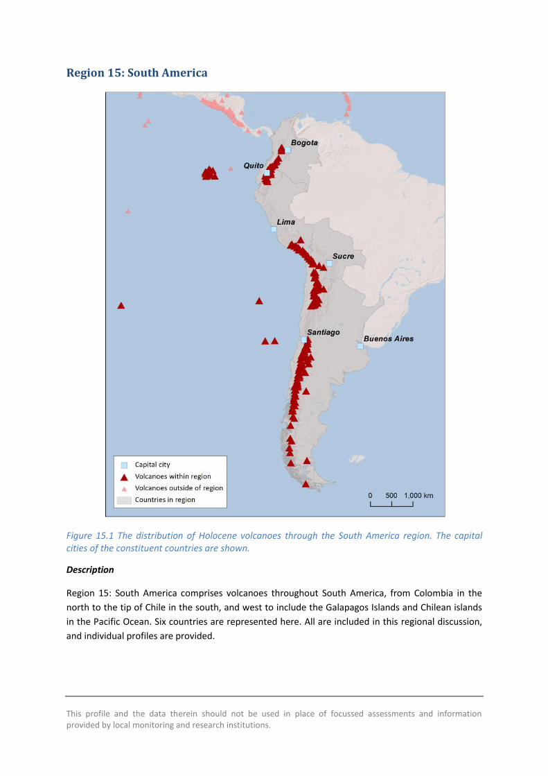
This profile and the data therein should not be used in place of focussed assessments and information provided by local monitoring and research institutions
Region 15 South America
Figure 151 The distribution of Holocene volcanoes through the South America region The capital cities of the constituent countries are shown
Description
Region 15 South America comprises volcanoes throughout South America from Colombia in the
north to the tip of Chile in the south and west to include the Galapagos Islands and Chilean islands
in the Pacific Ocean Six countries are represented here All are included in this regional discussion
and individual profiles are provided
600
Country Number of volcanoes
Argentina 41 Bolivia 12 Chile 105 Colombia 15 Ecuador 35 Peru 17
Table 151 The countries represented in this region and the number of volcanoes Volcanoes located on the borders between countries are included in the profiles of all countries involved Note that countries may be represented in more than one region as overseas territories may be widespread
197 Holocene volcanoes are located in South America Most of these volcanoes are in Chile
Volcanism here is largely related to the subduction of the Nazca Plate beneath the South American
Plate
A range of volcano types are present though most are stratovolcanoes The rock composition varies
from basaltic to rhyolitic but is most commonly andesitic
Along with ranges of volcano morphologies and rock types a range of activity styles and eruption
magnitudes are recorded throughout the Holocene with eruptions ranging from VEI 0 to 6 About
72 of eruptions have been small at VEI 0 to 2 however about 12 of eruptions have been large
explosive VEI ge4 events The only countries in this region with no Holocene record of VEI ge4
eruptions are Argentina and Bolivia though pyroclastic flows are recorded in eruptions at volcanoes
on the border of Chile-Argentina and Chile-Bolivia Four VEI 6 eruptions are recorded here The two
most recent were the 1280 eruption of Quilotoa in Ecuador in which pyroclastic flows and lahars
reached the Pacific and the 1600 eruption of Huaynaputina Peru in which pyroclastic flows
reached 13 km and lahars reached 120 km
Seventy-six volcanoes have historical records of 672 eruptions 95 of which were recorded through
direct observations Areas where the population is sparse have fewer observed events and therefore
a less comprehensive record Pyroclastic flows and lahars are recorded in 12 and 15 of historical
eruptions respectively Lava flows are recorded in 20 of historical eruptions Many of South
Americarsquos volcanoes are ice-capped and as such lahars and explosive eruptions may be frequent
Lives have been lost in 5 of historical eruptions The eruption of Nevado del Ruiz in Colombia in
1985 resulted in the greatest loss of life with over 20000 fatalities due to lahars These were
produced during a moderate VEI 3 eruption which led to the melting of the summit ice-cap Most
volcanoes (72) have low proximal populations and as such are considered relatively low risk
However the hazard is poorly constrained at many volcanoes here with no hazard and risk
classification at about 80 of the regionrsquos volcanoes Eight Risk Level III volcanoes are located in this
region all in Ecuador and Colombia
Most historically active volcanoes are monitored in this region with an apparent concentration of
monitoring at the Risk Level II and III volcanoes Chile Colombia Ecuador and Peru all have specific
monitoring institutions
601
Volcano facts
Number of Holocene volcanoes 197
Number of Pleistocene volcanoes with Mge4 eruptions 38
Number of volcanoes generating pyroclastic flows 45 (217 eruptions)
Number of volcanoes generating lahars 32 (126 eruptions)
Number of volcanoes generating lava flows 49 (194 eruptions)
Number of eruptions with fatalities 34
Number of fatalities attributed to eruptions 33230
Largest recorded Pleistocene eruption The 22 Ma M8 Cerro Galaacuten Ignimbrite from Cerro Galaacuten is the largest recorded Quaternary explosive eruption in this region
Largest recorded Holocene eruption The largest recorded Holocene eruption in LaMEVE in this region in the 800 BP Quilotoa eruption at M64
Number of Holocene eruptions 976 confirmed Holocene eruptions
Recorded Holocene VEI range 0 ndash 6 and unknown
Number of historically active volcanoes 76
Number of historical eruptions 672
Number of volcanoes
Primary volcano type Dominant rock type
13 Caldera(s) Andesitic (5) Dacitic (5) Rhyolitic (3)
129 Large cone(s) Andesitic (87) Basaltic (15) Dacitic (21) TrachyticAndesitic (1) Unknown (5)
7 Lava dome(s) Andesitic (1) Dacitic (4) Rhyolitic (1) Unknown (1)
18 Shield(s) Andesitic (1) Basaltic (17)
28 Small cone(s) Andesitic (13) Basaltic (11) Dacitic (1) Unknown (3)
1 Subglacial Dacitic (1)
1 Submarine Unknown (1)
Table 152 The volcano types and dominant rock types of the volcanoes of this region according to VOTW40
602
Eruption Frequency
VEI Recurrence Interval (Years)
Small (lt VEI 4) 1 Large (gt VEI 3) 50
Table 153 Average recurrence interval (years between eruptions) for small and large eruptions in South America
The eruption record indicates that on average small to moderate sized eruptions of VEI lt4 occur in
this region with an average recurrence interval (ARI) of about a year whilst the ARI for large
eruptions is longer at about 50 years
Eruption Size
Eruptions are recorded through South America of VEI 0 to 6 representing a range of eruption styles
from gentle effusive events to large explosive eruptions VEI 2 events dominate the record with over
50 of all Holocene eruptions classed as such 12 of eruptions here are explosive at VEI ge4
Figure 152 Percentage of eruptions in this region recorded at each VEI level the number of eruptions is also shown The percentage is of total eruptions with recorded VEI A further 232 eruptions were recorded with unknown VEI
Socio-Economic Facts
Total population (2011) 361188771
Gross Domestic Product (GDP) per capita (2005 PPP $) 4499 ndash 15501
(Mean 10129)
Gross National Income (GNI) per capita (2005 PPP $) 4444 ndash 15347
(Mean 10060)
603
Human Development Index (HDI) (2012) 0675 ndash 0819 (Medium to Very High Mean 0746 High)
Population Exposure
Number (percentage) of people living within 10 km of a Holocene volcano
1252806 (035 )
Number (percentage) of people living within 30 km of a Holocene volcano
8997260 (249 )
Number (percentage) of people living within 100 km of a Holocene volcano
35346223 (979 )
Infrastructure Exposure
Number of airports within 100 km of a volcano 20
Number of ports within 100 km of a volcano 10
Total length of roads within 100 km of a volcano (km) 30039
Total length of railroads within 100 km of a volcano (km) 3118
Table 154 (Next page) Identity of the volcanoes in this region in each Hazard-PEI group Those volcanoes with a sufficient record for determining a hazard score are deemed lsquoClassifiedrsquo (top) Those without sufficient data are lsquoUnclassifiedrsquo (bottom) The unclassified volcanoes are divided into groups U-NHHR is Unclassified No Historic or Holocene Record that is there are no confirmed eruptions recorded in the Holocene U-HR is Unclassified with Holocene Record that is there are confirmed eruptions recorded during the Holocene but no historical (post-1500) events U-HHR is Unclassified with Historic and Holocene record The unclassified volcanoes in bold have experienced unrest or eruptions since 1900 AD and those in red have records of at least one Holocene VEI ge4 eruption
604
CLA
SSIF
IED
Hazard III Azul Cerro Puyehue-Cordoacuten Caulle Osorno
Reventador Sangay Calbuco
Bravo Cerro Cayambe Cotopaxi Tungurahua
Nevado del Ruiz Guagua Pichincha
Galeras Atacazo
Hazard II Fernandina Yucamane Laacutescar Planchoacuten-Peteroa Chillaacuten Nevados de Antuco Copahue Lonquimay Llaima
Sabancaya Ubinas Villarrica
Tolima Nevado del
Hazard I Wolf Negra Sierra Azul Cerro Guallatiri Isluga San Pedro Huequi Lautaro
Maipo Puraceacute Misti El Tupungatito San Joseacute
UN
CLA
SSIF
IED
U ndash HHR Robinson Crusoe
Sumaco Darwin Alcedo Pinta Marchena Santiago Ticsani Irruputuncu Olca-Paruma Putana Llullaillaco Tinguiririca Descabezado Grande Tromen Callaqui Quetrupillan Huanquihue Group Mocho-Choshuenco Puntiagudo-Cordoacuten Cenizos Minchinmaacutevida Mentolat Hudson Cerro Arenales Viedma Reclus Burney Monte Fueguino
Huaynaputina Carraacuten-Los Venados Chaiteacuten
Huila Nevado del Dontildea Juana Cumbal Negro de Mayasquer Cerro Antisana
Chacana
U- HR Aliso
Ecuador Taapaca Parinacota Socompa Ojos del Salado Nevados Infiernillo Longaviacute Nevado de Laniacuten Antillanca Group Cayutueacute-La Vigueriacutea Yanteles Corcovado Melimoyu Macaacute Aguilera Pali-Aike Volcanic Field
Soche Huambo Sollipulli Caburgua-Huelemolle
Romeral Chachimbiro Chimborazo Quimsachata Andahua-Orcopampa
Santa Isabel Machiacuten Azufral Quilotoa
Cuicocha Imbabura
Pululagua
U- NHHR
San Feacutelix Unnamed Blanca Laguna
Genovesa Auquihuato Cerro Sara Sara Coropuna Tutupaca Casiri Nevados Tacora Tambo Quemado Tata Sabaya Jayu Khota Laguna Nuevo Mundo Pampa Luxsar Ollaguumle Azufre Cerro del Sairecabur Licancabur Guayaques Purico Complex Colachi Acamarachi Overo Cerro Chiliques Cordoacuten de Puntas Negras Mintildeiques Tujle Cerro Caichinque Tilocalar Negrillar El Pular Negrillar La Escorial Lastarria Cordoacuten del Azufre Bayo Gorbea Cerro Nevada Sierra Falso Azufre Incahuasi Nevado de Solo El Copiapoacute Tuzgle Aracar Unnamed Antofagasta Coacutendor El Peinado Robledo Tipas Palomo Atuel Caldera del Risco Plateado Calabozos Maule Laguna del San Pedro-Pellado Blancas Lomas Resago Payuacuten Matru Domuyo Cochiquito Volcanic Group Puesto Cortaderas Trolon Marintildeaqui Laguna Tolguaca Tralihue Pantojo Cerro Tronador Cuernos del Diablo Yate Hornopireacuten Apagado Crater Basalt Volcanic Field Palena Volcanic Group Puyuhuapi Cay Riacuteo Murta
Petacas Santa Cruz San Cristoacutebal Easter Island
Sotaraacute Illiniza Chachani Nevado Nicholson Cerro
Mojanda Licto
PEI 1 PEI 2 PEI 3 PEI 4 PEI 5 PEI 6 PEI 7
605
Population Exposure Index
Number of Volcanoes Population Exposure Index
1 7 5 6 8 5
23 4 18 3
137 2 5 1
Table 155 The number of volcanoes in South America classed in each PEI category
Risk Levels
Number of Volcanoes Risk Level
8 III 10 II 22 I
157 Unclassified
Table 156 The number of volcanoes in the South America region classified at each Risk Level
Figure 153 Distribution of the classified volcanoes of this region across Hazard and Population Exposure Index levels The warming of the background colours illustrates increasing Risk levels from Risk Level I - III
606
Regional Monitoring Capacity
Figure 154 The monitoring and risk levels of the historically active volcanoes in South America Monitoring Level 1 indicates no known dedicated ground-based monitoring Monitoring Level 2 indicates that some ground-based monitoring systems are in place including le3 seismic stations Monitoring Level 3 indicates the presence of a dedicated ground-based monitoring network including ge4 seismometers
This profile and the data therein should not be used in place of focussed assessments and information provided by local monitoring and research institutions
Argentina
Description
Figure 155 Location of Argentinarsquos volcanoes the capital and largest cities A zone extending 200 km beyond the countrys borders shows other volcanoes whose eruptions may directly affect Argentina
Forty-one volcanoes are recorded in Argentina including 19 on the border with Chile Most of these
volcanoes are located in the Andes in western Argentina dominantly in the centre and north of the
608
country Volcanism here is largely due to the subduction of the Nazca Plate beneath the South
American Plate A range of volcano types are present here though most are stratovolcanoes of
dominantly andesitic composition
Large explosive Pleistocene activity is recorded in Argentina and 61 eruptions of Holocene age are
recorded from 13 volcanoes The remaining Holocene volcanoes have activity that is suspected to
have occurred in the last 10000 years Of these Holocene eruptions 47 are of historical age
occurring at 8 volcanoes VOTW422 records Holocene eruptions of VEI 0 to 3 indicating a
prevalence of mild to moderate activity However recent studies have identified two Holocene VEI
ge6 eruptions from Cerro Blanco-Robledo volcanic complex with the caldera forming eruption being
one of the largest Holocene eruptions in the central Andes at approximately 4500 BP (Baez et al
2015) Just one eruption that of Copahue in 2000 has a recorded historical pyroclastic flow During
this event pyroclastic flows scoria and ash fall occurred and evacuations were ordered with damage
occurring to property
Many of the most populous cities in Argentina are located far to the east of the volcanic chain and
the elevation of much of the Andes means that local populations are small Indeed less than 2000
people live within 10 km of a Holocene volcano in the whole of Argentina and less than 2 of the
total population live within 100 km of one or more volcanoes (under 700000) Although the hazard
classification at many of Argentinarsquos volcanoes is complicated by large uncertainties the small local
populations mean that these volcanoes are considered relatively low risk to proximal populations
However the dominant wind direction is such that ash will commonly be distributed west to east
across much of Argentina from eruptions in the far west of the country
The Chilean volcanoes beyond the border are also very important to the hazard consideration in
Argentina Explosive eruptions of these volcanoes can produce ash clouds with ash dispersal
throughout Argentina Indeed the dominant wind direction here is west to east leading to ash fall in
Argentina in most Chilean eruptions (Viramonte et al 2001) There are many examples of this
(Figure 156) For example the 2008 eruption of Chaiteacuten produced ash fall beyond the Argentine
coast (Folch et al 2008 Durant et al 2012) and the 2011 eruption of Cordoacuten Caulle resulted in
significant ash fall across three Argentine provinces (Riacuteo Negro Neugueacuten and Chubut) (Collini et al
2012) Both eruptions had negative impacts on farming (livestock) and agriculture water
transportation networks and air and ground transportation networks (Collini et al 2012) See the
profile for Chile for further discussion of the Chilean volcanoes
Ash remobilisation can occur for years after an eruption due to wind and rain and this can cause
issues even in times of inactivity at the volcanoes therefore ash distribution throughout the country
must be understood both from Argentine and Chilean volcanoes
Authorities in Argentina especially SEGEMAR (Servicio Geologico y Minero Argentino) Comisioacuten
Nacional de Riesgos Ministerio de Ciencia Tecnologiacutea e Innovacioacuten Productiva (MINCyT) and the
Argentine Space Agency (CONAE) collaborate with the Servicio Nacional de Geologia y Mineria
(SERNAGEOMIN) in Chile for monitoring of the border volcanoes Seismic and deformation
monitoring is in place as are cameras for visual observations Universidad Nacional de Riacuteo Negro in
collaboration with Firenze University maintain temporary seismic array for volcanic monitoring in
several potential dangerous volcanoes (Copahue Domuyo Tromen) Universidad Nacional de Salta
in collaboration with Universidad de Cadiz maintains a high resolution GPS network in the Cerro
609
Blanco-Robledo caldera comnplex for deformation monitoring Servicio Meteoroloacutegico Nacional
Universidad Nacional de Salta CONICET and CONAE in cooperation with VAAC Buenos Aires work to
give early alerts and ash-fall dispersion forecasts Alerts are released and evacuations ordered as
unrest and eruption occurs SERNAGEOMIN also monitor most volcanoes within Chile releasing
alerts that can be used in ash forecasts for Argentina
Figure 156 The active volcanoes of the central and southern Andes and ash dispersal across
Argentina from recent eruptions of Chilean volcanoes Modified after Viramonte et al 2001
610
References
Baez W Arnosio M Chiodi A Ortiz-Yanes A Viramonte JG Bustos E Giordano G and Lopez
JF (2015) Estratigrafiacutea y evolucioacuten del Complejo Volcaacutenico Cerro Blanco Puna Austral Argentina
Revista Mexicana de Ciencias Geoloacutegicas
rmcggeocienciasunammxrevistamrevistaphpidioma=Eampnumero=X
Collini E Soledad Osores M Folch A Viramonte JG Villarosa G And Salmuni G (2012) Volcanic
ash forecast during the June 2011 Cordon Caulle eruption Natural Hazards 662 389-412
Durant A Villarosa G Rose WI Delmelle P Prata AJ Viramonte JG (2012) Long-range
volcanic ash transport and fallout during the 2008 eruption of Chaiten volcano Chile Physics and
Chemistry of the EarthParts ABC 45-46 50-64
Folch A Jorba O amp J Viramonte 2008 Volcanic Ash Forecast- Application to the May 2008
Chaiteacuten Eruption Natural Hazard and Earth System Sciences 8 927-940
Viramonte JG Peralta CM Garrido D and Felpeto A (2001) Uso de sensores remotos para la
mitigacioacuten de efectos causados por erupciones volcaacutenicas Elaboracioacuten de mapas de Riesgo
volcaacutenico y alertas para la aeronavegacioacuten Un caso de estudio
wwwconaegovarWEB_EmergenciasLinks_del_Cuerpo_PrincipalVolcanesInforme20Riesgo20
Volcanicohtm
Volcano Facts
Number of Holocene volcanoes 41 inclusive of 19 on the border with Chile
Number of Pleistocene volcanoes with Mge4 eruptions 6 inclusive of 3 on the border with Chile
Number of volcanoes generating pyroclastic flows 4
Number of volcanoes generating lahars 2
Number of volcanoes generating lava flows 6
Number of fatalities caused by volcanic eruptions -
Tectonic setting 37 subduction zone 4 intra-plate
Largest recorded Pleistocene eruption The M8 eruption of the Cerro Galaacuten Ignimbrite from Cerro Galaacuten at 208 Ma
Largest recorded Holocene eruption Recent studies reveal that Cerro Blanco ndash Robledo caldera has had the most powerful Holocene eruption in ~4500 BP and at VEI ge6 (Baez et al 2015)
611
Number of Holocene eruptions 61 confirmed eruptions 14 uncertain and 2 discredited eruptions
Recorded Holocene VEI range 0 ndash 3 in VOTW422 with VEI ge6 indicated by recent studies (Baez et al 2015)
Number of historically active volcanoes 8
Number of historic eruptions 47
Number of volcanoes
Primary volcano type Dominant rock type
3 Caldera(s) Andesitic (2) Rhyolitic (1)
28 Large cone(s) Andesitic (13) Basaltic (4) Dacitic (7) Unknown (4)
1 Lava dome(s) Dacitic (1)
1 Shield(s) Basaltic (1)
7 Small cone(s) Andesitic (3) Basaltic (4)
1 Subglacial Dacitic (1)
Table 157 The number of volcanoes in Argentina their volcano type classification and dominant rock type according to VOTW40
Socio-Economic Facts
Total population (2012) 41117000
Gross Domestic Product (GDP) per capita (2005 PPP $) 15501
Gross National Income (GNI) per capita (2005 PPP $) 15347
Human Development Index (HDI) (2012) 0811 (Very High)
Population Exposure
Capital city Buenos Aires
Distance from capital city to nearest Holocene volcano 9741 km
Total population (2011) 41769726
Number (percentage) of people living within 10 km of a Holocene volcano
1809 (lt1)
612
Number (percentage) of people living within 30 km of a Holocene volcano
26905 (lt1)
Number (percentage) of people living within 100 km of a Holocene volcano
618387 (15)
Ten largest cities as measured by population and their population size
Buenos Aires 13076300 Cordoba 1428214 Rosario 1173533 Mendoza 876884 San Miguel De Tucuman 781023 La Plata 694167 Salta 512686 Santa Fe 468632 San Juan 447048 Resistencia 387158
Infrastructure Exposure
Number of airports within 100 km of a volcano 2
Number of ports within 100 km of a volcano 1
Total length of roads within 100 km of a volcano (km) 4638
Total length of railroads within 100 km of a volcano (km) 278
Volcanoes in Argentina occur along the western border of the country on the border with Chile
Volcanoes here are located in three main groups in the north centre and south Many of the border
volcanoes here have 100 km radii that extend into Chile and likewise the radii of Chilean volcanoes
extend into western Argentina The capital Buenos Aires lies in the east of the country at nearly
1000 km distance to the nearest Holocene volcano and most of the largest cities in the country lie
far east of the volcanic chain Only the southernmost Palei-Aike volcano is located near the coast
exposing ports and an airport here An extensive road and rail network lies within the radii of the
volcanoes throughout the country
613
Figure 157 The location of Argentinarsquos volcanoes and the extent of the 100 km zone surrounding them Ports airports and the major cities are just some of the infrastructure that may be exposed to volcanic hazards
Hazard Uncertainty and Exposure Assessments
There are varying levels of information available in the eruption records of Argentinarsquos volcanoes
Just four out of 41 have sufficient detail to define the hazard through the calculation of the VHI
These are classified at Hazard Levels I and II
614
Of the unclassified volcanoes 28 have no confirmed eruptions in the Holocene record Nine have a
Holocene record including historical events at Llullaillaco Tromen Huanquihue Group and Viedma
The latter has recorded eruptions since 1900 AD Unrest has been recorded at a further three
unclassified volcanoes
The PEI in Argentina is classed as low to moderate with most volcanoes having a PEI of 2 All
classified volcanoes here are classed at Risk Level I Given the low population all unclassified
volcanoes would be classed at Risk Levels I and II were the hazard known
615
CLA
SSIF
IED
Hazard III
Hazard II
Copahue
Hazard I Maipo Tupungatito San Joseacute
UN
CLA
SSIF
IED
U ndash HHR Llullaillaco Tromen Huanquihue Group Viedma
U- HR Socompa Nevados Ojos del Salado Infiernillo Laniacuten Pali-Aike Volcanic Field Cerro Blanco-Robledo complex
U- NHHR
Blanca Laguna
Escorial Lastarria Cordoacuten del Azufre Bayo Gorbea Cerro Nevada Sierra Falso Azufre Incahuasi Nevado de Solo El Tuzgle Aracar Unnamed Antofagasta Coacutendor El Peinado Tipas Atuel Caldera del Risco Plateado Payuacuten Matru Domuyo Cochiquito Volcanic Group Puesto Cortaderas Trolon Tralihue Pantojo Cerro Tronador Crater Basalt Volcanic Field
PEI 1 PEI 2 PEI 3 PEI 4 PEI 5 PEI 6 PEI 7 Table 158 Identity of Argentinarsquos volcanoes in each Hazard-PEI group Those volcanoes with a sufficient record for determining a hazard score are deemed lsquoClassifiedrsquo (top) Those without sufficient data are lsquoUnclassifiedrsquo (bottom) The unclassified volcanoes are divided into groups U-NHHR is Unclassified No Historic or Holocene Record that is there are no confirmed eruptions recorded in the Holocene U-HR is Unclassified with Holocene Record that is there are confirmed eruptions recorded during the Holocene but no historical (post-1500) events U-HHR is Unclassified with Historic and Holocene record The unclassified volcanoes in bold have experienced unrest or eruptions since 1900 AD and those in red have records of at least one Holocene VEI ge4 eruption
Note that Robledo had no eruptions recorded in VOTW422 but recent studies have identified a large explosive Holocene at this volcano (Baez et al 2015) and so its entry has been adjusted here from U-NHHR to U-HR
616
Volcano Population Exposure Index Risk Level
San Joseacute 4 I Tupungatito 4 I Maipo 3 I Copahue 2 I
Table 159 Classified volcanoes of Argentina ordered by descending Population Exposure Index (PEI) Risk levels determined through the combination of the Hazard Level and PEI are given Risk Level I ndash 4 volcanoes Risk Level II ndash 0 volcanoes Risk Level III ndash 0 volcanoes
Figure 158 Distribution of Argentinarsquos classified volcanoes across Hazard and Population Exposure Index levels The warming of the background colours illustrates increasing Risk levels from Risk Level I - III
National Capacity for Coping with Volcanic Risk
Eight volcanoes in Argentina inclusive of those on the border with Chile have records of historical
activity Four are classified at Risk Level I (Tupungatito San Joseacute Maipo Copahue) and four are
unclassified with a PEI of 2 (Llullaillaco Tromen Huanquihue Group and Viedma) At the time of the
writing of this report no information is available to indicate that dedicated ground-based monitoring
is in place the four unclassified volcanoes However SERNAGEOMIN in Chile operate monitoring
systems at four of the border volcanoes with seismic and deformation monitoring at Copahue
Maipo Tupungatito and San Joseacute
617
Figure 159 The monitoring and risk levels of the historically active volcanoes in Argentina Monitoring Level 1 indicates no known dedicated ground-based monitoring Monitoring Level 2 indicates that some ground-based monitoring systems are in place including le3 seismic stations Monitoring Level 3 indicates the presence of a dedicated ground-based monitoring network including ge4 seismometers
This profile and the data therein should not be used in place of focussed assessments and information provided by local monitoring and research institutions
Bolivia
Description
Figure 1510 Location of Boliviarsquos volcanoes the capital and largest cities A zone extending 200 km beyond the countrys borders shows other volcanoes whose eruptions may directly affect Bolivia
Twelve Holocene volcanoes are located in Bolivia including seven on the border with Chile
Volcanism here is largely due to the subduction of the Nazca Plate beneath the South American
Plate A variety of volcano forms have developed here with stratovolcanoes being the most
common The composition varies from basaltic to rhyolitic though andesitic compositions are most
common
619
Very large explosive eruptions are recorded back into the Pleistocene but the Holocene record is
sparse with just seven confirmed eruptions Two of these were recorded historically in 1865 at
Olca-Paruma and in 1995 at Irruputuncu This latter eruption is the largest recorded in the
Holocene at just VEI 2
The sparse nature of the eruptive record suggests that the hazard (the VHI) is poorly constrained
however the volcanoes of Bolivia are remote with the most populous cities located to the east Only
a small number of people live in close proximity to Holocene volcanoes in Bolivia with about 3000
in total within 10 km and less than 500000 within 100 km of these volcanoes As such current
understanding suggests that these volcanoes are of relatively low risk
There is no official monitoring institution in Bolivia however SERNAGEOMIN in Chile monitors the
border volcanoes Two part-time scientists at the Universidad Mayor de San Andres undertaken
volcanic research in Bolivia and they advise that there are no current response protocols in place for
developing unrest or eruption largely due to the remote nature of the volcanoes They suggest that
infrastructure is at risk with highways (the Oruro-Pisiga and Patacamaya-Tambo Quemado
highway) railways (the Arica line) and an electricity generating station near Nuevo Mundo
highlighted as being exposed
Volcano Facts
Number of Holocene volcanoes 12 inclusive of 7 on the border with Chile
Number of Pleistocene volcanoes with Mge4 eruptions -
Number of volcanoes generating pyroclastic flows 1
Number of volcanoes generating lahars -
Number of volcanoes generating lava flows 1
Number of fatalities caused by volcanic eruptions -
Tectonic setting Subduction zone
Largest recorded Pleistocene eruption The M72 eruption of Laguna Colorado at 19 Ma
Largest recorded Holocene eruption The VEI 2 eruption of Irruputuncu in 1995 AD
Number of Holocene eruptions 7 confirmed eruptions 2 uncertain eruptions
Recorded Holocene VEI range 0 ndash 2
Number of historically active volcanoes 2
Number of historic eruptions 2
620
Number of volcanoes
Primary volcano type Dominant rock type
1 Caldera(s) Rhyolitic (1)
7 Large cone(s) Andesitic (7)
2 Lava dome(s) Dacitic (2)
2 Small cone(s) Andesitic (1) Basaltic (1)
Table 1510 The number of volcanoes in Bolivia their volcano type classification and dominant rock type according to VOTW40
Socio-Economic Facts
Total population (2012) 10523000
Gross Domestic Product (GDP) per capita (2005 PPP $) 4499
Gross National Income (GNI) per capita (2005 PPP $) 4444
Human Development Index (HDI) (2012) 0675 (Medium)
Population Exposure
Capital city Sucre
Distance from capital city to nearest Holocene volcano 1521 km
Total population (2011) 10118683
Number (percentage) of people living within 10 km of a Holocene volcano
3098 (lt1)
Number (percentage) of people living within 30 km of a Holocene volcano
29479 (lt1)
Number (percentage) of people living within 100 km of a Holocene volcano
465904 (46)
Largest cities as measured by population and their population size
Santa Cruz de La Sierra 1364389 Cochabamba 900414 La Paz 812799 Sucre 224838 Oruro 208684 Tarija 159269 Potosi 141251
621
Trinidad 84259 Cobija 26585
Infrastructure Exposure
Number of airports within 100 km of a volcano 0
Number of ports within 100 km of a volcano 0
Total length of roads within 100 km of a volcano (km) 908
Total length of railroads within 100 km of a volcano (km) 282
The volcanoes are situated in a chain along much of the western border of Bolivia and Chile The 100
km radii of these volcanoes fully encompasses this border and extends into Chile Peru and
Argentina Similarly the border volcanoes in these countries have 100 km radii that extend into
Bolivia The capital Sucre lies at over 150 km from the nearest Holocene volcano The volcanoes in
Bolivia are relatively remote but with numerous small settlements and an extensive road network
lying within their 100 km radii
622
Figure 1511 The location of Boliviarsquos volcanoes and the extent of the 100 km zone surrounding them Ports airports and the major cities are just some of the infrastructure that may be exposed to volcanic hazards
Hazard Uncertainty and Exposure Assessments
The eruption records for Boliviarsquos volcanoes lack sufficient detail to determine hazard levels through
the calculation of the VHI These volcanoes are therefore unclassified Indeed of the twelve
volcanoes here just three have a confirmed Holocene record of eruptions including historical
activity at Irruputuncu and Olca-Paruma Eruptions and unrest have been recorded at these two
volcanoes since 1900 AD respectively
The PEI at all Bolivian volcanoes is low at PEI 2 The absence of a hazard classification prevents
determination of risk levels however this low local populations suggests risk levels of I and II
623
CLA
SSIF
IED
Hazard III
Hazard II
Hazard I
UN
CLA
SSIF
IED
U ndash HHR
Irruputuncu Olca-Paruma
U- HR Parinacota
U- NHHR
Tambo Quemado Tata Sabaya Jayu Khota Laguna Nuevo Mundo Pampa Luxsar Ollaguumle Sairecabur Licancabur Guayaques
PEI 1
PEI 2 PEI 3 PEI 4 PEI 5 PEI 6 PEI 7
Table 1511 Identity of Boliviarsquos volcanoes in each Hazard-PEI group Those volcanoes with a sufficient record for determining a hazard score are deemed lsquoClassifiedrsquo (top) Those without sufficient data are lsquoUnclassifiedrsquo (bottom) The unclassified volcanoes are divided into groups U-NHHR is Unclassified No Historic or Holocene Record that is there are no confirmed eruptions recorded in the Holocene U-HR is Unclassified with Holocene Record that is there are confirmed eruptions recorded during the Holocene but no historical (post-1500) events U-HHR is Unclassified with Historic and Holocene record The unclassified volcanoes in bold have experienced unrest or eruptions since 1900 AD and those in red have records of at least one Holocene VEI ge4 eruption
National Capacity for Coping with Volcanic Risk
Two volcanoes on the Bolivia-Chile border have historical records of activity Monitoring undertaken
by SERNAGEOMIN in Chile is described at both these volcanoes however the details are unknown
624
Figure 1512 The monitoring and risk levels of the historically active volcanoes in Bolivia Monitoring Level 1 indicates no known dedicated ground-based monitoring Monitoring Level 2 indicates that some ground-based monitoring systems are in place including le3 seismic stations Monitoring Level 3 indicates the presence of a dedicated ground-based monitoring network including ge4 seismometers
This profile and the data therein should not be used in place of focussed assessments and information provided by local monitoring and research institutions
Chile
Description
Figure 1513 Location of Chilersquos volcanoes the capital and largest cities A zone extending 200 km beyond the countrys borders shows other volcanoes whose eruptions may directly affect Chile
There are 105 volcanoes in Chile including nearly 30 on the borders within Argentina Bolivia and
Peru Several groups of volcanoes are present with scattered remote volcanoes in the very far
south a large concentration of volcanic centres south of Santiago and north of Copiapo and Chilean
626
islands in the Pacific Ocean Volcanism through Chile is primarily due to the subduction of the Nazca
Plate beneath the South American Plate and intra-plate processes in the Pacific
A range of volcano types are present throughout Chile though stratovolcanoes are most common
with about three quarters of volcanoes here being classified as such The rock type also varies from
basaltic to rhyolitic however andesitic compositions are most common
Large explosive Pleistocene activity is recorded in Chile at 20 volcanoes The largest Pleistocene
eruptions were of magnitude 74 with three eruptions of this size at Calabozos caldera about
150000 300000 and 800000 years ago Holocene activity has occurred here and hot springs are
still active within the caldera
Holocene activity in Chile has included 476 confirmed eruptions from 56 volcanoes The remaining
volcanoes have activity of suspected Holocene age Holocene activity has comprised a range of
activity styles and sizes with eruptions from VEI 0 to 6 though only about 5 of these were VEI ge4
Historically 40 volcanoes are recorded producing 357 eruptions Of these 8 were VEI ge4 though
pyroclastic flows are recorded in 16 eruptions Lava flows have more commonly been recorded and
14 of eruptions have resulted in lahars The largest historical eruption in Chile occurred at Cerro
Azul in 1916 This VEI 5 eruption ejected 95 cubic kilometres of tephra and was one of the worldrsquos
largest eruptions in the 20th century
Only a small total population is situated within 10 km of one or more Holocene volcanoes in Chile
however this grows considerably at 30 km and to about 106 million at 100 km accounting for about
63 of the population Ten historic eruptions have resulted in loss of life at Lonquimay Llaima
Villarrica Carran-Los Venados Chaiten and Cerro Hudson
The Red de Vigilancia Volcanic (Volcano monitoring network) and the Observatorio Volcanologico de
Los Andes del Sur (OVDAS) are part of the Servicio Nacional de Geologia y Mineria (SERNAGEOMIN)
This body is government funded and was founded in 1996 The main objective of these groups is to
establish monitoring systems and monitor the most dangerous volcanoes in Chile (based on the
frequency of activity proximity to population centres and vulnerability of public and private
infrastructure) in order to provide information to the relevant authorities
Monitoring is undertaken at many volcanoes using seismic networks cameras deformation and gas
measurements Success of the network has been proven in the eruption of Puyehue-Cordon Caulle
and alerts at Hudson and Copahue Resources and plans are available for responding to developing
unrest and eruption at current un- or under-monitored volcanoes
Scientific technical and support staff are present at the monitoring institution and about 20 of
these have experience of responding to activity however large amounts of data are gathered and
further scientific experience and support is required for full analysis
Regular technical meetings are held in the event of increased activity and an informal response
protocol is followed including alerting the regional VAAC The Oficina Nacional de Emergencia del
Ministerio del Interior y Seguridad Puacuteblica (ONEMI) coordinates emergency response OVDAS
communicates hazard assessments and alerts to ONEMI who use a civil protection alert system
627
A relative threat ranking is produced by SERNAGEOMIN for the volcanoes of Chile This is similar to
the NVEWS method and VHI using hazard indicators taken from the records and coupling these with
exposure factors The relative threat is the sum of the hazard times sum of exposure This ranking system
indicates that Villarrica and Llaima have the largest relative threat ranking with these volcanoes
being the most frequently active here with 126 historical eruptions between them coupled with
large populations within 100 km
A questionnaire was completed by SERNAGEOMIN as part of this study This indicated that a number
of volcano records in VOTW40 require updating with some volcanoes considered Holocene age in
VOTW40 but designated as Pleistocene age by SERNAGEOMIN This highlights the value of close
collaboration between the volcanological community to ensure up-to-date and sustainable data
systems Updates will be considered by the Smithsonian Institution
See also
SERNAGEOMIN wwwsernageominclvolcan-observatoriophp
Volcano Facts
Number of Holocene volcanoes 105 inclusive of 19 on the border with Argentina 7 on the border with Bolivia and 1 on the border with Peru
Number of Pleistocene volcanoes with Mge4 eruptions 20 inclusive of 3 on the border with Argentina
Number of volcanoes generating pyroclastic flows 19
Number of volcanoes generating lahars 13
Number of volcanoes generating lava flows 25
Number of fatalities caused by volcanic eruptions 473
Tectonic setting 101 Subduction zone 3 Intra-plate 1 Rift zone
Largest recorded Pleistocene eruption The Loma Seca Tuff units S V and L from Calabozos are all recorded at M74 at 150 ka 300 ka and 800 ka respectively
Largest recorded Holocene eruption The M63 H1T2 eruption from Cerro Hudson at 7710 BP
Number of Holocene eruptions 476 confirmed eruptions 74 uncertain and 9 discredited eruptions
Recorded Holocene VEI range 0 ndash 6 and unknown
Number of historically active volcanoes 40
628
Number of historic eruptions 357
Number of volcanoes
Primary volcano type Dominant rock type
6 Caldera(s) Andesitic (3) Dacitic (2) Rhyolitic (1)
78 Large cone(s) Andesitic (51) Basaltic (12) Dacitic (12) Unknown (3)
2 Lava dome(s) Andesitic (1) Dacitic (1)
3 Shield(s) Basaltic (3)
15 Small cone(s) Andesitic (5) Basaltic (7) Dacitic (1) Unknown (2)
1 Submarine Unknown (1)
Table 1512 The number of volcanoes in Chile their volcano type classification and dominant rock type according to VOTW40
Socio-Economic Facts
Total population (2012) 17479000
Gross Domestic Product (GDP) per capita (2005 PPP $) 15272
Gross National Income (GNI) per capita (2005 PPP $) 14987
Human Development Index (HDI) (2012) 0819 (Very High)
Population Exposure
Capital city Santiago
Distance from capital city to nearest Holocene volcano 805 km
Total population (2011) 16888760
Number (percentage) of people living within 10 km of a Holocene volcano
21030 (lt1)
Number (percentage) of people living within 30 km of a Holocene volcano
208768 (12)
Number (percentage) of people living within 100 km of a Holocene volcano
10623259 (629)
Ten largest cities as measured by population and their population size
Santiago 4837295 Antofagasta 309832 Valparaiso 282448 Temuco 238129
629
Iquique 227499 Concepcion 215413 Talca 197479 Puerto Montt 160054 La Serena 154521 Copiapo 129280
Infrastructure Exposure
Number of airports within 100 km of a volcano 10
Number of ports within 100 km of a volcano 8
Total length of roads within 100 km of a volcano (km) 16196
Total length of railroads within 100 km of a volcano (km) 2139
The numerous volcanoes of Chile are located primarily along the countryrsquos eastern border with
Argentina Bolivia and Peru and as such the 100 km radii of these volcanoes extend into these
neighbouring countries Similarly volcanoes near the borders in these countries have radii extending
into Chile exposing the infrastructure here Several volcanoes are situated in the Pacific off the coast
of Chile The capital Santiago lies within 100 km of the historically active Tupungatito and San Joseacute
volcanoes hence considerable critical infrastructure is exposed here Being a relatively narrow
stretch of land much of southern Chile lies within 100 km of Holocene volcanoes and many ports
are exposed here A very extensive road and rail network is exposed throughout the country and
many of the countryrsquos largest cities lie within 100 km
630
Figure 1514 The location of Chilersquos volcanoes and the extent of the 100 km zone surrounding them Ports airports and the major cities are just some of the infrastructure that may be exposed to volcanic hazards
Hazard Uncertainty and Exposure Assessments
There are varying levels of information available in the eruption records of Chilersquos volcanoes About
20 of the volcanoes here (20 out of 105) have sufficient detail to define the hazard through the
calculation of the VHI These are classified across all three hazard levels with most being classed at
Hazard Levels I and II Four volcanoes are classed at Hazard Level III all with Holocene records of
eruptions of VEI 4 and 5 and all with records of explosive volcanism accompanied by the production
of pyroclastic flows
631
Of the unclassified volcanoes 49 have no records of confirmed Holocene age eruptions 36
volcanoes have a Holocene eruption record of which 20 have erupted historically (post-1500 AD)
including eruptions since 1900 AD at 11 volcanoes Unrest is described at nine unclassified volcanoes
since 1900 AD Seven unclassified volcanoes have Holocene records of large explosive VEI ge4
eruptions
The PEI ranges from 1 to 4 low to moderate in Chile with an overwhelming majority at PEI 2 The
classified volcanoes are therefore Risk Levels of I and II Although the risk levels cannot be defined
for the unclassified volcanoes due to the absence of hazard details these would all also be clased at
Risk Level I and II
632
CLA
SSIF
IED
Hazard III
Cerro Azul Puyehue-Cordoacuten Caulle Osorno Calbuco
Hazard II
Laacutescar Planchoacuten-Peteroa Chillaacuten Nevados de Antuco Copahue Lonquimay Llaima
Villarrica
Hazard I
Guallatiri Isluga San Pedro Huequi Lautaro Maipo Tupungatito San Joseacute
UN
CLA
SSIF
IED
U ndash HHR Robinson Crusoe
Irruputuncu Olca-Paruma Putana Llullaillaco Tinguiririca Descabezado Grande Callaqui Quetrupillan Mocho-Choshuenco Puntiagudo-Cordoacuten Cenizos Minchinmaacutevida Mentolat Cerro Hudson Arenales Reclus Monte Burney Fueguino
Carraacuten-Los Venados Chaiteacuten
U- HR
Taapaca Parinacota Socompa Nevados Ojos del Salado Longaviacute Nevado de Laniacuten Antillanca Group Cayutueacute-La Vigueriacutea Yanteles Corcovado Melimoyu Macaacute Aguilera Pali-Aike Volcanic Field
Sollipulli Caburgua-Huelemolle
U- NHHR
San Feacutelix Unnamed
Tacora Ollaguumle Azufre Cerro del Sairecabur Licancabur Guayaques Purico Complex Colachi Acamarachi Overo Cerro Chiliques Cordoacuten de Puntas Negras Mintildeiques Tujle Cerro Caichinque Tilocalar Negrillar El Pular Negrillar La Escorial Lastarria Cordoacuten del Azufre Bayo Gorbea Cerro Nevada Sierra Falso Azufre Incahuasi Nevado de Solo El Copiapoacute Palomo Calabozos Maule Laguna del San Pedro-Pellado Blancas Lomas Resago Marintildeaqui Laguna Tolguaca Pantojo Cerro Tronador Cuernos del Diablo Yate Hornopireacuten Apagado Palena Volcanic Group Puyuhuapi Cay Riacuteo Murta
Easter Island
PEI 1 PEI 2 PEI 3 PEI 4 PEI 5 PEI 6 PEI 7 Table 1513 Identity of Chilersquos volcanoes in each Hazard-PEI group Those volcanoes with a sufficient record for determining a hazard score are deemed lsquoClassifiedrsquo (top) Those without sufficient data are lsquoUnclassifiedrsquo (bottom) The unclassified volcanoes are divided into groups U-NHHR is Unclassified No Historic or Holocene Record that is there are no confirmed eruptions recorded in the Holocene U-HR is Unclassified with Holocene Record that is there are confirmed eruptions recorded during the Holocene but no historical (post-1500) events U-HHR is Unclassified with Historic and Holocene record The unclassified volcanoes in bold have experienced unrest or eruptions since 1900 AD and those in red have records of at least one Holocene VEI ge4 eruption
633
Volcano Population Exposure Index Risk Level
Tupungatito 4 I San Joseacute 4 I Villarrica 3 II Calbuco 3 II Maipo 3 I Azul Cerro 2 II Puyehue-Cordoacuten Caulle 2 II Osorno 2 II Guallatiri 2 I Isluga 2 I San Pedro 2 I Laacutescar 2 I Planchoacuten-Peteroa 2 I Chillaacuten Nevados de 2 I Antuco 2 I Copahue 2 I Lonquimay 2 I Llaima 2 I Huequi 2 I Lautaro 2 I
Table 1514 Classified volcanoes of Chile ordered by descending Population Exposure Index (PEI) Risk levels determined through the combination of the Hazard Level and PEI are given Risk Level I ndash 15 volcanoes Risk Level II ndash 5 volcanoes Risk Level III ndash 0 volcanoes
Figure 1515 Distribution of Chilersquos classified volcanoes across Hazard and Population Exposure Index levels The warming of the background colours illustrates increasing Risk levels from Risk Level I - III
634
National Capacity for Coping with Volcanic Risk
Forty volcanoes have records of historical activity in Chile These volcanoes are primarily classed at
Risk Level I All Risk Level II historical volcanoes are monitored by SERNAGEOMIN using seismic
stations as a minimum Many volcanoes also have deformation monitoring
Figure 1516 The monitoring and risk levels of the historically active volcanoes in Chile Monitoring Level 1 indicates no known dedicated ground-based monitoring Monitoring Level 2 indicates that some ground-based monitoring systems are in place including le3 seismic stations Monitoring Level 3 indicates the presence of a dedicated ground-based monitoring network including ge4 seismometers
This profile and the data therein should not be used in place of focussed assessments and information provided by local monitoring and research institutions
Colombia
Description
Figure 1517 Location of Colombiarsquos volcanoes the capital and largest cities A zone extending 200 km beyond the countrys borders shows other volcanoes whose eruptions may directly affect Colombia
Fifteen Holocene volcanoes are distributed through the northern Andes in western Colombia to the
Ecuador border paralleling the Pacific coastline These volcanoes are related to the subduction of
the Nazca Plate beneath the South American Plate
All Holocene volcanoes in Colombia form edifices typically associated with explosive-type activity
including stratovolcanoes and complex volcanoes with the exception of the Petacas lava dome and
636
Santa Isabel shield The Colombian volcanoes are dominantly andesitic in composition The explosive
record continues into the Pleistocene with three Colombian volcanoes hosting MVEI ge4 eruptions
in this period
There are 125 confirmed eruptions recorded in the Holocene at VEI 1 to 5 indicating a range of
activity from mild to strongly explosive Eight volcanoes have a Holocene record of producing
pyroclastic flows and six are associated with lahars Nine of the Colombian volcanoes have 79
eruptions recorded in historical times
Many of Colombiarsquos most populous cities are located on or towards the northern coast away from
volcanoes however the cities of Cali Ibague Pasto and Pereira lie within 100 km of one or more
Holocene volcanoes with the latter three over-looked by Machin Galeras and the Ruiz-Tolima chain
Numerous eruptions of Nevado del Ruiz Nevado del Huila Puraceacute and Galeras have resulted in
evacuations and property damage Fatalities are recorded in nine eruptions of these volcanoes and
Dontildea Juana
The assessment of hazard is complicated by sparse eruptive histories at over half of Colombiarsquos
volcanoes resulting in hazard levels with large associated uncertainties hence just five volcanoes
have a hazard level classified here Nevado del Ruiz Galeras and Cerro Bravo are classed with the
highest hazard in Colombia based on detailed eruptive histories Coupled with the high proximal
population these volcanoes are classed at Risk Level III
Both Galeras and Nevado del Ruiz have caused loss of life Machiacuten has not caused any fatalities but
has shown recent unrest and its geological record indicates the potential for violent and destructive
explosive eruptions In 1993 a sudden intense but small magnitude explosive eruption of Galeras
killed nine people including six volcanologists who were in the inner crater or on its rim A far larger
disaster the largest in South Americarsquos history was the 1985 eruption of Nevado del Ruiz Though
only VEI 3 the eruption generated pyroclastic flows that melted the volcanorsquos glacier cap and caused
lahars The mudflows descended the western flanks flowing along the Riacuteo Lagunillas valley The
town of Armero located on the banks of Riacuteo Lagunillas 48 km from the volcano was completely
buried Though the death toll is uncertain it is estimated that 21000 of the 29000 residents of
Armero were killed along with others elsewhere bringing the total loss of life to between 23000
and 26000
Further eruptions with human impacts have occurred very recently at Galeras volcano An eruption
starting on 25th August 2010 spread ash as far as 30 km to the northwest 7000 people were
advised to evacuate though few left their homes Activity did not increase after this until January
2011
Eruptions at a number of the northernmost volcanoes in Ecuador may directly affect Colombia as
they lie within 100 km of the border Similarly Galeras Cumbal and Azufral lie within 100 km of
Ecuador
Following the 1985 Nevado del Ruiz tragedy the Colombian Government took steps to strengthen
the monitoring and response mechanisms for Colombian volcanoes These measures included
making INGEOMINAS responsible for the monitoring of volcanoes and provision of scientific advice
637
The Servicio Geologico Colombiano (INGEOMINAS) operate three volcano observatories in Colombia
Observatorio Pasto (responsible for Galeras Cumbal Chiles Cerro Negro Las Animas Doňa Juana
and Azufral) Observatorio Manizales (responsible for Nevado del Ruiz Cerro Machin Cerro Bravo
Nevado Santa Isabel and Nevado Tolima) and Observatorio Popayan (responsible for Nevado del
Huila Sotaraacute and Puraceacute) INGEOMINAS operate a monitoring network at Colombiarsquos active
volcanoes and the status of the volcanoes is communicated publically and is available online
See also
INGEOMINAS - wwwsgcgovco
Volcano Facts
Number of Holocene volcanoes 15 inclusive of one on the border with Ecuador
Number of Pleistocene volcanoes with Mge4 eruptions 3
Number of volcanoes generating pyroclastic flows 8
Number of volcanoes generating lahars 6
Number of volcanoes generating lava flows 3
Number of fatalities caused by volcanic eruptions 25567
Tectonic setting Subduction zone
Largest recorded Pleistocene eruption The El Boqueron Ancestral caldera collapse eruption of 580 ka at Nevado del Tolima and the 560 ka Coba Negra caldera forming eruption of Galeras are both recorded at M62
Largest recorded Holocene eruption The M55 R8 eruption of Nevado del Ruiz at 28 ka
Number of Holocene eruptions 125 confirmed eruptions 10 uncertain eruptions
Recorded Holocene VEI range 1 ndash 5 and unknown
Number of historically active volcanoes 9
Number of historic eruptions 79
638
Number of volcanoes
Primary volcano type Dominant rock type
13 Large cone(s) Andesitic (9) Dacitic (4)
1 Lava dome(s) Unknown (1)
1 Shield(s) Andesitic (1)
Table 1515 The number of volcanoes in Colombia their volcano type classification and dominant rock type according to VOTW40
Socio-Economic Facts
Total population (2012) 47783000
Gross Domestic Product (GDP) per capita (2005 PPP $) 8861
Gross National Income (GNI) per capita (2005 PPP $) 8711
Human Development Index (HDI) (2012) 0719 (High)
Population Exposure
Capital city Bogataacute
Distance from capital city to nearest Holocene volcano 1386 km
Total population (2011) 44725543
Number (percentage) of people living within 10 km of a Holocene volcano
451010 (1)
Number (percentage) of people living within 30 km of a Holocene volcano
3236251 (72)
Number (percentage) of people living within 100 km of a Holocene volcano
13408843 (30)
Ten largest cities as measured by population and their population size
Bogota 7102602 Cali 2392877 Medellin 1999979 Barranquilla 1380425 Cartagena 952024 Cucuta 721398 Bucaramanga 571820 Pereira 440118 Santa Marta 431781 Ibague 421685
639
Infrastructure Exposure
Number of airports within 100 km of a volcano 2
Number of ports within 100 km of a volcano 0
Total length of roads within 100 km of a volcano (km) 3159
Total length of railroads within 100 km of a volcano (km) 420
Figure 1518 The location of Colombiarsquos volcanoes and the extent of the 100 km zone surrounding them Ports airports and the major cities are just some of the infrastructure that may be exposed to volcanic hazards
The volcanoes in Colombia are located in the west of the country from the border with Ecuador to
just north of the capital Bogata The southernmost volcanoes Galeras Cumbal and Azufral lie close
to the Ecuador border and their 100 km radii extend into Ecuador exposing infrastructure here
640
Similarly six of the northernmost of Ecuadorrsquos volcanoes have 100 km radii which extend into
Colombia Four of the largest cities in Colombia are situated within 100 km of Holocene volcanoes
including Pasto Cali Ibague and Pereira exposing much of the critical infrastructure here The
capital Bogata lies within 140 km of several Holocene volcanoes including the historically active
Nevado del Ruiz and Nevado del Tolima
Hazard Uncertainty and Exposure Assessments
The volcanoes in Colombia are classed at Hazard Levels I to III Ten of the 15 Colombian volcanoes
have insufficient data available in their eruption records to adequately calculate a hazard score
without very large uncertainties The highest hazard levels are found at Nevado del Ruiz Galeras and
Cerro Bravo
Of the unclassified volcanoes three Azufral Machiacuten and Sotaraacute have had recorded periods of unrest
above background levels since 1900 Both Azufral and Machiacuten have Holocene eruption records but
no historical eruptions Four Colombian volcanoes Nevado del Huila Dontildea Juana Cumbal and Cerro
Negro de Mayasquer are unclassified but have historical records of activity including post-1900
eruptions
CLA
SSIF
IED
Hazard III Cerro Bravo Nevado del Ruiz
Galeras
Hazard II Nevado del Tolima
Hazard I Puraceacute
UN
CLA
SSIF
IED
U ndash HHR
Nevado del Huila Dontildea Juana Cumbal Cerro Negro de Mayasquer
U- HR Romeral Santa Isabel Machiacuten Azufral
U- NHHR Petacas Sotaraacute
PEI 1 PEI 2 PEI 3 PEI 4 PEI 5 PEI 6 PEI 7 Table 1516 Identity of Colombiarsquos volcanoes in each Hazard-PEI group Those volcanoes with a sufficient record for determining a hazard score are deemed lsquoClassifiedrsquo (top) Those without sufficient data are lsquoUnclassifiedrsquo (bottom) The unclassified volcanoes are divided into groups U-NHHR is Unclassified No Historic or Holocene Record that is there are no confirmed eruptions recorded in the Holocene U-HR is Unclassified with Holocene Record that is there are confirmed eruptions recorded during the Holocene but no historical (post-1500) events U-HHR is Unclassified with Historic and Holocene record The unclassified volcanoes in bold have experienced unrest or eruptions since 1900 AD and those in red have records of at least one Holocene VEI ge4 eruption
641
Volcano Population Exposure Index Risk Level
Galeras 6 III Ruiz Nevado del 5 III Bravo Cerro 4 III Tolima Nevado del 4 II Puraceacute 4 I
Table 1517 Classified volcanoes of Colombia ordered by descending Population Exposure Index (PEI) Risk levels determined through the combination of the Hazard Level and PEI are given Risk Level I ndash 1 volcano Risk Level II ndash 1 volcano Risk Level III ndash 3 volcanoes
Figure 1519 Distribution of Colombiarsquos classified volcanoes across Hazard and Population Exposure Index levels The warming of the background colours illustrates increasing Risk levels from Risk Level I - III
All Colombian volcanoes have moderate to high PEI levels at PEI 3 to 6 The highest PEI is found at
Galeras which has over 120000 living just within 10 km Combined with a Hazard Level of III
Galeras is classed as a Risk Level III volcano Of the classified volcanoes just one volcano Puraceacute is
deemed Risk Level I whilst one Nevado del Tolima is classed at Risk Level II
National Capacity for Coping with Volcanic Risk
Nine volcanoes in Colombia have recorded historical activity Of these all have dedicated ground-
based monitoring systems operated by INGEOMINAS Seven volcanoes are classed here at
Monitoring Level 3 with seismic networks in operation and additional deformation and or gas
monitoring The three volcanoes with the highest risk classification here are continuously monitored
at this level
642
Figure 1520 The monitoring and risk levels of the historically active volcanoes in Colombia Monitoring Level 1 indicates no known dedicated ground-based monitoring Monitoring Level 2 indicates that some ground-based monitoring systems are in place including le3 seismic stations Monitoring Level 3 indicates the presence of a dedicated ground-based monitoring network including ge4 seismometers
This profile and the data therein should not be used in place of focussed assessments and information provided by local monitoring and research institutions
Ecuador and the Galapagos
Description
Figure 1521 Location of Ecuadorrsquos volcanoes the capital and largest cities A zone extending 200 km beyond the countrys borders shows other volcanoes whose eruptions may directly affect Ecuador
Thirty-five volcanoes of Holocene age are identified in Ecuador This includes volcanoes on mainland
Ecuador and in the Galapagos Islands nearly 1000 km to the west Volcanism in mainland Ecuador is
related to the subduction of the Nazca Plate beneath the South American Plate whilst Galapagos
volcanism is due to intra-plate hotspot volcanism and the Galapagos spreading centre Volcanoes of
the Galapagos are predominantly basaltic shields while in mainland Ecuador the composition is
more felsic and andesitic stratovolcanoes are most common
644
Twenty-eight of the volcanoes have 311 confirmed Holocene eruptions the remaining volcanoes
have suspected Holocene activity With records of activity ranging in size from VEI 0 to 6 a range of
activity styles is indicated from mild effusions of lavas to large explosive events The largest
Holocene eruption on record is the ~1280 AD eruption of Quilotoa at VEI 6 M64 This event
generated extensive pyroclastic flows ash fall and lahars A larger eruption (M69) is recorded in the
Pleistocene at 211 ka with the Ash Flow of the Chalupas Caldera Numerous Pleistocene eruptions
of VEIM ge4 are recorded in Ecuador and 43 large explosive eruptions of this size are recorded in the
Holocene
Since 1500 AD 197 eruptions are recorded at nineteen volcanoes Of these 11 were VEI 4 indicating
that large explosive eruptions are relatively frequent in Ecuador The dominantly andesitic
composition and stratovolcano morphology indicates typical explosive activity The altitude of the
volcanoes in Ecuador means that many of the volcanoes are capped with snow or glaciers This
increases the propensity to cause hazardous lahars as even small eruptions can result in the melting
of ice caps Indeed eight volcanoes in Ecuador have a Holocene record of lahar triggering
The most frequently active volcanoes here are Cotopaxi Reventador and Tungurahua while Sangay
is continuously active since 1628 but poses little threat since it is isolated from population centres
The Galapagos Island volcanoes are exclusively shield volcanoes With a small population of just over
20000 the main hazard they pose is largely environmental but also to wildlife such as slow moving
giant tortoises as a result of lava flows and ash fall One exception to this is Fernandina which has
erupted explosively on numerous occasions producing pyroclastic flows and debris avalanches No
fatalities are recorded as a result of eruptions of Fernandina
Much of central and northern mainland Ecuador lies within 100 km of one or more Holocene
volcanoes and six of the most populous cities in the country fall in this zone The capital Quito lies
within 100 km of many volcanoes and within about 12 km of the historically active Guagua
Pichincha This volcano had a VEI 4 eruption in 1660 resulting in extensive ash fall and ash
accumulation in the capital Pyroclastic flows and surges were channelled mainly to the west as the
caldera is breached in this direction This breach will still likely act to channel flows to the west
however surges in particular are not always constrained by topography and can reach small
communities such as Lloa but have never jumped the topographic barrier into the Quito basin
The presence of many cities within 100 km of the Holocene volcanoes exposes a large proportion of
the population to direct volcanic hazards with 50 of Ecuadorrsquos population residing within 100 km
of one or more Holocene volcano
The assessment of hazard at many of Ecuadorrsquos volcanoes is complicated by incomplete or sparse
eruption records and publication of this information in ldquogrey literaturerdquo that is difficult to access
hence the assignment of hazard levels is associated with large degrees of uncertainty
Fatalities have resulted from eruptions of Reventador Guagua Pichincha Cotopaxi Tungurahua
Sangay and Cerro Azul Greatest loss of life as a result of volcanism in Ecuadorian territories occurred
in 1640 following an eruption of Tungurahua Though some uncertainty surrounds the eruption
record it is believed an approximately VEI 3 eruption caused pyroclastic flows and a small sector
collapse that destroyed a village and its 5000 inhabitants Eruptions of Cotopaxi in 1742 1768 and
645
1877 have also significantly added to the death toll from volcanoes in Ecuador with roughly 1200
deaths as a result of lahars attributable to these three eruption periods
The Instituto Geofisico of the Escuela Politeacutecnica Nacional (IGEPN) is responsible for the study
monitoring and hazard assessment of Ecuadorrsquos volcanoes Sixteen volcanoes are monitored with at
least one broadband seismic instrument and one or more continuously operating GPS staton
Tungurahua Cotopaxi Guagua Pichincha Reventador Cuicocha and Antisana volcanoes are
monitored with a broad suite of geophysical instruments and because of the completeness of their
real-time networks are considered to b in an ldquoArdquo category Ten other volcanoes Atacazo Pululagua
Imbabura Chachimburo Cerro Negro Cayambe Soche Sangay Chimborazo and Quilotoa all have
at least one or more broadband seismic and deformation-detecting stations The IGEPN provides
advice and information regarding volcanic activity and presents this information online accessible to
the public Reports are regularly issued summarising volcanic activity and early warnings before a
notable increase in eruptive activity is given on this web via calls over local radio stations and
through social media Close collaborations exist with the Secretariat for Risk Management Before
and during volcanic crises IGEPN scientists communicate and provide hazard assessments to local
regional and national authorities At Tungurahua volcano which has been erupting since 1999 a
volunteer volcano observers group (Vigias) has been very successful in providing in situ observations
of eruptive activity via a radio system to the local observatory IGEPN scientists
From here we provide the information for mainland Ecuador and the Galapagos Islands separately
See also
Servicio Nacional de Sismologia y Vulcanologia wwwigepneduec
646
Mainland Ecuador
Volcano Facts
Number of Holocene volcanoes 22 inclusive of one on the border with Colombia
Number of Pleistocene volcanoes with Mge4 eruptions 7
Number of volcanoes generating pyroclastic flows 14
Number of volcanoes generating lahars 8
Number of volcanoes generating lava flows 7
Number of fatalities caused by volcanic eruptions 5690
Tectonic setting 22 Subduction zone
Largest recorded Pleistocene eruption The M69 Chalupas Ash Flow eruption of Chalupas at 211 ka
Largest recorded Holocene eruption The M64 eruption of Quilotoa about 700 years ago
Number of Holocene eruptions 229 confirmed eruptions
Recorded Holocene VEI range 0 ndash 6 and unknown
Number of historically active volcanoes 10 according to VOTW422 (Cotopaxi Reventador Tungurahua Guagua Pichincha Cayambe Sangay Chacana Antisana Sumaco and Cerro Negro de Mayasquer) Activity at the latter three volcanoes is ambiguous
Number of historic eruptions 131
Number of volcanoes
Primary volcano type Dominant rock type
4 Caldera(s) Dacitic (3) Rhyolitic (1)
17 Large cone(s) Andesitic (13) Basaltic (1) Dacitic (3)
1 Small cone(s) Andesitic (1)
Table 1518 The number of volcanoes in Ecuador their volcano type classification and dominant rock type according to VOTW40
647
Socio-Economic Facts
Total population (2012) 15520000
Gross Domestic Product (GDP) per capita (2005 PPP $) 7443
Gross National Income (GNI) per capita (2005 PPP $) 7471
Human Development Index (HDI) (2012) 0724 (High)
Population Exposure
Capital city Quito
Distance from capital city to nearest Holocene volcano 122 km
Total population (2011) 15007343
Number (percentage) of people living within 10 km of a Holocene volcano
750552 (5)
Number (percentage) of people living within 30 km of a Holocene volcano
4352168 (29)
Number (percentage) of people living within 100 km of a Holocene volcano
7393692 (493)
Ten largest cities as measured by population and their population size (2010 from UN data
dataunorg)
Guayaquil 2278691 Quito 1607734 Cuenca 329928 Machala 231260 Manta 217553 Portoviejo 206682 Loja 170280 Ambato 165185 Esmeraldas 154035 Riobamba 146324
Infrastructure Exposure
Number of airports within 100 km of a volcano 6 (Tulcan Quito Lago Agrio Latacunga Macas Tena)
Number of ports within 100 km of a volcano 0
Total length of roads within 100 km of a volcano (km) 3727
Total length of railroads within 100 km of a volcano (km) 0
648
In mainland Ecuador the 100 km radii of the volcanoes covers much of central and northern parts of
the country and the radii of six of the northernmost volcanoes extend into Colombia Similarly the
three southernmost volcanoes of Colombia have 100 km radii which extend into Ecuador Six of the
largest cities in Ecuador are situated within 100 km of Holocene volcanoes including the capital
Quito hence much of the critical infrastructure of the country is exposed including three airports
and an extensive road network Critical infrastructure such as two trans-Andean oil pipelines four
major hydroelectric installations Quitorsquos water supply from Antisana and Chacana volcanoes as well
as critical bridges are also exposed
Figure 1522 The location of Ecuadorrsquos volcanoes and the extent of the 100 km zone surrounding them Ports airports and the major cities are just some of the infrastructure that may be exposed to volcanic hazards
649
Hazard Uncertainty and Exposure Assessments
There are varying levels of information available in the eruption records of mainland Ecuadorrsquos
volcanoes Seven volcanoes out of 23 have sufficient detail to define the hazard through the
calculation of the VHI All of these are classified at Hazard Level III with Holocene records of VEI ge3
eruptions and records of explosive eruptions with the production of pyroclastic flows
Of the unclassified volcanoes three have no confirmed Holocene eruptions on record The
remaining 12 volcanoes have a Holocene eruptive record with historical events at four volcanoes
including post-1900 AD eruptions at Cerro Negro de Mayasquer Four unclassified volcanoes have a
Holocene record of large VEI ge4 eruptions
The size of the proximal populations at Ecuadorrsquos volcanoes ranges from small to large generating
PEIs of 1 to 7 Moderate and high PEIs dominate This range results in a range of risk levels when
combined with the Hazard Levels from II to III at the classified volcanoes Although here we consider
threat to life measured by population exposure infrastructure exposure such as the water supply to
Quito is also vital This for example is supplied from the PEI4 Antisana volcano which if it were to
erupt would have grave consequences for Quitorsquos water supply
CLA
SSIF
IED
Hazard III
Reventador Sangay
Cayambe Cotopaxi Tungurahua
Guagua Pichincha
Atacazo
Hazard II
Hazard I
UN
CLA
SSIF
IED
U ndash HHR
Sumaco
Cerro Negro de Mayasquer Antisana
Chacana
U- HR Aliso Soche Chachimbiro Chimborazo
Quilotoa Cuicocha Imbabura
Pululagua
U- NHHR
Illiniza Mojanda Licto
PEI 1
PEI 2 PEI 3 PEI 4 PEI 5 PEI 6 PEI 7
Table 1519 Identity of Mainland Ecuadorrsquos volcanoes in each Hazard-PEI group Those volcanoes with a sufficient record for determining a hazard score are deemed lsquoClassifiedrsquo (top) Those without sufficient data are lsquoUnclassifiedrsquo (bottom) The unclassified volcanoes are divided into groups U-NHHR is Unclassified No Historic or Holocene Record that is there are no confirmed eruptions recorded in the Holocene U-HR is Unclassified with Holocene Record that is there are confirmed eruptions recorded during the Holocene but no historical (post-1500) events U-HHR is Unclassified with Historic and Holocene record The unclassified volcanoes in bold have experienced unrest or eruptions since 1900 AD and those in red have records of at least one Holocene VEI ge4 eruption
Volcano Population Exposure Index Risk Level
650
Atacazo 6 III Guagua Pichincha 5 III Tungurahua 4 III Cotopaxi 4 III Cayambe 4 III Reventador 3 II Sangay 3 II
Table 1520 Classified volcanoes of Mainland Ecuador ordered by descending Population Exposure Index (PEI) Risk levels determined through the combination of the Hazard Level and PEI are given Risk Level I ndash 0 volcanoes Risk Level II ndash 2 volcanoes Risk Level III ndash 5 volcanoes
Figure 1523 Distribution of mainland Ecuadorrsquos classified volcanoes across Hazard and Population Exposure Index levels The warming of the background colours illustrates increasing Risk levels from Risk Level I - III
National Capacity for Coping with Volcanic Risk
Ten volcanoes in mainland Ecuador have recorded historical activity These volcanoes are distributed
across all three monitoring levels with half of the volcanoes being classed at Monitoring Level 3 All
Risk Level III volcanoes are monitored at Level 3 with the exception of Cayambe which also has both
seismic and deformation monitoring The Risk Level III volcanoes Tungurahua Guagua Pichincha and
Cotopaxi all have multiple monitoring systems in place inclduing continuous seismic and
deformation monitoring
651
Monitoring is undertaken by the Instituto Geofisico EPN Note that this institute also uses
Monitoring Levels 1 - 3 to describe levels of monitoring at Ecuadorrsquos volcanoes but these are
different levels to those used here
Figure 1524 The monitoring and risk levels of the historically active volcanoes in mainland Ecuador Monitoring Level 1 indicates no known dedicated ground-based monitoring Monitoring Level 2 indicates that some ground-based monitoring systems are in place including le3 seismic stations Monitoring Level 3 indicates the presence of a dedicated ground-based monitoring network including ge4 seismometers
652
Galapagos Islands
Figure 1525 The volcanoes of the Galapagos Islands Inset shows the location relative to mainland Ecuador
Volcano Facts
Number of Holocene volcanoes 13
Number of Pleistocene volcanoes with Mge4 eruptions 1
Number of volcanoes generating pyroclastic flows 1
Number of volcanoes generating lahars -
Number of volcanoes generating lava flows 9
653
Number of fatalities caused by volcanic eruptions 1
Tectonic setting 13 Rift zone
Largest recorded Pleistocene eruption The M52VEI 5 Alcedo-AB Tephra eruption of about 90000 years ago
Largest recorded Holocene eruption The VEI 4 eruption of Fernandina in 1968
Number of Holocene eruptions 82 confirmed eruptions
Recorded Holocene VEI range 0 ndash 4 and unknown
Number of historically active volcanoes 9
Number of historic eruptions 66
Number of volcanoes
Primary volcano type Dominant rock type
13 Shield(s) Basaltic (13)
Table 1521 The number of volcanoes in Ecuador their volcano type classification and dominant rock type according to VOTW40
Population Exposure
Capital city Puerto Baquerizo Moreno
Distance from capital city to nearest Holocene volcano 123 km
Total population (2010 wwwinecgobecestadisticas) 25124
Percentage of people living within 100 km of a Holocene volcano 100
Infrastructure Exposure
Number of airports within 100 km of a volcano 2
Number of ports within 100 km of a volcano -
Total length of roads within 100 km of a volcano (km) -
Total length of railroads within 100 km of a volcano (km) 0
In the Galapagos Islands the 100 km radii extend to fully encompass the island group exposing all
infrastructure here
654
Hazard Uncertainty and Exposure Assessments
Of the thirteen volcanoes in the Galapagos Islands just four have a sufficiently detailed eruption
record to determine hazard levels through the calculation of the VHI These are classified at Hazard
Levels I and II
Of the unclassified volcanoes three have no confirmed Holocene eruptions on record Six have a
record of Holocene eruptions including historical age events and post-1900 AD eruptions
The size of the proximal populations at the volcanoes of the Galapagos is typically small generating
PEIs of 2 to 3 All classified volcanoes here are classed at Risk Level I
CLA
SSIF
IED
Hazard III
Hazard II
Fernandina
Hazard I
Wolf Negra Sierra Azul Cerro
UN
CLA
SSIF
IED
U ndash HHR
Darwin Alcedo Pinta Marchena Santiago
U- HR Ecuador
U- NHHR
Genovesa Santa Cruz San Cristoacutebal
PEI 1 PEI 2 PEI 3 PEI 4 PEI 5 PEI 6 PEI 7 Table 1522 Identity of the Galapagos Islandsrsquo volcanoes in each Hazard-PEI group Those volcanoes with a sufficient record for determining a hazard score are deemed lsquoClassifiedrsquo (top) Those without sufficient data are lsquoUnclassifiedrsquo (bottom) The unclassified volcanoes are divided into groups U-NHHR is Unclassified No Historic or Holocene Record that is there are no confirmed eruptions recorded in the Holocene U-HR is Unclassified with Holocene Record that is there are confirmed eruptions recorded during the Holocene but no historical (post-1500) events U-HHR is Unclassified with Historic and Holocene record The unclassified volcanoes in bold have experienced unrest or eruptions since 1900 AD and those in red have records of at least one Holocene VEI ge4 eruption
Volcano Population Exposure Index Risk Level
Azul Cerro 2 I Fernandina 2 I Negra Sierra 2 I Wolf 2 I
Table 1523 Classified volcanoes of the Galapagos Islands ordered by descending Population Exposure Index (PEI) Risk levels determined through the combination of the Hazard Level and PEI are given Risk Level I ndash 4 volcanoes Risk Level II ndash0 volcanoes Risk Level III ndash 0 volcanoes
655
Figure 1526 Distribution of the Galapagos Islandsrsquo classified volcanoes across Hazard and Population Exposure Index levels The warming of the background colours illustrates increasing Risk levels from Risk Level I - III
National Capacity for Coping with Volcanic Risk
Nine volcanoes in the Galapagos Islands have recorded historical activity Monitoring is undertaken
by the Instituto Geofisico EPN Note that this institute also uses Monitoring Levels 1 - 3 to describe
levels of monitoring at Ecuadorrsquos volcanoes but these are different levels to those used here A
seismic monitoring network in the Galapagos Islands has been installed
Figure 1527 The monitoring and risk levels of the historically active volcanoes in the Galapagos Islands of Ecuador Monitoring Level 1 indicates no known dedicated ground-based monitoring Monitoring Level 2 indicates that some ground-based monitoring systems are in place including le3 seismic stations Monitoring Level 3 indicates the presence of a dedicated ground-based monitoring network including ge4 seismometers
This profile and the data therein should not be used in place of focussed assessments and information provided by local monitoring and research institutions
Peru
Description
Figure 1528 Location of Perursquos volcanoes the capital and largest cities A zone extending 200 km beyond the countrys borders shows other volcanoes whose eruptions may directly affect Peru
Seventeen Holocene volcanoes are recorded in Peru These volcanoes are located in the Andes in a
chain through southern Peru to the border with Chile Volcanism occurs here due to the subduction
of the Nazca Plate beneath the South American Plate Although subduction is also ongoing in
northern Peru the angle of the subducting slab has not led to recent volcanism Although Perursquos
volcanoes are a variety of types including cinder cones and lava domes most are stratovolcanoes of
dominantly andesitic composition
Large explosive Pleistocene activity is recorded in Peru and sixty eruptions of Holocene age are
recorded here Of these thirty-six are of historical age These historical eruptions occurred at six
657
volcanoes and covered a range of sizes from small events of VEI 1 to very large explosive VEI 6
eruptions Three volcanoes have Holocene records of producing pyroclastic flows and four with
lahars The largest historical eruption was the 1600 AD eruption of Huaynaputina This eruption
produced voluminous tephra falls pyroclastic flows and surges which travelled 13 km and lahars that
reached the Pacific Ocean 120 km away The cities of Arequipa and Moquengua suffered significant
damage and about 1500 lives were lost
Arequipa one of the most populous cities in Peru lies at about 75 km from Huaynaputina and
within 100 km of five other Holocene volcanoes including the historically active Sabancaya El Misti
and Ubinas the most frequently active volcano in Peru in historic times
The Instituto Geofisico del Peru (IGP) and the Instituto Geolόgico Minero y Metaluacutergico (INGEMMET)
are responsible for scientific research and the monitoring of the volcanoes in Peru and indeed
actively monitor five historically active volcanoes and three further Holocene volcanoes through a
variety of dedicated ground-based instrumentation including seismic stations geochemical and gas
monitoring and various deformation monitoring Monitoring is undertaken regularly with an alarm
system and automated seismic system A regional seismic network is operational in Peru which can
register seismicity throughout the volcanic chain Some resources and plans are available for
monitoring to be extended to currently un-monitored volcanoes in developing situations About a
quarter of the observatory staff have experience of responding to an eruption
In addition to ground-based monitoring VDAP ndash the Volcano Disaster Assistance Program of the US
Geological Survey provides satellite information during eruptions and InSAR and MODIS images are
provided by Cornell University and Torino University
The IGP provide scientific and technical advice to the Instituo Nacional de Defensa Civil (INDECI) in
the event of unrest and eruption The director of the Observatorio Vulcanologico de Sur (OVS)
Orlando Macedo represents the IGP on the regional committee for crises (the Comite de
Operaciones de Emergencia Regional COER) The regional aviation authority Corporacion Peruana
de Aviacion Comercial (CORPAC) reports to the regional VAAC
The IGP extend a programme of hazard education to the public and the IGP and INGEMMET
websites are publically accessible distributing information about Perursquos volcanic activity The IGP do
not provide risk assessments but advise on management and mitigation of volcanic risk An alert
level system is in place and the IGP INGEMMET and IGUNSA recommend declaration of alerts to the
COER authority
Large and growing cities are located near active volcanoes in Peru and with the expansion of the
cities the risk increases as larger populations live ever-closer to the volcanoes Educational
programs about volcanic risk and restriction of building in proximal areas would greatly improve the
volcanic risk situation in Peru
See also
Instituto Geofisico del Peru wwwigpgobpeportal
Instituto Geolόgico Minero y Metaluacutergico (INGEMMET)
wwwingemmetgobpeformInicioaspx
658
Observatorio Vulcanologico Del Sur ovsigpgobpemonitoreo
Thouret J-C Finizola A Fornari M Legeley-Padovani A Suni J and Frechen M (2001) Geology
of El Misti volcano near the city of Arequipa Peru Geological Society of America Bulletin 113 1593-
1610
Volcano Facts
Number of Holocene volcanoes 17 inclusive of one on the border with Chile
Number of Pleistocene volcanoes with Mge4 eruptions 4
Number of volcanoes generating pyroclastic flows 3
Number of volcanoes generating lahars 4
Number of volcanoes generating lava flows 3
Number of fatalities caused by volcanic eruptions 1500
Tectonic setting Subduction zone
Largest recorded Pleistocene eruption The M67 Sillar of Arequipa Ignimbrite eruption of Nevado Chachani at 242 Ma
Largest recorded Holocene eruption The 1600 AD eruption of Huaynaputina at M61
Number of Holocene eruptions 60 confirmed eruptions 14 uncertain eruptions
Recorded Holocene VEI range 0 ndash 6 and unknown
Number of historically active volcanoes 6
Number of historic eruptions 36
Number of volcanoes
Primary volcano type Dominant rock type
11 Large cone(s) Andesitic (9) Dacitic (1) Trachytic Andesitic (1)
2 Lava dome(s) Dacitic (1) Rhyolitic (1)
4 Small cone(s) Andesitic (3) Unknown (1)
Table 1524 The number of volcanoes in Peru their volcano type classification and dominant rock type according to VOTW40
659
Socio-Economic Facts
Total population (2012) 30041000
Gross Domestic Product (GDP) per capita (2005 PPP $) 9049
Gross National Income (GNI) per capita (2005 PPP $) 9306
Human Development Index (HDI) (2012) 0741 (High)
Population Exposure
Capital city Lima
Distance from capital city to nearest Holocene volcano 5331 km
Total population (2011) 29248943
Number (percentage) of people living within 10 km of a Holocene volcano
25307 (lt1)
Number (percentage) of people living within 30 km of a Holocene volcano
1143689 (39)
Number (percentage) of people living within 100 km of a Holocene volcano
2836138 (97)
Ten largest cities as measured by population and their population size
Lima 7737002 Arequipa 841130 Callao 813264 Trujillo 747450 Chiclayo 577375 Iquitos 437620 Huancayo 376657 Piura 325466 Chimbote 316966 Cuzco 312140
Infrastructure Exposure
Number of airports within 100 km of a volcano 3
Number of ports within 100 km of a volcano 1
Total length of roads within 100 km of a volcano (km) 1410
Total length of railroads within 100 km of a volcano (km) 0
660
Figure 1529 The location of Perursquos volcanoes and the extent of the 100 km zone surrounding them Ports airports and the major cities are just some of the infrastructure that may be exposed to volcanic hazards
The Peruvian volcanoes are located in the south of the country bordering Chile through the Andean
chain The southernmost two volcanoes in Peru have 100 km radii that extend into Chile exposing
the infrastructure here and similarly several of the northernmost volcanoes in Chile have 100 km
radii which extend into southern Peru The capital Lima is distal to the volcanoes being located
over 500 km north However one of the largest cities in Peru Arequipa is located with 100 km of six
Holocene volcanoes including the historically active Sabancaya El Misti Ubinas and Huaynaputina
volcanoes and hence considerable infrastructure is exposed here including an extensive road
network
661
Hazard Uncertainty and Exposure Assessments
There are varying levels of information available in the eruption records of Perursquos volcanoes The
record is sufficient at just four volcanoes to define the hazard through the calculation of the VHI
These are classified across Hazard Levels I and II
Despite a Holocene record including a VEI 4 eruption El Mistirsquos eruption record is dominated by
historical VEI 1 and 2 eruptions and older eruptions of an undetermined size This mildly explosive
historical activity controls the determination of the VHI giving El Misti a Hazard Level of I However
Thouret et al (2001) identified ldquotens of pyroclastic flowsrdquo over the last 50000 years from this
volcano including pyroclastic flows which reached about 12 km - a distance at which the outskirts of
the city of Arequipa now lies Thouret et al (2001) determine recurrence intervals for ash falls of
about 500 to 1500 years and for pumice falls of 2000 to 4000 years El Misti is assigned a Risk Level
of I due to the hazard level classification however the potential for larger eruptions than seen
historically must be recognised along with the potential for extensive pyroclastic flows Indeed
areas of Arequipa are designated as high risk by IGP (httpovsigpgobpe) and INGEMMET
(httpoviingemmetgobpe)
Of the unclassified volcanoes eight have no confirmed Holocene age eruptions on record Five have
a Holocene record including historical (post-1500 AD) age activity at Ticsani and Huaynaputina Just
the latter has a record of large explosive VEI ge4 Holocene eruptions
The PEI ranges from low to high in Peru at PEI 2 to 4 Of the classified volcanoes two are classed as
Risk Level II and two at Risk Level I
CLA
SSIF
IED
Hazard III
Hazard II
Yucamane Sabancaya Ubinas
Hazard I
Misti El
UN
CLA
SSIF
IED
U ndash HHR
Ticsani Huaynaputina
U- HR Huambo Quimsachata Andahua-Orcopampa
U- NHHR
Auquihuato Cerro Sara Sara Coropuna Tutupaca Casiri Nevados Tacora
Chachani Nevado Nicholson Cerro
PEI 1
PEI 2 PEI 3 PEI 4 PEI 5 PEI 6 PEI 7
662
Table 1525 Identity of Perursquos volcanoes in each Hazard-PEI group Those volcanoes with a sufficient record for determining a hazard score are deemed lsquoClassifiedrsquo (top) Those without sufficient data are lsquoUnclassifiedrsquo (bottom) The unclassified volcanoes are divided into groups U-NHHR is Unclassified No Historic or Holocene Record that is there are no confirmed eruptions recorded in the Holocene U-HR is Unclassified with Holocene Record that is there are confirmed eruptions recorded during the Holocene but no historical (post-1500) events U-HHR is Unclassified with Historic and Holocene record The unclassified volcanoes in bold have experienced unrest or eruptions since 1900 AD and those in red have records of at least one Holocene VEI ge4 eruption
Volcano Population Exposure Index Risk Level
Misti El 4 I Sabancaya 3 II Ubinas 3 II Yucamane 2 I
Table 1526 Classified volcanoes of Peru ordered by descending Population Exposure Index (PEI) Risk levels determined through the combination of the Hazard Level and PEI are given Risk Level I ndash 2 volcanoes Risk Level II ndash 2 volcanoes Risk Level III ndash 0 volcanoes
Figure 1530 Distribution of Perursquos classified volcanoes across Hazard and Population Exposure Index levels The warming of the background colours illustrates increasing Risk levels from Risk Level I - III
National Capacity for Coping with Volcanic Risk
Six volcanoes have records of historical activity in Peru Of these five have regular monitoring Just
Yucamane a Risk Level I volcano currently has no dedicated regular ground-based monitoring The
five others including El Misti (Risk Level I) Sabancaya and Ubinas (Risk Level II) and Huaynaputina
and Ticsani (Unclassified) are monitored by the Instituto Geofisico del Peru and the Instituto
Geolόgico Minero y Metaluacutergico (INGEMMET) These institutes also monitor Tutupaca Coropuna
663
and Nevado Chachani Seismic networks are used at Sabancaya and Huaynaputina Seismic networks
and additional deformation and gas monitoring is undertaken at Ticsani El Misit and Ubinas
Figure 1531 The monitoring and risk levels of the historically active volcanoes in Peru Monitoring Level 1 indicates no known dedicated ground-based monitoring Monitoring Level 2 indicates that some ground-based monitoring systems are in place including le3 seismic stations Monitoring Level 3 indicates the presence of a dedicated ground-based monitoring network including ge4 seismometers
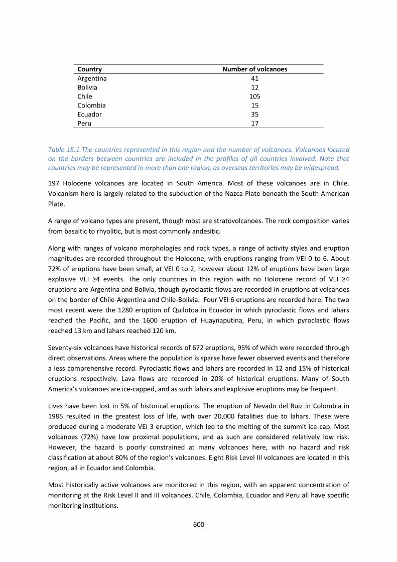
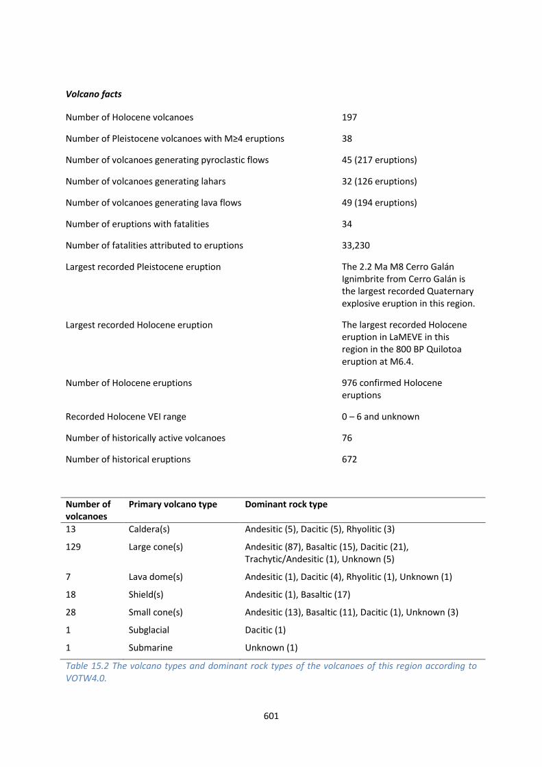
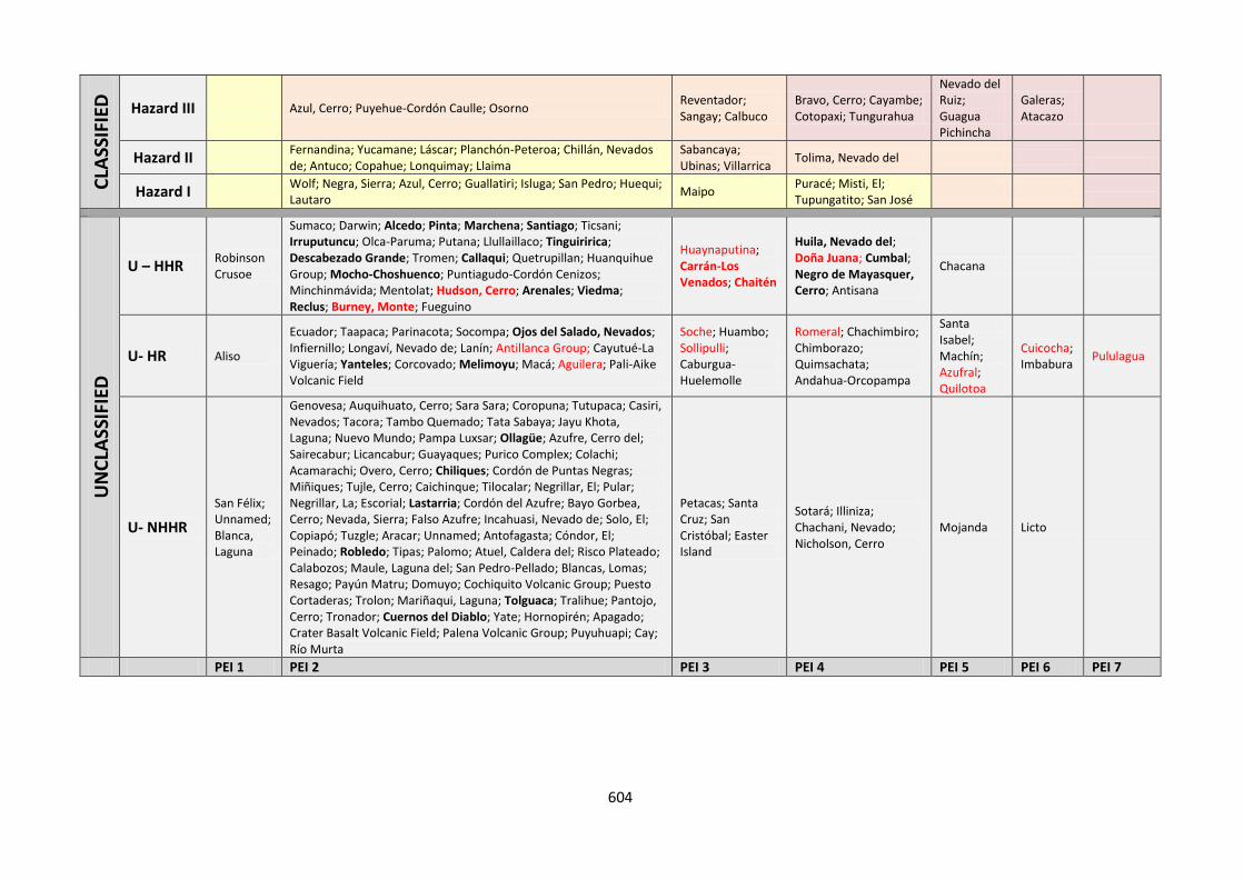
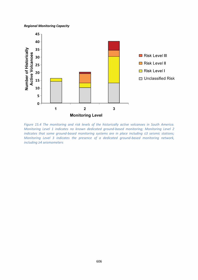
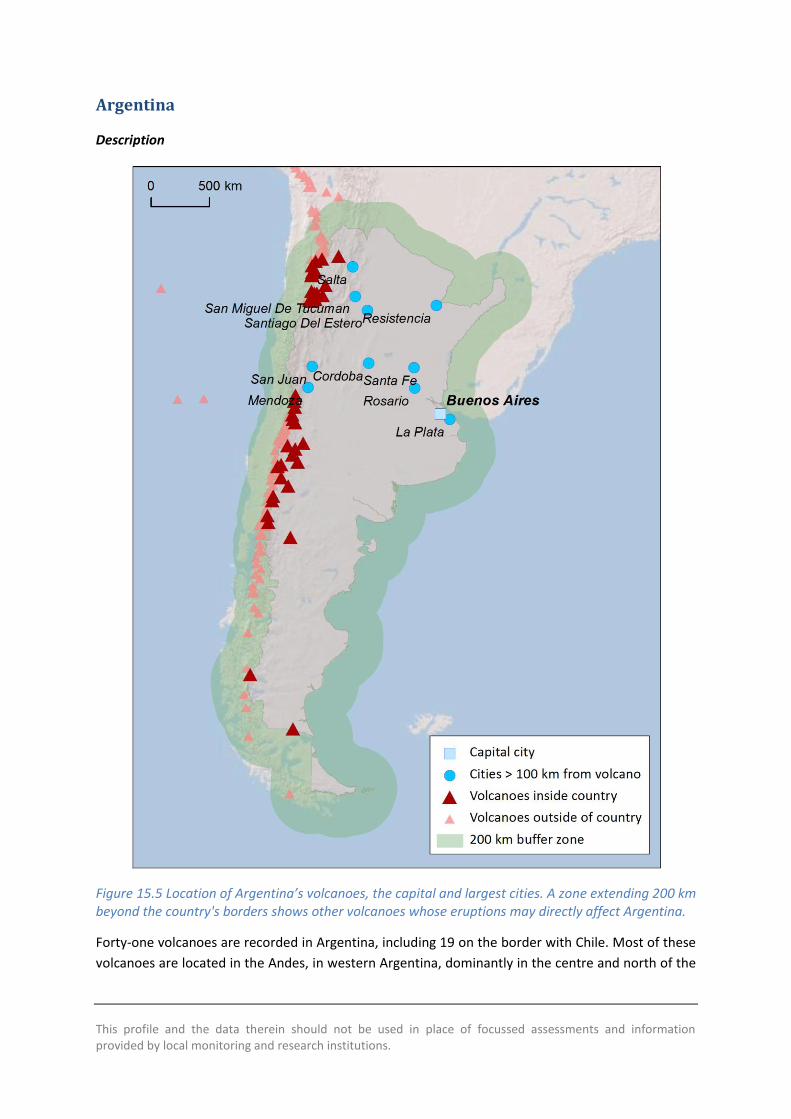
This profile and the data therein should not be used in place of focussed assessments and information provided by local monitoring and research institutions
Argentina
Description
Figure 155 Location of Argentinarsquos volcanoes the capital and largest cities A zone extending 200 km beyond the countrys borders shows other volcanoes whose eruptions may directly affect Argentina
Forty-one volcanoes are recorded in Argentina including 19 on the border with Chile Most of these
volcanoes are located in the Andes in western Argentina dominantly in the centre and north of the
608
country Volcanism here is largely due to the subduction of the Nazca Plate beneath the South
American Plate A range of volcano types are present here though most are stratovolcanoes of
dominantly andesitic composition
Large explosive Pleistocene activity is recorded in Argentina and 61 eruptions of Holocene age are
recorded from 13 volcanoes The remaining Holocene volcanoes have activity that is suspected to
have occurred in the last 10000 years Of these Holocene eruptions 47 are of historical age
occurring at 8 volcanoes VOTW422 records Holocene eruptions of VEI 0 to 3 indicating a
prevalence of mild to moderate activity However recent studies have identified two Holocene VEI
ge6 eruptions from Cerro Blanco-Robledo volcanic complex with the caldera forming eruption being
one of the largest Holocene eruptions in the central Andes at approximately 4500 BP (Baez et al
2015) Just one eruption that of Copahue in 2000 has a recorded historical pyroclastic flow During
this event pyroclastic flows scoria and ash fall occurred and evacuations were ordered with damage
occurring to property
Many of the most populous cities in Argentina are located far to the east of the volcanic chain and
the elevation of much of the Andes means that local populations are small Indeed less than 2000
people live within 10 km of a Holocene volcano in the whole of Argentina and less than 2 of the
total population live within 100 km of one or more volcanoes (under 700000) Although the hazard
classification at many of Argentinarsquos volcanoes is complicated by large uncertainties the small local
populations mean that these volcanoes are considered relatively low risk to proximal populations
However the dominant wind direction is such that ash will commonly be distributed west to east
across much of Argentina from eruptions in the far west of the country
The Chilean volcanoes beyond the border are also very important to the hazard consideration in
Argentina Explosive eruptions of these volcanoes can produce ash clouds with ash dispersal
throughout Argentina Indeed the dominant wind direction here is west to east leading to ash fall in
Argentina in most Chilean eruptions (Viramonte et al 2001) There are many examples of this
(Figure 156) For example the 2008 eruption of Chaiteacuten produced ash fall beyond the Argentine
coast (Folch et al 2008 Durant et al 2012) and the 2011 eruption of Cordoacuten Caulle resulted in
significant ash fall across three Argentine provinces (Riacuteo Negro Neugueacuten and Chubut) (Collini et al
2012) Both eruptions had negative impacts on farming (livestock) and agriculture water
transportation networks and air and ground transportation networks (Collini et al 2012) See the
profile for Chile for further discussion of the Chilean volcanoes
Ash remobilisation can occur for years after an eruption due to wind and rain and this can cause
issues even in times of inactivity at the volcanoes therefore ash distribution throughout the country
must be understood both from Argentine and Chilean volcanoes
Authorities in Argentina especially SEGEMAR (Servicio Geologico y Minero Argentino) Comisioacuten
Nacional de Riesgos Ministerio de Ciencia Tecnologiacutea e Innovacioacuten Productiva (MINCyT) and the
Argentine Space Agency (CONAE) collaborate with the Servicio Nacional de Geologia y Mineria
(SERNAGEOMIN) in Chile for monitoring of the border volcanoes Seismic and deformation
monitoring is in place as are cameras for visual observations Universidad Nacional de Riacuteo Negro in
collaboration with Firenze University maintain temporary seismic array for volcanic monitoring in
several potential dangerous volcanoes (Copahue Domuyo Tromen) Universidad Nacional de Salta
in collaboration with Universidad de Cadiz maintains a high resolution GPS network in the Cerro
609
Blanco-Robledo caldera comnplex for deformation monitoring Servicio Meteoroloacutegico Nacional
Universidad Nacional de Salta CONICET and CONAE in cooperation with VAAC Buenos Aires work to
give early alerts and ash-fall dispersion forecasts Alerts are released and evacuations ordered as
unrest and eruption occurs SERNAGEOMIN also monitor most volcanoes within Chile releasing
alerts that can be used in ash forecasts for Argentina
Figure 156 The active volcanoes of the central and southern Andes and ash dispersal across
Argentina from recent eruptions of Chilean volcanoes Modified after Viramonte et al 2001
610
References
Baez W Arnosio M Chiodi A Ortiz-Yanes A Viramonte JG Bustos E Giordano G and Lopez
JF (2015) Estratigrafiacutea y evolucioacuten del Complejo Volcaacutenico Cerro Blanco Puna Austral Argentina
Revista Mexicana de Ciencias Geoloacutegicas
rmcggeocienciasunammxrevistamrevistaphpidioma=Eampnumero=X
Collini E Soledad Osores M Folch A Viramonte JG Villarosa G And Salmuni G (2012) Volcanic
ash forecast during the June 2011 Cordon Caulle eruption Natural Hazards 662 389-412
Durant A Villarosa G Rose WI Delmelle P Prata AJ Viramonte JG (2012) Long-range
volcanic ash transport and fallout during the 2008 eruption of Chaiten volcano Chile Physics and
Chemistry of the EarthParts ABC 45-46 50-64
Folch A Jorba O amp J Viramonte 2008 Volcanic Ash Forecast- Application to the May 2008
Chaiteacuten Eruption Natural Hazard and Earth System Sciences 8 927-940
Viramonte JG Peralta CM Garrido D and Felpeto A (2001) Uso de sensores remotos para la
mitigacioacuten de efectos causados por erupciones volcaacutenicas Elaboracioacuten de mapas de Riesgo
volcaacutenico y alertas para la aeronavegacioacuten Un caso de estudio
wwwconaegovarWEB_EmergenciasLinks_del_Cuerpo_PrincipalVolcanesInforme20Riesgo20
Volcanicohtm
Volcano Facts
Number of Holocene volcanoes 41 inclusive of 19 on the border with Chile
Number of Pleistocene volcanoes with Mge4 eruptions 6 inclusive of 3 on the border with Chile
Number of volcanoes generating pyroclastic flows 4
Number of volcanoes generating lahars 2
Number of volcanoes generating lava flows 6
Number of fatalities caused by volcanic eruptions -
Tectonic setting 37 subduction zone 4 intra-plate
Largest recorded Pleistocene eruption The M8 eruption of the Cerro Galaacuten Ignimbrite from Cerro Galaacuten at 208 Ma
Largest recorded Holocene eruption Recent studies reveal that Cerro Blanco ndash Robledo caldera has had the most powerful Holocene eruption in ~4500 BP and at VEI ge6 (Baez et al 2015)
611
Number of Holocene eruptions 61 confirmed eruptions 14 uncertain and 2 discredited eruptions
Recorded Holocene VEI range 0 ndash 3 in VOTW422 with VEI ge6 indicated by recent studies (Baez et al 2015)
Number of historically active volcanoes 8
Number of historic eruptions 47
Number of volcanoes
Primary volcano type Dominant rock type
3 Caldera(s) Andesitic (2) Rhyolitic (1)
28 Large cone(s) Andesitic (13) Basaltic (4) Dacitic (7) Unknown (4)
1 Lava dome(s) Dacitic (1)
1 Shield(s) Basaltic (1)
7 Small cone(s) Andesitic (3) Basaltic (4)
1 Subglacial Dacitic (1)
Table 157 The number of volcanoes in Argentina their volcano type classification and dominant rock type according to VOTW40
Socio-Economic Facts
Total population (2012) 41117000
Gross Domestic Product (GDP) per capita (2005 PPP $) 15501
Gross National Income (GNI) per capita (2005 PPP $) 15347
Human Development Index (HDI) (2012) 0811 (Very High)
Population Exposure
Capital city Buenos Aires
Distance from capital city to nearest Holocene volcano 9741 km
Total population (2011) 41769726
Number (percentage) of people living within 10 km of a Holocene volcano
1809 (lt1)
612
Number (percentage) of people living within 30 km of a Holocene volcano
26905 (lt1)
Number (percentage) of people living within 100 km of a Holocene volcano
618387 (15)
Ten largest cities as measured by population and their population size
Buenos Aires 13076300 Cordoba 1428214 Rosario 1173533 Mendoza 876884 San Miguel De Tucuman 781023 La Plata 694167 Salta 512686 Santa Fe 468632 San Juan 447048 Resistencia 387158
Infrastructure Exposure
Number of airports within 100 km of a volcano 2
Number of ports within 100 km of a volcano 1
Total length of roads within 100 km of a volcano (km) 4638
Total length of railroads within 100 km of a volcano (km) 278
Volcanoes in Argentina occur along the western border of the country on the border with Chile
Volcanoes here are located in three main groups in the north centre and south Many of the border
volcanoes here have 100 km radii that extend into Chile and likewise the radii of Chilean volcanoes
extend into western Argentina The capital Buenos Aires lies in the east of the country at nearly
1000 km distance to the nearest Holocene volcano and most of the largest cities in the country lie
far east of the volcanic chain Only the southernmost Palei-Aike volcano is located near the coast
exposing ports and an airport here An extensive road and rail network lies within the radii of the
volcanoes throughout the country
613
Figure 157 The location of Argentinarsquos volcanoes and the extent of the 100 km zone surrounding them Ports airports and the major cities are just some of the infrastructure that may be exposed to volcanic hazards
Hazard Uncertainty and Exposure Assessments
There are varying levels of information available in the eruption records of Argentinarsquos volcanoes
Just four out of 41 have sufficient detail to define the hazard through the calculation of the VHI
These are classified at Hazard Levels I and II
614
Of the unclassified volcanoes 28 have no confirmed eruptions in the Holocene record Nine have a
Holocene record including historical events at Llullaillaco Tromen Huanquihue Group and Viedma
The latter has recorded eruptions since 1900 AD Unrest has been recorded at a further three
unclassified volcanoes
The PEI in Argentina is classed as low to moderate with most volcanoes having a PEI of 2 All
classified volcanoes here are classed at Risk Level I Given the low population all unclassified
volcanoes would be classed at Risk Levels I and II were the hazard known
615
CLA
SSIF
IED
Hazard III
Hazard II
Copahue
Hazard I Maipo Tupungatito San Joseacute
UN
CLA
SSIF
IED
U ndash HHR Llullaillaco Tromen Huanquihue Group Viedma
U- HR Socompa Nevados Ojos del Salado Infiernillo Laniacuten Pali-Aike Volcanic Field Cerro Blanco-Robledo complex
U- NHHR
Blanca Laguna
Escorial Lastarria Cordoacuten del Azufre Bayo Gorbea Cerro Nevada Sierra Falso Azufre Incahuasi Nevado de Solo El Tuzgle Aracar Unnamed Antofagasta Coacutendor El Peinado Tipas Atuel Caldera del Risco Plateado Payuacuten Matru Domuyo Cochiquito Volcanic Group Puesto Cortaderas Trolon Tralihue Pantojo Cerro Tronador Crater Basalt Volcanic Field
PEI 1 PEI 2 PEI 3 PEI 4 PEI 5 PEI 6 PEI 7 Table 158 Identity of Argentinarsquos volcanoes in each Hazard-PEI group Those volcanoes with a sufficient record for determining a hazard score are deemed lsquoClassifiedrsquo (top) Those without sufficient data are lsquoUnclassifiedrsquo (bottom) The unclassified volcanoes are divided into groups U-NHHR is Unclassified No Historic or Holocene Record that is there are no confirmed eruptions recorded in the Holocene U-HR is Unclassified with Holocene Record that is there are confirmed eruptions recorded during the Holocene but no historical (post-1500) events U-HHR is Unclassified with Historic and Holocene record The unclassified volcanoes in bold have experienced unrest or eruptions since 1900 AD and those in red have records of at least one Holocene VEI ge4 eruption
Note that Robledo had no eruptions recorded in VOTW422 but recent studies have identified a large explosive Holocene at this volcano (Baez et al 2015) and so its entry has been adjusted here from U-NHHR to U-HR
616
Volcano Population Exposure Index Risk Level
San Joseacute 4 I Tupungatito 4 I Maipo 3 I Copahue 2 I
Table 159 Classified volcanoes of Argentina ordered by descending Population Exposure Index (PEI) Risk levels determined through the combination of the Hazard Level and PEI are given Risk Level I ndash 4 volcanoes Risk Level II ndash 0 volcanoes Risk Level III ndash 0 volcanoes
Figure 158 Distribution of Argentinarsquos classified volcanoes across Hazard and Population Exposure Index levels The warming of the background colours illustrates increasing Risk levels from Risk Level I - III
National Capacity for Coping with Volcanic Risk
Eight volcanoes in Argentina inclusive of those on the border with Chile have records of historical
activity Four are classified at Risk Level I (Tupungatito San Joseacute Maipo Copahue) and four are
unclassified with a PEI of 2 (Llullaillaco Tromen Huanquihue Group and Viedma) At the time of the
writing of this report no information is available to indicate that dedicated ground-based monitoring
is in place the four unclassified volcanoes However SERNAGEOMIN in Chile operate monitoring
systems at four of the border volcanoes with seismic and deformation monitoring at Copahue
Maipo Tupungatito and San Joseacute
617
Figure 159 The monitoring and risk levels of the historically active volcanoes in Argentina Monitoring Level 1 indicates no known dedicated ground-based monitoring Monitoring Level 2 indicates that some ground-based monitoring systems are in place including le3 seismic stations Monitoring Level 3 indicates the presence of a dedicated ground-based monitoring network including ge4 seismometers
This profile and the data therein should not be used in place of focussed assessments and information provided by local monitoring and research institutions
Bolivia
Description
Figure 1510 Location of Boliviarsquos volcanoes the capital and largest cities A zone extending 200 km beyond the countrys borders shows other volcanoes whose eruptions may directly affect Bolivia
Twelve Holocene volcanoes are located in Bolivia including seven on the border with Chile
Volcanism here is largely due to the subduction of the Nazca Plate beneath the South American
Plate A variety of volcano forms have developed here with stratovolcanoes being the most
common The composition varies from basaltic to rhyolitic though andesitic compositions are most
common
619
Very large explosive eruptions are recorded back into the Pleistocene but the Holocene record is
sparse with just seven confirmed eruptions Two of these were recorded historically in 1865 at
Olca-Paruma and in 1995 at Irruputuncu This latter eruption is the largest recorded in the
Holocene at just VEI 2
The sparse nature of the eruptive record suggests that the hazard (the VHI) is poorly constrained
however the volcanoes of Bolivia are remote with the most populous cities located to the east Only
a small number of people live in close proximity to Holocene volcanoes in Bolivia with about 3000
in total within 10 km and less than 500000 within 100 km of these volcanoes As such current
understanding suggests that these volcanoes are of relatively low risk
There is no official monitoring institution in Bolivia however SERNAGEOMIN in Chile monitors the
border volcanoes Two part-time scientists at the Universidad Mayor de San Andres undertaken
volcanic research in Bolivia and they advise that there are no current response protocols in place for
developing unrest or eruption largely due to the remote nature of the volcanoes They suggest that
infrastructure is at risk with highways (the Oruro-Pisiga and Patacamaya-Tambo Quemado
highway) railways (the Arica line) and an electricity generating station near Nuevo Mundo
highlighted as being exposed
Volcano Facts
Number of Holocene volcanoes 12 inclusive of 7 on the border with Chile
Number of Pleistocene volcanoes with Mge4 eruptions -
Number of volcanoes generating pyroclastic flows 1
Number of volcanoes generating lahars -
Number of volcanoes generating lava flows 1
Number of fatalities caused by volcanic eruptions -
Tectonic setting Subduction zone
Largest recorded Pleistocene eruption The M72 eruption of Laguna Colorado at 19 Ma
Largest recorded Holocene eruption The VEI 2 eruption of Irruputuncu in 1995 AD
Number of Holocene eruptions 7 confirmed eruptions 2 uncertain eruptions
Recorded Holocene VEI range 0 ndash 2
Number of historically active volcanoes 2
Number of historic eruptions 2
620
Number of volcanoes
Primary volcano type Dominant rock type
1 Caldera(s) Rhyolitic (1)
7 Large cone(s) Andesitic (7)
2 Lava dome(s) Dacitic (2)
2 Small cone(s) Andesitic (1) Basaltic (1)
Table 1510 The number of volcanoes in Bolivia their volcano type classification and dominant rock type according to VOTW40
Socio-Economic Facts
Total population (2012) 10523000
Gross Domestic Product (GDP) per capita (2005 PPP $) 4499
Gross National Income (GNI) per capita (2005 PPP $) 4444
Human Development Index (HDI) (2012) 0675 (Medium)
Population Exposure
Capital city Sucre
Distance from capital city to nearest Holocene volcano 1521 km
Total population (2011) 10118683
Number (percentage) of people living within 10 km of a Holocene volcano
3098 (lt1)
Number (percentage) of people living within 30 km of a Holocene volcano
29479 (lt1)
Number (percentage) of people living within 100 km of a Holocene volcano
465904 (46)
Largest cities as measured by population and their population size
Santa Cruz de La Sierra 1364389 Cochabamba 900414 La Paz 812799 Sucre 224838 Oruro 208684 Tarija 159269 Potosi 141251
621
Trinidad 84259 Cobija 26585
Infrastructure Exposure
Number of airports within 100 km of a volcano 0
Number of ports within 100 km of a volcano 0
Total length of roads within 100 km of a volcano (km) 908
Total length of railroads within 100 km of a volcano (km) 282
The volcanoes are situated in a chain along much of the western border of Bolivia and Chile The 100
km radii of these volcanoes fully encompasses this border and extends into Chile Peru and
Argentina Similarly the border volcanoes in these countries have 100 km radii that extend into
Bolivia The capital Sucre lies at over 150 km from the nearest Holocene volcano The volcanoes in
Bolivia are relatively remote but with numerous small settlements and an extensive road network
lying within their 100 km radii
622
Figure 1511 The location of Boliviarsquos volcanoes and the extent of the 100 km zone surrounding them Ports airports and the major cities are just some of the infrastructure that may be exposed to volcanic hazards
Hazard Uncertainty and Exposure Assessments
The eruption records for Boliviarsquos volcanoes lack sufficient detail to determine hazard levels through
the calculation of the VHI These volcanoes are therefore unclassified Indeed of the twelve
volcanoes here just three have a confirmed Holocene record of eruptions including historical
activity at Irruputuncu and Olca-Paruma Eruptions and unrest have been recorded at these two
volcanoes since 1900 AD respectively
The PEI at all Bolivian volcanoes is low at PEI 2 The absence of a hazard classification prevents
determination of risk levels however this low local populations suggests risk levels of I and II
623
CLA
SSIF
IED
Hazard III
Hazard II
Hazard I
UN
CLA
SSIF
IED
U ndash HHR
Irruputuncu Olca-Paruma
U- HR Parinacota
U- NHHR
Tambo Quemado Tata Sabaya Jayu Khota Laguna Nuevo Mundo Pampa Luxsar Ollaguumle Sairecabur Licancabur Guayaques
PEI 1
PEI 2 PEI 3 PEI 4 PEI 5 PEI 6 PEI 7
Table 1511 Identity of Boliviarsquos volcanoes in each Hazard-PEI group Those volcanoes with a sufficient record for determining a hazard score are deemed lsquoClassifiedrsquo (top) Those without sufficient data are lsquoUnclassifiedrsquo (bottom) The unclassified volcanoes are divided into groups U-NHHR is Unclassified No Historic or Holocene Record that is there are no confirmed eruptions recorded in the Holocene U-HR is Unclassified with Holocene Record that is there are confirmed eruptions recorded during the Holocene but no historical (post-1500) events U-HHR is Unclassified with Historic and Holocene record The unclassified volcanoes in bold have experienced unrest or eruptions since 1900 AD and those in red have records of at least one Holocene VEI ge4 eruption
National Capacity for Coping with Volcanic Risk
Two volcanoes on the Bolivia-Chile border have historical records of activity Monitoring undertaken
by SERNAGEOMIN in Chile is described at both these volcanoes however the details are unknown
624
Figure 1512 The monitoring and risk levels of the historically active volcanoes in Bolivia Monitoring Level 1 indicates no known dedicated ground-based monitoring Monitoring Level 2 indicates that some ground-based monitoring systems are in place including le3 seismic stations Monitoring Level 3 indicates the presence of a dedicated ground-based monitoring network including ge4 seismometers
This profile and the data therein should not be used in place of focussed assessments and information provided by local monitoring and research institutions
Chile
Description
Figure 1513 Location of Chilersquos volcanoes the capital and largest cities A zone extending 200 km beyond the countrys borders shows other volcanoes whose eruptions may directly affect Chile
There are 105 volcanoes in Chile including nearly 30 on the borders within Argentina Bolivia and
Peru Several groups of volcanoes are present with scattered remote volcanoes in the very far
south a large concentration of volcanic centres south of Santiago and north of Copiapo and Chilean
626
islands in the Pacific Ocean Volcanism through Chile is primarily due to the subduction of the Nazca
Plate beneath the South American Plate and intra-plate processes in the Pacific
A range of volcano types are present throughout Chile though stratovolcanoes are most common
with about three quarters of volcanoes here being classified as such The rock type also varies from
basaltic to rhyolitic however andesitic compositions are most common
Large explosive Pleistocene activity is recorded in Chile at 20 volcanoes The largest Pleistocene
eruptions were of magnitude 74 with three eruptions of this size at Calabozos caldera about
150000 300000 and 800000 years ago Holocene activity has occurred here and hot springs are
still active within the caldera
Holocene activity in Chile has included 476 confirmed eruptions from 56 volcanoes The remaining
volcanoes have activity of suspected Holocene age Holocene activity has comprised a range of
activity styles and sizes with eruptions from VEI 0 to 6 though only about 5 of these were VEI ge4
Historically 40 volcanoes are recorded producing 357 eruptions Of these 8 were VEI ge4 though
pyroclastic flows are recorded in 16 eruptions Lava flows have more commonly been recorded and
14 of eruptions have resulted in lahars The largest historical eruption in Chile occurred at Cerro
Azul in 1916 This VEI 5 eruption ejected 95 cubic kilometres of tephra and was one of the worldrsquos
largest eruptions in the 20th century
Only a small total population is situated within 10 km of one or more Holocene volcanoes in Chile
however this grows considerably at 30 km and to about 106 million at 100 km accounting for about
63 of the population Ten historic eruptions have resulted in loss of life at Lonquimay Llaima
Villarrica Carran-Los Venados Chaiten and Cerro Hudson
The Red de Vigilancia Volcanic (Volcano monitoring network) and the Observatorio Volcanologico de
Los Andes del Sur (OVDAS) are part of the Servicio Nacional de Geologia y Mineria (SERNAGEOMIN)
This body is government funded and was founded in 1996 The main objective of these groups is to
establish monitoring systems and monitor the most dangerous volcanoes in Chile (based on the
frequency of activity proximity to population centres and vulnerability of public and private
infrastructure) in order to provide information to the relevant authorities
Monitoring is undertaken at many volcanoes using seismic networks cameras deformation and gas
measurements Success of the network has been proven in the eruption of Puyehue-Cordon Caulle
and alerts at Hudson and Copahue Resources and plans are available for responding to developing
unrest and eruption at current un- or under-monitored volcanoes
Scientific technical and support staff are present at the monitoring institution and about 20 of
these have experience of responding to activity however large amounts of data are gathered and
further scientific experience and support is required for full analysis
Regular technical meetings are held in the event of increased activity and an informal response
protocol is followed including alerting the regional VAAC The Oficina Nacional de Emergencia del
Ministerio del Interior y Seguridad Puacuteblica (ONEMI) coordinates emergency response OVDAS
communicates hazard assessments and alerts to ONEMI who use a civil protection alert system
627
A relative threat ranking is produced by SERNAGEOMIN for the volcanoes of Chile This is similar to
the NVEWS method and VHI using hazard indicators taken from the records and coupling these with
exposure factors The relative threat is the sum of the hazard times sum of exposure This ranking system
indicates that Villarrica and Llaima have the largest relative threat ranking with these volcanoes
being the most frequently active here with 126 historical eruptions between them coupled with
large populations within 100 km
A questionnaire was completed by SERNAGEOMIN as part of this study This indicated that a number
of volcano records in VOTW40 require updating with some volcanoes considered Holocene age in
VOTW40 but designated as Pleistocene age by SERNAGEOMIN This highlights the value of close
collaboration between the volcanological community to ensure up-to-date and sustainable data
systems Updates will be considered by the Smithsonian Institution
See also
SERNAGEOMIN wwwsernageominclvolcan-observatoriophp
Volcano Facts
Number of Holocene volcanoes 105 inclusive of 19 on the border with Argentina 7 on the border with Bolivia and 1 on the border with Peru
Number of Pleistocene volcanoes with Mge4 eruptions 20 inclusive of 3 on the border with Argentina
Number of volcanoes generating pyroclastic flows 19
Number of volcanoes generating lahars 13
Number of volcanoes generating lava flows 25
Number of fatalities caused by volcanic eruptions 473
Tectonic setting 101 Subduction zone 3 Intra-plate 1 Rift zone
Largest recorded Pleistocene eruption The Loma Seca Tuff units S V and L from Calabozos are all recorded at M74 at 150 ka 300 ka and 800 ka respectively
Largest recorded Holocene eruption The M63 H1T2 eruption from Cerro Hudson at 7710 BP
Number of Holocene eruptions 476 confirmed eruptions 74 uncertain and 9 discredited eruptions
Recorded Holocene VEI range 0 ndash 6 and unknown
Number of historically active volcanoes 40
628
Number of historic eruptions 357
Number of volcanoes
Primary volcano type Dominant rock type
6 Caldera(s) Andesitic (3) Dacitic (2) Rhyolitic (1)
78 Large cone(s) Andesitic (51) Basaltic (12) Dacitic (12) Unknown (3)
2 Lava dome(s) Andesitic (1) Dacitic (1)
3 Shield(s) Basaltic (3)
15 Small cone(s) Andesitic (5) Basaltic (7) Dacitic (1) Unknown (2)
1 Submarine Unknown (1)
Table 1512 The number of volcanoes in Chile their volcano type classification and dominant rock type according to VOTW40
Socio-Economic Facts
Total population (2012) 17479000
Gross Domestic Product (GDP) per capita (2005 PPP $) 15272
Gross National Income (GNI) per capita (2005 PPP $) 14987
Human Development Index (HDI) (2012) 0819 (Very High)
Population Exposure
Capital city Santiago
Distance from capital city to nearest Holocene volcano 805 km
Total population (2011) 16888760
Number (percentage) of people living within 10 km of a Holocene volcano
21030 (lt1)
Number (percentage) of people living within 30 km of a Holocene volcano
208768 (12)
Number (percentage) of people living within 100 km of a Holocene volcano
10623259 (629)
Ten largest cities as measured by population and their population size
Santiago 4837295 Antofagasta 309832 Valparaiso 282448 Temuco 238129
629
Iquique 227499 Concepcion 215413 Talca 197479 Puerto Montt 160054 La Serena 154521 Copiapo 129280
Infrastructure Exposure
Number of airports within 100 km of a volcano 10
Number of ports within 100 km of a volcano 8
Total length of roads within 100 km of a volcano (km) 16196
Total length of railroads within 100 km of a volcano (km) 2139
The numerous volcanoes of Chile are located primarily along the countryrsquos eastern border with
Argentina Bolivia and Peru and as such the 100 km radii of these volcanoes extend into these
neighbouring countries Similarly volcanoes near the borders in these countries have radii extending
into Chile exposing the infrastructure here Several volcanoes are situated in the Pacific off the coast
of Chile The capital Santiago lies within 100 km of the historically active Tupungatito and San Joseacute
volcanoes hence considerable critical infrastructure is exposed here Being a relatively narrow
stretch of land much of southern Chile lies within 100 km of Holocene volcanoes and many ports
are exposed here A very extensive road and rail network is exposed throughout the country and
many of the countryrsquos largest cities lie within 100 km
630
Figure 1514 The location of Chilersquos volcanoes and the extent of the 100 km zone surrounding them Ports airports and the major cities are just some of the infrastructure that may be exposed to volcanic hazards
Hazard Uncertainty and Exposure Assessments
There are varying levels of information available in the eruption records of Chilersquos volcanoes About
20 of the volcanoes here (20 out of 105) have sufficient detail to define the hazard through the
calculation of the VHI These are classified across all three hazard levels with most being classed at
Hazard Levels I and II Four volcanoes are classed at Hazard Level III all with Holocene records of
eruptions of VEI 4 and 5 and all with records of explosive volcanism accompanied by the production
of pyroclastic flows
631
Of the unclassified volcanoes 49 have no records of confirmed Holocene age eruptions 36
volcanoes have a Holocene eruption record of which 20 have erupted historically (post-1500 AD)
including eruptions since 1900 AD at 11 volcanoes Unrest is described at nine unclassified volcanoes
since 1900 AD Seven unclassified volcanoes have Holocene records of large explosive VEI ge4
eruptions
The PEI ranges from 1 to 4 low to moderate in Chile with an overwhelming majority at PEI 2 The
classified volcanoes are therefore Risk Levels of I and II Although the risk levels cannot be defined
for the unclassified volcanoes due to the absence of hazard details these would all also be clased at
Risk Level I and II
632
CLA
SSIF
IED
Hazard III
Cerro Azul Puyehue-Cordoacuten Caulle Osorno Calbuco
Hazard II
Laacutescar Planchoacuten-Peteroa Chillaacuten Nevados de Antuco Copahue Lonquimay Llaima
Villarrica
Hazard I
Guallatiri Isluga San Pedro Huequi Lautaro Maipo Tupungatito San Joseacute
UN
CLA
SSIF
IED
U ndash HHR Robinson Crusoe
Irruputuncu Olca-Paruma Putana Llullaillaco Tinguiririca Descabezado Grande Callaqui Quetrupillan Mocho-Choshuenco Puntiagudo-Cordoacuten Cenizos Minchinmaacutevida Mentolat Cerro Hudson Arenales Reclus Monte Burney Fueguino
Carraacuten-Los Venados Chaiteacuten
U- HR
Taapaca Parinacota Socompa Nevados Ojos del Salado Longaviacute Nevado de Laniacuten Antillanca Group Cayutueacute-La Vigueriacutea Yanteles Corcovado Melimoyu Macaacute Aguilera Pali-Aike Volcanic Field
Sollipulli Caburgua-Huelemolle
U- NHHR
San Feacutelix Unnamed
Tacora Ollaguumle Azufre Cerro del Sairecabur Licancabur Guayaques Purico Complex Colachi Acamarachi Overo Cerro Chiliques Cordoacuten de Puntas Negras Mintildeiques Tujle Cerro Caichinque Tilocalar Negrillar El Pular Negrillar La Escorial Lastarria Cordoacuten del Azufre Bayo Gorbea Cerro Nevada Sierra Falso Azufre Incahuasi Nevado de Solo El Copiapoacute Palomo Calabozos Maule Laguna del San Pedro-Pellado Blancas Lomas Resago Marintildeaqui Laguna Tolguaca Pantojo Cerro Tronador Cuernos del Diablo Yate Hornopireacuten Apagado Palena Volcanic Group Puyuhuapi Cay Riacuteo Murta
Easter Island
PEI 1 PEI 2 PEI 3 PEI 4 PEI 5 PEI 6 PEI 7 Table 1513 Identity of Chilersquos volcanoes in each Hazard-PEI group Those volcanoes with a sufficient record for determining a hazard score are deemed lsquoClassifiedrsquo (top) Those without sufficient data are lsquoUnclassifiedrsquo (bottom) The unclassified volcanoes are divided into groups U-NHHR is Unclassified No Historic or Holocene Record that is there are no confirmed eruptions recorded in the Holocene U-HR is Unclassified with Holocene Record that is there are confirmed eruptions recorded during the Holocene but no historical (post-1500) events U-HHR is Unclassified with Historic and Holocene record The unclassified volcanoes in bold have experienced unrest or eruptions since 1900 AD and those in red have records of at least one Holocene VEI ge4 eruption
633
Volcano Population Exposure Index Risk Level
Tupungatito 4 I San Joseacute 4 I Villarrica 3 II Calbuco 3 II Maipo 3 I Azul Cerro 2 II Puyehue-Cordoacuten Caulle 2 II Osorno 2 II Guallatiri 2 I Isluga 2 I San Pedro 2 I Laacutescar 2 I Planchoacuten-Peteroa 2 I Chillaacuten Nevados de 2 I Antuco 2 I Copahue 2 I Lonquimay 2 I Llaima 2 I Huequi 2 I Lautaro 2 I
Table 1514 Classified volcanoes of Chile ordered by descending Population Exposure Index (PEI) Risk levels determined through the combination of the Hazard Level and PEI are given Risk Level I ndash 15 volcanoes Risk Level II ndash 5 volcanoes Risk Level III ndash 0 volcanoes
Figure 1515 Distribution of Chilersquos classified volcanoes across Hazard and Population Exposure Index levels The warming of the background colours illustrates increasing Risk levels from Risk Level I - III
634
National Capacity for Coping with Volcanic Risk
Forty volcanoes have records of historical activity in Chile These volcanoes are primarily classed at
Risk Level I All Risk Level II historical volcanoes are monitored by SERNAGEOMIN using seismic
stations as a minimum Many volcanoes also have deformation monitoring
Figure 1516 The monitoring and risk levels of the historically active volcanoes in Chile Monitoring Level 1 indicates no known dedicated ground-based monitoring Monitoring Level 2 indicates that some ground-based monitoring systems are in place including le3 seismic stations Monitoring Level 3 indicates the presence of a dedicated ground-based monitoring network including ge4 seismometers
This profile and the data therein should not be used in place of focussed assessments and information provided by local monitoring and research institutions
Colombia
Description
Figure 1517 Location of Colombiarsquos volcanoes the capital and largest cities A zone extending 200 km beyond the countrys borders shows other volcanoes whose eruptions may directly affect Colombia
Fifteen Holocene volcanoes are distributed through the northern Andes in western Colombia to the
Ecuador border paralleling the Pacific coastline These volcanoes are related to the subduction of
the Nazca Plate beneath the South American Plate
All Holocene volcanoes in Colombia form edifices typically associated with explosive-type activity
including stratovolcanoes and complex volcanoes with the exception of the Petacas lava dome and
636
Santa Isabel shield The Colombian volcanoes are dominantly andesitic in composition The explosive
record continues into the Pleistocene with three Colombian volcanoes hosting MVEI ge4 eruptions
in this period
There are 125 confirmed eruptions recorded in the Holocene at VEI 1 to 5 indicating a range of
activity from mild to strongly explosive Eight volcanoes have a Holocene record of producing
pyroclastic flows and six are associated with lahars Nine of the Colombian volcanoes have 79
eruptions recorded in historical times
Many of Colombiarsquos most populous cities are located on or towards the northern coast away from
volcanoes however the cities of Cali Ibague Pasto and Pereira lie within 100 km of one or more
Holocene volcanoes with the latter three over-looked by Machin Galeras and the Ruiz-Tolima chain
Numerous eruptions of Nevado del Ruiz Nevado del Huila Puraceacute and Galeras have resulted in
evacuations and property damage Fatalities are recorded in nine eruptions of these volcanoes and
Dontildea Juana
The assessment of hazard is complicated by sparse eruptive histories at over half of Colombiarsquos
volcanoes resulting in hazard levels with large associated uncertainties hence just five volcanoes
have a hazard level classified here Nevado del Ruiz Galeras and Cerro Bravo are classed with the
highest hazard in Colombia based on detailed eruptive histories Coupled with the high proximal
population these volcanoes are classed at Risk Level III
Both Galeras and Nevado del Ruiz have caused loss of life Machiacuten has not caused any fatalities but
has shown recent unrest and its geological record indicates the potential for violent and destructive
explosive eruptions In 1993 a sudden intense but small magnitude explosive eruption of Galeras
killed nine people including six volcanologists who were in the inner crater or on its rim A far larger
disaster the largest in South Americarsquos history was the 1985 eruption of Nevado del Ruiz Though
only VEI 3 the eruption generated pyroclastic flows that melted the volcanorsquos glacier cap and caused
lahars The mudflows descended the western flanks flowing along the Riacuteo Lagunillas valley The
town of Armero located on the banks of Riacuteo Lagunillas 48 km from the volcano was completely
buried Though the death toll is uncertain it is estimated that 21000 of the 29000 residents of
Armero were killed along with others elsewhere bringing the total loss of life to between 23000
and 26000
Further eruptions with human impacts have occurred very recently at Galeras volcano An eruption
starting on 25th August 2010 spread ash as far as 30 km to the northwest 7000 people were
advised to evacuate though few left their homes Activity did not increase after this until January
2011
Eruptions at a number of the northernmost volcanoes in Ecuador may directly affect Colombia as
they lie within 100 km of the border Similarly Galeras Cumbal and Azufral lie within 100 km of
Ecuador
Following the 1985 Nevado del Ruiz tragedy the Colombian Government took steps to strengthen
the monitoring and response mechanisms for Colombian volcanoes These measures included
making INGEOMINAS responsible for the monitoring of volcanoes and provision of scientific advice
637
The Servicio Geologico Colombiano (INGEOMINAS) operate three volcano observatories in Colombia
Observatorio Pasto (responsible for Galeras Cumbal Chiles Cerro Negro Las Animas Doňa Juana
and Azufral) Observatorio Manizales (responsible for Nevado del Ruiz Cerro Machin Cerro Bravo
Nevado Santa Isabel and Nevado Tolima) and Observatorio Popayan (responsible for Nevado del
Huila Sotaraacute and Puraceacute) INGEOMINAS operate a monitoring network at Colombiarsquos active
volcanoes and the status of the volcanoes is communicated publically and is available online
See also
INGEOMINAS - wwwsgcgovco
Volcano Facts
Number of Holocene volcanoes 15 inclusive of one on the border with Ecuador
Number of Pleistocene volcanoes with Mge4 eruptions 3
Number of volcanoes generating pyroclastic flows 8
Number of volcanoes generating lahars 6
Number of volcanoes generating lava flows 3
Number of fatalities caused by volcanic eruptions 25567
Tectonic setting Subduction zone
Largest recorded Pleistocene eruption The El Boqueron Ancestral caldera collapse eruption of 580 ka at Nevado del Tolima and the 560 ka Coba Negra caldera forming eruption of Galeras are both recorded at M62
Largest recorded Holocene eruption The M55 R8 eruption of Nevado del Ruiz at 28 ka
Number of Holocene eruptions 125 confirmed eruptions 10 uncertain eruptions
Recorded Holocene VEI range 1 ndash 5 and unknown
Number of historically active volcanoes 9
Number of historic eruptions 79
638
Number of volcanoes
Primary volcano type Dominant rock type
13 Large cone(s) Andesitic (9) Dacitic (4)
1 Lava dome(s) Unknown (1)
1 Shield(s) Andesitic (1)
Table 1515 The number of volcanoes in Colombia their volcano type classification and dominant rock type according to VOTW40
Socio-Economic Facts
Total population (2012) 47783000
Gross Domestic Product (GDP) per capita (2005 PPP $) 8861
Gross National Income (GNI) per capita (2005 PPP $) 8711
Human Development Index (HDI) (2012) 0719 (High)
Population Exposure
Capital city Bogataacute
Distance from capital city to nearest Holocene volcano 1386 km
Total population (2011) 44725543
Number (percentage) of people living within 10 km of a Holocene volcano
451010 (1)
Number (percentage) of people living within 30 km of a Holocene volcano
3236251 (72)
Number (percentage) of people living within 100 km of a Holocene volcano
13408843 (30)
Ten largest cities as measured by population and their population size
Bogota 7102602 Cali 2392877 Medellin 1999979 Barranquilla 1380425 Cartagena 952024 Cucuta 721398 Bucaramanga 571820 Pereira 440118 Santa Marta 431781 Ibague 421685
639
Infrastructure Exposure
Number of airports within 100 km of a volcano 2
Number of ports within 100 km of a volcano 0
Total length of roads within 100 km of a volcano (km) 3159
Total length of railroads within 100 km of a volcano (km) 420
Figure 1518 The location of Colombiarsquos volcanoes and the extent of the 100 km zone surrounding them Ports airports and the major cities are just some of the infrastructure that may be exposed to volcanic hazards
The volcanoes in Colombia are located in the west of the country from the border with Ecuador to
just north of the capital Bogata The southernmost volcanoes Galeras Cumbal and Azufral lie close
to the Ecuador border and their 100 km radii extend into Ecuador exposing infrastructure here
640
Similarly six of the northernmost of Ecuadorrsquos volcanoes have 100 km radii which extend into
Colombia Four of the largest cities in Colombia are situated within 100 km of Holocene volcanoes
including Pasto Cali Ibague and Pereira exposing much of the critical infrastructure here The
capital Bogata lies within 140 km of several Holocene volcanoes including the historically active
Nevado del Ruiz and Nevado del Tolima
Hazard Uncertainty and Exposure Assessments
The volcanoes in Colombia are classed at Hazard Levels I to III Ten of the 15 Colombian volcanoes
have insufficient data available in their eruption records to adequately calculate a hazard score
without very large uncertainties The highest hazard levels are found at Nevado del Ruiz Galeras and
Cerro Bravo
Of the unclassified volcanoes three Azufral Machiacuten and Sotaraacute have had recorded periods of unrest
above background levels since 1900 Both Azufral and Machiacuten have Holocene eruption records but
no historical eruptions Four Colombian volcanoes Nevado del Huila Dontildea Juana Cumbal and Cerro
Negro de Mayasquer are unclassified but have historical records of activity including post-1900
eruptions
CLA
SSIF
IED
Hazard III Cerro Bravo Nevado del Ruiz
Galeras
Hazard II Nevado del Tolima
Hazard I Puraceacute
UN
CLA
SSIF
IED
U ndash HHR
Nevado del Huila Dontildea Juana Cumbal Cerro Negro de Mayasquer
U- HR Romeral Santa Isabel Machiacuten Azufral
U- NHHR Petacas Sotaraacute
PEI 1 PEI 2 PEI 3 PEI 4 PEI 5 PEI 6 PEI 7 Table 1516 Identity of Colombiarsquos volcanoes in each Hazard-PEI group Those volcanoes with a sufficient record for determining a hazard score are deemed lsquoClassifiedrsquo (top) Those without sufficient data are lsquoUnclassifiedrsquo (bottom) The unclassified volcanoes are divided into groups U-NHHR is Unclassified No Historic or Holocene Record that is there are no confirmed eruptions recorded in the Holocene U-HR is Unclassified with Holocene Record that is there are confirmed eruptions recorded during the Holocene but no historical (post-1500) events U-HHR is Unclassified with Historic and Holocene record The unclassified volcanoes in bold have experienced unrest or eruptions since 1900 AD and those in red have records of at least one Holocene VEI ge4 eruption
641
Volcano Population Exposure Index Risk Level
Galeras 6 III Ruiz Nevado del 5 III Bravo Cerro 4 III Tolima Nevado del 4 II Puraceacute 4 I
Table 1517 Classified volcanoes of Colombia ordered by descending Population Exposure Index (PEI) Risk levels determined through the combination of the Hazard Level and PEI are given Risk Level I ndash 1 volcano Risk Level II ndash 1 volcano Risk Level III ndash 3 volcanoes
Figure 1519 Distribution of Colombiarsquos classified volcanoes across Hazard and Population Exposure Index levels The warming of the background colours illustrates increasing Risk levels from Risk Level I - III
All Colombian volcanoes have moderate to high PEI levels at PEI 3 to 6 The highest PEI is found at
Galeras which has over 120000 living just within 10 km Combined with a Hazard Level of III
Galeras is classed as a Risk Level III volcano Of the classified volcanoes just one volcano Puraceacute is
deemed Risk Level I whilst one Nevado del Tolima is classed at Risk Level II
National Capacity for Coping with Volcanic Risk
Nine volcanoes in Colombia have recorded historical activity Of these all have dedicated ground-
based monitoring systems operated by INGEOMINAS Seven volcanoes are classed here at
Monitoring Level 3 with seismic networks in operation and additional deformation and or gas
monitoring The three volcanoes with the highest risk classification here are continuously monitored
at this level
642
Figure 1520 The monitoring and risk levels of the historically active volcanoes in Colombia Monitoring Level 1 indicates no known dedicated ground-based monitoring Monitoring Level 2 indicates that some ground-based monitoring systems are in place including le3 seismic stations Monitoring Level 3 indicates the presence of a dedicated ground-based monitoring network including ge4 seismometers
This profile and the data therein should not be used in place of focussed assessments and information provided by local monitoring and research institutions
Ecuador and the Galapagos
Description
Figure 1521 Location of Ecuadorrsquos volcanoes the capital and largest cities A zone extending 200 km beyond the countrys borders shows other volcanoes whose eruptions may directly affect Ecuador
Thirty-five volcanoes of Holocene age are identified in Ecuador This includes volcanoes on mainland
Ecuador and in the Galapagos Islands nearly 1000 km to the west Volcanism in mainland Ecuador is
related to the subduction of the Nazca Plate beneath the South American Plate whilst Galapagos
volcanism is due to intra-plate hotspot volcanism and the Galapagos spreading centre Volcanoes of
the Galapagos are predominantly basaltic shields while in mainland Ecuador the composition is
more felsic and andesitic stratovolcanoes are most common
644
Twenty-eight of the volcanoes have 311 confirmed Holocene eruptions the remaining volcanoes
have suspected Holocene activity With records of activity ranging in size from VEI 0 to 6 a range of
activity styles is indicated from mild effusions of lavas to large explosive events The largest
Holocene eruption on record is the ~1280 AD eruption of Quilotoa at VEI 6 M64 This event
generated extensive pyroclastic flows ash fall and lahars A larger eruption (M69) is recorded in the
Pleistocene at 211 ka with the Ash Flow of the Chalupas Caldera Numerous Pleistocene eruptions
of VEIM ge4 are recorded in Ecuador and 43 large explosive eruptions of this size are recorded in the
Holocene
Since 1500 AD 197 eruptions are recorded at nineteen volcanoes Of these 11 were VEI 4 indicating
that large explosive eruptions are relatively frequent in Ecuador The dominantly andesitic
composition and stratovolcano morphology indicates typical explosive activity The altitude of the
volcanoes in Ecuador means that many of the volcanoes are capped with snow or glaciers This
increases the propensity to cause hazardous lahars as even small eruptions can result in the melting
of ice caps Indeed eight volcanoes in Ecuador have a Holocene record of lahar triggering
The most frequently active volcanoes here are Cotopaxi Reventador and Tungurahua while Sangay
is continuously active since 1628 but poses little threat since it is isolated from population centres
The Galapagos Island volcanoes are exclusively shield volcanoes With a small population of just over
20000 the main hazard they pose is largely environmental but also to wildlife such as slow moving
giant tortoises as a result of lava flows and ash fall One exception to this is Fernandina which has
erupted explosively on numerous occasions producing pyroclastic flows and debris avalanches No
fatalities are recorded as a result of eruptions of Fernandina
Much of central and northern mainland Ecuador lies within 100 km of one or more Holocene
volcanoes and six of the most populous cities in the country fall in this zone The capital Quito lies
within 100 km of many volcanoes and within about 12 km of the historically active Guagua
Pichincha This volcano had a VEI 4 eruption in 1660 resulting in extensive ash fall and ash
accumulation in the capital Pyroclastic flows and surges were channelled mainly to the west as the
caldera is breached in this direction This breach will still likely act to channel flows to the west
however surges in particular are not always constrained by topography and can reach small
communities such as Lloa but have never jumped the topographic barrier into the Quito basin
The presence of many cities within 100 km of the Holocene volcanoes exposes a large proportion of
the population to direct volcanic hazards with 50 of Ecuadorrsquos population residing within 100 km
of one or more Holocene volcano
The assessment of hazard at many of Ecuadorrsquos volcanoes is complicated by incomplete or sparse
eruption records and publication of this information in ldquogrey literaturerdquo that is difficult to access
hence the assignment of hazard levels is associated with large degrees of uncertainty
Fatalities have resulted from eruptions of Reventador Guagua Pichincha Cotopaxi Tungurahua
Sangay and Cerro Azul Greatest loss of life as a result of volcanism in Ecuadorian territories occurred
in 1640 following an eruption of Tungurahua Though some uncertainty surrounds the eruption
record it is believed an approximately VEI 3 eruption caused pyroclastic flows and a small sector
collapse that destroyed a village and its 5000 inhabitants Eruptions of Cotopaxi in 1742 1768 and
645
1877 have also significantly added to the death toll from volcanoes in Ecuador with roughly 1200
deaths as a result of lahars attributable to these three eruption periods
The Instituto Geofisico of the Escuela Politeacutecnica Nacional (IGEPN) is responsible for the study
monitoring and hazard assessment of Ecuadorrsquos volcanoes Sixteen volcanoes are monitored with at
least one broadband seismic instrument and one or more continuously operating GPS staton
Tungurahua Cotopaxi Guagua Pichincha Reventador Cuicocha and Antisana volcanoes are
monitored with a broad suite of geophysical instruments and because of the completeness of their
real-time networks are considered to b in an ldquoArdquo category Ten other volcanoes Atacazo Pululagua
Imbabura Chachimburo Cerro Negro Cayambe Soche Sangay Chimborazo and Quilotoa all have
at least one or more broadband seismic and deformation-detecting stations The IGEPN provides
advice and information regarding volcanic activity and presents this information online accessible to
the public Reports are regularly issued summarising volcanic activity and early warnings before a
notable increase in eruptive activity is given on this web via calls over local radio stations and
through social media Close collaborations exist with the Secretariat for Risk Management Before
and during volcanic crises IGEPN scientists communicate and provide hazard assessments to local
regional and national authorities At Tungurahua volcano which has been erupting since 1999 a
volunteer volcano observers group (Vigias) has been very successful in providing in situ observations
of eruptive activity via a radio system to the local observatory IGEPN scientists
From here we provide the information for mainland Ecuador and the Galapagos Islands separately
See also
Servicio Nacional de Sismologia y Vulcanologia wwwigepneduec
646
Mainland Ecuador
Volcano Facts
Number of Holocene volcanoes 22 inclusive of one on the border with Colombia
Number of Pleistocene volcanoes with Mge4 eruptions 7
Number of volcanoes generating pyroclastic flows 14
Number of volcanoes generating lahars 8
Number of volcanoes generating lava flows 7
Number of fatalities caused by volcanic eruptions 5690
Tectonic setting 22 Subduction zone
Largest recorded Pleistocene eruption The M69 Chalupas Ash Flow eruption of Chalupas at 211 ka
Largest recorded Holocene eruption The M64 eruption of Quilotoa about 700 years ago
Number of Holocene eruptions 229 confirmed eruptions
Recorded Holocene VEI range 0 ndash 6 and unknown
Number of historically active volcanoes 10 according to VOTW422 (Cotopaxi Reventador Tungurahua Guagua Pichincha Cayambe Sangay Chacana Antisana Sumaco and Cerro Negro de Mayasquer) Activity at the latter three volcanoes is ambiguous
Number of historic eruptions 131
Number of volcanoes
Primary volcano type Dominant rock type
4 Caldera(s) Dacitic (3) Rhyolitic (1)
17 Large cone(s) Andesitic (13) Basaltic (1) Dacitic (3)
1 Small cone(s) Andesitic (1)
Table 1518 The number of volcanoes in Ecuador their volcano type classification and dominant rock type according to VOTW40
647
Socio-Economic Facts
Total population (2012) 15520000
Gross Domestic Product (GDP) per capita (2005 PPP $) 7443
Gross National Income (GNI) per capita (2005 PPP $) 7471
Human Development Index (HDI) (2012) 0724 (High)
Population Exposure
Capital city Quito
Distance from capital city to nearest Holocene volcano 122 km
Total population (2011) 15007343
Number (percentage) of people living within 10 km of a Holocene volcano
750552 (5)
Number (percentage) of people living within 30 km of a Holocene volcano
4352168 (29)
Number (percentage) of people living within 100 km of a Holocene volcano
7393692 (493)
Ten largest cities as measured by population and their population size (2010 from UN data
dataunorg)
Guayaquil 2278691 Quito 1607734 Cuenca 329928 Machala 231260 Manta 217553 Portoviejo 206682 Loja 170280 Ambato 165185 Esmeraldas 154035 Riobamba 146324
Infrastructure Exposure
Number of airports within 100 km of a volcano 6 (Tulcan Quito Lago Agrio Latacunga Macas Tena)
Number of ports within 100 km of a volcano 0
Total length of roads within 100 km of a volcano (km) 3727
Total length of railroads within 100 km of a volcano (km) 0
648
In mainland Ecuador the 100 km radii of the volcanoes covers much of central and northern parts of
the country and the radii of six of the northernmost volcanoes extend into Colombia Similarly the
three southernmost volcanoes of Colombia have 100 km radii which extend into Ecuador Six of the
largest cities in Ecuador are situated within 100 km of Holocene volcanoes including the capital
Quito hence much of the critical infrastructure of the country is exposed including three airports
and an extensive road network Critical infrastructure such as two trans-Andean oil pipelines four
major hydroelectric installations Quitorsquos water supply from Antisana and Chacana volcanoes as well
as critical bridges are also exposed
Figure 1522 The location of Ecuadorrsquos volcanoes and the extent of the 100 km zone surrounding them Ports airports and the major cities are just some of the infrastructure that may be exposed to volcanic hazards
649
Hazard Uncertainty and Exposure Assessments
There are varying levels of information available in the eruption records of mainland Ecuadorrsquos
volcanoes Seven volcanoes out of 23 have sufficient detail to define the hazard through the
calculation of the VHI All of these are classified at Hazard Level III with Holocene records of VEI ge3
eruptions and records of explosive eruptions with the production of pyroclastic flows
Of the unclassified volcanoes three have no confirmed Holocene eruptions on record The
remaining 12 volcanoes have a Holocene eruptive record with historical events at four volcanoes
including post-1900 AD eruptions at Cerro Negro de Mayasquer Four unclassified volcanoes have a
Holocene record of large VEI ge4 eruptions
The size of the proximal populations at Ecuadorrsquos volcanoes ranges from small to large generating
PEIs of 1 to 7 Moderate and high PEIs dominate This range results in a range of risk levels when
combined with the Hazard Levels from II to III at the classified volcanoes Although here we consider
threat to life measured by population exposure infrastructure exposure such as the water supply to
Quito is also vital This for example is supplied from the PEI4 Antisana volcano which if it were to
erupt would have grave consequences for Quitorsquos water supply
CLA
SSIF
IED
Hazard III
Reventador Sangay
Cayambe Cotopaxi Tungurahua
Guagua Pichincha
Atacazo
Hazard II
Hazard I
UN
CLA
SSIF
IED
U ndash HHR
Sumaco
Cerro Negro de Mayasquer Antisana
Chacana
U- HR Aliso Soche Chachimbiro Chimborazo
Quilotoa Cuicocha Imbabura
Pululagua
U- NHHR
Illiniza Mojanda Licto
PEI 1
PEI 2 PEI 3 PEI 4 PEI 5 PEI 6 PEI 7
Table 1519 Identity of Mainland Ecuadorrsquos volcanoes in each Hazard-PEI group Those volcanoes with a sufficient record for determining a hazard score are deemed lsquoClassifiedrsquo (top) Those without sufficient data are lsquoUnclassifiedrsquo (bottom) The unclassified volcanoes are divided into groups U-NHHR is Unclassified No Historic or Holocene Record that is there are no confirmed eruptions recorded in the Holocene U-HR is Unclassified with Holocene Record that is there are confirmed eruptions recorded during the Holocene but no historical (post-1500) events U-HHR is Unclassified with Historic and Holocene record The unclassified volcanoes in bold have experienced unrest or eruptions since 1900 AD and those in red have records of at least one Holocene VEI ge4 eruption
Volcano Population Exposure Index Risk Level
650
Atacazo 6 III Guagua Pichincha 5 III Tungurahua 4 III Cotopaxi 4 III Cayambe 4 III Reventador 3 II Sangay 3 II
Table 1520 Classified volcanoes of Mainland Ecuador ordered by descending Population Exposure Index (PEI) Risk levels determined through the combination of the Hazard Level and PEI are given Risk Level I ndash 0 volcanoes Risk Level II ndash 2 volcanoes Risk Level III ndash 5 volcanoes
Figure 1523 Distribution of mainland Ecuadorrsquos classified volcanoes across Hazard and Population Exposure Index levels The warming of the background colours illustrates increasing Risk levels from Risk Level I - III
National Capacity for Coping with Volcanic Risk
Ten volcanoes in mainland Ecuador have recorded historical activity These volcanoes are distributed
across all three monitoring levels with half of the volcanoes being classed at Monitoring Level 3 All
Risk Level III volcanoes are monitored at Level 3 with the exception of Cayambe which also has both
seismic and deformation monitoring The Risk Level III volcanoes Tungurahua Guagua Pichincha and
Cotopaxi all have multiple monitoring systems in place inclduing continuous seismic and
deformation monitoring
651
Monitoring is undertaken by the Instituto Geofisico EPN Note that this institute also uses
Monitoring Levels 1 - 3 to describe levels of monitoring at Ecuadorrsquos volcanoes but these are
different levels to those used here
Figure 1524 The monitoring and risk levels of the historically active volcanoes in mainland Ecuador Monitoring Level 1 indicates no known dedicated ground-based monitoring Monitoring Level 2 indicates that some ground-based monitoring systems are in place including le3 seismic stations Monitoring Level 3 indicates the presence of a dedicated ground-based monitoring network including ge4 seismometers
652
Galapagos Islands
Figure 1525 The volcanoes of the Galapagos Islands Inset shows the location relative to mainland Ecuador
Volcano Facts
Number of Holocene volcanoes 13
Number of Pleistocene volcanoes with Mge4 eruptions 1
Number of volcanoes generating pyroclastic flows 1
Number of volcanoes generating lahars -
Number of volcanoes generating lava flows 9
653
Number of fatalities caused by volcanic eruptions 1
Tectonic setting 13 Rift zone
Largest recorded Pleistocene eruption The M52VEI 5 Alcedo-AB Tephra eruption of about 90000 years ago
Largest recorded Holocene eruption The VEI 4 eruption of Fernandina in 1968
Number of Holocene eruptions 82 confirmed eruptions
Recorded Holocene VEI range 0 ndash 4 and unknown
Number of historically active volcanoes 9
Number of historic eruptions 66
Number of volcanoes
Primary volcano type Dominant rock type
13 Shield(s) Basaltic (13)
Table 1521 The number of volcanoes in Ecuador their volcano type classification and dominant rock type according to VOTW40
Population Exposure
Capital city Puerto Baquerizo Moreno
Distance from capital city to nearest Holocene volcano 123 km
Total population (2010 wwwinecgobecestadisticas) 25124
Percentage of people living within 100 km of a Holocene volcano 100
Infrastructure Exposure
Number of airports within 100 km of a volcano 2
Number of ports within 100 km of a volcano -
Total length of roads within 100 km of a volcano (km) -
Total length of railroads within 100 km of a volcano (km) 0
In the Galapagos Islands the 100 km radii extend to fully encompass the island group exposing all
infrastructure here
654
Hazard Uncertainty and Exposure Assessments
Of the thirteen volcanoes in the Galapagos Islands just four have a sufficiently detailed eruption
record to determine hazard levels through the calculation of the VHI These are classified at Hazard
Levels I and II
Of the unclassified volcanoes three have no confirmed Holocene eruptions on record Six have a
record of Holocene eruptions including historical age events and post-1900 AD eruptions
The size of the proximal populations at the volcanoes of the Galapagos is typically small generating
PEIs of 2 to 3 All classified volcanoes here are classed at Risk Level I
CLA
SSIF
IED
Hazard III
Hazard II
Fernandina
Hazard I
Wolf Negra Sierra Azul Cerro
UN
CLA
SSIF
IED
U ndash HHR
Darwin Alcedo Pinta Marchena Santiago
U- HR Ecuador
U- NHHR
Genovesa Santa Cruz San Cristoacutebal
PEI 1 PEI 2 PEI 3 PEI 4 PEI 5 PEI 6 PEI 7 Table 1522 Identity of the Galapagos Islandsrsquo volcanoes in each Hazard-PEI group Those volcanoes with a sufficient record for determining a hazard score are deemed lsquoClassifiedrsquo (top) Those without sufficient data are lsquoUnclassifiedrsquo (bottom) The unclassified volcanoes are divided into groups U-NHHR is Unclassified No Historic or Holocene Record that is there are no confirmed eruptions recorded in the Holocene U-HR is Unclassified with Holocene Record that is there are confirmed eruptions recorded during the Holocene but no historical (post-1500) events U-HHR is Unclassified with Historic and Holocene record The unclassified volcanoes in bold have experienced unrest or eruptions since 1900 AD and those in red have records of at least one Holocene VEI ge4 eruption
Volcano Population Exposure Index Risk Level
Azul Cerro 2 I Fernandina 2 I Negra Sierra 2 I Wolf 2 I
Table 1523 Classified volcanoes of the Galapagos Islands ordered by descending Population Exposure Index (PEI) Risk levels determined through the combination of the Hazard Level and PEI are given Risk Level I ndash 4 volcanoes Risk Level II ndash0 volcanoes Risk Level III ndash 0 volcanoes
655
Figure 1526 Distribution of the Galapagos Islandsrsquo classified volcanoes across Hazard and Population Exposure Index levels The warming of the background colours illustrates increasing Risk levels from Risk Level I - III
National Capacity for Coping with Volcanic Risk
Nine volcanoes in the Galapagos Islands have recorded historical activity Monitoring is undertaken
by the Instituto Geofisico EPN Note that this institute also uses Monitoring Levels 1 - 3 to describe
levels of monitoring at Ecuadorrsquos volcanoes but these are different levels to those used here A
seismic monitoring network in the Galapagos Islands has been installed
Figure 1527 The monitoring and risk levels of the historically active volcanoes in the Galapagos Islands of Ecuador Monitoring Level 1 indicates no known dedicated ground-based monitoring Monitoring Level 2 indicates that some ground-based monitoring systems are in place including le3 seismic stations Monitoring Level 3 indicates the presence of a dedicated ground-based monitoring network including ge4 seismometers
This profile and the data therein should not be used in place of focussed assessments and information provided by local monitoring and research institutions
Peru
Description
Figure 1528 Location of Perursquos volcanoes the capital and largest cities A zone extending 200 km beyond the countrys borders shows other volcanoes whose eruptions may directly affect Peru
Seventeen Holocene volcanoes are recorded in Peru These volcanoes are located in the Andes in a
chain through southern Peru to the border with Chile Volcanism occurs here due to the subduction
of the Nazca Plate beneath the South American Plate Although subduction is also ongoing in
northern Peru the angle of the subducting slab has not led to recent volcanism Although Perursquos
volcanoes are a variety of types including cinder cones and lava domes most are stratovolcanoes of
dominantly andesitic composition
Large explosive Pleistocene activity is recorded in Peru and sixty eruptions of Holocene age are
recorded here Of these thirty-six are of historical age These historical eruptions occurred at six
657
volcanoes and covered a range of sizes from small events of VEI 1 to very large explosive VEI 6
eruptions Three volcanoes have Holocene records of producing pyroclastic flows and four with
lahars The largest historical eruption was the 1600 AD eruption of Huaynaputina This eruption
produced voluminous tephra falls pyroclastic flows and surges which travelled 13 km and lahars that
reached the Pacific Ocean 120 km away The cities of Arequipa and Moquengua suffered significant
damage and about 1500 lives were lost
Arequipa one of the most populous cities in Peru lies at about 75 km from Huaynaputina and
within 100 km of five other Holocene volcanoes including the historically active Sabancaya El Misti
and Ubinas the most frequently active volcano in Peru in historic times
The Instituto Geofisico del Peru (IGP) and the Instituto Geolόgico Minero y Metaluacutergico (INGEMMET)
are responsible for scientific research and the monitoring of the volcanoes in Peru and indeed
actively monitor five historically active volcanoes and three further Holocene volcanoes through a
variety of dedicated ground-based instrumentation including seismic stations geochemical and gas
monitoring and various deformation monitoring Monitoring is undertaken regularly with an alarm
system and automated seismic system A regional seismic network is operational in Peru which can
register seismicity throughout the volcanic chain Some resources and plans are available for
monitoring to be extended to currently un-monitored volcanoes in developing situations About a
quarter of the observatory staff have experience of responding to an eruption
In addition to ground-based monitoring VDAP ndash the Volcano Disaster Assistance Program of the US
Geological Survey provides satellite information during eruptions and InSAR and MODIS images are
provided by Cornell University and Torino University
The IGP provide scientific and technical advice to the Instituo Nacional de Defensa Civil (INDECI) in
the event of unrest and eruption The director of the Observatorio Vulcanologico de Sur (OVS)
Orlando Macedo represents the IGP on the regional committee for crises (the Comite de
Operaciones de Emergencia Regional COER) The regional aviation authority Corporacion Peruana
de Aviacion Comercial (CORPAC) reports to the regional VAAC
The IGP extend a programme of hazard education to the public and the IGP and INGEMMET
websites are publically accessible distributing information about Perursquos volcanic activity The IGP do
not provide risk assessments but advise on management and mitigation of volcanic risk An alert
level system is in place and the IGP INGEMMET and IGUNSA recommend declaration of alerts to the
COER authority
Large and growing cities are located near active volcanoes in Peru and with the expansion of the
cities the risk increases as larger populations live ever-closer to the volcanoes Educational
programs about volcanic risk and restriction of building in proximal areas would greatly improve the
volcanic risk situation in Peru
See also
Instituto Geofisico del Peru wwwigpgobpeportal
Instituto Geolόgico Minero y Metaluacutergico (INGEMMET)
wwwingemmetgobpeformInicioaspx
658
Observatorio Vulcanologico Del Sur ovsigpgobpemonitoreo
Thouret J-C Finizola A Fornari M Legeley-Padovani A Suni J and Frechen M (2001) Geology
of El Misti volcano near the city of Arequipa Peru Geological Society of America Bulletin 113 1593-
1610
Volcano Facts
Number of Holocene volcanoes 17 inclusive of one on the border with Chile
Number of Pleistocene volcanoes with Mge4 eruptions 4
Number of volcanoes generating pyroclastic flows 3
Number of volcanoes generating lahars 4
Number of volcanoes generating lava flows 3
Number of fatalities caused by volcanic eruptions 1500
Tectonic setting Subduction zone
Largest recorded Pleistocene eruption The M67 Sillar of Arequipa Ignimbrite eruption of Nevado Chachani at 242 Ma
Largest recorded Holocene eruption The 1600 AD eruption of Huaynaputina at M61
Number of Holocene eruptions 60 confirmed eruptions 14 uncertain eruptions
Recorded Holocene VEI range 0 ndash 6 and unknown
Number of historically active volcanoes 6
Number of historic eruptions 36
Number of volcanoes
Primary volcano type Dominant rock type
11 Large cone(s) Andesitic (9) Dacitic (1) Trachytic Andesitic (1)
2 Lava dome(s) Dacitic (1) Rhyolitic (1)
4 Small cone(s) Andesitic (3) Unknown (1)
Table 1524 The number of volcanoes in Peru their volcano type classification and dominant rock type according to VOTW40
659
Socio-Economic Facts
Total population (2012) 30041000
Gross Domestic Product (GDP) per capita (2005 PPP $) 9049
Gross National Income (GNI) per capita (2005 PPP $) 9306
Human Development Index (HDI) (2012) 0741 (High)
Population Exposure
Capital city Lima
Distance from capital city to nearest Holocene volcano 5331 km
Total population (2011) 29248943
Number (percentage) of people living within 10 km of a Holocene volcano
25307 (lt1)
Number (percentage) of people living within 30 km of a Holocene volcano
1143689 (39)
Number (percentage) of people living within 100 km of a Holocene volcano
2836138 (97)
Ten largest cities as measured by population and their population size
Lima 7737002 Arequipa 841130 Callao 813264 Trujillo 747450 Chiclayo 577375 Iquitos 437620 Huancayo 376657 Piura 325466 Chimbote 316966 Cuzco 312140
Infrastructure Exposure
Number of airports within 100 km of a volcano 3
Number of ports within 100 km of a volcano 1
Total length of roads within 100 km of a volcano (km) 1410
Total length of railroads within 100 km of a volcano (km) 0
660
Figure 1529 The location of Perursquos volcanoes and the extent of the 100 km zone surrounding them Ports airports and the major cities are just some of the infrastructure that may be exposed to volcanic hazards
The Peruvian volcanoes are located in the south of the country bordering Chile through the Andean
chain The southernmost two volcanoes in Peru have 100 km radii that extend into Chile exposing
the infrastructure here and similarly several of the northernmost volcanoes in Chile have 100 km
radii which extend into southern Peru The capital Lima is distal to the volcanoes being located
over 500 km north However one of the largest cities in Peru Arequipa is located with 100 km of six
Holocene volcanoes including the historically active Sabancaya El Misti Ubinas and Huaynaputina
volcanoes and hence considerable infrastructure is exposed here including an extensive road
network
661
Hazard Uncertainty and Exposure Assessments
There are varying levels of information available in the eruption records of Perursquos volcanoes The
record is sufficient at just four volcanoes to define the hazard through the calculation of the VHI
These are classified across Hazard Levels I and II
Despite a Holocene record including a VEI 4 eruption El Mistirsquos eruption record is dominated by
historical VEI 1 and 2 eruptions and older eruptions of an undetermined size This mildly explosive
historical activity controls the determination of the VHI giving El Misti a Hazard Level of I However
Thouret et al (2001) identified ldquotens of pyroclastic flowsrdquo over the last 50000 years from this
volcano including pyroclastic flows which reached about 12 km - a distance at which the outskirts of
the city of Arequipa now lies Thouret et al (2001) determine recurrence intervals for ash falls of
about 500 to 1500 years and for pumice falls of 2000 to 4000 years El Misti is assigned a Risk Level
of I due to the hazard level classification however the potential for larger eruptions than seen
historically must be recognised along with the potential for extensive pyroclastic flows Indeed
areas of Arequipa are designated as high risk by IGP (httpovsigpgobpe) and INGEMMET
(httpoviingemmetgobpe)
Of the unclassified volcanoes eight have no confirmed Holocene age eruptions on record Five have
a Holocene record including historical (post-1500 AD) age activity at Ticsani and Huaynaputina Just
the latter has a record of large explosive VEI ge4 Holocene eruptions
The PEI ranges from low to high in Peru at PEI 2 to 4 Of the classified volcanoes two are classed as
Risk Level II and two at Risk Level I
CLA
SSIF
IED
Hazard III
Hazard II
Yucamane Sabancaya Ubinas
Hazard I
Misti El
UN
CLA
SSIF
IED
U ndash HHR
Ticsani Huaynaputina
U- HR Huambo Quimsachata Andahua-Orcopampa
U- NHHR
Auquihuato Cerro Sara Sara Coropuna Tutupaca Casiri Nevados Tacora
Chachani Nevado Nicholson Cerro
PEI 1
PEI 2 PEI 3 PEI 4 PEI 5 PEI 6 PEI 7
662
Table 1525 Identity of Perursquos volcanoes in each Hazard-PEI group Those volcanoes with a sufficient record for determining a hazard score are deemed lsquoClassifiedrsquo (top) Those without sufficient data are lsquoUnclassifiedrsquo (bottom) The unclassified volcanoes are divided into groups U-NHHR is Unclassified No Historic or Holocene Record that is there are no confirmed eruptions recorded in the Holocene U-HR is Unclassified with Holocene Record that is there are confirmed eruptions recorded during the Holocene but no historical (post-1500) events U-HHR is Unclassified with Historic and Holocene record The unclassified volcanoes in bold have experienced unrest or eruptions since 1900 AD and those in red have records of at least one Holocene VEI ge4 eruption
Volcano Population Exposure Index Risk Level
Misti El 4 I Sabancaya 3 II Ubinas 3 II Yucamane 2 I
Table 1526 Classified volcanoes of Peru ordered by descending Population Exposure Index (PEI) Risk levels determined through the combination of the Hazard Level and PEI are given Risk Level I ndash 2 volcanoes Risk Level II ndash 2 volcanoes Risk Level III ndash 0 volcanoes
Figure 1530 Distribution of Perursquos classified volcanoes across Hazard and Population Exposure Index levels The warming of the background colours illustrates increasing Risk levels from Risk Level I - III
National Capacity for Coping with Volcanic Risk
Six volcanoes have records of historical activity in Peru Of these five have regular monitoring Just
Yucamane a Risk Level I volcano currently has no dedicated regular ground-based monitoring The
five others including El Misti (Risk Level I) Sabancaya and Ubinas (Risk Level II) and Huaynaputina
and Ticsani (Unclassified) are monitored by the Instituto Geofisico del Peru and the Instituto
Geolόgico Minero y Metaluacutergico (INGEMMET) These institutes also monitor Tutupaca Coropuna
663
and Nevado Chachani Seismic networks are used at Sabancaya and Huaynaputina Seismic networks
and additional deformation and gas monitoring is undertaken at Ticsani El Misit and Ubinas
Figure 1531 The monitoring and risk levels of the historically active volcanoes in Peru Monitoring Level 1 indicates no known dedicated ground-based monitoring Monitoring Level 2 indicates that some ground-based monitoring systems are in place including le3 seismic stations Monitoring Level 3 indicates the presence of a dedicated ground-based monitoring network including ge4 seismometers
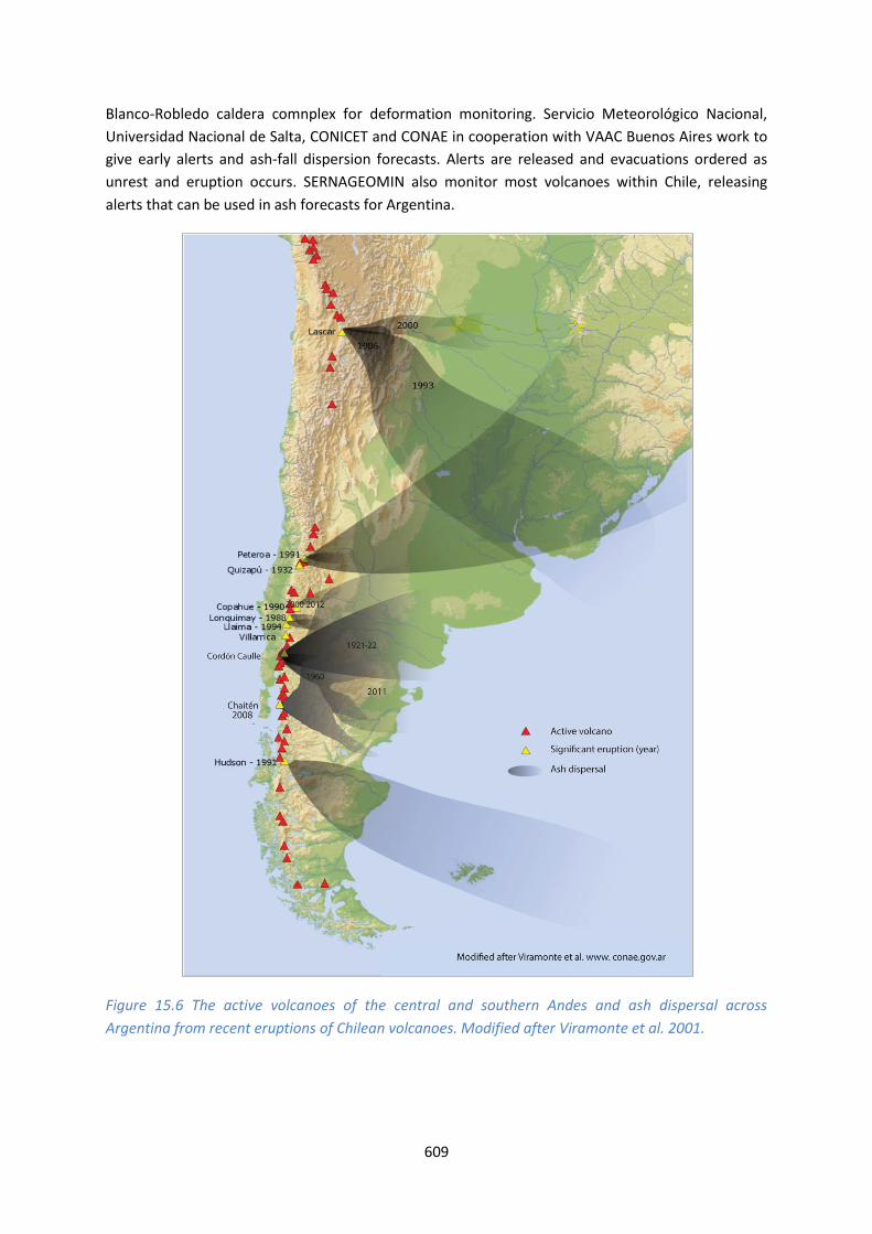
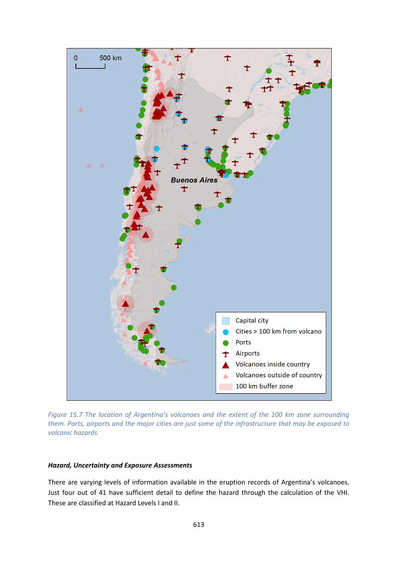
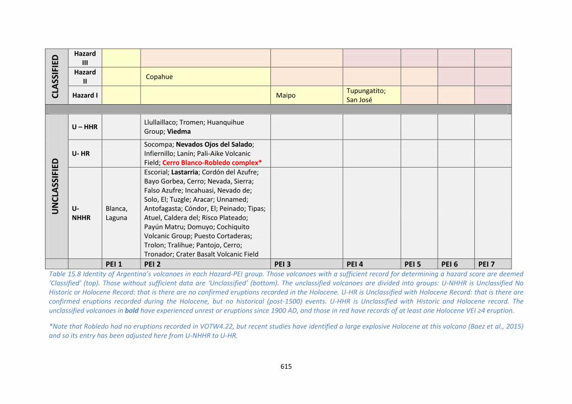
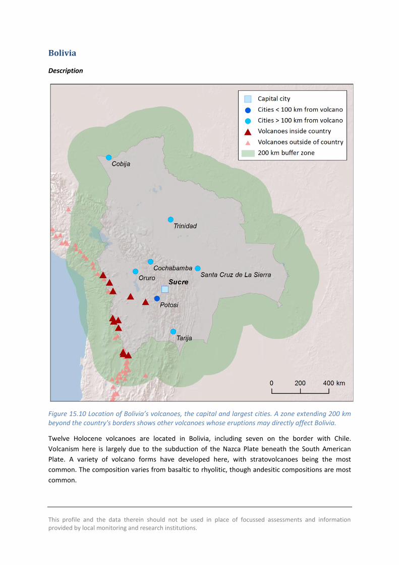
This profile and the data therein should not be used in place of focussed assessments and information provided by local monitoring and research institutions
Bolivia
Description
Figure 1510 Location of Boliviarsquos volcanoes the capital and largest cities A zone extending 200 km beyond the countrys borders shows other volcanoes whose eruptions may directly affect Bolivia
Twelve Holocene volcanoes are located in Bolivia including seven on the border with Chile
Volcanism here is largely due to the subduction of the Nazca Plate beneath the South American
Plate A variety of volcano forms have developed here with stratovolcanoes being the most
common The composition varies from basaltic to rhyolitic though andesitic compositions are most
common
619
Very large explosive eruptions are recorded back into the Pleistocene but the Holocene record is
sparse with just seven confirmed eruptions Two of these were recorded historically in 1865 at
Olca-Paruma and in 1995 at Irruputuncu This latter eruption is the largest recorded in the
Holocene at just VEI 2
The sparse nature of the eruptive record suggests that the hazard (the VHI) is poorly constrained
however the volcanoes of Bolivia are remote with the most populous cities located to the east Only
a small number of people live in close proximity to Holocene volcanoes in Bolivia with about 3000
in total within 10 km and less than 500000 within 100 km of these volcanoes As such current
understanding suggests that these volcanoes are of relatively low risk
There is no official monitoring institution in Bolivia however SERNAGEOMIN in Chile monitors the
border volcanoes Two part-time scientists at the Universidad Mayor de San Andres undertaken
volcanic research in Bolivia and they advise that there are no current response protocols in place for
developing unrest or eruption largely due to the remote nature of the volcanoes They suggest that
infrastructure is at risk with highways (the Oruro-Pisiga and Patacamaya-Tambo Quemado
highway) railways (the Arica line) and an electricity generating station near Nuevo Mundo
highlighted as being exposed
Volcano Facts
Number of Holocene volcanoes 12 inclusive of 7 on the border with Chile
Number of Pleistocene volcanoes with Mge4 eruptions -
Number of volcanoes generating pyroclastic flows 1
Number of volcanoes generating lahars -
Number of volcanoes generating lava flows 1
Number of fatalities caused by volcanic eruptions -
Tectonic setting Subduction zone
Largest recorded Pleistocene eruption The M72 eruption of Laguna Colorado at 19 Ma
Largest recorded Holocene eruption The VEI 2 eruption of Irruputuncu in 1995 AD
Number of Holocene eruptions 7 confirmed eruptions 2 uncertain eruptions
Recorded Holocene VEI range 0 ndash 2
Number of historically active volcanoes 2
Number of historic eruptions 2
620
Number of volcanoes
Primary volcano type Dominant rock type
1 Caldera(s) Rhyolitic (1)
7 Large cone(s) Andesitic (7)
2 Lava dome(s) Dacitic (2)
2 Small cone(s) Andesitic (1) Basaltic (1)
Table 1510 The number of volcanoes in Bolivia their volcano type classification and dominant rock type according to VOTW40
Socio-Economic Facts
Total population (2012) 10523000
Gross Domestic Product (GDP) per capita (2005 PPP $) 4499
Gross National Income (GNI) per capita (2005 PPP $) 4444
Human Development Index (HDI) (2012) 0675 (Medium)
Population Exposure
Capital city Sucre
Distance from capital city to nearest Holocene volcano 1521 km
Total population (2011) 10118683
Number (percentage) of people living within 10 km of a Holocene volcano
3098 (lt1)
Number (percentage) of people living within 30 km of a Holocene volcano
29479 (lt1)
Number (percentage) of people living within 100 km of a Holocene volcano
465904 (46)
Largest cities as measured by population and their population size
Santa Cruz de La Sierra 1364389 Cochabamba 900414 La Paz 812799 Sucre 224838 Oruro 208684 Tarija 159269 Potosi 141251
621
Trinidad 84259 Cobija 26585
Infrastructure Exposure
Number of airports within 100 km of a volcano 0
Number of ports within 100 km of a volcano 0
Total length of roads within 100 km of a volcano (km) 908
Total length of railroads within 100 km of a volcano (km) 282
The volcanoes are situated in a chain along much of the western border of Bolivia and Chile The 100
km radii of these volcanoes fully encompasses this border and extends into Chile Peru and
Argentina Similarly the border volcanoes in these countries have 100 km radii that extend into
Bolivia The capital Sucre lies at over 150 km from the nearest Holocene volcano The volcanoes in
Bolivia are relatively remote but with numerous small settlements and an extensive road network
lying within their 100 km radii
622
Figure 1511 The location of Boliviarsquos volcanoes and the extent of the 100 km zone surrounding them Ports airports and the major cities are just some of the infrastructure that may be exposed to volcanic hazards
Hazard Uncertainty and Exposure Assessments
The eruption records for Boliviarsquos volcanoes lack sufficient detail to determine hazard levels through
the calculation of the VHI These volcanoes are therefore unclassified Indeed of the twelve
volcanoes here just three have a confirmed Holocene record of eruptions including historical
activity at Irruputuncu and Olca-Paruma Eruptions and unrest have been recorded at these two
volcanoes since 1900 AD respectively
The PEI at all Bolivian volcanoes is low at PEI 2 The absence of a hazard classification prevents
determination of risk levels however this low local populations suggests risk levels of I and II
623
CLA
SSIF
IED
Hazard III
Hazard II
Hazard I
UN
CLA
SSIF
IED
U ndash HHR
Irruputuncu Olca-Paruma
U- HR Parinacota
U- NHHR
Tambo Quemado Tata Sabaya Jayu Khota Laguna Nuevo Mundo Pampa Luxsar Ollaguumle Sairecabur Licancabur Guayaques
PEI 1
PEI 2 PEI 3 PEI 4 PEI 5 PEI 6 PEI 7
Table 1511 Identity of Boliviarsquos volcanoes in each Hazard-PEI group Those volcanoes with a sufficient record for determining a hazard score are deemed lsquoClassifiedrsquo (top) Those without sufficient data are lsquoUnclassifiedrsquo (bottom) The unclassified volcanoes are divided into groups U-NHHR is Unclassified No Historic or Holocene Record that is there are no confirmed eruptions recorded in the Holocene U-HR is Unclassified with Holocene Record that is there are confirmed eruptions recorded during the Holocene but no historical (post-1500) events U-HHR is Unclassified with Historic and Holocene record The unclassified volcanoes in bold have experienced unrest or eruptions since 1900 AD and those in red have records of at least one Holocene VEI ge4 eruption
National Capacity for Coping with Volcanic Risk
Two volcanoes on the Bolivia-Chile border have historical records of activity Monitoring undertaken
by SERNAGEOMIN in Chile is described at both these volcanoes however the details are unknown
624
Figure 1512 The monitoring and risk levels of the historically active volcanoes in Bolivia Monitoring Level 1 indicates no known dedicated ground-based monitoring Monitoring Level 2 indicates that some ground-based monitoring systems are in place including le3 seismic stations Monitoring Level 3 indicates the presence of a dedicated ground-based monitoring network including ge4 seismometers
This profile and the data therein should not be used in place of focussed assessments and information provided by local monitoring and research institutions
Chile
Description
Figure 1513 Location of Chilersquos volcanoes the capital and largest cities A zone extending 200 km beyond the countrys borders shows other volcanoes whose eruptions may directly affect Chile
There are 105 volcanoes in Chile including nearly 30 on the borders within Argentina Bolivia and
Peru Several groups of volcanoes are present with scattered remote volcanoes in the very far
south a large concentration of volcanic centres south of Santiago and north of Copiapo and Chilean
626
islands in the Pacific Ocean Volcanism through Chile is primarily due to the subduction of the Nazca
Plate beneath the South American Plate and intra-plate processes in the Pacific
A range of volcano types are present throughout Chile though stratovolcanoes are most common
with about three quarters of volcanoes here being classified as such The rock type also varies from
basaltic to rhyolitic however andesitic compositions are most common
Large explosive Pleistocene activity is recorded in Chile at 20 volcanoes The largest Pleistocene
eruptions were of magnitude 74 with three eruptions of this size at Calabozos caldera about
150000 300000 and 800000 years ago Holocene activity has occurred here and hot springs are
still active within the caldera
Holocene activity in Chile has included 476 confirmed eruptions from 56 volcanoes The remaining
volcanoes have activity of suspected Holocene age Holocene activity has comprised a range of
activity styles and sizes with eruptions from VEI 0 to 6 though only about 5 of these were VEI ge4
Historically 40 volcanoes are recorded producing 357 eruptions Of these 8 were VEI ge4 though
pyroclastic flows are recorded in 16 eruptions Lava flows have more commonly been recorded and
14 of eruptions have resulted in lahars The largest historical eruption in Chile occurred at Cerro
Azul in 1916 This VEI 5 eruption ejected 95 cubic kilometres of tephra and was one of the worldrsquos
largest eruptions in the 20th century
Only a small total population is situated within 10 km of one or more Holocene volcanoes in Chile
however this grows considerably at 30 km and to about 106 million at 100 km accounting for about
63 of the population Ten historic eruptions have resulted in loss of life at Lonquimay Llaima
Villarrica Carran-Los Venados Chaiten and Cerro Hudson
The Red de Vigilancia Volcanic (Volcano monitoring network) and the Observatorio Volcanologico de
Los Andes del Sur (OVDAS) are part of the Servicio Nacional de Geologia y Mineria (SERNAGEOMIN)
This body is government funded and was founded in 1996 The main objective of these groups is to
establish monitoring systems and monitor the most dangerous volcanoes in Chile (based on the
frequency of activity proximity to population centres and vulnerability of public and private
infrastructure) in order to provide information to the relevant authorities
Monitoring is undertaken at many volcanoes using seismic networks cameras deformation and gas
measurements Success of the network has been proven in the eruption of Puyehue-Cordon Caulle
and alerts at Hudson and Copahue Resources and plans are available for responding to developing
unrest and eruption at current un- or under-monitored volcanoes
Scientific technical and support staff are present at the monitoring institution and about 20 of
these have experience of responding to activity however large amounts of data are gathered and
further scientific experience and support is required for full analysis
Regular technical meetings are held in the event of increased activity and an informal response
protocol is followed including alerting the regional VAAC The Oficina Nacional de Emergencia del
Ministerio del Interior y Seguridad Puacuteblica (ONEMI) coordinates emergency response OVDAS
communicates hazard assessments and alerts to ONEMI who use a civil protection alert system
627
A relative threat ranking is produced by SERNAGEOMIN for the volcanoes of Chile This is similar to
the NVEWS method and VHI using hazard indicators taken from the records and coupling these with
exposure factors The relative threat is the sum of the hazard times sum of exposure This ranking system
indicates that Villarrica and Llaima have the largest relative threat ranking with these volcanoes
being the most frequently active here with 126 historical eruptions between them coupled with
large populations within 100 km
A questionnaire was completed by SERNAGEOMIN as part of this study This indicated that a number
of volcano records in VOTW40 require updating with some volcanoes considered Holocene age in
VOTW40 but designated as Pleistocene age by SERNAGEOMIN This highlights the value of close
collaboration between the volcanological community to ensure up-to-date and sustainable data
systems Updates will be considered by the Smithsonian Institution
See also
SERNAGEOMIN wwwsernageominclvolcan-observatoriophp
Volcano Facts
Number of Holocene volcanoes 105 inclusive of 19 on the border with Argentina 7 on the border with Bolivia and 1 on the border with Peru
Number of Pleistocene volcanoes with Mge4 eruptions 20 inclusive of 3 on the border with Argentina
Number of volcanoes generating pyroclastic flows 19
Number of volcanoes generating lahars 13
Number of volcanoes generating lava flows 25
Number of fatalities caused by volcanic eruptions 473
Tectonic setting 101 Subduction zone 3 Intra-plate 1 Rift zone
Largest recorded Pleistocene eruption The Loma Seca Tuff units S V and L from Calabozos are all recorded at M74 at 150 ka 300 ka and 800 ka respectively
Largest recorded Holocene eruption The M63 H1T2 eruption from Cerro Hudson at 7710 BP
Number of Holocene eruptions 476 confirmed eruptions 74 uncertain and 9 discredited eruptions
Recorded Holocene VEI range 0 ndash 6 and unknown
Number of historically active volcanoes 40
628
Number of historic eruptions 357
Number of volcanoes
Primary volcano type Dominant rock type
6 Caldera(s) Andesitic (3) Dacitic (2) Rhyolitic (1)
78 Large cone(s) Andesitic (51) Basaltic (12) Dacitic (12) Unknown (3)
2 Lava dome(s) Andesitic (1) Dacitic (1)
3 Shield(s) Basaltic (3)
15 Small cone(s) Andesitic (5) Basaltic (7) Dacitic (1) Unknown (2)
1 Submarine Unknown (1)
Table 1512 The number of volcanoes in Chile their volcano type classification and dominant rock type according to VOTW40
Socio-Economic Facts
Total population (2012) 17479000
Gross Domestic Product (GDP) per capita (2005 PPP $) 15272
Gross National Income (GNI) per capita (2005 PPP $) 14987
Human Development Index (HDI) (2012) 0819 (Very High)
Population Exposure
Capital city Santiago
Distance from capital city to nearest Holocene volcano 805 km
Total population (2011) 16888760
Number (percentage) of people living within 10 km of a Holocene volcano
21030 (lt1)
Number (percentage) of people living within 30 km of a Holocene volcano
208768 (12)
Number (percentage) of people living within 100 km of a Holocene volcano
10623259 (629)
Ten largest cities as measured by population and their population size
Santiago 4837295 Antofagasta 309832 Valparaiso 282448 Temuco 238129
629
Iquique 227499 Concepcion 215413 Talca 197479 Puerto Montt 160054 La Serena 154521 Copiapo 129280
Infrastructure Exposure
Number of airports within 100 km of a volcano 10
Number of ports within 100 km of a volcano 8
Total length of roads within 100 km of a volcano (km) 16196
Total length of railroads within 100 km of a volcano (km) 2139
The numerous volcanoes of Chile are located primarily along the countryrsquos eastern border with
Argentina Bolivia and Peru and as such the 100 km radii of these volcanoes extend into these
neighbouring countries Similarly volcanoes near the borders in these countries have radii extending
into Chile exposing the infrastructure here Several volcanoes are situated in the Pacific off the coast
of Chile The capital Santiago lies within 100 km of the historically active Tupungatito and San Joseacute
volcanoes hence considerable critical infrastructure is exposed here Being a relatively narrow
stretch of land much of southern Chile lies within 100 km of Holocene volcanoes and many ports
are exposed here A very extensive road and rail network is exposed throughout the country and
many of the countryrsquos largest cities lie within 100 km
630
Figure 1514 The location of Chilersquos volcanoes and the extent of the 100 km zone surrounding them Ports airports and the major cities are just some of the infrastructure that may be exposed to volcanic hazards
Hazard Uncertainty and Exposure Assessments
There are varying levels of information available in the eruption records of Chilersquos volcanoes About
20 of the volcanoes here (20 out of 105) have sufficient detail to define the hazard through the
calculation of the VHI These are classified across all three hazard levels with most being classed at
Hazard Levels I and II Four volcanoes are classed at Hazard Level III all with Holocene records of
eruptions of VEI 4 and 5 and all with records of explosive volcanism accompanied by the production
of pyroclastic flows
631
Of the unclassified volcanoes 49 have no records of confirmed Holocene age eruptions 36
volcanoes have a Holocene eruption record of which 20 have erupted historically (post-1500 AD)
including eruptions since 1900 AD at 11 volcanoes Unrest is described at nine unclassified volcanoes
since 1900 AD Seven unclassified volcanoes have Holocene records of large explosive VEI ge4
eruptions
The PEI ranges from 1 to 4 low to moderate in Chile with an overwhelming majority at PEI 2 The
classified volcanoes are therefore Risk Levels of I and II Although the risk levels cannot be defined
for the unclassified volcanoes due to the absence of hazard details these would all also be clased at
Risk Level I and II
632
CLA
SSIF
IED
Hazard III
Cerro Azul Puyehue-Cordoacuten Caulle Osorno Calbuco
Hazard II
Laacutescar Planchoacuten-Peteroa Chillaacuten Nevados de Antuco Copahue Lonquimay Llaima
Villarrica
Hazard I
Guallatiri Isluga San Pedro Huequi Lautaro Maipo Tupungatito San Joseacute
UN
CLA
SSIF
IED
U ndash HHR Robinson Crusoe
Irruputuncu Olca-Paruma Putana Llullaillaco Tinguiririca Descabezado Grande Callaqui Quetrupillan Mocho-Choshuenco Puntiagudo-Cordoacuten Cenizos Minchinmaacutevida Mentolat Cerro Hudson Arenales Reclus Monte Burney Fueguino
Carraacuten-Los Venados Chaiteacuten
U- HR
Taapaca Parinacota Socompa Nevados Ojos del Salado Longaviacute Nevado de Laniacuten Antillanca Group Cayutueacute-La Vigueriacutea Yanteles Corcovado Melimoyu Macaacute Aguilera Pali-Aike Volcanic Field
Sollipulli Caburgua-Huelemolle
U- NHHR
San Feacutelix Unnamed
Tacora Ollaguumle Azufre Cerro del Sairecabur Licancabur Guayaques Purico Complex Colachi Acamarachi Overo Cerro Chiliques Cordoacuten de Puntas Negras Mintildeiques Tujle Cerro Caichinque Tilocalar Negrillar El Pular Negrillar La Escorial Lastarria Cordoacuten del Azufre Bayo Gorbea Cerro Nevada Sierra Falso Azufre Incahuasi Nevado de Solo El Copiapoacute Palomo Calabozos Maule Laguna del San Pedro-Pellado Blancas Lomas Resago Marintildeaqui Laguna Tolguaca Pantojo Cerro Tronador Cuernos del Diablo Yate Hornopireacuten Apagado Palena Volcanic Group Puyuhuapi Cay Riacuteo Murta
Easter Island
PEI 1 PEI 2 PEI 3 PEI 4 PEI 5 PEI 6 PEI 7 Table 1513 Identity of Chilersquos volcanoes in each Hazard-PEI group Those volcanoes with a sufficient record for determining a hazard score are deemed lsquoClassifiedrsquo (top) Those without sufficient data are lsquoUnclassifiedrsquo (bottom) The unclassified volcanoes are divided into groups U-NHHR is Unclassified No Historic or Holocene Record that is there are no confirmed eruptions recorded in the Holocene U-HR is Unclassified with Holocene Record that is there are confirmed eruptions recorded during the Holocene but no historical (post-1500) events U-HHR is Unclassified with Historic and Holocene record The unclassified volcanoes in bold have experienced unrest or eruptions since 1900 AD and those in red have records of at least one Holocene VEI ge4 eruption
633
Volcano Population Exposure Index Risk Level
Tupungatito 4 I San Joseacute 4 I Villarrica 3 II Calbuco 3 II Maipo 3 I Azul Cerro 2 II Puyehue-Cordoacuten Caulle 2 II Osorno 2 II Guallatiri 2 I Isluga 2 I San Pedro 2 I Laacutescar 2 I Planchoacuten-Peteroa 2 I Chillaacuten Nevados de 2 I Antuco 2 I Copahue 2 I Lonquimay 2 I Llaima 2 I Huequi 2 I Lautaro 2 I
Table 1514 Classified volcanoes of Chile ordered by descending Population Exposure Index (PEI) Risk levels determined through the combination of the Hazard Level and PEI are given Risk Level I ndash 15 volcanoes Risk Level II ndash 5 volcanoes Risk Level III ndash 0 volcanoes
Figure 1515 Distribution of Chilersquos classified volcanoes across Hazard and Population Exposure Index levels The warming of the background colours illustrates increasing Risk levels from Risk Level I - III
634
National Capacity for Coping with Volcanic Risk
Forty volcanoes have records of historical activity in Chile These volcanoes are primarily classed at
Risk Level I All Risk Level II historical volcanoes are monitored by SERNAGEOMIN using seismic
stations as a minimum Many volcanoes also have deformation monitoring
Figure 1516 The monitoring and risk levels of the historically active volcanoes in Chile Monitoring Level 1 indicates no known dedicated ground-based monitoring Monitoring Level 2 indicates that some ground-based monitoring systems are in place including le3 seismic stations Monitoring Level 3 indicates the presence of a dedicated ground-based monitoring network including ge4 seismometers
This profile and the data therein should not be used in place of focussed assessments and information provided by local monitoring and research institutions
Colombia
Description
Figure 1517 Location of Colombiarsquos volcanoes the capital and largest cities A zone extending 200 km beyond the countrys borders shows other volcanoes whose eruptions may directly affect Colombia
Fifteen Holocene volcanoes are distributed through the northern Andes in western Colombia to the
Ecuador border paralleling the Pacific coastline These volcanoes are related to the subduction of
the Nazca Plate beneath the South American Plate
All Holocene volcanoes in Colombia form edifices typically associated with explosive-type activity
including stratovolcanoes and complex volcanoes with the exception of the Petacas lava dome and
636
Santa Isabel shield The Colombian volcanoes are dominantly andesitic in composition The explosive
record continues into the Pleistocene with three Colombian volcanoes hosting MVEI ge4 eruptions
in this period
There are 125 confirmed eruptions recorded in the Holocene at VEI 1 to 5 indicating a range of
activity from mild to strongly explosive Eight volcanoes have a Holocene record of producing
pyroclastic flows and six are associated with lahars Nine of the Colombian volcanoes have 79
eruptions recorded in historical times
Many of Colombiarsquos most populous cities are located on or towards the northern coast away from
volcanoes however the cities of Cali Ibague Pasto and Pereira lie within 100 km of one or more
Holocene volcanoes with the latter three over-looked by Machin Galeras and the Ruiz-Tolima chain
Numerous eruptions of Nevado del Ruiz Nevado del Huila Puraceacute and Galeras have resulted in
evacuations and property damage Fatalities are recorded in nine eruptions of these volcanoes and
Dontildea Juana
The assessment of hazard is complicated by sparse eruptive histories at over half of Colombiarsquos
volcanoes resulting in hazard levels with large associated uncertainties hence just five volcanoes
have a hazard level classified here Nevado del Ruiz Galeras and Cerro Bravo are classed with the
highest hazard in Colombia based on detailed eruptive histories Coupled with the high proximal
population these volcanoes are classed at Risk Level III
Both Galeras and Nevado del Ruiz have caused loss of life Machiacuten has not caused any fatalities but
has shown recent unrest and its geological record indicates the potential for violent and destructive
explosive eruptions In 1993 a sudden intense but small magnitude explosive eruption of Galeras
killed nine people including six volcanologists who were in the inner crater or on its rim A far larger
disaster the largest in South Americarsquos history was the 1985 eruption of Nevado del Ruiz Though
only VEI 3 the eruption generated pyroclastic flows that melted the volcanorsquos glacier cap and caused
lahars The mudflows descended the western flanks flowing along the Riacuteo Lagunillas valley The
town of Armero located on the banks of Riacuteo Lagunillas 48 km from the volcano was completely
buried Though the death toll is uncertain it is estimated that 21000 of the 29000 residents of
Armero were killed along with others elsewhere bringing the total loss of life to between 23000
and 26000
Further eruptions with human impacts have occurred very recently at Galeras volcano An eruption
starting on 25th August 2010 spread ash as far as 30 km to the northwest 7000 people were
advised to evacuate though few left their homes Activity did not increase after this until January
2011
Eruptions at a number of the northernmost volcanoes in Ecuador may directly affect Colombia as
they lie within 100 km of the border Similarly Galeras Cumbal and Azufral lie within 100 km of
Ecuador
Following the 1985 Nevado del Ruiz tragedy the Colombian Government took steps to strengthen
the monitoring and response mechanisms for Colombian volcanoes These measures included
making INGEOMINAS responsible for the monitoring of volcanoes and provision of scientific advice
637
The Servicio Geologico Colombiano (INGEOMINAS) operate three volcano observatories in Colombia
Observatorio Pasto (responsible for Galeras Cumbal Chiles Cerro Negro Las Animas Doňa Juana
and Azufral) Observatorio Manizales (responsible for Nevado del Ruiz Cerro Machin Cerro Bravo
Nevado Santa Isabel and Nevado Tolima) and Observatorio Popayan (responsible for Nevado del
Huila Sotaraacute and Puraceacute) INGEOMINAS operate a monitoring network at Colombiarsquos active
volcanoes and the status of the volcanoes is communicated publically and is available online
See also
INGEOMINAS - wwwsgcgovco
Volcano Facts
Number of Holocene volcanoes 15 inclusive of one on the border with Ecuador
Number of Pleistocene volcanoes with Mge4 eruptions 3
Number of volcanoes generating pyroclastic flows 8
Number of volcanoes generating lahars 6
Number of volcanoes generating lava flows 3
Number of fatalities caused by volcanic eruptions 25567
Tectonic setting Subduction zone
Largest recorded Pleistocene eruption The El Boqueron Ancestral caldera collapse eruption of 580 ka at Nevado del Tolima and the 560 ka Coba Negra caldera forming eruption of Galeras are both recorded at M62
Largest recorded Holocene eruption The M55 R8 eruption of Nevado del Ruiz at 28 ka
Number of Holocene eruptions 125 confirmed eruptions 10 uncertain eruptions
Recorded Holocene VEI range 1 ndash 5 and unknown
Number of historically active volcanoes 9
Number of historic eruptions 79
638
Number of volcanoes
Primary volcano type Dominant rock type
13 Large cone(s) Andesitic (9) Dacitic (4)
1 Lava dome(s) Unknown (1)
1 Shield(s) Andesitic (1)
Table 1515 The number of volcanoes in Colombia their volcano type classification and dominant rock type according to VOTW40
Socio-Economic Facts
Total population (2012) 47783000
Gross Domestic Product (GDP) per capita (2005 PPP $) 8861
Gross National Income (GNI) per capita (2005 PPP $) 8711
Human Development Index (HDI) (2012) 0719 (High)
Population Exposure
Capital city Bogataacute
Distance from capital city to nearest Holocene volcano 1386 km
Total population (2011) 44725543
Number (percentage) of people living within 10 km of a Holocene volcano
451010 (1)
Number (percentage) of people living within 30 km of a Holocene volcano
3236251 (72)
Number (percentage) of people living within 100 km of a Holocene volcano
13408843 (30)
Ten largest cities as measured by population and their population size
Bogota 7102602 Cali 2392877 Medellin 1999979 Barranquilla 1380425 Cartagena 952024 Cucuta 721398 Bucaramanga 571820 Pereira 440118 Santa Marta 431781 Ibague 421685
639
Infrastructure Exposure
Number of airports within 100 km of a volcano 2
Number of ports within 100 km of a volcano 0
Total length of roads within 100 km of a volcano (km) 3159
Total length of railroads within 100 km of a volcano (km) 420
Figure 1518 The location of Colombiarsquos volcanoes and the extent of the 100 km zone surrounding them Ports airports and the major cities are just some of the infrastructure that may be exposed to volcanic hazards
The volcanoes in Colombia are located in the west of the country from the border with Ecuador to
just north of the capital Bogata The southernmost volcanoes Galeras Cumbal and Azufral lie close
to the Ecuador border and their 100 km radii extend into Ecuador exposing infrastructure here
640
Similarly six of the northernmost of Ecuadorrsquos volcanoes have 100 km radii which extend into
Colombia Four of the largest cities in Colombia are situated within 100 km of Holocene volcanoes
including Pasto Cali Ibague and Pereira exposing much of the critical infrastructure here The
capital Bogata lies within 140 km of several Holocene volcanoes including the historically active
Nevado del Ruiz and Nevado del Tolima
Hazard Uncertainty and Exposure Assessments
The volcanoes in Colombia are classed at Hazard Levels I to III Ten of the 15 Colombian volcanoes
have insufficient data available in their eruption records to adequately calculate a hazard score
without very large uncertainties The highest hazard levels are found at Nevado del Ruiz Galeras and
Cerro Bravo
Of the unclassified volcanoes three Azufral Machiacuten and Sotaraacute have had recorded periods of unrest
above background levels since 1900 Both Azufral and Machiacuten have Holocene eruption records but
no historical eruptions Four Colombian volcanoes Nevado del Huila Dontildea Juana Cumbal and Cerro
Negro de Mayasquer are unclassified but have historical records of activity including post-1900
eruptions
CLA
SSIF
IED
Hazard III Cerro Bravo Nevado del Ruiz
Galeras
Hazard II Nevado del Tolima
Hazard I Puraceacute
UN
CLA
SSIF
IED
U ndash HHR
Nevado del Huila Dontildea Juana Cumbal Cerro Negro de Mayasquer
U- HR Romeral Santa Isabel Machiacuten Azufral
U- NHHR Petacas Sotaraacute
PEI 1 PEI 2 PEI 3 PEI 4 PEI 5 PEI 6 PEI 7 Table 1516 Identity of Colombiarsquos volcanoes in each Hazard-PEI group Those volcanoes with a sufficient record for determining a hazard score are deemed lsquoClassifiedrsquo (top) Those without sufficient data are lsquoUnclassifiedrsquo (bottom) The unclassified volcanoes are divided into groups U-NHHR is Unclassified No Historic or Holocene Record that is there are no confirmed eruptions recorded in the Holocene U-HR is Unclassified with Holocene Record that is there are confirmed eruptions recorded during the Holocene but no historical (post-1500) events U-HHR is Unclassified with Historic and Holocene record The unclassified volcanoes in bold have experienced unrest or eruptions since 1900 AD and those in red have records of at least one Holocene VEI ge4 eruption
641
Volcano Population Exposure Index Risk Level
Galeras 6 III Ruiz Nevado del 5 III Bravo Cerro 4 III Tolima Nevado del 4 II Puraceacute 4 I
Table 1517 Classified volcanoes of Colombia ordered by descending Population Exposure Index (PEI) Risk levels determined through the combination of the Hazard Level and PEI are given Risk Level I ndash 1 volcano Risk Level II ndash 1 volcano Risk Level III ndash 3 volcanoes
Figure 1519 Distribution of Colombiarsquos classified volcanoes across Hazard and Population Exposure Index levels The warming of the background colours illustrates increasing Risk levels from Risk Level I - III
All Colombian volcanoes have moderate to high PEI levels at PEI 3 to 6 The highest PEI is found at
Galeras which has over 120000 living just within 10 km Combined with a Hazard Level of III
Galeras is classed as a Risk Level III volcano Of the classified volcanoes just one volcano Puraceacute is
deemed Risk Level I whilst one Nevado del Tolima is classed at Risk Level II
National Capacity for Coping with Volcanic Risk
Nine volcanoes in Colombia have recorded historical activity Of these all have dedicated ground-
based monitoring systems operated by INGEOMINAS Seven volcanoes are classed here at
Monitoring Level 3 with seismic networks in operation and additional deformation and or gas
monitoring The three volcanoes with the highest risk classification here are continuously monitored
at this level
642
Figure 1520 The monitoring and risk levels of the historically active volcanoes in Colombia Monitoring Level 1 indicates no known dedicated ground-based monitoring Monitoring Level 2 indicates that some ground-based monitoring systems are in place including le3 seismic stations Monitoring Level 3 indicates the presence of a dedicated ground-based monitoring network including ge4 seismometers
This profile and the data therein should not be used in place of focussed assessments and information provided by local monitoring and research institutions
Ecuador and the Galapagos
Description
Figure 1521 Location of Ecuadorrsquos volcanoes the capital and largest cities A zone extending 200 km beyond the countrys borders shows other volcanoes whose eruptions may directly affect Ecuador
Thirty-five volcanoes of Holocene age are identified in Ecuador This includes volcanoes on mainland
Ecuador and in the Galapagos Islands nearly 1000 km to the west Volcanism in mainland Ecuador is
related to the subduction of the Nazca Plate beneath the South American Plate whilst Galapagos
volcanism is due to intra-plate hotspot volcanism and the Galapagos spreading centre Volcanoes of
the Galapagos are predominantly basaltic shields while in mainland Ecuador the composition is
more felsic and andesitic stratovolcanoes are most common
644
Twenty-eight of the volcanoes have 311 confirmed Holocene eruptions the remaining volcanoes
have suspected Holocene activity With records of activity ranging in size from VEI 0 to 6 a range of
activity styles is indicated from mild effusions of lavas to large explosive events The largest
Holocene eruption on record is the ~1280 AD eruption of Quilotoa at VEI 6 M64 This event
generated extensive pyroclastic flows ash fall and lahars A larger eruption (M69) is recorded in the
Pleistocene at 211 ka with the Ash Flow of the Chalupas Caldera Numerous Pleistocene eruptions
of VEIM ge4 are recorded in Ecuador and 43 large explosive eruptions of this size are recorded in the
Holocene
Since 1500 AD 197 eruptions are recorded at nineteen volcanoes Of these 11 were VEI 4 indicating
that large explosive eruptions are relatively frequent in Ecuador The dominantly andesitic
composition and stratovolcano morphology indicates typical explosive activity The altitude of the
volcanoes in Ecuador means that many of the volcanoes are capped with snow or glaciers This
increases the propensity to cause hazardous lahars as even small eruptions can result in the melting
of ice caps Indeed eight volcanoes in Ecuador have a Holocene record of lahar triggering
The most frequently active volcanoes here are Cotopaxi Reventador and Tungurahua while Sangay
is continuously active since 1628 but poses little threat since it is isolated from population centres
The Galapagos Island volcanoes are exclusively shield volcanoes With a small population of just over
20000 the main hazard they pose is largely environmental but also to wildlife such as slow moving
giant tortoises as a result of lava flows and ash fall One exception to this is Fernandina which has
erupted explosively on numerous occasions producing pyroclastic flows and debris avalanches No
fatalities are recorded as a result of eruptions of Fernandina
Much of central and northern mainland Ecuador lies within 100 km of one or more Holocene
volcanoes and six of the most populous cities in the country fall in this zone The capital Quito lies
within 100 km of many volcanoes and within about 12 km of the historically active Guagua
Pichincha This volcano had a VEI 4 eruption in 1660 resulting in extensive ash fall and ash
accumulation in the capital Pyroclastic flows and surges were channelled mainly to the west as the
caldera is breached in this direction This breach will still likely act to channel flows to the west
however surges in particular are not always constrained by topography and can reach small
communities such as Lloa but have never jumped the topographic barrier into the Quito basin
The presence of many cities within 100 km of the Holocene volcanoes exposes a large proportion of
the population to direct volcanic hazards with 50 of Ecuadorrsquos population residing within 100 km
of one or more Holocene volcano
The assessment of hazard at many of Ecuadorrsquos volcanoes is complicated by incomplete or sparse
eruption records and publication of this information in ldquogrey literaturerdquo that is difficult to access
hence the assignment of hazard levels is associated with large degrees of uncertainty
Fatalities have resulted from eruptions of Reventador Guagua Pichincha Cotopaxi Tungurahua
Sangay and Cerro Azul Greatest loss of life as a result of volcanism in Ecuadorian territories occurred
in 1640 following an eruption of Tungurahua Though some uncertainty surrounds the eruption
record it is believed an approximately VEI 3 eruption caused pyroclastic flows and a small sector
collapse that destroyed a village and its 5000 inhabitants Eruptions of Cotopaxi in 1742 1768 and
645
1877 have also significantly added to the death toll from volcanoes in Ecuador with roughly 1200
deaths as a result of lahars attributable to these three eruption periods
The Instituto Geofisico of the Escuela Politeacutecnica Nacional (IGEPN) is responsible for the study
monitoring and hazard assessment of Ecuadorrsquos volcanoes Sixteen volcanoes are monitored with at
least one broadband seismic instrument and one or more continuously operating GPS staton
Tungurahua Cotopaxi Guagua Pichincha Reventador Cuicocha and Antisana volcanoes are
monitored with a broad suite of geophysical instruments and because of the completeness of their
real-time networks are considered to b in an ldquoArdquo category Ten other volcanoes Atacazo Pululagua
Imbabura Chachimburo Cerro Negro Cayambe Soche Sangay Chimborazo and Quilotoa all have
at least one or more broadband seismic and deformation-detecting stations The IGEPN provides
advice and information regarding volcanic activity and presents this information online accessible to
the public Reports are regularly issued summarising volcanic activity and early warnings before a
notable increase in eruptive activity is given on this web via calls over local radio stations and
through social media Close collaborations exist with the Secretariat for Risk Management Before
and during volcanic crises IGEPN scientists communicate and provide hazard assessments to local
regional and national authorities At Tungurahua volcano which has been erupting since 1999 a
volunteer volcano observers group (Vigias) has been very successful in providing in situ observations
of eruptive activity via a radio system to the local observatory IGEPN scientists
From here we provide the information for mainland Ecuador and the Galapagos Islands separately
See also
Servicio Nacional de Sismologia y Vulcanologia wwwigepneduec
646
Mainland Ecuador
Volcano Facts
Number of Holocene volcanoes 22 inclusive of one on the border with Colombia
Number of Pleistocene volcanoes with Mge4 eruptions 7
Number of volcanoes generating pyroclastic flows 14
Number of volcanoes generating lahars 8
Number of volcanoes generating lava flows 7
Number of fatalities caused by volcanic eruptions 5690
Tectonic setting 22 Subduction zone
Largest recorded Pleistocene eruption The M69 Chalupas Ash Flow eruption of Chalupas at 211 ka
Largest recorded Holocene eruption The M64 eruption of Quilotoa about 700 years ago
Number of Holocene eruptions 229 confirmed eruptions
Recorded Holocene VEI range 0 ndash 6 and unknown
Number of historically active volcanoes 10 according to VOTW422 (Cotopaxi Reventador Tungurahua Guagua Pichincha Cayambe Sangay Chacana Antisana Sumaco and Cerro Negro de Mayasquer) Activity at the latter three volcanoes is ambiguous
Number of historic eruptions 131
Number of volcanoes
Primary volcano type Dominant rock type
4 Caldera(s) Dacitic (3) Rhyolitic (1)
17 Large cone(s) Andesitic (13) Basaltic (1) Dacitic (3)
1 Small cone(s) Andesitic (1)
Table 1518 The number of volcanoes in Ecuador their volcano type classification and dominant rock type according to VOTW40
647
Socio-Economic Facts
Total population (2012) 15520000
Gross Domestic Product (GDP) per capita (2005 PPP $) 7443
Gross National Income (GNI) per capita (2005 PPP $) 7471
Human Development Index (HDI) (2012) 0724 (High)
Population Exposure
Capital city Quito
Distance from capital city to nearest Holocene volcano 122 km
Total population (2011) 15007343
Number (percentage) of people living within 10 km of a Holocene volcano
750552 (5)
Number (percentage) of people living within 30 km of a Holocene volcano
4352168 (29)
Number (percentage) of people living within 100 km of a Holocene volcano
7393692 (493)
Ten largest cities as measured by population and their population size (2010 from UN data
dataunorg)
Guayaquil 2278691 Quito 1607734 Cuenca 329928 Machala 231260 Manta 217553 Portoviejo 206682 Loja 170280 Ambato 165185 Esmeraldas 154035 Riobamba 146324
Infrastructure Exposure
Number of airports within 100 km of a volcano 6 (Tulcan Quito Lago Agrio Latacunga Macas Tena)
Number of ports within 100 km of a volcano 0
Total length of roads within 100 km of a volcano (km) 3727
Total length of railroads within 100 km of a volcano (km) 0
648
In mainland Ecuador the 100 km radii of the volcanoes covers much of central and northern parts of
the country and the radii of six of the northernmost volcanoes extend into Colombia Similarly the
three southernmost volcanoes of Colombia have 100 km radii which extend into Ecuador Six of the
largest cities in Ecuador are situated within 100 km of Holocene volcanoes including the capital
Quito hence much of the critical infrastructure of the country is exposed including three airports
and an extensive road network Critical infrastructure such as two trans-Andean oil pipelines four
major hydroelectric installations Quitorsquos water supply from Antisana and Chacana volcanoes as well
as critical bridges are also exposed
Figure 1522 The location of Ecuadorrsquos volcanoes and the extent of the 100 km zone surrounding them Ports airports and the major cities are just some of the infrastructure that may be exposed to volcanic hazards
649
Hazard Uncertainty and Exposure Assessments
There are varying levels of information available in the eruption records of mainland Ecuadorrsquos
volcanoes Seven volcanoes out of 23 have sufficient detail to define the hazard through the
calculation of the VHI All of these are classified at Hazard Level III with Holocene records of VEI ge3
eruptions and records of explosive eruptions with the production of pyroclastic flows
Of the unclassified volcanoes three have no confirmed Holocene eruptions on record The
remaining 12 volcanoes have a Holocene eruptive record with historical events at four volcanoes
including post-1900 AD eruptions at Cerro Negro de Mayasquer Four unclassified volcanoes have a
Holocene record of large VEI ge4 eruptions
The size of the proximal populations at Ecuadorrsquos volcanoes ranges from small to large generating
PEIs of 1 to 7 Moderate and high PEIs dominate This range results in a range of risk levels when
combined with the Hazard Levels from II to III at the classified volcanoes Although here we consider
threat to life measured by population exposure infrastructure exposure such as the water supply to
Quito is also vital This for example is supplied from the PEI4 Antisana volcano which if it were to
erupt would have grave consequences for Quitorsquos water supply
CLA
SSIF
IED
Hazard III
Reventador Sangay
Cayambe Cotopaxi Tungurahua
Guagua Pichincha
Atacazo
Hazard II
Hazard I
UN
CLA
SSIF
IED
U ndash HHR
Sumaco
Cerro Negro de Mayasquer Antisana
Chacana
U- HR Aliso Soche Chachimbiro Chimborazo
Quilotoa Cuicocha Imbabura
Pululagua
U- NHHR
Illiniza Mojanda Licto
PEI 1
PEI 2 PEI 3 PEI 4 PEI 5 PEI 6 PEI 7
Table 1519 Identity of Mainland Ecuadorrsquos volcanoes in each Hazard-PEI group Those volcanoes with a sufficient record for determining a hazard score are deemed lsquoClassifiedrsquo (top) Those without sufficient data are lsquoUnclassifiedrsquo (bottom) The unclassified volcanoes are divided into groups U-NHHR is Unclassified No Historic or Holocene Record that is there are no confirmed eruptions recorded in the Holocene U-HR is Unclassified with Holocene Record that is there are confirmed eruptions recorded during the Holocene but no historical (post-1500) events U-HHR is Unclassified with Historic and Holocene record The unclassified volcanoes in bold have experienced unrest or eruptions since 1900 AD and those in red have records of at least one Holocene VEI ge4 eruption
Volcano Population Exposure Index Risk Level
650
Atacazo 6 III Guagua Pichincha 5 III Tungurahua 4 III Cotopaxi 4 III Cayambe 4 III Reventador 3 II Sangay 3 II
Table 1520 Classified volcanoes of Mainland Ecuador ordered by descending Population Exposure Index (PEI) Risk levels determined through the combination of the Hazard Level and PEI are given Risk Level I ndash 0 volcanoes Risk Level II ndash 2 volcanoes Risk Level III ndash 5 volcanoes
Figure 1523 Distribution of mainland Ecuadorrsquos classified volcanoes across Hazard and Population Exposure Index levels The warming of the background colours illustrates increasing Risk levels from Risk Level I - III
National Capacity for Coping with Volcanic Risk
Ten volcanoes in mainland Ecuador have recorded historical activity These volcanoes are distributed
across all three monitoring levels with half of the volcanoes being classed at Monitoring Level 3 All
Risk Level III volcanoes are monitored at Level 3 with the exception of Cayambe which also has both
seismic and deformation monitoring The Risk Level III volcanoes Tungurahua Guagua Pichincha and
Cotopaxi all have multiple monitoring systems in place inclduing continuous seismic and
deformation monitoring
651
Monitoring is undertaken by the Instituto Geofisico EPN Note that this institute also uses
Monitoring Levels 1 - 3 to describe levels of monitoring at Ecuadorrsquos volcanoes but these are
different levels to those used here
Figure 1524 The monitoring and risk levels of the historically active volcanoes in mainland Ecuador Monitoring Level 1 indicates no known dedicated ground-based monitoring Monitoring Level 2 indicates that some ground-based monitoring systems are in place including le3 seismic stations Monitoring Level 3 indicates the presence of a dedicated ground-based monitoring network including ge4 seismometers
652
Galapagos Islands
Figure 1525 The volcanoes of the Galapagos Islands Inset shows the location relative to mainland Ecuador
Volcano Facts
Number of Holocene volcanoes 13
Number of Pleistocene volcanoes with Mge4 eruptions 1
Number of volcanoes generating pyroclastic flows 1
Number of volcanoes generating lahars -
Number of volcanoes generating lava flows 9
653
Number of fatalities caused by volcanic eruptions 1
Tectonic setting 13 Rift zone
Largest recorded Pleistocene eruption The M52VEI 5 Alcedo-AB Tephra eruption of about 90000 years ago
Largest recorded Holocene eruption The VEI 4 eruption of Fernandina in 1968
Number of Holocene eruptions 82 confirmed eruptions
Recorded Holocene VEI range 0 ndash 4 and unknown
Number of historically active volcanoes 9
Number of historic eruptions 66
Number of volcanoes
Primary volcano type Dominant rock type
13 Shield(s) Basaltic (13)
Table 1521 The number of volcanoes in Ecuador their volcano type classification and dominant rock type according to VOTW40
Population Exposure
Capital city Puerto Baquerizo Moreno
Distance from capital city to nearest Holocene volcano 123 km
Total population (2010 wwwinecgobecestadisticas) 25124
Percentage of people living within 100 km of a Holocene volcano 100
Infrastructure Exposure
Number of airports within 100 km of a volcano 2
Number of ports within 100 km of a volcano -
Total length of roads within 100 km of a volcano (km) -
Total length of railroads within 100 km of a volcano (km) 0
In the Galapagos Islands the 100 km radii extend to fully encompass the island group exposing all
infrastructure here
654
Hazard Uncertainty and Exposure Assessments
Of the thirteen volcanoes in the Galapagos Islands just four have a sufficiently detailed eruption
record to determine hazard levels through the calculation of the VHI These are classified at Hazard
Levels I and II
Of the unclassified volcanoes three have no confirmed Holocene eruptions on record Six have a
record of Holocene eruptions including historical age events and post-1900 AD eruptions
The size of the proximal populations at the volcanoes of the Galapagos is typically small generating
PEIs of 2 to 3 All classified volcanoes here are classed at Risk Level I
CLA
SSIF
IED
Hazard III
Hazard II
Fernandina
Hazard I
Wolf Negra Sierra Azul Cerro
UN
CLA
SSIF
IED
U ndash HHR
Darwin Alcedo Pinta Marchena Santiago
U- HR Ecuador
U- NHHR
Genovesa Santa Cruz San Cristoacutebal
PEI 1 PEI 2 PEI 3 PEI 4 PEI 5 PEI 6 PEI 7 Table 1522 Identity of the Galapagos Islandsrsquo volcanoes in each Hazard-PEI group Those volcanoes with a sufficient record for determining a hazard score are deemed lsquoClassifiedrsquo (top) Those without sufficient data are lsquoUnclassifiedrsquo (bottom) The unclassified volcanoes are divided into groups U-NHHR is Unclassified No Historic or Holocene Record that is there are no confirmed eruptions recorded in the Holocene U-HR is Unclassified with Holocene Record that is there are confirmed eruptions recorded during the Holocene but no historical (post-1500) events U-HHR is Unclassified with Historic and Holocene record The unclassified volcanoes in bold have experienced unrest or eruptions since 1900 AD and those in red have records of at least one Holocene VEI ge4 eruption
Volcano Population Exposure Index Risk Level
Azul Cerro 2 I Fernandina 2 I Negra Sierra 2 I Wolf 2 I
Table 1523 Classified volcanoes of the Galapagos Islands ordered by descending Population Exposure Index (PEI) Risk levels determined through the combination of the Hazard Level and PEI are given Risk Level I ndash 4 volcanoes Risk Level II ndash0 volcanoes Risk Level III ndash 0 volcanoes
655
Figure 1526 Distribution of the Galapagos Islandsrsquo classified volcanoes across Hazard and Population Exposure Index levels The warming of the background colours illustrates increasing Risk levels from Risk Level I - III
National Capacity for Coping with Volcanic Risk
Nine volcanoes in the Galapagos Islands have recorded historical activity Monitoring is undertaken
by the Instituto Geofisico EPN Note that this institute also uses Monitoring Levels 1 - 3 to describe
levels of monitoring at Ecuadorrsquos volcanoes but these are different levels to those used here A
seismic monitoring network in the Galapagos Islands has been installed
Figure 1527 The monitoring and risk levels of the historically active volcanoes in the Galapagos Islands of Ecuador Monitoring Level 1 indicates no known dedicated ground-based monitoring Monitoring Level 2 indicates that some ground-based monitoring systems are in place including le3 seismic stations Monitoring Level 3 indicates the presence of a dedicated ground-based monitoring network including ge4 seismometers
This profile and the data therein should not be used in place of focussed assessments and information provided by local monitoring and research institutions
Peru
Description
Figure 1528 Location of Perursquos volcanoes the capital and largest cities A zone extending 200 km beyond the countrys borders shows other volcanoes whose eruptions may directly affect Peru
Seventeen Holocene volcanoes are recorded in Peru These volcanoes are located in the Andes in a
chain through southern Peru to the border with Chile Volcanism occurs here due to the subduction
of the Nazca Plate beneath the South American Plate Although subduction is also ongoing in
northern Peru the angle of the subducting slab has not led to recent volcanism Although Perursquos
volcanoes are a variety of types including cinder cones and lava domes most are stratovolcanoes of
dominantly andesitic composition
Large explosive Pleistocene activity is recorded in Peru and sixty eruptions of Holocene age are
recorded here Of these thirty-six are of historical age These historical eruptions occurred at six
657
volcanoes and covered a range of sizes from small events of VEI 1 to very large explosive VEI 6
eruptions Three volcanoes have Holocene records of producing pyroclastic flows and four with
lahars The largest historical eruption was the 1600 AD eruption of Huaynaputina This eruption
produced voluminous tephra falls pyroclastic flows and surges which travelled 13 km and lahars that
reached the Pacific Ocean 120 km away The cities of Arequipa and Moquengua suffered significant
damage and about 1500 lives were lost
Arequipa one of the most populous cities in Peru lies at about 75 km from Huaynaputina and
within 100 km of five other Holocene volcanoes including the historically active Sabancaya El Misti
and Ubinas the most frequently active volcano in Peru in historic times
The Instituto Geofisico del Peru (IGP) and the Instituto Geolόgico Minero y Metaluacutergico (INGEMMET)
are responsible for scientific research and the monitoring of the volcanoes in Peru and indeed
actively monitor five historically active volcanoes and three further Holocene volcanoes through a
variety of dedicated ground-based instrumentation including seismic stations geochemical and gas
monitoring and various deformation monitoring Monitoring is undertaken regularly with an alarm
system and automated seismic system A regional seismic network is operational in Peru which can
register seismicity throughout the volcanic chain Some resources and plans are available for
monitoring to be extended to currently un-monitored volcanoes in developing situations About a
quarter of the observatory staff have experience of responding to an eruption
In addition to ground-based monitoring VDAP ndash the Volcano Disaster Assistance Program of the US
Geological Survey provides satellite information during eruptions and InSAR and MODIS images are
provided by Cornell University and Torino University
The IGP provide scientific and technical advice to the Instituo Nacional de Defensa Civil (INDECI) in
the event of unrest and eruption The director of the Observatorio Vulcanologico de Sur (OVS)
Orlando Macedo represents the IGP on the regional committee for crises (the Comite de
Operaciones de Emergencia Regional COER) The regional aviation authority Corporacion Peruana
de Aviacion Comercial (CORPAC) reports to the regional VAAC
The IGP extend a programme of hazard education to the public and the IGP and INGEMMET
websites are publically accessible distributing information about Perursquos volcanic activity The IGP do
not provide risk assessments but advise on management and mitigation of volcanic risk An alert
level system is in place and the IGP INGEMMET and IGUNSA recommend declaration of alerts to the
COER authority
Large and growing cities are located near active volcanoes in Peru and with the expansion of the
cities the risk increases as larger populations live ever-closer to the volcanoes Educational
programs about volcanic risk and restriction of building in proximal areas would greatly improve the
volcanic risk situation in Peru
See also
Instituto Geofisico del Peru wwwigpgobpeportal
Instituto Geolόgico Minero y Metaluacutergico (INGEMMET)
wwwingemmetgobpeformInicioaspx
658
Observatorio Vulcanologico Del Sur ovsigpgobpemonitoreo
Thouret J-C Finizola A Fornari M Legeley-Padovani A Suni J and Frechen M (2001) Geology
of El Misti volcano near the city of Arequipa Peru Geological Society of America Bulletin 113 1593-
1610
Volcano Facts
Number of Holocene volcanoes 17 inclusive of one on the border with Chile
Number of Pleistocene volcanoes with Mge4 eruptions 4
Number of volcanoes generating pyroclastic flows 3
Number of volcanoes generating lahars 4
Number of volcanoes generating lava flows 3
Number of fatalities caused by volcanic eruptions 1500
Tectonic setting Subduction zone
Largest recorded Pleistocene eruption The M67 Sillar of Arequipa Ignimbrite eruption of Nevado Chachani at 242 Ma
Largest recorded Holocene eruption The 1600 AD eruption of Huaynaputina at M61
Number of Holocene eruptions 60 confirmed eruptions 14 uncertain eruptions
Recorded Holocene VEI range 0 ndash 6 and unknown
Number of historically active volcanoes 6
Number of historic eruptions 36
Number of volcanoes
Primary volcano type Dominant rock type
11 Large cone(s) Andesitic (9) Dacitic (1) Trachytic Andesitic (1)
2 Lava dome(s) Dacitic (1) Rhyolitic (1)
4 Small cone(s) Andesitic (3) Unknown (1)
Table 1524 The number of volcanoes in Peru their volcano type classification and dominant rock type according to VOTW40
659
Socio-Economic Facts
Total population (2012) 30041000
Gross Domestic Product (GDP) per capita (2005 PPP $) 9049
Gross National Income (GNI) per capita (2005 PPP $) 9306
Human Development Index (HDI) (2012) 0741 (High)
Population Exposure
Capital city Lima
Distance from capital city to nearest Holocene volcano 5331 km
Total population (2011) 29248943
Number (percentage) of people living within 10 km of a Holocene volcano
25307 (lt1)
Number (percentage) of people living within 30 km of a Holocene volcano
1143689 (39)
Number (percentage) of people living within 100 km of a Holocene volcano
2836138 (97)
Ten largest cities as measured by population and their population size
Lima 7737002 Arequipa 841130 Callao 813264 Trujillo 747450 Chiclayo 577375 Iquitos 437620 Huancayo 376657 Piura 325466 Chimbote 316966 Cuzco 312140
Infrastructure Exposure
Number of airports within 100 km of a volcano 3
Number of ports within 100 km of a volcano 1
Total length of roads within 100 km of a volcano (km) 1410
Total length of railroads within 100 km of a volcano (km) 0
660
Figure 1529 The location of Perursquos volcanoes and the extent of the 100 km zone surrounding them Ports airports and the major cities are just some of the infrastructure that may be exposed to volcanic hazards
The Peruvian volcanoes are located in the south of the country bordering Chile through the Andean
chain The southernmost two volcanoes in Peru have 100 km radii that extend into Chile exposing
the infrastructure here and similarly several of the northernmost volcanoes in Chile have 100 km
radii which extend into southern Peru The capital Lima is distal to the volcanoes being located
over 500 km north However one of the largest cities in Peru Arequipa is located with 100 km of six
Holocene volcanoes including the historically active Sabancaya El Misti Ubinas and Huaynaputina
volcanoes and hence considerable infrastructure is exposed here including an extensive road
network
661
Hazard Uncertainty and Exposure Assessments
There are varying levels of information available in the eruption records of Perursquos volcanoes The
record is sufficient at just four volcanoes to define the hazard through the calculation of the VHI
These are classified across Hazard Levels I and II
Despite a Holocene record including a VEI 4 eruption El Mistirsquos eruption record is dominated by
historical VEI 1 and 2 eruptions and older eruptions of an undetermined size This mildly explosive
historical activity controls the determination of the VHI giving El Misti a Hazard Level of I However
Thouret et al (2001) identified ldquotens of pyroclastic flowsrdquo over the last 50000 years from this
volcano including pyroclastic flows which reached about 12 km - a distance at which the outskirts of
the city of Arequipa now lies Thouret et al (2001) determine recurrence intervals for ash falls of
about 500 to 1500 years and for pumice falls of 2000 to 4000 years El Misti is assigned a Risk Level
of I due to the hazard level classification however the potential for larger eruptions than seen
historically must be recognised along with the potential for extensive pyroclastic flows Indeed
areas of Arequipa are designated as high risk by IGP (httpovsigpgobpe) and INGEMMET
(httpoviingemmetgobpe)
Of the unclassified volcanoes eight have no confirmed Holocene age eruptions on record Five have
a Holocene record including historical (post-1500 AD) age activity at Ticsani and Huaynaputina Just
the latter has a record of large explosive VEI ge4 Holocene eruptions
The PEI ranges from low to high in Peru at PEI 2 to 4 Of the classified volcanoes two are classed as
Risk Level II and two at Risk Level I
CLA
SSIF
IED
Hazard III
Hazard II
Yucamane Sabancaya Ubinas
Hazard I
Misti El
UN
CLA
SSIF
IED
U ndash HHR
Ticsani Huaynaputina
U- HR Huambo Quimsachata Andahua-Orcopampa
U- NHHR
Auquihuato Cerro Sara Sara Coropuna Tutupaca Casiri Nevados Tacora
Chachani Nevado Nicholson Cerro
PEI 1
PEI 2 PEI 3 PEI 4 PEI 5 PEI 6 PEI 7
662
Table 1525 Identity of Perursquos volcanoes in each Hazard-PEI group Those volcanoes with a sufficient record for determining a hazard score are deemed lsquoClassifiedrsquo (top) Those without sufficient data are lsquoUnclassifiedrsquo (bottom) The unclassified volcanoes are divided into groups U-NHHR is Unclassified No Historic or Holocene Record that is there are no confirmed eruptions recorded in the Holocene U-HR is Unclassified with Holocene Record that is there are confirmed eruptions recorded during the Holocene but no historical (post-1500) events U-HHR is Unclassified with Historic and Holocene record The unclassified volcanoes in bold have experienced unrest or eruptions since 1900 AD and those in red have records of at least one Holocene VEI ge4 eruption
Volcano Population Exposure Index Risk Level
Misti El 4 I Sabancaya 3 II Ubinas 3 II Yucamane 2 I
Table 1526 Classified volcanoes of Peru ordered by descending Population Exposure Index (PEI) Risk levels determined through the combination of the Hazard Level and PEI are given Risk Level I ndash 2 volcanoes Risk Level II ndash 2 volcanoes Risk Level III ndash 0 volcanoes
Figure 1530 Distribution of Perursquos classified volcanoes across Hazard and Population Exposure Index levels The warming of the background colours illustrates increasing Risk levels from Risk Level I - III
National Capacity for Coping with Volcanic Risk
Six volcanoes have records of historical activity in Peru Of these five have regular monitoring Just
Yucamane a Risk Level I volcano currently has no dedicated regular ground-based monitoring The
five others including El Misti (Risk Level I) Sabancaya and Ubinas (Risk Level II) and Huaynaputina
and Ticsani (Unclassified) are monitored by the Instituto Geofisico del Peru and the Instituto
Geolόgico Minero y Metaluacutergico (INGEMMET) These institutes also monitor Tutupaca Coropuna
663
and Nevado Chachani Seismic networks are used at Sabancaya and Huaynaputina Seismic networks
and additional deformation and gas monitoring is undertaken at Ticsani El Misit and Ubinas
Figure 1531 The monitoring and risk levels of the historically active volcanoes in Peru Monitoring Level 1 indicates no known dedicated ground-based monitoring Monitoring Level 2 indicates that some ground-based monitoring systems are in place including le3 seismic stations Monitoring Level 3 indicates the presence of a dedicated ground-based monitoring network including ge4 seismometers
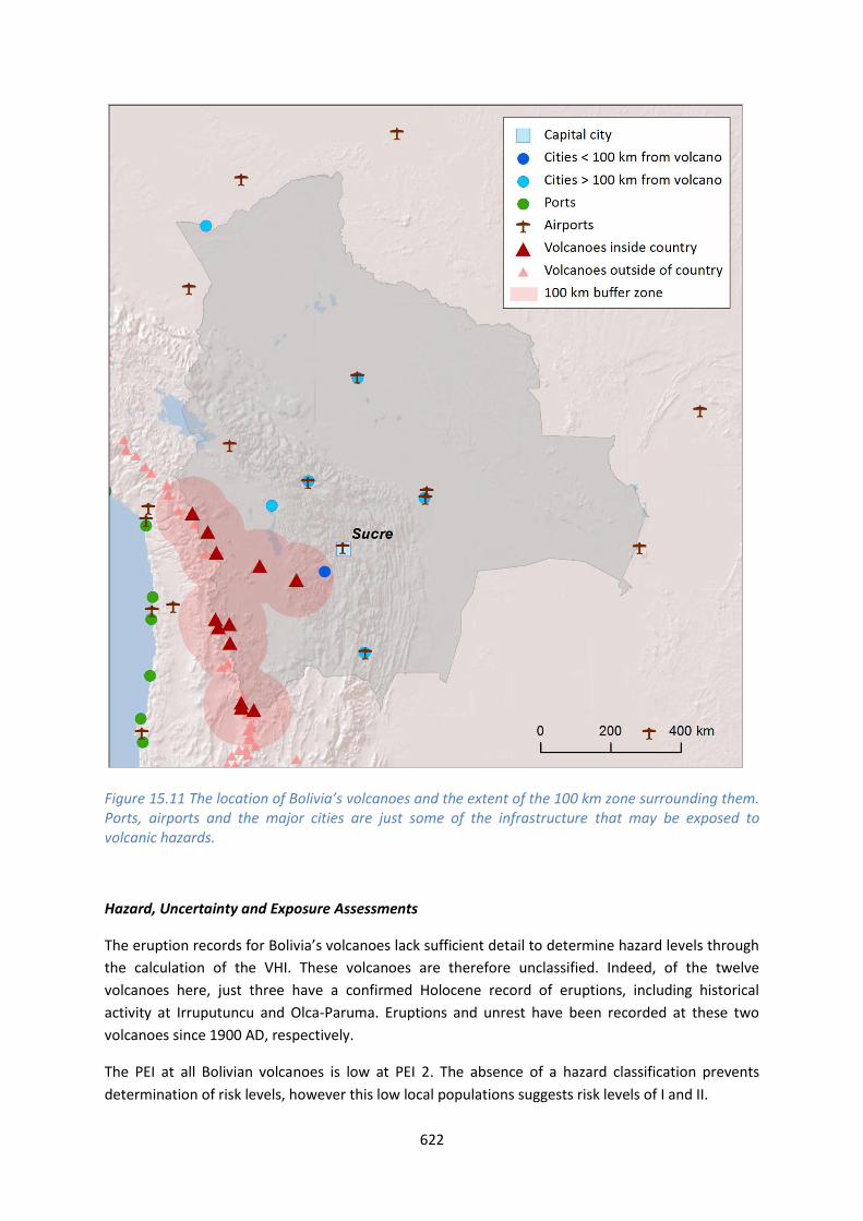
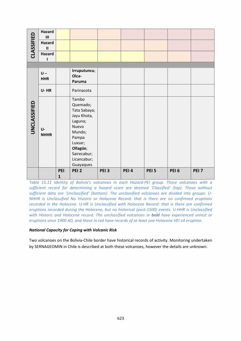
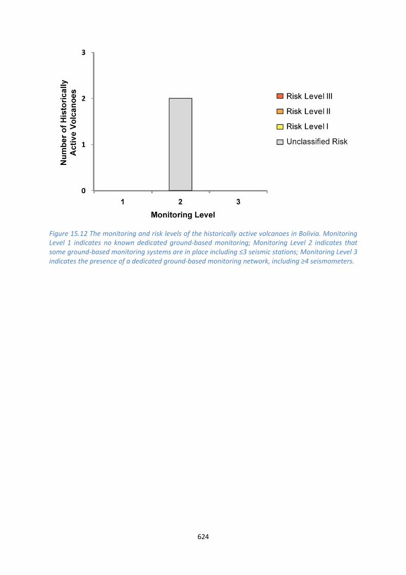
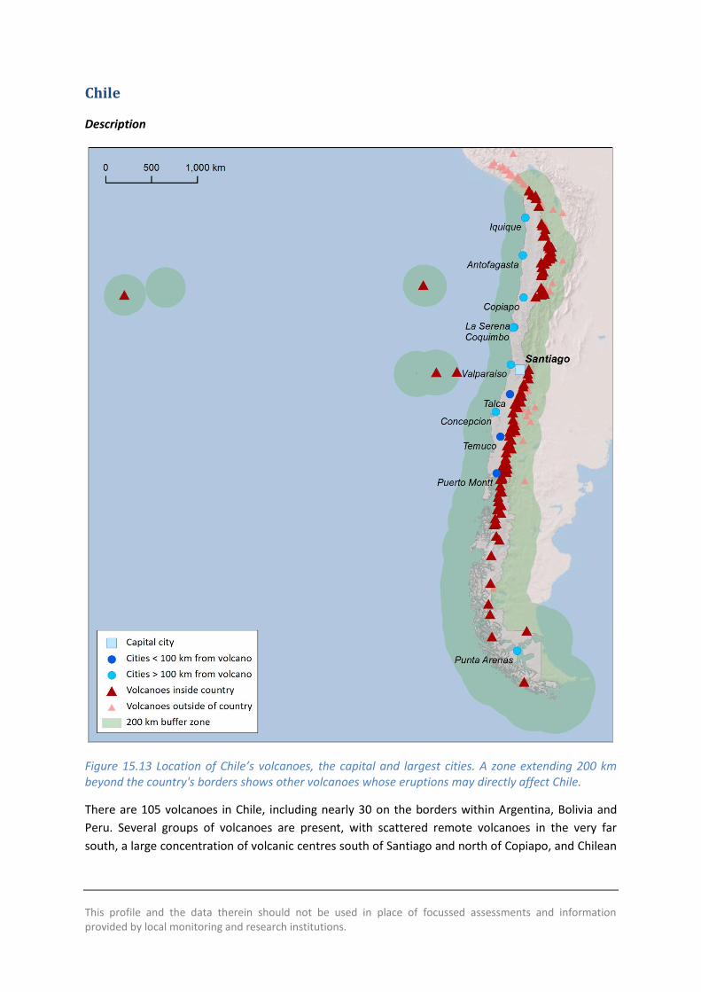
This profile and the data therein should not be used in place of focussed assessments and information provided by local monitoring and research institutions
Chile
Description
Figure 1513 Location of Chilersquos volcanoes the capital and largest cities A zone extending 200 km beyond the countrys borders shows other volcanoes whose eruptions may directly affect Chile
There are 105 volcanoes in Chile including nearly 30 on the borders within Argentina Bolivia and
Peru Several groups of volcanoes are present with scattered remote volcanoes in the very far
south a large concentration of volcanic centres south of Santiago and north of Copiapo and Chilean
626
islands in the Pacific Ocean Volcanism through Chile is primarily due to the subduction of the Nazca
Plate beneath the South American Plate and intra-plate processes in the Pacific
A range of volcano types are present throughout Chile though stratovolcanoes are most common
with about three quarters of volcanoes here being classified as such The rock type also varies from
basaltic to rhyolitic however andesitic compositions are most common
Large explosive Pleistocene activity is recorded in Chile at 20 volcanoes The largest Pleistocene
eruptions were of magnitude 74 with three eruptions of this size at Calabozos caldera about
150000 300000 and 800000 years ago Holocene activity has occurred here and hot springs are
still active within the caldera
Holocene activity in Chile has included 476 confirmed eruptions from 56 volcanoes The remaining
volcanoes have activity of suspected Holocene age Holocene activity has comprised a range of
activity styles and sizes with eruptions from VEI 0 to 6 though only about 5 of these were VEI ge4
Historically 40 volcanoes are recorded producing 357 eruptions Of these 8 were VEI ge4 though
pyroclastic flows are recorded in 16 eruptions Lava flows have more commonly been recorded and
14 of eruptions have resulted in lahars The largest historical eruption in Chile occurred at Cerro
Azul in 1916 This VEI 5 eruption ejected 95 cubic kilometres of tephra and was one of the worldrsquos
largest eruptions in the 20th century
Only a small total population is situated within 10 km of one or more Holocene volcanoes in Chile
however this grows considerably at 30 km and to about 106 million at 100 km accounting for about
63 of the population Ten historic eruptions have resulted in loss of life at Lonquimay Llaima
Villarrica Carran-Los Venados Chaiten and Cerro Hudson
The Red de Vigilancia Volcanic (Volcano monitoring network) and the Observatorio Volcanologico de
Los Andes del Sur (OVDAS) are part of the Servicio Nacional de Geologia y Mineria (SERNAGEOMIN)
This body is government funded and was founded in 1996 The main objective of these groups is to
establish monitoring systems and monitor the most dangerous volcanoes in Chile (based on the
frequency of activity proximity to population centres and vulnerability of public and private
infrastructure) in order to provide information to the relevant authorities
Monitoring is undertaken at many volcanoes using seismic networks cameras deformation and gas
measurements Success of the network has been proven in the eruption of Puyehue-Cordon Caulle
and alerts at Hudson and Copahue Resources and plans are available for responding to developing
unrest and eruption at current un- or under-monitored volcanoes
Scientific technical and support staff are present at the monitoring institution and about 20 of
these have experience of responding to activity however large amounts of data are gathered and
further scientific experience and support is required for full analysis
Regular technical meetings are held in the event of increased activity and an informal response
protocol is followed including alerting the regional VAAC The Oficina Nacional de Emergencia del
Ministerio del Interior y Seguridad Puacuteblica (ONEMI) coordinates emergency response OVDAS
communicates hazard assessments and alerts to ONEMI who use a civil protection alert system
627
A relative threat ranking is produced by SERNAGEOMIN for the volcanoes of Chile This is similar to
the NVEWS method and VHI using hazard indicators taken from the records and coupling these with
exposure factors The relative threat is the sum of the hazard times sum of exposure This ranking system
indicates that Villarrica and Llaima have the largest relative threat ranking with these volcanoes
being the most frequently active here with 126 historical eruptions between them coupled with
large populations within 100 km
A questionnaire was completed by SERNAGEOMIN as part of this study This indicated that a number
of volcano records in VOTW40 require updating with some volcanoes considered Holocene age in
VOTW40 but designated as Pleistocene age by SERNAGEOMIN This highlights the value of close
collaboration between the volcanological community to ensure up-to-date and sustainable data
systems Updates will be considered by the Smithsonian Institution
See also
SERNAGEOMIN wwwsernageominclvolcan-observatoriophp
Volcano Facts
Number of Holocene volcanoes 105 inclusive of 19 on the border with Argentina 7 on the border with Bolivia and 1 on the border with Peru
Number of Pleistocene volcanoes with Mge4 eruptions 20 inclusive of 3 on the border with Argentina
Number of volcanoes generating pyroclastic flows 19
Number of volcanoes generating lahars 13
Number of volcanoes generating lava flows 25
Number of fatalities caused by volcanic eruptions 473
Tectonic setting 101 Subduction zone 3 Intra-plate 1 Rift zone
Largest recorded Pleistocene eruption The Loma Seca Tuff units S V and L from Calabozos are all recorded at M74 at 150 ka 300 ka and 800 ka respectively
Largest recorded Holocene eruption The M63 H1T2 eruption from Cerro Hudson at 7710 BP
Number of Holocene eruptions 476 confirmed eruptions 74 uncertain and 9 discredited eruptions
Recorded Holocene VEI range 0 ndash 6 and unknown
Number of historically active volcanoes 40
628
Number of historic eruptions 357
Number of volcanoes
Primary volcano type Dominant rock type
6 Caldera(s) Andesitic (3) Dacitic (2) Rhyolitic (1)
78 Large cone(s) Andesitic (51) Basaltic (12) Dacitic (12) Unknown (3)
2 Lava dome(s) Andesitic (1) Dacitic (1)
3 Shield(s) Basaltic (3)
15 Small cone(s) Andesitic (5) Basaltic (7) Dacitic (1) Unknown (2)
1 Submarine Unknown (1)
Table 1512 The number of volcanoes in Chile their volcano type classification and dominant rock type according to VOTW40
Socio-Economic Facts
Total population (2012) 17479000
Gross Domestic Product (GDP) per capita (2005 PPP $) 15272
Gross National Income (GNI) per capita (2005 PPP $) 14987
Human Development Index (HDI) (2012) 0819 (Very High)
Population Exposure
Capital city Santiago
Distance from capital city to nearest Holocene volcano 805 km
Total population (2011) 16888760
Number (percentage) of people living within 10 km of a Holocene volcano
21030 (lt1)
Number (percentage) of people living within 30 km of a Holocene volcano
208768 (12)
Number (percentage) of people living within 100 km of a Holocene volcano
10623259 (629)
Ten largest cities as measured by population and their population size
Santiago 4837295 Antofagasta 309832 Valparaiso 282448 Temuco 238129
629
Iquique 227499 Concepcion 215413 Talca 197479 Puerto Montt 160054 La Serena 154521 Copiapo 129280
Infrastructure Exposure
Number of airports within 100 km of a volcano 10
Number of ports within 100 km of a volcano 8
Total length of roads within 100 km of a volcano (km) 16196
Total length of railroads within 100 km of a volcano (km) 2139
The numerous volcanoes of Chile are located primarily along the countryrsquos eastern border with
Argentina Bolivia and Peru and as such the 100 km radii of these volcanoes extend into these
neighbouring countries Similarly volcanoes near the borders in these countries have radii extending
into Chile exposing the infrastructure here Several volcanoes are situated in the Pacific off the coast
of Chile The capital Santiago lies within 100 km of the historically active Tupungatito and San Joseacute
volcanoes hence considerable critical infrastructure is exposed here Being a relatively narrow
stretch of land much of southern Chile lies within 100 km of Holocene volcanoes and many ports
are exposed here A very extensive road and rail network is exposed throughout the country and
many of the countryrsquos largest cities lie within 100 km
630
Figure 1514 The location of Chilersquos volcanoes and the extent of the 100 km zone surrounding them Ports airports and the major cities are just some of the infrastructure that may be exposed to volcanic hazards
Hazard Uncertainty and Exposure Assessments
There are varying levels of information available in the eruption records of Chilersquos volcanoes About
20 of the volcanoes here (20 out of 105) have sufficient detail to define the hazard through the
calculation of the VHI These are classified across all three hazard levels with most being classed at
Hazard Levels I and II Four volcanoes are classed at Hazard Level III all with Holocene records of
eruptions of VEI 4 and 5 and all with records of explosive volcanism accompanied by the production
of pyroclastic flows
631
Of the unclassified volcanoes 49 have no records of confirmed Holocene age eruptions 36
volcanoes have a Holocene eruption record of which 20 have erupted historically (post-1500 AD)
including eruptions since 1900 AD at 11 volcanoes Unrest is described at nine unclassified volcanoes
since 1900 AD Seven unclassified volcanoes have Holocene records of large explosive VEI ge4
eruptions
The PEI ranges from 1 to 4 low to moderate in Chile with an overwhelming majority at PEI 2 The
classified volcanoes are therefore Risk Levels of I and II Although the risk levels cannot be defined
for the unclassified volcanoes due to the absence of hazard details these would all also be clased at
Risk Level I and II
632
CLA
SSIF
IED
Hazard III
Cerro Azul Puyehue-Cordoacuten Caulle Osorno Calbuco
Hazard II
Laacutescar Planchoacuten-Peteroa Chillaacuten Nevados de Antuco Copahue Lonquimay Llaima
Villarrica
Hazard I
Guallatiri Isluga San Pedro Huequi Lautaro Maipo Tupungatito San Joseacute
UN
CLA
SSIF
IED
U ndash HHR Robinson Crusoe
Irruputuncu Olca-Paruma Putana Llullaillaco Tinguiririca Descabezado Grande Callaqui Quetrupillan Mocho-Choshuenco Puntiagudo-Cordoacuten Cenizos Minchinmaacutevida Mentolat Cerro Hudson Arenales Reclus Monte Burney Fueguino
Carraacuten-Los Venados Chaiteacuten
U- HR
Taapaca Parinacota Socompa Nevados Ojos del Salado Longaviacute Nevado de Laniacuten Antillanca Group Cayutueacute-La Vigueriacutea Yanteles Corcovado Melimoyu Macaacute Aguilera Pali-Aike Volcanic Field
Sollipulli Caburgua-Huelemolle
U- NHHR
San Feacutelix Unnamed
Tacora Ollaguumle Azufre Cerro del Sairecabur Licancabur Guayaques Purico Complex Colachi Acamarachi Overo Cerro Chiliques Cordoacuten de Puntas Negras Mintildeiques Tujle Cerro Caichinque Tilocalar Negrillar El Pular Negrillar La Escorial Lastarria Cordoacuten del Azufre Bayo Gorbea Cerro Nevada Sierra Falso Azufre Incahuasi Nevado de Solo El Copiapoacute Palomo Calabozos Maule Laguna del San Pedro-Pellado Blancas Lomas Resago Marintildeaqui Laguna Tolguaca Pantojo Cerro Tronador Cuernos del Diablo Yate Hornopireacuten Apagado Palena Volcanic Group Puyuhuapi Cay Riacuteo Murta
Easter Island
PEI 1 PEI 2 PEI 3 PEI 4 PEI 5 PEI 6 PEI 7 Table 1513 Identity of Chilersquos volcanoes in each Hazard-PEI group Those volcanoes with a sufficient record for determining a hazard score are deemed lsquoClassifiedrsquo (top) Those without sufficient data are lsquoUnclassifiedrsquo (bottom) The unclassified volcanoes are divided into groups U-NHHR is Unclassified No Historic or Holocene Record that is there are no confirmed eruptions recorded in the Holocene U-HR is Unclassified with Holocene Record that is there are confirmed eruptions recorded during the Holocene but no historical (post-1500) events U-HHR is Unclassified with Historic and Holocene record The unclassified volcanoes in bold have experienced unrest or eruptions since 1900 AD and those in red have records of at least one Holocene VEI ge4 eruption
633
Volcano Population Exposure Index Risk Level
Tupungatito 4 I San Joseacute 4 I Villarrica 3 II Calbuco 3 II Maipo 3 I Azul Cerro 2 II Puyehue-Cordoacuten Caulle 2 II Osorno 2 II Guallatiri 2 I Isluga 2 I San Pedro 2 I Laacutescar 2 I Planchoacuten-Peteroa 2 I Chillaacuten Nevados de 2 I Antuco 2 I Copahue 2 I Lonquimay 2 I Llaima 2 I Huequi 2 I Lautaro 2 I
Table 1514 Classified volcanoes of Chile ordered by descending Population Exposure Index (PEI) Risk levels determined through the combination of the Hazard Level and PEI are given Risk Level I ndash 15 volcanoes Risk Level II ndash 5 volcanoes Risk Level III ndash 0 volcanoes
Figure 1515 Distribution of Chilersquos classified volcanoes across Hazard and Population Exposure Index levels The warming of the background colours illustrates increasing Risk levels from Risk Level I - III
634
National Capacity for Coping with Volcanic Risk
Forty volcanoes have records of historical activity in Chile These volcanoes are primarily classed at
Risk Level I All Risk Level II historical volcanoes are monitored by SERNAGEOMIN using seismic
stations as a minimum Many volcanoes also have deformation monitoring
Figure 1516 The monitoring and risk levels of the historically active volcanoes in Chile Monitoring Level 1 indicates no known dedicated ground-based monitoring Monitoring Level 2 indicates that some ground-based monitoring systems are in place including le3 seismic stations Monitoring Level 3 indicates the presence of a dedicated ground-based monitoring network including ge4 seismometers
This profile and the data therein should not be used in place of focussed assessments and information provided by local monitoring and research institutions
Colombia
Description
Figure 1517 Location of Colombiarsquos volcanoes the capital and largest cities A zone extending 200 km beyond the countrys borders shows other volcanoes whose eruptions may directly affect Colombia
Fifteen Holocene volcanoes are distributed through the northern Andes in western Colombia to the
Ecuador border paralleling the Pacific coastline These volcanoes are related to the subduction of
the Nazca Plate beneath the South American Plate
All Holocene volcanoes in Colombia form edifices typically associated with explosive-type activity
including stratovolcanoes and complex volcanoes with the exception of the Petacas lava dome and
636
Santa Isabel shield The Colombian volcanoes are dominantly andesitic in composition The explosive
record continues into the Pleistocene with three Colombian volcanoes hosting MVEI ge4 eruptions
in this period
There are 125 confirmed eruptions recorded in the Holocene at VEI 1 to 5 indicating a range of
activity from mild to strongly explosive Eight volcanoes have a Holocene record of producing
pyroclastic flows and six are associated with lahars Nine of the Colombian volcanoes have 79
eruptions recorded in historical times
Many of Colombiarsquos most populous cities are located on or towards the northern coast away from
volcanoes however the cities of Cali Ibague Pasto and Pereira lie within 100 km of one or more
Holocene volcanoes with the latter three over-looked by Machin Galeras and the Ruiz-Tolima chain
Numerous eruptions of Nevado del Ruiz Nevado del Huila Puraceacute and Galeras have resulted in
evacuations and property damage Fatalities are recorded in nine eruptions of these volcanoes and
Dontildea Juana
The assessment of hazard is complicated by sparse eruptive histories at over half of Colombiarsquos
volcanoes resulting in hazard levels with large associated uncertainties hence just five volcanoes
have a hazard level classified here Nevado del Ruiz Galeras and Cerro Bravo are classed with the
highest hazard in Colombia based on detailed eruptive histories Coupled with the high proximal
population these volcanoes are classed at Risk Level III
Both Galeras and Nevado del Ruiz have caused loss of life Machiacuten has not caused any fatalities but
has shown recent unrest and its geological record indicates the potential for violent and destructive
explosive eruptions In 1993 a sudden intense but small magnitude explosive eruption of Galeras
killed nine people including six volcanologists who were in the inner crater or on its rim A far larger
disaster the largest in South Americarsquos history was the 1985 eruption of Nevado del Ruiz Though
only VEI 3 the eruption generated pyroclastic flows that melted the volcanorsquos glacier cap and caused
lahars The mudflows descended the western flanks flowing along the Riacuteo Lagunillas valley The
town of Armero located on the banks of Riacuteo Lagunillas 48 km from the volcano was completely
buried Though the death toll is uncertain it is estimated that 21000 of the 29000 residents of
Armero were killed along with others elsewhere bringing the total loss of life to between 23000
and 26000
Further eruptions with human impacts have occurred very recently at Galeras volcano An eruption
starting on 25th August 2010 spread ash as far as 30 km to the northwest 7000 people were
advised to evacuate though few left their homes Activity did not increase after this until January
2011
Eruptions at a number of the northernmost volcanoes in Ecuador may directly affect Colombia as
they lie within 100 km of the border Similarly Galeras Cumbal and Azufral lie within 100 km of
Ecuador
Following the 1985 Nevado del Ruiz tragedy the Colombian Government took steps to strengthen
the monitoring and response mechanisms for Colombian volcanoes These measures included
making INGEOMINAS responsible for the monitoring of volcanoes and provision of scientific advice
637
The Servicio Geologico Colombiano (INGEOMINAS) operate three volcano observatories in Colombia
Observatorio Pasto (responsible for Galeras Cumbal Chiles Cerro Negro Las Animas Doňa Juana
and Azufral) Observatorio Manizales (responsible for Nevado del Ruiz Cerro Machin Cerro Bravo
Nevado Santa Isabel and Nevado Tolima) and Observatorio Popayan (responsible for Nevado del
Huila Sotaraacute and Puraceacute) INGEOMINAS operate a monitoring network at Colombiarsquos active
volcanoes and the status of the volcanoes is communicated publically and is available online
See also
INGEOMINAS - wwwsgcgovco
Volcano Facts
Number of Holocene volcanoes 15 inclusive of one on the border with Ecuador
Number of Pleistocene volcanoes with Mge4 eruptions 3
Number of volcanoes generating pyroclastic flows 8
Number of volcanoes generating lahars 6
Number of volcanoes generating lava flows 3
Number of fatalities caused by volcanic eruptions 25567
Tectonic setting Subduction zone
Largest recorded Pleistocene eruption The El Boqueron Ancestral caldera collapse eruption of 580 ka at Nevado del Tolima and the 560 ka Coba Negra caldera forming eruption of Galeras are both recorded at M62
Largest recorded Holocene eruption The M55 R8 eruption of Nevado del Ruiz at 28 ka
Number of Holocene eruptions 125 confirmed eruptions 10 uncertain eruptions
Recorded Holocene VEI range 1 ndash 5 and unknown
Number of historically active volcanoes 9
Number of historic eruptions 79
638
Number of volcanoes
Primary volcano type Dominant rock type
13 Large cone(s) Andesitic (9) Dacitic (4)
1 Lava dome(s) Unknown (1)
1 Shield(s) Andesitic (1)
Table 1515 The number of volcanoes in Colombia their volcano type classification and dominant rock type according to VOTW40
Socio-Economic Facts
Total population (2012) 47783000
Gross Domestic Product (GDP) per capita (2005 PPP $) 8861
Gross National Income (GNI) per capita (2005 PPP $) 8711
Human Development Index (HDI) (2012) 0719 (High)
Population Exposure
Capital city Bogataacute
Distance from capital city to nearest Holocene volcano 1386 km
Total population (2011) 44725543
Number (percentage) of people living within 10 km of a Holocene volcano
451010 (1)
Number (percentage) of people living within 30 km of a Holocene volcano
3236251 (72)
Number (percentage) of people living within 100 km of a Holocene volcano
13408843 (30)
Ten largest cities as measured by population and their population size
Bogota 7102602 Cali 2392877 Medellin 1999979 Barranquilla 1380425 Cartagena 952024 Cucuta 721398 Bucaramanga 571820 Pereira 440118 Santa Marta 431781 Ibague 421685
639
Infrastructure Exposure
Number of airports within 100 km of a volcano 2
Number of ports within 100 km of a volcano 0
Total length of roads within 100 km of a volcano (km) 3159
Total length of railroads within 100 km of a volcano (km) 420
Figure 1518 The location of Colombiarsquos volcanoes and the extent of the 100 km zone surrounding them Ports airports and the major cities are just some of the infrastructure that may be exposed to volcanic hazards
The volcanoes in Colombia are located in the west of the country from the border with Ecuador to
just north of the capital Bogata The southernmost volcanoes Galeras Cumbal and Azufral lie close
to the Ecuador border and their 100 km radii extend into Ecuador exposing infrastructure here
640
Similarly six of the northernmost of Ecuadorrsquos volcanoes have 100 km radii which extend into
Colombia Four of the largest cities in Colombia are situated within 100 km of Holocene volcanoes
including Pasto Cali Ibague and Pereira exposing much of the critical infrastructure here The
capital Bogata lies within 140 km of several Holocene volcanoes including the historically active
Nevado del Ruiz and Nevado del Tolima
Hazard Uncertainty and Exposure Assessments
The volcanoes in Colombia are classed at Hazard Levels I to III Ten of the 15 Colombian volcanoes
have insufficient data available in their eruption records to adequately calculate a hazard score
without very large uncertainties The highest hazard levels are found at Nevado del Ruiz Galeras and
Cerro Bravo
Of the unclassified volcanoes three Azufral Machiacuten and Sotaraacute have had recorded periods of unrest
above background levels since 1900 Both Azufral and Machiacuten have Holocene eruption records but
no historical eruptions Four Colombian volcanoes Nevado del Huila Dontildea Juana Cumbal and Cerro
Negro de Mayasquer are unclassified but have historical records of activity including post-1900
eruptions
CLA
SSIF
IED
Hazard III Cerro Bravo Nevado del Ruiz
Galeras
Hazard II Nevado del Tolima
Hazard I Puraceacute
UN
CLA
SSIF
IED
U ndash HHR
Nevado del Huila Dontildea Juana Cumbal Cerro Negro de Mayasquer
U- HR Romeral Santa Isabel Machiacuten Azufral
U- NHHR Petacas Sotaraacute
PEI 1 PEI 2 PEI 3 PEI 4 PEI 5 PEI 6 PEI 7 Table 1516 Identity of Colombiarsquos volcanoes in each Hazard-PEI group Those volcanoes with a sufficient record for determining a hazard score are deemed lsquoClassifiedrsquo (top) Those without sufficient data are lsquoUnclassifiedrsquo (bottom) The unclassified volcanoes are divided into groups U-NHHR is Unclassified No Historic or Holocene Record that is there are no confirmed eruptions recorded in the Holocene U-HR is Unclassified with Holocene Record that is there are confirmed eruptions recorded during the Holocene but no historical (post-1500) events U-HHR is Unclassified with Historic and Holocene record The unclassified volcanoes in bold have experienced unrest or eruptions since 1900 AD and those in red have records of at least one Holocene VEI ge4 eruption
641
Volcano Population Exposure Index Risk Level
Galeras 6 III Ruiz Nevado del 5 III Bravo Cerro 4 III Tolima Nevado del 4 II Puraceacute 4 I
Table 1517 Classified volcanoes of Colombia ordered by descending Population Exposure Index (PEI) Risk levels determined through the combination of the Hazard Level and PEI are given Risk Level I ndash 1 volcano Risk Level II ndash 1 volcano Risk Level III ndash 3 volcanoes
Figure 1519 Distribution of Colombiarsquos classified volcanoes across Hazard and Population Exposure Index levels The warming of the background colours illustrates increasing Risk levels from Risk Level I - III
All Colombian volcanoes have moderate to high PEI levels at PEI 3 to 6 The highest PEI is found at
Galeras which has over 120000 living just within 10 km Combined with a Hazard Level of III
Galeras is classed as a Risk Level III volcano Of the classified volcanoes just one volcano Puraceacute is
deemed Risk Level I whilst one Nevado del Tolima is classed at Risk Level II
National Capacity for Coping with Volcanic Risk
Nine volcanoes in Colombia have recorded historical activity Of these all have dedicated ground-
based monitoring systems operated by INGEOMINAS Seven volcanoes are classed here at
Monitoring Level 3 with seismic networks in operation and additional deformation and or gas
monitoring The three volcanoes with the highest risk classification here are continuously monitored
at this level
642
Figure 1520 The monitoring and risk levels of the historically active volcanoes in Colombia Monitoring Level 1 indicates no known dedicated ground-based monitoring Monitoring Level 2 indicates that some ground-based monitoring systems are in place including le3 seismic stations Monitoring Level 3 indicates the presence of a dedicated ground-based monitoring network including ge4 seismometers
This profile and the data therein should not be used in place of focussed assessments and information provided by local monitoring and research institutions
Ecuador and the Galapagos
Description
Figure 1521 Location of Ecuadorrsquos volcanoes the capital and largest cities A zone extending 200 km beyond the countrys borders shows other volcanoes whose eruptions may directly affect Ecuador
Thirty-five volcanoes of Holocene age are identified in Ecuador This includes volcanoes on mainland
Ecuador and in the Galapagos Islands nearly 1000 km to the west Volcanism in mainland Ecuador is
related to the subduction of the Nazca Plate beneath the South American Plate whilst Galapagos
volcanism is due to intra-plate hotspot volcanism and the Galapagos spreading centre Volcanoes of
the Galapagos are predominantly basaltic shields while in mainland Ecuador the composition is
more felsic and andesitic stratovolcanoes are most common
644
Twenty-eight of the volcanoes have 311 confirmed Holocene eruptions the remaining volcanoes
have suspected Holocene activity With records of activity ranging in size from VEI 0 to 6 a range of
activity styles is indicated from mild effusions of lavas to large explosive events The largest
Holocene eruption on record is the ~1280 AD eruption of Quilotoa at VEI 6 M64 This event
generated extensive pyroclastic flows ash fall and lahars A larger eruption (M69) is recorded in the
Pleistocene at 211 ka with the Ash Flow of the Chalupas Caldera Numerous Pleistocene eruptions
of VEIM ge4 are recorded in Ecuador and 43 large explosive eruptions of this size are recorded in the
Holocene
Since 1500 AD 197 eruptions are recorded at nineteen volcanoes Of these 11 were VEI 4 indicating
that large explosive eruptions are relatively frequent in Ecuador The dominantly andesitic
composition and stratovolcano morphology indicates typical explosive activity The altitude of the
volcanoes in Ecuador means that many of the volcanoes are capped with snow or glaciers This
increases the propensity to cause hazardous lahars as even small eruptions can result in the melting
of ice caps Indeed eight volcanoes in Ecuador have a Holocene record of lahar triggering
The most frequently active volcanoes here are Cotopaxi Reventador and Tungurahua while Sangay
is continuously active since 1628 but poses little threat since it is isolated from population centres
The Galapagos Island volcanoes are exclusively shield volcanoes With a small population of just over
20000 the main hazard they pose is largely environmental but also to wildlife such as slow moving
giant tortoises as a result of lava flows and ash fall One exception to this is Fernandina which has
erupted explosively on numerous occasions producing pyroclastic flows and debris avalanches No
fatalities are recorded as a result of eruptions of Fernandina
Much of central and northern mainland Ecuador lies within 100 km of one or more Holocene
volcanoes and six of the most populous cities in the country fall in this zone The capital Quito lies
within 100 km of many volcanoes and within about 12 km of the historically active Guagua
Pichincha This volcano had a VEI 4 eruption in 1660 resulting in extensive ash fall and ash
accumulation in the capital Pyroclastic flows and surges were channelled mainly to the west as the
caldera is breached in this direction This breach will still likely act to channel flows to the west
however surges in particular are not always constrained by topography and can reach small
communities such as Lloa but have never jumped the topographic barrier into the Quito basin
The presence of many cities within 100 km of the Holocene volcanoes exposes a large proportion of
the population to direct volcanic hazards with 50 of Ecuadorrsquos population residing within 100 km
of one or more Holocene volcano
The assessment of hazard at many of Ecuadorrsquos volcanoes is complicated by incomplete or sparse
eruption records and publication of this information in ldquogrey literaturerdquo that is difficult to access
hence the assignment of hazard levels is associated with large degrees of uncertainty
Fatalities have resulted from eruptions of Reventador Guagua Pichincha Cotopaxi Tungurahua
Sangay and Cerro Azul Greatest loss of life as a result of volcanism in Ecuadorian territories occurred
in 1640 following an eruption of Tungurahua Though some uncertainty surrounds the eruption
record it is believed an approximately VEI 3 eruption caused pyroclastic flows and a small sector
collapse that destroyed a village and its 5000 inhabitants Eruptions of Cotopaxi in 1742 1768 and
645
1877 have also significantly added to the death toll from volcanoes in Ecuador with roughly 1200
deaths as a result of lahars attributable to these three eruption periods
The Instituto Geofisico of the Escuela Politeacutecnica Nacional (IGEPN) is responsible for the study
monitoring and hazard assessment of Ecuadorrsquos volcanoes Sixteen volcanoes are monitored with at
least one broadband seismic instrument and one or more continuously operating GPS staton
Tungurahua Cotopaxi Guagua Pichincha Reventador Cuicocha and Antisana volcanoes are
monitored with a broad suite of geophysical instruments and because of the completeness of their
real-time networks are considered to b in an ldquoArdquo category Ten other volcanoes Atacazo Pululagua
Imbabura Chachimburo Cerro Negro Cayambe Soche Sangay Chimborazo and Quilotoa all have
at least one or more broadband seismic and deformation-detecting stations The IGEPN provides
advice and information regarding volcanic activity and presents this information online accessible to
the public Reports are regularly issued summarising volcanic activity and early warnings before a
notable increase in eruptive activity is given on this web via calls over local radio stations and
through social media Close collaborations exist with the Secretariat for Risk Management Before
and during volcanic crises IGEPN scientists communicate and provide hazard assessments to local
regional and national authorities At Tungurahua volcano which has been erupting since 1999 a
volunteer volcano observers group (Vigias) has been very successful in providing in situ observations
of eruptive activity via a radio system to the local observatory IGEPN scientists
From here we provide the information for mainland Ecuador and the Galapagos Islands separately
See also
Servicio Nacional de Sismologia y Vulcanologia wwwigepneduec
646
Mainland Ecuador
Volcano Facts
Number of Holocene volcanoes 22 inclusive of one on the border with Colombia
Number of Pleistocene volcanoes with Mge4 eruptions 7
Number of volcanoes generating pyroclastic flows 14
Number of volcanoes generating lahars 8
Number of volcanoes generating lava flows 7
Number of fatalities caused by volcanic eruptions 5690
Tectonic setting 22 Subduction zone
Largest recorded Pleistocene eruption The M69 Chalupas Ash Flow eruption of Chalupas at 211 ka
Largest recorded Holocene eruption The M64 eruption of Quilotoa about 700 years ago
Number of Holocene eruptions 229 confirmed eruptions
Recorded Holocene VEI range 0 ndash 6 and unknown
Number of historically active volcanoes 10 according to VOTW422 (Cotopaxi Reventador Tungurahua Guagua Pichincha Cayambe Sangay Chacana Antisana Sumaco and Cerro Negro de Mayasquer) Activity at the latter three volcanoes is ambiguous
Number of historic eruptions 131
Number of volcanoes
Primary volcano type Dominant rock type
4 Caldera(s) Dacitic (3) Rhyolitic (1)
17 Large cone(s) Andesitic (13) Basaltic (1) Dacitic (3)
1 Small cone(s) Andesitic (1)
Table 1518 The number of volcanoes in Ecuador their volcano type classification and dominant rock type according to VOTW40
647
Socio-Economic Facts
Total population (2012) 15520000
Gross Domestic Product (GDP) per capita (2005 PPP $) 7443
Gross National Income (GNI) per capita (2005 PPP $) 7471
Human Development Index (HDI) (2012) 0724 (High)
Population Exposure
Capital city Quito
Distance from capital city to nearest Holocene volcano 122 km
Total population (2011) 15007343
Number (percentage) of people living within 10 km of a Holocene volcano
750552 (5)
Number (percentage) of people living within 30 km of a Holocene volcano
4352168 (29)
Number (percentage) of people living within 100 km of a Holocene volcano
7393692 (493)
Ten largest cities as measured by population and their population size (2010 from UN data
dataunorg)
Guayaquil 2278691 Quito 1607734 Cuenca 329928 Machala 231260 Manta 217553 Portoviejo 206682 Loja 170280 Ambato 165185 Esmeraldas 154035 Riobamba 146324
Infrastructure Exposure
Number of airports within 100 km of a volcano 6 (Tulcan Quito Lago Agrio Latacunga Macas Tena)
Number of ports within 100 km of a volcano 0
Total length of roads within 100 km of a volcano (km) 3727
Total length of railroads within 100 km of a volcano (km) 0
648
In mainland Ecuador the 100 km radii of the volcanoes covers much of central and northern parts of
the country and the radii of six of the northernmost volcanoes extend into Colombia Similarly the
three southernmost volcanoes of Colombia have 100 km radii which extend into Ecuador Six of the
largest cities in Ecuador are situated within 100 km of Holocene volcanoes including the capital
Quito hence much of the critical infrastructure of the country is exposed including three airports
and an extensive road network Critical infrastructure such as two trans-Andean oil pipelines four
major hydroelectric installations Quitorsquos water supply from Antisana and Chacana volcanoes as well
as critical bridges are also exposed
Figure 1522 The location of Ecuadorrsquos volcanoes and the extent of the 100 km zone surrounding them Ports airports and the major cities are just some of the infrastructure that may be exposed to volcanic hazards
649
Hazard Uncertainty and Exposure Assessments
There are varying levels of information available in the eruption records of mainland Ecuadorrsquos
volcanoes Seven volcanoes out of 23 have sufficient detail to define the hazard through the
calculation of the VHI All of these are classified at Hazard Level III with Holocene records of VEI ge3
eruptions and records of explosive eruptions with the production of pyroclastic flows
Of the unclassified volcanoes three have no confirmed Holocene eruptions on record The
remaining 12 volcanoes have a Holocene eruptive record with historical events at four volcanoes
including post-1900 AD eruptions at Cerro Negro de Mayasquer Four unclassified volcanoes have a
Holocene record of large VEI ge4 eruptions
The size of the proximal populations at Ecuadorrsquos volcanoes ranges from small to large generating
PEIs of 1 to 7 Moderate and high PEIs dominate This range results in a range of risk levels when
combined with the Hazard Levels from II to III at the classified volcanoes Although here we consider
threat to life measured by population exposure infrastructure exposure such as the water supply to
Quito is also vital This for example is supplied from the PEI4 Antisana volcano which if it were to
erupt would have grave consequences for Quitorsquos water supply
CLA
SSIF
IED
Hazard III
Reventador Sangay
Cayambe Cotopaxi Tungurahua
Guagua Pichincha
Atacazo
Hazard II
Hazard I
UN
CLA
SSIF
IED
U ndash HHR
Sumaco
Cerro Negro de Mayasquer Antisana
Chacana
U- HR Aliso Soche Chachimbiro Chimborazo
Quilotoa Cuicocha Imbabura
Pululagua
U- NHHR
Illiniza Mojanda Licto
PEI 1
PEI 2 PEI 3 PEI 4 PEI 5 PEI 6 PEI 7
Table 1519 Identity of Mainland Ecuadorrsquos volcanoes in each Hazard-PEI group Those volcanoes with a sufficient record for determining a hazard score are deemed lsquoClassifiedrsquo (top) Those without sufficient data are lsquoUnclassifiedrsquo (bottom) The unclassified volcanoes are divided into groups U-NHHR is Unclassified No Historic or Holocene Record that is there are no confirmed eruptions recorded in the Holocene U-HR is Unclassified with Holocene Record that is there are confirmed eruptions recorded during the Holocene but no historical (post-1500) events U-HHR is Unclassified with Historic and Holocene record The unclassified volcanoes in bold have experienced unrest or eruptions since 1900 AD and those in red have records of at least one Holocene VEI ge4 eruption
Volcano Population Exposure Index Risk Level
650
Atacazo 6 III Guagua Pichincha 5 III Tungurahua 4 III Cotopaxi 4 III Cayambe 4 III Reventador 3 II Sangay 3 II
Table 1520 Classified volcanoes of Mainland Ecuador ordered by descending Population Exposure Index (PEI) Risk levels determined through the combination of the Hazard Level and PEI are given Risk Level I ndash 0 volcanoes Risk Level II ndash 2 volcanoes Risk Level III ndash 5 volcanoes
Figure 1523 Distribution of mainland Ecuadorrsquos classified volcanoes across Hazard and Population Exposure Index levels The warming of the background colours illustrates increasing Risk levels from Risk Level I - III
National Capacity for Coping with Volcanic Risk
Ten volcanoes in mainland Ecuador have recorded historical activity These volcanoes are distributed
across all three monitoring levels with half of the volcanoes being classed at Monitoring Level 3 All
Risk Level III volcanoes are monitored at Level 3 with the exception of Cayambe which also has both
seismic and deformation monitoring The Risk Level III volcanoes Tungurahua Guagua Pichincha and
Cotopaxi all have multiple monitoring systems in place inclduing continuous seismic and
deformation monitoring
651
Monitoring is undertaken by the Instituto Geofisico EPN Note that this institute also uses
Monitoring Levels 1 - 3 to describe levels of monitoring at Ecuadorrsquos volcanoes but these are
different levels to those used here
Figure 1524 The monitoring and risk levels of the historically active volcanoes in mainland Ecuador Monitoring Level 1 indicates no known dedicated ground-based monitoring Monitoring Level 2 indicates that some ground-based monitoring systems are in place including le3 seismic stations Monitoring Level 3 indicates the presence of a dedicated ground-based monitoring network including ge4 seismometers
652
Galapagos Islands
Figure 1525 The volcanoes of the Galapagos Islands Inset shows the location relative to mainland Ecuador
Volcano Facts
Number of Holocene volcanoes 13
Number of Pleistocene volcanoes with Mge4 eruptions 1
Number of volcanoes generating pyroclastic flows 1
Number of volcanoes generating lahars -
Number of volcanoes generating lava flows 9
653
Number of fatalities caused by volcanic eruptions 1
Tectonic setting 13 Rift zone
Largest recorded Pleistocene eruption The M52VEI 5 Alcedo-AB Tephra eruption of about 90000 years ago
Largest recorded Holocene eruption The VEI 4 eruption of Fernandina in 1968
Number of Holocene eruptions 82 confirmed eruptions
Recorded Holocene VEI range 0 ndash 4 and unknown
Number of historically active volcanoes 9
Number of historic eruptions 66
Number of volcanoes
Primary volcano type Dominant rock type
13 Shield(s) Basaltic (13)
Table 1521 The number of volcanoes in Ecuador their volcano type classification and dominant rock type according to VOTW40
Population Exposure
Capital city Puerto Baquerizo Moreno
Distance from capital city to nearest Holocene volcano 123 km
Total population (2010 wwwinecgobecestadisticas) 25124
Percentage of people living within 100 km of a Holocene volcano 100
Infrastructure Exposure
Number of airports within 100 km of a volcano 2
Number of ports within 100 km of a volcano -
Total length of roads within 100 km of a volcano (km) -
Total length of railroads within 100 km of a volcano (km) 0
In the Galapagos Islands the 100 km radii extend to fully encompass the island group exposing all
infrastructure here
654
Hazard Uncertainty and Exposure Assessments
Of the thirteen volcanoes in the Galapagos Islands just four have a sufficiently detailed eruption
record to determine hazard levels through the calculation of the VHI These are classified at Hazard
Levels I and II
Of the unclassified volcanoes three have no confirmed Holocene eruptions on record Six have a
record of Holocene eruptions including historical age events and post-1900 AD eruptions
The size of the proximal populations at the volcanoes of the Galapagos is typically small generating
PEIs of 2 to 3 All classified volcanoes here are classed at Risk Level I
CLA
SSIF
IED
Hazard III
Hazard II
Fernandina
Hazard I
Wolf Negra Sierra Azul Cerro
UN
CLA
SSIF
IED
U ndash HHR
Darwin Alcedo Pinta Marchena Santiago
U- HR Ecuador
U- NHHR
Genovesa Santa Cruz San Cristoacutebal
PEI 1 PEI 2 PEI 3 PEI 4 PEI 5 PEI 6 PEI 7 Table 1522 Identity of the Galapagos Islandsrsquo volcanoes in each Hazard-PEI group Those volcanoes with a sufficient record for determining a hazard score are deemed lsquoClassifiedrsquo (top) Those without sufficient data are lsquoUnclassifiedrsquo (bottom) The unclassified volcanoes are divided into groups U-NHHR is Unclassified No Historic or Holocene Record that is there are no confirmed eruptions recorded in the Holocene U-HR is Unclassified with Holocene Record that is there are confirmed eruptions recorded during the Holocene but no historical (post-1500) events U-HHR is Unclassified with Historic and Holocene record The unclassified volcanoes in bold have experienced unrest or eruptions since 1900 AD and those in red have records of at least one Holocene VEI ge4 eruption
Volcano Population Exposure Index Risk Level
Azul Cerro 2 I Fernandina 2 I Negra Sierra 2 I Wolf 2 I
Table 1523 Classified volcanoes of the Galapagos Islands ordered by descending Population Exposure Index (PEI) Risk levels determined through the combination of the Hazard Level and PEI are given Risk Level I ndash 4 volcanoes Risk Level II ndash0 volcanoes Risk Level III ndash 0 volcanoes
655
Figure 1526 Distribution of the Galapagos Islandsrsquo classified volcanoes across Hazard and Population Exposure Index levels The warming of the background colours illustrates increasing Risk levels from Risk Level I - III
National Capacity for Coping with Volcanic Risk
Nine volcanoes in the Galapagos Islands have recorded historical activity Monitoring is undertaken
by the Instituto Geofisico EPN Note that this institute also uses Monitoring Levels 1 - 3 to describe
levels of monitoring at Ecuadorrsquos volcanoes but these are different levels to those used here A
seismic monitoring network in the Galapagos Islands has been installed
Figure 1527 The monitoring and risk levels of the historically active volcanoes in the Galapagos Islands of Ecuador Monitoring Level 1 indicates no known dedicated ground-based monitoring Monitoring Level 2 indicates that some ground-based monitoring systems are in place including le3 seismic stations Monitoring Level 3 indicates the presence of a dedicated ground-based monitoring network including ge4 seismometers
This profile and the data therein should not be used in place of focussed assessments and information provided by local monitoring and research institutions
Peru
Description
Figure 1528 Location of Perursquos volcanoes the capital and largest cities A zone extending 200 km beyond the countrys borders shows other volcanoes whose eruptions may directly affect Peru
Seventeen Holocene volcanoes are recorded in Peru These volcanoes are located in the Andes in a
chain through southern Peru to the border with Chile Volcanism occurs here due to the subduction
of the Nazca Plate beneath the South American Plate Although subduction is also ongoing in
northern Peru the angle of the subducting slab has not led to recent volcanism Although Perursquos
volcanoes are a variety of types including cinder cones and lava domes most are stratovolcanoes of
dominantly andesitic composition
Large explosive Pleistocene activity is recorded in Peru and sixty eruptions of Holocene age are
recorded here Of these thirty-six are of historical age These historical eruptions occurred at six
657
volcanoes and covered a range of sizes from small events of VEI 1 to very large explosive VEI 6
eruptions Three volcanoes have Holocene records of producing pyroclastic flows and four with
lahars The largest historical eruption was the 1600 AD eruption of Huaynaputina This eruption
produced voluminous tephra falls pyroclastic flows and surges which travelled 13 km and lahars that
reached the Pacific Ocean 120 km away The cities of Arequipa and Moquengua suffered significant
damage and about 1500 lives were lost
Arequipa one of the most populous cities in Peru lies at about 75 km from Huaynaputina and
within 100 km of five other Holocene volcanoes including the historically active Sabancaya El Misti
and Ubinas the most frequently active volcano in Peru in historic times
The Instituto Geofisico del Peru (IGP) and the Instituto Geolόgico Minero y Metaluacutergico (INGEMMET)
are responsible for scientific research and the monitoring of the volcanoes in Peru and indeed
actively monitor five historically active volcanoes and three further Holocene volcanoes through a
variety of dedicated ground-based instrumentation including seismic stations geochemical and gas
monitoring and various deformation monitoring Monitoring is undertaken regularly with an alarm
system and automated seismic system A regional seismic network is operational in Peru which can
register seismicity throughout the volcanic chain Some resources and plans are available for
monitoring to be extended to currently un-monitored volcanoes in developing situations About a
quarter of the observatory staff have experience of responding to an eruption
In addition to ground-based monitoring VDAP ndash the Volcano Disaster Assistance Program of the US
Geological Survey provides satellite information during eruptions and InSAR and MODIS images are
provided by Cornell University and Torino University
The IGP provide scientific and technical advice to the Instituo Nacional de Defensa Civil (INDECI) in
the event of unrest and eruption The director of the Observatorio Vulcanologico de Sur (OVS)
Orlando Macedo represents the IGP on the regional committee for crises (the Comite de
Operaciones de Emergencia Regional COER) The regional aviation authority Corporacion Peruana
de Aviacion Comercial (CORPAC) reports to the regional VAAC
The IGP extend a programme of hazard education to the public and the IGP and INGEMMET
websites are publically accessible distributing information about Perursquos volcanic activity The IGP do
not provide risk assessments but advise on management and mitigation of volcanic risk An alert
level system is in place and the IGP INGEMMET and IGUNSA recommend declaration of alerts to the
COER authority
Large and growing cities are located near active volcanoes in Peru and with the expansion of the
cities the risk increases as larger populations live ever-closer to the volcanoes Educational
programs about volcanic risk and restriction of building in proximal areas would greatly improve the
volcanic risk situation in Peru
See also
Instituto Geofisico del Peru wwwigpgobpeportal
Instituto Geolόgico Minero y Metaluacutergico (INGEMMET)
wwwingemmetgobpeformInicioaspx
658
Observatorio Vulcanologico Del Sur ovsigpgobpemonitoreo
Thouret J-C Finizola A Fornari M Legeley-Padovani A Suni J and Frechen M (2001) Geology
of El Misti volcano near the city of Arequipa Peru Geological Society of America Bulletin 113 1593-
1610
Volcano Facts
Number of Holocene volcanoes 17 inclusive of one on the border with Chile
Number of Pleistocene volcanoes with Mge4 eruptions 4
Number of volcanoes generating pyroclastic flows 3
Number of volcanoes generating lahars 4
Number of volcanoes generating lava flows 3
Number of fatalities caused by volcanic eruptions 1500
Tectonic setting Subduction zone
Largest recorded Pleistocene eruption The M67 Sillar of Arequipa Ignimbrite eruption of Nevado Chachani at 242 Ma
Largest recorded Holocene eruption The 1600 AD eruption of Huaynaputina at M61
Number of Holocene eruptions 60 confirmed eruptions 14 uncertain eruptions
Recorded Holocene VEI range 0 ndash 6 and unknown
Number of historically active volcanoes 6
Number of historic eruptions 36
Number of volcanoes
Primary volcano type Dominant rock type
11 Large cone(s) Andesitic (9) Dacitic (1) Trachytic Andesitic (1)
2 Lava dome(s) Dacitic (1) Rhyolitic (1)
4 Small cone(s) Andesitic (3) Unknown (1)
Table 1524 The number of volcanoes in Peru their volcano type classification and dominant rock type according to VOTW40
659
Socio-Economic Facts
Total population (2012) 30041000
Gross Domestic Product (GDP) per capita (2005 PPP $) 9049
Gross National Income (GNI) per capita (2005 PPP $) 9306
Human Development Index (HDI) (2012) 0741 (High)
Population Exposure
Capital city Lima
Distance from capital city to nearest Holocene volcano 5331 km
Total population (2011) 29248943
Number (percentage) of people living within 10 km of a Holocene volcano
25307 (lt1)
Number (percentage) of people living within 30 km of a Holocene volcano
1143689 (39)
Number (percentage) of people living within 100 km of a Holocene volcano
2836138 (97)
Ten largest cities as measured by population and their population size
Lima 7737002 Arequipa 841130 Callao 813264 Trujillo 747450 Chiclayo 577375 Iquitos 437620 Huancayo 376657 Piura 325466 Chimbote 316966 Cuzco 312140
Infrastructure Exposure
Number of airports within 100 km of a volcano 3
Number of ports within 100 km of a volcano 1
Total length of roads within 100 km of a volcano (km) 1410
Total length of railroads within 100 km of a volcano (km) 0
660
Figure 1529 The location of Perursquos volcanoes and the extent of the 100 km zone surrounding them Ports airports and the major cities are just some of the infrastructure that may be exposed to volcanic hazards
The Peruvian volcanoes are located in the south of the country bordering Chile through the Andean
chain The southernmost two volcanoes in Peru have 100 km radii that extend into Chile exposing
the infrastructure here and similarly several of the northernmost volcanoes in Chile have 100 km
radii which extend into southern Peru The capital Lima is distal to the volcanoes being located
over 500 km north However one of the largest cities in Peru Arequipa is located with 100 km of six
Holocene volcanoes including the historically active Sabancaya El Misti Ubinas and Huaynaputina
volcanoes and hence considerable infrastructure is exposed here including an extensive road
network
661
Hazard Uncertainty and Exposure Assessments
There are varying levels of information available in the eruption records of Perursquos volcanoes The
record is sufficient at just four volcanoes to define the hazard through the calculation of the VHI
These are classified across Hazard Levels I and II
Despite a Holocene record including a VEI 4 eruption El Mistirsquos eruption record is dominated by
historical VEI 1 and 2 eruptions and older eruptions of an undetermined size This mildly explosive
historical activity controls the determination of the VHI giving El Misti a Hazard Level of I However
Thouret et al (2001) identified ldquotens of pyroclastic flowsrdquo over the last 50000 years from this
volcano including pyroclastic flows which reached about 12 km - a distance at which the outskirts of
the city of Arequipa now lies Thouret et al (2001) determine recurrence intervals for ash falls of
about 500 to 1500 years and for pumice falls of 2000 to 4000 years El Misti is assigned a Risk Level
of I due to the hazard level classification however the potential for larger eruptions than seen
historically must be recognised along with the potential for extensive pyroclastic flows Indeed
areas of Arequipa are designated as high risk by IGP (httpovsigpgobpe) and INGEMMET
(httpoviingemmetgobpe)
Of the unclassified volcanoes eight have no confirmed Holocene age eruptions on record Five have
a Holocene record including historical (post-1500 AD) age activity at Ticsani and Huaynaputina Just
the latter has a record of large explosive VEI ge4 Holocene eruptions
The PEI ranges from low to high in Peru at PEI 2 to 4 Of the classified volcanoes two are classed as
Risk Level II and two at Risk Level I
CLA
SSIF
IED
Hazard III
Hazard II
Yucamane Sabancaya Ubinas
Hazard I
Misti El
UN
CLA
SSIF
IED
U ndash HHR
Ticsani Huaynaputina
U- HR Huambo Quimsachata Andahua-Orcopampa
U- NHHR
Auquihuato Cerro Sara Sara Coropuna Tutupaca Casiri Nevados Tacora
Chachani Nevado Nicholson Cerro
PEI 1
PEI 2 PEI 3 PEI 4 PEI 5 PEI 6 PEI 7
662
Table 1525 Identity of Perursquos volcanoes in each Hazard-PEI group Those volcanoes with a sufficient record for determining a hazard score are deemed lsquoClassifiedrsquo (top) Those without sufficient data are lsquoUnclassifiedrsquo (bottom) The unclassified volcanoes are divided into groups U-NHHR is Unclassified No Historic or Holocene Record that is there are no confirmed eruptions recorded in the Holocene U-HR is Unclassified with Holocene Record that is there are confirmed eruptions recorded during the Holocene but no historical (post-1500) events U-HHR is Unclassified with Historic and Holocene record The unclassified volcanoes in bold have experienced unrest or eruptions since 1900 AD and those in red have records of at least one Holocene VEI ge4 eruption
Volcano Population Exposure Index Risk Level
Misti El 4 I Sabancaya 3 II Ubinas 3 II Yucamane 2 I
Table 1526 Classified volcanoes of Peru ordered by descending Population Exposure Index (PEI) Risk levels determined through the combination of the Hazard Level and PEI are given Risk Level I ndash 2 volcanoes Risk Level II ndash 2 volcanoes Risk Level III ndash 0 volcanoes
Figure 1530 Distribution of Perursquos classified volcanoes across Hazard and Population Exposure Index levels The warming of the background colours illustrates increasing Risk levels from Risk Level I - III
National Capacity for Coping with Volcanic Risk
Six volcanoes have records of historical activity in Peru Of these five have regular monitoring Just
Yucamane a Risk Level I volcano currently has no dedicated regular ground-based monitoring The
five others including El Misti (Risk Level I) Sabancaya and Ubinas (Risk Level II) and Huaynaputina
and Ticsani (Unclassified) are monitored by the Instituto Geofisico del Peru and the Instituto
Geolόgico Minero y Metaluacutergico (INGEMMET) These institutes also monitor Tutupaca Coropuna
663
and Nevado Chachani Seismic networks are used at Sabancaya and Huaynaputina Seismic networks
and additional deformation and gas monitoring is undertaken at Ticsani El Misit and Ubinas
Figure 1531 The monitoring and risk levels of the historically active volcanoes in Peru Monitoring Level 1 indicates no known dedicated ground-based monitoring Monitoring Level 2 indicates that some ground-based monitoring systems are in place including le3 seismic stations Monitoring Level 3 indicates the presence of a dedicated ground-based monitoring network including ge4 seismometers
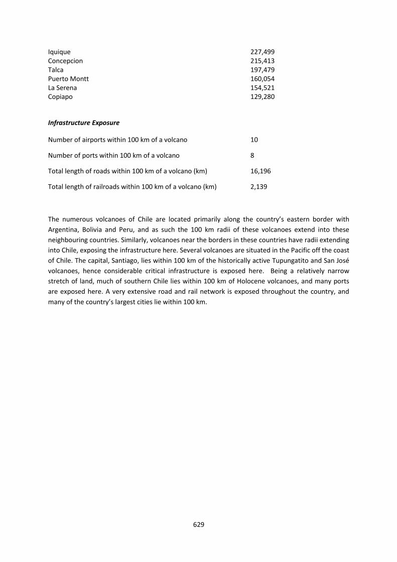
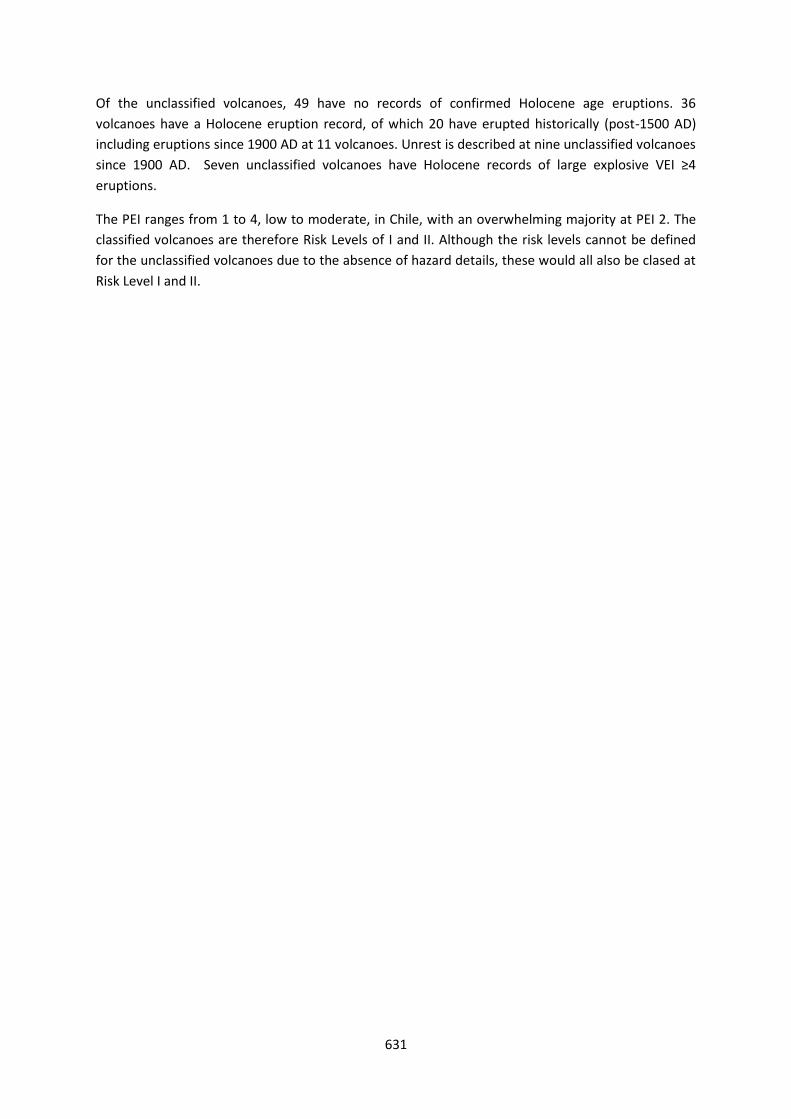
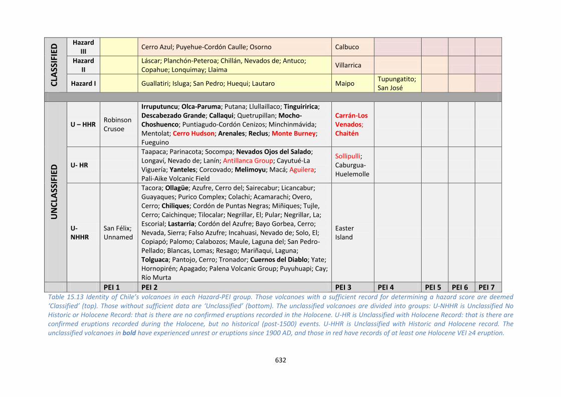

This profile and the data therein should not be used in place of focussed assessments and information provided by local monitoring and research institutions
Colombia
Description
Figure 1517 Location of Colombiarsquos volcanoes the capital and largest cities A zone extending 200 km beyond the countrys borders shows other volcanoes whose eruptions may directly affect Colombia
Fifteen Holocene volcanoes are distributed through the northern Andes in western Colombia to the
Ecuador border paralleling the Pacific coastline These volcanoes are related to the subduction of
the Nazca Plate beneath the South American Plate
All Holocene volcanoes in Colombia form edifices typically associated with explosive-type activity
including stratovolcanoes and complex volcanoes with the exception of the Petacas lava dome and
636
Santa Isabel shield The Colombian volcanoes are dominantly andesitic in composition The explosive
record continues into the Pleistocene with three Colombian volcanoes hosting MVEI ge4 eruptions
in this period
There are 125 confirmed eruptions recorded in the Holocene at VEI 1 to 5 indicating a range of
activity from mild to strongly explosive Eight volcanoes have a Holocene record of producing
pyroclastic flows and six are associated with lahars Nine of the Colombian volcanoes have 79
eruptions recorded in historical times
Many of Colombiarsquos most populous cities are located on or towards the northern coast away from
volcanoes however the cities of Cali Ibague Pasto and Pereira lie within 100 km of one or more
Holocene volcanoes with the latter three over-looked by Machin Galeras and the Ruiz-Tolima chain
Numerous eruptions of Nevado del Ruiz Nevado del Huila Puraceacute and Galeras have resulted in
evacuations and property damage Fatalities are recorded in nine eruptions of these volcanoes and
Dontildea Juana
The assessment of hazard is complicated by sparse eruptive histories at over half of Colombiarsquos
volcanoes resulting in hazard levels with large associated uncertainties hence just five volcanoes
have a hazard level classified here Nevado del Ruiz Galeras and Cerro Bravo are classed with the
highest hazard in Colombia based on detailed eruptive histories Coupled with the high proximal
population these volcanoes are classed at Risk Level III
Both Galeras and Nevado del Ruiz have caused loss of life Machiacuten has not caused any fatalities but
has shown recent unrest and its geological record indicates the potential for violent and destructive
explosive eruptions In 1993 a sudden intense but small magnitude explosive eruption of Galeras
killed nine people including six volcanologists who were in the inner crater or on its rim A far larger
disaster the largest in South Americarsquos history was the 1985 eruption of Nevado del Ruiz Though
only VEI 3 the eruption generated pyroclastic flows that melted the volcanorsquos glacier cap and caused
lahars The mudflows descended the western flanks flowing along the Riacuteo Lagunillas valley The
town of Armero located on the banks of Riacuteo Lagunillas 48 km from the volcano was completely
buried Though the death toll is uncertain it is estimated that 21000 of the 29000 residents of
Armero were killed along with others elsewhere bringing the total loss of life to between 23000
and 26000
Further eruptions with human impacts have occurred very recently at Galeras volcano An eruption
starting on 25th August 2010 spread ash as far as 30 km to the northwest 7000 people were
advised to evacuate though few left their homes Activity did not increase after this until January
2011
Eruptions at a number of the northernmost volcanoes in Ecuador may directly affect Colombia as
they lie within 100 km of the border Similarly Galeras Cumbal and Azufral lie within 100 km of
Ecuador
Following the 1985 Nevado del Ruiz tragedy the Colombian Government took steps to strengthen
the monitoring and response mechanisms for Colombian volcanoes These measures included
making INGEOMINAS responsible for the monitoring of volcanoes and provision of scientific advice
637
The Servicio Geologico Colombiano (INGEOMINAS) operate three volcano observatories in Colombia
Observatorio Pasto (responsible for Galeras Cumbal Chiles Cerro Negro Las Animas Doňa Juana
and Azufral) Observatorio Manizales (responsible for Nevado del Ruiz Cerro Machin Cerro Bravo
Nevado Santa Isabel and Nevado Tolima) and Observatorio Popayan (responsible for Nevado del
Huila Sotaraacute and Puraceacute) INGEOMINAS operate a monitoring network at Colombiarsquos active
volcanoes and the status of the volcanoes is communicated publically and is available online
See also
INGEOMINAS - wwwsgcgovco
Volcano Facts
Number of Holocene volcanoes 15 inclusive of one on the border with Ecuador
Number of Pleistocene volcanoes with Mge4 eruptions 3
Number of volcanoes generating pyroclastic flows 8
Number of volcanoes generating lahars 6
Number of volcanoes generating lava flows 3
Number of fatalities caused by volcanic eruptions 25567
Tectonic setting Subduction zone
Largest recorded Pleistocene eruption The El Boqueron Ancestral caldera collapse eruption of 580 ka at Nevado del Tolima and the 560 ka Coba Negra caldera forming eruption of Galeras are both recorded at M62
Largest recorded Holocene eruption The M55 R8 eruption of Nevado del Ruiz at 28 ka
Number of Holocene eruptions 125 confirmed eruptions 10 uncertain eruptions
Recorded Holocene VEI range 1 ndash 5 and unknown
Number of historically active volcanoes 9
Number of historic eruptions 79
638
Number of volcanoes
Primary volcano type Dominant rock type
13 Large cone(s) Andesitic (9) Dacitic (4)
1 Lava dome(s) Unknown (1)
1 Shield(s) Andesitic (1)
Table 1515 The number of volcanoes in Colombia their volcano type classification and dominant rock type according to VOTW40
Socio-Economic Facts
Total population (2012) 47783000
Gross Domestic Product (GDP) per capita (2005 PPP $) 8861
Gross National Income (GNI) per capita (2005 PPP $) 8711
Human Development Index (HDI) (2012) 0719 (High)
Population Exposure
Capital city Bogataacute
Distance from capital city to nearest Holocene volcano 1386 km
Total population (2011) 44725543
Number (percentage) of people living within 10 km of a Holocene volcano
451010 (1)
Number (percentage) of people living within 30 km of a Holocene volcano
3236251 (72)
Number (percentage) of people living within 100 km of a Holocene volcano
13408843 (30)
Ten largest cities as measured by population and their population size
Bogota 7102602 Cali 2392877 Medellin 1999979 Barranquilla 1380425 Cartagena 952024 Cucuta 721398 Bucaramanga 571820 Pereira 440118 Santa Marta 431781 Ibague 421685
639
Infrastructure Exposure
Number of airports within 100 km of a volcano 2
Number of ports within 100 km of a volcano 0
Total length of roads within 100 km of a volcano (km) 3159
Total length of railroads within 100 km of a volcano (km) 420
Figure 1518 The location of Colombiarsquos volcanoes and the extent of the 100 km zone surrounding them Ports airports and the major cities are just some of the infrastructure that may be exposed to volcanic hazards
The volcanoes in Colombia are located in the west of the country from the border with Ecuador to
just north of the capital Bogata The southernmost volcanoes Galeras Cumbal and Azufral lie close
to the Ecuador border and their 100 km radii extend into Ecuador exposing infrastructure here
640
Similarly six of the northernmost of Ecuadorrsquos volcanoes have 100 km radii which extend into
Colombia Four of the largest cities in Colombia are situated within 100 km of Holocene volcanoes
including Pasto Cali Ibague and Pereira exposing much of the critical infrastructure here The
capital Bogata lies within 140 km of several Holocene volcanoes including the historically active
Nevado del Ruiz and Nevado del Tolima
Hazard Uncertainty and Exposure Assessments
The volcanoes in Colombia are classed at Hazard Levels I to III Ten of the 15 Colombian volcanoes
have insufficient data available in their eruption records to adequately calculate a hazard score
without very large uncertainties The highest hazard levels are found at Nevado del Ruiz Galeras and
Cerro Bravo
Of the unclassified volcanoes three Azufral Machiacuten and Sotaraacute have had recorded periods of unrest
above background levels since 1900 Both Azufral and Machiacuten have Holocene eruption records but
no historical eruptions Four Colombian volcanoes Nevado del Huila Dontildea Juana Cumbal and Cerro
Negro de Mayasquer are unclassified but have historical records of activity including post-1900
eruptions
CLA
SSIF
IED
Hazard III Cerro Bravo Nevado del Ruiz
Galeras
Hazard II Nevado del Tolima
Hazard I Puraceacute
UN
CLA
SSIF
IED
U ndash HHR
Nevado del Huila Dontildea Juana Cumbal Cerro Negro de Mayasquer
U- HR Romeral Santa Isabel Machiacuten Azufral
U- NHHR Petacas Sotaraacute
PEI 1 PEI 2 PEI 3 PEI 4 PEI 5 PEI 6 PEI 7 Table 1516 Identity of Colombiarsquos volcanoes in each Hazard-PEI group Those volcanoes with a sufficient record for determining a hazard score are deemed lsquoClassifiedrsquo (top) Those without sufficient data are lsquoUnclassifiedrsquo (bottom) The unclassified volcanoes are divided into groups U-NHHR is Unclassified No Historic or Holocene Record that is there are no confirmed eruptions recorded in the Holocene U-HR is Unclassified with Holocene Record that is there are confirmed eruptions recorded during the Holocene but no historical (post-1500) events U-HHR is Unclassified with Historic and Holocene record The unclassified volcanoes in bold have experienced unrest or eruptions since 1900 AD and those in red have records of at least one Holocene VEI ge4 eruption
641
Volcano Population Exposure Index Risk Level
Galeras 6 III Ruiz Nevado del 5 III Bravo Cerro 4 III Tolima Nevado del 4 II Puraceacute 4 I
Table 1517 Classified volcanoes of Colombia ordered by descending Population Exposure Index (PEI) Risk levels determined through the combination of the Hazard Level and PEI are given Risk Level I ndash 1 volcano Risk Level II ndash 1 volcano Risk Level III ndash 3 volcanoes
Figure 1519 Distribution of Colombiarsquos classified volcanoes across Hazard and Population Exposure Index levels The warming of the background colours illustrates increasing Risk levels from Risk Level I - III
All Colombian volcanoes have moderate to high PEI levels at PEI 3 to 6 The highest PEI is found at
Galeras which has over 120000 living just within 10 km Combined with a Hazard Level of III
Galeras is classed as a Risk Level III volcano Of the classified volcanoes just one volcano Puraceacute is
deemed Risk Level I whilst one Nevado del Tolima is classed at Risk Level II
National Capacity for Coping with Volcanic Risk
Nine volcanoes in Colombia have recorded historical activity Of these all have dedicated ground-
based monitoring systems operated by INGEOMINAS Seven volcanoes are classed here at
Monitoring Level 3 with seismic networks in operation and additional deformation and or gas
monitoring The three volcanoes with the highest risk classification here are continuously monitored
at this level
642
Figure 1520 The monitoring and risk levels of the historically active volcanoes in Colombia Monitoring Level 1 indicates no known dedicated ground-based monitoring Monitoring Level 2 indicates that some ground-based monitoring systems are in place including le3 seismic stations Monitoring Level 3 indicates the presence of a dedicated ground-based monitoring network including ge4 seismometers
This profile and the data therein should not be used in place of focussed assessments and information provided by local monitoring and research institutions
Ecuador and the Galapagos
Description
Figure 1521 Location of Ecuadorrsquos volcanoes the capital and largest cities A zone extending 200 km beyond the countrys borders shows other volcanoes whose eruptions may directly affect Ecuador
Thirty-five volcanoes of Holocene age are identified in Ecuador This includes volcanoes on mainland
Ecuador and in the Galapagos Islands nearly 1000 km to the west Volcanism in mainland Ecuador is
related to the subduction of the Nazca Plate beneath the South American Plate whilst Galapagos
volcanism is due to intra-plate hotspot volcanism and the Galapagos spreading centre Volcanoes of
the Galapagos are predominantly basaltic shields while in mainland Ecuador the composition is
more felsic and andesitic stratovolcanoes are most common
644
Twenty-eight of the volcanoes have 311 confirmed Holocene eruptions the remaining volcanoes
have suspected Holocene activity With records of activity ranging in size from VEI 0 to 6 a range of
activity styles is indicated from mild effusions of lavas to large explosive events The largest
Holocene eruption on record is the ~1280 AD eruption of Quilotoa at VEI 6 M64 This event
generated extensive pyroclastic flows ash fall and lahars A larger eruption (M69) is recorded in the
Pleistocene at 211 ka with the Ash Flow of the Chalupas Caldera Numerous Pleistocene eruptions
of VEIM ge4 are recorded in Ecuador and 43 large explosive eruptions of this size are recorded in the
Holocene
Since 1500 AD 197 eruptions are recorded at nineteen volcanoes Of these 11 were VEI 4 indicating
that large explosive eruptions are relatively frequent in Ecuador The dominantly andesitic
composition and stratovolcano morphology indicates typical explosive activity The altitude of the
volcanoes in Ecuador means that many of the volcanoes are capped with snow or glaciers This
increases the propensity to cause hazardous lahars as even small eruptions can result in the melting
of ice caps Indeed eight volcanoes in Ecuador have a Holocene record of lahar triggering
The most frequently active volcanoes here are Cotopaxi Reventador and Tungurahua while Sangay
is continuously active since 1628 but poses little threat since it is isolated from population centres
The Galapagos Island volcanoes are exclusively shield volcanoes With a small population of just over
20000 the main hazard they pose is largely environmental but also to wildlife such as slow moving
giant tortoises as a result of lava flows and ash fall One exception to this is Fernandina which has
erupted explosively on numerous occasions producing pyroclastic flows and debris avalanches No
fatalities are recorded as a result of eruptions of Fernandina
Much of central and northern mainland Ecuador lies within 100 km of one or more Holocene
volcanoes and six of the most populous cities in the country fall in this zone The capital Quito lies
within 100 km of many volcanoes and within about 12 km of the historically active Guagua
Pichincha This volcano had a VEI 4 eruption in 1660 resulting in extensive ash fall and ash
accumulation in the capital Pyroclastic flows and surges were channelled mainly to the west as the
caldera is breached in this direction This breach will still likely act to channel flows to the west
however surges in particular are not always constrained by topography and can reach small
communities such as Lloa but have never jumped the topographic barrier into the Quito basin
The presence of many cities within 100 km of the Holocene volcanoes exposes a large proportion of
the population to direct volcanic hazards with 50 of Ecuadorrsquos population residing within 100 km
of one or more Holocene volcano
The assessment of hazard at many of Ecuadorrsquos volcanoes is complicated by incomplete or sparse
eruption records and publication of this information in ldquogrey literaturerdquo that is difficult to access
hence the assignment of hazard levels is associated with large degrees of uncertainty
Fatalities have resulted from eruptions of Reventador Guagua Pichincha Cotopaxi Tungurahua
Sangay and Cerro Azul Greatest loss of life as a result of volcanism in Ecuadorian territories occurred
in 1640 following an eruption of Tungurahua Though some uncertainty surrounds the eruption
record it is believed an approximately VEI 3 eruption caused pyroclastic flows and a small sector
collapse that destroyed a village and its 5000 inhabitants Eruptions of Cotopaxi in 1742 1768 and
645
1877 have also significantly added to the death toll from volcanoes in Ecuador with roughly 1200
deaths as a result of lahars attributable to these three eruption periods
The Instituto Geofisico of the Escuela Politeacutecnica Nacional (IGEPN) is responsible for the study
monitoring and hazard assessment of Ecuadorrsquos volcanoes Sixteen volcanoes are monitored with at
least one broadband seismic instrument and one or more continuously operating GPS staton
Tungurahua Cotopaxi Guagua Pichincha Reventador Cuicocha and Antisana volcanoes are
monitored with a broad suite of geophysical instruments and because of the completeness of their
real-time networks are considered to b in an ldquoArdquo category Ten other volcanoes Atacazo Pululagua
Imbabura Chachimburo Cerro Negro Cayambe Soche Sangay Chimborazo and Quilotoa all have
at least one or more broadband seismic and deformation-detecting stations The IGEPN provides
advice and information regarding volcanic activity and presents this information online accessible to
the public Reports are regularly issued summarising volcanic activity and early warnings before a
notable increase in eruptive activity is given on this web via calls over local radio stations and
through social media Close collaborations exist with the Secretariat for Risk Management Before
and during volcanic crises IGEPN scientists communicate and provide hazard assessments to local
regional and national authorities At Tungurahua volcano which has been erupting since 1999 a
volunteer volcano observers group (Vigias) has been very successful in providing in situ observations
of eruptive activity via a radio system to the local observatory IGEPN scientists
From here we provide the information for mainland Ecuador and the Galapagos Islands separately
See also
Servicio Nacional de Sismologia y Vulcanologia wwwigepneduec
646
Mainland Ecuador
Volcano Facts
Number of Holocene volcanoes 22 inclusive of one on the border with Colombia
Number of Pleistocene volcanoes with Mge4 eruptions 7
Number of volcanoes generating pyroclastic flows 14
Number of volcanoes generating lahars 8
Number of volcanoes generating lava flows 7
Number of fatalities caused by volcanic eruptions 5690
Tectonic setting 22 Subduction zone
Largest recorded Pleistocene eruption The M69 Chalupas Ash Flow eruption of Chalupas at 211 ka
Largest recorded Holocene eruption The M64 eruption of Quilotoa about 700 years ago
Number of Holocene eruptions 229 confirmed eruptions
Recorded Holocene VEI range 0 ndash 6 and unknown
Number of historically active volcanoes 10 according to VOTW422 (Cotopaxi Reventador Tungurahua Guagua Pichincha Cayambe Sangay Chacana Antisana Sumaco and Cerro Negro de Mayasquer) Activity at the latter three volcanoes is ambiguous
Number of historic eruptions 131
Number of volcanoes
Primary volcano type Dominant rock type
4 Caldera(s) Dacitic (3) Rhyolitic (1)
17 Large cone(s) Andesitic (13) Basaltic (1) Dacitic (3)
1 Small cone(s) Andesitic (1)
Table 1518 The number of volcanoes in Ecuador their volcano type classification and dominant rock type according to VOTW40
647
Socio-Economic Facts
Total population (2012) 15520000
Gross Domestic Product (GDP) per capita (2005 PPP $) 7443
Gross National Income (GNI) per capita (2005 PPP $) 7471
Human Development Index (HDI) (2012) 0724 (High)
Population Exposure
Capital city Quito
Distance from capital city to nearest Holocene volcano 122 km
Total population (2011) 15007343
Number (percentage) of people living within 10 km of a Holocene volcano
750552 (5)
Number (percentage) of people living within 30 km of a Holocene volcano
4352168 (29)
Number (percentage) of people living within 100 km of a Holocene volcano
7393692 (493)
Ten largest cities as measured by population and their population size (2010 from UN data
dataunorg)
Guayaquil 2278691 Quito 1607734 Cuenca 329928 Machala 231260 Manta 217553 Portoviejo 206682 Loja 170280 Ambato 165185 Esmeraldas 154035 Riobamba 146324
Infrastructure Exposure
Number of airports within 100 km of a volcano 6 (Tulcan Quito Lago Agrio Latacunga Macas Tena)
Number of ports within 100 km of a volcano 0
Total length of roads within 100 km of a volcano (km) 3727
Total length of railroads within 100 km of a volcano (km) 0
648
In mainland Ecuador the 100 km radii of the volcanoes covers much of central and northern parts of
the country and the radii of six of the northernmost volcanoes extend into Colombia Similarly the
three southernmost volcanoes of Colombia have 100 km radii which extend into Ecuador Six of the
largest cities in Ecuador are situated within 100 km of Holocene volcanoes including the capital
Quito hence much of the critical infrastructure of the country is exposed including three airports
and an extensive road network Critical infrastructure such as two trans-Andean oil pipelines four
major hydroelectric installations Quitorsquos water supply from Antisana and Chacana volcanoes as well
as critical bridges are also exposed
Figure 1522 The location of Ecuadorrsquos volcanoes and the extent of the 100 km zone surrounding them Ports airports and the major cities are just some of the infrastructure that may be exposed to volcanic hazards
649
Hazard Uncertainty and Exposure Assessments
There are varying levels of information available in the eruption records of mainland Ecuadorrsquos
volcanoes Seven volcanoes out of 23 have sufficient detail to define the hazard through the
calculation of the VHI All of these are classified at Hazard Level III with Holocene records of VEI ge3
eruptions and records of explosive eruptions with the production of pyroclastic flows
Of the unclassified volcanoes three have no confirmed Holocene eruptions on record The
remaining 12 volcanoes have a Holocene eruptive record with historical events at four volcanoes
including post-1900 AD eruptions at Cerro Negro de Mayasquer Four unclassified volcanoes have a
Holocene record of large VEI ge4 eruptions
The size of the proximal populations at Ecuadorrsquos volcanoes ranges from small to large generating
PEIs of 1 to 7 Moderate and high PEIs dominate This range results in a range of risk levels when
combined with the Hazard Levels from II to III at the classified volcanoes Although here we consider
threat to life measured by population exposure infrastructure exposure such as the water supply to
Quito is also vital This for example is supplied from the PEI4 Antisana volcano which if it were to
erupt would have grave consequences for Quitorsquos water supply
CLA
SSIF
IED
Hazard III
Reventador Sangay
Cayambe Cotopaxi Tungurahua
Guagua Pichincha
Atacazo
Hazard II
Hazard I
UN
CLA
SSIF
IED
U ndash HHR
Sumaco
Cerro Negro de Mayasquer Antisana
Chacana
U- HR Aliso Soche Chachimbiro Chimborazo
Quilotoa Cuicocha Imbabura
Pululagua
U- NHHR
Illiniza Mojanda Licto
PEI 1
PEI 2 PEI 3 PEI 4 PEI 5 PEI 6 PEI 7
Table 1519 Identity of Mainland Ecuadorrsquos volcanoes in each Hazard-PEI group Those volcanoes with a sufficient record for determining a hazard score are deemed lsquoClassifiedrsquo (top) Those without sufficient data are lsquoUnclassifiedrsquo (bottom) The unclassified volcanoes are divided into groups U-NHHR is Unclassified No Historic or Holocene Record that is there are no confirmed eruptions recorded in the Holocene U-HR is Unclassified with Holocene Record that is there are confirmed eruptions recorded during the Holocene but no historical (post-1500) events U-HHR is Unclassified with Historic and Holocene record The unclassified volcanoes in bold have experienced unrest or eruptions since 1900 AD and those in red have records of at least one Holocene VEI ge4 eruption
Volcano Population Exposure Index Risk Level
650
Atacazo 6 III Guagua Pichincha 5 III Tungurahua 4 III Cotopaxi 4 III Cayambe 4 III Reventador 3 II Sangay 3 II
Table 1520 Classified volcanoes of Mainland Ecuador ordered by descending Population Exposure Index (PEI) Risk levels determined through the combination of the Hazard Level and PEI are given Risk Level I ndash 0 volcanoes Risk Level II ndash 2 volcanoes Risk Level III ndash 5 volcanoes
Figure 1523 Distribution of mainland Ecuadorrsquos classified volcanoes across Hazard and Population Exposure Index levels The warming of the background colours illustrates increasing Risk levels from Risk Level I - III
National Capacity for Coping with Volcanic Risk
Ten volcanoes in mainland Ecuador have recorded historical activity These volcanoes are distributed
across all three monitoring levels with half of the volcanoes being classed at Monitoring Level 3 All
Risk Level III volcanoes are monitored at Level 3 with the exception of Cayambe which also has both
seismic and deformation monitoring The Risk Level III volcanoes Tungurahua Guagua Pichincha and
Cotopaxi all have multiple monitoring systems in place inclduing continuous seismic and
deformation monitoring
651
Monitoring is undertaken by the Instituto Geofisico EPN Note that this institute also uses
Monitoring Levels 1 - 3 to describe levels of monitoring at Ecuadorrsquos volcanoes but these are
different levels to those used here
Figure 1524 The monitoring and risk levels of the historically active volcanoes in mainland Ecuador Monitoring Level 1 indicates no known dedicated ground-based monitoring Monitoring Level 2 indicates that some ground-based monitoring systems are in place including le3 seismic stations Monitoring Level 3 indicates the presence of a dedicated ground-based monitoring network including ge4 seismometers
652
Galapagos Islands
Figure 1525 The volcanoes of the Galapagos Islands Inset shows the location relative to mainland Ecuador
Volcano Facts
Number of Holocene volcanoes 13
Number of Pleistocene volcanoes with Mge4 eruptions 1
Number of volcanoes generating pyroclastic flows 1
Number of volcanoes generating lahars -
Number of volcanoes generating lava flows 9
653
Number of fatalities caused by volcanic eruptions 1
Tectonic setting 13 Rift zone
Largest recorded Pleistocene eruption The M52VEI 5 Alcedo-AB Tephra eruption of about 90000 years ago
Largest recorded Holocene eruption The VEI 4 eruption of Fernandina in 1968
Number of Holocene eruptions 82 confirmed eruptions
Recorded Holocene VEI range 0 ndash 4 and unknown
Number of historically active volcanoes 9
Number of historic eruptions 66
Number of volcanoes
Primary volcano type Dominant rock type
13 Shield(s) Basaltic (13)
Table 1521 The number of volcanoes in Ecuador their volcano type classification and dominant rock type according to VOTW40
Population Exposure
Capital city Puerto Baquerizo Moreno
Distance from capital city to nearest Holocene volcano 123 km
Total population (2010 wwwinecgobecestadisticas) 25124
Percentage of people living within 100 km of a Holocene volcano 100
Infrastructure Exposure
Number of airports within 100 km of a volcano 2
Number of ports within 100 km of a volcano -
Total length of roads within 100 km of a volcano (km) -
Total length of railroads within 100 km of a volcano (km) 0
In the Galapagos Islands the 100 km radii extend to fully encompass the island group exposing all
infrastructure here
654
Hazard Uncertainty and Exposure Assessments
Of the thirteen volcanoes in the Galapagos Islands just four have a sufficiently detailed eruption
record to determine hazard levels through the calculation of the VHI These are classified at Hazard
Levels I and II
Of the unclassified volcanoes three have no confirmed Holocene eruptions on record Six have a
record of Holocene eruptions including historical age events and post-1900 AD eruptions
The size of the proximal populations at the volcanoes of the Galapagos is typically small generating
PEIs of 2 to 3 All classified volcanoes here are classed at Risk Level I
CLA
SSIF
IED
Hazard III
Hazard II
Fernandina
Hazard I
Wolf Negra Sierra Azul Cerro
UN
CLA
SSIF
IED
U ndash HHR
Darwin Alcedo Pinta Marchena Santiago
U- HR Ecuador
U- NHHR
Genovesa Santa Cruz San Cristoacutebal
PEI 1 PEI 2 PEI 3 PEI 4 PEI 5 PEI 6 PEI 7 Table 1522 Identity of the Galapagos Islandsrsquo volcanoes in each Hazard-PEI group Those volcanoes with a sufficient record for determining a hazard score are deemed lsquoClassifiedrsquo (top) Those without sufficient data are lsquoUnclassifiedrsquo (bottom) The unclassified volcanoes are divided into groups U-NHHR is Unclassified No Historic or Holocene Record that is there are no confirmed eruptions recorded in the Holocene U-HR is Unclassified with Holocene Record that is there are confirmed eruptions recorded during the Holocene but no historical (post-1500) events U-HHR is Unclassified with Historic and Holocene record The unclassified volcanoes in bold have experienced unrest or eruptions since 1900 AD and those in red have records of at least one Holocene VEI ge4 eruption
Volcano Population Exposure Index Risk Level
Azul Cerro 2 I Fernandina 2 I Negra Sierra 2 I Wolf 2 I
Table 1523 Classified volcanoes of the Galapagos Islands ordered by descending Population Exposure Index (PEI) Risk levels determined through the combination of the Hazard Level and PEI are given Risk Level I ndash 4 volcanoes Risk Level II ndash0 volcanoes Risk Level III ndash 0 volcanoes
655
Figure 1526 Distribution of the Galapagos Islandsrsquo classified volcanoes across Hazard and Population Exposure Index levels The warming of the background colours illustrates increasing Risk levels from Risk Level I - III
National Capacity for Coping with Volcanic Risk
Nine volcanoes in the Galapagos Islands have recorded historical activity Monitoring is undertaken
by the Instituto Geofisico EPN Note that this institute also uses Monitoring Levels 1 - 3 to describe
levels of monitoring at Ecuadorrsquos volcanoes but these are different levels to those used here A
seismic monitoring network in the Galapagos Islands has been installed
Figure 1527 The monitoring and risk levels of the historically active volcanoes in the Galapagos Islands of Ecuador Monitoring Level 1 indicates no known dedicated ground-based monitoring Monitoring Level 2 indicates that some ground-based monitoring systems are in place including le3 seismic stations Monitoring Level 3 indicates the presence of a dedicated ground-based monitoring network including ge4 seismometers
This profile and the data therein should not be used in place of focussed assessments and information provided by local monitoring and research institutions
Peru
Description
Figure 1528 Location of Perursquos volcanoes the capital and largest cities A zone extending 200 km beyond the countrys borders shows other volcanoes whose eruptions may directly affect Peru
Seventeen Holocene volcanoes are recorded in Peru These volcanoes are located in the Andes in a
chain through southern Peru to the border with Chile Volcanism occurs here due to the subduction
of the Nazca Plate beneath the South American Plate Although subduction is also ongoing in
northern Peru the angle of the subducting slab has not led to recent volcanism Although Perursquos
volcanoes are a variety of types including cinder cones and lava domes most are stratovolcanoes of
dominantly andesitic composition
Large explosive Pleistocene activity is recorded in Peru and sixty eruptions of Holocene age are
recorded here Of these thirty-six are of historical age These historical eruptions occurred at six
657
volcanoes and covered a range of sizes from small events of VEI 1 to very large explosive VEI 6
eruptions Three volcanoes have Holocene records of producing pyroclastic flows and four with
lahars The largest historical eruption was the 1600 AD eruption of Huaynaputina This eruption
produced voluminous tephra falls pyroclastic flows and surges which travelled 13 km and lahars that
reached the Pacific Ocean 120 km away The cities of Arequipa and Moquengua suffered significant
damage and about 1500 lives were lost
Arequipa one of the most populous cities in Peru lies at about 75 km from Huaynaputina and
within 100 km of five other Holocene volcanoes including the historically active Sabancaya El Misti
and Ubinas the most frequently active volcano in Peru in historic times
The Instituto Geofisico del Peru (IGP) and the Instituto Geolόgico Minero y Metaluacutergico (INGEMMET)
are responsible for scientific research and the monitoring of the volcanoes in Peru and indeed
actively monitor five historically active volcanoes and three further Holocene volcanoes through a
variety of dedicated ground-based instrumentation including seismic stations geochemical and gas
monitoring and various deformation monitoring Monitoring is undertaken regularly with an alarm
system and automated seismic system A regional seismic network is operational in Peru which can
register seismicity throughout the volcanic chain Some resources and plans are available for
monitoring to be extended to currently un-monitored volcanoes in developing situations About a
quarter of the observatory staff have experience of responding to an eruption
In addition to ground-based monitoring VDAP ndash the Volcano Disaster Assistance Program of the US
Geological Survey provides satellite information during eruptions and InSAR and MODIS images are
provided by Cornell University and Torino University
The IGP provide scientific and technical advice to the Instituo Nacional de Defensa Civil (INDECI) in
the event of unrest and eruption The director of the Observatorio Vulcanologico de Sur (OVS)
Orlando Macedo represents the IGP on the regional committee for crises (the Comite de
Operaciones de Emergencia Regional COER) The regional aviation authority Corporacion Peruana
de Aviacion Comercial (CORPAC) reports to the regional VAAC
The IGP extend a programme of hazard education to the public and the IGP and INGEMMET
websites are publically accessible distributing information about Perursquos volcanic activity The IGP do
not provide risk assessments but advise on management and mitigation of volcanic risk An alert
level system is in place and the IGP INGEMMET and IGUNSA recommend declaration of alerts to the
COER authority
Large and growing cities are located near active volcanoes in Peru and with the expansion of the
cities the risk increases as larger populations live ever-closer to the volcanoes Educational
programs about volcanic risk and restriction of building in proximal areas would greatly improve the
volcanic risk situation in Peru
See also
Instituto Geofisico del Peru wwwigpgobpeportal
Instituto Geolόgico Minero y Metaluacutergico (INGEMMET)
wwwingemmetgobpeformInicioaspx
658
Observatorio Vulcanologico Del Sur ovsigpgobpemonitoreo
Thouret J-C Finizola A Fornari M Legeley-Padovani A Suni J and Frechen M (2001) Geology
of El Misti volcano near the city of Arequipa Peru Geological Society of America Bulletin 113 1593-
1610
Volcano Facts
Number of Holocene volcanoes 17 inclusive of one on the border with Chile
Number of Pleistocene volcanoes with Mge4 eruptions 4
Number of volcanoes generating pyroclastic flows 3
Number of volcanoes generating lahars 4
Number of volcanoes generating lava flows 3
Number of fatalities caused by volcanic eruptions 1500
Tectonic setting Subduction zone
Largest recorded Pleistocene eruption The M67 Sillar of Arequipa Ignimbrite eruption of Nevado Chachani at 242 Ma
Largest recorded Holocene eruption The 1600 AD eruption of Huaynaputina at M61
Number of Holocene eruptions 60 confirmed eruptions 14 uncertain eruptions
Recorded Holocene VEI range 0 ndash 6 and unknown
Number of historically active volcanoes 6
Number of historic eruptions 36
Number of volcanoes
Primary volcano type Dominant rock type
11 Large cone(s) Andesitic (9) Dacitic (1) Trachytic Andesitic (1)
2 Lava dome(s) Dacitic (1) Rhyolitic (1)
4 Small cone(s) Andesitic (3) Unknown (1)
Table 1524 The number of volcanoes in Peru their volcano type classification and dominant rock type according to VOTW40
659
Socio-Economic Facts
Total population (2012) 30041000
Gross Domestic Product (GDP) per capita (2005 PPP $) 9049
Gross National Income (GNI) per capita (2005 PPP $) 9306
Human Development Index (HDI) (2012) 0741 (High)
Population Exposure
Capital city Lima
Distance from capital city to nearest Holocene volcano 5331 km
Total population (2011) 29248943
Number (percentage) of people living within 10 km of a Holocene volcano
25307 (lt1)
Number (percentage) of people living within 30 km of a Holocene volcano
1143689 (39)
Number (percentage) of people living within 100 km of a Holocene volcano
2836138 (97)
Ten largest cities as measured by population and their population size
Lima 7737002 Arequipa 841130 Callao 813264 Trujillo 747450 Chiclayo 577375 Iquitos 437620 Huancayo 376657 Piura 325466 Chimbote 316966 Cuzco 312140
Infrastructure Exposure
Number of airports within 100 km of a volcano 3
Number of ports within 100 km of a volcano 1
Total length of roads within 100 km of a volcano (km) 1410
Total length of railroads within 100 km of a volcano (km) 0
660
Figure 1529 The location of Perursquos volcanoes and the extent of the 100 km zone surrounding them Ports airports and the major cities are just some of the infrastructure that may be exposed to volcanic hazards
The Peruvian volcanoes are located in the south of the country bordering Chile through the Andean
chain The southernmost two volcanoes in Peru have 100 km radii that extend into Chile exposing
the infrastructure here and similarly several of the northernmost volcanoes in Chile have 100 km
radii which extend into southern Peru The capital Lima is distal to the volcanoes being located
over 500 km north However one of the largest cities in Peru Arequipa is located with 100 km of six
Holocene volcanoes including the historically active Sabancaya El Misti Ubinas and Huaynaputina
volcanoes and hence considerable infrastructure is exposed here including an extensive road
network
661
Hazard Uncertainty and Exposure Assessments
There are varying levels of information available in the eruption records of Perursquos volcanoes The
record is sufficient at just four volcanoes to define the hazard through the calculation of the VHI
These are classified across Hazard Levels I and II
Despite a Holocene record including a VEI 4 eruption El Mistirsquos eruption record is dominated by
historical VEI 1 and 2 eruptions and older eruptions of an undetermined size This mildly explosive
historical activity controls the determination of the VHI giving El Misti a Hazard Level of I However
Thouret et al (2001) identified ldquotens of pyroclastic flowsrdquo over the last 50000 years from this
volcano including pyroclastic flows which reached about 12 km - a distance at which the outskirts of
the city of Arequipa now lies Thouret et al (2001) determine recurrence intervals for ash falls of
about 500 to 1500 years and for pumice falls of 2000 to 4000 years El Misti is assigned a Risk Level
of I due to the hazard level classification however the potential for larger eruptions than seen
historically must be recognised along with the potential for extensive pyroclastic flows Indeed
areas of Arequipa are designated as high risk by IGP (httpovsigpgobpe) and INGEMMET
(httpoviingemmetgobpe)
Of the unclassified volcanoes eight have no confirmed Holocene age eruptions on record Five have
a Holocene record including historical (post-1500 AD) age activity at Ticsani and Huaynaputina Just
the latter has a record of large explosive VEI ge4 Holocene eruptions
The PEI ranges from low to high in Peru at PEI 2 to 4 Of the classified volcanoes two are classed as
Risk Level II and two at Risk Level I
CLA
SSIF
IED
Hazard III
Hazard II
Yucamane Sabancaya Ubinas
Hazard I
Misti El
UN
CLA
SSIF
IED
U ndash HHR
Ticsani Huaynaputina
U- HR Huambo Quimsachata Andahua-Orcopampa
U- NHHR
Auquihuato Cerro Sara Sara Coropuna Tutupaca Casiri Nevados Tacora
Chachani Nevado Nicholson Cerro
PEI 1
PEI 2 PEI 3 PEI 4 PEI 5 PEI 6 PEI 7
662
Table 1525 Identity of Perursquos volcanoes in each Hazard-PEI group Those volcanoes with a sufficient record for determining a hazard score are deemed lsquoClassifiedrsquo (top) Those without sufficient data are lsquoUnclassifiedrsquo (bottom) The unclassified volcanoes are divided into groups U-NHHR is Unclassified No Historic or Holocene Record that is there are no confirmed eruptions recorded in the Holocene U-HR is Unclassified with Holocene Record that is there are confirmed eruptions recorded during the Holocene but no historical (post-1500) events U-HHR is Unclassified with Historic and Holocene record The unclassified volcanoes in bold have experienced unrest or eruptions since 1900 AD and those in red have records of at least one Holocene VEI ge4 eruption
Volcano Population Exposure Index Risk Level
Misti El 4 I Sabancaya 3 II Ubinas 3 II Yucamane 2 I
Table 1526 Classified volcanoes of Peru ordered by descending Population Exposure Index (PEI) Risk levels determined through the combination of the Hazard Level and PEI are given Risk Level I ndash 2 volcanoes Risk Level II ndash 2 volcanoes Risk Level III ndash 0 volcanoes
Figure 1530 Distribution of Perursquos classified volcanoes across Hazard and Population Exposure Index levels The warming of the background colours illustrates increasing Risk levels from Risk Level I - III
National Capacity for Coping with Volcanic Risk
Six volcanoes have records of historical activity in Peru Of these five have regular monitoring Just
Yucamane a Risk Level I volcano currently has no dedicated regular ground-based monitoring The
five others including El Misti (Risk Level I) Sabancaya and Ubinas (Risk Level II) and Huaynaputina
and Ticsani (Unclassified) are monitored by the Instituto Geofisico del Peru and the Instituto
Geolόgico Minero y Metaluacutergico (INGEMMET) These institutes also monitor Tutupaca Coropuna
663
and Nevado Chachani Seismic networks are used at Sabancaya and Huaynaputina Seismic networks
and additional deformation and gas monitoring is undertaken at Ticsani El Misit and Ubinas
Figure 1531 The monitoring and risk levels of the historically active volcanoes in Peru Monitoring Level 1 indicates no known dedicated ground-based monitoring Monitoring Level 2 indicates that some ground-based monitoring systems are in place including le3 seismic stations Monitoring Level 3 indicates the presence of a dedicated ground-based monitoring network including ge4 seismometers
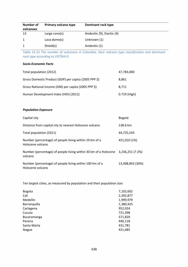
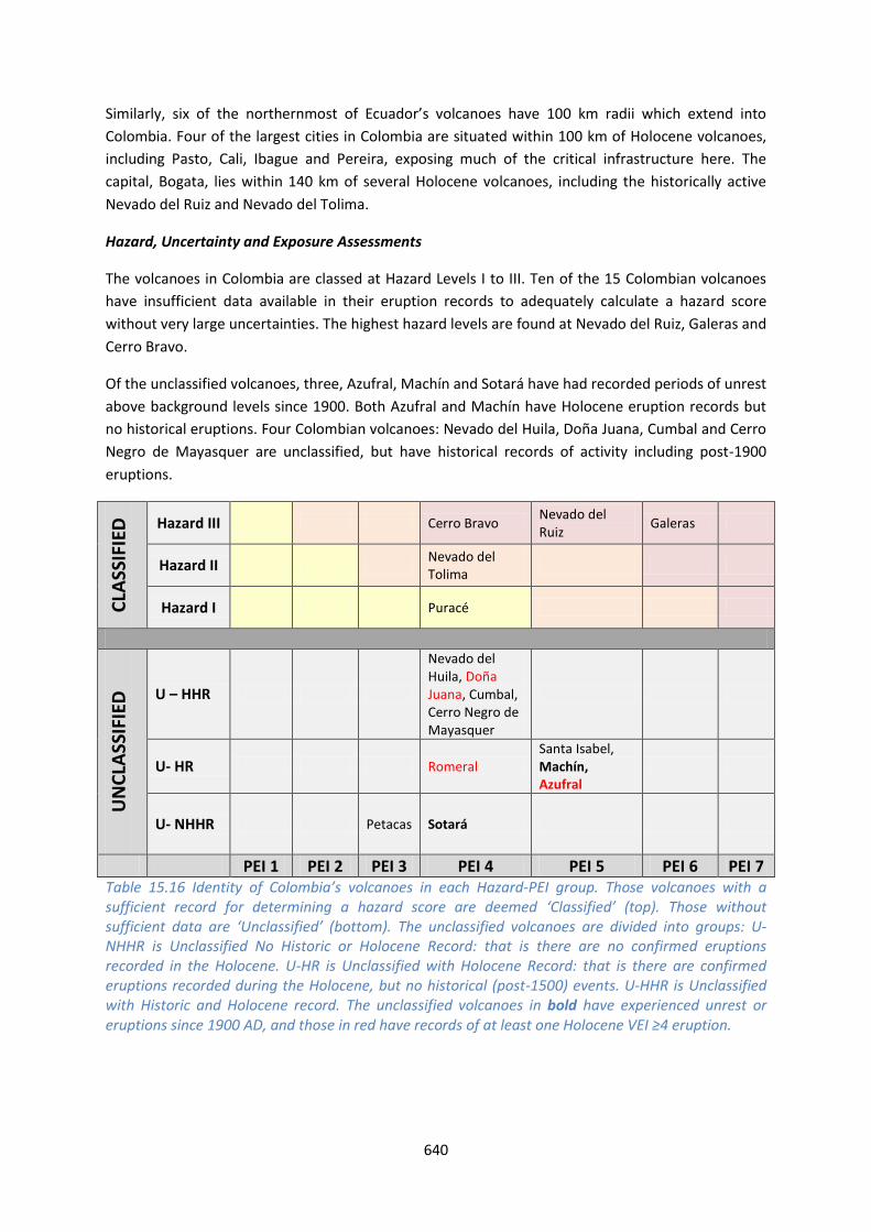
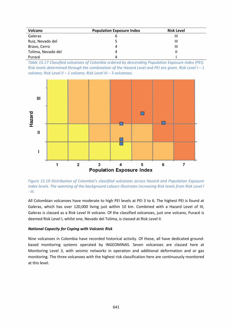
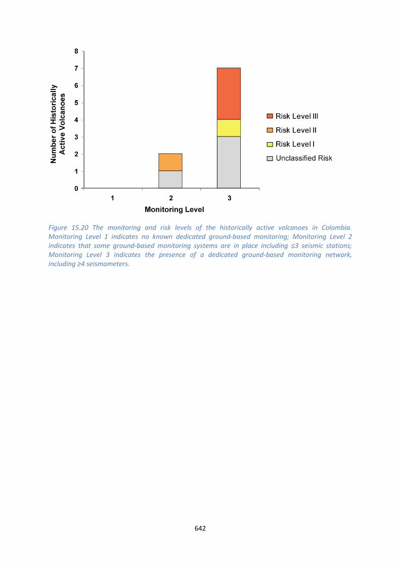

This profile and the data therein should not be used in place of focussed assessments and information provided by local monitoring and research institutions
Ecuador and the Galapagos
Description
Figure 1521 Location of Ecuadorrsquos volcanoes the capital and largest cities A zone extending 200 km beyond the countrys borders shows other volcanoes whose eruptions may directly affect Ecuador
Thirty-five volcanoes of Holocene age are identified in Ecuador This includes volcanoes on mainland
Ecuador and in the Galapagos Islands nearly 1000 km to the west Volcanism in mainland Ecuador is
related to the subduction of the Nazca Plate beneath the South American Plate whilst Galapagos
volcanism is due to intra-plate hotspot volcanism and the Galapagos spreading centre Volcanoes of
the Galapagos are predominantly basaltic shields while in mainland Ecuador the composition is
more felsic and andesitic stratovolcanoes are most common
644
Twenty-eight of the volcanoes have 311 confirmed Holocene eruptions the remaining volcanoes
have suspected Holocene activity With records of activity ranging in size from VEI 0 to 6 a range of
activity styles is indicated from mild effusions of lavas to large explosive events The largest
Holocene eruption on record is the ~1280 AD eruption of Quilotoa at VEI 6 M64 This event
generated extensive pyroclastic flows ash fall and lahars A larger eruption (M69) is recorded in the
Pleistocene at 211 ka with the Ash Flow of the Chalupas Caldera Numerous Pleistocene eruptions
of VEIM ge4 are recorded in Ecuador and 43 large explosive eruptions of this size are recorded in the
Holocene
Since 1500 AD 197 eruptions are recorded at nineteen volcanoes Of these 11 were VEI 4 indicating
that large explosive eruptions are relatively frequent in Ecuador The dominantly andesitic
composition and stratovolcano morphology indicates typical explosive activity The altitude of the
volcanoes in Ecuador means that many of the volcanoes are capped with snow or glaciers This
increases the propensity to cause hazardous lahars as even small eruptions can result in the melting
of ice caps Indeed eight volcanoes in Ecuador have a Holocene record of lahar triggering
The most frequently active volcanoes here are Cotopaxi Reventador and Tungurahua while Sangay
is continuously active since 1628 but poses little threat since it is isolated from population centres
The Galapagos Island volcanoes are exclusively shield volcanoes With a small population of just over
20000 the main hazard they pose is largely environmental but also to wildlife such as slow moving
giant tortoises as a result of lava flows and ash fall One exception to this is Fernandina which has
erupted explosively on numerous occasions producing pyroclastic flows and debris avalanches No
fatalities are recorded as a result of eruptions of Fernandina
Much of central and northern mainland Ecuador lies within 100 km of one or more Holocene
volcanoes and six of the most populous cities in the country fall in this zone The capital Quito lies
within 100 km of many volcanoes and within about 12 km of the historically active Guagua
Pichincha This volcano had a VEI 4 eruption in 1660 resulting in extensive ash fall and ash
accumulation in the capital Pyroclastic flows and surges were channelled mainly to the west as the
caldera is breached in this direction This breach will still likely act to channel flows to the west
however surges in particular are not always constrained by topography and can reach small
communities such as Lloa but have never jumped the topographic barrier into the Quito basin
The presence of many cities within 100 km of the Holocene volcanoes exposes a large proportion of
the population to direct volcanic hazards with 50 of Ecuadorrsquos population residing within 100 km
of one or more Holocene volcano
The assessment of hazard at many of Ecuadorrsquos volcanoes is complicated by incomplete or sparse
eruption records and publication of this information in ldquogrey literaturerdquo that is difficult to access
hence the assignment of hazard levels is associated with large degrees of uncertainty
Fatalities have resulted from eruptions of Reventador Guagua Pichincha Cotopaxi Tungurahua
Sangay and Cerro Azul Greatest loss of life as a result of volcanism in Ecuadorian territories occurred
in 1640 following an eruption of Tungurahua Though some uncertainty surrounds the eruption
record it is believed an approximately VEI 3 eruption caused pyroclastic flows and a small sector
collapse that destroyed a village and its 5000 inhabitants Eruptions of Cotopaxi in 1742 1768 and
645
1877 have also significantly added to the death toll from volcanoes in Ecuador with roughly 1200
deaths as a result of lahars attributable to these three eruption periods
The Instituto Geofisico of the Escuela Politeacutecnica Nacional (IGEPN) is responsible for the study
monitoring and hazard assessment of Ecuadorrsquos volcanoes Sixteen volcanoes are monitored with at
least one broadband seismic instrument and one or more continuously operating GPS staton
Tungurahua Cotopaxi Guagua Pichincha Reventador Cuicocha and Antisana volcanoes are
monitored with a broad suite of geophysical instruments and because of the completeness of their
real-time networks are considered to b in an ldquoArdquo category Ten other volcanoes Atacazo Pululagua
Imbabura Chachimburo Cerro Negro Cayambe Soche Sangay Chimborazo and Quilotoa all have
at least one or more broadband seismic and deformation-detecting stations The IGEPN provides
advice and information regarding volcanic activity and presents this information online accessible to
the public Reports are regularly issued summarising volcanic activity and early warnings before a
notable increase in eruptive activity is given on this web via calls over local radio stations and
through social media Close collaborations exist with the Secretariat for Risk Management Before
and during volcanic crises IGEPN scientists communicate and provide hazard assessments to local
regional and national authorities At Tungurahua volcano which has been erupting since 1999 a
volunteer volcano observers group (Vigias) has been very successful in providing in situ observations
of eruptive activity via a radio system to the local observatory IGEPN scientists
From here we provide the information for mainland Ecuador and the Galapagos Islands separately
See also
Servicio Nacional de Sismologia y Vulcanologia wwwigepneduec
646
Mainland Ecuador
Volcano Facts
Number of Holocene volcanoes 22 inclusive of one on the border with Colombia
Number of Pleistocene volcanoes with Mge4 eruptions 7
Number of volcanoes generating pyroclastic flows 14
Number of volcanoes generating lahars 8
Number of volcanoes generating lava flows 7
Number of fatalities caused by volcanic eruptions 5690
Tectonic setting 22 Subduction zone
Largest recorded Pleistocene eruption The M69 Chalupas Ash Flow eruption of Chalupas at 211 ka
Largest recorded Holocene eruption The M64 eruption of Quilotoa about 700 years ago
Number of Holocene eruptions 229 confirmed eruptions
Recorded Holocene VEI range 0 ndash 6 and unknown
Number of historically active volcanoes 10 according to VOTW422 (Cotopaxi Reventador Tungurahua Guagua Pichincha Cayambe Sangay Chacana Antisana Sumaco and Cerro Negro de Mayasquer) Activity at the latter three volcanoes is ambiguous
Number of historic eruptions 131
Number of volcanoes
Primary volcano type Dominant rock type
4 Caldera(s) Dacitic (3) Rhyolitic (1)
17 Large cone(s) Andesitic (13) Basaltic (1) Dacitic (3)
1 Small cone(s) Andesitic (1)
Table 1518 The number of volcanoes in Ecuador their volcano type classification and dominant rock type according to VOTW40
647
Socio-Economic Facts
Total population (2012) 15520000
Gross Domestic Product (GDP) per capita (2005 PPP $) 7443
Gross National Income (GNI) per capita (2005 PPP $) 7471
Human Development Index (HDI) (2012) 0724 (High)
Population Exposure
Capital city Quito
Distance from capital city to nearest Holocene volcano 122 km
Total population (2011) 15007343
Number (percentage) of people living within 10 km of a Holocene volcano
750552 (5)
Number (percentage) of people living within 30 km of a Holocene volcano
4352168 (29)
Number (percentage) of people living within 100 km of a Holocene volcano
7393692 (493)
Ten largest cities as measured by population and their population size (2010 from UN data
dataunorg)
Guayaquil 2278691 Quito 1607734 Cuenca 329928 Machala 231260 Manta 217553 Portoviejo 206682 Loja 170280 Ambato 165185 Esmeraldas 154035 Riobamba 146324
Infrastructure Exposure
Number of airports within 100 km of a volcano 6 (Tulcan Quito Lago Agrio Latacunga Macas Tena)
Number of ports within 100 km of a volcano 0
Total length of roads within 100 km of a volcano (km) 3727
Total length of railroads within 100 km of a volcano (km) 0
648
In mainland Ecuador the 100 km radii of the volcanoes covers much of central and northern parts of
the country and the radii of six of the northernmost volcanoes extend into Colombia Similarly the
three southernmost volcanoes of Colombia have 100 km radii which extend into Ecuador Six of the
largest cities in Ecuador are situated within 100 km of Holocene volcanoes including the capital
Quito hence much of the critical infrastructure of the country is exposed including three airports
and an extensive road network Critical infrastructure such as two trans-Andean oil pipelines four
major hydroelectric installations Quitorsquos water supply from Antisana and Chacana volcanoes as well
as critical bridges are also exposed
Figure 1522 The location of Ecuadorrsquos volcanoes and the extent of the 100 km zone surrounding them Ports airports and the major cities are just some of the infrastructure that may be exposed to volcanic hazards
649
Hazard Uncertainty and Exposure Assessments
There are varying levels of information available in the eruption records of mainland Ecuadorrsquos
volcanoes Seven volcanoes out of 23 have sufficient detail to define the hazard through the
calculation of the VHI All of these are classified at Hazard Level III with Holocene records of VEI ge3
eruptions and records of explosive eruptions with the production of pyroclastic flows
Of the unclassified volcanoes three have no confirmed Holocene eruptions on record The
remaining 12 volcanoes have a Holocene eruptive record with historical events at four volcanoes
including post-1900 AD eruptions at Cerro Negro de Mayasquer Four unclassified volcanoes have a
Holocene record of large VEI ge4 eruptions
The size of the proximal populations at Ecuadorrsquos volcanoes ranges from small to large generating
PEIs of 1 to 7 Moderate and high PEIs dominate This range results in a range of risk levels when
combined with the Hazard Levels from II to III at the classified volcanoes Although here we consider
threat to life measured by population exposure infrastructure exposure such as the water supply to
Quito is also vital This for example is supplied from the PEI4 Antisana volcano which if it were to
erupt would have grave consequences for Quitorsquos water supply
CLA
SSIF
IED
Hazard III
Reventador Sangay
Cayambe Cotopaxi Tungurahua
Guagua Pichincha
Atacazo
Hazard II
Hazard I
UN
CLA
SSIF
IED
U ndash HHR
Sumaco
Cerro Negro de Mayasquer Antisana
Chacana
U- HR Aliso Soche Chachimbiro Chimborazo
Quilotoa Cuicocha Imbabura
Pululagua
U- NHHR
Illiniza Mojanda Licto
PEI 1
PEI 2 PEI 3 PEI 4 PEI 5 PEI 6 PEI 7
Table 1519 Identity of Mainland Ecuadorrsquos volcanoes in each Hazard-PEI group Those volcanoes with a sufficient record for determining a hazard score are deemed lsquoClassifiedrsquo (top) Those without sufficient data are lsquoUnclassifiedrsquo (bottom) The unclassified volcanoes are divided into groups U-NHHR is Unclassified No Historic or Holocene Record that is there are no confirmed eruptions recorded in the Holocene U-HR is Unclassified with Holocene Record that is there are confirmed eruptions recorded during the Holocene but no historical (post-1500) events U-HHR is Unclassified with Historic and Holocene record The unclassified volcanoes in bold have experienced unrest or eruptions since 1900 AD and those in red have records of at least one Holocene VEI ge4 eruption
Volcano Population Exposure Index Risk Level
650
Atacazo 6 III Guagua Pichincha 5 III Tungurahua 4 III Cotopaxi 4 III Cayambe 4 III Reventador 3 II Sangay 3 II
Table 1520 Classified volcanoes of Mainland Ecuador ordered by descending Population Exposure Index (PEI) Risk levels determined through the combination of the Hazard Level and PEI are given Risk Level I ndash 0 volcanoes Risk Level II ndash 2 volcanoes Risk Level III ndash 5 volcanoes
Figure 1523 Distribution of mainland Ecuadorrsquos classified volcanoes across Hazard and Population Exposure Index levels The warming of the background colours illustrates increasing Risk levels from Risk Level I - III
National Capacity for Coping with Volcanic Risk
Ten volcanoes in mainland Ecuador have recorded historical activity These volcanoes are distributed
across all three monitoring levels with half of the volcanoes being classed at Monitoring Level 3 All
Risk Level III volcanoes are monitored at Level 3 with the exception of Cayambe which also has both
seismic and deformation monitoring The Risk Level III volcanoes Tungurahua Guagua Pichincha and
Cotopaxi all have multiple monitoring systems in place inclduing continuous seismic and
deformation monitoring
651
Monitoring is undertaken by the Instituto Geofisico EPN Note that this institute also uses
Monitoring Levels 1 - 3 to describe levels of monitoring at Ecuadorrsquos volcanoes but these are
different levels to those used here
Figure 1524 The monitoring and risk levels of the historically active volcanoes in mainland Ecuador Monitoring Level 1 indicates no known dedicated ground-based monitoring Monitoring Level 2 indicates that some ground-based monitoring systems are in place including le3 seismic stations Monitoring Level 3 indicates the presence of a dedicated ground-based monitoring network including ge4 seismometers
652
Galapagos Islands
Figure 1525 The volcanoes of the Galapagos Islands Inset shows the location relative to mainland Ecuador
Volcano Facts
Number of Holocene volcanoes 13
Number of Pleistocene volcanoes with Mge4 eruptions 1
Number of volcanoes generating pyroclastic flows 1
Number of volcanoes generating lahars -
Number of volcanoes generating lava flows 9
653
Number of fatalities caused by volcanic eruptions 1
Tectonic setting 13 Rift zone
Largest recorded Pleistocene eruption The M52VEI 5 Alcedo-AB Tephra eruption of about 90000 years ago
Largest recorded Holocene eruption The VEI 4 eruption of Fernandina in 1968
Number of Holocene eruptions 82 confirmed eruptions
Recorded Holocene VEI range 0 ndash 4 and unknown
Number of historically active volcanoes 9
Number of historic eruptions 66
Number of volcanoes
Primary volcano type Dominant rock type
13 Shield(s) Basaltic (13)
Table 1521 The number of volcanoes in Ecuador their volcano type classification and dominant rock type according to VOTW40
Population Exposure
Capital city Puerto Baquerizo Moreno
Distance from capital city to nearest Holocene volcano 123 km
Total population (2010 wwwinecgobecestadisticas) 25124
Percentage of people living within 100 km of a Holocene volcano 100
Infrastructure Exposure
Number of airports within 100 km of a volcano 2
Number of ports within 100 km of a volcano -
Total length of roads within 100 km of a volcano (km) -
Total length of railroads within 100 km of a volcano (km) 0
In the Galapagos Islands the 100 km radii extend to fully encompass the island group exposing all
infrastructure here
654
Hazard Uncertainty and Exposure Assessments
Of the thirteen volcanoes in the Galapagos Islands just four have a sufficiently detailed eruption
record to determine hazard levels through the calculation of the VHI These are classified at Hazard
Levels I and II
Of the unclassified volcanoes three have no confirmed Holocene eruptions on record Six have a
record of Holocene eruptions including historical age events and post-1900 AD eruptions
The size of the proximal populations at the volcanoes of the Galapagos is typically small generating
PEIs of 2 to 3 All classified volcanoes here are classed at Risk Level I
CLA
SSIF
IED
Hazard III
Hazard II
Fernandina
Hazard I
Wolf Negra Sierra Azul Cerro
UN
CLA
SSIF
IED
U ndash HHR
Darwin Alcedo Pinta Marchena Santiago
U- HR Ecuador
U- NHHR
Genovesa Santa Cruz San Cristoacutebal
PEI 1 PEI 2 PEI 3 PEI 4 PEI 5 PEI 6 PEI 7 Table 1522 Identity of the Galapagos Islandsrsquo volcanoes in each Hazard-PEI group Those volcanoes with a sufficient record for determining a hazard score are deemed lsquoClassifiedrsquo (top) Those without sufficient data are lsquoUnclassifiedrsquo (bottom) The unclassified volcanoes are divided into groups U-NHHR is Unclassified No Historic or Holocene Record that is there are no confirmed eruptions recorded in the Holocene U-HR is Unclassified with Holocene Record that is there are confirmed eruptions recorded during the Holocene but no historical (post-1500) events U-HHR is Unclassified with Historic and Holocene record The unclassified volcanoes in bold have experienced unrest or eruptions since 1900 AD and those in red have records of at least one Holocene VEI ge4 eruption
Volcano Population Exposure Index Risk Level
Azul Cerro 2 I Fernandina 2 I Negra Sierra 2 I Wolf 2 I
Table 1523 Classified volcanoes of the Galapagos Islands ordered by descending Population Exposure Index (PEI) Risk levels determined through the combination of the Hazard Level and PEI are given Risk Level I ndash 4 volcanoes Risk Level II ndash0 volcanoes Risk Level III ndash 0 volcanoes
655
Figure 1526 Distribution of the Galapagos Islandsrsquo classified volcanoes across Hazard and Population Exposure Index levels The warming of the background colours illustrates increasing Risk levels from Risk Level I - III
National Capacity for Coping with Volcanic Risk
Nine volcanoes in the Galapagos Islands have recorded historical activity Monitoring is undertaken
by the Instituto Geofisico EPN Note that this institute also uses Monitoring Levels 1 - 3 to describe
levels of monitoring at Ecuadorrsquos volcanoes but these are different levels to those used here A
seismic monitoring network in the Galapagos Islands has been installed
Figure 1527 The monitoring and risk levels of the historically active volcanoes in the Galapagos Islands of Ecuador Monitoring Level 1 indicates no known dedicated ground-based monitoring Monitoring Level 2 indicates that some ground-based monitoring systems are in place including le3 seismic stations Monitoring Level 3 indicates the presence of a dedicated ground-based monitoring network including ge4 seismometers
This profile and the data therein should not be used in place of focussed assessments and information provided by local monitoring and research institutions
Peru
Description
Figure 1528 Location of Perursquos volcanoes the capital and largest cities A zone extending 200 km beyond the countrys borders shows other volcanoes whose eruptions may directly affect Peru
Seventeen Holocene volcanoes are recorded in Peru These volcanoes are located in the Andes in a
chain through southern Peru to the border with Chile Volcanism occurs here due to the subduction
of the Nazca Plate beneath the South American Plate Although subduction is also ongoing in
northern Peru the angle of the subducting slab has not led to recent volcanism Although Perursquos
volcanoes are a variety of types including cinder cones and lava domes most are stratovolcanoes of
dominantly andesitic composition
Large explosive Pleistocene activity is recorded in Peru and sixty eruptions of Holocene age are
recorded here Of these thirty-six are of historical age These historical eruptions occurred at six
657
volcanoes and covered a range of sizes from small events of VEI 1 to very large explosive VEI 6
eruptions Three volcanoes have Holocene records of producing pyroclastic flows and four with
lahars The largest historical eruption was the 1600 AD eruption of Huaynaputina This eruption
produced voluminous tephra falls pyroclastic flows and surges which travelled 13 km and lahars that
reached the Pacific Ocean 120 km away The cities of Arequipa and Moquengua suffered significant
damage and about 1500 lives were lost
Arequipa one of the most populous cities in Peru lies at about 75 km from Huaynaputina and
within 100 km of five other Holocene volcanoes including the historically active Sabancaya El Misti
and Ubinas the most frequently active volcano in Peru in historic times
The Instituto Geofisico del Peru (IGP) and the Instituto Geolόgico Minero y Metaluacutergico (INGEMMET)
are responsible for scientific research and the monitoring of the volcanoes in Peru and indeed
actively monitor five historically active volcanoes and three further Holocene volcanoes through a
variety of dedicated ground-based instrumentation including seismic stations geochemical and gas
monitoring and various deformation monitoring Monitoring is undertaken regularly with an alarm
system and automated seismic system A regional seismic network is operational in Peru which can
register seismicity throughout the volcanic chain Some resources and plans are available for
monitoring to be extended to currently un-monitored volcanoes in developing situations About a
quarter of the observatory staff have experience of responding to an eruption
In addition to ground-based monitoring VDAP ndash the Volcano Disaster Assistance Program of the US
Geological Survey provides satellite information during eruptions and InSAR and MODIS images are
provided by Cornell University and Torino University
The IGP provide scientific and technical advice to the Instituo Nacional de Defensa Civil (INDECI) in
the event of unrest and eruption The director of the Observatorio Vulcanologico de Sur (OVS)
Orlando Macedo represents the IGP on the regional committee for crises (the Comite de
Operaciones de Emergencia Regional COER) The regional aviation authority Corporacion Peruana
de Aviacion Comercial (CORPAC) reports to the regional VAAC
The IGP extend a programme of hazard education to the public and the IGP and INGEMMET
websites are publically accessible distributing information about Perursquos volcanic activity The IGP do
not provide risk assessments but advise on management and mitigation of volcanic risk An alert
level system is in place and the IGP INGEMMET and IGUNSA recommend declaration of alerts to the
COER authority
Large and growing cities are located near active volcanoes in Peru and with the expansion of the
cities the risk increases as larger populations live ever-closer to the volcanoes Educational
programs about volcanic risk and restriction of building in proximal areas would greatly improve the
volcanic risk situation in Peru
See also
Instituto Geofisico del Peru wwwigpgobpeportal
Instituto Geolόgico Minero y Metaluacutergico (INGEMMET)
wwwingemmetgobpeformInicioaspx
658
Observatorio Vulcanologico Del Sur ovsigpgobpemonitoreo
Thouret J-C Finizola A Fornari M Legeley-Padovani A Suni J and Frechen M (2001) Geology
of El Misti volcano near the city of Arequipa Peru Geological Society of America Bulletin 113 1593-
1610
Volcano Facts
Number of Holocene volcanoes 17 inclusive of one on the border with Chile
Number of Pleistocene volcanoes with Mge4 eruptions 4
Number of volcanoes generating pyroclastic flows 3
Number of volcanoes generating lahars 4
Number of volcanoes generating lava flows 3
Number of fatalities caused by volcanic eruptions 1500
Tectonic setting Subduction zone
Largest recorded Pleistocene eruption The M67 Sillar of Arequipa Ignimbrite eruption of Nevado Chachani at 242 Ma
Largest recorded Holocene eruption The 1600 AD eruption of Huaynaputina at M61
Number of Holocene eruptions 60 confirmed eruptions 14 uncertain eruptions
Recorded Holocene VEI range 0 ndash 6 and unknown
Number of historically active volcanoes 6
Number of historic eruptions 36
Number of volcanoes
Primary volcano type Dominant rock type
11 Large cone(s) Andesitic (9) Dacitic (1) Trachytic Andesitic (1)
2 Lava dome(s) Dacitic (1) Rhyolitic (1)
4 Small cone(s) Andesitic (3) Unknown (1)
Table 1524 The number of volcanoes in Peru their volcano type classification and dominant rock type according to VOTW40
659
Socio-Economic Facts
Total population (2012) 30041000
Gross Domestic Product (GDP) per capita (2005 PPP $) 9049
Gross National Income (GNI) per capita (2005 PPP $) 9306
Human Development Index (HDI) (2012) 0741 (High)
Population Exposure
Capital city Lima
Distance from capital city to nearest Holocene volcano 5331 km
Total population (2011) 29248943
Number (percentage) of people living within 10 km of a Holocene volcano
25307 (lt1)
Number (percentage) of people living within 30 km of a Holocene volcano
1143689 (39)
Number (percentage) of people living within 100 km of a Holocene volcano
2836138 (97)
Ten largest cities as measured by population and their population size
Lima 7737002 Arequipa 841130 Callao 813264 Trujillo 747450 Chiclayo 577375 Iquitos 437620 Huancayo 376657 Piura 325466 Chimbote 316966 Cuzco 312140
Infrastructure Exposure
Number of airports within 100 km of a volcano 3
Number of ports within 100 km of a volcano 1
Total length of roads within 100 km of a volcano (km) 1410
Total length of railroads within 100 km of a volcano (km) 0
660
Figure 1529 The location of Perursquos volcanoes and the extent of the 100 km zone surrounding them Ports airports and the major cities are just some of the infrastructure that may be exposed to volcanic hazards
The Peruvian volcanoes are located in the south of the country bordering Chile through the Andean
chain The southernmost two volcanoes in Peru have 100 km radii that extend into Chile exposing
the infrastructure here and similarly several of the northernmost volcanoes in Chile have 100 km
radii which extend into southern Peru The capital Lima is distal to the volcanoes being located
over 500 km north However one of the largest cities in Peru Arequipa is located with 100 km of six
Holocene volcanoes including the historically active Sabancaya El Misti Ubinas and Huaynaputina
volcanoes and hence considerable infrastructure is exposed here including an extensive road
network
661
Hazard Uncertainty and Exposure Assessments
There are varying levels of information available in the eruption records of Perursquos volcanoes The
record is sufficient at just four volcanoes to define the hazard through the calculation of the VHI
These are classified across Hazard Levels I and II
Despite a Holocene record including a VEI 4 eruption El Mistirsquos eruption record is dominated by
historical VEI 1 and 2 eruptions and older eruptions of an undetermined size This mildly explosive
historical activity controls the determination of the VHI giving El Misti a Hazard Level of I However
Thouret et al (2001) identified ldquotens of pyroclastic flowsrdquo over the last 50000 years from this
volcano including pyroclastic flows which reached about 12 km - a distance at which the outskirts of
the city of Arequipa now lies Thouret et al (2001) determine recurrence intervals for ash falls of
about 500 to 1500 years and for pumice falls of 2000 to 4000 years El Misti is assigned a Risk Level
of I due to the hazard level classification however the potential for larger eruptions than seen
historically must be recognised along with the potential for extensive pyroclastic flows Indeed
areas of Arequipa are designated as high risk by IGP (httpovsigpgobpe) and INGEMMET
(httpoviingemmetgobpe)
Of the unclassified volcanoes eight have no confirmed Holocene age eruptions on record Five have
a Holocene record including historical (post-1500 AD) age activity at Ticsani and Huaynaputina Just
the latter has a record of large explosive VEI ge4 Holocene eruptions
The PEI ranges from low to high in Peru at PEI 2 to 4 Of the classified volcanoes two are classed as
Risk Level II and two at Risk Level I
CLA
SSIF
IED
Hazard III
Hazard II
Yucamane Sabancaya Ubinas
Hazard I
Misti El
UN
CLA
SSIF
IED
U ndash HHR
Ticsani Huaynaputina
U- HR Huambo Quimsachata Andahua-Orcopampa
U- NHHR
Auquihuato Cerro Sara Sara Coropuna Tutupaca Casiri Nevados Tacora
Chachani Nevado Nicholson Cerro
PEI 1
PEI 2 PEI 3 PEI 4 PEI 5 PEI 6 PEI 7
662
Table 1525 Identity of Perursquos volcanoes in each Hazard-PEI group Those volcanoes with a sufficient record for determining a hazard score are deemed lsquoClassifiedrsquo (top) Those without sufficient data are lsquoUnclassifiedrsquo (bottom) The unclassified volcanoes are divided into groups U-NHHR is Unclassified No Historic or Holocene Record that is there are no confirmed eruptions recorded in the Holocene U-HR is Unclassified with Holocene Record that is there are confirmed eruptions recorded during the Holocene but no historical (post-1500) events U-HHR is Unclassified with Historic and Holocene record The unclassified volcanoes in bold have experienced unrest or eruptions since 1900 AD and those in red have records of at least one Holocene VEI ge4 eruption
Volcano Population Exposure Index Risk Level
Misti El 4 I Sabancaya 3 II Ubinas 3 II Yucamane 2 I
Table 1526 Classified volcanoes of Peru ordered by descending Population Exposure Index (PEI) Risk levels determined through the combination of the Hazard Level and PEI are given Risk Level I ndash 2 volcanoes Risk Level II ndash 2 volcanoes Risk Level III ndash 0 volcanoes
Figure 1530 Distribution of Perursquos classified volcanoes across Hazard and Population Exposure Index levels The warming of the background colours illustrates increasing Risk levels from Risk Level I - III
National Capacity for Coping with Volcanic Risk
Six volcanoes have records of historical activity in Peru Of these five have regular monitoring Just
Yucamane a Risk Level I volcano currently has no dedicated regular ground-based monitoring The
five others including El Misti (Risk Level I) Sabancaya and Ubinas (Risk Level II) and Huaynaputina
and Ticsani (Unclassified) are monitored by the Instituto Geofisico del Peru and the Instituto
Geolόgico Minero y Metaluacutergico (INGEMMET) These institutes also monitor Tutupaca Coropuna
663
and Nevado Chachani Seismic networks are used at Sabancaya and Huaynaputina Seismic networks
and additional deformation and gas monitoring is undertaken at Ticsani El Misit and Ubinas
Figure 1531 The monitoring and risk levels of the historically active volcanoes in Peru Monitoring Level 1 indicates no known dedicated ground-based monitoring Monitoring Level 2 indicates that some ground-based monitoring systems are in place including le3 seismic stations Monitoring Level 3 indicates the presence of a dedicated ground-based monitoring network including ge4 seismometers
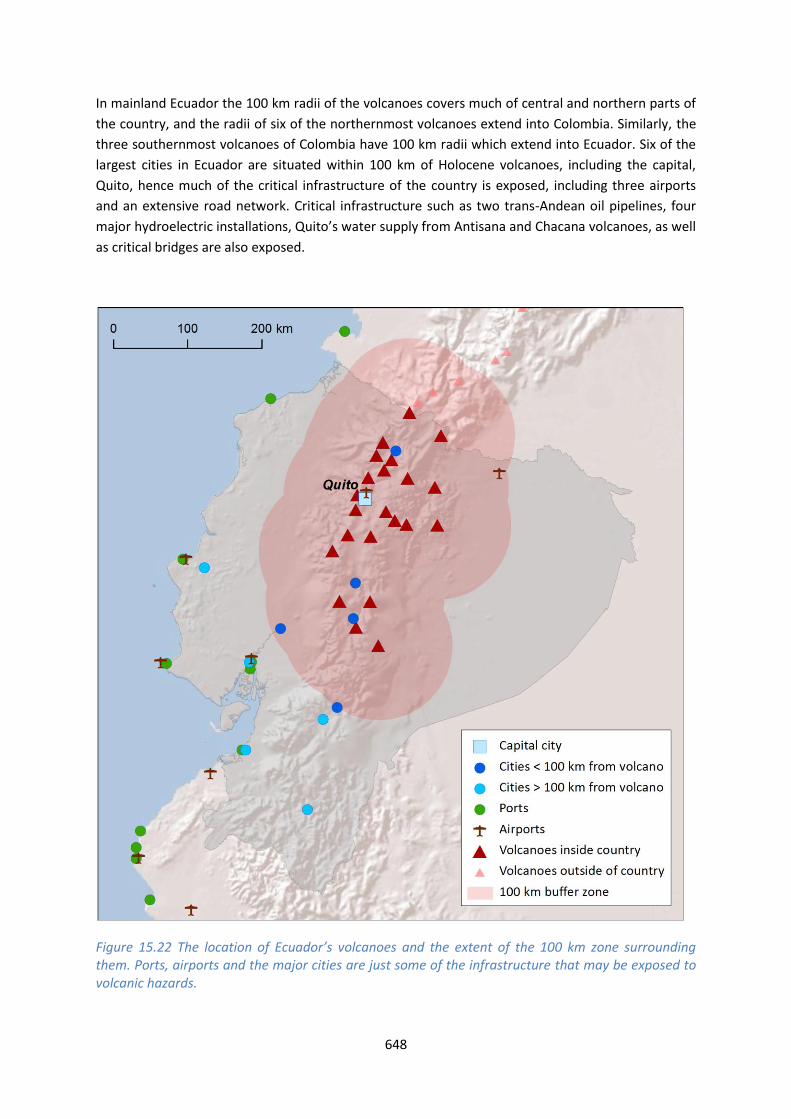
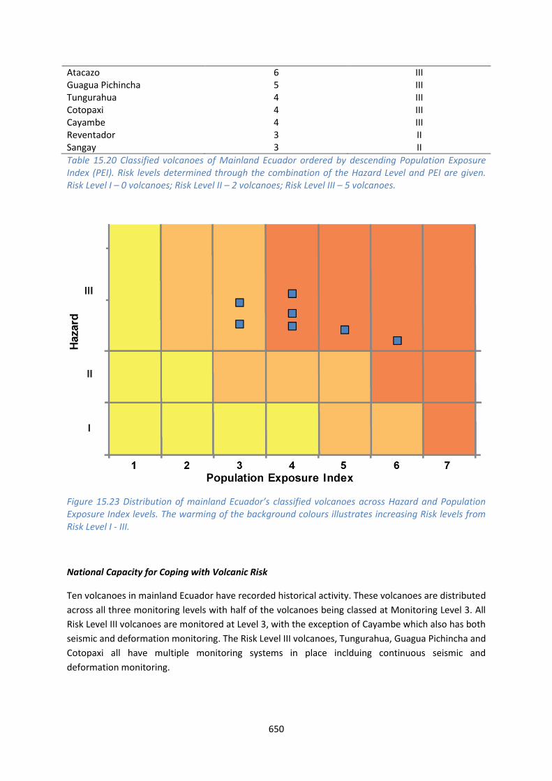
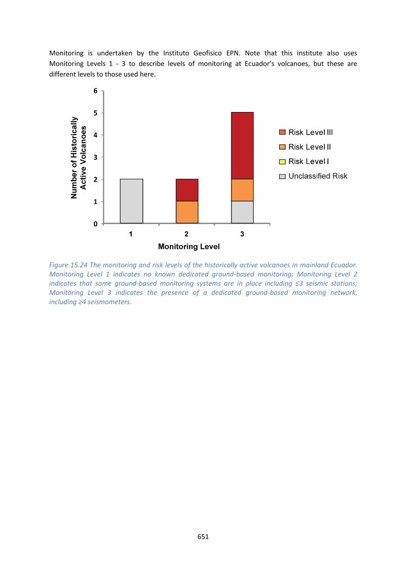
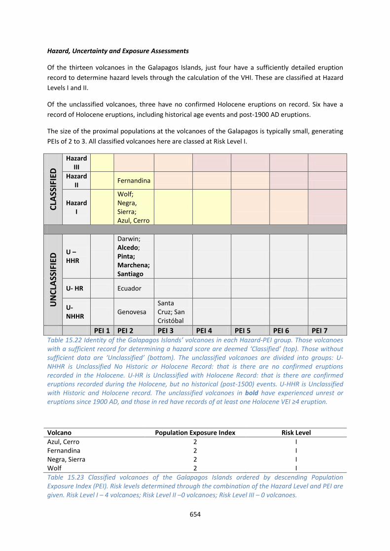
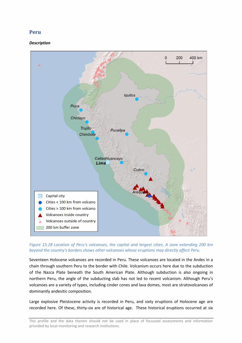
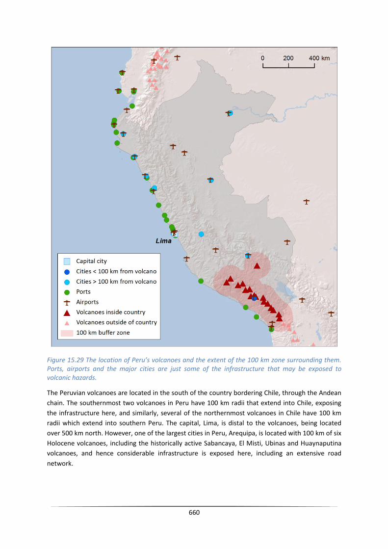
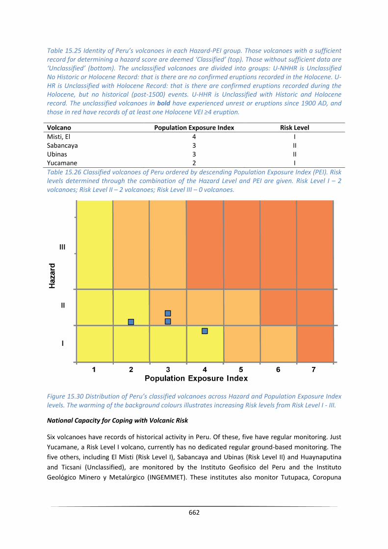