appendix 2 fauna species profiles - epa.nsw.gov.au · appendix 2 fauna species profiles...
TRANSCRIPT

APPENDIX 2 FAUNA SPECIES PROFILES Introduction This appendix provides summary information on each of the regionally significant species recorded during this survey. The aim of the profiles is to summarise and make easily available new information gathered in the Brigalow Belt South Bioregion on these species during Stage 1 and 2 surveys. Where known, each species profile details the distribution and status of the species in Australia and more specifically in New South Wales. Information on the ecology, preferred habitat, location, the survey technique used to obtain the current records as well as the number of individuals found and in various habitat types are discussed to give a detailed account of the species in the BBS. Additional information on each species including numbers of individuals observed, behaviour, local significance and details of specimens lodged with the Australian Museum is also provided where appropriate. In collating information, species listed as threatened or endangered were generally given the highest priority, all other species were given the second highest priority, unless the technical working group believed they were secure elsewhere in their range in which case they were given a lower priority. Species with the highest priority have more information than those with lower priorities. Species where no data from the stage 1 and stage 2 systematic surveys was available and other species not searched for during the survey such as waterbirds, platypus, water-rat were not prioritised. These species were flagged as species of concern and potentially in need of further research, however this project was incapable of assessing the priority. The full list of priority species is in Table AB and AC in the body of this report. The distribution maps for each priority species shows the location of the BBS within NSW, species distribution within NSW, and the locations of priority species within the BBS from Stage 1 and Stage 2 surveys. Point data on the NSW distribution maps for mammal, reptile and amphibian species was extracted from the Atlas of NSW Wildlife (NPWS). The grey shading on NSW distribution maps for birds was derived from Schodde, R., Mason, I., J. (1999) The Directory of Australian Birds: Passerines, CSIRO and Simpson, K., Day, N., (1999) Field Guide to the Birds of Australia, Penguin. These species profiles have been developed from data collected as part of the BBS Stage 1 and 2 bioregional assessment surveys. Other references should be consulted for information on each species outside the bioregion, and for detailed information on the biology and ecology of each species. Details on the statistical analysis and modelling of species with sufficient records is included in Appendix 1.

Contents: Summary information for each priority
species is presented in the following order.
Mammals
Arboreal
Squirrel Glider
Koala
Common Brush-tail Possum
Common Ring-tail Possum
Feather-tail Glider
Ground dwelling
Eastern Pygmy Possum
Black Striped Wallaby
Pilliga / Delicate Mouse
Microchiropteran bats
Vespadelus troughtoni
Rhinolophus megaphyllus
Saccolaimus flaviventrus
Nyctophilus timoriensis
Chalinolobus picatus
Chalinolobus dwyeri
Mormopterus sp 6 (Hairy -nosed
Mormopterus)
Birds
Diurnal
Malleefowl
Hooded Robin
Grey-crowned Babbler
Speckled Warbler
Black-chinned Honeyeater
Diamond Firetail
Squatter Pigeon
Bush Stone Curlew
Square-tailed Kite
Turquoise Parrot
White-backed Swallow
Crested Shrike-tit
White-browed Babbler
Southern Whiteface
Chestnut-rumped Heathwren
Painted Honeyeater
Yellow-throated Miner
Plum-headed Finch
Spotted Bowerbird
Nocturnal
Barking Owl
Masked Owl
Reptiles
Oedura rhombifer (Zig Zag Gecko)
Squirrel Glider Petaurus norfolcensis Other common names – Flying Squirrel, Sugar Squirrel, Squirrel Flying Opossum, Squirrel Flying Phalanger Conservation status – National: lower risk (near threatened)
NSW: vulnerable Species model produced: Yes
Distribution and Status – The Squirrel Glider is widespread in eastern Australia occurring throughout central Victoria (on the Riverine Plains, Northern Uplands and northern slopes of the Western Highlands), central eastern NSW and central eastern Queensland, excluding the dense coastal ranges (Suckling 1995, Ayers et al. 1996). Although the species lives at low population densities naturally, their range has contracted and fragmented and they have become locally extinct in many areas (Menkhorst et al. 1988). Threats – Main threats to the species include; decline in the quality and extent of habitat remnants due to the removal of timber, lack of suitable hollows, lack of regeneration of trees/ shrubs from grazing, inappropriate fire regimes, habitat loss from gold mining, and tree decline in rural areas (Maxwell et al. 1996).
Ecology – Family groups usually comprise one adult male, one or more adult females and their associated offspring of the season. Colonies usually comprise 2-9 individuals (Quin 1995). Breeding usually begins in June or July with each female producing two young, which remain in the pouch for about 70 days and are then deposited in the group nest for another 40-50 days. Squirrel Gliders and Sugar Gliders both emit a defiant gurgling chatter but the Squirrel Glider lacks the shrill, yapping call that is characteristic of the Sugar Glider (Suckling 1995). Squirrel Gliders also emit a soft, nasal grunt or ‘bark’ which was often heard during the BBS Stage 2 surveys. Nectar and pollen are principle food sources for the Squirrel Glider but when not available they feed on eucalypt sap, wattle gum and insects (mostly beetles and caterpillars) (Suckling 1995). Spatial behaviour is probably similar to Sugar Gliders, which occupy territories of about 0.7 ha in small, rich habitat patches and increases to 1.7- 14 ha in areas with fewer food resources (NPWS 2000). The Squirrel Glider inhabits dry sclerophyll forest and woodland habitats in south-eastern Australia but is absent from dense coastal ranges. However, in northern New South Wales and Queensland it occurs in coastal forest and in some wet forest areas that border on rainforest (Suckling 1995). Nest hollows with entrance holes large enough to enter and nectar producing trees and shrubs are important components of their habitat requirements (Paull and Date 1996, NPWS 2000). The species also appears to require a floristically diverse overstorey and understorey and have a particular dependence on mature acacias (Paull and Date 1996). Distribution within BBS – There are 66 records of the species in the study area (BBS fauna database). Most of the records occur in the Pilliga, Pilliga Outwash and Northern Basalt Provinces with some records in Liverpool Plains, and Liverpool Range Provinces but none recorded in the Northern Outwash and Talbragar Valley Provinces.
Brigalow Belt South Stage 2 Fauna Survey Number of records: 24 Number of individuals: 26 • Location These records were mostly in the Pilliga Province (n = 15), with some also in the Northern Basalts (n = 7), Liverpool Plains (n = 1) and Talbragar Valley Provinces (n = 1).
• Habitat The species was found in a wide range of habitat types but most notably these were usually associated with more fertile depressions/flat areas. Over half the sites in which the species was recorded were Red Gum, either as a dominant or subdominant canopy species and the remaining habitats included Rough-barked Apple, Smooth-barked Apple and White Box habitats. Of the opportunistic records and those obtained while spotlighting near/adjacent to sites, most were near White Box, Red Gum and Stringy Bark woodlands and the remainder were near Narrow-leaved Ironbark, Blue-leaved Ironbark, Scribbly Gum, Rough-barked Apple, Brigalow and Callitris woodlands. • Technique Most records were obtained (n = 13) on the spotlight transects (108 km) with the remainder recorded on the spotlight searches (n = 7, 111 hrs) or as opportunistic records (n = 4). No Squirrel Gliders were detected using call payback (124 hours). Of the 26 individuals detected, 24 were observed and two were heard from their calls while spotlighting. • Notes There were sufficient records to conduct statistical analysis and modelling for this species. Maximum temperature in the coldest period was the only variable selected as having the strongest explaining value. Squirrel glider records were clustered in the 5-15 degree range. The inclusion of vegetation data in future analysis may allow for more refined modelling of this species. In the BBS Stage 1 fauna surveys, Squirrel Gliders were recorded on five occasions representing eight individuals (BBS fauna database). One of the records was from Goonoo State Forest, which was the first for that area. Three of the records came from responses to Squirrel Glider call playbacks, one was a spotlighted individual and another group of four animals (possible family group) were heard calling opportunistically (and didn’t respond to the call playback). Habitats in which this species were detected included Narrow-leaved Ironbark, Red Gum /Rough-barked Apple, and mixed Box/Narrow-leaved Ironbark woodlands. All trees in which the Squirrel Gliders were observed or heard were old and hollow bearing with a diameter at breast height of > 60 cm. References Ayers, D., Nash, S., and Baggett, K. (1996). Threatened species of western New South Wales. New South Wales National Parks and Wildlife Service, Hurstville. Maxwell, S., Burbidge, A. A. and Morris, K. (1996). Action Plan for Australian Marsupials and Monotremes. Environment Australia, Canberra. Menkhorst, P. W., Weavers, B. W. and Alexander, J. S. A. (1988). Distribution, habitat and conservation status of the Squirrel Glider Petaurus norfolcensis (Petauridae: Marsupiala) in Victoria. Australian Wildlife Research 15, 59-71. NPWS (2000). Wildlife Management Manual for the Riverine Plains. NPWS, Hurstville. Paull, D. C. and Date, E. M. (1996). Species profiles for threatened and potentially threatened species in the Northwest Cypress and Ironbark belt of New South Wales. Unpublished report to NSW National Parks and Wildlife Service, Western Directorate. Quin, D. G. (1995). Population ecology of the Squirrel Glider (Petaurus norfolcensis) and the Sugar Glider (P. breviceps) (Marsupialia: Petauridae) at Limeburners Creek, on the Central North coast of New South Wales. Wildlife Research, 22, 471-505. Suckling, G. C. (1995). Squirrel Glider Petaurus norfolcensis p 234 in Strahan, R. (ed) The Mammals of Australia. The National Photographic Index of Australian Wildlife. Reed Books, Chatswood, NSW.

#
#
#
#
#
N
NNN
N
N
NNNNNN
NNNN
NN
N
N
NN
N
N
N
N
N
N
N
##
#######
######
#
#
##
####
#
#
# #
##
#
## #
#
##
###
#
#
#
#
###
##
#
##
#
## ####
#
##
##
#
#############
# #
#
###
#####
######
#
#### #######
#
#
#
#
#
############
#
#
##
##
#
#
#
#
#
##
# ##
#######
#
#######
#
##
# ####################
#
#######
#
######
###
######
#
#
#
#
#
##
##
##
#
#######
#
####
#
#
######
###########
########
# #
#
##
####
#
###
#
####
##
###
##
####
##
################
##
####
###
#
# ###
##
###
###
## ####
#
##
#
##
#
#
#
#
#### ##
##
#
#
##
#
####
#
#
####
##################
##
##
#
##
###
#
#####
#
##
#
#
####
# ####
#
###
# #
#####
# #
#
##
#######
##
####
#
######
#
###### ######
#######
######
#
##
#########################
####
#
##
#
##
############
##
#####
##
#
#
####
#
##
#
#
###
####
#
#########
#
####
#
#
#
#
#
#
##
#
##
#
#
# #
#######
#### ##### #######
##
####
#
#####
##
####
#
#
#
#
#
#
#
#
####
#
#
#
#
#
####
#
##
##
##
#
###
# ###
###
#
#
##
##
####
#
#
##
##
##
#
##
#
#
#
##
##
#
##
#
#
#
###
#
#
#
#
##
##
#
# #
#
#
#
# ##
#
#
###
#
#
#
######
#
############
###
#
###########################
##
#######
#
##
###
##
#
#
##
#
#
####
####
#
Woody Vegetation
State Forests NSW
NPWS Estate
NSW Mapsheet Boundaries
BBS Provinces
# Main Towns
BBS Boundary
BBS 15 km Buffer
N Stage 1 Records
N Stage 2 Records
N
EW
S
0 22 44
Kilometers
NSW Distribution #
Distribution of the Squirrel Glider in NSW and the Brigalow Belt South

Koala Phascolarctos cinereus Other common names – Koala Bear, Native Bear, Conservation status – National: none NSW: vulnerable Species model produced: Yes Distribution and Status – Koalas were once widespread throughout eastern Australia but their range is now restricted and fragmented. Their distribution extends from the tropics to the cool-temperate regions across eastern Queensland, eastern and central NSW, all of Victoria, except the far-west and north-west, and south-eastern coastal South Australia (Ayers et al. 1996). In NSW, the species occurs mainly on the north coast and has a patchy distribution in the south of the State and to the west of the Great Dividing Range. Although Koalas have declined in many areas, in some areas where they are at high densities the populations sometimes need to be artificially reduced to avoid the defoliation and death of scarce food trees (Martin and Handasyde 1995). Threats – Main threats to the species includes habitat fragmentation, grazing/trampling by stock that prevents regeneration of food trees, Chlamydiosis, predation by foxes and dogs, shooting and accidental road deaths.
Ecology –The species is solitary and individuals spend much of their time in distinct home ranges, the size of which depends on density of the population and available resources (Martin and Handasyde 1995). Breeding commences when females are two years old and healthy individuals are able to produce one young a year (gestation 35 days) until more than 14 years of age. Longevity is around 18 years for females and a few years less for males. Koalas feed almost entirely on eucalypt foliage although there are marked regional and local preferences in the species consumed (Martin and Handasyde 1995). Although six eucalypt species are usually consumed in any one area, an individual only feeds on two or three species. As eucalypt foliage is very low in nutrients, the Koala has a number of adaptations to such as being inactive for 20 hours a day and efficiently processing their food.
The species is restricted to open forest and woodland areas where acceptable food trees occur on higher nutrient soils (Ayers et al. 1996). Koalas are closely associated with eucalypt trees, their principal food source, throughout their range. However, they have also been observed resting in Belah and Callitris trees and eating the foliage and licking the sap from Callitris trees (Ayers et al. 1996).
In recent surveys of the Pilliga forests, Koalas were found to be widespread and common in some areas, particularly in the western half of the Central Pilliga (Kavanagh and Barrott 2001). They were found to be fairly common in West Pilliga and least common in the eastern and southern Pilliga. The absence of Koalas in some areas that contained apparently suitable habitat may have been due to the pattern of wildfire history (Kavanagh and Barrott 2001). In the Pilliga, Koalas regularly use Pilliga Box/ Cypress and Red Gum forests along creek lines, with Bimble Box/ Cypress pine also being highly utilised (Barrott 1999). They have also been frequently found in Cypress/ Narrow-leaved Ironbark/ Forest Oak habitats, which were previously considered to be of only marginal habitat quality.
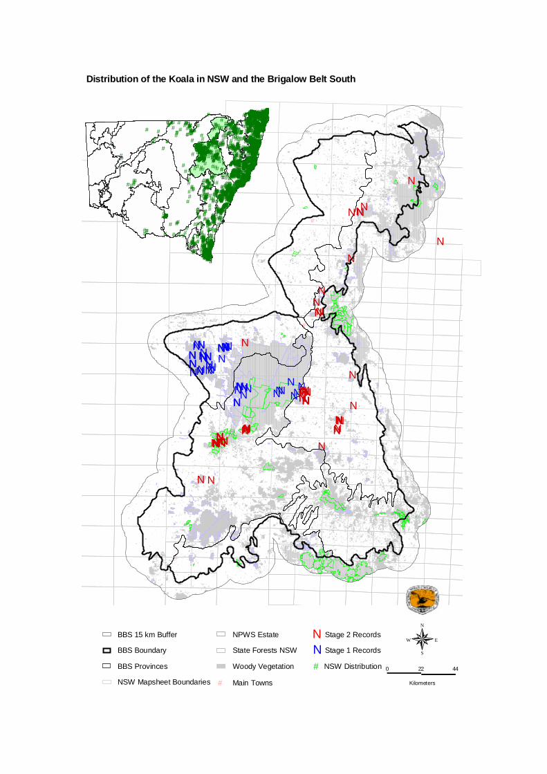
Distribution within BBS – There are 550 records of the species in the study area (BBS fauna database). Most of these were in the Pilliga, Pilliga Outwash and Liverpool Plains Provinces with some in the Liverpool Range, Northern Outwash and Northern Basalts provinces and none in the Talbragar Valley province.

Brigalow Belt South Stage 2 Fauna Survey Number of records: 62 Number of individuals: > 66 • Location The records tended to be clustered around locations where many koalas were observed, most records were obtained on private property near Coonabarabran (34%), in Kerringle State Forest (21%), and in/near Wondoba/Goran/Vickery State Forests (19%). Koalas were most often recorded during surveys in the Liverpool Plains (n = 25), Pilliga (n = 23) and Northern Basalts (n = 12) provinces, with some in Northern Outwash (n = 1) and Pilliga Outwash (n = 1) and none in Talbragar Valley or Liverpool Range provinces. • Habitat Most of the records at the systematic sites were obtained in Red Gum woodlands (46%) with the remainder in Narrow-leaved Ironbark (15%), Stringy Bark (15%), Brigalow (8%), Grey Box (8%) and Silver-leaved Ironbark (8%) habitats. Habitats in which the species was recorded off-site mostly comprised Poplar Box, White Gum and Scribbly Gum woodlands. • Technique Most Koalas were observed (n = 33) with the remainder heard (n = 18), scats/tracks seen (n = 10) or found as roadkills/dead (n = 3). Most Koalas were detected as opportunistic records (n = 34) or on the spotlight transects (n = 17, 108 km) or spotlight searches (n = 10, 111 hrs) with only 1 record detected using call playback (124 hours). • Notes There were sufficient records to conduct statistical analysis and modelling for this species. A combination of six variables had the highest explaining power for Koalas, these variables related to solar radiation, soil, proximity to streams (probably reflecting the preference for redgums), woody vegetation and location (appendix 1). The inclusion of vegetation data in future analysis may allow for more refined modelling of this species. In the BBS Stage 1 surveys, Koalas were recorded on 58 occasions in a wide range of habitats, in particular Narrow-leaved Ironbark forest, Bimble Box woodland and Red Gum woodlands. The species was also recorded in Broad-leaved Ironbark and Pilliga Box woodland but not in Blue-leaved Ironbark habitats. Koalas were also detected in Box trees within patches of Belah. Results from the Stage 1 surveys indicated no preference for flat ground versus gully habitats. References Ayers, D., Nash, S., and Baggett, K. (1996). Threatened species of western New South Wales. New South Wales National Parks and Wildlife Service, Hurstville. Barrott, E. (1999). Census techniques, habitat use and distribution of Koalas in the Pilliga State Forests. Honours thesis. University of Sydney. Kavanagh, R. and Barrott, E. (2001). Koala populations in the Pilliga forests. Ch 12 in Perfumed Pineries: environmental history of Australia’s Callitris forests. Centre for Resource and Environmental Studies, Australian National University, Canberra. Martin, R. W. and Handasyde, K. A. (1995). Koala Phascolarctos cinerus pp. 196-198 in Strahan, R. (ed) The Mammals of Australia. The National Photographic Index of Australian Wildlife. Reed Books, Chatswood, NSW.
#
#
#
#
#
NNNNNN
NNNN NNNNNN
N
NNNNNNN
NN
NNN
NN
NNNNNNNNNNN
NNNNN
NNNNNNNNNNN
N
N
NN
NNNNN
N
NNNNNNNNNNN
N
NNNNNNNNNNN
N
N
N
N
NNNN N
N
NNN
N
NNNNNNN
NN
NN
N
N
N
N#
##########
#
#
#
################
#############
#
#
## ##
###
###
##
##
###############################
##
##
#
### #####
##
###
####
#
#
##
#
########
#
######
#
#
#
#########################################
#
#
#
##############
#
###
#
####
#
#
####
###############
#
##
#
#
#
##
#
## #
#
###
#
#
####
###
## #
#
##
###
#
##
### #
#
#
##
#
######
#
#
#
#
#
###
#
#####
##
##
#
####
#
#
#
##
#
#
#
############################
#
#
##
#########
#
#####
#
###
#
#######
#
##
#
#
#####
#
#
##
#
#
###
#
#######################
#
######
########
#
#
##########
##
#
###
####
###
#
#
####
##
##
#
##
#######
#
##
#
##
####
#########
#
#
#
#
#
#
#
#
#
##
#
### ##
#
#
#
##
##
#
## ########
#
###
#
##############################
#
#
#
#######
#### ####
#
########
#
#
###
####
########################################
#
##
#
#
#
#### ###################
###
#
############
#
################# ##
#
#########################
#
###
#
######
##
#
#
#
##
#
#
##
#
#
#
##
#
#
#
##
#
#
##
#
###
#
#
#
##
#
#
###
#
# #
###
#
#
#
##
#
#
#
#
##
#
#
#######
##
#
#
#
#
#
#
##
##
#
##
#
#
#
#
##
##
#
#####
####
#
#
##########
#
##########
#
##########
#
#########
#
#########
#
######
#
#########
####
#
#
#
############
##
#####
#
##
###
# ###
#########
#
###
##
##
#
#
#
##
#
##
#
#
#
#
#
###
#
###
#
#####
#
#
#
#
#
##
#######################################################
#
###############################
#
#######
#
#
##
###
#
#
#######
#
#
#
###
##############
#
#######
#
#
#
######
##
##############
#
#######################
#
#
######## #########
#
#
#
#
#
#
#
#
#
#
#
#
##
#
#
#
#
##
#
#
#
##
#
#
#
#
#
#
##
##
#
#
#
#
#
#
#
#
#
#
#
#
#
#
#
#
##
#
#
#
#
#
#
#
#
#
#
#
#
#
#
#
#
#
#
#
##
#
#
#
#
#
#
#
#
#
#
#
#
#
#
#
#
#
#
#
##
#
#
#
#
#
#
#
##
#
#
#
#
#
########
#
#
#
#
#
#
##
#
#
#
#
#
#
#
#
#
#
#
#
#
##
##############
#
###########
#
#################################################################
#
###########
## ##
#
#############
#
###############################
#
############################################# ############################
#
#
###
##
#
##
#
####
########
##
#
#
##
#
##
#
#
##
###
#
#
######################
# #
#
##
#
#############
#
##
#
#
#
###
#
#####
#
#
#
###################################
#
#################################### #################### ###########
#
###
#
########################################
#
###################### ############
#
########################
#
#################
#
############################
#
###
#
################ ########### ##############################################################################
#
###
#
#
####
#########
#
########################################################################
#
##############
#
##############################################
#
#
##
#############
#
################# #############
#
##############
#
#############
#
###################
#
###
#
#
#
######
#
#################################################################
#
########
########### #######################
#
#
#
#
#
##
#
#
#
####### ############# ##
#
#
###########
#
###
#
#
## #########################
#
################### #####################
#
############################ #### ###############################################################
#
##
#
###########
#
###########
#
##########
##
#
#############################################
#
#############################
################################# ## ########## ###############
#######
#
###########
###
####
#############
#
####################
#
#### ###########
###############################################################
#
########################################################################################################
#
############################################################################## ##
#
### ###### ##### #######
#
##################### ##################################################
#
###########################################
#
#####
#
#############
##
#
#
##
####
#
##
#
#
#
#
#
#####
###
#
#
#####
##
##
###
#
#
#
###
#
####
############
###
##################
#######
#########
## ###########
#
#####
#
#
#
#
#################################### ##########
#
#####
#
##################### #########
##
###
##
###############
###################
#
##
#
#
#
###### ########
#
####
#
#
##
#
##
#########################################
#
# ##
#
###
#
######
#
######
#
########################
#
#
#
#####
#
####
#
###############
#####
#
#################################
##
####
#
#
#
##
#
######## ########
########################## ## #########################
##################
#####
#
############################################################# #############################
#
# ########### ##########################################
#
###### ###
#
#
##
#
#
#
#
#
###
#
#
###
#
####
#
#
#
##
#
#
#
##
#
#
#
#
#
#
###### #####
#
########################################
##
############################################################# ###################################################### #############################
#
################## ############
########
#
#
#
#
######
###
##
#
#
##
#####################
#
#####
#############
#
###########
#
#
#
#
#
#
#
#
#####################
#
##########
#
#############################
#
#
#
##### ##########################
###
##
#
#####################
####
############
##
#
###############
#####
######
###
#
#
##########
####
#####
#########
#
########################### ##
#
########## #######
#
#
#
##
#
#######
#
############################
#
# ###################################################################
#####################
#
#########################
##
#########
#
############################################################
#
############ #########
#
#######################################################################################
###
#
###############
#
####################################
#
##
#
#
##############################################
############
#
##
####
####
#
#
#####
#
#
#
#
###
#
##
#
#####
###
##################
#
## ######
#
#########
#
#
#
#
##################
#
##############################
#
#########
####
###
##
####
#
#
##
#####
#
#
#
##
#
#
##
#########
#
#
#
#
#
#
####
### ## ### ##############
#
#################
##
###
###
# # #
##
#
#####
#######
##
##
#
#
#
###############
#
########
#
#######################
#
#########
##
###### #####
#####################
##
##
#
#
#
#
#
#
#
#######
#
#
#
#####
#
########
#
#
##
#
#
#
####
#
#
##
##
#
#
#
###
#
#
#################
##
#
#####
#
#######################
########################
#############
####################
#
##################### ##
# ######
##
##
####
#
######
#
##########
#
##########
#
#####
#####
#
####
#
##
#
#
#
####
##
#
#
##
#
#########
#
#
##
#
#
#
###
#
##########################################
#
##################################################
#####
#
######
###################
#
#######################################
#
####################
#
####
#
#####
#
###### ######
#
##
#
############ #############
#
####
###
###
#
#
##
########
#
####
#
###
#
##
#
#
#
###
#
#
#
########
#
##########
####
#
#######
#
#
####
################
#
#######
#
#
#
##
####
##
#########
#
##################
#
######
#
############
#
#
#
#
#
#
##
############## ###
#
######## ########
#
##
#
###############
#
#########
#
#
#
#
#
#
#
#
#
#
##
#
#
#
#
##
#
#
#
#
#
#
######
#
#
######
#
#############
#
##
#
## ## #####
##
#######
#
##############
#
#####
#
###
##
#
#
#
#
###
##
##
#
#
#
#
#
#
#
#
#######
#
##
#
#########
#
#
##
###
###### ##
##
##
##
###
####
#
#####
#
#
####
#
# ###
#
#####
##
#
#
##
#
##
###
###
#
#
##
#
### ##
##
#
#
#
#
####
#
##
##
#########
#
######## ##
# ########### ########### ########### ##########
#
##########
#
##########
#
#######
#
#
#
#
###########
#
########
#
#
#
##########
#
##########
#
#
########
#
#
##
#
#
#
###
#
#
#
####
##
#
###
#
#
#
###
#
###
#
#
#########
#
#
##
#######
#
###
#
#
# #
#
##
#
#
#
#
###
#
####
#
##
#
###
####
#
###
# #
#
##
#
##
##
##
######
#
##
##
##
#
##
##
##
#
#
# ###
###
#
#
#
#
#
###
##
#
#############
#########
##
#
#
#
#
##
#
##
#
# ##
#
#
#
#
#
#########
###
#
#####
#
####
#
###
#
###
#
#
#
#
#####
#######
###
#
#######
#
#
##
#
#
##
#######
#############
####
#
#######
#####################
# #########
################################
#
#
###
#
##
########################
###### #### ###
#
#
#######
#
##############################
#
####
#
##
#
#
##
###
# ##
##
#
##
#
#####
#
#########
#####
##
###################
####################
######
##
#############
##
###
######
#######
##
#
#####
#
######
#####################
###
#
#####
#
#
###
##
#
#
#
# #
######
###### ####
#
#
#
##
###########
##
####
#
#
#
#
#
#
#
#
########
#
#
##
#
#
##
#####################
####
#
#
#
#
#
######
#
#############
#
#
#
#
##########
###
#
#
#
#
#
##
#
##################
##
#
##
#
## ####
#
##
#
#
#
###################################################
#####
###
####
#
##
############################################
###################
############### ###############################
############################
########
#
#########
#####
##
#
#####
##
#
#
##
####
####
#
###
#
#
#####
#
#####
#
##
################
#
###
####
#
#
######
#
##
#
# ##
#
##################
#
#############
#
##
# #
#
# #
#
##
#####
#
################################
######################
#########
######
#
#
##
###
###
###
##
###
#
#
#
###
#####
#
##
#
##
#
#
#
##########
#
####
#
####
###
########
##
####
###########################################################
#
################
#
##
# ##
##
###
###
#
#
####
##
#
##
###
#
###
#
#
## #
##
####
#####
##
# #
#######
#
#
#
#
###
#
##
###
##
#########
#
#
#
##
#
#
#
#
##
##################################################################################################################################################################
#
##
#
####
##
#
##
#
########
###
#
##############################################################################################################################
####
##
#
#####
#
#
######
####
#
#######
###
########################
############
#
#
###########
#
###
##
############
####
# ##########
#
#
#
# ##############
###############################################################################################################################################################################
##############################################################################################################################################################################################################
###
##
##
#####
#
# ####
# ####
##
#
#
## ##
####
###
###########
###
#
#
#
######
#
#####
##
#
##
#
##
##############################
####
##
##
#
##
#######
#
#
#
#
#
#
######################### #######
##
#
####
#
#
####
#
#
#
###
##
##
##
###
####################
#
#
##
#
#
#
######
####
########################################################################################################################################################################################
#########
#########
#
############
#
#
#
#####
##
###
#
#
##
##
#####
#
###
##
##########
##
#
#
##
###
#
#
#
##
#
#
#
#
#
#
#
#
#
## #
##
#
#
#
#
#
##
#
##
###
#
#
#
#
#
##
#
#
#
#
#
#
#
#
#
##
#
#
#
##
#
#
#
#
#
# #
##
#
#
##
##
#
##
#
#
#
#
#
#
#
###
#
#
#
#
#
#
#
#
#
#
#
#
#
#
#
#
#
#
#
#
#
#
#
#
#
##
#
# #
##
##
#
#
#
#
#
##
##
#
#
#
#
#
#
#
#
##
#
#
#
#
#
#
#
# #
##
#
#
#
#
#
#
#
# ##
#
#
#
#
#
#
#
##
#
#
#
#
#
#
#
#
#
#
#
#
#
##
#
# #
#
#
#
##
#
#
#
#
#
#
#
#
#
#
#
#
#
#
#
#
#
##
#
#
#
# #
#
#
#
#
#
##
#
##
#
#
#
#
#
#
#
#
##
#
#
##
#
#
#
#
#
#
###
##
# #
#
#
#
#
##
#
#
##
#
#
#
#
#
#
##
#
#
#
#
#
#
#
#
#
#
#
#
#
#
#
#
#
#
#
#
#
#
#
#
#
##
#
#
###
#
#
#
###
#
#
##
#
#
#
##
#
#
#
#
#
##
##
#
##
#
#
#
##
#
#
#
#
#
#
#
#
##
#
#
##
##
#
#
#
##
#
##
#
#
#
#
#
#
#
#
#
#
#
#
#
##
#
#
#
#
#
#
###
#
##
##
#
#
#
#
#
#
#
#
#
#
##
#
#
#
#
#
##
#
##
#
#
##
#
#
#
#
#
#
#
#
##
#
#
#
#
#
#
#
###
##
###
##
#
#
#
#
##
##
#
##
#
##
##
#
##
##
#
#
#
#
#
#
#
#
#
#
#
#
## ##
#
#
#
#
#
#
#
#
#
#
#
#
#
#
#
#
#
##
#
## #
# #
#
#
#
#
#
#
#
#
#
#
#
#
#
#
##
#
#
#
#
#
#
#
#
#
#
#
#
# #
#
##
#
#
#
#
#
##
#
##
#
#
#
##
#
## #
#
#
## #
#
##
#
#
#
#
#
#
#
#
#
##
#
##
#
##
##
#
#
#
#
#
#
#
#
#
#
#
#
##
#
#
##
#
#
#
#
# #
##
#
##
#
#
#
#
#
##
#
#
#
#
#
#
#
#
# #
##
##
#
#
##
#
#
##
#
#
#
#
#
#
#
#
#
#
##
###
#
#
#
#
#
#
#
#
#
#
#
#
#
#
#
#
##
#
##
#
#
#
#
#
#
#
#
#
##
#
#
##
#
#
#
#
#
#
#
#
#
#
#
# #
#
##
##
# #
#
#
##
##
#
#
#
#
#
#
#
#
#
#
##
#
#
##
#
#
#
#
#
##
#
##
#
#
#
###
###
#
#
#
#
#
#
#
#
#
#
#
###
#
#
##
#
#
#
#
#
#
#
## #
#
##
#
#
##
##
#
#
#
#
##
##
#
#
#
#
#
#
#
#
##
#
#
##
#
#
#
#
#
#
# ##
#
##
#
#
#
#
#
#
#
#
#
#
#
#
##
#
########################
#
##########################
# #
########################
##
####
#
#
####
##
#
##
###########
##
##
#
#######
#
#
###
#
# ###
#
###################
#
#
#
#
##
#
#
#
#
##
###
##
##
##
#
#
#
########
#
#
#
#
#
##
#
#
#
##
#######
#
#
#
#
###
##
####
#
#
#
#
#
##
#
# ###
#
#########
#
####
#
#
##
#
#
###
#
######
##
#
####### #### ##
##
#
#
###########
#
#
##
##
#
#
####
#
#
###
#
####
#
#
#####
#
#####
#####
##
#
#
#
##
###### #
# ####
#
##
#
###
###
###
##
##
#
#
#################
######################################################################################
##
################
#########
#
###
#
############
#
#####################################
####
############
#######
##
# #######
###########
#############
#######
#####################
#
###
###
######################### ###
######
##
##################
#######
#### ################
##
#####
######
#
#
#
#
##
#
############################################ ##
########### #####
############################ ## #########
######
########
#
#
######### # #####
###
###
#
##
############
###########
### ####### #########
#
## #######
###
#########
#######
#
###################
########
##
#######
######################
###########################################################################
###################################
##############################################################################################################################################################################################################################################################################################
############
###########################
###########################################
###########
##
###############################################################
#################
############
###########
# ####
##############################
#######
#
############## ##
##
## ##############
##
###############
####
# ###
##
#
#
############## ############################## ######
#
################################ ############################
##########################
###################################################################################
###########
############################
################################
#######
########
###
######
#####
#### #############
######
## ##### ######
#######################
#####
##
##
###
#
#################
#################
############### ###########
#####
######
#####
############################################################################### ################## #########
###########################################################################
########## ##############################
##
###
####
#
#######################################
##
#############
####
#
#
#
###########
######
################################
###
#
#
##
#
###########
######
#######
#######
####
#####
#########
## ##
#
#########
#######
###
#
#####
#######
####
######
##
#################
####
##
##
#####
###
####### #####
#
###
##
#
######################################################
###
#
##
######
##########################################################
## ##
Woody Vegetation
State Forests NSW
NPWS Estate
NSW Mapsheet Boundaries
BBS Provinces
# Main Towns
BBS Boundary
BBS 15 km Buffer
N Stage 1 Records
N Stage 2 Records
N
EW
S
0 22 44
Kilometers
NSW Distribution #
Distribution of the Koala in NSW and the Brigalow Belt South

Common Brushtail Possum Trichosurus vulpecula Conservation status – National: none NSW: none Species model produced: Yes Distribution within BBS – There are 486 records of the species in the study area (BBS fauna database).
Brigalow Belt South Stage 2 Fauna Survey Number of Records: 167 Number of individuals: 196 • Location Common Brushtail Possums were found in many survey areas throughout the study area, but more frequently on private property and in national parks than in State forests (Section 4.2 of report). • Habitat The species was found in a wide range of habitat types but most commonly detected in Box woodland (n = 25) (including Pilliga/Grey, Poplar, White Box) and Ironbark woodland (n = 18) (including Mugga, Narrow-leaved, Broad-leaved, Silver-leaved). The species was also recorded in Red Gum depressions (n = 8) and ridges (n = 3), Red Stringy Bark (n = 7), Scribbly Gum (n = 7), Cypress (n = 5), Casuarina (n = 5), dry rainforest (n = 4) and Smooth-barked Apple (n = 2) habitats. • Technique Most records (n = 66) were obtained on the spotlight transects (108 km), as opportunistic records (n = 48), or on the spotlight searches (n =43, 111 hrs) with the remainder recorded on diurnal habitat searches (n = 9, 109 hrs) or during call playback (n = 1, 124 hrs). • Notes There were sufficient records to conduct statistical analysis and modelling for this species. The combination of distance to clearing, solar radiation (aspect) and relative topographic position had the greatest explaining power. The most significant variable was distance to clearing which was highly correlated with possum distribution (p = 0.001). The great majority of brushtail possum records were within 2 kilometres of cleared areas. The relative topographic position (p = 0.022) showed a strong skew towards lower areas within the surrounding landscape (appendix 1). The inclusion of vegetation data in future analysis may allow for more refined modelling of this species. In the BBS Stage 1 fauna surveys, only 19 records (five of these were detected in predator scats) of the Common Brushtail possum were detected. Habitats in which the species was found included gully Narrow-leaved Ironbark/Red Gum strips, Broad-leaved Ironbark forest, Blue-leaved Ironbark forest, Pilliga Box woodlands and Western Grey Box woodland.

#
#
#
#
#
N
NNNN
NN NNNNNNN
N
NN
NN
N
NNNN
NNNNNNN
NNNNNNNNNNNN
N
N
NNNN
NNNNNNNNNNNN
NNNNNNNN
NNN N
NNNNNNNNNNNNNN
NNN
NN
N
N
N
NN
N
N
N
N
NNNNNNNNNN
N
NNNNN N
N
NNN
N
NNNNNNN
NNN
NNNNNNNNNNN
NNN
NNNNNN
N
NNN
NNN
NNN
NNNNNNNNN
NNNN
N
N
NN
N
NN
N
N
N###### #####
# #
#
##
#####
##
######################### ######
##
##
####
# ##
#
#
#
#
#
##
###########
###
####
############################
#
###
#
#
##
#######
#
##
##
#
##
#
#
###
#
#
#
#
#
#
#
#
#
#
#
#
#
#
##
#
#
#
#
#
#
#
#
###
#
#
##
#
#
#
#
#
#
##
#
#
#
#
##
###
##
#
#
###
#
#
#
#
#
##
#
#
#
#
#
##
#
#
#
# ###
#
#
#
#
#
#
##
#
#
###
##
##
#
#
#
#
###
#
###
#
######
#
#
####
#
#####
#
###
#
###
###########
#
####
##
#
###
#
###
#
# #
##
##
# ##
###
#
###
#
#
#
##
#
#
#
#
#
#
#
#
#
#
#######
#
#
# ##
#
#
#
#
###
###
###
##
#
#
#
######
#
#
#
###
##
#
#
##
##
##
#
#
#
#
#
# ##
#
##
#
#
## #
##
##
##
#
#
#
#
#
##
#
#
#
## ##
#
#
#
#
#
### ###
#
# #
####
#
#
#
##
##
#
# #
###
#
#
#
#
#
###
#
#
###
#
#
# #
#
#
#
#
### #
#
###
##
#
####
#
###
#
##
#
#
##
#
#
##
#
#
#
##
#
#
# #
#
##
#
#####
#
##
#####
##
#
####
##
##
##
#####
## ##
#
#
#
##
#
#
###
# #
#
#
###
#
##
###
#
####
##
###
#
#
###
#######
#
##
#
#
#
#
#
###
# #
# ####
#
#
#
#
#
#
##
##
#
#######
#
###
##
#
####
#
#
##
#
#
#
#
####
#
#
#
##
#
#
###
##
#
#
#
##
#####
#
# #
#
##
#
#
#
#
##
##
####
#
##
#
#
##
#
#
#
##
#
#
#############
####
# #
#
#
##
#
#
##
#######
#
##
#
#
##
#
# ###
###
##################
#########
#
#
#
#
#
# #
###
###############
##
#
##
#
##
# #######
## ##
##########
#
###
#
#
#
#
#
#
#
##
######
#
#
#
# #
##
####
#
##
###
#
###
#
#
#
###
#
#
##
##
##
##
#
####
###
##
##
######
#
#
#
###########
#
##
#
####
#
#
##
#
##################### ############## ##################
####
#
#
#
##
#
#
#
#
#
#
#
#
#
#
####
#
######
##########
#
#
#
##
#
#
###
# ###
#
####
#
#####
#######################
##
#
#
##
#
###
##
##
##
#
# ##
#
#
#
#
#
##
###
#
####
#
#
#
#
#
#
#
#
##
#########
####
#
# ##
###
##
#
#
####
#
###
######
#########
##
###
##########
#
##
#
##
#
##
###
###
#
###
# #####
###
##
########
###
#
#
##
#
#
#
#
##
#
#
#
#
####
####
#
#
#
#
##
#
#
###
#
##
##
#
#
#######
########
##
###
#
#
#
#########
##########
#
##
#####
#
#
#
##
#
##############
###
#
####
###
###
### #######
#
##
#
##
##
#
###
#
#
#
###
###
#
#
##
#
###
#
##################
###########
##
#
#####
##### #
#
#
###
#
######
##
### #
# #
############
#
###
#
##
#
#
#
############
#
##
####
###
##
##
#
####
#
##
#
###
##
##
#
####
####
##
###
#####
#
#########
#
###
#
######
####
#
#####
#
#######
######## # #####################################
########## #
# ###
#######################
#####
####
###########
# #### ###
#
# #########
##
#
####
##
##
##
#################
####
##
###
#
#
#
#####
##
##
#
######
##
#
##
#
###
#
#
#
#
#
# ##
#
##
###
###
##
####
#
#
##
#
#
#
#######################
######
##
#
#
############
###
##
#
#
####
#######
##
#
##
###################
####
##
#########################
##############################
##### ######
#
##
##
##
##
#
##
#
# #
#
#
#
####
#
##
#
#
#
##
#
# ##
########
####
#######
#
#####
####
#
#
#
#
## ########
## ##
#
#
##
##
###
#
#
##
##
#
#
#
#
#
##
#
##
####
##
####
#
#
#
##
#
#
#
#
#
#
###
##
#
######
#
#
#
##
##
########
#
##
#####
#
#
#
#
#
#
#####
####
##
# ####
# ####
#
##
######
#
##
##
##
#
#
###
#
#
## #
###
#
##
#
##
#
#
#
#
#
###
#
##
##
#
#
#
#
#
#
##
#
#
#
#
#
###
#
#
#
##
#
#
#
#
#
#
##
##
#
##
#
#
#
#
#
#
#
#
##
##
#
#
#
###
#
####
#
#
#
#
#
#
#
#
#
#
#
##
# #
#
#
#
#
###
#
#
#
###
##
##
#
#
#
#
#
#
#
#
###
#
#
#
#
###
#
#
#
###
#
#
#
#
#
#
#
#
#
#
#
#
#
#
#
#
##
#
#
###
#
#
#
#
#
#
#
#
#
#
#
#
#
#
##
##
##
#
#
#
#
###
###
#
###
#
#
# #
##
#
#
#
#####
##
#
#
#
##
#
#
#
#
#
#
#
#
#
#
#
#
###
####
##
###
#
#
#
###
###
###
#
##
#
##
#
#
###
##
#
#
#
##
#
###
#
#
#
##
#
#
#
##
#
#
#
#
#
##
#
#
#
#
#
#
###
###
#
#
##
#
#
#
#
#
#
#
#####
#
##
##
#
#
#
#
#
#
#
#
#
#
##
##
#
#
#
#
#
##
#
#
#
##
#
#
#
#
#
#
#
###
##
#
#
#
#
#
####
####
##
#
###
#
##
#
#
##
#
#
#
#
###
##
#
##
# #
##
##
#
#####
#
###
#
##
#
#
#
#
#
#
#
#
#
###
#
##
##
#
#
#
#
##
#
#
#
#
## #
#
#
#
##
#
#
#
#
#
#
#
##
# #
#
#
#
#
#
#
#
#
#
#
#
#
#
##
#
#
#
#
#
#
#
#
#
#
#
#
#
##
##
##
#
#
####
#
###
##
##
#
##
#
#
#
#
#
#
#
####
######## ###
#
#
##
##
#####
###
#
#######
#
######
#############
#### ###########
########
#######
#
#######
###
#####
#
####
########
###
####
#
#
######
####
#
### #
##
##
##########
######## #
##
#
###
## ##
#
##### ### ###
####
##
###
##################
####
##
###
##### #######
#######
###
###
####
#
###############
##
#
#
##
#
########
#
# ##
###
#
#
###
#
#
##
##
#################
######
#
#
#
#
##
#
#
#
#
##
#
##
#
####
#
##
####
#
##
#
#
#
####
##########
###
## ###
##
#
# #######
#
#
#
#####
#
#
#
#####
#
#
#
#
###
##
#
#
##
##
###
#
#
##########
##########
####
#####
######
#
######
##
###############
########
#################
#
#################### ################### #
#
####
#
##### #
############################
#### ##
######
#######################################
######
################
###
##
###
#######
########
###########
###
#################################################
##############
###
##
#
#######
##
###
##
##############
## #
######################
###### ##
###
#
###
####
#####
######
##
##
#
#
#
##
# ##
##
###########
########
####
##### #
#
#
#
#####
##########################
############ #
#####
####################################
##########
#
#
#
#######
## #
#
#################################
############
#####
####################
#######
#################
#####
#####
##
##
##### ####
############
#########
#####
# ####################
########### #################
###########
###
#
#########
##
#######
######
#######
#
####
###
########
##########
###
## ##########
##
#####
#
######
#########
## #
##
##
#######
#
#
##
#
##
###
####################
###
### #
#
#
######## ######
####
###########
##########
##########
#
### #
##########################
##
#### ##
#######
## ########
####
Woody Vegetation
State Forests NSW
NPWS Estate
NSW Mapsheet Boundaries
BBS Provinces
# Main Towns
BBS Boundary
BBS 15 km Buffer
N Stage 1 Records
N Stage 2 Records
N
EW
S
0 22 44
Kilometers
NSW Distribution #
Distribution of the Common Brushtail Possum in NSW and the Brigalow Belt South
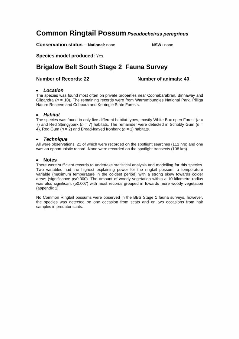
Common Ringtail Possum Pseudocheirus peregrinus Conservation status – National: none NSW: none Species model produced: Yes
Brigalow Belt South Stage 2 Fauna Survey Number of Records: 22 Number of animals: 40 • Location The species was found most often on private properties near Coonabarabran, Binnaway and Gilgandra (n = 10). The remaining records were from Warrumbungles National Park, Pilliga Nature Reserve and Cobbora and Kerringle State Forests. • Habitat The species was found in only five different habitat types, mostly White Box open Forest (n = 7) and Red Stringybark (n = 7) habitats. The remainder were detected in Scribbly Gum (n = 4), Red Gum (n = 2) and Broad-leaved Ironbark (n = 1) habitats. • Technique All were observations, 21 of which were recorded on the spotlight searches (111 hrs) and one was an opportunistic record. None were recorded on the spotlight transects (108 km). • Notes There were sufficient records to undertake statistical analysis and modelling for this species. Two variables had the highest explaining power for the ringtail possum, a temperature variable (maximum temperature in the coldest period) with a strong skew towards colder areas (significance p<0.000). The amount of woody vegetation within a 10 kilometre radius was also significant (p0.007) with most records grouped in towards more woody vegetation (appendix 1). No Common Ringtail possums were observed in the BBS Stage 1 fauna surveys, however, the species was detected on one occasion from scats and on two occasions from hair samples in predator scats.
#
#
#
#
#
NNN
N N
NNNNNNNNNNNNNNNNNNNNNNNN
NNN
N
NNNNNNNNNN
N
NNN
N
NN
N
#########
#####
### #
##
###########
###########
##########
####
######################
##
###########################
#
########
#######
#######
######
###
###
###
###
#
####### ###
#
#
###
##
#######################
####
#
##
###################
##############################
##############
########
#
################################### #
##
#####################
#
#
###
###
#####
##
##
##
##
#
#
#
#
#
### #
##
####
#
##
##
#
# #
##
#
#
#
#
###
#
#
#
#
########
#
#
#
#
#
#
#
#
#
###
##
#
#
#########
#
##########################################################################
#
#####
#
#
##
#
#
#
#
##
##
#
###
#
#
#
#######
# #
####
#
##
#
##
#####
##
#
###
##
##
#
#
###
####
##
#
####### ###
#
#
#
####
##
#
#
####
#
#
# #
#
#
###
#
#
###
#
#
#
##
#
#
####
#
#
#
#
#
##
##
#
#
#
#
#
#
#
#
#
##
##
#
#
#
#
###
#
#
##
#
#
###
#
#
##
#
#
#
##
##
##
##
##
#
#
#
#
#######
#
##
#
##
##
#
##
#
#
###
#
## # #
##
#
#
####
#
###
##
#
#
#
#
#
#
#
#
#
#
###
#
#
#
#
#
##
###
##
###
###
#
##
#
############# ###
#
###
#
###
#
###
#
#
#
#
#
#
#
#
##
#
##
#
#
#
#######
#
#
####
#####
#
###
#
#
#
#
#
##
###
#
#
##
# #
#
# ###
#
#
#
#
#
##
#
#
#
#
#
########
#
###
#
#
#
#
#
#####
####
#
##########
#
######
#
#######
#
#########
##
#
#######
#
##########
# ########
#
#
#
#
#
####
###
###########
######################
#
#####
#####
##
# ### ##
##
#
#
###
########### #
##
#####
#
#######
# #
##
#
#
##
#
#
#
####
#
#
###
##
####
###
#
##
##
#
#
#
#
#
#
#
##
##
#
######## ####
#
###############
##########
#
#######
#
#######
#
#
#
## #### ###############################
####
###
##
#
##
###
##
###
##
#
#
#
##
#
#
#
#
############
#
######
#######
##
###### ################
#####
##
##
####### #
#
#
##
#
##################################
#
#
##
#
##############
#
#
##
#
#
#
######
#
#
#
###
#
#
#
#
## ####
#
#############
#
#
#
#
#
#
##
#
####
#
# ##############
#
#
##
#
#
#
##
####
##
#
#
#
###
#
#
##########
###
#####
#
##
###
##
##
###
####
#####
###
###########
#
#
# #
#
##
##
#
#
#
##########
########
###
#
#
##
#
#
### #
#
#
###
#
###
#
## #
#
###########
#
#
##
#
####
##
####
#
#
##
#
##
####
##########
#
##
#
#
#
#
####
#
#
##
##
###
#
#
#
#
###
#
##
# #
#
###
####
#####
#######
###
###
######
##
#################################################
##
#
########
#
##
#
###############
#######
#
#############
#####
#####
#
#############
#####
#
##
#######
#################
##
#
#
#
#
### #
##
#
#
##
###
######
#
#
#
##
#
###
#
####
###
#
##
#
##
#
#
#
# ###
#
########
#
#
#####
#
##########
###
##################
#
##
#
##
#
#
#
#
###############
###
#
###
##
#
#
##
################################################
####
#
###
#######################
##
###############################
#######################
#####
####
# ###
#
# #####
##
#
#######################
#
#
###### #### #
# ########
#####
#
####
#
#
#
##
#
###
###################################
#############
#
##
####
#
#
#
#
##
#
#
#
## ##
#
###
#
#
###
#
#
#
###
##
#
#########
#
##
##
##
#
#
#
##
#
#
#
#
#
#
##
#
#
#
##
##
#
##
#
#
##
#
#
#
#
#
#####
#
#
#
#
#
##
#
#
#
#
##
###
#
#
#
###
#
#
#
#
#
#
#
#
######
##
#
#
#
#
#
###
#
##
#
#
#
##
#
#
# ##
#
#
#
#
#
##
#
#
#
#
#
#
#
#
##
#
##
#
#
##
#
#
#
###
#
#
##
#
##
#
#
#
#
#
#
#
#
#
#
#
#
#
#
#
#
#
#
#
#
#
#
#
##
#
##
#
#
##
#
#
#
#
#
#
#
## #
#
#
###
##
##
#
##
#
#
#
#
#
#
#
##
#
##
##
#
##
#
##
#
##
#
#
#
#
#
#
#
#
#
#
#
##
#
#
#
#
#
##
#
##
#
#
#
#
##
#
###
#
#
#
#
#
###
# #
#
#
##
#
##
###
#
##
###
#
#
#
##
#
#
#
#
#
######
#
#
#
#
#
#
#
##
#
##
#
#
##
####
#
#
#
#
#
##
#
##
#
#
#
#
##
#
##
##
#
##
#
#
#
#
#
#
####
#
###
#
#
#
##
#
#
##
#
##
####
#
#
##
###
#
#
#
#
#
#
##
#
#
#
#
#
#
##
##
#
##
#
##
#
##
#
##
#
#
#
###### ##
# ##
###
##
#####
######
### ##########
# # ###
##
################# ##
##
#########
#
#
##
#####
#
###
#
########################
#
#
#
########
#########
#
#
#
###
####
###
####
#
######
#
##
#####
#
#
####
###
#
#
#
#
#### ## #
#
# ##
#
##
#
#
#
##
####
#
##
###
###
#
#
#
#
##
###
##
##
###
###
###
#
###
#
##
###
#
#
##
#
#
##
##
#
#
#
#####
#
###
## #
#
#
##
###
#########
#####
##
###
##
#
#
#
#######
##
#
##
## ##
##
#
#
##
#
###### ####
#
####
#
######
####
#
#
##
###
#
##
#
##### #
#
#
#
#
##
###
##
###
##
#
#
#
#
#
###### #### #####
# ##################
###
#
########## ###########
###############
#########
##
##
#
####
###
#######
########
##########
############
##########
#
#####################
######
###############
#####
###
#####
################
####################
##############
### #### ### ##
#### #########
#####
########################################
#############
########
###
###########
############
##
##
###############
###
######
###
##
####
##########
#################
################
######
########################
####################
##
#######
####
#####
#####
############# ###
#######
#### ## ##
###
###
##################
#
######################
########## #### ###############
######
# ###
##############
######
####
#### ################
####
##
##
#
#####
########
##
#
## ###
#
###
####
####
########
########################## ########
#
#
####
## #####
#
#
###
## ########
##########
#
## ############# #######
#
#
##
##
###
### ###########
############
## #####
######
#
##
############
#########################
#########
#######
###
#
Woody Vegetation
State Forests NSW
NPWS Estate
NSW Mapsheet Boundaries
BBS Provinces
# Main Towns
BBS Boundary
BBS 15 km Buffer
N Stage 1 Records
N Stage 2 Records
N
EW
S
0 22 44
Kilometers
NSW Distribution #
Distribution of the Common Ringtail Possum in NSW and the Brigalow Belt South

Feathertail Glider Acrobates pygmaeus Other common names – Pygmy Glider, Pygmy Phalanger, Flying Mouse Conservation status – National: none NSW: none Species model produced: Yes Distribution within BBS – There are 29 records of the species within the study area (BBS fauna database). These records are represented in the Pilliga, Pilliga Outwash, Liverpool Range, Liverpool Plains and Northern Basalts provinces. Brigalow Belt South Stage 2 Fauna Survey Number of records: 11 Number of individuals: 13 • Location Most of the records were from sites in the Pilliga province (n = 8). The species was also recorded from sites in the Northern Basalts (n = 2) and Liverpool Plains (n = 1) provinces. • Habitat Habitats in which the species was recorded included White Box (n = 3), Poplar Box (n = 1), Red Stringybark (n = 1), Narrow-leafed Ironbark (n = 1), Blakleys Redgum / Barradine Redgum (n = 1), and Scribbly Gum (n = 3). Where noted, Feathertail Gliders were found in microhabitats including trees (n = 4), in high shrubs (n = 2), on trunks (n = 1) or in the lower (n = 1) or mid canopy (n = 1). • Technique Nine individuals were detected in spotlight searches (111 hrs) at the systematic sites, and four during spotlight transects (108 km). • Notes There were sufficient records to conduct statistical analysis and modelling for this species. Annual rainfall had the strongest explaining power for Feathertail glider distribution (p=0.002) with most records from areas with rainfall above the 700mm per annum. In the BBS Stage 1 fauna surveys, one Feathertail Glider was recorded.

#
#
#
#
#
N
NNN
N
NNNNN
N
N
#
#
###
# ##
###
#
#
##
#
#
#
#
#
#
#
##
#
#
#
#
##
##
#
###
#
###
##
#
#
#
#
#
#
#
#
#
#
#
###
#
#
#
####
#
#
#
###
######
#
##
#
##
#
#
#
###
#
#
##
# ## #
#
#
#
#
#
#
# ##
###
#
####
#
####
#
#
#
##
##
#
#
########
#
#######
#
#
#
##
#
###
#
#
##
# ##
#
##
#########
#
##
##
#
##
#
##
#
#
#
##
#
#
#
##
####
##
##########
#
##
#
###
###
#######
#
##
##
#
####
##
#
##
#
#
#
#
#
##
#
#
########
## ##
#
#####
#############
##
##
#
# ##
##
#
#
#
#########
#
##
#
#
#
#
#
#
#
##
##
#
#
#
#
#
#
#
#
##
##
###
#
#
#
#
#
#
#
#
#
##
##
#
#
#
#
#
#
#
#
####
#
#
#
##
#
##
###
###
#
#
#### #
###
####
###
##
#
#
##
###
##
#
##
###
###
#
#
#######
#
######
##
##
#
#
#
##
#
##
##
###
#
##
#
###
##
##
##
#
### ####
###### # #
#
##
#
#
#
#
#
###
##
#
#
#
#
## #
###
#
#
#
# ##
#
#
#
######
#
#
#
######
#
#
#
#
#
#
##
#
#
#
#
##
###
#
##
#
#
#
##
#
#
#
#
#### #
##
##
#
### #
#
#
##
###
#
#
##
##
#
#
#
#
#
#
#
#
#
#
###
#
###
#
##
#
#
#
#
##
##
##
#
##
#
#
#
#
# ###
#
#
#
##
#
##
#
#
###
#
##
##
###### #
#
#########
#
#
####
##
#
#
#
#
#### #
###
#
##
#######
#
#
#####
# #
#
##
#
#
#####
##
#
# ###
###
###########
####
#
##
##
##
## ###
##
#
#
####
#
#
### #
#
#
#
#
#
#####
#####
#
#
#
#
Woody Vegetation
State Forests NSW
NPWS Estate
NSW Mapsheet Boundaries
BBS Provinces
# Main Towns
BBS Boundary
BBS 15 km Buffer
N Stage 1 Records
N Stage 2 Records
N
EW
S
0 22 44
Kilometers
NSW Distribution #
Distribution of the Feathertail Glider in NSW and the Brigalow Belt South

Eastern Pygmy-possum Cercartetus nanus Other common names – Pygmy Possum, Common Dormouse-phalanger, Dormouse
Opossum, Possum Mouse Conservation Status – National: none NSW: vulnerable Species model produced: No Distribution within BBS – There are 28 records of the species in the study area (BBS fauna database). These records are all in the Pilliga province and extend back to 1988. Brigalow Belt South Stage 2 Fauna Survey Number of records: 1 Number of individuals: 1 • Location This individual was recorded in the Warrumbungles National Park within the Pilliga province. • Habitat The individual was recorded in White Box open forest. • Technique The individual was recorded during a spotlight transect (108 km) at a systematic site. • Notes There were insufficient records to conduct statistical analysis and modelling for this species. A more detailed targeted survey of this species was conducted by State Forests of NSW as part of the WRA process. In the BBS Stage 1 fauna surveys, six Eastern Pygmy-possums were recorded.

#
#
#
#
#N
###
####
#
#
#
#
########
###
#
######
#
#
#
#
##
#
###
#
#
#
#####
#
#
#
#
#
#
#
#######
#
#
##
#
##
#
##
#########################
#
#
#
#
#
####
#
######
####################
############################ #
#
#
#
##
#####
#
#
#
#
##
#
#
#
#
#
#
#
#
#
#
#
##
#
###########
##########
#
##########
##
####
##
#
##
#
#
#
#
#
## #
#
#
#
#
##
#
#
#
#
##
#########
#
#
#
#
#####
#
##
#
#
#
##
#
#
#
#
#
#
#
#
#
######
#
#
##
##
##
#
##
######
######
#
#
#
#
#
#
####
# #####
#
#
#
###
#
###
#
# #
###
###
#
####
#
#
#
#
#
##
#
####
###
#
Woody Vegetation
State Forests NSW
NPWS Estate
NSW Mapsheet Boundaries
BBS Provinces
# Main Towns
BBS Boundary
BBS 15 km Buffer
N Stage 1 Records
N Stage 2 Records
N
EW
S
0 22 44
Kilometers
NSW Distribution #
Distribution of the Eastern Pigmy-possum in NSW and the Brigalow Belt South
Black-striped Wallaby Macropus dorsalis Conservation status – National: none NSW: endangered Species model produced: No
Brigalow Belt South Stage 2 Fauna Survey Number of Records: 3 Number of animals: 3 • Location Black-striped Wallabies were observed in Bebo State Forest and Kerringle State Forest, the latter representing the southern extremity of this species known range. • Habitat The species was seen in Kerringle State Forest in open box woodland (Pilliga/Grey box) and in Bebo State Forest in Smooth-barked Apple habitat on a road beside thick fire regeneration of unidentified eucalypts. • Technique All three wallabies were observed by spotlighting, one during a site based spotlight search (111 hrs), one during a spotlight transect (108 km) and one opportunistically after the spotlighting period had finished. • Notes There were insufficient records for this species to undertake statistical analysis or modelling. In the BBS Stage 1 fauna surveys, one Black-striped wallaby was observed in Timmallallie State Forest. The habitat in which the individual was sighted was a low Broad-leaved Ironbark/Bloodwood overstorey dominated by a thick understorey of Black Cypress Pine, wattles, and a low covering of a mixture of grasses, shrubs and Macrozamia sp.

#
#
#
#
#
N N
NN
###
#
######
#
##
##
#
#
###
#
##
#####
##
### ## ##
#
###
##
###
#######
########
###########
#
#######
##########
#
###
#
##
Woody Vegetation
State Forests NSW
NPWS Estate
NSW Mapsheet Boundaries
BBS Provinces
# Main Towns
BBS Boundary
BBS 15 km Buffer
N Stage 1 Records
N Stage 2 Records
N
EW
S
0 22 44
Kilometers
NSW Distribution #
Distribution of the Black-striped Wallaby in NSW and the Brigalow Belt South

Pilliga Mouse Pseudomys pilligaensis / Delicate Mouse Pseudomys delicatulus N.B. Distribution/status and ecological information is provided for the Pilliga Mouse only Other common names – None Conservation status – National: vulnerable NSW: vulnerable Species model produced – yes
Distribution and Status – The Pilliga Mouse was first described in 1980 after which time there was some suspicion that it may be synonymous with the New Holland Mouse Pseudomys novaehollandiae. However, recent studies have shown that the sperm of the two species is morphologically different and captive breeding has demonstrated that their hybrids are infertile (Fox 1995). There has been recent speculation as to whether the Pilliga Mouse is synonymous with the Delicate Mouse P. delicatulus as identical DNA sequencing has been found for both species (F. Ford, unpublished data). The Pilliga Mouse has only been known to occur in the Pilliga State Forest and Pilliga Nature Reserve in NSW, although recent records have extended its distribution within the state (see below). Historical evidence indicates that this species was once more abundant and more widely distributed from the Gwydir River, perhaps to the Hunter confluence (Lim 1992). Threats – Main threats to the species include clearing of habitat, predation by foxes and feral cats, and habitat destruction by feral goats and pigs (Ayers et al. 1996, Paull and Date 1996).
Ecology – This species was previously only found in an isolated area of low-nutrient, deep sand of a distinct vegetation type in the Pilliga scrub (comprising < 8000 km2). The vegetation was described as Callitris-dominated woodland with a grassy, shrub or “heath” understorey (Fox 1995). However, the species has since been found in a range of other habitat types, such as mature shrubby woodlands, young post-fire regrowth, Broombush and Ironbark and mallee communities (Paull and Date 1996, Paull 1998, NPWS 2000) and is sometimes associated with disturbed habitats (Jarman and Green 2000). The Pilliga Mouse appears to prefer a high understorey density (31-50 cm above the ground) and avoids trap lines that lack shrub density near the ground or where the shrub density is too high at the upper levels (Jarman and Green 2000). The species also shows a preference for habitats that have been not been burnt for 2 years and 50 years with high understorey cover compared to habitats with a post-fire age of 15 years and low understorey cover (D. Paull pers. com.). Distribution within BBS – There are 157 records of the species in the study area (BBS fauna database). All known records were previously from the Pilliga State Forests and the Pilliga Nature Reserve, except one that was recorded by Fox and Briscoe (1980) from the Gilgandra area. However, more recently Jarman and Green (2000) trapped the species (n = 13) in Binnaway Nature Reserve (about 30 km south east of Coonabarabran) and a further three individuals were trapped in Bebo State Forest in the Stage 2 surveys (see below) which extends the species distribution outside the Pilliga region.

Brigalow Belt South Stage 2 Fauna Survey Number of records: 3 Number of individuals: 3 • Location The three individuals were all trapped in Bebo State Forest which is at least 300 km north of the previously known range in the Pilliga region and approximately midway between the known range of P. pilligaensis and P. delicatulus. Two of the individuals were collected as Voucher specimens (nos. 52527 and 52530) and sent to the Australian Museum for confirmation of identification. Morphological examinations by the Australian Museum revealed that these individuals were P. delicatulus (Henk Godthelp, pers. com.) • Habitat One Pilliga/Delicate Mouse was trapped in open forest dominated by Smooth-barked Apple Angophora leiocarpa in association with some Rough-barked Apple A. floribunda. The remaining two individuals were trapped at the same site in habitat dominated by Broad-leaved Ironbark Eucalyptus fibrosa in association with some Silver-leaved Ironbark E. melanophloia, Tumbledown Gum E. dealbata, and A. floribunda. Habitat at the two sites was structurally very different with the Smooth-barked Apple site being very open on deep sand with almost no understorey and sparse amounts of leaf litter. In contrast to the Broad-leaved Ironbark site was structurally diverse with moderate understorey and leaf litter. • Technique Three Pilliga/Delicate Mouse were trapped in Elliott traps in 32,700 trap nights (ie one mouse per 10,900 trap nights). Capture of the three individuals occurred on the 3rd, 4th and 6th (ie last) nights of the trapping session. • Notes There were sufficient records to conduct statistical analysis and modelling for this species. Environmental variables with the strongest explaining power of Pilliga mouse distribution were the amount of woody vegetation within 5 kilometres (p<0.000) with a strong skew towards the most woody, precipitation (p=0.001), and roughness (p=0.032) with all records from flat areas. This Pseudomys population appears to be isolated as surveys between the Pilliga region and Bebo State Forest have failed to detect the species. The finding that this population was that of the Delicate Mouse highlights the importance of further research into the Pilliga/Delicate mouse taxonomy and ecology. In the BBS Stage 1 surveys, the Pilliga Mouse was recorded on 30 occasions in the Pilliga region. The most common habitat type in which it was trapped was Red Gum/Rough-barked Apple habitats in the Pilliga Nature Reserve and in heathy scrub habitats in Timmallallie State Forest and Quegobla State Forest. The species was also trapped in Timmallallie State Forest in Baradine Red Gum mallee with a diverse and thick understorey of heath and spinifex and in Quegobla State Forest in a Broombush/Narrow-leaf Ironbark forest ecotone. The species was also trapped in Narrow-leaf Ironbark/Red Gum and Broad-leaf Ironbark habitats that were characterised by a medium height shrubby regrowth understorey, dominated by Cassinia and Acacia. All mature habitats in which this species was caught were characterised by a well-developed understorey cover of low shrubs with an extensive litter cover. References Ayers, D., Nash, S., and Baggett, K. (1996). Threatened species of western New South Wales. NSW National Parks and Wildlife Service, Hurstville. Fox, B. J. (1995) The Pilliga Mouse Pseudomys pilligaensis. P 616 in Strahan, R. (ed) The Mammals of Australia. The National Photographic Index of Australian Wildlife. Reed Books, Chatswood, NSW.

Fox, B. J. and Briscoe, D. (1980). Pseudomys pilligaensis, a new species of murid rodent from the Pilliga Scrub, northern NSW. Australian Mammalogy 3, 109-125. Jarman, P. J. and Green, S. W. (2000). Broad area survey for the Pilliga Mouse, Pseudomys pilligaensis. Unpublished report to the NSW National Parks and Wildlife Service, Western Directorate. Lim, L. (1992). Conservation and Biology of the Rare Pilliga Mouse, Pseudomys pilligaensis, Fox and Briscoe 1980 (Muridae: Conilurini). Report to Department of Planning and NSW National Parks and Wildlife Service. NSW NPWS (2000). Preliminary Fauna survey- Brigalow Belt South Regional Assessment (Stage 1). NSW National Parks and Wildlife Service, Western Directorate. Paull, D. (1998). Final report for a survey to capture and identify an unknown species of Hopping-mouse (Notomys sp.) from the Pilliga State Forests (November 1997-April 1998). NSW National Parks and Wildlife Service, Western Directorate. Paull, D. C. and Date, E. M. (1996). Species profiles for threatened and potentially threatened species in the Northwest Cypress and Ironbark belt of New South Wales. Unpublished report to NSW National Parks and Wildlife Service, Western Directorate.

#
#
#
#
#
NNNNN
N NN NNNNNNNNNN NNNN
NNNNN
NNN# ####### ### ##### ###################################################################################################
####
###### #############################
Woody Vegetation
State Forests NSW
NPWS Estate
NSW Mapsheet Boundaries
BBS Provinces
# Main Towns
BBS Boundary
BBS 15 km Buffer
N Stage 1 Records
N Stage 2 Records
N
EW
S
0 22 44
Kilometers
NSW Distribution #
Distribution of the Pilliga Mouse in NSW and the Brigalow Belt South

Eastern Cave Bat Vespadelus troughtoni Conservation status – National: none NSW: vulnerable Species model produced: No Brigalow Belt South Stage 2 Fauna Survey Number of Records: 17 Number of animals: 17 • Location Vespadelus troughtoni was caught in Bebo State Forest and Warrumbungle National Park. • Habitat This bat is strongly associated with caves on which it is dependent. All records were within close proximity to sandstone or volcanic escarpments. With respect to systematic survey sites the vegetation in which the species was recorded in included mallee and broad / blue leaved ironbark ridges. • Technique All were captured in Harp traps (435 trap nights) except for one which was observed while searching a cave for roosts in the Warrumbungle ranges. • Notes There were insufficient records for this species to undertake statistical analysis or modelling. In the BBS Stage 1 fauna surveys, 2 Eastern Cave Bats were recorded. One was recorded along a track, near Willala Mountain and the other outside a cave entrance where Large-eared Pied Bats had previously been caught. It is likely that this species roosts singly or in pairs, although one maternity colony was recently found in the Pilliga containing about 500 individuals (Glenn. Hoye, pers. com.). This species has been rarely recorded in western New South Wales, with only several old records from the Warrumbungles National Park and more recently from the Pilliga Nature Reserve (Glenn Hoye, pers. com.), from Yaminbah Rockholes, Borah Creek and from private land in the central area of the Pilliga.
#
#
#
#
#
NN
NNNN
NNNNNNNNNNNNN
#
# #
#
#
#
##
####
#
###
######
#####
#
####
#
#
##
#
#
#
#
#
####
#
##
#
##########
#####
#
####################
##########
#
#
#
#
####
##
##
Woody Vegetation
State Forests NSW
NPWS Estate
NSW Mapsheet Boundaries
BBS Provinces
# Main Towns
BBS Boundary
BBS 15 km Buffer
N Stage 1 Records
N Stage 2 Records
N
EW
S
0 22 44
Kilometers
NSW Distribution #
Distribution of the Eastern Cave Bat in NSW and the Brigalow Belt South
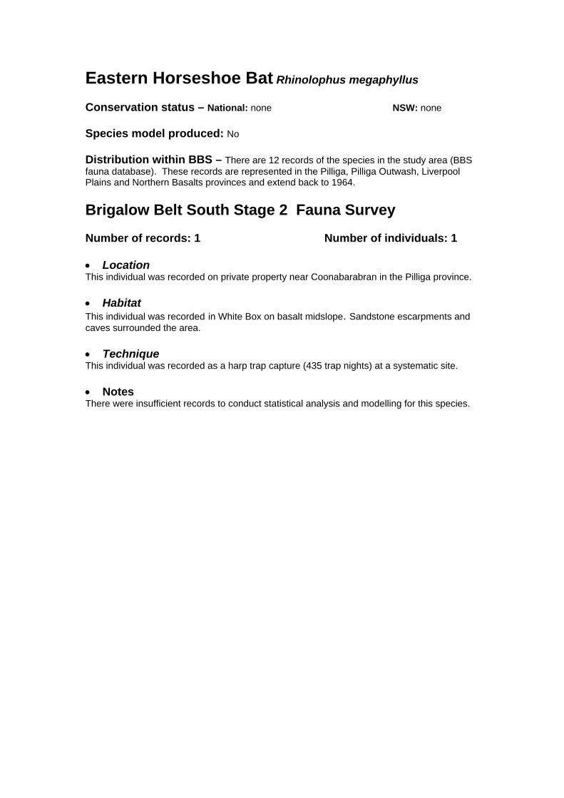
Eastern Horseshoe Bat Rhinolophus megaphyllus Conservation status – National: none NSW: none Species model produced: No Distribution within BBS – There are 12 records of the species in the study area (BBS fauna database). These records are represented in the Pilliga, Pilliga Outwash, Liverpool Plains and Northern Basalts provinces and extend back to 1964. Brigalow Belt South Stage 2 Fauna Survey Number of records: 1 Number of individuals: 1 • Location This individual was recorded on private property near Coonabarabran in the Pilliga province. • Habitat This individual was recorded in White Box on basalt midslope. Sandstone escarpments and caves surrounded the area. • Technique This individual was recorded as a harp trap capture (435 trap nights) at a systematic site. • Notes There were insufficient records to conduct statistical analysis and modelling for this species.

#
#
#
#
#
N
#########
### ##
##
########
#
##
#### #####
#
#####
#####
####
##
#
####
#
###
#
##
########
#
#
##
##
#
##
###
#
##
#
#
##
#
##
#
#
####
#
#
#
#
#
#
######
#
#
#####
##
#
#####
#
#
########
##
############
##
#
#
#
#
# #
#
#
#
#
##
####
###
####
#
#
####
#######
#
###
##
######
#
#
#
#
##
#
#
#
#####
#
#
#
#
# #####
#
#
##
#
##
##
###
#
#
#
#
#
#
#
#
#
#
#
##
##
#
##
#
#
###
#
#
###
#
#
##
#
#
#
#
#
##
#
##
#
#
#
#
#
#
#
#
#
#
#
##
#
## #
#
#####
####
####
####
#
########
#
######
###
##
#
#
#
#
##
####
##
#########
#
##
##
###
#
#
#
##
#
#
#
# #
##
####
###
####
#
###
#
###
##
#
#
###
#
#
#
###
###
#
##
#
#
#
#
#
#
#
# #
###
#
##
#############
##
###
###
# ####
###
####
########
#######
##
#############
######### #
##
#
##
#
###
###
# #
#
##
##
########
#
#
###
##
#
##
###
#
#
#
#
#
#
#
#
#
#
#
#
#
#######
#
#
#
#
#
## #
###################
#
#####
##
#
##
#
########
##
#############
##
#
#####
##########
###
#
####
#
##
####
#
###
##
#
#
###
######
####
####
##
#
########
###
###########
######
########
######
##########
########
#
#####
####
#######################################
##
####
#
#
##
#########
######
#############
##########################
#####
####
#############
#####
#
####
#
###################################
############
## ######
###########
############################ ####
#
Woody Vegetation
State Forests NSW
NPWS Estate
NSW Mapsheet Boundaries
BBS Provinces
# Main Towns
BBS Boundary
BBS 15 km Buffer
N Stage 1 Records
N Stage 2 Records
N
EW
S
0 22 44
Kilometers
NSW Distribution #
Distribution of the Eastern Horseshoe-bat in NSW and the Brigalow Belt South

Yellow-Bellied Sheathtail Bat Saccolaimus flaviventris Other common names – White-Bellied Sheathtail Bat, Yellow-Bellowed Freetail-bat Conservation status – National: none NSW: vulnerable Species model produced: Yes Distribution within BBS – There are 25 records of the species within the study area (BBS fauna database). These records are represented in the Northern Outwash, Pilliga, Pilliga Outwash and Liverpool Plains provinces.
Brigalow Belt South Stage 2 Fauna Survey Number of records: 38 Number of individuals: 41 • Location The Yellow-bellied Sheathtail Bat was frequently detected in the north of the bioregion, with most records from the Northern Basalts province (n = 21). The species was also recorded from sites in the Pilliga (n = 8), Liverpool Plains (n = 7), Pilliga Outwash (n = 1) and Northern Outwash (n = 1) provinces. • Habitat Habitats in which the Yellow-Bellied Sheathtail Bat were recorded included Pilliga Box/ Grey Box (n = 3), Poplar Box (n = 2), White Box (n =2), Bloodwood/ Smooth-barked Apple (n = 2), Dry vine-thicket/ Alphitonia (n = 3), Broad/ Blue-leafed Ironbark (n = 3), Silver-leafed Ironbark (n = 1), Mulga Ironbark (n = 1), Green Mallee (n = 2), Blakleys Redgum/ Barradine Redgum (n = 2), Scribbly Gum (n = 3), and Brigalow (n = 1). In most instances the bats were observed foraging well above the canopy of these vegetation groups, however, they were also observed hunting below the canopy in open White Box woodland in Deriah State Forest and also observed hawking moths above flowering Green Mallee at only 3 metres above the ground. • Technique Of the 38 records, 12 were from spotlight transects (108 km), 11 from spotlight searches (111 hours), eight from Anabat recordings (54 hours), five from opportunistic observations, one was a harp trap capture (435 trap nights) and one was an audible call heard during a call playback session (124 hrs) for other nocturnal fauna. • Notes There were sufficient records to conduct statistical analysis and modelling for this species. A combination of three variables had the strongest explaining power for the species distribution; solar radiation (aspect), soil drainage and amount of woody vegetation within 10 kilometres. In the BBS Stage 1 fauna surveys, three Yellow-Bellied Sheathtail Bats were recorded.

#
#
#
#
#
N
NN
NN
NNN
NN
N
NN
NN
NN
N
N
N
N
NN
N
NN
NNN
NN
N
NNNNN
N N
N
N
##
##
#
# #
#
##
## ##
##
#
#
#
#
##
#
#
##
#
#
## # #
#
#
#
###
#
#
#
#
#
#
##
#
##
#
#
###
##
##############
#
#
#
#
#
############
#
#######
####
#
#
##
#
#
# #
#
###
#
#
## #
#
#
#
##
###
##
##
# #
#
####
#
###
####
###
#
#######
#
####
#####
#
###
Woody Vegetation
State Forests NSW
NPWS Estate
NSW Mapsheet Boundaries
BBS Provinces
# Main Towns
BBS Boundary
BBS 15 km Buffer
N Stage 1 Records
N Stage 2 Records
N
EW
S
0 22 44
Kilometers
NSW Distribution #
Distribution of the Yellow-bellied Sheath-tail Bat in NSWand the Brigalow Belt South

Greater Long-eared Bat Nyctophilus timoriensis (also called Eastern Long-eared Bat) Conservation status – National: vulnerable NSW: vulnerable Species model produced: Yes
Brigalow Belt South Stage 2 Fauna Survey Number of Records: 25 Number of individuals: 25 • Location The species was found throughout the study area, 13 were recorded from systematic sites and 12 from targeted sites. • Habitat Habitats in which the species was recorded at the sites included Red Stringybark (n = 4), Red Gum depressions (n = 2), open Box woodland (White, Poplar) (n = 2), Bulloak (n = 2), Smooth-barked Apple (n = 1), Narrow-leaved Ironbark (n = 1) and Scribbly Gum (n = 1). The species generally appeared to have a preference for cluttered environments, however, it was caught on one occasion in very open Smooth-barked Apple woodland. • Technique All were captured in Harp traps (435 trap nights), this species may be more readily caught in harptraps placed within vegetation rather than across more open fly ways such as roads (pers. obs., Murray Ellis pers. com.) No N. timoriensis were detected during Anabat recording (54 hours). The genus Nyctophilus emit quiet calls and cannot be accurately differentiated using Anabat (Reinhold et. al. 2001). • Notes Sufficient data were available to undertake statistical analysis and modelling for this species. A combination of four variables provided the best explaining power for N. timorensis distribution. The species showed a preference for areas surrounded by a large amount of woody vegetation (woody within 10 kilometres significance p < 0.000), warmer areas in the coldest period (significance p < 0.000) and highly drained lower fertility soils (soil drainage p = 0.017, soil fertility p = 0.011). In the BBS Stage 1 fauna surveys, 83 Greater Long-eared Bats were trapped, mostly in Goonoo State Forest. The species appeared to prefer Narrow-leaved Ironbark and Broad-leaved Ironbark habitats in the Pilliga region. Little is known about roost selection or habitat preferences of this tree-roosting species (Duncan et al. 1999). Parnaby and Hoye (1997) caught only two individuals during their study of the Pilliga Nature Reserve. The number caught in this survey almost tripled the number of previous records of the species across the state, indicating that the Brigalow Belt South and Goonoo areas in particular, are an important stronghold for the Greater Long-eared Bat. References Duncan, A., Baker, G.B. and Montgomery, N., (1999). The Action Plan for Australian Bats. Natural Heritage Trust: Canberra. Parnaby, H.E. and Hoye, G.A., (1997). A survey of the bat fauna of Pilliga Nature Reserve, near Coonabarabran, New South Wales. Report to National Parks and Wildlife Service. Reinhold, L., Law, B., Ford, G., and Pennay, M. (2001). Key to the bat calls of south-east Queensland and north-east New South Wales. Queensland Department of Natural Resources and Mines Technical Report.

#
#
#
#
#
NNNNNNNNNNNNNNNNNNNNNNN
N NNNN NNN
NNNNN
NNNNNN
NNNNNNN
N
NN
NN
NNNNNNNNNNNNNNNNNNNNNNNNNNNNN
N
N
NNNN
NN
NN
N
N
N
NNNN
N
N
NNNNNN
#
#
#
##
#
##
##
##
## #
## ## ####
# ######
##
#
#
####
#
#
##### ##
#
##
###
## # ######
#
#
##
# #
#
##########################
#
##
#
# #
#
#
#
#
#
##
#####
#
#
##
##
#
#
#
##
###
##
####################################################
###############################
Woody Vegetation
State Forests NSW
NPWS Estate
NSW Mapsheet Boundaries
BBS Provinces
# Main Towns
BBS Boundary
BBS 15 km Buffer
N Stage 1 Records
N Stage 2 Records
N
EW
S
0 22 44
Kilometers
NSW Distribution #
Distribution of the Greater Long-eared Bat in NSW and the Brigalow Belt South

Little Pied Bat Chalinolobus picatus Other common names – Pied Bat, Blackish-grey Bat Conservation status – National: none NSW: vulnerable Species model produced: Yes Distribution and Status – The Little Pied Bat is distributed from coastal and south-eastern Queensland from the Greenvale region (north of Ingham) to the Maryborough-Childers-Miriam Vale area, extending across south-western Queensland, western New South Wales and far north-eastern South Australia (Duncan et al 1999). Previously thought to occur only in dry inland areas, there are a number of records from south-eastern Queensland within 50 km of the coast (Cordalba State Forest and Eurimbula National Park). The Little Pied Bat has also been recently recorded from north of Townsville. This species was thought to be an obligate cave-dwelling species and due to the sparse distribution of suitable roosting and maternity sites across its range, was thought to be rare (Duncan et al 1999). It is now known to use a variety of roost types. Threats – The continuing loss of hollow-bearing trees in production forests will likely impact on the species, particularly where relatively few hollow-bearing trees are present. Grazing pressure from leaseholders and frequent fire regimes may also impact on the species. Across its range the Little Pied bat may be under threat from large scale clearing of native vegetation for grazing and agriculture. The loss of mature roost trees in inland areas, particularly in riverine environments may result in loss of roost sites in some areas (Duncan et al 1999). Ecology – As well as roosting in caves Little Pied Bat colonies are now known from tree hollows and disused buildings (Duncan et al 1999). Across their range Little Pied Bats have been captured in dry open forest, open woodland, Mulga woodlands, chenopod shrublands, Cypress Pine forests and mallee environments (Churchill 1998). In arid and semi-arid environments the species may be locally common near permanent or semi-permanent water (Duncan et al 1999). Distribution within BBS – There are 14 records of the species within the study area (BBS fauna database). These records are represented in the Pilliga, Pilliga Outwash and Northern Basalts provinces. Brigalow Belt South Stage 2 Fauna Survey Number of records: 22 Number of individuals: 22 • Location Little Pied Bats were recorded in a number of State Forests including Goran, Trinkey, Vickery, Bebo and Bullala.

• Habitat Habitats in which the Little Pied Bat were recorded included Broad/ Blue-leafed Ironbark (n = 6) and Brigalow (n = 3) within the Northern Basalts province, and Pilliga/ Grey Box (n = 1) and White Box (n = 2) within the Liverpool Plains province. • Technique Of the 22 records, 19 resulted from harp trap captures (435 trap nights) and three were detected using Anabat recordings (54 hours). Half (n = 11) were recorded in systematic search sites, and half were recorded at targeted survey sites. • Notes There were sufficient records to conduct statistical analysis and modelling for this species. A combination of two variables had the highest explaining power for the Little Pied Bat distribution. Precipitation in the driest quarter (significance p = 0.001) showed a skew to the driest areas (less than 150mm) and stream within a 1 kilometre radius, which is an indicator of the amount of riparian habitat in an area, indicated that Little Pied bats occurred in areas with lower amounts of riparian habitat. In the BBS Stage 1 fauna surveys, only four Little Pied Bats were recorded. References Churchill, S. (1998). Australian Bats. New Holland Publishers, Sydney. Duncan, A., Baker, G.B. and Montgomery, N. (1999). The Action Plan for Australian Bats. Environment Australia, Canberra.

#
#
#
#
#
NNN N NN
NNNNNN
N
N
N
NNN
NNN
NNNNN
#
#
##
#
##
#
##
#
###
#####
#
#
#
#
##
#
###
#
#
#
######
##
#
#
######
####
##
##
##
####
#
#
#
#####
#
##
#
########
#
##########
###
##
##
#
#
#######
#
# #
#
#
#
#
#
# ####
#
###
####
###
#####
############
#
# #
#
#
#
##
#
###
#
##
#
##
### ###
#
#
#
###
#
####
##
##
#
###
###
###
#
########
####
Woody Vegetation
State Forests NSW
NPWS Estate
NSW Mapsheet Boundaries
BBS Provinces
# Main Towns
BBS Boundary
BBS 15 km Buffer
N Stage 1 Records
N Stage 2 Records
N
EW
S
0 22 44
Kilometers
NSW Distribution #
Distribution of the Little Pied Bat in NSW and the Brigalow Belt South
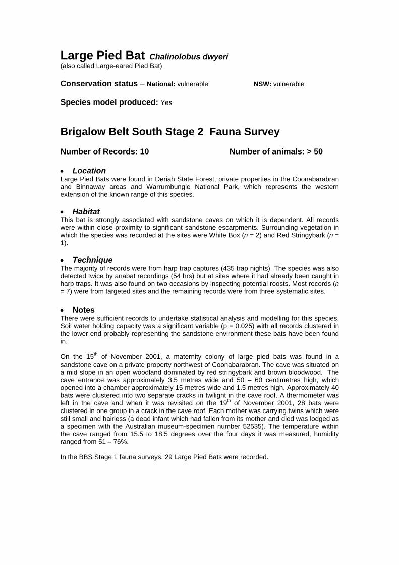
Large Pied Bat Chalinolobus dwyeri (also called Large-eared Pied Bat) Conservation status – National: vulnerable NSW: vulnerable Species model produced: Yes Brigalow Belt South Stage 2 Fauna Survey Number of Records: 10 Number of animals: > 50 • Location Large Pied Bats were found in Deriah State Forest, private properties in the Coonabarabran and Binnaway areas and Warrumbungle National Park, which represents the western extension of the known range of this species. • Habitat This bat is strongly associated with sandstone caves on which it is dependent. All records were within close proximity to significant sandstone escarpments. Surrounding vegetation in which the species was recorded at the sites were White Box (n = 2) and Red Stringybark (n = 1). • Technique The majority of records were from harp trap captures (435 trap nights). The species was also detected twice by anabat recordings (54 hrs) but at sites where it had already been caught in harp traps. It was also found on two occasions by inspecting potential roosts. Most records (n = 7) were from targeted sites and the remaining records were from three systematic sites. • Notes There were sufficient records to undertake statistical analysis and modelling for this species. Soil water holding capacity was a significant variable (p = 0.025) with all records clustered in the lower end probably representing the sandstone environment these bats have been found in. On the 15th of November 2001, a maternity colony of large pied bats was found in a sandstone cave on a private property northwest of Coonabarabran. The cave was situated on a mid slope in an open woodland dominated by red stringybark and brown bloodwood. The cave entrance was approximately 3.5 metres wide and 50 – 60 centimetres high, which opened into a chamber approximately 15 metres wide and 1.5 metres high. Approximately 40 bats were clustered into two separate cracks in twilight in the cave roof. A thermometer was left in the cave and when it was revisited on the 19th of November 2001, 28 bats were clustered in one group in a crack in the cave roof. Each mother was carrying twins which were still small and hairless (a dead infant which had fallen from its mother and died was lodged as a specimen with the Australian museum-specimen number 52535). The temperature within the cave ranged from 15.5 to 18.5 degrees over the four days it was measured, humidity ranged from 51 – 76%. In the BBS Stage 1 fauna surveys, 29 Large Pied Bats were recorded.

#
#
#
#
#
NNNNNNNNNNNNNNNNNNNNNNNNNNNNN
NNN
NN
N
N
NN
N
#
#
#####
# #####
#
#####################
########### ###
####
#
#
#
##
#
###
#
#
#
#######
########
##
#
###
#####
#
#
#####
#####
#
#
###
#
#
##
#
#
# #
##
#
#
###
###
## ####
#
#
#
##
###
###
#
# #
##
#
#
#
#
#
###
######
#
##
###
###
#
###
###
###
##
#############################
Woody Vegetation
State Forests NSW
NPWS Estate
NSW Mapsheet Boundaries
BBS Provinces
# Main Towns
BBS Boundary
BBS 15 km Buffer
N Stage 1 Records
N Stage 2 Records
N
EW
S
0 22 44
Kilometers
NSW Distribution #
Distribution of the Large Pied Bat in NSW and the Brigalow Belt South

Hairy-nosed Mormopterus Mormopterus species 6 Other common names – Hairy Rostrum Freetail Bat, Hairy-nosed Freetail Bat Conservation status – National: none NSW: none
IUCN Red List category: data deficient Species model produced: No Distribution and Status – Few records of the Hairy-nosed Mormopterus exist, however, the species has been collected from central Queensland and central Australia (Churchill 1998), central New South Wales (Ellis 2001) and northern South Australia (T. Reardon pers. com.). In NSW, the species is known from two records in the Darling River region, north-west of Cobar (Australian Museum collection) (Parnaby 1999). One of the records was captured in Bimble box woodland. The other record is from Gundabooka National Park, where Ellis (2001) found two lactating females and one male in a River Red Gum and Poplar Box watercourse site, with Poplar Box woodlands and Mulga shrublands in the vicinity. The species has been categorised as “data deficient” in the IUCN Red List criteria because there is inadequate information available to make a direct, or indirect, assessment of its risk of extinction based on its distribution and/or population status (Duncan et al. 1999).
Threats – The species is of conservation significance because it is phylogenetically distinct, it is known from very few records in NSW and elsewhere despite extensive bat surveys, and it occurs in semi-arid regions of NSW which have been highly modified by human activities and consequently vulnerable to associated threatening processes (Parnaby 1999). The species therefore may be listed under the Threatened Species Conservation Act (1995).
Ecology – The habitat of the Hairy-nosed Mormopterus is not known, however, it is likely to be tree dwelling as no caves have been observed near capture sites (Churchill 1998). In addition, all other species of the family Molossidae (to which this species belongs) in south-eastern Australia roost in hollows or fissures in old trees (Parnaby 1999). Ellis (2001) captured Hairy-nosed Mormopterus together with six known tree roosting bat species.
Distribution within BBS – The species has not previously been recorded in the study area. Brigalow Belt South Stage 2 Fauna Survey Number of records: 1 Number of individuals: 1 • Location This record is from Bebo State Forest in the far north of the study area in the Northern Basalts province. It is approximately 530 km from the previous record for the state, which was at Gundabooka National Park. • Habitat The site was on a rocky rise in Broad/ Blue-leafed Ironbark woodland. • Technique The individual was female and recorded as a harp trap capture (435 trap nights) at a systematic site. • Notes There were insufficient records to conduct statistical analysis and modelling for this species.

This individual was preserved as a voucher specimen and sent to the Australian Museum for confirmation (voucher number 52521). The species is currently undergoing taxonomic revision and is suspected to belong to a genus separate to Mormopterus (H. Parnaby Pers. com.). The morphometrics of this individual specimen were; tail length from tip to anus 30.8mm, head and body length 42.8mm, outer canine width 3.6mm, tibia length 10.9mm. In the BBS Stage 1 fauna surveys, no Hairy-nosed Mormopterus were recorded. References Churchill, S. (1998). Australian Bats. New Holland Publishers, Sydney. Duncan, A., Baker, G.B. and Montgomery, N. (1999). The Action Plan for Australian Bats. Environment Australia, Canberra. Ellis, M. (2001). The first record of the Hairy-nosed Freetail Bat in New South Wales. Australian Zoologist, 31 (4). pp 608–609. Parnaby, H. (1999). The Management of bats in New South Wales wood-production forests. Environmental Heritage Monograph Series, Forest Issues Report No. 5. NSW National Parks & Wildlife Service. Unpublished report. 168pp.

#
#
#
#
#
N#
Woody Vegetation
State Forests NSW
NPWS Estate
NSW Mapsheet Boundaries
BBS Provinces
# Main Towns
BBS Boundary
BBS 15 km Buffer
N Stage 1 Records
N Stage 2 Records
N
EW
S
0 22 44
Kilometers
NSW Distribution #
Distribution of Mormopterus species 6 in NSW and the Brigalow Belt South
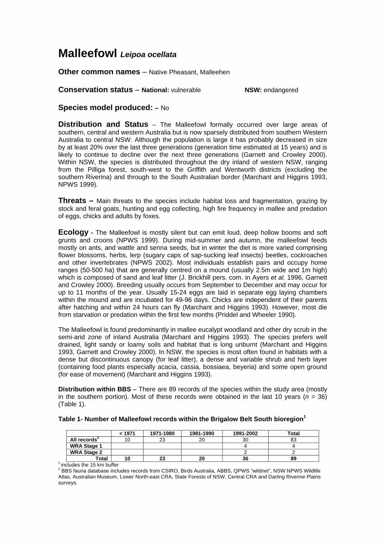
Malleefowl Leipoa ocellata Other common names – Native Pheasant, Malleehen Conservation status – National: vulnerable NSW: endangered Species model produced: – No
Distribution and Status – The Malleefowl formally occurred over large areas of southern, central and western Australia but is now sparsely distributed from southern Western Australia to central NSW. Although the population is large it has probably decreased in size by at least 20% over the last three generations (generation time estimated at 15 years) and is likely to continue to decline over the next three generations (Garnett and Crowley 2000). Within NSW, the species is distributed throughout the dry inland of western NSW, ranging from the Pilliga forest, south-west to the Griffith and Wentworth districts (excluding the southern Riverina) and through to the South Australian border (Marchant and Higgins 1993, NPWS 1999).
Threats – Main threats to the species include habitat loss and fragmentation, grazing by stock and feral goats, hunting and egg collecting, high fire frequency in mallee and predation of eggs, chicks and adults by foxes.
Ecology - The Malleefowl is mostly silent but can emit loud, deep hollow booms and soft grunts and croons (NPWS 1999). During mid-summer and autumn, the malleefowl feeds mostly on ants, and wattle and senna seeds, but in winter the diet is more varied comprising flower blossoms, herbs, lerp (sugary caps of sap-sucking leaf insects) beetles, cockroaches and other invertebrates (NPWS 2002). Most individuals establish pairs and occupy home ranges (50-500 ha) that are generally centred on a mound (usually 2.5m wide and 1m high) which is composed of sand and leaf litter (J. Brickhill pers. com. in Ayers et al. 1996, Garnett and Crowley 2000). Breeding usually occurs from September to December and may occur for up to 11 months of the year. Usually 15-24 eggs are laid in separate egg laying chambers within the mound and are incubated for 49-96 days. Chicks are independent of their parents after hatching and within 24 hours can fly (Marchant and Higgins 1993). However, most die from starvation or predation within the first few months (Priddel and Wheeler 1990). The Malleefowl is found predominantly in mallee eucalypt woodland and other dry scrub in the semi-arid zone of inland Australia (Marchant and Higgins 1993). The species prefers well drained, light sandy or loamy soils and habitat that is long unburnt (Marchant and Higgins 1993, Garnett and Crowley 2000). In NSW, the species is most often found in habitats with a dense but discontinuous canopy (for leaf litter), a dense and variable shrub and herb layer (containing food plants especially acacia, cassia, bossiaea, beyeria) and some open ground (for ease of movement) (Marchant and Higgins 1993). Distribution within BBS – There are 89 records of the species within the study area (mostly in the southern portion). Most of these records were obtained in the last 10 years (n = 36) (Table 1). Table 1- Number of Malleefowl records within the Brigalow Belt South bioregion1
< 1971 1971-1980 1981-1990 1991-2002 Total All records2 10 23 20 30 83 WRA Stage 1 4 4 WRA Stage 2 2 2
Total 10 23 20 36 89 1 includes the 15 km buffer 2 BBS fauna database includes records from CSIRO, Birds Australia, ABBS, QPWS “wildnet”, NSW NPWS Wildlife Atlas, Australian Museum, Lower North-east CRA, State Forests of NSW, Central CRA and Darling Riverine Plains surveys.

Brigalow Belt South Stage 2 Fauna Survey Number of Records: 2 Number of animals: 2 • Location Malleefowl were recorded in the northeastern portion of Goonoo State Forest. • Habitat The main habitats at the survey sites in Goonoo State Forest are Red Gum flats and Ironbark ridges. • Technique Both records were incidental observations made three days apart. Methods used to detect Malleefowl included a bird census (86 hours) and opportunistic records. Despite searches in nearby forests with similar habitat types, no other Malleefowl were recorded during these surveys. • Notes There were insufficient records to conduct statistical analysis and modelling for this species. There were four Malleefowl (six individuals) recorded in the BBS Stage 1 fauna surveys. Four individuals (all adults) were detected in Goonoo State Forest and two individuals (one adult, one juvenile) in Coolbaggie Nature Reserve. Those in Goonoo SF were detected on the eastern side of Mendooran Road near a known concentration of mounds (Korn 1988) in Blue-leaf Ironbark Eucalyptus nubila forest that had an extensive shrubby understorey. Those in Coolbaggie Nature Reserve were detected on the northern edge in the same area that a breeding mound had been seen previously (Korn 1988) in habitat that was Broombush scrub Melaleuca uncinata, with a scattered overstorey of White Mallee E. dumosa. As well, a Malleefowl was recorded during the recent community surveys in Cobborah State Forest, 8 km east of Goonoo State Forest (Medd and Kenna 2002), in Mugga ironbark E. sideroxylon habitat (D Paull pers. com.). Although no Malleefowl were detected in the Pilliga region during the Stage 1 surveys, they were previously known from the area (NPWS 2000). An active mound was seen as recently as 1995 (David Johnstone, pers. com.) in the Pilliga region indicating that adult birds may still be persisting. References Ayers, D., Nash, S., and Baggett, K. (1996). Threatened species of western New South Wales. New South Wales National Parks and Wildlife Service, Hurstville. Garnett, S. and Crowley, G. (2000). The Action Plan for Australian Birds 2000. Environment Australia, Canberra. Korn, T. (1988). The Mallee Fowl of the Goonoo Forest, Dubbo. National Parks Journal 32 (4), 22-24. Marchant, S. and Higgins, P. J. (Eds) (1993). Handbook of Australian, New Zealand and Antarctic Birds Volume 2: Raptors to Lapwings. Oxford University Press, Melbourne. Medd, R. W. and Kenna, J. I. (2002). Bird and plant survey of Cobborah State Forest. Orange Field Naturalist and Conservation Society Incorporated. NPWS (1999). Threatened Species Management- Species Information. NPWS, Hurstville. NPWS (2002). NPWS fact sheets. NPWS, Hurstville. Priddel, D. and Wheeler, R. (1990). Survival of Malleefowl chicks in the absence of ground-dwelling predators. Emu 90, 81-87.
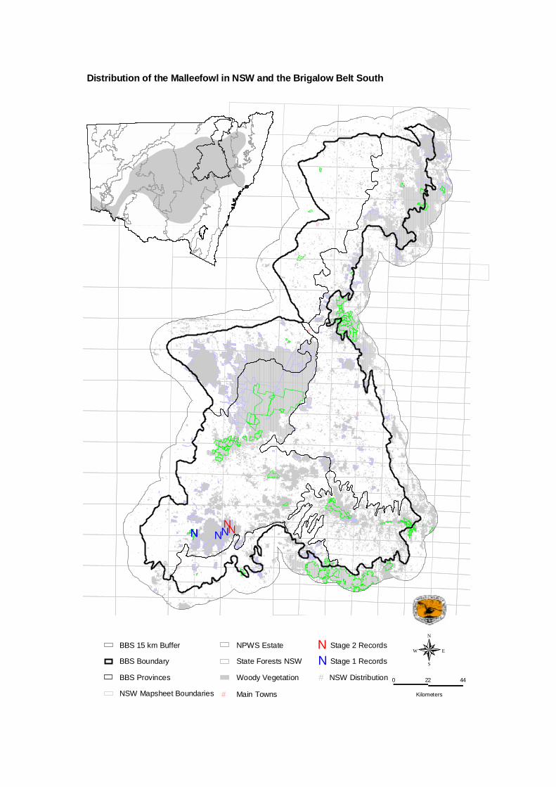
#
#
#
#
#
NN NNNN
Woody Vegetation
State Forests NSW
NPWS Estate
NSW Mapsheet Boundaries
BBS Provinces
# Main Towns
BBS Boundary
BBS 15 km Buffer
N Stage 1 Records
N Stage 2 Records
N
EW
S
0 22 44
Kilometers
NSW Distribution #
Distribution of the Malleefowl in NSW and the Brigalow Belt South

Hooded Robin (Melanodryas cucullata cucullata) Other Common names – Conservation Status – National: None NSW: Vulnerable Species model produced: Yes Distribution and Status – Hooded robins are found throughout much of inland Australia with four subspecies having been described. Two subspecies occur in New South Wales, M. c. cucullata in the southern and eastern parts of the state, and M. c. picata in the northern and western areas (Simpson et al. 1999). Both subspecies intergrade in the northern Murray-Darling Basin (Garnett and Crowley 2000). The precise distributional boundaries of the each subspecies are poorly defined. Hooded robins have declined significantly in range and population in New South Wales (Traill and Duncan 2000). Nationally, Garnett and Crowley (2000) regard M. c. cucullata as near-threatened. Threats - The predominant threat to the species identified by Garnett and Crowley (2000) and Traill and Duncan (2000) is the clearance and fragmentation of habitat. Subsidiary threats include habitat degradation by stock grazing and weed invasion, and nest predation (NSW National Parks and Wildlife Service 2001). Distribution within BBS – The species has been recorded within Goonoo State Forest, East Pilliga State Forest and Pilliga Nature Reserve (NSW National Parks and Wildlife Service 2000), Goobang National Park and Nangar National Park Faulkner et al. (1997), Goulburn River National Park (NSW NPWS, 2001). Gosper (2002) describes recent records from the adjoining DRP bioregion. Ecology – The south-eastern subspecies of the hooded robin inhabits eucalypt woodlands, open forest and mallee and Acacia shrublands (Blakers et al. 1984). Areas of dead timber and sparse shrub cover appear to be important, as do clearings adjoining large blocks of woodland (Fitri and Ford 1997). Invertebrates and small vertebrates are taken from the ground by pouncing from low perches (Garnett and Crowley 2000). The species live in small family groups, and nest in pairs or trios (Traill and Duncan 2000).
Brigalow Belt South Stage 2 Fauna Survey Number of Records: 7 Number of animals: 10 • Location Hooded robins were recorded in Vickery State Forest, Pilliga East State Forest, and Terry Hie Hie State Forest; on a private property near Binnaway; at Boomera Waterhole (TSR on Coonabarabran Road from Tambar Springs – Coolah Road), and; near the townships of Gilgandra and Coolatai. • Habitat Hooded robin was recorded in White Box / Narrow-leaved Ironbark / Callitris vegetation and open grassy woodland containing Yellow Box, Rough-barked Angophora and White Box. Most sightings of the hooded robin were incidental, no habitat information was collected from these locations.

• Technique Of all seven records only one hooded robin was observed within a systematic survey site. This individual was recorded during a bird census of a site located in the south-eastern corner of Vickery State Forest. All other hooded robin records were obtained opportunistically. No attempt was made to distinguish M. c. cucullata from M. c. picata in the field. Subsequently, the subspecies to which the records here refer is not known with certainty, and can only be presumed on the basis of published distribution maps. • Notes Insufficient data was available to undertake statistical analysis or modelling for this species. Past records of the hooded robin extend across much of the bioregion. The number of observations for the hooded robin have decreased regardless of an increase in survey effort. Time period Total number of records Percentage of records from
past three decades 1970 - 1979 233 52% 1980 - 1989 136 30% 1990 - 1999 35 8% 2000 - 2002 45 10% References Blakers, M., Davies, S.J.J.F. and Reilly, P.N., (1984), The atlas of Australian birds, Melbourne University Press, Melbourne. Faulkner, W., LeBreton, M. and Ellis, M., (1997), Fauna Survey of Goobang and Nangar National Parks: Autumn 1997, NSW National Parks and Wildlife Service, Hurstville. Fitri, L. and Ford, H., (1997), Status, habitat and social organisation of the Hooded Robin, Melanodryas cucullata in the New England region of New South Wales, Aust. Bird Watcher 17, p142-155. Garnett, S. and Crowley, G., (2000), The Action Plan for Australian Birds, Environment Australia, Canberra. Gosper, C., (2002), Darling Riverine Plains Biodiversity Survey Technical Report, NSW National Parks and Wildlife Service Western Regional Assessments Unit, Dubbo. NSW National Parks and Wildlife Service, (2000), Brigalow Belt South: Regional Assessment (Stage 1): Report on preliminary fauna survey of Pilliga and Goonoo Forests November 1999 to January 2000, NSW National Parks and Wildlife Service, Hurstville.
NSW National Parks and Wildlife Service, (2001), The fauna of Goulburn River National Park, NSW National Parks and Wildlife Service, Hurstville. Simpson, K., Day, N., and Trusler, P., (1999), Field guide to the birds of Australia, Sixth edition, Penguin, Ringwood. Traill, B.J. and Duncan, S., (2000), Status of birds in the New South Wales temperate woodlands region. Consultancy report for the NSW National Parks and Wildlife Service, Australian Woodland Conservancy, Chiltern.
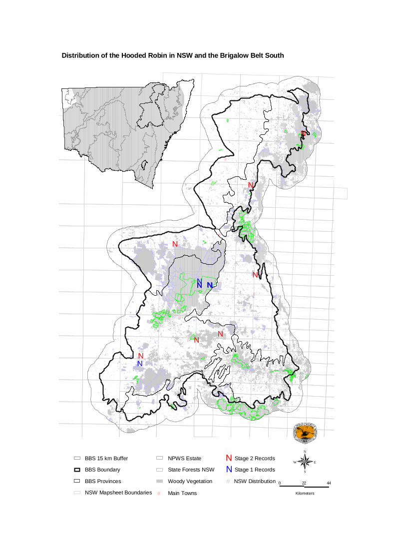
#
#
#
#
#
NNNN NN
NN
N
NN
N
N
N
Woody Vegetation
State Forests NSW
NPWS Estate
NSW Mapsheet Boundaries
BBS Provinces
# Main Towns
BBS Boundary
BBS 15 km Buffer
N Stage 1 Records
N Stage 2 Records
N
EW
S
0 22 44
Kilometers
NSW Distribution #
Distribution of the Hooded Robin in NSW and the Brigalow Belt South
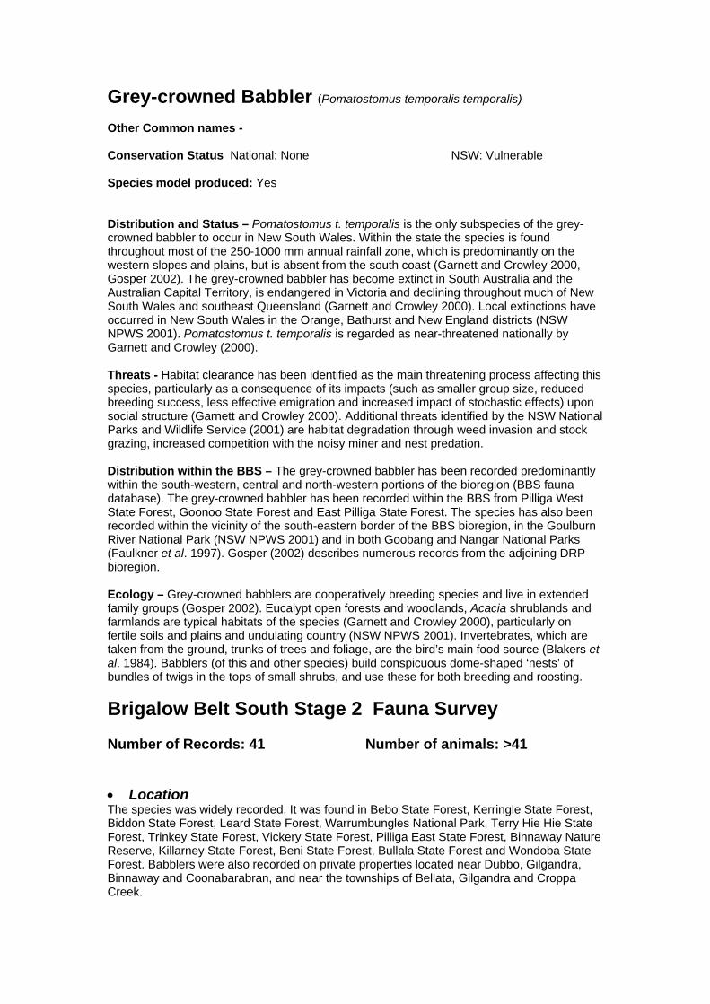
Grey-crowned Babbler (Pomatostomus temporalis temporalis) Other Common names - Conservation Status National: None NSW: Vulnerable Species model produced: Yes Distribution and Status – Pomatostomus t. temporalis is the only subspecies of the grey-crowned babbler to occur in New South Wales. Within the state the species is found throughout most of the 250-1000 mm annual rainfall zone, which is predominantly on the western slopes and plains, but is absent from the south coast (Garnett and Crowley 2000, Gosper 2002). The grey-crowned babbler has become extinct in South Australia and the Australian Capital Territory, is endangered in Victoria and declining throughout much of New South Wales and southeast Queensland (Garnett and Crowley 2000). Local extinctions have occurred in New South Wales in the Orange, Bathurst and New England districts (NSW NPWS 2001). Pomatostomus t. temporalis is regarded as near-threatened nationally by Garnett and Crowley (2000). Threats - Habitat clearance has been identified as the main threatening process affecting this species, particularly as a consequence of its impacts (such as smaller group size, reduced breeding success, less effective emigration and increased impact of stochastic effects) upon social structure (Garnett and Crowley 2000). Additional threats identified by the NSW National Parks and Wildlife Service (2001) are habitat degradation through weed invasion and stock grazing, increased competition with the noisy miner and nest predation. Distribution within the BBS – The grey-crowned babbler has been recorded predominantly within the south-western, central and north-western portions of the bioregion (BBS fauna database). The grey-crowned babbler has been recorded within the BBS from Pilliga West State Forest, Goonoo State Forest and East Pilliga State Forest. The species has also been recorded within the vicinity of the south-eastern border of the BBS bioregion, in the Goulburn River National Park (NSW NPWS 2001) and in both Goobang and Nangar National Parks (Faulkner et al. 1997). Gosper (2002) describes numerous records from the adjoining DRP bioregion. Ecology – Grey-crowned babblers are cooperatively breeding species and live in extended family groups (Gosper 2002). Eucalypt open forests and woodlands, Acacia shrublands and farmlands are typical habitats of the species (Garnett and Crowley 2000), particularly on fertile soils and plains and undulating country (NSW NPWS 2001). Invertebrates, which are taken from the ground, trunks of trees and foliage, are the bird’s main food source (Blakers et al. 1984). Babblers (of this and other species) build conspicuous dome-shaped ‘nests’ of bundles of twigs in the tops of small shrubs, and use these for both breeding and roosting.
Brigalow Belt South Stage 2 Fauna Survey Number of Records: 41 Number of animals: >41 • Location The species was widely recorded. It was found in Bebo State Forest, Kerringle State Forest, Biddon State Forest, Leard State Forest, Warrumbungles National Park, Terry Hie Hie State Forest, Trinkey State Forest, Vickery State Forest, Pilliga East State Forest, Binnaway Nature Reserve, Killarney State Forest, Beni State Forest, Bullala State Forest and Wondoba State Forest. Babblers were also recorded on private properties located near Dubbo, Gilgandra, Binnaway and Coonabarabran, and near the townships of Bellata, Gilgandra and Croppa Creek.

• Habitat Grey-crowned babblers were observed in various habitats. The vegetation types in which the species was observed are presented in the following table. The table indicates that babblers were predominantly recorded from Ironbark, Box, Red Gum and Bull Oak vegetation types. Systematic survey sites in which the grey-crowned babbler was recorded in during the BBS Biodiversity Assessment and associated vegetation types. BBS Systematic Survey Site
Vegetation Type
BS2SF005 Forest of Grey Box, Narrow-leaved Ironbark and Bull Oak - sparse understorey. BBS2SF008 White Box / Narrow-leaved Ironbark / Callitris. BS2SF011 Open woodland, Callitris, Box, Angophora and Red gum. BS2SF016 Open woodland mainly Callitris and some Brigalow with scattered other Eucalyptus species. BBS2SF033 Bull Oak woodland. BBS2SF049 Narrow-leaved Ironbark merging into Grey Box. BBS2SF054 Red gum mixed woodland gully. BBS2SF055 Poplar Box open woodland (edge of grazing land). BBS2SF056 Grey Box open woodland. BBS2SF057 Grassy White Box woodland, with Fuzzy Box, Blakely's Red gum, Yellow Box and Rough-
barked Apple. BBS2SF062 Narrow-leaved Ironbark woodland with regrowth Ironbark / Callitris. BBS2SF064 Grassy Grey Box woodland with some Narrow-leaved Ironbark. BBS2SF070 White Box with rocky sandstone substrate. BBS2SF091 Red gum open woodland with dense Callitris regrowth, Carbeen scattered throughout. BBS2SF095 Grey Box shrubby open forest. BBS2SF102 White Box open woodland. BBS2SF105 River Red gum on creek with Box / Callitris woodland on road.
• Technique Grey-crowned babblers were most frequently detected during both targeted and systematic site bird census’s, and opportunistically. The species was detected at 16.7 % of systematic survey sites. • Notes There was sufficient information to perform statistical analysis and modelling of this species distribution. The combination of variables with the highest explaining power were the area of streams within a 10 kilometre radius and the amount of solar radiation (Appendix 1). Past records are presented in the following table. The increase in records over the past three years may be attributed to a significant increase in survey intensity during this period. Time period Total number of records Percentage of records from
past three decades 1970 - 1979 160 31% 1980 - 1989 131 25% 1990 - 1999 96 18 % 2000 - 2002 135 26 % Flock size ranged from 1 to 8 individuals (average 3) during the survey period. References Blakers, M., Davies, S.J.J.F. and Reilly, P.N., (1984), The atlas of Australian birds, Melbourne University Press, Melbourne.

Faulkner, W., LeBreton, M. and Ellis, M., (1997), Fauna Survey of Goobang and Nangar National Parks: Autumn 1997, NSW National Parks and Wildlife Service, Hurstville. Garnett, S. and Crowley, G., (2000), The Action Plan for Australian Birds, Environment Australia, Canberra. Gosper, C., (2002), Darling Riverine Plains Biodiversity Survey Technical Report, NSW National Parks and Wildlife Service Western Regional Assessments Unit, Dubbo. NSW National Parks and Wildlife Service, (2000), Brigalow Belt South: Regional Assessment (Stage 1): Report on preliminary fauna survey of Pilliga and Goonoo Forests November 1999 to January 2000, NSW National Parks and Wildlife Service, Hurstville. NSW National Parks and Wildlife Service, (2001), Scientific Committee determinations and schedules to the Threatened Species Conservation Act. On-line: http://www.npws.nsw.gov.au. Slater, P., Slater, P., and Slater, R., (1986), The Slater field guide to Australian birds, Rigby Publishers, Sydney.
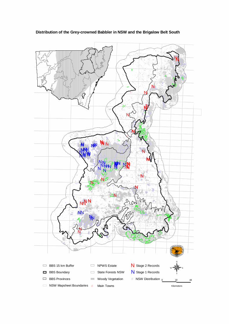
#
#
#
#
#
NNNNN
NNNNN
NNNNNNNNNNNN N
NN
NNNNNNN
NNNNNNNNNNNNNN
NNNNN
NNNNNNN
NNNNNN
NNNN NN
N
N
N
N
NN
N
N
N
N
N
NNN
N
N
N
N
N
NN
N
N
NN
N
N
N
N
Woody Vegetation
State Forests NSW
NPWS Estate
NSW Mapsheet Boundaries
BBS Provinces
# Main Towns
BBS Boundary
BBS 15 km Buffer
N Stage 1 Records
N Stage 2 Records
N
EW
S
0 22 44
Kilometers
NSW Distribution #
Distribution of the Grey-crowned Babbler in NSW and the Brigalow Belt South

Speckled Warbler Sericornis sagittatus Conservation status – National: near-threatened NSW: vulnerable Species model produced: Yes Distribution and status – The past range of the speckled warbler extended from south-eastern Australia, through south-western Victoria and eastern New South Wales to central Queensland. The species was predominantly located on the western slopes and tablelands of the Great Dividing Range and on the driest sections of the coast (Garnett and Crowley 2000). The present distribution of the species indicates that the speckled warbler has declined over the majority of its range. Traill and Duncan (2000) found there had been a decline in this species of 40 % in the last decade in places where no habitat fragments larger than 100 ha have been retained. Threats – Clearing (for agriculture), habitat fragmentation, population isolation, nest predation and grazing are all identified threats to the species (Garnett and Crowley 2000, Traill and Duncan 2000). Ecology – Speckled warblers inhabit a wide range of eucalypt-dominated vegetation that have a grassy understorey, often on rocky ridges or in gullies (Garnett and Crowley 2000). Warblers feed on both seeds and arthropods. The species breeds in pairs and trios, it often nests along drainage lines (J. Gardner pers. com.). Distribution within the BBS – There are 750 records of the species in the study area (BBS fauna database), mostly in the lower and north-easterly portions. Speckled warblers occur west approximately to Yetman, Warialda, Narrabri, the western edge of the Pilliga Forest, Coonabarabran, Gilgandra, and Dubbo, extending further west out to Nymagee, Roto and Hillston in Callitris pine country (Traill and Duncan 2000). More specifically, the species has been recorded within: the Pilliga West State Forest, Pilliga East State Forest, Goonoo State Forest and within the areas constituting the south-west border of the study area (in the vicinity of both the Goobang and Nangar National Parks) (NSW NPWS 2000, Faulkner et al. 1997). Brigalow Belt South Stage 2 Fauna Survey Number of Records: 149 Number of animals: 173 • Location Speckled Warblers were recorded in a number of State Forests including Bebo, Bobbiwaa, Moema, Kerringle, Cobbora, Leard, Deriah, Wondoba, Vickery, Mission, Beni, Biddon, Terry Hie Hie, Parkhurst, Bullala, Trinkey, Pilliga East, Curryall, Durridgeree, Goran, and Turill. The species was also recorded in Warrumbungles National Park, Binnaway Nature Reserve, Gamillaroi Nature Reserve, on private properties near Gilgandra, Binnaway, Coonabarabran and Dubbo, and on Travelling Stock Reserves near Narrabri and Boggabri. Notably, the species was recorded at every private property that was surveyed. • Habitat Speckled warblers occurred in a variety of habitats (Table 1), mostly Ironbark, Box, Red Gum and Callitris vegetation types. Table 1: Habitat at the systematic survey sites in which the Speckled Warbler was recorded.
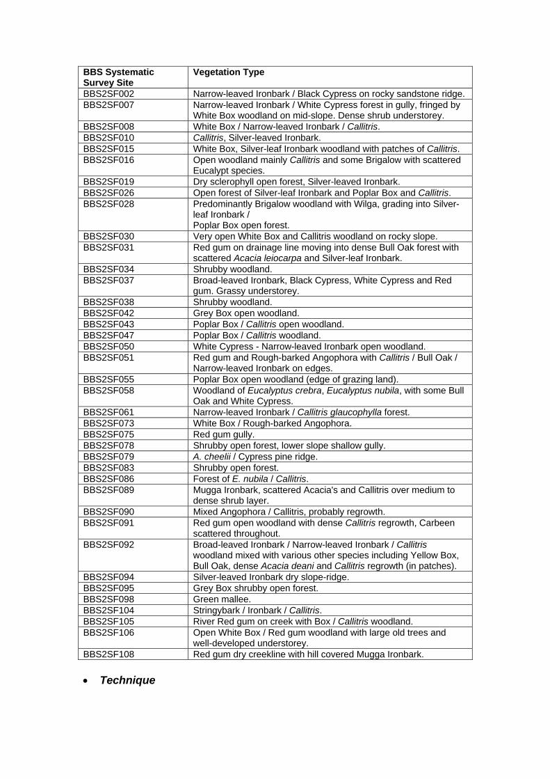
BBS Systematic Survey Site
Vegetation Type
BBS2SF002 Narrow-leaved Ironbark / Black Cypress on rocky sandstone ridge. BBS2SF007 Narrow-leaved Ironbark / White Cypress forest in gully, fringed by
White Box woodland on mid-slope. Dense shrub understorey. BBS2SF008 White Box / Narrow-leaved Ironbark / Callitris. BBS2SF010 Callitris, Silver-leaved Ironbark. BBS2SF015 White Box, Silver-leaf Ironbark woodland with patches of Callitris. BBS2SF016 Open woodland mainly Callitris and some Brigalow with scattered
Eucalypt species. BBS2SF019 Dry sclerophyll open forest, Silver-leaved Ironbark. BBS2SF026 Open forest of Silver-leaf Ironbark and Poplar Box and Callitris. BBS2SF028 Predominantly Brigalow woodland with Wilga, grading into Silver-
leaf Ironbark / Poplar Box open forest.
BBS2SF030 Very open White Box and Callitris woodland on rocky slope. BBS2SF031 Red gum on drainage line moving into dense Bull Oak forest with
scattered Acacia leiocarpa and Silver-leaf Ironbark. BBS2SF034 Shrubby woodland. BBS2SF037 Broad-leaved Ironbark, Black Cypress, White Cypress and Red
gum. Grassy understorey. BBS2SF038 Shrubby woodland. BBS2SF042 Grey Box open woodland. BBS2SF043 Poplar Box / Callitris open woodland. BBS2SF047 Poplar Box / Callitris woodland. BBS2SF050 White Cypress - Narrow-leaved Ironbark open woodland. BBS2SF051 Red gum and Rough-barked Angophora with Callitris / Bull Oak /
Narrow-leaved Ironbark on edges. BBS2SF055 Poplar Box open woodland (edge of grazing land). BBS2SF058 Woodland of Eucalyptus crebra, Eucalyptus nubila, with some Bull
Oak and White Cypress. BBS2SF061 Narrow-leaved Ironbark / Callitris glaucophylla forest. BBS2SF073 White Box / Rough-barked Angophora. BBS2SF075 Red gum gully. BBS2SF078 Shrubby open forest, lower slope shallow gully. BBS2SF079 A. cheelii / Cypress pine ridge. BBS2SF083 Shrubby open forest. BBS2SF086 Forest of E. nubila / Callitris. BBS2SF089 Mugga Ironbark, scattered Acacia's and Callitris over medium to
dense shrub layer. BBS2SF090 Mixed Angophora / Callitris, probably regrowth. BBS2SF091
Red gum open woodland with dense Callitris regrowth, Carbeen scattered throughout.
BBS2SF092 Broad-leaved Ironbark / Narrow-leaved Ironbark / Callitris woodland mixed with various other species including Yellow Box, Bull Oak, dense Acacia deani and Callitris regrowth (in patches).
BBS2SF094 Silver-leaved Ironbark dry slope-ridge. BBS2SF095 Grey Box shrubby open forest. BBS2SF098 Green mallee. BBS2SF104 Stringybark / Ironbark / Callitris. BBS2SF105 River Red gum on creek with Box / Callitris woodland. BBS2SF106 Open White Box / Red gum woodland with large old trees and
well-developed understorey. BBS2SF108 Red gum dry creekline with hill covered Mugga Ironbark. • Technique

The species was recorded from 50 systematic sites (i.e. 46.3 % of all systematic sites) and from 29 opportunistic sites. Speckled warblers were detected through incidental sightings and both systematic and targeted bird censuses (86 hrs). • Notes Sufficient records were available to undertake statistical analysis and modelling for this species. Environmental variables with the greatest explaining power of Speckled warbler distribution were, annual temperature (p<0.000) with most records in warmer areas, distance to streams (p=0.048) with most records clustered close to water courses, soil drainage (p=0.028) with a preference away from highly drained soils, and the amount of woody vegetation within a 5 kilometre radius (p=0.041) with no records in areas with very low amounts of woody vegetation. Of all threatened species recorded during the Stage 2 surveys, the Speckled Warbler was the most frequently recorded (n = 149). In contrast to other woodland bird species (see Duncan and Traill 2000), there appears to be no evidence of decline of the Speckled Warbler in the study area in the last three decades. Time period Total number of records Percentage of records from
past three decades 1970 - 1979 189 26% 1980 - 1989 129 17% 1990 - 2002 422 57% In the BBS Stage 1 surveys, 39 records were obtained. References Faulkner, W., LeBreton, M. and Ellis, M. (1997). Fauna Survey of Goobang and Nangar National Parks: Autumn 1997, NSW National Parks and Wildlife Service, Hurstville.
Garnett, S. and Crowley, G., (2000). The Action Plan for Australian Birds, Environment Australia, Canberra. NSW NPWS (2000). Brigalow Belt South: Regional Assessment (Stage 1): Report on preliminary fauna survey of Pilliga and Goonoo Forests November 1999 to January 2000, NSW National Parks and Wildlife Service, Hurstville. Traill, B.J. and Duncan, S., (2000). Status of birds in the New South Wales temperate woodlands region. Consultancy report for the NSW National Parks and Wildlife Service, Australian Woodland Conservancy, Chiltern.
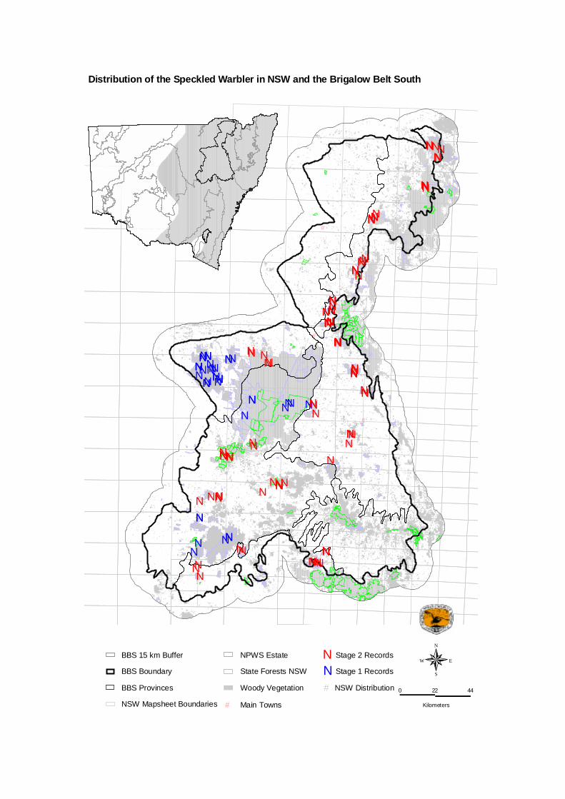
#
#
#
#
#
NNN
NNN N
NNNNNNNN
NN
NN
NNNNNNNNNN
NNN
NN
NN
NNN
NNNNNNNN
NNN
NNN NNN
N NNNN
NNNN
N
NNNNNNN
NN
N
NNN
N
N
N
N
NNN
N
NNN
NNNN
NNNNN
NN
NNN
NNNN
NN
NNN
NNNNN
NNNNN
NNNNN
NN
N
N
N
N
N
N
N
N
N
Woody Vegetation
State Forests NSW
NPWS Estate
NSW Mapsheet Boundaries
BBS Provinces
# Main Towns
BBS Boundary
BBS 15 km Buffer
N Stage 1 Records
N Stage 2 Records
N
EW
S
0 22 44
Kilometers
NSW Distribution #
Distribution of the Speckled Warbler in NSW and the Brigalow Belt South

Black-chinned Honeyeater (Melithreptus gularis gularis) Other Common names - Conservation Status National: None NSW: Vulnerable Species model produced: No Distribution and Status – The black-chinned honeyeater is distributed throughout much of northern and eastern Australia. Two subspecies are recognised, with Melithreptus gularis gularis the only sub-species found in New South Wales. This subspecies occurs in eucalypt woodlands, mainly west of the Great Dividing Range, from south Australia to southern Queensland (Schodde and Mason 1999). Threats - Probable threats to the species include: clearance and fragmentation of woodlands; degradation of habitat; population isolation; competition from aggressive native honeyeaters, and; increased nest predation in small remnants (Traill and Duncan 2000 and NSW NPWS 2001). Distribution within BBS - The majority of past records in the bioregion are from the Kaputar foothills (Leard State Forest north to Narrabri), through the Pilliga to the Warrumbungle Range (Warrumbungle to Binnaway). The species has also been recorded near the south-western border of the bioregion, in Goobang and Nangar National Parks (Faulkner et al.1997), near Geurie (C. Gosper pers. obs.) and near the south-eastern border of the bioregion, within Goulburn River National Park (NSW NPWS, 2001). The sub-species has been regarded as being near-threatened nationally as it has declined over most of its range (Garnett and Crowley 2000). Ecology – Black-chinned honeyeaters predominantly occur in dry eucalypt woodlands (Garnett and Crowley 2000). The species naturally exist in low densities, even in favoured eucalypt associations such as Box, Ironbark and E. camaldulensis (NSW NPWS 2001). Traill and Duncan (2000) suggest that they may be more restricted to box-ironbark and E. camaldulensis woodlands than other specialist woodland birds. Black-chinned honeyeaters mainly forage among foliage and bark, taking invertebrates, nectar and lerp (Blakers et al. 1984). Brigalow Belt South Stage 2 Fauna Survey Number of Records: 4 Number of animals: 5 • Location Black-chinned honeyeaters were recorded from four locations: Goran State Forest, Leard State Forest, Binnaway Nature Reserve and a private property 10 kilometres north west Coonabarabran. • Habitat White box was the dominant species at three of the four locations. The birds recorded in Leard State Forest were within Broad-leaved Ironbark open forest adjacent to a dam. • Technique Half the records for this species were collected during systematic bird census on site and the remainder were opportunistic.
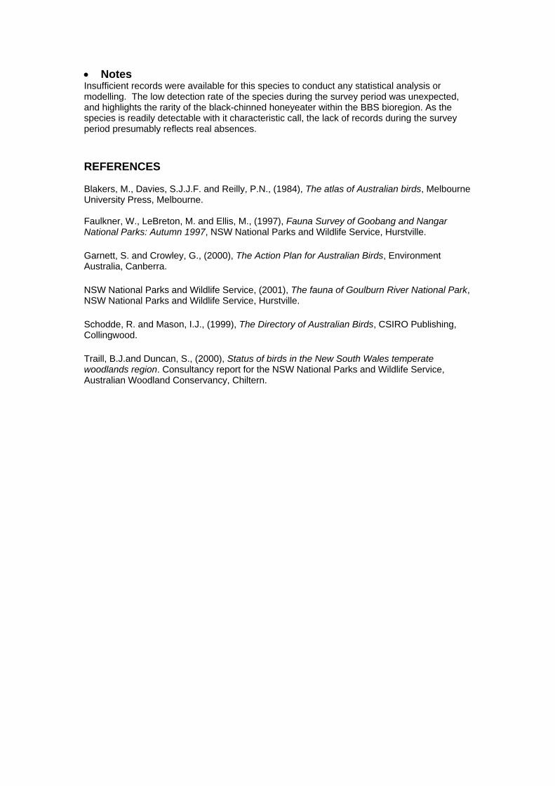
• Notes Insufficient records were available for this species to conduct any statistical analysis or modelling. The low detection rate of the species during the survey period was unexpected, and highlights the rarity of the black-chinned honeyeater within the BBS bioregion. As the species is readily detectable with it characteristic call, the lack of records during the survey period presumably reflects real absences. REFERENCES Blakers, M., Davies, S.J.J.F. and Reilly, P.N., (1984), The atlas of Australian birds, Melbourne University Press, Melbourne. Faulkner, W., LeBreton, M. and Ellis, M., (1997), Fauna Survey of Goobang and Nangar National Parks: Autumn 1997, NSW National Parks and Wildlife Service, Hurstville. Garnett, S. and Crowley, G., (2000), The Action Plan for Australian Birds, Environment Australia, Canberra. NSW National Parks and Wildlife Service, (2001), The fauna of Goulburn River National Park, NSW National Parks and Wildlife Service, Hurstville. Schodde, R. and Mason, I.J., (1999), The Directory of Australian Birds, CSIRO Publishing, Collingwood. Traill, B.J.and Duncan, S., (2000), Status of birds in the New South Wales temperate woodlands region. Consultancy report for the NSW National Parks and Wildlife Service, Australian Woodland Conservancy, Chiltern.
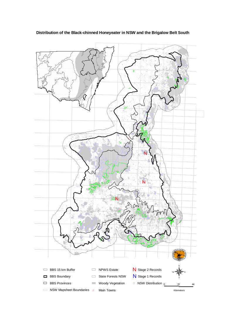
#
#
#
#
#
N
N
N
Woody Vegetation
State Forests NSW
NPWS Estate
NSW Mapsheet Boundaries
BBS Provinces
# Main Towns
BBS Boundary
BBS 15 km Buffer
N Stage 1 Records
N Stage 2 Records
N
EW
S
0 22 44
Kilometers
NSW Distribution #
Distribution of the Black-chinned Honeyeater in NSW and the Brigalow Belt South

Diamond Firetail (Stagonopleura guttata) Other Common names - Conservation Status National: None NSW: Vulnerable Species model produced: No Distribution and Status – Diamond firetails occur from central Queensland to South Australia, most frequently on the inland slopes of the Great Dividing Range (Garnett and Crowley 2000). In New South Wales the diamond firetail occurs west to approximately Walgett-Nyngan-Griffith, it has been recorded as far west as Weirmoringle (Damon Oliver pers. com.). Distribution within the BBS – The species has been recorded within the Pilliga East State Forest, Goobang and Nangar National Parks, Goulburn River National Park (NSW National Parks and Wildlife Service 2000, NSW National Parks and Wildlife Service 2001, Faulkner et al. 1997). Gosper (2002) describes records from the adjoining DRP bioregion. Ecology – Eucalypt-dominated grassy-forest, woodland and mallee form the preferred habitat of diamond firetails (Garnett and Crowley 2000). Seeds, mainly of grasses, are the main food of the species, with most foraging occurring on the ground (NSW National Parks and Wildlife Service 2001). Possible threats to the species identified in Garnett and Crowley (2000) and NSW National Parks and Wildlife Service (2001) are clearance and fragmentation of habitat, habitat degradation (particularly overgrazing), increased nest predation in small remnants, invasion by exotic grasses, competition with the red-browed finch Neochmia temporalis and illegal capture for aviculture.
Brigalow Belt South Stage 2 Fauna Survey Number of Records: 16 Number of animals: >30 • Location Diamond firetails were recorded within the Liverpool Plains province (Wondoba State Forest, Leard State Forest, Kerringle State Forest), Pilliga province (Cobbora State Forest; Boomera Waterhole (TSR on Coonabarabran Road from Tambar Springs – Coolah Road), and; on private properties near Binnaway, Coonabarabran and Gilgandra) and Northern outwash province (at Rocky Dam (on Wallangra Road near Coolatai)). • Habitat Diamond firetail was recorded in open grassy woodland containing Yellow Box, Rough-barked Angophora and White Box; a White Box open woodland with Callitris containing no understorey, shrubby open woodland, and a shrubby Grey Box open forest. All other sightings of the diamond firetail were incidental, consequently no habitat information was collected from these locations.

• Technique Diamond firetails were mostly detected with the standard bird census technique. The observation rate for the species was at 2.78 % of systematic survey sites. Recordings were not evenly spread across the survey area. Observations were most concentrated within Leard State Forest and on the private property located near Binnaway (18.75 % of all diamond firetail records). • Notes The distribution of diamond firetail observations from the BBS appears to be weighted toward private land. For instance, only 19.4 % of systematic survey sites were located on private property, however this tenure comprised 37.5 % of the sites in which diamond firetails were recorded. A review of past records for this species indicates a decline. This is illustrated in the following table. Time period Total number of records Percentage of records from
past three decades 1970 - 1979 188 47.5 % 1980 - 1989 107 26.8 % 1990 - 2002 103 25.8 % References Faulkner, W., LeBreton, M. and Ellis, M., (1997), Fauna Survey of Goobang and Nangar National Parks: Autumn 1997, NSW National Parks and Wildlife Service, Hurstville.
Garnett, S. and Crowley, G., (2000), The Action Plan for Australian Birds, Environment Australia, Canberra. Gosper, C., (2002), Darling Riverine Plains Biodiversity Survey Technical Report, NSW National Parks and Wildlife Service Western Regional Assessments Unit, Dubbo. NSW National Parks and Wildlife Service, (2000), Brigalow Belt South: Regional Assessment (Stage 1): Report on preliminary fauna survey of Pilliga and Goonoo Forests November 1999 to January 2000, NSW National Parks and Wildlife Service, Hurstville.
NSW National Parks and Wildlife Service, (2001), The fauna of Goulburn River National Park, NSW National Parks and Wildlife Service, Hurstville. Slater, P., Slater, P., and Slater, R., (1986), The Slater field guide to Australian birds, Rigby Publishers, Sydney. Traill, B.J. and Duncan, S., (2000), Status of birds in the New South Wales temperate woodlands region. Consultancy report for the NSW National Parks and Wildlife Service, Australian Woodland Conservancy, Chiltern.

#
#
#
#
#
NNN
NNN
N
N
N
N
N
N
N
N
N
NN
N
N
Woody Vegetation
State Forests NSW
NPWS Estate
NSW Mapsheet Boundaries
BBS Provinces
# Main Towns
BBS Boundary
BBS 15 km Buffer
N Stage 1 Records
N Stage 2 Records
N
EW
S
0 22 44
Kilometers
NSW Distribution #
Distribution of the Diamond Firetail in NSW and the Brigalow Belt South

Squatter Pigeon Geophaps scripta scripta Conservation status – National: vulnerable NSW: endangered Species model produced: No Distribution and Status – The Squatter Pigeon ranges from west of the Great Dividing Range from north-east New South Wales to Cape York (Slater et al. 1986). There are two subspecies which are separated (roughly) by the Burdekin River, these are G. scripta and G. s (Anon 2002). Although once common and widespread nationally and throughout its southern range, the Squatter pigeon is currently described as being both rare and patchy in distribution, classed only as abundant in the more tropical woodlands north of the Burdekin-Flinders River catchment in Queensland (Slater et al. 1986, Ayers et al. 1996). Historical records indicate that the species has been recorded in the Bourke area (1922), Cobar area (1970’s), near Louth and west of White Cliffs (Pizzey 1980, Ayers et al. 1996). Since 1975 there have only been nine records of the squatter pigeon in New South Wales (NSW NPWS 1999). Threats – Main threats to the species include: population and distribution reduction to a critical level; ecological speciality; grazing and competition from introduced herbivores (particularly during times of drought, which reduces the availability of herbaceous and perennial plants and grasses that are utilised as food and nesting resources); trampling of nests by domestic stock; clearing (particularly woodland clearing to allow for agricultural activities, resulting in habitat reduction); cultivation (which temporarily removes both nesting and feeding habitats); shooting; and predation by introduced predators (Garnett 1992, Ayers et al. 1996, Anon. 2002). Ecology –The Squatter Pigeon prefers open grassfield sites in sandy woodland areas close to permanent waterbodies, however, may also be found on grassy plains, well-drained river flats, open grassed woodlands and foothills, dry watercourses and around homesteads and cattle camps (Pizzey 1980, Ayers et al. 1996,). The Squatter Pigeon nests in grass-lined scrapes on the ground under bushes or grass tussocks and feeds on the seeds of grasses, legumes, other herbs, occasionally trees and shrubs, and insects in some months (Ayers et al. 1996). Diet may vary seasonally depending on food availability (NSW NPWS 1999). Notably the squatter pigeon requires water daily.
Brigalow Belt South Stage 2 Fauna Survey Number of Records: 1 Number of animals: 2 • Location The Squatter Pigeon was recorded at Emu Tank Bore within Bebo State Forest. The vegetation at this site was a mixture of Bull Oak and Red gum. It is believed that the pair flew in from surrounding areas in order to drink from the dam. • Technique Two individual birds were observed (opportunistically) drinking from the bore edge on dusk. • Notes Insufficient records were available to undertake any statistical analysis or modelling for this species. This record is significant as the Squatter Pigeon is rarely observed throughout the southern portion of its range and has previously failed to be recorded in any conservation reserves

(NSW NPWS 1999). This highlights the significance of Bebo State Forest for threatened species conservation. The species was not recorded in the Stage 1 surveys. References Anon., (2002), Birdworld: Squatter Pigeon, http://www.birdworld.com.au/records/pigeons/ squatter.html. Ayers, D., Nash, S., and Baggett, K., (1996), Threatened Species of Western New South Wales, NSW National Parks and Wildlife Service, Hurstville. Garnett, S., (1992), Threatened and Extinct Birds of Australia, Royal Australian Ornithologists Union and Australian National Parks and Wildlife Service, Canberra. NSW NPWS (1999), Threatened Species Information: Squatter Pigeon (Geophaps scripta), NSW National Parks and Wildlife Service, Hurstville. Pizzey, G., (1980), A field guide to the birds of Australia, Collins, Sydney. Slater, P., Slater, P., and Slater, R., (1986), The Slater field guide to Australian birds, Rigby Publishers, Sydney.

#
#
#
#
#
N
Woody Vegetation
State Forests NSW
NPWS Estate
NSW Mapsheet Boundaries
BBS Provinces
# Main Towns
BBS Boundary
BBS 15 km Buffer
N Stage 1 Records
N Stage 2 Records
N
EW
S
0 22 44
Kilometers
NSW Distribution #
Distribution of the Squatter Pigeon in NSW and the Brigalow Belt South

Bush Stone-curlew Burhinus grallarius Other common names – Bush Thick-knee, Bush Curlew, Willaroo, Curlew Conservation status – National: none NSW: endangered Species model produced: No Distribution and Status – The Bush Stone-curlew has a wide distribution across mainland Australia and coastal islands. In south-eastern Australia the species range has contracted dramatically since about 1950 and it is now extinct in many of its former locations south and east of the Great Dividing Range. Threats – Main threats to the species include habitat destruction and fragmentation, predation by foxes, and altered fire regimes. For further details see Marchant and Higgins (1993) or Garnett and Crowley (2000).
Ecology – The Bush Stone-curlew is nocturnal and emits a distinctive mournful, wailing “wee-loo” sound, usually at night (Simpson and Day 1999). It can occur singly, in pairs, or can occur in loose flocks up to 100+ (Simpson and Day 1999). It feeds mostly on insects and usually forages alone with its dependent young (NPWS 2000). A wide variety of other foods can also be eaten including seeds, small fruit, spiders, centipedes, snails, crustaceans, frogs, lizards, snakes and mice (NPWS 2000). In NSW, two eggs are laid on the ground from late August to mid-December and incubated by both parents for a period of 25 days (NPWS 1999). The species is long-lived with individuals living for up to 20-30 years (NPWS 2000). Although thought to be sedentary, their abundance appears to fluctuate with rainfall in central Australia (Garnett and Crowley 2000).
The species is found in all habitat types that contain ground litter, from rainforest to open woodland and paddocks (Slater et al. 2000). In NSW, it is found mainly in lowland grassy woodlands and riparian forests with a ground cover of low, sparse native grass and few or no shrubs (NPWS 2000). At night, curlews can travel up to 3km from the roost site to feeding grounds in paddocks, swamps or woodland remnants (NPWS 2000).
Distribution within BBS – There are 41 records of the species in the study area (mostly in the south-western portion) many of which were recorded in the 1971-1980 period and only eight records in the 1991-2002 period (Table 1). Given that much of the survey effort within the bioregion has occurred in the last 10 years (40% of all bird records were made during this period), these numbers may reflect a decline in abundance of the species within the bioregion. Table 1- Number of Bush Stone-curlew records within the Brigalow Belt South bioregion1 < 1971 1971-1980 1981-1990 1991-2002 Total All records2 6 21 6 7 40
WRA Stage 1 1 1 WRA Stage 2 0
Total 6 21 6 8 41 1 includes the 15 km buffer 2 BBS fauna database includes records from CSIRO, Birds Australia, ABBS, QPWS “wildnet”, NSW NPWS Wildlife Atlas, Australian Museum, Lower North-east CRA, State Forests of NSW, Central CRA and Darling Riverine Plains surveys.

Brigalow Belt South Stage 2 Fauna Survey Number of Records: 0 Number of animals: 0 • Location No Bush Stone-curlews were detected in the BBS Stage 2 fauna surveys despite surveys in potential curlew habitat. Techniques used to detect the species at each site included: spotlight searches (> 108 hours, 216 ha), call playback (> 124 hours), and spotlight transects (> 108km). • Notes There were insufficient records to conduct statistical analysis and modelling for this species. A Bush Stone-curlew call was recorded in the BBS Stage 1 fauna surveys near the eastern boundary of the Pilliga East State forest and adjacent farmland. A possible call was again heard in the same area on the eastern boundary of Pilliga East State forest during a National Parks Association survey in November 2001 (D. Paull pers. com.). References Garnett, S. and Crowley, G. (2000). The Action Plan for Australian Birds 2000. Environment Australia, Canberra. Marchant, S. and Higgins, P. J. (Eds) (1993). Handbook of Australian, New Zealand and Antarctic Birds Volume 2: Raptors to Lapwings. Oxford University Press, Melbourne. NPWS (2000). Wildlife Management Manual for the Riverine Plains. NPWS, Hurstville. Simpson, K. and Day, N. (1999). Field Guide to the birds of Australia. Viking O’Neil. Melbourne. Slater, P., Slater, P. and Slater, R. (2000). The Slater Field Guide to Australian Birds- revised edition. Lansdowne Publishing Pty Ltd.

#
#
#
#
#
N
Woody Vegetation
State Forests NSW
NPWS Estate
NSW Mapsheet Boundaries
BBS Provinces
# Main Towns
BBS Boundary
BBS 15 km Buffer
N Stage 1 Records
N Stage 2 Records
N
EW
S
0 22 44
Kilometers
NSW Distribution #
Distribution of the Bush Stone-curlew in NSW and the Brigalow Belt South

Square-tailed Kite Lophoictinia isura Conservation status – National: none NSW: vulnerable Species model produced: No Distribution and Status – The Square-Tailed Kite is widely but sparsely distributed across much of Australia, however, during recent times it has been found predominantly in coastal and subtropical areas (Ayers et al. 1996). Scattered records of the species throughout New South Wales indicate that the species is a regular resident in the north, and north-east, along the Barwon, Culgoa, Darling and Murray rivers and on the Paroo (NSW NPWS 1999). Threats – Main threats to the species include: loss of habitat and habitat fragmentation (through clearing, burning and grazing – particularly along watercourses in western New South Wales); illegal shooting and collection of eggs; disturbance to nest trees; inappropriate fire and/ or grazing regimes (which reduce nesting and feeding resources); poor recovery potential, and ecological speciality (Ayers et al. 1996, NSW NPWS 1999). Ecology – The Square-Tailed Kite typically inhabits the coastal forested and wooded lands of tropical and temperate Australia (NSW NPWS 1999). In the Western Region, the species is most commonly seen in riparian eucalypt woodlands (River Red Gum and Coolibah) and nearby chenopod and grass-covered plains, less frequently over stony ground with a similar groundcover, in acacia scrublands (Mulga Acacia aneura, Myall A. pendula) and in patches of open eucalypt woodland (Ayers et al. 1996). The species generally fails to inhabit areas that are absent of trees and water supplies, and is subsequently often absent from farming lands. The Square-Tailed Kite is a specialist hunter of passerines, especially honeyeaters, and insects in the tree canopy (Marchant and Higgins 1993). Breeding pairs have an enormous territory (greater than 100 km2) and may use the same nest for breeding year after year (Ayers et al. 1996). Such nests are also typically located within 100m of a watercourse (Marchant and Higgins 1993). Distribution within BBS - The species has an extensive, but sparse distribution throughout the study area, with most records concentrated in the southern Pilliga area. The species has been recorded from Goonoo State Forest, East Pilliga State Forest and Pilliga Nature Reserve (NSW NPWS 2000). Brigalow Belt South Stage 2 Fauna Survey Number of Records: 7 Number of animals: > 4 (excludes
possible multiple locations of the same bird) • Location The species was recorded from various state forests (including Beni, Cobbora, Wondoba and Goran) and within the township of Moree. • Habitat Habitat at Beni State Forest included a dry creekline containing Red Gum and Mugga Ironbark (Eucalyptus sideroxylon) (the individual bird was observed flying low above the tree canopy), whilst at Wondoba State Forest it was White Box (Eucalyptus albens) open forest containing Callitris and grassy surrounds (the bird was observed above the tree canopy). The two birds incidentally recorded within Goran State Forest were seen perched on dead limbs above the tree canopy in White Box/ Callitris woodland and the individual in Cobbora State

Forest was observed flying over the edge of the state forest in Grey Box woodland and pasture. • Technique All of the kites were detected opportunistically, with the exception of an individual bird that was observed within Beni State Forest during a systematic site bird census (86 hrs). • Notes Insufficient records were available to undertake any statistical analysis or modelling for this species. Square-tailed Kites were detected at 0.02% of the 108 systematic survey sites in the Stage 2 surveys and at 0.02% of the 56 systematic survey sites in the Stage 1 surveys. Although the species was found in a variety of areas throughout the study area it appeared to be rare overall and scattered in distribution. In the BBS Stage 1 surveys, 3 records of the species were obtained. References Ayers, D., Nash, S., and Baggett, K., (1996), Threatened Species of Western New South Wales, NSW National Parks and Wildlife Service, Hurstville.
Marchant, S. and Higgins, P.J., (Eds), (1993), Handbook of Australian, New Zealand and Antarctic Birds Volume 2: Raptors to Lapwings, Oxford University Press, Melbourne. NSW NPWS, (1999), Threatened Species Information: Square-tailed Kite (Lophoictinia isura), NSW National Parks and Wildlife Service, Hurstville. NSW NPWS, (2000), Brigalow Belt South: Regional Assessment (Stage 1): Report on preliminary fauna survey of Pilliga and Goonoo Forests November 1999 to January 2000, NSW National Parks and Wildlife Service, Hurstville.
#
#
#
#
#
NN
N
N
N
N
N
NNN
Woody Vegetation
State Forests NSW
NPWS Estate
NSW Mapsheet Boundaries
BBS Provinces
# Main Towns
BBS Boundary
BBS 15 km Buffer
N Stage 1 Records
N Stage 2 Records
N
EW
S
0 22 44
Kilometers
NSW Distribution #
Distribution of the Square-tailed Kite in NSW and the Brigalow Belt South
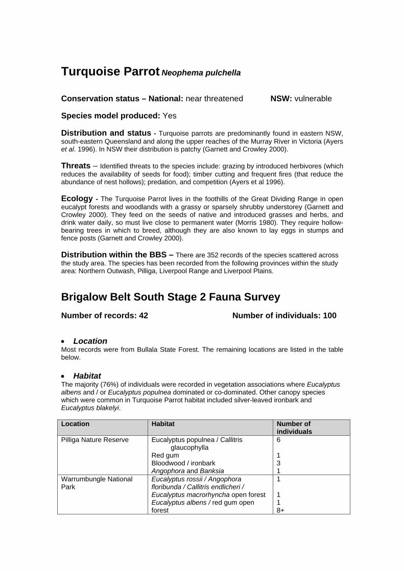
Turquoise Parrot Neophema pulchella Conservation status – National: near threatened NSW: vulnerable Species model produced: Yes Distribution and status - Turquoise parrots are predominantly found in eastern NSW, south-eastern Queensland and along the upper reaches of the Murray River in Victoria (Ayers et al. 1996). In NSW their distribution is patchy (Garnett and Crowley 2000). Threats – Identified threats to the species include: grazing by introduced herbivores (which reduces the availability of seeds for food); timber cutting and frequent fires (that reduce the abundance of nest hollows); predation, and competition (Ayers et al 1996). Ecology - The Turquoise Parrot lives in the foothills of the Great Dividing Range in open eucalypt forests and woodlands with a grassy or sparsely shrubby understorey (Garnett and Crowley 2000). They feed on the seeds of native and introduced grasses and herbs, and drink water daily, so must live close to permanent water (Morris 1980). They require hollow-bearing trees in which to breed, although they are also known to lay eggs in stumps and fence posts (Garnett and Crowley 2000). Distribution within the BBS – There are 352 records of the species scattered across the study area. The species has been recorded from the following provinces within the study area: Northern Outwash, Pilliga, Liverpool Range and Liverpool Plains.
Brigalow Belt South Stage 2 Fauna Survey Number of records: 42 Number of individuals: 100 • Location Most records were from Bullala State Forest. The remaining locations are listed in the table below. • Habitat The majority (76%) of individuals were recorded in vegetation associations where Eucalyptus albens and / or Eucalyptus populnea dominated or co-dominated. Other canopy species which were common in Turquoise Parrot habitat included silver-leaved ironbark and Eucalyptus blakelyi. Location Habitat Number of
individuals Pilliga Nature Reserve Eucalyptus populnea / Callitris
glaucophylla Red gum Bloodwood / ironbark Angophora and Banksia
6 1 3 1
Warrumbungle National Park
Eucalyptus rossii / Angophora floribunda / Callitris endlicheri / Eucalyptus macrorhyncha open forest Eucalyptus albens / red gum open forest
1 1 1 8+

Eucalyptus albens Goonoo State Forest Eucalyptus crebra / Eucalyptus blakelyi
/ Eucalyptus chloroclada / Eucalyptus microcarpa
1
Pilliga Group of State Forests
Callitris glaucophylla / Eucalyptus blakelyi woodland Eucalyptus populnea / Callitris glaucophylla
3 1
Leard State Forest Eucalyptus albens woodland 3 Bobbiwaa State Forest opportunistic record – no vegetation
type noted 1
Couradda State Forest opportunistic record – no vegetation type noted
3
Bullala State Forest Silver leaf ironbark / Eucalyptus populnea / Callitris open forest Eucalyptus albens / Callitris open woodland Eucalyptus albens / carbeen / silver-leaved ironbark / bloodwood open forest with Callitris Eucalyptus dolichocarpa / silver-leaved ironbark open forest with Callitris
17 15 4 2
Terry Hie Hie State Forest Eucalyptus albens / silver-leaved ironbark woodland with patches of Callitris
3
Coonabarabran Eucalyptus albens grassy open woodland
6
• Technique These records were obtained through incidental observations (n = 27) and bird censuses (n = 15, 86 hrs). • Notes The majority of records of Turquoise Parrots within the study area have been recorded in the last decade at a time when survey effort has increased significantly (see table below). Number of records 1980-1990 1991-2002 All records Study area 84 177 352 Stage 1 surveys 38 38 Stage 2 surveys 42 42 Total 84 257 432 There were sufficient records to conduct statistical analysis and modelling for this species. The environmental variables with the highest explaining power for Turquoise Parrot distribution were temperature (p=0.004) with most records in the warmer areas, the amount of woody vegetation within a 10 kilometre area (p=0.008) with no records from areas with low amounts of surrounding woody vegetation, and soil fertility (p=0.033) with all records from the lowest three categories. In the BBS Stage 1 fauna surveys, 38 records of Turquoise Parrot were detected representing 66 individuals. References Ayers, D., Nash, S., and Baggett, K. (1996). Threatened species of western New South Wales. New South Wales National Parks and Wildlife Service, Hurstville.

Garnett, S. and Crowley, G. (2000). The Action Plan for Australian Birds 2000. Environment Australia, Canberra. Morris, A. K. (1980). The status and distribution of the Turquoise Parrot in New South Wales. Aust. Birds 14 (4), 57-67.

#
#
#
#
#
NNNNNNNN
N
NNNN NNNNNNNNN NNNNN
NNNNNN
NNN
N
N
NNNNNNNN
N
N
N
NN
N
N
NNN
NN
NNNNNNNNNNN
NNNNN
N
NN
N
N
N
Woody Vegetation
State Forests NSW
NPWS Estate
NSW Mapsheet Boundaries
BBS Provinces
# Main Towns
BBS Boundary
BBS 15 km Buffer
N Stage 1 Records
N Stage 2 Records
N
EW
S
0 22 44
Kilometers
NSW Distribution #
Distribution of the Turquoise Parrot in NSW and the Brigalow Belt South

White-backed swallow Cheramoeca leucosternus Conservation status – National: none NSW: none Species model produced: No Distribution and status –The distribution of the White-Backed Swallow is southern Australia across the continent. This species is generally found in sandy country and associated open woodland, tree-scattered plains and grasslands (Simpson and Day 1999, Slater et al. 2000). The White-Backed Swallow was regarded as ‘data deficient’ by Traill and Duncan (2000) because the species showed some evidence of major declines in the temperate woodlands region, but evidence is still required for the species to be nominated as threatened. Distribution within the BBS – Records of White-Backed Swallows are scattered across the study area, excluding the extreme north and north-west. This species has been recorded in Manobalai NR and Goulburn River National Park to the south-east of the study area, the Warrumbungle National Park in the south west, Pilliga Nature Reserve and the Pilliga group of State Forests in the central west, Bullala State Forest in the north east and Mount Kaputar National Park to the east of the study area. The majority of records of the White-Backed Swallow within the study area occur outside NPWS and SFNSW estate. The data in table below suggests that there has been a significant decline in White-Backed Swallows within the study area between 1991-2002, despite 51% of all passerine bird records within the BBS being collected during this time. 1980-1990 1991-2002 All records All records 78 20 183Stage 1 1 1Stage 2 2 2Total 185
Brigalow Belt South Stage 2 Fauna Survey Number of records: 2 Number of individuals: 3 • Location One record was from Bullala State Forest and the other was an incidental observation. • Habitat Habitat at the systematic site was Smooth-barked Apple. • Technique One record was obtained on a diurnal bird census (86 hrs) and the other record was an incidental observation. • Notes There were insufficient records to conduct statistical analysis and modelling for this species. In the BBS Stage 1 fauna surveys, 1 record of the White-backed Swallow was obtained. References Simpson, K. and Day, N. (1999). Field Guide to the birds of Australia. Viking O’Neil. Melbourne.

Slater, P., Slater, P. and Slater, R. (2000). The Slater Field Guide to Australian Birds- revised edition. Lansdowne Publishing Pty Ltd. Traill, B.J. and Duncan, S., (2000). Status of birds in the New South Wales temperate woodlands region. Consultancy report for the NSW National Parks and Wildlife Service, Australian Woodland Conservancy, Chiltern.

#
#
#
#
#
N
N
N
Woody Vegetation
State Forests NSW
NPWS Estate
NSW Mapsheet Boundaries
BBS Provinces
# Main Towns
BBS Boundary
BBS 15 km Buffer
N Stage 1 Records
N Stage 2 Records
N
EW
S
0 22 44
Kilometers
NSW Distribution #
Distribution of the White-backed Swallow in NSW and the Brigalow Belt South

Crested Shrike-tit (Falcunculus frontatus) Conservation Status National: None NSW: None Brigalow Belt South Stage 2 Fauna Survey Number of Records: 17 Number of animals: 17 Species modelled: Yes • Location Crested shrike-tits were detected at: Pilliga Nature Reserve, Binnaway Nature Reserve, Warrumbungle National Park, Leard State Forest, Deriah State Forest, Vickery State Forest, Bobbiwaa State Forest and Bullala State Forest. The species was also recorded on private properties near Coonabarabran and Binnaway. • Habitat Crested shrike-tits were predominantly recorded from white box vegetation, but was also recorded within other gum (Scribbly, Blakely’s red, red Stringybark and broad / blue leaved Ironbark), mallee and dry rainforest (Ooline) vegetation types. • Technique All shrike-tits were detected opportunistically or during systematic site bird census. • Notes Sufficient records were available to undertake statistical analysis and modelling for this species. The combination of significant variables with the highest explaining power were related to solar radiation, soil drainage and the amount of woody vegetation within a 5 kilometre radius. A review of Wildlife atlas, RAOU, ABBS and other data (BBS fauna database) indicates that the number of crested shrike-tit observations have progressively declined during the past three decades. This is illustrated in the following table. Time period Total number of records Percentage of records from
past three decades 1970 - 1979 105 37.10% 1980 - 1989 68 24.03% 1990 - 1999 60 21.20% 2000 - 2002 50 17.67%

#
#
#
#
#NNN
NNN
NN
NN
N
N
N
NN
N
N
Woody Vegetation
State Forests NSW
NPWS Estate
NSW Mapsheet Boundaries
BBS Provinces
# Main Towns
BBS Boundary
BBS 15 km Buffer
N Stage 1 Records
N Stage 2 Records
N
EW
S
0 22 44
Kilometers
NSW Distribution #
Distribution of the Crested Shrike-tit in NSW and the Brigalow Belt South

White-browed Babbler Pomatostomus superciliosus Conservation status – National: none NSW: none Species model produced: Yes Brigalow Belt South Stage 2 Fauna Survey Number of Records: 14 Number of animals: 39 (excludes
possible recounts of birds observed multiple times)
• Location Records of the White-browed Babbler were mostly concentrated in the Warrumbungle National Park. Two records were also from the Coolah/ Binnaway area and Cobbora State Forest and one record from a private property near Gilgandra. These records were in the south-west, south-east and central (eastern) parts of the study area and not in the north. • Habitat Habitat at the systematic survey sites in which the species was recorded included Red Gum gully, Scribbly Gum, White Box open forest, Red Gum flats (Blakleys Red Gum and Barradine Red Gum) and Ironbark ridge (Broad/ blue-leaved Ironbark). • Technique Babblers were detected during systematic site bird censuses (86 hrs) and opportunistically. • Notes Sufficient records were available to undertake statistical analysis and modelling for this species. Babbler groups seen ranged in size from one to six individuals (average 3). Environmental variables with the strongest explaining power of this species distribution were, solar radiation (p=0.001) with most records in the mid range, distance to streams (p=0.025) with records spread over a large range of distances, and longitude (p=0.007) with most records in the west. In the BBS Stage 1 surveys, 28 records of the species were obtained.

#
#
#
#
#
NNNNNN NN N
NNNN
NNNNNN
N
N
N
NNNNNN
NNN
NNN
N
NN
NN
N N
N
Woody Vegetation
State Forests NSW
NPWS Estate
NSW Mapsheet Boundaries
BBS Provinces
# Main Towns
BBS Boundary
BBS 15 km Buffer
N Stage 1 Records
N Stage 2 Records
N
EW
S
0 22 44
Kilometers
NSW Distribution #
Distribution of the White-browed Babbler in NSW and the Brigalow Belt South
Southern Whiteface Aphelocephala leucopsis Conservation status – National: none NSW: none Species model produced: No Brigalow Belt South Stage 2 Fauna Survey Number of Records: 1 Number of animals: 4 • Location Four Southern Whiteface were observed on the ground at a homestead on a private property near Gilgandra. • Habitat As the observation was an incidental sighting no habitat information was collected. • Technique The observation was an incidental sighting. • Notes Insufficient records were available to under take any statistical analysis or modelling for this species. In the BBS Stage 1 surveys, 0 records of the species were obtained.

#
#
#
#
#
N
Woody Vegetation
State Forests NSW
NPWS Estate
NSW Mapsheet Boundaries
BBS Provinces
# Main Towns
BBS Boundary
BBS 15 km Buffer
N Stage 1 Records
N Stage 2 Records
N
EW
S
0 22 44
Kilometers
NSW Distribution #
Distribution of the Southern Whiteface in NSW and the Brigalow Belt South
Chestnut-rumped Heathwren (Hylacola pyrrhopygia) Conservation status – National: none NSW: none Species model produced: No Brigalow Belt South Stage 2 Fauna Survey Number of Records: 3 Number of animals: 4 • Location Chestnut-rumped heathwrens were detected in Binnaway Nature Reserve, a private property c. 5 km south of Binnaway, and an opportunistic site within the Warrumbungle National Park. • Habitat The vegetation types in which the species was recorded includes both Blakleys redgum/ Barradine redgum and Acacia cheelii/ Cypress pine. • Technique Heathwrens were recorded both incidentally and during site spotlighting searches (111 hrs). • Notes Sufficient records were available to produce a predictive model for this species. Environmental variables with the strongest explaining power of this species distribution were, solar radiation (p<0.000) with all records clustered in the mid range, the amount of woody vegetation within a 10 kilometre radius (p<0.000) with no records in areas with low amounts of surrounding woody vegetation and rainfall in the wettest period (p=0.007) with most records in the driest areas. In the BBS Stage 1 surveys, 19 records of the species were obtained.

#
#
#
#
#
N N NNNN
NN
NNNNNN NN
NNN
NN
N
Woody Vegetation
State Forests NSW
NPWS Estate
NSW Mapsheet Boundaries
BBS Provinces
# Main Towns
BBS Boundary
BBS 15 km Buffer
N Stage 1 Records
N Stage 2 Records
N
EW
S
0 22 44
Kilometers
NSW Distribution #
Distribution of the Chestnut-rumped Heathwren in NSW and the Brigalow Belt South

Painted Honeyeater (Grantiella picta) Conservation status – National: none NSW: vulnerable Species model produced: Yes Brigalow Belt South Stage 2 Fauna Survey Number of Records: 22 Number of animals: 26 • Location Painted Honeyeaters were detected from various locations across the study area but most commonly on private properties (50%), despite only 19.4% of the survey sites being conducted on private property. Locations of records included Bebo State Forest, Bobbiwaa State Forest, Killarney State Forest, Binnaway Nature Reserve, Brigalow Park Nature Reserve, Careunga Nature Reserve, Warrumbungle National Park, a Travelling Stock Reserve to the south-west of Bellata, and on private properties near Narrabri and Binnaway. • Habitat The species was predominantly recorded from Eucalypt and pine communities. Habitats in which the species were observed are presented in Table 1.
Table 1: Habitat at the systematic survey sites in which the Painted Honeyeater was recorded.
BBS Systematic Survey Site
Vegetation Type
BBS2SF034 Shrubby woodland. BBS2SF036 Ironbark ridges with Broad / blue leafed Ironbark. BBS2SF040 White cypress. BBS2SF043 Poplar Box / Callitris open woodland. BBS2SF074 Red gum flats of Blakleys red gum / Barradine red gum. BBS2SF077 Red stringybark. BBS2SF078 Shrubby open forest, lower slope shallow gully. BBS2SF079 A. cheelii / Cypress pine ridge. BBS2SF089 Mugga Ironbark, scattered Acacia's and Callitris over medium to
dense shrub layer. BBS2SF090 Mixed Angophora / Callitris, probably regrowth. • Technique All honeyeaters were detected opportunistically or during systematic site bird censuses (86 hrs). • Notes Sufficient records were available to undertake statistical analysis and modelling for this species. Environmental variables with the strongest explaining power of this species distribution were, the area of stream within one kilometre (p<0.000) with records grouped in areas with less streams, ecotone (forest edge) within one kilometre (p<0.000) with records clustered in areas with less ecotone (edge), annual rainfall (p=0.012) all sightings were above 600mm, and longitude (p=0.038) with a skew of records to the east. In the BBS Stage 1 surveys, no records of the species were obtained.

#
#
#
#
#
N
NNNN
NNNNNN
N
NN
NN
N
N
NNNN
Woody Vegetation
State Forests NSW
NPWS Estate
NSW Mapsheet Boundaries
BBS Provinces
# Main Towns
BBS Boundary
BBS 15 km Buffer
N Stage 1 Records
N Stage 2 Records
N
EW
S
0 22 44
Kilometers
NSW Distribution #
Distribution of the Painted Honeyeater in NSW and the Brigalow Belt South

Yellow – throated Miner Manorina flavigula Conservation status – National: none NSW: none Species model produced: No Brigalow Belt South Stage 2 Fauna Survey Number of Records: 15 Number of animals: 42 • Location Yellow-throated miner records were restricted to the northern portion of the bioregion with most in Moema/ Bobbiwaa State Forests and the Planchonella Nature Reserve/ Moree areas. Other records were in Bullala State Forest, Brigalow Park Nature Reserve and Terry Hie Hie State Forest. The species was also recorded between Couradda and Moema State Forests, within a Travelling Stock Reserve south of Bellata, near Bon Braggie, at Ottley Creek and within the townships of Narrabri and Moree. • Habitat Habitat at the systematic sites in which the species was recorded included Grey Box open woodland, Poplar Box/ Callitris open woodland, Acacia/ Myall, dry rainforest containing dry vine- thicket/ Alphitonia and open forest of Silver-leaved Ironbark, Poplar Box and Callitris. • Technique All miners were detected opportunistically or during systematic site bird censuses (86 hrs). • Notes Insufficient records were available to under take any statistical analysis or modelling for this species. Past records of this species over the last three decades indicates a possible decline in population size in the study area. Time period Total number of records Percentage of records from
past three decades 1970 - 1979 242 46 % 1980 - 1989 167 32 % 1990 - 2002 113 22 % In the BBS Stage 1 surveys, 1 record of the species was obtained.
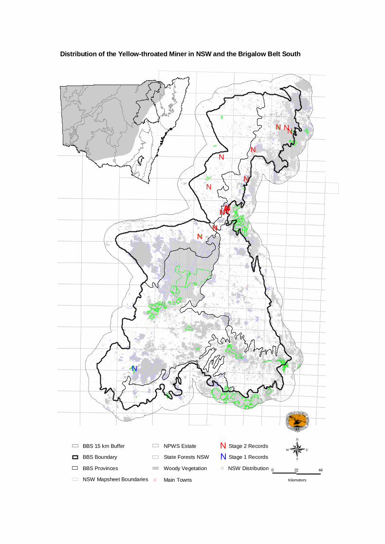
#
#
#
#
#
N
NNNNN
N
N
NN
N
N
N
N
NN
Woody Vegetation
State Forests NSW
NPWS Estate
NSW Mapsheet Boundaries
BBS Provinces
# Main Towns
BBS Boundary
BBS 15 km Buffer
N Stage 1 Records
N Stage 2 Records
N
EW
S
0 22 44
Kilometers
NSW Distribution #
Distribution of the Yellow-throated Miner in NSW and the Brigalow Belt South

Plum-headed Finch (Neochmia modesta) Conservation status – National: none NSW: none Species model produced: No Brigalow Belt South Stage 2 Fauna Survey Number of Records: 4 Number of animals: 42 • Location Plum-headed finches were recorded within Kerringle State Forest and Bullala State Forest, near Mendooran and at Oakley Creek (within close proximity to Planchonella Nature Reserve). • Habitat As all of observations were obtained opportunistically no habitat information was collected for the sites. • Technique The Finches were recorded opportunistically. • Notes Each record is within the known range of the species, as evidenced by various databases (BBS fauna database), with the exception of the records obtained from Bullala and Kerringle State Forests as these appear to be the first observations of the species from such areas. Insufficient records were available to under take any statistical analysis or modelling for this species. The species was not recorded during the BBS Stage 1 surveys.

#
#
#
#
#
N
NN
N
Woody Vegetation
State Forests NSW
NPWS Estate
NSW Mapsheet Boundaries
BBS Provinces
# Main Towns
BBS Boundary
BBS 15 km Buffer
N Stage 1 Records
N Stage 2 Records
N
EW
S
0 22 44
Kilometers
NSW Distribution #
Distribution of the Plum-headed Finch in NSW and the Brigalow Belt South

Spotted Bowerbird Chlamydera maculata Conservation status – National: none NSW: none Species model produced: No Brigalow Belt South Stage 2 Fauna Survey Number of Records: 16 Number of animals: 19 • Location Spotted Bowerbird records were concentrated in the lower portion of the Northern Basalt province. Individual records were also obtained from the central portion of the Pilliga province, northern reaches of the Northern Basalt province and the north-western extent of the Northern Outwash province. Locations of records included Bobbiwaa State Forest, Moema State Forest, Gamillaroi Nature Reserve, Planchonella Nature Reserve, Terry Hie Hie State Forest, Careunga Nature Reserve and Mission State Forest. The species was also recorded on private properties near Narrabri and Gilgandra. • Habitat Habitat at the systematic survey sites where the species was recorded included Poplar Box/ Callitris open woodland, dry rainforest containing dry vine- thicket/ Alphitonia, Casuarina/ Belah forest and Ironbark ridge dominated by Silver-leaved Ironbark. • Technique All Spotted Bowerbirds were detected opportunistically or during the systematic site bird census (86 hrs), with the exception of an individual record from Moema State Forest that was observed during spotlight searches (111 hrs). • Notes Insufficient records were available to undertake any statistical analysis or modelling for this species. In the BBS Stage 1 surveys, 6 records of the species were obtained.

#
#
#
#
#
NNNN
N
N
NNNNNNN
N
N
N
NN
NN
NN
Woody Vegetation
State Forests NSW
NPWS Estate
NSW Mapsheet Boundaries
BBS Provinces
# Main Towns
BBS Boundary
BBS 15 km Buffer
N Stage 1 Records
N Stage 2 Records
N
EW
S
0 22 44
Kilometers
NSW Distribution #
Distribution of the Spotted Bowerbird in NSW and the Brigalow Belt South

Barking Owl Ninox connivens Conservation Status National: None NSW: Vulnerable Species model produced: Yes Distribution and Status – The barking owl is widely distributed throughout much of Australia, New Guinea and the Moluccas (Garnett and Crowley, 2000). Debus (1997) suggests that barking owls are more numerous west of the divide in New South Wales, and reach higher densities in warmer lowland regions with the strongest Torresian influence. Threats - The main threat identified to the barking owl is habitat clearance, particularly in inland New South Wales, of riparian and floodplain habitats (Debus 1997). Continued habitat fragmentation and habitat degradation through firewood collection, lack of regeneration, tree decline, grazing, loss of hollows through competition with feral honeybees and the reduced abundance of prey also poses potential problems (Smith et al. 1995). Distribution within BBS - NSW National Parks and Wildlife Service’s Wildlife Atlas records indicate that the barking owl has been recorded throughout much of the bioregion, with fewer records in the north. Debus (1997), Smith et al. (1995), Gosper (2002) and wildlife databases contain a number of barking owl records along major watercourses. Faulkner et al. (1997) recorded barking owl in the Nangar National Park, it has also been recorded in Goulburn River National Park (NSW NPWS, 2001), near Armidale (Debus, 2001), Pilliga West State Forest and Goonoo State Forest (NSW NPWS 2000, Schedvin et al 2001). Ecology – Warm, lowland sites with woodland constitutes the preferred habitat for the barking owl (Debus, 1997). Dense riparian thickets are utilised for roosting, and hollows for nesting (Gosper, 2002). Barking owls have a varied diet consisting of arboreal and ground mammals, birds, bats and invertebrates (Kavanagh et al. 1995, Debus 1997). The species occupies a large home range. Schedvin et al (2001) note that following the radio-tracking of a female of a pair of owls using contiguous Cypress Pine – Ironbark forest within the Goonoo State Forest the female covered a total area of over 6000 ha. (concave polygon method), an area which is greater than any other published home range of an Australian owl. Discounting several of her longer voyages, the owl utilised a central area of 4100 ha. Brigalow Belt South Stage 2 Fauna Survey Number of Records: 17 Number of animals: < 9 • Location Barking owls were detected from nine survey sites on private land and state forests within four distinct survey areas: Bobbiwaa State Forest, Kerringle State Forest, Cobbora State Forest and on a private property adjacent to Binnaway Nature Reserve. An individual barking owl was also incidentally recorded, as roadkill, adjacent to the Castlereagh River in Gilgandra. • Habitat Owls were detected in a variety of habitats. Two sites were within redgum, two sites were located within broad-leaved Ironbark and single sites were located within belah, Pilliga box, scribbly gum, mugga ironbark and smooth barked apple vegetation.

• Technique Barking owls were recorded during site spotlighting, call playback and opportunistically. • Notes Gosper (2002) notes that in the adjoining DRP bioregion barking owls are associated with major watercourses and wetland systems with riparian vegetation. This was not directly evident in the BBS bioregion, with only two of the nine sites, in which barking owls were detected, being located in riparian vegetation. Proximity to watercourses was found to be significantly correlated with sites at which the species was found ( p= 4.44e-016) using stepwise multivariate statistical analysis. However the combination of variables related to rainfall, temperature and the amount of woody vegetation within a 10 kilometre radius had the highest explaining power (p=0.000, p= 0.000, p=0.005 respectively) and as such were selected for use in the species model (Appendix 1). Barking owls were detected 8% of the of the systematic fauna sites, this is an over-estimation of their actual occurrence as a single pair of owls was recorded at three sites. Barking owls were detected at 39% of the sites surveyed within Pilliga West State Forest and 6% of the sites surveyed within the Goonoo State Forest. No barking owls were detected in East Pilliga State Forest during the survey period. The results suggest that Pilliga West State Forest is of particular significance due to the presence of a comparatively high number of sites that harbour barking owls. The detection of a higher percentage of barking owls during Stage 1 of the BBS Biodiversity Assessment, as apposed to Stage 2 may reflect the surveying of considerably larger reserves during Stage 1. This is supported by Debus (2001) who states that barking owls seem most abundant in larger remnants but also occur at low density in fragmented habitat. REFERENCES Debus, S.J.S., (1997), The Barking Owl in New South Wales, Aust. Birds, 30: 53-80. Debus, S.J.S., (2001), Surveys of the Barking Owl and Masked Owl on the north-west slopes of New South Wales, Corella, 25 (1): 5 –11. Faulkner, W., LeBreton, M. and Ellis, M., (1997), Fauna Survey of Goobang and Nangar National Parks: Autumn 1997, NSW National Parks and Wildlife Service, Hurstville. Garnett, S. and Crowley, G., (2000), The Action Plan for Australian Birds, Environment Australia, Canberra. Gosper, C., (2002), Darling Riverine Plains Biodiversity Survey Technical Report, NSW National Parks and Wildlife Service Western Regional Assessments Unit, Dubbo. Kavanagh, R.P., Debus, S.J.S, Rose, A.B. and Turner, R.J., (1995), Diet and habitat of the Barking Owl Ninox connivens in New South Wales, Aust. Bird Watcher, 16: 137-144. NSW National Parks and Wildlife Service, (2000), Brigalow Belt South: Regional Assessment (Stage 1): Report on preliminary fauna survey of Pilliga and Goonoo Forests November 1999 to January 2000, NSW National Parks and Wildlife Service, Hurstville. NSW National Parks and Wildlife Service, (2001), The fauna of Goulburn River National Park, NSW National Parks and Wildlife Service, Hurstville. Smith, P.J., Smith, E.J., Pressey, R.L. and Whish, G.L., (1995), Birds of particular conservation concern in the Western Division of New South Wales: Distributions, habitats and threats, NSW National Parks and Wildlife Service Occasional paper No. 20, Hurstville.

Schedvin, N., Soderquist, T., Baker, J. and Taylor, I., (2001), One Barking Owl – 6000 ha of forest, AWMS 2001. Australasian Wildlife Management Society 14th Annual Conference and Annual General Meeting 3-5 December 2001 – Conference Programs and Abstracts. NSW NPWS, Dubbo, NSW.
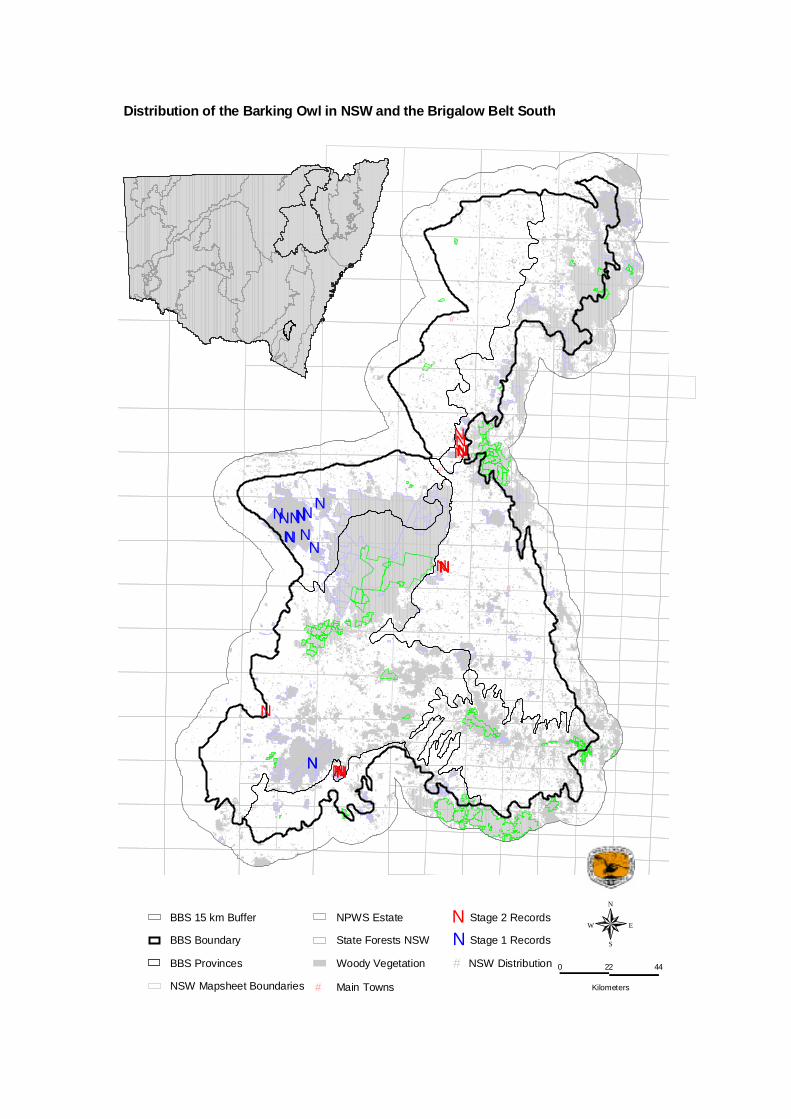
#
#
#
#
#
NNNNNNN
NN
N
N
NN
NN
NNNN
NNNNN
NNN
N
N
N
Woody Vegetation
State Forests NSW
NPWS Estate
NSW Mapsheet Boundaries
BBS Provinces
# Main Towns
BBS Boundary
BBS 15 km Buffer
N Stage 1 Records
N Stage 2 Records
N
EW
S
0 22 44
Kilometers
NSW Distribution #
Distribution of the Barking Owl in NSW and the Brigalow Belt South

Masked Owl (Tyto novaehollandiae) Other Common names - Conservation Status National: None NSW: Vulnerable Species model produced: No Distribution and Status – Recent accounts of the current distribution of the species have been conflicting. Some authors, notably Schodde and Mason (1980) and Blakers et al. (1984), have asserted that the range of the masked owl has contracted from some inland areas, being now restricted to forest and woodland in a coastal strip <300km wide. This opinion has also been put forward by Garnett and Crowley (2000), who state that the area of occupancy by the southern Australian subspecies of the masked owl is thought to have declined by near half, particularly in the semi-arid zone. Smith and Smith (1994) also identify the masked owl as having suffered a pronounced decline in the western division. These assessments contrast with Debus and Rose (1994), who in collating masked owl records from throughout NSW outlined several inland records in detail, and suggest that more locations for the species would be uncovered with the systematic survey of inland areas. This seems to be the case, with a number of recent survey records from the Brigalow Belt South (NSW NPWS 2000) and as far west as Wilcannia (Gosper 2002). Threats - Declines in food resources, habitat clearance and the destruction of nest trees have been identified as being possibly responsible for the perceived decline of this species (Schodde and Mason 1980, Blakers et al. 1984, Debus and Rose 1994). Distribution within BBS - Within the bioregion the masked owl has been recorded in Pilliga West State Forest, Goonoo State Forest, Coolah Tops and Goulburn River National Park (NSW National Parks and Wildlife Service 2000,Kavanagh (1995), NSW NPWS, ( 2001). Debus and Rose (1994) also note that throughout fauna surveys of the state forests of the north-west slopes during 1993-94 masked owls were positively identified, by nocturnal call playback and spotlighting, in eight state forests inland to Narrabri (Nandewar Range foothills), Pilliga (Pilliga West State Forest) and Coonamble (Sandgate State Forest), with unconfirmed records in four other state forests north to Yetman (Bebo State Forest) and south to Gilgandra (Breelong State Forest) and Dubbo (Beni State Forest). Ecology – As with other large owls, the masked owl typically occupies a large home range, in the order of 5 – 10km2 (Garnett and Crowley 2000). This home range usually contains a diverse array of wooded habitats with large hollow-bearing trees for roosting and nesting and open areas for foraging, including forests, woodlands, remnants and almost treeless plains caves are used in inland areas for roosting and occasionally nesting purposes. (Debus and Rose 1994). Masked owls have a varied diet, but catch most prey on the ground (Debus and Rose 1994).
Brigalow Belt South Stage 2 Fauna Survey Number of Records: 17 Number of animals: >4 • Location The masked owl was recorded within four distinct survey areas: Parkhurst State Forest, Bullala State Forest and on private properties near the townships of Gilgandra and Coonabarabran.

• Habitat The species was recorded mostly in more fertile areas, the dominant vegetation included narrow/ blue-leafed ironbark, red stringybark, silver-leaf ironbark, white box, carbeen, brigalow and poplar box woodlands • Technique The majority of masked owls were detected through the standard call playback technique. • Notes Insufficient systematic records were available to conduct statistical analysis or modelling for this species. Debus and Rose (1994) note that masked owls are rare and localised around rich patches such as watercourses in inland areas of New South Wales. The results obtained during the BBS Biodiversity Assessment support this concept, with masked owls being found to be located, on average, within 285 metres of a watercourse (maximum distance: 531 metres, minimum distance: 54 metres). References Blakers, M., Davies, S.J.J.F. and Reilly, P.N., (1984), The atlas of Australian birds, Melbourne University Press, Melbourne. Debus, S.J.S. and Rose, A.B.,(1994), The Masked Owl Tyto novaehollandiae in New South Wales, Aust. Birds 28 (Supplement): S40-S64. Garnett, S. and Crowley, G., (2000), The Action Plan for Australian Birds, Environment Australia, Canberra. Gosper, C., (2002), Darling Riverine Plains Biodiversity Survey Technical Report, NSW National Parks and Wildlife Service Western Regional Assessments Unit, Dubbo. Kavanagh, R.P., (1995), Nocturnal forest birds and arboreal marsupials of Coolah Tops, Warung Management Area, Western Region, Forest Resources Series No. 28 SFNSW, Sydney. NSW National Parks and Wildlife Service, (2000), Brigalow Belt South: Regional Assessment (Stage 1): Report on preliminary fauna survey of Pilliga and Goonoo Forests November 1999 to January 2000, NSW National Parks and Wildlife Service, Hurstville.
NSW National Parks and Wildlife Service, (2001), The fauna of Goulburn River National Park, NSW National Parks and Wildlife Service, Hurstville. Schodde, R. and Mason, I.J., (1980), Nocturnal birds of Australia, Lansdowne, Melbourne. Smith, P., and Smith, J., (1994), Historical changes in bird fauna of Western New South Wales: ecological patterns and conservation implications. In: Lunney, D., Hand, S., Reed, P. and Butcher, D., (Eds) Future of the fauna of Western New South Wales, Royal Zoological Society of New South Wales, Sydney.

#
#
#
#
#
NN
N
N
NN
NNNNN
NNNNNN
N
NN
Woody Vegetation
State Forests NSW
NPWS Estate
NSW Mapsheet Boundaries
BBS Provinces
# Main Towns
BBS Boundary
BBS 15 km Buffer
N Stage 1 Records
N Stage 2 Records
N
EW
S
0 22 44
Kilometers
NSW Distribution #
Distribution of the Masked Owl in NSW and the Brigalow Belt South

Zig Zag Gecko Oedura rhombifer Conservation status – National: none NSW: none Species model produced: No
Brigalow Belt South Stage 2 Fauna Survey Number of Records: 2 Number of animals: 2 • Location Oedura rhombifer was found in Bebo State Forest and Arakoola Nature Reserve within the Northern Basalts Province. Both records are significant as they represent a major extension to the previously known range of this species (i.e. tropical Australia). The record from Arakoola Nature Reserve represents the first time this species has been found in New South Wales (Ross Sadlier pers. com.) • Habitat One gecko was found in Casuarina (Bulloak) habitat in Bebo State Forest and the other was found in Smooth-barked Apple habitat in Arakoola Nature Reserve. Both individuals were located under the bark of trees. • Technique Both geckos were observed during diurnal habitat searches (109 hrs). • Notes There were insufficient records for this species to undertake statistical analysis or modelling. Both individuals were collected as specimens and their identification confirmed by the Australian Museum (voucher No’s. 52541, 52431). No Zig Zag geckos were recorded in the BBS stage 1 surveys.

#
#
#
#
#
N
N
Woody Vegetation
State Forests NSW
NPWS Estate
NSW Mapsheet Boundaries
BBS Provinces
# Main Towns
BBS Boundary
BBS 15 km Buffer
N Stage 1 Records
N Stage 2 Records
N
EW
S
0 22 44
Kilometers
NSW Distribution #
Distribution of the Zig Zag Gecko in NSW and the Brigalow Belt South
