annual report on major highway projects · this fifth annual report identifies major ... funding...
TRANSCRIPT

Annual Report on Major Highway Projects
December 2012

Annual Report on Major Highway Projects Minnesota Department of Transportation Page | 2
Annual Report on Major Highway Projects (per Minn. Stat. 174.56, Subd. 1-3)
December 2012
Prepared by the Minnesota Department of Transportation Office of Capital Programs and Performance Measure

Section 1
Annual Report on Major Highway Projects Minnesota Department of Transportation Page | 3
395 John Ireland Boulevard Saint Paul, Minnesota 55155-1899
Phone: 651-366-3798
Toll-Free: 1-800-657-3774 TTY, Voice or ASCII: 1-800-627-3529
www.dot.state.mn.us
To request this document in an alternative format, please contact MnDOT’s Affirmative Action Office at 651-366-4718 or 1-800-657-3774 (Greater Minnesota); 711 or 1-800-627-3529
(Minnesota Relay). You may also send an e-mail to [email protected].
Section 1
Annual Report on Major Highway Projects Minnesota Department of Transportation Page | 4
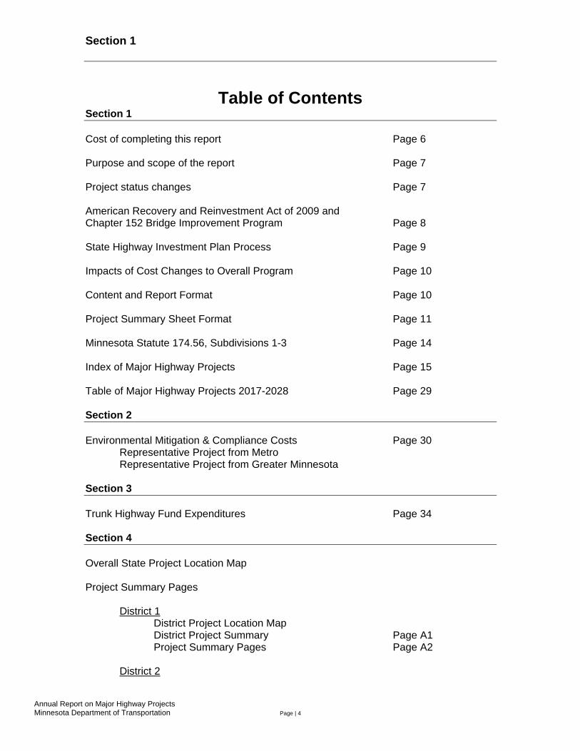
Table of Contents Section 1 Cost of completing this report Page 6 Purpose and scope of the report Page 7 Project status changes Page 7 American Recovery and Reinvestment Act of 2009 and Chapter 152 Bridge Improvement Program Page 8
State Highway Investment Plan Process Page 9 Impacts of Cost Changes to Overall Program Page 10 Content and Report Format Page 10 Project Summary Sheet Format Page 11 Minnesota Statute 174.56, Subdivisions 1-3 Page 14 Index of Major Highway Projects Page 15 Table of Major Highway Projects 2017-2028 Page 29 Section 2 Environmental Mitigation & Compliance Costs Page 30 Representative Project from Metro Representative Project from Greater Minnesota Section 3 Trunk Highway Fund Expenditures Page 34 Section 4 Overall State Project Location Map Project Summary Pages District 1 District Project Location Map District Project Summary Page A1 Project Summary Pages Page A2 District 2

Section 1
Annual Report on Major Highway Projects Minnesota Department of Transportation Page | 5
District Project Location Map District Project Summary Page B1 Project Summary Pages Page B2
District 3 District Project Location Map District Project Summary Page C1 Project Summary Pages Page C2 District 4 District Project Location Map District Project Summary Page D1 Project Summary Pages Page D2
District 6
District Project Location Map District Project Summary Page E1 Project Summary Pages Page E2
District 7 District Project Location Map District Project Summary Page F1 Project Summary Pages Page F2 District 8 District Project Location Map District Project Summary Page G1 Project Summary Pages Page G2 Metro District District Project Location Map District Project Summary Page H1 Project Summary Pages Page H2
Section 1
Annual Report on Major Highway Projects Minnesota Department of Transportation Page | 6
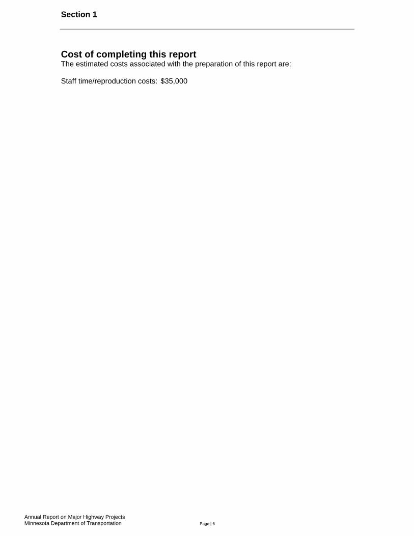
Cost of completing this report The estimated costs associated with the preparation of this report are: Staff time/reproduction costs: $35,000

Section 1
Annual Report on Major Highway Projects Minnesota Department of Transportation Page | 7
Purpose and scope of the report This fifth annual report identifies major projects on the state trunk highway system, which includes the interstate system. Per Minnesota Statute 174.56 (amended in 2012), this report includes projects with cost estimates equal to or in excess of $15 million in the Twin Cities Metro District and projects with cost estimates equal to or in excess of $5 million in Greater Minnesota. The information provided in this report is current as of November 2012. This report includes information on projects that meet the total project cost estimate criteria and are either under construction, programmed or planned within the next 15 years. Projects currently under construction will be reported on an annual basis through two years after substantial completion, i.e., when the highway opens to traffic. After that point, they will no longer be included in this report. Project status changes This report includes an additional 123 projects that met the statutory cost threshold requirements ($15 million or greater in the Twin Cities Metro District, $5 million or greater in Greater Minnesota). Table 1-2 - Projects included in 2012 MHP Report
DISTRICT Completed, Under Construction or in the STIP
Projects in years 2017-2028
Total # of projects
1 26 2 28 2 15 2 17 3 26 2 28 4 20 4 24 6 30 3 33 7 18 3 21 8 6 1 7 M 25 5 30
State 165 22 188 Of the 188 projects reported this year, 30 are in the Twin Cities metro area and 158 are in Greater Minnesota. Projects vary in type from pavement preservation, bridge replacement and rehabilitation, and expansion projects. Last year, in compliance with earlier legislative requirements, this report addressed 76 projects.

Section 1
Annual Report on Major Highway Projects Minnesota Department of Transportation Page | 8
American Recovery and Reinvestment Act of 2009 and Chapter 152 Bridge Improvement Program The American Recovery and Reinvestment Act of 2009 provided funding for one project included in this report that met the cost threshold for major highway projects (Hwy 610 realignment), which allowed the project to be advanced in construction scheduling. Projects funded with ARRA funds were selected based on project readiness, consistency with performance-based plans, statewide coverage, work-type balance and project advancement. The Chapter 152 Bridge Improvement Program provided bond funding for approximately 27 of the projects in this report. The projects funded through this program include bridges that are classified as Tier 1 or Tier 2, as required by Law of 2008, Chapter 152. 1
1 A Tier 1 bridge consists of any bridge in the program that has an average daily traffic count greater than 1,000 and a sufficiency rating that is at or below 50, or is identified by the commissioner as a priority project. A Tier 2 bridge consists of any bridge that is not a Tier 1 bridge and is classified as fracture critical or has a sufficiency rating that is at or below 80. For more information on the Chapter 152 Bridge Improvement Program, refer to the Trunk Highway Bridge Improvement Program Chapter 152 Annual Update Report, prepared by the Minnesota Department of Transportation’s Office of Capital Programs and Performance Measures and the Bridge Office.

Annual Report on Major Highway Projects Minnesota Department of Transportation Page | 9
State highway investment plan process The 20-year Minnesota State Highway Investment Plan is an important link between the Minnesota GO 50-Year Vision’s guiding principles, the Statewide Multimodal Transportation Plan’s strategies, and the capital improvements made to the state highway system. The plan sets a fiscally constrained framework for future capital improvements by identifying investment needs and priorities for available funding.
MnSHIP covers three planning periods: years 1-4, years 5-10, and years 11-20. Projects identified for years 1-4 (2013-16) are those listed in the Statewide Transportation Improvement Program. MnDOT intends to deliver these projects during the next four years, although the programmed year of construction may be adjusted if actual revenues increase or decrease. Investments identified for years 5-10 (2017-22) include general funding levels for certain improvement categories (e.g., pavement preservation, traveler safety) as well as construction cost estimates for several specific projects. These projects and their cost estimates should be considered to be preliminary, as revenue forecasts are uncertain. Specific projects will not be identified for years 11-20 (2023-32); MnSHIP will set broad investment priorities and develop associated funding allocations. Investment priorities may change as a result of system performance conditions, legislative initiatives or development of requirements within federal programs of the newly adopted MAP-21 transportation bill.
The flow chart above illustrates the steps in developing MnSHIP. MnDOT begins the process by projecting the federal and state funds that will be available for investment on the state highway system during the next 20 years. Next, MnDOT establishes a range of potential investment levels for nine categories of projects. These investment levels are combined into example investment approaches to solicit feedback from the public. To set its investment direction for the 20-year plan, MnDOT considers stakeholder input, legislative direction, federal requirements, and system-wide risks and outcomes to develop a final mix of investment priorities. This investment direction guides statewide and district investment goals and the projects that are selected to make progress towards these goals. MnDOT will produce the MnSHIP draft report in early 2013, and after a period of public review, submit the final plan to the Legislature and Governor.

Section 1
Annual Report on Major Highway Projects Minnesota Department of Transportation Page | 10
Impacts of cost changes to overall program Changes to project costs and schedules affect the state trunk highway capital investment program. These effects are most directly seen through annual revisions to the State Transportation Improvement Program, which lists projects that MnDOT has committed to completing in the next four construction seasons. A majority of projects that have been listed in the STIP (75 percent) are let and completed in their originally scheduled construction season. Other projects’ completion dates may be adjusted, and project scope and costs may increase or decrease after being listed in the STIP. Project costs may change for a variety of reasons including changes in economic conditions (e.g., inflationary factors), scope changes, supplemental agreements, cost overruns, right of way acquisition, etc. These costs may change prior to letting or after a contract is awarded. Changes in project costs prior to letting are handled through the STIP process, to which projects are added, revised or removed from annually. Project cost changes post-letting are managed at the district level, primarily through the use of set asides if costs are higher than projected or by advancing additional projects if project costs are lower than projected. The process of managing project costs is typically done at an aggregated level rather than on a project-by-project basis. If a statewide program (e.g., Statewide Bridge Preservation Fund Program) has cumulative cost estimate changes resulting in a significant amount of uncommitted funds, a program may be implemented, such as the recent Better Roads for a Better Minnesota program, which focused on achieving statewide performance objectives for overall pavement condition. To deliver the Better Roads program, projects that most effectively achieved these performance objectives and were at an appropriate stage in the project development process were accelerated so they could be completed earlier than previously programmed. Conversely, if cumulative project cost estimate changes increase by a significant enough level to necessitate revisions to the STIP, a number of projects may be delayed or removed, based on the fiscal ability to fully deliver each annual construction program. Projects that have not yet progressed through the project development process are more subject to these schedule delays or cost revisions. Content and format of this report
• Each project with a letting date between 2011 and 2016 has a one-page project summary
sheet, which is retained in this report for two years after substantial completion of the project.
• Projects with letting dates later than 2016 are listed in a tabular format after the 2010-16 project index, with the following information provided for each project:
o State project number o Description of work o Route, location and length (if applicable) o Status of project development o Current letting date o Total Project Cost Estimate (general TPCE factor applied to construction cost
estimate)

Section 1
Annual Report on Major Highway Projects Minnesota Department of Transportation Page | 11
Note on project inclusion: No new projects planned for construction between 2017-2027 (other than Chapter 152 bridges and other major reconstruction projects with significantly advanced project development) are included in this report because the potential changes related to current rulemaking under MAP-21 and MnDOT’s upcoming 20-year Highway Investment Plan have implications for investment direction on each district’s program. This does not preclude projects not listed in this report from being constructed in the 15-year timeframe; however, MnDOT must update statewide priorities prior to establishing any level of commitment for projects not listed in this report. Project summary sheets A one-page project summary sheet has been created in this report for each project planned for construction or already under construction prior to the end of the 2016 construction season. The summary sheets are categorized by district and include the following project information:
• Project location • Project description • Schedule • Date of approved STIP and
estimated project cost • Date(s) of environmental
approvals • Date(s) of municipal approvals • Date of final geometric layout
approval
• Date of establishment of construction limits
• Project history • Total project cost estimates • Recent changes and updates,
including past and/or potential reasons for delay in letting or completing the project
• Key cost assumptions
Cost Estimate Information For projects currently under construction, the construction letting cost is indicated in the “Current Estimate” column. The costs for projects that have been let are shown as actual construction contract amounts and costs are estimated for other elements, right of way and engineering. A baseline cost estimate has been established for each project with a one-page summary and is shown under the “Baseline Est.” column on the one-page project summary sheet. This is the cost estimate that was established when a project first entered into the STIP. The most current project cost estimate is shown under the “Current Estimate” column and compared to the costs shown under the “Baseline Estimate” column for projects that are in the STIP. Project Prioritization All projects identified within the 2013-16 STIP can be funded with current revenue projections (fiscally constrained) and are of a high priority to the districts. Projects within the 2017-27 mid-range and long-range planning periods are a priority, but revenue forecasts, federal program requirements and funding sources are more uncertain and full funding may not have been identified. The 20-year Highway Investment Plan details how investments at a program level are prioritized in this mid-range and long-range

Section 1
Annual Report on Major Highway Projects Minnesota Department of Transportation Page | 12
timeframe (see page 8). Projects identified in this report that are beyond districts’ 10-year work plan period (after 2023) have a larger greater degree of uncertainty. Project index and tables An index at the beginning of the report containing a list of the major highway projects is included as quick reference. The spreadsheet identifies the MnDOT district, trunk highway or interstate, year in which construction is anticipated, project location, description, and the total cost estimate. Projects outside of the STIP timeframe, but within the 15-year reporting period, are displayed in tabular format after the one-page project summary index, and will include basic information regarding project location, project description, planning cost estimates, and anticipated performance-based improvements or key objectives. Since many of these projects are in the planning stages (beyond the four-year STIP), cost estimates and scopes are preliminary and not yet well-defined. Abbreviations AUAR = Alternative Urban Area-wide Review C-I-P = Cast In Place CRAVE = Cost Risk Assessment Value Engineering DB = Design Build E = East EA = Environmental Assessment EB = Eastbound FONSI = Finding of No Significant Impact Hwy = Highway I = Interstate Jct. = Junction MI = Miles N = North NB = Northbound NBIS = National Bridge Inventory System NEPA = National Environmental Policy Act ROW = Right of Way RR = Railroad S = South SB = Southbound TPCE = Total Project Cost Estimate (includes engineering, right of way and construction) W = West WB = Westbound

Section 1
Annual Report on Major Highway Projects Minnesota Department of Transportation Page | 13
Definitions Alternative Pavement Type Selection or Alternative Bid Project: In an APTS project, the agency creates equivalent designs for concrete and asphalt construction. Then life-cycle cost analyses are calculated for both material types, and the difference between the LCCAs is computed and shown in the Special Provisions section of the RFP. Bidders may choose to bid either material type. For the purpose of bid selection, the difference between the calculated life-cycle costs is added to bids on the design with the higher life-cycle cost. ATP (Area Transportation Partnership): A group of traditional and non-traditional transportation partners, including representatives from MnDOT, Metropolitan Planning Organizations, Regional Development Commissions, counties, cities, tribal governments, special interests and the public that has the responsibility of developing a regional transportation improvement program for its area of the state. Cost Estimate Phases:
• Planning Estimate (Baseline Estimate): The most likely Total Project Cost Estimate including project contingency, and all cost estimate components. This estimate constitutes the approved project budget for cost management. The baseline is set based on an approved Scoping Report estimate.
• Engineer’s Estimate: The Engineer’s Estimate is used to analyze bids received for projects let by the state of Minnesota. It is an estimate based on what MnDOT considers to be the actual cost of construction about a month from bidding. The estimate is developed using cost-based and bid-based methods. The cost-based method is applied to paving, earthwork and pipe, which tend to be the major construction cost items. Bid-based estimates are developed using two-year average estimates on comparable projects.
• Award Amount: The contract bid price of the lowest responsible bidder at time of reward.
• 95 percent Cost Estimate: The value of work certified to date, which is greater than 95 percent of the funds encumbered. The threshold can also represent a project that MnDOT has closed out.
Cost Estimate Components:
• Construction Letting: The costs attributed directly to construction activities.
• Other Construction Elements: The costs for additional project elements, such as moving utilities, completing engineering documents, and implementing other consultant services.
• Right of Way: The costs associated with obtaining land needed to construct
transportation or other facilities.

Section 1
Annual Report on Major Highway Projects Minnesota Department of Transportation Page | 14
Minnesota Statute 174.56, Subdivision 1-3 Laws of 2012, Chapter 287, Article 4: Sec. 39. Minnesota Statutes 2010, section 174.56, is amended to read: 174.56 REPORT ON MAJOR HIGHWAY PROJECTS AND TRUNK HIGHWAY FUND EXPENDITURES. Subdivision 1. Report required. (a) The commissioner of transportation shall submit a report by December 15 of each year, on (1) the status of major highway projects completed during the previous two years or under construction or planned during the year of the report and for the ensuing 15 years; and (2) trunk highway fund expenditures. (b) For purposes of this section, a "major highway project" is a highway project that has a total cost for all segments that the commissioner estimates at the time of the report to be at least (1) $15,000,000 in the metropolitan highway construction district, or (2) $5,000,000 in any nonmetropolitan highway construction district. Subd. 2. Report contents; major highway projects. For each major highway project the report must include: (1) a description of the project sufficient to specify its scope and location; (2) a history of the project, including, but not limited to, previous official actions by the department or the appropriate area transportation partnership, or both, the date on which the project was first included in the state transportation improvement plan, the cost of the project at that time, the planning estimate for the project, the engineer's estimate, the award price, the final cost as of six months after substantial completion, including any supplemental agreements and cost overruns or cost savings, the dates of environmental approval, the dates of municipal approval, the date of final geometric layout, and the date of establishment of any construction limits; (3) the project's priority listing or rank within its construction district, if any, as well as the reasons for that listing or rank, the criteria used in prioritization or rank, any changes in that prioritization or rank since the project was first included in a department work plan, and the reasons for those changes; (4) past and potential future reasons for delay in letting or completing the project, details of all project cost changes that exceed $500,000, and specific modifications to the overall program that are made as a result of delays and project cost changes; (5) two representative trunk highway construction projects, one each from the department's metropolitan district and from greater Minnesota, and for each project report the cost of environmental mitigation and compliance; and (6) the annual budget for products and services for each Department of Transportation district and office, with comparison to actual spending and including measures of productivity for the previous fiscal year. Subd. 2a. Report contents; trunk highway fund expenditures. The commissioner shall include in the report information on the total expenditures from the trunk highway fund during the previous fiscal year, for each Department of Transportation district, in the following categories: road construction; planning; design and engineering; labor; compliance with environmental regulations; administration; acquisition of right-of-way, including costs for attorney fees and other compensation for property owners; litigation costs, including payment of claims, settlements, and judgments; maintenance; and road operations. Subd. 3. Department resources. The commissioner shall prepare and submit the report with existing department staff and resources. EFFECTIVE DATE. This section is effective August 1, 2012, except that (1) the changes in subdivision 2, clause (2), apply to projects that are substantially completed on or after July 1, 2012; and (2) subdivision 2, clause (6), is effective beginning with the report due by December 15, 2013.

ANNUAL REPORT ON MAJOR HIGHWAY PROJECTSDecember 15, 2012
District Route Project Location Project DescriptionProjected Year of
Construction
TPCE (Total Project Cost Estimates) (Millions)
SeeAlsoPage
State Project No.
Hwy 1 US Forest Rte 553 to US Forest Rte 424 A 21 2012 $9.23801-18 Project includes reconstruction of TH 1 from US Forest Route #553 to US Forest Route #424 (New Tomahawk Rd).
Hwy 1 .2 miles south of Kawishiwi River to US Forest Rte 533
A 31 2015 $8.43801-923802-21
Project inludes bituminous mill and overlay on TH 1 from .2 miles south of the Kawishiwi River to US Forest Route #533 and from 0.9 miles east of CSAH 2 to Isabella.
Hwy 1 0.3 Miles west of Six Mile Rd to Deer Haven Rd
A 41 2014-2015 $24.36904-46 The project is located in St. Louis County. The proposed project is a reconstruction and passing lane project located 0.3 miles west of Six Mile Lake Rd to Bradach Road. The project includes a combination of reconstruction and pavement reclaimation.
Hwy 1 Tower to Ely A 51 2013 $11.86904-49 Project includes bituminous mill and overlay from Alder St. in Tower to 0.1 miles west of Six Mile Lake Rd and from 0.1 miles east of Bradach Rd. to 0.17 miles west of 3rd Ave. west in Ely and from the east Jct of TH 169 to 200 feet east of Halfway Rd.
Hwy 2 Bong Bridge over St.Louis River A 61 2014 $17.86937-69100D The proposed rehabilitation of Bridge 69100 is a joint effort between the MN and WI DOT’s. The project work includes: bridge deck replacement; modular joint replacement; spot concrete spall repairs; support cable work; painting of the deck
Hwy 23 15.9 Miles NE of the south Carlton County line
A 71 2015 $6.30901-67 The project replaces the railroad bridge 15.9 miles northeast of the southern Carlton County line.
Hwy 23 ROM Smithville to Polk St in West Duluth A 81 2015 $14.96910-89 Project includes bituminous mill and overlay, drainage and ADA improvements from Smithville to Polk Street in West Duluth and bridge replacement at Kingsbury Creek.
Hwy 33 From 0.2 miles north of Morris Thomas Rd to JCT TH 53
A 91 2013 $6.66911-38 Project includes bituminous mill and overlay from 0.2 miles north of the Morris Thomas Rd to Jct of TH 53.
Hwy 33 I-35 to 1.4 mils north in Cloquet A 101 2014 $7.40905-53 The project includes removal and replacement of pavement from the Jct of I-35 to 1.4 miles north In Cloquet and signal replacement at Doddridge Ave.
I-35 North of Sturgeon Lake to south of Mahtowa
A 111 2011 - 2012 $17.30980-138 Project begins 1.8 miles south of the north Pine County line and continues north to 2.6 miles south of Carlton County Road 4. All 13.2 miles of southbound lanes will be preserved with an unbonded concrete overlay. 4.5 miles of the north lanes will be preserved.
I-35 St. Louis River to Boundary Avenue A 121 2012 & 2013 $38.70980-139 Ten miles of unbonded concrete overlay in each direction; I-35 traffic reduced to one lane in each direction with lower speed limit during construction; Use of alternate routes during construction will be encouraged to reduce traffic delays.; County highway
Questions about information contained in this report should be directed to Mn/DOT Office of Capital Programs and Performance Measures Page 15

ANNUAL REPORT ON MAJOR HIGHWAY PROJECTSDecember 15, 2012
District Route Project Location Project DescriptionProjected Year of
Construction
TPCE (Total Project Cost Estimates) (Millions)
SeeAlsoPage
State Project No.
I-35 Sandstone to 3 miles South of Willow River A 131 Spring - Fall 2011 $27.45880-173 ; 12.292 miles of unbonded concrete overlay in each direction; Traffic reduced to one lane in each direction with lower speed limit during construction; “A+B” style contracting is being used to minimize project timeline
I-35 North of Hinckley to south of Sandstone (north & south bound)
A 141 Spring 2011 $12.35880-177 Project begins 1 mile north of Hinckley and continues 0.8 miles south to 0.8 miles south of Sandstone. North and southbound lanes will be preserved with an unbonded concrete overlay. Traffic will be reduced to two-lanes during construction.
I-35 Boundary Avenue to 26th Avenue East A 151 4/2010- 9/2012 $86.86982-290 The project is located in Duluth (St. Louis County) from Boundary Avenue to 26th. Avenue East. The proposed project includes bridge and pavement replacement and repair, a new access road, culverts, ramp repairs, signing and lighting.
Hwy 53 Between Eveleth and Virginia A 161 Summer 2015-2017 $65.0 - $700.06918-80 The project is located in St. Louis County between Eveleth and Virginia. The proposed project is to abandon highway 53 in the area of the United Taconite mine expansion and reconstruct in a new location. The affected area is approximately one mile in length.
Hwy 53 From .25 miles south of CR 652 (Goodell Road) to south limits of Cook
A 171 2013 $42.96920-48 The project is located in St. Louis County from 0.25 miles south of CR 652 (Goodell Road) to the south city limits of Cook and involves expanding the existing two-lane highway to four lanes.�Project Length: 9.5 miles.
Hwy 61 Split Rock River to Chapins Curve A 181 2010/2011 $14.23806-60 Reconstruct 3.5 miles of Hwy 61, construct bicycle/pedestrian underpass, construct a bridge to replace the existing box culvert.
Hwy 61 3.2 miles north of TH 1 to JCT UT 81 A 191 2013/2014 $10.03808-35 Project includes bituminous pavement reclamation and surfacing and shoulder reconstruction on TH 61 in the Little Marais Area from 3.2 miles north of TH 1 to 0.31 miles south of Jct UT 81.
Hwy 65 North limits of Nashwauk to Hwy. 1 A 201 2010-2011 $14.43112-34 The project is located in Itasca County. The proposed project is a pavement reclamation from the north limits of Nashwauk to the West Junction of Hwy 1. The project also includes pipe culvert replacements.
Hwy 70 0.1 mils east to Wisconsin state line A 211 2015 $8.95811-12 Project includes bituminous mill and overlay on TH 70 from 0.1 miles east of the Wisconsin state line.
Hwy 169 Pokegama Ave. 3rd St N. to 13Th St SE, Grand Rapids
A 221 2013 $9.43115-51 The project inludes reconstruction and bituminous mill and overlay on Pokegama Ave from 3rd St. north to 13th St. SE in Grand Rapids.
Hwy 169 3.6 miles East of JCT TH65/TH169 in Nashwauk to west JCT TH 73
A 231 2013 $7.76934-115 Project includes a bituminous overlay and drainage improvements on TH 169 from 3.6 miles east of the north Jct of TH 65/TH 169 in Nashwalk to the West Jct of TH 73.
Questions about information contained in this report should be directed to Mn/DOT Office of Capital Programs and Performance Measures Page 16

ANNUAL REPORT ON MAJOR HIGHWAY PROJECTSDecember 15, 2012
District Route Project Location Project DescriptionProjected Year of
Construction
TPCE (Total Project Cost Estimates) (Millions)
SeeAlsoPage
State Project No.
Hwy 169 0.1 mi. south Jct. CR 438 to the South end of Br. 69087 (Pike River Br.)
A 241 Fall 2012 $6.06936-17 The project is located in St. Louis County. The proposed project is the reconstruction of TH 169 from 0.1 miles South of Jct. CR 438 to the South end of Br. 69087 (Pike River Br.)
Hwy 200 TH 6 to TH 2 and on TH 169 A 251 2012 $9.00106-29 Project includes bituminous mill and overlay and drainage improvements on TH 200 from TH 6 to TH 2 and on TH 169 from TH 200 to 3 miles south of the Aitkin/Itasca Conty line.
Hwy 217 Little Fork to Jct Hwy 53 A 261 $11.63614-20 The project includes bituminous pavement rehabilitation from the east Limit of Little Fork to TH 53.
Hwy 535 Bridge over St. Louis River A 271 2012-2013 $16.96981-9030E The project is located in St. Louis County and spans the St. Louis River at the Minnesota (Duluth) – Wisconsin (Superior) border. The proposed project is for bridge rehabilitation that includes structural steel repair, expansion, and joint replacement.
Hwy 1 From the south Jct. of TH 6 to TH 38 B 22 2012 $7.13101-35M Bituminous mill and overlay and reconstruction in Effie.
Hwy 1 From the east end of Northome to the north jct. of TH 6
B 32 2012 $7.13602-25 Bituminous mill and overlay, and culvert replacements.
Hwy 1 Red River of the North at Oslo B 42 2013 $18.74509-05 Rehabilitation or bridge replacement over the Red River between Minnesota and North Dakota. If a new bridge is constructed there will likely need to be significant regrading on each approach.
Hwy 2 From Fisher to East Grand Forks - Westbound lanes
B 52 2016 $7.36001-61 This is an Alternate Bid Project and will either be a bituminous reclamation or a concrete overlay.
Hwy 2 At the intersection of TH 2 & TH 89 west of Bemidji
B 62 2015 $6.10406-59 Project will consist of either a modification of the road alignments or adding a traffic signal or relocation of the TH 89 location.
Hwy 2 Kennedy Bridge over the Red River in East Grand Forks
B 72 2016 $25.0 - $17.46018-02 Rehabilitate existing Bridge 9090 including new bridge deck, repair/replace tilted pier, new paint system and enhanced pigeon abatement.
Hwy 9 From Ada to the Norman/Polk County line B 82 2013 $6.15408-30 This is an Alternate Bid Project and will either be a bituminous reclamation or a concrete overlay.
Hwy 11 From the Red River to the west end of Karlstad
B 92 2014 $6.33501-14 Bituminous mill and overlay and two box culvert bridge replacements.
Hwy 11 From 1 mile west of Indus to 1 mile west of Loman
B 102 2012 $6.53604-72M Reconstruction, bituminous resurfacing and reclamation and culvert replacements.
Hwy 11 From 1 mile west of Loman to to the west jct. of TH 71 at Pelland
B 112 2014 $8.23604-73M Reconstruction, bituminous mill and overlay and culvert replacements.
Questions about information contained in this report should be directed to Mn/DOT Office of Capital Programs and Performance Measures Page 17

ANNUAL REPORT ON MAJOR HIGHWAY PROJECTSDecember 15, 2012
District Route Project Location Project DescriptionProjected Year of
Construction
TPCE (Total Project Cost Estimates) (Millions)
SeeAlsoPage
State Project No.
Hwy 32 From the north end of Thief River Falls to the north end of Middle River
B 122 2015 $10.94503-14 This is an alternate bid project and will either be a bituminous reclamation or a concrete overlay. Four box culvert bridges and several culverts will be replaced.
Hwy 75 From the north limits of Warren to the south end of Stephen
B 132 2012 $6.14507-48 This is a bituminous mill and overlay project.
Hwy 75 12 miles north of TH 2 to 0.1 mile south of TH 1 in Warren
B 142 2014 $7.46011-24 Bituminous mill and overlay and seven box culvert bridge replacements.
Hwy 200 From TH 75 to the west limits of Ada B 152 2014 $6.25407-31 This is an Alternate Bid Project and will either be a concrete crack and bituminou overlay or a concrete overlay.
Hwy 220 From the west limits of Climax to the east junction of TH 2
B 162 2011 $4.26016-37 Standard bituminous mill and overlay project.
Hwy 10 From Benton Co. Hwy 4 to RR Crossing in St. Cloud
C 23 Summer 2014 $12.60502-103 Unbonded concrete overlay on US TH 10 from Benton CSAH 4 to 0.2 miles west of RR crossing in St. Cloud and on TH 15 from CSAH 29 to TH 10.
Hwy 10 Jct. Benton CSAH 2 in Rice C 33 Summer 2013 $18.80502-96 This is an interchange project along Hwy 10 in Rice.
Hwy 10 Anoka/Sherburne Co Line to Elk River C 43 2013 $5.07101-61M Bituminous mill and overlay on TH 10 from Anoka/Sherburne County Line to Norfolk Avenue in Elk River.
Hwy 10 Clear Lake to Big Lake C 53 Fall 2011, Summer 2012
$13.17102-122 This is an unbonded concrete overlay project at the Jct of TH 24 in Clear Lake to Jct TH 25 in Big Lake along the westbound lane.
Hwy 10 Westbound lanes from St. Cloud to Clear Lake
C 63 2010-2011 $16.37103-51 Pavement replacement on westbound lanes from St. Cloud to Clear Lake, including intersection reconstruction at 15th Avenue SE in St. Cloud and at Hwy 24 in Clear Lake. The existing 11 foot wide travel lanes will be widened to 12 feet to meet current standards.
Hwy 10 Sauk Rapids C 73 $6.20502-107 Locally Let -Construct improvements at Benton Co. Hwy. 3/Golden Spike Rd. interchange in Sauk Rapids.
Hwy 12 Delano C 83 2013 $6.48602-51 Construction of roadway improvements (left & right turn lanes) on TH 12 as part of new industrial park/city street connection in Delano (the new street will be Davidson Ave., at RP 137.18). Locally led TED/DEED project.
Hwy 15 St. Cloud C 93 2014 -2015 $12.47303-48 Construct new interchange at 33rd St. in St. Cloud. city/county led project.
Hwy 15 Stearns County Road 120 in St. Cloud/Sartell
C 103 2012-2013 $18.07321-47 Construction of a diverging diamond interchange.
Hwy 23 Jct TH 95 E of St. Cloud to Jct TH 25 in Foley
C 113 2011-2012 $37.80503-75 Jct TH 95 E of St. Cloud to Jct TH 25 in Foley, construct four-lane expressway and bridge construction. Jct TH 25 in Foley to 1.7 mi E, Mill and overlay, upgrade pedestrian ramps.
Questions about information contained in this report should be directed to Mn/DOT Office of Capital Programs and Performance Measures Page 18

ANNUAL REPORT ON MAJOR HIGHWAY PROJECTSDecember 15, 2012
District Route Project Location Project DescriptionProjected Year of
Construction
TPCE (Total Project Cost Estimates) (Millions)
SeeAlsoPage
State Project No.
Hwy 24 Replace Bridge 6557 over Mississippi River in Clearwater
C 123 2016 $31.87108-23 This project was programmed to replace the bridge over the Mississippi River. The bridge was constructed in 1958. Due to the age of the bridge, size and cost, it has been programmed for replacement. The deck is deteriorating with 9.3% delamination. The deck geometry and traffic volumes are a safety problem for motorists and pedestrians.
Hwy 25 Buffalo C 133 2015 $6.38605-49 Reconstruction from 7th St. to 0.5 miles north of Wright Co. Rd 137 in Buffalo, including traffic signal upgrades and ADA improvements.
Hwy 25 Monticello C 143 2014 $5.78605-50 Reconstruction from 0.5 miles south of Wright Co. Rd. 138 to south of School Boulevard in Monticello.
Hwy 71 Long Prairie to Bertha, Excluding Browerville
C 153 $8.07708-38 Mill and overlay from north of Todd Co. Rd 56/Riverside Dr. in Long Prairie to south of Co. Rd. 24 in Bertha.
I-94 Monticello C 163 2013 $9.48680-158 Reconstruction from west of state Hwy 25 to Wright County Hwy 18, including westbound and eastbound auxiliary lanes.
I-94 Monticello to St. Michael C 173 2013 $9.88680-162 Concrete pavement repair on westbound lane from Crow River Bridge to Monticello and on eastbound lane from Wright Hwy 19 to Hwy 37 in Albertville, including median cable barrier.
I-94 Collegeville to St. Joseph C 183 2016 $7.17380-223 Unbonded concrete overlay from Stearns Co. Rd. 159 at Collegeville to Co. Hwy 75. west of St. Joseph.
I-94 St. Cloud to Clearwater C 193 2013 $17.27380-238 Unbonded concrete overlay from Stearns Co. Hwy. 75 in St. Cloud to Wright/Stearns Co. line near Clearwater.
I-94 St. Joseph to Bridge over Sauk River C 203 2016 $10.67380-239 Bituminous overlay from Stearns Co. Hwy. 75 west of St. Joseph and east to the Sauk River bridge.
I-94 Wright Hwy 19 to Hwy 37 in Albertville C 213 2012 $11.38680-145 Construction of new collector distributor roadway interconnecting interchanges at Wright Co Hwy 19 and Hwy 37 north of I-94 in Albertville.
Hwy 95 Rum River Bridge in Cambridge C 223 2014 $6.23006-36 Replace bridge over Rum River in Cambridge.
Hwy 169 Mille Lacs Co Rd 148 to north of junction Co Hwy 19
C 233 $6.84812-83 Mill and overlay from Mille Lacs Co. Rd. 148/70th Street to 0.75 miles north of Hwy. 19.
Hwy 169 Zimmerman to Princeton C 243 2013 $6.37106-78 Pavement resurface and rehab on northbound lane from just south of Sherburne Hwy 4 to Mille Lacs Hwy 13 and north of 70th St to north of Hwy 12, and on southbound lane from Sherburne Hwy 4 to Hwy 29 exit ramp in Princeton.
Hwy 169 Elk River to Zimmerman C 253 2012 $9.17106-82 Mill and overlay from junction US Hwy. 10 in Elk River to Sherburne Co. Hwy. 4 in Zimmerman, including extension of turn lanes and ADA improvements.
Questions about information contained in this report should be directed to Mn/DOT Office of Capital Programs and Performance Measures Page 19
ANNUAL REPORT ON MAJOR HIGHWAY PROJECTSDecember 15, 2012
District Route Project Location Project DescriptionProjected Year of
Construction
TPCE (Total Project Cost Estimates) (Millions)
SeeAlsoPage
State Project No.
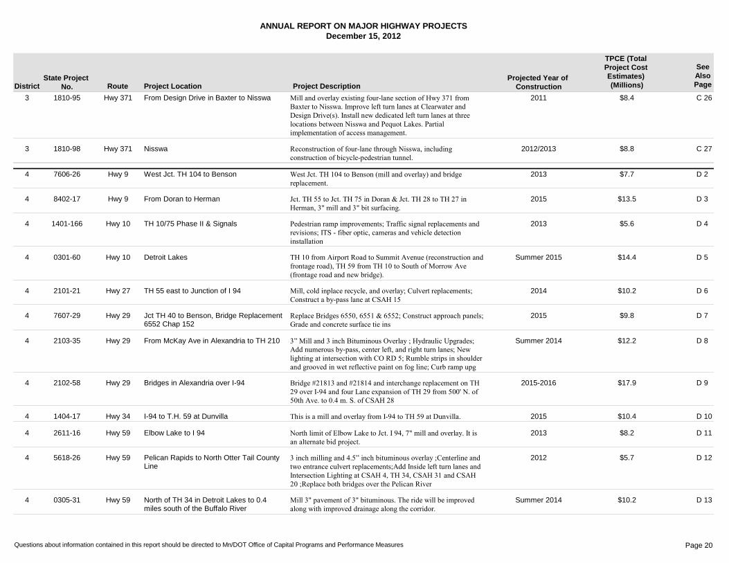
Hwy 371 From Design Drive in Baxter to Nisswa C 263 2011 $8.41810-95 Mill and overlay existing four-lane section of Hwy 371 from Baxter to Nisswa. Improve left turn lanes at Clearwater and Design Drive(s). Install new dedicated left turn lanes at three locations between Nisswa and Pequot Lakes. Partial implementation of access management.
Hwy 371 Nisswa C 273 2012/2013 $8.81810-98 Reconstruction of four-lane through Nisswa, including construction of bicycle-pedestrian tunnel.
Hwy 9 West Jct. TH 104 to Benson D 24 2013 $7.77606-26 West Jct. TH 104 to Benson (mill and overlay) and bridge replacement.
Hwy 9 From Doran to Herman D 34 2015 $13.58402-17 Jct. TH 55 to Jct. TH 75 in Doran & Jct. TH 28 to TH 27 in Herman, 3" mill and 3" bit surfacing.
Hwy 10 TH 10/75 Phase II & Signals D 44 2013 $5.61401-166 Pedestrian ramp improvements; Traffic signal replacements and revisions; ITS - fiber optic, cameras and vehicle detection installation
Hwy 10 Detroit Lakes D 54 Summer 2015 $14.40301-60 TH 10 from Airport Road to Summit Avenue (reconstruction and frontage road), TH 59 from TH 10 to South of Morrow Ave (frontage road and new bridge).
Hwy 27 TH 55 east to Junction of I 94 D 64 2014 $10.22101-21 Mill, cold inplace recycle, and overlay; Culvert replacements; Construct a by-pass lane at CSAH 15
Hwy 29 Jct TH 40 to Benson, Bridge Replacement 6552 Chap 152
D 74 2015 $9.87607-29 Replace Bridges 6550, 6551 & 6552; Construct approach panels; Grade and concrete surface tie ins
Hwy 29 From McKay Ave in Alexandria to TH 210 D 84 Summer 2014 $12.22103-35 3” Mill and 3 inch Bituminous Overlay ; Hydraulic Upgrades; Add numerous by-pass, center left, and right turn lanes; New lighting at intersection with CO RD 5; Rumble strips in shoulder and grooved in wet reflective paint on fog line; Curb ramp upg
Hwy 29 Bridges in Alexandria over I-94 D 94 2015-2016 $17.92102-58 Bridge #21813 and #21814 and interchange replacement on TH 29 over I-94 and four Lane expansion of TH 29 from 500' N. of 50th Ave. to 0.4 m. S. of CSAH 28
Hwy 34 I-94 to T.H. 59 at Dunvilla D 104 2015 $10.41404-17 This is a mill and overlay from I-94 to TH 59 at Dunvilla.
Hwy 59 Elbow Lake to I 94 D 114 2013 $8.22611-16 North limit of Elbow Lake to Jct. I 94, 7" mill and overlay. It is an alternate bid project.
Hwy 59 Pelican Rapids to North Otter Tail County Line
D 124 2012 $5.75618-26 3 inch milling and 4.5” inch bituminous overlay ;Centerline and two entrance culvert replacements;Add Inside left turn lanes and Intersection Lighting at CSAH 4, TH 34, CSAH 31 and CSAH 20 ;Replace both bridges over the Pelican River
Hwy 59 North of TH 34 in Detroit Lakes to 0.4 miles south of the Buffalo River
D 134 Summer 2014 $10.20305-31 Mill 3" pavement of 3" bituminous. The ride will be improved along with improved drainage along the corridor.
Questions about information contained in this report should be directed to Mn/DOT Office of Capital Programs and Performance Measures Page 20
ANNUAL REPORT ON MAJOR HIGHWAY PROJECTSDecember 15, 2012
District Route Project Location Project DescriptionProjected Year of
Construction
TPCE (Total Project Cost Estimates) (Millions)
SeeAlsoPage
State Project No.
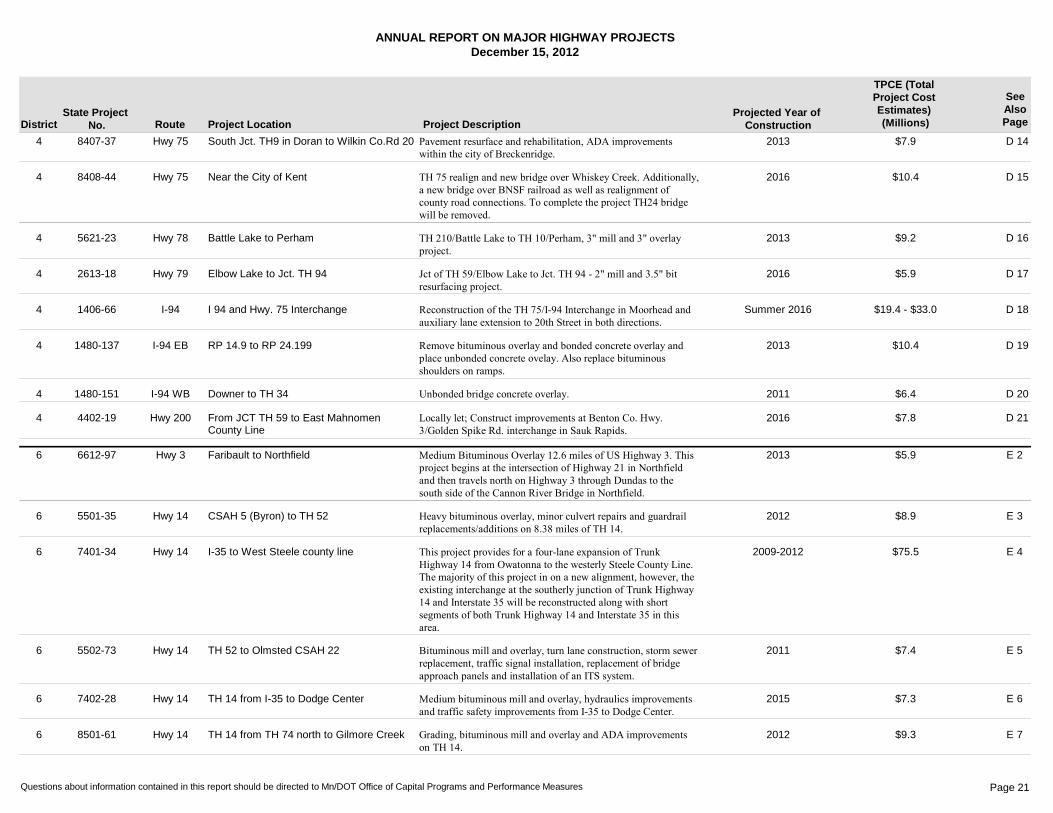
Hwy 75 South Jct. TH9 in Doran to Wilkin Co.Rd 20 D 144 2013 $7.98407-37 Pavement resurface and rehabilitation, ADA improvements within the city of Breckenridge.
Hwy 75 Near the City of Kent D 154 2016 $10.48408-44 TH 75 realign and new bridge over Whiskey Creek. Additionally, a new bridge over BNSF railroad as well as realignment of county road connections. To complete the project TH24 bridge will be removed.
Hwy 78 Battle Lake to Perham D 164 2013 $9.25621-23 TH 210/Battle Lake to TH 10/Perham, 3" mill and 3" overlay project.
Hwy 79 Elbow Lake to Jct. TH 94 D 174 2016 $5.92613-18 Jct of TH 59/Elbow Lake to Jct. TH 94 - 2" mill and 3.5" bit resurfacing project.
I-94 I 94 and Hwy. 75 Interchange D 184 Summer 2016 $19.4 - $33.01406-66 Reconstruction of the TH 75/I-94 Interchange in Moorhead and auxiliary lane extension to 20th Street in both directions.
I-94 EB RP 14.9 to RP 24.199 D 194 2013 $10.41480-137 Remove bituminous overlay and bonded concrete overlay and place unbonded concrete ovelay. Also replace bituminous shoulders on ramps.
I-94 WB Downer to TH 34 D 204 2011 $6.41480-151 Unbonded bridge concrete overlay.
Hwy 200 From JCT TH 59 to East Mahnomen County Line
D 214 2016 $7.84402-19 Locally let; Construct improvements at Benton Co. Hwy. 3/Golden Spike Rd. interchange in Sauk Rapids.
Hwy 3 Faribault to Northfield E 26 2013 $5.96612-97 Medium Bituminous Overlay 12.6 miles of US Highway 3. This project begins at the intersection of Highway 21 in Northfield and then travels north on Highway 3 through Dundas to the south side of the Cannon River Bridge in Northfield.
Hwy 14 CSAH 5 (Byron) to TH 52 E 36 2012 $8.95501-35 Heavy bituminous overlay, minor culvert repairs and guardrail replacements/additions on 8.38 miles of TH 14.
Hwy 14 I-35 to West Steele county line E 46 2009-2012 $75.57401-34 This project provides for a four-lane expansion of Trunk Highway 14 from Owatonna to the westerly Steele County Line. The majority of this project in on a new alignment, however, the existing interchange at the southerly junction of Trunk Highway 14 and Interstate 35 will be reconstructed along with short segments of both Trunk Highway 14 and Interstate 35 in this area.
Hwy 14 TH 52 to Olmsted CSAH 22 E 56 2011 $7.45502-73 Bituminous mill and overlay, turn lane construction, storm sewer replacement, traffic signal installation, replacement of bridge approach panels and installation of an ITS system.
Hwy 14 TH 14 from I-35 to Dodge Center E 66 2015 $7.37402-28 Medium bituminous mill and overlay, hydraulics improvements and traffic safety improvements from I-35 to Dodge Center.
Hwy 14 TH 14 from TH 74 north to Gilmore Creek E 76 2012 $9.38501-61 Grading, bituminous mill and overlay and ADA improvements on TH 14.
Questions about information contained in this report should be directed to Mn/DOT Office of Capital Programs and Performance Measures Page 21
ANNUAL REPORT ON MAJOR HIGHWAY PROJECTSDecember 15, 2012
District Route Project Location Project DescriptionProjected Year of
Construction
TPCE (Total Project Cost Estimates) (Millions)
SeeAlsoPage
State Project No.
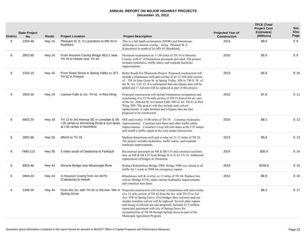
Hwy 16 Pleasant St. E. in Lanesboro to MN 43 in Rushford
E 86 2013 $9.82304-48 This is a full depth reclamation (SFDR) and bituminous surfacing or concrete overlay - along�Pleasant St. E. (Lanesboro) to north of Jct MN 43 (Rushford).
Hwy 16 From Houston County Bridge 95111 near TH 76 to Hokah near TH 44
E 96 2010 $5.52801-80 Pavement reclamation on 11.88 miles of TH 16 in Houston County, with 6" of bituminous pavement provided. The project includes hydraulics, traffic safety and roadside hardware improvements.
Hwy 16 From Grant Street in Spring Valley to JCT. TH 52 in Preston
E 106 2013 $5.82315-15 Better Roads For Minnesota Project. Proposed construction will include a bituminous mill and overlay of an 15.344-mile section of �TH 16 from Grant St. in Spring Valley, MN to 790 ft. W. of the W. Jct. T.H. 52. It is anticipated that one bypass lane will be added and 17 culverts will be replaced as part of this project.
Hwy 19 Cannon Falls to Jct. TH 61 in Red Wing E 116 2012 $7.82503-30 Proposed construction will include bituminous reclamation and resurfacing of a 15.56-mile section of TH 19 from 0.04 mi. east of the Jct. Almond St. in Cannon Falls, MN to Jct. TH 61 in Red Wing, MN. The project will also include nine culvert replacements. A right turnlane and a bypass lane are also proposed to be constructed.
Hwy 19 TH 13 to 3rd Avenue SE in Lonsdale & SB I-35 ramps to Armstrong Road & turn lanes at I-35 ramps in Northfield
E 126 2010 $8.16602-25 Mill and overlay 15.08 miles of TH 19. �Construct hydraulics improvements.�Construct turn lanes and other traffic safety improvements.�Construct 2-way left turn lanes at the I-35 ramps and install a traffic signal at the west ramps intersection.
Hwy 26 MN/IA to TH 16 E 136 2013 $5.82802-66 Medium bituminous mill and overlay on 21.12 miles of TH 26. The project includes hydraulics, traffic safety, and roadside hardware improvements.
Hwy 35 5 miles south of Owatonna to Faribault E 146 2014 $30.47480-113 Reconstruct pavement on NB & SB I-35 and construct auxiliary lane on NB & SB I-35 from Bridge St to N Jct US 14. Additional replacement of bridges in Owatonna.
Hwy 43 Winona Bridge over Mississippi River E 156 2015 $158.68503-46 Replace/Rehabilitate Bridge 5900. Bridge 5900 was closed to all traffic for 1 week in 2008 for emergency repairs.
Hwy 44 In Houston County from Jct 44/76 (Caledonia) to Hokah
E 166 2012 $8.92804-33 Bituminous mill & overlay on 13 miles of TH 44. Replace box culvert (Bridge 8158), make various hydraulics improvements and construct turn lanes.
Hwy 44 From the Jct. with TH 52 to 3rd Ave. NW in Spring Grove
E 176 $8.22308-26 Proposed construction will include a bituminous mill and overlay of a 13 mile section of TH 44 from the Jct. with TH 52 to 3rd Ave. NW in Spring Grove. Five bridges (box culverts) and one smaller mainline culvert will be replaced. Several other repairs and lining of culverts are also proposed. Includes $1.5 million municipal agreement with city of Spring Grove for reconstruction of TH 44 through Spring Grove as part of the Municipal Agreement Program.
Questions about information contained in this report should be directed to Mn/DOT Office of Capital Programs and Performance Measures Page 22
ANNUAL REPORT ON MAJOR HIGHWAY PROJECTSDecember 15, 2012
District Route Project Location Project DescriptionProjected Year of
Construction
TPCE (Total Project Cost Estimates) (Millions)
SeeAlsoPage
State Project No.
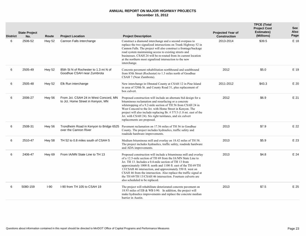
Hwy 52 Cannon Falls interchange E 186 2013-2014 $39.52506-52 Construct a diamond interchange and a second overpass to replace the two signalized intersections on Trunk Highway 52 in Cannon Falls. The project will also construct a frontage/backage road system maintaining access to existing streets and businesses. CSAH 24 will be re-routed from its current location at the northern most signalized intersection to the new interchange.
Hwy 52 85th St N of Rochester to 1.3 mi N of Goodhue CSAH near Zumbrota
E 196 2012 $5.02505-49 Concrete pavement rehabilitation northbound and southbound from 85th Street (Rochester) to 1.3 miles north of Goodhue CSAH 7 (Near Zumbrota).
Hwy 52 Elk Run interchange E 206 2011-2012 $43.32505-48 New interchange in Olmsted County at CSAH 12 in Pine Island in area of 520th St. and County Road 31, plus replacement of box culvert.
Hwy 56 From Jct. CSAH 24 in West Concord, MN to Jct. Home Street in Kenyon, MN
E 216 2012 $6.92006-27 Proposed construction will include an alternate bid design for a bituminous reclamation and resurfacing or a concrete whitetopping of a 9.2-mile section of TH 56 from CSAH 24 in West Concord to the Jct. with Home Street in Kenyon. The project will also include replacing Br. # 5713 (1.8 mi. east of the Jct. with CSAH 24). Six right turnlanes, and six culvert replacements are proposed.
Hwy 56 Trondheim Road in Kenyon to Bridge 6525 over the Cannon River
E 226 2013 $7.92508-31 Pavement reclamation on 17.56 miles of TH 56 in Goodhue County. The project includes hydraulics, traffic safety and roadside hardware improvements.
Hwy 58 TH 52 to 0.8 miles south of CSAH 5 E 236 2013 $5.92510-47 Medium bituminous mill and overlay on 18.42 miles of TH 58. The project includes hydraulics, traffic safety, roadside hardware and ADA improvements.
Hwy 69 From IA/MN State Line to TH 13 E 246 2013 $4.82406-47 Proposed construction will include a bituminous mill and overlay of a 12.5-mile section of TH 69 from the IA/MN State Line to Jct. TH 13. Includes a 0.4-mile section of TH 13 from approximately 1000 ft. north and 1100 ft. east of the TH 69/TH 13/CSAH 46 intersection, and approximately 350 ft. west on CSAH 46 from the intersection. Also replace the traffic signal at the TH 69/TH 13/CSAH 46 intersection. Fourteen culverts are also scheduled to be replaced.
I-90 I-90 from TH 105 to CSAH 19 E 256 2013 $7.55080-159 The project will rehabilitate deteriorated concrete pavement on 18.93 miles of EB & WB I-90.�In addition, the project will make hydraulics improvements and replace the concrete median barrier in Austin.
Questions about information contained in this report should be directed to Mn/DOT Office of Capital Programs and Performance Measures Page 23
ANNUAL REPORT ON MAJOR HIGHWAY PROJECTSDecember 15, 2012
District Route Project Location Project DescriptionProjected Year of
Construction
TPCE (Total Project Cost Estimates) (Millions)
SeeAlsoPage
State Project No.
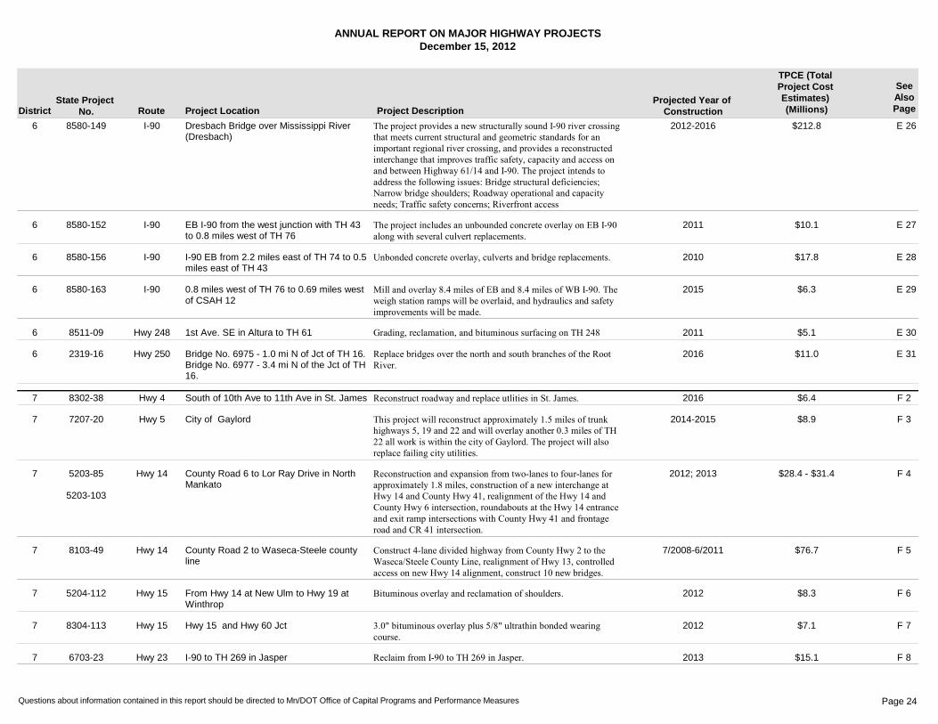
I-90 Dresbach Bridge over Mississippi River (Dresbach)
E 266 2012-2016 $212.88580-149 The project provides a new structurally sound I-90 river crossing that meets current structural and geometric standards for an important regional river crossing, and provides a reconstructed interchange that improves traffic safety, capacity and access on and between Highway 61/14 and I-90. The project intends to address the following issues: Bridge structural deficiencies; Narrow bridge shoulders; Roadway operational and capacity needs; Traffic safety concerns; Riverfront access
I-90 EB I-90 from the west junction with TH 43 to 0.8 miles west of TH 76
E 276 2011 $10.18580-152 The project includes an unbounded concrete overlay on EB I-90 along with several culvert replacements.
I-90 I-90 EB from 2.2 miles east of TH 74 to 0.5 miles east of TH 43
E 286 2010 $17.88580-156 Unbonded concrete overlay, culverts and bridge replacements.
I-90 0.8 miles west of TH 76 to 0.69 miles west of CSAH 12
E 296 2015 $6.38580-163 Mill and overlay 8.4 miles of EB and 8.4 miles of WB I-90. The weigh station ramps will be overlaid, and hydraulics and safety improvements will be made.
Hwy 248 1st Ave. SE in Altura to TH 61 E 306 2011 $5.18511-09 Grading, reclamation, and bituminous surfacing on TH 248
Hwy 250 Bridge No. 6975 - 1.0 mi N of Jct of TH 16.Bridge No. 6977 - 3.4 mi N of the Jct of TH 16.
E 316 2016 $11.02319-16 Replace bridges over the north and south branches of the Root River.
Hwy 4 South of 10th Ave to 11th Ave in St. James F 27 2016 $6.48302-38 Reconstruct roadway and replace utlities in St. James.
Hwy 5 City of Gaylord F 37 2014-2015 $8.97207-20 This project will reconstruct approximately 1.5 miles of trunk highways 5, 19 and 22 and will overlay another 0.3 miles of TH 22 all work is within the city of Gaylord. The project will also replace failing city utilities.
Hwy 14 County Road 6 to Lor Ray Drive in North Mankato
F 47 2012; 2013 $28.4 - $31.45203-85
5203-103
Reconstruction and expansion from two-lanes to four-lanes for approximately 1.8 miles, construction of a new interchange at Hwy 14 and County Hwy 41, realignment of the Hwy 14 and County Hwy 6 intersection, roundabouts at the Hwy 14 entrance and exit ramp intersections with County Hwy 41 and frontage road and CR 41 intersection.
Hwy 14 County Road 2 to Waseca-Steele county line
F 57 7/2008-6/2011 $76.78103-49 Construct 4-lane divided highway from County Hwy 2 to the Waseca/Steele County Line, realignment of Hwy 13, controlled access on new Hwy 14 alignment, construct 10 new bridges.
Hwy 15 From Hwy 14 at New Ulm to Hwy 19 at Winthrop
F 67 2012 $8.35204-112 Bituminous overlay and reclamation of shoulders.
Hwy 15 Hwy 15 and Hwy 60 Jct F 77 2012 $7.18304-113 3.0" bituminous overlay plus 5/8" ultrathin bonded wearing course.
Hwy 23 I-90 to TH 269 in Jasper F 87 2013 $15.16703-23 Reclaim from I-90 to TH 269 in Jasper.
Questions about information contained in this report should be directed to Mn/DOT Office of Capital Programs and Performance Measures Page 24
ANNUAL REPORT ON MAJOR HIGHWAY PROJECTSDecember 15, 2012
District Route Project Location Project DescriptionProjected Year of
Construction
TPCE (Total Project Cost Estimates) (Millions)
SeeAlsoPage
State Project No.
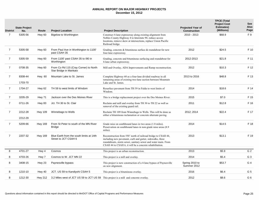
Hwy 60 Bigelow to Worthington F 97 2010 - 2013 $68.95305-56 Construct 4-lane expressway along existing alignment from Nobles County Highway 4 to Interstate 90, reduce access locations, remove skew at intersections, replace Union Pacific Railroad bridge.
Hwy 60 From Paul Ave in Worthington to 1100' past CSAH 35
F 107 2012 $24.55305-58 Grading, concrete & bituminous surface & roundabout for new four-lane expressway.
Hwy 60 From 1100' past CSAH 35 to I90 in Worthington
F 117 2012-2013 $21.85305-59 Grading, concrete and bituminous surfacing and roundabout for 4-lane urban expressway.
Hwy 60 From Co Rd 115 (Cray Corner) to North Star Bridge in Mankato
F 127 2012 $10.30708-35 Mill and Overlay, ADA Improvements and Ramp reconstruction.
Hwy. 60 Mountain Lake to St. James F 137 2013 to 2016 $48.88308-44
1703-70
Complete Highway 60 as a four-lane divided roadway in all remaining areas of existing two-lane section between Mountain Lake and St. James.
Hwy 62 TH 59 to west limits of Windom F 147 2014 $18.61704-27 Resurface pavement from TH 59 in Fulda to west limits of Windom.
Hwy 71 Jackson over the Des Moines River F 157 2015 $7.03205-29 This is a bridge replacement project over the Des Moines River.
Hwy 83 Jct. TH 30 to St. Clair F 167 2011 $12.80711-26 Reclaim and mill and overlay from TH 30 to TH 22 as well as removal of the existing guard rail.
Hwy 109 Winnebago to Wells F 177 2012; 2014 $22.42212-28
2212-29
Reclaim TH 109 from Winnebago to Wells. This will be done as either a bituminous reclamation or concrete alternate paving.
Hwy 169 From St Peter to south of the MN River Bridge
F 187 2014 $14.55209-66 Grade raise on southbound lanes in two areas (1.8 miles). Preservation on southbound lanes in non-grade raise areas (8.9 miles).
Hwy 169 Blue Earth from the south limits at 14th Street to JCT CSAH 6
F 197 2013 $13.12207-32 Reconstruction from 550’ north of railroad bridge to CSAH 44, including new pavement, curb and gutter, sidewalks, three roundabouts, storm sewer, sanitary sewer and water main. From CSAH 44 to CSAH 6, it will be a concrete rehabilitation.
Hwy 4 Cosmos G 28 2013 $5.94701-27 This project is an urban reconstruction.
Hwy 7 Cosmos to W. JCT MN 22 G 38 2014 $5.44703-26 This project is a mill and overlay.
Hwy 23 Paynesville bypass G 48 Spring 2010 to Summer 2012
$53.73408-15 This project is new construction of a 4-lane bypass of Paynesville on new alignment.
Hwy 40 JCT. US 59 to Kandiyohi CSAH 5 G 58 2016 $6.41210-10 This project is a bituminous overlay.
Hwy 212 3.2 Miles west of JCT US 59 to JCT US 59 G 68 2012 $8.61212-30 This project is a mill and concrete overlay.
Questions about information contained in this report should be directed to Mn/DOT Office of Capital Programs and Performance Measures Page 25

ANNUAL REPORT ON MAJOR HIGHWAY PROJECTSDecember 15, 2012
District Route Project Location Project DescriptionProjected Year of
Construction
TPCE (Total Project Cost Estimates) (Millions)
SeeAlsoPage
State Project No.
Hwy 212 0.2 Miles west of US 75 to First Street in Dawson
G 78 2012 $6.63706-39 This project is a mill and concrete overlay.
Hwy 7 At Louisana Ave in St. Louis Park H 2M 2013 $23.32706-226 Construction of a grade separated interchange at the intersection of TH 7 and Louisianna Avenue in St. Louis Park.
Hwy 13 New Interchange at CSAH 5 in Burnsville H 3M 2013/2014 $40.61901-148 Construct grade separated interchange at TH 13/CSAH 5 in Burnsville. The construction will add a new bridge (with trail) to carry CSAH 5 over TH 13. Construction will include noisewalls, retaining wall and ponding.
I-35E Cayuga Bridge between University Avenue and Maryland Avenue (Cayuga)
H 4M 2012-2015 $194.26280-308
6280-353
Cayuga Bridge (6515) replacement, Pennsylvania Ave. Bridge (9265) replacement, BNSF RR Bridge (6517) replacement, replace Pennsylvania interchange with interchange at Cayuga to solve safety and operational problems, geometric improvements on 35E.
I-35E I-35E between Pennsylvania ave and Little Canada Road
H 5M 2014 $111.06280-367 The I-35E MnPASS Project includes:�Long-term pavement rehabilitation between Maryland Ave. and Little Canada Rd.�Replacement of the Arlington, Wheelock and Larpenteur bridges. Replacement of the I-35E mainline bridges at Roselawn, CR B and Hwy. 36�Constru
I-35E From south of Ramsey Co CSAH 96 to north junction I-35W
H 6M 2011/2012 $25.40282-34
6281-23
Unbonded concrete overlay on I-35E from south of Ramsey Co CSAH 96 to the north junction of I-35W, drainage corrections, cable median guardrail.
I-35W From 3rd & 4th St ramp to Johnson St. in Minneapolis
H 7M 2013 $13.42783-136 Construct new entrance ramp from downtown Minneapolis to north bound I-35W, construct auxillary lane from 3rd and 4th Street north to Johnson St.
Hwy 36 St. Croix Crossing project in Oak Park Heights, Stillwater, & Bayport
H 8M 2013-2016 $626.48221-01
8214-114
Major river bridge replacement, two intersections, one interchange in Minnesota; one interchange and one overpass in Wisconsin. Project costs are to be split with WisDOT.
Hwy 36 From Hazelwood Ave to US 61 in Maplewood
H 9M 2013 $21.36211-90 Construction of a grade seperated interchange at the intersection of English St and Hwy 36 in Maplewood.
Hwy 36 Over Lexington Ave in Roseville H 10M late 2014-2015 $16.16212-148 Replace Lexington Ave Bridge No. 5723, reconstruct Lexington Ave. and access ramps, replace two signals at the ramp terminals, address ADA deficiencies on multiuse trail, construct guardrail, drainage ponds, and storm sewers.
Hwy 52 Lafayette River Bridge over Mississippi River in St. Paul
H 11M 2013-2015 $172.76244-30 Major river bridge replacement, ramps, loops to I-94 and connection to East 7th Street, replace/rehab Hwy 52 bridge over Plato Blvd and Hwy 52 bridge over I-94 as well as a full length pedestrian bridge.
Questions about information contained in this report should be directed to Mn/DOT Office of Capital Programs and Performance Measures Page 26
ANNUAL REPORT ON MAJOR HIGHWAY PROJECTSDecember 15, 2012
District Route Project Location Project DescriptionProjected Year of
Construction
TPCE (Total Project Cost Estimates) (Millions)
SeeAlsoPage
State Project No.
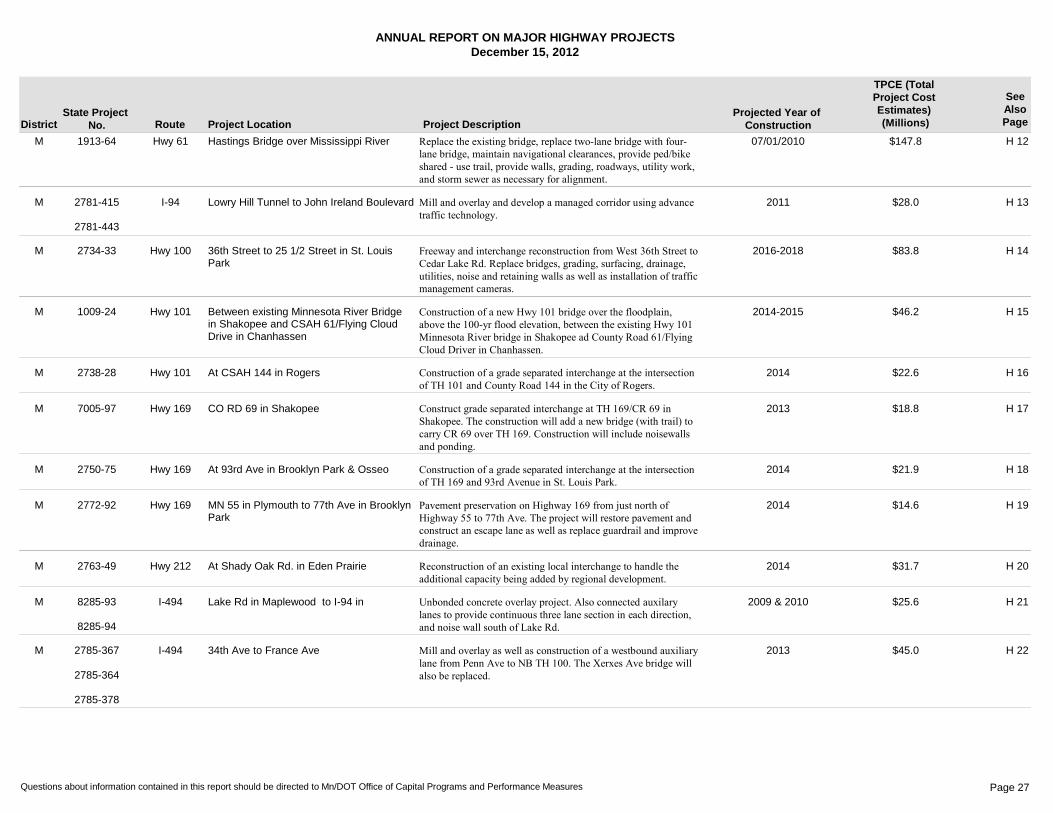
Hwy 61 Hastings Bridge over Mississippi River H 12M 07/01/2010 $147.81913-64 Replace the existing bridge, replace two-lane bridge with four-lane bridge, maintain navigational clearances, provide ped/bike shared - use trail, provide walls, grading, roadways, utility work, and storm sewer as necessary for alignment.
I-94 Lowry Hill Tunnel to John Ireland Boulevard H 13M 2011 $28.02781-415
2781-443
Mill and overlay and develop a managed corridor using advance traffic technology.
Hwy 100 36th Street to 25 1/2 Street in St. Louis Park
H 14M 2016-2018 $83.82734-33 Freeway and interchange reconstruction from West 36th Street to Cedar Lake Rd. Replace bridges, grading, surfacing, drainage, utilities, noise and retaining walls as well as installation of traffic management cameras.
Hwy 101 Between existing Minnesota River Bridge in Shakopee and CSAH 61/Flying Cloud Drive in Chanhassen
H 15M 2014-2015 $46.21009-24 Construction of a new Hwy 101 bridge over the floodplain, above the 100-yr flood elevation, between the existing Hwy 101 Minnesota River bridge in Shakopee ad County Road 61/Flying Cloud Driver in Chanhassen.
Hwy 101 At CSAH 144 in Rogers H 16M 2014 $22.62738-28 Construction of a grade separated interchange at the intersection of TH 101 and County Road 144 in the City of Rogers.
Hwy 169 CO RD 69 in Shakopee H 17M 2013 $18.87005-97 Construct grade separated interchange at TH 169/CR 69 in Shakopee. The construction will add a new bridge (with trail) to carry CR 69 over TH 169. Construction will include noisewalls and ponding.
Hwy 169 At 93rd Ave in Brooklyn Park & Osseo H 18M 2014 $21.92750-75 Construction of a grade separated interchange at the intersection of TH 169 and 93rd Avenue in St. Louis Park.
Hwy 169 MN 55 in Plymouth to 77th Ave in Brooklyn Park
H 19M 2014 $14.62772-92 Pavement preservation on Highway 169 from just north of Highway 55 to 77th Ave. The project will restore pavement and construct an escape lane as well as replace guardrail and improve drainage.
Hwy 212 At Shady Oak Rd. in Eden Prairie H 20M 2014 $31.72763-49 Reconstruction of an existing local interchange to handle the additional capacity being added by regional development.
I-494 Lake Rd in Maplewood to I-94 in H 21M 2009 & 2010 $25.68285-93
8285-94
Unbonded concrete overlay project. Also connected auxilary lanes to provide continuous three lane section in each direction, and noise wall south of Lake Rd.
I-494 34th Ave to France Ave H 22M 2013 $45.02785-367
2785-364
2785-378
Mill and overlay as well as construction of a westbound auxiliary lane from Penn Ave to NB TH 100. The Xerxes Ave bridge will also be replaced.
Questions about information contained in this report should be directed to Mn/DOT Office of Capital Programs and Performance Measures Page 27

ANNUAL REPORT ON MAJOR HIGHWAY PROJECTSDecember 15, 2012
District Route Project Location Project DescriptionProjected Year of
Construction
TPCE (Total Project Cost Estimates) (Millions)
SeeAlsoPage
State Project No.
I-494 Interchange in Bloomington H 23M Nov 10 - Nov 12 $170.02776-03 Remove three signals, connect the north and south frontage roads under Hwy 169, convert expressway to freeway with partial-directional interchange reconstruction, construct noise barriers/visual barriers, and construct drainage and water quality facilities.
I-694 From 40th St. in Oakdale to just W. of US 61 in Vadnais Heights
H 24M 2012 $23.56286-56 This project is an unbonded concrete overlay.
Hwy 610 New alignment Hwy. 169 to Hennepin County Road 81 (Elm Creek Blvd)
H 25M 2009-2011 $49.82771-38 This project is to continue the construction of Hwy 610. It will extend a four-lane freeway section from Hwy 169 to Hennepin County Road 81 on new alignment. The project will help complete the next step in extending the National Highway System between I-94 and I-35W in the northern Twin Cities metropolitan area.
I-694 From Lexington Avenue to west of Old Highway 10
H 26M 2011-2013 $55.36285-135 US 10 southbound to eastbound left entrance to I-694 and merge to Snelling and southbound Hamline to eastbound I-694 interchange reconstruction.
Questions about information contained in this report should be directed to Mn/DOT Office of Capital Programs and Performance Measures Page 28
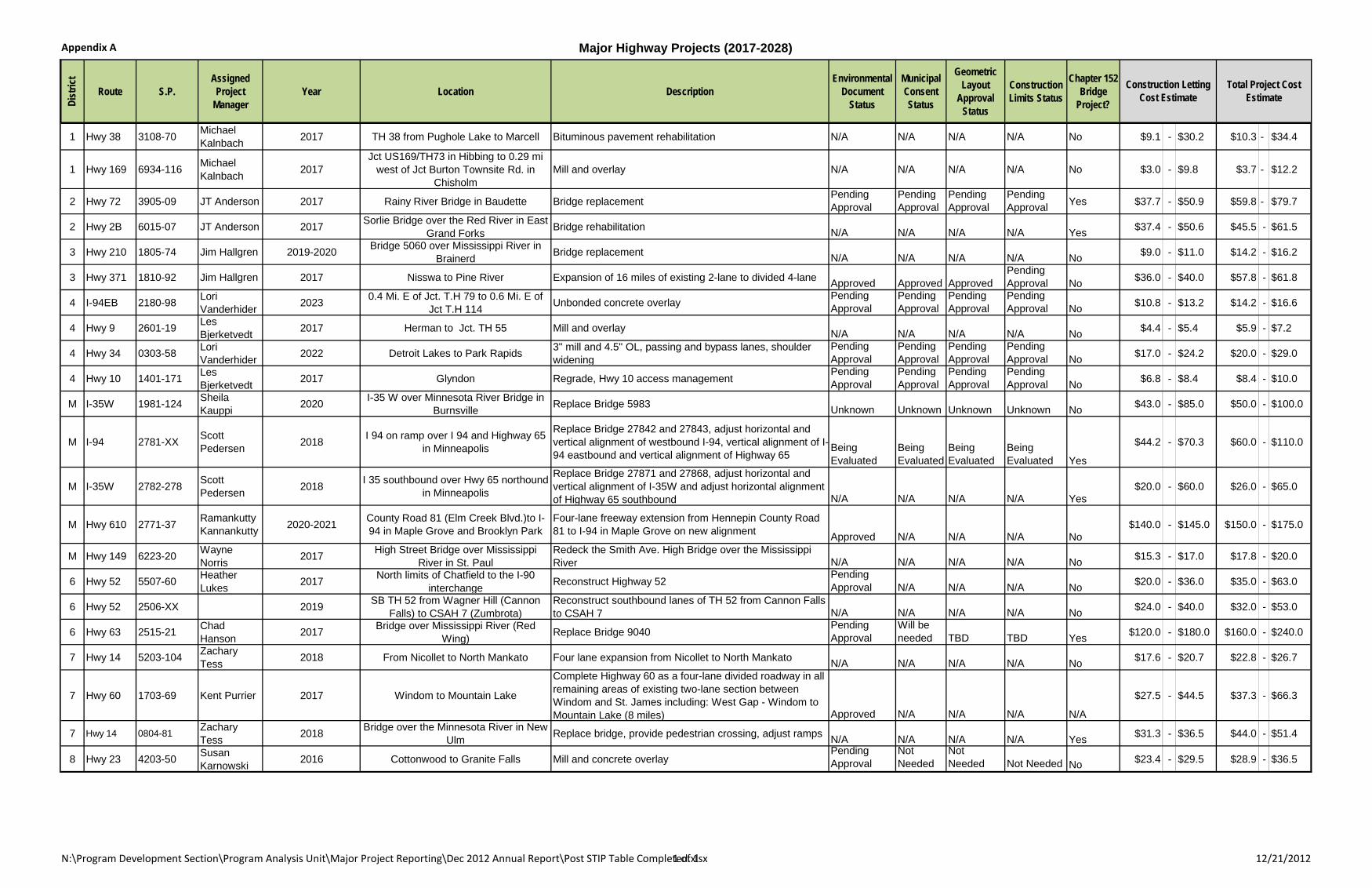
Appendix A Major Highway Projects (2017-2028)
N:\Program Development Section\Program Analysis Unit\Major Project Reporting\Dec 2012 Annual Report\Post STIP Table Completed.xlsx1 of 1 12/21/2012
Dist
rict
Route S.P.Assigned
Project Manager
Year Location DescriptionEnvironmental
Document Status
Municipal Consent Status
Geometric Layout
Approval Status
Construction Limits Status
Chapter 152 Bridge
Project?
1 Hwy 38 3108-70 Michael Kalnbach 2017 TH 38 from Pughole Lake to Marcell Bituminous pavement rehabilitation N/A N/A N/A N/A No $9.1 - $30.2 $10.3 - $34.4
1 Hwy 169 6934-116 Michael Kalnbach 2017
Jct US169/TH73 in Hibbing to 0.29 mi west of Jct Burton Townsite Rd. in
ChisholmMill and overlay N/A N/A N/A N/A No $3.0 - $9.8 $3.7 - $12.2
2 Hwy 72 3905-09 JT Anderson 2017 Rainy River Bridge in Baudette Bridge replacementPending Approval
Pending Approval
Pending Approval
Pending Approval Yes $37.7 - $50.9 $59.8 - $79.7
2 Hwy 2B 6015-07 JT Anderson 2017 Sorlie Bridge over the Red River in East Grand Forks Bridge rehabilitation N/A N/A N/A N/A Yes $37.4 - $50.6 $45.5 - $61.5
3 Hwy 210 1805-74 Jim Hallgren 2019-2020 Bridge 5060 over Mississippi River in Brainerd Bridge replacement N/A N/A N/A N/A No $9.0 - $11.0 $14.2 - $16.2
3 Hwy 371 1810-92 Jim Hallgren 2017 Nisswa to Pine River Expansion of 16 miles of existing 2-lane to divided 4-lane Approved Approved ApprovedPending Approval No $36.0 - $40.0 $57.8 - $61.8
4 I-94EB 2180-98 Lori Vanderhider 2023 0.4 Mi. E of Jct. T.H 79 to 0.6 Mi. E of
Jct T.H 114 Unbonded concrete overlayPending Approval
Pending Approval
Pending Approval
Pending Approval No $10.8 - $13.2 $14.2 - $16.6
4 Hwy 9 2601-19 Les Bjerketvedt 2017 Herman to Jct. TH 55 Mill and overlay N/A N/A N/A N/A No $4.4 - $5.4 $5.9 - $7.2
4 Hwy 34 0303-58 Lori Vanderhider 2022 Detroit Lakes to Park Rapids 3" mill and 4.5" OL, passing and bypass lanes, shoulder
wideningPending Approval
Pending Approval
Pending Approval
Pending Approval No $17.0 - $24.2 $20.0 - $29.0
4 Hwy 10 1401-171 Les Bjerketvedt 2017 Glyndon Regrade, Hwy 10 access management
Pending Approval
Pending Approval
Pending Approval
Pending Approval No $6.8 - $8.4 $8.4 - $10.0
M I-35W 1981-124 Sheila Kauppi 2020 I-35 W over Minnesota River Bridge in
Burnsville Replace Bridge 5983 Unknown Unknown Unknown Unknown No $43.0 - $85.0 $50.0 - $100.0
M I-94 2781-XX Scott Pedersen 2018 I 94 on ramp over I 94 and Highway 65
in Minneapolis
Replace Bridge 27842 and 27843, adjust horizontal and vertical alignment of westbound I-94, vertical alignment of I-94 eastbound and vertical alignment of Highway 65
Being Evaluated
Being Evaluated
Being Evaluated
Being Evaluated Yes
$44.2 - $70.3 $60.0 - $110.0
M I-35W 2782-278 Scott Pedersen 2018 I 35 southbound over Hwy 65 northound
in Minneapolis
Replace Bridge 27871 and 27868, adjust horizontal and vertical alignment of I-35W and adjust horizontal alignment of Highway 65 southbound N/A N/A N/A N/A Yes
$20.0 - $60.0 $26.0 - $65.0
M Hwy 610 2771-37 Ramankutty Kannankutty 2020-2021 County Road 81 (Elm Creek Blvd.)to I-
94 in Maple Grove and Brooklyn ParkFour-lane freeway extension from Hennepin County Road 81 to I-94 in Maple Grove on new alignment Approved N/A N/A N/A No
$140.0 - $145.0 $150.0 - $175.0
M Hwy 149 6223-20 Wayne Norris 2017 High Street Bridge over Mississippi
River in St. PaulRedeck the Smith Ave. High Bridge over the Mississippi River N/A N/A N/A N/A No $15.3 - $17.0 $17.8 - $20.0
6 Hwy 52 5507-60 Heather Lukes 2017 North limits of Chatfield to the I-90
interchange Reconstruct Highway 52Pending Approval N/A N/A N/A No $20.0 - $36.0 $35.0 - $63.0
6 Hwy 52 2506-XX 2019 SB TH 52 from Wagner Hill (Cannon Falls) to CSAH 7 (Zumbrota)
Reconstruct southbound lanes of TH 52 from Cannon Falls to CSAH 7 N/A N/A N/A N/A No $24.0 - $40.0 $32.0 - $53.0
6 Hwy 63 2515-21 Chad Hanson 2017 Bridge over Mississippi River (Red
Wing) Replace Bridge 9040Pending Approval
Will be needed TBD TBD Yes $120.0 - $180.0 $160.0 - $240.0
7 Hwy 14 5203-104 Zachary Tess 2018 From Nicollet to North Mankato Four lane expansion from Nicollet to North Mankato N/A N/A N/A N/A No $17.6 - $20.7 $22.8 - $26.7
7 Hwy 60 1703-69 Kent Purrier 2017 Windom to Mountain Lake
Complete Highway 60 as a four-lane divided roadway in all remaining areas of existing two-lane section between Windom and St. James including: West Gap - Windom to Mountain Lake (8 miles) Approved N/A N/A N/A N/A
$27.5 - $44.5 $37.3 - $66.3
7 Hwy 14 0804-81 Zachary Tess 2018 Bridge over the Minnesota River in New
Ulm Replace bridge, provide pedestrian crossing, adjust ramps N/A N/A N/A N/A Yes $31.3 - $36.5 $44.0 - $51.4
8 Hwy 23 4203-50 Susan Karnowski 2016 Cottonwood to Granite Falls Mill and concrete overlay
Pending Approval
Not Needed
Not Needed Not Needed No $23.4 - $29.5 $28.9 - $36.5
Construction Letting Cost Estimate
Total Project Cost Estimate

Section 2 Environmental Mitigation and Compliance Costs Two Representative Trunk Highway Construction Projects
30
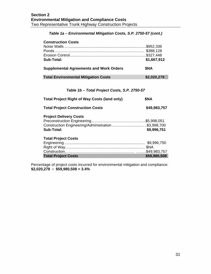
Project I: The Triangle (MnDOT Metro District) Location: Trunk Highway 169, Brooklyn Park and Osseo, Hennepin County MnDOT Project #: S.P. 2750-57 The reconstruction of 1.4 miles of Trunk Highway 169 raised the grade of the highway over the BNSF railroad tracks and local roadways. The project also included the reconstruction of County State Aid Highways 81 and 109. Eight new bridges were part of the interchange project. Environmental mitigation costs of $2,020,278 are detailed in Table 1a and account for roughly 3.4% of project costs. The total project cost (detailed in Table 1b) was $59,980,508. The construction cost of the project was $49,983,757, there were no right-of-way land-related costs and project engineering costs were $9,996,751.
Table 1a – Environmental Mitigation Costs, S.P. 2750-57 Environmental Documents (costs not included in mitigation costs) Environmental Assessment .................................................. .$192 Environmental Investigation Costs Historical/Cultural Resources…………………………………$528 Contamination Investigation………………………..................$18,064 Sub-Total: $18,592 Preconstruction Engineering Costs Noise Walls………………………………………………………$114,280 Ponds ................................................................................... $46,575 Erosion Control ..................................................................... .$39,294 Sub-Total: $200,149 Construction Engineering/Administration Costs Noise Walls .......................................................................... $76,187 Ponds ................................................................................... .$31,050 Erosion Control………………………………………………….$26,196 Sub-Total: $133,433 Right of Way Costs (land-related only) Ponds: .................................................................................. .$NA Wetlands (credits) ................................................................ $NA Sub-Total: $NA
Section 2 Environmental Mitigation and Compliance Costs Two Representative Trunk Highway Construction Projects
31
Table 1a – Environmental Mitigation Costs, S.P. 2750-57 (cont.) Construction Costs Noise Walls .......................................................................... ...$952,336 Ponds ................................................................................... . $388,128 Erosion Control ..................................................................... ...$327,448 Sub-Total: $1,667,912
Supplemental Agreements and Work Orders $NA Total Environmental Mitigation Costs $2,020,278
Table 1b – Total Project Costs, S.P. 2750-57 Total Project Right of Way Costs (land only) $NA Total Project Construction Costs $49,983,757 Project Delivery Costs Preconstruction Engineering…………………………………….$5,998,051 Construction Engineering/Administration ............................. …$3,998,700 Sub-Total: $9,996,751 Total Project Costs Engineering .......................................................................... .. $9,996,750 Right of Way ......................................................................... .. $NA Construction………………………………………………. ……..$49,983,757 Total Project Costs $59,980,508
Percentage of project costs incurred for environmental mitigation and compliance: $2,020,278 ÷ $59,980,508 = 3.4%
Section 2 Environmental Mitigation and Compliance Costs Two Representative Trunk Highway Construction Projects
32
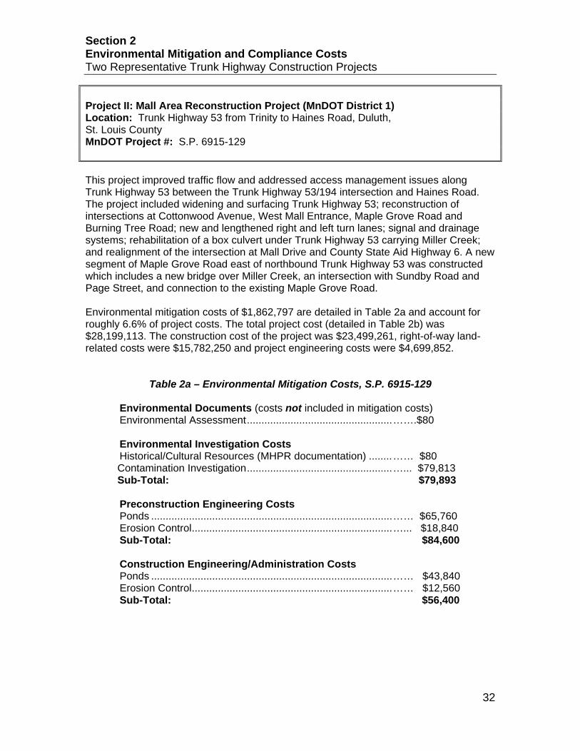
Project II: Mall Area Reconstruction Project (MnDOT District 1) Location: Trunk Highway 53 from Trinity to Haines Road, Duluth, St. Louis County MnDOT Project #: S.P. 6915-129 This project improved traffic flow and addressed access management issues along Trunk Highway 53 between the Trunk Highway 53/194 intersection and Haines Road. The project included widening and surfacing Trunk Highway 53; reconstruction of intersections at Cottonwood Avenue, West Mall Entrance, Maple Grove Road and Burning Tree Road; new and lengthened right and left turn lanes; signal and drainage systems; rehabilitation of a box culvert under Trunk Highway 53 carrying Miller Creek; and realignment of the intersection at Mall Drive and County State Aid Highway 6. A new segment of Maple Grove Road east of northbound Trunk Highway 53 was constructed which includes a new bridge over Miller Creek, an intersection with Sundby Road and Page Street, and connection to the existing Maple Grove Road. Environmental mitigation costs of $1,862,797 are detailed in Table 2a and account for roughly 6.6% of project costs. The total project cost (detailed in Table 2b) was $28,199,113. The construction cost of the project was $23,499,261, right-of-way land-related costs were $15,782,250 and project engineering costs were $4,699,852.
Table 2a – Environmental Mitigation Costs, S.P. 6915-129 Environmental Documents (costs not included in mitigation costs) Environmental Assessment .................................................. …….$80 Environmental Investigation Costs Historical/Cultural Resources (MHPR documentation) ........ …… $80
Contamination Investigation .................................................. …... $79,813 Sub-Total: $79,893
Preconstruction Engineering Costs Ponds ................................................................................... …… $65,760 Erosion Control ..................................................................... …... $18,840 Sub-Total: $84,600
Construction Engineering/Administration Costs Ponds ................................................................................... …… $43,840 Erosion Control ..................................................................... …… $12,560 Sub-Total: $56,400

Section 2 Environmental Mitigation and Compliance Costs Two Representative Trunk Highway Construction Projects
33
Table 2a – Environmental Mitigation Costs, S.P. 6915-129 cont.
Right of Way Costs (land-related only) Ponds ................................................................................... …$24,500 Wetlands (credits) ................................................................ …$1,350 Sub-Total: $25,850 Construction Costs Ponds ................................................................................... …$895,000 Erosion Control ..................................................................... …$548,000 Regulated Waste .................................................................. …$157,000 Sub-Total: $1,600,000 Supplemental Agreements and Work Orders Fish Weir………………………………………………………… $15,974 Sub-Total: $15,974 Total Environmental Mitigation Costs $1,862,797
Table 2b – Total Project Costs, S.P. 6915-129 Total Project Right of Way Costs (land only) $15,782,250 Total Project Construction Costs $23,499,261 Project Delivery Costs Preconstruction Engineering ................................................ $2,819,911 Construction Engineering/Administration ............................. .$1,879,941 Sub-Total: $4,699,852 Total Project Costs Engineering .......................................................................... .$4,699,852 Right of Way ......................................................................... .$15,782,250 Construction ......................................................................... $23,499,261 Total Project Costs $28,199,113
Percentage of project costs incurred for environmental mitigation and compliance: $1,862,797 ÷ $28,199,113 = 6.6 %
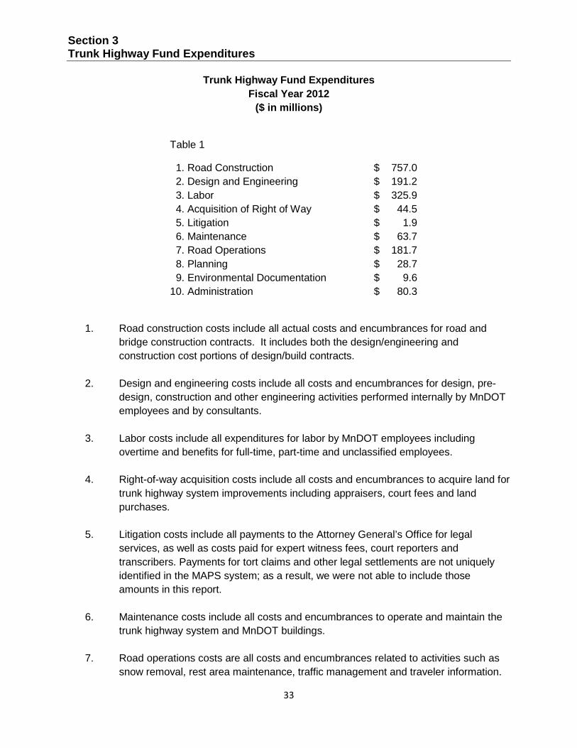
Section 3 Trunk Highway Fund Expenditures
33
Trunk Highway Fund Expenditures Fiscal Year 2012
($ in millions)
Table 1
1. Road Construction $ 757.0 2. Design and Engineering $ 191.2 3. Labor $ 325.9 4. Acquisition of Right of Way $ 44.5 5. Litigation $ 1.9 6. Maintenance $ 63.7 7. Road Operations $ 181.7 8. Planning $ 28.7 9. Environmental Documentation $ 9.6 10. Administration $ 80.3
1. Road construction costs include all actual costs and encumbrances for road and bridge construction contracts. It includes both the design/engineering and construction cost portions of design/build contracts.
2. Design and engineering costs include all costs and encumbrances for design, pre-
design, construction and other engineering activities performed internally by MnDOT employees and by consultants.
3. Labor costs include all expenditures for labor by MnDOT employees including
overtime and benefits for full-time, part-time and unclassified employees.
4. Right-of-way acquisition costs include all costs and encumbrances to acquire land for trunk highway system improvements including appraisers, court fees and land purchases.
5. Litigation costs include all payments to the Attorney General’s Office for legal
services, as well as costs paid for expert witness fees, court reporters and transcribers. Payments for tort claims and other legal settlements are not uniquely identified in the MAPS system; as a result, we were not able to include those amounts in this report.
6. Maintenance costs include all costs and encumbrances to operate and maintain the
trunk highway system and MnDOT buildings.
7. Road operations costs are all costs and encumbrances related to activities such as snow removal, rest area maintenance, traffic management and traveler information.

Section 3 Trunk Highway Fund Expenditures
34
8. Planning costs are all costs for planning related to construction and maintenance of
the trunk highway system, paid either to MnDOT employees or consultants.
9. Environmental documentation costs are the costs derived from the completion of environmental review processes and documentation of the results of those processes, such as environmental assessment worksheets and environmental impact statements. Both internal employee and consultant costs are included.
10. Administration costs include all general and administrative costs related to
construction, maintenance and general support.
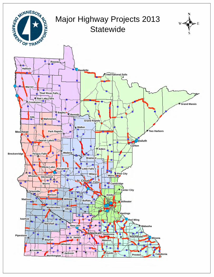
!(
!(
!(
!(
!(
!(
!(
!(
!(
!(
!(
!(!(
!(
!(
!(
!(
!(
!(
!(
!(
!(
!(
!(
!(
!(
!(
!(
!(
!(
!(
!(
!(
!(
!(
!(
!(
!(
!(
!(
!(!(
!(
!(
!(
!(
!(
!(
!(
!(
!(
!(
!(
!(
!(
!(
!(
!(
!(
!(
!(!(
!(
!(
!(
!(
!(
!(
!(
!(
!(
!(
!(
!(
!(
!(
!(
!(
!(
!(
!P
!P
!P
!P
!P
!P
!P
%&h(
%&h( !"b$
%&d(
%&f(
%&c( %&e(
%&d(
%&f(
%&c( !"b$
%&c(
%&f(
!"̀$
!"b$
!"̀$
!"b$
!"b$
%&d(
)y
)s
)p
)y
)s
)y
)y )z
)z
)n
)m
)s
)m
)m
)p
)s
)m
)p
)l
?ÙA@
?¹A@
?ØA@
?±A@
?«A@
?èA@
?ÇA@
?́A@
?©A@
?éA@
?ºA@
?ñA@
?ÓA@
?±A@
?cA@
?³A@
?uA@
?¾A@
?tA@
?ÞA@
?̧A@
?ÑA@
?lA@
?ÙA@
?ÖA@
?ØA@
?ÒA@
?¾A@
?ØA@
?tA@
?̧A@
?«A@
?óA@
?±A@
?©A@
?ûA@ ?ÌA@
?öA@
?ûA@
?©A@
?¾A@
?úA@
?àA@
?§A@
?ÇA@
?öA@
?öA@
?öA@
?§A@
?ÒA@
?÷A@
?©A@
?àA@
?̧A@
?ÕA@
?ØA@
?ÒA@
?©A@
?øA@
!"a$
!"b$
!"̀$
)x
?°A@
)q
)i
?ÝA@
?̈A@
)w?ÄA@
?¬A@
?ªA@
?«A@
)r
?¾A@
)o
)s
?ØA@
?åA@
)n
?òA@
?¦A@
?¼A@
?}A@
?}A@
?òA@
?ÒA@
)p
?öA@
!"b$
?ôA@
?ÑA@
?¦A@
)m
?ØA@
?êA@
?ÀA@
)s
?óA@
?±A@
?ÜA@
?¡A@
)r
?|A@
?îA@
?³A@
?ÍA@?ÚA@
?ÞA@
?ÓA@
+¢
?ïA@
+£
)o
?ÀA@?ÁA@
?íA@
?ãA@
?±A@
?ÆA@
?ÛA@
?»A@
?§A@
?dA@
?âA@
?ÈA@
?ÎA@
)i)w
?äA@
?çA@
?bA@
)i
)y
?¦A@
?̀A@
)q
?ÃA@?½A@
?¿A@
)m
?²A@?½A@
)v
?ùA@
?ØA@
)t
?́A@?́A@
)w
?ÏA@
?ýA@
?±A@
)r
!"a$
)i
?ºA@
?àA@
?rA@
)m
?öA@
?ÙA@
?òA@
!"b$
)u
?yA@
?ôA@
)z
?̧A@
?°A@
)p
)w
?eA@ ?¹A@
?vA@
?ÜA@
)x
)y
)p
?ÜA@
)i
?kA@
)o
)x
?}A@
+¡
)r
?ÄA@
?¬A@
)y
?ÜA@
)n
?²A@
)m
?gA@
?òA@
?¼A@
?¼A@
?àA@
!"̀$
?ÃA@
?̧A@
)w
?²A@
?̧A@
?¾A@
?fA@
?ÉA@
?³A@
?àA@
?̈A@
)y
!"a$
?òA@
?ÝA@
)w
?»A@
)r
)o
?aA@
)n
?ÜA@
)w
)x
?èA@
?|A@
)w
)y
?ËA@
?àA@
?³A@
!"̀$
?ÜA@
?«A@
)o
?̧A@
?¦A@
?ðA@
?¼A@
?ÙA@
?ÅA@
?ÂA@
?ªA@
?òA@
?ÃA@?¼A@
)o
?«A@
?¦A@
)y
?âA@
!"b$
?©A@
?èA@
?ÀA@
?ÃA@
?ÁA@
?}A@
?±A@
?ÀA@
?ÃA@
?àA@
?ºA@
?ÃA@
?åA@
?½A@
?¼A@
?ãA@
?æA@
)x
)m)w
?¼A@
)x
?¾A@
)x
?ùA@
?»A@
?âA@
)q
?}A@
?ãA@
?ÎA@
)w
?°A@
?¬A@
?́A@
?ßA@
)r
+£
)r
?|A@
?̈A@
?óA@
+¡
?ãA@
?̧A@
)t
?«A@
?°A@
?»A@
?àA@
)r?¼A@
)w
?ÃA@
?|A@
?ßA@
?ÁA@
?ÄA@
)o
?̈A@
?»A@
?¦A@
?ýA@
?¦A@
?æA@
?̈A@
?ØA@
?ÀA@
?²A@
?aA@
?»A@
)s
?ÒA@
?òA@
!"a$
?¾A@
)x
?¬A@
?çA@
?̧A@
)n
?æA@
?ÆA@
?ÀA@
?ÆA@
?ÙA@!"̀$
?ËA@
?«A@
!(
!(!(
!(
!(
!(
!(!(
!(!(
!(
!(
!(!(!(!(!(
!(
!(
!(!(!(!(
!(
!(
!(
!(!(
!(
!(
!(
!(
!(
!(
!(
!(
!(!(!(
!(
!(
!(!(
Duluth
Mankato
Moorhead
St. Cloud
Rochester
Ada
Mora
Foley
Anoka
Winona
WindomWaseca
Warren
Walker
Wadena
Roseau
Olivia
Morris
Milaca
Benson
Bagley
Austin
Aitkin
Willmar
Wheaton
Wabasha
Slayton
Preston
New Ulm
Madison
LuverneJackson
Ivanhoe
Hallock
Carlton
Buffalo
Bemidji
Red Wing
Owatonna
Marshall
Mahnomen
Hastings
Glenwood
Brainerd
Baudette
St. JamesPipestone
Pine City
Crookston
Cambridge
Caledonia
Stillwater
Ortonville
Montevideo
Elbow Lake Alexandria
Worthington
Two HarborsPark Rapids
Center City
Little Falls
Grand Rapids
Grand Marais
Fergus FallsBreckenridge
Detroit Lakes
Red Lake FallsThief River Falls
International Falls
.Major Highway Projects 2013Statewide

!(
!(
!(
!(
!(
!(
!(
!(
!(
!(!(
!(
!P
?ñA@
?öA@ !"b$
!"̀$
?°A@
)q
)i
?ÝA@
)w
?ªA@
?¾A@
?åA@
?¼A@
?}A@
?òA@
?ÒA@
?öA@
?ÑA@
?¦A@
?¡A@
?|A@
?îA@
?ÓA@
?±A@
?ÈA@
)i
?äA@
)y
?̀A@
)q
)m
?́A@?́A@
?àA@
?rA@
?öA@
?òA@
?vA@
)i
?}A@
)y
?àA@
!"̀$
?¾A@
?ÉA@
?àA@
?ÝA@
?|A@
)y
?àA@
!"̀$
?¦A@
?¼A@
?ÅA@
?ªA@
?¦A@
)y
?ÀA@
?ÀA@
?àA@
?åA@
?æA@
)m
?¼A@
)q
?}A@
?°A@
?́A@
?ßA@
?àA@
?¼A@
?¦A@
?æA@
?ÒA@
?òA@
?æA@
?ÀA@
!(
!(!(!(!(!(!(
!(
!(
Duluth
Aitkin
Carlton
Grand Rapids
International Falls
.Major Highway Projects 2013District 1
Duluth

ROUTE PROJECT LOCATION PAGE
District Project SummaryDistrict 1
State Project #
Hwy 1 US Forest Rte 553 to US Forest Rte 424 A 23801-18
Hwy 1 .2 miles south of Kawishiwi River to US Forest Rte 533 A 33801-92
Hwy 1 0.3 Miles west of Six Mile Rd to Deer Haven Rd A 46904-46
Hwy 1 Tower to Ely A 56904-49
Hwy 2 Bong Bridge over St.Louis River A 66937-69100D
Hwy 23 15.9 Miles NE of the south Carlton County line A 70901-67
Hwy 23 ROM Smithville to Polk St in West Duluth A 86910-89
Hwy 33 From 0.2 miles north of Morris Thomas Rd to JCT TH 53 A 96911-38
Hwy 33 I-35 to 1.4 mils north in Cloquet A 100905-53
I-35 North of Sturgeon Lake to south of Mahtowa A 110980-138
I-35 St. Louis River to Boundary Avenue A 120980-139
I-35 Sandstone to 3 miles South of Willow River A 135880-173
I-35 North of Hinckley to south of Sandstone (north & south bound)
A 145880-177
I-35 Boundary Avenue to 26th Avenue East A 156982-290
Hwy 53 Between Eveleth and Virginia A 166918-80
Hwy 53 From .25 miles south of CR 652 (Goodell Road) to south limits of Cook
A 176920-48
Hwy 61 Split Rock River to Chapins Curve A 183806-60
Hwy 61 3.2 miles north of TH 1 to JCT UT 81 A 193808-35
Hwy 65 North limits of Nashwauk to Hwy. 1 A 203112-34
Hwy 70 0.1 mils east to Wisconsin state line A 215811-12
Hwy 169 Pokegama Ave. 3rd St N. to 13Th St SE, Grand Rapids A 223115-51
Hwy 169 3.6 miles East of JCT TH65/TH169 in Nashwauk to west JCT TH 73
A 236934-115
Hwy 169 0.1 mi. south Jct. CR 438 to the South end of Br. 69087 (Pike River Br.)
A 246936-17
Hwy 200 TH 6 to TH 2 and on TH 169 A 250106-29
Hwy 217 Little Fork to Jct Hwy 53 A 263614-20
Hwy 535 Bridge over St. Louis River A 276981-9030E
Annual Report on Major Highway ProjectsMinnesota Department of Transportation Page A1

Project History:The existing structure of TH 1 between Kawishiwi River and Lake County Highway 2 is inadequate. AADT on this section is approximately 420. It is marked by sharp curves, narrow shoulders, poor sight distance and nearby hazards. This project is the second of three planned reconstruction phases, which, in total, include of 14.7 miles of highway as well as the Stony and Kawishiwi River bridges. The bridges have been replaced and the southernmost 5 miles of highway have been reconstructed by previous projects. The project is intended to strengthen the roadbed, improve drainage and safety, and where necessary soften sharp curves. Significant public involvement and an environmental assessment were part of the project delivery process.
Project Benefits:Strengthened roadbed, improved hydraulcs, straightened curves, smoother driving surface, decreased maintenance costs, wider shoulders, safer conditions for all users including bicyclists. Asdflk;gjahgdkjlasdghasl;dkjghaskjld;vhasdklvd;jansvasd;lkvjna asl;dkjfhas dasdlf;kjh a la;skdhf asdl;fkh a als;dkfh asldkfhasdlkfhasdkjlfh asldkfhasdlkfhasdkjlfhasldkfhasdlkfhasdkjlfh asldkfhasdlkfhasdkjlfh
Project Risks:Numerous wetands. Peat under the road core. Narrow footprint, which must be maintained. Numerous locations with ledgerock. Relatively lengthly detour over gravel road.
Environmental Document Approval Date:
Schedule:
Municipal Consent Approval Date: Geometric Layout Approval Date: Construction Limits Established Date: Original Letting Date: 9/22/2006Current Letting Date: 9/23/2011Construction Season: 2012Estimated Substantial Completion: Nov 2012
?¦A@!(
!(
!(
Ely
Winton
Babbitt
Project includes reconstruction of TH 1 from US Forest Route #553 to US Forest Route #424 (New Tomahawk Rd).
Project Description:
2008Total Project Cost Estimate (millions)Date in which the project entered into the STIP:
Construction Letting: 8.7Other Construction Elements: 0.4Engineering: 1.8Right of Way: 0.5
7.10.41.50.2
Baseline Est. Current Est.
Total: 11.4 9.2
$$$$
$
$$$$
$
Construction cost estimates are adjusted to the mid-year of construction, using inflation rates provided by OCPPM.
Recent Changes and Updates:
Project costs were updated to current inflation rates.
Key Cost Estimate Assumptions:
State Project No. 3801-18US Forest Rte 553 to US Forest Rte 424
Hwy 1PROJECT SUMMARY
District 1Minnesota Department of Transportation
1123 Mesaba Ave(218) 725-2700
District Engineer: Duane HillProject Manager: Todd Campbell
Original Date of Posting: 12/15/2012Revised Date: 12/15/2012
Annual Report on Major Highway ProjectsMinnesota Department of Transportation
Page A3

Project History:This project was initially planned to be a reconstruction, related to the reconstruction of 10 additional miles of TH 1 from this project's south limits to Lake County 2. Those two projects are either complete or will be completed in 2012. This project no longer includes pavement preservation and drainage improvements on the existing alignment.
Project Benefits:Smooth pavement surface, reduced annual maintenance costs, extended serviceable life of pavement structure, drainage improvements.
Project Risks:Subgrade weakness in certain areas, poor sight distance, relatively lengthy detour options over gravel roads, wetlands, and ledgerock.
Environmental Document Approval Date:
Schedule:
Municipal Consent Approval Date: Geometric Layout Approval Date: Construction Limits Established Date: Original Letting Date: 2/27/2015Current Letting Date: 2/27/2015Construction Season: 2015Estimated Substantial Completion:
?¦A@!(
!(
!(
Ely
Winton
Babbitt
Project inludes bituminous mill and overlay on TH 1 from .2 miles south of the Kawishiwi River to US Forest Route #533 and from 0.9 miles east of CSAH 2 to Isabella.
Project Description:
2012Total Project Cost Estimate (millions)Date in which the project entered into the STIP:
Construction Letting: 6.6Other Construction Elements: 0.4Engineering: 1.4Right of Way: 0.0
6.60.41.40.0
Baseline Est. Current Est.
Total: 8.4 8.4
$$$$
$
$$$$
$
Construction cost estimates are adjusted to the mid-year of construction, using inflation rates provided by OCPPM.
Recent Changes and Updates:
Standard practices used to develop cost estimates for this project.
Key Cost Estimate Assumptions:
State Project No. 3801-92,3802-21.2 miles south of Kawishiwi River to US Forest Rte 533
Hwy 1PROJECT SUMMARY
District 1Minnesota Department of Transportation
1123 Mesaba Ave(218) 725-2700
District Engineer: Duane HillProject Manager: Todd Campbell
Original Date of Posting: 9/26/2011Revised Date: 12/15/2012
Annual Report on Major Highway ProjectsMinnesota Department of Transportation
Page A4

Project History:Because of concerns with Highway 169 between Virginia and Winton, the Trunk Highway 169 North Improvement Task Force was formed in July 2000 with the mission “to ensure a safe, efficient, and aesthetically pleasing highway that addresses present and future needs between Virginia and Winton.” The efforts of the task force resulted in $18.4 million in Federal High Priority Project funds being provided in the SAFETEA-LU transportation bill for highway improvements. The Highway 1/169 segment from 0.3 miles west of the Six Mile Lake Road to Clear Lake was recommended by the task force as a priority for reconstruction.
Project Benefits:Improve the safety and operation of the highway by improving the vertical and horizontal alignments, widening shoulders, adding safety turn lanes and addressing winter shading issues.
Project Risks:Private property impacts; Environmental Concerns: wetlands, potential acid drainage runoff associated with sulfides in the rock; Federal High Priority Project (HPP) funds being used; relatively low traffic volume coupled with high construction costs.
Environmental Document Approval Date: Pending Approval
Schedule:
Municipal Consent Approval Date: Not NeededGeometric Layout Approval Date: Pending ApprovalConstruction Limits Established Date: Pending ApprovalOriginal Letting Date: 12/17/2010Current Letting Date: 7/25/2014Construction Season: 2014-2015Estimated Substantial Completion: 2015
?¦A@
?rA@
!(Tower
The project is located in St. Louis County. The proposed project is a reconstruction and passing lane project located 0.3 miles west of Six Mile Lake Rd to Bradach Road. The project includes a combination of reconstruction and pavement reclaimation.
Project Description:
2007Total Project Cost Estimate (millions)Date in which the project entered into the STIP:
Construction Letting: 14.3Other Construction Elements: 0.6Engineering: 3.0Right of Way: 1.2
18.50.83.91.2
Baseline Est. Current Est.
Total: 19.1 24.3
$$$$
$
$$$$
$
Construction cost estimates are adjusted to the mid-year of construction, using inflation rates provided by OCPPM.
Two projects were identified to use these funds. As scoping progressed it was clear that we didn’t have enough money for both projects and decisions about where to spend the funds needed to made. It was decided that less money should be spent in the Thirteen Hills Area and that more funds should be spent in the Eagles Nest Area.
Recent Changes and Updates:
Key Cost Estimate Assumptions:
State Project No. 6904-460.3 Miles west of Six Mile Rd to Deer Haven Rd
http://www.dot.state.mn.us/d1/projects/Hwy169eagles
Hwy 1PROJECT SUMMARY
District 1Minnesota Department of Transportation
1123 Mesaba Ave(218) 725-2700
District Engineer: Duane HillProject Manager: Michael Kalnbach
Original Date of Posting: 1/1/2009Revised Date: 12/15/2012
Annual Report on Major Highway ProjectsMinnesota Department of Transportation
Page A5

Project History:Two-lane bituminous roadway with deteriorating pavement resulting in rough ride, high maintenance costs and reduced load carrying capacity.
The previous pavement repairs in the project area include:1989 and 1992 – Bituminous Overlay2001 – Bituminous Spot Repairs
Project Benefits:Improves ride, extends useful life of roadway, and reduces maintenance costs.
Project Risks:
Environmental Document Approval Date:
Schedule:
Municipal Consent Approval Date: Geometric Layout Approval Date: Construction Limits Established Date: Original Letting Date: 3/22/13Current Letting Date: 5/17/2013Construction Season: 2013Estimated Substantial Completion: Fall 2013
?¦A@
?rA@
!(
!(
!(
!(
!(
!(
!(
Ely
Tower
Winton
Aurora
Biwabik
Babbitt
Hoyt Lakes
Project includes bituminous mill and overlay from Alder St. in Tower to 0.1 miles west of Six Mile Lake Rd and from 0.1 miles east of Bradach Rd. to 0.17 miles west of 3rd Ave. west in Ely and from the east Jct of TH 169 to 200 feet east of Halfway Rd.
Project Description:
2012Total Project Cost Estimate (millions)Date in which the project entered into the STIP:
Construction Letting: 9.3Other Construction Elements: 0.5Engineering: 2.0Right of Way: 0.0
9.30.52.00.0
Baseline Est. Current Est.
Total: 11.8 11.8
$$$$
$
$$$$
$
Construction cost estimates are adjusted to the mid-year of construction, using inflation rates provided by OCPPM.
Recent Changes and Updates:
Project costs were updated to current inflation rates.
Key Cost Estimate Assumptions:
State Project No. 6904-49Tower to Ely
Hwy 1PROJECT SUMMARY
District 1Minnesota Department of Transportation
1123 Mesaba Ave(218) 725-2700
District Engineer: Duane HillProject Manager: Michael Kalnbach
Original Date of Posting: 12/15/2012Revised Date: 12/15/2012
Annual Report on Major Highway ProjectsMinnesota Department of Transportation
Page A6

Project History:Note: WISCONSIN DOT IS LEAD AGENCY.The Highway 2 Bong Bridge over the St. Louis River between Duluth, MN, and Superior, WI, was built in 1982. This fracture critical bridge currently has National Bridge Inventory condition ratings of 5 (deck), 7 (superstructure) and 7 (substructure).
Project Benefits:The proposed rehabilitation work will extend the useful service life of this important bridge linking Duluth and Superior and decrease the amount of future maintenance activity needed to keep it operational.
Project Risks:Project will result in inconveniences in the movement of traffic between the communities.
Environmental Document Approval Date: Pending Approval
Schedule:
Municipal Consent Approval Date: Not NeededGeometric Layout Approval Date: Not NeededConstruction Limits Established Date: Pending ApprovalOriginal Letting Date: 2/28/2014Current Letting Date: 2/28/2014Construction Season: 2014Estimated Substantial Completion: 2015
!(!(
Duluth
The proposed rehabilitation of Bridge 69100 is a joint effort between the MN and WI DOT’s. The project work includes:• bridge deck replacement• modular joint replacement• spot concrete spall repairs• support cable work• painting of the deck
Project Description:
2010Total Project Cost Estimate (millions)Date in which the project entered into the STIP:
Construction Letting: 25.7Other Construction Elements: 1.0Engineering: 5.4Right of Way: 0.0
14.30.63.00.0
Baseline Est. Current Est.
Total: 32.1 17.8
$$$$
$
$$$$
$
Construction cost estimates are adjusted to the mid-year of construction, using inflation rates provided by OCPPM.
Rehabilitation costs have been reevaluated by WisDOT. Current estimate reflects reassessed maintenance needs of the bridge.
Recent Changes and Updates:
Estimates prepared by WisDOT
Key Cost Estimate Assumptions:
State Project No. 6937-69100D
Bong Bridge over St.Louis RiverHwy 2
PROJECT SUMMARY
Bridge 69100
District 1Minnesota Department of Transportation
1123 Mesaba Ave(218) 725-2700
District Engineer: Duane HillProject Manager: Perry Collins
Original Date of Posting: 9/26/2011Revised Date: 12/15/2012
Annual Report on Major Highway ProjectsMinnesota Department of Transportation
Page A7
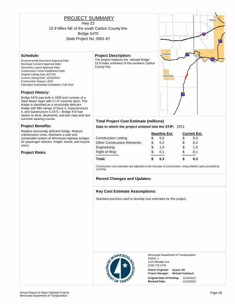
Project History:Bridge 5470 was built in 1936 and consists of a Steel Beam Span with C-I-P concrete deck. This bridge is classified as a structurally deficient bridge with NBI ratings of Deck 4, Superstructure 4, and Substructure 5.1973 – Bridge 470 had repairs to deck, abutments, and pier caps and new concrete wearing course.
Project Benefits:Replace structurally deficient bridge. Reduce maintenance costs. Maintains a safe and sustainable system of Minnesota highway bridges for passenger vehicles, freight, transit, and bicycle users.
Project Risks:
Environmental Document Approval Date:
Schedule:
Municipal Consent Approval Date: Geometric Layout Approval Date: Construction Limits Established Date: Original Letting Date: 6/27/03Current Letting Date: 12/19/2014Construction Season: 2015Estimated Substantial Completion: Fall 2015
?}A@
?¼A@
?¼A@
!"̀$
?}A@
!(
!(
!(
Thomson
Proctor
Wrenshall
The project replaces the railroad bridge 15.9 miles northeast of the southern Carlton County line.
Project Description:
2011Total Project Cost Estimate (millions)Date in which the project entered into the STIP:
Construction Letting: 5.0Other Construction Elements: 0.2Engineering: 1.0Right of Way: 0.1
5.00.21.00.1
Baseline Est. Current Est.
Total: 6.3 6.3
$$$$
$
$$$$
$
Construction cost estimates are adjusted to the mid-year of construction, using inflation rates provided by OCPPM.
Recent Changes and Updates:
Standard practices used to develop cost estimates for this project.
Key Cost Estimate Assumptions:
State Project No. 0901-67
15.9 Miles NE of the south Carlton County lineHwy 23
PROJECT SUMMARY
Bridge 5470
District 1Minnesota Department of Transportation
1123 Mesaba Ave(218) 725-2700
District Engineer: Duane HillProject Manager: Michael Kalnbach
Original Date of Posting: 12/15/2012Revised Date: 12/15/2012
Annual Report on Major Highway ProjectsMinnesota Department of Transportation
Page A8

Project History:Pavement condition on this segment of TH 23 is poor, as is the condition of storm sewer pipes, drainage structures, curb & gutter, and sidewalks. Pavement, drainage, and pedestrian improvements are needed.
Project Benefits:Smooth pavement surface, reduced annual maintenance costs, extended serviceable life of pavement structure, drainage improvements, greater pedestrian safety and ADA improvements.
Project Risks:High traffic volumes, no suitable detour in certain stretches, old utilities under the road, intermittent sidewalk on both sides, inadequate ROW width, concrete pavement under the bituminous surface.
Environmental Document Approval Date:
Schedule:
Municipal Consent Approval Date: Geometric Layout Approval Date: Construction Limits Established Date: Original Letting Date: 2/27/2015Current Letting Date: 2/27/2015Construction Season: 2015Estimated Substantial Completion:
)i
?¼A@
)q
!"̀$
!"̀$
?}A@
!(
!(
!P
Duluth
Proctor
Hermantown
Project includes bituminous mill and overlay, drainage and ADA improvements from Smithville to Polk Street in West Duluth and bridge replacement at Kingsbury Creek.
Project Description:
2012Total Project Cost Estimate (millions)Date in which the project entered into the STIP:
Construction Letting: 11.4Other Construction Elements: 0.5Engineering: 2.4Right of Way: 0.6
11.40.52.40.6
Baseline Est. Current Est.
Total: 14.9 14.9
$$$$
$
$$$$
$
Construction cost estimates are adjusted to the mid-year of construction, using inflation rates provided by OCPPM.
Recent Changes and Updates:
Key Cost Estimate Assumptions:
State Project No. 6910-89
ROM Smithville to Polk St in West DuluthHwy 23
PROJECT SUMMARY
Bridge 88544A
District 1Minnesota Department of Transportation
1123 Mesaba Ave(218) 725-2700
District Engineer: Duane HillProject Manager: Todd Campbell
Original Date of Posting: 12/15/2012Revised Date: 12/15/2012
Annual Report on Major Highway ProjectsMinnesota Department of Transportation
Page A9
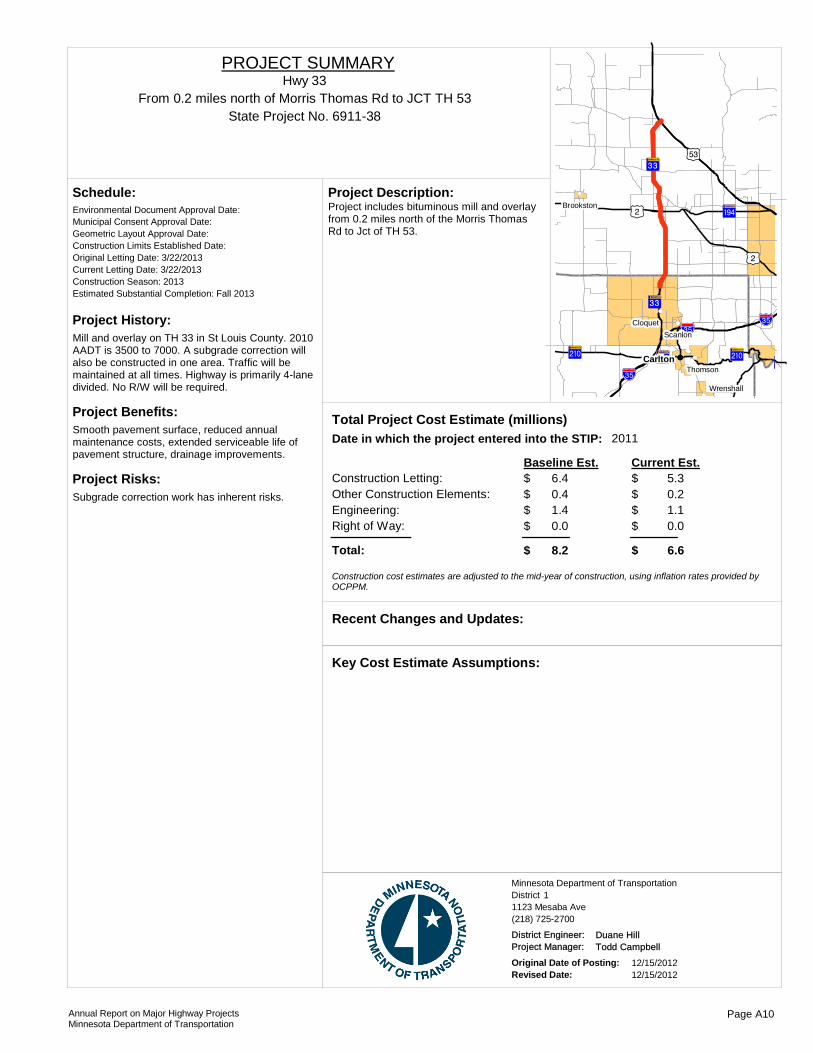
Project History:Mill and overlay on TH 33 in St Louis County. 2010 AADT is 3500 to 7000. A subgrade correction will also be constructed in one area. Traffic will be maintained at all times. Highway is primarily 4-lane divided. No R/W will be required.
Project Benefits:Smooth pavement surface, reduced annual maintenance costs, extended serviceable life of pavement structure, drainage improvements.
Project Risks:Subgrade correction work has inherent risks.
Environmental Document Approval Date:
Schedule:
Municipal Consent Approval Date: Geometric Layout Approval Date: Construction Limits Established Date: Original Letting Date: 3/22/2013Current Letting Date: 3/22/2013Construction Season: 2013Estimated Substantial Completion: Fall 2013
)i
?}A@
)q?ÅA@
?}A@
)i
?zA@
!"̀$?ÅA@
?}A@ ?}A@
!"̀$
!"̀$
!(
!(
!(
!(
!(
!(CarltonThomson
ScanlonCloquet
Wrenshall
BrookstonProject includes bituminous mill and overlay from 0.2 miles north of the Morris Thomas Rd to Jct of TH 53.
Project Description:
2011Total Project Cost Estimate (millions)Date in which the project entered into the STIP:
Construction Letting: 6.4Other Construction Elements: 0.4Engineering: 1.4Right of Way: 0.0
5.30.21.10.0
Baseline Est. Current Est.
Total: 8.2 6.6
$$$$
$
$$$$
$
Construction cost estimates are adjusted to the mid-year of construction, using inflation rates provided by OCPPM.
Recent Changes and Updates:
Key Cost Estimate Assumptions:
State Project No. 6911-38From 0.2 miles north of Morris Thomas Rd to JCT TH 53
Hwy 33PROJECT SUMMARY
District 1Minnesota Department of Transportation
1123 Mesaba Ave(218) 725-2700
District Engineer: Duane HillProject Manager: Todd Campbell
Original Date of Posting: 12/15/2012Revised Date: 12/15/2012
Annual Report on Major Highway ProjectsMinnesota Department of Transportation
Page A10

Project History:An alternate bid project with a 2-foot deep subcut, this project includes many components: access changes, cross-over changes, new pavement structure, new signal system, geometric improvements, and partnering with Carlton County and the city of Cloquet. These improvements have been supported for many years by local residents, business owners and government officials.
Project Benefits:Smooth pavement surface, reduced annual maintenance costs, extended serviceable life of pavement structure, drainage improvements. Improved functionality of Doddridge/Big Lake Rd/TH 33 intersection due to geometric changes and new signal system. Improved safety due to crossover changes at Armory Rd/Holmes Dr/TH 33.
Project Risks:Possible poor soils, utility complications. Municipal consent needed.
Environmental Document Approval Date:
Schedule:
Municipal Consent Approval Date: Geometric Layout Approval Date: Construction Limits Established Date: Original Letting Date: 3/27/2015Current Letting Date: 12/20/2013Construction Season: 2014Estimated Substantial Completion: Fall 2014
?ÅA@
?}A@
!"̀$
!(
!(
!(Carlton
Scanlon
Cloquet
The project includes removal and replacement of pavement from the Jct of I-35 to 1.4 miles north In Cloquet and signal replacement at Doddridge Ave.
Project Description:
2011Total Project Cost Estimate (millions)Date in which the project entered into the STIP:
Construction Letting: 4.7Other Construction Elements: 0.2Engineering: 1.0Right of Way: 0.0
6.00.31.10.0
Baseline Est. Current Est.
Total: 5.9 7.4
$$$$
$
$$$$
$
Construction cost estimates are adjusted to the mid-year of construction, using inflation rates provided by OCPPM.
A subcut is now needed for this project.
Recent Changes and Updates:
Project costs were updated to current inflation rates.
Key Cost Estimate Assumptions:
State Project No. 0905-53I-35 to 1.4 mils north in Cloquet
Hwy 33PROJECT SUMMARY
District 1Minnesota Department of Transportation
1123 Mesaba Ave(218) 725-2700
District Engineer: Duane HillProject Manager: Todd Campbell
Original Date of Posting: 12/15/2012Revised Date: 12/15/2012
Annual Report on Major Highway ProjectsMinnesota Department of Transportation
Page A11
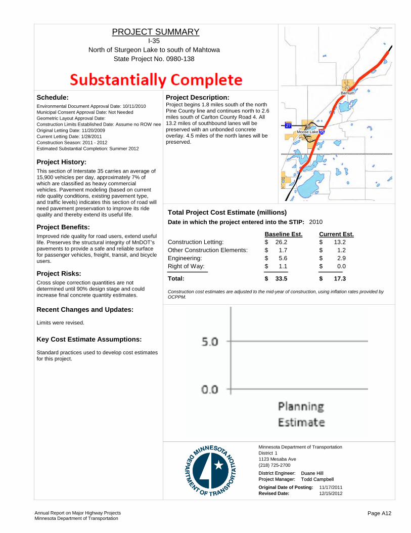
Project History:This section of Interstate 35 carries an average of 15,900 vehicles per day, approximately 7% of which are classified as heavy commercial vehicles. Pavement modeling (based on current ride quality conditions, existing pavement type, and traffic levels) indicates this section of road will need pavement preservation to improve its ride quality and thereby extend its useful life.
Project Benefits:Improved ride quality for road users, extend useful life. Preserves the structural integrity of MnDOT’s pavements to provide a safe and reliable surface for passenger vehicles, freight, transit, and bicycle users.
Project Risks:Cross slope correction quantities are not determined until 90% design stage and could increase final concrete quantity estimates.
Environmental Document Approval Date: 10/11/2010
Schedule:
Municipal Consent Approval Date: Not NeededGeometric Layout Approval Date: Construction Limits Established Date: Assume no ROW neeOriginal Letting Date: 11/20/2009Current Letting Date: 1/28/2011Construction Season: 2011 - 2012Estimated Substantial Completion: Summer 2012
Limits were revised.
Recent Changes and Updates:
Standard practices used to develop cost estimates for this project.
Key Cost Estimate Assumptions:
Barnum
Moose Lake
Project begins 1.8 miles south of the north Pine County line and continues north to 2.6 miles south of Carlton County Road 4. All 13.2 miles of southbound lanes will be preserved with an unbonded concrete overlay. 4.5 miles of the north lanes will be preserved.
Project Description:
2010Total Project Cost Estimate (millions)Date in which the project entered into the STIP:
Construction Letting: 26.2Other Construction Elements: 1.7Engineering: 5.6Right of Way: 1.1
13.21.22.90.0
Baseline Est. Current Est.
Total: 33.5 17.3
$$$$
$
$$$$
$
Construction cost estimates are adjusted to the mid-year of construction, using inflation rates provided by OCPPM.
State Project No. 0980-138North of Sturgeon Lake to south of Mahtowa
I-35PROJECT SUMMARY
District 1Minnesota Department of Transportation
1123 Mesaba Ave(218) 725-2700
District Engineer: Duane HillProject Manager: Todd Campbell
Original Date of Posting: 11/17/2011Revised Date: 12/15/2012
Annual Report on Major Highway ProjectsMinnesota Department of Transportation
Page A12
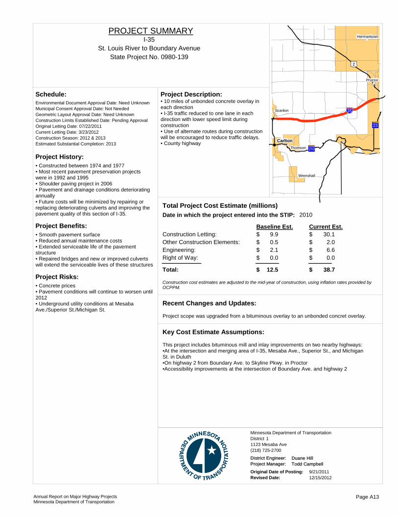
Project History:• Constructed between 1974 and 1977• Most recent pavement preservation projects were in 1992 and 1995• Shoulder paving project in 2006• Pavement and drainage conditions deteriorating annually• Future costs will be minimized by repairing or replacing deteriorating culverts and improving the pavement quality of this section of I-35.
Project Benefits:• Smooth pavement surface• Reduced annual maintenance costs• Extended serviceable life of the pavement structure• Repaired bridges and new or improved culverts will extend the serviceable lives of these structures
Project Risks:• Concrete prices• Pavement conditions will continue to worsen until 2012• Underground utility conditions at Mesaba Ave./Superior St./Michigan St.
Environmental Document Approval Date: Need Unknown
Schedule:
Municipal Consent Approval Date: Not NeededGeometric Layout Approval Date: Need UnknownConstruction Limits Established Date: Pending ApprovalOriginal Letting Date: 07/22/2011Current Letting Date: 3/23/2012Construction Season: 2012 & 2013Estimated Substantial Completion: 2013
?}A@
)i
?¼A@
!"̀$
!(
!(
!(
!(
!(
!(Carlton
Thomson
Scanlon
Proctor
Wrenshall
Hermantown
• 10 miles of unbonded concrete overlay in each direction• I-35 traffic reduced to one lane in each direction with lower speed limit during construction• Use of alternate routes during construction will be encouraged to reduce traffic delays.• County highway
Project Description:
2010Total Project Cost Estimate (millions)Date in which the project entered into the STIP:
Construction Letting: 9.9Other Construction Elements: 0.5Engineering: 2.1Right of Way: 0.0
30.12.06.60.0
Baseline Est. Current Est.
Total: 12.5 38.7
$$$$
$
$$$$
$
Construction cost estimates are adjusted to the mid-year of construction, using inflation rates provided by OCPPM.
Project scope was upgraded from a bituminous overlay to an unbonded concret overlay.
Recent Changes and Updates:
This project includes bituminous mill and inlay improvements on two nearby highways:•At the intersection and merging area of I-35, Mesaba Ave., Superior St., and Michigan St. in Duluth•On highway 2 from Boundary Ave. to Skyline Pkwy. in Proctor•Accessibility improvements at the intersection of Boundary Ave. and highway 2
Key Cost Estimate Assumptions:
State Project No. 0980-139St. Louis River to Boundary Avenue
I-35PROJECT SUMMARY
District 1Minnesota Department of Transportation
1123 Mesaba Ave(218) 725-2700
District Engineer: Duane HillProject Manager: Todd Campbell
Original Date of Posting: 9/21/2011Revised Date: 12/15/2012
Annual Report on Major Highway ProjectsMinnesota Department of Transportation
Page A13
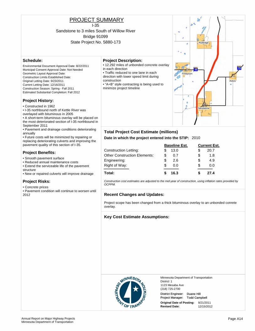
Project History:• Constructed in 1962• I-35 northbound north of Kettle River was overlayed with bituminous in 2005• A short-term bituminous overlay will be placed on the most deteriorated section of I-35 northbound in September 2011• Pavement and drainage conditions deteriorating annually• Future costs will be minimized by repairing or replacing deteriorating culverts and improving the pavement quality of this section of I-35.
Project Benefits:• Smooth pavement surface• Reduced annual maintenance costs• Extend the serviceable life of the pavement structure• New or repaired culverts will improve drainage
Project Risks:• Concrete prices• Pavement condition will continue to worsen until 2012
Environmental Document Approval Date: 8/22/2011
Schedule:
Municipal Consent Approval Date: Not NeededGeometric Layout Approval Date: Construction Limits Established Date: Original Letting Date: 9/23/2011Current Letting Date: 12/16/2011Construction Season: Spring - Fall 2011Estimated Substantial Completion: Fall 2012
Askov
Rutledge
Sandstone
Finlayson
• 12.292 miles of unbonded concrete overlay in each direction• Traffic reduced to one lane in each direction with lower speed limit during construction• “A+B” style contracting is being used to minimize project timeline
Project Description:
2010Total Project Cost Estimate (millions)Date in which the project entered into the STIP:
Construction Letting: 13.0Other Construction Elements: 0.7Engineering: 2.6Right of Way: 0.0
20.71.84.90.0
Baseline Est. Current Est.
Total: 16.3 27.4
$$$$
$
$$$$
$
Construction cost estimates are adjusted to the mid-year of construction, using inflation rates provided by OCPPM.
Project scope has been changed from a thick bituminous overlay to an unbonded conrete overlay.
Recent Changes and Updates:
Key Cost Estimate Assumptions:
State Project No. 5880-173
Sandstone to 3 miles South of Willow RiverI-35
PROJECT SUMMARY
Bridge 91099
District 1Minnesota Department of Transportation
1123 Mesaba Ave(218) 725-2700
District Engineer: Duane HillProject Manager: Todd Campbell
Original Date of Posting: 9/21/2011Revised Date: 12/15/2012
Annual Report on Major Highway ProjectsMinnesota Department of Transportation
Page A14
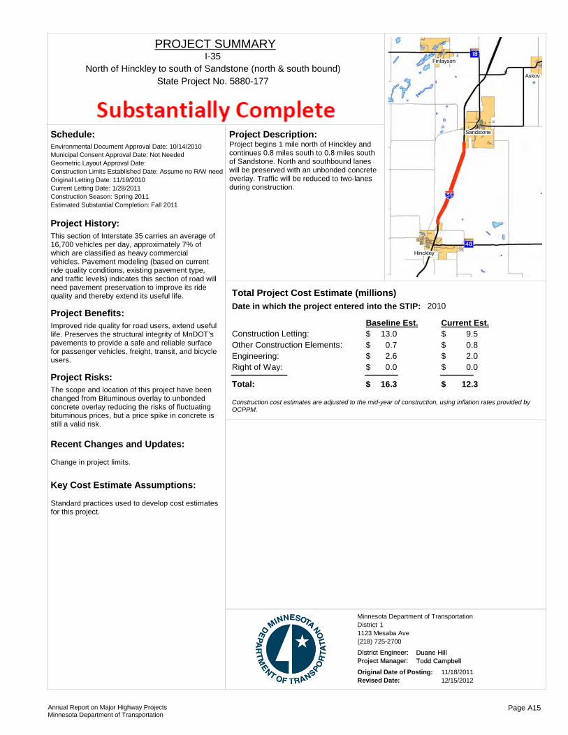
Project History:This section of Interstate 35 carries an average of 16,700 vehicles per day, approximately 7% of which are classified as heavy commercial vehicles. Pavement modeling (based on current ride quality conditions, existing pavement type, and traffic levels) indicates this section of road will need pavement preservation to improve its ride quality and thereby extend its useful life.
Project Benefits:Improved ride quality for road users, extend useful life. Preserves the structural integrity of MnDOT’s pavements to provide a safe and reliable surface for passenger vehicles, freight, transit, and bicycle users.
Project Risks:The scope and location of this project have been changed from Bituminous overlay to unbonded concrete overlay reducing the risks of fluctuating bituminous prices, but a price spike in concrete is still a valid risk.
Environmental Document Approval Date: 10/14/2010
Schedule:
Municipal Consent Approval Date: Not NeededGeometric Layout Approval Date: Construction Limits Established Date: Assume no R/W needOriginal Letting Date: 11/19/2010Current Letting Date: 1/28/2011Construction Season: Spring 2011Estimated Substantial Completion: Fall 2011
Change in project limits.
Recent Changes and Updates:
Standard practices used to develop cost estimates for this project.
Key Cost Estimate Assumptions:
Askov
Hinckley
Sandstone
Finlayson
Project begins 1 mile north of Hinckley and continues 0.8 miles south to 0.8 miles south of Sandstone. North and southbound lanes will be preserved with an unbonded concrete overlay. Traffic will be reduced to two-lanes during construction.
Project Description:
2010Total Project Cost Estimate (millions)Date in which the project entered into the STIP:
Construction Letting: 13.0Other Construction Elements: 0.7Engineering: 2.6Right of Way: 0.0
9.50.82.00.0
Baseline Est. Current Est.
Total: 16.3 12.3
$$$$
$
$$$$
$
Construction cost estimates are adjusted to the mid-year of construction, using inflation rates provided by OCPPM.
State Project No. 5880-177North of Hinckley to south of Sandstone (north & south bound)
I-35PROJECT SUMMARY
District 1Minnesota Department of Transportation
1123 Mesaba Ave(218) 725-2700
District Engineer: Duane HillProject Manager: Todd Campbell
Original Date of Posting: 11/18/2011Revised Date: 12/15/2012
Annual Report on Major Highway ProjectsMinnesota Department of Transportation
Page A15

Project History:I-35 from Boundary Avenue to Mesaba Avenue was constructed in the 1960's. The pavement is highly deteriorated and has been frequently patched. There are major bridges on the segment with substandard widths and fracture critical elements. Forty-six bridges in the corridor will require new railings, deck repairs and painting. I-35 from Mesaba Avenue to 26th Avenue East was opened in 1992 and requires concrete pavement repairs.
Project Benefits:Replace fracture critical bridges, improve ride and safety, extend the life of bridges, reduce maintenance costs.
Project Risks:High traffic volumes, extremely poor soils, tight construction schedule for 3 years, limited access, weather.
Environmental Document Approval Date: 2/5/09
Schedule:
Municipal Consent Approval Date: 10/26/09Geometric Layout Approval Date: Construction Limits Established Date: 11/14/2008Original Letting Date: 7/24/2009Current Letting Date: 4/2/2010Construction Season: 4/2010- 9/2012Estimated Substantial Completion: 10/2011
Recent Changes and Updates:
Standard practices used to develop cost estimates for this project.
Key Cost Estimate Assumptions:
Duluth
The project is located in Duluth (St. Louis County) from Boundary Avenue to 26th. Avenue East. The proposed project includes bridge and pavement replacement and repair, a new access road, culverts, ramp repairs, signing and lighting.
Project Description:
2006Total Project Cost Estimate (millions)Date in which the project entered into the STIP:
Construction Letting: 69.1Other Construction Elements: 4.3Engineering: 14.7Right of Way: 1.4
66.25.6
14.40.6
Baseline Est. Current Est.
Total: 89.5 86.8
$$$$
$
$$$$
$
Construction cost estimates are adjusted to the mid-year of construction, using inflation rates provided by OCPPM.
State Project No. 6982-290
Boundary Avenue to 26th Avenue East
http://www.dot.state.mn.us/d1/projects/i35-reconstruct/
I-35PROJECT SUMMARY
Bridge 69831, 69832, 69880
District 1Minnesota Department of Transportation
1123 Mesaba Ave(218) 725-2700
District Engineer: Duane HillProject Manager: Roberta Dwyer
Original Date of Posting: 11/17/2011Revised Date: 12/15/2012
Annual Report on Major Highway ProjectsMinnesota Department of Transportation
Page A16

Project History:On May 27, 1960 United States Steel granted MnDOT highway easement rights for highway 53 in the project area. On May 5, 2010, the successors of US Steel, United Taconite and RGGS Land and Minerals, in accordance with the easement provisions, gave Mn/DOT notice that they were terminating the easement rights for Highway 53 in parts of Section 17, Township 58, Range 17, in St. Louis County.
Project Benefits:Allows access to large quantities of iron ore deposits that will provide for the continued operation of United Taconite. The ability of mining companies to remain competitive in today’s global market is critical not only to the economic vitality of the region, but to the entire state of Minnesota.
Project Risks:• Unknown funding sources/lack of funding• Community impacts and social acceptance of new route• Impact of new route on mining operations• Short, aggressive timeline for relocating the highway• Volatility of mining industry• Geotechnical issues
Environmental Document Approval Date: Pending Approval
Schedule:
Municipal Consent Approval Date: Pending ApprovalGeometric Layout Approval Date: Pending ApprovalConstruction Limits Established Date: Original Letting Date: 4/24/2015Current Letting Date: 4/24/2015Construction Season: Summer 2015-2017Estimated Substantial Completion: Fall 2016
?ÈA@
)y
)q
?rA@
)q
Gilbert
Eveleth
VirginiaMcKinley
Leonidas
Mountain Iron
Iron Junction
The project is located in St. Louis County between Eveleth and Virginia. The proposed project is to abandon highway 53 in the area of the United Taconite mine expansion and reconstruct in a new location. The affected area is approximately one mile in length.
Project Description:
2011Total Project Cost Estimate (millions)Date in which the project entered into the STIP:
Construction Letting: 60.0Other Construction Elements: 0.0Engineering: 5.0Right of Way: 0.0
60.00.05.00.0
Baseline Est. Current Est.
Total: 65.0 65.0 700.0
$$$$
$
$$$$
$ - $
Construction cost estimates are adjusted to the mid-year of construction, using inflation rates provided by OCPPM.
Up to $60 million in trunk highway bonds have been made available for the project in 2015.
Recent Changes and Updates:
Standard practices used to develop cost estimates for this project.
Key Cost Estimate Assumptions:
State Project No. 6918-80Between Eveleth and Virginia
http://www.dot.state.mn.us/d1/projects/hwy53relocation/
Hwy 53PROJECT SUMMARY
District 1Minnesota Department of Transportation
1123 Mesaba Ave(218) 725-2700
District Engineer: Duane HillProject Manager: Roberta Dwyer
Original Date of Posting: 12/9/2010Revised Date: 12/15/2012
Annual Report on Major Highway ProjectsMinnesota Department of Transportation
Page A17
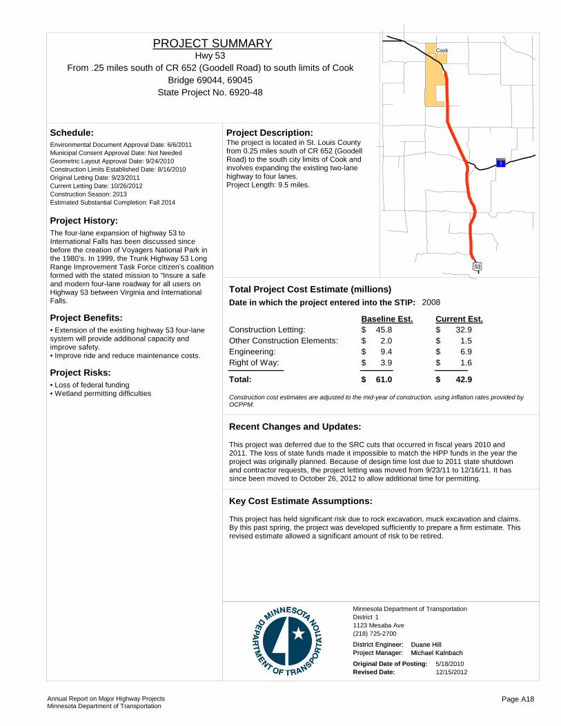
Project History:The four-lane expansion of highway 53 to International Falls has been discussed since before the creation of Voyagers National Park in the 1980’s. In 1999, the Trunk Highway 53 Long Range Improvement Task Force citizen’s coalition formed with the stated mission to “Insure a safe and modern four-lane roadway for all users on Highway 53 between Virginia and International Falls.
Project Benefits:• Extension of the existing highway 53 four-lane system will provide additional capacity and improve safety.• Improve ride and reduce maintenance costs.
Project Risks:• Loss of federal funding• Wetland permitting difficulties
Environmental Document Approval Date: 6/6/2011
Schedule:
Municipal Consent Approval Date: Not NeededGeometric Layout Approval Date: 9/24/2010Construction Limits Established Date: 8/16/2010Original Letting Date: 9/23/2011Current Letting Date: 10/26/2012Construction Season: 2013Estimated Substantial Completion: Fall 2014
)q
?¦A@
!(Cook
The project is located in St. Louis County from 0.25 miles south of CR 652 (Goodell Road) to the south city limits of Cook and involves expanding the existing two-lane highway to four lanes.Project Length: 9.5 miles.
Project Description:
2008Total Project Cost Estimate (millions)Date in which the project entered into the STIP:
Construction Letting: 45.8Other Construction Elements: 2.0Engineering: 9.4Right of Way: 3.9
32.91.56.91.6
Baseline Est. Current Est.
Total: 61.0 42.9
$$$$
$
$$$$
$
Construction cost estimates are adjusted to the mid-year of construction, using inflation rates provided by OCPPM.
This project was deferred due to the SRC cuts that occurred in fiscal years 2010 and 2011. The loss of state funds made it impossible to match the HPP funds in the year the project was originally planned. Because of design time lost due to 2011 state shutdown and contractor requests, the project letting was moved from 9/23/11 to 12/16/11. It has since been moved to October 26, 2012 to allow additional time for permitting.
Recent Changes and Updates:
This project has held significant risk due to rock excavation, muck excavation and claims. By this past spring, the project was developed sufficiently to prepare a firm estimate. This revised estimate allowed a significant amount of risk to be retired.
Key Cost Estimate Assumptions:
State Project No. 6920-48
From .25 miles south of CR 652 (Goodell Road) to south limits of CookHwy 53
PROJECT SUMMARY
Bridge 69044, 69045
District 1Minnesota Department of Transportation
1123 Mesaba Ave(218) 725-2700
District Engineer: Duane HillProject Manager: Michael Kalnbach
Original Date of Posting: 5/18/2010Revised Date: 12/15/2012
Annual Report on Major Highway ProjectsMinnesota Department of Transportation
Page A18

Project History:The Hwy 61 Rehabilitation Project includes reconstruction of 3.4 miles of Hwy 61 in Lake County to improve highway safety by correcting existing design issues, such as substandard horizontal curves, poor sight distance, narrow shoulders, steep in-slopes, and clear zone obstructions along the corridor. The reconstruction of Hwy. 61 will also reduce maintenance costs by replacing a deteriorating road core with a new structurally sound road core. Bicycle/pedestrian accessibility has been addressed by the addition of a bicycle/pedestrian underpass that connects the wayside rest just south of the Split Rock River to the existing bicycle/pedestrian trail.
Project Benefits:Improved highway safety, increased sight distance, reduced maintenance costs, bike/ped accessibility
Project Risks:If actual elevation of bed rock varies from the rock lines used for computation of quantities, the project costs could change significantly.
Environmental Document Approval Date: 12/4/2009
Schedule:
Municipal Consent Approval Date: Not NeededGeometric Layout Approval Date: 09/21/2008Construction Limits Established Date: 07/02/2008Original Letting Date: 11/12/2001Current Letting Date: 2/12/2010Construction Season: 2010/2011Estimated Substantial Completion: Fall 2011
Recent Changes and Updates:
Standard practices used to develop cost estimates for this project.
Key Cost Estimate Assumptions:
Silver Bay
Beaver Bay
Reconstruct 3.5 miles of Hwy 61, construct bicycle/pedestrian underpass, construct a bridge to replace the existing box culvert.
Project Description:
2007Total Project Cost Estimate (millions)Date in which the project entered into the STIP:
Construction Letting: 14.4Other Construction Elements: 0.6Engineering: 2.9Right of Way: 1.6
10.80.52.00.7
Baseline Est. Current Est.
Total: 19.5 14.2
$$$$
$
$$$$
$
Construction cost estimates are adjusted to the mid-year of construction, using inflation rates provided by OCPPM.
State Project No. 3806-60Split Rock River to Chapins Curve
http://www.dot.state.mn.us/d1/projects/hwy61_split_rock/index.html
Hwy 61PROJECT SUMMARY
District 1Minnesota Department of Transportation
1123 Mesaba Ave(218) 725-2700
District Engineer: Duane HillProject Manager: Todd Campbell
Original Date of Posting: 11/17/2011Revised Date: 12/15/2012
Annual Report on Major Highway ProjectsMinnesota Department of Transportation
Page A19

Project History:This stretch of TH 61 is marked by narrow shoulders, poor pavement condition, steep inslopes and a few vertical curves with poor sight distance. AADT on this segment is 3250 (275 HCADT). Repairs on some deep culverts may require detour. Pavement will be reclaimed and overlaid, shoulders widened (to approximately six feet, five of which will be paved) and inslopes flattened. Drainage will be improved and guardrail will be replaced/added/improved. Lack of funding for a full reconstruction here will result in this "scaled-down, reconstruct-light" approach.
Project Benefits:Strengthened roadbed, improved hydraulics, straightened curves, smoother driving surface, decreased maintenance costs, wider shoulders, flatter inslopes, safer conditions for all users including bicyclists.
Project Risks:Deep culvert work, presence of ledgerock, difficult traffic staging, no available detour on north half, high traffic volumes on weekends, narrow road core.
Environmental Document Approval Date:
Schedule:
Municipal Consent Approval Date: Geometric Layout Approval Date: Construction Limits Established Date: Original Letting Date: 2/13/2013Current Letting Date: 6/7/2013Construction Season: 2013/2014Estimated Substantial Completion: 2014
?ÝA@
?¦A@
?ÝA@
!(
!(Silver Bay
Beaver Bay
Project includes bituminous pavement reclamation and surfacing and shoulder reconstruction on TH 61 in the Little Marais Area from 3.2 miles north of TH 1 to 0.31 miles south of Jct UT 81.
Project Description:
2012Total Project Cost Estimate (millions)Date in which the project entered into the STIP:
Construction Letting: 7.7Other Construction Elements: 0.3Engineering: 1.6Right of Way: 0.3
7.70.31.60.3
Baseline Est. Current Est.
Total: 10.0 10.0
$$$$
$
$$$$
$
Construction cost estimates are adjusted to the mid-year of construction, using inflation rates provided by OCPPM.
Recent Changes and Updates:
Standard practices used to develop cost estimates for this project.
Key Cost Estimate Assumptions:
State Project No. 3808-353.2 miles north of TH 1 to JCT UT 81
Hwy 61PROJECT SUMMARY
District 1Minnesota Department of Transportation
1123 Mesaba Ave(218) 725-2700
District Engineer: Duane HillProject Manager: Todd Campbell
Original Date of Posting: 12/15/2012Revised Date: 12/15/2012
Annual Report on Major Highway ProjectsMinnesota Department of Transportation
Page A20

Project History:The construction project is completed.The pavement condition of Hwy 65 between north limits of Nashwauk to the West Junction of Hwy 1 is in disrepair.The previous pavement repair in the project areas were:1995 - Bituminous overlay - Nashwauk to 9.4 miles north (9.4 miles)1999-2000 - Bituminous overlay - various locations (6.5 miles)2001-2002 - Mill and bituminous overlay - Junction Hwy 1 South 25.1 miles West (25 miles)
Project Benefits:Improves ride, extends useful life of roadway, and reduces maintenance costs.
Project Risks:
Environmental Document Approval Date: 11/2/2009
Schedule:
Municipal Consent Approval Date: Not NeededGeometric Layout Approval Date: Not NeededConstruction Limits Established Date: 11/10/2008Original Letting Date: 02/26/2010 Current Letting Date: 5/7/2010Construction Season: 2010-2011Estimated Substantial Completion: Fall 2011
Recent Changes and Updates:
Standard practices used to develop cost estimates for this project.
Key Cost Estimate Assumptions:
Hibbing
Nashwauk
Keewatin
The project is located in Itasca County. The proposed project is a pavement reclamation from the north limits of Nashwauk to the West Junction of Hwy 1. The project also includes pipe culvert replacements.
Project Description:
2009Total Project Cost Estimate (millions)Date in which the project entered into the STIP:
Construction Letting: 13.2Other Construction Elements: 0.7Engineering: 2.0Right of Way: 0.3
10.50.72.11.1
Baseline Est. Current Est.
Total: 16.2 14.4
$$$$
$
$$$$
$
Construction cost estimates are adjusted to the mid-year of construction, using inflation rates provided by OCPPM.
State Project No. 3112-34North limits of Nashwauk to Hwy. 1
Hwy 65PROJECT SUMMARY
District 1Minnesota Department of Transportation
1123 Mesaba Ave(218) 725-2700
District Engineer: Duane HillProject Manager: Michael Kalnbach
Original Date of Posting: 11/17/2011Revised Date: 12/15/2012
Annual Report on Major Highway ProjectsMinnesota Department of Transportation
Page A21
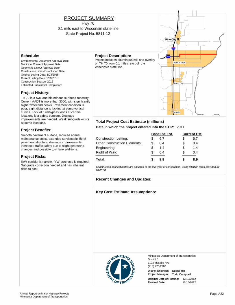
Project History:TH 70 is a two-lane bituminous surfaced roadway. Current AADT is more than 3000, with significantly higher weekend peaks. Pavement condition is poor, sight distance is lacking at some vertical curves. Lack of turn/bypass lanes at certain locations is a safety concern. Drainage improvements are needed. Weak subgrade exists at some locations.
Project Benefits:Smooth pavement surface, reduced annual maintenance costs, extended serviceable life of pavement structure, drainage improvements, increased traffic safety due to slight geometric changes and possible turn lane additions.
Project Risks:R/W corridor is narrow, R/W purchase is required. Subgrade correction needed and has inherent risks to cost.
Environmental Document Approval Date:
Schedule:
Municipal Consent Approval Date: Geometric Layout Approval Date: Construction Limits Established Date: Original Letting Date: 1/23/2015Current Letting Date: 1/23/2015Construction Season: 2015Estimated Substantial Completion:
!"̀$
?äA@
!(
!(
!(
!(Pine City
Harris
Rush City
Rock CreekProject includes bituminous mill and overlay on TH 70 from 0.1 miles east of the Wisconsin state line.
Project Description:
2011Total Project Cost Estimate (millions)Date in which the project entered into the STIP:
Construction Letting: 6.7Other Construction Elements: 0.4Engineering: 1.4Right of Way: 0.4
6.70.41.40.4
Baseline Est. Current Est.
Total: 8.9 8.9
$$$$
$
$$$$
$
Construction cost estimates are adjusted to the mid-year of construction, using inflation rates provided by OCPPM.
Recent Changes and Updates:
Key Cost Estimate Assumptions:
State Project No. 5811-120.1 mils east to Wisconsin state line
Hwy 70PROJECT SUMMARY
District 1Minnesota Department of Transportation
1123 Mesaba Ave(218) 725-2700
District Engineer: Duane HillProject Manager: Todd Campbell
Original Date of Posting: 12/15/2012Revised Date: 12/15/2012
Annual Report on Major Highway ProjectsMinnesota Department of Transportation
Page A22

Project History:Reconstruction of TH 169 in Grand Rapids between 1st St SE and 10th St SE from an urban undivided four-lane to an urban five-lane (includes center turn lane) as well as a lengthened NB right turn lane from 10th St to the north. The city of Grand Rapids is a project partner, participating in 4th St work and city-owned utility upgrades.
Project Benefits:Smooth pavement surface, reduced annual maintenance costs, extended serviceable life of pavement structure, drainage improvements, increased traffic safety due to slight geometric changes and turn lane additions (center and right). Reduced traffic congestion. Greater pedestrian safety and ADA improvements.
Project Risks:Underground utility construction and relocation.
Environmental Document Approval Date:
Schedule:
Municipal Consent Approval Date: Geometric Layout Approval Date: Construction Limits Established Date: Original Letting Date: 7/28/1995Current Letting Date: 3/7/2012Construction Season: 2013Estimated Substantial Completion: Fall 2013
Recent Changes and Updates:
Cost estimate is based on a pavement mill & overlay project.
Key Cost Estimate Assumptions:
)y
?ÉA@
)i
)y
!(
!(
!(
!(
!(
!(Grand Rapids
Bovey
Taconite
CohassetColeraine
La Prairie
The project inludes reconstruction and bituminous mill and overlay on Pokegama Ave from 3rd St. north to 13th St. SE in Grand Rapids.
Project Description:
2007Total Project Cost Estimate (millions)Date in which the project entered into the STIP:
Construction Letting: 4.8Other Construction Elements: 0.3Engineering: 1.3Right of Way: 1.3
6.50.31.41.2
Baseline Est. Current Est.
Total: 7.7 9.4
$$$$
$
$$$$
$
Construction cost estimates are adjusted to the mid-year of construction, using inflation rates provided by OCPPM.
State Project No. 3115-51Pokegama Ave. 3rd St N. to 13Th St SE, Grand Rapids
Hwy 169PROJECT SUMMARY
District 1Minnesota Department of Transportation
1123 Mesaba Ave(218) 725-2700
District Engineer: Duane HillProject Manager: Todd Campbell
Original Date of Posting: 12/15/2012Revised Date: 12/15/2012
Annual Report on Major Highway ProjectsMinnesota Department of Transportation
Page A23

Project History:This existing Concrete divided four-lane is deteriorating with a 2007 Ride Quality Index of 2.6 Eastbound and 2.5 westbound.The concrete pavement was constructed in 1974. There have been numerous concrete surface and joint repairs performed. The most recent were completed in 1991 and 1992.
Project Benefits:Improves ride, extends useful life of roadway, and reduces maintenance costs.
Project Risks:
Environmental Document Approval Date:
Schedule:
Municipal Consent Approval Date: Geometric Layout Approval Date: Construction Limits Established Date: Original Letting Date: 2/27/2009Current Letting Date: 2/22/2013Construction Season: 2013Estimated Substantial Completion: Fall 2013
?ÈA@
?æA@
)y
?àA@
!(
!(
!(
!(
Hibbing
Nashwauk
Keewatin
Chisholm
Project includes a bituminous overlay and drainage improvements on TH 169 from 3.6 miles east of the north Jct of TH 65/TH 169 in Nashwalk to the West Jct of TH 73.
Project Description:
2009Total Project Cost Estimate (millions)Date in which the project entered into the STIP:
Construction Letting: 5.0Other Construction Elements: 0.2Engineering: 1.0Right of Way: 0.0
6.10.31.30.0
Baseline Est. Current Est.
Total: 6.2 7.7
$$$$
$
$$$$
$
Construction cost estimates are adjusted to the mid-year of construction, using inflation rates provided by OCPPM.
Recent Changes and Updates:
Standard practices used to develop cost estimates for this project.
Key Cost Estimate Assumptions:
State Project No. 6934-1153.6 miles East of JCT TH65/TH169 in Nashwauk to west JCT TH 73
Hwy 169PROJECT SUMMARY
District 1Minnesota Department of Transportation
1123 Mesaba Ave(218) 725-2700
District Engineer: Duane HillProject Manager: Michael Kalnbach
Original Date of Posting: 12/15/2012Revised Date: 12/15/2012
Annual Report on Major Highway ProjectsMinnesota Department of Transportation
Page A24

Project History:Because of concerns with highway 169 between Virginia and Winton, the Trunk Highway 169 North Improvement Task Force was formed in July 2000 with the stated mission statement “to ensure a safe, efficient, and aesthetically pleasing highway that addresses present and future needs between Virginia and Winton.” The efforts of the task force resulted in $18.4 million in Federal High Priority Project funds being provided in the SAFETEA-LU transportation bill for highway improvements. This project was recommended by the task force as a priority for reconstruction.
Project Benefits:Improve safety and operation of the highway by improving the vertical and horizontal alignments, and widening shoulders. With these improvements, they will provide passing opportunities.
Project Risks:Estimated rock quantities were a key element in the cost estimating.
Environmental Document Approval Date: Pending
Schedule:
Municipal Consent Approval Date: Geometric Layout Approval Date: 8/17/2011Construction Limits Established Date: EstablishedOriginal Letting Date: 12/17/2010Current Letting Date: 8/3/2012Construction Season: Fall 2012Estimated Substantial Completion: Summer 2013
?rA@
)q
?¦A@
?vA@
Tower
BiwabikVirginia McKinley
The project is located in St. Louis County. The proposed project is the reconstruction of TH 169 from 0.1 miles South of Jct. CR 438 to the South end of Br. 69087 (Pike River Br.)
Project Description:
2010Total Project Cost Estimate (millions)Date in which the project entered into the STIP:
Construction Letting: 12.3Other Construction Elements: 0.5Engineering: 2.6Right of Way: 1.7
3.60.20.91.3
Baseline Est. Current Est.
Total: 17.1 6.0
$$$$
$
$$$$
$
Construction cost estimates are adjusted to the mid-year of construction, using inflation rates provided by OCPPM.
The project limits for this project have been changed and are now focused on the segment of this highway with the greatest concerns. Reducing the length of this project allowed the district to use a larger portion of the HPP funds on the Eagles Nest Lake area project which was also recommended by the task force as a priority for reconstruction.
Recent Changes and Updates:
Standard practices used to develop cost estimates for this project.
Key Cost Estimate Assumptions:
State Project No. 6936-17
0.1 mi. south Jct. CR 438 to the South end of Br. 69087 (Pike River Br.)Hwy 169
PROJECT SUMMARY
Bridge 69087
District 1Minnesota Department of Transportation
1123 Mesaba Ave(218) 725-2700
District Engineer: Duane HillProject Manager: Michael Kalnbach
Original Date of Posting: 10/20/2011Revised Date: 12/15/2012
Annual Report on Major Highway ProjectsMinnesota Department of Transportation
Page A25

Project History:This construction project is completed.
Project Benefits:Preserves the structural integrity of MnDOT’s pavements to provide a safe and reliable surface for passenger vehicles, freight, transit, and bicycle users.
Project Risks:
Environmental Document Approval Date:
Schedule:
Municipal Consent Approval Date: Geometric Layout Approval Date: Construction Limits Established Date: Original Letting Date: 3/23/2012Current Letting Date: 4/27/2012Construction Season: 2012Estimated Substantial Completion: Fall 2012
)y
?ÉA@
)i
?àA@
?àA@
?«A@
?|A@
?}A@
?|A@
?ªA@
)y
)y!(
!(
!(
!(
!(
!(
!(
!(
!(
!(
!(
!(
!(
!(
!(
!(
!(Grand Rapids
Warba
BoveyZemple Marble Calumet
Tamarack
Taconite
Palisade
Nashwauk
McGregor
Cohasset
Hill City
Coleraine
La Prairie
Project includes bituminous mill and overlay and drainage improvements on TH 200 from TH 6 to TH 2 and on TH 169 from TH 200 to 3 miles south of the Aitkin/Itasca Conty line.
Project Description:
2012Total Project Cost Estimate (millions)Date in which the project entered into the STIP:
Construction Letting: 8.0Other Construction Elements: 0.5Engineering: 0.5Right of Way: 0.0
8.10.40.50.0
Baseline Est. Current Est.
Total: 9.0 9.0
$$$$
$
$$$$
$
Construction cost estimates are adjusted to the mid-year of construction, using inflation rates provided by OCPPM.
Recent Changes and Updates:
Standard practices used to develop cost estimates for this project.
Key Cost Estimate Assumptions:
State Project No. 0106-29TH 6 to TH 2 and on TH 169
Hwy 200PROJECT SUMMARY
District 1Minnesota Department of Transportation
1123 Mesaba Ave(218) 725-2700
District Engineer: Duane HillProject Manager: Michael Kalnbach
Original Date of Posting: 12/15/2012Revised Date: 12/15/2012
Annual Report on Major Highway ProjectsMinnesota Department of Transportation
Page A26

Project History:This is a pavement rehabilitation project slated for the 2016 fiscal year. It has been scoped for development along the eastern edge of Littlefork to the junction at highway 53.
Project Benefits:Preserves the structural integrity of MnDOT’s pavements to provide a safe and reliable surface for passenger vehicles, freight, transit, and bicycle users.
Project Risks:
Environmental Document Approval Date:
Schedule:
Municipal Consent Approval Date: Geometric Layout Approval Date: Construction Limits Established Date: Original Letting Date: 2/28/2016Current Letting Date: 2/28/2016Construction Season: Estimated Substantial Completion:
?°A@
)w
?°A@
)q)w
?àA@
!(
!(
!(!(International Falls
Ranier
Big Falls
Littlefork
The project includes bituminous pavement rehabilitation from the east Limit of Little Fork to TH 53.
Project Description:
2012Total Project Cost Estimate (millions)Date in which the project entered into the STIP:
Construction Letting: 9.0Other Construction Elements: 0.5Engineering: 1.9Right of Way: 0.2
9.00.51.90.2
Baseline Est. Current Est.
Total: 11.6 11.6
$$$$
$
$$$$
$
Construction cost estimates are adjusted to the mid-year of construction, using inflation rates provided by OCPPM.
Recent Changes and Updates:
Standard practices used to develop cost estimates for this project.
Key Cost Estimate Assumptions:
State Project No. 3614-20
Little Fork to Jct Hwy 53Hwy 217
PROJECT SUMMARY
Bridge 9028A
District 1Minnesota Department of Transportation
1123 Mesaba Ave(218) 725-2700
District Engineer: Duane HillProject Manager: Michael Kalnbach
Original Date of Posting: 12/15/2012Revised Date: 12/15/2012
Annual Report on Major Highway ProjectsMinnesota Department of Transportation
Page A27

Project History:Note: MINNESOTA DOT IS LEAD AGENCY.Bridge 9030 was built in 1961 and consists of a main span continuous steel high truss open spandrel steel arch with continuous steel deck girder approach spans. Bridge 9030 is 7980 feet long. This bridge is classified as a fracture critical and functionally obsolete with bridge NBI ratings of Deck 6, Superstructure 5, and Substructure 6.
Project Benefits:Extend the useful life of Bridge 9030 through preventative maintenance activities.
Project Risks:
Environmental Document Approval Date:
Schedule:
Municipal Consent Approval Date: Geometric Layout Approval Date: Construction Limits Established Date: Original Letting Date: 7/22/2011Current Letting Date: 3/23/2012Construction Season: 2012-2013Estimated Substantial Completion: Fall 2013
!(!(!(!(
Duluth
The project is located in St. Louis County and spans the St. Louis River at the Minnesota (Duluth) – Wisconsin (Superior) border. The proposed project is for bridge rehabilitation that includes structural steel repair, expansion, and joint replacement.
Project Description:
2008Total Project Cost Estimate (millions)Date in which the project entered into the STIP:
Construction Letting: 9.0Other Construction Elements: 0.4Engineering: 1.9Right of Way: 0.0
13.70.52.70.0
Baseline Est. Current Est.
Total: 11.2 16.9
$$$$
$
$$$$
$
Construction cost estimates are adjusted to the mid-year of construction, using inflation rates provided by OCPPM.
It was decided that additional work should be done on this bridge. This is why the current estimate has been raised.
Recent Changes and Updates:
Standard practices used to develop cost estimates for this project.
Key Cost Estimate Assumptions:
State Project No. 6981-9030E
Bridge over St. Louis RiverHwy 535
PROJECT SUMMARY
Bridge 9030
District 1Minnesota Department of Transportation
1123 Mesaba Ave(218) 725-2700
District Engineer: Duane HillProject Manager: Michael Kalnbach
Original Date of Posting: 12/19/2008Revised Date: 12/15/2012
Annual Report on Major Highway ProjectsMinnesota Department of Transportation
Page A28
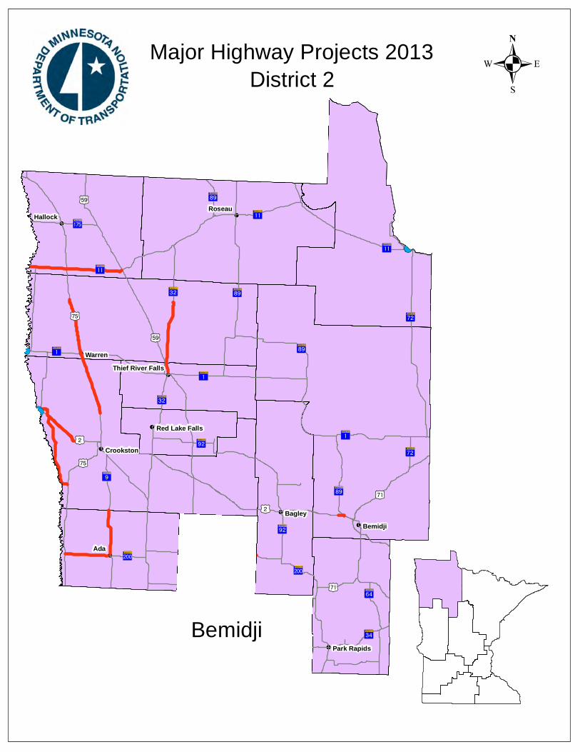
!(
!(
!(
!(
!(
!(
!(
!(
!(
!(
!(
!(
!(
!(
!P
?°A@
)i
?ÄA@
)r
?åA@
?òA@
?¦A@
?òA@
?ôA@
?îA@
?ÆA@
)w
)i ?¦A@
)r
)i
!"b$
?yA@
?ôA@
?°A@
)r
?ÄA@
?¬A@
)m
?òA@
)w
?fA@
?òA@
)x
?|A@
?ðA@
?òA@
?åA@)x
)x
?¬A@
?|A@
?°A@
?|A@
?ßA@
?ÄA@
?¦A@
?òA@
?ÆA@
?ÆA@
!(
!(
!(
!(
!(
Ada
Warren
Roseau
Bagley
Hallock
Bemidji
Crookston
Park Rapids
Red Lake Falls
Thief River Falls
.Major Highway Projects 2013District 2
Bemidji

ROUTE PROJECT LOCATION PAGE
District Project SummaryDistrict 2
State Project #
Hwy 1 From the south Jct. of TH 6 to TH 38 B 23101-35M
Hwy 1 From the east end of Northome to the north jct. of TH 6 B 33602-25
Hwy 1 Red River of the North at Oslo B 44509-05
Hwy 2 From Fisher to East Grand Forks - Westbound lanes B 56001-61
Hwy 2 At the intersection of TH 2 & TH 89 west of Bemidji B 60406-59
Hwy 2 Kennedy Bridge over the Red River in East Grand Forks B 76018-02
Hwy 9 From Ada to the Norman/Polk County line B 85408-30
Hwy 11 From the Red River to the west end of Karlstad B 93501-14
Hwy 11 From 1 mile west of Indus to 1 mile west of Loman B 103604-72M
Hwy 11 From 1 mile west of Loman to to the west jct. of TH 71 at Pelland
B 113604-73M
Hwy 32 From the north end of Thief River Falls to the north end of Middle River
B 124503-14
Hwy 75 From the north limits of Warren to the south end of Stephen
B 134507-48
Hwy 75 12 miles north of TH 2 to 0.1 mile south of TH 1 in Warren B 146011-24
Hwy 200 From TH 75 to the west limits of Ada B 155407-31
Hwy 220 From the west limits of Climax to the east junction of TH 2 B 166016-37
Annual Report on Major Highway ProjectsMinnesota Department of Transportation Page B1

Project History:This segment is in need of pavement improvement. The project's purpose is to improve the ride and surface condition, pavement strength and extended pavement life.
Project Benefits:Improved ride and surface condition, pavement strength and extended the pavement life.
Project Risks:
Environmental Document Approval Date:
Schedule:
Municipal Consent Approval Date: Geometric Layout Approval Date: Construction Limits Established Date: Original Letting Date: 5/18/2012Current Letting Date: 5/18/2012Construction Season: 2012Estimated Substantial Completion: October 2012
)w
?¦A@
?¦A@
?ÔA@
?ÉA@
!(
!(
!(
Effie
Bigfork
Big Falls
Bituminous mill and overlay and reconstruction in Effie.
Project Description:
Total Project Cost Estimate (millions)Date in which the project entered into the STIP:
Construction Letting: 7.1Other Construction Elements: 0.0Engineering: 0.0Right of Way: 0.0
7.10.00.00.0
Baseline Est. Current Est.
Total: 7.1 7.1
0.00.00.00.0
$$$$
$
$$$$
$
- $ - $ - $ - $
Construction cost estimates are adjusted to the mid-year of construction, using inflation rates provided by OCPPM.
Recent Changes and Updates:
Cost estimate is based on a pavement mill and overlay project.
Key Cost Estimate Assumptions:
State Project No. 3101-35MFrom the south Jct. of TH 6 to TH 38
Hwy 1PROJECT SUMMARY
District 2Minnesota Department of Transportation
3920 Highway 2 West(218) 755-6500
District Engineer: Craig CollisonProject Manager: Jeremy Hadrava
Original Date of Posting: 12/15/2012Revised Date: 12/15/2012
Annual Report on Major Highway ProjectsMinnesota Department of Transportation
Page B2

Project History:This bituminous resurfacing project was let and constructed in 2012.
Project Benefits:Improved ride and surface condition, pavement strength and extended pavement life.
Project Risks:
Environmental Document Approval Date:
Schedule:
Municipal Consent Approval Date: Geometric Layout Approval Date: Construction Limits Established Date: Original Letting Date: 5/18/2012Current Letting Date: 5/18/2012Construction Season: 2012Estimated Substantial Completion: Oct. 2012
?ÑA@ ?ªA@
)w
)w
?¦A@
?ÔA@
?ÉA@
!(
!(
!(
!(
!(
!(
!(
Effie
Mizpah
Bigfork
Northome
Big Falls
Squaw Lake
Bituminous mill and overlay, and culvert replacements.
Project Description:
Total Project Cost Estimate (millions)Date in which the project entered into the STIP:
Construction Letting: 7.1Other Construction Elements: 0.0Engineering: 0.0Right of Way: 0.0
7.10.00.00.0
Baseline Est. Current Est.
Total: 7.1 7.1
0.00.00.00.0
$$$$
$
$$$$
$
- $ - $ - $ - $
Construction cost estimates are adjusted to the mid-year of construction, using inflation rates provided by OCPPM.
Recent Changes and Updates:
Cost estimate is based on a pavement mill and overlay project.
Key Cost Estimate Assumptions:
State Project No. 3602-25From the east end of Northome to the north jct. of TH 6
Hwy 1PROJECT SUMMARY
District 2Minnesota Department of Transportation
3920 Highway 2 West(218) 755-6500
District Engineer: Craig CollisonProject Manager: Jeremy Hadrava
Original Date of Posting: 12/15/2012Revised Date: 12/15/2012
Annual Report on Major Highway ProjectsMinnesota Department of Transportation
Page B3
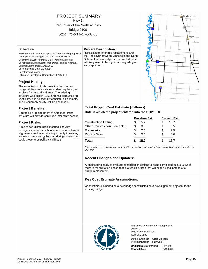
Project History:The expectation of this project is that the new bridge will be structurally redundant, replacing an in-place fracture critical truss. The existing structure was built in 1959 and has exhausted its useful life. It is functionally obsolete, so geometry, and presumably safety, will be enhanced.
Project Benefits:Upgrading or replacement of a fracture critical structure will provide continued inter-state access.
Project Risks:Need to coordinate project scheduling with emergency services, schools and transit; alternate alignments are limited due to proximity to existing infrastructure; closing the road during construction could prove to be politically difficult.
Environmental Document Approval Date: Pending Approval
Schedule:
Municipal Consent Approval Date: Need UnknownGeometric Layout Approval Date: Pending ApprovalConstruction Limits Established Date: Pending ApprovalOriginal Letting Date: 11/16/2012Current Letting Date: 2/28/2014Construction Season: 2013Estimated Substantial Completion: 08/01/2014
!( ?¦A@
?éA@ )x
?£A@
WarrenOslo
Argyle
Stephen
Alvarado
Rehabilitation or bridge replacement over the Red River between Minnesota and North Dakota. If a new bridge is constructed there will likely need to be significant regrading on each approach.
Project Description:
2010Total Project Cost Estimate (millions)Date in which the project entered into the STIP:
Construction Letting: 15.7Other Construction Elements: 0.5Engineering: 2.5Right of Way: 0.0
15.70.52.50.0
Baseline Est. Current Est.
Total: 18.7 18.7
0.00.00.00.0
$$$$
$
$$$$
$
- $ - $ - $ - $
Construction cost estimates are adjusted to the mid-year of construction, using inflation rates provided by OCPPM.
A engineering study to evaluate rehabilitation options is being completed in late 2012. If there is rehabilitation option that is a feasible, then that will be the used instead of a bridge replacement.
Recent Changes and Updates:
Cost estimate is based on a new bridge constructed on a new alignment adjacent to the existing bridge.
Key Cost Estimate Assumptions:
State Project No. 4509-05
Red River of the North at OsloHwy 1
PROJECT SUMMARY
Bridge 9100
District 2Minnesota Department of Transportation
3920 Highway 2 West(218) 755-6500
District Engineer: Craig CollisonProject Manager: Ray Gust
Original Date of Posting: 1/1/2009Revised Date: 12/15/2012
Annual Report on Major Highway ProjectsMinnesota Department of Transportation
Page B4

Project History:This segment is in need of pavement improvement. The project's purpose is to improve the ride and surface condition, pavement strength and extended pavement life.
Project Benefits:Improved ride and surface condition, pavement strength and extended the pavement life.
Project Risks:This project is required to be let as an alternate bid project. The current estimate is based on a bituminous repair. Additional costs needed for a concrete choice may cause other projects to be delayed.
Environmental Document Approval Date:
Schedule:
Municipal Consent Approval Date: Geometric Layout Approval Date: Construction Limits Established Date: Original Letting Date: 1/22/2016Current Letting Date: 1/22/2016Construction Season: 2016Estimated Substantial Completion: Sept. 2016
?£A@
)i
?£A@
!(
!(Fisher
East Grand Forks
This is an Alternate Bid Project and will either be a bituminous reclamation or a concrete overlay.
Project Description:
2012Total Project Cost Estimate (millions)Date in which the project entered into the STIP:
Construction Letting: 5.9Other Construction Elements: 0.4Engineering: 1.0Right of Way: 0.0
5.90.41.00.0
Baseline Est. Current Est.
Total: 7.3 7.3
$$$$
$
$$$$
$
Construction cost estimates are adjusted to the mid-year of construction, using inflation rates provided by OCPPM.
Recent Changes and Updates:
This is an Alternate Bid Project and the cost estimate assumptions are based on a bituminous repair.
Key Cost Estimate Assumptions:
State Project No. 6001-61From Fisher to East Grand Forks - Westbound lanes
Hwy 2PROJECT SUMMARY
District 2Minnesota Department of Transportation
3920 Highway 2 West(218) 755-6500
District Engineer: Craig CollisonProject Manager: Brandy Pemberton
Original Date of Posting: 12/15/2012Revised Date: 12/15/2012
Annual Report on Major Highway ProjectsMinnesota Department of Transportation
Page B5
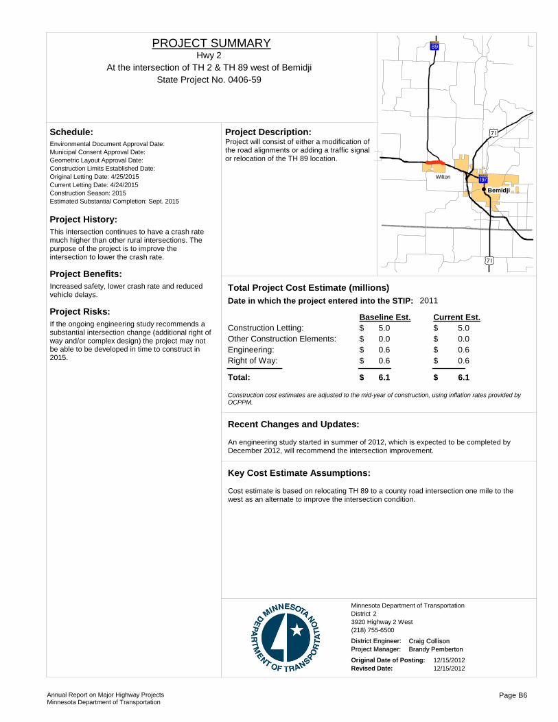
Project History:This intersection continues to have a crash rate much higher than other rural intersections. The purpose of the project is to improve the intersection to lower the crash rate.
Project Benefits:Increased safety, lower crash rate and reduced vehicle delays.
Project Risks:If the ongoing engineering study recommends a substantial intersection change (additional right of way and/or complex design) the project may not be able to be developed in time to construct in 2015.
Environmental Document Approval Date:
Schedule:
Municipal Consent Approval Date: Geometric Layout Approval Date: Construction Limits Established Date: Original Letting Date: 4/25/2015Current Letting Date: 4/24/2015Construction Season: 2015Estimated Substantial Completion: Sept. 2015
)w
?òA@
)w
?{A@!(
!(Bemidji
Wilton
Project will consist of either a modification of the road alignments or adding a traffic signal or relocation of the TH 89 location.
Project Description:
2011Total Project Cost Estimate (millions)Date in which the project entered into the STIP:
Construction Letting: 5.0Other Construction Elements: 0.0Engineering: 0.6Right of Way: 0.6
5.00.00.60.6
Baseline Est. Current Est.
Total: 6.1 6.1
0.00.00.00.0
$$$$
$
$$$$
$
- $ - $ - $ - $
Construction cost estimates are adjusted to the mid-year of construction, using inflation rates provided by OCPPM.
An engineering study started in summer of 2012, which is expected to be completed by December 2012, will recommend the intersection improvement.
Recent Changes and Updates:
Cost estimate is based on relocating TH 89 to a county road intersection one mile to the west as an alternate to improve the intersection condition.
Key Cost Estimate Assumptions:
State Project No. 0406-59At the intersection of TH 2 & TH 89 west of Bemidji
Hwy 2PROJECT SUMMARY
District 2Minnesota Department of Transportation
3920 Highway 2 West(218) 755-6500
District Engineer: Craig CollisonProject Manager: Brandy Pemberton
Original Date of Posting: 12/15/2012Revised Date: 12/15/2012
Annual Report on Major Highway ProjectsMinnesota Department of Transportation
Page B6
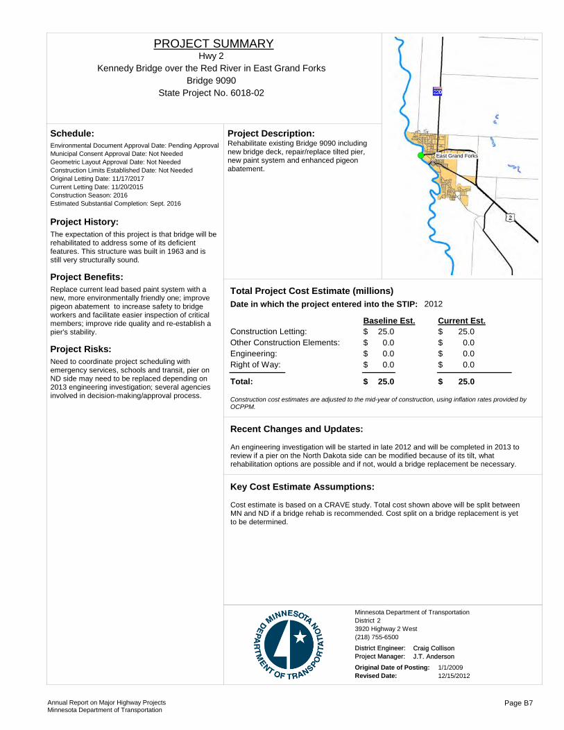
Project History:The expectation of this project is that bridge will be rehabilitated to address some of its deficient features. This structure was built in 1963 and is still very structurally sound.
Project Benefits:Replace current lead based paint system with a new, more environmentally friendly one; improve pigeon abatement to increase safety to bridge workers and facilitate easier inspection of critical members; improve ride quality and re-establish a pier's stability.
Project Risks:Need to coordinate project scheduling with emergency services, schools and transit, pier on ND side may need to be replaced depending on 2013 engineering investigation; several agencies involved in decision-making/approval process.
Environmental Document Approval Date: Pending Approval
Schedule:
Municipal Consent Approval Date: Not NeededGeometric Layout Approval Date: Not NeededConstruction Limits Established Date: Not NeededOriginal Letting Date: 11/17/2017Current Letting Date: 11/20/2015Construction Season: 2016Estimated Substantial Completion: Sept. 2016
!( East Grand Forks
Rehabilitate existing Bridge 9090 including new bridge deck, repair/replace tilted pier, new paint system and enhanced pigeon abatement.
Project Description:
2012Total Project Cost Estimate (millions)Date in which the project entered into the STIP:
Construction Letting: 25.0Other Construction Elements: 0.0Engineering: 0.0Right of Way: 0.0
25.00.00.00.0
Baseline Est. Current Est.
Total: 25.0 25.0
15.00.02.40.0
17.4
$$$$
$
$$$$
$
- $ - $ - $ - $
- $
Construction cost estimates are adjusted to the mid-year of construction, using inflation rates provided by OCPPM.
An engineering investigation will be started in late 2012 and will be completed in 2013 to review if a pier on the North Dakota side can be modified because of its tilt, what rehabilitation options are possible and if not, would a bridge replacement be necessary.
Recent Changes and Updates:
Cost estimate is based on a CRAVE study. Total cost shown above will be split between MN and ND if a bridge rehab is recommended. Cost split on a bridge replacement is yet to be determined.
Key Cost Estimate Assumptions:
State Project No. 6018-02
Kennedy Bridge over the Red River in East Grand ForksHwy 2
PROJECT SUMMARY
Bridge 9090
District 2Minnesota Department of Transportation
3920 Highway 2 West(218) 755-6500
District Engineer: Craig CollisonProject Manager: J.T. Anderson
Original Date of Posting: 1/1/2009Revised Date: 12/15/2012
Annual Report on Major Highway ProjectsMinnesota Department of Transportation
Page B7
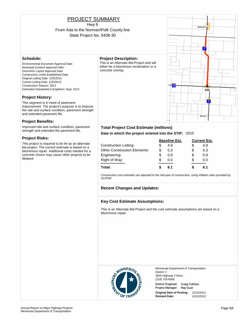
Project History:This segment is in need of pavement improvement. The project's purpose is to improve the ride and surface condition, pavement strength and extended pavement life.
Project Benefits:Improved ride and surface condition, pavement strength and extended the pavement life.
Project Risks:This project is required to be let as an alternate bid project. The current estimate is based on a bituminous repair. Additional costs needed for a concrete choice may cause other projects to be delayed.
Environmental Document Approval Date:
Schedule:
Municipal Consent Approval Date: Geometric Layout Approval Date: Construction Limits Established Date: Original Letting Date: 1/25/2013Current Letting Date: 1/25/2013Construction Season: 2013Estimated Substantial Completion: Sept. 2013
?¬A@
?¬A@
?|A@
!(
!(
!(
Ada
Borup
Beltrami
This is an Alternate Bid Project and will either be a bituminous reclamation or a concrete overlay.
Project Description:
2010Total Project Cost Estimate (millions)Date in which the project entered into the STIP:
Construction Letting: 4.9Other Construction Elements: 0.3Engineering: 0.9Right of Way: 0.0
4.90.30.90.0
Baseline Est. Current Est.
Total: 6.1 6.1
$$$$
$
$$$$
$
Construction cost estimates are adjusted to the mid-year of construction, using inflation rates provided by OCPPM.
Recent Changes and Updates:
This is an Alternate Bid Project and the cost estimate assumptions are based on a bituminous repair.
Key Cost Estimate Assumptions:
State Project No. 5408-30From Ada to the Norman/Polk County line
Hwy 9PROJECT SUMMARY
District 2Minnesota Department of Transportation
3920 Highway 2 West(218) 755-6500
District Engineer: Craig CollisonProject Manager: Ray Gust
Original Date of Posting: 12/15/2012Revised Date: 12/15/2012
Annual Report on Major Highway ProjectsMinnesota Department of Transportation
Page B8
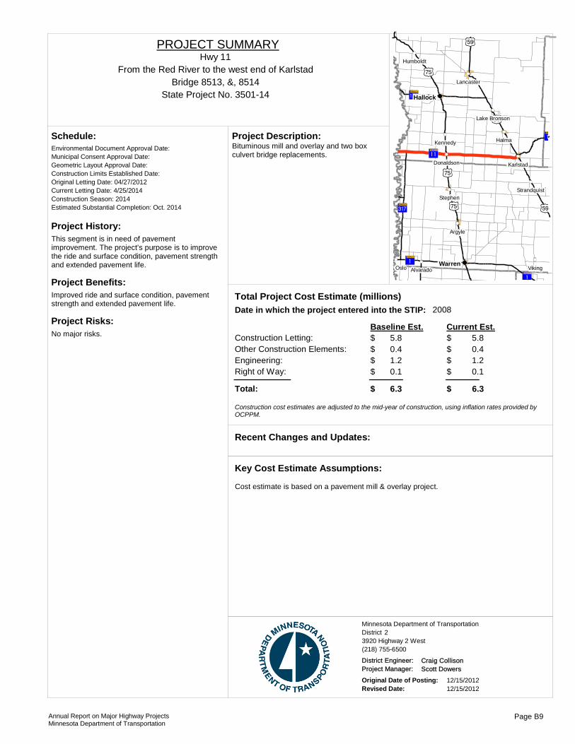
Project History:This segment is in need of pavement improvement. The project's purpose is to improve the ride and surface condition, pavement strength and extended pavement life.
Project Benefits:Improved ride and surface condition, pavement strength and extended pavement life.
Project Risks:No major risks.
Environmental Document Approval Date:
Schedule:
Municipal Consent Approval Date: Geometric Layout Approval Date: Construction Limits Established Date: Original Letting Date: 04/27/2012Current Letting Date: 4/25/2014Construction Season: 2014Estimated Substantial Completion: Oct. 2014
?°A@
?°A@
)x
?yA@
?¦A@
?¦A@
?éA@ )x )r
)r
)r
)x
!(
!(
!(
!(
!(
!(
!(
!(
!(
!(
!(
!(
!(
!(
!(Warren
Hallock
Oslo
Halma
Viking
Argyle
Stephen
Kennedy
Karlstad
Humboldt
Alvarado
Lancaster
Donaldson
Strandquist
Lake Bronson
Bituminous mill and overlay and two box culvert bridge replacements.
Project Description:
2008Total Project Cost Estimate (millions)Date in which the project entered into the STIP:
Construction Letting: 5.8Other Construction Elements: 0.4Engineering: 1.2Right of Way: 0.1
5.80.41.20.1
Baseline Est. Current Est.
Total: 6.3 6.3
0.00.00.00.0
$$$$
$
$$$$
$
- $ - $ - $ - $
Construction cost estimates are adjusted to the mid-year of construction, using inflation rates provided by OCPPM.
Recent Changes and Updates:
Cost estimate is based on a pavement mill & overlay project.
Key Cost Estimate Assumptions:
State Project No. 3501-14
From the Red River to the west end of KarlstadHwy 11
PROJECT SUMMARY
Bridge 8513, &, 8514
District 2Minnesota Department of Transportation
3920 Highway 2 West(218) 755-6500
District Engineer: Craig CollisonProject Manager: Scott Dowers
Original Date of Posting: 12/15/2012Revised Date: 12/15/2012
Annual Report on Major Highway ProjectsMinnesota Department of Transportation
Page B9

Project History:This segment was in need of an improved surface ride, wider shoulders and increased pavement strength to a 10 ton pavement.
Project Benefits:Wider shoulders and improved ditches, smother pavement ride and year round 10 ton pavement strength.
Project Risks:
Environmental Document Approval Date:
Schedule:
Municipal Consent Approval Date: Geometric Layout Approval Date: Construction Limits Established Date: Original Letting Date: 5/18/2012Current Letting Date: 5/18/2012Construction Season: 2012Estimated Substantial Completion: Nov. 2012
?°A@
)w
)w
?àA@
!(
!(
!(International Falls
Big Falls
Littlefork
Reconstruction, bituminous resurfacing and reclamation and culvert replacements.
Project Description:
Total Project Cost Estimate (millions)Date in which the project entered into the STIP:
Construction Letting: 6.5Other Construction Elements: 0.0Engineering: 0.0Right of Way: 0.0
6.50.00.00.0
Baseline Est. Current Est.
Total: 6.5 6.5
0.00.00.00.0
$$$$
$
$$$$
$
- $ - $ - $ - $
Construction cost estimates are adjusted to the mid-year of construction, using inflation rates provided by OCPPM.
Recent Changes and Updates:
Cost estimate is based on a pavement reconditioning project to widen the shoulder width, improve ditches and pavement resurfacing.
Key Cost Estimate Assumptions:
State Project No. 3604-72MFrom 1 mile west of Indus to 1 mile west of Loman
Hwy 11PROJECT SUMMARY
District 2Minnesota Department of Transportation
3920 Highway 2 West(218) 755-6500
District Engineer: Craig CollisonProject Manager: Todd Vonasek
Original Date of Posting: 12/15/2012Revised Date: 12/15/2012
Annual Report on Major Highway ProjectsMinnesota Department of Transportation
Page B10
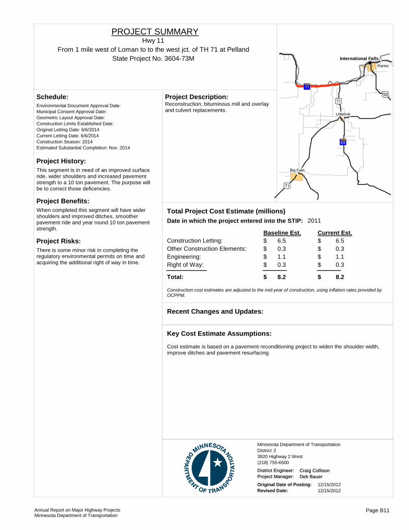
Project History:This segment is in need of an improved surface ride, wider shoulders and increased pavement strength to a 10 ton pavement. The purpose will be to correct those deficencies.
Project Benefits:When completed this segment will have wider shoulders and improved ditches, smoother pavement ride and year round 10 ton pavement strength.
Project Risks:There is some minor risk in completing the regulatory environmental permits on time and acquiring the additional right of way in time.
Environmental Document Approval Date:
Schedule:
Municipal Consent Approval Date: Geometric Layout Approval Date: Construction Limits Established Date: Original Letting Date: 6/6/2014Current Letting Date: 6/6/2014Construction Season: 2014Estimated Substantial Completion: Nov. 2014
?°A@
)w
)q)w
?àA@
!(
!(
!(
!(International Falls
Ranier
Big Falls
Littlefork
Reconstruction, bituminous mill and overlay and culvert replacements.
Project Description:
2011Total Project Cost Estimate (millions)Date in which the project entered into the STIP:
Construction Letting: 6.5Other Construction Elements: 0.3Engineering: 1.1Right of Way: 0.3
6.50.31.10.3
Baseline Est. Current Est.
Total: 8.2 8.2
0.00.00.00.0
$$$$
$
$$$$
$
- $ - $ - $ - $
Construction cost estimates are adjusted to the mid-year of construction, using inflation rates provided by OCPPM.
Recent Changes and Updates:
Cost estimate is based on a pavement reconditioning project to widen the shoulder width, improve ditches and pavement resurfacing.
Key Cost Estimate Assumptions:
State Project No. 3604-73MFrom 1 mile west of Loman to to the west jct. of TH 71 at Pelland
Hwy 11PROJECT SUMMARY
District 2Minnesota Department of Transportation
3920 Highway 2 West(218) 755-6500
District Engineer: Craig CollisonProject Manager: Deb Bauer
Original Date of Posting: 12/15/2012Revised Date: 12/15/2012
Annual Report on Major Highway ProjectsMinnesota Department of Transportation
Page B11
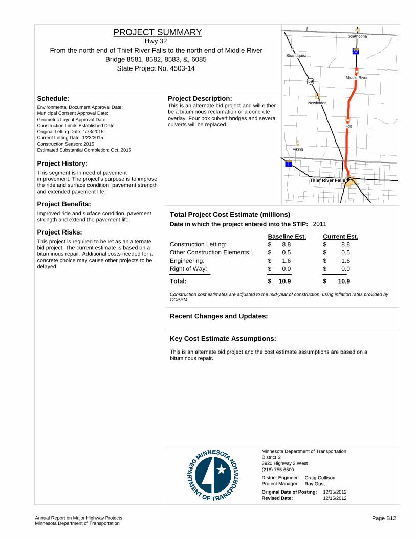
Project History:This segment is in need of pavement improvement. The project's purpose is to improve the ride and surface condition, pavement strength and extended pavement life.
Project Benefits:Improved ride and surface condition, pavement strength and extend the pavement life.
Project Risks:This project is required to be let as an alternate bid project. The current estimate is based on a bituminous repair. Additional costs needed for a concrete choice may cause other projects to be delayed.
Environmental Document Approval Date:
Schedule:
Municipal Consent Approval Date: Geometric Layout Approval Date: Construction Limits Established Date: Original Letting Date: 1/23/2015Current Letting Date: 1/23/2015Construction Season: 2015Estimated Substantial Completion: Oct. 2015
?ÄA@
?¦A@
)r
!(
!(
!(
!(
!(
!(
!(Thief River Falls
Holt
Viking
Newfolden
Strathcona
Strandquist
Middle River
This is an alternate bid project and will either be a bituminous reclamation or a concrete overlay. Four box culvert bridges and several culverts will be replaced.
Project Description:
2011Total Project Cost Estimate (millions)Date in which the project entered into the STIP:
Construction Letting: 8.8Other Construction Elements: 0.5Engineering: 1.6Right of Way: 0.0
8.80.51.60.0
Baseline Est. Current Est.
Total: 10.9 10.9
0.00.00.00.0
$$$$
$
$$$$
$
- $ - $ - $ - $
Construction cost estimates are adjusted to the mid-year of construction, using inflation rates provided by OCPPM.
Recent Changes and Updates:
This is an alternate bid project and the cost estimate assumptions are based on a bituminous repair.
Key Cost Estimate Assumptions:
State Project No. 4503-14
From the north end of Thief River Falls to the north end of Middle RiverHwy 32
PROJECT SUMMARY
Bridge 8581, 8582, 8583, &, 6085
District 2Minnesota Department of Transportation
3920 Highway 2 West(218) 755-6500
District Engineer: Craig CollisonProject Manager: Ray Gust
Original Date of Posting: 12/15/2012Revised Date: 12/15/2012
Annual Report on Major Highway ProjectsMinnesota Department of Transportation
Page B12

Project History:This pavement resurfacing project was let and constructed in 2012.
Project Benefits:Improved ride and surface condition, pavement strength and extended the pavement life.
Project Risks:
Environmental Document Approval Date:
Schedule:
Municipal Consent Approval Date: Geometric Layout Approval Date: Construction Limits Established Date: Original Letting Date: 4/27/2012Current Letting Date: 4/27/2012Construction Season: 2012Estimated Substantial Completion: Sept. 2012
?¦A@
)x
)x
!(
!(
!(
!(Warren
Argyle
Stephen
Alvarado
This is a bituminous mill and overlay project.Project Description:
Total Project Cost Estimate (millions)Date in which the project entered into the STIP:
Construction Letting: 6.1Other Construction Elements: 0.0Engineering: 0.0Right of Way: 0.0
6.10.00.00.0
Baseline Est. Current Est.
Total: 6.1 6.1
0.00.00.00.0
$$$$
$
$$$$
$
- $ - $ - $ - $
Construction cost estimates are adjusted to the mid-year of construction, using inflation rates provided by OCPPM.
Recent Changes and Updates:
Cost estimate is based on a pavement mill & overlay project.
Key Cost Estimate Assumptions:
State Project No. 4507-48From the north limits of Warren to the south end of Stephen
Hwy 75PROJECT SUMMARY
District 2Minnesota Department of Transportation
3920 Highway 2 West(218) 755-6500
District Engineer: Craig CollisonProject Manager: Shawn Groven
Original Date of Posting: 12/15/2012Revised Date: 12/15/2012
Annual Report on Major Highway ProjectsMinnesota Department of Transportation
Page B13

Project History:This segment is in need of pavement improvement. The project's purpose is to improve the ride and surface condition, pavement strength and extended pavement life.
Project Benefits:Improved ride and surface condition, pavement strength and extended pavement life. Replace narrow box culvert bridges with wider box culverts.
Project Risks:No major risks.
Environmental Document Approval Date:
Schedule:
Municipal Consent Approval Date: Geometric Layout Approval Date: Construction Limits Established Date: Original Letting Date: 12/20/2013Current Letting Date: 5/16/2014Construction Season: 2014Estimated Substantial Completion: Sept. 2014
)x
)i?£A@
?¦A@
)i
?üA@
!(
!(
!(
!(
!(
Warren
Crookston
Fisher
Alvarado
Bituminous mill and overlay and seven box culvert bridge replacements.
Project Description:
2010Total Project Cost Estimate (millions)Date in which the project entered into the STIP:
Construction Letting: 5.7Other Construction Elements: 0.4Engineering: 0.1Right of Way: 0.1
5.70.40.10.1
Baseline Est. Current Est.
Total: 7.4 7.4
0.00.00.00.0
$$$$
$
$$$$
$
- $ - $ - $ - $
Construction cost estimates are adjusted to the mid-year of construction, using inflation rates provided by OCPPM.
Recent Changes and Updates:
Cost estimate is based on a pavement mill & overlay project.
Key Cost Estimate Assumptions:
State Project No. 6011-24
12 miles north of TH 2 to 0.1 mile south of TH 1 in WarrenHwy 75
PROJECT SUMMARY
Bridge 8392, 3958, 8393, 8394, 3959, 4463, &, 6631
District 2Minnesota Department of Transportation
3920 Highway 2 West(218) 755-6500
District Engineer: Craig CollisonProject Manager: Shawn Groven
Original Date of Posting: 12/15/2012Revised Date: 12/15/2012
Annual Report on Major Highway ProjectsMinnesota Department of Transportation
Page B14

Project History:This segment is in need of pavement improvement. The project's purpose is to improve the ride and surface condition, pavement strength and extended pavement life.
Project Benefits:Improved ride and surface condition, pavement strength and extended pavement life.
Project Risks:This project is required to be let as an alternate bid project. The current estimate is based on a bituminous repair. Additional costs needed for a concrete choice may cause other projects to be delayed.
Environmental Document Approval Date:
Schedule:
Municipal Consent Approval Date: Geometric Layout Approval Date: Construction Limits Established Date: Original Letting Date: 3/26/2010Current Letting Date: 4/25/2014Construction Season: 2014Estimated Substantial Completion: Sept. 2014
?¬A@
?¬A@)x
?|A@
!(
!(
!(
!(
!(
!(
!(
Ada
Borup
Shelly
Perley
Hendrum
Halstad
Georgetown
This is an Alternate Bid Project and will either be a concrete crack and bituminou overlay or a concrete overlay.
Project Description:
2007Total Project Cost Estimate (millions)Date in which the project entered into the STIP:
Construction Letting: 4.9Other Construction Elements: 0.3Engineering: 1.0Right of Way: 0.0
4.90.31.00.0
Baseline Est. Current Est.
Total: 6.2 6.2
0.00.00.00.0
$$$$
$
$$$$
$
- $ - $ - $ - $
Construction cost estimates are adjusted to the mid-year of construction, using inflation rates provided by OCPPM.
In September of 2012 the project was changed from 2013 to 2014 because of extended design time that was needed to resolve hydraulic issues with the local watershed.
Recent Changes and Updates:
This is an Alternate Bid Project and the cost estimate assumptions are based on a bituminous repair.
Key Cost Estimate Assumptions:
State Project No. 5407-31
From TH 75 to the west limits of AdaHwy 200
PROJECT SUMMARY
Bridge 2068
District 2Minnesota Department of Transportation
3920 Highway 2 West(218) 755-6500
District Engineer: Craig CollisonProject Manager: Shawn Groven
Original Date of Posting: 12/15/2012Revised Date: 12/15/2012
Annual Report on Major Highway ProjectsMinnesota Department of Transportation
Page B15

Project History:This pavement resurfacing project was constructed and completed in 2012.
Project Benefits:Improved ride and surface condition, pavement strength and extended pavement life.
Project Risks:
Environmental Document Approval Date:
Schedule:
Municipal Consent Approval Date: Geometric Layout Approval Date: Construction Limits Established Date: Original Letting Date: 5/18/2012Current Letting Date: 5/18/2012Construction Season: 2011Estimated Substantial Completion: Sept. 2012
?£A@
)i
?£A@
)x
!(
!(
!(Fisher
Climax
East Grand Forks
Standard bituminous mill and overlay project.Project Description:
Total Project Cost Estimate (millions)Date in which the project entered into the STIP:
Construction Letting: 4.2Other Construction Elements: 0.0Engineering: 0.0Right of Way: 0.0
4.20.00.00.0
Baseline Est. Current Est.
Total: 4.2 4.2
0.00.00.00.0
$$$$
$
$$$$
$
- $ - $ - $ - $
Construction cost estimates are adjusted to the mid-year of construction, using inflation rates provided by OCPPM.
Recent Changes and Updates:
Cost estimate is based on a pavement mill & overlay project.
Key Cost Estimate Assumptions:
State Project No. 6016-37From the west limits of Climax to the east junction of TH 2
Hwy 220PROJECT SUMMARY
District 2Minnesota Department of Transportation
3920 Highway 2 West(218) 755-6500
District Engineer: Craig CollisonProject Manager: Shawn Groven
Original Date of Posting: 12/15/2012Revised Date: 12/15/2012
Annual Report on Major Highway ProjectsMinnesota Department of Transportation
Page B16

!(
!(
!(
!(
!(
!(
!(
!(
!(
!(
!(!(
!(
!(
!(
!(
!(
!(
!(
!P
!P
!P
%&h(
%&h( !"b$
%&f(
%&c( %&e(
%&d(
%&f(
%&c( !"b$
%&f(
!"b$
!"̀$
!"b$
!"b$
%&d(
)y
)y )n
)m
)p
)s
)m
)l
?«A@
?ÇA@
?©A@
?ñA@
?±A@
?cA@
?³A@
?uA@
?¾A@
?ÞA@
?̧A@
?ÑA@
?lA@
?ÖA@
?ØA@
?ÒA@
?ØA@
?tA@ ?«A@
?óA@
?©A@ ?öA@
?ûA@
?©A@
?¾A@
?úA@
?àA@
?ÇA@
?öA@
?öA@
?ÒA@
?÷A@
?àA@
?ØA@
?©A@
?øA@
!"b$
!"̀$
)i
?̈A@
?«A@
?¾A@
?ØA@
)n
?}A@
?}A@
?òA@
?ÒA@
?öA@
!"b$
?ÑA@
)m
?ØA@
?|A@
?îA@
?ÁA@
?±A@
?ÆA@
?»A@
)i)w
?äA@
)y
?̀A@
)m
?²A@?½A@
?́A@?́A@
?ýA@
?àA@
)m
?öA@
?òA@
?ôA@
)w
?}A@
)y
)n
?¼A@
?àA@
)w
?¾A@
?ÉA@
)y
)w
)n
?|A@
)w
)y
?àA@
!"̀$
?«A@
?ðA@
?¼A@
?ÂA@
?ªA@
?òA@
)y
!"b$
?ÀA@
?ÀA@
?àA@
?½A@
?æA@
)m)w
?¼A@
?¾A@
?»A@
?}A@
?́A@
?ßA@
?|A@
?̈A@
?àA@
?¼A@)w
?ßA@
?æA@
?ØA@
?ÀA@
?ÒA@
?òA@
?ÀA@
!(!(
!(
!(
!(!(
!(!(!(!(!(!( !(!(!(
!(
!(
!(
!(
!(
!(
!(
!(
!(
!(!(
St. Cloud
Mora
Foley
Walker
Wadena
Milaca
Buffalo
Brainerd
Elk River
Long Prairie Little Falls
.Major Highway Projects 2013District 3
Brainerd

ROUTE PROJECT LOCATION PAGE
District Project SummaryDistrict 3
State Project #
Hwy 10 From Benton Co. Hwy 4 to RR Crossing in St. Cloud C 20502-103
Hwy 10 Jct. Benton CSAH 2 in Rice C 30502-96
Hwy 10 Anoka/Sherburne Co Line to Elk River C 47101-61M
Hwy 10 Clear Lake to Big Lake C 57102-122
Hwy 10 Westbound lanes from St. Cloud to Clear Lake C 67103-51
Hwy 10 Sauk Rapids C 70502-107
Hwy 12 Delano C 88602-51
Hwy 15 St. Cloud C 97303-48
Hwy 15 Stearns County Road 120 in St. Cloud/Sartell C 107321-47
Hwy 23 Jct TH 95 E of St. Cloud to Jct TH 25 in Foley C 110503-75
Hwy 24 Replace Bridge 6557 over Mississippi River in Clearwater C 127108-23
Hwy 25 Buffalo C 138605-49
Hwy 25 Monticello C 148605-50
Hwy 71 Long Prairie to Bertha, Excluding Browerville C 157708-38
I-94 Monticello C 168680-158
I-94 Monticello to St. Michael C 178680-162
I-94 Collegeville to St. Joseph C 187380-223
I-94 St. Cloud to Clearwater C 197380-238
I-94 St. Joseph to Bridge over Sauk River C 207380-239
I-94 Wright Hwy 19 to Hwy 37 in Albertville C 218680-145
Hwy 95 Rum River Bridge in Cambridge C 223006-36
Hwy 169 Mille Lacs Co Rd 148 to north of junction Co Hwy 19 C 234812-83
Hwy 169 Zimmerman to Princeton C 247106-78
Hwy 169 Elk River to Zimmerman C 257106-82
Hwy 371 From Design Drive in Baxter to Nisswa C 261810-95
Hwy 371 Nisswa C 271810-98
Annual Report on Major Highway ProjectsMinnesota Department of Transportation Page C1
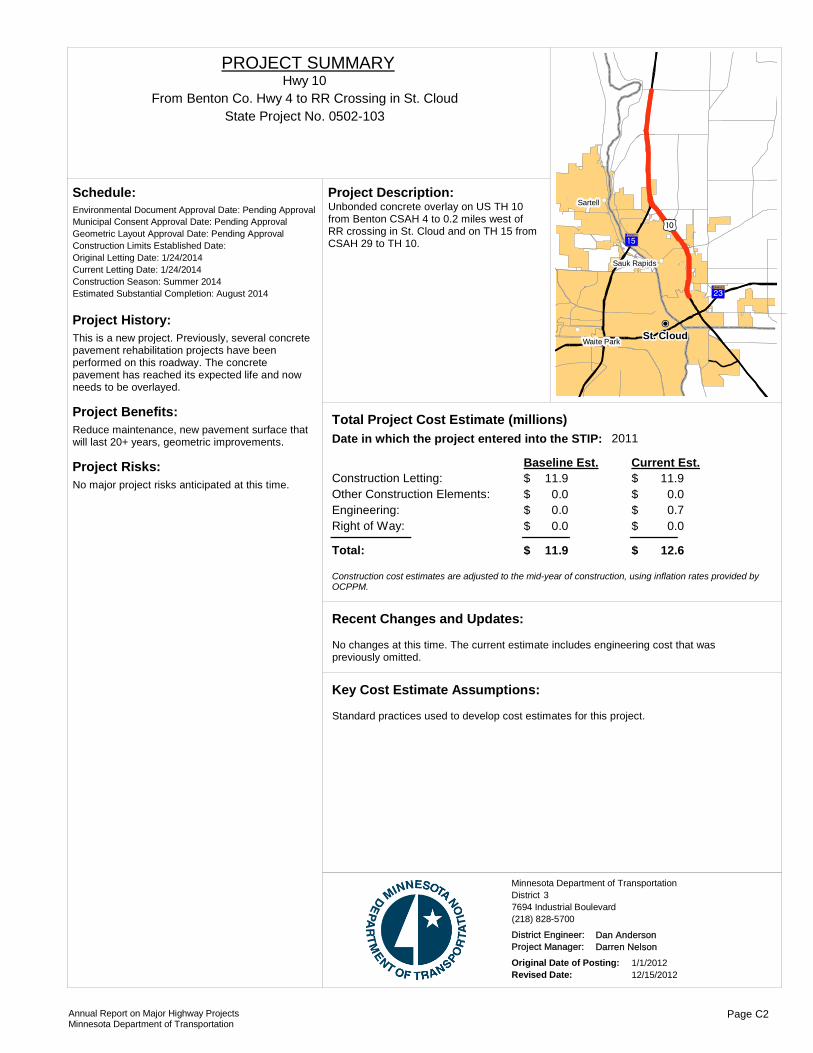
Project History:This is a new project. Previously, several concrete pavement rehabilitation projects have been performed on this roadway. The concrete pavement has reached its expected life and now needs to be overlayed.
Project Benefits:Reduce maintenance, new pavement surface that will last 20+ years, geometric improvements.
Project Risks:No major project risks anticipated at this time.
Environmental Document Approval Date: Pending Approval
Schedule:
Municipal Consent Approval Date: Pending ApprovalGeometric Layout Approval Date: Pending ApprovalConstruction Limits Established Date: Original Letting Date: 1/24/2014Current Letting Date: 1/24/2014Construction Season: Summer 2014Estimated Substantial Completion: August 2014
)m?²A@
?¼A@
!(
!(
!(!P
St. Cloud
Sartell
Waite Park
Sauk Rapids
Unbonded concrete overlay on US TH 10 from Benton CSAH 4 to 0.2 miles west of RR crossing in St. Cloud and on TH 15 from CSAH 29 to TH 10.
Project Description:
2011Total Project Cost Estimate (millions)Date in which the project entered into the STIP:
Construction Letting: 11.9Other Construction Elements: 0.0Engineering: 0.0Right of Way: 0.0
11.90.00.70.0
Baseline Est. Current Est.
Total: 11.9 12.6
$$$$
$
$$$$
$
Construction cost estimates are adjusted to the mid-year of construction, using inflation rates provided by OCPPM.
No changes at this time. The current estimate includes engineering cost that was previously omitted.
Recent Changes and Updates:
Standard practices used to develop cost estimates for this project.
Key Cost Estimate Assumptions:
State Project No. 0502-103From Benton Co. Hwy 4 to RR Crossing in St. Cloud
Hwy 10PROJECT SUMMARY
District 3Minnesota Department of Transportation
7694 Industrial Boulevard(218) 828-5700
District Engineer: Dan AndersonProject Manager: Darren Nelson
Original Date of Posting: 1/1/2012Revised Date: 12/15/2012
Annual Report on Major Highway ProjectsMinnesota Department of Transportation
Page C2

Project History:The at-grade intersection has a history of severe and fatal crashes.
Project Benefits:Improved safety and reduced congestion.
Project Risks:
Environmental Document Approval Date: Pending Approval
Schedule:
Municipal Consent Approval Date: Pending ApprovalGeometric Layout Approval Date: Pending ApprovalConstruction Limits Established Date: Pending ApprovalOriginal Letting Date: 2/23/2013Current Letting Date: 3/22/2013Construction Season: Summer 2013Estimated Substantial Completion: 11/1/2013
?¾A@
)m
)m?²A@
!(
!(
!(
!(
!(
Rice
Sartell
Royalton
St. Stephen
This is an interchange project along Hwy 10 in Rice.
Project Description:
2012Total Project Cost Estimate (millions)Date in which the project entered into the STIP:
Construction Letting: 20.7Other Construction Elements: 0.0Engineering: 4.4Right of Way: 7.0
14.50.03.01.3
Baseline Est. Current Est.
Total: 32.1 18.8
$$$$
$
$$$$
$
Construction cost estimates are adjusted to the mid-year of construction, using inflation rates provided by OCPPM.
The design was changed to reduce costs associated with relocating a county state aid highway.
Recent Changes and Updates:
Standard practices used to develop cost estimates for this project.
Key Cost Estimate Assumptions:
State Project No. 0502-96Jct. Benton CSAH 2 in Rice
Hwy 10PROJECT SUMMARY
District 3Minnesota Department of Transportation
7694 Industrial Boulevard(218) 828-5700
District Engineer: Dan AndersonProject Manager: Claudia Dumont
Original Date of Posting: 1/1/2012Revised Date: 12/15/2012
Annual Report on Major Highway ProjectsMinnesota Department of Transportation
Page C3
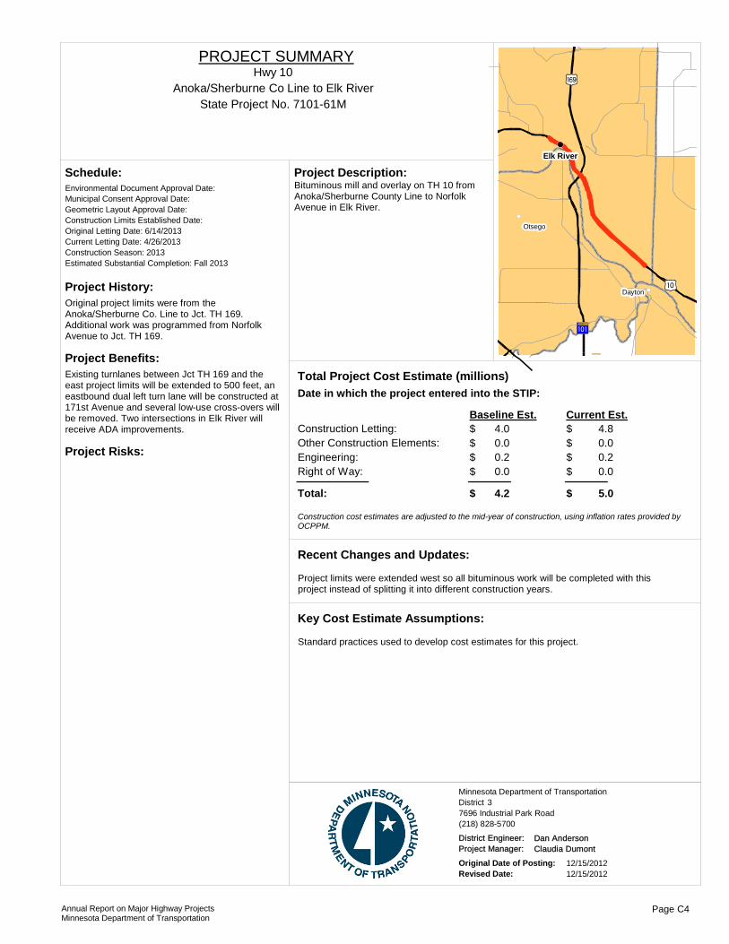
Project History:Original project limits were from the Anoka/Sherburne Co. Line to Jct. TH 169. Additional work was programmed from Norfolk Avenue to Jct. TH 169.
Project Benefits:Existing turnlanes between Jct TH 169 and the east project limits will be extended to 500 feet, an eastbound dual left turn lane will be constructed at 171st Avenue and several low-use cross-overs will be removed. Two intersections in Elk River will receive ADA improvements.
Project Risks:
Environmental Document Approval Date:
Schedule:
Municipal Consent Approval Date: Geometric Layout Approval Date: Construction Limits Established Date: Original Letting Date: 6/14/2013Current Letting Date: 4/26/2013Construction Season: 2013Estimated Substantial Completion: Fall 2013
?ûA@
)m
)y
!(
!(
!(
Elk River
Otsego
Dayton
Bituminous mill and overlay on TH 10 from Anoka/Sherburne County Line to Norfolk Avenue in Elk River.
Project Description:
Total Project Cost Estimate (millions)Date in which the project entered into the STIP:
Construction Letting: 4.0Other Construction Elements: 0.0Engineering: 0.2Right of Way: 0.0
4.80.00.20.0
Baseline Est. Current Est.
Total: 4.2 5.0
$$$$
$
$$$$
$
Construction cost estimates are adjusted to the mid-year of construction, using inflation rates provided by OCPPM.
Project limits were extended west so all bituminous work will be completed with this project instead of splitting it into different construction years.
Recent Changes and Updates:
Standard practices used to develop cost estimates for this project.
Key Cost Estimate Assumptions:
State Project No. 7101-61MAnoka/Sherburne Co Line to Elk River
Hwy 10PROJECT SUMMARY
District 3Minnesota Department of Transportation
7696 Industrial Park Road(218) 828-5700
District Engineer: Dan AndersonProject Manager: Claudia Dumont
Original Date of Posting: 12/15/2012Revised Date: 12/15/2012
Annual Report on Major Highway ProjectsMinnesota Department of Transportation
Page C4

Project History:Project identified by district as having poor pavement conditions.
Project Benefits:Project addresses pavement preservation.
Project Risks:
Environmental Document Approval Date: 4/14/2011
Schedule:
Municipal Consent Approval Date: Geometric Layout Approval Date: Construction Limits Established Date: Original Letting Date: 3/25/2011Current Letting Date: 8/19/2011Construction Season: Fall 2011, Summer 2012Estimated Substantial Completion: June 2012
Project was recipient of FY 2011 extra federal appropriations funding and was subsequently rescoped to a longer term improvement contributing to a higher cost.
Recent Changes and Updates:
Baseline estimate reflects a shorter project with a short term fix. After programming, the project was re-scoped to a combination reconstruct and unbonded concrete overlay, and the project limits were lengthened.
Key Cost Estimate Assumptions:
?½A@
?½A@
?öA@
?¾A@
?¾A@
)m
!"b$
Becker
Big Lake
Monticello
Maple Lake
Clearwater
Clear LakeThis is an unbonded concrete overlay project at the Jct of TH 24 in Clear Lake to Jct TH 25 in Big Lake along the westbound lane.
Project Description:
2008Total Project Cost Estimate (millions)Date in which the project entered into the STIP:
Construction Letting: 7.5Other Construction Elements: 0.0Engineering: 0.0Right of Way: 0.0
13.10.00.00.0
Baseline Est. Current Est.
Total: 7.5 13.1
$$$$
$
$$$$
$
Construction cost estimates are adjusted to the mid-year of construction, using inflation rates provided by OCPPM.
State Project No. 7102-122Clear Lake to Big Lake
Hwy 10PROJECT SUMMARY
District 3Minnesota Department of Transportation
7694 Industrial Boulevard(218) 828-5700
District Engineer: Dan AndersonProject Manager: Claudia Dumont
Original Date of Posting: 1/1/2012Revised Date: 12/15/2012
Annual Report on Major Highway ProjectsMinnesota Department of Transportation
Page C5

Project History:The westbound lanes of Hwy 10 were constructed in 1951. A joint sealing project was conducted in 1974, followed by a repair project in 1997. The shoulders and turn lanes are bituminous.
Project Benefits:The new pavement will provide a smooth ride and will require minimal maintenance during the next 20 years. The widened lanes will meet current standards.
Project Risks:
Environmental Document Approval Date: 5/1/2009
Schedule:
Municipal Consent Approval Date: Geometric Layout Approval Date: Construction Limits Established Date: Original Letting Date: 1/22/2010Current Letting Date: 4/23/2010Construction Season: 2010-2011Estimated Substantial Completion: Fall 2010
This project received Chapter 152 funds. No changes or updates since the last report.
Recent Changes and Updates:
Based on estimated quantities and average bid prices.
Key Cost Estimate Assumptions:
St. Cloud
Clearwater
Clear Lake
Sauk Rapids
St. Augusta
Pavement replacement on westbound lanes from St. Cloud to Clear Lake, including intersection reconstruction at 15th Avenue SE in St. Cloud and at Hwy 24 in Clear Lake. The existing 11 foot wide travel lanes will be widened to 12 feet to meet current
Project Description:
Total Project Cost Estimate (millions)Date in which the project entered into the STIP:
Construction Letting: 16.9Other Construction Elements: 0.0Engineering: 3.4Right of Way: 0.0
13.60.02.70.0
Baseline Est. Current Est.
Total: 20.3 16.3
$$$$
$
$$$$
$
Construction cost estimates are adjusted to the mid-year of construction, using inflation rates provided by OCPPM.
State Project No. 7103-51Westbound lanes from St. Cloud to Clear Lake
Hwy 10PROJECT SUMMARY
District 3Minnesota Department of Transportation
7694 Industrial Boulevard(218) 828-5700
District Engineer: Dan AndersonProject Manager: Claudia Dumont
Original Date of Posting: 1/1/2009Revised Date: 12/15/2012
Annual Report on Major Highway ProjectsMinnesota Department of Transportation
Page C6
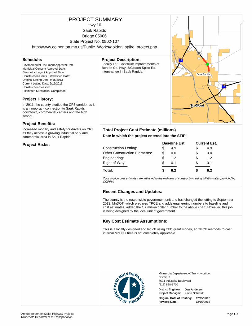
Project History:In 2011, the county studied the CR3 corridor as it is an important connection to Sauk Rapids downtown, commercial centers and the high school.
Project Benefits:Increased mobility and safety for drivers on CR3 as they access a growing industrial park and commercial area in Sauk Rapids.
Project Risks:
Environmental Document Approval Date:
Schedule:
Municipal Consent Approval Date: Geometric Layout Approval Date: Construction Limits Established Date: Original Letting Date: 9/15/2013Current Letting Date: 9/15/2013Construction Season: Estimated Substantial Completion:
)m
?²A@
?¼A@
!(
!P
!(!(
St. Cloud
Sauk Rapids
Locally Let -Construct improvements at Benton Co. Hwy. 3/Golden Spike Rd. interchange in Sauk Rapids.
Project Description:
Total Project Cost Estimate (millions)Date in which the project entered into the STIP:
Construction Letting: 4.9Other Construction Elements: 0.0Engineering: 1.2Right of Way: 0.1
4.90.01.20.1
Baseline Est. Current Est.
Total: 6.2 6.2
$$$$
$
$$$$
$
Construction cost estimates are adjusted to the mid-year of construction, using inflation rates provided by OCPPM.
The county is the responsible government unit and has changed the letting to September 2013. MnDOT, which prepares TPCE and adds engineering numbers to baseline and cost estimates, added the 1.2 million dollar number to the above chart. However, this job is being designed by the local unit of government.
Recent Changes and Updates:
This is a locally designed and let job using TED grant money, so TPCE methods to cost internal MnDOT time is not completely applicable.
Key Cost Estimate Assumptions:
State Project No. 0502-107
Sauk Rapids
http://www.co.benton.mn.us/Public_Works/golden_spike_project.php
Hwy 10PROJECT SUMMARY
Bridge 05006
District 3Minnesota Department of Transportation
7694 Industrial Boulevard(218) 828-5700
District Engineer: Dan AndersonProject Manager: Kevin Schmidt
Original Date of Posting: 12/15/2012Revised Date: 12/15/2012
Annual Report on Major Highway ProjectsMinnesota Department of Transportation
Page C7
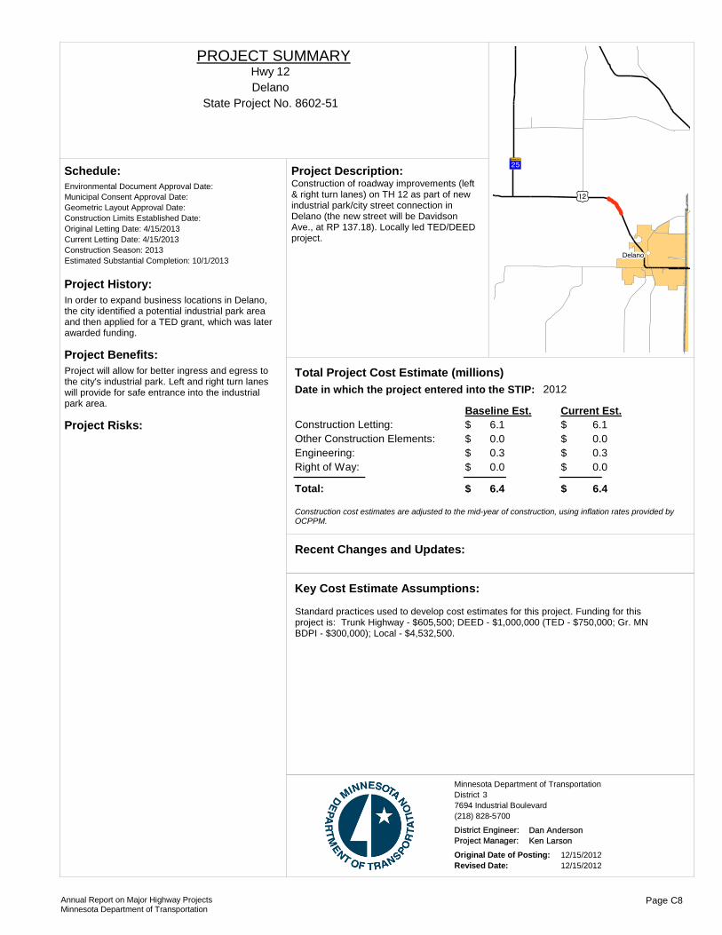
Project History:In order to expand business locations in Delano, the city identified a potential industrial park area and then applied for a TED grant, which was later awarded funding.
Project Benefits:Project will allow for better ingress and egress to the city's industrial park. Left and right turn lanes will provide for safe entrance into the industrial park area.
Project Risks:
Environmental Document Approval Date:
Schedule:
Municipal Consent Approval Date: Geometric Layout Approval Date: Construction Limits Established Date: Original Letting Date: 4/15/2013Current Letting Date: 4/15/2013Construction Season: 2013Estimated Substantial Completion: 10/1/2013
?¾A@
)n
!(Delano
Construction of roadway improvements (left & right turn lanes) on TH 12 as part of new industrial park/city street connection in Delano (the new street will be Davidson Ave., at RP 137.18). Locally led TED/DEED project.
Project Description:
2012Total Project Cost Estimate (millions)Date in which the project entered into the STIP:
Construction Letting: 6.1Other Construction Elements: 0.0Engineering: 0.3Right of Way: 0.0
6.10.00.30.0
Baseline Est. Current Est.
Total: 6.4 6.4
$$$$
$
$$$$
$
Construction cost estimates are adjusted to the mid-year of construction, using inflation rates provided by OCPPM.
Recent Changes and Updates:
Standard practices used to develop cost estimates for this project. Funding for this project is: Trunk Highway - $605,500; DEED - $1,000,000 (TED - $750,000; Gr. MN BDPI - $300,000); Local - $4,532,500.
Key Cost Estimate Assumptions:
State Project No. 8602-51DelanoHwy 12
PROJECT SUMMARY
District 3Minnesota Department of Transportation
7694 Industrial Boulevard(218) 828-5700
District Engineer: Dan AndersonProject Manager: Ken Larson
Original Date of Posting: 12/15/2012Revised Date: 12/15/2012
Annual Report on Major Highway ProjectsMinnesota Department of Transportation
Page C8
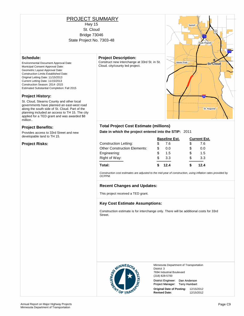
Project History:St. Cloud, Stearns County and other local governments have planned an east-west road along the south side of St. Cloud. Part of the planning included an access to TH 15. The city applied for a TED grant and was awarded $8 million..
Project Benefits:Provides access to 33rd Street and new developable land to TH 15.
Project Risks:
Environmental Document Approval Date:
Schedule:
Municipal Consent Approval Date: Geometric Layout Approval Date: Construction Limits Established Date: Original Letting Date: 11/15/2013Current Letting Date: 11/15/2013Construction Season: 2014 -2015Estimated Substantial Completion: Fall 2015
!"b$
)m?²A@
?¼A@
!(
!(
!(
!(!P
St. Cloud
Sartell
Waite Park
Sauk Rapids
St. Augusta
Construct new interchange at 33rd St. in St. Cloud. city/county led project.
Project Description:
2011Total Project Cost Estimate (millions)Date in which the project entered into the STIP:
Construction Letting: 7.6Other Construction Elements: 0.0Engineering: 1.5Right of Way: 3.3
7.60.01.53.3
Baseline Est. Current Est.
Total: 12.4 12.4
$$$$
$
$$$$
$
Construction cost estimates are adjusted to the mid-year of construction, using inflation rates provided by OCPPM.
This project received a TED grant.
Recent Changes and Updates:
Construction estimate is for interchange only. There will be additional costs for 33rd Street.
Key Cost Estimate Assumptions:
State Project No. 7303-48
St. CloudHwy 15
PROJECT SUMMARY
Bridge 73046
District 3Minnesota Department of Transportation
7694 Industrial Boulevard(218) 828-5700
District Engineer: Dan AndersonProject Manager: Terry Humbert
Original Date of Posting: 12/15/2012Revised Date: 12/15/2012
Annual Report on Major Highway ProjectsMinnesota Department of Transportation
Page C9
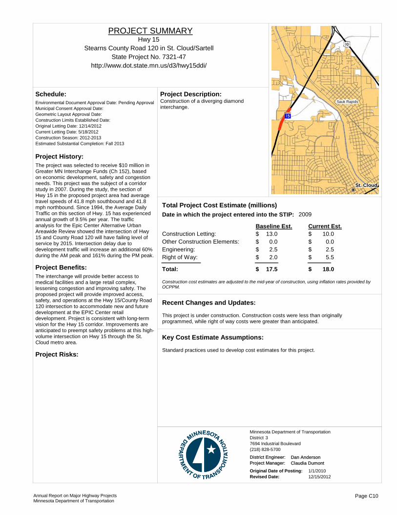
Project History:The project was selected to receive $10 million in Greater MN Interchange Funds (Ch 152), based on economic development, safety and congestion needs. This project was the subject of a corridor study in 2007. During the study, the section of Hwy 15 in the proposed project area had average travel speeds of 41.8 mph southbound and 41.8 mph northbound. Since 1994, the Average Daily Traffic on this section of Hwy. 15 has experienced annual growth of 9.5% per year. The traffic analysis for the Epic Center Alternative Urban Areawide Review showed the intersection of Hwy 15 and County Road 120 will have failing level of service by 2015. Intersection delay due to development traffic will increase an additional 60% during the AM peak and 161% during the PM peak.
Project Benefits:The interchange will provide better access to medical facilities and a large retail complex, lessening congestion and improving safety. The proposed project will provide improved access, safety, and operations at the Hwy 15/County Road 120 intersection to accommodate new and future development at the EPIC Center retail development. Project is consistent with long-term vision for the Hwy 15 corridor. Improvements are anticipated to preempt safety problems at this high-volume intersection on Hwy 15 through the St. Cloud metro area.
Project Risks:
Environmental Document Approval Date: Pending Approval
Schedule:
Municipal Consent Approval Date: Geometric Layout Approval Date: Construction Limits Established Date: Original Letting Date: 12/14/2012Current Letting Date: 5/18/2012Construction Season: 2012-2013Estimated Substantial Completion: Fall 2013
St. Cloud
Sauk RapidsConstruction of a diverging diamond interchange.
Project Description:
2009Total Project Cost Estimate (millions)Date in which the project entered into the STIP:
Construction Letting: 13.0Other Construction Elements: 0.0Engineering: 2.5Right of Way: 2.0
10.00.02.55.5
Baseline Est. Current Est.
Total: 17.5 18.0
$$$$
$
$$$$
$
Construction cost estimates are adjusted to the mid-year of construction, using inflation rates provided by OCPPM.
This project is under construction. Construction costs were less than originally programmed, while right of way costs were greater than anticipated.
Recent Changes and Updates:
Standard practices used to develop cost estimates for this project.
Key Cost Estimate Assumptions:
State Project No. 7321-47Stearns County Road 120 in St. Cloud/Sartell
http://www.dot.state.mn.us/d3/hwy15ddi/
Hwy 15PROJECT SUMMARY
District 3Minnesota Department of Transportation
7694 Industrial Boulevard(218) 828-5700
District Engineer: Dan AndersonProject Manager: Claudia Dumont
Original Date of Posting: 1/1/2010Revised Date: 12/15/2012
Annual Report on Major Highway ProjectsMinnesota Department of Transportation
Page C10

Project History:This highway segment has a history of severe and fatal head-on crashes.
Project Benefits:Improved safety and mobility on the corridor.
Project Risks:
Environmental Document Approval Date: 9/5/2003
Schedule:
Municipal Consent Approval Date: 5/18/2004Geometric Layout Approval Date: 6/26/2003Construction Limits Established Date: 4/1/2010Original Letting Date: 11/11/2007Current Letting Date: 4/22/2011Construction Season: 2011-2012Estimated Substantial Completion: September 2012
Foley
Gilman
Jct TH 95 E of St. Cloud to Jct TH 25 in Foley, construct four-lane expressway and bridge construction. Jct TH 25 in Foley to 1.7 mi E, Mill and overlay, upgrade pedestrian ramps.
Project Description:
Total Project Cost Estimate (millions)Date in which the project entered into the STIP:
Construction Letting: 28.5Other Construction Elements: 0.0Engineering: 5.7Right of Way: 6.3
25.80.25.26.8
Baseline Est. Current Est.
Total: 40.5 37.8
$$$$
$
$$$$
$
Construction cost estimates are adjusted to the mid-year of construction, using inflation rates provided by OCPPM.
First time project is included in this report. Project presently under construction. Project low bid was lower than program estimates.
Recent Changes and Updates:
Standard practices used to develop cost estimates for this project.
Key Cost Estimate Assumptions:
State Project No. 0503-75Jct TH 95 E of St. Cloud to Jct TH 25 in Foley
Hwy 23PROJECT SUMMARY
District 3Minnesota Department of Transportation
7694 Industrial Boulevard(218) 828-5700
District Engineer: Dan AndersonProject Manager: Claudia Dumont
Original Date of Posting: 12/15/2012Revised Date: 12/15/2012
Annual Report on Major Highway ProjectsMinnesota Department of Transportation
Page C11

Project History:This is a new project.
Project Benefits:Improve safety and long-term mobility.
Project Risks:Parallel bridge or long detour.
Environmental Document Approval Date: Need Unknown
Schedule:
Municipal Consent Approval Date: Need UnknownGeometric Layout Approval Date: Need UnknownConstruction Limits Established Date: Need UnknownOriginal Letting Date: 2/26/2016Current Letting Date: 5/15/2015Construction Season: 2016Estimated Substantial Completion:
!(Clearwater
Clear Lake
This project was programmed to replace the bridge over the Mississippi River. The bridge was constructed in 1958. Due to the age of the bridge, size and cost, it has been programmed for replacement. The deck is deteriorating with 9.3% delamination. The deck geometry and traffic volumes are a safety problem for motorists and pedestrians.
Project Description:
Total Project Cost Estimate (millions)Date in which the project entered into the STIP:
Construction Letting: 20.0Other Construction Elements: 2.2Engineering: 4.4Right of Way: 5.0
24.02.24.41.2
Baseline Est. Current Est.
Total: 31.6 31.8
$$$$
$
$$$$
$
Construction cost estimates are adjusted to the mid-year of construction, using inflation rates provided by OCPPM.
No changes or updates since the last report.
Recent Changes and Updates:
Standard practices used to develop cost estimates for this project.
Key Cost Estimate Assumptions:
State Project No. 7108-23
Replace Bridge 6557 over Mississippi River in ClearwaterHwy 24
PROJECT SUMMARY
Bridge 6557
District 3Minnesota Department of Transportation
7694 Industrial Boulevard(218) 828-5700
District Engineer: Dan AndersonProject Manager: Claudia Dumont
Original Date of Posting: 1/1/2010Revised Date: 12/15/2012
Annual Report on Major Highway ProjectsMinnesota Department of Transportation
Page C12

Project History:This is a new project.
Project Benefits:Ride quality will be improved as this project will address deteriorating pavement conditions.
Project Risks:
Environmental Document Approval Date:
Schedule:
Municipal Consent Approval Date: Geometric Layout Approval Date: Construction Limits Established Date: Original Letting Date: 3/28/2014Current Letting Date: 3/27/2015Construction Season: 2015Estimated Substantial Completion: Fall 2015
?ØA@
?¾A@
!(
Buffalo
Reconstruction from 7th St. to 0.5 miles north of Wright Co. Rd 137 in Buffalo, including traffic signal upgrades and ADA improvements.
Project Description:
2012Total Project Cost Estimate (millions)Date in which the project entered into the STIP:
Construction Letting: 5.0Other Construction Elements: 0.0Engineering: 0.4Right of Way: 0.9
5.00.00.40.9
Baseline Est. Current Est.
Total: 6.3 6.3
$$$$
$
$$$$
$
Construction cost estimates are adjusted to the mid-year of construction, using inflation rates provided by OCPPM.
Recent Changes and Updates:
Standard practices used to develop cost estimates for this project.
Key Cost Estimate Assumptions:
State Project No. 8605-49BuffaloHwy 25
PROJECT SUMMARY
District 3Minnesota Department of Transportation
7694 Industrial Boulevard(218) 828-5700
District Engineer: Dan AndersonProject Manager: Claudia Dumont
Original Date of Posting: 12/15/2012Revised Date: 12/15/2012
Annual Report on Major Highway ProjectsMinnesota Department of Transportation
Page C13

Project History:This is a new project.
Project Benefits:Ride quality will be improved as this project will address deteriorating pavement conditions.
Project Risks:
Environmental Document Approval Date:
Schedule:
Municipal Consent Approval Date: Geometric Layout Approval Date: Construction Limits Established Date: Original Letting Date: 3/28/2014Current Letting Date: 3/28/2014Construction Season: 2014Estimated Substantial Completion: Fall 2014
?¾A@
?¾A@
!"b$
!(
!(
!( Buffalo
Big Lake
Monticello
Reconstruction from 0.5 miles south of Wright Co. Rd. 138 to south of School Boulevard in Monticello.
Project Description:
2012Total Project Cost Estimate (millions)Date in which the project entered into the STIP:
Construction Letting: 5.0Other Construction Elements: 0.0Engineering: 0.3Right of Way: 0.4
5.00.00.30.4
Baseline Est. Current Est.
Total: 5.7 5.7
$$$$
$
$$$$
$
Construction cost estimates are adjusted to the mid-year of construction, using inflation rates provided by OCPPM.
Recent Changes and Updates:
Standard practices used to develop cost estimates for this project.
Key Cost Estimate Assumptions:
State Project No. 8605-50Monticello
Hwy 25PROJECT SUMMARY
District 3Minnesota Department of Transportation
7694 Industrial Boulevard(218) 828-5700
District Engineer: Dan AndersonProject Manager: Claudia Dumont
Original Date of Posting: 12/15/2012Revised Date: 12/15/2012
Annual Report on Major Highway ProjectsMinnesota Department of Transportation
Page C14
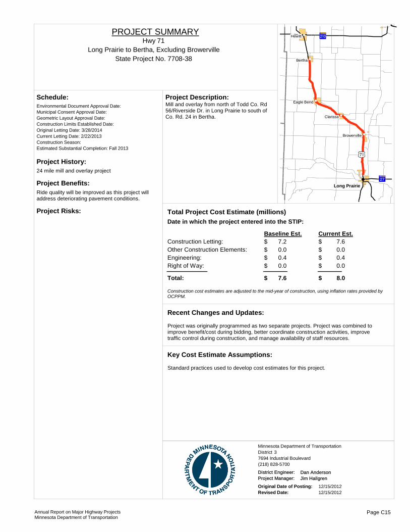
Project History:24 mile mill and overlay project
Project Benefits:Ride quality will be improved as this project will address deteriorating pavement conditions.
Project Risks:
Environmental Document Approval Date:
Schedule:
Municipal Consent Approval Date: Geometric Layout Approval Date: Construction Limits Established Date: Original Letting Date: 3/28/2014Current Letting Date: 2/22/2013Construction Season: Estimated Substantial Completion: Fall 2013
)w
?}A@
?ÀA@
!(
!(
!(
!(
!(
!(
Long Prairie
Hewitt
Bertha
Clarissa
Eagle Bend
Browerville
Mill and overlay from north of Todd Co. Rd 56/Riverside Dr. in Long Prairie to south of Co. Rd. 24 in Bertha.
Project Description:
Total Project Cost Estimate (millions)Date in which the project entered into the STIP:
Construction Letting: 7.2Other Construction Elements: 0.0Engineering: 0.4Right of Way: 0.0
7.60.00.40.0
Baseline Est. Current Est.
Total: 7.6 8.0
$$$$
$
$$$$
$
Construction cost estimates are adjusted to the mid-year of construction, using inflation rates provided by OCPPM.
Project was originally programmed as two separate projects. Project was combined to improve benefit/cost during bidding, better coordinate construction activities, improve traffic control during construction, and manage availability of staff resources.
Recent Changes and Updates:
Standard practices used to develop cost estimates for this project.
Key Cost Estimate Assumptions:
State Project No. 7708-38Long Prairie to Bertha, Excluding Browerville
Hwy 71PROJECT SUMMARY
District 3Minnesota Department of Transportation
7694 Industrial Boulevard(218) 828-5700
District Engineer: Dan AndersonProject Manager: Jim Hallgren
Original Date of Posting: 12/15/2012Revised Date: 12/15/2012
Annual Report on Major Highway ProjectsMinnesota Department of Transportation
Page C15
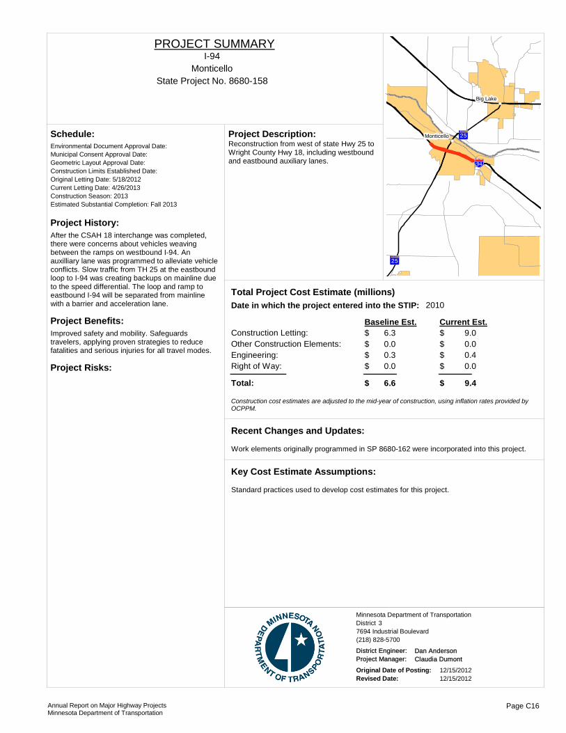
Project History:After the CSAH 18 interchange was completed, there were concerns about vehicles weaving between the ramps on westbound I-94. An auxilliary lane was programmed to alleviate vehicle conflicts. Slow traffic from TH 25 at the eastbound loop to I-94 was creating backups on mainline due to the speed differential. The loop and ramp to eastbound I-94 will be separated from mainline with a barrier and acceleration lane.
Project Benefits:Improved safety and mobility. Safeguards travelers, applying proven strategies to reduce fatalities and serious injuries for all travel modes.
Project Risks:
Environmental Document Approval Date:
Schedule:
Municipal Consent Approval Date: Geometric Layout Approval Date: Construction Limits Established Date: Original Letting Date: 5/18/2012Current Letting Date: 4/26/2013Construction Season: 2013Estimated Substantial Completion: Fall 2013
?¾A@
?¾A@
!"b$
!(
!(
Big Lake
MonticelloReconstruction from west of state Hwy 25 to Wright County Hwy 18, including westbound and eastbound auxiliary lanes.
Project Description:
2010Total Project Cost Estimate (millions)Date in which the project entered into the STIP:
Construction Letting: 6.3Other Construction Elements: 0.0Engineering: 0.3Right of Way: 0.0
9.00.00.40.0
Baseline Est. Current Est.
Total: 6.6 9.4
$$$$
$
$$$$
$
Construction cost estimates are adjusted to the mid-year of construction, using inflation rates provided by OCPPM.
Work elements originally programmed in SP 8680-162 were incorporated into this project.
Recent Changes and Updates:
Standard practices used to develop cost estimates for this project.
Key Cost Estimate Assumptions:
State Project No. 8680-158Monticello
I-94PROJECT SUMMARY
District 3Minnesota Department of Transportation
7694 Industrial Boulevard(218) 828-5700
District Engineer: Dan AndersonProject Manager: Claudia Dumont
Original Date of Posting: 12/15/2012Revised Date: 12/15/2012
Annual Report on Major Highway ProjectsMinnesota Department of Transportation
Page C16

Project History:Pavement is original concrete from 1973. The joints have faulted and need repair.
Project Benefits:Prolong the life of the concrete pavement until replacement is necessary.
Project Risks:
Environmental Document Approval Date:
Schedule:
Municipal Consent Approval Date: Geometric Layout Approval Date: Construction Limits Established Date: Original Letting Date: 12/20/2013Current Letting Date: 11/16/2012Construction Season: 2013Estimated Substantial Completion: Fall 2013
?²A@
?¾A@ )m
!"b$
)y
!"b$
!(
!(
!(
!(
!(
!(
!(
Elk River
Otsego
Hanover
Big Lake
St. Michael
Albertville
Concrete pavement repair on westbound lane from Crow River Bridge to Monticello and on eastbound lane from Wright Hwy 19 to Hwy 37 in Albertville, including median cable barrier.
Project Description:
2011Total Project Cost Estimate (millions)Date in which the project entered into the STIP:
Construction Letting: 7.7Other Construction Elements: 0.0Engineering: 0.4Right of Way: 0.0
9.40.00.40.0
Baseline Est. Current Est.
Total: 8.1 9.8
$$$$
$
$$$$
$
Construction cost estimates are adjusted to the mid-year of construction, using inflation rates provided by OCPPM.
Cost increased due to extensive use of ultra high early concrete mixes to reduce traffic impacts.
Recent Changes and Updates:
Standard practices used to develop cost estimates for this project.
Key Cost Estimate Assumptions:
State Project No. 8680-162Monticello to St. Michael
I-94PROJECT SUMMARY
District 3Minnesota Department of Transportation
7694 Industrial Boulevard(218) 828-5700
District Engineer: Dan AndersonProject Manager: Claudia Dumont
Original Date of Posting: 12/15/2012Revised Date: 12/15/2012
Annual Report on Major Highway ProjectsMinnesota Department of Transportation
Page C17

Project History:This is a new project.
Project Benefits:Ride quality will be improved as this project will address deteriorating pavement conditions.
Project Risks:Maintaining good traffic flow during construction.
Environmental Document Approval Date:
Schedule:
Municipal Consent Approval Date: Geometric Layout Approval Date: Construction Limits Established Date: Original Letting Date: 2/27/2009Current Letting Date: 3/25/2016Construction Season: 2016Estimated Substantial Completion: Fall 2016
?¼A@
!"b$!(
!(
!(
!(
Avon
Rockville
St. Joseph
Cold Spring
Unbonded concrete overlay from Stearns Co. Rd. 159 at Collegeville to Co. Hwy 75. west of St. Joseph.
Project Description:
2013Total Project Cost Estimate (millions)Date in which the project entered into the STIP:
Construction Letting: 6.7Other Construction Elements: 0.0Engineering: 0.4Right of Way: 0.0
6.70.00.40.0
Baseline Est. Current Est.
Total: 7.1 7.1
$$$$
$
$$$$
$
Construction cost estimates are adjusted to the mid-year of construction, using inflation rates provided by OCPPM.
Recent Changes and Updates:
Standard practices used to develop cost estimates for this project.
Key Cost Estimate Assumptions:
State Project No. 7380-223Collegeville to St. Joseph
I-94PROJECT SUMMARY
District 3Minnesota Department of Transportation
7694 Industrial Boulevard(218) 828-5700
District Engineer: Dan AndersonProject Manager: Claudia Dumont
Original Date of Posting: 12/15/2012Revised Date: 12/15/2012
Annual Report on Major Highway ProjectsMinnesota Department of Transportation
Page C18
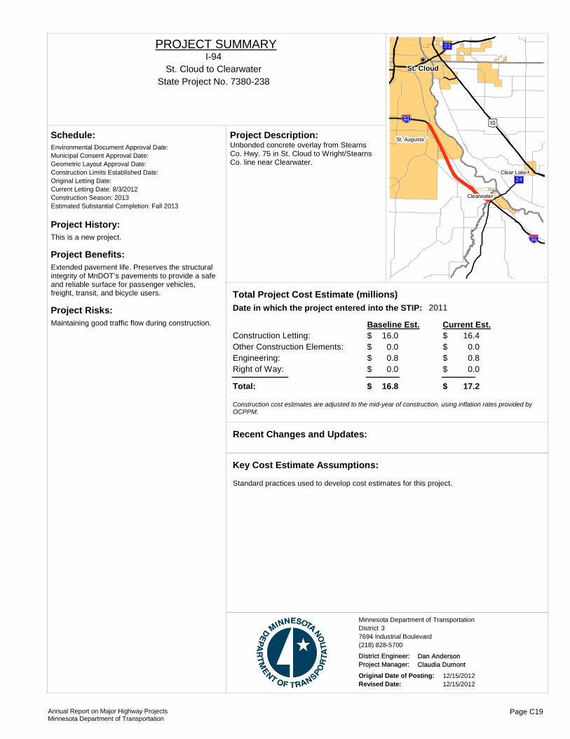
Project History:This is a new project.
Project Benefits:Extended pavement life. Preserves the structural integrity of MnDOT’s pavements to provide a safe and reliable surface for passenger vehicles, freight, transit, and bicycle users.
Project Risks:Maintaining good traffic flow during construction.
Environmental Document Approval Date:
Schedule:
Municipal Consent Approval Date: Geometric Layout Approval Date: Construction Limits Established Date: Original Letting Date: Current Letting Date: 8/3/2012Construction Season: 2013Estimated Substantial Completion: Fall 2013
!"b$
?½A@
!"b$ )m
?¼A@
!(
!(
!(
!P
St. Cloud
Clearwater
Clear Lake
St. AugustaUnbonded concrete overlay from Stearns Co. Hwy. 75 in St. Cloud to Wright/Stearns Co. line near Clearwater.
Project Description:
2011Total Project Cost Estimate (millions)Date in which the project entered into the STIP:
Construction Letting: 16.0Other Construction Elements: 0.0Engineering: 0.8Right of Way: 0.0
16.40.00.80.0
Baseline Est. Current Est.
Total: 16.8 17.2
$$$$
$
$$$$
$
Construction cost estimates are adjusted to the mid-year of construction, using inflation rates provided by OCPPM.
Recent Changes and Updates:
Standard practices used to develop cost estimates for this project.
Key Cost Estimate Assumptions:
State Project No. 7380-238St. Cloud to Clearwater
I-94PROJECT SUMMARY
District 3Minnesota Department of Transportation
7694 Industrial Boulevard(218) 828-5700
District Engineer: Dan AndersonProject Manager: Claudia Dumont
Original Date of Posting: 12/15/2012Revised Date: 12/15/2012
Annual Report on Major Highway ProjectsMinnesota Department of Transportation
Page C19

Project History:This is a new project.
Project Benefits:Ride quality will be improved as this project will address deteriorating pavement conditions.
Project Risks:Maintaining good traffic flow during construction.
Environmental Document Approval Date:
Schedule:
Municipal Consent Approval Date: Geometric Layout Approval Date: Construction Limits Established Date: Original Letting Date: 2/26/2016Current Letting Date: 2/26/2016Construction Season: 2016Estimated Substantial Completion: Fall 2016
?¼A@
!"b$!(
!(
!(
!(
!(
Avon
Rockville
Waite ParkSt. Joseph
Cold Spring
Bituminous overlay from Stearns Co. Hwy. 75 west of St. Joseph and east to the Sauk River bridge.
Project Description:
2013Total Project Cost Estimate (millions)Date in which the project entered into the STIP:
Construction Letting: 10.0Other Construction Elements: 0.0Engineering: 0.6Right of Way: 0.0
10.00.00.60.0
Baseline Est. Current Est.
Total: 10.6 10.6
$$$$
$
$$$$
$
Construction cost estimates are adjusted to the mid-year of construction, using inflation rates provided by OCPPM.
Recent Changes and Updates:
Standard practices used to develop cost estimates for this project.
Key Cost Estimate Assumptions:
State Project No. 7380-239St. Joseph to Bridge over Sauk River
I-94PROJECT SUMMARY
District 3Minnesota Department of Transportation
7694 Industrial Boulevard(218) 828-5700
District Engineer: Dan AndersonProject Manager: Claudia Dumont
Original Date of Posting: 12/15/2012Revised Date: 12/15/2012
Annual Report on Major Highway ProjectsMinnesota Department of Transportation
Page C20
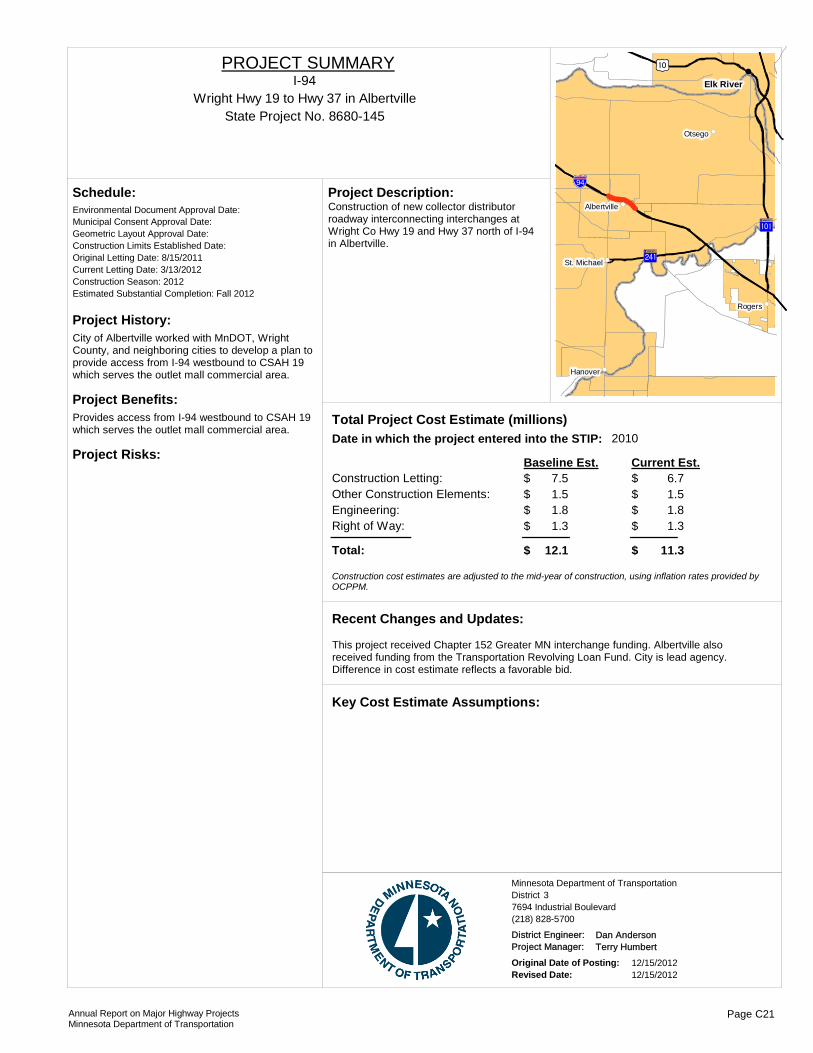
Project History:City of Albertville worked with MnDOT, Wright County, and neighboring cities to develop a plan to provide access from I-94 westbound to CSAH 19 which serves the outlet mall commercial area.
Project Benefits:Provides access from I-94 westbound to CSAH 19 which serves the outlet mall commercial area.
Project Risks:
Environmental Document Approval Date:
Schedule:
Municipal Consent Approval Date: Geometric Layout Approval Date: Construction Limits Established Date: Original Letting Date: 8/15/2011Current Letting Date: 3/13/2012Construction Season: 2012Estimated Substantial Completion: Fall 2012
?²A@
?ûA@
)m
!"b$!(
!(
!(
!(
!(
!(
Elk River
Rogers
Otsego
Hanover
St. Michael
AlbertvilleConstruction of new collector distributor roadway interconnecting interchanges at Wright Co Hwy 19 and Hwy 37 north of I-94 in Albertville.
Project Description:
2010Total Project Cost Estimate (millions)Date in which the project entered into the STIP:
Construction Letting: 7.5Other Construction Elements: 1.5Engineering: 1.8Right of Way: 1.3
6.71.51.81.3
Baseline Est. Current Est.
Total: 12.1 11.3
$$$$
$
$$$$
$
Construction cost estimates are adjusted to the mid-year of construction, using inflation rates provided by OCPPM.
This project received Chapter 152 Greater MN interchange funding. Albertville also received funding from the Transportation Revolving Loan Fund. City is lead agency. Difference in cost estimate reflects a favorable bid.
Recent Changes and Updates:
Key Cost Estimate Assumptions:
State Project No. 8680-145Wright Hwy 19 to Hwy 37 in Albertville
I-94PROJECT SUMMARY
District 3Minnesota Department of Transportation
7694 Industrial Boulevard(218) 828-5700
District Engineer: Dan AndersonProject Manager: Terry Humbert
Original Date of Posting: 12/15/2012Revised Date: 12/15/2012
Annual Report on Major Highway ProjectsMinnesota Department of Transportation
Page C21
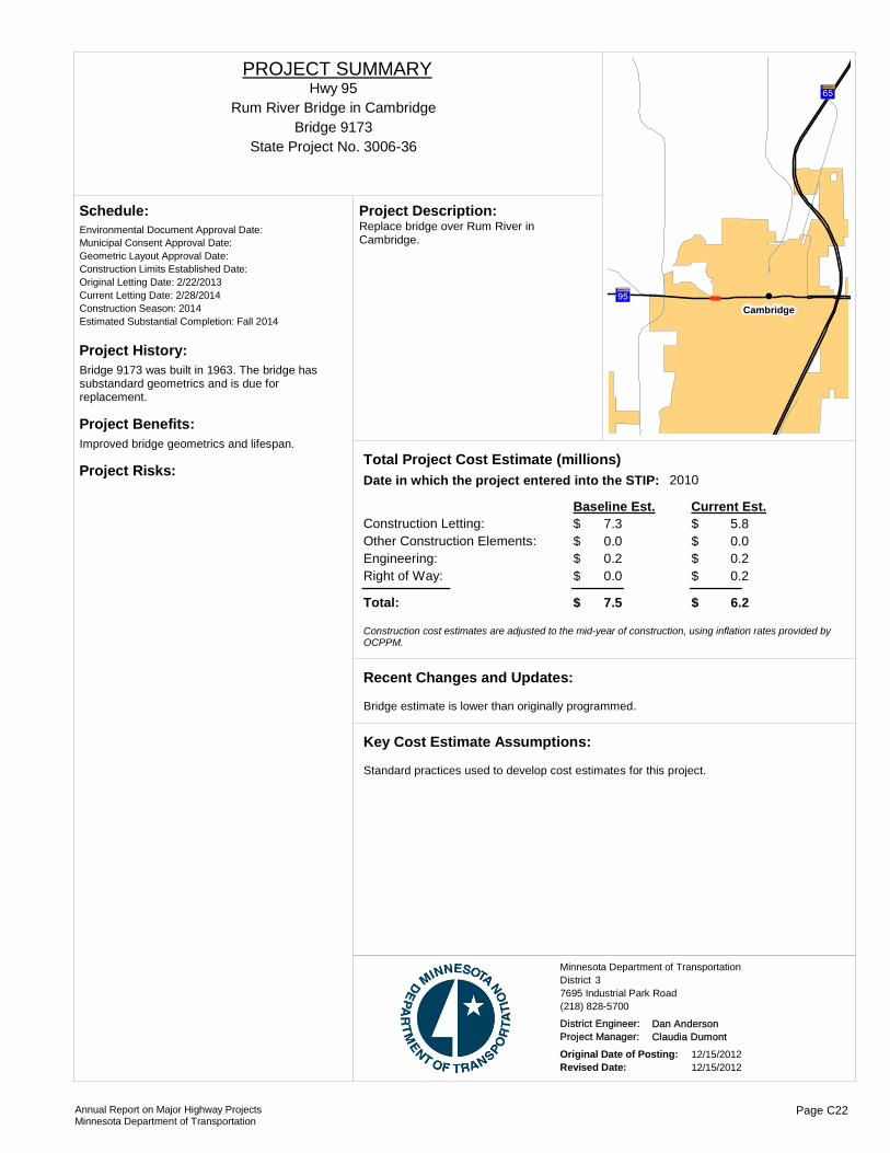
Project History:Bridge 9173 was built in 1963. The bridge has substandard geometrics and is due for replacement.
Project Benefits:Improved bridge geometrics and lifespan.
Project Risks:
Environmental Document Approval Date:
Schedule:
Municipal Consent Approval Date: Geometric Layout Approval Date: Construction Limits Established Date: Original Letting Date: 2/22/2013Current Letting Date: 2/28/2014Construction Season: 2014Estimated Substantial Completion: Fall 2014
?öA@
?àA@
!(
Cambridge
Replace bridge over Rum River in Cambridge.
Project Description:
2010Total Project Cost Estimate (millions)Date in which the project entered into the STIP:
Construction Letting: 7.3Other Construction Elements: 0.0Engineering: 0.2Right of Way: 0.0
5.80.00.20.2
Baseline Est. Current Est.
Total: 7.5 6.2
$$$$
$
$$$$
$
Construction cost estimates are adjusted to the mid-year of construction, using inflation rates provided by OCPPM.
Bridge estimate is lower than originally programmed.
Recent Changes and Updates:
Standard practices used to develop cost estimates for this project.
Key Cost Estimate Assumptions:
State Project No. 3006-36
Rum River Bridge in CambridgeHwy 95
PROJECT SUMMARY
Bridge 9173
District 3Minnesota Department of Transportation
7695 Industrial Park Road(218) 828-5700
District Engineer: Dan AndersonProject Manager: Claudia Dumont
Original Date of Posting: 12/15/2012Revised Date: 12/15/2012
Annual Report on Major Highway ProjectsMinnesota Department of Transportation
Page C22

Project History:This is a new project.
Project Benefits:Ride quality will be improved as this project will address deteriorating pavement conditions.
Project Risks:
Environmental Document Approval Date:
Schedule:
Municipal Consent Approval Date: Geometric Layout Approval Date: Construction Limits Established Date: Original Letting Date: 11/16/2012Current Letting Date: 11/16/2012Construction Season: Estimated Substantial Completion: Fall 2013
?ÀA@
?¼A@
)y
?¼A@!(
!(
!(
!(
!(
Milaca
Bock
Wahkon
Onamia
Foreston
Mill and overlay from Mille Lacs Co. Rd. 148/70th Street to 0.75 miles north of Hwy. 19.
Project Description:
Total Project Cost Estimate (millions)Date in which the project entered into the STIP:
Construction Letting: 5.7Other Construction Elements: 0.0Engineering: 0.4Right of Way: 0.0
6.40.00.40.0
Baseline Est. Current Est.
Total: 6.1 6.8
$$$$
$
$$$$
$
Construction cost estimates are adjusted to the mid-year of construction, using inflation rates provided by OCPPM.
Project was originally programmed as two separate projects. Project was combined to improve benefit/cost during bidding, better coordinate construction activities, improve traffic control during construction, and manage availability of staff resouces.
Recent Changes and Updates:
Standard practices used to develop cost estimates for this project.
Key Cost Estimate Assumptions:
State Project No. 4812-83Mille Lacs Co Rd 148 to north of junction Co Hwy 19
Hwy 169PROJECT SUMMARY
District 3Minnesota Department of Transportation
7696 Industrial Boulevard(218) 828-5700
District Engineer: Dan AndersonProject Manager: Darren Nelson
Original Date of Posting: 12/15/2012Revised Date: 12/15/2012
Annual Report on Major Highway ProjectsMinnesota Department of Transportation
Page C23
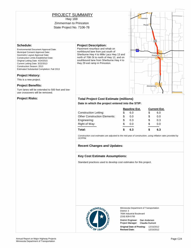
Project History:This is a new project.
Project Benefits:Turn lanes will be extended to 500 feet and low-use crossovers will be removed.
Project Risks:
Environmental Document Approval Date:
Schedule:
Municipal Consent Approval Date: Geometric Layout Approval Date: Construction Limits Established Date: Original Letting Date: 4/24/2015Current Letting Date: 3/22/2013Construction Season: 2013Estimated Substantial Completion: Fall 2013
)y
?öA@
!(
!(
!(
!(
Pease
Foreston
Zimmerman
Princeton
Pavement resurface and rehab on northbound lane from just south of Sherburne Hwy 4 to Mille Lacs Hwy 13 and north of 70th St to north of Hwy 12, and on southbound lane from Sherburne Hwy 4 to Hwy 29 exit ramp in Princeton.
Project Description:
Total Project Cost Estimate (millions)Date in which the project entered into the STIP:
Construction Letting: 6.0Other Construction Elements: 0.0Engineering: 0.3Right of Way: 0.0
6.00.00.30.0
Baseline Est. Current Est.
Total: 6.3 6.3
$$$$
$
$$$$
$
Construction cost estimates are adjusted to the mid-year of construction, using inflation rates provided by OCPPM.
Recent Changes and Updates:
Standard practices used to develop cost estimates for this project.
Key Cost Estimate Assumptions:
State Project No. 7106-78Zimmerman to Princeton
Hwy 169PROJECT SUMMARY
District 3Minnesota Department of Transportation
7694 Industrial Boulevard(218) 828-5700
District Engineer: Dan AndersonProject Manager: Claudia Dumont
Original Date of Posting: 12/15/2012Revised Date: 12/15/2012
Annual Report on Major Highway ProjectsMinnesota Department of Transportation
Page C24

Project History:This project combines work initially assigned to SP 4811-66 and 7106-74.
Project Benefits:Right and left turn lanes extended to 500 feet. Low-usage crossovers will removed.
Project Risks:
Environmental Document Approval Date:
Schedule:
Municipal Consent Approval Date: Geometric Layout Approval Date: Construction Limits Established Date: Original Letting Date: 4/27/12Current Letting Date: 5/18/2012Construction Season: 2012Estimated Substantial Completion: Fall 2012
)m
)y !(
!(
!(
!(
!(
Elk River
Otsego
Nowthen
Zimmerman
Princeton
Mill and overlay from junction US Hwy. 10 in Elk River to Sherburne Co. Hwy. 4 in Zimmerman, including extension of turn lanes and ADA improvements.
Project Description:
Total Project Cost Estimate (millions)Date in which the project entered into the STIP:
Construction Letting: 7.2Other Construction Elements: 0.0Engineering: 0.4Right of Way: 0.0
8.70.00.40.0
Baseline Est. Current Est.
Total: 7.6 9.1
$$$$
$
$$$$
$
Construction cost estimates are adjusted to the mid-year of construction, using inflation rates provided by OCPPM.
Additional turn lanes were added to provide a consistent corridor.
Recent Changes and Updates:
Standard practices used to develop cost estimates for this project.
Key Cost Estimate Assumptions:
State Project No. 7106-82Elk River to Zimmerman
Hwy 169PROJECT SUMMARY
District 3Minnesota Department of Transportation
7694 Industrial Boulevard(218) 828-5700
District Engineer: Dan AndersonProject Manager: Claudia Dumont
Original Date of Posting: 12/15/2012Revised Date: 12/15/2012
Annual Report on Major Highway ProjectsMinnesota Department of Transportation
Page C25
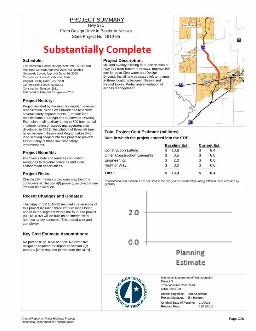
Project History:Project initiated by the need for regular pavement rehabilitation. Scope was broadened to include several safety improvements. [Left turn lane modifications at Design and Clearwater Drive(s), Extension of all auxiliary lanes to 500 feet, partial implementation of access management plan developed in 2001]. Installation of three left turn lanes between Nisswa and Pequot Lakes [two-lane section] scoped into this project to prevent further delay of these low-cost safety improvements.
Project Benefits:Improves safety and reduces congestion. Responds to regional concerns and local collaboration opportunities.
Project Risks:Closing 10+ median crossovers may become controversial. Section 4(f) property involved at one left turn lane location.
Environmental Document Approval Date: 12/20/2010
Schedule:
Municipal Consent Approval Date: Not NeededGeometric Layout Approval Date: 8/6/2009Construction Limits Established Date: Original Letting Date: 3/27/2009Current Letting Date: 3/25/2011Construction Season: 2011Estimated Substantial Completion: 2011
The delay of SP 1810-92 resulted in a re-scope of this project including three left turn lanes being added in the segment where the four-lane project (SP 1810-92) will be built as an interim fix to address safety concerns. This added cost and complexity.
Recent Changes and Updates:
No purchase of ROW needed. No extensive mitigation required for impact to section 4(f) property [Only requires permit from the DNR].
Key Cost Estimate Assumptions:
Brainerd
Baxter
Lake Shore
East Gull Lake
Mill and overlay existing four-lane section of Hwy 371 from Baxter to Nisswa. Improve left turn lanes at Clearwater and Design Drive(s). Install new dedicated left turn lanes at three locations between Nisswa and Pequot Lakes. Partial implementation of access management.
Project Description:
Total Project Cost Estimate (millions)Date in which the project entered into the STIP:
Construction Letting: 10.8Other Construction Elements: 0.5Engineering: 2.0Right of Way: 0.0
8.40.00.00.0
Baseline Est. Current Est.
Total: 13.3 8.4
$$$$
$
$$$$
$
Construction cost estimates are adjusted to the mid-year of construction, using inflation rates provided by OCPPM.
State Project No. 1810-95From Design Drive in Baxter to Nisswa
Hwy 371PROJECT SUMMARY
District 3Minnesota Department of Transportation
7694 Industrial Park Road(218) 828-5700
District Engineer: Dan AndersonProject Manager: Jim Hallgren
Original Date of Posting: 1/1/2009Revised Date: 12/15/2012
Annual Report on Major Highway ProjectsMinnesota Department of Transportation
Page C26

Project History:Phase I of TH 371 North EIS (under SP 1116-22)
Project Benefits:This project is being coordinated with Crow Wing County's realignment of highway 18, which is intended to achieve improved safety by taking traffic out of downtown.
Project Risks:
Environmental Document Approval Date:
Schedule:
Municipal Consent Approval Date: Geometric Layout Approval Date: Construction Limits Established Date: Original Letting Date: Feb-12Current Letting Date: 6/8/2012Construction Season: 2012/2013Estimated Substantial Completion: Fall 2012 ?òA@
?}A@!(
!(
!(
!(
!(
Brainerd
Nisswa
Baxter
Lake Shore
East Gull Lake
Reconstruction of four-lane through Nisswa, including construction of bicycle-pedestrian tunnel.
Project Description:
Total Project Cost Estimate (millions)Date in which the project entered into the STIP:
Construction Letting: 5.0Other Construction Elements: 0.0Engineering: 0.3Right of Way: 1.8
5.32.30.30.9
Baseline Est. Current Est.
Total: 7.1 8.8
$$$$
$
$$$$
$
Construction cost estimates are adjusted to the mid-year of construction, using inflation rates provided by OCPPM.
This project is presently under construction. Current estimate includes work performed by Crow Wing County and City of Nisswa as part of this project.
Recent Changes and Updates:
Key Cost Estimate Assumptions:
State Project No. 1810-98Nisswa
Hwy 371PROJECT SUMMARY
District 3Minnesota Department of Transportation
7695 Industrial Boulevard(218) 828-5700
District Engineer: Dan AndersonProject Manager: Jim Hallgren
Original Date of Posting: 12/15/2012Revised Date: 12/15/2012
Annual Report on Major Highway ProjectsMinnesota Department of Transportation
Page C27

!(
!(
!(
!(
!(
!(
!(
!(
!(
!(
!(
!(
!(
!(
!(
!P
?¬A@
?ØA@
)n
?}A@
)m
?êA@
?ÀA@
)r
?ÀA@
)w
?ØA@
?ýA@
)i
!"b$
?ôA@
)w
)x
?kA@
)r
?¬A@
)m
?gA@
?fA@
)w
?aA@
)w
?ËA@
?ðA@
?ÂA@
?òA@
?«A@
!"b$
?ÁA@
?}A@
)w
)x
?¬A@
)r
?|A@
)r)w
?|A@
?ÁA@
?ÄA@
?ýA@
?ÀA@
?aA@
?¬A@)n
?ÆA@
?ÆA@
?ËA@
?«A@
!(!(!(!(
Moorhead
Morris
Benson
Wheaton
Mahnomen
Glenwood
Ortonville
Elbow Lake
Alexandria
Fergus FallsBreckenridge
Detroit Lakes
.Major Highway Projects 2013District 4
Detroit Lakes

ROUTE PROJECT LOCATION PAGE
District Project SummaryDistrict 4
State Project #
Hwy 9 West Jct. TH 104 to Benson D 27606-26
Hwy 9 From Doran to Herman D 38402-17
Hwy 10 TH 10/75 Phase II & Signals D 41401-166
Hwy 10 Detroit Lakes D 50301-60
Hwy 27 TH 55 east to Junction of I 94 D 62101-21
Hwy 29 Jct TH 40 to Benson, Bridge Replacement 6552 Chap 152 D 77607-29
Hwy 29 From McKay Ave in Alexandria to TH 210 D 82103-35
Hwy 29 Bridges in Alexandria over I-94 D 92102-58
Hwy 34 I-94 to T.H. 59 at Dunvilla D 101404-17
Hwy 59 Elbow Lake to I 94 D 112611-16
Hwy 59 Pelican Rapids to North Otter Tail County Line D 125618-26
Hwy 59 North of TH 34 in Detroit Lakes to 0.4 miles south of the Buffalo River
D 130305-31
Hwy 75 South Jct. TH9 in Doran to Wilkin Co.Rd 20 D 148407-37
Hwy 75 Near the City of Kent D 158408-44
Hwy 78 Battle Lake to Perham D 165621-23
Hwy 79 Elbow Lake to Jct. TH 94 D 172613-18
I-94 I 94 and Hwy. 75 Interchange D 181406-66
I-94 EB RP 14.9 to RP 24.199 D 191480-137
I-94 WB Downer to TH 34 D 201480-151
Hwy 200 From JCT TH 59 to East Mahnomen County Line D 214402-19
Annual Report on Major Highway ProjectsMinnesota Department of Transportation Page D1
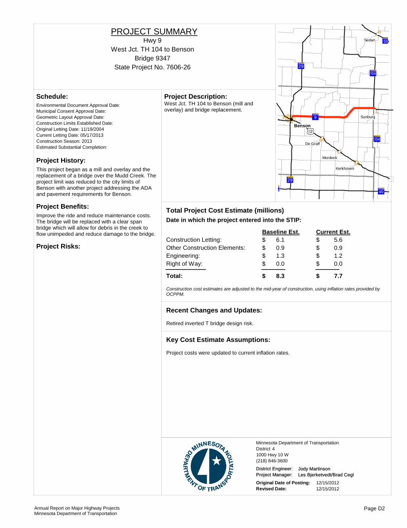
Project History:This project began as a mill and overlay and the replacement of a bridge over the Mudd Creek. The project limit was reduced to the city limits of Benson with another project addressing the ADA and pavement requirements for Benson.
Project Benefits:Improve the ride and reduce maintenance costs. The bridge will be replaced with a clear span bridge which will allow for debris in the creek to flow unimpeded and reduce damage to the bridge.
Project Risks:
Environmental Document Approval Date:
Schedule:
Municipal Consent Approval Date: Geometric Layout Approval Date: Construction Limits Established Date: Original Letting Date: 11/19/2004Current Letting Date: 05/17/2013Construction Season: 2013Estimated Substantial Completion:
?ÂA@
)n
?¬A@
?ýA@
?ØA@
?ýA@
?ËA@?ÂA@
?ËA@
!(
!(
!(
!(
!(
!(
Benson
Sedan
Sunburg
Murdock
De Graff
Kerkhoven
West Jct. TH 104 to Benson (mill and overlay) and bridge replacement.
Project Description:
Total Project Cost Estimate (millions)Date in which the project entered into the STIP:
Construction Letting: 6.1Other Construction Elements: 0.9Engineering: 1.3Right of Way: 0.0
5.60.91.20.0
Baseline Est. Current Est.
Total: 8.3 7.7
$$$$
$
$$$$
$
Construction cost estimates are adjusted to the mid-year of construction, using inflation rates provided by OCPPM.
Retired inverted T bridge design risk.
Recent Changes and Updates:
Project costs were updated to current inflation rates.
Key Cost Estimate Assumptions:
State Project No. 7606-26
West Jct. TH 104 to BensonHwy 9
PROJECT SUMMARY
Bridge 9347
District 4Minnesota Department of Transportation
1000 Hwy 10 W(218) 846-3600
District Engineer: Jody MartinsonProject Manager: Les Bjerketvedt/Brad Cegl
Original Date of Posting: 12/15/2012Revised Date: 12/15/2012
Annual Report on Major Highway ProjectsMinnesota Department of Transportation
Page D2

Project History:The existing bituminous pavement is severely cracked and potholes are developing as the pavement structure continues to deteriorate. Many of the centerline culverts are in very poor condition and need replacement.
Project Benefits:Preserves roadway structures. Improves hydraulics as well as ride conditions. Update to pedestrian ramps.
Project Risks:• Construction is being considered done without a detour.• Project not drilled has potential for subgrade issues.• Accessibility requirements by 2015.
Environmental Document Approval Date: Pending Approval
Schedule:
Municipal Consent Approval Date: Pending ApprovalGeometric Layout Approval Date: Pending ApprovalConstruction Limits Established Date: Pending ApprovalOriginal Letting Date: 1/23/2015Current Letting Date: 1/23/2015Construction Season: 2015Estimated Substantial Completion: 2015
)x
)x
?¬A@
?¬A@
?¬A@
?ÀA@?ÀA@
?×A@
?ëA@
?ØA@?ØA@
?ØA@
)r
?ÁA@
)r
Morris
Wheaton
Elbow Lake
Doran
Tintah
Tenney Nashua
Herman
Dumont
Dalton
Chokio
Wendell
Johnson
Barrett
Alberta
Norcross
Donnelly
Campbell
Graceville
Jct. TH 55 to Jct. TH 75 in Doran & Jct. TH 28 to TH 27 in Herman, 3" mill and 3" bit surfacing.
Project Description:
2011Total Project Cost Estimate (millions)Date in which the project entered into the STIP:
Construction Letting: 10.3Other Construction Elements: 1.4Engineering: 2.1Right of Way: 0.0
10.01.42.10.0
Baseline Est. Current Est.
Total: 13.8 13.5
$$$$
$
$$$$
$
Construction cost estimates are adjusted to the mid-year of construction, using inflation rates provided by OCPPM.
Right of way department has started on property acquisition. Cost estimate updated with new inflation factor. Estimate includes cost for multiple detours.
Recent Changes and Updates:
Assumed city of Morris does not want to reconstruct water and sewer. Assumed TH 9 sidewalks will not be reconstructed. Four foot width an issue. Assumed hydraulic needs. Hydraulic req. will be provided Fall 2011.
Key Cost Estimate Assumptions:
State Project No. 8402-17From Doran to Herman
Hwy 9PROJECT SUMMARY
District 4Minnesota Department of Transportation
1000 Hwy 10 W(218) 846-3600
District Engineer: Jody MartinsonProject Manager: Bradley Cegla
Original Date of Posting: 12/15/2012Revised Date: 12/15/2012
Annual Report on Major Highway ProjectsMinnesota Department of Transportation
Page D3

Project History:Phase 1 of this project was made possible after state funds were allocated for use on trunk highways to address damage resulting from heavy trucks hauling sand during the 2009 Red River flood protection effort. This project is a follow-up to the original paving project.
Project Benefits:• Improve pedestrian accessibility• View traffic and signal performance and make modifications remotely• Monitor level of service• The pavement rehabilitation is intended to correct the pavement surface distress (roughness and rutting) and provide a smooth ride. These repairs will result in lower maintenance costs
Project Risks:Utility conflicts
Environmental Document Approval Date:
Schedule:
Municipal Consent Approval Date: Geometric Layout Approval Date: Construction Limits Established Date: Original Letting Date: 4/22/2011Current Letting Date: 8/24/2012Construction Season: 2013Estimated Substantial Completion: Fall 2013
)x ?¬A@
!"b$
)m!(
!(
!(
!P
Moorhead
Sabin
GlyndonDilworth
•Pedestrian ramp improvements•Traffic signal replacements and revisions•ITS - fiber optic, cameras and vehicle detection installation
Project Description:
2011Total Project Cost Estimate (millions)Date in which the project entered into the STIP:
Construction Letting: 3.2Other Construction Elements: 0.2Engineering: 0.8Right of Way: 0.0
4.30.30.90.0
Baseline Est. Current Est.
Total: 4.2 5.6
$$$$
$
$$$$
$
Construction cost estimates are adjusted to the mid-year of construction, using inflation rates provided by OCPPM.
Recent Changes and Updates:
ITS elements and traffic control signal systems exceeded original cost estimates.
Key Cost Estimate Assumptions:
State Project No. 1401-166TH 10/75 Phase II & Signals
Hwy 10PROJECT SUMMARY
District 4Minnesota Department of Transportation
1000 Hwy 10 W(218) 846-3600
District Engineer: Jody MartinsonProject Manager: Lori Vanderhider
Original Date of Posting: 12/15/2012Revised Date: 12/15/2012
Annual Report on Major Highway ProjectsMinnesota Department of Transportation
Page D4

Project History:To provide safe and controlled access to Hwy 10 with the development of a frontage road system that allows vehicular/ bike/pedestrian to travel from downtown Detroit Lakes to facilities west of TH 59 without having to travel on TH 10.
Project Benefits:The frontage road system and TH 59 underpass will increase safety and mobility for all modes of transportation from downtown Detroit Lakes to businesses on the west side of town. Access management will be improved throughout the corridor. New pavement structure on TH 10 will reduce maintenance costs.
Project Risks:• Staging not set• Contaminants• Concrete vs. bituminous (MDR) not set• Swamps (no borings yet)• R/W (6-10 parcels)• Swamp impaired by phosphates (MPCA ongoing study will determine water quality treatment requirments in furture)• Environmental Documents
Environmental Document Approval Date: Pending Approval
Schedule:
Municipal Consent Approval Date: Pending ApprovalGeometric Layout Approval Date: Pending ApprovalConstruction Limits Established Date: Pending ApprovalOriginal Letting Date: 12/19/2014Current Letting Date: 12/19/2014Construction Season: Summer 2015Estimated Substantial Completion: Fall 2015
Detroit Lakes
TH 10 from Airport Road to Summit Avenue (reconstruction and frontage road), TH 59 from TH 10 to South of Morrow Ave (frontage road and new bridge).
Project Description:
2011Total Project Cost Estimate (millions)Date in which the project entered into the STIP:
Construction Letting: 14.0Other Construction Elements: 0.7Engineering: 2.8Right of Way: 0.0
10.00.72.71.0
Baseline Est. Current Est.
Total: 17.4 14.4
$$$$
$
$$$$
$
Construction cost estimates are adjusted to the mid-year of construction, using inflation rates provided by OCPPM.
• Transportation planning study completed in June 2011• Public, business & agency meetings June 28, 2012• Value engineering study, July 2012• Preliminary layout September-November 2012
Recent Changes and Updates:
TH 10 EB/WB will be concrete on existing alignment (airport to TH 59), new frontage road south of TH 10 (Wal-Mart Property to DL Auto), underpass at Main Morrow with city project on Thomas Avenue.
Key Cost Estimate Assumptions:
State Project No. 0301-60Detroit Lakes
http://www.dot.state.mn.us/d4/projects/dlfrontageroad/
Hwy 10PROJECT SUMMARY
District 4Minnesota Department of Transportation
1000 Hwy 10 W(218) 846-3600
District Engineer: Jody MartinsonProject Manager: Tom Lundberg
Original Date of Posting: 12/15/2012Revised Date: 12/15/2012
Annual Report on Major Highway ProjectsMinnesota Department of Transportation
Page D5
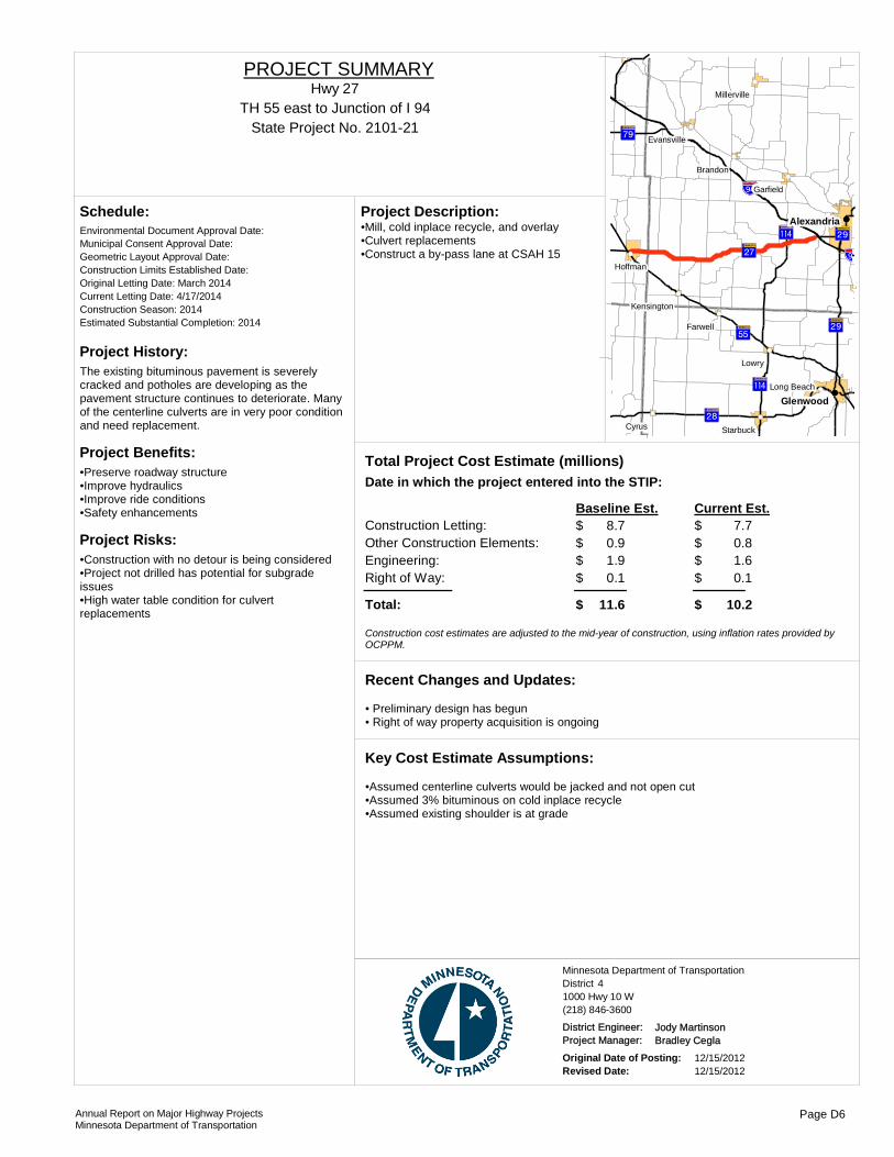
Project History:The existing bituminous pavement is severely cracked and potholes are developing as the pavement structure continues to deteriorate. Many of the centerline culverts are in very poor condition and need replacement.
Project Benefits:•Preserve roadway structure•Improve hydraulics•Improve ride conditions•Safety enhancements
Project Risks:•Construction with no detour is being considered•Project not drilled has potential for subgrade issues•High water table condition for culvert replacements
Environmental Document Approval Date:
Schedule:
Municipal Consent Approval Date: Geometric Layout Approval Date: Construction Limits Established Date: Original Letting Date: March 2014Current Letting Date: 4/17/2014Construction Season: 2014Estimated Substantial Completion: 2014
?ÀA@
!"b$
?ëA@
?gA@
?ØA@
?ÁA@
?ÂA@
?gA@
!"b$
?ÂA@
!(
!(
!(
!(
!(
!(
!(
!(
!(
!(
!(
!(
!(
!(Glenwood
Alexandria
Lowry
Cyrus
Hoffman
Farwell
Brandon
Starbuck
Garfield
Long Beach
Kensington
Evansville
Millerville
•Mill, cold inplace recycle, and overlay•Culvert replacements•Construct a by-pass lane at CSAH 15
Project Description:
Total Project Cost Estimate (millions)Date in which the project entered into the STIP:
Construction Letting: 8.7Other Construction Elements: 0.9Engineering: 1.9Right of Way: 0.1
7.70.81.60.1
Baseline Est. Current Est.
Total: 11.6 10.2
$$$$
$
$$$$
$
Construction cost estimates are adjusted to the mid-year of construction, using inflation rates provided by OCPPM.
• Preliminary design has begun• Right of way property acquisition is ongoing
Recent Changes and Updates:
•Assumed centerline culverts would be jacked and not open cut•Assumed 3% bituminous on cold inplace recycle•Assumed existing shoulder is at grade
Key Cost Estimate Assumptions:
State Project No. 2101-21TH 55 east to Junction of I 94
Hwy 27PROJECT SUMMARY
District 4Minnesota Department of Transportation
1000 Hwy 10 W(218) 846-3600
District Engineer: Jody MartinsonProject Manager: Bradley Cegla
Original Date of Posting: 12/15/2012Revised Date: 12/15/2012
Annual Report on Major Highway ProjectsMinnesota Department of Transportation
Page D6
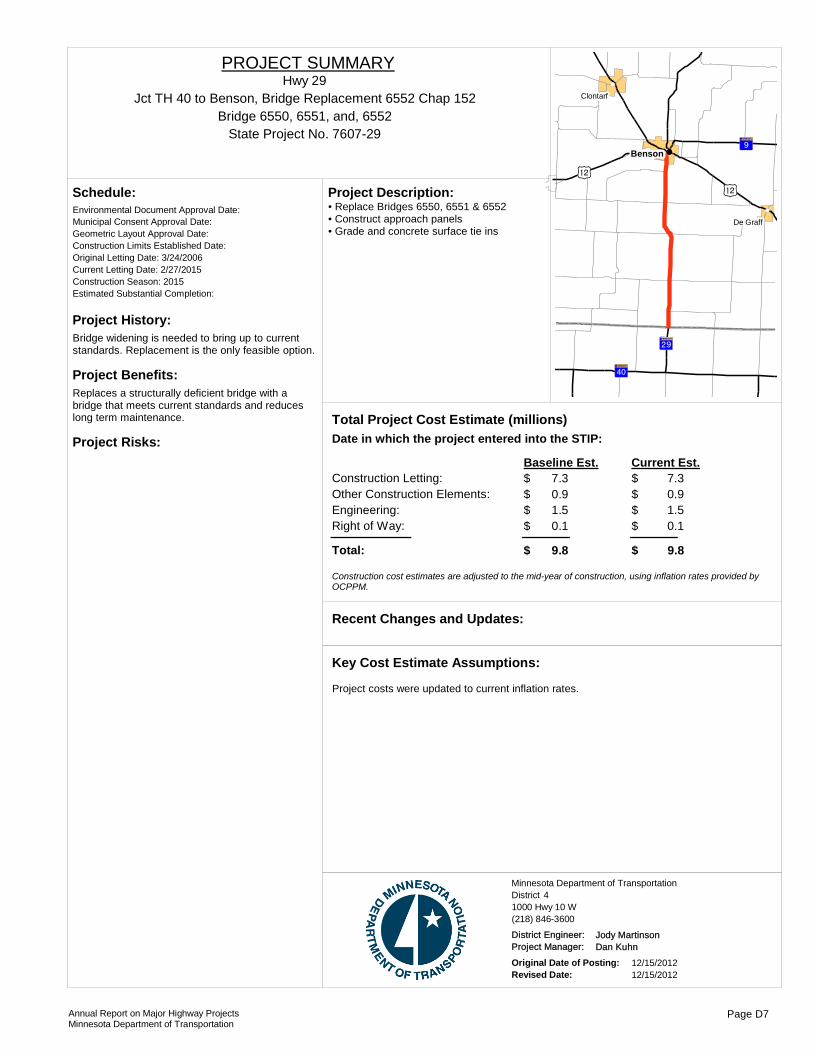
Project History:Bridge widening is needed to bring up to current standards. Replacement is the only feasible option.
Project Benefits:Replaces a structurally deficient bridge with a bridge that meets current standards and reduces long term maintenance.
Project Risks:
Environmental Document Approval Date:
Schedule:
Municipal Consent Approval Date: Geometric Layout Approval Date: Construction Limits Established Date: Original Letting Date: 3/24/2006Current Letting Date: 2/27/2015Construction Season: 2015Estimated Substantial Completion:
)n)n
?¬A@
?ËA@
?ÂA@
!(
!(
!(Benson
De Graff
Clontarf
• Replace Bridges 6550, 6551 & 6552• Construct approach panels• Grade and concrete surface tie ins
Project Description:
Total Project Cost Estimate (millions)Date in which the project entered into the STIP:
Construction Letting: 7.3Other Construction Elements: 0.9Engineering: 1.5Right of Way: 0.1
7.30.91.50.1
Baseline Est. Current Est.
Total: 9.8 9.8
$$$$
$
$$$$
$
Construction cost estimates are adjusted to the mid-year of construction, using inflation rates provided by OCPPM.
Recent Changes and Updates:
Project costs were updated to current inflation rates.
Key Cost Estimate Assumptions:
State Project No. 7607-29
Jct TH 40 to Benson, Bridge Replacement 6552 Chap 152Hwy 29
PROJECT SUMMARY
Bridge 6550, 6551, and, 6552
District 4Minnesota Department of Transportation
1000 Hwy 10 W(218) 846-3600
District Engineer: Jody MartinsonProject Manager: Dan Kuhn
Original Date of Posting: 12/15/2012Revised Date: 12/15/2012
Annual Report on Major Highway ProjectsMinnesota Department of Transportation
Page D7

Project History:Maintenance has been patching by wedge paving to fill both longitudinal and transverse cracks. There also have been overlays placed over entire width to prevent pop-outs of in place roadway.
Project Benefits:Goal is to improve ride quality and reduce spending maintenance.
Project Risks:• Condition of pavement at time of construction• Borings not complete• Hydraulic recommendation not complete• Potential for major fix through Parkers Prairie due to storm sewer condition
Environmental Document Approval Date: Pending Approval
Schedule:
Municipal Consent Approval Date: Geometric Layout Approval Date: Construction Limits Established Date: Pending ApprovalOriginal Letting Date: 2/27/2014Current Letting Date: 2/27/2014Construction Season: Summer 2014Estimated Substantial Completion: Sep-14
?ÀA@
!"b$
?}A@
?gA@
?ÂA@
?¬A@
?}A@
?ÂA@
?ÂA@
!(
!(
!(
!(
!(
!(
!(
!(
!(
!(Alexandria
Vining
Urbank
Nelson
Carlos
Miltona
Henning
Garfield
Millerville
Parkers Prairie
• 3” Mill and 3 inch Bituminous Overlay • Hydraulic Upgrades• Add numerous by-pass, center left, and right turn lanes• New lighting at intersection with CO RD 5• Rumble strips in shoulder and grooved in wet reflective paint on fog line• Curb ramp upg
Project Description:
2010Total Project Cost Estimate (millions)Date in which the project entered into the STIP:
Construction Letting: 9.4Other Construction Elements: 0.9Engineering: 1.8Right of Way: 0.1
9.40.91.80.1
Baseline Est. Current Est.
Total: 12.2 12.2
$$$$
$
$$$$
$
Construction cost estimates are adjusted to the mid-year of construction, using inflation rates provided by OCPPM.
• Scoping complete Spring 2010• City of Parkers Prairie to provide recommendation for storm sewer replacement in early 2012• Cost estimate updated with new inflation rate• Hydraulic recommendation recently completed
Recent Changes and Updates:
Key Cost Estimate Assumptions:
State Project No. 2103-35From McKay Ave in Alexandria to TH 210
Hwy 29PROJECT SUMMARY
District 4Minnesota Department of Transportation
1000 Hwy 10 W(218) 846-3600
District Engineer: Jody MartinsonProject Manager: Seth Yliniemi
Original Date of Posting: 12/15/2012Revised Date: 12/15/2012
Annual Report on Major Highway ProjectsMinnesota Department of Transportation
Page D8

Project History:• Bridge abutments have rotated and moved toward the girder ends• Bridges have full depth patches and under deck delimitations• Bridges width and railings are substandard• Bridges built in 1965• Considered Structurally Deficient• NBI Deck rating = 4
Project Benefits:• Replaces structurally deficient bridges with bridges that meet current standards• Reduces long-term maintenance• Improves safety and mobility at the T.H. 29 / 50th Ave intersection• Adds left turn lane for I-94 EB and WB on ramp for improved safety
Project Risks:• Access changes not accepted by property owners• 50th Ave staging requires additional public involvement and acceptence• FHWA reviews may require additional documentation• Geotechnical issues such as high groundwater could affect construction
Environmental Document Approval Date: Pending Approval
Schedule:
Municipal Consent Approval Date: Need UnknownGeometric Layout Approval Date: Need UnknownConstruction Limits Established Date: Pending ApprovalOriginal Letting Date: 1/22/2016Current Letting Date: 2/27/2015Construction Season: 2015-2016Estimated Substantial Completion: September 2016
!(!(!(!(
Alexandria
Bridge #21813 and #21814 and interchange replacement on TH 29 over I-94 and four Lane expansion of TH 29 from 500' N. of 50th Ave. to 0.4 m. S. of CSAH 28
Project Description:
2011Total Project Cost Estimate (millions)Date in which the project entered into the STIP:
Construction Letting: 16.2Other Construction Elements: 1.1Engineering: 3.0Right of Way: 0.1
13.91.12.80.1
Baseline Est. Current Est.
Total: 20.5 17.9
$$$$
$
$$$$
$
Construction cost estimates are adjusted to the mid-year of construction, using inflation rates provided by OCPPM.
• Geometric layout is getting closer to complete• Traffic and noise studies are complete• Value Engineering Study has been completed• Website went live on 9-27-2012• Public Meeting 10-11-2012
Recent Changes and Updates:
• Two-span steel girder structure with tall abutments• Estimate derived from Planning Study and will be refined during scoping and value engineering activities
Key Cost Estimate Assumptions:
State Project No. 2102-58
Bridges in Alexandria over I-94
http://www.dot.state.mn.us/d4/projects/alexi94hwy29/index.html
Hwy 29PROJECT SUMMARY
Bridge 21813, 21814
District 4Minnesota Department of Transportation
1000 Hwy 10 W(218) 846-3600
District Engineer: Jody MartinsonProject Manager: Bradley Cegla
Original Date of Posting: 12/15/2012Revised Date: 12/15/2012
Annual Report on Major Highway ProjectsMinnesota Department of Transportation
Page D9

Project History:This project was programmed due to the intense annual maintenance required to repair cracks, rutting and other deficiencies. It also appears that gravel truck traffic has increased from TH 32 west resulting in more rapid deterioration of the roadway.
Project Benefits:A 4” mill and overlay would preserve the pavement, improve ride and enhance safety for the traveling public. Pipes in poor condition would also be replaced improving hydraulic conditions.
Project Risks:• The MDR is not completed. There is a risk that the edge drains may need repair and that the fix may be changed to a 5” mill and overlay.• The Hydraulics Inspection has not been completed. There is a risk regarding the number of pipes in poor condition
Environmental Document Approval Date: Pending Approval
Schedule:
Municipal Consent Approval Date: Geometric Layout Approval Date: Construction Limits Established Date: Pending ApprovalOriginal Letting Date: 5/27/2015Current Letting Date: 3/27/2015Construction Season: 2015Estimated Substantial Completion: November 2015
ErhardRothsay
Elizabeth
Barnesville
Pelican Rapids
This is a mill and overlay from I-94 to TH 59 at Dunvilla.
Project Description:
2011Total Project Cost Estimate (millions)Date in which the project entered into the STIP:
Construction Letting: 8.1Other Construction Elements: 0.8Engineering: 1.7Right of Way: 0.0
7.90.81.60.0
Baseline Est. Current Est.
Total: 10.6 10.4
$$$$
$
$$$$
$
Construction cost estimates are adjusted to the mid-year of construction, using inflation rates provided by OCPPM.
Project was scoped in May 2011.
Recent Changes and Updates:
Baseline estimate was adjusted to 2015 year of construction using an inflation rate of 1.1466. A general project risk factor of 6% was used to calculate contingency in addition to the specific risks identified.
Key Cost Estimate Assumptions:
State Project No. 1404-17I-94 to T.H. 59 at Dunvilla
Hwy 34PROJECT SUMMARY
District 4Minnesota Department of Transportation
1000 Hwy 10 W(218) 846-3600
District Engineer: Jody MartinsonProject Manager: Lori Vanderhider
Original Date of Posting: 12/15/2012Revised Date: 12/15/2012
Annual Report on Major Highway ProjectsMinnesota Department of Transportation
Page D10

Project History:The southern limit of this project was to start at the north city limits of Elbow Lake. Upon review this limit was moved near to where the pavement splits for a center grass way through the rest of the City. The project was changed from a mill and overlay to an alternate bid project. The edge drains are being inspected to see if they need to be repaired or be replaced.
Project Benefits:To provide a pavement fix that will give a 20-year pavement life.
Project Risks:
Environmental Document Approval Date:
Schedule:
Municipal Consent Approval Date: Geometric Layout Approval Date: Construction Limits Established Date: Original Letting Date: 4/27/2012Current Letting Date: 1/25/2013Construction Season: 2013Estimated Substantial Completion:
)r!"b$
!(
!(
!(Elbow Lake
Dalton
Wendell
North limit of Elbow Lake to Jct. I 94, 7" mill and overlay. It is an alternate bid project.
Project Description:
Total Project Cost Estimate (millions)Date in which the project entered into the STIP:
Construction Letting: 5.8Other Construction Elements: 0.5Engineering: 1.2Right of Way: 0.0
6.20.61.40.0
Baseline Est. Current Est.
Total: 7.6 8.2
$$$$
$
$$$$
$
Construction cost estimates are adjusted to the mid-year of construction, using inflation rates provided by OCPPM.
Fix changed from a 6" mill to a 7" mill. Letting year changed, which increased inflation rate.
Recent Changes and Updates:
Key Cost Estimate Assumptions:
State Project No. 2611-16Elbow Lake to I 94
Hwy 59PROJECT SUMMARY
District 4Minnesota Department of Transportation
1000 Hwy 10 W(218) 846-3600
District Engineer: Jody MartinsonProject Manager: Les Bjerketvedt/Brad Cegl
Original Date of Posting: 12/15/2012Revised Date: 12/15/2012
Annual Report on Major Highway ProjectsMinnesota Department of Transportation
Page D11

Project History:•This section of roadway was last paved in 1990 with 1.5 inches and prior to that in 1971 with 3+ inches•This section is showing deterioration with increased maintenance.•The existing bridges have deteriorated faster than anticipated and have required extensive maintenance.
Project Benefits:•New bituminous pavement will extend life and improve ride and safety and reduce maintenance •Upgrade hydraulics•Additional left turn lanes will enhance safety and mobility•Rumble stripes will improve safety
Project Risks:
Environmental Document Approval Date:
Schedule:
Municipal Consent Approval Date: Geometric Layout Approval Date: Construction Limits Established Date: Original Letting Date: 2/22/2013Current Letting Date: 3/23/2012Construction Season: 2012Estimated Substantial Completion: October 2012
)m
)r
?ªA@
?aA@
)r
?ÆA@
)m
!(
!(
!(
!(
!(Detroit Lakes
Vergas
Audubon
Pelican Rapids
•3 inch milling and 4.5” inch bituminous overlay •Centerline and two entrance culvert replacements•Add Inside left turn lanes and Intersection Lighting at CSAH 4, TH 34, CSAH 31 and CSAH 20 •Replace both bridges over the Pelican River
Project Description:
Total Project Cost Estimate (millions)Date in which the project entered into the STIP:
Construction Letting: 7.5Other Construction Elements: 0.6Engineering: 1.6Right of Way: 0.0
5.30.40.00.0
Baseline Est. Current Est.
Total: 9.7 5.7
$$$$
$
$$$$
$
Construction cost estimates are adjusted to the mid-year of construction, using inflation rates provided by OCPPM.
Project is under construction and will be completed in October 2012.
Recent Changes and Updates:
Project was constructed and completed in October 2012.
Key Cost Estimate Assumptions:
State Project No. 5618-26
Pelican Rapids to North Otter Tail County LineHwy 59
PROJECT SUMMARY
Bridge 56023;, 56027
District 4Minnesota Department of Transportation
1000 Hwy 10 W(218) 846-3600
District Engineer: Jody MartinsonProject Manager: Seth Yliniemi
Original Date of Posting: 12/15/2012Revised Date: 12/15/2012
Annual Report on Major Highway ProjectsMinnesota Department of Transportation
Page D12

Project History:Need to provide pavement repair because existing pavement conditions are below standard for statewide measures for principal arterial. Also considerable maintenance resources have been spent patching transverse and longitudinal cracks.
Project Benefits:• New pavement will extend life by 15-20yrs and improve ride and safety and reduce maintenance • Upgrade hydraulics• Additional by-pass and turn lanes will enhance safety and mobility• Rumble strips, wet reflective striping and new lighting will improve visibility
Project Risks:• Condition of pavement at time of construction.• Borings not complete• Hydraulics – shared pipes with RR• Subcut for frost heaves• Right of way
Environmental Document Approval Date: Pending Approval
Schedule:
Municipal Consent Approval Date: Pending ApprovalGeometric Layout Approval Date: Pending ApprovalConstruction Limits Established Date: Pending ApprovalOriginal Letting Date: 3/23/2014Current Letting Date: 11/22/2013Construction Season: Summer 2014Estimated Substantial Completion: September 2014
Detroit Lakes
Audubon
Callaway
Mill 3" pavement of 3" bituminous. The ride will be improved along with improved drainage along the corridor.
Project Description:
2010Total Project Cost Estimate (millions)Date in which the project entered into the STIP:
Construction Letting: 8.1Other Construction Elements: 0.7Engineering: 1.6Right of Way: 0.0
8.00.71.50.0
Baseline Est. Current Est.
Total: 10.4 10.2
$$$$
$
$$$$
$
Construction cost estimates are adjusted to the mid-year of construction, using inflation rates provided by OCPPM.
• Scoping complete Spring 2010• Updated with current inflation factor• Project Scope is being amended (2012) to change the fix to a 3" mill and 3" overlay
Recent Changes and Updates:
Key Cost Estimate Assumptions:
State Project No. 0305-31North of TH 34 in Detroit Lakes to 0.4 miles south of the Buffalo River
Hwy 59PROJECT SUMMARY
District 4Minnesota Department of Transportation
1000 Hwy 10 W(218) 846-3600
District Engineer: Jody MartinsonProject Manager: Seth Yliniemi
Original Date of Posting: 12/15/2012Revised Date: 12/15/2012
Annual Report on Major Highway ProjectsMinnesota Department of Transportation
Page D13

Project History:The existing bituminous pavement is severely cracked and potholes are developing as the pavement structure continues to deteriorate. Centerline culverts are in poor condition and need replacement.
Project Benefits:Improve ride and reduce maintance costs.
Project Risks:Soil type in the Breckenridge area.
Environmental Document Approval Date:
Schedule:
Municipal Consent Approval Date: Geometric Layout Approval Date: Construction Limits Established Date: Original Letting Date: 2/28/2014Current Letting Date: 2/22/2013Construction Season: 2013Estimated Substantial Completion: July, 2013 )x
?¬A@
?¬A@
!(
!(
!(Breckenridge
Kent
Doran
Pavement resurface and rehabilitation, ADA improvements within the city of Breckenridge.
Project Description:
2011Total Project Cost Estimate (millions)Date in which the project entered into the STIP:
Construction Letting: 6.0Other Construction Elements: 0.7Engineering: 1.3Right of Way: 0.0
5.90.71.20.0
Baseline Est. Current Est.
Total: 8.0 7.9
$$$$
$
$$$$
$
Construction cost estimates are adjusted to the mid-year of construction, using inflation rates provided by OCPPM.
Recent Changes and Updates:
Project costs were updated to current inflation rates.
Key Cost Estimate Assumptions:
State Project No. 8407-37
South Jct. TH9 in Doran to Wilkin Co.Rd 20Hwy 75
PROJECT SUMMARY
Bridge No, Bridge, Work
District 4Minnesota Department of Transportation
1000 Hwy 10 W(218) 846-3600
District Engineer: Jody MartinsonProject Manager: Jesse Miller
Original Date of Posting: 12/15/2012Revised Date: 12/15/2012
Annual Report on Major Highway ProjectsMinnesota Department of Transportation
Page D14

Project History:Annual flooding due to spring melt and large rain events cause TH 75 to be detoured. Bridge 5186 is also due to be replaced. Flood mitigation money allowed for project realignment.
Project Benefits:New Bridge structures 5185 & 5186 will go over Whiskey Creek and BNSF RR line. New alignment should eliminate need for detours.
Project Risks:County road connection coordination.Construction season detour route.BNSF RR agreementEnvironmental issuesFlood plain issues.Noise analysis study. Consultant contract.Cost/benefit analysis.
Environmental Document Approval Date:
Schedule:
Municipal Consent Approval Date: Geometric Layout Approval Date: Construction Limits Established Date: Original Letting Date: January 2016Current Letting Date: 1/22/2016Construction Season: 2016Estimated Substantial Completion: October 2016
)x
?¬A@
!(
!(Breckenridge
Kent
TH 75 realign and new bridge over Whiskey Creek. Additionally, a new bridge over BNSF railroad as well as realignment of county road connections. To complete the project TH24 bridge will be removed.
Project Description:
Total Project Cost Estimate (millions)Date in which the project entered into the STIP:
Construction Letting: 7.6Other Construction Elements: 0.6Engineering: 1.5Right of Way: 0.7
7.60.61.50.7
Baseline Est. Current Est.
Total: 10.4 10.4
$$$$
$
$$$$
$
Construction cost estimates are adjusted to the mid-year of construction, using inflation rates provided by OCPPM.
Recent Changes and Updates:
Assume railroad agreement, municipal consent, geometric layout consent, approve noise analysis and cost benefit ratio. County and city of Kent cost participation percentages.
Key Cost Estimate Assumptions:
State Project No. 8408-44
Near the City of KentHwy 75
PROJECT SUMMARY
Bridge 5185, 5186
District 4Minnesota Department of Transportation
1000 Hwy 10 W(218) 846-3600
District Engineer: Jody MartinsonProject Manager: Thomas Pace
Original Date of Posting: 12/15/2012Revised Date: 12/15/2012
Annual Report on Major Highway ProjectsMinnesota Department of Transportation
Page D15

Project History:This project was initiated as a Better Roads project as a basic mill and overlay. The city of Battle Lake wanted to replace its undergound utilites. The city formed a planning committee that came to the conclusion the downtown should be redone as a complete streets project for approximately three blocks.
Project Benefits:Improve the ride and reduce maintenance needs. Two cattle passes will be replaced with culverts. A bypass that is sliding will be repaired. The profile across the railroad tracks at Ottertail will be improved. ADA in the city of Battle Lake will be brought into compliance.
Project Risks:
Environmental Document Approval Date:
Schedule:
Municipal Consent Approval Date: Geometric Layout Approval Date: Construction Limits Established Date: Original Letting Date: 04/26/2013Current Letting Date: 04/26/2013Construction Season: 2013Estimated Substantial Completion:
?aA@
?}A@
?êA@
?êA@
?aA@
!(!(
!(
!(
!(
!(
!(
!(
Dent
Vining
Perham
Richville
Ottertail
ClitherallBattle Lake
TH 210/Battle Lake to TH 10/Perham, 3" mill and 3" overlay project.
Project Description:
Total Project Cost Estimate (millions)Date in which the project entered into the STIP:
Construction Letting: 6.4Other Construction Elements: 0.9Engineering: 1.4Right of Way: 0.0
6.80.91.50.0
Baseline Est. Current Est.
Total: 8.6 9.2
$$$$
$
$$$$
$
Construction cost estimates are adjusted to the mid-year of construction, using inflation rates provided by OCPPM.
Complete Streets Design was added to downtown portion of Battle Lake.
Recent Changes and Updates:
The city of Battle Lake wanted to upgrade their infrastructure in a three-block section, which increased costs to the project. The project costs were updated to current inflation rates.
Key Cost Estimate Assumptions:
State Project No. 5621-23Battle Lake to Perham
Hwy 78PROJECT SUMMARY
District 4Minnesota Department of Transportation
1000 Hwy 10 W(218) 846-3600
District Engineer: Jody MartinsonProject Manager: Les Bjerketvedt/Seth Ylini
Original Date of Posting: 12/15/2012Revised Date: 12/15/2012
Annual Report on Major Highway ProjectsMinnesota Department of Transportation
Page D16
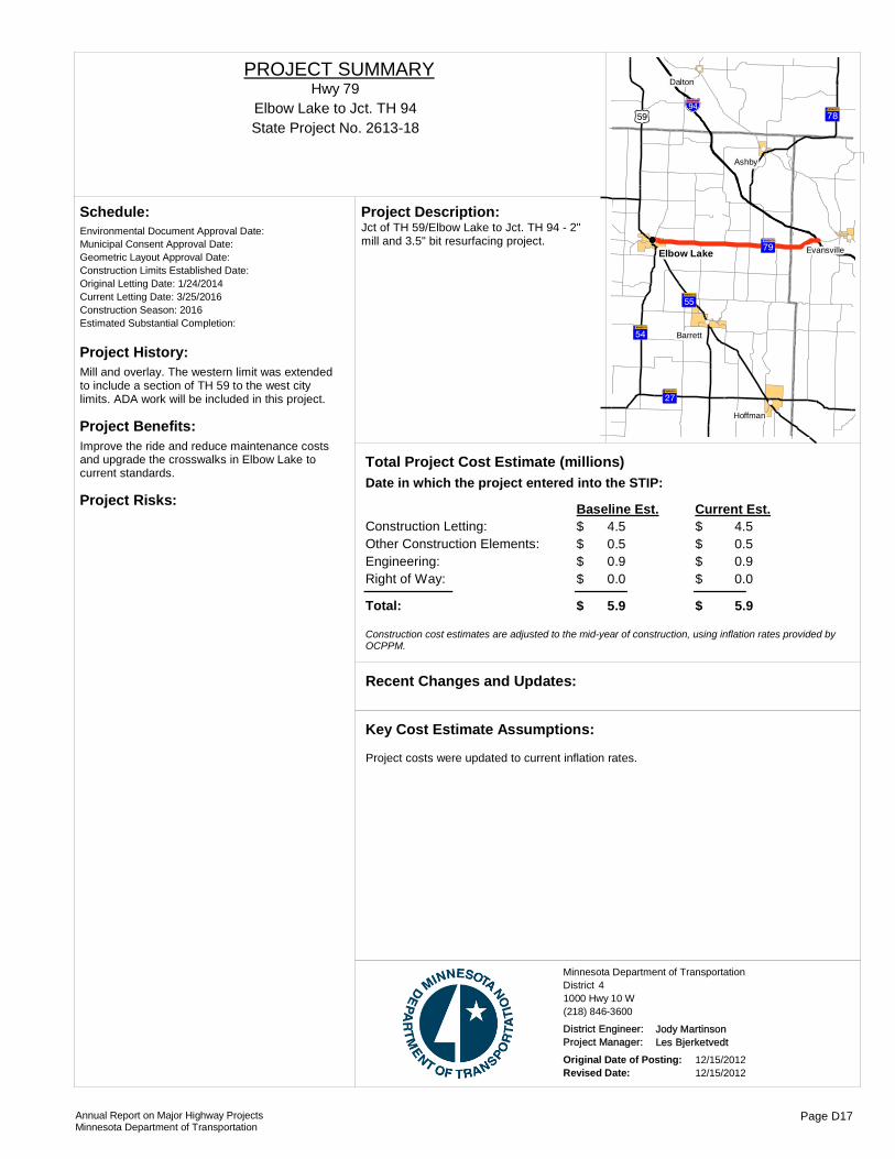
Project History:Mill and overlay. The western limit was extended to include a section of TH 59 to the west city limits. ADA work will be included in this project.
Project Benefits:Improve the ride and reduce maintenance costs and upgrade the crosswalks in Elbow Lake to current standards.
Project Risks:
Environmental Document Approval Date:
Schedule:
Municipal Consent Approval Date: Geometric Layout Approval Date: Construction Limits Established Date: Original Letting Date: 1/24/2014Current Letting Date: 3/25/2016Construction Season: 2016Estimated Substantial Completion:
?ÀA@
?×A@
?ëA@
?êA@
?ØA@
)r!"b$
!(
!(
!(
!(
!(
!(
Elbow Lake
Ashby
Dalton
Hoffman
Barrett
Evansville
Jct of TH 59/Elbow Lake to Jct. TH 94 - 2" mill and 3.5" bit resurfacing project.
Project Description:
Total Project Cost Estimate (millions)Date in which the project entered into the STIP:
Construction Letting: 4.5Other Construction Elements: 0.5Engineering: 0.9Right of Way: 0.0
4.50.50.90.0
Baseline Est. Current Est.
Total: 5.9 5.9
$$$$
$
$$$$
$
Construction cost estimates are adjusted to the mid-year of construction, using inflation rates provided by OCPPM.
Recent Changes and Updates:
Project costs were updated to current inflation rates.
Key Cost Estimate Assumptions:
State Project No. 2613-18Elbow Lake to Jct. TH 94
Hwy 79PROJECT SUMMARY
District 4Minnesota Department of Transportation
1000 Hwy 10 W(218) 846-3600
District Engineer: Jody MartinsonProject Manager: Les Bjerketvedt
Original Date of Posting: 12/15/2012Revised Date: 12/15/2012
Annual Report on Major Highway ProjectsMinnesota Department of Transportation
Page D17

Project History:There is a safety and mobility problem at the interchange of TH 75/I-94. This project is the preferred alternative from the TH 75 Corridor Transportation Study that was completed in 2008. The study recommendations will be incorporated into this project.
Project Benefits:• New Interchange configuration will enhance mobility and safety.• Auxiliary lane extension to 20th St will improve mobility on interstate by increasing capacity and safety• Reduces long-term maintenance
Project Risks:Since the consultant has just started pre-design work project activities have not been accomplished like geotechnical evaluations, surveys, etc., resulting in many project unknowns at this point.
Environmental Document Approval Date: Pending Approval
Schedule:
Municipal Consent Approval Date: Pending ApprovalGeometric Layout Approval Date: Pending ApprovalConstruction Limits Established Date: Pending ApprovalOriginal Letting Date: 06/24/2016Current Letting Date: 1/24/2016Construction Season: Summer 2016Estimated Substantial Completion: October 2016
§̈b
)x
!"b$
!(
!PMoorhead
Dilworth
Reconstruction of the TH 75/I-94 Interchange in Moorhead and auxiliary lane extension to 20th Street in both directions.
Project Description:
Total Project Cost Estimate (millions)Date in which the project entered into the STIP:
Construction Letting: 15.0Other Construction Elements: 1.2Engineering: 3.0Right of Way: 0.2
15.01.23.00.2
Baseline Est. Current Est.
Total: 19.4 19.4
22.03.05.03.0
33.0
$$$$
$
$$$$
$
- $ - $ - $ - $
- $
Construction cost estimates are adjusted to the mid-year of construction, using inflation rates provided by OCPPM.
The Transportation Planning Study for this corridor was completed in 2008. Consultant aquisition was complete in spring 2012. Value Engineering Study will be complete in October 2012.
Recent Changes and Updates:
Current cost estimate was derived from the Planning Study and will be refined during scoping and value engineering activities.
Key Cost Estimate Assumptions:
State Project No. 1406-66
I 94 and Hwy. 75 InterchangeI-94
PROJECT SUMMARY
Bridge 14813/14814
District 4Minnesota Department of Transportation
1000 Hwy 10 W(218) 846-3600
District Engineer: Jody MartinsonProject Manager: Seth Yliniemi
Original Date of Posting: 1/1/2009Revised Date: 12/15/2012
Annual Report on Major Highway ProjectsMinnesota Department of Transportation
Page D18
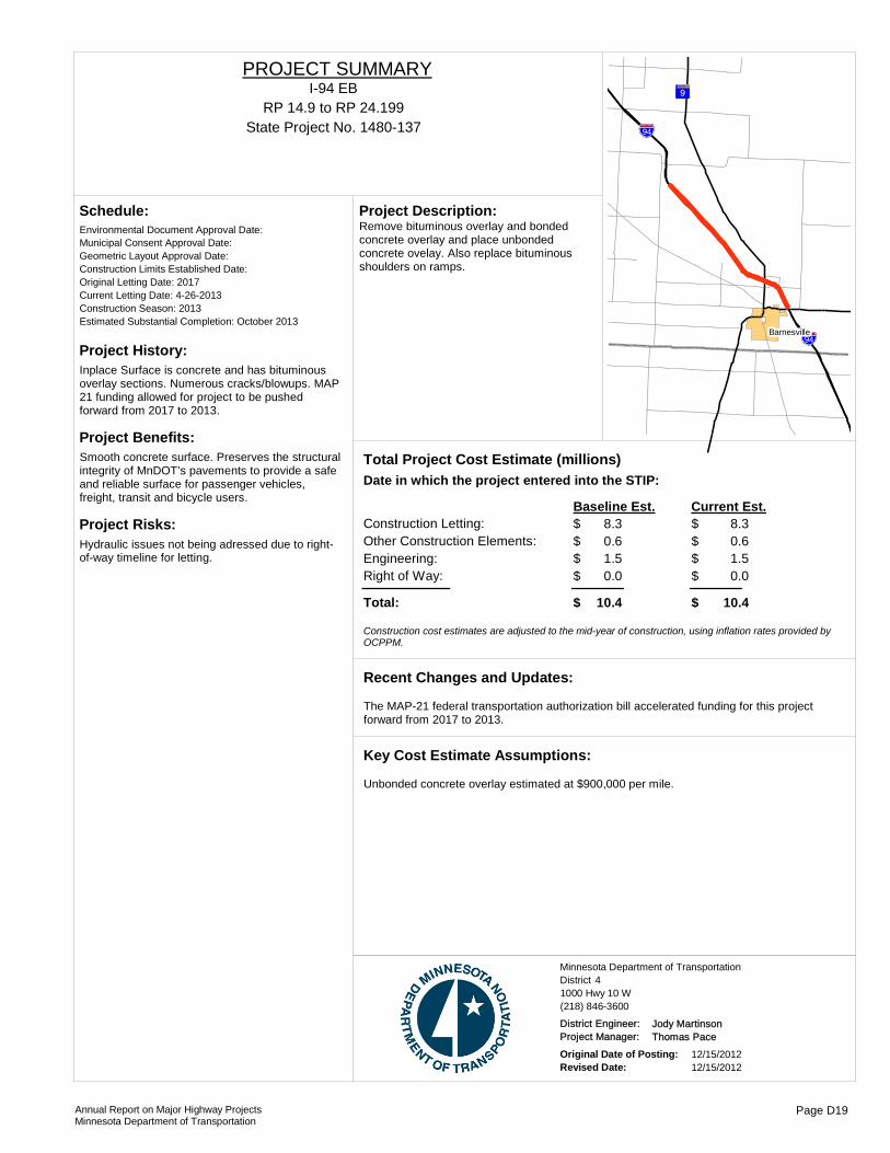
Project History:Inplace Surface is concrete and has bituminous overlay sections. Numerous cracks/blowups. MAP 21 funding allowed for project to be pushed forward from 2017 to 2013.
Project Benefits:Smooth concrete surface. Preserves the structural integrity of MnDOT’s pavements to provide a safe and reliable surface for passenger vehicles, freight, transit and bicycle users.
Project Risks:Hydraulic issues not being adressed due to right-of-way timeline for letting.
Environmental Document Approval Date:
Schedule:
Municipal Consent Approval Date: Geometric Layout Approval Date: Construction Limits Established Date: Original Letting Date: 2017Current Letting Date: 4-26-2013Construction Season: 2013Estimated Substantial Completion: October 2013
?¬A@
!"b$
!"b$
!(
Barnesville
Remove bituminous overlay and bonded concrete overlay and place unbonded concrete ovelay. Also replace bituminous shoulders on ramps.
Project Description:
Total Project Cost Estimate (millions)Date in which the project entered into the STIP:
Construction Letting: 8.3Other Construction Elements: 0.6Engineering: 1.5Right of Way: 0.0
8.30.61.50.0
Baseline Est. Current Est.
Total: 10.4 10.4
$$$$
$
$$$$
$
Construction cost estimates are adjusted to the mid-year of construction, using inflation rates provided by OCPPM.
The MAP-21 federal transportation authorization bill accelerated funding for this project forward from 2017 to 2013.
Recent Changes and Updates:
Unbonded concrete overlay estimated at $900,000 per mile.
Key Cost Estimate Assumptions:
State Project No. 1480-137RP 14.9 to RP 24.199
I-94 EBPROJECT SUMMARY
District 4Minnesota Department of Transportation
1000 Hwy 10 W(218) 846-3600
District Engineer: Jody MartinsonProject Manager: Thomas Pace
Original Date of Posting: 12/15/2012Revised Date: 12/15/2012
Annual Report on Major Highway ProjectsMinnesota Department of Transportation
Page D19
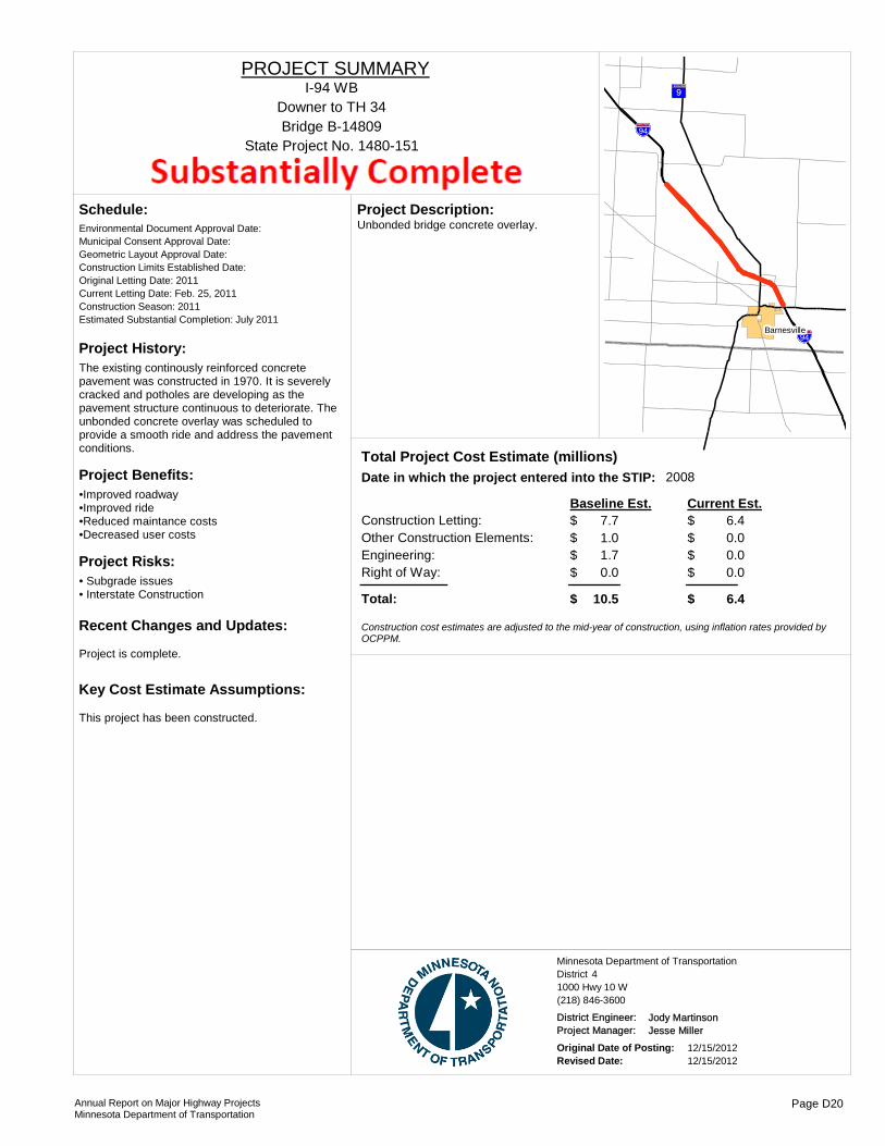
Project History:The existing continously reinforced concrete pavement was constructed in 1970. It is severely cracked and potholes are developing as the pavement structure continuous to deteriorate. The unbonded concrete overlay was scheduled to provide a smooth ride and address the pavement conditions.
Project Benefits:•Improved roadway•Improved ride•Reduced maintance costs •Decreased user costs
Project Risks:• Subgrade issues• Interstate Construction
Environmental Document Approval Date:
Schedule:
Municipal Consent Approval Date: Geometric Layout Approval Date: Construction Limits Established Date: Original Letting Date: 2011Current Letting Date: Feb. 25, 2011Construction Season: 2011Estimated Substantial Completion: July 2011
Project is complete.
Recent Changes and Updates:
This project has been constructed.
Key Cost Estimate Assumptions:
?¬A@
!"b$
!"b$
!(
Barnesville
Unbonded bridge concrete overlay.Project Description:
2008Total Project Cost Estimate (millions)Date in which the project entered into the STIP:
Construction Letting: 7.7Other Construction Elements: 1.0Engineering: 1.7Right of Way: 0.0
6.40.00.00.0
Baseline Est. Current Est.
Total: 10.5 6.4
$$$$
$
$$$$
$
Construction cost estimates are adjusted to the mid-year of construction, using inflation rates provided by OCPPM.
State Project No. 1480-151
Downer to TH 34I-94 WB
PROJECT SUMMARY
Bridge B-14809
District 4Minnesota Department of Transportation
1000 Hwy 10 W(218) 846-3600
District Engineer: Jody MartinsonProject Manager: Jesse Miller
Original Date of Posting: 12/15/2012Revised Date: 12/15/2012
Annual Report on Major Highway ProjectsMinnesota Department of Transportation
Page D20
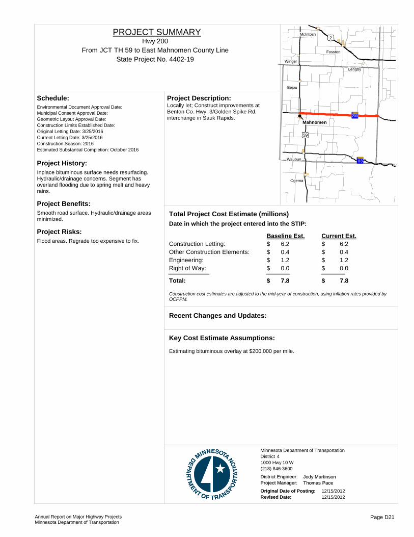
Project History:Inplace bituminous surface needs resurfacing. Hydraulic/drainage concerns. Segment has overland flooding due to spring melt and heavy rains.
Project Benefits:Smooth road surface. Hydraulic/drainage areas minimized.
Project Risks:Flood areas. Regrade too expensive to fix.
Environmental Document Approval Date:
Schedule:
Municipal Consent Approval Date: Geometric Layout Approval Date: Construction Limits Established Date: Original Letting Date: 3/25/2016Current Letting Date: 3/25/2016Construction Season: 2016Estimated Substantial Completion: October 2016
)i
)r
?|A@
?fA@
!(
!(
!(
!(
!(
!(
!(
!(
Mahnomen
Ogema
Bejou
Winger
Waubun
Lengby
Fosston
McIntosh
Locally let; Construct improvements at Benton Co. Hwy. 3/Golden Spike Rd. interchange in Sauk Rapids.
Project Description:
Total Project Cost Estimate (millions)Date in which the project entered into the STIP:
Construction Letting: 6.2Other Construction Elements: 0.4Engineering: 1.2Right of Way: 0.0
6.20.41.20.0
Baseline Est. Current Est.
Total: 7.8 7.8
$$$$
$
$$$$
$
Construction cost estimates are adjusted to the mid-year of construction, using inflation rates provided by OCPPM.
Recent Changes and Updates:
Estimating bituminous overlay at $200,000 per mile.
Key Cost Estimate Assumptions:
State Project No. 4402-19From JCT TH 59 to East Mahnomen County Line
Hwy 200PROJECT SUMMARY
District 4Minnesota Department of Transportation
1000 Hwy 10 W(218) 846-3600
District Engineer: Jody MartinsonProject Manager: Thomas Pace
Original Date of Posting: 12/15/2012Revised Date: 12/15/2012
Annual Report on Major Highway ProjectsMinnesota Department of Transportation
Page D21
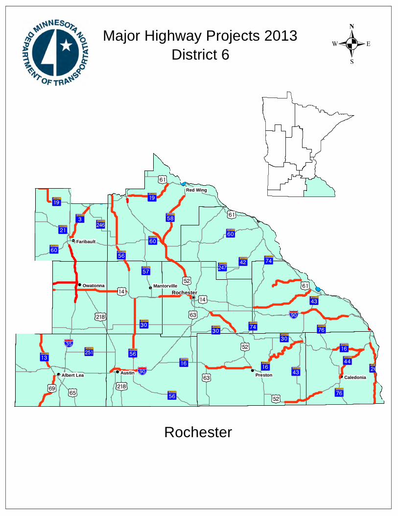
!(!(
!(
!(
!(
!(!(
!(
!(
!(
!(!(
!P
%&d(
%&f( %&c(
!"̀$ )y
)s )p
)s
)y
)z
)m
)s )m
)p
)p
?ÙA@
?¹A@
?ØA@
?±A@
?èA@
?éA@
?ºA@
?ÓA@
?±A@
?tA@
?ÙA@
?ØA@
?¾A@
?̧A@
?±A@
?©A@
?ûA@ ?ÌA@
?§A@
?§A@
?̧A@
?ÕA@
?ÒA@
)o
)s
)p
)s
?±A@
?ÜA@
?³A@
?ÍA@?ÚA@
+£
)o?íA@
?ÛA@?§A@
?ÎA@
?çA@
?ÃA@
?½A@
?¿A@
)v
)t
?ÏA@
?±A@
!"a$
?ºA@
?ÙA@)u
)p
?¹A@?ÜA@
)p
?ÜA@
?³A@
!"a$?»A@
?èA@
?³A@
)o
?̧A@
?ÙA@
?èA@
?±A@
?ÃA@
?ºA@
?ÃA@
?ùA@
?ÎA@
+£)t
?ÃA@
)s
?çA@
?̧A@
?ÙA@!"̀$
!(!(
!(
!(!(!(!(Rochester
Austin Preston
Red Wing
Owatonna
Faribault
CaledoniaAlbert Lea
Mantorville
.Major Highway Projects 2013District 6
Rochester

ROUTE PROJECT LOCATION PAGE
District Project SummaryDistrict 6
State Project #
Hwy 3 Faribault to Northfield E 26612-97
Hwy 14 CSAH 5 (Byron) to TH 52 E 35501-35
Hwy 14 I-35 to West Steele county line E 47401-34
Hwy 14 TH 52 to Olmsted CSAH 22 E 55502-73
Hwy 14 TH 14 from I-35 to Dodge Center E 67402-28
Hwy 14 TH 14 from TH 74 north to Gilmore Creek E 78501-61
Hwy 16 Pleasant St. E. in Lanesboro to MN 43 in Rushford E 82304-48
Hwy 16 From Houston County Bridge 95111 near TH 76 to Hokah near TH 44
E 92801-80
Hwy 16 From Grant Street in Spring Valley to JCT. TH 52 in Preston
E 102315-15
Hwy 19 Cannon Falls to Jct. TH 61 in Red Wing E 112503-30
Hwy 19 TH 13 to 3rd Avenue SE in Lonsdale & SB I-35 ramps to Armstrong Road & turn lanes at I-35 ramps in Northfield
E 126602-25
Hwy 26 MN/IA to TH 16 E 132802-66
Hwy 35 5 miles south of Owatonna to Faribault E 147480-113
Hwy 43 Winona Bridge over Mississippi River E 158503-46
Hwy 44 In Houston County from Jct 44/76 (Caledonia) to Hokah E 162804-33
Hwy 44 From the Jct. with TH 52 to 3rd Ave. NW in Spring Grove E 172308-26
Hwy 52 Cannon Falls interchange E 182506-52
Hwy 52 85th St N of Rochester to 1.3 mi N of Goodhue CSAH near Zumbrota
E 192505-49
Hwy 52 Elk Run interchange E 202505-48
Hwy 56 From Jct. CSAH 24 in West Concord, MN to Jct. Home Street in Kenyon, MN
E 212006-27
Hwy 56 Trondheim Road in Kenyon to Bridge 6525 over the Cannon River
E 222508-31
Hwy 58 TH 52 to 0.8 miles south of CSAH 5 E 232510-47
Hwy 69 From IA/MN State Line to TH 13 E 242406-47
I-90 I-90 from TH 105 to CSAH 19 E 255080-159
I-90 Dresbach Bridge over Mississippi River (Dresbach) E 268580-149
Annual Report on Major Highway ProjectsMinnesota Department of Transportation Page E1

I-90 EB I-90 from the west junction with TH 43 to 0.8 miles west of TH 76
E 278580-152
I-90 I-90 EB from 2.2 miles east of TH 74 to 0.5 miles east of TH 43
E 288580-156
I-90 0.8 miles west of TH 76 to 0.69 miles west of CSAH 12 E 298580-163
Hwy 248 1st Ave. SE in Altura to TH 61 E 308511-09
Hwy 250 Bridge No. 6975 - 1.0 mi N of Jct of TH 16.Bridge No. 6977 - 3.4 mi N of the Jct of TH 16.
E 312319-16
Annual Report on Major Highway ProjectsMinnesota Department of Transportation Page E1

Project History:• This segment of TH 3 was originally graded and paved with concrete in 1921.• The last overlay was constructed in 1990.• The pavement is showing signs of deterioration and cracking. • Culverts, storm sewers and traffic safety have all been noted as in need of repairs and improvement.
Project Benefits:• Extend the pavement life by an anticipated 8-10 years and improve ride quality.• Improvements to multiple culverts, ditches, aprons, and pipe sections as recommended by the District 6 Hydraulics Department.• Safety improvements, including guardrail, turn lanes and rumble strips.• Reconstruction of the ped ramps is anticipated for Northfield & Faribault.
Project Risks:•No detour agreements are anticipated for this project. However, drainage improvements recommended by the District Structures Section may lead to the need for a detour•Access management improvements are not included, but could increase the scope of the project
Environmental Document Approval Date:
Schedule:
Municipal Consent Approval Date: Geometric Layout Approval Date: Construction Limits Established Date: Original Letting Date: 1/24/2014Current Letting Date: 2/22/2013Construction Season: 2013Estimated Substantial Completion: Fall 2013
?̧A@
!"̀$
?ÜA@
?§A@
!(
!(
!(
Faribault
Dundas
Northfield
Medium Bituminous Overlay 12.6 miles of US Highway 3. This project begins at the intersection of Highway 21 in Northfield and then travels north on Highway 3 through Dundas to the south side of the Cannon River Bridge in Northfield.
Project Description:
2010Total Project Cost Estimate (millions)Date in which the project entered into the STIP:
Construction Letting: 4.7Other Construction Elements: 0.5Engineering: 0.7Right of Way: 0.0
4.70.50.70.0
Baseline Est. Current Est.
Total: 5.9 5.9
$$$$
$
$$$$
$
Construction cost estimates are adjusted to the mid-year of construction, using inflation rates provided by OCPPM.
Recent Changes and Updates:
•It is assumed that traffic would be maintained on Highway 3 during construction, so no detour costs were included in the estimate•It is assumed that there will be no right-of-way costs•A three-inch bituminous overlay was assumed. Depending on the pave
Key Cost Estimate Assumptions:
State Project No. 6612-97Faribault to Northfield
Hwy 3PROJECT SUMMARY
District 6Minnesota Department of Transportation
2900 48th Street NW(507) 286-7500
District Engineer: Nelrae SuccioProject Manager: Heather Lukes
Original Date of Posting: 12/15/2012Revised Date: 12/15/2012
Annual Report on Major Highway ProjectsMinnesota Department of Transportation
Page E2
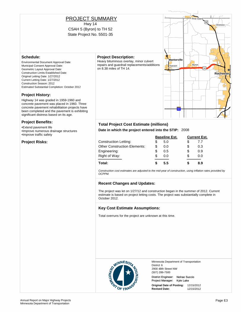
Project History:Highway 14 was graded in 1959-1960 and concrete pavement was placed in 1960. Three concrete pavement rehabilitation projects have been completed and the pavement is exhibiting significant distress based on its age.
Project Benefits:•Extend pavement life•Improve numerous drainage structures•Improve traffic safety
Project Risks:
Environmental Document Approval Date:
Schedule:
Municipal Consent Approval Date: Geometric Layout Approval Date: Construction Limits Established Date: Original Letting Date: 1/27/2012Current Letting Date: 1/27/2012Construction Season: 2012Estimated Substantial Completion: October 2012
?ÃA@
)t
)o
)p
!(!(
!(
!(
!(
!P
Rochester
Mantorville
ByronKasson
Oronoco
Pine Island
Heavy bituminous overlay, minor culvert repairs and guardrail replacements/additions on 8.38 miles of TH 14.
Project Description:
2008Total Project Cost Estimate (millions)Date in which the project entered into the STIP:
Construction Letting: 5.0Other Construction Elements: 0.0Engineering: 0.5Right of Way: 0.0
7.70.30.90.0
Baseline Est. Current Est.
Total: 5.5 8.9
$$$$
$
$$$$
$
Construction cost estimates are adjusted to the mid-year of construction, using inflation rates provided by OCPPM.
The project was let on 1/27/12 and construction began in the summer of 2012. Current estimate is based on project letting costs. The project was substantially complete in October 2012.
Recent Changes and Updates:
Total overruns for the project are unknown at this time.
Key Cost Estimate Assumptions:
State Project No. 5501-35CSAH 5 (Byron) to TH 52
Hwy 14PROJECT SUMMARY
District 6Minnesota Department of Transportation
2900 48th Street NW(507) 286-7500
District Engineer: Nelrae SuccioProject Manager: Kyle Lake
Original Date of Posting: 12/15/2012Revised Date: 12/15/2012
Annual Report on Major Highway ProjectsMinnesota Department of Transportation
Page E3

Project History:Highway 14 provides a direction connection between Mankato and Rochester, both major regional centers in southern Minnesota.
Project Benefits:The purpose of this project is to improve the connectivity, safety and level of service for users on Trunk Highway 14 from Owatonna to the westerly Steele County Line as part of an overall effort to improve Trunk Highway 14 from Waseca to Owatonna.
Project Risks:Traffic detour during construction.
Environmental Document Approval Date: 2009
Schedule:
Municipal Consent Approval Date: Need UnknownGeometric Layout Approval Date: 2009Construction Limits Established Date: 2009Original Letting Date: 1/23/09Current Letting Date: 1/23/09Construction Season: 2009-2012Estimated Substantial Completion: Fall 2012
)o
!"̀$
!"̀$
Owatonna
Medford
This project provides for a four-lane expansion of Trunk Highway 14 from Owatonna to the westerly Steele County Line. The majority of this project in on a new alignment, however, the existing interchange at the southerly junction of Trunk Highway 14 and Interstate 35 will be reconstructed along with short segments of both Trunk Highway 14 and Interstate 35 in this area.
Project Description:
2007Total Project Cost Estimate (millions)Date in which the project entered into the STIP:
Construction Letting: 65.3Other Construction Elements: 0.0Engineering: 3.2Right of Way: 12.3
51.82.1
10.411.2
Baseline Est. Current Est.
Total: 80.8 75.5
$$$$
$
$$$$
$
Construction cost estimates are adjusted to the mid-year of construction, using inflation rates provided by OCPPM.
The project was let on 1/23/09 and was substantially in the summer of 2012. Current estimate reflects the project construction and updated right of way costs.
Recent Changes and Updates:
The overruns for the project are at a reasonable level.
Key Cost Estimate Assumptions:
State Project No. 7401-34I-35 to West Steele county line
Hwy 14PROJECT SUMMARY
District 6Minnesota Department of Transportation
2900 48th Street NW(507) 286-7500
District Engineer: Nelrae SuccioProject Manager: Chad Casey
Original Date of Posting: 1/1/2009Revised Date: 12/15/2012
Annual Report on Major Highway ProjectsMinnesota Department of Transportation
Page E4

Project History:• Highway 14 is an east – west corridor that was graded in 1960s.• Bituminous overlay projects were completed in the 1980s and 1990s. • In 2007, the Ride Quality Index (RQI) was rated as poor, the Remaining Service Life as Poor (0-3 years) and the Surface Rating as Good. This indicates the need for improvement.
Project Benefits:Extend pavement life, improve traffic safety and operations and improve hydraulics & drainage features, and improve bridge approaches.
Project Risks:
Environmental Document Approval Date:
Schedule:
Municipal Consent Approval Date: Geometric Layout Approval Date: Construction Limits Established Date: Original Letting Date: 11/20/2009Current Letting Date: 2/25/2011Construction Season: 2011Estimated Substantial Completion: November 2011
The project was let on 2/25/2011 and construction began in May 2011. The current estimate is based on project letting costs. Construction was completed in November 2011.
Recent Changes and Updates:
Total overruns for the project are unknown at this time.
Key Cost Estimate Assumptions:
)t
)o
)p
!P
Rochester
Bituminous mill and overlay, turn lane construction, storm sewer replacement, traffic signal installation, replacement of bridge approach panels and installation of an ITS system.
Project Description:
2007Total Project Cost Estimate (millions)Date in which the project entered into the STIP:
Construction Letting: 3.2Other Construction Elements: 0.0Engineering: 0.4Right of Way: 0.0
6.00.21.20.0
Baseline Est. Current Est.
Total: 3.6 7.4
$$$$
$
$$$$
$
Construction cost estimates are adjusted to the mid-year of construction, using inflation rates provided by OCPPM.
State Project No. 5502-73TH 52 to Olmsted CSAH 22
Hwy 14PROJECT SUMMARY
District 6Minnesota Department of Transportation
2900 48th Street NW(507) 286-7500
District Engineer: Nelrae SuccioProject Manager: Paul Schauer
Original Date of Posting: 12/15/2012Revised Date: 12/15/2012
Annual Report on Major Highway ProjectsMinnesota Department of Transportation
Page E5

Project History:This segment of TH 14 was built in 1927. Various segments of the project have been overlaid in 1989, 1993, 2005 and 2006. The road Ride Quality Index (RQI) and the Remaining Service Life (RSL) indicate the need for improvement in the short-term.
Project Benefits:• Extend the life of this pavement for an anticipated 15 years and improve safety on TH 14. •Preserve the pavement •Improvements to drainage structures exhibiting signs of distress as recommended by the District Hydraulics Section
Project Risks:No Detour Agreements are anticipated for this project. Recommended drainage improvements may lead to the need for a detour.
Environmental Document Approval Date:
Schedule:
Municipal Consent Approval Date: Geometric Layout Approval Date: Construction Limits Established Date: Original Letting Date: 1/23/2015Current Letting Date: 1/23/2015Construction Season: 2015Estimated Substantial Completion: Fall 2015
)o
?ÃA@
!"̀$
){
){
?ÜA@
!"̀$
!"̀$
?ÜA@
!(
!(
!(
!(
!(
!(
!(
!(
!(
!(
!( Owatonna
Faribault
Kenyon
Medford
Hayfield
Claremont
West Concord
Dodge Center
Blooming Prairie
Medium bituminous mill and overlay, hydraulics improvements and traffic safety improvements from I-35 to Dodge Center.
Project Description:
2011Total Project Cost Estimate (millions)Date in which the project entered into the STIP:
Construction Letting: 5.9Other Construction Elements: 0.2Engineering: 1.2Right of Way: 0.0
5.90.21.20.0
Baseline Est. Current Est.
Total: 7.3 7.3
$$$$
$
$$$$
$
Construction cost estimates are adjusted to the mid-year of construction, using inflation rates provided by OCPPM.
Recent Changes and Updates:
Standard practices used to develop cost estimates for this project.Right of way is not required for the project. It is assumed that traffic will be maintained during construction, so no crossover or detour costs were included.
Key Cost Estimate Assumptions:
State Project No. 7402-28TH 14 from I-35 to Dodge Center
Hwy 14PROJECT SUMMARY
District 6Minnesota Department of Transportation
2900 48th Street NW(507) 286-7500
District Engineer: Nelrae SuccioProject Manager: Mike Kempinger
Original Date of Posting: 12/15/2012Revised Date: 12/15/2012
Annual Report on Major Highway ProjectsMinnesota Department of Transportation
Page E6

Project History:This segment of TH 14 was built in 1936. This road was widened in 1982 and from 1990 to 1992 it received a bituminous overlay. Several segments recieved thin overlays between 1992 and 2007. The road Ride Quality Index (RQI) and the Remaining Service Life (RSL) indicate the need for improvement in the short-term.
Project Benefits:•Extend the life of this pavement for an anticipated 10 years•Preserve the pavement •Improve drainage structures exhibiting signs of distress as recommended by the District Hydraulics Section
Project Risks:
Environmental Document Approval Date:
Schedule:
Municipal Consent Approval Date: Geometric Layout Approval Date: Construction Limits Established Date: Original Letting Date: 1/25/13Current Letting Date: 3/7/2012Construction Season: 2012Estimated Substantial Completion: Fall 2012
!"a$
?ÎA@
?¼A@
)s
?»A@
)o ?ÎA@
?ÃA@
?çA@
?çA@
)s
!(
!(
!(
!(
!(
!(
!(
!(
!(!(
!(
!(
!(
Elba
Utica
Altura
Stockton
Rushford
Peterson
Lewiston
Goodview
Minneiska
St. Charles
Rollingstone Minnesota City
Rushford Village
Grading, bituminous mill and overlay and ADA improvements on TH 14.
Project Description:
2007Total Project Cost Estimate (millions)Date in which the project entered into the STIP:
Construction Letting: 6.3Other Construction Elements: 0.0Engineering: 0.6Right of Way: 0.0
7.50.31.50.0
Baseline Est. Current Est.
Total: 6.9 9.3
$$$$
$
$$$$
$
Construction cost estimates are adjusted to the mid-year of construction, using inflation rates provided by OCPPM.
The project was let on 3/7/12. Current Estimate reflects bid amount.
Recent Changes and Updates:
Key Cost Estimate Assumptions:
State Project No. 8501-61TH 14 from TH 74 north to Gilmore Creek
Hwy 14PROJECT SUMMARY
District 6Minnesota Department of Transportation
2900 48th Street NW(507) 286-7500
District Engineer: Nelrae SuccioProject Manager: Mark Anderson
Original Date of Posting: 12/15/2012Revised Date: 12/15/2012
Annual Report on Major Highway ProjectsMinnesota Department of Transportation
Page E7
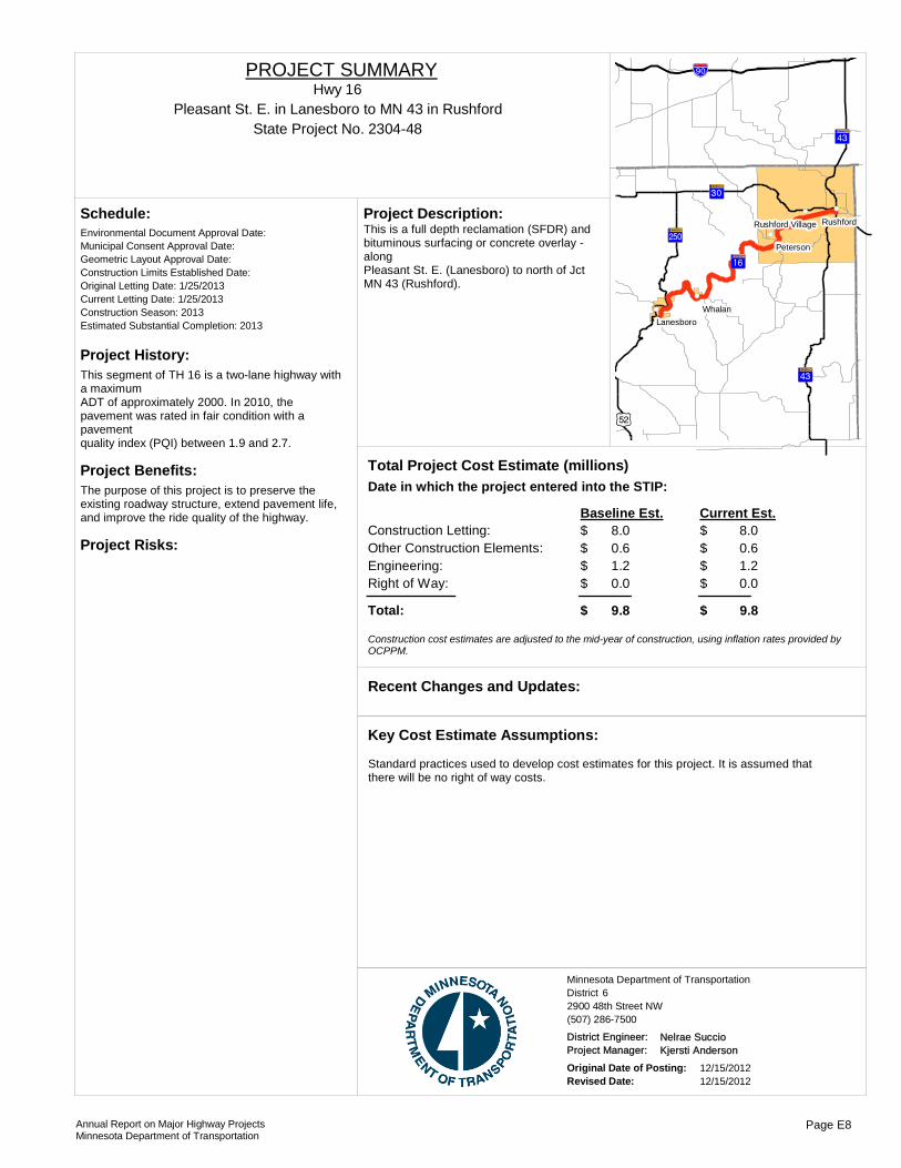
Project History:This segment of TH 16 is a two-lane highway with a maximumADT of approximately 2000. In 2010, the pavement was rated in fair condition with a pavementquality index (PQI) between 1.9 and 2.7.
Project Benefits:The purpose of this project is to preserve the existing roadway structure, extend pavement life, and improve the ride quality of the highway.
Project Risks:
Environmental Document Approval Date:
Schedule:
Municipal Consent Approval Date: Geometric Layout Approval Date: Construction Limits Established Date: Original Letting Date: 1/25/2013Current Letting Date: 1/25/2013Construction Season: 2013Estimated Substantial Completion: 2013
!"a$
?ÎA@
?ÎA@
)p
?¼A@
?³A@
?ÃA@
!(
!(
!(!(
!(
Whalan
Rushford
Peterson
Lanesboro
Rushford VillageThis is a full depth reclamation (SFDR) and bituminous surfacing or concrete overlay - alongPleasant St. E. (Lanesboro) to north of Jct MN 43 (Rushford).
Project Description:
Total Project Cost Estimate (millions)Date in which the project entered into the STIP:
Construction Letting: 8.0Other Construction Elements: 0.6Engineering: 1.2Right of Way: 0.0
8.00.61.20.0
Baseline Est. Current Est.
Total: 9.8 9.8
$$$$
$
$$$$
$
Construction cost estimates are adjusted to the mid-year of construction, using inflation rates provided by OCPPM.
Recent Changes and Updates:
Standard practices used to develop cost estimates for this project. It is assumed that there will be no right of way costs.
Key Cost Estimate Assumptions:
State Project No. 2304-48Pleasant St. E. in Lanesboro to MN 43 in Rushford
Hwy 16PROJECT SUMMARY
District 6Minnesota Department of Transportation
2900 48th Street NW(507) 286-7500
District Engineer: Nelrae SuccioProject Manager: Kjersti Anderson
Original Date of Posting: 12/15/2012Revised Date: 12/15/2012
Annual Report on Major Highway ProjectsMinnesota Department of Transportation
Page E8

Project History:This section of TH 16 was originally graded in 1926 and paved in the early 1940s.Records show that it was last paved in 1985.The pavement has significant deterioration and distress and major pavement improvements are needed.
Project Benefits:• Restore pavement life• Numerous improvements to drainage structures• Improve traffic and roadside safety
Project Risks:
Environmental Document Approval Date:
Schedule:
Municipal Consent Approval Date: Geometric Layout Approval Date: Construction Limits Established Date: Original Letting Date: 1/26/2007Current Letting Date: 2/12/2010Construction Season: 2010Estimated Substantial Completion: Fall 2010
The project was let on 2/12/2010 and was completed in September 2010. The current estimate is based on project letting costs.
Recent Changes and Updates:
Total overruns for the project are unknown at this time.
Key Cost Estimate Assumptions:
?³A@
?ÏA@
?èA@
!"a$
?èA@
!(
!(!(
!(
!(Caledonia
Hokah
Dakota
Houston
La Crescent
Pavement reclamation on 11.88 miles of TH 16 in Houston County, with 6" of bituminous pavement provided. The project includes hydraulics, traffic safety and roadside hardware improvements.
Project Description:
2006Total Project Cost Estimate (millions)Date in which the project entered into the STIP:
Construction Letting: 5.3Other Construction Elements: 0.2Engineering: 1.1Right of Way: 0.0
4.40.20.90.0
Baseline Est. Current Est.
Total: 6.6 5.5
$$$$
$
$$$$
$
Construction cost estimates are adjusted to the mid-year of construction, using inflation rates provided by OCPPM.
State Project No. 2801-80From Houston County Bridge 95111 near TH 76 to Hokah near TH 44
Hwy 16PROJECT SUMMARY
District 6Minnesota Department of Transportation
2900 48th Street NW(507) 286-7500
District Engineer: Nelrae SuccioProject Manager: Mark Anderson
Original Date of Posting: 12/15/2012Revised Date: 12/15/2012
Annual Report on Major Highway ProjectsMinnesota Department of Transportation
Page E9
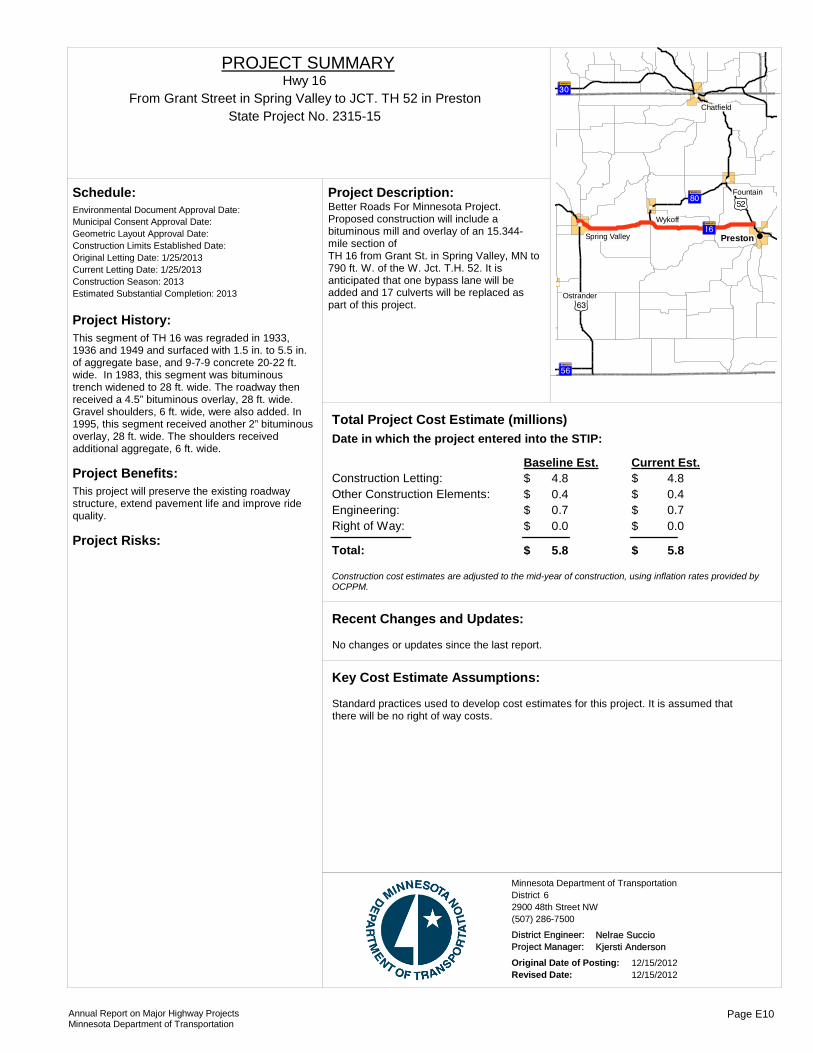
Project History:This segment of TH 16 was regraded in 1933, 1936 and 1949 and surfaced with 1.5 in. to 5.5 in. of aggregate base, and 9-7-9 concrete 20-22 ft. wide. In 1983, this segment was bituminous trench widened to 28 ft. wide. The roadway then received a 4.5” bituminous overlay, 28 ft. wide. Gravel shoulders, 6 ft. wide, were also added. In 1995, this segment received another 2” bituminous overlay, 28 ft. wide. The shoulders received additional aggregate, 6 ft. wide.
Project Benefits:This project will preserve the existing roadway structure, extend pavement life and improve ride quality.
Project Risks:
Environmental Document Approval Date:
Schedule:
Municipal Consent Approval Date: Geometric Layout Approval Date: Construction Limits Established Date: Original Letting Date: 1/25/2013Current Letting Date: 1/25/2013Construction Season: 2013Estimated Substantial Completion: 2013
?ÃA@
?³A@
)t
?ìA@
?ÙA@
)p
!(
!(
!(
!(
!(
!(Preston
Wykoff
Fountain
Ostrander
Chatfield
Spring Valley
Better Roads For Minnesota Project. Proposed construction will include a bituminous mill and overlay of an 15.344-mile section of TH 16 from Grant St. in Spring Valley, MN to 790 ft. W. of the W. Jct. T.H. 52. It is anticipated that one bypass lane will be added and 17 culverts will be replaced as part of this project.
Project Description:
Total Project Cost Estimate (millions)Date in which the project entered into the STIP:
Construction Letting: 4.8Other Construction Elements: 0.4Engineering: 0.7Right of Way: 0.0
4.80.40.70.0
Baseline Est. Current Est.
Total: 5.8 5.8
$$$$
$
$$$$
$
Construction cost estimates are adjusted to the mid-year of construction, using inflation rates provided by OCPPM.
No changes or updates since the last report.
Recent Changes and Updates:
Standard practices used to develop cost estimates for this project. It is assumed that there will be no right of way costs.
Key Cost Estimate Assumptions:
State Project No. 2315-15From Grant Street in Spring Valley to JCT. TH 52 in Preston
Hwy 16PROJECT SUMMARY
District 6Minnesota Department of Transportation
2900 48th Street NW(507) 286-7500
District Engineer: Nelrae SuccioProject Manager: Kjersti Anderson
Original Date of Posting: 12/15/2012Revised Date: 12/15/2012
Annual Report on Major Highway ProjectsMinnesota Department of Transportation
Page E10
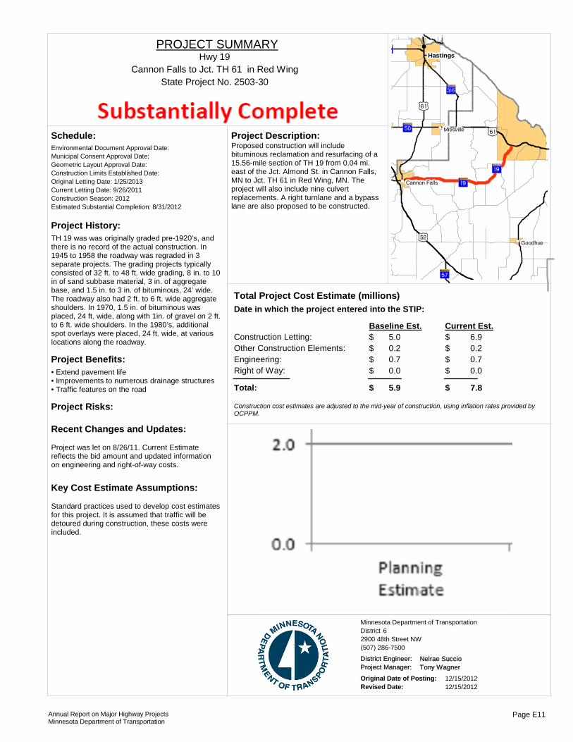
Project History:TH 19 was was originally graded pre-1920’s, and there is no record of the actual construction. In 1945 to 1958 the roadway was regraded in 3 separate projects. The grading projects typically consisted of 32 ft. to 48 ft. wide grading, 8 in. to 10 in of sand subbase material, 3 in. of aggregate base, and 1.5 in. to 3 in. of bituminous, 24’ wide. The roadway also had 2 ft. to 6 ft. wide aggregate shoulders. In 1970, 1.5 in. of bituminous was placed, 24 ft. wide, along with 1in. of gravel on 2 ft. to 6 ft. wide shoulders. In the 1980’s, additional spot overlays were placed, 24 ft. wide, at various locations along the roadway.
Project Benefits:• Extend pavement life• Improvements to numerous drainage structures• Traffic features on the road
Project Risks:
Environmental Document Approval Date:
Schedule:
Municipal Consent Approval Date: Geometric Layout Approval Date: Construction Limits Established Date: Original Letting Date: 1/25/2013Current Letting Date: 9/26/2011Construction Season: 2012Estimated Substantial Completion: 8/31/2012
Project was let on 8/26/11. Current Estimate reflects the bid amount and updated information on engineering and right-of-way costs.
Recent Changes and Updates:
Standard practices used to develop cost estimates for this project. It is assumed that traffic will be detoured during construction, these costs were included.
Key Cost Estimate Assumptions:
)p
?̧A@
)s
?ÚA@
?ÕA@
?èA@
?ØA@
)s
?̧A@!(
!(
!(!(
!(
Hastings
Goodhue
Miesville
Cannon Falls
Proposed construction will include bituminous reclamation and resurfacing of a 15.56-mile section of TH 19 from 0.04 mi. east of the Jct. Almond St. in Cannon Falls, MN to Jct. TH 61 in Red Wing, MN. The project will also include nine culvert replacements. A right turnlane and a bypass lane are also proposed to be constructed.
Project Description:
Total Project Cost Estimate (millions)Date in which the project entered into the STIP:
Construction Letting: 5.0Other Construction Elements: 0.2Engineering: 0.7Right of Way: 0.0
6.90.20.70.0
Baseline Est. Current Est.
Total: 5.9 7.8
$$$$
$
$$$$
$
Construction cost estimates are adjusted to the mid-year of construction, using inflation rates provided by OCPPM.
State Project No. 2503-30Cannon Falls to Jct. TH 61 in Red Wing
Hwy 19PROJECT SUMMARY
District 6Minnesota Department of Transportation
2900 48th Street NW(507) 286-7500
District Engineer: Nelrae SuccioProject Manager: Tony Wagner
Original Date of Posting: 12/15/2012Revised Date: 12/15/2012
Annual Report on Major Highway ProjectsMinnesota Department of Transportation
Page E11

Project History:• On TH 19 from Lonsdale to Highway 13 intersection, bituminous overlays were placed in 1981 and 1999 and pavement is showing considerable distress today. In 2002, the Present Serviceability Rating was as low as 2.5, indicating the need for improvement.• From Interstate 35 to Northfield, a bituminous overlay was placed in 1978 and in 2002, the Present Serviceability Rating is 2.8, indicating the need for improvement.
Project Benefits:•Extend pavement life•Pave gravel shoulders•Improve traffic safety and operations•Improve drainage infrastructure
Project Risks:
Environmental Document Approval Date:
Schedule:
Municipal Consent Approval Date: Geometric Layout Approval Date: Construction Limits Established Date: Original Letting Date: 1/22/2010Current Letting Date: 3/26/2010Construction Season: 2010Estimated Substantial Completion: October 2010
The project was let on 3/26/10 and construction was started on 7/6/2010. Current estimate is based on project letting. Construction was complete in October 2010.
Recent Changes and Updates:
Standard practices used to develop cost estimates for this project. It is assumed that traffic will be detoured during construction,these costs were included.
Key Cost Estimate Assumptions:
?±A@
?ºA@
)y
?ÒA@
?̧A@!(
!(
!(
!(
!(
Jordan
Lonsdale
New Prague
Montgomery
Heidelberg
Mill and overlay 15.08 miles of TH 19. Construct hydraulics improvements.Construct turn lanes and other traffic safety improvements.Construct 2-way left turn lanes at the I-35 ramps and install a traffic signal at the west ramps intersection.
Project Description:
2006Total Project Cost Estimate (millions)Date in which the project entered into the STIP:
Construction Letting: 5.5Other Construction Elements: 0.0Engineering: 0.2Right of Way: 0.1
6.50.31.30.0
Baseline Est. Current Est.
Total: 5.7 8.1
$$$$
$
$$$$
$
Construction cost estimates are adjusted to the mid-year of construction, using inflation rates provided by OCPPM.
State Project No. 6602-25
TH 13 to 3rd Avenue SE in Lonsdale & SB I-35 ramps to Armstrong Road & turn lanes at I-35 ramps in Northfield
Hwy 19PROJECT SUMMARY
District 6Minnesota Department of Transportation
2900 48th Street NW(507) 286-7500
District Engineer: Nelrae SuccioProject Manager: Kyle Lake
Original Date of Posting: 12/15/2012Revised Date: 12/15/2012
Annual Report on Major Highway ProjectsMinnesota Department of Transportation
Page E12

Project History:In 2010, the Ride Quality Index, Surface Rating, and Pavement Quality Index were all rated as fair. With the existing condition and further degradation by 2013 the pavement will be in need for improvement.
Project Benefits:•Extend pavement life•Improve drainage structures•Improve traffic and roadside safety
Project Risks:There is a sidewalk and two sets of stairways in or near the city of Brownsville that may need improvements or removal as part of the project. This highway is part of the Mississippi River Trail.
Environmental Document Approval Date:
Schedule:
Municipal Consent Approval Date: Geometric Layout Approval Date: Construction Limits Established Date: Original Letting Date: 1/25/2013Current Letting Date: 1/25/2013Construction Season: 2013Estimated Substantial Completion: Fall 2013
?³A@
?ÏA@
?¿A@
?èA@
!(
!(
!(
!(
Hokah
Eitzen
La Crescent
BrownsvilleMedium bituminous mill and overlay on 21.12 miles of TH 26. The project includes hydraulics, traffic safety, and roadside hardware improvements.
Project Description:
2009Total Project Cost Estimate (millions)Date in which the project entered into the STIP:
Construction Letting: 4.7Other Construction Elements: 0.4Engineering: 0.7Right of Way: 0.0
4.70.40.70.0
Baseline Est. Current Est.
Total: 5.8 5.8
$$$$
$
$$$$
$
Construction cost estimates are adjusted to the mid-year of construction, using inflation rates provided by OCPPM.
Recent Changes and Updates:
The cost estimate does not include costs for sidewalks or for bicycle accommodations. It is assumed that any sidewalk work, if included, will be funded by the city of Brownsville.
Key Cost Estimate Assumptions:
State Project No. 2802-66MN/IA to TH 16
Hwy 26PROJECT SUMMARY
District 6Minnesota Department of Transportation
2900 48th Street NW(507) 286-7500
District Engineer: Nelrae SuccioProject Manager: Jeff Bunch
Original Date of Posting: 12/15/2012Revised Date: 12/15/2012
Annual Report on Major Highway ProjectsMinnesota Department of Transportation
Page E13
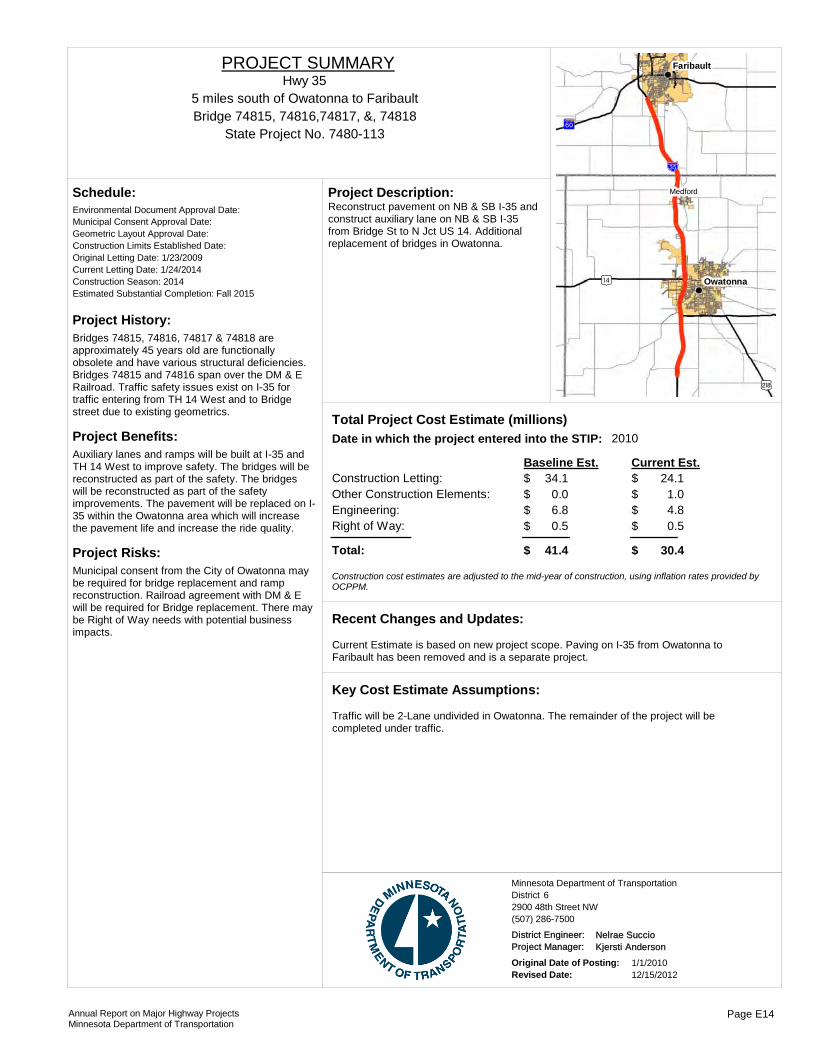
Project History:Bridges 74815, 74816, 74817 & 74818 are approximately 45 years old are functionally obsolete and have various structural deficiencies. Bridges 74815 and 74816 span over the DM & E Railroad. Traffic safety issues exist on I-35 for traffic entering from TH 14 West and to Bridge street due to existing geometrics.
Project Benefits:Auxiliary lanes and ramps will be built at I-35 and TH 14 West to improve safety. The bridges will be reconstructed as part of the safety. The bridges will be reconstructed as part of the safety improvements. The pavement will be replaced on I-35 within the Owatonna area which will increase the pavement life and increase the ride quality.
Project Risks:Municipal consent from the City of Owatonna may be required for bridge replacement and ramp reconstruction. Railroad agreement with DM & E will be required for Bridge replacement. There may be Right of Way needs with potential business impacts.
Environmental Document Approval Date:
Schedule:
Municipal Consent Approval Date: Geometric Layout Approval Date: Construction Limits Established Date: Original Letting Date: 1/23/2009Current Letting Date: 1/24/2014Construction Season: 2014Estimated Substantial Completion: Fall 2015
)o
!"̀$
){
?ÜA@
Owatonna
Faribault
Medford
Reconstruct pavement on NB & SB I-35 and construct auxiliary lane on NB & SB I-35 from Bridge St to N Jct US 14. Additional replacement of bridges in Owatonna.
Project Description:
2010Total Project Cost Estimate (millions)Date in which the project entered into the STIP:
Construction Letting: 34.1Other Construction Elements: 0.0Engineering: 6.8Right of Way: 0.5
24.11.04.80.5
Baseline Est. Current Est.
Total: 41.4 30.4
$$$$
$
$$$$
$
Construction cost estimates are adjusted to the mid-year of construction, using inflation rates provided by OCPPM.
Current Estimate is based on new project scope. Paving on I-35 from Owatonna to Faribault has been removed and is a separate project.
Recent Changes and Updates:
Traffic will be 2-Lane undivided in Owatonna. The remainder of the project will be completed under traffic.
Key Cost Estimate Assumptions:
State Project No. 7480-113
5 miles south of Owatonna to FaribaultHwy 35
PROJECT SUMMARY
Bridge 74815, 74816,74817, &, 74818
District 6Minnesota Department of Transportation
2900 48th Street NW(507) 286-7500
District Engineer: Nelrae SuccioProject Manager: Kjersti Anderson
Original Date of Posting: 1/1/2010Revised Date: 12/15/2012
Annual Report on Major Highway ProjectsMinnesota Department of Transportation
Page E14
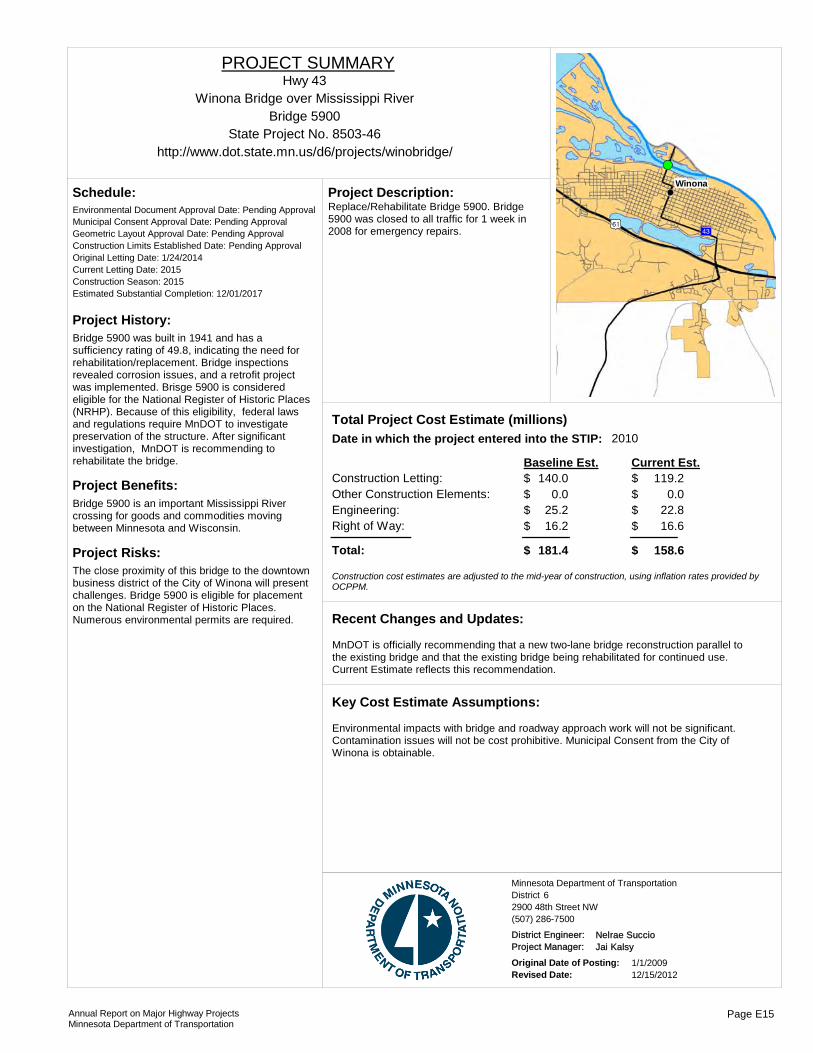
Project History:Bridge 5900 was built in 1941 and has a sufficiency rating of 49.8, indicating the need for rehabilitation/replacement. Bridge inspections revealed corrosion issues, and a retrofit project was implemented. Brisge 5900 is considered eligible for the National Register of Historic Places (NRHP). Because of this eligibility, federal laws and regulations require MnDOT to investigate preservation of the structure. After significant investigation, MnDOT is recommending to rehabilitate the bridge.
Project Benefits:Bridge 5900 is an important Mississippi River crossing for goods and commodities moving between Minnesota and Wisconsin.
Project Risks:The close proximity of this bridge to the downtown business district of the City of Winona will present challenges. Bridge 5900 is eligible for placement on the National Register of Historic Places. Numerous environmental permits are required.
Environmental Document Approval Date: Pending Approval
Schedule:
Municipal Consent Approval Date: Pending ApprovalGeometric Layout Approval Date: Pending ApprovalConstruction Limits Established Date: Pending ApprovalOriginal Letting Date: 1/24/2014Current Letting Date: 2015Construction Season: 2015Estimated Substantial Completion: 12/01/2017
!(!(!(!(
)s ?ÎA@
Winona
Replace/Rehabilitate Bridge 5900. Bridge 5900 was closed to all traffic for 1 week in 2008 for emergency repairs.
Project Description:
2010Total Project Cost Estimate (millions)Date in which the project entered into the STIP:
Construction Letting: 140.0Other Construction Elements: 0.0Engineering: 25.2Right of Way: 16.2
119.20.0
22.816.6
Baseline Est. Current Est.
Total: 181.4 158.6
$$$$
$
$$$$
$
Construction cost estimates are adjusted to the mid-year of construction, using inflation rates provided by OCPPM.
MnDOT is officially recommending that a new two-lane bridge reconstruction parallel to the existing bridge and that the existing bridge being rehabilitated for continued use. Current Estimate reflects this recommendation.
Recent Changes and Updates:
Environmental impacts with bridge and roadway approach work will not be significant. Contamination issues will not be cost prohibitive. Municipal Consent from the City of Winona is obtainable.
Key Cost Estimate Assumptions:
State Project No. 8503-46
Winona Bridge over Mississippi River
http://www.dot.state.mn.us/d6/projects/winobridge/
Hwy 43PROJECT SUMMARY
Bridge 5900
District 6Minnesota Department of Transportation
2900 48th Street NW(507) 286-7500
District Engineer: Nelrae SuccioProject Manager: Jai Kalsy
Original Date of Posting: 1/1/2009Revised Date: 12/15/2012
Annual Report on Major Highway ProjectsMinnesota Department of Transportation
Page E15

Project History:• The majority of the existing pavements were graded in the 1930s and 1940s with concrete pavement placed at that time.• In 1990, the existing 9-7-9 concrete pavement was trench widened and a bituminous overlay was placed.• The existing pavement is exhibiting signs of distress and is in need of improvement.
Project Benefits:•Extend pavement life •Improve drainage structures •Improve traffic and roadside safety
Project Risks:Detour agreements may become necessary for replacement of the drainage structures and box culvert, as recommended by the Districts 6 Hydraulics Section.
Environmental Document Approval Date:
Schedule:
Municipal Consent Approval Date: Geometric Layout Approval Date: Construction Limits Established Date: Original Letting Date: 1/27/2012Current Letting Date: 1/27/2012Construction Season: 2012Estimated Substantial Completion: October 2012
The original project scope and cost estimate did not include replacement of the box culvert (Bridge 8158). The project was let on 1/27/2012 and completed in October 2012.
Recent Changes and Updates:
The project would be completed while maintaining traffic.
Key Cost Estimate Assumptions:
Bituminous mill & overlay on 13 miles of TH 44. Replace box culvert (Bridge 8158), make various hydraulics improvements and construct turn lanes.
Project Description:
2008Total Project Cost Estimate (millions)Date in which the project entered into the STIP:
Construction Letting: 4.2Other Construction Elements: 0.2Engineering: 0.8Right of Way: 0.0
7.10.31.40.0
Baseline Est. Current Est.
Total: 5.2 8.9
$$$$
$
$$$$
$
Construction cost estimates are adjusted to the mid-year of construction, using inflation rates provided by OCPPM.
State Project No. 2804-33
In Houston County from Jct 44/76 (Caledonia) to HokahHwy 44
PROJECT SUMMARY
Bridge 8158
District 6Minnesota Department of Transportation
2900 48th Street NW(507) 286-7500
District Engineer: Nelrae SuccioProject Manager: Mark Anderson
Original Date of Posting: 12/15/2012Revised Date: 12/15/2012
Annual Report on Major Highway ProjectsMinnesota Department of Transportation
Page E16
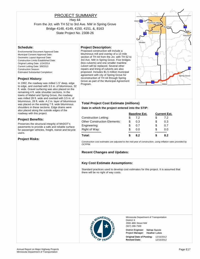
Project History:In 1992, the roadway was milled 1.5” deep, edge to edge, and overlaid with 3.5 in. of bituminous, 32 ft. wide. Gravel surfacing was also placed on the remaining 4 ft. wide shoulder sections. In the towns of Mabel and Spring Grove, the roadway was milled 28 ft. wide and overlaid with 3.5 in. of bituminous, 28 ft. wide. A 2 in. layer of bituminous was placed on the existing 7 ft. wide bituminous shoulders in these sections. Edge drains were also placed along the outside edges of the roadway with this project.
Project Benefits:Preserves the structural integrity of MnDOT’s pavements to provide a safe and reliable surface for passenger vehicles, freight, transit and bicycle users.
Project Risks:
Environmental Document Approval Date:
Schedule:
Municipal Consent Approval Date: Geometric Layout Approval Date: Construction Limits Established Date: Original Letting Date: 1/24/2014Current Letting Date: 3/8/2013Construction Season: Estimated Substantial Completion:
?ÎA@
?ÏA@
?ÏA@
?³A@
?èA@
?ÃA@
!(
!(
!(
!(
!(!(
!(
!(
Mabel
Whalan
Canton
Houston
Rushford
Peterson
Spring Grove
Rushford Village
Proposed construction will include a bituminous mill and overlay of a 13 mile section of TH 44 from the Jct. with TH 52 to 3rd Ave. NW in Spring Grove. Five bridges (box culverts) and one smaller mainline culvert will be replaced. Several other repairs and lining of culverts are also proposed. Includes $1.5 million municipal agreement with city of Spring Grove for reconstruction of TH 44 through Spring Grove as part of the Municipal Agreement Program.
Project Description:
Total Project Cost Estimate (millions)Date in which the project entered into the STIP:
Construction Letting: 7.2Other Construction Elements: 0.3Engineering: 0.7Right of Way: 0.0
7.20.30.70.0
Baseline Est. Current Est.
Total: 8.2 8.2
$$$$
$
$$$$
$
Construction cost estimates are adjusted to the mid-year of construction, using inflation rates provided by OCPPM.
Recent Changes and Updates:
Standard practices used to develop cost estimates for this project. It is assumed that there will be no right of way costs.
Key Cost Estimate Assumptions:
State Project No. 2308-26
From the Jct. with TH 52 to 3rd Ave. NW in Spring GroveHwy 44
PROJECT SUMMARY
Bridge 4148, 4149, 4150, 4151, &, 8163
District 6Minnesota Department of Transportation
2900 48th Street NW(507) 286-7500
District Engineer: Nelrae SuccioProject Manager: Heather Lukes
Original Date of Posting: 12/15/2012Revised Date: 12/15/2012
Annual Report on Major Highway ProjectsMinnesota Department of Transportation
Page E17

Project History:This intersection is located within the Highway 52 segment categorized by the state as a high priority interregional corridor that connects two regional trade centers - the Twin Cities metro area and Rochester.
Project Benefits:Construction will accommodate growing traffic volumes and replace the remaining two signals on this roadway. One of the intersections to be removed is on the top 200 most dangerous intersection list. It will also improve connectivity of Hwy. 52 with other roadways in the area and enhance traffic safety. All of Hwy. 52 has been designated a Toward Zero Deaths Corridor.
Project Risks:Traffic accommodation during construction, right of way acquisition, funding.
Environmental Document Approval Date: 12/2/2009
Schedule:
Municipal Consent Approval Date: 7/19/2011Geometric Layout Approval Date: Pending ApprovalConstruction Limits Established Date: Pending ApprovalOriginal Letting Date: 2014Current Letting Date: 2/22/2013Construction Season: 2013-2014Estimated Substantial Completion: 2014
!(
)p
?̧A@ Cannon Falls
Construct a diamond interchange and a second overpass to replace the two signalized intersections on Trunk Highway 52 in Cannon Falls. The project will also construct a frontage/backage road system maintaining access to existing streets and businesses. CSAH 24 will be re-routed from its current location at the northern most signalized intersection to the new interchange.
Project Description:
Total Project Cost Estimate (millions)Date in which the project entered into the STIP:
Construction Letting: 38.1Other Construction Elements: 0.0Engineering: 3.7Right of Way: 10.2
30.80.03.75.0
Baseline Est. Current Est.
Total: 52.0 39.5
$$$$
$
$$$$
$
Construction cost estimates are adjusted to the mid-year of construction, using inflation rates provided by OCPPM.
The project was awarded funding through the Safety and Mobility (SaM) program in January 2011. This funding, along with funding from MnDOT District 6, Goodhue County and the City of Cannon Falls has accelerated the project schedule. Final design of Phase 1 began in June 2011.
Recent Changes and Updates:
Standard practices used to develop cost estimates for this project.
Key Cost Estimate Assumptions:
State Project No. 2506-52Cannon Falls interchange
Hwy 52PROJECT SUMMARY
District 6Minnesota Department of Transportation
2900 48th Street NW(507) 286-7500
District Engineer: Nelrae SuccioProject Manager: Craig Lenz
Original Date of Posting: 1/1/2009Revised Date: 12/15/2012
Annual Report on Major Highway ProjectsMinnesota Department of Transportation
Page E18
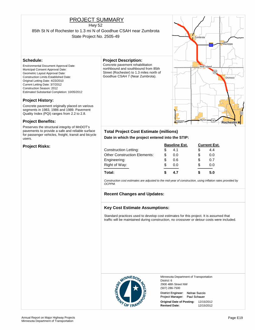
Project History:Concrete pavement originally placed on various segments in 1983, 1986 and 1989. Pavement Quality Index (PQI) ranges from 2.2 to 2.8.
Project Benefits:Preserves the structural integrity of MnDOT’s pavements to provide a safe and reliable surface for passenger vehicles, freight, transit and bicycle users.
Project Risks:
Environmental Document Approval Date:
Schedule:
Municipal Consent Approval Date: Geometric Layout Approval Date: Construction Limits Established Date: Original Letting Date: 4/23/2010Current Letting Date: 3/7/2012Construction Season: 2012Estimated Substantial Completion: 10/05/2012
)t
)o
)p
?ÜA@
!(!(
!(
!(
!(
!(
(
!PRochesterByronKasson
Oronoco
Mazeppa
Zumbrota
Pine IslandConcrete pavement rehabilitation northbound and southbound from 85th Street (Rochester) to 1.3 miles north of Goodhue CSAH 7 (Near Zumbrota).
Project Description:
Total Project Cost Estimate (millions)Date in which the project entered into the STIP:
Construction Letting: 4.1Other Construction Elements: 0.0Engineering: 0.6Right of Way: 0.0
4.40.00.70.0
Baseline Est. Current Est.
Total: 4.7 5.0
$$$$
$
$$$$
$
Construction cost estimates are adjusted to the mid-year of construction, using inflation rates provided by OCPPM.
Recent Changes and Updates:
Standard practices used to develop cost estimates for this project. It is assumed that traffic will be maintained during construction, no crossover or detour costs were included.
Key Cost Estimate Assumptions:
State Project No. 2505-4985th St N of Rochester to 1.3 mi N of Goodhue CSAH near Zumbrota
Hwy 52PROJECT SUMMARY
District 6Minnesota Department of Transportation
2900 48th Street NW(507) 286-7500
District Engineer: Nelrae SuccioProject Manager: Paul Schauer
Original Date of Posting: 12/15/2012Revised Date: 12/15/2012
Annual Report on Major Highway ProjectsMinnesota Department of Transportation
Page E19

Project History:The current TH 52 is a four-lane divided highway. The Highway 52 Interregional Corridor Management Plan, completed in 2002, recommends the construction of an interchange and supporting frontage roads in the vicinity of 520th Street and County Road 31. A large-scale development known as 'Elk Run' for bioscience, commercial/retail and residential development is planned in the vicinity of this interchange. This is a design build project with contract approval granted November 2010.
Project Benefits:Improve safety and mobility in four-lane section of highway with construction of interchange, removing turning movements from 520th Street and CR 31. Improve connectivity of proposed Bioscience and Business Park with locations along the Highway 52 corridor and the City of Pine
Project Risks:Environmental assessment, traffic accommodation during construction, right of way acquisition, funding.
Environmental Document Approval Date: 08/01/2010
Schedule:
Municipal Consent Approval Date: 11/24/2009Geometric Layout Approval Date: 09/01/12Construction Limits Established Date: 10/16/2009Original Letting Date: 8/28/2009Current Letting Date: 9/2/2010Construction Season: 2011-2012Estimated Substantial Completion: 2013
Oronoco
Mazeppa
Zumbrota
Pine Island
New interchange in Olmsted County at CSAH 12 in Pine Island in area of 520th St. and County Road 31, plus replacement of box culvert.
Project Description:
Total Project Cost Estimate (millions)Date in which the project entered into the STIP:
Construction Letting: 40.3Other Construction Elements: 0.0Engineering: 5.2Right of Way: 13.8
34.32.32.74.0
Baseline Est. Current Est.
Total: 59.3 43.3
$$$$
$
$$$$
$
Construction cost estimates are adjusted to the mid-year of construction, using inflation rates provided by OCPPM.
Current estimate reflects the September 2011 design-build project letting. The project is currently under construction.
Recent Changes and Updates:
Traffic is assumed not to be detoured during construction.
Key Cost Estimate Assumptions:
State Project No. 2505-48Elk Run interchange
http://www.dot.state.mn.us/d6/projects/hwy52pineisland/index.html
Hwy 52PROJECT SUMMARY
District 6Minnesota Department of Transportation
2900 48th Street NW(507) 286-7500
District Engineer: Nelrae SuccioProject Manager: Terry Ward
Original Date of Posting: 1/1/2009Revised Date: 12/15/2012
Annual Report on Major Highway ProjectsMinnesota Department of Transportation
Page E20

Project History:In 1977, 3 in. of bituminous was placed, 24 ft. wide, and the gravel shoulders were reconstructed to 7 ft. to 8 ft. wide. In 1998, the majority of the roadway was paved with a 1.5 in bituminous overlay, 24 ft. wide.
Project Benefits:Preserve the existing roadway structure, extend pavement life, and improve the ride quality of the highway.
Project Risks:
Environmental Document Approval Date:
Schedule:
Municipal Consent Approval Date: Geometric Layout Approval Date: Construction Limits Established Date: Original Letting Date: 1/25/12Current Letting Date: 10/28/2011Construction Season: 2012Estimated Substantial Completion: August 2012
Recent Changes and Updates:
Standard practices used to develop cost estimates for this project. It is assumed that traffic will be detoured during construction,these costs were included.
Key Cost Estimate Assumptions:
)o
?ÜA@
?ÚA@
!(
!(
!(
!(
!(
!(
Kenyon
Wanamingo
Nerstrand
Claremont
West Concord
Dodge Center
Proposed construction will include an alternate bid design for a bituminous reclamation and resurfacing or a concrete whitetopping of a 9.2-mile section of TH 56 from CSAH 24 in West Concord to the Jct. with Home Street in Kenyon. The project will also include replacing Br. # 5713 (1.8 mi. east of the Jct. with CSAH 24). Six right turnlanes, and six culvert replacements are proposed.
Project Description:
Total Project Cost Estimate (millions)Date in which the project entered into the STIP:
Construction Letting: 6.1Other Construction Elements: 0.2Engineering: 0.6Right of Way: 0.0
6.10.20.60.0
Baseline Est. Current Est.
Total: 6.9 6.9
$$$$
$
$$$$
$
Construction cost estimates are adjusted to the mid-year of construction, using inflation rates provided by OCPPM.
State Project No. 2006-27
From Jct. CSAH 24 in West Concord, MN to Jct. Home Street in Kenyon, MNHwy 56
PROJECT SUMMARY
Bridge 5713
District 6Minnesota Department of Transportation
2900 48th Street NW(507) 286-7500
District Engineer: Nelrae SuccioProject Manager: Kjersti Anderson
Original Date of Posting: 12/15/2012Revised Date: 12/15/2012
Annual Report on Major Highway ProjectsMinnesota Department of Transportation
Page E21

Project History:This section of TH 56 was originally graded in 1928, last received a bituminous overlay in 1990 and was crack sealed in 1993. In 2010 it had a Ride Quality Index of fair and is expected to see increased deterioration of the pavement in the coming years.
Project Benefits:•Restore pavement life•Numerous improvements to drainage structures•Improve traffic and roadside safety
Project Risks:
Environmental Document Approval Date:
Schedule:
Municipal Consent Approval Date: Geometric Layout Approval Date: Construction Limits Established Date: Original Letting Date: 1/25/13Current Letting Date: 3/8/2013Construction Season: 2013Estimated Substantial Completion: Fall 2013
?ÙA@
?ÜA@
?§A@
!(
!(
!(
!(
!(
!(
Kenyon
Randolph
Dennison
Nerstrand
Northfield
Cannon Falls
Pavement reclamation on 17.56 miles of TH 56 in Goodhue County. The project includes hydraulics, traffic safety and roadside hardware improvements.
Project Description:
2009Total Project Cost Estimate (millions)Date in which the project entered into the STIP:
Construction Letting: 6.4Other Construction Elements: 0.5Engineering: 1.0Right of Way: 0.0
6.40.51.00.0
Baseline Est. Current Est.
Total: 7.9 7.9
$$$$
$
$$$$
$
Construction cost estimates are adjusted to the mid-year of construction, using inflation rates provided by OCPPM.
The project is currently in the design phase.
Recent Changes and Updates:
Detours will be needed, since traffic cannot be maintained on this reclamation project. This is a rural project with no local funding expected.
Key Cost Estimate Assumptions:
State Project No. 2508-31Trondheim Road in Kenyon to Bridge 6525 over the Cannon River
Hwy 56PROJECT SUMMARY
District 6Minnesota Department of Transportation
2900 48th Street NW(507) 286-7500
District Engineer: Nelrae SuccioProject Manager: Kjersti Anderson
Original Date of Posting: 12/15/2012Revised Date: 12/15/2012
Annual Report on Major Highway ProjectsMinnesota Department of Transportation
Page E22
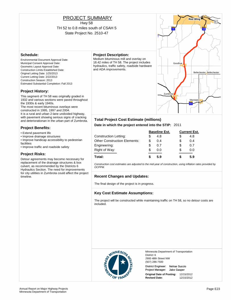
Project History:This segment of TH 58 was originally graded in 1932 and various sections were paved throughout the 1930s & early 1940s.The most recent bituminous overlays were constructed in 1995, 1997 and 2004.It is a rural and urban 2-lane undivided highway, with pavement showing serious signs of cracking and deteriorationan in the urban part of Zumbrota.
Project Benefits:• Extend pavement life• Improve drainage structures• Improve handicap accessibility to pedestrian facilities• Improve traffic and roadside safety
Project Risks:Detour agreements may become necessary for replacement of the drainage structures & box culvert, as recommended by the Districts 6 Hydraulics Section. The need for improvements for city utilities in Zumbrota could affect the project timeline.
Environmental Document Approval Date:
Schedule:
Municipal Consent Approval Date: Geometric Layout Approval Date: Construction Limits Established Date: Original Letting Date: 1/25/2013Current Letting Date: 2/22/2013Construction Season: 2013Estimated Substantial Completion: Fall 2013
?ÜA@
?̧A@
)s
?ÛA@?̧A@
!(!(
!(
!(
!(
!(Red Wing
Mazeppa
Goodhue
Zumbrota
Bellechester Bellechester
Medium bituminous mill and overlay on 18.42 miles of TH 58. The project includes hydraulics, traffic safety, roadside hardware and ADA improvements.
Project Description:
2011Total Project Cost Estimate (millions)Date in which the project entered into the STIP:
Construction Letting: 4.8Other Construction Elements: 0.4Engineering: 0.7Right of Way: 0.0
4.80.40.70.0
Baseline Est. Current Est.
Total: 5.9 5.9
$$$$
$
$$$$
$
Construction cost estimates are adjusted to the mid-year of construction, using inflation rates provided by OCPPM.
The final design of the project is in progress.
Recent Changes and Updates:
The project will be constructed while maintaining traffic on TH 58, so no detour costs are included.
Key Cost Estimate Assumptions:
State Project No. 2510-47TH 52 to 0.8 miles south of CSAH 5
Hwy 58PROJECT SUMMARY
District 6Minnesota Department of Transportation
2900 48th Street NW(507) 286-7500
District Engineer: Nelrae SuccioProject Manager: Jake Gasper
Original Date of Posting: 12/15/2012Revised Date: 12/15/2012
Annual Report on Major Highway ProjectsMinnesota Department of Transportation
Page E23

Project History:This segment of Highway 69 was graded in 1928 to 1932 and paved with concrete in 1941. The roadway was widened and overlayed in 1976 and reconditioned in 1992.
Project Benefits:Extend the life of the pavement for an anticipated 15 years and improve drainage structures.
Project Risks:Cooperative agreement with city of Albert Lea and Rice County will likely be required.
Environmental Document Approval Date:
Schedule:
Municipal Consent Approval Date: Geometric Layout Approval Date: Construction Limits Established Date: Original Letting Date: 1/24/2014Current Letting Date: 2/8/2013Construction Season: 2013Estimated Substantial Completion: 2013
!"a$
!"̀$
)v
!(
!(
!(Albert Lea
Emmons
Twin Lakes
Proposed construction will include a bituminous mill and overlay of a 12.5-mile section of TH 69 from the IA/MN State Line to Jct. TH 13. Includes a 0.4-mile section of TH 13 from approximately 1000 ft. north and 1100 ft. east of the TH 69/TH 13/CSAH 46 intersection, and approximately 350 ft. west on CSAH 46 from the intersection. Also replace the traffic signal at the TH 69/TH 13/CSAH 46 intersection. Fourteen culverts are also scheduled to be replaced.
Project Description:
Total Project Cost Estimate (millions)Date in which the project entered into the STIP:
Construction Letting: 3.9Other Construction Elements: 0.4Engineering: 0.5Right of Way: 0.0
3.90.40.50.0
Baseline Est. Current Est.
Total: 4.8 4.8
$$$$
$
$$$$
$
Construction cost estimates are adjusted to the mid-year of construction, using inflation rates provided by OCPPM.
Updated cost estimate to include replacement of TH 13/TH 69 traffic signal.
Recent Changes and Updates:
Key Cost Estimate Assumptions:
State Project No. 2406-47From IA/MN State Line to TH 13
Hwy 69PROJECT SUMMARY
District 6Minnesota Department of Transportation
2900 48th Street NW(507) 286-7500
District Engineer: Nelrae SuccioProject Manager: Jake Gasper
Original Date of Posting: 12/15/2012Revised Date: 12/15/2012
Annual Report on Major Highway ProjectsMinnesota Department of Transportation
Page E24

Project History:These sections of I-90 were originally graded and paved with concrete in 1961-1962. Various segments received concrete surfacing and bituminous shoulder construction in 1983-1985. The existing pavement section consists of driving lanes made of 9" of reinforced concrete pavement and 5" of open graded aggregate base. The shoulders consist of 2" of bituminous surface and 3" of Class 5 aggregate shouldering.
Project Benefits:• Improve pavement life• Improve hydraulics and drainage• Upgrade concrete barrier
Project Risks:Replicating the existing design the concrete barrier in Austin could be challenging.
Environmental Document Approval Date:
Schedule:
Municipal Consent Approval Date: Geometric Layout Approval Date: Construction Limits Established Date: Original Letting Date: 1/27/12Current Letting Date: 10/26/2012Construction Season: 2013Estimated Substantial Completion: Summer 2013
?ÃA@?ÃA@
?½A@ ?ÙA@
?þA@ ){
){
){
!"a$
!(
!(
!(
!(
!(
!(
!(
!(
!(
!(
!(
!(
Austin
Lyle
Adams
Elkton
Dexter
WalthamSargeant
Hayfield
Mapleview
Rose Creek
Brownsdale
Blooming Prairie
The project will rehabilitate deteriorated concrete pavement on 18.93 miles of EB & WB I-90.In addition, the project will make hydraulics improvements and replace the concrete median barrier in Austin.
Project Description:
2009Total Project Cost Estimate (millions)Date in which the project entered into the STIP:
Construction Letting: 6.5Other Construction Elements: 0.4Engineering: 0.6Right of Way: 0.0
6.50.40.60.0
Baseline Est. Current Est.
Total: 7.5 7.5
$$$$
$
$$$$
$
Construction cost estimates are adjusted to the mid-year of construction, using inflation rates provided by OCPPM.
Recent Changes and Updates:
The project will be completed while maintaining traffic, however increased costs for staging were not assumed. It was assumed that concrete barrier will be installed that is similar to what is currently in place.
Key Cost Estimate Assumptions:
State Project No. 5080-159I-90 from TH 105 to CSAH 19
I-90PROJECT SUMMARY
District 6Minnesota Department of Transportation
2900 48th Street NW(507) 286-7500
District Engineer: Nelrae SuccioProject Manager: Paul Schauer
Original Date of Posting: 12/15/2012Revised Date: 12/15/2012
Annual Report on Major Highway ProjectsMinnesota Department of Transportation
Page E25

Project History:The existing, fracture-critical bridge has narrow shoulders that cause lane closures when vehicles are stranded or during routine maintenance operations. Current interchange geometry creates difficult and unsafe traffic movements for commuter traffic.
Project Benefits:The existing fracture critical bridge was built in 1967 and is near the end of its life expectancy.
Project Risks:The close proximity of this bridge to Trunk Highway 61, the railroad tracks and the Minnesota rest area, will make roadway and bridge geometry challenging. There will be numerous environmental permits required.
Environmental Document Approval Date: 40544
Schedule:
Municipal Consent Approval Date: Not NeededGeometric Layout Approval Date: December 2010Construction Limits Established Date: December 2010Original Letting Date: 01/24/2012Current Letting Date: 10/19/12Construction Season: 2012-2016Estimated Substantial Completion: 2016
!"a$
?³A@
)s
)s
!"a$
La Crescent
The project provides a new structurally sound I-90 river crossing that meets current structural and geometric standards for an important regional river crossing, and provides a reconstructed interchange that improves traffic safety, capacity and access on and between Highway 61/14 and I-90. The project intends to address the following issues:•Bridge structural deficiencies•Narrow bridge shoulders•Roadway operational and capacity needs•Traffic safety concerns•Riverfront access
Project Description:
2009Total Project Cost Estimate (millions)Date in which the project entered into the STIP:
Construction Letting: 265.5Other Construction Elements: 0.0Engineering: 28.1Right of Way: 0.0
187.50.0
24.80.5
Baseline Est. Current Est.
Total: 293.6 212.8
$$$$
$
$$$$
$
Construction cost estimates are adjusted to the mid-year of construction, using inflation rates provided by OCPPM.
Current Estimate reflects the bid amount and updated information on engineering and right of way costs.
Recent Changes and Updates:
Environmental impacts with bridge and roadway approach work are not significant. US Fish and wildlife services agrees to right of way swap.
Key Cost Estimate Assumptions:
State Project No. 8580-149
Dresbach Bridge over Mississippi River (Dresbach)
http://www.dot.state.mn.us/d6/projects/dresbachbridge/
I-90PROJECT SUMMARY
Bridge 9320
District 6Minnesota Department of Transportation
2900 48th Street NW(507) 286-7500
District Engineer: Nelrae SuccioProject Manager: Jai Kalsy
Original Date of Posting: 1/1/2009Revised Date: 12/15/2012
Annual Report on Major Highway ProjectsMinnesota Department of Transportation
Page E26

Project History:•Interstate 90 concrete surface was constructed in 1971.
Project Benefits:•Improve ride quality•Reduce maintenance costs•Replace or repair drainage•Replace or repair appurtenances
Project Risks:
Environmental Document Approval Date:
Schedule:
Municipal Consent Approval Date: Geometric Layout Approval Date: Construction Limits Established Date: Original Letting Date: 12/17/10Current Letting Date: 12/17/2010Construction Season: 2011Estimated Substantial Completion: August 2011
Recent Changes and Updates:
Standard practices used to develop cost estimates for this project. The costs for a crossover were included. The overruns for the project are at a reasonable level.
Key Cost Estimate Assumptions:
?ÎA@
)s
?èA@
?ÎA@
!"a$
?èA@
!(
!(
!(!(
!(
!(Winona
Stockton
Rushford
Goodview
Minnesota City
Rushford Village
The project includes an unbounded concrete overlay on EB I-90 along with several culvert replacements.
Project Description:
2006Total Project Cost Estimate (millions)Date in which the project entered into the STIP:
Construction Letting: 8.1Other Construction Elements: 0.3Engineering: 1.6Right of Way: 0.0
8.10.31.60.0
Baseline Est. Current Est.
Total: 10.1 10.1
$$$$
$
$$$$
$
Construction cost estimates are adjusted to the mid-year of construction, using inflation rates provided by OCPPM.
State Project No. 8580-152EB I-90 from the west junction with TH 43 to 0.8 miles west of TH 76
I-90PROJECT SUMMARY
District 6Minnesota Department of Transportation
2900 48th Street NW(507) 286-7500
District Engineer: Nelrae SuccioProject Manager: Jake Rezac
Original Date of Posting: 12/15/2012Revised Date: 12/15/2012
Annual Report on Major Highway ProjectsMinnesota Department of Transportation
Page E27

Project History:• Both the WB and EB lanes of this section of I-90 were originally graded in 1971 and were last overlaid in 1997 and 1998• In 2009 the pavement was rated in good condition with a pavement quality index from 2.8 to 3.6• The remaining service life of this roadway is estimated to be three to five years
Project Benefits:• Improve ride quality• Reduce maintenance costs• Replace or repair drainage• Replace or repair appurtenances
Project Risks:
Environmental Document Approval Date:
Schedule:
Municipal Consent Approval Date: Geometric Layout Approval Date: Construction Limits Established Date: Original Letting Date: 1/25/2013Current Letting Date: 2/12/2010Construction Season: 2010Estimated Substantial Completion: August 2010
Recent Changes and Updates:
Standard practices used to develop cost estimates for this project. The costs for a crossover were included. The overruns for the project are at a reasonable level.
Key Cost Estimate Assumptions:
!"a$
?ÎA@
?¼A@
?³A@
)s?»A@
)o
?ÃA@
?çA@
Elba
Utica
Altura
Stockton
Rushford
Peterson
Lewiston
Rollingstone Minnesota City
Rushford Village
Unbonded concrete overlay, culverts and bridge replacements.
Project Description:
2006Total Project Cost Estimate (millions)Date in which the project entered into the STIP:
Construction Letting: 14.3Other Construction Elements: 0.6Engineering: 2.9Right of Way: 0.0
14.30.62.90.0
Baseline Est. Current Est.
Total: 17.8 17.8
$$$$
$
$$$$
$
Construction cost estimates are adjusted to the mid-year of construction, using inflation rates provided by OCPPM.
State Project No. 8580-156
I-90 EB from 2.2 miles east of TH 74 to 0.5 miles east of TH 43I-90
PROJECT SUMMARY
Bridge 85820, &, 85824
District 6Minnesota Department of Transportation
2900 48th Street NW(507) 286-7500
District Engineer: Nelrae SuccioProject Manager: Jacob Rezac
Original Date of Posting: 12/15/2012Revised Date: 12/15/2012
Annual Report on Major Highway ProjectsMinnesota Department of Transportation
Page E28
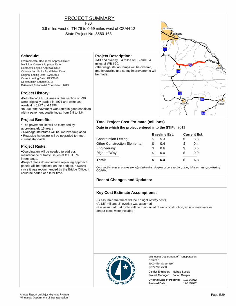
Project History:•Both the WB & EB lanes of this section of I-90 were originally graded in 1971 and were last overlaid in 1997 and 1998•In 2009 the pavement was rated in good condition with a pavement quality index from 2.8 to 3.6
Project Benefits:• The pavement life will be extended by approximately 15 years• Drainage structures will be improved/replaced• Roadside hardware will be upgraded to meet current standards
Project Risks:•Coordination will be needed to address maintenance of traffic issues at the TH 76 interchange.•Project plans do not include replacing approach panels will be replaced on the bridges, however since it was recommended by the Bridge Office, it could be added at a later time.
Environmental Document Approval Date:
Schedule:
Municipal Consent Approval Date: Geometric Layout Approval Date: Construction Limits Established Date: Original Letting Date: 1/24/2014Current Letting Date: 1/23/2015Construction Season: 2015Estimated Substantial Completion: 2015
?³A@
?ÏA@
?èA@
?ÎA@
!"a$
)s
?èA@
!(
!(
!(!(
!( Winona
Hokah
Dakota
Houston
Goodview
•Mill and overlay 8.4 miles of EB and 8.4 miles of WB I-90.•The weigh station ramps will be overlaid, and hydraulics and safety improvements will be made.
Project Description:
2011Total Project Cost Estimate (millions)Date in which the project entered into the STIP:
Construction Letting: 5.3Other Construction Elements: 0.4Engineering: 0.6Right of Way: 0.0
5.30.40.60.0
Baseline Est. Current Est.
Total: 6.4 6.3
$$$$
$
$$$$
$
Construction cost estimates are adjusted to the mid-year of construction, using inflation rates provided by OCPPM.
Recent Changes and Updates:
•Is assumed that there will be no right of way costs•A 1.5" mill and 3" overlay was assumed•It is assumed that traffic will be maintained during construction, so no crossovers or detour costs were included
Key Cost Estimate Assumptions:
State Project No. 8580-1630.8 miles west of TH 76 to 0.69 miles west of CSAH 12
I-90PROJECT SUMMARY
District 6Minnesota Department of Transportation
2900 48th Street NW(507) 286-7500
District Engineer: Nelrae SuccioProject Manager: Jacob Gasper
Original Date of Posting: 12/15/2012Revised Date: 12/15/2012
Annual Report on Major Highway ProjectsMinnesota Department of Transportation
Page E29
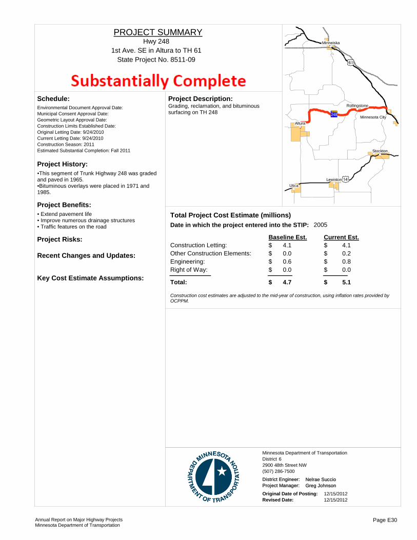
Project History:•This segment of Trunk Highway 248 was graded and paved in 1965.•Bituminous overlays were placed in 1971 and 1985.
Project Benefits:• Extend pavement life• Improve numerous drainage structures• Traffic features on the road
Project Risks:
Environmental Document Approval Date:
Schedule:
Municipal Consent Approval Date: Geometric Layout Approval Date: Construction Limits Established Date: Original Letting Date: 9/24/2010Current Letting Date: 9/24/2010Construction Season: 2011Estimated Substantial Completion: Fall 2011
Recent Changes and Updates:
Key Cost Estimate Assumptions:
?»A@
)o
)s
!(
!(
!(
!(!(
!(
!(Utica
Altura
Stockton
Lewiston
Minneiska
Rollingstone
Minnesota City
Grading, reclamation, and bituminous surfacing on TH 248
Project Description:
2005Total Project Cost Estimate (millions)Date in which the project entered into the STIP:
Construction Letting: 4.1Other Construction Elements: 0.0Engineering: 0.6Right of Way: 0.0
4.10.20.80.0
Baseline Est. Current Est.
Total: 4.7 5.1
$$$$
$
$$$$
$
Construction cost estimates are adjusted to the mid-year of construction, using inflation rates provided by OCPPM.
State Project No. 8511-091st Ave. SE in Altura to TH 61
Hwy 248PROJECT SUMMARY
District 6Minnesota Department of Transportation
2900 48th Street NW(507) 286-7500
District Engineer: Nelrae SuccioProject Manager: Greg Johnson
Original Date of Posting: 12/15/2012Revised Date: 12/15/2012
Annual Report on Major Highway ProjectsMinnesota Department of Transportation
Page E30

Project History:Bridge 6975 was built in 1931 and Bridge 6977 was built in 1924. Both structures are classified as functionally obsolete.
Project Benefits:Both bridges have substandard roadway approaches with need for horizontal geometric improvements. This project will improve safety.
Project Risks:The roadway approach work could lead to significant environmental issues. It is anticipated traffic will be detoured during construction. Municipal Consent from the City of Lanesboro may be required for the bridge.
Environmental Document Approval Date: Need Unknown
Schedule:
Municipal Consent Approval Date: Need UnknownGeometric Layout Approval Date: Need UnknownConstruction Limits Established Date: Need UnknownOriginal Letting Date: 1/22/2016Current Letting Date: 1/22/2016Construction Season: 2016Estimated Substantial Completion: 2016
!(
!(
Lanesboro
Replace bridges over the north and south branches of the Root River.
Project Description:
Total Project Cost Estimate (millions)Date in which the project entered into the STIP:
Construction Letting: 9.0Other Construction Elements: 0.0Engineering: 1.7Right of Way: 0.3
9.00.01.70.3
Baseline Est. Current Est.
Total: 11.0 11.0
$$$$
$
$$$$
$
Construction cost estimates are adjusted to the mid-year of construction, using inflation rates provided by OCPPM.
No changes or updates since the last report.
Recent Changes and Updates:
Environmental impacts with roadway approach work not significant. Traffic is assumed to be detoured during construction. Municipal Consent from the City of Lanesboro is obtainable, if required for Bridge 6975.
Key Cost Estimate Assumptions:
State Project No. 2319-16
Bridge No. 6975 - 1.0 mi N of Jct of TH 16.Bridge No. 6977 - 3.4 mi N of the Jct of TH 16.
Hwy 250PROJECT SUMMARY
Bridge 6975, 6977
District 6Minnesota Department of Transportation
2900 48th Street NW(507) 286-7500
District Engineer: Nelrae SuccioProject Manager: Kjersti Anderson
Original Date of Posting: 1/1/2009Revised Date: 12/15/2012
Annual Report on Major Highway ProjectsMinnesota Department of Transportation
Page E31

!(!(
!(
!(
!(
!(
!(
!(
!(
!(
!(
!(
!(
!(
!(
!(
!(
!(
!(
!(
!(
!(
!P
%&d(
%&f(
!"̀$ )y
)y )z
)z
?±A@
?«A@
?éA@
?ºA@
?ÓA@
?ÞA@
?¾A@
?̧A@
?«A@
?±A@
?©A@
?ûA@ ?ÌA@ ?¾A@
?©A@
?ÒA@
!"a$
)x
?óA@
?±A@
?ÜA@
?ÞA@
+¢
?ïA@
?íA@
?ãA@ ?§A@
?dA@
?âA@
?bA@
)v
?ùA@
)w
?±A@
)u
)z
?̧A@
?eA@)y
)o
)x
+¡
?ÜA@
?²A@
?¼A@
?ÃA@
?̧A@
?²A@
?̧A@
?̈A@
?»A@
)r
)o
?ÜA@
)w
?ÜA@
?«A@
)o
?ÃA@?¼A@
)o
?âA@
?©A@
?ÃA@
?±A@
?ºA@
?ÃA@
?¼A@
?ãA@
)x
?ùA@
?»A@
?âA@
?ãA@ )w)r
?óA@
+¡
?ãA@
?̧A@
?»A@
)o
?̈A@
?»A@
?̈A@
?²A@
?»A@
!"a$
?¾A@
)x
?̧A@
!"̀$
!(!(
!(!(!(
!(!(!(!(!(!( !(!(!( !(
!(
!( !(!(!(
Mankato
Windom
Waseca
New Ulm
LuverneJackson
Gaylord
Fairmont
St. Peter
St. James
Le Center
Blue EarthWorthington
.Major Highway Projects 2013District 7
Mankato

ROUTE PROJECT LOCATION PAGE
District Project SummaryDistrict 7
State Project #
Hwy 4 South of 10th Ave to 11th Ave in St. James F 28302-38
Hwy 5 City of Gaylord F 37207-20
Hwy 14 County Road 6 to Lor Ray Drive in North Mankato F 45203-85
Hwy 14 County Road 2 to Waseca-Steele county line F 58103-49
Hwy 15 From Hwy 14 at New Ulm to Hwy 19 at Winthrop F 65204-112
Hwy 15 Hwy 15 and Hwy 60 Jct F 78304-113
Hwy 23 I-90 to TH 269 in Jasper F 86703-23
Hwy 60 Bigelow to Worthington F 95305-56
Hwy 60 From Paul Ave in Worthington to 1100' past CSAH 35 F 105305-58
Hwy 60 From 1100' past CSAH 35 to I90 in Worthington F 115305-59
Hwy 60 From Co Rd 115 (Cray Corner) to North Star Bridge in Mankato
F 120708-35
Hwy. 60 Mountain Lake to St. James F 138308-44
Hwy 62 TH 59 to west limits of Windom F 141704-27
Hwy 71 Jackson over the Des Moines River F 153205-29
Hwy 83 Jct. TH 30 to St. Clair F 160711-26
Hwy 109 Winnebago to Wells F 172212-28
Hwy 169 From St Peter to south of the MN River Bridge F 185209-66
Hwy 169 Blue Earth from the south limits at 14th Street to JCT CSAH 6
F 192207-32
Annual Report on Major Highway ProjectsMinnesota Department of Transportation Page F1

Project History:Existing 1951 concrete throughout the corridor in very poor condition with an RQI of 0.3, well below the poor threshold. Multiple city utility breaks each winter, due to poor utilities below the roadway.
Project Benefits:Improve Ride Quality with a new surface and replace old city utilities.
Project Risks:Local funding of needs on project.
Environmental Document Approval Date:
Schedule:
Municipal Consent Approval Date: Geometric Layout Approval Date: Construction Limits Established Date: Original Letting Date: 2/26/2016Current Letting Date: 2/26/2016Construction Season: 2016Estimated Substantial Completion:
?̈A@
?ÜA@
!(St. James
Reconstruct roadway and replace utlities in St. James.
Project Description:
Total Project Cost Estimate (millions)Date in which the project entered into the STIP:
Construction Letting: 4.7Other Construction Elements: 0.4Engineering: 1.0Right of Way: 0.0
4.70.41.00.0
Baseline Est. Current Est.
Total: 6.4 6.4
$$$$
$
$$$$
$
Construction cost estimates are adjusted to the mid-year of construction, using inflation rates provided by OCPPM.
Recent Changes and Updates:
Construction Cost - MnDOT share -$4.7M, local share - $5.2M.
Key Cost Estimate Assumptions:
State Project No. 8302-38South of 10th Ave to 11th Ave in St. James
Hwy 4PROJECT SUMMARY
District 7Minnesota Department of Transportation
2151 Bassett Drive(507) 304-6100
District Engineer: Greg OusProject Manager: Zachary Tess
Original Date of Posting: 12/15/2012Revised Date: 12/15/2012
Annual Report on Major Highway ProjectsMinnesota Department of Transportation
Page F2

Project History:This project was first identified as a resurfacing project. The project has since been revised to be primarily full reconstruction to accommodate the replacement of failing city utilities. The portion of TH 22 South of the railroad tracks remains a mill and overlay section.
Project Benefits:This project will provide a smooth new pavement surface, new city utilities infrastucture, ADA compliant sidewalks, and a more pedestrian friendly streetscape.
Project Risks:Fluctuations in bituminous and concrete pavement prices may increase project costs. Accomodations for business access during construction may also raise project costs. Contaminated soils may be identified.
Environmental Document Approval Date:
Schedule:
Municipal Consent Approval Date: Geometric Layout Approval Date: Construction Limits Established Date: Original Letting Date: 12/20/13Current Letting Date: 4/25/2014Construction Season: 2014-2015Estimated Substantial Completion: Fall 2015
?©A@
?»A@
!(Gaylord
This project will reconstruct approximately 1.5 miles of trunk highways 5, 19 and 22 and will overlay another 0.3 miles of TH 22 all work is within the city of Gaylord. The project will also replace failing city utilities.
Project Description:
Total Project Cost Estimate (millions)Date in which the project entered into the STIP:
Construction Letting: 6.6Other Construction Elements: 0.9Engineering: 1.3Right of Way: 0.1
6.60.91.30.1
Baseline Est. Current Est.
Total: 8.9 8.9
$$$$
$
$$$$
$
Construction cost estimates are adjusted to the mid-year of construction, using inflation rates provided by OCPPM.
No specific changes to note.
Recent Changes and Updates:
Standard practices were used to develop the cost estimates for this project.
Key Cost Estimate Assumptions:
State Project No. 7207-20City of Gaylord
Hwy 5PROJECT SUMMARY
District 7Minnesota Department of Transportation
2151 Bassett Drive(507) 304-6100
District Engineer: Greg OusProject Manager: Steve Bowers
Original Date of Posting: 12/15/2012Revised Date: 12/15/2012
Annual Report on Major Highway ProjectsMinnesota Department of Transportation
Page F3
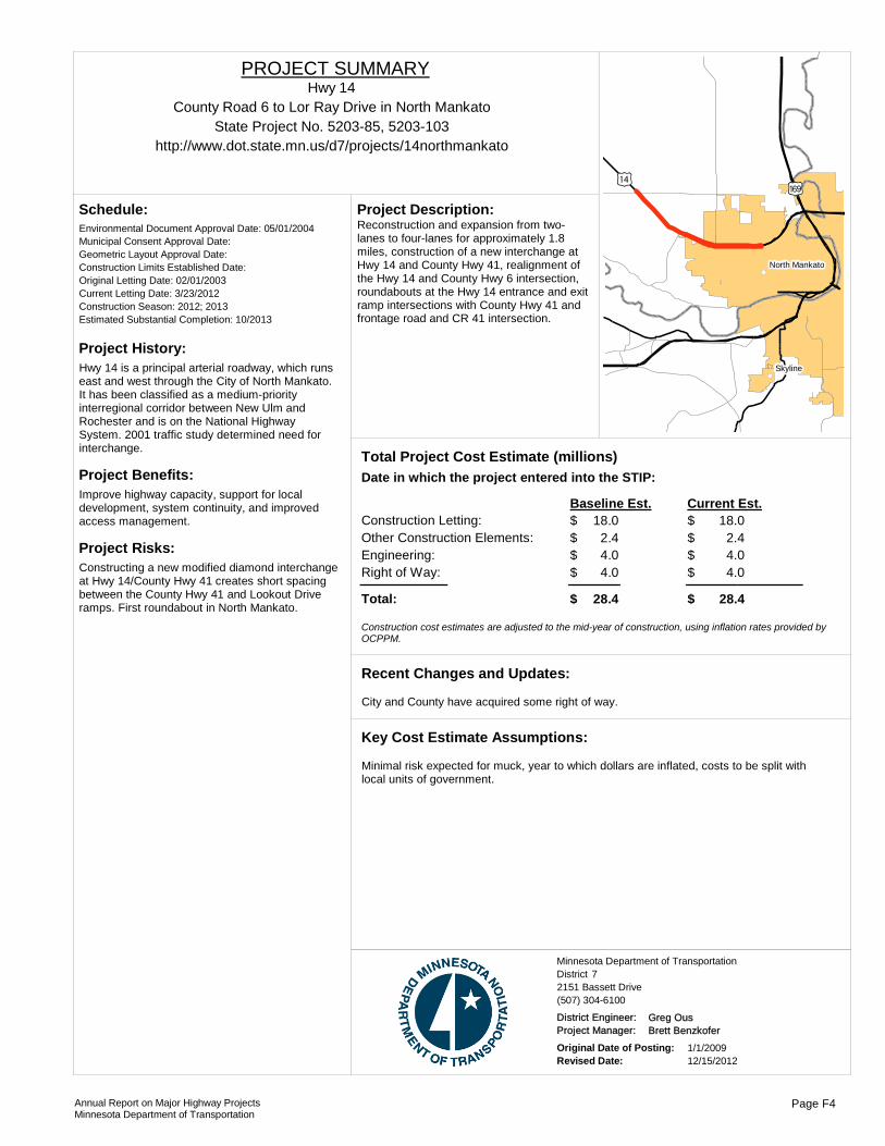
Project History:Hwy 14 is a principal arterial roadway, which runs east and west through the City of North Mankato. It has been classified as a medium-priority interregional corridor between New Ulm and Rochester and is on the National Highway System. 2001 traffic study determined need for interchange.
Project Benefits:Improve highway capacity, support for local development, system continuity, and improved access management.
Project Risks:Constructing a new modified diamond interchange at Hwy 14/County Hwy 41 creates short spacing between the County Hwy 41 and Lookout Drive ramps. First roundabout in North Mankato.
Environmental Document Approval Date: 05/01/2004
Schedule:
Municipal Consent Approval Date: Geometric Layout Approval Date: Construction Limits Established Date: Original Letting Date: 02/01/2003Current Letting Date: 3/23/2012Construction Season: 2012; 2013Estimated Substantial Completion: 10/2013
)o)y
!(
!(Skyline
North Mankato
Reconstruction and expansion from two-lanes to four-lanes for approximately 1.8 miles, construction of a new interchange at Hwy 14 and County Hwy 41, realignment of the Hwy 14 and County Hwy 6 intersection, roundabouts at the Hwy 14 entrance and exit ramp intersections with County Hwy 41 and frontage road and CR 41 intersection.
Project Description:
Total Project Cost Estimate (millions)Date in which the project entered into the STIP:
Construction Letting: 18.0Other Construction Elements: 2.4Engineering: 4.0Right of Way: 4.0
18.02.44.04.0
Baseline Est. Current Est.
Total: 28.4 28.4
21.00.00.00.0
31.4
$$$$
$
$$$$
$
- $ - $ - $ - $
- $
Construction cost estimates are adjusted to the mid-year of construction, using inflation rates provided by OCPPM.
City and County have acquired some right of way.
Recent Changes and Updates:
Minimal risk expected for muck, year to which dollars are inflated, costs to be split with local units of government.
Key Cost Estimate Assumptions:
State Project No. 5203-85, 5203-103County Road 6 to Lor Ray Drive in North Mankato
http://www.dot.state.mn.us/d7/projects/14northmankato
Hwy 14PROJECT SUMMARY
District 7Minnesota Department of Transportation
2151 Bassett Drive(507) 304-6100
District Engineer: Greg OusProject Manager: Brett Benzkofer
Original Date of Posting: 1/1/2009Revised Date: 12/15/2012
Annual Report on Major Highway ProjectsMinnesota Department of Transportation
Page F4

Project History:SP 8103-49 is the third construction stage of a four-lane expansion of Hwy 14 from Mankato to Owatonna. The design of the road will be a rural, four-lane, depressed median expressway with grade-separated overpasses and interchanges.
Project Benefits:Provides continuity between adjacent four-lane section, improves safety with four-lane divided design and removal of at-grade crossings, and increases highway capacity.
Project Risks:Severe weather conditions will cause construction delays and affect timelines.
Environmental Document Approval Date: 6/1/1999
Schedule:
Municipal Consent Approval Date: 3/1/2008Geometric Layout Approval Date: 9/7/1999Construction Limits Established Date: 2/20/2004Original Letting Date: 7/1/2005Current Letting Date: 5/2/2008Construction Season: 7/2008-6/2011Estimated Substantial Completion: 2011
Project will be open to traffic in Summer 2012.
Recent Changes and Updates:
Standard practices used to develop cost estimates for this project.
Key Cost Estimate Assumptions:
?±A@
?±A@
)o
)o
!(
!( Waseca
Construct 4-lane divided highway from County Hwy 2 to the Waseca/Steele County Line, realignment of Hwy 13, controlled access on new Hwy 14 alignment, construct 10 new bridges.
Project Description:
Total Project Cost Estimate (millions)Date in which the project entered into the STIP:
Construction Letting: 57.5Other Construction Elements: 11.5Engineering: 1.2Right of Way: 6.5
57.511.5
1.26.5
Baseline Est. Current Est.
Total: 76.7 76.7
$$$$
$
$$$$
$
Construction cost estimates are adjusted to the mid-year of construction, using inflation rates provided by OCPPM.
State Project No. 8103-49County Road 2 to Waseca-Steele county line
http://www.dot.state.mn.us/d7/projects/14waton
Hwy 14PROJECT SUMMARY
District 7Minnesota Department of Transportation
2151 Bassett Drive(507) 304-6100
District Engineer: Greg OusProject Manager: Craig Felber
Original Date of Posting: 1/1/2009Revised Date: 12/15/2012
Annual Report on Major Highway ProjectsMinnesota Department of Transportation
Page F5

Project History:Severe road roughness and poor condition of bituminous shoulders. Pavement preservation project funded with Better Roads funding.
Project Benefits:Improved pavement smoothness and ride quality.
Project Risks:
Environmental Document Approval Date:
Schedule:
Municipal Consent Approval Date: Geometric Layout Approval Date: Construction Limits Established Date: Original Letting Date: 5/8/2012Current Letting Date: 5/18/2012Construction Season: 2012Estimated Substantial Completion: Fall 2012
)o
?²A@
?̧A@
!(
!(
!(
!(
!( New Ulm
GibbonWinthrop
Lafayette
Courtland
Bituminous overlay and reclamation of shoulders.
Project Description:
Total Project Cost Estimate (millions)Date in which the project entered into the STIP:
Construction Letting: 6.4Other Construction Elements: 0.6Engineering: 1.3Right of Way: 0.0
6.40.61.30.0
Baseline Est. Current Est.
Total: 8.3 8.3
$$$$
$
$$$$
$
Construction cost estimates are adjusted to the mid-year of construction, using inflation rates provided by OCPPM.
Project is near completion.
Recent Changes and Updates:
Standard practices used to develop cost estimates for this project.
Key Cost Estimate Assumptions:
State Project No. 5204-112From Hwy 14 at New Ulm to Hwy 19 at Winthrop
Hwy 15PROJECT SUMMARY
District 7Minnesota Department of Transportation
2151 Bassett Drive(507) 304-6100
District Engineer: Greg OusProject Manager: Susan Museus
Original Date of Posting: 12/15/2012Revised Date: 12/15/2012
Annual Report on Major Highway ProjectsMinnesota Department of Transportation
Page F6

Project History:Rough pavement due to concrete faulting and damaged panels. Pavement preservation project funded with Better Roads funding.
Project Benefits:Improved pavement smoothness and ride quality.
Project Risks:
Environmental Document Approval Date:
Schedule:
Municipal Consent Approval Date: Geometric Layout Approval Date: Construction Limits Established Date: Original Letting Date: Current Letting Date: 4/27/2012Construction Season: 2012Estimated Substantial Completion:
?ÜA@
?²A@
?ÜA@
!(
!(
Madelia
Lewisville
3.0" bituminous overlay plus 5/8" ultrathin bonded wearing course.
Project Description:
Total Project Cost Estimate (millions)Date in which the project entered into the STIP:
Construction Letting: 5.5Other Construction Elements: 0.5Engineering: 1.1Right of Way: 0.0
5.50.51.10.0
Baseline Est. Current Est.
Total: 7.1 7.1
$$$$
$
$$$$
$
Construction cost estimates are adjusted to the mid-year of construction, using inflation rates provided by OCPPM.
Recent Changes and Updates:
Standard practices used to develop cost estimates for this project.
Key Cost Estimate Assumptions:
State Project No. 8304-113Hwy 15 and Hwy 60 Jct
Hwy 15PROJECT SUMMARY
District 7Minnesota Department of Transportation
2151 Bassett Drive(507) 304-6100
District Engineer: Greg OusProject Manager: Bob Williams
Original Date of Posting: 12/15/2012Revised Date: 12/15/2012
Annual Report on Major Highway ProjectsMinnesota Department of Transportation
Page F7
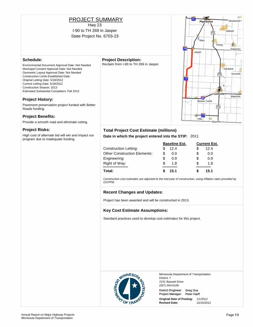
Project History:Pavement preservation project funded with Better Roads funding.
Project Benefits:Provide a smooth road and eliminate rutting.
Project Risks:High cost of alternate bid will win and impact our program due to inadequate funding.
Environmental Document Approval Date: Not Needed
Schedule:
Municipal Consent Approval Date: Not NeededGeometric Layout Approval Date: Not NeededConstruction Limits Established Date: Original Letting Date: 5/18/2012Current Letting Date: 5/18/2012Construction Season: 2013Estimated Substantial Completion: Fall 2013
Luverne
Pipestone
Steen
Ihlen
Hills
Trosky
Jasper
Kenneth
Magnolia
Hatfield
Hardwick
Edgerton
Woodstock
Beaver Creek
Reclaim from I-90 to TH 269 in Jasper.Project Description:
2011Total Project Cost Estimate (millions)Date in which the project entered into the STIP:
Construction Letting: 12.4Other Construction Elements: 0.0Engineering: 0.9Right of Way: 1.8
12.40.00.91.8
Baseline Est. Current Est.
Total: 15.1 15.1
$$$$
$
$$$$
$
Construction cost estimates are adjusted to the mid-year of construction, using inflation rates provided by OCPPM.
Project has been awarded and will be constructed in 2013.
Recent Changes and Updates:
Standard practices used to develop cost estimates for this project.
Key Cost Estimate Assumptions:
State Project No. 6703-23I-90 to TH 269 in Jasper
Hwy 23PROJECT SUMMARY
District 7Minnesota Department of Transportation
2151 Bassett Drive(507) 304-6100
District Engineer: Greg OusProject Manager: Peter Harff
Original Date of Posting: 1/1/2012Revised Date: 12/15/2012
Annual Report on Major Highway ProjectsMinnesota Department of Transportation
Page F8

Project History:Existing road constructed in 1930s, corridor was identified for four-lane expansion in the 1960s, last segment of unimproved roadway between the Iowa border and the Twin Cities (via Highway 169). Environmental Impact Statement has been finalized for the selected route.
Project Benefits:Provides continuity between adjacent four-lane sections, improves safety with four-lane divided design and skew at intersections. It will increase highway capacity.
Project Risks:Potential for substantial muck removal, possibility of contaminated soil in MnDOT right-of-way by Ruder Dump, settlements for business impacts, East Acres Trailer Park relocations, Union Pacific railroad bridge.
Environmental Document Approval Date: 02/01/2005
Schedule:
Municipal Consent Approval Date: Geometric Layout Approval Date: Pending ApprovalConstruction Limits Established Date: Original Letting Date: 3/2010-12/2013Current Letting Date: 7/9/10; 5/6/11; 5/18/12Construction Season: 2010 - 2013Estimated Substantial Completion: 2013
?ÜA@)r
!(
!(Worthington
Bigelow
Construct 4-lane expressway along existing alignment from Nobles County Highway 4 to Interstate 90, reduce access locations, remove skew at intersections, replace Union Pacific Railroad bridge.
Project Description:
Total Project Cost Estimate (millions)Date in which the project entered into the STIP:
Construction Letting: 91.1Other Construction Elements: 17.5Engineering: 19.3Right of Way: 22.7
45.617.5
9.811.5
Baseline Est. Current Est.
Total: 150.6 68.9
$$$$
$
$$$$
$
Construction cost estimates are adjusted to the mid-year of construction, using inflation rates provided by OCPPM.
Initial baseline estimate did not include full scoping and soil investigations were not done yet. There is an industrial dump just south of Worthington and the alignment had not been set in the Worthington area. The $150M was a worst case scenario. MnDOT managed to constrain construction limits to avoid the dump, spent less than anticipated on right of way and reduced other costs as the project was developed and contingency was retired. In addition, using alternate bid pavement and breaking the corridor into smaller low-risk projects allowed better bids in a very competitive market.
Recent Changes and Updates:
Cost estimates are adjusted to midpoint of construction year assuming 5% annual inflation.
Key Cost Estimate Assumptions:
State Project No. 5305-56Bigelow to Worthington
http://www.dot.state.mn.us/d7/projects/hwy60/index.html
Hwy 60PROJECT SUMMARY
District 7Minnesota Department of Transportation
2151 Bassett Drive(507) 304-6100
District Engineer: Greg OusProject Manager: Rolin Sinn
Original Date of Posting: 1/1/2009Revised Date: 12/15/2012
Annual Report on Major Highway ProjectsMinnesota Department of Transportation
Page F9

Project History:The project has been completed.
Project Benefits:Preserves the structural integrity of MnDOT’s pavements to provide a safe and reliable surface for passenger vehicles, freight, transit, and bicycle users.
Project Risks:
Environmental Document Approval Date:
Schedule:
Municipal Consent Approval Date: Geometric Layout Approval Date: Construction Limits Established Date: Original Letting Date: 12/17/10Current Letting Date: 5/6/2011Construction Season: 2012Estimated Substantial Completion: 2012
Construction cost is actual amount.
Recent Changes and Updates:
Standard practices used to develop cost estimates for this project.
Key Cost Estimate Assumptions:
?ÜA@
)r
!"a$
?ÜA@
)r
!(WorthingtonGrading, concrete & bituminous surface & roundabout for new four-lane expressway.
Project Description:
9/09Total Project Cost Estimate (millions)Date in which the project entered into the STIP:
Construction Letting: 18.5Other Construction Elements: 3.7Engineering: 3.2Right of Way: 5.0
12.63.73.25.0
Baseline Est. Current Est.
Total: 30.4 24.5
$$$$
$
$$$$
$
Construction cost estimates are adjusted to the mid-year of construction, using inflation rates provided by OCPPM.
State Project No. 5305-58From Paul Ave in Worthington to 1100' past CSAH 35
Hwy 60PROJECT SUMMARY
District 7Minnesota Department of Transportation
2151 Bassett Drive(507) 304-6100
District Engineer: Greg OusProject Manager: Kent Purrier
Original Date of Posting: 12/15/2012Revised Date: 12/15/2012
Annual Report on Major Highway ProjectsMinnesota Department of Transportation
Page F10

Project History:The project has been completed.
Project Benefits:Preserves the structural integrity of MnDOT’s pavements to provide a safe and reliable surface for passenger vehicles, freight, transit, and bicycle users.
Project Risks:
Environmental Document Approval Date:
Schedule:
Municipal Consent Approval Date: Geometric Layout Approval Date: Construction Limits Established Date: Original Letting Date: 12/16/11Current Letting Date: 5/18/2012Construction Season: 2012-2013Estimated Substantial Completion: 2013
?ÜA@
)r
!"a$
?ÜA@
)r
!(WorthingtonGrading, concrete and bituminous surfacing and roundabout for 4-lane urban expressway.
Project Description:
9/09Total Project Cost Estimate (millions)Date in which the project entered into the STIP:
Construction Letting: 13.0Other Construction Elements: 2.8Engineering: 1.5Right of Way: 2.1
14.52.81.53.0
Baseline Est. Current Est.
Total: 19.4 21.8
$$$$
$
$$$$
$
Construction cost estimates are adjusted to the mid-year of construction, using inflation rates provided by OCPPM.
Construction letting and right-of-way costs are actual costs - as let.
Recent Changes and Updates:
Standard practices used to develop cost estimates for this project.
Key Cost Estimate Assumptions:
State Project No. 5305-59From 1100' past CSAH 35 to I90 in Worthington
Hwy 60PROJECT SUMMARY
District 7Minnesota Department of Transportation
2151 Bassett Drive(507) 304-6100
District Engineer: Greg OusProject Manager: Kent Purrier
Original Date of Posting: 12/15/2012Revised Date: 12/15/2012
Annual Report on Major Highway ProjectsMinnesota Department of Transportation
Page F11
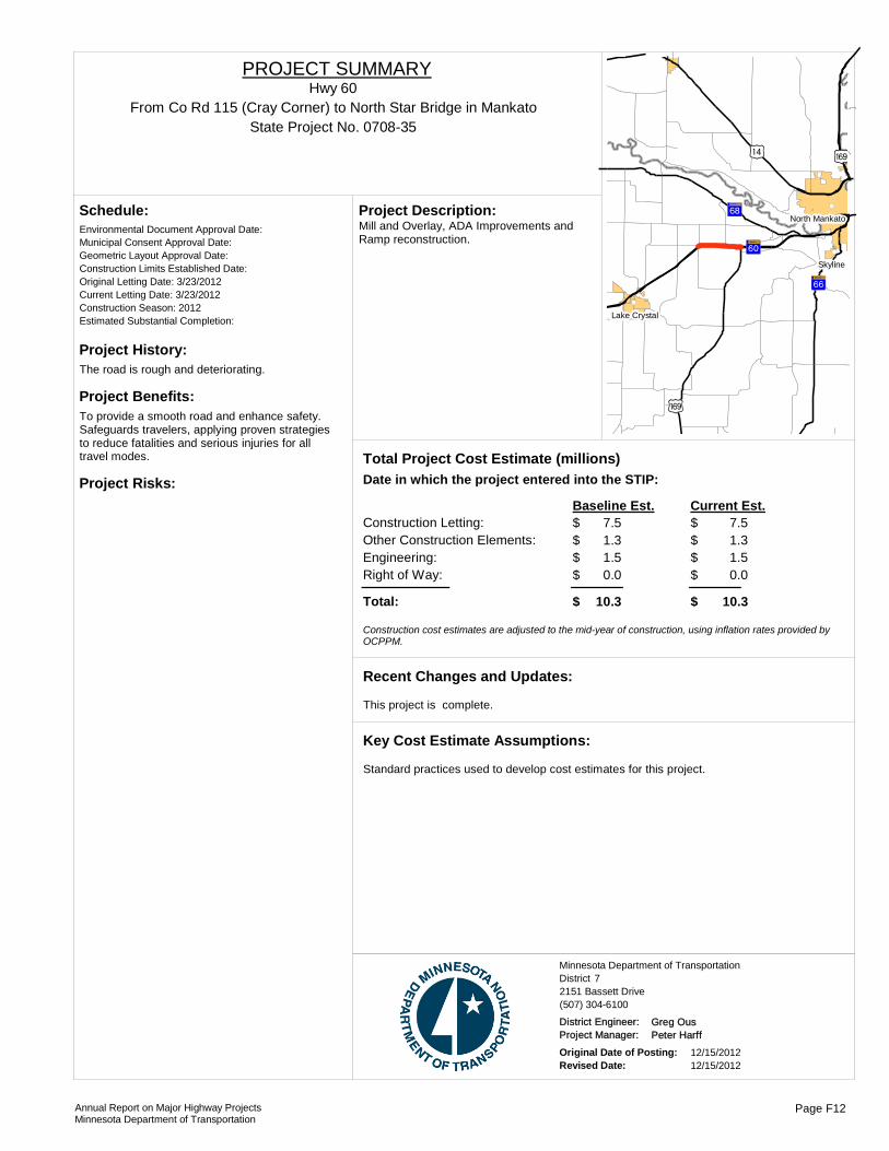
Project History:The road is rough and deteriorating.
Project Benefits:To provide a smooth road and enhance safety. Safeguards travelers, applying proven strategies to reduce fatalities and serious injuries for all travel modes.
Project Risks:
Environmental Document Approval Date:
Schedule:
Municipal Consent Approval Date: Geometric Layout Approval Date: Construction Limits Established Date: Original Letting Date: 3/23/2012Current Letting Date: 3/23/2012Construction Season: 2012Estimated Substantial Completion:
)o )y
)y
?áA@
?ãA@
?ÜA@
!(
!(
!(
Skyline
Lake Crystal
North MankatoMill and Overlay, ADA Improvements and Ramp reconstruction.
Project Description:
Total Project Cost Estimate (millions)Date in which the project entered into the STIP:
Construction Letting: 7.5Other Construction Elements: 1.3Engineering: 1.5Right of Way: 0.0
7.51.31.50.0
Baseline Est. Current Est.
Total: 10.3 10.3
$$$$
$
$$$$
$
Construction cost estimates are adjusted to the mid-year of construction, using inflation rates provided by OCPPM.
This project is complete.
Recent Changes and Updates:
Standard practices used to develop cost estimates for this project.
Key Cost Estimate Assumptions:
State Project No. 0708-35From Co Rd 115 (Cray Corner) to North Star Bridge in Mankato
Hwy 60PROJECT SUMMARY
District 7Minnesota Department of Transportation
2151 Bassett Drive(507) 304-6100
District Engineer: Greg OusProject Manager: Peter Harff
Original Date of Posting: 12/15/2012Revised Date: 12/15/2012
Annual Report on Major Highway ProjectsMinnesota Department of Transportation
Page F12
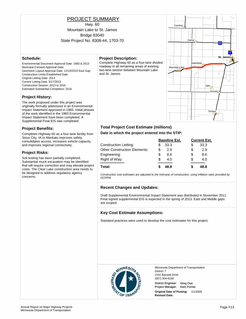
Project History:The work proposed under this project was originally formally addressed in an Environmental Impact Statement approved in 1983. Initial phases of the work identified in the 1983 Environmental Impact Statement have been completed. A Supplemental Final EIS was completed.
Project Benefits:Completes Highway 60 as a four-lane facility from Sioux City, IA to Mankato improves safety, consolidates access, increases vehicle capacity, and improves regional connectivity.
Project Risks:Soil testing has been partially completed. Substantial muck excavation may be identified that will require correction and may elevate project costs. The Clear Lake construction area needs to be designed to address regulatory agency concerns.
Environmental Document Approval Date: 1983 & 2013
Schedule:
Municipal Consent Approval Date: Geometric Layout Approval Date: 12/10/2010 East GapConstruction Limits Established Date: Original Letting Date: 2014Current Letting Date: 5/17/2013Construction Season: 2013 to 2016Estimated Substantial Completion: 2016
?̈A@
?ÃA@
!(
!(
!(
!(
!(
!(
!(
!(St. James
Odin
Ormsby
Darfur
Trimont
Comfrey
Butterfield
Mountain Lake
Complete Highway 60 as a four-lane divided roadway in all remaining areas of existing two-lane section between Mountain Lake and St. James.
Project Description:
Total Project Cost Estimate (millions)Date in which the project entered into the STIP:
Construction Letting: 33.3Other Construction Elements: 2.9Engineering: 8.6Right of Way: 4.0
33.32.98.64.0
Baseline Est. Current Est.
Total: 48.8 48.8
$$$$
$
$$$$
$
Construction cost estimates are adjusted to the mid-year of construction, using inflation rates provided by OCPPM.
Draft Supplemental Environmental Impact Statement was distributed in November 2011. Final signed supplemental EIS is expected in the spring of 2013. East and Middle gaps are scoped.
Recent Changes and Updates:
Standard practices were used to develop the cost estimates for this project.
Key Cost Estimate Assumptions:
State Project No. 8308-44, 1703-70
Mountain Lake to St. JamesHwy. 60
PROJECT SUMMARY
Bridge 83040
District 7Minnesota Department of Transportation
2151 Bassett Drive(507) 304-6100
District Engineer: Greg OusProject Manager: Kent Purrier
Original Date of Posting: 1/1/2009Revised Date:
Annual Report on Major Highway ProjectsMinnesota Department of Transportation
Page F13
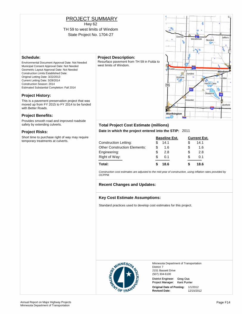
Project History:This is a pavement preservation project that was moved up from FY 2015 to FY 2014 to be funded with Better Roads.
Project Benefits:Provides smooth road and improved roadside safety by extending culverts.
Project Risks:Short time to purchase right of way may require temporary treatments at culverts.
Environmental Document Approval Date: Not Needed
Schedule:
Municipal Consent Approval Date: Not NeededGeometric Layout Approval Date: Not NeededConstruction Limits Established Date: Original Letting Date: 3/22/2013Current Letting Date: 3/28/2014Construction Season: 2014Estimated Substantial Completion: Fall 2014
Windom
Worthington
Fulda
Wilder
Dundee
DovrayStorden
Okabena
Kinbrae
Jeffers
Brewster
Westbrook
Lakefield
Heron Lake
Resurface pavement from TH 59 in Fulda to west limits of Windom.
Project Description:
2011Total Project Cost Estimate (millions)Date in which the project entered into the STIP:
Construction Letting: 14.1Other Construction Elements: 1.6Engineering: 2.8Right of Way: 0.1
14.11.62.80.1
Baseline Est. Current Est.
Total: 18.6 18.6
$$$$
$
$$$$
$
Construction cost estimates are adjusted to the mid-year of construction, using inflation rates provided by OCPPM.
Recent Changes and Updates:
Standard practices used to develop cost estimates for this project.
Key Cost Estimate Assumptions:
State Project No. 1704-27TH 59 to west limits of Windom
Hwy 62PROJECT SUMMARY
District 7Minnesota Department of Transportation
2151 Bassett Drive(507) 304-6100
District Engineer: Greg OusProject Manager: Kent Purrier
Original Date of Posting: 1/1/2012Revised Date: 12/15/2012
Annual Report on Major Highway ProjectsMinnesota Department of Transportation
Page F14

Project History:Plans were substantially completed in 2004, but the project was delayed due to repriortizing needs vs. funding.
Project Benefits:Replaces an aging bridge with fracture-critical pin and hanger joints.
Project Risks:Need municipal consent. Project is adjacent to a delisted Superfund site, need environmental assessment.
Environmental Document Approval Date:
Schedule:
Municipal Consent Approval Date: Geometric Layout Approval Date: Construction Limits Established Date: Original Letting Date: 11/15/2004Current Letting Date: 3/27/2015Construction Season: 2015Estimated Substantial Completion: )w
!"a$
)w
!(
!(
Jackson
This is a bridge replacement project over the Des Moines River.
Project Description:
Total Project Cost Estimate (millions)Date in which the project entered into the STIP:
Construction Letting: 5.0Other Construction Elements: 1.0Engineering: 1.0Right of Way: 0.1
5.01.01.00.1
Baseline Est. Current Est.
Total: 7.0 7.0
$$$$
$
$$$$
$
Construction cost estimates are adjusted to the mid-year of construction, using inflation rates provided by OCPPM.
Delayed due to funding reasons.
Recent Changes and Updates:
Based off the 2004 layout. Waiting for new bridge cost estimate, expect costs to decrease.
Key Cost Estimate Assumptions:
State Project No. 3205-29
Jackson over the Des Moines River
http://www.dot.state.mn.us/roadwork/future
Hwy 71PROJECT SUMMARY
Bridge 6741
District 7Minnesota Department of Transportation
2151 Bassett Drive(507) 304-6100
District Engineer: Greg OusProject Manager: Chris Bower
Original Date of Posting: 12/15/2012Revised Date: 12/15/2012
Annual Report on Major Highway ProjectsMinnesota Department of Transportation
Page F15
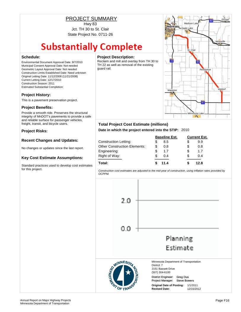
Project History:This is a pavement preservation project.
Project Benefits:Provide a smooth ride. Preserves the structural integrity of MnDOT’s pavements to provide a safe and reliable surface for passenger vehicles, freight, transit, and bicycle users.
Project Risks:
Environmental Document Approval Date: 9/7/2010
Schedule:
Municipal Consent Approval Date: Not neededGeometric Layout Approval Date: Not neededConstruction Limits Established Date: Need unknownOriginal Letting Date: 11/12/2008 (11/21/2008)Current Letting Date: 12/17/2010Construction Season: 2011Estimated Substantial Completion:
No changes or updates since the last report.
Recent Changes and Updates:
Standard practices used to develop cost estimates for this project.
Key Cost Estimate Assumptions:
Mankato
Waldorf
Elysian
Mapleton
St. Clair
Pemberton
Janesville
Eagle Lake
Madison Lake
Minnesota Lake
Reclaim and mill and overlay from TH 30 to TH 22 as well as removal of the existing guard rail.
Project Description:
2010Total Project Cost Estimate (millions)Date in which the project entered into the STIP:
Construction Letting: 8.5Other Construction Elements: 0.8Engineering: 1.7Right of Way: 0.4
9.90.81.70.4
Baseline Est. Current Est.
Total: 11.4 12.8
$$$$
$
$$$$
$
Construction cost estimates are adjusted to the mid-year of construction, using inflation rates provided by OCPPM.
State Project No. 0711-26Jct. TH 30 to St. Clair
Hwy 83PROJECT SUMMARY
District 7Minnesota Department of Transportation
2151 Bassett Drive(507) 304-6100
District Engineer: Greg OusProject Manager: Steve Bowers
Original Date of Posting: 1/1/2011Revised Date: 12/15/2012
Annual Report on Major Highway ProjectsMinnesota Department of Transportation
Page F16

Project History:The project is for pavement preservation.
Project Benefits:Provide a smooth road with a 20 year life.
Project Risks:There is an airport in Wells that coiuld pose some restrictions as well as maintaining traffic through the three towns.
Environmental Document Approval Date:
Schedule:
Municipal Consent Approval Date: Not NeededGeometric Layout Approval Date: Not NeededConstruction Limits Established Date: Original Letting Date: 1/1/2015; 1/1/2013Current Letting Date: 5/18/12; 1/24/14Construction Season: 2012; 2014Estimated Substantial Completion: 2014
?»A@)y
)y?ÀA@ ?¿A@
?bA@
?»A@
?»A@
!"a$Blue Earth
Wells
Frost
Amboy
Elmore
EastonDelavan
Mapleton
Bricelyn
PembertonGood Thunder
Vernon Center
Minnesota Lake
Reclaim TH 109 from Winnebago to Wells. This will be done as either a bituminous reclamation or concrete alternate paving.
Project Description:
2010Total Project Cost Estimate (millions)Date in which the project entered into the STIP:
Construction Letting: 14.3Other Construction Elements: 2.5Engineering: 2.9Right of Way: 0.2
17.11.83.40.1
Baseline Est. Current Est.
Total: 19.7 22.4
$$$$
$
$$$$
$
Construction cost estimates are adjusted to the mid-year of construction, using inflation rates provided by OCPPM.
These are two separate projects and SP 2212-28 is substantially complete and SP 2212-29 will be constructed in 2014.
Recent Changes and Updates:
Standard practices used to develop cost estimates for this project.
Key Cost Estimate Assumptions:
State Project No. 2212-28, 2212-29Winnebago to Wells
Hwy 109PROJECT SUMMARY
District 7Minnesota Department of Transportation
2151 Bassett Drive(507) 304-6100
District Engineer: Greg OusProject Manager: Craig Felber
Original Date of Posting: 1/1/2011Revised Date: 12/15/2012
Annual Report on Major Highway ProjectsMinnesota Department of Transportation
Page F17

Project History:When the highway was originally constructed in the early 1960s, the Minnesota River highwater elevation was assumed at 751.0, and the roadway was constructed accordingly. The actual 100yr flood elevation in this area ranges from about 756.0 to 756.6.
Project Benefits:Raise the southbound lanes of the highway above 100 year flood elevation and provide for a smooth surface to ride on from St. Peter to LeSueur.
Project Risks:Inconsistent soil in areas to be grade raised.
Environmental Document Approval Date:
Schedule:
Municipal Consent Approval Date: Geometric Layout Approval Date: Construction Limits Established Date: Original Letting Date: 3/28/2014Current Letting Date: 3/28/2014Construction Season: 2014Estimated Substantial Completion:
?»A@
?ùA@
?eA@
?̧A@
?»A@
)y
)y
!(
!(
!(
!(
!( St. Peter
Kasota
Le Sueur
Henderson
Cleveland
Grade raise on southbound lanes in two areas (1.8 miles). Preservation on southbound lanes in non-grade raise areas (8.9 miles).
Project Description:
Total Project Cost Estimate (millions)Date in which the project entered into the STIP:
Construction Letting: 11.3Other Construction Elements: 0.9Engineering: 2.3Right of Way: 0.0
11.30.92.30.0
Baseline Est. Current Est.
Total: 14.5 14.5
$$$$
$
$$$$
$
Construction cost estimates are adjusted to the mid-year of construction, using inflation rates provided by OCPPM.
Recent Changes and Updates:
Bituminous alternative used for cost estimate. Project will be alt-bid candidate.
Key Cost Estimate Assumptions:
State Project No. 5209-66From St Peter to south of the MN River Bridge
Hwy 169PROJECT SUMMARY
District 7Minnesota Department of Transportation
2151 Bassett Drive(507) 304-6100
District Engineer: Greg OusProject Manager: Zachary Tess
Original Date of Posting: 12/15/2012Revised Date: 12/15/2012
Annual Report on Major Highway ProjectsMinnesota Department of Transportation
Page F18
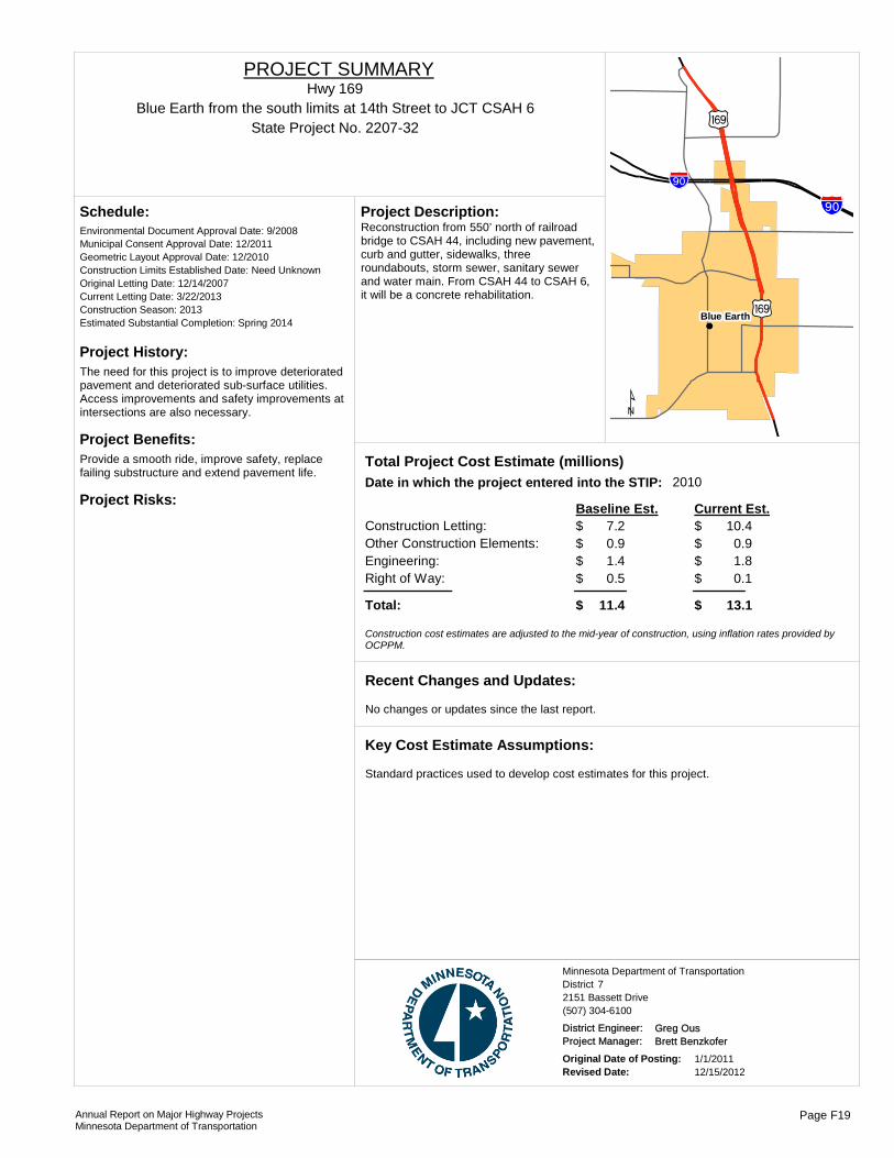
Project History:The need for this project is to improve deteriorated pavement and deteriorated sub-surface utilities. Access improvements and safety improvements at intersections are also necessary.
Project Benefits:Provide a smooth ride, improve safety, replace failing substructure and extend pavement life.
Project Risks:
Environmental Document Approval Date: 9/2008
Schedule:
Municipal Consent Approval Date: 12/2011Geometric Layout Approval Date: 12/2010Construction Limits Established Date: Need UnknownOriginal Letting Date: 12/14/2007Current Letting Date: 3/22/2013Construction Season: 2013Estimated Substantial Completion: Spring 2014 !(
)y
§̈a
Blue Earth
¹
§̈a
)y
Reconstruction from 550’ north of railroad bridge to CSAH 44, including new pavement, curb and gutter, sidewalks, three roundabouts, storm sewer, sanitary sewer and water main. From CSAH 44 to CSAH 6, it will be a concrete rehabilitation.
Project Description:
2010Total Project Cost Estimate (millions)Date in which the project entered into the STIP:
Construction Letting: 7.2Other Construction Elements: 0.9Engineering: 1.4Right of Way: 0.5
10.40.91.80.1
Baseline Est. Current Est.
Total: 11.4 13.1
$$$$
$
$$$$
$
Construction cost estimates are adjusted to the mid-year of construction, using inflation rates provided by OCPPM.
No changes or updates since the last report.
Recent Changes and Updates:
Standard practices used to develop cost estimates for this project.
Key Cost Estimate Assumptions:
State Project No. 2207-32Blue Earth from the south limits at 14th Street to JCT CSAH 6
Hwy 169PROJECT SUMMARY
District 7Minnesota Department of Transportation
2151 Bassett Drive(507) 304-6100
District Engineer: Greg OusProject Manager: Brett Benzkofer
Original Date of Posting: 1/1/2011Revised Date: 12/15/2012
Annual Report on Major Highway ProjectsMinnesota Department of Transportation
Page F19
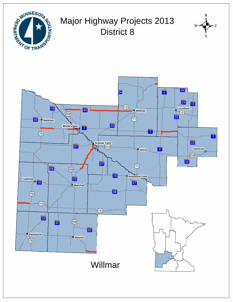
!(
!(
!(
!(
!(
!(
!(
!(
!(
!(
!(
!(
!(
!(
!(
!(
!(
!(
!(
!P
)z
?«A@
?¾A@
?©A@
!"b$
)x
?̈A@
?«A@
)n
?ØA@
)r
?ÞA@
+¢
?íA@
?ãA@
?»A@
?dA@
?âA@
?bA@
?²A@?½A@
?ùA@
?ýA@
)m
)z
?̧A@
?eA@)y
?kA@
)o
)x
?ÜA@
)n
?²A@
?¼A@
?¼A@
?ÃA@
?̧A@
?²A@
?̧A@
?¾A@
?̈A@)r
)o
)n
?ÜA@
)w
)w
?ËA@
?ÜA@
?«A@
?ÃA@?¼A@
)o
?«A@
?âA@
?©A@
?ÃA@
?½A@
?¼A@
?ãA@
?¾A@
?»A@
?âA@
?ãA@ )w)r
?óA@
+¡
?ãA@
?̧A@
?«A@
?»A@
)r?¼A@
)w
)o
?̈A@
?»A@
?̈A@
?ØA@
?²A@
?»A@?¾A@
)x
?¬A@)n
?ËA@
?«A@
!(
!(
Olivia
Willmar
Slayton
Madison
Ivanhoe
Glencoe
Marshall
Pipestone
Montevideo
Litchfield
Redwood Falls
Granite Falls
.Major Highway Projects 2013District 8
Willmar

ROUTE PROJECT LOCATION PAGE
District Project SummaryDistrict 8
State Project #
Hwy 4 Cosmos G 24701-27
Hwy 7 Cosmos to W. JCT MN 22 G 34703-26
Hwy 23 Paynesville bypass G 43408-15
Hwy 40 JCT. US 59 to Kandiyohi CSAH 5 G 51210-10
Hwy 212 3.2 Miles west of JCT US 59 to JCT US 59 G 61212-30
Hwy 212 0.2 Miles west of US 75 to First Street in Dawson G 73706-39
Annual Report on Major Highway ProjectsMinnesota Department of Transportation Page G1

Project History:The need for the project includes deteriorating pavement, with a rough ride and high maintenance costs; failing utilities including significant water main breaks under Highway 4 that have needed repair, and a wide corridor that is not needed for existing or projected traffic volumes.
Project Benefits:The benefits of the project will include a smooth, long lasting pavement surface, the replacement of aging underground infrastructure and provide a streetscape that is more pedestrian friendly, appropriate for the context and provides for the future needs of the community.
Project Risks:
Environmental Document Approval Date:
Schedule:
Municipal Consent Approval Date: Geometric Layout Approval Date: Construction Limits Established Date: Original Letting Date: 12/14/2012Current Letting Date: 12/14/2012Construction Season: 2013Estimated Substantial Completion: FALL 2013
?«A@
?̈A@
!(
CosmosThis project is an urban reconstruction.Project Description:
2013Total Project Cost Estimate (millions)Date in which the project entered into the STIP:
Construction Letting: 3.5Other Construction Elements: 0.2Engineering: 0.7Right of Way: 0.2
4.50.40.90.1
Baseline Est. Current Est.
Total: 4.6 5.9
$$$$
$
$$$$
$
Construction cost estimates are adjusted to the mid-year of construction, using inflation rates provided by OCPPM.
Recent Changes and Updates:
Engineering estimates reflect 20% of construction letting. Engineer's Estimate (preliminary) type. Current Estimate for Construction letting includes approximately $0.9M in local share costs, which is not reflected in the Baseline Estimate.
Key Cost Estimate Assumptions:
State Project No. 4701-27CosmosHwy 4
PROJECT SUMMARY
District 8Minnesota Department of Transportation
2505 Transportation Road(320) 231-5195
District Engineer: Jon HusebyProject Manager: Lowell Flaten
Original Date of Posting: 12/15/2012Revised Date: 12/15/2012
Annual Report on Major Highway ProjectsMinnesota Department of Transportation
Page G2
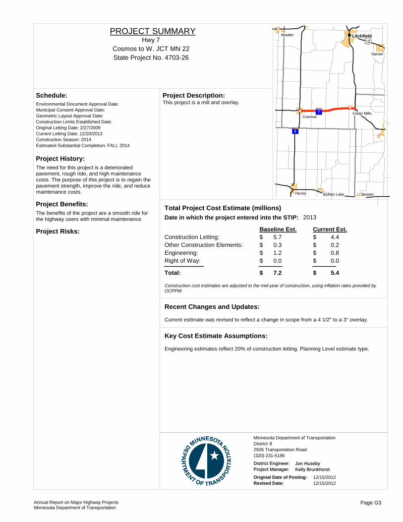
Project History:The need for this project is a deteriorated pavement, rough ride, and high maintenance costs. The purpose of this project is to regain the pavement strength, improve the ride, and reduce maintenance costs.
Project Benefits:The benefits of the project are a smooth ride for the highway users with minimal maintenance
Project Risks:
Environmental Document Approval Date:
Schedule:
Municipal Consent Approval Date: Geometric Layout Approval Date: Construction Limits Established Date: Original Letting Date: 2/27/2009Current Letting Date: 12/20/2013Construction Season: 2014Estimated Substantial Completion: FALL 2014
)n
?«A@
?̈A@
!(
!(
!(
!(
!(
!(
!(
!( Litchfield
Hector
Darwin
Cosmos
Stewart
Atwater
Cedar Mills
Buffalo Lake
This project is a mill and overlay.Project Description:
2013Total Project Cost Estimate (millions)Date in which the project entered into the STIP:
Construction Letting: 5.7Other Construction Elements: 0.3Engineering: 1.2Right of Way: 0.0
4.40.20.80.0
Baseline Est. Current Est.
Total: 7.2 5.4
$$$$
$
$$$$
$
Construction cost estimates are adjusted to the mid-year of construction, using inflation rates provided by OCPPM.
Current estimate was revised to reflect a change in scope from a 4 1/2" to a 3" overlay.
Recent Changes and Updates:
Engineering estimates reflect 20% of construction letting. Planning Level estimate type.
Key Cost Estimate Assumptions:
State Project No. 4703-26Cosmos to W. JCT MN 22
Hwy 7PROJECT SUMMARY
District 8Minnesota Department of Transportation
2505 Transportation Road(320) 231-5195
District Engineer: Jon HusebyProject Manager: Kelly Brunkhorst
Original Date of Posting: 12/15/2012Revised Date: 12/15/2012
Annual Report on Major Highway ProjectsMinnesota Department of Transportation
Page G3
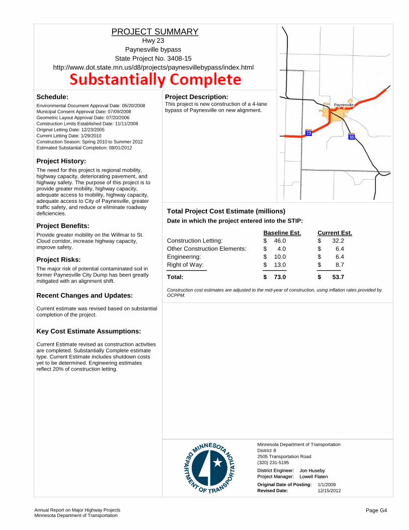
Project History:The need for this project is regional mobility, highway capacity, deteriorating pavement, and highway safety. The purpose of this project is to provide greater mobility, highway capacity, adequate access to mobility, highway capacity, adequate access to City of Paynesville, greater traffic safety, and reduce or eliminate roadway deficiencies.
Project Benefits:Provide greater mobility on the Willmar to St. Cloud corridor, increase highway capacity, improve safety.
Project Risks:The major risk of potential contaminated soil in former Paynesville City Dump has been greatly mitigated with an alignment shift.
Environmental Document Approval Date: 05/20/2008
Schedule:
Municipal Consent Approval Date: 07/09/2008Geometric Layout Approval Date: 07/20/2006Construction Limits Established Date: 11/11/2008Original Letting Date: 12/23/2005Current Letting Date: 1/29/2010Construction Season: Spring 2010 to Summer 2012Estimated Substantial Completion: 08/01/2012
Current estimate was revised based on substantial completion of the project.
Recent Changes and Updates:
Current Estimate revised as construction activities are completed. Substantially Complete estimate type. Current Estimate includes shutdown costs yet to be determined. Engineering estimates reflect 20% of construction letting.
Key Cost Estimate Assumptions:
PaynesvilleThis project is new construction of a 4-lane bypass of Paynesville on new alignment.
Project Description:
Total Project Cost Estimate (millions)Date in which the project entered into the STIP:
Construction Letting: 46.0Other Construction Elements: 4.0Engineering: 10.0Right of Way: 13.0
32.26.46.48.7
Baseline Est. Current Est.
Total: 73.0 53.7
$$$$
$
$$$$
$
Construction cost estimates are adjusted to the mid-year of construction, using inflation rates provided by OCPPM.
State Project No. 3408-15Paynesville bypass
http://www.dot.state.mn.us/d8/projects/paynesvillebypass/index.html
Hwy 23PROJECT SUMMARY
District 8Minnesota Department of Transportation
2505 Transportation Road(320) 231-5195
District Engineer: Jon HusebyProject Manager: Lowell Flaten
Original Date of Posting: 1/1/2009Revised Date: 12/15/2012
Annual Report on Major Highway ProjectsMinnesota Department of Transportation
Page G4
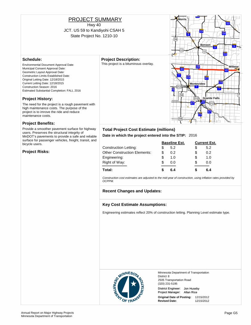
Project History:The need for the project is a rough pavement with high maintenance costs. The purpose of the project is to imrove the ride and reduce maintenance costs.
Project Benefits:Provide a smoother pavement surface for highway users. Preserves the structural integrity of MnDOT’s pavements to provide a safe and reliable surface for passenger vehicles, freight, transit, and bicycle users.
Project Risks:
Environmental Document Approval Date:
Schedule:
Municipal Consent Approval Date: Geometric Layout Approval Date: Construction Limits Established Date: Original Letting Date: 12/18/2015Current Letting Date: 12/18/2015Construction Season: 2016Estimated Substantial Completion: FALL 2016
?ÁA@
?ÂA@
?«A@
)r
)n )n)r
?¬A@
?¬A@
?ýA@
?ØA@
?ýA@
?âA@
)r
)r+¢
+¢
?ÎA@?âA@
)w
?ËA@
+¢?ÏA@
?ÂA@
?¬A@
?ÂA@?ËA@
?«A@ ?«A@
?ÐA@?¼A@
?¼A@
!(
!(
!(
!(
!(
Morris
Benson
Willmar
Montevideo
Granite Falls
This project is a bituminous overlay.Project Description:
2016Total Project Cost Estimate (millions)Date in which the project entered into the STIP:
Construction Letting: 5.2Other Construction Elements: 0.2Engineering: 1.0Right of Way: 0.0
5.20.21.00.0
Baseline Est. Current Est.
Total: 6.4 6.4
$$$$
$
$$$$
$
Construction cost estimates are adjusted to the mid-year of construction, using inflation rates provided by OCPPM.
Recent Changes and Updates:
Engineering estimates reflect 20% of construction letting. Planning Level estimate type.
Key Cost Estimate Assumptions:
State Project No. 1210-10JCT. US 59 to Kandiyohi CSAH 5
Hwy 40PROJECT SUMMARY
District 8Minnesota Department of Transportation
2505 Transportation Road(320) 231-5195
District Engineer: Jon HusebyProject Manager: Allan Rice
Original Date of Posting: 12/15/2012Revised Date: 12/15/2012
Annual Report on Major Highway ProjectsMinnesota Department of Transportation
Page G5

Project History:The need for this project is the deteriorated full-depth bituminous pavement, causing reduced ability to support heavy loads, rough ride, and high maintenance costs. The purpose of this project is to regain the pavement strength, improve the ride, and reduce maintenance costs.
Project Benefits:Provides long term improvement to the failing full depth bituminous and a smooth ride and long-lasting surface for the highway users.
Project Risks:
Environmental Document Approval Date:
Schedule:
Municipal Consent Approval Date: Geometric Layout Approval Date: Construction Limits Established Date: Original Letting Date: 2/27/2009Current Letting Date: 1/13/2012Construction Season: 2012Estimated Substantial Completion: Fall 2012
?«A@
)r
+¢
?ÏA@
?ÂA@
!(
!(
!(Montevideo
Boyd
Watson
This project is a mill and concrete overlay.Project Description:
2014Total Project Cost Estimate (millions)Date in which the project entered into the STIP:
Construction Letting: 5.8Other Construction Elements: 0.2Engineering: 1.2Right of Way: 0.0
6.60.71.30.0
Baseline Est. Current Est.
Total: 7.2 8.6
$$$$
$
$$$$
$
Construction cost estimates are adjusted to the mid-year of construction, using inflation rates provided by OCPPM.
Current estimate was revised based on substantial completion of the project.
Recent Changes and Updates:
Engineering estimates reflect 20% of construction letting. Substantially Complete estimate type.
Key Cost Estimate Assumptions:
State Project No. 1212-303.2 Miles west of JCT US 59 to JCT US 59
http://www.dot.state.mn.us/d8/projects/hwy212and75/
Hwy 212PROJECT SUMMARY
District 8Minnesota Department of Transportation
2505 Transportation Road(320) 231-5195
District Engineer: Jon HusebyProject Manager: Allan Rice
Original Date of Posting: 12/15/2012Revised Date: 12/15/2012
Annual Report on Major Highway ProjectsMinnesota Department of Transportation
Page G6
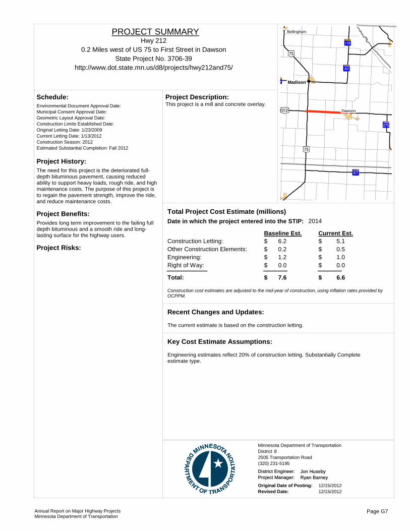
Project History:The need for this project is the deteriorated full-depth bituminous pavement, causing reduced ability to support heavy loads, rough ride, and high maintenance costs. The purpose of this project is to regain the pavement strength, improve the ride, and reduce maintenance costs.
Project Benefits:Provides long term improvement to the failing full depth bituminous and a smooth ride and long-lasting surface for the highway users.
Project Risks:
Environmental Document Approval Date:
Schedule:
Municipal Consent Approval Date: Geometric Layout Approval Date: Construction Limits Established Date: Original Letting Date: 1/23/2009Current Letting Date: 1/13/2012Construction Season: 2012Estimated Substantial Completion: Fall 2012
)x
)x
?âA@
?ËA@
?ËA@
+¢
?ÏA@
?kA@
!(
!(
!(
!(
!(Madison
Dawson
Bellingham
This project is a mill and concrete overlay.Project Description:
2014Total Project Cost Estimate (millions)Date in which the project entered into the STIP:
Construction Letting: 6.2Other Construction Elements: 0.2Engineering: 1.2Right of Way: 0.0
5.10.51.00.0
Baseline Est. Current Est.
Total: 7.6 6.6
$$$$
$
$$$$
$
Construction cost estimates are adjusted to the mid-year of construction, using inflation rates provided by OCPPM.
The current estimate is based on the construction letting.
Recent Changes and Updates:
Engineering estimates reflect 20% of construction letting. Substantially Complete estimate type.
Key Cost Estimate Assumptions:
State Project No. 3706-390.2 Miles west of US 75 to First Street in Dawson
http://www.dot.state.mn.us/d8/projects/hwy212and75/
Hwy 212PROJECT SUMMARY
District 8Minnesota Department of Transportation
2505 Transportation Road(320) 231-5195
District Engineer: Jon HusebyProject Manager: Ryan Barney
Original Date of Posting: 12/15/2012Revised Date: 12/15/2012
Annual Report on Major Highway ProjectsMinnesota Department of Transportation
Page G7

!(
!(
!(
!(
!(
!(
!(
!(
!(
!(
!(
!P
!P
%&h(
%&h( !"b$
%&d(
%&f(
%&c( %&e(
%&d(
%&f(
%&c( !"b$
%&c(
%&f(
!"̀$
!"b$
!"̀$
!"b$
!"b$
%&d(
)y
)s )p
)y
)s
)y
)y )z
)z
)n
)m
)s
)m
)m
)p
)s
)m
)p
)l
?ÙA@
?¹A@
?ØA@
?±A@
?«A@
?èA@
?ÇA@
?́A@
?©A@
?éA@
?ºA@
?ñA@
?ÓA@
?±A@
?cA@
?³A@
?uA@
?¾A@
?tA@
?ÞA@
?̧A@
?ÑA@
?lA@
?ÙA@
?ÖA@
?ØA@
?ÒA@
?¾A@
?ØA@
?tA@
?̧A@
?«A@
?óA@
?±A@
?©A@
?ûA@ ?ÌA@
?öA@
?ûA@
?©A@
?¾A@
?úA@
?àA@
?§A@
?ÇA@
?öA@
?öA@
?öA@
?§A@
?ÒA@
?÷A@
?©A@
?àA@
?̧A@
?ÕA@
?ØA@
?ÒA@
?©A@
?øA@
?öA@
!"b$
)s
?ÛA@?§A@
?äA@
?àA@
)m
?öA@
?eA@)y
?̧A@
?¾A@
)y
)n
?«A@
?̧A@
?¼A@
?©A@
?±A@
?½A@
?¾A@
?ØA@
?ÒA@
?¾A@
?̧A@
!(!(
!(
!(
!(
!(
!(!(!(!(!(!(!(!(
!(
!(
!(!(
!(
!(
!(
!(!(
St. PaulMinneapolis
Anoka
ChaskaShakopee
Hastings
Stillwater
Center City
.Major Highway Projects 2013Metro District
ROUTE PROJECT LOCATION PAGE
District Project SummaryDistrict Metro
State Project #
Hwy 7 At Louisana Ave in St. Louis Park H 22706-226
Hwy 13 New Interchange at CSAH 5 in Burnsville H 31901-148
I-35E Cayuga Bridge between University Avenue and Maryland Avenue (Cayuga)
H 46280-308
I-35E I-35E between Pennsylvania ave and Little Canada Road H 56280-367
I-35E From south of Ramsey Co CSAH 96 to north junction I-35W
H 60282-34
I-35W From 3rd & 4th St ramp to Johnson St. in Minneapolis H 72783-136
Hwy 36 St. Croix Crossing project in Oak Park Heights, Stillwater, & Bayport
H 88221-01
Hwy 36 From Hazelwood Ave to US 61 in Maplewood H 96211-90
Hwy 36 Over Lexington Ave in Roseville H 106212-148
Hwy 52 Lafayette River Bridge over Mississippi River in St. Paul H 116244-30
Hwy 61 Hastings Bridge over Mississippi River H 121913-64
I-94 Lowry Hill Tunnel to John Ireland Boulevard H 132781-415
Hwy 100 36th Street to 25 1/2 Street in St. Louis Park H 142734-33
Hwy 101 Between existing Minnesota River Bridge in Shakopee and CSAH 61/Flying Cloud Drive in Chanhassen
H 151009-24
Hwy 101 At CSAH 144 in Rogers H 162738-28
Hwy 169 CO RD 69 in Shakopee H 177005-97
Hwy 169 At 93rd Ave in Brooklyn Park & Osseo H 182750-75
Hwy 169 MN 55 in Plymouth to 77th Ave in Brooklyn Park H 192772-92
Hwy 212 At Shady Oak Rd. in Eden Prairie H 202763-49
I-494 Lake Rd in Maplewood to I-94 in Woodbury H 218285-93
I-494 34th Ave to France Ave H 222785-367
I-494 Interchange in Bloomington H 232776-03
I-694 From 40th St. in Oakdale to just W. of US 61 in Vadnais Heights
H 246286-56
Hwy 610 New alignment Hwy. 169 to Hennepin County Road 81 (Elm Creek Blvd)
H 252771-38
I-694 From Lexington Avenue to west of Old Highway 10 H 266285-135
Annual Report on Major Highway ProjectsMinnesota Department of Transportation Page H1

Project History:TH 7 is a principal areterial roadway that traverses across the southern metropolitan area. Metro District in partnership with Hennepin County and the city of St. Louis Park have been working to convert TH 7 from a four-lane expressway to a four-lane controlled access facility. This project will advance that vision by constructing an interchange at the intersectin of TH 7 and Louisianna Avenue.
Project Benefits:Removes signalized intersectin on TH 7 at Louisianna Avenue and relieves congestion in the AM and PM peak periods.
Project Risks:Project is being developed and delivered by St. Louis Park. Funding for the project has been fully identified and the project development is tracking towards letting.
Environmental Document Approval Date:
Schedule:
Municipal Consent Approval Date: Geometric Layout Approval Date: Construction Limits Established Date: Original Letting Date: 4/22/2011Current Letting Date: 2/14/2013Construction Season: 2013Estimated Substantial Completion: 2013
%&f(
%&f(
)y
)y
?«A@
!(
!(
!(
!(
!(
!(
Edina
Hopkins
Plymouth
Medicine Lake
Golden Valley
St. Louis ParkConstruction of a grade separated interchange at the intersection of TH 7 and Louisianna Avenue in St. Louis Park.
Project Description:
Total Project Cost Estimate (millions)Date in which the project entered into the STIP:
Construction Letting: 15.4Other Construction Elements: 0.0Engineering: 2.2Right of Way: 2.7
18.40.02.22.7
Baseline Est. Current Est.
Total: 20.3 23.3
$$$$
$
$$$$
$
Construction cost estimates are adjusted to the mid-year of construction, using inflation rates provided by OCPPM.
Recent Changes and Updates:
Standard practices used to develop cost estimates for this project.
Key Cost Estimate Assumptions:
State Project No. 2706-226At Louisana Ave in St. Louis Park
Hwy 7PROJECT SUMMARY
District MMinnesota Department of Transportation
1500 West County Road B2(651) 234-7500
District Engineer: Scott McBrideProject Manager: April Crockett
Original Date of Posting: 12/15/2012Revised Date: 12/15/2012
Annual Report on Major Highway ProjectsMinnesota Department of Transportation
Page H2

Project History:Traffic volumes have increased in the project area to the point that the traffic demand is exceeding the capacity of the at-grade interesection, which in turn results in extended periods of heavy congestion and unacceptable leves of service (LOS) of E and F during peak hours. This intersection ranks 21st in the state's top worst crash cost intersections in 2009.
Project Benefits:The project is needed to provide safety and operation benefits for the area transportation network. The TH 13 Corridor Study, completed in 2000, identified the intersection of TH 13 and CSAH 5 as a top priority for improvements along the TH 13 corridor. TH 13 serves as an importatn pricipal arterial serving transportation needs south fo the Minnesota River, including ciritcal freight movements. CSAH 5 is the only continious minor arterial connecting CSAH 42 and TH 13 between I-35W and TH 13 to the west. As such, CSAH 5 serves a critically importatn role for both local and regional travel.
Project Risks:
Environmental Document Approval Date:
Schedule:
Municipal Consent Approval Date: Geometric Layout Approval Date: Construction Limits Established Date: Original Letting Date: 2013Current Letting Date: 9/15/2012Construction Season: 2013/2014Estimated Substantial Completion:
)y
%&f(
!"̀$
%&d(
?±A@
!(
!(
!(
!(Savage
Burnsville
Bloomington
Apple Valley
Construct grade separated interchange at TH 13/CSAH 5 in Burnsville. The construction will add a new bridge (with trail) to carry CSAH 5 over TH 13. Construction will include noisewalls, retaining wall and ponding.
Project Description:
Total Project Cost Estimate (millions)Date in which the project entered into the STIP:
Construction Letting: 27.9Other Construction Elements: 0.0Engineering: 1.8Right of Way: 10.0
30.00.00.0
10.6
Baseline Est. Current Est.
Total: 39.7 40.6
$$$$
$
$$$$
$
Construction cost estimates are adjusted to the mid-year of construction, using inflation rates provided by OCPPM.
Recent Changes and Updates:
Standard practices used to develop costs for this project.
Key Cost Estimate Assumptions:
State Project No. 1901-148
New Interchange at CSAH 5 in Burnsville
http://www.co.dakota.mn.us/EnvironmentRoads/Reports/Road/StateHwy13CSAH5.htm
Hwy 13PROJECT SUMMARY
Bridge 19036
District MMinnesota Department of Transportation
1500 West County Road B2(651) 234-7500
District Engineer: Scott McBrideProject Manager: Dakota County
Original Date of Posting: 12/15/2012Revised Date: 12/15/2012
Annual Report on Major Highway ProjectsMinnesota Department of Transportation
Page H3

Project History:Cayuga Bridge: Built in 1965, bridge repair and paint in 1975, "limited service" overlay in 2004, inspection in 2008, NBI deck: 5, super: 4, sub: 4, sufficiency rating: 40.8. Need to replace bridge by 2018 per Chapter 152 requirements.
Project Benefits:Bridge replacement, geometric improvements for safety and operation, added capacity.
Project Risks:High potential for environmental contamination, poor soils.
Environmental Document Approval Date: Pending Approval
Schedule:
Municipal Consent Approval Date: Pending ApprovalGeometric Layout Approval Date: Pending ApprovalConstruction Limits Established Date: Pending ApprovalOriginal Letting Date: 4/25/2014Current Letting Date: 11/16/2012Construction Season: 2012-2015Estimated Substantial Completion: 2015
?ÇA@
)s
)s?ÇA@
!"b$
%&h(!(
!(
!(
!(
!(
!(!(
!(
!(
!P
St. Paul
Lilydale
Gem Lake
Roseville Maplewood
Arden Hills
Little Canada
Falcon Heights
West Saint Paul
Vadnais Heights
Cayuga Bridge (6515) replacement, Pennsylvania Ave. Bridge (9265) replacement, BNSF RR Bridge (6517) replacement, replace Pennsylvania interchange with interchange at Cayuga to solve safety and operational problems, geometric improvements on 35E.
Project Description:
Total Project Cost Estimate (millions)Date in which the project entered into the STIP:
Construction Letting: 143.9Other Construction Elements: 5.3Engineering: 24.4Right of Way: 11.3
139.511.025.518.2
Baseline Est. Current Est.
Total: 184.9 194.2
$$$$
$
$$$$
$
Construction cost estimates are adjusted to the mid-year of construction, using inflation rates provided by OCPPM.
Maryland Ave. Bridge project (SP 6280-353) is included as part of the total project cost.
Recent Changes and Updates:
Risk added for roadway construction (i.e. soils, water resources, pavement design), risk added for environmental cleanup and oversight, RR agreement ($4,926,980 estimate), and utility relocation ($3,000,000).
Key Cost Estimate Assumptions:
State Project No. 6280-308, 6280-353
Cayuga Bridge between University Avenue and Maryland Avenue (Cayuga)
http://www.dot.state.mn.us/projects/cayuga
I-35EPROJECT SUMMARY
Bridge 6515, 9265, 6517
District MMinnesota Department of Transportation
1500 West County Road B2(651) 234-7500
District Engineer: Scott McBrideProject Manager: Joey Lundquist
Original Date of Posting: 1/1/2009Revised Date: 12/15/2012
Annual Report on Major Highway ProjectsMinnesota Department of Transportation
Page H4
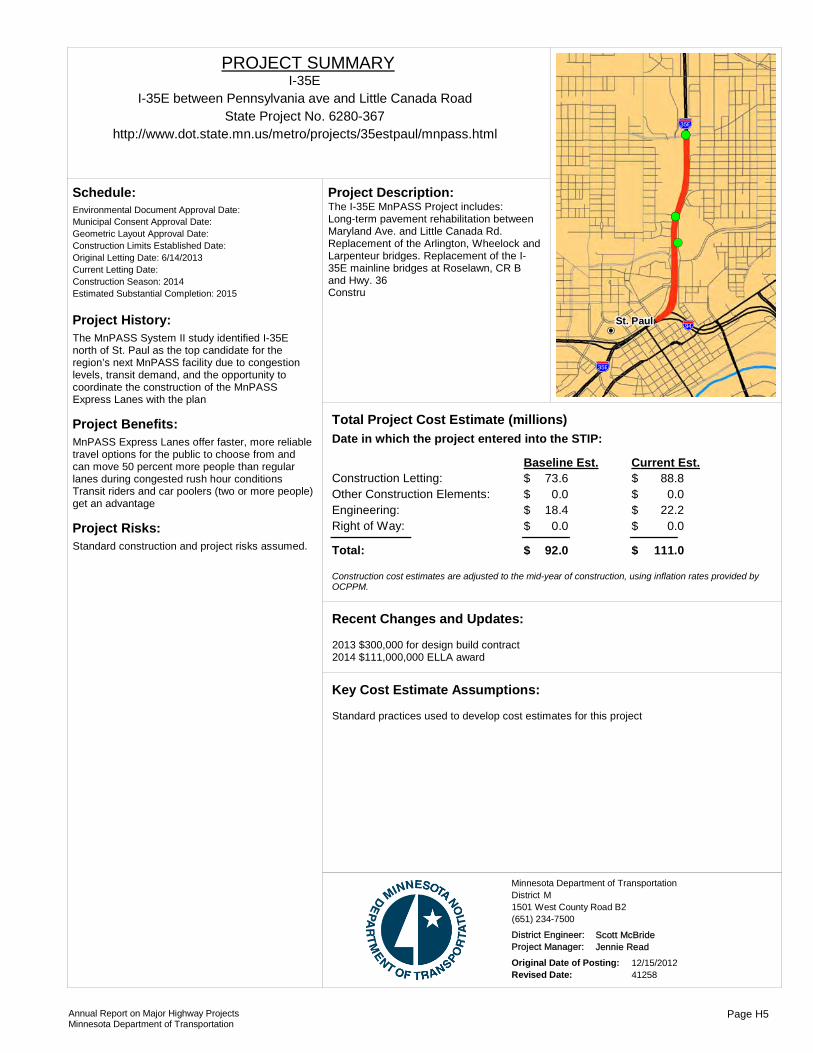
Project History:The MnPASS System II study identified I-35E north of St. Paul as the top candidate for the region’s next MnPASS facility due to congestion levels, transit demand, and the opportunity to coordinate the construction of the MnPASS Express Lanes with the plan
Project Benefits:MnPASS Express Lanes offer faster, more reliable travel options for the public to choose from and can move 50 percent more people than regular lanes during congested rush hour conditionsTransit riders and car poolers (two or more people) get an advantage
Project Risks:Standard construction and project risks assumed.
Environmental Document Approval Date:
Schedule:
Municipal Consent Approval Date: Geometric Layout Approval Date: Construction Limits Established Date: Original Letting Date: 6/14/2013Current Letting Date: Construction Season: 2014Estimated Substantial Completion: 2015
!(!(
!(!(
!(
!"b$
%&c(
%&c(
St. Paul
The I-35E MnPASS Project includes:Long-term pavement rehabilitation between Maryland Ave. and Little Canada Rd.Replacement of the Arlington, Wheelock and Larpenteur bridges. Replacement of the I-35E mainline bridges at Roselawn, CR B and Hwy. 36Constru
Project Description:
Total Project Cost Estimate (millions)Date in which the project entered into the STIP:
Construction Letting: 73.6Other Construction Elements: 0.0Engineering: 18.4Right of Way: 0.0
88.80.0
22.20.0
Baseline Est. Current Est.
Total: 92.0 111.0
$$$$
$
$$$$
$
Construction cost estimates are adjusted to the mid-year of construction, using inflation rates provided by OCPPM.
2013 $300,000 for design build contract2014 $111,000,000 ELLA award
Recent Changes and Updates:
Standard practices used to develop cost estimates for this project
Key Cost Estimate Assumptions:
State Project No. 6280-367I-35E between Pennsylvania ave and Little Canada Road
http://www.dot.state.mn.us/metro/projects/35estpaul/mnpass.html
I-35EPROJECT SUMMARY
District MMinnesota Department of Transportation
1501 West County Road B2(651) 234-7500
District Engineer: Scott McBrideProject Manager: Jennie Read
Original Date of Posting: 12/15/2012Revised Date: 41258
Annual Report on Major Highway ProjectsMinnesota Department of Transportation
Page H5

Project History:The project has been completed.
Project Benefits:Project provides 20-year pavement, corrected drainage, and safety improvements.
Project Risks:
Environmental Document Approval Date: Pending Approval
Schedule:
Municipal Consent Approval Date: Geometric Layout Approval Date: Construction Limits Established Date: Original Letting Date: 6/12/2015Current Letting Date: 4/22/2011Construction Season: 2011/2012Estimated Substantial Completion: 2011
Project Completed
Recent Changes and Updates:
Standard practices used to develop cost estimates for this project.
Key Cost Estimate Assumptions:
%&c(
)s
%&d(
Hugo
Dellwood
North Oaks
Lino LakesCenterville
White Bear Lake
Unbonded concrete overlay on I-35E from south of Ramsey Co CSAH 96 to the north junction of I-35W, drainage corrections, cable median guardrail.
Project Description:
2010Total Project Cost Estimate (millions)Date in which the project entered into the STIP:
Construction Letting: 18.3Other Construction Elements: 0.0Engineering: 4.1Right of Way: 0.0
21.20.04.20.0
Baseline Est. Current Est.
Total: 22.4 25.4
$$$$
$
$$$$
$
Construction cost estimates are adjusted to the mid-year of construction, using inflation rates provided by OCPPM.
State Project No. 0282-34, 6281-23From south of Ramsey Co CSAH 96 to north junction I-35W
I-35EPROJECT SUMMARY
District MMinnesota Department of Transportation
1500 West County Road B2(651) 234-7500
District Engineer: Scott McBrideProject Manager: Jennie Read
Original Date of Posting: 12/15/2012Revised Date: 12/15/2012
Annual Report on Major Highway ProjectsMinnesota Department of Transportation
Page H6

Project History:TED project being developed by Hennepin County for a design build letting. Project is experiencing issues with noise mitigation and historic properties.
Project Benefits:Provides additional access to NB I-35W out of Downtown Minneapolis reducing the congestion on Washington Avenue and reducing the diversion of traffic to 4th Street SE.
Project Risks:Historical review and noise mitigation.
Environmental Document Approval Date:
Schedule:
Municipal Consent Approval Date: Geometric Layout Approval Date: Construction Limits Established Date: Original Letting Date: 2/14/2012Current Letting Date: 9/28/2012Construction Season: 2013Estimated Substantial Completion: 2013
%&d(
%&d(
!"b$
?àA@
!(
!(
!P
Minneapolis
Lauderdale
St. Anthony
Construct new entrance ramp from downtown Minneapolis to north bound I-35W, construct auxillary lane from 3rd and 4th Street north to Johnson St.
Project Description:
Total Project Cost Estimate (millions)Date in which the project entered into the STIP:
Construction Letting: 9.7Other Construction Elements: 1.5Engineering: 2.2Right of Way: 0.0
9.71.52.20.0
Baseline Est. Current Est.
Total: 13.4 13.4
$$$$
$
$$$$
$
Construction cost estimates are adjusted to the mid-year of construction, using inflation rates provided by OCPPM.
Recent Changes and Updates:
Total cost estimate including all construction costs, right of way, utility work, agreements, project delivery costs, and risk contigency were calculated as part of the TED application and award.
Key Cost Estimate Assumptions:
State Project No. 2783-136From 3rd & 4th St ramp to Johnson St. in Minneapolis
I-35WPROJECT SUMMARY
District MMinnesota Department of Transportation
1500 West County Road B2(651) 234-7500
District Engineer: Scott McBrideProject Manager: Scott Pedersen
Original Date of Posting: 12/15/2012Revised Date: 12/15/2012
Annual Report on Major Highway ProjectsMinnesota Department of Transportation
Page H7
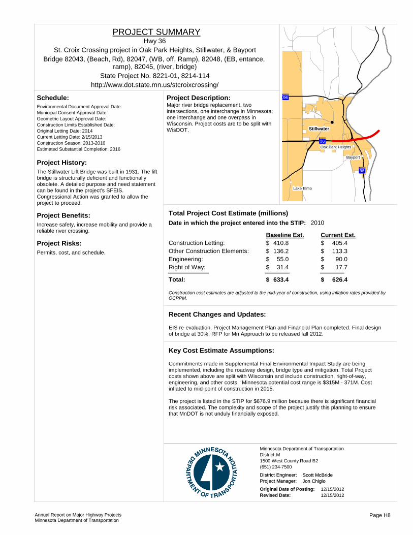
Project History:The Stillwater Lift Bridge was built in 1931. The lift bridge is structurally deficient and functionally obsolete. A detailed purpose and need statement can be found in the project's SFEIS. Congressional Action was granted to allow the project to proceed.
Project Benefits:Increase safety, increase mobility and provide a reliable river crossing.
Project Risks:Permits, cost, and schedule.
Environmental Document Approval Date:
Schedule:
Municipal Consent Approval Date: Geometric Layout Approval Date: Construction Limits Established Date: Original Letting Date: 2014Current Letting Date: 2/15/2013Construction Season: 2013-2016Estimated Substantial Completion: 2016
?öA@
?÷A@
?ÇA@
!(
!(
!(
!(
Stillwater
Bayport
Lake Elmo
Oak Park Heights
Major river bridge replacement, two intersections, one interchange in Minnesota; one interchange and one overpass in Wisconsin. Project costs are to be split with WisDOT.
Project Description:
2010Total Project Cost Estimate (millions)Date in which the project entered into the STIP:
Construction Letting: 410.8Other Construction Elements: 136.2Engineering: 55.0Right of Way: 31.4
405.4113.3
90.017.7
Baseline Est. Current Est.
Total: 633.4 626.4
$$$$
$
$$$$
$
Construction cost estimates are adjusted to the mid-year of construction, using inflation rates provided by OCPPM.
EIS re-evaluation, Project Management Plan and Financial Plan completed. Final design of bridge at 30%. RFP for Mn Approach to be released fall 2012.
Recent Changes and Updates:
Commitments made in Supplemental Final Environmental Impact Study are being implemented, including the roadway design, bridge type and mitigation. Total Project costs shown above are split with Wisconsin and include construction, right-of-way, engineering, and other costs. Minnesota potential cost range is $315M - 371M. Cost inflated to mid-point of construction in 2015.
The project is listed in the STIP for $676.9 million because there is significant financial risk associated. The complexity and scope of the project justify this planning to ensure that MnDOT is not unduly financially exposed.
Key Cost Estimate Assumptions:
State Project No. 8221-01, 8214-114
St. Croix Crossing project in Oak Park Heights, Stillwater, & Bayport
http://www.dot.state.mn.us/stcroixcrossing/
Hwy 36PROJECT SUMMARY
Bridge 82043, (Beach, Rd), 82047, (WB, off, Ramp), 82048, (EB, entance, ramp), 82045, (river, bridge)
District MMinnesota Department of Transportation
1500 West County Road B2(651) 234-7500
District Engineer: Scott McBrideProject Manager: Jon Chiglo
Original Date of Posting: 12/15/2012Revised Date: 12/15/2012
Annual Report on Major Highway ProjectsMinnesota Department of Transportation
Page H8

Project History:This project is partially funded with regional solicitation funds and TED funds. Projects accelerated from 2014 to 2013.
Project Benefits:Removes the last signal between I-35W and Highwway 120. Responds to regional concerns and local collaboration opportunities.
Project Risks:
Environmental Document Approval Date:
Schedule:
Municipal Consent Approval Date: Geometric Layout Approval Date: Construction Limits Established Date: Original Letting Date: 2014Current Letting Date: 12/7/2013Construction Season: 2013Estimated Substantial Completion: Oct 2013
)s
)s
?ÇA@
!(
!(
!(
Gem Lake
Maplewood
Vadnais Heights
Construction of a grade seperated interchange at the intersection of English St and Hwy 36 in Maplewood.
Project Description:
Total Project Cost Estimate (millions)Date in which the project entered into the STIP:
Construction Letting: 17.8Other Construction Elements: 0.0Engineering: 2.0Right of Way: 1.5
17.80.02.01.5
Baseline Est. Current Est.
Total: 21.3 21.3
$$$$
$
$$$$
$
Construction cost estimates are adjusted to the mid-year of construction, using inflation rates provided by OCPPM.
Project was accelerated to 2013.
Recent Changes and Updates:
Standard practices used to develop estimates for this project.
Key Cost Estimate Assumptions:
State Project No. 6211-90
From Hazelwood Ave to US 61 in Maplewood
http://www.dot.state.mn.us/metro/projects/hwy36maplewood/
Hwy 36PROJECT SUMMARY
Bridge 62067, 62004, (ped)
District MMinnesota Department of Transportation
1500 West County Road B2(651) 234-7500
District Engineer: Scott McBrideProject Manager: City
Original Date of Posting: 12/15/2012Revised Date: 12/15/2012
Annual Report on Major Highway ProjectsMinnesota Department of Transportation
Page H9

Project History:Built in 1938, NBI condition ratings (deck-4, superstructure-4, substructure-5) deck replaced in 1956, and bituminous overlay in 1999. This bridge is structurally deficient and functionally obsolete (Sufficiency Rating of 61). The bridge needs to be replaced to provide a safe structure for the traveling public that meets current design standards.
Project Benefits:New bridge that is structurally sound and meets current design standards, improved roadway safety by modifying 3 ramps to current standards, improved ride, widened structure to accommodate third lane on 36, improve Lexington Ave by extending turn lanes and adding pedestrian and bicycle accommodations.
Project Risks:Staged construction of bridge to allow Lexington Ave to remain open, possible ponding needs, possible retaining wall needs, utility impacts, earthwork questions due to no soil borings along modified 36 alignment.
Environmental Document Approval Date:
Schedule:
Municipal Consent Approval Date: Geometric Layout Approval Date: Construction Limits Established Date: Original Letting Date: 1/25/2002Current Letting Date: 7/25/2014Construction Season: late 2014-2015Estimated Substantial Completion: 11/1/2015
!(!(
?ÖA@
?ÇA@Roseville
Falcon Heights
Replace Lexington Ave Bridge No. 5723, reconstruct Lexington Ave. and access ramps, replace two signals at the ramp terminals, address ADA deficiencies on multiuse trail, construct guardrail, drainage ponds, and storm sewers.
Project Description:
Total Project Cost Estimate (millions)Date in which the project entered into the STIP:
Construction Letting: 19.6Other Construction Elements: 0.0Engineering: 3.5Right of Way: 0.0
13.60.02.50.0
Baseline Est. Current Est.
Total: 23.0 16.1
$$$$
$
$$$$
$
Construction cost estimates are adjusted to the mid-year of construction, using inflation rates provided by OCPPM.
Reduced scope in 2011 to update STIP and to avoid right of way needs and minimize work on the interchange ramps and 36 mainline.
Recent Changes and Updates:
Lexington Ave will be open to traffic during construction except for short term closures. Four lanes of traffic will be maintained on TH 36 during construction.
Key Cost Estimate Assumptions:
State Project No. 6212-148
Over Lexington Ave in RosevilleHwy 36
PROJECT SUMMARY
Bridge 5723
District MMinnesota Department of Transportation
1500 West County Road B2(651) 234-7500
District Engineer: Scott McBrideProject Manager: Jennie Read
Original Date of Posting: 12/15/2012Revised Date: 12/15/2012
Annual Report on Major Highway ProjectsMinnesota Department of Transportation
Page H10
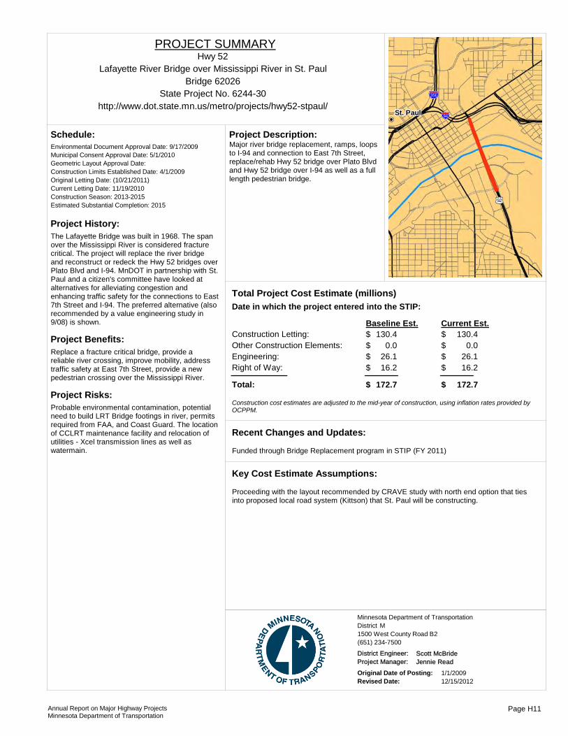
Project History:The Lafayette Bridge was built in 1968. The span over the Mississippi River is considered fracture critical. The project will replace the river bridge and reconstruct or redeck the Hwy 52 bridges over Plato Blvd and I-94. MnDOT in partnership with St. Paul and a citizen's committee have looked at alternatives for alleviating congestion and enhancing traffic safety for the connections to East 7th Street and I-94. The preferred alternative (also recommended by a value engineering study in 9/08) is shown.
Project Benefits:Replace a fracture critical bridge, provide a reliable river crossing, improve mobility, address traffic safety at East 7th Street, provide a new pedestrian crossing over the Mississippi River.
Project Risks:Probable environmental contamination, potential need to build LRT Bridge footings in river, permits required from FAA, and Coast Guard. The location of CCLRT maintenance facility and relocation of utilities - Xcel transmission lines as well as watermain.
Environmental Document Approval Date: 9/17/2009
Schedule:
Municipal Consent Approval Date: 5/1/2010Geometric Layout Approval Date: Construction Limits Established Date: 4/1/2009Original Letting Date: (10/21/2011)Current Letting Date: 11/19/2010Construction Season: 2013-2015Estimated Substantial Completion: 2015 )p
!"b$
%&c(
St. Paul
Major river bridge replacement, ramps, loops to I-94 and connection to East 7th Street, replace/rehab Hwy 52 bridge over Plato Blvd and Hwy 52 bridge over I-94 as well as a full length pedestrian bridge.
Project Description:
Total Project Cost Estimate (millions)Date in which the project entered into the STIP:
Construction Letting: 130.4Other Construction Elements: 0.0Engineering: 26.1Right of Way: 16.2
130.40.0
26.116.2
Baseline Est. Current Est.
Total: 172.7 172.7
$$$$
$
$$$$
$
Construction cost estimates are adjusted to the mid-year of construction, using inflation rates provided by OCPPM.
Funded through Bridge Replacement program in STIP (FY 2011)
Recent Changes and Updates:
Proceeding with the layout recommended by CRAVE study with north end option that ties into proposed local road system (Kittson) that St. Paul will be constructing.
Key Cost Estimate Assumptions:
State Project No. 6244-30
Lafayette River Bridge over Mississippi River in St. Paul
http://www.dot.state.mn.us/metro/projects/hwy52-stpaul/
Hwy 52PROJECT SUMMARY
Bridge 62026
District MMinnesota Department of Transportation
1500 West County Road B2(651) 234-7500
District Engineer: Scott McBrideProject Manager: Jennie Read
Original Date of Posting: 1/1/2009Revised Date: 12/15/2012
Annual Report on Major Highway ProjectsMinnesota Department of Transportation
Page H11
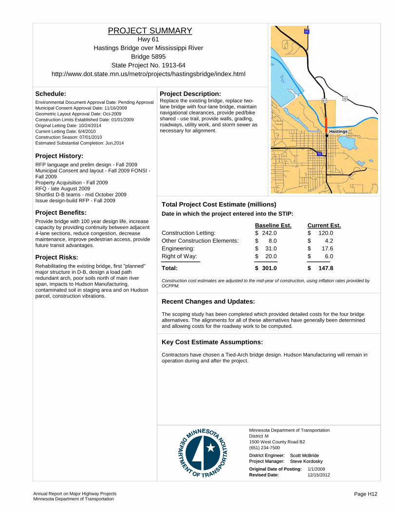
Project History:RFP language and prelim design - Fall 2009 Municipal Consent and layout - Fall 2009 FONSI - Fall 2009Property Acquisition - Fall 2009RFQ - late August 2009Shortlist D-B teams - mid October 2009Issue design-build RFP - Fall 2009
Project Benefits:Provide bridge with 100 year design life, increase capacity by providing continuity between adjacent 4-lane sections, reduce congestion, decrease maintenance, improve pedestrian access, provide future transit advantages.
Project Risks:Rehabilitating the existing bridge, first "planned" major structure in D-B, design a load path redundant arch, poor soils north of main river span, impacts to Hudson Manufacturing, contaminated soil in staging area and on Hudson parcel, construction vibrations.
Environmental Document Approval Date: Pending Approval
Schedule:
Municipal Consent Approval Date: 11/16/2009Geometric Layout Approval Date: Oct-2009Construction Limits Established Date: 01/01/2009Original Letting Date: 10/24/2014Current Letting Date: 6/4/2010Construction Season: 07/01/2010Estimated Substantial Completion: Jun,2014
?ØA@
)m)s
?öA@
Hastings
Replace the existing bridge, replace two-lane bridge with four-lane bridge, maintain navigational clearances, provide ped/bike shared - use trail, provide walls, grading, roadways, utility work, and storm sewer as necessary for alignment.
Project Description:
Total Project Cost Estimate (millions)Date in which the project entered into the STIP:
Construction Letting: 242.0Other Construction Elements: 8.0Engineering: 31.0Right of Way: 20.0
120.04.2
17.66.0
Baseline Est. Current Est.
Total: 301.0 147.8
$$$$
$
$$$$
$
Construction cost estimates are adjusted to the mid-year of construction, using inflation rates provided by OCPPM.
The scoping study has been completed which provided detailed costs for the four bridge alternatives. The alignments for all of these alternatives have generally been determined and allowing costs for the roadway work to be computed.
Recent Changes and Updates:
Contractors have chosen a Tied-Arch bridge design. Hudson Manufacturing will remain in operation during and after the project.
Key Cost Estimate Assumptions:
State Project No. 1913-64
Hastings Bridge over Mississippi River
http://www.dot.state.mn.us/metro/projects/hastingsbridge/index.html
Hwy 61PROJECT SUMMARY
Bridge 5895
District MMinnesota Department of Transportation
1500 West County Road B2(651) 234-7500
District Engineer: Scott McBrideProject Manager: Steve Kordosky
Original Date of Posting: 1/1/2009Revised Date: 12/15/2012
Annual Report on Major Highway ProjectsMinnesota Department of Transportation
Page H12

Project History:This project was developed from the I-94 managed lane study that was completed in 2009. The eastern segment will be funded via ARRA funding. The western segment will include the technology components of the project.
Project Benefits:This project will provide a managed corridor from Minneapolis to St. Paul, which will provide congestion relief and a transit advantage.
Project Risks:New traffic technology similar to the I-35W UPA project will be used.
Environmental Document Approval Date: 6/21/2010
Schedule:
Municipal Consent Approval Date: Mpls Approved, St. Paul iGeometric Layout Approval Date: 7/2/2010Construction Limits Established Date: 5/28/2010Original Letting Date: (1/23/2009)Current Letting Date: 2/25/2011Construction Season: 2011Estimated Substantial Completion: 2011
A favorable bid climate expains the cost descrepencies between the baseline and current estimates.
Recent Changes and Updates:
Standard practices used to develop cost estimates for this project.
Key Cost Estimate Assumptions:
%&f(
?ØA@
!"b$
%&d(
?ÒA@ %&d(?ÖA@
?ÖA@
%&h(
?ÇA@
%&h(
?©A@
%&c(
%&c(
%&f(
?±A@
St. Paul
Minneapolis
Mendota
Hilltop
Lilydale
RosevilleLauderdale
St. Anthony
Arden Hills
Sunfish Lake
Falcon Heights
West Saint Paul
Mendota Heights
Columbia Heights
Mill and overlay and develop a managed corridor using advance traffic technology.
Project Description:
Total Project Cost Estimate (millions)Date in which the project entered into the STIP:
Construction Letting: 50.0Other Construction Elements: 0.0Engineering: 5.0Right of Way: 0.0
23.05.00.00.0
Baseline Est. Current Est.
Total: 55.0 28.0
$$$$
$
$$$$
$
Construction cost estimates are adjusted to the mid-year of construction, using inflation rates provided by OCPPM.
State Project No. 2781-415, 2781-443Lowry Hill Tunnel to John Ireland Boulevard
http://www.dot.state.mn.us/metro/projects/i94study/
I-94PROJECT SUMMARY
District MMinnesota Department of Transportation
1500 West County Road B2(651) 234-7500
District Engineer: Scott McBrideProject Manager: Scott Pedersen
Original Date of Posting: 1/1/2009Revised Date: 12/15/2012
Annual Report on Major Highway ProjectsMinnesota Department of Transportation
Page H13
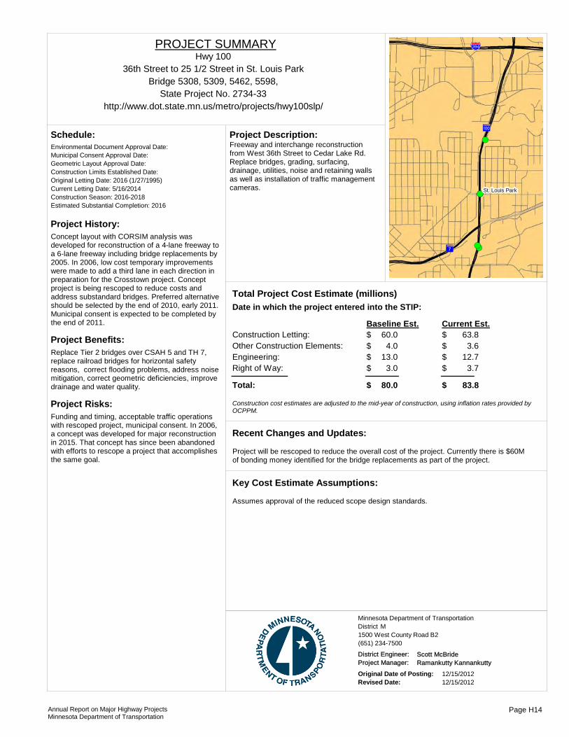
Project History:Concept layout with CORSIM analysis was developed for reconstruction of a 4-lane freeway to a 6-lane freeway including bridge replacements by 2005. In 2006, low cost temporary improvements were made to add a third lane in each direction in preparation for the Crosstown project. Concept project is being rescoped to reduce costs and address substandard bridges. Preferred alternative should be selected by the end of 2010, early 2011. Municipal consent is expected to be completed by the end of 2011.
Project Benefits:Replace Tier 2 bridges over CSAH 5 and TH 7, replace railroad bridges for horizontal safety reasons, correct flooding problems, address noise mitigation, correct geometric deficiencies, improve drainage and water quality.
Project Risks:Funding and timing, acceptable traffic operations with rescoped project, municipal consent. In 2006, a concept was developed for major reconstruction in 2015. That concept has since been abandoned with efforts to rescope a project that accomplishes the same goal.
Environmental Document Approval Date:
Schedule:
Municipal Consent Approval Date: Geometric Layout Approval Date: Construction Limits Established Date: Original Letting Date: 2016 (1/27/1995)Current Letting Date: 5/16/2014Construction Season: 2016-2018Estimated Substantial Completion: 2016
!(
!(
!(
!(
!(
?«A@
?úA@
%&e(
St. Louis Park
Freeway and interchange reconstruction from West 36th Street to Cedar Lake Rd. Replace bridges, grading, surfacing, drainage, utilities, noise and retaining walls as well as installation of traffic management cameras.
Project Description:
Total Project Cost Estimate (millions)Date in which the project entered into the STIP:
Construction Letting: 60.0Other Construction Elements: 4.0Engineering: 13.0Right of Way: 3.0
63.83.6
12.73.7
Baseline Est. Current Est.
Total: 80.0 83.8
$$$$
$
$$$$
$
Construction cost estimates are adjusted to the mid-year of construction, using inflation rates provided by OCPPM.
Project will be rescoped to reduce the overall cost of the project. Currently there is $60M of bonding money identified for the bridge replacements as part of the project.
Recent Changes and Updates:
Assumes approval of the reduced scope design standards.
Key Cost Estimate Assumptions:
State Project No. 2734-33
36th Street to 25 1/2 Street in St. Louis Park
http://www.dot.state.mn.us/metro/projects/hwy100slp/
Hwy 100PROJECT SUMMARY
Bridge 5308, 5309, 5462, 5598,
District MMinnesota Department of Transportation
1500 West County Road B2(651) 234-7500
District Engineer: Scott McBrideProject Manager: Ramankutty Kannankutty
Original Date of Posting: 12/15/2012Revised Date: 12/15/2012
Annual Report on Major Highway ProjectsMinnesota Department of Transportation
Page H14
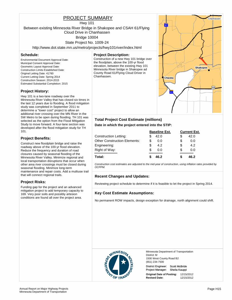
Project History:Hwy 101 is a two-lane roadway over the Minnesota River Valley that has closed six times in the last 12 years due to flooding. A flood mitigation study was completed in September 2011 to determine a "lower cost" project to allow an additional river crossing over the MN River in the SW Metro to be open during flooding. TH 101 was selected as the option from the Flood Mitigation Study to move forward. A four-lane section was developed after the flood mitigation study for TH 101.
Project Benefits:Construct new floodplain bridge and raise the roadway above of the 100-yr flood elevation. Reduce the frequency and duration of road closures caused by seasonal flooding of the Minnesota River Valley. Minimize regional and local transportation disruptions that occur when other area river crossings must be closed during seasonal flooding. Minimize long-term maintenance and repair costs. Add a multiuse trail that will connect regional trails.
Project Risks:Funding gap for the project and an advanced mitigation project to add temporary capacity to 169. Very poor soils and possibly artesion conditions are found all over the project area.
Environmental Document Approval Date:
Schedule:
Municipal Consent Approval Date: Geometric Layout Approval Date: Construction Limits Established Date: Original Letting Date: 41760Current Letting Date: Spring 2014Construction Season: 2014-2015Estimated Substantial Completion: 2015
?ÌA@
)y?ÌA@
!(
!(
!(
Chaska
Shakopee
Chanhassen
Construction of a new Hwy 101 bridge over the floodplain, above the 100-yr flood elevation, between the existing Hwy 101 Minnesota River bridge in Shakopee ad County Road 61/Flying Cloud Driver in Chanhassen.
Project Description:
Total Project Cost Estimate (millions)Date in which the project entered into the STIP:
Construction Letting: 42.0Other Construction Elements: 0.0Engineering: 4.2Right of Way: 0.0
42.00.04.20.0
Baseline Est. Current Est.
Total: 46.2 46.2
$$$$
$
$$$$
$
Construction cost estimates are adjusted to the mid-year of construction, using inflation rates provided by OCPPM.
Reviewing project schedule to determine if it is feasible to let the project in Spring 2014.
Recent Changes and Updates:
No permanent ROW impacts, design exception for drainage, north alignment could shift.
Key Cost Estimate Assumptions:
State Project No. 1009-24
Between existing Minnesota River Bridge in Shakopee and CSAH 61/Flying Cloud Drive in Chanhassen
http://www.dot.state.mn.us/metro/projects/hwy101river/index.html
Hwy 101PROJECT SUMMARY
Bridge 10004
District MMinnesota Department of Transportation
1500 West County Road B2(651) 234-7500
District Engineer: Scott McBrideProject Manager: Sheila Kauppi
Original Date of Posting: 12/15/2012Revised Date: 12/15/2012
Annual Report on Major Highway ProjectsMinnesota Department of Transportation
Page H15
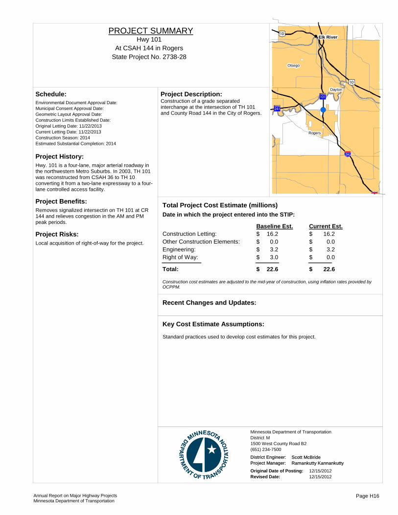
Project History:Hwy. 101 is a four-lane, major arterial roadway in the northwestern Metro Suburbs. In 2003, TH 101 was reconstructed from CSAH 36 to TH 10 converting it from a two-lane expressway to a four-lane controlled access facility.
Project Benefits:Removes signalized intersectin on TH 101 at CR 144 and relieves congestion in the AM and PM peak periods.
Project Risks:Local acquisition of right-of-way for the project.
Environmental Document Approval Date:
Schedule:
Municipal Consent Approval Date: Geometric Layout Approval Date: Construction Limits Established Date: Original Letting Date: 11/22/2013Current Letting Date: 11/22/2013Construction Season: 2014Estimated Substantial Completion: 2014
?²A@
!"b$
?ûA@
)m
)m
!"b$
!(
!(
!(
!(
!(
!(
Elk River
Rogers
Otsego
Dayton
Construction of a grade separated interchange at the intersection of TH 101 and County Road 144 in the City of Rogers.
Project Description:
Total Project Cost Estimate (millions)Date in which the project entered into the STIP:
Construction Letting: 16.2Other Construction Elements: 0.0Engineering: 3.2Right of Way: 3.0
16.20.03.20.0
Baseline Est. Current Est.
Total: 22.6 22.6
$$$$
$
$$$$
$
Construction cost estimates are adjusted to the mid-year of construction, using inflation rates provided by OCPPM.
Recent Changes and Updates:
Standard practices used to develop cost estimates for this project.
Key Cost Estimate Assumptions:
State Project No. 2738-28At CSAH 144 in Rogers
Hwy 101PROJECT SUMMARY
District MMinnesota Department of Transportation
1500 West County Road B2(651) 234-7500
District Engineer: Scott McBrideProject Manager: Ramankutty Kannankutty
Original Date of Posting: 12/15/2012Revised Date: 12/15/2012
Annual Report on Major Highway ProjectsMinnesota Department of Transportation
Page H16

Project History:The 2002 US 169 Interregional Corridor Plan suggested that the Hwy 69 intersection with US 169 should be grade-separated as an overpass at a minimum or possibly an interchange. Final system connection decisions were deferred to the EIS process for new Highway 41 River Crossing alignments because the Highway 41 River Crossing decision would help clarify system reconfiguration requirements on the regional highway system (US 169, US 41, Hwy 78, Hwy 69) needed to support the preferred river crossing alignment.
Project Benefits:The purpose of the project is to addresss future capacity and safety issues at the current US 169/CR 69 intersection while maintaining adequate operations and improved safety for vehicles and pedestrians/bicyclists, create an efficient regional roadway system, consisten with future roadway plans and interregional corridor objectives, and support land use and economic development goals.
Project Risks:
Environmental Document Approval Date:
Schedule:
Municipal Consent Approval Date: Geometric Layout Approval Date: Construction Limits Established Date: Original Letting Date: 11/15/2013Current Letting Date: 11/15/2013Construction Season: 2013Estimated Substantial Completion:
)y?ÌA@
!(
!(
Chaska
Shakopee
Construct grade separated interchange at TH 169/CR 69 in Shakopee. The construction will add a new bridge (with trail) to carry CR 69 over TH 169. Construction will include noisewalls and ponding.
Project Description:
Total Project Cost Estimate (millions)Date in which the project entered into the STIP:
Construction Letting: 15.4Other Construction Elements: 0.5Engineering: 2.8Right of Way: 0.1
15.40.52.80.1
Baseline Est. Current Est.
Total: 18.8 18.8
$$$$
$
$$$$
$
Construction cost estimates are adjusted to the mid-year of construction, using inflation rates provided by OCPPM.
Recent Changes and Updates:
Total cost estimate including all construction costs, right of way, utility work, agreements, project delivery costs, and risk contigency were calculated as part of the SaM application and award.
Key Cost Estimate Assumptions:
State Project No. 7005-97
CO RD 69 in Shakopee
http://www.scottcounty69and169.com/
Hwy 169PROJECT SUMMARY
Bridge 70007
District MMinnesota Department of Transportation
1500 West County Road B2(651) 234-7500
District Engineer: Scott McBrideProject Manager: Scott County
Original Date of Posting: 12/15/2012Revised Date: 12/15/2012
Annual Report on Major Highway ProjectsMinnesota Department of Transportation
Page H17

Project History:TH 169 is a Principal Arterial roadway in the western metropolitan area. The proposed project will remove the last signal between County Road 81 and TH 610. This will extend the controlled access freeway from County Road 81 to TH 610.
Project Benefits:Removes the last signalized intersection on TH 169 between County Road 81 and TH 610 improving the corridor's safety and mobility
Project Risks:Locals acquiring right-of-way for the project.
Environmental Document Approval Date:
Schedule:
Municipal Consent Approval Date: Geometric Layout Approval Date: Construction Limits Established Date: Original Letting Date: 6/12/2015Current Letting Date: 10/26/2012Construction Season: 2014Estimated Substantial Completion: 2014
)y
)y
?óA@
Osseo
Brooklyn Park
Construction of a grade separated interchange at the intersection of TH 169 and 93rd Avenue in St. Louis Park.
Project Description:
Total Project Cost Estimate (millions)Date in which the project entered into the STIP:
Construction Letting: 11.6Other Construction Elements: 0.0Engineering: 2.3Right of Way: 5.0
11.906,000.0
2.47.4
Baseline Est. Current Est.
Total: 18.9 21.9
$$$$
$
$$$$
$
Construction cost estimates are adjusted to the mid-year of construction, using inflation rates provided by OCPPM.
Recent Changes and Updates:
Standard practices used to develop cost estimates for this project.
Key Cost Estimate Assumptions:
State Project No. 2750-75At 93rd Ave in Brooklyn Park & Osseo
Hwy 169PROJECT SUMMARY
District MMinnesota Department of Transportation
1500 West County Road B2(651) 234-7500
District Engineer: Scott McBrideProject Manager: Ramankutty Kannankutty
Original Date of Posting: 12/15/2012Revised Date: 12/15/2012
Annual Report on Major Highway ProjectsMinnesota Department of Transportation
Page H18

Project History:This is a pavement preservation project being developed as a design bid build project.
Project Benefits:The project will maintain the curent pavement infrastructure and extend the pavement life.
Project Risks:High Potential for traffic impacts.
Environmental Document Approval Date:
Schedule:
Municipal Consent Approval Date: Geometric Layout Approval Date: Construction Limits Established Date: Original Letting Date: 11/22/2013Current Letting Date: 11/22/2013Construction Season: 2014Estimated Substantial Completion: 2014
%&f(
?óA@
%&h(
!"b$
)y
)y
!(
!(
!(
!(
!(
!(
!(
!(
!(
!(
!(
Osseo
Crystal
Plymouth
New Hope
Robbinsdale
Maple Grove
Medicine Lake
Golden Valley
Brooklyn Park
St. Louis Park
Brooklyn Center
Pavement preservation on Highway 169 from just north of Highway 55 to 77th Ave. The project will restore pavement and construct an escape lane as well as replace guardrail and improve drainage.
Project Description:
Total Project Cost Estimate (millions)Date in which the project entered into the STIP:
Construction Letting: 11.5Other Construction Elements: 0.0Engineering: 2.2Right of Way: 0.0
12.20.02.40.0
Baseline Est. Current Est.
Total: 13.7 14.6
$$$$
$
$$$$
$
Construction cost estimates are adjusted to the mid-year of construction, using inflation rates provided by OCPPM.
Recent Changes and Updates:
Standard oractices used to develop cost estimates for this project.
Key Cost Estimate Assumptions:
State Project No. 2772-92MN 55 in Plymouth to 77th Ave in Brooklyn Park
Hwy 169PROJECT SUMMARY
District MMinnesota Department of Transportation
1500 West County Road B2(651) 234-7500
District Engineer: Scott McBrideProject Manager: Dale Gade
Original Date of Posting: 12/15/2012Revised Date: 12/15/2012
Annual Report on Major Highway ProjectsMinnesota Department of Transportation
Page H19
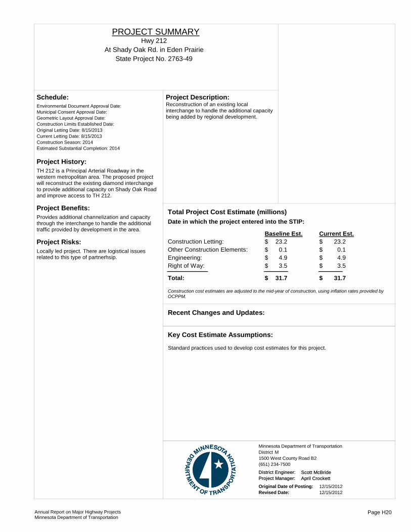
Project History:TH 212 is a Principal Arterial Roadway in the western metropolitan area. The proposed project will reconstruct the existing diamond interchange to provide additional capacity on Shady Oak Road and improve access to TH 212.
Project Benefits:Provides additional channelization and capacity through the interchange to handle the additional traffic provided by development in the area.
Project Risks:Locally led project. There are logistical issues related to this type of partnerhsip.
Environmental Document Approval Date:
Schedule:
Municipal Consent Approval Date: Geometric Layout Approval Date: Construction Limits Established Date: Original Letting Date: 8/15/2013Current Letting Date: 8/15/2013Construction Season: 2014Estimated Substantial Completion: 2014
Reconstruction of an existing local interchange to handle the additional capacity being added by regional development.
Project Description:
Total Project Cost Estimate (millions)Date in which the project entered into the STIP:
Construction Letting: 23.2Other Construction Elements: 0.1Engineering: 4.9Right of Way: 3.5
23.20.14.93.5
Baseline Est. Current Est.
Total: 31.7 31.7
$$$$
$
$$$$
$
Construction cost estimates are adjusted to the mid-year of construction, using inflation rates provided by OCPPM.
Recent Changes and Updates:
Standard practices used to develop cost estimates for this project.
Key Cost Estimate Assumptions:
State Project No. 2763-49At Shady Oak Rd. in Eden Prairie
Hwy 212PROJECT SUMMARY
District MMinnesota Department of Transportation
1500 West County Road B2(651) 234-7500
District Engineer: Scott McBrideProject Manager: April Crockett
Original Date of Posting: 12/15/2012Revised Date: 12/15/2012
Annual Report on Major Highway ProjectsMinnesota Department of Transportation
Page H20

Project History:Pavement project also connected auxilary lanes to provide continuous three lane roadway in each direction.
Project Benefits:Pavement condition improved, less congestion, and additional safety improvements.
Project Risks:The cost and schedule provide risk exposure.
Environmental Document Approval Date:
Schedule:
Municipal Consent Approval Date: Geometric Layout Approval Date: Construction Limits Established Date: Original Letting Date: 3/29/09 &Current Letting Date: 3/29/09 & 2/12/2010Construction Season: 2009 & 2010Estimated Substantial Completion: fall 2010
Project completed
Recent Changes and Updates:
Standard practices used to develop cost estimates for this project.
Key Cost Estimate Assumptions:
?©A@
%&f(
%&h(
!(
!(
!(
!(
!(
!(
!(
!(
Oakdale
Newport
Woodbury
Landfall
Maplewood
South Saint Paul
North Saint Paul
Inver Grove Heights
Unbonded concrete overlay project. Also connected auxilary lanes to provide continuous three lane section in each direction, and noise wall south of Lake Rd.
Project Description:
Total Project Cost Estimate (millions)Date in which the project entered into the STIP:
Construction Letting: 21.3Other Construction Elements: 0.0Engineering: 4.3Right of Way: 0.0
21.30.04.30.0
Baseline Est. Current Est.
Total: 25.6 25.6
$$$$
$
$$$$
$
Construction cost estimates are adjusted to the mid-year of construction, using inflation rates provided by OCPPM.
State Project No. 8285-93, 8285-94Lake Rd in Maplewood to I-94 in Woodbury
http://www.dot.state.mn.us/metro/projects/i494and694/
I-494PROJECT SUMMARY
District MMinnesota Department of Transportation
1500 West County Road B2(651) 234-7500
District Engineer: Scott McBrideProject Manager: Marc Briese
Original Date of Posting: 12/15/2012Revised Date: 12/15/2012
Annual Report on Major Highway ProjectsMinnesota Department of Transportation
Page H21

Project History:The mill and overlay was the first project programmed in this set of projects. The Xerxes Ave bridge was being scoped for a 2015 letting. With a bridge replacement programmed and the ability to place the bridge abutments in a desired location, the auxillary lane which was identified on the Congestion Mitigation Safety Plan list could now be advanced if funding could be found.
Project Benefits:The mill and overlay will provide an improved driving surface for several years, the Xerxes Ave bridge replacement is a preservation project with the added benefit of allowing for an increase in capacity for the auxillary lane. The auxillary lane will provide some needed capacity to WB I-494.
Project Risks:Funding for the auxillary lane has not been identified, the advancement of the Xerxes Ave bridge from 2015 to 2012 will need some coordination. Additional capacity on I-494 has been identified by Met Council and MnDOT's long range plan as being managed.
Environmental Document Approval Date: Approved - Being r
Schedule:
Municipal Consent Approval Date: Pending ApprovalGeometric Layout Approval Date: Pending ApprovalConstruction Limits Established Date: Pending ApprovalOriginal Letting Date: 2012Current Letting Date: 6/8/2012Construction Season: 2013Estimated Substantial Completion: 2013
%&d(
%&f(
?ÞA@
%&d(
?éA@
?±A@
Richfield
Bloomington
Mill and overlay as well as construction of a westbound auxiliary lane from Penn Ave to NB TH 100. The Xerxes Ave bridge will also be replaced.
Project Description:
2010Total Project Cost Estimate (millions)Date in which the project entered into the STIP:
Construction Letting: 40.5Other Construction Elements: 0.0Engineering: 4.5Right of Way: 0.0
40.50.04.50.0
Baseline Est. Current Est.
Total: 45.0 45.0
$$$$
$
$$$$
$
Construction cost estimates are adjusted to the mid-year of construction, using inflation rates provided by OCPPM.
No changes or updates since the last report
Recent Changes and Updates:
Standard practices used to develop cost estimates for this project.
Key Cost Estimate Assumptions:
State Project No. 2785-367, 2785-364, 2785-378
34th Ave to France Ave
http://www.dot.state.mn.us/metro/projects/i494richfield/
I-494PROJECT SUMMARY
Bridge 9126
District MMinnesota Department of Transportation
1500 West County Road B2(651) 234-7500
District Engineer: Scott McBrideProject Manager: Scott Pedersen
Original Date of Posting: 12/15/2012Revised Date: 12/15/2012
Annual Report on Major Highway ProjectsMinnesota Department of Transportation
Page H22
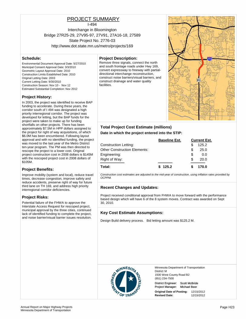
Project History:In 2003, the project was identified to receive BAP funding to accelerate. During these years, the corridor south of I 494 was designated a high priority interregional corridor. The project was developed for letting, but the BAP funds for the project were taken to make up for funding shortfalls on other projects. There has been approximately $7.5M in HPP dollars assigned to the project for right of way acquisitions, of which $6.0M has been encumbered. Following layout approval and with no identified funding, the project was moved to the last year of the Metro District ten-year program. The PM was then directed to rescope the project to a lower cost. Original project construction cost in 2008 dollars is $145M with the rescoped project cost in 2008 dollars of $105M.
Project Benefits:Improve mobility (system and local), reduce travel times, decrease congestion, improve safety and reduce accidents, preserve right of way for future third lane on TH 169, and address high priority interregional corridor deficiencies.
Project Risks:Potential failure of the FHWA to approve the Interstate Access Request for rescoped project, municipal approval by the three cities, continued lack of identified funding to complete the project, and noise barrier/visual barrier issues resolution.
Environmental Document Approval Date: 5/27/2010
Schedule:
Municipal Consent Approval Date: 3/3/2010Geometric Layout Approval Date: 2010Construction Limits Established Date: 2010Original Letting Date: 2003Current Letting Date: 9/30/2010Construction Season: Nov 10 - Nov 12Estimated Substantial Completion: Nov 2012
Remove three signals, connect the north and south frontage roads under Hwy 169, convert expressway to freeway with partial-directional interchange reconstruction, construct noise barriers/visual barriers, and construct drainage and water quality facilities.
Project Description:
Total Project Cost Estimate (millions)Date in which the project entered into the STIP:
Construction Letting:Other Construction Elements:Engineering:Right of Way:
125.225.0
0.020.0
Baseline Est. Current Est.
Total: 125.2 170.0$
$$$$
$
Construction cost estimates are adjusted to the mid-year of construction, using inflation rates provided by OCPPM.
Project received conditional approval from FHWA to move forward with the performance based design which will have 6 of the 8 system moves. Contract was awarded on Sept 30, 2010.
Recent Changes and Updates:
Design Build delivery process. Bid letting amount was $125.2 M.
Key Cost Estimate Assumptions:
State Project No. 2776-03
Interchange in Bloomington
http://www.dot.state.mn.us/metro/projects/169
I-494PROJECT SUMMARY
Bridge 27R25-29, 27V95-97, 27V91, 27A16-18, 27589
District MMinnesota Department of Transportation
1500 West County Road B2(651) 234-7500
District Engineer: Scott McBrideProject Manager: Michael Beer
Original Date of Posting: 12/15/2012Revised Date: 12/15/2012
Annual Report on Major Highway ProjectsMinnesota Department of Transportation
Page H23
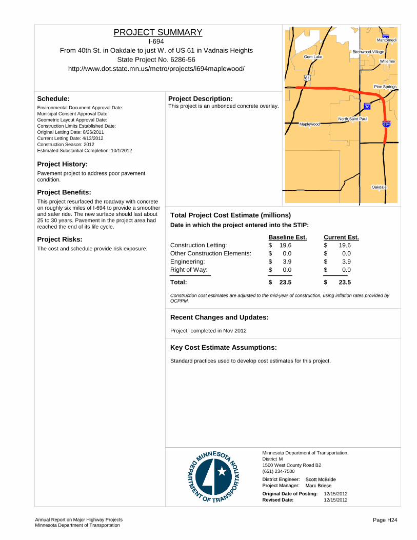
Project History:Pavement project to address poor pavement condition.
Project Benefits:This project resurfaced the roadway with concrete on roughly six miles of I-694 to provide a smoother and safer ride. The new surface should last about 25 to 30 years. Pavement in the project area had reached the end of its life cycle.
Project Risks:The cost and schedule provide risk exposure.
Environmental Document Approval Date:
Schedule:
Municipal Consent Approval Date: Geometric Layout Approval Date: Construction Limits Established Date: Original Letting Date: 8/26/2011Current Letting Date: 4/13/2012Construction Season: 2012Estimated Substantial Completion: 10/1/2012
%&h(
?̧A@
)s
?ÇA@
!(
!(
!(
!(
!(
!(
!(
!(
Oakdale
Gem LakeWillernie
Maplewood
Mahtomedi
Pine Springs
North Saint Paul
Birchwood Village
This project is an unbonded concrete overlay.Project Description:
Total Project Cost Estimate (millions)Date in which the project entered into the STIP:
Construction Letting: 19.6Other Construction Elements: 0.0Engineering: 3.9Right of Way: 0.0
19.60.03.90.0
Baseline Est. Current Est.
Total: 23.5 23.5
$$$$
$
$$$$
$
Construction cost estimates are adjusted to the mid-year of construction, using inflation rates provided by OCPPM.
Project completed in Nov 2012
Recent Changes and Updates:
Standard practices used to develop cost estimates for this project.
Key Cost Estimate Assumptions:
State Project No. 6286-56From 40th St. in Oakdale to just W. of US 61 in Vadnais Heights
http://www.dot.state.mn.us/metro/projects/i694maplewood/
I-694PROJECT SUMMARY
District MMinnesota Department of Transportation
1500 West County Road B2(651) 234-7500
District Engineer: Scott McBrideProject Manager: Marc Briese
Original Date of Posting: 12/15/2012Revised Date: 12/15/2012
Annual Report on Major Highway ProjectsMinnesota Department of Transportation
Page H24
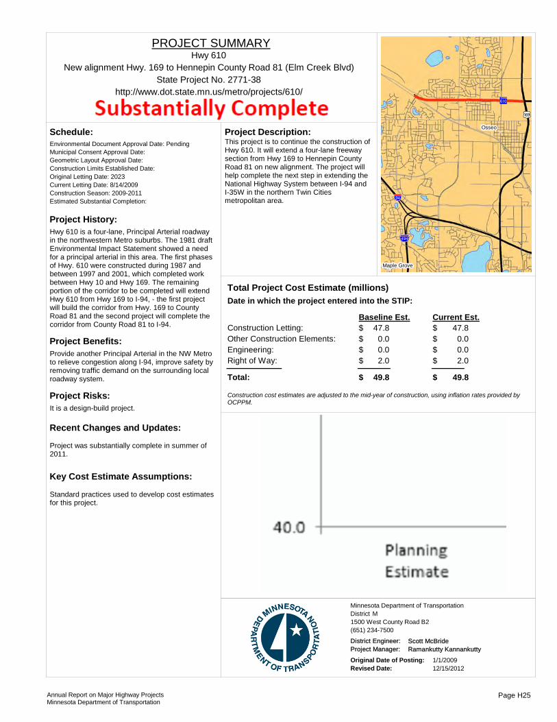
Project History:Hwy 610 is a four-lane, Principal Arterial roadway in the northwestern Metro suburbs. The 1981 draft Environmental Impact Statement showed a need for a principal arterial in this area. The first phases of Hwy. 610 were constructed during 1987 and between 1997 and 2001, which completed work between Hwy 10 and Hwy 169. The remaining portion of the corridor to be completed will extend Hwy 610 from Hwy 169 to I-94, - the first project will build the corridor from Hwy. 169 to County Road 81 and the second project will complete the corridor from County Road 81 to I-94.
Project Benefits:Provide another Principal Arterial in the NW Metro to relieve congestion along I-94, improve safety by removing traffic demand on the surrounding local roadway system.
Project Risks:It is a design-build project.
Environmental Document Approval Date: Pending
Schedule:
Municipal Consent Approval Date: Geometric Layout Approval Date: Construction Limits Established Date: Original Letting Date: 2023Current Letting Date: 8/14/2009Construction Season: 2009-2011Estimated Substantial Completion:
Project was substantially complete in summer of 2011.
Recent Changes and Updates:
Standard practices used to develop cost estimates for this project.
Key Cost Estimate Assumptions:
)y
%&f(
?óA@
!"b$
Osseo
Maple Grove
This project is to continue the construction of Hwy 610. It will extend a four-lane freeway section from Hwy 169 to Hennepin County Road 81 on new alignment. The project will help complete the next step in extending the National Highway System between I-94 and I-35W in the northern Twin Cities metropolitan area.
Project Description:
Total Project Cost Estimate (millions)Date in which the project entered into the STIP:
Construction Letting: 47.8Other Construction Elements: 0.0Engineering: 0.0Right of Way: 2.0
47.80.00.02.0
Baseline Est. Current Est.
Total: 49.8 49.8
$$$$
$
$$$$
$
Construction cost estimates are adjusted to the mid-year of construction, using inflation rates provided by OCPPM.
State Project No. 2771-38New alignment Hwy. 169 to Hennepin County Road 81 (Elm Creek Blvd)
http://www.dot.state.mn.us/metro/projects/610/
Hwy 610PROJECT SUMMARY
District MMinnesota Department of Transportation
1500 West County Road B2(651) 234-7500
District Engineer: Scott McBrideProject Manager: Ramankutty Kannankutty
Original Date of Posting: 1/1/2009Revised Date: 12/15/2012
Annual Report on Major Highway ProjectsMinnesota Department of Transportation
Page H25
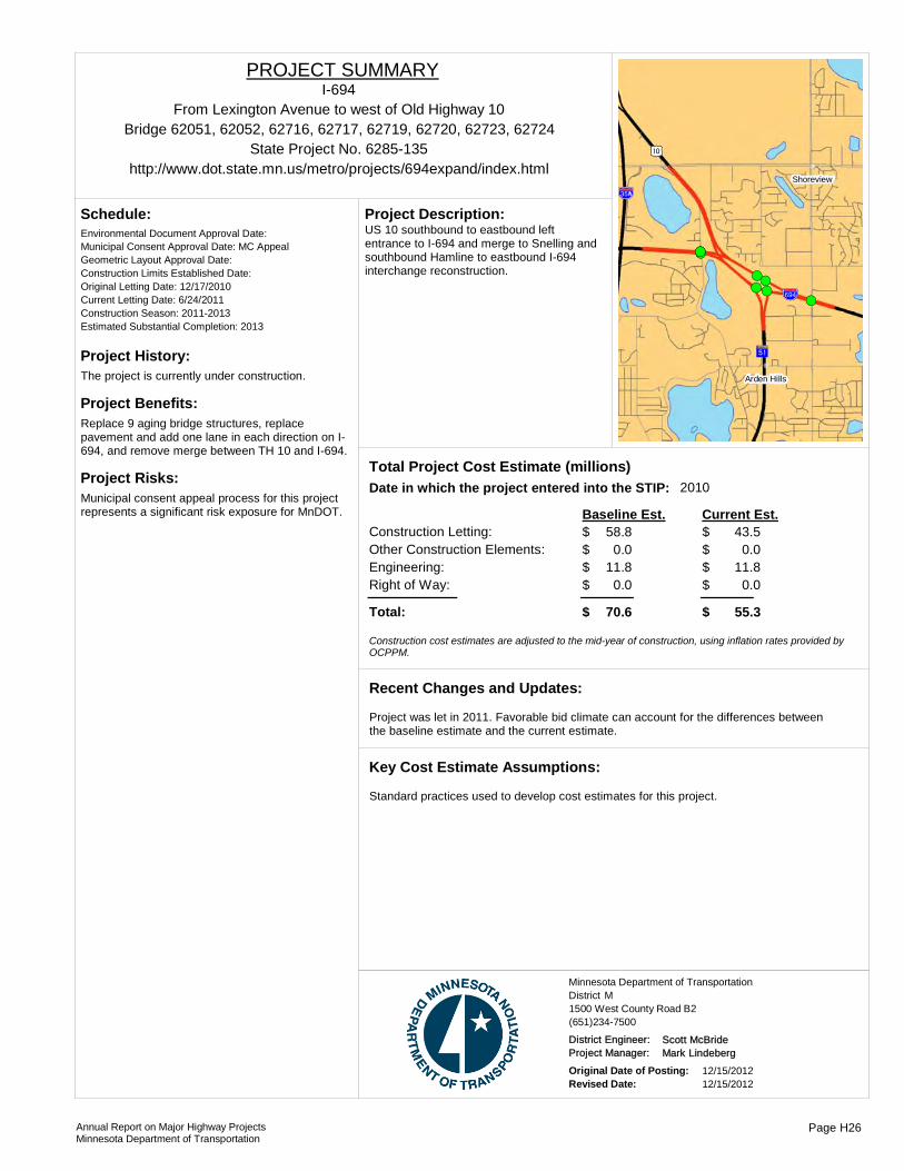
Project History:The project is currently under construction.
Project Benefits:Replace 9 aging bridge structures, replace pavement and add one lane in each direction on I-694, and remove merge between TH 10 and I-694.
Project Risks:Municipal consent appeal process for this project represents a significant risk exposure for MnDOT.
Environmental Document Approval Date:
Schedule:
Municipal Consent Approval Date: MC AppealGeometric Layout Approval Date: Construction Limits Established Date: Original Letting Date: 12/17/2010Current Letting Date: 6/24/2011Construction Season: 2011-2013Estimated Substantial Completion: 2013
((
!(!(
!(!(!(!(!(!(
!(!(!(!(!(!(!(!(
)m
%&h(
?ÖA@
%&d(Shoreview
Arden Hills
US 10 southbound to eastbound left entrance to I-694 and merge to Snelling and southbound Hamline to eastbound I-694 interchange reconstruction.
Project Description:
2010Total Project Cost Estimate (millions)Date in which the project entered into the STIP:
Construction Letting: 58.8Other Construction Elements: 0.0Engineering: 11.8Right of Way: 0.0
43.50.0
11.80.0
Baseline Est. Current Est.
Total: 70.6 55.3
$$$$
$
$$$$
$
Construction cost estimates are adjusted to the mid-year of construction, using inflation rates provided by OCPPM.
Project was let in 2011. Favorable bid climate can account for the differences between the baseline estimate and the current estimate.
Recent Changes and Updates:
Standard practices used to develop cost estimates for this project.
Key Cost Estimate Assumptions:
State Project No. 6285-135
From Lexington Avenue to west of Old Highway 10
http://www.dot.state.mn.us/metro/projects/694expand/index.html
I-694PROJECT SUMMARY
Bridge 62051, 62052, 62716, 62717, 62719, 62720, 62723, 62724
District MMinnesota Department of Transportation
1500 West County Road B2(651)234-7500
District Engineer: Scott McBrideProject Manager: Mark Lindeberg
Original Date of Posting: 12/15/2012Revised Date: 12/15/2012
Annual Report on Major Highway ProjectsMinnesota Department of Transportation
Page H26