anglers atlas northern boreal fishing guide
DESCRIPTION
Detailed maps, along with interviews of fishing resorts and outfitters and stocking data for the Northern Boreal Region of Alberta. Great resource for businesses in the area, check it out!!TRANSCRIPT

Northern Boreal
ALBERTA
FIRST PIKE OF THE DAY
aFish stocking on pp. 34
2016
LEARN MORE, SIGN-UP & DOWNLOAD
AnglersAtlas.com
Cover shot submitted by Steve Allen, winner of the 2016 photo contest.
See all our winners online and read their amazing stories.
2nd EDITION
GET OUR NEW APP FREE!

R0011228923
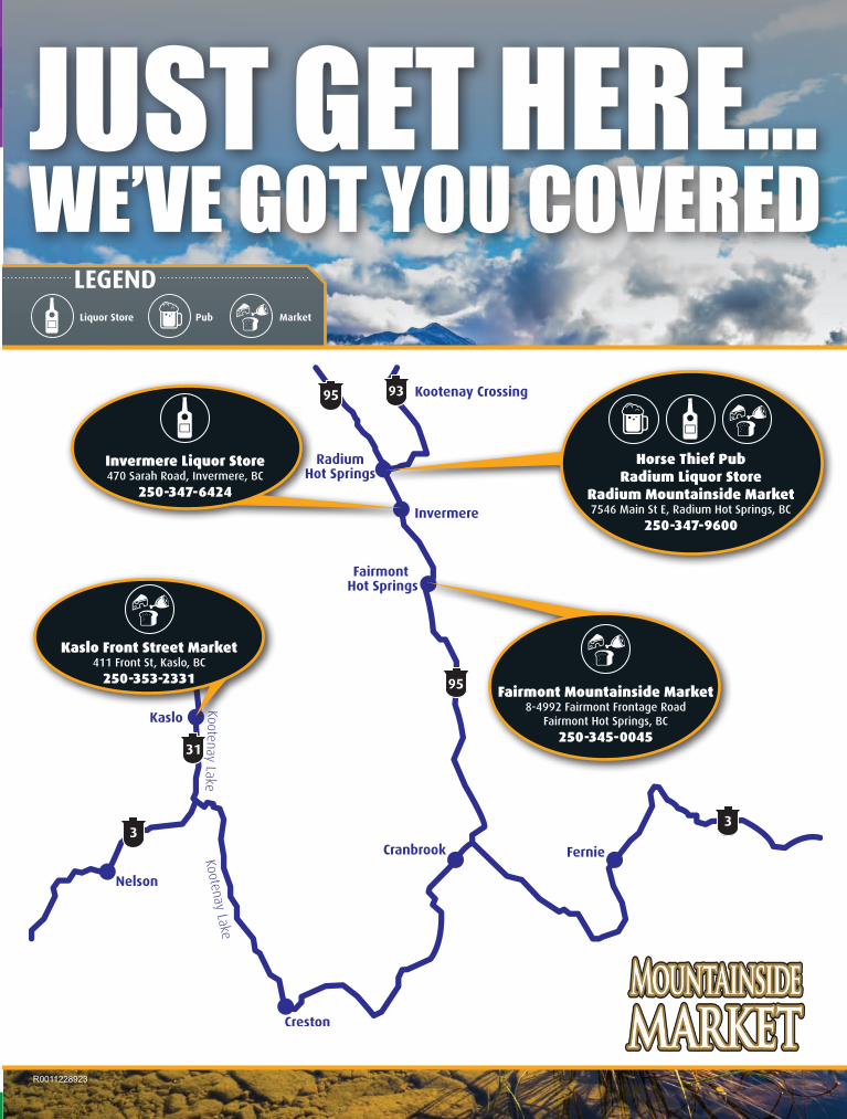
Just get here...We’ve got you covered
95 93
95
31
33
LegendLiquor Store Pub Market
Horse Thief Pub Radium Liquor Store
Radium Mountainside Market 7546 Main St E, Radium Hot Springs, BC
250-347-9600
Kaslo Front Street Market 411 Front St, Kaslo, BC
250-353-2331Fairmont Mountainside Market
8-4992 Fairmont Frontage RoadFairmont Hot Springs, BC
250-345-0045
Invermere Liquor Store 470 Sarah Road, Invermere, BC
250-347-6424
RadiumHotSprings.com | 888.347.9331
@TourismRadium Facebook.com/Tourism.Radium @Tourism_Radium
Towering canyons, high mountain passes and exquisite natural vistas will greet you on a trip to Radium Hot Springs BC. Nothing can beat a soak in our world-famous hot springs after a great day of fishing. Clear water streams, stocked mountain lakes, and a variety of flowing wrivers make Radium worth being discovered.
Find Your Peace by Getting Caught in the Moment!
R0011230229
R0011228923
Just get here...We’ve got you covered
95 93
95
31
33
LegendLiquor Store Pub Market
Horse Thief Pub Radium Liquor Store
Radium Mountainside Market 7546 Main St E, Radium Hot Springs, BC
250-347-9600
Kaslo Front Street Market 411 Front St, Kaslo, BC
250-353-2331Fairmont Mountainside Market
8-4992 Fairmont Frontage RoadFairmont Hot Springs, BC
250-345-0045
Invermere Liquor Store 470 Sarah Road, Invermere, BC
250-347-6424
RadiumHotSprings.com | 888.347.9331
@TourismRadium Facebook.com/Tourism.Radium @Tourism_Radium
Towering canyons, high mountain passes and exquisite natural vistas will greet you on a trip to Radium Hot Springs BC. Nothing can beat a soak in our world-famous hot springs after a great day of fishing. Clear water streams, stocked mountain lakes, and a variety of flowing wrivers make Radium worth being discovered.
Find Your Peace by Getting Caught in the Moment!
R0011230229

Page 4Northern Boreal Fishing 2016 Free maps at www.AnglersAtlas.com
Caution: Do not use this map for navigational purposes. This map may not reflect current conditions. Uncharted hazards may exist. Base Map © Province of Alberta
Northern Boreal takes its name from the forest that
dominates the landscape of northern Alberta. It’s a wooded and watery expanse that encom-passes all of the upper half of the province. Its four watershed zones, NB1-4, comprise most of the lakes in Alberta.
There is so much wall-eye and pike fishing in northern Al-berta that anglers will want to take advantage of trout where a v a i l a b l e .The northern pothole lakes represent one such opportu-nity.
For families, occasional anglers and those new to the sport, free fishing weekends offer a chance to get their feet wet twice a year. On two weekends, once in July and once in February, anyone can fish in Alberta without a licence. The weekends coin-
cide with National Fishing Day in summer and Alberta Family Day in winter in the interest of encouraging wider participation in fishing.
Check out The Angler’s Atlas on your mobile device! Now
you can take our maps with you wherever you go with our new app! All of your favourite web-site features are now mobile. Free to download for iOS and Android!
NortherN Boreal Key Map
NORTHERN BOREALFISHING 2016
PublisherSean Simmons
Production: Kathy Buhler, Ja-mie Svendsen, Alison Warner
Contributors: Chad Bullock, Kevin Dergez, Ewashko, fredalex, Wally Garrick, Tony Gellings, gogomez, Jason Hooper, Ray Kohlruss, Brad Kowald, Lac La Biche Sporting Goods, shaggy99, thejordanforsythe
Advertising sales, printing and distribution managed by Glacier Media Inc.
Eastern Slopes Fishing 2016 is part of The Angler’s Atlas and is owned by Goldstream Publish-ing Inc.
Suite 210 500 Victoria St.Prince George, BC, V2L 2J9(250) [email protected]
www.AnglersAtlas.com
12 Months of the Year! Salmon and Halibut fishing in the famous waters of Sooke, Victoria and Port Renfrew, British Columbia.
3319 Douglas St., Victoria, BC
Victoria’s Largest Fishing and Hunting Store!
CALL US TODAY! 250-475-4969 1-866-915-4254 email: [email protected] islandoutfitters.ca
Get off the beaten path.
tourismgolden.com
These waterways are home to Rainbow, Bull, Cutthroat and Brook Trout, Dolly Varden, Burbot and Kokanee.Golden is situated on the Columbia River, which includes a vast selection of rivers and streams as its tributaries. These and the numerous lakes that surround Golden, offer fabulous fishing options for spin casting and fly fishing from the shore or boat.Whatever your preferred catch of the day, Golden is the place to enjoy fantastic year-round fishing. The Golden Outdoor Discovery Map shows fishing areas and access roads.View online or order the Outdoor Discovery Map at www.tourismgolden.com/catch
Located just 3 hours west of Calgary, Golden, BC is an anglers dream with spectacular mountain scenery, glacier fed lakes, rivers and streams.
D02936 tSG Golden Kootenays Fishing Ad.indd 1 2016-03-10 8:45 AM
Victoria’s Victoria’s Largest Fishing Largest Fishing
and Hunting Store and Hunting Store
1-866-915-4254 1-866-915-4254 250-475-4969 250-475-4969
3319 Douglas St. 3319 Douglas St. Victoria BC Victoria BC
islandoutfitters.ca islandoutfitters.ca
(Full selection of firearms & accessories)
Huge Selection of Huge Selection of Freshwater Freshwater
and and Fly Fishing Gear Fly Fishing Gear

Page 5Northern Boreal Fishing 2016 Free maps at www.AnglersAtlas.com
Get off the beaten path.
tourismgolden.com
These waterways are home to Rainbow, Bull, Cutthroat and Brook Trout, Dolly Varden, Burbot and Kokanee.Golden is situated on the Columbia River, which includes a vast selection of rivers and streams as its tributaries. These and the numerous lakes that surround Golden, offer fabulous fishing options for spin casting and fly fishing from the shore or boat.Whatever your preferred catch of the day, Golden is the place to enjoy fantastic year-round fishing. The Golden Outdoor Discovery Map shows fishing areas and access roads.View online or order the Outdoor Discovery Map at www.tourismgolden.com/catch
Located just 3 hours west of Calgary, Golden, BC is an anglers dream with spectacular mountain scenery, glacier fed lakes, rivers and streams.
D02936 tSG Golden Kootenays Fishing Ad.indd 1 2016-03-10 8:45 AM


Surface Area• 122.8 sq. km
Maximum Depth• 17 metres (50 feet)
Elevation (ASL)• 594 metres (1,782 feet)
Survey Date• Unknown
Contour Units• Feet
QUICK FACTS
WiNefred laKe
Winefred Lake’s reputa-tion rests with its con-
sistently trophy-sized northern pike --fish of 20 lbs. or more are not uncommon --and wall-eye. Winefred lies in the south-ern Regional Municipality of Wood Buffalo between Cold Lake and Fort McMurray. The lake offers excellent fishing for lake whitefish, burbot, and pickerel. All year long, the fishing is fabulous in Winefred Lake. Some of the best fishing, in fact, is during the winter through the ice.
Angler’s Atlas members have posted several pictures of the monster fish in Winefred Lake. Member gogogomez reports that jigging with a Five of Dia-monds landed more pike and walleye than he knew what to do with. Check out the Angler’s Atlas page for Winefred Lake at an-glersatlas.com/lake102100 for more information, or to post your own photos and fish-ing tips.In the open water sea-son, try trolling back and forth across the small bay in the northeast side.
LAKE ACCESS
Winefred is a five-hour drive from Edmonton.
Follow Secondary Hwy. 881 north from Lac La Biche for approximately 100 km. At the sign to Winefred Lake Lodge, turn east onto a gravel road and follow it for 70km until it reaches Winefred Lake. A 4WD is recommended.
© The Angler’s Atlas
5006 - 55th Street, Cold Lake, 780.594.33999240 - 102nd Avenue, Fairview, 780.835.3900Bay C - 225 MacKay Crescent, Fort McMurray, 780.790.60399511 Franklin Avenue, Fort McMurray, 780.743.02921111 Main Street, Grassland, 780.525.222011102 - 100th Street, La Crete, 780.928.3460

Page 8Northern Boreal Fishing 2016 Free maps at www.AnglersAtlas.com
Caution: Do not use this map for navigational purposes. This map may not reflect current conditions. Uncharted hazards may exist. Base Map © Province of Alberta
Amisk means, “abundance of beaver,” in Cree. Amisk
Lake lies at the western edge of the Beaver River drainage basin. Long and narrow, the lake com-prises two basins nestled in the woods of picturesque Athabasca county.
The larger basin, the south basin, is 60 metres deep while the north basin is 34 metres deep.
Fishing has declined in recent years but the lake is still known for producing plenty of walleye. Both walleye and northern pike must be released.
Members of The Angler’s Atlas have posted several markers for Amisk Lake. Member marcel.s notes that there is good fishing along the western edge of the southern basin. Be careful here; member Xtreme also report warnings just to the north and south of the hotspot.
See the markers and warnings, as well as the locations of the two boat launches, at anglersat-las.com/lake/101783.
Much of the shore remains un-developed, and iFish Alberta user Dominic suggests “trolling along the shore, using a Five of Diamonds.”
Typical of deep parkland and boreal
lakes in Alberta, Amisk has algae blooms and high phos-phorous levels in mid to late summer.
Skeleton Lake drains into Amisk Lake from the west, while Long Lake drains into Amisk Lake from the south. Waterfowl and shorebirds are abundant, espe-cially in the shallow bays.
LAKE ACCESS
Amisk Lake is located in cen-tral Alberta approximately
175 km northeast of Edmonton and 15 km east of the village of Boyle, which lies south of Sec-ondary Road 663. The lake’s main axis runs north-south.
A boat launch and day-use area are located on the north side.
aMisK laKe
Surface Area• 5.15 sq. km
Maximum Depth• 60 metres (180 feet)
Mean Depth• 16 metres (48 feet)
Survey Date• Unknown
Contour Units• Feet
QUICK FACTS
© The Angler’s Atlas
© The Angler’s Atlas

Page 9Northern Boreal Fishing 2016 Free maps at www.AnglersAtlas.com
Caution: Do not use this map for navigational purposes. This map may not reflect current conditions. Uncharted hazards may exist. Base Map © Province of Alberta
Baptiste laKe
Surface Area• 981 Hectares
(2,424 Acres)
Maximum Depth• 28 metres (90 feet)
Elevation (ASL)• 579 metres (1,900 feet)
Survey Date• February 1981
Contour Units• Metres
QUICK FACTS
Baptiste Lake is a very productive, moderate-
sized lake in the County of Athabasca in central Alberta. The lake is comprised of two basins joined by a long neck
called the Narrows. Baptiste Lake is popular in the summer
with its fishing, primarily for yellow perch,
northern pike and walleye, as well as for boat-
ing and swimming. The walleye limit is zero, ex-cept the holder of a special Fish Harvest Licence and tags. Those license holders may re-tain walleye of a size, number and at the times specified on
the licence. The pike limit is 1 over 63 cm; Perch limit
is 15; Lake Whitefish limit is 10; and Burbot
limit is 10.Baptiste Lake is closed to all fishing Apr. 1 to May 14.
LAKE ACCESS
Located 165 km northwest of the city of Edmonton
and 16 km west of the town of Athabasca. Take Hwy. 2 west from Athabasca and follow an access road around the south end of the lake to a boat launch on the southwest corner. The summer village of White Gull, located at the north end of the lake, can be reached either from the ring road that goes around the south and west sides of the lake or from a sep-arate exit directly off Hwy. 2 at the north end of the lake. The summer village of Whispering Hills, located on the east side of the Narrows, has a separate exit from Hwy. 2. The road used to reach it does not con-nect with the ring road.There are three private camp-grounds and five summer vil-lages on the lake. The summer villages of Sunset Beach, South Baptiste and West Baptiste can be reached from a gravel road that goes around the south end of the lake.
© The Angler’s Atlas
R0011241452newwaymotorsports.com
4308 1st Avenue S.Lethbridge, AB
Toll Free800.752.8834
newwaymotorsports.com
4308 1st Avenue S.Lethbridge, AB
R0011241439
New & PreowNed • Full Service • FiNaNce
Toll Free 800.752.8834
Alberta’s Authorized Lund Boat Dealer
tf 800.752.8834 4308 1st Avenue S.
Lethbridge, AB
newwaymotorsports.com
New & PreowNed Full Service • Finance
R0011241446
Alberta’s
Authorized Lund
Boat Dealer
Page 10Northern Boreal Fishing 2016 Free maps at www.AnglersAtlas.com
Caution: Do not use this map for navigational purposes. This map may not reflect current conditions. Uncharted hazards may exist. Base Map © Province of Alberta
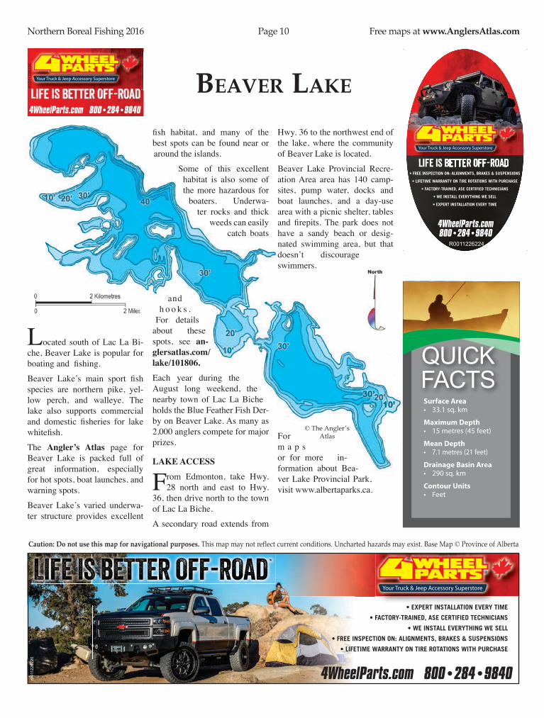
Beaver laKe
Surface Area• 33.1 sq. km
Maximum Depth• 15 metres (45 feet)
Mean Depth• 7.1 metres (21 feet)
Drainage Basin Area• 290 sq. km
Contour Units• Feet
QUICK FACTS
© The Angler’s Atlas
Located south of Lac La Bi-che, Beaver Lake is popular for boating and fishing.
Beaver Lake’s main sport fish species are northern pike, yel-low perch, and walleye. The lake also supports commercial and domestic fisheries for lake whitefish.
The Angler’s Atlas page for Beaver Lake is packed full of great information, especially for hot spots, boat launches, and warning spots.
Beaver Lake’s varied underwa-ter structure provides excellent
fish habitat, and many of the best spots can be found near or around the islands.
Some of this excellent habitat is also some of the more hazardous for
boaters. Underwa-ter rocks and thick
weeds can easily catch boats
and h o o k s .
For details about these spots, see an-glersatlas.com/lake/101806.Each year during the August long weekend, the nearby town of Lac La Biche holds the Blue Feather Fish Der-by on Beaver Lake. As many as 2,000 anglers compete for major prizes.
LAKE ACCESS
From Edmonton, take Hwy. 28 north and east to Hwy.
36, then drive north to the town of Lac La Biche.
A secondary road extends from
Hwy. 36 to the northwest end of the lake, where the community of Beaver Lake is located.
Beaver Lake Provincial Recre-ation Area area has 140 camp-sites, pump water, docks and boat launches, and a day-use area with a picnic shelter, tables and firepits. The park does not have a sandy beach or desig-nated swimming area, but that doesn’t discourage swimmers.
For m a p s or for more in-formation about Bea-ver Lake Provincial Park, visit www.albertaparks.ca.
4WheelParts.com 800•284•9840
AnglerAd_1.725x1.indd 1 4/6/16 5:08 PM
R00
1122
6226
4WheelParts.com 800•284•9840
• EXPERT INSTALLATION EVERY TIME
• FACTORY-TRAINED, ASE CERTIFIED TECHNICIANS
• WE INSTALL EVERYTHING WE SELL
• FREE INSPECTION ON: ALIGNMENTS, BRAKES & SUSPENSIONS
• LIFETIME WARRANTY ON TIRE ROTATIONS WITH PURCHASE
AnglerAd_7.25x2.indd 1 4/6/16 5:02 PM
r001
1226
220
4WheelParts.com 800•284•9840
• FREE INSPECTION ON: ALIGNMENTS, BRAKES & SUSPENSIONS
• LIFETIME WARRANTY ON TIRE ROTATIONS WITH PURCHASE
• FACTORY-TRAINED, ASE CERTIFIED TECHNICIANS
• WE INSTALL EVERYTHING WE SELL
• EXPERT INSTALLATION EVERY TIME
AnglerAd_7.725x3.indd 1 4/6/16 5:17 PM
R0011226224

Page 11Northern Boreal Fishing 2016 Free maps at www.AnglersAtlas.com
Caution: Do not use this map for navigational purposes. This map may not reflect current conditions. Uncharted hazards may exist. Base Map © Province of Alberta
CalliNg laKe
Surface Area• 14,282 Hectares
(35,290 Acres)
Maximum Depth• 16 metres (52 feet)
Elevation (ASL)• 594 metres (1,949 feet)
Survey Date• Unknown
Contour Units• Feet
QUICK FACTS
Calling Lake is a large, at-tractive recreational lake
noted for its sandy shore-line. The main sport fish are northern pike, yellow perch and walleye. “It’s no secret where the fish are biting in this lake; there are usually quite a few boats anchored right off the provin-cial boat launch,” says Brad Kowald, Angler’s Atlas field staff volunteer. Kowald and his friends Dann and Frank headed out and picked up several nice walleye using deep diving crank bait. “We had a few nice pike throughout the day, too, for the most part in the 60-70 cm range, although it seemed they would bite more often when we drifted into shallower water anywhere from 6-10 ft.Check out the Angler’s Atlas page for Calling Lake at an-glersatlas.com/lake/101830. Hint: there are several markers for hot spots posted on the map there!Please be mindful of Alberta provincial regulations for fish quotas.
LAKE ACCESS
Calling Lake is located bout
200 km north of Edmonton. The town of Atha-basca, 55 km to the south, is the closest centre. The hamlet of Calling Lake is located on the lake’s eastern shore. From Edmonton, take Hwy. 2 north to Athabasca, then Sec-ondary Road 813 north to the hamlet and provincial park.Calling Lake Provincial Park
is a 741-hectare area the south-ern shore. The park is open from May to September and has 25 campsites, flush toilets, tap water, a boat launch, swim-ming and a picnic area.
© The Angler’s Atlas
Western Canada’s Exclusive Compact Luxury
Fish and Ski Pontoons“Families Making Waves”www.albertamarine.com
866-887-2628 Nanton, AB
35 minutes south of Calagary
R0011241459
866-887-2628
R00
1124
1463

Page 12Northern Boreal Fishing 2016 Free maps at www.AnglersAtlas.com
Caution: Do not use this map for navigational purposes. This map may not reflect current conditions. Uncharted hazards may exist. Base Map © Province of Alberta
Cold laKe
Surface Area• 37,300 Hectares
(92,167 Acres)
Maximum Depth• 99 metres (325 feet)
Elevation (ASL)• 535 metres (1,605 feet)
Survey Date• Unknown
Contour Units• Feet
QUICK FACTS
Cold Lake has the distinc-tion of being one of the best
fishing lakes in two provinces. Cold Lake straddles the Alberta / Saskatchewan border, and is part of Saskatchewan’s excellent fish-ing park, Meadow Lake Provincial Park.Cold Lake is one of the deepest
lakes in both
Saskatchewan and Alberta, and
offers numerous bays and shoals that are great places to cast a line.Cold Lake is one of the few lakes in Saskatchewan that offer fishing for lake trout. This slow-growing spe-cies can be fabulous fishing. Lakes this size can be both intimi-dating and appealing. Despite its popularity, it is possible to find quiet fishing spots here. Anglers can fish here frequently and still not
cover the whole lake. Motorboats are useful here to help make the
most of your time on the lake. Also, check out the Angler’s Atlas page for Cold Lake to see locations of hot spots to
help make it a little easier! See anglersatlas.com/
lake/101848.With such
vast ter-r i t o r y, and so
many fish species pres-ent in the lake (a dozen is
a conservative estimate), it is vital to familiarize yourself with
the freshwater fishing regulations for both Saskatchewan and Alberta. Fishing licenses for both provinces are valid in Cold Lake.
LAKE ACCESS
Drive roughly 300 km north-east of Edmonton on Hwy.
28. to reach Cold Lake. The city’s marina is the largest inland marina in western Canada, as explained online by Anglers Atlas user coldlakeinfo.
Cold Lake Provincial Park is lo-cated on the north shore of the lake. The park has 117 campsites as well as a day use area.
Just west of Cold Lake is Marie Lake, which also offers great fish-ing opporunities for walleye.
© The Angler’s Atlas
ExploreSouthWestAlberta.ca
R00
1124
0991
A place where the sun nearly always shines and the opportunity
for adventure never ends
ExploreSouthWestAlberta.caExploreSouthWestAlberta.caR0011240980

Page 13Northern Boreal Fishing 2016 Free maps at www.AnglersAtlas.com
Caution: Do not use this map for navigational purposes. This map may not reflect current conditions. Uncharted hazards may exist. Base Map © Province of Alberta
CraNe (Moore) laKe
© The Angler’s Atlas
Surface Area• 994 Hectares
(2,456 Acres)
Maximum Depth• 26 metres (85 feet)
Elevation (ASL)• 550 metres (1,650 feet)
Survey Date• Unknown
Contour Units• Feet
QUICK FACTS
Crane Lake, also known as Moore Lake, is one of several lakes in the Cold Lake area. Sport fish species in the lake are walleye, northern pike, yel-low perch and lake whitefish. During the summer, Crane Lake can get busy, making it tricky to catch larger pike and perch. The lake is popular in winter for ice fishing.Multiple iFish Alberta us-ers recommend casting a line or drilling a hole near Bodina Resort. As user Tkaminski ex-plains, “lots of pike action just off the shore at Bodina Resort. 10 feet of water is where the pike are cruising. Any shal-lower or deeper and you will get nothing.”The lake water turns from clear to green in lake summer and early fall. Aquatic plant life is limited to only a few areas such as the west basin. This lack of v e g e t a t i o n
limits fish spawning and feed-ing habitat in the lake.The sport fishery in the lake’s inlet and outlet streams is closed for a period during April and May each year.Other popular spots in the area include Hilda Lake and Tucker Lake, both of which are also known for their ice-fishing op-portunities.
LAKE ACCESS
Crane Lake is lo-cated about
25 km north-west of Cold Lake. From Cold Lake town centre, fol-low Hwy. 55 west
about 19 km to secondary Hwy. 892. Turn right onto this road and the lake is roughly 10 km from the turnoff. There are two provincial recre-ation areas on the south shore of the lake, Moore Lake East and Moore Lake West. Both parks have boat launches and campsites.
R0011241456newwaymotorsports.com
4308 1st Avenue S.Lethbridge, AB
Toll Free800.752.8834
newwaymotorsports.com
4308 1st Avenue S.Lethbridge, AB
R0011241441
New & PreowNed • Full Service • FiNaNce
Toll Free 800.752.8834
Alberta’s Authorized Lund Boat Dealer
tf 800.752.8834 4308 1st Avenue S.
Lethbridge, AB
newwaymotorsports.com
New & PreowNed Full Service • Finance
R0011241449
Alberta’s
Authorized Lund
Boat Dealer

Page 14Northern Boreal Fishing 2016 Free maps at www.AnglersAtlas.com
Caution: Do not use this map for navigational purposes. This map may not reflect current conditions. Uncharted hazards may exist. Base Map © Province of Alberta
dolBerg laKe
Dolberg Lake is a popular fishing spot northwest of
Barrhead. Each year, the lake is stocked with 18,000 rainbow trout, helping to sustain a thriv-ing fishery.
Bait is permitted in Dolberg Lake and trout will often key in on shrimp or maggots, particu-larly for ice fishing.
“Good little lake, good fish-ing” writes Angler’s Atlas user martin78. “[I] will definitely be back.”
Another Angler’s Atlas user, lancetay, jokes, “there are no fish here, nothing to see, move along,” while holding a fat 6- to 8-lb. rainbow.
iFish Alberta user Dick-weed reports “nice rainbows, power bait marshmallows and pink or green trout power bait, on snell hook and bobber, just keeping it easy for the kids.”
Some of the best fishing here is in the fall. Fly fishing can be particularly productive when the waterboatmen are hatching.
The Angler’s Atlas page for Dolberg Lake is at anglersatlas.com/lake/101867. There you’ll
find the location of the hot spot along the southern shore, as well as photos and other useful map markers.
LAKE ACCESS
Located northwest of Ed-monton. Take Hwy. 16
west to Highway 43, and turn right. Con-tinue along this road for 25 km to Hwy. 33, and turn right.
F o l -l o w
this route 43 km north to Bar-rhead, then west along Hwy. 18 to secondary Hwy. 655, roughly 18 km from the town.
Turn right onto Hwy. 655 and follow it about 25 km. Hwy. 655 takes a sharp turn left at about 3 km, then follows a straight line to the lake, where
there is a boat launch.
© The Angler’s Atlas
Surface Area• 33 Hectares
(82 Acres)
Maximum Depth• 11 metres (36 feet)
Elevation (ASL)• Unknown
Survey Date• Unknown
Contour Units• Feet
QUICK FACTS
ExploreSouthWestAlberta.ca
R00
1124
0991
A place where the sun nearly always shines and the opportunity
for adventure never ends
ExploreSouthWestAlberta.caExploreSouthWestAlberta.caR0011240977

Page 15Northern Boreal Fishing 2016 Free maps at www.AnglersAtlas.com
Caution: Do not use this map for navigational purposes. This map may not reflect current conditions. Uncharted hazards may exist. Base Map © Province of Alberta
faWCett laKe
Surface Area• 33 Hectares
(82 Acres)
Maximum Depth• 11 metres (36 feet)
Elevation (ASL)• Unknown
Survey Date• Unknown
Contour Units• Feet
QUICK FACTS
Fawcett Lake can be an angler’s dream. There are so many opportu-nities, the question will be how to keep up with them all.Ray Kohlruss from Reel Angling Adventures, says that Fawcett is a big lake, and the best locations will depend on such things as weather and time of day. It also depends on the species you target.When going after perch, Kohlruss suggests a Marmish hook tipped with maggots, meal worms or min-nows. Head down between 15 and 30 feet, and try to stay near the steep drop-offs.The rocks around the islands are also good locations, as the rocks will act as cover. Try the east end of the lake near the boat launch, too, for a good starting point.If walleye are more your thing, Kohlruss emphasises that smaller is better. “With walleye, less is more,” he says. Try small pink ladies, jigs tipped with minnows, or small perch hooks with maggots.“Pike will go after just about any-thing,” says Kohlruss, but a starting point is a small jig head and min-now. Head about 100 feet out from
the boat
launch, down up to 30 feet deep. The pike in Fawcett Lake are in about the 6 lb range, though some as big as 25 lbs have been known to come out.Burbot are an excellent ice-fishing target. Kohlruss says that in warmer weather they’re more river fish than lake fish. In winter, however, they are feeding heavily in the lakes and are growing more than they do in warmer weather. They spawn in February, he says, and that is the perfect time to head out for a day of ice fishing.Please make sure you consult the Alberta Guide to Sportfishing Regulations before heading out. Fawcett Lake has several different regulations in place, and there is a closure in effect on the northeast side for part of the spring.A guided trip is also a great idea. Ray Kohlruss of Reel Angling Adventures, guides in many north-central area lakes, including Fawcett. Check out his website at reelangling.com.
LAKE ACCESS
To reach Fawcett Lake, start from the town of Smith, 123
km north of Westlock or 73 km east of Slave Lake.
Once in Smith, cross the river and fol-
low the signs east and north for 27 km to Fawcett Lake.
Fawcett Lake Provincial Rec-
reation Area is located on the west side
of the lake and includes 58 camp-
sites, though they are unserviced. The park
also includes a day use area and boat launches.
© The Angler’s Atlas
GET OUR NEW APP FREE!
learn more, sign-up & download
AnglersAtlas.com
70,000 free maps Contests • Newsletters
GET OUR NEW APP FREE!
learn more, sign-up & download
AnglersAtlas.com
70,000 free maps Contests • Newsletters

Page 16Northern Boreal Fishing 2016 Free maps at www.AnglersAtlas.com
Caution: Do not use this map for navigational purposes. This map may not reflect current conditions. Uncharted hazards may exist. Base Map © Province of Alberta
islaNd laKe
Surface Area• 790 Hectares (1,952
Acres)
Maximum Depth• 21 metres (70 feet)
Elevation• 603 metres (1,977 feet)
Survey Date• September 1967
Contour Units• Feet
QUICK FACTS
© The Angler’s Atlas
Island Lake pro-vides habitat for
some of Alberta’s larg-est bird species, and where there are waterfowl, there are fish. While northern pike are con-sidered the main sport fish species in the lake, anglers can sometimes catch walleye, even when casting from the dock. Ice fishing for perch during the winter is also popular.Densely rooted vegetation in regions around the lake pro-vides healthy spawning and feeding habitat, enabling many fish species to live in the lake.Lake whitefish are exceptional-ly large in Island Lake, but they
can be fussy. This is a good time to experiment with your lures or flies.One of the islands is home to a colony of great blue herons. On another island, the trees su-port immense eagle nests. Island Lake Days are celebrat-ed each July.
LAKE ACCESS
The lake is located in the County of Athabasca,
about 20 km northwest of the town of Athabasca. The lake’s west side is acces-
sible from Hwy. 2, which passes north
through Athabasca from Edmonton then along Is-
land Lake enroute to the town of Slave Lake.There are several public access points on the west shores at the Summer Villages. On the east shore, there are two boat launches, one at the day-use area, the other at the camp-ground. Island Lake Campground offers a day-use area, boat launch, dock, pier, firewood and a fish-cleaning station. There are 11 unserviced camp-sites with well water. There is no public access by vehicle to the south shore.
R0011241457newwaymotorsports.com
4308 1st Avenue S.Lethbridge, AB
Toll Free800.752.8834
newwaymotorsports.com
4308 1st Avenue S.Lethbridge, AB
R0011241443
New & PreowNed • Full Service • FiNaNce
Toll Free 800.752.8834
Alberta’s Authorized Lund Boat Dealer
tf 800.752.8834 4308 1st Avenue S.
Lethbridge, AB
newwaymotorsports.com
New & PreowNed Full Service • Finance
R0011241450
Alberta’s
Authorized Lund
Boat Dealer
TRAMPOLINE BRANDING Contact: Larry Bootland 902 405 4809 Project: 12759DC CNS Ontario ad Client: DDB Canada Publication: Angler’s Atlas Size: 8” x 10.5” Insertion Date: Photos/Logos: Hi res NOTE: All trapping is the responsibility of prepress
C M Y KPROCESS SEPARATIONS
A REAL LIFE DISCOVERY CHANNELOver 7,600 km of coastline, 6,700 lakes and 100 rivers.
From speckled trout to Bluefin tuna — Nova Scotia
has ample fishing opportunities to suit every appetite.
Take to the ocean or explore our inland lakes and
rivers. All you have to do is relax and cast your line.
Margaree Valley
NovaScotia.ca/Fish/Sportfishing
12759DC CNS Ontario Angler Ad.indd 1 5/5/16 10:57 AM

Page 17Northern Boreal Fishing 2016 Free maps at www.AnglersAtlas.com
Caution: Do not use this map for navigational purposes. This map may not reflect current conditions. Uncharted hazards may exist. Base Map © Province of Alberta
TRAMPOLINE BRANDING Contact: Larry Bootland 902 405 4809 Project: 12759DC CNS Ontario ad Client: DDB Canada Publication: Angler’s Atlas Size: 8” x 10.5” Insertion Date: Photos/Logos: Hi res NOTE: All trapping is the responsibility of prepress
C M Y KPROCESS SEPARATIONS
A REAL LIFE DISCOVERY CHANNELOver 7,600 km of coastline, 6,700 lakes and 100 rivers.
From speckled trout to Bluefin tuna — Nova Scotia
has ample fishing opportunities to suit every appetite.
Take to the ocean or explore our inland lakes and
rivers. All you have to do is relax and cast your line.
Margaree Valley
NovaScotia.ca/Fish/Sportfishing
12759DC CNS Ontario Angler Ad.indd 1 5/5/16 10:57 AM

Find your perfect place to fish – in Saskatchewan. Mix the peace and tranquility of our beautiful lakes with incredible fishing for walleye, lake trout, northern pike and more.
Find all of Saskatchewan’s outfitters at FishSask.com. To order your free copy of the 2016 Saskatchewan Fishing and Hunting Guide call Tourism Saskatchewan toll-free at 1-877-237-2273.
FishSask.com
100,000 LAKES AND RIVERS, RIGHT NEXT DOOR
11220_Tourism_Anglers Atlas Print Ad_Alberta _FA.indd 1 2016-03-28 11:19 AM

Page 19Northern Boreal Fishing 2016 Free maps at www.AnglersAtlas.com
Caution: Do not use this map for navigational purposes. This map may not reflect current conditions. Uncharted hazards may exist. Base Map © Province of Alberta
Find your perfect place to fish – in Saskatchewan. Mix the peace and tranquility of our beautiful lakes with incredible fishing for walleye, lake trout, northern pike and more.
Find all of Saskatchewan’s outfitters at FishSask.com. To order your free copy of the 2016 Saskatchewan Fishing and Hunting Guide call Tourism Saskatchewan toll-free at 1-877-237-2273.
FishSask.com
100,000 LAKES AND RIVERS, RIGHT NEXT DOOR
11220_Tourism_Anglers Atlas Print Ad_Alberta _FA.indd 1 2016-03-28 11:19 AM
laC la BiChe
Surface Area• 11.8 sq km
Maximum Depth• 25 metres (82 feet)
Elevation (ASL)• 544 metres (1,632 feet)
Survey Date• Unknown
Contour Units• Metres
QUICK FACTS
La c La Biche is a
picturesque lake most popular for its walleye and northern pike fishing. Perch are also caught in the lake. Because of its popularity and abundance of fish, the angling pressure can be intense.Lac La Biche is stocked with nearly 25,000 walleye, part of efforts to rehabilitate the lake. Lac La Biche is not part of the walleye tag system and the walleye fishery is catch and re-lease only.
While the perch can be more plentiful at times, pike fishing brings with it the excitement of landing the big one.Angler’s Atlas member
gogogomez reports that he “can’t keep the pike off the hook,” using a Five of Dia-
monds.
Ewash-ko also reports that a small Rat-tling Rap did the trick for him when he was targetting pike.Lac La Biche is rela-tively shallow and in many parts can be weedy during the summer months. It’s especially important to note that there are many places in Lac La Biche where caution is warranted if you’re boating. These maps are for general use, but if you know of the location of specific haz-ards, post them at anglersatlas.
com/lake/101945.The best time for fishing here is spring and fall, although ice fishing is a big draw as well.
LAKE ACCESS
Located in the town of Lac
La Biche, the lake is roughly 225 km northeast of Edmonton along Hwys. 28 and 36.
There are s e v e r a l
commer-c i a l
campsites/a c c o m m o d a t i o n s
situated along the lake. Sir Winston Churchill Provincial Park is lo-cated on the large pen-insula on the southeast side of the lake and includes the sur-rounding islands. The park has 72 campsites.
© The Angler’s Atlas
4WheelParts.com 800•284•9840
AnglerAd_1.725x1.indd 1 4/6/16 5:08 PM
R00
1122
6226
4WheelParts.com 800•284•9840
• EXPERT INSTALLATION EVERY TIME
• FACTORY-TRAINED, ASE CERTIFIED TECHNICIANS
• WE INSTALL EVERYTHING WE SELL
• FREE INSPECTION ON: ALIGNMENTS, BRAKES & SUSPENSIONS
• LIFETIME WARRANTY ON TIRE ROTATIONS WITH PURCHASE
AnglerAd_7.25x2.indd 1 4/6/16 5:02 PM
r001
1226
220
4WheelParts.com 800•284•9840
• FREE INSPECTION ON: ALIGNMENTS, BRAKES & SUSPENSIONS
• LIFETIME WARRANTY ON TIRE ROTATIONS WITH PURCHASE
• FACTORY-TRAINED, ASE CERTIFIED TECHNICIANS
• WE INSTALL EVERYTHING WE SELL
• EXPERT INSTALLATION EVERY TIME
AnglerAd_7.725x3.indd 1 4/6/16 5:17 PM
R0011226224

Page 20Northern Boreal Fishing 2016 Free maps at www.AnglersAtlas.com
Caution: Do not use this map for navigational purposes. This map may not reflect current conditions. Uncharted hazards may exist. Base Map © Province of Alberta
laC la NoNNe
© The Angler’s Atlas
Surface Area• 1,191 Hectares (2,943
Acres)
Maximum Depth• 20 metres (65 feet)
Elevation (ASL)• Unknown
Survey Date• August 1961
Contour Units• Feet
QUICK FACTS
Walleye, pike, perch, whitefish and burbot are all caught in Lac La Nonne. Lac La Nonne is a tagged lake for walleye, which means that anglers need to win a special tag to allow for wall-eye fishing.Perch are easy to catch in Lac La Nonne, and can provide a great introduction to angling. Northern pike are also big catches during the summer, as well as during the winter for ice fishing. Angler’s Atlas member Chad-Bullock reports: “20 big perch on ice! My Dad and I had a kill-er day on the ice. For 45 minutes I couldn’t drop a hook without smacking a jumbo perch! The smallest one we caught on the
day was 10 inches and the biggest was 15 inches! We let that big girl go! My greatest perch day of my young fishing career!”See his report, as well as oth-ers, at anglersatlas.com/lake/101946.This well-developed lake is a great place to take the kids be-cause it offers a variety of recre-ation on and off the water. Tributaries are closed to sport fishing for a designated period during April and May. Most of the lake is free of boating re-strictions, but there are posted areas where boats are prohib-ited or where power boats have limited speeds of 12 km/hr.
LAKE ACCESS
Follow Hwy. 16 west to Hwy. 43, and turn right. Continue
along this road for nearly 25 km to Hwy. 33 at the town of Gunn. Turn right again.Lac La Nonne is located on the west side of the highway, about 25 km from the last turnoff. Ac-cess to the lake is via one of the side roads leading off the high-way.Angler’s Atlas user shaggy99 recommends the “willow bend private boat launch. It costs $20 to put your boat in [but] it is the best launch on the lake and for those with larger boats, it is worth the $20.” Most of the lake’s access points are private-ly owned.
ExploreSouthWestAlberta.ca
R00
1124
0991
A place where the sun nearly always shines and the opportunity
for adventure never ends
ExploreSouthWestAlberta.caExploreSouthWestAlberta.caR0011240980
All NEW Pro Trailer Backup Assist
NEW, usEd vEhiclEs & gENuiNE sErvicE1-888-427-5520 | 1111 9 AvE sW, cAlgAry, AB | www.metrofordcalgary.com |
Makes backing up & parking trailers easier than ever!
R0011241037
METRO FORD

Page 21Northern Boreal Fishing 2016 Free maps at www.AnglersAtlas.com
Caution: Do not use this map for navigational purposes. This map may not reflect current conditions. Uncharted hazards may exist. Base Map © Province of Alberta
loNg laKe
Surface Area• 5.84 sq. km
Maximum Depth• 9 metres (27 feet)
Elevation (ASL)• 534 metres (1,752 feet)
Survey Date• Unknown
Contour Units• Feet
QUICK FACTS
Long Lake is a pretty lake set in a steep-sided, heavi-
ly wooded valley in the County of Thorhild. The lake follows a glacial meltwater channel through a steep-sided, forested valley. Anglers at Long Lake find the pike and walleye fishing rewarding even if they are on the small side. Whitefish and yellow perch are also found in Long Lake, but fishing can be slower. Brad Kowald, an Angler’s Atlas field staff volunteer based out of Edmonton, says jigging is a productive tech-nique in what is generally a catch-and-release fishery. “[Long Lake] mostly has smaller pike and a few wall-eye. That’s what most people catch a lot. The limit is 63 cm and you’d be lucky to get one that’s 63 cm.”Long lake has been locally popular for recreational use since the early part of the 20th century. Multiple iFish Al-berta users praise the lake as be-
ing great to take kids. As user Pike22 suggests, “fishing from shore would be difficult at best as the weeds are quite estab-lished. Fishing from the flotation pier is possible but can’t a c c o m m o d a t e many people.”
LAKE ACCESS
Long Lake is located 130
km northeast of Ed-monton and 15 km south of the village of Boyle. To reach the lake
from Edmonton, take Hwy. 28 to Hwy. 63. Drive north on Hwy. 63
to Newbrook, then east on Secondary Road 661 for
13 km and north on Second-ary Road 831 for 7 km.Turn east onto the entrance
road to Long Lake Provincial Park. The park’s campground gets high marks from local anglers, especially from boaters, who like its lakeshore campsites. Long Lake Provincial Park was established through the efforts of the local communi-ty in 1957. The park includes many amenities, like swim-ming areas, boat launches, fish cleaning stations, volleyball nets, horseshoe pits, and play-grounds.In addition to the 220 camp-sites in the provincial park, there are several commercial campgrounds/accommoda-tions located around the lake. A golf course and ski hill are also nearby.
© The Angler’s Atlas
R0011241457newwaymotorsports.com
4308 1st Avenue S.Lethbridge, AB
Toll Free800.752.8834
newwaymotorsports.com
4308 1st Avenue S.Lethbridge, AB
R0011241443
New & PreowNed • Full Service • FiNaNce
Toll Free 800.752.8834
Alberta’s Authorized Lund Boat Dealer
tf 800.752.8834 4308 1st Avenue S.
Lethbridge, AB
newwaymotorsports.com
New & PreowNed Full Service • Finance
R0011241450
Alberta’s
Authorized Lund
Boat Dealer

Page 22Northern Boreal Fishing 2016 Free maps at www.AnglersAtlas.com
Caution: Do not use this map for navigational purposes. This map may not reflect current conditions. Uncharted hazards may exist. Base Map © Province of Alberta
lesser slave laKe West
Alberta’s great sport fish, the walleye, is now in relative-
ly plentiful supply again thanks to a recovery program imple-mented a few years back. Lesser Slave Lake --the province’s larg-est accessible water body-- re-mains Alberta’s walleye capital, offering marinas and resorts to service anglers.
Walleye are the most popular fish in Lesser Slave Lake, though they are certainly not the only
ones. Whitefish, burbot, yellow perch and pike also provide am-ple opportunity for a catch.
Tony Gellings of Adventure Alberta says that maggots and mealworms are good for perch.
For pike, anglers should go big. Wally Garrick of Reel-In Re-sort/Southshore Fishing Ad-ventures suggests a tip-up rig with a big herring
or a Norwegian Sardine. Gellings adds, “the pike will bite on anything. If they’re out there, you’ll catch them.”
He also notes that more people are becoming interested in fish-ing for burbot. The limits are higher -10- and they are tasty, despite their appearance.
In winter, the ice fishing is sim-ply spectacular on Lesser Slave Lake and there is no better time to plan a getaway.
Lesser Slave Lake is one of the best walleye fisheries in Alberta and the action is just heating up when the water freezes. Garrick says that ice fishing is a big deal in the area.
Typically, there are tournaments around Free Fishing Weekend in February, and if the ice is ready
to go, there are fire-
w o r k s and celebrations
in Joussard on News Year’s Eve.
Garrick advises that when go-ing after walleye, your priority should be structure. “Typically, fishing near underwater structure is most effective, so right ot the middle or bottom of a dropoff.” That is where the fish will hold for the winter.
Surface Area• 1,160 sq. km (118,659
Hectares)
Maximum Depth• 21 metres (69 feet)
Elevation (ASL)• 578 metres (1,734 feet)
Survey Date• August 1970
Contour Units• Feet
QUICK FACTS
© The Angler’s Atlas

Page 23Northern Boreal Fishing 2016 Free maps at www.AnglersAtlas.com
Caution: Do not use this map for navigational purposes. This map may not reflect current conditions. Uncharted hazards may exist. Base Map © Province of Alberta
lesser slave laKe east
Once you locate the structure, your setup can be as simple
as a jig head and minnow. Try jig-ging a smaller Cleo, Len Thomp-son, or Swedish Pimple. Use an 8 lb. test line with the spoon or jig tied on directly and your minnow out behind the jig. Head for the deep water, again right down to the bottom.
Keep in mind t h a t
regu-lations prohibit the use of live bait.
In most cases, walleye are caught during during low light condititions such as dawn, dusk, or cloudy days. Garrick notes, however, that on Lesser Slave Lake many anglers fish produc-tively right through the night. Here a hut is welcome in winter.
Businesses around the lake rent
ice huts, from the simple shelter to the elaborate setup with beds and stoves. Outfitters have these huts located all over the ice, available for rent all winter long.
The Lesser Slave Lake region ca-ters to all winter enthusiasts. The sparkling snow is ideal for snow-
shoe-ing and cross-country skiing and there are ample skating opportuni-ties. Bring your gear, or rent from one of the many outfitters in the area.
LAKE ACCESS
From Edmonton, drive north on Hwy. 2 for about 56 km.
Turn left at Hwy. 18.
At Westlock, turn right onto Hwy. 44 (104th street). Continue on Hwy. 44 for about 104 km, and then for approximately 100
km after Hwy. 44 merges again with Hwy 2. Follow the
signs for various access points along the lake.
Lesser Slave Lake Provincial
Park is 22km north of the
town of S l a v e
Lake a n d
there are winter camping options available. Marten River campground, within the provin-cial park, has 111 sites as well as a day-use area. The park in-cludes many services like hiking
trails, interpretive programs, and a group camping area.
Hilliard’s Bay Provincial Park is also located along the lake, along the northwest shore. From Slave Lake, drive west along Hwy. 2 for 100 km and then turn north onto Hwy. 750 for approximately 30 km until reaching Hilliard’s Bay. The campground has 164 sites, a day use area, and a boat launch.
The communities of Widewa-ter, Joussard, Faust, and Kinu-so all make good locations for outfitting, hiring a guide, and finding accommodations.
As Garrick and Gellings note, it is also a good idea to talk to lo-
cals before heading out onto the lake, particularly to get informa-tion about spots to avoid.
R0011240959
Western Canada’s Exclusive Compact Luxury
Fish and Ski Pontoons“Families Making Waves”www.albertamarine.com
866-887-2628 Nanton, AB
35 minutes south of Calagary
866-887-2628
R00
1124
1463

Page 24Northern Boreal Fishing 2016 Free maps at www.AnglersAtlas.com
Caution: Do not use this map for navigational purposes. This map may not reflect current conditions. Uncharted hazards may exist. Base Map © Province of Alberta
Moose laKe
Surface Area• 4,080 Hectares (10,081
Acres)
Maximum Depth• 20 metres (65 feet)
Elevation (ASL)• 534 metres (1,752 feet)
Survey Date• Unknown
Contour Units• Feet
QUICK FACTS
Large and lovely, Moose Lake supports a healthy
population of lake trout and walleye, both of which tend to prefer to cooler water tempera-tures. The Moose Lake Walleye Classic is held each year at the end of June, and the lake is a great spot for family fishing. While not exceptionally deep, the lake has some varied shoreline and steep drop-offs.
iFish Alberta user Toad9414 recommends to “look at the depth chart and troll the chan-nel that runs between the two shallow spots. [We caught] 32 fish in four hours!”Moose Lake is also home to bur-bot, whitefish, pike, and perch. Catch limits and certain regula-tions are specific to Moose Lake. Please be sure to familiarize yourself with limits and closures before heading out.
LAKE ACCESS
Moose Lake lies northwest of Bonnywille. From the
town, follow Hwy. 41 north for five kilometres. Then turn left on Secondary Hwy. 660 and continue for another 10 km.
A t this point, a side
road leading to Moose Lake Pro-vincial Park ap-pears on the left side of the road.
Follow this road for about two kilometres
until it reaches the park. The campground has 52
sites, a boat launch, and a pier.
© The Angler’s Atlas
R0011241757newwaymotorsports.com
4308 1st Avenue S.Lethbridge, AB
Toll Free800.752.8834
newwaymotorsports.com
4308 1st Avenue S.Lethbridge, AB
R0011241753
New & PreowNed • Full Service • FiNaNce
Toll Free 800.752.8834
Alberta’s Authorized Lund Boat Dealer
tf 800.752.8834 4308 1st Avenue S.
Lethbridge, AB
newwaymotorsports.com
New & PreowNed Full Service • Finance
R0011241754
Alberta’s
Authorized Lund
Boat Dealer

Page 25Northern Boreal Fishing 2016 Free maps at www.AnglersAtlas.com
Caution: Do not use this map for navigational purposes. This map may not reflect current conditions. Uncharted hazards may exist. Base Map © Province of Alberta
Muriel laKe
Surface Area• 64.1 sq. km
Maximum Depth• 11 metres (33 feet)
Elevation (ASL)• 559 metres (1,677 feet)
Survey Date• Unknown
Contour Units• Feet
QUICK FACTS
Muriel Lake fish popula-tions struggled for years
because the lake level was gradually but significantly falling. Then came a double whammy --a winter fish kill in 2010-2011. Despite having lost half of its depth and most of its fish, the lake can still give up the occasional pike. According to the Muriel Lake Management Society, the level of the lake has dropped four metres from 1975 levels. At its deepest, Muriel is only five metres deep, about half of what it was when the lake supported thriving sport, domestic, and commercial fisheries. All be-gan to decline in the 1970s along with the lake levels. Authorities tend to blame this situation on dry climate condi-tions since the 1980s but local residents believe there is more behind the problem, citing industry and develop-ment. The fish kill five years ago was linked to the shallowness of the lake and may have extirpated the perch, walleye and whitefish.
LAKE ACCESS:
Muriel Lake is 13 km south of the town of
Bonnyville and 200 km north-east of Edmonton. From Ed-monton, follow Hwys. 28 and 28A north and east to Bonny-ville.At the junction of Hwys. 28 and 41, at 55th Street in Bonny-ville, turn south onto the Gur-neyville Road. This road joins Secondary Road 657 south of the locality of Gurneyville on the western side of the lake.
This is also the access to Muri-el Lake Provincial Recreation Area. The recreation area has 22 unserviced sites.
© The Angler’s Atlas
Western Canada’s Exclusive Compact Luxury
Fish and Ski Pontoons“Families Making Waves”www.albertamarine.com
866-887-2628 Nanton, AB
35 minutes south of Calagary
R0011241459
866-887-2628
R00
1124
1010
4WheelParts.com 800•284•9840
• EXPERT INSTALLATION EVERY TIME
• FACTORY-TRAINED, ASE CERTIFIED TECHNICIANS
• WE INSTALL EVERYTHING WE SELL
• FREE INSPECTION ON: ALIGNMENTS, BRAKES & SUSPENSIONS
• LIFETIME WARRANTY ON TIRE ROTATIONS WITH PURCHASE
AnglerAd_7.25x2.indd 1 4/6/16 5:02 PM
r001
1226
220

Page 26Northern Boreal Fishing 2016 Free maps at www.AnglersAtlas.com
Caution: Do not use this map for navigational purposes. This map may not reflect current conditions. Uncharted hazards may exist. Base Map © Province of Alberta
North BuCK laKe
Surface Area• 19 sq. km
Maximum Depth• 6.1 metres (20 feet)
Drainage Basin• 100 sq. km
Survey Date• Unknown
Contour Units• Feet
QUICK FACTS
North Buck Lake is a large, shallow lake northeast of
Edmonton. Like many shal-low lakes, North Buck is best fished early or late in the sea-son. North Buck Lake is home to
perch and pike.
Pike prefer weedier areas and will ambush their prey. They are also indis-criminate feeders and tend to follow a wide variety of lures. Their teeth are razor shape and they are strong fighters. Bear this in mind when selecting
your gear. Perch are eager biters as well, though not as fierce as pike. They are fun for kids to catch. This makes perch a bonus for families because they are small, enabling young anglers to confidently handle them.Most iFish Alberta users dis-cuss tips for ice fishing in win-ter. The lake is popular for ice fishing.
D u r i n g t h e
sum-
m e r , though, one iFish Alber-ta user, prop-per71 writes, “small jack ev-erywhere. Any
type of spoon works. Smaller perch straight off boat launch. Fun weekend.”
LAKE ACCESS
North Buck Lake (not to be confused with Buck
Lake) is located northeast of Edmonton. Follow Hwy. 28 for 155 km to Mewarth Beach. Turn right and head east along secondary Hwy. 663 and con-tinue roughly 15 km to the community of Caslan. Then turn right and head north onto a
side r o a d
leading to North Buck
Lake Recreation Area. A public boat launch and
overnight camp-ing are available. The park has 125 sites.
© The Angler’s Atlas
Western Canada’s Exclusive Compact Luxury
Fish and Ski Pontoons“Families Making Waves”www.albertamarine.com
866-887-2628 Nanton, AB
35 minutes south of Calagary
R0011241459
R00
1124
1750
866-887-2628 TerraceVisit
www.VisitTerrace.com • 1.877.635.4944
Vancouver
TERRACE
Haida Gwaii
Prince George
Follow Us!
#terracebc
VisitTerrace
if you love to fish .

TerraceVisit
www.VisitTerrace.com • 1.877.635.4944
Vancouver
TERRACE
Haida Gwaii
Prince George
Follow Us!
#terracebc
VisitTerrace
if you love to fish .

Page 28Northern Boreal Fishing 2016 Free maps at www.AnglersAtlas.com
Caution: Do not use this map for navigational purposes. This map may not reflect current conditions. Uncharted hazards may exist. Base Map © Province of Alberta
4WheelParts.com 800•284•9840
• EXPERT INSTALLATION EVERY TIME
• FACTORY-TRAINED, ASE CERTIFIED TECHNICIANS
• WE INSTALL EVERYTHING WE SELL
• FREE INSPECTION ON: ALIGNMENTS, BRAKES & SUSPENSIONS
• LIFETIME WARRANTY ON TIRE ROTATIONS WITH PURCHASE
AnglerAd_7.25x2.indd 1 4/6/16 5:02 PM
r001
1226
220
piNehurst laKe
© The Angler’s Atlas
Maximum Depth• 21 metres (63 feet)
Mean Depth• 12 metres (36 feet)
Drainage Basin• 285 sq. km
Survey Date• Unknown
Contour Units• Feet
QUICK FACTS
Pinehurst is known for produc-ing some hefty northern pike,
along with walleye, yellow perch, lake whitefish and burbot.
Angler’s Atlas members obtech, andersdd and jleskow all report great fishing at Pinehurst Lake, and their walleye photos show good catches.
As well, rbrady and bo_sullivan report some great fishing among the bays on the eastern side.
“Pinehurst Lake is a large lake,” writes fredalex. “It is oriented in a line from northwest to southeast. The prevailing winds are from the north-west. Strong winds can and do create
dangerous water at the souteast end of the lake. Pay attention to the winds.”
These tips and more can be found on the Angler’s Atlas website at anglersatlas.com/lake/102022.A portion of the lake around Snug Cove was closed to fish-ing in 2014. Check the 2016 provincial regulations f o r updates.
LAKE ACCESS
Pinehurst Lake is located 245 km northeast of the city of
Edmonton. The town of Lac La Biche, which is the nearest large population centre, is 60 km to the northwest.
To reach the lake from Edmon-ton, take Hwy. 28 north and east to the village of Vilna, then Hwy. 36 north to the Hwy. 55 intersec-tion.
Follow Hwy. 55 for 5 km, then turn north onto a gravelled road, Range Road 132B that runs north for 2.5 km and then intersects with Township Road 652. Turn east and drive for around 25km.
Turn north on Range Road 113. Follow this road for 5 km until it reaches the lake.
Pinehurst Lake campground, part of Lakeland Provincial Recre-ation Area, has 63 unservices
sites, a b o a t launch, a day u s e a r e a ,
and a fish clean-
ing station.
4WheelParts.com 800•284•9840
AnglerAd_1.725x1.indd 1 4/6/16 5:08 PM
R00
1122
6226
4WheelParts.com 800•284•9840
• FREE INSPECTION ON: ALIGNMENTS, BRAKES & SUSPENSIONS
• LIFETIME WARRANTY ON TIRE ROTATIONS WITH PURCHASE
• FACTORY-TRAINED, ASE CERTIFIED TECHNICIANS
• WE INSTALL EVERYTHING WE SELL
• EXPERT INSTALLATION EVERY TIME
AnglerAd_7.725x3.indd 1 4/6/16 5:17 PM
R0011226224

Page 29Northern Boreal Fishing 2016 Free maps at www.AnglersAtlas.com
Caution: Do not use this map for navigational purposes. This map may not reflect current conditions. Uncharted hazards may exist. Base Map © Province of Alberta
sieBert laKe
Surface Area• 38 sq. km
Maximum Depth• 11 metres (33 feet)
Mean Depth• 6.9 metres (21 feet)
Survey Date• Unknown
Contour Units• Feet
QUICK FACTS
© The Angler’s Atlas
Siebert Lake, a wilderness lake in the Lakeland Re-
gion, attracts anglers for the promise of large northern pike. Walleye fishing can be reward-ing too, if the big ones do not bite.Officially designated a trophy lake in 1970, Seibert has the distinction of requiring a spe-cial licence. Anglers require a trophy waters fishing licence in addition to their provincial licence, unless they are under 16 years of age, or over 65. Check the regulations for 2016 updates.Fishing for bait and use of bait fish are not permitted. Inlet and outlet streams are closed to fishing during a designated period in April and May. iFish Alberta user Wall rec-ommends to try a few casts in “8-12 feet of water with jigs. [The] big walleye [keep bit-ing].”
LAKE ACCESS
Siebert Lake is located 265 km northeast of Edmonton
and 100 km east of the town of Lac La Biche.
From Edmon-ton, take Hwy. 28 and 28A northeast to Sec-ondary Road 881. Drive north to Hwy. 55, then turn east and drive for about 6 km un-til an improved road that runs north. This leads to Siebert Lake Forest Rec-reation Area on the south-east shore. Ice anglers take note: the road is not plowed regularly in win-ter. Siebert Lake Forest Recreation Area is open from May to Sep-tember and offers 43 camp-sites, pump water, a beach, a boat launch, and a day use area with picnic tables and a picnic
s h e l -ter. The c a m p -g r o u n d is unser-viced.For more in-formation, visit www.alber-taparks.ca.
OK Tire’s Backroad Fishing Adventures
EntEr onlinE to win a set of four premium off road tires*.
AnglersAtlas.com/OKTire
*See contest details on website.
EntEr onlinE to win a set of four premium off road tires*.
AnglersAtlas.com/OKTire
*See contest details on
website.
OK Tire’s Backroad Fishing
Adventures

Page 30Northern Boreal Fishing 2016 Free maps at www.AnglersAtlas.com
Caution: Do not use this map for navigational purposes. This map may not reflect current conditions. Uncharted hazards may exist. Base Map © Province of Alberta
sKeletoN laKe
Skeleton Lake is a local and regional focal point for
water-based recreation, and offers great fishing in all sea-sons. The lake is popular for pike, perch and walleye.Angler’s Atlas member the-jordanforsythe reports that the walleye fishing is good in Skeleton Lake, and has posted a photo of a fish caught while fishing from a kayak. Other members have posted some great map markers. In particu-lar, the bay at the north end of the lake can be very produc-tive. See these posts and more
at anglers-
atlas.com/lake/102046.Please note that walleye must be released. The lake also has burbot and lake white-fish.The fish-ery is c l o s e d f r o m April 1 to May 1 4 t h . F r o m M a y 15 to
Mar. 31, Walleye limit is 0; Pike limit is 1 (no size limit); Perch limit is 15; Lake White-fish limit is 10; and the Burbot
limit is 10.The lake’s Cree
name is a trans-lation of a Cree phrase
which means “place of the skeletons.” A Cree chief is said to be buried along the shores of the lake.
LAKE ACCESSSkeleton Lake is located in the County of Athabasca, 160 km northeast of Edmonton and 6.5 km northeast of the vil-lage of Boyle. From Edmon-ton, take Hwy. 28 northeast to Hwy. 63. Go north on Hwy. 63 to its junction with Secondary Road 663, turn east and drive until you are about 5 km past Boyle. Local routes from Secondary Road 663 lead north to the summer villages of Mewatha Beach and Bondiss.
Boat speeds are restricted to 12 km/h in posted
areas.
Surface Area• 789 Hectares
(1,950 Acres)
Maximum Depth• 17 metres (56 feet)
Elevation (ASL)• 623 metres (1,869 feet)
Survey Date• Unknown
Contour Units• Feet
QUICK FACTS
© The Angler’s Atlas
R0011241550newwaymotorsports.com
4308 1st Avenue S.Lethbridge, AB
Toll Free800.752.8834
newwaymotorsports.com
4308 1st Avenue S.Lethbridge, AB
R0011241486
New & PreowNed • Full Service • FiNaNce
Toll Free 800.752.8834
Alberta’s Authorized Lund Boat Dealer
tf 800.752.8834 4308 1st Avenue S.
Lethbridge, AB
newwaymotorsports.com
New & PreowNed Full Service • Finance
R0011241524
Alberta’s
Authorized Lund
Boat Dealer

Page 31Northern Boreal Fishing 2016 Free maps at www.AnglersAtlas.com
Caution: Do not use this map for navigational purposes. This map may not reflect current conditions. Uncharted hazards may exist. Base Map © Province of Alberta
touChWood laKe
A good departure point for many lakes in Lakeland
Provincial Recreation Area, Touchwood Lake is set in the rolling, densely forested hills of northeast Alberta.Walleye and northern pike are the main species caught in a popular sport fishery, which has recovered since catch-and-release rules were introduced 20 years ago. iFish Alberta user Rmillsfish-ing writes, “[I] love this lake, I’ve had really good luck early in the season and late in the
season. [The] trick is water temperature. When it’s cold, find the warm water, about 50 to 60F, and you will get them.”Likewise, Angler’s Atlas user LacLaBicheSporting-Goods posted a warning on the website for winter anglers: “Be careful when travelling through the narrows because the ice can be much thinner than elsewhere. Water tends to move faster through this stretch of the lake, weakening the ice.” See their report and more at anglersatlas.com/lake/102071.
LAKE ACCESS
As with the other lakes in Lakeland Provincial Rec-
reation Area, Touchwood Lake is located 265 km northeast of Edmonton and 46 km northeast of Lac La Biche on Hwy. 663. Touchwood Lake campground is open from May to Septem-ber and offers 98 unserviced campsites, tap water, a beach, a day use area, and a boat launch. For more information on Lakeland Provincial Rec-reation Area, visit www.alber-taparks.ca.
Surface Area• 29 sq. km
Maximum Depth• 40 metres (120 feet)
Elevation (ASL)• 623 metres (1,893 feet)
Survey Date• Unknown
Contour Units• Feet
QUICK FACTS
© The Angler’s Atlas
All NEW Pro Trailer Backup Assist
NEW, usEd vEhiclEs & gENuiNE sErvicE1-888-427-5520 | 1111 9 AvE sW, cAlgAry, AB | www.metrofordcalgary.com |
Makes backing up & parking trailers easier than ever!
R0011241037
METRO FORD
4WheelParts.com 800•284•9840
AnglerAd_1.725x1.indd 1 4/6/16 5:08 PM
R00
1122
6226
4WheelParts.com 800•284•9840
• FREE INSPECTION ON: ALIGNMENTS, BRAKES & SUSPENSIONS
• LIFETIME WARRANTY ON TIRE ROTATIONS WITH PURCHASE
• FACTORY-TRAINED, ASE CERTIFIED TECHNICIANS
• WE INSTALL EVERYTHING WE SELL
• EXPERT INSTALLATION EVERY TIME
AnglerAd_7.725x3.indd 1 4/6/16 5:17 PM
R0011226224

Page 32Northern Boreal Fishing 2016 Free maps at www.AnglersAtlas.com
Caution: Do not use this map for navigational purposes. This map may not reflect current conditions. Uncharted hazards may exist. Base Map © Province of Alberta

Page 33Northern Boreal Fishing 2016 Free maps at www.AnglersAtlas.com
Caution: Do not use this map for navigational purposes. This map may not reflect current conditions. Uncharted hazards may exist. Base Map © Province of Alberta
athaBasCa river
The Athabasca River, which originates from the Columbia
icefield in Jasper National Park, is fished for walleye, Rocky Moun-tain whitefish and northern pike as well as bull, brown and rainbow trout.
Draining northward, the historic Athabasca journeys 1,231 km be-fore it meets the Peace River. The river’s upper reaches, silty and swift, are not ideal fish habitat, but fly anglers do fish this stretch for Dolly Varden, Rocky Moun-tain whitefish and rainbows. Early spring and summer, when the river flows clearest, are best.
You can also catch Arctic gray-ling, goldeye and burbot in the Athabasca River.
Ray Kohlruss, from Reel An-gling Adventures, says that when you’re going after grayling, “they usually will attack insects on the surface, and they like sitting along the fast and slow current areas. Most of the grayling I catch are on the tributaries of the Athabasca. Small dry flies, such as nymphs or hoppers work good for them. Most of the grayling fishing is also closer to the mountains, they pre-fer to stay away from walleye. I would use a 4 wt. fly rod, also you can use a spinning rod with small spinners.”
A small population of rainbow trout are found in the Athabasca.
They can grow as large as 5 lbs. and are known to rise to dry flies in midsummer.
When lake fishing slows down at the height of summer, some an-glers switch to fishing for northern pike in the river.
The Athabasca River is open to angling for only certain periods of time (check the regulations for dif-ferent sections). A mercury advi-sory is in place for walleye caught downstream from Fort McMurray. Check the regulations for details.
Kohlruss says that spring and late summer are the best times for fish-ing in the Athabasca River. Kohl-russ operates his guiding service, fishing the river regularly.
The Athabasca River is great for fishing both by boat or from the shore, and there are numerous places to do so. If you’re going to venture out into the river by boat, Kohlruss says he recommends us-ing a jet boat.
For anglers wanting to get a feel for the river, Kohlruss advises that in general, there are some places to consider starting. He suggests fishing the slow seams of the river from the main current.
It’s a good idea to look out for sharp curves in the river, he says. Try fishing near, “tributary rivers or creeks, back sloughs of the river and islands,” he notes.
Outdoor Canada, in their article about fishing the Athabasca River with Kohlruss, has some sugges-tions for how to find the best spots in a river. The inflows of creeks are good, they say, because the in-flowing water will scour out deep-er holes, making for prime walleye habitat.
As well, darker colours can indi-cate deeper holes, as can slower water, since flowing water will slow down as it goes over deeper spots. The fish prefer the deeper spots in a river for the simple rea-son that it’s easier for them, with less current to work against.
Kohlruss echoes this wisdom. “With bends in the river it will slow down the current, which makes it easier to fish, and more fish hold in the slower currents. For slow seams it is where the fast and slow current meets. I like fishing on the slower current, this is where most fish will hang out and it is easier to for them to ambush their prey as fish swim into these areas.
Poacher’s Landing is a popular put-in spot, and from there, there is easy access to some of these tributaries. Others, such as the LaBiche River and the Calling River, are a little harder to access. The Calling River, for example, is challenging to access the best fish-ing spots.
Parts of the Athabasca River and its tributaries can see a lot of an-gling pressure. However, Kohlruss says that there are also times when you might be the only one fishing on any given day.
With a river this size, there are dozens of potential launch points. Kohlruss suggests the launches at Hinton, Blue Ridge, Fort As-siniboine, Klondike Ferry, Smith, Athabasca, Poacher’s Landing, and Fort MacMurray.
Ray Kohlruss has been fishing the Athabasca river and area lakes since childhood, and guiding since 2003 on such waters as the Athabasca River, Calling Lake, Fawcett Lake, and many other lakes in the region. He is proud to be a Pro Staff of Abu Garcia, Berkley, Fenwick Rods, and Pflueger. He’s been on fishing shows such as The Fishn Canada Show, Trigger Effect, and Dimestore.
R0011240959
Western Canada’s Exclusive Compact Luxury
Fish and Ski Pontoons“Families Making Waves”www.albertamarine.com
866-887-2628 Nanton, AB
35 minutes south of Calagary
866-887-2628
R00
1124
1463

Page 34Northern Boreal Fishing 2016 Free maps at www.AnglersAtlas.com
2015 NortherN Boreal fish stoCKiNg
Waterbody Name District Species Released SizeARDMORE COMMUNITY POND
COLD LAKE RB 400 20
ARDMORE COMMUNITY POND
COLD LAKE RB 200 25.4
ATLANTIC RICHFIELD RESERVOIR
HIGH PRAIRIE RB 1800 15.9
ATLANTIC RICHFIELD RESERVOIR
HIGH PRAIRIE RB 6500 12.2
BELLIS BEACH LAKE SMOKY LAKE RB 14000 14.5CECIL THOMPSON PONDPEACE RIVER RB 1000 22.4CHRYSTINA LAKE SLAVE LAKE EB 2100 21.4CUMMINGS LAKE FAIRVIEW RB 1000 22.4DOLBERG LAKE BARRHEAD RB 5783 15.8DOLBERG LAKE BARRHEAD RB 5783 14.7DOLBERG LAKE BARRHEAD RB 5783 15EAST TWIN LAKE MANNING RB 4200 19.1EAST TWIN LAKE MANNING Tiger
Trout1000 33.9
EDITH LAKE HIGH PRAIRIE EB 2100 20.7ENGSTROM LAKE FORT McMURRAY RB 25000 14.7ENGSTROM LAKE FORT McMURRAY RB 6993 25.1ENGSTROM LAKE FORT McMURRAY RB 18051 14FAIRVIEW COLLEGE POND
FAIRVIEW RB 500 22.4
FIGURE EIGHT LAKE PEACE RIVER RB 9000 15.7HIGH LEVEL POND HIGH LEVEL RB 500 22.4HWY 63 POND FORT McMURRAY RB 1000 14.8Lac DELORME ST. PAUL RB 4000 20.7LAC LA BICHE TROUT POND
LAC LA BICHE RB 600 21.6
LAC LA BICHE TROUT POND
LAC LA BICHE RB 600 26
LACRETE POND FORT VERMILION RB 1500 15.5LARA FISH POND BONNYVILLE RB 400 20LARA FISH POND BONNYVILLE RB 200 25.4LITTLE BEAR LAKE (HASSE)
COLD LAKE RB 2400 16
LITTLE BEAR LAKE (HASSE)
COLD LAKE RB 8518 16
LITTLE BEAR LAKE (HASSE)
COLD LAKE RB 10258 14.1
LITTLE BEAR LAKE (HASSE)
COLD LAKE RB 2791 16
LOWER CHAIN LAKES ATHABASCA RB 56000 11.7LOWER CHAIN LAKES ATHABASCA Tiger
Trout5000 25.4
LOWER CHAIN LAKES ATHABASCA Tiger Trout
6468 32
MACHESIS LAKE HIGH LEVEL RB 4000 20.5
Stock Species Codes:
BT Brown Trout
EB Eastern Brook Trout (Char)
RB Rainbow Trout
For more information on Fish Stocking in Alberta, visit: www.mywildalberta.com
Waterbody Name District Species Released SizeMcLENNAN RESERVOIR VALLEYVIEW RB 500 22.4MEDLEY RIVER COLD LAKE RB 1500 19.7MILE 7 LAKE LAC LA BICHE RB 12000 14.2MONTAGANEUSSE LAKE FAIRVIEW RB 10028 17MOONSHINE LAKE SPIRIT RIVER RB 9300 14.2MOONSHINE LAKE SPIRIT RIVER RB 500 22.7NARDAM LAKE SPIRIT RIVER RB 500 22.4OLES LAKE FAIRVIEW RB 3000 22.4PEACE POND #1 PEACE RIVER RB 1000 22.4PEACE POND #2 PEACE RIVER RB 1000 22.4PEANUT LAKE BARRHEAD RB 15000 14.8RAINBOW LAKE POND HIGH LEVEL RB 500 22.4RUNNING LAKE FAIRVIEW EB 3000 19.9SCHUMAN LAKE SWAN HILLS RB 10000 13.6SHEMELUK LAKE SMOKY LAKE RB 6000 16.1ST. PAUL FISH POND ST. PAUL RB 1800 21.4ST. PAUL FISH POND ST. PAUL RB 600 25.4ST. PAUL FISH POND ST. PAUL RB 60 55TEXACO EAST POND FORT McMURRAY RB 2700 14.8TEXACO POND FORT McMURRAY RB 1500 14.8WEBERVILLE POND PEACE RIVER RB 1000 22.4WHITERIDGE RECRE-ATION POND
WHITECOURT RB 2100 19.3
ZAMA COMMUNITY POND
HIGH LEVEL RB 500 15.5

