analysis of aerosol, cloud, and water vapor using gli nuv ... · analysis of aerosol, cloud, and...
TRANSCRIPT

Analysis of aerosol, cloud, and watervapor using GLI NUV, O2 absorption,
and IR channels
Makoto KUJINara Women's University, Japan
GLI Workshop in Tsukuba, Jan. 30, 2007

Contents
Algorithm developments:1. Retrieval of cloud heights
• using the following GLI Channels:VIS, Oxygen A-band, NIR, TIR;
2. Retrieval of aerosol amount• using GLI NUV channels;
3. Retrieval of water vapor amount• using GLI NIR channels;
Global analysis of cloud geometricalproperties
using ADEOS-II / GLI datafor radiation budget studies
Makoto KujiNara Women's University, Japan
Teruyuki NakajimaCCSR, University of Tokyo, Japan

Objective• Cloud has an influence on the Earth radiation budget
– For Shortwave and/or Longwave flux at TOA and/or surface;– Depending upon optical, microphysical and geometrical properties;
• Optical thickness, particle size, and layer height;
• There still exists some uncertainty in the estimation of surfaceradiation budget among observations and/or simulations;
• Retrieval of cloud geometrical properties (ie, cloud layer height)– Reducing uncertainty of downward longwave flux;– Improvement of surface radiation budget;– Air-/space-borne imager-type remote sensing data
are useful for extended cloud systems;IR
IR
Cloud (Tc)
Surface
Zt
Zb

Approach• ADEOS-II / GLI
– A nadir looking imager with 1kmfootprint;
• Four-channel algorithm: Visible, Oxygen A-band, NIR, and
TIR;• Retrieval of cloud properties:
τc, re, zt, and Δz;
• Application to Global observationdataset;
http://sharaku.eorc.jaxa.jp/http://www.eoc.jaxa.jp/
ADEOS-Ⅱ

GLI global data (678nm; Mar. 20, 2003)
90˚N
90˚S
1 8 0 ˚ W 1 8 0 ˚ E0 ˚
(EQ)
1 2 0 ˚ W 6 0 ˚ W 6 0 ˚ E 1 2 0 ˚ E
* Segment dataset: GAC type dataset divided every 60˚ in longitude

Cloud top height (Mar. 20, 2003)
90˚N
90˚S
1 8 0 ˚ W 1 8 0 ˚ E0 ˚
(EQ)
1 2 0 ˚ W 6 0 ˚ W 6 0 ˚ E 1 2 0 ˚ E
* Future improvement: cloud type flag (water or ice) for cirrus cloud contamination

Cloud geometrical thickness (Mar. 20, 2003)
90˚N
90˚S
1 8 0 ˚ W 1 8 0 ˚ E0 ˚
(EQ)
1 2 0 ˚ W 6 0 ˚ W 6 0 ˚ E 1 2 0 ˚ E
* Future improvement: multilayered cloud system for a single layer application
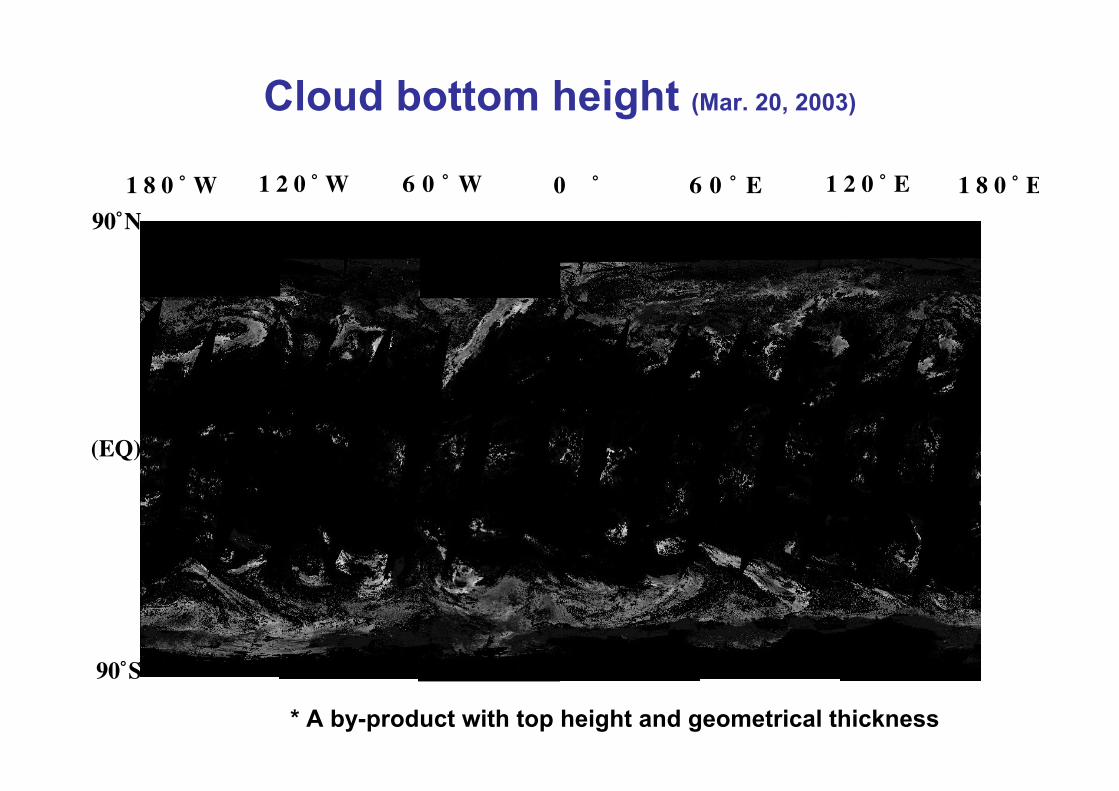
Cloud bottom height (Mar. 20, 2003)
90˚N
90˚S
1 8 0 ˚ W 1 8 0 ˚ E0 ˚
(EQ)
1 2 0 ˚ W 6 0 ˚ W 6 0 ˚ E 1 2 0 ˚ E
* A by-product with top height and geometrical thickness

Summary (cloud)• A four-channel algorithm was developed and applied to the
ADEOS-II / GLI global dataset to retrieve cloud geometricalproperties as well as optical and microphysical ones.
• An initial global analysis and preliminary results reveal Algorithm works as a whole, but more elaborate analyses are
necessary Surface condition: albedo, land/ocean, temerature, and pressure; Atmospheric profile: temperature, relative humidity, and pressure; Cirrus screening: water vapor absorbing band or thermal IR bands; Sun glint screening: scan geometry;
• Future works Validation studies with active sensors; Further global analyses for radiation budget and cloud physics
studies;

Characterization of sulfate haze overEast Asia retrieved with satellite andground-based remote sensing data
*M. Kuji, M. Hibino, Y. Kondo, S. HayashidaNara Women's University, Japan
M. Shiobara, M. YabukiNational Institute of Polar Research, Japan
K. Hara Fukuoka University, Japan
H. KobayashiYamanashi University, Japan
T. Hayasaka, S. SatakeResearch Institute for Humanity and Nature, Japan
July 31, 2006APRS @ Kanazawa, JAPAN

Objective
エアロゾルの主な発生要因
• Air pollution accompanying with recent rapideconomic growth in East and South Asia has apotential to influence our environment.
• It is important to investigate aerosol type anddistribution with remote sensors and groundbased measurements.
• In this study, we characterize a haze eventaround Japan in autumn of 2003 withobservations and chemical transport modelsimulations.

ADEOS-Ⅱ/GLI
Global Imager (GLI)Operation:
December 2002 to October 2003Channels: 36
from 380nm (NUV) to 12 µm (TIR)Recursive period: 4 daysSpatial resolution: 1km (IFOV) and
1600km (Swath)
http://sharaku.eorc.jaxa.jp/http://www.eoc.jaxa.jp/より
Data to be analyzedDate: September 16, 2003Band: Near Ultraviolet (NUV); 380nm (ch1) and 400nm (ch2)Scene: around Japan
ADEOS-Ⅱ
GLI obs.
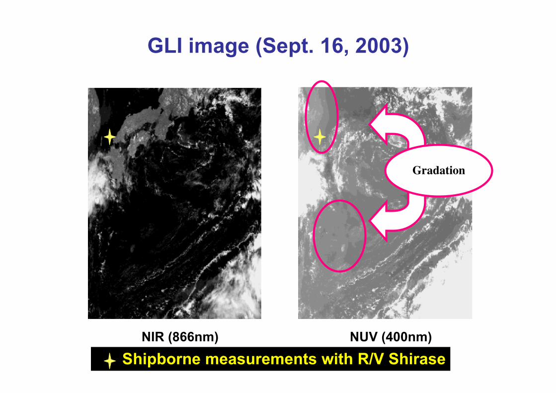
GLI image (Sept. 16, 2003)
NIR (866nm) NUV (400nm)
Gradation
Shipborne measurements with R/V Shirase
Retrieval of aerosol type andoptical thickness
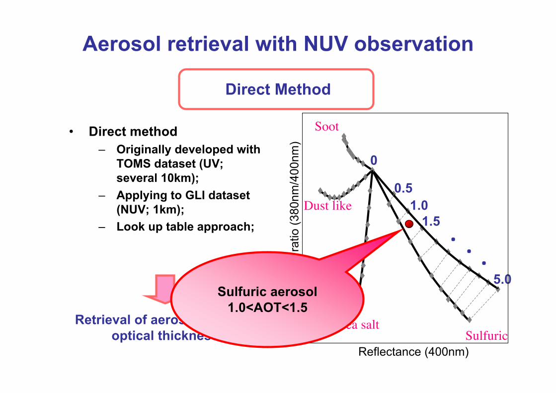
Aerosol retrieval with NUV observation
Direct Method
• Direct method– Originally developed with
TOMS dataset (UV;several 10km);
– Applying to GLI dataset(NUV; 1km);
– Look up table approach;
0
0.51.0
1.5
5.0
・
・・
SulfuricSea salt
Dust like
Soot
Reflectance (400nm)
Ref
lect
ance
ratio
(380
nm/4
00nm
)Sulfuric aerosol
1.0<AOT<1.5
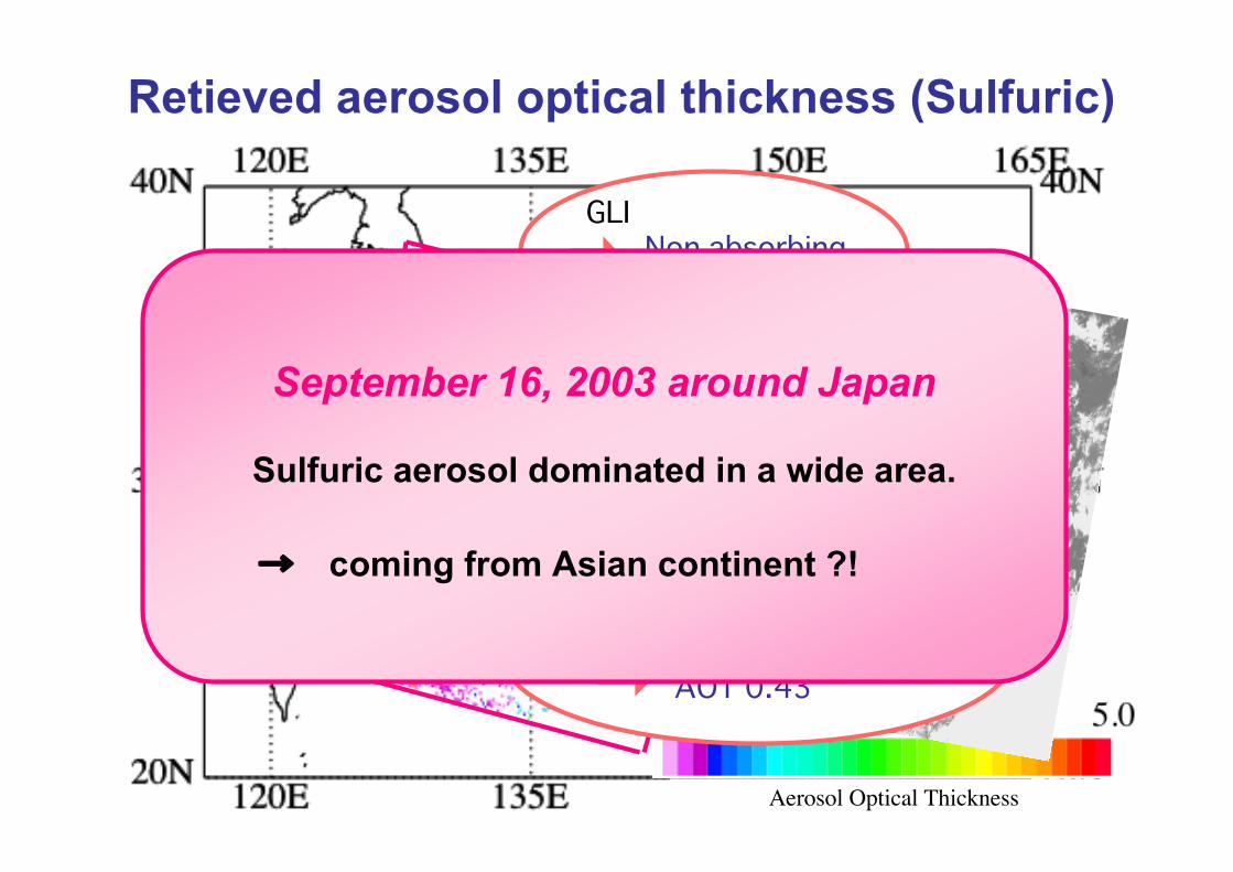
Retieved aerosol optical thickness (Sulfuric)
Aerosol Optical Thickness
ShiraseR/V Shirase
Sulfuric
GLI Non absorbing (sulfuric)
Amami
GLI Non abs. (sulfuric) AOT 0.38
Ground LIDAR Sphere (sulfuric) AOT 0.43
consistent
consistentSeptember 16, 2003 around Japan
Sulfuric aerosol dominated in a wide area.
→ coming from Asian continent ?!

Summary (aerosol)
• GLI NUV (380 nm) enables us to retrieve Asian Hazeproperties in 1-km resolution;– Comparison to the in situ observations, such as surface
sampling as well as lidar and skyradiometer, indicated theretrieved optical thickness was reasonable;
• Combined analyses of surface, satellite, and modelsimulation are useful (necessary) to characterizeaerosol properties– Chemical type, amount, microphysics, distribution,
transportation (source and sink), and so on;• Aerosol layer height is one of the greatest error
sources for absorbing aerosols;– LIDAR observation will help us;– O2 A-band (763nm) will be a possible candidate in GLI
analysis;
Retrieval of precipitable waterusing ADEOS-II / GLI
Near Infrared data
Makoto Kuji*Nara Women's University, Japan
Nobuyuki KikuchiJAXA / EORC, Japan
Akihiro UchiyamaMeteorological Research Institute, Japan

Objectives• Water vapor: Integrated amount (precipitable water);
– A key parameter in an aerosol-cloud interaction as well asradiation budget study;
• Utility: Atmospheric product (clear sky) or correction;– Over land, in particular (AMSR only over ocean);
• Applications to ADEOS-II / GLI;– The MODIS algorithm (King et al. 1992; Kaufman and Gao 1992);
• Advantage of GLI analysis:– on a pixel-by-pixel (about 1 km2) basis;– Fully synchronized data set with other channels;– Cloud and ecosystem flags from GLI processing flow;– Atmospheric correction for surface products, e.g., vegetation,
snow/ice, etc.;

Approach• Radiance Ratio Method:
– Near Infrared (ADEOS-II / GLI Application);• Water vapor absorbing band (1135 nm), and;• Non-absorbing band (1050 or 1240 nm);
– Daytime Retrieval;– Under a clear sky condition;– Surface albedo: high or moderate (over land);– Aerosol loading: up to moderate (1.0 @ 500 nm);
• Analysis and Validation:– Implemented to EORC (ATSK6p);– GLI analysis: April and August, 2003 @ Global;– Comparison to radiosonde observations, and so on;– Re-evaluation of algorithm;
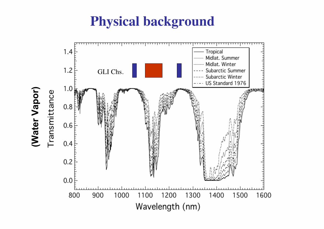
GLI Chs.
Physical background(W
ater
Vap
or)

Calibration (Bright Surface; Lambertian 50%)!"#
!"$
$"%
$"&
$"'
$"#
$"$
()*+,-./0123,1.,45023,6.)
#$$!7$!$$7$$
8,60*29,:)*2;,6<2=++>
2!a=0.0
!a=0.1
!a=1.0
2*R
1135
/(R
1050
+ R
1240
)
* We
adop
t the
cal
ibra
tion
curv
e un
der L
ambe
rtia
nsu
rfac
e (5
0% re
flect
ivity
) con
ditio
n w
ithou
t aer
osol
load
ing
in th
is a
naly
sis;
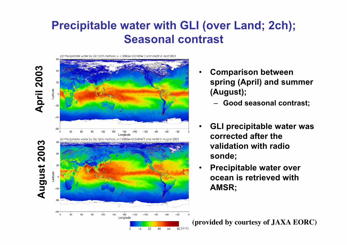
Precipitable water with GLI (over Land; 2ch);Seasonal contrast
• Comparison betweenspring (April) and summer(August);– Good seasonal contrast;
• GLI precipitable water wascorrected after thevalidation with radiosonde;
• Precipitable water overocean is retrieved withAMSR;
(provided by courtesy of JAXA EORC)
Apr
il 20
03A
ugus
t 200
3
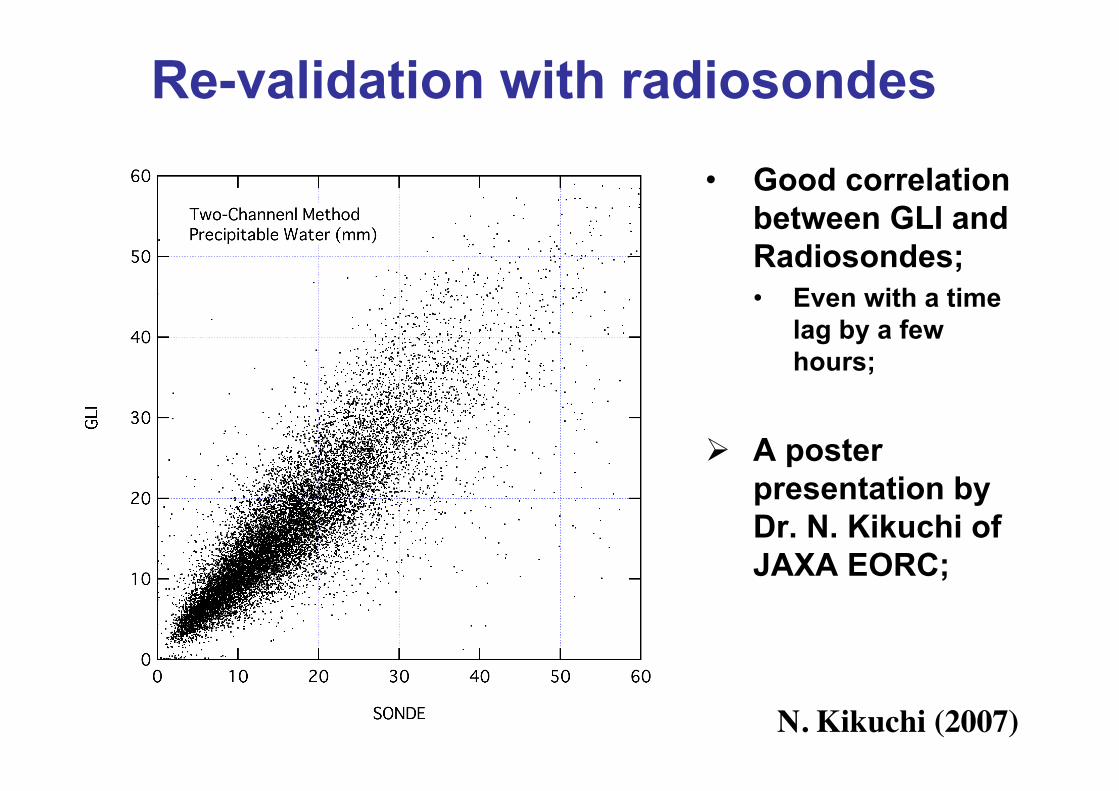
Re-validation with radiosondes• Good correlation
between GLI andRadiosondes;• Even with a time
lag by a fewhours;
A posterpresentation byDr. N. Kikuchi ofJAXA EORC;
N. Kikuchi (2007)

Summary (water vapor)
• GLI NIR enables us to retrieve precipitablewater over land in 1-km resolution under aclear-sky condition;
• Global analysis over land– Combined results with water vapor over ocean
with AMSR;– Good seasonal variation;
• Re-evaluation of calibration curve– Improvement of water vapor amount estimation;– Re-analysis on a global basis in the future;

Final Summary
WV-NIR***********Water vapor amount
WV-IR (#)
NUV
O2 A-band
Relevant Channel
*****Water vapor profile
Table 1. The development status (self-evaluation)
*** Almost done; ** Ongoing; * Future works;# A possible retrieval algorithm for water vapor profile with GLI water vapor IR bands;
********Aerosol type over land
**********Cloud heights
Paperpreparation
Validation(precision)
Globalanalysis
Algorithm