analysis and modelling of airborne geophysical data in the
TRANSCRIPT

Accep
ted M
anus
cript
Bulletin of Earth Sciences of Thailand
Sangsomphong, A_Airborne geophysical modeling at Phetchabun. Vol. 5, No.1, pp.xx-xx
Analysis and Modelling of Airborne Geophysical Data in the Phetchabun Volcanic Belt, Northern Part of Central Thailand
Arak Sangsomphong
Department of Geology, Faculty of Science, Chulalongkorn University, Bangkok, 10330, Thailand
Corresponding author e-mail: [email protected]
Abstract
New re-processed airborne geophysical data together with relevant current field verification as well as previous geochronological, geochemical and geological investigations lead to the clarification of the complex structures and tectonic evolution in Phetchabun volcanic belt covered by thick Cenozoic deposits. During the Permo-Carboniferous period, the original elongate units in central domain corresponding to intrusive igneous bodies may have occurred in association with subduction of the Nakhonthai oceanic plate beneath the Indochina continental plate. Additionally, the trench zone may have occurred by cause of eastward suduction in the western domain with correspond to deep basin filled by Permian deep marine sedimentary rocks of Nam Duk Formation whereas, paleo-back arc basin in the eastern and northern domains filled by shallow marine sedimentary rocks of Pha Nok Khao and Hua Na Kham Formation. Subsequently, during the Permo-Triassic period, the elongate units were shear as ductile and brittle structures which are deformed by represent of the accreted zone in central domain besides the mesothermal gold deposit in this zone. The structural configuration of this stage is characterized by east-west compressional stress, ring units of paleo-volcanic arc centers and the presence of circular units representing equigranular intrusive bodies from the result of eastward subduction. On the contrary, the east-west extensional stress during the Triassic period is inferred to be deposited the epithermal gold and contemporaneous diachronous with the subsidence in volcanic arc of eastern domain with uplift of the preliminary Khorat basin in northern 2 sub-domain. Finally, the spot units representing shallow porphyritic intrusive bodies occurred along the subsidenced fault zone during this stage.
Keywords: Airborne geophysics, Phetchabun Volcanic Terrane, Tectonic evolution
1. Introduction The Phetchabun Volcanic Belt (PVB)
is located in the central part of the Loei-Petchabun-Nakhon Nayok volcanic belt so–called (Intasopa, 1992) extending approximately north-south trending through central Thailand.
Re-processed airborne geophysical data have been used to interpret the complex subsurface structures of the PVB which is covered by thick Cenozoic deposits at the western edge of the Khorat
Plateau (Fig.1B). Reduction to the pole, residual high pass filtering, shade relief and directional cosine filtering constitute the main processing approaches applied to the original data using the Oasis Montaj® v6.1 program by followed and modified Neawsuparp et al., (2005) for airborne magnetic enhancement processes.
2. Geologic setting
The Phetchabun Volcanic Belt (PVB) is dominated by Upper Permian and

Accep
ted M
anus
cript
Bulletin of Earth Sciences of Thailand
Sangsomphong, A_Airborne geophysical modeling at Phetchabun. Vol. 5, No.1, pp.xx-xx
Triassic parallel zones of volcanic arc felsic to intermediate volcanic and Triassic marine sedimentary rocks (Fig.1B) which were formed above a subduction zone prior to and during the collision in the Triassic of the Shanthai and Southeast Asian continental plates (Bunopas and Vella, 1992). The volcanism is characterized by 3 volcanic successions, specifically Carboniferous rhyolite flows (Salam et al., 2007), Permo-Triassic andesitic-rhyolitic tuffs, flows and sub-intrusives, which mark the western margin of the Belt; Neogene basaltic and rhyolitic flows, which are recorded in the southern portion of the Belt possibly representing the reactivation of a zone of crustal weakness (Intasopa, 1992). Permo-Triassic intrusives perceived as cal-alkaline, I-type granites including diorite, quart diorite, granodiorite and quartz monzonite bodies are distributed throughout the Belt (Barr and Macdonald, 1991 and Garwin, 1993). Major structures in the Belt, from north to south comprise the southerly pluging Loei anticlinorium, the north-northwest oriented Chum Phae synclinorium and the west-northwest trending Saraburi anticlinorium (Garwin, 1993). Metal mineralization occurs in the Belt, characterized by base metals (Cu, Pb, Zn), iron ore, barite, manganese, pyrite, silver and gold. The majority of metallogenesis in the Belt is likely related to the Permo-Triassic intrusive magmatic-arc-related rocks and structural preparation provided by anticlinal folds formed during the late Triassic Indosinian Orogeny (Garwin, 1993, Charusiri et al., 1993).
3. Materials and Methods
The airborne geophysical and geological data are selectively acquired the Department of Mineral Resources (DMR)
of Thailand. The main data set used in this study is comprised of survey B-3, B-4 and C-2 flying to reasonable of north-south structure which have 2km and 5 km line-spacing at 305 above ground level that was used by the Mineral Resources Development Project in 1987 to interpret basement geology (Fig.1A). Geological mapping in the Phetchabun area was compiled from the 1: 100,000 scale geology map from Chonglakmani et al. (2004) (Fig.1B) from Geological Compilation and Edition Section, Mineral Resource Development Project (MRDP, 1984).
Airborne magnetic data provides the most significant information for subsurface interpretation. In this study, it is essential to define the magnetic anomalies at the place where they sit over the source, because there is a considerable difference in magnetic intensities from the inclination and declination at low latitudes. Mathematical transformation or filtering techniques, such as reduction to the pole (Fig.4A), residual high pass filtering (Fig.2A), upward continuation (Fig.2B), shaded relief (Fig.3A) and directional cosine filtering (Fig.3B), were applied to the magnetic data to enhance features for interpretation. Many of the linear anomalies for the Phetchabun Volcanic Terrane were completely revealed by shaded-relief method. Interpretations using remove the influence of the large amplitude, long wavelength anomalies by residual high pass method help to separating signals of different wavelength to isolate and hence enhance anomalous features with a certain wavelength. The directional cosine filter method, in particular, worked well to reveal a comprehensive pattern of faulting. Upward continuation filtering helped

Accep
ted M
anus
cript
Bulletin of Earth Sciences of Thailand
Sangsomphong, A_Airborne geophysical modeling at Phetchabun. Vol. 5, No.1, pp.xx-xx
determine the depth range of deeper sources. All the methods together provided a view of the pattern and general depth ranges of faults within the area that aid
research on the geology, intrusions, and faults.
Figure 1. (A) The residual magnetic map with the overlain tectonic lines in Thailand (modified after Tulyatid et al., 1999, Charusiri et al., 2002, Sangsomphong et al., 2008 and Sangsomphong et al., 2012) (B) The geologic map of the study area (modified from Chonglakmani et al., 2004).

Accep
ted M
anus
cript
Bulletin of Earth Sciences of Thailand
Sangsomphong, A_Airborne geophysical modeling at Phetchabun. Vol. 5, No.1, pp.xx-xx
Figure 2. (A) Enhanced airborne magnetic map of the PVB based on high pass residual filtering data by cutoff at 1.5 1/K_unit of wave number for separating long magnetic wavelength form the map. (B) Enhanced airborne magnetic map based on upward continuation data of 1 km higher magnetic survey levels useful for visual slope of magnetic intensity with helps to outline geometrical model for source bodies in practice of dipping.
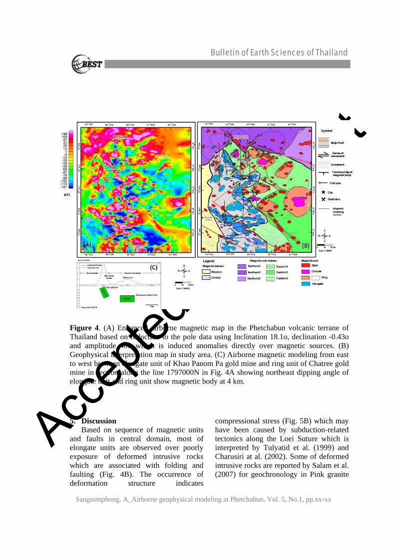
4. Results and Interpretations 1) New reduction to the pole map
displays four distinct magnetic domains including northern, eastern, central and western domains. Both of northern and eastern domains can divide into 3 sub-domains namely northern1, northern2, northern3, eastern1, eastern2 and eastern3 based upon magnetic intensity. Within these domains and sub-domains, three magnetic units of high magnetic anomalies are recognized, namely
elongate, circular, and spot units (Fig.4A).
2) The upward continuation map (Fig.2B) and airborne magnetic modeling (Fig.4C) show magnetic intensity changing to northeast and magnetic unit dipping to northeast in the elongate unit. In addition, the residual high pass filtering map (Fig.2A) also illustrates the ring units in eastern and northern domains with the distinct northwest-southeast regional trend.

Accep
ted M
anus
cript
Bulletin of Earth Sciences of Thailand
Sangsomphong, A_Airborne geophysical modeling at Phetchabun. Vol. 5, No.1, pp.xx-xx
3) In the central domain, the elongate units display occurrence deformation along elongate units in northwest-southeast trending with ductile of sinistral shear zone as delta-type porphyroclast about 10-87 km distance cut by northwest-southeast faults with 33 km sinistral slip, ring units, the circular units, symmetrical fold with north-south axial plane, east-west faults with 3-9 km sinistral slip and northeast-soutwest faults with 1-2.7 km dextral slip, respectively (Fig.4B) that east-west compression, northnortheast-southsouthwest transpression sinistral shear and north-south extension are occur, respectively (Fig.5B).
4) Based on reduction to the pole (Fig.4A), shaded relief (Fig.3A) and directional cosine filtering maps (Fig.3B) show northeast-southwest faults with 47 km sinistral slip, symmetrical fold with east-west axial plane, asymmetrical fold with northeast-southwest axial plane, north-south faults with 1-5 km dextral slip, and northwest-southeast faults with 2-10 km dextral slip have been encountered. The younger spot units occur along the latest fault segments (Fig.4B) that indicate east-west extension compression, north-south compression, northwest-southeast transpression sinistral shear and northeasteast-southwestwest dextral shear occur, respectively (Fig.5B).
Figure 3. (A) Enhanced airborne magnetic map based on shaded relief image by shading from north direction showing linear structure in study area. (B) Enhanced airborne magnetic map based on directional cosine filtering data by filtering in north direction and show clearly structure of east-west, northwest and northeast lineaments.
Accep
ted M
anus
cript
Bulletin of Earth Sciences of Thailand
Sangsomphong, A_Airborne geophysical modeling at Phetchabun. Vol. 5, No.1, pp.xx-xx
Figure 4. (A) Enhanced airborne magnetic map in the Phetchabun volcanic terrane of Thailand based on reduction to the pole data using Inclination 18.1o, declination -0.43o and amplitude 40o which is induced anomalies directly over magnetic sources. (B) Geophysical interpretation map in study area. (C) Airborne magnetic modeling from east to west between elongate unit of Khao Panom Pa gold mine and ring unit of Chatree gold mine in section along the line 1797000N in Fig. 4A showing northeast dipping angle of elongate unit and ring unit show magnetic body at 4 km.
5. Discussion
Based on sequence of magnetic units and faults in central domain, most of elongate units are observed over poorly exposure of deformed intrusive rocks which are associated with folding and faulting (Fig. 4B). The occurrence of deformation structure indicates
compressional stress (Fig. 5B) which may have been caused by subduction-related tectonics along the Loei Suture which is interpreted by Tulyatid et al. (1999) and Charusiri at al. (2002). Some of deformed intrusive rocks are reported by Salam et al. (2007) for geochronology in Pink granite

Accep
ted M
anus
cript
Bulletin of Earth Sciences of Thailand
Sangsomphong, A_Airborne geophysical modeling at Phetchabun. Vol. 5, No.1, pp.xx-xx
that is in 310 +/-8 Ma by LA ICP-MS U-Pb Zr age or Late Carboniferous age.
The eastern and western domains correspond to tectonic basins filled by Permian deep bedded carbonate rocks of Nam Duk Formation (Chutakositkanon et al., 1999) in the western domain and Permian shallow bedded-massive carbonate platform of Pha Nok Khao and Hua Na Kham Formations (Charoentitirat, 2002) deposit in back arc environment of the eastern and northern domains (Fig.5A).
Ring units in the PVT study area show moderate intensity with ring pattern anomalies at possibly their volcanic center of Permo-Triassic volcanic rocks. Chonglakmani et al. (2004) report these volcanic rocks occurring in Permo-Triassic age which conforms with the isotopic age by Salam et al. (2007) for the Chatree volcanic complex at 250+/-6 Ma by LA ICP-MS U-Pb Zr age. Cumming et al. (2004), Nakchaiya et al. (2008), Marhotorn et al. (2008) and Boonsoong, et al. (2011) considered that these rocks derived from calc-alkalic magma in the volcanic arc setting environment.
Moreover, the results of this study show more extent and new granitoid intrusions than the previous geological mapping (see Figs. 2.3). Large and higher amplitude anomalies (~10 km in diameter) of circular magnetic units in the eastern domain, particularly in the eastern1 sub-
domain, indicate exposure of equigranular granitoid. Geophysical interpretation reveals that the granitoid of the circular unit occurred during Permo-Triassic time. These granitoids have been assigned by Kamvong et al. (2006) into a volcanic arc setting environment and largely derived from I-type calc alkaline magma origin.
Additionally, Chatree epithermal gold deposit is intersected by major north-south and minor northeast-southwest striking sub-vertical dipping faults, and mineralization is controlled by structural and stratigraphic features (James et al., 2007). The latest Triassic east-west extensional tectonic period has caused uplift of the preliminary Khorat basin and subsidence of Permo-Triassic volcanic arc along Loei suture zone. The Chatree epithermal gold deposit can be well-preserved in northwest-southeast Triassic basin.
The spots of small circular magnetic feature (<5 km in diameter) are observed over the exposed porphyritic intrusive stocks, particularly along subsided fault zone. Salam et al. (2007) had reported geochronologies for grano-diorites are in the Early-Late Triassic age (244 +/-1 Ma by Re-Os age and 213 +/-10 Ma by LA ICP-MS U-Pb Zr age) whereas, based on Boonsoong et al. (2011), some of these intrusive occurred from tholeiitic magma origin in volcanic arc type setting.
Accep
ted M
anus
cript
Bulletin of Earth Sciences of Thailand
Sangsomphong, A_Airborne geophysical modeling at Phetchabun. Vol. 5, No.1, pp.xx-xx
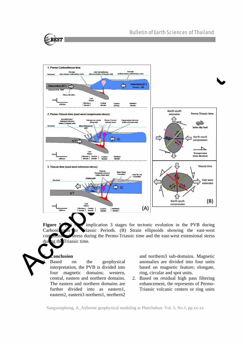
Figure 5. (A) New implication 3 stages for tectonic evolution in the PVB during Carboniferous to Triassic Periods. (B) Strain ellipsoids showing the east-west compressional stress during the Permo-Triassic time and the east-west extensional stress during the Triassic time.
6. Conclusion 1. Based on the geophysical
interpretation, the PVB is divided into four magnetic domains; western, central, eastern and northern domains. The eastern and northern domains are further divided into as eastern1, eastern2, eastern3 northern1, northern2
and northern3 sub-domains. Magnetic anomalies are divided into four units based on magnetic feature; elongate, ring, circular and spot units.
2. Based on residual high pass filtering enhancement, the represents of Permo-Triassic volcanic centers or ring units

Accep
ted M
anus
cript
Bulletin of Earth Sciences of Thailand
Sangsomphong, A_Airborne geophysical modeling at Phetchabun. Vol. 5, No.1, pp.xx-xx
display in northwest-southeast trend in eastern and northern domains.
3. The PVB can be sub-divided into three kinds of intrusive bodies based on geophysical and field data: (1) deformed elongate units of intrusive in central domain, (2) circular units of equigranular intrusive in eastern domain and (3) spot units of porphyritic intrusive dominant along subsidence fault zones.
4. Three stages of Tectonic evolution are newly proposed for the PVB:
-Permo-Carboniferous tectonic stage event, the Nakhonthai oceanic plate subject to eastward subduction beneath the Indochina continental plate by generate magmatic bodies of elongate units in volcanic arc which may have formed in Late Carboniferous time. Deep marine deposition of Nam Duk Formation may have taken place in the trench zone and shallow marine carbonate platform of Pha Nok Khao and Hua Na Kham Formations may have been deposited in back-arc basin. - Permo-Triassic tectonic stage is represented by the east-west compressive stress and this may have caused deformation of the elongate unit with northeast dipping and suggesting the eastward subduction of the Nakhonthai oceanic plate beneath the Indochina continental plate. Ring units of paleo-volcanic centers and circular units of equigranular intrusive bodies may have occurred in the volcanic arc of this stage. - Triassic tectonic stage is dominated by east-west extensional stress which in turn caused uplifting of the preliminary Khorat basin and subsidence of the Phetchabun volcanic arc. The spot units of porphyritic intrusive bodies may have occurred along the depressed basement.
Acknowledgements Foremost, we would like to thank
Department of Mineral Resource (DMR) for provided the airborne geophysical data and allow us to used the geophysical enhance program and encouragement and permission to publish the results in this study. I am greatly indebted to Mr. Aphichat Piyarom (senior geologist of DMR) who takes care and offered the airborne geophysic data until finish the study. Sincerely, appreciations also provide to Isara mining limited (Explolation Company of Akara mining) for extremely financial support the research during field observation with all facility, epecially the equipments and data in the company. Speial thanks; Mr. Prakarn Beunkhuntod, Mr. Veerasak Lunwongsa for their helpful and advice involve idea throughout this field study.
References Barr, S.M. and Macdonal, A.S. 1991.
Toward a Late Paleozoic-Early Mesozoic Tectonic model for Thailand. Journal of Thai Geosciences, 1, 11-22.
Boonsoong, A., Panjasawatwong, Y. and Metparsopsan, K. 2011. Petrochemistry and tectonic setting of mafic volcanic rocks in the Chon Daen–Wang Pong area, Phetchabun, Thailand. Journal of Island Arc, 20, 107–124.
Bunopas, S. and Vella, P. 1992. Geotectonics and geologic evolution of Thailand. National Conference on Geologic Resources of Thailand: Potential for Future Development, Bangkok, Thailand, 209-228.

Accep
ted M
anus
cript
Bulletin of Earth Sciences of Thailand
Sangsomphong, A_Airborne geophysical modeling at Phetchabun. Vol. 5, No.1, pp.xx-xx
Charoentitirat, T. 2002. Permian fusulinodean biostratigraphy and carbonate development in the Indochina Block of Thailand with their paleogeographic implication. Doctoral Thesis, University of Tsukuba, Japan.
Charusiri, P., Clark, AH., Farrar, E., Archibald, D. and Charusiri, B. 1993. Granite belts in Thailand: evidence from the 40Ar/ 39Ar geochronological and geological synthesis. Journal of Southeast Asian Earth Science, 8, 127-136.
Charusiri, P, Daorerk, V., Archibald, D., Hisada, K. and Ampaiwan, T. 2002. Geotectonic Evolution of Thailand: A new Synthesis. Journal of the Geological Society of Thailand, 1, 1-20.
Chongrakmani, C. and Sattayarak, N. 2004. Geological map of Changwat Phetchabun Thailand 1:250000. Department of Mineral Resources Report, Bangkok, Thailand.
Chutakositkanon, V., Hisada, K., Charusiri, P. Arai, S. and Charoentitirat, T. 1999. Characteristics of detrital chromian spinels from the Nam Duk Formation: Implication for the occurrence of mysterious ultramafic and volcanic rocks in central Thailand. In C. Khantaprab and others (eds.), Proceedings of the symposium on mineral, energy, and water resources of Thailand: Towards the year 2000, Bangkok, Thailand, 604-606.
Cumming, G.V. 2004. An assessment of the volcanic facies at the Chatree mine and other selected areas in the Loei – Phetchabun Volcanic belt. B.Sc. (Hons) Thesis (unpublished), Centre for Ore Deposit Research, School of
Earth Sciences, University of Tasmania, Hobart, Australia, 1-95.
Garwin, S.L. 1993. The Gold Potential of the Loei-Prachinburi Mineralized Belt, Northeastern Thailand: Unpublished Manuscript Newmont Thailand Limited 2004; 56-70.
Intasopa, S. 1992. Petrology and geochronology of the volcanic rocks of the Central Thailand Volcanic Belt. Doctoral dissertation. Department of Geology, Faculty of Science, New Brunswick University.
Kamvong, T., Charusiri, P. and Intasopa, S. 2006. Petrochemical characteristics of igneous rocks from the Wang Pong area, Phetchabun, north central Thailand: Implication for tectonic setting. Journal of the Geological Society of Thailand, 1, 9–26.
Marhotorn, K., Mizuta, T., Ishiyama, D., Takashima, I., Won-in, K., Charusiri, P., et al. 2008. Petrochemistry of Igneous rocks in the Southern Parts of the Chatree Gold Mine, Pichit, and Central Thailand: Implication for Tectonic Setting. Proceedings of the International Symposia on Geoscience Resources and Environments of Asian Terranes (GREAT 2008), 4th IGCP 516 and 5th APSEG. Bangkok, Thailand, 24-26, 289-298.
Nakchaiya, T., Mitzuta, T., Ishiyama, D., Takashima, I. and Won-In, K., Charusiri P, et al. 2008. Stratigraphy and Petrochemistry of Volcanic Rocks in the Chatree Gold Mine, Central Thailand: Implication for Tectonic Setting. Proceedings of the International Symposia on Geoscience Resources and Environments of Asian Terranes (GREAT 2008), 4th IGCP 516 and 5th APSEG. Bangkok, Thailand, 24-26, 302-311.

Accep
ted M
anus
cript
Bulletin of Earth Sciences of Thailand
Sangsomphong, A_Airborne geophysical modeling at Phetchabun. Vol. 5, No.1, pp.xx-xx
Neawsuparpa, K., Charusiri, P. and Meyersb, J. 2005. New Processing of Airborne Magnetic and Electromagnetic Data and Interpretation for Subsurface Structures in the Loei Area, Northeastern Thailand. Journal of ScienceAsia, 31, 283-298.
Salam, A., Zaw, K., Meffre, S., James, R. and Stein H. 2007. Geological setting, alteration, mineralization and geochronology of Chatree epithermal gold silver deposit, Phetchabun Province, central Thailand. Ores and Orogenesis Symposium at Tucson, Arizona, 24-30, 181.
Sangsomphong, A., Tulyatid, D., Thimakorn, T. and Charusiri P. 2008. Tectonic feature of eastern Thailand using enhanced airborne geophysical data. In Proceeding of the Geosciences, Resources and
Environments of Asian Terranes (GREAT2008), Bangkok, Thailand (Extended abstract), 67-70.
Sangsomphong, A., Thimakorn, T., Charusiri, P. 2012. Analysis and modeling of airborne geophysical data in the Phetchabun volcanic terrane, Northern part of central Thailand. International Conference on Tectonics of northwestern Indochina (TNI2012), Chiangmai, Thailand (Abstract), 22-24, 28-29.
Tulyatid, J. and Charusiri, P. 1999. The ancient Tethys in Thailand as indicated by nationwide airborne geophysical data. Proceedings of International Symposium on Shallow Tethys (ST) 5, Chiang Mai, Thailand, 380-388.