an historic survey of the marshall avenue …
TRANSCRIPT

AN HISTORIC SURVEY
OF THE MARSHALL AVENUE COMMERCIAL DISTRICT
IN VEBSTER GROVES
o tc;x'I 8CX> 1'2aJ '60:)
Gl."PIotI( ')(AlE IN F"EEl
GllD IQUAlEI '.£OlEIENT ~""LE IQ
Q.~~~ ~Y·~Q~
UPDATED BYGILLUM· POLK ASSOCIATES ~
(NOlI 198U
lPOATED BY' GLLUIII POLK ASSOC.(YAY 25, 1983)
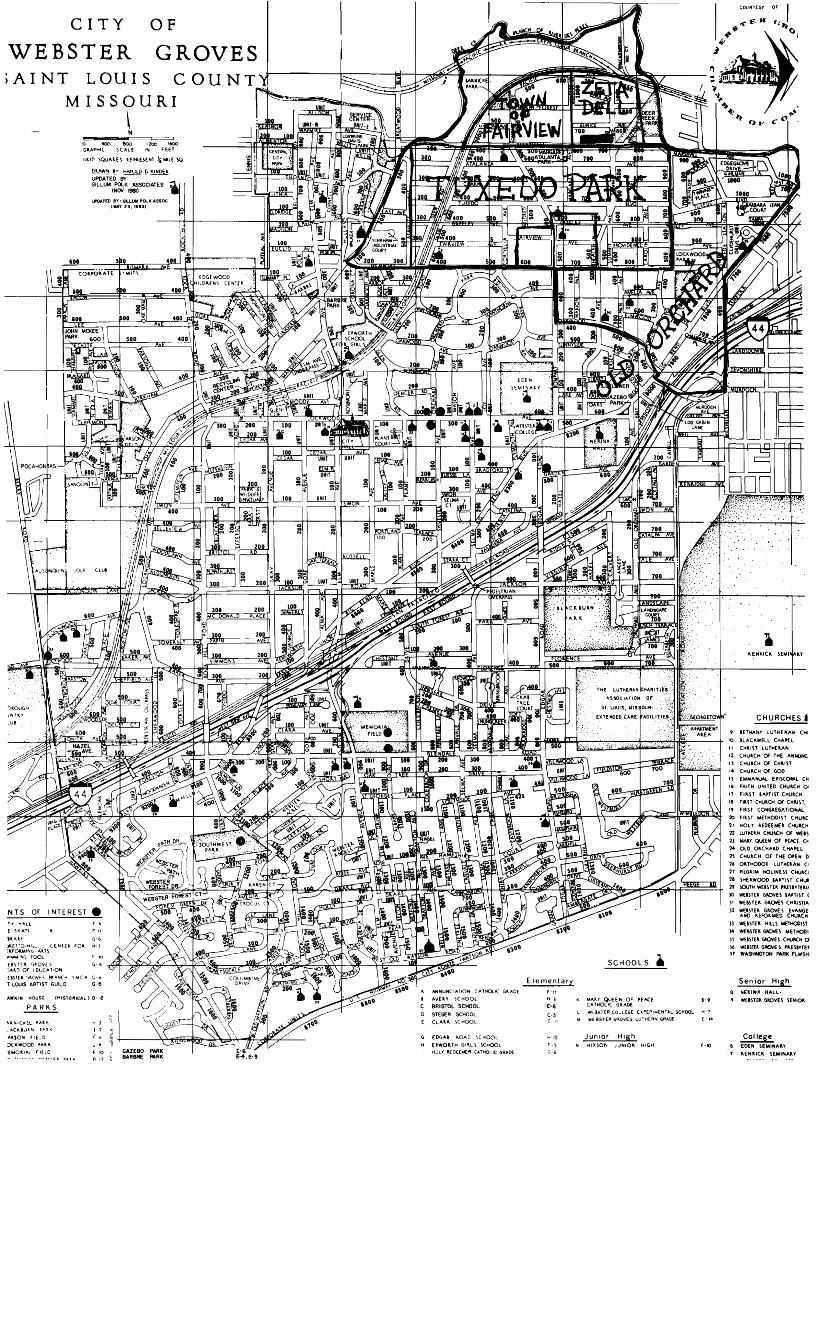
CHURCHES~
~EN~IC~ I Ell I Of
Senior HighNE~INX HALL,
WEBlTEl~VEI IENlOl
CollegeEDEN SEMINAlY~ENllC~ IEMINAlr
9 8ETHANY LUTHElAN CHI
8LAC~WELL CHAP{LCHllIT lUTHERANCHU~CH OF THE ANNUNCCHUlCH OF CHllSTCHUlCH OF GOD
EMM"'NUAl. EPlICO""L CHF...,TH UNITED CHUlCH oFllST BAPTIST CHU~CH
FllST CHU~CH OF CH~IIT.
19 FllST CONGlEGATIONAL ''10 FI~ST METHODIST CHU~C
21 HOLY lEDEEMEk CHua.CH22 LUTHHN CHU~H OF WE8123 WAY QUEEN OF 'EKE C>24 OLD OlCHAlD CHAPel21 CHU~CH OF THE O'EN 026 oaTHOooI LUTHE~AN C I
21 PlLGllM HOliNESI CHUlCI28 SHE~WOOO IMIIIT CHua:l9 \OUTHWEllTEl "-fIIYTE~1I
lO wUln~ G~VES IA'lIST (l' WEIITE~ GP.CMS CHllSTIAl2 WE8ITE~ GlOVES EVANGE
AND lEFOlMED CHUlCHII MIITEl HILLI METHODIST34 WEISTE~ GIlOIIEI METHODIl\ WUSTE~ GJOVES CHU~H al6 WHlTEl GAOIEI ,leSIYTEI31 WASHINGTON _ FLWSHi
SCHOOL S •
K lY QUEEN OF PEACE B-9C THOLiC GlADEWEBSTER COLl.EGE. £XPEPIMENTAL SC~OOL H-1
WEBSTER GROVES LUTHERN CRADE E -14
Junior HighN HIXSON JUNIOIl HIGH r-1C
H·'2,-\G-6
H-3
E-6
C-3C-II
ElementaryANNUNCIATION CATHOUC Gl."DE:
!'VElY IC HOOL8RISTDL SCHOOL
STEGER SCHOOLClAk~ ICHooL
G ED(,M lo...D SCHOOLHWOlTH GlllI ICHCX)lHOLY REDE.EMER CATI-IOUC GRADE
OFCITY
AWKIN HOUSE (MISTO"ICAL) 0·12
~
NTS OF INTEREST
U.~ICKEL PA.~ H 2
.AC~'UIN ~"'=-l( I ?
"'''SON 'IElO
:x,;,wooc ''''1.1Il J'c
EMOa.f.-.( rlfLD
T' H~ll
f ')I(;ATJ
UAI.'AET-:'Q.H1t. CEN1EI. FOa.I.rOl.M1N(J ""l.n
iI!¥",INf, rcxxt:I'.lT~" r)~O""t S),,1.1) Of tDU(AliON
£I\'El r,.OVlS '''''N(H YMCA G-oT LOUIS ARTIST GUILD G·6
WEBSTERAINT LOUIS COUNT
MISSOURI\~

5/4 1'3 12 II 10 9
0 ...s
C{] 0 il n J'I.
D 0.--- s
::)
---. t,/)
'1' 119 727 731 133 135 1:31 ·)9 1 41' +'3 '''''5' 41 14' 756
M A R 5 H A L l A V E.
MARS~ALl AVENUE BUSINESS DISTRICTWEBSTER GROVES, MISSOURI
MAP DE.CE.MBEI\ \QS3 !S'f PAT HAYs BAE~
I": 100'
Back in the days when the City of Webster Groves was divided into four wards,
the northeast section of the city was known as the Bloody Fourth Ward. 1 The Bloody
Fourth was made up of the community of Old Orchard including several subdivisions
developed by the Joy Brothers, the large real estate development known as Tuxedo
Park, an early subdivision called the Town of Fairview and other small subdivisions
north of Webster Park and Oakwood Avenue and east of Webster Park and Shady Avenue
(now called Brentwood Boulevard).2 Old Orchard and Tuxedo Park grew up as commuter
communities around the Old Orchard Station on the Frisco Railroad and the Tuxedo
Park Station on the Missouri Pacific. They were both annexed by the City of Webster
Groves in 1897, one year after the city had incorporated. 3 The residents of Old
Orchard and Tuxedo Park were furious and for almost twenty years they tried to secede
from Webster. They resented being taxed to pay for water, sewers, gas, electricity,
streets and sidewalks that were installed first in central Webster and Webster Park.
They did not want those improvements for themselves. They treasured their rural
innocence, their fenced pastures and their spring water. 4
Today the area is all built up, civilized, urbanized. It is all residential
except for the large commercial area along Big Bend Boulevard, still called Old
Orchard, and a small, half block of commercial buildings on Marshall Avenue at Summit
which resembles a western ghost town. This survey will examine that half block of
buildings to see why history put them there.
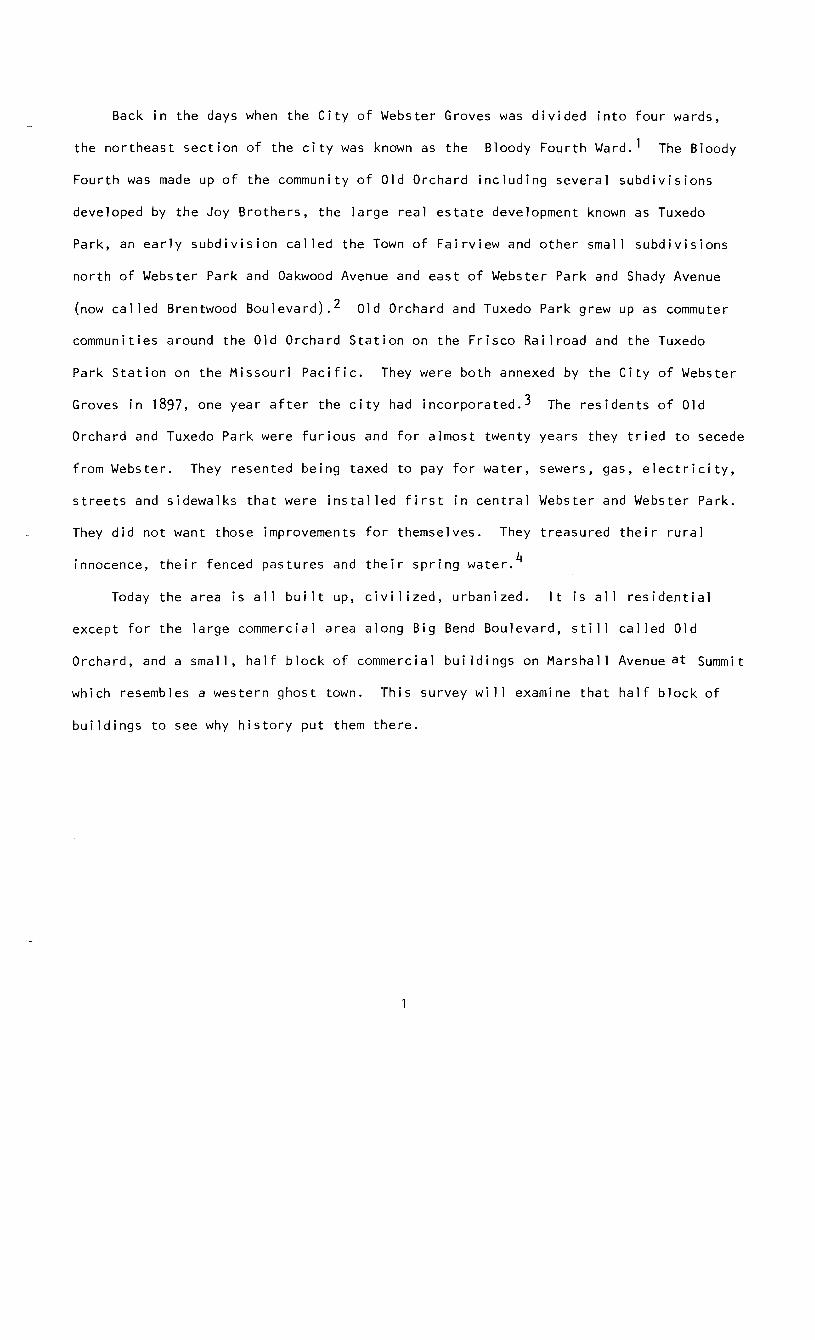
745, 747 and 749 Marshall Avenue today.
The subdivision now known as Zeta Dell lies north of Marshall Avenue and east
of the subdivision called the Town of Fairview. 5 It is 25 acres in the southeast
corner of a Spanish Land Grant given to Therese Barois and Francis Brazeau. 6 Henri
Picotte, an early member of the American Fur Company,7 bought the 25 acres and gave
it to his daughter, Celeste, before the Civil War. 8 Celeste married Dr. Louis Tousard
Pim, a 'prominent St. Louis physician, a student and partner of Dr. Joseph N. McDowell.
During the Civil War, Pim established and had charge of the hospital system of the
South. 9 The Pims built a summer home on their 25 acres near the Missouri Pacifi c
Railroad but after Prim1s death in 1888, Celeste Pim created the Zeta Dell Subdivision
in 1890 and sold all the land. Summit Avenue north of Marshall Avenue was originally
called Celeste. 10
2

Also in 1890, the Tuxedo Park Land and Improvement Company, with Lilburn G.
McNair as the president, subdivided the two hundred acres south of Marshall Avenue,
calling it Tuxedo Park and advertising it as a beautiful commuter suburb. 11 The
brochure, called "Leaves of Tuxedo", praised the new Queen Anne style, white stone,
Tuxedo Park station. It had forty daily trains to and from Union Station. McNair
arranged for free excursions on the train to see Tuxedo Park with its $500 lots that
could be purchased for only ten dollars down and ten dollars a month. The exclusive
subdivision had deed restrictions which prohibited saloons, stores and groceries but
there was free delivery from the city. 12
The new houses going up and the deed restrictions in the large subdivisions,
Tuxedo Park and the many Old Orchard subdivisions being developed by Edward and
Justin Joy, created a market for small convenience stores, confectionaries, where
there were no deed restrictions. Zeta Dell had no deed restrictions. 13
In 1890 Clement and Elizabeth Foster bought Lot 9 of Block 5 of Zeta Dell and
built a simple two-story frame building, a store on the first floor with living
quarters above. 14 For years it was known as Burney's Confectionary, owned by Charles
and Nellie Burney.15 It sat right on Marshall Avenue, a dirt road along the property
line between the original Spanish land grants and running from the old Fairview
Station east to Deer Creek and the Big Bend Road. 16
The 1890 Plat of Celeste Pim's Zeta Dell subdivision shows a station where
Celeste Avenue, now Summit Avenue, meets the Missouri Pacific Railroad. 17 Tracks
were laid north from this point to Creve Coeur Lake in 1881, and the small board and
batten LakeJunction Station was built at the junction where the Creve Coeur Branch
broke off from the main line of the Missouri Pacific Railroad. 18 For many years it
was a flag stop. Trains slowed down as they approached the wooden shelter and if the
engineer saw anyone waiting at the station he stopped and the passenger bought a
3
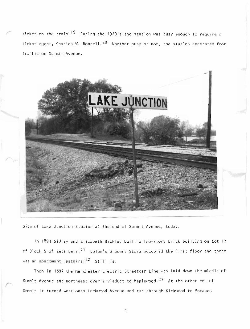
ticket on the train. 19 During the 1920's the station was busy enough to require a
ticket agent, Charles W. Bonnell. 20 Whether busy or not, the station generated foot
traffic on Summit Avenue.
Site of Lake Junction Station at the end of Summit Avenue, today.
In 1893 Sidney and Elizabeth Bickley built a two-story brick building on Lot 12
of Block 5 of Zeta Dell. 21 Dolen's Grocery Store occupied the first floor and there
was an apartment upstairs. 22 S't il l is.
Then in 1897 the Manchester Electric Streetcar Line was laid down the middle of
Summit Avenue and northeast over a viaduct to Maplewood. 23 At the other end of
Summit it turned west onto Lockwood Avenue and ran through Kirkwood to Meramec
4
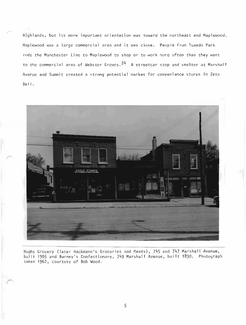
Highlands, but its more important orientation was toward the northeast and Maplewood.
Maplewood was a large commercial a rea and it was close. People from Tuxedo Park
rode the Manchester Line to Maplewood to shop or to work more often than they went
to the commercial area of Webster Groves. 24 A streetcar stop and shelter at Marshal 1
Avenue and Summit created a strong potential market for convenience stores in Zeta
Dell.
Hughs Grocery (later Hackmann's Groceries and Meats) , 745 and 747 Marshall Avenue ,built 1905 and Burney's Confectionary, 749 Marshall Avenue, built ]890. Photographtaken 1962, courtesy of Bob Wood.
5
In 1905 Claude and Mary Hughs built a two-story brick bui lding with a Victorian
cast iron storefront on Lot 10 of Block 5. 25 They opened a grocery store on the
first floor and lived upstairs. 26 And in 1909 Dr. Horace Van Nort bought Lot 13
and built a small one-story frame drugstore. 27
And that was Marshall Avenue at Summit near the Lake Junction flag stop, from
the turn of the century until the 1920's; two groceries, a confectionary and a drug-
store. Mothers sent their children to Dolen's Grocery Store with a shopping list
p
and a wagon and Mr. Dolen fil led each list and gave each chi ld a hot dog. Dr. Van
Nort mixed prescriptions and sold ice cream. And the Burneys who had the confection
ary sold penny candy and knew all the children by name. The Manchester Streetcar
Line had a shelter at the stop on the southwest corner of Marshall and Summit and
boys sold newspapers there. Men pitched horseshoes in the vacant lot on the north
west corner of Marshall and Summit. Children went down to the Deer Creek Branch of
the River Des Peres to i,ce skate in winter and to catch crawdads in summer. They
watched the men from the Missouri Pacific construct the 19]2 Bridge oyer Deer Creek.
Every evening they played'stickball in the middle of the dirt road until the street
lights came on. 28
Children went to the Tuxedo Park School and when Tuxedo Park had a school picnic
the school band led a parade of children, parents and teachers down Atalanta to
Summit where they got on chartered streetcars decorated with flags and bunting and
rode to Forest Park. 29
6

Peter White's house, 731 Marshall Avenue, bui lt ]903 , also Dr. Horace Van Nort 'sDrugstore, 733 Marshall Avenue, built 1909. Photograph taken 1962 , courtesy ofBob Wood.
Peter and Mary White had a frame house on lot 14 of Block 5 of Zeta Dell jus t
west of where Van Nort bui lt his drugstore. Peter White played t he s axophone for the
Powhatten Theater Orchestra in Maplewood and the neighbors loved to hear him practice.
Bret Call icott lived in the large brick house west of the Whites. Callicott was a
mail sorter on the Missouri Pacific Railroad and every Christmas he set up electric
trains in his basement and neighborhood children cam to watch. West of Callicotts
the Robyns had a small, old, frame house and west of them the Co~nellys had a s ma l l
farm with a big barn and sold milk. 30
7
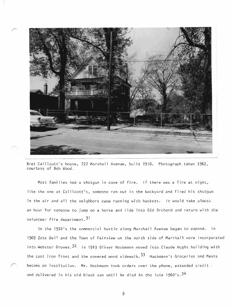
Bret Callicott's house, 727 Marshall Avenue, built 1910. Photograph taken 1962 ,courtesy of Bob Wood.
Most families had a shotgun in case of fire. If there was a fire at nigh t ,
like the one at Callicott's, someone ran out in the backyard and fired his shotgun
in the air and all the neighbors came running with buckets. It would t ake al most
an hour for someone to jump on a horse and ride into Old Orchard and return with the
volunteer fire department. 31
In the 1920 's the commercial bustle along Marshall Avenue began to expand. In
1909 Zeta Dell and the Town of Fairview on the north side of Marshall were incorporated
into Webster Groves. 32 In 1913 Oliver Hackmann moved into Claude Hughs building with
the cast iron front and the covered wood sidewalk. 33 Hackmann1s Groceries and Meats
became an institution. Mr. Hackmann took orders over the phone , extended credit
and delivered in his old black van until he died in the late 1960's .34
8

Gebelien1s Dry Goods Store, 753 and 755 Marshall Avenue, built 1922. Photographtaken in 1962, courtesy of Bob Wood.
In 1922, Charles M. Gebelien built a dry goods store with an apartment above on
the northwest corner of Summit and Marshall, where men used to play horseshoes. 35
Gebelien sold fabric, notions, hats and women1s clothes through the 1940 1s. 36 Mack ,
the barber, had a barbershop in the west half of the building. 37
In 1924, Charles Burney had a gasoline pump installed on the sidewalk in front
of his confectionary shop.38 Automobiles were appearing .
9
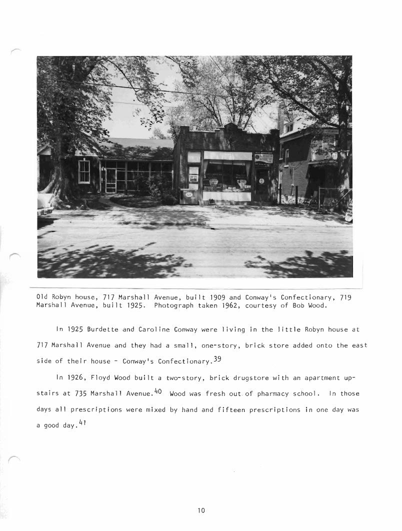
Old Robyn house, 717 Marshall Avenue, built 1909 and Conway1s Confectionary, 719Marshall Avenue, built 1925. Photograph taken 1962, courtesy of Bob Wood.
In 1925 Burdette and Carol ine Conway were living in the little Robyn house at
717 Marshall Avenue and they had a small, one-story, brick store added onto the east
side of their house - .Conway ' s Confectionary.39
In 1926, Floyd Wood built a two-story, brick drugstore with an apartment up
stairs at 735 Marshall Avenue. 40 Wood was fresh out of pharmacy school. In those
days all prescriptions were mixed by hand and fifteen prescriptions in one day was
a good day.41
10
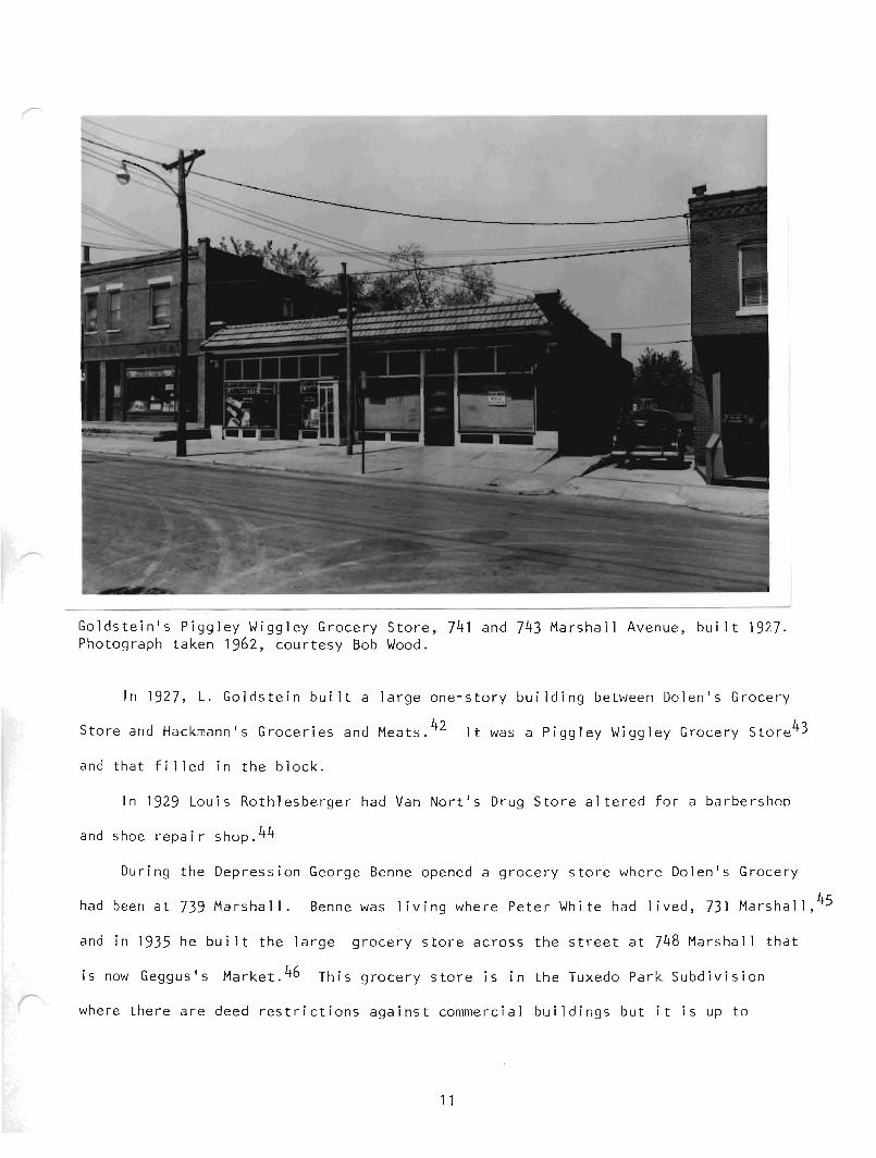
Goldstein's Piggley Wiggley Grocery Store, 741 and 743 Marshall Avenue, built 1927.Photograph taken 1962, courtesy Bob Wood.
In 1927, L. Goldstein bui It a large one-story building between Dolen's Grocery
Store and Hackmann's Groceries and Meats. 42 It was a Piggley Wiggley Grocery Store43
and that filled in the block.
In 1929 Louis Rothlesberger had Van Nort's Drug Store altered for a barbershop
and shoe repair shop.44
During the Depression George Benne opened a grocery store where Dolen's Grocery
had been at 739 Marshall. Benne was living where Peter White had lived 73] Marshall,45
and in 1935 he built the large grocery store across the street at 748 Marshall that
is now Geggus's Market. 46 This grocery store is in the Tuxedo Park Subdivision
where there are deed restrictions against commercial buildings but it is up to
11
property owners within a subdivision to take any deed restriction violations to the
civil court and apparently no one felt strongly enough against Benne's Grocery to do
so.47
A tavern where Dolen and Benne had been at 739 Marshall sold sandwiches and
3-2 beer during the 1930's and 1940's.48
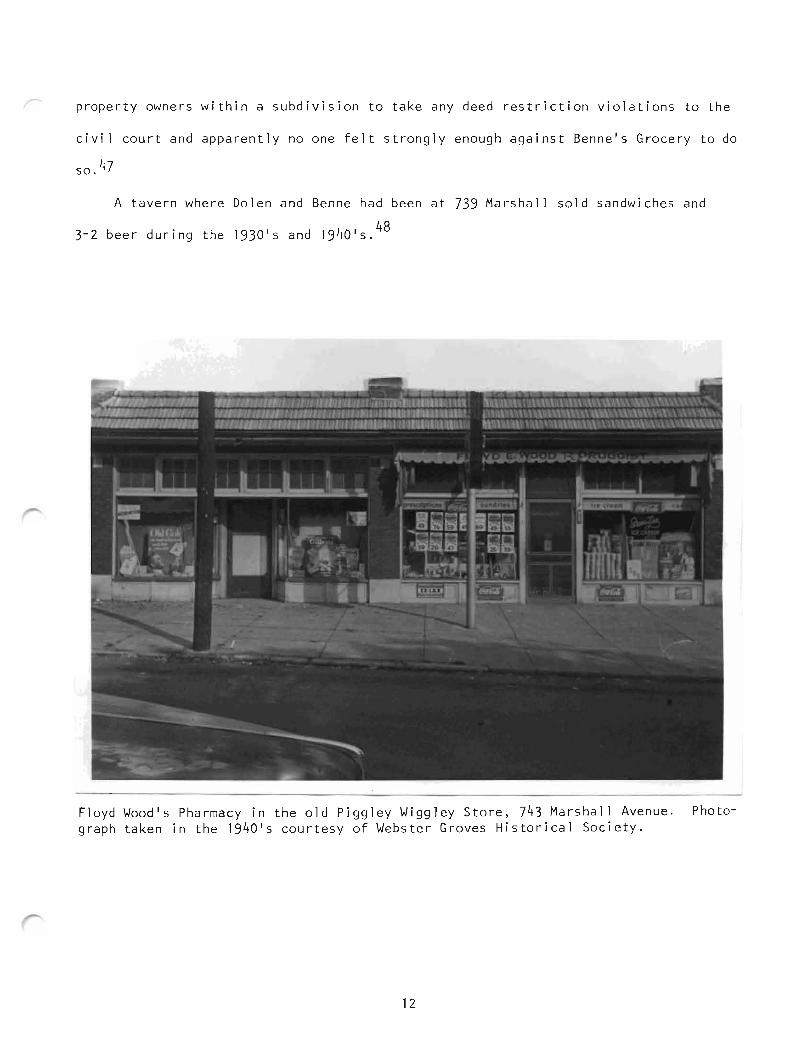
Floyd Wood's Pharmacy in the old Piggley Wiggley Store, 743 Marshall Avenue . Photograph taken in the 1940·s courtesy of Webster Groves Historical Society .
12

Interior of Floyd Woodis Pharmacy, 743 Marshall Avenue. Photograph taken in 1950's,courtesy of Bob Wood.
Floyd Wood moved his drugstore into the old Piggley Wiggley at 743 Marshall in
the 1930 1s. 49 George Werner had a hardware store in Woodis old drugstore, 735
Marshall during the thirties and forties. 50 In 1949, Milton Graubner and his son-in-
law, Fred Berger, bought out Werner and operated Graubner-Berger Hardware there until
1979. There was a dentist1s office upstairs. 51
13
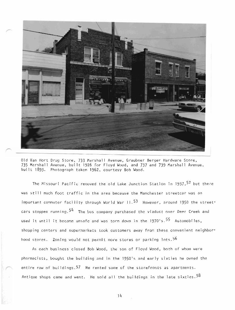
Old Van Hart Drug Store, 733 Marshall Avenue, Graubner Berger Hardware Store,735 Marshall Avenue, bui lt 1926 for Floyd Wood , and 737 and 739 Marshall Avenue,built 1893. Photograph taken 1962 , courtesy Bob Wood.
The Missouri Pacific removed the old Lake Junction Station in 1937,52 but there
was still much foot traffic in the area because the Manchester streetcar was an
important commuter facility through World War I I .53 However, around 1950 the street
cars stopped running. 54 The bus company purchased the viaduct over Deer Creek and
used it until it became unsafe and was torn down in the ]970 ' s . 55 Automobiles ,
shopping centers and supermarkets took customers away from these convenient neighbor-
hood stores. Zoning would not permit more stores or parking lots. 56
As each business closed Bob Wood, the son of Floyd Wood, both of whom were
pharmacists, bought the building and in the 1950 l s and early sixties he owned t he
entire row of buildings. 57 He rented some of the storefronts as apartments .
Antique shops came and went. He sold al 1 the buildings in the late sixties. 58
14
F
The buildings are all owner occupied now. Most of the owners are contractors
or artisans. This commercial row of buildings is ideal for these businesses because
they have low overhead and contractors do not need an impressive public appearance.
The area seems eligible to be designated a local historic district. Lack of
economic growth has protected these buildings from extensive modernization. They
have an air of history, frozen time. Inside one sees pressed tin ceilings and hard-
wood floors. However, the present owners, although their "adjusted basis" (the
depreciated property value calculated for tax purposes) is significantly low, may
have little need for tax credits for restoration and find the Department of the
Interior's Standards for Rehabilitation too restrictive. The important task for the
Webster Groves Historic Preservation Commission will be to help property owners
appreciate the history and the architectural characteristics of their typical verna-
cular buildings and find simple, inexpensive ways to preserve or restore their nostal-
gic charm.
Prepared by the Historic Section of the St. Louis CountyDepartment of Parks and Recreation
with funding from the Missouri State Historic Preservation Programand the St. Louis County Community Development Program
15
p
NOTES
1. Captain Tom Gibson, Memories of the Old Home Town, (Webster Groves: The WebsterNews Times, 1946), p. 105.
2. Plat Book of St. Louis County, Missouri, (Des Moines, Iowa: Northwest Publ ishingCo., 1909), pp. 58 and 59.
3. Webster Groves Ordinance #64, May 29, 1897.
4. "Old Orchard", Kate Moody Collection located at the Missouri Historical Society.
5. Plat Book of St. Louis County, Missouri, 1909, pp. 58 and 59.
6. C. Thomas Uhlmann, Atlas of St. Louis County, Missouri, (St. Louis: Julius Hutawa,1862), Township 44 Range 6 East of the 5th Principal Meridian.
7. Ibi d.William Hyde and Howard Conard, Encyclopedia of the History of St. Louis, (St.Louis: The Southern History Company, 1899), pp. 1736-1738, "Pim, Louis Tousard".
8. Julius Pitzman, Atlas of Sto Louis City and County, (St. Louis: 1878), "WebsterGroves".
9. William Hyde and Howard Conard, Encyclopedia of the History of St. Louis, pp. 17361738, "Pim, Louis Tousard".
10. St. Louis County Plat Book 2, p. 96, located in Recorder of Deeds' Office.
11. St. Louis County Plat Book 2, p. 95.St. Louis County Plat Book 3, p. 10.
12. "Leaves of Tuxedo," a brochure located in the archives of the Missouri HistoricalSociety, (St. Louis, Tuxedo Park Land and Improvement Co., 1890).
13. St. Louis County Deed Book 48, p. 154, located in the Recorder of Deeds' Office.
14. Sto Lou i s Coun ty Deed Book 48, p. 154.St. Louis County Deed Book 51, p. 254.
15. Conversations with Jim McMillan, 10 Jefferson Road and Grace Wifley, c/o Mrs.Donald Maness, 835 Renee Lane.
16. Julius Pitzman, Atlas of St. Louis City and County, (St. Louis: 1878), "WebsterGroves."
17. St. Louis County Plat Book 2, p. 96.
18. Conversation with Walter Fussner, Public Relations Department, Missouri PacificRailway Company, 13th and Olive.
19. Conversation with Jim McMillan.
20. Missouri Pacific Railroad Train Schedule, 1925, in collection of Walter Fussner,Missouri Pacific Railway Company.
16
p
21. St. Louis County Deed Book 69, p. 100.St. Louis County Deed Book 70, p. 228.
22. Conversations with Jim McMillan and Grace Wifley.
23. "Growth and Improvements", Kate Moody Collection.
24. Conversation with Jim McMillan.
25. St. Louis County Deed Book 162, p. 72.
26. Conversation with Grace Wifley.
27. St. Louis County Deed Book 223, p. 582.
28. Conversation with Jim McMillan.
29. Ibi d.
30. Ibid.
31. Ibid.
32. Webster Groves City Ordinance #797, April 19, 1909.
33. Photograph owned by Bob Wood, Wood Drugs, 10702 Manchester Road, taken 1962,says "Hackmann Groce r ies and Meats, Estab 1i shed 1913."
34. Conversation with Bob Wagner, 737 Marshall Avenue.
35. Webster Groves Building Permit #1850.
36. Conversation with Bob Wood.
37. Ibid.
38. Webster Groves Building Permit #2301.
39. Webster Groves Building Permit #3091.Conversation with Jim McMillan.
40. Webster Groves Building Permit #3670.
41. Conversation with Bob Wood.
42. Webster Groves Building Permit #3977.
43. Conversation with Bob Wood.
44. Webster Groves Building Permit #4634.
45. Conversations with Bob Wood and Jim McMillan.
46. Webster Groves Building Permit #5403.
17
F
47. Conversation wi th Mary Lou Mill er, City Clerk of Webster Groves.
48. Conversation wi th Mrs. Fred Berger, 8826 Laclede Station Road.
49. Conversation wi th Bob Wood.
50. Conversation wi th Mrs. Fred Berger.
51. Ibid.
52. "Missouri Pacific Railway Company Bridges and Buildings Inventory", from WalterFussner.
53. Conversation wi th Mrs. Allen Goodloe, 108 S. Rock Hill Road.
54. Conversation wi th Mrs. Gerald Rogers, 545 Lee Avenue.
55. Conversation wi th Mary Lou Miller.
56. Webster Groves Zoning Map, 1956, located in City Clerk's Office.
57. Conversation wi th Bob Wood.
58. Conversation wi th Bob Wagner.