agriculture in mali - world meteorological organization in mali mali women thrashing grain harvest....
TRANSCRIPT

Agriculture in Mali
Mali women thrashing grain harvest. Photo from Tempo Bamako http://www.tempo-bamako.ch/wordpress/?p=81
This case study: - Highlights key elements of the WMO’s Capacity Dev elopment Strategy as well as Service Delivery Strat egy in enhancing the capability of NMHS of Mali to provide critical climate information directly to farmers in rural co mmunities. - Shows how capacity of the rural farmers is enhanc ed to comprehend the information provided and use i t in farming decision-making and activities to increase yields, as well as provide feedback on what they perceived to be most useful and inform the tailoring of products to meet their needs. - Highlights the role of the Multidisciplinary Grou p as the interface between climate information prov iders and farmers Highlights the role of regional climate institution s in the provision of climate information and linka ge to the NMHS at national level. -Exhibits potential for upscaling to other countri es in RA-I.
Background Approximately 65% of Mali’s land area is either desert or semi-desert, and less than 4% is used for farming to grow crops. Rainfed agriculture is the mainstay of most rural peoples’ livelihoods, situated in the south of the country, where most of the rain falls, and where the bulk of the population lives. Recurrent droughts pose a threat to the agricultural sector making cropping a high-risk venture, reflected in high levels of poverty and undernourishment. Mali is categorized as a least developed country and the majority of the populations settled in rural regions with livelihoods heavily reliant on small scale subsistence farming and wholly dependent on rainfall. Subsequently, advance knowledge on how rainfall behaves is a matter of survival in Mali. With over 60% of countries categorized as least developed, Africa’s calamity is compounded by degrading landscapes and ecosystems making it the most vulnerable region impacted by extreme climate events in the form of drought and floods due to variations in climate. WMO in collaboration with UNDP responded to these recurrent catastrophic events and established regional climate monitoring institutions in Africa’s sub-regions to provide early warning advisories to countries for extreme climate events preparedness. In the western parts of Africa, ACMAD, AGRHYMET and CILSS were the regional climate centers established where generated climate products from these institutions were downscaled to national level to cater for national needs. However, regional climate products lack the level of resolution to provide adequate details at national levels. The situation is aggravated by the lack of skilled staff at NMHSs to interpret these products and even then, service delivery to the rural communities who are most in need of such critical information is poor. Mali is no exception. The WMO Strategy for Service Delivery puts emphasis on user-driven high quality products, effective mechanism for delivery to the targeted user and the ability for the user to use the information and derive benefits. Emphasis is also laid on user feedback for product improvement.

Long-term averaged rainfall totals showing rainfall patterns in MALI. Source – Mali NMHS The Mali Project/Programme Description Mali has continued to experience anomalies in rainfall with widespread devastation to economies and livelihoods. Recognizing that rural communities need help in managing the risks associated with rainfall variability for sustaining their livelihoods, Mali’s Direction Nationale de la Météorologie (DNM), the NMHS of Mali, launched a project in 1982, to provide climate information to rural communities especially farmers, with external funding from the Swiss Agency for Development and Cooperation (SDC), assisted by the AGRHYMET center and included technical support from WMO. It was envisioned the climate information would help them in their decision-making in farming activities and food security. Over the years, the project evolved into an extensive and effective collaboration between government agencies, research institutions, media, extension services, and farmers. The project was highly innovative from the outset and the first in Africa for a NMHS to supply climate-related advice and recommendations directly to local communities including farmers, and to enhance their capacity to measure rainfall themselves. The graph below illustrates the variations of rainfall in the west Sahel region over a 50-year period and more pronounced from 1994 onwards:
1Rainfall Anomalies over a 50-year period in the Sahel. The period between 1994 to 2000 exhibits abrupt variations from very wet to very dry years. Drought Monitoring and Early Warning in West Africa: Presentation By Traore, Seydou B, Agrometeorologist.
1 WMO Inter-Regional Workshop on Indices and Early Warning Systems for Drought, Lincoln, Nebraska, USA, 8-11 December 2009

From the outset, the programme was aimed to address a high impact application sector of meteorological services which was the agriculture sector comprising of crop production farmers, livestock pastoralists, fishermen from fisheries and the forestry community. Climate information was provided to all these users in the agriculture sector although the nature of required information differed from one user group to another. As the programme progressed, the uptake and readiness by farmers and agronomists to use climate services differed from the other sub-sectors in relation to sector activities such that applicability was higher for farmers than any of the other users and easily became the focus for the programme. Local communities of Mali had been managing climate-related risks regularly as part of their everyday lives. Using traditional indicators such as the behavior of insects, birds and folk lore handed down for generations, they made decisions that aimed to minimize climate risks and exploit climate opportunities. An example is the efforts by farmers to time the planting of their crops to coincide with the onset of the rains basing their decisions on such traditional information. The behavior of climate has become increasingly variable and predictability of amount and distribution of rainfall has remained elusive to date.
STEP 1 - Requirements for the provision of climate informati on to rural farmers and the utility of the information to result in benefits were defined and involved users (rural communities)
The project was phased into three major phases: Experimental, capacity building, evaluation and scaling up phases. Some of the activities in the Experimental Phase involved project staff visiting farmers to ask what kinds of information might be useful to them. Basic farmer needs were found to be information on the onset and end of the rainy season, the amount and distribution of rainfall. These findings fed into the experimental phase, which looked at ways of enabling farmers to access and use such information and derive benefits as well as provide feedback on the information they found useful in meeting their needs to inform user-driven product generation. It was envisioned that learning to better manage climate variability over seasons and from year to year by enhancing the capacity of these local communities particularly farmers to incorporate climate information into their decision–making would result in increased resilience of the farmers to future, more severe impacts of climate change and ensure food security in Mali. At the outset, a multidisciplinary working group composed of technical, development, and research experts was created to plan and execute the project. This group, which still meets today, includes members from the NMHS, the Ministry of Agriculture, agricultural research institutes, rural development agencies, farmers, and the media. Different group members provide inputs as follows:
● Users define the climate-related data and products they need ● The meteorological service analyzes technical aspects of these data and products ● The Ministry of Agriculture, extension services, and research groups work on issues related to
food production, crop health/protection, and choice of crop varieties ● The rural development agencies focus on capacity building and information ● The media sensitize users and disseminate climatic and agrometeorological information
The project expanded gradually over the next two decades with long-term support from the SDC and proved to be successful. A major element of success was attributed to the multidisciplinary team work and the sustained relationships among the diverse group of stakeholders. The following key institutions were established with funding from WMO and UNDP
Year/ Institution Funding Source Function
1973/ CILSS WMO/ UNDP/ FAO/SDC
Increase capacity in food security, desertification control, natural resource management.
1975/ AGRHYMET
WMO/ UNDP /FAO/SDC
Strengthen NMHSs in the Sahelian region.

This table shows the effects of climate variability on pearl millet crop performances and adaptation options
The Project When the project began in 1982, farmers were already receiving advice from agricultural extension workers on soil management, fertilizer use, appropriate crop varieties, and crop rotations. This information targeted rural farmers and communities . This was part of the operational services provided by the Mali NMHS Agromet unit where the Ministry of Agriculture Extension officers were trained to receive such data and communicate the information directly to farmers. . However the weather and climate services were missing in this advice “package”. Climate information was expected to be provided by the NMHS of Mali with assistance from the AGRHYMET centre. The following Table illustrates an example of agrometeorological data and information communicated to farmers by extension officers.

Agrometeorological Data Observations Crop Data Info rmation
• Air Temperature in Degrees Celsius (Maximum, Minimum, Wet Bulb, Dry Bulb, Dew Point)
• Soil Temperature in Degrees Celsius at 5, 10, 20, 30, 50, 100 cm depths.
• Sunshine duration in Hours • Radiation in Megajoules per Metre Square. • Wind Speed in Metres per Second at 2 metres
height. • Calculated Relative Humidity (%) at 0900 Hrs
and 1500 Hrs. • Pan Evaporation in Millimeters per day • Calculated Potential Evapotranspiration in
Millimeters per Dekad (10 - day period) • Rainfall in Millimeters per day
• Crop variety • Crop development stage • Assessment of crop performance • Crop damage by pests, diseases and adverse
weather • State of weeding in the farm • Plant density • Soil moisture
Objective The project aimed to identify whether and how climate information could be useful to rural farmers to assist them in making informed decisions in their farming activities and food security to alleviate the impacts of drought. The climate information would be in addition to the agrometeorological information described above. 2The Climate Product - format
The figure above is an example of a seasonal climate forecast product as of 26th June 2007 for west Africa CILSS countries including Mali. In this product, the southern part of Mali lies in the Zone 2 forecast area with a 40% probability of normal to above normal rainfall, and a 20% probability of below normal rainfall.
2 WMO CLIPS, Regional Climate Products: http://www.wmo.int/pages/prog/wcp/wcasp/clips/outlooks/climate_forecasts.html
STEP 2 – Capabilities of the farmers to comprehend the climate information provided by the NMHS of Mali and enable them to make informed decis ions and deal with drought were evaluated and a baseline was established,
The probabilistic nature and highly scientific type of seasonal forecast proved to be difficult for farmers to comprehend and integrate into their dfarming activities and was not immediately usable to rural farmers. This demonstrated the inability by NMHSs to communicate critical weather and climate information to vulnerable communities in rural areas in a readily usable format and has been a persistent drawback in developing countries and least developed countries in Africa. With Agriculture being at the center of national economies, rural farmers become the most critical users of this information. The important role of the Multidisciplinary Group described above acting as the user interface between providers and users demonstrates the GFCS principle as a critical component to facilitate user-driven services by NMHSs.
STEP 3 – Deficiencies were identified from STEP 2 i n terms of capabilities of the farmers to meet the requirements (Gaps were analyzed),
In view of the literacy level of the farmers coupled with the highly scientific level of climate products and information, it became necessary to translate the information into multiple local languages which is a more usable format for the rural farmers to ensure its effective use and sustain the agricultural sector in economic development. This was one of the Multidisciplinary Group's most important functions which was to act as a 'boundary institution'/interface, bridging the gap between the climate and agricultural communities by 'translating' climate information into useful information and advice for farmers. The project commenced in 1982 with a 5-year experimental phase, which was followed by the scaling up phase and involved evaluation, capacity development with the scaling-up. Immediately after the experimental phase, the capacity building and evaluation activities commenced and ran concurrently.
STEPS 4 – A strategic plan was developed to addres s the gaps identified
The Multidisciplinary Group formation was a critical part of the strategy in meeting the identified gaps for the success of the project. The strategy laid out from the onset was planned for the Malian government to eventually take over the project’s planning, management, and financing. After a gradual transfer of respon-sibility over the years, the Malian government assumed full ownership in 2005.
STEP 5 - There was national commitment to the strat egic plan which developed to national budget funds committed to the project.
The Malian government recognized the positive impacts of this project, and endorsed it in 2001 with a financial commitment to strengthen the meteorological service. Improved buildings for the service opened in 2004, and about US$1.2 million was allocated for new weather stations and equipment in the years 2005 – 2006. This demonstrates national buy-in and political support for the Malian NMHS by the government. The Project Team The project team comprised of international organizations (WMO, Swiss Agency for Development and Cooperation); Regional Climate Centres (AGRHYMET and ACMAD); a national multidisciplinary group of experts from the technical, development, and research fields including members from the NMHS, the Ministry of Agriculture,research institutes, rural development agencies; participating farmers, and the media. This Multidisciplinary Group was the centre of information flow from climate providers to the users and the flow of feedback information from the users back to the climate providers for tailoring climate information to be more useful and usable. The following is a list of information needs by each sub-sector:
• The forestry sub-sector needed information related to forest fire monitoring and advisory, however, relevant satellite products were not easily accessible at that time.
• The pastoralist community required advisory services that were based on climate watch and
medium term weather forecasts.
• The farmers climate services needs were technically easier to produce and the applicability was higher, including partnership with stakeholders, particularly "Rural Development organizations" and Extension Services. Information provided included cropping periods, agrometeorological calendars, short and medium term forecasts, statistical models for climate prediction, interaction with farmers.
Activities Experimental Phase: In the first year the experimental work focused on 16 farmers who were growing pearl millet, sorghum, maize, cotton, and groundnut in the region of Bancoumana, in the south of the country. These were ‘representative’ farmers; who worked directly with the project and also provided links to the farming community as a whole. The farmers managed two plots: one experimental plot in which they made decisions based on agrometeorological information, and another in which they relied on traditional indicators in their decision making. The farmers traditionally relied on observations of the moon, as well as signs such as the appearance of certain birds, the dropping of fruits from certain trees, and the movement of termites, to indicate the onset and character of the rainy season. Decisions included when to prepare the fields, how and what to sow, when to weed, and when to apply inputs such as fertilizers and pesticides.
The farmers were also given rain gauges to measure rainfall in their fields, and were trained in taking measurements and using them in conjunction with sowing calendars, which indicated suitable planting dates and appropriate crop varieties in the different locations, depending on rainfall as measured by the gauges. In addition, throughout the May–October growing season farmers received 10-day bulletins, which provide summary information on hydrological, meteorological, agricultural, and pest conditions, as well as corresponding advice and recommendations. In addition, daily and 3-day weather forecasts were also provided.
The first phase of the project worked on fostering participation and building capacity among agricultural extension agents, establishing routes for information flow between stakeholders, and developing methods for rapid processing of data and their conversion into appropriate and useful advice. (GFCS Principles 1 & 8)
The results from the field at the end of the first year showed increases in yields for the plots where the farmers had used agro-meteorological information, as compared to the traditionally managed plots as shown on the table below. As a result, in 1984 there was a high demand from neighboring communities for rain gauges, agrometeorological information, and training.
The media began to play a central role in disseminating agrometeorological information around 1988, when national and rural radio and television networks were brought into the project and by 1990, 80 representative farmers had been formally trained.

Sorghum and peal millet yields in experimental and traditional plots, 1983 - 1986
Mali an farmer displaying a healthy head of grain
STEP 6 - External financial support was provided by the Swiss Development Agency for 23 years before the government of Mali took over.
The Swiss Agency for Development provided financial funding for 23 years before handing over full responsibility to the Mali government to take over the project’s planning, management, and financing in 2005. There was a built-in smooth transition in handing over the project to the Malian government which ensured its sustainability and demonstrated national ownership as a desirable capacity development element.
Step 7 - The strategic plan was implemented
Other desirable capacity development elements shown included the project building upon existing capacities of the rural farmer communities in Mali to use hydromeeteorological and climate information and enhanced their capacity for use in their farming decision-making; the project was scalable and in addition, all four areas of capacity development were enhanced: Human resources (the rural farmers), institution (the Agriculture sector, the NMHS), infrastructure (rain gauges), and process (How to take and report measurements by rural farmers).
STEP 8 - Monitoring and Evaluation was performed an d results used for continuous improvement of the project
The Scaling Up Phase: The scaling-up phase of the project, began in earnest with a large stakeholder workshop held in 1993, during which participants evaluated their activities over the years from 1989 to 1993. Monitoring and Evaluation was a major activity in this phase. The following are the outcomes of the Up-scaling Phase: ● The number of representative farmers involved in the project increased to over 2000 ● The number of districts involved increased to five ● Local production of rain gauges begun and replaced the more expensive imported gauges ● The information flow loop was enhanced with the formation of two local-level multidisciplinary teams in
2001, to help reach rural communities more efficiently. Two additional groups were also being developed in other regions. These groups complemented the national-level group, allowing the project to work more closely with farmers.
● Over 50 bicycles were provided to representative farmers to facilitate the recording and transmission of rain gauge data to the nearest synoptic meteorological station for transmission to the NMC of the NMHS.
● Climate and agrometeorological information was being provided to an expanding number of farmers’ organizations, rural programs, development agencies, and NGOs; such as for example, the Compagnie Malienne de Coton, the Office de Riz Ségou (ORS), the Organisation de la Haute Vallée du Niger (OHVN), and the Programme d’Appui aux Initiatives des Producteurs et Productrices Agricoles (PAIP/HELVETAS), a Swiss NGO.
● Farmers were regularly visited and asked for feedback on how well the project met their needs. ● By keeping close records of rainfall, the farmers gradually built valuable ‘climatological profiles’ of their
own fields which added to the national meteorological data archives (GFCS Principle 2).
The scaling up of the project has been ongoing to date. The process involved the collection of regional level climate information from diverse sources such as WMO, IRI, the African Centre of Meteorological Application for Development (ACMAD) and was fed into the NMHS for further downscaling to the national situation of Mali. The information was further processed into useful formats by the Multidisciplinary Working Group acting as the user interface before being disseminated to end users including rural farmers.
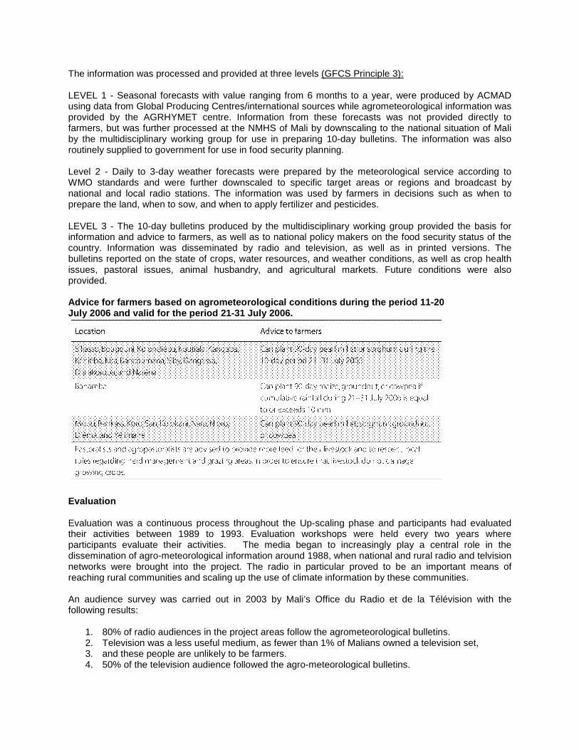
The information was processed and provided at three levels (GFCS Principle 3): LEVEL 1 - Seasonal forecasts with value ranging from 6 months to a year, were produced by ACMAD using data from Global Producing Centres/international sources while agrometeorological information was provided by the AGRHYMET centre. Information from these forecasts was not provided directly to farmers, but was further processed at the NMHS of Mali by downscaling to the national situation of Mali by the multidisciplinary working group for use in preparing 10-day bulletins. The information was also routinely supplied to government for use in food security planning. Level 2 - Daily to 3-day weather forecasts were prepared by the meteorological service according to WMO standards and were further downscaled to specific target areas or regions and broadcast by national and local radio stations. The information was used by farmers in decisions such as when to prepare the land, when to sow, and when to apply fertilizer and pesticides. LEVEL 3 - The 10-day bulletins produced by the multidisciplinary working group provided the basis for information and advice to farmers, as well as to national policy makers on the food security status of the country. Information was disseminated by radio and television, as well as in printed versions. The bulletins reported on the state of crops, water resources, and weather conditions, as well as crop health issues, pastoral issues, animal husbandry, and agricultural markets. Future conditions were also provided. Advice for farmers based on agrometeorological cond itions during the period 11-20 July 2006 and valid for the period 21-31 July 2006.
Evaluation Evaluation was a continuous process throughout the Up-scaling phase and participants had evaluated their activities between 1989 to 1993. Evaluation workshops were held every two years where participants evaluate their activities. The media began to increasingly play a central role in the dissemination of agro-meteorological information around 1988, when national and rural radio and telvision networks were brought into the project. The radio in particular proved to be an important means of reaching rural communities and scaling up the use of climate information by these communities. An audience survey was carried out in 2003 by Mali’s Office du Radio et de la Télévision with the following results:
1. 80% of radio audiences in the project areas follow the agrometeorological bulletins. 2. Television was a less useful medium, as fewer than 1% of Malians owned a television set, 3. and these people are unlikely to be farmers. 4. 50% of the television audience followed the agro-meteorological bulletins.

The survey results gave an indication of the success of using the radio as a dissemination tool that enabled climate information to reach a wider audience of rural communities and farmers especially the pastoralist communities who moved from place to place. Results and Impact Result 1: Higher crop yields Results from the 2003–2004 cropping season showed that crop yields and farmers’ incomes were higher in fields where climate and agrometeorological information was used compared with those where it was not used (GFCS Principle 2). The increase in income was substantial, notably for maize in the OHVN zone, where farmers earned 80% more income from ‘agromet’ fields. Testimonies from farmers indicated substantial production increases in maize, sorghum, pearl millet, groundnut, and cotton. However, more research was needed to evaluate these results, as it was difficult to single out agrometeorological information as the main reason for the increased yields without rigorous analysis of other relevant factors such as field conditions, the farmers sampled, and the use of inputs. It was however, clear that farmers felt they were exposed to lower levels of risk and were therefore more confident about purchasing and using inputs such as improved seeds, fertilizers, and pesticides, all of which boost production. These results are shown on the following table below: Crop yields and farm incomes for farmers taking man agement decisions with and without agrometeorological information, in the 2003 – 2004 season
Result 2: Enhanced capacity of the local farmers After nearly 25 years of practical experience, the capacity of the national and local multidisciplinary working groups to collect, analyze, and disseminate agrometeorological information greatly increased (GFCS Principle 4). Farmers’ understanding of this information, and their ability to assimilate it, also increased (GFCS Principle 1). By keeping close records of rainfall, the farmers gradually built valuable ‘climatological profiles’ of their own fields and added the data to the national climatological archives (GFCS Principles 2 & 7).

Result 3: Increased visibility of the NMHS leading to enhanced Infrastructural Capacity at the NMHS The Malian government recognized the positive impacts of this project and the benefits of meteorological services to the national development goals and endorsed it in 2001 with a financial commitment to strengthen the meteorological service (GFCS Principle 1). Improved buildings for the service opened in 2004, and about US$1.2 million was allocated for new weather stations and equipment in 2005–06. Implications for CRM Good Practices Several factors have contributed to the achievements of this project:
• The drought-induced famine of the mid-1970s was a stark demonstration of the effects of climate on peoples’ livelihoods; thus politicians began to give higher priority to managing climate risks (GFCS Principle 5)
• Long-term support from the principal donor SDC, as well as technical support from WMO
• The project’s farmer-centered approach, which has led to the development and delivery of climate
products and services that meet their needs (GFCS Pprinciples 2 & 8).
• Effective communication channels, especially the user interface by the Multidisciplinary Working Group that facilitated information flow between representative farmers and the climate information providers at national (NMHS of Mali) and regional level (AGRYHMET and ACMAD) (GFCS Principle 8).
• The project built on existing national systems
• The use of radio as an effective medium for information dissemination.
The project has successfully built a framework for gathering, analyzing, processing, and disseminating information that farmers can use and derive benefits. The project has demonstrated successful mechanisms for effective user-driven climate services provision and use by local vulnerable communities, including women for a least developed country with great potential for upscaling to other regions with similar circumstances. The most important aspect of the project for replication was the user interface mechanism that facilitated the flow of information between climate providers and users in a closed-loop system that enabled climate product improvement in a least developed country setting. Challenges However, the following challenges were identified which will need to be addressed for the future sustainability of the project
• Funding for agriculture extension officers is still limited and field visits to farmers were reduced. This threatens the sustainability of representative farmers taking rainfall measurements and adding to the national climate data archives. This limitation has potential to add to the decline of the national rainfall station observatories, a serious problem in developing and least developed countries. The decline of national observatories particularly rainfall stations has plagued developing countries and least developed countries due to inadequate funding by national governments such that rainfall stations with long-term historical data become silent and cease to report. The UNFCCC gave high priority for the rehabilitation and maintenance of this critical infrastructure in NMHSs of WMO Members to preserve and make available long-term historical rainfall data and Mali should seize opportunities to accomplish this through ongoing programmes and adaptation funds.

• Limiting factors in the development of relevant climate products included the advancement in weather and climate science, the capability of the NMHS and the funding.
• Limitations in providing reliable local-scale information to farmers. Higher resolution climate
products with more detail are needed. RCCs in Africa (ACMAD, ICPAC, SADC-CSC) are working towards achieving higher resolution climate products at the regional level.
• Communication problems were evident and there is a need for translating the more technical
terms into local languages;
• Poor radio reception in some areas;
• Low literacy levels and little formal education among farmers such that highly scientific information is brocken down to simpler syntax and translated to local languages for usability by farmers.
The Way Forward The following factors were identified with potential to enhance the project and result in increased benefits and outcomes: Capacity Building in forecast skills at the NMHS The Africa Climate Desk at the NOAA, National Centers for Environmental Prediction (NCEP) in USA is an ongoing programme which has continuously developed capacity of NMHSs staff to enhance their skill in interpreting and downscaling regional climate products to the national level. Climate scientists from NMHSs of RA-I countries periodically participate in the Programme at the Africa Desk at NOAA/NCEP for a period of six months fully funded by NOAA. This part of the training would be followed immediately by government secondment to regional climate centres (RCCs) such as ICPAC, SADC-CSC, ACMAD to gain regional experience before returning to their home countries to assist in downscaling broader, regional climate forecasts to specific country situations in their social, cultural, political, economic, and geographic context. Mali’s participation at NOAA’s NCEP Africa Desk will continue to enhance forecast skill of the NMHS staff to downscale regional climate products to the specific situation in Mali and progressively improve forecast products to meet farmer’s needs in the onset, cessation, distribution and amount of rainfall expected.
Agricultural research and climate Agriculturalists' understanding of the implications of weather and climate for farmers' practices had developed markedly and there was a sizeable body of knowledge, together with some useful products, ready for extension. If this knowledge and these products could be used to complement the advice to farmers being provided by the project, the additional impact on yields and incomes could be substantial. Longer lead times of improved seasonal Forecasts Advances in climate science, notably the increased skill of seasonal forecasting, could be used to provide farmers with a longer lead time for their decision making. Links to Markets for Farmers Finally, links to markets are crucial to the success of projects such as this one for commercial purposes. Without access to a market, there is little or no incentive for farmers to increase production. However, food security for subsistence farmers remaind important for domestic consumption and was not exclusively linked to markets. This project is scalable not only to other sectors of Mali’s economy, but to other drought prone regions of Africa as well and foster effective user-driven service delivery to vulnerable communities to enable adaptation to climate variability and change.

Similar attempts at this type of programme were conducted in Senegal, Mauritania, Cape Verde, Chad and Burkina Faso but have not proved as successful. Understanding the ingredients of success for such a programme is essential if it is to be replicated elsewhere. What is encouraging about the Malian programme and evidence of its success is that it resulted in significant budgetary allocation from the national government to the National Meteorological Services which ensured the sustainability of the project. Conclusion and Lessons Learned The following factors were attributed to the success of this project/programme: 1. The solicitation of user feedback as the engine that drove the process and informed climate products. 2. A sustained spirit of team work and the multidisciplinary composition of the team that represented the
user interface for the project/programme. 3. Importance of the relationships that were maintained between users, decision makers/donors and
stakeholders putting emphasis to the fact that climate service providers cannot work in isolation. 4. A spirit of transparency and accountability that facilitated openness to all involved that resulted in
motivation and more importantly, long-term commitment to the project/programme. 5. Continuous dialogue/interaction with users (through various mechanisms depending on the context and
resources) 6. Innovation, creativity and realism reflected in the design of the project/programme as well as building
upon existing local systems. 7.The multidisciplinary team approach was particularly useful in integrating different disciplinary ‘takes’
that emerged on a given problem such that the different disciplinary takes were complementary rather than conflicting in solution formulation.
Benefits
1. The benefit of climate services in support of Mali’s development goals was recognized, particularly in the work of rural communities, including farmers and women.
2. Higher visibility and increased support for the NMHS by the government and partners and resulted in government commitment to strengthen the NMHS of Mali.
This initiative needs to be applied to other sectors of the economy with services provided by the NMHS of Mali and foster effective user-driven service delivery for the benefit of Mali. Similar attempts at this type of programme were conducted in Senegal, Mauritania, Cape Verde, Chad and Burkina Faso but have not proved as successful. Understanding the ingredients of success for such a programme is essential if it is to be replicated elsewhere. What is encouraging about the Malian programme and evidence of its success is that it resulted in significant budgetary allocation from the national government to the National Meteorological Services which ensured the sustainability of the project. Source: Adapted from Climate Risk Management in Africa – Learning From Practice, International Research Institute for Climate and Society (IRI) , 2007. www.iri.columbia.edu