agricultural land and forestry resources
TRANSCRIPT

Draft Environmental Impact Report Peña’s Material Recovery Facility and Transfer Station Expansion Project
Chapter 3.2: Agricultural Land and Forestry Resources April 2013
3.2-1
Agricultural Land and Forestry Resources Chapter 3.2
SUMMARY OF FINDINGS The proposed Project will result in Less Than Significant Impacts to Agricultural Land and Forestry Resources. No mitigation measures will be required. A detailed review of potential impacts is provided in the following analysis.
INTRODUCTION California Environmental Quality Act (CEQA) Requirements
This section of the Draft Environmental Impact Report (DEIR) addresses potential impacts to Agricultural Land and Forestry Resources. As required in CEQA Guidelines Section 15126, all phases of the proposed Project will be considered as part of the potential environmental impact.
As noted in Section 15126.2 (a), “[a]n EIR shall identify and focus on the significant environmental effects of the proposed project. In assessing the impact of a proposed project on the environment, the lead agency should normally limit its examination to changes in the existing physical conditions in the affected area as they exist at the time the notice of preparation is published, or where no notice of preparation is published, at the time environmental analysis is commenced. Direct and indirect significant effects of the project on the environment shall be clearly identified and described, giving due consideration to both the short-term and long-term effects. The discussion should include relevant specifics of the area, the resources involved, physical changes, alterations to ecological systems, and changes induced in population distribution, population concentration, the human use of the land (including commercial and residential development), health and safety problems caused by the physical changes, and other aspects of the resource base such as water, historical resources, scenic quality, and public services. The EIR shall also analyze any significant environmental effects the project might cause by bringing development and people into the area affected. For example, an EIR on a subdivision astride an active fault line should identify as a significant effect the seismic hazard to future occupants of the subdivision. The subdivision would have the effect of attracting people to the location and exposing them to the hazards found there. Similarly, the EIR should evaluate any potentially significant impacts of locating development in other areas susceptible to hazardous conditions (e.g., floodplains, coastlines, wildfire risk areas) as identified in authoritative hazard maps, risk assessments or in land use plans addressing such hazards areas.”1
The environmental setting provides a description of the Agricultural Lands and Forestry Resources in the County. The regulatory setting provides a description of applicable Federal, State and Local regulatory policies that were developed in part from information contained in the Tulare County 2030 General Plan, Tulare County General Plan Background Report, and/or Tulare County 2030 General Plan EIR, incorporated by reference and summarized below.
1 2013 CEQA Guidelines, Section 15126.2 (a)

Draft Environmental Impact Report Peña’s Material Recovery Facility and Transfer Station Expansion Project
Chapter 3.2: Agricultural Land and Forestry Resources April 2013
3.2-2
Additional documents utilized are noted as appropriate. A description of the potential impacts of the proposed Project is provided and includes the identification of feasible mitigation measures (if necessary and feasible) to avoid or lessen the impacts.
Thresholds of Significance
The Department of Conservation identifies the location of prime Agricultural Land resource areas and Williamson Act Contract lands. Thresholds of potential significance will include the following:
Conversion of Prime Farmland, Unique Farmland, or Farmland of Statewide Importance
Conflict with Williamson Act Contracts
Convert Forest Land
ENVIRONMENTAL SETTING “Tulare County exhibits a diverse ecosystems landscape created through the extensive amount of topographic relief (elevations range from approximately 200 to 14,000 feet above sea level). The County is essentially divided into three eco-regions. The majority of the western portion of the County comprises the Great Valley Section, the majority of the eastern portion of the County is in the Sierra Nevada Section, and a small section between these two sections comprises the Sierra Nevada Foothill Area.2
Agricultural Productivity
The Project site is located in the San Joaquin Valley portion of Tulare County. This area is characterized by rich, highly productive farmland. Agriculture is the most important sector in Tulare County’s economy, and agriculture and related industries make Tulare County one of the two most productive agricultural counties in the United States, according to Tulare County Farm Bureau statistics.34 Agricultural lands (crop and commodity production and grazing) also provide the County’s most visible source of open space lands. As such, the protection of agricultural lands and continued growth and production of agriculture industries is essential to all County residents.”5
The 2011 Tulare County Annual Crop and Livestock Report listed Tulare County’s total gross production value for 2011 as $5,629,396,000. Milk was the leading agricultural commodity in Tulare County in 2011, representing 37% of the total crop and livestock value. The 2011 report listed over 120 different commodities, forty-three of which had a gross value greater than $1 million. The top agricultural commodities in the County in 2011, based on total/gross value were milk, oranges, cattle, grapes, corn – grain silage, and alfalfa (source: 2011 Tulare County Annual Crop and Livestock Report prepared by the office of the Tulare County Agricultural Commissioner/Sealer, published June 2012).
The California Department of Conservation Farmland Mapping and Monitoring Program (FMMP, 2010) indicates that agricultural lands in Tulare County included 859,991 acres of
2 Tulare County 2030 General Plan RDEIR, page 3.11-5 3 Tulare County Farm Bureau, “Agricultural Facts,” http://www.tulcofb.org/index.php?page=agfacts 4 Tulare County Agricultural Commissioner, 2011 Tulare County Agricultural Crop and Livestock Report, http://agcomm.co.tulare.ca.us/default/index.cfm/standards-and-quarantine/crop-reports1/ 5 Tulare County 2030 General Plan, page 3-4

Draft Environmental Impact Report Peña’s Material Recovery Facility and Transfer Station Expansion Project
Chapter 3.2: Agricultural Land and Forestry Resources April 2013
3.2-3
important farmland (designated as FMMP Prime, Farmland of Statewide Importance, Unique Farmland, or Farmland of Local Importance) and 440,042 acres of grazing land, for a total of 1,300,033 acres of agricultural land.
The Tulare County Subvention Report (November 21, 2012, see Table 3.2-1) notes that 1,069,299 acres of farmland with Tulare County is under California Land Conservation Act (Williamson Act) contracts; a program designed to prevent premature conversion of farmland to residential or other urban uses. As of January 1, 2012, there were 1,096,299 acres of farmland under Williamson Act or Farmland Security Zone contracts in Tulare County divided by the following categories: 571,904 acres of Williamson Act prime, 513,243 acres nonprime, and 11,152 acres of Farmland Security Zone lands (The acreage totals also include 6,040 acres of Williamson Act prime contract land in nonrenewal and 7,513 acres of Williamson Act of nonprime contract land in nonrenewal.)
Table 3.2-1
2012 Tulare County Lands under Williamson Act or Farmland Security Zone Contracts
Acres Category
571,904 *Total prime = Prime active + NR Prime
513,243 *Total Nonprime = Nonprime active + NR Prime
11,152 Farmland Security Zone
1,096,299 TOTAL ACRES in Williamson Act and Farmland Security Zone contracts
*Prime total includes 6,039.75 acres in nonrenewal; Nonprime total includes 7,512.56 acres in nonrenewal
Source: Data compiled from 2012 Tulare County Subvention Report
Important Farmland Trends
Using data collected by the FMMP, farmland acreage has been consistently decreasing for each two-year period since 1998. In the 2010 FMMP analysis, Tulare County lost 17,502 acres of important farmland, and 17,748 acres of total farmland between 2008 and 2010.6
“For Tulare County and the surrounding region, the reported major cause of this conversion is the downgrading of important farmlands to other agricultural uses (e.g., such as expanded or new livestock facilities, replacing irrigated farmland with non-irrigated crops, or land that has been fallow for six years or longer).”7
Forest Lands
“Timberlands that are available for harvesting are located in the eastern portion of Tulare County in the Sequoia National Forest. Hardwoods found in the Sequoia National Forest are occasionally harvested for fuel wood, in addition to use for timber production. Since most of the timberlands are located in Sequoia National Forest, the U.S. Forest Service has principal 6 California Department of Conservation, Division of Land Resource Protection, FMMP, “Tulare County 2008-2010 Land Use Conversion” Report, Table A-44 7 Tulare County 2030 General Plan RDEIR, page 3.10 to 3.13
Draft Environmental Impact Report Peña’s Material Recovery Facility and Transfer Station Expansion Project
Chapter 3.2: Agricultural Land and Forestry Resources April 2013
3.2-4
jurisdiction, which encompasses over 3 million acres. The U.S. Forest Service leases these federal lands for timber harvests.”8
8 General Plan Background Report, page 4-17

Draft Environmental Impact Report Peña’s Material Recovery Facility and Transfer Station Expansion Project
Chapter 3.2: Agricultural Land and Forestry Resources April 2013
3.2-5
Figure 3.2-1 - Prime Farmland Map
Draft Environmental Impact Report Peña’s Material Recovery Facility and Transfer Station Expansion Project
Chapter 3.2: Agricultural Land and Forestry Resources April 2013
3.2-6
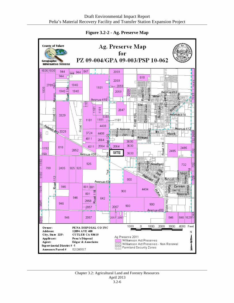
Figure 3.2-2 - Ag. Preserve Map

Draft Environmental Impact Report Peña’s Material Recovery Facility and Transfer Station Expansion Project
Chapter 3.2: Agricultural Land and Forestry Resources April 2013
3.2-7
REGULATORY SETTING Federal Agencies & Regulations Federal Farmland Protection Act (FFPA)
“The FPPA is intended to minimize the impact Federal programs have on the unnecessary and irreversible conversion of farmland to nonagricultural uses. It assures that to the extent possible federal programs are administered to be compatible with state, local units of government, and private programs and policies to protect farmland… Projects are subject to FPPA requirements if they may irreversibly convert farmland (directly or indirectly) to nonagricultural use and are completed by a Federal agency or with assistance from a Federal agency.”9
US Forest Service
“The U.S. Department of Agriculture Forest Service is a Federal agency that manages public lands in national forests and grasslands. The Forest Service is also the largest forestry research organization in the world, and provides technical and financial assistance to state and private forestry agencies. Gifford Pinchot, the first Chief of the Forest Service, summed up the purpose of the Forest Service—"to provide the greatest amount of good for the greatest amount of people in the long run."”10
State Agencies & Regulations California Department of Conservation: Farmland Mapping and Monitoring Program
“The California Department of Conservation (DOC), under the Division of Land Resource Protection, has developed the Farmland Mapping and Monitoring Program (FMMP), which monitors the conversion of the state’s farmland to and from agricultural use. Data is collected at the county level to produce a series of maps identifying eight land use classifications using a minimum mapping unit of 10 acres. The program also produces a biannual report on the amount of land converted from agricultural to non-agricultural use. The program maintains an inventory of state agricultural land and updates the “Important Farmland Series Maps” every two years (Department of Conservation, 2000).”11
Williamson Act: California Land Conservation Act of 1965
“The California Land Conservation Act (CLCA) of 1965, Sections 51200 et seq. of the California Government Code, commonly referred to as the “Williamson Act”, enables local governments to restrict the use of specific parcels of land to agricultural or related open space use. Landowners enter into contracts with participating cities and counties and agree to restrict their land to agriculture or open space use for a minimum of ten years. In return, landowners receive property tax assessments that are much lower than normal because they are based upon farming and open space uses as opposed to full market (speculative) value. Local governments receive an annual subvention of forgone property tax revenues from the state via the Open Space Subvention Act of 1971.”12
9 Federal Farmland Protection Act, http://www.nrcs.usda.gov/wps/portal/nrcs/main/national/programs/alphabetical/fppa 10 US Forest Service Description, http://www.fs.fed.us/aboutus/meetfs.shtml 11 General Plan Background Report, Page 4-12 12 Ibid. 4-13
Draft Environmental Impact Report Peña’s Material Recovery Facility and Transfer Station Expansion Project
Chapter 3.2: Agricultural Land and Forestry Resources April 2013
3.2-8
California Department of Forestry and Fire Protection (CAL FIRE)
“CAL FIRE manages eight Demonstration State Forests that provide for commercial timber production, public recreation, and research and demonstration of good forest management practices. CAL FIRE foresters can be found in urban areas working to increase the number of trees planted in our cities, or preventing the spread of disease by identifying and removing infected trees. A Native American burial ground in the path of a logging operation or fire may be verified and saved due to a CAL FIRE archaeologist's review of the area. And, an improved strain of trees, resistant to disease and pests, may be nurtured and introduced by a CAL FIRE forester.”13
Local Policy & Regulations Tulare County General Plan Policies
The Tulare County General Plan has a number of policies that apply to projects within County of Tulare. General Plan policies that relate to the proposed Project are listed below.
AG-1.1 Primary Land Use - The County shall maintain agriculture as the primary land use in the valley region of the County, not only in recognition of the economic importance of agriculture, but also in terms of agriculture’s real contribution to the conservation of open space and natural resources. AG-1.3 Williamson Act - The County should promote the use of the California Land Conservation Act (Williamson Act) on all agricultural lands throughout the County located outside established UDBs. However, this policy carries with it a caveat that support for the Williamson Act as a tax reduction component is premised on continued funding of the State subvention program that offsets the loss of property taxes. AG-1.4 Williamson Act in UDBs and HDBs - The County shall support non-renewal or cancellation processes that meet State law for lands within UDBs and HDBs. AG-1.6 Conservation Easements - The County shall consider developing an Agricultural Conservation Easement Program (ACEP) to help protect and preserve agricultural lands (including “Important Farmlands”), as defined in this Element. This program may require payment of an in-lieu fee sufficient to purchase a farmland conservation easement, farmland deed restriction, or other farmland conservation mechanism as a condition of approval for conservation of important agricultural land to non-agricultural use. If available, the ACEP shall be used for replacement lands determined to be of statewide significance (Prime or other Important Farmlands), or sensitive and necessary for the preservation of agricultural land, including land that may be a part of a community separator as part of a comprehensive program to establish community separators. The in-lieu fee or other conservation mechanism shall recognize the importance of land value and shall require equivalent mitigation. AG-1.7 Preservation of Agricultural Lands - The County shall promote the preservation of its agricultural economic base and open space resources through the implementation of resource management programs such as the Williamson Act, Rural Valley Lands Plan, Foothill Growth Management Plan or similar types of strategies and the identification of growth boundaries for all urban areas located in the County. 13 California Department of Forestry and Fire Protection, http://www.fire.ca.gov/about/about.php

Draft Environmental Impact Report Peña’s Material Recovery Facility and Transfer Station Expansion Project
Chapter 3.2: Agricultural Land and Forestry Resources April 2013
3.2-9
AG-1.8 Agriculture within Urban Boundaries - The County shall not approve applications for preserves or regular Williamson Act contracts on lands located within a UDB and/or HDB unless it is demonstrated that the restriction of such land will not detrimentally affect the growth of the community involved for the succeeding 10 years, that the property in question has special public values for open space, conservation, other comparable uses, or that the contract is consistent with the publicly desirable future use and control of the land in question. If proposed within a UDB of an incorporated city, the County shall give written notice to the affected city pursuant to Government Code §51233. AG-1.9 Agricultural Preserves Outside Urban Boundaries - The County shall grant approval of individual applications for agricultural preserves located outside a UDB provided that the property involved meets the requirements of the Williamson Act and the regulations of Tulare County. AG-1.10 Extension of Infrastructure into Agricultural Areas - The County shall oppose extension of urban services, such as sewer lines, water lines, or other urban infrastructure, into areas designated for agriculture use unless necessary to resolve a public health situation. Where necessary to address a public health issue, services should be located in public rights-of-way in order to prevent interference with agricultural operations and to provide ease of access for operation and maintenance. Service capacity and length of lines should be designed to prevent the conversion of agricultural lands into urban/suburban uses. AG-1.11 Agricultural Buffers - The County shall examine the feasibility of employing agricultural buffers between agricultural and non-agricultural uses, and along the edges of UDBs and HDBs. Considering factors include the type of operation and chemicals used for spraying, building orientation, planting of trees for screening, location of existing and future rights-of-way (roads, railroads, canals, power lines, etc.), and unique site conditions. LU-2.6 Industrial Development - Other than provided in Policy LU-2.5: Agricultural Support Facilities, the County shall, and the cities should, through their industrial development policies, approve only those agriculturally-oriented or related industries and uses that can demonstrate, whether by location and/or controlled methods of operation, that they will not adversely affect agricultural production or the County’s natural resources. These uses should be located inside UDBs, HDBs, PCAs and regional growth corridors unless necessary for the support of agricultural operations or as provided in Policy LU-2.5: Agricultural Support Facilities. IMPACT EVALUATION In determining whether impacts to agricultural resources are significant environmental effects, lead agencies may refer to the California Agricultural Land Evaluation and Site Assessment Model (1997) prepared by the California Dept. of Conservation as an optional model to use in assessing impacts on agriculture and farmland. In determining whether impacts to forest resources, including timberland, are significant environmental effects, lead agencies may refer to information compiled by the California Department of Forestry and Fire Protection regarding the state’s inventory of forest land, including the Forest and Range Assessment Project and the Forest Legacy Assessment project; and forest carbon measurement methodology provided in
Draft Environmental Impact Report Peña’s Material Recovery Facility and Transfer Station Expansion Project
Chapter 3.2: Agricultural Land and Forestry Resources April 2013
3.2-10
Forest Protocols adopted by the California Air Resources Board. Would the project:
a) Convert Prime Farmland, Unique Farmland, or Farmland of Statewide Importance
(Farmland), as shown on the maps prepared pursuant to the FMMP of the California Resources Agency, to non-agricultural uses? Project Impact Analysis: No Impact According to the FMMP map, the Project site is not located on Prime Farmland, Unique Farmland, or Farmland of Statewide Importance. As such, no Project-specific impacts to this Checklist Item will occur.
Cumulative Impact Analysis: No Impact The geographic area of this cumulative analysis is the entire State of California. This cumulative analysis is based on the Statewide FMMP map provided by the California Department of Conservation.
The Project site is not located on Prime Farmland, Unique Farmland, or Farmland of Statewide Importance. The Project site is located adjacent to prime farmland and farmland of statewide importance; however, the proposed expansion will not result in the conversion of these adjacent parcels or induce the conversion of these adjacent parcels to a non-agricultural use. No Cumulative Impacts related to this Checklist Item will occur. Mitigation Measure(s): None Required. Conclusion: No Impact As noted earlier, No Project-specific or Cumulative Impacts to this Checklist Item will occur.
b) Conflict with existing zoning for agricultural use, or a Williamson Act contract? Project Impact Analysis: Less than Significant Impact The Project site does not have a Williamson Act contract. There are parcels with agricultural uses (and Williamson Act contracts) adjacent to the Project site; however, the existing use has not resulted in the adjacent agricultural uses to be converted into a non-agricultural use. In addition, there are industrial uses near and adjacent to the Project site.
The proposed Project includes a request to change the zoning designation of the Project site from AE-20 (Exclusive Agricultural Zone–20 Acre Minimum) to M-1 (Light Manufacturing Zone). The Project site is located within the Cutler-Orosi Urban Development Boundary, and there are parcels with M-1 (Light Manufacturing Zone) and C-3 (Service Commercial Zone) zoning designations along the south side of Avenue 408. The Wawona Packing Company is located across the street on the south side of Avenue 408, the Sun Tree Nut Packing Company is located west of Road 120, and the Cutler-Orosi Joint Wastewater Authority Treatment Plant is located southwest of the Project site, west of Road 120.
This zone change will be compatible with the existing uses in the area and is consistent with the current use of the Project site. As such, Project-specific impacts to this Checklist Item will be Less Than Significant.

Draft Environmental Impact Report Peña’s Material Recovery Facility and Transfer Station Expansion Project
Chapter 3.2: Agricultural Land and Forestry Resources April 2013
3.2-11
Cumulative Impact Analysis: Less than Significant Impact The geographic area of this cumulative analysis is the entire State of California. This cumulative analysis is based on the Statewide FMMP map provided by the California Department of Conservation.
The Project site does not have a Williamson Act contract. The existing use has not resulted in the adjacent agricultural uses to be converted into a non-agricultural use. The expansion of the existing use will not induce other agricultural uses to be converted. Cumulative impacts to this Checklist Item will be Less Than Significant. Mitigation Measure(s): None Required. Conclusion: Less than Significant Impact As noted earlier, Less Than Significant Project-specific and Cumulative Impacts to this Checklist Item will occur.
c) Conflict with existing zoning for, or cause rezoning of forest land (as defined in Public Resources Code § 12220(q), timberland (as defined by Public Resources Code § 4526), or timberland zoned Timberland Production (as defined by Government Code § 51104(g))? Project Impact Analysis: No Impact The Project site and surrounding areas contain no lands zoned or identified as forest land or timberland. The site is currently zoned as AE-20 (Exclusive Agricultural Zone–20 Acre Minimum). Although the proposed Project includes a request to change the zoning designation to M-1 (Light Manufacturing Zone), the proposed zone change would not result in the rezoning of designated forestland. As such, No Project-specific Impacts to this Checklist Item will occur.
Cumulative Impact Analysis: No Impact The geographic area of this cumulative analysis is Tulare County. This cumulative analysis is based on the information provided in the Tulare County 2030 General Plan, General Plan background Report, and/or Tulare County 2030 General Plan EIR.
The proposed Project is not located within a forestland zone or would require the change of a forestland zone. As such No Cumulative Impacts to this Checklist Item will occur.
Mitigation Measure(s): None Required. Conclusion: No Impact As noted earlier, No Project-specific or Cumulative Impacts to this Checklist Item will occur.
d) Result in the loss of forest land or conversion of forest land to non-forest use? Project Impact Analysis: No Impact As noted earlier, the proposed Project is not located within a forest land zone or would require the change of a forest land zone. As such, No Project-specific Impacts to this Checklist Item will occur.

Draft Environmental Impact Report Peña’s Material Recovery Facility and Transfer Station Expansion Project
Chapter 3.2: Agricultural Land and Forestry Resources April 2013
3.2-12
Cumulative Impact Analysis: No Impact The geographic area of this cumulative analysis is Tulare County. This cumulative analysis is based on the information provided in the Tulare County 2030 General Plan, General Plan background Report, and/or Tulare County 2030 General Plan EIR.
As noted earlier, the proposed Project is not located within a forest land zone or would require the change of a forest land zone. As such, No Cumulative Impacts to this Checklist Item will occur.
Mitigation Measure(s): None Required. Conclusion: No Impact As noted earlier, No Project-specific or Cumulative Impacts to this Checklist Item will occur.
e) Involve other changes in the existing environment which, due to their location or nature, could result in conversion of Farmland, to non-agricultural use or conversion of agricultural use or conversion of forest land to non-forest use? Project Impact Analysis: Less than Significant Impact The proposed Project is an expansion of an existing Material Recovery Facility and Transfer Station. The nature of the proposed Project will not induce housing or commercial growth in the adjacent area. The Project site is located in a rural area, at the edge of the Cutler-Orosi Urban Development Boundary, and is not located within forest land. Although the proposed Project includes a zoning change request, this zone change is appropriate for the site and the context of the adjacent manufacturing and commercial zoned parcels. In addition, a special use permit is required for uses that could potentially create smoke, fumes, dust, odor, and other hazards that could affect adjacent uses. With the implementation of the conditions of approval contained in the Special Use Permit, Less Than Significant Project-specific Impacts to this Checklist Item will occur.
Cumulative Impact Analysis: Less than Significant Impact The geographic area of this cumulative analysis is Tulare County. This cumulative analysis is based on the information provided in the Tulare County 2030 General Plan, General Plan background Report, and/or Tulare County 2030 General Plan EIR.
The proposed Project includes a General Plan amendment to allow the conversion of the site from Industrial Reserve/Residential Reserve to Industrial. As the site is an established industrial use, and as there are industrial uses adjacent to the site, the proposed Project includes an appropriate amendment to the General Plan. As noted earlier, the use and location of the Project site will not cause the conversion of adjacent agricultural uses or the conversion of forestland. Less Than Significant Cumulative Impacts related to this Checklist Item will occur.
Mitigation Measure(s): None Required. Conclusion: Less Than Significant Impact
Draft Environmental Impact Report Peña’s Material Recovery Facility and Transfer Station Expansion Project
Chapter 3.2: Agricultural Land and Forestry Resources April 2013
3.2-13
As noted earlier, Less Than Significant Project-specific and Cumulative Impacts to this Checklist Item will occur.
DEFINITIONS/ACRONYMS DEFINITIONS “The California Department of Conservation, Division of Land Resource Protection, maintains the Farmland Mapping and Monitoring Program (FMMP), which monitors the conversion of the state’s farmland to and from agricultural use. The map series identifies eight classifications (discussed below) and uses a minimum mapping unit size of 10 acres. The program also produces a biannual report on the amount of land converted from agricultural to non-agricultural use. The program maintains an inventory of state agricultural land and updates its “Important Farmland Series Maps” every two years. Although the program monitors a wide variety of farmland types (more fully described below), Important Farmland consists of lands classified as Prime Farmland, Farmland of Statewide Importance, and Unique Farmland.”14 Prime Farmland (P) - “Prime Farmland is farmland with the best combination of physical and chemical features to sustain long-term agricultural production. This land has the soil quality, growing season, and moisture supply needed to produce sustained high yields. Land must have been used for irrigated agricultural production at some time during the four years prior to the mapping date.”15 Farmland of Statewide Importance (S) - “Farmland of Statewide Importance is similar to Prime Farmland but has minor shortcomings, such as greater slopes or a lesser ability to store soil moisture. Land must have been used for irrigated agricultural production at some time during the four years prior to the mapping date.”16 Unique Farmland (U) - “Unique Farmland has lesser quality soils used for the production of the state's leading agricultural crops. This land is usually irrigated, but may include nonirrigated orchards or vineyards as found in some climatic zones in California. Land must have been cropped at some time during the four years prior to the mapping date.”17 Farmland of Local Importance (L) - “Farmland of Local Importance is land important to the local agricultural economy as determined by each county’s board of supervisors and a local advisory committee.”18 Grazing Land (G) - “Grazing Land is land on which the vegetation is suited to the grazing of livestock. This category was developed in cooperation with the California Cattlemen’s
14 General Plan Update RDEIR, page 3.10-4 15 Ibid. 16 Op. Cit. 17 Op. Cit. 18 Op. Cit.

Draft Environmental Impact Report Peña’s Material Recovery Facility and Transfer Station Expansion Project
Chapter 3.2: Agricultural Land and Forestry Resources April 2013
3.2-14
Association, the University of California Cooperative Extension, and other groups interested in the extent of grazing activities. The minimum mapping unit for Grazing Land is 40 acres.”19 Urban and Built-Up Land (D) - “Urban and Built-Up Land is land occupied by structures with a building density of at least 1 unit to 1.5 acres, or approximately 6 structures to a 10-acre parcel. This land is used for residential, industrial, commercial, construction, institutional, public administration, railroad and other transportation yards, cemeteries, airports, golf courses, sanitary landfills, sewage treatment, water control structures, and other developed purposes.”20 Other Land (X) - “Other Land is land not included in any other mapping category. Common examples include low-density rural developments; brush, timber, wetland, and riparian areas not suitable for livestock grazing; confined livestock, poultry, or aquaculture facilities; strip mines and borrow pits; and water bodies smaller than 40 acres. Vacant and nonagricultural land surrounded on all sides by urban development and greater than 40 acres is mapped as Other Land.”21 Water (W) - “Water is defined as perennial water bodies with an extent of at least 40 acres. While the number of agricultural lands classified as Important Farmlands (i.e., Prime Farmland, Farmland of Statewide Importance, and Unique Farmland) have been decreasing over the past several years, the total acreage for all categories of farmland (including grazing land) remained relatively stable between the years 1998 and 2006 (see Table 3.10-4). The locations of these farmland types are identified in Figure 3.10-1. The farmlands are concentrated in the Rural Valley/Foothill Planning areas. No important farmlands are located in the Mountain Area.”22 ACRONYMS CLCA California Land Conservation Act (Williamson Act) FFPA Federal Farmland Protection Act FMMP Farmland Mapping and Monitoring Program REFERENCES Tulare County 2030 General Plan, August 2012
California Department of Conservation (DOC), Division of Land Resource Protection (DLRP), California Land Conservation, “Williamson Act Status Report (2010)” downloaded from “Williamson Act Reports and Statistics”
http://www.conservation.ca.gov/dlrp/lca/stats_reports/Pages/index.aspx
Department of Conservation, Division of Land Resources Protection, Farmland Mapping and Monitoring Program, http://www.conservation.ca.gov/dlrp/fmmp/Pages/Index.aspx
19 Op. Cit. 20 Op. Cit. 3.10-4 and 3.10-5 21 Op. Cit. 3.10-5 22 Op. Cit.
Draft Environmental Impact Report Peña’s Material Recovery Facility and Transfer Station Expansion Project
Chapter 3.2: Agricultural Land and Forestry Resources April 2013
3.2-15
Tulare County Farm Bureau, “Agricultural Facts,” Tulare County Farm Bureau, “Agricultural Facts,” http://www.tulcofb.org/index.php?page=agfacts
Tulare County 2030 General Plan Background Report, February 2010
Tulare County 2030 General Plan, Recirculated Draft Environmental Impact Report (RDEIR), February 2010
Tulare County Agricultural Commissioner, “2011 Tulare County Annual Crop and Livestock Report”, June 2012, http://agcomm.co.tulare.ca.us/default/index.cfm/standards-and-quarantine/crop-reports1/
Tulare County Agricultural Commissioner, 2011 Tulare County Agricultural Crop and Livestock Report, http://agcomm.co.tulare.ca.us/default/index.cfm/standards-and-quarantine/crop-reports
Tulare County Resource Management Agency, Tulare County Subvention Report for Fiscal Year 2012-2013 (submitted to Department of Conservation, November 2012)
Tulare County Zoning Ordinance and Related State and Local Land Use Regulations (Ordinance 352, as amended) (Revised September 2005), http://www.tularecounty.ca.gov/rma/index.cfm/documents-and-forms/planning-documents/tulare-county-zoning-ordinance/
California Department of Forestry and Fire Protection, http://www.fire.ca.gov/about/about.php
Federal Farmland Protection Act,
http://www.nrcs.usda.gov/wps/portal/nrcs/main/national/programs/alphabetical/fppa
US Forest Service, “About Us – Meet the Forest Service”,
http://www.fs.fed.us/aboutus/meetfs.shtml
2013 CEQA Guidelines