aerosol products from noaa operational...
TRANSCRIPT

Aerosol Products from NOAA Operational Satellites
S. Kondragunta, I. Laszlo, and M. GoldbergPresented by R. B. Pierce
NOAA/NESDIS Center for Satellite Applications and Research
April 27‐29, 2010 1Aerosol Observability Workshop, Naval
Research Laboratory, Monterey, CA
NOAA National Environmental Satellite, Data, and Information Service (NESDIS) provides timely access to global environmental data from satellites and other sources to promote, protect, & enhance the Nation's economy, security, environment, & quality of life.
NESDIS Responsibilities
•Acquire and manage the Nation's operational environmental satellites
•Operate the NOAA National Data Centers
•Provide data and information services including Earth system monitoring
•Perform official assessments of the environment
•Conduct related research
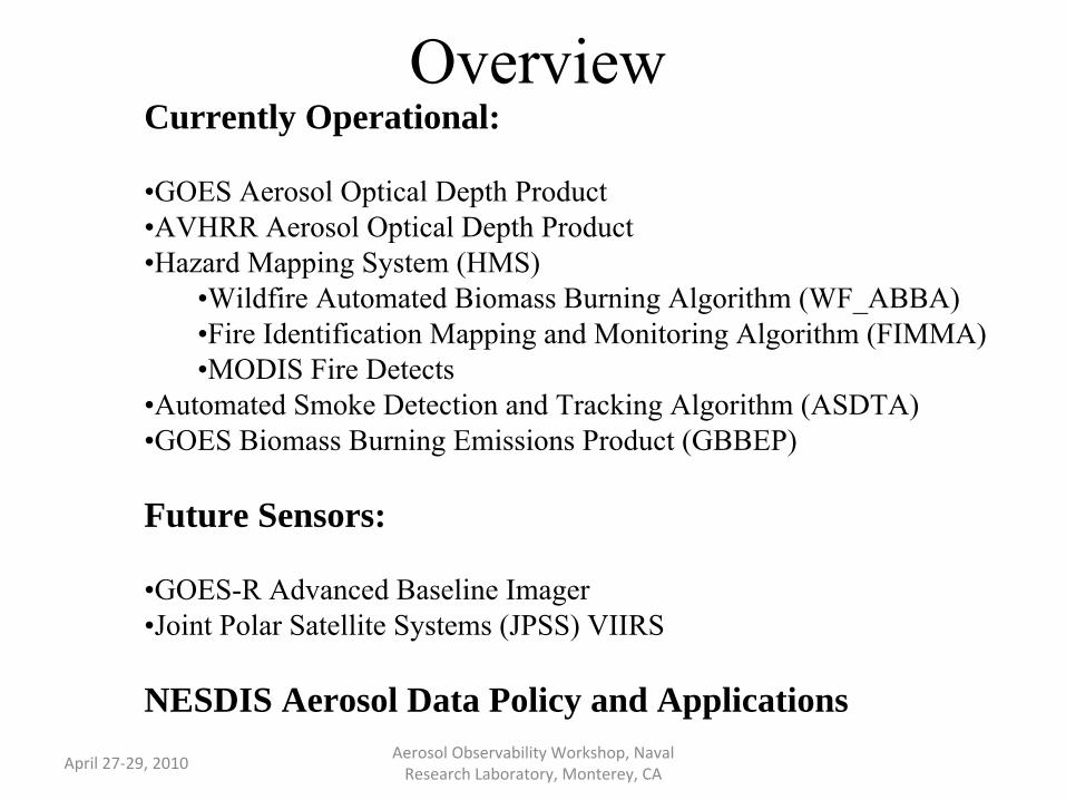
OverviewCurrently Operational:
•GOES Aerosol Optical Depth Product•AVHRR Aerosol Optical Depth Product•Hazard Mapping System (HMS)
•Wildfire Automated Biomass Burning Algorithm (WF_ABBA)•Fire Identification Mapping and Monitoring Algorithm (FIMMA)•MODIS Fire Detects
•Automated Smoke Detection and Tracking Algorithm (ASDTA)•GOES Biomass Burning Emissions Product (GBBEP)
Future Sensors:
•GOES-R Advanced Baseline Imager•Joint Polar Satellite Systems (JPSS) VIIRS
NESDIS Aerosol Data Policy and ApplicationsApril 27‐29, 2010 Aerosol Observability Workshop, Naval
Research Laboratory, Monterey, CA
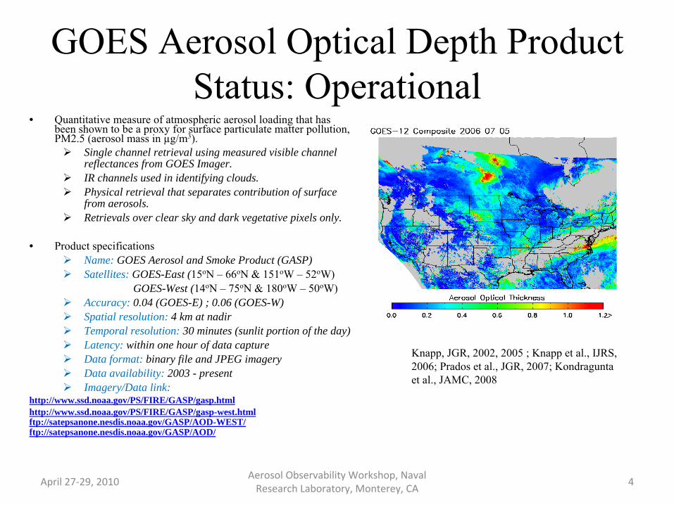
GOES Aerosol Optical Depth Product Status: Operational
April 27‐29, 2010 Aerosol Observability Workshop, Naval
Research Laboratory, Monterey, CA
• Quantitative measure of atmospheric aerosol loading that has been shown to be a proxy for surface particulate matter pollution, PM2.5 (aerosol mass in µg/m3).
Single channel retrieval using measured visible channel reflectances from GOES Imager.IR channels used in identifying clouds.Physical retrieval that separates contribution of surface from aerosols.Retrievals over clear sky and dark vegetative pixels only.
• Product specificationsName: GOES Aerosol and Smoke Product (GASP)Satellites: GOES-East (15oN – 66oN & 151oW – 52oW)
GOES-West (14oN –
75oN & 180oW –
50oW)Accuracy: 0.04 (GOES-E) ; 0.06 (GOES-W)Spatial resolution: 4 km at nadirTemporal resolution: 30 minutes (sunlit portion of the day)Latency: within one hour of data captureData format: binary file and JPEG imageryData availability: 2003 - presentImagery/Data link:
http://www.ssd.noaa.gov/PS/FIRE/GASP/gasp.htmlhttp://www.ssd.noaa.gov/PS/FIRE/GASP/gasp-west.htmlftp://satepsanone.nesdis.noaa.gov/GASP/AOD-WEST/ftp://satepsanone.nesdis.noaa.gov/GASP/AOD/
Knapp, JGR, 2002, 2005 ; Knapp et al., IJRS, 2006; Prados et al., JGR, 2007; Kondragunta et al., JAMC, 2008
4
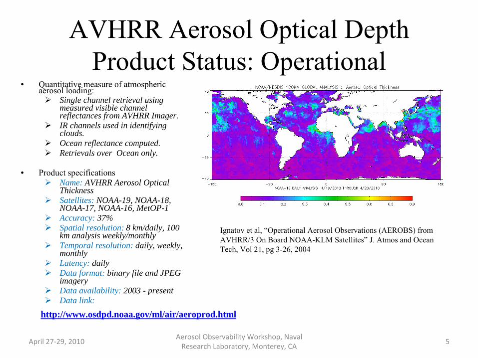
AVHRR Aerosol Optical Depth Product Status: Operational
April 27‐29, 2010 Aerosol Observability Workshop, Naval
Research Laboratory, Monterey, CA 5
• Quantitative measure of atmospheric aerosol loading:
Single channel retrieval using measured visible channel reflectances from AVHRR Imager.IR channels used in identifying clouds.Ocean reflectance computed. Retrievals over Ocean only.
• Product specificationsName: AVHRR Aerosol Optical ThicknessSatellites: NOAA-19, NOAA-18, NOAA-17, NOAA-16, MetOP-1Accuracy: 37%Spatial resolution: 8 km/daily, 100 km analysis weekly/monthlyTemporal resolution: daily, weekly, monthlyLatency: dailyData format: binary file and JPEG imageryData availability: 2003 - presentData link:
Ignatov et al, “Operational Aerosol Observations (AEROBS) from AVHRR/3 On Board NOAA-KLM Satellites”
J. Atmos and Ocean Tech, Vol 21, pg 3-26, 2004
http://www.osdpd.noaa.gov/ml/air/aeroprod.html

•The HMS integrates satellite data from different platforms with the output from automated fire detection algorithms for the different instruments as well as various ancillary data layers that aid analysts in their decision making process.
•Analysts review fire detects from the algorithms and either retain them in the analysis or delete them if they feel they are false detects. Analysts also scan the satellite imagery and add hotspots that the algorithms have not detected.
Hazard Mapping System (HMS)Operational daily fire and smoke analysis for North America using seven geostationary (GOES) and polar orbiting (POES and MODIS) satellites
Satellite SensorSWIR nominal
resolution Refresh Rate Geographic coverageAutomated detection algorithm
GEOSTATIONARYGOES-EastGOES-West
4km 15 minutesCONUS/Canada/Central America WFABBA
Western half of CONUS/Alaska/Hawaii
POLARNOAA-15/17/18MODIS TerraMODIS Aqua
1km
Twice/day low/mid latitudes
More frequent at high latitudes
Most of North/Central America except NOAA-15 which does not
cover Western US
FIMMA
MODIS
April 27‐29, 2010 Aerosol Observability Workshop, Naval
Research Laboratory, Monterey, CA

Product developed by the biomass burning monitoring team at CIMSS using the GOES Imager, Meteosat SEVIRI, and MTSAT JAMI to detect and monitor fires (wildfires, prescribed burns and agricultural burns) globally. The WF-ABBA runs all available imagery data from supported geostationary satellites.
Wildfire Automated Biomass Burning Algorithm (WF_ABBA)
The WF_ABBA fire product includes: fire location (lat./lon.), estimates of instantaneous fire size, temperature, and radiative power, ~4 and ~11 micron observed brightness temperatures, background brightness temperatures, albedo statistics, ecosystem type, and a detection classification flag. The product also produces a mask identifying on a per-pixel basis whether the pixel has a fire, does not have a fire, or no determination could be made due to clouds, solar block-out zones, ecosystem type, etc…
Prins, E. M. and W. P. Menzel, 1994: Trends in South American biomass burning detected with the GOES visible infrared spin scan radiometer atmospheric sounder from 1983 to 1991, Jour. Geo. Res., 99, 16719-16735.Prins, E. M. and W. P. Menzel, 1992: Geostationary Satellite detection of biomass burning in South America, Int. J. of Remote Sensing, 13, 2783-2799.
ftp://satepsanone.nesdis.noaa.gov/FIRE/ABBA/
Binary Data:
WF_ABBA daily fires summary from NESDIS Operations
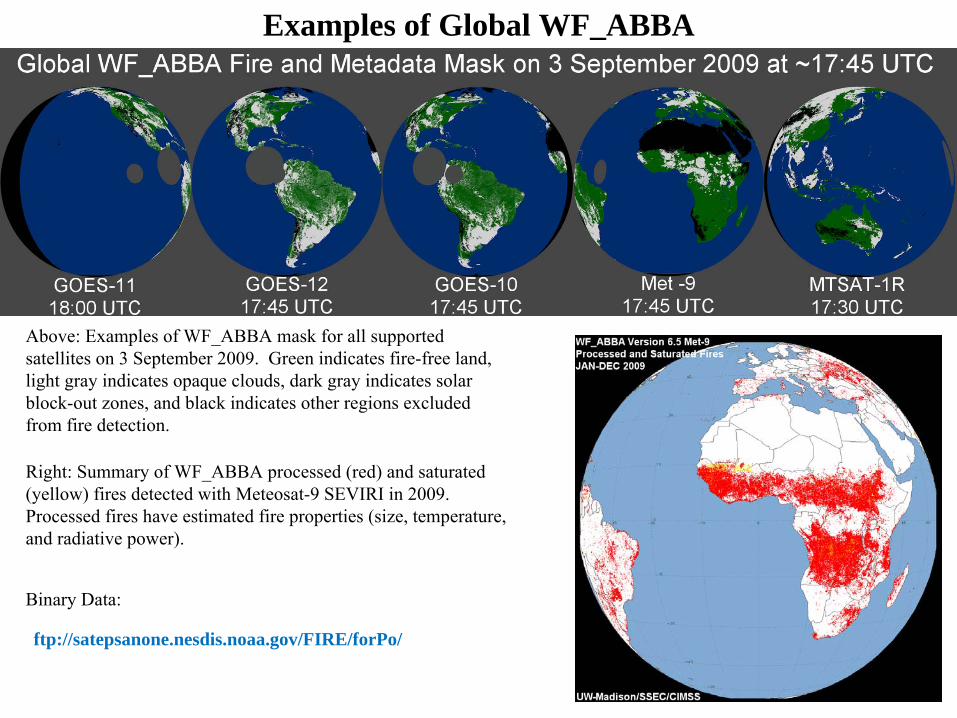
Examples of Global WF_ABBA
Above: Examples of WF_ABBA mask for all supported satellites on 3 September 2009. Green indicates fire-free land, light gray indicates opaque clouds, dark gray indicates solar block-out zones, and black indicates other regions excluded from fire detection.
Right: Summary of WF_ABBA processed (red) and saturated (yellow) fires detected with Meteosat-9 SEVIRI in 2009. Processed fires have estimated fire properties (size, temperature, and radiative power).
ftp://satepsanone.nesdis.noaa.gov/FIRE/forPo/
Binary Data:

The FIMMA is an automated algorithm to detect fires from Advanced Very High Resolution Radiometer (AVHRR) data from NOAA polar-orbiting satellites. The FIMMA product was developed by CIRA by modifying an algorithm developed at the University of Maryland. The current version uses geo-corrected High Resolution Picture Transmission (HRPT) AVHRR data over the US (including Alaska and Hawaii).
Fire Identification Mapping and Monitoring Algorithm (FIMMA)
Files are available in comma delimited format (Lon, Lat, Channel 3b, 4, 5 brightness temperatures, and Landcover) covering North America.
This product occassionally suffers from false detects due to satellite noise, high surface temperatures, or stong solar reflectivity. Attempts to eliminate this noise in this automated algorithm may have filtered true fires. Users are advised to use the HMS fire product for better accuracy.
ftp://satepsanone.nesdis.noaa.gov/FIRE/FIMMA
Binary Data:
Li, Z., R. Fraser, J. Jin, A. A. Abuelgasim, I. Csiszar, P. Gong, R. Pu, and W. Hao, Evaluation of algorithms for fire detection
and mapping across North America from satellite, J. Geophys. Res., 108(D2), 4076, doi:10.1029/2001JD001377, 2003.
FIMMA daily fires summary from NESDIS Operations

MODIS Fire Detects
OSDPD produces TERRA & AQUA MODIS fire products using data from the near real-
time NASA MODIS Rapid Response System. The fire algorithm was developed by the MODIS Fire and Thermal Anomalies team.
Giglio, L., Csiszar, I., Justice, C.O. 2006. Global distribution
and seasonality of active fires as observed with the Terra and Aqua MODIS sensors. Journal of Geophysical Research - Biogeosciences, Vol 111, G02016, doi:10.1029/2005JG000142.Schroeder, W., Prins, E., Giglio, L., Csiszar, I., Schimdt, C., Morisette, J., Morton, D. 2008. Validation of GOES and MODIS active fire detection products using ASTER and ETM+ data. Remote Sensing of Environment 112 (2008) 2711–2726.
ftp://satepsanone.nesdis.noaa.gov/FIRE/MODISBinary Data:
OSDPD extracts the fire positions and confidence values from NASA HDF files and place them into comma-delimited ascii files.
Fire locations represent the approximate location of the fire pixel and do not represent the actual fire size.
The Near Real Time Processing System is not considered operational. We do not guarantee 24/7 access to this data at this time.
MODIS daily fires summary from NESDIS Operations

Automated Smoke Detection and Tracking Algorithm (ASDTA) Status: Operational
April 27‐29, 2010 11
• Semi-quantitative retrieval of column average smoke concentration (µg/m3) using AOD and fire hot spots from GOES
Uses source apportionment and pattern recognition techniques to isolate smoke aerosols from other type of aerosolsSmoke mass concentration (mc) is obtained using AOD (τ), mass extinction efficiency (k), and aerosol height (h)
• Product specificationsName: ASDTASatellites: GOES-East and GOES-West (includes Alaska and Hawaii)Accuracy: 40%Spatial resolution: 0.15o
Temporal resolution: hourlyLatency: one dayData format: binary file, GRIB file, JPEG imageryData availability: 2007 - presentData link: ftp://satepsanone.nesdis.noaa.gov/FIRE/HMS/SMOKE
Animation of Smoke Plume DetectionOriginal AOD Image Smoke AOD Image
hkmc ∗
=τ
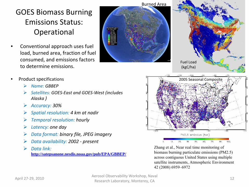
GOES Biomass Burning Emissions Status:
Operational
• Conventional approach uses fuel
load, burned area, fraction of fuel
consumed, and emissions factors
to determine emissions.
April 27‐29, 2010 Aerosol Observability Workshop, Naval
Research Laboratory, Monterey, CA 12
Fuel Load
(kgC/ha)
Burned Area
• Product specificationsName: GBBEPSatellites: GOES‐East and GOES‐West (includes Alaska )Accuracy: 30%Spatial resolution: 4 km at nadirTemporal resolution: hourlyLatency: one dayData format: binary file, JPEG imageryData availability: 2002 ‐ presentData link: http://satepsanone.nesdis.noaa.gov/pub/EPA/GBBEP/
2005 Seasonal Composite
Zhang et al., Near real time monitoring of biomass burning particulate emissions (PM2.5) across contiguous United States using multiple satellite instruments, Atmospheric Environment 42 (2008) 6959–6972

Global Biomass Burning Emissions Product from a Constellation of
Geostationary Satellites
Status: Experimental
Currently developing a new
experimental product using
fire radiative power approach.
Satellites used are GOES‐E,
GOES‐W, MetoSAT, MTSAT.
April 27‐29, 2010 Aerosol Observability Workshop, Naval
Research Laboratory, Monterey, CA 13
Hourly Biomass Burning Aerosols on Sept. 16, 2009

Aerosol Products from Next Generation NOAA Satellite Sensors GOES‐R Advanced Baseline Imager
• ABI is a multi‐channel Imager that will
provide Suspended Matter/Aerosol
Optical Depth– MODIS/VIIRS
algorithms have
been adapted for ABI
– Algorithm tested
using seven years of
MODIS radiances as
proxy data
April 27‐29, 2010 Aerosol Observability Workshop, Naval
Research Laboratory, Monterey, CA 14
GOES‐R ABI AOD (1/28/2008)
RangeLand Water
AOD Accuracy AOD Accuracy
Low <0.04 0.06 <0.4 0.02
Medium 0.04-0.8 0.04
High >0.8 0.12 >0.4 0.10
Laszlo I., P. Ciren, H. Liu, S. Kondragunta, J. D. Tarpley and M. D. Goldberg, 2008: Remote sensing of aerosol and radiation from geostationary satellites, Adv. Space Res., 41, 11, 1882-1893, doi: 10.1016/j.asr.2007.06.047
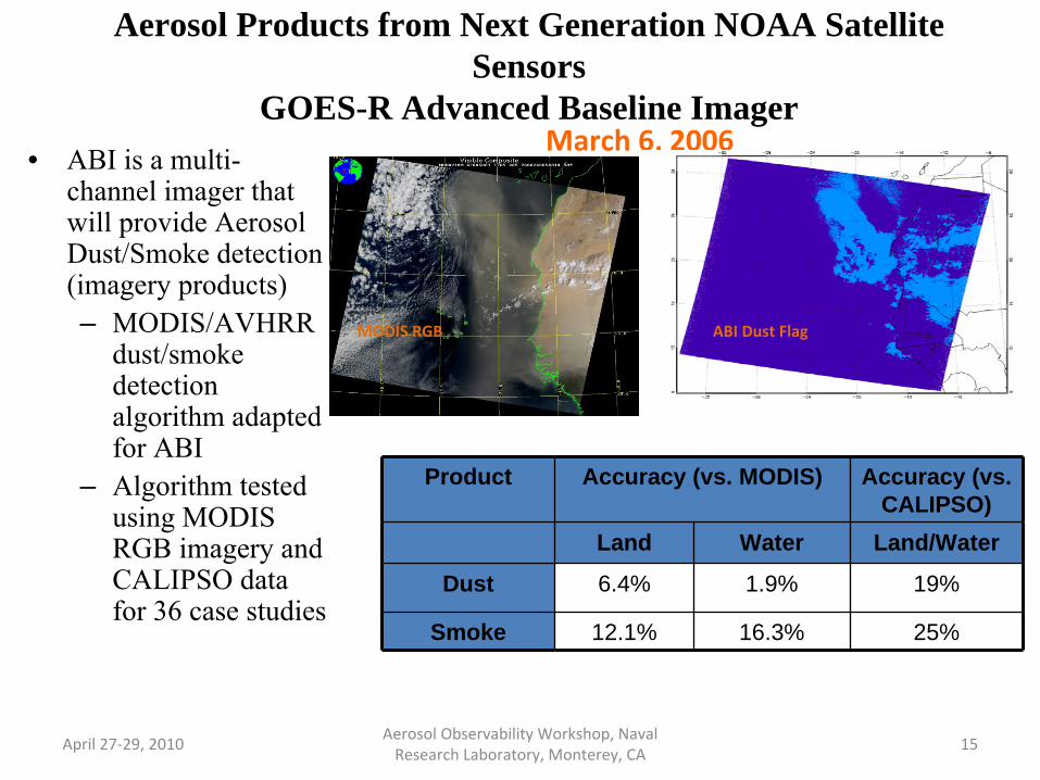
Aerosol Products from Next Generation NOAA Satellite Sensors
GOES-R Advanced Baseline Imager• ABI is a multi-
channel imager that will provide Aerosol Dust/Smoke detection (imagery products)– MODIS/AVHRR
dust/smoke detection algorithm adapted for ABI
– Algorithm tested using MODIS RGB imagery and CALIPSO data for 36 case studies
April 27‐29, 2010 Aerosol Observability Workshop, Naval
Research Laboratory, Monterey, CA 15
March 6, 2006
Product Accuracy (vs. MODIS) Accuracy (vs. CALIPSO)
Land Water Land/Water
Dust 6.4% 1.9% 19%
Smoke 12.1% 16.3% 25%
ABI Dust FlagMODIS RGB

Aerosol Products from Next Generation NOAA Satellite Sensors Joint Polar Satellite Systems (JPSS) VIIRS
• VIIRS is a multi-channel Imager that will provide Aerosol Optical Depth, Aerosol Particle Size, Suspended Matter (smoke/dust classification products– NESDIS is validating
the algorithm/product. Official product will be available through system prime. Additional improved products through NESDIS (JPSS data exploitation project) are anticipated.
April 27‐29, 2010 Aerosol Observability
Workshop, Naval
Research Laboratory, Monterey, CA 16
VIIRS AOD
MODIS AOD
8/8 2006

NESDIS Aerosol Data Policy and Applications
• All products, if operational, are available for public use on public domain (DDS, Data Distribution System) from OSDPD (Office of Satellite Data Production and Distribution). They have 24-hr/7-day technical support.
– NOAA is not responsible for products developed by non-NOAA personnel using NOAA satellite data.– All NOAA products have PALs (Product Area Leads) who receive feedback from users and who provide product
upgrades/outage etc. information to the users. PALs get science
guidance from algorithm developers at STAR (Center for Satellite Applications and Research).
– Users interested in these products should contact the PALs– Requests for new products must come through submission of a user
request from at http://projects.osd.noaa.gov/spsrb/
• All products, if experimental, are available for testing and potential applications through STAR PIs. They do not have 24-hr/7-day technical support.
• List of OSDPD PALs: – GOES AOD ([email protected])– HMS ([email protected])– Fires ([email protected])– Emissions ([email protected])– GOES ASDTA ([email protected])– MODIS and AVHRR AOD ([email protected])
• Science support from STAR:– GOES AOD ([email protected])– Fires ([email protected], [email protected])– Emissions ([email protected])– GOES ASDTA ([email protected])– AVHRR AOD ([email protected])
April 27‐29, 2010 Aerosol Observability Workshop, Naval
Research Laboratory, Monterey, CA 17

Acknowledgements
• Supporting material for this briefing provided by:– Pubu Ciren (IMSG)– Hongqing Liu (IMSG)– Mi Zhou (IMSG)– Xiaoyang Zhang (ERT)– Jian Zeng (ERT)– Chris Schmidt (CIMSS)
April 27‐29, 2010 Aerosol Observability Workshop, Naval
Research Laboratory, Monterey, CA 18