aemr 2013-2014 - main text - austar coal mine
TRANSCRIPT
AUSTAR COAL MINE PTY LTD | PART OF THE YANCOAL AUSTRALIA GROUP
Annual Environmental
Management Report July 2013 – June 2014

Austar Annual Environmental Management Report July 2013 – June 2014
AUSTAR COAL MINE PTY LTD | PART OF THE YANCOAL AUSTRALIA GROUP i
TITLE BLOCK
Name of Mine: Austar Coal Mine Titles/Mining Leases: Refer to Table 1.2 and 1.4 MOP Commencement Date: May 2008 MOP Completion Date: May 2015 AEMR Commencement Date: 01/07/2013 AEMR End Date: 30/06/2014 Name of Leaseholder: Austar Coal Mine Pty Limited Reporting Officer: Gary Mulhearn Title: Environment and Community Manager Date: 30 September 2014

Austar Annual Environmental Management Report July 2013 – June 2014
AUSTAR COAL MINE PTY LTD | PART OF THE YANCOAL AUSTRALIA GROUP ii
TABLE OF CONTENTS
1 Introduction ..................................................................................................................................... 1
1.1 Scope ........................................................................................................................................ 1 1.2 Background .............................................................................................................................. 1 1.3 Consents, Leases and Licences ................................................................................................. 5
1.3.1 Development Approvals and Consents Held by Austar Coal Mine .................................. 5 1.3.2 Subsidence Management Plan / Extraction Plan ............................................................. 9 1.3.3 Mining Leases ................................................................................................................. 10 1.3.4 Environment Protection Licence .................................................................................... 11 1.3.5 Water Licences ............................................................................................................... 11 1.3.6 Mining Operations Plan (MOP) ...................................................................................... 12 1.3.7 Environmental Management Plans ................................................................................ 12
1.4 Mine Contacts ........................................................................................................................ 13 1.5 Actions Required at Previous AEMR Review .......................................................................... 13
2 Operations During The Reporting Period ...................................................................................... 16
2.1 Exploration ............................................................................................................................. 16 2.2 Land Preparation .................................................................................................................... 16
2.2.1 Kitchener SIS .................................................................................................................. 16
2.3 Construction ........................................................................................................................... 17 2.3.1 Kitchener SIS .................................................................................................................. 17 2.3.2 Pit Top Car Park .............................................................................................................. 17
2.4 Mining .................................................................................................................................... 17 2.4.1 Underground Mining Operations ................................................................................... 17 2.4.2 Production and Forecast Production ............................................................................. 18
2.5 Mineral Processing ................................................................................................................. 19 2.6 Waste (Coal Reject) Management ......................................................................................... 19
2.6.1 Chemical/Physical Characteristics of Reject .................................................................. 19 2.6.2 Coarse Reject Material ................................................................................................... 19 2.6.3 Tailings Disposal ............................................................................................................. 20 2.6.4 North West Chitter Area Recovery ................................................................................ 20
2.7 Waste Management .............................................................................................................. 20 2.7.1 Hydrocarbon Management ............................................................................................ 22
2.8 ROM and Product Stockpiles ................................................................................................. 23 2.9 Water Management ............................................................................................................... 23
2.9.1 Overview ........................................................................................................................ 23 2.9.2 Surface Water ................................................................................................................ 24 2.9.3 Underground Mine Water Management ....................................................................... 25 2.9.4 Monitoring System ......................................................................................................... 27 2.9.5 CHPP Water Management System ................................................................................ 28
2.10 Hazardous and Explosive Materials Management................................................................. 29

Annual Environmental Management Report July 2013 – June 2014
AUSTAR COAL MINE PTY LTD | PART OF THE YANCOAL AUSTRALIA GROUP iii
2.11 Other Infrastructure Management ........................................................................................ 30 2.12 Product Coal Transport .......................................................................................................... 30
3 Environmental Management and Performance ............................................................................ 31
3.1 Environmental Management ................................................................................................. 31 3.2 Meteorological Data .............................................................................................................. 33
3.2.1 Rainfall ........................................................................................................................... 33 3.2.2 Temperature .................................................................................................................. 34 3.2.3 Wind Speed .................................................................................................................... 34
3.3 Air Pollution ........................................................................................................................... 37 3.3.1 Environmental Management ......................................................................................... 37 3.3.2 Environmental Performance .......................................................................................... 38
3.4 Erosion and Sediment ............................................................................................................ 41 3.4.1 Environmental Management ......................................................................................... 41 3.4.2 Environmental Performance .......................................................................................... 42
3.5 Surface Water ........................................................................................................................ 43 3.5.1 Environmental Management ......................................................................................... 43 3.5.2 Environmental Performance .......................................................................................... 44
3.6 Ground Water ........................................................................................................................ 45 3.6.1 Environmental Management ......................................................................................... 45 3.6.2 Environmental Performance .......................................................................................... 46
3.7 Contaminated Land ................................................................................................................ 47 3.7.1 Environmental Management and Performance ............................................................ 47
3.8 Threatened Flora and Fauna .................................................................................................. 47 3.8.1 Environmental Management ......................................................................................... 47 3.8.2 Environmental Performance .......................................................................................... 49
3.9 Weed and Feral Animal Management and Control ............................................................... 52 3.9.1 Environmental Management and Performance ............................................................ 52
3.10 Vibration and Blasting ............................................................................................................ 52 3.10.1 Environmental Management ......................................................................................... 52 3.10.2 Environmental Performance .......................................................................................... 52
3.11 Noise ...................................................................................................................................... 53 3.11.1 Environmental Management ......................................................................................... 53 3.11.2 Environmental Performance .......................................................................................... 53
3.12 Visual and Lighting Management .......................................................................................... 60 3.12.1 Environmental Management and Performance ............................................................ 60
3.13 Aboriginal Heritage ................................................................................................................ 61 3.13.1 Environmental Management and Performance ............................................................ 61
3.14 Historic Heritage .................................................................................................................... 62 3.14.1 Environmental Management and Performance ............................................................ 62
3.15 Spontaneous Combustion ...................................................................................................... 63 3.15.1 Environmental Management and Performance ............................................................ 63

Annual Environmental Management Report July 2013 – June 2014
AUSTAR COAL MINE PTY LTD | PART OF THE YANCOAL AUSTRALIA GROUP iv
3.16 Bushfire .................................................................................................................................. 63 3.16.1 Environmental Management and Performance ............................................................ 63
3.17 Mine Subsidence .................................................................................................................... 64 3.17.1 Environmental Management ......................................................................................... 64 3.17.2 Environmental Performance .......................................................................................... 64
3.18 Hydrocarbon Contamination ................................................................................................. 66 3.18.1 Environmental Management ......................................................................................... 66 3.18.2 Environmental Performance .......................................................................................... 67
3.19 Methane Drainage / Ventilation ............................................................................................ 67 3.19.1 Environmental Management and Performance ............................................................ 67
3.20 Public Safety ........................................................................................................................... 68 3.20.1 Environmental Management and Performance ............................................................ 68
3.21 Other Issues and Risks ........................................................................................................... 68 3.22 Independent Environmental Audit ........................................................................................ 68
4 Community Relations ..................................................................................................................... 69
4.1 Environmental Complaints ..................................................................................................... 69 4.2 Community Liaison ................................................................................................................. 69
4.2.1 Community Consultative Committee (CCC) ................................................................... 69 4.2.2 Resident Consultation .................................................................................................... 70 4.2.3 Community Contributions .............................................................................................. 71
5 Rehabilitation ................................................................................................................................. 72
5.1 Buildings ................................................................................................................................. 72 5.2 Rehabilitation of Disturbed Land ........................................................................................... 72 5.3 Other Infrastructure ............................................................................................................... 74 5.4 Rehabilitation Trials and Research ......................................................................................... 75 5.5 Further Development of the Final Rehabilitation Plan .......................................................... 78
6 Activities Proposed for the Next AEMR Period .............................................................................. 79
TABLE OF FIGURES Figure 1.1 Locality Plan and Approved Mining Operations ............................................................. 3 Figure 2.1 Hydrocarbon Remediation Area ................................................................................... 22 Figure 3.1 EMS Framework & Other Management Plans .............................................................. 32 Figure 3.2 Recorded Rainfall at Austar Meteorological Station (mm) 2013-2014......................... 34 Figure 3.3 Monthly Average Wind Rose 2013-2014 ...................................................................... 36 Figure 3.4 Location of Stage 2 Ecological Monitoring Sites ........................................................... 50 Figure 3.5 Location of Stage 3 Ecological Monitoring Sites ........................................................... 51 Figure 5.1 Rehabilitated area at the Aberdare Reject Emplacement Area - March 2014 ............. 73 Figure 5.2 Area 12 Rehabilitation - April, 2014 .............................................................................. 74
Annual Environmental Management Report July 2013 – June 2014
AUSTAR COAL MINE PTY LTD | PART OF THE YANCOAL AUSTRALIA GROUP v
TABLE OF PLANS
Plan 1 Mine and Context Plan 2 Austar Environmental Monitoring Network Plan 4A Mining Activities 2013-2014 & Planned Mining Plan 4C Kitchener Land Preparation 2013-2014 and Erosion and Sediment Control Plan Plan 5B Pelton CHPP – Rehabilitation Schedule Plan 5C Aberdare Extended Emplacement Area – Rehabilitation Schedule Plan 6C Aberdare Extended Emplacement Area – Conceptual Final Landform and
Rehabilitation
TABLE OF APPENDICES
Appendix A Dust Monitoring Data Appendix B Water Quality Data Appendix C Stage 2 Area Groundwater Level Monitoring Data Appendix D Vibration Monitoring Data Appendix E Subsidence – Stage 3 End of Panel Report, Longwall A7 Appendix F Community Complaints Appendix G Environmental Incidents

Austar Annual Environmental Management Report July 2013 – June 2014
AUSTAR COAL MINE PTY LTD | PART OF THE YANCOAL AUSTRALIA GROUP 1
1 INTRODUCTION
1.1 Scope
This Annual Environmental Management Report (AEMR) covers the twelve month reporting period from 1 July 2013 to 30 June 2014. Austar Coal Mine Pty Limited (Austar) is required to prepare and submit an AEMR in accordance with the Department of Trade and Investment, Resources and Energy Division Guidelines and Format for Preparation of an Annual Environmental Management Report Version 3, January 2006. The preparation of this AEMR, also satisfies the Annual Reporting and Annual Review requirements under Development Applications (DA) No.29/95, Project Approval (PA) 08_0111, Consolidated Mining Lease No.2 (CML No.2), Mining Operations Plan (MOP) and management plans required under the various development consents. Table 1.1 displays each annual reporting requirement of both DA No.29/95 and PA08_0111 and where these requirements are addressed within the AEMR. The purpose of the AEMR is to provide a summary of mining and coal handling activities, and environmental and community performance for Austar undertaken during the reporting period. This report outlines:
• details of mining and coal handling activities;
• environmental monitoring activities and results;
• compliance with statutory provisions;
• community relations;
• rehabilitation; and
• proposed mining activities for next reporting period.
1.2 Background
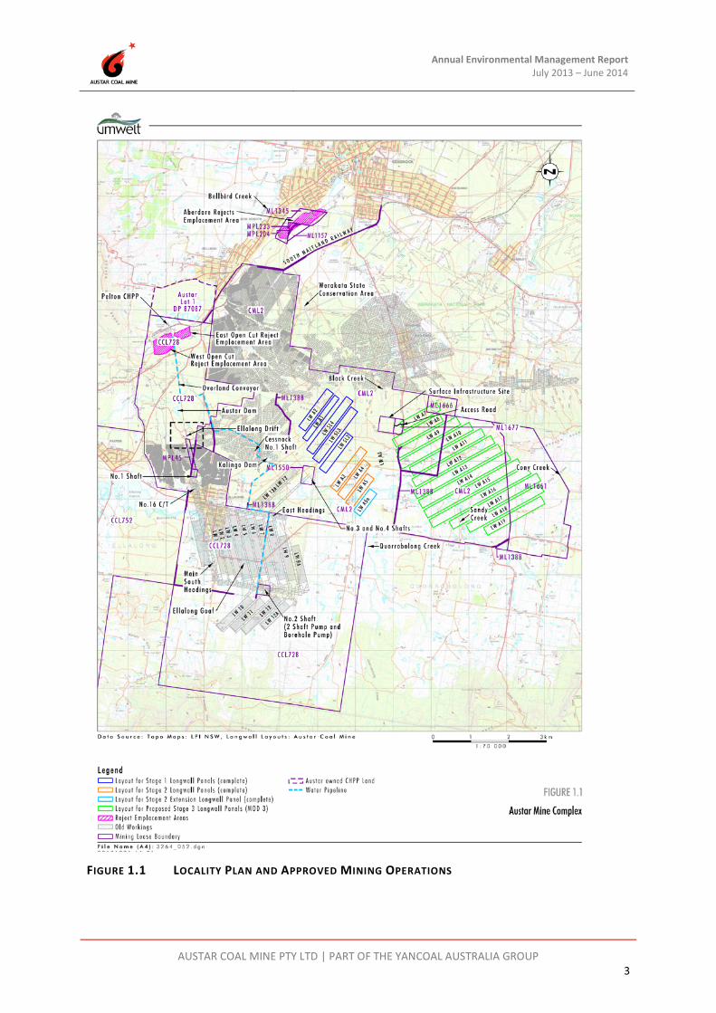
Austar is an aggregate of the former Pelton, Ellalong, Cessnock No.1 (Kalingo) Colliery and Bellbird South Collieries. Austar is owned by Yancoal Australia Limited. Austar is located on Middle Road, Paxton, NSW (Figure 1.1 and Plan 1). Underground mining commenced in 1916 at Pelton Colliery and continued until 1992. Kalingo Colliery began as an underground mine in 1921 and ceased operations in 1961. In the late 1960’s the Kalingo Colliery was amalgamated into the Pelton Colliery. Longwall production commenced at the Pelton Colliery in 1983 and continued until the mine, then known as Ellalong Colliery, was closed in May 1998 by Oakbridge. Southland Coal then acquired the assets of Ellalong and Pelton Collieries and amalgamated those with Bellbird South, which was also owned by Southland Coal. Southland Coal developed a longwall operation that mined the substantial Bellbird South coal reserves utilising the existing Ellalong facilities and infrastructure.

Annual Environmental Management Report July 2013 – June 2014
AUSTAR COAL MINE PTY LTD | PART OF THE YANCOAL AUSTRALIA GROUP 2
In December 2003, spontaneous combustion in longwall panel SL4 resulted in Southland Coal ceasing mining activities. The site of the underground fire was sealed and the mine was placed on a ‘care and maintenance’ program for 18 months. Yancoal purchased the mine in December 2004 and changed the name to Austar Coal Mine. Austar introduced an enhanced form of the conventional retreat longwall system to the Australian Coal Mining Industry in 2006 called Longwall Top Coal Caving (LTCC). To allow for the introduction of LTCC to panels A1 and A2, a modification under section 96(2) of the Environmental Planning and Assessment Act was sought in 2006. The Minister for Planning approved the modification to allow the extraction of up to 6.5 metres of coal in panels A1 and A2 subject to a number of conditions. In 2008, consent was granted for extraction in panels A3, A4 and A5 under a second modification, and for slightly longer and wider panels in A4 and A5 under a subsequent modification. In December 2010 approval was granted for extraction of additional longwall panel A5a in the Stage 2 area, and a modification to lengthen panel A5a was granted on 27 April 2012. Approval for Stage 3 operations was granted on 6 September 2009 by the Minister for Planning. A minor wording modification was granted on 4 May 2010, and a modification to allow reorientation of Stage 3 longwall panels was granted by the Minister for Planning and Infrastructure on 13 March 2012. A further modification to allow extension of longwall panels A7 to A10 to the west by between 100m and 300m was granted under delegated authority of the Minister for Planning and Infrastructure on 17 December 2013. The Stage 3 project (as modified) involves mining of known coal resources within Austar’s Consolidated Mining Lease 2 (CML2) and Mining Lease Areas (ML1661 and ML1666). The Stage 3 development (as modified) consists of:
• Extension of underground mining from current Stage 1 and Stage 2 operations into the area described as Stage 3 of the Austar Mine. Coal will be extracted from the Greta Coal Seam at depths of 450 to 740 metres using Longwall Top Coal Caving (LTCC) methods. A total of approximately 45.3 million tonnes (Mt) of coal will be produced from longwall panels A7 to A19 over a 21 year mine life. This will involve extraction of up to 3.6 Mt of Run of Mine (ROM) coal per year.
• Construction and operation of a new Surface Infrastructure Site off Quorrobolong Road south of Kitchener. This site will include an access road, upcast and downcast ventilation shafts, main ventilation fan, bathhouse, workshop, electricity substation and distribution line, service boreholes, offices and store. The Surface Infrastructure Site will be used to provide ventilation to the mine and to provide access to the Stage 3 underground workings for men and materials. No coal will be brought to the surface at this site.
• Continued use of Austar's existing water management, coal transport systems, coal preparation plant and rejects emplacement areas.
The location of approved operations is shown in Figure 1.1 and Plan 1.
Annual Environmental Management Report July 2013 – June 2014
AUSTAR COAL MINE PTY LTD | PART OF THE YANCOAL AUSTRALIA GROUP 3
FIGURE 1.1 LOCALITY PLAN AND APPROVED MINING OPERATIONS

Annual Environmental Management Report July 2013 – June 2014
AUSTAR COAL MINE PTY LTD | PART OF THE YANCOAL AUSTRALIA GROUP 4
TABLE 1.1 ANNUAL REPORTING REQUIREMENTS
DA No. 29/95 Section of the AEMR Schedule 5
Annual Reporting 5. Each year, the Applicant shall submit an Annual Environmental Management Report (AEMR) to the Director-General and the relevant agencies. This report must: (a) identify the standards and performance measures that apply to the development; (b) describe the works carried out in the last 12 months; (c) describe the works that will be carried out in the next 12 months; (d) include a summary of the complaints received during the past year, and compare this to the complaints received in previous years; (e) include a summary of the monitoring results for the development during the past year; (f) include an analysis of these monitoring results against the relevant:
• impact assessment criteria/limits; • monitoring results from previous years; and • predictions in the EIS and/or SEE;
(g) identify any trends in the monitoring results over the life of the development; (h) identify any non-compliance during the previous year; and (i) describe what actions were, or are being, taken to ensure compliance.
This AEMR
Section 3 Section 2 & 5 Sections 2 & 6
Section 4
Section 3
Section 3
Section 3 Section 3 Section 3
PA 08_0111 Section of the AEMR Schedule 7
Annual Review 3. Each year, the Proponent shall review the environmental performance of the mine complex to the satisfaction of the Director-General. This review must: (a) describe the works that were carried out in the past year, and the works that are proposed to be carried out over the next year; (b) include a comprehensive review of the monitoring results and complaints records of the mine complex over the past year, which includes a comparison of these results against the
• the relevant statutory requirements, limits or performance measures/criteria;
• the monitoring results of previous years; and • the relevant predictions in the EA and Extraction Plan;
(c) identify any non-compliance over the last year, and describe what actions were (or are being) taken to ensure compliance; (d) identify any trends in the monitoring data over the life of the mine complex; (e) identify any discrepancies between the predicted and actual impacts of the mine complex, and analyse the potential cause of any significant discrepancies; and (f) describe what measure will be implemented over the next year to improve the environmental performance of the mine complex.
This AEMR
Sections 2, 5 & 6
Sections 3 & 4
Section 3
Section 3
Section 3
Section 6

Annual Environmental Management Report July 2013 – June 2014
AUSTAR COAL MINE PTY LTD | PART OF THE YANCOAL AUSTRALIA GROUP 5
1.3 Consents, Leases and Licences
1.3.1 Development Approvals and Consents Held by Austar Coal Mine
A summary of development approvals and consents held by Austar is outlined in Table 1.2.
TABLE 1.2 DEVELOPMENT APPROVALS AND CONSENTS
Consent Description
Date Approval Authority
Approved Development
DA 74/75/79 4 December 1975 Cessnock City Council (CCC)
Development Consent for a coal mine at Ellalong.
• Approval for underground coal mining. • Construction of a new access drift, upcast
shaft and ventilation shaft.
• Expansion of the Pelton CHPP. • Conveyance of coal from the Ellalong pit top
to the Pelton CHPP Operation of the Pelton CHPP for the washing and handling of coal.
• Water management systems. • Upgrade of the Pelton rail loading facility
and railway spur.
• Reject emplacement underground, company owned land, open cut areas adjoining Pelton and other abandoned mine sites.
DA 118/680/93 8 October 1980 CCC Downcast Ventilation Shaft and Man Access Shaft, Bathhouse and Offices at Ellalong Colliery.
DA 118/691/181 26 Nov 1992 CCC Pelton Open Cut Coal Mine.
• Approval of an open cut coal mine adjoining Pelton Colliery up to 300,000 t of coal and underground mining of approximately 27,000 t of coal from a section of prior workings south of the proposed open cut.
DA 118/691/181 (modification)
11 January 1993 CCC Pelton Open Cut Coal Mine – Modification.
• Extension of open cut mining area. • Infrastructure and water management
modifications.

Annual Environmental Management Report July 2013 – June 2014
AUSTAR COAL MINE PTY LTD | PART OF THE YANCOAL AUSTRALIA GROUP 6
Consent Description
Date Approval Authority
Approved Development
DA 118/691/229 7 Jan 1993 CCC Pelton Coal Handling Preparation Plant – Raw Coal Handling Facility, Washed Coal Facility and Upgrading Water Management System.
• Upgrade and replacement of coal handling infrastructure such as surge bin, automatic stacking system, reclaim facilities and skyline conveyor.
• Increase in stockpile capacity. • Upgrade to water management system. • Extension of the reclaim tunnel. • Construction of a mine water transfer
pipeline from Ellalong Colliery to Pelton.
• Provision of underground workings for emergency mine water disposal.
• Upgrade of lime treatment plant. DA 118/693/42 26 Nov 1993 CCC Extension of Pelton Open Cut Mine.
• Extension of open cut mining area including emplacement of overburden in previously mined blocks and extension of the mine’s water management system.
DA 118/694/152 7 July 1994 CCC Relocatable Office and Temporary Bathhouse at Pelton Colliery.
DA 118/695/22 12 July 1995 CCC Establishment of Overburden Stockpile at Pelton Colliery. • Establishment of an overburden stockpile
for the Pelton Open Cut Operations. DA 118/695/81 12 July 1995 CCC Additions for Bathhouse, Office and Car park at
Ellalong Colliery.
• Extension to the bathhouse at the Ellalong drift site.
• Extension of existing offices or construction of portable offices.
• Construction of a 4000 square metre car park.
DA 8/1999/1658 18 Feb 2000 CCC Relocation of Ventilation Facilities at Bellbird South Underground Mine.
• Installation of a ventilation shaft and fan house.
• Upgrading of the existing access track to the site from the Pelton-Ellalong Road.
DA 8/2002/655/1 16 Oct 2002 CCC Compressor and Pump Enclosure Buildings at Ellalong Colliery.
DA 118/695/18 21 Feb 1995 CCC Re-locatable Office at Pelton Colliery.

Annual Environmental Management Report July 2013 – June 2014
AUSTAR COAL MINE PTY LTD | PART OF THE YANCOAL AUSTRALIA GROUP 7
Consent Description
Date Approval Authority
Approved Development
DA 29/95 14 Feb 1996 Minister for Urban Affairs and
Planning
Ellalong Colliery Extension into Bellbird South.
• Extension of underground mining activities into Bellbird South area (CML 2).
• Mine life of 21 years with a production of 3 Mtpa.
• Reject emplacement. • Construction and operation of a new
infrastructure site including new ventilation shaft and fan(s) (No. 2 Shaft) adjacent to Sandy Creek Road.
• Use of Pelton CHPP for washing and handling of coal.
• Provision of a maximum raw coal stockpile of 100,000 t.
• Reopening of disused Cessnock No. 1 Colliery shafts for ventilation and access, or the sinking of new shafts, as required.
• Construction of various water management devices including sedimentation and clean water dams and drainage systems.
DA 29/95 (modifications)
27 Sep 2006 8 Jun 2008 (MOD 2) 28 May 2009 (MOD 3) 7 Dec 2010 (MOD 4) 27 April 2012 (MOD 5)
Minister for Planning (or
delegate)
Extension of Underground Mining Activities into Bellbird South (Ellalong Colliery) – Modification.
• Use of long wall top coal caving mining methods in two longwall panels.
• Installation of a larger capacity fan at the site approved for DA 8/1999/1658.
• Installation of a new downcast ventilation shaft.
• Installation of a new 10 MVA substation. • Installation of a nitrogen inertisation plant
with a 2,000 cubic metre capacity. • Provision of a diesel and emulsion fluid
storage area and dispatch system. • Installation of a tube bundle shed to house
electronic monitoring equipment.
• Upgrade of the existing water treatment plant.
• Upgrade of water reticulation and pumps. • Minor embankment stabilisation works at
Kalingo Dam.
• Longer and wider panels A4 and A5. • Extract one additional Longwall Panel A5a
(LW A5a)
• Extension of Longwall Panel A5a

Annual Environmental Management Report July 2013 – June 2014
AUSTAR COAL MINE PTY LTD | PART OF THE YANCOAL AUSTRALIA GROUP 8
Consent Description
Date Approval Authority
Approved Development
Project Approval 08_0111
6 Sep 2009 Minister For Planning
Stage 3 Expansion Project - extension to longwall mining to an area east of existing operations. Key features:
• Longwall production from the Greta coal seam from panels A6 to A17 using longwall Top Coal Caving (LTCC) technology
• Construction of a new surface infrastructure site south west of Kitchener including ventilation shafts and fans, winders, bath house facilities, a workshop, electricity substation, store and offices. Construction of a new road and intersection at Quorrobolong Road.
• Coal will continue to be brought to the surface at Austar's existing surface facilities at Paxton. These facilities will continue to be used to take large mining equipment into and out of the mine.
• Continued use of Austar's existing water management, coal transport systems, coal preparation plant and rejects emplacement areas.
Project Approval 08_0111 (Modifications)
4 May 2010 (MOD 1) 13 March 2012 (MOD 2) 17 Dec 2013 (MOD 3)
Delegate for Minister for
Planning
Delegate for Minister for
Planning
• Minor change to wording regarding subsidence impact performance measures to built features in Table 1 of approval. The key performance indicator requires the project does not cause built features to go beyond safe, serviceable and repairable criteria, unless the landowner agrees in writing.
• Reorientation of the Stage 3 longwalls. Removal of longwall A6, and extraction of coal in longwalls A7 to A19, which are a reorientation of previously approved longwalls A7 to A17 to more closely align with the direction of principal stress. In addition, the chain pillar widths are increased from 45m to 55m to reduce roadway failure risks which in turn further minimises subsidence. The modification will enable more efficient and safer extraction of coal from the Stage 3 area.
• Extension of longwalls A7 to A10 to the west by approximately 100m and 300m
DA 8/2012/503/1 19 Dec 2012 CCC • Extension of car parking area associated with Austar Coal Mine
Annual Environmental Management Report July 2013 – June 2014
AUSTAR COAL MINE PTY LTD | PART OF THE YANCOAL AUSTRALIA GROUP 9
1.3.2 Subsidence Management Plan / Extraction Plan
Austar operates under an approved Subsidence Management Plan (SMP) for longwall panels A3 to A5a in Stage 2 and under a combined SMP / Extraction Plan for longwall panels A7 to A10 in Stage 3. The combined SMP / Extraction Plan was prepared to satisfy both the conditions of the Mining Leases in relation to SMP, and also the conditions of PA08_0111 in relation to the Extraction Plan. The SMP approval for the Stage 2 LWA5a extension was granted on 7 May 2012 by the Department of Trade and Investment – Division of Resources and Energy (DTI-DRE). Conditions of approval were the same as those issued for LW A5a. The SMP includes the monitoring and management strategies for environmental impacts associated with subsidence from the extraction of longwall A5a. The combined SMP / Extraction Plan for Stage 3 longwalls A7 to A10 was granted Extraction Plan approval by the Department of Planning and Infrastructure (DP&I) on 30 May 2013, and was granted SMP approval on 3 June 2013 by the Department of Trade and Investment – Division of Resources and Energy (DTI-DRE). The SMP / Extraction Plan includes the monitoring and management of environmental impacts associated with subsidence from the extraction of longwalls A7 to A10. The Stage 3 first workings were varied to retract the commencing end of LWA8 to LWA9 with approval of the DP&I in November 2013 and December 2013 in response to further geological information on the location of a dyke structure. A variation to the Extraction Plan / SMP for longwalls A7 to A10 to address the extension of LWA7 to LWA10 to the west by approximately 100m to 300m and the retraction of LWA8 commencing end was approved by DP&I on 6 January 2014, and was granted SMP approval on 7 January 2014 by DTI-DRE. A variation to the SMP was approved by DTI-DRE on 19 February 2014 to reflect the change to first workings by retracting the commencing end of LWA9, short of the dyke structure, this will be followed by a variation to the Extraction Plan prior to extraction of longwall A9. A summary of SMP approvals for Stage 2 and 3 mining areas held by Austar is outlined in Table 1.3. TABLE 1.3 SUBSIDENCE MANAGEMENT PLAN / EXTRACTION PLAN APPROVALS
Consent Description
Date Approval Authority Approval Summary
SMP Approval 06/7775
30 Jan 2009 DTI-DRE Subsidence Management Plan approval for Austar Colliery Longwall A3 only
SMP Approval 08/2956
24 Dec 2009 DTI-DRE Subsidence Management Plan approval for Austar Colliery Longwalls A4-A5
SMP Approval 10/22
27 April 2011 DTI-DRE Subsidence Management Plan approval for Austar Colliery Longwall A5a
SMP Approval 10/22
7 May 2012 DTI-DRE Subsidence Management Plan approval for Austar Colliery Longwall A5a extension. Conditions of approval are the same as those issued for Longwall A5a.

Annual Environmental Management Report July 2013 – June 2014
AUSTAR COAL MINE PTY LTD | PART OF THE YANCOAL AUSTRALIA GROUP 10
Consent Description
Date Approval Authority Approval Summary
Extraction Plan Approval
30 May 2013 DP&I Extraction Plan approval for Austar Coal Mine Longwalls A7 to A10
SMP Approval 13/1876
3 June 2013 DTI-DRE Subsidence Management Plan approval for Austar Coal Mine Longwalls A7 to A10.
Extraction Plan Approval
6 January 2014
DP&I Extraction Plan approval for Austar Coal Mine Longwalls A7 to A10 to correspond to PA08_0111 MOD3 and retraction to LWA8 commencing end
SMP Variation Approval 13/1876
7 January 2014
DTI-DRE Subsidence Management Plan approval for Austar Coal Mine Longwalls A7 to A10 to correspond to PA08_0111 MOD and retraction to LWA8 commencing end
SMP Variation Approval 13/1876
19 February 2014
DTI-DRE Subsidence Management Plan approval for retraction to LWA9 commencing end
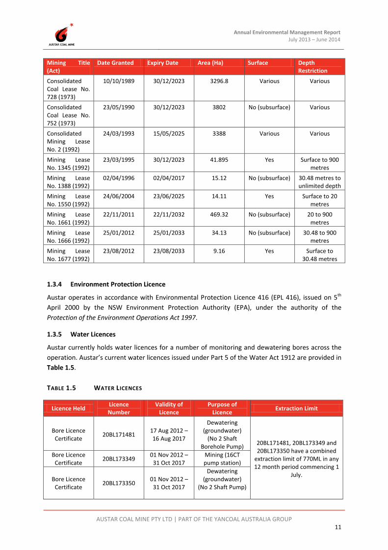
1.3.3 Mining Leases
Details of the relevant mining leases are summarized in Table 1.4.
TABLE 1.4 MINING LEASES
Mining Title (Act)
Date Granted Expiry Date Area (Ha) Surface Depth Restriction
Dam Site Lease 89 (1901)
04/04/1908 04/04/2030 3.961 Yes Surface to 15.24 metres
Mineral Lease No. 1157 (1906)
8/07/1949 08/07/2028 10.24 Yes Surface to 15.24 metres
Mineral Lease No. 1283 (1906)
13/07/1961 13/07/2022 1.973 No (subsurface) 7.62 to 15.24 metres
Mining Purposes Lease No. 23 (1906)
17/05/1909 17/05/2030 2.421 Yes Surface to 15.24 metres
Mining Purposes Lease No. 204 (1906)
03/02/1916 03/02/2018 1.2 Yes Surface to 15.24 metres
Mining Purposes Lease No. 217 (1906)
12/04/1916 12/04/2018 0.6298 Yes Surface to 15.24 metres
Mining Purposes Lease No. 233 (1906)
01/08/1916 01/08/2016 1.973 Yes Surface to 7.62 metres
Mining Purposes Lease No. 269 (1906)
07/12/1917 07/12/2018 2.79 Yes Surface to 6.1 metres below
the level of the rails when laid
Mining Purposes Lease No. 1364 (1906)
28/10/1968 28/10/2029 0.4527 Yes Surface to 15.24 metres
Annual Environmental Management Report July 2013 – June 2014
AUSTAR COAL MINE PTY LTD | PART OF THE YANCOAL AUSTRALIA GROUP 11
Mining Title (Act)
Date Granted Expiry Date Area (Ha) Surface Depth Restriction
Consolidated Coal Lease No. 728 (1973)
10/10/1989 30/12/2023 3296.8 Various Various
Consolidated Coal Lease No. 752 (1973)
23/05/1990 30/12/2023 3802 No (subsurface) Various
Consolidated Mining Lease No. 2 (1992)
24/03/1993 15/05/2025 3388 Various Various
Mining Lease No. 1345 (1992)
23/03/1995 30/12/2023 41.895 Yes Surface to 900 metres
Mining Lease No. 1388 (1992)
02/04/1996 02/04/2017 15.12 No (subsurface) 30.48 metres to unlimited depth
Mining Lease No. 1550 (1992)
24/06/2004 23/06/2025 14.11 Yes Surface to 20 metres
Mining Lease No. 1661 (1992)
22/11/2011 22/11/2032 469.32 No (subsurface) 20 to 900 metres
Mining Lease No. 1666 (1992)
25/01/2012 25/01/2033 34.13 No (subsurface) 30.48 to 900 metres
Mining Lease No. 1677 (1992)
23/08/2012 23/08/2033 9.16 Yes Surface to 30.48 metres
1.3.4 Environment Protection Licence
Austar operates in accordance with Environmental Protection Licence 416 (EPL 416), issued on 5th April 2000 by the NSW Environment Protection Authority (EPA), under the authority of the Protection of the Environment Operations Act 1997.
1.3.5 Water Licences
Austar currently holds water licences for a number of monitoring and dewatering bores across the operation. Austar’s current water licences issued under Part 5 of the Water Act 1912 are provided in Table 1.5. TABLE 1.5 WATER LICENCES
Licence Held Licence Number
Validity of Licence
Purpose of Licence Extraction Limit
Bore Licence Certificate 20BL171481 17 Aug 2012 –
16 Aug 2017
Dewatering (groundwater)
(No 2 Shaft Borehole Pump) 20BL171481, 20BL173349 and
20BL173350 have a combined extraction limit of 770ML in any 12 month period commencing 1
July.
Bore Licence Certificate 20BL173349 01 Nov 2012 –
31 Oct 2017 Mining (16CT pump station)
Bore Licence Certificate 20BL173350 01 Nov 2012 –
31 Oct 2017
Dewatering (groundwater)
(No 2 Shaft Pump)

Annual Environmental Management Report July 2013 – June 2014
AUSTAR COAL MINE PTY LTD | PART OF THE YANCOAL AUSTRALIA GROUP 12
Licence Held Licence Number
Validity of Licence
Purpose of Licence Extraction Limit
Bore Licence Certificate
20BL171361 17 May 2007 - Perpetuity
Monitoring Bore (AQD1077)
N/A
Bore Licence Certificate 20BL172524 20 Jul 2010 -
Perpetuity Monitoring Bore
(NER1010) N/A
Bore Licence Certificate 20BL172852 7 Jun 2011 -
Perpetuity
Monitoring Bore (WBH1, WBH2,
WBH3) N/A
1.3.6 Mining Operations Plan (MOP)
In accordance with the Mining Act 1992, Austar conduct operations in accordance with a Mining Operations Plan (MOP), which was approved by the DTI-DRE on 30 June 2008. The approved MOP covers underground mining, coal handling and other associated activities for a seven year period between May 2008 to May 2015. All mining activities at Austar were carried out generally in accordance with the approved MOP during the reporting period. A new MOP will be prepared for approval during the 2014-2015 AEMR reporting period.
1.3.7 Environmental Management Plans
In accordance with DA No.29/95 and PA08_0111, Austar have developed and implemented a range of environmental management plans. Table 1.6 outlines the environmental management plans currently required by each relevant development consent, the determining authority and their approval status.
TABLE 1.6 ENVIRONMENTAL MANAGEMENT PLANS
Plan DA Requirement Approval Authority
Approval Date
Environmental Management Strategy, May 2013
DA29/95 – Schedule 5 Condition 1 PA08_0111 - Schedule 7 Condition 1
DP&I 2 October 2013
Environmental Monitoring Program, May 2013
DA29/95 – Schedule 5 Condition 2 PA08_0111 - Schedule 7 Condition 1
DP&I 2 October 2013
Shaft Construction Environmental Management Plan, June 2012
PA08_0111 – Schedule 4 Condition 1, 2, 8
DP&I
15 June 2012
Landscape Management Plan – Kitchener SIS, June 2013
PA08_0111 – Schedule 6 Condition 4 DP&I
22 July 2013
Site Water Management Plan, April 2013
DA29/95 – Schedule 3 Condition 6-11 PA08_0111 – Schedule 4 Condition 9
DP&I 17 May 2013
Noise and Vibration Management Plan, July 2013
DA29/95 – Schedule 3 Condition 13-16 PA08_0111 – Schedule 4 Condition 2-3
DP&I 2 August 2013
Air Quality and Greenhouse Gas Management Plan, June 2013
DA29/95 – Schedule 3 Condition 17-20 PA08_0111 – Schedule 4 Condition 6-7
DP&I 26 June 2013

Annual Environmental Management Report July 2013 – June 2014
AUSTAR COAL MINE PTY LTD | PART OF THE YANCOAL AUSTRALIA GROUP 13
Plan DA Requirement Approval Authority
Approval Date
Aboriginal Cultural Heritage Management Plan, May 2013 &
Addendum October 2013.
PA08_0111 – Schedule 3 Condition 4 and Schedule 4 Condition 10
DP&I
30 May 2013 & 6 January 2014
Historic Heritage Management Plan, January 2014
PA08_0111 – Schedule 4 Condition 11 DP&I 19 February 2014
Surface Infrastructure Site Traffic Management Plan, December 2009
PA08_0111 – Schedule 4 Condition 1 Statement of Commitments 1.12.1
Cessnock City Council
22 December 2009
Austar Coal Mine Longwalls A7 to A10 Extraction Plan, December
2013
PA08_0111 – Schedule 3 Condition 4-5 DP&I 6 January 2014
Environmental management plans are available from the Austar website (www.austarcoalmine.com.au).
1.4 Mine Contacts
Table 1.7 outlines the contact details for site personnel responsible for mining, coal preparation, rehabilitation, environmental and community liaison at Austar. TABLE 1.7 SITE PERSONNEL
Position Name Company Contact Number Operations Manager Greg Pawley Austar Coal Mine (02) 4993 7356
CHPP Manager Paul Davis Austar Coal Mine (02) 4993 7501
Technical Services Manager Adrian Moodie Austar Coal Mine (02) 4993 7293
Environment & Community Manager Gary Mulhearn Austar Coal Mine (02) 4993 7334
Environment & Community Coordinator Jack Potter Austar Coal Mine (02) 4993 7363
1.5 Actions Required at Previous AEMR Review
DP&I reviewed the 2012-2013 AEMR and advised in correspondence dated 4 April 2014 that the form and content meets the annual reporting requirements of development consent DA29/95 and Project Approval 08_0111. DP&I advised that the Director-General approved the 2012-2013 AEMR. DTI-DRE reviewed the 2012-2013 AEMR and conducted an inspection on 29th January 2014. DTI-DRE found the AEMR was acceptable for the reporting period. The following actions were identified to ensure conformance and improvement in site rehabilitation for issues that were identified during the inspection, this information is presented in Table 1.8.

Annual Environmental Management Report July 2013 – June 2014
AUSTAR COAL MINE PTY LTD | PART OF THE YANCOAL AUSTRALIA GROUP 14
TABLE 1.8 ISSUES/ACTIONS FROM DTI-DRE SITE INSPECTION
Item Issue / Action Addressed Pelton Coal Handling Preparation Plant
Issue 1 Dust generated from transfer stations on conveyor.
Action 1.1 Cause and options for minimising dust escaping from transfer stations to be developed.
Austar undertook the following actions in response to the dust observations: • Immediate investigation was
undertaken which determined that the visible dust was caused by clean-up activities of the overland conveyor easement where coal, mixed with dry soil/roadbase material was loaded on to the conveyor;
• CHPP supervisor communicated dust observations to the contractor and instructed the contractor that clean-up materials with excessive soil/roadbase materials are to be loaded onto a truck to be emplaced in an approved reject emplacement area;
• Dust monitoring data was reviewed which determined that there were no spikes in dust readings around the time of the observed dust; and
• A letter outlining the findings of the investigation and the actions taken to prevent reoccurrence was provided to the DTI DRE on 4tApril 2014.
Kitchener Surface Infrastructure Site (SIS)
Issue 2 Sedimentation of pollution control dams.
Action 2.1 As advised by Austar during the site inspection, cutting stockpiles are to be rehabilitated. Bare areas are to be stabilised to minimise erosion.
Bulk shaping of cuttings stockpiles and bare areas, including drainage improvements was completed February to June 2014. One main stockpile and steep embankment area was stabilised with mulch. Remaining bare areas not used for operational requirements to be stabilised during spring 2014.
Kalingo Site
Issue 3 Woody debris stockpiles harbouring vermin (e.g. rabbits).
Action 3.1 Stockpiles to be removed. Root balls remained in this area at the end of the reporting period. These are planned to be removed by October 2014.
Pit Top
Issue 4 Informal laydown area.

Annual Environmental Management Report July 2013 – June 2014
AUSTAR COAL MINE PTY LTD | PART OF THE YANCOAL AUSTRALIA GROUP 15
Item Issue / Action Addressed Action 4.1 Stabilisation of the area to be monitored
and remedial actions reported in next AEMR.
Monitoring in this area confirms at end of the reporting period the laydown is stabilising well. Nil further actions required.
2012-2013 Annual Environmental Management Report
Issue 5 Issues in the AEMR requiring clarification or further detail, as listed in the draft inspection agenda.
Action 5.1 Submit a letter addendum to the AEMR that addresses issues that were identified and discussed at the site meeting. There is no need to provide source documentation, however a summary is acceptable where applicable.
An addendum report to the 2012-2013 AEMR was provided to the DTI DRE on 4 April 2014 to clarify the issues identified in the 2012-2013 AEMR.

Austar Annual Environmental Management Report July 2013 – June 2014
AUSTAR COAL MINE PTY LTD | PART OF THE YANCOAL AUSTRALIA GROUP 16
2 Operations During The Reporting Period
2.1 Exploration
No exploration activities were undertaken during the 2013-2014 reporting period. Exploration will recommence in the 2014-2015 reporting period with approximately eight (8) holes planned within the southern and eastern areas of the Stage 3 mining area (CML2 and EL6598) for resource infill and mine planning.
2.2 Land Preparation
2.2.1 Kitchener SIS
As part of the Stage 3 mining activities to construct the approved Surface Infrastructure Site (SIS), land clearing activities are required for the construction of the new facilities and for access to the proposed location. The Stage 3 Environmental Assessment (EA) indicates that approximately 8 to 10 Ha of the SIS site may be disturbed to achieve the final SIS layout.
Approximately 6.4ha of Austar owned land was cleared in 2009-2010 to facilitate shaft construction and mine access roads. 1.3ha of land was cleared during the 2011-2012 AEMR reporting period for construction of the switch yard and switch room, and a further 0.4ha was cleared in 2012-2013 for the installation of the 33kV power line. The total cleared area is currently 8.1ha. The land preparation associated with Kitchener SIS is shown in Plan 4C.
To date all clearing activities at the SIS have been undertaken in accordance with the approved Shaft Construction Environmental Management Plan (SCEMP) and the MOP. The SCEMP has both a preclearance procedure and vegetation clearing procedure to minimise the impacts on both flora and fauna. The Landscape Management Plan – Kitchener SIS (AECOM, June 2013) has, since it’s approval, superceded the SCEMP in respect of land preparation measures at the SIS.
No further significant clearing or land preparation was required during the 2013-2014 AEMR reporting period as the site transitioned from construction into an operational and rehabilitation phase. A single tree adjacent to the switch room was felled due to proximity to the building for safety purposes.
In accordance with the Landscape Management Plan – Kitchener SIS, a pre-clearance inspection was undertaken prior to vegetation clearing by a suitably qualified and experienced person. The number of hollows present in the tree was recorded, as was the size class of each hollow. As a result of the preclearance works, there were three hollows that were needed to replace those present in the felled tree. As Austar had previously installed a surplus of nest boxes in response to clearing works undertaken in July 2012 (ten nest boxes) and May 2013 (eight nest boxes), no further nest boxes were required.

Annual Environmental Management Report July 2013 – June 2014
AUSTAR COAL MINE PTY LTD | PART OF THE YANCOAL AUSTRALIA GROUP 17
2.3 Construction
2.3.1 Kitchener SIS
Construction at the SIS commenced in November 2009 with the clearing and earthworks phase. Drilling of Upcast Ventilation Shaft No.5 commenced in June 2010 to bore a 5.5m shaft diameter. This shaft was drilled to full depth of 463m in 2011-2012, and was fully lined with a steel and concrete composite liner to a finished diameter of 4.5m in the 2012-2013 AEMR period. Ventilation fans were constructed on the surface and commissioning began on 10 June 2013. A temporary noise wall comprising shipping containers and timber of height greater than 3.5m was installed prior to fan operation, as committed to in the Stage 3 Environmental Assessment. The temporary noise wall was replaced by a permanent Hebel noise wall of a height greater than 3.5m in the 2013-2014 reporting period.
Downcast Ventilation Shaft No.6 commenced in late July 2012 and was completed in June 2013. A services borehole was also drilled and fully lined during the 2012-2013 period.
Construction of the switchyard and switch room to provide power to the site commenced in October 2012. Power line construction commenced in November 2012 bringing power from Kitchener Village along Quorrobolong Road and into the SIS. Power was supplied to site in June 2013.
A permanent water and communications pipeline was constructed during June 2013 from Austar owned land south of the SIS, through a 400m section of the Werakata SCA to the SIS with approval of the National Parks and Wildlife Service. Permanent pumping stations were installed on dams within the SIS during the 2013-2014 reporting period.
2.3.2 Pit Top Car Park
The new Pit Top car park was completed with unsealed surface during the 2013-2014 AEMR reporting period after receiving development consent from Cessnock City Council. Vegetation was cleared and a road base material emplaced. This car park provides an additional 80 car spaces in a defined area as a considerable safety improvement. The lack of available car parking prior to this new car park during shift overlap times saw staff and contractors informally parking within the asset protection zone surrounding the Pit Top infrastructure.
2.4 Mining
2.4.1 Underground Mining Operations
The Austar Coal resource covers a large area of the Greta Seam in the Newcastle Coalfield. The Bellbird South reserves are situated north-east of and adjoin the original Ellalong Colliery.
Longwall panel A2 in the Stage 1 mining area was completed in November 2008, with production in Stage 2 (A3-A5a) beginning in February 2009 being completed in February 2013.
Development operations have been focused on creating the mains access roadways and longwall gateroads for Stage 3. Longwall panel A7 and A8 have been developed with longwall extraction of A7 occurring over the period June 2013 to April 2014. Longwall A8 extraction commenced in June 2014,

Annual Environmental Management Report July 2013 – June 2014
AUSTAR COAL MINE PTY LTD | PART OF THE YANCOAL AUSTRALIA GROUP 18
and continued at the end of the 2013-2014 reporting period. Stage 3 coal clearance occurs via the new 1500 tonne underground surge bin and associated infrastructure. Whilst longwall operations continue in longwall A8, unfortunately development operations have been suspended since April 2014 following a double fatality incident. Investigations are still ongoing with development operations aiming to potentially recommence prior to the end of 2014. This will mean a significant outage of longwall operations in 2015.
Management of the other key mine hazards of ventilation, spontaneous combustion and water have been effective in that no major incidents have occurred during this period. Similarly, monitoring of environmental impacts has shown that assessments completed have accurately assessed impacts and management strategies are working effectively.
Mining undertaken in the AEMR period, and planned in future years is presented in Plan 4A.
2.4.2 Production and Forecast Production
Table 2.1 provides a summary of coal production and waste generation for the 2013-2014 reporting period. During the reporting period a combined total of 1,566,002t of ROM coal was mined.
TABLE 2.1 PRODUCTION AND WASTE SUMMARY
Cumulative Production Unit 2012-2013
Reporting Period 2013-2014
Reporting Period 2014-2015
Reporting Period (Prediction)
Topsoil stripped T 1275 0 0
Topsoil used/spread T 0 1840 3500
Processing waste
Fine Tailings m3 232,000 228,200 364,600
Coarse Reject T 77,123 101,900 145,850
ROM Coal Mined
- Development T 256,042 242,245 111,993
- Longwall T 1,127,793 1,323,756 2,318,851
Total ROM T 1,383,835 1,566,002 2,430,844
Product Coal T 1,155,175 1,359,961 2,041,909
The provisional mine production in the MOP for the 2013-2014 reporting period estimated approximately 1.64 Mt ROM coal mined and approximately 1.36 Mt product coal produced. Coal production at Austar during the reporting period was lower than predicted due to development mining constraints, and completion of the surge bin infrastructure for longwall A8 Stage 3 area. The predicted production for the 2014-2015 period is expected to rise with increased longwall production being achievable with the introduction of the surge bin.

Annual Environmental Management Report July 2013 – June 2014
AUSTAR COAL MINE PTY LTD | PART OF THE YANCOAL AUSTRALIA GROUP 19
2.5 Mineral Processing
All ROM coal from the underground is transferred by conveyors via the Ellalong Drift to a 2000 tonne bin at Pit Top, where an overland conveyor system with a nominal capacity of 750 tonnes per hour conveyors the coal to the Pelton CHPP raw coal stockpile. The majority of product coal processed at the CHPP is railed to the Port of Newcastle via the Austar Rail Line, the South Maitland Railway and the Main Northern Rail Line.
The CHPP is a heavy medium (HM) plant. There are three circuits that treat different fractions:
• No.1 HM circuit treats the -10mm x 1mm coal;
• No.2 HM circuit treats the - 40mm x 10mm coal; and
• Fines circuit treats the -1mm fraction (spirals and Classifying cyclones).
Coal enters the plant passing over a set of sizing screens.
The +40mm material reports to the plant MMD sizer, where it is sized to -38mm. The -38mm +0mm material then reports to the No.2 heavy medium circuit. The -10 x 1mm material is fed over the desliming screens and to the No.1 heavy medium circuit. The -1mm fraction is fed to the fines circuit.
2.6 Waste (Coal Reject) Management
2.6.1 Chemical/Physical Characteristics of Reject
Analysis of the waste materials at Austar indicates that it contains sulphur in the organic or pyritic form, and therefore has the potential for acid mine drainage (AMD). Details regarding the control of acid water onsite are outlined in the approved Site Water Management Plan (SWMP). Rehabilitation strategies have been developed to reduce the potential for acid mine drainage to leave the site with emplacement areas designed to drain to old mine workings.
2.6.2 Coarse Reject Material
In accordance with the MOP and the Section 102 application approved by the DTI-DRE in 2008, coarse reject emplacement was undertaken at the following sites during the AEMR reporting period.
Aberdare Extended Open Cut Void (Aberdare Extended) The Aberdare Extended Open Cut area is the primary reject emplacement area utilised by Austar during the approved MOP term. Rejects are hauled by truck along a private haul road from the CHPP to the emplacement area.
It is planned that following the emplacement of rejects, the area will be rehabilitated to a final landform that has been agreed with the private landowner of the property. The area will be progressively rehabilitated during the MOP term. Once Aberdare Extended Emplacement Area has reached its maximum capacity, the voids on the CHPP site will become the primary Austar coal reject emplacement areas.
Annual Environmental Management Report July 2013 – June 2014
AUSTAR COAL MINE PTY LTD | PART OF THE YANCOAL AUSTRALIA GROUP 20
The Aberdare Extended Emplacement Area is situated in close proximity to neighbouring residences, as near as 40 metres, with a significant number of residences within 300 metres of the emplacement area. A consultation program was implemented prior to resuming use in 2009, and an update on progress and consultation was undertaken prior to recommencing night emplacement in June 2013. Subsequently there have been no complaints regarding reject emplacement activities at Aberdare.
East Open Cut Void (East Open Cut) The East Open Cut is a small void on the CHPP site covering an area of approximately 15 hectares. Previously the remaining void has been used as an emergency emplacement area when dumping at the Aberdare Extended area was unavailable due to heavy rain. Since the mine recommenced in June 2005, coarse reject has been emplaced in the East Open Cut void.
It is intended that in the future until the Aberdare Extended reject emplacement area is complete, the East Open Cut reject emplacement area will be primarily utilised at times when the Aberdare Extended Emplacement Area is not available. Once the Aberdare Extended emplacement area has reached its maximum capacity, the East Open Cut will become the primary emplacement area for Austar.
West Open Cut Emplacement Area (West Open Cut) The west open cut area has been utilised as a clean material overburden emplacement area during previous open cut operations at the site. This area provides a source of inert capping material, which will be utilised as part of the rehabilitation of reject emplacement areas. After removal of the clean overburden for capping purposes at Aberdare Extended and East Open Cut emplacement areas, it is planned to use the resultant void at the West Open Cut for ongoing reject emplacement.
2.6.3 Tailings Disposal
The fine rejects, known as tailings, flow from the CHPP and are discharged into the Pelton old underground mine workings. The return water from these tailings gravitates through the old mine workings and is recovered by dewatering pumps back into Austar’s contaminated water management system for treatment and reused in the CHPP or discharged off-site under Austar’s EPL license.
2.6.4 North West Chitter Area Recovery
Approximately 8,640 tonnes of tailings were recovered from the North West Chitter Area during the reporting period and blended with product coal where market specification allows.
2.7 Waste Management
Waste management at Austar is undertaken using licensed waste contractors (Transpacific Industries, Sell & Parker and Close the Loop®) to collect and dispose of waste from the Austar site on a regular basis under waste management contracts. Austar will continue to work with external waste contractors and mine site personnel to implement a total waste management system.
Transpacific Industries Group, who manages all waste except scrap metal and printer cartridges, produces a monthly waste management report which summarises the amount of waste produced at Austar across the different waste streams (see Table 2.2). The monthly waste reports also allow

Annual Environmental Management Report July 2013 – June 2014
AUSTAR COAL MINE PTY LTD | PART OF THE YANCOAL AUSTRALIA GROUP 21
Austar to determine whether contamination between waste streams has occurred during the reporting month. Any issues and further information regarding cross contamination of the various waste streams can be delivered to employees and contractors through tool box talks and inductions.
TABLE 2.2 WASTE MANAGEMENT DATA FOR THE 2013-2014 REPORTING PERIOD (TONNES)
Month Cardboard Recycle
General Waste
Oil filters
Oily Rags
Oily Water
Waste oil
Wash Water Effluent Asbestos
Jul-13 1.38 53.60 0.12 - 3.10 - - - -
Aug-13 1.15 50.00 - - 1.60 - - - -
Sep-13 1.02 43.02 0.24 0.06 - - - - -
Oct-13 0.76 40.72 0.12 0.06 1.40 - - - -
Nov-13 1.21 51.07 0.06 - - - - - 0.50
Dec-13 1.28 65.06 0.06 - 4.40 - 5.30 - -
Jan-14 0.77 64.67 0.24 0.12 1.70 3.30 - - -
Feb-14 0.89 64.37 - - 0.60 - - 13.50 -
Mar-14 0.83 39.47 0.18 - - 4.50 0.20 - -
Apr-14 1.38 35.21 - - 4.40 - - - -
May-14 0.68 45.01 0.30 - - 1.00 - - -
Jun-14 0.66 51.21 0.06 - - - - - -
TOTAL 12.01 603.39 1.38 0.24 17.20 8.80 5.50 13.50 0.50
Sell & Parker manage scrap metal recycling at Austar Coal Mine. Metals are sorted into categories and measured by weight recovered. Metals collected in the 2013-2014 reporting period are documented in Table 2.3.
TABLE 2.3 SCRAP METAL DATA FOR THE 2013-2014 REPORTING PERIOD
Metal Total Weight (Tonnes)
Armoured Cu/Pb Cable 1.34
Armoured PVC Cu Cable 0.94
Black Iron 23.90
Black Iron S&P Transport 269.21
Electric Motors (under 1MT) 1.51
Heavy 4.82
Heavy S&P Transport 154.32
Mixed Scrap S&P Transport 64.86
No Value 11.06
Oversize S&P Transport 27.32
Oversized 58.30
Reinforcing Steel 3.00
TOTAL 620.58

Annual Environmental Management Report July 2013 – June 2014
AUSTAR COAL MINE PTY LTD | PART OF THE YANCOAL AUSTRALIA GROUP 22
Close the Loop® collect and recycle printer cartridges from site. Cartridges collected in the 2013-2014 reporting period are documented in Table 2.4.
TABLE 2.4 PRINTER CARTRIDGES COLLECTED FOR THE 2012/2013 REPORTING PERIOD
Printer Cartidges Total Weight (Kilograms)
Cartridge 35.16
Large Bottle 0.18
Other 40.36
Small Inkjet 0.18
Waste Collector 12.26
Total Diverted from landfill 88.14
2.7.1 Hydrocarbon Management
All necessary measures are taken to ensure that operations at the colliery are conducted in a responsible manner, minimising the risk of pollution to the environment. Hydrocarbon management systems are designed and installed in accordance with Australian Standards and EPA guidelines.
The CHPP hydrocarbon management systems include a covered oil store on concreted flooring, covered and bunded empty oil drum store, heavy vehicle lubrication service area and an oil evacuation system.
Austar operates a hydrocarbon remediation area at the CHPP to manage hydrocarbon contaminated material retrieved from the site. As shown in Figure 2.1 the area is signposted and has three bunded cells for segregation of materials of different ages. The bunded area was constructed on a disused laydown area and is within the sites dirty water catchment. It is proposed to periodically turn the contaminated materials to allow an adequate supply of oxygen to microbes that use the contaminants as a source of food and energy.
FIGURE 2.1 HYDROCARBON REMEDIATION AREA
At the Austar Pit Top site, the hydrocarbon management system includes a covered oil store, an oily water treatment system for the washdown bay and surface runoff, and a covered empty drum

Annual Environmental Management Report July 2013 – June 2014
AUSTAR COAL MINE PTY LTD | PART OF THE YANCOAL AUSTRALIA GROUP 23
draining rack before drums are placed in recycling bins. Longwall fluid (solcenic) is stored in an above ground bunded storage area at the No. 3 shaft infrastructure site.
There is one 55,000L and one 15,000L above ground bulk diesel storage tank at the CHPP and one 58,000L above ground bulk diesel storage tank at the Pit Top. All bulk diesel storage tanks are bunded. Rain water caught on the floor of the bunds drains to a sump which can be emptied by pumps when required. Water pumped from the bund at the Pit Top bulk diesel storage bund enters the washdown pit which in turn flows into the oil water separator.
All hydrocarbon storage areas are equipped with mobile spillage kits.
2.8 ROM and Product Stockpiles
The raw or ROM coal stockpile has a live capacity of 50,000 tonnes, and an overall capacity of 500,000 tonnes. The washed product coal stockpile has a capacity of approximately 350,000 tonnes. All coal stored in excess of the live storage capacity of the system is handled using tracked bulldozers.
2.9 Water Management
2.9.1 Overview
Austar operate under an approved Site Water Management Plan (SWMP). The most recent version of the SWMP incorporating the requirements of the Stage 3 project was prepared in accordance with Condition 9 of Schedule 4 of PA08_0111 and approved by the Director General of the DP&I on 17 May 2013.
The factors that influence the site water balance at Austar are complex and variable. There are a number of geographically separated interrelated systems that are managed as a whole to ensure that the operational needs of the mine are addressed whilst also meeting Environment Protection Licence (EPL) requirements. There are many large water storage areas, both on the surface and underground, that act as buffers such that individual systems can operate independently of each other. The water management system at Austar comprises of three (3) three major components or systems:
1. Underground Mine Water Management System;
2. Pelton CHPP Site Water Management System; and
3. Surface Water Storage and Management System.
Water treatment onsite includes pH adjustment, flocculation and settlement of suspended sediments in addition to a reverse osmosis water treatment plant.

Annual Environmental Management Report July 2013 – June 2014
AUSTAR COAL MINE PTY LTD | PART OF THE YANCOAL AUSTRALIA GROUP 24
With the use of the reverse osmosis water treatment plant, the site operates almost independently of the town potable supply and only discharges treated water to Bellbird Creek in accordance with EPL416 conditions.
2.9.2 Surface Water
Austar’s surface water management system has been designed to match the capacity of the underground dewatering systems with additional provision to store and handle surface runoff during heavy rain events.
The main surface water storage facilities are located at the CHPP, Kalingo Dam, Austar Dam and the Kitchener Surface Infrastructure Site. The water storages at Austar are summarised in Table 2.5.
TABLE 2.5 STORED WATER
Volume held (cubic metres) Start of reporting
period (1 July 2013)
At end of reporting period (30 June
2014) Storage capacity
Clean water Doyle Street Dam 4 ML 4 ML 5 ML Dirty water Precipitate Dam 8 ML 8 ML 8 ML Process Water Dam 0 ML 52 ML 70 ML Number 7 Dam 62 ML 86 ML 100 ML Water Pollution Control Ponds 0 ML 0 ML 8 ML Storm Water Retention Dam 0 ML 0 ML 10 ML Water Pollution Control Dam 2.4 ML 3.2 ML 40 ML Emergency Overflow Dam 0 ML 0 ML 40 ML Kalingo Dam 17.6 ML 51.7 ML 110 ML Austar Dam 17.2 ML 25.9 ML 35 ML Kitchener SIS Water Storage Dams 0 – 5 ML* 1 ML 5 ML Kitchener SIS Eastern Sediment Basins 0 ML 0 ML 1.6 ML Controlled discharge water SW6 Discharge to Bellbird Creek 0 ML 340.4 ML 1 ML Tank Contaminated water Not applicable (identified in Dirty water) *Operating Range provided as dam levels not recorded for reporting period.
CHPP Water Management System
The CHPP water management system includes a number of surface storage dams. The system has been developed over time and is designed to limit the need for off-site discharges to Bellbird Creek (other than at the treated water discharge point licenced by EPL 416) whilst also maximising the potential for water reuse on-site.
Kalingo Dam
Kalingo Dam has a capacity of approximately 110ML and receives water from old underground workings via No. 2 shaft dewatering pumps via a buried 450mm HDPE pipeline. Kalingo Dam is used

Annual Environmental Management Report July 2013 – June 2014
AUSTAR COAL MINE PTY LTD | PART OF THE YANCOAL AUSTRALIA GROUP 25
as a staging and water storage facility. This dam assists in the removal of iron and manganese via oxidation.
Austar Dam
Austar Dam has a capacity of approximately 35ML and receives water from Kalingo Dam via a buried 315mm HDPE pipeline. It also receives water from an underground pumping station (16 cut through main south) via a rising main along the drift and surface runoff from the Austar mine pit top.
Kitchener Surface Infrastructure Site
The eastern sediment basin at the Kitchener SIS has a capacity of approximately 1.6ML and receives runoff water from the disturbed areas on the western part of the SIS. The water storage dams have a capacity of approximately 5ML and accept water from the eastern disturbed part of the site. The sediment basins send water to the water storage dams (or discharge off-site in a greater than design rainfall event), which in turn can pump water to Kalingo Dam.
2.9.3 Underground Mine Water Management
The mine has a complex groundwater management system that is heavily influenced by inflow from surrounding historic mine workings. This system is discussed in detail in the following sections.
Inflow Sources
Inflow water sources into the mine workings can be described as:
• Fairly static natural strata inflow of groundwater;
• Water piped underground used for mining and ancillary underground operations (such as dust control). A large proportion of this water is returned to the surface in the ROM coal;
• Water from high rainfall periods that enter old shallow mine workings via surface cracks etc;
• Coal washery reject water pumped underground into the old shallow mine workings;
• Water from dirty surface water management systems from mining operations, the pit top, and CHPP pumped underground into the old shallow workings; and
• Brine from the Reverse Osmosis water treatment plants pumped underground into the old shallow mine workings.
All major inflow sources have been identified and systems put in place to measure the cumulative volumes. Measurements are generally recorded on a monthly basis and results logged in a database that allows analysis of long term trends and inflows. Water levels are also monitored for the old workings of the neighbouring Bellbird, Kalingo and Aberdare Central Collieries.

Annual Environmental Management Report July 2013 – June 2014
AUSTAR COAL MINE PTY LTD | PART OF THE YANCOAL AUSTRALIA GROUP 26
Underground Water Storages
The main underground water storages include the following:
• East Pelton;
• West Pelton;
• Ellalong (2 East Panel, Longwalls 1-12);
• Ellalong Longwall 13;
• SL2 Panel; and
• Bellbird/ Aberdare Central.
For more detail, refer to the approved SWMP, available on the Austar website www.austarcoalmine.com.au
Underground Pumping
There are two (2) underground pumping systems that deliver mine water to the surface water management system, they include:
16 Cut Through (East Pelton and West Pelton)
The 16 c/t Main South Pump Station has been designed and installed to pump mine strata water inflow from the old Pelton (East and West) Mine workings. The main tank has two pumps to pump the water to the surface to Austar Dam via a rising main installed in the drift.
Number 2 Shaft (Ellalong)
The old Ellalong Colliery workings (Longwalls 1 to 12) within Austar mine are utilised as the main underground water storage reservoir for the mine. A large diameter, multistage bore hole pump and additional pumping system installed directly within the Number 2 shaft site pumps water from these underground workings to Kalingo Dam via a vertical rising main and connecting polyethylene pipe line. Mine water may be diverted from this pipeline to Bellbird Colliery.
Groundwater Interception
Austar maintains a comprehensive water inflow database which allows assessments to be made regarding the origin of inflow sources. The recirculation of stored waters, which reside in the up dip old mine workings and percolate through the coal barriers at a relatively constant rate, can be separated from the inflows resulting from the interception of natural groundwater bearing zones due to mining. These natural groundwater bearing zones will typically comprise water held within the Greta seam depressurising into the mine as new workings enter virgin domains and similarly as a result of goaf formation above the longwall panels within the lower sections of the Branxton Formation.

Annual Environmental Management Report July 2013 – June 2014
AUSTAR COAL MINE PTY LTD | PART OF THE YANCOAL AUSTRALIA GROUP 27
Bore Licence Certificates 20BL171481, 20BL173349 and 20BL173350 have a combined extraction limit of 770ML (approximately 2.1 ML/day) in any 12 month period commencing 1 July.
The amount of groundwater intercepted from monthly flow rates and volumes for the annual licence period are provided in Table 2.6.
TABLE 2.6 INCIDENTAL GROUNDWATER INTERCEPTION AT AUSTAR
Month Groundwater Interception (ML/day) Monthly Groundwater Interception (ML)
July 2013 0.9 28
August 2013 0.8 25
September 2013 0.7 21
October 2013 1.0 31
November 2013 1.0 30
December 2013 1.0 31
January 2014 0.8 25
February 2014 0.7 20
March 2014 1.1 34
April 2014 1.2 37
May 2014 1.3 40
June 2014 1.4 43
TOTAL 365
The total incidental groundwater interception of 365 ML for the reporting period is within the licensed groundwater interception of 770 ML in any 12 month period. The total incidental groundwater intercepted is similar to but slightly less than in the 384 ML recorded for the 2012-2013 reporting period
Groundwater interception rates will continue to be reviewed as mining progresses. A 2007 study by Connell Wagner determined the most important natural groundwater resource in the Newcastle / Cessnock area is found in the alluvial sediments. These aquifers are not predicted to be intercepted by Austar mining due to the depth of cover above the Greta Coal Seam. Groundwater monitoring within the alluvial aquifer supports this prediction with no depressurisation identified by monitoring in the Stage 2 area (Section 3.6).
2.9.4 Monitoring System
The site has a centralised monitoring and communication system (CITECT) that is managed 24 hours a day by the Control Room Operator. The system enables remote control of the major components and communications across the entire mine site. The real time monitoring system includes a wide range of parameters including water pressure, flow rates and storage dam levels.

Annual Environmental Management Report July 2013 – June 2014
AUSTAR COAL MINE PTY LTD | PART OF THE YANCOAL AUSTRALIA GROUP 28
In addition, a range of water quality and flow data is collected underground. The following component areas are monitored regularly:
• Water pumped underground by events or processes controlled at the CHPP;
• Inflow from inseam drilled boreholes;
• Flow from stored water bodies;
• Water piped underground and used for mining operations; and
• Water intercepted underground and pumped out of the mine.
2.9.5 CHPP Water Management System
Monitoring System
All mine water pumped from underground inflow sources and the surface mine water dams (Austar Dam / Kalingo Dam) is pumped to the Process Water Dam at the CHPP after passing through the lime treatment plant and precipitate dam.
Depending on dam levels, flow rate and demand within the system, water is managed via the:
• Reverse osmosis (RO) water treatment system;
• Coal washing and handling system; and
• Stormwater runoff and management system.
Dirty water from the three systems is discharged back into the old underground mine workings where settling of sediment occurs prior to the water being collected and pumped to the surface again.
Clean permeate from the treatment plant is used as the water supply for underground mining operations and in the coal preparation plant. Excess treated water that is not utilised on site is discharged into Bellbird Creek in accordance with the conditions of EPL 416. The CHPP site, including water management infrastructure, is inspected daily by CHPP personnel.
Water Treatment System – Reverse Osmosis (RO)
Mine water collected from underground workings is passed through a lime softening process neutralising pH causing the precipitation of iron and other metals prior to treatment at the Water Treatment Plant (WTP). Limited oxidation occurs in Austar and Kalingo dams preceding this. The water then enters into the precipitation dam where the precipitated iron and other metals settle out with the assistance of a flocculation aid. Water then flows to the Process Water Dam from where it is pumped to the WTP.
The WTP contains three reverse osmosis (RO) units and can treat up to 6.2 ML/day in total of mine water with three units running in parallel at >50% recovery. The current configuration is two units in
Annual Environmental Management Report July 2013 – June 2014
AUSTAR COAL MINE PTY LTD | PART OF THE YANCOAL AUSTRALIA GROUP 29
parallel (primary stage) with the third unit, a secondary recovery brine treatment stage, for additional clean water recovery from the brine of the primary units.
Water pumped from the process dam undergoes primary filtration, secondary filtration through multi-media filters and final tertiary filtration through cartridge/bag filters. Filtered water is then pumped through the RO Trains for permeate (clean water) production. The reject or brine (approximately <50% of feed water to the WTP plant) is returned underground via the Bellbird borehole. The clean permeate is used in the CHPP or underground mine with any excess discharged to Bellbird Creek in accordance with EPL requirements.
Coal Handling Preparation Plant (CHPP)
The Austar CHPP is a dense medium cyclone and spirals plant that operates at >750 tph.
The CHPP requires an average 2.0 ML/day of water to operate. This water may be a blend of process dam water and permeate from the RO plant. Approximately 1.2 ML/day of fine tailings (approximately 30-45% solids) is returned underground to the abandoned Pelton underground workings.
Storm Water Run-Off and Management System
Stormwater management at the CHPP aims to contain all runoff in surface dams up to their capacity with excess dirty water runoff piped into the former Bellbird Colliery workings via a borehole. All dirty water runoff from the CHPP surface is contained within the dirty water management system, with the final destination in normal operation being the Water Pollution Control Dam in the eastern part of the CHPP site. Other areas of the CHPP site are used to act as on site retention structures to control stormwater flow to the Water Pollution Control Dam in large storm events.
Water levels in the Water Pollution Control Dam are monitored and pump status to the Bellbird Colliery borehole checked regularly. In the event of a major storm exceeding the Water Pollution Control Dam capacity, the overflow is directed to the Emergency Overflow Dam. A pump in the Emergency Overflow Dam can return storm water to the dirty water system to minimise the risk of off-site discharge at the licensed outlet (weir) of the Emergency Overflow Dam.
2.10 Hazardous and Explosive Materials Management
An explosive magazine storage facility is located at the Austar Pit Top. Two relocatable type magazines are installed in a bunded area. The magazines were prepared in accordance with AS 2187.1 – 1998, behind an earth embankment that is approximately 10 metres high. The magazine stores have been located to provide appropriate separation distances from other buildings and facilities on the site, with appropriate security in place.
In addition, the following dangerous goods depots are located on site:
• Packaged oil store (20,000 litres), in accordance with AS 1940 - 1993;
• Flammables cabinet (<100 litres);

Annual Environmental Management Report July 2013 – June 2014
AUSTAR COAL MINE PTY LTD | PART OF THE YANCOAL AUSTRALIA GROUP 30
• Compressed gas store (<7 Size G Cylinders) containing no more than 4x E oxygen and 2x E acetylene plus nitrogen and argon in store.
2.11 Other Infrastructure Management
Other infrastructure associated with Austar Coal Mine includes the following:
• Austar Pit Top Facilities (mine drift, mine dewatering, workshop, equipment storage, services, coal clearance, and offices);
• Pelton CHPP (coal handling, water treatment, and coal transport);
• Aberdare Extended Emplacement Area (coarse reject emplacement);
• No. 1 Shaft (second egress man winder);
• No. 2 Shaft (mine dewatering);
• No. 3 and No.4 Shaft service facilities (ventilation fans, underground services);
• Kalingo Pit Top (including Kalingo Dam); and
• Kitchener Surface Infrastructure Site (ventilation shaft No. 5 and No. 6, services borehole/drophole).
The above mentioned areas are part of the monthly environmental inspection at Austar.
2.12 Product Coal Transport
The existing approved coal transport system has continued to be utilised to transport product from the site. During the reporting period 1,367,365 tonnes of product coal from Austar was transported 65km by rail to Port Waratah Coal Services (PWCS) ship coal loading facilities for sale on the export market. There was no road transport of coal during the reporting period.

Austar Annual Environmental Management Report July 2013 – June 2014
AUSTAR COAL MINE PTY LTD | PART OF THE YANCOAL AUSTRALIA GROUP 31
3 ENVIRONMENTAL MANAGEMENT AND PERFORMANCE
3.1 Environmental Management
Austar operates in accordance with the approved Environmental Management Strategy (EMS). The EMS is a requirement of Condition 1, Schedule 7 of PA08_0111 and Condition 1, Schedule 5 of DA No. 29/95. Figure 3.1 outlines the relationship between the EMS and the other management plans and monitoring programs. The objectives of the EMS include:
• provide an overall framework for environmental management;
• identify key environmental aspects to be addressed in the strategy and supporting plans and procedures;
• establish procedures for reviewing progress and implementing corrective actions; and
• provide a framework for review and continual improvement.

Austar Annual Environmental Management Report July 2013 – June 2014
AUSTAR COAL MINE PTY LTD | PART OF THE YANCOAL AUSTRALIA GROUP 32
FIGURE 3.1 EMS FRAMEWORK & OTHER MANAGEMENT PLANS
Environment Management
Strategy
Noise and Vibration
Management Plan
Air Quality and Greenhouse
Gas Management
Plan
Site Water Management
Plan
Aboriginal Cultural Heritage
Management Plan
Historic Heritage
Management Plan
Landscape Management
Plan
Bushfire Management
Plan
Shaft Construction
Environmental Management
Plan
Consolidated Environmental
Monitoring Program
Mining Operations
Plan
Extraction Plan/
Subsidence Management
Plan
Subsidence Monitoring
Program
Public Safety Management
Plan
Built Features Management
Plan
Heritage Management
Plan (refer ACHMP)
Land Management
Plan
Biodiversity Management
Plan

Austar Annual Environmental Management Report July 2013 – June 2014
AUSTAR COAL MINE PTY LTD | PART OF THE YANCOAL AUSTRALIA GROUP 33
Environmental monitoring at Austar is undertaken in accordance with requirements of the various individual management plans, the monitoring details of which are consolidated into the Environmental Monitoring Program (EMP) for ease of reference. The EMP monitoring details are summarised in Table 3.1.
TABLE 3.1 ENVIRONMENTAL MONITORING FOR 2013-2014 REPORTING PERIOD
Element Frequency Method
Air Quality Monthly 6 daily
8 x static dust gauges (1 x temporary static dust gauge) 3 x HVAS
Noise Quarterly Attended monitoring at 9 locations, 3 nights per quarter (CHPP, KIA and SIS)
Water – Surface Monthly Sampling at 5 locations as per EPL 416 and 4 locations per SWMP
Water – Ground Quarterly Sampling at range of locations in accordance with SWMP
Vibration Continuous Triaxial geophone at 2 locations
Subsidence Monthly & Quarterly Field survey per Subsidence Monitoring Program
Meteorology 15 minute Weather station at CHPP
Ecology Bi-annual Spring / Autumn survey over Stage 2 and 3 mining area
General Environmental Conditions
Monthly Visual inspection of key facilities
Community Checked daily during business hours 24 hour community complaint/enquiry line
Environmental monitoring is an integral part of the overall EMS. The measurement and evaluation of monitoring data allows for the assessment of performance against quantitative and qualitative standards and assists in the identification of any non-conformances or areas that may require additional attention. The location of Austar’s surface water, groundwater, air quality, noise and vibration monitoring sites are shown on Plan 2.
3.2 Meteorological Data
In accordance with DA29/95, PA 08_011 and EPL 416, Austar operate and maintain a meteorological station located at the CHPP (Plan 2). The following section summarises the meteorological data for the 2013-2014 AEMR reporting period.
3.2.1 Rainfall
The total monthly rainfall (mm) and number of rain days during the reporting period is shown in Table 3.2 and Figure 3.2. A total rainfall of 480.5 mm was recorded during the 2013-2014 reporting period. This represents a decrease of 324.9 mm from the previous 805.4 mm for the 2012-2013 reporting period, additionally it is 269.5 mm below the annual average rainfall for the Cessnock region of 750mm.
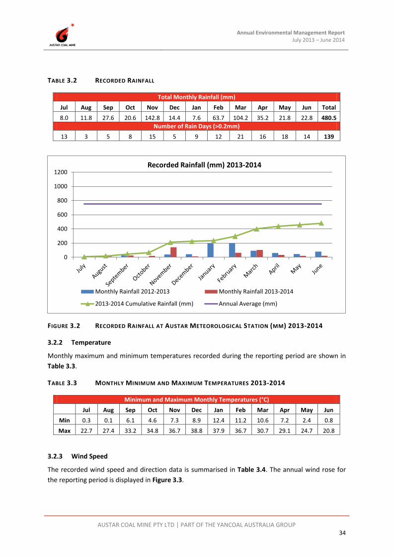
Annual Environmental Management Report July 2013 – June 2014
AUSTAR COAL MINE PTY LTD | PART OF THE YANCOAL AUSTRALIA GROUP 34
TABLE 3.2 RECORDED RAINFALL
Total Monthly Rainfall (mm) Jul Aug Sep Oct Nov Dec Jan Feb Mar Apr May Jun Total 8.0 11.8 27.6 20.6 142.8 14.4 7.6 63.7 104.2 35.2 21.8 22.8 480.5
Number of Rain Days (>0.2mm) 13 3 5 8 15 5 9 12 21 16 18 14 139
FIGURE 3.2 RECORDED RAINFALL AT AUSTAR METEOROLOGICAL STATION (MM) 2013-2014
3.2.2 Temperature
Monthly maximum and minimum temperatures recorded during the reporting period are shown in Table 3.3.
TABLE 3.3 MONTHLY MINIMUM AND MAXIMUM TEMPERATURES 2013-2014
Minimum and Maximum Monthly Temperatures (°C) Jul Aug Sep Oct Nov Dec Jan Feb Mar Apr May Jun
Min 0.3 0.1 6.1 4.6 7.3 8.9 12.4 11.2 10.6 7.2 2.4 0.8 Max 22.7 27.4 33.2 34.8 36.7 38.8 37.9 36.7 30.7 29.1 24.7 20.8
3.2.3 Wind Speed
The recorded wind speed and direction data is summarised in Table 3.4. The annual wind rose for the reporting period is displayed in Figure 3.3.
0
200
400
600
800
1000
1200Recorded Rainfall (mm) 2013-2014
Monthly Rainfall 2012-2013 Monthly Rainfall 2013-2014
2013-2014 Cumulative Rainfall (mm) Annual Average (mm)

Annual Environmental Management Report July 2013 – June 2014
AUSTAR COAL MINE PTY LTD | PART OF THE YANCOAL AUSTRALIA GROUP 35
TABLE 3.4 MEAN MONTHLY WIND SPEED
Month Mean Wind Speed (m/s) Mean Maximum Wind Speed (m/s)
Dominant Wind Direction
July 2013 0.9 6.4 S
August 2013 1.2 9.1 SW
September 2013 1.3 8.6 SW
October 2013 1.5 9.6 SW
November 2013 1.5 8.7 SW
December 2013 1.3 8.3 E
January 2014 1.2 7.7 E
February 2014 1.2 7.5 E
March 2014 0.9 7.3 SW
April 2014 1.0 6.5 SW
May 2014 0.9 6.5 S
June 2014 1.2 8.2 SW

Annual Environmental Management Report July 2013 – June 2014
AUSTAR COAL MINE PTY LTD | PART OF THE YANCOAL AUSTRALIA GROUP 36
2013-2014 AEMR WIND DATA 1 July 2013 – 30 June 2014
FIGURE 3.3 MONTHLY AVERAGE WIND ROSE 2013-2014

Annual Environmental Management Report July 2013 – June 2014
AUSTAR COAL MINE PTY LTD | PART OF THE YANCOAL AUSTRALIA GROUP 37
3.3 Air Pollution
3.3.1 Environmental Management
Austar prepared an updated Air Quality and Greenhouse Gas Management Plan for the Mine Complex as required by PA08_0111 Schedule 4 Conditions 6 and 7 which included the Stage 3 operations. This Plan was approved by DP&I on 26 June 2013. In accordance with this Plan, additional air quality monitoring commenced in July 2013.
Dust generated from traffic around the CHPP, Pit Top, workshop areas and access roads is controlled by a water cart during active use of these areas. Generally, the majority of the site is stable, and does not generate excessive dust.
The AQM&MP was implemented by Austar and utilises eight (8) dust depositional gauges and three (3) high volume air samplers (HVAS). The HVAS measure for particulate matter less than 10 micrometers (<=10μm), or more commonly referred to as PM10. The location of Austar’s air quality monitoring equipment is listed in Table 3.5, and shown on Plan 2.
TABLE 3.5 LOCATION OR AIR QUALITY MONITORING POINTS
Site Location Description Dust Gauge D1 Pyne Way, Mount View
Dust Gauge D2 Ellalong Road, Pelton Village
Dust Gauge D2A Ellalong Road, Pelton Village
Dust Gauge D3 Bimbadeen Road, Mount View
Dust Gauge D4 Ellalong Village
Dust Gauge D5 Kalingo Infrastructure Area (Upcast Shaft 3)
Dust Gauge D7 Pelton Fire Trail, Quorrobolong
Dust Gauge D8 Coney Creek Lane, Quorrobolong
Dust Gauge D9 Kitchener Village
HVAS 1 (PM10) Pyne Way, Mount View
HVAS 2 (PM10) Ellalong Road, Pelton Village
HVAS 3 (PM10) Coney Creek Lane, Quorrobolong
The air quality criteria for deposited dust, particulate matter <10µm (PM10) and total suspended particulates (TSP) are provided in Table 3.6.

Annual Environmental Management Report July 2013 – June 2014
AUSTAR COAL MINE PTY LTD | PART OF THE YANCOAL AUSTRALIA GROUP 38
TABLE 3.6 AIR QUALITY CRITERIA FOR PARTICULATE MATTER
Description Pollutant Criterion Averaging Period
Long Term Impact Assessment Criteria for
Particulate Matter
Total Suspended Particulate (TSP) matter
90 µg/m3 Annual
Particulate Matter < 10µm (PM10)
30 µg/m3 Annual
Short Term Impact Assessment Criterion for
Particulate Matter
Particulate Matter < 10µm (PM10)
50 µg/m3 24 hour
Long Term Impact Assessment Criteria for
Deposited Dust
Depositional Dust
2 g/m2/month (maximum increase in deposited dust level)
Annual
4 g/m2/month (maximum total
deposited dust level)
Annual
Note: Deposited Dust is assessed as insoluble solids as defined by Standards Australia, 2003 AS3580.10.1 -2003: Methods for Sampling and Analysis of Ambient Air – Determination of Particulates – Deposited Matter – Gravimetric Method.
Methods for sampling and analysis of ambient air as defined by Standards Australian, AS 3580.9.6 -2003: Determination of suspended particulate matter—PM10 high volume sampler with size selective inlet—Gravimetric method.
3.3.2 Environmental Performance
In accordance with the AQM&MP, eight (8) dust depositional gauges and three (3) high volume air samplers were operated by Austar during the reporting period; an additional temporary dust gauge was also operated. During the reporting period, all dust samples were collected by trained specialists and analysed by NATA certified laboratories. This work is carried out in accordance with statutory requirements and relevant standards. Monitoring equipment is maintained in accordance with the manufacturer’s specifications by qualified specialists. A compilation of dust deposition results and PM10 monitoring data for the reporting period is provided in Appendix A.
Dust Deposition
Table 3.7 provides a summary of Austar’s annual average for insoluble solids during the reporting period and the previous reporting period.
Depositional dust results during the reporting period were below the annual average criteria of 4g/m2/month for insoluble solids. Overall dust results were generally equivalent to the 2012-2013 reporting year, with a large decrease in insoluble solids recorded at D2 in Pelton Village compared with elevated results from the 2012/2013 reporting period.
Dust results for the reporting period are consistent with dust results stated in the 1995 Environmental Impact Statement (EIS) for extension of underground mining operations at Pelton/Ellalong Colliery. Section 4.7.2 of the 1995 EIS states that historical dust depositional data since 1991 ranges between 0.2 to 2.7 g/m2/month.
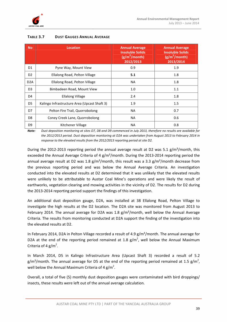
Annual Environmental Management Report July 2013 – June 2014
AUSTAR COAL MINE PTY LTD | PART OF THE YANCOAL AUSTRALIA GROUP 39
TABLE 3.7 DUST GAUGES ANNUAL AVERAGE
No Location Annual Average Insoluble Solids (g/m2/month)
2012/2013
Annual Average Insoluble Solids (g/m2/month)
2013/2014 D1 Pyne Way, Mount View 0.9 1.9
D2 Ellalong Road, Pelton Village 5.1 1.8
D2A Ellalong Road, Pelton Village NA 1.8
D3 Bimbadeen Road, Mount View 1.0 1.1
D4 Ellalong Village 2.4 1.8
D5 Kalingo Infrastructure Area (Upcast Shaft 3) 1.9 1.5
D7 Pelton Fire Trail, Quorrobolong NA 0.7
D8 Coney Creek Lane, Quorrobolong NA 0.6
D9 Kitchener Village NA 0.8 Note: Dust deposition monitoring at sites D7, D8 and D9 commenced in July 2013, therefore no results are available for
the 2012/2013 period. Dust deposition monitoring at D2A was undertaken from August 2013 to February 2014 in response to the elevated results from the 2012/2013 reporting period at site D2.
During the 2012-2013 reporting period the annual average result at D2 was 5.1 g/m²/month, this exceeded the Annual Average Criteria of 4 g/m²/month. During the 2013-2014 reporting period the annual average result at D2 was 1.8 g/m²/month, this result was a 3.3 g/m²/month decrease from the previous reporting period and was below the Annual Average Criteria. An investigation conducted into the elevated results at D2 determined that it was unlikely that the elevated results were unlikely to be attributable to Austar Coal Mine’s operations and were likely the result of earthworks, vegetation clearing and mowing activities in the vicinity of D2. The results for D2 during the 2013-2014 reporting period support the findings of this investigation.
An additional dust deposition gauge, D2A, was installed at 38 Ellalong Road, Pelton Village to investigate the high results at the D2 location. The D2A site was monitored from August 2013 to February 2014. The annual average for D2A was 1.8 g/m²/month, well below the Annual Average Criteria. The results from monitoring conducted at D2A support the finding of the investigation into the elevated results at D2.
In February 2014, D2A in Pelton Village recorded a result of 4.9 g/m²/month. The annual average for D2A at the end of the reporting period remained at 1.8 g/m2, well below the Annual Maximum Criteria of 4 g/m2.
In March 2014, D5 in Kalingo Infrastructure Area (Upcast Shaft 3) recorded a result of 5.2 g/m²/month. The annual average for D5 at the end of the reporting period remained at 1.5 g/m2, well below the Annual Maximum Criteria of 4 g/m2.
Overall, a total of five (5) monthly dust deposition gauges were contaminated with bird droppings/ insects, these results were left out of the annual average calculation.

Annual Environmental Management Report July 2013 – June 2014
AUSTAR COAL MINE PTY LTD | PART OF THE YANCOAL AUSTRALIA GROUP 40
Assessment criterion of a maximum increase of 2g/m2/month annual average for deposited dust was undertaken by comparing annual average deposited dust results for 2013-2014 to those from the previous reporting period. All gauges had a difference in annual averages of less than 2g/m2/month when compared with dust results from the 2012-2013 reporting period.
PM10 (Fine Dust)
The annual average PM10 results for the reporting period are provided in Table 3.8.
TABLE 3.8 PM10 HVAS RESULTS
No Location Annual Average PM10 (µg/m3) 2012-2013
Annual Average PM10 (µg/m3) 2013-2014
HVAS1 Pyne Way, Mount View 12.4 12.4
HVAS2 Ellalong Road, Pelton Village 14.0 13.8
HVAS3 Coney Creek Lane, Quorrobolong NA 3.5* Note: *Operation of HVAS3 commenced on the 9th June 2014, therefore no data is available for the 2012-2013 reporting
period.
The HVAS units continued to operate on a six day cycle (in line with the OEH cycle) during the reporting period. HVAS3 was installed at 159 Coney Creek Lane, Quorrobolong, in June 2014. Monitoring commenced at HVAS3 on 9 June 2014, as such there is only limited data available for the 2013-2014 reporting period from HVAS3. The annual average PM10 results for the reporting period are well below the annual average criterion of 30 µg/m3 at HVAS1, HVAS2 and HVAS3. Results have decreased or remained unchanged since the previous reporting period of 2012-2013.
The measured 24 hour PM10 did not exceeded the 24 hour maximum criteria of 50µg/m3 during any monitoring events during the 2013-2014 reporting period.
Total Suspended Particulates
The annual average TSP results for the reporting period are provided in Table 3.9.
TABLE 3.9 TSP HVAS RESULTS
No Location Annual Average TSP (µg/m3) 2012/2013
Annual Average TSP (µg/m3) 2013/2014
HVAS1 Pyne Way, Mount View 31 31
HVAS2 Ellalong Road, Pelton Village 35 32.5
HVAS3 Coney Creek Lane, Quorrobolong NA 8.8* Note: *Operation of HVAS3 commenced on 9 June 2014, therefore no data is available for the 2012-2013 reporting
period.
The current project average for calculated Total Suspended Particulates (TSP) is well below the annual average criterion of 90ug/m3. The TSP is calculated by multiplying the PM10 result by 2.5 in accordance with the method outlined in the AQM&MP.
Annual Environmental Management Report July 2013 – June 2014
AUSTAR COAL MINE PTY LTD | PART OF THE YANCOAL AUSTRALIA GROUP 41
3.4 Erosion and Sediment
3.4.1 Environmental Management
In accordance with PA08_0111 Schedule 4 Condition 9, Austar prepared a Site Water Management Plan (SWMP) for the mine complex which includes an erosion and sediment control plan. The SWMP was approved by the Director-General of DP&I on 17 May 2013.
In accordance with the SWMP, a range of erosion and sediment control measures have been implemented across the mining complex with the aim of preventing soil erosion and the entry of sediments into surrounding water bodies. Monthly environmental inspections are undertaken to inspect the sediment control structures for capacity, structural integrity and effectiveness. A summary of Austar’s sediment and erosion control measures is outlined below. The performance of these measures is discussed in Section 3.4.2 of the AEMR.
The Landscape Management Plan for Kitchener SIS has been developed to document management strategies for the Kitchener SIS in the short, medium and long term and was approved by the Director-General of DP&I 22 July 2013. The SIS is transitioning from shaft construction activities to an operational infrastructure site, and site stabilisation activities were in progress at the end of the 2013-2014 reporting period.
The Landscape Management Plan and SWMP indicates that the erosion and sediment controls documented in the Shaft Construction Environmental Management Plan (SCEMP) will continue to be implemented until the site is stabilised. Section 6 of the SCEMP details the erosion and sediment control strategy for the SIS during construction, which were implemented in accordance with this plan during the 2013-2014 reporting period.
Drainage Channels
Drains have generally been constructed with either a parabolic or trapezoidal cross section rather than a V-shape which can be easily eroded. Where possible, channels have been constructed with an adjacent earth bank. All channels are periodically inspected (at least every three months or after rain) to repair damage caused by scour, sediment deposition, channel obstruction and loss of vegetative cover.
Sediment Basins
Several small sediment basins have been constructed within the dirty water system. These are in addition to the main pollution control structures. The sediment control basins have been designed and located to contain dirty water from disturbed areas on site. The primary purpose of these basins is to contain sediment from normal rainfall events as well as reduce flow velocity during high rainfall events.
These structures are regularly maintained and cleaned out once capacity has reduced by over 10%. The structures are inspected after major rainfall events and any erosion of the spillway is corrected.

Annual Environmental Management Report July 2013 – June 2014
AUSTAR COAL MINE PTY LTD | PART OF THE YANCOAL AUSTRALIA GROUP 42
Within the footprint of the SIS disturbed area there are two designed sediment basins shown in the SCEMP for surface water runoff management. These sediment basins are designed for a specific design rainfall event, and are managed using pumping to minimise overflow occurrences during greater than design rainfall. These sediment basins are inspected regularly by the Environment and Community Coordinator and by specific pumping crew. During the 2013-2014 reporting period, a drainage improvement was made during site stabilisation bulk earthworks to enable dirty water runoff from the western part of the site flow to water storage dams of larger capacity than the western sediment basin, therefore the western sediment basin was decommissioned.
Sediment Fences
The use of sediment fences and hay bales provides interim protection from sediment runoff at Austar. Regular inspection of sediment fences and hay bales is undertaken at Austar following significant rainfall events.
3.4.2 Environmental Performance
During the 2013-2014 reporting period there was one reportable incident at the Kitchener SIS that involved water overflowing from the eastern sediment basin after a rainfall event that exceeded the design capacity of the basin. The sediment basin design size is based on a catchment area of 3.7 Ha (being the cleared area on the eastern side) and Type D soils for a 90th percentile five day rainfall depth of 42.8mm. The sediment dam has a volume of approximately 1.6ML. During a period of heavy rainfall from 15 November to 18 November 2013 during which a total of 158mm was recorded, the design capacity of the eastern sediment basin at the Kitchener SIS was exceeded which caused discharge over the outlet weir into Black Creek to occur. The sediment basins performed as designed and approved in the SCEMP.
As a result of this incident the following actions were undertaken:-
• The incident was immediately reported to the EPA Environment Line; • Water samples were collected on 18 November 2013 and result provided to the EPA with a
written incident report; • Pumping of water from the eastern sediment basin to the water storage dams occurred as soon
as sufficient runoff had collected in the basin, and continued until the eastern basin was empty; and
• Pumping of water from the water storage dams to Kalingo Dam occurred as soon as sufficient water had collected, to reduce accumulated stormwater pumped to these dams in readiness for future rainfall events.
For further details regarding this incident please refer to Appendix G.
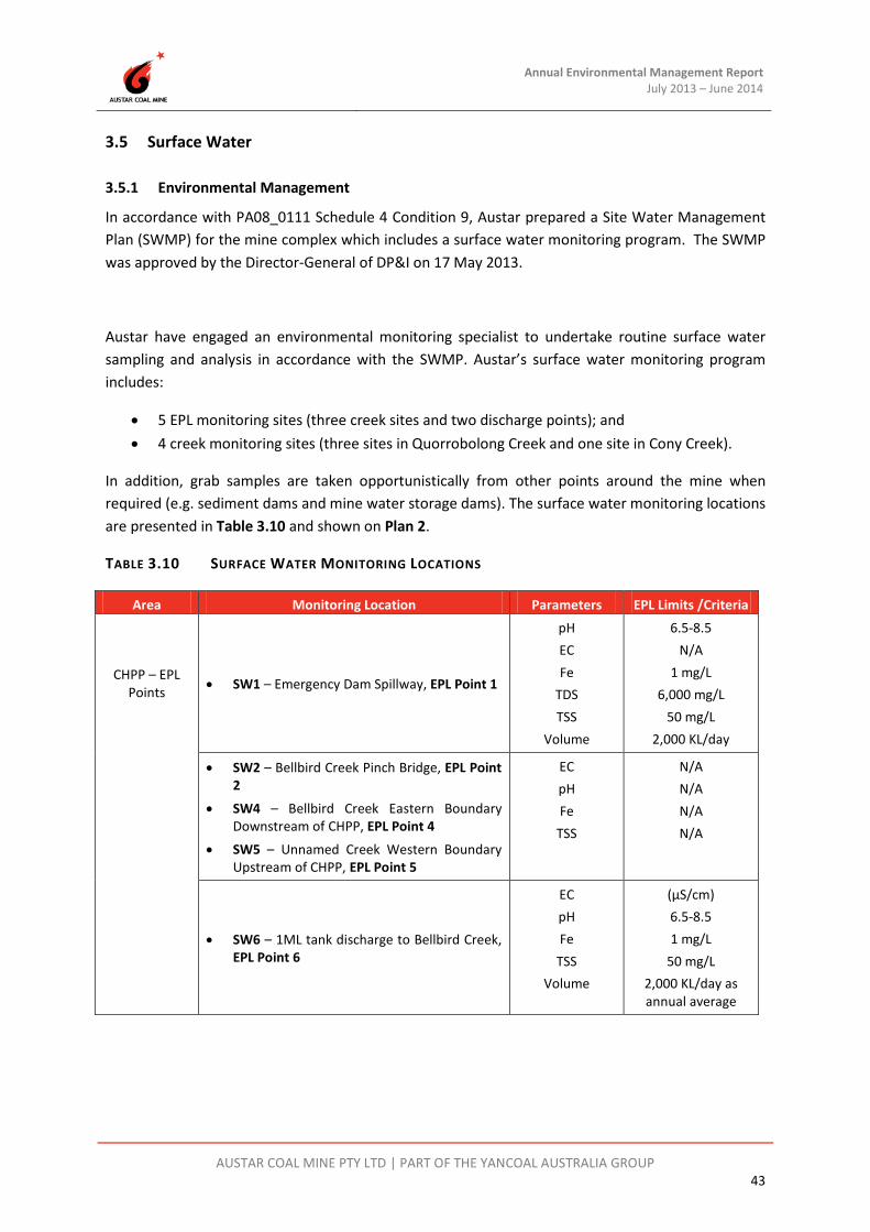
Annual Environmental Management Report July 2013 – June 2014
AUSTAR COAL MINE PTY LTD | PART OF THE YANCOAL AUSTRALIA GROUP 43
3.5 Surface Water
3.5.1 Environmental Management
In accordance with PA08_0111 Schedule 4 Condition 9, Austar prepared a Site Water Management Plan (SWMP) for the mine complex which includes a surface water monitoring program. The SWMP was approved by the Director-General of DP&I on 17 May 2013.
Austar have engaged an environmental monitoring specialist to undertake routine surface water sampling and analysis in accordance with the SWMP. Austar’s surface water monitoring program includes:
• 5 EPL monitoring sites (three creek sites and two discharge points); and • 4 creek monitoring sites (three sites in Quorrobolong Creek and one site in Cony Creek).
In addition, grab samples are taken opportunistically from other points around the mine when required (e.g. sediment dams and mine water storage dams). The surface water monitoring locations are presented in Table 3.10 and shown on Plan 2.
TABLE 3.10 SURFACE WATER MONITORING LOCATIONS
Area Monitoring Location Parameters EPL Limits /Criteria
CHPP – EPL Points • SW1 – Emergency Dam Spillway, EPL Point 1
pH EC Fe
TDS TSS
Volume
6.5-8.5 N/A
1 mg/L 6,000 mg/L
50 mg/L 2,000 KL/day
• SW2 – Bellbird Creek Pinch Bridge, EPL Point 2
• SW4 – Bellbird Creek Eastern Boundary Downstream of CHPP, EPL Point 4
• SW5 – Unnamed Creek Western Boundary Upstream of CHPP, EPL Point 5
EC pH Fe
TSS
N/A N/A N/A N/A
• SW6 – 1ML tank discharge to Bellbird Creek, EPL Point 6
EC pH Fe
TSS Volume
(µS/cm) 6.5-8.5 1 mg/L
50 mg/L 2,000 KL/day as annual average

Annual Environmental Management Report July 2013 – June 2014
AUSTAR COAL MINE PTY LTD | PART OF THE YANCOAL AUSTRALIA GROUP 44
Area Monitoring Location Parameters EPL Limits /Criteria
Creeks – Stage 2 UG Mining
Area
• SWQ1 – Quorrobolong Creek Sandy Creek Road
• SWQ2 – Quorrobolong Creek Upstream of Stage 2 Area
• SWQ3 – Quorrobolong Creek Downstream of Stage 2 Area
• SWC1 – Cony Creek
EC pH Fe
TSS
N/A N/A N/A N/A
3.5.2 Environmental Performance
Surface water quality data is presented in Appendix B. Only EPL licensed discharge points SW1 and SW6 have water quality limits. Other locations are monitored for baseline data, or to observe any changes in water quality in the Stage 2 area.
There were no discharge events from SW1 during the reporting period, so no sampling was required. At the permeate EPL discharge point SW6, water quality results for pH and EC were within EPL limits.
For the background CHPP creek monitoring points (SW2, SW4 & SW5):
• the pH measured at individual sites remained relatively constant ranging between pH 6.51 and pH 7.74 which was similar to the 2012-2013 range of pH 6.54 to 8.34;
• Surface water EC ranged between 124μS/cm (SW2) and 13,700μS/cm (SW5) which was similar to the 2012-2013 range of 122μS/cm (SW2) to 15,900μS/cm (SW5);
• TSS recorded a maximum of 104mg/L (SW5) with a minimum TSS of <5mg/L (SW2 & SW4) for the reporting period, similar to the 2012-2013 range of <5mg/L to 66mg/L (SW5); and
• Fe (Iron) recorded a minimum of 0.06 mg/L (SW2) and a maximum of 14.9 mg/L (SW5) for the reporting period, similar to the 2012-2013 maximum result of 17.9mg/L (SW5).
Results from SW5 (upstream of CHPP influence) for TSS and iron were similar to those from the 2012-2013 reporting period but remain variable, most likely due to the ephemeral nature of the stream in this location. SW5 samples were collected from small pools in the creek bed on numerous occasions throughout the reporting period.
Natural fluctuations in water quality in Quorrobolong and Cony Creeks were observed, with sample points displaying similar trends when compared to the previous reporting period. No environmental impacts upon surface waters from mining in the Stage 2 area can be interpreted.
For the Quorrobolong and Cony Creek monitoring points (SWQ1, SWQ2, SWQ3 & SWC1):
• The pH measured at individual sites remained relatively constant ranging between pH 6.52 and pH 8.03, which was similar to the 2012-2013 range of pH 6.67 to 7.83;
• EC ranged between 144μS/cm and 3,000μS/cm, which was similar to the 2012-2013 range of 116 to 2,680 μS/cm;

Annual Environmental Management Report July 2013 – June 2014
AUSTAR COAL MINE PTY LTD | PART OF THE YANCOAL AUSTRALIA GROUP 45
• TSS recorded a maximum of 381 mg/L with a minimum TSS of <5mg/L for the reporting period, the maximum TSS was slightly elevated compared to the 2012-2013 range of <5 to 135mg/L; and
• Fe (Iron) recorded a minimum of 0.07 mg/L and a maximum of 9.40 mg/L for the reporting period, which was similar to the 2012-2013 range of 0.62 to 7.54mg/L.
3.6 Ground Water
3.6.1 Environmental Management
In accordance with PA08_0111 Schedule 4 Condition 9, Austar prepared a Site Water Management Plan (SWMP) for the mine complex which includes a groundwater monitoring program. The SWMP was approved by the Director-General of DP&I on 17 May 2013.
Additional groundwater bores are to be installed in several locations in the Stage 3 area prior to subsidence impacts in accordance with the SWMP.
An environmental monitoring specialist is engaged by Austar to undertake quarterly groundwater monitoring and analysis in accordance with the SWMP, utilising five piezometers (AQD1073a, NER1010, WBH1, WBH2 and WBH3) to assess impacts on groundwater levels in the Stage 2 area. For general operational purposes, Austar’s groundwater monitoring program also includes monthly and quarterly monitoring of underground flows, water quality and pressure.
There have been no known incidences of groundwater pollution as a result of Austar operations to date. A detailed review of groundwater sources and groundwater water movement in and around the mining operations was undertaken by Connell Wagner and reported as part of SWMP.
Groundwater resources in the vicinity of Austar operations include:
• Shallow alluvial aquifers associated with Bellbird Creek downstream of the CHPP. These groundwater resources are very limited in extent. The potential for Austar mining operations to cause pollution of this groundwater resource is very low and is mitigated by the surface water management controls that are in place at the CHPP and the leachate controls at the East and West Open Cut emplacement areas;
• Shallow alluvial aquifers associated with the Black Creek system. These groundwater resources are also very limited in extent. The potential for Austar mining operations to cause pollution of this groundwater resource is very low and is mitigated by leachate controls at the Aberdare Extended emplacement area and the surface water management controls that are proposed for the final landform at the CHPP. The new surface infrastructure site off Quorrobolong Road also drains to the Black Creek system. The potential for groundwater pollution to result from operations at the new surface infrastructure site is limited to spills and surface runoff and is mitigated by the surface water management system that is implemented at the site;

Annual Environmental Management Report July 2013 – June 2014
AUSTAR COAL MINE PTY LTD | PART OF THE YANCOAL AUSTRALIA GROUP 46
• Shallow alluvial aquifers associated with the Quorrobolong Creek system in the vicinity of Stage 2 and Stage 3 underground mining areas. Analysis indicates that underground mining operations will have negligible to low potential to impact on these shallow alluvial resources and negligible potential to result in pollution of this groundwater resource;
• Fractured rock aquifers in the vicinity of the underground mining area. Monitoring indicates that there are very limited groundwater reserves in the fractured rock aquifer and that what groundwater there is, exhibits high salinity. Mining operations have negligible potential to result in pollution of these resources; and
• Coal seam aquifers including groundwater contained in abandoned underground workings. Monitoring indicates that there are extensive volumes of this mine water associated with the coal seams and abandoned underground workings with the mine water exhibiting low pH, high iron concentrations, high manganese concentrations and high salinity. The mine contributes to the ongoing management of this groundwater and through the control of groundwater levels in the abandoned underground workings, minimises the potential for this poor quality groundwater to discharge into surrounding surface waters. Reverse osmosis brine derived from the treatment of the mine water pumped from the underground workings and tailings are discharged underground into abandoned workings. This process effectively returns the existing contaminates from the coal seams and underground mine water to the abandoned underground workings. As a result operations at Austar mine have low potential to pollute these groundwater reserves.
3.6.2 Environmental Performance
A groundwater specialist was engaged to undertake quarterly groundwater depth monitoring in the Quorrobolong Creek alluvial aquifer (AQD1073a), in the fractured rock aquifer (NER1010), and in alluvial groundwater monitoring wells (WBH1, WBH2 and WBH3).
Appendix C illustrates the groundwater monitoring results at Austar during the reporting period. The graphs compare groundwater depth and rainfall, and pH and conductivity.
• Overall, the groundwater levels within alluvial monitoring wells AQD1073a, WBH2 and WBH3 have remained fairly high, with water within 3 m of the surface. The piezometer within WBH1 is measuring the same alluvial ‘aquifer’, although plots at a lower level below ground, due to the higher elevation of this well.
• The groundwater in NER1010 fell at a steady rate from 16m to 18m below ground level (m bgl) during the period July 2013 to June 2014, but remained consistent with historical results. Over the long-term, the groundwater in NER1010 was on a rising trend throughout all of 2011, before plateauing at a maximum base level (ignoring the short-term spikes) of 15.2 m bgl. The trend then reversed in February 2012. Throughout 2012 and early 2013 groundwater levels were on a steady decline until wetter climatic conditions experienced over the period 27 January to 3 March 2013, which saw an increase in groundwater level from 18 to 14.7 m bgl. The groundwater level has since continued to decline to

Annual Environmental Management Report July 2013 – June 2014
AUSTAR COAL MINE PTY LTD | PART OF THE YANCOAL AUSTRALIA GROUP 47
approximately 18 m bgl due to the below average rainfall over the reporting period. This piezometer generally reacts to daily rainfall events greater than 20 mm.
• Groundwater quality, pH and conductivity remained relatively stable throughout the reporting period.
There has been no observable depressurization of either the alluvial or fractured rock aquifers due to longwall extraction in the Stage 2 mining area. Water quality data within the monitoring bores has revealed no obvious trends in relation to mining.
3.7 Contaminated Land
3.7.1 Environmental Management and Performance
A Phase 1 contamination assessment of the potential for contamination on site will be undertaken during the approved MOP term and will continue to be periodically undertaken through the life of the operation and immediately prior to site decommissioning.
In regards to the areas on site that may be identified from the Phase 1 assessment as posing low to moderate risk of resulting in contamination, it is planned that further investigations will be postponed until the decommissioning phase or at the time of demolition/decommissioning of particular infrastructure. Alternatively, where there is a high risk of contamination that may lead to environmental harm, a Phase 2 – Detailed Investigation (e.g. Soil sampling and analysis) will be undertaken to verify the type, extent and level of contamination that may exist.
In the event that the results of the detailed investigation suggest that the site poses unacceptable risks to human health or the environment then a remedial action plan (Phase 3) will be prepared and implemented. This will be followed by Phase 4 – Site Validation and Reporting to demonstrate that the site clean-up complies with the relevant EPA guidelines.
During the operational phase of the site, contamination resulting from environmental incidents (e.g. Spills) and areas of high risk associated with hydrocarbon storage infrastructure will be cleaned up and appropriately managed (e.g. Remediated or disposed off site by an authorised waste contractor) as soon as possible after they occur. Further details on hydrocarbon contamination are provided in Section 3.18.
3.8 Threatened Flora and Fauna
3.8.1 Environmental Management
In accordance with DA No.29/95 Schedule 3 Condition 23, Austar have implemented an ecological monitoring program of riparian vegetation over Stage 2 Longwall Panels A3 to A5a, with particular reference to the River Flat Eucalypt Forest EEC. The Stage 2 monitoring program commenced with baseline surveys in 2008 and now has six years of data prior to and following the commencement of mining which commenced in LWA3 in February 2009.
In accordance with PA08_0111 Schedule 4 Condition 9, Austar have implemented an ecological monitoring program as part of the Stage 3 Biodiversity Management Plan. Baseline surveys were

Annual Environmental Management Report July 2013 – June 2014
AUSTAR COAL MINE PTY LTD | PART OF THE YANCOAL AUSTRALIA GROUP 48
carried out in Spring 2012 and Autumn 2013. Routine surveys were conducted during this reporting period in Spring 2013 and Autumn 2014. The Stage 3 Biodiversity Management Plan was reviewed and updated in December 2013, as a result different sites were monitored during the Spring 2013 and Autumn 2014 surveys.
In addition, to satisfy Condition 1 Schedule 4 of PA08_0111, Austar implemented the approved SCEMP to manage any fauna impacts resulting from construction activities at the SIS. Ecological considerations for the SIS have since been incorporated into the Landscape Management Plan – Kitchener SIS (June 2013), prepared in accordance with Schedule 6 Condition 4 of PA08_0111.
There are no rare or threatened flora or fauna known to occur within colliery holding land that requires active management. Austar land ownership is approximately 2,600 hectares of land which is predominantly vegetated, where threatened flora and fauna are known to occur in the area. As such, any land disturbance that is required for the on-going operation is only carried out following the appropriate assessments.
Stage 2
Baseline ecological monitoring was undertaken for the Stage 2 mining area during autumn and spring 2008, and autumn and spring 2009. The 2009 Ecological Monitoring Report for Stage 2 Longwalls documented the baseline results from monitoring sites in the Stage 2 Mine Area. The results included a description of the vegetation structure, floristics and condition in such a way that comparisons with post-mining data can be readily made to determine any possible impacts of the longwall mining. Photo monitoring further supplements this data, providing a visual reference of the baseline condition of the vegetation and creeklines.
During the baseline survey all monitoring sites were found to be in varying states of disturbance, particularly due to past clearing and grazing practices and subsequent heavy weed invasion. Because the longwall mining had not commenced in this area at the time of the baseline surveys, the report indicated that no observed disturbance-related matters were a result of subsidence.
Stage 3
Baseline surveys ahead of mining longwalls A7 and A8 were undertaken in Spring 2012 and Autumn 2013. A monitoring location above each longwall and two additional monitoring locations outside the affected subsidence zone were surveyed. Baseline monitoring of each of these sites indicated that vegetation is stable, in good health and consistent with that of Lower Hunter Spotted Gum Ironbark Forest EEC.
Surveys were conducted during this reporting period in Spring 2013 and Autumn 2014. The Stage 3 Biodiversity Management Plan was reviewed and updated in December 2013 in response to a modification to PA08_0111 (MOD3), resulting in some sites being relocated and the monitoring schedule of sites being modified. Consequentially the sites monitored in the Spring 2013 and Autumn 2014 surveys varied slightly in accordance with the approved Biodiversity Management Plan at the time of monitoring, but in each case involved a combination of sites over the longwall mining area, and reference sites outside the area of mining influence.

Annual Environmental Management Report July 2013 – June 2014
AUSTAR COAL MINE PTY LTD | PART OF THE YANCOAL AUSTRALIA GROUP 49
3.8.2 Environmental Performance
Ecological monitoring during the AEMR period was undertaken by qualified ecologists during Spring 2013 and Autumn 2014 in accordance with Austar’s Stage 2 Ecological Monitoring Program and Stage 3 Biodiversity Management Plan. The Study Area for the ecological monitoring is shown in Figure 3.4 for Stage 2 and Figure 3.5 for Stage 3 (Autumn 2014 shown).
Ecological monitoring concluded the following for the Stage 2 and Stage 3 areas:
• Longwall mining has now passed under all Stage 2 monitoring sites; • None of the Stage 2 or 3 sites currently appear to be experiencing impacts as a result of
longwall mining (in particular surface cracking, subsidence, or resulting fluctuations to species numbers);
• No obvious increase in rates of erosion or bank instability has been recorded at any of the Stage 2 sites monitored, or elsewhere in the Stage 2 Study Area;
• No obvious increase in dieback has been recorded at any of the Stage 2 or 3 sites monitored; • Good levels of regeneration of canopy species were observed along the length of the Stage 2
monitoring sites and are considered likely to be a result of stock exclusion from the riparian zone;
• The photo monitoring indicates there have been no obvious visual changes to the health of the Stage 2 and 3 vegetation since the baseline photos were taken;
• The biggest threat to the ecological integrity of the Stage 2 sites continues to be weed infestation by blackberry (Rubus fruticosus sp. agg.) and wandering Jew (Tradescantia fluminensis) which are not related to underground mining activity;
• There are not considered to be any significant threats to the ecological integrity of Stage 3 monitoring sites;
• There has been a significant reduction in the ground coverage of wandering Jew at Site 2, as a direct result of a weed control program by Austar; and
• To date, there is no evidence of any impacts on ecological features as a result of longwall mining.

Annual Environmental Management Report July 2013 – June 2014
AUSTAR COAL MINE PTY LTD | PART OF THE YANCOAL AUSTRALIA GROUP 50
FIGURE 3.4 LOCATION OF STAGE 2 ECOLOGICAL MONITORING SITES

Austar Annual Environmental Management Report July 2013 – June 2014
AUSTAR COAL MINE PTY LTD | PART OF THE YANCOAL AUSTRALIA GROUP 51
FIGURE 3.5 LOCATION OF STAGE 3 ECOLOGICAL MONITORING SITES

Austar Annual Environmental Management Report July 2013 – June 2014
AUSTAR COAL MINE PTY LTD | PART OF THE YANCOAL AUSTRALIA GROUP 52
3.9 Weed and Feral Animal Management and Control
3.9.1 Environmental Management and Performance
Weeds Management
No weed control works were undertaken on Austar land during the 2013-2014 reporting period. It is planned to undertake weed control works in Area 12 and 13 during the 2014-2015 reporting period.
Feral Animal Management
Little evidence of feral animal issues were identified during the reporting period. Feral animals will be controlled should the need arise.
3.10 Vibration and Blasting
3.10.1 Environmental Management
The mining complex Noise and Vibration Management Plan (NVMP) prepared in accordance with Schedule 4 Condition 3 of PA08_0111, was approved by the Director General DP&I on 2 August 2013 and includes vibration considerations in relation to mining operations undertaken within the Stage 3 area. Longwall mining in the Stage 3 area commenced on 14 June 2013 and Austar have implemented the approved Noise and Vibration Monitoring Program (NVMP). Vibration monitors are located at 159 Coney Creek Lane, Quorrobolong (V8), and at 345 Quorrobolong Road, Quorrobolong (V7). No surface blasting activities are undertaken at Austar Coal Mine.
3.10.2 Environmental Performance
Vibration monitoring in the Stage 3 mining area was undertaken during the 2013-2014 reporting period in accordance with the relevant approved vibration management plans as described above. In accordance with the NVMP, the monitors are set to trigger when vibration is greater than 1mm/second. Vibration monitoring results are presented in Appendix D.
Longwall mining during the reporting period involved:
• Mining of LWA7 commenced on 14 June 2013;
• Mining of LWA7 was completed on 19 April 2014; and
• Mining of LWA8 commenced on 16 June 2014 and was ongoing at the end of the AEMR period.
Monitoring to date has indicated vibration in the mining area is event based. Of the 36 events recorded only 2 occurred in the period between completion of LWA7 and commencement of LWA8. This indicates that vibration is generally coincidental with operational longwall extraction, and generally ceases after longwall extraction ceases. This trend is supported by previous longwall mining vibration data.
Annual Environmental Management Report July 2013 – June 2014
AUSTAR COAL MINE PTY LTD | PART OF THE YANCOAL AUSTRALIA GROUP 53
Vibration is typically generated from the caving zone behind the longwall, or from tensile fractures in the overlying strata immediately above the longwall mining area. Of the 36 events recorded during the AEMR period, a large proportion (30) of the events have been measured at less than 3 mm/s. Vibrations of this magnitude, whilst at levels known to be noticeable for humans, are significantly less than any potential building damage criteria.
There were six (6) vibration events greater than 3 mm/s during the 2013-2014 AEMR period. An event at V8 of 10.1 mm/s at 16:12 (daytime) on 16 August 2013 was greater than the DECC daytime preferred vibration criteria (8.6 mm/s), but was less than the DECC daytime maximum vibration criteria (17mm/s). An event at V8 of 11.7 mm/s at 02:58 (night time) on 25 October 2013 was greater than the DECC night time maximum vibration criteria (5.6 mm/s). This was the highest recorded vibration event measured during the 2013-2014 AEMR period. It is noted that both of these vibration events were less than the lowest vibration level where a minimal risk of cosmetic damage may occur (15 mm/s).
Results are similar to those from the previous reporting periods.
3.11 Noise
3.11.1 Environmental Management
The mining complex Noise and Vibration Management Plan (NVMP) prepared in accordance with Schedule 4 Condition 3 of PA08_0111, was approved by the Director General DP&I on 2 August 2013. Monitoring during the 2013-2014 period was in accordance with the NVMP.
3.11.2 Environmental Performance
Periodic noise monitoring was conducted on a quarterly basis during the reporting period in accordance with NVMP by an independent noise consultant. Nine (9) key monitoring locations representative of the surrounding receivers have been selected as reference locations and form the basis for assessing and evaluating noise emissions from the operation. The locations are listed in Table 3.11 and presented in Plan 2.

Annual Environmental Management Report July 2013 – June 2014
AUSTAR COAL MINE PTY LTD | PART OF THE YANCOAL AUSTRALIA GROUP 54
TABLE 3.11 NOISE IMPACT ASSESSMENT CRITERIA AND GOALS
Receiver Location Receiver Description Criteria/Goal Nearest Potentially Affected Receivers to CHPP
C1 South of Bimbadeen Road, Mt View West of CHPP LA90 40 dB
C2 Pelton Village South East of CHPP LA90 43 dB
C3 Bimbadeen Road, Mt View North-west of CHPP LA90 37 dB
C4 84 Bimbadeen Road, Mt View North of CHPP LA90 37 dB
C5 43 Doyle Street, Mt View North East of CHPP LA90 37 dB
Nearest Potentially Affected Receivers to Surface Infrastructure Site
K1 Pelt on Road , Quor rob o long (Sout h ) South of SIS LAeq 35 dB / LA1 45 dB
K2 Coney Creek Lane, Quor rob o long (East ) East of SIS LAeq 35 dB / LA1 45 dB
K3 Richm ond St reet , Kit chener North of SIS LAeq 35 dB / LA1 45 dB
Nearest Potentially Affected Receivers to Kalingo Infrastructure Area
K4 Nash Lane, Quorrobolong East of Kalingo Infrastructure Area LAeq 35 dB
A summary of results from attended monitoring undertaken during the AEMR period is provided in Table 3.12, Table 3.13 and Table 3.14.
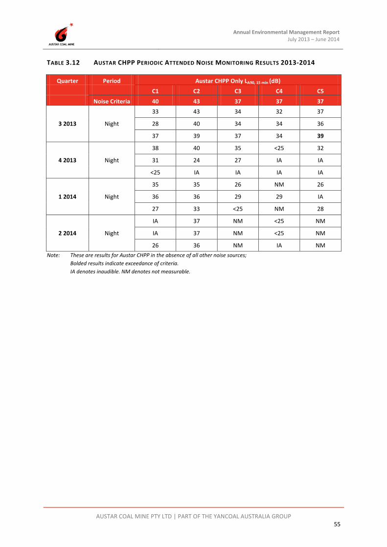
Annual Environmental Management Report July 2013 – June 2014
AUSTAR COAL MINE PTY LTD | PART OF THE YANCOAL AUSTRALIA GROUP 55
TABLE 3.12 AUSTAR CHPP PERIODIC ATTENDED NOISE MONITORING RESULTS 2013-2014
Quarter Period Austar CHPP Only LA90, 15 min (dB) C1 C2 C3 C4 C5 Noise Criteria 40 43 37 37 37
3 2013 Night
33 43 34 32 37
28 40 34 34 36
37 39 37 34 39
4 2013 Night
38 40 35 <25 32
31 24 27 IA IA
<25 IA IA IA IA
1 2014 Night
35 35 26 NM 26
36 36 29 29 IA
27 33 <25 NM 28
2 2014 Night
IA 37 NM <25 NM
IA 37 NM <25 NM
26 36 NM IA NM Note: These are results for Austar CHPP in the absence of all other noise sources;
Bolded results indicate exceedance of criteria. IA denotes inaudible. NM denotes not measurable.

Annual Environmental Management Report July 2013 – June 2014
AUSTAR COAL MINE PTY LTD | PART OF THE YANCOAL AUSTRALIA GROUP 56
TABLE 3.13 AUSTAR SIS ATTENDED NOISE MONITORING RESULTS 2013-2014
Quarter Period Austar KIA Only LAeq, 15 min (dB) K1 K2 K3 Noise Criteria 35 35 35
3 2013 Night
24 IA IA
23 <23 <20
23 IA IA
4 2013 Night
34 <25 IA
32 IA IA
29 IA IA
1 2014 Night
<25 IA IA
24 IA NM
27 IA IA
2 2014 Night
25 IA IA
29 IA IA
30 NM IA Note: These are results for Austar SIS in the absence of all other noise sources;
Bolded results indicate exceedance of criteria. IA denotes inaudible. NM denotes not measurable.

Annual Environmental Management Report July 2013 – June 2014
AUSTAR COAL MINE PTY LTD | PART OF THE YANCOAL AUSTRALIA GROUP 57
TABLE 3.14 AUSTAR KIA ATTENDED NOISE MONITORING RESULTS 2013-2014
Quarter Period Austar KIA Only LAeq, 15 min (dB)
K4 Noise Criteria 35
3 2013 Night
32
27
25
4 2013 Night
30
<25
27
1 2014 Night
IA
IA
IA
2 2014 Night
27
29
NM Note: These are results for Austar KIA in the absence of all other noise sources;
Bolded results indicate exceedance of criteria. IA denotes inaudible. NM denotes not measurable.
Activities from Austar complied with the relevant noise limits during the survey at all monitoring locations, with the exception of C5. On 25 September 2013 (Q3 2013), the LA90 criteria was exceeded by 2 dB at C5 (43 Doyle Street, Mt View). This exceedance is not considered significant as Chapter 11 of the EPA ‘Industrial Noise Policy’ deems a development to be in non-compliance only when “the monitored noise level is more than 2 dB above the statutory noise limit specified in the consent or licence condition.”
Low Frequency Noise Assessment
Noise measurements recorded are analysed for low frequency content. Where the above results exceed the Industrial Noise Policy (INP) low frequency criterion, a 5 dB modifying factor penalty is applied to the measured LA90 level. With this 5 dB penalty applied, the penalty resulted in noise levels exceeding project specific criteria as specified in Table 3.15, Table 3.16 and Table 3.17 during the 2013-2014 AEMR reporting period.

Annual Environmental Management Report July 2013 – June 2014
AUSTAR COAL MINE PTY LTD | PART OF THE YANCOAL AUSTRALIA GROUP 58
TABLE 3.15 INP LOW FREQUENCY EXCEEDANCES FOR AUSTAR CHPP DURING 2013-2014
Quarter Period Austar CHPP Only LA90, 15 min (dB) Low Frequency Exceedances
C1 C2 C3 C4 C5 Noise Criteria 40 43 37 37 37
3 2013 Night
- - 39 - -
42 44 42 - -
- - - - -
4 2013 Night
43 - 40 - -
- - - - -
- - - - -
1 2014 Night
- - - - -
41 - - - -
- - - - -
2 2014 Night
- - - - -
- - - - -
- - - - -
TABLE 3.16 INP LOW FREQUENCY EXCEEDANCES FOR AUSTAR SIS DURING 2013-2014
Quarter Period Austar KIA Only LAeq, 15 min (dB) Low Frequency Exceedances
K1 K2 K3 Noise Criteria 35 35 35
3 2013 Night
- - -
- - -
- - -
4 2013 Night
39 - -
- - -
- - -
1 2014 Night
- - -
- - -
- - -
2 2014 Night
- - -
- - -
- - -

Annual Environmental Management Report July 2013 – June 2014
AUSTAR COAL MINE PTY LTD | PART OF THE YANCOAL AUSTRALIA GROUP 59
TABLE 3.17 INP LOW FREQUENCY EXCEEDANCES FOR AUSTAR KIA DURING 2013-2014
Quarter Period Austar KIA Only LAeq, 15 min (dB) Low Frequency Exceedances
K4 Noise Criteria 35
3 2013 Night
-
-
-
4 2013 Night
-
-
-
1 2014 Night
-
-
-
2 2014 Night
-
-
-
When the INP low frequency modifying factor penalty was applied a further eight (8) exceedances of project specific noise criteria were recorded, which were also reported to the EPA. Four of the exceedances are not considered significant as Chapter 11 of the EPA ‘Industrial Noise Policy’ deems a development to be in non-compliance only when “the monitored noise level is more than 2 dB above the statutory noise limit specified in the consent or licence condition.” It is understood that the EPA are developing a revised policy in relation to low frequency noise at present.
CHPP Noise Pollution Reduction Program
Austar Coal Mine Pty Ltd (Austar) is undertaking a noise pollution reduction program (PRP) on the CHPP. The PRP commenced with a noise impact assessment titled Austar Coal CHPP Assessment of Noise Impacts (Global Acoustics, September 2008). The assessment was prepared in accordance with Section 10 of the Industrial Noise Policy (INP, DECC 2000), which provides guidance on the application of the INP to existing premises, such as the Austar Coal CHPP.
After receipt of the CHPP Assessment of Noise Impacts report, the EPA attached condition U1 to Austar’s EPL 416 indicating specific noise controls and studies with timeframes for completion. In response, Austar completed several noise control initiatives(improving the acoustic performance of the CHPP walls and roof, noise bund, and other fixed and mobile plant controls), and provided regular status reports to the EPA on a 6 monthly basis, which identified the controls implemented and the effectiveness of those controls through onsite and offsite noise measurement. The last status report was provided to the EPA on 31 January 2014.

Annual Environmental Management Report July 2013 – June 2014
AUSTAR COAL MINE PTY LTD | PART OF THE YANCOAL AUSTRALIA GROUP 60
The EPA issued a notice of variation to Environment Protection Licence No. 416 on 10 February 2014. The Notice acknowledged completion of various noise control projects, and the provision of status reports. Condition U1 of the varied EPL requires a Premises Noise Assessment (PNA) to be conducted in accordance with the NSW Industrial Noise Policy (INP) by 31 August 2014. The assessment of noise levels in the PNA is required to establish noise levels that can be included as conditions in the licence.
The assessment is to include:
1. Project Specific Noise Levels (PSNLs) for the nearest noise sensitive receptors;
2. Predicted or measured noise levels at these noise sensitive receptors due to all activities and operations carried out at the premises;
3. Proposed noise limits for the premises (criteria) derived with regard to the PSNLs and predicted noise level contributions that can be placed on the licence; and
4. Details of methods to determine compliance with noise limits.
Austar was in the process of completing the PNA for the operations and activities carried out at Austar’s licenced premises in accordance with the requirements of condition U1 at the end of the 2013-2014 AEMR period. Austar will report on progress with the Pollution Reduction Program and the outcomes of the Premises Noise Assessment in the next AEMR period.
3.12 Visual and Lighting Management
3.12.1 Environmental Management and Performance
All of the infrastructure areas within Austar are well screened, mostly by native vegetation which limits the views to operational areas from public viewpoints. Austar operates 24 hours per day, seven days per week. For safety and security reasons, this requires Austar to have certain operational areas under lighting during non-daylight hours. While fugitive light may be seen from some public areas, lights are positioned to minimise extraneous light off site.
The principles followed for the use of lights are as follows:
• Main flood lights are directed away from the nearest residences;
• Portable lights used are also directed away from residences;
• Flood lights attached to towers are adjustable to enable fine tuning; and
• If necessary, the location of portable lights are varied to ensure that extraneous light catchment is minimised.
Austar did not receive any community complaints during the reporting period in relation to lighting and visual aesthetics.

Annual Environmental Management Report July 2013 – June 2014
AUSTAR COAL MINE PTY LTD | PART OF THE YANCOAL AUSTRALIA GROUP 61
3.13 Aboriginal Heritage
3.13.1 Environmental Management and Performance
Previous archaeological research has identified 35 Aboriginal archaeological sites within the CML2 mining lease and Stage 3 lease extension area in the vicinity of the Stage 2 and Stage 3 mining areas, as detailed in the Stage 3 Modification Environmental Assessment. In addition the location of registered sites within the wider area is known from AHIMS search data.
The majority of known sites listed have been assessed to be of low scientific significance, being small artefact scatters or isolated finds found in open (and frequently disturbed) contexts. Site types that are rarer or sites that have research potential and are of higher scientific significance, include a grinding groove site recorded as ACM6 which is considered to be of low to moderate scientific significance, and three artefact scatters and isolated finds (ACM9, ACM10 and ACM14) also assessed as having low to moderate archaeological significance. Aboriginal stakeholders involved in previous investigations of the area have identified that all archaeological sites are of cultural significance, but that grinding groove sites and larger artefact scatters are of particular significance.
During the reporting period, to satisfy a condition of Project Approval 08_0111, the Aboriginal Cultural Heritage Management Plan (ACHMP) for the Austar Mining Complex was updated as part of the preparation of the Extraction Plan to mine LWA7 to LWA10.
The aim of this ACHMP is to define Aboriginal cultural heritage management and mitigation strategies for the Austar Mine Complex including: responsibilities of all parties; on-going Registered Aboriginal Party consultation; compliance with current legislative requirements; and timeframes for required heritage works.
Archaeological inspections during the period included:
• A due diligence inspection was undertaken prior to the commencement of drilling of borehole 2014/2. No Aboriginal archaeological material was identified during the due diligence inspection.
• In accordance with the ACHMP, baseline monitoring of known archaeological sites and PADs within the LWA8 20 mm subsidence contour was undertaken on 22 May 2014 by Registered Aboriginal Party representatives and a qualified archaeologist. This monitoring was undertaken more than four weeks prior to any subsidence impacts occurring using a standardised baseline monitoring system that allows comparison and contrast with post-subsidence monitoring results.

Annual Environmental Management Report July 2013 – June 2014
AUSTAR COAL MINE PTY LTD | PART OF THE YANCOAL AUSTRALIA GROUP 62
Grinding Groove Offset – Aboriginal Projects and Programs Fund
The Stage 3 Project Approval 08_0111 includes Austar’s Statement of Commitments developed during the Environmental Assessment for the Stage 3 Project. Commitment 1.5.2 – reads:
“Austar will make a monetary contribution of $100,000 to an Aboriginal project or program (to be decided by Aboriginal stakeholders) as an offset for any subsidence impacts that affect the grinding groove site. Austar will make this contribution when all necessary government approvals for the Project have been obtained.”
This commitment is included in the approved ACHMP. Between 2010 and 2013 Austar facilitated meetings and consultation with Registered Aboriginal Parties (RAPs) in relation to the nature of the Aboriginal project or program that would be selected by the RAPs. During this process, the RAPs decided that a consensus on a single Aboriginal project or program could not and would not be decided upon by the RAPs. The RAPs present decided that the most appropriate manner for the funding to be used was for each of the 15 Registered Aboriginal Party’s to utlitise an equal portion of the available funds for a suitable Aboriginal project or programme of their Group’s choosing. This decision was communicated to all RAPs.
All government approvals for the Stage 3 Project were granted by 3 June 2013, and mining commenced in the first Stage 3 longwall A7 on 14 June 2013. The approval to extract longwall coal in Stage 3 triggered the availability of the Aboriginal Projects or Programs Fund (the Grinding Groove Offset fund) as provided for in Austar’s Statement of Commitments to Project Approval 08_0111, and the RAPs were notified.
A total of ten applications to support Projects or Programs were received by Austar during the 2013-2014 reporting period, which enabled funding to be provided from the Aboriginal Projects and Programs Fund. A variety of educational, historical documentation, cultural, and mapping projects or programs were approved for funding.
3.14 Historic Heritage
3.14.1 Environmental Management and Performance
The Stage 3 Project Historic Heritage Management (HHMP) was prepared in accordance with Schedule 4 Condition 3 of PA08_0111, was first approved by the Director General DP&I on 19 April 2013, and an update was approved by DP&I on 19 February 2014. The HHMP outlines management strategies for historic heritage items within the Stage 3 mining area, and other listed heritage sites in the Austar mine complex.
Historic Heritage assessments of the Bellbird, Pelton and Cessnock No.1 (Kalingo) Collieries were completed by Umwelt in November 2008 as part of rehabilitation proposals for the site in the current MOP. The heritage assessment outlines management strategies for assessed extant structures and foundations within these collieries, including items that require no further management. A structural engineer’s report on the condition of existing structures was also completed in August 2008.

Annual Environmental Management Report July 2013 – June 2014
AUSTAR COAL MINE PTY LTD | PART OF THE YANCOAL AUSTRALIA GROUP 63
The DTI-DRE has indicated previously that many of the structures from these collieries present a significant safety liability and they would like to see progress to rehabilitation of these structures. It is intended that structures and foundations will continue to progress towards demolition, with reference to recommendations of the Historical Heritage assessments, to satisfy commitments of the current MOP.
Austar will continue progressing Heritage issues in relation to rehabilitation commitments with Council in the 2014-2015 AEMR period.
Austar undertook vegetation clearing works on the Bellbird Pilons and Rail Line Man underpass during the 2013-2014 reporting period. The purpose of these works was to prevent vegetation growth from damaging these heritage structures.
3.15 Spontaneous Combustion
3.15.1 Environmental Management and Performance
The Greta Seam has a long history of susceptibility to spontaneous combustion. The most recent evidence of this is the fire in the Southland Mine in December 2003. Austar have implemented the Spontaneous Combustion Management Plan (SCMP) at the mine to control spontaneous combustion risks. This SCMP utilises enhanced gas monitoring and management through use of:
• A tube bundle system and gas monitoring analyses;
• An on-site gas chromatograph for gas analysis;
• Air free gas analysis techniques;
• Training of mine officials;
• Nitrogen rich, pressurised balance chambers that help to seal goaved voids;
• Installation of a nitrogen inertisation plant; and
• An infrared camera for scanning of hot areas on coal pillars and stockpiles.
There was no evidence of spontaneous combustion occurring during the reporting period.
3.16 Bushfire
3.16.1 Environmental Management and Performance
Austar owns significant areas of land surrounding the pit top and coal handling and preparation plant. These properties are covered predominantly by native woodland and forests, with occasional grassland paddocks. These areas are considered valuable in providing a buffer zone to reduce the impact of operations on nearby private residences, however, do require active management to minimise the risk of bushfires originating, or spreading through Austar property.
Annual Environmental Management Report July 2013 – June 2014
AUSTAR COAL MINE PTY LTD | PART OF THE YANCOAL AUSTRALIA GROUP 64
A Bushfire Management Plan (BFMP) was developed in September 2002 to ensure the land owned by the mine is managed in a way that minimises the risk of bushfire and to reduce the risk of fire originating on Austar owned land and spreading to adjacent properties. Austar is currently reviewing the BFMP.
During the reporting period a number of activities were undertaken to reduce the risk of bushfire including vegetation slashing and maintenance within asset protection zones.
3.17 Mine Subsidence
3.17.1 Environmental Management
In accordance with PA08_0111 Schedule 3 Condition 4, and the conditions of CML2, Austar are required to prepare and implement an Extraction Plan/Subsidence Management Plan prior to the commencement of any second workings in the Stage 3 area. Austar prepared the Longwalls A7-A10 Extraction Plan to satisfy the requirement for both the Extraction Plan and the Subsidence Management Plan, of which the Extraction Plan was first approved on 30 May 2013 by the Director-General DP&I, and the Subsidence Management Plan was first approved on 3 June 2013 by the Executive Director of Mineral Resources (File 13/1876). Variations to the Extraction Plan/SMP have since been approved in January 2014 and February 2014 to reflect changes to the mine plan approved by modification to PA08_0111 approved on 17 December 2013 (PA08_0111 MOD3).
Subsidence monitoring for Stage 3 at Austar during the reporting period was completed in accordance with the subsidence monitoring strategy which forms part of the Extraction Plan/Subsidence Management Plan. Monitoring is conducted in affected areas pre and post mining on a monthly and quarterly basis.
The overall framework for subsidence monitoring and management of impacts can be described as a subsidence monitoring program (actual measured subsidence, and inspections for environmental consequences of subsidence to compare against predicted impacts) which may trigger a response, or set of responses.
The response is commensurate with the nature of the measurement or the impact which has been identified. For Stage 3 the Extraction Plan relies on a set of individual management plans which are intended to address impacts to particular environmental or built features within the Extraction Plan area.
3.17.2 Environmental Performance
During the reporting period, Austar completed extraction of Longwall A7 on 19 April 2014, after commencing A7 in June 2013. An End of Panel report for Longwall A7 was prepared in accordance with Condition 18 of the SMP Approval for Longwall A7. A complete copy of the End of Panel report for Longwall A7 is provided in Appendix E.
The End of Panel report encompasses the monitoring undertaken during the extraction of Longwall A7. There has been no abnormal behaviour that has required particular review. The report consists of the analysis from:

Annual Environmental Management Report July 2013 – June 2014
AUSTAR COAL MINE PTY LTD | PART OF THE YANCOAL AUSTRALIA GROUP 65
• Surface subsidence monitoring program;
• Public safety monitoring and management plan;
• Vibration monitoring plan; and
• Biodiversity Management Plan.
Subsidence monitoring has been undertaken in accordance with the Subsidence Monitoring Program. Summary results are displayed in Table 3.18 and compared against maximum predicted subsidence from MSEC Report MSEC484 (2011) which supported the original Extraction Plan/SMP application; and MSEC Report MSEC650 (2013) which supported a modification to the Longwall A7 geometry (shortened start position and lengthened finish position) and associated Extraction Plan/SMP Revision 3.
TABLE 3.18 ACTUAL VS MAXIMUM PREDICTED SUBSIDENCE PARAMETERS
LW Maximum Predicted
Cumulative Subsidence
(mm)
Actual Cumulative Subsidence
(mm)
Maximum Predicted
Cumulative Tilt
(mm/m)
Actual Cumulative
Tilt (mm/m)
Maximum Predicted
Cumulative Tensile Strain
(mm/m)
Actual Cumulative
Tensile Strain
(mm/m)
Maximum Predicted
Cumulative Compressive
Strain (mm/m)
Actual Cumulative
Compressive Strain
(mm/m)
After A7
450 232 2.5 1.5 0.6 0.9 0.9 0.8
Note Predictions for strain after A7 have been converted from curvature predictions from the MSEC650 using the relationship strain = 15 x curvature. The factor of 15 was adopted (rather than 10 which is typically used in the Newcastle Coalfield) due to the higher depths of cover and better correlation with the local monitoring at Austar and Ellalong.
Subsidence monitoring results from Stage 3 longwalls will no longer be compared with Upper Bound subsidence parameters in End of Panel reports as results have been consistently within the maximum predicted range. Summary results from subsidence monitoring of A7 are compared to Upper Bound subsidence parameters from MSEC484 (which were provided in the Stage 3 Environmental Assessment) in Table 3.19.
TABLE 3.19 ACTUAL VS UPPER BOUND SUBSIDENCE PARAMETERS – STAGE 3
LW Upper Bound
Cumulative Subsidence
(mm)
Actual Cumulative Subsidence
(mm)
Upper Bound
Cumulative Tilt
(mm/m)
Actual Cumulative
Tilt (mm/m)
After A7 825 232 4.0 1.5
Further detailed analysis of the individual monitoring lines can be found in the attached report ‘MSEC719 Longwall A7 End of Panel Subsidence Review Report’ (Appendix E).

Annual Environmental Management Report July 2013 – June 2014
AUSTAR COAL MINE PTY LTD | PART OF THE YANCOAL AUSTRALIA GROUP 66
In summary, surface subsidence for A7 was of the order of 200mm, less than predictions. There were no perceptible impacts to the environment or increases in public safety risk. At the completion of mining A7 there was no abnormal behaviour observed that required particular review.
The mine subsidence movements resulting from the extraction of Longwall A7 were monitored using the following:
• Line A7;
• Line XL3; and
• Quorrobolong Road Line.
The locations of these monitoring lines are shown in the attached report ‘MSEC719 Longwall A7 End of Panel Subsidence Review Report’ (Appendix E).
The ground movements measured along Lines A7 and XL3 indicate that the observed subsidence and tilt, resulting from the extraction of Longwall A7, were generally similar to or less than the maximum predicted. The profiles of observed subsidence and tilt also reasonably matched those predicted, but with reduced magnitudes.
Only low level subsidence was measured along the Quorrobolong Road Line as this monitoring line crosses the corner of the longwall. The observed tilt and strain profiles along this monitoring line were very irregular and the localised movements appear to be the result of disturbed survey marks. The observed strains along Lines A7 and XL3 were typically less than the predicted conventional strains.
The maximum observed tensile strain along the XL3 Line, of 0.9 mm/m, occurred at the top of a hill and could have been influenced by the surface topography. Tensile-compressive strain pairs also occurred along each of the Lines A7 and XL3, at locations outside of the longwall and, therefore, could have resulted from disturbed survey marks. Otherwise, the strains were similar to the order of survey tolerance.
No subsidence management actions were required to be undertaken as a result of A7 extraction during the 2013-2014 reporting period.
3.18 Hydrocarbon Contamination
3.18.1 Environmental Management
All fuel and oil storage areas at the CHPP and Austar Pit Top areas are bunded. Hydrocarbon waste material and liquids are disposed of off-site via an authorised waste contractor.
Measures that are implemented at Austar to improve hydrocarbon management include:
• Rationalisation of the surface storage area;
• Designating specific areas within the pit top area to prevent the spread of equipment as well as limiting the storage of equipment containing oil to hardstand areas;

Annual Environmental Management Report July 2013 – June 2014
AUSTAR COAL MINE PTY LTD | PART OF THE YANCOAL AUSTRALIA GROUP 67
• Upgrades to the oily water waste treatment system;
• Bunding of hydrocarbon fill and dispensing points; and
• Installation of a dedicated used oil drum draining rack, oil collection system and oil drum disposal facility.
Fuel and oil storage areas at Austar are inspected on a monthly basis by the Environment and Community Coordinator.
3.18.2 Environmental Performance
During the 2013-2014 reporting period there was one environmental incident that could have potentially resulted in hydrocarbon contamination. On 4 June 2014 a leak was identified in the pipeline from the oil / water separator in the 3 Shaft compressor compound to the environmental dam in the fan compound. The discharged water could potentially have contained hydrocarbons. The leak was caused by vandalism to the pipeline. As a result of this incident the following actions were undertaken:
• The pump was turned off and isolated;
• The pipeline was repaired and tested to ensure no further leaks were present;
• Potentially contaminated material was excavated and removed to the hydrocarbon remediation area at the CHPP;
• Topsoil was imported to site and spread over the excavated area; and
• A sediment fence was installed downslope of the disturbed area.
For further details regarding this incident please refer to Appendix G.
3.19 Methane Drainage / Ventilation
3.19.1 Environmental Management and Performance
A mine gas monitoring station is located on the surface near the No.3 Shaft facility. Monitoring data indicates low levels of seam gas emissions and a composition that is predominantly CO2 (2013-2014 Average 0.24%) with some CH4 (2013-2014 Average 0.11%) under normal operating conditions. Gas desorption tests have been carried out previously in several boreholes and at development faces in the mining area. This indicated seam gas levels in the area are low, however have risen slightly in the Stage 3 area.

Annual Environmental Management Report July 2013 – June 2014
AUSTAR COAL MINE PTY LTD | PART OF THE YANCOAL AUSTRALIA GROUP 68
3.20 Public Safety
3.20.1 Environmental Management and Performance
Entry to the site is managed as follows:
• All visitors and members of the public are required to report to the main office prior to entering the mine;
• The private haul road has gates which are locked outside of operating hours;
• Key facilities and areas are fenced as appropriate;
• When public access is required, inductions are undertaken and inspections supervised by colliery personnel; and
• A private security company is employed to patrol the site particularly after hours.
Signs have been erected on affected roads and trails in the Stage 2 and Stage 3 mining areas to inform affected residents that they are entering a subsidence zone. This is part of the Public Safety Management Plan for Stage 2 and Stage 3 longwall panels.
3.21 Other Issues and Risks
Other environmental risks which have been previously recognised and addressed in the management systems at Austar include:
• Acid mine drainage;
• Pollution events from excessive rainfall;
• Noise issues arising from the operation (particularly the CHPP);
• Rehabilitation liability;
• Mine subsidence; and
• Risk of trespasser entering onto the property from the adjacent town, surrounding bushland and roads.
3.22 Independent Environmental Audit
Austar’s last Independent Environmental Audit was led by Trevor Brown & Associates during November 2011 to January 2012, with the final audit report completed on 4 April 2012.
The next Independent Environmental Audit is scheduled to be commissioned by December 2014 in accordance with the requirements of PA08_0111.

Austar Annual Environmental Management Report July 2013 – June 2014
AUSTAR COAL MINE PTY LTD | PART OF THE YANCOAL AUSTRALIA GROUP 69
4 COMMUNITY RELATIONS
4.1 Environmental Complaints
Austar’s Environmental Management Strategy (EMS) includes a procedure for receiving, investigating, responding and reporting complaints received from the community. Austar maintains a 24-hour-a-day, 7 days a week, free call number 1800 701 986 to receive environmental complaints and other enquiries.
In the 2013-2014 AEMR reporting period a total of seven (7) complaints were received, a significant decrease on the 37 complaints in 2012-2013 reporting period. A summary of all the complaints received during the reporting period is provided in Appendix F.
All seven of the complaints received by Austar during the reporting period were in relation to noise, two from the CHPP, two from the Pit Top area, one from the Kitchener SIS and two general noise complaints that did not identify specific sources. Full details of the complaints are provided in Appendix F.
4.2 Community Liaison
The mine continues to maintain close relationships with all neighbouring properties, as well as nearby communities as part of normal business.
4.2.1 Community Consultative Committee (CCC)
The Austar Community Consultative Committee (CCC) continued to operate during the AEMR period. Meetings are held on a quarterly basis and the membership is shown in Table 4.1. A change in Chairperson occurred between the Quarter 4 2013 and Quarter 1 2014 meetings. Ms Margaret MacDonald-Hill was appointed by the Director-General of DP&I as Austar’s Independent Chairperson on 30 January 2014. During the reporting period Austar held four CCC meetings, which occurred on the following dates:
• 14 August 2013; • 13 November 2013; • 12 February 2014; and • 14 May 2014.
TABLE 4.1 AUSTAR COMMUNITY CONSULTATIVE COMMITTEE (CCC)
Organisation/Representative Name
Independent Chairperson Mr Garry West (Q3-Q4 2013) Ms Margaret MacDonald-Hill (Q1-Q2 2014)
Cessnock Council Representative Clr Jeff Maybury (or delegate)
Community Representatives Mr Alan Smith Mr David Holmes Mr Peter Sturrock

Annual Environmental Management Report July 2013 – June 2014
AUSTAR COAL MINE PTY LTD | PART OF THE YANCOAL AUSTRALIA GROUP 70
Organisation/Representative Name
Company Representatives Mr Greg Pawley Mr David McLean Mr Gary Mulhearn Ms Carly McCormack
Austar coordinates these meetings and provides information before and during the meetings on mining progress, community programs and environmental performance. Minutes from meetings are prepared by Austar in a format and manner acceptable to CCC members. The major discussion points from the Austar meetings in 2013-2014 were:
• Current mining operations – underground, CHPP, Kitchener SIS and rehabilitation;
• Environmental monitoring and results;
• Environmental incidents;
• Complaints management;
• Community sponsorships;
• 2012-2013 AEMR preparation and feedback;
• End of Panel Reports;
• Stage 3 Modification to Project Approval
• Stage 3 Environmental Management Plan updates; and
• Stage 3 Extraction Plan updates.
These discussions led to outcomes aimed at improving the understanding and management of these issues. Minutes of CCC meetings are published on the Austar Coal Mine website.
4.2.2 Resident Consultation
During 2013-2014, Austar Coal Mine consulted with individual residents who live in areas potentially affected by the mine. This consultation was often conducted informally, in a manner that allowed the residents to openly discuss issues of importance to them. Monitoring results were often provided and discussed as part of this resident consultation.
Stage 2 and Stage 3 landholders were provided with regular updates by letter to inform of the location of the underground mining operations, and the results of monitoring of subsidence and environmental impacts over the mining area.

Annual Environmental Management Report July 2013 – June 2014
AUSTAR COAL MINE PTY LTD | PART OF THE YANCOAL AUSTRALIA GROUP 71
4.2.3 Community Contributions
During the reporting period, Austar provided financial assistance for a number of community activities and projects. Projects and groups sponsored included, but not limited to:
• Cancer Council NSW – Biggest morning tea fundraiser • Kitchener Public School - assist with purchase of sporting team jerseys • Paxton Womens Bowling Club – sponsorship of Wombat Triple Carnival • Bellbird Public School – sponsorship to assist with new playground equipment • Cessnock Mayoral Academic Scholarship – Austar Mining / Technical Scholarship,
Presentation Night held on 8 April 2014; • Nulkaba Public School – sponsorship for the fundraising annual fair; • 2014 Slater & Gordon Golf Championship – Golf tournament for Westpac Helicopter at
Cessnock Oaks; • Kurri Kurri Football Club – sponsorship for the 2014 season; • Bellbird Park Bowling Club – Womens Invitation Triples - Austar Black Diamond Triples; • Cesssnock Rugby League Club – sponsorship for the 2014 season; • Shamrocks Football Club – 2014 season sponsorship; • Ellalong Woodchop Championship – sponsorship for 2014 Ellalong Woodchop; and • Hunter Valley Steamfest 2014 – supplied coal to support the event.

Austar Annual Environmental Management Report July 2013 – June 2014
AUSTAR COAL MINE PTY LTD | PART OF THE YANCOAL AUSTRALIA GROUP 72
5 REHABILITATION This section describes land management within the mining lease area and includes land use objectives, landscaping operations, and a review of the rehabilitation performance of mining and infrastructure areas.
5.1 Buildings
Several buildings are proposed to be demolished as part of site rehabilitation works including the remaining buildings at the Bellbird site, Kalingo site and several buildings and the pony stables at the CHPP site.
A Historical Heritage Assessment and Structural Engineer’s inspection report were completed in November 2008 and August 2008 respectively. The Heritage Assessment identified items which did not require further heritage management, and items of potential heritage value. Items which were identified as having no heritage significance in the Heritage Assessment will be progressively demolished.
The needs of Heritage Management will need to be balanced against structural and safety issues identified in the Structural Engineer’s report and by DTI-DRE. Consultation has continued during this AEMR period and will continue with Cessnock City Council in the next AEMR period.
5.2 Rehabilitation of Disturbed Land
During the 2013-14 reporting period, rehabilitation works were undertaken in the following areas:
• Aberdare Reject Emplacement Area;
• Areas 12; and
• Kitchener SIS.
In regard to other infrastructure areas, rehabilitation works during the reporting period have been minimal as the majority of these areas continue to be utilised as part of the mining operation.
Aberdare Reject Emplacement Area
Works to stabilise capping over emplaced reject was ongoing throughout the reporting period. Topsoil was spread to a depth of 150 mm over an area of approximately 0.96 hectares at the northern end of the emplacement area. Topsoil was sourced from the construction of the pit top car park and from stockpiles in Area 12. The shaped surface was treated with gypsum and lime, then ripped with a track dozer and seeded with a pasture mix in December 2013. Figure 5.1 shows the rehabilitated area at the reject emplacement area in March 2014.
Drainage works were undertaken to manage groundwater seepage flows occurring at the south western extent of the emplacement area.
Rehabilitation activities carried out at the Aberdare Reject Emplacement Facility are summarised in Plan 6C.

Annual Environmental Management Report July 2013 – June 2014
AUSTAR COAL MINE PTY LTD | PART OF THE YANCOAL AUSTRALIA GROUP 73
FIGURE 5.1 REHABILITATED AREA AT THE ABERDARE REJECT EMPLACEMENT AREA - MARCH 2014
Area 12
Works to complete capping of 4.5 hectares within Area 12 commenced in September 2013, this included landform shaping and the construction of drainage lines. Bulk earthworks were completed in November 2013. The shaped surface was treated with gypsum, lime and compost in late November 2013, then ploughed and seeded with a pasture mix in early December 2013. Approximately 0.6 hectare has been left untreated as a stockpile area to be used for capping material in the future. Figure 5.2 shows the Area 12 rehabilitation in April 2014.

Annual Environmental Management Report July 2013 – June 2014
AUSTAR COAL MINE PTY LTD | PART OF THE YANCOAL AUSTRALIA GROUP 74
FIGURE 5.2 AREA 12 REHABILITATION - APRIL, 2014
Kitchener SIS
Rehabilitation works were undertaken at the Kitchener SIS from February 2014 to June 2014 with the aim of stabilising the areas not required for operational purposes. This involved bulk shaping of shaft cuttings stockpiles and the construction of drainage lines, including the installation of geofabric and rock lining in areas of concentrated flow with a high erosion risk. Modifications were also made to the sediment basins, specifically the removal of the western sediment dam and directing those flows via a channel to the larger water storage dam, raising the dam wall in the water storage dam to take advantage of an existing spillway between the water storage dams, and breaching the dividing wall in the eastern sediment dam to allow water to flow between the cells.
It is planned to complete stabilisation works at the Kitchener SIS during the next AEMR reporting period. This will involve spreading of stockpiled topsoil, landform shaping, soil treatment and seeding with a pasture mix.
5.3 Other Infrastructure
No rehabilitation activities other than the works outlined in Section 5.2 were carried out during the 2013-2014 reporting period.

Annual Environmental Management Report July 2013 – June 2014
AUSTAR COAL MINE PTY LTD | PART OF THE YANCOAL AUSTRALIA GROUP 75
5.4 Rehabilitation Trials and Research
The majority of rehabilitation to be undertaken in the future will principally involve reshaping of disturbed areas once demolition works and rubbish removal has been completed and establishment of a stable vegetative cover in these areas. Methods for these rehabilitation works are well understood and require no further investigation.
The Aberdare Extended Reject Emplacement Area will be the first coarse reject emplacement area to be rehabilitated and will be used to refine emplacement and rehabilitation requirements at the East Open Cut and West Open Cut reject emplacement areas. All of these areas have been selected as they directly drain to former underground workings providing a suitable long term control for acidic leachate from the emplaced reject.
Aberdare Extended is to be rehabilitated as future open space under agreement with the landholder. This will involve:
• Filling the site to within 1 metre of the agreed final landform with coarse reject material;
• Capping the coarse reject with at least 1 metre of suitable overburden material from the West Open Cut;
• Shaping the landform to be free draining in accordance with the agreed final landform;
• Topsoiling the shaped landform (if available), or application of some organic material; and
• Establishing a stable grass cover over the reshaped landform.
These works will be undertaken on an ongoing basis over the approved MOP period.
During the MOP period a number of research actions in relation to rehabilitation were progressed.
Investigations commenced during the 2013-2014 reporting period into the construction of a permanent connection from the Aberdare Extended Reject Emplacement Area to the old underground workings for the management of acid leachate drainage. A risk assessment was conducted into the proposed dewatering project in November 2013 to identify the hazards involved in the project, assess the risks arising from the those hazards and develop controls for the identified risks. The dewatering project will continue to be developed throughout the 2014-2015 reporting period.
A design was progressed for the East Pit in consultation with DTI-DRE mine safety officers to allow for safe emplacement of reject in the vicinity of an adit to underground workings.
During the 2014-2015 AEMR reporting period soil testing of the materials within the West Pit will be undertaken to confirm suitability as a capping material. This will also inform a life of mine capping and reject emplacement strategy.
Annual Environmental Management Report July 2013 – June 2014
AUSTAR COAL MINE PTY LTD | PART OF THE YANCOAL AUSTRALIA GROUP 76
Further research may include:
• An evaluation (e.g. soil analysis) of previously remediated acidic areas on site to determine whether further treatment is required. This information is to assist in determining the level of acid treatment required for other areas on site;
• Monitoring of leachate levels within the emplaced reject material to gain an understanding of maximum leachate levels and potential height of associated capillary rise to determine the need for additional capping material; and
• Broad chemical characterisation of the reject material and its acid generation potential to explore the amount of acid that may be generated, rate of acid generation and period over which significant amounts of acid may continue to be generated.
Table 5.1 summarises the areas which require rehabilitation at Austar Coal Mine and Table 5.2 rehabilitation maintenance requirements.

Annual Environmental Management Report July 2013 – June 2014
AUSTAR COAL MINE PTY LTD | PART OF THE YANCOAL AUSTRALIA GROUP 77
TABLE 5.1 REHABILITATION SUMMARY
Areas Affected / Rehabilitated (hectares)
To Date Last Report Next Report (Estimated)
A. Mine Lease Area
A1 Mine Lease(s) Area 10927.2 10927.2 10927.2
B. Disturbed Areas
B1 Infrastructure Area (other disturbed areas to be rehabilitated at closure including facilities, roads) - CHPP, Pit Top, Shafts 1, 2, 3, Kalingo Site, Rail line, conveyor, Kitchener SIS.
80.3 80.3 80.3
B2 Active Mining Area (excluding items B3 – B5 below)
NA NA NA
B3 Waste Emplacements (active/unshaped/uncapped). Aberdare Extended Emplacement Area, CHPP East Open Cut, CHPP NW chitter area, Area 12 stockpile. Next Rpt – less 2 Ha Aberdare
38.5 40.0 36.5
B4 Tailings Emplacements (active/unshaped/uncapped) CHPP No.9 Dam
3.4 3.4 3.4
B5 Shaped Waste Emplacement (awaits final vegetation) Nxt Rpt 1 Ha Aberdare
0 5.0 1
ALL DISTURBED AREAS 122.2 128.7 121.2
C. Rehabilitation Progress
C1 Total Rehabilitated Area (except for maintenance) 1.3 Ha Aberdare grassed. 5.16 Ha of Area 12 grassed. Next report 1Ha of Aberdare.
6.48 5.6 1
D. Rehabilitation on Slopes
D1 10 to 18 degrees (from 2008 MOP) 0.5 0.5 0.5
D2 Greater than 18 degrees 0.0 0.0 0.0
E. Surface of Rehabilitated Land
E1 Pasture and grasses Area 12, Area 13, West Pit, CHPP Trial areas, former CHPP Clay Pit. Next report 1 Ha of Aberdare.
46.4 40.0 47.4
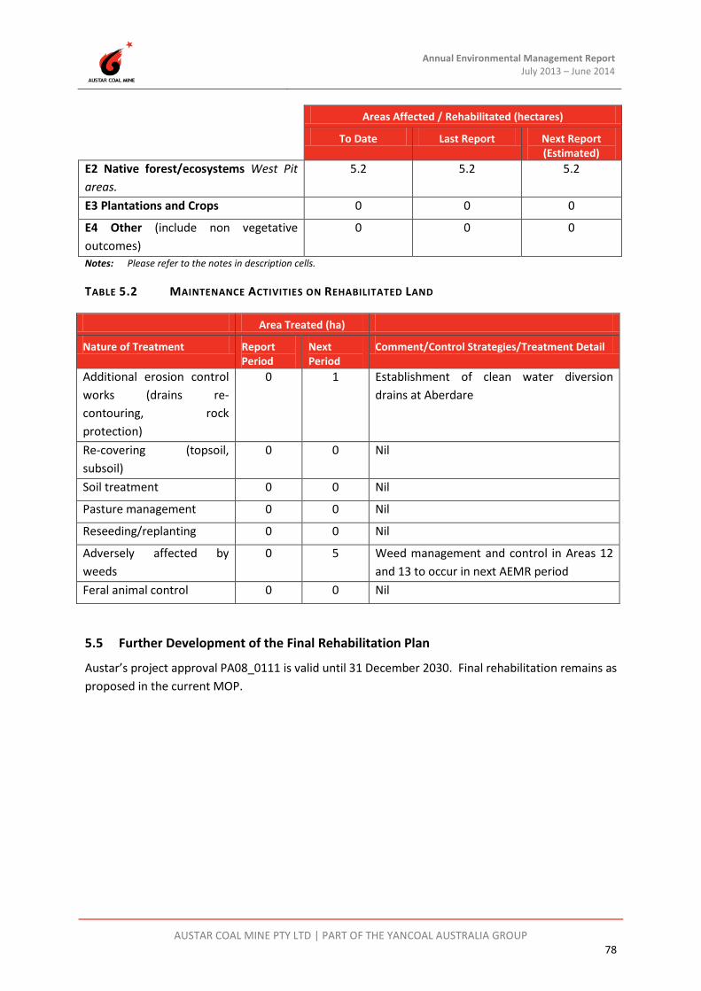
Annual Environmental Management Report July 2013 – June 2014
AUSTAR COAL MINE PTY LTD | PART OF THE YANCOAL AUSTRALIA GROUP 78
Areas Affected / Rehabilitated (hectares)
To Date Last Report Next Report (Estimated)
E2 Native forest/ecosystems West Pit areas.
5.2 5.2 5.2
E3 Plantations and Crops 0 0 0
E4 Other (include non vegetative outcomes)
0 0 0
Notes: Please refer to the notes in description cells.
TABLE 5.2 MAINTENANCE ACTIVITIES ON REHABILITATED LAND
Area Treated (ha)
Nature of Treatment Report Period
Next Period
Comment/Control Strategies/Treatment Detail
Additional erosion control works (drains re-contouring, rock protection)
0 1 Establishment of clean water diversion drains at Aberdare
Re-covering (topsoil, subsoil)
0 0 Nil
Soil treatment 0 0 Nil
Pasture management 0 0 Nil
Reseeding/replanting 0 0 Nil
Adversely affected by weeds
0 5 Weed management and control in Areas 12 and 13 to occur in next AEMR period
Feral animal control 0 0 Nil
5.5 Further Development of the Final Rehabilitation Plan
Austar’s project approval PA08_0111 is valid until 31 December 2030. Final rehabilitation remains as proposed in the current MOP.

Austar Annual Environmental Management Report July 2013 – June 2014
AUSTAR COAL MINE PTY LTD | PART OF THE YANCOAL AUSTRALIA GROUP 79
6 ACTIVITIES PROPOSED FOR THE NEXT AEMR PERIOD Austar will endeavour to carry out the following activities during the 2014-2015 reporting period, as outlined in Table 6.1.
TABLE 6.1 PROPOSED ACTIVITIES FOR 2014-2015 REPORTING PERIOD
Activities Proposed in 2014-2015 Reporting Period
1 Preparation of a Mining Operations Plan to replace the current MOP which expires in May 2015.
2 Lodgement of a Mining Lease Application over CHPP Lot 1 DP87087 to encompass mining purposes on that lot.
3 Completion of an Independent Environmental Audit for the Austar Mine Complex in accordance with PA08_0111 requirements.
4 Commencement of the sinkhole tributary reinstatement between Area 12 and Area 13.
5 Monitor pasture establishment for Area 12 and the Aberdare Extended Reject Emplacement Area.
6 Progress demolition of existing structures and foundations at Bellbird, Pelton, and Cessnock No. 1 (Kalingo) Collieries.
7 Continued emplacement of coarse reject at Aberdare Extended Emplacement Area.
8 Progressive implementation of the erosion and sediment control plan at the Aberdare Extended Emplacement area for capped areas with potential to drain to natural watercourses. Progress installation of the clean water diversion drain.
9 Establishment of permanent drainage mechanism for leachate/surface water within Aberdare Extended Reject Emplacement Area to underground workings.
10 Capping and pasture establishment of the portion of Aberdare Extended Emplacement Area that has achieved final coarse reject level.
11 Continued implementation of noise pollution reduction program at the Austar CHPP.
12 Stabilisation of the areas of Kitchener SIS no longer required for construction.
13 Planning and preparation to allow sourcing of capping from within the West Pit.