advanced seismic imaging for geothermal ...crack.seismo.unr.edu/geothermal/louie-nzgw11.pdf1 new...
TRANSCRIPT
1 New Zealand Geothermal Workshop 2011 Proceedings
21 - 23 November 2011 Auckland, New Zealand
ADVANCED SEISMIC IMAGING FOR GEOTHERMAL DEVELOPMENT John N. Louie1, Satish K. Pullammanappallil2 and William Honjas2
1 Great Basin Center for Geothermal Energy, Mailstop 0174, University of Nevada, Reno, NV 89557 USA 2 Optim, 200 S. Virginia St. Suite 560, Reno, NV 89501 USA
Keywords: Seismic, Geophysics, Geothermal, Exploration, Development, Fault, Extensional, Reflection, Nevada, Optim.
ABSTRACT In the geothermal fields of the Great Basin physiographic province of western North America, drilling success or failure often depends on hitting fault or fracture zones. Advanced seismic reflection imaging has proven to be the only effective geophysical means of accurately targeting geothermal drilling. At target depths of 1 to 2 kilometers, the pay zones are often less than 0.1 km wide. Surface geological and “integral” (e.g., potential-field, electrical, magnetotelluric, seismic-refraction) geophysical studies have often proven successful at locating new geothermal fields for development. However, surface and integral methods cannot direct exploration or development within a field, and geothermal exploration drilling in the region has had a success rate as small as 10%. Such high risk for costly drilling has long held back the development of the region’s full geothermal-power potential. The development of advanced seismic imaging techniques by Optim, especially the SeisOpt® technologies, has led to drilling success rates of 80% at some prospects. Advanced seismic imaging, as a “differential” method, is able to focus direct images of steeply dipping faults as seismic reflectors, allowing accurate planning of geothermal drill targets. SeisOpt® technology achieves the focusing and accurate location of structure and stratigraphy through thick piles of heterogeneous Tertiary volcanics, below complex surficial basin structure. This capability has allowed researchers at the University of Nevada, Reno, to use these seismic images to carry out advanced seismic attribute analyses, model testing, and verification of tectonic hypotheses. Optim and UNR are collaborating on research to further refine these imaging methodologies.
1. INTRODUCTION Coolbaugh et al. (2005a) reviewed the chemistry and geologic setting of productive geothermal fields in California and Nevada, western United States. They draw a sharp distinction between what they term magmatic-sourced geothermal resources, and extension-sourced geothermal resources. Examples of magmatic geothermal resources include the Geysers and Salton Sea fields in California and the Steamboat field in Nevada. Within the Great Basin physiographic province of eastern California, Nevada, and Utah, magmatic geothermal systems are found at the edges of the province. Within the province only extensionally controlled, tectonically sourced geothermal resources are found. The majority of the productive geothermal fields in Nevada are thus extensionally sourced, with northern Dixie Valley hosting the most productive power plant at 260 MW, and 50 MW Faulkner power plant at Blue Mountain as one of the newest. As a result, the geothermal potential map of Coolbaugh et al. (2005b) uses fault proximity and measured
extensional geodetic strain as two of the predictive indicators for potential production.
Oldow (2003) identified the extensional tectonics as one component of the trans-tensional strains occurring across the western part of the Great Basin due to the northwestward movement of the Sierra Nevada microplate relative to stable North America. The movement of the Sierra Nevada Mountain and California Great Valley block all occurs east of the San Andreas fault and the Pacific–North America plate boundary proper. Faulds et al. (2005) regard this region as a broad, distributed plate boundary, almost 1000 km wide. The result of this strain distribution is an incipient transform through western Nevada, effectively and obliquely rifting the Sierra Nevada away from North America. The transtensional region of the western Great Basin, east of the Sierra Nevada, is known as the Walker Lane.
Faulds et al. (2006) proposed the structural control of geothermal systems having an extensional origin. They observed that productive geothermal systems in the Great Basin tend to occur in the extensional quadrants of fault intersections. Surpless (2008) similarly identified localized pull-apart basin extension within the Walker Lane transtensional system with the appearance of geothermal systems. Hinz et al. (2008) provide a specific example of the transtensional control of one system in western Nevada, and Bell and Ramelli (2009) illustrate the fault controls on several high temperature systems.
Given the fault control on these extensionally sourced geothermal fields of the Great Basin, the success or failure of geothermal exploration and development often depend on whether exploration drilling is able to intersect the controlling fault or fracture zones. At target depths of 1 to 2 kilometers, the faulted pay zones are often less than 0.1 km wide. Accurately locating faults, at reservoir depths, in advance of exploration drilling will significantly reduce the economic risk of geothermal development, by lowering the number of unsuccessful bores.
Surface geological investigations and “integral” geophysical techniques form a class of predictive methods that have rapidly increasing uncertainty with depth below the surface. Integrative geophysical measurements show the total effect of all rocks within a volume or along a path. Integrative measurement methods include temperature, gravity and magnetic (potential-field), electrical-resistivity, magnetotelluric, and seismic refraction and surface-wave measurements. The long distances between reservoir depths and surface geological and geophysical measurements leave integrative results with accurate measurements of average rock properties over large volumes. However, these average measurements suffer from poor precision in that anomalous areas cannot be accurately located. For reservoirs that are kilometers deep, the location precision of an integrative

New Zealand Geothermal Workshop 2011 Proceedings
21 - 23 November 2011 Auckland, New Zealand
measurement will be on the order of the depth, and not the ten times greater precision needed to locate a 0.1-km-wide fault zone.
Integrative methods have often proven successful at locating new geothermal fields within a region for possible development. Heimgartner and Louie (2007) used regional seismic refraction studies to show the association of geothermal productivity with crustal thickness in the Great Basin. Cumming (2011) described a method for the exploration of magmatic geothermal systems using the discovery of hydrothermal sinter deposits followed by electromagnetic surveys to define the clay cap bounding the geothermal reservoir. Such investigations can help define the potential that a geothermal reservoir may exist.
However, surface geological and integral geophysical methods are of limited use in directing exploration or development within a field once it has been discovered. As one result, geothermal exploration drilling in the Great Basin has had a low success rate in the past, perhaps as small as 10%. Such high risk for costly drilling has long held back the development of the region’s full geothermal-power potential.
An alternative to integral geophysical methods is “differential” methods. Where integral methods show average measurements of high accuracy but poor location precision, differential methods attain localized measurements with (often) poor accuracy, but excellent location precision. Differential geophysical sounding techniques are few in number, amounting essentially to just seismic reflection and ground-probing radar. Above ground, optical techniques such as Lidar and multispectral remote sensing, and synthetic-aperture radar, count as differential methods. Instead of integrating rock properties along a path or within a volume, differential methods produce data related to changes in rock properties over short distances. For example, a modern seismic-reflection survey might not be able to distinguish whether a fault zone is 50 or 100 meters wide, but it will be able to locate the center of the fault zone with a precision of 100 meters or better, within a geothermal reservoir at 1-2 km depth.
The imaging and location precision capabilities of seismic-reflection surveys have long been critical to the success of the oil and gas industry. Brown (2005) recounts how the development of the three-dimensional seismic reflection surveying technique allowed that industry to raise the drilling success rate of from 10% to over 50% between 1985 and 1995. The fivefold reduction in risk allowed the economic exploration of remote and deepwater areas where the cost of drilling is huge, greatly increasing global energy production.
The geothermal industry did not share this period of boom with the oil industry. Certainly a principal problem in the 1990-2000 period was geothermal energy’s lack of economic competitiveness with cheap oil and gas. But it was true as well that, until recently, seismic reflection surveys could not be used effectively for geothermal exploration.
While oil and gas are often found in large sedimentary basins, both magmatic and extensional geothermal resources are typically found in much more geologically complex settings. Lateral geologic complexity such as swarms of faults, interfingering flows and sediments in
piles of volcanic basin fill, and complex small basins lead to rapid lateral changes in the seismic velocity property of rocks. This great degree of velocity heterogeneity requires the most advanced seismic imaging techniques, similar to the “sub-salt” techniques currently being developed in the oil industry. The need for such advanced techniques prevented accurate velocity modeling in geothermal fields, until recently.
The lack of accurate velocity models prevented focusing of reflection data. Lack of focused reflectors makes for a poor seismic image. A poor seismic image results in lack of “added value” for seismic reflection surveys, preventing the use of this expensive survey technique by most geothermal explorers. These problems deprived the geothermal industry of the basic means for economically mapping the subsurface over large tracts of land.
2. ADVANCED SEISMIC IMAGING The first part of the solution to the problem of the lack of added value for reflection surveys was to solve the seismic velocity problem. Simulated annealing velocity optimization was researched at the University of Nevada Seismological Laboratory during the early 1990s (Pullammanappallil and Louie, 1994). Optim commercially developed and released the method, under the name SeisOpt® in 1998. SeisOpt® iterates through hundreds of thousands of possible velocity distributions to find the single, or “global” solution that best fits the seismic data, making no assumptions on the direction or magnitude of velocity gradient. The nonlinear simulated annealing optimization method produces high-resolution velocity sections from first arrivals picked off raw seismic shot records.
The second part of the solution was to employ pre-stack Kirchhoff depth migration in processing raw seismic shot records into true-depth sections. Kirchhoff imaging directly images subsurface structures oriented in any direction (Louie et al., 1988). It has the advantage of requiring minimal pre-processing of the records, with no need for the numerous pre-processing steps common to conventional seismic data processing. The simplified processing flow leads to savings on labor costs for interpreters.
Kirchhoff depth migration directly images structures in depth rather than seismic travel time. It takes advantage of the accurate velocity models from the optimization technique to place reflectors in their correct location. Direct imaging in depth avoids the unreliable time to depth conversion common in conventional data processing. The technique can handle velocity variations in any direction in addition to structures with any strike and dip (Louie and Qin, 1993). Unlike the processing procedures that had been used previously with geothermal seismic surveys, pre-stack migration can image flat and moderately dipping structures together with steeply dipping structures. This attribute makes pre-stack Kirchhoff depth migration ideal for imaging of areas with extensive faulting and fracturing (Chavez-Perez et al., 1998).
A successful early DOE-funded pilot study in Dixie Valley, Nevada (Honjas et al., 1997; Grant Number DE-FG07-97ID13465) utilized 2-d seismic surveys that had been recorded in the 1980s with the parameters that were standard at the time. Later surveys have been designed with
New Zealand Geothermal Workshop 2011 Proceedings
21 - 23 November 2011 Auckland, New Zealand
new data acquisition parameters that enhance the results from advanced processing techniques.
3. CASE HISTORIES
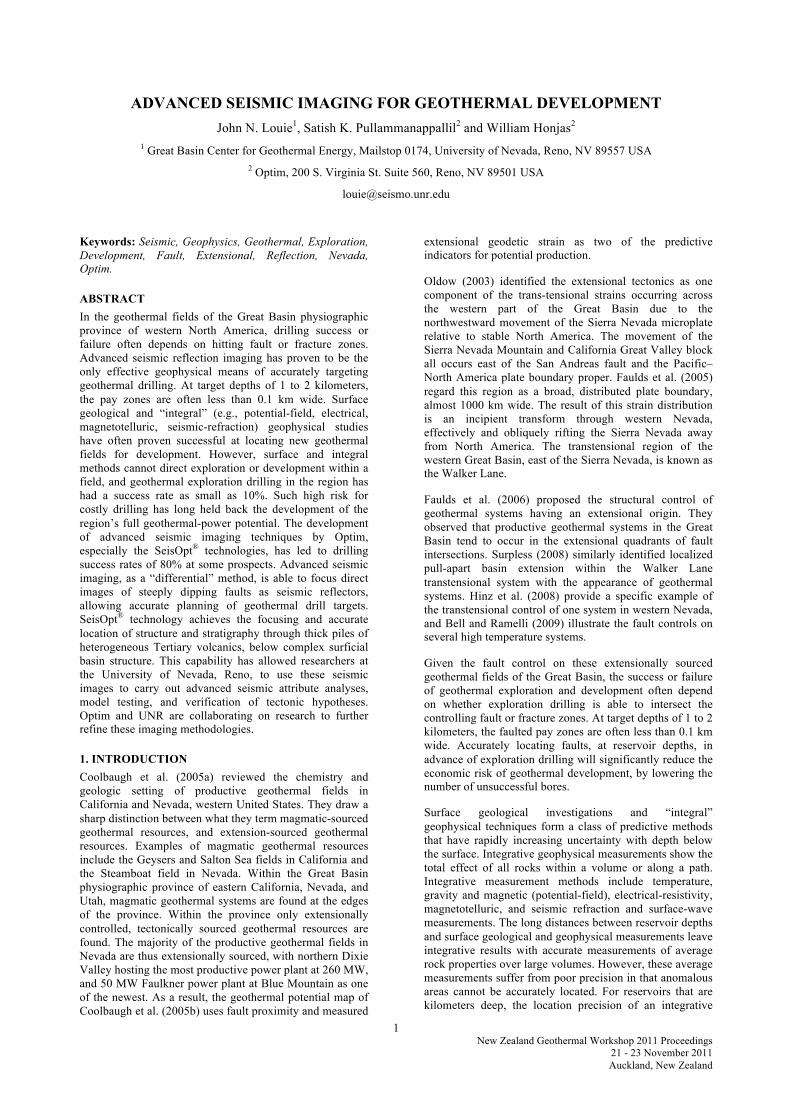
3.1 Defining Lateral Velocity Heterogeneity Honjas et al. (1997) developed a three-dimensional seismic velocity model for the northern Dixie Valley, Nevada geothermal field, by reprocessing a network of existing two-dimensional seismic survey lines (fig. 1). This resource is located below the Quaternary and tertiary sediments filling the Dixie Valley basin. We term such a model a “2.5-d” model, as it contains some information on 3-d velocity variations, limited by the spatial coverage of the network of 2-d surveys.
Figure 1: 3-d view of the 2.5-dimensional seismic velocity model across the Dixie Valley, Nevada geothermal field, from Honjas et al. (1997). Seismic survey tracks are in red.
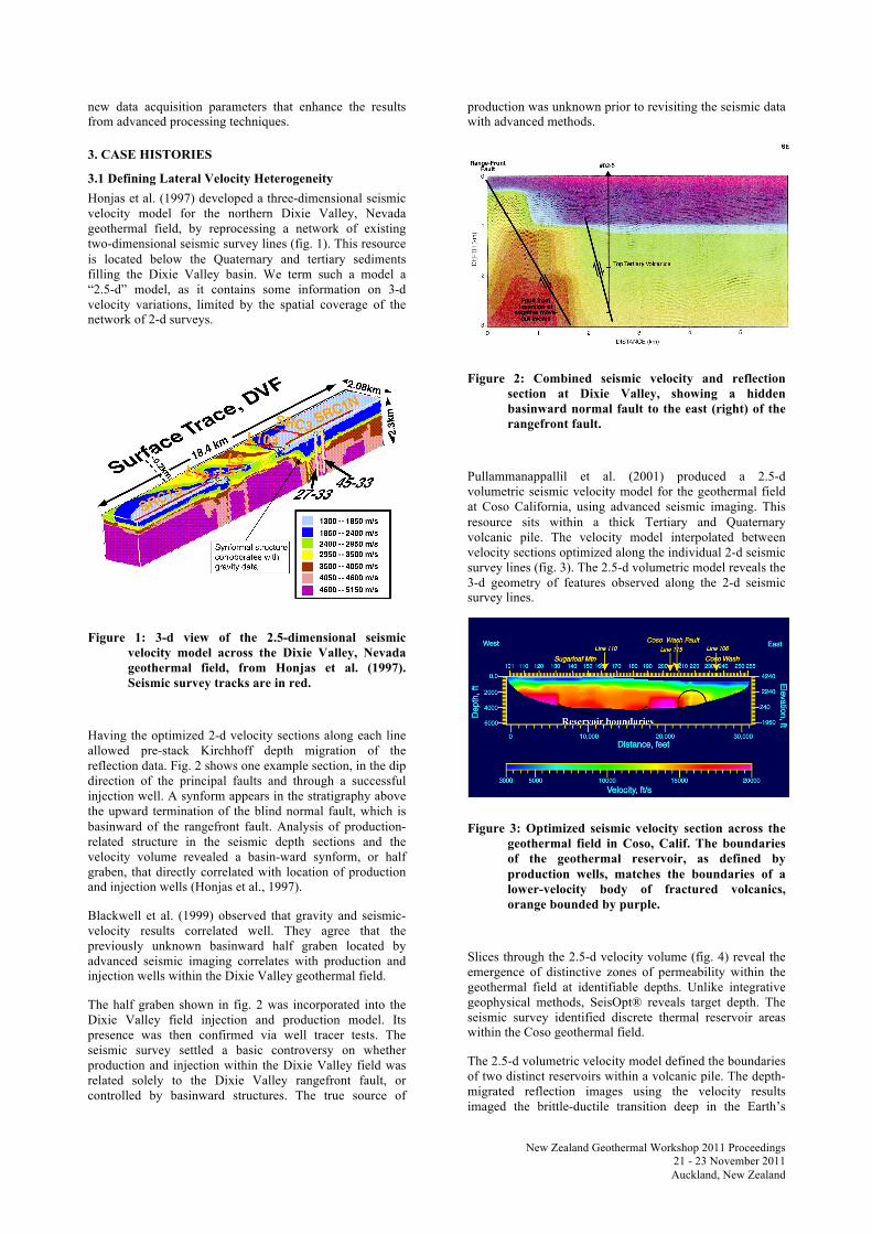
Having the optimized 2-d velocity sections along each line allowed pre-stack Kirchhoff depth migration of the reflection data. Fig. 2 shows one example section, in the dip direction of the principal faults and through a successful injection well. A synform appears in the stratigraphy above the upward termination of the blind normal fault, which is basinward of the rangefront fault. Analysis of production-related structure in the seismic depth sections and the velocity volume revealed a basin-ward synform, or half graben, that directly correlated with location of production and injection wells (Honjas et al., 1997).
Blackwell et al. (1999) observed that gravity and seismic-velocity results correlated well. They agree that the previously unknown basinward half graben located by advanced seismic imaging correlates with production and injection wells within the Dixie Valley geothermal field.
The half graben shown in fig. 2 was incorporated into the Dixie Valley field injection and production model. Its presence was then confirmed via well tracer tests. The seismic survey settled a basic controversy on whether production and injection within the Dixie Valley field was related solely to the Dixie Valley rangefront fault, or controlled by basinward structures. The true source of
production was unknown prior to revisiting the seismic data with advanced methods.
Figure 2: Combined seismic velocity and reflection section at Dixie Valley, showing a hidden basinward normal fault to the east (right) of the rangefront fault.
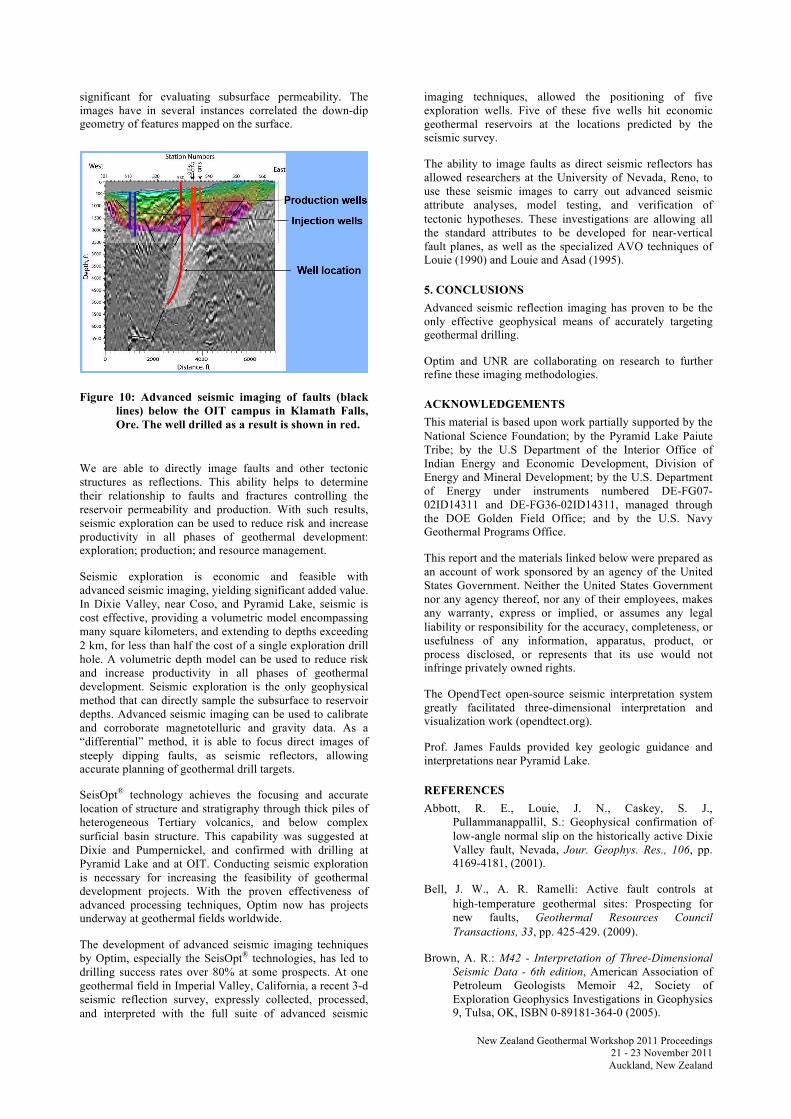
Pullammanappallil et al. (2001) produced a 2.5-d volumetric seismic velocity model for the geothermal field at Coso California, using advanced seismic imaging. This resource sits within a thick Tertiary and Quaternary volcanic pile. The velocity model interpolated between velocity sections optimized along the individual 2-d seismic survey lines (fig. 3). The 2.5-d volumetric model reveals the 3-d geometry of features observed along the 2-d seismic survey lines.
Figure 3: Optimized seismic velocity section across the geothermal field in Coso, Calif. The boundaries of the geothermal reservoir, as defined by production wells, matches the boundaries of a lower-velocity body of fractured volcanics, orange bounded by purple.
Slices through the 2.5-d velocity volume (fig. 4) reveal the emergence of distinctive zones of permeability within the geothermal field at identifiable depths. Unlike integrative geophysical methods, SeisOpt® reveals target depth. The seismic survey identified discrete thermal reservoir areas within the Coso geothermal field.
The 2.5-d volumetric velocity model defined the boundaries of two distinct reservoirs within a volcanic pile. The depth-migrated reflection images using the velocity results imaged the brittle-ductile transition deep in the Earth’s

New Zealand Geothermal Workshop 2011 Proceedings
21 - 23 November 2011 Auckland, New Zealand
crust, and predicted the orientation and location of fracture systems within the field. Below the reservoir, advanced seismic imaging found a deep, “bright lens” reflector, which is thought to be created by high-temperature thermal brines (Pullammanappallil et al., 2001).
Figure 4: 3-d view of the 2.5-d volumetric seismic velocity model developed for the Coso geothermal field in California by Pullammanappallil et al. (2001). Seismic survey tracks are in red.
3.2 Direct Imaging of Faults In advanced seismic imaging, the more accurate, laterally variable seismic velocity sections lead directly to much-improved seismic-reflection images across the narrow and laterally complex Tertiary and Quaternary basin structures of the Great Basin. These advanced sections often contain images of faults within and bounding the basins. Faults are traditionally seen only indirectly in seismic results, offsetting imaged stratigraphy, or as low-velocity zones. With advanced seismic imaging, fault planes often appear directly as seismic reflectors in their own right, even at vertical dip.
Abbott et al. (2001) recorded seismic reflection and gravity surveys across southern Dixie Valley, Nevada, and conducted advanced seismic imaging work on the data with National Science Foundation sponsorship. This work was 60 km south of the geothermal field in the area of the 1954 magnitude 7.2 Dixie Valley earthquake rupture. In the area of the earthquake, southern Dixie Valley trends north-south, the strike of the fault is northerly, and there are no economic geothermal resources. By contrast, northern Dixie Valley trends northeast, the strike of the fault is northeasterly, and Nevada’s most productive geothermal power plant has been operating there for 25 years.
Fig. 5 shows the results of Abbott et al. (2001) from southern Dixie Valley. In contrast to the high-angle normal faults seen in northern Dixie Valley in fig. 2, the section shows a prominent reflection dipping only 30° east, down from the 1954 rupture. This low-angle normal fault has been confirmed by geologic mapping; and by Abbott et al. (2001) with their direct imaging of the shallow-dipping fault plane at 100-meter as well as 1-km depths, the imaging of rollover anticlines against the fault in the
Tertiary and Quaternary sedimentary and volcanic stratigraphy, the velocity section and seismic refraction records, and with gravity data.
Figure 5: West (left) to east (right) section across southern Dixie Valley, Nevada assembled by Abbott et al. (2001). The top left inset shows the reflecting, shallow-dipping fault plane at 100 m depth, and the annotated reflection section below shows the fault reflection at 1 km depth. The section continues into gravity results crossing the valley.
A geothermal prospect under development in northern Nevada was surveyed recently with a network of several 2-d seismic surveys. This exploration program was designed explicitly for advanced seismic imaging. Figs. 6 and 7 show two of the sections, from lines in the dip direction of the rangefront fault, in red. Additional normal faults (yellow and blue) appear basinward of the rangefront fault. Each controls a hidden half graben and syncline, as in northern Dixie Valley in fig. 2. Only the rangefront fault is manifested at the surface.
Figure 6: Section A from a geothermal prospect in northern Nevada. The optimized velocity section is superimposed on the black-and-white reflection section. Faults are marked as colored lines, with the rangefront fault in red.

New Zealand Geothermal Workshop 2011 Proceedings
21 - 23 November 2011 Auckland, New Zealand
Both figs. 6 and 7 show prominent fault-plane reflections from the rangefront fault, red. In fig. 7, the blue basinward fault is marked by particularly strong fault-plane reflections. These appear as strongly as any of the other reflections, perhaps indicating the higher concentration of fluids found in a geothermal reservoir. The alluvial-fan stratigraphy above is also strikingly clear.
Figure 7: Section B from a geothermal prospect in northern Nevada. The optimized velocity section is superimposed on the black-and-white reflection section. Faults are marked as colored lines, with the rangefront fault in red.
Frary et al. (2011) reported on a recent network of 2-d advanced seismic imaging surveys near Pyramid Lake, Nevada. Fig. 8 shows a 3-d view of a few of the sections in the network, with a prominent fault-plane reflection marked by “A”. This fault was unknown to the geologic model until discovered with the seismic imaging.
Figure 8: Advanced seismic imaging sections of a geothermal prospect near Pyramid Lake, Nevada, with a direct image of a fault plane marked with “A”. From Frary et al. (2011).
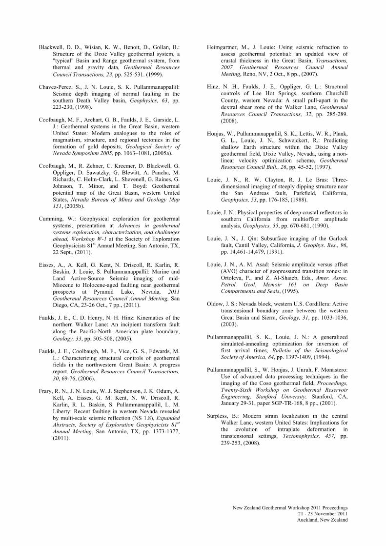
Interpretations of faults across all the seismic lines in the network have been made on the basis of direct fault images as well as stratigraphic terminations, in Frary et al. (2011) and Eisses et al. (2011). At a depth of 1300 m in a well drilled 6 months after completion of the seismic surveys (at the intersection of the two seismic sections shown in fig. 9), a fault gouge noted in the geologic log and confirmed in the chips by J. Faulds and B. Mayhew (pers. comm., 2011) correlates within 28 m depth with a fault interpreted from the advanced seismic images of several sections. This fault is marked with blue fault sticks in fig. 9.
Figure 9: Alternative 3-d view of advanced seismic imaging sections of a Pyramid Lake geothermal prospect, with interpreted fault sticks. From Frary et al. (2011) and Eisses et al. (2011).
Figure 9 shows as well that advanced seismic techniques are able to accurately image the complex and discontinuous stratigraphy of volcanic and volcaniclastic basin fill. The shorter cross-line shows a strongly reflective sequence of basalts as a synform below a more seismically transparent rhyolite dome (J. Faulds and B. Mayhew, pers. comm., 2011). The recent drill hole logs show these features as well correlate closely with the stratigraphic interpretations made from the seismic results, to within 10 m depth at these shallower levels. Eisses et al. (2011) are further correlating the fault interpretations from the geothermal prospects with additional fault data from marine surveys on Pyramid Lake, which will help develop a comprehensive tectonic model of the region.
A final case history is shown in figure 10. This study started with an advanced seismic survey conducted in 2008 on the campus of the Oregon Institute of Technology (OIT) in Klamath Falls. Black lines on the image mark interpreted faults. OIT located a new well (red in fig. 9) based on the seismic interpretation. Drilling intersected the fault within 15 m of the subsurface location predicted by the seismic program. Together with the shallower production and injection wells, the new well provides enough heat to meet 60% of the electrical needs of the entire OIT campus.
4. DISCUSSION The conclusions of the early projects included the successful imaging of permeable structures at reservoir depths, and of tectonic structures beneath the Coso, as well as other magmatic-sourced geothermal fields. Advanced seismic imaging is able to constrain the down-dip geometry of reservoir structures, characterizing features that are
New Zealand Geothermal Workshop 2011 Proceedings
21 - 23 November 2011 Auckland, New Zealand
significant for evaluating subsurface permeability. The images have in several instances correlated the down-dip geometry of features mapped on the surface.
Figure 10: Advanced seismic imaging of faults (black lines) below the OIT campus in Klamath Falls, Ore. The well drilled as a result is shown in red.
We are able to directly image faults and other tectonic structures as reflections. This ability helps to determine their relationship to faults and fractures controlling the reservoir permeability and production. With such results, seismic exploration can be used to reduce risk and increase productivity in all phases of geothermal development: exploration; production; and resource management.
Seismic exploration is economic and feasible with advanced seismic imaging, yielding significant added value. In Dixie Valley, near Coso, and Pyramid Lake, seismic is cost effective, providing a volumetric model encompassing many square kilometers, and extending to depths exceeding 2 km, for less than half the cost of a single exploration drill hole. A volumetric depth model can be used to reduce risk and increase productivity in all phases of geothermal development. Seismic exploration is the only geophysical method that can directly sample the subsurface to reservoir depths. Advanced seismic imaging can be used to calibrate and corroborate magnetotelluric and gravity data. As a “differential” method, it is able to focus direct images of steeply dipping faults, as seismic reflectors, allowing accurate planning of geothermal drill targets.
SeisOpt® technology achieves the focusing and accurate location of structure and stratigraphy through thick piles of heterogeneous Tertiary volcanics, and below complex surficial basin structure. This capability was suggested at Dixie and Pumpernickel, and confirmed with drilling at Pyramid Lake and at OIT. Conducting seismic exploration is necessary for increasing the feasibility of geothermal development projects. With the proven effectiveness of advanced processing techniques, Optim now has projects underway at geothermal fields worldwide.
The development of advanced seismic imaging techniques by Optim, especially the SeisOpt® technologies, has led to drilling success rates over 80% at some prospects. At one geothermal field in Imperial Valley, California, a recent 3-d seismic reflection survey, expressly collected, processed, and interpreted with the full suite of advanced seismic
imaging techniques, allowed the positioning of five exploration wells. Five of these five wells hit economic geothermal reservoirs at the locations predicted by the seismic survey.
The ability to image faults as direct seismic reflectors has allowed researchers at the University of Nevada, Reno, to use these seismic images to carry out advanced seismic attribute analyses, model testing, and verification of tectonic hypotheses. These investigations are allowing all the standard attributes to be developed for near-vertical fault planes, as well as the specialized AVO techniques of Louie (1990) and Louie and Asad (1995).
5. CONCLUSIONS Advanced seismic reflection imaging has proven to be the only effective geophysical means of accurately targeting geothermal drilling.
Optim and UNR are collaborating on research to further refine these imaging methodologies.
ACKNOWLEDGEMENTS This material is based upon work partially supported by the National Science Foundation; by the Pyramid Lake Paiute Tribe; by the U.S Department of the Interior Office of Indian Energy and Economic Development, Division of Energy and Mineral Development; by the U.S. Department of Energy under instruments numbered DE-FG07-02ID14311 and DE-FG36-02ID14311, managed through the DOE Golden Field Office; and by the U.S. Navy Geothermal Programs Office.
This report and the materials linked below were prepared as an account of work sponsored by an agency of the United States Government. Neither the United States Government nor any agency thereof, nor any of their employees, makes any warranty, express or implied, or assumes any legal liability or responsibility for the accuracy, completeness, or usefulness of any information, apparatus, product, or process disclosed, or represents that its use would not infringe privately owned rights.
The OpendTect open-source seismic interpretation system greatly facilitated three-dimensional interpretation and visualization work (opendtect.org).
Prof. James Faulds provided key geologic guidance and interpretations near Pyramid Lake.
REFERENCES Abbott, R. E., Louie, J. N., Caskey, S. J.,
Pullammanappallil, S.: Geophysical confirmation of low-angle normal slip on the historically active Dixie Valley fault, Nevada, Jour. Geophys. Res., 106, pp. 4169-4181, (2001).
Bell, J. W., A. R. Ramelli: Active fault controls at high‐temperature geothermal sites: Prospecting for new faults, Geothermal Resources Council Transactions, 33, pp. 425‐429. (2009).
Brown, A. R.: M42 - Interpretation of Three-Dimensional Seismic Data - 6th edition, American Association of Petroleum Geologists Memoir 42, Society of Exploration Geophysics Investigations in Geophysics 9, Tulsa, OK, ISBN 0-89181-364-0 (2005).
New Zealand Geothermal Workshop 2011 Proceedings
21 - 23 November 2011 Auckland, New Zealand
Blackwell, D. D., Wisian, K. W., Benoit, D., Gollan, B.: Structure of the Dixie Valley geothermal system, a "typical" Basin and Range geothermal system, from thermal and gravity data, Geothermal Resources Council Transactions, 23, pp. 525‐531. (1999).
Chavez-Perez, S., J. N. Louie, S. K. Pullammanappallil: Seismic depth imaging of normal faulting in the southern Death Valley basin, Geophysics, 63, pp. 223-230, (1998).
Coolbaugh, M. F., Arehart, G. B., Faulds, J. E., Garside, L. J.: Geothermal systems in the Great Basin, western United States: Modern analogues to the roles of magmatism, structure, and regional tectonics in the formation of gold deposits, Geological Society of Nevada Symposium 2005, pp. 1063–1081, (2005a).
Coolbaugh, M., R. Zehner, C. Kreemer, D. Blackwell, G. Oppliger, D. Sawatzky, G. Blewitt, A. Pancha, M. Richards, C. Helm-Clark, L. Shevenell, G. Raines, G. Johnson, T. Minor, and T. Boyd: Geothermal potential map of the Great Basin, western United States, Nevada Bureau of Mines and Geology Map 151, (2005b).
Cumming, W.: Geophysical exploration for geothermal systems, presentation at Advances in geothermal systems exploration, characterization, and challenges ahead, Workshop W-1 at the Society of Exploration Geophysicists 81st Annual Meeting, San Antonio, TX, 22 Sept., (2011).
Eisses, A., A. Kell, G. Kent, N. Driscoll, R. Karlin, R. Baskin, J. Louie, S. Pullammanappallil: Marine and Land Active-Source Seismic imaging of mid-Miocene to Holocene-aged faulting near geothermal prospects at Pyramid Lake, Nevada, 2011 Geothermal Resources Council Annual Meeting, San Diego, CA, 23-26 Oct., 7 pp., (2011).
Faulds, J. E., C. D. Henry, N. H. Hinz: Kinematics of the northern Walker Lane: An incipient transform fault along the Pacific‐North American plate boundary, Geology, 33, pp. 505‐508, (2005).
Faulds, J. E., Coolbaugh, M. F., Vice, G. S., Edwards, M. L.: Characterizing structural controls of geothermal fields in the northwestern Great Basin: A progress report. Geothermal Resources Council Transactions, 30, 69‐76, (2006).
Frary, R. N., J. N. Louie, W. J. Stephenson, J. K. Odum, A. Kell, A. Eisses, G. M. Kent, N. W. Driscoll, R. Karlin, R. L. Baskin, S. Pullammanappallil, L. M. Liberty: Recent faulting in western Nevada revealed by multi-scale seismic reflection (NS 1.8), Expanded Abstracts, Society of Exploration Geophysicists 81st Annual Meeting, San Antonio, TX, pp. 1373-1377, (2011).
Heimgartner, M., J. Louie: Using seismic refraction to assess geothermal potential: an updated view of crustal thickness in the Great Basin, Transactions, 2007 Geothermal Resources Council Annual Meeting, Reno, NV, 2 Oct., 8 pp., (2007).
Hinz, N. H., Faulds, J. E., Oppliger, G. L.: Structural controls of Lee Hot Springs, southern Churchill County, western Nevada: A small pull‐apart in the dextral shear zone of the Walker Lane, Geothermal Resources Council Transactions, 32, pp. 285‐289. (2008).
Honjas, W., Pullammanappallil, S. K., Lettis, W. R., Plank, G. L., Louie, J. N., Schweickert, R.: Predicting shallow Earth structure within the Dixie Valley geothermal field, Dixie Valley, Nevada, using a non-linear velocity optimization scheme, Geothermal Resources Council Bull., 26, pp. 45-52, (1997).
Louie, J. N., R. W. Clayton, R. J. Le Bras: Three-dimensional imaging of steeply dipping structure near the San Andreas fault, Parkfield, California, Geophysics, 53, pp. 176-185, (1988).
Louie, J. N.: Physical properties of deep crustal reflectors in southern California from multioffset amplitude analysis, Geophysics, 55, pp. 670-681, (1990).
Louie, J. N., J. Qin: Subsurface imaging of the Garlock fault, Cantil Valley, California, J. Geophys. Res., 96, pp. 14,461-14,479, (1991).
Louie, J. N., A. M. Asad: Seismic amplitude versus offset (AVO) character of geopressured transition zones: in Ortoleva, P., and Z. Al-Shaieb, Eds., Amer. Assoc. Petrol. Geol. Memoir 161 on Deep Basin Compartments and Seals, (1995).
Oldow, J. S.: Nevada block, western U.S. Cordillera: Active transtensional boundary zone between the western Great Basin and Sierra, Geology, 31, pp. 1033‐1036, (2003).
Pullammanappallil, S. K., Louie, J. N.: A generalized simulated-annealing optimization for inversion of first arrival times, Bulletin of the Seismological Society of America, 84, pp. 1397-1409, (1994).
Pullammanappallil, S., W. Honjas, J. Unruh, F. Monastero: Use of advanced data processing techniques in the imaging of the Coso geothermal field, Proceedings, Twenty-Sixth Workshop on Geothermal Reservoir Engineering, Stanford University, Stanford, CA, January 29-31, paper SGP-TR-168, 8 pp., (2001).
Surpless, B.: Modern strain localization in the central Walker Lane, western United States: Implications for the evolution of intraplate deformation in transtensional settings, Tectonophysics, 457, pp. 239‐253, (2008).