addressing non-motorised transport movement along and
TRANSCRIPT

Proceedings of the 33rd Southern African Transport Conference (SATC 2014) 7 – 10 July 2014 Proceedings ISBN Number: 978-1-920017-61-3 Pretoria, South Africa Produced by: CE Projects cc
ADDRESSING NON-MOTORISED TRANSPORT MOVEMENT ALONG AND ACROSS RAILWAY LINES IN THE
CITY OF CAPE TOWN Y VENTER*, L HERMANT*, K SHIRLEY*, E TUKUSHE** and T KOK**
Hatch Goba (Pty) Ltd, P O Box 3878, Tyger Valley 7536
Tel: (021) 911 5823/ Fax (021) 911 5793
Email: [email protected]
**Non-Motorised Transport and Universal Access, City of Cape Town
ABSTRACT There are numerous reasons why pedestrians choose to cross railway tracks in South
Africa and in Cape Town in particular. Whilst this behavior generally forms part of their
desire line and is often part of their journey, the crossing of railway lines is illegal and
unsafe and is causing a significant amount of injuries and fatalities within the rail network
in the City. Such incidents occurring along railway lines cause a great disruption to the
railway operational service with a resultant negative effect on the economic growth of the
City.
In this paper, an investigation into the Non-Motorised Transport (NMT) movements along
and across all railway lines, within the jurisdictional area of the City of Cape Town, has
been undertaken using innovative video-based techniques and assessed using GIS-
mapping methods. The investigation identified several “hotspot” locations where various
types of recommendations and/or intervention strategies are urgently needed to enhance
public (pedestrian) safety and ensure uninterrupted train service. Intervention strategies
proposed have been drawn from international best practice tailored to suit the unique
South African pedestrian culture.
The paper highlights the “Nomzamo rail crossing” as a special case study as it
demonstrates the failure of town planning processes to consider the impacts of locating
developments next to railway lines. The Nomzamo case study is an example of a large-
scale, low-income urban development that has been allowed to develop alongside a rail
line without due consideration of NMT desire lines that have materialised across the rail
line. Currently, approx. 3,000 pedestrians cross the railway line at the Nomzamo location
in the 2½-hour morning peak period, which include scholars and cyclists
207

Proceedings of the 33rd Southern African Transport Conference (SATC 2014) 7 – 10 July 2014 Proceedings ISBN Number: 978-1-920017-61-3 Pretoria, South Africa Produced by: CE Projects cc
1. INTRODUCTION To answer the problem statement for this project defined as, “Why people cross railway lines and how best to solve the problem of access across railway lines?”, a comprehensive study was commissioned and undertaken which investigated the Non-Motorised Transport (NMT) movement along and across railway lines specifically within the City of Cape Town municipal area. The main objective of this study was to suggest ways to create a safe environment for NMT users crossing the Citywide Railway-line Corridors, which was done through a comprehensive study of non-motorised transport movement along and across all railway lines, within the jurisdictional area of the City of Cape Town, using innovative video-based techniques and assessed using GIS-mapping methods. The investigation identified several “hotspot” locations where various types of recommendations and/or intervention strategies are urgently needed to enhance public (pedestrian) safety and ensure uninterrupted train service. Intervention strategies proposed have been drawn from international best practice tailored to suit the unique South African pedestrian culture. The study incorporated three distinct phases viz. a status quo investigation1 of the current rail network operations; a situational analysis and finally the interventions and recommendations based on the situational analysis. Figures 1(a) to 1(d) show pedestrians within the railway reserve near Ysterplaat Station (Cape Town), either illegally crossing the railway lines or walking alongside it.
1 Status quo investigation of the current rail network operations is not discussed in this paper.
208

Proceedings of the 33rd Southern African Transport Conference (SATC 2014) 7 – 10 July 2014 Proceedings ISBN Number: 978-1-920017-61-3 Pretoria, South Africa Produced by: CE Projects cc
Figure 1(a) and 1(b): Examples of pedestrians crossing the railway line
Figure 1(c) and 1(d): Examples of pedestrians walking along the railway line
Figure 2 indicates the extent of the railway network located within the City of Cape Town municipal area depicting the study area for the project. Note that the study area excluded the rail link from Van der Stel Station to Sir Lowry’s Pass Station, the link from Lyndoch to Koelenhof, the Northern line from Muldersvlei to Worcester as well as the Malmesbury line from Fisantekraal to Malmesbury.
Figure 2: Cape Town Railway Network and Study Area
Study Area
209

Proceedings of the 33rd Southern African Transport Conference (SATC 2014) 7 – 10 July 2014 Proceedings ISBN Number: 978-1-920017-61-3 Pretoria, South Africa Produced by: CE Projects cc
SITUATIONAL ANALYSIS
2.1 Level Crossing Assessment
In order to address the safety and status at level crossings, a thorough assessment of the existing level crossings was undertaken. The level crossings were prioritised according to a status quo rating, an operational rating and an incident rating. For the status quo assessment, a site investigation of all the formal level crossings within the City of Cape Town was conducted, which audited the following components: • NMT infrastructure: Facility type, surface, width, condition and lighting as well as universal accessibility; • Pedestrian protection: Presence of a safety barrier; • Access control system: Condition of the device, functioning and type; • Fencing: Existing or missing and the type of fencing used; • Signage: Adherence/adequacy of signage to SARTSM2 standards, road markings, danger plates, presence of regulatory signs. Figure 3(a) shows a poorly maintained vehicle level crossing with very little protection and safety for the users, while Figure 3(b) shows a pedestrian level crossing providing no formal walkway and/or universal accessibility leading to the pedestrian level crossing.
Figure 3(a): Level Crossing at Eerste River
Figure 3(b): Pedestrian Level Crossing at Lakeside B
Figures 4(a) and 4(b) show well-maintained vehicle and pedestrian level crossings with good pedestrian protection and access contol.
2 South African Road Traffic Signs Manual (Department of Transport, 2012)
210

Proceedings of the 33rd Southern African Transport Conference (SATC 2014) 7 – 10 July 2014 Proceedings ISBN Number: 978-1-920017-61-3 Pretoria, South Africa Produced by: CE Projects cc
Figure 4(a): Kenilworth Figure 4(b): Muizenberg
In order to prioritise the Vehicle Level crossings, the following assessments were done: • A Status Quo Rating (based on site investigations); • An Incident Rating (based on the accident history for the specific level crossing); • An Operations Rating (based on train frequency, vehicular & pedestrian volumes). From the ratings mentioned above, a final score was then calculated which assisted towards identifying the following top five vehicle level crossings requiring urgent attention: • Eerste River; • Military Road; • Austel Road; • Buttskop Road; • White Road.
211
Proceedings of the 33rd Southern African Transport Conference (SATC 2014) 7 – 10 July 2014 Proceedings ISBN Number: 978-1-920017-61-3 Pretoria, South Africa Produced by: CE Projects cc
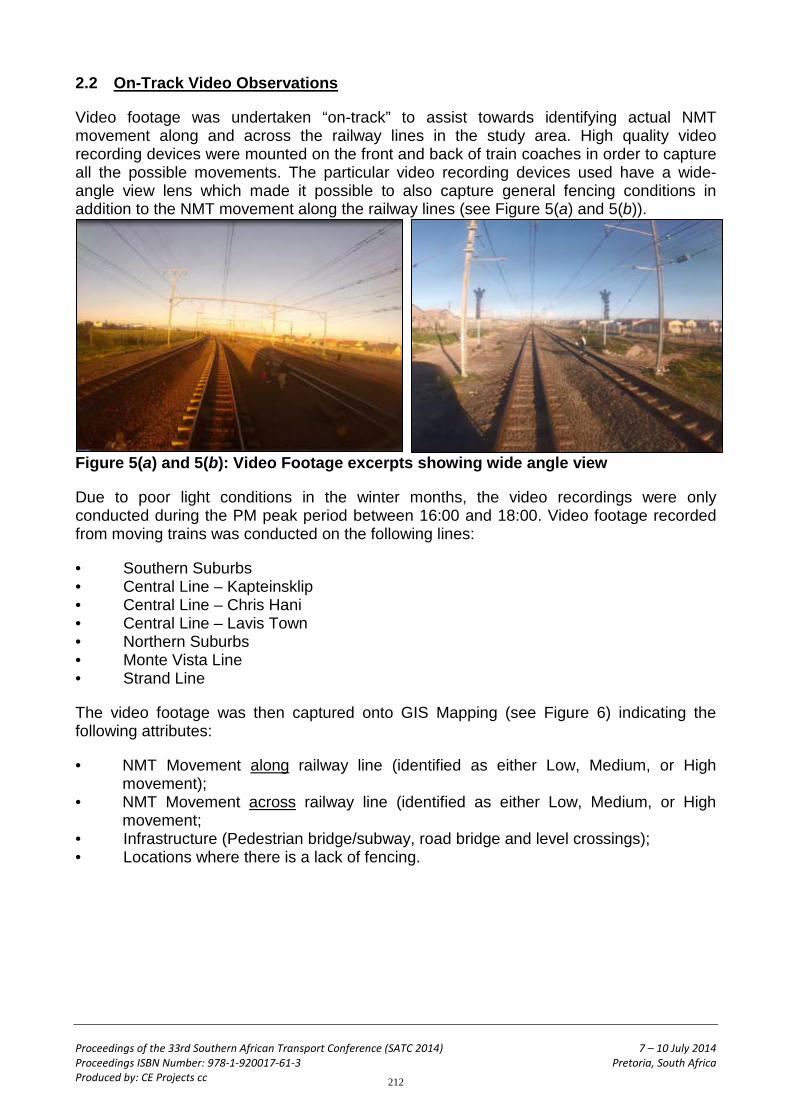
2.2 On-Track Video Observations
Video footage was undertaken “on-track” to assist towards identifying actual NMT movement along and across the railway lines in the study area. High quality video recording devices were mounted on the front and back of train coaches in order to capture all the possible movements. The particular video recording devices used have a wide-angle view lens which made it possible to also capture general fencing conditions in addition to the NMT movement along the railway lines (see Figure 5(a) and 5(b)).
Figure 5(a) and 5(b): Video Footage excerpts showing wide angle view
Due to poor light conditions in the winter months, the video recordings were only conducted during the PM peak period between 16:00 and 18:00. Video footage recorded from moving trains was conducted on the following lines:
• Southern Suburbs • Central Line – Kapteinsklip • Central Line – Chris Hani • Central Line – Lavis Town • Northern Suburbs • Monte Vista Line • Strand Line
The video footage was then captured onto GIS Mapping (see Figure 6) indicating the following attributes:
• NMT Movement along railway line (identified as either Low, Medium, or High movement);
• NMT Movement across railway line (identified as either Low, Medium, or High movement;
• Infrastructure (Pedestrian bridge/subway, road bridge and level crossings); • Locations where there is a lack of fencing.
212

Proceedings of the 33rd Southern African Transport Conference (SATC 2014) 7 – 10 July 2014 Proceedings ISBN Number: 978-1-920017-61-3 Pretoria, South Africa Produced by: CE Projects cc
Figure 6: GIS Mapping of Video Observations * Red colouring indicates accident zone with the number displaying the accident rating 2.3 Corridor Assessment
The results from the video “On-track” observations together with “Google Earth” imagery and railway network operations data were used for the corridor assessment. During the data capture stage, the following criteria were indicated on a line diagram per 500m corridor interval:
• PRASA Corridor status (A, B or C); • Station / Level Crossing; • Line Arrangement; • Infrastructure; • Number of Lines; • Operational Speed; • Accidents; • Fence Condition; • Pedestrian Dynamic Across line/s; • Pedestrian Dynamic Along line/s; • Pedestrian Desire Line; • Morning Peak railway operational headway.
2.3.1 Multi-Criteria Analysis
For the purposes of this project, a Multi-Criteria Analysis (MCA) matrix was developed for each railway corridor incorporating seven levels of prioritisation assessment. The matrix was developed to be sufficiently versatile to address different end state objectives through the manipulation of the criteria weighting.
213
Proceedings of the 33rd Southern African Transport Conference (SATC 2014) 7 – 10 July 2014 Proceedings ISBN Number: 978-1-920017-61-3 Pretoria, South Africa Produced by: CE Projects cc
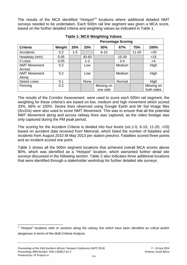
The results of the MCA identified “Hotspot”3 locations where additional detailed NMT surveys needed to be undertaken. Each 500m rail line segment was given a MCA score, based on the further detailed criteria and weighting values as indicated in Table 1.
Table 1: MCA Weighting Values Percentage Scoring
Criteria Weight 25% 33% 50% 67% 75% 100% Accidents 0.2 1-5 6-10 11-20 >20 Headway (min) 0.05 30-60 15-29 <15 # Lines 0.05 1-2 3-4 >4 NMT Movement Across
0.2 Low Medium High
NMT Movement Along
0.2 Low Medium High
Desire Lines 0.1 None Normal High Fencing 0.2 Missing on
one side Missing on
both sides
The results of the Corridor Assessment were used to score each 500m rail segment, the weighting for these criteria’s are based on low, medium and high movement which scored 33%, 66% or 100%. Desire lines observed using Google Earth and Mr Sid Image files (ArcGis) were also used to score NMT Movement. This was to ensure that all the potential NMT Movement along and across railway lines was captured, as the video footage was only captured during the PM peak period.
The scoring for the Accident Criteria is divided into four levels (viz.1-5, 6-10, 11-20, >20) based on accident data received from Metrorail, which listed the number of fatalities and incidents from August 2010 till May 2013 per station precinct. Fatalities scored three points and an incident scored one point.
Table 2 shows all the 500m segment locations that achieved overall MCA scores above 80%, which was identified as a “Hotspot” location, which warranted further detail site surveys discussed in the following section. Table 2 also indicates three additional locations that were identified through a stakeholder workshop for further detailed site surveys.
3 “Hotspot” locations refer to sections along the railway line which have been identified as critical and/or
dangerous in terms of the Multi-Criteria Analysis.
214

Proceedings of the 33rd Southern African Transport Conference (SATC 2014) 7 – 10 July 2014 Proceedings ISBN Number: 978-1-920017-61-3 Pretoria, South Africa Produced by: CE Projects cc
Table 2: MCA Results showing the top 17 “Hotspot” locations
Rank Location MCA Score (%) 1 South of Netreg Station 98 2 Between Nyanga and Philippi Station 92 3 East of Philippi Station 88 4 East of Bellville Station 85 5 South of Nyanga Station 85 6 Between Lengtegeur and Mitchells Plein Station 84 7 East & West of Bonteheuwel Station 83 8 Nomzamo 83 9 South of Brackenfell Station 83 10 North and South of Eikenfontein Station 83 11 Ysterplaat 83 12 Between Philippi and Mandalay Station 81 13 Between Philippi and Lengtegeur Station 81 14 East of Langa Station 81
* 15 East and West of Lavistown 79 * 16 North and south of Heideveld Station 78 * 17 West and east of Kuilsriver Station 78
* Additional locations identified for further detailed site surveys
2.4 “Hotspot” Surveys
Additional detailed field surveys were undertaken at all identified “Hotspot” locations during the AM peak period, viz. 05:30 – 08:30, and also the during Midday peak period, viz. 12:00 – 15:00. NMT movement was counted along the railway lines, across the railway lines including pedestrians that accessed or got off the platform onto the tracks instead of using the station access, assumed to evade the fare checks. Figure 7 shows the results of one of the “Hotspot” Surveys undertaken.
Figure 7: Nyanga “Hotspot” Survey Results
215

Proceedings of the 33rd Southern African Transport Conference (SATC 2014) 7 – 10 July 2014 Proceedings ISBN Number: 978-1-920017-61-3 Pretoria, South Africa Produced by: CE Projects cc
3. NOMZAMO RAIL CROSSING – SPECIAL CASE STUDY
This chapter describes in detail the assessment of the Nomzamo “Hotspot” location identified as case study No. 8 in Table 2.
3.1 Background & Study Area
The “Nomzamo crossing” is located in the Strand area between the Van der Stel and Strand railway stations (see Figure 8(a)) and provides the communities of Asanda, Nomzamo and Lwandle direct access to Strand Main Road. From the Main Road, NMT movement is towards the Van der Stel Station, the Somerset-West CBD, Strand CBD and the industrial and commercial areas. Awareness of the large volume of NMT movement (pedestrians and cyclists) across the rail line at the “Nomzamo crossing” and towards the crossing point (see Figure 8(b)) was raised for the first time in October 2012 when officials of the Universal Access and Non-motorised Transport Section of the City of Cape Town distributed visibility items to pedestrians and cyclists as part of Transport Month activities. Subsequently, the Nomzamo crossing was highlighted by the ward councillors as a concern and requested the City to address the matter. Consultants were then appointed in July 2013 to undertake a scoping process involving the identification of possible solutions and the assessment thereof as part of Phase 2 of the Citywide NMT Programme.
Figure 8(a): Nomzamo study area
Figure 8(b): Pedestrian movement towards the rail line at the Nomzamo crossing
216

Proceedings of the 33rd Southern African Transport Conference (SATC 2014) 7 – 10 July 2014 Proceedings ISBN Number: 978-1-920017-61-3 Pretoria, South Africa Produced by: CE Projects cc
3.2 Current Status Quo
The Lwandle land parcel was first to be developed and had an established hostel quarters for migrant labour. This area expanded further west into the area now called Nomzamo. Asanda was the last area to be developed in 2001/2 consisting of RDP4 type housing. Lwandle, Nomzamo and Asanda have an estimated population of 34 260, mostly housed in low-income residential settlements with no job opportunities. While residents from Lwandle and Nomzamo have access to the N2, Asanda is landlocked between the powerline servitude and Atlas Park (fenced industrial park) to the north, the single rail line to Strand Station to the west, the road reserve for the future realigned N2 to the south and Hlathi Drive to the east (north-south access road to the N2). The town planning layout of Asanda is a closed road system (loop type network) and the houses bordering the powerline servitude are orientated towards the road, creating an unsafe open area. A vibracrete wall was erected on the western boundary of Asanda in an attempt to prevent people crossing the rail line. Unfortunately, due to the town planning arrangement, a pedestrian desire line across the railway line to the north-western portion of Asanda for access to Strand Main Road en-route to schools, shopping and employment opportunities became established. In the process, a desire line was created across the existing railway line and has become well established. The remnants of the vibracrete wall bear testimony to poor urban design and an ill-fated attempt to prevent crossing of the rail line.
In order to address pedestrian movement in the area, a pedestrian walkway (with overhead lighting) was constructed on the southern side of the N2, extending all the way from Lwandle to the bridge across the rail line and Strand Main Road. On the bridge a dedicated pedestrian facility barrier separated from vehicle traffic, is provided. A new walkway was also constructed between Atlas Park and the Metrorail substation that provides access to the walkway along the N2 and the dedicated pedestrian facility across the bridge. The expectation was that residents from Lwandle, Nomzamo and Asanda would use the new walkway to access the bridge and cross the rail line and Strand Main Road via the dedicated pedestrian facility.
Pedestrians originating from Lwandle and Nomzamo (situated more to the east) follow the walkway along the N2, but then divert to an informal path before the bridge and then cross the rail line below the bridge as this provides a direct access towards the Somerset West CBD and Van der Stel Station, with the result that the dedicated pedestrian facility across the bridge is not optimally used. In order to prevent the at-grade crossing, a concrete palisade barrier fence was constructed along the western side of the rail line by Metrorail at the end of 2011, but was vandalised on the first night and a section removed (see Figure 9(a)). Despite repeated repairs to the fence, vandalism continues to occur.
4 RDP: Reconstruction and Development Programme.
217

Proceedings of the 33rd Southern African Transport Conference (SATC 2014) 7 – 10 July 2014 Proceedings ISBN Number: 978-1-920017-61-3 Pretoria, South Africa Produced by: CE Projects cc
Figure 9(a): Opening in fence where NMT users illegally cross the rail reserve
Pedestrian surveys reflect very high volumes of crossing pedestrians during the morning peak period (06:00-08:30), where, in July 2013, 7 408 pedestrians (including school children) and 757 cyclists crossed at-grade. Of the pedestrians (including cyclists) crossing the line, the destination split is approximately 50% walk west across Strand Main Road towards the industrial/commercial area along the N2, 45% walk north towards Van der Stel Station, the Somerset-West CBD and residential areas and 5% south towards the Strand CBD. Pick-up and drop-off of commuters and workers by taxi and contractors also occur regularly along the Strand Main Road in proximity of the rail crossing area.
218

Proceedings of the 33rd Southern African Transport Conference (SATC 2014) 7 – 10 July 2014 Proceedings ISBN Number: 978-1-920017-61-3 Pretoria, South Africa Produced by: CE Projects cc
3.3 Conclusions & Recommendations
The Nomzamo crossing area poses a number of constraints, (which complicates finding a long-term solution) listed as follows: • 32m wide electrical servitude with high voltage overhead cables crossing the
railway line; • 18m wide railway reserve with a single rail line; • Metrorail Strand Substation and associated gantry structures for the electrification
of the rail network; • + 8m high steel support structure for DC cables for electrification of railway network; • Undeveloped erven in the Asanda development that is in private ownership; • The walkway along the N2 and the dedicated pedestrian facility on the bridge are
mal-aligned with the pedestrian desire lines; • Pedestrians are at risk when crossing Strand Main Road as two carriageways in
both direction carry high traffic volumes and high travel speeds have been observed;
• There are two distinct pedestrian crossing desire lines (evident from the openings repeatedly created in the palisade fence);
• Pedestrians that cross the Nomzamo crossing originate as far back as Lwandle (confirmed in a comprehensive survey undertaken in December 2013) and may not be willing to follow a redirected route across the bridge;
• A wide sidewalk is provided along the eastern side of Strand Main Road and this is the preferred route pedestrians follow north to Van der Stel Station and the Somerset-West CBD.
The following four options were nevertheless identified and further investigated by the consultants during the scoping process:
A. A minimalistic approach consisting of the upgrade (cleaning and widening) of the existing walkway between Atlas Park and the substation, provision of stairs from the N2 down the embankment to Main Road and repair of the palisade fence.
B. A pedestrian bridge consisting of universal accessible ramps on either side. C. A pedestrian underpass consisting of universal accessible ramps on either side and
stepped embankments to decrease the tunnel effect and increase visibility. D. A pedestrian level crossing consisting of a level surface for crossing the tracks,
warning signage (including text in Xhosa and English). The proposal for a level crossing is based on the following: a single rail line exists with low commuter train frequencies, high number of pedestrians cross the rail line at-grade and a formalised pedestrian crossing will include improved surface and warning signage, which will improve pedestrian safety.
219

Proceedings of the 33rd Southern African Transport Conference (SATC 2014) 7 – 10 July 2014 Proceedings ISBN Number: 978-1-920017-61-3 Pretoria, South Africa Produced by: CE Projects cc
The following constraints and challenges were faced in an attempt to find a suitable option:
• The walkway from Asanda to the walkway along the N2 is bordered by the security wall of Atlas Park and the Metrorail substation and is regarded as dangerous and unsafe by the community.
• The ward councillors representing the Asanda, Nomzamo and Lwandle communities have expressed their objection to a proposal that requires people who have already risen early and walked from as far as Lwandle to be redirected towards the N2 and have to ascend and cross the bridge.
• Representatives from the City Department responsible for the high voltage electricity network have indicated that the proposed pedestrian bridge will encroach onto the electrical servitude and will be located within the minimum clearance required from high voltage powerlines.
• Ward councillors from the Strand area have indicated that an underpass is not acceptable due to maintenance problems and crime experienced with the two current underpasses in the Strand area.
• Representatives from Metrorail have indicated that the policy of the Passenger Rail Agency of South Africa (PRASA) dictate that no new level crossings, including pedestrian level crossings, be implemented.
Due to the constraints and challenges posed by the crossing area, the need for people from Lwandle, Nomzamo and Asanda to access opportunities elsewhere, the established pedestrian behavior to cross the rail line at-grade and the movement to Strand Main Road, finding a long-term solution for the at-grade crossing of the rail line proved to be challenging.
Considering the constraints, the input received from the community and representatives and information and insight gained during site visits and surveys, a formalised pedestrian level crossing (as per the example shown in Figure 10) which includes warning signage (including text) and an improved surface was considered as a feasible option viz. Option D. Whilst this project is still a work-in-progress at the time of writing this paper, it is intended that a proposal be submitted to the senior management of Transport for Cape Town (TCT) towards motivating the proposal solution to PRASA5 for their consideration.
Figure 10: Example of a Formalised pedestrian level crossing
5 PRASA: Passenger Rail Agency of South Africa
220

Proceedings of the 33rd Southern African Transport Conference (SATC 2014) 7 – 10 July 2014 Proceedings ISBN Number: 978-1-920017-61-3 Pretoria, South Africa Produced by: CE Projects cc
4. ALTERNATIVE RECOMMENDATIONS AND CONCLUSION
Part of the project included suggesting new and innovative generic interventions towards addressing safety at Level crossings. The development of a South African guideline document towards determining the warrants of providing grade separated pedestrian facilities over railway lines is highly recommended, incorporating both quantitative and qualitative criteria.
Furthermore, it is recommended that a South African Pedestrian Level Crossing Standard and Classification System be developed and integrated into the SARTSM document. It is intended that this classification system will form the basis and standard for all future level crossing designs. A City wide level crossing maintenance plan is recommended, which ensures that all existing level crossings receive proper ongoing maintenance, rather than maintaining on an ad-hoc basis after accidents occur and/or to gain political leverage.
Towards discouraging pedestrian movement within the railway reserve, public awareness campaigns are highly recommended if implemented correctly; with children and scholars being the target market for advertising media.
The following innovative infrastructure/devices (viz. Figures 11(a) to (l)) are currently used internationally to improve the safety at level crossings:
Figure 11(a): Pedestrian Maze, (Web. A Pedestrian Maze, 2010)
Figure 11(b): Pedestrian Swing Gates, (web. FHWA, 2007)
Figure 11(c): Lockable Gates, (web. FHWA, 2007)
Figure 11(d): Warning Tactile ground surface Indicators, (Clark, May 2008)
Figure 11(e): Diagonal Speed-Breaker Humps, (N.S. Ramnath and A.K. Mishra, 2012)
Figure 11(f): Innovative Signage, (Dept. For Transport, London).
221

Proceedings of the 33rd Southern African Transport Conference (SATC 2014) 7 – 10 July 2014 Proceedings ISBN Number: 978-1-920017-61-3 Pretoria, South Africa Produced by: CE Projects cc
Figure 11(g): Pedestrian underpass. Clark (2008)
Figure 11 (h): Fence between rail and sidewalk. Clark (2008)
Figure 11(i): Full automatic barriers. Clark (2008)
Figure 11(j): Track ballast discouraging pedestrian movement. Clark (2008)
Figure 11(k): Close up view of security fencing. Clark (2008)
Figure 11(l): The length of ballast helps discourage pedestrians from using this route. Clark (2008)
In conclusion, no individual infrastructural solution can solve the problem of pedestrian movement along and across railway lines; rather it is a tailoring of three elements viz. infrastructure, social aspects and enforcement/education that need to be integrally combined in order to solve the problem optimally.
Overall, this research-based project has succeeded in highlighting the problems and challenges regarding NMT behaviour within the rail environment facing the City and Rail Authorities in Cape Town and has identified critical areas requiring urgent attention. The contribution of the study and this paper are considered the early stages in changing the perception in the country towards more appropriate and safe rail level-crossing facilities.
5. ACKNOWLEDGEMENT
The author/s would like to thank the Universal Access and NMT section of the City of Cape Town for the opportunity to undertake this project and their contribution made towards this paper.
222

Proceedings of the 33rd Southern African Transport Conference (SATC 2014) 7 – 10 July 2014 Proceedings ISBN Number: 978-1-920017-61-3 Pretoria, South Africa Produced by: CE Projects cc
6. REFERENCES Clark (2008). Pedestrian-Rail Crossings In California, May 2008. California Public Utilities Commission (CPUC). Department of Transport, South Australia (2010). South Australian Level Crossing Safety Strategy and Action Plan 2010-2012, 2010. Department of Transport, Western Australia (2012). Planning and designing for pedestrians: guidelines, March 2012. Department of Transport (2012), South African Road Traffic Signs Manual (SARTSM) 3rd Ed., May 2012. Department of Transport, Victoria (2009). Towards Zero, A Strategy for Improved Level Crossing Safety in Victoria, 2009. European Railway Review (2012). Level Crossing Safety Supplement, Volume 18, Issue 4, 2012. Forbes India (2012). How Unmanned Level Crossings Spell Danger, (Dec 2012). N. S. Ramnath, A.K. Mishra. Sinclair Knight Merz, (2005). Pedestrian Behaviour and the Design of Accessible Rail Crossings, 28th Australasian Transport Research Forum, 2005. Sinclair Knight Merz (2003). Disability Access at Pedestrian Rail Crossings, DOI Study, June 2003. Wikimedia, (2010) Pedestrian Mazes, Kingdon Street [ONLINE]. Available at: http://commons.wikimedia.org/wiki/File:New_Pedestrian_Mazes,_Kingdon_Street.jpg
223