additional environmentally significant areas mapping project
TRANSCRIPT
Additional Environmentally Significant Areas Mapping Project
Prepared for:
The Corporation of the District of Saanich
RFP 33/11
Prepared by:
Moraia Grau and Associates
PO Box 118
Silverton, B.C. V0G 2B0

Additional ESA Mapping Project Report
Moraia Grau & Associates, email:[email protected] Page i
June 2012
TABLE OF CONTENTS
1. Introduction 1.1. Background ........................................................................................................................1 1.2. Phase 1 Project Objectives .................................................................................................2
2. Methods 2.1. ESA Mapping Technical Advisory Group ............................................................................3 2.2. Public Consultation ............................................................................................................3 2.3. Air Photo Analysis ..............................................................................................................3 2.4. Site Selection ......................................................................................................................3 2.5. Field Surveys ......................................................................................................................3 2.6. GIS Mapping .......................................................................................................................5 2.7. Evaluation of the Ecological Integrity ................................................................................5
3. Results 3.1. Site Nominations ................................................................................................................8 3.2. Site Selection and Groundtruthing ....................................................................................9 3.3. Evaluation of the Sites .......................................................................................................13 3.4. Environmentally Significant Areas .....................................................................................13 3.4.1. Sites with SEI Sensitive Ecosystem types ..............................................................13 3.4.2. Isolated wetlands and watercourses .....................................................................16 3.4.3. SEI Older Second Growth Forest ...........................................................................17 3.4.4. Wildlife trees .........................................................................................................17 3.4.5. Outstanding size Douglas firs ................................................................................18 3.5. Municipal lands...................................................................................................................19 3.6. GIS Coverage and Associated Data .....................................................................................19
4. Recommendations ............................................................................................................20
5. References .........................................................................................................................23
LIST OF TABLES
Table 1 Priority Criteria for Selection of Sites ....................................................................4 Table 2 Criteria for Assessment of Ecological Integrity .....................................................7 Table 3 List of Nominated Sites ..........................................................................................8 Table 4 Selection of Sites to Groundtruth .........................................................................9 Table 5 Breakdown of Ecosystem Types ............................................................................12 Table 6 Specific Values of Groundtruthed Forested Sites .................................................18 Table 7 New Sites SEI Types in Fair or Better Condition ....................................................21 Table 8 New sites Wildlife Tree Inventory .........................................................................21 Table 9 New Sites Isolated Watercourses and Wetlands Inventory ..................................22 Table 10 Undeveloped Municipal lands of ecological value ................................................22
LIST OF FIGURES
List of Sites by code and location Site 12MG001 and Site 12TM002
Additional ESA Mapping Project Report
Moraia Grau & Associates, email:[email protected] Page ii
Site 12MG002 Site 12MG003 Site 12MG004 and Site 12MG015 Site 12MG005 Site 12MG006 Site 12MG007 Site 12MG008 Site 12MG009 Site 12MG010 Site 12MG011 Site 12MG012 Site 12MG013 Site 12MG014 Site 12MG016 Site 12MG017 Site 12MG018 Site 12TM001 Site 12TM003 Site 12TM004 Site 12TM005 Site 12TM006 Site 12TM007 Site 12TM008 Site 12TM009 Site 12TM010 Site 12TM011 Site 12TM012 Site 12TM013 APPENDICES Appendix I Ecological Assessment of Sites Appendix II Photographic Report Appendix III Field Forms

Additional ESA Mapping Project Report
Moraia Grau & Associates, email:[email protected] Page 1
1. INTRODUCTION
1.1. Background
The District of Saanich, with a rapid population increase and potential housing and other development
projects on the rise, realized that it is important to have the most complete environmental information in
order to protect remaining environmentally significant areas. The District of Saanich 2010 Strategic Plan
contained the following initiative:
C4b. “Establish an Environmentally Significant Areas Development Permit Area to
protect and enhance sensitive ecosystems, species at risk and the marine shoreline.
Increasing development pressure adds to the need to protect natural ecosystems and
the habitat of rare plants and animals at a level similar to the existing protection for
riparian areas.”
A new Environmental Development Permit Area (EDPA) was adopted by Saanich Council on March 12, 2012.
Five inventories or data sets are used to define the areas subject to the new EDPA:
Sensitive Ecosystem Inventory (SEI), 2002 (Ministry of the Environment and Environment Canada); Red and Blue listed animals, plants and ecological communities (Conservation Data Centre, Ministry of
the Environment); Wildlife Tree Stewardship Program (WITS) (Federation of BC Naturalists); Isolated wetlands and watercourses, 2010 (District of Saanich); Saanich Marine Inventory, 2000 (District of Saanich and the Veins of Life Watershed Society)
However, these inventories, and associated atlases, are not complete. In part, this is due to the fact that many
important and smaller ESA´s were not mapped during the Sensitive Ecosystems Inventory of East Vancouver
Island and the Gulf Islands because of the large scale of the project (1:20,000). In addition, many areas with
high ecological value such as habitat connecting corridors, buffers for sensitive areas, and urban forests were
not considered by previous inventories.
Following the C4b Strategic Plan initiative, a project to map additional ESAs was developed by Saanich
Environmental Services aided by a Specialists Working Group. The overall objective of the Saanich initiative is
to identify and map remaining environmentally significant areas, including smaller sensitive, rare and
endangered ecosystems, species at risk (SAR) sites, as well as buffers and linkages between these areas. The
project is to be carried out in two phases:
In Phase 1 new environmentally significant areas are to be identified and mapped through the
evaluation of sites suggested by the general public or Saanich staff.
In Phase 2, a complete aerial photo analysis of the District of Saanich will be carried out to investigate
new potential ESA sites. The analysis will include potential SEI sites, buffers, ecosystem linkages and
wildlife corridors. The consultant biologist will assess the new potential sites, prioritize, ground‐truth,
and recommend the inclusion of new sites in the ESA Atlas.
This report recounts the completion of Phase 1.
Additional ESA Mapping Project Report
Moraia Grau & Associates, email:[email protected] Page 2
1.2. Phase 1 Project Objectives
The overall objective of Phase 1 is to investigate and incorporate to the ESA Atlas unmapped environmentally
significant areas within the District of Saanich, through suggestions by the public, or Saanich staff. The
nominated sites are to be groundtruthed and their ecological value assessed by a consultant biologist, who will
map and recommend the inclusion in the Atlas of those found of highest value for conservation.
Additional ESA Mapping Project Report
Moraia Grau & Associates, email:[email protected] Page 3
2. METHODS
2.1. ESA Mapping Technical Advisory Group
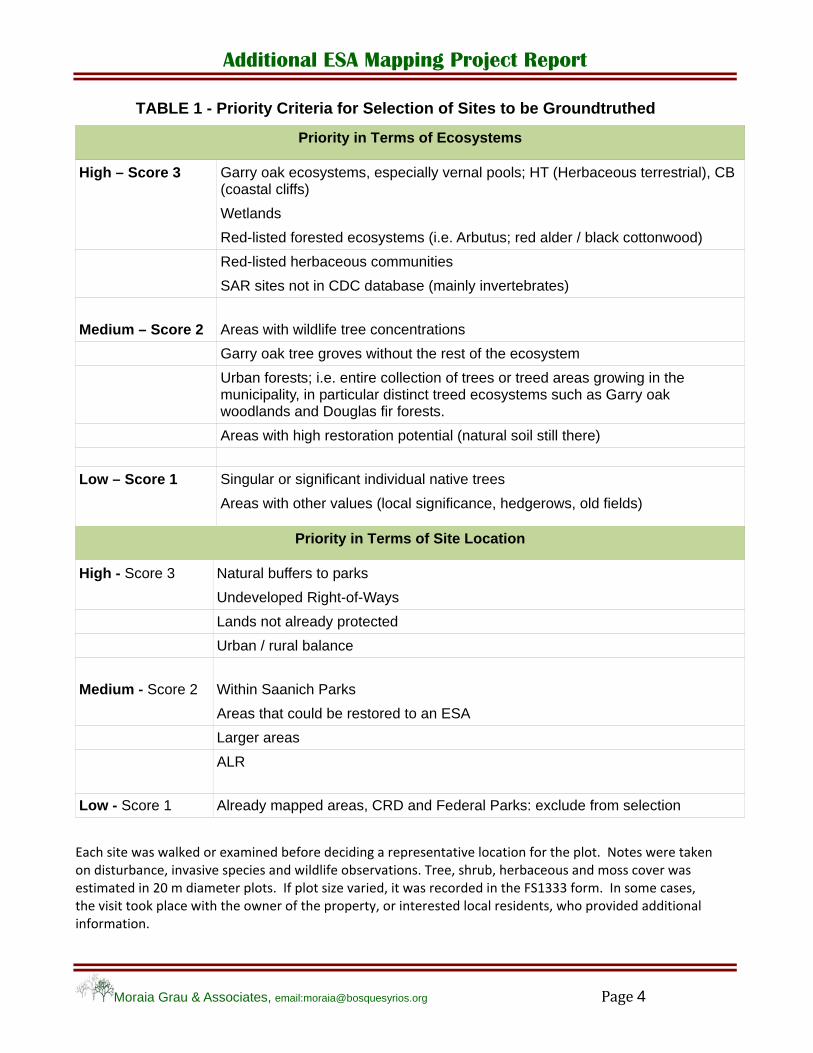
In November 2011, a group was formed to guide the ESA mapping project. Members are from the District of Saanich (Environmental Services, Planning, Parks, Engineering, and GIS), the Canadian Wildlife Service, the Conservation Data Centre, the Ministry of Forests, Lands and Resource Operations, and the Garry Oak Ecosystem Recovery Team. The Terms of Reference were to: determine priorities for ESA types, create priority criteria for ESA locations, and establish standards for data collection and presentation. Table 1 shows the priorities and criteria created by the advisory group.
2.2. Public Participation
A public and internal campaign was carried out during March 2012 to nominate areas for consideration as potential ESAs. The campaign was announced in the District of Saanich website as well as in the local paper Saanich News.
2.3. Air Photo Analysis
Nominated sites were examined with Saanich GIS Map Service to establish location, protection status, classification as SEI site or other important ecosystems, undeveloped Right‐of‐Ways, and their potential value as urban forests, buffers or linkage corridors. If the site was already identified as a SEI site or was in a Streamside Development Permit Areas, the adjacent landscape was examined for unidentified and potential ecologically important sites near the nominated area.
2.4. Site Selection
Each nominated site was assessed by its conservation and priority value, according to two sets of criteria: ecosystem type and site protection status as discussed with the Working Group and Adriane Pollard, Saanich Environmental Manager (Table 1). The high priority ecosystem types were assigned a score of 3 whereas low priority types were assigned a score of 1. The site´s protection status was also ranked using a 3 to 1 score (highest for those sites not having protection and lowest for sites in Parks). CRD and Federal Parks were excluded from selection, as well as already identified SEI sites. Another consideration in the selection was to groundtruth a relatively equal proportion of sites within the urban containment area and the rural part of the District.
2.5. Field Surveys
Each selected site was to be inspected in the field. A pre‐typed orthophoto print of each site was used to aid in the delineation of the ecological community and for future air photo interpretation reference. The objective of the field surveys was to:
identify the ecological community,
identify the SEI class and subclass, if applicable,
describe characteristics of the site and species vegetation cover, and
take note of the anthropogenic and natural disturbances affecting the site.
Additional ESA Mapping Project Report
Moraia Grau & Associates, email:[email protected] Page 4
TABLE 1 - Priority Criteria for Selection of Sites to be Groundtruthed
Priority in Terms of Ecosystems
High – Score 3 Garry oak ecosystems, especially vernal pools; HT (Herbaceous terrestrial), CB (coastal cliffs)
Wetlands
Red-listed forested ecosystems (i.e. Arbutus; red alder / black cottonwood)
Red-listed herbaceous communities
SAR sites not in CDC database (mainly invertebrates)
Medium – Score 2 Areas with wildlife tree concentrations
Garry oak tree groves without the rest of the ecosystem
Urban forests; i.e. entire collection of trees or treed areas growing in the municipality, in particular distinct treed ecosystems such as Garry oak woodlands and Douglas fir forests.
Areas with high restoration potential (natural soil still there)
Low – Score 1 Singular or significant individual native trees
Areas with other values (local significance, hedgerows, old fields)
Priority in Terms of Site Location
High - Score 3 Natural buffers to parks
Undeveloped Right-of-Ways
Lands not already protected
Urban / rural balance
Medium - Score 2 Within Saanich Parks
Areas that could be restored to an ESA
Larger areas
ALR
Low - Score 1 Already mapped areas, CRD and Federal Parks: exclude from selection
Each site was walked or examined before deciding a representative location for the plot. Notes were taken on disturbance, invasive species and wildlife observations. Tree, shrub, herbaceous and moss cover was estimated in 20 m diameter plots. If plot size varied, it was recorded in the FS1333 form. In some cases, the visit took place with the owner of the property, or interested local residents, who provided additional information.

Additional ESA Mapping Project Report
Moraia Grau & Associates, email:[email protected] Page 5
Through the field surveys, sufficient information on the type, condition (including disturbances) and location of the ecosystems was to be collected for the assessment and mapping of the site as a potential ESA. Two site forms were used: Site Visit Form FS 1333 and the CDC Conservation Evaluation Form (see appendix III).
Fields collected on the FS 1333 were: plot code and location (UTM coordinates), Biogeoclimatic Zone and Site Series, stand age and canopy composition (forested sites), signs of disturbance, and percent cover of trees, shrubs, herbs and mosses. The information was collected in a 20 m diameter plot. In some cases the shape or size of the plot was changed to adapt to narrow sites and recorded in the site form.
The Conservation Evaluation Form complemented the FS 1333 regarding the description and condition of the site, by including SEI classification, succession status, ownership or jurisdiction, presence of invasive species observed outside the plot, known threats, and amount of fragmentation.
The assignment of Sensitive Ecosystem classes and subclasses followed the SEI classification used in the Southern Vancouver Island and Gulf Islands Inventory. By using the same criteria, all sites identified under a certain code will be equivalent to the sites already mapped. Specifically in regards to Older Forests, which were identified as "conifer dominated forests with an average tree age of >100 yrs or greater" in the original inventory. On the other hand, the minimum area requirement of 0.5 ha for any of the classes (due to mapping constraints), and minimum 25 ha for Older Second Growth Forests has not been used in this project.
The principles that set the 25 ha minimum size for Older Second Growth Forests in the 2002 SEI, (recognizing the importance of a larger area for biodiversity and to support species with large home ranges in mapping a vast territory of 4,000 sq.km), apply at a lower scale in rural and urban areas; i.e. one or two hectares of Older Second Growth Forests in Saanich may have as much value for biodiversity and wildlife as 25 ha in wilderness areas. In addition, small patches of older second growth are important in maintaining connectivity with larger parcels of forests across the rural‐urban landscape. Therefore, there was no minimum size set for any of the SEI classes in this project.
The characteristics of the sensitive ecosystems and other important ecosystems identified in this project are described in Sensitive Ecosystems Inventory: East Vancouver Island and Gulf Islands 1993 ‐ 1997 (Canadian Wildlife Service, 2000). The new Sensitive Ecosystem Codes Classes and subclasses are described in Standard for Mapping Ecosystems at Risk in British Columbia (B.C. Ministry of the Environment 2006).
2.6. GIS Mapping
First, the selected sites were located on the 2011 orthophotos, available through the Saanich GIS Map Service. The ecosystems of interest were then identified and delineated. In ArcGIS, a geodatabase was created following the standards provided by the District of Saanich. The geodatabase was populated by creating a number of layers containing the information redeemed necessary for the completion of the project. A polygon feature class was created containing the digitized site location as well as elevation, slope and aspect information for each site (this was calculated using Zonal Statistics tools). A point layer was created containing information on significant trees collected during field surveys. Finally a point feature class was created for each plot containing attribute information collected during the field survey. Additional tables are included in the geodatabase with detailed vegetation information for each plot. All plots and corresponding sites can be linked by the plot unique identifier. All features classes have detailed Metadata information following standards provided by the District of Saanich.
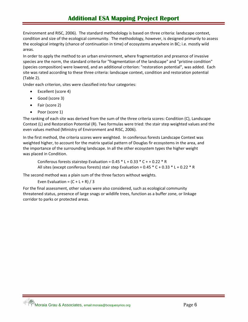
2.7. Evaluation of the Ecological Integrity
The ecological value of the sites was assessed through a modification of the procedure described in the manual "Standard for Mapping Ecosystems at Risk in British Columbia" (Sec. 4.4 and 4.5) (Ministry of
Additional ESA Mapping Project Report
Moraia Grau & Associates, email:[email protected] Page 6
Environment and RISC, 2006). The standard methodology is based on three criteria: landscape context, condition and size of the ecological community. The methodology, however, is designed primarily to assess the ecological integrity (chance of continuation in time) of ecosystems anywhere in BC; i.e. mostly wild areas.
In order to apply the method to an urban environment, where fragmentation and presence of invasive species are the norm, the standard criteria for "fragmentation of the landscape" and "pristine condition" (species composition) were lowered, and an additional criterion: "restoration potential", was added. Each site was rated according to these three criteria: landscape context, condition and restoration potential (Table 2).
Under each criterion, sites were classified into four categories:
Excellent (score 4)
Good (score 3)
Fair (score 2)
Poor (score 1)
The ranking of each site was derived from the sum of the three criteria scores: Condition (C), Landscape Context (L) and Restoration Potential (R). Two formulas were tried: the stair step weighted values and the even values method (Ministry of Environment and RISC, 2006).
In the first method, the criteria scores were weighted. In coniferous forests Landscape Context was weighted higher, to account for the matrix spatial pattern of Douglas fir ecosystems in the area, and the importance of the surrounding landscape. In all the other ecosystem types the higher weight was placed in Condition.
Coniferous forests stairstep Evaluation = 0.45 * L + 0.33 * C + + 0.22 * R All sites (except coniferous forests) stair step Evaluation = 0.45 * C + 0.33 * L + 0.22 * R
The second method was a plain sum of the three factors without weights.
Even Evaluation = (C + L + R) / 3
For the final assessment, other values were also considered, such as ecological community threatened status, presence of large snags or wildlife trees, function as a buffer zone, or linkage corridor to parks or protected areas.

Additional ESA Mapping Project Report
Moraia Grau & Associates, email:[email protected] Page 7
TABLE 2 - Criteria for Assessment of Ecological Integrity
Criteria applied to groundtruthed sites for assessment of ecological integrity.
Landscape context (L) (approx. 2,500 Ha)
Excellent – Score 4
The surrounding landscape has <25% fragmentation due to roads, urban areas, and rural settlements, and no recent industrial activity. Site occurs within a larger landscape with some formal protection status or protected by conservation covenants.
Good – Score 3
Up to 50% of the surrounding landscape is fragmented. The larger landscape context provides some protection from anthropogenic disturbance, although changes to natural disturbance regimes exist (fire suppression; flooding control).
Fair – Score 2
More than 50% of the surrounding landscape is fragmented and affected by anthropogenic influences. Development may affect the ecosystem´s existence.
Poor – Score 1
Less than 15% of the surrounding landscape consists of natural or semi-natural vegetation, or the ecosystem is completely isolated from natural areas and protected areas.
Condition (C)
Excellent – Score 4
Minor cover of exotic species occur in the site (<10%). Forested ecological communities are climax vegetation. The community may have minor internal fragmentation (<5%). Wetland and riparian communities have natural hydrology regimes. No artificial structures occur at the site.
Good– Score 3
Some cover of exotic species (10 - 40%). Forested ecological communities may be late seral vegetation. Wetland and riparian communities have largely natural hydrology regimes. There could be moderate internal fragmentation (<25%).
Fair– Score 2
Significant cover of exotic species (40 - 75%). Forested ecological communities typically are young seral vegetation after anthropogenic disturbance. There may be significant alterations of hydrology regime in wetlands and riparian ecological communities. There is moderate internal fragmentation (<25%).
Poor– Score 1
Exotic species dominate a vegetation layer or may total >75%. Significant anthropogenic disturbance, such as removal of soil material or vegetation. There are significant alterations to the hydrology regime in wetlands and riparian ecosystems. High internal fragmentation (>25%), presence of artificial structures or barriers.
Restoration potential (R)
Excellent– Score 4
The natural species, soils and disturbance regime are mostly intact, only a minor control of invasive species is needed.
Good– Score 3
The natural species, soils and disturbance regime are present, but sustained invasive species work is needed to achieve restoration.
Fair– Score 2
Alterations to the natural disturbance regime require major work. The removal of invasive species will leave major portions of exposed soil, requiring plantings. Many years of work will be needed, to achieve a complete natural appearance.
Poor– Score 1
Soils and vegetation were removed, and site is dominated by alien invasive species. Site may be affected permanently.
Additional ESA Mapping Project Report
Moraia Grau & Associates, email:[email protected] Page 8
3. RESULTS
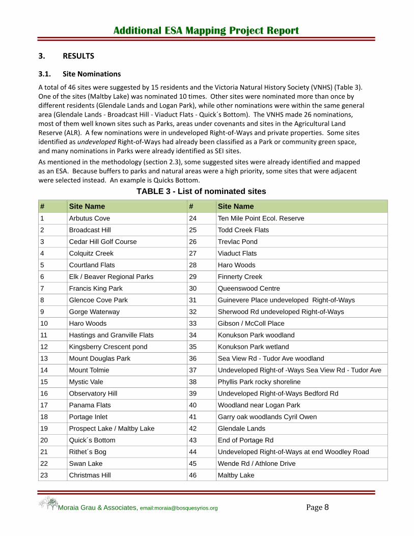
3.1. Site Nominations
A total of 46 sites were suggested by 15 residents and the Victoria Natural History Society (VNHS) (Table 3). One of the sites (Maltby Lake) was nominated 10 times. Other sites were nominated more than once by different residents (Glendale Lands and Logan Park), while other nominations were within the same general area (Glendale Lands ‐ Broadcast Hill ‐ Viaduct Flats ‐ Quick´s Bottom). The VNHS made 26 nominations, most of them well known sites such as Parks, areas under covenants and sites in the Agricultural Land Reserve (ALR). A few nominations were in undeveloped Right‐of‐Ways and private properties. Some sites identified as undeveloped Right‐of‐Ways had already been classified as a Park or community green space, and many nominations in Parks were already identified as SEI sites.
As mentioned in the methodology (section 2.3), some suggested sites were already identified and mapped as an ESA. Because buffers to parks and natural areas were a high priority, some sites that were adjacent were selected instead. An example is Quicks Bottom.
TABLE 3 - List of nominated sites
# Site Name # Site Name
1 Arbutus Cove 24 Ten Mile Point Ecol. Reserve
2 Broadcast Hill 25 Todd Creek Flats
3 Cedar Hill Golf Course 26 Trevlac Pond
4 Colquitz Creek 27 Viaduct Flats
5 Courtland Flats 28 Haro Woods
6 Elk / Beaver Regional Parks 29 Finnerty Creek
7 Francis King Park 30 Queenswood Centre
8 Glencoe Cove Park 31 Guinevere Place undeveloped Right-of-Ways
9 Gorge Waterway 32 Sherwood Rd undeveloped Right-of-Ways
10 Haro Woods 33 Gibson / McColl Place
11 Hastings and Granville Flats 34 Konukson Park woodland
12 Kingsberry Crescent pond 35 Konukson Park wetland
13 Mount Douglas Park 36 Sea View Rd - Tudor Ave woodland
14 Mount Tolmie 37 Undeveloped Right-of -Ways Sea View Rd - Tudor Ave
15 Mystic Vale 38 Phyllis Park rocky shoreline
16 Observatory Hill 39 Undeveloped Right-of-Ways Bedford Rd
17 Panama Flats 40 Woodland near Logan Park
18 Portage Inlet 41 Garry oak woodlands Cyril Owen
19 Prospect Lake / Maltby Lake 42 Glendale Lands
20 Quick´s Bottom 43 End of Portage Rd
21 Rithet´s Bog 44 Undeveloped Right-of-Ways at end Woodley Road
22 Swan Lake 45 Wende Rd / Athlone Drive
23 Christmas Hill 46 Maltby Lake
Additional ESA Mapping Project Report
Moraia Grau & Associates, email:[email protected] Page 9
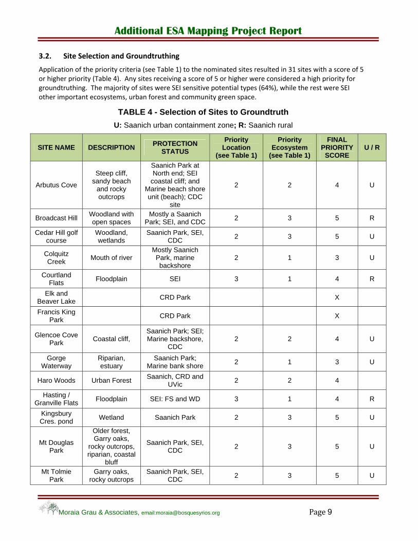
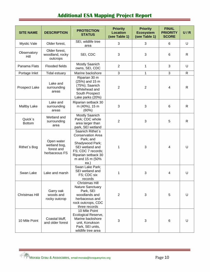
3.2. Site Selection and Groundtruthing
Application of the priority criteria (see Table 1) to the nominated sites resulted in 31 sites with a score of 5 or higher priority (Table 4). Any sites receiving a score of 5 or higher were considered a high priority for groundtruthing. The majority of sites were SEI sensitive potential types (64%), while the rest were SEI other important ecosystems, urban forest and community green space.
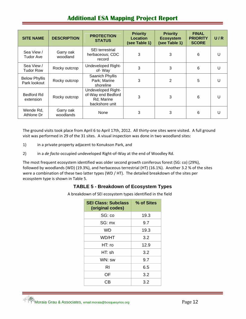
TABLE 4 - Selection of Sites to Groundtruth
U: Saanich urban containment zone; R: Saanich rural
SITE NAME DESCRIPTION PROTECTION
STATUS
Priority Location
(see Table 1)
Priority Ecosystem
(see Table 1)
FINAL PRIORITY
SCORE U / R
Arbutus Cove
Steep cliff, sandy beach
and rocky outcrops
Saanich Park at North end; SEI
coastal cliff; and Marine beach shore unit (beach); CDC
site
2 2 4 U
Broadcast Hill Woodland with open spaces
Mostly a Saanich Park; SEI, and CDC
2 3 5 R
Cedar Hill golf course
Woodland, wetlands
Saanich Park, SEI, CDC
2 3 5 U
Colquitz Creek
Mouth of river Mostly Saanich Park, marine backshore
2 1 3 U
Courtland Flats
Floodplain SEI 3 1 4 R
Elk and Beaver Lake
CRD Park X
Francis King Park
CRD Park X
Glencoe Cove Park
Coastal cliff, Saanich Park; SEI; Marine backshore,
CDC 2 2 4 U
Gorge Waterway
Riparian, estuary
Saanich Park; Marine bank shore
2 1 3 U
Haro Woods Urban Forest Saanich, CRD and
UVic 2 2 4
Hasting / Granville Flats
Floodplain SEI: FS and WD 3 1 4 R
Kingsbury Cres. pond
Wetland Saanich Park 2 3 5 U
Mt Douglas Park
Older forest, Garry oaks,
rocky outcrops, riparian, coastal
bluff
Saanich Park, SEI, CDC
2 3 5 U
Mt Tolmie Park
Garry oaks, rocky outcrops
Saanich Park, SEI, CDC
2 3 5 U
Additional ESA Mapping Project Report
Moraia Grau & Associates, email:[email protected] Page 10
SITE NAME DESCRIPTION PROTECTION
STATUS
Priority Location
(see Table 1)
Priority Ecosystem
(see Table 1)
FINAL PRIORITY
SCORE U / R
Mystic Vale Older forest, SEI, wildlife tree
area 3 3 6 U
Observatory Hill
Older forest, woodland, rocky
outcrops SEI, CDC 3 3 6 R
Panama Flats Flooded fields Mostly Saanich owns, SEI, CDC
2 1 3 U
Portage Inlet Tidal estuary Marine backshore 3 1 3 R
Prospect Lake Lake and
surrounding areas
Riparian 30 m (25%) and 15 m (75%); Saanich Whitehead and South Prospect
Lake parks (20%)
2 2 4 R
Maltby Lake Lake and
surrounding areas
Riparian setback 30 m (40%), 15 m
(60%) 3 3 6 R
Quick´s Bottom
Wetland and surrounding
area
Mostly Saanich Park; CDC whole area larger than
park, SEI wetland
2 3 5 R
Rithet´s Bog
Open water wetland bog,
forest and herbaceous FS
Saanich Rithet´s Conservation Area
Park; and Shadywood Park; SEI wetland and
FS; CDC 7 records; Riparian setback 30 m and 15 m (50%
ea.)
1 3 4 U
Swan Lake Lake and marsh
Swan Lake Park; SEI wetland and
FS; CDC six records
1 3 4 U
Christmas Hill Garry oak woods and
rocky outcrop
Christmas Hill Nature Sanctuary
Park, SEI woodlands and herbaceous and
rock outcrops, CDC three records
2 3 5 U
10 Mile Point Coastal bluff,
and older forest
10 Mile Point Ecological Reserve, Marine backshore
unit, Konukson Park, SEI units, wildlife tree area
3 3 6 U

Additional ESA Mapping Project Report
Moraia Grau & Associates, email:[email protected] Page 11
SITE NAME DESCRIPTION PROTECTION
STATUS
Priority Location
(see Table 1)
Priority Ecosystem
(see Table 1)
FINAL PRIORITY
SCORE U / R
Tod Creek Flats
Creek, wetlands and floodplain
SEI floodplain (FS), CDC one record,
riparian setback 15 (80%) and 30 m
(20%)
3 2 5 R
Trevlac Pond Wetland and surrounding
forested area
Saanich Calvert Park; SEI wetland;
CDC record 2 3 5 R
Viaduct Flats Floodplain Saanich covenant;
SEI floodplain 3 2 5 R
End Portage Rd
Estuary´s shoreline
Marine backshore unit, marine
biodiversity area 3 3 6 U
Woodley Rd Woodlands None 3 3 6 U
Near Logan Garry oak and
arbutus woodlands
Possibly SEI woodland
3 3 6 R
Glendale Lands
Woodlands
Layritz Park, some covenants; SEI
woodlands outside park; CDC record
2 3 5 R
Logan Park Wetland,
Viaduct Cr. and older forest
Saanich Park 2 3 5 R
Arbutus/ Finnerty Rd
Urban Forest remnant
Queen Alexandra Centre Children’s
Health 3 2 5 U
Finnerty Cr. Creek
riparian setback 10 m; area owned by Saanich, CRD and
UVic
2 3 5 U
Queenswood Centre
Forest UVic 3 2 5 U
Queenswood Drive
Forest None 3 2 5 U
Macdonald North Row
Forest Undeveloped Right-
of-Way 3 2 5 U
Gibson/McColl Forest Undeveloped Right-
of-Way, partly a Park
2 2 4 U
Sea Point Dr East
Wetland / vernal pools
Saanich Konukson Park; SEI wetland;
CDC record 2 3 5 U
Konukson Park
vernal Saanich Park, SEI wetland, Wildlife
tree area 2 3 5 U
Additional ESA Mapping Project Report
Moraia Grau & Associates, email:[email protected] Page 12
SITE NAME DESCRIPTION PROTECTION
STATUS
Priority Location
(see Table 1)
Priority Ecosystem
(see Table 1)
FINAL PRIORITY
SCORE U / R
Sea View / Tudor Ave
Garry oak woodland
SEI terrestrial herbaceous; CDC
record 3 3 6 U
Sea View / Tudor Row
Rocky outcrop Undeveloped Right-
of- Way 3 3 6 U
Below Phyllis Park lookout
Rocky outcrop Saanich Phyllis Park; Marine
shoreline 3 2 5 U
Bedford Rd extension
Rocky outcrop
Undeveloped Right-of-Way end Bedford
Rd; Marine backshore unit
3 3 6 U
Wende Rd, Athlone Dr
Garry oak woodlands
None 3 3 6 U
The ground visits took place from April 6 to April 17th, 2012. All thirty‐one sites were visited. A full ground visit was performed in 29 of the 31 sites. A visual inspection was done in two woodland sites:
1) in a private property adjacent to Konukson Park, and
2) in a de facto occupied undeveloped Right‐of‐Way at the end of Woodley Rd.
The most frequent ecosystem identified was older second growth coniferous forest (SG: co) (29%), followed by woodlands (WD) (19.3%), and herbaceous terrestrial (HT) (16.1%). Another 3.2 % of the sites were a combination of these two latter types (WD / HT). The detailed breakdown of the sites per ecosystem type is shown in Table 5.
TABLE 5 - Breakdown of Ecosystem Types
A breakdown of SEI ecosystem types identified in the field
SEI Class: Subclass (original codes)
% of Sites
SG: co 19.3
SG: mx 9.7
WD 19.3
WD/HT 3.2
HT: ro 12.9
HT: sh 3.2
WN: sw 9.7
RI 6.5
OF 3.2
CB 3.2
Additional ESA Mapping Project Report
Moraia Grau & Associates, email:[email protected] Page 13
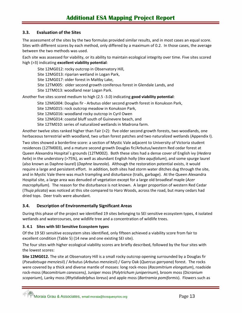
3.3. Evaluation of the Sites
The assessment of the sites by the two formulas provided similar results, and in most cases an equal score. Sites with different scores by each method, only differed by a maximum of 0.2. In those cases, the average between the two methods was used.
Each site was assessed for viability, or its ability to maintain ecological integrity over time. Five sites scored high (>3) indicating excellent viability potential:
Site 12MG012: rocky outcrop in Observatory Hill, Site 12MG013: riparian wetland in Logan Park, Site 12MG017: older forest in Maltby Lake, Site 12TM005: older second growth coniferous forest in Glendale Lands, and Site 12TM013: woodland near Logan Park.
Another five sites scored medium to high (2.5 ‐3.0) indicating good viability potential:
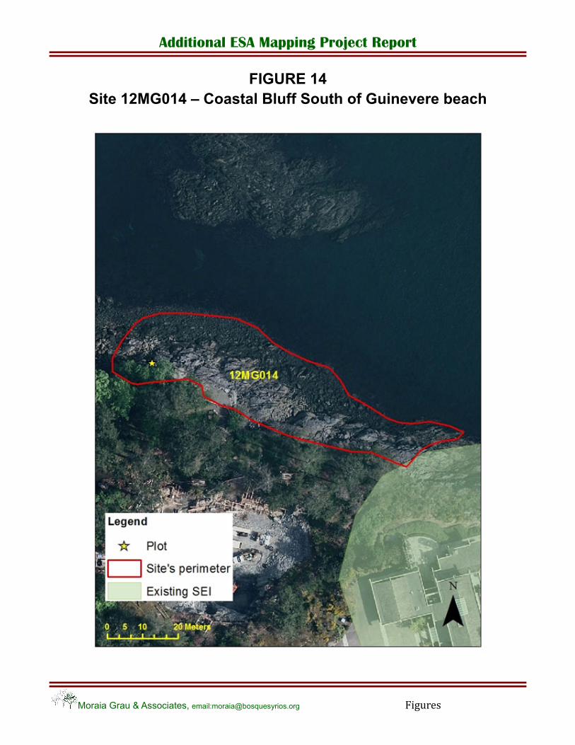
Site 12MG004: Douglas fir ‐ Arbutus older second growth forest in Konukson Park, Site 12MG015: rock outcrop meadow in Konukson Park, Site 12MG016: woodland rocky outcrop in Cyril Owen Site 12MG014: coastal bluff south of Guinevere beach, and Site 12TM010: series of naturalized wetlands in Madrona farm.
Another twelve sites ranked higher than Fair (>2): five older second growth forests, two woodlands, one herbaceous terrestrial with woodland, two urban forest patches and two naturalized wetlands (Appendix I).
Two sites showed a borderline score: a section of Mystic Vale adjacent to University of Victoria student residences (12TM003), and a mature second growth Douglas fir/Arbutus/western Red cedar forest at Queen Alexandra Hospital´s grounds (12TM002). Both these sites had a dense cover of English ivy (Hedera helix) in the understory (>75%), as well as abundant English holly (Ilex aquifolium), and some spurge laurel (also known as Daphne‐laurel) (Daphne laureola). Although the restoration potential exists, it would require a large and persistent effort. In addition, both sites had storm water ditches dug through the site, and in Mystic Vale there was much trampling and disturbance (trails, garbage). At the Queen Alexandra Hospital site, a large area was denuded of vegetation except for a large old broadleaf maple (Acer macrophyllum). The reason for the disturbance is not known. A larger proportion of western Red Cedar (Thuja plicata) was noticed at this site compared to Haro Woods, across the road, but many cedars had dried tops. Deer trails were abundant.
3.4. Description of Environmentally Significant Areas
During this phase of the project we identified 19 sites belonging to SEI sensitive ecosystem types, 4 isolated wetlands and watercourses, one wildlife tree and a concentration of wildlife trees.
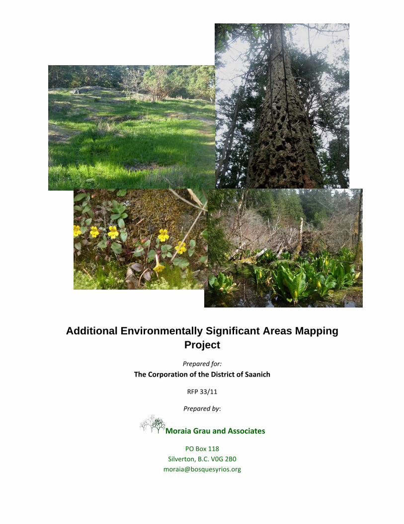
3. 4.1 Sites with SEI Sensitive Ecosystem types
Of the 19 SEI sensitive ecosystem sites identified, only fifteen achieved a viability score from fair to excellent condition (Table 5) (14 new and one existing SEI site).
The four sites with higher ecological viability scores are briefly described, followed by the four sites with the lowest scores:
Site 12MG012. The site at Observatory Hill is a small rocky outcrop opening surrounded by a Douglas fir (Pseudotsuga menziesii) / Arbutus (Arbutus menziesii) / Garry Oak (Quercus garryana) forest. The rocks were covered by a thick and diverse mantle of mosses: long rock‐moss (Racomitrium elongatum), roadside rock‐moss (Racomitrium canescens), Juniper moss (Polytrichum juniperinum), broom moss (Dicranium scoparium), Lanky moss (Rhytidiadelphus loreus) and apple moss (Bartramia pomiformis). Flowers such as
Additional ESA Mapping Project Report
Moraia Grau & Associates, email:[email protected] Page 14
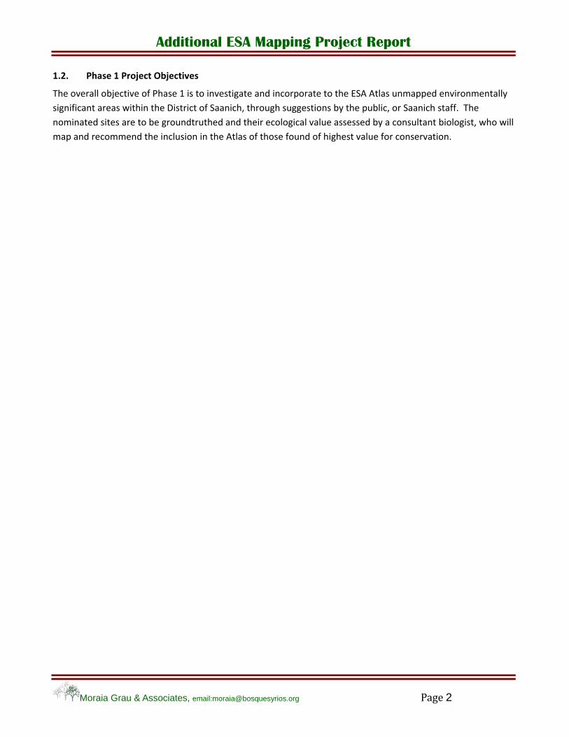
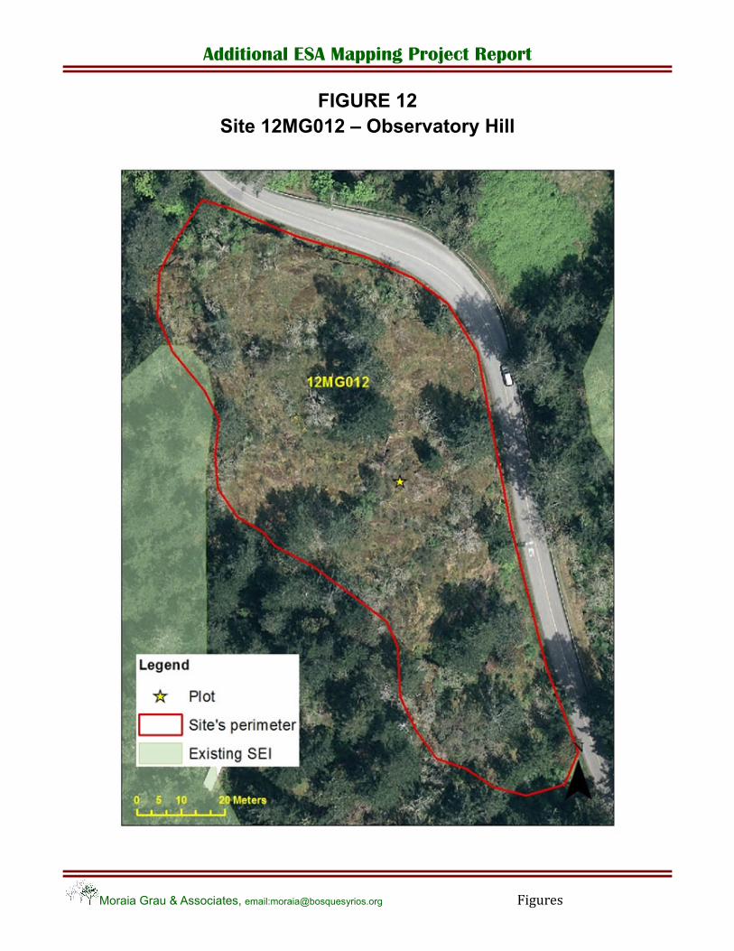
Monkey flower (Mimulus alsinoides) were found on the rock ledges; camas (Camasia spp.) and small‐flowered blue‐eyed Mary (Collinsia parviflora) were widespread in the meadow. Restoration and research projects are taking place at the site. Asphalt tiles were placed on the ground to monitor the presence of sharp‐tailed snake (Contia tenuis) (a red listed species), and Scotch broom (Cytisus scoparius) is removed every year. There was, however, abundant regeneration of Scotch broom around the site. A dark‐eyed junco (Junco hyemalis), a Wilson´s warbler (Wilsonia pusilla) and vultures (Cathartes aura) were observed during the survey.
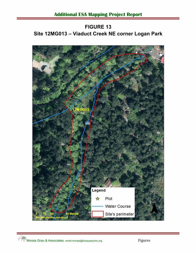
Site 12MG013. The riparian site in Logan Park includes the headwaters of Viaduct Creek. The canopy is largely mature broad‐leaf maples and red alders (Alnus rubra), and a few young western red cedars. The understory has a dense cover of sword fern (Polystichum munitum) and false lily‐of‐the‐valley (Maianthemum dilatatum). There is also red columbine (Aquilegia formosa), foamflower (Tiarella trifoliate), lady fern (Athyrium filix‐femina), common horsetail (Equisetum arvense) and sedges (Carex spp.). Only two exotic species were noted: dandelion (Taraxacum officinale) and catnip (Nepeta cataria); both had a sparse distribution. Near the site there is a high concentration of grand fir (Abies grandis) snags used by woodpeckers. A northern flicker (Colaptes auratus) was seen drilling a hole, and two mallards (Anas platyrhynchos) were secretively feeding in a small pond, and flew away with our presence. Road kill Rough‐skinned newts (Taricha granulosa) have been found immediately adjacent to this riparian site. Logan Park is also home to the blue grey tail‐dropper slug (Prophysaon coeruleum), a red listed species. Pileated woodpeckers (Dryocopus pileatus) and Great‐horned owls (Ardea herodias) inhabit the park (K. Ovaska pers. comm.). The larger forested ecosystem in Logan Park should likely be identified as a Sensitive Ecosystem in the next phase of the project.
Site 12MG017. The Maltby Lake property is a complex landscape with a rich variety of red listed and blue listed species and ecosystems. The forest surrounding the lake is an older coniferous forest dominated by Douglas fir, mixed with Arbutus on the north and west sides of the lake. There are many significant trees larger than 1.5 m diameter. The coordinates of six of these very large trees and clumps of trees were located with GPS and included in the GIS files. Parts of the property in the north side were logged in 1915 and again in 1972. The south side was logged in 1990. The last forest fire occurred in the early 1900´s (W. Thompson personal comm.). Woodlands seem to occur mostly on the south side.
The plot site was done at a floodplain, at the mouth of small creek flowing into the lake on the north side. At the time of the visit no flowing water reached the lake, and the only evidence of the creek was a wet channel that disappeared in the floodplain. western red cedar was the dominant species forming a closed canopy. The understory was dominated by sword fern, with some lady fern and red cedar seedlings. The shrub layer was sparse with English holly as the dominant species, a low cover of salal (Gaultheria shallon), traces of red huckleberry (Vaccinium parvifolium), dull Oregon grape (Mahonia nervosa), and trailing blackberry (Rubus ursinus). One sprout of spurge laurel was observed at the site.
Great blue heron, red‐tailed hawk (Buteo jamaicensis), a beaver house and beaver activity were observed during the survey. The endangered and red listed western Painted Turtle (Chrysemys picta bellii) has been documented from Maltby Lake. Also, according to the report by ENKON Environmental Ltd. (2002), there is a red‐tailed hawk nest, a great‐horned owl active nest, and presence of purple martin (Progne subis) (blue listed), barred owl (Strix varia), red‐legged frog (Rana draytonii) (blue listed), black‐tailed deer (Cervus canadensis), river otter (Lutra canadensis), American mink (Mustela vison), and resident coastal cutthroat trout (Oncorhynchus clarki) (blue listed).
In the Maltby Lake property, several red and blue listed plant species and communities have been identified: two blue listed plants ‐ California willow herb (Epilobium foliosum) and Humped bladderwort (Utricularia gibba); four red listed communities – Douglas fir/salal, Garry oak/Arbutus, Garry oak/California brome, Garry oak/ocean spray; and a rare fungi: Amanita aprica. Also three SEI wetlands (WN) and eight

Additional ESA Mapping Project Report
Moraia Grau & Associates, email:[email protected] Page 15
woodland areas (WD) exist in the property (ENKON Environmental Report, 2002, for Mr. Holmes). These at risk EO have not been documented yet by the CDC.
Site 12TM013. The private property examined on Viaduct Avenue, adjacent to Saanich’s Logan Park, was one of the most intact ecological community visited. A series of rock outcrops rise behind the owner’s home toward the southwest, and the outcrops are lightly forested with maturing Douglas fir and Arbutus, with a scattering of small Garry oaks. A dense layer of mosses cover the rocks, including Oregon beaked moss (Kindbergia oregana), electrified cat’s tail moss (Rhytidiadelphus triquetus), and haircap moss (Polytrichum commune), with smaller coverage of golden short‐capsuled moss (Brachythecium frigidum), broom moss, and step moss (Hylocomium splendens). Spring wildflowers were in abundance, including common camas, broad‐leaved shooting star (Dodecatheon hendersonii), fawn lily (Erythronium oregonum), miner’s lettuce (Claytonia perfoliata), and samples of seablush (Plectritis congesta), and large‐leaved avens. There is a good cover of stonecrop on much of the rock ledges, mainly broad‐leaved stonecrop (Sedum spathulifolium). Down slope of the rocky outcrops, in ravines closer to the house, were found dull Oregon grape, sword fern, and salal.
The only disturbance on site was in the form of scattered patches of Scotch broom. The owner indicated that he clears broom annually from the area, hence the sparse cover. Deer trails criss‐crossed the grassy and mossy rock outcrops, but there was little other evidence of visitors to the hill side.
Four potential sensitive ecosystems were in poor condition:
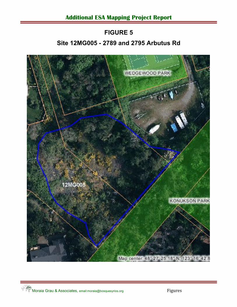
12MG005. A potential woodland ‐ rock outcrop next to Konukson Park turned to be severely altered by rock fill for a construction site. The rock was laid over few years ago since it looked weathered. Some native species characteristic of rocky outcrops surface in a few patches among the rock fill such as licorice fern (Polypodium glycyrrhiza). Garry oaks border the rock fill covered area. Himalayan blackberry (Rubus discolor) and other invasive species dominate the site (Photo 13).
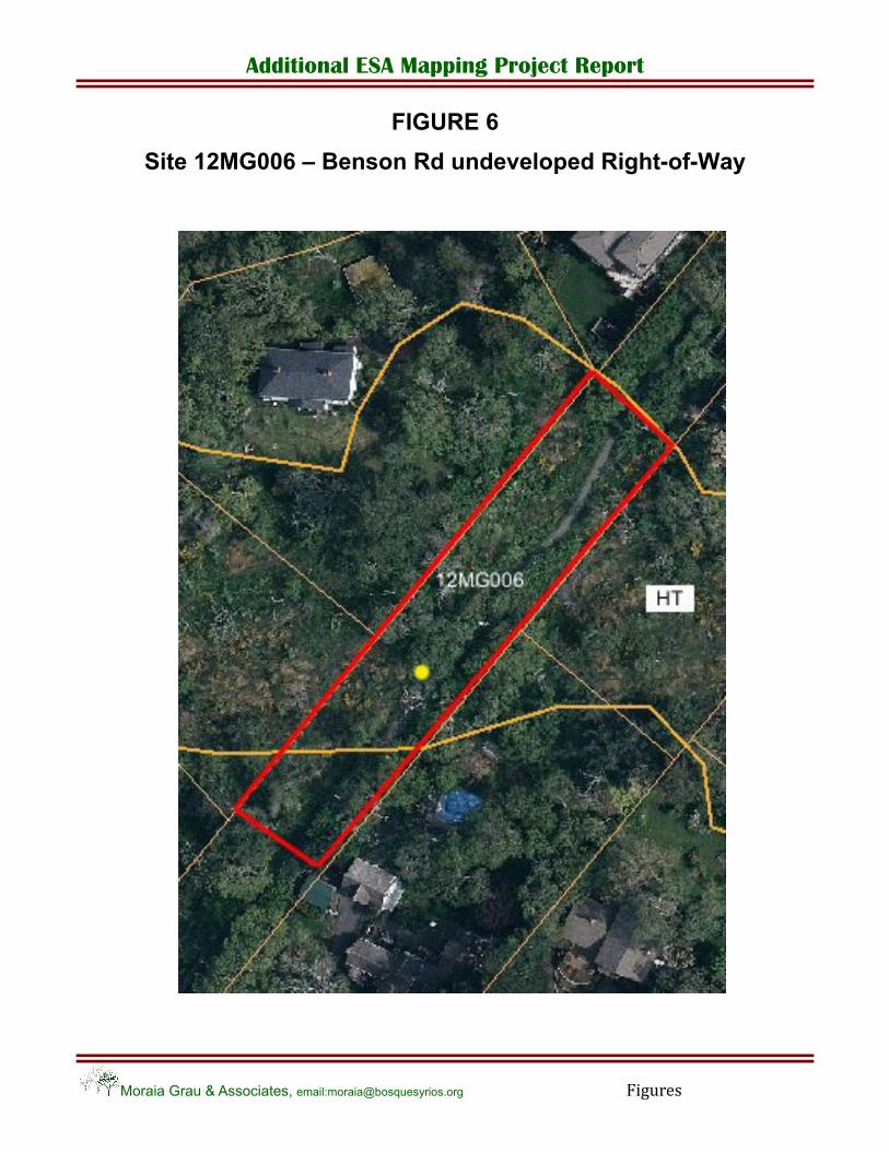
12MG006. The undeveloped Right‐of‐Ways in Benson Rd crosses an SEI identified herbaceous terrestrial ecosystem in relatively good to fair condition, even though there is abundant presence of Scotch broom. However, the area adjacent to the walking path, approximately 4 m on either side, is covered with periwinkle (Vinca major), Himalayan blackberry, English bluebells (Hyacinthoides hispanica) and other exotic species. Garry oaks, both in the Right‐of‐Ways and in the adjacent private properties, show signs of drying out. A drain ditch along the path collects and delivers storm water down the hill, towards Cadboro Bay. The site is correctly classified as Herbaceous Terrestrial (HT), yet the Right‐of‐Way is contributing to altering this sensitive ecosystem by being a source of invasive exotic species and by altering the hydrology pattern.
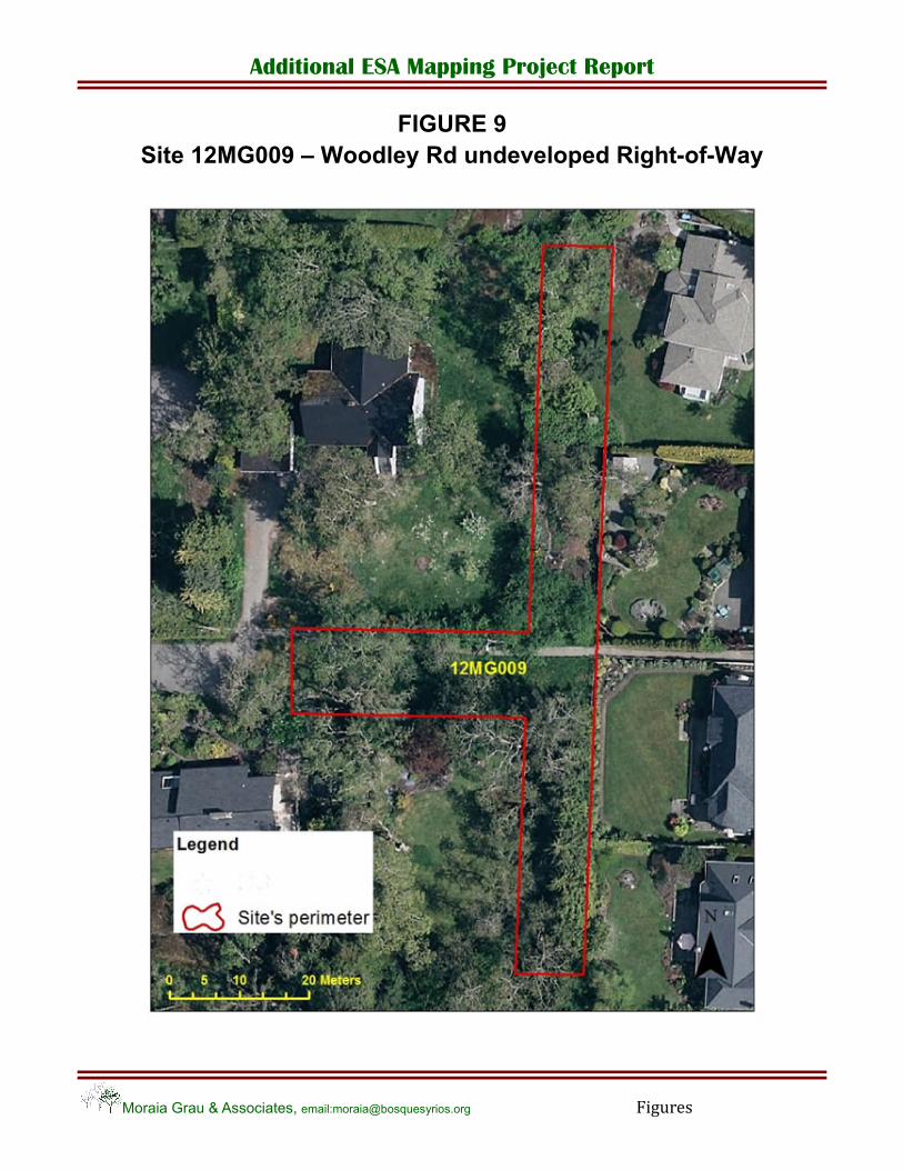
12MG009. The undeveloped Right‐of‐Ways at the end of Woodley Rd turned out to be a Garry oak woodland being used de facto as part of the adjacent properties. In the south end it has been landscaped, and in the north end has been turned into a vegetable garden. The only components of the ecosystem remaining are four large Garry oaks, six younger ones, some camas and a small mossy rock outcrop. At this point, it is not recommended to include it as a sensitive ecosystem. If the District of Saanich were to exert its ownership over the Right‐of‐Ways area and restore it to a natural woodland site, that alone would be a very small site. A better solution would be to make an agreement with the property owners to restore the Right‐of‐Ways and part of their properties to a natural state, perhaps placing of a covenant, in exchange for some lease or use of the Right‐of‐Ways.
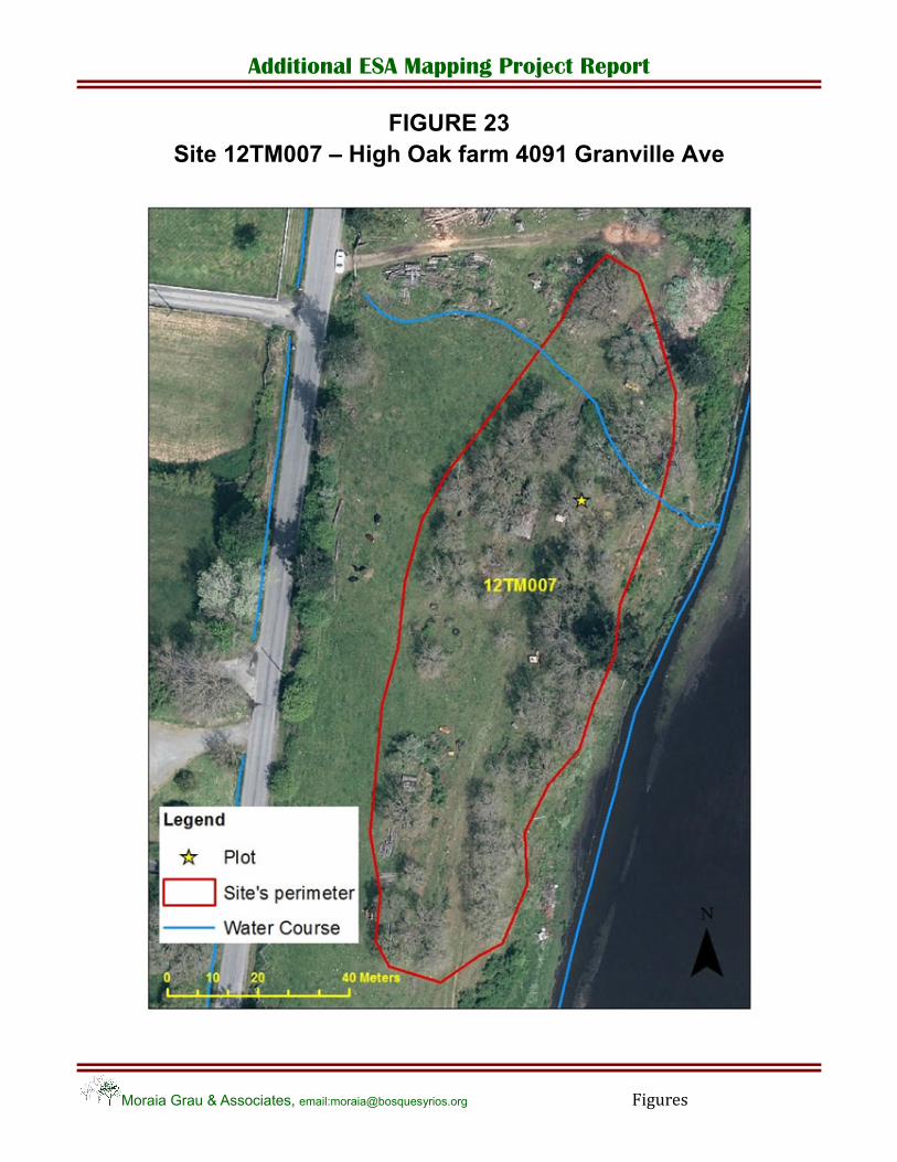
12TM007. A remnant Garry oak woodland in Hastings and Granville flats was examined. It is located on a property which has been actively farmed since 1893 (High Oak Farm). A plot was established in an agricultural field which has a sparse cover of old Garry oaks, some likely exceeding 100 years of age, on an easterly slope overlooking a seasonally flooded field which has designation by Saanich as an SE. Despite over 100 years of agricultural impacts, there still exists some remnant Garry oak understory shrub species interspersed among
Additional ESA Mapping Project Report
Moraia Grau & Associates, email:[email protected] Page 16
rocky outcrops overlooking the wet field below: tall Oregon grape (Mahonia aquifolium), Indian plum (Oemlaria cerasiformis), snowberry (Symphoricarpos albus) and Nootka rose (Rosa nutkana). On the rocky outcrops were found Siberian miner’s lettuce (Claytonia sibirica) and several mosses – red‐roof moss (Ceratodon purpureus) and red bryum (Bryum miniatum). Fawn lilies still bloom below the shrub layer among the rocks as well.
Due to the lengthy agricultural history, most of the meadow below the Garry oaks and away from the rocky outcrops is dominated by invasive agronomic grasses: orchard grass (Dactylis glomerata) and Kentucky bluegrass (Poa pratensis). Other invasive plants too numerous to mention are found on the disturbed ground along the meadow.
3. 4.2 Isolated wetlands and watercourses
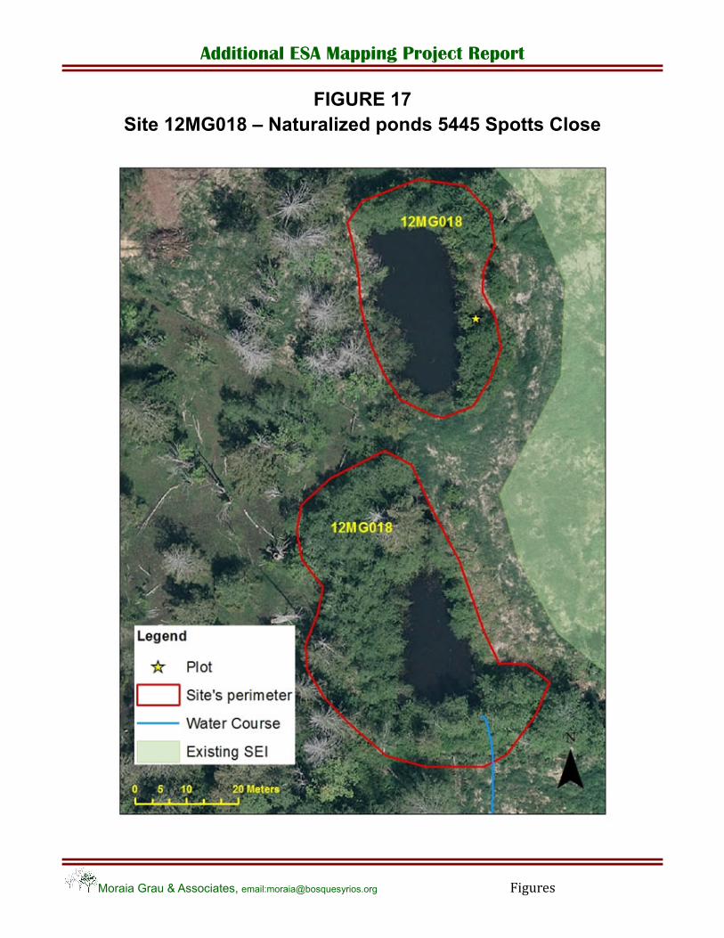
Three isolated wetlands (WN: sw following the SEI classification) and one isolated water course were identified:
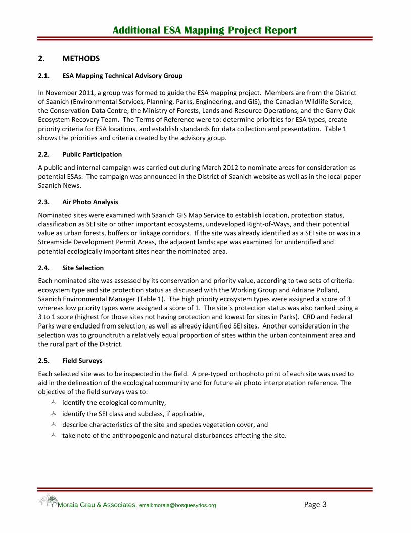
12TM010. A series of four naturalized wetlands was examined at Madrona Farm on Blenkinsop Road, adjacent to the border with Mount Douglas Park. The four wetlands were constructed on the farm by the grandfather of the present owner, in the early 1950’s. The four ponds are connected hydrologically, i.e., water flows down slope from the topmost pond to the next pond, and in series via tile drainage and seepage, to the lower pond. Vegetation varies between ponds, ranging from only agricultural grasses and cattails at the upper pond, to red alder stands around the middle two ponds, and mature Douglas‐fir and western red cedar adjacent to the lower ponds. Invasive species such as Reed canary grass (Phalaris arundinacea), cattail (Typha latifolia), Himalayan blackberry, and agronomic grasses have also populated the sides of the ponds. However, native shrub species are present in abundance, such as snowberry, Indian plum, and various willows.
The owners of Madrona Farm are actively practicing agriculture and managing the farm under restrictions imposed through a land covenant with The Land Conservancy (TLC). All farm practices are carried out with the intention of protecting the habitat values found on the property, including the shallow water ponds.
12MG002. Kingsberry Crescent´s pond is a natural wetland occurring at the foot of Mount Tolmie, and within the Bowker Creek watershed. The wetland has been altered mostly on the west side because of the construction of an apartment building next to the pond. The riparian zone in the apartment grounds is formed by a birch tree (Betula papyrifera), a rock berm and adjacent lawn. However the shoreline around the rest of the wetland has several large native willows, black hawthorn (Crataegus douglasii) and Indian plum. Red alder and mature broadleaf maples form the tree canopy. The south portion of the pond belongs to Saanich Parks (Mount Tolmie Park), the northwest portion to the strata building and the northeast portion, where a large portion of the natural riparian zone lies, to the property at 3640 Iona Drive. This latter property is a large lot, approx. 4000 sq.m, and in the future it is likely that it may be subdivided. The pond is used by mallards, which are being fed by residents from the apartment building.
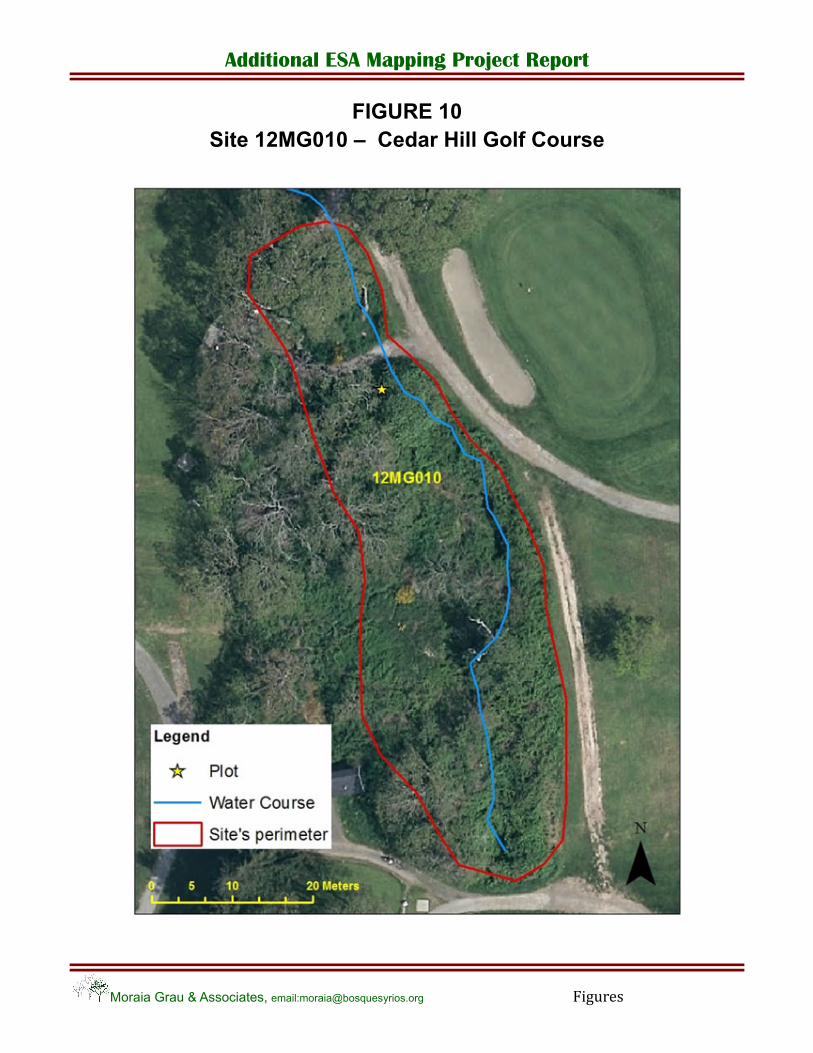
12MG010. A small creek flowing south through Cedar Hill Golf Course towards a wetland near the Recreation Centre. Sections of the creek are piped underground. It surfaces as open water by a small rock outcrop and a sedge clump (Photo 25). The channel runs through the greens, past a weeping willow, through a blackberry thicket, and into a pipe. The total length of the creek channel as surface water is less than 200 m. Downstream it surfaces again, and is identified as a water course with a 10 m set back protection.
The condition of the creek has little resemblance to what would be its natural riparian vegetation, therefore it cannot be classified as a sensitive ecosystem, but it should be included in the Atlas of isolated watercourses and wetlands.
Additional ESA Mapping Project Report
Moraia Grau & Associates, email:[email protected] Page 17
12MG018. Two naturalized wetlands, no longer in use, on the west slope of Todd Creek flats. In one of the wetlands, a clump of Red cedars and a dense shrub cover (Indian plum and H. blackberry) shade the water, while the other is more open and dominated by reed canary grass, under a canopy of young red alders, some of them cut down by beavers (Photo 37). Other species include common hawthorn (Crataegus monogyna), ocean spray (Holodicus discolor), hardhack (Spiraea douglasii), Indian plum, Himalayan blackberry, spurge laurel and cattails.
3.4.3. SEI Older Second Growth Forest
Eleven forested ecosystems were groundtruthed. Under SEI, Older Forests are the only forested ecosystem recognized as sensitive. Second Growth Older Forests, less than 100 yrs old, are considered "Important ecosystems" but not sensitive ecosystems. Table 6 identifies significant specific values of the forested sites that were groundtruthed: two undeveloped Right‐of‐Ways and nine older second growth forest patches. The two older second growth sites with higher viability score were: Konukson Park coniferous forest (12MG004) and a remnant forest in Glendale lands (12TM005):
Site 12MG004. Konukson Park has a variety of ecosystems: herbaceous terrestrial, wetland, and coniferous forest. The forest is dominated by Douglas fir with a component of Arbutus and Grand fir. The age of the stand is about 80 yrs, but there are veteran trees disseminated throughout 150 yrs and older. Some should be catalogued as "significant trees" because of their outstanding size. The understory is well developed with ocean spray, snowberry, dull Oregon grape, salal and two species of honeysuckle (Lonicera ciliosa and L. hispidula) as major species. The Park has a community volunteer group that among other functions is looking after the removal of invasive species. English ivy and spurge laurel have been removed from large areas of the Park, which is an outstanding accomplishment, especially when compared with other forested sites in the vicinity with an understory dominated by English ivy. A large veteran tree had until four years ago an active Bald eagle nest. The site is home to barred owl, Great‐horned owl, Pileated woodpecker, and brown creeper (Certhia Americana). The forested area of approximately 2.5 ha is the largest continuous forest in the Ten Mile Point peninsula. The closest large forest patches are Haro Woods at 2 km and Mystic Vale at 1.7 km. Connectivity between these areas is limited except for smaller pockets of forested areas around private residences.
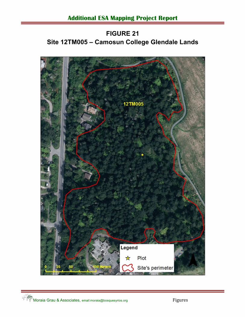
Site 12TM005. At Camosun College Glendale Lands, a large second‐growth coniferous woodland was examined adjacent to Interurban Road. The site is dominated by large Douglas‐fir, with a scattering of broadleaf maple and western red cedar. The understory contains a healthy cover of Dull Oregon grape, topped by snowberry, and ocean spray. Herbs encountered include abundant large‐leaved avens and cleavers (Galium aparine). Oregon beaked moss (Kindberghia oregana) and electrified cat’s tail moss (Rhytidiadelphus trequetrus) underlie the above layers.
Disturbance at the woodland is minimal, mainly in the form of several bisecting trails for dog walkers. Invasive species such as Scotch broom and Himalayan blackberry were only present along the edges of the woodland and had not invaded the interior. A minor amount of spurge laurel was found in the interior of the woodland.
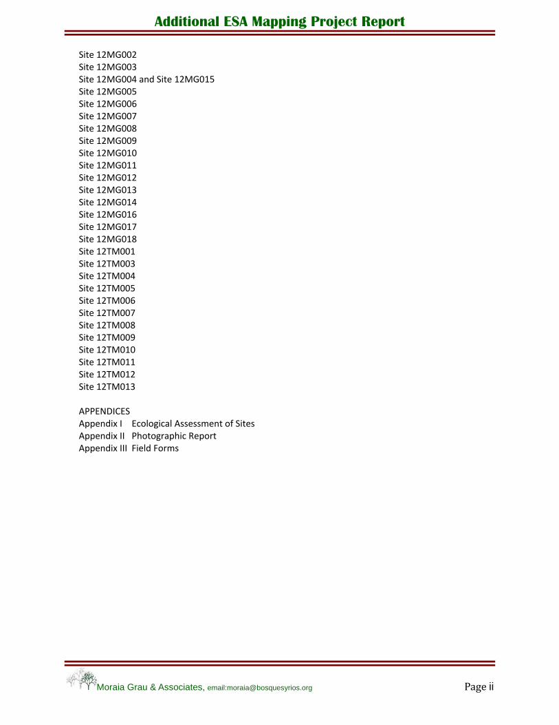
3.4.4 Wildlife trees
A large veteran Douglas fir (1.3 m diameter) in Konukson Park is being used to study spiders, because of the high number of spider species that inhabit the holes in its bark (Photo 12).
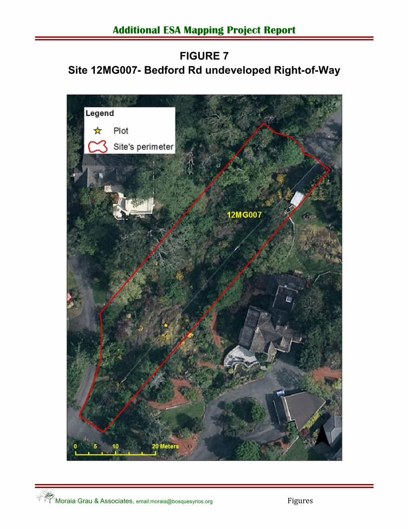
An active bald eagle nest was located near the undeveloped Right‐of‐Way site at Bedford Rd (site 12MG007), in a large Douglas fir tree on the yard of 2861 Tudor Ave (Photo 19).
A concentration of wildlife Grand firs (Abies grandis) was observed at the SE corner of Logan Park.
Additional ESA Mapping Project Report
Moraia Grau & Associates, email:[email protected] Page 18
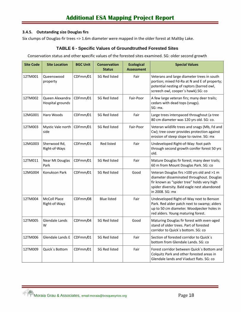
3.4.5. Outstanding size Douglas firs
Six clumps of Douglas‐fir trees => 1.6m diameter were mapped in the older forest at Maltby Lake.
TABLE 6 - Specific Values of Groundtruthed Forested Sites
Conservation status and other specific values of the forested sites examined. SG: older second growth
Site Code Site Location BGC Unit Conservation Status
Ecological Assessment
Special Values
12TM001 Queenswood property
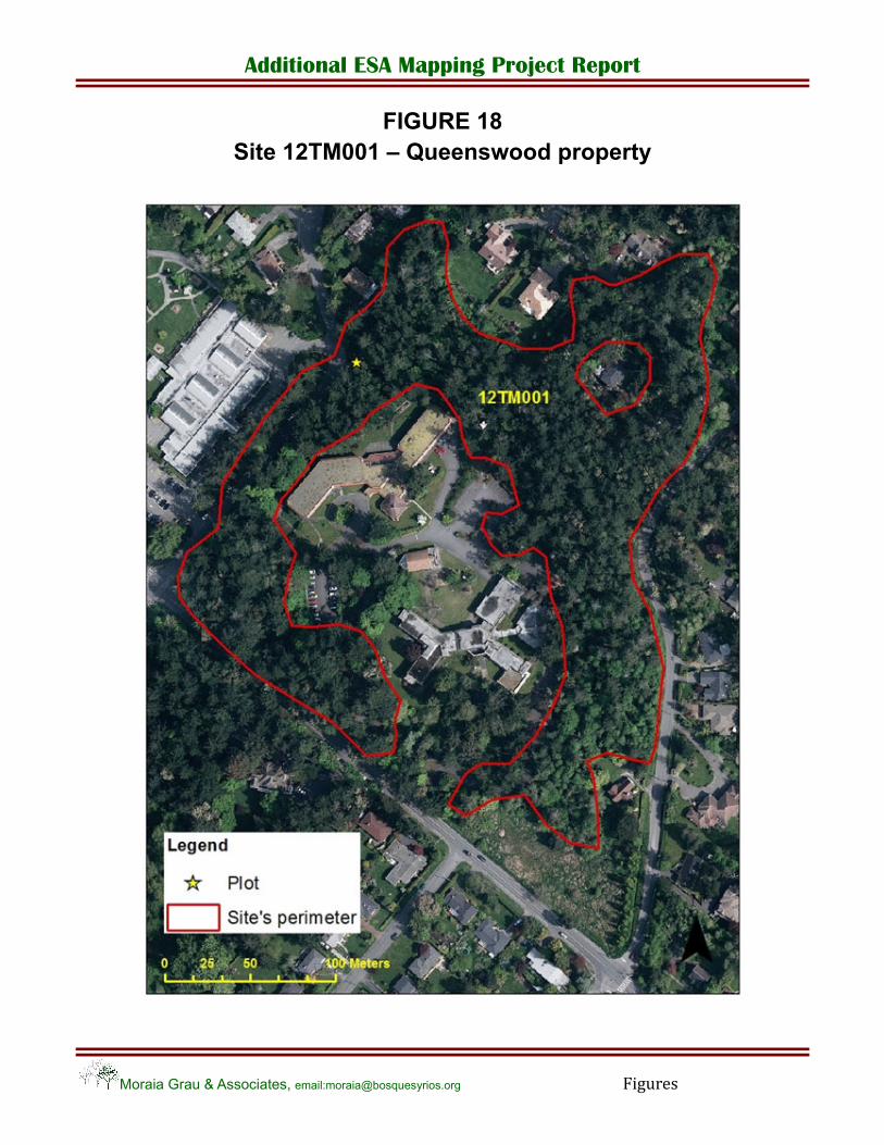
CDFmm/01 SG Red listed Fair Veterans and large diameter trees in south portion; mixed Fd‐Ra at N and E of property; potential nesting of raptors (barred owl, screech owl, cooper´s hawk).SG: co
12TM002 Queen Alexandra Hospital grounds
CDFmm/01 SG Red listed Fair‐Poor A few large veteran firs; many deer trails; cedars with dead tops (snags). SG: mx.
12MG001 Haro Woods CDFmm/01 SG Red listed Fair Large trees interspaced throughout (a tree 80 cm diameter was 120 yrs old. SG: co.
12TM003 Mystic Vale north side
CDFmm/01 SG Red listed Fair‐Poor Veteran wildlife trees and snags (Mb, Fd and Cw); tree cover provides protection against erosion of steep slope to ravine. SG: mx
12MG003 Sherwood Rd, Right‐of‐Ways
CDFmm/01 Red listed Fair Undeveloped Right‐of‐Way: foot path through second growth conifer forest 50 yrs old.
12TM011 Near Mt Douglas Park
CDFmm/01 SG Red listed Fair Mature Douglas fir forest; many deer trails; 60 m from Mount Douglas Park. SG: co
12MG004 Konukson Park CDFmm/01 SG Red listed Good Veteran Douglas firs >100 yrs old and >1 m diameter disseminated throughout. Douglas fir known as “spider tree” holds very high spider diversity. Bald eagle nest abandoned in 2008. SG: mx
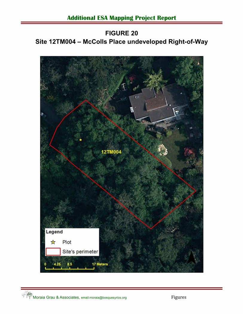
12TM004 McColl Place Right‐of‐Ways
CDFmm/08 Blue listed Fair Undeveloped Right‐of‐Way next to Benson Park. Red alder patch next to swamp; alders up to 50 cm diameter. Woodpecker holes in red alders. Young maturing forest.
12TM005 Glendale Lands W
CDFmm/04 SG Red listed Good Maturing Douglas fir forest with even‐aged stand of older trees. Part of forested corridor to Quick´s bottom. SG: co
12TM006 Glendale Lands E CDFmm/01 SG Red listed Fair Section of forested corridor to Quick´s bottom from Glendale Lands. SG: co
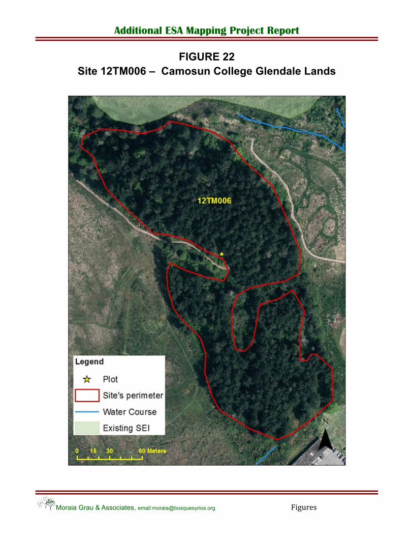
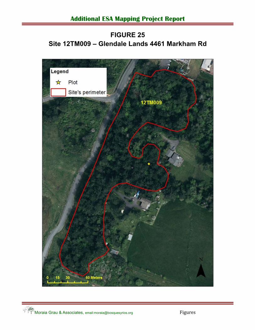
12TM009 Quick´s Bottom CDFmm/01 SG Red listed Fair Forest corridor between Quick´s Bottom and Colquitz Park and other forested areas in Glendale lands and Viaduct flats. SG: co

Additional ESA Mapping Project Report
Moraia Grau & Associates, email:[email protected] Page 19
3.5. Municipal Lands
A total of six undeveloped Right‐of‐Ways were investigated. One had recently been bulldozed and converted into an unpaved road (Guinevere Street) with a small creek culverted along the side. Five Right‐of‐Ways and one community green‐space were investigated and mapped. Of the five undeveloped Right‐of‐Ways that were visited, two were forested: McColl Place (12TM004) and Sherwood Drive (12MG003); two had a mix of shrub and herbaceous cover (HT) with a few isolated trees: Benson Rd (12MG006) and Bedford Rd (12MG007); and Woodley Rd undeveloped Right‐of‐Ways (12MG009) was a landscaped and altered Garry oak woodland (Photo 20). All sites had an abundant to moderate presence of exotic invasive species.
12MG003. The undeveloped Right‐of‐Way along Sherwood Road is a maturing coniferous stand well used by residents for walks. English ivy, English holly and periwinkle are abundant and extend into neighbouring properties. The nearest SEI site is a woodland 200 m to the east. This is one of two municipal properties (outside of a park) that is recommended as a new ESA.
12MG006. Benson Rd undeveloped Right‐of‐Way. The trail through this herbaceous terrestrial ecosystem site fills a social need for residents, who likely enjoy the flowers and the view while walking through the area. However, the sides of the path are covered with exotic species (English blue bells, periwinkle, grape hyacinth, daffodils) which may extend into the adjacent SEI terrestrial herbaceous (HT) meadows.
12MG007. The undeveloped Right‐of‐Way along Bedford Rd composed by a rocky meadow with a few Garry oaks has been identified as a new SEI site (HT). This undeveloped Right‐of‐Way is recommended as a new ESA.
12MG008. The site is a community green‐space located along the Portage Inlet northern shoreline, and adjacent to the TransCanada Hwy. A paved path runs along the length of the site, and there are mowed and landscaped areas. A few Douglas fir, one Arbutus, and a grove of stunted Garry oaks form the tree cover. There is a patch of young Douglas fir (3 m ht) with a good growth, but invasive exotic species dominate the site (H. blackberries, Scotch broom, spurge laurel, and agronomic grasses).
12TM004. Undeveloped portion of Right‐of‐Way at end of McColl Place next to Benson Park. It is an interesting site with a healthy red alder grove next to a wet swamp with high bird use and a blue listed community. This site is a natural extension to Benson Park. It is recommended to extend the area of Benson Park to include this site.
3.6. GIS Coverage and Associated Data
A polygon feature class was created with ArcGIS v.10 containing information on altitude, slope, aspect, area and perimeter for each site. In addition a point feature class was created with information collected in the plots, including location, succession status, site series, other descriptive characteristics of the site, and tables containing species percent vegetation cover. These features were all included in a personal Geodatabase. Metadata was edited for each of the features following District of Saanich standards. Maps were created for each site included in the report.

Additional ESA Mapping Project Report
Moraia Grau & Associates, email:[email protected] Page 20
4. RECOMMENDATIONS
The final objective of this project is to increase the available information regarding the environmentally significant areas that remain in the District of Saanich, thereby allowing the staff at the municipality to be able to make better informed decisions in dealing with potential development and conservation of endangered species and ecosystems within the District.
In general, environmentally significant areas are associated with SEI sensitive ecosystem types, water bodies, and their shorelines and riparian zones. However, other ecosystem types such as Older Second Growth forests may also be crucial in conservation efforts, particularly in an urban environment where the size of sensitive sites tends to be small. Smaller sites are more exposed to alteration from the adjacent landscape and border effects, which are greater than in larger areas (i.e. increased exposure to exotic invasive species, changes in micro‐climatic conditions: isolation, temperature, etc.). In this situation, having buffer zones around sensitive sites may be of significant importance. Also ecosystems that once covered most of the landscape now survive in a maze of fragmented patches that need interconnection, such as Douglas fir forests.
For Saanich, to maintain connectivity and prevent isolation of ecosystem habitats requires conscious effort and planning. Urban forests and undeveloped areas (i.e. undeveloped Right‐of‐Ways), can serve as buffers to protected areas, contributing to maintain their ecological integrity, as well as maintaining connectivity between patches. In addition, non‐sensitive ecosystems such as young and maturing urban forests will eventually become older second growth forests. The ecological value of urban forests and undeveloped sites therefore need to be considered individually, each site for their own merits, within a larger conservation plan. It should be noted, however, that these sites will play a positive contribution as long as they do not promote the spread of exotic invasive species. An overall exotic invasive control plan should be developed at different levels and in coordination between the various Saanich Departments, and with other municipalities, Provincial Government and agencies. Some of the municipal lands described in section 3.6 would benefit from invasive species control and/or a restoration plan, such as: 12MG006—the undeveloped Right‐of‐Way in Benson Rd; 12MG003 — the undeveloped Right‐of‐Way in Sherwood Drive, and 12MG008 — a community green‐space located along the Portage Inlet northern shoreline.
It should also be noted that most site series in the Coastal Douglas fir moist maritime biogeoclimatic subzone (CDFmm) are classified as red and blue listed ecosystems in BC. Also many of the forested sites visited had large veteran trees scattered throughout, providing a structural complexity that second growth forests of more uniform age and with an even canopy do not have. In the urban and rural environment, they provide crucial habitat for many species of wildlife, such as raptors, woodpeckers and other forest nesting species (Great Blue Heron). Phase 2 should increase our knowledge of Coastal Douglas‐fir sites in Saanich.
The sites at Queenwood property, Haro Woods, Queen Alexandra Hospital, Mystic Vale, and Konukson Park all have large veteran trees and snags, which make these forested areas of special value for biodiversity and wildlife within the urban landscape, although these sites are somewhat degraded by invasive plants. A special subclass of Older Second Growth forests with structural diversity may need to be considered as a sensitive ecosystem in the urban context.
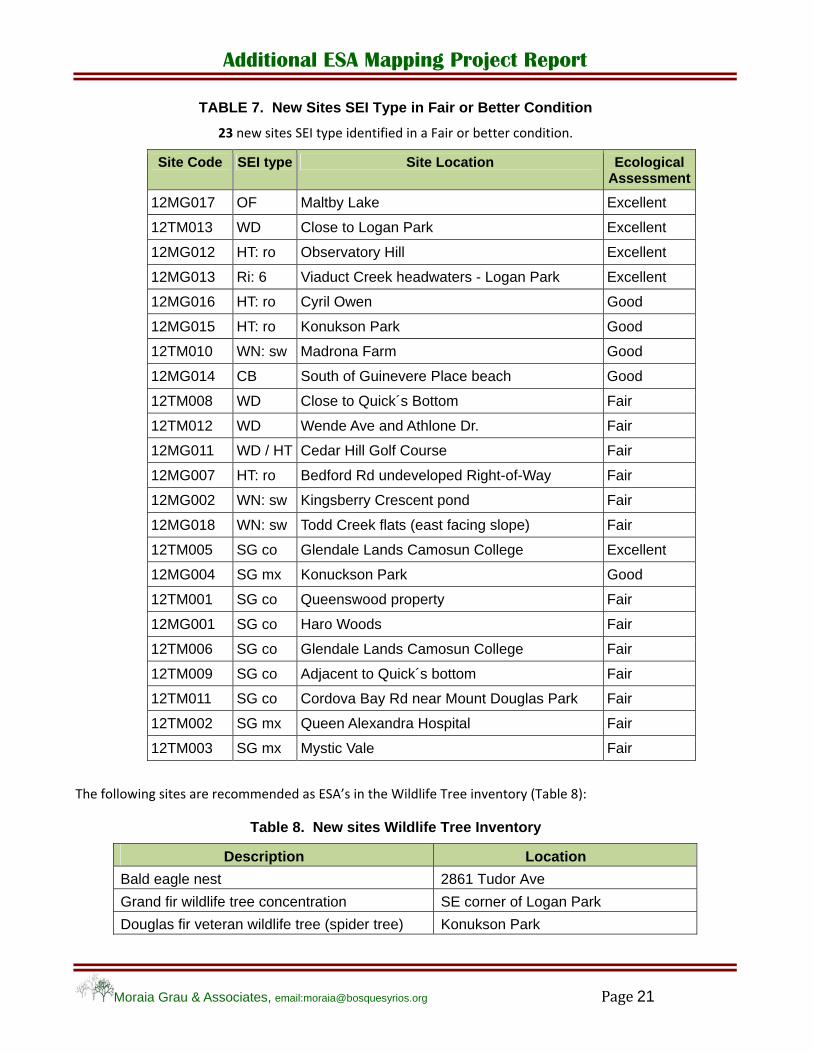
In view of the values that Older Second Growth forests provide, particularly, in an urban and rural context, we recommend the inclusion of the nine sites identified as Older Second Growth SEI type with a viability score >2.
Table 7 shows the sites recommended as ESAs as part of the SEI inventory:
Additional ESA Mapping Project Report
Moraia Grau & Associates, email:[email protected] Page 21
TABLE 7. New Sites SEI Type in Fair or Better Condition
23 new sites SEI type identified in a Fair or better condition.
Site Code SEI type Site Location Ecological Assessment
12MG017 OF Maltby Lake Excellent
12TM013 WD Close to Logan Park Excellent
12MG012 HT: ro Observatory Hill Excellent
12MG013 Ri: 6 Viaduct Creek headwaters - Logan Park Excellent
12MG016 HT: ro Cyril Owen Good
12MG015 HT: ro Konukson Park Good
12TM010 WN: sw Madrona Farm Good
12MG014 CB South of Guinevere Place beach Good
12TM008 WD Close to Quick´s Bottom Fair
12TM012 WD Wende Ave and Athlone Dr. Fair
12MG011 WD / HT Cedar Hill Golf Course Fair
12MG007 HT: ro Bedford Rd undeveloped Right-of-Way Fair
12MG002 WN: sw Kingsberry Crescent pond Fair
12MG018 WN: sw Todd Creek flats (east facing slope) Fair
12TM005 SG co Glendale Lands Camosun College Excellent
12MG004 SG mx Konuckson Park Good
12TM001 SG co Queenswood property Fair
12MG001 SG co Haro Woods Fair
12TM006 SG co Glendale Lands Camosun College Fair
12TM009 SG co Adjacent to Quick´s bottom Fair
12TM011 SG co Cordova Bay Rd near Mount Douglas Park Fair
12TM002 SG mx Queen Alexandra Hospital Fair
12TM003 SG mx Mystic Vale Fair
The following sites are recommended as ESA’s in the Wildlife Tree inventory (Table 8):
Table 8. New sites Wildlife Tree Inventory
Description Location
Bald eagle nest 2861 Tudor Ave
Grand fir wildlife tree concentration SE corner of Logan Park
Douglas fir veteran wildlife tree (spider tree) Konukson Park

Additional ESA Mapping Project Report
Moraia Grau & Associates, email:[email protected] Page 22
The following site is recommended as an ESA in the Isolated Watercourses and Wetlands inventory:
Table 9. New Sites Isolated Watercourses and Wetlands Inventory
Code Description
12MG010 Isolated watercourse Cedar Hill Golf Course
Maturing forest on Sherwood Road undeveloped Right‐od‐Way is also recommended as an ESA in account of its Red listed status and connectivity corridor values (Table 10).
Table 10. Undeveloped Municipal lands of ecological value
Code Description
12MG003 Undeveloped Right‐of‐Way Sherwood Road
It is recommended that Phase 2 of the project proceed in order to identify new ESAs that are as yet unmapped but have been identified in other inventories or can be located by aerial photo interpretation.

Additional ESA Mapping Project Report
Moraia Grau & Associates, email:[email protected] Page 23
5. REFERENCES
B.C. Ministry of Environment. 2010. Field Manual for Describing Terrestrial Ecosystems. 2nd Ed. Land Management Handbook 25.
B.C. Ministry of Environment. 2006. Standard for Mapping Ecosystems at Risk in British Columbia. Available at: http://www.env.gov.bc.ca/fia/documents/standards_for_mapping_ear_version1.pdf
Canadian Wildlife Service. 2000. Sensitive Ecosystems Inventory: East Vancouver Island and Gulf Islands 1993 ‐ 1997. Volume 2: Conservation Manual. Pacific and Yukon Region. Technical Report Series No. 345. Available at:
http://a100.gov.bc.ca/appsdata/acat/documents/r2124/SEI_4206_rpt2_1111099716576_7025110f245d45caa101abdef711671d.pdf

Additional ESA Mapping Project Report
Moraia Grau & Associates, email:[email protected] Figures
FIGURES
Additional ESA Mapping Project Report
Moraia Grau & Associates, email:[email protected] Figures
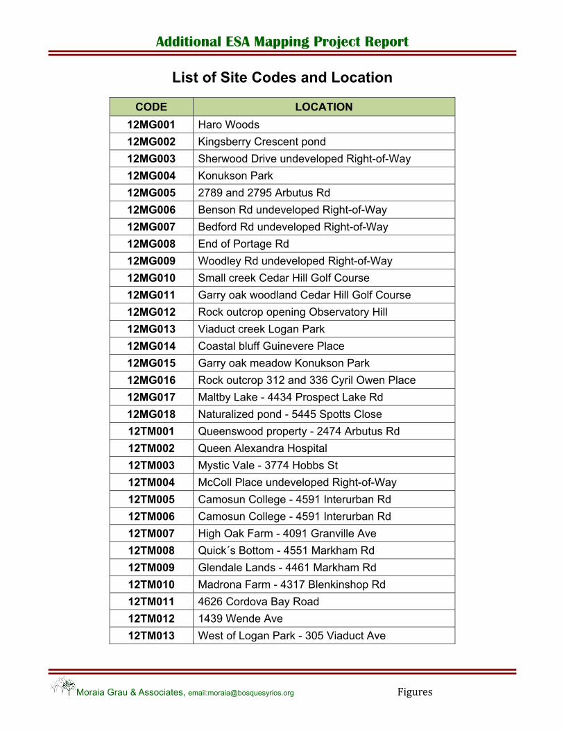
List of Site Codes and Location
CODE LOCATION
12MG001 Haro Woods
12MG002 Kingsberry Crescent pond
12MG003 Sherwood Drive undeveloped Right-of-Way
12MG004 Konukson Park
12MG005 2789 and 2795 Arbutus Rd
12MG006 Benson Rd undeveloped Right-of-Way
12MG007 Bedford Rd undeveloped Right-of-Way
12MG008 End of Portage Rd
12MG009 Woodley Rd undeveloped Right-of-Way
12MG010 Small creek Cedar Hill Golf Course
12MG011 Garry oak woodland Cedar Hill Golf Course
12MG012 Rock outcrop opening Observatory Hill
12MG013 Viaduct creek Logan Park
12MG014 Coastal bluff Guinevere Place
12MG015 Garry oak meadow Konukson Park
12MG016 Rock outcrop 312 and 336 Cyril Owen Place
12MG017 Maltby Lake - 4434 Prospect Lake Rd
12MG018 Naturalized pond - 5445 Spotts Close
12TM001 Queenswood property - 2474 Arbutus Rd
12TM002 Queen Alexandra Hospital
12TM003 Mystic Vale - 3774 Hobbs St
12TM004 McColl Place undeveloped Right-of-Way
12TM005 Camosun College - 4591 Interurban Rd
12TM006 Camosun College - 4591 Interurban Rd
12TM007 High Oak Farm - 4091 Granville Ave
12TM008 Quick´s Bottom - 4551 Markham Rd
12TM009 Glendale Lands - 4461 Markham Rd
12TM010 Madrona Farm - 4317 Blenkinshop Rd
12TM011 4626 Cordova Bay Road
12TM012 1439 Wende Ave
12TM013 West of Logan Park - 305 Viaduct Ave

Additional ESA Mapping Project Report
Moraia Grau & Associates, email:[email protected] Figures
FIGURE 1 Site 12MG001 – Haro Woods
Site 12TM002 – Queen Alexandra Hospital

Additional ESA Mapping Project Report
Moraia Grau & Associates, email:[email protected] Figures
FIGURE 2 Site 12MG002 – Kingsberry Crescent Pond

Additional ESA Mapping Project Report
Moraia Grau & Associates, email:[email protected] Figures
FIGURE 3 Site 12MG003 – Undeveloped Right-of-Way Sherwood Dr.

Additional ESA Mapping Project Report
Moraia Grau & Associates, email:[email protected] Figures
FIGURE 4 Sites 12MG004 and 12MG015 - Konukson Park
Additional ESA Mapping Project Report
Moraia Grau & Associates, email:[email protected] Figures
FIGURE 5
Site 12MG005 - 2789 and 2795 Arbutus Rd
Additional ESA Mapping Project Report
Moraia Grau & Associates, email:[email protected] Figures
FIGURE 6
Site 12MG006 – Benson Rd undeveloped Right-of-Way
Additional ESA Mapping Project Report
Moraia Grau & Associates, email:[email protected] Figures
FIGURE 7 Site 12MG007- Bedford Rd undeveloped Right-of-Way

Additional ESA Mapping Project Report
Moraia Grau & Associates, email:[email protected] Figures
FIGURE 8 Site 12MG008 – End of Portage Rd
Additional ESA Mapping Project Report
Moraia Grau & Associates, email:[email protected] Figures
FIGURE 9 Site 12MG009 – Woodley Rd undeveloped Right-of-Way
Additional ESA Mapping Project Report
Moraia Grau & Associates, email:[email protected] Figures
FIGURE 10 Site 12MG010 – Cedar Hill Golf Course

Additional ESA Mapping Project Report
Moraia Grau & Associates, email:[email protected] Figures
FIGURE 11 Site 12MG011 – Cedar Hill Golf Course
Additional ESA Mapping Project Report
Moraia Grau & Associates, email:[email protected] Figures
FIGURE 12 Site 12MG012 – Observatory Hill
Additional ESA Mapping Project Report
Moraia Grau & Associates, email:[email protected] Figures
FIGURE 13 Site 12MG013 – Viaduct Creek NE corner Logan Park
Additional ESA Mapping Project Report
Moraia Grau & Associates, email:[email protected] Figures
FIGURE 14 Site 12MG014 – Coastal Bluff South of Guinevere beach

Additional ESA Mapping Project Report
Moraia Grau & Associates, email:[email protected] Figures
FIGURE 15 Site 12MG016 – 312 and 336 Cyril Owen Place

Additional ESA Mapping Project Report
Moraia Grau & Associates, email:[email protected] Figures
FIGURE 16 Site 12MG017 – Maltby Lake
Additional ESA Mapping Project Report
Moraia Grau & Associates, email:[email protected] Figures
FIGURE 17 Site 12MG018 – Naturalized ponds 5445 Spotts Close
Additional ESA Mapping Project Report
Moraia Grau & Associates, email:[email protected] Figures
FIGURE 18 Site 12TM001 – Queenswood property

Additional ESA Mapping Project Report
Moraia Grau & Associates, email:[email protected] Figures
FIGURE 19 Site 12TM003 – Mystic Vale
Additional ESA Mapping Project Report
Moraia Grau & Associates, email:[email protected] Figures
FIGURE 20 Site 12TM004 – McColls Place undeveloped Right-of-Way
Additional ESA Mapping Project Report
Moraia Grau & Associates, email:[email protected] Figures
FIGURE 21 Site 12TM005 – Camosun College Glendale Lands
Additional ESA Mapping Project Report
Moraia Grau & Associates, email:[email protected] Figures
FIGURE 22 Site 12TM006 – Camosun College Glendale Lands
Additional ESA Mapping Project Report
Moraia Grau & Associates, email:[email protected] Figures
FIGURE 23 Site 12TM007 – High Oak farm 4091 Granville Ave

Additional ESA Mapping Project Report
Moraia Grau & Associates, email:[email protected] Figures
FIGURE 24 Site 12TM008 – Quick´s Bottom - 4551 Markham Rd
Additional ESA Mapping Project Report
Moraia Grau & Associates, email:[email protected] Figures
FIGURE 25 Site 12TM009 – Glendale Lands 4461 Markham Rd

Additional ESA Mapping Project Report
Moraia Grau & Associates, email:[email protected] Figures
FIGURE 26 Site 12TM010 – Madrona Farm West of Mount Douglas Park
Additional ESA Mapping Project Report
Moraia Grau & Associates, email:[email protected] Figures
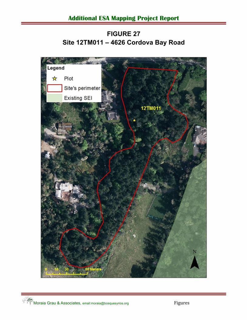
FIGURE 27 Site 12TM011 – 4626 Cordova Bay Road
Additional ESA Mapping Project Report
Moraia Grau & Associates, email:[email protected] Figures
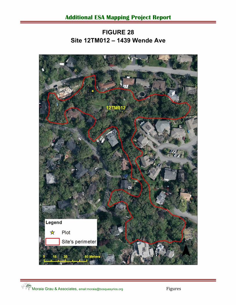
FIGURE 28 Site 12TM012 – 1439 Wende Ave

Additional ESA Mapping Project Report
Moraia Grau & Associates, email:[email protected] Figures
FIGURE 29 Site 12TM013 – 305 Viaduct Ave
Additional ESA Mapping Project Report
Moraia Grau & Associates, email:[email protected]
Appendix I
Appendix I
Ecological Assessment of Groundtruthed Sites
Additional ESA Mapping Project Report
Moraia Grau & Associates, email:[email protected] Appendix I
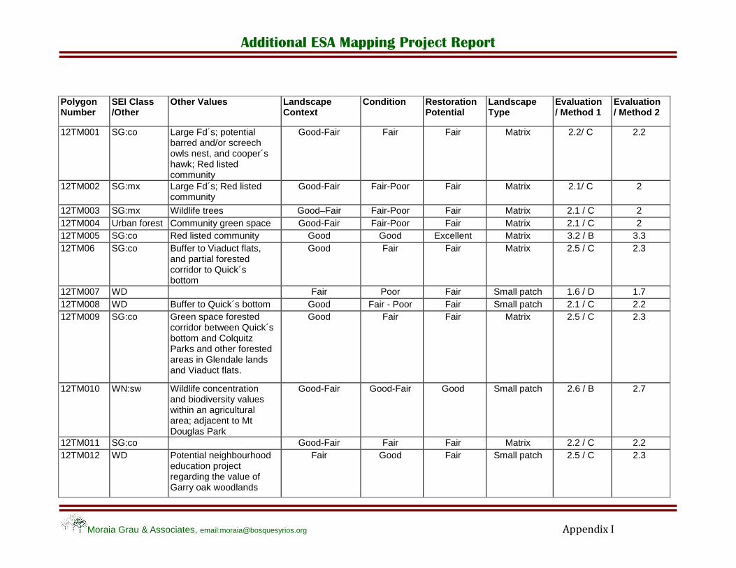
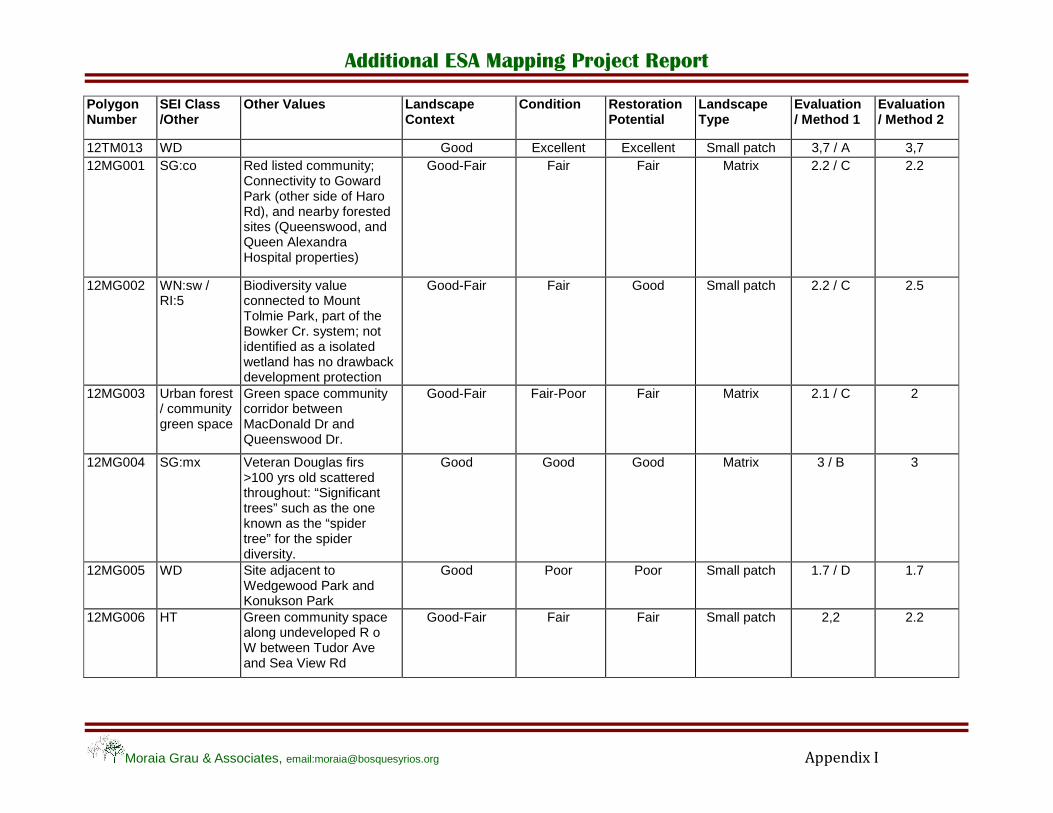
Polygon Number
SEI Class /Other
Other Values Landscape Context
Condition Restoration Potential
Landscape Type
Evaluation / Method 1
Evaluation / Method 2
12TM001 SG:co Large Fd´s; potential barred and/or screech owls nest, and cooper´s hawk; Red listed community
Good-Fair Fair Fair Matrix 2.2/ C 2.2
12TM002 SG:mx Large Fd´s; Red listed community
Good-Fair Fair-Poor Fair Matrix 2.1/ C 2
12TM003 SG:mx Wildlife trees Good–Fair Fair-Poor Fair Matrix 2.1 / C 2 12TM004 Urban forest Community green space Good-Fair Fair-Poor Fair Matrix 2.1 / C 2 12TM005 SG:co Red listed community Good Good Excellent Matrix 3.2 / B 3.3 12TM06 SG:co Buffer to Viaduct flats,
and partial forested corridor to Quick´s bottom
Good Fair Fair Matrix 2.5 / C 2.3
12TM007 WD Fair Poor Fair Small patch 1.6 / D 1.7 12TM008 WD Buffer to Quick´s bottom Good Fair - Poor Fair Small patch 2.1 / C 2.2 12TM009 SG:co Green space forested
corridor between Quick´s bottom and Colquitz Parks and other forested areas in Glendale lands and Viaduct flats.
Good Fair Fair Matrix 2.5 / C 2.3
12TM010 WN:sw Wildlife concentration and biodiversity values within an agricultural area; adjacent to Mt Douglas Park
Good-Fair Good-Fair Good Small patch 2.6 / B 2.7
12TM011 SG:co Good-Fair Fair Fair Matrix 2.2 / C 2.2 12TM012 WD Potential neighbourhood
education project regarding the value of Garry oak woodlands
Fair Good Fair Small patch 2.5 / C 2.3
Additional ESA Mapping Project Report
Moraia Grau & Associates, email:[email protected] Appendix I
Polygon Number
SEI Class /Other
Other Values Landscape Context
Condition Restoration Potential
Landscape Type
Evaluation / Method 1
Evaluation / Method 2
12TM013 WD Good Excellent Excellent Small patch 3,7 / A 3,7 12MG001 SG:co Red listed community;
Connectivity to Goward Park (other side of Haro Rd), and nearby forested sites (Queenswood, and Queen Alexandra Hospital properties)
Good-Fair Fair Fair Matrix 2.2 / C 2.2
12MG002 WN:sw / RI:5
Biodiversity value connected to Mount Tolmie Park, part of the Bowker Cr. system; not identified as a isolated wetland has no drawback development protection
Good-Fair Fair Good Small patch 2.2 / C 2.5
12MG003 Urban forest / community green space
Green space community corridor between MacDonald Dr and Queenswood Dr.
Good-Fair Fair-Poor Fair Matrix 2.1 / C 2
12MG004 SG:mx Veteran Douglas firs >100 yrs old scattered throughout: “Significant trees” such as the one known as the “spider tree” for the spider diversity.
Good Good Good Matrix 3 / B 3
12MG005 WD Site adjacent to Wedgewood Park and Konukson Park
Good Poor Poor Small patch 1.7 / D 1.7
12MG006 HT Green community space along undeveloped R o W between Tudor Ave and Sea View Rd
Good-Fair Fair Fair Small patch 2,2 2.2
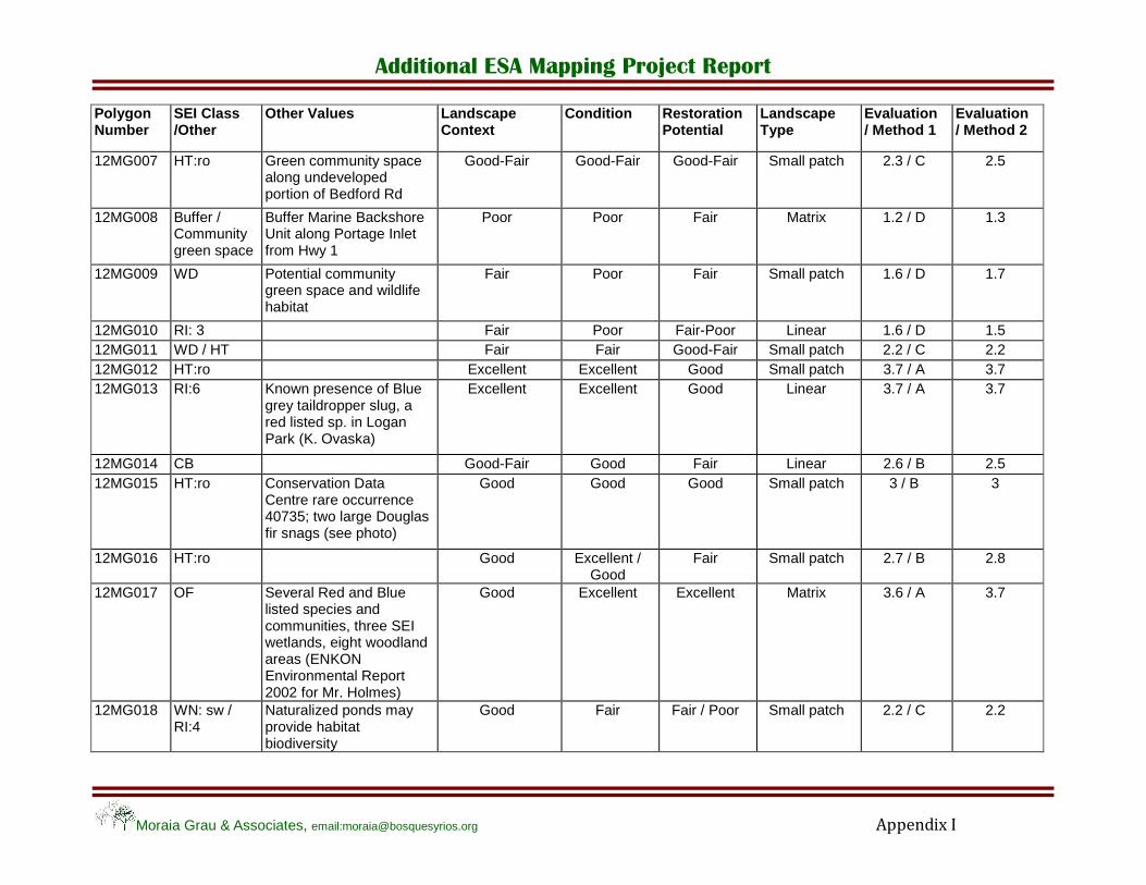
Additional ESA Mapping Project Report
Moraia Grau & Associates, email:[email protected] Appendix I
Polygon Number
SEI Class /Other
Other Values Landscape Context
Condition Restoration Potential
Landscape Type
Evaluation / Method 1
Evaluation / Method 2
12MG007 HT:ro Green community space along undeveloped portion of Bedford Rd
Good-Fair Good-Fair Good-Fair Small patch 2.3 / C 2.5
12MG008 Buffer / Community green space
Buffer Marine Backshore Unit along Portage Inlet from Hwy 1
Poor Poor Fair Matrix 1.2 / D 1.3
12MG009 WD Potential community green space and wildlife habitat
Fair Poor Fair Small patch 1.6 / D 1.7
12MG010 RI: 3 Fair Poor Fair-Poor Linear 1.6 / D 1.5 12MG011 WD / HT Fair Fair Good-Fair Small patch 2.2 / C 2.2 12MG012 HT:ro Excellent Excellent Good Small patch 3.7 / A 3.7 12MG013 RI:6 Known presence of Blue
grey taildropper slug, a red listed sp. in Logan Park (K. Ovaska)
Excellent Excellent Good Linear 3.7 / A 3.7
12MG014 CB Good-Fair Good Fair Linear 2.6 / B 2.5 12MG015 HT:ro Conservation Data
Centre rare occurrence 40735; two large Douglas fir snags (see photo)
Good Good Good Small patch 3 / B 3
12MG016 HT:ro Good Excellent / Good
Fair Small patch 2.7 / B 2.8
12MG017 OF Several Red and Blue listed species and communities, three SEI wetlands, eight woodland areas (ENKON Environmental Report 2002 for Mr. Holmes)
Good Excellent Excellent Matrix 3.6 / A 3.7
12MG018 WN: sw / RI:4
Naturalized ponds may provide habitat biodiversity
Good Fair Fair / Poor Small patch 2.2 / C 2.2
Additional ESA Mapping Project Report
Appendix II
Photographic Report
Moraia Grau & Associates, email:[email protected] Appendix II
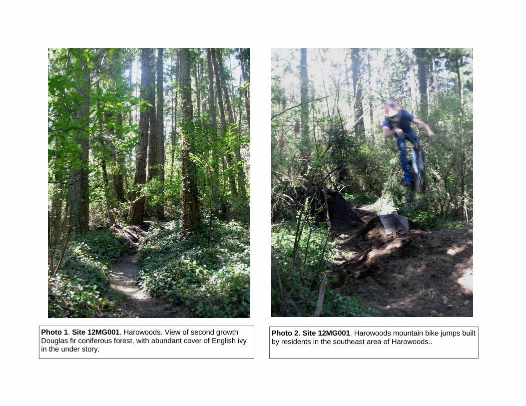
Photo 1. Site 12MG001. Harowoods. View of second growth Douglas fir coniferous forest, with abundant cover of English ivy in the under story.
Photo 2. Site 12MG001. Harowoods mountain bike jumps built by residents in the southeast area of Harowoods..
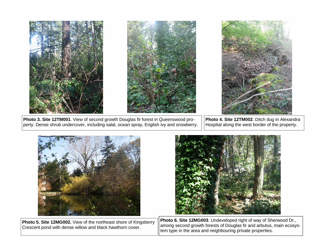
Photo 3. Site 12TM001. View of second growth Douglas fir forest in Queenswood pro-perty. Dense shrub undercover, including salal, ocean spray, English ivy and snowberry.
Photo 4. Site 12TM002. Ditch dug in Alexandra Hospital along the west border of the property.
Photo 5. Site 12MG002. View of the northeast shore of Kingsberry Crescent pond with dense willow and black hawthorn cover.
Photo 6. Site 12MG003. Undeveloped right of way of Sherwood Dr., among second growth forests of Douglas fir and arbutus, main ecosys-tem type in the area and neighbouring prívate properties.
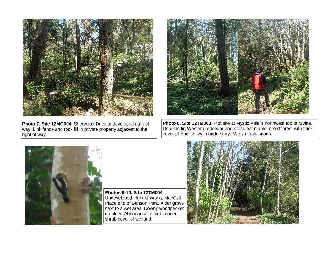
Photo 7. Site 12MG004. Sherwood Drive undeveloped right of way. Link fence and rock fill in private property adjacent to the right of way.
Photo 8. Site 12TM003. Plot site at Mystic Vale´s northwest top of ravine. Douglas fir, Western redcedar and broadleaf maple mixed forest with thick cover of English ivy in understory. Many maple snags.
Photos 9-10. Site 12TM004. Undeveloped right of way at MacColl Place end of Benson Park. Alder grove next to a wet area. Downy woodpecker on alder. Abundance of birds under shrub cover of wetland.

Photo 11. 12MG004. Older second growth forest in Konukson Park, with veteran trees interspaced throughout.
Photo 12. 12MG004. Outstanding veteran tree in Kanukson Park known as the “spider tree”.
Photo 13. 12MG005. Old Garry oak woodland and rocky outcrop altered by rockfill for a building site. Site dominated by invasive plants. Licorice fern and surviving Garry oaks denotes the old woodland site.

Photos 14-15. 12MG006. Undeveloped right-of-way bet-ween Tudor Ave and Sea View Rd across a herbaceous terrestrial SEI site. Sides of the path covered by invasive exotic species (periwinkle, H. blueberry). Garry oaks drying out and covered with English ivy.
Photo 16. 12MG006. Herbaceous terrestrial ecosystem with some old but mostly small Garry oaks; sides of the foot trail and storm ditch covered with invasive species.
Photo 17. 12MG006. Downy wood-pecker drilling on an old Garry oak.
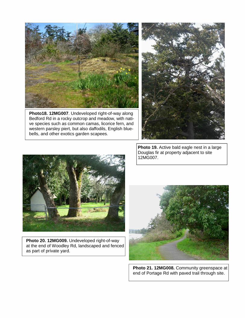
Photo18. 12MG007. Undeveloped right-of-way along Bedford Rd in a rocky outcrop and meadow, with nati-ve species such as common camas, licorice fern, and western parsley piert, but also daffodils, English blue-bells, and other exotics garden scapees.
Photo 19. Active bald eagle nest in a large Douglas fir at property adjacent to site 12MG007.
Photo 21. 12MG008. Community greenspace at end of Portage Rd with paved trail through site.
Photo 20. 12MG009. Undeveloped right-of-way at the end of Woodley Rd, landscaped and fenced as part of prívate yard.
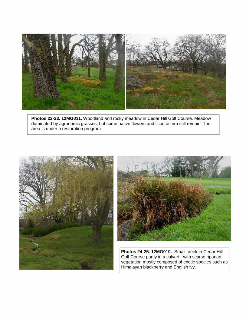
Photos 22-23. 12MG011. Woodland and rocky meadow in Cedar Hill Golf Course. Meadow dominated by agronomic grasses, but some native flowers and licorice fern still remain. The area is under a restoration program.
Photos 24-25. 12MG010. Small creek in Cedar Hill Golf Course partly in a culvert, with scarse riparian vegetation mostly composed of exotic species such as Himalayan blackberry and English ivy.

Photos 26-27. 12MG012. Open grassy rocky outcrop with moss covered rocks in Observatory Hill, with isolated Garry Oak, arbutus and Douglas fir.
Photo 29. 12MG013. Riparian ecosystem in Logan Park: headwaters of Viaduct Creek. Luxurious cover of forbs and ferns under a canopy of broadleaf maples.
Photo 28. Forested ecosystem with large Douglas firs in Logan. Park with abundance of wildlife trees.

Photo 30. 12MG014. Coastal bluff near Guinevere Place. A group of river otters were feeding and grooming themselves in the islets nearby.
Photos 31- 32. 12MG015. Grass meadow and vernal pool at a rocky opening in Kanukson Park. Abundant cover of camas and small-flowered blue-eyed Mary.

Photo 33. 12MG016. Rocky outcrop and grassy meadow in Cyril Owen Place Abundant cover of camas, shooting stars and mosses. A few Garry oaks and arbutus trees, Scotch broom is being removed by owner every year.
Photo 34. 12MG017. Older forest of Western Red Cedar at Maltby Lake flo-odplain with downed logs and abundant cover of mosses.

Photos 35- 36. 12MG017. Older coniferous forest at Maltby Lake property. Last forest fire took place at the turn of the 20th century, visible signs in many trees scarred by the fire.
Photos 37- 38. 12MG018. Naturalized wetlands not in use near Todd Creek flats, with Indian plum, willows and alders in the riparian zone.

Photos 39 - 40. 12TM005. Maturing second-growth Douglas fir woodland on Glendale Lands, Camosun College. Understory of dull Oregon grape and ocean spray.
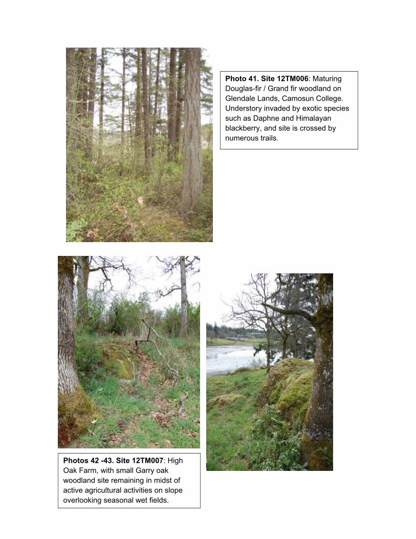
Photo 41. Site 12TM006: Maturing Douglas-fir / Grand fir woodland on Glendale Lands, Camosun College. Understory invaded by exotic species such as Daphne and Himalayan blackberry, and site is crossed by numerous trails.
Photos 42 -43. Site 12TM007: High Oak Farm, with small Garry oak woodland site remaining in midst of active agricultural activities on slope overlooking seasonal wet fields.
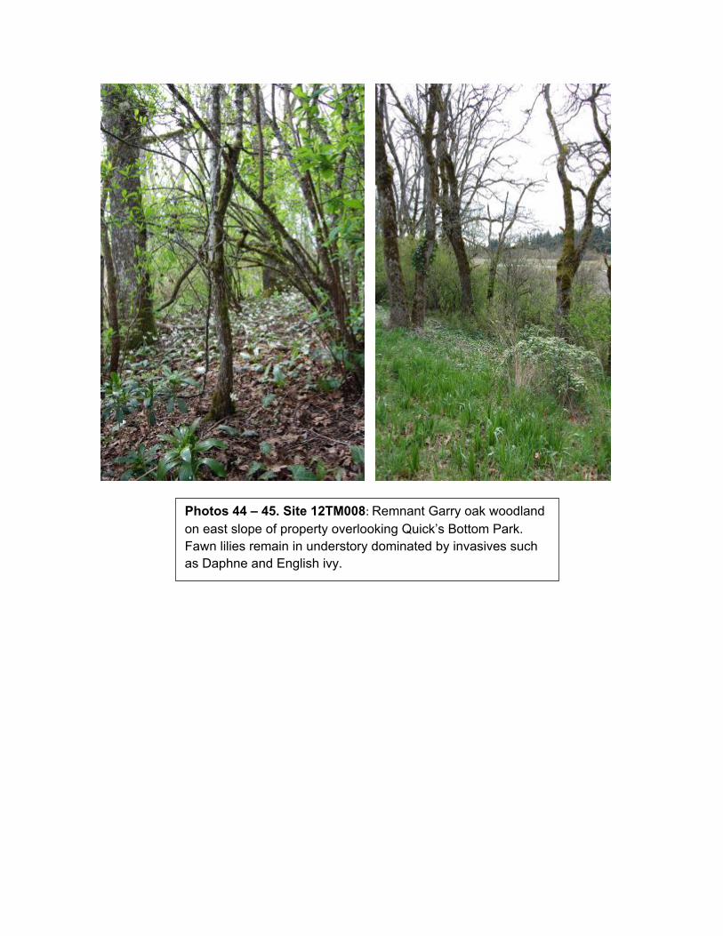
Photos 44 – 45. Site 12TM008: Remnant Garry oak woodland on east slope of property overlooking Quick’s Bottom Park. Fawn lilies remain in understory dominated by invasives such as Daphne and English ivy.
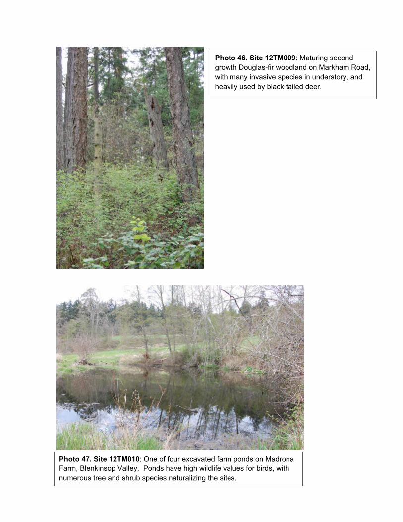
Photo 46. Site 12TM009: Maturing second growth Douglas-fir woodland on Markham Road, with many invasive species in understory, and heavily used by black tailed deer.
Photo 47. Site 12TM010: One of four excavated farm ponds on Madrona Farm, Blenkinsop Valley. Ponds have high wildlife values for birds, with numerous tree and shrub species naturalizing the sites.
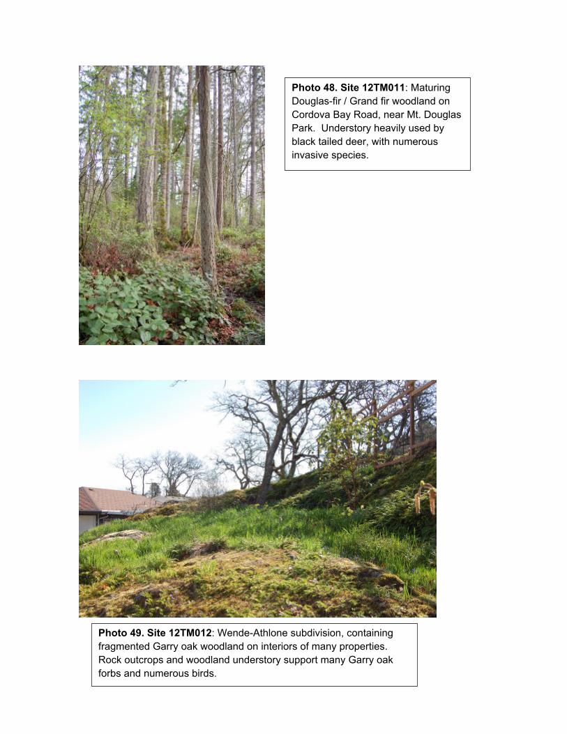
Photo 48. Site 12TM011: Maturing Douglas-fir / Grand fir woodland on Cordova Bay Road, near Mt. Douglas Park. Understory heavily used by black tailed deer, with numerous invasive species.
Photo 49. Site 12TM012: Wende-Athlone subdivision, containing fragmented Garry oak woodland on interiors of many properties. Rock outcrops and woodland understory support many Garry oak forbs and numerous birds.
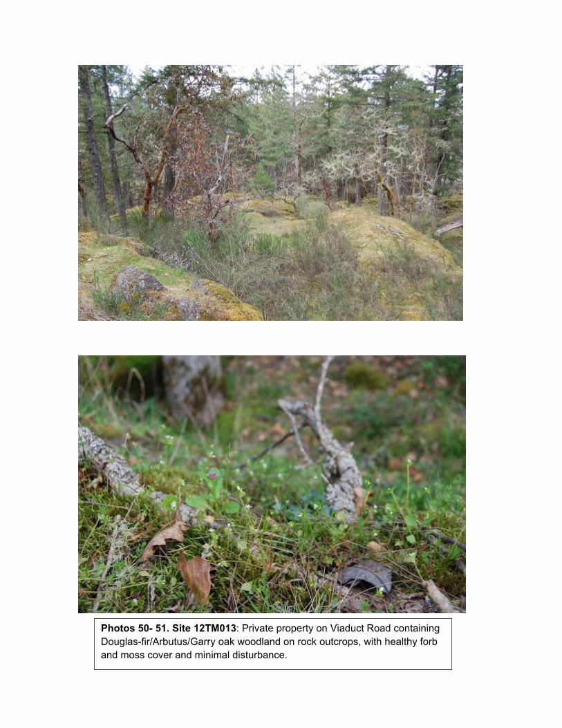
Photos 50- 51. Site 12TM013: Private property on Viaduct Road containing Douglas-fir/Arbutus/Garry oak woodland on rock outcrops, with healthy forb and moss cover and minimal disturbance.

Additional ESA Mapping Project Report
Moraia Grau & Associates, email:[email protected] Appendix III
Appendix III
Field Forms

Additional ESA Mapping Project Report
Moraia Grau & Associates, email:[email protected] Appendix III
Site Visit Form Page 1
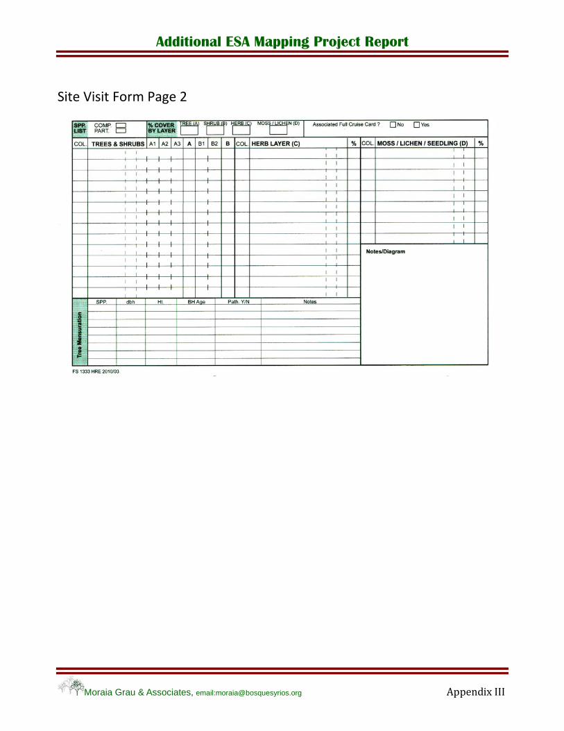
Additional ESA Mapping Project Report
Moraia Grau & Associates, email:[email protected] Appendix III
Site Visit Form Page 2

Additional ESA Mapping Project Report
Moraia Grau & Associates, email:[email protected] Appendix III
Conservation Evaluation Form