adaptive management for biodiversity conservation under...
TRANSCRIPT

19
2
Adaptive Management for Biodiversity Conservation under Climate Change – a Tropical Andean Perspective David G. Hole, Kenneth R. Young, Anton Seimon, Carla Gomez Wichtendahl, Dirk Hoffmann, Klaus Schutze Paez, Silvia Sanchez, Douglas Muchoney, H. Ricardo Grau, and Edson Ramirez The tropical Andes are a globally significant region for biodiversity (Mittermeier et al. 2004). Dramatic environmental heterogeneity across the region including steep gradients in elevation and humidity, and complex mosaics of bedrocks and soils (Young, Chapter 8, this volume), together with the wide range of historical variability in Andean climates (Chapter 5, this volume), have helped shape this remarkable biological diversity (e.g., Trenel et al. 2008; Antonelli et al. 2009; Guarnizo et al. 2009). These same processes have also shaped the human context and provided natural resources that now sustain the wellbeing of millions of people, including lands for farming and grazing, water for households, irrigation and industries, and space for settlements. The region is one of the key places in the world for the development of early human societies, from organized settlements, to irrigated agriculture and the domestication of plant and animal species (Denevan 2001). Hence, it now contains large expanses of human-dominated landscapes, from highly urbanized centers to more rural areas, where native forests have been replaced by agriculture and non-native tree plantations. Even the dry environments and high elevation sites are often used for extensive grazing of livestock. This leaves relatively few areas without a human presence, principal exceptions being the cool, moist cloud forests and the very humid paramos on the high mountains of the northern Andes. As a result of these historical and contemporary land-use patterns, there have long been tensions among the needs for conservation and protection of natural biodiversity, versus those for economic development and the reduction of social inequalities (Terborgh 1999). These tensions substantially increase the complexities of conservation planning in the region. Historically, the rate of change in the land cover of tropical landscapes is unlikely to have occurred as rapidly as it has in the last 50 years (Young 2007). Deforestation and conversion of land has led to an unprecedented loss of natural habitats in recent decades, with profound ramifications for the continued functioning of entire ecosystems (MEA 2005). Ongoing and projected climate change adds a substantial new component to this mix. Dramatic changes to

20
both biotic and abiotic systems and processes are already being seen across the tropical Andes, with glacial ice diminishing and upward biotic range extensions occuring even into high alpine areas (Seimon et al. 2007), with local people already altering their land uses in response (Postigo et al. 2008; Young 2008). Such changes are having profound impacts on species’ phenologies, distributions and abundance (Parmesan 2006) that will increase in magnitude in the future. Of particular conservation concern are the likely changes in representation and abundance of species within existing protected areas and across networks (Araujo et al. 2004; Hole et al. 2009), as well as the high likelihood of profound changes in the location and continued functioning of many Andean ecosystems (Anderson et al. Chapter 1, this volume). Indeed, such changes are likely to result in the formation of ‘no-analog’ communities (i.e. species assemblages for which there are no present-day examples) (Williams and Jackson 2007). Given the projected pace and likely consequences of climate change, magnified as they are in regions such as the high Andes (Bradley et al. 2006; IPCC 2007), it is critical that we adapt conservation management strategies in an effort to maintain their effectiveness under climate change. Without such effort, the region risks losing substantial components of its biodiversity (Larsen et al. Chapter 3, this volume), loss of key ecological processes (Aguirre et al. Chapter 4, this volume) and disruption of its ecosystems and consequent reduction or loss of the services they provide (Anderson et al. Chapter 1, this volume). In this chapter, we will focus on the conservation spotlight on adaptive management. It is not intended to be exhaustive in its coverage - the topics included are broad and need consideration in greater detail. Instead, we begin the process of identifying the range of risks and opportunities for biodiversity conservation and adaptive management presented by climate change within the unique context of the tropical Andean region. We highlight some of the principal tools available for assessing the vulnerability of biodiversity and ecosystems, and describe a range of conservation and management options that might be selected, based on the degree of manipulation and use required in order to maintain human wellbeing. In some cases, strict protection of very fragile ecosystems and endangered wild species is likely to be needed. In other cases, a mix of conservation through protected area systems and integrated planning for sustainable land use will likely be more appropriate. We then look briefly at options for monitoring climate change impacts and the effectiveness of management actions, before highlighting the opportunities (however limited) that climate change may bring for conservation. Finally, we identify critical institutional capacity needs within the region that are urgently required in order to effectively, efficiently, and equitably enable adaptation to the profound challenges posed by climate change. Current Status of Andean Biodiversity Conservation Protected areas are the single most important tool for biodiversity conservation in the tropical Andes region and have seen a substantial increase in number and area covered over the past 15 years (Hoffmann et al. Chapter 22, this volume). Currently, around 15% of the four Andean nations' land area is under national protected area status. While designation of protected areas has generally been based on biodiversity targets, it has not necessarily resulted in the representation of the most biologically pristine or valuable areas within priority ecosystems. More recently, protected areas have in many cases been created simply on the basis of socio-political opportunity.

21
Even though robust assessments of the representativeness of the different protected area systems have not been carried out in a systematic manner, around 70-80% of species are likely to be represented within national protected areas (excluding municipal and departmental level protected areas, indigenous and community conservation areas, and indigenous communal lands). However, representation is biased towards lowlands and foothills, and little attention has been paid to ecological processes, especially in western regions. Capacity and data limitations mean that potential gaps in the network under climate change are largely unknown. However, there is now a push to integrate the large number of additional conservation areas managed at local and regional levels, into the National Protected Area Systems (Hoffmann 2009; Hoffmann et al. Chapter 22, this volume), in some cases led by municipal governments, and in others by native peoples, which could play a vital role in adapting national biodiversity conservation efforts to the challenges of climate change. There are also efforts under way to define national and regional conservation corridors that serve to link protected areas (e.g., Vilcanota-Amboró Corridor in Bolivia and Peru; three altitudinal corridors on the Eastern slopes in Colombia). Only in Colombia, however, has climate change recently been incorporated as an explicit component of the conservation planning process behind these efforts (see Appendix 2.1 and Hoffmann et al. Chapter 22, this volume, for further details). Hence, substantial basic research, including gathering of baseline data, as well as modelling of potential future shifts in species distributions and consequent changes in the provision of ecosystem services, is a critical priority for the tropical Andes region. Adaptive Management and the Identification of Future Vulnerabilities and Opportunities If we are to be proactive in addressing climate change, the identification of likely vulnerabilities and evaluation of possible adaptation responses, as well as the identification of potential opportunities, is paramount. Proactive strategies are likely to prove both more cost-effective (Hannah et al. 2007) and ethically responsible - in terms of preventing or ameliorating some of the worst potential impacts of climate change (Adger et al. 2009). However, given the magnitude of uncertainty in projections of climate change and in species, ecosystems and human responses, conservation planning must be set in the context of a range of potential future scenarios. Such an approach is not an excuse for inaction, but a call for adaptive management. Adaptive management is an iterative process of optimal decision making in the face of uncertainty, that attempts to reduce that uncertainty over time by system-level monitoring (see Sutherland 2006 for more details). Broadly speaking, such an approach has five stages (Figure 2.1): 1) define plausible future scenarios and set conservation targets within this plausible range; 2) perform conservation actions; 3) actions will lead to new behaviour within the system; 4) monitor to detect changes in the system; 5) analyze impacts of conservation actions and adjust initial targets accordingly. The cycle is then repeated. However, the high degree of historical and contemporary variability in Andean climate presents a substantial challenge to the identification of future scenario’s (Figure 2.1, Stage 1) in relation to climate change impacts on species, processes and ecosystems. For example, for much of the high Andean region above 3000 m, climatological data indicates that inter-annual thermal variability is regionally synchronous and largely controlled by the phases of the El Niño Southern Oscillation (ENSO), whereas the precipitation pattern varies spatially. At Cusco in

22
Figure 2.1. Simple schematic of the five stages of the adaptive management process: 1) Define plausible future scenarios based on modelling and/or expert opinion and set conservation targets within this plausible range; 2) Perform conservation actions; 3) Actions will lead to new behaviour within the system, which will also be subject to influence by multiple external factors; 4) Monitor to detect changes in the behaviour of the system, as well as the influence of external factors, including measurement of the direct and indirect costs of management actions, both positive (e.g. rehabilitation of ecosystem services) and negative (e.g. opportunity cost of foregone agricultural production); 5) Feed these data into an analysis of the impacts of the conservation actions, and adjust the initial models/scenario’s and targets accordingly. This cycle is then repeated at appropriate time intervals. southern Peru, the inter-annual range of variation in daily maximum temperature over the summer growing season has been as much as 3.80C (from +2.50C accompanying a strong El Niño event in 1983, to -1.30C under La Niña conditions in 1984). Historically, such a range of variability is likely the norm, although glaciological evidence suggests downward shifts in

23
baseline mean temperature followed by a rebound to present levels probably occurred during the Little Ice Age (1500-1900 AD). Such natural climatic variability creates two challenges. Firstly, it translates into greater uncertainty in projections of future climatic change in the region, particularly at the relatively fine scales required for most spatial planning needs (Vuille et al. 2008). Secondly, it has shaped the evolutionary environment of regional biodiversity, potentially enhancing the resilience of species and ecosystems to sequential climatic extremes. Moreover, the amplitude of change of such short term climatic shocks (i.e. 3.80C) exceeds the expected net thermal increase projected for the end of the 21st century under all but the most extreme emissions scenarios depicted by climate models for the Andes. Hence, there is a risk that some assessments could overestimate the impacts of climate change, projecting extinction in regions where a species or component populations are, at least potentially, pre-adapted. Perhaps more pertinent, however, is the capacity of individual species and ecological systems to adapt to a shifting thermal baseline that increasingly biases the distribution towards higher temperatures likely to surpass historical experience. Hence, the Andean context highlights a key issue in the development of scenarios of potential climate change impacts: what is the level of acceptable uncertainty? Practically however, when considering biodiversity targets, such uncertainty necessitates the use of multiple, but necessarily limited data sources, and therefore a judicious assessment of vulnerability. Assessing Vulnerability Direct Impacts Broadly speaking, the vulnerability of a species to climate change is a product of its susceptibility (defined by its intrinsic biological traits), its exposure (does it occur in a region of high climatic change?) and its adaptive capacity (can it adapt to climatic change?) (Figure 2.2). The vulnerability of an ecosystem can then be defined by the likely complex interactions and synergies between the relative vulnerabilities of its component species and proximate abiotic processes (see Chapter 4 for a discussion of the complexity of the interactions).
Figure 2.2. Schematic representation of a species vulnerability to climate change, where each component varies from ‘low’ to ‘high’ according to the colour gradient, such that ‘X’ represents greatest vulnerability (i.e., the intersection of the three components – high susceptibility, high exposure and low adaptive capacity)
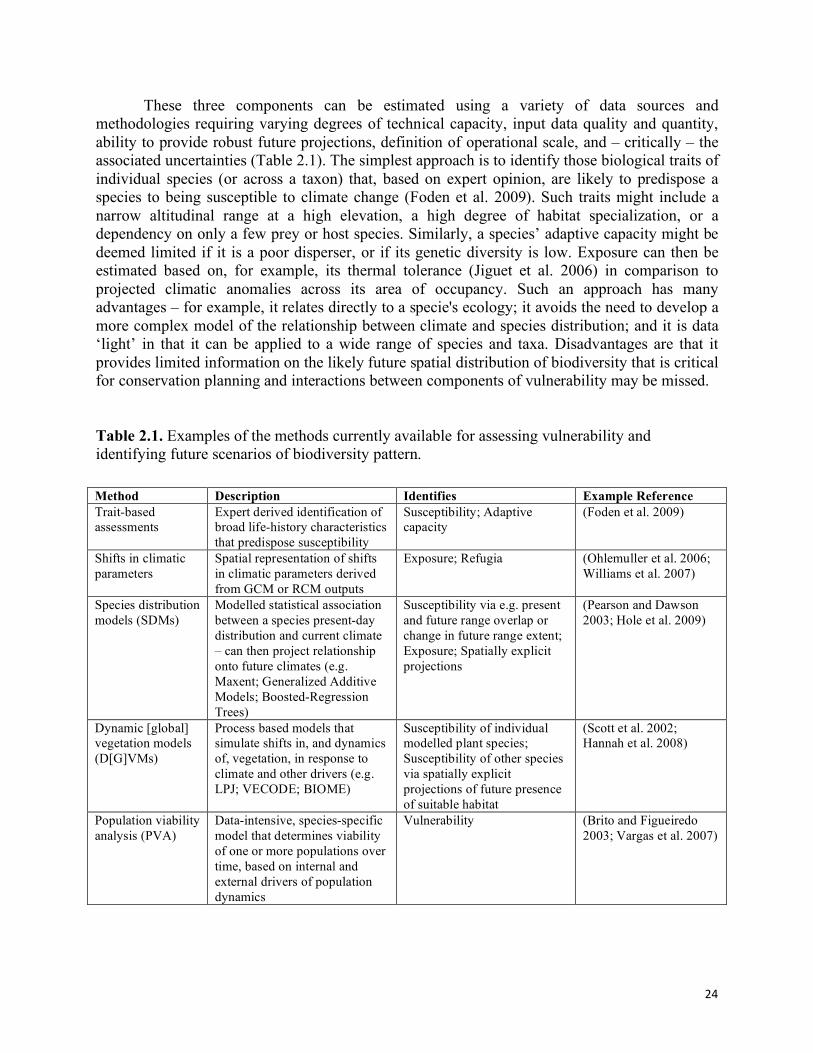
24
These three components can be estimated using a variety of data sources and methodologies requiring varying degrees of technical capacity, input data quality and quantity, ability to provide robust future projections, definition of operational scale, and – critically – the associated uncertainties (Table 2.1). The simplest approach is to identify those biological traits of individual species (or across a taxon) that, based on expert opinion, are likely to predispose a species to being susceptible to climate change (Foden et al. 2009). Such traits might include a narrow altitudinal range at a high elevation, a high degree of habitat specialization, or a dependency on only a few prey or host species. Similarly, a species’ adaptive capacity might be deemed limited if it is a poor disperser, or if its genetic diversity is low. Exposure can then be estimated based on, for example, its thermal tolerance (Jiguet et al. 2006) in comparison to projected climatic anomalies across its area of occupancy. Such an approach has many advantages – for example, it relates directly to a specie's ecology; it avoids the need to develop a more complex model of the relationship between climate and species distribution; and it is data ‘light’ in that it can be applied to a wide range of species and taxa. Disadvantages are that it provides limited information on the likely future spatial distribution of biodiversity that is critical for conservation planning and interactions between components of vulnerability may be missed. Table 2.1. Examples of the methods currently available for assessing vulnerability and identifying future scenarios of biodiversity pattern. Method Description Identifies Example Reference Trait-based assessments
Expert derived identification of broad life-history characteristics that predispose susceptibility
Susceptibility; Adaptive capacity
(Foden et al. 2009)
Shifts in climatic parameters
Spatial representation of shifts in climatic parameters derived from GCM or RCM outputs
Exposure; Refugia (Ohlemuller et al. 2006; Williams et al. 2007)
Species distribution models (SDMs)
Modelled statistical association between a species present-day distribution and current climate – can then project relationship onto future climates (e.g. Maxent; Generalized Additive Models; Boosted-Regression Trees)
Susceptibility via e.g. present and future range overlap or change in future range extent; Exposure; Spatially explicit projections
(Pearson and Dawson 2003; Hole et al. 2009)
Dynamic [global] vegetation models (D[G]VMs)
Process based models that simulate shifts in, and dynamics of, vegetation, in response to climate and other drivers (e.g. LPJ; VECODE; BIOME)
Susceptibility of individual modelled plant species; Susceptibility of other species via spatially explicit projections of future presence of suitable habitat
(Scott et al. 2002; Hannah et al. 2008)
Population viability analysis (PVA)
Data-intensive, species-specific model that determines viability of one or more populations over time, based on internal and external drivers of population dynamics
Vulnerability (Brito and Figueiredo 2003; Vargas et al. 2007)
25
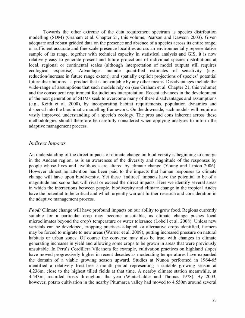
Towards the other extreme of the data requirement spectrum is species distribution modelling (SDM) (Graham et al. Chapter 21, this volume; Pearson and Dawson 2003). Given adequate and robust gridded data on the presence and absence of a species across its entire range, or sufficient accurate and fine-scale presence localities across an environmentally representative sample of its range, together with technical capacity in statistical analysis and GIS, it is now relatively easy to generate present and future projections of individual species distributions at local, regional or continental scales (although interpretation of model outputs still requires ecological expertise). Advantages include quantified estimates of sensitivity (e.g., reduction/increase in future range extent), and spatially explicit projections of species’ potential future distributions – a product that is unavailable by any other means. Disadvantages include the wide-range of assumptions that such models rely on (see Graham et al. Chapter 21, this volume) and the consequent requirement for judicious interpretation. Recent advances in the development of the next generation of SDMs seek to overcome many of these disadvantages and assumptions (e.g., Keith et al. 2008), by incorporating habitat requirements, population dynamics and dispersal into the bioclimatic modelling framework. On the downside, such models will require a vastly improved understanding of a specie's ecology. The pros and cons inherent across these methodologies should therefore be carefully considered when applying analyses to inform the adaptive management process. Indirect Impacts An understanding of the direct impacts of climate change on biodiversity is beginning to emerge in the Andean region, as is an awareness of the diversity and magnitude of the responses by people whose lives and livelihoods are altered by climate change (Young and Lipton 2006). However almost no attention has been paid to the impacts that human responses to climate change will have upon biodiversity. Yet these ‘indirect’ impacts have the potential to be of a magnitude and scope that will rival or exceed the direct impacts. Here we identify several areas in which the interactions between people, biodiversity and climate change in the tropical Andes have the potential to be critical and which urgently warrant further research and consideration in the adaptive management process. Food: Climate change will have profound impacts on our ability to grow food. Regions currently suitable for a particular crop may become unsuitable, as climate change pushes local microclimates beyond the crop's temperature or water tolerance (Lobell et al. 2008). Unless new varietals can be developed, cropping practices adapted, or alternative crops identified, farmers may be forced to migrate to new areas (Warner et al. 2009), putting increased pressure on natural habitats or urban zones. Of course the converse may also be true, with changes in climate generating increases in yield and allowing some crops to be grown in areas that were previously unsuitable. In Peru’s Cordillera Vilcanota for example, cultivation practices on highland slopes have moved progressively higher in recent decades as moderating temperatures have expanded the domain of a viable growing season upward. Studies at Nunoa performed in 1964-65 identified a relatively frost-free 5-month period representing a suitable growing season at 4,236m, close to the highest tilled fields at that time. A nearby climate station meanwhile, at 4,543m, recorded frosts throughout the year (Winterhalder and Thomas 1978). By 2003, however, potato cultivation in the nearby Pitumarca valley had moved to 4,550m around several

26
communities. The warming regional climate has thus been accompanied by a rise in the limit of cultivation by as much as 300m over the 38 year period (Halloy et al. 2005; Figure 2.3). Further upward shifts in cultivation may put still largely pristine high elevation habitats under pressure. In the Cordillera Apolobamba in Bolivia, the upward shift in agricultural activities has displaced livestock (camélidos) to even greater elevations, with consequent impacts on high altitude ecosystems in the region (Schulte 1996). Where higher elevations have limited area, the same number of animals is often packed into a smaller area resulting in increased erosion. Yields of cash-crops crucial to livelihoods in the region, such as coffee, will also respond to changes in temperature, as projected for other regions of the America’s (e.g., Mexico; Schroth et al. 2009). Increased pressures on upslope protected areas, as cost-effective yields of Coffea arabica become increasingly limited to higher elevations, are a likely consequence. Water: Deglaciation caused by climate change over the past several decades, has led to a significant reduction in dry season flows in glacier-fed rivers (Francou et al. 2005; Vergara et al. 2007). This has necessitated the creation of upstream reservoir capacity to provide a buffer to ensure sufficient flow for hydropower generation and agricultural needs downstream. For example, the largest high-alpine lake in the Andes, Peru’s 32 km2 Laguna Sibinacocha at 4,900 m, which provides habitat for thousands of flamingos and other waterfowl, was artificially enlarged by a dam in the mid-1990s to augment diminishing dry season flow far downstream at the Machu Picchu hydroelectric generation plant on the Vilcanota-Urubamba river (Seimon 2001). Anecdotal evidence suggests that avian diversity and abundance on the lake may have decreased as a result, due to inundation of traditional nesting areas (see Anderson et al. Chapter 1, this volume for further examples). Health: A major potential impact of climate change on human health is the change in the incidence and geographic range of vector-borne diseases (Martens 1998; Patz et al. 2002). Changes in ambient temperatures and rainfall have affected the seasonality, duration of outbreaks and morbidity profiles of both malaria and dengue fever, diseases whose transmission, distribution and seasonality are linked to climatic conditions (Poveda et al. 2001; Ruiz et al. 2006). Projected increases in temperature under climate change may now drive these diseases into formerly mosquito-free territories. As in the past, communities may choose to seek out malarial-free areas (Gade 1999) beyond the expanding disease front, putting further pressure on natural habitats within these regions. Energy: Biofuels have been proposed as one method for mitigating greenhouse gas emissions. Whether or not biofuels actually offer carbon savings depends on how they are produced. In many regions the production of food crop-based biofuels is leading to the conversion of rainforests, savannas, peatlands, grasslands and other natural ecosystems to agriculture, generating a substantial “carbon debt” (Fargione et al. 2008), while simultaneously causing widespread degradation of natural ecosystems. In the Andean region, it is unclear as yet whether the increase in biofuel demand will have substantial negative impacts on Andean biodiversity as a result of deforestation and other legal, illegal or politically motivated land use changes. Although laws have been passed recently in Bolivia for example, encouraging biofuel production for national consumption, the government has so far opposed producing biofuels for exports, because of the potentially negative impacts on food security and on small farmers.

27
Hydroelectric power generation meanwhile is affected by changes in climate and stream flows. In Peru, the prospect of decreasing dry season flows from glacier-fed rivers has motivated an adaptive electricity generation strategy shifting away from hydropower, which formerly contributed 90% of the country’s power supply, to greenhouse gas producing gas/thermoelectric power generation facilities (Vergara et al. 2007).
Figure 2.3. Rising altitudinal limit to cultivation in the Andes associated with regional warming. Photograph © Anton Seimon 2003
---------- ~4,550 m
Pitumarca valley, 2003
<growing>
season
Cordillera Vilcanota, Peru Frost frequency vs. elevation(1964-65)
monthly percentage of days < 0°C
4,236m 4,543m

28
Human migration: Large-scale displacements of people resulting from climate change is already a reality, with the United Nations High Commissioner for Refugees in 2008 arguing for the first time that the increase in displaced people globally was at least partly attributable to climate change-related conflict. However, even in the absence of conflict, this trend is likely to increase substantially in synergy with many of the drivers outlined above, generating new, or modifying existing patterns. Rural-urban migration is already significant in the Andes, and will be further enhanced by the increased unpredictability of agricultural production. While this process may result in socioeconomic improvements, as well as more efficient use of natural resources, it is also likely to result in increased human pressure in urban areas, local increases in water demand and water diversion, with consequent impacts on freshwater and terrestrial ecosystems. Conversely, the reduction in the human footprint in rural areas could lead to a beneficial indirect impact on biodiversity (Grau et al. 2003; Grau and Aide, 2007), assuming the land has not been badly degraded and is allowed, or actively encouraged to revert to a natural state. Adaptive Management Responses Mitigating identified vulnerabilities to climate change in the tropical Andean region will be challenging, given the complex patterns and associated interactions of biodiversity and human land use. Here we highlight key adaptive management responses (see Heller and Zavaleta 2009 for a more comprehensive review), noting that these responses require coordination and integration at local, national and regional levels (Figure 2.4) if they are to be effective. Although here we break these responses down into species-, site- and landscape-level approaches, such distinctions must become necessarily blurred when developing a holistic adaptation strategy under climate change. Regional planning process A systematic conservation planning process (Margules and Pressey 2000) for the region is a critical research and policy requirement for the near term. While the potential foundations for such a process exist (e.g., the Estrategia Regional de Biodiversidad para los Paises del Tropico Andino), climate change is at best a marginal component in such plans. Any process must also be cognizant of the specific national and local contexts in which biodiversity conservation will be carried out. Species-level approaches Removing current stresses and threats to a vulnerable species or ecosystem (e.g., hunting pressure, habitat fragmentation) requires minimal knowledge of potential climate change impacts, yet it is a practical way to increase resilience since a system facing multiple stressors is less able to cope with additional pressures from climate change. The Andean bear (Tremarctos ornatus) is one example that would likely benefit from such an approach, given its large home-range and lack therefore of site-specific conservation options. Individual species action plans such as the Biodiversity Action Plans (BAPs) in Europe, or the US Endangered Species Program that are backed up by legal enforcement, also reduce the vulnerability of a species to climate change. A limited number of such plans already exist in the Andean region, e.g., for Polylepis in the Callejon de Conchucos in Ancash, Peru; and Southern Horned Curassow Pauxi unicornis in

29
Bolivia. Identification of further species for which alternative adaption options are unlikely to be sufficient to maintain viable populations should be a priority.
Figure 2.4. Adaptive management options for increasing resilience to biodiversity, across spatial scales. Where a species is imminently at risk of extinction, its translocation (or assisted migration) to suitable but inaccessible habitat (perhaps due to distance from the species’ current range) and ex situ conservation have to be seriously considered, despite acknowledged costs, difficulties and risks (e.g., Hoegh-Guldberg et al. 2008). For example, following precipitous population declines caused principally by Chytridiomycosis (Pounds et al. 2006), many Andean amphibians now require an ex situ approach, namely bringing the most threatened species into captive breeding until release back into the wild becomes feasible. In other situations, this may be done in situ, translocating plants and animals to sites that will be buffered from the effects of climate change (see ‘refugia’ below) or at sites that can be managed such that the negative effects of climate change are mitigated. Crucially, translocation will also likely have to include long-lived elements of critical habitat types, such as seedlings of trees that upon maturity will provide food, shelter and other resources, for the range of species and taxa that will be shifting their distributions into these newly climatically suitable sites/regions. Site-level approaches Protected areas (PAs) and PA networks remain the optimal strategy for conserving global biodiversity (Bruner et al. 2001). Increasing the coverage of the global PA network in order to fill ‘gaps’ (i.e., species whose ranges are not included in the current network (Rodrigues et al. 2004)) is an urgent conservation priority. However, under climate change simply trying to achieve adequate representation of current biodiversity pattern when choosing new sites is likely

30
to be insufficient. Instead, other considerations, particularly potential shifts in both biodiversity pattern and process, must be explicitly considered. Relict forest patches above the mean closed timberline are a common feature on many steep mountain slopes up to 5,400 m, especially along the eastern Andes. Composed primarily of Polylepis and Gynoxys (Fjeldså and Kessler 1996; Coblentz and Keating 2008), these forest islands harbour assemblages of other species including endemic fauna and flora such as the critically endangered bird, the Royal Cinclodes (Cinclodes aricomae). Indeed, these patches have likely functioned as biological refugia through climatically stressful epochs in the past, including most recently the Little Ice Age. Their apparent stability therefore suggests resilience in the face of climate change. It has therefore been argued that they should be considered high priority targets for conservation, both for their current ecological function and for their potential to serve as refugia under the changed climatic conditions of the future. However, some caution is needed since these relict patches could simply represent remnants of much more extensive forests fragmented by humans over centuries or millennia (Fjeldså and Kessler 1996; Fjeldså 2002; Kessler 2002), raising doubt over their ability to act as future refugia. Other putative refugia have also been identified in the Andean region, including areas with stable mist formation on the Pacific slope and the intermontane basins (Fjeldså et al. 1999). Clearly, the robust identification of functional refugia in the tropical Andes must be a research priority. Environmental gradients containing sufficient natural habitat to create land-use mosaics that will maintain functional habitat connectivity, should be incorporated into conservation units wherever possible (e.g. sites, corridors, watersheds). Both short, sharp, and broad, diffuse gradients should be considered where relevant, because of the different options they provide for rapid dispersal of species or adaptation through genetic plasticity (Killeen and Solorzano 2008). Gradients of particular relevance to the Andes include elevational, edaphic, and humidity gradients. This strategy is already being utilized in Peru, where three large national parks have been created that include entire elevational gradients (Rio Abiseo, Yanachaga-Chemillen, and Manu National Parks) (Young and Lipton 2006), in Bolivia (Madidi, Carrasco, and Amboró National Parks), in Ecuador (La Reserva Cofanes-Chingual), and in Colombia. The tracking of ecotones (the transition between two ecosystems or biomes) offers a further adaptive management option. An important example in the Andean context is the treeline, the dynamics of which are sensitive to both climatic and human impacts (Bader et al. 2007; Young and Leon 2007). Given the relatively high environmental and climatic variability at ecotones, populations in or near these areas are likely to be pre-adapted to a relatively high level of physiological stress and may possess adaptive genetic traits that are absent from core populations (Killeen and Solorzano 2008). Monitoring and tracking of ecotones is now feasible thanks to recent advances in remote sensing (see Monitoring section). Riverine forest corridors have served as pathways or refugia for many forest taxa (e.g., in Madagascar; Wilme et al. 2006) and are likely to continue to do so under climate change. By connecting higher elevation watersheds to the lowlands, they incorporate many of the environmental gradients already highlighted as key targets in the Andean region. Examples include the Topo and Palora rivers in Ecuador, whose watersheds are protected by the Llangantes and Sangay National Parks, thereby covering an elevational gradient of almost 3000 m.

31
Maintaining riverine forest can reduce the build up of sediment and/or chemicals leaching into the water from the surrounding landscape, preserving water quality for aquatic species. The rivers themselves are also critical for both freshwater and biodiversity. In order to reduce or remove threats to a vulnerable species or ecosystems, strict protection of some localities within PAs, or of entire PAs, will be required. Most tropical Andean national protected area systems include strict protection as a management option, typically defining specific vulnerable zones as “no impact” or “no visit”. Use of this management option is likely to become even more crucial under climate change and sensitivity will need to be shown in deriving the correct balance between sustainable use of an area by local communities and the preservation of species and key habitats. SDM projections provide a means of identifying regions or even sites that could represent concentrations of future species richness and/or regions projected to experience large numbers of species moving through them, as species’ ranges shift. As a result, they have begun to be incorporated into adaptive management planning, e.g. for the Cape Proteaceae in South Africa (Williams et al. 2005); for the African IBA network (Hole et al. in press). If the assumptions and uncertainties in such modelling exercises are fully acknowledged, these techniques currently provide the only method of proactively identifying future regions of potentially high conservation value that may not be included in current conservation plans. Similarly, use of SDM and dynamic vegetation models (DVM) projections provide a means of informing future site-based management strategies by identifying and targeting broad management strategies across networks of conservation sites, that reflect potential changes in the species composition of those sites. Broad strategies can be characterized from SDM derived projections of inter-site differences in the number of immigrant, emigrant and persistent species across a network of sites (e.g., for the African IBA network; Hole et al. in press), or based on DVM projections of future vegetation patterns within sites (e.g., the Canadian Parks system; Scott et al. 2002). Landscape-level approaches – corridors and landscape permeability Large protected areas may include sufficient environmental gradients such that they can be managed as a single landscape unit (Figure 2.5 A). Within such sites, species range shifts will likely leave relict distributions in addition to forming new species assemblages along elevation and humidity gradients. A variety of approaches may then be viable for preservation, translocation, and restoration. Most Andean landscapes, however, include a wide variety of human land uses, creating mosaics within which conservation strategies are more constrained (Figure 2.5 B). Given the potential speed and magnitude of species range shifts in response to climate change, and the very high likelihood of substantial species turnover within conservation areas (Hole et al. 2009), most site-based conservation strategies will continue to fulfil their role only if the landscapes within which they are embedded (i.e., the matrix) allow species to move through them across ecologically relevant temporal and spatial scales (Gascon et al. 1999). Corridors are landscape scale conservation and management units (Soule and Terborgh 1999) that have already been defined across parts of the Andean region. Within such landscape units, promotion of land use efficiency may prove to be key. Encouraging the concentration of agricultural production within restricted, but high yield areas, may favour de-intensification in

32
Figure 2.5. Andean landscapes have strong environmental gradients, with dramatic changes in elevation joined by shifts in humidity, mediated through rainfall amounts, degree of seasonality, and soil moisture. XA, represents a protected landscape, wherein the goals of biodiversity conservation take priority. Climate change can force species shifts along the elevational gradient (b), along the humidity gradient (c), or in some cases may not cause species shifts or may not affect a particular site (a). Strategies within this protected area may include special attention to a, given it serves as a conservation refugia, while facilitated transformation of important habitat elements (e.g., tree plantings) and translocation of species of concern to places predicted to be important for altitudinal shifts (b) and range shifts to wetter or drier sites (c). XB, represents an inhabited landscape, utilized by people and with multiple land owners and land tenures. Here there could also be refugia (a), elevational shifts (b) and shifts with changing humidity regimes (c), but the conservation strategies may be more constrained in deference to competing needs for land use. Instead management strategies or conservation incentives could be used to lessen the landscape matrix’s resistance to species movements, through formal conservation corridors or through land uses such as agroforestry or shade coffee. The refugia (a) could be particularly important conservation targets, requiring active management interventions including strict protection and habitat management.

33
less productive and more vulnerable areas (e.g., on slopes and at higher elevations) and reduce encroachment on natural habitats (Green et al. 2005; Grau and Aide 2007), although the effectiveness of such ‘land sparing’ remains questionable (Ewers et al. 2009). Monitoring Monitoring is a critical component of the adaptive management process (Figure 2.1, Stage 4). It provides baseline assessments of biodiversity and environmental parameters of interest (e.g., climate) from which to interpret current and potential future changes; a means to validate model outputs (e.g. is a species range shifting in the manner projected by its SDM?); an early-warning mechanism of unexpected climate change impacts; and a measure of the effectiveness of a conservation action, that must then be fed back into adaptive management. Choosing the correct indicators to monitor can be challenging given limited resources, and they will depend on the goal of the monitoring. Suitable indicators can be individual species (e.g., amphibians with a recognized sensitivity to climatic conditions); assemblages (repeat censusing of floral assemblages is already underway through the GLORIA initiative but is otherwise lacking in the Andes); ecosystems (e.g., paramos are a crucial ecosystem to monitor since there is nowhere ‘upwards’ for constituent species to go (Anderson et al. Chapter 1, this volume)); processes or interactions (e.g., the well documented relationship between fig trees (Ficus spp.) and their fig-wasp pollinators (Agaoninae) represents a powerful indicator since its disruption through climate change would resonate across communities or even entire ecosystems); composites of these (e.g., GLORIA http://www.gloria.ac.at/?a=20 and TEAM http://www.teamnetwork.org/en/ networks); or derived products from remote sensing (e.g., NDVI to assess seasonal ‘greening’). Utilizing a broad range of indicators increases our ability to detect climate change signals and rapidly adapt management responses accordingly. Long-term data series are also vital for understanding the natural range of variability of systems, yet standardized long-term monitoring records are lacking throughout the majority of the tropical Andes. The utility of remote sensing data for monitoring purposes has increased rapidly over the past decade and merits closer inspection, given its potential for relatively cheap, standardized monitoring over much of the globe, including the tropical Andes. There is now a wide array of current and/or planned Earth observing systems (satellite, aerial, and in situ) at local, national and regional scales, that collect and disseminate monitoring data. The Global Earth Observing System of Systems (GEOSS) is coordinating the collection, distribution and use of these data across multiple themes of importance to society: climate, weather, energy, health, agriculture, water, disasters, biodiversity, and ecosystems. Recent changes in data policy have made remote sensing data available at little or no cost. Table 2.2 provides an overview of current satellite and associated sensors most relevant to monitoring climate change effects on biodiversity and ecosystems in the tropical Andes. As an example of the utility of such data, satellite and aerial photography, together with radar and LIDAR data, when coupled with field-based calibration and validation, now provide an operational means of defining and monitoring ecotones, including changes in treelines, through estimation of tree height, basal area and stem volume (Holmgren 2004), treeline structure (Rees 2007), species composition (Holmgren and Persson 2004), tree migration (Næsset and Nelson 2007), and changes in treeline over time (Zhang et al. 2009). The number of satellite-borne sensors has increased dramatically and many hyperspectral, radar, and LIDAR missions are on-going or planned. Yet access to this high data volume, to

34
usable, derived products, and to technical capacity for interpretation remain limiting factors for monitoring climate change impacts on biodiversity. Table 2.2. An overview of principal current remote sensing data, of relevance to biodiversity and ecosystem monitoring in the tropical Andes . * = commercial system; Pan = panchromatic; XS = multispectral.
Satellite / Sensor Temporal Resolution (days)
Spatial Resolution (m)
Spectral Resolution / Band
Program Life
Derivative Products
Moderate-resolution (250-8000m)
AVHRR 1 1000-8000 XS, thermal 1982- IGBP Land Cover, GIMMS NDVI
SeaWIFS 1 1000 XS 1998- Ocean Color SPOT-Vegetation (VGT) 2 1000 XS 1998- GLC 2000, GIMMS
NDVI MODIS 1 250-1000 36 channels in
visible - thermal 2000- MODIS LAI/fPAR, VI,
NPP, Land Cover, Fire. Land Surface Temperature
MERIS 1 300 36 channels in visible - thermal
2000- GLC 2005
Medium-resolution optical (10-250m)
Landsat 1-3 MSS 16 80 XS 1973-87 Global Land Survey 1970
Landsat 4-5 TM 16 28.5 XS, thermal 1984- Global Land Survey 1970, 1990, 2000, 2005
Landsat 7 ETM 16 15-28.5m XS, thermal. pan
1999- Global Land Survey 2000, 2005
SPOT 1-5 2 10-20 Green, red, near-IR
1990-
ASTER 16 15, 30, 90 XS, thermal 1999- ASTER Global Digital Elevation Model
IRS Variable 2.5, 20, 30 Pan, XS 1988- CBERS 1-3 5 20 XS, Pan 2003- ALOS 46 10 XS 2006- Medium-resolution radar(10-250m)
ERS 1-2 35 25 C-band SAR 1996- JERS-1 44 10 L-band 1992-98 Radarsat 1-2 24 8, 20, 50 C-band 1995- PALSAR 46 10, 100 L-band 2006- SRTM short-lived 30,90, 1000 Interferometric
radar 2002 SRTM30, SRTM90
DEMS ENVISAT ASAR 35 C-band 2002- High-resolution (<10m)
Ikonos * Variable 1-4 Pan, XS 1998- GeoEye * Variable 1 Pan, XS 2009- TerraSAR 11 days 1, 3, 6 X-band SAR 2007- RapidEye* 1 6.5 XS, Pan 2008-
35
Opportunities – Demonstrating the Value of Maintaining Functional Ecosystems Climate change is already having negative repercussions for both biodiversity and people and poses a multitude of future risks. If there is any positive side to this, it may be that climate change has helped push biodiversity, ecosystems and the services they provide, to finally being recognized and valued as critical components of the Earth system, rather than as a global commons to be used and abused without concern for the consequences. Attaching a ‘value’ to nature is seen as anathema by some and care must be taken to ensure that the value of an ecosystem reflects not just its direct commercial or marketable value (e.g., provision of hydrological services), but also those goods and services that are extremely difficult to quantify and value (e.g., cultural services such as spiritual value). Nevertheless, the lack of any sort of valuation is an underlying cause of the degradation of ecosystems and the loss of biodiversity that we see today (TEEB 2008). Such a valuation becomes even more critical given that the maintenance of functional ecosystem services is likely to represent the most cost-effective way to avoid and/or adapt to many of the projected impacts of climate change on human wellbeing. So-called ‘ecosystem based adaptation’ (an adaptation strategy now defined and endorsed by IUCN, the World Bank and many other international organizations) is likely to be of particular relevance in much of the developing world, where ‘technical’ adaptation options, such as the building of a large-scale water treatment plant in response to diminished freshwater quality, may be a far less pertinent adaptation option than, for example, maintaining or restoring forest-cover throughout a key watershed. In light of these developments, including a valuation (even a “back-of-the-envelope” calculation) of the ecosystem services preserved or restored as part of any adaptive management strategy, represents a key tool to leverage biodiversity-favourable policy across stakeholders. Payment for Ecosystem Services (PES) Paying individuals or communities for the services provided by natural ecosystems on their land is still rare in the Andean region. However, successful PES schemes do exist. For example, in the Los Negros river watershed in Bolivia, Fundación Natura has initiated a project that seeks to reduce or prevent reductions in water quality and quantity for downstream users (principally farmers relying on irrigation) caused by upstream deforestation. Through the scheme, these downstream irrigators agree to compensate upstream farmers to protect certain forests and restore others, thereby ensuring the quality of their water supply. In Ecuador meanwhile, the Pimampiro initiative places a specific fee for watershed forest protection onto the water bills of nearly 1300 families; 20% of these funds are then used to pay 19 upstream farmers to conserve their forests (390 ha of forest and 163 ha of paramo) (Camacho 2008). Major cities such as Bogotá in Colombia and Santa Cruz in Bolivia are now also beginning to utilize water-based PES schemes through small additions to water or electricity fees to pay for watershed conservation. In Quito, Ecuador, which receives its water supply from the high plateaus of the surrounding Andean range, a Water Conservation Fund (FONAG) was set up in 2000 to manage and direct revenue generated by a water consumption fee, to fund conservation and restoration projects in surrounding watershed. These projects include, for example, improving sheep and cattle production practices in order to reduce negative impacts on land cover and water quality.

36
On a potentially far greater scale, the introduction of REDD (Reduced Emissions from Deforestation and Degradation) as a climate change mitigation strategy, could provide a potentially massive increase in the funds available for forest conservation through their role in carbon sequestration and storage. The benefits to biodiversity could be increased further still if policymakers could agree to prioritize forests with high biodiversity for REDD funding. The potential for REDD to contribute to biodiversity conservation in the tropical Andean region is substantial and numerous pilot studies are being carried out. For example, a recent study in Peru’s Cordillera Azul National Park, has demonstrated that management activities over the past six years have decreased deforestation rates in its buffer zone and prevented further deforestation in the park. However, without a continuous source of revenue, such as REDD could provide, continued management will be impossible and the park will likely succumb to threats from logging, oil extraction and the expansion of the agricultural frontier that have impacted the park in the past. Incorporating Biodiversity Conservation into Development Planning There is a growing awareness, from local NGOs to the large multilateral organizations, that poverty and biodiversity are intimately linked. The poor, especially in rural areas, depend on biodiversity for food, fuel, shelter, medicines and a wealth of other ecosystem services. Biodiversity loss therefore exacerbates poverty, while poverty in turn is a major threat to biodiversity, through unsustainable land use. The conservation and sustainable use of biodiversity also plays a critical role in the economic survival of a variety of production sectors such as fisheries, agriculture, and tourism. Consideration of biodiversity must therefore be integrated into the development process. This ‘mainstreaming’ of biodiversity into production sectors, poverty reduction plans and national sustainable development plans has been an internationally acknowledged goal for some time. For instance, goal 3.3 of the Strategic Plan of the Convention on Biodiversity (CBD), developed in 2002, requires that “biodiversity concerns are being integrated into relevant national sectoral and cross-sectoral plans, programmes and policies”. Yet progress on achieving this goal in the Andean region, as elsewhere, has been limited. It must now become a priority, both in terms of collating the scientific and socio-economic evidence to support it, and the development of the policy initiatives to make it happen. Obstacles – Institutional Capacity Perhaps the single greatest limitation to robustly addressing the combination of the direct and indirect effects of climate change, together with the impacts of other global change (e.g., deforestation, species invasion) on biodiversity in the Andean Region, is the lack of institutional capacity. This lack is principally a result of competing and overlapping responsibilities, compounded by lack of interconnections between and among institutions, authorities and other stakeholders in the region. Although skilled and technically adept scientists and policy makers exist across the region, they are in profoundly short supply. In order to improve capacity therefore, there is a clear need to: 1) Develop interdisciplinary higher education programs, to train qualified local researchers in the processing and analysis of ever increasing quantities of data (e.g., by promoting international programmes for students to study in leading institutions in

37
Europe, Asia and North America). 2) Promote training opportunities for local leaders to facilitate their understanding and interpretation of complex analyses. 3) Involve the social, behavioral, and economic sciences in the necessary planning, implementation, and monitoring; advances are being made in the areas of environmental economics and common pool resource theory, used for understanding decisions relating to natural resource use and valuation. 4) Establish and promote social networks, for example, through the internet, to coordinate and facilitate information dissemination to decision makers and other stakeholders. At the scale of the tropical Andes, institutions like the Comunidad Andina (CAN) could play a leading role in promoting and facilitating integration and adaptive practices among signatory countries. Ideally, this would result in a regional planning process at least every five years, timed to coincide with the availability of new assessments resulting from the IPCC process. The planning process may also need to expand to include the Venezuelan Andes, north-west Argentina and north-east Chile, given the extension of tropical Andean ecosystems across these country’s borders. At the national level, there are existing planning initiatives in both the private and public sectors that could be expanded and replicated elsewhere. Not only should this involve the scientific community, but also social communicators. At the local level, municipalities and local communities will need access to results to allow them to assess and plan for locally-led initiatives. It will therefore be important to promote the provision of training to meet identified needs, so that local concerns are accounted for. In some regions, municipalities coordinate with protected area systems and should also be partners when setting climate change goals. Throughout the regional planning process, it will be crucial to facilitate public dissemination in order to ensure that the process is transparent and accountable. Conclusions Given the global importance of the tropical Andes for biodiversity, and the considerable risks posed by climate change, it is critical that both a regional and an international response be oriented to provide the necessary information and resources at the appropriate regional, national, and local scales, in order to inform robust adaptive management responses. Given current social inequalities which will likely be further exacerbated by climate change, the implementation of strategies that incorporate the use of economic, policy, and legal instruments for biodiversity conservation across the tropical Andean region will need to consider equity, fairness and distributional issues. How are these policies impacting stakeholders? Are they imposing burdens on the poorest sectors? These and other similar questions must be considered when designing and implementing integrated conservation and development policies. We highlight nine critical needs:
• Convene a region-wide systematic conservation planning process, that explicitly incorporates the impacts of climate change, and that reconvenes every five years, in order to coincide with the availability of new knowledge from the IPCC and other assessments.
• Continue to develop a comprehensive understanding of Andean climatology of the present and recent past to provide a baseline for detecting change and for assessing species and ecosystem capacities for resilience to climate stresses.
• Implement standardized monitoring protocols to provide baseline evaluations of species distributions, population status, and ecosystem integrity, drawing from taxonomy, field

38
ecology, and remote sensing. It is critical that data transparency and sharing is widely promoted.
• Continue to develop and test the next generation of SDMs for projecting species and ecosystem (or proxy) spatial responses to climate change, since these provide the only way of assessing potential synergies and conflicts with people in an uncertain future.
• Improve the understanding of the indirect impacts of climate change, resulting from planned and unplanned human adaptation and mitigation responses, on biodiversity and the provision of ecosystem services.
• Demonstrate the direct and indirect benefits of ecosystem based adaptation as a key tool for making lives and livelihoods more resilient to climate change.
• Build institutional capacity to design and implement robust adaptive management strategies, at regional, national and local scales, including all stakeholders.
• Incorporate consideration of biodiversity into local, national and regional development planning, across all economic and societal sectors. Biodiversity and the ecosystem services it underpins must be front and center with economic and other considerations.
Literature Cited Adger, W. N., S. Dessai, M. Goulden, M. Hulme, I. Lorenzoni, D. R. Nelson, L. O. Naess, J.
Wolf, and A. Wreford. 2009. Are there social limits to adaptation to climate change? Climatic Change 93:335-354.
Antonelli, A., J. A. A. Nylander, C. Persson, and I. Sanmartin. 2009. Tracing the impact of the Andean uplift on Neotropical plant evolution. Proceedings of the National Academy of Sciences of the United States of America 106:9749-9754.
Araujo, M. B., M. Cabeza, W. Thuiller, L. Hannah, and P. H.Williams. 2004. Would climate change drive species out of reserves? An assessment of existing reserve-selection methods. Global Change Biology 10:1618-1626.
Bader, M. Y., M. Rietkerk, and A. K. Bregt. 2007. Vegetation structure and temperature regimes of tropical alpine treelines. Arctic, Antarctic, and Alpine Research 39:353-364.
Bradley, R. S., M. Vuille, H. F. Diaz, and W. Vergara. 2006. Threats to water supplies in the tropical Andes. Science 302:1755-1756.
Brito, D., and M. D. L. Figueiredo. 2003. Minimum viable population and conservation status of the Atlantic Forest spiny rat Trinomys eliasi. Biological Conservation 113:153-158.
Bruner, A. G., R. E. Gullison, R. E. Rice, and G. A. B. da Fonseca. 2001. Effectiveness of parks in protecting tropical biodiversity. Science 291:125-128.
Camacho, D. C. 2008. Esquemas de pagos por servicios ambientales para la conservacion de cuencas hidrograficas en el Ecuador. Investigacion Agraria: Sistemas y Recursos Forestales 17:54-66.
Coblentz, D., and P. L. Keating. 2008. Topographic controls on the distribution of tree islands in the high Andes of south-western Ecuador. Journal of Biogeography 35:2026-2038.
Denevan, W. F. 2001. Cultivated landscapes of native Amazonia and the Andes. Oxford: Oxford University Press.
Ewers, R. M., J. P. W. Scharlemann, A. Balmford, and R. E. Green. 2009. Do increases in agricultural yield spare land for nature? Global Change Biology 15:1716-1726.
39
Fargione, J., J. Hill, D. Tilman, S. Polasky, and P. Hawthorne. 2008. Land clearing and the biofuel carbon debt. Science 319:1235-1238.
Fjeldså, J. 2002. Polylepis forests – vestiges of a vanishing ecosystem in the Andes. Ecotropica 8:111-123.
Fjeldså, J., and M. Kessler. 1996. Conserving the biological diversity of Polylepis woodlands of the highland of Peru and Bolivia: a contribution to sustainable natural resource management in the Andes. Copenhagen: NORDECO.
Fjeldså, J., E. Lambin, and B. Mertens. 1999. Correlation between endemism and local ecoclimatic stability documented by comparing Andean bird distributions and remotely sensed land surface data. Ecography 22:63-78.
Foden, W. B., G. M. Mace, J.-C. Vie, A. Angulo, S. H. M. Butchart, L. DeVantier, H. T. Dublin, A. Gutsche, S. Stuart, and E. Turak. 2009. Species susceptibility to climate change impacts. Pp. 77-88 in Wildlife in a changing world – an analysis of the 2008 IUCN Red List of threatened species, edited by J.-C. Vie, C. Hilton-Taylor, and S. N. Stuart. Gland: International Union for Conservation of Nature and Natural Resources. 180 pp.
Francou, B., P. Ribstein, P. Wagnon, E. Ramirez, and B. Pouyaud. 2005. Glaciers of the tropical Andes, indicators of the global climate variability. Pp. 197-204 in Global change and mountain regions: a state of knowledge overview, edited by U. Huber, K. M. Harald, and M. A. Reasoner. Dordrecht: Springer.
Gade, D. 1999. Nature and culture in the Andes. Madison: University of Wisconsin Press. Gascon, C., T. E. Lovejoy, R. O. Bierregaard, J. R. Malcolm, P. C. Stouffer, H. L. Vasconcelos,
W. F. Laurance, B. Zimmerman, M. Tocher, and S. Borges. 1999. Matrix habitat and species richness in tropical forest remnants. Biological Conservation 91:223-229.
Grau, H. R., and T. M. Aide. 2007. Are rural-urban migration and sustainable development compatible in mountain systems? Mountain Research and Development 27:119-123.
Grau, H. R., T. M. Aide, J. K. Zimmerman, J. R. Thomlinson, E. Helmer, and X. Zou. 2003. The ecological consequences of socioeconomic and land use changes in post agricultural Puerto Rico. BioScience 53:1159-1168.
Green, R. E., S. J. Cornell, J. P. W. Scharlemann, and A. Balmford. 2005. Farming and the fate of wild nature. Science 307:550-555.
Guarnizo, C. E., A. Amezquita, and E. Bermingham. 2009. The relative roles of vicariance versus elevational gradients in the genetic differentiation of the high Andean tree frog, Dendropsophus labialis. Molecular Phylogenetics and Evolution 50:84-92.
Halloy, S. R. P., A. Seimon, K. Yager, and A. Tupayachi Herrera. 2005. Multidimensional (climate, biodiversity, socio-economics, agriculture) context of changes in land use in the Vilcanota watershed, Peru. Pp. 323-337 in Land use changes and mountain biodiversity, edited by E. M.Spehn, M. Liberman Cruz, and C. Körner. Boca Raton FL: CRC Press LLC.
Hannah, L., R. Dave, P. P. Lowry, S. Andelman, M. Andrianarisata, L. Andriamaro, A. Cameron, R. Hijmans, C. Kremen, J. MacKinnon, H. H. Randrianasolo, S. Andriambololonera, A. Razafimpahanana, H. Randriamahazo, J. Randrianarisoa, P. Razafinjatovo, C. Raxworthy, G. E. Schatz, M. Tadross, and L. Wilmee. 2008. Climate change adaptation for conservation in Madagascar. Biology Letters 4:590-594.
Hannah, L., G. Midgley, S. Andelman, M. Araujo, G. Hughes, E. Martinez-Meyer, R. Pearson, and P. Williams. 2007. Protected area needs in a changing climate. Frontiers in Ecology and the Environment 5:131-138.

40
Heller, N. E., and E. S. Zavaleta. 2009. Biodiversity management in the face of climate change: a review of 22 years of recommendations. Biological Conservation 142:14-32.
Hoegh-Guldberg, O., L. Hughes, S. McIntyre, D. B. Lindenmayer, C. Parmesan, H. P. Possingham, and C. D. Thomas. 2008. Assisted colonization and rapid climate change. Science 321:345-346.
Hoffmann, D. 2009. Municipal protected areas as policy instruments to enhance ecosystem resilience. Lessons from Latin American experiences. IOP Conference Series: Earth and Environmental Sciences 6:312019.
Hole, D. G., B. Huntley, J. Arinaitwe, S. H. M. Butchart, Y. C. Collingham, L. D. Fishpool, D. J. Pain, and S. G. Willis. In press. Towards a management framework for key biodiversity networks in the face of climate change. Conservation Biology.
Hole, D. G., S. G. Willis, D. J. Pain, L. D. Fishpool, S. H. M. Butchart, Y. C. Collingham, C. Rahbek, and B. Huntley. 2009. Projected impacts of climate change on a continent-wide protected area network. Ecology Letters 12:420-431.
Holmgren, J. 2004. Prediction of tree height, basal area and stem volume in forest stands using airborne laser scanning. Scandinavian Journal of Forest Research 19:543-553.
Holmgren, J., and A. Persson. 2004. Identifying species of individual trees using airborne laser scanner. Remote Sensing of Environment 90:415-423.
IPCC. 2007. Climate change 2007: the physical science basis. Contribution of Working Group I to the Fourth Assessment Report of the Intergovernmental Panel on Climate Change, edited by S. Soloman, D. Qin, M. Manning, Z. Chen, M. Marquis, K. B. Averyt, M. Tignor, and H. L. Miller. Cambridge: Cambridge University Press.
Jiguet, F., R. Julliard, C. D. Thomas, O. Dehorter, S. E. Newson, and D. Couvet. 2006. Thermal range predicts bird population resilience to extreme high temperatures. Ecology Letters 9:1321-1330.
Keith, D. A., H. R. Akcakaya, W. Thuiller, G. F. Midgley, R. G. Pearson, S. J. Phillips, H. M. Regan, M. B. Araujo, and T. G. Rebelo. 2008. Predicting extinction risks under climate change: coupling stochastic population models with dynamic bioclimatic habitat models. Biology Letters 4:560-563.
Kessler, M. 2002. The “Polylepis problem”: where do we stand? Ecotropica 8:97-110. Killeen, T. J., and L. A. Solorzano. 2008. Conservation strategies to mitigate impacts from
climate change in Amazonia. Philosophical Transactions of the Royal Society of London B, Biological Sciences 363:1881-1888.
Lobell, D. B., M. B., Burke, C. Tebaldi, M. D. Mastrandrea, W. P. Falcon, and R. L. Naylor. 2008. Prioritizing climate change adaptation needs for food security in 2030. Science 319:607-610.
Margules, C. R., and R. L. Pressey. 2000. Systematic conservation planning. Nature 405:243-253.
Martens, W. J. M. 1998. Health impacts of climate change and ozone depletion: an eco-epidemiological modelling approach. Environmental Health Perspectives 106(Suppl. 1):241-251.
MEA, 2005. Ecosystems and human well-being: synthesis. Washington, DC: Island Press. Mittermeier, R. A., P. Robles Gil, M. Hoffmann, J. Pilgrim, T. Brooks, C. G. Mittermeier, J.
Lamoreux, and G. A. B. da Fonseca. 2004. Hotspots revisited. Mexico City: CEMEX. Naesset, E., and R. Nelson. 2007. Using airborne laser scanning to monitor tree migration in the
boreal-alpine transition zone. Remote Sensing of Environment 110:357-369.

41
Ohlemuller, R., E. S. Gritti, M. T. Sykes, and C. D. Thomas. 2006. Towards European climate risk surfaces: the extent and distribution of analogous and non-analogous climates 1931-2100. Global Ecology and Biogeography 15:395-405.
Parmesan, C. 2006. Ecological and evolutionary responses to recent climate change. Annual Review of Ecology, Evolution, and Systematics 37:637-669.
Patz, J. A., M. Hulme, C. Rosenzweig, T. D. Mitchell, R. A. Goldberg, A. K. Githeko, S. Lele, A. J. McMichael, and D. Le Sueur. 2002. Climate change - regional warming and malaria resurgence. Nature 420:627-628.
Pearson, R. G., and T. P. Dawson. 2003. Predicting the impacts of climate change on the distribution of species: are bioclimate envelope models useful? Global Ecology and Biogeography 12:361-371.
Postigo, J., K. R. Young, and K. A. Crews. 2008. Change and continuity in a pastoralist community in the high Peruvian Andes. Human Ecology 36:535-551.
Pounds, J. A., M. R. Bustamante, L. A. Coloma, J. A. Consuegra, M. P. L. Fogden, P. N. Foster, E. La Marca, K. L. Masters, A. Merino-Viteri, R. Puschendorf, S. R. Ron, G. A. Sanchez-Azofeifa, C. J. Still, and B. E. Young. 2006. Widespread amphibian extinctions from epidemic disease driven by global warming. Nature 439:161-167.
Poveda, G., W. Rojas, M. L. Quinones, I. D. Velez, R. I. Mantilla, D. Ruiz, J. S. Zuluaga, and G. L. Rua. 2001. Coupling between annual and ENSO timescales in the malaria-climate association in Colombia. Environmental Health Perspectives 109:489-493.
Rees, W. G. 2007. Characterization of arctic treelines by LiDAR and multispectral imagery. Polar Record 227:345-352.
Rodrigues, A. S. L., S. J. Andelman, M. I. Bakarr, L. Boitani, T. M. Brooks, R. M. Cowling, L. D. C. Fishpool, G. A. B. da Fonseca, K. J. Gaston, M. Hoffmann, J. S. Long, P. A. Marquet, J. D. Pilgrim, R. L. Pressey, J. Schipper, W. Sechrest, S. N. Stuart, L. G. Underhill, R. W. Waller, M. E. J. Watts, and X. Yan. 2004. Effectiveness of the global protected area network in representing species diversity. Nature 428:640-643.
Ruiz, D., G. Poveda, I. D. Velez, M. L. Quinones, G. L. Rua, L. E. Velasquez, and J. S. Zuluaga. 2006. Modelling entomological-climatic interactions of Plasmodium falciparum malaria transmission in two Colombian endemic-regions: contributions to a national malaria early warning system. Malaria Journal 5:66.
Schroth, G., P. Laderach, J. Dempewolf, S. Philpott, J. Haggar, H. Eakin, T. Castillejos, J. G. Moreno, L. S. Pinto, R. Hernandez, A. Eitzinger, and J. Ramirez-Villegas. 2009. Towards a climate change adaptation strategy for coffee communities and ecosystems in the Sierra Madre de Chiapas, Mexico. Mitigation and Adaptation Strategies for Global Change 1:605-625.
Schulte, M. 1996. Tecnología agrícola altoandina. La Paz: Plural Editores – CID. Scott, D., J. R. Malcolm, and C. Lemieux. 2002. Climate change and modelled biome
representation in Canada's national park system: implications for system planning and park mandates. Global Ecology and Biogeography 11:475-484.
Seimon, A. 2001. Dilemmas of transport and energy development in Peru's Cordillera Carabaya. Pp. 26-27 in Mountains of the world: mountains, energy, and transport, edited by M. Price, T. Kohler, T. Wachs, and A. Zimmermann. Berne: Mountain Agenda and the Swiss Agency for Development. 53 pp.
Seimon, T. A., A. Seimon, P. Daszak, S. R. P. Halloy, L. M. Schloegel, C. A. Aguilar, P. Sowell, A. D. Hyatt, B. Konecky, and J. E. Simmons. 2007. Upward range extension of Andean

42
anurans and chytridiomycosis to extreme elevations in response to tropical deglaciation. Global Change Biology 13:288-299.
Soule, M. E., and J. W. Terborgh (eds.). 1999. Continental conservation: scientific foundations of regional reserve networks. Washington, DC: Island Press.
Sutherland, W.J. 2006. Predicting the ecological consequences of environmental change: a review of the methods. Journal of Applied Ecology 43:599-616.
Terborgh, J. W. 1999. Requiem for nature. Washington, DC: Island Press. The Economics of Ecosystems and Biodiversity. 2008. The economics of ecosystems and
biodiversity: an interim report. European Communities. 68 pp. Trenel, P., M. M. Hansen, S. Normand, and F. Borchsenius. 2008. Landscape genetics, historical
isolation and cross-Andean gene flow in the wax palm, Ceroxylon echinulatum (Arecaceae). Molecular Ecology 17:3528-3540.
Vargas, F. H., R. C. Lacy, P. J. Johnson, A. Steinfurth, R. J. M. Crawford, P. D. Boersma, and D. W. Macdonald. 2007. Modelling the effect of El Niño on the persistence of small populations: the Galapagos penguin as a case study. Biological Conservation 137:138-148.
Vergara, W., A. Deeb, A. Valencia, R. Bradley, B. Francou, A. Zarzar, A. Grünwaldt, and S. Haeussling. 2007. Economic impacts of rapid glacier retreat in the Andes. EOS, Transactions, American Geophysical Union 88:261-263.
Vuille, M., B. Francou, P. Wagnon, I. Juen, G. Kaser, B. G. Mark, and R. S. Bradley. 2008. Climate change and tropical Andean glaciers: past, present and future. Earth-Science Reviews 89:79-96.
Warner, K., C. Ehrhart, A. de Sherbinin, S. Adamo, and T. Chai-Onn. 2009. In search of shelter – mapping the effects of climate change on human migration and displacement. Available at: http://www.careclimatechange.org/.
Williams, J. W., and S. T. Jackson. 2007. Novel climates, no-analog communities, and ecological surprises. Frontiers in Ecology and the Environment 5:475-482.
Williams, J. W., S. T. Jackson, and J. E. Kutzbach. 2007. Projected distributions of novel and disappearing climates by 2100 AD. Proceedings of the National Academy of Sciences of the United States of America 104:5738-5742.
Williams, P., L. Hannah, S. Andelman, G. Midgley, M. Araujo, G. Hughes, L. Manne, E. Martinez-Meyer, and R. Pearson. 2005. Planning for climate change: identifying minimum-dispersal corridors for the Cape Proteaceae. Conservation Biology 19:1063-1074.
Wilme, L., S. M. Goodman, and J. U. Ganzhorn. 2006. Biogeographic evolution of Madagascar's microendemic biota. Science 312:1063-1065.
Winterhalder, B. P., and R. B. Thomas. 1978. Geoecology of southern highland Peru: a human adaptation perspective. Occasional Paper 27. Boulder: Institute of Arctic and Alpine Research, University of Colorado.
Young, K. R. 2007. Causality of current environmental change in tropical landscapes. Geography Compass 1:1299-1314.
Young, K. R. 2008. Stasis and flux in long-inhabited locales: change in rural Andean landscapes. Pp. 11-32 in Land-change science in the tropics: changing agricultural landscapes, edited by A. Millington and W. Jepson. New York: Springer.

43
Young, K. R., and B. Leon. 2007. Tree-line changes along the Andes: implications of spatial patterns and dynamics. Philosophical Transactions of the Royal Society of London B, Biological Sciences 362:263-272.
Young, K. R., and J. K. Lipton. 2006. Adaptive governance and climate change in the tropical highlands of western South America. Climatic Change 78:63-102.
Zhang, Y., M. Xu, J. Adams, and X. Wang. 2009. Can Landsat imagery detect tree line dynamics? International Journal of Remote Sensing 30:1327-1340.

44
Appendix 2.1. Summary information on the current PA systems in three of the four tropical Andean countries 1. What is the focus of the current PA system – i.e., is it selected on biodiversity targets or just the cheapest/unusable land? Bolivia In general, on biodiversity targets, but not necessarily in the best portions of the priority ecosystems in terms of conservation status and threat levels. Most recent PAs were created on the basis of socio-political opportunities (political will). Gap analysis at national level requires downscaling in order to better prioritize where future PAs need to be created. Peru At present what is being used are “marxan” type approximations, which are looking for sectors with maximum protection at minimum cost. Ecuador Apparently the design of PA systems is changing, not only looking for the opportunity to create spaces that might contain representative samples of biodiversity, but also to include concrete targets, such as a certain key or endangered species, certain natural monuments or specific ecosystem services. “Using the cheapest lands” has not been a common criteria for selection it seems. 2. How well does the current PA system likely represent current biodiversity pattern and process? Bolivia At species level, about 70-80% covered by national PAs (without considering municipal and departmental level PAs or indigenous and community conservation areas or indigenous communal lands (TCOs). There is a bias on representation of lowlands (and Andean foothills). Peru It seems that there is a lack of representation of ecological processes in the western part. Ecuador There is no definition (base line) about what to understand as “biodiversity pattern and process”. Both GAP analysis in Ecuador (marine and terrestrial) consider maintaining representative samples of all ecosystems – vegetation formations of the country as main criteria (rather than processes). 3. What are the likely key gaps under climate change? Bolivia Altitudinal ranges and intersections between ecosystems (e.g. bosque seco chiquitano – pantanal).

45
Peru Difficult to say, as there are not many climate change scenarios available for analysis of representativness in mountainous conditions. It seems the problem is more serious on the western side, because of the lower rate of PA coverage and the high number of population, especially in the valleys. This population generates a high demand of hydrological resources, that are being extracted from the high parts of the (Eastern slope?) watersheds. Ecuador Lack of information (e.g., a base line of how biodiversity would be affected by climate change). Existing climate models are not detailed enough, especially for the Andean region, and are not an adequate basis to define strategies. What would be needed is a balance between practical mitigation actions and local adaptation measures, combining the following: biodiversity management, management of hydrological resources, risk management, agro-ecology, food security, poverty reduction strategies, conflict management, capacity development, territorial approach, among others.

46
Appendix 2.2. Definitions of key terms Biological diversity: Variability among living organisms from all sources including, inter alia, terrestrial, marine and other aquatic ecosystems and the ecological complexes of which they are part; this includes diversity within species, between species and of ecosystems. (CBD,Art.2) Planning: Refers to a set of activities which leads to identifying i) issues, and goals; and to ii) formulating strategies and plans to be followed for the achievement of concrete goals. Conservation: Protection and management of natural resources. The CBD identifies 2 biodiversity conservation options: i)"In-situ conservation" (in their natural habitats), ii)"Ex-situ conservation" (outside their natural habitats.) (CBD, Art. 2) Natural resources management: Set of activities and actions or inactions carried out to either: exploit, use, conserve or preserve natural resources. These set of actions or inactions can lead to either positive or negative impacts on biodiversity. Question: * whether conservation is a component of management/ or whether management is a component of conservation. Climate change: A change of climate which is attributed directly or indirectly to human activity that alters the composition of the global atmosphere and which is in addition to natural climate variability observed over comparable time periods. (UNFCCC, Art.1)