aberarder - river nairn morphology river restoration ... · aberarder - river nairn morphology...
TRANSCRIPT

ABERARDER - RIVER NAIRN MORPHOLOGY
RIVER RESTORATION PROJECT
WEF 0017
TENDER QUOTE SPECIFICATION

BACKGROUND 1. The River Nairn rises on Carn Ghriogair (NH6520) from where it gently flows north through peat hags for 2 km before turning north west, descending through a steep unstable ravine for 3.5 km culminating in a constricted waterfall before spreading out onto a flat flood plain. From here for the next 4km the river is either partially or fully constrained and straightened within raised embankments dating back to the early 19th century. In this reach there is very little recovery of the historically more sinuous channel morphology. The majority of these works are therefore considered as High Impact Realignment in terms of SEPA’s classification of morphological pressures. 2. Along this last 4 km stretch there is evidence of former Estate owners and tenant farmers attempting to dredge the river to maintain the riverbed level in order to prevent flooding and maintain drainage of the adjacent good agricultural land. These efforts have not been maintained in the recent past allowing the gravel deposits to increase significantly, causing a perched riverbed and increasing the likelihood of flooding and field drainage problems. 3. Aberarder Estate has previously been awarded Water Environment Funding WEF 0006 to scope and review restoration and sediment management options for the Upper River Nairn from NH632237 to NH636266. This work undertaken by CBEC in Feb ’151 had the following objectives:
To undertake an assessment of the current geomorphological and ecological conditions in the upper Nairn and the degree of impact to the river;
To use the information generated to develop a series of potential restoration /management options, including options covering different levels of intervention;
To assess each option in relation to a range of factors, in order to understand the benefits, disadvantages and costs.
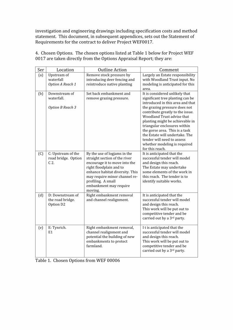
The CBEC appraisal was formulated around providing restoration options on 5 Reaches of the river that had been identified by Alasdair Matheson SEPA in an early survey of the river.2 These are shown at Fig 1. Subsequently the Project Board for WEF0006 chose options from the CBEC report which, if funding became be available, should be developed and taken forward to design stage. It is to be noted that the Matheson reaches are numbered 1-5 and the CBEC report refers to Option A-E shown on Figure 2. These broadly overlap.
1 CBEC Upper Nairn River Restoration Project, Geomorphological Assessment and Restoration Options Appraisal – Feb 15. 2 SEPA Hydromorphology File Note dated May 13.
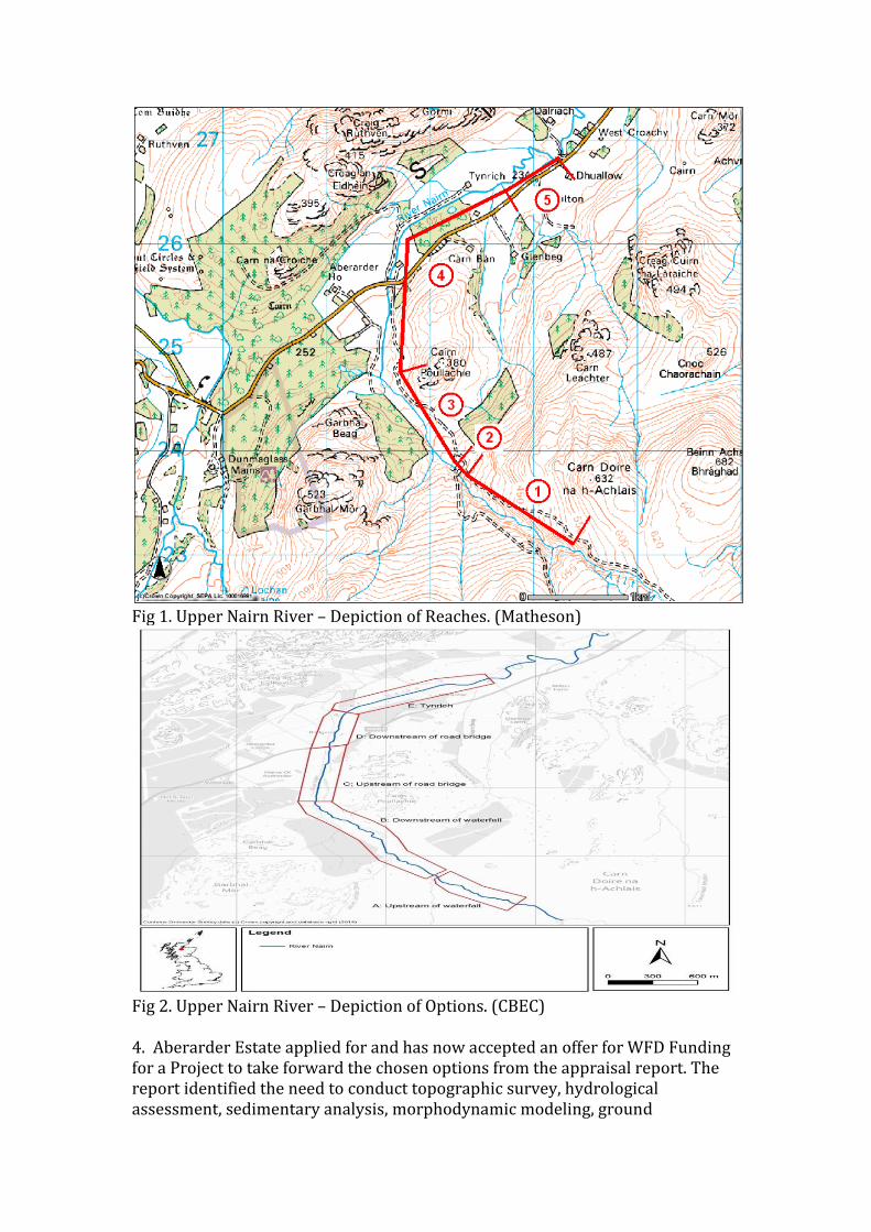
Fig 1. Upper Nairn River – Depiction of Reaches. (Matheson)
Fig 2. Upper Nairn River – Depiction of Options. (CBEC) 4. Aberarder Estate applied for and has now accepted an offer for WFD Funding for a Project to take forward the chosen options from the appraisal report. The report identified the need to conduct topographic survey, hydrological assessment, sedimentary analysis, morphodynamic modeling, ground
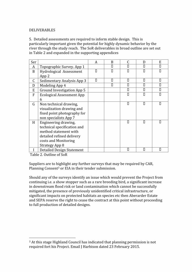
investigation and engineering drawings including specification costs and method statement. This document, in subsequent appendices, sets out the Statement of Requirements for the contract to deliver Project WEF0017. 4. Chosen Options. The chosen options listed at Table 1 below for Project WEF 0017 are taken directly from the Options Appraisal Report; they are:
Ser Location Outline Action Comment (a) Upstream of
waterfall Option A Reach 1
Remove stock pressure by introducing deer fencing and reintroduce native planting
Largely an Estate responsibility with Woodland Trust input. No modeling is anticipated for this area.
(b) Downstream of waterfall. Option B Reach 3
Set back embankment and remove grazing pressure.
It is considered unlikely that significant tree planting can be introduced in this area and that the grazing pressure does not contribute greatly to the issue. Woodland Trust advise that planting might be achievable in triangular enclosures within the gorse area. This is a task the Estate will undertake. The tender will need to assess whether modeling is required for this reach.
(C) C: Upstream of the road bridge. Option C 2.
By the use of logjams in the straight section of the river encourage it to move into the right floodplain and to enhance habitat diversity. This may require minor channel re-profiling. A small embankment may require moving.
It is anticipated that the successful tender will model and design this reach. The Estate may undertake some elements of the work in this reach. The tender is to identify suitable works.
(d) D: Downstream of the road bridge. Option D2
Right embankment removal and channel realignment.
It is anticipated that the successful tender will model and design this reach. This work will be put out to competitive tender and be carried out by a 3rd party.
(e) E: Tynrich. E1
Right embankment removal, channel realignment and potential the building of new embankments to protect farmland.
I t is anticipated that the successful tender will model and design this reach. This work will be put out to competitive tender and be carried out by a 3rd party.
Table 1. Chosen Options from WEF 00006
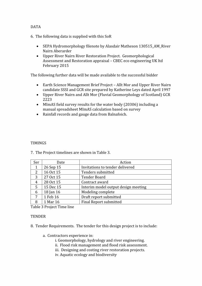
DELIVERABLES 5. Detailed assessments are required to inform stable design. This is particularly important given the potential for highly dynamic behavior by the river through the study reach. The SoR deliverables in broad outline are set out in Table 2 and expanded in the supporting appendices
Ser A B C D E A Topographic Survey. App 1
B Hydrological Assessment App 2
C Sedimentary Analysis App 3
D Modeling App 4
E Ground Investigation App 5
F Ecological Assessment App 6
G Non technical drawing, visualization drawing and fixed point photography for non specialists App 7
H Engineering drawing, technical specification and method statement with detailed refined delivery costs and Monitoring Strategy App 8
I Detailed Design Statement
Table 2. Outline of SoR Suppliers are to highlight any further surveys that may be required by CAR, Planning Consent3 or EIA in their tender submission. Should any of the surveys identify an issue which would prevent the Project from continuing i.e. a show stopper such as a rare breeding bird, a significant increase in downstream flood risk or land contamination which cannot be successfully mitigated, the presence of previously unidentified critical infrastructure, or significant impacts on protected habitats an species etc then Aberarder Estate and SEPA reserve the right to cease the contract at this point without proceeding to full production of detailed designs.
3 At this stage Highland Council has indicated that planning permission is not required fort his Project. Email J Harbison dated 23 February 2015.
DATA 6. The following data is supplied with this SoR
SEPA Hydromorphology filenote by Alasdair Matheson 130515_AM_River Nairn Aberarder
Upper River Nairn River Restoration Project. Geomorphological Assessment and Restoration appraisal – CBEC eco engineering UK ltd February 2015
The following further data will be made available to the successful bidder
Earth Science Management Brief Project – Allt Mor and Upper River Nairn candidate SSSI and GCR site prepared by Katherine Leys dated April 1997
Upper River Nairn and Allt Mor (Fluvial Geomorphology of Scotland) GCR 2223
MImAS field survey results for the water body (20306) including a manual spreadsheet MImAS calculation based on survey
Rainfall records and gauge data from Balnafoich. TIMINGS 7. The Project timelines are shown in Table 3.
Ser Date Action 1 26 Sep 15 Invitations to tender delivered 2 16 Oct 15 Tenders submitted 3 27 Oct 15 Tender Board 4 28 Oct 15 Contract award 5 15 Dec 15 Interim model output design meeting 6 18 Jan 16 Modeling complete 7 1 Feb 16 Draft report submitted 8 1 Mar 16 Final Report submitted
Table 3 Project Time line TENDER 8. Tender Requirements. The tender for this design project is to include:
a. Contractors experience in: i. Geomorphology, hydrology and river engineering. ii. Flood risk management and flood risk assessment. iii. Designing and costing river restoration projects. iv. Aquatic ecology and biodiversity

b. A method statement showing how the contractor will complete each element of the design project with clear times and costs allocated for each element. c. A non-technical summary of the issues involved. Noting in particular the electricity power line in Reach 4 and 5 d. An outline of resources available to the contractor to complete the task and the timeframe within which the contract can be completed.
9. Tender Scoring Criteria. Members of the Project Board that is to include at least one representative from SEPA, Aberarder Estate and the Findhorn, Nairn Lossie Fisheries Trust, will score tender submissions. Others may be invited on to the Board at a later date. Tender scoring criteria are as follows:
a. Understanding the brief. b. Proven experience and technical knowledge in the field of high-energy dynamic rivers. c. Delivery Approach. d. Resources and staff. e. Communications f. Cost, value for money and time

Appendix 1: Topographic survey
In order to provide boundary conditions for the subsequent modeling, a detailed
topographic survey of the site where any restoration is anticipated option is to
be implemented. The tender is to justify the extents of their survey and
modeling. It is important that the survey team members are not only proficient
surveyors and include someone who has a good understanding of geomorphic
process/ form and the aspects of river corridor topography required by 2D
hydrodynamic modeling. Failure to capture key features of the channel and its
margins can produce very misleading model output. Surveys should not
necessarily be conducted on a cross-section basis but designed to capture all
inflections in channel geometry in the horizontal and vertical planes. The surveys
are to define the 3D topography of the river channel, bar features, hydraulic
controls, flood plain, embankments, and other engineering structures. The
survey is to be undertaken in the OSGB36 co-ordinate system.

Appendix 2: Hydrological assessment
Since the specific site is not associated with a nearby flow gauge, design
hydrographs for the modeling phase will need to be developed using appropriate
methodologies for ungauged catchments. It is proposed that WINFAP-FEH 3 is an
appropriate methodology for this task. Responses wishing to use alternative
methods are to justify their selection.
The flow gauge at Balnafoich, while influenced by significant tributaries below
the model section, might offer useful readings for validation.

Appendix 3: Sedimentary analysis
Detailed sedimentary analysis is required as input data to the 2D
morphodynamic model (both for input information on bedload character and
roughness partitioning). A proposed strategy of sampling design and
methodology for this task, which meets with the objective if modeling is to be
submitted.
Appendix 4: Geomorphic and Flood Risk Modelling
2D hydraulic models are generally incapable of predicting equilibrium channel
form- especially in high energy systems like the Nairn with high sediment
supply. Therefore, hydraulic and sediment transport modelling with a morpho-
dynamic bed will be necessary in this project to predict whether proposed
designs are quasi-stable, and/ or what equilibrium state the channel will adopt.
Such a model is to include unsteady flow, as many erosion/ aggradation
processes in rivers are dependent on the hydrograph shape, be 2D to include
lateral and longitudinal flow, be capable of computing transcritical flow and use
an unstructured or curvilinear mesh, fitted to the channel shape. In addition, for
accurate prediction of erosion at meander bends, the model is to account for
helical flow, although this need not be by direct 3D calculation. The supplier is to
specify the suitable modeling platform to be employed. Mike21C would be
deemed an appropriate modeling platform/software. The supplier is to provide
evidence of their understanding and application of the proposed software.
For prediction of stable channel form, the morpho-dynamic model should be run
for single bankfull, extreme events (e.g. 50ye 200yr and 1000yr ) and a series of
variable high flows. The supplier is to detail how model validation will be
achieved and the format in which model outputs will be presented and
explained.
For a flood risk assessment, the hydraulic model domain is to be at least large
enough to capture the functional flood plain (approximately the 200 year flow).
A flood risk model, following SEPA guidelines, should be either 1D/2D or fully
2D, incorporate variable surface roughness, be unsteady and capture shocks. All
of these capabilities are to be already encompassed by the sediment transport
model so, to improve efficiency, the same, or slightly modified, hydraulic model
used for sediment transport are to be used to assess the flood risk potential. A
range of unsteady hydrographs are to be simulated for flood risk, from the 2 year
event up to at least the 200 year plus climate change flow.
For all models, appropriate sensitivity testing for roughness and boundary
conditions are to be carried out.

Appendix 5: Ground investigation
Desk and field-based assessments of soil and ground conditions are to be
conducted, prior to final designs suitable for construction being produced. The
data generated will be used to fine-tune the earthworks element of the design to
be implemented. The nature of these assessments are to be specifically tailored
in relation to the final design (e.g. targeted at locations of the restoration site
proposed for the greatest degree of vertical alteration - i.e., both excavation and
raising - of the existing ground surface). The level of detail required will be
dependent on the nature of the site and the design. Components of the
investigation are to include:
A desk based study to identify:
• Soil types, their potential composition and any spatial variation.
• The productivity and porosity of the soils.
• Any information on ground water and its importance.
• Any other information on the local soils and substrate, including physical,
hydrological and strength properties and the typical depth to bedrock.
A field based assessment, directed by the desk study, following EuroCode 7
methodologies, including:
• Core sampling, with laboratory analysis to identify various soil and
substrate physical properties (e.g. particle size distribution, moisture and
organic content, plasticity)
• Pits samples for bulk density analysis
• Infiltration measurements
A ground investigation strategy is to be proposed along with detailed costings
for carrying out the same.
A desk based utilities search is to be carried out to identify any utilities in the
vicinity of the proposed works that may add limitation to the design.

Appendix 6 Ecological Assessment
Particular attention is to be given to the ecological elements associated with the
Project. An analysis of the short term damage done to the local ecology against
the long term benefits created by the Project are to be presented. This analysis is
to be done in conjunction with the RSPB, SNH and the Findhorn Nairn and Lossie
Fisheries Trust. The analysis will inform the decisions as to when the build
element of the Project might be undertaken. It is to be noted that the Estate is
especially interested in seeing and increase in available spawning ground for
migratory fish. Costs for such work are to be included within the overall design
plan.

Appendix 7: Non technical drawings, visualization drawings and fixed point photography for non specialists Non technical drawings, visualization drawings with a fixed point photography
plan for each option/reach are to be presented in order that the non specialist
may easily understand the design plan. A fixed-point photography plan is to be
drafted and costed which is to demonstrate a simple before and after Project
record. Visualizations are to be produced integrating current and post-
implementation depictions.

Appendix 8: Engineering drawings, technical specification method
statement and Monitoring Strategy
Detailed engineering design drawings of the proposed restoration option(s) are
to be prepared to the standard necessary for the construction of the works,
including an associated works contract. At the very least this will include
engineering drawings, a bill of quantities and detailed project costs.
Map‐based plots of the general site lay‐out of each structure are to be presented
at high resolution (not less than at 1:5000 scale). At greater detail, AutoCAD
drawings are to be used to present dimensions and detail on plan, long profile
and cross‐sections for each of the proposed designs with details of materials also
provided. Areas of the selected designs of specific importance will receive
particular attention in design detail. Electronic copies of all drawings are to be
made available and hard copies are to be presented on an A0 map.
All engineering design drawings are to be reviewed by a Chartered Civil
Engineer. The documents produced through this task are to provide a sufficient
level of detail to enable statutory consents to be applied for and suitable for the
development of a construction contract.
A detailed Construction Method Statement for the works is to be produced. The
method statement will cover the chronological sequence of the various detailed
stages of the construction process. This is to include site clearance, design
‘roughing out’, design base geometry profiling, the movement and storage of
required materials, substrate placement and profiling, bank stabilisation
measures, implementation of large wood structures, floodplain reprofiling and
vegetation planting. The statement is to be supported by the detailed
engineering design drawings (presented to a standard understandable to a
construction contractor) and the Bill of Quantities defining cut/ fill volumes for
each component of the design. Furthermore, the statement is to provide detail on
the requirements for fine sediment pollution control, including the appropriate
location for the implementation of measures and the suitable methods/
materials that should be employed.
A related issue is the application of the most current Construction (Design and
Management) Regulations (CDM). Any project that is classified as ‘construction’

needs to be managed in accordance with these regulations, the definition of the
proposed project determining the likely scope and scale of the works. It is
important to consider that, where the construction phase will last for more than
30 days, or involve more than 500 person-days of work, the project will become
‘notifiable’ to the Health and Safety Executive. Should this be triggered the
associated costs are to be made clear.
Monitoring and Gravel Management Strategy
The tenderer is to propose with indicative costs and duration a monitoring and
gravel management strategy to assess the response of the river compared with
the predicted response from the morphological model. It is to be noted in
particular that the gravel management strategy will require an enduring
license/agreement between SEPA and the Estate to be prepared which facilitates
the removal of gravel from the moths of drainage ditches.

Appendix 9. Detailed Design Statement
The designs produced under the WFD0006 Project are in outline form only and
are as such indicative. These designs are to be developed into detailed designs
that accurately show the proposed location, extent and geometry of alterations
that will achieve the desired improved morphological condition and associated
benefits.
Prior to any modeling being carried out it will be necessary for the supplier to
produce a ‘first cut’ design which can then be tested and if necessary refined
using the models. The ‘first cut’ design must be based on sound
geomorphological principles. A detailed design statement is to be produced
which explains and justifies the chosen design. The document will also outline
any limitations on the design e.g. valley slope/bank material, adjacent
infrastructure/land use and outline measures to deal with these limitations as
appropriate. The supplier is to describe the method they propose using to
undertake the design in their submission.