abbreviated fort point historic structure report · abbreviated fort point historic structure...
TRANSCRIPT

Abbreviated Fort Point Historic Structure Report
National Park ServiceU.S. Department of the Interior
Fort Point National Historic Site Golden Gate National Recreation Area


Abbreviated Fort Point Historic Structure Report
Fort Point National Historic Site Golden Gate National Recreation AreaFort Mason, Building 201San Francisco, California
Produced by the Cultural Resources & Museum Management DivisionGolden Gate National Recreation AreaNational Park Service
U.S. Department of the InteriorWashington, DC
September 2006
Front cover photo: A view of Fort Point, circa 1869. Credit: Fort Point NHS Collection, Golden Gate National Recreation Area.
inside front page photo: View of Fort Point, circa 1869. Credit: National Archives, Record Group 77
Back cover photo: This photo, dated 1910, shows the Fort Point lighthouse keeper’s residences located at the south of the fort. Credit: Fort Point NHS Collection, Golden Gate National Recreation Area.


Contents
Introduction ............................................................................................... 8
Developmental History ........................................................................... 14
Fort Point: Sentry at Golden Gate ............................................. 14Chronology of Fort Point Development & Use ......................... 28
1776-1852: Castillo de San Joaquin ................................... 281853-1860: Initial Construction ........................................ 301861-1868: The Civil War & the First Garrison.................... 351868-1906: Dire Straights ................................................. 371907-1930: Detention Barracks WWI, Army Use ............... 451931-1940: Golden Gate Bridge Construction .................. 491941-1945: World War II ................................................... 541946-1970: The Move Toward Preservation: Establishment of the Fort Point Museum Association .............................. 551970-1998: National Park Service Stewardship ................... 57
Physical Description .................................................................... 74Conditions Assessment and Material Investigations .............. 100
Treatment & Work Recommendations ................................................. 122
Evaluation of Restoration Work to Date ................................ 122Secretary of the Interior’s Standards ........................................124Requirement for Treatments & Use (Outline) ..........................125Treatment Recommendations (Outline) ...................................125
Bibliography ........................................................................................... 126
Glossary .................................................................................................. 130
Appendices A: Floor Plans ..................................................................... 133
Appendices B: List of Fort Point Documents ........................................151
Appendices C: Supplemental Record of Work Performed ................. 152
Left: Photo of Fort Point during winter of 2000. Photo circa 2000. Credit: Su Chu-Way, Golden Gate National Recreation Area.

7 Fort Point Historic Structures Report

National Park Service 8
Left: Contemporary view of Fort Point interior. Photo circa 2000. Credit: Golden Gate National Parks Conservancy.
Fort Point became part of the National Park Service in 1970 and has been administered by Golden Gate National Recreation Area since that park was cre-ated in 1972. Since then, the National Park Service has conducted significant research on the Fort in order make the best building rehabilitation deci-sions. This Abbreviated Fort Point Historic Structure Report is a synthesis of most of the research con-ducted to-date and makes references to other related reports and studies. The appendices also contain floor plans and a list of Fort Point documents.
However, this Abbreviated Fort Point Historic Structure Report does not contain a completed Treatment Recommendations section that is one of the critical components of a standard historic structure report; hence the title “Abbreviated” Fort Point Historic Structure Report. The historic preservation consultants Carey & Co. wrote an outline for this section which provides guidance for future work. It is the National Park Service’s hope that the treatment recommendations work will be conducted by a historical architect in the near future. PreparationAt Carey & Co. (460 Bush Street, San Francisco, CA 415-773-0773), individuals included Alice Carey, Principal; Nancy Goldenberg, Project Manager; and Heidi Stosick.
At Architectural Resources Group (Pier 9, The Embarcadero, San Francisco, CA 415-421-1680), individuals included Davis Wessel, Principal; Glenn David Mathews, Project Architect; Ricarda Cepeda, Project Manager & Historic Preserva-tion Specialist; and Christina Wallace, Technical Editing.
At the Golden Gate National Recreation Area, National Park Service (Bldg 201, Fort Mason, San Francisco, CA 415-561-4700), individuals included Jane Lehman, Historical Architect; Kristin Baron, Architectural Historian; Paul Scolari, Historian; Theresa Griggs, Fort Point Supervisor; Maureen Rogers, Park Ranger; Susan Ewing Haley, Park Archivist; Mary Gentry, Archivist Technician, George Su, Media Specialist; and John Martini, Curator of Military History. Executive SummaryFort Point in the Presidio of San Francisco is a National Register property that contributes to the Presidio of San Francisco National Historic Landmark. The fort and the surrounding 29 acres today comprise Fort Point National Historic Site, a unit of the National Park Service.
Fort Point is a classic brick and granite 19th-cen-tury American coastal fort, and the only one of its style constructed west of the Mississippi River. The fort and its exterior batteries were key ele-ments of the harbor defenses of San Francisco during the American Civil War, the Spanish
American War, and World War II. The fort is now recognized as one of the best-preserved “Third System” forts in the United States.
Originally built to protect the entrance to San Francisco Bay during the Gold Rush, Fort Point was garrisoned throughout the Civil War in antic-ipation of enemy attack either by Confederate naval forces or by Confederate insurgents living in California. In 1863, the U.S. Lighthouse Board erected a hexagonal iron lighthouse on the fort’s roof (“barbette”) to mark the southern boundary of the harbor entrance. San Francisco was never attacked, and Fort Point never saw battle, and three years after the war ended the army withdrew the garrison and began removing the obsolete cannon.
The fort entered a period of underutilization for several decades, during which it was used spo-radically as barracks, classroom site, warehouse and automotive workshop. Newer gun batteries constructed of earth and concrete were erected on the hillsides overlooking the fort, and in 1882 the Army formally named the masonry fort and its exterior batteries “Fort Winfield Scott.” In the 1930s, the fort was initially scheduled for demoli-tion to make way for the Golden Gate Bridge, but instead was saved by the bridge’s chief engineer who recognized its unique historic and archi-tectural values.
During construction of the Golden Gate Bridge, “old Fort Point” as it had come to be known held office spaces, workshops, a cafeteria, and other con-struction-related activities. Following the outbreak of World War II, the fort once again became a key element in the Harbor Defenses of San Francisco when the Coast Artillery erected a battery of rapid-fire guns on the barbette tier as protection against Japanese attack. In 1959, a group of retired military officers and civilian engineers formed the Fort Point Museum Association to lobby for its preservation as a Historic Site. That effort culminated on October 16, 1970 with the creation of Fort Point National Historic Site.
The building’s official name and number is Fort Point National Historic Site, Presidio of San Fran-cisco Building #999.Relevant DocumentsThe following is a list of research conducted on Fort Point. All of the following documents are included in the Abbreviated Fort Point Historic Structure Report except for the 1973 Historic Data Section.
1973: Historic Data Section, Fort Point Historic Structure Report; National Park Service
In 1973, the National Park Service wrote the Historic Data Section for the Fort Point HSR. This report, written by Edwin C. Bearss, focused mainly on the initial construction for the Fort. The report does not contain an Architectural Data Section,
Introduction
which would have graphically outlined the developmental history of the fort, or analyzed existing conditions, and made any recommendations for treatment. While this document is valuable, it is focused largely on the minute details of the construction process and represents only a small part of what comprises of a whole HSR. The Bearss document is referenced but not included in the Abbreviated Fort Point Historic Structure Report. Currently, the 1973 Historic Data Section is not in public circulation, but the hope is that the document will be available on the Golden Gate National Recreation Area’s website in the near future.
1991: Fort Point; Sentry at the Golden Gate; John Martini
In 1991, John Martini wrote Fort Point; Sentry at the Golden Gate for the Golden Gate National Park Association. This booklet was designed to introduce visitors to Fort Point and provides useful historical background. The document has been adapted for the Abbreviated Fort Point Historic Structure Report and used as the narrative part of the Developmental History.
1997: Outline Historic Structures Report; Carey & Co.
In October of 1997, the National Park Service contracted with Carey & Co. to create an Outline Historic Structure Report to update the existing 1973 Fort Point HSR. The goal of this Outline Historic Structure Report was to serve as a design for completing a full Historic Structure Report. Their document featured an in-depth
“Chronology of Development and Use”, as well as an assessment of restoration work to-date and an examination of the Fort for physical evidences of change.
The “Chronology of Development and Use” listed projects by date in chronological order. For ease of use, Carey & Co. organized the material into chapters by historical period. These periods are for the most part defined by major events or changes in use or management that resulted in physical alterations to the fort.
• 1776-1852: Castillo de San Joaquin• 1853-1861: Initial Construction• 1862-1868: The Civil War and the First Gar-
rison• 1868-1906: Dire Straights• 1907-1930: Detention Barracks, WWI, Army
Use• 1931-1940: Golden Gate Bridge Construc-
tion• 1941-1945: WWII• 1946-1970: The Move Toward Preservation:
Establishment of the Fort Point Museum Association
• 1971-1998: National Park Service Stewardship
The “Chronology of Development and Use”, focusing on the construction history of the fort, chronicles the history of Fort Point from the first Spanish fort through the present. Mea-sured drawings and a glossary were also pre-pared as part of this contract.Carey & Co. updated the 1973 HSR with post-1973 building projects. They also added relevant material from local archives that were probably not available when the earlier document was prepared and placed everything into a clear, easy-to-use format. Carey & Co. conducted research at several local repositories containing primary research materials. Their research is referenced in the annotated bibliography at the end of this document.
Research was conducted at the following archives:
• The Park Archives and Records Center of Golden Gate National Recreation Area.
• The Pacific Sierra Branch of the National Archives Administration (San Bruno).
• The San Francisco History Room of the San Francisco Public Library.
• The Fort Point National Historic Site Administrative Office.
• The J. Porter Shaw Library of the San Fran-cisco Maritime National Historical Park.
• The California Historical Society.
Carey & Co. also interviewed the following individuals who had long-term familiarity with the Fort: John Martini, former Curator of Military History, Golden Gate; Maureen Rogers, Park Ranger, Golden Gate; Ric Borjes, former Historical Architect and Chief, Branch of Cultural Resources, Golden Gate; Charles Schultheis, former Maintenance Buildings and Utilities, Golden Gate; Rich Weideman, for-mer South District Chief Interpretive Ranger, Golden Gate.January 2005: Conditions Assessment and Materials Investigation; Architectural Resources Group (ARG)
The purpose of the Architectural Resources Group investigation was to evaluate the nature, cause and extent of water intrusion and general material deterioration in areas excluded from recent rehabilitation projects. The recommendations included in their report are guidelines for the repair of the most critically deteriorated materials and areas; they are not construction documents. These are recommendations that may be incorporated into preventative maintenance and general housekeeping plans for Fort Point.
9 Fort Point Historic Structures Report

Statement of Significance Fort Point has stood guard at the narrows of the Golden Gate for nearly 150 years. It has been called “the pride of the Pacific,” “the Gibraltar of the West Coast,” and “one of the most perfect models of masonry in America.” When construc-tion began during the height of the California gold rush, Fort Point was planned as the most formidable deterrence America could offer to a naval attack on California. Although its guns never fired a shot in anger, the “Fort at Fort Point” as it was originally named has witnessed Civil War, obsolescence, earthquake, bridge construc-tion, reuse for World War II, and preservation as a National Historic Site.
Fort Point was built between 1853 and 1861 by the U.S. Army Engineers as part of a defense system of forts planned for the protection of San Francisco Bay. Designed at the height of the gold rush, the fort and its companion fortifications would pro-tect the Bay’s important commercial and military installations against foreign attack. The fort was built in the Army’s traditional “Third System” style of military architecture (a standard adopted in the 1820s), and would be the only fortification of this impressive design constructed west of the Mississippi River. This fact bears testimony to the importance the military gave San Francisco and the gold fields during the 1850s.
Although the fort never saw battle, it has tremen-dous significance due to its military history, its architecture, and its association with maritime history.
Fort Point has significance under National Reg-ister Criteria A and C for its association with the Civil War and World War II; construction of the Golden Gate Bridge; maritime history; and its important architectural features.
The fort meets Criterion A, “the broad patterns of our history,” for its role in military history as a defensive fortification that was continually manned during the American Civil War. Its hasty completion on the eve of the war and its armed presence throughout the Civil War reflect the importance given by the government to protect-ing San Francisco and its important harbor. The fort has further military significance due to its important associations with World War II when the army gave the old structure a renewed defen-sive role as the site of anti-torpedo boat defenses mounted on the fort’s roof to against possible Japanese attack. The fort also has significance under this criterion due to its association with the construction of the Golden Gate Bridge in the 1930s, an undertaking of overwhelming engineer-ing and sociological importance during the Great Depression. Finally, the fort’s lighthouse gives it association with the patterns of maritime his-tory in the United States for its role guiding ships through the hazardous Golden Gate straits.
Fort Point meets Criterion C, “distinctive char-acteristics of a type, period, or method of con-struction” because of its architectural style and construction techniques. The United States Army
engineers constructed more than thirty brick and masonry forts in the Third System style between 1820 and 1870, but of this number only Fort Point was built in the West. More importantly, the fort represents the culmination of the Third System designs and incorporates design features per-fected over the preceding decades. Because Fort Point never saw battle, and because it was never extensively rebuilt like so many other forts, it remains virtually unchanged from its Civil War appearance. Also, due to the mild San Francisco climate, the fort has been spared the destructive forces of hurricanes and “freeze-thaw” cycles that have reduced many other forts to near ruins. Historians recognize Fort Point as one of the best-preserved Third System forts in the country.Civil War Period, 1861-1868Fort Point was originally designed to serve as one of a trio of forts located on San Francisco Bay under a plan devised by the U.S. Army Engi-neers in 1850 at the height of the California Gold Rush. (The other two forts were to be located on Alcatraz Island and Lime Point. Alcatraz was eventually fortified, albeit in a radically different style from Fort Point, but the Lime Point fort was never built.) Work began on Fort Point in 1853 and continued through the outbreak of Civil War in early 1861. Planned to mount 141 cannon in its interior and exterior batteries, Fort Point was the ultimate expression of an American “Third Sys-tem” fortification, so-named because it was part of the third system of permanent fortifications constructed by the young United States.
The original threat for which the fort was built was a possible attack by Great Britain, which maintained a large naval base in British Columbia. However, when war came to California the threat would come from within our nation, not from a foreign power, and Fort Point was rushed to completion at the start of the American Civil War. Troops were actually ordered into the fort before its cannon were even mounted to make sure that local Confederate supporters did not seize the empty fort. When the soldiers did begin installing the guns shortly afterwards, they positioned many weapons to face south to defend against possible land attack rather against a naval assault.
Throughout the war, Union artillerymen gar-risoned the fort and readied its dozens of smoothbore cannon in anticipation of enemy attack—either by Confederate warships or by Confederate insurgents living in California. At its height of readiness in 1865, Fort Point mounted 55 cannon ranging in size from 24-lb. howitzers up through 10-inch caliber Columbian cannon. More than 500 enlisted men, officers, and civilians lived within the fort’s casemated living quarter rooms or in nearby wooden barracks.
Beginning in 1855, a temporary wooden light-house had been built on the seawall adjacent to the fort to mark the southern boundary of the harbor entrance. In 1864, a hexagonal iron lighthouse was erected on the fort’s roof (“barbette”) that stood clear of the fort’s cannon. The tower’s Fresnel-
National Park Service 10

11 Fort Point Historic Structures Report
pattern lens was eventually augmented by a fog bell hung from the fort’s exterior wall. Manned by civilian keepers who lived on the hillside south of the fort, the Fort Point Light Station would lead countless ships through the Golden Gate straits for the next 70 years.
The fort’s career as an active harbor defense post lasted only seven years. Battles waged during the Civil War demonstrated the vulnerability of masonry forts such as Fort Point to long-range artillery attack. Instead of providing robust defense against enemy bombardment, their thick masonry walls had actually proven to offer scant resistance to modern rifled artillery fire. (Fort Pulaski in Georgia fell to rifled artillery fire in 30 hours.) Military planners feared that in this new era of warfare, Fort Point’s towering walls would only provide attractive targets to an attack-ing enemy. Following the war, Fort Point entered a period of decline until its troops were totally withdrawn in 1868. Next came a decades-long period of intermittent abandonment and reuse that lasted until the 1930s. During this period the fort sporadically served as a barracks, artil-lery training site, temporary quarters for military families, a school for motor vehicles mechanics, and even a never-completed military prison. Golden Gate Bridge Construction, 1933-1937In the 1920s, plans were developed to construct a breath-taking new bridge that would span the straits of the Golden Gate. Designed to connect the City of San Francisco with the sparsely-popu-lated rural counties to the north, voters hoped its presence would spur commercial development north of the Gate. The new bridge would be an engineering achievement in many ways, but most impressively, it would be the longest single-span suspension bridge in the world when completed. When work actually began in 1933, at the depths of the Great Depression, the bridge’s construc-tion would also represent a leap of faith in the economic future of America.
But there was a problem with the planned Golden Gate Bridge: Fort Point stood precisely where the southern anchorage of the new bridge was to be con-structed. The fort, it seemed, would have to go.
Before construction began, though, Chief Engi-neer Joseph Strauss toured the empty fort and changed his mind – and also his design. In a 1937 memorandum to the bridge’s Board of Directors, Strauss wrote: “While the old fort has no military value now, it remains nevertheless a fine exam-ple of the mason’s art. Many urged the razing of this venerable structure to make way for modern progress. In the writer’s view it should be pre-served and restored as a national monument…” Consequently, Strauss designed a steel arch in the southern anchorage to span the old fort. Fort Point would be overshadowed by the new bridge, but it would be preserved.
Work on the Golden Gate Bridge lasted from 1933 to 1937. Fort Point’s casemates made convenient work space for the hundreds of workers and artisans who soon swarmed around the bridge’s
southern anchorage. The second tier gun rooms served as a cafeteria for bridge workers, and the fort was soon enveloped in a maze of wooden scaffolding as the huge steel arch was erected over the barbette tier.
Although the main casemated portion of Fort Point was spared during construction, some of the outworks of the fort had to be demolished to make way for the southern bridge anchorage, including a small counterscarp gallery that had protected the fort’s southern face and a sepa-rate ten-gun battery located on the hill south of the fort. The Fort Point Lighthouse was also to become a victim of the bridge. By late 1934 the bridge’s rising steelwork and concrete caissons had obscured the light’s beam. It was replaced that year with new light at the base of the bridge’s south tower.
The Golden Gate Bridge’s grand dedication took place in May of 1937. For the next few years the fort was nearly forgotten, overshadowed by the soaring new steel bridge overhead.World War II, 1942-1945The outbreak of World War II brought a massive increase in military activity around the Bay. Ironi-cally, in the aftermath of Pearl Harbor, old Fort Point would once again become a key element in the Harbor Defenses of San Francisco.
In response to the fear that Japanese submarines might try to enter the harbor, the Navy strung a steel net across the Golden Gate in early 1942. Defense of this net became the responsibility of the U.S. Army. To help both protect this net and to guard against a possible attack by swift motor-torpedo boats, the Army removed four 3-inch caliber Anti-Motor Torpedo Boat (AMTB) guns from Fort Baker in Marin County and remounted them on the barbette tier of Fort Point. Named
“Battery Point” in honor of the fort, two of the guns were positioned facing west to protect the mine fields outside the Golden Gate while the other two guns faced into the Bay to defend the anti-submarine net.
In addition to the AMTB guns, the fort’s bar-bette also mounted a 60-inch searchlight used for illuminating targets at night, and a pair of range finding stations used in aiming the big coastal guns mounted at the Presidio.
The AMTB guns were manned by about 100 sol-diers from Battery N of the 6th U.S. Coast Artil-lery Regiment, who took up residence in the barracks rooms originally built for Civil War-era troops. Stationed several thousand miles from the major theaters of combat, the men spent their days in a routine of drills, artillery practice, inspec-tions, sentry duty, and maintenance chores. The lower levels of the fort were soon refurbished for a variety of war-time uses: barracks spaces, administrative offices, a mess hall, recreation room, barber shop and even a post exchange for the new garrison. The first-floor rooms provided storage space for camouflage materials used by Harbor Defense troops in disguising nearby gun emplacements.

National Park Service 12
By late 1944, however, the threat of Japanese attack had disappeared and the Fort Point troops were removed. Once again, the future of the fort was uncertain.Preservation of the FortFollowing World War II, a movement took hold to protect and preserve Fort Point. This move-ment crystallized in 1959 when a group of retired military officers and civilian engineers banded together to form the Fort Point Museum Associa-tion. Operating with the blessing of the U.S. Army, the Association spent the next eleven years raising funds for the preservation of the fort and lobbying for its creation as a National Historic Site.
In 1968, local congressmen introduced bills calling for the creation of Fort Point National Historic Site. Both bills passed the House and Senate. On October 16, 1970, the bill in its final form was signed into law by President Richard Nixon. Today, Fort Point National Historic Site is open to the public and administered by Golden Gate National Recreation Area, National Park Service.
Fort Point stands today beneath the soaring Golden Gate Bridge as a monument to more than two centuries of military presence on San Fran-cisco Bay. The fort also bears silent and eloquent testimony to the craftsmanship of the U.S. Army engineers who designed it and the stonemasons, carpenters, brick layers, mule skinners, and labor-ers who erected it.

13 Fort Point Historic Structures Report

National Park Service 14
Early History: 1776–1846The site of Fort Point was originally a high prom-ontory known to 18th-century Spanish colonizers as “Punta del Cantil Blanco”- White Cliff Point. Located at the narrowest part of the only entrance to San Francisco Bay, the point was an obvious location for a fort to keep out enemy ships. In 1794 the Spanish erected a tiny adobe gun battery atop Cantil Blanco as defense against possible British and Russian aggression. Christened “Castillo de San Joaquin,” the little fort and its handful of century-old bronze and iron guns soon fell victim to the harsh San Francisco climate. Adobe walls melted in the rain, and lack of repair funds from far-off Madrid led to eventual ruin of the Castillo. Shortly after Mexico gained its independence from Spain in 1821, the fort was abandoned to the elements.
The only invasion in San Francisco’s history occurred at the Castillo in 1846 during the short-lived “Bear Flag Revolt.” Early in the morning of July 1, a rough-hewn group of Yankees, led by John Charles Fremont and Kit Carson began the long pull across the Bay from Sausalito to the ancient Spanish fort “Castillo de San Joaquin” on
the San Francisco shore. They called themselves “Bear Flaggers” after their flag of revolution, and their goal was the liberation of California from Mexican control.
Nosing their launch into a sheltered cove below the fort, the raiders scrambled up the hundred-foot hillside, swarmed into the crumbling Castillo and spiked the cannon mounted within its walls. The only tarnish on the victory was that the Cas-tillo had not been garrisoned for a dozen years.
“In the absence of a garrison with no powder,” wrote one caustic historian, “it is not surprising that not one of the ten cannon offered the slight-est resistance.”
United States military forces were shortly in con-trol of California. The growing American popu-lation gave local landmarks new names, and the old Castillo soon became known as “Fort Blanco.” The point upon which it sat was simply nicknamed
“Fort Point.” It was a name that would stick.
Developmental HistoryFort Point: Sentry at Golden Gate by John Martini
Above: Contemporary view of Fort Point, circa 2000. Credit: Golden Gate National Parks Conservancy.
Left: Contemporary view of Fort Point interior. Photo circa 2000. Credit: Golden Gate National Parks Conservancy.

15 Fort Point Historic Structures Report
A Fort to Guard the Golden Gate: 1848 - 1868 The California Gold Rush of 1848 took the United States by surprise. Not only was the wealth of the gold fields nearly incalculable, but ship traffic into San Francisco increased dramatically. Only a few ships a year had previously visited the port, but during 1849 alone, 770 vessels entered the Golden Gate. Commerce was booming, and docks, a Navy yard and other strategic harbor installations were under construction. The military suddenly found itself responsible for protecting the most valuable prize in North America: San Francisco Bay.
While the U.S. Army quickly realized that per-manent defenses were needed, it would take time to plan and build major fortifications, or “works;’ to protect the Bay. The harbor needed immedi-ate security, so in March 1849, six modern artil-lery pieces were temporarily mounted inside the remains of the old Castillo de San Joaquin. The following year, a joint Army-Navy board con-vened to make recommendations for defending the entire Pacific coast. Their report, released on November 1, 1850, focused on San Francisco Bay and the Golden Gate channels as the keys to defense of the new state. The board recommended the construction of two major forts, one on either shore of the Golden Gate’s straits formed by Fort Point and Lime Point. The proposed forts would provide a devastating crossfire where the channel measured little more than a mile wide, focusing the effect of several hundred cannon upon any enemy ship entering the Bay.
Backing up this outer line of defense would be an inner line centered around a third major fort on Alcatraz Island. This fort, in turn, would be
backed up by smaller batteries on Angel Island, Yerba Buena Island, and Point San Jose on the northern San Francisco waterfront. Any ship making it through the crossfire at the Golden Gate would thus have to run a gauntlet of addi-tional gun batteries no matter which course it chose through the Bay.
Board members were very insistent that work begin immediately at Fort Point, where “the first work for the defense of the passage should be placed, and nothing should be allowed to interfere with bringing this battery as rapidly as possible to a state of efficiency.” They specified the fort should be “as powerful in its fire on the water as...the largest of our fortifications on the Atlantic,” and recommended mounting over 100 cannon of the largest caliber available.
The style of fort proposed by the engineers was a massive, multi-storied masonry structure contain-ing scores of smoothbore cannon. The guns would be mounted both in enclosed “casemates” and in open “barbette” batteries atop the fort’s roof. Within its five to seven foot thick walls would also be quarters for the officers and soldiers, store rooms, powder magazines, and enough water and provisions to withstand a six-month siege.
Before work could begin on construction of the fort, the remains of the old Castillo and the heights of Cantil Blanco had to be leveled. Mili-tary technology of the day dictated that the lowest level of guns in the fort should be as close to the water as possible. The new work would be built at an elevation only fifteen feet above the Bay. The
This view show the fort’s lighthouse and the lighthouse keepers residences located at the top of the hill, south of the fort. Photo circa 1910. Credit: Fort Point NHS Collection, Golden Gate National Recreation Area.
National Park Service 16
entire tip of the hundred-foot-high peninsula would have to be cut down nearly to sea level to provide a platform for the huge casemated fort.
By mid-September of 1853, a construction gang had demolished the old Castillo and begun lev-eling the promontory, spreading its rocky spoil along the base of the cliffs east and west of the point. It took a year of chipping and blasting at the serpentine rock to complete a platform mea-suring 150 yards by 100 yards. Once the site was cleared, work began on the massive foundations for the fort itself.
Finding the necessary building materials at rea-sonable prices became a never-ending problem for the engineers overseeing the project. Very few of the sources of brick and stone in California met the Army’s high standards for use in fortifi-cations. Adding to the engineers’ problems was the remoteness of California; every construction bid and material sample examined by the local Army engineers had to be reviewed by Chief of Engineers General Joseph Totten in Washing-ton, D.C. During the Gold Rush, the simple act of sending a memo and receiving a reply took as long as three months.
In late 1854, the supervising engineer at Fort Point finally secured permission to use granite imported from China in the work’s foundations; it was of better quality than anything he had been able to find in California, and it cost less than local stone despite being shipped over 5,000 miles. As soon as the foundation trenches were dug, workers laid the slabs of granite atop concrete footings secured to bedrock. Inside the perimeter of the founda-tions, additional excavations were made for five deep cisterns that would hold 200,000 gallons of water for use during time of siege.
Once the foundations were complete, construc-tion began on the arched casemates that would provide rooms for the garrison and guns. The fort’s f loor plan was basically an irregularly shaped rectangle with four principal sides, or faces. The west, north, and east faces looked out on the straits of the Golden Gate and into the harbor, and it was on these sides that the fort mounted three tiers of guns. The south side of the fort, officially known as the “gorge,” would contain the powder magazines, storerooms, tiny jail, kitchens and barracks for the garrison. In the
center of this land face stood the only entrance to the fort – a heavily guarded “sallyport,” or pro-tected passageway, sealed at both ends by heavy oak doors. Atop the fort was the barbette tier which mounted guns on all four sides. On the hill behind the fort, an additional ten-gun battery known as an “outwork” was planned, providing still more protection.
Three years into the project, changes were made to the original semi-rectangular outline of the fort. The engineers added two flanking towers, or
“bastions,” jutting out from the east and west faces of the main work, and they discarded their plan to build a moat separating the fort from the land. They also decided not to build the fort entirely of granite, even though the first tier had been par-tially completed. Instead, most of the fort would be constructed of brick made to the engineers’ specifications in their own brickyard on the hill south of the fort.
Work progressed at a steady pace on construc-tion of the tiers of casemates on the waterfronts and gorge face. Master masons were recruited for dressing and setting the granite blocks and lay-ing the millions of brick required in the work. To assist them, the engineers recruited a small army of journeymen masons, carpenters, blacksmiths, teamsters, and common laborers from the swollen ranks of unemployed miners who had gone “bust” in the gold fields.
By late 1859, the fort’s walls had nearly reached their full height and the work was almost ready to receive its armament. The two additional bas-tions brought the total number of gun positions inside the fort’s walls to 126, while the outwork battery above the fort could mount ten more guns. A detached “counterscarp gallery” capable of han-dling an additional five guns had also been built facing the sallyport, bringing the grand total to 141 cannon positions at “the fort at Fort Point.”
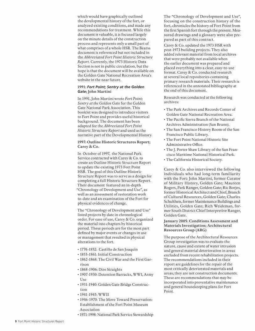
Pioneer photographer Eadweard Muybridge documented the empty fort in 1870. A line of Columbaid guns points towards the Golden Gate, while in the foreground a child lounges on a 32-pounder gun with its stands of grape shot. Credit: Fort Point NHS Collection, Golden Gate National Recreation Area.

17 Fort Point Historic Structures Report
The Civil War Years: Occupying the Fort Ironically, as the fort neared completion, funds grew scarce. By late 1860, the labor force had been reduced to just a few men engaged in setting flag-stones and hanging doors. All that changed in early 1861, however, when South Carolina led the other southern states in seceding from the Union. Nervous Unionists in San Francisco feared that
“pro-Secessionist” forces might try to arrack and seize the forts on the Bay.
Kentucky-born Colonel Albert Sydney Johnston was the Army’s Commander of the Department of the Pacific. To head off any attempts by local Southern sympathizers to capture the Bay, John-ston ordered the garrison on newly finished Alca-traz Island to go on full alert, and directed that troops immediately occupy the nearly complete fort at Fort Point. On February 15, 1861, Com-pany I of the Third U.S. Artillery U.S. Regiment, Captain John Lendrum commanding, moved into the unfinished quarters and empty gun casemates of the fort.
The soldiers’ first orders reflected Johnston’s overriding concern that the fort might be attacked momentarily by Southern sympathizers-the great-est perceived threat was from land, not sea. Cap-tain Lendrum was directed to keep two guards on duty at all times; none of the magazines or outer doors were to be opened without an officer present; a patrol was to search the perimeter of the fort within distance of rifle shot before the
sallyport was opened; and the entire garrison was to be kept under arms while the patrol was outside the fort.
The artillerymen of Company I, however, were the keepers of a fort without cannon - a “toothless tiger.” The fort would not receive its guns for the casemates or barbettes for nearly three months. Pro-secessionists boasted that they could easily capture the fort, so when the first guns arrived the artillerymen mounted them on the barbette tier of the gorge, facing south to repel a land attack rather than seaward to fend off an enemy fleet. By October, additional guns had arrived and the annual ordnance report showed 55 guns mounted inside the fort, mostly on the first tier and atop the barbette.
Colonel Johnston resigned his command on April 13, 1861, the day following the attack on Fort Sum-ter. His replacement, General Edwin Sumner, posted new orders upon receiving word of the outbreak of war. The Bay’s two forts were to be ready for instant action, and all ships entering the harbor were to be inspected by a revenue cutter and their intentions verified before being allowed to moor along the waterfront. If any vessels were spotted flying the rebel flag, they were to be imme-diately stopped or “fired into and sunk.”
No Confederate ships ever tried to run the gauntlet of defenses that sprang up around San Francisco Bay during the Civil War. The artillerymen-over 500 in June 1865-occupied the fort mainly as an armed deterrent at the Golden Gate. Soldiers were
A view of Fort Point from the Golden Gate straights. Photo circa 1910. Credit: Fort Point NHS Collection, Golden Gate National Recreation Area.

National Park Service 18
frequently moved in and out of the fort, and dur-ing the presidential election of 1864 the troops were sent into San Francisco to provide additional security against possible rioting.
The closest the fort ever came to seeing combat actually occurred after the end of the Civil War. In the summer of 1865, news reached San Fran-cisco that the Confederate raider Shenandoah was off the California coast. The ship’s commander, Captain James Waddell, had been at sea for over a year and was unaware that the Confederacy had fallen. Waddell’s plan was to run past Fort Point at night, ram and disable the Navy’s picket ship, and turn his guns on San Francisco. Artillery-men at Fort Point and Alcatraz were ready, but they waited in vain for the Shenandoah. Only a few days away from the Golden Gate, Waddell learned from a friendly British ship of the peace at Appomattox Court House and dropped his plan to capture San Francisco. Life at Fort Point Throughout the Civil War, the soldiers at Fort Point waited for an enemy that never came. For most of the war, life at the fort was a never-ending series of drills, parades, gun practice and main-tenance work. Every day, soldiers responded to a seemingly endless succession of bugle calls and drum rolls interrupted by periodic inspections by visiting dignitaries and weekly artillery exer-cises.
The population of the fort fluctuated throughout the 1860s, with some companies spending only a few weeks at the post. The longest stay at the fort is credited to Company B of the Third Artillery, which arrived in March 1861 and stayed for the next two and half years.
As a post, Fort Point was damp, cold, and iso-lated. The fort was on a tip of land of great stra-tegic value but it was frequently enveloped in fog and swept by strong winds. Spray from crashing Pacific waves often blew over the parapet walls of the barbette tier, making life miserable for the sentries on duty. The interior courtyard of the fort was arranged like a well, and for much of the day the parade ground and living quarters were cloaked in deep shadows. The thick walls of the fort, designed to keep out enemy artillery fire, created dank living quarters. The only heat came from tiny fireplaces in each of the gorge rooms, and it took hours for a smoky coal fire to heat up the interior of a gloomy casemate.
Garrison life was considerably better for the officers assigned to the fort than for the enlisted soldiers. The second tier of the gorge was “offi-cers’ country,” where unmarried officers were assigned individual bedrooms. Each pair of bed-rooms shared a common parlor, and personal furnishings for these rooms were popular; a well-turned-out parlor might feature curtains, carpets, a hooked rug, paintings on the walls and damask-covered chairs. A few lucky officers were allowed to bring their wives to the post, and
Illustration circa 1991. Courtesy of Lawrence Orsmby.

19 Fort Point Historic Structures Report
before the end of the Civil War a handful of wood frame residences were built south of the fort for these married officers. Officers were also part of San Francisco’s privileged class of society, and invitations to dress balls, parties and other events offered pleasant breaks from the monotony of duty in a seacoast fortress.
Enlisted men enjoyed few luxuries at Fort Point. Living in the third-tier gorge casemates, the pri-vates and non-commissioned soldiers lacked almost all of the comforts enjoyed by the officers downstairs. The enlisted men slept in two-man bunks, twelve bunks to a casemate, twenty-four men to a room filled with the mingled aromas of sour straw, stale tobacco and unwashed, wet woolen uniforms. A soldier had few posses-sions, restricted to what could be stuffed in a pack stowed at the foot of the bunk or hung on a wooden wall peg. Mattresses were sacks filled with straw ticking, the latrine was at the end of the tier and personal hygiene was basic. (Army regulations stipulated mandatory bathing once a week and washing of the feet twice a week.)
Part of life at Fort Point was visiting the sutler’s store. The sutler, a fixture at nearly every 19th-century Army post in the United States, was a civilian merchant who was licensed by the Sec-retary of War to sell ‘luxury items’ that were oth-erwise unavailable from the fort’s quartermaster. Fort Point’s original sutler was E. B. Willitson, who established his store in a wood frame building outside the fort’s walls. Inside his small structure, lit with oil-burning lanterns, were aisles lined with barrels and crates of goods. Tobacco, candy, sew-ing kits, civilian-manufactured clothing, canned
foods, decks of cards, “penny dreadful” novels, and on occasion, alcoholic beverages, could be found on his well-stocked shelves.
Willitson was authorized to extend credit to up to one-third of a soldier’s monthly pay to any-one whose cravings exceeded his wallet’s con-tents. However, Willitson also appeared with the paymaster on payday to settle any outstanding accounts before the soldiers were issued their $13 salaries. Although soldiers grumbled about the high prices and occasionally shoddy mer-chandise, the sutler’s store still served as an oasis from the regimented routine of military life. The sutler’s became an off-duty gathering spot where the troops could pass a private hour around a coal-burning stove or linger over a game of checkers. Defense Against the Sea: The Seawall Almost as soon as the soldiers moved into the new fort they found it was literally being eaten away by natural forces. When the bluff of Cantil Blanco was demolished to make way for the new fort, its rocky remains were spread along the shore to pro-tect the new fortification’s foundations. By early 1862, though, much of this rubble had eroded and waves were threatening to undermine the concrete and granite footings. Engineers began to focus their attentions on construction of a seawall to protect the fort.
Over the next eight years, work progressed on a 1,500-foot granite seawall enclosing the tip of Fort Point that would have to withstand the full force of the Pacific Ocean. Thousands of tons of granite blocks were imported from Folsom, California, and laid together in interlocking keyed courses backed with concrete and packed rubble.
This photo shows the interior courtyard of Fort Point, circa 1870. Credit: Fort Point NHS Collection, Golden Gate National Recreation Area.

National Park Service 20
The spaces between the stones were filled with cement, and then covered with tar-impregnated cloth and molten lead to keep out the salt water. The seawall was finally completed in 1869, just as soldiers began vacating the fort.
The new seawall, a masterpiece of engineering, protected a fortress whose day was rapidly passing. Military engineers had studied the performance of forts similar to Fort Point during the Civil War and came up with a dismal forecast: advances in modern long-range rifled artillery made these masonry forts obsolete. The most notable exam-ple of a failed casemated work occurred at Fort Pulaski near Savannah, Georgia, where Union guns demolished the fort’s seven-foot thick walls in just under 48 hours. Now that the war was over, the U.S. Army was having serious doubts about the wisdom of protecting the country’s crucial harbors with such vulnerable targets.
The artillerymen at Fort Point left in March 1868. Where only four years before the fort had been reported “in perfect order and cleanliness,” an inspection of the post a few months after clos-ing revealed a dismal picture. The guns were badly cared for, their wooden carriages were in disrepair, ironwork around the gun embrasures was rusting, the interiors of the barracks rooms were falling apart, and several unmounted guns were found lying in the surf near the fort’s wharf. The reporting officer was furious: “There must be something wrong in a military organization which can present such carelessness.” The fort at Fort Point, he concluded, “was sadly in want of a commanding officer.” As it turned out, the fort would be in want of a good commanding officer, and a garrison-for another ten years. The Fort Becomes a Barracks: 1868 - 1914 The years following 1868 were lonely ones at Fort Point. No soldiers were posted there for nearly ten years, and the fort was relegated to caretaker sta-tus. The little work that did take place focused on completing the seawall and fighting the on-going battle against rust. While the war had shown how vulnerable casemated forts could be, engineers weren’t ready to give up on what had become known to locals as “old Fort Point.” Instead, they looked for ways to adapt the work to meet the challenge of rifled artillery.
Beginning in 1870, workers began erecting bat-teries of a radically different style along the slopes above the old fort. Constructed of masses of dirt and masonry, the new “earthwork” gun emplace-ments of Batteries East and West (so-named because of their locations to the east and west of the old fort) soon began stretching along the heights of the Presidio. Designed to mount 15-inch caliber Rodman guns, the earthworks would serve as a simple, inexpensive defense that could easily be adapted to more modern gun designs.
In 1876, however, all worked ceased at Fort Point when Congress refused to allocate money for con-struction of America’s coastal defenses. Even the
earthwork Batteries East and West stood incom-plete, with only a handful of their 15-inch guns in place.
The fort’s caretaker, officially titled the Fort Keeper, now found himself not only combat-ing rusty iron in the old fort but fighting off the advancing hordes of gophers which multiplied in the slopes of the earthwork batteries.
Fort Point received a garrison again in 1878 when two companies of the 4th Artillery moved into the casemates. Over the next eight years, artil-lery and infantry soldiers would inhabit the old fort for short periods, using it primarily as a bar-racks rather than as a functioning defensive work. The soldiers periodically practiced with the rifled guns mounted in the casemates of the fort and with the 15-inch smoothbores in Battery West, but contemporary accounts reveal that accuracy was very poor. The problem apparently was with the training of the soldiers; the post-war bud-get for artillery practice was so small that the guns were only allotted an average of one shot per month. Besides, necessary maintenance had been deferred and the guns had an alarming habit of dismounting themselves during target practice. On one occasion, a 15-inch Rodman weighing 50,000 pounds jumped off its carriage in Battery West, in front of a horrified assemblage of mili-tary officers, invited dignitaries and newspaper reporters.
After only eight years the soldiers were again withdrawn, and in 1886 the fort was once more left to the care of a Fort Keeper. Thanks to its scenic location, though, the now-vacant fortress became something of a tourist attraction. A con-stant stream of visitors found their way into the fort. The view from the barbette tier was spec-tacular, and the aging Columbiad guns sitting on their platforms made favorite backdrops for photographers.
In the early 1890s, Congress made funds available for yet another generation of fortifications, and plans were drawn up for a network of modern gun batteries on both sides of the Golden Gate. Pre-liminary concepts called for partly demolishing the old brick fort and placing two huge 16-inch caliber rifles in its remains.
On July 13, 1890, on the eve of constructing the new concrete batteries at Fort Point, the San Fran-cisco Examiner sent a reporter out to take what might have been a last look at the fort which “for many years has stood guard at the entrance to the Golden Gate.” The picture he painted was evocative of an age long gone, even though the fort was less than thirty years old: “The ponder-ous smoothbores, once the pride of the military, are becoming rusted from want of use and the portholes are covered with cobwebs, and the grim-looking corridors which once knew the martial tread are now silent and deserted save for the merry prattle of children’s voices or the presence of curious sightseers.”

21 Fort Point Historic Structures Report
The fort had begun to lose its “teeth” by this time. The oldest cannons still in place - the pre-Civil War 42-pounder guns now mounted in the third-tier casemates-were the first ones removed in 1885. The following year the barbette was disarmed, and throughout the 1890s, the removal of obsolete ordnance continued with the scrapping of the slightly more modern 10-inch smoothbore and 8-inch rifled Rodman guns. Shortly after the turn of the century, the remaining guns were dragged out the sallyport and turned over to a scrap dealer.
Despite being disarmed, Fort Point was spared the fate of being demolished for another gun battery. By the time construction of the new fortifications began in 1892, plans for the two 16-inch guns atop the fort had been dropped. The engineers decided to leave the fort intact for the time being. It would serve well as barracks for soldiers man-ning the new gun batteries being erected on the site of Battery West. Shortly after the turn of the century, soldiers from the 66th Company of the newly named Coast Artillery Corps took up resi-dence in the fort. The Great Quake of 1906 The Great San Francisco Earthquake of 1906 found several dozen men of the 66th Company asleep in their quarters in the gorge barracks. Jolted awake by the shock of the quake, the artil-lerymen quickly evacuated the fort but noticed one soldier was missing. Returning to their quar-ters, they heard a noise coming from outside the windows where one of their men was trapped. The half-awake soldier had attempted to climb out the window, found it barred on the outside, then turned to find the window had slammed shut behind him.
The stranded artilleryman turned out to be only slightly shaken and dirty. The fort had fared much worse. A rock slide had closed the road leading to the city, the footbridge from the lighthouse keep-ers’ residences to the top of the fort had collapsed, and perhaps most alarming, the entire gorge face had pulled away from the rest of the fort, leav-ing an eight-inch gap between the interior and exterior walls.
The soldiers, fearing another quake might hit at any minute, formed a human chain into the fort and passed out their clothes and personal belong-ings. Making their way over the rock slide into the city, they spent the next several days fighting fires and helping with relief efforts.
A formal inspection of the old fort eventually fol-lowed and the engineers decided that the cost of repairing the damaged south wall was simply too high. Fort Point was abandoned and its troops moved into new barracks south of the point. For the next several years, the fort slid deeper and deeper into disrepair, its interior slowly succumb-ing to the ravages of the elements and the vandal-ism of visitors. Despite periodic suggestions that the fort be rehabilitated for uses such as married enlisted men’s quarters or as a military museum
for the upcoming 1915 World’s Fair, no preserva-tion efforts took place other than an occasional sweeping out of accumulated debris.
While the Army was concerning itself with how to deal with the flood of visitors the 1915 World’s Fair would draw, another government agency was making plans on how to handle the huge num-bers of new immigrants that would arrive in San Francisco once the new Panama Canal opened. The Bureau of Immigration and Naturalization eventually chose Alcatraz Island as the best pos-sible location for a new immigration station.
The fort on Alcatraz was also obsolete, and since 1907 the Army had transformed the island into a major military prison. In 1912 they had completed the world’s largest concrete prison building atop the island, and it was this brand-new facility that attracted the Bureau of Immigration’s attention. In 1914, two bills were introduced in Congress directing that the island be transferred to the Bureau of Immigration, and that the military prisoners be moved into old Fort Point.
What followed was one of the most intriguing and depressing chapters in the history of the fort. Before either bill ever left committee, the Army undertook the complete remodeling of Fort Point for use as a “detention barracks,” commit-ting thousands of dollars to the conversion work without ever receiving direct orders or monetary authorization from the Congress.
Throughout 1914, inmate crews from Alcatraz were ferried out to Fort Point to carry out the remodeling work. The convict workers tore up rusty gun rails, demolished the shot furnaces, paved the parade and barbette with concrete, installed toilets in the bastions, ripped out inte-rior walls to make way for guards’ barracks, cut oversized window openings into the gorge, and built wooden partitions in the casemates, dividing the gun rooms into oversized cells. The original wooden floors in the officers’ and enlisted bar-racks were repaired, innumerable coal stoves were installed to provide heat, and the orna-mental iron railings in the rear openings of the gun casemates were ripped out and replaced with wooden walls.
Despite all the changes, Fort Point never became a detention barracks. Neither congressional bill authorizing the transfer of Alcatraz was ever enacted, and the entire matter died in commit-tee before a single prisoner ever took up residence in the fort. Perhaps the only positive result of the conversion work was the repair of the south wall; the engineers installed steel tie-rods and turnbuckles to pull the earthquake-damaged gorge face back into an upright position. From the exterior, at least, the fort still looked much as it had in the 1860s.

National Park Service 22
The Golden Gate Bridge & World War II: 1915–1947 Although the fort never housed a detention bar-racks, the newly rehabilitated structure served a variety of other Presidio uses. Unmarried officers moved into the gorge during the World War I troop buildup, and in the early 1920s, trade schools at the Presidio used the casemates for classrooms and shop space. The Coast Artillery also found a new use for the fort by maintaining two “base end stations” atop the barbette as range-finding positions for the latest generation of Fort Scott gun batteries. The artillerymen also installed a 60-inch searchlight on the barbette and a genera-tor plant in the first-floor casemates.
By 1926 the fort was abandoned once again and vandals were finding their way into the struc-ture. An inspection that year reported nearly all windows broken, ironwork badly rusting, one of the sallyport doors lying unhinged, filthy inte-rior rooms covered with obscene graffiti, and lower-tier embrasures standing open, allowing unlimited access to tourists. The War Department, strapped for funds, spent a total of $40.37 to board up doors and windows in an unsuccessful effort to keep out intruders.
The Construction of the Golden Gate Bridge
At the same time the Army was spending tens of dollars on sealing the fort, the newly created Golden Gate Bridge District was raising tens of millions of dollars through bond sales for a bridge that would span the Golden Gate from Fort Point to Lime Point. Chief Engineer Joseph Strauss ini-
tially concluded that Fort Point sat on the optimal location for a huge concrete caisson anchoring the bridge’s San Francisco end. After touring the empty fort, however, he changed his mind. In a 1937 memorandum to the bridge’s Board of Directors, Strauss wrote: “While the old fort has no military value now, it remains nevertheless a fine example of the mason’s art. Many urged the razing of this venerable structure to make way for modern progress. In the writer’s view it should be preserved and restored as a national monument…”
Strauss made some additional calculations and concluded that the fort could be spared by mov-ing the southern anchorage several hundred feet south. However, in order to make up the difference in the total length, he would have to add a ‘bridge within the bridge,’ and consequently designed a steel arch in the southern anchorage to span the old fort. Fort Point would be overshadowed by the new bridge, but it would be preserved.
Work on the Golden Gate Bridge began in 1933. Fort Point’s casemates made convenient work space for the hundreds of workers and artisans who soon swarmed around the bridge’s southern anchorage, and draftsmen set up shop in the old barracks. The second tier gun rooms served as a cafeteria for bridge workers, and atop the fort dozens of steel plates were painted with a variety of paint coatings and tints, then studied for resis-
Contemporary view of Fort Point, circa 2000. Credit: Golden Gate National Parks Conservancy.

23 Fort Point Historic Structures Report
Above: This Stick-Style wood-frame residence was one of three buildings constructed as housing for the fort’s lighthouse keepers. Photo circa 1925. Credit: Fort Point NHS Collection, Golden Gate National Recreation Area.
Right: During WWII, obsolete cannons were removed from the fort. Photo circa 1942. Credit: San Francisco History Room, San Francisco Public Library.

National Park Service 24
tance to salt corrosion. The fort was soon envel-oped in a maze of wooden scaffolding as the huge steel arch was erected over the barbette tier.
Although the main casemated portion of Fort Point was spared during construction, some of the outworks of the fort had to be demolished to make way for the southern bridge anchorage. Early in the excavation process, the bluff south of the fort was cut back several hundred feet, destroying the counterscarp gallery and ten-gun battery. Bridge excavators also uncovered a long-buried adobe shed believed to be a powder magazine from the Castillo de San Joaquin. After its loca-tion was noted and photographed, the hut was demolished; it stood in a location too critical for it to be preserved.
But the bridge crews went to extraordinary lengths to preserve one of the fort’ s most out-standing examples of military engineering, the granite seawall. A tall concrete bridge pylon was planned for the north side of the fort, directly atop the seawall. Instead of demolishing the wall or burying it with concrete, Strauss had it dis-mantled, stored, and re-erected once the pylon was finished.
The Golden Gate Bridge’s grand dedication took place in May of 1937. For the next few years the fort was nearly forgotten, overshadowed by the soaring new steel bridge overhead.
World War II
The outbreak of World War II brought a massive increase in military activity around the Bay. In response to the fear that Japanese submarines might try to enter the harbor, a steel net was strung across the Golden Gate in early 1942. Stretching from Sausalito to the Marina Green, the submarine net was supported by dozens of buoys. A Navy tug boat was stationed midway along the net to pull it open for allied shipping, then close it once the vessels were safely through. The net was backed up by three mine fields in the approaches to the harbor, and the mine fields in turn were guarded by small, rapid-fire gun bat-teries on both sides of the Golden Gate.
The Army needed a few more guns on the San Francisco side of the Golden Gate, so early in the war a pair of 3-inch caliber Anti-Motor Tor-pedo Boat (AMTB) guns from Marin County’s forts were moved to the barbette tier of Fort Point. Named “Battery Point,” the guns were positioned to protect the mine fields and sub-marine net from enemy ships. The AMTB guns were manned by soldiers from Battery N of the 6th U.S. Coast Artillery, who took up residence in the gorge barracks.
The interior of the fort was refurbished one more time for living quarters and office space for a new garrison. The gun casemates were remodeled into a mess hall, recreation room, barber shop and post exchange, while the first-floor gorge rooms provided storage space for camouflage materials used in disguising nearby gun emplacements. By
late 1944, however, the threat of Japanese attack had disappeared and the Fort Point troops were removed.
The rapid demobilization following the end of the war left the Army with little time or money for preservation of the again-vacant fort. The few visitors who did find their way to the boarded-up structure found a desolate scene. The sallyport doors were kept locked, and only furtive glimpses of the interior were visible through chinks in concrete cinderblocks plugging the lowest tier of embrasures. The railings along the seawall had long-since rusted away, and generations of fish-ermen had dug most of the lead sheathing from between the granite blocks for use as sinkers. Even the three old lighthouse keepers’ houses stood vacant, the Army unable to find anyone willing either to live beneath the incessant noise of the bridge or able to put up with the perils of debris dropped by pedestrians on its sidewalks.

25 Fort Point Historic Structures Report
Lighthouses at Fort Point Fort Point may have set a record for lighthouse construction; the site featured three different lighthouses within ten years, one of which gained notoriety for being razed before it ever showed a light.
The U.S. Lighthouse Board decided to erect a light at the point in 1852 as an aid to ships entering the harbor during the Gold Rush. The Board ordered a combination keepers’ residence and tower built at the tip of Punta Del Cantil Blanco, and before the end of 1852 a Cape Cod style lighthouse had been erected atop the point. The completed light-house awaited only the arrival of its brassbound crystal lens to go into service.
Unknown to the Lighthouse Board, the Army Corps of Engineers also had plans for Cantil Blanco - they intended to cut it down to water
level for their new casemated fort. In mid-1853 the old Spanish fort, the promontory on which it stood, and the brand new lighthouse were torn down. The engineers quickly worked out an arrangement with the Lighthouse Board to build another light tower just north of the fort at the Army’s expense.
The second light structure was completed in early 1855 and began operation March 21st. Its lantern was classified as a fifth-order Fresnel-pattern lens, producing a magnified beam of light visible twelve miles at sea.
The two light keepers, or “wickies” as they were familiarly known, were responsible for both oper-ating the light and for winding up the counter-weights on an 1,100 pound fog bell mounted just outside the fort’s walls. Local mariners, though, claimed the light was too dim for such an impor-tant location.
The lighthouse soon had more severe problems than complaints from seafarers; the very land the tower sat on was being washed away by Pacific storms. In 1863, while the Army planned to build a granite seawall to protect the foundations of Fort Point, the Lighthouse Board secured per-mission to relocate the tower to the barbette tier of the fort itself.
The third lighthouse, a nine-sided iron tower mounted atop one of the fort’s spiral staircases, went into operation in January 1864. The Fort Point Light Station soon became known as one of the more desirable billets for West Coast wickies. The duties were relatively easy, the view inspiring, and the pleasures of San Francisco nearly unlim-ited. (This last benefit was greatly appreciated by men who had served at remote stations such as Pt. Reyes, where several 19th-century keepers were hauled away after going insane.)
Below: Two of the assistant keepers’ houses at the Fort Point Light Station were built atop the hill south of the fort. A windlass helped haul supplies up the steep slope to the “wickies” homes. Terra cotta pipes in the foreground were for plumbing. Photo circa 1910. Credit: Fort Point NHS Collection, Golden Gate National Recreation Area.
Right: Contemporary view of the Fort Point Lighthouse. Photo circa 2000. Credit: Golden Gate National Parks Conservancy.

National Park Service 26
The Fort Point staff eventually increased to three keepers, and modern improvements such as elec-tricity and a compressed-air foghorn made life easier for the crew. The wickies also found them-selves carrying out duties more closely associated with tour guides and lifeguards than lighthouse keepers. The crowds that visited the point always seemed to find some new way to wriggle their way into the abandoned fortress, and tourists unfamiliar with the hazards of “sneaker” waves rolling in from the Pacific regularly ended up in the waters of the Gate. Keeper James Rankin set a record by rescuing eighteen people from the frigid waters of San Francisco Bay during his 41 years at Fort Point.
The early 1930s brought the end of the Fort Point Station. The rising towers and anchorages of the Golden Gate Bridge that overshadowed old Fort Point also blotted out the light shining from its stubby lighthouse tower. In 1934 the station was shut down and its last keepers transferred to other lights, their duties assumed by an automatic light-house at the foot of the south bridge tower and remotely controlled fog signals along the span.
Restoring Fort Point: 1947–PresentPublic curiosity about Fort Point increased after World War II, and in 1947 a reporter doing a piece on the abandoned fort queried an Army public affairs officer on the military’s neglect of the sel-dom-seen fortress. The officer responded that while the post-war Army did not have funds to rehabilitate the fort, the War Department “might be amenable to its conversion to a public monu-ment.”
The idea of preserving Fort Point purely for its historic and architectural value had its origins in 1926. In that year, the prestigious American Insti-tute of Architects (AIA) had written Secretary of War Dwight Davis about the deterioration of the fort. The AIA urged the Secretary to implement necessary repairs and begin routine maintenance of Fort Point, and to remove the “temporary parti-tions which alter the original historical purpose of the (fort’s) plan.”
Following World War II, a movement took hold to protect and preserve Fort Point. In March 1947, the Army hosted an “open house” at the fort commemorating 100 years of U.S. military presence on the site. General Mark Clark, Com-
This photo shows the fort in an unoccupied state after World War II. Photo circa 1948. Credit: Fort Point NHS Collection, Golden Gate National Recreation Area.

27 Fort Point Historic Structures Report
manding Officer of the Sixth Army, proposed to declare the fort surplus and turn it over to the War Assets Administration for disposal of an agency that might preserve it as a public attraction.
Since the fort sat on federal land, the National Park Service (NPS) was the most likely candi-date to receive the fort. If the NPS didn’t have the funds, the State of California seemed the next most probably recipient. But that didn’t stop other preservation-minded groups from making a bid for control of the fort. The hoped-for transfer never took place – a War Department study deter-mined, somewhat surprisingly, that it was still in the nation’s interest to retain possession of the area.
Preservation efforts languished for nearly ten years. The fort was opened for infrequent tours and to the general public for Armed Forces Day festivities. Despite several grassroots “Save-the-Fort” movements, the fort remained largely unprotected. Estimates for its restoration steadily grew higher. Fort Point National Historic Site In 1959, a group of retired military officers and civilian engineers banded together to form the Fort Point Museum Association. Operating with the blessing of the U.S. Army, the Associa-tion spent the next eleven years raising funds for the preservation of the fort and lobbying for its creation as a National Historic Site. The Fort Point Museum Association realized that it must make the fort accessible to the public in order to build support for legislation of a new historic park. Working hand-in-hand with the 6th Army, the Association cleaned up the interior of the fort, erected safety barricades, sponsored spe-cial open house events, hosted school groups and civic agencies on tours of the fort, and opened the sallyport doors on weekends to ever-increasing numbers of visitors.
These public activities and lobbying efforts did not go unnoticed. In 1968, local congressmen introduced bills calling for the creation of Fort Point National Historic Site. Both bills passed the House and Senate. On October 16, 1970, the bill in its final form was signed into law by President Richard Nixon. Today, Fort Point National His-toric Site is open to the public and administered by Golden Gate National Recreation Area, National Park Service.
Old Fort Point, “the fort that never fired a shot in anger,” still stands beneath the Golden Gate Bridge as an impressive monument to the crafts-men who labored to create an impregnable for-tress at the edge of America; a monument to the preservationists who fought to save the fort from decay and demolition; and most importantly, as a monument to the artillerymen who awaited an enemy that never came.

National Park Service 28
1776-1852: Castillo de San JoaquinA high promontory overlooking the entrance to the San Francisco Bay, named “Punta del Cantil Blanco” (White Cliff Point) by 18th Century Spanish colonizers, provided an ideal site to defend the bay from enemy vessels.1 Recognizing the strategic importance of White Cliff Point, the Spanish built the first fort located on this site, Castillo de San Joaquin. At least three forts were built by the Spaniards: a first redwood palisaded fort, later replaced by adobe; a second adobe fort, constructed after drifting sand and storms demolished the first; and a stone and brick fort constructed after an earthquake destroyed the second adobe fort. Shortly after Mexico gained its independence from Spain in 1821, the fort was abandoned to the elements. The Bear Flag Revolt of 1846 brought Yankees to the fort, which became U.S. property in 1848 when California formally became a U.S. territory. The California Gold Rush of 1848 accelerated the need for fortifications at the mouth of the San Francisco Bay. Temporary measures utilized the old Spanish fort, while a joint Army and Navy commission studied Pacific Coast defense fortification needs. 1774—Spanish Viceroy Don Antonio Maria Bucarely commands Lieutenant Colonel Don Juan Bautista de Anza to begin an exploratory expedition from Tubac, Mexico to the Bay of San Francisco.2
1776—March 28. Colonel de Anza selects the Cantil Blanco (White Cliff, present site of Fort Point) to erect a cross, marking the spot where a fort is to be built.3 The presidio is subsequently built one-and-one half miles southeast of this site, in a sheltered valley.4 The remains of the early Presidio referenced here still exist at the present day Officers Club.
1776—June 27. A group of 193 Spaniards, mostly soldier-settlers and their families, arrive at the site of the San Francisco mission.5
1776—September 17. The Presidio of San Francisco is formally established under the command of Lt. Jose Moraga.6
1776—December. Colonel de Anza departs, turning over the command to Lt. Moraga, with instructions to begin constructing a fort. The original fort is built in the form of a wooden square, 275 feet on each side. The walls are redwood palisades.7
1778—Redwood palisade walls are replaced by adobe walls of the same dimensions.8
1794—Drifting sand and storms demolish the original fort. A new fort, Castillo de San Joaquin (figure 1), is constructed. The fort is designed by Miguel Constanso, Engineer of Fortifications, under the direction of Lieutenant Jose Dario
Arguello and the approval of Governor Jose Joaquin de Arrillaga. The fort is an irregular square, 210 feet north and south and 140 feet east and west, with two main entrances. Wide esplanades on two sides flank a central porticoed barrack, approximately 60 x 30 feet, consisting of two large rooms. The horseshoe-shaped walls are ten feet thick and pierced with four brick-lined embrasures. The fort is initially garrisoned by a corporal and six artillerymen. Armament consists of eight 12-pounder canon, cast in Spain and sent by the Spanish Viceroy, Conde de Ravilla Cigodo.9 (The promontory where Castillo de San Joaquin is located would be leveled for the future construction of Fort Point).
1813—An earthquake almost completely destroys the fort.10
1816—The Castillo de San Joaquin is rebuilt, partly in brick and stone, with brick-lined magazines. Bricks used are 11 inches wide, 15 inches long, and two-and-one-half inches thick.11
1821—Mexican independence. (Castillo de San Joaquin is gradually abandoned, terminating in the mid 1830s when all Mexican troops move to Sonoma).12
1846—July 1. The Bear Flag Revolt. The Castillo de San Joaquin is raided:
A rough-hewn group of Yankees, led by John Charles Fremont and Kit Carson began the long pull across the Bay from Sausalito to the ancient Spanish fort “Castillo de San Joaquin” on the San Francisco shore. They called themselves Bear Flaggers after their flag of revolution, and their goal was the liberation of California from Mexican control.
Nosing their launch into a sheltered cove below the fort, the raiders scrambled up the hundred-foot hillside, swarmed into the crumbling Castillo and spiked the cannon mounted within its walls. The only tarnish on the victory was that the Castillo had not been garrisoned for a dozen years.13
1848—February 2. The Treaty of Guadalupe Hidalgo ends the Mexican War. California is part of the lands acquired by the United States from Mexico.14
1848—November 30. The Secretaries of War and the Navy by joint-action establish a Commission to study Pacific Coast defense fortification needs. Members include Col. John L. Smith, Maj. Cornelius A. Ogden, and Lt. Danville Leadbetter, selected by Chief Engineer Joseph Totten to represent the Army; and Commanders Lewis M. Goldsborough, G. J. Van Brunt, and Lt. Simon F. Blunt, selected by the Secretary of the Navy.15
Chronology of Fort Point Development & Useby Carey & Co.

29 Fort Point Historic Structures Report
1848—The California Gold Rush begins.
1849—Ship traffic into San Francisco Bay increases to a staggering 770 vessels, only a few ships a year had previously visited the port.16
1849—March. As a result of the Gold Rush, commerce booms in the San Francisco Bay Area and the military realizes its responsibility to protect what has become the most valuable prize in North America. Temporary measures are needed to secure the booming harbor, with permanent fortifications to follow. Six modern artillery pieces are temporarily mounted at the old adobe Spanish fort, Castillo de San Joaquin.17
1850—September 9. California enters the Union as the 31st state.18
1850—November 1. The Commission to study Pacific Coast defense fortification needs releases its report, which focuses on San Francisco Bay and the Golden Gate channel as strategic defense sites for the new state. The board recommends two forts, one at Fort Point and the other at Lime point, directly across the bay.19 Local landmarks are given names and the Castillo becomes known as “Fort Blanco,” while the point it sits on is called “Fort Point.” The
nickname “Fort Point” remains years later even after the fort is officially named Fort Winfield Scott.
1851—June 17. Chief Engineer Totten issues a General Order establishing a Board of Engineers for the Pacific Coast, headquartered in San Francisco, to implement recommendations made by the Commission. Members include Colonel Smith, Major Ogden, Lieutenant Leadbetter, Bvt. Lt. Col. James L. Mason and Capt. F.A. Smith. 20
1851—October 28. The Board recommends Congress appropriate not less than $500,000 toward defense fortifications at the entry to the San Francisco Bay. 21
Figure 1. Drawing: The Castillo de San Joaquin, plan view, drawn in 1796. Credit: Fort Point NHS Collection, Golden Gate National Recreation Area.
National Park Service 30
1853-1860: Initial ConstructionFollowing the $500,000 appropriation for San Francisco Bay Defense Works, the Board of Engineers for the Pacific Coast declared the strategic importance of Fort Point. In preparation for constructing a fort at this location, the first Fort Point Light was razed and the Fort Point Bluff was leveled. Correspondence between San Francisco and Washington D.C. strengthened the design of the new fort and construction began.
Fort Point was the only major third system structure built on the Pacific Coast. The third system fort, characterized by a high concentration of armament, consists of one to three levels of casemate tiers and a barbette tier. The casemate tiers consist of tiers of emplacements, in this case, three tiers of casemated armament. The barbette tier is a roof-top battery consisting of heavy weapons along the seaward fronts and lighter weapons facing landward. Two similar forts, Fort Sumter in Charleston Harbor, South Carolina and Fort Pulaski at the mouth of the Savannah River, Georgia, were never finished or completely armed. Congress feared these two forts would benefit the south in the event of war between the states.
During this period, construction of the fort was hampered by both the quality and avail-ability of local materials and the difficulty of transporting materials to the remote site. Con-struction of a 500’ wharf and a brickyard near the fort helped alleviate construction delays. By 1860, the fort neared substantial completion.
(NOTE: In the following chronologies, many subject headings, like “materials”, “seawall”,
“batteries” are capitalized as finding tools, allowing the reader to focus on an in-depth chronology of specific subject.)
1853—APPROPRIATIONS: March 3. President Millard Fillmore signs legislation appropriating $500,000 for San Francisco Bay defense.1
1853—August 4. The Board of Engineers for the Pacific Coast submits its majority report to Chief Engineer Totten, declaring the strategic importance of Fort Point.2
1853—DESIGN: Fort Point plans are drawn by Lt. Danville Leadbetter (figure 2), and approved by Secretary of War Jefferson Davis.3
1853—PERSONNEL: April 11. Chief Engineer Totten selects Bvt. Col. Joseph K. F. Mansfield to supervise the construction of Fort Point.4
1853—PERSONNEL: Chief Engineer Totten selects Bvt. Lt. Col. James L. Mason to replace Chief Engineer Mansfield, re-assigned by Secretary of War Davis to the prestigious Inspector-General’s Department. Chief Engineer Totten selects Lt. William H. C. Whiting and Lt. N. F. Alexander to assist Project Engineer Mason.5
1853—PERSONNEL: September 5. Project Engineer Mason dies from a APanama Fever” relapse. Lt. Whiting becomes Acting Project Engineer.6
1853 Under Whiting’s supervision:
1. The first Fort Point Light is razed (Construction of the first Fort Point Light began in December of 1852. The Army tears down the brand new unlighted lighthouse, declaring it in the way of the fortification construction). 2. The topography survey is completed. 3. Temporary accommodations are set up. 4. Castillo de San Joaquin is razed. 5. Fort Point Bluff is leveled.7
1853 Financial problems cause embarrassment and delays as a result of Mason’s untimely death. United States public funds deposited in his name are impounded, resulting in a short-age of funds, drafts are delayed, and outstand-ing vouchers surface.8
1853—PERSONNEL: Chief Engineer Totten selects Bvt. Maj. John G. Barnard to replace deceased Project Engineer Mason.9
1853—DESIGN: Project Engineer Barnard reviews and makes recommendations for changes in Fort Point plans. Changes approved by Chief Engineer Totten include the following:
1. Increasing the thickness of the scarp walls from five to seven feet, reducing the depth of the gun casemates by two feet. 2. Introducing two tower bastions for flanking fires (figure 2).10
1853—ROOFS: April 18. General Totten directs Barnard to regulate roof surfaces before begin-ning walls and piers, “to bring down the water in the best way into the conduits and cisterns.” Six-inch diameter cast iron pipes, embedded in the piers, are recommended.Totten forwards drawings of Fort Richmond, New York, to show how roof surfaces at Fort Point are to be handled.11
1853-1865—APPROPRIATIONS: Total appropriations during these years is $2,012,500.00.12
1854—WHARF: A 500’ Fort Point Wharf is constructed to handle ocean-going vessels bringing building materials to the site. The wharf is completed in June, prior to the receipt of Chief Engineer Totten’s May 18 letter of approval to begin its construction.13
1854—ARMAMENT: Nine 32-pounders are mounted. Four cannon are emplaced at the point and six are located at the site of the future 10-Gun Battery.14
1854—MATERIALS: Project Engineer Barnard contracts with W.B. Farwell to quarry Monterey and Point Reyes granite on land owned by Dr. Rundall.15

31 Fort Point Historic Structures Report
1854—MATERIALS: Available materials for Fort Point include:
1. Monterey and Point Reyes granite 2. Chinese granite 3. Bay bluestone 4. Brick 16
1854—MATERIALS: April. Project Engineer Barnard orders 2,000 tons of dressed Chinese granite from John Parrott at a cost of $17,844.17
1854—APPROPRIATIONS: August 9. Congress appropriates $100,000 for Fort Point, F.Y. 1855.18
1854—PERSONNEL: October 9. Project Engineer Barnard leaves for an assignment on the Atlantic coast. Lt. Whiting is Acting Project Engineer.19
1854—MATERIALS: Whiting cancels the contract with Farwell for granite for failure to deliver promised quantities by due dates. Farwell transfers his rights and interests in the quarry to Degraw and Blake. Deliveries to Fort Point resume.20
1854—October. The Ostend Manifesto declares that the United States will take Cuba from Spain, if Spain refuses to sell it to the U.S. In preparation for war, work increases on the 10-Gun Battery, on the escarpment to the south of the Fort. The Ostend Manifesto is later repudiated by the United States.21
1854—PERSONNEL: November 9. Colonel De Russy arrives as Barnard’s successor.22 Under Project Engineer Barnard, the promontory is leveled and the building support services erected.23
1854—ARMAMENT: November 18. Chief Engineer Totten alerts Project Engineer De Russy of possible War with Spain, as a result of the Ostend Manifesto. Preparations to mount 33, 8- and 10- inch columbiads en route from the east coast are made.24
1855—MATERIALS: Chief Project Engineer De Russy opens a brickyard on the bluff, near Fort Point, as local brick is unsuitable for the project. The brick is superior to average California brick, but inferior to Atlantic coast brick. By September 1 over one million pressed and common bricks are fired on-site for use at both Fort Point and Alcatraz. The bricks are first used to build the cisterns at Fort Point.25
1855—FOUNDATIONS: February 6. Initial work on fort foundation begins.26 The slabs of Chinese granite are laid on top of concrete footings secured to bedrock.27
1855—General Wool, department commander, visits the construction site during a trip to San Francisco.28
1855—APPROPRIATIONS: March 3. Congress appropriates $300,000 for Fort Point, F.Y. 1856.29
1855—LIGHTHOUSE: March. The second Fort Point Lighthouse is operational. Located outside and in front of the fortification, a 52-foot tower displays a 5th order Fresnel Lens.30
1855—ARMAMENT: March. The Armament Board Reports on the armament for Fort Point:
1. First tier- twenty-six 42-pounders 2. Second & third tiers- twenty-eight 8-inch columbiads 3. Right flank of northeast bastion, three tiers, six 24-pounder 4. Reverse of ditch- four 24-pounders howitzers 5. Tower Bastions- two 10-inch columbiads en barbette 6. North salient- three 10-inch columbiads en barbette; South salient- two 10-inch columbiads en barbette 7. Curtains of water fronts- seventeen 8-inch columbiads en barbette 8. Land front- eleven 32-pounders en barbette Advanced battery- ten 42-pounders en barbette.
(The above list is the planned armament for the fort, which is never fully executed).31
1855—BATTERY: 10-Gun Battery is constructed on the bluff above the Fort.32
1856—APPROPRIATIONS: August 20. Congress appropriates $350,000 for Fort Point, F.Y. 1857.33
1856—PERSONNEL: Chief Project Engineer De Russy becomes ill and requests reassignment to a milder climate.34 Major Zealous B. Tower relieves De Russy as Project Engineer;35 Major Tower was Project Engineer at Alcatraz since 1853.
1856—PERSONNEL: April 1. Lt. George H. Elliott arrives as second assistant.36
1856-1857—CONSTRUCTION ACTIVITY: October 1, 1856-June 30, 1857. During this period, the following work is accomplished:
1. The scarp walls on all sea fronts rise approximately to the sills of the second tier embrasures. 2. The first tier piers rise to their full height. 3. The communication arches between the first tier casemates and the arches supporting the second tier floor are turned. The spaces between the arches are filled with concrete. 4. The three stair towers rise approximately ten feet above the parade, with steps set to that height. 5. The excavations for the counterscarp gallery, defenses, and for the western portion of the seawall are completed. 6. The excavations at the south end of the Ten-Gun Battery (exterior to the main work) are finished, the arch of its magazine covered with asphalt, and the slopes formed and sodded.37
1856—The Annual Report for this year describes wild storms that slow construction:

National Park Service 32
The unusually heavy gales experienced on this coast last winter destroyed much of the plank road constructed from the wharf to the Fort. This had to be repaired...an apron of heavy stone was constructed, at considerable expense, on the slope in front of them.38
1857—APPROPRIATIONS: March 10. Congress appropriates $350,000 for Fort Point, F.Y. 1858.39
1857—CONSTRUCTION ACTIVITY: October. “reporter from the Alta California visits the site:
The walls of the second tier are “fast riding the arch, whilst the counterscarp battery on the southwest is rapidly advancing toward connecting with the 10-gun battery on the heights above.”
He enters the fort through the sally port; “the solid masonry of more than ordinary artistic skill meets the eye at every point, and the visitor is at a loss to determine what he admires most—the granite or the brickwork.”
Each wall “as much an object of art as a statue. Science has invested each of the works with interest; and as a monument of mechanical skill the fort is destined to be the cynosure of all who take pride in the dignity of labor and the advance of art. We cannot do justice to the subject in an ephemeral article.”
When completed, “we venture to predict it will be the admiration and pride of the Pacific.”40
1857—MATERIALS: The scarp walls are con-structed of pressed brick fired at the onsite brick yards. C.D. Nagel, in charge at the time, stamps each brick with his name.41
1858—CONSTRUCTION ACTIVITY: Major Zealous B. Tower’s Annual Report for F.Y. 1858:
1. The scarp rises two tiers, except for turning the third tier of gorge arches. 2. The scarp throughout its entire length rises to an average of 27 feet, including construction of 60 embrasures. 3. The second tier piers are carried up 102 feet; upon them are turned the arches and communication arches, and the spandrels filled with concrete. 4. Horizontal and vertical iron pipes to conduct rainwater from the roof surfaces of the upper tier of arches to the cisterns below, are built in the masonry. 5. The third tier piers, except near the parade gorge, are carried up. Waterfront piers are carried up 62 feet and gorge-front piers 72 feet. 6. The arches and communication arches of the water fronts are turned, and upon the arches, the parade retaining wall of the terreplein is built to the proper height to receive its coping. 7. Masonry of the four service magazines for the second and third tiers is completed. 8. The three stairway towers are carried up, including the setting of the stone steps, one of them 22 feet, another 322 feet, and the third 24 feet.
9. The ironwork of the gallery in front of the officers’ quarters, including the stone bases, colonnade, girders, and entablature, are positioned.42
1858—MATERIALS: July 7. Project Engineer Zealous Tower secures granite from Mr. G. Griffith at the Mormon Island Quarries, near Folsom. The quarry will supply granite for the first tier traverse circles.43
1858—PERSONNEL: July 31. Project Engineer Zealous Tower receives orders to Boston. Lt. George W.C. Lee (son of Robert E. Lee) is acting Project Engineer. Captain Jeremy F. Gilmer arrives as new Project Engineer.44
1858—MATERIALS: September 16. Acting Project Engineer Lt. George W.C. Lee agrees to purchase 200,00 bricks of the Atwo classes suitable for our work,” from San Quentin State Prison. The purchase price is 13 dollars per thousand.45
1858—MATERIALS: October 1. Acting Project Engineer Lt. George W.C. Lee agrees to purchase an additional 200,00 bricks from San Quentin State Prison. The purchase price is 12.25 dollars per thousand.46
1859—APPROPRIATIONS: March 18. Congress appropriates $50,000 for Fort Point, F.Y. 1860.47
1859—MATERIALS, WESTERN SCARP: Chief Engineer Totten instructs Captain Gilmer to experiment with different repointing treatments on six two-foot squares on the exterior of the western scarp. In following instructions from Chief Engineer Totten, Captain Gilmer made the following tests:
1. Diluted soft soap is repeatedly applied to square A until the bricks are impregnated. 2. The surface of B is treated similarly with a diluted solution of caustic potash. 3. The surface of C is treated with a diluted solution of muriate of lime. 4. The pointing mortar of D is made with diluted soft soap instead of water. 5. The pointing mortar of E is mixed with a diluted solution of caustic potash instead of water. 6. The pointing mortar of F is made with a diluted solution of muriate of lime substituted for water.
At the same time, Captain Gilmer carries out his own experiment. He uses a pointing mortar mixture consisting of one part each of cement and sand to c part of iron fillings. These are mixed in a dry state and iron water added. The iron water is made by placing scraps of wrought iron in water and leaving them there for several weeks, and then adding one-half pint of molasses to one gallon of water. The joints are wet down with iron water before pointing.48 Results of these experiments are detailed in the entry for 1868.

33 Fort Point Historic Structures Report
1859—CONSTRUCTION ACTIVITY: Work completed during this fiscal year includes the following:
1. Doors are hung for the magazines and passageways. 2. Shutters are placed in windows. 3. An iron stairway is positioned at the east end of the quarters gallery. 4. The barbette tier stone platforms for guns bearing on the landfront are placed. 5. The shot furnace in the northeast corner of the quadrangle is begun. 6. The iron railings along the second and third tiers of gorge are installed.49
1860—APPROPRIATIONS: June. Congress appropriates $50,000 for Fort Point, F.Y. 1861.50
1860—June 30. Work remaining on the fort includes completion of the following:
1. Living quarters 2. Barracks 3. Interior finish 4. Cisterns 5. Mounting the platform stones at the gun emplacements, on the barbette tier land side.51
1860—CONSTRUCTION ACTIVITY: Work during August 1–December 31:
1. Brickmasons complete the shot furnace in the northeast corner of the quadrangle. 2. Construction of a second shot furnace begins in the opposite corner. The 32-pounder gun platforms along the land front are set. 3. Masonry of the quarters and barracks is prepared for the introduction of water pipes. 4. Masonry is pointed. 5. Culverts for draining the parade and privy vaults are constructed. 6. Prison walls are built. 7. Carpenters made and hung doors for the stairway towers and inner sally port. 8. Furring and finishing work occurs in the quarters and barracks. 9. A timber bulkhead is constructed in advance of the east bastion to guard against encroachments by the sea, 10. Light frame penthouses are built to cover each of the tower stairways. 11. Two plumbers introduce pipes into the quarters and barracks.52
Figure 2. Drawing: Composite Floor Plan, drawn by Danville Leadbetter, c. 1853, with Project Engineer Barnard’s Bastion additions sketched in. Credit: Fort Point NHS Collection, Golden Gate National Recreation Area.

National Park Service 34
Figure 3. Map: Fort Point and Vicinity, 1876-1891. Credit: Edwin C. Bearss. Historic Structure Report, Fort Point: Historic Data Section (National Park Service: Denver Service Center, 1973).

35 Fort Point Historic Structures Report
1861-1868: The Civil War & the First GarrisonFollowing the secession of South Carolina, soldiers moved into the unfinished fort quarters in preparation for a Civil War. Although the fort was substantially completed when the garrison arrived, it remained unarmed for almost another three months. Despite the civil turmoil, work continued at the fort. During this period the fort received its armament, the second Fort Point Light was removed, the third was constructed over the north stairway at the barbette tier, and the seawall reached 60% completion.
The Civil War introduced a new weapon, the rifled cannon, which quickly made smoothbore cannon and the associated defense works obsolete. The first bombardments at both Fort Sumter and Fort Pulaski demonstrated not only the accuracy of the rifled cannon, but its ability to penetrate at long range. The casualties suffered by these two forts demonstrated that brick fortresses were vulnerable to the new heavy artillery. This realization caused Fort point to become obsolete in February of 1861, just three months after it was completed and garrisoned.1861—Civil War. South Carolina leads the southern states seceding from the Union.1
1861—GARRISON STARTS: February. General Johnston orders the Fort garrisoned, anticipating a Civil War. Troops arrive at the Fort, February 15, 1861.2
1861—PERSONNEL: February 15. Captain John Lendrum, commanding Company I of the Third U.S. Artillery Regiment, moves the soldiers into the unfinished quarters of the Fort. The Fort does not receive its cannon for nearly three months.3
1861—PERSONNEL: Project Engineer Gilmer resigns his commission to the United States, following the secession of his native state, North Carolina. Elliott is Acting Project Engineer.4
1861—APPROPRIATIONS: March. Congress appropriates $50,000 for Fort Point and its outworks for the fiscal year ending June 30, 1862.5
1861—GARRISON: March. Company B of the Third Artillery arrives. They stay for two and a half years, the longest stay at the Fort.6
1861—CONSTRUCTION ACTIVITY: Work accomplished in F.Y. 1861 includes the following:
1. Earthwork of the gorge rampart is filled in and platforms placed for eleven 32-pounders and two columbiads. 2. Iron traverse rails are fitted for the columbiad and gun platforms of the barbette. 3. A second 15-foot shot furnace is constructed on the parade.
4. The interiors of the main and service magazines are finished and their doors are hung.
5. Interiors of the barracks, quarters, privies, guard-, prison-, and storerooms are completed. 6. A large iron tank is placed on the third tier. 7. A force pump is provided for the tank supply, and another on the parade. 8. The interior culverts are built. 9. Penthouses are constructed over the tower stairways. 10. The terreplein of the barbette tier is sodded. 11. The flagstaff is erected. 12. The stairway towers, guard-, prison-, and storerooms, and the sally port and ramp are paved. 13. The traverse stones of the counterscarp gallery are set, and their iron rails placed. 14. A wooden bulkhead is built for protection against the sea, 174 feet long, around the East Bastion. 15. A four foot wall at the west end of the ditch is erected, between the pan coup’ and the counterscarp gallery. 16. The penthouses and ironwork of the colonnade and embrasures are painted.7
1861—PERSONNEL: November 7. De Russy returns as Project Engineer.8
1861—December storms destroy the temporary bulkhead.9
1861—10-GUN BATTERY: Wooden columbiad traverse circles are damaged in storms and replaced with traverse circles placed in poured concrete.10
1861—The Fort is essentially complete at a total cost of $2,800,000 (work continues on the seawall). The incomplete 2,000 foot granite seawall costs an additional $400,000.11
1861—ARMAMENT: The substantially completed fort is armed with fifty-five guns and eleven mortars.12
1862—PPROPRIATIONS: February. Congress appropriates $300,000 for Fort Point, F.Y. 1863.13
1863—APPROPRIATIONS: February. Congress appropriates $200,000 for Fort Point, F.Y. 1864.14
1863—SEAWALL: March. Colonel De Russy discovers a surveying error. He had presumed reference (0) on the plan forwarded by General Totten had been taken from the tide gauge established in 1854, from which the fort was traced. De Russy learns that a topographical survey of 1859 supercedes the one he is using from 1857. The result is a difference of 1’7” between the (0) of the fort references and the (0) of the tidal references. De Russy issues a change order that the course of granite under the coping of the sea wall will be one-foot thick rather than two, to remedy his error.15
1863—LIGHTHOUSE: April. The second Fort Point Lighthouse, located outside the fort, is removed to permit seawall construction. The Lighthouse Board selects the north stairway for its new location, and constructs the third Fort Point

National Park Service 36
lighthouse, a nine-sided metal light tower. The third lighthouse is the first lighthouse actually built in the fort. The Fog Bell also is relocated.16
1863—COVERFACE: November. Work begins on the coverface.17
1863-1864—CONSTRUCTION ACTIVITY: October 1863-July 1864. During this period, the following work is accomplished:
1. Traverse irons for iron carriages and pintle-blocks are placed in 90 casemates. 2. Garde-fous (railings) are positioned on the coping of the terreplein of the barbette tier. 3. Wooden flooring of the barbette tier terreplein coping and of the barbette balcony are laid.
4. Brickwork is pointed. 5. Ironwork is painted.18
1864—SEAWALL: June 30. 22,581 cubic feet of granite are laid, making the seawall about 60 percent complete.19
1864—PERSONNEL: April 22. Chief Engineer Totten dies and Richard Delafield replaces him.20
1864—APPROPRIATIONS: June. Congress appropriates $50,000 for Fort Point, F.Y. 1865.21 (figure 4).
1865—The Civil War ends.22
1865—APPROPRIATIONS: June. Congress appropriates $150,000 for Fort Point, F.Y. 1866.23
1865—PERSONNEL: November 23. Project Engineer De Russy dies.24 He is replaced by Major Elliott.25
1866—PERSONNEL: The San Francisco District is established and charged with the responsibility of fortifications and river and harbor improvements for the Pacific Coast. Bvt. Brig. General B.S. Alexander is the first Supervising Engineer.26
1866—APPROPRIATIONS: June. Congress appropriates $125,000 for Fort Point, F.Y. 1867.27
1866—December 4. The Board of Engineers for the Pacific is reconstituted by Chief Engineer Humphreys.28
1867—APPROPRIATIONS: March 2. Congress appropriates $50,000 for Fort Point.29
1867—GARRISON: Summer. The fort is garrisoned by 343 officers and men of Companies H and K, 2d US Artillery, and Company F, 9th US Infantry. The units are transferred in August and September.30
1867—August. Major Elliott buys a 75 ton sloop for $7,939.00. The sloop is to bring supplies from the City to the fort, reducing transportation costs.31
1867—GARRISON: September. Company D, U.S. Engineer Battalion, garrisons the fort.32
1867—Autumn. Following the results of the Civil War, Congress questions whether masonry works such as Fort Point are obsolete. Military engineers study the results of the Civil War on masonry forts similar to Fort Point. They conclude advances in modern long-range rifle artillery make these forts obsolete, for Union guns demolished the seven-foot thick walls at Fort Pulaski, a casemated fort similar to Fort Point, in under 48 hours.33
1867-68—CASEMATES: Major General Henry W. Halleck contacts Chief Engineer Elliott, requesting modifications for prison facilities to relieve overflowing guardhouses at Alcatraz and the Presidio. Three unoccupied third tier casemates at the southwest angle (61-63) are walled off. Modifications include a door, gratings and windows in the embrasures.34
1868—The sloop is sold to secure operating funds.35
Figure 4. Photograph: Gorge side of Fort Point, viewed from the parade, 1865. Credit: Fort Point NHS Collection, Golden Gate National Recreation Area.

37 Fort Point Historic Structures Report
1868-1906: Dire StraightsBy this time technological advances in weaponry had rendered Fort Point obsolete. The garrison left and the fort began to be disarmed. The fort received a further blow when it sustained earthquake damage. Still capable of carrying its own weight and delivering fire, the ability of the scarp wall to withstand bombardment was greatly reduced. Congress suspended fortification construction funds initially for three successive years. Although funds were limited and minimal maintenance occurred, the seawall was completed and the seawall apron constructed during this period.
When appropriations resumed, the focus turned to earthen barbette batteries south of the fort. Battery West was completed before Congress again suspended fortification construction funds, this time for 14 successive years. All construction at the Fort halted and Battery East remained incomplete. Minimum maintenance occurred, though the Lighthouse Board requested and received a footbridge connecting the bluff and the fort.
After ten years, the fort was garrisoned and minor improvements were made. Improve-ments during this period included two new light house keepers’ houses, the replacement of Battery West with reinforced concrete Endi-cott emplacements armed with breech-loading rifles, a new wharf equipped with derricks and hoisting engines, and converted rifles mounted at Battery East.
Following the Spanish-American War, disarmament continued until 1900 when the disarmament was completed. Again the fort suffered another blow when following the 1906 earthquake, the fort was reported unstable and subsequently abandoned.1868—GARRISON: March. Company D, U.S. Engineer Battalion, leaves the fort for Yerba Buena Island. With their departure, the post is merged with the Presidio, and for the next ten years no troops are billeted there.1
1868—ARMAMENT: July 25. Chief Engineer Humphreys orders Project Engineer Elliott to dismount the 28 42-pounders on wooden carriages from the first tier and remount 25 of them in the third tier. Forty 10-inch Rodmans with iron carriages will be mounted in the first and second tiers. Ten 42-pounder smoothbores emplaced in the ten-gun battery are to be dismounted (figure 5).2 Elliott makes the changes in Autumn.3
1868—EARTHQUAKE: October 21. An intense earthquake jolts the Bay area causing extensive damage. Heavy damage to the fort includes:
1. First tier- cracks from 1/16 to 1/8 of an inch appear in the embrasure arches and jambs of Casemates Nos. 1-10, 15-18, and 20-23 (figures 25-28).
2. Second tier-cracks in the soffits in Casemates Nos. 9, 11-13, 15-16, and 22-23. The sole stones in the embrasures of Casemates Nos. 3-5, and 14 are cracked. 3. Third tier- Cracks opened in the Scotch flagging of Casemate Nos. 15 and 16. 4. The small piers and main arches separated from the scarp on all sides of the fort, from 1/10 to 1/8 of an inch. 5. Cracks in the exterior of the scarp were found in front of first tier Casemates Nos. 8-11.
Major Elliott could not explain “why the cracks in the first tier were vertically lengthwise to the scarp, while on the second tier the sole stones immediately over these cracks were fractured in a transverse direction.”
Elliott concluded “the strength of the fort for sustaining the weight of its armament and delivering its fire was unimpaired. The strength of the scarp in withstanding a bombardment, however, was materially reduced, as the embrasures, its weakest points, had been much shattered.”4
1868—Major Elliott reports on the pointing experiments conducted in 1859:
All the sections tested under Chief Engineer Totten’s instructions disintegrated at about the same rate. Captain Gilmer’s experiment produced great results. The surface of the joints was “as hard and smooth as nine years before,” however leaving “an ugly nasty appearance.”5
1868-1870—APPROPRIATIONS: Congress refuses to appropriate fortification construc-tion funds for three successive fiscal years.6 1869—May. Damaged wood and plumbing in the quarters and barracks are repaired. The ordnance yard is enlarged and teredo-damaged wharf piles are replaced.7
1869—SEAWALL: Major Elliott improves the seawall, following advice from John Kelly, one of his masons. Kelly suggests placing “strips of lead, 3-inch thick by one-inch wide, in lieu of the standard bagging. After the mortar had been set, the front edges of the lead strips were used as caulking, so that the mortar was shielded from the sea air and saltwater.” 8 The seawall is completed early in the year (figure 6).9
1869—ARMAMENT: December 27. 25 unmounted 15-inch Rodmans are located at Fort Point.10
1870—SEAWALL APRON: Major Elliott requests funds to construct an apron to protect De Russy’s seawall from further concrete masonry erosion. Chief Engineer Humphreys approves the request on June 28. 11 Major Elliott estimates that the project will cost $18,000. On April 26 General Humphreys approves Elliott’s proposal to place ten ton stones in front of the seawall. Money is made available from contingency funds.12

National Park Service 38
1870—PERSONNEL: March. Chief Engineer Elliott is replaced as superintending engineer by Lt. Col. C. Seaforth Stewart.13
1870—SEAWALL APRON: April. The apron is complete. It is 709 feet long, 16 feet wide, 6 2 feet average depth, and comprised of 3,500 tons of stone.14
1870—BATTERIES: December. Plans are made and approved for earthen barbette batteries south of the Fort. 15 (figure 7). Work begins on Battery West.16
1871—APPROPRIATIONS: Congress appropriates $50,000 for Fort Point, F.Y. 1872.17
1872—APPROPRIATIONS: Congress appropriates $85,000 for Fort Point, F.Y. 1873.18
1873—BATTERY WEST: Battery West is essentially complete.19
BATTERY EAST: June 30. Battery East is well under way.20
1873—APPROPRIATIONS: Congress appropriates $65,000 for Fort Point, F.Y. 1874.21
1873—WHARF: Autumn. Wharf piles are replaced and part of the wharf superstructure renewed.22
1873—BATTERY WEST: A windmill and tank are purchased. 1800 feet of two-inch redwood pipe is laid to irrigate the sod parapets of Battery West.23
1874—APPROPRIATIONS: BATTERY EAST. Congress appropriates $30,000 for Fort Point, F.Y. 1875. Progress continues at Battery East.24
1875—APPROPRIATIONS: BATTERY EAST. Congress appropriates $25,000 for Fort Point, F.Y. 1876.25 Reduced appropriations cause construction at the Fort to slow, but work continues on Battery East.26
1875—APPROPRIATIONS: Congress does not appropriate funds for seacoast fortification construction for the next 14 years, resulting in the following:
1. Battery East is not completed. 2. The earthen batteries deteriorate, rains cause magazines to leak, weasels and gophers burrow into and damage the traverses and parapets.27
1876—APPROPRIATIONS: June 27. President Grant approves an act authorizing $100,000 for “Contingencies of Fortifications” for fis-cal year 1877. (Congress refuses to vote any funds for construction of coastal fortifications for several years. Funds are required for the maintenance and protection of the existing for-tification system, and Congress makes a small appropriation to be administered by the Chief Engineer). Colonel Stewart is asked to submit an estimate for the amount of the sum required for the “defense works” under his supervision. No appropriations exist exclusively for Fort Point at this time.28
1876—FOOTBRIDGE: A wooden bridge connects the bluff to the fort, as requested by the Lighthouse Board.29
1877—APPROPRIATIONS: March 26. President Grant approves Congressional appropriation of $100,000 for “Protection, Preservation and Repair of Fortifications” for fiscal year 1878. Colonel Stewart submits Fort Point needs estimates:
1. $1500 for the salaries of two watchmen. 2. $1000 to repaint the fort ironwork. 3. Repairs to the seawall apron and bulkhead of the wharf road.30
1878—SEAWALL: January 15-30. A sou’easter causes surf to break over the bulkheads, smash-ing timbers and washing out the road. Several hundred feet of bulkhead and roadway are carried away. The seawall apron is damaged, with several feet of earth and cobble behind the seawall removed; several wharf pilings are smashed.31
1878—FOG BELL: February. The Lighthouse Board requests a new fog bell, the “steam fog signal” request is denied.32
1878—APPROPRIATIONS: March 23. President Hayes approves Congressional appropriation of $100,000 for “Protection, Preservation and Repair of Fortifications” for fiscal year 1879. Colonel Stewart submits Fort Point needs estimates.33
1878—WHARF: Wharf pilings are replaced.34
1878—Lt. Marvin Fuger of the Quartermaster Department inspects the buildings he is responsible for at the post. They include:
1. Commanding officer’s quarters—a two-story frame structure with kitchen ell and pantry, and attached weatherboarded office (constructed 1865). 2. Officer’s quarters—two-story frame buildings with porches and bathrooms and pantries in the rear. The quarters are enclosed by wind fences, and have wood and coal sheds (constructed 1865). 3. Commissary storehouse—two-story frame with pile foundation. 4. Coal shed- built of rough boards and battens (constructed 1862). 5. Post Bakery—one and one-half stories (constructed 1853). 6. Civil War barracks—one story, windows knocked out and currently used for storage. 7. Kitchens—single story, currently used as laundress’ quarters (constructed 1865). 8. Quartermaster stable and shed—built during the war to accommodate 20 animals and 10,000 pounds of hay, 10,000 pounds of straw and 6,000 pounds of oats. 9. Blacksmith shop. 10. Laundress quarters—board and batten with attached shed. 11. Ordnance sergeant’s quarters. 12. Quartermaster storeroom and office.

39 Fort Point Historic Structures Report
Lt. Fuger estimates the cost of making these structures habitable to be $3717.38. General Sherman approves the expenditure on May 11, as the fort is about to be reoccupied.35
1878—GARRISON. September 16. After more than ten years, soldiers return to the fort as a garrison. Companies A and K , 4th U.S. Artillery, travel from the Washington Territory to Fort Point, where senior officer Capt. John Egan assumes command of the post. (Without soldiers posted at the fort for the previous ten years, the fort was maintained by caretakers, and little work took place).36
1878—September. General William T. Sherman, commander of the army, arrives at Fort Point eleven days after the soldiers. Sherman inspects the post and garrison following the repairs he authorized Lt. Marvin Fuger of the Quartermaster Department to make in preparation for the arrival of the garrison.37
1879—APPROPRIATIONS: March 3. President Hayes approves Congressional appropriation of $100,000 for “Protection, Preservation and Repair of Fortifications” for fiscal year 1880. Colonel Stewart submits Fort Point needs estimates.38
1879—WINDOWS: October 28. Request for windows, window frames and paint for the fort is approved.39
1879—DISPENSARY: The Post Surgeon requests closets and shelves for the Dispensary.40
1879—WHARF: December. 140 wharf piles are replaced.41
1879—DISPENSARY: Closets and shelves are built in the dispensary. Prior to this, all medicines were stored on the floor.42
1880—APPROPRIATIONS: President Hayes approves Congressional appropriation of $100,000 for “Protection, Preservation and Repair of Fortifications” for fiscal year 1881. Colonel Stewart submits Fort Point needs estimates.43
1880—FOG BELL: The fog bell at Fort Point is replaced with the larger Yerba Buena Island Bell.44
1881—APPROPRIATIONS: President Hayes approves Congressional appropriation of $175,000 for “Preservation and Repair of Fortifications” for fiscal year 1882. Colonel Stewart submits Fort Point needs estimates.45
1881—ARMAMENT: Fort Point armament includes 102 guns, the greatest number of cannon ever mounted at the Fort.46
1882—ARMAMENT: March. Six 10-inch Rodmans are removed from the second tier and replaced by rifled 8-inch Rodmans, mounted on front-pintle iron carriages. Ten additional ones are added to empty casemates.47
1882—November 25. General William T. Sherman issues General Order 133, naming Fort Point officially Fort Winfield Scott, in honor of Brevet Lieutenant General Winfield Scott.48
1883—Construction and maintenance in F.Y. 1883:
1. A one-story frame officers’ quarters is constructed approx. 250 feet southeast of the gorge and 50 feet from the seawall. 2. Teredo-damaged wharf pilings are replaced. 3. The wharf road is widened. 4. Ironwork of the embrasures, and railings of the casemate and barbette tiers are repainted.49
1883—APPROPRIATIONS: President Hayes approves Congressional appropriation of $175,000 for “Preservation and Repair of Fortifications” for fiscal year 1884. Colonel Stewart submits Fort Point needs estimates.50
1883—ARMAMENT: Six 24-pounders on the right flank of the East Bastion (Nos. 26, 27, 56, 57, 86, 87) are dismounted, their wooden carriages remaining. A single 24-pounder flanking howitzer is dismounted in the counterscarp gallery.51 (Three more 24-pounder howitzers remain until 1885).
1884—LIGHTHOUSE KEEPERS HOUSES: Two new Lighthouse Keepers houses are constructed at the rear of the now abandoned 10-gun battery (figure 8).52
1884—WINDMILL: The windmill is damaged by a violent gale and is repaired. Damaged redwood water pipes are repaired.53
1884—Buildings on the bluff behind the barbette batteries, erected 33 years earlier, includes the following:
1. Keeper’s quarters (in fair condition). 2. Mess hall with kitchen (in need of repair). 3. Mechanics’ quarters (in need of repair). 4. Wagon-house and laborers’ quarters (in need of repair). 5. Laborers’ quarters (in need of repair). 6. Storehouse (in good condition). 7. Officers’ stable (in fair condition). 8. Stables (serviceable with slight repairs). 9. Wooden water tank (unserviceable at time of inventory).54
1884—APPROPRIATIONS: President Chester Arthur approves Congressional appropria-tion of $175,000 for “Preservation and Repair of Fortifications” for fiscal year 1885. Colonel Stewart submits Fort Point needs estimates.55
1885—President Grover Cleveland constitutes a board to review the coastal defenses of the United States and to recommend a program to update them. The board is headed by Secretary of War William C. Endicott.56
1885—APPROPRIATIONS: President Chester Arthur approves Congressional appropriation of $100,000 for “Preservation and Repair of Fortifications” for fiscal year 1886. Colonel Stewart submits Fort Point needs estimates.57

National Park Service 40
1885—ARMAMENT: April. The remaining three 24-pounder flanking howitzers are removed from the counterscarp gallery.58
1885—August. Lt. Colonel George H. Mendell takes over responsibility for Fort Point from Project Engineer Stewart.59
1885—The 1885 Inventory of shops located near the wharf includes the following:
1. Blacksmith shop (serviceable). 2. Mortar shed (serviceable). 3. Storehouses (in fair condition). 4. Carpenter’s shop (in good order). 5. Wharf boathouse (beyond repair and no longer required for use). 6. Wharf (piles and planking need to be replaced, the derrick is in ruins).60
1885—ARMAMENT: The pre-Civil War 42-pounder guns on the third tier are dismounted.61
1886—ARMAMENT: The barbette tier is disarmed.62
1887–1896—The Endicott Board details plans for 23 key harbors, including San Francisco.63
1887–1888—APPROPRIATIONS: Congress does not appropriate funds for “Preservation and Repair of Fortifications” for fiscal years 1887-1888.64
1887—GARRISON: The garrison is removed. Buildings (the barracks, officers’ quarters, commissary and quartermaster storehouse) near the wharf are moved to the Presidio.65
1888—ARMAMENT: Twenty-four 42-pounders of the third tier, ten columbiads, and eleven 32-pounders from the barbette tier, are dismounted and removed. The guns and carriages of the designated guns are removed, with the addition of six 10-inch mortars on the Barbette and third tier. Damage was done to several third tier casemates during dismounting and removal. Several traverse rails are dislocated and the coping stone on the face of a casemate arch is broken.66
1889—FOG BELL: The fog bell receives a new striking apparatus.67
1890—APPROPRIATIONS: Congress resumes annual appropriations for construction of coastal defenses. $1,221,000 is applied to the defense of three harbors, including San Francisco.68
1890—Work during fiscal year 1890 includes:
1. A new 10,000 gallon water tank is constructed on the bluff, and is connected to the spring.69 2. Cavities in De Russy’s Seawall foundation are filled in with concrete and a portion of the apron, fronting the seawall, is relaid. 112 feet of the bulkhead protecting the wharf road are torn down and rebuilt.70
3. Barbed wire is placed around two sides of the unfinished emplacements in Battery West and in front of Battery East for protection.71
1890—ARMAMENT: July. The obsolete guns are dismantled and taken to the Benicia arsenal.
1890—ARMAMENT: Two 10-inch siege mortars from Casemate No. 16 are removed and turned over to the Presidio Commander.72
1890—The old fog bell support is removed from the exterior face of the scarp and a new iron pump is installed at the windmill.73
1883-1891—Scant funds are available for maintenance of existing coastal defenses at Fort Winfield Scott.74
1891—BATTERIES: Battery West is replaced by the reinforced concrete Endicott emplacements armed with breech- loading rifles. The Battery West location saved the fort from being largely destroyed, when the initial proposal to locate two 16-inch rifles within the fort was rejected. Battery East, although obsolete, is left undisturbed.75
1891—Buildings and shops are rehabilitated.76
1891—WHARF: The wharf (destroyed in 1886-1887) is replaced and the new one is equipped with derricks and hoisting engines.77
1892—The Telephone Company runs lines over land and places a cable servicing the Presidio. An instrument (telephone) is placed at Fort Point and one in Colonel Mendell’s office in town.78
1892—BULKHEAD: A storm destroys 135 feet of bulkhead protecting the wharf road. Colonel Mendell uses emergency funds for repairs.79
1893—ARMAMENT: Two 8-inch converted rifles on skids near the sally port entry are removed, as are four 8-inch casemate carriages on skids near a shot furnace.80
1893—Endicott emplacement excavation uncovers a historic cannon (a rust-encrusted iron 32-pounder) near the former Castillo de San Joaquin site.81
1894—BULKHEAD: October. 150 feet of the timber bulkhead is replaced.82
1896—BULKHEAD: Spring. 375 lineal feet of bulkhead are rebuilt at the western end.83
1896—WHARF: June 30. The wharf collapses.84
1896—CONSTRUCTION ACTIVITY: October. Construction begins on three more Endicott emplacements.85
1897—ARMAMENT: December. Four 8-inch converted rifles mounted at Battery East.86
1898—ARMAMENT: A converted 8-inch rifle on blocks is removed.87
1898—GARRISON: The Spanish-American War begins. Company I returns to Fort Point (figure 9).88

41 Fort Point Historic Structures Report
1900—ARMAMENT: March. 32 10-inch Rodmans, 13 8-inch Rifled guns and carriages are removed from the first and second tier casemates. The Fort is now disarmed.89
1900—Herman White purchases Fort Point obsolete armament for scrapping-called
“White’s Elephants.”90
1902—BATTERIES: February 14. The War Department issues General Order No. 16 designating emplacements Nos. 6, 7, 8 as Battery Lancaster in honor of Lt. Col. James M. Lancaster.
Emplacements Nos. 9 and 10 are designated as Battery Cranston in honor of 1st Lt. Arthur Cranston.
Emplacements Nos. 14, 15, 16 are designated as Battery Godfrey in honor of Capt. George J. Godfrey.91
1902—BATTERY: October 9. The War Department issues General Order No. 105 designating the 5-inch rapid fire emplacements Battery Boutelle, in honor of 2d Lt. Henry M. Boutelle.92
1902—FOG SIGNAL: A new fog signal is installed on the West Bastion (following the wreck of the Rio de Janiero on the Fort Point Shoals,) Congress approved $7000 for a new fog whistle. 93 The concrete signal house contains a Daboll Trumpet and two five-horsepower Hornsby-Akroyd engines.94
1903—ENGINEER BUILDINGS: The engineer buildings behind batteries Lancaster and Cranston are replaced. The new structures are located near the wharf.95
1906—EARTHQUAKE: April 18. The quake has been estimated at 8.3 on the Richter Scale. While damage to the cities brick buildings was great, even greater damage was caused by the resulting fire-storm.
A member of the 66th Company, Coast Artillery, occupying the Fort at this time describes:
The quake naturally came as a surprise. As the men began to collect their wits, they were attracted to a noise coming from outside of one of the windows. Standing on the outside ledge, with his face covered in dust, was one of his roommates calling for help.
The men of the 66th Company rescue their roommate and proceed to evacuate the fort:
The normal route from the fort to the mainland was over a bridge which ran from the cliff to the top of the fort. It had fallen down. They got out through the sally port at ground level. Once outside, they could see more of what had happened and began to calm down. They discovered they had left the fort in various stages of undress- mostly without pants!
Earthquake damage to the fort includes:
1. The south wall moved out up to eight inches in some places, and up to 15 inches outward at the top of the wall.
Figure 5. Photograph: Southwest view of Fort and 10-Gun Battery, circa 1869. The 10-Gun Battery is disarmed. Credit: Fort Point NHS Collection, Golden Gate National Recreation Area.

National Park Service 42
Figure 6. Photograph: Photograph of Fort Point taken by Eadweard Muybridge. Photo circa 1870. Credit: Fort Point NHS Collection, Golden Gate National Recreation Area.

43 Fort Point Historic Structures Report
Figure 7. Photograph: Southeast view of Fort, circa 1868-1876. Credit: Fort Point NHS Collection, Golden Gate National Recreation Area.
Figure 8. Photograph: Southeast view of Fort, Lighthouse Keeper’s Houses on bluff above, circa 1900. Credit: Fort Point NHS Collection, Golden Gate National Recreation Area.
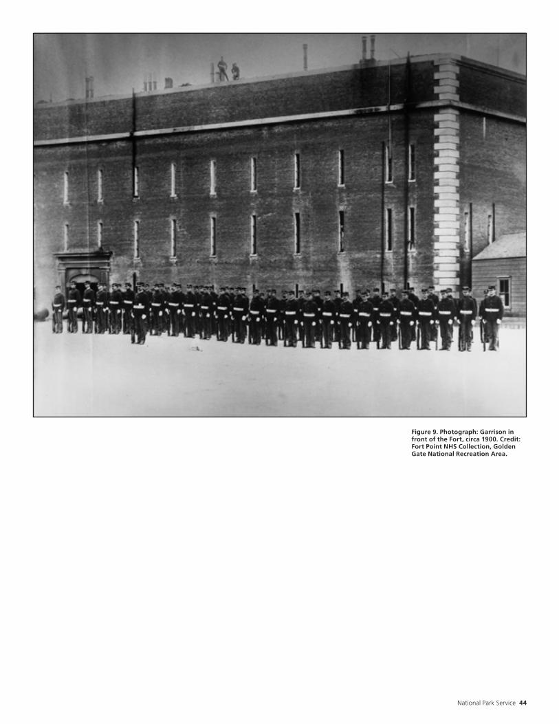
National Park Service 44
Figure 9. Photograph: Garrison in front of the Fort, circa 1900. Credit: Fort Point NHS Collection, Golden Gate National Recreation Area.

45 Fort Point Historic Structures Report
2. The dislocation of the south wall pulled the 92 foot lighthouse bridge off of its south foundation.96
1906—The bridge is rebuilt by the Lighthouse Board. The Fort is reported unstable and is abandoned.97
1907-1930: Detention Barracks WWI, Army UseFollowing the 1906 earthquake, engineers inspected damage to the fort. The cost to repair the damage is prohibitive and the fort is abandoned. What follows after a period of abandonment, is a period of intense construction activity, as the fort is remodeled for use as detention barracks. Bills introduced into Congress suggest the use of Alcatraz Island for a new immigration station, transferring its military prisoners to a renovated Fort Point detention barracks. Although the Army spends thousands of dollars and inmate crews from Alcatraz complete the conversion, Fort Point never becomes detention barracks. The bills authorizing the transfer of Alcatraz to the Bureau of Immigration are not enacted, and prisoners never use the renovated facility. The newly remodeled fort does serve a variety of other purposes, before it is once again abandoned.1907—BATTERIES: October 11. A General Order is issued designating Emplacements Nos. 11,12,13 as Battery Marcus Miller to honor Brig. Gen. Marcus P. Miller.1
1913—Secretary of War Lindley M. Garrison decides to convert Fort Point into a detention barracks.2
1913—PERSONNEL: Lt. Col. G. K. Williamson is assigned to prepare plans and specifications to convert Fort Point into a detention barracks (see figure 10, which is a floor plan located in the appendices).3
1913—EARTHQUAKE REPAIRS: Tie rods are positioned, and the rear wall is pulled into place and anchored back to the main structure.4 Engineers install steel tie-rods and turnbuckles to pull the earthquake-damaged gorge face back into place. The repair of the south wall is part of the “detention barracks” conversion.5
1914—January. Superintendent of Construction Gary F. Richards is in charge of the Fort Point detention barracks conversion (figure 11). By mid-April work accomplished includes:
1. Two shot furnaces are demolished and removed. 2. The ironwork is scraped and repainted. 3. The sally port doors are re-hung. 4. Iron window guards for the first and second tier embrasures are positioned. 5. Iron traverse rails are removed. 6. Iron railings facing the parade are removed. Wood frame walls replace them. 7. The walls for the kitchen extensions are put up. 8. The gallery floor is repaired.
9. The tin gallery roof is removed in preparation for a new tar and gravel roof. 10. Lath in finished rooms is repaired. 11. Replastering commences. 12. Old sash are repaired. 13. Mill work is ready for positioning. 14. Chimneys are cleaned and fireplaces readied for rebuilding. 15. Old soil pipes are traced out and sewer lines are reopened. 16. Holes are cut for roughing in pipe.6 17. Gun ports are blocked. 18. Electrical wiring and plumbing are installed.7 19. A water system, an oil supply line, and two French oil burning ranges are installed. 20. Fifteen fireplaces with basket grates and twenty flues for the use of stoves are built.8
Projects planned, but not yet commenced or in progress but requiring more than two weeks to finish include the following:
1. Concrete paving of the parade ground. 2. Enlargement of 10 south gorge windows in the first tier. 3. Removal of four first tier partition walls. 4. Repair of the roof to curb seepage into the casemates below. 5. Removal of vegetation from the superior slopes and from the earthen fill covered with concrete slab. 6. Filling of cracks with hot asphalt.9
1914—September 29. The conversion of the Fort is almost complete (figure 12).10
1914—The 63d Congress does not pass the bills authorizing use of Fort Point as a disciplinary barracks. 11 The Army remodeled Fort Point for use as a “detention Barracks” without receiving either direct orders or monetary authorization from Congress.12
1914—October 13. The War Department issues General Order No. 77, authorizing the Commandant of the Pacific Branch, U.S. Military Prisons “to Occupy Old Fort Point.”
Commandant Howland is in charge of the Fort.13
1915—September. District Engineer Rees visits the Fort:
[The Fort is] practically rehabilitated. Doors, windows, etc., have been replaced, walls and ceilings of the portion of the structure to be used as living quarters have been replastered, tinted, etc., plumbing fixtures installed, the main court [parade] of the ground floor and the entire area of the barbette tier and parapet wall previously occupied by earthen fills have been paved with concrete, windows installed in all of the embrasures, the archways at rear of each emplacement on the 1st, 2nd, and 3rd casemate tiers...have been closed with sash partitions, and the building generally put in good condition.14

National Park Service 46
1915—The fort is used by the Lighthouse Bureau to locate a searchlight on the west side of the barbette. Its power plant occupies the first two gun casemates on the east side of the first tier, fronting the parade. (figure 13).15
1917—January. Colonel Rees visits and inspects the Fort. He notes broken glass and damage to metal chimney tops.16
1917—World War I. Fort Point is used as quarters to house overflow from the Presidio and Fort Winfield Scott.17
1918—November 11. Armistice.
1920—Autumn. Fort Point is used as a Bachelor Officers’ Quarters.18
1920-1925—The army ceases to use the Fort as Bachelor Officers’ Quarters. By 1926, the Fort is abandoned and being vandalized.19
1924-1925—Several of the casemates are used for vocational school classrooms and shops (figure 14).20
1926—March 2. Dr. Lawrence Kocher, Chairman of the Department of Architecture at Pennsylvania State College and Chairman of the A.I.A.’s Committee on the Preservation of Historic Monuments and Scenery, writes Secretary of War Dwight Davis, regarding the preservation of Fort Point. Kocher writes “it is the opinion of many architects that the massive fortress possesses much merit in both design and construction” and that it is “in danger of
deterioration through lack of proper upkeep.” The matter is referred to the officers of the Quartermaster Corps.21
1926—May. Lt. Col. L.B. Bash of the Quartermaster Corps. thoroughly inspects Fort Point. Damage includes:
Figure 11. Photograph: Detention Barracks conversion in progress, viewed from the parade, circa 1914. Credit: Fort Point NHS Collection, Golden Gate National Recreation Area.

47 Fort Point Historic Structures Report
Figure 12. Photograph: Detention Barracks conversion in progress, viewed from the parade, circa 1914. Credit: Fort Point NHS Collection, Golden Gate National Recreation Area.

National Park Service 48
Figure 13. Photograph: Fog Signal Station located on the barbette tier. 1915. Credit: Fort Point NHS Collection, Golden Gate National Recreation Area.
Figure 14. Photograph: Vocational School, viewed from the parade, circa 1924-1925. Credit: Fort Point NHS Collection, Golden Gate National Recreation Area.

49 Fort Point Historic Structures Report
1. Almost all the windows are broken by vandals. 2. Doors opening onto the parade are either broken or not working. 3. An exterior sally port door is knocked off its hinges, breaking the wood and ironwork. 4. The inner sally port doors are in bad condition. 5. Iron bars at the embrasures are rusted and bent. 6. Ironwork of the gorge stairways and colonnade is badly rusted. 7. Water has seeped through the casemate arches where the pointing has failed. 8. Grass and weeds are growing on the barbette tier. 9. The plumbing is missing or in bad condition. 10. Pieces of the scotch flagging from the balconies have been stolen. 11. The iron cover of the parade cistern is gone. 12. Brickwork on the seaward faces has eroded from wind and water exposure.
No repairs have been made since the 1914-1915 detention barracks conversion.22
1926—August 7. The fort is abandoned once again. The windows of the fort are mostly broken, ironwork is badly rusting, one of the sallyport doors is unhinged, and obscene graf-fiti covers dirty interior rooms. The IX Corps Quartermaster orders the windows and doors of Fort Point boarded-up to curb vandalism. The War Department spends $40.37 in an unsuccessful effort to prevent further vandal-ism.23
1931-1940: Golden Gate Bridge ConstructionChief Engineer Joseph Strauss played an instrumental role in the hstory of Fort Point during the Golden Gate Bridge construction period. Initial bridge plans called for a concrete caisson anchoring the southern end of the bridge to be located on the Fort Point site. After touring the empty fort, Strauss changed his mind, altering bridge plans to save the old masonry fort. The southern anchorage was moved a couple hundred feet to the south and an arched span, “a bridge within a bridge,” carried the bridge safely over the fort.1
Although the fort was saved, the counterscarp was razed. Portions of the seawall were dismantled and reconstructed. Other modifications to the fort resulted from its use as a construction center during bridge construction. Cars were parked in the parade, and interior spaces served as offices, storage spaces, and a cafeteria. 1930s— Initial plans for the Golden Gate Bridge call for razing the Fort. Joseph P. Strauss, the engineer who both designs and builds the bridge, determines to save the Fort for its architectural significance. Strauss designs a steel arch to span the Fort, thereby saving it, although the counterscarp gallery is demolished. The breast-height walls and gun platforms of the 10-Gun Battery give way to bridge approaches.2
1933— Work begins on the construction of the Golden Gate Bridge (figures 15, 16, 17).3
1933-1937—Fort Point serves as a construction center for bridge operations. Workers use the Fort for storage, office space and a cafeteria. Second tier casemates serve as the cafeteria and experiments in steel plate resistance to salt corrosion are studied on the barbette tier (figure 18).4
SEAWALL: To preserve the seawall, a portion of the seawall is dismantled, stored and rebuilt when the Golden Gate Bridge southern pylon and southern anchorage are completed.5 The seawall serves as a cofferdam for the foundations of the concrete pylon.6
Bridge excavations uncover a buried adobe shed believed to be a powder magazine from the Spanish fort, Castillo de San Joaquin.7
1934—LIGHTHOUSE: The U.S. Lighthouse service extinguishes the Fort Point Light for the final time due to Golden Gate Bridge construction.8
1936—San Francisco Mayor Rossi appoints a 15 person Citizen’s Committee, headed by Strauss, to survey the fort, with the goal of preserving it as a historic site similar to Fort Ticonderoga in New York. The group planned to approach the Works Progress Administration for assistance. However, with the depression at hand, there was little interest in the proposal to develop Fort Point as a Historic Site, and this initial preservation campaign proved fruitless.9, 10

National Park Service 50
Figure 15. Photograph: Golden Gate Bridge construction, viewed from bluff above Fort, circa 1933. Credit: Fort Point NHS Collection, Golden Gate National Recreation Area.

51 Fort Point Historic Structures Report
Figure 16. Photograph: Golden Gate Bridge construction, Lighthouse Keeper’s Houses, viewed from bluff above Fort, circa 1933. Credit: Fort Point NHS Collection, Golden Gate National Recreation Area.

National Park Service 52
Figure 17. Photograph: Golden Gate Bridge construction, viewed from East, circa 1936. Credit: Fort Point NHS Collection, Golden Gate National Recreation Area.

53 Fort Point Historic Structures Report
Figure 18. Photograph: Fort parade used as a parking lot, circa 1930s. Credit: Fort Point NHS Collection, Golden Gate National Recreation Area.

National Park Service 54
1937—The Golden Gate Bridge is complete, bridge workers leave.11
1937—May. The Golden Gate Bridge is dedicated.12
1937— Joseph Strauss writes to the bridge’s Board of Directors:
While the old fort has no military value now, it remains nevertheless a fine example of the mason’s art. Many urged the razing of this venerable structure to make way for modern progress. In the writer’s view it should be preserved and restored as a national monument...13
1938—Fiscal year. Window and embrasure openings are infilled with brick.14
1941-1945: World War IIWith the onslaught of World War II, San Francisco Bay became the focus of military strategic defense. A mine-reinforced steel net was strung across the bay in 1942 to deter Japanese submarines. Defense activity at Fort Point was limited to the rapid-fire gun battery and the addition of two guns mounted on the barbette tier. The fort itself provided living and office space for the new garrison. The end of World War II saw the fort abandoned and locked up once again. 1941—December 7. The Japanese attack Pearl Harbor. War in the Pacific begins.1
1941—All military construction, real estate, repair and utilities activities in the San Francisco area are transferred to the San Francisco District, Corps of Engineers, from the Quartermaster Corps.2
1942—GARRISON: Troops occupy the Fort. Battery N, 6th U.S. Coast Artillery protects the Golden Gate.3
1942—To deter Japanese submarines that might try to enter the harbor, a steel net is strung across the mouth of the bay early in 1942. The net stretches from Sausalito to the Marina Green and is supported by dozens of buoys. A Navy tug boat is required to both open and close the net for allied shipping passage, and the tug boat remains stationed midway along the net. Three mine fields, guarded by small rapid-fire gun batteries flanking the Golden Gate, are placed along the approaches to the harbor to back up the net.4
1942—ARMAMENT: To better protect the San Francisco side of the Golden Gate, two rapid-firing 3-inch anti-aircraft guns from Battery Yates at Fort Baker are mounted on the barbette tier, with a fixed searchlight and its generator.5 Soldiers from Battery N of the 6th U.S. Coast Artillery, quartered in the gorge barracks, man the guns. Named “Battery Point,” the guns are positioned to protect the mine fields and submarine net from enemy ships.6
Post Engineer H.N. supervises the conversion of some casemate rooms into a messhall, dayroom, barber shop and post exchange. The gorge officers’ quarters and enlisted men’s barracks are rehabilitated.7
The first tier gorge rooms are used to store camouflage materials that disguise nearby gun emplacements.8
1945—GARRISON: A Japanese attack is no longer a threat and the troops depart from Fort Point.9

55 Fort Point Historic Structures Report
1946-1970: The Move Toward Preservation: Establishment of the Fort Point Museum Association Following many years of post-war neglect, this period sees the establishment of the Fort Point Museum Association. Public tours begin on a limited basis, and lobbying begins to develop Fort Point into a National Historic Site.1947—September 5. A reporter from the San Francisco News visits Fort Point. The sallyport doors are locked because the present condition of the fort constitutes a danger to visitors. A sign is posted warning off trespassers. He writes:
One of San Francisco’s best potential tourist attractions is badly in need of a friend... [Rust lay] in great scales on the barbette pintles on the parapet. Rust had eaten the ironwork railings. The seaward side and outer walls...are pocked and pitted by nearly a century of attack from the sea (figure 19).1
1947—September 23. Army Commander Gen. Mark Clark proposes to declare Fort Point surplus to the army’s needs and recommends the establishment of the site as a public monu-ment. Army Engineers at the Presidio estimate the cost of stabilizing the Fort at $5000.00. This would include repairing iron railings, replacing broken glass, and general clean-up. The cost to restore the Fort to its nineteenth century appearance, including heavy ordinance is “a different story.” 2
1948—The Fort is not declared surplus to the Army’s needs.3
1955—May 7. The Daughters of the American Revolution dedicate a historical plaque at Fort Point. Sixth Army Maj. Gen. William Dean accepts the plaque on behalf of the Department of Defense.4
1956—Summer. Maj. Earle K. Stewart, Post Troop Information and Education Officer, is asked by his superiors to comment on the significance of Fort Point. He replies:
I am convinced, as a professional historian, that the uniqueness, historicity, present state of excellent preservation, and accessibility dictate the desirability of establishing Fort Point as a national monument. [He recommends Fort Point be established as a National Monument under the National Park Service]. I do not believe the Army should relinquish control of the ground on which it stands or to any avenues of approach.5
1957—December. Edward B. Page (Architect), John J Gould (Civil Engineer), and Major Her-bert Batz (USA, retired) meet at the Presidio with the Deputy Chief of Staff to discuss plans to restore, preserve and maintain Fort Point.6
1958—January. A plan to restore, preserve, and maintain Fort Point is submitted to the Army.7
1958—June. Major Myron B. Goldsmith, AUS, retired, proposes to the Commanding General, Sixth US Army, a plan to preserve the Fort by establishing a citizens corporation to use the Fort as a military museum.8
1959—May. The Fort Point Museum Association is incorporated by Maj. Herbert Batz, John J. Gould, Edward D. Page, Myron B. Goldsmith.9
1959—July. The Fort Point Museum Association formally requests lease of the Fort land and buildings from the Army.10
The Association campaigns for the next eleven years to preserve Fort Point. The Associations signs a special use permit with the Sixth Army. Over the next eleven years the fort is cleaned up and a small museum is established.11
1966—June 24. Text of the bronze tablet placed at Fort Point during the dedication ceremonies by the Fort Point Museum Association:
Fort Point is considered one of the finest examples of military architecture in the United States and is San Francisco’s only major building constructed before the Civil War which has remained basically unchanged since it was completed and garrisoned in February of 1861. Two months later the firing on Fort Sumter, South Carolina, marked the beginning of the Civil War, but the bombardment also clearly demonstrated that brick and granite fortresses could not withstand the devastating power of the rifled cannon. Fort Point was the last such fortress to be constructed.12
1967—July 25. United States Senator Thomas Kuchel and Representative William S. Mail-liard introduce companion bills to the 90th Congress requesting the transfer of 29 Presidio acres, including Fort point, from the Depart-ment of Defense to the Department of the Inte-rior.13
1967—August 15. Senator Kuchel’s bill is brought before Senator Allan Bible’s Sub-committee on Parks and Recreation. Assistant Secretary Stanley Cain asks the sub-committee to postpone any action on Senator Kuchel’s bill until the next session, allowing the Department of the Interior to complete a feasibility study. The sub-committee votes to tour Fort Point and Alcatraz in fall.14
1967—October. The Secretary of the Interior’s Advisory Board on National Parks, Historic Sites, Buildings and Monuments, endorses the proposal to establish a National Historic Site at Fort Point. Secretary of the Interior Stewart Udall reports to Senator Kuchel that the National Park Service is completing the feasibility study and expects to submit it to Congress in January.15
1968—Local congressmen introduce bills calling for the creation of Fort Point National Historic Site.16

National Park Service 56
Figure 19. Photograph: Fort, viewed from Southeast corner of barbette, circa 1947. Credit: Fort Point NHS Collection, Golden Gate National Recreation Area.
57 Fort Point Historic Structures Report
1970-1998: National Park Service StewardshipThe designation of Fort Point as a National Historic Landmark is a catalyst for restoration and rehabilitation work. The neglected Fort soon boasts repainted metalwork, reproduced ironwork railings, a rebuilt lighthouse, the return of armament, refurbished plaster, and much more. Fort point, “the pride of the Pacific,” and “the Gibraltar of the West Coast,” proudly exhibits its history through both the architecture and the interpretive exhibits, open to the public and continuing to attract visitors daily.1
1970—October 16. President Nixon signs Public Law 91-457, 91st Congress, HR 18410, the bill to establish Fort Point National Historic Site.2
1971—April 14. The Department of the Army formally transfers Fort Point to the National Park Service. Although Congress passes the legislation authorizing transfer of the area and the expenditure of public funds, no funds are appropriated.3
1972—LIGHTHOUSE. October. A $46,000 contract is awarded for the restoration of the Fort Point lighthouse. The project (package 130) is one-third complete at the end of the year.4
1972—SALLYPORT. Minor brick repair at the inner end of the sallyport arch is made, and to the exterior sides of the sally port.5
1973—A Historic Structures Report is prepared by Edwin C. Bearss, a military historian with the National Park Service’s Denver Service Center. The report establishes a restoration period of 1861-1913. Drawings are also prepared to accompany the report (figures 20-24 located in the appendices). The following projects are recommended to accomplish the desired restoration:
1. Reconstruction of one of the shot furnaces 2. Removal of iron window guards and brick infill from the embrasures 3. Relaying of casemate traverse rails in casemates scheduled to be rearmed 4. Restoration of the iron rails facing the parade 5. Removal of 1914 toilet facilities and kitchens 6. Removal of concrete to expose flagstone in casements scheduled to be rearmed 7. Removal of concrete from the superior slope of the barbette tier, and its replacement with earthen fill and sod 8. Restoration of walls and windows in the four casemates west of the sally port on the first tier to their appearance before conversion to a
“guard dormitory.” 9. Restoration and furnishing of selected casemates on the second and third tiers as proposed in the Interpretive Prospectus.6
1973—LIGHTHOUSE. March. The lighthouse is “completely restored,” except for the internal lighting fixtures.7 The lighthouse and railing project is completed in August.8
1973—GALLERY/STAIRS: A $90,000 estimate is prepared to restore the gallery roof, gallery columns and railings, and to replace the three flights of cast iron stairs and the three foot walkway at the barbette tier.9
1974—The organization of the Golden Gate National Recreation Area is finalized, placing Fort Point as an independent operation under the direction of an on-site superintendent, who is under the supervision of the GGNRA south unit superintendent.10
1974—GALLERY/STAIRS: June 25. Reliance Enterprises is awarded a $155,391.00 restoration contract.11 In December, contractors move in to the fort to begin restoration of the gallery roof, the three-foot walkway on the barbette tier, the iron balustrade columns, and replacement of the gorge railings and the three flights of iron stairs on the north side of the parade.12
1974—LIGHTHOUSE: The lighthouse is dismantled again, undergoing its second restoration.13
1975—The Reliance Enterprises restoration contract work is completed. The total project cost is $226,805.67, including eight change orders.14
1976—February 13. Estimate submitted by L. Koue and R. Cox for repairs to Fort Point.15
Accompanying estimate lists the following items under the category of “Reconstruction” (reference drawing # is L.C.S. 1 b):
1. Refill [19] windows, first level Magazine* ..... ...................................................................$16,500. 2. Repair Penthouse Roofs & Cornices $8,450.3. Repair Sally Port Gates ......................$15,000.4. New manhole covers for Cisterns .... $3,750.5. Removal of Plumbing ......................... $13,125.6. Remove World War II Concrete .....$9,375 .7. Remove raised floor in West Bastion* .4,600.8. Remove infill at embrasures ...............$4,600.9. Remove infill from windows ..............$5,600.10. Replace embrasures ........................ $219,400.11. Replace Traverse circles ...................$43,500.12. Reconstruct wood f loors, first tier magazines* ................................................. $5,100.13. Reconstruct coal bins ........................$4,300.14. Reconstruct privy, second tier ......... $9,700.15. Rough work, second tier Officers Quarters* ..................................................$33,000.16. Rough work, third tier Enlisted Men Quarters ....................................................$24,300.17. Wash sinks, second and third tiers .. $7,900.18. Install Water Tank ..............................$3,000.19. Flagpole* ............................................... $7,500.20. Reconstruct Shot Furnace .............. $19,000.SUBTOTAL ........................................... $457,700 .Historic Furnishing Study ...................... $1,500.Historic Structure Preservation Guide .. 3,500.TOTAL ....................................................$462,700.

National Park Service 58
Estimate for “Preservation” items (reference drawing #L.C.S. - 1a)
1. Work on Security doors .......................$6,200.2. Repair of Chimney Pots ....................... $1,900.3. Repair Paving, Barbette Tier Level .. $17,000.4. Repair to Granite Stairs & landings .. $1,125.5. Repair to Paving at Parade Level .......$17,100.6. Repair to Paving at second and third Tier Galleries ...................................................... $6,750.7. Repair to Millwork, etc. second tier Officers Quarters ....................................................$54,000.8. Work on Fireplaces, second tier Officers Quarters ....................................................$22,500.9. Repair to Millwork, etc. third tier Enlisted Men Qrs.* ..................................................$46,500.10. Work on Fireplaces, third tier Enlisted Men Qrs. ............................................................$18,000.11. Repair Jail Area ....................................$5,200.12. Repaint all spaces, second & third tiers - Gorge Side ...............................................$60,000 .13. Repair & Repoint Ext. Brickwork, West Wall And West Bastion, 14,575 s.f. ................ $65,587.14. Repair & Repoint Exterior Brickwork, North Wall & East Bastion, 17,655 s.f. ........... $105,930.15. Repair & Repoint exterior Brickwork, South and Southeast Wall, 16,455 s.f.* ............ $74,048.16. Repair and Repoint Interior Brickwork Assume 75,000 s.f. .................................$225,000.TOTAL ....................................................$726,840.
* According to John Martini, Military Historian with the National Park Service, items followed by an asterisk (*) have been completed at the time of this writing. Other items were either not done or only partially completed. He was uncertain about items 1, 3 and 11 from the
“Preservation” list.
1976—SOUTH MAGAZINE WALL: February 20. An emergency contract, FX 816060062, is established for repair of an approximately 200 square foot area of bricks outside the south magazine wall. William A. Rainey & Son is awarded a contract in the amount of $1,259.52. Work takes place April 13-16.16
1976—METALWORK: March. Railings restoration project costs $226,000. Much of the original metalwork is replaced.17
1976—May 15. Fort Point is dedicated as a California Historic Civil Engineering Landmark, by the American Society of Civil Engineers.18
1976—May 25-July 9, 1976. A suicide barrier is completed along the Golden Gate Bridge public walkway, above Fort Point.19
1976—An alarm system is installed at the Fort.20
1976—SOUTH WALL OF GORGE. September 30-December 17. Contract CX 814060015 for the amount of $64,200.00, is partially completed. 7,155 square feet of the south wall, from the foundation to the granite cordon, is repaired by McAley and McDonough. Work includes the removal of bricks used to infill windows cut in the south magazine wall during the 1914 detention barracks conversion; bricks
more closely matching the original are used to restore the wall and the concrete surrounds are removed.21
1978—FIRST TIER WINDOWS: First tier windows on the gorge (south) side of the Fort facing the parade are restored or replaced by the Parker Weather Strip Company, for $1,430.00.22
1978—The Young Adult Conservation Corps works to:
1. Restore the floor in Powder Magazine B. 2. Paint the 32-pounder gun carriage and cannonballs exhibits. 3. Clear access to the old Battery East parapet area. 4. Build a viewing platform to protect the historic parapet of Battery East from heavy foot traffic.23
1978—JAIL: December 20. Maintenance request to replace wooden lath and plaster over damaged areas in the jail (3 rooms).24
1979—SEAWALL. August 20-December 14. R.E. Lenihan International, Inc. is contracted to stabilize the Fort Point seawall for $217,853.80. 680 linear feet of the east portion of the seawall is repaired.25
1979—ARMAMENT: June 18-August 10. Members of the California Conservation Corps. scrape and paint cannon tubes and carriages, caissons, limbers, cannon balls, artillery equipment, and clear brush at Battery East.26
1979—SECOND/THIRD TIER WINDOWS: November. Bill Wright Painting and Decorating Inc. is contracted to stabilize, repair or replace operable wood window sash and fixed transoms on the second and third floors for $16,473.11.27 Covered work includes 8 windows at the parade face of the second tier, 8 windows at the third tier parade face, and 24 windows at the third tier land face.28
1980—SECOND TIER WINDOWS: Window contract is increased to $31,903.44, to include 24 windows on the Land Side of the Second Tier.29
1980—SEAWALL: February 15. Storm damage includes Marine Drive wash out and slight seawall displacement.30
1980—April 8. High waves from the west side of the Fort flow through the sallyport, leaving eighteen inches of water on the parade ground. The Presidio’s D Company 864th Engineers volunteer to pump the water out of the fort and build a protective 90 foot sand bag dike. 50,000 gallons of water are pumped from the courtyard.31
1980—Excavation to uncover a clogged drain reveals a 7 2 foot long, 66 inches high and 22 inches thick, Flemish Bond style brick wall [location unspecified].32
1980—May 15-June 24. California Engineering Construction, Incorporated, is contracted for $240,000 to repair the storm damage.33

59 Fort Point Historic Structures Report
1980—SECOND TIER WINDOWS: July. Bill Wright Painting and Decorating, Inc. restore and stabilize 24 operable wood sash windows on the second tier land face, completing the stabilization and restoration of windows in the living quarters of the fort for $15,340.33.34
1980—WEST FACADE: October. The west facade brickwork is in need of repair. Estimates state between 25-30 percent of the bricks need replacement. The entire west face needs repointing. The repair area is approximately 14,575 square feet.35
1981—GRANITE STAIR: January 22. A structural engineer from the NPS Division of Adobe/Stone Conservation issues a memorandum reporting upon his visit to numerous sites in the Bay Area, during September 1980. He reports on a “dangerous condition” at the top of the spiral staircase at the southwest end of the Fort. The granite slab forming half of the landing at the top of the stairs is cracked completely through.36
1981—January. Pacific Telephone and Telegraph Company pave the entire length of Marine Drive after installing a fiber optics telephone cable on the south side of Marine Drive.37
1981—April. A large cavern is discovered underneath the west end of Marine Drive, caused by waves undercutting the seawall.38
1981—SOUTH PARAPET: October 15. Fong’s Consolidated Contracting Company seals the cracks in the concrete seal of the south parapet, for $2,425. Water seeping into the barracks is causing deterioration of the fort’s interior.39
1981—ARMAMENT: The Fort Point and Army Museum Association spend $38,659 to cast an 8-inch Columbiad Cannon, building the carriage, and hoisting it into place. The gun is expected to be in place early in 1982.40
1982—SOUTH FACADE: May. 7,155 square feet of the south facade and 75,000 square feet of the interior courtyard facade need repointing and repair. The estimate is $1,418,100.41
1982—BRICK EXTERIOR: June. Deerpath Construction Company, New Jersey, is awarded contract # CX 8000-2-0025 in the amount of $385,759.06, to repair and repoint the brick exterior walls of the fort. L.P. McNear Brick Company, Inc. manufactures bricks to meet specified standards for wall restoration. At the end of the year, 4,468 square feet of wall are repaired.42
1982—SEAWALL CHAIN BARRIER: September 3. Coast Fence Company is awarded contract #CX 8140-2-0012 in the amount of $19,243.25, to remove and reconstruct 403 feet of the chain-barrier on top of the granite seawall at the west end of Marine Drive.43
1983—METALWORK: The metalwork throughout the fort interior, including iron railings, columns, steps, roof supports, and the lighthouse are described as “in dire need of treatment.”44
1983—ELLIOT SEAWALL: Winter. The Elliot portion of the seawall near the fort is damaged by heavy storms. Several of the cap stones work loose under pressure of pounding waves. One keystone cracks, allowing several of the stones to fall into the bay. The wall also moves forward in the damaged area. The dislodged stones are recovered, and huge rock riprap is placed in front of the damage until summer when repairs can be made. Cost of the riprap rock is $75,000. Plans for the project are completed, with repairs estimated at $38,000. At the end of the year, an additional $800,000 is requested to complete other recommended riprap protection for the entire seawall.45
1983—SECOND TIER QUARTERS: September. Dave Peeler Painting and Decorating is awarded contract CX 8140-3-0033 with the Small Business Administration for the amount of $58,000.00. The contract is for multiple sites, including two rooms on the second floor of the fort.46
1983—BRICK EXTERIOR/INTERIOR: September. 5000 square feet of repointing and brick replacement on the south exterior wall and approximately 19,000 square feet of interior wall repairs are estimated at $240,000.47
1983—L.P. Mc Near Brick Co., Inc., manufactures 25,000 re-pressed brick to replace worn bricks.48 This is a “full run,” which is much more than is required for currently funded projects.49
1983—BRICK EXTERIOR: Deerpath Construction Corporation completes contract # CX 8000-2-0025, repairing and repointing the brick exterior walls.50 Mr. Vince Trentowski, the job superintendent, also completes several small brick repair project within the fort after completion of the regular contract at no cost.51
1983—SECOND/THIRD TIER QUARTERS: December 16. Baca & Sons Painting is awarded contract #CX 8140-4-0015 in the amount of $32,473.00, to paint interior of Historic Structures in the Golden Gate National Recreation Area. Items at Fort Point include painting the floors of 20 rooms on the second and third tiers, and painting the second tier Akitchen.” 52
1983—SECOND TIER QUARTERS: Local plasterer John (Jack) Falvey performs plaster restoration at the west end of the second tier. Work includes removal of deteriorated battens, wedges and lath; use of salvaged lath from other locations of the Fort as well as from other nineteenth century buildings in the area; and replastering with a three-coat plaster system.53 Cut-up rope is added to the plaster mix to simulate horsehair.54 The project is funded by

National Park Service 60
public donations, the Skaggs foundation of San Francisco, Food Machinery Corporation of San Jose, and the Fort Point and Army Museum Association.55
1984—SEAWALL: Lewis M. Merlo, Inc. is awarded contract #CX8140-3-0031, to repair 88 linear feet of the Elliott seawall top course granite blocks. The work is completed in January, total cost of the project is $162,832.00.56
1984—BARBETTE TIER GRANITE LANDING: April. Lewis M. Merlo, Inc. is awarded a contract to repair the 3700 lb. granite landing at the barbette tier, southwest stairwell of the fort. Work is completed in midsummer, total cost of the project is $1,999.00.57
1984—SECOND/THIRD TIER WOOD FLOORS: Baca and Sons Painting Contractors treat 20 wooden floors in the second and third tier quarters with CWF, a wood preservative. Work is completed in April, total project cost is $2,890.00. The restored kitchen on the second tier is painted, total project cost is $1,118.00.58
1984—LIGHTHOUSE/METALWORK: March-April. T and A Painting Company paints the lighthouse, iron stairs, fluted columns and balustrades.59
1984—LIGHTHOUSE: September 11. Fort Point Site Manager complains about the lighthouse paint job, done through U.S. Army contractors. It appears the lighthouse was never finished, and rust is evident on areas that were painted. Throughout the Fort, paint was not applied properly to ironwork and where applied it is showing rust.60
1984—SECOND TIER QUARTERS: Dave Peeler Painting and Decorating Company is awarded Contract #CX 8140-3-033 in the amount of $4,300.00, to paint four rooms, touch-up other rooms and paint eight exterior doors of the second tier quarters area. Work is completed in August.61
1984—SEAWALL: September. MTL Construction Company is awarded Contract #CX 8000-4-9006 in the amount of $393,223.00 for repair of the storm damaged seawall and roadway along Marine Drive. At the end of the year the project cost is estimated at $518,000, due to construction changes.62
1985—February 19. Contract #CX 8000-4-9006 is completed. Total project cost is $643,955.00, which includes Contract #CX 8140-3-0009 for emergency road repair by Lewis M. Merlo Inc., for $125,000.63
1985—The fort’s brickwork is stained with slurry from the cutting of concrete road slabs on the Golden Gate bridge. Negotiations with Dillingham/Tokola, the Bridge project contractor, are underway at year’s end, to bring the fort back to standard.64
1985—IRON RAILINGS: June. Dillingham/Tokola removes the iron railings of the fort, to clean and repaint them off-site.65
1985—July 30. United States Department of the Interior Requisition for R.B. McNair Sons to pour a concrete slab on the existing dirt base of the old lighthouse foot bridge landing at the southwest corner of the barbette tier.66
1985—WOOD FLAGPOLE: December. The fort’s wooden flagpole collapses and falls into the courtyard.67 (This is not the original flag pole but rather a replacement installed by the Fort Point Museum Association in the late 1960s).
c.1985—THIRD TIER. Historical Architect Robert Cox arranges for a National Park Service plastering class to conduct plaster repairs in gorge rooms at the east end of the third tier (labeled Rooms 2 and 4 on plan, figure 24).68
1986—February 10. Bridge contractor Dillingham/Tokola begins clean-up work to remove slurry stains from the inner and outer walls of the fort. The work is completed on April 4.69
1986—IRON RAILINGS: April 18. McNair Brothers Construction Company begins final painting of the railings. The project is completed on July 3rd, with the railings back in place.70
1986—ARMAMENT: April. Ironworkers from the Golden Gate Bridge scrape and paint the Rodman cannon and carriage in the Fort parade area.71
1986—ARMAMENT: Ten soldiers from Fort Ord spend a weekend at the fort scraping, treating and painting the 10-inch seacoast mortar, stacks of cannonballs and metal stanchions.72
1986—METALWORK: October 11. R.B. McNair Sons invoice for work completed at Fort Point:
1. Removing and replacing of guard railings: .. ................................................................. $4,151.32 2. Cleaning & painting of railings, in place, under Light Station: ............................... $232.00 3. Cleaning, etching, rinsing & applying two coats of Rust-Oleum paint to railings before replacement: .........................................$5,400.00 4. Furnishing four gallons of paint: ...... $101.57Total: ....................................................... $9,884.89
1987—METALWORK/LIGHTHOUSE: Rex Potter is awarded Contract #8140-2554-301 in the amount of $20,256.00 to paint fort metalwork. The work includes the iron columns, entablatures, porch support brackets under first, second and third floors, iron stairway south side of the fort, iron stairway under the lighthouse, and the lighthouse. Work is completed in November.73
1987—SEAWALL: K.G. Walters Construction Co. Inc. is awarded Contract #CX-800-7-9006 in the amount of $564,670.00 to pump grout behind the seawall to fill voids, and to place

61 Fort Point Historic Structures Report
8,000-10,000 pound rocks in front of the seawall to provide protection from wave action.74 The San Francisco Chronicle publishes an article on January 14 expressing concern that the work might destroy the scenic value of the high wave action at the fort.75
1987—FIRST TIER GUARD ROOM: A new power panel is installed in the first floor guard room, with new circuits extending to the second and third floor quarters (these new circuits replace non-operational c. 1915 circuits). Work begins in August and is completed October 30, total project cost is $20,000.76
1988—METALWORK: Rust spots are observed on iron columns, entablatures, porch support brackets, iron stairway, lighthouse stairway and lighthouse, all repainted in November of 1987. The iron railings throughout the Fort are also observed to be in need of painting.77
1988—SEAWALL: March 22. K.G. Walters Construction Co. Inc., of Santa Rosa, completes Contract #CX-800-7-9006, Rip Rap Protection of Seawall, IFB FOPO-147.78
1988—CISTERNS: August 26. Twelve members of Conquistadores del Mar, U.S. Army Presidio Dive club, under the guidance of President Thomas M. Healy, perform an underwater survey of two of the five cisterns. The divers check walls and ceilings for structural damage, and locate and check intake and outflow drains. The cisterns were measured, and water and sediment samples taken for analysis. Findings indicate that the cisterns are in good condition. Plans are made to investigate the three remaining cisterns at a later date.79
1988—FLAGPOLE: November 15. Kurt Raillard, of Ace Pacific Company in San Francisco, inspects the existing flagpole base. He finds the base strong enough to support the vertical load of the new pole. He recommends the base be cleaned and painted for corrosion protection, and that additional work be done to secure the existing anchorage bolts. At the end of the year, the Site Manager works with Pat Christopher, Historical Architect, GGNRA, and John Anglim, Anglim Flag Pole Company, to initiate the project, with a completion goal of May 1, 1989.80
1988—SEAWALL: December 7. Work begins on Golden Gate Bridge Contract No. 88-B-13, south Anchorage, Seawall Repairs Phase I, for the amount of $30,188. The Contractor, Horre Construction Company of Sonoma, completes the work on December 30. The project focused on repairing cracking and upward movement in the top later of granite blocks just west of the Golden Gate Bridge south anchorage. Phase II, addressing that part of the seawall just west of the Fort near the south bridge pylon, is in the planning stage.81
1989—PENTHOUSE: 14 July. Development Study Package Proposal describes need for penthouse stabilization. Wood panels with rusty nails are falling onto the staircases and
the parade ground. Moisture travels through the chicken-wire window closures and open doorways into the spiral stairways, a structural and safety issue. The roofing is deteriorated and pieces are falling onto the staircases and parade ground.82
1989—EARTHQUAKE/SOUTH WALL: October 17. Loma Prieta earthquake damage to the fort causes the south wall to lean out from the main fort structure. The roof over the wall loses its water tight integrity.83
1989—FLAGPOLE: October 15. The Fort Point flagpole is reinstalled.84 (The flag pole is not the same flag pole that collapsed in 1985, but a fiberglass replacement pole.)
1989—November 17. 10-577 Priority List.85
1. Repair, treat, and preserve wooden staircase structures 2. Grade land, remove sand, from west and north base of Fort walls. 3. Repair, scrape, treat, paint lighthouse. 4. Fix door mounts and door on east spiral staircase. 5. Seal with doors, heat and environmentally control exhibit spaces. 6. Remove non-historic fabric from and repair historic sally port doors. 10. Improve heating system. 11. Create accurate exhibit space by mounting correct replica weapons at correct casemates, opening sealed windows and placing replicas of Totten shutters in them. 13. Provide new flagpole lanyard tie off. 14. Fix lighting system in Sutler store.
(According to Maureen Rogers, Park Ranger, item #1 was completed in 1997, item #2 is an ongoing maintenance item, item #3 was com-pleted in 1991, items #4 and #5 have not been done, item #6 is in progress, items #10 and #11 have not been done, item #13 was completed c. 1990, and item #14 has not been done.86) 1990—FY90 10-577 Priority List87 Parenthetical information regarding status at the time of this writing comes from an interview with Maureen Rogers, Park Ranger.88
FOR-01 Stabilize, preserve wood penthouses (completed 1997)
FOR-02 Repair, scrape and paint structural metalwork (not done)
FOR-03 Re-point bricks (phase 1 completed in 1996)
FOR-04 Prevent wet sand from building up against fort (ongoing maintenance)
FOR-05 Repair, paint lighthouse (completed 1991)
FOR-06 Repair and maintain barbette and escarpment roofs (completed as part of repointing and roof-sealing project)

National Park Service 62
FOR-07 Repair historic staircase doors (not done)
FOR-08 Remove plants damaging historic fabric and other hazardous plants (ongoing maintenance effort)
FOR-09 Repair and preserve large Fort Point artifacts
FOR-10 Inspect and add if needed rip rap to seawall (not done)
FOR-11 Environmentally control exhibit spaces (not done)
FOR-12 Repair sally port doors located at both ends of sally port (in progress, but only exterior doors included)
FOR-13 Repair needed bars and remove dangerous iron bar work from south wall windows (not done)
FOR-14 Repair and stabilize hillside trails above administration area (ongoing maintenance effort)
FOR-15 Build wooden walkway at Battery East (not done)
FOR-16 Construct accessibility ramps into 1st floor rooms (completed c. 1993, the same year the audio tour was instituted)
FOR-17 Construct pedestrian walkway (uncertain)
FOR-18 Inspect and paint seawall fence (uncertain)
FOR-19 Improve heating system in the fort (not done)
FOR-20 Repair, scrape, treat, and paint flagpole (uncertain)
FOR-21 Improve heating system in admin. building (uncertain)
FOR-22 Prepare accurate exhibit space by replacing rusted Totten shutters with new ones (not done)
FOR-23 Re-design lower parking lot to create bus parking (completed c. 1991)
FOR-24 Install proper toilets at the Fort (not done)
FOR-25 Place new halyard tie off on flagpole
FOR-26 Upgrade track lighting in Sutler Store (not done)
FOR-27 Enlisted men’s quarters electrical work
FOR-28 Paint enlisted men’s room (completed 1993, in furnished rooms only)
FOR-29 Remove storage tank (completed 1996-1997. This was an oil storage tank across from the Pilot’s Houses on Lincoln; seen in photographs above the Keeper’s Houses.)
FOR-30 Remove administration area paint locker (completed 1997)
1990—NORTH WALLS: October 13. Lichen Removal Project tests different solutions on five 3’ by 3’ test patches on north walls.
1. North wall of east bastion- Ammonia 5% 2. North wall of east bastion- water 3. North wall- Nokomis 5% 4. North wall- bleach 5% 5. North wall- control. No treatment.89
1990—EAST PENTHOUSE: East stairwell house is deteriorating so badly that boards are falling off into the Parade Ground below. The east half of the parade is roped off for safety.90
c. 1990—OUTSIDE OF FORT: Regrading (mainly on North side) to drain water away from structure. Removal of accumulated sand as part of ongoing maintenance.
1991—SOUTH WALL: August 15. Engineering report discloses that damage to the fort from the 1989 earthquake is limited to the south wall. Separation between the south wall and intersecting interior walls occurred at all levels, greater at the top of the wall. The center section of the wall near the top is 5” out of plumb. Sand and moisture run down the inside face of the south wall. The report also cites vertical cracks noted in parapet construction at east and west ends.91
c. 1991—BARBETTE TIER: The pent roof behind the parapet on the gorge side is covered with a temporary roof as a post-earthquake repair to stop water infiltration to rooms below. The roof is constructed as follows: 2 X 6 cross members, with 2 X 4s at 24” on center, with 1/2” plywood and roofing paper.92
1991—October 28. Project lists for donated funds and Bureau of Prisons. Parenthetical information regarding status at the time of this writing comes from an interview with Maureen Rogers, Park Ranger.93
Donated Funds:1. Stabilize/restore penthouses (redone in 1997) 2. Remove and re-caulk “seam” around barbette (completed in 1994)
Bureau Of Prisons (B.O.P.) Projects:1. Prepare, patch, and paint third tier rooms and jail cell (not done) 2. Scrape, prime, and paint iron 3. Lighthouse 4. Remove bars from south side windows (not done) 5. Remove non-historic plumbing pipes from bastions (not done) 6. Remove plaster and clean up 3rd floor S.W. corner (not done)
1991—THIRD TIER: 24 gunports are glassed in as Aresource protection” work, to act as wind breaks, thereby reducing the amount of blown-in sand and moisture entering the Fort. Project incorporated 1916 frames, with new redwood stops.94

63 Fort Point Historic Structures Report
1992—Funded Projects for FY92:
1. Accessibility Plan (produce architectural plans) .........................................................$30,000. 2. Repair/rehabilitate metalwork (lighthouse is the most in need) .....................................$10,000. 3.Earthquake repair (produce construction drawings) ..................................................$50,000. 4. Re-stripe parking lot .........................$10,000.
Proposed Projects for FY92:1. Stabilize/restore penthouses (prevent water leakage) 2. Remove and re-caulk seam around Barbette Tier (prevent water leakage into third tier vaults) 3. Prepare, patch and repaint third floor rooms and jail cell 4. Rehabilitate office space and staff room 5. Scrape, prime and paint iron railings 6. Remove bars from south side windows and remove non-historic plumbing pipes from bastion areas 7. Remove plaster and clean up third floor room in southwest corner of Fort 8. Remove lichen on north walls of Fort95
1992—WHARF: January. Deteriorated torpedo wharf platform is removed.96
1992—SALLYPORT: April. Project Statement notes that wood of sallyport doors requires cyclical maintenance for continued preservation.97 Work is performed as follows: inner doors are scraped and primed. Rivet heads receive a 50-50 primer of iron oxide and zinc chromate. Wood receives a rustoleum primer. Both wood and rivet heads are finished with rustoleum gloss black.
1992—LIGHTHOUSE: May 21-August 21. Lighthouse BOP (Bureau of Prisons) restoration project includes:
1. Tongue-and-groove paneling is removed and bundled (and not replaced; 1974 restoration glued tongue-and-groove paneling to struts). 2. Flooring is removed. 3. Tongue-and-groove decking is removed (and not replaced). 4. Plexiglass is removed from windows and reinstalled with gaskets and caulking. 5. New lantern room door, frame and hinges are fabricated (closing mechanism and handle not historic; stainless steel hinges welded to door and frame). 6. All metal (except bronze and copper) is sandblasted and treated with Sherwin/Williams DTM acrylic primer and finish and replaced as needed. 7. Sheet metal and duct tape are used to cover vents in the metal wall of the parapet (temporary until louvered vents are fabricated and installed). 8. New trapezoidal plexiglass windows installed at level “B,” frames sandblasted, primed and caulked. 9. 6 ¼” holes drilled in bottom plates to aid ventilation.
“Flash rust” appears through the first prime coat and the second. Rust is still visible follow-ing two finish coats.98
1992—THIRD TIER: December 19. The “furring” and fill material on the south side ceilings of rooms three, four and five slips. The furring between the south wall and vault ceilings slips in rooms four & five, damaging the lath and plaster. The electrical conduit in room five is damaged. The lath and plaster of the vault in room three is damaged. The cause of the damage is unknown.99
1993—ACCESSIBILITY. Cedar decking is installed in front of the jail, bookstore and AV room. Ramps are constructed providing access into the guard room and powder magazine. A circular concrete ramp is installed connecting the courtyard and bookstore. New bronze hinges, pins and reproduction doors are fabricated and the brickwork at two openings in the sallyport is repaired.100
1993—EAST PENTHOUSE: January. Four Lexan panels installed in east penthouse window openings and secured with a quarter round. 30-pound roofing felt is secured to roof with battens.101
1993—THIRD TIER: January. An analysis of the December 19, 1992 plaster damage at the south wall on the third tier results with a “no positive explanation for failure” conclusion.102
1993—September 6. Lexan partition is completed in the Third Tier Privates’ Quarters (furnished exhibit room - completed in conjunction with audio tour).103
1993—FIRST TIER: Accessibility modifications to First Tier are completed as part of work for audio tour. Modifications include the following:
1. Ramp into guardroom from sallyport. 2. Ramp from guardroom to parade. 3. Ramp from parade into powder magazine. 4. Wooden platform in front of ASutler’s” store/theater, and related concrete fan-shaped ramp.
Other modifications resulting from the audio tour include the following:
1. SALLYPORT: Replica doors, including new pintels and some surrounding bricks, are installed between the sallyport and the guardroom, and the sallyport and the jail cell. 2. GUARDROOM: A replica wooden platform is installed. 3. POWDER MAGAZINE: Barrels are reoriented and new lighting is installed.104
1994—BARBETTE TIER WALKWAY: July 14-15. Barbette Tier wooden walkway (1970s non-historic redwood tongue-and-groove) is treated with a water repellent wood preservative and a semi-transparent penetrating oil stain.105
1994—BRICKWORK: July. Contract #1443-CX-8140-94-029 is awarded to Small Business Administration (prime contractor) and Farinha Inc. dba Paragon Construction (subcontractor)

National Park Service 64
in the amount of $199,999.86 for repair, repointing and replacing of the fort’s brickwork. Phase I includes repointing of brickwork and replacing bricks as needed on the barbette tier:
1a. The southeast (gorge) parapet (breast-high wall) ..................................................... 1,944 sq. ft. 1b. The southeast barbette platform wall ......... ..................................................................631 sq. ft. 1c. The west parapet ............................795 sq. ft. 1e. The northwest bastion parapet ...315 sq. ft. 1f. The north and northeast parapet ................. ............................................................. 1,290 sq. ft. 1h. The east bastion parapet .............. 600 sq. ft. 1i. The east parapet .............................. 480 sq. ft. 1k. Gun emplacement platforms ........368 sq. ft.Total square footage to be repointed: ...... 7,051
Repair work stops after phase I. Project also included patching some of the concrete surfaces on the Barbette tier. A synthetic concrete patching compound, “Thorite,” by Thoroseal, is used. Also, the inside joint of the Barbette tier parapet is treated with a Sika sealant and backer rod. Some of the joint is saw cut in order to accommodate the material. The joint was originally filled with lead.106
1995—SALLYPORT DOORS: Replace Sallyport doors. Drawings for this project were originally prepared in 1995. The project was stalled, however, because of contractual disputes. Anticipated replacement of existing deteriorated doors with new replica doors anticipated to take place in the first quarter of 1998.107
1997—PENTHOUSES: Penthouses are restored, including evaluation, removal of plexiglass infill and installation of new historic replica windows, and replacing deteriorated wood siding (approximately half of total).108
1997—October. The National Park Service contracts with Carey & Co. (A/E Contract 1443CX-8140-96-006) as a first phase toward an update to the existing Fort Point Historic Structure Report. Measured drawings are prepared (figures 25-33 located in the appendices).
1998 —Two projects are funded for this year, and will be planned and carried out by the Santa Fe Preservation Crew. The projects are as follows:
1. A pilot project to repair gun embrasures. The non-original masonry infill will be removed from one embrasure and the surrounding historic masonry restored. The intent is to ultimately re-open the closed-in embrasures and restore them to their original condition. 2. Repair the doors and windows at the south side of the Parade. Corroded hardware will be replaced, and, where corrosion jacking is occurring, surrounding masonry will be repaired.109

65 Fort Point Historic Structures Report
1853 – 1860: Initial Construction 1. Edwin C. Bearss. Historic Structure Report, Fort Point: Historic Data Section (National Park Service: Denver Service Center, 1973) p. 14.
2. Ibid., 8-9.
3. 1974 Fort Point Superintendent’s Annual Report.
4. Bearss, 14.
5. Ibid., 16.
6. Ibid., 16.
7. Ibid., 19-20.
8. Ibid., 22.
9. Ibid., 27.
10. Ibid., 31.
11. Ibid., 32.
12. Memorandum; February 8, 1933; Land Records, 1850-1981; Records of the Presidio of San Francisco, San Bruno National Archives.
13. Bearss, 49.
14. Ibid., 50.
15. Ibid., 41.
16. Ibid., 35-37.
17. Ibid., 38.
18. Ibid., 52.
19. Ibid., 57.
20. Ibid., 45.
21 . Ibid., 73.
22. Ibid., 59.
23. Ibid., 46.
24. Ibid., 73.
25. Ibid., 63.
26. Ibid., 66.
27. John A. Martini, Fort Point: Sentry at the Golden Gate (Golden Gate National Park Asso-ciation, 1991), p. 3.
28. Bearss, 69.
29. Ibid., 71.
30. Ibid., 94.
31. Ibid., 75.
32. Fort Point, Fort Point National Historic Site visitor brochure.
33. Bearss, 95.
34. Ibid., 96.
35. Ibid., 99.
36. Ibid., 99.
37. Ibid., 101.
38. Interpretive signage, Fort Point National Historic Site.
39. Bearss, 102.
40. Ibid., 104.
41. Ibid., 105.
42. Ibid., 107.
End Notes for Chronology and Use
1776 – 1852: Castillo de San Joaquin1. John A. Martini, Fort Point: Sentry at the Golden Gate (Golden Gate National Park Asso-ciation, 1991), p. 3.
2. Anonymous, “Origin, history and present use of the brick fort at Fort Point, known as Fort Winfield Scott,” December 2, 1929. Unpub-lished manuscript in Fort Point clipping file at the San Francisco Public Library.
3. Ibid.
4. Masonry Design West; “Fort Point at the Golden Gate and McNear Brick of Marin.” Undated. From the Fort Point NHS Adminis-trative Files, Building 983.
5. Walton Bean and James J. Rawls, California: An Interpretive History (New York: McGraw-Hill Book Company, 1983), p. 32.
6. Ibid.
7. Anonymous, “Origin, history and present use of the brick fort at Fort Point, known as Fort Winfield Scott,” December 2, 1929. Unpub-lished manuscript in Fort Point clipping file at the San Francisco Public Library.
8. Ibid.
9. Ibid.
10. Ibid.
11 . Ibid.
12. Martini, 3.
13. Ibid., 4.
14. Edwin C. Bearss. Historic Structure Report, Fort Point: Historic Data Section (National Park Service: Denver Service Center, 1973) p. 3.
15. Ibid, 4.
16. Martini, 7.
17. Ibid.
18. Bearss, 3.
19. Martini, 7.
20. Bearss, 6.
21 . Ibid., 8.

National Park Service 66
43. Correspondence between Project Engineer Zealous Tower and Mr. G. Griffith; July 7, 1858.
44. Bearss, 123.
45. Correspondence between Lt. George W.C. Lee and G. Harrison; September 16, 1858.
46. Correspondence between Lt. George W.C. Lee and G. Harrison; October 19, 1858.
47. Bearss, 131.
48. Ibid., 228.
49. Ibid., 135-136. This source also notes the completion of “the bridge across the ditch.” The source is unclear where this is. Since the same source notes that no bridge was in place between the bluff and the barbette tier prior to 1876, we do not think that this reference was a precursor to that catwalk.
50. Ibid., 137.
51. Memorandum; February 8, 1933; Land Records, 1850-1981; Records of the Presidio of San Francisco, San Bruno National Archives.
52. Bearss, 138-139.
1861 – 1868: The Civil War and the First Garrison1. John A. Martini, Fort Point: Sentry at the Golden Gate (Golden Gate National Park Asso-ciation, 1991), p. 10.
2. Edwin C. Bearss. Historic Structure Report, Fort Point: Historic Data Section (National Park Service: Denver Service Center, 1973) p. 152.
3. Martini, 10.
4. Bearss, 161.
5. Ibid., 163.
6. Martini, 13.
7. Ibid., 162.
8. Ibid., 166.
9. Ibid., 168.
10. Bearss, 170.
11. Masonry Design West “Fort Point at the Golden Gate and McNear Brick of Marin.” Undated. From the Fort Point NHS Adminis-trative Files, Building 983.
12. Fort Point, Fort Point National Historic Site visitor brochure.
13. Bearss, 168.
14. Ibid., 171.
15. Ibid., 179-180.
16. Ibid., 196.
17. Ibid., 186. The source does not define the term coverface, but it apparently was an asso-ciated construction outside of the main fort walls. Page 184 contains the following discus-sion “the Department, after many months, by mid-summer of 1863 had nearly completed drawings of the coverface to be erected on the land front at Fort Point. To prepare DeRussy for its reception, General Totten informed him that that the coverface with its covered way, place of arms, approaches, profiles slopes of the ground, etc., would be “exhibited in a general manner, leaving some slight details to be…added.”
18. Ibid., 172.
19. Ibid., 183.
20. Ibid., 197.
21. Ibid., 203.
22. Ibid., 202.
23. Ibid., 203.
24. Ibid., 199.
25. Ibid., 203.
26. Administrative History; Record Group 77; Records of the Office of the Chief Engineers, Records of the San Francisco District, 1866-November 1996; San Bruno National Archives. The source did not describe what this District was or how it related to Fort Point.
27. Bearss, 207.
28. Ibid., 231.
29. Ibid., 211.

67 Fort Point Historic Structures Report
30. Ibid., 236.
31. Ibid., 209. It is assumed goods were previ-ously transported by horse and wagon.
32. Ibid, 236.
33. Martini, 15.
34. Bearss, 213.
35. Ibid., 218.1868 – 1906: Dire Straights1. Edwin C. Bearss. Historic Structure Report, Fort Point: Historic Data Section (National Park Service: Denver Service Center, 1973) p. 236.
2. John A. Martini, Fort Point: Sentry at the Golden Gate (Golden Gate National Park Asso-ciation, 1991), p. 233.
3. Ibid., 234.
4. Bearss p. 230.
5. Ibid., 228.
6. Ibid., 216.
7. Ibid., 227.
8. Ibid., 222.
9. Memorandum; February 8, 1933; Land Records, 1850-1981; Records of the Presidio of San Francisco, San Bruno National Archives.
10. Bearss, Appendix D.
11. Ibid., 224.
12. Ibid., 225.
13. Ibid., 236.
14. Ibid., 226.
15. Ibid., 239.
16. Ibid., 245.
17. Ibid., 248.
18. Ibid., 249.
19. Ibid., 249.
20. Ibid., 253.
21. Ibid., 253.
22. Ibid., 260.
23. Ibid., 260.
24. Ibid., 255.
25. Ibid., 256.
26. Ibid., 257.
27. Ibid., 258.
28. Ibid., 261.
29. Ibid., 280. A lighthouse keeper was found unconscious, having fallen down the steep steps leading down the bluff towards the fort entrance.
30. Ibid., 262.
31. Ibid., 263.
32. Ibid., 281.
33. Ibid., 263-264.
34. Ibid., 264.
35. Ibid., 277.
36. Ibid., 275.
37. Ibid., 276.
38. Ibid., 265-266.
39. Ibid., 278.
40. Ibid., 278.
41. Ibid., 265.
42. Ibid., 279.
43. Ibid., 265-266.
44. Ibid., 282.
45. Ibid., 267.
46. Martini, 3.
47. Bearss, 272.
48. Ibid., 283. Winfield Scott served in the mili-tary from 1808-1861. In 1841 he became the Army’s commander-in-chief. Scott served in the War of 1812, led the army in 1847 to capture Mexico City and in 1852 he was an unsuccess-ful Whig nominee for the Presidency. The name Fort Winfield Scott includes the Fort, batteries and the Engineer and Quartermaster buildings.
49. Ibid., 289
50. Ibid., 289.
51. Ibid., 310.
52. Ibid., 283.
53. Ibid., 291.
54. Ibid., 317-318.
55. Ibid., 291.
56. Ibid., 287. The Board is referred to as the Endicott Board.
57. Ibid., 293.
58. Ibid., 314.
59. Ibid., 295.
60. Ibid., 319.
61. Martini, 27.
62. Ibid., 27.
63. Bearss, 288.
64. Ibid., 297.
65. Ibid., 299.
66. Ibid., 314-315.
67. Ibid., 321.
68. Ibid., 299.
69. Ibid., 300.
70. Ibid., 300.
71. Ibid., 304.
72. Ibid., 315.
73. Ibid., 321.
74. Ibid., 303. Fort Point is sometimes referred to as Fort Scott, the officially designated name.
75. Ibid., 307.
76. Ibid., 319.
77. Ibid., 319.
78. “History of the Telephone Service...” Land Records, 1850-1981; Records of the Presidio of San Francisco; San Bruno Archives.
79. Bearss, 302.

National Park Service 68
80. Ibid., 315.
81. Ibid., 316.
82. Ibid., 317.
83. Ibid., 317.
84. Ibid., 320.
85. Ibid., 320.
86. Ibid., 310.
87. Ibid., 316.
88. Fort Point Video
89. Bearss, 316.
90. Ibid., 316.
91. Ibid., 308.
92. Ibid. 308.
93. Ibid., 322.
94. Ibid., 323.
95. Ibid., 325.
96. Ibid., 325-326.
97. Ibid., 327.
1907 – 1930: Detention Barracks, World War I, Army Use1. Edwin C. Bearss. Historic Structure Report, Fort Point: Historic Data Section (National Park Service: Denver Service Center, 1973) p. 308.
2. Bearss, 334.
3. Ibid., 336
4. Ibid., 334.
5. John A. Martini, Fort Point: Sentry at the Golden Gate (Golden Gate National Park Asso-ciation, 1991), p. 29.
6. Ibid., 337.
7. Fort Point National Register Nomination Form.
8. Bearss, 340.
9. Ibid., 340.
10. Ibid., 342.
11. Ibid., 342.
12. Martini, 29.
13. Bearss, 342.
14. Ibid., 343.
15. Ibid., 344.
16. Ibid., 344.
17. Ibid., 344.
18. Ibid., 344.
19. Ibid., 345
20. Ibid., 349.
21. Ibid., 345.
22. Ibid., 346.
23. Martini, 33.

69 Fort Point Historic Structures Report
1931 – 1940: Golden Gate Bridge Construction1. John A. Martini, Fort Point: Sentry at the Golden Gate (Golden Gate National Park Asso-ciation, 1991), pp. 33-34.
2. Edwin C. Bearss. Historic Structure Report, Fort Point: Historic Data Section (National Park Service: Denver Service Center, 1973) p. 350.
3. Martini, 34.
4. Ibid., 34.
5. Ibid., 34.
6. Report of the Chief Engineer to the Board of Directors of the Golden Gate Bridge and High-way District; The Golden Gate Bridge; Septem-ber 1937.
7. Martini, 34.
8. Interpretive signage, Fort Point National Historic Site.
9, 10. Bearss, 350, Fort Point National Historic Site video.
11. Martini, 34.
12. Ibid., 33.
13. Bearss, 349.1941 – 1945: World War II1. Edwin C. Bearss. Historic Structure Report, Fort Point: Historic Data Section (National Park Service: Denver Service Center, 1973) p. 350.
2. Administrative History; Record Group 77; Records of the Office of the Chief Engineers, Records of the San Francisco District, 1866-November 1996; San Bruno National Archives.
3. Bearss, p. 351.
4. John A. Martini, Fort Point: Sentry at the Golden Gate (Golden Gate National Park Asso-ciation, 1991), p. 35.
5. Bearss, p. 351.
6. Martini, p. 35.
7. Bearss, 351.
8. Martini, 35.
9. Martini, 35.
1946 – 1970: The Move toward Preservation: Establishment of the Fort Point Museum Association1. San Francisco News: “Guardian of a Golden Gate, San Francisco Neglects an Old Pal, As Fort Point Yields to Sea and Rust.” September 5, 1947.
2. Edwin C. Bearss. Historic Structure Report, Fort Point: Historic Data Section (National Park Service: Denver Service Center, 1973) p. 352.
3. Ibid., 353.
4. Ibid., 353.
5. Ibid., 354.
6. “Civilian Interest in Fort Point Restoration,” Chronology. From the Fort Point NHS Admin-istrative Files, Building 983.
7. Ibid., 1.
8. Ibid., 1.
9. Bearss, 355.
10. Chronology, 1.
11. Bearss, 355.
12. Fort Point Museum Association bronze tablet text, June 24, 1966; Land Records, 1850-1981; Records of the Presidio of San Francisco, San Bruno National Archives.
13. Bearss, 356.
14. Ibid., 356.
15. Ibid., 356.
16. John A. Martini, Fort Point: Sentry at the Golden Gate (Golden Gate National Park Asso-ciation, 1991), p. 41. 1970 – 1998: National Park Service Stewardship1. John A. Martini, Fort Point: Sentry at the Golden Gate (Golden Gate National Park Asso-ciation, 1991), p. 3.
2. Edwin C. Bearss. Historic Structure Report, Fort Point: Historic Data Section (National Park Service: Denver Service Center, 1973) p. 357.
3. Bearss, 358.
4. 1972 Fort Point Superintendent’s Annual Report.
5. 1972 Fort Point Superintendent’s Annual Report.
6. Bearss 2, drawings.
7. National Register Nomination Form; pre-pared by James D. Lester; 4/13/73; Box 13, folder H34, Presidio Archives.
8. 1973 Fort Point Superintendent’s Annual Report.
9. 1973 Fort Point Superintendent’s Annual Report.
10. 1974 Fort Point Superintendent’s Annual Report.
11. 1975 Fort Point Superintendent’s Annual Report.

National Park Service 70
12. 1974 Fort Point Superintendent’s Annual Report.
13. 1974 Fort Point Superintendent’s Annual Report. John Martini does not recall a restora-tion of the lighthouse at this time, although both the 1972 and 1974 Superintendent’s Annual Reports reference a lighthouse restora-tion project.
14. 1975 Fort Point Superintendent’s Annual Report.
15. Classified structure field inventory; 13 Feb-ruary 1976; Robert M. Cox; Box 13, folder H30; Presidio Archives.
16. 1976 Fort Point Superintendent’s Annual Report.
17. Memo To Chief, Park Preservation, from Regional Historical Architect, Western Region; February 22, 1984. From the Fort Point NHS Administrative Files, Building 983.
18. 1976 Fort Point Superintendent’s Annual Report.
19. 1976 Fort Point Superintendent’s Annual Report.
20. 1976 Fort Point Superintendent’s Annual Report.
21. 1976 Fort Point Superintendent’s Annual Report.
22. 1978 Fort Point Superintendent’s Annual Report.
23. 1978 Fort Point Superintendent’s Annual Report.
24. Golden Gate National Recreation Area Maintenance Request; December 20, 1978; requested by Charlie Hawkins. From the Fort Point NHS Administrative Files, Building 983.
25. 1979 Fort Point Superintendent’s Annual Report.
26. 1979 Fort Point Superintendent’s Annual Report.
27. 1979 Fort Point Superintendent’s Annual Report.
28. Lump Sum Contract between the National Park Service and Bill Wright Painting And Decorating, contract #CX 8000-9-0034.
29. Lump Sum Contract between the National Park Service and Bill Wright Painting And Decorating, contract #CX 8000-9-0034.
30. 1980 Fort Point Superintendent’s Annual Report.
31. 1980 Fort Point Superintendent’s Annual Report.
32. 1980 Fort Point Superintendent’s Annual Report.
33. 1980 Fort Point Superintendent’s Annual Report.
34. 1980 Fort Point Superintendent’s Annual Report.
35. Memo to Tom Mulhern, Chief, Cultural Resource Management, from Bob Cox, Histori-cal Architect; December 11, 1980. From the Fort Point NHS Administrative Files, Building 983.
36. United States Department of the Interior, National Park Service, Western Archeological Center, Tucson, Arizona. Memorandum from Structural Engineer, Division of Adobe/Stone Conservation, to Chief, Division of Adobe/Stone Conservation (names not provided). Date-stamped January 22, 1981. From Box 13, Folder H30, Presidio Archives.
37. 1981 Fort Point Superintendent’s Annual Report.
38. 1981 Fort Point Superintendent’s Annual Report.
39. 1981 Fort Point Superintendent’s Annual Report.
40. 1981 Fort Point Superintendent’s Annual Report.
41. Development/Study Package Proposal; signed by Patrick Christopher; May 14, 1982. From the Fort Point NHS Administrative Files, Building 983.
42. 1982 Fort Point Superintendent’s Annual Report.
43. 1982 Fort Point Superintendent’s Annual Report.
44. 1983 Fort Point Superintendent’s Annual Report.
45. 1983 Fort Point Superintendent’s Annual Report.
46. Letter to Dave Peeler Painting and Deco-rating, (Dave Peeler-owner) from Fay Lew, Contracting Officer for GGNRA, September 30, 1983. From the Fort Point NHS Administrative Files, Building 983.
47. Development/Study Package Proposal; signed by Chief, Resource Management and Planning; September, 19, 1983. From the Fort Point NHS Administrative Files, Building 983.
48. Masonry Design West, “Fort Point at the Golden Gate and McNear Brick of Marin,” Undated. From the Fort Point NHS Adminis-trative Files, Building 983.
49. Interview with Ric Borjes, Historical Archi-tect and Chief, Branch of Cultural Resources, Golden Gate NRA.
50. Letter to Deerpath, from Richard A. Borjes, Regional Historical Architect, NPS; October 21, 1983. From the Fort Point NHS Administra-tive Files, Building 983.
51. 1983 Fort Point Superintendent’s Annual Report.
52. Construction Contract. From the Fort Point NHS Administrative Files, Building 983.

71 Fort Point Historic Structures Report
53. Interpretive signage, Fort Point National Historic Site. According to the 1983 Superin-tendent’s Annual Report, the lath came from an old 1909 Victorian house that was torn down in San Francisco.
54. Interview with Maureen Rogers; February 6, 1998.
55. Interpretive signage, Fort Point National Historic Site.
56. 1984 Fort Point Superintendent’s Annual Report.
57. 1984 Fort Point Superintendent’s Annual Report.
58. 1984 Fort Point Superintendent’s Annual Report.
59. 1984 Fort Point Superintendent’s Annual Report.
60. Memo from Charles S. Hawkins, Fort Point Site Manager, to Mike Stricklin, Chief of Main-tenance, GGNRA, dated 9/11/84. From the Fort Point NHS Administrative Files, Building 983.
61. 1984 Fort Point Superintendent’s Annual Report.
62. 1984 Fort Point Superintendent’s Annual Report.
63. 1985 Fort Point Superintendent’s Annual Report.
64. 1985 Fort Point Superintendent’s Annual Report.
65. 1985 Fort Point Superintendent’s Annual Report.
66. United States Department of the Interior Requisition; July 30 1985; R.B. McNair Sons.
67. 1985 Fort Point Superintendent’s Annual Report.
68. Charles Schultheis, Maintenance Buildings and Utilities, Golden Gate NRA, interviewed by Nancy Goldenberg, April 15, 1998.
69. 1986 Fort Point Superintendent’s Annual Report.
70. 1986 Fort Point Superintendent’s Annual Report.
71. 1986 Fort Point Superintendent’s Annual Report.
72. 1986 Fort Point Superintendent’s Annual Report.
73. 1987 Fort Point Superintendent’s Annual Report.
74. 1987 Fort Point Superintendent’s Annual Report.
75. The San Francisco Chronicle; January 14, 1987.
76. 1987 Fort Point Superintendent’s Annual Report.
77. 1988 Fort Point Superintendent’s Annual Report.
78. 1988 Fort Point Superintendent’s Annual Report.
79. 1988 Fort Point Superintendent’s Annual Report.
80. 1988 Fort Point Superintendent’s Annual Report.
81. 1988 Fort Point Superintendent’s Annual Report.
82. Development Study Package Proposal; Dated 14 July 89.1989.
83. 1989 Fort Point Superintendent’s Annual Report.
84. 1989 Fort Point Superintendent’s Annual Report.
85. Attached to memo from Acting Site Man-ager, Fort Point National Recreation Area; Nov. 11, 1989. From the Fort Point NHS Administra-tive Files, Building 983.
86. Maureen Rogers, Park Ranger, Golden Gate NRA, interviewed by Nancy Goldenberg, Feb-ruary 6, 1998.
87. From the Fort Point NHS Administrative Files, Building 983.
88. Maureen Rogers, Park Ranger, Golden Gate NRA, interviewed by Nancy Goldenberg, Feb-ruary 6, 1998.
89. Hand-written notes, dated 10/13/90. From the Fort Point NHS Administrative Files, Building 983.
90. Memo; Gordon Chappell, Regional Histo-rian, Western Region, to Chief, Division of Park Historic Preservation, Western Region; July 17, 1990.
91. Site Investigation Report and Recommen-dations for Stabilization and Repair, SOH and Associates, Structural Engineers and KCA Engineers, Inc., August 15, 1991. From the Fort Point NHS Administrative Files, Building 983.
92. Charles Schultheis, Maintenance Buildings and Utilities, Golden Gate NRA, interviewed by Nancy Goldenberg, April 15, 1998.
93. Maureen Rogers, Park Ranger, Golden Gate NRA, interviewed by Nancy Goldenberg, Feb-ruary 6, 1998.
94. Charles Schultheis, Maintenance Buildings and Utilities, Golden Gate NRA, interviewed by Nancy Goldenberg, April 15, 1998.
95 Fort Point National Historic Site Funded Projects - FY92 and Fort Point National His-toric Site Proposed Projects for BOP Crew - FY92. From the Fort Point NHS Administrative Files, Building 983.
96. Handwritten notes; January 27, 1992; anon-ymous. From the Fort Point NHS Administra-tive Files, Building 983.
97. Project Statement; April 1992. From the Fort Point NHS Administrative Files, Building 983.
98. Handwritten notes; no date; anonymous. From the Fort Point NHS Administrative Files, Building 983.
National Park Service 72
99. Handwritten notes; December 20, 1992; signed ACS. From the Fort Point NHS Admin-istrative Files, Building 983.
100. Information provided by Charles Schul-theis. Work performed by Dan Brown and Charles Schultheis of the National Park Service Maintenance Division.
101. Project Statement sheet, dated 1993, hand-written notes, anonymous. From the Fort Point NHS Administrative Files, Building 983.
102. Memo; Harry Okino, SOH&A Engineers, to Marti Leicester; January 13, 1993. From the Fort Point NHS Administrative Files, Building 983.
103. Handwritten notes, Project completed September 6, 1993, anonymous. From the Fort Point NHS Administrative Files, Building 983.
104. Rich Weideman, South District Chief Interpretive Ranger, Golden Gate NRA, inter-viewed by Nancy Goldenberg, March 26, 1998.
105. Project Statement, regarding re-finishing Fort Point Barbette wooden walkway. From the Fort Point NHS Administrative Files, Building 983.
106. Contract 1443-CX-8140-94-029, between NPS/GGNRA and Small Business Administra-tion/Farinha Inc. dba Paragon Construction, September 30, 1994. From the Fort Point NHS Administrative Files, Building 983.
107. Interview with Ric Borjes, Histori-cal Architect and Chief, Branch of Cultural Resources, Golden Gate NRA.
108. Maureen Rogers, Park Ranger, Golden Gate NRA, interviewed by Nancy Goldenberg, February 6, 1998.
109. Interview with Ric Borjes, Histori-cal Architect and Chief, Branch of Cultural Resources, Golden Gate NRA.

73 Fort Point Historic Structures Report

National Park Service 74 National Park Service 74
Exterior ElevationsThere are two flanking towers, referred to as “bas-tions,” jutting out from the east and west faces of the main fort. There are also smaller walls, referred to as flanks, which form obtuse angles at the corners and give the fort a more rounded appearance. The entire exterior wall is composed of brick masonry and rubble infill to a depth of 7 feet thick with granite quoins at each of the cor-ners. The brick is laid in a Flemish bond pattern. This brickwork pattern has alternating headers and stretchers in each course, with each header centered above and below a stretcher. The quoins, made from Folsom granite, are 36” x 24” x 16” high, with 1” chamfers, stacked in an alternating pattern. There is a continuous line of granite dripstones 30 feet high. The foundation, con-structed of Chinese granite, is 10 feet thick. All of these elements are common around the entire exterior of the fort.
Southwest Gorge ElevationThe front of the fort, referred to as the Southwest Gorge elevation, is a brick wall, 110 feet long and 40 feet high. The parking lot abuts this face of the fort. Slightly to the right of center is the only entrance to the fort, referred to as the sallyport. There is a ramp sloping down to the entrance of the fort at a slope of approximately 1:8. Originally the grade around the fort was several feet lower, but the build up of sand and the addition of many layers of pavement over the years has caused this current condition.
The sallyport opening is framed by a classical entablature. There are brick pilasters with granite capitals, topped by a brick frieze and architrave course, with a granite cornice at the very top. To enter the fort there is a pair of heavy wooden doors, each 4’-10” wide x 9’-4” high, topped by a segmental brick arch with granite keystone and spring stones. There is a smaller passage door, 2 ft. wide x 4 ft. high, set into the left hand door. This set of doors is a replacement constructed in 2003, but the original fort entry doors are on display
Physical DescriptionFort Point, an unreinforced brick masonry fortification, was constructed be-tween 1853 and 1861. The structure has withstood the ravages of both nature and man over its 150-year history. It is located prominently at the mouth of the San Francisco Bay directly below the south span of the Golden Gate Bridge. Fort Point was originally constructed as a strategic military defense fortifica-tion, but the building has had other uses over the years. The fort’s floor plan is basically an irregularly-shaped rectangle with four principle sides, or faces. The west, north, and east faces look out on the straits of the Golden Gate and into the San Francisco Bay. The south side of the fort, known as the “gorge,” faces the land and contains the only entry to the fort.
Granite quoins define the edges of the fort. (Jane Lehman, 2005)
Above: The only entry into the fort is through this pair of large doors. (Jane Lehman, 2005)
Left: Two Civil War reeanctors dem-onstrate how the Army used the gar-rison gin to hoist cannons to the upper floors of the fort. Contemporary view of Fort Point interior. Photo circa 2000. Credit: Golden Gate National Parks Conservancy.
Right: The southwest gorge elevation, with its regularly spaced rows of rifle slits, is considered the “front” of the fort. (Jane Lehman, 2005)

75 Fort Point Historic Structures Report
inside the fort near casemate 28. There is a wheel mechanism inside a small recess at the top of each of the brick pilasters that would have originally been part of the drawbridge system; however the drawbridge was never installed so this piece of equipment was never actually used.
There are three regularly spaced rows of openings in this elevation. To the left of the sallyport at the first tier is the outline of 10 former windows that were bricked over. Originally, there were two rifle slits and the rest was a solid brick wall. In 1914 the two rifle slits were enlarged as window openings and eight more windows were cut into the solid wall. These windows deteriorated over the years and left the fort open to vandalism. At some point in the 1950s these windows were hastily bricked up to prevent unauthorized entry into the fort.
To the right of the sallyport at the 1st tier is a row of eight original rifle slits. These openings are 6 in. wide by 34 in. high. Four of them have been bricked over and four still have the iron grates that were added in 1914.
There are two rows of 23 windows each at the 2nd and 3rd tiers. At the 2nd tier the openings are approximately 2 ft. wide x 8 ft. high, while at the 3rd tier they are slightly shorter, 2 ft. wide x 7 ft. high. All of these windows were originally constructed as rifle slits, but later altered to make larger openings. Most of the openings have wood sash windows with glazing in them, reproduc-tions that were installed in 1979. About half of the openings still have the iron bars or remnants on them from 1914. There is a shallow brick arch and a granite sill at each of these openings. Because of the alteration, the granite sill is slightly smaller than the actual window opening, however, the width of the brick arch above matches the open-ing exactly.
At the top of this wall, and running the entire length of the southwest gorge elevation is granite coping. Visible just above the coping on top of the parapet are 30 clay chimney pots, grouped in 10 sets of three.
The east face elevation and the east bastion. (Jane Lehman, 2005)

National Park Service 76 National Park Service 76
East Face ElevationThis elevation faces the parking lot. The wall is 70 ft. long. The window patterns of the 1st and 2nd tiers of the southwest gorge elevation con-tinue around the fort to the right. At the 1st tier of the east face elevation are two small rifle slits, 6 in. x 34 in. At the 2nd tier are the larger rifle slits, approximately 1 ft. x 8 ft. high. These rifle slits were restored to their original size opening on the exterior, but remain bricked over on the interior.
At this point begins a pattern of cannon embra-sure openings that continues the rest of the way around the fort. On the east face there are three rows of three. Each embrasure opening is approx-imately 32 in. wide x 39 in. high. Originally the embrasures were wrought iron and lead. The openings were cased in ½” iron plate with iron double doors that opened to allow the barrel of the cannon through. Over the years, the iron has rusted and been removed. The outside dimension of the iron plates is 4’-3” wide x 4’-10” high.
The majority of the openings have been infilled with brick sometime in the past. The brick at the exterior of each opening is crumbling away. There is a metal screen held in place by a thick metal frame covering each of the openings. The three openings at the bottom row and the adja-
cent brick deterioration were restored in a 1998 embrasure restoration project. Although they are still in sound condition, they are beginning to rust because of the harsh weather conditions.
The top of the wall steps down approximately two feet from left to right. Rather than the flush gran-ite coping of the southwest gorge there is a brick coping on this wall that corbels out slightly. The remaining elevations are all similar to this one.
If embrasures are not painted regularly they will rust away, as is the case at this east face opening. (Jane Lehman, 2005)
The quoins in the path of the wind and saltwater spray have lost their smooth quarried finish. (Jane Lehman, 2005)
This embrasure was reconstructed in 1998. (Jane Lehman, 2005)
A red-orange algae growth is pres-ent on many areas of the fort. (Jane Lehman, 2005)

77 Fort Point Historic Structures Report
East Bastion - Southeast Face ElevationThis elevation also faces the parking lot. There are six embrasures on the face of this 35 ft. long wall, two at each of the tiers. The bottom two embrasures have been restored, but as with the embrasures on the east face, the embrasures on the southeast face are also rusting prematurely.
Both the east face and the southeast face elevations have a horizontal black line approximately 10 feet off the ground that appears to be a tar substance. This is likely the remnants of a shed structure that was adjacent to the fort in the 1930’s.
East Bastion - East Flank ElevationThe east flank elevation is only 13 ft. wide. There are no openings in it at all.
East Bastion - Northeast Face ElevationThis elevation is 26 ft. wide with three embra-sure openings. The elevations that face the water have the most deterioration because of the harsh weather. These embrasures are severely deterio-rated and the upper two have lost all original iron and concrete surrounds.
The quoins on the east bastion are eroding also, especially the lower ones that are susceptible to the salt water spray.
East Bastion - North FlankThe north flank elevation also is only 13 ft. wide with no openings either. The brick and the quoins on this elevation are in good condition, but the top half of this wall is covered with the red algae.
East Bastion - Northwest FaceThis elevation has six embrasures on it, all are severely deteriorated. The right side embrasure on the 2nd tier has vertical bars in it.
North FaceThis elevation is 43 ft. wide. It also has six embrasures on it. The entire elevation is in a similar condition to its adjoining wall, the northwest face of the of the east bastion. One embrasure has the vertical iron bars and another embrasure has only the two bars on either side of opening remaining. All of the iron is severely rusted and there is much red algae on this wall.North FlankThis flank is 13 ft. wide with 3 embrasures and is extensively covered with red algae.
Northwest FaceThis elevation is 140 ft. long. It has 21 embrasures, three rows of seven on each tier. This elevation has extensive amounts of red algae.
West Bastion—North FaceThis elevation is 36 ft. wide with six embrasures.
West Bastion—Northwest FlankThis 13 ft. wide elevation has no openings, but the brick has a whitish substance on it, possibly paint overspray from the bridge project above. Extensive portions of the brick were replaced on this face; however, they were never repointed. This repointing should be completed.
Lateral d isplacement is evi -dent in the south flank parapet. (Jane Lehman, 2005)
Former rifle slit on south flank filled in with brick. (Jane Lehman, 2005)
The west face of the west bas-tion has the remains of a fog bell and other structures that were at-tached to the sides of the fort. (Jane Lehman, 2005)
West Bastion—West FaceThis 26 ft. wide elevation has 3 embrasures. The brick on this elevation is eroding due to the salt water spray. Each one of the embrasures had, at some time in the past, something attached to the outside of it. The 1st tier embrasure has two brackets on either side of the opening. The 2nd tier embrasure has a piece of heavy timber, approximately 12” x 12”m attached to the wall below the opening with 3 large rusted angles. The bolts were very large. The 3rd tier embrasure has an 8” pipe elbow projecting out of the wall just above the opening. There are two odd brackets near the top of the parapet also.
West Bastion—Southwest FlankThis elevation is 13 ft. wide. It has no embrasures. It is in fairly good condition considering it faces directly out to the mouth of the Golden Gate.
West Bastion—South FaceThis elevation is 35 ft. long. It has six embrasures. There are remnants of attachments from two different things. On the right end of the parapet are two rusted brackets that project out approxi-mately 30 in. On the 3rd tier centered between the two embrasures are the remnants of seven miscellaneous rusted attachments. The brick on this and the following elevation is in fairly good condition.
West FaceThis elevation is nearly 130 ft. long. The brick parapet has brick coping and steps down from south to north in a series of six steps. There are 21 embrasures on this elevation, all rusted severely. The top of the granite foundation is visible.
South FlankThis 13 ft wide elevation has two rifle slit open-ings in it. There is a parapet with a granite coping. On the 1st tier there is the outline of a small rifle slit that was infilled with brick at some point in the past. The parapet on top shows evidence of a lateral displacement that was never corrected, but instead the opening was patched with brick. The quoins in this area are eroding and the lower quoins have parallel grooves from quarrying.

National Park Service 78
Interior Elevations
ParadeAfter passing through the sallyport, you enter into a large interior courtyard that served as the fort’s parade ground. It is approximately 50 ft. by 100 ft. and shaped like an irregular rectangle. The courtyard floor is concrete and slopes to a 2 ft. square drain in the center. Originally the surface was packed earth, but concrete was added in 1914. The concrete is now in poor condition with many patches and cracks.
The walls on all sides of the Parade are three sto-ries high. With the exception of the southeast elevation, which faced the military quarters and magazines, the predominant view in the courtyard is of the casemates, which comprise the majority of the fort’s area.
Southeast Courtyard FaceLooking southeast from the courtyard is the 3 story high elevation facing the military quarters and magazines. There are balconies at the 1st, 2nd, and 3rd tiers, supported by cast iron columns at 10 ft. on center. At the east end of each of the bal-conies is a straight run, cast iron staircase leading to the next level. The window and door openings on the southeast face of the fort, with a few excep-tions, are centered between each of the columns, giving this elevation a very uniform appearance. The only exception to the column spacing exists at either side of the sallyport entrance, where the column spacing increased to 12 ft. to accommo-date entry into the fort, resulting in 4 ft. spacing of the two columns immediately to either side of the entry. This spacing continues on the 2nd and 3rd tiers also.
The 6 ½ in. diameter, fluted columns are 12 ft. high with a 3 in. cast iron base and a modified Corin-thian capital. On the 1st tier the columns sit on a 16 in. square, 6 in. high granite base. The columns are supporting balconies at the 2nd and 3rd tiers. Beams span from the columns back to the brick face of the fort and between these beams is a very shallow brick vault supporting the balcony just above. The floor of each balcony is finished with 12 in. square slate tiles. At the 2nd and 3rd tiers 3 ft. high railings are attached directly to the col-umns. These cast iron railings have flat top and bottom rail, and a honeycomb pattern infill. The fort’s original iron railings had all deteriorated beyond repair by the the 1960’s. A remnant of the original railing was used to create a prototype and replacement railings were installed throughout the fort in a 1973 project.
Above the 3rd tier balcony is a shed roof sloping out to the balcony face. The roof has a painted copper gutter running the entire length, drained by 3 round copper downspouts mounted on the columns.
All of the metal work on this elevation is painted an off-white color. Due to the harsh salt air con-ditions it is necessary to paint this metal work on a regular basis. When work is done on the historic metal it needs to be primed and painted immediately after sanding because if there are more than a few hours between coats, rust will form and work its way into the cast iron. Specifi-cations need to be followed carefully in order to preserve this important metal work.
Interior courtyard elevation looking west. The southeast courtyard face is on the left and the lighthouse is partially visible on top of stair #2. (John Martini, 2005)

79 Fort Point Historic Structures Report
Northeast Courtyard FaceThe northeast courtyard face is essentially sym-metrical along the axis of the east bastion. There is a stair tower in the center, flanked by casemates on each side. The 1st tier at the casemate eleva-tions is constructed of 18 in. high granite ashlar stones in a running bond. Over these arches are a series of 17 granite stones held in place by skew-backs stones, a stone or course of masonry having a sloping face against which the end of a segmental arch rests. There are shallow segmental arches over each casemate at the 1st and 2nd tiers, while the arches on the 3rd tier are round.
The stair tower projects into the courtyard by approximately 5 ft. It is an octagon shaped tower with granite at the 1st tier, brick at the 2nd and 3rd tiers, and wood siding at the barbette tier. Two granite steps lead to a pair of double doors in the center of the stair tower at the 1st tier. These doors have heavy vertical wood planks and iron rivets in a diagonal pattern. The doors do not open very easily and show signs of rot at the bot-tom. The rusty rivets leave a streaked pattern on the doors.
The casemates to either side of the stair tower taper down to a 5 ft. opening facing the court-yard. The crown and the spring point of these arches are the same as the wider casemates, giving these arches a semicircular appearance at the 1st and 2nd tier, and an elliptical appearance at the 3rd tier. At all of the casemate openings facing the courtyard are honeycomb railings similar to balcony railing.
Mounted in the corner of the northeast courtyard face and the northwest courtyard face at the 3rd tier is a large flagpole. It is attached by straps at the 3rd and barbette tiers and rests on a metal corner bracket.
Northwest Courtyard FaceThis elevation has five arched openings on each tier. They are the same style in both materials and size as the arched openings on the northeast courtyard face. At the east end of the 3rd tier on this elevation is the fort’s flagpole. This 64 ft. high fiberglass flagpole was installed in 1989 to replace an earlier wooden flagpole that collapsed. The flagpole is mounted to the brick with iron straps and rests on a metal corner bracket.
West Lighthouse FaceThis elevation is similar to the northeast court-yard face in that there is a stair tower in the center of it with smaller arched openings on each side of the tower and larger openings on each side of the smaller ones. This stair tower houses stair #2 and is the same design and dimension as the stair tower on the northeast courtyard face.
West Courtyard FaceThis elevation has two arched openings on each tier, same material and size as the openings on the other faces. Stair #1 is visible on the left hand side of this elevation. This stair is surrounded by continuations of the balconies from the southeast courtyard face which enter into arched openings of the casemates. On the barbette tier there is a wooden structure that covers the stair tower housing stair #1.
Courtyard level doors into stair #2. This is one of the few pairs of heavy wood doors original to the fort’s construc-tion. (John Martini, 2005)

National Park Service 80
StairsThere are four different staircases serving the inte-rior of the fort. Three circular stairs are located inside masonry stair towers and one exposed straight run staircase connecting the galleries on the southeast courtyard face.
The three circular staircases, referred to as stair #1, #2, and #3, are all part of the fort’s original construction. They are constructed of 8” high wedge-shaped blocks of Folsom granite fitted together with mathematical precision that con-tinue up to all four tiers in a counter-clockwise direction. Each tread is stacked on the lower one and extends into the circular brick wall several inches. The run on each of the treads varies from 20” on the outside wall down to 0” in the center. There are no handrails on any of these three staircases.
Stairs #1 and #3 end in a structure on the barbette tier. The lighthouse is on the top of Stair #2.
Stair #1Stair #1 is located in the southeast corner of the parade ground. At the 1st tier, this staircase is entered through a 5’ wide x 7’-5” high opening at the end of the Gallery. There are two granite steps at this entry. No doors remain at this entry, but there are pintles on the sides, which suggest that there were doors here at one point. The small hole in the granite floor was probably related to a surface bolt on one of these former doors.
The 1st tier of stair #1 is a circular room 14 ft. in diameter. The floor is slate, laid in a common bond. There is a 2’-8” x 6’-6” opening to the maga-zine corridor in the south wall. This opening has a granite header and sill on the stair side, but switches to a brick opening with an arched top as it penetrates the brick wall. The pintles on the stair side probably held one large shutter that swung into the space. These pintles were replaced in the 1998 renovation, but there is a granite stone remaining in this opening that probably held the latch mechanism. There are bars in this opening, but they are not the original iron bars, whose outline appears in the granite below.
There is a 1’-4” x 2’-8” opening on the north wall. This opening is original and it lines up with the upper windows, but its sill height is 9’-6” above the ground.
Nineteen steps lead to the 2nd tier. The sixteenth step is larger than the standard steps because it forms a landing leading to several steps that lead to the surgeon’s room. The landing at the 2nd tier is a granite triangle, approximately 6 ft. long on the outside wall, and supported in the same manner as the steps. The opening to the 2nd tier gallery is 5’ x 7’-6” high. It has a granite header. The pintles have been removed, but the brick around them has been replaced.
There is an opening in the north wall at the 2nd tier as well. This opening is 1’-3” wide x 6’-1” high, but its’ sill height is 5’-6” above the 2nd tier floor which makes it possible for a person to actually see out through the opening. There is a paint outline in this opening, most likely from a window frame that was installed at some point, but there is no evidence of any mechanical attachment to the brick.
Twenty steps lead from the 2nd tier to the 3rd tier. Again the sixteenth step is larger because it forms the landing for the four steps that lead to the enlisted men’s quarters. Both the landing and the steps are narrower at this level because this is only a single door as compared to the double doors into the surgeon’s room.
The landing at the barbette tier consists of two quarter round blocks of granite. One of these granite blocks has a crack on the bottom. It is not clear how long the granite has been cracked, but it should be repaired before it creates fur-
Typical interior of circular stair-case showing curving brick walls and wedge-shaped granite treads. (John Martini, 2005)

81 Fort Point Historic Structures Report
ther damage. The railing at this landing is 3 ft. high. It is constructed of 1x3 tongue and groove boards with a 2x4 top and bottom rail. It runs between the outer wall and a 7” diameter full height center post.
Stair #2Stair #2 is located on the northwest edge of the parade ground. It has 1 ½ steps up from the parade ground to a 4 ft. wide x 6’-8” high opening. There is a pair of heavy wooden doors, 2’-4” wide x 7’-0” high, that rest just behind this opening. The doors are in fair condition, but they are starting to rot at the bottom from sitting in ponding water.
This staircase is almost identical to stair #1, wedge-shaped granite treads spiraling around inside a circular brick stair tower. From the 1st tier it is nineteen steps up to the 2nd tier. Eighteen of these treads are identical, but the nineteenth is slightly larger to align with the 2nd tier landing. Above the 8th step the headroom was tight so a large mitre was carved into stair above. There is a small window opening, 1’-3” wide x 2’-9” high, midway between the 1st and 2nd tiers.
The 2nd tier landing is a half round shape with openings at both ends. The openings are 4 ft. wide x 8 ft. high with a shallow granite arch at the top. Eighteen steps lead to the 3rd tier landing. These steps are steeper with risers of 9”. The last 3 steps before the landing and the 3rd tier landing itself are approximately 4 ft. at the wide part of the wedge. At the 15th step 3 small steps lead to the opening on the other side of the 3rd tier.
There are 23 steps leading to the barbette tier. These steps are blocked off at the 3rd tier with a 6 ft. high metal gate. The attachments for this gate are drilled into the granite and brick and the gate is rusting.
There are granite headers over the doorways lead-ing from the stairwell to the 2nd & 3rd tiers. At the 2nd tier the header is one continuous piece of granite with a fairly shallow arch over the door. The header over the 3rd tier doors is composed of three segmental pieces of granite with a raised keystone in the center.
The Fort Point Light sits atop stair #2 at the barbette tier. The upper granite landing is approximately 1/6 of a circle. The staircase then switches to a metal spiral staircase with 18 risers leading into the light-house. This staircase is blocked off from the barbette tier by a 3 ft. high metal railing.
Stair #3Stair #3 is located on the northeast face of the parade ground and is of similar construction to stairs #1 & #2. The granite steps and wood entry doors from the parade ground into this stair-well are identical to stair #2. Inside the stairwell the rise, run, tread layout and landings are all identical to stair #2 as well. Stair #3 exits into a wood-framed, nine-sided penthouse at the bar-bette tier. The interior of the penthouse has 1x5 tongue & groove siding on the walls and ceiling. There is a wood hand rail at the top landing ter-minating at the center support post. The doorway
Stair #1 - The steps to the surgeon’s room lead from an intermediate land-ing between the 1st and 2nd tiers. (John Martini, 2005)
Stair #2 - Extra headroom was creat-ed between the 1st and 2nd tiers by carving into the granite tread. (John Martini, 2005)
Stair #3 - The header over the open-ings on the 3rd tier consist of a 3-part segmental granite arch. (Jane Lehman, 2005)
Stair #4 - This cast iron stair-case was replicated in 1974 based on the original construction. (Jane Lehman, 2005)

National Park Service 82
from this stair out to the barbette tier is closed off with chicken wire and a note about the space being unsafe to enter due to pigeon droppings. Closing off this doorway rather than fixing the actual problem is exacerbating deterioration of the space and should be corrected. Mold and algae are building up in this space.
Stair #4This is the only straight-run staircase in the fort. It is located on the east end of the gallery and connects all 4 tiers. It was originally constructed of cast iron treads & risers on wrought iron car-riages. The original stair was removed in the 1974 and replaced with the current stair. The current stair has 19 risers in the first and second runs and 24 risers in the third run connecting the 3rd tier to the barbette tier. The risers are 8 1/2” and the treads are 11 1/2”. Flat metal handrails run down both sides of the stairs held up by 1” square pickets on each tread. The steps are carried on two string-
ers constructed of iron channels. The channels are 2 1/2” x 9” on the first run, 2 1/2” x 10” on the second run, and 3” x 12” on the third.
There was a 2x6 wood kickplate wired to the gal-lery pickets on the 2nd and 3rd tiers. It is unclear what the function of this 2x 6 was, but it has caused a rust problem at the base of the pickets by allowing standing water in the area.
Each landing in the circular staircase is composed of slightly different shaped pieces of granite depend-ing on the floor to floor heights. (John Martini, 2005)
The cast iron staircase at the east end of the gallery is the only straight-run staircase in the fort. (Jane Lehman, 2005)

83 Fort Point Historic Structures Report
CasematesColonel Joseph Totten, the principal American fortress designer of the 19th century, invented the Totten Casemate. The Totten Casemate design featured cannon that pivoted about the narrowest part of the embrasure, allowing both a smaller embrasure and a wider field of fire than previ-ous designs.
There are 30 casemates on the each tier of the fort. They are generally 15 ft. wide and of vary-ing depths. All of the casemates have similar fea-tures and are aligned continuously around three sides of the parade ground. The embrasures are openings in the exterior masonry walls, which are reinforced and lined with cast iron and iron plate, and have (or had) operable cast iron shutters that were opened in order to fire the guns that were located inside the fort. All of the embrasures are very weathered and deteriorated and many have been modified in one way or another.
1st Tier CasematesOriginally the 1st Tier casemates held 28 42-pounder guns and 2 24-pounder guns. These big guns were mounted on carriages that could be pivoted around on a circular metal track. The muzzle of the cannons was aimed through the smaller brick opening known as the embrasure.
Each casemate has brick walls, laid in an English bond (alternating courses of headers and stretch-ers), and a brick barrel-vaulted ceiling. The mor-tar is deteriorated in many places; green algae and efflorescence is present as well. There is an arched opening from the parade into most of the casemates and all of the casemates have a cannon embrasure at the opposite end. The walls between the casemates on the 1st tier are constructed of 18” high granite blocks. Connecting each of the casemates is a 12 ft. wide arched opening with a brick arched header, 7’-6” high at the spring point and 9’-2” at the high point.
The cannon embrasure openings are 5’-4” wide x 3’-4” high that taper down to 1’-7” wide x 2’-2” high. The embrasures start at 3 ft. above the floor. Below this main opening is a horizontal slit 6” high x 4’-3” wide that held the iron bar on which the cannon pivoted. To either side of this horizontal slit is a rectangular recess with an arched top. This recess, most likely clearance for part of the equipment, is 1’-5” wide x 2’ high x 8” deep.
The floor is large granite blocks laid in a com-mon bond pattern. At each of the embrasures there were semi-circular tracks, referred to as traverse circles, for the cannon to ride on. The granite floor under this track was semi-circular as well, approximately 16 ft. in diameter. The granite blocks remain, as do many of the bolts ends, but the iron tracks are gone. There is a smaller track, approximately 5 ft. in diameter, inside the larger circle. The outline of this track is visible in each casemate, but there is only one remaining example in casemate 2. Page 18 of the history section has a good detail through all three levels of the case-mates plus the barbette tier.
Originally there were iron shutters on each of the embrasure openings, but these have rusted severely over the years. Five embrasures on the east face were reconstructed as part of the 2001 restoration project. These are very accurate replacements of the originals, but they are already rusting and will deteriorate quickly in the salt air if they are not painted on a regular basis.
2nd Tier CasematesThe 2nd tier casemates are identical in size and proportion to the 1st tier casemates. The walls on the 2nd tier are composed entirely of brick, rather than the granite found on the 1st tier. There are two different kinds of granite on the floor. The basic layout is large granite blocks laid in a
This 3rd tier casemate narrows towards the parade end forming a parabolic arch. (John Martini, 2005)
Typical brick casemates with arched ceilings and granite floors. (John Martini, 2005)
Typical cannon embrasure. This embra-sure in casemate 2 still retains part of its original front pintle carriages. (John Martini, 2005)

National Park Service 84
random pattern, but under the area where the semi-circular tracks for the cannon lay is a dif-ferent type of granite.
Of the 30 embrasure openings on the 2nd tier, all but three of them have been hastily filled in with a mixture of brick and concrete block. The other three have Plexiglas covering.
During the 1914 remodel restroom facilities were installed on both the 2nd and 3rd tiers in the east and west bastions. The restrooms have been removed, but remnants of the fixtures remain. There is a 1 ft. high concrete platform, approxi-mately 7 ft. square, centered between casemates 50, 51, and 52 in the west bastion, which accom-modated two toilets and two showers. In the east bastion there are three separate platforms remain-ing. The two toilet platforms are against the wall on either side of the embrasure in casemate 36 and the shower platform is against the wall in casemate 37.
3rd Tier CasematesThe 3rd tier casemates have the same floors as the 2nd tier. The walls are also brick like the 2nd tier except that the ceiling has a tighter radius than the 2nd tier. The connecting arches have a spring point of 6 ft. and a high point of 10 ft.
On this tier three of the embrasure openings have been filled in with concrete and the remaining ones have Plexiglas. The west bastion has a similar concrete platform as the 2nd tier with the drain and outlines of two toilets and two showers. In the east bastion the concrete platform has been removed, but its’ outline remains.
As mentioned previously, the last three casemates on the 3rd tier were converted into a prison cell with a brick wall separating the cell from the other casemates.
These concrete platforms for plumbing fixtures remain from the 1914 attempted remodel of the fort into a disciplinary barracks. (John Martini, 2005)
Most of the iron embrasures have deteriorated over the years and the openings have been infilled with brick and block for security purposes. (John Martini, 2005)

85 Fort Point Historic Structures Report
First Tier—GorgeThe gorge is the entrance side of an enclosed fort where the living quarters, storerooms, magazines, and shops are located.
SallyportThe only entry to the fort leads through the sal-lyport. This space is 16 ft. wide x 28 ft. long with large double doors at each end. Opposite the main entry doors, described previously under the southwest gorge elevation, is another pair of 3 in. thick wood doors with iron rivets embed-ded in them at 3 – 4 in. on center. Each door is 4’-10” wide x 9’-4” high. The upper half of each door has a lattice made of 3x3 lumber, forming 4½” square openings. There is a 3” x 23” heavy iron strap attached to the left-hand door and a hook on the right-hand door. This pair of doors is original to the fort’s construction and is in good condition. There is some deterioration of the wood near the original latching mechanism and the iron rivets rust quickly, but overall the door has been consistently maintained. The iron strap and hook were added at some later time.
The sallyport’s purpose was to provide a secure entry into the fort. If someone gained entry through the outer doors, the inner doors could still remain locked and secure. Lining the walls of the sallyport was a series of seven rifle slits, each 6” wide x 12” high, approximately 5½ ft. off the ground.
The walls of the sallyport are brick and the ceiling is a brick barrel vault. The floor is made of gran-ite stones, varying in size from 11” x 14” to 18” x 22”, laid unevely in a coarsed ashlar pattern. The surface pattern of each stone varies depending on the cutting method used. After years of foot traffic, the center stones are worn smoother than the edge stones. There are several large concrete patches remaining from when the floor was torn up during the installation of a water line.
There is a 24” diameter opening, covered by a metal grate, in the southeast corner of the floor. This leads to one of five underground cisterns that supplied water to the fort. Each one of the
cisterns held up to 40,000 gallons of water. Two of these cisterns were entered and inspected in 1988. These cisterns were in good condition.
On each side of the sallyport near the north wall is a single door leading to rooms on either side. Each door is 3’-6” x 7’-2” x 4” thick. They are hinged on two iron pintles with 32 in. long iron straps. The door on the west side leads to the guardroom and the door on the east side lead into the fort’s jail. These doors are reproductions of the original doors. They were installed in 1993 and are in good condition.
GalleryIn between the sallyport and the parade is the gal-lery. This 6 ft. wide colonnaded walkway covers the entire north elevation of the gorge. At the first tier the floor is granite. Doors from the sallyport, guardroom, jail corridor, stores, and magazines all enter onto the gallery.
The upper floors are held up by cast iron columns with beams that span between the column and the gorge wall. The ceilings on the 1st and 2nd tiers of the gallery are shallow brick barrel vaults which span between these intermediate beams. These beams are exhibiting some signs of rust, but are generally in good shape. The entire gal-lery is original and is a very significant feature of the fort.
Seven original 6” X 12” rifle slit open-ings remain in the sallyport. (John Martini, 2005)
The original granite floors remain in good condition although a large con-crete patch exists where a previous water line was installed. (John Martini, 2005)
The rivets on the original wood doors rust quickly in the marine environment. (John Martini, 2005)

National Park Service 86
GuardroomThe guardroom, just to the left of the sallyport, is where the guards could monitor the comings and goings at the fort. Previously there was one granite step down from the sallyport into the guardroom. Now this step is covered by a 3 ft. wide wooden ramp projecting 8 ft. into the room, as part of the wheelchair accessible path into the fort.
The four rifle slits that face the sallyport have openings 28 in wide x 8 in. high. Each opening is 6’-10” above the floor with a solid granite header. There is a raised wooden platform, called a “ban-quette”, which the soldiers would have stood on to fire through the rifle slits if that became necessary. The current 6 ft. x 21 ft. platform is a reconstruction, but was constructed based on historical data.
Originally there were also two rifle slits facing the southwest gorge. During the conversion to Deten-tion Barracks in 1914 these rifle slits were opened to accommodate larger double-hung windows. These window openings were subsequently covered with brick for security purposes. What remains visible today is the original arched brick header course and the outline of the original rifle slit.
There was also another window on the west wall facing into the inner magazine corridor next door. This window has been filled in with concrete; however the brick header arch is still clearly vis-ible. There is one door and one window opening facing the gallery which are still intact.
The guardroom has a brick barrel vault ceiling and a slate floor. The slates are 12” x 12”, in good con-dition, and laid in regular coursed pattern. At the south wall, there is a steel plate sealed to the floor, which leads to another one of the water cisterns.
In the southwest corner of the room is a 5 ft. x 7 ft. partitioned off space. This recent addition houses electrical and fire alarm panels. A new power panel was installed in this space in 1987, with new circuits extending to the 2nd and 3rd tiers. With various conduits running along the walls and ceil-ing, a series of track lights mounted in the center of the ceiling vault lights this space.
The rifle slit openings inside the guard-room measure 28” wide by 8” high. (John Martini, 2005)
R i g h t : G u a r d r o o m l o o k -ing out towards the parade. (John Martini, 2005)
The reconstructed banquette on the right would have dou-bled as a platform to fire into the sallyport and a sleeping area for the guards. (John Martini, 2005)

87 Fort Point Historic Structures Report
MagazinesHistorically the powder magazine was the physi-cal heart of the fort and security and safety of the powder supply was critical to the success of the fort. Construction methods, along with stringent rules and regulations, provided maximum secu-rity against careless sparks and enemy hot shot. Heavy oak studded doors and window shutters, backed by a double inner passage wall, provided ultimate protection to the fort powder supply.
Fort Point’s main storage magazine was made up of three rooms. Six smaller service magazines are located at each level behind the two circular stair-cases on the casemate side (north) of the fort.1
The main storage magazine is the series of 5 rooms west of the guardroom. These magazines are accessed by a 3’-8” wide inner corridor. Four of these rooms are 16 ft. x 19 ft. with 4 ft. thick walls between them. The fifth is irregularly shaped and much smaller due to its location in the corner of the fort. The four main rooms were built as two pairs. Each pair was joined together by a 12 ft. wide arched opening. One half of the pair had a 3 ft. wide doorway opening to the corridor and the other half of that pair had a 2’-8” wide x 6’-2” high window opening for ventilation. There is one 2 ft. x 2 ft. opening between magazine 1 and 2 referred to as a powder pass window. Its granite sill is 4½ ft. off the ground and it has an arched brick header course. There is another powder pass window similar, but slightly smaller, between magazines 2 and 3. All of the magazines have barrel vaulted ceilings and wood plank floors.
Venting was important in powder magazines. There are two different types of vent openings in each of these magazines, all were part of the original construction of the fort. A 12” square vent is located at the high point of each arched ceiling near the east wall. There is also a pair of
12” square openings, 8 feet off the ground, in each of the magazines. Each one of these vents has a granite header.
In 1914, in anticipation of converting the fort to a detention barracks, several changes were made to these magazines. The rooms, now to be used as guard’s quarters, were enlarged and lightened by two 2’-4” x 5 ft. high wood double-hung win-dows installed in the south wall of each of the larger magazines. these windows, along with the heavy wooden floors and the oak doors, were destroyed by vandalism during the time the fort was vacant. The windows were hastily covered with brick at some point for security purposes. As part of the fort’s restoration program the wood plank floor and several of the windows have been reconstructed.
The original 4½ ft. thick wall between magazine 1 and the corridor was also removed in 1914. In this area the floor is patched with concrete and the cut bricks are visible on the walls and ceiling. Only part of the wall between magazine 1B and
Powder pass windows in the maga-zines. (John Martini, 2005)
Rifle sl it openings were en-larged and then bricked up leav-ing various building components. (John Martini, 2005)
Right: Magazine 1 and 1B are sepa-rated by a communicating arch. (John Martini, 2005)
One of the square vents in the corner of each magazine with a small granite header. (John Martini, 2005)

National Park Service 88
the corridor was removed. This wall shows the four wythes of brick on each side, the concrete infill, and the granite foundation.
The main doorway to the inner corridor remains, as do three of the original ventilation openings that faced the gallery. Only one of these openings has the original iron grille in it. At the east end of the corridor, in the original ventilation opening to the guardroom, is a display case with a glass door. All of these magazines are currently used as museum space. Magazine 2 has reproduction racks with powder kegs on them.
The six smaller service magazines in the rear of the stairway towers are five-sided spaces, approxi-mately 9 ft. by 12 ft. There are two on each of the tiers located behind stair #2 and stair #3. There is a 3 ft. wide corridor behind each stairwell with a 3 ft. wide doorway in the center leading to the magazine. These spaces are currently used for storage.
The west service magazine on the 1st tier behind stairway 2 has a wood tongue and groove arched ceiling following the contour of the barrel-vaulted ceiling. There was a fire in this space several years ago which completely blackened this ceiling.
Jail roomsThe door on the east wall of the sallyport leads to the jail area This space consists of a 5 ft. wide corridor running from the gallery to the outside wall. On the west wall of this corridor, in addition to the door from the sallyport, there are three rifle slits facing into the sallyport. The rifle slits are the same size and configuration as the rifle slits in the guardroom, except that there is no banquette platform in this area. On the corridor wall opposite the rifle slits are three doors that lead to three small jail cells. The two end cells are 9 ft. x 10 ft. and the center cell is 7½ ft. x 10 ft. The brick barrel vault ceiling arches over all the spaces.
There were two rifle slits in this area facing the front of the fort, one at the end of the corridor and one in the southernmost cell. These rifle slits were 9 in. high by 27 in. wide, set in a 1’-1” deep brick reveal, with a brick arched header. These rifle slits were bricked in during the 1914 remodel, along with the rifle slits in the stores.
The openings to the jail cells are 2’-3” wide x 5’-10” high with an arched brick header. There are two iron pintles and one iron latch, embedded in the brick, remaining on each of the openings. One door remains, assumed to be original. It is con-structed of two layers of 1 in. thick wood planks. One layer of planks is diagonal and one layer of planks is vertical. The two layers are held together with iron rivets and the door is held closed by a 3/8” x 13” iron strap.
There is a 1’x 1’ square metal insert in an open-ing in the wall high above the door. This appears to be the ventilation for the space. There is one window with iron bars in the cell adjacent to the gallery, and the cell adjacent to the front of the fort would have had a rifle slit opening, but the middle cell had no other opening, thus it would have needed some additional ventilation if its heavy wooden was closed.
In the north jail cell, there is a drawing on the wall that was done by a prisoner in the 1860s. It is fair condition now, but should be preserved. The drawing depicts an oval portrait hung on a nail of a young woman with Victorian dress.
The jail area is currently used as staff offices and storage. The majority of the walls inside the cells have a parge coat of plaster applied directly on the brick. One of the walls has furring strips with lath and plaster on it, and two of the walls are still brick. The corridor walls are brick as well. The floors in the cells are random sized wood planks running in the east-west direction. These floors
Walls were removed in the magazines during the conversion of the fort to a disciplinary barracks in 1914. Half of the 4-foot thick brick and rubble wall remains at right, while only the outline of a wall remains above. (John Martini, 2005)
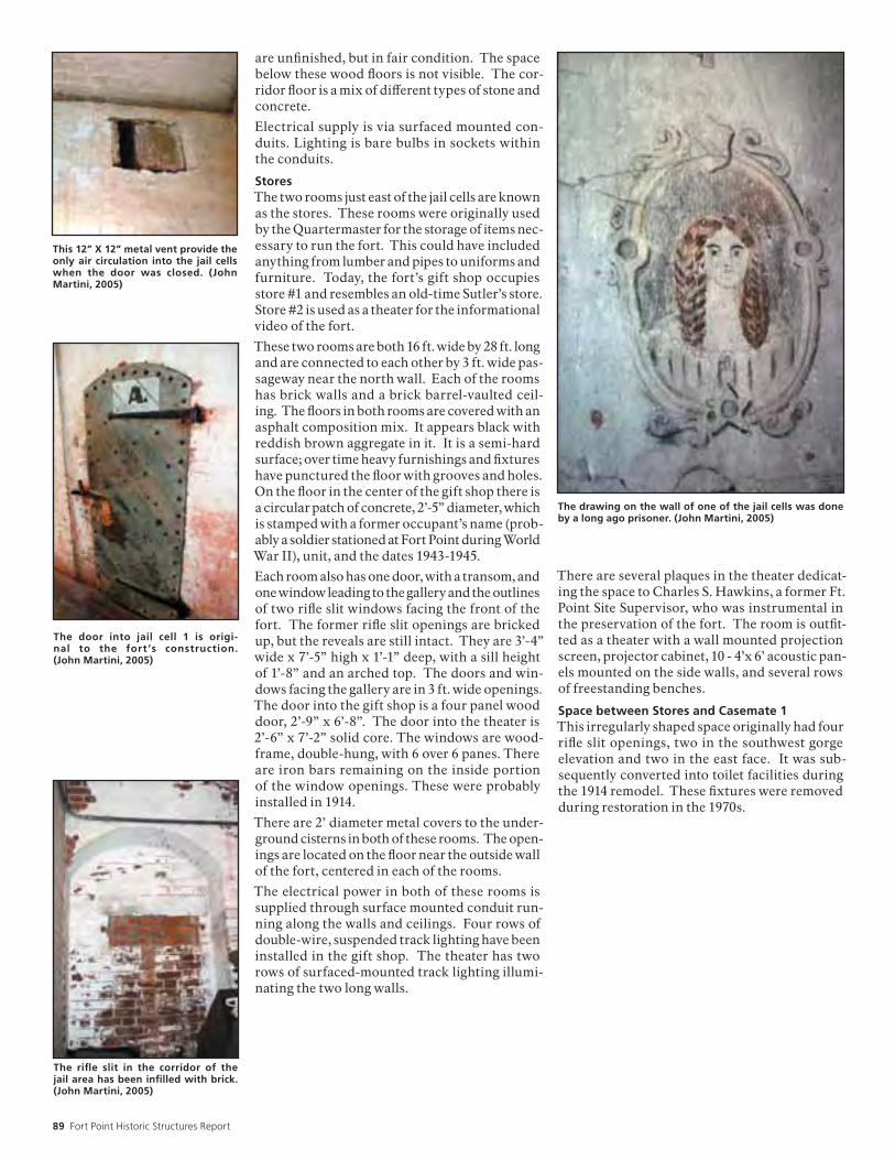
89 Fort Point Historic Structures Report
are unfinished, but in fair condition. The space below these wood floors is not visible. The cor-ridor floor is a mix of different types of stone and concrete.
Electrical supply is via surfaced mounted con-duits. Lighting is bare bulbs in sockets within the conduits.
StoresThe two rooms just east of the jail cells are known as the stores. These rooms were originally used by the Quartermaster for the storage of items nec-essary to run the fort. This could have included anything from lumber and pipes to uniforms and furniture. Today, the fort’s gift shop occupies store #1 and resembles an old-time Sutler’s store. Store #2 is used as a theater for the informational video of the fort.
These two rooms are both 16 ft. wide by 28 ft. long and are connected to each other by 3 ft. wide pas-sageway near the north wall. Each of the rooms has brick walls and a brick barrel-vaulted ceil-ing. The floors in both rooms are covered with an asphalt composition mix. It appears black with reddish brown aggregate in it. It is a semi-hard surface; over time heavy furnishings and fixtures have punctured the floor with grooves and holes. On the floor in the center of the gift shop there is a circular patch of concrete, 2’-5” diameter, which is stamped with a former occupant’s name (prob-ably a soldier stationed at Fort Point during World War II), unit, and the dates 1943-1945.
Each room also has one door, with a transom, and one window leading to the gallery and the outlines of two rifle slit windows facing the front of the fort. The former rifle slit openings are bricked up, but the reveals are still intact. They are 3’-4” wide x 7’-5” high x 1’-1” deep, with a sill height of 1’-8” and an arched top. The doors and win-dows facing the gallery are in 3 ft. wide openings. The door into the gift shop is a four panel wood door, 2’-9” x 6’-8”. The door into the theater is 2’-6” x 7’-2” solid core. The windows are wood-frame, double-hung, with 6 over 6 panes. There are iron bars remaining on the inside portion of the window openings. These were probably installed in 1914.
There are 2’ diameter metal covers to the under-ground cisterns in both of these rooms. The open-ings are located on the floor near the outside wall of the fort, centered in each of the rooms.
The electrical power in both of these rooms is supplied through surface mounted conduit run-ning along the walls and ceilings. Four rows of double-wire, suspended track lighting have been installed in the gift shop. The theater has two rows of surfaced-mounted track lighting illumi-nating the two long walls.
There are several plaques in the theater dedicat-ing the space to Charles S. Hawkins, a former Ft. Point Site Supervisor, who was instrumental in the preservation of the fort. The room is outfit-ted as a theater with a wall mounted projection screen, projector cabinet, 10 - 4’x 6’ acoustic pan-els mounted on the side walls, and several rows of freestanding benches.
Space between Stores and Casemate 1This irregularly shaped space originally had four rifle slit openings, two in the southwest gorge elevation and two in the east face. It was sub-sequently converted into toilet facilities during the 1914 remodel. These fixtures were removed during restoration in the 1970s.
The drawing on the wall of one of the jail cells was done by a long ago prisoner. (John Martini, 2005)
This 12” X 12” metal vent provide the only air circulation into the jail cells when the door was closed. (John Martini, 2005)
The door into jail cell 1 is origi-nal to the fort ’s construction. (John Martini, 2005)
The rifle slit in the corridor of the jail area has been infilled with brick. (John Martini, 2005)

National Park Service 90
Second Tier—GorgeThe 2nd and 3rd tiers are accessed by all four stair-cases. The section of the fort referred to as the gorge consists of enclosed rooms that were used primarily as living spaces, while the remaining three sides of the fort consist of open casemates similar to the 1st tier. The main entrance and circulation for the 2nd tier gorge rooms is through the gallery, a 6 ft. wide covered porch that runs between stair #1 and stair #4.
There are 18 enclosed rooms running the length of the 2nd and 3rd tier galleries. Each room is approximately 16 ft. x 30 ft. and has one door and one window facing the gallery, and two windows on the opposite wall facing the front of the fort. The 2nd tier was primarily officer’s quarters, while the 3rd tier housed non-commissioned officers and enlisted men. A small hospital section was located at the south end of the 2nd tier. All of these rooms currently house exhibits and are open to the public.
All the doors facing the gallery are 3 ft. x 7 ft. with a 1’-6” high transom window. The windows are 2’-10” x 6’-6”, wood-frame double-hung win-dows with 6 over 6 panes. On the gallery side the doors and windows all have a 9” thick granite header and the windows have a 5” thick granite sill. Inside both the doors and windows have 7” painted wood trim.
The two windows in each room that look out to the front of the fort were originally rifle slits, but as with all the other rifle slits, these openings were enlarged in 1914. The openings are cur-rently approximately 3 ft. wide with a 2’-3” x 8’-2” double-hung window. These tall, narrow win-dows have 4 over 4 panes and are slightly arched at the top. There are remnants of the iron bars that were installed to secure the openings during the 1914 conversion to a detention barracks, but these bars are severely rusted and deteriorated in many areas. All of the wood-frame windows in the gorge appear to have been replaced in a 1979 project.
The interior rooms on these tiers were constructed in the same manner as the 1st tier brick masonry walls with brick barrel vaulted ceilings. The exterior walls are approximately 4 ft. thick and the interior wall that faces the gallery is approxi-mately 18 in. thick. The partition walls between the rooms are about 4 ft. thick with two arched openings, each 7 ft. wide. Most of the walls and ceilings have been covered with lath and plaster and one of the communication arches between each of the rooms has been framed in to form a closet. Originally each of these large rooms was divided into three smaller rooms, a living room of approximately 16 ft. x 17 ft. and two bedrooms against the outside wall, each approximately 8 ft. x 12 ft. These interior walls have been long since removed, but a there is a 12” wide piece of remnant trim at the former center wall.
The floors throughout these interior spaces are 3¼” wood planks. The sub floor is not visible, but it is presumed to be masonry or masonry rubble.
GalleryThe second tier gallery is 8 ft. wide and runs the length of the gorge. At the west end of the gorge it widens to 10 ft. as it wraps around stair #1. At the east end stair #4 limits the gallery width to 4 ft.
The cast iron columns and beams, and the brick barrel-vaulted ceiling are nearly identical to the 1st tier.
Typical wood frame window in gorge. (John Martini, 2005)
View of the 2nd tier gallery with its cast iron columns, brick ceiling, and slate floor. (John Martini, 2005)

91 Fort Point Historic Structures Report
Surgeon’s RoomThe surgeon’s room is directly behind stair #1 on the 2nd tier. There is an intermediate landing from stair #1 with 3 granite steps leading to this room. The lowest granite step is concave shaped matching the outline of the circular stair tower. These steps lead to a pair of 2’-8” x 9’-4” double doors. The doors are constructed of 1x6 planks with 1x6 top, intermediate and bottom rails and cross pieces. While the date of the door instal-lation is unknown, they are probably a recent addition because the nominal dimension of the planks is ¾” x 5¼” (a more contemporary wood dimension).
This room is 2 ft. shallower than the standard rooms because of its location next to the stair tower. On the west wall there is a closet to the left of the double doors and an alcove to the right. The closet is irregularly shaped due to its location next to the stair tower, but it has a standard size, framed door opening, 2’-6” x 6’-8”. The alcove is 2’-2” wide, 1’5” deep and 9 ft. high with an arched top. There is another closet in this room on the north wall; the closet door is constructed of 1x6 planks similar to the double doors, but is irregu-larly sized at 2’-3” x 6’-6”.
The wood floors in this room are weathered to the point of being unfinished, with traces of two layers of vinyl sheet goods in the northwest corner. The floor near the outside wall is rotting and has been covered with a sheet of plywood. There is a small masonry fireplace in the southeast corner of the room with a granite hearth smaller than the actual fireplace and a wood mantle. The masonry is covered with a poorly applied coat of plaster and the fireplace is completely bricked in, prob-ably during conversion to a gas fired heater unit. There is a flue hole remaining in the wall above the fireplace.
On the south wall there is a 2’-9” x 6’-9” door leading into a triangular shaped room. On this side of the room there is also an alcove 6’-8” wide x 3’-4” deep with a 9 ft. high arched top.
The small triangular room off the surgeon’s room is currently used for a display of brick and plaster construction methods. The lath and plaster is removed in one half of the room, the floor is rot-ting along the outside wall, and there is a similar fireplace in this room. The mantle is missing from the fireplace and there are large cracks at the top of its firebox, but cast in the concrete on top of this fireplace is the name and prisoner number of a convict from Alcatraz that was sent to Fort Point on work duty in 1914. There is a door from this triangular room to the casemate 59.
HospitalThe hospital room is just east of the surgeon’s room. This room is typical of all the others, the only real differences being the fireplace location and the room divider trim. When the fort was constructed, this room had a dispensary in the south end of it and the walls forming these rooms were originally lath and plaster. The fireplace on the center east wall is brick and was not covered with plaster. The metal lintel is rusting and the brick is spalling just over the firebox opening.
The graffiti on the top of this fire-place in the triangular-shaped room off the surgeon’s room re-mains from the Alcatraz convicts who worked on the fort in 1914. (John Martini, 2005)
The surgeon’s room is accessed directly from stair #1. An irregu-larly-shaped closet is left of the door and an alcove is on the right. (John Martini, 2005)

National Park Service 92
Officers QuartersThe next six rooms in a row are virtually identi-cal. The doors leading through them aligned precisely, such that they give the appearance of peering into back to back mirrors and seeing an almost endless reflection.
All of the rooms have a fireplace in them similar to ones in the hospital and surgeon’s room; all are located in the southwest corner of the room, except for one, which is in the same location as the hospital fireplace. Most of the fireboxes have square openings, except for two which have nicely proportioned arched openings.
Kitchen and Mess HallAt the easternmost end of the 2nd tier gorge rooms was the officer’s mess hall. This room has the same features as the other rooms, except that there was originally a stove in the southeast corner of the room. Currently there is a reproduction stove there now sitting on three concrete pads that form the hearth. There is no fireplace in this room. There is a 2’-4” wide door on the east wall in a 3’- 7” wide alcove that leads to the casemate area.
StoresThis irregularly shaped room formed by the bend in the fort has obviously been remodeled for many different uses over the years. Originally it was a store room for the adjacent kitchen with a privy on the exterior wall behind it. These spaces were separated by an 8” masonry wall. On the west wall is the door to the kitchen with a segmental arch. Above this arch is a double arch, 4 ft. wide at its spring point and 9’-4” high at its peak. On the left side of this arch it appears as though a 90º projecting wall was constructed. This wall was removed leaving half cut bricks visible. At some later time the 4 ft. wide opening was bricked in and a door was installed with a shallow brick header course overhead.
Continuing to the right on this wall is the out-line of another filled-in brick arch. This space had contained two shower stalls at some point; because there is a raised concrete floor with a floor drain and piping on the wall for hot and cold water. At the top of this wall is an 8” high metal strap running the length of the room. This strap is part of the seismic bracing project completed in 2000.
On the opposite wall are two concrete steps lead-ing to 3 ft. x 12 ft. concrete platform. The outlines of 4 toilets are visible, as are the 4” sanitary waste lines. There is a water supply line against this wall and in both of the corners there are plumbing pipes coming down from the upper level.
This space has a smooth concrete floor with a 6” floor drain in the center. All of the drains are completely clogged with debris.
One of two fireplaces remain-ing with an arched opening. (John Martini, 2005)
The outline of the former rifle slit is visible in all the window sills along the southwest gorge elevation. (Jane Lehman, 2005)
This view through the officer’s quarters on the 2nd tier gives the appearance of looking into back-to-back mirrors. (John Martini, 2005)

93 Fort Point Historic Structures Report
Above the door from the stores to the kitchen is a double arch in the brick. To the left of the door is the outline of one of the fort’s original brick walls. The metal brack running along the wall above the door is part of the seismic reinforcing project. (John Martini, 2005)
The opening for the store from the kitchen to the stores is nar-row with a tight arch above. (John Martini, 2005)

National Park Service 94
Third Tier—GorgeThe 3rd tier gorge is virtually identical to the 2nd tier gorge. The rooms are the same sizes and are entered by identical type doorways off the 3rd tier gallery. The 3 windows in each space are in the same locations and are of similar char-acteristics. The brick archways connecting the spaces are the same size and in the same locations. The finishes are also similar, with lath and plaster walls, plank floors, and wood trim. The primary difference between the two floors seems to be only the height of the former rifle slit windows, 6’-8” high rather than 8’-2”, and a tighter radius on the arched ceilings.
The main partition walls which support the bar-rel vaulted ceilings of the 3rd tier are 4 ft. thick. These 4 ft. thick walls are penetrated by two 7 ft. wide arched openings between each of the spaces. These arched openings seem to have originally been randomly filled in with 8” thick brick walls, which in turn had 3 ft. wide doorways in them. Some of these 8” walls are remaining and some have been removed, leaving the outline of where the bricks were cut.
GalleryThe 3rd tier gallery is similar to the 2nd tier gallery. The front doors to each of the spaces are made of 1 x 6 vertical planks with Z bracing. Transom windows above all doors have been replaced with wood louvers. These louvers are installed back-wards and direct moisture into the space. This problem should be corrected.
Enlisted Men’s BarracksThe first four rooms on the south end of the gorge were originally designed for enlisted men. The room furthest south is slightly smaller than the others. It is directly above the surgeon’s room and it, too, has an entrance from an intermediate land-
ing in stair #1. There are 4 granite steps leading to a 3’ x 7’ door into this room. There is a closet to the left of the door and a 4 ft. wide alcove to the right. There is another closet in the northeast arch of the room and there are doors in both the northwest and southwest arches. The door on the south wall leads to the triangular room, while the door on the north wall leads to the adjacent barracks space. This doorway appears to be in one of the original 8” brick partition walls. The remaining arched opening in this room is finished as an alcove.
The plaster in this first space is in relatively good condition; however, the next three spaces have large sections of missing plaster and lath. The furring strips are approximately 2-7/8” x 1-1/8” @ 16” on center. The wood lath strips are approxi-mately ¼” x 1” with ¼” spacing between. This is covered by a two-coat plaster system, a base coat with a finish coat.
There are fireplaces in the southeast corner of each of the rooms, and the fireplaces, hearths, and mantles are of similar characteristics and condition to the fireplaces on the 2nd tier. The floor in the first space has the remnants of several coats of paint or finish, but the other floors are stripped bare.
Center BayThis space is not connected by an interior door to either the enlisted men’s barracks or the non-commissioned officer’s quarters, so it is unclear what its original or subsequent use was. It does have all the typical features of the other spaces though including, doors, windows, closet, and fireplace. The plaster is in good condition. The floor is unfinished, but there are traces of vinyl flooring attachments remaining.
The outline of a previous, original brick wall is visible in the communication arch between enlisted men’s quarters 2 & 3. (John Martini, 2005)
Right: Typical enlisted men’s barracks on 3rd tier. (John Martini, 2005)
The transom windows above the 3rd tier gallery doors were re-placed with wood louvres. These louvres need to be replaced because they are all installed backwards. (John Martini, 2005)

95 Fort Point Historic Structures Report
Non-Commissioned Officers QuartersThe four rooms on the north end of the gorge were designed for non-commissioned officers. The northernmost room was the kitchen area and the next three rooms were living quarters. Each of these three rooms is divided in half by a wood frame wall forming a sitting room along the gallery side and a bedroom, approximately 12 ft. x 16 ft., along the exterior wall. There are doors connecting each of the sitting rooms and each of the bedrooms, in addition to a door between each sitting room and bedroom.
The lath and plaster walls are in good condition. Peeling paint has been scraped smooth and reveals many layers of paint in shades of red, brown, and gray. There is a 6” chair rail trim and a 4” plate rail trim in all of the rooms, in addition to the 7” baseboard.
The fireplaces in these spaces differ from the others in the fort. In the living quarter nearest the kitchen there is no remaining fireplace, but the outline of the former fireplace is evident. It appears as though the fireplaces were carved out of the masonry walls after the fort’s original con-struction because this area shows a hollowed out section approximately 2 ft. wide x 3 ft. high x 6” deep with a 9” diameter chase in the upper right hand corner. The granite hearth is remaining, but the fireplace surround and the mantle have been removed. The lath and plaster is cut around the outline of the former fireplace. There is a 7” diameter hole in the wall above the fireplace that was most likely from a conversion to a gas-fired appliance.
One room to the south contains no evidence of a fireplace at all, but in the second adjacent room, there is a fireplace that appears to be the only remaining fireplace not converted into a gas appli-ance. The fireplace is plaster over brick with an
arched opening over the firebox. The bricks in the firebox are rough and appear to be carved out of the masonry wall as well. There is a remaining flue and no evidence of another flue hole in the wall above the fireplace. There is also a decora-tive iron insert remaining, although this is heavily rusted and broken in places.
KitchenThis room in the gorge area, stripped of all later layers of lath and plaster, and interior walls, provides a good example of the fort’s original masonry construction in the Gorge rooms. The masonry is in good condition although it needs repointing. The barrel vault spring height is at 7 ft. and rises to 12 ft. at its center. There are three 7 ft. wide arched openings and one arched opening in the southeast corner that is only 4 ft. wide. It is unclear why this opening is smaller, but it is 4 ft. wide on the 2nd tier also.
This room also illustrates the original configura-tion of the alcoves in the 4 ft. thick walls. The alcove in the northeast corner is an excellent example. It has a 7 ft. wide arch, but is filled in with a brick wall that is clearly the same construc-tion period as the original fort. There is an arched doorway in this wall that is 3 ft. wide x 7’-2” high at it peak. The doorway has since been filled in, but most likely the other doorways in the fort were similar to this originally.
On the opposite wall the two alcoves still have plaster on the back wall. It appears that the plaster was applied directly to the masonry, rather than on lath, and consequently, is difficult to remove. There are wood inserts in the masonry joints in the rest of the room where the furring strips were attached. In the northwest alcove there is evi-dence of where the original masonry wall was cut
It is apparent from the remnants in this non-commissioned officer’s room that the fireplaces were not part of the fort ’s original construction. (John Martini, 2005)
One of the older style fireplaces in non-commissioned officer’s quarters 3. (John Martini, 2005)
Right: Typical non-commissioned officer ’s quarters on 3rd tier. (John Martini, 2005)

National Park Service 96
out, although in the southwest alcove the brick is smooth; obviously there was no brick wall there originally.
On the outside wall of this space the brick walls reveal a 4” wide gap which is the result of the seis-mic bracing project in 2000. There are also several vent holes in this room. There is a 6” round clay flue, 6 ft. off the floor that was probably from a former stove. There are two 8” x 12” rectangular openings, 1’-9” off the floor, one is poorly patched in, but the other one appears to be original con-struction. It is unclear what the purpose of these openings was, but there is a keystone in the brick course immediately above the openings.
Cook’s RoomAs with the 2nd tier, the cook’s room and store room on the 3rd tier is in the irregularly shaped space between the gorge and the casemate area. One of the doors from the kitchen is bricked in and the other door is boarded up. There is a raised concrete pad with a floor drain in it from a former shower installation and a concrete platform on the opposite wall that shows the outline of two toilets. The floor is concrete with a 4” floor drain in the center and there are remnants of some plumbing pipes, but most of the old pipes in this area have been removed.
Prison CellAt the opposite end of the gorge from the cook’s room is a prison cell constructed in casemates 88, 89, and 90. The communication arch between casemate 87 and 88 was filled in with brick and a door and a small window were added. This brick wall was most likely constructed by prison labor and is not of the same quality as the rest of the fort, but it does have a granite header over the door opening and the narrow window opening. There is also a door to this cell from the triangular room beside the enlisted men’s quarters.
This small kitchen vent has a keystone brick on the top part of the opening. (John Martini, 2005)
This wall was added to convert three 3rd tier casemates into a jail cell. (John Martini, 2005)
The original doors and brick infill walls are visible in the 3rd tier stores. (John Martini, 2005)

97 Fort Point Historic Structures Report
Barbette TierThe barbette tier is essentially the roof, or the top tier, of the fort. It was designed as a deck where cannon were mounted on exposed posi-tions rather than in enclosed casemates. All four staircases lead to the barbette tier. Stairs #1 and #3 are covered in a wood frame penthouse, stair #4 doesn’t have any cover, and stair #2 is topped with the lighthouse.
There is a brick parapet wall surrounding the entire perimeter of the fort that is approximately 6 ft. thick and 5 ft. high. The top of the parapet slopes towards the outside wall, or scarp wall, of the fort. The south parapet wall is generally higher than north wall. The east and west walls step down.
The deck of the barbette tier is concrete now, but was originally grass. The south portion above the gorge is raised 4 ft. and the east and west sections also have raised platforms, but these step down following the outline of the parapet wall. There are 36 octagonal cannon mounts lined around the exterior parapet wall. These were designed for a variety of different types of cannon, although very few were ever installed here. Red and white paint spatter from the Golden Gate Bridge project above is obvious on many areas of this tier.
Above GorgeThe south portion of the barbette tier was designed to hold eleven 32-pounder guns. Eleven mounting platforms still remain, consisting of a 7 ft. wide x 5½ ft. deep x 20 in. high brick mounting pad with a 2’ x 2’ granite square on top. There is a severely rusted 4” high pintle in the center of each granite square. Each of these square platforms has a 12” deep alcove in the brick parapet wall immediately beside it. In a semi-circle around the square platforms are 14” high x 16” deep con-
crete blocks that originally held a 16 ft. diameter iron rail on which the cannon rotated. The rail is gone, but the rusted remnants of the mounting bolts remain.
The deck for these eleven platforms is 4 ft. above the main barbette tier and is accessed by 5 sets of steps. These granite steps are 4 ft. wide with 7½” risers and 10” treads. There is no nosing or railing on any of these steps.
One of these cannon mounts holds the concrete base for a former bridge that led from the light-house to the light keeper’s cottages on the south hill. This bridge was installed in 1880s following construction of the third lighthouse. A section of the brick parapet wall was removed when it was installed and two concrete piers were added to the front of the fort. On the hill to the south there is another large concrete pier remaining. At some point, the bridge was damaged and was never rebuilt. The missing piece of the parapet wall was patched with concrete at a later time, but the 3 ft. deep x 5 ft. high concrete pier still remains obscuring part of one of the cannon mounts.
The top of the parapet wall in this area is concrete, but was originally grass. There are several dozen clay flue pipes projecting up though this concrete. There are 3 different styles of pipes, most likely related to the different time periods when they were installed. There are 1” diameter weep holes every 8 ft. in this wall. Although the top is con-crete, moisture still appears to be coming from the weep holes, indicating that the concrete is leaking.
The remnants of the WWII searchlight housing are adjacent to the penthouse for stair #1. (John Martini, 2005)
The parapet wall on the east and west end of the fort steps down. (John Martini, 2005)
The octagonal cannon mounts on the barbette tier were de-signed to hold 10” columbiads. (John Martini, 2005)

National Park Service 98
Above CasematesThe remaining mounts were designed for 8” or 10” Columbiads. There are 25 circular brick plat-forms, approximately 15 ft. in diameter. On top of the brick platform is an 11½ ft. diameter octagon platform made of granite blocks. In the center is a square piece of granite with the rusted remains of the iron track that the gun pivoted on. There is an exposed aggregate concrete mix on the tops of these platforms.
Five of these cannon mounts have additional concrete on their tops that formed the base for anti-motor Torpedo boat guns during World War II. These guns were positioned to protect the mine fields and the submarine net that spanned the Golden Gate from enemy ships.
A portion of the top of the parapet wall is brick; this was original to the fort’s construction. The parapet walls on top of the east and west bas-tions are now concrete, but they were originally grass-covered.
There is granite coping around the edge of this tier facing the parade ground below. The granite would have formed an edge for the earth in the earliest construction. It now has a railing on it that matches the railings in the rest of the fort. Along the edge directly above the gallery is an unusual condition. The granite coping is there, but a 2 ft. wide deck was installed slightly below it, for unknown reasons. The same honeycomb metal railing found elsewhere is installed at the edge of this wood deck.
There is a small 18” square wood covering in the barbette deck near cannon mount 111. It is unclear what its function was, but there are remains of previous flashing surrounding it.
PenthousesThere are two wood-frame penthouses on the barbette tier over the openings for stairs #1 & #3. One is nine-sided and the other is a ten-sided structure, both have conical roofs supported by a round wood center column.
The penthouses have 1x6 lap siding, wood frame, six over six, double hung windows, and boxed eaves. The shallow conical-shaped roofs have composition shingles.
Although the penthouses were part of the fort’s original construction, these currect penthouses were completely replaced in 1997.
LighthouseThe Fort Point Light sits atop stair #2. It is a nine-sided structure described in greater detail in the Fort Point Light Historic Structure Report, done in 1972. The lighthouse was extensively recon-structed during a 1973 project. It’s last major restoration work was done in 1992, by a Bureau of Prisons work crew.
Searchlight ShelterThe searchlight housing is a cast-in-place concrete structure constructed over cannon mount 113. The concrete walls are 12 ft. x 18 ft. x 10 ft. high with a 6” horizontal board finish. Inside the con-crete walls is an octagonal concrete mount, which held the search light. There are remnants of the 2x10 wood floor joists and the 2x6 wood sills on top of the concrete, but nothing remains of the rest of the wood structure. There is no obvious door into this space. Enough dirt and debris has collected inside this space that several small trees are growing there.
(ENDNOTES) 1 Interpretation Panel, Fort Point Powder Maga-zine.
Vents in barbette tier floor. (John Martini, 2005)
This 3-foot wide walkway and railing above the gallery on the southwest gorge elevation was re-placed in a 1973 project. Beyond is the penthouse over stair #3. (John Martini, 2005)
Along the southwest barbette wall is a series of 11 platforms de-signed to hold 32-pounder guns. (John Martini, 2005)

99 Fort Point Historic Structures Report

National Park Service 100
EXECUTIVE SUMMARYThis report summarizes the findings of a Con-dition Assessment and Materials Investiga-tion of Fort Point National Historic Site (Fort Point or The Fort) performed by Architectural Resources Group (ARG). The purpose of the investigation is to evaluate the nature, cause and extent of water intrusion and general mate-rial deterioration in areas excluded from recent rehabilitation projects. The survey was con-ducted over a period of several months (August 2, 2002, January 19, 2003, February 7, 2003 and August 21, 2003) in rain, fog and temperate weather to evaluate the building in different conditions. Stabilization treatments have been developed based upon the findings of these investigations. The recommendations included in this report are guidelines for the repair of the most critically deteriorated materials and areas; they are not construction documents. The findings are supplemented with annotated drawings and photographs. Other issues not directly related to specific material deficiencies are listed at the end of the report. These are recommendations that may be incorporated into preventative maintenance and general housekeeping plans for Fort Point.
Recommendations for material repair included in this report:
• Spot replacement of deteriorated non-original brick.
• Patching and crack repairs to damaged origi-nal brick.
• Pointing of joints where mortar is missing or deteriorated at brick, granite and concrete locations.
• Removal of biological growth.
• Removal of efflorescence and inappropriate surface materials.
• Repair or replacement of corroded metal ele-ments.
• Replacement of failed paint.
• Repair or replacement of deteriorated wood elements.
Other recommendations:
• Removal of tripping hazards.
• Treatment of slippery horizontal surfaces.
• Preventative maintenance suggestions.
CONDITIONS ASSESSMENT AND MATERIALS INVESTIGATIONFort Point was constructed between 1853 and 1861. The structure has withstood the ravages of both nature and man over its 150-year his-tory. The unreinforced brick masonry fortifi-cation is located prominently at the mouth of the San Francisco Bay directly below the east span of the Golden Gate Bridge. Fort Point
was originally constructed as a strategic mili-tary defense fortification and was later used for detainment purposes. San Francisco’s harsh marine environment is detrimental to the building materials; there are high levels of humidity, salts, wind exposure, rainstorms, as well as water surges from the Bay. The build-ing endures severe weathering cycles. Falling debris from the Golden Gate Bridge use and repair projects have also caused damage to the structure over the years.
The condition assessment is organized by exterior materials and interior materials. The deterioration of the exterior brick, granite and concrete are fairly typical to all elevations. The deterioration of interior materials tends to be site or deficiency specific. Several materials that consistently display deficiencies are noted specifically because they appear to be contrib-uting to the overall deterioration of the struc-ture. Areas of water intrusion entering from the building exterior into the building interior have also been noted in this report. Exact loca-tions of the material deficiencies are included in the drawings and referenced in the photo-graphs located in Appendix A.
Exterior ConditionsARG performed construction management services throughout the 2000 Fort Point Repair Project. During that project ARG documented material deterioration and biological growth patterns at the exterior elevations of the build-ing. As part of the repair project, the brick masonry at specific west and south elevations was repointed and the biological growth con-trolled. The evaluation of the condition of the exterior materials in this report is based in part on the observation of the work completed in 2000, sample testing of foreign matter, and visual surveys conducted over a several month period.
Brick Masonry
The exterior walls of the fortification are primarily brick masonry, with granite corner quoins, window sills and cordon. Detailed brick masonry and granite also surrounds the sallyport.
The mortar joints are typically failing and are open throughout the exterior of the structure in locations other than those treated in the recent repair project. Open joints are allowing water and other materials to travel through to the interior of the structure. Joints at the west end and several locations on the south and east ends were repointed in the 2000 Repair Proj-ect. However, there are still many remaining locations that require repointing in order to address all joint deficiencies.
Conditions Assessment and Material Investigationsby Architectural Resources Group
Left: Contemporary view of barbette tier. Photo circa 2005. Credit: John Martini.

101 Fort Point Historic Structures Report
Biological growth typically exists on masonry building materials at The Fort, but is most evi-dent on the brick masonry elevations directly facing the water. The biological growth micro-organism consists largely of a red-orange color material, but also includes a green, brown, and black material. This material has colonized on the brickwork, the granite face of the quoins, and the granite cordon. A sample of the growth was retrieved from the north face elevation and submitted to The California Lichen Society for analysis. The results placed the growth in the algae category.
Efflorescence exists on the brick masonry on the west elevation, an elevation that was part of the recent Repair Project completed in 2000. This appears to be caused by residual salts on the surfaces of the new brick. (The bricks were stored over a period of time and the surface salts may not have been removed prior to the brick laying.) Although the salts are found on the recently laid bricks, the historic original bricks potentially have high levels of salts due to the high moisture levels in the environment and the salt content in the water.
Other material deficiencies to brick surfaces include missing brick, spalling, cracking, and small voids in the brick surfaces. Cracks and holes found in the brick are generally small. The cracks are typically 0.080” to 1/4” of an inch and are perhaps caused by the original firing process. Small holes (approx. _” in diam-eter) found in several bricks appear to be man-made, typically at attachment locations.
Mounds of beach sand are present at the north-west and west elevations. Wind and water deposits sand consistently against the building, but the greatest accumulations are often below the lowest embrasure openings. The sand cover prevents water from evaporating from the brick surfaces at these lower levels (see Condition Photos 1–5).
GraniteThe foundation, lintels, base course, window-sills, quoins, and cordon are constructed of smooth faced granite blocks. Most granite materials have mortar joints that are open or have failed, particularly at the lower elevations of the building. The granite quoins are typi-cally weathered with some granite material missing from the face of the blocks. There are currently three to four elevations covered in sand from the foundation up to the first embra-sure opening.
Biological growth is evident on most granite surfaces. Peeling the algae off of the granite quoins has revealed deep attachment of the algae to the substrate, which in turn led to exfo-liation. There are also high levels of biological growth and open mortar joints at the granite cordon. The open joints are allowing water to migrate to the barbette and third tiers.
Cracks and spalls in the granite occur through-out the building, but particularly at the quoins. Cracks range from as small as 0.010” to as large as 0.080” wide (and in a few cases greater) while the lengths vary. There are three primary reasons that cracks may have occurred in the granite materials; earthquake damage, uneven building settlement, and weathering. Salts have also entered the granite and appear to have expanded and contracted the material during the seasonal climatic changes. The surface of the granite quoins are consistently spalled (approximately 1/32” wide or more) leaving a scalloped, rough surface. Although it was not possible to get a full view of the upper quoins on the building it is understood that the movement of material and biological growth contributes to the steady deterioration. There are several locations where small holes are found, but do not appear to contribute to water intrusion into the building.
There is one location of a substantial loss at the upper southwest quoin. The severity and location of this opening allows water to sit and enter the walls. There is impact damage on the granite at the East Bastion on the southeast face elevation, which appears to have been caused by vehicles. The damage is unsightly, but does not currently contribute to water intrusion (see Condition Photos 6–7).
ConcreteThe original embrasure openings are typically sealed with concrete masonry units. The con-crete units are often cracked and allow minor amounts of water to enter. The entrance ramps at the sallyport are also concrete, and have minor cracks (see Condition Photo 8).
MetalMetal elements are located throughout the for-tification. The main elements are the columns and trim that support the tier floors, metal rail-ings, metal trim at the embrasures, metal stairs, balusters and treads, chicken wire, and metal security grills at the exterior brick openings. All metal elements exhibit some amount of cor-rosion and corrosion staining.
The embrasure openings are typically framed with an approximately 9” wide metal trim pieces. The metal trim is often missing. Where the trim is extant, it is severely corroded. Chicken wire is found at several locations and is typically distorted and corroded. Corrosion at the metal trim pieces has caused spalling at the attachment to the adjacent brick surfaces. Miscellaneous metal elements are attached directly to the brick surfaces on the West Bas-tion elevations. These elements no longer serve a specific purpose and have corroded and are staining the surfaces below. The voids where other attachments once existed and are missing allow water to penetrate to the brick interior.
The columns and metal trim in the courtyard appear to be in sound condition, but the paint finish is failing. Metal stairs and components

National Park Service 102
have missing paint finishes and missing fasten-ers. The metal rainwater leaders that provide drainage from the roof to the courtyard drains are deformed in places and do not perform efficiently.
The lighthouse is constructed almost entirely of metal. Most of these elements show signs of corrosion and corrosion staining. Some of the material, like the flooring and stair treads, are displaced and the section of the metal is thin. The lighthouse structure is off limits to the public due to the poor condition of the materi-als (see Condition Photos 9–11).
WoodWood is found at the doors, door frames, win-dow trim and sash on the southeast courtyard elevation. Wood siding is the finishing trim of the stair penthouses on the exterior of the building. The massive wood doors at the sally-port have round metal ornamentation elements that are corroded and sometimes missing. The doors are worn and abraded, but still appear to function as intended. The double hung windows exhibit various deficiencies, such as missing glazing putty, flaking paint, biologi-cal growth and missing hardware. It does not appear that all window sash function prop-erly. There is no remaining paint finish on the penthouses. The wood siding is weatherworn, incised with graffiti, and in some cases missing (see Condition Photos 12–14).
Interior ConditionsThe interior courtyard of The Fort consists of three floors topped by the exposed barbette tier, and an open courtyard. Comparable to the exterior, the primary building materials of the interior consists of brick walls, granite walls and granite trim. The sallyport on the south is the only entry and exit into the interior court-yard. There are 105 interior casemates and enclosed rooms linked by an open air corridor. Four staircases provide vertical access to the tiers and the barbette. The gallery levels are located on the southeast courtyard elevation. Adjacent to the stairs are the east and west magazines on tiers one through three. In gen-eral, the casemates exhibit high levels of mois-ture and resultant degradation to the interior finishes. Falling debris from the Golden Gate Bridge and on-going bridge repair projects, coupled with the level of exposure to the envi-ronment, has sped up the deterioration process for material at the barbette level. (See drawings: First Tier, Second Tier, Third Tier, Barbette Tier, and Interior Elevations. For interior con-ditions photos, see Condition Photos 15–22)
Brick MasonryThe walls, piers and barrel vaults in the case-mates are constructed of brick masonry. The underside of gallery levels of tiers one and two is brick veneer. The barbette tier scarp walls and breast high walls are also constructed
of brick. The parapet, gun emplacements or mounts, bridge pier, and terreplein are partially constructed of brick.
Open joints in the brick masonry are typical throughout the interior casemates, along with high levels of moisture and biological growth. An example of severe loss in the mortar joints is in casemate 23, along the wall and around the embrasure. Most casemates have extensive mortar loss at the underside of the barrel vaults. The mortar loss is greatest at the gallery eleva-tion directly beside Stair four.
The biological growth on the interior is identi-cal to the growth on the exterior and ranges from the orange and black growth, to a bright green growth found in shaded areas. The case-mates surrounding the east and west magazines have significantly higher levels of biological growth. Casemate 35 shows severe levels of biological growth and fungal decay. The supe-rior slope and parapet have plant and biological growth throughout. Efflorescence also appears in some areas of the interior brick.
While there are a few individual interior bricks that are cracked, the cracks do not appear to be of significant size to allow for water penetra-tion. A large crack in casemate 19 has traveled over 3 lineal feet and is slowly permitting water moisture to enter. This crack may have been caused by the shifting of the building.
Many of the brick walls in the casemates have been painted. The paint, which most likely con-tains lead, is deteriorated and flaking through-out. Noticeably higher levels of flaking paint exist in the west corridors. In several places graffiti exists, incised directly into the paint fin-ish. In casemate 68A graffiti has been painted on a wall of deteriorated paint, and has dripped down the wall. In several locations, such as the magazines, markers were used for graffiti.
Casemate piers at the second and third tiers also have water intrusion, typically at arch-ways between the magazines and bastions on the east and west ends. Water flows from the center of the arch, through the spring, and down the pier. Calcium deposits, in the form of a white viscous material, spreads down the surfaces of the brick walls. It is not hazardous to the general public, but is unsightly and may ultimately erode the brick.
Masonry at stairs 1, 2 and 3 exhibit similar types of deterioration. Water is leaking and spilling onto the masonry wall at Stair 1 due to an open joint above. The space has no open-ings between levels and is shaded, allowing biological growth to thrive and salts to collect. Although only stair 1 could be surveyed, it appears that the conditions are similar in stair 2 and 3.
The gallery at the second and third tiers is cur-rently closed, and was not accessible to survey. The condition in the galleries is likely similar to conditions throughout the balance of the inte-

103 Fort Point Historic Structures Report
rior casemate spaces. Water is ponding in sev-eral areas of the gallery floors. Missing mortar in the slate flooring above allows water to travel through the slate and down through the over-head brick veneer on the next floor down. The masonry wall on the second and third tiers has large amounts of organic growth due to the water draining down from the barbette tier.
The barbette tier is open to the elements and has been repaired more than other areas of the Fort. The brick courses along the walk below the parapet on the southern end all have biological growth, efflorescence, and open joints. The brick platform foundations to the south of the plan have spalled and cracked concrete bases (including patchwork), missing and spalled brick courses, and gaping joints. The brick platforms (or gun emplacements) at the southwest area of the structure have plant growth and failed joints. The platforms allow water to enter the raised floor of the barbette tier, but do not divert the flow for proper drain-age. The few remaining original bolts on the gun emplacements are not sealed and are cor-roded.
A sample of a white thick fluid dripping along the parapet of the recently renovated space was taken by ARG. The sampling was sent to Tech-nology of Materials in San Diego for analysis. The results reveal a composition of quartz and clay components, which is possibly residual material draining from the 2000 Repair Project.
A black tar like substance is found on many interior brick locations, most commonly at the casemate openings to the courtyard. The casemates were once enclosed and it appears the tar remains from when the enclosures were removed. The tar does not appear to be harm-ful, but it is unsightly.
GraniteGranite is located along the courtyard interior casemate piers. Within the casemates, it exists at the foot of the embrasure, as well as trim at the door, window, and stair openings. The steps and walls in the staircase enclosures are of granite, and also steps that lead up to the parapet.
There are open joints where mortar is missing in the granite bands, stairs, staircase enclosure, gun emplacements, and at the southern gal-lery levels. These open joints allow water to enter the masonry and move through the floors, often entering the ceiling levels of the lower tiers. The granite curbs surrounding the plat-forms were repointed during the 2000 Repair Project, but have corroded bolts embedded. The curbs contribute further to water retention due to ponding at the base. The interior granite pier walls are covered with orange-colored bio-logical growth similar to the exterior. It also exists in areas such as the granite horizontal bands on the elevations of the courtyard.
Cracks found in the horizontal granite tend to be a minor structural issue rather than water intrusion problem. The top landing in stair one has a crack in the slab, which extends across and through the material. In many instances there are hairline cracks that are not imme-diately visible. The noticeable cracks found in the material tend to be 0.050” or greater in width. Spalls and openings in the material are not readily noticeable, but care should be taken at the metal locations. Also, the corroded bolts at the gun emplacements are not all properly sealed leading to future spalling of the granite.
SlateThe flooring on the gallery levels is slate. There are open joints in the slate at the gallery level and casemate floor openings (under con-crete). These openings allow water to enter the masonry and move through the floors, often entering the ceiling levels of the lower tiers. The slate roof connections and floor joints are open allowing water to enter the floor and travel to the lower floors. Other structural ele-ments, which require monitoring, include the roof at the third tier. This roof is covered in slate, which is cracked and allows water to flow through to the substrate. Water pooling on the slate walk in the galleries possibly has a high salt level, which enters the open joints and trav-els through to the lower floor.
ConcreteThe concrete paving at the parade and the barbette tier walkway is cracked in many loca-tions, and is uneven, perhaps due to shifting. Cracking also occurs at the repairs made to both the pavement and previous repairs to the gun emplacements. There are corrosion stains around the pieces of metal, which may expand and produce a concrete spall. Frag-ments of metal that remain along the face of the gun emplacements are corroding. The superior slope and parapet have many cracks due perhaps to the building materials contract-ing and expanding. The concrete has cracked or spalled over the years and the corrosion from the metal has stained the concrete. The concrete walkway has many cracks, which also allows water to enter and move through to the lower tier. The waterproofing at the floor drains on the terreplein is deteriorated and fail-ing.
MetalsThere are few metal elements on the interior of the fortification, limited to miscellaneous attachments in the brick masonry, drainage systems, the straight iron staircases and railing. The embrasure openings also have metal trim material at the interior, and small hardware is found on the window sash at the southern end. Pipes and floor plates are typically found at the first tier. There are chicken wire screens above the doorways of the entrance to the east and

National Park Service 104
west magazines. Metal attachments are also embedded in the gun emplacements or mounts, the granite curbs, and in the parapet wall.
Biological growth is attacking the metal sur-faces throughout the gallery. The treads of Stair four are coated metal and the coating is starting to fail. Often the steps are covered with biological growth and pooling water producing a slippery surface for pedestrians. The screens above the magazine openings are becoming detached; birds have nested in these areas leaving large amounts of droppings.
Metal attachments in the brick masonry typi-cally are critically corroded, which has resulted in small spalls. There are problematic condi-tions in the casemates on all three tiers at the embrasures where metal has corroded due to the high levels of moisture in the air. All metal attachments are corroded and staining in case-mates 34 and 35. There are metal attachments embedded in the gun emplacements or mounts, the granite curbs, and in the parapet wall.
Paint coatings on the metal elements are failing, allowing the metal to deteriorate more quickly. The gallery iron columns, hand rails, supports and drains are corroding. The coatings on the metal plate support at the first and second gallery levels are failing. The metal bands are beginning to split from the corrosion expan-sion and could potentially begin to break apart. The third level gallery brackets may also begin to corrode as the paint finish is now deteriorat-ing.
WoodInterior wood is limited to interior doors, embrasure openings, flooring in quarters, first tier south side walkway, third tier roof-ing, and barbette walkway. Most wood ele-ments appear to be in good condition, with the exception of some missing paint on the doors, windows and trim. The wood underside of the gallery roof is waterlogged and appears to be rotting. There are locations where bacterial growth on the wood is at a higher level on the third tier than the other levels. Wood flooring at the barbette tier is worn from use, but still functions as intended.
PlasterMany interior rooms were replastered in the 2002 Repair Project, and remains in good con-dition.
Terra CottaThe terra cotta chimneys on the south elevation were installed during the 2000 Repair Project. These chimneys are in good condition.
105 Fort Point Historic Structures Report
Treatment RecommendationsThis section provides recommendations for treatment for the deteriorated materials at Fort Point. The recommendations are based upon the results of survey work, coupled with the knowledge gained and techniques used in the Fort Point Repair Project completed in 2000. The recommendations are listed by material, deficiency and proposed repair treatment. These treatments are guided by The Secretary of the Interior’s Standards for the Treatment of Historic Properties with Guidelines for Pre-serving, Rehabilitating, Restoring, and Recon-structing Historic Buildings.
Brick MasonryOpen joints in mortarRepointing all joints where mortar is missing, deteriorated, cracked or otherwise failing is a top priority. The pointing mortar should match the original mortar in color, material composition, strength and surface tool. Bio-logical growth and efflorescence will eventu-ally subside once all mortar joints are properly pointed and a biocide has been applied.
Removal of biological growthThe removal of the biological and plant growth from the brick masonry surfaces is the second priority.
A biocide product specifically formulated to remove biological growth should be used on all masonry surfaces exhibiting biological growth. BioWash by ProSoCo, Inc. was used success-fully in the 2000 Repair Project.
Repair of damaged bricksRemove damaged bricks and repair using the following repair procedures. The first is the
“turn-around method.” This method entails removal of a face-deteriorated whole brick from the wall, cleaning mortar residue from the unexposed brick faces and ends, and reinstal-lation with the deteriorated face inward. The second option is total replacement of the brick with a sound salvaged brick or one of matching color and composition.
Repair of cracks and voids in bricksThe cracks and holes found in the bricks after a general survey do not appear to be detri-mental to the longevity of the building and do not contribute to the water infiltration issues significantly. There are bricks that should be replaced in the future, at locations that were not included in the 2000 Repair Project. Repair all cracks and voids in brick surfaces with a patch material specifically formulated to match the color and material composition of the exist-ing bricks.
Repair of painted surfacesThe lead-based paint coatings throughout the fortification are in poor condition with heavily flaking paint and biological growth.
Hazardous material abatement may be neces-sary. Remove the biological growth and repair the open joints in the brick prior to repair of the painted finishes. The interior walls may require several months after the joint repairs have been made to reach a proper moisture level for repainting. Once repairs are complete, prepare the surface and repaint with a paint designed for masonry surfaces.
Removal of tar from brick surfacesRemove the tar from the brick surfaces where it exists to reestablish the original appearance. The tar substance will require testing to deter-mine the appropriate chemical or cleaning technique for removal.
GraniteRemoval of biological growth
The removal of the biological and plant growth from the granite surfaces, like brick surfaces, is a top priority. A biocide product specifically formulated to remove biological growth should be used on all masonry surfaces exhibiting biological growth. Once the biological growth is removed, periodic water spray rinses with a mild detergent will prevent the biological growth from returning.
Open joints in mortarRepoint all joints in granite surfaces where mortar is missing, deteriorated, cracked or otherwise failing. The pointing mortar should match the original mortar in color, material composition, strength and surface tool.
Repair of cracks and voids in graniteRepair all cracks and voids in granite surfaces with a patch material specifically formulated to match the color and material composition of the granite.ConcreteRemoval of biological growthRemove all biological growth from concrete surfaces by power washing with warm water. If power washing is unsuccessful, use the biocide specified under brick and granite above.
Open grout jointsRegrout all joints in horizontal concrete sur-faces where grout is missing, deteriorated, cracked or otherwise failing. The color of the grout should match the color of the adjacent concrete.
Repair of spalls and cracksRepair spalls that are greater than 1” in depth and cracks greater than 1/8” wide with a cementitious patching mortar. The repair procedure should incorporate treatment of the entire concrete system, including the reinforc-ing steel and final exposed surface.
Metals Removal of corrosionMost metal elements in the fortification exhibit some amount of corrosion, and several ele-ments are severely corroded. Clean all metal surfaces to remove build up of corrosion using the gentlest means possible. Severely corroded

National Park Service 106
metal may require blast removal of deteriorated material depending on the level of decomposi-tion and thickness at locations, such as the embrasure surrounds. Great care has to be taken not only on the material itself, but also the surrounding elements. Use a metal patch material to build up the substrate and smooth out voids in metal surface. Prime and repaint all metal elements with a paint specifically for-mulated for metals. Metal elements in harsh marine environments will require painting more frequently to prevent corrosion from reoccurring.
Reattach metal elementsMetal elements that are loose should be reat-tached. Also, non-historic metal elements that are currently attached to the building but no longer serve a purpose should be removed. Replace the chicken wire screen at the maga-zine entrances and at the embrasures with a stainless steel screening.
Missing metal elementsMetal elements that are missing should be replicated to match the original design. Miss-ing metal elements include embrasure compo-nents, fasteners at railings and exterior window grilles.
RoofingThe gallery roof should be evaluated further to estimate the level of deterioration. It appears that the flashing on the structure it is not func-tioning properly, thus allowing the water to seep into the walls. Evaluate the condition of the rainwater leaders; replace leaders that are not functioning properly.
SlateOpen joint in slateThe joints between the slate tiles have some biological growth. Remove the biological growth with a warm water rise and/or biocide. Regrout the open joints between the slate tiles where grout is missing, loose, cracked or other-wise deteriorated.
Missing slateReplace missing, spalled, or severely cracked slate pieces with new slate to match the original. Check the remaining tiles for proper attach-ment, replace where tiles are loose.
Pooled water on slateThe pools of water on the slate floor surfaces should be removed as often as it occurs to pre-vent slippery surfaces and biological growth.
Wood Removal of biological growth
Remove the biological growth from the painted wood surfaces with a mild detergent, warm water and a fiber brush.
Repair of painted surfacesRemove residual flaking paint from wood sur-faces. Sand all surfaces smooth. Apply a brush on preservation to all wood elements, prime and paint. Painting contractor should be certi-fied for handling lead based coatings.
Missing wood elementsReplace all wood elements that are missing. This includes siding at the penthouses and miscellaneous elements on interior doors and windows.
GlazingReplace panes that are missing or broken. Replace all missing glazing putty.
ADDITIONAL RECOMMENDATIONSOther issues were noted during the survey and, although perhaps not directly related to material deterioration, should be corrected and monitored to avoid additional damage and potential accidents.
• Plate covers have shifted and the metal is uneven with the level walkway in casemates 34 and 35. Realign the metal covers with the level walkway to prevent tripping hazards.
• Remove standing water from the concrete surface in the courtyard to prevent biological growth. Broom sweep periodically to remove standing water. The tripping hazards can be shaved down to provide a level walk.
• Remove beach sand that builds up around the base of the Fort periodically to avoid a cover of sand.
• Survey interior rooms (that were plastered in 2000) for deteriorated conditions annually.
• Evaluate the reproduced terra cotta chimneys that were installed in 2000 on an annual basis.

107 Fort Point Historic Structures Report
Condition Photo 1: Northwest Face Elevation; Biological growth located on brick wall and granite quoin surfaces. Exfoliation on granite quoin is due to the growth. (Courtesy of ARG, 2003)
Condition Photo 2: Intersecting Arch of Casements 98 and 99; Biological growth and efflorescence settle on masonry surfaces. (Courtesy of ARG, 2003)

National Park Service 108
Condition Photo 3: Casemate 101; Calcium deposits are draining from open joints and coasting is no longer extant. (Courtesy of ARG, 2003)
Condition Photo 4: Casemate 100; Biological growth and salts on masonry surface. (Courtesy of ARG, 2003)

109 Fort Point Historic Structures Report
Condition Photo 5: Gun Emplacement 97; Efflorescence occurring on the brick parapet wall surface. (Courtesy of ARG, 2003)
Condition Photo 6: Top Landing at Barbette Tier; Crack in granite. (Courtesy of ARG, 2003)
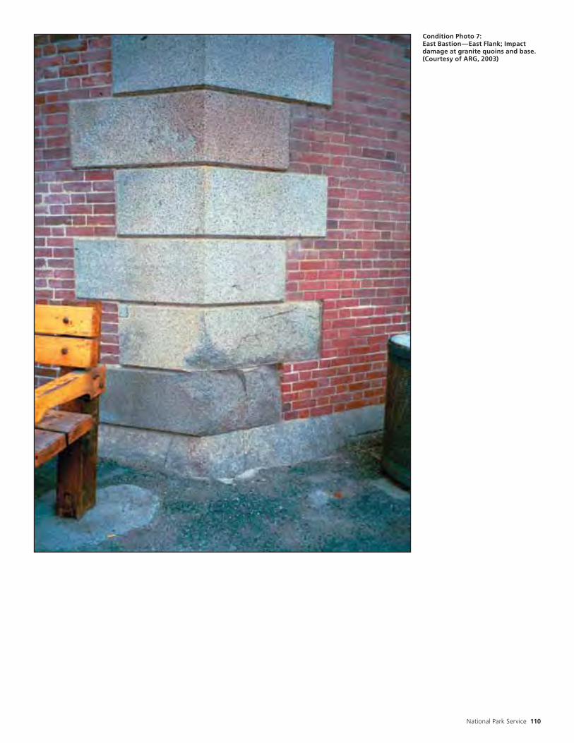
National Park Service 110
Condition Photo 7: East Bastion—East Flank; Impact damage at granite quoins and base. (Courtesy of ARG, 2003)
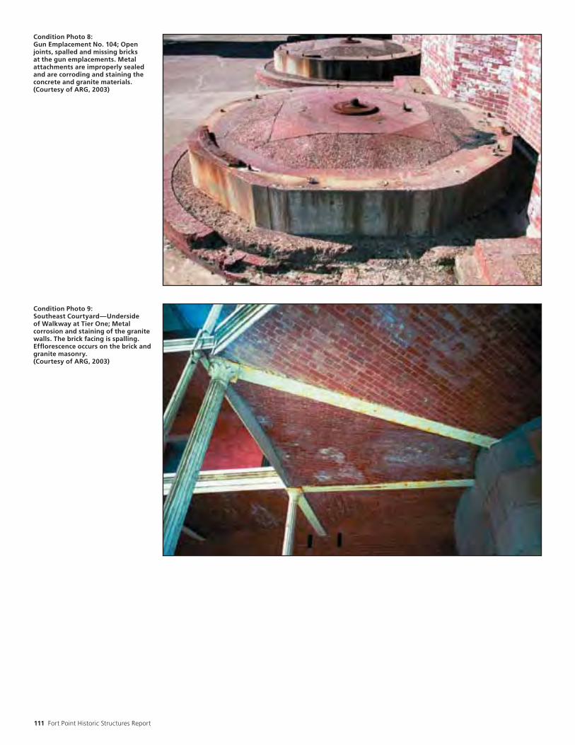
111 Fort Point Historic Structures Report
Condition Photo 8: Gun Emplacement No. 104; Open joints, spalled and missing bricks at the gun emplacements. Metal attachments are improperly sealed and are corroding and staining the concrete and granite materials. (Courtesy of ARG, 2003)
Condition Photo 9: Southeast Courtyard—Underside of Walkway at Tier One; Metal corrosion and staining of the granite walls. The brick facing is spalling. Efflorescence occurs on the brick and granite masonry. (Courtesy of ARG, 2003)

National Park Service 112
Condition Photo 10: Southeast Face Courtyard; Corroding metal columns and walkway supports. Missing metal railings in this photo have been reinstalled. (Courtesy of ARG, 2003)
Condition Photo 11: Biological growth on flagpole. (Courtesy of ARG, 2003)
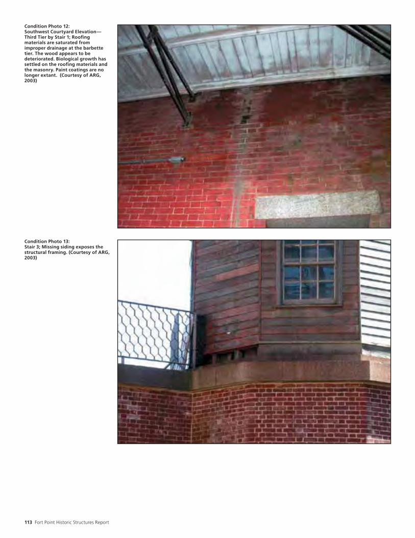
113 Fort Point Historic Structures Report
Condition Photo 12: Southwest Courtyard Elevation—Third Tier by Stair 1; Roofing materials are saturated from improper drainage at the barbette tier. The wood appears to be deteriorated. Biological growth has settled on the roofing materials and the masonry. Paint coatings are no longer extant. (Courtesy of ARG, 2003)
Condition Photo 13: Stair 3; Missing siding exposes the structural framing. (Courtesy of ARG, 2003)

National Park Service 114
Condition Photo 14: Wood Walkway – Barbette Tier by Stair 1; Components are not properly fastened at wood walkway. (Courtesy of ARG, 2003)

115 Fort Point Historic Structures Report
Condition Photo 15: Casemate 19; Cracks in brick masonry and joints have failed. The heavily flaking paint is typical in casements. (Courtesy of ARG, 2003)

National Park Service 116
Condition Photo 16: Casemate 11; Open joints at the brick masonry and heavy water infiltration. Biological growth on the interior brick. (Courtesy of ARG, 2003).

117 Fort Point Historic Structures Report
Condition Photo 17: Casemate 68A- Third Tier; Crack spanning the arch of a casemate, typical at the intersection of the east bastion and arch of the adjacent walkway. Extensive water damage, biological growth and efflorescence of masonry. (Courtesy of ARG, 2003)

National Park Service 118
Condition Photo 18: Casemate 68A—Second Tier; Graffiti noted on masonry wall. (Courtesy of ARG, 2003)
Condiiton Photo 19: Casemate 34; Uneven surfaces, open holes and potential tripping hazards. (Courtesy of ARG, 2003)

119 Fort Point Historic Structures Report
Condition Photo 20: Photo shows interior plaster patching at 2nd tier. (Courtesy of ARG, 2003)
Condition Photo 21: Detail of brick lath, wire mesh, and plaster layers. (Courtesy of ARG, 2003)

National Park Service 120
Condition Photo 22: Masonry repointing project at 1st tier. (Courtesy of ARG, 2003)
Condition Photo 23: Stained plaster at Casemate 81. (Courtesy of ARG, 2003)

121 Fort Point Historic Structures Report

National Park Service 122
by Carey & Co.
Evaluation of Restoration Work to Date The ultimate treatment for Fort Point is resto-ration to the period 1861-1913. “Restoration” is defined by The Secretary of the Interior’s Stan-dards for the Treatment of Historic Properties as the act or process of accurately depicting the form, features, and character of a property as it appeared at a particular period of time by means of the removal of features from other periods in its history and reconstruction of missing features from the restoration period. Because the property now serves as a museum rather than as a military fort, some projects fall more into the category of rehabilitation. “Reha-bilitation” is defined as the act or process of making possible a compatible use for a property through repair, alterations, and additions while preserving those portions or features which convey its historical, cultural, or architectural values.
Restoration projects at Fort Point have in gen-eral focused upon reversing the substantial 1914 alterations dealing with change of use to a prison; and stabilizing, repairing and recreat-ing badly deteriorated elements. Some projects have also been performed to support the inter-pretation of the Fort. These include the addi-tion of appropriate furnishings and armaments.
The 1973 HSR, which established the period of significance, recommended that the following projects be completed:
1. Reconstruction of one of the shot furnaces (not done).
2. Removal of iron window guards and brick infill from the embrasures (in progress).
3. Relaying/replacement of casemate traverse rails in casemates scheduled to be rearmed (in progress).
4. Restoration of the iron rails facing the parade (yes, but this is a cyclical maintenance issue).
5. Removal of 1914 toilet facilities and kitchens plumbing remaining (substantially completed).
6. Removal of concrete to expose flagstone in casements scheduled to be rearmed (in progress).
7. Removal of concrete from the superior slope of the barbette tier, and its replacement with earthen fill and sod (not done).
8. Restoration of walls and windows in the four casemates west of the sally port on the first tier to their appearance before conversion to a “guard dormitory” (completed).
9. Restoration and furnishing of selected casemates on the second and third tiers as proposed in the Interpretive Prospectus (completed).
All the items on the list, except for items #1 reconstruction of one of the shot furnaces, and item #7 removal of concrete from the superior slope of the barbette tier, and its replacement with earthen fill and sod, are either in progress or have been completed. In addition, work has been done to restore the lighthouse, the sea-walls, the penthouses and the Sallyport doors; and the exterior masonry has undergone sev-eral repointing campaigns. While these proj-ects may be deemed “complete,” many fall into the category of periodic maintenance. Wood, masonry and metals with an exterior expo-sure, especially one as severe as Fort Point’s, undergo rapid weathering; periodic mainte-nance must therefore be considered in any long range budget.
While overall these projects have definitely resulted in a resource that is more consistent with the period of significance than when the NPS acquired the property, the projects, individually and as a group, do not completely comply with the Secretary of the Interior’s Standards for Restoration. Perhaps the most significant and consistent violation of the Stan-dards is the failure to document the projects in a consistent methodical manner (Standards 3 and 4). While many of the projects were well documented in terms of what was done and why, there was no consistent format or even repository for the information. It was some-times difficult to ascertain whether a proposed project had been completed. Rationale for detail and material selection was sometimes missing, as were before and after photography.
Rehabilitation projects at the fort during the National Park Service stewardship period pri-marily fall into two categories; visitor center and accessibility improvements. Ideally an historic structure would retain its historical physical appearance and associated use. In the case of an outdated military defense work, the historical use is no longer possible, but a com-patible use is.
As a National Historic Site, Fort Point is pre-served for future generations as an educational tool describing our past. In order to facilitate this use, changes were required. Accessibil-ity improvements required by law, follow the Secretary of the Interior’s Standards; the mate-rials differentiate new material from old and the additions are largely reversible. The visitor center improvements are also largely reversible, and in the case of replicated features, they are compatible.
Treatment & Work Recommendations
Left: Contemporary view of barbette tier looking toward the Golden Gate Bridge. Photo circa 2005. Credit: John Martini.

123 Fort Point Historic Structures Report
Major projects that have not yet been accom-plished include:
1. Reconstruction of one of the shot furnaces.
2. Removal of concrete from the superior slope of the barbette tier, and its replacement with earthen fill and sod.
3. Penthouse stabilization, including repair of the penthouse roofs and cornices.
4. New manhole covers for the cisterns.
5. Removal of World War II concrete.
6. Removal of infill from windows.
7. Reconstruction of coal bins.
8. Reconstruction of a privy, second tier.
9. Reconstruction of wash sinks, second and third tiers.
10. Installation of a water tank.
11. Repair of the chimney pots.
12. Repair the paving at barbette tier.
13. Repair to granite stairs and landings.
14. Repair to paving at parade level, and second and third tier Galleries
15. Repair to millwork, etc., second tier Officers Qtrs.
16. Work on fireplaces, second tier Officers Qtrs.
17. Work on fireplaces, third tier Enlisted Men Qtrs.
18. Repair of the jail area.
19. Repair of historic staircase doors.
20. Inspect and add if needed rip rap to seawall.
21. Repair needed bars and remove dangerous iron bar work from the south wall windows.
22. Repair, scrape, treat, and paint flagpole.
23. Prepare accurate exhibit space by replacing rusted Totten shutters with new ones.
24. Loma Prieta earthquake repairs, produce construction drawings.
25. Remove and re-caulk seam around barbette tier to prevent water leakage into third tier vaults.
26. Remove plaster and clean up third floor rooms in southwest corner of fort.
Additional proposed projects also focus on needed cyclical maintenance, such as masonry repair, the painting of wood and metal ele-ments, and the regular inspection and replace-
ment of caulking and sealants which are rou-tine maintenance items that should be bud-geted and planned for on an ongoing basis.

National Park Service 124
Secretary of the Interior’s Standards The Standards (Department of Interior Regu-lations, 36 CFR 67) pertain to historic buildings of all materials, construction types, sizes and occupancy and encompass the exterior and the interior, related landscape features and the building’s site and environment as well as attached, adjacent, or related new construc-tion. The Standards are to be applied to spe-cific restoration or rehabilitation projects in a reasonable manner, taking into consideration economic and technical feasibility.
Standards for Restoration1. A property will be used as it was historically or be given a new use which reflects the proper-ty’s restoration period.
2. Materials and features from the restoration period will be retained and preserved. The removal of materials or alteration of features, spaces, and spatial relationships that character-ize the period will not be undertaken.
3. Each property will be recognized as a physical record of its time, place, and use. Work needed to stabilize, consolidate and conserve materials and features from the restoration period will be physically and visually compat-ible, identifiable upon close inspection, and properly documented for future research.
4. Materials, features, spaces, and finishes that characterize other historical periods will be documented prior to their alteration or removal.
5. Distinctive materials, features, spaces, fin-ishes, and construction techniques or examples of craftsmanship that characterize the restora-tion period will be preserved.
6. Deteriorated features from the restoration period will be repaired rather than replaced. Where the severity of the deterioration requires replacement of a distinctive feature, the new feature will match the old in design, color, tex-ture, and, where possible, materials.
7. Replacement of missing features from the restoration period will be substantiated by doc-umentary and physical evidence. A false sense of history will not be created by adding conjec-tural features, features from other properties, or by combining features that never existed together historically.
8. Chemical or physical treatments, if appro-priate, will be undertaken using the gentlest means possible. Treatments that cause damage to historic materials will not be used.
9. Archaeological resources affected by a proj-ect will be protected and preserved in place. If such resources must be disturbed, mitigation measures will be undertaken.
10. Designs that were never executed histori-cally will not be constructed.
Standards for Rehabilitation 1. A property shall be used for its historic pur-pose or be placed in a new use that requires minimal change to the defining characteristics of the building and its site and environment.
2. The historic character of a property shall be retained and preserved. The removal of historic materials or alteration of features and spaces that characterize a property shall be avoided.
3. Each property shall be recognized as a physi-cal record of its time, place and use. Changes that create a false sense of historic develop-ment, such as adding conjectural features or architectural elements from other buildings, shall not be undertaken.
4. Most properties change over time; those changes that have acquired historic signifi-cance in their own right shall be retained and preserved.
5. Distinctive features, finishes, and construc-tion techniques or examples of craftsmanship that characterize a property shall be preserved.
6. Deteriorated historic features shall be repaired rather than replaced. Where the severity of deterioration requires replacement of a distinctive feature, the new feature shall match the old in design, texture, and other visual qualities and, where possible, materials. Replacement of missing features shall be sub-stantiated by documentary, physical, or picto-rial evidence.
7. Chemical or physical treatments, such as sandblasting, that cause damage to historic materials shall not be used. The surface clean-ing of structures, if appropriate, shall be under-taken using the gentlest means possible.
8. Significant archeological resources affected by a project shall be protected and preserved. If such resources must be disturbed, mitigation measures shall be undertaken.
9. New additions, exterior alterations, or related new construction shall not destroy his-toric materials that characterize the property. The new work shall be differentiated from the old and shall be compatible with the massing, size and scale, and architectural features to protect the historic integrity of the property and its environment.
10. New additions and adjacent or related new construction shall be undertaken in such a manner that if removed in the future, the essen-tial form and integrity of the historic property and its environment would be unimpaired.

125 Fort Point Historic Structures Report
Requirement for Treatments & Use (Outline)A. Ultimate Treatment and Use B. Requirements for Treatment
1. Preservation Standards
a. Secretary of the Interior Standards for the Treatment of Historic Properties
b. Secretary of the Interior Standards for Restoration
2. Applicable laws, Regulations, Functional requirements for life safety, fire protection, energy conservation, abatement, universal access
a. Uniform Building Codeb. Uniform Code for Building
Conservation (UCBC)c. (California State Historical Building
Code)d. Uniform Federal Accessibility Standards
C. Alternatives for treatment1. How to realize ultimate treatment
Treatment Recommendations (Outline)A. Exterior Recommendations
1. Exterior materials and components
a Brickb Granitec Sandstoned Slatee Terra Cottaf C.M.U.g Concreteh Wood doorsi Wood windowsj Wood walkwaysk Wood sidingl Hardwarem Metal railingsn Metal stairso Metal colonnadep Metal embrasure surroundsq Metal window barsr Exterior lightings Miscellaneous elements
1) signage2) flagpole3) metal tracks4) armament
B. Interior Recommendations1. Interior materials and components
a Plasterb Woodc Brickd Interior doorse Granite stairsf Hardwareg Lightingh Plumbing remnantsi Miscellaneous elements
1) fireplaces2) cisterns3) partitions
C. Maintenance Recommendations

National Park Service 126
Books and ReportsBean, Walton and Rawls, James J. California: An Interpretive History. Fourth Edition. New York: Mc Graw-Hill Book Company, 1983.
Bearss, Edwin. Fort Point Historic Structure Report. National Park Service, 1973.
Carey & Co., Inc. Outline Historic Structure Report; Fort Point National Historic Structure Report. March 1, 1999.
Fisher, Charles E. (ed.) Caring for Your Historic House. New York: Henry Abrams, Inc. 1998.
General Management Plan, Environmental Analysis for the Golden Gate National Recre-ation Area and Point Reyes National Seashore (NPS, September 1980).
Historic American Building Survey (HABS). Fort Point, U.S. Highway 101, San Francisco, San Francisco County, HABS Call No: HABS CAL, 38-SANFRA-4, 1983. (previous call no: HABS No. CA-1239.)
Lewis, Emanuel Raymond. Seacoast Fortifica-tions of the United States: An Introductory His-tory. Missoula, Montana: Pictorial Histories Publishing Company, 1990.
Martini, John A. Fort Point: Sentry at the Golden Gate. San Francisco: Golden Gate National Park Association, 1991.
Report of the Chief Engineer to the Board of Directors of the Golden Gate Bridge and High-way District; The Golden Gate Bridge; Septem-ber 1937.
Superintendent’s Annual Reports, 1972-1989, the Fort Point National Historic Site Adminis-trative Office Files, Building 983.
Thompson, Erwin N. Seacoast Fortifications, San Francisco Harbor; Historic Resource Study (National Park Service, Denver Service Center, May 1979).
Weaver, Martin E. Conserving Buildings: A Manual of Techniques and Materials. New York: John Wiley & Sons, 1997.
Articles and JournalsMasonry Design West, “Fort Point at the Golden Gate and McNear Brick of Marin, Undated. From the Fort Point National Historic Site Administrative Office Files, Building 983.
San Francisco News: “Guardian of a Golden Gate, San Francisco Neglects an Old Pal, As Fort Point Yields to Sea and Rust.” September 5, 1947.
The San Francisco Chronicle; January 14, 1987.
Letters and MemorandaLetter from Fay Lew, Contracting Officer for GGNRA, to Dave Peeler Painting and Decorat-ing, (Dave Peeler-owner); September 30, 1983. From the Fort Point National Historic Site Administrative Office Files, Building 983.
Letter from Richard A. Borjes, Regional His-torical Architect, NPS, to Deerpath; October 21, 1983. From the Fort Point National Historic Site Administrative Office Files, Building 983.
Memo from Acting Site Manager, Fort Point National Recreation Area; November 11, 1989. From the Fort Point National Historic Site Administrative Office Files, Building 983.
Memo from Gordon Chappell, Regional Histo-rian, Western Region, to Chief, Division of Park Historic Preservation, Western Region; July 17, 1990. From the Fort Point National Historic Site Administrative Office Files, Building 983.
Memo from Regional Historical Architect, Western Region, to Chief, Park Preserva-tion; February 22, 1984. From the Fort Point National Historic Site Administrative Office Files, Building 983.
Memo from Charles S. Hawkins, Fort Point Site Manager, to Mike Stricklin, Chief of Mainte-nance, GGNRA; September 11, 1984. From the Fort Point National Historic Site Administra-tive Office Files, Building 983.
Memorandum; February 8, 1933; From Records of the Presidio of San Francisco, Land Records, 1850-1981, location 3268 F, San Bruno National Archives.
Memorandum from Structural Engineer, Divi-sion of Adobe/Stone Conservation, to Chief, Division of Adobe/Stone Conservation (names not provided); date-stamped January 22, 1981. United States Department of the Interior, National Park Service, Western Archeological Center, Tucson, Arizona. From Box 13, Folder H30, Park Archives and Records Center.
Archive HoldingsResearch was conducted by Carey & Co. at the following archives:
The Park Archives and Records Center of Golden Gate National Recreation Area
The Park Archives are a rich source for drawings, photographs and written records. Primary research materials relevant to Fort Point include the following:
1. Drawings. Four drawers of drawings relate to Fort Point:
a. Drawer 1: “Restoration projects.”
b. Drawer 6: “Fort Point Construction Plans.”
c. Drawer 7: 1866-1944
d. Drawer 9: Historical Maps of Fort Point, the Presidio and Golden Gate Bridge.
2. Photographs. Several boxes. Three contain historic black and white photographs. Most are in folders by general time period, but few are dated. Several boxes have snapshots, negatives and slides of construction projects
Bibliography

127 Fort Point Historic Structures Report
from the 1970s and 1980s. Some are well labeled with project and date, and some are not.
3. 23 boxes of administrative files. These are well indexed and organized. Boxes that appeared to have relevant materials, based upon the index, were reviewed. These included Box 9, Box 10, Box 11, Box 13, Box 20, Box 1-H and Box 2-H.
The Pacific Sierra Branch of the National Archives Administration (San Bruno)
The Archives holdings relative to Fort Point are in Record Group 77, Records of the Office of the Chief Engineer. The material reviewed seemed for the most part to duplicate information already contained in the Historic Structure Report, by Edwin Bearss. Within this record group, relevant material that was reviewed is contained in the following boxes:
1. Box 80: Letters sent by J.F. Gilmer, Supervising Engineer, July 1858-February 1861. These letters are mostly to Colonel R.E. De Russy.
2. Box 80A: Letters sent by Engineer Officers Gilmer and DeRussy relating to fortifications, January 1861-December 1864.
3. Box 80B. Letters Received by the Supervising Engineer, 1896-1902. These letters are from other officers, contractors and others in California.
The following boxes were not reviewed. They cover the time period that was already well-documented by Bearss.
1. Boxes 81-82. Daily Report of Operations, April 1854 - August 1864. The daily reports discuss materials and services received and activities performed.
2. Box 83. Time Rolls of Employees, July 1853-December 1864. The rolls list the following: name, occupation, days worked, and whether living on or off the Fort.
3. Boxes 84, 84A. Vouchers paid, Quarterly returns and accounts current of LT. Col. R.E. De Russy, 1855. Each record describes the material or service received, the amount paid, and to whom.
4. Box 84E. Register of Materials Received, 1858-1863. The register lists the name of the supplier, a description of the material received, the amount paid, and to whom.
The San Francisco History Room of the San Francisco Public Library
This repository has clipping and photograph files relevant to Fort Point. There were three photograph files, largely duplicating materials examined at the Park Archive. The thin clipping file contained a couple of pamphlets not seen elsewhere, and two brief, hand-typed histories dated 1929 but
of unknown authorship. Also of interest are handwritten notes from an interview with the Lighthouse Keeper conducted in 1929.
The Fort Point National Historic Site Adminis-trative Office
Dead files stored in Building 983. Relevant materials consist primarily of two file drawers, organized by subject, containing contracts, drawings, inspection reports, wish lists, and the full run of “Superintendent’s Annual Reports,” which highlight construction projects performed from 1972 through 1989.
The J. Porter Shaw Library of the San Francisco Maritime Museum
Archive contains both prints and negatives of Fort Point, mostly undated. These images typically are of a nautical vessel in the foreground, with the fort in the background. Materials are arranged in collections or as single items, with images of the fort in the background appearing in several collections. A variety of images were viewed dating from pre-fort to the recent past, including both aerial views and elevations. Images either duplicated previous material or the Fort appeared so far in the background, that images from this resource are not included. Due to the nature of the archives, a complete review of materials pertaining to Fort Point was not possible.
The California Historical Society.Modest holdings related to Fort Point, including DeRussy vouchers from 1855-57, prints of the 1913 drawings, a copy of the Bearss Historic Structure Report, indexed San Francisco scrapbooks including some materials on Fort Point, and 19th century San Francisco guidebooks which include mention of Fort Point.
The Golden Gate Bridge DistrictIn addition, the Golden Gate Bridge District was contacted but not visited. They have a large collection of photographs, as well as other, un-catalogued materials (drawings, specifications, administrative records etc.). At the time that this document was prepared, the Bridge District had just hired an archivist to catalog the vault material. This repository may therefore prove a valuable resource for future researchers of the Fort.

National Park Service 128
InterviewsThe following individuals having long-term familiarity with the Fort were interviewed:
• John Martini, Curator of Military History, Golden Gate NRA
• Maureen Rogers, Park Ranger, Golden Gate NRA
• Ric Borjes, Historical Architect and Chief, Branch of Cultural Resources, Golden Gate NRA
• Robert M. Cox, Former Historical Architect, Golden Gate NRA
• Charles Schultheis, Maintenance Buildings and Utilities, Golden Gate NRA
• Rich Weideman, South District Chief Interpretive Ranger, Golden Gate NRA
ContractsContract 1443-CX-8140-94-029 from garage files, between NPS/GGNRA and Small Busi-ness Administration/Farinha Inc. dba Paragon Construction, September 30, 1994).
Contract 1443-CX-8140-96-006; contract between National Park Service and Carey & Co., 460 Bush Street, San Francisco to produce Outline Historic Structure Report for Fort Point National Historic Site. October 1997.
Contract 1443-CX-8140-98-1600; contract between National Park Service and Archi-tectural Resources Group, Pier 9, Embar-cadero, San Francisco, 94111. Task order # T2000981615, package # FOPO-393.
Lump Sum Contract between the National Park Service and Bill Wright Painting And Decorating, contract #CX 8000-9-0034.
MiscellaneousAdministrative History; Record Group 77; Records of the Office of the Chief Engineers, Records of the San Francisco District, 1866-November 1996; San Bruno National Archives.
Development Study Package Proposal; Dated July 14, 1989.
Classified structure field inventory; February 13, 1976; Robert M. Cox; Box 13, folder H30; Presidio Archives.
Fort Point Museum Association bronze tablet text, June 24, 1966; Land Records, 1850-1981; Records of the Presidio of San Francisco, San Bruno National Archives.
Fort Point National Register Nomination form.
Fort Point National Historic Site Funded Proj-ects - FY92 and Fort Point National Historic Site Proposed Projects for BOP Crew - FY92. From the Fort Point National Historic Site Administrative Office Files, Building 983.
Fort Point National Historic Site, HABS draw-ings.
Fort Point National Historic Site Videotape.
“History of the Telephone Service...” Land Records, 1850-1981; Records of the Presidio of San Francisco; San Bruno Archives.
Interpretive Signage, Fort Point National His-toric Site.
Project Statement sheet, dated 1993, hand-written notes, no name. From the Fort Point National Historic Site Administrative Office Files, Building 983.
Project Statement, regarding re-finishing Fort Point barbette wooden walkway. From the Fort Point National Historic Site Administrative Office Files, Building 983.
Site Investigation Report and Recommenda-tions for Stabilization and Repair, SOH and Associates, Structural Engineers and KCA Engineers, Inc., August 15, 1991. From the Fort Point National Historic Site Administrative Office Files, Building 983.
United States Department of the Interior Req-uisition; July 30, 1985; R.B. McNair Sons.

129 Fort Point Historic Structures Report

National Park Service 130
Left: Contemporary view of metal staircase that leads to the lighthouse. Photo circa 2005. Credit: John Martini.
Aangle of defense - The angle of defense formed by a line of defense and a flank.
angle - A projecting or sharp corner.
archway - A passage through or under an arch, especially when long, as under a barrel vault.
Bbarbette battery - battery of cannon mounted in open positions with only a short parapet wall to protect them from enemy gunfire.
barbette tier - the top tier of a fort, where can-non are mounted on exposed positions rather than in enclosed casemates.
barrel vault - A masonry vault of plain, semicir-cular cross section supported by parallel walls or arcades; a vault having a semi-cylindrical roof.
bastion - A projection in the enceinte, made up of two faces and two flanks which enable a garrison to defend the ground adjacent to the enceinte. Or, a defense work projecting from the outer wall of a fortification, principally to defend the adjacent perimeter.
bombproof - A structure designed to provide security against artillery fire.
battery - a group of cannon in a fortification. Also, a company of soldiers assigned to man the guns, as in “Battery N of the 6th Coast Artillery.”
Ccasemate - A bombproof enclosure, generally located under the rampart, to house cannons, which fired through embrasures in the scarp.
cistern - An artificial reservoir or tank for stor-ing water for use when required.
cordon - The coping or top course of the scarp designed to protect the wall from weathering.
counterscarp - The exterior side of the ditch, the side away from the body of the place.
counterscarp gallery - A work located behind the counterscarp from which the ditch could be defended with reverse fire.
curtain - A section of bastioned fortifications that lies between two bastions.
curtain angle - In a plan, the angle formed between the curtain and the flank.
Ddischarging arch, or safety arch - An arch, usu-ally segmental and often a blind arch, built above the lintel of a door or window to dis-charge the weight of the wall above the lintel to each side.
Glossary
Credit: Fort Point NHS Collection, Golden Gate National Recreation Area.

131 Fort Point Historic Structures Report
Eembrasure - An opening in a wall or parapet through which cannons were fired. The sides generally splayed outward are the cheeks, the bottom was the sole, the narrow part, the throat and the widening, the splay.
en barbette - An arrangement for cannons in which they were mounted on high platforms or carriages so they fired over a parapet instead of through embrasures.
enceinte - The works of the fortifications, the walls, ramparts and parapets, that enclose a fort.
enfilade - An alignment of a series of doors axi-ally through a sequence of rooms.
Fface - a main exterior side of a fort.
Ggauged arch - An arch of wedge shaped bricks which have been shaped so the joints radiate from a common center.
glacis - A sloped embankment in front of a for-tification to bring the advancing enemy into the most direct line of fire.
gorge - In a bastion, the space between the two curtain angles; in some forts, the designation applied to the rear section of the enceinte; or a narrow entry into a bastion.
Lloophole - A small opening in a wall or stockade through which small arms were fired.
Mmagazine - A place for the storage of gunpow-der, arms or goods.
Ooutwork - a smaller fortification built outside the main body of a fort, such as the Ten Gun Battery and the Counterscarp Gallery at Fort Point.
ordnance - artillery pieces and the equipment used to fire or maintain them.
Pparade - An area usually centrally located where troops were assembled.
parapet - A low guarding wall at a point of sud-den drop, at the edge of a terrace, roof, battle-ment, balcony, etc. A defense wall.
postern - A passage leading from the interior of the fortification to the ditch. A minor, often inconspicuous entry. Any small door or gate, especially one far from the main gate in a forti-fied place.
projectile - an object fired from a gun, such as solid shot, explosive shells, grape shot, and canister.
Rrampart - A mass of earth formed with mate-rial excavated from the ditch to protect the enclosed area from artillery fire and to elevate defenders. Earthen or masonry defense wall.
rifle - gun manufactured with spiral grooves cut into the interior of the barrel, designed to fire pointed projectiles.
Ssalient - Describing any projecting part or member, such as salient corner.
sallyport - A passage from the covered way to the country or a passage under the rampart usually vaulted form the interior of the fort to the exterior, primarily to provide for sorties.
scarp - A steep slope constructed as a defensive measure in a fortification.
smoothbore - gun manufactured with a smooth interior barrel, or bore, designed to fire round projectiles.
sortie - A sudden attack on the besiegers by troops from defensive works, also called a sally. The main object was to destroy any siegeworks.
Tterreplein - A level space on the rampart between the parapet and the parade face.
tower bastion - A masonry bastion distin-guished by its vertical characteristic. Often, it was higher than the curtain ramparts.
Uunderpitched vault, welsh vault - A construc-tion formed by the penetration of two vaults of unequal size, springing from the same level.
Wwicket - A small door or gate, especially one forming part of a larger one.

National Park Service 132
Figure 34. Drawing: Fort Point Nomenclature, Section I-J, undated. Credit: Fort Point NHS Collection, Golden Gate National Recreation Area.

Appendices A: Floor Plans
Figure 10. Drawing: Detention Barracks conversion, first floor plan, 1914.
Figure 20. Drawing: First Tier Plan, 1973.
Figure 21. Drawing: Second Tier Plan, 1973.
Figure 22. Drawing: Third Tier Plan, 1973.
Figure 23. Drawing: Barbette Plan, 1973.
Figure 24. Drawing: Section A-A; Site Plan, 1973.
Figure 25. Drawing: Title Sheet, 1998.
Figure 26. Drawing: First Tier Plan, 1998.
Figure 27. Drawing: Second Tier Plan, 1998.
Figure 28. Drawing: Third Tier Plan, 1998.
Figure 29. Drawing: Barbette Plan, 1998.
Figure 30. Drawing: Exterior Elevations, 1998.
Figure 31. Drawing: Exterior Elevations, 1998.
Figure 32. Drawing: Sections, 1998.
Figure 33. Drawing: Courtyard Elevations, 1998.
Figure 34. Drawing: Fort Point Nomenclature, section I-J.
Figure 35. Drawing: Fort Point Nomenclature, barbette tier.
133 Fort Point Historic Structures Report

National Park Service 151
2004 | BookFinal Report on the Conditions Assessment and Treatment Recommendations for Waterproofing
Architectural Resources Group for DSC—January 12, 2004
1999 | DrawingsFOPO 393-RP8000-99-902
Repair Earthquake Damage & Misc Masonry Repairs – As Built Drawings (scanned images) SOHA Engineers & DSC—6/99
Sheets 1-16 (Repointing, brick repair, tie rods, anchor beams)
1999 | BookCompletion Report—Embrasure Repairs FY 98
Intermountain Support Office Architectural Conservation Program—April 1999
1999 | DrawingsEmbrasure Repairs
Intermountain Support Office, Sheets 1–12
1999 | BookTechnical Specifications—Embrasure Repairs
April 1999
1999 | BookCompletion Report—Replacement of Metal Pintles and Repair of Brick Masonry FY 98
Intermountain Support Office Architectural Conservation Program—April 1999
1999 | BookOutline Historic Structure Report
Carey & Co—March 1, 1999
1998 | DrawingsFt Point NHS - HABS Drawings
Carey & Co—1997–1998, Sheets 1–9, 1998
1998 | BookScope of Work – Replacement of Metal Pintles and Repair of Brick Masonry
Intermountain Support Office Architectural Conservation Program—March 1998
1998 | BookOutline Developmental History Draft
Carey & Co—February 13, 1998
1994 | BookFinal General Management Plan EIS Presidio of San Francisco
July 94 (barely mentions Fort)
1994 | BookHistoric Furnishings Report
Mary Grassick, Harper’s Ferry Center—July 5, 1994
1993 | DrawingsStructural EQ Repair Dwgs (preliminary work for FOPO 393)
KCA Engineers, 12/93, Sheets S1-S6
1993 | BookComprehensive Design Plan Preliminary
Corlett, Skaer & DeVoto, Architects and KCA Engineers—June 1993
1992 | BookHandicapped Accessibility Survey
KCA Engineers—November 1992
1991 | BookFort Point—Sentry at the Golden Gate
John Martini
1991 | BookSite Investigation Report and Recommendations for Stabilization and Repair
SOHA Architects, KCA Engineers—August 15, 1991
1980 | BookGeneral Management Plan—EA GOGA/PORE
Sept 80 (says Ft Point should be restored)
1974 | DrawingsRefurbishing & Restoration of Metalwork
NPS Western Region—Office of Professional Services—May 1974
1973 | BookHistoric Structure Report—Historic Data Section
Edwin Bearss, DSC—March 1973
1972 | DrawingsFt Point Light—Partial Restoration 400-21491
DSC, 2 Sheets
1972 | BookHistoric Structure Report – Fort Point Light
A. Lewis Koue and F. Ross Holland, DSC—May 1972
National Register FormSallyport Doors
Appendices B: List of Fort Point Documents

152 Fort Point Historic Structures Report
2004—Condition Assessment and Treatment RecommendationsThis investigation evaluated the nature, cause and extent of water intrusion and general material deterioration in areas excluded from recent rehabilitation projects. No actual repair work has been undertaken yet as a result of this report.
Documents produced for this project include:1. Conditions Assessment and Treatment Recommendations report—Architectural Resources Group, January 2004
2. Drawings that accompany report—Architectural Resources Group, 12/2003
This report was contracted by the National Park Service—Denver Service Center with funds remaining from the 1999 Repair Earth-quake Damage and Miscellaneous Masonry Repairs project. Mike Casias was the proj-ect manager for the Denver Service Center. David Wessel, Glenn David Mathews, Ricarda Cepeda, and Christina Wallace worked on the project for Architectural Resources Group.
2003—Sallyport Entry DoorsPlans and specs were prepared to replace the main doors into the fort in 1993. These replacement doors began warping shortly after they were installed in 1997. After determination that the replacement doors were not salvage-able, a new pair was constructed and installed in 2003. The second set of replacement doors was built to different specifications that the first set. The original sallyport entry doors are currently located on the 1st tier of the fort near casemate 28.
Documents produced for this project include:1. New Exterior Sallyport Doors—NPS Western Region, date 7/93, 4 sheets (641/60,175)
The original drawings were prepared by WH at the Western Regional office. Jim Kren (Golden Gate/NPS) managed the project for the first set of doors. Diane Nicholson (Golden Gate/NPS) managed the project for the second set of doors.
1999—Repair Earthquake Damage and Miscellaneous Masonry RepairsThis project replaced brick and repointed mor-tar joints on the interior and exterior of the fort. Metal straps, tie rods, and anchor beams were added to attach outer gorge wall to the interior walls. New waterproofing and concrete slabs were poured on the barbette tier and parapet wall over the area of the gorge.
Documents produced for this project included:1. Repair Earthquake Damage and Misc. Masonry Repairs—As Built Drawings, 6/99
2. Construction Documents—contract no. CX-8140-0-0005, dated 12/93, 6 sheets
3. Site Investigation Report and Recommendations for Stabilization and Repair, D5215 (WR-GOGA), dated August 15, 1991, 77 pages
These drawings were produced by the National Park Service—Denver Service Center. SOHA was the structural engineer and produced the Site Investigation Report. KCA Engineers was the consulting engineer.
FY 1998—Embrasure RepairsThis project involved the rehabilitation of the embrasures on the fort. All of the embrasures were studied to determine the best method of rehabilitating them. Alternatives were consid-ered and specifications were prepared for the restoration of all of the embrasures, but only five embrasures were actually restored during this project. These were the 5 embrasures on the 1st tier of the fort facing the parking lot on the east side of the fort.
Documents produced for this project include:1. Embrasure Repairs drawings, dated 4/99, 12 sheets
2. Technical Specifications—Embrasure Repairs, dated April 1999
3. Completion Report—Embrasure Repairs, dated April 1999
The design and the construction work were accomplished by the National Park Service Intermountain Support Office—Santa Fe, Architectural Conservation Program. Jeff Brown and Mark Mortier were project manag-ers from Intermountain Support Office and Ric Borjes was the historical architect from GGNRA. Wayne Smallcanyon, Norman Thinn, and Richard Blackhorse did the actual con-struction.
The casemate/embrasure numbers for this project are reversed from the HABS drawings prepared by Carey and Co. in 1998. The five embrasures that were repaired are referred to as numbers 26 through 30 on the Embrasure Repair drawings, but they are referred to as numbers 1 through 5 on the HABS drawings.
Appendices C: Supplemental Record of Work Performed

National Park Service 153
FY 1998—Replacement of Metal Pintles and Repair of Brick MasonryThis project involved rehabilitation of the metal pintles located at doors, windows and openings off the gallery. All of the pintles on the 1st tier of the gallery were replaced and the associated brick masonry was repaired. The pintles that were embedded in stone were not replaced.
Also during this project approximately 50 pieces of slate flooring were replaced on the 2nd and 3rd tier galleries.
Documents produced for this project include:1. Scope of Work—Intermountain Support Office Architectural Conservation Program, dated March 1998
2. Completion Report—Intermountain Support Office Architectural Conservation Program, dated April 1999
The design and the construction work were accomplished by the National Park Service Intermountain Support Office—Santa Fe, Architectural Conservation Program. Jeff Brown and Mark Mortier were project manag-ers from Intermountain Support Office and Ric Borjes was the historical architect from GGNRA. Lyle Stewart, William Kinlicheene, and Taylor Tsosie did the actual construction.
1997—HABS Drawings and Historic Structure ReportThis project was to document the existing conditions at the fort and complete the archi-tectural data section of the earlier Historic Structure Report prepared by Ed Bearss.
Documents produced during this project include:
1. HABS drawings, Recording Project 1997-1998, 9 sheets
2. Outline Historic Structure Report, dated March 1, 1999, 121 pages
The drawings and historic structure report were prepared by Laura Culberson, Heidi Sto-sick, and Rodolfo Llamas Jr. of Carey and Co. (A/E contract 1443CX-8140-96-006).
1994—Historic Furnishings ReportThis 248 page report was prepared by Mary Grassick of the National Park Service—Harp-ers Ferry Center. It provides recommendations for furnishing spaces within the fort.
1993—Handicapped Accessibility ProjectThe purpose of this project was to make Fort Point more accessible for persons with dis-abilities. Some of the easier accommodations were accomplished, but larger ones, such as the elevator, were never completed.
Documents produced for this project include:1. Handicapped Accessibility Survey for Fort Point National Historic Site, Nov 1992
2. Comprehensive Design Plan, Preliminary, for Fort Point National Historic Site, Jun 1993
The approximately 200 page velo-bound Hand-icapped Accessibility Survey was prepared for the fort’s compliance with the Americans with Disabilities Act of 1992. It was prepared by KCA Consulting Engineers, San Francisco. The project architect was Ric Borjes (GOGA/NPS). The majority of the report consists of detailed survey sheets. Included in the back of the report is a set of plans with 5 sheets noting accessibility problems and possible solutions.
The Comprehensive Design Plan is 72 pages. It outlines accessibility problems and recommen-dations for correction. There are 5 sheets of plans at the back of the book. It was prepared by KCA Consulting Engineers, and Corlett, Skaer and DeVoto Architects, Inc.
1991—Fort Point, Sentry at the Golden GateThis bound, soft-cover book, written by John Martini, was published by the Golden Gate National Park Association for sale in the fort’s bookstore. It provides an easy-to-read history of the fort with very good photographs and illustrations.
1974—Refurbishing & Restoration of MetalworkThis project replaced the 4 cast iron staircases; gallery roof, brackets, gutters and downspouts; barbette tier walkway and brackets; and rail-ings on this side of the fort. It also added a new fence and gate around the lighthouse base. The work was completed.
Documents produced for this project include:1. Refurbishing & Restoration of Metalwork drawings, dated 5/74, 8 sheets (400/80000)
2. Refurbishing & Restoration of Metalwork shop drawings, dated 9/18/74, 12 sheets
The design was done by the National Park Ser-vice Western Region – Office of Professional Services. Drawings were prepared by Bob Cox, L. Koue, Hunter, and Kucera. Charles Hawkins was Fort Point Acting Superintendent. Reliance Enterprises was the contractor and Associated Ironworkers did the metalwork fab-rication.
1973—Fort Point Historic Structure Report—Historic Data SectionThis 375 page soft-cover document contains an exhaustive history of Fort Point from the time of its construction until its partial alteration as a detention barracks around 1914. It barely touches on history of the fort after 1914. This document was written by Edwin Bearss and a Historic Preservation Team from the National Park Service – Denver Service Center.
1972—Partial Restoration of LighthouseThis project involved replacement of various wood and metal lighthouse components.
Documents produced for this project include:1. Partial Restoration drawings – Fort Point Light, dated May 1972, 2 sheets (400/41004)
2. Historic Structure Report – Fort Point Light, dated May 1972, approx. 72 pages

154 Fort Point Historic Structures Report
The historic structure report was prepared by A. Lewis Koue, Architect, and F. Ross Holland, Historian of the National Park Service—Den-ver Service Center. The drawings were done by Koue.
1968—Fort Point National Historic Site ProposalThis bound, soft-cover book (24 pages) is a fea-sibility study and master plan for incorporating Fort Point into the National Park Service as a National Historic Site. It provides a description of elements of the fort that existed in 1968, in addition to information about the legislative history leading to the creation of Fort Point National Historic Site. It was published by the National Park Service, but the author is not listed.


Fort Point National Historic SiteGolden Gate National Recreation AreaFort Mason, Building 201San Francisco, CA 94123
National Park ServiceU.S. Department of the Interior
EXPERIENCE YOUR AMERICA