fort benton historic district: draft nomination
TRANSCRIPT

NATIONAL HISTORIC LANDMARK NOMINATION NPS Form 10-900 USDI/NPS NRHP Registration Form (Rev. 8-86) OMB No. 1024-0018 FORT BENTON HISTORIC DISTRICT Page 1 United States Department of the Interior, National Park Service National Register of Historic Places Registration Form
1. NAME OF PROPERTY Historic Name: Fort Benton Historic District Other Name/Site Number: 2. LOCATION Street & Number: Front Street (1220 through 1900 block), levee, and bridge Not for publication: City/Town: Fort Benton Vicinity: State: MT County: Chouteau Code: 015 Zip Code: 59442 3. CLASSIFICATION
Ownership of Property Category of Property Private: X Building(s): ___ Public-Local: District: _X_ Public-State: ____ Site: ___ Public-Federal: ___ Structure: ___
Object: ___ Number of Resources within Property Contributing Noncontributing 10 27 buildings 2 0 sites 1 2 structures 0 7 objects 13 36 Total Number of Contributing Resources Previously Listed in the National Register: 5 Name of Related Multiple Property Listing: N/A

NPS Form 10-900 USDI/NPS NRHP Registration Form (Rev. 8-86) OMB No. 1024-0018 FORT BENTON HISTORIC DISTRICT Page 2 United States Department of the Interior, National Park Service National Register of Historic Places Registration Form
4. STATE/FEDERAL AGENCY CERTIFICATION As the designated authority under the National Historic Preservation Act of 1966, as amended, I hereby certify that this ____ nomination ____ request for determination of eligibility meets the documentation standards for registering properties in the National Register of Historic Places and meets the procedural and professional requirements set forth in 36 CFR Part 60. In my opinion, the property ____ meets ____ does not meet the National Register Criteria. Signature of Certifying Official Date State or Federal Agency and Bureau In my opinion, the property ____ meets ____ does not meet the National Register criteria. Signature of Commenting or Other Official Date State or Federal Agency and Bureau 5. NATIONAL PARK SERVICE CERTIFICATION I hereby certify that this property is: ___ Entered in the National Register ___ Determined eligible for the National Register ___ Determined not eligible for the National Register ___ Removed from the National Register ___ Other (explain): Signature of Keeper Date of Action

NPS Form 10-900 USDI/NPS NRHP Registration Form (Rev. 8-86) OMB No. 1024-0018 FORT BENTON HISTORIC DISTRICT Page 3 United States Department of the Interior, National Park Service National Register of Historic Places Registration Form
6. FUNCTION OR USE Historic: Commerce and Trade Sub: Department Store Commerce and Trade Sub: Financial Institution Commerce and Trade Sub: Restaurant Commerce and Trade Sub: Specialty Store Defense Sub: Fortification Domestic Sub: Hotel Domestic Sub: Single Dwelling Government Sub: Fire Station Social Sub: Meeting Hall Transportation Sub: Road-Related (Vehicular) Transportation Sub: Water-Related Current: Commerce and Trade Sub: Business Commerce and Trade Sub: Financial Institution Commerce and Trade Sub: Organizational Commerce and Trade Sub: Restaurant Commerce and Trade Sub: Specialty Store Domestic Sub: Hotel Recreation and Culture Sub: Museum Recreation and Culture Sub: Outdoor Recreation Transportation Sub: Pedestrian-Related 7. DESCRIPTION ARCHITECTURAL CLASSIFICATION: Late Victorian Late Victorian/Italianate Other/Pratt through truss Other/Baltimore truss MATERIALS:
Foundation: Stone Walls: Brick, Wood/Weatherboard, Adobe Roof: Asphalt, Wood/Shingles Other: Stone, Steel

NPS Form 10-900 USDI/NPS NRHP Registration Form (Rev. 8-86) OMB No. 1024-0018 FORT BENTON HISTORIC DISTRICT Page 4 United States Department of the Interior, National Park Service National Register of Historic Places Registration Form
Describe Present and Historic Physical Appearance. Administrative Background of the Fort Benton NHL A National Survey of Historic Sites and Buildings in 1960 found Fort Benton nationally significant and specifically noted the existing blockhouse and adobe walls, as well as the riverfront, which it described as appearing “unchanged.” On 5 November 1961 Fort Benton was designated as a National Historic Landmark, under the subtheme “Transportation and Communication” of Theme XV, “Westward Expansion, 1830-1898.” The Fort Benton National Historic Landmark designation was completed before standards were established for a complete survey and description of resources and the identification of district boundaries. Therefore, the 1961 form did not indicate the precise boundaries of the Fort Benton Historic District, describe the resources within it, or define the area encompassed by the term “riverfront.” This lack of clear boundaries and a discussion of all of the components of the district necessitated the need for a boundary study. On 14 September 1972, the Fort Benton Historic District, encompassing several blocks within the town, was listed in the National Register of Historic Places. In 1980 the NPS completed a boundary study for the NHL, but the boundary was not adopted. In 2003-04, a second boundary study was undertaken, in part because the Montana State Historic Preservation Office (SHPO) and the town of Fort Benton had repeatedly asked for clarification. The study, completed by Front Range Research Associates of Denver, produced a boundary that encompassed the contiguous historic resources closely associated with the steamboat era, including the fort, levee, bridge, and a group of waterfront buildings. Some of the buildings had undergone restoration since the 1961 NHL designation, and several fort buildings had been reconstructed. The 2003-04 study was the first to thoroughly utilize the resources of Fort Benton’s Overholser Historical Research Center and historic Fort Benton newspapers to produce accurate dates of construction for the buildings and to assess the alterations to the riverfront area after 1890. The current nomination form resulted from the 2003-2004 study, as well as additional information gathered during a 2010 NPS site visit to Fort Benton.1 During the 2010 site visit, the NPS took photographs of the Bourgeois’ Quarters and stockade, which were reconstructed at the fort in 2010; those photographs are included with this nomination form. General Description of District Fort Benton, the historic official head of steamboat navigation on the Missouri River, is located on the west bank of the river in north-central Montana, about thirty-four miles northeast of Great Falls and eighty-four miles south of the Canadian border. The Fort Benton National Historic Landmark was designated in 1961 without specifying a boundary. The district described in this nomination encompasses the heart of the historic riverfront commercial area, which developed during the period when steamboats traveled the Upper Missouri, from 1860 through 1890. This area is very similar in appearance to the way it was when the NHL was created in 1961. The district includes the fort, levee, bridge, firehouse and city hall, mercantile, hotels, Masonic Hall, saloon, hardware store, banks, and a residence that are linked to the nationally significant history of the community. Five of the resources are individually listed in the National Register of Historic Places (NRHP), and all are located within the boundary of the Fort Benton Historic District, which was listed in the National Register of Historic Places in 1972.
1 Much of the discussion in the two previous paragraphs is summarized from Dan Vivian, National Park Service, National
Register of Historic Places, “Additional Comments on Boundary Study Documentation,” 27 March 2006. The September 2010 site visit was conducted by Lysa Wegman-French, National Park Service, Intermountain Region.

NPS Form 10-900 USDI/NPS NRHP Registration Form (Rev. 8-86) OMB No. 1024-0018 FORT BENTON HISTORIC DISTRICT Page 5 United States Department of the Interior, National Park Service National Register of Historic Places Registration Form
The district extends along Front Street and the river levee from the three-story, 1882 Italianate style Grand Union Hotel and the 1880 Murphy, Neel & Co. mercantile on the south to the adobe buildings of Fort Benton, founded in 1846, on the north. The long, broad levee, where passengers disembarked and freight was unloaded, is now a city park, as well as the historic site of the firehouse/city hall and the hotel. Spanning the river is the 1888 steel truss Fort Benton Bridge, designed by the Milwaukee Bridge and Iron Works. The view of the Upper Missouri, part of a protected wild and scenic stretch of the river, and surrounding agricultural bottom lands and uplands from the levee is remarkably unchanged. On the west side of Front Street, facing the river, are the one- to three-story historic brick buildings of the business district, many of which display late Victorian architectural influences, as well as a few frame and masonry dwellings. Several of the buildings reflect Italianate style influences, principally seen in tall, narrow, double-hung sash windows with hooded crowns. Architectural features characteristic of Fort Benton buildings erected during the steamboat era include use of locally manufactured brick, cornices with corbelling and other decorative brickwork, and tall double-hung sash windows with round or segmental arches. Some of the buildings were notably designed with arcaded storefronts. Attempts to preserve the soft, locally produced brick utilized before 1890 and the desire to update the appearance of business blocks have resulted in the modification of many of the historic buildings of the town. Most of the two-story commercial buildings have experienced alterations to their storefronts, such as changes to the fenestration, as well as painting, stuccoing, or otherwise covering the brick. The buildings dating to the district’s period of significance are interspersed among later edifices that were constructed after the loss of some historic resources and reflect continued development of Fort Benton following the end of the steamboat era. Of the forty-nine resources in the district, thirteen, or 27 percent, are contributing historic resources and thirty-six, or 73 percent, are noncontributing resources. The thirteen contributing resources include two historic sites, ten historic buildings, and one historic structure. The resources are directly linked to the steamboat era through their dates of construction and historical associations. These steamboat-era buildings were integral to the functioning of the river commerce, supplying essential financial, mercantile, lodging, and support services. Because a number of historic buildings representing the steamboat era have been lost, the remaining resources have acquired increased significance for their contribution to our understanding of the period. The maps accompanying this nomination identify the location and contributing/noncontributing status of resources within the district. The period of significance for the district extends from 1860, the date the first commercial steamboat reached Fort Benton, until 1890, the end of commercial steamship arrivals. The boundaries of the district were drawn to include the largest concentration of resources reflecting the national significance of the steamboat era. Date of construction was an initial factor in determining which resources in the district were contributing. The buildings present in the district during the period 1860 to 1890 were further evaluated for historic physical integrity. Nearly all of the resources evaluated as noncontributing were built after the end of the steamboat era; one resource was assessed as noncontributing due to major alterations that diminished its historic integrity. Reconstruction of the fort began in 1992, utilizing reconstruction plans for the individual buildings and the complex as a whole. The plans were developed by the Fort Benton Restoration Committee, headed by John G. “Jack” Lepley, Executive Director of the River & Plains Society, which operates the Montana Agricultural Center and Museum in Fort Benton. Lepley is the author of several books about Fort Benton and has been closely involved in all aspects of the preservation and reconstruction of the fort. The Restoration Committee developed detailed plans for each building, including construction drawings, using written reports based on historical research, archaeological studies, historic photographs and drawings, and military and other

NPS Form 10-900 USDI/NPS NRHP Registration Form (Rev. 8-86) OMB No. 1024-0018 FORT BENTON HISTORIC DISTRICT Page 6 United States Department of the Interior, National Park Service National Register of Historic Places Registration Form
government records. An 1869 survey map produced by the Army and an historic investigation of the fort completed by the National Park Service in 1936 were significantly valuable. The River & Plains Society also is involved in the management of the Museum of the Upper Missouri, the Museum of the Northern Great Plains, and the Upper Missouri Breaks National Monument Interpretive Center. The Society also operates the Schwinden Library and Archives at The Montana Agricultural Center, which houses the Overholser Historical Research Center, a major repository of historical documentation on Fort Benton. Jack Lepley states that when the National Park Service was reconstructing Fort Union, the original Fort Benton blockhouse was examined to study its historic construction materials and techniques. The River & Plains Society consulted with Bent’s Old Fort regarding the appropriate use of materials for the Fort Benton reconstruction, learning from the experiences of the Colorado facility which products and methods were successfully utilized. A firm from Great Falls, Montana, performed the major reconstruction work, while a local contractor completed the woodwork. 2 Four buildings, as well as the stockade, have been reconstructed to date. Although the four reconstructed buildings – the Trade Store, Warehouse, Blacksmith Shop and Bourgeois’ Quarters – and the stockade were evaluated as noncontributing because they are new construction outside the period of significance, they are presented in a dignified manner as part of the museum and educational facilities associated with the fort, and greatly assist with the interpretation of the fort for the visiting public. The following section describes all of the resources within the district. Contributing resources are described in detail, with the most significant resources discussed first. Noncontributing resources are then briefly described in address order. Following these descriptions is a table providing a complete list of all contributing and noncontributing resources within the district. Resources are cited by their historic names, and dates of construction are included. “NRHP” indicates that the resource is individually listed in the National Register of Historic Places. Photograph number refers to the photographs included as part of this nomination. Map number refers to the number assigned to the resource on the accompanying district maps. Contributing Resources Fort Benton Site, 1846, Photograph 4, Map Number 40. Fort Benton, the historic fur trading facility, Indian agency, and military post, is located on a level site at the northern end of the district on the west side of Front Street, facing the river. The site was selected in 1846 by Alexander Culbertson, representing the American Fur Company, and foundations were laid in preparation for construction. According to Parchen and Doerk, Culbertson may have been influential in the use of adobe blocks for the fort and other buildings within the town.
Before Factor Alexander Culbertson was sent back up to Blackfoot country, he operated Fort Laramie where he’d been exposed to the joys of adobe buildings. Adobe homes were warm in the winter, cool in the summer, hard to burn down, and the walls stopped bullets. Culbertson directed that his house (the Bourgeois House or Factor’s Quarters [at the fort]) be constructed out of adobe. This began the gradual replacement of the original wooden logs with adobe, a transition that took thirteen years.3
2 Christine Whitacre, National Park Service Cultural Resource Specialist, Rocky Mountains Cooperative Ecosystem Studies Unit
(CESU), University of Montana, Missoula, Email to Greg Kendrick, 13 June 2006; and “The Reconstruction Project,” www.fortbenton.com/fbrestore/index retrieved on 28 April and 13 September 2006.
3 David Parchan and Bob Doerk, “Reconstructing Old Fort Benton,” Historical Fort Benton Blog, http//fortbenton.blogspot.com (accessed 15 February 2011).

NPS Form 10-900 USDI/NPS NRHP Registration Form (Rev. 8-86) OMB No. 1024-0018 FORT BENTON HISTORIC DISTRICT Page 7 United States Department of the Interior, National Park Service National Register of Historic Places Registration Form
The first log buildings were erected, and the fort opened in 1847. Replacement of the log facilities with adobe buildings was completed by 1860. During the steamboat era, tons of goods and supplies were shipped to and from the fort. Fur traders operated the fort until 1869, when it was acquired by the United States Army, which utilized it and added facilities. After 1874 the military moved into quarters in town, and the fort was essentially abandoned and quickly deteriorated. The 199’ by 157’ fort was laid out with buildings facing an almost square (112’ by 118’)4 interior quadrangle, with square two-story blockhouses projecting at the northeast and southwest corners. A fourteen-foot-tall adobe wall connected the fort buildings and secured the interior. The buildings were constructed with adobe blocks measuring 4” by 8” by 16”.5 Three buildings (the trade store, the warehouse, and the blacksmith and carpenter shop) have been reconstructed on the river side of the fort site, replicating the appearance and location of the original buildings. The entrance gate (the sally port gate) to the fort is located between the trade store and the blacksmith shop. The gate (reconstructed in 2000) has vertical board doors, with the door on the south also having a smaller door, or postern. The gate is surmounted by a wood sign which is a replication of the original sign. Reconstruction of the river side of the fort is complete. The master plan for future reconstruction at the fort includes the Engagee’s Quarters, the Bourgeois’ Quarters, the southwest blockhouse, the kitchen, and the barn. Although the buildings of the fort deteriorated rapidly following their abandonment by the military, they were recognized to be historically significant from an early date. In 1907, the Montana Legislature appropriated funds for the restoration and maintenance of the fort with the stipulation that the town first set the site apart as a public park.6 In 1908, the Daughters of the American Revolution, acting as an agent of the state, attempted to stabilize the remaining standing building, a blockhouse. Two piles of adobe ruins associated with the walls of another building also were preserved over the years. Today, the ruins include two fenced sites that contain remnants of two walls of the Engagee’s Quarters and are covered with corrugated metal roofs and enclosed with chain link fencing. The ruin to the west is a pile of deteriorated adobe. The ruin to the east displays a honeycomb of deteriorated adobe bricks and concrete mortar. (These ruins are part of the site of Fort Benton, which is itself a contributing site in the list of contributing resources within the district.) The portion of the park in the area of the fort (and within the district) was planted with cottonwood trees about 1900 and has been landscaped with grass and picnic tables. A small, one-story, rectangular, concrete block building, known as the Museum of the Upper Missouri, was erected at the southeast corner of the park in 1957. (Included as a noncontributing building in the list of noncontributing resources within the district.) Fort Benton Blockhouse, circa 18567, Photographs 1-4, Map Number 37. The northeast blockhouse is the only standing building dating from the fur trade era of Fort Benton. More than 800,000 buffalo robes were shipped via steamboat from Fort Benton down the Missouri River. The building retains its original eighteen-inch-thick battered adobe brick walls and timbered roof. The twenty-foot-square blockhouse has a pyramidal hipped roof with flared, overhanging eaves and asphalt roofing, and is topped by a central metal observation platform with wood flagpole. The walls are covered on the outside with a stucco shell added in 1908 by the
4 “Plan of Fort Benton, MT,” in Edward Hummel, “Historical Report: Preliminary Investigation of Fort Benton, Montana,” 18
July 1936, in the files of the National Park Service, Denver, Colorado. 5 W.S. Bell, Old Fort Benton (Helena, Montana: W.S. Bell, 1909), 12; John G. Lepley, Birthplace of Montana: A History of Fort
Benton, 2nd ed. (Missoula, Mt.: Pictorial Histories Publishing Co., 2001), 25. 6 See Bell, Old Fort Benton, 29-31. 7 Various dates have been cited by historians for the date of completion of the blockhouse. According to Joel Overholser, there is
documentation in the Fort Benton journal of completion of a bastion (which one is not identified) in 1856. Overholser also mentions that Vincent Mercure, who was “almost constantly at Fort Benton” during the 1850s, said that the bastions were built after the mid-1850s. See Joel Overholser, Fort Benton: World’s Innermost Port (Fort Benton, Mt.: River & Plains Society, 1987), 19 and 269.

NPS Form 10-900 USDI/NPS NRHP Registration Form (Rev. 8-86) OMB No. 1024-0018 FORT BENTON HISTORIC DISTRICT Page 8 United States Department of the Interior, National Park Service National Register of Historic Places Registration Form
Daughters of the American Revolution (DAR) to stabilize the building. The upper story features narrow rifle and cannon ports, with three ports on the east, south, and west walls and two on the north. The west wall has a deeply inset, off-center entrance with a four-panel diagonal board door accessed from the quadrangle by a concrete walkway with concrete side walls. The foundation of the building has a concrete collar that extends upward a short distance on the walls and has low buttresses added in 1988. The interior of the blockhouse includes a reconstructed second floor gallery that provided access to the portals, and ladders lead to the hatch that originally opened onto the observation structure (both rebuilt in 1990). Fort Benton Levee, 1860, Photographs 5 and 6, Map Number 9. The Fort Benton levee extends along the northwest bank of the Missouri River opposite the historic commercial buildings facing Front Street. The levee, extending from the river to the eastern edge of Front Street, was utilized for ship docking, passenger disembarking, and freight transfer and storage during the steamboat era. By 1884 the levee included large warehouses of I.G. Baker and T.C. Power & Brother (both no longer standing), the Grand Union Hotel, and the Fort Benton Fire House and City Hall. Historic estimations of the length of the levee reported it to be a mile to a mile-and-a-half. The part of the levee included in the district extends from the area adjacent to the hotel to the area across from the fort, a distance of about 2,600 feet or nearly half a mile.8 The levee within the district is widest at the site of the Grand Union Hotel, where it measures about 172 feet, narrows to about 75 feet in width in the vicinity of the Fort Benton Bridge, and then widens slightly at the northern end of the district to about 111 feet at the location of the Lewis and Clark Monument. From the levee, visitors have an unobstructed view of the unaltered course of the Upper Missouri and the river banks and adjacent bluffs. During the steamboat era, the levee was a bustling scene of traffic and commercial activity, but today it is part of the park system of Fort Benton and includes a level site landscaped with grass and trees, an asphalt pedestrian and bicycle path, and scattered picnic tables and benches. Large cottonwood trees, planted at the end of the nineteenth century, stand along the levee, together with other trees.9 Interpretive signs along the western edge of the levee discuss historic buildings and events in Fort Benton. The bank of the river between the hotel and the bridge was shored up with blocks of sandstone rip rap to control erosion in 1900. The levee appears much as it did when the NHL was designated in 1961.10 (The levee is a contributing site included on the list of contributing resources within the district.) A number of monuments and other objects, erected on the levee after the district’s period of significance, are discussed under noncontributing resources. 704 14th/1317 Front Street, Grand Union Hotel, Thomas Tweedy (architect) and Frank Combs (contractor), 1882, individually listed in the NRHP, Photograph 7, Map Number 8. Fort Benton businessmen erected this substantial three-story Italianate style hotel adjacent to the river, hoping to capitalize on the provision of services for travelers during the steamboat era by creating the finest accommodations between Minneapolis and the West Coast. The superbly situated hotel was oriented perpendicular to the axis of Front Street, facing downriver toward the levee and arriving steamboat passengers. Aside from the brick provided by local kilns, all of the materials for the building were shipped by river to the site. The hotel features lavishly ornamented walls facing Front Street and the levee and plain walls facing the river and at the rear. The painted brick walls have brick quoins of contrasting color on the second and third stories atop paneled corner piers and are topped by short brick piers projecting slightly above the roof. There is a double cornice with corbel course, decorative moldings and panels, and a wide belt course with corbels between the first and second stories. The asymmetrical north wall containing the main entrance includes three bays, with a projecting central bay
8 Accounts cite the length of the levee at a mile to a mile-and-half. Examining historic photographs and comparing the area in use to current USGS maps, it appears that the focus of landing activity occurred within the area included in the proposed NHL boundary, whereas 1.5 miles is virtually the entire frontage of the town. Extending the boundary further southward would encounter the 1960s highway bridge, which obliterated the levee in that area.
9 John G. Lepley, Fort Benton, Montana, Interview by R. Laurie Simmons and Thomas H. Simmons, 24 September 2003 10 John G. Lepley, Fort Benton, Montana, Interview by R. Laurie Simmons and Thomas H. Simmons, 23 September 2003.

NPS Form 10-900 USDI/NPS NRHP Registration Form (Rev. 8-86) OMB No. 1024-0018 FORT BENTON HISTORIC DISTRICT Page 9 United States Department of the Interior, National Park Service National Register of Historic Places Registration Form
crowned by a gabled parapet. The upper stories of the projecting bay have three segmental arched double-hung sash windows with compound arched brick hoodmolds with keystones. The second story is ornamented with continuous molding between the hoodmolds. There is a projecting canopy sheltering the entrance to the lobby, topped by a drilled and sawn balustrade. The portico has four chamfered columns atop paneled pedestals. The columns are bracketed and there are partial spandrel ornaments. The center entrance has a two-light transom, paneled and glazed door, and deep reveal with wood paneling. Large segmental arched four-light windows with wide stone sills flank the entrance. Above the entrance and windows are segmental arched interlocking hood molds with keystones and dentil molding. The east bay of the north wall has three segmental arched windows of the same design as those of the center bay on each of the upper stories. The bay at the west end of the north wall features one window on each story of the same design as the other bays, with a wider window on the first story. The northwest corner facing the intersection of Front and 14th streets is angled and has a gabled parapet, with windows of the same design as the north wall, one on each story. The second story window faces a balcony with balustrade that is cantilevered outward and has block modillions and brackets under the base. The first story segmental arched entrance has a two-light transom and double paneled and glazed doors. The asymmetrical west wall is divided into three bays, with a gabled parapet at the top of the central bay enframed by wall piers. The central bay features an entrance on the first story and a balcony on the second. The north bay has three windows on each of the upper two stories (of the same design as those of the north wall), while the first story has two large, widely separated, segmental arched four-part windows. The south bay has two windows on each of the upper stories and a large four-light window and entrance with double paneled and glazed doors and a two-light transom on the first story. The unornamented east wall has a plain cornice of projecting bricks and the wall is stepped down toward the south. The two upper stories have a series of seven segmental arched four-over-four-light windows with sandstone sills. The first story has very tall segmental arched four-over-four-light windows with sandstone sills. At the center of the first story is a segmental arched entrance with a single paneled and glazed door and a large overdoor. The interior of the hotel retains many original features, including the central black walnut staircase, pieces of which were carried up the river in the cargo hold of a sternwheeler.11 The lobby of the hotel includes its original wood wainscoting and elaborate registration desk. The saloon bar counter, back bar, and mirrors are original hotel features. Among the original components of the dining room that remain is a pressed metal ceiling. The roof of the hotel originally sported multiple pinnacled chimneys that were removed in the 1960s due to deterioration. The building was restored in the 1990s, including replication of the canopy on the north and balconies on the northwest corner and north wall. An elevator tower at the rear was also added. Fort Benton Bridge, Milwaukee Bridge and Iron Works, 1888, individually listed in the NRHP, Photograph 8, Map Number 21. This 748-foot steel bridge across the Missouri River was manufactured by the Milwaukee Bridge and Iron Works in 1888. Fort Benton boosters supported construction of the bridge as a means of encouraging shipments from agricultural areas to the south and bolstering the declining fortunes of the steamboat trade. The bridge includes three central spans of Baltimore through trusses and has a Pratt through truss span on the far (east) bank. The west end of the bridge originally featured a swing span with center pier that allowed the passage of steamboats. The O.K. steamboat ran into the pier supporting the swing span of the
11 Levee Restoration Corporation, Richard I. Shope, Architects, “Grand Union Hotel,” document in the files of the Montana
Agricultural Center Schwinden Library, Fort Benton, Montana.

NPS Form 10-900 USDI/NPS NRHP Registration Form (Rev. 8-86) OMB No. 1024-0018 FORT BENTON HISTORIC DISTRICT Page 10 United States Department of the Interior, National Park Service National Register of Historic Places Registration Form
bridge and weakened the pier, which was then washed out in a flood in 1908. The swing span was rebuilt with a wooden fixed span, which was later replaced with a steel Camelback truss span in 1927. Approximately eighty percent of the original 1888 bridge remains. The spans of the bridge are eighteen feet in width. The trusses are pin connected, and the deck is composed of wood planks. A concrete approach to the bridge at the west end has tube railings. The bridge piers are sheathed in metal plates, have rounded corners, and are battered on the upriver side. The bridge was used by vehicles until 1963, when the Chouteau County Memorial Bridge one-quarter mile upriver was completed, and then this bridge became a pedestrian feature of the park. 15th and Front streets, Fort Benton Fire House and City Hall, John Wilton (builder), 1883, individually listed in the NRHP, Photograph 9, Map Number 20. An ordinance prohibiting obstructions on the levee was amended to allow construction of this combination fire house and city hall building, which was erected while the Missouri River steamboat trade was still flourishing. The one-and-one-half-story fire house is a rectangular painted brick building with a clipped side gable roof and features an eleven-foot frame bell tower with battered walls and louvered openings, and a brick chimney with corbelled top. The building has a clipped gable roof dormer on the west with vertical board and batten siding with decorative scalloped ends and a three-light horizontal window. The west wall of the building has two sets of double vertical board doors with strap hinges which were fabricated after 1950 (the north doors open into an inset restroom access area). The southern part of the west wall has two tall two-over-two-light, double-hung, wood windows with wood lintels and sills. The south wall of the building has board and batten siding with decorative scalloped board ends on the gable face, as well as a one-over-one-light window. The rest of the wall is painted brick and has an off-center entrance with paneled and glazed door and plain wood surround. The east wall of the building is painted brick and has an off-center entrance with paneled and glazed door and two two-over-two-light, double-hung, wood windows. The north wall has the same cladding and window on the gable face as the south end, as well as two two-over-two-light windows and painted brick on the gable end. The north wall originally had two doors for movement of the fire engines. The building was utilized for city government and as a firehouse until 1966. Today it functions as a visitor center. 1610 Front Street, I.G. Baker House, 1867, individually listed in the NRHP, Photograph 10, Map Number 29. The I.G. Baker House is one of the oldest dwellings in Fort Benton and is associated with prominent mercantile families of the steamboat era. The one-story side gable roof house with overhanging eaves and wood shingle roofing is constructed of adobe bricks covered with horizontal board siding. The four-room dwelling has a center entrance with paneled and glazed door with round arched lights and decorative molding flanked by two tall two-over-two-light double-hung sash windows with plain wood surrounds. A projecting shed roof porch has square posts and a wood deck protects/identifies the entry. There is a projecting addition with a shed roof porch at the rear. An ornamental wrought iron fence encloses the front yard, and there is a board sidewalk. The house was remodeled twice between 1867 and 1876, resulting in the addition of two rooms, alteration of the roof pitch and addition of wood shingle roofing, application of wood siding, and building of the front porch. The interior of the house has been restored as a house museum. 1220 Front Street, Murphy & Neel Mercantile, A.J. Jamieson (builder), 1880, Photograph 12, Map Number 1. Montana businessmen John T. Murphy and Samuel Neel erected this ornately detailed mercantile building to house one of Fort Benton’s principal businesses which sold a wide variety of merchandise during the steamboat era. The River Press boasted of the attractiveness of the construction in February 1881: “The openings on Front street consist of six arched doors in front and one at the side, making seven in all. These doors are filled with large double sash, and admit a splendid light, adding much to the effect given by the elegant display of goods which fill the rows of shelves and counters extending down the length of the room.”12
12 River Press, 23 February 1881, 1.

NPS Form 10-900 USDI/NPS NRHP Registration Form (Rev. 8-86) OMB No. 1024-0018 FORT BENTON HISTORIC DISTRICT Page 11 United States Department of the Interior, National Park Service National Register of Historic Places Registration Form
The one-story, rectangular, orange brick building has a flat roof which retains one of the original corbelled brick chimneys. The upper wall of the building is decorated with corbelled bands of molded brick enframing a band of dogtooth bricks. The frieze features projecting bricks forming ornaments of oval shape set in panels terminated by bands of brick. Short brick pilasters rise from a regular arcade extending across the front façade. The arches include three slightly projecting voussoirs of brick which originally elaborated inset entrances with double paneled and glazed doors. The entrances are now variously filled with variegated brick and a door and five flat arch plate glass windows with concrete sills. The lower wall is painted brick, and areas below the windows are filled with wire-cut brick. There is a painted stone foundation rimmed with a concrete curb. The north wall of the building continues the cornices and frieze ornamentation of the east wall and is divided by brick pilasters. Elongated oval ornaments decorate the frieze, except for the first bay at the east end. This first bay features a round arch that originally marked an inset entrance like those of the front façade. The arch has been filled with variegated brick and a flat arch plate glass window has been added. There is a painted wall sign on the next bay to the west, which is terminated by a pilaster clad with stucco and topped by the remaining chimney. This is followed by a blank bay, a bay altered with the addition of two entrances, and a bay with a large four-part window. The two bays furthest west display arched openings that have been filled in and have added two-part windows and doors. 1310 Front Street, Bank of Northern Montana, 1881, Photograph 13, Map Number 4. The River Press greeted the first bank building in Fort Benton with enthusiasm: “The building has a very handsome front, and the inside is being finished up in a very neat and tasty manner.”13 This one-story brick building has a flat roof that is stepped down toward the rear. The parapet is punctuated by projecting brick pinnacles and has stone coping. The parapet features three blind arches, brick bands, and a brick modillion course. There is a paneled frieze enframed by horizontal stucco and brick bands. The façade is covered with stucco and painted to resemble buff colored brick with dark mortar. The storefront is divided into three bays with inset panels above round arches with stuccoed archivolts and stone keystones. The center keystone is carved with the date of construction, “1881.” The arched openings are filled with plywood. A fabric awning extends across the façade. There is a center entrance with a metal frame glazed door flanked by large plate glass windows. Brick planters are located below the windows. The three arched openings originally marked the location of a central double door entrance and two large four-light windows. Assessor records show the building was remodeled in 1916, probably resulting in the stucco applied to the façade to preserve the soft brick. The storefront alterations are of later vintage. 1418-20 Front Street, Masonic Hall, Wilton and Worrick (builders), 1883, individually listed in the NRHP, Photograph 11, Map Number 17. This two-story, rectangular, orange brick fraternal and commercial building has a flat roof with cornice of decorative brickwork enframed by ornamented end piers. There is a stone plaque at the south end of the front façade below the cornice, inscribed “1882.” The second story is divided into two bays, with the northern bay inset and containing three windows and the narrow southern bay having one window. The windows are flat arch double-hung sash and have decoratively carved arched granite pediments (one is missing), a granite lintel course, and a continuous stone sill course. The first story is clad with horizontal board siding and has a center entrance and large plate glass windows. This wall treatment is extended to a one-story addition to the south. 1502 Front Street, Pacific Hotel, Tweedy & Combs (builder), 1883, Photograph 15, Map Number 22. R.S. Culbertson, a fur trader and nephew of Alexander Culbertson, erected this early hotel. The two-story rectangular orange brick building occupies a corner site and has a flat roof and a decoratively corbelled cornice.
13 River Press, 5 October 1881, 5.

NPS Form 10-900 USDI/NPS NRHP Registration Form (Rev. 8-86) OMB No. 1024-0018 FORT BENTON HISTORIC DISTRICT Page 12 United States Department of the Interior, National Park Service National Register of Historic Places Registration Form
The front façade features a full-width balcony supported by decorative triangular knee braces with decorative brackets at the angles of the braces. Two segmental arched entrances flanked by tall, narrow, segmental arched two-over-two-light, double-hung windows with brick hood molds and stone sills face the balcony. The first story has three segmental arched entrances with double paneled and glazed doors and two-light transoms and three segmental arched two-over-two-light, double-hung windows with brick sills. The building has a stone foundation. The south wall continues the ornamental cornice of the front façade and has seven segmental arched double-hung windows with stone sills and a smaller two-light window. The first story has a segmental arched entrance with double paneled and glazed doors and a two-light transom at the east end. West of the entrance are four segmental arched double-hung windows and a short segmental arched window. There is a frame shed roof projection on the rear at the southwest corner. The building is in the process of being restored. 1506-08 Front Street, T.A. Cummings Building, 1882, Photograph 15, Map Number 23. Stockman, developer, and lawyer T.A. Cummings erected this commercial building, which included a saloon, gambling rooms, and a bordello. The two-story, rectangular, painted brick building has a flat roof, a cornice composed of bands of brick, and a paneled frieze. The upper story features three tall three-over-one-light double-hung windows with round arched brick hood molds with keystones. The arched transoms have been filled with brick. The first story of the building has been reclad with stacked blond brick with an accent row of brown brick. There is an off-center entrance to the second story with a stone threshold at the south end of the front façade, while the storefront has a center metal frame glazed door with transom flanked by large metal frame plate glass display windows with brown brick sills. There is a 1969 one-story addition to the north that has a flat roof, walls of blond brick with brown brick coping, an off-center entrance, and large display windows. Bricks set in a circle in the sidewalk in front of the building mark the site of an original well. 1620 Front Street, H.J. Wackerlin Hardware, Frank Combs (builder), 1882, Photograph 14, Map Number 32. Hans J. Wackerlin, who arrived in Fort Benton by steamboat in 1864, erected this two-story corner hardware store and tin shop in 1882 with a flat roof and a cornice of dogtooth bricks set on end at an angle, a brick modillion course, and painted brick walls. The front façade is divided into four bays by full-height pilasters, and there is a round arched opening (with replacement window) with brick hood mold with keystone and stone sill in each bay. There is a belt course of several bands of brick between the stories. The first story of the front façade is clad with stucco and has an off-center, inset entrance with wood door with rectangular light, transom, sidelight, and stone threshold at the south end. There are plate glass display windows sheltered by a fabric awning toward the north. The foundation is covered with stucco and projects outward. The north wall has six full-height brick wall piers and continues the cornice and modillion course. Toward the west end of the building is an inset entrance sheltered by a fabric awning, with a round arch entrance filled in west of this. The projecting foundation on the north is brick. Noncontributing Resources Fort Benton Blacksmith and Carpenter Shop, 1999, Photographs 1-4, Map Number 36. The reconstructed blacksmith and carpenter shop is a 25’ by 35’ rectangular building adjacent to the southwest wall of the blockhouse. The building is composed of concrete brick that closely resembles adobe. The bricks were reproduced in the exact form, shape, and texture of the originals. The shop has a side gable roof with wood shingle roofing and overhanging eaves and a chimney on the north wall at the center of the gable. The west wall has two entrances. There are no openings on the north, south, or east. Between this building and the warehouse is the entrance gate. The building is noncontributing due to its date of construction. Fort Benton Warehouse, 1998, Photographs 1-4, Map Number 35. The reconstructed warehouse is a large, rectangular, two-story building composed of concrete brick that closely resembles adobe. The 25’ by 65’

NPS Form 10-900 USDI/NPS NRHP Registration Form (Rev. 8-86) OMB No. 1024-0018 FORT BENTON HISTORIC DISTRICT Page 13 United States Department of the Interior, National Park Service National Register of Historic Places Registration Form
building has a side gable roof with wood shingle roofing and overhanging eaves. The west wall has three vertical board strap hinge doors on the lower story and three doors on the upper wall. The south wall is shared with the trade store. The building is noncontributing due to its date of construction. Fort Benton Trade Store, 1996, Photographs 1-4, Map Number 34. The reconstructed trade store is a rectangular, one-story building composed of concrete brick that closely resembles adobe. The 25’ by 65’ building has a side gable roof with wood shingle roofing and overhanging eaves. There is a square chimney at the north end on the west roof slope. The west wall has two vertical board strap hinge doors. There is a multi-light window at the south end of the west wall. The south wall has no openings. The north wall is shared with the warehouse. The east side of the trade store has a vertical board door. The building is noncontributing due to its date of construction. Fort Benton Bourgeois’ Quarters, 2010 (under construction), Photographs 21-22, Map Number 38. The reconstructed Bourgeois’ Quarters is a rectangular, two-story structure composed of concrete brick that closely resembles adobe. The 4,500-square-foot building is currently the largest structure within the fort complex. (The River & Plains Society has plans to eventually reconstruct the Engagees’ Quarters, which will be of similar size.) The building has a side gable roof with wood shingle roofing and overhanging eaves; the southernmost bay is higher than the rest of the structure. Three square chimneys are on the west roof slope. The west wall, which faces outside the fort, has no openings and is abutted on either side by the log stockade. The south wall has a single window on each floor. The east wall is the building front. The higher, southernmost bay of the east wall has a central doorway flanked by single windows on both floors; this portion of the building will include a two-story wooden porch (still under construction). The lower portion of the east wall has three doorways on the first floor, flanked by multi-pane windows; the second story also has three door-size openings flanked by square multi-pane windows. The building is noncontributing due to its date of construction. Fort Benton Stockade, 2010, Photographs 21-22, Map Number 39. The stockade is comprised of unpeeled logs placed side-by-side and braced with three courses of wood boards. The stockade encloses the north and south sides of the site. On the east and west sides, the stockade connects with the sides of buildings, which also serve as part of the fort enclosure. The stockade is indented on the southwestern corner of the fort, allowing room for the eventual reconstruction of the historic blockhouse that once stood in this location. The stockade is a noncontributing structure due to its date of construction. 1304 Front Street, Gans & Klein, Tweedy, Combs and Wilton (builders), 1882, Map Number 2. Fort Benton’s first men’s clothing store, this building is noncontributing due to major alterations in recent years. The one-story building has a flat roof and a nonhistoric brick façade with a decorative brick cornice and banded end piers. The recently rebuilt façade has a central entrance with glazed door, sidelights, and overdoor flanked by single-light windows. The north and south walls are clad with stucco and the south wall has a drive-up window, as well as other alterations. 1308 Front Street, Dwelling, circa 1920-1939, Map Number 3. This one-and-a-half-story frame dwelling with broad front gable roof is a noncontributing building due to its date of construction. The house is clad with asbestos siding and has an enclosed projecting entrance bay. 1312 Front Street, Riverside Mortuary, 1912, Map Number 5. A noncontributing building due to its date of construction, this one-story buff brick commercial building has a flat roof, a continuous clerestory, and a center, inset entrance flanked by plate glass windows.

NPS Form 10-900 USDI/NPS NRHP Registration Form (Rev. 8-86) OMB No. 1024-0018 FORT BENTON HISTORIC DISTRICT Page 14 United States Department of the Interior, National Park Service National Register of Historic Places Registration Form
1314 Front Street, Pool Hall/Bar and Drugstore, 1912, Map Number 6. Erected after the period of significance for the district, this noncontributing one-story buff and tan brick commercial building has a flat roof with stone coping along the front. There are two storefronts on the façade, with off-center entrances, and plate glass windows surrounded by glass blocks. 1318 Front Street, Stockmen’s National Bank, 1900, Photograph 20, Map Number 7. This two-story corner brick building features a series of arched openings with stone trim on the front and north walls of the first story and flat arched double-hung sash windows on the upper story. The building received an addition at the rear in 1913. The building is noncontributing due to its date of construction. 1402 Front Street, Central Service Station, 1927, Map Number 10. This former corner gas station with hipped roof has been drastically remodeled with metal roofing and a variety of wood siding and brick veneer. The building is noncontributing due to its date of construction. 1406 Front Street, Pastime Bar, circa 1912, Map Number 11. This one-story brick building has a flat roof with projecting molded metal cornice with dentil molding and bracketed ends, a central entrance surrounded by glass blocks, a narrow band of clerestory windows, and panels covering the windows flanking the entrance. The building is noncontributing due to its date of construction. 1408 Front Street, U.S. Post Office, 1955, Map Number 12. This one-story flat roof brick commercial building has an off-center entrance and a band of three sash and transom metal frame windows. The building is noncontributing due to its date of construction. 1410 Front Street, Pharmacy and Doctor’s Office, 1955, Map Number 13. Noncontributing due to its date of construction, this two-story brown brick commercial building has two storefronts and a northern entrance to the upper story. The upper story has a tripartite window, a central window with air conditioner, and a two-part window. 1412 Front Street, Morger Realty and Insurance, 1953, Map Number 14. This one-story false front frame building is clad with horizontal lap siding and has a projecting cornice, an off-center entrance, three windows, and a shed roof porch with bracketed post supports. The building is noncontributing due to its date of construction. 1414 Front Street, Frontier Lounge, 1948, Map Number 15. This one-story commercial building projects slightly forward and has a flat roof with metal coping, a shingled mansard, and an off-center entrance and metal frame display windows. This building is noncontributing due to its date of construction. 1416 Front Street, Ward and Morrison Clothing and Dry Goods, 1910, Map Number 16. Noncontributing due to its date of construction, this is a one-story building with flat roof with brick parapet and concrete coping. The lower wall of the façade is clad with half-log siding and there is a center entrance flanked by small windows. 1422 Front Street, Lehman’s True Value Hardware, 1974, Map Number 18. This one-story flat roof commercial building is clad with vertical metal panels and randomly coursed stone veneer. The building has a central inset door flanked by plate glass display windows. The building is noncontributing due to its date of construction.

NPS Form 10-900 USDI/NPS NRHP Registration Form (Rev. 8-86) OMB No. 1024-0018 FORT BENTON HISTORIC DISTRICT Page 15 United States Department of the Interior, National Park Service National Register of Historic Places Registration Form
1424 Front Street, Benton State Bank, 1910, Map Number 19. This two-story buff brick corner bank building has a flat roof with shaped parapets, a projecting metal cornice, and dark brown brick accents. The upper story of the façade features two triple windows, while the first story has an off-center double door entrance and a large sash and transom window with stone sill. This building is noncontributing due to its date of construction. 1510 Front Street, Commercial Building, circa 1940, Map Number 24. This small one-story frame building has a flat roof with an arched center parapet on the façade, stained horizontal board siding, an off-center entrance, and a plate glass display window. This building is noncontributing due to its date of construction. 1512 Front Street, J.J. McGraw Club, 1912, Map Number 25. This one-story dark brown glazed brick commercial building features terra cotta ornaments, a stepped parapet, and a projecting marquee hood. The building has an off-center entrance and large two-part display windows. The building is noncontributing due to its date of construction. 1514 Front Street, House, 1936, Map Number 26. This frame dwelling is set back from the street and is attached to the building to the south (1512 Front Street). The one-story building has a flat roof, horizontal lap siding, and a projecting entrance. The building is noncontributing due to its date of construction. 1518 Front Street, Food Farm, 1990, Map Number 27. This one-story rectangular grocery store building has a side gable roof, rock-faced and grooved concrete block walls, and a projecting shed roof entrance bay at the northeast corner. This building is noncontributing due to its date of construction. 1604 Front Street, A.E. McLeish House, George Sherry (architect) and H.C. Brown (builder), 1908, Map Number 28. This large two-and-a-half-story ornamental concrete block and wood shingle dwelling has a hipped roof with hipped roof dormers on three facades. A full-width porch with paired columns atop a concrete block balustrade is surmounted by an enclosed balcony. This building is noncontributing due to its date of construction. Garage at 1604 Front Street, associated with A.E. McLeish House, Map Number 28. The associated garage was erected between 1910 and 1920. This building is noncontributing due to its date of construction. 1614-16 Front Street, Chouteau House, 1900-03, Map Number 30. This building consists of a two-story flat roof component to the south and a three-story flat roof component to the north. The upper stories of the building have corbelled brick cornices, flat arched double-hung sash windows on the third story, and round arched windows with brick hood molds on the second story. The southern component has two central entrances flanked by hipped roof bay windows on the first story, while the northern component has vertical panel siding and horizontal plate glass windows. The building is noncontributing due to its date of construction. 1618 Front Street, Power Dry Goods Store, 1900, Photograph 14, Map Number 31. This rectangular two-story red brick commercial building with a flat roof and corbelled brick frieze features three round-arched windows (with replacement windows) with painted stone sills on the second story. The first story of the building has stucco on the upper wall, a hanging wall sign, an inset central entrance, and large metal frame plate glass display windows, with newer variegated brick below the windows. This building is noncontributing due to its date of construction.

NPS Form 10-900 USDI/NPS NRHP Registration Form (Rev. 8-86) OMB No. 1024-0018 FORT BENTON HISTORIC DISTRICT Page 16 United States Department of the Interior, National Park Service National Register of Historic Places Registration Form
Front and 18th streets, Museum of Upper Missouri, 1957, Map Number 33. The museum is a one-story, rectangular, painted concrete block building with a shallow gable roof and insets at southwest and southeast corners. This building is noncontributing due to its date of construction. Commemorative Monuments. The Fort Benton levee contains five commemorative monuments, all of which are noncontributing objects due to their date of construction. A memorial sculpture dedicated to a faithful dog, Shep, (Map Number 42) was created by Montana sculptor Robert Scriver and installed on a concrete and brick area north of the Grand Union Hotel in 1994. Immediately north of the Fort Benton Bridge is a bronze sculpture, Rider of the Purple Sage (2003, Map Number 43), depicting a cowboy holding a rifle and saddle. Started by George Montgomery in 2000, Gary Schildt completed the work in 2003. An obelisk in honor of Captain John Mullan (1917, Map Number 44) is present just north of 17th Street; originally located near the fort, it was later moved to the levee. A Lewis and Clark Memorial (1976, Map Number 46), located at the north end of the levee near 18th Street, includes a large bronze sculpture of explorers Meriwether Lewis and William Clark, Sacagawea, and her infant son Pomp by Robert Scriver. A boulder with a plaque commemorating the Whoop-up Trail (1969, Map Number 47) lies a short distance to the north along with three metal flagpoles fling the flags of the United States, Canada, and Montana. A short distance north of the Mullan monument is a replica keelboat, the “Mandan,” built for and featured in the 1952 movie “The Big Sky,” in a gravel-covered site surrounded by a woven wire fence (Map Number 45). This is a noncontributing structure. The Fort Benton Park includes two commemorative monuments which are noncontributing objects. A World War I Doughboy monument (1921, Map Number 48) is located on a small triangular block west of the museum. The western area of the park contains the Fort Benton Centennial Stone (1946, Map Number 49).

NPS Form 10-900 USDI/NPS NRHP Registration Form (Rev. 8-86) OMB No. 1024-0018 FORT BENTON HISTORIC DISTRICT Page 17 United States Department of the Interior, National Park Service National Register of Historic Places Registration Form
8. STATEMENT OF SIGNIFICANCE
Certifying official has considered the significance of this property in relation to other properties: Nationally: X Statewide: Locally: Applicable National Register Criteria: A X B C X D__ Criteria Considerations (Exceptions): A B C D E X F G__ NHL Criteria: 1 NHL Theme(s): V. Developing the American Economy 3. Transportation and Communication Areas of Significance: Transportation, Commerce, Architecture Period(s) of Significance: 1860-1890 Significant Dates: 1860, 1890 Significant Person(s): N/A Cultural Affiliation: N/A Architect/Builder: Combs, Frank; Jamieson, A.J.; Tweedy, Thomas; Wilton, John (builders) Historic Contexts: XII. Business L. Shipping and Transportation XIV. Transportation B. Ships, Boats, Lighthouses, and Other Structures

NPS Form 10-900 USDI/NPS NRHP Registration Form (Rev. 8-86) OMB No. 1024-0018 FORT BENTON HISTORIC DISTRICT Page 18 United States Department of the Interior, National Park Service National Register of Historic Places Registration Form
State Significance of Property, and Justify Criteria, Criteria Considerations, and Areas and Periods of Significance Noted Above.
Strange indeed must it have seemed to the Indians and to the old trappers to behold upon this spot, where for so many years there had been only a single palisade—sole habitation of white men within five hundred miles—buildings of metropolitan style and quality, trains of wagons coming and going, and lines of noble steamboats lying at the bank along the entire front of the town. It was a wonderful metamorphosis, scarcely paralleled in any other city of the country. Mushroom towns have sprung up all over the West, but no permanent city from causes like those which built up Fort Benton. Her rise and greatness were due solely to her position as a strategic point in the commerce of the far Northwest, not from any great mineral discovery in her neighborhood. Her supremacy she maintained until other commercial routes had rendered useless the great natural highway which found terminus at her door. --Hiram M. Chittenden14
Fort Benton, Montana, is nationally significant under Criterion 1 in the area of transportation, for its service as the head of steamboat navigation on the Missouri River during the period 1860-1890. The town functioned as the intermodal hub of a transportation network serving the northern United States plains and Western Canada (see Figure 1). During the three decades of commercial steamboat operations, more than six hundred steamboat landings occurred, carrying more than 195,000 tons of cargo and over 40,000 passengers. Vessels initially traveled upriver nearly 2,300 miles to reach Fort Benton; as transcontinental railroads intersected the Missouri River, boats made the trip from such closer points as Sioux City, Iowa; Yankton, South Dakota; and Bismarck, North Dakota. Wagon roads extended from Fort Benton in several directions: westward over the Mullan Road to Fort Walla Walla (the head of navigation on the Columbia River); northwest over the Whoop-Up Trail to Fort Macleod and northeast over the Fort Walsh Road to Fort Walsh (both in Canada); southwest over wagon roads to the Montana goldfields at Helena, Virginia City, and Bannack; and east over the Montana-Minneapolis road. In the era before railroads spanned the northern tier of the nation, the steamboat link moved emigrants, freight, goldseekers, and military troops from the East to distant frontier outposts. Great mercantile firms, such as I.G. Baker & Co. and T.C. Power & Brother, were established in Fort Benton to handle the transshipment of cargo to points in the hinterland. The freight and passenger commerce of an expanding nation was carried by mule and bulltrains and stagecoaches from Fort Benton. I.G. Baker & Co. reportedly shipped $2.5 million in goods through Fort Benton in 1878, and was the largest mercantile firm in the northwest by the end of the nineteenth century. The company had outlets in Montana, several adjacent states, and in Canada. Historian Paul F. Sharp judged that “Few towns have played so important a part in the growth of a region, for through Fort Benton flowed the commerce of a great inland empire. From Wyoming deep into British North America, the plains country paid tribute to the little inland port.” 15 Steamboat commerce to Fort Benton fostered the development of Montana gold mining in the 1860s, by transporting miners and mining equipment to the goldfields and carrying gold dust and ore to the East. The Upper Missouri transportation linkage also importantly facilitated the trade in fur and buffalo robes and impacted Native American tribes through the trade of such items for whiskey. More than 800,000 buffalo robes
14 Hiram M. Chittenden, History of Early Steamboat Navigation on the Missouri River, vol. 1 (New York: Francis P. Harper,
1903), 238. 15 Paul F. Sharp, Whoop-Up County: The Canadian-American West, 1865-1885 (Norman, Oklahoma: University of
Oklahoma Press, 1955), 5.

NPS Form 10-900 USDI/NPS NRHP Registration Form (Rev. 8-86) OMB No. 1024-0018 FORT BENTON HISTORIC DISTRICT Page 19 United States Department of the Interior, National Park Service National Register of Historic Places Registration Form
were shipped through Fort Benton. In addition to carrying trade goods, the steamboats also brought supplies to Indian agencies for distribution to tribes under treaty provisions. Steamboat transportation to Fort Benton fostered agricultural development on the plains of Montana and Alberta in Canada. The mountain steamboats brought settlers, farm implements, wagons, and livestock. The downriver trade provided access to Eastern markets, to which wool, crops, and livestock were shipped. Provisions and supplies for agricultural settlements on the Northern Plains of both nations flowed through Fort Benton, which also served as a center for banking and credit services. In 1894, the Daily Independent of Helena, Montana, reflected that in pre-railroad days Fort Benton was “the heart of commerce, the shipping and supply center for the whole upper Missouri country and all of the regions in the north.” Historian and journalist Emerson Hough, reflecting in 1918 on the demise of the frontier, described Fort Benton as “the great northern supply post.”16 U.S. Army troops and stores brought to Fort Benton contributed to the nation’s military preparedness and to the expansion of communication on the Northern Plains. In the early 1860s, the Mullan Road connected Fort Benton to Fort Walla Walla, the head of navigation on the Columbia, and comprised a means of moving troops against hostile Native American tribes. In the 1870s, military supplies were delivered by steamboat to the small detachment of soldiers at Fort Benton, as well as to the chain of Army posts to the north and upriver. Similarly, Canada’s North West Mounted Police in the Alberta area relied on Fort Benton steamboats for the receipt of supplies and payroll and for the movement of troops. The water route was preferable to the undeveloped lines of communication across the plains from Winnipeg. Historian Robert Archibald stated that after the arrival of steamboats, Fort Benton became “the entrepot for a vast region encompassing much of Montana and an international post for an enormous region of Canada directly to the north. The small adobe fur trading post became the terminus for a lifeline from St. Louis which connected Montana and regions north and west to eastern economic centers.”17 Fort Benton: Fur Trade Post, 1846-1859 Fort Benton traces its origins to the fur and buffalo robe trade of the Upper Missouri. Beginning in the late 1820s, the American Fur Company created a succession of fur forts aimed at opening up trade in the territory of the Blackfoot people. Faced with reversals and hostility, an enduring trade presence was not established until the creation of Fort Benton in 1846. Fort Benton is the oldest, continuously occupied Anglo-American settlement in Montana. Early Fur Forts The potential of the Upper Missouri region as a rich fur territory was recognized as early as 1805, when the Lewis and Clark expedition journeyed through the area. The Corps of Discovery traveled past the future site of Fort Benton in June of that year, and Capt. Meriwether Lewis (at Maria’s River, a short distance to the east) opined “that it will become one of the most interesting branc[h]es of the Missouri in a commercial point of view, I have but little doubt, as it abounds with anamals [sic] of the fur kind . . . ”18 Capt. William Clark passed Fort Benton’s location on his trip eastward the following year. News of the potential of the northern Rocky Mountains for trapping spread on the return of the expedition to the United States. In 1807, Manual Lisa
16 Daily Independent (Helena, Montana), 3 March 1894, 8; Emerson Hough, The Passing of the Frontier (New Haven,
Conn.: Yale University Press, 1918). 17 Robert Archibald, “Fort Benton: Gold and the Missouri River Trade,” Gone West!, 2(Summer 1984):3. 18 Bernard DeVoto, ed., The Journals of Lewis and Clark (Boston: Houghton Mifflin Co., 1953), 132.

NPS Form 10-900 USDI/NPS NRHP Registration Form (Rev. 8-86) OMB No. 1024-0018 FORT BENTON HISTORIC DISTRICT Page 20 United States Department of the Interior, National Park Service National Register of Historic Places Registration Form
established the first fur fort in Montana on the Yellowstone River at the Big Horn in the south-central part of the state.19 Over the next several decades efforts were made to open north central Montana to the fur trade, but resistance from the Blackfoot people hindered such attempts. One of the principal players in the fur trade of the region was the American Fur Company (AFC), organized in 1808 by John Jacob Astor. AFC acquired the services of Kenneth MacKenzie in 1827, when it purchased the Columbia Fur Company. In 1828, MacKenzie built AFC’s Fort Union on the Missouri River at the extreme western edge of today’s North Dakota. In 1830, the AFC successfully negotiated with the Blackfoot to build a fur trade post within their territory. In the spring of 1831, James Kipp established Fort Piegan on the Missouri River at the mouth of Maria’s River, about fourteen downriver miles from Fort Benton. The fort was abandoned the following winter and was then burned by Native Americans. In 1832, the AFC sent David Mitchell to resume trade with the Blackfoot. Mitchell constructed Fort MacKenzie about five miles above Fort Piegan, a site about halfway between today’s Fort Benton and Loma. The fur outpost operated until 1844.20 In 1834, Alexander Culbertson assumed command of Fort MacKenzie. In the same year, Astor sold his interest in the AFC, and the company was reorganized as Pratt, Chouteau, and Company, also known as the Upper Missouri Outfit. Keelboats and mackinaws linked the post to the East. Beaver pelts and buffalo robes were the principal trade goods shipped downriver from the fort, with buffalo robes growing in importance throughout the 1830s. The American traders had a transportation advantage over their Hudson Bay Company rivals in the buffalo robe trade. It was far easier and cheaper for the Americans to ship the heavy, bulky buffalo robes down the Missouri River to eastern markets. In 1839, the company was again reorganized, becoming Chouteau and Company. Culbertson assumed a greater role in the firm’s affairs and was replaced at Fort MacKenzie by Francis A. Chardon in about 1841. Relations with the Blackfoot deteriorated under Chardon, culminating in a February 1844 attack which killed or wounded several Native Americans. The post was abandoned and later burned by the Blackfoot.21 The Founding of Fort Benton Following the debacle at Fort MacKenzie, Chouteau and Company dispatched Alexander Culbertson to the region to mend relations with the Blackfoot. In 1845, Culbertson established Fort Lewis at a site about three miles upriver from today’s Fort Benton. This site proved to be unsatisfactory, and a decision was made to move the post downriver to the Fort Benton location. Foundations were completed there in the fall of 1846. In May 1847, the log palisades of Fort Lewis were floated downriver and installed. The new post was initially called Fort Lewis and then Fort Clay, before Fort Benton came into general use in about 1848. Culbertson officially named the post Fort Benton on 25 December 1850, in honor of U.S. Senator Thomas Hart Benton of Missouri. Senator Benton had been instrumental in saving the company’s trading license following government accusations concerning the sale of liquor to Native Americans. Fort Benton proved to be the region’s enduring fur fort for the remaining years of the fur trade. A 1960 National Park Service study of significant fur trade resources provided this analysis: “During the final phase of the fur trade era, Fort Benton was the most important post on the Missouri River above Fort Union.”22
19 Lepley, Birthplace of Montana, 16. 20 Lepley, Birthplace of Montana, 16-19; Overholser, Fort Benton: World’s Innermost Port, 7-9. 21 Lepley, Birthplace of Montana, 19-20; Overholser, Fort Benton: World’s Innermost Port, 12-13. 22 Lepley, Birthplace of Montana, 22-23; National Park Service, “Theme XV, Westward Expansion and the Extension of the
National Boundaries to the Pacific, 1830-1898: The Fur Trade,” National Survey of Historic Sites and Buildings (Washington: National Park Service, 1960), 126.

NPS Form 10-900 USDI/NPS NRHP Registration Form (Rev. 8-86) OMB No. 1024-0018 FORT BENTON HISTORIC DISTRICT Page 21 United States Department of the Interior, National Park Service National Register of Historic Places Registration Form
Andrew Dawson served as the factor (a fur trading agent) at Fort Benton for more than fifteen years. Under his tenure, the fort was gradually reconstructed of adobe during the 1850s, with the final buildings completed at the south corner in 1860.23 Composed of adobe bricks, the buildings of the facility faced an interior quadrangle with blockhouses on opposing corners in the manner of other western forts. Buildings, including the trade store, store houses, and workers quarters, faced inward with their rear walls forming part of the fort’s palisade. The entrance to the fort (a large double wood gate with a postern door) faced the river near the northeast blockhouse (See Figure 3).24 Early Efforts to Develop Steamboat Navigation Keelboats and mackinaws originally transported trade goods and furs to and from Fort Benton in a slow and labor intensive process. Keelboats had to be poled or cordelled (pulled with lines) upriver against the current, although sails could be used in a few locations where prevailing winds were favorable. U.S. Sen. John J. Ingalls of Kansas once described the Missouri River as “a little too thick for a beverage and a little too thin for cultivation.” Historian Paul E. Sharp observed that the upper river “was especially dangerous, for treachery lay under the shallow, murky waters in shifting sand bars, constantly changing channels, and the countless snags on which the fragile ‘Mountain’ boats might be ‘stove in’ without warning.” Despite such factors, the prospect of a water route to the Northern Plains and Rocky Mountains was attractive as an alternative to overland routes, which were slow, grueling, and vulnerable to Native American attacks.25 While steamboats had penetrated the Lower Missouri beginning in 1819, their expansion to the Upper Missouri came more slowly. The first steamboat did not reach Fort Union until 1832. During the 1840s, Chouteau and Company saw the advantage of opening steamboat navigation to Fort Benton. Steamboats could transport bulky buffalo robes (a growing proportion of the company’s trade) more easily than mackinaws. In addition, the vessels could help the company secure contracts for transporting Native American treaty supplies and military provisions upriver. In 1859, Pierre Chouteau, Jr., purchased the “Chippewa,” a 165-foot sternwheeler at Fort Union. Under the command of John LaBarge, the “Chippewa” left for Fort Benton on 4 July and traveled within twelve miles of the town by 17 July. The attempt to reach Fort Benton was abandoned due to the narrow channel upriver and a lack of wood for fuel; the boat’s cargo was carried the remainder of the journey by wagons.26 Fort Benton: “World’s Innermost Port,” 1860-1890 The “Chippewa” returned in 1860 and became the first steamboat to reach Fort Benton, establishing the community as the head of navigation on the Missouri River. The event opened an era of commercial steamboat traffic that extended for three decades. Fort Benton newspaperman and historian Joel Overholser called the town “the world’s innermost port,” based on the 2,285 miles from Fort Benton down the Missouri to the Mississippi River near St. Louis and an additional 1,100 miles to the sea at the Gulf of Mexico.27
23 Overholser, Fort Benton: World’s Innermost Port, 269. 24 Gerald L. Berry, The Whoop-Up Trail: Early Days in Alberta … Montana (Lethbridge, Alberta: Lethbridge Historical Society,
1995), 14. 25 Sharp,5. 26 John G. Lepley, Packets to Paradise Steamboating to Fort Benton (Missoula, Montana: Pictorial Histories Publishing
Company, 2001), 15-16; William E. Lass, A History of Steamboating on the Upper Missouri (Lincoln, Nebraska: University of Nebraska Press, 1962), 21.
27 The Missouri River is approximately 2,945 river miles from its source to its confluence with the Mississippi River. Reported lengths for river mileages vary; Overholser cites 2,385 miles from Fort Benton to the Mississippi River. Lass, 1; Overholser, Fort Benton: World’s Innermost Port, v.
NPS Form 10-900 USDI/NPS NRHP Registration Form (Rev. 8-86) OMB No. 1024-0018 FORT BENTON HISTORIC DISTRICT Page 22 United States Department of the Interior, National Park Service National Register of Historic Places Registration Form
While the fur trade initially attracted steamboats to Fort Benton, two other events soon displaced robes and pelts in importance: the Montana Gold Rush of the 1860s and the opening of the Canadian West in the 1870s. Fort Benton became the commercial hub of the transportation network of the Northern Plains, with goods and passengers transshipped there from steamboats to wagons and stagecoaches. As commerce grew, large wholesale firms, such as I.G. Baker & Co. and T.C. Power & Brother, emerged at Fort Benton and built large warehouses, stores, and other facilities. Ancillary businesses were also established in the town to serve the movement of people, goods, and money through Fort Benton, including saloons, restaurants, banks, hotels, bordellos, laundries, hardware stores, and blacksmiths. Physically, the era saw Fort Benton evolve from log, adobe, and false front buildings of the 1860s and 1870s, into solid, permanent, brick construction of the 1880s. The late 1870s and early 1880s represented Fort Benton’s peak as a transportation center and resulted in a corresponding building boom. The arrival of transcontinental railroads in western Canada and Montana in the 1880s quickly diminished the importance of river commerce and ended Fort Benton’s preeminence as a nationally significant commercial center. The Arrival of the Steamboat The Chippewa, accompanied by the Key West and Spread Eagle, left St. Louis on 3 May 1860. After the flotilla reached Fort Union on 15 June, the sidewheeler Spread Eagle returned downriver, while the two other vessels continued upriver. On 2 July, the “Chippewa” moored at Fort Benton. Passengers aboard ship for the initial trip included three hundred troops under the command of Maj. George Blake, who planned to travel over the Mullan Road to Fort Walla Walla.28 While the first steamboats to arrive at Fort Benton were owned and operated by Chouteau and Company, the potential profits from the trade were so great that other operators soon sent vessels upriver. During the gold rush era of the 1860s, cabin fares were $150 to $200 per person to Fort Benton from St. Louis, with deck fares about half those sums; cargo rates were ten to fifteen cents per pound. Historian John G. Lepley judges that “a small packet could make its owner rich in only one trip by carrying 200 to 250 tons of freight worth about $40,000 to $50,000, fifty to one hundred passengers, downriver freight and miners returning with a full poke of gold. Even though salaries were three or four times higher than the rate on the lower river, the profits were enormous.”29 Packet companies based in St. Louis dominated the Fort Benton river trade during the gold rush era. (Packet boats carried both cargo and passengers.) The earliest challenge to the fur company’s vessels came from LaBarge, Harkness and Company, which ran two steamboats during 1862-63. In 1862, the competition to reach Fort Benton first produced confrontation and minor damage to one boat. The LaBarge vessels, Emilie and Shreveport, arrived first and established a trading store just upriver from Fort Benton. Other early boat operators on the upper river included the Montana and Idaho Transportation Company, which was organized in 1864-65 and operated six vessels, the St. Louis and Omaha Packet Company, the Mepham Brothers, the Keisers, and various independent operators.30 During the 1870s, Fort Benton’s two leading mercantile companies, I.G. Baker & Co. and T.C. Power & Brother, became involved in operating steamboat lines. In 1875, the two companies formed a joint enterprise that operated a single boat, the Benton. I.G. Baker sold its interest in the undertaking to Power in 1877 and then created an independent packet firm. T.C. Power’s firm was known as the Benton Transportation Company (or
28 Lepley, Packets to Paradise, 16-18; New York Times, 1 August 1860, 2. 29 Lepley, Packets to Paradise, 24. 30 Lepley, Packets to Paradise, 103; Lass, 33 and 37.

NPS Form 10-900 USDI/NPS NRHP Registration Form (Rev. 8-86) OMB No. 1024-0018 FORT BENTON HISTORIC DISTRICT Page 23 United States Department of the Interior, National Park Service National Register of Historic Places Registration Form
“Block P” line after its logo), while Baker’s company was the Baker Line. The Benton Transportation Company owned eleven steamboats by 1883. Another major player in Upper Missouri steam boating was the Missouri River Transportation Company, organized by Sanford B. Coulson in 1871. The Coulson line sent more boats to Fort Benton than any other company during the 1873-83 period and built a brick office and warehouse in the town in 1881.31 The Logistics of Steamboat Commerce The arrival of the Chippewa in 1860 inaugurated a period of commercial steamboat trade to Fort Benton that lasted until 1890. Navigation to Fort Benton was affected by such factors as water levels, the condition of the channel, and the type of boat attempting the trip. Some of the logistics of operating steamboats on the Upper Missouri River are discussed below. The Navigation Season and Length of the Trip. The length of the steamboat navigation season varied, depending upon when ice broke up on the upper river and upon water levels in the Missouri River. Water levels were dependent upon mountain runoff and spring and summer rains on the adjoining prairies. Generally, the transportation season opened in late April or early May, with most Fort Benton landings taking place between May and August.32 A trip from St. Louis to Fort Benton by steamboat generally took about two months, and few boats could complete more than one roundtrip per season. As railroads penetrated the prairies, the length of the trip to Fort Benton was shortened, extending from the then current railhead to the head of navigation on the river. In 1868, when the Union Pacific Railroad reached Sioux City, Iowa, most steamboat commerce to Fort Benton shifted to that point, cutting nearly a thousand river miles from the trip. By 1879, there were rail connections at Sioux City, Iowa, Yankton, South Dakota, and Bismarck, North Dakota, on the upper river. After the Northern Pacific Railroad reached Bismarck in the early 1870s, many boat owners moved their operations to that point. Upriver trips from Bismarck to Fort Benton took about fourteen days and downriver trips about three to four days. As the trip distance to Fort Benton decreased, more boats were able to complete more than one roundtrip per season.33 Boat Design. Designs appropriate for steamboats on the Lower Missouri (the 660 miles from St. Louis, Missouri, to Council Bluffs, Iowa) did not work well on the Upper Missouri (the section between Council Bluffs and Fort Benton). The “mountain steamboats,” suitable for navigation on the upper river, featured a bowl-like or “spoonbill” bow and a flat bottomed hull. Most were sternwheelers (as opposed to sidewheelers), which were preferable for getting over sandbars and avoiding damage to the wheel from snags. Archaeologist Annalies Corbin described the characteristics of the vessels:
Mountain boats were shallow-draft craft with sturdy hulls and powerful high-pressure engines. They were smaller than the Mississippi River packets and lacked the elaborate “gingerbread” work commonly seen on southern rivers. . . . When fully loaded, a well constructed mountain boat drew, at most, four feet of water. The vessel had a large cargo hold in which the cargo was stacked up to two thirds of the length of the vessel. The forward deck was almost always open, while the stern contained a closed room to protect the engines as well as an onboard repair shop. The furnace and boilers sat directly on
31 Lepley, Packets to Paradise, 118-19 and 143-44. 32 Lepley, Packets to Paradise, 126-27. 33 Lass, 57; Thomas Dowse, The New Northwest: Montana, Fort Benton—Its Past, Present and Future (St. Paul, Minnesota:
Thomas Dowse, 1879), 18.

NPS Form 10-900 USDI/NPS NRHP Registration Form (Rev. 8-86) OMB No. 1024-0018 FORT BENTON HISTORIC DISTRICT Page 24 United States Department of the Interior, National Park Service National Register of Historic Places Registration Form
deck, slightly forward of the engines. Cord wood was piled up to starboard, front to back, leaving only walkways for the crew between. In front of the huge furnaces was a stairway that led to the upper deck, which was supported, the length of the boat, by cast iron columns. This deck included the dining room or saloon and the cabins or staterooms. The great paddle wheel was as wide as the whole stern. The pilothouse, which contained the wheel, was located above the upper deck between two large smokestacks.34
In the early period of steamboat navigation to Fort Benton, Upper Missouri steamboats generally were equipped with fieldpieces to defend against attacks by Native Americans. Joseph Mills Hanson noted that such attacks were “little cause for apprehension,” since nearly all of those aboard such vessels were well-armed and the pilot houses were “sheathed with boiler iron against which the bullets of the savages might patter harmlessly.”35 River Challenges. A number of river hazards faced steamboats on the Upper Missouri, including sandbars, rocks, and underwater snags. Snags were trees or parts of trees that had fallen into the river “with one end securely anchored in the river bottom.” They were immobile, difficult to see, and presented a danger of penetrating the hull of a passing steamboat and disabling or sinking it. Boats traveled only during the day in order to keep a lookout for such obstacles. The last segment of the Missouri to Fort Benton (that lying above Cow Island) was known as the “Rocky River,” featuring loose boulders and a steeper gradient.36 Sandbars, created by the shifting currents of the river, were less dangerous than snags, but could be maddening in the amount of time consumed in crossing them. Sparring or “grasshoppering” was used to raise the boat up and over a sand bar. The technique used a mechanism of spars, derrick, capstan, and lines and pulleys which was said to resemble the poised legs of a grasshopper. In some cases, it was necessary to lighten the load of a vessel to pass over a sand bar. Henry Boller, in a May-June 1865 trip to Fort Benton aboard the “Twilight,” related numerous groundings on sand bars:
June 13: The boat got along very well until noon, when we struck a sandbar which we could not cross until the boat was lightened. All of us, soldiers and voyageurs included, also, the twelve oxen and two horses, were landed and after a two-hour struggle the boat got across, when she signaled us to come aboard. Cabin passengers were complaining violently and some wanted to get off but with the $100 fare they had paid to come here, they thought better to forsake the boat for the open prairie.37
Acquiring an adequate supply of fuel was another concern for steamboats plying the Upper Missouri. Initially there were no wood yards along the river, and steamboats, which burned 20 to 25 cords of wood per day, were required to stop several times daily to cut wood. Granville Stuart, who traveled to Fort Benton in 1866, noted that the large number of steamboats traveling the river had stripped the banks of available fuel. Stuart observed that, between Cow Island and Fort Benton, “there is absolutely no dry wood and very little green; and unless some of the many coal banks in this section are opened next year, it will be almost impossible for any steamers to reach Benton.” Over time, wood yards were established along the river, where woodcutters would bring wood for purchase by passing vessels.38
34 Annalies Corbin, The Material Culture of Steamboat Passengers: Archaeological Evidence from the Missouri River (New
York: Kluwer Academic/Plenum Publishers, 2000), 5-6. 35 Robert G. Athearn, Forts of the Upper Missouri (Englewood Cliffs, New Jersey: Prentice-Hall, Inc., 1967), 232; Corbin, 7;
Joseph Mills Hanson, The Conquest of the Missouri (New York: Murray Hill Books, Inc., 1946; orig. publ. 1909), 70-71. 36 Lass, 1-3. 37 Quoted in Lepley, Packets to Paradise, 75. 38 Granville Stuart, Diary and Sketchbook of a Journey to “America” in 1866, and Return Trip Up the Missouri River to Fort
Benton, Montana (Los Angeles: Dawson’s Book Shop, 1963), 50; Lepley, Packets to Paradise, 79-80.

NPS Form 10-900 USDI/NPS NRHP Registration Form (Rev. 8-86) OMB No. 1024-0018 FORT BENTON HISTORIC DISTRICT Page 25 United States Department of the Interior, National Park Service National Register of Historic Places Registration Form
Cargo. Most of the steamboats serving Fort Benton were packet boats, vessels that carried both cargo and passengers. Small packets could carry 200 to 250 tons of freight, while the largest boats making the trip had capacities of 300 to 400 tons. The steamboats carried a full range of freight, including tools, provisions, livestock, wagons and carriages, agricultural implements, mining machinery, wool, furs, robes, ore, and liquor. John G. Lepley observed that the freight manifests of the late 1870s had evolved beyond the practical staple goods carried during the gold rush era. The 19 May 1876 Benton Record described the stock received by the I.G. Baker store:
The variety of goods seems almost endless, consisting of a large assortment of Centennial clocks; Star Spangled banner and other patterns of dress goods of new and elegant designs; clothing of stylish cut, hats and caps; boots and shoes; carpets; hardware; and in fact anything and everything that our citizens are likely to need. We venture to say that the stock of furniture now in the warehouses of this firm surpasses anything of its kind ever brought to the Territory. Bedroom suites, dressing case sets, marble top bureaus and wash stands, office chairs, rockers, stoves, cooking utensils, and in fact an endless variety of everything that a man, woman or child might want.39
In Fort Benton, steamboats moored adjacent to the riverbank, and cargo was unloaded directly onto the levee via gangways (See Figures 5 and 8). No wharves or piers were ever constructed, and historic photographs show goods piled high along the open levee, reportedly for a distance of a mile to a mile-and-a-half. Warehouses of the town’s large mercantile firms were located on the levee between Front Street and the river north of today’s 15th Street. Passengers and the Passenger Experience. In addition to cargo, steamboats also carried passengers to and from Fort Benton. Packet companies advertised their boats and departure dates in newspapers in towns along the river and in the East, so that potential passengers could gather at pickup points (See Figure 4). Historian Robert G. Athearn noted that the steamboats carried a wide variety of passengers, “ranging from preachers bound for the mining camps to save souls, to prostitutes, gamblers, and saloonkeepers whose efforts helped to keep the clerics busy.” Agricultural emigrants, American soldiers, and Canadian North West Mounted Police were also frequent passengers. The Spread Eagle, bound for Fort Benton in 1862, for example, carried traders and trappers employed by the fur company, independent traders, miners headed to Washington and Oregon, and “fashionable young men in quest of health and pleasure.40 More affluent passengers could choose cabin passage, which included board, lodging, and transportation. Cabin accommodations were relatively luxurious. Bentonite May Flanagan recalled her 1882 trip aboard the Helena, which had “gleaming white woodwork and her long salon, furnished with red plush couches and chairs and soft thick carpets… [W]e had negro waiters, negro laundress at the rear of the main deck near the sternwheel, busy all day long doing the laundry for the boat service and for the passengers. We had fine meals with ice cream every day.” However, most passengers opted for deck passage, providing their own provisions and finding sleeping accommodations among the freight or livestock. Ticket prices were generally higher than those charged for journeys on the Lower Missouri or Mississippi; downriver fares were less expensive than upriver fares.41
39 Benton Record, 19 May 1876, quoted in Lepley, Packets to Paradise, 53. 40 Athearn, 85. 41 Lepley, Packets to Paradise, 61; Corbin, 9-10.

NPS Form 10-900 USDI/NPS NRHP Registration Form (Rev. 8-86) OMB No. 1024-0018 FORT BENTON HISTORIC DISTRICT Page 26 United States Department of the Interior, National Park Service National Register of Historic Places Registration Form
The trip, particularly in the early days, could be uncomfortable. E.W. Carpenter, who traveled from St. Louis to Fort Benton in 1865, described the trip as “two months of life on a ‘mountain steamer’ with cracked roofs and warped decks, especially adapted to the broiling of passengers in fair weather and drenching them in foul; two months of life between a double wall of muddy bluffs bounding the river on either side and cutting off whatever scenery might lie beyond…” Other passenger complaints included “millions of mosquitoes” and shipboard cuisine. In some instances, low water or other factors prevented a vessel from reaching the head of navigation, forcing passengers to finish the trip overland.42 Steamboating on the Upper Missouri is generally recounted in utilitarian transportation terms, with the tourism potential seldom mentioned. However, Thomas Dowse, writing in 1879, hailed the river route as a “pleasure trip,” pointing to “the grand bluffs beautiful in outline and variegated in color, skirting the valley from Bismarck to Benton; see the wonderful creamy white sand stone formations above the mouth of the Milk River, surpassing in beauty any of the ruined castles or abbys [sic] of the Rhine . . .” Suggested outings from Fort Benton included trout fishing excursions, visits to mineral springs, and access to Yellowstone National Park.43 The Montana Gold Rush Era The journal of John Largent recorded that there were no buildings at Fort Benton outside the walls of the fort in the spring of 1862.44 The discovery of placer gold at a number of sites in present-day Montana “turned sleepy Fort Benton into a busy river port and a rough-and-tumble town populated by renegade characters.” Gold was found at Grasshopper Creek (Bannack) in 1862, Alder Gulch (Virginia City) in 1863, and Last Chance Gulch (Helena) in 1864. Such developments and the accompanying influx of population led to the creation of Montana Territory in 1864. The gold strikes resulted in a rush of prospectors through Fort Benton and stimulated further commercial development. An employee of Culbertson, Clement Corneille, reportedly built a log house upriver about 1863, the first dwelling outside the fort. A year later, Carroll, Steell & Co., the first of several important trading companies to locate in Fort Benton, built the first commercial building outside the fort of cottonwood logs.45 By that time, some adobe buildings outside the walls of the fort had also been completed. William Gladstone found six saloons, a store, and a blacksmith shop on the town site in the fall of 1864.46 William T. Hamilton reported that in 1864 he built the first log hotel, which also functioned as a restaurant and butcher shop.47 The town site was surveyed by W.W. De Lacy in 1865. By that date the developed portion of the settlement consisted of a single street (Front Street) along the bank of the river.48 Access to the goldfields from Fort Benton had been enhanced by the completion of the Mullan Road, between Fort Walla Walla, Washington, and Fort Benton, in 1862. The six-hundred-mile wagon road had been contemplated in the 1850s as a strategic link between the heads of navigation of the Columbia and Missouri rivers. The primitive road took its name from Lt. John Mullan, who conceived of the route and oversaw its construction. Secretary of War John Floyd wrote in 1859 that the road would be useful in facilitating western emigration and would be of “very great importance” militarily. The road would provide a less costly and faster
42 Lass, 45-46. Gen. Philippe Régis de Trobriand, a passenger on the “Deer Lodge” in 1867 stated that the “yellow, dirty,
unpurified, and tepid water of the Missouri” was preferable to the wine served aboard ship. 43 Dowse, 20. 44 John G. Lepley, Birthplace of Montana, 35. 45 Joel F. Overholser, A Souvenir History of Fort Benton, Montana (Fort Benton, Mt.: The River Press, n.d.), 8; Overholser, Fort
Benton: World’s Innermost Port, 46. 46 Overholser, Fort Benton: World’s Innermost Port, 269. 47 Overholser, Fort Benton: World’s Innermost Port, 239. 48 River Press, 5 July 1972, 8.

NPS Form 10-900 USDI/NPS NRHP Registration Form (Rev. 8-86) OMB No. 1024-0018 FORT BENTON HISTORIC DISTRICT Page 27 United States Department of the Interior, National Park Service National Register of Historic Places Registration Form
means of moving troops and supplies, thus aiding in the subjugation of powerful Native American groups at either end of the route. During the gold rush period, freight wagons used the Mullan Road to travel to Helena from Fort Benton in about ten days. The gold camps of Bannack and Virginia City lay further to the south and southwest over other wagon roads. Large freighting companies, such as the Montana and Idaho Transportation Line, J.J. Roe and Company, J.T. Murphy, and King and Gillette, moved goods between Fort Benton and the camps. In 1866, an estimated 2,500 men and 3,000 teams of oxen and mules were engaged in freighting at Fort Benton.49 Only four steamboats successfully reached Fort Benton during the Civil War years (See Table 2 and Figure 6). While arrivals were relatively few, by 1864, the tonnage of mining equipment and supplies exceeded that of Indian trade goods.50 The continuing gold excitement and the end of the Civil War in 1865 combined to produce a boom in steamboat traffic during 1866. In June, there were seven steamboats moored at the same time along the town’s levee. The Montana mines were yielding significant amounts of gold and there was a increasing demand for the transportation of heavy mining machinery and supplies. During 1866, thirty-two steamboat landings at Fort Benton delivered 8,944 tons of goods. Downriver return trip cargoes included gold bullion, buffalo hides, and wool. The season demonstrated the viability of river commerce to Fort Benton. Historian Robert Athearn remarked: “It was now known that Fort Benton could be reached successfully, and the reward for doing so made all the efforts and risks worthwhile.”51 In 1866 one of Fort Benton’s most significant businesses was established by Isaac G. Baker and his brother, George; the I.G. Baker company became the largest mercantile enterprise in the Northwest by the end of the century.52 Gold rush immigration reached its peak in 1866. I.G. Baker erected a frame and adobe dwelling facing Front Street in 1867. In the same year, another of the town’s prominent merchants, T.C. Power, arrived with a stock of goods and became Baker’s biggest rival as well as his partner in other ventures. Together they opened a two-story adobe-nogged frame hotel and restaurant known as the Thwing House in 1868 (the building was later known as the Chouteau House and rebuilt in brick).53 The impact of the Montana gold rush on Fort Benton in 1866 was evidenced in the mountains of goods delivered to the levee. The settlement had grown to a cluster of twenty-seven buildings by that year, and local boosters saw their community as a budding “Chicago of the Plains.” Visitors, however, “saw only a mile-long levee piled high with commercial goods, a few unimpressive adobe or log huts housing small business establishments, and a row of disreputable saloons or hurdy-gurdy houses, boisterous and wicked.” Joseph Mills Hanson described the unsavory recreational opportunities available: “In shabby huts where villainous whiskey sold for forty cents a glass and in tawdry dancehalls presided over by women whose records had driven them from older settlements, men jostled one another to spend in an hour’s debauchery the fruits of toilsome months.”54 The whiskey trade with Native Americans was also an important component of the Fort Benton economy in the 1860s and early 1870s. In 1864, Blackfoot Indian Agent Henry Reed complained that liquor comprised a large proportion of cargo destined for Fort Benton and that the government did little to punish those who sold liquor to Native Americans. An illegal trade in whiskey to Native tribes in Canada flourished in the late 1860s. When
49 Athearn, 64; Lepley, Birthplace of Montana, 42-43; Michael P. Malone, Richard B. Roeder, and William L. Lang, Montana: A
History of Two Centuries, revised ed. (Seattle, Washington: University of Washington Press, 1991), 73. 50 Malone, et al, 65-68, 73; Athearn, 130. 51 Athearn, 213; Malone, et al, 73; Chittenden, 1:238. 52 Lepley, Birthplace of Montana, 44. 53 River Press, 5 July 1972, 8. 54 Sharp, 158-59; Hanson, 72-73.

NPS Form 10-900 USDI/NPS NRHP Registration Form (Rev. 8-86) OMB No. 1024-0018 FORT BENTON HISTORIC DISTRICT Page 28 United States Department of the Interior, National Park Service National Register of Historic Places Registration Form
authorities in Montana made an effort to curtail the commerce, traders established “whiskey forts” just across the Canadian border from which the trade was continued with liquor shipments flowing through Fort Benton. The 1860s also saw the arrival of a permanent military presence at Fort Benton. As early as 1863, Indian Agent Henry Reed and LaBarge, Harkness, and Company had urged that a company or two of troops be stationed at Fort Benton. U.S. Army troops were quartered at Fort Benton in 1866-67 but were withdrawn. Troops returned to the town in 1869, and an average of fifty-one soldiers remained there until 1881. At the beginning of its occupation, the Army produced a detailed scaled plan of the post showing dimensions and building uses. Soldiers were initially housed in the old fort, but it proved to be in such deteriorated condition that, after 1874, quarters were leased in town buildings. Paul E. Sharp described Fort Benton as “the linchpin of the army’s logistic planning in northern Montana.” Forts to the north, such as Ellis, Shaw, and Assiniboine, received supplies through Fort Benton and were connected by its telegraph to military posts downriver.55 Trade with the Canadian West By the early 1870s, the commerce of Fort Benton had slowed considerably, reflecting the decline of the fur trade and the fading of the Montana gold rush. From a high of $18 million in gold production in 1865, the Montana gold output shrank to about $4 million by the mid-1870s. In addition, the completion of the Union Pacific Railroad to Utah had diverted some business from the Upper Missouri steamboat trade. A wagon road from Corinne, Utah, on the Union Pacific Railroad, to Helena, Montana, provided a transportation alternative for points in the southern part of the territory.56 The 1870 Census counted 367 inhabitants in Fort Benton. In that year the town included businesses such as four Indian trading houses, a brewery, a bakery, blacksmith, carpenter, tailor, shoemaker, and butcher shops, and twelve saloons, as well as a courthouse, jail, and log school.57 Cargo tonnage, numbers of passengers, and steamboat landings all dropped during the 1870-73 period, averaging just nine steamboat landings, 2,113 tons of upriver cargo, and 300 upriver passengers annually (See Figures 6 and 7). Growing trade with western Canada in the latter half of the decade brought Fort Benton out of its slump. Although the Confederation of Canada was created in 1867, a territorial government was not formed in the Alberta area until 1875. The North West Mounted Police (NWMP) established a presence in 1874 and brought law and order to the region. While the whiskey trade to Canada was crushed by the Mounties, Fort Benton’s economy revived in the mid- to late-1870s, as legitimate trade with the growing Canadian West increased in importance. The river trade through Fort Benton was superior to the primitive system of communication over the Canadian plains from Winnipeg. The infrastructure for banking, credit, and wholesale mercantile enterprise was also largely undeveloped in the Canadian West. Fort Benton merchants and bankers were eager to fill the void. Supplies for ranchers and farmers on the Canadian plains, trade goods for buffalo robes, and Canadian government supplies for the NWMP and native peoples all passed through Fort Benton. Even mail sent from Fort Macleod and other Canadian points bore U.S. stamps and was carried to the east via Fort Benton.58 Bull and mule trains hauled wagonloads of goods from Fort Benton over the Whoop-Up Trail to Fort Macleod, 250 miles to the northwest, and to Fort Walsh, about 130 miles to the northeast (See Figure 9). Historian Paul
55 Athearn, 123; Sharp, 161; Ray H. Mattison, “The Army Post on the Northern Plains, 1865-1885, Nebraska History, 34(March 1954), cited in Lass, 54; Michael J. Koury, Military Posts of Montana (Bellevue, Nebraska: Old Army Press, 1970), 41-42; United States Army, Military Division of the Missouri, Outline Descriptions of the Posts in the Military Division of the Missouri (Chicago: Headquarters, Military Division of the Missouri, 1876; reprinted Bellevue, Nebraska: Old Army Press, 1969), 51-55..
56 Lass, 61-63. 57 River Press, 5 July 1972, 8. 58 Sharp, 188 and 212.

NPS Form 10-900 USDI/NPS NRHP Registration Form (Rev. 8-86) OMB No. 1024-0018 FORT BENTON HISTORIC DISTRICT Page 29 United States Department of the Interior, National Park Service National Register of Historic Places Registration Form
Sharp described the Whoop-Up Trail as the main artery into the western Canadian plains for a quarter-century. The boom years for the trail embraced the 1874-85 period, when the route “carried one third of all the freight handled through Fort Benton and enriched Montana merchants with profits drained from Canada.”59 The trade in buffalo robes grew throughout the 1870s and was an important segment of Fort Benton’s commerce. The demand for buffalo robes resulted from their use in clothing and industrial belts. Eighty thousand robes were shipped from Fort Benton in 1876 and 75,000 in 1875 and 1878. The 1873-78 period saw a total of 375,000 robes go downriver by steamboat. The trade fell off sharply after 1878, as the great herds of plains buffalo had been decimated.60 The Peak Years of Fort Benton’s River Commerce The period 1877 to 1883 comprised the peak of Fort Benton’s river commerce, significantly exceeding the gold rush period of the 1860s (see Table 2 and Figures 6 and 7). More than ten thousand tons of cargo were delivered to Fort Benton each year from 1878 through 1883; the top year was 1881, when 17,420 tons reached the town. On average, about thirty-six steamboat landings were recorded each year at Fort Benton between 1877 and 1883, with fifty-four landings occurring in 1878 and fifty-one in 1882. Large numbers of passengers were also carried during the 1877-83 period, a total of 17,183 upriver and 10,750 downriver. This Casablanca of the Plains acquired a cosmopolitan air from the presence of its varied visitors: “Through this inland port passed pious missionaries and hunted desperadoes, merchants and gamblers, American soldiers and British policemen, hopeful land seekers and speculators, miners, roustabouts, muleskinners, bullwhackers, and cowboys. Immigrants from nearly every nation of Europe visited it, as well as wanderers from China and Negroes from the Deep South.” Freight brought upriver continued to include various merchandise, agricultural and mining machinery, and wagons. Typical downriver cargo, described by Thomas Dowse in 1878, included “931,000 pounds of wool, 75 tons of silver ore, 60,000 buffalo robes, 16,665 beef hides, 26,400 pounds of assorted furs, antelope and other skins, and 750 head of beef cattle.” 61 During the latter 1870s, the first brick buildings began to appear in Fort Benton, as well as other indications of the settlement’s maturity. William H. Buck produced the town’s first newspaper, the Benton Record, on 1 February 1875. The second half of the decade saw the first construction in materials other than log and adobe. I.G. Baker enlarged its facilities in 1876 by erecting a large brick store and warehouse (no longer standing). Joel Overholser described 1877 as the beginning of a “seven year building spree.” A small brick school (no longer standing) utilizing the first bricks produced locally was dedicated with a fancy ball in November 1877. Kleinschmidt Brothers erected a concrete and stone store and warehouse in 1877 (no longer standing). At the end of 1878 the Benton Record announced plans for construction of a three-story brick building. The structure (no longer standing) would become one of the town’s most visible landmarks for many years due to its size and its Second Empire design. When it moved into the building the following year, the Benton Record boasted it possessed the finest plant in the state.62 In 1879, a Chicago writer observed that Fort Benton “has changed into a well-to-do community of solid businessmen, with a legitimate trade.”63 Forty-two steamboat arrivals were recorded in Fort Benton that year, disgorging freight and passengers and reflecting Fort Benton’s role as the supply center for a large region of the Northern Plains. The activity drew developers and builders to the river community. Joel Overholser noted that
59 Sharp, 4. 60 Lepley, Birthplace of Montana, Appendix A. 61 Lepley, Packets to Paradise, Appendix A; Sharp, 5; Dowse, 17. 62 The building was demolished in 1984. “Front Street Fort Benton,” in the files of the Montana Agricultural Center, Schwinden
Library; Overholser, Fort Benton: World’s Innermost Port, 93, 242-243, and 252-253. 63Frank W. Warner, Montana and the Northwest Territory. (Chicago: Blakely, Brown, and Marsh, 1879), 45

NPS Form 10-900 USDI/NPS NRHP Registration Form (Rev. 8-86) OMB No. 1024-0018 FORT BENTON HISTORIC DISTRICT Page 30 United States Department of the Interior, National Park Service National Register of Historic Places Registration Form
contractor John Wilton, whom he called “the city’s foremost builder,” arrived in Fort Benton in 1878. Wilton established a brickyard and, by 1879, was producing thousands of bricks each day for new buildings. Paris Gibson, who later founded Great Falls, started a lumber yard with a supply of Minnesota lumber brought by steamboats. Sawmills and brickyards were begun by others, but contractors and builders often reported a lack of building materials due to excessive demand during the early 1880s.64 During the boom period of construction extending from the late 1870s to 1884, three contractors were principally responsible for the erection of the brick buildings of Fort Benton: John Wilton, Tweedy & Combs, and Gus Senieur. Wilton’s accomplishments included the fire house and city hall, as well as a number of residences, the Episcopal Church, and a three-story school. Frank Combs and Thomas Tweedy were responsible for the brickwork on the Grand Union Hotel. Gus Senieur, who had worked in Helena in the 1870s, is best remembered for his completion of the Chouteau County Courthouse (outside the NHL district).65 Census population counts showed a population of 1,618 inhabitants in Fort Benton in 1880, a fourfold increase over 1870. The town was the third largest community in Montana Territory, after Helena and Butte. The community’s population varied greatly from season to season. There was a great influx in late spring or early summer, corresponding to the river transportation season, followed by a sharp drop at the end of the freighting season. Housing was always in short supply during the steamboat season each year. The Merchant Princes The great mercantile firms of Fort Benton were the driving economic forces of the town, and their owners have been described as “merchant princes of the plains.” Historian Paul Sharp observed that “the merchant princes of Fort Benton were the final agents for a vast system which provided Canadian and American ranchers, gold seekers, treaty Indians, and government forces with the products of the looms of Manchester and Hartford, of the forges and furnaces of Sheffield and Pittsburgh, and of the distilleries of Boston and Louisville.”66 The I.G. Baker and T.C. Power and Brother firms were the leading business houses of Fort Benton. In 1874, George Baker sold his interest in the I.G. Baker company to the three Conrad brothers (William, Charles, and John), who became important figures in the firm. The influence of the businesses stretched far beyond Fort Benton. In 1874, I.G. Baker opened an office in St. Louis; the enterprise had stores and shipped merchandise to points in Montana, Idaho, Washington, the Dakotas, and Canada. In 1878, I.G. Baker shipped $2.5 million worth of goods via steamboat through Fort Benton. The freighting side of I.G. Baker was also significant; in 1879, the firm employed 72 men, 576 oxen, 60 mules, and 108 wagons. Historian Paul F. Sharp noted that “both firms grew strong and wealthy through investments in fur trading, mining, milling, banking, Indian trading, retail, wholesale merchandising, river steamers, wagon freighting, and lucrative government contracts, both Canadian and American.”67 Other mercantile businesses operated out of Fort Benton, but were of less regional importance than the two leading firms. John Murphy and Sam Neel of Murphy, Neel & Co. established a branch of their mercantile operation in Fort Benton in August 1876, selling everything from groceries to wagons. According to the River Press, the company moved to town when it “became evident that Benton had a future before it which every
64 Quoted in Sharp, 160; John D. Ellingsen, “The Grand Union Hotel, Fort Benton, Montana, A Symbol of an Age,” M.A. Thesis, Montana State University, Bozeman, Montana, June 1971, 12-13; Overholser, Fort Benton: World’s Innermost Port, 253; Joel F. Overholser, Centenary History of Fort Benton, Montana, 1846-1946 (N.P.: Fort Benton Centennial Association, 1946); River Press, 5 July 1972, 8, and 6 January 1986.
65 Lepley, Birthplace of Montana, 85; Overholser, Fort Benton: World’s Innermost Port, 253-254. 66 Sharp, 210. 67 Sharp, 214; Lepley, Birthplace of Montana, 44-45; Berry, 14; Dowse, 13.

NPS Form 10-900 USDI/NPS NRHP Registration Form (Rev. 8-86) OMB No. 1024-0018 FORT BENTON HISTORIC DISTRICT Page 31 United States Department of the Interior, National Park Service National Register of Historic Places Registration Form
indication foreshadowed would be prosperous and brilliant . . . .” Increased business led the company to purchase land at the corner of Front and 13th streets and erect a brick building costing nearly $15,000 in the spring of 1880 (See Figure 10). The River Press described the new business block: “The building is of brick, and the area on the ground is 44 X 125 feet. It is one story and basement, but notwithstanding this, it does not present that low, squatty appearance which was anticipated by many before it was built. This is due to artistic ornamentation above, and the unusual height of the basement, which for all practical purposes, equals another story.” Other features of the building were foundation walls two-and-a-half feet thick and an iron roof. Freighting goods that arrived on the Missouri was an important part of the Murphy & Neel business, which included more than one hundred wagons and almost four hundred oxen. It was said that one of the company’s wagon trains standing empty represented an investment of $25,000.68 Supporting Businesses Other businesses played a supporting role in the commerce of the town. A sizable range of enterprises were needed to address the needs of mule- and bull train freighters. A number of blacksmiths, wheelwrights, and harness makers comprised an important service industry. Other needs of freighters, steam boaters, and travelers were seen to by hotels, groceries, restaurants, saloons, hurdy-gurdys, bordellos, tailors, and barbers. Paul F. Sharp observed that by the 1880s, Fort Benton had “undisputed primacy” in the field of saloons. The town boasted a second newspaper with the publication of the River Press on 27 October 1880. Hotels were also quite important given the thousands of travelers who passed through the town. Considerable advances in Fort Benton’s built environment coincided with the peak years of steamboat commerce in the early 1880s. The bulk of the community’s substantial brick commercial buildings along Front Street were erected during the period, as well as significant civic and social structures. Although shortages of building materials were often mentioned as the pace of construction increased, by June 1881 the River Press reported that “building material is beginning to arrive in quantity, and a large stock of brick and stone is on hand, leaving nothing to be desired in building lines for those desiring to build.” At the same time, the newspaper noted a scarcity of houses available to rent. There was also a large demand for business buildings for stores and offices. “As fast as new buildings are completed, they are seized upon by a dozen applicants.” In 1881 the stonemason firm of Dutro, Kielhauer & Co. was supplying cut foundation stones from a quarry fourteen miles away, using barges and teams. The stone foundations were later cited as a reason some of the buildings of the steamboat era survive today. In June 1882 the River Press reported that two brick yards were operating near town, and “it begins to look as if they cannot supply the demand.” By August of that year, the lack of construction materials was said to be retarding growth.69 Grand Union Hotel. The concept of erecting a substantial hotel in Fort Benton was first mentioned in the Benton Record in February 1880: “An effort is under way for the building of a mammoth hotel at Benton. One of the leading firms in town has submitted a proposition for the consideration of moneyed citizens, and whether accepted or not it will probably result in other propositions, of which one at least will be brought to a successful issue . . . a first class hotel has become an urgent necessity. . . .” In June 1881 stockholders in the Benton Hotel Company organized and subscribed $30,000 toward the project. Included in the group were the town’s most prominent businessmen. William H. Todd, representative of the Coulson Steamboat line, was a primary supporter of the hotel concept and had acquired what became the site for the building about 1880. On 17 August 1881, ground was broken for construction, with Frank Combs serving as contractor for the brickwork
68 “Locations of Buildings,” in the files of the Joel Overholser, Montana Agricultural Center, Schwinden Library; River Press, 23
February 1881, 1, and 29 October 1969. 69 River Press, 1 June 1881, 1, 2 June 1881, 8, 8 June 1881, 8, 7 June 1882, 5, and 6 January 1982; Benton Record, 31 August
1882.

NPS Form 10-900 USDI/NPS NRHP Registration Form (Rev. 8-86) OMB No. 1024-0018 FORT BENTON HISTORIC DISTRICT Page 32 United States Department of the Interior, National Park Service National Register of Historic Places Registration Form
and W.G. Jones as carpenter superintendent. Delays subsequently resulted from the inability to obtain enough brick and lumber for the work of construction crews. However, the brickwork was more than half complete by February of the following year.70 During 1882 steamboats brought furnishings for the interior, and, by September, some of the sixty rooms were being rented. The total cost of the building was said to be $50,000, with reports of another $150,000 expended on furnishings. The grand opening of the hotel was held on 2 November 1882 with a fancy dress ball and celebratory dinner offered by the first operators, Stephen Spitzley & Company (See Figure 11). Of particular note were the “almost 100 of the fair sex” in attendance, signaling the increased presence of civilizing influences in town. 71 The fabulous new enterprise prospered for only a short period. Those attending the lavish festivities did not foresee the plunge that would occur the following year after the railroads arrived in Montana and Alberta, taking with them more than half the trade from Fort Benton. As steam boating diminished and the town’s fortunes declined so did those of the Grand Union, despite the attempt of a number of entrepreneurs to operate it. The fine accommodations attracted many of the most important and influential people of Montana’s territorial period, yet the hotel could not escape the economic downturn experienced by the rest of the community. As Overholser later observed, “Almost every hotel man in town took a whirl at running the hotel under lease” until prosperity returned in the early twentieth century.72 John Ellingsen described the hotel’s significance and the mood of the community in his master’s thesis on the institution:
The Grand Union Hotel . . . was the boast and pride of the whole territory and the special showpiece of Fort Benton. It symbolized the spirit of the town, which optimistic citizens believed to be the most up and coming city in the region . . . . Goods bound for a thousand booming mining towns were first heaped in piles a mile in length on Benton’s river banks and levees. From the town, the Mullan road led west, the trail to Helena branched south, and to the north was the Whoop-Up Trail wound toward the Canadian Frontier. Studying the lessons taught by history, Fort Benton merchants and promoters noted that Chicago, St. Louis, and other cities had grown to greatness under exactly the same circumstances. The future seemed filled with the promise of prosperity, and for the present, “all trails lead out of Fort Benton.”73
Banks. Fort Benton did not have a formal banking institution until the peak of the steamboat era, relying on some financial services provided by I.G. Baker & Co. and T.C. Power & Bro. The First National Bank received the first bank charter on 14 May 1880, but the Bank of Northern Montana opened its offices first, on 1 June 1880. Both firms were originally housed in the Benton Record Building. The First National moved into its own brick building, quickly followed by plans for the construction of a building for the Bank of Northern Montana. Frank Combs received the contract for construction of the second bank building. In October 1881, the financial institution moved into its new quarters, with the River Press commenting: “The counter and desks are very finely finished, and Collins, Duer & Co. have one of the neatest banking houses in the Territory.”74
70 Benton Record, 13 February 1880, 3; Stock Ledger, Benton Hotel Company in the files of Schwinden Library, Montana Agricultural Center, Fort Benton, Montana; River Press, 28 September 1881, 5 and 12 March 1986.
71 River Press, 18 February 1876. 72 River Press, 12 March 1986. 73 Ellingsen, “The Grand Union Hotel,” 6-7. 74 Overholser, Fort Benton: World’s Innermost Port, 243-244; River Press, 7 September 1881, 5, and 5 October 1881, 5; Benton
Record, 11 August 1881.

NPS Form 10-900 USDI/NPS NRHP Registration Form (Rev. 8-86) OMB No. 1024-0018 FORT BENTON HISTORIC DISTRICT Page 33 United States Department of the Interior, National Park Service National Register of Historic Places Registration Form
Other Businesses. The year 1882 was an important one for Fort Benton, when economic factors stimulated the biggest building boom in the town’s history, with nearly $200,000 expended. The River Press stated that three million bricks were laid in 1882, including the walls of the Grand Union and Pacific hotels and the Bank of Northern Montana. Throughout the year, there was a great demand for brick and building supplies were short. In April the River Press noted rock being hauled for the foundation of the new Centennial House (soon known as the Pacific Hotel) (see Figure 12). In August an old hotel on the site, dating to 1867, was removed for construction of the new building to be erected by Robert S. Culbertson. Culbertson’s son reported that the owner inspected each brick used in the construction to guarantee the quality of the materials. The walls of the first story were up by the end of August, and the building was completed the following year.75 Contractors Tweedy, Combs, and Wilton received the contract to erect a new building for the men’s clothing firm of Gans & Klein in May 1882. By the beginning of August, the basement walls of the building were complete, and construction was finished in September 1882. Louis Gans and Henry Klein, both immigrants from Austria, opened a branch men’s clothing store of their firm in Helena. Gans & Klein was among the first of the specialty stores opened at Fort Benton. The company stayed in Fort Benton until 1890.76 In April 1882 the River Press announced that the contract for Hans J. Wackerlin & Co.’s new hardware building had been let. Brick laying began in June, with Frank Combs serving as the builder. The building was described as nearly ready for occupancy in September (see Figure 13). Wackerlin, a native of Switzerland, had come to the United States with his parents in 1852 and arrived in Fort Benton aboard a steamboat in 1867. A tinner by trade, Wackerlin opened his own business in 1878, and with the assistance of the Power and Conrad brothers erected this building as H.J. Wackerlin & Co. The firm was described as “Montana’s Largest Hardware Store” after the new building opened.77 In May 1882 the River Press was reported to be “contemplating the erection of a handsome two-story brick building,” with a Masonic hall on the second floor. Rowe Brothers was hired to demolish the 1865 log warehouse of Carroll & Steell to clear a site for the new construction. Excavation for the basement of the Masonic building began in September 1882. Apparently, the contractors, Jones & Merrill, failed to progress with the construction. In September, the Benton Record announced that the construction contract had been awarded to John Wilton and James Worrick for $13,000. The building was completed in 1883, and a drawing of the new Masonic Hall appeared in the 2 January 1884 edition of the River Press. The illustration indicated that W.H. Burgess, who had moved to Fort Benton about three years earlier, was operating a grocery on the first floor.78 By the end of May 1882, T.A. Cummings, a stockman, developer, and lawyer, was preparing to erect a brick building on Front Street next to the Centennial (Pacific) Hotel. The finishing touches on the two-story building were completed in December 1882. The building housed a saloon, gambling rooms, and a bordello.79
75 Joel Overholser stated that Culbertson’s daughter reported the old frame building was moved to the back of the lot so that it
could continue to operate during the construction. River Press, 5 July 1972, 8, 20 April 1882, and 23 August 1978; Benton Record, 10 August 1882; Overholser, Fort Benton: World’s Innermost Port, 240; Benton Record, 13 April 1882, 8 June 1882, and 24 August 1882.
76 Benton Record, 11 May 1882, 3 August 1882, and 14 September 1882; River Press, 8 May 1881, 18 May 1882, and 30 August 1890.
77 River Press, 5 April 1882, 7 June 1882, 5, and 29 April 1970; Benton Record, 22 June 1882, 14 September 1882, and 28 September 1882.
78 Benton Record, 28 September 1882; River Press, 3 May 1882, 5, and 2 January 1884. 79 River Press, 24 May 1882; Benton Record, 7 December 1882.

NPS Form 10-900 USDI/NPS NRHP Registration Form (Rev. 8-86) OMB No. 1024-0018 FORT BENTON HISTORIC DISTRICT Page 34 United States Department of the Interior, National Park Service National Register of Historic Places Registration Form
Community and Civic Buildings. Fort Benton voted to incorporate as a city, and a charter was approved in March 1883. In August 1883 a notice was published for the building of a fire engine house. John R. Wilton received the contract to construct the building to house new fire equipment ordered by the town, which included a steam powered engine and hook and ladder and two hose carts. The roof of the building was complete and painting was underway in November 1883. The steamboat freighting the fire equipment had to unload it at Cow Island about 130 miles away due to low water. Three companies of volunteer firemen were ready to man the equipment after it finally reached Fort Benton. After the bridge was built in 1888, the engine house was also used as the quarters of the toll collector. Several important buildings were completed in 1884, including a new county courthouse that replaced the earlier building destroyed by fire the previous year, a $70,000 school, and the first hospital in northern Montana.80 The Last Years of Commercial Steamboat Operations The arrival of transcontinental railroads in Montana and western Canada sounded a death knell to steamboat transportation on the Upper Missouri River. The Canadian Pacific reached Calgary in today’s Alberta in 1883. The Northern Pacific Railroad, built through the southern part of Montana, reached Bozeman in 1883. The Great Northern Railway was constructed through northern Montana, reaching Fort Benton and Great Falls in 1887. Bentonites initially entertained the notion that their city might benefit from the coming of the railroad by becoming a rail center with a network of steel extending from the head of river navigation. However, rail transportation proved so superior on a number of counts that no role was left for the river trade. Railroads were not dependent on fluctuating water levels; they operated throughout the year (not just during a few late spring and summer months); and they were considerably faster. The effect on river commerce was immediate, from fifty-one steamboat landings at Fort Benton in 1882, to thirty-one in 1883, to less than twenty each year during 1884-86 (see Figure 6). Ironically, the number of steamboat landings increased in 1887, due to vessels carrying construction supplies for the building of the Great Northern railroad extension to Great Falls. Even the distant New York Times took note of the railroad’s impact, observing in August 1887 that the completion of the railroad to Fort Benton “has ruined river traffic on the Upper Missouri. The steamer Benton passed south to St. Louis to-day and other boats are following.” The downturn in river commerce brought an end to Fort Benton’s building boom. The quick turnaround in the town’s prospects was reflected in the sheriff’s sale of the Grand Union Hotel in 1884.81 Hoping to reverse the trend of the faltering economy, local merchants incorporated the Benton Bridge Company in March 1884 with plans to erect a structure across the Missouri River to insure Fort Benton’s status as an important wool market. Participants in the venture included E.G. Maclay, T.E. Collins, Ira Myers, Charles E. Duer, Charles E. Conrad, A.C. Johnson, and J.W. Tattan. To complete the $65,000 bridge, money was raised by public subscription, including large amounts provided by local merchants. Work on the bridge site started in 1887, and, in January 1888, the Milwaukee Bridge Works received the contract for the superstructure, with Ryan & Henry erecting the approaches and piers. Historian John G. Lepley notes that the Fort Benton Bridge was “the first vehicular bridge in Montana to span the Missouri, the first all steel truss bridge in Montana, and the oldest steel bridge in the state.”82 Although the twilight of steamboat commerce was at hand, the bridge was
80 Of these latter three buildings, only the courthouse is still standing, located outside of the NHL district one-and-a-half blocks to
the west. The courthouse is individually listed in the NRHP. Benton Record, 31 March 1883, 25 August 1883, and 3 November 1883; River Press, 21 June 1972.
81 Lass, 154; New York Times, 25 August 1887, 5. The article reported that most of the boats would enter the sugar and cotton trade on the lower Mississippi.
82 Overholser, Fort Benton: World’s Innermost Port, 141; River Press, 2 January 1884; Overholser, Centenary History; Lepley, Birthplace of Montana, 106.

NPS Form 10-900 USDI/NPS NRHP Registration Form (Rev. 8-86) OMB No. 1024-0018 FORT BENTON HISTORIC DISTRICT Page 35 United States Department of the Interior, National Park Service National Register of Historic Places Registration Form
constructed with a swing-span at the Fort Benton end of the bridge, permitting the passage of vessels upriver. The structure functioned as a toll bridge until 1896, when it was sold to the county. During the 1888-90 seasons, only eight steamboat landings were recorded at Fort Benton, carrying a total of just 1,300 tons of cargo upriver. The town’s population dropped to 624 persons in 1890, a 61 percent decline from 1880. In 1890, the F.Y. Batchelor became the last commercial steamboat to make the trip to the head of navigation of the Missouri River. Historian William E. Lass concluded that “there is no evidence of any long-haul business to Fort Benton after that time.” A few steamboats operated on the Upper Missouri after 1890, but they were locally operated vessels and not commercial boats bearing cargo from downriver. The O.K. and the Baby Rose are two examples of later steamboats that operated in the Fort Benton area, for short periods and with little success.83 Conclusion During the 1860-90 period of commercial steam boating, Fort Benton recorded 614 steamboat landings. Nearly 200,000 tons of cargo passed through the town, 161,531 tons upriver and 33,813 tons downriver. Included in the tonnage were more than 800,000 buffalo robes. More than 40,000 passengers traveled through the settlement, 24,279 travelers upriver and 16,360 downriver. Fort Benton played an important role in opening up the Montana goldfields in the 1860s, bringing in miners and mining equipment and shipping out gold ore. The great mercantile houses, banks, and other businesses of the town were critical in the settlement of the plains of Montana and Alberta in the 1870s and 1880s, carrying in supplies and equipment and providing financial and other services. The scope of the town’s commerce during its peak years, dependent on the success of its river transportation network, was described by William G. Conrad, one of the merchant princes of the era. Writing in 1906, Conrad pictured Fort Benton as a “business metropolis that had as its active business activities nearly a whole continent, that purchased goods from New Orleans on the south and the Great Slave lakes on the north, almost within the Arctic circle and sold goods all over the world, in St. Louis and New York, in London and St. Petersburg, a business running into the many millions of dollars in value annually.”84
83 Lepley, “Packets to Paradise,” 203; Lass, 156. 84 William G. Conrad, “Business of Early Days at Fort Benton,” Tribune (Great Falls), 16 December 1906.

NPS Form 10-900 USDI/NPS NRHP Registration Form (Rev. 8-86) OMB No. 1024-0018 FORT BENTON HISTORIC DISTRICT Page 36 United States Department of the Interior, National Park Service National Register of Historic Places Registration Form
9. MAJOR BIBLIOGRAPHICAL REFERENCES
Archibald, Robert. “Fort Benton: Gold and the Missouri River Trade.” Gone West! 2(Summer 1984):2-5. Athearn, Robert G. Forts of the Upper Missouri. Englewood Cliffs, New Jersey: Prentice-Hall, Inc., 1967. Bell, W.S. Old Fort Benton: What It Was, and How It Came to Be. Helena, Montana: n.p., 1909. Benton Record (Fort Benton). Berry, Gerald L. The Whoop-Up Trail: Early Days in Alberta. . . Montana. Occasional Paper No. 29.
Lethbridge, Alberta, Canada: Lethbridge Historical Society, 1995. Chittenden, Hiram M. History of Early Steamboat Navigation on the Missouri River. 2 vols. New York:
Francis P. Harper, 1903. Conrad, William G. Conrad. “Business of Early Days at Fort Benton.” Tribune (Great Falls, Montana). 16
December 1906. Corbin, Annalies. The Material Culture of Steamboat Passengers: Archaeological Evidence from the Missouri
River. New York: Kluwer Academic/Plenum Publishers, 2000. Daily Independent (Helena, Montana). DeVoto, Bernard, ed. The Journals of Lewis and Clark. Boston: Houghton Mifflin Co., 1953. Dowse, Thomas. The New Northwest: Montana, Fort Benton—Its Past, Present and Future. St. Paul,
Minnesota: Thomas Dowse, 1879. “The Early Fort Benton.” Daily Independent (Helena, Montana). 3 March 1894. Ellingsen, John D. “The Grand Union Hotel, Fort Benton, Montana: A Symbol of an Age.” M.A. Thesis.
Montana State University, Bozeman, Montana, 1971. Hanson, Joseph Mills. The Conquest of the Missouri. New York: Murray Hill Books, Inc., 1946. Orig.
published 1909. Hough, Emerson. The Passing of the Frontier. New Haven, Conn.: Yale University Press, 1918. Hummel, Edward A. “Preliminary Investigation of Fort Benton, Montana.” Omaha, Nebraska: National Park
Service, 18 July 1936. Koury, Michael J. Military Posts of Montana. Bellevue, Nebraska: Old Army Press, 1969. Lass, William E. A History of Steamboating on the Upper Missouri. Lincoln, Nebraska: University of
Nebraska Press, 1962.

NPS Form 10-900 USDI/NPS NRHP Registration Form (Rev. 8-86) OMB No. 1024-0018 FORT BENTON HISTORIC DISTRICT Page 37 United States Department of the Interior, National Park Service National Register of Historic Places Registration Form
Lepley, John G. Birthplace of Montana: A History of Fort Benton. Missoula, Montana: Pictorial Histories Publishing Company, 1999.
__________. Packets to Paradise: Steamboating to Fort Benton. Missoula, Montana: Pictorial Histories
Publishing Company, 2001. __________. Fort Benton, Montana. Telephone Interview by Thomas H. Simmons. 10 November 2003. Malone, Michael P., Richard B. Roeder, and William L. Lang. Montana: A History of Two Centuries. Revised
ed. Seattle, Washington: University of Washington Press, 1991. Mattison, Ray E. “The Army Post on the Northern Plains, 1865-1885.” Nebraska History 35(March 1954). Montana Agricultural Center. Schwinden Library. Joel Overholser files, photographic collection. Fort Benton,
Montana. Murphy, James E. Half Interest in a Silver Dollar: The Saga of Charles E. Conrad. Missoula, Montana:
Mountain Press Publishing Co., 1983. National Park Service. “Theme XV, Westward Expansion and the Extension of the National Boundaries to the
Pacific, 1830-1898: The Fur Trade.” National Survey of Historic Sites and Buildings. Washington: National Park Service, 1960.
__________. “Theme XV, Westward Expansion and the Extension of the National Boundaries to the Pacific,
1830-1898: Transportation and Communication.” National Survey of Historic Sites and Buildings. Washington: National Park Service, 1960.
New York Times. O’Neil, Paul and the Editors of Time-Life Books. The Rivermen. New York: Time-Life Books, 1975. Overholser, Joel. Centenary History of Fort Benton, Montana: 1846-1946. Fort Benton, Montana: Fort Benton
Centennial Association, 1946. __________. Fort Benton: World’s Innermost Port. Fort Benton, Montana: River and Plains Society, 1987. __________. “A Souvenir History of Fort Benton, Montana.” Fort Benton, Montana: The River Press, n.d. Parchen, David and Bob Doerk. “Reconstructing Old Fort Benton.” Historic Fort Benton Blog.
http://fortbenton.blogspot.com. River Press (Fort Benton). Robison, Ken. “Shooting Fort Benton: The Early Photographers.” Fort Benton River Press. 31 May 2006. Sanborn Map Co. “Fort Benton, Montana.” Fire insurance maps. Pelham, New York: Sanborn Map Co., 1884,
1888, 1902, 1910, 1920, and 1939.

NPS Form 10-900 USDI/NPS NRHP Registration Form (Rev. 8-86) OMB No. 1024-0018 FORT BENTON HISTORIC DISTRICT Page 38 United States Department of the Interior, National Park Service National Register of Historic Places Registration Form
Sharp, Paul F. Whoop-Up Country: The Canadian-American West, 1865-1885. Norman, Oklahoma: University of Oklahoma Press, 1955.
Stuart, Granville. Diary and Sketchbook of a Journey to ‘America’ in 1866 and Return Trip Up the Missouri
River to Fort Benton, Montana. Los Angeles: Dawson’s Book Shop, 1963. United States Army, Military Division of the Missouri. Outline Descriptions of the Posts in the Military
Division of the Missouri. Chicago: Headquarters, Military Division of the Missouri, 1876. Reprinted Bellevue, Nebraska: Old Army Press, 1969.
Vestal, Stanley. The Missouri. New York: Farrar and Rinehart, 1945. Warner, Frank W. Montana and the Northwest Territory. Chicago: Blakely, Brown, and Marsh, 1879. Woods, Gar. Loma, Montana. Telephone Interview by R. Laurie Simmons. 17 November 2003. Previous documentation on file (NPS): Preliminary Determination of Individual Listing (36 CFR 67) has been requested. X Previously Listed in the National Register. Previously Determined Eligible by the National Register. X Designated a National Historic Landmark. Recorded by Historic American Buildings Survey: # X Recorded by Historic American Engineering Record: #HAER MT-9 Primary Location of Additional Data: X State Historic Preservation Office Other State Agency X Federal Agency Local Government University X Other (Specify Repository): Montana Agricultural Center, Fort Benton, MT 10. GEOGRAPHICAL DATA Acreage of Property: 20.2 acres UTM References: Zone Easting Northing A 12 525249 5296413 B 12 525374 5296311 C 12 525210 5295719 D 12 524827 5295644 E 12 524770 5295678 F 12 525106 5296227

NPS Form 10-900 USDI/NPS NRHP Registration Form (Rev. 8-86) OMB No. 1024-0018 FORT BENTON HISTORIC DISTRICT Page 39 United States Department of the Interior, National Park Service National Register of Historic Places Registration Form
Verbal Boundary Description: In general, the district extends along Front Street (the principal historic and current commercial street of the town) to include the greatest concentration of contributing resources within a contiguous area (see Sketch Maps 1 through 4), from about 13th Street on the southwest to the fort on the northeast and from the alley between Front and Main streets to the western bank of the Missouri River. The boundary is described as follows: beginning at the intersection of Main Street and 20th Street; thence southeasterly along the line of 20th Street (extended) through the park to the western (near) bank of the Missouri River; thence generally southwesterly along the west bank of the Missouri River to the Fort Benton Bridge; thence east-southeasterly along the northern edge of the bridge to its eastern end; thence south-southwesterly along the eastern end of the bridge; thence west-northwesterly along the southern edge of the bridge to the west bank of the Missouri River; thence southwesterly along the west bank of the Missouri River to a point opposite the south end of the Grand Union Hotel; thence northwesterly along the latter line to the intersection with Front Street; thence southwesterly along Front Street to the southern edge of 1220 Front Street; thence northwesterly along the southern edge of 1220 Front Street to the alley between Front and Main streets; thence northeasterly along the alley between Front and Main streets to 17th Street; thence southeasterly along 17th Street to Front Street; thence northeasterly along Front Street to 18th Street; thence northwesterly along 18th Street to Main Street; and thence northeasterly along Main Street to the point of beginning. Boundary Justification: The nominated area is drawn to include those resources which display historic physical integrity and were built within the period of significance (1860-90) that are located adjacent to the Missouri River, which was the focus of Fort Benton’s transportation and commerce, where steamboats arrived and departed and where freight and passenger transshipment occurred. That portion of the town park lying southwest of 20th Street (extended) was included in the district to encompass the resources of the historic fort. That part of the park northeast of 20th Street (extended) was excluded as it contains more recent recreational facilities. The 1700 block of Front Street was excluded from the district since all of its buildings would be evaluated as noncontributing; only one building of the blockface was erected during the period of significance for the district. The district includes forty-nine resources, thirteen contributing (27 percent) and thirty-six noncontributing (73 percent) (see Table 1). Almost all of the noncontributing resources (thirty-five out of thirty-six) were evaluated as noncontributing due to their construction after the period of significance. Only one resource was evaluated as noncontributing due to alterations that have diminished its integrity. There are three principal reasons for the preponderance of noncontributing resources: 1) construction of buildings during the “homestead boom” of the early twentieth century, 2) loss of earlier buildings due to fire or building collapse and replacement with buildings dating to the 1940s and 1950s and beyond, and 3) placement of commemorative monuments or objects along the levee and within the park. Extending the district further northwestward would result in the inclusion of large numbers of noncontributing resources in an effort to pick up a handful of resources built within the period of significance that still retain their historic integrity.

NPS Form 10-900 USDI/NPS NRHP Registration Form (Rev. 8-86) OMB No. 1024-0018 FORT BENTON HISTORIC DISTRICT Page 40 United States Department of the Interior, National Park Service National Register of Historic Places Registration Form
11. FORM PREPARED BY Name/Title: R. Laurie Simmons and Thomas H. Simmons, historians Address: Front Range Research Associates, Inc. 3635 W. 46th Avenue Denver, CO 80211 Telephone: 303-477-7597 Date: 18 November 2010 Edited by: Patty Henry and Paul Lusignan National Park Service National Historic Landmarks Program and National Register of Historic Places 1849 C St., NW (2280) Washington, DC 20240 Phone: 202-354-2216 and 202-354-2229
NATIONAL HISTORIC LANDMARKS PROGRAM March 29, 2011
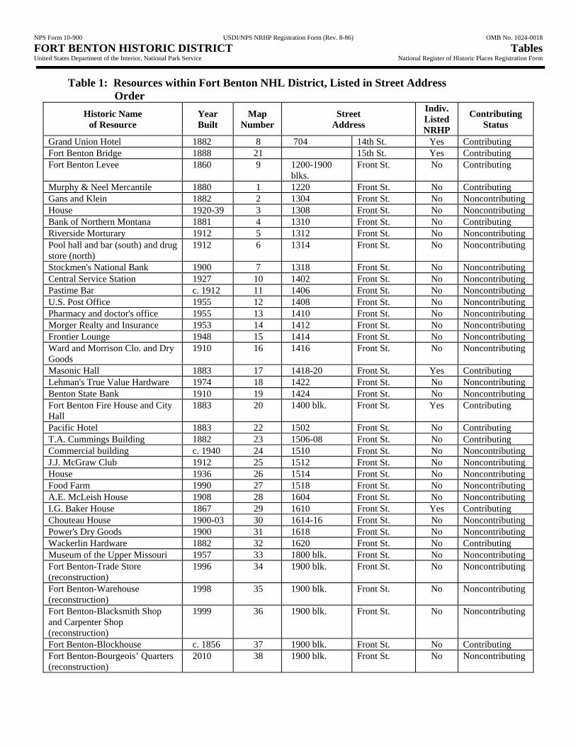
NPS Form 10-900 USDI/NPS NRHP Registration Form (Rev. 8-86) OMB No. 1024-0018 FORT BENTON HISTORIC DISTRICT Tables United States Department of the Interior, National Park Service National Register of Historic Places Registration Form
Table 1: Resources within Fort Benton NHL District, Listed in Street Address Order
Historic Name of Resource
Year Built
Map Number
Street Address
Indiv. Listed NRHP
Contributing Status
Grand Union Hotel 1882 8 704 14th St. Yes Contributing Fort Benton Bridge 1888 21 15th St. Yes Contributing Fort Benton Levee 1860 9 1200-1900
blks. Front St. No Contributing
Murphy & Neel Mercantile 1880 1 1220 Front St. No Contributing Gans and Klein 1882 2 1304 Front St. No Noncontributing House 1920-39 3 1308 Front St. No Noncontributing Bank of Northern Montana 1881 4 1310 Front St. No Contributing Riverside Morturary 1912 5 1312 Front St. No Noncontributing Pool hall and bar (south) and drug store (north)
1912 6 1314 Front St. No Noncontributing
Stockmen's National Bank 1900 7 1318 Front St. No Noncontributing Central Service Station 1927 10 1402 Front St. No Noncontributing Pastime Bar c. 1912 11 1406 Front St. No Noncontributing U.S. Post Office 1955 12 1408 Front St. No Noncontributing Pharmacy and doctor's office 1955 13 1410 Front St. No Noncontributing Morger Realty and Insurance 1953 14 1412 Front St. No Noncontributing Frontier Lounge 1948 15 1414 Front St. No Noncontributing Ward and Morrison Clo. and Dry Goods
1910 16 1416 Front St. No Noncontributing
Masonic Hall 1883 17 1418-20 Front St. Yes Contributing Lehman's True Value Hardware 1974 18 1422 Front St. No Noncontributing Benton State Bank 1910 19 1424 Front St. No Noncontributing Fort Benton Fire House and City Hall
1883 20 1400 blk. Front St. Yes Contributing
Pacific Hotel 1883 22 1502 Front St. No Contributing T.A. Cummings Building 1882 23 1506-08 Front St. No Contributing Commercial building c. 1940 24 1510 Front St. No Noncontributing J.J. McGraw Club 1912 25 1512 Front St. No Noncontributing House 1936 26 1514 Front St. No Noncontributing Food Farm 1990 27 1518 Front St. No Noncontributing A.E. McLeish House 1908 28 1604 Front St. No Noncontributing I.G. Baker House 1867 29 1610 Front St. Yes Contributing Chouteau House 1900-03 30 1614-16 Front St. No Noncontributing Power's Dry Goods 1900 31 1618 Front St. No Noncontributing Wackerlin Hardware 1882 32 1620 Front St. No Contributing Museum of the Upper Missouri 1957 33 1800 blk. Front St. No Noncontributing Fort Benton-Trade Store (reconstruction)
1996 34 1900 blk. Front St. No Noncontributing
Fort Benton-Warehouse (reconstruction)
1998 35 1900 blk. Front St. No Noncontributing
Fort Benton-Blacksmith Shop and Carpenter Shop (reconstruction)
1999 36 1900 blk. Front St. No Noncontributing
Fort Benton-Blockhouse c. 1856 37 1900 blk. Front St. No Contributing Fort Benton-Bourgeois’ Quarters (reconstruction)
2010 38 1900 blk. Front St. No Noncontributing

NPS Form 10-900 USDI/NPS NRHP Registration Form (Rev. 8-86) OMB No. 1024-0018 FORT BENTON HISTORIC DISTRICT Tables United States Department of the Interior, National Park Service National Register of Historic Places Registration Form
Historic Name of Resource
Year Built
Map Number
Street Address
Indiv. Listed NRHP
Contributing Status
Fort Benton-Stockade (reconstruction)
2010 39 1900 blk. Front St. No Noncontributing
Fort Benton-Fort Site 1846 40 1900 blk. Front st. No Contributing A.E. McLeish House Garage 1910-20 41 1604 Front St. No Noncontributing Shep sculpture 1994 42 1400 blk. Front St. No Noncontributing Rider of the Purple Sage sculpture
2003 43 1500 blk. Front St. No Noncontributing
Captain John Mullan obelisk 1917 44 1700 blk. Front St. No Noncontributing “Mandan” keelboat replica 1952 45 1700 blk. Front St. No Noncontributing Lewis and Clark Memorial 1976 46 1700 blk. Front St. No Noncontributing Whoop-up Trail monument 1969 47 1700 blk. Front St. No Noncontributing World War I Doughboy monument
1921 48 18th St. (in park)
No Noncontributing
Fort Benton Centennial Stone 1946 49 Main St. (in park)
No Noncontributing

NPS Form 10-900 USDI/NPS NRHP Registration Form (Rev. 8-86) OMB No. 1024-0018 FORT BENTON HISTORIC DISTRICT Figures United States Department of the Interior, National Park Service National Register of Historic Places Registration Form
Figure 1. General Location Map of Missouri River from St. Louis to Fort Benton. SOURCE: Based on Lass, Map 1, 40.

NPS Form 10-900 USDI/NPS NRHP Registration Form (Rev. 8-86) OMB No. 1024-0018 FORT BENTON HISTORIC DISTRICT Figures United States Department of the Interior, National Park Service National Register of Historic Places Registration Form
Figure 2. By the date of this photograph (1860), the walls and blockhouses of Fort Benton had been replaced with adobe. SOURCE: River and Plains Society website.
Figure 3. Packet companies advertised in communities along the Missouri River and in the East so that passengers could gather for transport. SOURCE: Lepley, Packets to Paradise, 139.

NPS Form 10-900 USDI/NPS NRHP Registration Form (Rev. 8-86) OMB No. 1024-0018 FORT BENTON HISTORIC DISTRICT Figures United States Department of the Interior, National Park Service National Register of Historic Places Registration Form
Figure 4. The steamboat "Ida Rees No. 2" is shown unloading freight at the Fort Benton levee in this c. 1869-71 photograph. SOURCE: Lepley, Packets to Paradise, 40.
0
10
20
30
40
50
60
1860
1861
1862
1863
1864
1865
1866
1867
1868
1869
1870
1871
1872
1873
1874
1875
1876
1877
1878
1879
1880
1881
1882
1883
1884
1885
1886
1887
1888
Years
Ste
amb
oat
Lan
din
gs
Figure 5. Steamboat Landings at Fort Benton, 1860-1890. SOURCE: Lepley, Packets to Paradise, Appendix A. NOTE: Data for “1888” above includes 1889 and 1890.

NPS Form 10-900 USDI/NPS NRHP Registration Form (Rev. 8-86) OMB No. 1024-0018 FORT BENTON HISTORIC DISTRICT Figures United States Department of the Interior, National Park Service National Register of Historic Places Registration Form
0
5000
10000
15000
20000
25000
1860
1861
1862
1863
1864
1865
1866
1867
1868
1869
1870
1871
1872
1873
1874
1875
1876
1877
1878
1879
1880
1881
1882
1883
1884
1885
1886
1887
1888
Years
To
ns
of
Car
go
Upriver Tons Downriver Tons
Figure 6. Total Tons of Cargo Shipped Through Fort Benton by Steamboat, 1860-1890. SOURCE: Lepley, Packets to Paradise, Appendix A. NOTE: Data for “1888” above includes 1889 and 1890.
Figure 7. Freight was unloaded from steamboats onto the mile-long levee at Fort Benton, where it was transshipped to ox and mule trains for carriage to its ultimate destinations. SOURCE: Lepley, Packets to Paradise, 56.

NPS Form 10-900 USDI/NPS NRHP Registration Form (Rev. 8-86) OMB No. 1024-0018 FORT BENTON HISTORIC DISTRICT Figures United States Department of the Interior, National Park Service National Register of Historic Places Registration Form
Figure 8. Bulltrains of oxen carried goods from Fort Benton to gold mining camps, agricultural settlements, and the Canadian West. SOURCE: Lepley, Birthplace of Montana, 40.
Figure 9. Murphy, Neel, & Co. erected this brick mercantile store at Front and 13th streets in 1880. SOURCE: Lepley, Birthplace of Montana, 89.

NPS Form 10-900 USDI/NPS NRHP Registration Form (Rev. 8-86) OMB No. 1024-0018 FORT BENTON HISTORIC DISTRICT Figures United States Department of the Interior, National Park Service National Register of Historic Places Registration Form
Figure 10. The Grand Union Hotel, completed in 1882, was Fort Benton's most elegant hostelry. SOURCE: Montana Agricultural Center, Schwinden Library.
Figure 11. The Pacific Hotel, built by Robert S. Culbertson, opened in 1883. SOURCE: Pacific Hotel, interpretive sign.

NPS Form 10-900 USDI/NPS NRHP Registration Form (Rev. 8-86) OMB No. 1024-0018 FORT BENTON HISTORIC DISTRICT Figures United States Department of the Interior, National Park Service National Register of Historic Places Registration Form
Figure 12. The Wackerlin Hardware Co. building is shown at right, with the Power Dry Goods building and the Chouteau House to the left, in this early twentieth century view. SOURCE: Montana Agricultural Center, photographic collection.

NPS Form 10-900 USDI/NPS NRHP Registration Form (Rev. 8-86) OMB No. 1024-0018 FORT BENTON HISTORIC DISTRICT Figures United States Department of the Interior, National Park Service National Register of Historic Places Registration Form
Table 2 Steamboat Landings, Cargo Tonnage, Passengers, and Buffalo Robes Shipped
Fort Benton, Montana, 1860-1890
Year
Steamboat Landings
Cargo Tonnage Passengers Carried Buffalo Robes
Shipped Fort Benton
Below Up
River Down River
Up River
Down River
1860 1 1 160 225 0 0 20,0001861 0 2 500 250 350 25 18,0001862 4 1 1,300 200 600 50 15,0001863 0 4 1,250 300 500 200 30,0001864 5 3 1,660 250 650 400 20,0001865 13 6 3,700 365 1,850 800 29,0001866 32 13 8,944 350 2,000 1,000 15,0001867 42 16 9,220 600 2,200 2,600 15,0001868 37 10 5,716 350 1,200 800 15,0001869 42 12 6,575 400 700 800 20,0001870 8 0 1,600 250 230 200 30,0001871 6 5 2,150 850 200 300 40,0001872 13 0 2,950 850 400 200 45,0001873 7 1 1,750 600 360 160 50,0001874 7 12 4,100 1,250 400 500 40,0001875 11 3 3,302 2,090 249 190 75,0001876 17 6 4,700 2,300 425 460 80,0001877 25 8 6,150 2,100 1,060 350 55,0001878 54 11 10,180 1,833 1,625 750 75,0001879 42 9 10,711 1,900 1,650 800 30,0001880 46 2 13,000 2,500 1,800 700 25,0001881 35 12 17,420 4,200 1,300 2,800 30,0001882 51 4 12,898 3,000 2,350 1,350 25,0001883 31 2 11,000 1,650 965 400 12,0001884 16 1 4,200 1,500 450 150 3,0001885 15 3 4,800 1,000 200 150 01886 13 4 3,745 950 300 100 01887 33 0 6,550 1,200 200 100 01888-90 8 2 1,300 500 65 25 0
Total 614 153 161,531 33,813 24,279 16,360 812,000
SOURCE: Lepley, Packets to Paradise, Appendix A, 244-46.
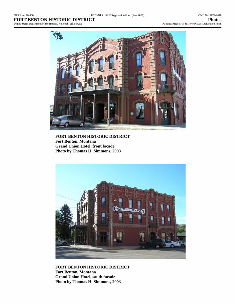
NPS Form 10-900 USDI/NPS NRHP Registration Form (Rev. 8-86) OMB No. 1024-0018 FORT BENTON HISTORIC DISTRICT Photos United States Department of the Interior, National Park Service National Register of Historic Places Registration Form
FORT BENTON HISTORIC DISTRICT Fort Benton, Montana Grand Union Hotel, front facade Photo by Thomas H. Simmons, 2003
FORT BENTON HISTORIC DISTRICT Fort Benton, Montana Grand Union Hotel, south facade Photo by Thomas H. Simmons, 2003

NPS Form 10-900 USDI/NPS NRHP Registration Form (Rev. 8-86) OMB No. 1024-0018 FORT BENTON HISTORIC DISTRICT Photos United States Department of the Interior, National Park Service National Register of Historic Places Registration Form
FORT BENTON HISTORIC DISTRICT Fort Benton, Montana Engine House Photo by Thomas H. Simmons, 2003
FORT BENTON HISTORIC DISTRICT Fort Benton, Montana Bridge Photo by Thomas H. Simmons, 2003

NPS Form 10-900 USDI/NPS NRHP Registration Form (Rev. 8-86) OMB No. 1024-0018 FORT BENTON HISTORIC DISTRICT Photos United States Department of the Interior, National Park Service National Register of Historic Places Registration Form
FORT BENTON HISTORIC DISTRICT Fort Benton, Montana Bank of Northern Montana Photo by Thomas H. Simmons, 2003
FORT BENTON HISTORIC DISTRICT Fort Benton, Montana Pacific Hotel Photo by Thomas H. Simmons, 2003

NPS Form 10-900 USDI/NPS NRHP Registration Form (Rev. 8-86) OMB No. 1024-0018 FORT BENTON HISTORIC DISTRICT Photos United States Department of the Interior, National Park Service National Register of Historic Places Registration Form
FORT BENTON HISTORIC DISTRICT Fort Benton, Montana Wackerlin Hardware (right) and Powers Dry Goods (left) Photo by Thomas H. Simmons, 2003
FORT BENTON HISTORIC DISTRICT Fort Benton, Montana Murphy, Neel and Co. Building Photo by Thomas H. Simmons, 2003
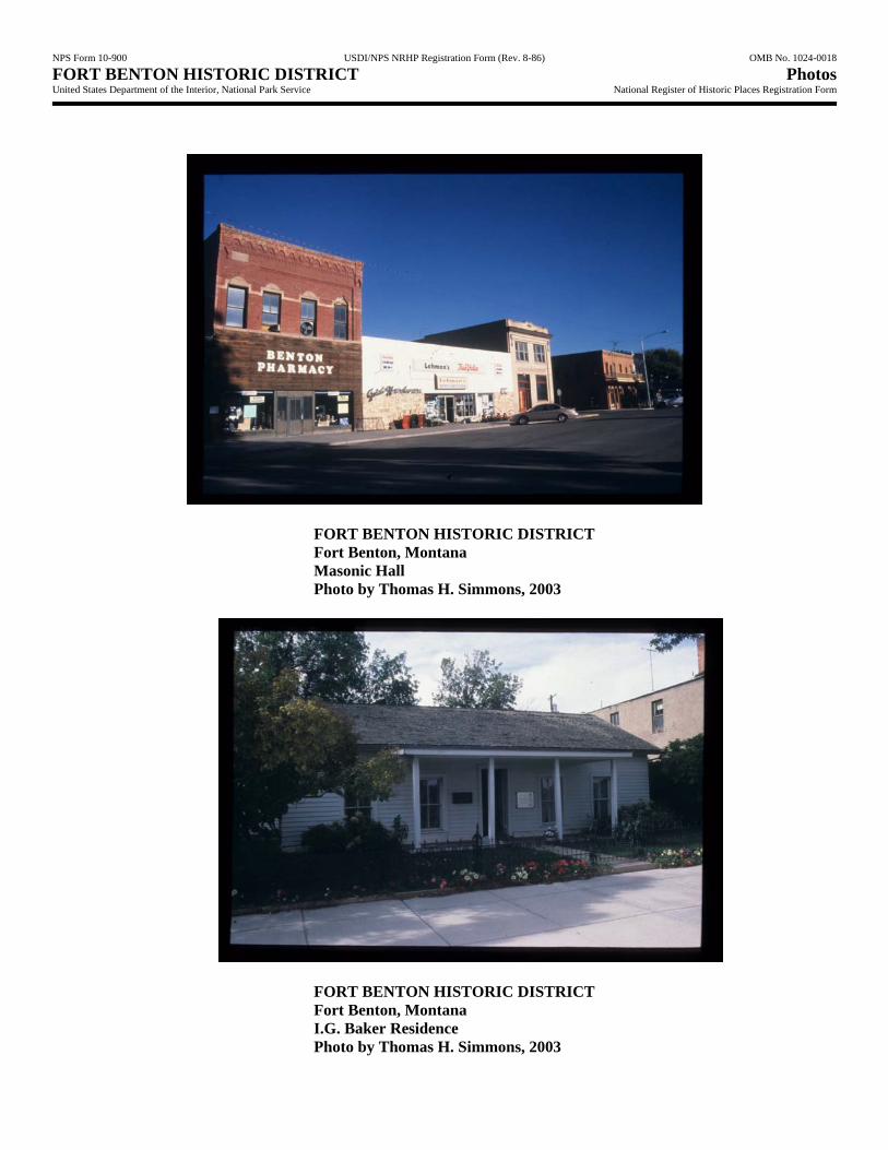
NPS Form 10-900 USDI/NPS NRHP Registration Form (Rev. 8-86) OMB No. 1024-0018 FORT BENTON HISTORIC DISTRICT Photos United States Department of the Interior, National Park Service National Register of Historic Places Registration Form
FORT BENTON HISTORIC DISTRICT Fort Benton, Montana Masonic Hall Photo by Thomas H. Simmons, 2003
FORT BENTON HISTORIC DISTRICT Fort Benton, Montana I.G. Baker Residence Photo by Thomas H. Simmons, 2003

NPS Form 10-900 USDI/NPS NRHP Registration Form (Rev. 8-86) OMB No. 1024-0018 FORT BENTON HISTORIC DISTRICT Photos United States Department of the Interior, National Park Service National Register of Historic Places Registration Form
FORT BENTON HISTORIC DISTRICT Fort Benton, Montana Levee with Grand Union Hotel in center. Modern Bridge on left. Photo by Thomas H. Simmons, 2003
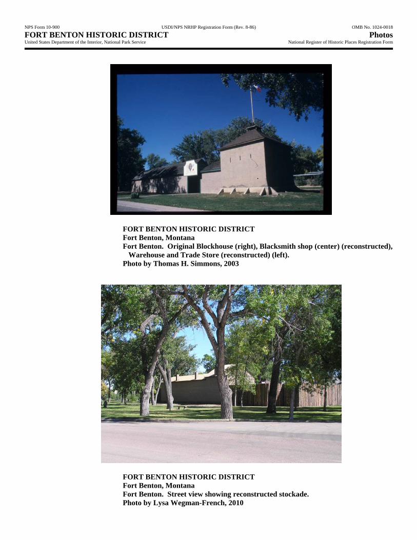
NPS Form 10-900 USDI/NPS NRHP Registration Form (Rev. 8-86) OMB No. 1024-0018 FORT BENTON HISTORIC DISTRICT Photos United States Department of the Interior, National Park Service National Register of Historic Places Registration Form
FORT BENTON HISTORIC DISTRICT Fort Benton, Montana Fort Benton. Original Blockhouse (right), Blacksmith shop (center) (reconstructed), Warehouse and Trade Store (reconstructed) (left). Photo by Thomas H. Simmons, 2003
FORT BENTON HISTORIC DISTRICT Fort Benton, Montana Fort Benton. Street view showing reconstructed stockade. Photo by Lysa Wegman-French, 2010

NPS Form 10-900 USDI/NPS NRHP Registration Form (Rev. 8-86) OMB No. 1024-0018 FORT BENTON HISTORIC DISTRICT Photos United States Department of the Interior, National Park Service National Register of Historic Places Registration Form
FORT BENTON HISTORIC DISTRICT Fort Benton, Montana Fort Benton interior Photo by Thomas H. Simmons, 2003
FORT BENTON HISTORIC DISTRICT Fort Benton, Montana Fort Benton adobe ruins (under protective cover). Photo by Thomas H. Simmons, 2003

��
��
�
�
������������� ����������������
�������������� ��������������������
������������
����������������������������������������������� !"#$���� �����%�&'(������)��*������������ ����$
���� � ���� ����