a symposium on continental drift || the formation of new oceanic crust
TRANSCRIPT
The Formation of New Oceanic CrustAuthor(s): R. W. GirdlerSource: Philosophical Transactions of the Royal Society of London. Series A, Mathematical andPhysical Sciences, Vol. 258, No. 1088, A Symposium on Continental Drift (Oct. 28, 1965), pp.123-136Published by: The Royal SocietyStable URL: http://www.jstor.org/stable/73338 .
Accessed: 08/05/2014 06:36
Your use of the JSTOR archive indicates your acceptance of the Terms & Conditions of Use, available at .http://www.jstor.org/page/info/about/policies/terms.jsp
.JSTOR is a not-for-profit service that helps scholars, researchers, and students discover, use, and build upon a wide range ofcontent in a trusted digital archive. We use information technology and tools to increase productivity and facilitate new formsof scholarship. For more information about JSTOR, please contact [email protected].
.
The Royal Society is collaborating with JSTOR to digitize, preserve and extend access to PhilosophicalTransactions of the Royal Society of London. Series A, Mathematical and Physical Sciences.
http://www.jstor.org
This content downloaded from 169.229.32.137 on Thu, 8 May 2014 06:36:01 AMAll use subject to JSTOR Terms and Conditions

[ 123 ]
XI. The formation of new oceanic crust
BY R. W. GIRDLER
Department of Physics, The University, Newcastle upon Tyne
'Now would I give a thousand furlongs of sea for an acre of barren ground' W. SHAKESPEARE, The Tempest, Act 1, Sc. 1
Seismic exploration at sea has established that the oceanic crust is completely different from that of the continents. If we accept continental drift, it is therefore necessary to invoke a mechanism for the evolution of new oceanic crust.
An attempt is made to locate regions where new oceanic crust may be forming and it is suggested that these regions are related to regions of uprising convection in the mantle.
The crustal structures beneath the Red Sea and the Gulf of California are very similar and closer to oceanic than continental. As these are seismically active regions of extension, it seems reasonable to suppose that they represent areas where new oceanic crust is evolving in regions of continental break-up. These rift zones are in continuity with the seismically active oceanic rifts where similar seismic velocities (about 7 km/s) have been found and it is inferred that the oceanic rifts also represent regions where new oceanic crust is evolving. These are generally near the centres of the oceans.
The tensional rift zones which are regions of shallow seismicity help to locate regions of rising convection currents in the mantle. It is further suggested that regions of deep and intermediate focus earthquakes locate regions of descending convection currents and maps of earthquake distributions are used to reveal a possible large-scale pattern of mantle convection.
It is supposed that new oceanic crust evolves over the rising convection currents. A study is therefore made of the crustal sections for the Red Sea, Gulf of California and mid-oceanic rift regions and these are compared with typical continental and oceanic crusts. A possible mechanism for the evolution of new oceanic crust is given based on the isostatic equilibrium of oceans and continents.
1. INTRODUCTION
Over the last 15 years seismic refraction work at sea has confirmed the predictions of sea gravity observations that the oceanic crust is completely different from. the continental crust. If we accept the evidence for continental drift, it is necessary not only to think of a mechanism for moving the continents but also a mechanism for the formation of new oceanic crust.
The large movements along transcurrent faults (sometimes of the order of 103 km) as well as the palaeomagnetic evidence for continental drift provide powerful reasons for supposing horizontal motions in the upper mantle and this leads to supposing the existence of subcrustal convection currents. The most likely regions where new oceanic crust may be forming are regions of extension such as the rifts. These regions could be a consequence of rising, diverging convection currents. A study of such regions, which include the Red Sea and Gulf of California, gives us a clue as to how new oceanic crust may be forming in areas of recent continental break-up.
16-2
This content downloaded from 169.229.32.137 on Thu, 8 May 2014 06:36:01 AMAll use subject to JSTOR Terms and Conditions

124 R. W. GIRDLER
2. THE LOCATION OF POSSIBLE REGIONS OF RISING AND
DESCENDING MANTLE CONVECTION CURRENTS
It has been suggested (see, for example, Holmes I928; Runcorn I962) that large mantle convection currents are required to move the continents. If these exist, it is important to try to establish criteria for locating the rising and descending currents.
In 1954, Hess suggested that the mid-Atlantic rift and ridge might be explained by the presence of a rising, diverging mantle convection current. Menard (I960) uses a rising convection current to explain the East Pacific Rise, and Girdler (I962) suggested the Red Sea and Gulf of Aden fault troughs are consequences of rising convection. These regions are parts of the world rift system (figure 1) and it seemed reasonable to suggest (Girdler I962) that the rift valleys and seismically active ocean rises are the loci of uprising con- vection currents. It now seems more likely that the rifts are a consequence of regions of upwelling mantle convection and the world-wide rift system connects these regions of upwelling.
It is also important to the hypothesis of convection to establish a criterion for locating descending convection currents. It has long been suggested (see, for example, Holmes 1928, I933; Hess I938; Griggs I939) that some of the mountain ranges are due to compres- sional forces associated with converging convection currents and Vening Meinesz (I934, 1948) has suggested that the island arcs are due to down-warping associated with con- vection. These regions are associated with intermediate and deep focus earthquakes. The distribution of intermediate (70 to 300 km) and deep (greater than 300 km) earthquakes are therefore also plotted in figure 1 as semi-quantitative criteria for locating regions of descending mantle convection.
It is seen from figure 1 that the regions of deep and intermediate focus earthquakes are usually situated approximately midway between various branches of the rifts. The rifts are almost entirely confined to the ocean floor except for a few places where they intersect the landmasses such as the Afro-Arabian continent and the west coast of North America. In the northern hemisphere the deep focus earthquakes are found around Japan, the Philippines, the Mediterranean and Central America. In the southern hemisphere the deep focus earthquakes occur beneath the Andes, the Scotia arc, the Tonga trench and the East Indies. The intermediate focus earthquakes occur in proximity to the deep focus earthquakes, usually extending over much wider areas. Intermediate focus earthquakes also occur beneath the northern shore of the Persian Gulf and beneath the Himalayas.
The maps of figure 1 may be used to locate possible regions of uprising and descending convection currents in the mantle. These regions are shown in figure 2. Apart from the evidence for extension and compression associated with the two diverse types of region it is reasonable to expect shallow seismicity over the warmer, rising convection currents and deeper seismicity associated with the cooler, descending currents. From isostasy, we know that the upper mantle yields plastically at about 100 km depth and it is reasonable that the depth to this plastic zone will be less over the higher temperature regions (the ascending currents) and deeper over the lower temperature regions (the descending currents). In the latter case the situation is complicated by thrusting and associated volcanism which is often found near the continental margins (see, for example, Benioff I949, I954).
This content downloaded from 169.229.32.137 on Thu, 8 May 2014 06:36:01 AMAll use subject to JSTOR Terms and Conditions

SYMPOSIUM ON CONTINENTAL DRIFT 125
180 0
@0
90 <90 W_ <? 90
0SO
FIGURE 1. The distribution of the world rift system (shallow seismicity) together with the distribution of intermediate (e) and deep focus (v) earthquakes.
140 100 60 20 20 60 100 140 180
0~ ~ ~ ~ ~~~~~~~2
20 / ~~~~~~~~%7~~~~~O 20~~0
160 120 80 40 0 40 80 120 160 FIGURE 2. The location of possible regions of upwelling and downwelling mantle convection (arrows).
-, zone of shallow earthquakes associated with rifting; 0, intermediate focus earthquakes; v, deep focus earthquakes.
This content downloaded from 169.229.32.137 on Thu, 8 May 2014 06:36:01 AMAll use subject to JSTOR Terms and Conditions

126 R. W. GIRDLER
Runcorn (I963) has shown that there is a reasonable correlation between the location of the oceanic rifts and the satellite gravity data. It is to be expected that the higher tempera- ture and therefore less dense regions will be associated with negative gravity anomalies and the lower temperature, more dense regions will be associated with positive anomalies. At present the correlation is very rough and it is hoped that figure 2 will be useful for comparison with future satellite gravity maps.
3. FEATURES ASSOCIATED WITH REGIONS OF DESCENDING MANTLE CONVECTION
The regions of possible descending mantle convection located from deep and inter- mediate focus earthquakes (figure 2) are all regions associated with characteristic geo- logical structures. These are island arcs, deep sea trenches, wrench faults and shear zones, volcanism, geosynclines and fold mountains.
The gravity anomalies over many of these areas reveal large deviations from isostatic equilibrium (see, for example, Vening Meinesz 1934) and it is clear that compressional forces are required to maintain these deviations. This is in contrast to regions of extension such as the Red Sea where the gravity anomalies show that isostatic equilibrium of the crust is largely maintained (Girdler 1958).
Some outstanding examples of deviations from isostatic equilibrium are found in the island arc areas such as the East Indies, West Indies and Scotia Sea. The pioneering work of Vening Meinesz in the East Indies revealed a belt of strong negative gravity anomalies, 100 to 200 km wide with weak positive anomalies on either side. After topographic and isostatic corrections for T 30 km and R = 174-3 km, the total amplitude of the anomalies is of the order of 200 mgal. Most of this anomaly can be shown to be due to a downbuckling of the crust (Vening Meinesz 1934) and such large deviations from isostatic equilibrium are explained by strong horizontal compression. This is consistent with the geology of the nearby islands which shows evidence of folding and overthrusting. There is evidence that the process has been operating since the Upper Miocene and the present- day seismicity indicates that it is still continuing.
The topographic features associated with the above gravity anomalies and crustal down- buckling are the deep sea trenches. These are the deepest parts of the oceans ranging in depth from 6-7 km (Central America trench) to 11 km (Challenger Deep). Vening Meinesz distinguishes between two types of trenches: the central trenches with isostatic anomalies ranging from -130 to - 200 mgal and the wing trenches with smaller anomalies of -50 mgal. Both gravity and seismic results show that the crust bends downwards as the trenches are approached and this is considered evidence for compressive stresses. Low values of heat-flow have been found near the Central America trench (Bullard, Maxwell & Revelle 1956), the Peru-Chile trench (Von Herzen & Uyeda I963) and the Japan trenclh (Uyeda, Horai, Yasui & Akamatsu i962). A recent review of the deep-sea trenches has been given by Fisher & Hess (I963).
Trowards the ends of the island arcs the seismicity becomes less deep (figure 2) and the compressive stresses seem to be weaker. Examples are Sumatra, East Philippines and south-east Seram. The smaller gravity anomalies (-50 mgal) over these trenches can be shown to be due to the trenches themselves and Vening Meinesz (1948, 1963) cites evidence
This content downloaded from 169.229.32.137 on Thu, 8 May 2014 06:36:01 AMAll use subject to JSTOR Terms and Conditions
SYMPOSIUM ON CONTINENTAL DRIFT 127
of transcurrent movements. It is likely that such trenches can originate due to shear as well as crustal downbuckling.
The island arcs are also associated with volcanism and for the East Indies the volcanoes occur approximately 200 km from the inner side of the structural arc. They frequently occur in straight lines and are probably associated with wrench faults.
Further tectonic features associated with regions of descending convection are the geo- synclinal and fold mountain regions such as the Mediterranean, the Alps, Himalayas and the Andes (figure 2). The evolution of geosynclines and fold mountains have been fully discussed by Griggs (I939). Horizontal compression is thought to lead to plastic thickening of the crust and the associated downbuckling gives rise to a geosynclinle. If the down- buckled area is a region of sedimentation the infilling eventually becomes folded, uplifted and overthrust. The crustal shortening in the Alps is thought to be 200 to 300 km. The island arcs and trenches possibly represent early stages in the evolution of a geosyncline whilst the Himalayas which now have relatively little deep seismicity probably represent the final stage. The Andes and associated deep-sea trench might be an intermediate stage. The whole process seems to take approximately 50 million years.
All the structures are features compatible with regions of descending mantle convection. An especially interesting region is the western part of North America which was a geo- synclinal region in the late Mesozoic and now has no deep seismicity and seems to be a region of extension as evidenced by the Gulf of California and Basin and Range structure. This seems to provide strong evidence for a change of the mantle convection pattern during the last 50 million years (Girdler I962).
4. FEATURES ASSOCIATED WITH REGIONS OF RISING MANTLE CONVECTION
As the rift valleys are tensional features, it is likely that the world rift system (figures 1 and 2) may be a consequence of regions of rising, diverging mantle convection. In the ocean floor, the rift is usually associated with a broad ridge or rise. A rift valley has not always been found (e.g. the East Pacific Rise) although shallow seismicity seems invari- ably to be present and suggests there is some kind of fracture zone. The rift system is usually located from the occurrence of shallow seismicity, topography, associated magnetic anomalies and high heat-flow. Where the rift system intersects the continents such as Afro-Arabia and the west coast of North America, wide fault troughs are the characteristic features (e.g. the Gulfs of Aden and California).
Transcurrent movement is also known to occur along parts of the world rift system. Spectacular examples are the San Andreas fault of California, the Dead Sea rift ofJordan and the Alpine fault of South Island, New Zealand. It is possible that these occur at the margins of regions of upwelling convection.
A further feature is the presence of transcurrent faults which offset the rifts themselves. Examples of these are the displacements of the Mid-Atlantic Rift in equatorial regions (Heezen & Tharp I96I). It is possible that transcurrent faults of a similar nlature include those found off the coast of California (Vacquier 1962) .
In the land areas, the rifts are associated with high plateaux. Examples are the Western United States (including the Colorado Plateau), the African and Arabian Plateaux and
This content downloaded from 169.229.32.137 on Thu, 8 May 2014 06:36:01 AMAll use subject to JSTOR Terms and Conditions
128 R. W. GIRDLER
the Vitim Plateau (Lake Baikal area) of Siberia. All are regions of block faulting, an out- standing example being the 'Basin and Range' area of the Western United States. These are regions of extension and uplift. If the extension is sufficient, vulcanism occurs along the fault planes. The vulcanism is usually basaltic, some of the lavas being rich in alkalis. It is likely that the amount of vulcanism is directly related to the degree of extension.
Sometimes the extension is sufficient for a complete crustal separation. Examples are the Red Sea and Gulf of Aden and the Gulf of California. Such regions are especially interesting in relation to possible mechanisms for continental drift.
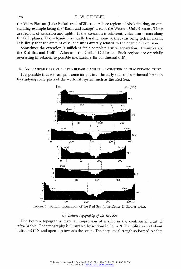
5. AN EXAMPLE OF CONTINENTAL BREAKUP AND THE EVOLUTION OF NEW OCEANIC CRUST
It is possible that we can gain some insight into the early stages of continental breakup by studying some parts of the world rift system such as the Red Sea.
km lat. (?N) shore shore
0
-1 2435
-2
0 / 160 200 \ 300
shore shore 0 -1 __ ~~~~~~~~~~~~~~~22-0
-2 X1 0 36 400 +1 shj shorej
1 __21 Q
-2 0 i6o 0 206o 300
t I I
shore X I shore 0
-1 _ _ 1 8 5
-2 0 /1001 20'0 3 6000
1 1 h , shore _ _ _ 1 6~~~~~~~~~~~~~~~~~~~~~~~65
-1-~~~~~~~~~~~~~~~~~~~2-
1 __-
0 100 200 300 400 km
FIGURE 3. Bottom topography of the Red Sea (after Drake & Girdler i964).
(i) Bottom topography of the Red Sea The bottom topography gives an impression of a split in the continental crust of
Afro-Arabia. The topography is illustrated by sections in figure 3. The split starts at about latitude 24? N and opens up towards the south. The deep, axial trough so formed reaches
This content downloaded from 169.229.32.137 on Thu, 8 May 2014 06:36:01 AMAll use subject to JSTOR Terms and Conditions

SYMPOSIUM ON CONTINENTAL DRIFT 129
depths greater than 2 km and widths of the order of 60 km. The deep trough is obscured in the south by associated volcanism and the build-up of evaporite deposits and coral reefs.
(ii) Gravity and magnetic anomalies over the Red Sea
The Bouguer gravity anomalies over the Red Sea are strongly positive. As early as 1901, von Triulzi produced a gravity map for the Red Sea showing anomalies reaching more than + 140 mgal. The largest anomalies occur over the deepest parts of the axial trough. Interpretation of the gravity anomalies (Girdler I958) reveals that the crust beneath the axial trough is of higher density and more oceanic in character than continental.
+z 500r 0
I- a I?- <_v_ ? o 500-.O
+100 -
(- +50
0
-50
km 2t
1 shore so
-1
0 100 200 300 400 km
FIGURE 4. Gravity and magnetic profiles for the Red Sea at latitude 16? N (after Drake & Girdler I964).
The deep, axial trough is also characterized by large total intensity magnetic anomalies (Drake, Girdler & Landisman 1959). The anomalies have amplitudes of the order of 1200 y and are clearly associated with a series of dykes just beneath the deep, axial trough (Drake & Girdler I964). The natures of the gravity and magnetic anomalies are illustrated in figure 4.
(iii) Seismic evidence for the nature of the crust beneath the Red Sea
Seismic refraction measurements in the Red Sea by Dr C. L. Drake in 1958 showed the presence of high velocity material (7.08 ?0+21 km/s) at shallow depths (3 7 to 7 2 kin) beneath the axial trough. The shelves are underlain by material with velocity of 5v92 L
0 24 km/s-a velocity appropriate for downfaulted rocks of the Arabian-Nubian Shield. The two contrasting sections are illustrated in table 1.
' 7 VOL. 258. A.
This content downloaded from 169.229.32.137 on Thu, 8 May 2014 06:36:01 AMAll use subject to JSTOR Terms and Conditions

130 R. W. GIRDLER
TABLE 1. SEISMIC REFRACTION RESULTS ILLUSTRATING THE DIFFERENT CRUSTAL STRUCTURES
BENEATH THE RED SEA AXIAL TROUGH AND SHELVES
velocity density thickness pressure (km/s) (g/cm3) (km) (102 Kg/Cm2)
Red Sea centre water 1P54 141 132 1'45 sediments 3 00 2-2 0)86 19() ? lava and sediment 4-25 2-4 3412 7-48 basic intrusive zone 7-08 3-0 29 70 87-91
35 00 98*74 Red Sea shelves
water 1P54 1.1 0-28 0 30 loose sediments 1P85 P-8 0414 0-26 ? coral reefs 2-62 241 0-66 1'39 evaporites 3-73 2-3 2'85 655 shield and 589 2-8 13-57 38-00 continental crust 3 0 17'50 52-50
35-00 99*00
1,
(d)~~~~~~~~~~~~b AQABA SUE A/S
\SA
FIGURE S. 'Ihe formuation of the Red Sea by extenlsion. The hatchled areas in (b) represent the regions of quasi-oceanic crulst.
This~~ is ilutae/nfgr/heetecutlscini cmae ihtesadr
sectionsN fo ocasadcoInn
This content downloaded from 169.229.32.137 on Thu, 8 May 2014 06:36:01 AMAll use subject to JSTOR Terms and Conditions

SYMPOSIUM ON CONTINENTAL DRIFT 131
(iv) Areal extent of new oceanic crust
There is now considerable geophysical evidence to suggest that the Red Sea and Gulf of Aden represent a splitting of the continental crust of Africa and Arabia (figure 5 (a)) with the formation of regions of 'quasi-oceanic crust' in between. The extent of these regions may be determined from studies of the topography and magnetic anomalies. Over the shelves, the magnetic anomalies are comparatively small whilst over the deep, axial trough the anomalies are large. These regions of large magnetic anomalies are shown by the shaded areas in figure 5 (b). The regions widen towards the south in the Red Sea and towards the east in the Gulf of Aden.
6. COMPARISON OF REGIONS OF NEW OCEANIC CRUST
The fact that the Red Sea and Gulf of Aden forms part of a continuous belt of world- wide shallow seismicity leads to the possibility that new oceanic crust may be forming along this zone.
?N r . ON~~~~~~........... ................;
.............
40,
30 :::. .
v~~~~~~K I \ 0 - --.- ... 0...
20
125 115- 105 : :
FIGURE 6. The approximate extent of the quasi-oceanic crust beneath the Gulf of California.
masses.~~~~~~~ These ar th Gul of Caiori an nea th mot of th Ri XXXXve Len in northern
the RedSeaI(see for exmpe, arprioniat &xen Mathur 1964).in-theai cenreuofthesuhr
This content downloaded from 169.229.32.137 on Thu, 8 May 2014 06:36:01 AMAll use subject to JSTOR Terms and Conditions

132 R. W. GIRDLER
two-thirds of the Gulf, there is a positive Bouguer anomaly which falls to zero on both sides as the shores are approached. As in the Red Sea, the anomaly is over the deep water and indicates the presence of oceanic crust beneath the sea bottom. The approximate extent of this oceanic type crust is shown by the shaded area in figure 6, and seems directly comparable to the shaded areas of figure 5 (b). To the north, the Gulf of California becomes associated with the San Andreas fault similar to the association of the Red Sea with Aqaba and the transcurrent faulting of the Dead Sea area (figure 5 (b)).
o~ ~ ~~~~ ~ ~ ~ ~~ ~ ~~ ~ ~~ .Q Q 0
4|.
0 0
2;5 ~ ~ ~ ~ ~ ~ ~~2
41 428 0
J 7~~276195541 5
FIGURE 7.. 6ompriso-7ofcrusal sctios fr th cenre o theRed ea afte Drae etal. 959) th 7-2~~~~~~~~~~.
J f
10-~ ~ ~ ~ ~ ~ ~ ~ ~ ~ ~ ~~~~~~~8
Vp(kmn /s)
8- .1 1
FIGURE 7. Comparison of crustal sections for the centre of the Red Sea (after Drake et al. I959), the mid-Atlantic ridge (after Ewing & Ewing 1959), the East Pacific Rise (after Raitt 1956), and the centre of the Gulf of California (after Phillips I964) with standard sections for continents and oceans.
The similarity of the Gulf of California to the Gulf of Aden and Red Sea further leads one to suspect that the whole of the seismically active rift zone may be a region where new oceanic crust may be forming. This is supported by the seismic sections which are available for various parts of the seismically active zone. Four of these are compared with standard sections for the continental and oceanic crusts in figure 7.
For seismically active regions between the continents, and in the ocean floor the deeper velocities are similar. In all cases high velocity material (7.1 to 7-7 km/s) is found. It appears that these regions may represent various stages towards the formation of normal oceanic crust.
This content downloaded from 169.229.32.137 on Thu, 8 May 2014 06:36:01 AMAll use subject to JSTOR Terms and Conditions

SYMPOSIUM ON CONTINENTAL DRIFT 133
7. MECHANISM FOR THE EVOLUTION OF NEW OCEANIC CRUST
The geophysical evidence suggests that the evolution of new oceanic crust is related to the evolution of the world rift system. The rifts are associated with normal and transcurrent faulting and are therefore regions of extension and shear. In continental areas the nature of the rift depends on the amount of extension and the ratio of the tensional and shear stress components. In the East African rifts, the amount of extension is small compared with the Red Sea. The rift faults in Africa are often linear for long distances suggesting an appreci- able shear component. This is supported by the analysis of seismic records for first motions
FIGURE 8. The formation of a simple rift valley due to a relative small amount of extension of the crust. A considerable transcurrent motion may also occur.
FIGURE 9. The formation of the Red Sea structure due to a relatively large amount of extension of the crust.
along fault planes for the Western rift (Sutton & Berg 1958; de Bremaecker 1959). Both transcurrent and normal components were found. The type of relation for the stress components for a simple rift valley is shown in figure 8.
In the Red Sea, the tensional stresses have been large enough to cause a separation of the continental crust (figure 9). This has resulted in the formation of a small region of deep water along the centre whiich is underlain by heavy, oceanic crust. There is some evidence that the separation was accompanied by marginal step-faulting of the continental crust.
The possible stages in the formation of the Red Sea are shown in figure 10. A crack occurred in the continental crust (stage 1 and figure 5 (a)) and the tensional stresses were large enough to cause a crustal separation. Frhis resulted in the intrusion of heavy, possibly basaltic magma (Girdler 1963 b), into a series of wide dykes in the fracture zone (stage 2) until hydrostatic equilibrium was attained. The tearing of the crust and subsurface movements also caused some marginal faulting (stage 3 and figure 5 (b)).
This content downloaded from 169.229.32.137 on Thu, 8 May 2014 06:36:01 AMAll use subject to JSTOR Terms and Conditions

1,34 R. W. GIRDLER
This mechanism implies that there should be considerable freedom for the celntre and shelves to reach isostatic equilibrium. The positive Bouguer anomalies over the deep water indicate that the deep trough is in approximate equilibrium. A further test is to see if the condition const
is satisfied for the shelves and deep trough. In table 1, the thicknesses (xi) are given and the densities (pi) have been obtained from the Nafe-Drake curve which gives an empirical relation between densities and seismic velocities. It is seen that the pressures for a total depth of 35 km are equal and equilibrium has been achieved.
(1)
(2)
(3)
FIGURE 10. A possible mechanism for the formation of the Red Sea structure and crustal separation. It is considered that the tensional stresses are a consequence of a region of rising mantle convection.
Approximate achievement of isostatic equilibrium is probably a characteristic feature of the rift system, as fault blocks associated with extension should be free to reach isostatic adjustment. In the ocean floor the density of the extruded lava is low with respect.to the oceanic crust and hence rises such as the Mid-Atlantic Ridge and East Pacific Rise are built up (figure 7). Where the fracture zone occurs between continents the density of the igneous material is high with respect to the continental crust resulting in a deep rift such as the centres of the Red Sea, Gulfs of Aden and California and possibly Lake Baikal.
The presence of these regions of tension require horizontal stresses in the upper inantle such as might be associated with diverging mantle convection currents (figure 10). rrlle evidence for different degrees of extension of the crust and the occurrence of transcurrent fault motions along the rift system leads to the suspicion that the rifts are a consequence of regions of upwelling mantle convection. Extension would be at a maximum over the centres of these regions anld transcurrent and shear stresses would develop near the margins. It seems likely, for example, that regions of upwelling exist under the south- eastern Pacific and under the Indian Ocean. The transcurrent motions associated with these would be along the San Andreas fault of California and along the Dead Sea and
This content downloaded from 169.229.32.137 on Thu, 8 May 2014 06:36:01 AMAll use subject to JSTOR Terms and Conditions

SYMPOSIUM ON CONTINENTAL DRIFT 135
East African rifts. Possible regions of upwelling are tentatively shown by the diverging arrows in figure 2. It is felt that the world-rift system is a consequence of and links these regions of upwelling which might be roughly elliptical in cross-section. In this way, we have a concept which explains the transcurrent motions along the rifts and also explains the extension required to give rise to new oceanic crust along various parts of the oceanic rifts and along the centres of the Red Sea and Gulf of California.
8. CONCLUSIONS
The hypothesis of mantle convection currents is favoured for the breakup and movement of the continents and a mechanism is given for the evolution of new oceanic crust. The following suggestions are made:
(i) The convective motion in the mantle is in the form of a series of 'sinks' and 'rises' rather than cylindrical cells. This implies relatively small regions of pure extension and compression and large areas of the Earth's surface where shear stresses are dominant between the regions of rising and falling convection. This is supported by the fault plane solutions of earthquakes which indicate that for the whole world, normal and thrust motions are approximately equal and 70 % of all motions are transcurrent (see, for example, Scheidegger I959; Hodgson I962).
(ii) The regions of converging convection are located from the distribution of deep and intermediate focus earthquakes.
(iii) The regions of rising, diverging currents are associated with shallow seismicity. (iv) The regions of falling, converging convection give rise to such surface features as
island areas, deep-sea trenches, geosynclines, fold mountains and thrusts. (v) The regions of rising, diverging convection give rise to the world rift system, high
plateaux, block faulting and crustal separation. (vi) Transcurrent faults and shear zones are associated with the margins of regions of
both uprising and descending convection. (vii) Isostatic equilibrium is usually attained over the uprising currents but large
deviations from isostatic equilibrium are observed over the descending currents. (viii) New regions of upwelling mantle convection sometimes occur under or near the
continents giving rise to rift valleys and crustal separation depending on the degree of extension.
(ix) Examples of regions of new oceanic crust are found beneath the Red Sea, Gulfs of Aden and California. These are in continuity with the seismically active oceanic rift zones and it is likely that new crust is forming along the whole belt of shallow seismicity.
(x) The formation of the new oceanic crust is in accord with the principle of isostatic equilibrium, the tensional zones allowing free movement of crustal blocks.
(xi) The changeover in structure from geosynclinal to block faulting in the soutlhwestern United States indicates that there has been a change in the mantle convection pattern in the last 50 million years.
I amn inldebted to various members of the Oxford University Geological Society for suggesting after a lecture in February 1963 that I should try to relate the world rift system anld rising convection currents to regions of descending mantle convection. This
This content downloaded from 169.229.32.137 on Thu, 8 May 2014 06:36:01 AMAll use subject to JSTOR Terms and Conditions

136 R. W. GIRDLER
resulted in the plotting of deep and intermediate focus earthquakes and the recognition that roughly elliptical regions of upwelling and downwelling mantle convection are more likely. I also wish to thank Dr Charles Drake, Dr Bruce Heezen and Professor S. K. Runcorn for many stimulating discussions.
REFERENCES (Girdler)
Benioff, H. 1949 Bull. Geol. Soc. Amer. 60, 1837-1866. Benioff, H. 1954 Bull. Geol. Soc. Amer. 65, 385-400. Bullard, E. C., Maxwell, A. E. & Revelle, R. R. I956 Advanc. Geophys. 3, 153-181. de Bremaecker, J. C. I959 J. Geophys. Res. 64, 1961-1966. Drake, C. L. & Girdler, R. W. I964 Geophys. J. R. Astron. Soc. 8. Drake, C. L., Girdler, R. W. & Landisman, M. 1959 Reprints Int. Oceanographic Congr. p. 21. Ewi:ng, J. & Ewing, M. 1959 Bull. Geol. Soc. Amer. 70, 291-318. Fisher, R. L. & Hess, H. H. i963 The sea, vol. in, chap. 17 (ed. M. N. Hill). New York: Interscience. Girdler, R. W. 1958 Quart. J. Geol. Soc. Lond. 114, 79-105. Girdler, R. W. I962 Nature, Lond,, 94, 521-524. Girdler, R. W. I963 a Nature, Lond., 198, 1037-1039. Girdler, R. W. i963 b Bull. Volcanol. 26, 37-47. Girdler, R. W. I963c Phys. and Chem. Earth, 5, 122-156. Griggs, D. I939 Amer. J. Sci. 237, 611-650. Harrison, J. C. & Mathur, S. P. I964 Marine geology, Gulf of Califbrnia (ed. Van Endel & Shor).
A.A.P.G. Mem. no. 3, pp. 76-89. Heezen, B. C. & Tharp, M. I96I Physiographic map of the South Atlantic, the Caribbean, the Scotia Sea,
and the East Mfargin of the South Pacific Basin. Published by Geol. Soc. Amer. N.Y. Hess, H. H. 1938 Proc. Amer. Phil. Soc. 79, 71-96. Hess, H. H. 1954 Proc. Roy. Soc. A, 222, 341-348. Hodgson, J. H. I962 Continental drift, chap. 3 (ed. S. K. Runcorn). New York & London: Academic
Press. Holmes, A. i928 Trans. Geol. Soc. Glasgow, 28, 559-606. Holmes, A. 1933 J. Wash. Acad. Sci. 23, 169-195. Menard, H. W. I960 Science, 132, 1737-1746. Phillips, R. P. I964 AMarine geology, Gulf of California (ed. Van Endel & Shor). A.A.P.G. Mem. no. 3. Raitt, R. W. 1956 Bull. Geol. Soc. Amer. 67, 1623-1640. Runcorn, S. K. I962 Nature, Lond., 193, 311-314. Runcorn, S. K. I963 Nature, Lond., 200, 628-630. - Scheidegger, A. E. 1959 Bull. Soc. Seism. Amer. 49, 337-347. Sutton, G. H. & Berg, E. 1958 Trans. Amer. Geophys. Un. 39, 474-481. Uyeda, S., Horai, K., Yasui, M. & Akamatsu, H. I962 Oceanogr. Mag. 13, 185-189. Vacquier, V. I962 Continental drift, chap. 5 (ed. S. K. Runcorn). New York & London: Academic
Press. Vening Meinesz, F. A. 1948 Gravity expeditions at sea, vol. iv, Netherlands Geodetic Commission,
Waltman, Delft. Vening Meinesz, F. A. I963 Proc. Acad. Sci. Amst. B 66, 55-63. Vening Meinesz, F. A., Umbgrove, J. H. F. & Kuenen, Ph. H. 1934 Gravity expeditions at sea,
1923-1932, vol. II, Netherlands Geodetic Commission, Waltman, Delft. Von Herzen, R. P. & Uyeda, S. I963 J. Geophys. Res. 68, 4219-4250. Von Triulzi, A. E. I9OI Denkschr. K. Akad. Wiss. Math-Nat. Classe, 69, 143-219.
This content downloaded from 169.229.32.137 on Thu, 8 May 2014 06:36:01 AMAll use subject to JSTOR Terms and Conditions