a summary of nfip policy for local officials - oregon new fema preliminary ... ao zones –...
TRANSCRIPT

NATIONAL FLOOD INSURANCE PROGRAM
A Summary of NFIP Policy for
Local Officials
A Guide to Assist Local Governments in their
Floodplain Management Programs
11
FEMA Region 10 Mitigation Division
July 2001 (Updated January 2004)
Table of Contents
NATIONAL FLOOD INSURANCE PROGRAM
A Summary of NFIP Policy For
Local Officials
A Guide to Assist Local Governments in their
Floodplain Management Programs
Report Prepared by Chuck Steele,
Chaz & Associates
for Federal Emergency Management Agency
FEMA Region 10 June 30, 2001
(Updated January 2004)

A SUMMARY OF NFIP POLICY for
LOCAL OFFICIALS
Table of Contents
I. INTRODUCTION Purpose of this Document……………………………………………………………. 1 Background of the NFIP……………………………………………………………… 3
II. POLICY SUMMARY by NFIP REGULATIONS FEMA Model Ordinances……………………………………………………………. 7 Format Used in the Report…………………………………………………………… 8 Not All Regulations are Alike………………………………………………………… 9 Note to Readers……………………………………………………………………….. 9 60.3[a][1]: Permit Required for All Structures and Other Development…………. 9
The permit requirement with additional data……………………………………….. 9 Basic permit requirement…………………………………………………………… 10 Storage of equipment or materials added to definition…………………………….. 10 Type of permit………………………………………………………………………. 10 When and when not to require a permit…………………………………………….. 11 Permit issuance vs. start of construction……………………………………………. 11 Permit required for less than substantial improvements……………………………. 12 Must Federal agencies obtain local floodplain permits?……………………………. 12
60.3[a][2]: Permits from Other Agencies Prior to Issuance of Floodplain Permit… 12 Basic requirement……………………………………………………………………. 12 Examples of other permits…………………………………………………………… 12 So which permit comes last?………………………………………………………… 13 Floodplain and fish permits………………………………………………………….. 13
60.3[a][3]: Building Sites Reasonably Safe from Flooding…………………………… 14
Broad application……………………………………………………………………… 14 Section 60.1[c], local knowledge in absence of FEMA data………………………….. 14
Table of Contents i
The basic standard…………………………………………………………………….. 15

60.3[a][3][i]: Anchoring (other than for Manufactured Homes)…………………….. 15
The basic standard…………………………………………………………………….. 15 Hydrostatic and hydrodynamic loads…………………………………………………. 16 Anchoring when ground is above BFE……………………………………………….. 16
60.3[a][3][ii]: Materials Resistant to Flood Damage………………………………….. 16 The basic standard…………………………………………………………………….. 16 Technical Bulletin 2-93, Flood-Resistant Materials Requirements…………………… 17 Do use of flood-resistant materials below BFE require elevation one foot above BFE? 18
60.3[a][3][iii]: Methods that Minimize Flood Damage……………………………….. 18 This is a general standard……………………………………………………………… 18 Use the non-floodplain portion of a lot……………………………………………….. 19 A suggested practice to locate buildings further from streams……………………….. 19
60.3[a][3][iv]: Elevate or Floodproof Utilities Servicing the Structure……………… 19 Regulation change for greater emphasis………………………………………………. 19 Do building utilities always have to be elevated?…………………………………….. 20 Applying the requirement to existing buildings………………………………………. 20 “Protecting Building Utilities from Flood Damage”………………………………….. 21
60.3[a][4]: Subdivisions, Other Large Developments…………………………………. 22 Application…………………………………………………………………………….. 22 “Subdivision Design in Flood Hazard Areas”…………………………………………. 22 Techniques for meeting the performance standards…………………………………… 23 When BFEs are required of the applicant……………………………………………… 24 What level of BFE data is required?…………………………………………………… 24 What if only a part of the subdivision is in the floodplain?……………………………. 24
60.3[a][5],[6]: Water and Sewer Systems, including On-Site Sewage Systems………. 25 Applies community-wide, and to building utilities……………………………………. 25 Some general principles……………………………………………………………….. 26 On-site sewage disposal systems………………………………………………………. 26 Considerations for other building utilities…………………………………………….. 27 “Protecting Building Utilities from Flood Damage”…………………………………… 27
60.3[b][4]: Use of Other BFE and Floodway Data, Managing Unnumbered A Zones 28 Managing unnumbered A zones – the problem……………………………………….. 28 When data is available from another source…………………………………………… 29 Using Preliminary Flood Insurance Study (FIS) data as available information……….. 29
60.3[b][5]: Elevation and Floodproofing Certificates, Record Keeping……………… 32
What does record-keeping entail?…………………………………………………….. 32 Records to be retained…………………………………………………………………. 33
A Summary of NFIP Policy for Local Officials ii
The Elevation Certificate……………………………………………………………… 33

Floodproofing Certificate……………………………………………………………… 35
60.3[b][6]: Alteration of Watercourses………………………………………………… 36 Notification……………………………………………………………………………. 36 Definition of watercourse……………………………………………………………… 36 Maintain the carrying capacity, application in unnumbered A zones only……………. 36 Same or greater capacity, level of analysis……………………………………………. 37 Maintaining the capacity over time……………………………………………………. 37 Oversize, and avoid the maintenance program………………………………………… 38 What’s best for fish?…………………………………………………………………… 38
60.3[b][8]: Anchoring & Installing Manufactured Homes in Unnumbered A Zones 39
More later……………………………………………………………………………… 39 Basic elevation requirement…………………………………………………………… 39 Basic anchoring standard……………………………………………………………… 40 General vs. specific anchoring standard………………………………………………. 40
60.3[c][2]: Elevate Residential Structures…………………………………………….. 40 Key regulation………………………………………………………………………… 41 Definitions…………………………………………………………………………….. 41 Freeboard, i.e., additional height above BFE…………………………………………. 43 Building Techniques………………………………………………………………….. 45 Negative effects of fill………………………………………………………………… 46 Accessory structures…………………………………………………………………… 47 Insurance and wet-floodproofing……………………………………………………… 48 Below-grade parking in residential buildings………………………………………….. 48 Local interpretation of FEMA maps…………………………………………………… 48 Does landscaping alter the grade level of a dwelling?………………………………… 49
Crawl Space Construction………………………………………………………………. 49
The crawl space problem………………………………………………………………. 49 Rating crawl spaces for insurance……………………………………………………… 50 Why the current controversy?………………………………………………………….. 50 The FEMA Region 10 response……………………………………………………….. 51 The FEMA response…………………………………………………………………… 51
60.3[c][3]: Nonresidential Building Elevation, Floodproofing and Certification…… 51 Basic requirement……………………………………………………………………… 52 The dry-floodproofing standard……………………………………………………….. 52 Can human intervention be used?……………………………………………………… 53 Other floodproofing guidance documents……………………………………………… 53 Insurance considerations………………………………………………………………. 53 Floodproofing Certificate……………………………………………………………… 54 Below-grade parking in nonresidential buildings……………………………………… 54
A Summary of NFIP Policy for Local Officials iii
Wet-floodproofing…………………………………………………………………….. 54
Agricultural structures and wet floodproofing………………………………………… 55 Substantial Improvement/Substantial Damage………………………………………… 57
FEMA 213…………………………………………………………………………….. 57 Background……………………………………………………………………………. 57 Types of substantial improvements……………………………………………………. 58 Loophole……………………………………………………………………………….. 59 Figuring the 50%………………………………………………………………………. 59 Improvement cost……………………………………………………………………… 59 Determining Market Value…………………………………………………………….. 60 Market value vs. replacement cost…………………………………………………….. 60 Substantial damage……………………………………………………………………. 60 Exceptions…………………………………………………………………………….. 62 New FEMA preliminary damage assessment form……………………………………. 62
60.3[c][5]: Openings in Enclosures…………………………………………………….. 63 Major concern…………………………………………………………………………. 63 Background……………………………………………………………………………. 63 Technical Bulletin 1-93……………………………………………………………….. 64 Attached garages………………………………………………………………………. 65 Avoiding conversions of enclosures…………………………………………………… 66
60.3[c][6], [12]: Manufactured Home Elevation………………………………………. 66
Background…………………………………………………………………………… 66 Elevation on a permanent foundation………………………………………………… 67 Acceptable foundation systems………………………………………………………. 68 Anchoring techniques, FEMA 85…………………………………………………….. 69 Freeboard recommended for manufactured homes…………………………………… 70 Substantially damaged manufactured home………………………………………….. 70
60.3[c][7], [8]: AO Zones – Residential and Nonresidential Elevation………………. 71 The AO Zone………………………………………………………………………….. 71 Floodplain management in AO zones…………………………………………………. 71 Openings……………………………………………………………………………….. 72 Manufactured homes in AO zones…………………………………………………….. 72 Insurance rates…………………………………………………………………………. 72 Drainage around structures…………………………………………………………….. 73
60.3[c][9]: Mapping Partially Complete Flood Protection Systems………………….. 73 Criteria………………………………………………………………………………… 73 Relief provided………………………………………………………………………… 73 Federal projects only…………………………………………………………………… 74
60.3[c][10]: Encroachments Where Maps Show BFEs, but No Floodways………….. 74 Reasons for lack of floodway data…………………………………………………….. 74
A Summary of NFIP Policy for Local Officials iv
The policy……………………………………………………………………………… 75

Difficulty in administration……………………………………………………………. 76 Novel ways to meet [c][10]……………………………………………………………. 76
60.3[c][13], [d][4]: BFE Increases Greater than One Foot……………………………. 77 Can the one-foot rise be exceeded?……………………………………………………. 77 The process…………………………………………………………………………….. 78 Changes proposed to the process………………………………………………………. 78
60.3[c][14]: Recreational Vehicles………………………………………………………. 79 Early problems with RVs vs. manufactured homes………………………………….. 79 Regulation change in 1989…………………………………………………………….. 79 Can RVs that have to be elevated be grandfathered?………………………………….. 80
60.3[d][2]: Community Must Adopt Floodway………………………………………… 81
Floodway defined……………………………………………………………………… 81 How floodways are determined……………………………………………………….. 81 Hydraulic, not hydrologic floodways………………………………………………….. 82 More restrictive State floodways……………………………………………………… 82 More restrictive local floodways………………………………………………………. 83 Moving the floodway………………………………………………………………….. 83
60.3[d][3]: The Floodway Encroachment Standard…………………………………… 84 Significance of floodway regulation…………………………………………………… 84 The no-rise standard and its certification……………………………………………… 85 Increases but within surcharge limits………………………………………………….. 86 Documenting no-rise and other floodway analyses……………………………………. 86 Minor projects…………………………………………………………………………. 87 Replacement in kind…………………………………………………………………… 87 Hydraulic shadow……………………………………………………………………… 87 How to determine floodways from the maps………………………………………….. 87 LOMAs in the floodway……………………………………………………………….. 88 Floodways and fish…………………………………………………………………….. 88
60.3[e][3]: Landward of Mean High Tide for Coastal Construction…………………. 89 Coastal flooding in the Northwest – general…………………………………………… 89 V zone study methods in the Northwest……………………………………………….. 89 Landward of the reach of mean high tide……………………………………………. 90 New construction on piers…………………………………………………………….. 90
60.3[e][4]: Elevating and Anchoring in V Zones – Certification……………………… 90 The V zone standard…………………………………………………………………… 91 FEMA Coastal Construction Manual…………………………………………………. 91 Acceptable construction techniques in V zones………………………………………. 91 Can shear walls be used?………………………………………………………………. 93
A Summary of NFIP Policy for Local Officials v
Certification……………………………………………………………………………. 93

60.3[e][5]: Breakaway Walls, Obstructions……………………………………………. 94 Description of the standard…………………………………………………………….. 94 1985 regulation change………………………………………………………………… 95 Wind standard…………………………………………………………………………. 95 Enclosures below BFE limited to 300 square feet?……………………………………. 95 Free-of-obstruction requirements………………………………………………………. 96 Breakaway wall technical standards…………………………………………………… 96
60.3[e][6]: Fill Prohibited for Structural Support in V Zones……………………….. 97
Reason for standard…………………………………………………………………… 97 Fill for landscaping……………………………………………………………………. 97 Alaska Exception……………………………………………………………………… 98
60.3[e][7]: Prohibit Man-Made Alteration of Sand Dunes………………………….. 98 The basic standard……………………………………………………………………. 98 Frontal dunes in V zones……………………………………………………………… 99 Dune “scalping” in the Northwest…………………………………………………….. 99 Current situation in the Northwest……………………………………………………. 100
60.3[e][8]: Manufactured Homes and RVs in V Zones………………………………. 101 Background……………………………………………………………………………. 101 Manufactured homes same as other construction…………………………………….. 101 Constructing manufactured homes in V zones……………………………………….. 101
III. POLICY SUMMARY – OTHER ASPECTS OF THE NFIP Ordinance/Administration……………………………………………………………… 103
Section 60.1[c], locally known but unmapped flood hazards………………………… 103 Section 60.1[d], the precedence clause………………………………………………… 104 Regulations apply everywhere in the community……………………………………… 105 Incorporating maps and regulations by reference……………………………………… 105 Community boundary changes………………………………………………………… 106 Keep those old maps…………………………………………………………………… 106 Building in two flood zones…………………………………………………………… 107 Reading profiles vs. BFE lines………………………………………………………… 107
CAVs, Enforcement, Compliance……………………………………………………….. 108 FEMA monitoring tools……………………………………………………………….. 108 Typical CAV findings…………………………………………………………………. 109
A Summary of NFIP Policy for Local Officials vi
Examples of remedial actions…………………………………………………………. 109

Full compliance……………………………………………………………………….. 110
Probation, Suspension, other Compliance Tools……………………………………… 110
Background…………………………………………………………………………… 110 Regulatory procedures for probation and suspension………………………………… 111 Substantive findings………………………………………………………………….. 113 Remedy a violation……………………………………………………………………. 113 Some compliance tools………………………………………………………………… 113 FEMA Region 10 pre-probation letter………………………………………………… 114
Variances…………………………………………………………………………………. 115 Variances and floodplains……………………………………………………………… 115 Variance defined……………………………………………………………………….. 115 Basis for variances…………………………………………………………………….. 115 The NFIP variance criteria…………………………………………………………….. 116 Some justifiable variances…………………………………………………………….. 117 Variances and insurance costs…………………………………………………………. 119 Keeping records……………………………………………………………………….. 119
LOMAs and LOMRs……………………………………………………………………. 120 Background……………………………………………………………………………. 120 Types of LOMCs………………………………………………………………………. 120 Forms that are used…………………………………………………………………….. 122 FEMA Determination Document………………………………………………………. 122 Who is responsible for reading the maps?…………………………………………….. 123 BFEs for LOMAs in unnumbered A zones……………………………………………. 123 Retaining LOMCs by communities……………………………………………………. 123 LOMR-Fs and basements……………………………………………………………… 124 LOMAs and floodways………………………………………………………………… 124 LOMC fees…………………………………………………………………………….. 125
A Few Words About Insurance………………………………………………………….. 125 Powerful combination…………………………………………………………………. 125 The NFIP is self-sufficient…………………………………………………………….. 126 Basic insurance principles………………………………………………………………126 Rates based on elevations……………………………………………………………… 127 Rating with no elevations (in unnumbered A zones)………………………………….. 127 Sewer backup, seepage and subsidence……………………………………………….. 128 Grandfather rules………………………………………………………………………. 128 Increased Cost of Compliance coverage………………………………………………. 128 Basement coverage……………………………………………………………………. 129 Coverage for public buildings…………………………………………………………. 129 Rating buildings in more than one zone………………………………………………. 130
A Summary of NFIP Policy for Local Officials vii
Adjusting continuous flooding claims………………………………………………… 130

Basic Lender Requirements in the NFIP……………………………………………….. 130 Background……………………………………………………………………………. 130 Insurance purchase requirement……………………………………………………….. 130 Lender notification…………………………………………………………………….. 131 Impact of 1973 law, need for strengthening…………………………………………… 131 Reform Act…………………………………………………………………………….. 131 How to read the maps………………………………………………………………….. 132 Who to read the maps………………………………………………………………….. 133 Other lender considerations……………………………………………………………. 133
Legal Issues……………………………………………………………………………….. 135
Background of the Taking Issue……………………………………………………….. 136 Some cases to remember………………………………………………………………. 137 Texas Landowners Rights Association v. Harris (HUD), 1978…………………… 137 Turnpike Realty Company, Inc. v. Town of Dedham, Massachusetts, 1972………. 137 Responsible Citizens in Opposition to the Floodplain Ordinance, v. the City of Asheville, 1983………………………………………………………….. 138 Adolph v. FEMA, 1988…………………………………………………………….. 138 Maple Leaf Investors, Inc., v. The Department of Ecology, 1977…………………. 139 Liability………………………………………………………………………………… 139
Appendix A, 44 CFR Part 60, Criteria for Land Management and Use, NFIP Regulations for Community Floodplain Management Ordinances
A Summary of NFIP Policy for Local Officials viii
Appendix B, Abbreviated Index

National Flood Insurance Program
A SUMMARY of NFIP POLICY for
LOCAL OFFICIALS
I. INTRODUCTION Purpose of This Document. There are currently over 19,600 communities that participate in the National Flood Insurance Program (NFIP); in the Pacific Northwest, as of this writing there are 732 participating communities. Each of these communities is responsible for administration of a local floodplain management ordinance that must contain, at a minimum, Federal regulation requirements of the NFIP that provide performance standards for activities in floodplains. The NFIP has been in existence since passage of the National Flood Insurance Act of 1968. This Act made insurance available to residents of any community that participated in the Program, but the insurance was not mandatory. Consequently, few communities participated in the early years, and few policies were sold. This changed significantly with passage of the Flood Disaster Protection Act of 1973, which made flood insurance mandatory as a condition of any Federal or Federally-related assistance in identified Special Flood Hazard Areas (SFHAs, or 100-year floodplains shown as A or V zones on FEMA maps). Because a community had to participate in the NFIP in order for its residents to purchase the insurance, the 1973 Act provided a strong incentive for communities to participate in the Program. As a result, by 1975, over 15,000 communities had joined the program, cf., under 3,000 that had joined on a voluntary basis (see Background of the NFIP in the next section). Thus, the Program has been in existence for over 35 years, and there has been extensive community involvement for over 30 years. Thousands of communities have administered
A Summary of NFIP Policy for Local Officials 1

a complex program based, in large part, on the same standards, viz., the NFIP performance standards. (NOTE: Throughout FEMA regulations and literature, these standards are described as minimal standards, minimal in that they are applied everywhere in the U.S., from the smallest to the largest communities, from unsophisticated to highly sophisticated communities. It is recognized that many communities have programs that far exceed FEMA’s minimum standards; however, all communities, including the most sophisticated, are responsible for carrying out the basic FEMA standards). Given the pervasiveness and long history of the NFIP, an abundance of policy on virtually all aspects of the Program has been issued through the years. Since this is a Federal program operating on a National basis, policy is issued by the Washington D.C. Headquarters office of FEMA; the FEMA Regional Offices are responsible for implementation of policy. In the early years of the NFIP, policy was issued through a series of Policy Notices. This was in the 1970s, when the Program was part of the U.S. Department of Housing and Urban Development prior to being shifted to FEMA in 1979. These Notices, many of which are still effective, were augmented through the years by issuance of policy memoranda, letters to communities explaining policy, through various FEMA publications, and in similar ways. A Policy Notebook was prepared by the FEMA Headquarters Office in 1988, called NFIP Floodplain Management Guidance Handbook. This Notebook, which was circulated basically to the FEMA Regional Offices, was the most comprehensive policy document ever produced in the long history of the NFIP. To this day, it is used extensively in the Regional Offices, and is the single most important background document for this Policy Summary. The result of the above-noted efforts is that there is a significant amount of policy available to guide communities in administration of the NFIP requirements; however, this policy does not exist in a single document. The 1988 Guidance Handbook was excellent, but was too long and cumbersome to easily replicate and distribute to communities. Since communities are the most important end-users of policy and policy interpretations, it is important that they be aware of major policy that has been issued by FEMA through the years.
A Summary of NFIP Policy for Local Officials 2
The purpose of this document, therefore, is to provide local officials with a summary of policy that is known to the FEMA Region 10 Office, based on Policy Notices, the 1988 Guidance Handbook, subsequent issuances in the form of policy letters, memoranda, etc., FEMA publications and related documents. As implied by the title, this is a summary of policy, i.e., it does not go into great detail as much of the original material did. A synopsis of the substance of a policy is described, and the reader is referred to the original policy document if additional detail and context is needed. Based on all the sources of information used in compiling this document, the end product should be as complete a listing of policies related to local administration of FEMA floodplain management requirements as is available in this Region.

It is emphasized that this document does not attempt to fully describe the subjects it covers; other document are recommended for that purpose, such as the NFIP Home Study Course (Independent Study 9) that is used throughout as a reference and that provides, perhaps, the most complete coverage of the NFIP for the benefit of local officials. Rather than comprehensively describing the subjects covered, this document merely tries to provide information that is known in the FEMA Region 10 Office that is of a policy nature, mainly policies that have been issued through the years by the FEMA Washington D.C. Office, to describe aspects of the subjects covered. Background of the NFIP. The Southeast Hurricane Disaster Relief Act of 1965, passed in response to Hurricane Betsy in 1964, produced a study by HUD on the feasibility of a Federal flood insurance program. That study, entitled Insurance and Other Programs for Financial Assistance to Flood Victims, in conjunction with a recommendation that a national program of flood insurance be established stemming from another effort in 1966, called A Unified National Program for Managing Flood Losses, were the bases for establishment of the National Flood Insurance Act in 1968. Congress noted three major reasons for establishing the NFIP:
1) To reduce the sole National emphasis on structural flood control measures, by balancing them with nonstructural floodplain management measures. Congress noted that projects were costing too much, were benefiting the few at the expense of all taxpayers, were increasingly being opposed on environmental grounds, and were providing a false sense of security, in that once projects were built, more people would move to areas now “protected,” with grave consequences when flooding exceeded design protection levels.
2) To reduce Federal disaster costs, by shifting the burden from general taxpayers to
floodplain occupants – only 10% of the population live in floodplains, and they were being subsidized by the 90% who did not live in floodplains.
3) To provide insurance coverage not generally available on the private market. Insurance
was not sold privately because there was a certainty of loss, there was a fear a major loss could severely cripple the industry, and insurance companies were not able to calculate the rates, much less prevent additional floodplain occupancy.
A Summary of NFIP Policy for Local Officials 3

The two major objectives of the NFIP were: (1) to provide a better form of assistance to flood victims; and (2) to stimulate sound floodplain management to guide future development by preventing damage to new construction, and not worsening the flood hazard for existing construction. Thus, insurance and mitigation are the two words that best describe the major concepts embodied in the NFIP. Floodplain management was very clearly mentioned in the law itself, since this is what distinguished the 1968 Act from the earlier 1956 Federal Flood Insurance Act, which failed because it did not have a floodplain management component. From the 1968 Act:
“It is the purpose of this title to encourage State and local governments to make appropriate land use adjustments to constrict the development of land which is exposed to flood damage and minimize damage caused by flood losses, and to guide the development of proposed future construction, where practicable, away from locations which are threatened by flood hazards.”
Overcoming the unavailability of private insurance for flood losses was also clearly specified in the 1968 Act, which stated that a major purpose was to: “Authorize a flood insurance program by means of which flood insurance, over a period of time, can be made available on a nationwide basis through the cooperative efforts of the Federal Government and the private insurance industry.” It has been shown innumerable times that insurance is a better benefit; for example, in the 1996 flooding in the Northwest, the average claim was $25,000, while the average grant for individuals was $2,500, one-tenth of the average insurance claim. The combination of insurance and mitigation is a powerful one. The NFIP mechanism for stimulating good floodplain management was identified in a claims analysis a few years ago which showed that only 2% of NFIP claims were for new buildings constructed after communities received their flood maps and adopted their ordinances, i.e., 98% of the losses were to buildings that were already there. Also, an independent study showed that because of the NFIP ordinance in communities that were examined, 78% of new residential development was steered away from flood hazard areas, and 90% of nonresidential development was similarly steered away from those areas (see Cities Under Water, University of Colorado Institute of Behavioral Science, 1988). Subsequent to passage of the 1968 Act, significant amendments included the following:
• 1969 – the Emergency Program was established, making it possible for communities to enter the program before detailed engineering studies were completed; also, the insurance policy was expanded to include coverage for flood-related mudslide, i.e., mudflow, losses.
• 1973 – the Flood Disaster Protection Act was passed, making insurance mandatory as
a condition of receipt of federal and federally-related financing for acquisition and construction purposes in flood hazard areas. This was the single
A Summary of NFIP Policy for Local Officials 4
most important amendment to the NFIP through the years; it made it virtually impossible for communities to stay out of the NFIP because that would mean residents could not purchase flood insurance which, in turn, would mean that direct federal and federally-related grants and loans, including conventional loans, would not be available in flood hazard areas. Also, the 1973 law added coverage in the flood policy for flood-related erosion losses.
• 1974 – an amendment was passed that required lenders to notify prospective
borrowers of a property’s location in the floodplain well before closing. • 1994 – the National Flood Insurance Reform Act was passed. The Act greatly
strengthened lender requirements, established a mitigation grant program which can be used for pre-disaster mitigation actions, and created Increased Cost of Compliance (ICC) coverage in all policies. This coverage provides up to $30,000 beyond the cost of repairs to elevate a substantially flood damaged building, when the requirement to elevate the building is made by a local official who is enforcing this Federal regulation standard in the local ordinance.
The NFIP is based on a mutual agreement between the Federal Government and the community, whereby Federally-backed flood insurance is made available on the condition that a community adopt and enforce floodplain management measures that include at least the NFIP minimum performance standards specified in the Federal regulations for flood loss reduction. Basic to the standards is the requirement that communities review all building permit applications to determine whether proposed construction is in the floodplain, and then to ensure that specific measures are taken to avoid or reduce flood damage. Basically, these measures require that new structures be elevated to the base (100-year) flood level, and that the floodway portion of the 100-year floodplain be kept free of encroachments that would result in any increase in flood levels. The floodway in the NFIP is defined in reference to hydraulic conveyance, and includes the channel and usually some overbank area. Permits are required for all floodplain development, and there are restrictions on public utilities, utilities servicing buildings, on altering watercourses and on subdivision development in flood hazard areas. Floodplain ordinances are based on flood maps that are prepared by FEMA and provided to communities. FEMA conducts hydrologic and hydraulic engineering analyses and gathers historical data to determine flood risks, and the results are presented on Flood Insurance Rate Maps (FIRM) and in the accompanying Flood Insurance Study text. The text also includes discussions of the flood hazards within the community. The maps and studies are then used by communities to determine which lands are subject to NFIP standards in the local floodplain management regulations. The maps are also used by insurance agents for rating flood insurance policies, and by lenders and Federal agencies to determine when flood insurance must be purchased as a condition of a loan or other financial assistance.
A Summary of NFIP Policy for Local Officials 5
Floodplain regulations in a community are designed to ensure that new buildings will be protected from the flood levels shown on the FIRM and that development will not make the flood hazard worse. Over time, exposure to flood damage should be reduced, as the inventory of older pre-FIRM buildings is removed or replaced by new ones built to code. If a structure is built properly, it will pay insurance rates that are reasonable. New construction is insured using actuarial rates – the higher a building is built, the lower the rate and, conversely, the lower the building, the higher the rate. A community’s continued participation depends on enforcement of its floodplain management ordinance and program. FEMA and State Coordinating agencies perform periodic Community Assistance Visits (CAV) to assure that the ordinance is being properly administered. The CAV is a good time for face-to-face contact with communities for the purpose of providing clarity relative to NFIP requirements, and being brought up to date on current policy. Such visits should be conducted every 3 to 5 years. Finally, the NFIP is a self-sufficient program, in that all costs in the program are paid by ratepayers, not taxpayers. These costs include payment of all claims, costs for flood studies and maps, even costs for those Federal officials who administer the program. In this way, the burden of who pays for flood losses mentioned above, has truly been shifted from the taxpayer to floodplain occupants. The program is self-sufficient in the average historic loss year, and achieved this status in the mid-1980s. In times with abnormally high amounts of flooding, such as the early 1990s with the Midwest Floods and a host of other major events, the Program can borrow from the U.S. Treasury up to certain limits. While this borrowing reached close to a billion dollars in the mid-1990s, the Program Fund repaid all monies, with interest, by November 2002.
A Summary of NFIP Policy for Local Officials 6

II. POLICY SUMMARY by NFIP REGULATIONS
This Section summarizes known policy in the National Flood Insurance Program in relation to the Federal regulations that are minimal requirements for a community’s participation in the Program. There are over 150 pages of NFIP regulations; however, the most important regulations for local officials are those found at Part 60, Criteria for Land management and Use, Subpart A, Requirements for Floodplain Management Regulations, Section 60.3, Floodplain Management Criteria for Flood-Prone Areas. Of the 150 pages of regulations, the 6 pages at this Section, included as Appendix A, form the basis for local government involvement in the NFIP. While some regulations from other Sections will be addressed in this document, the 60.3 regulations are the primary measures that are addressed in FEMA Model Ordinances, are in all local ordinances either through the model ordinance, zoning regulations or in other forms, and represent the basic floodplain management responsibilities all participating local governments must adopt and enforce. They are, therefore, the focus in this, the major Section of the report. FEMA Model Ordinances. FEMA Model Ordinances have been available since the mid-1970s through a Community Assistance Series of publications termed “Guide for Ordinance Development.” This series produced several Models geared to a community’s particular status in the NFIP. Community status is related to the type of data that is provided to the community. Thus, if a community participates, but has no flood maps from FEMA, they fall under Subsection (a) of the 60.3 regulations; if the community participates on the basis of only a Flood Hazard Boundary Map (a map showing only Unnumbered A zones derived from approximate study methods), they are a 60.3(b) community. The various kinds of participation are summarized as follows:
60.3[a] – The community participates but does not have a FEMA map. 60.3[b] – The community participates on the basis of a Flood Hazard Boundary Map
provided by FEMA, or the community’s Flood Insurance Rate Map (FIRM) only has unnumbered A zones.
60.3[c] – The community participates on the basis of a FIRM provided by FEMA with Base Flood Elevations (BFEs), but without floodways.
60.3[d] – The community participates on the basis of a FIRM with BFEs and with floodways.
60.3[e] – The community participates on the basis of a FIRM that shows Coastal High Hazard Areas, i.e., V zones.
A Summary of NFIP Policy for Local Officials 7

The Community Assistance Series produced Model Ordinances that related to the particular status of a community, per these classifications. The models showed the various regulation requirements in ordinance language in the left column of each page, and provided explanations or rationales for the requirement in the right column adjacent to the ordinance language. All subsequent models produced by the FEMA Region 10 office tracked these ordinances, i.e., they did not vary substantively from the National models, in view of the fact that the ordinances had to be based on the regulations and there was not much latitude for a field office to change the National model. Policy per Regulation Classifications. It is important to note that the regulation and ordinance requirements are cumulative, in that a community participating under Section 60.3[d] (has a FIRM with BFEs and floodways) must also address appropriate requirements of Sections 60.3[a], [b], and [c]. Certain basic requirements that are found at Section 60.3[a], e.g., for subdivisions and utilities, are not repeated in later sections; rather, all communities that participate must apply these requirements cumulatively, and that is how they are represented in the Model Ordinances. Also, it is normal for communities to have several levels of data and, therefore, different sets of requirements as represented by the 60.3 classifications. For example, a 60.3[d] community obviously has BFE and floodway data; however, that may be for only one or a few streams, while other streams in the community (e.g., a large county) may have only approximate study for several other streams. Thus, the community must use BFE and floodway data for the stream studied in detail, but may apply only the 60.3[b] criteria for its other streams. Likewise, many Northwest coastal communities have V Zones with 60.3[e] requirements, but also have streams that have data that meets the 60.3[b], [c] and/or [d] classifications. In this Section of the report, headings shown below are classified generally in the order of the regulations. The reader is directed to Appendix A to see the context of regulations that will be addressed. However, the order of the regulations will not be strictly followed in all instances. For example, Section 60.3[c][6] and [c][12] both relate to elevation of manufactured homes and, therefore, will be addressed at the same time.
A Summary of NFIP Policy for Local Officials 8
Format Used in the Report. Each regulation standard below will start with a popularized description that can be discerned by any reader, regardless of the regulation citation. That description will be shown in a shaded box. Below that, the actual regulation will be quoted in smaller print and in a box, so that the policies that are listed can be viewed against the actual regulatory language. Below the regulatory language in the boxes, will be bolded headings that either further describe the requirements of that particular regulatory requirement, or describe policies that have been developed through the years that further define the regulation. In most instances, where a policy has been identified and is used in this document, it will be referenced in parentheses and italics at the end of the description. In this way, the reader can seek additional clarification or context of a particular policy by contacting the FEMA Regional Office for the original policy document. Often, policy in this report is merely a summary of a much lengthier document, and the reader is cautioned that in particularly sensitive cases, obtaining the entire document may be in their best interest.

Not all Regulations are Alike. It is important to note that some regulations, even those that may take few words to describe, will have reams of policy attached to them, while others may have very little in terms of policy through the years. For example, the residential elevation standard at Section 60.3[c][2] basically just requires that new residences be elevated to or above the BFE. However, the basic standard evokes some very complicated concepts, such as substantial improvement, definition of lowest floor, historic structures, accessory structures and treatment of crawl space buildings. Thus, there will be many pages devoted to this single requirement, whereas there will be little described under Section 60.3[c][9], A99 Zone standards. This is because there is little in the way of accumulated policy and there has been little activity relative to the [c][9] standard. Note to Readers. The regulation numbers, sections, subsections, citations, etc., identified in this part of the report are not overly important and should not be emphasized. They are used here because they give some order in terms of presenting policy in the NFIP. Since most of the policy is derived from the regulations and serves to clarify intentionally broad language in the regulations, it is logical to tie this policy to the actual regulations. However, the numbers are not presented to confuse or complicate issues; rather, they are merely used as a framework for collecting policy developed through the years, and to present it in an order that a reader can refer to. In Section III, policy will be described for those aspects of the NFIP that cannot conveniently be traced to specific regulation requirements but that, nevertheless, are important for those administering the Program at the local level. It should be emphasized that the primary audience for this document is local planning, building and engineering officials, those who have a direct role in implementation and enforcement of local floodplain laws and regulations. While there will be some policy provided that relates to the insurance and lender aspects of the program, those sections are by no means exhaustive, and are merely presented here in the context of how they relate to better understanding of the local official’s responsibilities.
Permit Required for All Structures and Other Development
Section 60.3[a][1]. “Require permits for all proposed construction or other development in the community, including the placement of manufactured homes, so that (the community) may determine whether such construction or other development is proposed within flood-prone areas.”
A Summary of NFIP Policy for Local Officials 9
The permit requirement with additional data. The permit requirement in the above definition is for an “a” community. As FEMA provides additional data, the permit requirement becomes more specific. Under [b] of Section 60.3, permits are required specifically within Zone A on the community’s Flood Hazard Boundary Map (if the community is still in the

Emergency Program), and on the Flood Insurance Rate Map for areas that were studied by approximate methods. With 60.3[c] and [d] data, permits are required in all A Zones, including A1-A30, AE, A, AH and AO Zones. Under 60.3[e], permits are required for coastal areas in all V Zones, including V1-V30, VE, and V. Basic permit requirement. A permit is required before construction or development begins within any Special Flood Hazard Area. The permit is for all structures, including manufactured homes, and including modifications to all structures. Of great significance is the fact that the permit is also required for all “other development” per the definition of “development.” Users of the model ordinance are referred to that definition in the model, which is taken from Section 59.1 of the regulations, as follows:
“Development means any man-made change to improved or unimproved real estate, including but not limited to buildings or other structures, mining, dredging, filling, grading, paving, excavation or drilling operations or storage of equipment or materials.”
Storage of equipment or materials added to definition. In 1989, FEMA added storage of equipment or materials to the definition of development. The intent of the modification was to assure that continuous storage operations such as lumber yards and automobile junkyards are “development” and are subject to permit requirements and the “no-rise” floodway and cumulative encroachment standards. Many activities besides construction, such as permanent storage yards for heavy equipment, logging or saw mill operations, can cause increases in floodflows. FEMA makes a distinction between very temporary storage, such as short-term parking of equipment on a construction site or brief roadside storage of salt or sand in winter, and those storage activities associated with continuous operations. The community is responsible for distinguishing between the two. This distinction should be based on considerations such as the length of storage time, nature of the materials, and physical characteristics of the floodplain and flood flows. (Federal Register, August 15, 1989, page 33544.) Type of permit. The concept of “development” goes beyond the traditional building permit. Whereas the building permit is concerned with buildings, the development permit includes not only buildings, but any alteration to the present landscape (such as the use of fill and other activities in the definition of development) that would affect drainage patterns or the flood carrying capacity of a watercourse. To comply with this, a community could alter its traditional building permit system to incorporate the definition of “development,” though in the Northwest this is highly unlikely. Building codes are specified by the States and are oriented to construction of buildings. A more likely action is to establish a separate Development
A Summary of NFIP Policy for Local Officials 10

Permit system as part of the floodplain management ordinance. Sample permits are available from the FEMA Regional Office and from the State Coordinating Agencies. (See FEMA’s Sample Permit in its Local Administrator’s Guide, 3rd Edition, pages 15 and 16; see also Guide for Ordinance Development.) When and when not to require a permit. Requiring the permit allows the community to determine whether a particular “development” will impact flood heights, change the direction or velocity of flood waters, etc. This would apply, for example, to clearing or grading activities that remove vegetation or push soil into a stream and divert the flow of water from its normal channel. The question that is often asked, however, is whether a permit is required for development which does not affect water surface elevations or increase insurable damages, i.e., is a permit required for every conceivable action that might occur in a floodplain? Taking the permit requirement literally, activities such as rototilling a garden, normal agricultural practices, planting flower beds or erecting small picket fences would be development, thereby triggering the permit requirement. Policy has been issued that gives communities some flexibility. The policy states that the requirement can be related to the type and magnitude of the activity, as well as to its location. Similar magnitudes of development in different communities may have dissimilar impacts. For example, 100 cubic yards of fill placed in a rural floodplain may have no measurable impact, while within a completely developed area, any amount of fill could have adverse impacts. As such, FEMA does not attempt to provide standard thresholds, but does encourage communities to establish their own “triggers” for requiring permits. These triggers could be in the form of dollar amounts or a cubic yard figure. The performance standard in this policy is that: “Any development which could potentially increase areas delineated as subject to the 100-year flood or affect the floodway must require a permit.” Location is also considered. If the community has floodways, it is wise to require permits in all cases. However, if the community only has approximate zone A information, permits may only be required above approved thresholds and within certain distances from the channel. The FEMA Region 10 office has approved ordinances that contain thresholds below which permits are not required. (See FIA Policy Notice 77-23, dated August 10, 1977—still current.) Permit issuance vs. start of construction. Start of construction for buildings is defined as the date the building permit was issued, “provided the actual construction, repair, reconstruction, rehabilitation, addition placement, or other improvement was within 180 days of the permit date.” Thus, the pouring of a slab or footings, installation of piles, etc. defines the actual start of construction, but the permit date defines whether or not a building will be considered a Pre- or Post-FIRM building for insurance and floodplain management purposes. Actual construction is not defined to include land preparation, excavation or placement of accessory structures. (See Definition of Start of Construction at Section 59.1, and August 25, 1986 Rules and Regulations, page 30294.)
A Summary of NFIP Policy for Local Officials 11

Permit required for less than substantial improvements. If an addition to a building is less than a substantial improvement, it is not required to be elevated, and some have suggested a permit is not required. This is not the case. Such an improvement meets the definition of “development” at Section 59.1 in that it is a “man-made change to improved real estate” and is, therefore, subject to the permit requirement. This is important in that such an improvement, though not subject to elevation, may lie within a floodway, which means it would have to address the floodway encroachment standard. While repairing an existing building with a less than 50% improvement within its current footprint will not increase flood heights, elevating that same building on fill, changing its orientation or location, or adding an addition can and usually will increase flood heights and must be evaluated through hydrologic and hydraulic analyses. In addition, constructing levees, berms, or similar mitigation measures in the floodway will generally increase flood stages and must be evaluated. Therefore, a permit must be required in order to determine in advance any potential impacts on the floodway. (See April 23, 1986 letter from FEMA to the City of Bradenton, Florida, and July 11,1994 FEMA Policy Memo to Regions.) Must Federal agencies obtain local floodplain permits? Under the Constitution, a Federal agency does not have to obtain local community permits to develop property within the community. However, all Federal agencies are responsible for implementing Executive Order 11988 through their own regulations. The Order states that, at a minimum, Federal agencies must comply with NFIP regulations. These, of course, are the same minimum standards that are in all local ordinances. If a particular agency is not complying with this Order, that would provide grounds for an action against them. (See March 18, 1988 Status of Issues – FIA’s 1988 Rulemaking, page 26.)
Permits from Other Agencies Prior to Issuance of Floodplain Permit
Section 60.3[a][2]. “Review proposed development to assure that all necessary permits have been received from those governmental agencies from which approval is required by Federal or State law, including section 404 of the Federal Water Pollution Control Act Amendments of 1972, U.S.C. 1334.”
Basic requirement. The local development or building permit should be the last stop in the permitting process so that the local permit official can ensure that the applicant has met all other applicable Federal, State or local requirements. Since the local permit official is often the first stop an applicant makes when planning a development activity, and developers are often unaware of other permit needs, the local official should be prepared to alert the applicant to other required permitting processes.
A Summary of NFIP Policy for Local Officials 12
Examples of other permits. Some of the more common Federal permits include: (1) U.S. Army Corps of Engineers (COE) Section 404 permits for wetlands filling; (2) COE Section 10 permits for work in navigable waterways; (3) U.S. Coast Guard permits for bridges that may

affect navigation, and; (4) U.S. Fish & Wildlife Service or National Marine Fisheries Service requirements under various sections of the Endangered Species Act (ESA – see below). There is a great deal of variation with respect to State permits in the Northwest. For example, in Idaho, a Department of Water Resources permit is required for stream channel alterations, a Health and Welfare permit is required for waste disposal and water supply systems, a Fish and Game permit for any project that may affect fish migration, and a Public Lands permit is required for encroachments into lake beds; these are the most common, but there are more. In Oregon, Washington and Alaska, the most common other permits relate to construction in the coastal zone, projects that affect navigable rivers (e.g., Hydraulic Project Approval permits in Washington, Division of State Lands permits in Oregon), installation of septic systems (e.g., Alaska Department of Environmental Conservation), and permits related to public health facilities such as hospitals and nursing homes, alteration of sand dunes, sanitary landfills or hazardous materials storage facilities.
Other local permits may be needed from county sewer, sanitary or flood control districts, water management districts, and other local or regional agencies that may regulate certain types of development in the floodplain. An exhaustive list is not intended here for other permit requirements; rather, it is suggested that local governments prepare such a list that is applicable to development in their communities, so that it can serve as a checklist to assist in accomplishing the objectives of this NFIP requirement. So which permit comes last? While the [a][2] requirement specifies that the floodplain permit should not be issued until all others have been obtained, there are similar specifications for many of these other permits. Sometimes, other State and Federal government agencies will not issue a permit until the local permit has been obtained. To avoid a standoff, the locality may issue a local development permit on the condition that the specified State or Federal permits are in process and will subsequently be obtained. The aim of this provision is not to create an additional hurdle for developers but rather to foster cooperation between agencies that have similar permit requirements. (See Guide for Ordinance Development, FEMA, 1978.)
A Summary of NFIP Policy for Local Officials 13
Floodplain and fish permits. The Endangered Species Act potentially has a profound impact on floodplain development in the Northwest. While there is no “ESA permit” as such, any activity that could evoke the need for a fish-related permit is, nevertheless, addressed through

the general requirement to obtain “necessary permits from those Federal, State or local governmental from which prior approval is required.” If Federal funding is involved, the applicant must furnish evidence from the Federal agency assuring compliance with the Endangered Species Act, per Section 7 of that Act.
Building Sites Reasonably Safe from Flooding
Section 60.3[a][3]]. Review all permit applications to determine whether proposed building sites will be reasonably safe from flooding.
Broad application. The term “reasonably safe from flooding” has broad applicability and, as such, will be mentioned frequently in this document. It is a catchall phrase that can apply in situations that may not be clear cut, in situations where local knowledge of flooding is more specific and/or detailed than what may appear on a FEMA map, or where an action can technically proceed even when it clearly can result in a dangerous circumstance. An example of the latter case occurred in Southern Oregon in 1994, where a detailed step-backwater analysis and a conveyance computation calculation showed there to be no rise in flood levels as a result development of a residential lot in the floodway, thereby technically meeting FEMA’s floodway standard. The FEMA engineering review confirmed that there would be no rise, but noted that the site would be subject to up to 6 feet of water flowing at a velocity of 12 feet per second. Since this is a highly dangerous circumstance, it was necessary for the community to invoke the general “reasonably safe from flooding” standard to either stop the development, or provide additional information (e.g., erosion data, emergency evacuation information, access during flooding, etc.). (FEMA Region 10 letter to Grants Pass, August 4, 1994.) Section 60.1[c], local knowledge in absence of FEMA data. This section of the regulations is not in the FEMA Model Ordinances, but is very important in terms of recognizing local flooding problems wherever they may exist regardless of whether or not they are recognized (mapped) by FEMA. The section reads as follows:
“Nothing in this subpart shall be construed as modifying or replacing the general requirement that all eligible communities must take into account flood. . .hazards, to the extent that they are known, in all official actions relating to land management and use.”
A Summary of NFIP Policy for Local Officials 14
When this language is combined with the general performance standard specifying a review of permits to assure that proposed building sites will be “reasonably safe from flooding,” it is clear that local officials have much discretion to regulate lands that are either not mapped at all, or to regulate lands that are mapped but to a higher standard. In early years before studies and maps were available, local jurisdictions were routinely advised to use these two standards

regulate new uses in their floodplains, based on known flooding hazards. (See, for example, FEMA Region 10 June 4, 1976 letter to City of Portland.) The standard is currently being used by some communities to require elevations higher than FEMA’s BFEs, reflecting greater flooding that was seen in the February 1996 Flood (see also page 104). The basic standard. In order to assure that the “reasonably safe from flooding” language be provided for use by all participating localities, it has been in the Regional model ordinances from the first publication. It reads as follows:
“Where elevation data is not available either through the Flood Insurance Study, FIRM, or from another authoritative source, applications for building permits shall be reviewed to assure that proposed construction will be reasonably safe from flooding. The test of reasonableness is a local judgment and includes use of historical data, high water marks, photographs of past flooding, etc., where available.”
While this standard does not compel a community to require that BFE data per se be generated, it does require some effort to utilize existing knowledge. The effort expended should generally be commensurate with the potential for loss of life or economic loss from structures placed in flood hazard areas. For smaller developments, past flooding history, documented by photographs, newspaper accounts, high water marks and verbal accounts not only supply readily observable criteria, but is often more believable to some than are elevations which are “predicted” or “forecast” by studies. For larger developments, more rigid methods are needed, as will be discussed in the [b][3] and [b][4] regulation sections.
Anchoring (other than for Manufactured Homes)
Section 60.3[a][3][i]. “If a proposed building site is in a flood-prone area, all new construction and substantial improvements shall (i) be designed (or modified) and adequately anchored to prevent flotation, collapse, or lateral movement of the structure resulting from hydrodynamic and hydrostatic loads, including the effects of buoyancy.”
A Summary of NFIP Policy for Local Officials 15
The basic standard. Conventionally-built buildings, other than manufactured homes and other than V Zone structures, usually meet the anchoring standard by complying with recognized building codes, i.e., the Uniform Building Code in the Northwest. This means anchoring of buildings to their foundations, and assuring that the foundation will not move, which in most cases will be achieved through normal construction practices. Anchoring of manufactured homes will be discussed under Section [b][8] of the regulations, and anchoring of structures in V Zones will be discussed under Section [e][4]. If a structure will be placed in an area with high-velocity flood flows, communities are advised to require foundations such as piles or piers which provide less resistance to floodwaters, and/or to obtain a builder’s architect

or engineer statement that the building design includes anchoring adequate to prevent flotation, collapse and lateral movement. (FEMA Independent Study 9, August 1999, page 5-40.) Hydrostatic and hydrodynamic loads. To meet the standard to prevent flotation, collapse and lateral movement, walls must not be watertight preventing floodwaters to enter the enclosure below BFE. The wording on hydrostatic loads, etc., was added to the regulations in 1986 to assure that floodwaters would be able to enter enclosed areas to, in turn, assure that walls would not collapse causing major damage to the rest of the structure. This general standard applies to all buildings constructed in floodplains regardless of the level of data provided by FEMA. Thus, if a building is not subject to the specific openings standard that applies when FEMA has provided detailed BFE data to the community (Section [c][5] of the regulations), it still must be constructed to prevent flotation, etc., caused by hydrostatic and hydrodynamic loads, including effects of buoyancy, which means the building must have openings. (Federal Register, August 25, 1986, p. 30296.) Anchoring when ground is above BFE. When natural ground or fill in a floodplain is above the BFE, anchoring is not specifically required for floodplain construction, including placement of manufactured homes. (FEMA Policy Notice 77-24, September 28, 1977 – still current.) However, this is a moot point in most of the Northwest, since most communities are under the UBC which does require anchoring, in view of wind, earthquake and other hazards.
Materials Resistant to Flood Damage
Section 60.3[a][3][ii]. “If a proposed building site is in a flood-prone area, all new construction and substantial improvements shall(ii) be constructed with materials resistant to flood damage.”
The basic standard. A residential building’s lowest floor is required to be elevated to or above the BFE, per Section [c][2] of the regulations, and any uses below the BFE are limited to parking, building access and limited storage. The basic standard at this section of the regulations is that all structural and nonstructural materials below the BFE must be flood resistant. Whether a building is elevated or floodproofed, it is important that all parts exposed to floodwaters be made of flood-resistant materials.
A Summary of NFIP Policy for Local Officials 16

Technical Bulletin 2-93, Flood-Resistant Materials Requirements. Technical Bulletins provide guidance to communities on the minimum requirements of NFIP regulations. TB 2-93 is devoted exclusively to defining flood resistant materials and specifying actual materials for flood resistant construction of floors, walls and ceilings. Both the International Building Code (IBC) and International Residential Code (IRC) now reference the Technical Bulletin in addressing this regulation standard. Below are pertinent excerpts from this document (the reader is referred to the actual Technical Bulletin, dated April 1993):
• Definition of flood-resistant material – means “any building material capable of withstanding direct and prolonged contact with floodwaters without sustaining significant damage. The term ‘prolonged contact’ means at least 72 hours, and the term ‘significant damage’ means any damage requiring more than low-cost cosmetic repair (such as painting).” The basic standard that all materials below the BFE must be flood resistant applies regardless of the expected or historic flood duration, i.e., even if a flood is not expected to last 72 hours, flood-resistant materials are required.
• Finish materials not allowed below BFE. The requirement to use flood-resistant
materials means that all interior wall, floor, and ceiling materials located below the BFE be unfinished and resistant to flood damage. This is meant to exclude the use of materials and finishes normally associated with living areas constructed above the BFE, including items such as carpeting, paneling, insulation and drywall or sheet rock. Also, flood insurance will not pay a claim for finishing materials located in areas below the lowest floor of an elevated building.
• Basis for classification of materials. TB 2-93 is very specific about materials that are
flood-resistant. The document is based on The Corps of Engineers 1995 publication “Flood Proofing Regulations,” which provides 5 classes of materials rated as to their flood resistant capabilities. Only Classes 4 and 5 are considered to be acceptable for areas below the BFE in flood-prone buildings; these classes, briefly, are “highly resistant” and “resistant” to floodwater damage, and are spelled out fully in the TB. Exception: Classes 1-3 materials may be permitted below the BFE when specifically required to meet local building code provisions concerning life-safety issues.
A Summary of NFIP Policy for Local Officials 17

• • Interpretation of TBs. TBs do not promulgate new regulations; they offer local
officials and design professionals guidance in interpreting minimum NFIP requirements. At times they are an interpretation of the NFIP minimum requirements, and at other times they provide specific recommendations to reduce flood damages. The Bulletins use words such as “must” and “should” to indicate a requirement or a recommendation. Community or State requirements that exceed those of the NFIP take precedence, and all applicable standards of State or local building codes must also be met for any buildings in flood hazard areas. (FEMA Region I and Headquarters letters to State of Vermont, 9/24/93 and 10/29/93.)
Do use of flood-resistant materials below BFE require elevation one foot above BFE? An argument can be made that the required use of flood-resistant materials below BFE is a de facto requirement for elevating all buildings one foot above the BFE. This is because, e.g., floor joists would be below the BFE in a building built just to the BFE, thereby requiring pressure treated wood. More significantly, items like flood resistant insulation and heat ducts could greatly increase the cost of construction. One building official estimates that for duct work below the BFE, the prescribed flood-resistant ducts are a product that is fiberglass with metal reinforcement and closed cell insulation, which, he estimates, adds an average of $8,000 to a typical residential building. While the NFIP still does not require that buildings be a foot above BFE, it is recognized that interpretation of the flood-resistant materials standard can have a similar effect (FEMA Call for Issues, 2000, p. II-3-4, 5.)
Methods that Minimize Flood Damage
Section 60.3[a][3][iii]. “If a proposed building site is in a flood-prone area, all new construction and substantial improvements shall (iii) be constructed by methods and practices that minimize flood damages.”
This is a general standard. There are no specific additional measures that have been prepared for this standard as there are with flood-resistant materials. The standard involves commonly-accepted measures such as placing structures on the highest land on a given lot and orienting them to create the least amount of obstruction to flood flows. Generally, the latter measure calls for orienting structures in floodplains parallel to flow rather than perpendicular, and placing foundations with the narrower portion of the structure upstream to minimize interruption to natural flood flow. It also means minimizing the use of fill or the extent of fills wherever possible, minimizing creation of impervious surfaces, keeping structures as far away from streams and floodways as possible, and practicing the same measures for accessory structures, fencing, landscaping, etc. This general standard should be used to encourage any other kind of method or practice that is founded in good common sense, since that is the intent of the performance standard (e.g., provision of access and evacuation routes to higher ground,
A Summary of NFIP Policy for Local Officials 18

allowance for erosion and wave action, consideration of off-site drainage impacts when allowing fills since fills will increase runoff onto adjacent property, etc). Use the non-floodplain portion of a lot. Another practice that has some application in the Northwest is where existing lots, either separate lots or lots in subdivisions, have portions in the floodplain but have buildable sites out of the floodplain, and the local official directs new construction to the non-floodplain area. The rationale is public safety, but an appeals process, either through a variance or reasonable use exception, is often provided to afford relief in these kinds of situations. A suggested practice to locate buildings further from streams. Local officials have often suggested that there be some kind of standard that encourages people to locate buildings as far away from the stream as possible, even going so far as to suggest lower flood insurance rates for such structures. A suggestion from recent works is that the local official provide applicants with elevations of not only the 100-year flood, but also the 10 and 50 year floods where these elevations are available (they are depicted in water surface profiles for most all detailed study areas); the applicant then would be required to plot these elevations in the proximate area of the building site. The local official would describe the probabilities associated with the three events (the 100-year flood has a 26% chance of happening in a 30-year period, while the 50 year flood has almost twice the probability of happening and the 10-year flood has a 96% chance, i.e., it almost certainly will happen at least once during this period). A study prepared to establish the NFIP asserted that two-thirds of the Country’s average annual flood losses occur to structures located in the 10-year floodplain. With knowledge provided through this practice, many may choose to locate further away from the stream. (Insurance and Other Programs for Financial Assistance to Flood Victims, U.S. DHUD, November 8, 1965.)
Elevate or Floodproof Utilities Servicing the Structure
Section 60.3[a][3][iv]. “If a proposed building site is in a flood-prone area, all new construction and substantial improvements shall (iv) be constructed with electrical, heating, ventilation, plumbing, and air conditioning equipment and other service facilities that are designed and/or located so as to prevent water from entering or accumulating within the components during conditions of flooding.”
Regulation change for greater emphasis. The original regulation stated that new construction and substantial improvements had to be “constructed with materials and utility equipment resistant to flood damage.” The intent of the original regulation was to require that all mechanical and utility equipment such as furnaces, air conditioner units, hot water heaters, washers and dryers, and other similar equipment be elevated to or above the BFE, floodproofed or made otherwise flood resistant. But because of the general wording in the original
A Summary of NFIP Policy for Local Officials 19

regulation, more specificity was added for additional clarification in 1986, as defined in the box above. (Proposed Rule, March 28, 1986 Federal Register.) Do building utilities always have to be elevated? Mechanical and utility equipment is critical to the continued habitability of the structure after a flood. If this equipment is not properly protected it would be damaged or destroyed in floods more frequent than the base flood. Even though the residence itself may not be damaged, it would not be habitable until the equipment is repaired or replaced. Without water, sewer or electricity families would be unable to return to their homes, which would create hardships and could increase Federal disaster assistance expenditures for temporary housing. The question that is often asked is whether or not this regulation absolutely requires that building utilities be elevated above the BFE. Elevation is definitely the measure that is recommended by FEMA and, although the requirement is not absolute, other methods are usually precluded by costs. “Mechanical and utility equipment such as furnaces, air conditioner units, hot water heaters, washers and dryers, and other similar equipment would either have to be elevated to or above the BFE or under limited circumstances be floodproofed (i.e., placed in watertight cases).” (FEMA letter to Hilton Head, South Carolina, March 13, 1987.) Alternative ways to “prevent water from entering or accumulating within the components” are possible, such as in the example of water pumps that are submersible needing only the switch and junction box servicing the pumps above the BFE, and such as using protective shafts for lines that must enter or exit buildings below the BFE. However, costs escalate rapidly when floodproofing techniques are used (costs of construction, possible higher insurance costs, etc.). (Final Rule, August 25, 1986 Federal Register). The 2000 International Residential Code is more directive about requiring that building utilities be elevated, not floodproofed. Applying the requirement to existing buildings. The requirement applies only to new construction and substantial improvements to existing construction. It does not apply to alterations to existing structures that are not substantial improvements. For alterations to new construction, permits should already be required. Since an elevation certificate already has been prepared for the structure and should be on file, it should be relatively easy for local officials to verify that newly installed mechanical and utility equipment is compliant. However, it is advisable to provide flood protection to building utility systems regardless of the requirement. (Final Rule, August 26, 1986, Federal Register.)
A Summary of NFIP Policy for Local Officials 20

“Protecting Building Utilities from Flood Damage.” This document was released in November 1999. Its subtitle is “Principles and Practices for the Design and Construction of Flood Resistant Building Utility Systems.” This is the definitive guide for implementation of Section 60.3[a][3][iv] of the regulations. It is a 196-page document that thoroughly discusses the primary protection methods that apply to residential and non-residential building utilities, and that meet the minimum requirements of the NFIP. For all utilities, the document discusses: (1) elevation of equipment and system components above the Design Flood Elevation (BFE plus any local freeboard requirement) on pedestals, platforms, or fill, suspending them from structural elements, or moving them to upper floors; and (2) protecting system components that exist below the flood elevation by utilizing watertight enclosures, protective utility shafts, and anchoring systems. Most of “Protecting Building Utilities” is devoted to building utility systems in new and substantially improved buildings. However, there is also a chapter on methods for elevating or floodproofing utilities in existing buildings. With the wealth of information presented in this book, it is far beyond the scope of this document to describe or even summarize. Noted here will only be the systems that are covered:
• HVAC Systems. This section covers compressors, heat pumps, outdoor equipment, furnaces, boilers, water heaters, other indoor equipment and supporting distribution systems. In all cases, elevation is “highly recommended;” component protection is discussed and described as meeting “minimum requirements” in A zones but is not allowed in V zones.
• Fuel Systems. There is a detailed discussion here about fuel storage tanks. Also
discussed are fuel lines, gas meters and control panels. As with HVAC systems, elevation is the “highly recommended” technique, with component protection meeting “minimum requirements” in A zones, but not allowed in V zones. A checklist is provided to aid local officials in their review of proposed designs (this is provided for all systems).
• Electrical Systems. This section covers meters, distribution panels and circuit
breakers; receptacles, switches and lighting components; and wiring and wire connections (such as floodproofing incoming wiring in watertight conduits, etc.). Elevation, again, is the “highly recommended” technique, with component protection meeting the “minimum requirement” in A zones but not being allowed in V zones.
A Summary of NFIP Policy for Local Officials 21

The remainder of the book discusses sewage management systems and potable water systems, both of which will be addressed later in this document. It is important for local officials to have a copy of “Protecting Building Utilities from Flood Damage,” since it has everyday application. It can be obtained by either calling the FEMA Region 10 Office (425-487-4677); from the FEMA Website (www.fema.gov, click mitigation, click mitigation library); or it is available on a FEMA Region 10 Compact Disc entitled “Reducing Disaster Losses” that can also be obtained by calling the Regional Office.
Subdivisions, Other Large Developments
Section 60.3[a][4]. “Review subdivision proposals and other proposed new development, including manufactured home parks or subdivisions, to determine whether such proposals will be reasonably safe from flooding. If a subdivision proposal or other proposed new development is in a flood-prone area, any such proposals shall be reviewed to assure that (i) all such proposals are consistent with the need to minimize flood damage within the flood-prone area, (ii) all public utilities and facilities, such as sewer, gas, electrical, and water systems are located and constructed to minimize or eliminate flood damage, and (iii) adequate drainage is provided to reduce exposure to flood hazards.” Section 60.3[b][3]. “Require that all new subdivision proposals and other proposed developments (including proposals for manufactured home parks and subdivisions) greater than 50 lots or 5 acres, whichever is the lesser, include within such proposals base flood elevation data”
Application. The [a][4] standard applies everywhere, including in communities that participate without a flood map. It is a general performance standard that invokes the “reasonably safe from flooding” standard that is described for buildings under Section 60.3[a][3] above. The [b][3] standard applies to unnumbered A zones that appear either on a Flood Hazard Boundary Map or on a Flood Insurance Rate Map. The unnumbered A zone was studied by approximate (vs. detailed) methods, and consequently does not have BFEs. In these zones the local administrator must require the applicant to develop BFEs (see page 24 below). Proposals for subdivisions and other development include subdividing a parcel of land into two or more separate lots, or other proposals for large scale development such as industrial parks, shopping centers or apartment projects. The items of greatest concern are public facilities, utilities and drainage systems because of their role in determining the pattern and location of future development; also of concern is assurance that the subdivision or other development does not result in an increase in flood levels.
A Summary of NFIP Policy for Local Officials 22
“Subdivision Design in Flood Hazard Areas.” As “Protecting Building Utilities” is to the general performance standards in the FEMA regulations for utilities, “Subdivision Design in Flood Hazard Areas” is to defining the general subdivision performance standards of the NFIP. This document, issued in 1997, was prepared by the American Planning Association, was partially funded by FEMA, and is Report Number 473 of APA’s Planning Advisory Service.

A feature of the report is its description of a hierarchy of approaches to subdivision design, starting with the recommended approach, which is to prohibit new subdivisions in floodplains. The second level in this hierarchy is to plat the subdivision in such a way that each lot has a buildable portion on natural high ground outside the floodplain, using floodplain lands for open space, backyards, etc. The third level requires developers to make maximum use of the natural high ground and allows them to use fill only in limited areas where it is necessary to provide road access and to establish limited building sites above BFE. The lowest level, not recommended by either FEMA or APA, is applied only when the subdivision will be located entirely in the floodplain. Here, the community would require that fills be kept to a minimum by requiring clustering of building sites in areas subject to the shallowest flooding and as far from the flooding source as possible. The Report then provides specific techniques and design principles for subdivision developments, provides specific guidance in alluvial fan and coastal floodplains, and includes selected ordinances and development policies from communities as an appendix. There is a good discussion of concepts that can truly minimize development in floodplains, such as cluster development; density transfer, credits and bonuses; planned unit development; and transfer of development rights. This is a report that every local floodplain administrator should have; it can be obtained from the APA Publications Office in Chicago (312-431-9100). Techniques for meeting the performance standards. The [a][4] regulation describes performance standards in locating and developing subdivisions and other developments in flood hazard areas. A few techniques that have been mentioned in FEMA/APA and related literature through the years include the following (many of these techniques are derived from and practiced through stormwater management programs and regulations):
• Placing buildings on the highest ground, orienting them parallel to flow, and locating them as far from the watercourse as possible;
A Summary of NFIP Policy for Local Officials 23
Review Subdivision ProposalsReview Subdivision ProposalsReview Subdivision ProposalsZone A

• Limiting creation of impervious surfaces (minimizing road widths, using pervious
materials for trails, etc., retaining as much vegetation and natural ground cover as possible);
• Clustering structures away from the floodplain such as through density transfers and planned unit developments which can attain normal densities;
• For subdivision lots partially in and partially out of the floodplain, requiring that only the non-floodplain portion of the lot be used for structures;
• Detention basins sized to hold and gradually release runoff (a typical size provides capacity to capture the 2-year, 24-hour storm and hold it for at least 24 hours, as noted, for example, in Snohomish County Administrative Rules);
• Infiltration devices such as trenches, basins and swales designed to collect runoff and release it into the soil, thereby delaying its entrance into watercourses;
• Grading restrictions to assure natural swales are not removed; • Use of lands adjacent to streams for greenways, trails and open space; • Setting buildings back from streams, for conveyance (especially where there is no
designated floodway), for riparian habitat enhancement, to avoid erosion hazards and for water quality purposes; and
• Providing road access from the non-floodplain side of the subdivision, and assuring adequate emergency access (some jurisdictions require that roads be at a certain level, such as the 10-year flood level, one foot below the BFE, etc.).
When BFEs are required of the applicant. The [b][3] standard defined above is required when a proposed subdivision or development involves more than 50 lots or 5 acres and FEMA has not established BFEs, i.e., in unnumbered A zones. The community may wish to generate the data itself, but more likely will require that the applicant provide the data. Usually this will require the applicant to hire engineering services to develop BFEs; while floodways are not mandated by this regulation, they are advised in order to ensure that the building sites will be reasonably safe from flooding. What level of BFE data is required? It has long been recognized that this standard will have a sliding scale, usually, but not always, necessitating the most sophisticated engineering techniques. The degree of detail of the information should be consistent with the size and complexity of the development, the percent of area that is flood-prone, whether the flood-prone area will be used for structural development, and whether construction is likely in the near future. An example that is given in FEMA documents is a proposed subdivision that is 20 acres of rural land to be divided into 4 equal parcels and no immediate construction is planned; in this case, only the most elementary elevation data would be necessary. However, if the same proposal was for 20 acres to be divided into 80 lots, FEMA would expect the developer to obtain or develop data commensurate with the methods and accuracy of a Flood Insurance Study. (Policy Notice FIA 77-13, November 25, 1977 – still current; also FEMA Guide for Ordinance Development, 1978.)
A Summary of NFIP Policy for Local Officials 24
What if only a part of the subdivision is in the floodplain? This standard requires development of BFE data if any part of the subdivision or other development in an

unnumbered A zone, other than land used solely for open space purposes. For example, in a 76-lot subdivision with less than a third of the lots subject to flooding, this circumstance would clearly require a detailed analysis using the same methods FEMA uses in preparing its studies. In a situation where there are only 12 lots (less than 50), but the development is greater than 5 acres, 5 of the lots are subject to flooding and they are buildable, BFEs would be required because the development is over 5 acres, and the same degree of detail is specified. If, on the other hand, the proposed 76-lot subdivision mentioned in the first example was subject to the same flooding but the plans showed lots to be configured in such a way that the floodplain will be contained entirely within a large open space lot, it is not necessary to conduct a detailed engineering analysis to develop BFE data. (FEMA Consolidated Report on 1994 Rulemaking, August 12, 1993, page 4; FEMA Independent Study 9, August 1999, pages 5-12 and 5-13.)
Water and Sewer Systems, including On-site Sewage Systems
Section 60.3[a][5]. “Require within flood-prone areas new and replacement water supply systems to be designed to minimize or eliminate infiltration of flood waters into the systems; and Section 60.3[a][6]. “Require within flood-prone areas (i) new and replacement sanitary sewage systems to be designed to minimize or eliminate infiltration of flood waters into the systems and discharges from the systems into flood waters and (ii) onsite waste disposal systems to be located to avoid impairment to them or contamination from them during flooding.”
Applies community-wide, and to building utilities. The intent of this standard is to assure that the design of community-wide water and sewer systems take flood hazards into account, as well of the design of systems that service individual buildings. All utilities, whether for public systems or private buildings, are regulated to prevent impairment of them by flooding. This provision is also critical in preventing the degradation of water quality that often occurs during flooding. Sewers back up mixing sanitary sewage with flood waters. Pollutants and debris are washed into and out of storm sewers, combined sewers, drainage ditches, and streams. Eroded soil raises sedimentation levels, and sewage treatment systems located in flooded areas cannot function properly. (FEMA Guide for Ordinance Development, 1978.)
A Summary of NFIP Policy for Local Officials 25

Some general principles. Because of the potential public health impacts caused by their failure during a flood, it is very important that water and sewer utility systems be afforded a high degree of flood protection. Modern technology allows properly installed underground water and sewer lines to be much more resistant to leakage and infiltration than in the past. This, coupled with their burial underground, generally affords utilities an adequate measure of flood protection; i.e., generally, for community-wide systems Best Management Practices are recommended for meeting the standard. However, the siting of utilities in flood hazard areas still requires that certain design factors be addressed, like:
• Adequate anchoring and ballasting of underground tanks, chambers, boxes, and pipes to prevent them from becoming buoyant or shifting under flooding conditions;
• Dry floodproofing of electrical or mechanical equipment (pumps, etc.) located within the 100-year floodplain (greater protection for critical components of public systems); and
• Protection for segments of water and sewer lines subject to high velocity, potentially erosive floodwaters (e.g., riprap protection for a utility line near or at grade in a V zone or floodway), or exposed to debris damage (e.g., utility lines carried on bridge superstructures should be placed on the downstream side of the bridge where debris damage is less likely). (Idaho Guidebook for Local Floodplain Ordinance Administrators, 1988 – based in part on Washington and North Dakota Guidebooks.)
On-site sewage disposal systems. The ideal technique for septic systems is to keep them out of flood hazard areas. Several communities in the Northwest prohibit septic systems in the floodway and a few prohibit them in the entire floodplain. Some require that they be kept out of channel migration areas, areas where channels may move in the future, and others prohibit these systems in riparian habitat buffer zones. Recently, there has been a proposal to keep septic systems out of at least the 10-year floodplain, a practice that has been in effect in other States and communities for some time, in view of the certainty and frequency of flooding. If on-site sewage disposal systems are to be allowed in floodplains, they should be located to ensure they are accessible during a flood, and that they will not release contamination in a flood. Normal practices preclude locating an individual waste disposal system in areas with a high water table or subject to frequent flooding. (FEMA Handbook for Local Administration of the NFIP, 1978.) Other advisory recommendations:
• If a septic system is required to operate during flooding, provisions should be made for sealing the septic tank.
• Both septic tanks and holding tanks should be watertight and not subject to excessive corrosion or decay. Metal or wooden tanks are not suitable.
A Summary of NFIP Policy for Local Officials 26
• The outlet of the septic tank should be located at an elevation so effluent will flow by
gravity into the distribution pipes of the drain field. The bottom of the trenches should be at least as high as the elevation of the 10-year flood (On-Site Sewage Disposal in Floodplain Areas, Minnesota Technical Report 5, 1974).
• The line to the septic tank should be fitted with a valve which will prevent the backflow of any liquid into the house or other structure. The backflow valve is opened by the flow of sewage exiting the structure, but closes when the flow reverses preventing sewage from backing up into the structure.
• The inlet to a holding tank should be at least at the BFE, preferably one foot above. Considerations for other building utilities. In most instances, meeting the performance standards at [a][5] and [a][6] can be done through careful system design. Manholes should be raised above the 100-year flood level or equipped with seals to prevent leakage. Pumps should have electrical panels elevated above the BFE. Lines servicing the building should be equipped with backflow preventers to protect the systems from backflow or back siphonage of floodwaters. If the structure’s water supply is obtained from an on-site well located in the floodplain, the well should be equipped with a watertight casing which extends at least 25 feet below grade and the top of the casing should be above the BFE (wells are not allowed in Washington’s floodways). To prevent sewer backup, common measures include installation of a standpipe or plug in a floor drain, installing an overhead sewer line, or installing a backup valve in the sewer line to keep sewer surcharges from backing up into the building. (Idaho Guidebook, Alaska Guidebook, FEMA Independent Study 9, 1988 Illinois Homeowner Floodproofing Behavior Report.) “Protecting Building Utilities from Flood Damage.” The intent of the previous paragraphs of this section is not to provide a definitive guide to meet the standards but, merely, to distinguish between community-wide systems and systems servicing buildings, and to offer a few examples that have been used to meet the standards. The definitive guide for these standards is “Protecting Building Utilities” which, as mentioned above has the subtitle of “Principles and Practices for the Design and Construction of Flood Resistant Building Utility Systems” and was issued in late-1999. This document is more fully described under Section 60.3[a][3][iv] above (page 21). In addition to coverage of HVAC, fuel and electrical systems, the document also has chapters that cover sewage management and potable water systems:
• Sewage Management Systems. This section covers treatment/disposal components, as well as collection components. The treatment/disposal systems include either an off-site public facility or an on-site facility; this document does not address public, or community-wide systems, but focuses on utilities servicing buildings. Only the privately-owned on-site portion of public sewage systems is covered in the manual. Mitigation measures in this document emphasize elevation as the “highly recommended” measure,
A Summary of NFIP Policy for Local Officials 27

with component protection meeting minimum requirements in A zones, though not allowed in V zones. • Potable Water Systems. This section covers the supply system and distribution
components. As with other utilities, elevation is the “highly recommended” measure, with component protection only meeting the “minimum requirement” for A zones (not allowed in V zones).
Again, this manual should be in the possession of every local floodplain administrator, and can be obtained at addresses listed under the [a][3][iv] discussion above.
Use of Other BFE and Floodway Data, Managing Unnumbered A Zones
Section 60.3[b][4]. “Obtain, review and reasonably utilize any base flood elevation and floodway data available from a Federal, State, or other source, including data developed pursuant to paragraph [b][3] of this section, as criteria for requiring that new construction, substantial improvements, or other development in Zone A on the community’s FHBM or FIRM meet the standards in paragraphs [c][2], [c]3, [c][5], [c][6], [c][12], [c][14], [d][2] and [d][3] of this section.”
Managing unnumbered A zones – the problem. Practicing good floodplain management in unnumbered A zones has long been recognized as a major problem in the NFIP. Unnumbered A zones are those areas that were not studied by detailed hydrological and hydraulic engineering study methods, i.e., they were studied by “approximate” methods, vs. detailed methods. The unnumbered A zones do not have BFEs nor floodways; they only show approximate 100-year flood boundaries. FEMA does not require that communities or permit applicants develop BFE data if none is provided. While the NFIP regulations do not require development of BFE data in unnumbered A zones other than for development that meets the subdivision thresholds under 60.3[b][3] above, it can be required by a local official in terms of assuring that sites are “reasonably safe from flooding,” and/or when local knowledge of a serious hazard necessitates significant mitigation (Section 60.1[c] relating to local knowledge of hazards, page 14); beyond that, there are many advantages and financial benefits for communities and individual property owners who develop BFE data. (FEMA Call for Issues, June 2000, page II-3-25.) Managing unnumbered A zones generally falls into two categories; first, dealing with development proposals where there is data available from another source such as other Federal or State agencies (including data developed for subdivisions and other large developments, as well as preliminary data from FEMA); and second, dealing with development proposals where there is no authoritative data from another source.
A Summary of NFIP Policy for Local Officials 28

When data is available from another source. The [b][4] regulation requires that every attempt should be made by local administrators to obtain information in the form of floodplain studies or other technical data that might be available from other sources. The sources include FEMA Preliminary Flood Insurance Study data, FEMA’s technical library, other Federal, State or local agencies, State agencies such as transportation departments or private engineering reports:
• FEMA’s technical library may have flood data generated for specific cases in the general area of concern, but that has not yet been incorporated onto maps (contact FEMA Project Library at [703] 317-6531).
• Concerning Federal agencies, Corps of Engineers District offices generally have extensive technical libraries that include flood studies, unpublished reports and reports related to floods and flood control projects that may pertain to the area in question; other Federal agencies that may have data include the U.S. Geological Survey, the Natural Resources Conservation Service and the National Park Service.
• A most likely source for State information is the State transportation agency; other agencies that may have data include departments of water resources, natural resources, forestry, ecology and land use agencies.
• Local agencies besides the community itself include regional planning agencies, flood control districts, river basin planning groups and utilities.
• Private engineering firms frequently have reports that have been prepared for a particular development, but which is not necessarily out in official form.
Data obtained from one of these other sources should be used as long is it reasonably reflects flooding conditions expected during the 100-year flood, is known to be technically correct and represents the best data available. (FEMA-265, “Managing Floodplain Development in Approximate Zone A Areas, April 1995.) Using Preliminary Flood Insurance Study (FIS) data as available information. FEMA is constantly preparing or updating FISs throughout the Country. However, these studies often take a long time to finalize, i.e., to officially get onto FIRMs and make them effective. The study itself can take some time to complete, there are several processes that must be observed to finalize the data, and often the studies can be held up for long periods for technical reasons. This means that while the actual flood data may be available, there are questions as to how and when it can be used. For example, NFIP regulations require that data from a draft Preliminary FIS be used as best available data in unnumbered A zones, but the same preliminary data that refines existing detailed data is not required to be used. This spurred FEMA to issue the first of a series of Floodplain Management Bulletins, Bulletin 1-98, entitled “Use of Flood Insurance Study (FIS) Data as Available Data” in January 1998. Applicable policies from that Bulletin are as follows:
A Summary of NFIP Policy for Local Officials 29
• For Unnumbered A Zones, whether on an FHBM or FIRM, the BFE and floodway
data from a draft or Preliminary FIS constitute available data under [b][4], and communities are required to reasonably utilize that data. Drafts are provided to communities even before the study is sent to Washington D.C. to be published in the Preliminary format. The reasonable use term stems from earlier policies offering communities less than strict use of the data in view of the fact that they had not been given the opportunity to appeal the accuracy of the data yet. (FEMA Memo to Region II Office, dated March 9, 1979 – repeated in later letters and memoranda.) When appeals have been resolved and a final notice has been provided to the community, the BFE and floodway data is required to be used (no more “reasonable” use). A community that appeals the data is not held to it, but must assure that sites are “reasonably safe from flooding,” etc., thus implying at least a “reasonable” use of the data.
• For areas with existing detailed study, communities are not required to use draft or
Preliminary BFE and floodway data. This is because they already have detailed data that has gone through appeals, etc., and there is a presumption of validity given to such existing effective data until the new data passes the same test. However, where the new data shows increases in the BFE, if the increases are significant, communities must ensure that new construction is protected, though FEMA cannot mandate specific use of the new data. The new data definitely should not be used if BFEs decrease, in view of very significant insurance penalties if errors are discovered through appeals and other final work.
• For B, C, and X zones, where new BFE and floodway data becomes available, it is
not required to be used in Preliminary form, until it can become finalized. When other data is not available. When there is no data available from another source, including Preliminary FIS data from FEMA, the community is still responsible for the “reasonably safe from flooding” performance standard. In the FEMA model ordinances, this test of reasonableness is characterized as a “local judgment and includes use of historical data, high water marks, photographs of past flooding, etc., where available.” Using existing historical knowledge can sometimes be effective; e.g., the February 1996 Flood in many parts of the Northwest was quite large, even exceeding the 100-year frequency on some streams, and inundation maps are available showing this flood for most areas. This Flood has been used effectively by some communities to require elevations higher than published BFEs, and to require elevations where none were provided. Of course, BFE data is required if a subdivision or large development is being developed in an unnumbered A zone, per Section 60.3[a][3], which is described above.
A Summary of NFIP Policy for Local Officials 30

Insurance implications. If a structure is not elevated at all in an unnumbered A zone, there will be a serious insurance penalty. These building are considered “submit-for-rate” cases, where the agent must send the application to Washington D.C. or a home office of a Write-Your-Own insurance company to get a rate that will be quite high. Some communities avoid this by requiring an elevation of two feet above grade in unnumbered A zones, in view of the fact that this elevation gets a reasonable, though not cheap, insurance rate. The next rate break is 5 feet above grade, which produces a rate that is half the rate at two feet above grade. While this approach will result in lower flood insurance rates than if the building had no protection, the rates are not as favorable as they would be if a BFE were estimated, as described in the following paragraphs. (Independent Study 9, 1999, page 5-11 and 12.) Estimating the BFE. With an estimated BFE and the building elevated to or above that BFE, buildings are better protected and the rates are comparable to those for buildings in AE zones. There are several ways that a site-specific engineering analysis can be conducted. The greater the risk on a piece of property, the more justification there is for a community official to either perform such an analysis, or, more likely, to have it performed by the applicant as a condition of the permit. “Managing Floodplain Development in Approximate Zone A Areas” (FEMA 265) offers several methods to accomplish this, some of them simple methods, and one of them a more detailed normal depth calculation. First, the simplified methods (summarized):
• Contour interpolation. This method involves superimposing approximate zone A boundaries onto a topographic map in order to estimate the BFE. The smaller the coutour interval of the topographic map, the greater the accuracy.
• Ground elevation vis a vis contours. On each side of the stream determining ground
elevations at the zone A boundaries and interpolating them between two contour lines and adding one-half of the map contour interval to the lower of the elevations will produce an estimated BFE.
• Data Extrapolation. If a site is within 500 feet upstream of a stream reach for which a
100-year flood profile has been computed by detailed methods, and the floodplain and channel bottom slope characteristics are relatively similar to the downstream reaches, data extrapolation may be used to determine the BFE.
• Other methods. There are several other methods, not described in FEMA 265, that can
be used to estimate the BFE. A document prepared by the State of Oregon has been used for this purpose, based primarily on soil, rainfall and drainage basin characteristics (Flood Water Surface Determination Manual, Oregon Department of Land Conservation & Development, December 1984.)
A Summary of NFIP Policy for Local Officials 31
Detailed methods/normal depth calculations. FEMA 265 describes several detailed methods a community or applicant’s engineer can use to develop a BFE at a specific location. It

describes field work, hydrology and hydraulics methods that can be used for computing normal depth, critical depth and step-backwater by hand as well as through the QUICK-2 computer program. This is a user-friendly computer program developed by FEMA that is included as a floppy disc with FEMA 265, and that includes a users manual as part of the document. For a relatively low cost, an estimated BFE can be produced anywhere on a free-flowing stream, which can offer building protection and lower insurance rates. This is important because rates keyed to estimated BFEs are significantly less expensive than rates in unnumbered A zones that are keyed to the difference between the lowest floor and the ground, mentioned above.
Elevation and Floodproofing Certificates, Record Keeping
Section 60.3[b][5]. “Where base flood elevation data are utilized, within Zone A on the community’s FHBM or FIRM: (i) Obtain the elevation (in relation to mean sea level) of the lowest floor (including basement)
of all new and substantially improved structures, and (ii) Obtain, if the structure has been floodproofed in accordance with paragraph [c][3][ii] of this
section, the elevation (in relation to mean sea level) to which the structure was floodproofed, and
(iii) Maintain a record of all such information with the official designated by the community.” What does record-keeping entail? Records show what has been approved for particular cases, what developers were told, and provides a paper trail that is needed for administrative proceedings related to development. This provides documentation in the event of legal proceedings, and provides backup documentation to justify actions that may be questioned as a result of a Community Assistance Visit (CAV) conducted by FEMA or the State. There are several records that will be mentioned; however, concerning FEMA-related activities, the most important activities for the purpose of this regulation, is obtaining and maintaining elevation and floodproofing certificates. Also, in V zones, certificates are required to assure that buildings were properly elevated and protected from the impact of waves, wind and erosion. Another certificate is the no-rise certificate, which is required to document any development that might have been placed in the floodway.
A Summary of NFIP Policy for Local Officials 32

Records to be retained. Retention of records is a requirement of participation in the NFIP. While some communities have limits on the time they will retain permit records, there is no such limitation for records with respect to flood cases. They are subject to review during a CAV, and should be retained separate from normal permit files, especially if the community has a policy of discarding permit records. Typical documents that will be asked for during CAVs from the permit files are (see FEMA Independent Study 9, August 1999, and FEMA Region 10 Local Administrator’s Handbook, 2000):
• The permit application and attachments, including the site plan. • All correspondence pertinent to the project. • Floodplain and floodway data prepared by the developer. • Elevation and floodproofing certificates. • Engineering analyses if there were floodway encroachments or watercourse alterations. • Proceedings from any variances or appeals. • Records of inspection of the project while under construction. • Certificates of compliance or occupancy.
The Elevation Certificate. The basic requirement is that where BFE information has been provided by FEMA, i.e., in detailed study areas, and where other BFE data has been used as per [b][4] (see the preceding paragraphs), the community must obtain and record the actual elevation (in relation to mean sea level) of the lowest floor, including basement, of all new or substantially improved structures, and maintain this record for public inspection. Actual means as-built. This usually means the applicant will have to have two surveys, one to set the elevation prior to construction, and a second to determine the actual elevation of the building either at the time of a foundation inspection or after the building is completed (often this occurs prior to issuing the certificate of occupancy). With the new EC, it will not be possible to use the foundation inspection for the second survey, because obtaining the elevation of machinery and equipment servicing the building, a new requirement, can only be gotten after construction is complete. Elevation information is required to: (1) assure compliance with the community’s floodplain management ordinance; (2) to determine the proper insurance premium rate; and (3) to support a request for a Letter of Map Amendment or Revision, in the event the applicant applies for one. Originally, the elevation certificate per se was only required “for the purpose of the determination of applicable flood insurance risk premium rates.” Insurance agents writing flood insurance policies have been required to use the form itself. Because elevation information was also needed to show compliance with local ordinances, in 1985 the [b][5] regulation was clarified to give equal attention to both
A Summary of NFIP Policy for Local Officials 33
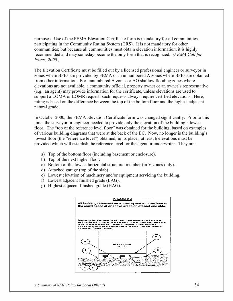
purposes. Use of the FEMA Elevation Certificate form is mandatory for all communities participating in the Community Rating System (CRS). It is not mandatory for other communities; but because all communities must obtain elevation information, it is highly recommended and may someday become the only form that is recognized. (FEMA Call for Issues, 2000.) The Elevation Certificate must be filled out by a licensed professional engineer or surveyor in zones where BFEs are provided by FEMA or in unnumbered A zones where BFEs are obtained from other information. For unnumbered A zones or AO shallow flooding zones where elevations are not available, a community official, property owner or an owner’s representative (e.g., an agent) may provide information for the certificate, unless elevations are used to support a LOMA or LOMR request; such requests always require certified elevations. Here, rating is based on the difference between the top of the bottom floor and the highest adjacent natural grade. In October 2000, the FEMA Elevation Certificate form was changed significantly. Prior to this time, the surveyor or engineer needed to provide only the elevation of the building’s lowest floor. The “top of the reference level floor” was obtained for the building, based on examples of various building diagrams that were at the back of the EC. Now, no longer is the building’s lowest floor (the “reference level”) obtained; in its place, at least 6 elevations must be provided which will establish the reference level for the agent or underwriter. They are:
a) Top of the bottom floor (including basement or enclosure). b) Top of the next higher floor. c) Bottom of the lowest horizontal structural member (in V zones only). d) Attached garage (top of the slab). e) Lowest elevation of machinery and/or equipment servicing the building. f) Lowest adjacent finished grade (LAG). g) Highest adjacent finished grade (HAG).
A Summary of NFIP Policy for Local Officials 34

In addition, the surveyor or engineer must determine the number of permanent openings that are no more than one foot above the adjacent grade, and calculate the total area of those openings. The elevations that must be obtained are depicted in the building diagrams at the back of the Elevation Certificate document. Obtaining the “top of the bottom floor” for crawl space buildings (common in the Northwest) means shooting the elevation of the ground within the enclosed space below the lowest living floor level; if this elevation is below the ground (the lowest adjacent grade elevation), higher insurance rates are triggered. This has fueled a controversy with respect to crawl space construction (see “Crawl Space Construction” under the [c][2] regulation, pp. 49-51). Another change is the requirement to shoot the elevation of machinery and/or equipment servicing the building, as mentioned above. Getting this elevation means a building cannot get an EC until it is “finished construction,” since all machinery and/or equipment such as furnaces, hot water heaters, heat pumps, air conditioners, and associated equipment must be installed and the grading around the building must be completed. This includes machinery and equipment that may be outside the building, such as a heat pump, if that machinery services the building. A box termed “finished construction” must be checked by the surveyor. Also, it is possible this may include ductwork in the future (as of this writing, ductwork does not have to be surveyed); if a building is built only to the BFE, the ductwork will probably be below the BFE, which could trigger higher insurance rates. Another change is that a community official can no longer fill out the survey parts of the FEMA EC, unless that official is also a licensed surveyor or engineer. The FEMA Elevation Certificate is available through the FEMA Website, NFIP Site Index, double click on Flood Insurance Library, then click on Forms. An instructional Compact Disc (CD) with an electronic copy of the new EC is also available from FEMA. Floodproofing Certificate. Floodproofing means making a building watertight, completely or substantially impermeable to the passage of water and capable of resisting hydrostatic and hydrodynamic loads and effects of buoyancy (this is the dry-floodproofing standard; see [c][3] below). It is an option only allowed for nonresidential buildings. Designs for a floodproofed building must account for flood warning time, uses of the building, mode of entry to and exit from the building and the site, floodwater velocities, flood depths, debris impact potential and flood frequency. (FEMA Independent Study 9, August 1999, page 7-58.) A Floodproofing Certificate (FEMA Form 81-65) is required for all dry-floodproofed buildings. This form differs from the Elevation Certificate in that it is required before the building is constructed, vs., the EC which is based on as-built construction. This is because the registered professional engineer or architect only reviews the structural design, specifications, and plans for construction and, based on that review, certifies that the design and methods of construction are in accordance with accepted standards of practice for meeting the dry-floodproofing standard.
A Summary of NFIP Policy for Local Officials 35

It is important to note that for insurance purposes, the building’s floodproofed design elevation must be at least one foot above the BFE in order to receive rating credit. If a local ordinance does not require one foot of freeboard, rates will be very high. Whatever level the building is floodproofed to, one foot is subtracted for rating purposes, reflecting less certainty in this method vs. elevation of the building.
Alteration of Watercourses
Section 60.3[b][6]. “Notify, in riverine situations, adjacent communities and the State Coordinating Office prior to any alteration or relocation of a watercourse, and submit copies of such notifications to the Administrator (FEMA);’ Section 60.3[b][7]. “Assure that the flood carrying capacity within the altered or relocated portion of any watercourse is maintained.”
Notification. If a development permit application proposes a stream alteration, the local official must notify adjacent communities, the State Coordinating Agency for the NFIP, and provide a copy to the FEMA Regional Office. This provision recognizes that flooding problems do not respect legal boundaries and is intended to make communities aware of proposed stream changes that might create new flood problems or aggravate an existing one in surrounding areas. If an adverse impact is suspected, the neighboring community will be able to voice its concerns prior to any modification. Federal and State permits will usually be required for any alteration or relocation. It is recommended that the community require the submittal and approval of a Conditional LOMR for large-scale proposals (this is approval of the proposal before it is to be built – assures that FEMA will recognize it for a map change when construction is complete). (FEMA Guide for Ordinance Development, 1978; FEMA Independent Study 9, August 1999.) Definition of watercourse. FEMA does not have a definition of watercourse in its regulations. However, the term does have a commonly understood meaning – the channel itself. FEMA policy has been that a watercourse includes only the channel and banks of the watercourse, not the adjoining floodplain areas. The term “flood carrying capacity” as used in [b][7] refers to the flood carrying capacity of the channel (except, possibly, in alluvial fan situations). (FEMA August 12, 1993 Rulemaking Call, page 5; July 30, 1996 FEMA Memorandum in response to FEMA Region V.) Maintain the carrying capacity, application in unnumbered A zones only. The alteration or relocation of a watercourse is development and requires a development permit. The alteration standard only applies in unnumbered A zones, since alterations in zones with elevations and/or floodways are addressed by the [c][10] or [d][3] encroachment standards. If
A Summary of NFIP Policy for Local Officials 36

the watercourse is being altered or relocated in a zone A area, the requirement has two elements; the community must make whatever arrangements are necessary to assure that:
• the altered or relocated watercourse has the same or greater capacity as the original watercourse; and
• the capacity of the altered or relocated watercourse must be maintained over time. (FEMA Memorandum to Region V, July 30, 1996.)
Same or greater capacity, level of analysis. Concerning the first part of the requirement, NFIP regulations do not specifically limit or address water surface elevation increases in unnumbered A zones. While some type of analysis is required on the part of the community to determine that the altered or relocated watercourse has the same or greater capacity as the original watercourse, FEMA cannot require the community to conduct an analysis similar to the level of analysis required under [c][10] or [d][3]. FEMA can only require an analysis commensurate with the level of data that is provided (except for the detailed analysis for a subdivision or large development under [b][3]). To assure the flood carrying capacity is not diminished in this situation, a community review should include the following basic items for less developed areas:
• Making sure the channel size (watercourse) is as big as the original; • Making sure the roughness coefficient of the channel is maintained; • Making sure the square footage of the cross section is relatively the same; and • Making sure that the same or similar material for the bottom (i.e., sand or gravel) is
used. For more developed areas, a more detailed analysis should be conducted. A community does not have to seek recognition from FEMA to change its flood map as a result of an alteration but, if it does, another section of the regulations determines the degree of data FEMA will need (this is Section 65.6[a][12]). This regulation basically says that FEMA may request additional data in support of the alteration. Also, see measures for fish habitat protection below. (FEMA July 30, 1996 Memorandum in response to Region V.) Maintaining the capacity over time. After altering a watercourse, the developer has created an artificial situation and must assume responsibility for maintaining the capacity of the modified channel. If maintenance is not required, this can result in situations such as severe overgrowth or sediment deposition in channelized streams, causing reduced conveyance and increased flood hazards. In other cases, inadequate maintenance has resulted in erosion and scour problems within altered watercourses, thereby increasing potential floodwater velocities and downstream flood damages. Formal maintenance agreements, such as are required in other parts of the NFIP regulations, like for levees, are not specified or required for alterations of watercourses. Also, this requirement does not pertain to existing channels, whether natural or man-altered, that pre-dated the NFIP requirements (Call for Issues, June 2000,
A Summary of NFIP Policy for Local Officials 37
page II-3-29).

FEMA’s only requirement is for appropriate assurances that maintenance will be provided. These assurances should specify all maintenance activities, the frequency of their performance and the community officials responsible for their performance. Even in the case of bridges and culverts that may alter the watercourse, an arrangement must be made to maintain the flood carrying capacity of the channel. Such assurances can come in the form of a simple letter from a responsible community official. Maintenance should consist of a program of periodic inspections, routine channel clearing and other related functions (but see fish measures below). This is necessary for FEMA to verify that maintenance will be carried out in the event the community requests a map revision (Federal Register, May 6, 1988, page 16273, and November 3, 1987, page 42119). Oversize, and avoid the maintenance program. Some communities have design criteria for watercourse alterations that include factors that account for regrowth of vegetation, sediment deposition, etc., thus obviating the need for maintenance. This is a much better course of action as it relates to fish habitat enhancement in the Northwest, and is a practice recognized by FEMA in Section 65.6[a][13] of the regulations:
“. . .a community may submit, in lieu of the documentation specified in Section 65.6[a][12] (the maintenance program), certification by a registered professional engineer that the project has been designed to retain its flood carrying capacity without periodic maintenance.”
What’s best for fish? Recognizing the need to enhance fish habitat in the Northwest, there are several measures that communities can require relative to alteration of watercourses (including bank stabilization projects) that would not degrade fish habitat (some of the general standards in the preceding paragraphs, while FEMA policy for the Nation, would not be in the best interests of preserving fish habitat in this area):
• Bridges should be used instead of culverts wherever possible; • Any culverts that are used should be arch/bottomless culverts or provide comparable
fish protection; • Crossings should allow for uninterrupted downstream movement of wood and gravel,
minimize fill and pass 100-year flood flows; • Alterations must maintain natural meander patterns, channel complexity and
floodplain connectivity; these should be restored as part of the alteration wherever feasible;
• The applicant should identify any possible channel migration zone and assure there will be no disruption inhibiting movement of the channel;
• Culverts that do not meet fish requirements should be removed per the alteration; • Alterations should not result in blockage of side channels, and known barriers to fish
passage into side channels should be removed; • Adequate screening should be provided for man-made diversions for irrigation, power,
etc.
A Summary of NFIP Policy for Local Officials 38
• Soft, bioengineered armoring should be required on any fish-bearing stream.

Anchoring and Installing Manufactured Homes in Unnumbered A Zones
Section 60.3[b][8]. “Require that all manufactured homes to be placed within Zone A on a community’s FHBM or FIRM shall be installed using methods and practices which minimize flood damage. For the purposes of this requirement, manufactured homes must be elevated and anchored to resist flotation, collapse, or lateral movement. Methods of anchoring may include, but are not to be limited to, use of over-the-top or frame ties to ground anchors. This requirement is in addition to applicable State and local anchoring requirements for resisting wind forces.”
More later. This section only addresses installation and anchoring of manufactured homes in unnumbered A zones. The detailed discussion of elevating manufactured homes on a permanent foundation to the BFE or on a 36-inch pier, together with more details of anchoring systems will be found under the [c][6] and [c][12] standards. Basic elevation requirement. If a manufactured home in an unnumbered A zone is part of a subdivision or large development subject to the requirement that the applicant develop BFEs per [b][3], i.e., the 50 lots/5 acre standard, it will be subject to the same requirements as are described in the [c][6] and [c][12] standards. This is likewise true if the “use of other BFE data” requirement found at [b][4] is applicable. For the [b][8] standard, manufactured homes must be installed using methods and practices that minimize flood damage, and they are specifically required to be anchored to prevent flotation, collapse and lateral movement. Since BFEs are not known, the “reasonably safe from flooding” criteria kicks in; this is described above in the [b][4] standard under the headings “Managing unnumbered A Zones – the problem” and “When other data is not available.” This can involve the use of historical data, such as past flood records, inundation maps, newspaper accounts, high water marks, photographs, etc. If there is not data of any kind available for a particular stream, and the community does not require that the applicant develop an estimated BFE, FEMA strongly recommends the use of a 36-inch reinforced pier to elevate the manufactured home. This standard is found at section [c][12], and is described more fully there. The 36-inch reinforced pier combined with the height of the manufactured home chassis and floor system will usually place the top of the manufactured home floor elevation between 4 and 5 feet above the lowest grade at the site. FEMA estimates that this practice would be sufficient to protect
A Summary of NFIP Policy for Local Officials 39

from inundation damage the estimated 75% of manufactured homes in floodplains that are subject to shallow flooding during the 100-year flood. (FEMA Draft Technical Standards Bulletin 90-4, Installation of Manufactured Homes in Special Flood Hazard Areas.) Basic anchoring standard. The [b][8] regulation provides the underlying basis and minimum standard for all other NFIP floodplain management requirements for manufactured home installation. This minimum performance standard requires the consideration of flood and wind forces when designing the foundation and anchoring systems of manufactured homes. Some form of reinforcement of the foundation is necessary to comply with these standards to resist flotation, collapse or lateral movement due to both flood and wind forces. (FEMA Draft Technical Standards Bulletin 90-4.) In some cases, State or local wind standards may also meet floodplain tie-down standards; e.g., an anchoring system designed to withstand a wind force of 90 miles per hour or greater meets the FEMA standards (FEMA Policy Notice 77-26). Also, if the manufactured home pad is elevated on fill so the pad itself is above the BFE, anchoring for flood is not specifically required, though it is encouraged and will probably need to be done to meet State or local wind tie-down standards anyway (FEMA Policy Notice 77-24). General vs. specific anchoring standard. At the inception of the NFIP, there were very specific tie-down requirements for mobile homes in floodplains. The regulations specified the number of over-the-top ties and frame ties needed, and required that all components be capable of carrying a force of 4,800 pounds. These regulations were revised in 1985 with the more general performance standard that is presently in the regulation. This was done mainly to eliminate conflicts with mobile home manufacturing standards and State and local regulations that specified sometimes different standards for the number, type and location of tiedowns, based on differences in soil types and other site considerations. (Federal Register, September 4, 1985, page 36019.) At the same time, FEMA published its “Manufactured Home Installation in Flood Hazard Areas” guidebook, designated as FEMA 85. This document shows a number of ways to attain the performance standard that newly-placed manufactured homes be “elevated and anchored to prevent flotation, collapse or lateral movement.” As of 2004, FEMA 85 is being completely revised to reflect regulation changes that occurred subsequent to its publication, as well as a wealth of disaster experience since that time.
Elevate Residential Structures
Section 60.3[c][2]. “Require that all new construction and substantial improvements of residential structures within Zones A1-30, AE and AH zones on the community’s FIRM have the lowest floor (including basement) elevated to or above the base flood level, unless the community is granted an exception by the Administrator for the allowance of basements in accordance with Section 60.6[b] or [c].”
A Summary of NFIP Policy for Local Officials 40

Key regulation. This regulation is one of the real keys to implementing the NFIP. It requires that the lowest floor of all new construction and substantial improvement of residential buildings be built to or above the BFE. Elevation can be done through a number of techniques, such as through the use of fill, through post, pier, pile or column construction, or using stem-wall construction. After a building is elevated, the structure is not excluded from the floodplain; the structure can still be impacted or surrounded by water, so a significant risk of damage remains and flood insurance is still required. The only NFIP procedure that will remove a structure from the Special Flood Hazard Area for insurance purposes is the Letter of Map Amendment (LOMA) procedure, which is discussed later. LOMAs are rare relative to the total number of permits issued in floodplains. (FEMA Call for Issues, June 2000, page II-3-28.) Also, the second part of this regulation, floodproofed residential basements, are so rare in the Northwest (only 2 of 732 communities have exceptions for these basements), that they will not be discussed in any detail here. Definitions. In order to better understand the elevation criteria in the NFIP, a few terms should first be defined (see Section 59.1of the regulations):
• Structure. Structure is defined in the NFIP regulations for floodplain management purposes as “a walled and roofed building, including a gas or liquid storage tank, that is principally above ground, as well as a manufactured home.” The term does not include open pavilions, bleachers, carports and similar structures that do not have at least two rigid walls and a roof.
• New construction. New construction means “structures for which the start of
construction commenced on or after the effective date of a floodplain management regulation adopted by a community and includes any subsequent improvements to such structures.” An important element here is that any subsequent improvement, whether or not it is a substantial improvement, must also be elevated; conversely, for an existing building, improvements do not have to be elevated unless they are substantial improvements. Also, if an existing structure is to be relocted to another site in the floodplain, it is interpreted as new construction, and must comply with the elevation standard. (FIA Policy Notice 77-7, March 30, 1977 -- still current.)
• Lowest floor. Lowest floor is defined as “the lowest
floor of the lowest enclosed area (including basement).” The definition in the regulations attempts to assure there will be no habitable enclosures below the BFE by specifying that: “An unfinished or flood resistant enclosure, usable solely for parking of vehicles, building access or storage in an area other than a basement area is not considered a building’s lowest floor; provided, that
A Summary of NFIP Policy for Local Officials 41

such enclosure is not built so as to render the structure in violation of the applicable non-elevation design requirements of Section 60.3,” i.e., provided they have proper openings, use flood resistant materials below the BFE, and elevate utilities, machinery and equipment.
Storage, means limited storage, “. . .limited to items such as lawn and garden equipment, snow tires, and other low damage items.” (Federal Register, March 7, 1989, page 9525.) The term lowest floor used to be defined as lowest habitable floor (also called the lowest finished floor), and reference level. Thus, for example, any floor level equipped for such uses as a kitchen; dining, living, family or recreation room; bedroom, bathroom; office; professional studio or commercial occupancy, may not be permitted below the BFE. (FEMA Policy Statement on Use of the term “Lowest Floor,” dated September 1983.) Though this is not currently in the definition, it still gives direction on what is not allowed below the lowest floor.
An attached garage, if below BFE (p. 65), is treated the same as an enclosure below the elevated floor of a building. Specifically, such a garage would not be considered the lowest floor if it was used for parking, building access or limited storage, and met the same requirements for openings, use of flood resistant materials below the BFE and machinery and equipment above the BFE. If laundry equipment or a workshop were placed in an attached garage, it would no longer be used for parking, building access, or storage, and the floor of the garage would have to be considered the lowest floor of the structure. Such a case would be considered a violation. Detached garages are discussed under “accessory structures” below. (FEMA Memorandum to Region IX, dated August 6, 1986.)
• Substantial improvement. Buildings that are substantially improved are treated the same as new construction. This is a key term for which an entire section will be devoted (pages 57-63), so only the definition is shown here:
“Substantial improvement means any reconstruction, rehabilitation, addition, or other improvement of a structure, the cost of which equals or exceeds 50 percent of the market value of the structure before the “start of construction” of the improvement. This term includes structures which have incurred “substantial damage,” regardless of the actual repair work performed. The term does not, however, include either: (1) any project for improvement of a structure to correct existing violations of state or local health, sanitary, or safety code specifications which have been identified by the local code enforcement official and which are the minimum necessary to assure safe living conditions, or (2) Any alteration of a “historic structure,” provided that the alteration will not preclude the structure’s continued designation as a “historic structure.”
A Summary of NFIP Policy for Local Officials 42
•

• Substantial damage. This term includes “damage of any origin sustained by a structure whereby the cost of restoring the structure to its before damaged condition would equal or exceed 50 percent of the market value of the structure before the damage occurred.” This means that if a structure is damaged by fire, wind, earthquake, etc., it still is considered substantial damage, and is subject to the requirement to elevate. This also will be discussed further on pages 57-63.
• Historic structure includes structures that are: “(a) listed individually in the National Register of Historic Places (a listing maintained by the Department of Interior) or preliminarily determined by the Secretary of the Interior as meeting the requirements for individual listing on the National Register; (b) certified or preliminarily determined by the Secretary as contributing to the historical significance of a registered historic district or a district preliminarily determined by the Secretary to qualify as a registered historic district; (c) individually listed on a state inventory of historic places in states with historic preservation programs which have been approved by the Secretary of the Interior; or (d) individually listed on a local inventory of historic places in communities with historic preservation programs that have been certified. . .. ” The significance of this is that the NFIP regulations, at Section 60.6[a], permit communities to issue variances for substantial improvements of historic structures.
FEMA acknowledges that the buildings that “contribute to the historical significance of a registered historic district” will include a larger number of structures than if only the historic structures themselves were addressed, but will still be only a small percentage of the structures in most historic districts. (FEMA Policy Memorandum to Regional Offices, dated April 15, 1986.) This and other historic building issues were discussed in the Federal regulations in 1989, which clarified that issuing variances for historic buildings should be only the minimum deviation from NFIP criteria that is necessary to assure that the historic character and design of the structure is not destroyed. Also, if plans to substantially improve or repair a substantially damaged historic structure would result in loss of its designation, the structure would be required to meet the NFIP elevation requirements. Historic structures that retain their designation will be rated as Pre-FIRM, i.e., they will be able to get subsidized flood insurance, and will not have to pay actuarial rates (Federal Register, August 15, 1989, page 33543 and FEMA Policy Memorandum to Regional Offices, dated November 8, 2000.)
A Summary of NFIP Policy for Local Officials 43
Freeboard, i.e., additional height above BFE. The NFIP regulations require that the lowest floor of a building must be elevated “to or above” the BFE, i.e., FEMA does not require “freeboard,” additional height that provides a margin of safety for buildings placed in floodplains. This policy was questioned by the State of Maryland in 1993 because of the one-foot rise that is built into FEMA’s flood maps caused by legal encroachment expected in the flood fringes. FEMA responded that the BFE reflects current conditions and not a future condition that may or may not occur; studies in the late 1970s were cited that predicted that full

encroachments would generally not occur (FEMA Consolidated Report on 1994 Rulemaking, dated August 12, 1993).
However, FEMA has always recommended and advocated at least a foot of freeboard for new development in floodplains and, indeed, provides credits in the Community Rating System to communities that have such measures. Also, the International Building Code adopts, by reference, ASCE-24 that requires freeboard for buildings in certain categories, including critical facilities. (FEMA Call for Issues Status Report, June 2000, page II-3-5.) FEMA points out that approximately 75% of structures built in the Nation’s floodplains are built to some freeboard standard. Following are some of the reasons FEMA has cited for the value of freeboard for floodplain structures:
• Freeboard accounts for the one-foot rise in the BFE if the flood fringes are filled. The FEMA floodway-flood fringe concept allows total development in the fringe once the floodway is designated; thus, a structure that is safely elevated to the BFE today, is subject to up to one foot of flooding tomorrow.
• Freeboard accommodates upstream watershed development. The BFE is based on current conditions; flood heights often will increase as development occurs, especially in smaller watersheds.
• Flood levels can be increased by log and debris jams. FEMA studies assume clear flow through bridges, culverts, etc. FEMA cannot predict jams, therefore they cannot project them on maps. But they do happen, and freeboard provides added protection against their effects.
• Freeboard reflects uncertainties inherent in flood hazard modeling, topography, mapping limitations and floodplain encroachments.
• Larger floods than the 100-year flood do occur.
• Buildings built only to the BFE may not offer protection to ducts and insulation placed between floor joists.
• Freeboard makes nonresidential floodproofing work, in that one foot is subtracted from the elevation to which a nonresidential building is floodproofed; without the one-foot of freeboard, a building floodproofed only to the BFE is not credited.
A Summary of NFIP Policy for Local Officials 44
LF = lowest floor
-------BFE---------
LF = BFE LF = BFE + 2ft

• Freeboard provides significantly lower insurance rates due to lower flood risk. Generally, insurance rates decrease by 40 to 50%, and premiums decrease by 25 to 40% with just one foot of freeboard.
Many communities have incorporated freeboard requirements into their elevation and floodproofing standards. In Oregon, it is required everywhere for residential buildings through the State Structural Specialty Code (13 States have more restrictive freeboard requirements). Some communities require an even higher freeboard standard; for example, Tillamook County started requiring 3 feet of freeboard after devastating floods in the mid-1990s, Portland requires 2 feet of freeboard on some streams, and Pierce County has a similar standard. When constructing a new elevated building, the additional cost of going up another foot or two is usually negligible. The higher one elevates above the flood level, the lower the flood insurance costs will be for current and future owners.
Building techniques. Fill is a commonly used elevation technique in the Northwest. Where fill is the method of choice, it should be properly designed, installed in layers and compacted. Simply adding dirt to the building site may result in differential settling over time. In 1987, FEMA published regulations that included requirements for soil compaction for Letters of Map Revision based on fill (fill must be compacted to 95% of the maximum density obtainable with the Standard Proctor Test method, fill slopes may not be steeper than one vertical on one and a half horizontal, etc.); however, these standards are not required for single structure or single lot LOMR-Fs. (Federal Register, August 25, 1986, page 30313.) The fill should also be properly sloped and protected from erosion and scour during flooding. To provide a factor of safety for the building and its residents, it is recommended that the fill extend 10-15 feet beyond the walls before it drops below the BFE (FEMA Guide for Ordinance Development, 1978, page 21: FEMA Independent Study 9, August 1999, page 5-29).
Elevation using posts, piers, piles or columns is a method used commonly to avoid large fills and when flood heights are extreme. Where flooding is likely to have high velocities or to create waves, elevation with no lower area enclosure is recommended, in order to permit unrestricted flow of floodwater under buildings and cause little impact on flood heights. (FEMA Independent Study 9, August 1999, page 5-30.) For buildings that are elevated in this way, NFIP policy even allows swimming pools beneath elevated buildings provided the area is not enclosed and the pool or other potential obstruction is
A Summary of NFIP Policy for Local Officials 45

flush with the natural grade of the site. FEMA 54, “Elevated Residential Structures,” provides a great deal of information on how to construct buildings using these and other methods of elevation. This document addresses regulatory issues, architectural design issues, and gives design and construction guidelines for foundations, framing, and related activities, including building utilities, mechanical equipment, building materials, etc. It shows how to calculate costs and gives performance criteria and sources for design information.
Finally, buildings can be elevated using stem wall foundations. In shallower flooding areas, this technique is the same as creating a crawlspace – a foundation of solid walls that puts the lowest floor above the flood level. When solid walls are used, care must be taken to ensure that hydrostatic or hydrodynamic pressure does not damage the walls. This requires use of openings that are described at Section [c][5] below. The openings must be sufficient to allow floodwaters to flow in and out, preventing differential pressures on the walls. (FEMA Independent Study 9, August 1999, page 5-30.)
Negative effects of fill. While fill is a legitimate technique to elevate buildings in floodplains, it is increasingly seen as a problem, particularly from a geomorphological and biological standpoint, i.e., in how it can disrupt natural processes of streams. Following are some reasons why fills are being looked at more cautiously in the Northwest:
• Fills remove natural storage of floodwaters, thereby altering hydrology by making it more efficient for runoff to enter a stream quicker, which often leads to increased peak flows downstream. Many communities have ordinance provisions requiring a developer to compensate for the loss of storage caused by filling in the fringe by removing an equal amount of material in the floodplain near the proposed development (“cut and fill,” or compensatory storage requirements).
• Filling in the fringe should not cause an increase in flood levels of more than one foot at any point in the base (100-year) flood; however, the same fills can cause localized drainage problems in lesser floods, thereby affecting neighboring lands.
• The more fill that is used in the fringe, the greater the chances of achieving the one foot rise that is built into the FEMA studies and maps, vs. use of other techniques that remove lesser amounts of land or allow flow-thru construction.
• Fills in the fringe can have a devastating effect on natural processes and riparian habitat, specifically by creating larger impervious surfaces and removing more natural vegetation than other techniques.
A Summary of NFIP Policy for Local Officials 46

• Without careful analysis, floodplain fills can block natural channel migration, which adversely affects attainment of properly functioning conditions and hydrological and geomorphological processes needed to sustain fish habitat.
Northwest communities are increasingly recognizing the very negative impacts of filling in floodplains. A few now prohibit fill as a construction technique at least for residential buildings (e.g., King County, Skagit County), and a significant number only allow fills in the context of cut and fill requirements (e.g., all Portland Metro communities). This will certainly increase in the near future with the listing of many salmonid species as threatened under the Endangered Species Act.
Accessory structures. If an accessory structure qualifies under the definition of “structure,” it theoretically must meet the elevation or dry-floodproofing standards of [c][2] and [c][3] of the regulations. However, FEMA has long had a policy of allowing accessory structures, such as detached garages, boathouses, small pole barns and storage sheds, to be built using lesser standards. (Policy Notice 77-18, dated July 13, 1977 – still current.) The minor initial investment in such structures (past FEMA documents have suggested no more than 10% of total property value or a comparable square foot limit) would be greatly increased by the necessity to either elevate or dry-floodproof them, and such measures may provide an excessive degree of protection for these types of structures (FEMA Memorandum to Region VI, dated May 6, 1985). FEMA has provided general performance standards in its Policy Notice, as follows:
1) Accessory structures shall not be used for human habitation.
2) Accessory structures shall be designed to have low flood damage potential.
3) Accessory structures shall be constructed and placed on the building site so as to offer the minimum resistance to the flow of floodwaters.
4) Accessory structures shall be firmly anchored to prevent flotation which may result in damage to other structures, and must have flood openings.
5) Service facilities such as electrical and heating equipment shall be elevated or floodproofed; flood resistant materials must be used below the BFE.
In order to permit accessory structures which are not elevated or dry floodproofed, the community would have to include these or equivalent provisions in its ordinances or require the issuance of variances. (FEMA Memorandum to Region I, March 18, 1985.) The community can also determine what constitutes a minimal investment, subject to review by FEMA. Structures constructed in this fashion are considered to be wet-floodproofed. Wet floodproofing involves using flood-resistant materials below the BFE and elevating items subject to flood damage above the BFE. Items that can be installed
A Summary of NFIP Policy for Local Officials 47
Excavated Cut
Fill Pad

above the BFE include electrical boxes, switches and outlets. Only the minimum amount of electrical equipment required by code may be located below the BFE, and that equipment must be flood damage resistant (FEMA Independent Study 9, August 1999, page 5-41). Additional guidance is provided in FEMA’s Technical Bulletin TB-7, “Wet Floodproofing Requirements,” 1994.
Detached garages can be accessory buildings, provided they meet dollar or square footage limitations to assure they represent a minimal investment. It is recommended they be elevated, but if they are not, they need to meet the above requirements for accessory structures, plus: (1) use of the garage must be limited to parking or limited storage (i.e., no workshops, recreation rooms, etc.); (2) the garage must be built using unfinished and flood damage resistant materials below the BFE; (3) the garage must be adequately anchored to prevent flotation, collapse or lateral movement, and meet the openings requirement at [c][5]; (4) any mechanical and utility equipment in the garage must be elevated to or above the BFE or floodproofed; and (5) the garage must not violate the floodway encroachment standard. As with accessory structures in general, these standards would have to be in the community’s ordinance, or a variance would be required (FEMA Memo to Region IX, August 6, 1986).
Insurance and wet-floodproofing. It is important to recognize that insurance does not recognize wet-floodproofing, and if this technique is used for an accessory structure that will be insured separately, rates could be quite high. The only appurtenant structure covered by the NFIP Dwelling Policy is a detached garage at the same location. Coverage for this is limited to no more than 10% of the limit of liability on the dwelling. This insurance will not cover any detached garage used for residential (i.e., dwelling), business or farming purposes. (NFIP Flood Insurance Manual, December 2000, page GR-2.)
Below-grade parking in residential buildings. Below-grade parking is considered a basement by the NFIP. A basement is defined as any area of a building having its floor subgrade (below ground level) on all sides. The lowest floor, including basement, of residential structures must be elevated to or above the BFE. A below-grade parking garage is considered a basement if it is below grade on all sides, therefore, the construction of below-grade parking garages is prohibited beneath residential buildings in all Zones A, A1-30, AE, AH and AO. This pertains even when the basement garage is a small part of the total building area (e.g., a low garage with a bedroom on top, which is a common construction technique in parts of the Northwest).
Local interpretation of FEMA maps. BFEs published in Flood Insurance Studies set the level for flood protection purposes. The maps are a graphic portrayal of the flood elevations. Since FEMA usually does not have topographic maps with the best possible contour intervals (e.g., like two-foot intervals) to prepare the maps, the flood boundaries are interpolated. This can result in inaccuracies in drawing the boundaries on the map. The BFE in
A Summary of NFIP Policy for Local Officials 48

relation to the actual ground elevation sets the floodplain limits for regulatory purposes. When ground surveys show that a development site is above the BFE, the information should be recorded, but the action is not subject to the floodplain regulation. (FEMA Independent Study 9, August 1999, page 5-9.)
This has been a long-standing policy that was originally issued by FIA in 1978 (Policy Notice 78-8, October 10, 1978 – still current). Among other things, this document explained that: “If a person requests a permit from a community, and the responsible official finds that the proposed construction area is already at or above the BFE, nothing more need be required, since the goals of floodplain management have been met. FIA would not question the community’s interim determination that the property is not within a flood hazard area, provided a “good faith” interpretation has been made.”
Does landscaping alter the grade level of a dwelling? The subgrade portion of a dwelling is determined based upon natural grade considerations. After a building is completed and its lowest floor is at or above the natural grade level of the surrounding land, if earth is moved up against the building and above the adjacent natural grade level as a landscaping or insulation material in conjunction with energy efficient building techniques, the building would not be construed to be an uninsurable underground structure. Such a process would not transform the lowest floor area, at the natural adjacent grade, into a basement for NFIP purposes. Whether this is the case, or an actual basement was constructed below natural grade on all sides, would need to be resolved on an individual case-by-case basis. (FEMA Letter to Congressman John D. Dingell, November 13, 1985.)
Crawl Space Construction
A Summary of NFIP Policy for Local Officials 49
The crawl space problem. NFIP regulations require the lowest floor of a building to be at or above the BFE. FEMA defines basement as “any area of the building having its floor subgrade (below the ground level) on all sides.” The enclosed space below the elevated lowest floor is the crawl space, especially for stem wall construction. If the crawl space is at grade, i.e., the interior crawl space is at least as high as the exterior grade adjacent to the structure, the space is an enclosure below the lowest floor of the building and there is no problem. The problem is when the crawl space has been excavated below grade, often to the footers, and the bottom level of the crawl space is below grade on all sides. Such a crawl space is subject to minimum floodplain management requirements of the NFIP. According to FEMA, this is considered a floodplain management violation, and the crawl space and building are subject to additional risk of flood damage due to increased hydrostatic and soil loadings on the foundation walls that could occur during flood conditions. (November 1999 FEMA Headquarters Letter to Three Forks, Montana.)

Rating crawl spaces for insurance. In the past, rates that were used for below grade crawl space construction were the rates used for a full 8-foot basement. In reviewing the rate structure, FEMA determined that the basement rates were inappropriate for below grade crawl space floors that were only 1 or 2 feet below grade. As a result, an actuarial rate to address this issue was developed, and as of May 1, 1999, rates for crawl space construction with the interior floor 1 or 2 feet below grade on all sides gets an enclosure loading that is less than the basement rate. However, these rates are not cheap; they increase the policy premium by 30% with just one foot below grade, and by 45% with two feet below grade. If the crawl space is more than 3 feet below grade, it is rated using the “with basement” rate tables in the NFIP Submit-for-Rate Guidelines, which produces very high premiums.
Why the controversy? While the background explained above has been operative for many years (FEMA’s basement definition was added in the mid- to late-1980s), it was never perceived as a problem in the Northwest. This is because all Northwest communities use the Uniform Building Code, which permits crawl spaces to be excavated below grade, down to the top of the footings, and because crawl spaces never were required to be noted for insurance purposes.
This all changed with the new FEMA Elevation Certificate that went into effect on October 1, 2000. FEMA’s Building Diagrams that are part of the Elevation Certificate (page 34) instruct the surveyor or engineer that the “top of the bottom floor” elevation, one of 6 or 7 required elevations, is defined as the “floor” of the crawl space, regardless of the fact that this floor is generally dirt. Comparing this elevation with the required elevation for the lowest adjacent grade (LAG), if the crawl space is at or above the LAG, there is no problem; the building is compliant with floodplain regulations and is rated by the “top of the next higher floor” elevation, which is usually the lowest floor or finished floor as most know it. If, on the other hand, the crawl space elevation is below grade, below the elevation of the LAG, it is considered a “basement,” with crawl space loading for the first 1 or 2 feet, and basement rating for anything below that.
A Summary of NFIP Policy for Local Officials 50
Openings
Not Compliant – crawlspace excavated, subgrade on all sides
Compliant – interior and exterior grade at same level
---------BFE------------

The FEMA Region 10 response. From the time the crawl space issue came to a head in late-1998, FEMA Region 10 staunchly opposed the above interpretation. There was strong evidence that in virtually every community in the Region the policy defied normal building practices. Through a series of 37 Floodplain Management Workshops in 2000 that were attended by over 900 local officials, at least one-third of whom were building officials, there was no disagreement that crawl space construction below grade was not only permitted by the codes (UBC, CABO), but was the norm in the Northwest. There was some support for this position from other States, such as North Dakota, Nebraska and Michigan (FEMA Consolidated Report – 1994 Rulemaking Call, page 17). FEMA Region 10’s basic problems with the policy were: the crawl space insurance loading was substantial; the surcharge was not based on empirical evidence; subgrade crawl space construction is a standard building practice in the Northwest; and FEMA interpreted lack of adherence to this policy as a floodplain management violation.
The FEMA response. The FEMA Headquarters office took this issue under advisement and commissioned additional studies. This included a review of insurance claims history and an engineering analysis on below-grade crawl spaces, both of which provided substance for changing the basic policy. The result of the further investigations did result in changes, although the changes were relatively minor. FEMA continues to consider a structure that has its “top of the bottom floor” below the lowest adjacent grade, to be a noncompliant structure. A compliant structure is one that has its interior grade equal to or above its lowest exterior grade. However, FEMA Technical Bulletin 11-01, which was issued in November 2001, does allow below-grade crawl spaces if the following conditions are met:
The community amends its ordinance to allow them.
Interior grade is not more than 2 feet below the lowest adjacent exterior grade.
The height of the below-grade crawl space, from the interior grade of the crawl space to the top of the foundation wall, must not exceed 4 feet at any point.
There must be an adequate drainage system that removes interior floodwaters.
The velocity of floodwaters is not more than 5 feet per second.
Nonresidential Building Elevation, Floodproofing and Certification
A Summary of NFIP Policy for Local Officials 51
Section 60.3[c][3]. “Require that all new construction and substantial improvements of nonresidential structures within Zones A1-30, AE and AH zones on the community’s FIRM (i) have the lowest floor (including basement) elevated to or above the base flood level or, (ii) together with attendant utility and sanitary facilities, be designed so that below the base flood level the structure is watertight with walls substantially impermeable to the passage of water and with structural components having the capability of resisting hydrostatic and hydrodynamic loads and effects of buoyancy.”
Section 60.3[c][4]. “Provide that where a nonresidential structure is intended to be made watertight below the base flood level, (i) a registered professional engineer or architect shall develop and/or review structural design, specifications, and plans for the construction, and shall certify that the design and methods of construction are in accordance with accepted standards of practice for meeting the applicable provisions of paragraph [c][3][ii] or [c][8][ii] of this section, and (ii) a record of such certificates which includes the specific elevation (in relation to mean sea level) to which such structures are floodproofed shall be maintained with the official designated by the community under 59.22[a][9][iii]."
Basic requirements. For nonresidential buildings, the NFIP regulations provide an option to either elevate, or structurally floodproof the building. Elevation of a nonresidential building would be substantially the same as elevation of residential buildings. Elevation is the preferred method because it is more dependable, and can be designed so that the building can continue to operate during a flood, thereby reducing or eliminating business disruption. Since floodproofing is rarely seen in Northwest Floodplains, the discussion will be shortened.
Floodproofing can allow a building to be built at grade, but structurally designed and built to keep floodwaters out. FEMA defines floodproofing as “any combination of structural and nonstructural additions, changes, or adjustments to structures which reduce or eliminate flood damage to real estate or improved real property, water and sanitary facilities, structures and their contents.” Examples of such adjustments and additions include “installation of watertight closures for doors and windows; reinforcement of walls to withstand floodwater pressures and impact forces generated by floating debris; use of membranes and other sealants to reduce seepage of floodwater through walls and wall penetrations; installation of pumps to control interior water levels; installation of check valves to prevent the entrance of floodwater or sewage flows through utilities; and the location of electrical, mechanical, utility, and other valuable damageable equipment and contents above the expected flood level.”(FEMA TB 3-93, April 1993)
The dry-floodproofing standard. Careful evaluation of site conditions should precede decisions to dry-floodproof a nonresidential building. For a site with flood velocities in excess of 5 feet per second or base flood depths in excess of 3 feet, the cost of dry-floodproofed construction may be prohibitive. The dry-floodproofing standard is as defined above in the regulation (i.e., walls substantially impermeable to the passage of water, etc.). For this standard, FEMA has adopted the U.S. Army Corps of Engineers
A Summary of NFIP Policy for Local Officials 52

definition of substantially impermeable from the COE publication “Flood Proofing Regulations,” dated December 15, 1995. This is a document that every community should have if there will be cases where nonresidential buildings will be floodproofed (it is available through the COE and FEMA Regional Offices). The FEMA watertight, or dry-floodproofing, standard corresponds to the Corps’ FP1 and FP2 building classifications, and is met through compliance with the Corps’ W1 (completely dry) and W2 (essentially dry) space classifications. Detailed standards are given in this document for classifying materials, and for complying with the various standards, for flooring, walls and ceilings, contents, electrical and mechanical systems. (FEMA Letter to North Wildwood, New Jersey, dated July 10, 1984.)
Can human intervention be used? Floodproofing techniques that require human intervention are allowed, but are generally discouraged. This means that a person has to take some action before the floodwater arrives, such as turn a valve, close an opening or switch on a pump. There can be many potential causes of failure for these techniques, including inadequate warning time, no person on duty when the warning is issued, the responsible person cannot find the right parts or tools, the person is too excited or too weak to install things correctly, the person has forgotten the emergency drill due to lack of training, and/or the electricity fails. Thus, techniques that rely on human intervention should only be allowed in areas with adequate warning time and in situations where there will be someone present who is capable of implementing or installing the required measures. (FEMA Independent Study 9, August 1999, page 5-38.)
Other floodproofing guidance documents. Technical Bulletin 3-93, “Non-Residential Floodproofing – Requirements and Certification” offers excellent guidance for determining whether or not to utilize the dry-floodproofing performance standard, while the Corps’ “Floodproofing Regulations” describes how technically to meet the standard. There are several other documents that are very helpful for floodproofing assistance:
• FEMA 102, “Floodproofing Non-Residential Structures,” May 1986. This 200-page document is FEMA’s major floodproofing effort, and is a companion document to “Elevated Residential Structures” (FEMA 54).
• Technical Bulletin 7-93, “Wet Floodproofing Requirements,” dated December 1993 (this will be further described below).
• Technical Bulletin 6-93, “Below-Grade Parking Requirements,” dated April 1993 (also see below).
Insurance considerations. A nonresidential building must be floodproofed to +1 foot in order to receive a rate equivalent to a building with its lowest floor elevated just to the BFE, i.e., a foot is subtracted from the floodproofed level in order to determine the rate. For example, if a building is floodproofed to 2 feet above the BFE, then it is credited for floodproofing and is treated for rating purposes as having a +1 foot elevation. This reflects the judgment that the floodproofing technique is not as desirable as elevating a
A Summary of NFIP Policy for Local Officials 53

building. Also, the floodproofing certificate (see next paragraph) must accompany the NFIP flood insurance application. (FEMA Flood Insurance Manual, December 2000, page Rate 30 and 31.)
Floodproofing Certificate. For compliance with the floodproofing standard and for insurance rating purposes, a Floodproofing Certificate must be available for the agent. This is FEMA Form 81-65, which is noted above under the [b][5] standard as one of the certificates that local officials must obtain and maintain (page 35). The engineer or architect used to have to certify that the floodproofing was adequate to withstand the pressures, velocities, etc. associated with the 100-year flood. That wording was changed in 1985, because the language conflicted with requirements of professional liability insurers. In addition, the engineer or architect could not reasonably make such a certification since he/she normally was not at the construction site during all phases of construction. Thus, the certification now is done before construction begins, and specifies that the engineer or architect has reviewed the structural design, specifications, and plans for construction, and that the design and methods of construction are in accordance with accepted standards of practice for meeting the dry-floodproofing standard. (Federal Register, volume 50, number 72, April 15, 1985.)
Below-grade parking in nonresidential buildings. Below-grade parking garages are considered basements because their floors are subgrade on all sides and, as a result, the floor of the parking garage is always the lowest floor of the structure. The exclusion for parking, limited storage and building access in the definition of lowest floor does not apply in basement areas. (FEMA Memorandum to Regional Offices, April 4, 1990.) However, compared to residential structures where below-grade garages are prohibited, these garages can be permitted beneath nonresidential buildings in A zones, provided they are dry floodproofed. This means designing for hydrostatic and hydrodynamic forces, providing the additional foot of freeboard that is required for dry-floodproofing credit, and designing the entry to the garage to be above the BFE (flood shields can be used instead, but are not as effective). A sufficient number of emergency exits must be available so that people will not be trapped in the garage by rising floodwaters. (FEMA Technical Bulletin 6-93, Below-Grade Parking Requirements, April 1993). Guidance is available in TB 6-93, TB 3-93, “Non-Residential Floodproofing,” and FEMA 102, “Floodproofing Non-Residential Structures.”
Wet-floodproofing. FEMA has long had a policy to permit wet-floodproofing of certain nonresidential buildings by variance. “A lesser degree of floodproofing may be the most appropriate flood damage prevention technique for certain types of structures. For example, requiring a warehouse for storing steel beams to be floodproofed watertight may cause exceptional hardship to the applicant. When properly used, (wet-floodproofing) is not in conflict with the goals of the NFIP.” (FIA Policy Notice 77-29, November 30, 1977 – still current.)
FEMA has comprehensive guidance for wet-floodproofing in its Technical Bulletin 7-93, “Wet Floodproofing Requirements.” The document defines wet floodproofing as:
A Summary of NFIP Policy for Local Officials 54

“Permanent or contingent measures applied to a structure and/or its contents that prevent or provide resistance to damage from flooding by allowing floodwaters to enter the structure.” Allowing water to enter the building counteracts hydrostatic pressure on the walls, surfaces, and supports of the structure by equalizing interior and exterior water levels during a flood. Inundation also reduces the danger of buoyancy from hydrostatic uplift forces. Wet floodproofing is allowed through a variance to the dry floodproofing standard, but can be allowed without a variance for enclosed areas below the BFE that are used solely for parking, building access, or limited storage (see next section), and for attached garages.
FEMA has advised communities that variances to allow wet floodproofing may be issued for certain categories of structures, including: structures functionally dependent in close proximity to water; historic buildings; accessory structures, and; certain agricultural structures. Specific allowance of a variance to wet-floodproof boat storage facilities has been recognized by FEMA (FEMA Policy Memorandum of December 10, 1986 to Regional Offices). Throughout the discussion of wet floodproofing in TB 7-93, it is emphasized that although variances can be justified, insurance does not recognize the practice, and rates will be generally higher. Also, the regulations require that an applicant be notified of these increased premium rates as part of issuance of the variance.
TB 7-93 contains thorough discussions of: planning considerations, including warning time, safety and access factors; other flood characteristics that must be considered, including floodway encroachment, duration, flood-borne contaminants, frequency, depth
and water temperature; operational procedures, including flood warning, inspection and maintenance, and flood operation plans; and provides thorough engineering/building considerations for protection of the structure and protection of contents and equipment.
Agricultural structures and wet floodproofing. FEMA recognizes that wet floodproofing may be appropriate for certain types of agricultural structures, especially those located in wide, expansive floodplains. A variance may be issued only if the structure is used solely for agricultural purposes in which the use is exclusively in connection with the production, harvesting, storage, drying, or raising of agricultural commodities, including the raising of livestock. Buildings must be designed to have minimal damage and create no threats to public safety. Types of agricultural structures that may be wet floodproofed following the issuance of a variance are (TB 7-93, “Wet Floodproofing Requirements, page 4):
A Summary of NFIP Policy for Local Officials 55
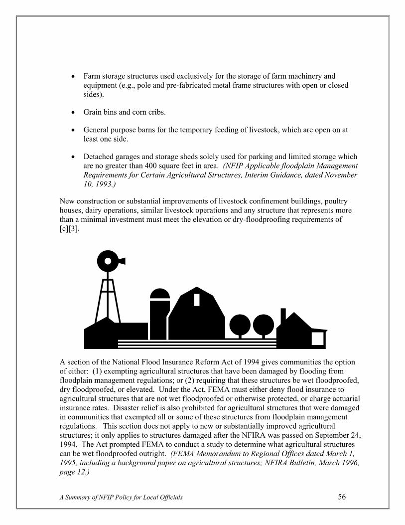
• Farm storage structures used exclusively for the storage of farm machinery and equipment (e.g., pole and pre-fabricated metal frame structures with open or closed sides).
• Grain bins and corn cribs.
• General purpose barns for the temporary feeding of livestock, which are open on at least one side.
• Detached garages and storage sheds solely used for parking and limited storage which are no greater than 400 square feet in area. (NFIP Applicable floodplain Management Requirements for Certain Agricultural Structures, Interim Guidance, dated November 10, 1993.)
New construction or substantial improvements of livestock confinement buildings, poultry houses, dairy operations, similar livestock operations and any structure that represents more than a minimal investment must meet the elevation or dry-floodproofing requirements of [c][3].
A section of the National Flood Insurance Reform Act of 1994 gives communities the option of either: (1) exempting agricultural structures that have been damaged by flooding from floodplain management regulations; or (2) requiring that these structures be wet floodproofed, dry floodproofed, or elevated. Under the Act, FEMA must either deny flood insurance to agricultural structures that are not wet floodproofed or otherwise protected, or charge actuarial insurance rates. Disaster relief is also prohibited for agricultural structures that were damaged in communities that exempted all or some of these structures from floodplain management regulations. This section does not apply to new or substantially improved agricultural structures; it only applies to structures damaged after the NFIRA was passed on September 24, 1994. The Act prompted FEMA to conduct a study to determine what agricultural structures can be wet floodproofed outright. (FEMA Memorandum to Regional Offices dated March 1, 1995, including a background paper on agricultural structures; NFIRA Bulletin, March 1996, page 12.)
A Summary of NFIP Policy for Local Officials 56

Substantial Improvement/Substantial Damage
Substantial improvement “means any reconstruction, rehabilitation, addition or other improvement of a structure, the cost of which equals or exceeds 50% of the market value of the structure before the “start of construction” of the improvement. This term includes structures which have incurred “substantial damage,” regardless of the actual repair work performed. The term does not, however, include either: (1) Any project for improvement of a structure to correct existing violations of State or local health, sanitary, or safety code specifications which have been identified by the local code enforcement official and which are the minimum necessary to assure safe living conditions; or (2) any alteration of a “historic structure,” provided that the alteration will not preclude the structure’s continued designation as a “historic structure.”
Substantial damage “means damage of any origin sustained by a structure whereby the cost of restoring the structure to its before damaged condition would equal or exceed 50 percent of the market value of the structure before the damage occurred.”
FEMA 213. The substantial improvement/substantial damage concept is one of the most written about, complex and controversial subjects in the NFIP. There have been reams written defining and clarifying the issue since the beginning of the Program. Fortunately, FEMA addressed most all issues through publication of FEMA 213, “Answers to Questions About Substantially Damaged Buildings,” dated May 1991. While the subject is substantial damage, most all the concepts apply also to substantial improvement not caused by damage. The reader is referred to this document as the definitive guide to SI/SD issues; only some of the major points from that document will be repeated here.
Background. The NFIP requirements governing the improvement of pre-existing flood-prone structures were designed to progressively bring these structures into compliance with NFIP elevation requirements for new construction, as they were significantly damaged and/or improved. The intent of the requirement was not to prohibit owners of property in the floodplain from making significant improvements to a structure, but merely to require that when extensive improvements were made, steps be taken to ensure that the structure is protected from future flood damage. This, in turn, minimizes the increase in the investment at risk in floodplains.
Substantial improvement is similar to the nonconforming use standards contained in most State zoning enabling laws, and which are widely used in many communities across the Country. The use is allowed to remain nonconforming until it is substantially altered, at which point it must become a conforming use.
A Summary of NFIP Policy for Local Officials 57
The 50 percent threshold was chosen as a compromise between the extremes of: (1) prohibiting all investment to existing structures in floodplains that do not meet minimum NFIP floodplain management requirements; and (2) allowing existing structures to be improved in any fashion without meeting any regulatory standards. The threshold conforms with similar building code and zoning standards that also use a 50 percent threshold. The threshold was selected on the basis that it does not make sense to pay flood losses on the same property over and over again. It attempts to strike a balance between the competing demands for sound

floodplain management and the needs of owners of existing structures. (FEMA October 23, 1991 Letter to Region IV.)
Types of substantial improvements. The basic types of improvements are rehabilitations or reconstructions that do not increase square footage, and lateral or vertical additions that do increase square footage. A rehabilitation could involve upgrading a kitchen, bathroom and/or other areas, whereas a reconstruction could involve, e.g., converting a seasonal house to a permanent residence. A lateral addition could involve adding several rooms to a side of the existing structure, and a vertical addition could involve adding a second story onto the structure.
A rehabilitation or reconstruction typically would be a partial or complete “gutting” and replacement of internal workings, and may or may not involve structural changes. If this action is substantial, i.e., over 50 percent of the structure’s market value, it is considered new construction, and the entire building must be elevated to or above the BFE (elevation or floodproofing if the building is nonresidential). The insurance will be actuarial insurance and the structure will be considered Post-FIRM and elevation rated just as new construction is; subsidized insurance will no longer be available. The underlying principal for including rehabilitations is that they, like additions and repair of damage, represent investment and reinvestment in flood hazard areas, that if not protected, are at serious risk of flooding. In some form, the Federal government, either through the NFIP, disaster aid, SBA loans, casualty loss deductions on income taxes, etc., would likely be obligated to pay a portion or all of future damages. (FEMA October 23, 1991 Letter to Region IV.)
For a lateral addition, if the substantial improvement is to add a room or rooms outside the walls or “footprint” of the existing building, only the addition is required to be elevated to or above the BFE; the existing building does not have to be elevated. Also, actuarial insurance rates will not apply to the addition, and the entire structure will retain its Pre-FIRM (subsidized) rate. (FEMA Letter of March 2, 1988 to Huntington Beach, Calif.).
For a vertical improvement, if the substantial improvement is to add a room or rooms on top of an existing building, FEMA would interpret the addition as a rehabilitation project since it would normally involve tearing off the existing roof, utilizing existing structural walls for support, etc. This would require that the entire structure be elevated to or above the BFE. The rationale is that even though the improvement itself is entirely above the BFE, it is dependent on the walls and foundation of the existing building for structural support. Because the walls are susceptible to structural damage from flooding, this also places the second story at risk. (Above Letter to Region IV.) The entire structure must be insured at actuarial rates;
A Summary of NFIP Policy for Local Officials 58

the Pre-FIRM subsidized rates are no longer available. An exception to this scenario is where the added story is placed on top of an existing building but has a separate support system. Here, only the addition needs to be elevated; the existing structure does not need to be brought up to the BFE, and Pre-FIRM insurance is available for the entire structure.
Loophole. The NFIP regulations do not specify that improvements to a structure are cumulative, i.e., a person could apply for a 30% improvement one year, then another 30% improvement two years later, and the regulations would not stop them from being approved even though they total over 50%. A community has several options to address the intentional phasing of permits to deter circumvention of the requirement such as adopting a timeframe for reviewing permits for substantial improvement and carefully reviewing the scope of work in the permits. (FEMA Call for Issues, June 2000, page II-3-15.) Some communities require that improvements be calculated cumulatively over several years. All improvement and repair projects undertaken over a period of 5 years, 10 years or the life of the structure are added up; when they total 50%, the building must be brought into compliance as if it were new construction. (FEMA Independent Study 9, August 1999, page 8-4.) Also, some deal with this by having a lower substantial improvement threshold, like 40% instead of 50% (one county in Oregon has a 20% threshold). Both these practices, though not required, receive credits in the Community Rating System.
Figuring the 50%. The formula for figuring whether or not the building will be improved by 50% or more places the cost of the improvement over the market value of the building. If the improvement, e.g., cost $30,000 and the market value is $50,000, that is 60%, which exceeds the 50% threshold; thus, it is a substantial improvement.
Improvement cost. A detailed cost estimate for both materials and labor needs to accompany the permit. This estimate is usually prepared by a licensed general contractor, a professional construction estimator, or, sometimes, the local government. Regardless of whether or not the local government prepares the estimate, it must review the estimate submitted by the applicant. The estimate should include all structural elements, interior finishing elements, utility and service equipment, costs of altering building components to accommodate improvements or additions, overhead and profit (FEMA Independent Study 9, page 8-7). Besides contractor estimates, qualified estimates can be made by the local building department using professional judgment and knowledge of local and regional construction costs, and using methods such as those published by Marshall and Swift. Also, Building code valuation tables published by ICBO can be used for determining estimates for particular replacement items for normal (not architecturally unique) structures. (FEMA 213, May 1991, page 10.) Finally, where donated or discounted materials are used, the value should be adjusted by the local official to be equivalent to values estimated through normal market prices; also, where non-reimbursed labor is involved, the value of labor needs to be estimated by local officials based on applicable minimum-hour wage scales (FEMA 213, page 13).
A Summary of NFIP Policy for Local Officials 59

Determining Market Value. Market value is determined for the structure only; the value of the land, landscaping, accessory buildings, etc., must be subtracted from the equation. Market value is defined as the price a willing buyer and seller can agree on. The market value of a structure reflects its original quality, subsequent improvements, physical age of building components and current condition. The normal (and recommended) way this is done is by having the applicant obtain an independent appraisal from a professional appraiser. The appraisal must not use the “income capitalization approach” because it bases value on the use of the property, not the structure.
Another acceptable way to estimate market value is to determine the structure’s actual cash value, i.e., the replacement cost minus a depreciation percentage based on age and condition. This is a more objective method that may be easier where there may not be sufficient comparable data available. Property appraisals used for tax assessment purposes can also be used, if they are adjusted as recommended by the tax assessors office to reflect market conditions (i.e., adjusted assessed value). There are limitations on this method related to the appraisal cycle, assurance that land is subtracted, and on the ratio in some communities between the assessment level and true market value. Finally, qualified estimates based on sound professional judgment made by the staff of the local building department or tax assessors office can be used. Whatever method is used, the closer the estimate falls relative to the 50% threshold, the more precise the market value figures may need to be; the burden of proof can be placed on the applicant who can be required to submit an independent appraisal. (FEMA 213, p. 10-11 and Independent Study 9, p. 8-8.)
Market value vs. replacement cost. FEMA policy does not allow replacement cost to be used in determining substantial improvement. Replacement cost is viewed as less subjective and easier to determine, but in the majority of cases would result in a greater value, making the substantial improvement definition less restrictive. FEMA has agonized over this matter for years, but with no overriding consensus from its many forums has not changed from use of market value (FEMA Call for Issues, page II-3-15). An original reason given for previous rejection of changing from market value to replacement cost was that the use of market value is based on direction of the Senate Committee on Banking, Housing and Urban affairs, in Report Number 93-583 (FEMA Consolidated Report on 1994 Rulemaking, August 12, 1993). Replacement cost may be used, as mentioned above, only if it is adjusted for depreciation.
Substantial damage. The regulatory definition of substantial damage (above) clearly shows that damage is from any origin, i.e., not just from flooding. The basic formula used for substantial improvement in the preceding paragraphs is the same, cost to repair divided by market value of the structure, and determining market value is calculated in the same way. The only difference
A Summary of NFIP Policy for Local Officials 60

is that in a flood event, the market value of buildings may be taken from NFIP claims data, which can be used as a screening tool to determine whether more detailed data may be needed. This is pre-flood, not post-flood market value (unless a community has a more restrictive measure). There are some additional differences between substantial improvement and substantial damage:
Cost to repair. As pointed out in Independent Study 9 (page 8-18), this is referred to as “cost to repair,” not “cost of repairs,” reflecting the fact that the cost must be calculated for full repair to the building’s before-damage condition, even if the owner elects to do less. The total cost to repair includes the same items that are mentioned above for improvements. Since there is great incentive on the part of the owner to keep the costs down, thus not having to elevate, costs can become quite contentious between the applicant and community. All of the cost methods mentioned above are applicable here, especially those involving a licensed general contractor or professional estimator. Added to this is the fact that in flooding events there may be damage assessment field surveys available, and there may be flood insurance adjustment papers, both of which can aid in determining costs.
Substantial damage estimator. FEMA has published a “Guide for Estimating Substantial Damage Using the NFIP Residential Substantial Damage Estimator,” or FEMA 31. This document comes with software and a manual, and is for the purpose of helping local officials make substantial damage determinations. It is available through FEMA publications, or through the FEMA Regional Office.
Exclude costs of debris removal and clean-up. Costs for debris removal and clean-up can be excluded from the cost (numerator) portion of the equation (FEMA Policy Memorandum to Regional Offices, October 7, 1993). These costs are not related to the actual cost of restoring the building, and can be determined by submitting itemized costs from contractors, from documentation on an insurance adjuster’s Building Worksheet, or use of a default figure (FEMA considers a 3 to 6% range of total cost of repair to be a reasonable amount to deduct).
A Summary of NFIP Policy for Local Officials 61
Use of replacement cost in lieu of market value in Presidential Disaster Declarations. After the Midwest floods, FEMA issued a policy statement allowing community officials, at their option and where not prohibited by State law, to use replacement cost to estimate a building’s market value following natural disasters that are Presidential Disaster Declarations (FEMA Policy Statement, dated September 3, 1993). However, this was clarified to allow replacement cost to be used only for catastrophic damage situations (“. . .events such as Hurricane Andrew and the 1993 Midwest flood constitute catastrophic events.”). Clearly, more localized events such as the normal Fall-Winter flooding experienced in the Northwest would not constitute a catastrophic event. (FEMA May 25, 1994 Memorandum to Region VII.)

Exceptions. There are three exceptions in dealing with substantial improvements and damages. They are: (1) specifically exempt activities; (2) historic buildings; and (3) improvements required to correct existing code violations.
Specifically exempt activities. Items that should not be counted toward the cost to repair include plans, specifications, survey costs, permit fees, and other items which are separate from or incidental to the repair. This includes demolition or emergency repairs to prevent further damage to the building, and improvements to items outside the building, such as the driveway, septic systems, wells, fencing, landscaping and detached structures. (FEMA 312, page 13.)
Historic structures. Historic structures can be exempted from the substantial improvement requirements; they can be exempted outright if the substantial improvement and historic structure definitions are in a local ordinance, or they can be granted through a variance procedure. The three criteria they must meet are: (1) the building must be a genuine historic structure (see the definition under [c][2], page 43; (2) the project must maintain the historic status of the structure – if plans to substantially improve or repair a substantially damaged historic structure would result in loss of its designation, the structure would be required to meet the NFIP elevation requirements (Federal Register, August 15, 1989, page 33543); and (3) all possible flood damage reduction measures short of elevation should be taken.
Improvements required to correct existing code violations. The definition above should be read carefully, because there are some key words that make this circumstance a rarity. The violations must be pre-cited violations; thus, the cost for new wiring just because outdated wiring that is not up to code was found, does not qualify for deduction from the formula, unless this circumstance was pre-cited by a local official. The original purpose of this exclusionary provision was to provide relief in the case of rehabilitation projects for low-income housing in areas suffering from grievous substandard living conditions (FEMA Policy Memorandum to Regional Offices, dated October 30, 1991). The two important phrases in the definition are “correct existing violations” and “identified by the local official.” This exemption was intended for involuntary improvements or violations that existed before the improvement permit was applied for or before the damage occurred, e.g., a house pre-cited for unsafe stairs, etc.
A clear distinction is made between violations, and elements that simply do not meet present-day design or building code standards; such standards are not included in the exemption, unless they were pre-cited. There are code violations in all structures built before the current code was enacted; this is very different from a code violation citation that forces a property owner to correct those violations. (FEMA Independent Study 9, August 1999, page 8-26, 27.)
A Summary of NFIP Policy for Local Officials 62
FEMA preliminary damage assessment form. FEMA now routinely provides Regional Offices and Disaster Field Offices with forms that adjusters use to identify potential substantially damaged buildings following a flood event (whether declared by the President or

not). The purpose is to help communities determine buildings that have been substantially damaged. The information on this form is not a final determination that a building is substantially damaged; rather, it is sent to communities as a useful screening tool to assist communities to make the determination they are responsible for, based on more detailed estimates of the cost of repair and the market value of the building. A statement on the form says: “This form is to be used for advisory purposes in helping FEMA and communities identify potential substantially damaged buildings. The adjuster will use “replacement cost” when completing this form, however, the community is required under the NFIP to use “market value” in determining substantial damage.” (FEMA Memorandum to Regional Offices, dated October 2, 1997.)
Openings in Enclosures
Section 60.3[c][5]. “Require, for all new construction and substantial improvements, that fully enclosed areas below the lowest floor that are usable solely for parking of vehicles, building access or storage in an area other than a basement and which are subject to flooding shall be designed to automatically equalize hydrostatic flood forces on exterior walls by allowing for the entry and exit of floodwaters. Designs for meeting this requirement must either be certified by a registered professional engineer or architect or meet or exceed the following minimum criteria: A minimum of two openings having a total net area of not less than one square inch for every square foot of enclosed area subject to flooding shall be provided. The bottom of all openings shall be no higher than one foot above grade. Openings may be equipped with screens, louvers, valves, or other coverings or devices provided that they permit the automatic entry and exit of floodwaters.”
Major concern. The FEMA definition of lowest floor allows for unfinished enclosures below the lowest floor, provided that they are used solely for parking of vehicles, building access or limited storage (“. . .limited to items such as lawn and garden equipment, snow tires, and other low damage items;” see discussion of lowest floor under [c][2], page 42), and provided that they meet requirements for anchoring and mechanical and utility equipment. The major concern in these situations is that flotation, collapse or lateral movement of the structure would occur if the walls were watertight and floodwaters were not permitted to enter the enclosure; hydrostatic and hydrodynamic pressures from floodwaters could collapse the walls causing major damage to the rest of the structure. (Federal Register, March 28, 1986, pages 10743, 10744.) Another major concern is that enclosures created by a crawlspace or solid walls below the BFE offer a temptation for people to convert them into areas that become habitable and can sustain flood damage.
Background. The need for openings has been implicit in NFIP regulations for many years. In order to meet the [a][3][i] requirement (“. . .anchored to prevent flotation, collapse or lateral movement of the structure resulting from hydrodynamic and hydrostatic loads, including the effects of buoyancy”), as early as 1983 FEMA noted that:
A Summary of NFIP Policy for Local Officials 63

“the walls of an enclosed area below flood elevation. . .must be designed and constructed to prevent buildup of flood loads which could result in foundation failure or damage. In these cases, the enclosure should be designed to minimize the buildup of flood loads by allowing water to automatically enter into, flow through and drain from the enclosed area. For fully enclosed areas, balance of internal and external water pressure is controlled by size and placement of the openings. It is recommended that openings be designed to allow no more than one foot of differential hydrostatic pressure and that each main face of the building exterior have a minimum of one opening, with the bottom of the opening set no lower than one foot above grade.” (FEMA September 1983 Policy Statement on Lowest Floor; FEMA Headquarters Letter to Congressman Connie Mack, September 16, 1983.)
Thus, there was early recognition that openings were essential for enclosed spaces below the lowest floor, but through the years there was confusion and uneven application of the measure, because there were no specific openings requirements in the regulations; that is why this section was added to the regulations in 1986. Section [c][5] provides that where BFE data is available, the basic [a][3][i] requirement would be achieved through use of openings. (Final Rule in Federal Register, August 25, 1986, page 30296.)
Technical Bulletin 1-93. This TB provides guidance for non-engineered foundation openings, the specific standards of which are described in the regulation itself, and for alternative designs by registered professional engineers or architects that meet or exceed the specific standard in the regulations. The specific criteria in the TB are as follows:
• There must be a minimum of two openings on different sides of each enclosed area. If a building has more than one enclosed area, each area must have openings on exterior walls to allow floodwater to directly enter. This criterion is now also in the International Residential Code (IRC).
• The total area of all openings must be at least 1 square inch for each square foot of enclosed area. For example, if a building footprint was 40 feet by 40 feet, the square footage of the enclosure would be 1,600 square feet; that would mean there would need to be at least 1,600 square inches of openings. If there were only the 2 that are minimally required, they could be 40 inches by 20 inches (equals 800 square inches, times 2 openings); or, they could be 10 inches by 16 inches, totaling 160 square inches, times 10 openings to total the required 1,600 square inches.
• The bottom of each opening can be no more than 1 foot above the adjacent grade, though they can be placed at grade. Openings are not located at ground level by the regulation so that the crawl space area does not get wet on a frequent basis from surface waters during normal rainfall. Also, because of problems with vermin, local building officials may not allow openings to be at ground level due to building code requirements. Thus, it may be necessary to pump out the remaining 1 foot of water
A Summary of NFIP Policy for Local Officials 64

inside the crawl space. FEMA would not consider allowing the height of openings to be greater than 1 foot above grade to satisfy circulation venting requirements because this would reduce the safety factor relative to hydrostatic pressure. (FEMA Call for Issues, June 2000, page II-3-12.) Also, the IRC says the openings shall be 1 foot or less above adjacent grade, and the International Building Code specifically allows circulation venting to also satisfy flood openings, i.e., they can be placed lower than they generally are. (International Building Code #1202.3.2, from Reducing Flood Losses Through the International Code Series, page B-16.)
• Any louvers, screens, or other opening covers must not block or impede the automatic flow of floodwaters into and out of the enclosed area.
All new construction and substantial improvements with enclosed areas below the BFE, other than floodproofed nonresidential buildings, must have openings as described in this regulation. The only exception is when the grade inside the foundation walls is above the BFE; here, openings would not be required.
Attached garages. If an attached garage is built with its slab below the BFE (acceptable from a floodplain management standpoint assuming flood resistant materials are used below BFE), it is an enclosed area and openings are required. The openings must be either in the exterior walls of the garage, or in the garage doors themselves. Garage doors without openings specifically designed to allow for the free flow of floodwaters do not meet the openings requirement. Gaps that may be present between the door segments and between the garage door and the garage door jamb, do not guarantee the automatic entry and exit of floodwaters. Also, the human intervention necessary to open garage doors when flooding threatens is not an acceptable means of meeting the openings requirement. (TB 1-93, page 4; FEMA Consolidated Report on 1994 Rulemaking, page 5.) The new Elevation Certificate now requires a survey shot of the top of the garage slab. Finally, the IRC specifies that doors and windows without openings do not meet code.
A Summary of NFIP Policy for Local Officials 65
Opening
Openings

Avoiding conversions of enclosures. When the lower area is enclosed, there is often the tendency for the owner to forget about the flood hazard and convert the enclosure to a bedroom or other finished room. Cases (from Community Assistance Visits) have been seen where openings have been covered over, and other violations made to make the enclosure habitable. This is a very difficult problem in the NFIP, though it is not overly pervasive in the Northwest.
The lower area of an elevated building must be floodable. Finished carpeting, paneling, insulation, and gypsum wallboard are not allowed. Utilities that serve the upper level also must be protected from flood damage, i.e., above the BFE. A flood resistant stairway providing access to the upper level is allowed, as is parking and limited storage (see “Major Concern” in this section). (FEMA Independent Study 9, August 1999, page 5-32.) Some communities have dealt with the issue of enclosures by requiring that building owners file a nonconversion agreement. The City of Portland has an “Unfinished Enclosure in Flood Hazard Areas” covenant that is signed by the owner and recorded on the deed. It specifically states that owners covenant to maintain the enclosure as unfinished and nonhabitable.
Manufactured Home Elevation
Section 60.3[c][6]. “Require that manufactured homes that are placed or substantially improved within Zones A1-30, AH, and AE on the community’s FIRM on sites: (i) Outside of a manufactured home park or subdivision, (ii) In a new manufactured home park or subdivision, (iii) In an expansion to an existing manufactured home park or subdivision, or (iv) In an existing manufactured home park or subdivision on which a manufactured home has incurred “substantial damage” as the result of a flood, be elevated on a permanent foundation such that the lowest floor of the manufactured home is elevated to or above the base flood elevation and be securely anchored to an adequately anchored foundation system to resist floatation, collapse and lateral movement.”
Section 60.3[c][12]. “Require that manufactured homes to be placed or substantially improved on sites in an existing manufactured home park or subdivision within Zones A1-30, AH, and AE on the community’s FIRM that are not subject to the provisions of paragraph [c][6] of this section be elevated so that either: (i) The lowest floor of the manufactured home is at or above the base flood elevation, or (ii) The manufactured home chassis is supported by reinforced piers or other foundation elements of at least equivalent strength that are no less than 36 inches in height above grade and be securely anchored to an adequately anchored foundation system to resist floatation, collapse, and lateral movement.”
Background. Manufactured homes were formerly called mobile homes in NFIP regulations, and are defined in the regulations as: “a structure, transportable in one or more sections, which is built on a permanent chassis and is designed for use with or without a permanent foundation when attached to the required utilities. The term ‘manufactured home’ does not include a ‘recreational vehicle’.”
A Summary of NFIP Policy for Local Officials 66

Reading the above regulations can be a bit overwhelming and confusing. It would be easier if one could say that to meet FEMA’s manufactured home elevation standard, communities should simply require that all new, substantially improved, and replacement homes must be elevated to or above the BFE. That is exactly what was contained in proposed regulations published in the Federal Register on October 1, 1986. Prior to that time, existing manufactured home parks were grandfathered, in that no new placements had to be elevated, even though the elevation requirement applied to all other placements of manufactured homes (such as in new parks, expansions to parks, outside of parks, etc.). The regulation requiring that all manufactured homes be elevated came out, and many Northwest communities adopted it and have it in their ordinances to this day. In such communities, any and all manufactured home placements, including those in existing parks and subdivisions, must be elevated to the BFE.
However, there was resistance to the requirement to elevate homes in existing parks, which prompted FEMA to suspend the rule on June 30, 1987. It was eventually suspended through July 31, 1989. After much interaction with those opposed to the rule, a compromise was made which allowed new placements in existing parks and subdivisions to be elevated not to the BFE, but on 36” reinforced piers or other comparable foundation elements. This was suggested and supported by members of the National Manufactured Housing Federation Task Force as the maximum height that a number of States allow without use of an engineered foundation, which would be more costly. This measure gave protection with minimal impacts on the owners of manufactured homes and of parks. (Letter of February 16, 1990 from Federal Insurance Administrator to Congressman Denny Smith; Federal Register, March 28, 1986, pages 10742 and 10743.) Thus, a simple reading of the rather complicated regulations now would go like this:
“All manufactured homes placed into floodplains have to be elevated to or above the BFE, except those being placed in a Pre-FIRM manufactured home park or subdivision, where such homes may be elevated on at least 3-foot reinforced piers, or to the BFE if the specific site has had substantial flood damage to a home.”
Communities that have ordinance provisions that require that all manufactured homes be elevated to the BFE are encouraged to retain them. In fact, because the 36-inch reinforced pier, combined with the height of the manufactured home chassis and floor system will place the top of the floor between 4 and 5 feet above grade, elevating to the BFE will in many instances be a lesser standard. If, however, a community chooses to go with the 36” reinforced piers, they must incorporate language to meet all the situations described above in the [c][6] and [c][12] regulations (and which are repeated in FEMA’s model ordinances).
A Summary of NFIP Policy for Local Officials 67
Elevation on a permanent foundation. The basic [c][6] elevation standard is that the manufactured home has to be “elevated on a permanent foundation” to or above the BFE and be “securely anchored to an adequately anchored foundation system to resist floatation, collapse and lateral movement.” The same anchoring standard is required if the 36” reinforced pier is used, as it is in unnumbered A zone cases, but the “permanent foundation” language is

not found in these cases. However, since most manufactured home cases will be in numbered A zones, and because insurance cannot be written on any manufactured home that is not placed on a permanent foundation, the term will be better defined here.
The permanent foundation requirement is intended to be a general performance standard, not a specific design standard. FEMA does not specifically define permanent foundation, because the local administrator must determine whether a proposed foundation setup meets the performance standard for resisting flood forces at the site. The local official may require an engineer to determine whether the proposed foundation system and connections between the foundation and home will resist flood forces at the site. FEMA does specify that, generally, a permanent foundation should include the following features:
• A below-grade footing capable of providing resistance against overturning of the manufactured home (the depth of which takes into account frost depth and expected scour) and sized appropriately for the site’s soil bearing capacity;
• An anchoring system (consisting of a combination of ties, anchors, and anchoring equipment) capable of providing resistance to uplift and overturning of the manufactured home due to flood and wind forces, and able to maintain the required pullout resistance in saturated soil conditions; and
• Adequate connections between all the components of the foundation and the home such that the foundation acts as a cohesive unit when resisting flood and wind forces. The size, strength, and configuration of each of the components is dependent upon the site conditions (soil type, frost depth, wind exposure, topography) and expected flood conditions (depth, velocity, duration of flooding expected). (July 17, 1996 FEMA Policy Memorandum to Regional Offices.)
Acceptable foundation systems. Examples of permanent foundation systems that are capable of resisting flood forces include: reinforced piers, posts, piles, and poured concrete or reinforced block foundation walls. Compacted fill can also be used.
Concrete blocks. Stacked concrete blocks are a common manufactured home installation technique in the Northwest. While this type of foundation may provide sufficient support for vertical dead and live loads, it does not provide sufficient resistance to lateral or horizontal wind and flood loads and, therefore, does not meet the performance criteria of any NFIP regulation that specifies the need to resist flotation, collapse and lateral movement. A dry stacked block pier foundation is dependent on the weight of the unit to keep the foundation in place and provides very little resistance to flood forces. Under flooding conditions, the manufactured home can become buoyant, resulting in overturning and collapse. (Federal Register, September 29, 1989, page 40280.) While dry-stacked blocks are prohibited within
A Summary of NFIP Policy for Local Officials 68

floodplains, they may be used if they are reinforced by filling the hollows with cement, placing rebar inside and extending them into the footing, also using mortar to cement the blocks together (Draft FEMA Technical Bulletin 90-4, Installation of Manufactured Homes in Special Flood Hazard Areas.)
Pier/Column foundation. This type of foundation consists of brick, concrete masonry units, or cast-in-place concrete with steel rebar for both the pier/column and the below-grade footing. Piers are an effective technique for flood depths up to 10 feet. They can withstand lateral wind and water forces due to reinforcement within the piers, which must be continuous from the footings to the I-beam connections. If ground around pier footings is susceptible to erosion and scour, the footings must be embedded below expected erosion and scour depths. (Draft FEMA TB 90-4.)
Piles. Pile foundations provide protection for the broadest range of flooding conditions. The system consists of the pile supports, horizontal beams, longitudinal support under the home, and foundation bracing for additional resistance to lateral wind and water loads. This type of foundation will withstand high wind and water velocities, and can resist scour and erosion around its base if embedded adequately. It is rarely seen in the Northwest, however, where flood depths are generally less severe.
Stem walls. Walls in this method are usually either reinforced concrete block or poured concrete perimeter walls, but are rarely seen in the Northwest. If used, this technique must have openings to equalize internal and external pressures, and is not recommended for use where velocities are high or where there are highly erosive conditions.
Fill. This technique can either be used by itself, or in combination with one of the above techniques. Fill pads should be armored or otherwise stabilized in high-velocity flood conditions, and the fill should be compacted. The lot should be filled so that the top of the pad is at or above the BFE. Since the portion of the foundation above the BFE is still vulnerable to wind forces, the home should be anchored.
Anchoring techniques, FEMA 85. The basic anchoring standard is described above under the [b][8] regulation, wherein the minimum performance standard requires that flood and wind forces be considered when designing a reinforced foundation that will be capable of resisting flotation, collapse and lateral movement. FEMA has devoted an
A Summary of NFIP Policy for Local Officials 69

entire book to elevation and anchoring techniques. This book is FEMA 85, “Manufactured Home Installation in Flood Hazard Areas.” The book was first published in 1985, and is presently (late-2003) undergoing an extensive revision.
Specific anchoring standards were in the original NFIP regulations, but were removed in 1985 with the more general performance standard mainly because anchoring systems are so site-dependent and cannot be generalized on a National basis. However, a few words will be mentioned here about anchoring systems from FEMA’s Draft Technical Bulletin 90-4:
• Anchoring systems consist of ties (straps) and anchors. The ties are generally of two types: over-the-top ties and frame ties which connect the I-beam to the anchor. Over-the-top ties are rare on new units because they are built into them.
• Ties are secured to either a ground anchor, which may be either a screw auger or concrete deadman anchor, or to a slab anchor, or to the foundation itself.
• Anchors must be sufficiently embedded to account for saturated soil conditions which accompany flooding. Concrete deadman anchors meet this requirement.
• To anchor a manufactured home to a pier foundation, frame ties connect the I-beams to an anchor set into the ground below the home. For posts or piles, the I-beams can be anchored directly to the horizontal beam of the foundation.
Freeboard recommended for manufactured homes. Manufactured homes are particularly susceptible to flood damage. Once a manufactured home is flooded to any depth, even one foot, it is often a total or near-total loss. The floor systems will often warp and buckle, the walls may fail and the flood forces may move the home off the foundation supports leading to irreparable structural damage to the manufactured home. These damages are generally far more severe than those which would occur to a conventional home flooded to a similar depth. This is clearly reflected in FEMA’s insurance rating; the premium for a manufactured home built only to the BFE is almost two and a half times greater than for a conventionally-built home at the same elevation. On the other hand, the two homes insure for about the same premium if both are built to one foot above the BFE (i.e., the premium for a manufactured home goes down by 50 percent with just one foot of elevation above the BFE).
A Summary of NFIP Policy for Local Officials 70
Substantially damaged manufactured home. The [c][6] regulation says a manufactured home must be elevated to the BFE (not on a 36” pier) if “in an existing manufactured home park or subdivision on which a manufactured home has incurred ‘substantial’ damage as the result of a flood.” For clarification, this pertains only to the particular manufactured home, not to adjacent homes in the park (unless they, too, suffered substantial damage). Also, a manufactured home that was evacuated due to the threat of a flood can return to the same site in a Pre-FIRM park without having to be elevated to the BFE or to the 36” criterion, so long as it is not enlarged or altered. If the same home is placed onto a different site in the existing park, it would have to meet the

36” criterion (would have to be elevated to BFE if it is moved into a Post-FIRM park (FEMA July 17, 1996 Policy Memorandum.)
AO Zones – Residential and Nonresidential Elevation
Section 60.3[c][7]. “Require within any AO zone on the community’s FIRM that all new construction and substantial improvements of residential structures have the lowest floor (including basement) elevated above the highest adjacent grade at least as high as the depth number specified in feet on the community’s FIRM (at least two feet if no depth number is specified).”
Section 60.3[c][8]. “Require within any AO zone on the community’s FIRM that all new construction and substantial improvements of nonresidential structures (i) have the lowest floor (including basement) elevated above the highest adjacent grade at least as high as the depth number specified in feet on the community’s FIRM (at least two feet if no depth number is specified), or (ii) together with attendant utility and sanitary facilities be completely floodproofed to that level to meet the floodproofing standard specified in Section 60.3[c][3][ii].”
Section 60.3[c][11]. “Require within Zone AO adequate drainage paths around structures on slopes, to guide floodwaters around and away from proposed structures.”
The AO Zone. AO zones depicted on FEMA maps have been studied through detailed, not approximate methods. Shallow flooding is distinguishable from riverine or coastal flooding because it occurs in areas where there is no channel or identifiable flow path. The AO zones are Special Flood Hazard Areas inundated by the 100-year flood usually for sheet flow on sloping terrain; however, they are the only zone that is not depicted using elevations – depths are used. The depths are averaged and range from 1 to 3 feet, showing on the maps as AO with a depth number (1, 2, or 3) written next to the designation. For areas of alluvial fan flooding, velocities are also determined and sometimes shown as a written number (in feet per second) next to the designation. In the late-1970s, an AF designation was proposed for alluvial fan flooding, but was never enacted. Often, the AO zones show shallow overflow areas adjacent to streams (overflow over a divide or perched rise that carries floodwaters away from the channel never to return to the floodplain); another common AO zone in the Northwest is the overflow area adjacent to coastal V zones, i.e., the shallow flooding that occurs after the wave breaks.
A Summary of NFIP Policy for Local Officials 71
Floodplain management in AO zones. Because no BFEs are provided for AO zones, NFIP regulations require that residential structures in these areas must have the lowest floor (including basement) elevated above the highest adjacent grade, at least as high as the depth number specified on the FIRM. If no depth number is indicated, a 2-foot flood protection level is required. Nonresidential structures must be elevated or floodproofed above the highest adjacent grade, to a foot above the depth number specified on the FIRM in order to get floodproofing credit. The highest adjacent grade “means the highest natural elevation of the ground surface prior to construction next to the proposed walls of a structure” (Section 59.1,

Definitions), i.e., not ground that has been filled. The original policy guidance made this clear by specifying “protection to the AO depth number above highest adjacent grade prior to construction.” (FEMA Policy Memorandum to Regional Offices, July 10, 1979.)
Openings. The openings requirement is found at Section [c][5], and does not specifically apply to AO zone buildings. However, other publications do specify the need for openings in AO zones – the Flood Insurance Manual requires openings for insurance purposes (page LFG-1), and Technical Bulletin 1-93 on openings seems to include them with all other A zone structures. While the regulations do not require openings specifically, there will be an insurance penalty (loading) if they are not present in an AO building with at least 2-foot depths. This is not an excessive loading; it is the same as it is for any structure rated with enclosure but without openings. This loophole in the floodplain management regulations is considered a technical point that will be revised when a comprehensive revision occurs. (Summary from discussions with FEMA Headquarters Mitigation staff dated February 17, 1994.)
Manufactured homes in AO zones. The regulations pertaining to elevation and anchoring of manufactured homes at [b][8], [c][6] and [c][12] do not apply in AO zones. While they must be elevated to the depth criteria, there is no specific anchoring standard. Also, existing manufactured home parks and subdivisions located in AO zones were not grandfathered, since the required elevation could be accomplished by using a standard manufactured home installation, thus the 36”reinforced piers at [c][12] do not apply. (Draft FEMA Technical Bulletin 90-4, Installation of Manufactured Homes in SFHAs.)
Insurance rates. Insurance rates depend on the availability of an Elevation Certificate, and on meeting the depth requirement. The difference between the top of the bottom floor and the highest adjacent grade is the lowest floor used for rating. If the lowest floor elevation is equal to or greater than the Base Flood Depth printed on the FIRM, the “with certificate” or AOB rate is used; if the difference is less, the “without certification” rate is used. The Elevation Certificate does not require a licensed professional surveyor or engineer in AO zones (or unnumbered A zones); it can be filled out by a community official, the building owner or
A Summary of NFIP Policy for Local Officials 72

his/her agent. The insurance rate for a compliant AO zone residential building without an EC is 4 times the rate for the same building that has the EC, producing a premium that is more than 2 ½ times greater. Note that there is no rate break given for additional freeboard above the minimum required elevation in AO zones.
Drainage around structures. Adequate drainage paths are required around structures on slopes to guide floodwater around and away from proposed structures. This is mainly aimed at alluvial fan flood hazard areas where excessive slopes, and therefore velocities, can cause serious harm to property. This can be accomplished by landscaping that directs flood flows, small retaining walls, etc.
Mapping Partially Complete Flood Protection Systems
Section 60.3[c][9]. “Require within any A99 zones on a community’s FIRM the standards of paragraphs [a][1] through [a][4][i] and [b][5] through [b][9] of this section.”
Criteria. An amendment in 1974 to the original 1968 Act provided insurance and floodplain management relief for Federal projects where adequate progress had been made toward providing 100-year flood protection, such as a levee or dam. The [c][9] regulation is implemented through Section 61.12 of the NFIP regulations. The criteria specify that the Federal Insurance Administrator can determine that adequate progress is sufficient to recognize the flood protection system when: (1) 100 percent of the total cost of the system has been authorized; (2) at least 60 percent of the total cost has been appropriated; (3) at least 50 percent has been expended, and; (4) the project is 50 percent completed. The 50 percent completion criteria was re-defined in the regulations in 1986 to require that all critical features of the system be under construction and 50 percent completed as measured by the actual expenditure of the estimated construction budget funds. This was added because the project could have been 50 percent completed, but not 50 percent effective in terms of reducing flood hazards. Also, adequate progress includes a determination that the community is not responsible for any delay in completion of the system (this must be certified annually). (Federal Register, March 28, 1986.)
A Summary of NFIP Policy for Local Officials 73
Relief provided. Upon meeting the above criteria, the flood hazard zones within the community may be re-designated as A 99 zones on the community’s FIRM. When this occurs, the applicable risk premium rates for any property located within a Special Flood Hazard Area intended to be protected by such a system will be those risk premium rates which would be applicable when the system is complete. (FEMA Letter to Congressman Whittaker, November 7, 1984.) NFIP floodplain management criteria are also relaxed in that communities are allowed to apply less stringent regulations to construction with the A 99 zone. The criteria do not require that structures be elevated or floodproofed to or above the BFE, though most other standards still apply, as defined in the [c][9] regulation. (FEMA Letter to Congressman Rogers, November 9, 1984.)

Federal projects only. The law was written only for large Federal projects. State or locally funded projects were not addressed in the amendment, and there is no comparable measure to make map revisions for such projects. However, FEMA encourages local governments to send copies of final levee or other project designs to FEMA in advance, so they can be reviewed ahead of time in order to issue a revision soon after completion. (FEMA Letter to Congressman Whittaker.)
Encroachments Where Maps Show BFEs, but No Floodways
Section 60.3[c][10]. “Require until a regulatory floodway is designated, that no new construction, substantial improvements, or other development (including fill) shall be permitted within Zones A1-30 and AE on the community’s FIRM, unless it is demonstrated that the cumulative effect of the proposed development, when combined with all other existing and anticipated development, will not increase the water surface elevation of the base flood more than one foot at any point within the community.”
Background. As mentioned in the Introduction, one of the two major objectives of the NFIP is to stimulate sound floodplain management to guide future development by preventing damage to new construction, and not worsening the flood hazard for existing construction. The major tool to prevent a worsening of flood hazards is the floodway. However, there are several instances where detailed data including BFEs is available, but floodways have not been provided (next paragraph). With a floodway, there is a defined zone where development cannot occur, whereas development can occur in the remainder of the floodplain (i.e., the flood fringe areas). Without a floodway, there needs to be a tool to assure that encroachment in the floodplain will not cause increases in flood levels beyond the FEMA-prescribed standard of one foot; that is where the [c][10] encroachment standard is invoked. Reasons for lack of floodway data. The basic reason this measure was placed in the regulations was that there were many early studies (late 1960s, early 1970s) produced in the NFIP and obtained from other agencies, that did not have floodways and this regulation was considered a place-holder until floodways could be developed. The floodway routine in the HEC programs was not in widespread use until the early 1970s. The [c][10] regulation allowed communities to enforce the elevations even though there was no floodway, the thought being that FEMA would eventually produce the floodway. Following are the reasons for lack of floodway data:
•
A Summary of NFIP Policy for Local Officials 74

• Older NFIP studies, called Type 10 Flood Insurance Studies, produced BFEs and
profiles, but did not have floodways, mainly because floodways had not yet become routine in FISs.
• Some early studies that were obtained from other agencies (called Existing Data
Studies, or XDSs,) did not contain floodways but were considered valuable in that they did have elevations and, thus, were published, again with the thought that FEMA would eventually produce the floodway.
• Floodways were sometimes not produced in areas that were completely urbanized.
An early memorandum to field staff on Intermediate Level Study suggested that such staff: “. . .would have the authority to determine whether or not a floodway needed to be prepared for a community. . .. Thus, if a community was already fully developed. . .100-year elevation levels should be determined . . .but no floodway should be delineated.” (August 26, 1976 Headquarters Memorandum to Field Staff.)
• There were areas where floodways were considered inappropriate, such as where
overflows escaped the channel and did not return, therefore were not part of the step backwater model. Areas that can fit this category include deltas, certain steep mountain streams, some very small streams and streams that flow into coastal waters. “Floodways are not normally delineated in coastal high hazard areas.” (FIS Guidelines and Specifications for Study Contractors, FEMA 37, March 1993, page 5-4.)
• Cost-cutting measures in some years produced studies with elevations but no
floodways. For example, in 1977, field staff were advised that one way to reduce study costs was to not include floodways, that this would reduce the costs by 38%. Field staff: “. . .should eliminate the task of delineating floodways where they are not needed. For instance, where adequate community recognition of floodway hazards is reflected in existing restrictions on new construction, floodway delineations may be eliminated.” (April 12, 1977 Headquarters Memorandum to Regional Directors.) Later in the 1980s, FEMA advocated simplified studies, called Limited Detailed Studies (LDS), which were prepared using fewer cross sections, simpler methods and which did not include floodways.
The policy. From the above, it can be seen that there were many reasons floodways were not included in some FISs. The only policy guidance found for this standard states that: “In a riverine area for which a regulatory floodway has not been identified but will be in the future and for which the BFE has been determined,” section 60.3[c][10] is applied. (FIA Proposed Regional Office Handbook, July 8, 1976, page 58.) The key words are “but will be in the future.” As can be seen in the above reasons for not doing floodways
A Summary of NFIP Policy for Local Officials 75

in the original studies, there are clearly some cases where there is no intent to do floodways in the future; this includes studies in fully urbanized areas, some deltas and coastal areas, where FEMA made a conscious decision to not prepare floodways. Here, the [c][10] standard does not apply (in one delta case, the Skagit Delta, the [c][10] standard was determined to be met by reserving the area between the levees, reserving a strip of land along the levees, requiring flow-through construction in a special risk zone, and only applying the encroachment standard for the largest of developments). On the other hand, where it is clear that FEMA could do a floodway, but did not, this would fall into the category “but will be in the future.” This includes, especially, the old Type 10 studies (which were the genesis of the requirement to begin with), XDSs with no floodways, and studies where floodways were not produced due to cost cutting measures, including LDSs. The presumption is that FEMA will someday produce floodways here but, until that happens, communities will have to administer the encroachment standard. Difficulty in administration. The encroachment standard is very difficult to administer. Taken literally, an individual cannot even place a fill for a residence without going through the process of applying [c][10]. The first development anywhere in the floodplain would technically evoke this standard, and the first applicant would have to, in essence, perform an analysis akin to a floodway analysis, because FEMA did not provide it. This is especially onerous because the analysis has to factor in “the cumulative effect of the proposed development, when combined with all other existing and anticipated development” in assuring there will be no greater than a one- foot rise. There has been much confusion, widely varying interpretations and uneveness in applying this criterion. Region 10 has generally interpreted it to apply to larger developments, not to single-lot type development. Any study done today will have a floodway, except for those where the floodway concept is inappropriate and, therefore, where [c]10] will not apply. Novel ways to meet [c][10]. There are a few limited ways to meet the [c][10] standard that do not require a detailed step-backwater analysis. The Skagit Delta case mentioned above is one example. FEMA approved a method suggested by the State of Ohio, which required use of a setback equal to 60% of the width of the floodplain as a means of applying [c][10] to streams where floodways were not designated. FEMA gave this proposal qualified approval, judging it reasonable enough to be defended, particularly if a permit applicant retains the right to submit a [c][10] engineering analysis and if adoption by any Ohio community would be voluntary. (FEMA Headquarters Memorandum to the Regional Office, dated January 3, 1986.) This is consistent with a report prepared for FEMA where the Corps of Engineers took over 2000 cross sections from FISs and other floodway analyses and concluded that the average width of the 100-year floodway was about 55 percent of the width of the 100-year floodplain (“Origin and Rationale of Criterion Used in Designating Floodways,” by James E. Goddard, October 1978).
A Summary of NFIP Policy for Local Officials 76

BFE Increases Greater than One Foot
Section 60.3[c][13]. “Notwithstanding any other provisions of Section 60.3, a community may approve certain development in Zones A1-30, AE, and AH, on the community’s FIRM which increase the water surface elevation of the base flood by more than one foot, provided that the community first applies for a conditional FIRM revision, fulfills the requirements for such a revision as established under the provisions of 65.12, and receives the approval of the Administrator.” Section 60.3[d][4]. “Notwithstanding any other provisions of 60.3, a community may permit encroachments within the adopted regulatory floodway that would result in an increase in base flood elevations, provided that the community first applies for a conditional FIRM and floodway revision, fulfills the requirements for such revisions as established under the provisions of 65.12, and receives approval from the Administrator.
Can the one-foot rise be exceeded? In most all FEMA literature, the one-foot rise is considered to be inviolate, even to the point of not allowing there to be a rise detectable in a step-backwater analysis beyond 0.00. That remains the norm; however, there is a way beyond the norm to accommodate rises that, by definition, must exceed the zero rise standard for floodways (the [d][3] standard) and the one-foot rise when floodways are not included in detailed study areas (the [c][10] standard). Before the [c][13] and [d][4] processes were established, the regulations constituted a complete prohibition of any development in the floodway which would cause any rise in BFEs; similarly, they prohibited any action in the floodplain which caused more than a one foot rise in BFEs when a floodway was not available. Because of the need to allow for exceptions to these limitations, this mechanism was established. Without such a mechanism, communities could not accommodate such proposed projects as dams or levees that, while causing a localized increase beyond the regulations, reduce overall flooding, and stormwater detention facilities that prevent increased flood hazards to downstream development though they usually cause rises in BFE beyond one foot or beyond zero rise in floodways. In other instances, projects may be constructed which, although lacking direct flood hazard reduction benefits, offer benefits in excess of the costs associated with their resulting BFE increase. Examples of such cases include increasing the height of existing dams to provide hydroelectric power, and the construction of bridges. The cost of bridge construction to completely span floodways without having supports such as piers or columns that encroach on the floodway can often be economically prohibitive, yet, in some instances, the construction of structures that do not completely span the floodway might provide significant net public
A Summary of NFIP Policy for Local Officials 77

benefits where no existing development would be impacted by the BFE increase resulting from the project. (Federal Register, Final Rule, November 3, 1987, pages 42119 and 42120.) The process. The two regulations discussed in this section make it possible to, for example, build a flood control dam even though it would have a major impact on flood heights. However, when the project will change the flood level, maps must be changed to reflect the new hazard. The [c][13] and [d][4] regulations address this by requiring that the community apply to FEMA for a Conditional Letter of Map Revision (CLOMR) of such an action prior to permitting the project to occur. The process for this is described in Section 65.12 of the regulations, and includes (in summary form):
1) A complete application and letter of request for conditional approval of a change in the FIRM, or a CLOMR;
2) An evaluation of alternatives that would not result in an increase in the BFE beyond what is allowed, along with explanations as to why they are not feasible;
3) Documentation of individual legal notice to all impacted property owners within and outside the community, explaining the impact of the proposed action on their property;
4) Concurrence, in writing, from the chief executive officer of any other communities affected by the proposed action; and
5) Certification that no structures are located in areas which would be impacted by the increased BFEs. (FEMA Independent Study 9, August 1999, page 5-25.)
Changes proposed to the process. In an effort to assure that this regulation not be used excessively, FEMA looked into further revisions to the process in the early 1990s (there have been few applications for this kind of action in the Northwest, and the fact that existing insurable structures cannot be impacted by the increased BFEs has been effective in stopping these projects from being submitted). The changes focused on assuring that these projects only be allowed when it has been demonstrated that the result is a reduction in flood hazards or that there is some other net public benefit, and they are not designed solely to reduce construction costs or benefit one property owner or interest. A definition was developed to emphasize this:
“Net Public Benefit means that a proposed project will result in positive benefits for the general public such as increased water supply or recreation, reduced downstream flooding or sedimentation, increased public safety, or preservation of natural and beneficial floodplain functions.”
Another change that was proposed was to obtain evidence that each affected property owner has consented to and accepted the increased flood elevations by a legal agreement, such as a fee-simple purchase, or easements. Also, the alternatives analysis was to focus on engineering designs that do not result in higher BFE increases, not economic analyses alone. While these changes have not been made, they do shed light on how this regulation is viewed; it is expected to be used only infrequently, and to clearly show
A Summary of NFIP Policy for Local Officials 78

public benefit, as described in explanatory text from the regulations, above. (FEMA Headquarters Memorandum to Regional Offices, dated May 17, 1993.)
Recreational Vehicles
Section 60.3[c][14]. “Require that recreational vehicles placed on sites within Zones A1-30, AH, and AE on the community’s FIRM either: (i) be on the site for fewer than 180 consecutive days, (ii) be fully licensed and ready for highway use, or (iii) meet the permit requirements of paragraph [b][1] of this section and the elevation and anchoring requirements for “manufactured homes” in paragraph [c][6] of this section. A recreational vehicle is ready for highway use if it is on its wheels or jacking system, is attached to the site only by quick disconnect type utilities and security devices, and has no permanently attached additions.”
Early problems with RVs vs. manufactured homes. For purposes of floodplain regulation, the distinction between RVs and manufactured homes has long been recognized as a problem. In 1978, a Draft Policy Notice was issued discussing criteria to determine what are and are not RVs. These criteria included the 180-day limitation now in the regulation above, removal of wheels, presence of a permanent license, inability to remove the unit by a truck or self-contained motor and, interestingly, a 256 square foot figure, which is now 400 square feet; if the unit met one or more of these criteria, it was considered to be a mobile (manufactured) home. (Draft Policy Notice on clarification of mobile home requirements, November 1978.) Regulation change in 1989. Problems continued in distinguishing RVs from manufactured homes, especially with the emergence of park trailers or park models. Park models and other RVs grew in size, were being placed in RV parks for long periods of time and, over time, stick-built additions and other living areas and garages were being added to these units. Also, older RVs were often taken off their wheels and placed on blocks to be used as weekend cabins, fishing camps, etc. It became clear that FEMA had to change its regulations to specifically address RVs. The regulation changed, first, by adding a definition for RVs at Section 59.1: “Recreational vehicle means a vehicle which is:
a) Built on a single chassis; b) 400 square feet or less when measured at the largest horizontal projection; c) Designed to be self-propelled or permanently towable by a light duty truck; and d) Designed primarily not for use as a permanent dwelling but as temporary living
quarters for recreational, camping, travel, or seasonal use.”
A Summary of NFIP Policy for Local Officials 79

This definition was taken from HUD’s definition. The criteria governing placement of RVs was defined in the new Section [c][14], which says that floodplain management measures will not apply if the RV is on a site for less than 180 consecutive days, or is fully licensed and ready for highway use. Highway use is defined to mean that the RV is on its wheels or jacking system, is attached to the site only by quick-disconnect utility devices, and has no permanently attached additions. If either of these conditions are not met, the RV becomes subject to the manufactured home requirements at [c][6] of the regulations, i.e., it has to be properly elevated and anchored. (Federal Register, May 19, 1989, page 21894.) Concerning additions, under the NFIP if an addition or other improvement is attached to a RV, that RV would no longer be “ready for highway use” and would be subject to the elevation and anchoring standards. (FEMA Call for Issues, June 2000, page II-3-31.) Can RVs that have to be elevated be grandfathered? The “grandfathered” standards available to manufactured home parks and subdivisions that allow elevation only on a 36” reinforced pier, are not available to RV parks where absence of either of the two criteria mentioned in the previous paragraph would require elevation and anchoring of a RV; instead, they must be elevated to or above the BFE. This is in recognition of the difference in RV parks which are clearly more transient than manufactured home park (studies have shown that up to 95% of manufactured homes are not moved during their lifetime). (FEMA Headquarters Letter of April 17, 1987 to Senator Brock Adams).
A Summary of NFIP Policy for Local Officials 80

Community Must Adopt Floodway
Section 60.3[d][2]. “Select and adopt a regulatory floodway based on the principle that the area chosen for the regulatory floodway must be designed to carry the waters of the base flood, without increasing the water surface elevation of that flood more than one foot at any point.”
Floodway defined. FEMA’s definition of the regulatory floodway “means the channel of a river or other watercourse and the adjacent land areas that must be reserved in order to discharge the base flood without cumulatively increasing the water surface elevation more than a designated height.” The designated height is one foot, i.e., there can be no more than a one-foot increase as a result of subsequent encroachment in the flood fringes after designating and prohibiting any encroachment in the floodway. The rationale for the one foot was to designate a floodway that was a compromise between prohibiting encroachments while permitting some economic use of floodplain lands. It is traced back to the 1950s, where the Tennessee Valley Authority was the first to introduce it. This rationale is contained in a report prepared for FIA by James E. Goddard, called “Origin and Rationale of Criterion Used in Designating Floodways” dated October 1978. So the floodway is the stream channel and that portion of the adjacent floodplain that must remain open to permit passage of 100-year flood flows. Floodwaters generally are deepest and swiftest in the floodway, and anything in this area is usually in the greatest danger during a flood.
How floodways are determined. Mapping a floodway eases the problem of community administration of a floodplain ordinance. In mapping a floodway it is assumed that all floodplain areas outside the floodway will eventually be filled in or otherwise obstructed; thus, there is no need for a case by case hydraulic analysis of each proposed development in the flood fringes. The floodway boundary is determined by “squeezing in” the floodplain boundary on the step-backwater computer model until the base flood is raised one foot. The one-foot rise will
A Summary of NFIP Policy for Local Officials 81
actually be less than one foot at some points in order to keep the increase from exceeding one foot at other points. This simulates the effect of building a “wall” from both sides of the floodplain toward the center of the stream. When the imaginary obstruction has blocked the flood flow enough to raise the BFE a maximum of one foot, the limits of the obstruction define the boundary between the floodway and the flood fringe. The floodway boundaries at each cross section are transferred to the topographic or contour map that shows the floodplain boundaries. The plotted points are connected to show the floodway and flood fringe on the map. The floodway is the part of the floodplain which carries and discharges the largest part of the flood flow. Fringe areas outside the floodway serve primarily as storage areas for floodwaters, and can be filled in or otherwise obstructed without causing more than a one-foot rise in the BFE upstream. However, any obstruction in the floodway which causes any rise is prohibited. This is because such a rise will increase BFEs by more than one foot when the fringes are obstructed. (The Floodway: A Guide for Community Permit Officials, FEMA Community Assistance Series, 1979.) Hydraulic, not hydrologic floodway. The FEMA floodway, and any floodway that is calculated using a step-backwater model, is a hydraulic concept in that it is designed to prevent unacceptable increases in flood levels at the site of a proposal or upstream. The concept does not address hydrologic changes that could increase flood levels downstream. For example, filling the fringes removes valuable storage; when storage is gone or reduced, runoff can much more efficiently enter streams and, especially in smaller streams, this more rapid influx into the stream channel can raise flood levels downstream. Here, the same volume of water travels through the system faster and in a much shorter duration of time, thus the peak discharge rate at any given point in the stream actually increases (FEMA Consolidated Report, 1994 Rulemaking Call, page 25.) This is not regulated in the NFIP. Similarly, urbanizing an entire watershed can have the same effect, that of enabling runoff to more quickly enter stream systems thereby increasing flood heights downstream; this is also not regulated in the NFIP. More restrictive State floodways. The FEMA one-foot rise floodway is a minimal standard, and can be exceeded by States or communities with stronger standards, i.e., lower thresholds. If a State has established more stringent regulations for a maximum allowable rise in water surface elevations through legally enforceable statutes or regulations, then this rise will be used in computing the regulatory floodway presented in the FIS. Section 60.1(d) of the FEMA regulations states that any “regulations adopted by a State or a community which are more restrictive. . . are encouraged and shall take precedence.” Some States allow only a 0.5-foot or 0.1-foot rise as their floodway standard, which results in wider floodways and less area in the flood fringes. There are some 12 States that have floodway standards that are more restrictive in this way (none in the Northwest), and FEMA must publish its maps with their more restrictive standards. (FIA Policy Notice 79-3, July 9, 1979 – still current.)
A Summary of NFIP Policy for Local Officials 82

More restrictive local floodways. Communities can and do enact more restrictive floodways. If a community requests a lesser-rise floodway during the study process, FEMA will prepare a run with the one-foot rise floodway, and another with the lesser-rise floodway. The one-foot rise floodway will be published on the FEMA maps vs. the more restrictive floodway pursuant to a State law, but the community will have the data to enforce its more restrictive floodway. Since only the community can adopt the floodway and the floodway map is separate, even if only in Draft form, the community has all the tools it needs to enforce the stricter standard. Communities are treated differently than States because it is more likely that a new community administration could change the more restrictive floodway adopted by a previous administration (FIA Policy Notice 79-3). There are some communities that have enacted zero-rise floodways on the basis of Draft or Work maps, though the published FEMA maps show a one-foot rise floodway. Recently, FEMA has shown greater flexibility in terms of actually publishing more restrictive floodways for communities that are Cooperating Technical Partners (CTP). Such communities “now have considerable latitude on how their floodways are designated and could map zero-rise floodways.” (FEMA Call for Issues, June 2000, page II-3-6.) Moving the floodway. FEMA floodways are prepared on the basis of equal degrees of encroachment on both sides of a stream; i.e., they are equal conveyance floodways. This concept requires that the quantity of floodwaters conveyed on both sides of the watercourse be reduced by an equal percentage when developing the floodway boundary. It is based on the legal need to treat similarly situated property owners in a similar manner. In practice, this rule is not always followed, because property owners are often not similarly situated. Many factors, including topography, existing development patterns, and comprehensive land use plans may justify modifications to the equal conveyance floodway. For example, if there were a city park or freeway right-of-way on one side of a stream and a downtown commercial area on the other, it would be entirely possible to “shift” the theoretical floodway away from the downtown, onto the park or right-of-way. As long as the new configuration has the same conveyance as determined through a new step-backwater run, it can
A Summary of NFIP Policy for Local Officials 83
FLOODPLAIN with FLOODW AYFLOODPLAIN with FLOODW AY(Lesser Surcharge*)(Lesser Surcharge*)
100 yr Floodplain
STREAM CHANNEL
FLOOD FRIN GE
FLO OD FRIN GE
BFE
FLOODW AY
*G enerally results in a w ider floodw ay
FLO OD FRIN GE
<1ft
The FLOODPLAIN withThe FLOODPLAIN withFLOODWAYFLOODWAY
100 yr Floodplain
STREAM CHANN EL
FLOODWAYFLO OD FRINGE FLO OD FRIN GE
BFE 1ft

be placed wherever the community wants it, because it is theirs to adopt. FEMA will even prepare alternative floodways reflecting such a shift in the floodway as part of the FIS. After the study process is over, and at any time in the future, the community would have to either hire an engineering firm to perform such an analysis, or perhaps obtain the services of the Corps of Engineers or another similar agency. However, deviations from the equal conveyance floodway must be carefully considered, since floodways based on this concept most easily satisfy the legal requirement to treat similarly situated people in a similar manner. (FEMA 1979 Publication on The Floodway.) So if the floodway is being shifted from Mr. Smith’s property to Mr. Jones’s, it probably is not a good idea. Likewise, if more than one jurisdiction is involved, there must be written concurrence from all parties. In the Northwest, this kind of shifting of floodways has been done in several instances, though it is not a pervasive practice. Any change subsequent to FEMA’s study process would have to be prepared pursuant to Part 65.7 of the FEMA regulations governing floodway revisions.
The Floodway Encroachment Standard
Section 60.3[d][3]. “Prohibit encroachments, including fill, new construction, substantial improvements, and other development within the adopted regulatory floodway unless it has been demonstrated through hydrologic and hydraulic analyses performed in accordance with standard engineering practice that the proposed encroachment would not result in any increase in flood levels within the community during the occurrence of the base flood discharge.”
Significance of floodway regulation. Regulation of the floodway is one of the most important aspects of a community’s floodplain management program. By designating a floodway zone in which development is strictly limited, the community can be assured, without detailed study of each development proposal, that the BFE will not be increased by more than one foot (or less) as a result of development in the remainder of the floodplain (i.e., the flood fringes). Because of this, any proposal for development in the floodway is considerably more critical and is treated quite differently.
A Summary of NFIP Policy for Local Officials 84
An analysis must be performed to determine if a project proposed in the floodway will increase flood heights. This means a developer must hire a qualified professional engineer to analyze the plans and certify how the BFEs will be affected. The engineer must be experienced in hydrologic and hydraulic engineering procedures used in preparing FISs. The FEMA Guidelines and Specifications for FIS Study Contractors would have to be satisfied. Projects, such as filling, grading or construction of a new building, must be reviewed to determine whether they will obstruct flood flows and cause an increase in flood heights upstream or adjacent to the project site. Prior to issuing any building, grading or development permit, the community must obtain a certification stating the proposed development will not impact the pre-project BFEs, floodway

elevations, or floodway data widths. In addition to private engineering study expenses, the permittee would need to cover FEMA’s costs for revising and republishing a map. Depending upon the scope of the revisions required, costs can start at about $1,000 and may exceed $5,000 in some cases (current costs).
The no-rise standard and its certification. The no-rise standard calls for an engineering certification based on technical data including a step-backwater analysis, and a conveyance compensation analysis. The [d][3] regulation was augmented in 1987 to assure that analyses for projects proposed in floodways be performed to the highest engineering standards (“demonstrated through hydrologic and hydraulic analyses performed in accordance with standard engineering practice”). (Federal Register, November 3, 1987, page 42119.) The standard step-backwater computer model is utilized to develop the 100-year floodway shown on the effective flood map and Floodway Data Table in the FIS for the community. Once the hydraulic models reflecting the proposed encroachments are prepared, the impact of the project on flood levels can be determined. The 100-year encroached (“with floodway”) profiles are used to measure the rise. The “with floodway” profile is the BFE plus the surcharge resulting from the encroachment analysis used to establish the floodway. By comparing the “with floodway” profiles to the pre-project (base) and post-project (modified) conditions models, the impact on flood levels can be ascertained. The development is considered compliant if it results in a 0.00 foot increase at every cross section in the “with floodway” profile when comparing the post-project (modified) conditions model to the pre-project (base) conditions model. FEMA is very serious about the zero rise standard. The regulation is interpreted exactly, and strictly, as written, i.e., no rise above the BFE (0.00 on the backwater run) is
A Summary of NFIP Policy for Local Officials 85

permitted. Nothing that offers any resistance to the flow of floodwaters may be placed within a regulatory floodway unless compensatory action is taken to restore the lost conveyance. The compensation would need to include some means or measures within the proposed floodway development for providing an increase in effective conveyance (channel widening, deepening, etc.). (FEMA Headquarters May 1990 Policy entitled “Certification Requirements for Simple Floodway Encroachments.”) Increases but within surcharge limits. If the development results in any increase along the “with floodway” profile, the project is considered to cause an increase. But if the increase caused by the proposed encroachment plus the floodway surcharge is less than the allowable one-foot maximum sucharge, it may be acceptable. For example, if the effective floodway surcharge is 0.6 foot and the proposed development results in a 0.2-foot increase, the total cumulative surcharge of 0.8 foot is within the allowable 1.0 maximum. If this revised floodway configuration is acceptable to the community, a floodway revision must be requested by the community even if the floodway width does not change, since the Floodway Data Table must be revised. (Policy Notice 77-30, December 12, 1977 – still current.) Documenting no-rise and other floodway analyses. FEMA does not normally become involved in reviewing individual no-rise proposals (unless they result in floodway revisions). The community is responsible for their review and issuance. (FEMA Policy Memorandum to Regional Offices, August 7, 1985.) What is important is that the such certificates be kept in community files so that they will be available for review during a Community Assistance Visit by the State or FEMA. The FEMA Regional Office may make final approval for floodway revision requests if there are no associated FIRM changes, i.e., when the BFEs and the flood hazard zones remain unchanged. If a Region cannot process such a request, it is forwarded to the Washington D.C. Office. In either case, backup data must be submitted to the Headquarters Office so it will be available for any future revisions in the same area. (FEMA Headquarters Memorandum to Regional Offices, December 5, 1984.)
A Summary of NFIP Policy for Local Officials 86
B ASE FLO O D FLO O D ING SO U RC E FLO O DW AY W A TER SUR FAC E ELEVA TIO N
SEC TIO N M EAN W ITH O U T W ITHCR O SS DISTA NC E 1 W ID TH AR EA VELO CITY REG U LATO R Y FLO O D W AY FLO O DW AY IN CR EA SE
SEC TIO N (FEET) (SQ U AR E (FEET PERFEET) SEC O ND ) (FEET N G VD)
G reen R iver A 0 188 1,691 6.9 267.5 257.32 257.4 2 0 .1B 380 161 1,539 7.6 267.5 258.02 258.1 2 0 .1C 480 161 1,550 7.6 267.5 258.12 258.2 2 0 .1D 980 155 1,143 10.3 267.5 259.62 259.7 2 0 .1E 1,560 319 2,103 5.6 267.5 262.92 262.9 2 0 .0F 1,770 288 2,345 5.0 267.5 265.22 265.2 2 0 .0G 2,270 73 849 13.8 267.5 265.32 265.3 2 0 .0H 2,770 119 1,564 7.5 267.5 267.5 268.5 1.0I 2,940 169 1,971 6.0 267.5 267.5 268.5 1.0J 3,440 170 1,802 6.5 268.1 268.1 269.1 1.0K 4,540 207 2,164 5.4 270.1 270.1 270.7 0.6L 4,840 227 1,839 6.4 270.3 270.3 271.0 0.7M 5,370 113 837 14.0 271.2 271.2 271.5 0.3
1 Feet Above C onfluence W ith Lake H ighw ater2 E levation Com puted W ithout Consideration of B ackw ater From Lake H ighw ater
TA BLE FED ER AL EM ER G ENC Y M AN AG EM EN T A G ENC Y FLO O DW AY DA TA1 C ity of F loodville , C A G REEN RIVER

Minor projects. Some projects may be too small to warrant an engineering study and the certification, such as a sign post, a telephone pole, an at-grade driveway, road or parking lot, etc. Other uses that may be okay in floodways, assuming they do not increase BFEs, are agricultural uses, loading and parking areas, recreational uses and uses incidental to residential structures, such as lawns, gardens, parking areas and play areas. (FEMA Independent Study 9, August 1999, pages 5-21 to 24.) Replacement in-kind. FEMA has had a long-standing policy of allowing the replacement of structures in-kind in floodways. The concept was first explained in a June 10, 1976 memorandum, and was also part of the June 1976 Draft Regional Office Handbook. An example that has been given is if a structure is demolished by a flood, fire or other hazard, it could be rebuilt without increasing BFEs. This is true because the obstruction caused by the original structure was considered in calculating the floodway. The structure could be rebuilt as long as it meets the elevation requirements, but probably would have to be placed on pilings or columns since fill would cause a greater obstruction than was caused by the original structure. (The Floodway: A Guide for Community Permit Officials, page 4.) While this procedure is technically permissible, the community may wish to prohibit it, based on possible erosion hazards or emergency considerations. In Washington, substantial improvements not involving damages are prohibited, and many rebuilding cases resulting from substantial damage would not be allowed by State law, especially those with significant flood depths and velocities. Hydraulic shadow. FEMA discourages any type of development in floodways, and even small additions to existing buildings must provide a hydraulic analysis to assure that the no-rise standard will be met. However, there are some circumstances where the analysis may not need to be as rigorous as the normal method. A small addition to an existing structure may be acceptable if it is constructed on the downstream side of the structure, which is the side that normally contains ineffective flow conveyance areas. Small additions that are aligned parallel to flood flows on the downstream side of an existing structure will generally not result in an increase in flood levels. The applicant may be required to do a full no-rise certification if the hydraulics and flow paths are complex; but if it can be shown that flow patterns are not significantly interfered with and that the addition is relatively small, it may be approvable without the analysis. For this condition, the proposed development must be located within the hydraulic shadow of the existing building, conceptualized by a diamond shaped area at 20 degree angles with the downstream corners of the building. (The Floodway: A Guide for Community Permit Officials, page 11.) The FEMA Regional Engineer can provide additional information. How to determine floodways from the maps. To determine whether a property is in the floodway, the normal method is to scale horizontal distances on the maps. Site topography can only be used to determine whether or not property is in the floodplain, not the floodway. Distances are measured in inches on the floodway maps, and the map distances are converted to feet using the “Approximate Scale” on the map. The floodway
A Summary of NFIP Policy for Local Officials 87

boundary is measured relative to some identifiable physical feature, such as a road, or an elevation reference mark, which can be located both on the map and in the field. This scaling technique is necessary because floodway boundaries are not based on ground elevations, unlike the floodplain boundaries which intersect the ground at a specific elevation. Floodway widths are printed for each cross section in the Floodway Data Table in the FIS. In cases where floodway widths are too small to be shown on the map, the width of the floodway at the nearest cross section is divided in half and this distance is scaled in the field from the center of the stream to get the floodway boundary. These floodway widths can also be used to scale from features shown on the map. Excellent backup sources to determine floodway boundaries are the Draft or Work maps. These are the maps prepared by the Study Contractors that eventually become the FIRM, but often which contain topographic contours and additional features. If a precise reading is needed, it is recommended that community officials contact the FEMA Regional Office to find out how to obtain backup data from the study. Cross section data from the study, showing banks, etc., can be a very definitive source to obtain exact boundaries. (“The Floodway: A Guide for Community Permit Officials,” FEMA, 1979.) LOMAs in the floodway. Letters of Map Amendment (LOMA) can be issued in floodways, though Letters of Map Revision based on fill (LOMR-F) can not be issued. If a request for a LOMA is received, supporting data must include certified topographic information and certifications regarding the date of any fill that might have been placed, but it does not have to include engineering analyses. If the topography shows the natural ground to be above the BFE, it will usually be removed just as for land in the flood fringe. However, it is processed as a LOMR, in view of the fact that it must be handled through the community. Cases must include written evidence from the community that they have reviewed and acknowledged the request. This additional item is needed to assure proper coordination with the community. The LOMR that is issued exempts the property from the Special Flood Hazard Area, but only the community may exempt it from the floodway, thus the need for community coordination. These determinations are based on the BFE alone and do not consider the floodway surcharge elevation. In reviewing these cases, the reviewer also makes an engineering judgment concerning the significance of the impact that the new topographic data may have on the effective BFEs. In general, BFE increases of less than 0.5 foot should not be considered for further action, making it necessary to consider further engineering only for larger proposals. (FEMA Policy on LOMAs for Properties Within Regulatory Floodways, Memorandum to Region, September 15, 1989.) Floodways and fish. Fish enhancement projects, such as drop structures, log drops, root wads, placement of woody debris, rock deflectors, etc., have become very common and necessary in the Northwest, in view of the listing of several species of salmon, etc., as threatened or endangered. FEMA Region 10 has had a policy since 1998 that gives some relief to local officials judging these projects. The policy acknowledges that requiring the
A Summary of NFIP Policy for Local Officials 88

no-rise standard could be more expensive than the projects themselves, and it is not appropriate to judge most of them as strictly as judging a new building, fill, etc. The policy makes it possible for the local administrator to rely on an informed judgment regarding fish enhancement structures, most of which are in-stream projects, short of the maximum hydraulic analysis required for other projects. It allows the community to defer to the judgment of a qualified professional such as staff of the Rural Conservation and Development and the Natural Resources Conservation Service to certify that projects are designed to keep any rise in 100-year flood levels as close to zero as practically possible, and that no structures (buildings) are impacted by a potential rise.
Landward of Mean High Tide for Coastal Construction
Section 60.3[e][3]. “Provide that all new construction within Zones V1-30, VE, and V on the community’s FIRM is located landward of the reach of mean high tide.”
Coastal flooding in the Northwest - general. Only 4 percent of the communities in the Northwest have Coastal High Hazard Areas (31 of the 732 participating communities; 7 in Alaska, 18 in Oregon and 6 in Washington). Nor is coastal flooding as severe in the Northwest as it is in other parts of the Country. “Storm surges are of limited magnitude on the Pacific Coast because of the great ocean depths close to shore.” (FEMA 55, Coastal Construction Manual, February 1986, page 2-12). Consequently, there will be limited detail in this document for the [e] series of regulations that deal with coastal flooding V zones. V zone study methods in the Northwest. The methods used to establish BFEs and floodplains throughout coastal areas of the Country are varied. The methodology in the Northwest is entitled “Determination of Flood Levels on the Pacific Northwest Coast for Flood Insurance Studies,” 1977, is currently being revised. This method describes flooding in Northwest coastal areas as being caused by high stillwater levels and wave
A Summary of NFIP Policy for Local Officials 89

action. The stillwater level is derived from tide records (tide height histograms) and storm surge. Storm surge is caused by action of wind and low pressure, and gives height values for sea and swell. Tide and surge height are computed using the COAST model (adapted from the National Weather Service’s SPLASH model). Wave setup, which is the shoreward mass transport of water, tracks waves from deepwater locations using the WAVES 2 model. Wave runup then factors in waves after they break, i.e., the energy that the wave produces in terms of height above the stillwater level. The Corps of Engineers Shoreline Protection Manual is used for wave runup. The product is the V (velocity) zone, which is that portion of the coastal floodplain subject to wave heights of 3 feet or greater. It has been determined that the 3 foot breaking wave is the minimum size necessary to cause structural damage to a typical wood frame structure. (FEMA Questions & Answers on Wave Heights and Velocity Zones, ~1982.) Landward of the reach of mean high tide. The intent of this regulation is to attempt to keep new construction in V zones as far from the water as possible. The requirement is in recognition that conventional structures built seaward of the reach of mean high tide are generally not capable of withstanding the wave impacts and other hazards encountered in V zones. It is recognized that “reach of mean high tide” could change due to natural causes such as accretion or erosion, but only under very limited circumstances could these changes be acceptable due to artificial fills. (FEMA June 17, 1986 letter to Corpus Christi, Texas). New construction on piers. New construction on piers over water is not allowed under this regulation. The only way to accomplish this is through the variance process at Section 60.6 of the regulations. FEMA does not recommend or endorse this kind of construction and, indeed, will not insure any structures built on piers over water. A variance issued in accordance with Sections 60.6[a][3] and [4] would require a formal finding by the community that the variance would be consistent with these criteria, which would be difficult to do (must show good and sufficient cause, exceptional hardship, no increase in flood heights, additional threats to public safety, public expense, nuisances, etc., and the variance must be the minimum necessary to afford relief). (FEMA Memorandum to Region IX, December 16, 1985.)
Elevating and Anchoring in V Zones – Certification
Section 60.3[e][4]. “Provide that all new construction and substantial improvements in Zones V1-30 and VE, and also Zone V if base flood elevation data is available, on the community’s FIRM, are elevated on pilings and columns so that (i) the bottom of the lowest horizontal structural member of the lowest floor (excluding the pilings or columns) is elevated to or above the base flood level; and (ii) the pile or column foundation and structure attached thereto is anchored to resist flotation, collapse and lateral movement due to the effects of wind and water loads acting simultaneously on all
A Summary of NFIP Policy for Local Officials 90

building components. Water loading values used shall be those associated with the base flood. Wind loading values used shall be those required by applicable State or local building standards. A registered professional engineer or architect shall develop or review the structural design, specifications and plans for the construction, and shall certify that the design and methods of construction to be used are in accordance with accepted standards of practice for meeting the provisions of paragraphs [e][4][i] of this section.”
The V zone standard. In V zones, all new construction and substantial improvements must be elevated on pilings, posts, piers or columns. The bottom of the lowest horizontal structural member of the lowest floor must be at or above the BFE, not the top of the lowest floor as is the case in A zones. Elevation on fill, with solid walls or crawlspace construction, and floodproofing, are prohibited because these techniques present obstructions to wave action. The force of a breaking wave is so great that these types of foundations would be severely damaged, resulting in collapse of the building. Construction on piles or columns allows waves to pass under the building without transmitting the full force of the waves to the building’s foundation. The NFIP requires that the area beneath an elevated building remain free of any obstructions that would reduce or eliminate the free flow of coastal floodwaters. The design of supporting foundations must account for wind loads in combination with the flood forces that accompany the base flood. (FEMA Independent Study 9, August 1999, page 5-48.) FEMA Coastal Construction Manual. FEMA has for some time had extensive guidance for constructing buildings in V zones, through Publication FEMA 55, “Coastal Construction Manual,” dated February 1986. This document provided site design recommendations and structure design recommendations for all elevation techniques, mainly for construction of modest (one and two-story) structures, though the manual also does address larger structures. This document has now been superseded by a completely revised Coastal Construction Manual, Third Edition (still FEMA 55), which consists of 3 volumes; it is available from FEMA either in hard copy, or on compact disc, and is considered to be the definitive guide for coastal construction in flood hazard areas. Acceptable construction techniques in V zones. Normal construction techniques, such as use of a concrete slab, cannot be used in V zones. Most all coastal areas subjected to velocity
A Summary of NFIP Policy for Local Officials 91
LOWESTFLOOR
LOWEST HORIZONTAL STRUCTURAL BEAM
BFE

water and wave action will experience some degree of scour and erosion which will result in the loss of soil. Generally, a concrete slab or other types of at-grade foundations are considered to be more susceptible to failure from scour and erosion. Because of the increased risk of damage or failure of concrete slab or other types of at-grade foundations, FEMA developed as a National standard the pile and column foundation for coastal high hazard areas. (FEMA Headquarters Memorandum to Regional Offices on Pile and Column Foundation Requirements, April 17, 1989.) Open foundations are the only acceptable way to elevate in areas subject to wave action. Elevating a building on an open foundation involves raising it onto piers, posts (columns), or piles, which are embedded sufficiently below the expected depth of erosion. High winds in coastal areas will impose significant forces on the structure and elements of the foundation. Wind forces can stress connections between structural members, such as between piles and floor beams, weakening the structure. Due to velocity flow, wave impacts, and soil types, elevation on deeply embedded piles is the primary technique recommended for use in V zones. However, elevation on even the most deeply embedded piles is not adequate in areas where historical erosion is severe. Where high-velocity flooding can result in scouring (erosion of supporting soil), piles usually provide the most effective foundation. Piles are mechanically driven or jetted deep into the ground. Because they are deeply embedded, piles are less susceptible to the scouring effects of high-velocity flood waters than columns or piers. Piers are vertical structural members that are supported entirely by concrete footings. They are the least suited for withstanding flood forces in V zones. In conventional use, piers are designed primarily for vertical loading; when located in V zones, they will also experience hydrodynamic forces. For this reason, piers must be substantial enough to support the structure and sufficiently reinforced to resist a range of flood forces. Thus, elevation on piers is not recommended as the best technique in V zones. Elevation on posts has limited applicability in V zones because these areas may be affected by scour or erosion. This technique is used in coastal areas where the underlying ground is bedrock to which the column can be structurally tied and building loads transferred. Posts are made of wood, steel, or precast reinforced concrete. Posts differ from piles in that posts are thicker and are set in pre-dug holes, perhaps at a more shallow depth. Concrete, earth, gravel, or crushed stone is backfilled around the hole once the
A Summary of NFIP Policy for Local Officials 92

post is set. (FEMA 257, “Mitigation of Flood and Erosion Damage to Residential Buildings in Coastal Areas,” October 1994; See FEMA Coastal Construction Manual for much greater detail on these and other methods.) Can shear walls be used? Shear walls can be used if the same design considerations required for pile construction are also met, i.e., the structure must be securely anchored to the building’s support foundation which in turn must be anchored to withstand velocity waters. Shear walls should only be permitted if: (1) the load-bearing walls are designed to withstand all superimposed loads; (2) the shear walls are all placed parallel to the direction of flow, and are spaced to provide adequate floodwater conveyance underneath the elevated structure; (3) they are constructed using reinforced concrete; and (4) the space between the shear walls below the lowest elevated floor must either remain free of obstruction or contain only breakaway wall type construction. (FEMA 1984 Q&A, called “Common Questions on Coastal Building Standards;” See also Coastal Construction Manual, FEMA 55, page 4-31.) Certification. As with floodproofing certification, a registered professional engineer or architect must develop or review the structural design, specifications and plans for the construction, and certify that the design and planned methods of construction are in accordance with accepted standards of practice for meeting the above provisions. This standard gives the engineer or architect the ability to only review plans and designs, vs. certifying that the building was actually built to the standard, as had been the case in this regulation previously. It was determined that the engineer or architect could not reasonably make that certification since he/she is normally not at the construction site during all phases of construction. Thus, this is a certification that is done before construction begins, as with the floodproofing certificate for nonresidential buildings in [c][4]; both are the opposite of the Elevation Certificate, which must be provided after the building is completed, i.e., that is an as-built certificate. The change was first introduced into the regulations in 1985 (Federal Register, September 4, 1985, page 36018.) The certification of structural adequacy will usually also include elevations, per the [e][2] regulation. This is the Elevation Certificate requirement for V zones, which is identical to the elevation requirement for A-zone construction that is described above in the [b][5] regulation. The community is responsible for retaining both the Elevation Certificate and the V-Zone Certification for new construction and substantial improvements in the V zone. The FEMA Elevation Certificate is not absolutely required for recording elevations to assure compliance with the floodplain management ordinance and such elevations can be a part of the V-zone certification. However, for insurance purposes, the applicant will have to use the FEMA Elevation Certificate, whether it is for new construction, or merely an individual wanting insurance on an existing structure.
A Summary of NFIP Policy for Local Officials 93
FEMA does not have a standard form for V-zone certification. Sample forms were created by FEMA that include the [e][2] elevation certification, the [e][4] V zone certification, and the [e][5] breakaway wall certification (next section). (November 5, 1987 and August 26, 1991 FEMA Headquarters Memoranda to Regional Offices.) While

these forms are comprehensive and will achieve all needed certification, they were never formally issued. This form as well as sample forms used by other jurisdictions are available through the FEMA Regional Office.
Breakaway Walls, Obstructions
Section 60.3[e][5]. “Provide that all new construction and substantial improvements within Zones V1-30, VE, and V on the community’s FIRM have the space below the lowest floor either free of obstruction or constructed with non-supporting breakaway walls, open wood lattice work, or insect screening intended to collapse under wind and water loads without causing collapse, displacement, or other structural damage to the elevated portion of the building or supporting foundation system. For the purposes of this section, a breakaway wall shall have a design safe loading resistance of not less than 10 and no more than 20 pounds per square foot. Use of breakaway walls which exceed a design safe loading resistance of 20 pounds per square foot (either by design or when so required by local or State codes) may be permitted only if a registered professional engineer or architect certifies that the designs proposed meet the following conditions: (i) Breakaway wall collapse shall result from a water load less than that which would occur during the base flood; and, (ii) The elevated portion of the building and supporting foundation system shall not be subject to collapse, displacement, or other structural damage due to the effects of wind and water loads acting simultaneously on all building components (structural and non-structural). Water loading values used shall be those associated with the base flood. Wind loading values used shall be those required by applicable State or local building standards. Such enclosed space shall be useable solely for parking of vehicles, building access, or storage.”
Description of the standard. Walls or other obstructions below the elevated building in a V zone can significantly increase the potential for flood damage to the elevated building by increasing the surface area subject to wave impact and velocity flow during a coastal storm. The space below all newly constructed or substantially improved buildings in V zones must either be free of obstructions, or enclosed only by open wood lattice work, insect screening or non-supporting breakaway walls intended to collapse under water loads without causing collapse, displacement or other structural damage to the elevated portion of the building or the supporting foundation system. There are additional requirements that apply to the use of an enclosed area below the BFE; it may be used only for parking, building access, or storage, and requirements for flood-resistant materials below the BFE and for mechanical and utility equipment must also be met. (FEMA 55, Coastal Construction Manual, 2001, page 6-14.) Breakaway solid enclosure walls, though not encouraged, will not significantly increase the damage potential to the foundation and/or superstructure provided they meet the design
A Summary of NFIP Policy for Local Officials 94

standards in this regulation. Under the free-of-obstruction requirement, any type of lower area enclosure or other construction element that will obstruct the flow of velocity water and wave action beneath an elevated building during a base flood event is not allowed. An enclosure is defined as an area partially or totally enclosed by rigid walls. (FEMA Technical Bulletin 5-93, Free-of-Obstruction Requirements, April 1993.) 1985 regulation change. Prior to 1985, the [e][5] regulation was a much more general performance standard that communities were having difficulty administering. The 1985 change established more specific performance standards and limited enclosures to insect screening, open wood lattice-work, or breakaway walls that have a design safe loading resistance of not less than 10 and no more than 20 pounds per square foot. Stronger walls which will fail and not result in damage to the rest of the structure are permitted, but they must be certified by a registered professional engineer or architect. Also, masonry breakaway walls were allowed without special certification, as long as they met the standard. This change added specificity, but did not change the basic requirement that breakaway walls be intended to collapse under stress without jeopardizing the structural support of the structure. (FEMA Memorandum to Community CEOs, December 9, 1985.) Wind standard. The 1985 regulation change also specified that the wind load values to be used shall have a one percent chance of being equaled or exceeded in a given year (100-year mean recurrence interval). This wind standard was used in FEMA’s Coastal Construction Manual. Because FEMA originally used a 1972 standard published by the American National Standards Institute (ANSI) that changed in 1982, FEMA clarified that the new standard (ANSI A58.1-1982) was the basis for its wind load value, despite the reference to that standard in some publications as “the 50-year wind map.” (Draft Technical Standards Bulletin 88-1, Wind Design Standards & the NFIP.) Enclosures below BFE limited to 300 square feet? There is a conflict between floodplain management and insurance aspects of the NFIP regarding these enclosures. In the V zone, the floodplain management requirements permit breakaway wall enclosures below the BFE without regard to the size of the enclosed area. For insurance rating purposes, however, the floor of such an enclosed area will become the structure’s lowest floor level if the size of the enclosed area exceeds 300 square feet. (FEMA Flood Insurance Manual, December 31, 2000, pages LFG 2 and RATE 20.)
A Summary of NFIP Policy for Local Officials 95
The 300 square foot limit was established because of the risk of excessive loading on the structure’s foundation system as the size of the enclosure increases. This provision establishes an upper size limit where, from an insurance standpoint, additional design information is needed in order to set proper risk premium rates. Where information on the building’s design has been provided through the submit-for-rate process, which is required for any enclosure exceeding the 300 square feet, if that information shows that the structure adequately meets the performance standards for V zone construction, then lower rates can be provided. (September 16, 1983 FEMA Letter to Congressman Connie Mack; 1984 “Common Questions on Coastal Building Standards,” FEMA Headquarters; FEMA Call for Issues, June 2000, pages I-7-6 and II-3-10.)
Free-of-obstruction requirements. Technical Bulletin 5-93 is entitled “Free-of-Obstruction Requirements for Buildings Located in Coastal High Hazard Areas,” and is a thorough discussion of all that must be considered when judging obstructions per this regulation. Any construction element, such as a garage, deck, bulkhead, or accessory building, that is structurally dependent on or attached to a V-zone building, is considered to be part of that building. If any of these elements are attached to the building and located below the lowest horizontal structural member of the building, they constitute an obstruction and are prohibited unless constructed to the breakaway standard. The construction of such a prohibited feature attached to an otherwise compliant building may result in a significantly higher flood insurance premium because of the increased risk of damage to the building. Also, construction elements outside the perimeter of and not attached to a coastal building (such as bulkheads, swimming pools, and accessory buildings) may alter the physical characteristics of flooding or significantly increase wave or debris impact forces affecting nearby buildings. As part of the certification process for V-zone buildings, the person designing the project must consider the effects that any of these elements will have on the building in question. Increased foundation element embedment depth, size and number may be employed to compensate for any increased impact forces. TB 5-93 discusses specific common construction elements and factors that must be considered prior to construction in order to comply with this regulation. The specific elements that are addressed in some detail in this TB include: access stairs and elevators; accessory buildings; bulkheads; concrete pads; decks and patios; enclosed areas; fences; fill; foundation bracing; grade beams; septic systems; and swimming pools. Breakaway wall technical standards. As with obstructions, FEMA has prepared a comprehensive Technical Bulletin dealing with breakaway walls, designated as TB 9-99, “Design and Construction Guidance for Breakaway Walls Below Elevated Coastal Buildings,” dated September 1999. This TB explains that breakaway walls must either be constructed to meet prescriptive criteria for resistance to wind and water loads, or be certified by a registered professional engineer or architect. According to NFIP performance criteria for breakaway walls, any wall with a design safe working resistance of not less than 10 and not more than 20 pounds per square foot (psf) is considered a breakaway wall and does not require certification by an engineer or architect. In the model V-Zone Certification Worksheet FEMA prepared (but did not formally issue), Section IV is the Breakaway Wall Certification Statement, and the form states that this section must be completed by a registered engineer or architect only when breakaway walls exceed a design safe loading resistance of 20 psf. (Section III on this form is the V-Zone Certification Statement, and Section II is the elevation Information.) TB 9-99 also describes the fact that insect screening and open lattice work below elevated buildings are not considered obstructions as long as they meet the performance requirements of this section. The Bulletin recommends that vertical framing members on which the screen or lattice is mounted be spaced at least 2 feet apart, that either metal or
A Summary of NFIP Policy for Local Officials 96

synthetic insect screening is acceptable, and that the lattice should be no thicker than ½ inch with an opening ratio of at least 40 percent. The current NFIP regulations do not provide specifications or other detailed guidance for the design and construction of alternative types of breakaway walls. However, the results of recent research conducted for FEMA and the National Science Foundation by North Carolina State University and Oregon State University, including full-scale tests of breakaway wall panels, provide the basis for prescriptive criteria for the design and construction of breakaway wall panels that do not meet the requirement for a loading resistance of 10-20 psf. These are the criteria that are presented in TB 9-99. They address breakaway wall construction materials, including wood framing, light-gauge steel framing, and masonry; attachment of walls to floors and foundation members; utility lines; wall coverings such as interior and exterior sheathing, siding, and stucco; and other design and construction issues. In addition, the TB describes the results of the University tests mentioned above. (FEMA 55, Coastal Construction Manual, 2001, page 6-14.)
Fill Prohibited for Structural Support in V Zones
Section 60.3[e][6]. “Prohibit the use of fill for structural support of buildings within Zones V1-30, VE, and V on the community’s FIRM.”
Reason for the standard. Constructing residential structures on engineered fill is a common elevation technique in riverine floodplains. However, in coastal zones the scouring action of waves can erode the fill and expose the foundation to the point of failure. Even if proper slopes are provided for the fill, and protective measures such as riprap, vegetation, or landscaping with grass are applied to the seaward slopes, there will remain concern regarding its adequacy. For these reasons, the use of earthfill to elevate structures in V zones is prohibited by the NFIP. (FEMA 55, Coastal Construction Manual, February 1986, page 3-6.) The intent of this provision is to: (1) emphasize the need for pile or column foundations rather than fill as the primary means of structural support because of the high risk of scour and erosion; and (2) limit unnecessary blockage of the space below the lowest elevated floor which otherwise must be free of permanent obstructions. (FEMA Headquarters 1984 “Common Questions on Coastal Building Standards.)
A Summary of NFIP Policy for Local Officials 97
Fill for landscaping. Fill may be used on coastal building sites for landscaping and site grading, as long as it does not interfere with the free passage of water beneath the structure or cause changes in flow direction which impact on elevated portions of the structure or adjacent buildings. The key to the acceptability of loose fill around the perimeter of an elevated V zone building for aesthetic purposes, is the certainty that the fill will wash out from storm surge

prior to generating excessive loading forces, ramping effects, or wave deflection. (FEMA Letter to Pensacola, Florida, dated December 20, 1984.) Under the building, no fill may be used except for minor landscaping and minor site grading for drainage purposes. An example of unacceptable placement of fill would be the construction of a small berm or retaining wall that is back-filled and used for landscaping purposes when it has been determined that ramping or deflection of floodwaters will adversely affect adjacent buildings and thereby create additional flood damage potential. (TB 5-93, Free-of-Obstruction Requirements, April 1993, page 6.) Alaska exception. A very limited exception to the fill prohibition has been granted for a couple of Alaska communities. These are communities that do not have open ocean coast (vs. the norm in other Northwest communities with V zones) and have very little flat land adjacent to steep mountains that meet the water. The limited exception is to allow use of large shot rock, large quarry stone of roughly three feet or more in diameter, to be used to elevate support facilities for ports and other functionally-dependent maritime industries such as seafood processing and shipbuilding. These foundations are comparable to rubble mound groins or breakwaters. The use of this fill is prohibited for any residential structure; can be used alone or in combination with pilings or columns to elevate functionally dependent, nonresidential structures described here; and a registered professional engineer or architect must certify that the foundation meets the Corps of Engineers construction requirements for shore-connected breakwaters, or comparable standards, as specified in the Corps’ Shore Protection Manual.
Prohibit Man-Made Alteration of Sand Dunes
Section 60.3[e][7]. “Prohibit man-made alteration of sand dunes and mangrove stands within Zones V1-30, VE, and V on the community’s FIRM which would increase potential flood damage.”
The basic standard. This regulation appears to be straightforward and easy to understand and implement; however, for reasons discussed below, it has been very controversial in the Northwest, because of the fact that many coastal areas here are accreting, rather than eroding. FEMA’s basic policy is akin to a “no-touch” policy, first promulgated with Policy Notice 77-3, dated February 11, 1977. FEMA advises communities that dunal areas should be avoided, that human alteration of sand dunes within V zones is prohibited unless it can be demonstrated that such alterations will not increase potential flood damage.
A Summary of NFIP Policy for Local Officials 98

Dunes are important first lines of defense against coastal storms and can do much to reduce losses to inland coastal development. Dunes provide a natural shoreline defense and are often termed a nonstructural coastal protection method. (FEMA 55, Coastal Construction Manual, February 1986, page 3-3.) FEMA states that, generally, it can be assumed that any removal or other alteration of a sand dune will increase flood damage. The burden should be placed on the permit applicant to demonstrate that this will not occur. This will require a report by a coastal engineer or geologist. (FEMA Independent Study 9, August 1999, page 5-47.) Frontal dunes in V zones. Under the coastal mapping system that was in place when most all the V zones were established for Northwest coastal communities, there were many instances where frontal dunes were not included in the V zones because erosion potential and wave runup were not considered. In these instances, the inappropriate crediting of sand dunes with flood protection has resulted in the unrealistic delineation of coastal flood hazard zones that terminate at the seaward face of the dune. Most development that alters frontal dunes occurs on dunes mapped as being outside the V zone, i.e., they are not subject to the [e][7] requirement. In the mid-1980s, FEMA studied dune erosion, and concluded that the primary frontal dune would, in most cases, be completely eroded during 100-year storm surge conditions. As a result, FEMA decided in 1988 to include all primary frontal dunes in V zones, because they are features that absorb the brunt of the wave action. Also, if a dune is smaller than the threshold of a cross-sectional area of 540 square feet above the 100-year storm tide stillwater level and seaward of the dune crest, it is assumed the dune will fail and the maps are prepared showing no protection from the dune, thereby extending the V zone further inland. Both of these measures had the effect of significantly expanding the areas with sand dunes that would be protected under the [e][7] standard; however, few maps in the Northwest have yet been revised to show the change. (Federal Registers of November 3, 1987 and May 6, 1988.) Dune “scalping” in the Northwest. The [e][7] regulation probably has few challenges on the East Coast where there are many areas of serious erosion; however, there are continually problems with the policy in the Northwest because of the fact that there is very significant accretion of dunes that occurs along the coastlines of Oregon and Washington. The accreting dunes grow by several feet to block views of properties that formerly had good ocean views, and even grow to the point of physically touching houses and other structures. When this was first noted in the late 1980s, FEMA Headquarters was contacted and asked for current policy on the regulation. In a March 8, 1988 memorandum, FEMA responded with the following policy clarifications (summarized):
A Summary of NFIP Policy for Local Officials 99

• The presumption is that any excavation and removal of sand from a sand dune will render the dune more susceptible to erosion and increase the potential damages to structures behind that dune.
• Any earth moving activity on the sand dune can be presumed to damage the structural integrity of the dune and make it more susceptible to erosion. The practice of temporarily moving a sand dune, then replacing it after construction, should not be permitted.
• The removal of any vegetation from the sand dune must also be presumed to make the dune more susceptible to erosion and hinders the dune’s ability to regenerate itself by trapping wind-blown sand.
• The cutting of natural vegetation will have the same effect, but conditions vary, and evaluations must be on a case by case basis.
• Placing additional sand and revegetating dunes need not be presumed to increase flood damages, since they will generally increase the ability of the dune to withstand erosion.
• Installing bulkheads or placing riprap is presumed to increase the sand dune’s susceptibility to erosion, and should not be allowed.
In all actions where there is a presumption that flood damages will be increased, the community must place the burden of proof on the permit applicant. The applicant should be required to demonstrate through use of a qualified coastal engineer or coastal geologist that, after the alteration has been completed, the sand dune’s ability to provide protection during the base flood event or during more frequent events would be no less than if the alteration had not occurred. (FEMA Headquarters Policy Memorandum to Region 10.) Current situation in the Northwest. While the above noted policy considerations quite clearly discourage any alteration of a dune in a V zone, the issue has not gone away, mainly because there is still a strong accretion cycle evident in many parts of the Northwest. In the mid-1990s, policies were suggested to offer communities some relief from the strict interpretation; the cornerstone of these measures were that dune alterations other than enrichment could only occur in areas of accretion, and the alteration would have to be consistent with a locally adopted foredune grading plan. Implicit in this measure was that such a plan could contain a standard that would allow dune cutting, but only to a certain threshold above the BFE; the threshold of 4 feet was mentioned. However, where a threshold had been applied, in the State of Oregon, that was only for irrevocably committed lands before 1977 because these areas had a reasonable expectation of maintaining ocean views. Also, FEMA Headquarters’ earlier response to dune cutting to a threshold did not condone the practice: “We are concerned about the use by communities of an established freeboard above the BFE to determine how much a sand dune can be “scalped.” Freeboard is only one of a number of factors that determine the degree of protection provided by a particular sand dune.”
A Summary of NFIP Policy for Local Officials 100

Manufactured Homes and RVs in V Zones
Section 60.3[e][8]. “Require that manufactured homes placed or substantially improved within Zones V1-30, V, and VE on the community’s FIRM on sites: (i) Outside of a manufactured home park or subdivision, (ii) In a new manufactured home park or subdivision, (iii) In an expansion to an existing manufactured home park or subdivision, or (iv) In an existing manufactured home park or subdivision on which a manufactured home has incurred “substantial damage” as the result of a flood, meet the standards of paragraphs [e][2] through [7] of this section and that manufactured homes placed or substantially improved on other sites in an existing manufactured home park or subdivision within Zones V1-30, V, and VE on the community’s FIRM meet the requirements of paragraph [c][12] of this section.” Section 60.3[e][9]. “Require that recreational vehicles placed on sites within Zones V1-30, V, and VE on the community’s FIRM either: (i) Be on the site for fewer than 180 consecutive days, (ii) Be fully licensed and ready for highway use, or (iii) Meet the requirements in paragraphs [b][1] and [e][2] through [7] of this section. A recreational vehicle is ready for highway use if it is on its wheels or jacking system, is attached to the site only by quick disconnect type utilities and security devices, and has no permanently attached additions.”
Background. By Final Rule on August 25, 1986, significant changes were made with respect to manufactured (mobile) homes in V zones. Manufactured homes, to that time, were prohibited in V zones. The 1986 change eliminated the prohibition against placement of manufactured homes in V zones (and in floodways). The Final Rule of September 29, 1989, clarified the placement of manufactured homes in V zones of existing parks and subdivisions, i.e., that they did not have to be elevated to the BFE, but could be elevated on 36 inch piers on sites that had not been substantially damaged. On sites that were substantially damaged, they had to be elevated to the BFE, just as with manufactured homes in riverine ares. The basic difference with locating manufactured homes in any V zone is that they have to be elevated on piles and columns (no fill or stem wall construction) and meet the same elevation and anchoring requirements as stick-built construction, per Section 60.3[e][4] of the regulations. The same is true for RVs that are not on a site for less than 180 days or are not fully licensed and highway ready. Manufactured homes same as other construction. The same basic measures apply to manufactured homes as to conventional construction, thus reference is made to the discussion under the [c][6], [c][12] and [c][14] regulations above. In V zones, however, all [e] requirements have to be met (including [e][2] through [e][7]), which means elevation techniques cannot include fill or stem wall construction or any other technique that would violate the V zone requirements, structures must be located landward of mean high tide, there can be no man-made alteration of sand dunes, etc.
A Summary of NFIP Policy for Local Officials 101
Constructing manufactured homes in V zones. To comply with [e][4], which requires that the lowest horizontal member of the lowest floor be at or above the BFE, this means that the bottom of the horizontal support beam to which the I-beams of a manufactured home are

bolted must be at or above the BFE. Anchoring of these homes in the coastal environment requires special consideration of the anchor’s pullout strength in wet, sandy soils, its composition (so as not to corrode in salt air and water), and its ability to withstand high-velocity forces of wind, water and debris. Both over-the-top and frame ties are required to resist lateral forces. Anchor bolts and ties need to be checked annually for corrosion. If 36” piers are used in the V zone, they must be adequately embedded below the expected scour depth, allow the unobstructed flow of velocity water and wave action, and be adequately designed to resist the wind forces transferred from the structure to the foundation supports. Piers should be designed to withstand velocity water loads associated with a water depth that reaches the lowest horizontal structural member. Footings must be designed to resist scour forces and be embedded below the anticipated scour depth. If piers are used, reinforced poured-in-place concrete piers are recommended for maximum resistance to wind and velocity loads. It is especially hazardous to elevate on 36 inch reinforced piers in coastal areas, especially if the BFE is significantly higher that 3 feet above grade. High wave velocities will easily knock over even a securely-anchored manufactured home, and strong winds acting above the water surface elevation will also contribute to overturning. FEMA strongly urges elevation on pile and column foundations to or above the BFE even if the manufactured home is located in an existing manufactured home park or subdivision. Once floodwater comes in contact with a manufactured home in coastal areas, it is likely to be destroyed. (FEMA Draft Technical Standards Bulletin 90-4, “Installation of Manufactured Homes in Special Flood Hazard Areas.)
A Summary of NFIP Policy for Local Officials 102

POLICY SUMMARY – OTHER ASPECTS OF THE NFIP
This section summarizes policy that is known to the FEMA Region 10 (Seattle) Office for categories that are not easily correlated to specific regulation measures. Rather, these are more general categories of interest to local government officials that relate to their administration of the specific floodplain management requirements described in Section II. They describe overall eligibility and ordinance administration policies, FEMA policies on enforcement and compliance actions of local governments, and legal, insurance and lender aspects of the NFIP that can contribute to a better understanding of the overall local government role in the NFIP. The categories in this section include:
• Ordinance/Administration • Community Assistance Visits (CAVs) – Enforcement and Compliance • Probation and Suspension Procedures, Other Compliance Tools • Variances • LOMAs and LOMRs • A Few Words about Insurance • Basic Lender Requirements in the NFIP • Legal Issues
Ordinance/Administration
There are two regulations that are not part of the 60.3 series that will be mentioned here, because they can have an effect on how a local government administers its floodplain management program. Beyond that, there are several issues relative to ordinance administration that have received policy interpretations through the years, and they are also highlighted in this section. Section 60.1[c], locally known but unmapped flood hazards. This measure is shown in the regulations included as Appendix A, and is repeated here (see also page 14):
A Summary of NFIP Policy for Local Officials 103

“Nothing in this subpart shall be construed as modifying or replacing the general requirement that all eligible communities must take into account flood. . .hazards, to the extent that they are known, in all official actions relating to land management and use.”
This is a general measure, but one that can have significant applicability. The measure recognizes, for example, that FEMA maps cannot possibly be updated as regularly as would be desired and, as a result, may not reflect recent flooding that may exceed mapped floodplain areas. This occurred in the Northwest with the February 1996 Floods that hit Oregon, Washington and Idaho. Many communities saw that this event was greater than the 100-year floodplains on their maps, and adopted higher elevations to reflect this higher flood. Section 60.1[c] not only “authorizes” a community to do this, it provides strong direction indicating that communities should be enacting higher elevations, in that “all eligible communities must take into account flood hazards to the extent that they are known. . ..” It is often explained to FEMA staff that the maps provided to a community show areas of known flooding, but do not depict certain areas where flooding occurs, in some cases more severely than in the mapped areas. When asked whether or not these unmapped areas can be regulated, FEMA will refer to the 60.1[c] standard, which gives communities the charge to regulate any hazard area that is known to them, regardless of whether or not it is on a FEMA map. Where this measure has been used and taken to court, it has been upheld. Though it is not mandatory, it does provide communities with a tool to accomplish regulation needed for known flooding sources that are not on FEMA’s maps. Section 60.1[d], the precedence clause. This section of the regulations is also shown in Appendix A, but is repeated here:
“The criteria set forth in this subpart are minimum standards for the adoption of floodplain management regulations by flood-prone. . .communities. Any community may exceed the minimum criteria under this part by adopting more comprehensive floodplain management regulations utilizing the standards such as contained in subpart C of this part. In some instances, community officials may have access to information or knowledge of conditions that require, particularly for human safety, higher standards than the minimum criteria set forth in subpart A of this part. Therefore, any floodplain management regulations adopted by a State or a community which are more restrictive than the criteria set forth in this part are encouraged and shall take precedence.”
This regulation clearly shows that FEMA recognizes that its regulations are minimal, must be applied everywhere in the Country and, therefore, will not be as strong as many States and communities may want. Thus, wherever there are stronger State or community standards, they are encouraged and shall take precedence. The Community Rating System offers a vast array of stronger measures and, at this point in time, most communities in the Northwest do have standards in their ordinances that surpass the minimal FEMA regulations. This regulation supports that practice.
A Summary of NFIP Policy for Local Officials 104

A condition of FEMA acceptance of stronger standards, however, is the requirement that State or local governments that do have such standards must be responsible for enforcement of them. If a State has a stronger law that requires communities to have that in their ordinance, the State must assure FEMA that it will enforce the law. If the State chooses not to enforce its own law and relies on FEMA to enforce it, FEMA will not recognize the measure, and will limit its enforcement to only FEMA criteria. This position obviates the potential situation in which FEMA is asked to enforce very restrictive, but unenforced, State floodplain management measures. The same rationale is applicable to stronger local standards. (Policy Notice 78-6, September 12, 1978 – still current.) In the Northwest, the precedence clause is used to reflect the State of Washington’s more restrictive floodway laws. Here, there can be no new construction and limited substantial improvement of existing construction of residences in floodways. FEMA Headquarters has interpreted this to mean that the FEMA Regional Office has the responsibility to deny approval of local ordinances submitted for compliance with NFIP regulations if they do not meet the more restrictive State requirements, and to authorize enforcement actions against a local government that fails to enforce the State requirement. This interpretation is based on the precedence clause. (FEMA Headquarters Memorandum to the Regional Office, dated December 4, 1987.) This interpretation followed a similar, precedent-setting case in La Crosse, Wisconsin, documented in a Headquarters letter to a Congressman, wherein it was stated that FEMA would not accept the City’s ordinance unless it included more restrictive regulations adopted by the State of Wisconsin. (FEMA Headquarters Draft Letter to Congressman Gunderson, April 1985.) Regulations apply everywhere in the community. In response to a county in Colorado that wanted to enforce its floodplain regulations in some parts of the county, but not in others, FEMA issued a policy interpretation that this could not be done. The interpretation was based on Section 59.22 of the regulations requiring that “to qualify for flood insurance availability a community shall apply for the entire area within its jurisdiction” and Section 60.1[b], which states that in order to participate in the NFIP, the community must adopt floodplain management regulations that “must be legally enforceable, (and) applied uniformly throughout the community to all privately and publicly owned land within flood-prone areas.” If a community was able to single out areas for participation, some would choose to participate only where the insurance was needed but allow development to proceed in other places unregulated and unprotected. (FEMA Headquarters Letter of August 5, 1986 to Congressman Schaefer.) Incorporating maps and regulations by reference. Although it is technically possible to incorporate FEMA regulations by reference, as a practical matter it is not allowed. The reasons are that a community cannot incorporate by reference any future amendments
A Summary of NFIP Policy for Local Officials 105

which FEMA may enact, and a community exposes itself to problems if FEMA changes its regulations, which causes obvious problems of notice and due process questions. On the other hand, maps may be incorporated by reference but must be specifically identified and made a part of the public record. This practice is seen frequently in the Northwest, where communities have a clause “and subsequent amendments thereto” attached to identification of their effective maps; however, a common legal interpretation from other community attorneys is that the community cannot adopt a future map. The FEMA Regional Office leaves the legal interpretation for maps up to the community, i.e., a community desiring a clause to automatically incorporate future maps should get approval, first, from their attorney. (Policy Notice 77-5 of March 8, 1977 – still current; also FEMA Headquarters legal interpretation to Region V Office, July 10, 1987.) Community boundary changes. If a property is in a recently annexed area that does not show up on a community’s effective map, the county map and BFEs must be used to determine flood protection measures. Though use of the county map should happen immediately, the community should formally adopt the county’s FIRM in their ordinance in order to strengthen their basis for regulating areas that are not shown on their maps. This situation is obviated where FEMA has published Countywide FIRMs, a practice that started in the mid-1980s. Here, flood hazard information is shown for all geographic areas of a county, including all cities, towns, etc. With these maps, FIRMs do not have to be updated when corporate boundaries change. (FEMA Independent Study 9, August 1999, page 5-8.) If a newly incorporated community gains land use control over an area that was previously in a participating county, insurance availability continues for 6 months, but the community must establish eligibility after that or it will lose insurance coverage. Also, the community has one year from the date of its identification to join the program or suffer sanctions in its flood hazard areas, i.e., no Federal or Federally-related loans or grants, no disaster aid, etc. (Policy Notice 78-7, Community Boundary Changes, October 10, 1978 – still current.) Keep those old maps. Administrative grandfathering has been used in the NFIP since the 1970s. It permits NFIP policyholders to retain a more favorable premium rate on the basis of flood zone or elevation information at the time the policy was first bought or when the building was constructed rather than higher premiums which might result from changes in the BFE or flood risk zone resulting from a restudy of the area at a later date. (FIA Executive Administrator Response to Region X, dated January 27, 1997.) “Post-FIRM buildings in the Regular Program built in compliance with the floodplain management regulations in effect at the start of construction will continue to have favorable rate treatment even though higher BFEs or more restrictive, greater risk zone designations result from FIRM revisions.” (FEMA Flood Insurance Manual, December 31, 2000, page DEF 4.)
A Summary of NFIP Policy for Local Officials 106
NATIONAL FLOOD INSURANCE PROGRAM
FIRMFLOOD INSURANCE RATE MAP
CITY OF FLOODVILLE,CALIFORNIAWHITEWATER COUNTY
PANEL 350 OF 1200(SEE MAP INDEX FOR PANELS NOT PRINTED)
COMMUNITY-PANEL NUMBER060001 0350 CMAP REVISED:JUNE 20, 1987
Federal Emergency Management Agency

The trick in this concept is to be able to produce the older FIRM that was effective at the time of construction. If that map is not available, the property will have to be rated per the current effective map; if BFEs are higher on the new map, insurance could be substantially higher. If a property formerly was in a B, C or X zone but is now in an A zone, insurance will, likewise, be much higher, an Elevation Certificate will be required, etc. In the latter case, the insurance will be mandatory per the new map, but can be inexpensive per the old map. Thus, it is extremely important for communities to keep all older versions of effective FIRMs, since the community is the official repository for all flood maps. Building in two flood zones. If a building is partially located in 2 zones which have different construction requirements, then the more restrictive requirements must be applied. For example, a structure located partially in a V zone and partially in an A zone must meet the requirements of Section 60.3[e] (the V zone standard). The entire building would have to be elevated on piles, etc. Also, if a structure is to be located in 2 identical zones but with different BFEs, then the higher BFE must be applied in order to meet the elevation requirements. (FEMA Policy Memorandum to Region II, April 16, 1987.) Also, buildings located in more than one flood zone must be rated using the most hazardous zone (FEMA Flood Insurance manual, December 2000, page GR-10.) Reading profiles vs. BFE lines. Conflicts have been noted between elevations derived from reading or interpolating BFE lines on the maps, vs. elevations derived from the water surface profiles at the back of the FIS. Where this may occur, communities are advised to look at copies of the original work map in order to verify the effective BFE location and cross section location. This highlights the need to keep the Draft or Work maps that are produced by the Study Contractor before these maps are placed into the standard FIRM format, because there is often greater detail on these maps, and there can be transposition discrepancies in drafting the FIRM. Also, if a computer printout is available (it can be obtained from FEMA), this would be even better data to support the effective BFE. When comparing BFE lines to elevations from water surface profiles, the profile elevation is more accurate. Although BFEs are directly related to elevation data on the profiles, the flood profiles should always be used to determine precise flood elevations along rivers and streams. (FEMA Independent Study 9, August 1999, p. 4-19.)
A Summary of NFIP Policy for Local Officials 107
F L O O D P R O F IL EF L O O D P R O F IL E
V i s u a l 3 . 3 2

CAVs, Enforcement, Compliance
The cornerstone of the NFIP efforts to reduce future flood losses is the successful and continuous implementation of flood loss reduction measures by participating local governments. Without local ordinances, unwise development in floodplains would occur and flood losses would escalate. In the late-1970s and early-1980s, FEMA was criticized for not dedicating sufficient resources to monitor communities that participated in the NFIP. As a result, the agency instituted a Community Assistance Program and a Community Compliance Program that had as a goal, visits or contacts by FEMA or the State Coordinating Agencies with 20% of the participating communities in a given year. FEMA monitoring tools. FEMA has basically 3 ways to identify community assistance needs and assess enforcement:
1) Community Assistance Visit. The CAV is the most important tool for gauging enforcement of floodplain management. It is a scheduled visit to an NFIP community for the purpose of conducting a comprehensive assessment of the community’s floodplain management program and its knowledge and understanding of the requirements of the NFIP. It usually includes a field tour, a meeting with local staff to discuss procedures and review permit files, and a check of building permits and elevation documentation for cases noted in the field. The visit is as much for the purpose of providing current information on the program, as it is for monitoring enforcement practices. (NFIP Guidance for Conducting CACs and CAVs, August 1989.)
2) Community Assistance Contact. The CAC is a less intense meeting that is briefer
than a CAV and is for the purpose of providing current NFIP information and determining if any problems or issues exist that may warrant a CAV.
3) Biennial Report. Communities are asked to fill out this report every two years; the
report asks questions about changes in boundaries, physical changes affecting flood hazards, number of permits issued, need for assistance, etc.
A Summary of NFIP Policy for Local Officials 108

Typical CAV findings. An entire manual is devoted to giving direction to those performing CAVs, which is the “NFIP Guidance for Conducting CACs and CAVs” document referenced above. Once a CAV has been conducted, another entire manual is devoted to describing ways to deal with enforcement actions and remedy violations; this document is the: “NFIP Community Compliance Program Guidance” manual. A basic tenet of this document is to emphasize resolving problems through technical assistance rather than through an enforcement action, wherever possible. Another important principle is to provide an array of options for resolving program deficiencies and remedying violations. FEMA criteria specifies that in order to take a major enforcement action, there should be a pattern and practice of widespread program deficiencies or violations as opposed to an isolated instance of noncompliance; it also specifies that the violation or deficiency be “substantive,” which is defined as one that has or could result in increased potential flood damages or stages in the community. Through years of experience in the Region, following are some of the typical findings from CAVs:
1) Inadequate record-keeping systems. 2) Not requiring permits for “other” development (other than buildings). 3) Elevation certificates are often missing, or are not based on as-built conditions. 4) The definition of the lowest floor is often misunderstood, which sometimes
contributes to the presence of illegally enclosed spaces below the BFE. 5) Encroachments in the floodway are found (mainly fills, but also inappropriate
storage of materials or equipment). 6) Allowance of wet-floodproofing of buildings that exceed the low-damage potential
threshold. 7) Inadequate documentation of altered watercourses. 8) Manufactured homes not anchored (or not adequately anchored).
Examples of remedial actions. The Community Compliance Manual has several examples of ways to correct program deficiencies and to remedy violations. The important point is that if a CAV develops findings, these findings must be “fixed,” and can have serious implications for community officials and/or permit applicants. In summary form, these are just some of the remedial actions that are commonly pursued:
1) Subsequent removal of fill and other materials from the floodway. 2) Development of detailed step-backwater hydraulic analyses for fills or other
encroachments not removed from the floodway. 3) Removal or relocation of floodway structures. 4) Re-configuration of an altered watercourse, or development of a detailed study
showing changes to the BFEs and floodways. 5) Re-conversion of enclosures back to an unfinished area usable only for access,
parking or limited storage (removal of solidly filled openings, finished walls, plumbing, electrical, heating, etc., equipment).
6) Retrofitting manufactured homes with adequate anchors.
A Summary of NFIP Policy for Local Officials 109

7) Development of adequate record-keeping systems (often this means maintaining flood records in separate files).
8) Elevation of buildings not properly elevated, or re-rating them to actuarial (higher) rates, or a Section 1316 declaration by the local official that the building violates the local ordinance, thereby removing it from insurance availability.
9) Recording of violations on the property title where full compliance cannot be achieved.
Full compliance. There may be shades of gray with respect to compliance. For example, a community may have a minor element missing in their ordinance that has not been pursued by FEMA because it does not have an effect on reducing flood damages or harming others in the floodplain in any way. This could be a wording error, a missing date, lack of a minor measure such as missing the adequate drainage clause in the subdivision section, etc. Pursuit would not be vigorous for situations like this. Yet, the community would be considered to be only minimally compliant, not fully compliant. While they would be able to continue in the NFIP, they would not be allowed to enter the Community Rating System, which calls for full compliance, unless the ordinance deficiency was cleared up. Likewise, older deficiencies or violations of any kind that have lingered for some time, would have to be resolved to achieve full compliance.
Probation, Suspension, other Compliance Tools
Background. Procedures for suspension from the NFIP have been in regulations since the beginning of the program. These procedures identified suspension for lack of adoption of adequate floodplain management regulations by a local government, and for failure by a local government to adequately enforce their floodplain regulations. Whenever suspension occurs (or when a community does not join the NFIP or withdraws from the Program), the following sanctions apply:
• Flood insurance is no longer available; no resident or business will be able to purchase a flood insurance policy. Existing policies will not be renewed.
• No Federal grants or loans for buildings may be made in identified flood hazard areas under programs administered by Federal agencies such as HUD, EPA, EDA, SBA, etc.
A Summary of NFIP Policy for Local Officials 110
• No Federal disaster assistance may be provided to repair buildings in identified flood
hazard areas. • No Federal mortgage insurance or loan guarantees may be provided in identified flood
hazard areas. This includes policies written by FHA, VA, Farm Services Agency, and others.
• Federally insured or regulated lending institutions, such as banks, savings and loan associations, and credit unions, must notify applicants seeking loans for insurable buildings in floodplains that: (1) there is a flood hazard, and; (2) the property is not eligible for Federal disaster relief. (FEMA Independent Study 9, August 1999, page 2-16.)
In 1986, the probation procedure was added to suspension in the FEMA Community Compliance Program. This procedure is applied to problems with local enforcement of ordinances, usually as a result of a CAV finding. Probation does not suspend a community’s eligibility in the NFIP, but it does notify the community that their floodplain management program is considered to be non-compliant. Probation is administered by the FEMA Regional Office, whereas suspension for any cause, whether it be for lack of adoption of proper regulatory measures or lack of enforcement, is administered through the authority of FEMA Headquarters. Regulatory procedures for probation and suspension. The Federal regulations on procedures for probation and suspension are found at Section 59.24. Following is a brief summary of these procedures:
Lack of adoption. If a community does not adopt appropriate regulation requirements after being given a 6-month notice that its FIS and maps will become effective then (with subsequent 90- and 30-day notices), that community is subject to suspension by FEMA Headquarters. (Section 59.24[a]). Local repeal. If a community repeals its regulations, allows them to lapse or amends them so that they no longer meet the minimum requirements, FEMA Headquarters issues a 30-day written notice; lack of response by the community would lead to suspension. (Section 59.24[d]). Local withdrawal from the NFIP. If a community formally withdraws from the Program (sends FEMA a copy of a legislative action explicitly taking such action), FEMA Headquarters will suspend the community without issuing a notice. (Section 59.24[e]).
A Summary of NFIP Policy for Local Officials 111
Lack of enforcement. If a CAV determines that there are program deficiencies and violations, and technical assistance from FEMA or the State do not resolve them, the community is given a 90-day written notice of probation (sent 121 days ahead of the probation date). There is a concurrent notification to the affected Congressional delegation, a 90-day notice to each flood insurance policyholder in the community

that they will be surcharged $50 because of actions by their community, and a 60-day notice in the form of a press release to local media. The flat surcharge distributes the burden equally throughout the community. It is not intended to be punitive, as much as it is intended to focus the attention of policyholders on the community’s noncompliance and, by doing so, avoid suspension. It is also intended in part to compensate the NFIP for a portion of the increased liability that results from noncompliance. (Federal Register, September 4, 1985, page 36017). When a community is on probation, flood insurance may continue to be sold and renewed. The probation lasts for a period of one year, but can be renewed for another year (or more) in cases where communities are actively working to resolve deficiencies and violations. (Section 59.24[b]). Probation to suspension. When a community fails to overcome program deficiencies and violations within the one-year probation period and is not actively working to resolve them, this will lead to suspension from the NFIP. When this happens, FEMA Headquarters will issue a 30-day notice to show cause why the community should not be suspended. If there is no response or if the response is inadequate, FEMA Headquarters issues a 30-day written notice that the community will be suspended, and prints this notice in the Federal Register. (Section 59.24[c]). Reinstatement. A community must send FEMA a local legislative or executive measure reaffirming its formal intent to adequately enforce the floodplain management requirements of the NFIP, together with evidence of action taken by the community to correct program deficiencies and remedy violations to the maximum extent possible, in order to be reinstated. (FEMA Headquarters Memorandum to Regional Offices, February 24, 1982.) In certain cases, FEMA may withhold reinstatement for a period of one year from the date of receipt of this submission, in order to evaluate the community’s performance under the terms of the submission. (Section 59.24[c]). Actions during ineligibility. During a community’s ineligibility if any actions have been permitted to take place that aggravate existing flood hazards, FEMA Headquarters may withhold reinstatement until the community submits evidence that it has taken action to remedy increased hazards to the maximum extent possible. FEMA can also place a reinstated community on probation. (Section 59.24[f]). Also, a structure built in a Regular Program community during a period of suspension is considered new construction and, therefore, is charged actuarial rates (FIA Policy Notice 77-8, March 30, 1977 – still current).
In support of the regulations, FEMA has published a complete guidebook, referenced above, to better describe the procedures. The “NFIP Community Compliance Program Guidance” handbook is referred to as FEMA Manual 7810.3, and is dated July 1986. This document has complete descriptions of:
A Summary of NFIP Policy for Local Officials 112
• Objectives of the Community Compliance Program • Objectives of individual enforcement actions. • Enforcement options that can be applied to the community. • Enforcement options that can be applied to individual structures. • Conditions for enforcement actions (“substantive” findings). • Mitigating or aggravating factors. • Remedial measures (to deal with program deficiencies and violations). • Detailed guidelines for both probation and suspension. • Guidelines on specific enforcement issues. • Sequence of events in an enforcement action.
This Manual contains extensive detail on expectations and procedures in FEMA’s compliance activities. The Manual also has an entire chapter on denial of insurance coverage under Section 1316 of the Program, which gives the community the ability to declare a property in violation of its regulations, thereby making it possible for FEMA to remove flood insurance availability for that particular property. The manual also discusses documentation needs, techniques for community monitoring, and the role of the States in compliance actions. Substantive findings. CAVs can often reveal many findings, some of which are minor, such as procedural deficiencies that can easily be overcome. If, however, there are substantive findings, they will often result in difficult compliance actions. Substantive is defined in the Compliance Manual: “A substantive program deficiency or violation is one that has resulted or could result in increased potential flood damages or stages during events up to or equal to the base flood in the community.” Several examples are given, such as frequent and inconsistent variances (for program deficiencies), and extensive fills in floodways and several residential structures built below BFE (for violations). Remedy a violation. This is another term that is highlighted here, because it can cause much consternation to the community and to FEMA in its compliance actions. Program deficiencies can always be corrected since a community has considerable control over its own ordinance, administrative procedures and enforcement tools. Violations, on the other hand, often cannot be wholly undone, since they involve complicated issues of private property rights, legal constraints, and a property owner’s financial investment. Communities are not, therefore, always required to remove violations completely if such would be infeasible from a practical or legal standpoint, but are required to take whatever actions are necessary to alleviate to the maximum extent possible the effects of the violation. The phrase “remedy a violation” is intended to convey the broad range of actions available to a community when violations must be addressed. (Federal Register, March 28, 1986, page 10744.)
Some compliance tools. Besides technical assistance, probation and suspension, there are other compliance tools that communities should be aware of. They include the 1316 denial of flood insurance based on a community declaration of a violation, re-rating a
A Summary of NFIP Policy for Local Officials 113

structure that is in violation to actuarial rates, subrogation action against a community or an individual, and denial or modification of Hazard Mitigation Grant Program grants. In the 1316 declaration, only a community can make the declaration after it has made repeated efforts to bring the structure into compliance. The intent of FEMA here is to support local governments in achieving compliance with their ordinances. There are serious ramifications for a 1316-declared building, in that the structure is formally listed by FEMA as one for which insurance cannot be written and this, in turn, means that no loans or grants may be available for the structure. As mentioned, an entire chapter is devoted to the 1316 process in FEMA Manual 7810.3. Also, Part 73 of the program regulations contains formalized procedures for implementing Section 1316 of the law. Re-rating is a tool that is also available after attempts to achieve compliance for a particular structure fail. If the structure is below BFE, the re-rated premiums can be very high, even with one foot below the BFE. Generally, premiums more than double when lowest floors are one foot below BFE; with 3 feet below BFE, premiums can easily quadruple. Subrogation is also an available tool, but one that is used less frequently. FEMA can bring subrogation actions against individuals if flood damage has occurred, claims have been paid, and all or part of the damage can be attributed to acts or omissions of that individual. (FEMA Manual 7810.3, July 1, 1986, page 2-4.) FEMA Region 10 pre-probation letter. Since the 90-day probation letter (sent 121 days before actual probation begins) can be very traumatic for a community, FEMA Region 10 has generally followed a policy that transmits a Draft of that letter before the actual letter is sent. The Draft contains all that will be included in the actual probation letter, in terms of complete descriptions of findings regarding Program Deficiencies and Violations. The experience has been that in light of the seriousness of this kind of action, together with the certainty that every citizen with flood insurance will also get a notice, many communities will act quickly to avoid the formal process from commencing. This is in keeping with the Region’s policy of achieving compliance by working with a community through technical assistance rather than through an enforcement action, which is one of the major stated objectives of the Community Compliance Program (FEMA Manual 7810.3, page 1-2).
A Summary of NFIP Policy for Local Officials 114

Variances
Issuing variances in floodplains is a very complicated issue, and one for which generalizations are hard to come by. The variance criteria are a compilation of general standards most frequently found in State variance law, coupled with some specific floodplain management standards. (FEMA Letter to Congressman Bo Ginn, April 18, 1980.) Variances have already been discussed in relation to accessory structures (see Accessory structures under [c][2], page 47 ), wet-floodproofing (see wet-floodproofing under [c][3], page 54) and agricultural structures (see agricultural structures and wet floodproofing, also under [c][3], page 55). In these cases, a standard that varies from the elevation criteria can be granted if: (1) the community has specific thresholds and/or criteria defining when the lesser standard can be allowed outright, or; (2) the community issues a variance. FEMA’s Home Study floodplain course, “Managing Floodplain Development through the NFIP,” referred to as Independent Study 9, dated August 1999, has an excellent section on variances, and will be the main source of information for this section of the Summary of NFIP Policy. Variances and floodplains. Zoning ordinances, building codes and floodplain management regulations cannot be written to anticipate every imaginable situation. A process for issuing variances gives a permit applicant a way to seek permission to vary from the letter of the rules because of a special situation. A variance can mean that the minimum standards of the NFIP may not be met by a project due to a special local circumstance. Courts are generally more likely to uphold floodplain regulations that provide some administrative relief from all possible circumstances that may appear. Though adoption of the FEMA variance criteria is not absolutely required as a condition of FEMA approval of the ordinance, knowing how courts have viewed these provisions may make it important for a community to be sure they are included in the ordinance or at least referenced as criteria for judging variance requests. A variance request typically would be sent to a planning commission in Northwest communities. This entity does not have the authority to change the ordinance, just to apply or interpret the ordinance’s provisions. The planning commission may or may not have authority to make a final decision; it not, it will make recommendations to the governing board (city council, county commission) which makes the final decision. Variance defined. A variance, per the definition in Section 59.1, “means a grant of relief by a community from the terms of a floodplain management regulation.” Because a variance can create an increased risk to life and property, variances from flood elevation or other requirements in the flood ordinance, such as the floodway encroachment standard, should be rare. Basis for variances. Granting variances is a local decision that must be based on not only NFIP criteria, but also on State law and other provisions the community may wish to require. Variances are based on the general principal of zoning law that they pertain to a
A Summary of NFIP Policy for Local Officials 115

piece of property and are not personal in nature. Though standards vary from State to State, in general a variance is granted for a parcel with physical characteristics so unusual that complying with the ordinance would create an exceptional hardship to the applicant or surrounding property owners. Those characteristics must: (1) be unique to that property and not shared by adjacent parcels; and (2) pertain to the land, not to any structure, its inhabitants or the property owners. Characteristics that might justify a variance include an irregularly shaped lot, a parcel with unsuitable soils, or a parcel with an unusual geologic condition below ground level. It is difficult, however, to imagine any physical characteristic that would give rise to a hardship sufficient to justify issuing a variance to a flood elevation requirement, with the issue of public safety in mind. Variance requests should not be judged on the basis of multiple lots or subdivisions; rather, they should only be considered on a case by case structure review. The NFIP variance criteria. Because variances may expose insurable property to a higher flood risk, NFIP regulations set guidelines for granting them. The guidelines, which are designed to screen out situations in which alternatives other than a variance are most appropriate, appear in Section 60.6[a] of the regulations. Those reviewing requests for variances must consider the NFIP criteria in making their decision. When these guidelines are followed, few situations will qualify for a variance. A community which grants a variance pursuant to FEMA guidelines does not jeopardize its standing in the NFIP. However, FEMA becomes concerned when the granting of variances becomes more the rule rather than the exception. When FEMA determines that a community is granting variances in such a manner or number that sound floodplain management cannot be achieved, the community will be informed of these concerns and offered technical assistance. If the community does not indicate a willingness to adequately enforce its floodplain management ordinance and does not attempt to abrogate past mistakes, then the probation and suspension processes are invoked. (FEMA Letter to Surfside Beach, Texas, March 18, 1984). The FEMA variance guidelines include:
Good and sufficient cause. The regulations at Section 60.6[a][3] state that variances shall only be issued by a community upon [i] “a showing of good and sufficient cause.” Reasons that do not constitute good and sufficient cause include: loss of property value; inconvenience to the property owner; lack of funding to comply; the property will look different from adjacent properties; etc.
A Summary of NFIP Policy for Local Officials 116
Hardship. Variances can only be issued upon [ii] “a determination that failure to grant the variance would result in exceptional hardship to the applicant.” The concept of unnecessary hardship is the cornerstone of most variance standards, and is used widely to limit the granting of variances. The hardship that would result from failure to grant a requested variance must be exceptional, unusual, and peculiar to the property involved. Mere economic or financial hardship alone is not exceptional. Inconvenience, aesthetic considerations, physical handicaps, personal preferences, or the disapproval of one’s

neighbors likewise cannot qualify as exceptional hardship. (FEMA Headquarters Policy Memorandum to Regions, July 22, 1986.) The applicant has the burden of proving unnecessary hardship. Requests to vary from elevations must be viewed against the long-term risk to the building. When considering variances, local boards (planning commissions, etc.) continually face the difficult task of frequently having to deny requests from applicants whose personal circumstances evoke compassion, but whose hardships are simply not sufficient to justify deviation from community-wide flood damage prevention requirements. Other criteria. The 60.6[a][3] regulation also states that variances should only be issued by a community upon “(iii) a determination that the granting of a variance will not result in increased flood heights, additional threats to public safety, extraordinary public expense, create nuisances, cause fraud on or victimization of the public, or conflict with existing local laws or ordinances.” Because a variance to allow development within a floodway would result in an increase in 100-year flood levels, they must be denied as a threat to public safety. Also, variances could defraud the public, in that one that is issued to satisfy a current owner, may cause harm to a future owner who may be unaware that because of the variance, the property is subject to potential flood damages and can only be insured at high rates. Minimum variance necessary. Section 60.6[a][4] states that “Variances shall only be issued upon a determination that the variance is the minimum necessary, considering the flood hazard, to afford relief.” A variance is a request to vary from the rules, not to ignore them. Any variance should allow only minimum deviation from the requirements. This means that a local board deciding on a variance should not necessarily grant relief, e.g., from a BFE elevation to no elevation; only to that level the board believes will both provide relief and preserve the integrity of the local ordinance (this could mean varying from a local freeboard requirement but still requiring elevation to the BFE.)
Some justifiable variances. Section 60.6[a] defines three circumstances where variances may be issued. They are for: (1) “new construction and substantial improvements to be erected on a lot of one-half acre or less in size contiguous to and surrounded by lots with existing structures constructed below the base flood level;” (2) for the repair and rehabilitation of historic structures; and (3) for functionally-dependent uses.
A Summary of NFIP Policy for Local Officials 117
Lots of ½ acre or less. This provision was placed into the regulations long ago, and primarily related to older Eastern cities which have a preponderance of small lots and densely built-up areas. The provision is not directed to aesthetic considerations, but rather is intended to apply to those instances in which elevating a house on fill on such a small lot would cause a drainage problem for adjacent property owners. These drainage problems can generally be accommodated by grading the lot so that rainwater drains away from the adjoining residences. Also, an alternative method of elevation other than fill can be used. There are elevation methods that cause no more disruption of drainage patterns than

building the structure at ground level through a variance. (FEMA June 18, 1985 Letter to Indian Shores, Florida.) Given this and the other variance criteria, there are few instances in any communities throughout the Northwest for which these kinds of variances would be justified. Historic structures. A variance may be issued for the reconstruction, rehabilitation or restoration of historic structures that are listed in the National Register of Historic Places or the State Inventory of Historic Places, or that contribute to a historic district. A certified local historic board or the State historic preservation officer must review and approve remodeling, renovations and additions before granting a variance. While variances were always allowed for historic structures, a regulation change in 1989 clarified that: (1) such variances should be only the minimum deviation from NFIP criteria that is necessary to assure that the historic character and design is not destroyed, and; (2) the variance must not preclude the continued designation of the structure as an historic structure. (Federal Register, August 15, 1989, page 33543.) Whatever mitigation measures can be taken to reduce future flood damage must be required – such as elevating an air conditioner or using flood-resistant materials. See also the definition of historic structure under the [c][2] regulation above. Functionally-dependent uses. FEMA defines functionally-dependent use as “a use which cannot perform its intended purpose unless it is located or carried out in close proximity to water.” Examples include a docking or port facility necessary for the unloading of cargo or passengers, shipbuilding and ship repair – it does not include long-term storage or related manufacturing facilities. This variance exception was added to the regulations at Section 60.6[a][7] to recognize that practical difficulties were encountered by uses such as port facilities, the seafood and shipbuilding industries in fully complying with all NFIP requirements. Such compliance could make port development impractical or economically infeasible. Thus, the variance standard provided a means for addressing many of the unique problems related to functionally dependent uses. A community that grants variances for these uses in a manner consistent with the NFIP criteria at Section 60.6[a][7] does not jeopardize its NFIP eligibility. (Federal Register, March 28, 1986, page 10745.)
A Summary of NFIP Policy for Local Officials 118

Agricultural levees? An early policy memorandum to Regional Offices stated that since agricultural levees are normally constructed in low density areas, several factors could allow for an agricultural levee in a floodway which would cause an increase in BFEs. Cases considered acceptable because they did not adversely impact other property owners in the community were: (1) cases where the increased flood hazard is limited to the property of the farmer owning the levee; and (2) cases where the increased flood hazard is limited to areas within the community which the community judges to have no development potential. If the community is certain that the increased flood heights will not increase the potential for flood damages to other property owners, it may decide to grant a variance allowing an agricultural levee encroachment in the floodway. However, this flexibility is not available to a community when the BFE increase affects areas outside the community. (FEMA Policy Memorandum on Agricultural Levees, August 2, 1979.) This concept can now be accommodated by Section [c][13] and [d][4] of the regulations dealing with BFE increases greater than one foot.
Variances and insurance costs. While a variance may allow deviation from building standards specified in a local ordinance, flood insurance rates and the flood insurance purchase requirement, which must be enforced by lending institutions, cannot be waived. This can create severe financial consequences for a property owner, as insurance rates for a building built below BFE will be substantially higher than those for elevated buildings. If a variance is requested to construct a building below the BFE, the community must notify the applicant, in writing, that granting the variance will result in increased flood insurance premium rates, up to $25 per $100 coverage. This means that, e.g., for $100,000 coverage at that rate, the annual premium would be $25,000, a rate so high as to make the building essentially uninsurable because the owners cannot afford the premium. The notification, complete with wording about the increase up to $25 per $100 coverage, is contained in Section 60.6[a][5]. While the original owner who applied for the variance may not care, it will be most difficult to sell a building in the future with such a high insurance rate. Keeping records. Record keeping in all aspects of administration of the NFIP is important, as discussed under the [b][5] regulation above, but is most important with respect to issuing variances. The community must keep a record of all variances and, especially, the rationale for granting them. The records must include a copy of the written notification to the applicant that the issuance of a variance to construct a building below the BFE will result in increased flood insurance premium rates as high as $25 per $100 of coverage, and such construction below the BFE increases risk to life and property. It is recommended that the variance findings, conditions and authorization be recorded in the county deed records. This provides a means of permanently notifying future or prospective owners about the terms and conditions of the variance.
A Summary of NFIP Policy for Local Officials 119

LOMAs and LOMRs
NFIP maps are vital to effective enforcement of a community’s floodplain management responsibilities; they are also the key to accurate flood insurance rating and fair determinations of the mandatory flood insurance purchase requirement. However, no map is perfect, and no flood situation is static. From time to time, FEMA, communities, or individuals may find it necessary to update, change or correct a map. (FEMA Independent Study 9, August 1999, page 4-21.) This section will not be a discussion of comprehensive revisions of studies and maps based on new hydrology and/or hydraulic analyses; rather, it will focus on the smaller kinds of changes that can occur, and that are more pervasive and recognizable in communities that participate in the NFIP. These are the Letters of Map Correction (LOMC), that include Letters of Map Amendment (LOMA), Letters of Map Revision based on Fill (LOMR-F), and Letters of Map Revision (LOMR). Because these letters officially amend or revise the effective NFIP map, it is a public record that the community must maintain. Any LOMC should be noted on the community’s master flood maps and filed by panel number in an accessible fashion. Background. The LOMA process was originally developed to address properties that were included in the original “blocked out” SFHA boundaries of the first Emergency Program maps. These boundaries were meant to be more simplified in order for insurance agents and lenders to interpret the maps. Accurate SFHA boundaries were not required because the purchase of flood insurance was voluntary until the Flood Disaster Protection Act of 1973. Beginning in 1974, lenders were mandated to require flood insurance coverage for a Federally affected mortgage for structures mapped within the SFHA. Until the maps could be physically revised to reflect the more correct curvilinear flood boundaries, a quick process was needed to inform lenders that a specific property or structure was not in the actual floodplain, even though it was mapped that way. After the maps were changed to the curvilinear line, inaccuracies remained owing to lack of detailed topographic information used to plot flood boundaries, and the process has been in use since that time. (FEMA Call for Issues, June 2000, page III-I-48.) Passage of the National Flood Insurance Reform Act of 1994 greatly strengthened lender responsibilities for requiring the insurance which, in turn, greatly accelerated the number of LOMC requests in the Country. Types of LOMCs. LOMCs that will be summarized here include LOMAs, LOMR-Fs, LOMRs and Conditional LOMAs and LOMRs. The other kind of revision is a Physical Map Revision, which is a reprinting of all or some of a community’s map panels to reflect a detailed FIS revision or restudy. LOMAs and LOMR-Fs are basically for insurance purposes, i.e., to assist an applicant in getting a waiver of the insurance requirement, whereas LOMRs are more usually issued to reflect more detailed hydrology, hydraulics and/or flood control projects such as berms, etc., short of a comprehensive
A Summary of NFIP Policy for Local Officials 120

revision or restudy. Conditional LOMAs and LOMRs are issued by FEMA prior to construction of a project, to show that if a project is built according to plans that are submitted, it will or will not be sufficient for FEMA to change its maps.
Letter of Map Amendment (LOMA). This is the simplest and most common of the LOMCs. It is issued when an individual shows through a survey that the natural grade of their property is higher than the BFE, i.e., it depicts an inadvertent inclusion. If the map had been prepared with the best possible topography, this land would not have been shown as flood prone to begin with. The LOMA establishes that the property or structure is not located in the SFHA. LOMAs can be used to waive the flood insurance purchase requirement, but only if it is accepted by the lender, i.e., only the lender can waive the requirement because lender makes the original requirement. Once waived, the applicant can obtain a refund for the current year’s premium. An Elevation Certificate can be used to support the LOMA but, by itself, does not remove the insurance requirement. This process amends the map. Letter of Map Revision based on Fill (LOMR-F). A LOMR-F removes land and/or a structure from the SFHA that has been filled above the BFE since the date of the map. Because this represents a changed condition to an effective map, the process revises the map. Before a LOMR-F is issued by FEMA, the community must concur with the request from an applicant; the community must sign a form certifying that they have reviewed the request and found that it complies with their floodplain management regulations. Fill compaction standards are no longer specified in the FEMA regulations; however, a local official signing the form must be sure that fill compaction standards that may be required, for example by the UBC, are met. A LOMR-F can be used to waive the flood insurance requirement if a lender accepts it, but can not be used to obtain a refund of the current year’s premium. Also, the LOMR-F process does cost the applicant a fee, whereas the LOMA process does not. Letters of Map Revision (LOMR). Any map revision other than an inadvertent inclusion, a simple fill or a detailed restudy is handled through this process. Typically, this includes changes based on minor projects, such as a new bridge, channelization, culvert, levee, floodwall, etc., or new technical data provided for a development or section of a stream. Rather than issuing a physical map revision that is rather costly, where the action will only affect a single or few panels, through the LOMR process FEMA issues an annotated FIRM which is a photocopy of the existing FIRM panel, marked up to show the changes. As appropriate, the Floodway Data Table and Water Surface Profiles are also changed in this fashion. Because this information is not published but is still an official action by FEMA, it is extremely important for the community to retain the information and make it available to any inquirer, since the community is the official repository for all the studies and maps.
A Summary of NFIP Policy for Local Officials 121

Conditional LOMAs and LOMRs. Based on a technical submittal by a community or a developer within the community, this is a letter from FEMA commenting on whether a project, if built as proposed, will justify a map revision. Once the project is complete, FEMA can issue a LOMR based on as-built information that will change the map (since the map change cannot be based on the proposed project).
Forms that are used. For simple LOMAs and for LOMR-Fs, a package designated as FEMA MT-1 is used. This packet includes 4 forms, as follows:
• Property Information Form – this is the application that is completed by the property owner or applicant.
• Elevation Form – this form must be completed by a licensed professional surveyor or engineer. For most LOMAs and other cases, the FEMA Elevation Certificate can be used in addition to this form.
• Community Acknowledgment Form – this form must be completed by the community official responsible for floodplain management for requests involving the placement of fill, or to remove a property from the SFHA that is located within the regulatory floodway. The Certification of Fill Placement Form that was in the original packet is no longer required.
• Payment Information Form – used to document how fees will be paid, where appropriate (fees are not charged for LOMAs).
For most normal LOMA applications, typical documentation consists of the Property Information Form, and a FEMA Elevation Certificate if only a structure is involved; the Elevation Information Form must be used if the case involves land or land and a structure. For LOMAs, only the lowest adjacent grade to the structure is required; the lowest floor is not required. For LOMR-Fs, on the other hand, both the lowest adjacent grade and the lowest floor elevations must be submitted and must be above the BFE. A structure on natural ground that is above the BFE could have its lowest floor below the BFE, but would still receive a LOMA. On the other hand, if an attached garage slab is below the BFE, a practice that is acceptable from a floodplain management standpoint, neither a LOMA nor LOMR-F may be issued, since a portion of that structure is still susceptible to floodwaters. For the more complicated LOMRs, an applicant must work from a different packet of forms, designated as MT-2. This packet contains forms that, in essence, elicit information that is as detailed as that which was used in the preparation of the FIS. There are 11 forms that relate to hydrology and hydraulics used for the project, and elicit specific information regarding bridges, culverts, levees, etc., depending on the type of project. FEMA Determination Document. The format for FEMA’s issuance of LOMCs is now standardized in a format that is called a Determination Document. This is a form that is
A Summary of NFIP Policy for Local Officials 122

recognizable because it is used for all LOMA and LOMR-F issuances; it is transmitted with a short letter and has attachments that list specific conditions. Upon issuance, copies are distributed by FEMA to the requester, the community and the State. Copies are also made available to the general public through the LOMC compendium subscription service, so that any who read maps will be able to see these changes even though they do not show on the effective map panels. Who is responsible for reading the maps? For floodplain management purposes, community officials have the responsibility to determine the location of a proposed project relative to the floodplain. The responsibility includes reviewing any information that is submitted with the application. However, reading the maps for the purpose of determining whether or not flood insurance is required per the mandatory purchase requirement is a different story. Here, lenders are responsible for reading the maps. Community officials are encouraged to assist in some cases, but their determinations are not official; only the lender’s is. While most lenders now use private firms to read maps for their mortgage transactions, lender guidelines issued by FEMA that have been out for years clearly place the responsibility on the lender, not the map determination company, as noted in the following excerpt:
“The 1994 Reform Act sets the ultimate responsibility to place flood insurance on the applicable lender, yet allows for limited reliance on third parties to the extent the information they provide is guaranteed. Under any alternative, the lender, using such evidence as is reasonable, must take the responsibility for making determinations and redeterminations. Regardless of how the determination is reached, the non-delegable obligation of the determination remains the responsibility of the lender.” (FEMA Mandatory Purchase of Flood Insurance Guidelines, FEMA 186, September 1999, pages 10-11.)
BFEs for LOMAs in unnumbered A zones. It is most difficult for an applicant to apply for a LOMA in an unnumbered A zone, because the application has to have certified, surveyed elevations of the ground, but there are no BFEs that were prepared in these zones. The applicant can hire an engineer to develop a BFE on his/her site; this is especially possible now that FEMA has published its “Quick 2” method for developing a normal depth calculation, or the individual can use simpler methods from the same document or obtain other authoritative data. If none of these are submitted with the application and no authoritative sources are available, FEMA will determine the flood elevation on behalf of private homeowners for the requester in a LOMA case. (FEMA Call for Issues, June 2000, pages III-I-26 and 45.)
A Summary of NFIP Policy for Local Officials 123
Retaining LOMCs by communities. Communities are the official repository for all map changes, from Physical Map Revisions, to simple LOMAs. When a map panel is physically revised and reprinted, all previously issued LOMAs and LOMRs are reflected where possible and all valid LOMAs and LOMRs that were not able to be reflected are revalidated by letter

shortly after the revised panel is issued. A listing of incorporated, revalidated, and superseded LOMC actions is provided to the community with the revised map panel. The community must maintain copies of the LOMAs and LOMRs to provide local access to information for residents and lenders. Homeowners can attach a copy of the LOMC to their deed and transfer it with ownership because the LOMC is issued for a specific structure or lot or parcel of land, not for a specific owner. Recording the LOMC with the deed for the property is at the discretion of the community (and has been done in some places). (FEMA Call for Issues, June 2000, page III-1-46.) LOMR-Fs and basements. FEMA’s LOMR-F policy has been controversial in the past with respect to basements. FEMA’s interpretation of the regulations “is that once a final LOMR-F is issued, the parcel is no longer within the SFHA and is no longer subject to the floodplain management requirements in Section 60.3[c]. (LOMR-Fs can be issued for structures or just for land, or a portion of a land parcel as described through a metes and bounds survey.) After the LOMR-F is issued, the community can issue permits to allow construction of structures with basements below the BFE on the parcel of land. There is no basis for denying a LOMR-F based solely on the fact that a type of construction may occur which the community may legally permit.” (Letter from the Federal Insurance Administrator to Region V, September 29, 1992.) While there have been relatively few LOMR-Fs in the Northwest (less than 10% of all LOMCs are LOMR-Fs here), the policy clearly is unsettling to those who advocate minimizing or eliminating fill as a construction technique in floodplains, especially in light of the harm fills can cause relative to preserving fish habitat. On January 8, 2001, FEMA published a Final Rule that changed this practice somewhat. The LOMR-F procedures remain essentially the same (see above), with the exception that the community official now has to certify that any structure to be removed through the LOMR-F process has been built to the “reasonably safe from flooding” standard, regardless of whether or not the building includes a basement. To assist the community in making the “reasonably safe from flooding” judgment, FEMA has issued a new Technical Bulletin, entitled “Ensuring that Structures Built in or Near Special Flood Hazard Areas Are Reasonably Safe from Flooding,” TB-10, August 2000. Thus, fills may continue to be exempted through a LOMR-F and a basement may still be built, but only if it is judged to be “reasonably safe from flooding” by a local official. LOMAs and floodways. See the section on LOMAs in the floodway under the [d][3] regulation, p. 88. In essence, LOMAs can be issued in the floodway, but not LOMR-Fs. The process requires a signoff by the community and is therefore handled using the same paper requirements as are used in processing LOMR-Fs. While the LOMA removes the property from the SFHA, only the community may exempt it from the floodway it has adopted. Also, the floodway surcharge elevation is not used in the determination, unless there is judged to be a significant impact. (FEMA Headquarters Memoranda to all Regions, dated March 2, 1990, and to Region 10, dated September 15, 1989.)
A Summary of NFIP Policy for Local Officials 124

LOMC fees. There are no fees charged for LOMAs. However, fees are charged for LOMR-Fs, ranging from $425 (in 2004) for a single-lot/single structure case, to $800 for multiple-lot/multiple structure cases. CLOMRs also have generally the same charges. The detailed LOMRs range from $2,300 to $5,000 (more is possible depending on the complexity of the case). For any inquiries regarding LOMCs, a tollfree number has been set up; this number is important for individuals because through this number they can get the MT-1 and other packets and forms, and they will be submitting their applications to the same address. Community officials should be aware of this number so that they can direct residents to it. The number is: 1-877-336-2627 (or 1-877-FEMA-Map).
A Few Words About Insurance
Powerful combination. Insurance and mitigation through floodplain management ordinances, taken together, offer a powerful combination. Insurance alone could not work. Without floodplain management serving as a mitigation device, insurance availability would act as more of an enticement to move into areas where common sense would have formerly kept most people out. The NFIP has had a tremendous impact on establishing local floodplain management programs. In the late 1950s, a study by the University of Chicago showed there were only 25 local floodplain ordinances in the Country. Shortly after the NFIP was established, over 15,000 communities passed floodplain ordinances by the mid-‘70s, and today there are over 19,600. FEMA has testified to Congress that these ordinances save the Nation $1 billion a year in flood losses avoided, because of the effectiveness of local floodplain management programs. A book that was published by the University of Colorado in 1988 concluded that because of the NFIP ordinances in the cities that were studied, 78% of new residential development was steered away from the floodplain, and 90% of commercial development was likewise steered away. (Cities Under Water, University of Colorado Institute of Behavioral Science, 1988.)
A Summary of NFIP Policy for Local Officials 125

It is clear that the insurance benefit has been very instrumental in achieving good local floodplain management throughout this Country. This section will cover only a few highlights regarding insurance and attempt to focus on what a local official might need to know about insurance, in terms of how it relates to the local floodplain management program. The NFIP is self sufficient. As mentioned in the Introduction, since the mid-1980s the NFIP declared that it was self-sufficient in an average historic loss year. That means that all costs are paid by ratepayers, not taxpayers. These costs cover all claims, the costs of preparing Flood Insurance Studies and maps, even the salaries of FEMA employees who work the program. Basic insurance principles. A few basic insurance principles follow:
• Flood insurance is only available in a participating community; once a community joins the program, anybody in that community can buy the insurance. In communities that never chose to join the program, or that are suspended from the program, insurance is not available.
• The insurance is bought and sold through the private sector, through local property insurance agents and brokers.
• Policy rates are based on data that is on the FEMA flood maps (flood zones and BFEs). • For losses, an insured contacts his/her agent, who assigns an adjuster. Claims can be
made anytime it floods, regardless of whether it is a Presidentially-declared disaster (90% of all disasters in the Country are not declared).
• The basis for new or substantially improved buildings are actuarial insurance rates, or rates based on the risk which is directly tied to elevation of a building’s lowest floor in relation to the BFE.
• Buildings constructed prior to the FIRM date for a community are usually insured at subsidized, or zone rates (they can be insured at actuarial rates if those would be lower than the subsidized rate, i.e., if the building had been elevated to begin with).
• In 1968, it was envisioned that by 1990, 90% of all existing floodplain housing would be gone and only 10% of the structures would be insured with subsidized rates; instead, as of mid-2003, it is more like 35% of the policies that are still subsidized.
• The insurance covers any kind of building, but does not cover land, landscaping, fencing, patios, etc. Contents are insured separately.
• There is a 30-day waiting period for the insurance to become effective, except when insurance is being bought in the process of a mortgage transaction where insurance becomes effective generally at the time of closing.
A Summary of NFIP Policy for Local Officials 126

• Replacement cost coverage is available for principle residences only; it is not available for nonresidential buildings, second homes, etc. They are insured on the basis of actual cash value (replacement cost minus depreciation).
• If a building was issued a variance to have its lowest floor below the BFE, to be wet-floodproofed, etc., insurance does not follow the variance, i.e., the insurance will be very expensive.
• There is a $1,000 deductible for existing (Pre-FIRM) buildings and a $500 deductible for new buildings (Post-FIRM).
• Up to 10% of a residential policy can be used to provide coverage for a detached garage, but that is the only accessory building for which this applies; other accessory buildings can be covered through separate policies.
• There is no insurance coverage for buildings located over water. • The insurance covers losses from the overflow of rivers, lakes, creeks, streams, oceans,
etc., and also from ponding, inadequate drainage, snowmelt flooding, runoff from hillsides, and flood-related erosion. Of importance to Northwest coastal communities, it also would cover water losses from tsunamis.
• Insurance is available outside the floodplain; in fact, about 30% of all claims in the NFIP are to structures that are located outside the floodplain.
• Insurance rates in coastal V zones are generally around twice the rates in A zones, reflecting the greater hazard.
Rates based on elevations. A typical residential building with its lowest floor at the BFE will pay a modest annual insurance premium. With just one foot of freeboard above the BFE, the rate for a standard residential building goes down by 42% and the premium reduces by 29% (there are fixed costs that do not allow the premiums to reduce by as much as the rates). If the lowest floor is 2 feet above the BFE, the rate reduces by 64% and the premium by 44%. For a manufactured home, the rate with one foot of freeboard reduces by 60% and the premium by 50%. For a typical commercial building, one foot of freeboard reduces the rate by 51% and the premium by 47%. Conversely, with the lowest floor just one foot below BFE, a typical residential building will be charged a rate that produces a premium that is almost 3 times higher. The point is that there are serious insurance ramifications to a permit applicant if the community does not assure that correct elevations are required and enforced for all new construction and substantial improvements. Rating with no elevations (in unnumbered A zones). The unnumbered A zones do not have BFEs and, therefore, are rated with a special rate table in the Flood Insurance Manual. Post-FIRM buildings in these zones are rated by the difference in feet between the lowest floor and the highest adjacent (natural) grade (HAG). If the structure is built at grade, i.e., it is not elevated, the agent must submit the case for special rating, which is very expensive. One foot of elevation gets a rate that is almost double the rate of a
A Summary of NFIP Policy for Local Officials 127
building in a numbered A zone that is built to the BFE. A rate break occurs when the lowest floor is 2 feet above the HAG, generally matching a structure in a numbered A zone built to the BFE. It is this rate that is mentioned to community officials as a default criteria, absent a requirement to develop a BFE, i.e., elevating at least 2 feet will produce a reasonable rate. The next rate break occurs when the difference between the lowest floor and HAG is 5 feet; here, the rate is roughly half the rate with the 2 foot difference. The best advice, however, is to require the applicant to develop a BFE – this can be done through various estimation methods including use of FEMA’s Quick 2 normal depth calculation method (see the discussion under the [b][4] standard, p. 31). If the applicant develops a BFE, or if it is developed by the community and the building is elevated to or above that BFE, the rates are comparable to or less than those for buildings in AE zones. (FEMA Independent Study 9, August 1999, page 9-11.) In all these cases an Elevation Certificate is required. If elevations are not developed, the Certificate can be filled out by a community official, the property owner or his/her representative. If there is not a Certificate, the insurance is extremely high (costing about 4 times the average policy). Sewer backup, seepage and subsidence. These coverages were added to the Standard Flood Insurance Policy in 1994. They were available for the many cases that were seen, especially of seepage, in the Winter Storm of 1996-97, particularly in the Puget Sound area. In that event, the lower areas of many buildings were damaged by seepage from record levels of groundwater as augmented by record rains and snowmelt. However, in 2000, this coverage was removed from the policy and is no longer available unless at the same time the building is damaged by surface waters (that was rare in the Winter Storm). Grandfather rules. See “Keep those old maps” under Ordinance/Administration, page 106. The important point here is that it is critical that communities keep all their old maps and map panels when replaced by newer versions in order to help retain better insurance rates for their residents. For example, a homeowner may not currently have insurance because previously the home was not in a floodplain. Now, however, based on new maps, the property is in the SFHA and below the BFE. If that homeowner can go to the local community’s floodplain map file and show that when the house was built, it was not in the floodplain, i.e., it was constructed in a B, C, or X zone, that homeowner, though still subject to the mandatory purchase requirement, can save very substantial amounts in flood insurance premiums based on the lower rates – but the map has to be available. (Golden State Floodlight, April-June 1990, page 8.)
A Summary of NFIP Policy for Local Officials 128
Increased Cost of Compliance coverage. The National Flood Insurance Reform Act of 1994 instituted ICC coverage in the Standard Flood Insurance Policy for the first time. The coverage is a significant mitigation measure, in that it provides up to $30,000 over and above the loss up to policy limits, to either elevate the structure to or above the BFE, floodproof it (nonresidential only), relocate it or demolish the structure and apply some of the $30,000 to set up a new site. The payment is in the claim, and can only be made if the community is enforcing its ordinance by requiring that a substantially-damaged building must be elevated to

or above the BFE. This coverage is automatic for all Regular Program policies (except Preferred Risk Policies), and does not need a Presidential disaster declaration to be effected. ICC coverage is available to all in A and V zones of Regular Program communities because it is paid for by virtually all who have policies. Payments for the coverage are built into the premium. The coverage is for structures in numbered A or V zones, but also in unnumbered A zones where the local ordinance requires elevation to a BFE that must be developed (a good reason for requiring that BFEs be developed in these zones). The major focus is on substantially-damaged buildings, since all communities have regulations to require that they be elevated. The policy pays only for those buildings substantially damaged by flood. The coverage can also be triggered by a repetitively damaged building, but so far, there are only a handful of communities that have adopted this requirement (it is not mandatory). The community is responsible for assuring that the damage determination complies with their ordinance measure specifying that the building is substantially damaged; however, the individual can make their own selection on the mitigation measure (elevation, relocation, etc.). (Complete guidance is in FEMA 301, “Guidance for State and Local Officials on ICC Coverage,” September 2003.) Basement coverage. Basements are not allowed in newly constructed buildings in the floodplain. However, there are some basement buildings that pre-date the FIRM and local floodplain ordinance. In the early 1980s, FEMA discovered that basements constituted only 15% of its policies, but that these 15% were costing the program 53% of its losses. That prompted the agency to put a limitation on basement coverage on October 1, 1983. However, for structures with existing basements, the essential elements that make a building safe and sanitary are still covered, including: foundation elements, utility connections, sump pumps, well water tanks, oil tanks, furnaces, hot water heaters, clothes washers and dryers, freezers, air conditioners, heat pumps and electrical junction and circuit breaker boxes. Also unfinished sheetrock, stairs and cleanup of the basement are still covered. Contents and finished materials are not covered. Coverage for public buildings. Starting in 1989 with passage of the Stafford Disaster Relief Act, if a flood disaster affects an insurable publicly owned building, FEMA will reduce otherwise eligible disaster assistance to State and local governments by the maximum amount that could have been purchased under a Standard Flood Insurance Policy had the building been fully insured. The Stafford Act affects all communities whether or not they participate in the NFIP. Thus, if a community is participating in the NFIP, they should have flood insurance for all insurable publicly owned buildings in the floodplain, including contents coverage. If they do not have coverage, or are under-insured, FEMA will reduce eligible disaster aid accordingly. The maximum amount of insurance available for each public building is currently $500,000 for structure coverage and $500,000 for contents. (56 CFR 206.250, “Public Assistance Insurance Requirements,” page 473.)
A Summary of NFIP Policy for Local Officials 129

Rating buildings in more than one zone. Buildings located in more than one flood zone must be rated using the more hazardous zone. These rating rules also apply in cases where an addition or extension located in the floodplain is attached to a building located outside the SFHA. FEMA’s loss experience has demonstrated that these additions can cause damage to the original portion of the building during floods, and that must be reflected in the rates charged. Under the mandatory purchase requirement, the purchase of flood insurance and notice requirements apply to the entire building even though part of the building is outside the designated SFHA. The mandatory purchase requirement also applies to the entire building even if that part of the building within the SFHA is not subject to coverage (e.g., a deck). (FEMA Call for Issues, June 2000, page II-3-19.) Adjusting continuous flooding claims. In situations where lake or other waters rise over a long period of time gradually causing increased damage to an insured building, FEMA has a policy that assumes the loss will eventually reach the building policy limits, and authorizes adjustment of the claim to full policy limits without waiting for the further damage to occur. This applies to lakes (such as Harney Lake in Oregon), and can also apply to some groundwater cases that have been seen in the Northwest. (FEMA Policy Interpretation No. 1-86, 1/6/86.)
Basic Lender Requirements in the NFIP
Background. The National Flood Insurance Act was passed in 1968. However, in the early years, sales of flood insurance policies were disappointingly low. When Hurricane Agnes caused devastating flooding in much of the East during June 1972, fewer than one percent of damaged properties eligible for flood insurance were insured. By 1973, there were only 2,271 communities participating in the NFIP out of over 21,000 that had been estimated to be flood-prone, and there were fewer than 275,000 policies in force. It became apparent that without mandating the purchase of flood insurance in connection with Federal financial assistance, the insurance mechanism could not function as an alternative to Federal disaster relief. These conditions led to passage of the Flood Disaster Protection Act of 1973, which represented the most significant expansion of both the provisions and the National impact of the NFIP. (“The NFIP – 20 Years of Progress Towards Nationwide Flood Loss Reduction,” FEMA, Brian Mrazik and Harriette Kinberg, 1988.) This concept was supported by a study by the Wharton School of the University of Pennsylvania, which concluded that “If we are to be successful in getting homeowners to acquire flood. . . insurance in hazardous areas, it will have to be mandated by financial institutions, as a condition for a mortgage loan, and/or by law.” (“Limited Knowledge and Insurance Protection: Implications for Natural Hazards Policy,” 1977.) Insurance purchase requirement. The Flood Disaster Protection Act of 1973 made insurance mandatory as a condition of any Federal and Federally-related assistance if
A Summary of NFIP Policy for Local Officials 130

property to be financed (i.e., a building) is in a Special Flood Hazard Area (Zone A or V) on NFIP maps. This includes:
• All Federal grant and loan programs involving buildings (e.g., programs through HUD, EPA, EDA, USDA, SBA, etc.).
• Federal mortgage insurance programs, including FHA, VA and Farm Services Agency loans.
• Federal disaster assistance. • Conventional loans from banks, savings and loan associations, credit unions, etc.,
backed by entities such as FDIC, Comptroller, OTS, NCUA, etc. The requirement comes into play if a loan is made, increased, renewed or extended.
Lender notification. As a result of a 1974 amendment to the Flood Disaster Protection Act, all Federally-backed lenders must notify borrowers of their location in a Special Flood Hazard Area in advance of a loan closing. This notification must be made in writing at least 10 days before closing or at the time of commitment, and the lender must receive written acknowledgment. The notification must be made regardless of community participation, and also applies to the purchase of loans in the secondary market including such purchases through Fannie Mae and Freddie Mac. Impact of 1973 law, need for strengthening. The impacts of the FDPA of 1973 were huge, in that the Program experienced tremendous growth in terms of community participation, and in the number of flood insurance policies. By the mid-1970s, over 15,000 communities participated, and over 1.5 million policies were in force. However, as was noted in the Galloway Report (prepared after the Midwest Floods of 1993), estimates of those covered by flood insurance Nationwide ranged from only 20 to 30 percent of the insurable buildings in floodplains. Further, the report concluded that for the Nation as a whole, over half of owner-occupied properties are not subject to the mandatory purchase requirement, because they were either owned free and clear of mortgages or had mortgages financed by lenders or other sellers that were not covered by the law. (Sharing the Challenge, June 1994, pages 131-133.) This, together with efforts already underway, led to passage of the National Flood Insurance Reform Act of 1994. Reform Act. This Act was passed on September 23, 1994 and has had a dramatic effect on flood insurance purchases. While the number of flood insurance policies had been a steady 2 million for years, passage of the Act quickly doubled that number. Following are key provisions of the Act as it affects lender requirements:
Mandatory purchase. The insurance purchase requirements were expanded to assure that insurance is maintained for the term of the loan, and to require Government Sponsored Enterprises (GSEs) that purchase loans in the secondary mortgage market to implement procedures to ensure that loans are covered by
A Summary of NFIP Policy for Local Officials 131

insurance and maintained for the term of the loan. (FEMA Bulletin on the Reform Act, March 1997.) The importance of this is underscored by the fact that 2 out of every 3 conventional mortgages ends up sold in the secondary market to Freddie Mac or Fannie Mae. Whereas thrifts used to be the dominant force for mortgage originations, deregulation of the industry resulted in mortgage bankers being the primary loan originators today. They are unregulated and not subject to the flood insurance requirements of the law. However, they become involved with flood insurance when they sell loans to Freddie or Fannie. (Al LeQuang, Freddie Mac, at FEMA Staff Conference, November 19, 1992.) Escrow. Lenders are now required to escrow for flood insurance for residences if escrows for taxes, insurance, and/or other reasons are already required. Force placement. Lenders must now buy flood insurance if a borrower is notified and fails to purchase the insurance within 45 days of notification. Whereas the 1973 law focused on loan origination, the 1994 Act requires insurance at any time if it is discovered to not be in effect. Penalties. Civil penalties may now be imposed on Federally regulated lenders and GSEs for patterns of noncompliance with flood insurance requirements, notification, escrow and placement and maintenance of flood insurance. The penalties are $350 for each offense, up to a maximum of $100,000 in any given year. Standard form. The law requires that all lenders use the Standard Flood Hazard Determination Form (FEMA Form 81-93, October 1993) to identify whether or not a property is in the SFHA.
How to read the maps. There are a few basic principles that are mentioned here in terms of lenders reading the maps for compliance with the Mandatory Purchase Requirement:
• Property in floodplain, structure out: if the structure is clearly out of the floodplain, even though much of the lot is in the floodplain, insurance is not required.
• Property and small portion of structure in: if even
a small portion of the building is in the floodplain, insurance is required. In fact, the Mandatory Purchase Requirement also applies to the entire building even if that part of the building within the SFHA is not subject to insurance coverage (e.g., a deck). (FEMA Call for Issues, June 2000, page II-3-19: also FEMA 186, September 1999, page 10.)
• Structure in floodplain, but on obvious high ground: if the structure is clearly in the
SFHA, insurance is always required even if it is obvious that it is vertically well above
A Summary of NFIP Policy for Local Officials 132
the BFE. The lender must make the insurance purchase requirement, but this is a prime case where a Letter of Map Amendment could be applied for by the property owner.
• Structure elevated above BFE: if the structure is clearly in the floodplain but is
elevated above the BFE on fill or through any other technique, the lender must always make the insurance purchase requirement. Elevation is a basic NFIP requirement for all new construction, and elevated buildings must still carry insurance coverage, albeit at lower rates because of their elevation. However, if the structure is elevated on fill, the property owner can apply and be eligible to receive a LOMA (if fill pre-dated the FIRM) or LOMR-F if this is a Post-FIRM fill. If the structure is elevated using any other technique, a LOMA will not be granted, since some part of the structure will still be affected by floodwaters.
• Structure on high bluff on floodplain boundary: borderline cases are the most
difficult for lenders. However, if the structure is on a high bluff adjacent to the floodplain, in view of topographic limitations in the mapping this is probably a case where the lender would not have to make the insurance purchase requirement, as long as he/she documents their files accordingly.
Who to read the maps. It is the lenders responsibility to determine if a structure subject to the requirement is in the SFHA. See the discussion under “Who is responsible for reading the maps” of the LOMA and LOMR Section, page 123. In summary, “The 1994 Reform Act sets the ultimate responsibility to place flood insurance on the applicable lender, yet allows for limited reliance on third parties to the extent the information they provide is guaranteed. Under any alternative, the lender. . .must take the responsibility for making determinations and redeterminations.” (FEMA 186, Mandatory Purchase of Flood Insurance Guidelines,” September 1999.) Regarding community officials, the guidelines note that lenders may supplement their determinations with other reliable information from community officials and others. Often community officials can provide extremely useful information that can be used by the lender or by the property owner to either make a more clear interpretation of borderline cases, or to assist the property owner in a possible LOMC case. Examples of data communities have that few others have include topographic maps, base maps, past surveys, sanborn-type maps, planning and zoning maps, aerial photos, and many more. Other lender considerations. FEMA 186, the “Mandatory Purchase of Flood Insurance Guidelines,” has a very complete description of all that lenders must consider. Following are a few examples from this guide:
Amount of insurance required. The amount of insurance a lender must require is the lesser of the outstanding principle balance of the loan, or the maximum amount
A Summary of NFIP Policy for Local Officials 133

available. Land values are subtracted because land is not covered by the insurance. Insurance is required for all structures, but not usually for contents (unless they, too, are used as security for the loan). Can insurance other than NFIP be used? Other private insurance can be used if: (1) the coverage is at least as broad as the NFIP; (2) the insurer is licensed or admitted to do business in the State; (3) the insurer will give a 45-day notice of cancellation or non-renewal; and (4) a mortgage interest clause is included. In the Northwest, the only known private insurance is the Homeowners Catastrophe Insurance Trust policy marketed by Trustco, Inc. in Salt Lake City. This policy is available only in Idaho and Washington. The number of policies are limited in these States, probably because there is underwriting involved and cancellations have been seen after flooding, thereby making the policy not “at least as broad” as the NFIP policy in the eyes of some lenders. Types of loans affected. The insurance purchase requirement applies to all types of loans, including refinances, second mortgages, home equity loans, etc. Coverage on seconds and home equity loans does not require the 30-day waiting period. Lenders are advised to require the full amount of the home equity loan at the beginning, in order to save additional work later as installments are withdrawn. A home equity lender is usually in a junior position for coverage, and should rely on the standard hazards clause to get the borrower to take out the full amount of coverage so that not just the primary lender will be covered. Lenders can exceed requirements. Lenders have the option of requiring insurance whether it is required through the NFIP or not. They also have the option of requiring more insurance than the law specifies. In fact, if a loan is sold to Fannie Mae or Freddie Mac, those entities will require insurance to value, which is more than the law specifies. If a lender perceives a risk that the FEMA maps do not address, the purchase of flood insurance is encouraged. Also, lenders do not have to accept a LOMC from FEMA. The LOMC is an option a lender can deny, and the Determination Document makes it clear that only the lender can waive the insurance. Court case. A significant court case occurred in Connecticut in 1989, called Small v. Norwalk. This case ruled against a lender who did not notify the borrower or require insurance, and resulted in full payment to the borrower. The case was decided on the basis of simple negligence law of the State, whereas most previous cases had centered around right-of-action considerations in the Federal law. All States have similar negligence laws.
A Summary of NFIP Policy for Local Officials 134

Legal Issues
This section will not be comprehensive because of the complexity of legal issues, and because there are many existing documents that provide good background on legal issues and floodplains. A few of these are noted here at the outset:
• Land Use and Society: Geography, Law, and Public Policy, Rutherford H. Platt, Island Press, 1996.
• FEMA Analysis of Dolan v. City of Tigard, FEMA Office of General Counsel
Memorandum and Report, August 3, 1994. • Avoiding Public Liability in Floodplain Management, ASFPM, Jon Kusler, 1989. • FEMA Analysis of Keystone Bituminous Coal, Lutherglen and Nollan Supreme Court
Cases, Spence Perry, August 31, 1987 General Counsel Memorandum. • FEMA Analysis of First English Evangelical Lutheran Church of Glendale
(Lutherglen) v. County of Los Angeles, California Supreme Court Case, Susan Kantor Bank, Office of General Counsel Memorandum, June 12, 1987.
• Avoiding Legal Problems in Dealing with the NFIP, John Sheibel, FEMA Office of
General Counsel, 1984 (this document discusses NFIP cases related to Constitutional Issues, the Appeals Process, Injunctions, Local Jurisdiction, Right to Hearing, Review by FEMA Technical Evaluation Contractors, Technical Accuracy of FEMA Maps, Liability, Executive Order 11988, Floodplain Management, and the Lender Notification Requirement).
• Common Legal Questions Pertaining to the Use of Floodplains and Wetlands, Jon
Kusler and Rutherford H. Platt, ASFPM, 1983. • Floodplain Regulations and the Courts, 1970-1981, Jon Kusler, University of Colorado
Institute of Behavioral Science, 1982. • Supplementary Readings and Program Materials: Institute on Legal Issues of
Flooding, Urban Drainage and Wetlands, American Bar Association, 1982.
A Summary of NFIP Policy for Local Officials 135
• Litigation on the National Flood Insurance Program, Mary T. Smith, Insurance Law
Journal, September 1979. • Legal Aspects of Floodplain Management, William A. Campbell, University of North
Carolina, 1979. • Floodplain Zoning: Implications of Hydrologic and Legal Uncertainty, S. Lawrence
Dingman, Water Resources Research, 1977. Background of the Taking Issue. The two important issues in any local land use program are the issues of: (1) taking; and (2) liability. The Taking Issue will be discussed mainly here, although the issue of liability suits are becoming more important in view of the fact that the Taking Issue has largely been neutralized by the courts with respect to floodplain management. The discussion in this subsection is taken from FEMA Independent Study 9, August 1999, pages 6-5 through 6-8, which offers a very good summary of legal issues. Taking is derived from the Fifth Amendment to the Constitution, which states: “Nor shall property be taken for public use without just compensation.” Most NFIP criteria are performance standards that do not prohibit development of a floodplain site provided the performance standards are met. For example, development in the floodway is prohibited only if it increases flood heights. Permit applicants who can find a way to develop in the floodway without increasing the flood problem are permitted to do so. These performance-oriented standards of the NFIP have never been ruled as a taking. This is highly significant, given that more than 19,600 communities administer floodplain management ordinances. Although it may be more costly to build according to the NFIP standards and, in some instances, it may not be economical to develop a property, the performance standard is a valid exercise of the police power because it is based on a legitimate public purpose: preventing flood damage. Floodway requirements in particular are defensible because they prevent the actions of one property owner from increasing flood damage to his or her neighbors. The NFIP regulatory criteria have not lost a single taking case, because they allow any floodprone site to be built on as long as precautions are taken to protect new structures and neighboring property from flood damage. The owners are not denied all economic uses of their properties as long as their construction accounts for the level of hazard. Cases need to be reasonable. For example, a complete prohibition of development in a shallow flooding area where there is no velocity may not be considered reasonable by a court. The lesson is that regulatory standards that are reasonable, tied to the hazard and support public objectives, should be upheld.
A Summary of NFIP Policy for Local Officials 136

Some cases to remember. There have been a number of NFIP cases where courts have sustained the program and its regulations. Courts have generally found that regulations may substantially reduce the value of property without unconstitutionally taking such property. Where actual flooding has occurred on the site, courts have almost unanimously upheld public regulations since the early 1970s. If some part of the land is usable for development, even limited development (like forestry), the regulation is likely to be upheld. The most important factor is whether a property owner is allowed to make some economic use of the total property even though the most profitable use is not possible. Neither the NFIP as a whole (Texas Landowners), nor local regulations (Asheville) are considered a taking, and this was not changed by later cases such as the Lutherglen and Nollan cases. Cases which are important Nationally (such as the Texas Landowners case) and local cases that support these general principles, are noted below:
Texas Landowners Rights Association v. Harris (HUD). This is the precedent-setting case that determined that the NFIP is constitutional. The plaintiffs were the State of Missouri, 40 communities and 30 landowners and associations. They attacked the NFIP on 3 grounds: (1) they asserted that the land use and building code criteria were a usurpation of the States’ land use authority and therefore a violation of the Tenth Amendment; (2) they contended that the land use requirements resulted in a taking of property without compensation in violation of the Fifth and Fourteenth Amendments; and (3) they alleged that the NFIP provides inadequate due process protections in violation of the Fifth and Fourteenth Amendments. The District Court rejected all 3 assertions. It ruled that the NFIP was a voluntary Federal benefit program, not a mandatory regulatory program, and therefore is not a violation of the Tenth Amendment. The court also ruled that the program was not a taking, because neither the diminution in land value resulting from the lack of Federal assistance in a non-participating community, nor the decrease in land values resulting from land use restrictions amounts to an unconstitutional taking of property. This provided strong defense for local floodplain ordinances. The decision was later upheld in the Court of Appeals and the U.S. Supreme Court. (Avoiding Legal Problems in Dealing with the NFIP, John Scheibel, FEMA OGC, 1984.) Turnpike Realty Company, Inc. v. Town of Dedham, Massachusetts, 1972. This early case challenged the validity and constitutionality of a local government adopting floodplain regulations pursuant to the NFIP requirements. Due process requirements dictate that floodplain regulations can be adopted only if the governmental unit is authorized to adopt such regulations by an enabling statute or
A Summary of NFIP Policy for Local Officials 137

home rule powers. In every case that challenged the local government’s authority to adopt regulations, the courts found sufficient powers in basic State enabling legislation. This case was one of the first such cases, and here the Court upheld adoption of floodplain zoning under broad enabling statutes: “. . .we believe that a municipality could validly have enacted a floodplain zoning by-law under the general grant of authority. . .to promote the health, safety. . .and welfare.” The court also specified that the floodplain ordinance safeguards property against flood hazards and “protects the community against the cost of flooding resulting from inappropriate land use.” (“Floodplain Management through Land Use Regulation,” Dwight H. Merriam, ASFPM Tenth Annual Conference, 1986.) Responsible Citizens in Opposition to the Floodplain Ordinance, v. The City of Asheville, 1983. FEMA’s Office of General Counsel, in commenting on the Asheville case, has issued opinions that for an unconstitutional taking to occur, floodplain regulations must deny all reasonable use of an entire property, and that the FEMA regulations are not absolute prohibitions on land use; rather, they permit uses provided that performance standards are met. It is technically feasible to meet these performance standards in most cases. Generally, as the threat to public safety increases, so does the cost of implementing the performance standards. Even in those situations where a community’s regulations impose costly burdens upon development of land, court cases, such as this one, have upheld regulations that substantially reduce landowner’s property values because they serve important health and safety objectives. (FEMA Headquarters Memorandum to Region VI, November 30, 1987.) The “responsible citizens” claimed that the floodplain regulations of the City of Asheville, which are the same as those enacted by communities throughout the Country, were unconstitutional. The entire ordinance was attacked, including the requirements to elevate buildings, floodway restrictions, and other ordinance measures. The court ruled: “. . .that new construction and substantial improvements on property be built so as to prevent or minimize flood damage was reasonably necessary to further the public goal of preventing or reducing flood damage and given reasonableness of means chosen to implement the goal and reasonableness of degree to which right to use property was interfered with, was not unconstitutional as amounting to a ‘taking’ of property without just compensation.” This was the Supreme Court of North Carolina, and is considered a landmark case relative to the taking issue for local governments, just as the Texas Landowners case was a landmark case for the Federal Government. (North Carolina Supreme Court Case # 545PA82.) Adolph v. FEMA, 1988. In this case, Louisiana property owners filed a class action suit challenging parish (county) commission enactment of floodplain regulations without providing compensation. Because the parish was required by FEMA regulations to adopt such a stringent building code in order to participate in the NFIP, the plaintiffs named FEMA as a defendant, as well the parish council. The argument was that these regulations
A Summary of NFIP Policy for Local Officials 138

rendered the plaintiffs’ property unmarketable, resulting in an unconstitutional taking in violation of the Fifth and Fourteenth Amendments. The court ruled that as a matter of law there was no taking. “The parish’s enactment of ordinances in compliance with FEMA standards and in order to participate in the NFIP was not done under Federal coercion or as an unconstitutional condition to Federal benefits, so FEMA was not the proper party to sue, and the program (NFIP) when operating precisely as intended by Congress, resulted in no unconstitutional taking of property regardless of State law. Language in the local land use regulations that tracks the criteria of the NFIP does not, on its face, effect a taking in violation of the Fifth and Fourteenth Amendments. The parish’s building code protects the public health and substantial non-complying, but non-injurious uses are permitted; there are also no indications of arbitrary, discriminatory, or acquisitive governmental conduct.” This case was decided in District Court, and upheld in the U.S. Court of Appeals, Fifth Circuit, on September 13, 1988. (No. 87-3196.) Maple Leaf Investors, Inc., v. The Department of Ecology, 1977. This is a Washington State case that tested the constitutionality of the State’s flood control zone authority and the taking issue. The appellant tried to construct single-family residences on land in the Cedar River floodplain in the Seattle area; 70 percent of the land was within the floodway, and the remaining 30 percent was in the flood fringe. State law prohibits new residences in the floodway. The State Supreme Court ruled that denial of a permit to build residential structures in the floodway was a valid exercise of police power and did not constitute a taking. The court said the regulations in question do not prohibit the building of all structures, only those for human habitation, and that the restrictions are not applicable to the land in the flood fringe. “There is no finding, nor is there persuasive testimony, that these restrictions prohibit the appellant from making profitable use of its property.” In closing, the court said: “It also should be noted it was not the State which placed appellant’s property in the path of floods. Nature has placed it where it is and, if the respondent had done nothing with respect to flood-plain zoning, the property would still be subject to physical realities.”
Liability. The issue of greatest concern, taking, appears to have been substantially neutralized through these, and several additional court cases. The references at the beginning of this section detail many more cases that relate to floodplain regulations which, taken together, indicate very solid legal grounds for floodplain regulation even beyond that which is in the NFIP (e.g., the Asheville ordinance exceeded the standard NFIP requirements in several areas, including a mandatory two-foot freeboard standard). What is probably more troubling for local officials is the possibility of liability suits. These suits can occur, for example, when a building permit is issued in violation of local regulations,
A Summary of NFIP Policy for Local Officials 139

a subdivision that is improved increases flood hazards, there is negligent evaluation of permits such as incorrect interpretation of flood elevations, or there is negligence in the inspection of buildings. The test here is usually one of reasonable care; liability is usually with the local government, not the employee. Courts recently have tended to hold local governments responsible for a broad range of negligent actions that result in hazard losses These are hard to generalize, and vary with each State’s own negligence laws.
A Summary of NFIP Policy for Local Officials 140
Lewiston
Sa lm onRiver
IDAHO
Boise
Sna keRiver
SunValley
IdahoFalls
Pocatello
84
86
15
15
84
90