a stronger, more resilient new york · lyn neighborhoods was once an actual island, separated from...
TRANSCRIPT

A STRONGER, MORE RESILIENT NEW YORKConey Island, Brooklyn

CHAPTER 17 | SOUTHERN BROOKLYN 336
Southern Brooklyn

The D, F, N, and Q trains converge at Stillwell Avenue in Coney Island, one ofthe most vibrant centers of residential andcommercial life in Southern Brooklyn. Eachyear millions of visitors stream onto the board-walk here overlooking the beach and AtlanticOcean. Many move on to ogle the sea lions atthe New York Aquarium or race down thefamed wooden Cyclone, one of dozens of rideson offer.
Coney Island was not always so lively—or so ac-cessible. The peninsula that now containsConey Island and three other Southern Brook-lyn neighborhoods was once an actual island,separated from the mainland by Coney IslandCreek and reachable only at low tide. The entirearea was a collection of wetlands, tidal marsh-lands, bays, inlets, creeks, and barrier islands—first the fishing grounds of the Lenape peopleand then part of a quiet farming community.(See map: The Shoreline: Then and Now)
Over time, as the area evolved into a summerresort and further development took place,property owners (and later, the City) filled in themiddle of Coney Island Creek, connecting theisland to the mainland. Throughout the area,marshlands and waterways were also filled to yield new land for development. The coast-line was extended into the ocean andSheepshead and Gravesend Bays, subsumingsmaller barrier islands. By the mid-20th century,summer bungalow communities had largely become year-round neighborhoods: Sea Gate,Coney Island, Brighton Beach, ManhattanBeach, Gravesend, Sheepshead Bay, andGerritsen Beach. Home to an economically andethnically diverse array of residents—somewith roots that go back generations—theseneighborhoods offer a range of housing types,along with access to beautiful beaches, bays,and a network of public parks. (See map: Neigh-borhoods of Southern Brooklyn)
But because of Southern Brooklyn’s location,low-lying topography, and pattern of develop-ment, the area has long been vulnerable todamage from storm waves and flooding. Whilethe Rockaway Peninsula provides some protec-tion to eastern portions of Southern Brooklyn,the smaller barrier islands that once helped attenuate (or break up) waves elsewhere aregone, and some of the area’s building stock, including bungalows built in the early 20th century for summer use, are particularly susceptible to damage. Portions of the shore-line have experienced continuous erosion—infact, the first documented beach nourishmentproject in the United States was at Coney Islandin the 1920s, and there have been many suchprojects in the area since then, including amajor United States Army Corps of Engineers(USACE) effort in the mid-1990s along theoceanfront in Coney Island and Brighton Beach.
During Sandy, the beach that had been nourished by the USACE did indeed help bufferthose two neighborhoods. However, stormwaves battered buildings in areas withoutcoastal protections, including Sea Gate andManhattan Beach, and inundation in SouthernBrooklyn was widespread, much of it caused byflooding originating not from the ocean butfrom the area’s bays, creeks, and inlets. As ofthe writing of this report, local businesses re-main slow to recover. Although the USACEplans to restore the beach along Coney Islandand Brighton Beach to its pre-storm condition—replenishing the roughly 272,000 cubic yards ofsand that were washed away or pushed inlandduring Sandy—all of Southern Brooklyn is ex-pected to be subject to future risks from stormsurge, rising sea levels, and increased stormsand precipitation resulting from climate change.
A STRONGER, MORE RESILIENT NEW YORK337
Gravesend
Coney Island
Sheepshead Bay
Sea GateBrighton Beach Manhattan Beach
GerritsenBeach
Sheepshead BayConey Island Creek
GravesendBay
Subway Lines
Parks
SIRR Area
Neighborhoods of Southern Brooklyn
2013 Shoreline
The Shoreline: Then and Now
Brighton Beach Boardwalk Credit: Tom Geibel

CHAPTER 17 | SOUTHERN BROOKLYN 338
To help Southern Brooklyn recover from Sandyand move forward on firmer footing, the Cityhas developed a strategy that reflects the overarching goals of this report, which are toseek to limit the impacts of climate change,while enabling New York and its neighborhoodsto bounce back quickly when those impactscannot be averted. The plan will address Southern Brooklyn’s most significant risk—itsvulnerability to storm surge, particularly as sealevels rise—by strengthening oceanfront andbackdoor exposures, by facilitating retrofits andresiliency in new construction and existingbuildings, and by protecting vital infrastructure.The plan will also address other significant riskssuch as more frequent heavy downpours, heatwaves, and high wind events by drawing onboth citywide and locally tailored initiatives.Finally, the plan will build on the area’s naturalassets and local economic strengths to encour-age reinvestment in its many neighborhoods.
Area Characteristics
Southern Brooklyn is largely residential, encom-passing a range of housing types, from smallbungalows to large single-family homes to multi-family elevator buildings. While the vast majorityof the area’s residential buildings are privatehomes, most Southern Brooklyn households (76 percent) live in multi-family structures, eachof which may contain scores or even hundredsof individual units. Small businesses on localcommercial corridors primarily serve local resi-dents, but Southern Brooklyn also has, ofcourse, the destination entertainment attrac-tions that draw people from all across the city and beyond, as well as large institutions andcritical infrastructure. (See charts: Area Build-ings Characterized by Type; Area Housing UnitsCharacterized by Building Type)
Neighborhoods and Residential DevelopmentSeven major neighborhoods make up SouthernBrooklyn. Though several share a number ofcharacteristics, in some cases they are quitedistinct from one another.
There are four primary neighborhoods on theConey Island peninsula. On the western tip ofthe peninsula is Sea Gate, a private enclave developed as a planned community in the late1890s and today operated by the Sea Gate Association. Sea Gate’s 4,800 mixed-incomeresidents live mostly in single-family homes onquiet streets near community-maintained private beaches and the waterfront Lindy Park.
Next to Sea Gate, at the center of the Coney Island peninsula is the neighborhood of ConeyIsland itself. Coney Island has a mix of multi-
Coney Island Beach
17%
69%
Total = 21,000 Buildings
4%
2%
2%
6%
Multi-Family (elevator)
Mixed
Commercial/Non-Profit
Other
1-2 Family
Multi-Family (walk-up)
Area Buildings Characterized by Type
51% 15%
24%
10%
Total = 81,000 Housing Units
Multi-Family (elevator)
Mixed
1-2 Family
Multi-Family (walk-up)
Area Housing Units Characterized by Building Type
Source: DCP PLUTO
Credit: Ian Spanier
Source: DCP PLUTO

A STRONGER, MORE RESILIENT NEW YORK339
family buildings and single-family homes, witha high concentration of public housing andpublicly- supported housing, including 37 buildings managed by the New York City HousingAuthority (NYCHA) and approximately 6,300units in the Mitchell-Lama program. Coney Island’s main retail corridor is is Mermaid Avenue;meanwhile, an entertainment district stretchesalong Surf Avenue and the Coney Island Board-walk. On the north side of Coney Island is KaiserPark, bordering Coney Island Creek.
To the east of Coney Island and sharing its broadbeach is Brighton Beach, the most densely developed Southern Brooklyn neighborhood, at102 residents per acre (more than twice the cityaverage). Most of its 31,500 residents live inmulti-family buildings, though some bungalowsremain from the 1920s, and have now havebeen adapted to year-round occupancy. An elevated train runs over Brighton Beach Avenue,the principal commercial corridor in the area.(See chart: Area Population Density)
Manhattan Beach is the easternmost neighbor-hood on the peninsula. Its 4,600 residents primarily occupy large single-family homes inan oceanfront setting. The neighborhood en-compasses Manhattan Beach Park—dottedwith playgrounds, baseball diamonds, and tennis courts—and Kingsborough CommunityCollege, which sits on a former Coast Guardbase along the shoreline.
Farther inland are three other major SouthernBrooklyn neighborhoods. Gravesend, one of thearea’s larger neighborhoods, has a population of38,300 people primarily occupying single-familyrow houses and multi-family elevator buildings.The MTA’s Coney Island Yards, Coney Island Hospital, and Calvert Vaux Park also lie withinGravesend’s boundaries.
The neighborhood of Sheepshead Bay, frontingthe water body of the same name, has 62,000residents, most of whom live in single-familyhomes and newer multi-family buildings. Rowsof bungalows, however, remain along pedestrianwalks on the north and south sides of EmmonsAvenue, one of Sheepshead Bay’s main commer-cial corridors. Some of these bungalows are asmuch as 5 feet below the street grade (which hasbeen raised over time), making them particularlysusceptible to flooding.
Gerritsen Beach—located on Plumb Beach Chan-nel and Shell Bank Creek, off Gerritsen Inlet—today is a tight-knit neighborhood of 5,200residents who reside mostly in single-familyhomes. Developed in the 1920s as a plannedcommunity, Gerritsen Beach still has hundreds ofbungalows. Despite renovations, alterations, andexpansions over the decades, many of thesestructures not only were erected without thebenefit of modern construction codes; they alsowere built at low elevations and today are at riskof flooding.
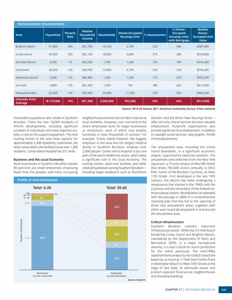
Socioeconomic CharacteristicsJust as there are differences in population density and housing types among SouthernBrooklyn’s neighborhoods, so too do theseneighborhoods differ in their socioeconomicmakeup. Southern Brooklyn encompasses bothwealthier and economically distressed neighbor-hoods. For example, in Manhattan Beach, whereunemployment is 5 percent and the poverty rate16 percent, the majority (over 75 percent) of res-idents owns their homes and the average prop-erty value is close to $1 million. At the other endof the socioeconomic spectrum is Coney Island,where the unemployment rate is 13 percent andthe poverty rate is 23 percent. Only one-fifth ofConey Island residents own homes. (See table:Socioeconomic Characteristics)
Typical residences in Gerritsen Beach Credit: gerritsenbeach.net
Sheepshead Bay
Sea Gate
Manhattan Beach
Gravesend
Gerritsen Beach
Coney Island
Brighton Beach 102
51
58
43
27
15
28
NYC average = 42 people/acre
Area Population Density
Source: 2010 US Census
CHAPTER 17 | SOUTHERN BROOKLYN 340
Vulnerable populations also reside in SouthernBrooklyn. There are over 18,000 residents ofNYCHA developments, including significant numbers of individuals who have impaired mo-bility or are on life-support equipment. The ninenursing homes in the area have capacity for approximately 2,400 inpatients; meanwhile, thearea’s seven adult care facilities house over 1,300residents. Coney Island Hospital has 371 beds.
Business and the Local Economy Most businesses in Southern Brooklyn (nearly85 percent) are small enterprises employingfewer than five people, with many occupying
neighborhood commercial corridors that servelocal residents. However, over one-third of thearea’s employees work for larger businesses or institutions, each of which may employhundreds or even thousands of workers. Forexample, Coney Island Hospital, the biggestemployer in the area and the largest medicalfacility in Southern Brooklyn, employs over2,000 people. Coney Island Hospital is but onepart of the area’s healthcare sector, which playsa significant role in the local economy. The nursing homes, adult-care facilities, and othermedical businesses serving Southern Brooklyn—including larger employers such as Shorefront
Geriatric and the Shore View Nursing Home—offer not only critical services but also valuableemployment. Nonprofit organizations alsoprovide significant local employment, in additionto valuable social services. (See graphic: Profileof Area Businesses)
The amusement area, including the Coney Island Boardwalk, is a significant economic engine, supported by seasonal visitation. Theamusement area stretches from the New YorkAquarium, a 14-acre campus at West 8th Streetthat draws 750,000 visitors annually, to MCUPark, home of the Brooklyn Cyclones, at West17th Street. First developed in the late 19thcentury, the district has been undergoing a renaissance that started in the 1990s with the Cyclones and the renovation of the Stillwell Av-enue subway station. Revitalization acceleratedwith the passage in 2009 of a comprehensiverezoning plan that has led to the opening ofthree new amusement areas, together withother year-round development in and aroundthe amusement area.
Critical Infrastructure Southern Brooklyn contains important infrastructure assets. While the 2.5-mile beachbordering Coney Island and Brighton Beach,maintained by the Department of Parks andRecreation (DPR), is a major recreationalamenity, it is also critical for storm protectionfor the entire peninsula. The mid-1990sreplenishment project by the USACE raised thebeach by as much as 11 feet from Corbin Placein Manhattan Beach to West 37th Street at theedge of Sea Gate, to attenuate waves andprotect adjacent flood-prone neighborhoodsand shoreline buildings.
Businesses by size of business
1 - 4
5 - 9
50 - 99
Employees by size of business
Total: 6.2K Total: 35.6K
8%
Num
ber
of E
mp
loye
es
100+
10 - 49
84%
6%1%
29%
8%
9%
20%
34%
Profile of Area Businesses
Source: Hoovers
Area PopulationPoverty
Rate
Median Household
IncomeHouseholds
Owner-OccupiedHousing Units
% Homeowners
% Owner-Occupied
Housing Unitswith Mortgage
Median Owner-
Occupied UnitValue
Brighton Beach 31,500 24% $31,700 12,100 2,700 22% 58% $487,000
Coney Island 45,000 23% $32,100 18,000 3,800 21% 38% $320,800
Gerritsen Beach 5,200 7% $62,500 1,900 1,400 75% 78% $446,000
Gravesend 38,300 16% $38,900 13,800 4,700 34% 44% $546,200
Manhattan Beach 4,600 16% $84,800 1,600 1,200 77% 52% $922,300
Sea Gate 4,800 14% $61,500 1,500 730 48% 66% $614,600
Sheepshead Bay 62,000 14% $49,900 24,000 11,200 47% 55% $460,500
Citywide Total/Average
8,175,000 19% $51,300 3,050,000 993,500 33% 64% $514,900
Socioeconomic Characteristics
Source: 2010 US Census, 2011 American Community Survey, 5-Year estimate

A STRONGER, MORE RESILIENT NEW YORK341
Meanwhile, the Belt Parkway, an integral part ofthe regional highway network, extends 25 milesfrom the Gowanus Expressway in Brooklyn to the Cross Island Parkway in Queens. Built be-ginning in the 1930s, this major roadway hasadjacent parks and esplanades maintained byDPR. Many sections of the Belt Parkway haveoceanfront exposures and flood during rain orstorm surge events, although a seawall or bulk-head exists along portions of the roadway. OnPlumb Beach, a former barrier island east of Sheepshead Bay, the USACE has advancedrenourishment projects to protect the roadwayfrom erosion, including a recent project that involved the installation of geotubes (large,long textile tubes filled with sand).
Run by the Metropolitan Transportation Authority(MTA), Coney Island Yards facility is anotherintegral part of the transportation infrastructure.The 75-acre facility—the largest rapid transitcomplex of its type in the world—includes work-shops where maintenance and overhauls areperformed on the subway fleet. The facility wasconstructed on former marshlands and near sea level, however, making the yard vulnerable to inundation.
The Coney Island Wastewater Treatment Plant(WWTP) is also a critical infrastructure asset.Located on Shell Bank Creek within GerritsenInlet, this Department of Environmental Protec-tion (DEP) facility has the capacity to process110 million gallons per day. It serves most ofSouthern Brooklyn and areas to the north andeast. (See map: Area Critical Infrastructure)
What Happened During Sandy
Sandy’s storm surge struck Southern Brooklyn intwo ways. The storm brought direct wave impacts
along ocean-facing areas, particularly in areaswhere coastal protections were lacking orinadequate, such as in Sea Gate and ManhattanBeach. Even more significant, though, was the in-undation that occurred via inland waterways, andhistoric creeks and marshland that had beenpaved over decades before. Generally, waters thatentered Southern Brooklyn through these routesresulted in “stillwater flooding,” where the waterrose steadily through the peak of the storm, andthen receded quickly after the surge and high tide had passed. At Sandy’s peak, floodwatersreached a height of 10 feet in some places,including, for example, along Neptune Avenue inConey Island. (See map: Area Inundation andSurge Height)
In Sea Gate, powerful waves struck buildingsalong the waterfront, knocking out the firstfloors of a number of structures. Where owners
had built bulkheads at the edges of their prop-erties, damage generally was mitigated. However, areas without bulkheads both werethemselves vulnerable and allowed waves toscour and undermine neighboring seawalls andbulkheads. For example, the substandard bulkhead at Lindy Park collapsed as a result ofsevere wave impacts.
Along Coney Island and Brighton Beach, by contrast, the USACE nourishment project generally performed as intended, breakingwaves before they made contact with buildings.However, the beach lost approximately 272,000cubic yards of sand, according to USACEestimates, and some areas along the beach thatwere nourished to lower elevations experiencedbreaches, with waves pushing sand and waterinto adjacent neighborhoods. At Ocean Parkway,for instance, waves pushed thousands of tons of
Sheepshead BayConey Island Creek
GravesendBay
Inundation (Feet Above Ground)
Less Than 3
3 - 6
6 - 10
More Than 10
Area Inundation and Surge Height
Damage in Sea Gate
Coney Island Yards (MTA) Coney Island WWTP (DEP)
Belt Parkway
Beach/ Boardwalk (Parks)
Coney Island Creek Sheepshead Bay
GravesendBay
Coney Island Hospital (HHC)
Area Critical Infrastructure
Credit: Fred R. Conrad/The New Yo rk Times
Source: FEMA MOTF 11/6 Hindcast surge extent

CHAPTER 17 | SOUTHERN BROOKLYN 342
sand northward, with water traveling 1.5 milesnorth to Avenue W, joining floodwaters fromSheepshead Bay and Coney Island Creek.
Meanwhile, in Manhattan Beach and at Kings-borough Community College, the elevation ofthe area helped mitigate flooding. Waves,though, damaged esplanades, docks, and otherstructures at the water’s edge, particularlyalong the Manhattan Beach waterfront, fromCorbin Place to the college campus at theeastern tip of the peninsula.
Sheepshead Bay was a major source of thefloodwaters that impacted the neighborhoodsof Sheepshead Bay and Manhattan Beach. The swelling of Coney Island Creek, too, led toinundation in Coney Island and Gravesend. The surge overtopped the creek’s low edges (in fact, there was flooding along Neptune Av-enue, adjacent to Coney Island Creek, a full 12hours before the surge’s peak). Even in theocean-facing neighborhoods of Coney Island,Brighton Beach, and Manhattan Beach, flood-waters came primarily from their “backdoors”until the peak of the storm when, in manyareas, waters from the ocean met waters fromthe north side of the peninsula on land.
Elsewhere, storm surge pushed into GerritsenInlet, which then overflowed into the neighbor-hood of Gerritsen Beach (although floodwatersalso came over Plumb Beach and the Belt Parkway). This water then flowed to Shell BankCreek and up and over the creek’s edges intoadjacent homes.
The most methodologically rigorous buildingdamage assessment undertaken by New YorkCity of Buildings (DOB) was completed in December 2012. According to this assess-ment, of those buildings citywide that weretagged, either yellow or red (including thosefurther classified as destroyed), 10 percentwere located in Southern Brooklyn. The yellowand red tagged buildings in Southern Brooklyntended to be clustered along Atlantic Avenue inSea Gate, in Sheepshead Bay and GerritsenBeach. Southern Brooklyn was unusual amongocean-facing parts of the city, with a larger percentage of red and yellow tagged buildingsthat were tagged yellow (78 percent) thanneighborhoods such as South Queens (41 percent) and the East and South Shores (52 percent). This was reflective of the fact that,in Southern Brooklyn, although a significantnumber of buildings were damaged by powerfulwaves coming off of the ocean, the area also experienced significant “backdoor” (stillwater)inundation in its northern regions. (See map:Location and Level of Building Damage)
Southern Brooklyn Citywide
78%
1%
62%
21%
11%
27%Destroyed
Yellow
Red
DOB Tag Data
Level of Building Damage
Source: DOB December Tags
Sheepshead BayConey Island Creek
GravesendBay
Destroyed
Red
Yellow
DOB Tag Data
Source: DOB December Tags
Damage at Manhattan Beach
Location and Level of Building Damage
Credit: Nate Bliss

A STRONGER, MORE RESILIENT NEW YORK343
Overall, the storm’s impact on buildings inSouthern Brooklyn was primarily from stillwaterflooding. Inundation damaged ground-floor andbasement spaces, destroying electrical equipment and other building systems, and disrupting power service. Thousands of com-mercial spaces were inundated, resulting in theloss of inventory and valuable equipment that
was not elevated, as well as the destruction ofinterior finishes.
Flooding had a huge impact on the homes andresidents of Southern Brooklyn. Flooding ofground-floor residential units, single-familyhomes, and bungalows throughout the area resulted in temporary displacement of
residents. Repairs to electrical, heat, and elevator systems in high-rise buildings— including public housing and Mitchell-Lamabuildings—took two to four weeks and, in somecases, even longer. Meanwhile, 10 Departmentof Education buildings had major damage,which impacted fifteen schools. In Coney Island, it was nearly two and half months beforestudents could return to P.S. 288 (the ShirleyTanyhill School). In the interim, these studentswere sent to other schools.
Local businesses were also hit hard, with over 5,000 businesses employing over 30,000 people affected by the storm. Alongneighborhood retail corridors, local grocerystores were closed, making it difficult for residents in Coney Island to access food following the storm. In turn, many businessesthat managed to reopen found themselves withfewer customers because so many SouthernBrooklyn residents had been displaced.
There were significant losses within the entertainment area as well. At the New YorkAquarium, operated by the Wildlife ConservationSociety, floodwaters poured into buildings,causing an estimated $65 million in damageto life-support systems for fish and marine mam-mals and exhibit infrastructure. Sandy also destroyed the MCU Park front office, lockerrooms, and field, and did millions of dollars of damage to rides and electrical systems atthe area’s amusement parks.
Southern Brooklyn’s Jamaica Bay Neighborhoods The neighborhoods of Southern Brooklynthat front on Jamaica Bay, including MarinePark, Bergen Beach, Mill Basin, Canarsie, and East New York, experienced Sandy insome ways that were similar to the neighbor-hoods on which this report focuses and insome ways that were different. Howevereach was impacted in ways that continue to affect the residents and businesses of theseneighborhoods.
During Sandy, most of the damage done to these neighborhoods was the result of inundation from Jamaica Bay. Sandy's flood-waters arrived with the storm, were pushedthrough Rockaway Inlet into the Bay and thenmade their way into creeks, basins, and inlets, overflowing sandy beaches and wetlands and overwhelming bulkheads. Inthe case of Canarsie, this neighborhood wasflooded on multiple fronts, with waters coming both from Paerdegat Basin and FreshCreek, impacting hundreds of structures.
Looking to the future, low-lying areas such asthese neighborhoods are particularly at riskfrom rising sea levels that could exacerbatestorm surges like that brought by Sandy. Theinitiatives described in this report are designed to help address these risks througha range of strategies. Among these are: newcoastal protections (studying, for example,a potential storm surge barrier across Rockaway Inlet; see Southern Brooklyn Initiative 4); a program to raise bulkheads
and other shoreline structures in low-lyingmost at risk of flooding, including potentiallythese Bay-facing Brooklyn neighborhoods(see Coastal Protection Initiative 6); andwetland restoration measures in and aroundJamaica Bay. At the same time, this reportproposes other measures that will help with recovery in these neighborhoods bysupporting housing and commercial rebuild-ing, building-level resiliency investments, andinvestments in critical infrastructure.
Credit: Nate Bliss
Damage at the W. 37th Street jetty Credit: Nate Bliss

CHAPTER 17 | SOUTHERN BROOKLYN 344
Meanwhile, Coney Island Hospital and manyarea nursing homes, adult-care residences, andother outpatient medical facilities experiencedflooding and power loss, resulting in evacuations in the days after the storm. In fact,Coney Island Hospital, which lost power and suffered significant damage to its mechan-ical and electrical systems, had to close the day after the storm—evacuating more than220 patients—and it was months before thehospital could begin providing inpatient care(see Chapter 8, Healthcare).
Sandy also had a significant impact on key infrastructure in the area, resulting in damageand disruption to critical services. The BeltParkway was inundated in sections, with dam-age to its seawall and bulkhead. At Coney IslandYards, there was flooding and significant dam-age to track switches. Transit service was downfor nine days following the storm. The Coney Is-land WWTP lost power during the storm for twohours, and inundation inflicted modest damageon the facility. DEP workers heroically laboredto get the plant back online quickly, whichhelped minimize the discharge of untreatedwastewater following the storm.
What Could Happen in the Future
Going forward, given the area’s coastal exposure and low topography, and as evi-denced by Sandy’s destructive impacts, themost significant risk to Southern Brooklyn isfrom flooding resulting from coastal storms, exacerbated by projected sea level rise.
Major RisksPreliminary Work Maps (PWMs) were releasedin June 2013 by the Federal Emergency Management Agency (FEMA). According tothese new PWMs, the boundaries for the 100-year floodplain—the area that has a 1 percent or greater chance of flooding in anygiven year—have expanded to include mostportions of the area that were once marshlands.(See map: Comparison 1983 FIRMs and Preliminary Work Maps)
There is also a dramatic increase—215 percent—in buildings of all types in the 100-year floodplain of the PWMs compared to thatof the 1983 FIRMs. Base Flood Elevations(BFE)—the height to which floodwaters couldrise during a storm—shown on the maps haveincreased two to three feet in large swaths of
the area. Meanwhile, V Zones, the areas of the100-year floodplain where waves could exceedthree feet in height, have increased along theoceanfront and, in some cases, they even extend into residential areas. Sensitive facilities,such as Coney Island Hospital and Coney IslandYards, are now within the 100-year floodplain.(See table: Buildings in the Floodplain)
According to projections from the New YorkCity Panel on Climate Change (NPCC), de-scribed in Chapter 2, sea levels are projected torise through the 2020s and 2050s. During thisperiod, the floodplain will likely expand, andthroughout the area, the BFE will likely continueto rise, reflecting the risk of ever-higherfloodwaters during storms. According to the NPCC’s high-end projections, the 2050s,in Southern Brooklyn, approximately 20,000buildings are expected to be in the floodplain(an increase of 30 percent over the PWMs), V Zones are also expected to expand, and BFEs are expected to increase. (See map: Comparison of Preliminary Work Maps andFuture Floodplains)
Taking into account the combination of sea level rise and increased storm severity, existing coastal protections may prove no
Scale of Impact
Hazard Today 2020s 2050s Comments
Gradual
Sea level rise Minimal impact
Increased precipitation
Could result in combined sewer overflows and flooding of low-lying areas
Higher average temperature
Minimal impact
Extreme Events
Storm surgeSignificant risk of both flooding and wave action, as evidenced by Sandy; risk will grow as V Zone expands; increased storm frequency will leave less time to restore coastal protections
Heavy downpourAs with increased precipitation, likely to result in more combined sewer overflowsand flooding
Heat waveGreater strain on power system with potential for more failures; most significant impact on high-rise buildings
High winds Overhead power lines are at risk of failure
Risk Assessment: Impact of Climate ChangeMajor Risk Moderate Risk Minor Risk
A STRONGER, MORE RESILIENT NEW YORK345
longer adequate. Additionally, increased stormfrequency will make it challenging to restorecoastal protections between extreme weather events.
Other RisksThough considerably less significant than therisk from storm surge, other moderate climatechange risks do exist going forward for SouthernBrooklyn. For example, increased precipitationand heavy downpours may overwhelm sewersystems, a phenomenon that already occurstoday in some areas. Heavy rain events alsocould result in additional localized flooding.
While future projections for changes in windspeeds are not available from the NPCC, agreater frequency of intense hurricanes by the2050s could present a greater risk of high windsin the New York area, which could result indowned overhead powerlines and trees, andpotentially damage older buildings not constructed to modern wind standards. Heatwaves may also strain power systems.
Because much of its land lies at least several feetabove sea level, most of Southern Brooklyn isnot expected to be threatened by sea level risealone, under typical conditions, and in the ab-sence of extreme weather events. However, iso-lated low-lying areas may experience increasedregular tidal flooding. Higher average tempera-tures outside of the increase in the number ofheat waves are not expected to have meaning-ful impacts on the area.
Sheepshead BayConey Island Creek
GravesendBay
1983 FIRMs 100-Year Floodplain
2013 PWMs 100-Year Floodplain
Overlap
Comparison of 1983 FIRMs and Preliminary Work Maps
Sheepshead BayConey Island Creek
GravesendBay
2013 PWMs 100-Year Floodplain
Projected 2020s 100-Year Floodplain
Projected 2050s 100-year-Floodplain
Comparison of Preliminary Work Maps and Future Flooplains
Coney Island CreekCredit: Charles Denson/
Coney Island History Project
Buildings & Units100-Year Floodplain
1983FIRMs
2013PWMs
Projected 2020s
Projected 2050s
Residential Buildings 4,240 14,220 16,880 18,560
Residential Units 28,100 61,400 73,700 78,800
Commercial andOther Buildings
700 1,340 1,540 1,650
Buildings in the Floodplain
Source: DCP PLUTO, FEMA, CUNY Institute for Sustainable Cities
Source: FEMA, CUNY Institute for Sustainable Cities
Source: FEMA
CHAPTER 17 | SOUTHERN BROOKLYN 346
Priorities from Public Engagement in Southern Brooklyn
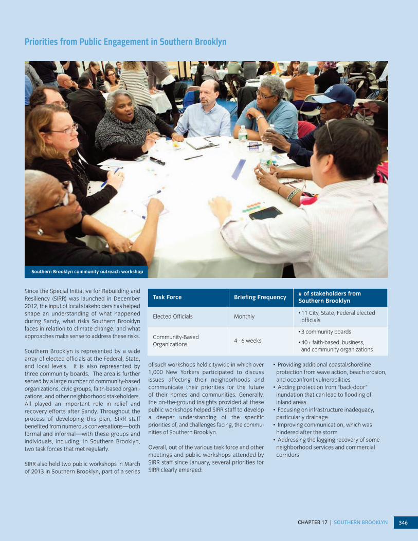
Since the Special Initiative for Rebuilding andResiliency (SIRR) was launched in December2012, the input of local stakeholders has helpedshape an understanding of what happened during Sandy, what risks Southern Brooklynfaces in relation to climate change, and whatapproaches make sense to address these risks.
Southern Brooklyn is represented by a widearray of elected officials at the Federal, State,and local levels. It is also represented by three community boards. The area is furtherserved by a large number of community-basedorganizations, civic groups, faith-based organi-zations, and other neighborhood stakeholders.All played an important role in relief and recovery efforts after Sandy. Throughout theprocess of developing this plan, SIRR staff benefited from numerous conversations—bothformal and informal—with these groups and individuals, including, in Southern Brooklyn,two task forces that met regularly.
SIRR also held two public workshops in Marchof 2013 in Southern Brooklyn, part of a series
of such workshops held citywide in which over1,000 New Yorkers participated to discuss issues affecting their neighborhoods and communicate their priorities for the future of their homes and communities. Generally, the on-the-ground insights provided at thesepublic workshops helped SIRR staff to developa deeper understanding of the specific priorities of, and challenges facing, the commu-nities of Southern Brooklyn.
Overall, out of the various task force and othermeetings and public workshops attended bySIRR staff since January, several priorities forSIRR clearly emerged:
• Providing additional coastal/shoreline protection from wave action, beach erosion,and oceanfront vulnerabilities
• Adding protection from “back-door”inundation that can lead to flooding of inland areas.
• Focusing on infrastructure inadequacy,particularly drainage
• Improving communication, which was hindered after the storm
• Addressing the lagging recovery of someneighborhood services and commercial corridors
Task Force Briefing Frequency# of stakeholders from Southern Brooklyn
Elected Officials Monthly• 11 City, State, Federal elected
officials
Community-Based Organizations
4 - 6 weeks
• 3 community boards
• 40+ faith-based, business, and community organizations
Southern Brooklyn community outreach workshop

A STRONGER, MORE RESILIENT NEW YORK347

CHAPTER 17 | SOUTHERN BROOKLYN 348

A STRONGER, MORE RESILIENT NEW YORK349
INITIATIVES FOR INCREASING RESILIENCY IN SOUTHERN BROOKLYN
Southern Brooklyn CommunityRebuilding and Resiliency Plan
Southern Brooklyn is an historic area containingsome of New York City’s most iconic attractionsand unique neighborhoods. The area benefitsfrom unparalleled access to a beautiful beach,the waterfront, and a network of public parks.
The following is a multilayered plan that notonly applies citywide strategies to SouthernBrooklyn, but also provides strategies designedto address the area’s specific needs and particular vulnerabilities. In anticipation of future climate change-related risks, this planproposes ways that Southern Brooklyn neigh-borhoods can adapt by: addressing wave actionand inundation along the entire coastline; providing opportunities to retrofit the area’smost vulnerable building stock while exploringpotential redevelopment over time in certainneighborhoods; protecting and improving critical infrastructure; and focusing investmentsin strategic areas, such as the beachfront, to advance a long-term and sustainable recovery.
Coastal Protection
As Sandy illustrated, the greatest extremeweather-related risk faced by New York Cityis storm surge, the effects of which are likely toincrease given current projections of sea levelrise. Going forward, it is anticipated that climatechange will render coastal regions of the city, including Southern Brooklyn, even morevulnerable to these risks.
While it is impossible to eliminate the chanceof flooding in coastal areas, the City will seek toreduce its frequency and effects—mitigatingthe impacts of sea level rise, storm waves including erosion, and inundation on the coastline of the city generally and SouthernBrooklyn in particular. Among the strategiesthat the City will use to achieve these goals will be the following: increasing coastal edgeelevations; minimizing upland wave zones; protecting against storm surge; and improvingcoastal design and governance. When evaluat-ing coastal protection, other priorities includingnavigation and ongoing efforts to improvewater quality and natural habitats, also will be considered prior to implementation, where appropriate.
The initiatives described below provide importantexamples of how the City intends to advance its coastal protection agenda citywide. These initiatives will have a significant impact on theresidents, businesses, and nonprofits of SouthernBrooklyn. Taken together, when completed, the
first six coastal protection initiatives describedbelow would provide enhanced protection for nearly 1,000 buildings in Southern Brooklyn,representing nearly 12,000 housing units as wellas many businesses and much of the criticalinfrastructure in Southern Brooklyn. For a fullexplanation of the following initiatives and a complete description of the City’s comprehensivecoastal protection plan, please refer to Chapter3 (Coastal Protection).
Coastal Protection Initiative 1Continue to work with the USACE to complete emergency beach nourishmentin Coney Island
Though the beach at Coney Island helped toprotect adjacent neighborhoods from some ofthe impacts of Sandy's surge, doing so came atthe cost of significant beach erosion. The City,therefore, will support emergency beach nourishment work from Corbin Place to West37th Street. The initiative will replace approxi-mately 1 million cubic yards of sand, which replaces sand lost during Sandy and will restorethe beach to its original design profile. As partof this initiative, the City and USACE will developa plan for ongoing beach maintenance to ensure future events can be followed quickly by restoration of lost sand. The project willbegin in July with completion expected by the end of 2013.
Coastal Protection Initiative 4Install armored stone shoreline protection(revetments) in Coney Island
During Sandy, Coney Island Creek was the sourceof much of the “backdoor” flooding in SouthernBrooklyn. Subject to available funding, the City,therefore, will raise the lowest edge elevationswith revetments along Coney Island Creek to aconsistent grade. The City, through the Office ofLong-Term Planning and Sustainability (OLTPS)and the New York City Economic DevelopmentCorporation (NYCEDC), will begin design in 2013with completion expected within three years.
Coastal Protection Initiative 6 Raise bulkheads in low-lying neighborhoods to minimize inland tidal flooding
Bulkheads provide the first line of defenseagainst flooding in many neighborhoods, including Southern Brooklyn, but throughoutthe city many bulkheads are built to an eleva-tion that may be insufficient given the latestprojections of sea level rise by 2050. Subject toavailable funding, the City, therefore, will launch a program to raise bulkheads and othershoreline structures across the five boroughs inlow-lying areas most at risk of daily or weekly
This chapter contains a series of initiatives thatare designed to mitigate the impacts of climatechange on Southern Brooklyn. In many cases,these initiatives are both ready to proceed and have identified funding sources assignedto cover their costs. With respect to theseinitiatives, the City intends to proceed withthem as quickly as practicable, upon the receipt of identified funding.
Meanwhile, in the case of certain other initiativesdescribed in this chapter, though these initiativesmay be ready to proceed, they still do not havespecific sources of funding assigned to them. In Chapter 19 (Funding), the City describes additional funding sources, which, if secured,would be sufficient to fund the full first phase of projects and programs described in this document over a 10-year period. The City willwork aggressively on securing this funding andany necessary third-party approvals required inconnection therewith (i.e., from the Federal orState governments). However, until such timeas these sources are secured, the City will onlyproceed with those initiatives for which it hasadequate funding.

CHAPTER 17 | SOUTHERN BROOKLYN 350
tidal flooding, a phenomenon that could impactover one mile of Southern Brooklyn’s shorelineby the 2050s. OLTPS will work with NYCEDC tomanage this program, to begin implementationin 2013, in conjunction with the new citywidewaterfront inspections program described in Chapter 3.
Coastal Protection Initiative 7Complete emergency bulkhead repairsadjacent to the Belt Parkway in Southern Brooklyn
Several critical bulkheads along the Belt Park-way failed during Sandy, leaving several por-tions of the roadway exposed and vulnerable tofuture extreme weather. The City, through DPR,therefore will complete bulkhead repairs inareas damaged during Sandy, including at 14thAvenue, 17th Avenue and 95th Street. Theserepairs will enhance protection during thisyear’s hurricane season. These repairs are expected to be completed in 2013.
Coastal Protection Initiative 16Continue to work with the USACE to complete its Plumb Beach breakwaterand beach nourishment project in Southern Brooklyn
Shortly before Sandy's arrival, the USACE completed the first phase of a beach nourish-ment project at Plumb Beach, along the BeltParkway. The project provided critical protectionto the Parkway during the storm. The City, therefore, will support completion of the secondphase of this existing project. The second phasewill include additional nourishment and construction of an offshore breakwater. It is expected to be completed in 2014.
Coastal Protection Initiative 18Continue to work with the USACE to complete its Sea Gate project in Southern Brooklyn
Sea Gate has very little coastal protection. As a result, during Sandy, the neighborhood sustained significant damage. The City, there-fore, will support construction of groins in thisneighborhood. These offshore structures areprimarily intended to protect the terminal groinat West 37th Street, but also will provide afirst line of protection to the neighborhoodagainst some of the impacts of inundation anddestructive wave action. This project is expected to be completed by 2014.
– – –
Beyond the priority coastal protection projects described in Chapter 3, includingthose summarized briefly above, the City is
proposing additional coastal protection initia-tives specific to Southern Brooklyn’s vulnerabil-ities. These initiatives are described below.
Southern Brooklyn Initiative 1Call on and work with the USACE to study additional Sea Gate oceanfront protection
As described above, Sea Gate is highly vulnerable to wave action risks. This is due inpart to the neighborhood’s decision not toparticipate in the USACE replenishment projectof the mid-1990s as a result of concerns relatingto public access required in connection with thereceipt of Federal funding. The City will call forthe USACE to develop an implementation planfor additional protection measures at Sea Gateto address these lingering vulnerabilities. Whilethe groin project referenced above will provideneeded shoreline protection in the near-term,in developing its implementation plan, theUSACE should investigate whether additionalbeach nourishment extending west of the existing West 37th Street jetty to Norton’s Pointand development of a reinforced sea wall ordune system on the coastal edge of GravesendBay may be appropriate. To obtain Federalfunding for protective measures, the Sea GateAssociation, which is the predominant owner ofoceanfront property in the area, will likely berequired to provide public access to the community’s beaches. The goal is for USACE tobegin work on this plan as part of its continuingstudies of flood risk reduction in New York City,based on the recommendations of this report.
Southern Brooklyn Initiative 2Continue to work with the USACE tostudy strengthening the ConeyIsland/Brighton Beach nourishment
While immediate restoration of these beachesto pre-storm conditions with sand replacementand reshaping is critical, rising sea levels andmore frequent storm surge demands more protection, focused first on areas of the beach(such as that at the end of Ocean Parkway) thatwere breached in the recent storm. The City willcall on the USACE to develop an implementa-tion plan containing options for strengtheningthe protections offered by these beaches. Ad-ditional measures could include structureddune systems, seasonal installation of “snow-fencing” to control sand and sediment migra-tion, and potential reinforcement or extensionof existing groins. Working with DPR, the USACEshould also explore such protective measuresas part of its current comprehensive study. Cer-tain low-cost interventions—such as temporaryfencing—may be pursued or piloted by DPR inthe near-term. The goal is for the USACE tobegin work on this plan as part of its continuing
studies of flood risk reduction in New York City,based on the recommendations of this report.
Southern Brooklyn Initiative 3Call on and work with the USACE to studyManhattan Beach oceanfront protections
In Manhattan Beach, an historic esplanade hasbeen the subject of an ownership dispute andwas not repaired following a 1993 nor’easter,leaving waterfront properties and the neighbor-hood behind them vulnerable, therefore, toSandy’s pounding waves. The City will call on theUSACE to develop an implementation plan con-taining options for reinforcing protections alongthe Manhattan Beach waterfront from CorbinPlace to Kingsborough Community College at theeastern tip of the Coney Island peninsula. TheCity will encourage private waterfront propertyowners to engage with the USACE and considerparticipating in the implementation of such pro-tections. New or reinforced ocean-facing protec-tions—such as sea walls, bulkheads andrevetments—would serve to protect ocean-fac-ing structures and homes from waves and uplandareas from inundation. The Federal governmentwould likely require public waterfront access inorder to support additional oceanfront protec-tions. The goal is for the USACE to begin work onthis plan as part of its comprehensive study offlood risk reduction in New York City, based onthe recommendations of this report.
Southern Brooklyn Initiative 4Call on and work with the USACE tostudy mitigating inundation risks throughRockaway Inlet, exploring a surge barrierand alternative measures
Much of the flood damage from Sandy in theneighborhoods of Brooklyn and Queens thatface Jamaica Bay came from water that flowedthrough Rockaway Inlet into the Bay. The extensive shoreline that surrounds Jamaica Baysupports a variety of land uses and densities,all of which are at risk of flooding. Becauseflood protection along the existing shoreline ofJamaica Bay would be extremely expensive and disruptive, and in some cases nearlyimpossible, the City will call on and work withthe USACE to develop an implementation plan for a local storm surge barrier to be constructed across Rockaway Inlet approxi-mately between Manhattan Beach in Brooklynand Breezy Point in Queens. A Rockaway Inletlocal storm surge barrier at this location couldprotect against significant inland flooding andwave risk in neighborhoods from SheepsheadBay to Howard Beach, as well as JFK Airport,Broad Channel and the entire bayside of theRockaway peninsula (provided that the barrierwere completed in conjunction with dune enhancements along the oceanside of the

INITIATIVES FOR INCREASING RESILIENCY IN SOUTHERN BROOKLYN
A STRONGER, MORE RESILIENT NEW YORK351
Rockaway peninsula and mitigation measuresalong Coney Island Creek). This project, in turn, would obviate the need for extensive lo-calized coastal protections spread around theshoreline of the Bay. A preliminary feasibility assessment, to be performed by OLTPS in coordination with DEP, would examine impactson water quality, habitat, hydrodynamics, andnavigation, and would identify potential secondary coastline reinforcements.
The aforementioned study should also examinealternative approaches to coastal protection of the vulnerable areas behind this potentialsurge barrier, including localized options for pro-tecting areas adjacent to Sheepshead Bay. Examples of alternative approaches could be theuse of the elevated Belt Parkway as a levee withpassive floodwalls at roadway underpasses; permanent levees along the perimeter of theBay; and the “shallowing” of Jamaica Bay. As an-other alternative, the study should also examinethe feasibility of a navigable or non-navigablesurge barrier at Gerritsen Inlet, exploring costs and potential impacts to navigation andwater quality.
The goal is for the USACE to begin work on thisplan as part of its comprehensive study of floodrisk reduction in New York City, based on therecommendations of this report.
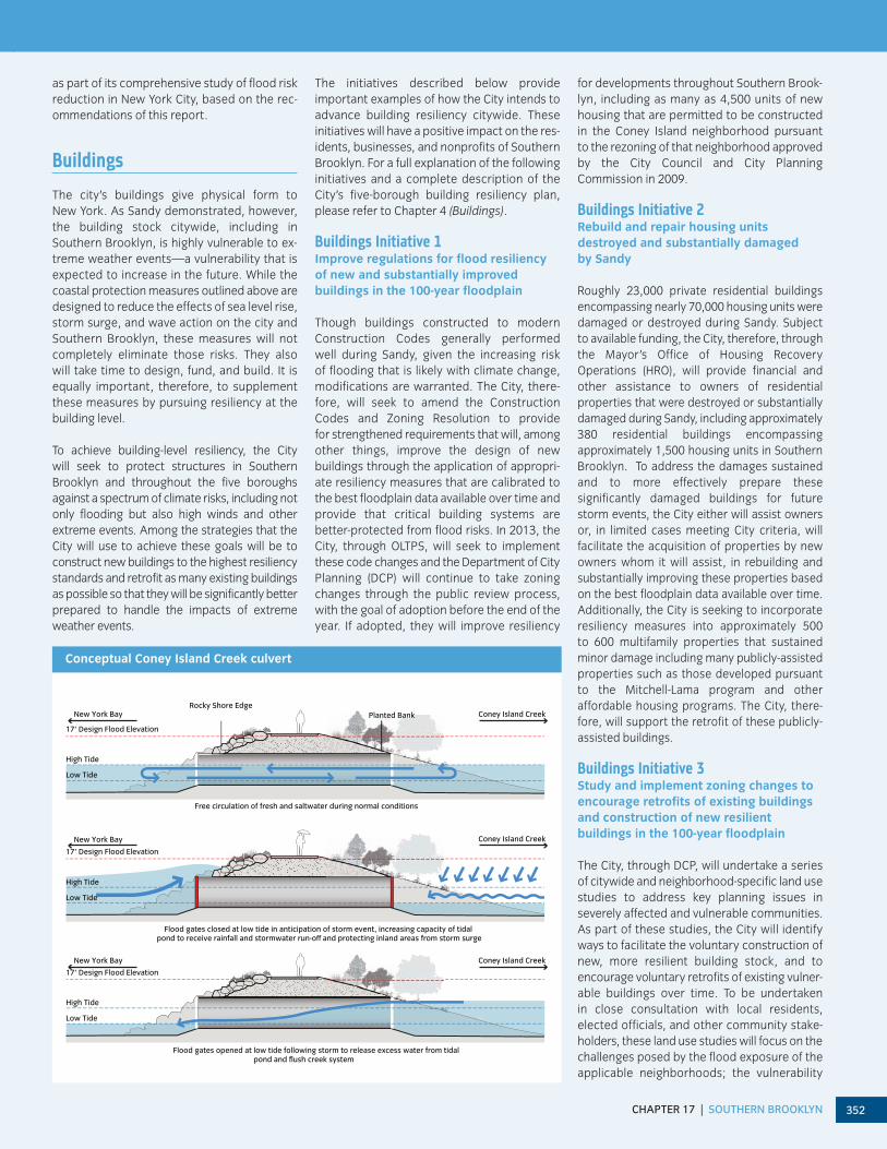
Southern Brooklyn Initiative 5Develop an implementation plan and preliminary designs for new Coney IslandCreek wetlands and tidal barrier
Coney Island Creek presents a significant floodrisk to Coney Island and Gravesend. Therefore,the City will develop an implementation plan andpreliminary designs for a significant rethinking of the Creek that goes beyond the revetment project described above. This rethinking will include consideration of further protections, including edge-strengthening and edge-softeningmeasures, such as wetland construction, and apotential up-creek tidal barrier or dam across theCreek to control tidal surge and improve waterquality. A new levee and tide gate system couldconnect Calvert Vaux and Kaiser Parks. New culverts (pipes) that generally would allow normal tidal flow could be closed at low-tide in anticipation of a storm, converting the Coney Island Creek bed into a water detention basin
for the surrounding neighborhoods and holdingback surge. Following a weather event, the culverts could be reopened and water coulddrain, flushing the Creek. (See graphic: Concep-tual Coney Island Creek culvert)
While these changes would impede future navigation of the Creek, they would also present an unprecedented opportunity to mit-igate flood risks for the entire Coney Islandneighborhood, for much of the Gravesendneighborhood, and for sensitive infrastructuresuch as the MTA’s Coney Island Yards, all ofwhich were damaged by Sandy. Additionally,the Creek protections could serve to expandrecreation options and public access, poten-tially transforming this ill-used waterway into amajor public open space amenity for SouthernBrooklyn. (See rendering: Coney Island Creek)
The implementation plan and preliminary designs, to be advanced by OLTPS and by theUSACE subject to available funding, would investigate environmental impacts and bene-fits, hydrology, water quality issues, permittingissues, and operational considerations. Thegoal is for the USACE to begin work on this plan
Conceptual rendering of Coney Island Creek wetlands and tidal barrier, with Rockaway inlet barrier
Coney Island Creek
CHAPTER 17 | SOUTHERN BROOKLYN 352
as part of its comprehensive study of flood riskreduction in New York City, based on the rec-ommendations of this report.
Buildings
The city’s buildings give physical form to New York. As Sandy demonstrated, however,the building stock citywide, including in Southern Brooklyn, is highly vulnerable to ex-treme weather events—a vulnerability that isexpected to increase in the future. While thecoastal protection measures outlined above are designed to reduce the effects of sea level rise,storm surge, and wave action on the city andSouthern Brooklyn, these measures will notcompletely eliminate those risks. They also will take time to design, fund, and build. It isequally important, therefore, to supplementthese measures by pursuing resiliency at thebuilding level.
To achieve building-level resiliency, the City will seek to protect structures in Southern Brooklyn and throughout the five boroughsagainst a spectrum of climate risks, including notonly flooding but also high winds and other extreme events. Among the strategies that theCity will use to achieve these goals will be to construct new buildings to the highest resiliencystandards and retrofit as many existing buildingsas possible so that they will be significantly betterprepared to handle the impacts of extremeweather events.
The initiatives described below provide important examples of how the City intends toadvance building resiliency citywide. Theseinitiatives will have a positive impact on the res-idents, businesses, and nonprofits of SouthernBrooklyn. For a full explanation of the followinginitiatives and a complete description of theCity’s five-borough building resiliency plan,please refer to Chapter 4 (Buildings).
Buildings Initiative 1Improve regulations for flood resiliencyof new and substantially improved buildings in the 100-year floodplain
Though buildings constructed to modern Construction Codes generally performed well during Sandy, given the increasing risk of flooding that is likely with climate change,modifications are warranted. The City, there-fore, will seek to amend the ConstructionCodes and Zoning Resolution to provide for strengthened requirements that will, amongother things, improve the design of newbuildings through the application of appropri-ate resiliency measures that are calibrated tothe best floodplain data available over time andprovide that critical building systems are better-protected from flood risks. In 2013, theCity, through OLTPS, will seek to implementthese code changes and the Department of CityPlanning (DCP) will continue to take zoningchanges through the public review process,with the goal of adoption before the end of theyear. If adopted, they will improve resiliency
for developments throughout Southern Brook-lyn, including as many as 4,500 units of newhousing that are permitted to be constructedin the Coney Island neighborhood pursuant to the rezoning of that neighborhood approvedby the City Council and City Planning Commission in 2009.
Buildings Initiative 2Rebuild and repair housing units destroyed and substantially damaged by Sandy
Roughly 23,000 private residential buildings encompassing nearly 70,000 housing units weredamaged or destroyed during Sandy. Subject to available funding, the City, therefore, throughthe Mayor’s Office of Housing RecoveryOperations (HRO), will provide financial andother assistance to owners of residential properties that were destroyed or substantiallydamaged during Sandy, including approximately380 residential buildings encompassing approximately 1,500 housing units in SouthernBrooklyn. To address the damages sustainedand to more effectively prepare these significantly damaged buildings for future storm events, the City either will assist ownersor, in limited cases meeting City criteria, willfacilitate the acquisition of properties by newowners whom it will assist, in rebuilding andsubstantially improving these properties basedon the best floodplain data available over time.Additionally, the City is seeking to incorporateresiliency measures into approximately 500 to 600 multifamily properties that sustainedminor damage including many publicly-assistedproperties such as those developed pursuantto the Mitchell-Lama program and other affordable housing programs. The City, there-fore, will support the retrofit of these publicly-assisted buildings.
Buildings Initiative 3Study and implement zoning changes toencourage retrofits of existing buildingsand construction of new resilient buildings in the 100-year floodplain
The City, through DCP, will undertake a series of citywide and neighborhood-specific land usestudies to address key planning issues in severely affected and vulnerable communities.As part of these studies, the City will identifyways to facilitate the voluntary construction ofnew, more resilient building stock, and to encourage voluntary retrofits of existing vulner-able buildings over time. To be undertakenin close consultation with local residents,elected officials, and other community stake-holders, these land use studies will focus on thechallenges posed by the flood exposure of theapplicable neighborhoods; the vulnerability
17’ Design Flood Elevation
Free circulation of fresh and saltwater during normal conditions
Flood gates closed at low tide in anticipation of storm event, increasing capacity of tidal pond to receive rainfall and stormwater run-o� and protecting inland areas from storm surge
Flood gates opened at low tide following storm to release excess water from tidal pond and flush creek system
17’ Design Flood Elevation
17’ Design Flood Elevation
High Tide
Low Tide
High Tide
Low Tide
High Tide
Low Tide
Rocky Shore EdgeConey Island Creek
Coney Island Creek
Coney Island Creek
New York Bay
New York Bay
New York Bay
Planted Bank
Conceptual Coney Island Creek culvert

INITIATIVES FOR INCREASING RESILIENCY IN SOUTHERN BROOKLYN
A STRONGER, MORE RESILIENT NEW YORK353
of the building types that are found in theseneighborhoods (e.g., older, 1-story bungalows);and site conditions in these areas (e.g., narrowlots) that can make elevation or retrofit of vul-nerable buildings expensive or complicated. InSouthern Brooklyn, DCP will examine neighbor-hoods including Gerritsen Beach, exploringzoning and other land use changes that, in thefuture, could encourage residents, if they so choose, to make changes with respect to existing homes or build new homes that wouldresult in significantly greater resiliency. Subjectto available funding, the goal is for DCP to commence this study in 2013. Thereafter, DCP would move to implement changes, if any,that it deems to be appropriate based onthe results.
Buildings Initiative 4Launch a competition to encourage development of new, cost-effective housing types to replace vulnerable stock
Subject to available funding, the City, throughthe Department of Housing Preservation and Development (HPD), will launch an internationalResilient Housing Design Competition. This competition will offer prizes to private-sector developers who design and develop new, high-quality housing prototypes that offer own-ers of vulnerable building types (e.g., older, 1-story bungalows), a cost-effective path thatis consistent with city building and zoning requirements, and meet the highest resiliencystandards. In addition to cash prizes, the winners of this competition will be given the op-portunity to put these structures into service inconnection with a City-sponsored developmentproject. Prototypes will have applicabilitythroughout the five boroughs, including in sections of Southern Brooklyn such as Gerritsen Beach and other vulnerable bungalowcommunities. The goal is for HPD to launch thiscompetition in 2013.
Buildings Initiative 5Work with New York State to identify eligible communities for the New YorkSmart Home Buyout Program
The City will evaluate opportunities for collaboration with the State in connection withits home buyout program, using an objectiveset of criteria developed by the City, includingextreme vulnerability, consensus among a critical mass of contiguous local residents, andother relevant factors. It is anticipated thatthese criteria will be met in a limited number ofareas citywide. As of the writing of this report,no areas have been identified for this programin Southern Brooklyn.
Buildings Initiative 6Amend the Building Code and complete studies to strengthen wind resiliency for new and substantially improved buildings
As noted above, buildings constructed tomodern Building Code standards generally performed well during Sandy. Sandy, however,brought relatively weak winds, compared to other hurricanes. Given the possibility of morefrequent or intense wind events in the future,modifications to the Building Code are war-ranted. The City, therefore, through OLTPS, will seek to amend the Building Code to providefor strengthened requirements so that new buildings citywide can meet enhanced standards for wind resiliency. The City will furtherstudy whether additional wind resiliency standards should be required going forward. The amendments will be submitted to the CityCouncil for adoption, and the study will commence, in 2013.
Buildings Initiative 7Encourage existing buildings in the 100-year floodplain to adopt flood resiliency measures through an incentiveprogram and targeted mandate
Even if every structure destroyed or damagedby Sandy were rebuilt to the highest resiliencystandards, this would still leave tens of thousands of existing structures in the 100-yearfloodplain vulnerable—with more becomingvulnerable as the climate changes. Subject toavailable funding, the City, therefore, will launcha $1.2 billion program to provide incentives toowners of existing buildings in the 100-yearfloodplain to encourage them to make resiliency investments in those buildings. Of theup to $1.2 billion available through the pro-gram, the City will reserve up to $100 million for1- and 2- family homes, up to $500 million fordistribution to the five boroughs based on eachborough’s share of vulnerable buildings citywide, and $100 million for affordable hous-ing developments. The City also will mandatethat large buildings (those with seven or morestories that are more than 300,000 square feet in size) undertake certain flood resiliencyinvestments by 2030. If the City consistentlyachieves its stated goal of encouragingsignificant resiliency retrofit investments for thevast majority of the vulnerable built floor areain the five boroughs, nearly 45,000 units encompassing approximately 55 million squarefeet of built space in Southern Brooklynwould, over time, be made meaningfully lessvulnerable. The goal is to launch these programs in 2013.
Buildings Initiative 8Establish Community Design Centers toassist property owners in developing design solutions for reconstructionand retrofitting, and connect them toavailable City programs
The City, through HRO, will establish Commu-nity Design Centers in neighborhoods across the City, potentially including SouthernBrooklyn, to assist property owners in develop-ing design solutions for reconstruction andretrofitting, and connect them to available Cityprograms. The Centers would be managed bythe City—through agencies such as HRO, HPD,DOB, DCP, and NYCEDC—with support fromlocal partners.
Buildings Initiative 9Retrofit public housing units damaged bySandy and increase future resiliency ofpublic housing
During Sandy, public housing developmentsowned and operated by NYCHA suffered significant damage throughout the city. Stillmore were not impacted by Sandy but remainvulnerable to extreme weather, with even morelikely to become vulnerable as the climatechanges. The City, therefore, through NYCHA,will repair public housing developments acrossthe city that were damaged by Sandy, incorpo-rating new flood resiliency measures. In South-ern Brooklyn, 40 buildings containing over 4,000units will be repaired. NYCHA also will undertakea planning process to identify additional resiliency investments in developments that arevulnerable to weather-related events, even ifthey were unaffected by Sandy. In SouthernBrooklyn, NYCHA is, subject to available funding,evaluating resiliency investments in 47 buildingscontaining nearly 3,000 additional units.
Buildings Initiative 10Launch a sales tax abatement programfor flood resiliency in industrial buildings
As Sandy demonstrated, many industrial buildings are vulnerable to extreme weather,with more likely to become vulnerable as the climate changes. However, many industrialbuildings operate on thin margins, making itchallenging to invest in resiliency. The City,through the New York City Industrial Develop-ment Agency (NYCIDA), therefore, will launch a$10 million program to provide incentives toowners of industrial buildings to encouragethem to make resiliency investments in thosebuildings. The program will prioritize 1- to 2-story buildings with more than four feet between their actual ground elevation and the applicable BFE. In Southern Brooklyn,

CHAPTER 17 | SOUTHERN BROOKLYN 354
approximately 25 industrial buildings with over200,000 square feet of floor area will be eligiblefor this program. This program will be launchedin 2013.
Buildings Initiative 11Launch a competition to increase floodresiliency in building systems
Many existing strategies for improving resiliencyin buildings are either imperfect, expensive, or acombination of both. The City, through NYCEDC,therefore, will launch an approximately $40 million Resiliency Technologies Competitionusing allocated Community DevelopmentBlock Grant (CDBG) funding to encourage thedevelopment, deployment, and testing of newresiliency technologies for building systems.In Southern Brooklyn, 15,570 buildings will be eligible to benefit from this competition. The program will be launched in 2013.
Buildings Initiative 12Clarify regulations relating to the retrofit of landmarked structures in the100-year floodplain
The City, through the Landmarks PreservationCommission, will clarify the Commission’s regulations to assist owners of landmarkedbuildings and properties in landmarked districtsin the 100-year floodplain who are contemplat-ing retrofit projects. In Southern Brooklyn, thereare seven landmarked buildings or structures inthe floodplain. The Commission will issue itsclarifying regulations in 2013.
Buildings Initiative 13Amend the Building Code to improvewind resiliency for existing buildings andcomplete studies of potential retrofits
As noted above, given the possibility for morefrequent intense wind events in the future, mod-ifications to the Building Code are warranted.The City, therefore, through OLTPS, will seekto amend the Building Code and expand the ex-isting DOB Façade Inspection Safety Program forhigh-rise buildings to include rooftop structuresand equipment. The City will further studywhether additional wind resiliency standards arerequired going forward. These amendments willbe submitted to the City Council for adoptionand the study will commence in 2013.
– – –
Beyond the priority building resiliency projectsdescribed in Chapter 4, including those summa-rized briefly above, the City is proposing an ad-ditional building resiliency initiative that isspecific to Southern Brooklyn’s vulnerabilities.The initiative is described below.
Southern Brooklyn Initiative 6Study additional resiliency initiatives for ground-floor housing within NYCHA buildings
NYCHA developments are a significant featurein Southern Brooklyn. One challenge in NYCHA’sfacilities is the presence of ground-floor residential units that are below the BFE, and arevulnerable to flooding. There are approximately115 ground-floor units located in 37 NYCHAbuildings in the Coney Island area.
To address this challenge, the City will explorethe construction of new, resilient units in theConey Island area to replace at-risk units. Theseunits would be reserved for tenants of existingground-floor units in public housing develop-ments in Southern Brooklyn. Such a project,provided it were determined to be feasible andwere funded, would include rent and occupancyprotections for NYCHA residents and wouldallow residents to relocate into new, modern,and resilient units in their community. The studyalso will assess how NYCHA could best repurpose vacated ground floor units in currentNYCHA buildings—exploring, for example, community or public-serving commercial uses.
The City’s study will be undertaken in close consultation with the NYCHA resident commu-nity and will seek to identify new sources ofcapital funding and new operating resources.Such new sources of capital funding and oper-ating resources are a necessary preconditionfor any project to proceed. The study will becompleted by early 2014.
Insurance
Insurance can help provide residents and businesses with financial protection againstlosses from climate change and other types ofrisks. Sandy not only highlighted the impor-tance of insurance, it also revealed that manyNew Yorkers are exposed to flood losses, whichare not covered in standard homeowners orsmall business property insurance policies.Citywide, 95 percent of homeowners carryhomeowners insurance, but when Sandy struckless than 50 percent of residential buildings inthe effective 100-year floodplain had coveragethrough the National Flood Insurance Program(NFIP), a Federal program administered by FEMA that provides flood insurance to properties in participating communities likeNew York City. While larger properties, inparticular large commercial properties, tend topurchase flood insurance through the privatemarket, NFIP is the primary source of floodinsurance for homeowners throughout the
country. The City estimates that in areas ofSouthern Brooklyn inundated by Sandy, lessthan 17 percent of residential properties typi-cally insured under the NFIP, including 1- to 2-family homes, amongst others, actually hadpolicies in force during Sandy. Furthermore,Sandy drew attention to the significant cost in-creases in flood insurance that many New York-ers will soon face, resulting from recent reformsto the NFIP as required by the Biggert-WatersFlood Insurance Reform Act.
The City will use several strategies to encour-age more New Yorkers to seek coverage and tohelp the NFIP meet the needs of policyholderscitywide. Specifically, the City will work to: address affordability issues for the most financially vulnerable policyholders; definemitigation measures that are feasible in anurban environment such as Southern Brooklynand create commensurate premium credits tolower the cost of insurance for property ownerswho invest in these measures; encourage theNFIP to expand pricing options (including op-tions for higher deductibles) to give potentialpolicyholders more flexibility to make choicesabout coverage; and launch efforts to improveconsumer awareness, to help policyholdersmake informed choices. The initiatives described below are important examples ofhow the City will advance these strategies.These initiatives will have a major impact on theresidents, small businesses and nonprofits inthis community. For a full explanation of thefollowing initiatives and a complete descriptionof the City’s five-borough insurance reformplan, please refer to Chapter 5 (Insurance).
Insurance Initiative 1Support Federal efforts to address affordability issues related to reform ofthe NFIP
The City will call on FEMA to work with the National Academy of Sciences to complete thestudy of flood insurance affordability, as required under the Biggert-Waters Act. The Citywill urge its Federal government partners tocomply with this provision of the Act and takeswift action to enact the recommendations.
Insurance Initiative 4 Call on FEMA to develop mitigationcredits for resiliency measures
The NFIP provides few incentives for propertyowners to protect their buildings from flooddamage and reduce their premiums, other thanby elevating their buildings—actually liftingstructures above flood elevation levels. In anurban environment such as Southern Brooklyn,for a variety of reasons, elevation can be impractical, undesirable, and/or economically

INITIATIVES FOR INCREASING RESILIENCY IN SOUTHERN BROOKLYN
infeasible. Fortunately, other mitigation optionsare available. The City, therefore, will call uponFEMA to provide appropriate premium creditsfor mitigation measures other than elevation.
Insurance Initiative 6 Call on FEMA to allow residential policy-holders to select higher deductibles
Flexible pricing options can encourage morepeople, especially those not required to carryinsurance, to purchase insurance coverage thatsuits their needs. A higher-deductible optioncan substantially reduce premium costs to policyholders while remaining truly risk-based.Currently under the NFIP, deductibles up to$50,000 are allowed for commercial policies,but residential policies are limited to a maximum deductible of $5,000. The City, there-fore, will call upon FEMA to allow homeownersthat are not required to carry NFIP policies topurchase high-deductible policies, protectingthem from catastrophic loss; initial estimatesindicate that doing so could reduce insurancepremiums by about half.
Critical Infrastructure
A resilient New York requires protection of itscritical services and systems from extremeweather events and the impacts of climatechange. This infrastructure includes the city’sutilities and liquid fuel system, its hospitals andother healthcare facilities, telecommunicationsnetwork, transportation system, parks, waste-water treatment and drainage systems, as wellas other critical networks—all vital to keepingthe city, including Southern Brooklyn, running.
Utilities
The city’s electric, natural gas, and steam systems are essential to everyday life in areasthroughout the five boroughs, including South-ern Brooklyn. As Sandy proved, however, thesesystems are highly vulnerable to extremeweather events with 800,000 customers losingelectricity and 80,000 customers losing natural gas service during Sandy across the city,including approximately 160,000 that lostelectricity service in the borough of Brooklyn.This vulnerability will only grow as the climate changes.
Among the strategies that the City will use toaddress these challenges for residents ofSouthern Brooklyn and other parts of the citywill be to: call for risk-based analysis of low-probability but high-impact weather eventsto be incorporated into utility regulation andinvestment decision-making; call for capital
investments that harden energy infrastructureand make systems more flexible in respondingto disruptions and managing demand; and better diversify the city’s sources of energy. Theinitiatives described below provide importantexamples of how the City intends to advanceutilities resiliency citywide. These initiatives willhave a positive impact on the residents, businesses, and nonprofits of Southern Brook-lyn. For a full explanation of the following initia-tives and a complete description of the City’sfive-borough utilities resiliency plan, pleaserefer to Chapter 6 (Utilities).
Utilities Initiative 5Work with utilities and the Public Service Commission (PSC) to harden keyelectric transmission and distribution infrastructure against flooding
Various transmission substations, distributionsubstations, utility tunnels, and undergroundequipment in the city are at risk of flooding dur-ing extreme weather. For example, 40 percentof transmission substations are in the 100-yearfloodplain today, and 67 percent are likely to bein the 100-year floodplain by the 2050s. TheCity, through OLTPS, will work with Con Edisonand the Long Island Power Authority (LIPA) toprioritize these assets based on their rolesin system reliability and to harden them as ap-propriate. This effort will begin in 2013.
Utilities Initiative 6Work with utilities and the PSC to hardenvulnerable overhead lines against winds
During extreme weather events, high winds anddowned trees threaten overhead electric poles,transformers, and cables. The City, throughOLTPS, will work with Con Edison and LIPA to man-age the risk of wind and downed-tree damagethrough tree maintenance, line strengthening,and a line-relocation program. In some limitedcases, rerouting lines underground may also bewarranted, depending on the outcome of a cost-benefit analysis to be performed in partnershipwith the utilities. This effort will begin in 2013.
Utilities Initiative 7Work with utilities, regulators, and gaspipeline operators to harden the naturalgas system against flooding
Although the city's high-pressure gas transmis-sion system performed relatively well duringSandy, there were instances where remote op-eration of parts of the system failed. Additionally,the distribution system had localized outagesdue to water infiltration. Seeking to limit thecompromising effects of future floods on boththe system’s backbone and the ability of Con Edi-son and National Grid to control and monitor the
system, the City, through OLTPS, will work withthe PSC, Con Edison, and National Grid to hardencontrol equipment against flooding. In addition,the City will call upon Con Edison and NationalGrid to take steps to prevent water from infiltrat-ing its gas pipes. This effort will begin in 2013.
Utilities Initiative 21Work with public and private partners to scale up distributed generation (DG),including microgrids
The city’s DG systems, including microgrids,have the potential for significant expansion—but are constrained by regulations, financingchallenges, and lack of information. The City,through OLTPS and the New York City Distrib-uted Generation Collaborative—a stakeholdergroup convened by the City in 2012—will con-tinue efforts to achieve a PlaNYC goal of in-stalling 800 megawatts of DG citywide by 2030.These efforts will include reform of PSC tariffsand other regulatory changes, expansion oflow-cost financing, and provision of technicalassistance to property owners and developers.This ongoing effort will continue in 2013.
– – –
Beyond the priority utilities resiliency projectsdescribed in Chapter 6, including those summa-rized briefly above, the City is proposing addi-tional utilities resiliency initiatives that arespecific to Southern Brooklyn’s vulnerabilities.These initiatives are described below.
Southern Brooklyn Initiative 7Support CUNY launch of study and pilot ofnew technologies for high-rise buildings
The City University of New York’s BuildingPerformance Lab intends to launch a study andpilot program in Southern Brooklyn to placebackup renewable energy systems and on-site re-newable energy generation at high-rise residen-tial buildings, in part to aid resiliency. The City willprovide technical assistance, as needed, forCUNY’s study and the eventual launch. Such tech-nologies may provide building-specific solutionsfor energy resiliency and help ease pressures onthe grid in times of peak demand, while also pro-ducing cost savings for the relevant consumers.The CUNY Building Performance Lab will advancethis study and pilot in the next two years.
Southern Brooklyn Initiative 8Study options to ensure resiliency of private cogeneration facilities in the area
Several residential and commercial developmentsin Southern Brooklyn have on-site private cogen-eration facilities that supply energy to certainbuildings. Many of these facilities were damaged
A STRONGER, MORE RESILIENT NEW YORK355

during the recent storm, and are vulnerable to fu-ture extreme weather events. The City, throughOLTPS, will explore changes to the ConstructionCodes or other regulations to ensure proper pro-tection measures are in-place at these facilities.This effort will begin with a study of cogenerationfacilities and their vulnerabilities.
Liquid Fuels
The liquid fuel supply chain is essential foreveryday life throughout the five boroughs, including in Southern Brooklyn. Sandy demon-strated the vulnerability of this system to extreme weather events. In the aftermath ofSandy, citywide—and particularly in SouthernBrooklyn—there were long lines at gas stationsand other challenges for drivers, includingemergency responders. The vulnerability of thissystem will only grow as the climate changes.
Among the strategies that the City will use toaddress these challenges for residents ofSouthern Brooklyn and other parts of the citywill be to: develop a strategy for the hardeningof liquid fuels infrastructure along the supplychain; increase redundancy and fuel supplyflexibility; and increase supply availability for ve-hicles critical to the city’s infrastructure, safety,and recovery from significant weather events.The initiatives described below provide impor-tant examples of how the City intends to ad-vance its liquid fuel resiliency agenda citywide.These initiatives will have a positive impact onthe residents, businesses, and nonprofits ofSouthern Brooklyn. For a full explanation of thefollowing initiatives and a complete descriptionof the City’s five-borough liquid fuels resiliencyplan, please refer to Chapter 7 (Liquid Fuels).
Liquid Fuels Initiative 1Call on the Federal government to con-vene a regional working group to developa fuel infrastructure hardening strategy
The fuel supply shortage after Sandy wascaused mainly by damage to infrastructure inNew Jersey and other states, where the Cityand State of New York have no regulatory orlegislative authority or oversight. The City,through OLTPS, will call on the Federal Hurri-cane Sandy Rebuilding Task Force and theUnited States Department of Energy to con-vene regional stakeholders to develop a strat-egy for hardening key infrastructure againstfuture extreme weather. This effort will belaunched in 2013.
Liquid Fuels Initiative 4Work with New York State to provide in-centives for the hardening of gas stationsto withstand extreme weather events
New York State's 2013–2014 budget requiredthat certain retail fuel stations invest inequipment that would allow them to connectgenerators quickly in the event of a power loss,and enter into supply contracts for emergencygenerators. The City, through OLTPS, will support the State in the design and implemen-tation of this generator program, an effort thatwill include working with the New York State Energy Research and Development Authority(NYSERDA) to develop an incentive program tominimize the financial impact of the require-ments on the businesses involved. In addition,OLTPS will work with the State to develop incen-tives to encourage retail fuel stations to implement resiliency measures other thanbackup power capability. This effort will belaunched in 2013.
Liquid Fuels Initiative 5Enable a subset of gas stations and terminals have access to backup generators in case of widespread power outages
Gas stations are vulnerable to widespreadpower outages resulting from extreme weatherevents, which could prevent them from dispens-ing fuel. In New York State's 2013–2014 budget,NYSERDA was directed to develop a generatorpool program for gas stations. The City, throughits Office of Emergency Management (OEM), willwork with NYSERDA, FEMA, and the USACE in2013 and beyond to develop such a pool and tocreate a pre-event positioning plan to enablethe ready deployment of generators to im-pacted areas in the wake of a disaster.
Liquid Fuels Initiative 8Develop a package of City, State, andFederal regulatory actions to address liquid fuel shortages during emergencies
Various regulations relating to the transporta-tion and consumption of fuels in New York Citylimit the flexibility of the market to respond todisruptions, including following extremeweather events. The City, through OEM, willwork with the State and Federal governmentsto prepare an “off-the-shelf” package of regula-tory measures for use in the event of a liquidfuels shortage to allow supply-demand imbal-ances in the fuel supply to be mitigated morequickly. This effort will be launched in 2013.
Liquid Fuels Initiative 9Harden municipal fueling stations and enhance mobile fueling capability to support both City government and critical fleets
The City must be able to respond quickly to afuel supply disruption, providing continuous fu-eling to vehicles that are critical for emergencyresponse, infrastructure rebuilding, and disas-ter relief. The City, through the Department ofCitywide Administrative Services (DCAS), willprocure fuel trucks, generators, light towers,forklifts, and water pumps to permit the City toput in place emergency fueling operations im-mediately following a disruption in the fuel sup-ply chain. DCAS also will issue a Request forExpressions of Interest (RFEI) to potential sup-pliers of liquid fuels to evaluate options forsourcing such fuel during emergencies. Theprocurement effort will be launched in 2013,with the RFEI to follow in 2014.
Healthcare
The city’s healthcare system is critical to thewell-being of New Yorkers throughout the fiveboroughs, including in Southern Brooklyn. Thissystem is also a major economic engine for thecity as a whole. This is especially true for South-ern Brooklyn, where a major New York CityHealth and Hospitals Corporation (HHC) hospi-tal, numerous nursing homes and adult care fa-cilities, and a network of community-basedfacilities, doctors’ offices, and pharmacies sup-port the local area. Sandy exposed this sys-tem’s vulnerabilities, which are expected togrow as the climate changes.
Among the strategies that the City will use toaddress these challenges for residents ofSouthern Brooklyn and other parts of the citywill be to: build new hospitals, nursing homes,and adult care facilities to higher resiliency stan-dards and harden existing facilities to protectcritical systems; seek to keep lines of commu-nication open between patients and providers,even during extreme weather events; and en-able community-based providers to reopenquickly after a disaster. The initiatives describedbelow provide important examples of how theCity intends to advance its healthcare resiliencyagenda citywide. These initiatives will have apositive impact on the residents and healthcareproviders of Southern Brooklyn. For a full expla-nation of the following initiatives and a com-plete description of the City’s five-boroughhealthcare resiliency plan, please refer to Chap-ter 8 (Healthcare).
CHAPTER 17 | SOUTHERN BROOKLYN 356

INITIATIVES FOR INCREASING RESILIENCY IN SOUTHERN BROOKLYN
Healthcare Initiative 2Require the retrofitting of existing hospitals in floodplains
Many existing hospital buildings in the flood-plain remain vulnerable to the impact of stormsurge, with more likely to become vulnerable asthe climate changes. The City, through OLTPS,therefore, will seek to amend the ConstructionCode to require existing hospital buildings inthe 500-year floodplain—including Coney Is-land Hospital—to meet by 2030 a subset of theamended Construction Code standards forflood-resistant design. To minimize the risk of emergency evacuations and extended closures, these hospitals will be required to pro-tect their electrical equipment, emergencypower system, and domestic water pumps to the 500-year flood elevation. These hospitalsalso will be required to install backup air-condi-tioning service for inpatient care areas in caseof utility outages, pre-connections for tempo-rary boilers and chillers if primary equipment isnot elevated, and pre-connections for externalgenerators as a backup power source. ConeyIsland Hospital already has begun exploring anumber of these and other flood mitigationmeasures as part of its post-Sandy rebuildingprocess. OLTPS will propose these require-ments to the City Council in 2013.
Healthcare Initiative 3Support the HHC’s efforts to protectpublic hospital emergency departmentsfrom flooding
Emergency departments (EDs) are critical accesspoints for patients in need of hospital services,and at three public hospitals citywide—includingConey Island Hospital—EDs are at risk of floodingdue to storm surge. Subject to available funding,the City, therefore, through HHC, will invest inmeasures to flood-protect these vulnerable EDsso they can remain available to provide care during extreme weather events. HHC has alreadybegun exploring strategies to protect their EDsand will continue to develop their mitigationplans through 2013.
Healthcare Initiative 4Improve design and construction of newnursing homes and adult care facilities
New nursing homes and adult care facilities areat risk of power failures due to storm surge,which could result in patient evacuations. TheCity, through OLTPS, therefore, will seek toamend the Construction Codes to require thatnew facilities are constructed with additional resiliency measures for their emergency powersystems. New nursing homes also will be required to have emergency generators and
electrical pre-connections for external stand-bygenerators. Adult care facilities will be requiredto install either emergency generators that areadequately protected or pre-connections to ex-ternal stand-by generators. OLTPS will proposethese requirements to the City Council in 2013.
Healthcare Initiative 5Require retrofitting of nursing homes in floodplains
Many existing nursing home facilities in the fiveboroughs are vulnerable to storm surge—a vul-nerability that will only grow as the climatechanges. The City, through OLTPS, therefore,will seek to amend the Construction Codes torequire nursing homes in the 100-year flood-plain—including five facilities in SouthernBrooklyn—to meet standards for the protec-tion of electrical equipment, emergency powersystems, and domestic water pumps (if applica-ble) by 2030. These systems will be protectedto the 100-year flood elevation, in accordancewith specifications already in the ConstructionCodes, and will help enable patients to shelterin place safely or reoccupy quickly after astorm. OLTPS will propose these requirementsto the City Council in 2013.
Healthcare Initiative 6Require retrofitting of adult care facilities in floodplains
Nineteen adult care facilities in the city are vulnerable to storm surge, including six inSouthern Brooklyn alone. The City, throughOLTPS, will seek to amend the ConstructionCodes to require existing adult care facilitieslocated in the floodplain to elevate or protecttheir electrical equipment to the 100-year floodelevation by 2030, in accordance with the spec-ifications in the Construction Codes. In addi-tion, the City will seek to require theseproviders to have either emergency generatorsthat are adequately protected or electricalpre-connections to external generators. OLTPSwill propose these requirements to the CityCouncil in 2013.
Healthcare Initiative 7Support nursing homes and adult care facilities with mitigation grants and loans
The primary challenge for most nursing homesand adult care facilities in implementing mitiga-tion measures is obtaining financing. Subject toavailable funding, the City, through NYCEDCand the New York City Department of Healthand Mental Hygiene (DOHMH), therefore, willadminister competitive grants and subsidizedloans to assist providers with mandated retrofitprojects. The goal is for NYCEDC and DOHMHto launch the program when proposed
Construction Code amendments applicable to nursing homes and adult care facilities proposed in this report go into effect, likelyin 2013.
Healthcare Initiative 8Increase the air conditioning capacity ofnursing homes and adult care facilities
Nursing homes and adult care facilities typicallydo not have enough emergency power capacityto run their air conditioning systems followingthe loss of power. This could cause someproviders to evacuate during power outagesthat occur during hot summer months. The Citywill offer sales tax waivers totaling $3 millioncitywide to assist eligible nursing homes andadult care facilities that install emergencypower solutions for air conditioning systems.
Healthcare Initiative 9Harden primary care and mental health clinics
In communities such as Southern Brooklyn thatare at risk of extensive flooding during extremeweather events, primary care and mentalhealth services may be compromised for weeksafter a disaster due to extended facility closures. Subject to available funding, the City,through DOHMH and a fiscal intermediary,therefore, will administer a competitive financing program to harden large clinics providing primary care and mental health serv-ices in Southern Brooklyn and other high-needcommunities. The program will include grantsand interest-free loans for capital investmentsthat enable faster recovery of services—for ex-ample, installation of emergency power sys-tems, protection of other critical buildingsystems, and wet flood-proofing of facilities.The goal is for this effort to be launched in late2013 or early 2014.
Healthcare Initiative 10Improve pharmacies’ power resiliency
Pharmacies dispense life-saving medicines essential for those with chronic conditions.However, without power, pharmacists cannotaccess the necessary patient records or insur-ance information to dispense these medicines.The City, through DOHMH, will work with pharmacies to improve their ability to leveragegenerators for power resiliency and addresstheir other emergency preparedness needs—including the launch of an emergency preparedness website for pharmacies. This effort already has begun and will continuethroughout 2013.
A STRONGER, MORE RESILIENT NEW YORK357
Healthcare Initiative 11Encourage telecommunications resiliencyin the healthcare system
In the aftermath of a disaster, it is importantthat New Yorkers be able to speak to their doctors for guidance on needed medical care.The City, through DOHMH, therefore, will develop a best practice guide and outreachplan to help community-based providers under-stand the importance of telecommunicationsresiliency. Resiliency solutions could includeusing backup phone systems (such as a remoteanswering service that would not be affectedby local weather hazards), Voice over InternetProtocol (VoIP) technology that allows officephone lines to be used off-site, and pre-disasterplanning to inform patients of available emergency phone numbers. This effort willbegin in 2013.
Healthcare Initiative 12Encourage electronic health record-keeping
Doctors rely on patients’ medical records toprovide and track care, but paper records maybe compromised or destroyed due to extremeweather events. The City, through existingDOHMH programs, therefore, will call uponcommunity-based providers located in the 100-year floodplain and other disaster-prone areasto implement electronic health records (EHR)systems for resiliency. DOHMH’s Primary CareInformation Project will sponsor initiatives to provide primary care and mental healthproviders citywide with EHR technical assis-tance. This effort will begin in 2013.
– – –
Beyond the priority healthcare resiliency projects described in Chapter 8, includingthose summarized briefly above, the City is pro-posing an additional healthcare resiliency initia-tive that is specific to Southern Brooklyn’svulnerabilities. This initiative is described below.
Southern Brooklyn Initiative 9Construct new Coney Island Hospital outpatient clinic to replace the destroyedIda G. Israel facility
Hurricane Sandy wreaked havoc on Coney Is-land Hospital’s outpatient facility, the Ida G. Is-rael Clinic, which was located north of NeptuneAvenue along Coney Island Creek. Instead of re-building the clinic in its existing flood-prone lo-cation, HHC has identified a likely permanentsite at a higher elevation. In order to restorethese vital outpatient services as soon as possi-ble, the City, through HHC, will construct aninterim clinic on City-owned property located on
Surf Avenue in Coney Island. This interim facilitycould be completed before the end of 2013.
Telecommunications
The city’s telecommunications system is essen-tial to individuals and businesses throughoutthe five boroughs, including in Southern Brook-lyn. While this is true at all times, it is especiallytrue during emergencies. As Sandy demon-strated, however, this system is highly vulnera-ble to extreme weather events—precisely whentelecommunications are most needed. Citywideand in Southern Brooklyn, Sandy resulted in out-ages to landlines and mobile service, as well asto data service. The vulnerability of this systemlikely will grow as the climate changes.
Among the strategies that the City will use to ad-dress these challenges for residents, businesses,and nonprofits of Southern Brooklyn and otherparts of the city will be to: increase accountabil-ity among providers to promote resiliency; usestrengthened City regulatory powers andstronger relationships with providers to ensurerapid recovery after extreme weather events; en-courage hardening of facilities to reduceweather-related impacts; and increase redun-dancy to reduce the impact of outages. The ini-tiatives described below provide importantexamples of how the City intends to advance itstelecommunications resiliency agenda citywide.These initiatives will have a positive impact onthe residents, businesses, and nonprofits ofSouthern Brooklyn. For a full explanation of the following initiatives and a complete description of the City’s five-borough telecom-munications resiliency plan, please refer toChapter 9 (Telecommunications).
Telecommunications Initiative 1Establish an office within the Departmentof Information Technology and Telecommunications (DoITT) to focus on telecommunications regulation andresiliency planning
While the City has regulatory authority oversome aspects of telecommunications service,it has no entity focused broadly on ensuring theresiliency of the public communications networks. The City, therefore, will form withinDoITT a new Planning and Resiliency Office(PRO) that will have the resources needed to de-velop, monitor, and enforce resiliency stan-dards, in close cooperation with State andFederal regulators and providers. DoITT willlaunch the new office in 2013.
Telecommunications Initiative 2Establish new resiliency requirements forproviders using scheduled renewals ofthe City’s franchise agreements
Flooding caused outages during Sandy in facil-ities that did not follow the Federal Communi-cation Commission’s recommended bestpractices for resiliency, including flood protec-tion measures. The City, through DoITT, there-fore, will encourage and enforce resiliencystandards for telecommunications providersthrough the franchise renewal process and,through other agreements into which suchproviders enter with the City, explore optionsto increase conduit infrastructure redundancyand resiliency. The City will also seek to requirestandardized outage reporting and publishing.DoITT will launch this effort in 2014, in advanceof 2020 franchise renewals.
Transportation
Without the city’s expansive transportation sys-tem, New York would grind to a halt. This wasillustrated starkly during Sandy when outagesoccurred across the system during and imme-diately following the storm. These outages se-verely impacted Southern Brooklyn, whichfound itself isolated by the shutdown of subwayand other public transit systems, as well as byflooding on arterial and secondary roads. Thevulnerability of this system will only grow as theclimate changes.
Among the strategies that the City will use to ad-dress these challenges for residents of SouthernBrooklyn and other parts of the city will be to:make the system more flexible and more resilient; protect critical elements of the systemfrom damage; and seek to maintain system op-erations during extreme weather events; and,following extreme events, to enable quick recov-ery, while also putting in place plans for backuptransportation options until regular service canbe restored. The initiatives described below provide important examples of how the City in-tends to advance its transportation resiliencyagenda citywide. These initiatives will have apositive impact on the residents, businesses,and nonprofits of Southern Brooklyn. For a fullexplanation of the following initiatives and acomplete description of the City’s five-boroughtransportation resiliency plan, please refer toChapter 10 (Transportation).
CHAPTER 17 | SOUTHERN BROOKLYN 358
A STRONGER, MORE RESILIENT NEW YORK359
INITIATIVES FOR INCREASING RESILIENCY IN SOUTHERN BROOKLYN
Transportation Initiative 1Reconstruct and resurface key streets damaged by Sandy
Sandy’s waves and flooding caused significantdamage to area roadways. The City, through theDepartment of Transportation (NYCDOT), will re-construct 60 lane-miles of streets that weredamaged severely, and will repave approxi-mately 500 lane-miles of streets with damagedsurfaces. In Southern Brooklyn, this will includeover a linear mile of reconstructed streets andover six linear miles resurfaced throughout thearea. Wherever feasible, the reconstructedstreets also will include resiliency features toprevent future damage. NYCDOT will launch thisinitiative in 2013 with funding from Federal andCity sources.
Transportation Initiative 3Elevate traffic signals and providebackup electrical power
New York’s traffic signals—and particularly thecontrollers that operates these signals and com-municate with the NYCDOT Traffic ManagementCenter—are vulnerable to damage from floodingas well as to power loss from various extremeweather events. Accordingly, the City, through NY-CDOT, will raise controllers at approximately 500intersections in flood-vulnerable locations acrossthe city, including in Southern Brooklyn. In tandemwith this effort to place electrical hardware abovethe 100-year floodplain elevation, NYCDOT alsowill install power inverters in approximately 500NYPD vehicles to allow these vehicles to providebackup electrical power to critical traffic signals.This effort will begin in 2013.
Transportation Initiative 8Call on non-City transportation agenciesto implement strategies to addressclimate change threats
Many non-City agencies that own and operatecritical portions of New York City’s transporta-tion system have already announced resiliencyand protection initiatives appropriate to theirsystem. Without such action, the critical facili-ties managed by these agencies will remain vul-nerable to damage and disruption from futureweather-related events. The City, therefore, willcall on these agencies to implement the initiatives that they have announced and takeadditional steps to protect their major trans-portation assets from climate change threatsand prepare for quick restoration following anextreme weather event. Assets that may requirehardening and/or preparation measures inSouthern Brooklyn include: Coney Island Yard,the lower level of the Stillwell Avenue station,and the limited portions of the subway infra-
structure located at grade in the area. The Citywill work with these agencies to advance theseplans in 2013.
Transportation Initiative 9Plan for temporary transit services in theevent of subway system suspensions
When major portions of the subway system areout of service, there simply is not sufficient ca-pacity in the rest of the transit network or theroadway system to carry the increased volumeof commuters and other travelers. The City,through NYCDOT, therefore, will work with theMTA and other transportation partners to de-velop and regularly update formal plans to pro-vide temporary transportation services in suchan event, including following extreme weather.These services could take the form of tempo-rary, high-capacity “bus bridges” of the type im-plemented during Sandy, linking, for example,Southern Brooklyn to Midtown Manhattan viathe Nostrand Avenue Select Bus Service route(see Initiative 16, below) or temporary point-to-point ferry services, for example connectingConey Island and Lower Manhattan. This plan-ning effort will begin in 2013.
Transportation Initiative 10Identify critical transportation networkelements and improve transportationresponses to major events through regular resiliency planning exercises
Many of the facilities critical to the City’s abilityto respond effectively to a disaster are vulnera-ble to disruption and damage during extremeweather events, potentially impairing deliveryof emergency services and supplies, as well asimpairing the restoration of critical non-trans-portation infrastructure and economic activity.This vulnerability is expected to increase as theclimate changes. To respond better to a varietyof different possible transportation outage andrestoration scenarios, the City, through NYC-DOT, will work with transportation agenciesaround the region to identify the critical ele-ments of the surface transportation networkthat need to be available quickly following dif-ferent types of events. The key tool to identifythese networks will be an ongoing series of de-tailed and multi-disciplinary resiliency planningexercises that will allow NYCDOT and its part-ners to understand where resources need to befocused before, during, and after an event. Thiseffort will begin in 2013.
Transportation Initiative 16Expand the city’s Select Bus Service (SBS) network
Parts of the city lack subway access or have slowand unreliable public transportation. In theseareas, the City and the MTA have been deployingSBS routes to improve general mobility. Theseroutes can form the backbone of high-capacitybus service in the event of major subway out-ages, including following extreme weatherevents. The City, through NYCDOT, will work withthe MTA to expand the SBS network significantly,building on a plan developed jointly in 2010. Im-plementation of this plan has already begun, witha new SBS route that will go into effect this yearon Nostrand Avenue in Brooklyn.
– – –
Beyond the priority transportation resiliencyprojects described in Chapter 10, includingthose summarized briefly above, the City is pro-posing an additional transportation resiliencyinitiative that is specific to Southern Brooklyn’svulnerabilities. This initiative is described below.
Southern Brooklyn Initiative 10Call for the USACE to develop animplementation plan for the reinforcement of existing Belt Parkwayedge protections
The coastal edges along portions of the BeltParkway not only protect this key piece of transportation infrastructure, but also have thepotential to provide additional flood protectionto mainland neighborhoods throughout Southern Brooklyn. The City and State have anopportunity to incorporate resiliency designmeasures into future roadway and bridge reconstruction projects along the highway. TheCity, therefore, will call on the USACE to developan implementation plan containing various options for reinforcing and strengthening existingedge protections along the Belt Parkway beyondthe immediate repairs underway. The Belt Park-way is maintained by the NYCDOT, but its coastaledges are generally maintained by the Parks Department, as is the surrounding parkland. TheNew York State Department of Transportation isalso involved in certain capital work. The goal isfor USACE to begin work on this plan by 2015.
Parks
During Sandy, it became clear that, in additionto serving as neighborhood front yards andrecreation centers, in many places (includingSouthern Brooklyn), the City’s parks serve asthe city’s front line of defense when extreme
CHAPTER 17 | SOUTHERN BROOKLYN 360
weather events hit, buffering adjacent neigh-borhoods. As the climate changes, it will beeven more critical that the city’s parks are ableto play all of these roles.
Among the strategies that the City will use toaddress these challenges for residents ofSouthern Brooklyn and elsewhere in the Citywill be to: strengthen the city’s parks so thatthey are able to survive weather-related eventsmore effectively and can act as stronger buffersfor adjacent communities; and pursue tech-nologies and approaches that will enable theCity to monitor, analyze, and prepare the parksystem for its many roles in an era of increasingchange. The initiatives described below provideimportant examples of how the City intends toadvance its parks resiliency agenda citywide.These initiatives will have a positive impact onthe residents, businesses, and nonprofits ofSouthern Brooklyn. For a full explanation of thefollowing initiatives and a complete descriptionof the City’s five-borough parks resiliency plan,please refer to Chapter 11 (Parks).
Parks Initiative 1Restore city beaches
Beaches play an important recreational role inSouthern Brooklyn and also are a vital component of the area’s coastal defenses, butthey cannot protect adjacent areas withoutbeing “renourished” (replenished with newsand to replace that lost to erosion) from timeto time. Subject to available funding, the City,through DPR, will collaborate with Federal andState partners—including the USACE—to implement plans quickly to restore sand lostafter extreme storm events and to conduct regular nourishment of beach and regular mon-itoring to detect the early signs of erosion. Thiswill focus on key beaches, including SouthernBrooklyn beaches such as Plumb Beach, Manhattan Beach, Brighton Beach and ConeyIsland. The goal is to begin this effort in 2013. To restore the beaches following Sandy, theCity, in cooperation with many other City, Stateand Federal partners, conducted an expeditedprogram of projects to provide new and ele-vated lifeguard stations and public bathroomsand improvements to other beachfront ameni-ties in advance of Memorial Day 2013. This im-pressive achievement comprised the firstphase of restoring the city’s beaches. In thecoming months and years, DPR will continue itsefforts to provide emergency sand nourish-ment and to expedite planning, evaluation, anddesign work for long-term plans to restore thebeaches, boardwalks, and other beachfrontamenities of Southern Brooklyn.
Parks Initiative 2Harden or otherwise modify shorelineparks and adjacent roadways to protectadjacent communities.
Approximately 24 percent of DPR parks andother open spaces are in the 100-year flood-plain, which is expected to expand as sea levelsrise—including in areas where parks front resi-dential and commercial districts. Subject toavailable funding, the City, through DPR, willstudy and identify mitigation strategies, includ-ing cost-effective ways to use its park system toprotect adjacent neighborhoods and the parksthemselves. Strategies could include hardeningor elevating park infrastructure, construction oflevees or floodwalls to minimize flooding andattenuate waves, and using flood-tolerant ma-terials in the construction of parks. Target sitesin Southern Brooklyn include especially MarinePark, Manhattan Beach, Calvert Vaux Park,Kaiser Park, and other shoreline parks in thearea. The goal is to complete this study in 2014
Parks Initiative 4Expand the City’s Greenstreets, includingfor Jamaica Bay
Increased localized flooding is likely from morefrequent heavy downpours in the future. Sub-ject to available funding, the City, through DPRand in partnership with DEP, will expand its ef-forts to build more and larger Greenstreets toabsorb stormwater, mitigate local flooding, im-prove urban heat island effects, increase pedes-trian and traffic safety, and beautifyneighborhoods. This will expand the installa-tion of green infrastructure at appropriate loca-tions in the City’s streets, with technologysimilar to the NYC Green Infrastructure Plan,which improves water quality in combinedsewer areas. The first phase of this expansionwould focus on fourteen neighborhoods withthe greatest potential for improvement, areasthat are not slated for CSO improvementsthrough the City’s Green Infrastructure Plan, butcould be well suited for greenstreets based onbest available data showing low bedrock andground water. An early priority for this effortwill be the area surrounding Jamaica Bay, whereDPR will collaborate with DEP and NYCDOT toreduce localized flooding and stormwaterrunoff, directly improving the health of the Bay.The goal is to begin with pilot projects in andaround Coney Island, Marine Park, the Rock-aways, and Canarsie Park, including green-streets and parkland installations by 2014.
Parks Initiative 11Improve the health and resiliency of thecity’s urban forest
The city’s forests and trees provide an array ofhealth and environmental benefits but are vul-nerable to a variety of climate change-relatedimpacts, including storm surge, wind, and evenchanges in average temperatures. Subject toavailable funding, the City, through DPR, will un-dertake a variety of efforts to protect trees—whether located in natural areas and parks, oralong streets. This would include adding forestmanagement crews, identifying locations inwhich to expand tree beds, and modifying reg-ular tree inspection and pruning efforts to pri-oritize trees in areas vulnerable to extremeweather events. The goal is for DPR to launchthis effort in 2013.
– – –
Beyond the priority park resiliency projects described in Chapter 11, including those summarized briefly above, the City is proposingan additional parks resiliency initiative that isspecific to Southern Brooklyn’s vulnerabilities.This initiative is described below.
Southern Brooklyn Initiative 11Restore recreational infrastructure alongSouthern Brooklyn beaches
DPR will work to restore recreational infrastruc-ture along Southern Brooklyn beaches, includ-ing facilities (comfort stations, lifeguardstations, and administrative buildings) at PlumbBeach, Manhattan Beach, Brighton Beach, andConey Island. In each case, these replacementfacilities will be more resilient than the struc-tures that preceded them. DPR has also alreadybegun the reconstruction of damaged play-grounds, ball fields, courts, neighborhoodparks, and other park facilities. DPR will complete this restoration and reconstructionwork by 2014.
Water and Wastewater
The city’s water and wastewater system is oneof the most complex in the world, not only sup-plying millions of New Yorkers with safe drink-ing water in all conditions, but also treatingwastewater to ensure that the area’s water-ways remain clean, while draining rainwater tominimize flooding. Sandy demonstrated thesystem’s vulnerability to a whole host ofweather-related threats, ranging from surgeand sea level rise, to heavy downpours—threats that are expected to worsen as the climate changes.

A STRONGER, MORE RESILIENT NEW YORK361
INITIATIVES FOR INCREASING RESILIENCY IN SOUTHERN BROOKLYN
Among the strategies that the City will use toaddress these challenges for residents ofSouthern Brooklyn and other parts of the citywill be to: protect wastewater facilities fromstorm surge; improve and expand drainage in-frastructure; and promote redundancy and flex-ibility to make available a constant supply ofhigh-quality drinking water. The initiatives de-scribed below provide important examples ofhow the City intends to advance its water andwastewater resiliency agenda citywide. Theseinitiatives will have a positive impact on the res-idents, businesses, and nonprofits of SouthernBrooklyn. For a full explanation of the followinginitiatives and a complete description of theCity’s five-borough water and wastewater re-siliency plan, please refer to Chapter 12 (Waterand Wastewater).
Water and Wastewater Initiative 1Adopt a wastewater facility design standard for storm surge and sea level rise
Sandy damaged wastewater treatment plantsand pumping stations even though the designof City wastewater facilities has taken into ac-count the highest historically recorded waterheight of nearby water bodies or the BFEs iden-tified in FEMA maps. The City, therefore, willadopt an increased level of protection for designand construction of all wastewater facilitiesbased on the latest FEMA maps, modified to re-flect sea level rise projections for the 2050s. DEPwill adopt the new design guidelines in 2013.
Water and Wastewater Initiative 2Harden pumping stations
Many of the city’s pumping stations are locatedin low-lying areas and are necessary to conveywastewater and stormwater out of communi-ties; however, their location also increases theirvulnerability to storm surge. Therefore, subjectto available funding, the City, through DEP, willretrofit these pumping stations to improve theirresiliency. These retrofits will include raising orflood-proofing critical equipment, constructingbarriers, and installing backup power supplies.Preliminary estimates indicate that there arecurrently 58 at-risk pumping stations, of whichseveral are already scheduled for capital im-provements. Subject to available funding, DEPwill pursue implementation of resiliency proj-ects in conjunction with repairs and plannedcapital work, and as appropriate based on thelevel of risk, historical flooding, and potentialcommunity impacts, among other criteria. Thegoal is to begin implementation in 2014.
Water and Wastewater Initiative 3Harden wastewater treatment plants
All 14 of the City’s wastewater treatment facilitiesare located along the waterfront and are there-fore at risk in the event of a coastal storm. Sub-ject to available funding, the City, through DEP,will protect these critical treatment facilities byraising or flood-proofing assets that are critical tothe treatment process, constructing barriers, im-proving waterfront infrastructure, or implement-ing redundancy measures to avoid failure ofthese critical treatment systems. DEP will initiallytarget facilities that have been identified as eithermost at-risk, or most likely to create issues for ad-jacent communities and waterways, based onthe findings of an in-depth study by DEP. Thesefacilities include the Coney Island WastewaterTreatment Plant. The goal is for DEP to begin im-plementation of adaptation measures for theseand other facilities in 2014 as part of repairs andother planned capital projects.
Water and Wastewater Initiative 8Reduce combined sewer overflow (CSO)with Green Infrastructure
As climate change brings increasing rainfall vol-ume to the New York area, the city may also ex-perience shifts in the frequency and volume ofCSOs. The City will continue to implement itsGreen Infrastructure Plan and CSO Long-TermControl Plans (LTCPs) to reduce such CSOs. Forthis purpose, DEP, working with DPR and NYC-DOT, will continue to pursue its plan to capturethe first inch of runoff in 10 percent of impervi-ous surfaces citywide by 2030. At the sametime, DEP also will continue to develop LTCPs toevaluate long-term solutions to reduce CSOsand improve water quality in New York City’swaterways. DEP will issue an LTCP for AlleyCreek in Queens in 2013, with nine additionalwaterbody-specific LTCPs and one citywideLTCP to follow through 2017—including forConey Island Creek, the Gowanus Canal, New-town Creek, and Jamaica Bay.
– – –
Beyond the priority water and wastewater re-siliency projects described in Chapter 12, in-cluding those summarized briefly above, theCity is proposing additional water and waste-water resiliency initiatives that are specific toSouthern Brooklyn’s vulnerabilities. These ini-tiatives are described below.
Southern Brooklyn Initiative 12Complete planned drainageimprovements in Coney Island to mitigate flooding
DEP has identified Coney Island as an areawhere existing stormwater and other related in-frastructure systems require upgrades based,in part, on anticipated new development in thearea. In conjunction with robust coastal de-fenses, expanded drainage infrastructure mayassist in protecting against damage fromweather-related flooding. In Coney Island, theCity, therefore, will complete approximately$137 million in planned upgrades to stormwa-ter and sewer infrastructure, including enlarg-ing pipes and outfalls to handle additional flow.These projects are now being undertaken byDEP and the Department of Design and Con-struction (DDC), and are scheduled for phasedcompletion over the next six years.
Southern Brooklyn Initiative 13Provide technical assistance to supportSea Gate in repairing Sandy-damaged infrastructure
The Sea Gate community, where a private hous-ing association owns and maintains the streets,parks, and sewer infrastructure, is outside ofDEP’s jurisdiction and thus faces unique chal-lenge in the aftermath of Sandy. The neighbor-hood’s Sandy-damaged infrastructure, whicheventually ties into the City’s sewer system, im-pacts not only Sea Gate but also poses down-stream risks from clogs and back-ups. The City,through DDC, therefore, will work with the SeaGate Association to assist it in obtaining all Fed-eral funding for repairs for which it is eligible.The Sea Gate Association has engaged an engi-neering firm to study the condition of the area’sinfrastructure and suggest a scope for repairs,and the City will provide technical assistance inconnection with that effort.
Other Critical Networks:Solid Waste
On a daily basis, the solid waste collection sys-tem in New York disposes of more than 12,000tons of waste and recycling in a safe and sanitaryfashion. Unlike many other critical City systems,during Sandy this one proved remarkably re-silient, resuming many of its normal functions al-most immediately after the storm. In fact, thanksto the efforts of the City’s Department of Sanita-tion, even as the agency was dealing with its ownstorm-related challenges, it was able to assistwith the recovery of Southern Brooklyn and thelarger city by collecting the debris left by thestorm in an organized and efficient manner.

CHAPTER 17 | SOUTHERN BROOKLYN 362
However, the system does face real issues. Forexample, during Sandy, the city’s solid wastedisposal system experienced interruptions thatinterfered with its ability to convey refuse outof the city to its ultimate destination. Addition-ally, as the climate changes, it is likely that thissystem will become more vulnerable to ex-treme weather.
Among the strategies that the City will use toaddress these challenges for residents ofSouthern Brooklyn and other parts of the citywill be to: harden critical City-owned solidwaste assets to protect them from extremeweather-related impacts; and seek to improvethe resiliency of the broader solid waste net-work—both City- and third-party owned—en-abling it to resume operation quickly shoulddisruptions occur. The initiatives in Chapter 13describe how the City intends to advance itssolid waste resiliency agenda citywide. Theseinitiatives will have a positive impact on the res-idents, businesses, and nonprofits of SouthernBrooklyn. For a complete description of the City’sfive-borough solid waste resiliency plan, pleaserefer to Chapter 13 (Other Critical Networks).
Other Critical Networks: Food Supply
Though the food supply chain generallyemerged intact following Sandy, in certain localareas (including parts of Southern Brooklyn),residents found themselves without access tobasic sustenance after the storm. In addition,had Sandy played out just a little differently, it ispossible that significant links in the food supplychain—including the food distribution center inHunts Point in the Bronx—could have been se-riously threatened. As the climate changes, it islikely that risks such as these will grow.
Although initiatives outlined in several othersections above are important contributors tothe overall resiliency of the food supply network(including especially those addressing utilities,liquid fuels, and transportation), the City alsowill pursue food-specific strategies to meet thisgoal for the benefit of residents of SouthernBrooklyn and other parts of the city. Thesestrategies will involve calling for resiliency in-vestments at the most significant food whole-saling and distribution centers in the city andaddressing issues relating to retail access in theevent of extreme weather. The initiatives inChapter 13 describe how the City intends to ad-vance its food supply resiliency agenda city-wide. These initiatives will have a positiveimpact on the residents, businesses, and non-profits of Southern Brooklyn. For a completedescription of the City’s five-borough food sup-
ply resiliency plan, please refer to Chapter 13(Other Critical Networks).
Environmental Protectionand Remediation
Sandy showed that extreme weather events—which are likely to increase in severity with cli-mate change—not only have the potential toimpact the city’s people, built environment, andcritical systems; they also can have a deleteri-ous impact on the natural environment. To helpminimize the impact of future extreme weatheron the environment, the City will advance arange of initiatives to protect open and en-closed industrial sites containing hazardoussubstances in an economically feasible way,and to encourage the cost-effective remedia-tion and redevelopment of brownfields in a re-silient fashion. These initiatives will have apositive impact on the residents, businesses,and nonprofits of Southern Brooklyn, which ishome to approximately 130 industrial compa-nies and one site designated under the NewYork City Brownfield Cleanup Program. For acomplete description of the City’s five-boroughenvironmental protection and remediationplan, please refer to Environmental Protectionand Remediation.
Community and Economic Recovery
New York is a city of neighborhoods, and theseneighborhoods vary widely in size and nature.Notwithstanding this variety, successful neigh-borhoods across the city tend to share certaintraits. Two of these are: a formal and informalnetwork of community members who help andsupport one another in good times and bad;and vibrant commercial and nonprofit sectorsthat employ and provide goods and services tothe people of the community.
As Sandy demonstrated, however, both the net-work of community-based organizations and thecommercial and nonprofit sectors in New York’sneighborhoods can be sorely tested when ex-treme weather hits. During these times (whencontributions from these networks and sectorsare desperately needed) these organizationsand businesses themselves are frequently cop-ing with the same set of challenges that the com-munity at large is—a circumstance that can pusheven the most well-run organization or businessto the breaking point. Even with these pressures,during and in the immediate aftermath of Sandy,New York’s commercial and nonprofit sectorsovercame many of their own difficulties, playinga critical role in the recovery of neighborhoods
across the city, including Southern Brooklyn.However, as the climate changes, difficultiessuch as these will likely arise more frequently,testing institutions mightily.Among the strategies that the City will use toachieve the goal of making its neighborhoodsand their critical institutions more resilient willbe to: help build grassroots capacity and fostercommunity leadership; help businesses andnonprofits impacted by Sandy to recover; helpbusinesses and nonprofits in vulnerable loca-tions to make resiliency investments that willbetter prepare them for future extremeweather; and bring new economic activity toneighborhoods recovering from the impacts ofSandy to enable these neighborhoods to comeback even stronger than before.
The initiatives described below provide impor-tant examples of how the City intends to ad-vance its community and economic recoveryagenda citywide. These initiatives will have apositive impact on the residents, businesses,and nonprofits of Southern Brooklyn. For a fullexplanation of the following initiatives and acomplete description of the City’s five-boroughcommunity and economic recovery plan, pleaserefer to Community and Economic Recovery.
Community Disaster PreparednessInitiative 1Identify and address gaps in community capacity
The capacity of a community to organize to aidbusinesses and residents after an extremeweather event or other disaster is a strong pre-dictor of the success of that community’s recov-ery. To improve the capacity of vulnerablecommunities, OEM, working with the NYC Cen-ter for Economic Opportunity (CEO), will under-take a pilot assessment of the strengths andweaknesses of a Sandy-impacted community—which could be a neighborhood in SouthernBrooklyn—to inform the creation of a plan toaddress needs uncovered by the assessment.Subject to available funding, the City, throughOEM and CEO, will choose a pilot communityand begin their study in 2013.
Community Disaster PreparednessInitiative 2Continue and expand OEM’s CommunityEmergency Response Teams
OEM currently trains 54 teams of 1,500 volun-teers across the city, which staff CommunityEmergency Response Teams (CERTs). Before,during, and after disasters, including extremeweather events, members of these teams helpto organize community disaster preparednessand participate in emergency response and re-covery. In light of Sandy, OEM will work with

A STRONGER, MORE RESILIENT NEW YORK363
INITIATIVES FOR INCREASING RESILIENCY IN SOUTHERN BROOKLYN
communities to create additional teams, ensur-ing that the volunteers are as representative aspossible of the communities that they serve.Towards the same end, OEM, working with CEO,will identify low-income young adults to betrained to lead their communities in disasterpreparedness. OEM and CEO will launch thisprogram by 2014.
Economic Recovery Initiative 1Launch business recovery and resiliency programs
During Sandy, over 27,000 businesses citywide,including over 5,500 in Southern Brooklyn, wereimpacted by the storm. For many, recovery hasbeen challenging. To assist with this recovery,immediately after the storm, the City launcheda series of programs described in Communityand Economic Recovery including a $25 millionloan and grant program and a $25 million salestax waiver program designed to help busi-nesses get back on their feet. Building on themomentum of these programs, which have as-sisted over 2,500 businesses as of the writing ofthis report, the City, through NYCEDC, willlaunch the CDBG-funded Business Resiliency In-vestment Program of up to $100 million to helpvulnerable businesses throughout the city makeresiliency investments in their buildings andequipment, and the Business Loan and Grant
Program of up to $80 million will assist busi-nesses with recovery and rebuilding efforts.NYCEDC will launch these programs in 2013.
Economic Recovery Initiative 2Launch the Neighborhood Game-Changer Competition
The recovery of many of the communities im-pacted by Sandy, including Southern Brooklyn,has been hampered by a lack of opportunitiesfor economic advancement and employmentamong significant populations that were im-pacted by the storm. In many cases, these chal-lenges existed even before Sandy, but havebeen exacerbated by the impacts of the storm.To address this, the City, through NYCEDC, willlaunch the CDBG-funded Neighborhood GameChanger Competition to invest up to $20 millionin public money in each of the five communitieson which this report focuses, including South-ern Brooklyn. This funding will be available ona competitive basis to help finance transforma-tional projects. To win the competition, a proj-ect will have to spur incremental economicactivity, generate new employment opportuni-ties, and match public funding with significantprivate capital. Projects that would be eligibleto be funded in Southern Brooklyn through thiscompetition could include new attractionsbringing new visitors, significant new opera-
tions of a major business or non-profit, the re-vitalization of important commercial corridors,the expansion of an existing neighborhood in-stitution, or a major new transportation option.NYCEDC will launch this program in 2013.
Economic Recovery Initiative 3Launch Neighborhood Retail Recovery Program
At the core of many Sandy-impacted neighbor-hoods are the local commercial corridors thatprovide employment opportunities and servicesto those who live and work around them. Theyinclude local retailers, institutions, and serviceproviders—such as food markets, pharmacies,social service organizations, laundromats, andothers. In many cases, though, these corridorswere devastated by the storm. To address this,the City will call on the PSC and Con Edison toamend the preferential Business Incentive Rate(BIR) program, which offers a discount on ConEdison’s electric delivery charges, to allow it tobe extended to impacted small businesses inthe five communities on which this report focuses, including Southern Brooklyn. Businesses and nonprofits with 10 or fewer employees that have received support fromCity-sponsored loan and grant programs will be eligible for the discount for five years up to amaximum discount of $50,000 per business ornonprofit. The maximum aggregate benefitavailable across Southern Brooklyn will be $1 million. The goal is for NYCEDC to launch thiseffort in 2013. Among the corridors where thebenefit could be available in Southern Brooklyn include:• Brighton Beach Avenue (between Ocean
Parkway and West End Avenue)• Coney Island, including Neptune, Mermaid,
and Surf Avenues• Coney Island Avenue (between Avenue X
and Brighton Beach Avenue)• Emmons Ave. (between West End Avenue
and Knapp Street)• Gerritsen Avenue (between Ave. U and
Seba Avenue)• Nostrand Avenue (between Avenue Z and
Avenue U)• Ocean Avenue (between Avenue W and
Emmons Avenue)• Sheepshead Bay Rd. (between Avenue Z and
Emmons Avenue)
Economic Recovery Initiative 4 Support local merchants in improving andpromoting local commercial corridors
As mentioned above, Sandy highlighted the im-portant role played by local commercial corri-dors in many communities impacted by thestorm. The City, through the Department ofSmall Business Services (SBS), will provide finan-
Coney Island Boardwalk conceptual rendering including new protective dune and amusements
Coney Island Boardwalk
Coney Island Boardwalk today
CHAPTER 17 | SOUTHERN BROOKLYN 364
cial and/or technical assistance to area businessimprovement districts (BIDs), merchant associa-tions, and other groups that work to improve,market, maintain, and otherwise promote pri-marily commercial corridors. Subject to reviewof applications received, SBS will prioritize allo-cating its resources, including its CDBG funding,to Sandy-impacted commercial corridors. Suchfunding could be used for a variety of purposes,including capacity building, façade improvementprograms, streetscape improvements, and busi-ness recruitment and marketing efforts. InSouthern Brooklyn, corridors that could receivethis additional assistance include corridors inBrighton Beach, Sheepshead Bay, GerritsenBeach, Coney Island, and Gravesend. SBS willprovide this assistance beginning in 2013.
Economic Recovery Initiative 5Continue to support the FRESH programto increase the number of full-line grocers in underserved neighborhoods
Even before Sandy, the residents of many com-munities impacted by Sandy, including parts ofSouthern Brooklyn, lacked adequate access tofresh fruits, vegetables, and other healthyfoods. Noting this challenge, especially in underprivileged areas of the city, in 2009, theCity launched the FRESH (Food Retail Expansionto Support Health) program, a series of zoningand financial incentives available to supermar-kets to fill this gap in neighborhoods under-served by grocery retail. To promote therecovery of commercial corridors in theseareas, the City will continue to support theFRESH program, with a particular focus onSandy-impacted neighborhoods, includingthose in Southern Brooklyn.
Economic Recovery Initiative 6Reassess commercial properties citywideto reflect post-Sandy market values
After Sandy, many commercial properties wereworth less than before the storm. To reflect thisfact and to help with recovery from the storm,the City has reassessed more than 88,000 prop-erties impacted by the storm citywide. Overall,these reassessments have lowered the tax bur-den on Sandy-impacted properties—includingboth commercial and residential properties—by over $90 million, with commercial propertiesin neighborhoods impacted by Sandy receivinga reduction, on average, of approximately 10percent off of their pre-storm assessed values.
– – –
In addition to the measures described above,the City will advance the following initiatives toaddress Southern Brooklyn’s community andeconomic recovery needs:
Southern Brooklyn Initiative 14Work with Brooklyn Chamber of Commerce to assist in organizingSheepshead Bay businesses
Strengthened local civic infrastructure can pre-pare communities for disaster response. InSheepshead Bay, where no existing merchantgroup exists, increased cooperation amongarea merchants and stakeholders would resultin multiple benefits. Since early 2013, the Brook-lyn Chamber of Commerce has been working toconvene local merchants and support the potential establishment of a new merchant association. Additionally, the FEMA CommunityPlanning and Capacity Building program hasidentified the area as a potential recipient oftechnical assistance in connection with the de-velopment of a tailored revitalization strategy.The City will support this effort by providingtechnical assistance of its own and, through existing programs, potential financial supportcoordinated by the SBS to match local business investments.
Southern Brooklyn Initiative 15Support area recovery through therebuilding and expansion of the entertainment district
The entertainment attractions in SouthernBrooklyn are an important symbol of the area.More significantly, they contribute to area busi-ness activity, enhance local quality of life, anddrive visitor activity that benefits the local econ-omy. The entertainment areas have witnessedgrowth in recent years, and this momentummust be sustained to anchor area recovery.
The City will support enhancement of key areaattractions to anchor recovery and growth, including construction of major new amuse-ments, construction of a new seasonal amphitheater and community arts center, andexpansion of the New York Aquarium, the most-visited attraction in Brooklyn and a year-roundasset in the entertainment district. The City alsowill support enhanced programming, market-ing, and district improvements to set the stagefor economic growth, and will continue to support programs to link this growth to the localresidential neighborhood through workforce development and other initiatives.
Costs to enhance and expand the entertainmentdistrict—including the construction of a newstate-of-the-art steel rollercoaster between West15th and West 16th Streets on the Boardwalk—will be borne primarily by private operators. Forthe New York Aquarium, the repair of damagesfrom Sandy and the planned expansion of thecampus including the Ocean Wonders project
will be a joint effort of the Department of CulturalAffairs, the Wildlife Conservation Society, andFEMA. (See rendering: Coney Island Boardwalk)
Southern Brooklyn Initiative 16Study opportunities along Coney IslandCreek to generate economic activity andfacilitate resiliency investments
In areas that contain particularly vulnerable buildings, vacant or underutilized properties, orunprotected privately owned waterfront edges,encouraging new construction can help to spureconomic activity and achieve resiliency goals.The City will work to identify waterfront redevel-opment and edge improvement opportunitiesalong Coney Island Creek. Focusing on siteswhere existing utility and road infrastructure maybe able to accommodate new development, theCity will study opportunities to generate eco-nomic activity through resilient new construction,which could house a range of potential commer-cial and residential uses. By 2014, NYCEDC willlaunch and complete an economic developmentstudy of these potential sites along Coney IslandCreek that will examine specific sites, regulatoryconstraints and infrastructure capacity.
Southern Brooklyn Initiative 17Implement planned and ongoinginvestments by the City and private partners
Preservation and revitalization of neighborhoodsmost impacted by Sandy will be furthered bykeeping planned development projects on-track.Among the development projects that the Citywill continue to pursue are the following:
Parks and Open Space• Calvert Vaux Park, an enhancement project
that incudes new artificial turf fields, newcoastal habitat along the shoreline, and otherpark improvements.
• The West 8th Street Access Project, a projectto improve access from the W. 8th Street subway station by demolishing an extantpedestrian bridge and creating a new board-walk entry at W. 10th Street.
Economic Development• Coney Island Commons and YMCA, a mixed-
use development project that will create over190 units of affordable housing and SouthernBrooklyn’s first YMCA, opening in 2013.
• Coney Island Comprehensive Plan, includingthe development of the Coney Island amuse-ment and entertainment district, including thenew Luna Park, Scream Zone, and SteeplechasePlaza, the re-lighting of the iconic ParachuteJump, and the construction of a new seasonalamphitheater, as well as new housing andneighborhood amenities.