› _resources › pdf › pony-creek-technical... elko county, nevada - contact gold corp.elko...
TRANSCRIPT

Suite 1050, 400 Burrard Street Vancouver, British Columbia V6C 3A6 Canada +1 (604) 449-3361
Report Date: 22 October 2018 Effective Date: 16 October 2018
N I43 -101 Technica l Report
PO N Y CR E E K P R O J E C T
Elko County, Nevada
United States of America
By Vance Spalding, C.P.G
For: Approved: Contact Gold Corp. 1050 – 400 Burrard Street Vancouver, BC V6C 3A6 _____________________ Vance Spalding Vice President Exploration

Pony Creek Project Elko County, Nevada
Pony Creek Property Technical Report October 16, 2018 I
Contents
Contents ......................................................................................................................................I 1 Summary .............................................................................................................................4
1.1 Property Description and Ownership...................................................................................... 4 1.2 Exploration and Mining History .............................................................................................. 5 1.3 Historical Mineral Resource Estimates ................................................................................... 5 1.4 Geology and Mineralization .................................................................................................... 6 1.5 Data Verification ..................................................................................................................... 6 1.6 Conclusions and Recommendations ....................................................................................... 7
2 Introduction ........................................................................................................................9 2.1 Issuer ....................................................................................................................................... 9 2.2 Terms of Reference ................................................................................................................. 9 2.3 Qualified Person Property Inspection ..................................................................................... 9 2.4 Previous Technical Reports ................................................................................................... 10
3 Reliance on Other Experts ................................................................................................ 11 4 Property Description and Location .................................................................................. 12
4.1 Area of Property .................................................................................................................... 12 4.2 Location of Property ............................................................................................................. 12 4.3 Mineral Tenure ..................................................................................................................... 14 4.4 Tenure Agreements and Encumbrances ............................................................................... 14 4.5 Environmental Liabilities ....................................................................................................... 17
4.5.1 Plan of Operations ............................................................................................................ 17 4.5.2 Notice Level ...................................................................................................................... 17
5 Accessibility, Climate, Local Resources, Infrastructure and Physiography ...................... 19 5.1 Topography, Elevation and Vegetation ................................................................................. 19 5.2 Access to Property ................................................................................................................ 19 5.3 Climate .................................................................................................................................. 19 5.4 Infrastructure ........................................................................................................................ 20
6 History .............................................................................................................................. 21 6.1 Historical Exploration ............................................................................................................ 21 6.2 Historical Mineral Resource Estimates ................................................................................. 26
7 Geological Setting and Mineralization ............................................................................. 27 7.1 Northeastern Nevada Regional Geological Setting ............................................................... 27 7.2 Piñon Range Geology ............................................................................................................ 28
7.2.1 Stratigraphic Units in the Piñon Range ............................................................................. 29 7.2.2 Regional Tectonics and Structure ..................................................................................... 36
7.3 Prospect and Local Geology .................................................................................................. 37 7.3.1 Property Stratigraphy ....................................................................................................... 37 7.3.2 High-Angle Faults .............................................................................................................. 38
7.4 Alteration and Mineralization ............................................................................................... 42 7.4.1 Bowl Zone ......................................................................................................................... 44 7.4.2 West Target ...................................................................................................................... 44 7.4.3 North Zone ........................................................................................................................ 45 7.4.4 Pony Spur .......................................................................................................................... 45
8 Deposit Types ................................................................................................................... 47 9 Exploration ....................................................................................................................... 49
9.1 Geological Mapping .............................................................................................................. 49 9.2 Surface Rock Sampling and Soil Geochemistry ..................................................................... 53 9.3 Geophysics ............................................................................................................................ 57
10 Drilling ........................................................................................................................... 60

Pony Creek Project Elko County, Nevada
Pony Creek Property Technical Report October 16, 2018 II
10.1 Summary of Drilling............................................................................................................... 60 10.1.1 Bowl Zone ..................................................................................................................... 64 10.1.2 West Target .................................................................................................................. 71 10.1.3 North Zone ................................................................................................................... 74 10.1.4 Pony Spur ..................................................................................................................... 77
10.2 Historical Drilling ................................................................................................................... 80 10.3 Sampling ................................................................................................................................ 81
10.3.1 RC Sampling .................................................................................................................. 81 10.3.2 Core Sampling .............................................................................................................. 81
10.4 Surveying ............................................................................................................................... 82 10.4.1 Collar Surveying ............................................................................................................ 82 10.4.2 Down Hole Surveying ................................................................................................... 82
10.5 Summary Statement ............................................................................................................. 82 11 Sample Preparation, Analyses and Security ................................................................. 84
11.1 Sample Preparation and Analysis .......................................................................................... 84 11.2 Quality Assurance and Quality Control ................................................................................. 85 11.3 Summary Statement ............................................................................................................. 89 11.4 Author’s Opinion on Sample Preparation, Security and Analytical Procedures ................... 89
12 Data Verification ........................................................................................................... 90 12.1 Site Visit ................................................................................................................................ 90 12.2 Data Validation...................................................................................................................... 90 12.3 Database Audit ...................................................................................................................... 96
12.3.1 Assay Audit ................................................................................................................... 96 12.3.2 Down-Hole Survey Audit .............................................................................................. 97 12.3.3 Drill-Collar Audit ........................................................................................................... 98
12.4 Quality Assurance/Quality Control ....................................................................................... 98 12.5 Summary Statement ............................................................................................................. 98
13 Mineral Processing and Metallurgical Testing ............................................................ 100 13.1 Metallurgical Testing Procedures........................................................................................ 100 13.2 Sample Selection and Results ............................................................................................. 100
14 Mineral Resource Estimates ....................................................................................... 102 15 Adjacent Properties .................................................................................................... 103 16 Other Relevant Data and Information ........................................................................ 105 17 Interpretation and Conclusions .................................................................................. 106 18 Recommendations ...................................................................................................... 108 19 References .................................................................................................................. 110 20 Date and Signature Page ............................................................................................ 115 21 Certificate of Qualified Person ................................................................................... 116 Appendices ............................................................................................................................ 117
Figures
Figure 1: Location of the Pony Creek project relative to major mines and local infrastructure ............ 13 Figure 2: Mineral tenure for the Pony Creek project. Tenures that extend beyond the
project boundary are invalid for that portion which exceeds the boundary due to the existence of senior claims or private ground. ................................................................. 16
Figure 3: NOIs held by Contact Gold main area of drilling, and the in-progress PoO area .................... 18 Figure 4: Regional gravity data from the Piñon Range. .......................................................................... 24 Figure 5: Regional Magnetic data of the Piñon Range. .......................................................................... 25 Figure 6: Generalized Geology of the Piñon Range ................................................................................ 30 Figure 7: Detailed geological mapping in the north eastern part of the Pony Creek project
combined with 1:250,000 USGS mapping. ............................................................................ 40 Figure 8: Detailed stratigraphic section produced from detailed mapping at Pony Creek. ................... 41 Figure 9: Mineralized areas of the Pony Creek property. ....................................................................... 43

Pony Creek Project Elko County, Nevada
Pony Creek Property Technical Report October 16, 2018 III
Figure 10: Schematic Cross-Section of a Hypothetical Carlin-Type Gold Deposit .................................. 48 Figure 11: Detailed geological mapping of the northeast part of the Pony Creek project. .................... 51 Figure 12: Fossil studies to support age dating mapped stratigraphy in the northeast section
of the Pony Creek project. ..................................................................................................... 53 Figure 13: Complete soil sampling on the Pony Creek property including 2018 infill. ........................... 55 Figure 14: Rock sampling completed by Contact Gold across the Pony Creek property........................ 56 Figure 15: Vertical derivative of Contact Gold’s detailed gravity survey processed and
interpreted by Wright. ........................................................................................................... 58 Figure 16: CSAMT data showing structural interpretation based on data collected by Wright ............. 59 Figure 17: Plan map of all drilling on the Pony Creek Project. ............................................................... 63 Figure 18: Plan map of drilling with gold values from the Bowl Zone. ................................................... 69 Figure 19: West-East section through the southern part of the Bowl Zone with gold values
plotted (g/t). .......................................................................................................................... 70 Figure 20: West-East section through the central part of the Bowl Zone with gold values
plotted (g/t). .......................................................................................................................... 71 Figure 21: Plan map of drilling with gold values plotted against the anomalous gold-in-soil
footprint from the West Target. ............................................................................................ 73 Figure 22: West-East section through the discovery hole from the West Target noting
significant gold intercepts (g/t). ............................................................................................ 74 Figure 23: Plan map of drilling with gold values from the North Zone. ................................................. 76 Figure 24: West-East section from the northern most part of the North Zone with gold
intercepts (g/t). ...................................................................................................................... 77 Figure 25: Pony Spur Plan map of the three holes drilled by Contact during 2018’s drill
program. ................................................................................................................................ 79 Figure 26: East-West section through Contact’s 2018 drill holes noting significant gold
intercepts (g/t) at Pony Spur. ................................................................................................ 80 Figure 27: QAQC plots from Contact Gold’s drilling programs. .............................................................. 88 Figure 28: PC05-02 Brecciated sandstone or sedimentary breccia @ 143.26 meters. .......................... 92 Figure 29: PC-06-03 Altered rhyolite @ 120.4 meters. .......................................................................... 93 Figure 30: PC-06-03 Altered porphyritic rhyolite @ 109.7 meters. ........................................................ 94 Figure 31: Photograph of Core Interval for MDA Sample PC06-03-02. .................................................. 95 Figure 32: Pony Creek property position. ............................................................................................. 104 Figure 33: Schematic cross section showing deep gold targets ........................................................... 107
Tables
Table 1: Historical Mineral Resource Estimates ....................................................................................... 5 Table 2: Summary of estimated costs for recommended exploration ..................................................... 8 Table 3: Schedule of advance royalty payments for the Jennings Claims .............................................. 15 Table 4: Regional climate summary (Russell, 2006) ............................................................................... 20 Table 5: Exploration at Pony Creek......................................................................................................... 23 Table 6: Historical Mineral Resource Estimates ..................................................................................... 26 Table 7: Summary of Piñon Range Stratigraphy ..................................................................................... 29 Table 8: Total drilling completed on the Pony Creek project. ................................................................ 62 Table 9: Significant gold intercepts from Contact Gold’s drilling at Bowl Zone. .................................... 65 Table 10: Significant gold intercepts from Contact Gold’s drilling at West Target. ................................ 72 Table 11: Significant gold intercepts from Contact Gold’s drilling at North Zone. ................................. 75 Table 12: Summary of significant gold mineralization intercepts from Pony Spur during
Contact’s 2018 drilling ........................................................................................................... 78 Table 13: Comparison of MDA Gold Assays to Database Values ............................................................ 96 Table 14: Summary of bottle roll test results conducted by ALS Chemex for Bowl Zone
composites........................................................................................................................... 100 Table 15: Summary of Estimated Costs for Recommended Exploration .............................................. 109

Pony Creek Project Elko County, Nevada
Pony Creek Property Technical Report October 16, 2018 4
1 Summary
Vance Spalding, C.P.G #10739 (the “Author”), has prepared this technical report on the Pony Creek project at the
request of Contact Gold Corp. (“Contact Gold” or “Contact” or the “Company”). This report is an update to the 43-
101 report prepared by Mike Gustin for Mine Development Associates ("MDA") with an effective date, March 15,
2017 (the “MDA Report”). It has been prepared in accordance with the disclosure and reporting requirements set
forth in the Canadian Securities Administrators’ National Instrument 43-101 (“NI 43-101”), Companion Policy 43-
101CP, and Form 43-101F1, as amended.
Contact Gold was formed pursuant to a reverse-takeover transaction between Winwell Ventures Inc (“Winwell”) and
Carlin Opportunities Inc. (“Carlin”) by way of a court-approved statutory plan of arrangement (the “RTO
Transaction”). Immediately thereafter, Winwell continued into the State of Nevada and changed its name to
Contact Gold. Contact Gold then acquired Clover Nevada II LLC ("Clover Nevada") from a subsidiary of Waterton
Precious Metals Fund II Cayman, LP ("Waterton"). Clover Nevada holds the Pony Creek property, along with 12 other
exploration stage properties in Nevada. Contact Gold listed on the TSX Venture Exchange (“TSXV”) on June 15, 2017.
Upon closing of the transaction, Waterton received CAD 7 million in cash, a 37% percent common share ownership
position in Contact Gold, and preferred shares with a face value of CAD 15 million. Contact Gold is the sole owner of
the Pony Creek property and the remaining exploration assets.
This report has been prepared by Vance Spalding, V.P. Exploration for Contact Gold. Mr. Spalding is a Qualified
Person under NI 43-101, but due to his affiliation with Contact Gold, is not an independent consultant. The Effective
Date of this technical report is October 16, 2018.
All amounts in this report are expressed in United States dollars "$", unless otherwise stated. Amounts in Canadian
dollars are expressed as "CAD".
1.1 Property Description and Ownership
The Pony Creek property is comprised of 1,345 unpatented lode mining claims located on federal lands managed by
the Bureau of Land Management ("BLM") covering approximately 107 square kilometers in the southern part of the
Piñon Range in Elko County, Nevada. The property is centered at approximately 40°21′10″N, 115°58′20″W, in the
southern portion of the Carlin gold trend, approximately 27 kilometers south of the presently producing Emigrant
gold mine of Newmont Mining Corporation (“Newmont”) and 11 kilometers south of Gold Standard Ventures’ Pinion
and Dark Star gold deposits. Annual claim maintenance and County filing fees are the only government payments
related to the unpatented mining claims, and these fees, totalling $224,625 annually have been paid in full through
September 1, 2019. Other annual holding costs for 68 leased claims through September 14, 2019 were $10,000.
The Pony Creek claims are subject to a royalty of 3.0% of the net smelter returns (“NSR”) from any and all production
and sale of minerals from the claims. The royalty is payable to Royalty Consolidation Company LLC (“RCC”) and its
successors but may be reduced to a rate of 2.0% in exchange for the payment to RCC of $1,500,000 made before the
February 7, 2020 expiration date. There are no known environmental liabilities within the Pony Creek property.

Pony Creek Project Elko County, Nevada
Pony Creek Property Technical Report October 16, 2018 5
Year 1983 2006
Estimate Newmont* Vista Gold Cut-off oz Au/ton unknown unknown
Tons, no classification 1,124,000 32,409,100 Au oz, no classification 65,000 1,426,000
1.2 Exploration and Mining History
Modern historical gold exploration in the southern Piñon Range commenced with regional stream-sediment sampling
by Newmont in 1980. Newmont conducted various drilling programs intermittently from 1981 through 1989. This
drilling led to the discovery of two zones of gold mineralization, the Bowl and North Zones, located in the south and
north lobes of a north trending, altered, rhyolitic intrusive body and in sedimentary rocks beneath the rhyolite.
Between 1990 and 2007, eight different major and junior mining and exploration companies explored the property.
A total 38,586 meters of mainly Reverse Circulation ("RC") drilling in 213 holes, was completed from 1981 to 2007. In
mid-2006, Vista Gold Corp. (“Vista”) acquired the Pony Creek property from the Pescio Group and, following a series
of transactions, control of the property was assigned to Allied Nevada Gold Corp. (“Allied Nevada”) in May 2007.
Neither Vista nor Allied Nevada conducted exploration of the dormant Pony Creek property, but the claims were
maintained.
Contact Gold began exploration work on the Pony Creek property in June of 2017 upon the closing of the
Transaction. Since that time, Contact has completed 21,216 meters of drilling in 93 RC and diamond core (“core”)
drill holes, extensive rock and soil sampling, geological mapping, geophysical surveys, and acquired data from prior
operators. The Company expanded the Pony Creek property by staking and acquiring an additional 458 unpatented
claims after closing the RTO Transaction.
1.3 Historical Mineral Resource Estimates
Newmont completed a resource estimation in 1983 (Russell, 2004) that is judged to be relevant and therefore
suitable for disclosure (Table 1). This Newmont estimate is not classified, and used an unknown number of drill
holes, but the author estimates it was based upon only the first 40 of 306 total drill holes as of the date of this report.
The author has not done sufficient work to categorize this historical estimate as current mineral resources and
Contact Gold is not treating this historical estimate as current resources, and therefore, although considered
relevant, this historical resource should not be relied on.
Table 1: Historical Mineral Resource Estimates
* as reported by Russell (2004); table in Technical Report notes “Au oz/ton”,
In a NI 43-101 technical report prepared for Vista Gold and Allied Nevada, Russell (2006) re-stated a resource
estimate of 32,409,100 tons at a grade of 0.044 oz Au/ton (1,426,000 ounces) he prepared for Mill City International
in 2004. The author has not done sufficient work to categorize this historical estimate as current mineral resources,
and it is the author’s opinion that the Russell (2004, 2006) historical resource estimate does not meet current
Canadian Institute of Mining, Metallurgy and Petroleum (“CIM”) standards. Contact Gold is not treating this historical
estimate as current and this historical resource should not be relied upon.

Pony Creek Project Elko County, Nevada
Pony Creek Property Technical Report October 16, 2018 6
1.4 Geology and Mineralization
The Pony Creek project is situated in the Piñon Range within the south-central Carlin trend, a northwest- southeast
alignment of sedimentary rock-hosted gold deposits in the Basin and Range geologic province of western North
America. The central part of the Piñon Range is composed of Ordovician through Mississippian marine sedimentary
rocks that form a structural dome with calcareous clastic marine sedimentary rocks as young as early Permian along
the margins. The Paleozoic sedimentary rocks have been intruded and overlain by subvolcanic and volcanic stocks,
dikes and extrusive units of the Eocene Indian Well volcanic field, which comprise the Indian Well Formation, and the
Eocene Robinson Mountain volcanic center.
Prominent structural features include the north-south trending Piñon Range anticline and the related “Piñon graben”
and associated faults. Extensional Basin and Range faults have overprinted the Piñon Range anticline.
At the Pony Creek property, a porphyritic rhyolite intrusion of uncertain age is present near the axis of the Piñon
Range anticline, emplaced as a north-south elongated body that is approximately 3.2 kilometers long and 1.2
kilometers wide. It is variably hydrothermally altered and locally mineralized. A majority of the gold mineralization
identified to date in surface exposures and drilling is spatially associated with the rhyolite intrusive body, especially
immediately beneath it in silicified and altered Pennsylvanian-Permian age calcareous sandstones and conglomerates
adjacent to the intrusion. This mineralization is strongly controlled by north, northwest and northeast-striking
structures.
In drill chips and core, gold mineralization is associated with oxidized and unoxidized marcasite, pyrite, and minor
realgar and stibnite that occur along fractures and as disseminations in the rhyolite intrusion and underlying
calcareous sedimentary rocks. The Bowl Zone is somewhat continuously mineralized over a north-south strike length
of about 1,400 meters, with maximum east-west extents of 600 meters. Two zones of more continuous and higher-
grade gold mineralization in the Bowl area that trend north south appear to be structurally controlled.
Other zones of gold mineralization have been identified by drilling at the North Zone, West Target and Pony Spur.
Further drilling is needed to define gold mineralization within these areas.
In the North Zone, drilling has penetrated two north-trending zones of gold mineralization within a larger northwest-
trending zone of generally lower-grade and more erratically distributed mineralization also present in the eastern
part of the North area. Of the two north-trending zones, the eastern one includes the most significant and
continuous gold mineralization in the North area. This mineralized zone extends over a strike length of 200 meters, is
open to the south, and occurs along the contact of the rhyolite intrusion and underlying Paleozoic sedimentary units.
First pass exploration drilling, by Contact, at the West Target and the Pony Spur Target in 2018 discovered significant
oxidized gold mineralization. Both of these areas remain open for expansion.
The more significant intervals of gold mineralization encountered in the historical drilling are listed in Appendix 3.
1.5 Data Verification
As reported in the MDA Report, Historical drill core from the project that was stored in a secure outdoor storage
facility in Lovelock, Nevada was examined and sampled by MDA during the preparation of the MDA Report.

Pony Creek Project Elko County, Nevada
Pony Creek Property Technical Report October 16, 2018 7
Mineralized portions of holes PC-05-02 and PC-06-03 were inspected and three verification samples were collected.
These sample were then prepared and analyzed at the ALS laboratory in Reno, Nevada. MDA’s samples returned
values that verify the presence of gold values similar to those in the project database.
MDA performed audits whereby the database was compared manually to available original-source records, including
original laboratory assay certificates, photocopies of certificates, and original handwritten down-hole survey records.
In some cases, computer printouts of assay results from annual reports were also used. The author has verified that
the Pony Creek data as a whole are acceptable as used in this report. While issues were uncovered during auditing of
the historical analytical data, the errors identified result in the risk that some portion of the database gold values may
be approximately 9% lower than the original assay results. These potential errors are not material to the reporting of
drill- hole intercepts in this report, although the issue will need to be addressed in any future resource estimations.
In 2018 Contact Gold acquired from Barrick Gold Corporation (“Barrick”) a large amount of paper data from prior
explorers of Pony Creek and the RC chips for most of the historic drilling were discovered at the Waterton warehouse
and brought to Contact's Elko facilities. This data was not provided by Waterton at the time of the RTO Transaction,
and it included assay certificates and other data for 96 drill holes, rock sample locations, numerous geological reports
and other data. The assay certificates are now being used to validate assays for a future resource calculation, and
additional data is being extracted from the detailed geology logs to build a better three dimensional geology model
to constrain the resource model.
1.6 Conclusions and Recommendations
The project database provided by Waterton has been upgraded to high confidence since the MDA Report, due to the
subsequent acquisition from Barrick of extensive paper data, including assay certificates. The current database
accurately represents the Pony Creek project geology and gold mineralization.
Historical exploration data that identified significant near-surface gold mineralization over an area 3,800 meters long
in a north-south direction and up to 3,000 meters wide has been confirmed and expanded by Contact Gold's 2017
and 2018 programs. The area of gold mineralization is open for expansion and at depth in many places, and contains
both the Bowl Zone and the North Zone, and the newly discovered West Target and Pony Spur Target.
In the Bowl Zone, the higher-grade mineralization is controlled by two north-trending high-angle fault zones, with
lower-grade mineralization extending laterally away from the fault along the subhorizontal contact between the
intrusion and especially within the underlying Pennsylvanian/Permian aged calcareous sandstones and
conglomerates. The near-surface gold mineralization defined to date remains open in many areas and warrants
follow-up exploration work. By conducting routine cyanide assays, Contact has confirmed that much of the Bowl
mineralization is oxidized with good gold recoveries.
In the North Zone, drilling has penetrated two north-trending zones of gold mineralization within a larger northwest-
trending zone of generally lower-grade and more erratically distributed mineralization also present in the eastern
part of the North Zone. Of the two north-trending gold zones, the eastern one includes the most significant and
continuous gold mineralization. The North Zone is open to the south where gold mineralization occurs along the
contact of the rhyolite intrusion and underlying Pennsylvanian/Permian aged calcareous sandstones and

Pony Creek Project Elko County, Nevada
Pony Creek Property Technical Report October 16, 2018 8
conglomerates. The rest of the North Zone gold mineralization defined to date remains open in many areas and
warrants follow-up exploration work.
Contact Gold has discovered significant gold mineralization in drill holes at the West Target and Pony Spur. At the
West Target, shallow, well-oxidized gold mineralization occurs at a structural contact between strongly silicified
conglomerate and sandstone on the west margin and within sandstone, silicified conglomerate and rhyolite on the
east margin. At the Pony Spur target, oxidized and unoxidized gold mineralization occurs at upper contact of the
Devonian Devil's Gate limestone with the Devonian Webb siltstone. Both targets remain open in all directions for
expansion and warrant aggressive follow up drilling, including some core holes.
The author concludes that Pony Creek is a project of merit that includes both near-surface and deep gold targets.
Contact Gold exceeded the Phase 1 program of $2.5M recommended in the MDA Report by spending $3.1M, and in
2018 conducted a Phase 2 program estimated to total $2.5M. Due to the success of these programs in confirming
and adding significant areas of gold mineralization, the project warrants additional exploration investment.
A Phase 3 budget and program totalling $3.7 million, including of 10,000 meters of RC and 2,500 meters of core
drilling is therefore recommended, and depending on the success of the program, to be immediately followed by a
Phase 4 budget and program of $6.52 million, including 20,000 meters of RC and 5,000 meters of core. These
programs include RC and core drilling and associated road building, additional soil and rock- chip sampling, geologic
studies, and geophysics, and resource calculation and metallurgical studies. Costs for the recommended program are
summarized in Table 2.
Table 2: Summary of estimated costs for recommended exploration
Item
Phase 3
Phase 4
Geology; Soil and Rock Sampling $ 400,000 $ 400,000 Geophysics 100,000 100,000 RC Drilling Program - Contractors 1,100,000 2,200,000
Core Drilling Program - Contractors 1,100,000 2,000,000 Drilling Program - Assaying 400,000 900,000 Drilling Program - Personnel 100,000 200,000
Project Supervision and Interpretation 100,000 200,000
Land Holding 240,000 260,000
Permitting and Environmental 60,000 60,000
Resource Calculation 50,000 100,000
Metallurgy 50,000 100,000
Total $3,700,000 $6,520,000

Pony Creek Project Elko County, Nevada
Pony Creek Property Technical Report October 16, 2018 9
2 Introduction
The purpose of this report is to provide an update to the MDA Report, to include exploration undertaken by Contact
since closing the RTO Transaction. A majority remains unchanged from the MDA Report regarding the general setting,
geology, project history, and data verification. References are cited in the text and listed in Section 19.0.
The Pony Creek project contains the Bowl Zone, which was discovered through drilling in the 1980s by Newmont
Exploration Ltd., a division of Newmont Mining Corporation (“Newmont”). Technical Reports for the project were
prepared by E. W. Abbott (Abbott, 2003) and R. H. Russell (Russell, 2004; 2006) for subsequent operators of the
property.
All amounts in this report are expressed in United States dollars "$", unless otherwise stated. Amounts in Canadian
dollars are expressed as "CAD".
2.1 Issuer
Contact Gold was formed pursuant to a reverse-takeover transaction between Winwell and Carlin by way of the RTO
Transaction. Immediately thereafter, Winwell continued into the State of Nevada and changed its name to
Contact Gold. Contact Gold then acquired Clover Nevada from a subsidiary of Waterton. Clover Nevada holds the
Pony Creek property, along with 12 other exploration stage properties in Nevada. Contact Gold listed on the TSXV
on June 15, 2017.
Upon closing of the transaction, Waterton received CAD 7 million in cash, a 37% percent common share ownership
position in Contact Gold, and preferred shares with a face value of CAD 15 million. Contact Gold is the sole owner of
the Pony Creek property and the remaining exploration assets.
2.2 Terms of Reference
Vance Spalding, C.P.G #10739, has prepared this technical report on the Pony Creek project at the request of
Contact Gold. This report is an update to the 43-101 MDA Report prepared by Mike Gustin. It has been prepared in
accordance with the disclosure and reporting requirements set forth in the Canadian Securities Administrators’
National Instrument 43-101 (“NI 43-101”), Companion Policy 43-101CP, and Form 43-101F1, as amended.
2.3 Qualified Person Property Inspection
This report has been prepared under the supervision of Vance Spalding, V.P. Exploration for Contact Gold. Mr.
Spalding is a Qualified Person under NI 43-101, but is not independent owing to his affiliation with the Company.
Mr. Spalding has visited the project numerous times in his capacity of VP Exploration of Contact Gold, taken rock
samples at the property and inspected historical drill core as well as and chips and core from the 2017 and 2018
programs. He has also located claim posts in the field and supervised the design and execution of Contact Gold's
exploration programs.

Pony Creek Project Elko County, Nevada
Pony Creek Property Technical Report October 16, 2018 10
The author has reviewed almost all of the available data and has made judgments about the general reliability of the
underlying data. Mr. Spalding has made such investigations as deemed necessary in his professional judgment to be
able to reasonably present the conclusions discussed herein.
The Effective Date of this technical report is October 16, 2018.
2.4 Previous Technical Reports
Contact Gold has previously filed a technical report on the Pony Creek Project dated effective March 15, 2017 and
entitled “Technical Report on the Pony Creek Project, Elko County, Nevada, USA” prepared by Michael M. Gustin,
Ph.D., C.P.G., of Mine Development Associates and available on Contact Gold’s issuer profile on SEDAR at
www.sedar.com.

Pony Creek Project Elko County, Nevada
Pony Creek Property Technical Report October 16, 2018 11
3 Reliance on Other Experts
Mr. Spalding is not an expert in legal matters, such as the assessment of the validity of mining claims, mineral rights,
and property agreements in the United States or elsewhere. Furthermore, Mr. Spalding is not an expert in the
environmental, social, or political issues associated with the Pony Creek project. The author has therefore relied
upon information and opinions provided by Neil Whitmer, Manager of Land, Legal and Permitting for Contact Gold
with regards to the following:
• Section 4.3, which pertains to land tenure, including a title report on the standing of the claims prepared for
Waterton by Parr Brown Gee and Loveless (Jansen, 2017);
• Section 4.4, which pertains to legal agreements and encumbrances; and
• Section 4.5, which pertains to environmental permits and liabilities.

Pony Creek Project Elko County, Nevada
Pony Creek Property Technical Report October 16, 2018 12
4 Property Description and Location
Mr. Spalding is not an expert in land, legal, environmental, and permitting matters and expresses no opinion
regarding these topics as they pertain to the Pony Creek project. Subsections 4.2, 4.3, and 4.4 are based entirely on
information provided by Neil Whitmer, Manager of Land, Legal and Permitting and a title report dated February 17,
2017 prepared for Waterton by Parr Brown, Gee and Loveless (Jensen, 2017). Mr. Spalding does not know of any
significant factors and risks that may affect access, title, or the right or ability to perform work on the property,
beyond what is described in this report.
4.1 Area of Property
The Pony Creek property consists of 1,345 unpatented lode mining claims that cover approximately 107 square
kilometres within the historical Larrabee mining district in the southern part of the Piñon Range. From south to
north, the claims occupy portions of T27N, R53 and 54E, T28N, R53E and R54E; and T29N, R53E and R54E; Mount
Diablo Base and Meridian. Contact Gold represents that the unpatented claims in Figure 2 is complete, accurate, and
valid as of the Effective Date of this report.
The title report of Jensen (2017) states, “Based solely upon the title evidence examined, and subject to the comments,
qualifications, and exceptions set forth below, it appears that as of the effective date of this report, Clover Nevada II
LLC, a Nevada limited liability company, (“Clover Nevada II”), is the record owner of the Subject Claims [which consist
of 887 unpatented federal lode mining claims], subject, of course, to paramount ownership of the land by the United
States of America given that all of the Subject Claims are unpatented. We understand Clover Nevada II to be an
affiliate of Waterton.” While the title report includes a number of “comments, qualifications, and exceptions”, the
report also includes recommendations to remedy them.
Each individual unpatented lode claim is up to 457.2 meters long by 182.9 meters wide with four corner posts and
one location monument. Russell (2006) states that all of the claims were located by 5.08- centimeter x 5.08-
centimeter wooden posts about 1.37-meter high and properly marked. It is not known if the claims have been
surveyed by a professional surveyor. The claims were recorded in Elko County, Nevada, and were filed with the U.S.
Bureau of Land Management (“BLM”) along with the payment of any appropriate fees. The claims continue to be
held by payment of annual rental fees of $155 per claim to the BLM before September 1 of each year and by filing of
a Notice of Intent to Hold Mining Claims with Elko County, at a cost of $12.00 per claim.
4.2 Location of Property
Contact Gold’s Pony Creek project is located in northern Nevada in the southwestern part of Elko County, 28 miles
southeast of the town of Carlin (Figure 1). The property is centered at approximately 40°21′10″N, 115°58′20″W, in
the southern portion of the Carlin gold trend approximately 27 kilometers south of Newmont Mining Corporation’s
presently producing Emigrant gold mine and 11 kilometers south of Gold Standard Ventures’ Pinion and Dark Star
gold deposits (Figure 1).

Pony Creek Project Elko County, Nevada
Pony Creek Property Technical Report October 16, 2018 13
Figure 1: Location of the Pony Creek project relative to major mines and local infrastructure

Pony Creek Project Elko County, Nevada
Pony Creek Property Technical Report October 16, 2018 14
4.3 Mineral Tenure
Each individual unpatented lode claim is up to 457.2 meters long by 182.9 meters wide with four corner posts and
one location monument. Russell (2006) states that all of the claims were located by 5.08- centimeter x 5.08-
centimeter wooden posts about 1.37-meter high and properly marked. It is not known if the claims have been
surveyed by a professional surveyor. The claims were recorded in Elko County, Nevada, and were filed with the BLM
along with the payment of any appropriate fees. The claims continue to be held by payment of annual rental fees of
$155 per claim to the BLM before September 1 of each year and by filing of a Notice of Intent to Hold Mining Claims
with Elko County, at a cost of $12.00 per claim.
Ownership of the unpatented mining claims is in the name of the holder (locator), subject to the paramount title of
the United States of America, under the administration of the BLM. Under the Mining Law of 1872, which governs
the location of unpatented mining claims on federal lands, the locator has the right to explore, develop, and mine
minerals on unpatented mining claims without payments of production royalties to the U.S. government, subject to
the surface management regulation of the BLM. Currently, annual claim maintenance fees are the only federal
payments related to unpatented mining claims, and these fees have been paid in full through September 1, 2019.
Contact Gold’s holding costs for the Pony Creek unpatented mining claims are estimated at $224,615 annually,
including the county recording fees. Contact also paid an Advance Royalty for a small claim group to Don Jennings
through September 14, 2019. The next payment due will be $15,000. Based on the author’s personal observations
during the site visit, there are no known encumbrances or known problems with legal access of the Pony Creek
property, and the author is not aware of any land use or conflicting rights, or such other factors and risks that might
affect title or the right to explore.
4.4 Tenure Agreements and Encumbrances
A total of 224 unpatented claims were originally located in 1999 by Mr. Carl Pescio. In 2003, an additional 95 claims
were added to the property. Subsequently, the claims were leased by Mr. Pescio and his partners (“the Pescio
Group”) to several successive operators (Section 6.1) and the claim block was expanded to the current total of 887
claims. Allied Nevada Gold Corporation (“Allied”) acquired the property from the Pescio Group in 2006. In 2015,
Waterton purchased the exploration properties of Allied, including the Pony Creek property.
In December 2016, Winwell entered into a securities exchange agreement with Waterton to acquire the Pony Creek
property. The consideration for the acquisition of the Pony Creek property was a cash payment by Winwell (Contact
Gold) following completion of the RTO Transaction and its continuance into the State of Nevada) of CAD 7 million
and the issuance to Waterton of common shares of Contact Gold representing 37% of the pro forma interest in
Contact Gold and preferred shares of Contact Gold with a face value of CAD 15 million.
The Pony Creek claims are subject to a royalty of 3.0% of the net smelter returns (“NSR”) from any and all production
and sale of minerals from the claims. The royalty is payable to Royalty Consolidation Company LLC (“RCC”) and its
successors. The claims owner may permanently reduce the royalty rate from 3.0% to 2.0% in exchange for the
payment to RCC of US $1.5 million. The royalty reduction option expires on February 7, 2020.

Pony Creek Project Elko County, Nevada
Pony Creek Property Technical Report October 16, 2018 15
Mineral production from the Pony Creek claims would be subject to the Nevada net proceeds tax (“NPT”). For
operations with annual gross proceeds over US$4 million, the NPT rate is 5%. For operations with gross proceeds less
than US $4 million annually, the NPT tax rate is dependent on the ratio of net proceeds to gross proceeds.
Subsequent to the RTO Transaction, Contact Gold increased the total number of claims at Pony Creek to 1,345 by
adding 458 unpatented mining claims by location, and entering into agreements for two separate claim groups with
RMIC Gold, and with TF Minerals (USA) Inc. (“TF Minerals”), respectively.
The February 6, 2018 agreement with TF Minerals included the purchase of 61 claims (the “TFL Claims”) and
assignment of an option agreement with Donald K. Jennings for 48 Ump, Lump, and Bailey claims (the “Jennings
Claims”). In consideration for the agreement, Contact Gold issued 250,000 of common shares of Contact Gold and
granted a 2% NSR on all minerals from the TFL Claims. The option agreement, currently in the fourth year at the time
of this report, includes advanced royalty payments to Donald K. Jennings, as outlined below, at 3% NSR on all
minerals from the Jennings Claims, and an option to purchase the Jennings Claims for $1,000,000. The NSR may be
reduced at any time by up to 2% at a price of $1,000,000 per 1%.
Table 3: Schedule of advance royalty payments for the Jennings Claims
First Year $ nil
Second Year $ nil
Third Year $5,000
Fourth Year $10,000
Fifth Year $15,000
Sixth Year $20,000
Seventh Year $25,000
Eighth Year $30,000
Ninth Year $35,000
Tenth Year $40,000
Eleventh Year $45,000
Subsequent Years $50,000

Pony Creek Project Elko County, Nevada
Pony Creek Property Technical Report October 16, 2018 16
Figure 2: Mineral tenure for the Pony Creek project. Tenures that extend beyond the project boundary are invalid for that portion which exceeds the boundary due to the existence of senior claims or private ground.

Pony Creek Project Elko County, Nevada
Pony Creek Property Technical Report October 16, 2018 17
4.5 Environmental Liabilities
There are no known environmental liabilities within the Pony Creek property. Contact Gold currently has one Plan of
Operations (“PoO”) being prepared for submittal to the BLM for review and six notices of intent (NOI) in place for
exploration on the Pony Creek Project. The following sections discusses land use permitting and other regulatory
information specific to the Pony Creek Project.
4.5.1 Plan of Operations
Contact Gold is in the process of completing baseline studies necessary for submission of a Plan of Operations for the
Pony Creek Project. The anticipated PoO covers approximately 4,600 acres of public land (1,860 ha) located in
portions of Sections 10, 14, 16, 22, 26, 27, 28, 33, 34, and 35, T29N, R53E and portions of Sections 2, 3, 4, and 11,
T28N, R53E. Within the area of the PoO, exploration-related disturbance and reclamation bonding will be requested
in two phases of up to 50 acres in Phase I and an additional 100 acres in Phase II.
4.5.2 Notice Level
The Company has six approved BLM Notices (NVN-95621, Pony Creek Project NOI; NVN-95913, Moleen Project NOI;
NVN-95914, Red Rock Project NOI; NVN-95921, Intrusive Project NOI; NVN-95922, Bailey Project NOI; and NVN-
96895, Willow Project NOI) with a total planned disturbance of approximately 12.55 acres. The current bond
amounts for these plans and notices are, respectively: $25,994, $25,573, $11,653, $11,418, $11,351, and $17,776.

Pony Creek Project Elko County, Nevada
Pony Creek Property Technical Report October 16, 2018 18
Figure 3: NOIs held by Contact Gold main area of drilling, and the in-progress PoO area

Pony Creek Project Elko County, Nevada
Pony Creek Property Technical Report October 16, 2018 19
5 Accessibility, Climate, Local Resources, Infrastructure and Physiography
The information summarized in this section is derived from MDA/Gustin (2017) and other sources, as cited. Mr.
Spalding has reviewed this information and believes this summary is materially accurate.
5.1 Topography, Elevation and Vegetation
The property covers the crest of the Piñon Range at elevations ranging from 2,000 meters to about 2,400 meters
within the Bailey Mountain and Robinson Mountain U.S.G.S. 7.5 minute topographic quadrangles. Most of the
property comprises gently rolling to moderately steep, sagebrush- and grass- covered hills with a few juniper,
mountain mahogany and pine trees.
5.2 Access to Property
From Elko, access to the property is generally by proceeding south via State Highway 227 (Lamoille highway) for a
distance of 8.7 kilometers, then south on State Highway 228 past the town of Jiggs, for a total of 53.3 kilometers to
the intersection with the Red Rock Ranch gravel county road. Proceeding west on the Red Rock Ranch road, after 2.1
kilometers bear left at the first intersection and bear left again at the next intersection after another 2.3 kilometers.
After traveling 24.3 kilometers, you are on the Pony Creek eastern property boundary (Russell, 2006). To continue to
the Bowl Zone, turn right on a two-track road and after 2.1 kilometers turn right on another two-track road and
continue to the top of the range where the Bowl Zone is situated. Alternatively Pony Creek can be accessed from the
west by travelling the Indian Pony road off State Highway 278.
5.3 Climate
The climate can be described as dry and montane. Regional climate data for Elko, Nevada to the north, and Eureka to
the south are summarized in Table 4 (Weatherbase, 2006). Temperatures are cool to cold during the winter, with
occasional moderate snowfalls, and summers are warm with cool nights. The area is fairly dry during the summer.
Total annual precipitation is about 23 centimeters per year, mostly as snow during the winter months. The climate is
favorable for year-round mining. Road access for exploration may be limited or interrupted by snow and mud during
December through April. Conditions can be highly variable from year to year.

Pony Creek Project Elko County, Nevada
Pony Creek Property Technical Report October 16, 2018 20
5.4 Infrastructure
A highly-trained mining and industrial workforce is available at Elko, Carlin, Winnemucca, and Reno, Nevada, as well
as in Salt Lake City, Utah. The project area is served by U.S. Interstate Highway 80, which passes about 45 kilometers
to the north. Mining and industrial equipment, fuel, maintenance, and engineering services and supplies are
available in Elko, as are telecommunications, a regional commercial airport, hospitals, and banking.
There are no inhabitants in the immediate Project area and there is no electrical power at the project site, but ranch
power is available a few miles away. Although the project area is generally hilly, flat areas are present and have the
potential for siting a processing plant, tailings storage areas, waste disposal areas, and leach pads.
Year-round surface water is not available within the project area, and most of the springs dry up in August and
September. No ground water has been encountered in airlift testing of Contact Gold's RC drill holes to date. A few
holes have encountered very small volumes of ground water, but not enough to stop the pneumatic hammer from
functioning. The drilled area to date appears to be mostly dewatered as is the case at the Bald Mountain mine to the
south, and while detailed hydrological studies will need to be completed as part of any future mine planning, it would
appear that dewatering requirements will be minimal in the areas that Contact Gold has been drilling. Large water
volumes were encountered in one of the holes drilled near the Red Rock Ranch by Grandview Gold Inc.
(“Grandview”) in the lower elevations on the east side of the project (Russell, 2006). Contact Gold plans to drill a few
exploration holes in the area prior to permitting and drilling a water well.
Table 4: Regional climate summary (Russell, 2006)

Pony Creek Project Elko County, Nevada
Pony Creek Property Technical Report October 16, 2018 21
6 History
The information summarized in this section has been extracted and modified to a significant extent from Gustin
(2017) and others. Mr. Spalding has reviewed this information and believes this summary is materially accurate.
6.1 Historical Exploration
Silver, gold, copper, lead, and zinc were discovered approximately 22.5 kilometers north of the Pony Creek property
in the central Piñon Range in 1869, at what was subsequently organized into the Railroad (or Bullion) mining district
(Russell, 2006). The Railroad district was worked throughout the 1870s and 1880s, mainly for lead, copper, and
silver. The district was later revived in 1905, and there was intermittent production through to the early 1940s
(Smith, 1976; LaPointe et al., 1991).
In the southern Piñon Range, the Larrabee mining district was organized and covered two areas of shallow workings
and prospects where small, but unrecorded, amounts of silver and copper may have been produced, as well as less
than 1,000 tons of barite (LaPointe et al., 1991). Modern historical exploration in the southern Piñon Range
commenced with regional stream-sediment sampling by Newmont in 1980. This led to the recognition of anomalous
gold and arsenic in exposures of hydrothermally altered rhyolite within what is now the Pony Creek property. Table 5
summarizes the historical exploration of the Pony Creek project area. See Section 10.1 for further details on the
various drilling programs summarized in this section.
Newmont located 180 claims at Pony Creek in the early 1980s and, beginning in 1981, conducted drilling programs
intermittently through 1989. In 1987, NERCO drilled 6 reverse-circulation rotary (“RC”) holes, but it is not known if
this was done under an agreement with Newmont or on ground not controlled by Newmont; the holes were drilled
outside of the current property limits. Gold mineralization was intersected by Newmont’s drilling in the south lobe of
a rhyolitic intrusive body and in sedimentary rocks beneath the rhyolite, in what became to be known as the Bowl
Zone (Section 7.0). The results of Newmont’s exploration program apparently did not meet their corporate
objectives, and Newmont optioned the property to Westmont Mining, Inc. (“Westmont”) in 1990. Westmont drilled
31 RC holes through 1992.
In April of 1993, Quest International Management Services, Inc. (“Quest”) acquired Westmont and in 1994 formed a
joint venture with Uranerz U.S.A., Inc. (“Uranerz”) to explore the property. In 1995, the Uranerz joint venture was
terminated. A total of 173 holes were drilled from 1981 through 1995.
Quest and Barrick Gold Exploration Inc. (“Barrick Exploration”) formed a joint venture in August 1997. Barrick
Exploration’s main effort consisted of recompiling and reinterpreting drill hole and geophysical data generated by
previous operators and conducting a controlled-source audio-magnetotelluric (“CSAMT”) survey in the northern part
of the claim block (Russell, 1999). The joint venture drilled 4 RC holes.
In 1999, Quest was acquired by the Standard Mining Co., which abandoned the Pony Creek property. Later that year,
Mr. Carl Pescio located new claims over the mineralized rhyolite area and leased the property to the Homestake

Pony Creek Project Elko County, Nevada
Pony Creek Property Technical Report October 16, 2018 22
Mining Company (“Homestake”) shortly afterward. Homestake drilled 5 RC holes and terminated their agreement
with Mr. Pescio (Russell, 2006).
Nevada Contact Inc. optioned the property from Mr. Pescio in 2001 and drilled 8 RC holes in 2002 before terminating
the agreement in early 2003. In July 2003, Mill City International Corp. (“Mill City”) purchased the property from Mr.
Pescio, who became an officer of Mill City.
Grandview Gold Inc. (“Grandview”) entered into a letter Option Agreement with Mill City in 2004. Grandview carried
out mapping and surface sampling, and in 2005 and 2006 drilled a total of 10 core holes.
The 2006 technical report on the Pony Creek project prepared for Vista Gold (Russell, 2006) presented regional
gravity and total-field aeromagnetic maps compiled and interpreted by J. Wright in 2004. Russell (2006) did not
specify the company that commissioned the Wright 2004 geophysical interpretations, so it is not clear if this work
was done for Mill City or Grandview. These regional geophysical maps are presented in Figure 4 and Figure 5.
By 2006 ownership of Pony Creek had been transferred from Mill City to the Pescio Group. In mid-2006, Vista Gold
Corp. (“Vista”) acquired the Pony Creek from the Pescio Group and, following a series of transactions, control of the
property was assigned to Allied Nevada Gold Corp. (“Allied Nevada”) in May 2007. Neither Vista nor Allied Nevada
conducted exploration of Pony Creek, but the claims were maintained.
During 2007, Grandview drilled 13 RC holes. It is assumed by the Author that Grandview’s option with Mill City,
discussed above, survived through the change in property ownership to Allied Nevada.
Allied Nevada entered bankruptcy in March 2015. In June of the same year, a subsidiary of Waterton acquired Pony
Creek, along with other exploration assets, through the bankruptcy process.
Contact Gold was formed pursuant to a reverse-takeover transaction between Winwell and Carlin by way of the RTO
Transaction. As part of the RTO Transaction, Winwell continued into the State of Nevada and changed its name to
Contact Gold, following which, Contact Gold acquired Clover Nevada from a subsidiary of Waterton, which held the
Pony Creek property, along with 12 other exploration stage properties in Nevada.
No recorded mineral production has been attributed to the Pony Creek property and no workings larger than a few
small prospect pits are known to exist.

Pony Creek Project Elko County, Nevada
Pony Creek Property Technical Report October 16, 2018 23
Table 5: Exploration at Pony Creek
(modified from Russell 2004, Russell 2006 and Gustin 2017)
Year Operator Drilling (holes) Comments
1980 Newmont none Stream sediment sampling, 100 claims staked
1981-1982 Newmont 20 RC; 2 Core Drilling, Mapping, soil sampling, aeromagnetic survey, 80 claims staked
1983-1985 Newmont 59 RC Drilling, photogeologic study, structural analysis, soil sampling,
mapping
1987 NERCO 6 RC Drilling (West of claim boundary or at Pony Spur?)
1987-1989 Newmont 40 RC Mapping, Drilling at Bowl, Pot Holes, Picnic Ridge and Pony Spur?
1990 Westmont-Newmont JV none JV formed with Westmont operating
1991-1992 Westmont-Newmont JV 31 RC Soil Sampling, induced Potential survey, Drilling
1993 Ramrod Gol d Inc. none Westmont acquired by Ramrod Gold (Quest International Resources
1994-1995 Uranerz U.S.A. 15 RC Optioned from Quest, IP, ground magnetics, mapping, soil sampling
1996-1997 Quest International none Quest purchases Newmont interest
1997-1998 Barrick-Quest JV 4 RC JV with Quest, compilation, rock sampling, drilling, CSAMT
1999 Home take none Quest acquired by Standard mining, claims lapse, Pescio stakes,
Homestake leases
2000 Homestake 5 RC Homestake terminates lease
2001-2003 Nevada Contact 8 RC Leases from Pescio, relog drill holes, CSAMT surveys, drilling
2003 Mill City International none Mill City purchases Pony from Pescio
2004-2007 Grandview 10 Core; 13 RC Options from Mill City/Pescio, mapping, drilling, Mill City option terminates
2006-2014 Vista Gold / Allied Nevada none Vista acquires Pony in 2006, spun off to Allied Nevada in 2007, goes dormant
2015-2016 Waterton none Acquired out of Allied bankruptcy in 2015 by Waterton Precious Metals Fund
2017 Contact Gold 37 RC; 5 Core Acquired from Waterton, drilling, gravity, CSAMT, soil and rock sampling, mapping
2018 Contact Gold 51 RC
Drilling, soil and rock sampling, CSAMT from GSV for north Pony, mapping
306 total

Pony Creek Project Elko County, Nevada
Pony Creek Property Technical Report October 16, 2018 24
Figure 4: Regional gravity data from the Piñon Range.
Pony Creek Project Elko County, Nevada
Pony Creek Property Technical Report October 16, 2018 25
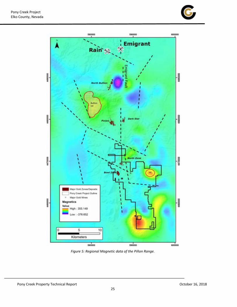
Figure 5: Regional Magnetic data of the Piñon Range.

Pony Creek Project Elko County, Nevada
Pony Creek Property Technical Report October 16, 2018 26
6.2 Historical Mineral Resource Estimates
Newmont completed a resource estimation in 1983 (Russell, 2004) that is judged to be relevant and therefore
suitable for disclosure (Table 6). This Newmont estimate is not classified, and used an unknown number of drill
holes, but the author estimates it was based upon only the first 40 of 306 total drill holes as of the date of this report.
The author has not done sufficient work to categorize this historical estimate as current mineral resources and
Contact Gold is not treating this historical estimate as current resources, and therefore, although considered
relevant, this historical resource should not be relied on.
In an NI 43-101 technical report prepared for Vista Gold and Allied Nevada, Russell (2006) re-stated his prior resource
estimate of 32,409,100 tons at a grade of 0.044 oz Au/ton (1,426,000 ounces) prepared for Mill City in 2004. The
author has not done sufficient work to categorize this historical estimate as current mineral resources, and it is the
author’s opinion that the Russell (2004, 2006) historical resource estimate does not meet current CIM standards.
Contact Gold is not treating this historical estimate as current and this historical resource should not be relied upon.
Table 6: Historical Mineral Resource Estimates Year 1983 2006
Estimate Newmont Vista Gold
Cut-off oz Au/ton unknown unknown
Tons, no classification 1,124,000 32,409,100
Au oz, no classification 65,000 1,426,000

Pony Creek Project Elko County, Nevada
Pony Creek Property Technical Report October 16, 2018 27
7 Geological Setting and Mineralization
Gustin (2017) summarized a detailed description of regional geological setting , Piñon Range geology, and Pony Creek
property geology and mineralization, much of which was extracted from a 2003 Technical Report prepared for Mill
City by E.W. Abbott (Abbott, 2003), who had worked extensively in the Piñon Range during the 1990s and early 2000s
and Russell (2006). The following summary of the geological setting and project mineralization is modified from
Russell (2006), Abbott (2003) and Gustin (2017) references cited in those reports, as well as the 2016 Technical
Report on the Pinion gold deposit by Dufresne and Nicholls (2016), which lies 11.3 kilometers north of Pony Creek in
the Piñon Range.
The author believes the summary presented in this section is an accurate representation of the geology of the Pony
Creek project as it is presently understood.
7.1 Northeastern Nevada Regional Geological Setting
The Pony Creek project is situated in the south-central Carlin Trend, a northwest-southeast alignment of sedimentary
rock-hosted gold deposits and mineralization in the Basin and Range geologic province of western North America.
The area of what is now known as the greater Carlin Trend was within the passive, marine continental margin during
early and middle Paleozoic time, which is the time of deposition of the oldest rocks observed in the area (Stewart,
1980). A westward-thickening wedge of sediments was deposited along the continental margin, in which the eastern
facies tended to be siltier and carbonate-rich shelf and slope deposits and carbonate platform deposits, while the
western facies were primarily fine-grained siliciclastic sediments of deeper basin environments. The Carlin Trend is
proximal to the shelf-slope break, although the position of this break was not static over time.
In the Late Devonian through Middle Mississippian epochs, east-west compression during the Antler Orogeny
produced folds and thrust faults, the most significant manifestation of which is the Roberts Mountain thrust fault.
This regional low-angle fault system placed western facies siliciclastic rocks over eastern facies carbonate rocks
across the region. As the result of this tectonism, the Mississippian and Pennsylvanian overlap assemblage of clastic
rocks was deposited across the region (Smith and Ketner, 1975). Regional stratigraphic studies show interleaved
allochthonous and autochthonous late Paleozoic sedimentary units in the Piñon Range (Smith and Ketner, 1975;
Rayias, 1999; Mathewson, 2001; Longo et al., 2002). The region was subsequently affected by at least two and
possibly three episodes of Mesozoic folding during the east-directed crustal shortening of the Sonoma Orogeny and
the Sevier- Laramide orogenies.
During Paleogene and Neogene time, igneous activity swept through central and eastern Nevada (Stewart,
1980; John, 2001). The period between 43 and 34 m.y. ago was characterized by andesitic to rhyolitic eruptive
volcanism and granitic intrusive rocks. It was during the Eocene that the bulk of the Carlin-type sedimentary-rock
hosted gold deposits were formed in northeastern Nevada and western Utah (e.g., Ressel et al., 2000).
A significant change in the character of volcanic activity occurred at about 34 m.y. ago (McKee, 1971; Noble, 1972).
Voluminous eruptions of silicic ash-flow tuffs occurred during the period from 34 to 17 m.y. The sources for these

Pony Creek Project Elko County, Nevada
Pony Creek Property Technical Report October 16, 2018 28
eruptions have been identified as calderas and volcano-tectonic troughs, 50 of which have been identified in central
Nevada and western Utah (John, 2001).
Between 17 and 6 m.y. ago (late Oligocene through Miocene), another change in the character of volcanism in
central and eastern Nevada took place. Early in that period, 17 to 15 m.y. ago, mafic volcanism, dike emplacement
and related gold mineralization took place along the Northern Nevada Rift and parallel fractures (Wallace and John,
2000; Ponce and Glen, 2002). From about 15 m.y. to 6 m.y., bimodal basalt-rhyolite and calc-alkaline to peralkaline
and rhyolitic volcanism, including voluminous silicic ash-flow tuffs and lava flows, occurred in southern and
northernmost Nevada.
Multiple igneous intrusions were emplaced along the Carlin trend. The oldest igneous rocks are reported to be Late
Triassic in age (Teal and Jackson, 2002). Other igneous rocks include a Late Jurassic dioritic intrusion at the Goldstrike
deposit (Bettles, 2002); intermediate to mafic dikes of Jurassic and Cretaceous age; the Cretaceous Richmond Stock;
the Eocene Welches Canyon Stock; and hydrothermally altered and locally gold-bearing felsic to mafic dikes of
Eocene age (Ressel, 2000). The Eocene Bullion stock (Henry et al., 2015) and the Eocene Robinson Mountain volcanic
center (Lund Snee and Miller, 2015) intruded the Paleozoic rocks in the Piñon Range ~10 miles north of, and at the
Pony Creek project, respectively.
Basin and Range faulting began approximately 15 m.y. ago, due to approximately east-west directed regional
extension and crustal thinning, concurrent with, and continuing after, the development of the Northern Nevada Rift.
The north-south elongated mountain ranges and intervening valleys developed as the result of this extension, which
has continued through the Quaternary Period and remains on-going.
7.2 Piñon Range Geology
The geology of the Piñon Range was originally defined by the stratigraphic studies and mapping of Smith and Ketner
(1975; 1978) who principally described the Paleozoic sedimentary units and documented Mississippian strata
overlapping structures that can be related to the Mississippian Roberts Mountains thrust fault (Silberling et al., 1997).
Abbott (2003) noted issues in the stratigraphic and structural interpretations of rocks in the Piñon Range and offered
an alternative stratigraphic interpretation utilizing his compilation of the published and unpublished interpretations
that could be found, but initially focused on the work of Smith and Ketner (1975; 1976; 1978), Dean et al. (1990), and
Abbott and Keith (1999). Most of the formations were the same as defined by Smith and Ketner (1975), but changes
to a few of those formations and a few newer formations primarily followed the work of Iverson (1991) and Silberling
et al. (1997). The interpreted stratigraphic assignments of Abbott (2003) are presented in Table 7. A generalized
geologic map of the Piñon Range is shown in Figure 6.
The central part of the Piñon Range is composed of Ordovician through Mississippian marine sedimentary rocks
(Smith and Ketner, 1975) that form a structural dome with clastic marine sedimentary rocks as young as
Pennsylvanian or early Permian along the margins. At least one large-scale, asymmetric anticline is present, but
younger horst and graben structure developed within a framework of overprinted high-angle faults is a prominent
feature of the range (Dufresne and Nicholls, 2016). Tertiary sedimentary rocks that were deposited in shallow
freshwater lakes and overlying intermediate to felsic Eocene volcanic rocks are present on the flanks of the range and
within adjacent grabens.

Pony Creek Project Elko County, Nevada
Pony Creek Property Technical Report October 16, 2018 29
7.2.1 Stratigraphic Units in the Piñon Range
Paleozoic sedimentary rocks of the Piñon Range are described below in ascending stratigraphic order as modified
from Abbott (2003):
Table 7: Summary of Piñon Range Stratigraphy
(modified from Abbott, 2003; Russell, 2006)
Cenozoic Units
Quaternary Alluvium, Colluvium, Gravel and Landslide Deposits
Pliocene-Pleistocene Hay Ranch Fm
Miocene Palisade Rhyolite Miocene Carlin and Humboldt Fms Eocene Indian Well Fm
Eocene Robinson Mountain Volcanic Rocks
Eocene Elko Fm
Eocene(?) Conglomerate, Sandstone, Siltstone, Limestone
Intrusive Igneous Units
Eocene Granite, Monzonite, Quartz Diorite
Eocene Rhyolite Intrusions at Pony Creek
Paleozoic Sedimentary Units
Overlap Assemblage Pennsylvanian-Permian Undivided Pennsylvanian Tomera and Moleen Fms
Mississippian Tonka Fm (Diamond Peak Fm of Smith and Ketner 1975)
Allochthonous Assemblage
Mississippian Stump Springs Turbidites Devonian-Mississippian Lee Canyon Fm Mississippian Webb Formation of Abbott (2003) Devonian Woodruff Fm
Ordovician Vinini
Autochthonous Shelf Assemblage
Mississippian Chainman “Fm”:
(Pilot Shale, Dale Canyon Fm, Diamond Peak Fm) Mississippian Webb Fm (Island Mountain Fm) Devonian Devils Gate Limestone
Devonian Nevada Fm:
(Upper Dolomite Member, Beacon Peak Member and Oxyoke Fm of Abbott, 2003)
Extended Shelf and Outer Reef Units
Silurian-Devonian Lone Mountain Dolomite Ordovician Hanson Creek Formation Ordovician Eureka Quartzite
Pogonip Group (Antelope Valley Limestone)

Pony Creek Project Elko County, Nevada
Pony Creek Property Technical Report October 16, 2018 30
Figure 6: Generalized Geology of the Piñon Range
(from Smith and Ketner, 1978)

Pony Creek Project Elko County, Nevada
Pony Creek Property Technical Report October 16, 2018 31
Ordovician Pogonip Group:
Of the three formations in the Pogonip Group, only the Antelope Valley Limestone is exposed in Piñon Range. The
limestone has been dolomitized, possibly by fluids emanating from the Bullion stock. The upper part consists of
dark gray dolomite interbedded with yellow or brown shale in beds a few inches thick. In the lower part, the shale
is missing and the dolomite is in beds from 2.5 to 30 centimeters thick. Fossils indicative of the Middle Ordovician
have been collected from exposures in the Piñon Range. Only 107 meters of exposed thickness is present in the
area. Its base is not exposed and it is conformably overlain by the Eureka Quartzite. It is only exposed near the axis
of the Piñon Range anticline (Smith and Ketner, 1975; 1978).
Ordovician Eureka Quartzite:
In the Piñon Range, the Eureka Quartzite crops out near the axis of the Piñon Range anticline. It is composed of
white quartz sandstone and quartzite. It is recognized by its purity, 99% quartz, and the well-rounded, well-sorted
nature of its sand-sized grains. Quartz overgrowths impart a mosaic of intergrown quartz, resulting in a rock with
very poor permeability. The remaining 1% of the rock is interstitial clay. Since no fossils from the Eureka Quartzite
were found in the Piñon Range its age is only known to be between the youngest fossils in the underlying Pogonip
Group and the oldest fossils in the overlying, Middle Ordovician Hanson Creek Formation. The Eureka Quartzite is
21 meters thick where exposed near the town of Bullion in the Railroad mining district. The upper and lower
contacts are conformable (Smith and Ketner, 1975 and 1978).
Ordovician Hanson Creek Formation:
Rocks of the Hanson Creek Formation crop out within the Piñon Range anticline in the Railroad mining district just
west of the town of Bullion. Although this formation is composed of thin- bedded limestone in much of Nevada, in
these outcrops it is mainly gray to black, thin-bedded to massive dolomite. A 6.1-meter thick section at the top of
the formation is composed of yellowish- weathering, calcareous siltstone, silty limestone, and very fine sandstone.
On the basis of fossils, it is considered to be Middle and Late Ordovician. Its total thickness is 45.7 meters (Smith
and Ketner, 1975 and 1978).
Devonian(?) -Silurian Lone Mountain Dolomite:
Dolomite of the Silurian and lower Devonian in east-central Nevada have been included in the Lone Mountain
Dolomite, a catch-all formation name for both primary and secondary dolomites in this region. In the northern
Piñon Range, the formation is exposed near the core of the Piñon Range anticline in the vicinity of Bunker Hill and
Ravens Nest. No complete section is exposed and the total thickness is obscured by lack of clear bedding
indications. The lower part of the formation is thick bedded gray dolomite, while the upper part of the formation is
brown and gray dolomite in beds 0.6 to 3.7 meters thick. On the basis of fossils, the age of the formation is Late
Silurian to perhaps early Devonian in the Piñon Range (Smith and Ketner, 1975 and 1978).
Devonian Nevada Formation:
The Nevada Formation crops out in the core of the northern Piñon Range and at Pine Mountain to the west. It was
divided into three members by Smith and Ketner, (1975 and 1978): the Beacon Peak Dolomite Member, the Oxyoke
Canyon Sandstone Member, and the Upper Dolomite Member. Coral “spaghetti” beds occur throughout the
formation. North along the Carlin trend, the Nevada Formation, especially the Beacon Peak Dolomite Member, is
equivalent to the Popovich Formation limestone which, with the underlying upper part (lower Devonian) of the

Pony Creek Project Elko County, Nevada
Pony Creek Property Technical Report October 16, 2018 32
Roberts Mountains Formation, is the most prolific host rock for gold deposits on the Carlin trend. To the south and
west, the Beacon Peak Dolomite Member is equivalent to the McColley Canyon Member, a limestone. On the basis
of studies to the south and east, the Nevada Formation is Early and Middle Devonian in age.
Beacon Peak Dolomite Member:
This unit is composed of thick-bedded gray to brown dolomite with a peculiar grainy appearance and characteristic
red stylolites. Quartz sandstone with dolomite cement makes up the basal unit and there are occasional quartz
sand grains scattered throughout the member. The section on Pine Mountain contains two beds of limestone, each
a maximum of 15.2 meters thick, but is predominantly composed of white crystalline dolomite. A buried intrusion
is believed to be responsible for the recrystallization. A total thickness of 205.7 meters is measured at Coffin
Mountain, to the south of the Railroad mining district, but it is much less thick in the northern Piñon Range. At
Coffin Mountain, a 7.6-meter thick, thin-bedded, yellow, argillaceous dolomite unit contains numerous silicified
brachiopods. This unit is not mentioned in the northern Piñon Range, but, if found at the surface or in drilling,
would make a very good marker unit midway in the sequence (Smith and Ketner, 1975; 1978).
Oxyoke Sandstone Member:
White, pink, gray, and light brown sandstone and quartzite containing variable amounts of dolomite
comprise the Oxyoke Sandstone Member. Sand grains are well rounded and sometimes frosted, but are also
commonly indistinct and sutured. Cement is often carbonate, but in the area west of the town of Bullion, the
original dolomite matrix has been metamorphosed to a diopside skarn. A measured section at the southern end of
the Railroad mining district, north of Trout Creek, contains 126.5 meters of Oxyoke Sandstone Member while the
section at Pine Mountain is about 30.5 meters thick (Smith and Ketner, 1975 and 1978).
Upper Dolomite Member:
Brown and gray dolomite in alternating layers comprises the Upper Dolomite Member. It is characterized by fine
laminations, often contorted, a checkered weathered surface, and a petroliferous odor on breaking. In the area
west of the town of Bullion, intrusions have changed the dolomite into coarsely crystalline white marble and skarn
composed of diopside and garnet or have at least destroyed the sedimentary features. A buried intrusion has also
recrystallized the Upper Dolomite Member at Pine Mountain. North of Trout Creek, the member has been
measured at 257.6 meters in thickness (Smith and Ketner, 1975 and 1978).
Devonian Devils Gate Limestone:
Medium- to thick-bedded, light and dark gray, fine-grained limestone makes up most of the Devils Gate Limestone.
“Spaghetti” beds containing the coral Amphipora are characteristically scattered throughout the formation. It is
exposed along the flanks of the Piñon Range anticline as well as at Pine Mountain, in addition to being found in
numerous small exposures wherever the lower part of the Chainman Formation is present. The top of the Devils
Gate is believed to be a karst surface by Iverson (1991). West of Bullion and at Pine Mountain, the limestone is
recrystallized by nearby intrusions to distinctive light and dark bands of “zebra” rock or to marble and skarn. Fossils
date the formation from late Middle Devonian to early Late Devonian. North of Trout Creek, the thickness of the
formation measures 259.1 meters. Its contact with the Nevada Formation below is gradational while its contact
with an overlying platy limestone is an erosional unconformity (Smith and Ketner, 1975).

Pony Creek Project Elko County, Nevada
Pony Creek Property Technical Report October 16, 2018 33
Mississippian - Devonian Pilot Shale and Island Mountain Formation:
Rocks of the Mississippian - Devonian Pilot Shale and Island Mountain Formation were mapped by previous
workers in the Piñon Range as Mississippian Chainman Formation (Smith and Ketner, 1975; 1978), Mississippian
Webb Formation (Smith and Ketner, 1975; 1978), Mississippian Dale Canyon Formation (Iverson, 1992),
Mississippian Turbidite rocks of Stump Springs, Mississippian Tripon Pass Formation, Devonian Woodruff
Formation, and perhaps even Devonian Devils Gate Limestone. The Mississippian Island Mountain Formation of
Nichols and Silberling (1995) consists of rocks lying between the Pilot Shale and the Mississippian Dale Canyon
Formation, and is composed of lime mudstone, siliceous argillite, and bioclastic grainstone.
As defined by Abbott (2003), the age of the Pilot Shale and Island Mountain Formation is Upper Devonian (late
Frasnian) to Lower Mississippian (Osagean), based in part on fossils collected by Iverson (1991) and identified by
Terry Hutter. The formation rests unconformably on the Devonian Devils Gate Limestone and is
unconformably overlain by the Mississippian Dale Canyon Formation. Abbott (2003) defined the Pilot
Shale/Island Mountain Formation as autochthonous with respect to the Roberts Mountains thrust fault, and
consisting of platy limestone or calcareous siltstone that overlies the Devils Gate Limestone. This agrees with
Iverson (1991) in the area of the Rain Mine and Emigrant Springs deposit.
The thickness of the Pilot Shale/Island Mountain Formation has been measured as between 61 meters in the
northern part of the Railroad mining district to 91.4 meters near Dry Creek in the southern part of the Piñon Range
(Iverson, 1992; Silberling et al., 1997). It may be absent in some areas because of non-deposition or erosion.
According to Abbott (2003), correlative rocks above the Roberts Mountains thrust fault are the upper portion of the
Devonian Woodruff Formation and the lower part of the Mississippian Webb Formation. Abbott (2003) stated:
“The Pilot Shale/Island Mountain Formation is the host rock for most of the stratiform ore in the Rain Mine, as
well as the Emigrant Springs, Gnome, SMZ, and South Bullion deposits. Most published descriptions of these
deposits name the Mississippian Webb as the host formation. These interpretations are in error and lead to
exploration into Roberts Mountains Thrust Fault upper plate, allochthonous rocks that are poor host rocks for
disseminated gold deposits.”
Mississippian Dale Canyon Formation:
According to Abbott (2003) the Dale Canyon Formation has been formerly mapped by Smith and Ketner (1975;
1978) as Chainman Shale and Diamond Peak Formation, and has been included by them in both the upper and
lower plates of the Roberts Mountains thrust fault. It has also been mapped, in part, as Tonka Formation.
As defined by Abbott (2003), the Dale Canyon Formation is limited to the lower plate of the Roberts Mountains
thrust fault and is autochthonous. In the area of the northern Piñon Range, the Dale Canyon Formation is a thick
sequence of shale, sandstone, and conglomerate. According to Iverson (1992), the lower part of the formation is
composed of thinly bedded, black, carbonaceous mudstone or shale, interbedded with siltstone and red-
weathering fine sandstone. Coarse, pebbly sandstone and cherty conglomerate occur as sparse channel deposits
containing plant fragments. This lower part of the formation may be, in part, the Island Mountain Formation of
Silberling et al. (1997). Higher in the formation, the coarser clastic units become increasingly abundant at the
expense of the shale. It also becomes less carbonaceous. Fossils date this formation as Early Mississippian and a
total of 457-609 meters is postulated.

Pony Creek Project Elko County, Nevada
Pony Creek Property Technical Report October 16, 2018 34
Rocks which were assigned by Abbott (2003) to the allochthonous category form the upper plate of the Roberts
Mountains thrust fault and have been moved into the area of central and eastern Nevada from the west and
northwest during the Antler Orogeny in Late Devonian to Early Mississippian time. Regionally, they comprise a
number of stacked thrust nappes containing rocks as old as at least Ordovician, and probably Cambrian, to as young
as Early Mississippian. To the northwest of the northern Piñon Range, one of the higher nappes is exposed and
contains Ordovician Vinini Formation.
Devonian Woodruff Formation:
The oldest unit exposed above the Roberts Mountains thrust fault in the Piñon Range is the Devonian Woodruff
Formation. Rocks of this unit are typically composed predominantly of mudstone, chert, and shale. Other less
abundant rocks include beds and lenses of limestone and dolomite, calcareous sandstone, and siltstone. Its age
spans the entire Devonian on the basis of fossil evidence. Phosphatic nodules containing well preserved
microfossils such as plant spores are characteristic. Also characteristic is the claw-like or jaw-like rami of the
probable arthropod Angustidontus, which are said to be so widespread that with a diligent search one can find
them almost anywhere. Although no complete section is known in the Piñon Range, it is believed to be more than
914 meters thick (Smith and Ketner, 1975; 1978).
Mississippian Webb Formation:
The Webb Formation was defined by Smith and Ketner (1968) for exposures near Webb Creek in the northern
Piñon Range. As originally defined, the Webb Formation was allochthonous with respect to the Roberts Mountains
thrust fault. Rocks hosting gold in what was to become the Rain Mine were also mapped as Webb Formation,
requiring that the Webb Formation be in both the upper and lower plates of the Roberts Mountains thrust fault, or
that the thrust fault separate the Webb Formation and the Devils Gate Limestone in the Rain pit. In addition, the
Webb Formation in the vicinity of the Rain Mine was found to be much more calcareous than in the type area. This
lower unit was also said to host the Emigrant Springs and Trout Creek gold deposits (Putnam and Henriques, 1991;
Thoreson, 1991). This lower unit does not occur above the Roberts Mountains thrust fault and is therefore is not
considered a part of the Webb Formation by Abbott (2003). Abbott (2003) restricted the Webb Formation to the
upper plate of the Roberts Mountains thrust fault. At its type area, the Webb is mostly siliceous mudstone and
claystone that has been measured to be at least 224 meters thick. Its age is Early Mississippian (Smith and Ketner,
1975).
Mississippian - Devonian Argillite of Lee Canyon:
The Argillite of Lee Canyon was named for a group of rocks on the west side of the Piñon Range which has been
thermally metamorphosed to dense, black, carbonaceous argillite with minor black chert. A few beds of quartzite
and conglomerate are known from the upper parts of the formation (Smith and Ketner, 1975; 1978). The unit rests
on what is believed to be the Roberts Mountains thrust fault and it is believed to be correlative with one or more of
the upper plate formations (Abbott, 2003). The Argillite of Lee Canyon was suspected by Abbott (2003) to consist of
the Devonian Woodruff Formation and the Mississippian Web Formation that have been thermally affected by a
buried intrusive igneous body.

Pony Creek Project Elko County, Nevada
Pony Creek Property Technical Report October 16, 2018 35
Mississippian Turbidite Rocks of Stump Springs:
Tosdal (1999) named a group of rocks formerly included within the Chainman Shale by Smith and Ketner (1978) and
the Dale Canyon Formation by Silberling and others (1997) as the Turbidite Rocks of Stump Springs. Sandstone,
conglomerate, and mudstone are believed to have been deposited by turbidity flows in a deep-water basin. Their
age is Early Mississippian and their thickness is unspecified. Abbott (2003) restricted this designation to rocks in the
upper plate only.
The rocks assigned to the so-called overlap assemblage were deposited over structures related to the Antler
Orogeny. These units are as much as 305 meters thick and are composed of submarine to subaerial fan-delta and
braided-delta deposits shed from the Antler orogenic upland to the west. They have been called the Newark Valley
sequence by Trexler and Nichtman (1990) and Silberling et al. (1997). The age of these rocks is Upper Mississippian
to perhaps Lower Pennsylvanian and include:
Pennsylvanian Mississippian Tonka Formation:
Tosdal (1999) divided the Tonka Formation into three units. Smith and Ketner (1975; 1978) originally mapped
these rocks as Diamond Peak Formation. The Tonka Formation is composed of reddish tan, quartzose sandstone
and conglomerate, and lesser fine sandstone and quartzose siltstone. Clasts are well-rounded and dominantly
composed of quartzite, quartz, and lesser chert in a matrix of similar composition. The unit forms conspicuous cliffs
in which are exposed large- scale cross-beds (Tosdal, 1999).
Pennsylvanian Tomera and Moleen Formations Undivided:
Smith and Ketner (1975; 1978) mapped rocks that crop out on the ridge south of Elliott High Ranch, as undivided
Tomera and Moleen Formations. The rocks are nearly all silicified and the sequence consists of limestone,
conglomerate, and quartzite. Fossils date this unit as Pennsylvanian and no thickness is known.
Upper Pennsylvanian and Permian Rocks Undivided:
Smith and Ketner (1975; 1978) assigned this name to thin-bedded calcareous siltstone and sandstone which
weather to yellow and tan platy fragments. It includes limestone, dolomitic limestone, and dolomite, as well as
black platy limestone, conglomerate, and conglomeratic sandstone. It could be as much as 1,219 meters thick.
Mesozoic rocks are not known to be present in the Piñon Range. A major erosional unconformity is present between
fluvial, lacustrine and volcanic rocks of mainly Eocene and Miocene ages that overlie and are in normal-fault contact
with the Paleozoic rocks along the east and west flanks of the range. These consist of:
Paleocene or Eocene(?) Conglomerate, Sandstone, Siltstone, and Limestone:
An unnamed sequence of conglomerate, which has pebbles and boulders derived from Paleozoic rocks, is
interbedded with sandstone, siltstone, and limestone, crops out in a small area in the northeastern part of the
Piñon Range and is also found in the southern Piñon Range. The limestone is brown and gray, weathering to
tan, brown, and red, and may be sandy. It may be as much as 762 meters thick and is believed to be Paleocene or
Eocene in age (Smith and Ketner, 1976) or in part as old as Late Cretaceous (Lund Snee et al, 2016).

Pony Creek Project Elko County, Nevada
Pony Creek Property Technical Report October 16, 2018 36
Eocene Elko Formation:
The type section of the Elko Formation is near the northeastern part of the Piñon Range and was formally named
and described by Smith and Ketner (1976). It has more recently been described by Solomon (1992). In the Piñon
Range, thin-bedded limestone and laminated oil shale characterize the formation, but elsewhere numerous ash
beds and thin units of rhyolite ash-flow tuff are widely distributed and have Eocene ages (Haynes, 2003; Henry,
2008GSA geosphere; Lund Snee eta al., 2016). The lower part of the formation is primarily light gray to light tan
limestone, commonly with ostracodes. Above the limestone is brown to dark brown to almost black oil shale
containing ostracodes and plant fossils. It may be as much as 762 meters thick.
The Paleozoic sedimentary rocks of the Piñon Range have been intruded and overlain by subvolcanic and volcanic
stocks, dikes and extrusive units of the Eocene Indian Well volcanic field, which comprise the Indian Well Formation,
and the Eocene Robinson Mountain volcanic center (Lund Snee, 2013; Lund Snee and Miller, 2015; Henry et al.,
2015). Extrusive rocks erupted from these volcanic centers overlie the unnamed conglomerate and are interbedded
with or overlie portions of the Elko Formation in Huntington Valley adjacent to the Piñon Range (Coats 1987; Lund
Snee and Miller, 2015).
Oligocene Indian Well Formation:
The Indian Well Formation was named by Smith and Ketner (1976) for a sequence of tuffaceous sedimentary rocks
and ash-flow tuffs about 1,000 meters in thickness. They crop out on the eastern side of the Piñon Range. The
sedimentary rocks include volcaniclastic conglomerate, sandstone, and siltstone which in the lower part of the
formation contain clasts of Paleozoic rocks. Ash-flow tuffs which are rhyolitic to dacitic in composition and range
from nonwelded to densely welded form the middle part of the formation. Lacustrine limestone is sometimes
interbedded with the sandstone in the upper part of the formation, which is predominantly composed of fluvial,
tuffaceous sandstone. The volcanic rocks were erupted during Eocene time from the Indian Well volcanic field on
the east flank of the Piñon Range (Henry et al., 2015).
Miocene Humboldt Formation:
In Huntington Valley, adjacent to and east of the Piñon Range, Smith and Ketner (1976) defined an upper Miocene
sequence of interbedded fluvial and lacustrine ash, tuff, sandstone, conglomerate, siltstone and thin fresh-water
limestone as the Humboldt Formation with a maximum thickness of about 609.6 meters. This name had
been previously applied to a widespread and less specifically defined formation in western Utah and eastern
Nevada by King (1878) and west of the Ruby Mountains by Sharp (1939).
Pliocene and Pleistocene Hay Ranch Formation:
On the west side of the Piñon Range, Smith and Ketner (1978) mapped a sequence of clay, tuff, limestone,
tuffaceous siltstone, sandstone, and fanglomerate, which they assigned to the Hay Ranch Formation of Regnier
(1960). It is about 396.2 meters thick.
7.2.2 Regional Tectonics and Structure
A prominent structural feature of the Piñon Range is the Piñon Range anticline and the related “Piñon graben” of
Abbott (2003). Abbott (2003) considered the anticline to be related to the development of the Eocene Ruby

Pony Creek Project Elko County, Nevada
Pony Creek Property Technical Report October 16, 2018 37
Mountains metamorphic core complex, which overprinted the folds and faults of the Antler, Sonoma and Sevier fold
and thrust belts. According to Abbott (2003) the Piñon Range anticline was overprinted by a Tertiary right-lateral
wrench fault system.
The Piñon Range anticline is a north-south trending, south-plunging, asymmetric, apparently west- vergent fold with
Paleozoic carbonate rocks as old as the Ordovician Pogonip Group in the core. Abbott (2003) stated his speculative
belief that:
“It is believed to be formed as part of the metamorphic core complex forming event that begins in Nevada with
major east-directed underthrusting in the Mesozoic and continues into the Tertiary, culminating in the unroofing of
the Ruby Mountains metamorphic core complex and others such as the Snake Range, Raft River Range, and Schell
Creek Range metamorphic core complexes in eastern Nevada. The westward-vergent, low-angle movement of the
upper crust has resulted in a series of asymmetric folds to the west of those ranges such as the Butte Valley
anticline, the Radar Range syncline, the Illipah anticline, and perhaps the Adobe Range syncline. The reason that
the west-directed deformation has not been more noticeable is that most of the deformation was taken up by
underthrusting of a flat-dipping, oceanic crust under the continent and the west-directed folds and faults are
adjustments to that major deformation (the Laramide orogeny) by the continental cover.”
The Piñon Range anticline can be traced from south of the Pony Creek property, through the Railroad mining district,
just west of the town site of Bullion. From there it continues just to the east of north and extends under Tertiary
cover for about 8 kilometers before emerging in the vicinity of the Newmont Emigrant Springs gold deposit (Abbott,
2003). According to Abbott (2003), a series of north-south- trending faults, which tend to be east-dipping, high-angle
reverse faults, have accentuated the amplitude of the Piñon Range anticline and are an essential part of the
deformation. The interested reader is referred to Abbott (2003) for a discussion of his interpretation of the structural
evolution of the Piñon Range that is beyond the scope of this report.
Basin and Range faults have overprinted the Piñon Range anticline as evidenced by a number of range- bounding,
normal faults. These faults generally separate the Paleozoic interior of the Piñon Range from the Tertiary and
Quaternary rocks on the flanks of the range.
7.3 Prospect and Local Geology
The following description of the property geology is largely taken from Abbott (2003), which was drawn from Jones
and Postlethwaite (1993) and Russell (1999). A geological map of the property is shown in Figure 7.
7.3.1 Property Stratigraphy
Middle to upper Devonian through Permian carbonate and clastic sedimentary rocks are exposed at the Pony Creek
property. The south-plunging Piñon Range anticline exposes progressively older units toward the north, with the
Devils Gate Limestone being the oldest unit exposed on the surface of the Pony Creek property. It is composed of
medium- to thick-bedded, light to dark gray limestone formed in a reef environment. The upper contact of the Devils
Gate Limestone is not well exposed on Pony Creek. A small exposure of limestone in the western part of Section 26 is
interpreted to be Devils Gate Limestone, but the upper contact with the Devonian Webb formation is not well
exposed. Drilling by Newmont at Pony Spur and further to the west on ground still controlled by Newmont has
encountered zero to over 40 meters of Devonian Webb formation, and drilling by Contact at Pony Spur has

Pony Creek Project Elko County, Nevada
Pony Creek Property Technical Report October 16, 2018 38
encountered significant gold mineralization at this contact. The variable thickness appears to be due to low angle
faulting eliminating the unit in places during emplacement of the Roberts Mountains allochthon, and subsequent low
angle normal movement during younger Tertiary extensional faulting. Most holes elsewhere at Pony Creek have not
reached the Devil's Gate formation, so the thickness of Webb formation remains unknown under most of the project
area. The top of the Devil's Gate is strongly silicified, gold mineralized collapse breccia in drilling at Pony Spur; the
only place where it has been drill tested.
At Pony Creek, the Mississippian, Pennsylvanian and Permian rocks of the overlap assemblage are problematic due to
the chaotic and laterally discontinuous nature of the coarse clastic strata formed by being shed off from the Antler
highlands just to the west of Pony Creek during multiple orogenic pulses of the Antler orogeny which began in
Mississippian time. The lower contact of the Chainman Shale of the Chainman Formation is not well exposed on the
property.
Overlying the Chainman Formation is a sequence of conglomerates, sandstones, and shales that are assigned to the
upper Mississippian to lower Pennsylvanian Diamond Peak Formation of Smith and Ketner (1975 and 1978). Chert
and quartzite clasts are the most common rock types in the conglomerates. The name Diamond Peak Formation will
be used here and it is widespread on the Pony Creek property, especially on the western and southern boundaries.
In the northern Piñon Range, however, the Diamond Peak Formation was previously referred to as the Tonka
Formation by Dott (1955) for those rocks that were deposited across the Roberts Mountains thrust fault.
The middle to upper Pennsylvanian Moleen Formation, composed of gray, medium-bedded, silty limestone with
banded, nodular chert and congolmerate interbeds overlies the Diamond Peak Formation and is in turn overlain by
unnamed (by Smith and Ketner (1975 and 1978)) upper Pennsylvanian to Permian sedimentary rocks, some of which
have been assigned to the Strathearn Formation in mapping by Contact Gold. Calcareous sandstone and
conglomerate with interbedded limestone make up this unnamed “Penn-Perm” unit.
A porphyritic rhyolite intrusive body of unknown age is present as a north-south elongated body that is
approximately 3.2 kilometers long and 1.2 kilometers wide. Rocks of this body have been variously described as
rhyolite, felsite, or felsic porphyry. Four felsic lithologies have been described: 1) white- to cream-colored, fine-
grained feldspar porphyry, 2) white- to cream-colored, fine-grained quartz porphyry, 3) fragmental rhyolite, and
4) dark-colored to nearly black, aphanitic felsite. Locally, the rhyolite appears to be a volcanic sandstone. These rock
types are hydrothermally altered and locally mineralized. The intrusive body lies near the axis of the north-south
trending, south-plunging Piñon Range anticline in the central part of the Piñon graben (Figure 7).
Volcanic tuffs, flows, and volcaniclastic rocks previously assigned to the Eocene Indian Well Formation by Abbott
(2003) crop out on the east side of the property and are at least 243.8 meters thick. This sequence is now assigned to
the Robinson Mountain volcanic field of Eocene age (Lund Snee, 2013; Lund Snee and Miller, 2015). The base of
these rocks is not observed within the property and they occur only in fault contact with the Paleozoic rocks
described above.
7.3.2 High-Angle Faults
North- and northeast-trending, high-angle faults are prominent structures at Pony Creek and in part define the Piñon
graben. The western margin of the rhyolite intrusion is bounded by north-trending faults that are important controls
for the gold mineralization in the “Bowl” area of the south lobe of the intrusion. Northeast-trending high-angle

Pony Creek Project Elko County, Nevada
Pony Creek Property Technical Report October 16, 2018 39
faults control the eastern margin of the north lobe of the intrusion and are the controls of the gold mineralization in
the north zone. Northwest trending, high- angle faults form at least two prominent, but subsidiary, grabens at Pony
Creek. The northernmost of these down-drops Paleozoic sediments into a trough on the northeast side of the
rhyolite intrusion. A second similar graben is developed in the southeast portion of the intrusion. Northwest-
trending faults exhibit strong control on mineralization and define the southwest limit of the intrusion.

Pony Creek Project Elko County, Nevada
Pony Creek Property Technical Report October 16, 2018 40
Figure 7: Detailed geological mapping in the north eastern part of the Pony Creek project combined with 1:250,000 USGS mapping.

Pony Creek Property Technical Report October 16, 2018 41
Figure 8: Detailed stratigraphic section produced from detailed mapping at Pony Creek.

Pony Creek Project Elko County, Nevada
Pony Creek Property Technical Report October 16, 2018 42
7.4 Alteration and Mineralization
Hydrothermal alteration at Pony Creek is reported to be characterized by the assemblage quartz-sericite- pyrite
within the intrusive body in and near north-trending and northeast-trending faults. The fault zones are fragmental
and/or brecciated, and contain very fine-grained quartz, sericite, and pyrite or limonite. Pyrite occurs both as
disseminated grains and on fracture surfaces while limonite occurs after pyrite or is secondary in fractures. Away
from the faults the intrusion becomes less altered, grading outward from a rock with relict feldspar ghosts to one
with a distinct porphyritic texture. In the center of the intrusion, a granular texture in which the feldspars have been
argillically altered is present, leaving open or clay- filled vugs. The intrusion locally contains 3% to 5% pyritized and
chloritized hornblende crystals.
Newmont geologists used the terms “sanded rhyolite” and “rhyolite sand” to describe the texture of the rhyolite
intrusion in some of the altered and mineralized areas. They reported that sanded rhyolite consists of medium-
grained, rounded clasts of glassy rhyolite breccia commonly occurring near the margins and at the base of the
intrusion, and locally as narrow stockwork zones within the intrusion. The distribution and texture of the sanded
rhyolite suggest that the unit formed in vitric chill margins and was apparently affected by subsequent hydrothermal
activity.
Sedimentary rocks along the margins of the intrusion and immediately beneath it are silicified, decalcified,
sulfidized, and variably oxidized near gold mineralized zones.
Almost all significant mineralization identified to date in surface exposures and drilling is spatially associated with the
rhyolite intrusive body, either within it or in silicified and altered Mississippian- Permian clastic rocks immediately
beneath and adjacent to the intrusion. This mineralization appears to be related to or controlled by north-,
northwest- and northeast-striking structures. Specific mineralized areas are shown in Figure 9 and discussed below.

Pony Creek Project Elko County, Nevada
Pony Creek Property Technical Report October 16, 2018 43
Figure 9: Mineralized areas of the Pony Creek property.

Pony Creek Project Elko County, Nevada
Pony Creek Property Technical Report October 16, 2018 44
7.4.1 Bowl Zone
The presence of significant gold mineralization at the Bowl Zone was first established by Newmont. The
mineralization is associated with oxidized and unoxidized marcasite, pyrite, and minor realgar and stibnite that occur
along fractures and as disseminations in and beneath the rhyolite intrusion, as well as in the matrix of breccias in the
intrusion (Jones and Postlethwaite, 1993). Newmont defined two continuous zones of mineralization in the Bowl
Zone. One occurs along what is interpreted as a steeply dipping, north-trending structure that forms the eastern
boundary of the Bowl area. The second lies to the west and forms a tabular, flat-lying zone or zones of mineralization
that occur at, or on either side of, the lower contact of the rhyolite with the underlying Paleozoic sediments. Work
by Contact Gold has identified a second, north-striking structure parallel to the eastern bounding fault. Drilling has
shown that these three zones are continuously mineralized in some areas (Figure 9).
As presently defined by drilling, the Bowl Zone is somewhat continuously mineralized over a north-south strike length
of about 1,400 meters, with maximum east-west extents of 600 meters and a maximum depth of about 200 meters.
This area includes the three more continuously mineralized zones mentioned above. The high-angle, structurally-
controlled mineralization along the eastern limits of the Bowl Zone is generally narrow, sinuous, and irregular, but
can have substantial grades. For example, Newmont’s hole PC-20 intercepted 22.9 meters of continuous gold
mineralization starting at 124.97 meters that averages 7.17g Au/t, including a 6.1-meter interval of 15.99g Au/t.
While this intercept is from a vertical RC hole, which therefore overstates the true thickness of the steeply dipping
mineralization along the fault, the grade is consistent with adjacent holes. It seems likely that the mineralizing fluids
in the Bowl Zone were at least partially focused along this high-angle north-south structure, which is near the eastern
contact of the rhyolite intrusion in this area. The mineralized fault may be related to the reactivation of a structural
zone that controlled the hypothetical dike-like roots of the flat-lying portions of the rhyolite intrusion.
Oxidation of gold mineralization varies from complete to almost none. The assay database provided by Waterton, on
closing of the Arrangement, did not include any cyanide soluble gold assays, and the data obtained from Barrick by
Contact Gold in 2018 did not contain any cyanide assays. Contact Gold has completed cyanide assays at ALS Chemex
on all 2018 fire assays above 0.100 g/t Au and all 2017 fire assays above 0.140 g/t Au, to begin to develop a database
from which an oxide model can be built. The best oxidized interval encountered to date was from drill hole PC18-003
which returned 2.51 g/t Au over 47.24 meters from 86.87 meters depth. Gold recoveries from bottle roll assays on
oxide composites by Contact Gold were 85% for rhyolite and 90% for conglomerate of the fire assays for the two
composites.
7.4.2 West Target
The West Target was generated by Contact in 2017 based on geology, geochemistry, and geophysics, and was never
drilled by previous explorers. A new, significant area of gold mineralization currently measuring 1 km in a north-
south direction and 400 meters wide east-west at its maximum, was subsequently defined after the discovery hole,
PC18-18 returned 0.42 g/t Au over 33.53 meters starting 4.57 meters below surface. Cyanide assays showed the
intervals to be well oxidized with cyanide assays averaging 89% of fire assays for the entire interval in hole 18 and
similar, strong recoveries in the other holes' cyanide assays.

Pony Creek Project Elko County, Nevada
Pony Creek Property Technical Report October 16, 2018 45
Gold mineralization at the West Target is associated with a large silicified, north-striking rib of Pennsylvanian-Permian
aged calcareous conglomerate (the same host at GSV's North Dark Star deposit to the north of Pony). Gold grades
are enhanced where multiple cross cutting NW and NE striking faults intersect the North-South Conglomerate ridge
that occupies the Emigrant-Dark Star-Dixie-Bowl zone structural corridor. To date the best gold grades have been
encountered on the east and west margins of this silicified conglomerate. Assays have been received for 16 holes to
date, with all widely spaced holes returning anomalous to low grade gold intersections. It remains completely open
for expansion, particularly to the north and south.
7.4.3 North Zone
Gold mineralization has been somewhat irregularly intersected in drilling in a broad area within and adjacent to the
northern lobe of the rhyolite intrusion. The most continuous mineralization identified to date in this area occurs
within two north-trending zones that occur within a larger northwest-trending zone of generally lower-grade and
more erratically distributed mineralization.
The easternmost of the two north-trending zones includes the most significant and continuous gold mineralization in
the North Zone. This approximately 40-meter wide mineralized zone occurs over a strike length of 200 meters, is
open to the south, and is defined by holes PC-111, PC-121, PC-128, 95-07, 95-08, and PC-06-03. The most significant
intercept, 16.8 meters @ 1.50 g Au/t, was returned from hole PC-121. The top of the mineralization lies 50 to 100
meters from the surface, with mineralized thicknesses of 15 to 30 meters. The mineralization within this zone is very
similar to the Bowl area, with the gold occurring near the contact of rhyolite intrusion and underlying
Pennsylvanian/Permian age calcareous sandstone and conglomerate units.
As part of Westmont’s 1992 drilling program, three holes (PC-129, PC-130, and PC-131) tested the possible northern
extension of the eastern north-trending zone as it projects beyond the limits of the rhyolite intrusion. These three
holes are the northernmost holes drilled at Pony Creek. PC-129, the southern of the three holes, intersected 42.7
meters grading 0.47 g Au/t starting at a down-the-hole depth of 26 meters. The gold mineralization in this hole is
hosted in what was logged as weakly argillized arkosic sandstone with veinlets of very fine-grained pyrite and
limonite-stained fractures. The next hole to the north, PC-130, intersected a large void and was abandoned; the void
might be indicative of the targeted fault. The northernmost hole intersected unmineralized sedimentary rocks.
The eastern, possibly northwest-trending portion of the North Zone is predominantly characterized by anomalous to
low-grade gold values within the rhyolite intrusion and Permian-Pennsylvanian units, although thin higher-grade
zones were intermittently intersected.
7.4.4 Pony Spur
The Pony Spur target was acquired in 2017 as part of Contact Gold's expansion of Pony Creek. The claims cover a
regional-scale, northwest-striking fault that projects into the Bowl Zone and into the major SE flexure in the
otherwise north-striking Emigrant/ Dark Star/ Pony Creek structural zone. Very strong silicification with a high barite
and hematite content occurs within the Mississippian Chainman sandstone at Pony Spur. Contact Gold drilled three
holes in 2018, with significant gold intersections in each hole. Two of the three intercepts were well oxidized with

Pony Creek Project Elko County, Nevada
Pony Creek Property Technical Report October 16, 2018 46
good gold recoveries in cyanide assays. Gold mineralization occurs at the Devonian Devil's Gate/Webb contact (same
host as the Pinion deposit owned by Gold Standard Ventures and Alligator Ridge Mine owned by Kinross).

Pony Creek Project Elko County, Nevada
Pony Creek Property Technical Report October 16, 2018 47
8 Deposit Types
The Carlin-type disseminated gold deposit (“CTGD”) model is applicable at Pony Creek. In particular, the stratigraphic
settings of the Rain, Emigrant Springs, and Pinion CTGDs north of Pony Creek in the Piñon Range include
disseminated gold mineralization focused in solution-collapse and karst breccia at the upper contact between the
Devils Gate Limestone and overlying Webb Formation shale-sandstone units. Significant higher-grade, disseminated
gold mineralization has also recently been discovered in silicified Pennsylvanian calcareous conglomerates at the
nearby Dark Star deposit. These deposits are near high-angle faults and have geochemically anomalous Au, As, Sb,
Hg, and Tl, and alteration in the form of argillic alteration in the silty or clay-rich rocks, decalcification of carbonate-
bearing units, jasperoid, and residual or introduced organic carbon. They are characterized by concentrations of very
finely disseminated gold in silty, carbonaceous, and calcareous rocks. The gold is present as micron-size or smaller
disseminated grains, often internal to iron-sulfide minerals (arsenical pyrite is most common) or with carbonaceous
material in the host rock. A significant amount north-striking Eocene rhyolite dike is also reported at various deposits
to the north of Pony Creek.
Deposit configurations and shapes are quite variable. CTGDs are generally variably stratiform in nature, with
mineralization localized within specific, favorable stratigraphic units, particularly where a permeability contrast
occurs such as a contact or more permeable bed. Carbonate removal is the most common alteration, and fault and
solution breccias can also be primary hosts to mineralization (Figure 10). In some CTGDs, such as Beast and Deep
Star in the Carlin area, silicic dikes of Eocene age have been strongly mineralized and have been mined with the
adjacent sedimentary-rock hosted material. At Pony Creek's Bowl and North Zones, most of the presently identified
mineralization is hosted along the lower margin of the north trending rhyolitic intrusion and within adjacent
Pennsylvanian to Permian calcareous sandstones and conglomerates. Gold mineralization at the West Target and the
Pony Spur Target does not show quite as strong a preference to rhyolite, and most holes did not intersect any
rhyolite.

Pony Creek Project Elko County, Nevada
Pony Creek Property Technical Report October 16, 2018 48
Figure 10: Schematic Cross-Section of a Hypothetical Carlin-Type Gold Deposit
(from Robert et al., 2007).

Pony Creek Project Elko County, Nevada
Pony Creek Property Technical Report October 16, 2018 49
9 Exploration
Contact Gold began exploration at Pony Creek in late June, 2017 after 10 years of dormancy at the Project. Contact
has completed 93 drill holes totalling 21,216 meters to date. Drill programs were designed to confirm and expand
known areas of historic drilling, with a focus on understanding the controls to mineralization as well as the degree
and configuration of oxidation and the orientation of the higher grade gold mineralization, and to test new
exploration targets that were developed through geological mapping, soil and rock geochemistry and gravity and
CSAMT surveys.
9.1 Geological Mapping
Contact Gold completed detailed geologic mapping in 2017 and 2018. Paul Hohbach and Jamie Robinson were the
primary mappers. Mapping focused on gold occurrences within the Penn-Perm section at Pony Creek. Multiple visits
to the type localities of the Penn/Perm formations were conducted with the exploration team. Mapping emphasis
was on defining formational stratigraphy and identifying favorable host rock units, and on structural paragenesis.
Geophysical and geochemical data were utilized, and drill targets resulted from integrating data sets.
Fifteen individual sheets comprising approximately 20 square miles (52 square kilometers) at a scale of 1 inch to 200
feet were generated. These 13 map areas cover the Bowl and North Zones as well as the geochemical and
geophysical anomalies to the North and West. Ten different fault types were characterized. Fossil assemblages were
sent to Dr. Pierre Zippi in Texas for description and age-dating. Rhyolite and volcanic rock samples were given to
Elizabeth Hollingsworth and Dr. Michael Ressel of UNR for age-dating of phaneritic phases of Pony Creek rhyolite for
which results are pending. Rock sampling was conducted and assayed for Au and multi element using ALS Chemex.
The mapping effort indicates that the structural setting of the area encompassing the Bowl and North Zones, and the
West Target and the Pony Spur Target, is a wrench fault system formed during southeastward directed Mesozoic
compression. West-Northwest strike slip faults formed to accommodate differential thrust related compression on
the north versus the south sides of them. North-Northeast striking folds and faults formed perpendicular to the
direction of thrust movement, and the north-south striking ore controlling faults were formed as en-echelon, tension
faults which were then open for hydrothermal fluid flow of the mineralizing system to focus along. An illustration of
this setting follows in Figure 11.

Pony Creek Project Elko County, Nevada
Pony Creek Property Technical Report October 16, 2018 50

Pony Creek Project Elko County, Nevada
Pony Creek Property Technical Report October 16, 2018 51
Figure 11: Detailed geological mapping of the northeast part of the Pony Creek project.

Pony Creek Project Elko County, Nevada
Pony Creek Property Technical Report October 16, 2018 52

Pony Creek Project Elko County, Nevada
Pony Creek Property Technical Report October 16, 2018 53
Figure 12: Fossil studies to support age dating mapped stratigraphy in the northeast section of the Pony Creek project.
9.2 Surface Rock Sampling and Soil Geochemistry
In 2017, Contact completed soil grid sampling on spacing of 100 meters over areas deemed to be of lower potential
and 100 by 50 meters over areas to be more prospective from just south of the Bowl Zone to the northern and
western edges of the claim boundary and eastward to the contact with the post-mineral volcanics. Approximately
3,566 samples were collected and assayed for gold with a 1 ppb Au limit and the MEMS41 method for 51 major,
minor and trace elements by ALS Chemex.
In 2018, 4,122 soil assays have been received to date. The newly staked exposures of Mississippian Diamond Peak
and Chainman formations, and the southward continuation of the Emigrant/ Dark Star/ Pony Creek structural zone
were soil sampled on a 100 by 100 meter grid, and the gold-in-soil anomalies generated from the 2017 program were
tightened up to a 50 meter grid.

Pony Creek Project Elko County, Nevada
Pony Creek Property Technical Report October 16, 2018 54
Multiple, large gold and trace element anomalies were generated on the northwest portion of Pony Creek from this
work, and were utilized to generate drill targets, and to date gold mineralization has regularly been intersected
beneath most of the first order anomalies. Many of the targets generated, such as Elliott Dome and Moleen warrant
drill testing, but have not yet been drilled due to prioritization as well as permitting/allowed disturbance. Assays are
currently pending for the Pony Spur soil grid.
Rock sampling has been completed over most of the soil anomalies with values returned in excess of 2 g/t Au. For
the most part however, rock sample values from the surface soil anomalies have been lower than those encountered
in drilling beneath the soil anomalies. this is attributed to decalcification making the higher grade gold mineralization
recessive during weathering. Outcrops of silicified material tend to dominate and appears to be lower grade in
general than the adjacent areas of decalcification. This is not unusual for Carlin-Type mineralization. The Pony Creek
rock chip database currently contains 857 assays with coordinates known, and additional historic assays for which
locations have not yet been found.

Pony Creek Project Elko County, Nevada
Pony Creek Property Technical Report October 16, 2018 55
Figure 13: Complete soil sampling on the Pony Creek property including 2018 infill.

Pony Creek Project Elko County, Nevada
Pony Creek Property Technical Report October 16, 2018 56
Figure 14: Rock sampling completed by Contact Gold across the Pony Creek property.

Pony Creek Project Elko County, Nevada
Pony Creek Property Technical Report October 16, 2018 57
9.3 Geophysics
In 2017, Contact completed gravity and CSAMT surveys over Pony Creek. These methods often map structures in the
subsurface and are useful in targeting structurally controlled gold mineralization. Contact Gold added 427 gravity
stations on a nominal 300meter grid to the existing database provided by Waterton. Jim Wright Geophysics
interpreted the data resulting in the identification of 5 new targets on the eastern portion of the project, as well as a
fairly detailed image of the structural zone containing the known gold mineralization at the Bowl and North Zones.
The gravity interpretation was then used to plan additional CSAMT lines which is an electrical method that measures
resistivity and gives a higher resolution image of structure and stratigraphy in the subsurface.
Contact Gold completed 11 lines totalling 32.87 km of CSAMT in late 2017 in addition to the existing 19 lines of
CSAMT provided in the data package from Waterton. In 2018, Contact Gold acquired an additional seven lines of
CSAMT over the northern reaches of the Pony Creek project that were run by a competitor in the area. Much
structural and stratigraphic detail is apparent in the interpretations provided by Wright geophysics. A simple
illustration of the major structures follows in Figure 15 and Figure 16.

Pony Creek Project Elko County, Nevada
Pony Creek Property Technical Report October 16, 2018 58
Figure 15: Vertical derivative of Contact Gold’s detailed gravity survey processed and interpreted by Wright.

Pony Creek Project Elko County, Nevada
Pony Creek Property Technical Report October 16, 2018 59
Figure 16: CSAMT data showing structural interpretation based on data collected by Wright

Pony Creek Project Elko County, Nevada
Pony Creek Property Technical Report October 16, 2018 60
10 Drilling
Contact has completed 93 drill holes totalling 21,216 meters to date. The drill database provided by Waterton
contained data for 213 historic holes drilled by previous operators. Contact Gold's drill programs were designed to:
confirm and expand known areas of historic drilling, with a focus on understanding the controls to mineralization as
well as the degree and configuration of oxidation and the orientation of the higher-grade gold mineralization, and to
test new exploration targets that were developed through geological mapping, soil and rock geochemistry and gravity
and CSAMT surveys.
10.1 Summary of Drilling
The project database includes data for 295 holes totalling 59,837 meters drilled at the Pony Creek project from 1981
through September 2018 as summarized in Table 8. Data is missing for 11 of the historic holes mentioned by Russell
(2004). Seventeen of the holes were drilled with diamond core (“core”) methods and the rest were reverse-
circulation (“RC”) drill holes. A total of 148 holes were inclined and 147 holes were vertical or near vertical. Of
Contact Gold's 93 drill holes, only 27 were vertical, and a qualitative analysis of intercepts indicates that the angle
holes more often intersect significant intervals of gold because those holes have a higher likelihood of intersecting
high angle, structural controls to gold mineralization. Hole locations are shown in Figure 17. Most of the holes
mentioned by Gustin (2017) as being off the current Pony Creek boundary are now within Pony Creek due to the
acquisition of the Pony Spur claims.

Pony Creek Project Elko County, Nevada
Pony Creek Property Technical Report October 16, 2018 61
Table 9, Table 10, Table 11,

Pony Creek Project Elko County, Nevada
Pony Creek Property Technical Report October 16, 2018 62
Table 12, Appendix 3 (Historical Gold Mineralized Intervals) and Appendix 2 (Collar Table) present summaries of the
information that is known about these drill holes. The available data are not complete enough to determine the
relationship between the true thickness of the gold mineralization and the length of the mineralized intercepts in the
drill holes. In most cases, the orientation of the mineralization is unknown.
Table 8: Total drilling completed on the Pony Creek project.
Year Company RC Holes RC Meters Core Holes Core Meters Total Meters 1981-1982 Newmont 20 2,662.4 2 559.0 3,221.4 1983-1985 Newmont 59 8,240.3 8,240.3
1987 Newmont 16 1,799.5 1,799.5 1988 Newmont 3 576.1 576.1
1989 Newmont 16 2,619.8 2,619.8 1991-1992 Wes tmont 31 4,597.9 4,597.9 1994-1995 Ura nerz 15 3,819.1 3,819.1 1997-1998 Ba rri ck-Ques t 4 970.8 970.8
2000 Homes ta ke 5 1,849.5 1,849.5 2002-2003 Neva da Conta ct 8 2,389.6 2,389.6 2005-2007 Gra ndvi ew 13 3,912.1 10 4,589.7 8,501.8 2017 Contact Gold 37 7,604.9 5 2,784.1 10,389.0
2018 Contact Gold 51 10,862.6 10,862.6
Totals 278 51,904.7 17 7,932.8 59,837.4

Pony Creek Project Elko County, Nevada
Pony Creek Property Technical Report October 16, 2018 63
Figure 17: Plan map of all drilling on the Pony Creek Project.

Pony Creek Project Elko County, Nevada
Pony Creek Property Technical Report October 16, 2018 64
10.1.1 Bowl Zone
As presently defined by drilling, the Bowl Zone is somewhat continuously mineralized over a north-south strike length
of about 1,400 meters, with maximum east-west extents of 600 meters and a maximum depth of about 200 meters.
Most of the drilling to date has been completed at the Bowl Zone, totalling 174 holes. The best intercept in historic
hole PC-20 intercepted 22.9 meters of continuous gold mineralization starting at 124.97 meters that averages 7.17
g/t Au, including a 6.1-meter interval of 15.99g/t Au. While this intercept is from a vertical RC hole, which therefore
overstates the true thickness of the steeply dipping mineralization along the fault, the grade is consistent with
adjacent holes. It seems likely that the mineralizing fluids in the Bowl Zone were at least partially focused along this
high-angle north-south structure, which is near the eastern contact of the rhyolite intrusion in this area.
Of Contact Gold's 93 holes drilled to date, 56 have been at the Bowl zone. These holes were designed to: confirm
and expand areas of mineralization intersected in historic holes, to gather cyanide solubility data to eventually
develop an oxide model to target higher grade and better oxidized portions of the Bowl mineralization, to explore the
edges of the current drill pattern where ore controls were thought to exist, and three deep core holes were
completed in 2017 as recommended by Gustin (2017) to test for the Devil's Gate/Webb contact at depth beneath the
high-grade portion of the Bowl Zone. The deepest hole, PC17-27 was drilled to a total depth of 977.4 meters where
the hole remained in Pennsylvanian/Permian aged sedimentary rocks with abundant fusilinid fossils which are age
diagnostic.
Oxidation of gold mineralization encountered in Contact Gold's drill holes varies from complete to almost none. The
assay database provided by Waterton did not include any cyanide soluble gold assays, and the data obtained from
Barrick by Contact Gold in 2018 did not contain any cyanide assays. Contact Gold has completed cyanide assays at
ALS Chemex on all 2018 fire assays above 0.10 g/t Au and all 2017 fire assays above 0.14 g/t Au, to begin to develop a
database from which an oxide model can be built. The best oxidized interval encountered to date was from drill hole
PC18-03 which returned 2.51 g/t Au over 47.24 meters from 86.87 meters depth. Gold recoveries on oxide
composites by Contact Gold varied between 85-90% of the fire assays for the composites.

Pony Creek Project Elko County, Nevada
Pony Creek Property Technical Report October 16, 2018 65
Table 9: Significant gold intercepts from Contact Gold’s drilling at Bowl Zone.
Drill Hole From (m) To (m) Au g/t Interval (m) Zone/Target Metallurgy
PC18-01 28.96 56.39 0.91 27.43 Bowl Zone
including 35.05 50.29 1.18 15.24
77.72 80.77 0.21 3.05
92.97 99.06 0.32 6.10
109.73 117.35 0.42 7.62
121.92 129.54 0.91 7.62 Oxide
PC18-02 1.52 60.96 0.53 59.44 Bowl Zone 13.72m Oxide
74.68 77.72 0.20 3.05
111.25 114.30 0.19 3.05
PC18-03 0.00 3.05 0.16 3.05 Bowl Zone Oxide
38.10 144.78 1.37 106.68
including 86.87 134.11 2.51 47.24 Oxide
PC18-04 50.29 143.26 1.00 92.97 Bowl Zone
including 68.58 74.68 4.00 6.10 Oxide and including 109.73 124.97 1.82 15.24
and including 135.64 138.69 1.61 3.05 Oxide
PC18-05 22.86 32.00 0.33 9.14 Bowl Zone Oxide
85.35 88.39 1.08 3.05 Oxide
99.06 102.11 0.13 3.05 Oxide
PC18-06 15.24 18.29 0.24 3.05 Bowl Zone
24.38 27.43 0.15 3.05
38.10 44.20 0.16 6.10
67.06 80.77 0.15 13.72
112.78 120.40 0.17 7.62
129.54 164.59 0.35 35.05 Mixed
including 155.45 164.59 0.29 9.14 Oxide
185.93 201.17 0.20 15.24 Oxide
PC18-07 0.00 25.91 0.18 25.91 Bowl Zone Oxide
25.91 38.10 0.16 12.19
59.44 62.48 0.14 3.05
132.59 135.64 0.24 3.05
149.35 156.97 0.31 7.62
163.07 166.12 0.19 3.05
173.74 176.79 0.31 3.05 Oxide
PC18-08 161.55 170.69 0.19 9.14 Bowl Zone Oxide
184.41 208.79 0.21 24.48 Oxide

Pony Creek Project Elko County, Nevada
Pony Creek Property Technical Report October 16, 2018 66
Drill Hole From (m) To (m) Au g/t Interval (m) Zone/Target Metallurgy
301.76 306.33 0.25 4.57 Oxide
PC18-09 30.48 39.62 0.29 9.14 Bowl Zone Oxide
PC18-10 39.62 42.67 0.19 3.05 Bowl Zone
51.82 56.39 0.21 4.57
62.48 70.10 0.19 7.62
PC18-11 Bowl Zone
PC18-12 103.63 124.97 0.61 21.34 Bowl Zone Oxide
144.78 147.83 0.18 3.05 Oxide
163.07 166.12 0.17 3.05 Oxide
PC18-28 44.20 50.29 0.22 6.10 Bowl Zone
88.39 92.97 0.33 4.57
100.59 149.36 0.64 48.77
178.31 181.36 0.15 3.05
201.17 204.22 0.14 3.05
364.24 367.29 0.45 3.05
385.58 388.62 0.14 3.05
PC18-29 30.48 44.20 0.15 13.72 Bowl Zone
88.39 123.45 0.34 35.05 Oxide
129.54 164.59 0.31 35.05 Oxide
184.41 187.45 0.15 3.05 Oxide
PC18-30 3.05 15.24 0.14 12.19 Bowl Zone Oxide
PC18-31 77.72 80.77 0.21 3.05 Bowl Zone Oxide
92.97 128.02 0.57 35.05 Oxide
including 99.06 103.63 1.77 4.57 Oxide
149.35 163.07 0.38 13.72 Oxide
PC18-32 224.03 227.08 0.35 3.05 Bowl Zone Oxide
256.04 262.13 0.34 6.10 Oxide
PC18-33 41.15 92.97 0.31 51.82 Bowl Zone
108.21 114.30 0.17 6.10
131.07 135.64 0.19 4.57
243.84 252.99 0.73 9.14
266.70 301.76 2.42 35.05
including 274.32 298.71 3.15 24.38
312.42 347.48 0.32 35.05
PC18-34 57.91 60.96 0.19 3.05 Bowl Zone
67.06 71.63 0.16 4.57
76.20 79.25 0.16 3.05
83.82 91.44 1.58 7.62
including 85.35 88.39 3.09 3.05

Pony Creek Project Elko County, Nevada
Pony Creek Property Technical Report October 16, 2018 67
Drill Hole From (m) To (m) Au g/t Interval (m) Zone/Target Metallurgy
105.16 131.07 0.55 25.91 Mixed
PC18-35 74.68 79.25 0.25 4.57 Bowl Zone 94.49 97.54 0.15 3.05 112.78 115.83 0.15 3.05 121.92 141.73 0.71 19.81
including 134.11 137.16 1.24 3.05
214.89 220.98 0.27 6.10 Oxide 263.66 266.70 0.15 3.05 Oxide
PC17-18 6.1 9.14 0.14 3.05
13.72 28.96 0.21 15.24
57.91 77.72 0.24 19.81
97.54 115.83 0.3 18.29 231.65 240.79 0.18 9.14
PC17-19 92.97 102.11 0.52 9.14
149.35 153.93 1.75 4.57
160.02 166.12 3.95 6.1 172.21 175.26 0.56 3.05
PCC17-15 0 14.02 0.19 14.02
108.36 114.76 0.43 6.4 132.28 146.61 0.2 14.33
PCC17-11 109.42 128.02 0.26 18.59
135.64 159.41 0.23 23.77 172.21 176.18 0.23 3.96
PC17-29 51.82 60.96 0.32 9.14
70.1 96.01 0.18 25.91
102.11 117.35 0.48 15.24
193.55 214.89 0.44 21.34 220.98 243.84 0.37 22.86
PC17-30 18.29 24.38 0.17 6.1
38.1 41.15 0.18 3.05
51.82 56.39 0.21 4.57
64.01 97.54 0.24 33.53
143.26 147.83 0.37 4.57
160.02 163.07 0.25 3.05
207.27 236.22 0.22 28.96 254.51 257.56 0.16 3.05
PC17-31 140.21 143.26 0.22 3.05
PC17-37 51.82 163.07 0.35 7.62
PC17-38 39.62 42.67 0.31 3.05
71.63 86.87 0.17 15.24

Pony Creek Project Elko County, Nevada
Pony Creek Property Technical Report October 16, 2018 68
Drill Hole From (m) To (m) Au g/t Interval (m) Zone/Target Metallurgy
233.17 240.79 0.16 7.62
PCC17-040 64.01 86.87 2.12 22.86
including 65.53 74.68 4.53 9.14
PC17-41 15.24 18.29 0.25 3.05
25.91 57.91 0.59 32
102.11 106.68 0.15 4.57
PC17-42 50.29 53.34 0.22 3.05
60.96 70.1 1.06 9.14
PCC17-28 39.62 42.67 0.15 3.05
57.91 64.01 0.17 6.1
106.68 109.73 0.21 3.05
115.83 118.87 0.23 3.05
123.45 126.49 0.18 3.05
134.11 137.16 0.15 3.05
199.65 205.74 1.88 6.1

Pony Creek Project Elko County, Nevada
Pony Creek Property Technical Report October 16, 2018 69
Figure 18: Plan map of drilling with gold values from the Bowl Zone.

Pony Creek Project Elko County, Nevada
Pony Creek Property Technical Report October 16, 2018 70
Figure 19: West-East section through the southern part of the Bowl Zone with gold values plotted (g/t).

Pony Creek Project Elko County, Nevada
Pony Creek Property Technical Report October 16, 2018 71
Figure 20: West-East section through the central part of the Bowl Zone with gold values plotted (g/t).
10.1.2 West Target
The West Zone was generated by Contact in 2017 based on geology, geochemistry, and geophysics, and was never
drilled by previous explorers. A new, significant area of gold mineralization currently measuring 1 km in a north-
south direction and 400 meters wide east-west at its maximum, was subsequently defined after the discovery hole,
PC18-18 returned 0.42 g/t Au over 33.53 meters starting 4.57 meters below surface. Cyanide assays indicate the gold
intersections to date to be well oxidized with cyanide assays averaging 89% of fire assays for the entire interval in
hole 18 and similar, strong recoveries in the other holes' cyanide assays.
Gold mineralization at the West Target is associated with a large silicified, north striking rib of Pennsylvanian-Permian
aged calcareous conglomerate (the same host at GSV's North Dark Star deposit to the north of Pony) Gold grades are
enhanced where multiple cross cutting NW and NE striking faults intersect the North-South Conglomerate ridge that
occupies the Emigrant-Dark Star-Dixie-Bowl zone structural corridor at West Zone. To date the best gold grades have
been encountered on the east and west margins of this silicified conglomerate. Assays have been received for 16
holes to date, with all widely spaced holes returning anomalous to low grade gold intersections. It remains
completely open for expansion, particularly to the north and south.

Pony Creek Project Elko County, Nevada
Pony Creek Property Technical Report October 16, 2018 72
Of 93 drill holes completed by Contact Gold, 23 were drilled at the West Target, with 13 holes pending of the date of
this report.
Table 10: Significant gold intercepts from Contact Gold’s drilling at West Target.
Drill Hole From (m) To (m) Au g/t Interval (m) Zone Target Metallurgy
PC18-15 1.52 4.57 0.21 3.05 West Target Oxide
PC18-16 230.13 23.17 0.26 3.05 West Target Oxide
PC18-17 13.72 25.91 0.18 12.19 West Target Oxide
91.44 94.49 0.18 3.05 Oxide
106.68 111.25 0.34 4.57 Oxide
PC18-18 4.57 38.10 0.42 33.53 West Target Oxide
PC18-19 73.15 76.20 0.28 3.05 West Target Oxide
PC18-20 169.17 185.93 0.19 16.76 West Target Oxide
PC18-21 10.67 19.81 0.34 10.67 West Target Oxide
PC18-22 19.81 30.48 0.71 10.67 West Target Oxide
PC18-23 10.67 25.91 0.29 15.24 West Target Oxide
39.62 47.24 0.24 7.62 Oxide
64.01 96.01 0.22 32.00 Oxide
PC18-24 1.52 18.29 0.28 16.76 West Target Oxide

Pony Creek Project Elko County, Nevada
Pony Creek Property Technical Report October 16, 2018 73
Figure 21: Plan map of drilling with gold values plotted against the anomalous gold-in-soil footprint from the West Target.

Pony Creek Project Elko County, Nevada
Pony Creek Property Technical Report October 16, 2018 74
Figure 22: West-East section through the discovery hole from the West Target noting significant gold intercepts (g/t).
10.1.3 North Zone
Gold mineralization has been somewhat irregularly intersected in drilling in a broad area within and adjacent to the
northern lobe of the rhyolite intrusion. The most continuous mineralization identified to date in this area occurs
within two north-trending zones, within a northwest-trending zone of generally lower-grade and more erratically
distributed mineralization.
The easternmost of the two north-trending zones includes the most significant and continuous gold mineralization in
the North Zone. This approximately 40-meter wide mineralized zone occurs over a strike length of 200 meters, is
open to the south, and is defined by holes PC-111, PC-121, PC-128, 95-07, 95-08, and PC-06-03. The most significant
intercept, 16.8 meters @ 1.50 g/t Au, was returned from hole PC-121. The top of the mineralization lies 50 to 100
meters from the surface, with mineralized thicknesses of 15 to 30 meters. The mineralization within this zone is very
similar to the Bowl Zone, with the gold occurring near the contact of rhyolite intrusion and underlying Paleozoic
sedimentary units.
As part of Westmont’s 1992 drilling program, three holes (PC-129, PC-130, and PC-131) tested the possible northern
extension of the eastern north-trending zone as it projects beyond the limits of the rhyolite intrusion. These three
holes are the northernmost holes drilled at Pony Creek. PC-129, the southern of the three holes, intersected 42.7
meters grading 0.47 g/t Au starting at a down-the-hole depth of 26 meters. The gold mineralization in this hole is

Pony Creek Project Elko County, Nevada
Pony Creek Property Technical Report October 16, 2018 75
hosted in what was logged as weakly argillized arkosic sandstone with veinlets of very fine-grained pyrite and
limonite-stained fractures. The next hole to the north, PC-130, intersected a large void and was abandoned; the void
might be indicative of the targeted fault. The northernmost hole intersected unmineralized sedimentary rocks.
The eastern, possibly northwest-trending portion of the North Zone is predominantly characterized by anomalous to
low-grade gold values within the rhyolite intrusion and Permian-Pennsylvanian units, although thin higher-grade
zones were intermittently intersected.
Of the 93 holes drilled by Contact Gold, 11 were at the North Zone. they were designed as offsets of previously
mineralized holes, particularly Westmont hole 129.
Table 11: Significant gold intercepts from Contact Gold’s drilling at North Zone.
Drill Hole From (m) To (m) Au g/t Interval (m) Zone/Target Metallurgy
PC17-23 30.48 44.2 0.32 13.72 North Zone Oxide
PC17-22 44.2 47.24 0.26 3.05 North Zone Oxide
PC17-25 35.05 38.1 0.17 3.05 North Zone Oxide
65.53 68.58 0.15 3.05 Oxide
71.63 85.35 0.33 13.72 Oxide
PC17-20 27.43 32 0.31 4.57 North Zone Oxide
64.01 68.58 0.72 4.57 Oxide
PC17-21 12.19 19.81 0.28 7.62 North Zone Oxide
25.91 70.1 0.34 44.2 Oxide
100.59 108.21 0.18 7.62 Oxide
PC17-26 25.91 35.05 0.33 9.14 North Zone Oxide
71.63 74.68 0.14 3.05 Oxide
PC17-32 83.82 86.87 0.14 3.05 North Zone Oxide
PC17-33 35.05 47.24 0.17 12.19 North Zone Oxide
PC17-34 140.21 163.07 0.16 22.86 North Zone Oxide
PC17-43 4.57 19.81 0.33 15.24 North Zone Oxide
47.24 50.29 0.15 3.05 Oxide
126.49 141.73 0.17 15.24 Oxide

Pony Creek Project Elko County, Nevada
Pony Creek Property Technical Report October 16, 2018 76
Figure 23: Plan map of drilling with gold values from the North Zone.

Pony Creek Project Elko County, Nevada
Pony Creek Property Technical Report October 16, 2018 77
Figure 24: West-East section from the northern most part of the North Zone with gold intercepts (g/t).
10.1.4 Pony Spur
The Pony Spur Target was acquired in 2017 as part of Contact Gold's expansion of Pony Creek. The claims cover a
regional-scale, northwest-striking fault that projects into the Bowl Zone and into the major SE flexure in the
otherwise north-striking Emigrant/ Dark Star/ Pony Creek structural zone. Very strong silicification with a high barite
and hematite content occurs within the Mississippian Chainman sandstone at Pony Spur. Contact Gold drilled three
holes in 2018, with significant gold intersections in each hole. Two of the three intercepts were well oxidized with
good gold recoveries in cyanide assays. Gold mineralization occurs at the Devonian Devil's Gate/Webb contact
(same host as the Pinion deposit owned by Gold Standard Ventures and Alligator Ridge Mine owned by Kinross).
Of the 93 holes drilled by Contact, three were at Pony Spur. Most of the drillholes mentioned by Gustin (2017) as
being off the Pony Creek claim block at the time his report was prepared were drilled at Pony Spur, which was
subsequently acquired so that most or all of those holes mentioned by Gustin (2017) are now within the current Pony
Creek claim block (Figure 25).

Pony Creek Project Elko County, Nevada
Pony Creek Property Technical Report October 16, 2018 78
Table 12: Summary of significant gold mineralization intercepts from Pony Spur during Contact’s 2018 drilling
Drill Hole From (m) To (m) Au (g/t) Interval Zone/Target
PC18-25 57.91 60.96 0.15 3.05 Pony Spur
70.1 91.44 0.17 21.34
100.59 105.16 0.22 4.57
PC18-26 65.53 92.97 0.19 27.43 Pony Spur
102.11 106.68 0.17 4.57
PC18-27 53.34 73.15 0.21 19.81 Pony Spur

Pony Creek Project Elko County, Nevada
Pony Creek Property Technical Report October 16, 2018 79
Figure 25: Pony Spur Plan map of the three holes drilled by Contact during 2018’s drill program.

Pony Creek Project Elko County, Nevada
Pony Creek Property Technical Report October 16, 2018 80
Figure 26: East-West section through Contact’s 2018 drill holes noting significant gold intercepts (g/t) at Pony Spur.
10.2 Historical Drilling
No information is available concerning the drilling contractors, drill rig types and drilling methods used during the
Newmont and NERCO drill programs from 1981 through 1989. The drilling done by the Westmont-Newmont joint
venture in 1991 and 1992 was done by Hackworth Drilling of Elko, Nevada. In 1991, an Ingersoll-Rand PH600 truck-
mounted RC drill was used and an MPD 1000 track-mounted drill was used. In 1992, a Schramm C650 track-mounted
RC drill was used. No other information is available.
The Author has been unable to obtain any information on the drilling contractors, drill rig types and drilling methods
used during the Uranerz drilling in 1994-1995, or the drilling done by Barrick Exploration in July, 1998.
Database files indicate that the Homestake drilling in 2000, and the Nevada Contact drilling in 2001-2003 utilized RC
drilling. Eklund Drilling of Elko, Nevada conducted the Homestake RC drilling using a track-mounted MPD 1500 drill.
A track-mounted RC rig was also used by Nevada Contact for most of their 2002 holes, with a truck-mounted TH-75
RC rig used for hole PCK02-06A.
Mill City did not conduct any drilling on the property. Grandview completed 2 core holes in 2005 and resumed
drilling in late July, 2006. The 2006 drilling was conducted by Boart Longyear using a core drill. Inspection of core
stored in Lovelock, Nevada indicates the drilling was done with HQ-diameter core size. In 2007 Grandview drilled 12
RC holes, but no other information is available. Portions of the 10 core holes drilled by Grandview were stored in the
Waterton storage facility in Lovelock, Nevada, and have been recovered by Contact Gold.

Pony Creek Project Elko County, Nevada
Pony Creek Property Technical Report October 16, 2018 81
Contact Gold utilized a Shramm 455 track mounted RC drill provided by Major Drilling of Salt Lake City for the 2017
and 2018 programs, and in 2017 Major utilized a LF 90 core drill. All RC drilling was wet and utilized a rotary, 16
section pie splitter for sample collection, and great care was taken to make sure enough pie plates were installed to
avoid overfilling and losing sample. Only one to occasionally two pie plates were left open for sample collection.
Almost all core drilling was HQ size, although one hole had to be reduced to NQ due to pullback limitations of the
drill. All drill cores were photographed and then sawn in half by Rangefront Consulting in their Elko warehouse and
half was submitted to ALS Chemex for assay, while the other half was kept and is in storage at Contact Gold's Elko
warehouse.
10.3 Sampling
10.3.1 RC Sampling
Due to the preponderance of RC drilling at the Project, 1.524-meter (5-foot) down-hole sample lengths dominate the
drill-hole database. Very little information is available for the sampling methods and analytical procedures used at
the Pony Creek project prior to 2000. Most of the RC drilling was sampled and assayed at 1.524-meter intervals, but
there is little information regarding dry versus wet RC drilling, potential RC contamination issues, or how RC samples
were collected and split for drilling done prior to 2000. Drill core was mainly sampled on 1.524-meter (5-foot)
intervals, although in some holes long intervals were not sampled and assayed. In 1991, Westmont’s RC samples
were collected at 1.524-meter intervals and split with a Gilson splitter when dry, or a rotating cone splitter
when wet. Beginning with the Homestake RC drilling in 2000, sample intervals were mainly every 1.524 meters.
For core holes drilled by Grandview in 2006, the core was sawed in half on 1.524-meter sample intervals after being
logged and photographed. As the Pony Creek mineralization is presently understood, these sample lengths are
appropriate.
Contact Gold's RC drilling was wet and utilized a rotary 16 section pie plate splitter for sample collection on 1.524
metre intervals, and great care was taken to make sure enough pie plates were installed to avoid overfilling and
losing sample. Only one to occasionally two pie plates were left open for sample collection. RC duplicates were
initially collected using a Y splitter attachment on the rotary splitter on the drill rig, but because those Y split
duplicates regularly failed in comparison, a riffle splitter is now used to split the single sample into two and duplicate
assays have compared very well since this method was utilized.
10.3.2 Core Sampling
Almost all of Contact Gold's core drilling was HQ size, although one hole had to be reduced to NQ due to pullback
limitations of the drill. Sample intervals were 1.523 meters, except where lithologic or alteration breaks were
observed, in which case the sample interval varies accordingly. All drill cores were photographed and then sawn in
half by Rangefront Consulting in their Elko warehouse using sample interval sheets supplied by the Contact Gold
geologist and additionally marks and sample tags were stapled into the core boxes for sample breaks and half was
submitted to ALS Chemex for assay, while the other half was kept and is in storage at Contact Gold's Elko warehouse.
Core duplicates consume the remaining half of the drill core for comparison, rather than quartering the remaining

Pony Creek Project Elko County, Nevada
Pony Creek Property Technical Report October 16, 2018 82
half core. Samples were then picked up by ALS Minerals from the Rangefront warehouse and submitted to ALS
Minerals in Elko, Nevada, for sample preparation.
10.4 Surveying
10.4.1 Collar Surveying
Contact has no information about the previous operators’ methods used to determine drill collar locations. It is not
known if collar locations were surveyed professionally by any of the historical operators. Evidence for several historic
collar locations has been observed in the field and those locations do have a drill hole that plots very close to where
the collar database has a drill hole.
Contact Gold utilizes a high accuracy Trimble GEOXH 6000 handheld GPS unit with a stated post processing accuracy
of 10 to 50 cm to survey final drill hole collars in the field. Contact personnel have been trained by Elevation
Technical Services in Ely, NV on proper usage and post processing.
10.4.2 Down Hole Surveying
Database and paper files indicate that the Homestake 2000 drill holes were surveyed for down-hole deviation at 50
foot intervals, but the type of instrument used for the down-hole surveys is not known. In 2006 the Grandview drill
holes were surveyed at 30.48 meter intervals for down-hole deviation; a gyroscopic type of instrument was used. It
remains unknown whether Newmont or the other operators performed down-hole surveys, but there are none
present in the digital database provided by Waterton.
For Contact Gold's 2017 drilling International Directional Services Elko office was contracted to complete gyro surveys
on all RC and core holes. Single shot REFLEX surveys were taken on the core holes as a check to the gyro surveys, and
they compared very well. In 2018, a north seeking gyro was rented from REFLEX by Contact Gold, and the Major
drillers were trained on proper usage at the start of the program. Check surveys were completed on two of the holes
by IDS, which showed nearly identical results for down hole deviation for Major versus IDS gyro surveys.
10.5 Summary Statement
Half of the holes at Pony Creek have been drilled at vertical to subvertical angles. In some areas, such as at Bowl
Zone, there are sufficient drill data to define mineralization that is oriented subhorizontally, and in these areas the
steeply-angled holes cut the shallowly-dipping mineralization at high angles. This leads to drilled thicknesses that
approximate true mineralized thicknesses. However, steeply-dipping holes that intersect high-angle mineralized
structures, such as at the eastern limits of the Bowl Zone, can lead to down-hole gold intercepts that exaggerate the
true thickness of the mineralization. Vertical and near vertical holes also have a much lesser chance of intersecting
high angle mineral controls compared to angle holes, and Contact Gold has observed that when angle holes and
vertical holes are drilled from the same pad, the angle holes are often better mineralized because the vertical holes
have a lesser chance of cutting the high angle, mineralized structures. In many cases throughout the Project, the
data are not sufficient to determine the orientation of the intersected mineralization with confidence, although

Pony Creek Project Elko County, Nevada
Pony Creek Property Technical Report October 16, 2018 83
significant improvements in the understanding of ore controls have been gained by Contact Gold's drilling. Future
resource estimation will need to account for variable drill-hole- to-mineralization orientations in order to avoid
overstatement of mineralized widths.
Due to the preponderance of RC drilling at the project, 1.524-meter (5-foot) down-hole sample lengths dominate the
drill-hole database. Very little information is available for the sampling methods and analytical procedures used at
the Pony Creek project prior to 2000. Most of the RC drilling was sampled and assayed at 1.524-meter intervals, but
there is little information regarding dry versus wet RC drilling, potential RC contamination issues, or how RC samples
were collected and split for drilling done prior to 2000. Drill core was mainly sampled on 1.524-meter (5-foot)
intervals, although in some holes long intervals were not sampled and assayed. In 1991, Westmont’s RC samples
were collected at 1.524-meter intervals and split with a Gilson splitter when dry, or a rotating cone splitter
when wet. Beginning with the Homestake RC drilling in 2000, sample intervals were mainly every 1.524 meters.
For core holes drilled by Grandview in 2006, the core was sawed in half on 1.524-meter sample intervals after being
logged and photographed. As the Pony Creek mineralization is presently understood, these sample lengths are
appropriate.
Contact Gold's RC drilling was wet and utilized a rotary 16 section pie plate splitter for sample collection on 1.524
metre intervals, and great care was taken to make sure enough pie plates were installed to avoid overfilling and
losing sample. Only one to occasionally two pie plates were left open for sample collection. RC duplicates were
initially collected using a Y splitter attachment on the rotary splitter on the drill rig, but because those Y split
duplicates regularly failed in comparison, so a riffle splitter is now used to split the single sample into two and
duplicate assays have compared very well since this method was utilized.
Almost all of Contact Gold's core drilling was HQ size, although one hole had to be reduced to NQ due to pullback
limitations of the drill. Sample intervals were 1.523 meters, except where lithologic or alteration breaks were
observed, in which case the sample interval varies accordingly. All drill cores were photographed and then sawn in
half by Rangefront Consulting in their Elko warehouse using sample interval sheets supplied by the geologist and
additionally marks and sample tags were stapled into the core boxes for sample breaks and half was submitted to ALS
Chemex for assay, while the other half was kept and is in storage at Contact Gold's Elko warehouse. Core duplicates
consume the remaining half of the drill core for comparison, rather than quartering the remaining half core. Samples
were then picked up by ALS Minerals from the Rangefront warehouse and submitted to ALS Minerals in Elko, Nevada,
for sample preparation.

Pony Creek Project Elko County, Nevada
Pony Creek Property Technical Report October 16, 2018 84
11 Sample Preparation, Analyses and Security
11.1 Sample Preparation and Analysis
There is no information on the analytical laboratories, sample preparation procedures and analytical methods used
prior to 2000. Homestake’s RC samples drilled in 2000 were sent to the Bondar Clegg laboratory in Sparks, Nevada.
Gold was determined by fire-assay fusion of 30g aliquots with an atomic absorption (“AA”) finish. Mercury was
determined by cold-vapor AA, and silver plus 35 major, minor and trace elements were determined by inductively-
coupled plasma-emission spectrometry (“ICP”) following an aqua regia digestion. It is not known how the samples
were prepared for assay.
Nevada Contact’s RC drilling samples in 2003 were sent to ALS Chemex in Elko, Nevada, for sample preparation. The
samples were oven dried, then crushed in their entirety to 70% at -2mm. The crushed material was riffle split to
obtain a 250g split, which was then ring-pulverized to 85% at -75μm. These pulps were then shipped to the ALS
Chemex analytical laboratory in either Sparks, Nevada, or in North Vancouver, British Columbia, for assaying. Gold
was determined by fire-assay fusion with an AA finish using 30g aliquots.
In 2005 and 2006, Grandview’s core samples were sent to ALS Chemex in Elko, Nevada, for sample preparation. The
samples were crushed to 70% at -2mm. The crushed material was riffle split to obtain a 1.0kg split, which was then
ring-pulverized to 85% at -75μm. These pulps were then shipped to the ALS Chemex analytical laboratory in either
Sparks, Nevada, or in North Vancouver, British Columbia, for assaying. Gold was determined by fire-assay fusion with
an AA finish using 50g aliquots. 34 major, minor and trace elements were determined by ICP following an aqua regia
digestion.
Grandview’s rock samples in 2006 were also prepared at the ALS Chemex facility in Elko, Nevada, using the
preparation methods described for the 2005-2006 core samples. The rock sample pulps were assayed by ALS
Chemex in North Vancouver, British Columbia, for gold by 30g fire-assay fusion with an AA finish. Separate 1g
aliquots were analyzed for 47 major, minor and trace elements using a combination of ICP and mass spectrometry
(“ICP-MS”), and mercury was determined by cold-vapor AA.
In 2007 Grandview’s RC drilling samples were submitted to ALS Chemex in Elko, Nevada. Following sample
preparation, the pulps were then shipped to the ALS Chemex analytical laboratory in either Sparks, Nevada, or in
North Vancouver, British Columbia, for assaying. Gold was determined by fire- assay fusion with an AA finish using
30g aliquots.
Contact Gold's RC and core samples were assayed by ALS Chemex using standard preparation - crushed to 70% at -
2mm. The crushed material was riffle split to obtain a 1.0kg split, which was then ring-pulverized to 85% at -75μm.
These pulps were then shipped to the ALS Chemex analytical laboratory in either Sparks, Nevada, or in North
Vancouver, British Columbia, for assaying. Gold was determined by ALS Chemex method FAAA23 fire-assay fusion
with an AA finish and 5 ppb detection using 30g aliquots. 6.09 meter composites were prepared from four 1.524
meter samples on RC holes, and the composites were assayed by ALS Chemex method MEMS61M for 49 major,

Pony Creek Project Elko County, Nevada
Pony Creek Property Technical Report October 16, 2018 85
minor and trace elements using a 4 acid digestion for all elements except mercury which is analyzed by cold vapor.
Core samples were assayed for the same MEMS61M package but was not composited.
Contact Gold's programs then completed fire assays with a gravimetric finish (ALS code Au-GRA21) for fire assay AA
values in excess of 4.0 ppm Au; and for samples with a fire assay AA value exceeding 0.14 ppm in 2017 and 0.100
ppm Au in 2018, cyanide solubility assays were complete (ALS code Au-AA13) to identify oxide versus sulfide
mineralization.
11.2 Quality Assurance and Quality Control
During the 2000 RC drilling by Homestake, a total of 54 duplicate RC samples were analyzed at Bondar Clegg. A total
of six core duplicate samples and 38 RC duplicate samples were analyzed by ALS Chemex during Grandview’s drilling
in 2006 and 2007. Results of these quality assurance/quality control (“QA/QC”) programs are discussed in Section
12.4. It is not known if QA/QC programs were instituted by the other historical operators at the Pony Creek
project. Internal QA/QC methods involving analytical blanks, standards, and duplicate samples were employed by
Bondar Clegg for the analyses of Homestake’s drilling samples in 2000. ALS Chemex typically used internal blanks,
standards, and duplicate samples for QA/QC controls during the analyses of Grandview’s drilling and rock samples in
2005-2006.
Contact Gold implements an industry standard QA/QC program. A certified standard, duplicate or blank is inserted
into the sample sequence every 10 samples using sequential numbers, with no footage or meters noted on samples.
RC duplicates were initially collected using a Y splitter attachment on the rig, but because those initial Y split
duplicates regularly failed in comparison, a riffle splitter is now used to split the single sample into two and duplicate
assays now compare very well. QA/QC failures are addressed in the form of re assaying batches in which they occur
prior to finalizing gold intercept calculations. A yearly summary report is completed documenting all failures and
follow up measures and includes charts of duplicates, standards and blanks.
The certified reference Standards used were Rocklabs products: OXB130, OXE126, OXE143, and OXJ120. This
selection provided a range of expected oxide gold grades associated to the historic drill values. The Standards were
bought from A & A Equipment in Elko, NV and the Blank material used was prepared with a carbonate matrix from
Shea Clark Smith / MEG Inc. Sample weights averaged 0.06 kilograms for standards and averaged 0.59 kilograms for
Blanks. The majority of duplicate samples for the RC drilling were collected concurrently as the interval being
duplicated using the second slot in the cyclone. At the beginning of 2018 there were several RC sample duplicate
failures. After re-running failed duplicate sample rejects and pulps it became obvious that the problem was occurring
in the initial sample collection and not at the laboratory. A procedure for collecting a duplicate RC sample using a
riffle splitter was initiated and there were no other failed duplicates after PC11-18, the drill hole when the riffle slitter
was introduced.
The 2017 quality control program with respect to the 6,445 gold assays consisted of:
a) 93 coarse blanks (approximately 1 in 69 drill samples);
b) 89 standards for gold assay (approximately 1 in 72 drill samples),
c) 85 duplicate assays submitted with the original job to the primary lab (1 in 76 drill samples)

Pony Creek Project Elko County, Nevada
Pony Creek Property Technical Report October 16, 2018 86
Cumulatively there was a check sample inserted on average every 25 samples.
93 coarse blanks were inserted regularly in the sample stream for approximately 6,445 samples in 2017. Detectable
gold was reported in 8 of the 93 blanks submitted during 2017 as follows: 0.023, 0.006, 0.028, 0.021, 0.012, 0.031,
0.006 and 0.006 ppm Au. The values were looked at closer and geologically the 0.023 sample was irrelevant in a zone
of no mineralized rock. The 0.028 sample was still an order of magnitude below the surrounding assay values, minor
contamination from previous samples is thought to be the reason for this blank fail. Similar rational was used for the
0.021, 0.012, and 0.031 blank values. The 0.006 samples didn’t warrant concern because below detection values are
reported at >0.005 ppm Au and it was believed that 0.006 was in the realm of error.
During 2017, 89 pulp certified reference standards were inserted regularly within the sample stream for
approximately 6,445 samples. There were 2 QC failures reported for the standard check samples in 2017. There was
no pulp remaining from the original assay to be re-analysed.
85 drill intervals were assayed in duplicate during 2017. For 2017, there were three QC failures for duplicates, 2 with
RC drilling and 1 with core. Reruns on the RC samples showed consistent values with the original assays. The
variance between the A and B sample on the RC failures are believed to be due to poor sampling procedure on the RC
rig cyclone. Drillers were made aware and review of sampling was conducted with the drill crews in the field.

Pony Creek Project Elko County, Nevada
Pony Creek Property Technical Report October 16, 2018 87

Pony Creek Project Elko County, Nevada
Pony Creek Property Technical Report October 16, 2018 88
Figure 27: QAQC plots from Contact Gold’s drilling programs.
The 2018 quality control program with respect to the 7,124 gold assays consisted of:
a) 246 coarse blanks (approximately 1 in 29 drill samples);
b) 234 standards for gold assay (approximately 1 in 30 drill samples),
c) 211 duplicate assays submitted with the original job to the primary lab (1 in 34 drill samples)
Cumulatively there was a check sample inserted on average every 31 samples.
246 coarse blanks were inserted regularly in the sample stream for approximately 7,124 samples in 2018. Detectable
gold was reported in 20 of the 246 blanks submitted during 2018. Of those 20 only 4 had values greater than 20ppb
Au. The samples that returned values less than 20ppb Au are believed to be in the realm of error. Sample 1824010
had the highest returned value for a blank in 2018 at 70ppb Au. The samples remaining reject was re assayed with
ALS. The second assay was also high and it was concluded that the blank failure was due to contamination from the
interval prior to the sample.
During 2018, 234 pulp certified reference standards were inserted regularly within the sample stream for
approximately 7,124 samples. Sample 1823140 was the largest bust seen in standard material. It was a check
sample of OXE126 that ran 0.594ppm for standard fire assay package AA23, the expected value for OXE126 is
0.623ppm +- 0.005. However, the fire assay value triggered the cyanide assay package AA13 which returned a closer
value of 0.610ppm, subsequently the standard was not considered a failure necessary to follow up with the
laboratory.
211 drill intervals were assayed in duplicate during 2018. For 2018, there were 8 QC failures for RC duplicates.
Reruns on the RC samples showed consistent values with the original assays. It was recognized that there must be an
issue with the initial collection of the duplicate sample on the drill rig. The issue was addressed with the drill crews
and Contact Gold decided the best practice for all subsequent RC duplicates after drill hole PC18-11 would be to split

Pony Creek Project Elko County, Nevada
Pony Creek Property Technical Report October 16, 2018 89
RC duplicate samples in to an A and B sample using a riffle splitter. The utilization of the splitter gave a much more
consistent duplicate sample value and no further failures were seen.
There was one sample bust that was not related to a standard, blank or duplicate. 1816167 returned a fire assay
value of 0.306ppm Au and a cyanide assay of 0.680ppm Au. A re run on the sample reject was initiated for the AA13
cyanide assay and the re run returned a Au value of 0.250ppm. This was much more in line with the fire assay value
and was used to replace the original cyanide assay value of 0.680pppm Au.
11.3 Summary Statement
Very little information relating to the historical sample preparation, analytical procedures, and sample security at the
Pony Creek project prior to 2000 is available. The sample preparation and analytical procedures documented for
post-2000 exploration programs meet industry norms, the laboratories are well-known and widely used, and the
author therefore concludes there are no issue with these procedures.
Additional paper copies of drill hole information for several of the PC series drill holes were recently recovered by
Contact Gold. This data is being reviewed for more understanding of the sample process prior to 2000. The QAQC
program for Contact Gold is the most detailed for the property’s history. The success of the laboratory’s ability to
provide accurate values for the Contact Gold QAQC samples lends more confidence to historic samples knowing that
there are no known significant nugget effects or erratic distributions of gold seen in the current deposit types being
drilled at Pony Creek.
11.4 Author’s Opinion on Sample Preparation, Security and Analytical Procedures
The Author is unaware of any information concerning the handling, storage or transport of drilling samples from the
drill sites to the analytical laboratories by the historical operators of the Pony Creek project.
Contact Gold's RC samples were either transported to the ALS Chemex prep lab in Elko by Contact personnel or
picked up by ALS Chemex trucks and taken directly to the Elko lab. All drill cores were transported to Contact Gold's
Elko warehouse, where they were logged, and then transported to Rangefront Consulting's Elko warehouse for
photographing and sawing. Half samples were bagged and transported to ALS Chemex's Elko lab or picked up by ALS
Chemex at the Rangefront warehouse, while the other half was returned for storage at Contact Gold's Elko
warehouse.

Pony Creek Project Elko County, Nevada
Pony Creek Property Technical Report October 16, 2018 90
12 Data Verification
Historical drilling was undertaken at Pony Creek by Newmont, Nerco, Westmont, Uranerz, Barrick, Homestake,
Nevada Contact, Grandview, and Contact Gold. All but the latter three were well known mining and exploration
companies active in Nevada and as such the validity of the data generated by them is less likely to be suspect.
Nevada Contact and Grandview, the most recent operators at Pony Creek prior to Carlin Opportunities, were junior
exploration companies at the time of their work at the project.
Historical documentation prior to Contact Gold's program includes only a minor amount of QA/QC data in the form of
duplicate data from the Homestake and Grandview drilling programs. Contact Gold's 93 holes drilled to date were
drilled and assayed with industry standard QA/QC protocols of inserting one certified standard, or blank or duplicate
as a sequential sample number every 10 drill samples and following up any failures with the lab and conducting batch
re-assays as required.
12.1 Site Visit
The Author has visited the project numerous times in his capacity of VP Exploration for Contact Gold, based in Elko,
Nevada. Most visits have been to the drill rig to inspect sampling and logging methods, safety protocols and to visit
key outcrops and soil and rock anomalies as they are identified. As part of the claims check, the Author located and
recorded with GPS several claim posts in 2017 and 2018 and conducted rock chip sampling as follow up within soil
anomalies.
The Author assisted in locating and moving the core and chips from Waterton's Lovelock facility to Contact Gold's
Elko facilities, and reviewed many of the mineralized RC chips and drill core intervals as assays arrived.
12.2 Data Validation
Independent Verification of Mineralization (repeated from MDA, 2017)
During the inspection of drill core in Lovelock summarized above, Gustin and Weiss of MDA collected three
verification samples from mineralized intervals of remaining core. MDA sample number PC06-03-01 was collected
from crumbly to competent clay-altered rhyolite half core from 118.87 to 120.40 meters in hole PC-06-03 (Figure 29).
MDA sample number PC06-03-02 was collected from severely fractured, clay-altered rhyolite from 108.20 to 109.73
meters in hole PC-06-03 (Figure 30). Efforts were made to collect both of the above samples in a representative
manner, but due to the finely fragmental, friable nature of much of the material, both samples could be considered
grab samples.
MDA sample PC05-02-03 was extracted from the interval from 143.26 to 144.78 meters in hole PC-05-02 (Figure
31). MDA marked centerlines on both sides of the half core to guide cutting for sampling.

Pony Creek Project Elko County, Nevada
Pony Creek Property Technical Report October 16, 2018 91
The three samples were transported by MDA to the ALS laboratory in Reno, Nevada. ALS cut each piece of half core
in sample PC05-02-03 with a saw to produce two quarter-core samples. One quarter was sample was separated for
assay and the other returned to the core box. The three verification samples were then prepared and analyzed at
the ALS laboratory in Reno. The samples were crushed in their entirety to 70% less than 2mm and each was riffle
split to a subsample of 250g. The subsamples were ring-pulverized to better than 85% passing 75μm. For each
sample pulp gold was determined for a 30g aliquot by fire assay with an atomic adsorption (“AA”) finish (ALS method
code Au-AA23). In the case of MDA sample number PC06-03-01, the 30g aliquot assayed >10.0g Au/t and a
second 30g aliquot was fire assayed using a gravimetric finish (ALS method code AU-GRA21). The results are
compared in Table 13 to database assays from Grandview for the same intervals.

Pony Creek Project Elko County, Nevada
Pony Creek Property Technical Report October 16, 2018 92
Figure 28: PC05-02 Brecciated sandstone or sedimentary breccia @ 143.26 meters.

Pony Creek Project Elko County, Nevada
Pony Creek Property Technical Report October 16, 2018 93
Figure 29: PC-06-03 Altered rhyolite @ 120.4 meters.

Pony Creek Project Elko County, Nevada
Pony Creek Property Technical Report October 16, 2018 94
Figure 30: PC-06-03 Altered porphyritic rhyolite @ 109.7 meters.

Pony Creek Project Elko County, Nevada
Pony Creek Property Technical Report October 16, 2018 95
Figure 31: Photograph of Core Interval for MDA Sample PC06-03-02.

Pony Creek Project Elko County, Nevada
Pony Creek Property Technical Report October 16, 2018 96
Table 13: Comparison of MDA Gold Assays to Database Values
MDA Sample ID
Hole ID
From (m)
To (m) Grandview
Au ppm MDA Au
ppm PC06-03-01 PC-06-03 118.87 120.40 7.96 12.75 PC06-03-02 PC-06-03 108.20 109.73 1.225 1.255 PC05-02-03 PC-05-02 143.26 144.78 1.244 3.00
MDA’s samples returned values that verify the presence of gold values similar to those in
the project database.
12.3 Database Audit
In 2017, at the time of Gustin's report, few original-source records were available for
drilling information by the historical operators. For data verification, MDA performed audits
whereby the database was compared manually to available, original-source records such as
original laboratory assay certificates, or photocopies of certificates, and original handwritten
down-hole survey records. In some cases, computer printouts of assay results from annual
reports were also used, although it is recognized that such printouts are not original-source
information, but are the best available source of information.
Contact Gold has upgraded the Pony Creek database significantly since MDA's 2017 work. A
large amount of paper data from prior explorers of Pony Creek was acquired from Barrick's
Elko exploration office. This data was not provided by Waterton as part of the Transaction,
and it included assay certificates and other data for 96 drill holes, as well as rock sample
locations, numerous geological reports and other data. The assay certificates can now be
used to validate assays in the database for a more robust future resource calculation, and
additional data is being extracted from the detailed geology logs to build better three
dimensional geology and oxide models to constrain the resource model.
12.3.1 Assay Audit
Gustin, in his 2017 Technical report discusses finding numerous conversion errors in the
database that results in an approximately 9% lower value in most cases. He discusses a lack
of original source records to do a hard check with, and he was relying heavily on assays
reported in Wesmont's annual reports.
Gustin also reported that all 1,196 gold values in the audited database from the five
Homestake RC holes drilled in 2000 were compared to copies of laboratory assay
certificates. The Homestake assays represent 6.3% of the entire assay database. The
database ounces-per-ton and grams-per-tonne values in the database were found to be at
odds with those in the assay certificates for almost all of the sampled intervals. Many of
the problems can be explained by the use of improper conversions from grams-per-tonne to

Pony Creek Project Elko County, Nevada
Pony Creek Property Technical Report October 16, 2018 97
ounces-per-ton, and, in some cases, back again. MDA re-transcribed all of the Homestake
assays into the project database using the Bondar Clegg assay certificates. Gustin (2017)
found minor errors in the database when comparing certificates to the digital file, and those
were corrected.
MDA did not have further historical documentation to audit data generated before 1992 in
2017 when their report was written, and stated that there is a risk that the entire
database prior to Grandview has the same flaws. These errors are caused by the failure
to account for the Imperial-ton to metric-tonne conversion within the conversion
calculation. MDA summarized that f all pre-Grandview values in the database are subject to
this error, approximately 75% of the database gold ppm values are at risk of being
approximately 9% too low.
Subsequent to MDA's 2017 report, Contact Gold has obtained 96 assay certificates in 2018
from Barrick's Elko office, including many that were missing at the time of MDA's assay audit
as mentioned above. The certificates are being used to correct many errors in the old
database, including many anomalous to low grade values that appear to have been assigned
to samples that returned "trace" amounts of gold on the certificate. As such, the current
database is much more accurate than it was in 2017 when Gustin wrote MDA's technical
report.
12.3.2 Down-Hole Survey Audit
Down-hole survey data that record hole deviation was audited by MDA for the seven
Grandview core holes drilled in 2006 and 20 Grandview RC holes drilled in 2007. MDA is
not aware of any other existing down-hole survey data. For the Grandview core drilling in
2006, database values were compared manually with hand-written azimuth and dip values
on drill-hole logs. The type of survey instrument was not recorded. For the Grandview
RC drilling in 2007, the 397 database values were compared manually with original down-
hole survey printouts from Major Drilling for each hole; a gyroscopic instrument was used
in the surveys. Eight readings (2% of the audited records) were found to be missing
and were added to the database. Another, non-material transcription error of 0.36 degrees
in a dip reading was found and the database was corrected.
Contact Gold contracted International Directional Services Elko office to complete gyro
surveys on all 2017 RC and core holes. Single shot REFLEX surveys were taken on the core
holes as a check to the gyro surveys. In 2018, a north seeking gyro was rented from REFLEX,
and the Major drillers were trained on proper usage at the start of the program. Check
surveys were completed by IDS on two of the holes surveyed by Major, which showed nearly
identical results for down hole deviation for Major versus IDS. No additional down hole
survey data for historic drilling was found in the data obtained from Barrick in 2018.

Pony Creek Project Elko County, Nevada
Pony Creek Property Technical Report October 16, 2018 98
12.3.3 Drill-Collar Audit
Contact Gold has observed evidence of drilling in the field in the form of casing and poorly
reclaimed sumps that corresponds to where a few of the historical drill collars in the
database plot, but due to reclamation and degradation of roads, most pre-2017 drill hole
collars are not exposed.
12.4 Quality Assurance/Quality Control
During the process of database auditing, MDA compiled analyses of 54 duplicate samples
related to Homestake’s 2000 drilling program and 44 duplicates from Grandview’s 2006 and
2007 drilling programs. The nature of the duplicate samples is not presently known; further
investigation is needed to attempt to determine the type of duplicates before meaningful
analyses of the data can be completed.
The author can verify that Contact Gold implements an industry standard QA/QC program.
A certified standard, duplicate or blank is inserted into the sample sequence every 10
samples using sequential numbers, with no footage or meters noted on samples. RC
duplicates were initially collected using a Y splitter attachment on the rig, but because those
initial Y split duplicates regularly failed in comparison, a riffle splitter is now used to split the
single sample into two and duplicate assays now compare very well. QA/QC failures are
addressed in the form of re assaying batches in which they occur prior to finalizing gold
intercept calculations. A yearly summary report prepared by Contact Gold geologist Zach
Hibdon was reviewed and edited by the author. It documents all failures and follow up
measures and includes charts of duplicates, standards and blanks (see Section 11.3).
12.5 Summary Statement
The author has verified that the Pony Creek data as a whole are acceptable as used in this
report. This determination is based on the fact that Newmont, Homestake, Westmont, and
Barrick drilled more than 75% of the pre 2017 holes in the project database, and these
companies were well-known and respected mining companies at the times they conducted
exploration at the project. Drilling by Contact Gold in 2017 and 2018 resulted in an
additional 46% of drill holes being added to the database that were done using a stringent
QA/QC program. In places where these holes are near pre 2017 drill holes, there is generally
good correlation of mineralization and logged geology which further supports the validity of
the historic database.
While issues were uncovered by Gustin, (2017) during the MDA auditing of the historical
analytical data, the errors identified result in the risk that some portion of the database gold
values may be approximately 9% lower than the original assay results, Contact Gold has
since upgraded the database by acquiring data including assay certificates for 96 drill holes
that eliminate most of the uncertainty outlined by Gustin, (2017).

Pony Creek Project Elko County, Nevada
Pony Creek Property Technical Report October 16, 2018 99
The author experienced no limitations with respect to its data verification activities related
to the Pony Creek project.

Pony Creek Project Elko County, Nevada
Pony Creek Property Technical Report October 16, 2018 100
13 Mineral Processing and Metallurgical Testing
The assay database provided by Waterton, as well as the paper data obtained from Barrick
by Contact Gold in 2018, did not include any cyanide soluble gold assays or other
metallurgical test work from prior operators at Pony Creek.
13.1 Metallurgical Testing Procedures
Contact Gold has completed cyanide assays at ALS Chemex on all 2018 fire assays above
0.100 g/t Au and all 2017 fire assays above 0.140 g/t Au, to begin to develop a database
from which a three dimensional oxide model can be built to constrain a future resource
calculation. Oxidation in Contact Gold's drill intercepts of gold mineralization varies from
complete to almost none. The best oxidized interval encountered to date was from drill hole
PC18-003 which returned 2.51 g/t Au over 47.24 meters from 86.87 meters depth. Cyanide
assays from this interval averaged 89% recovery when compared to the fire assay / AA
values used to calculate the intercept.
13.2 Sample Selection and Results
In 2018, Contact Gold generated composites using remaining pulp material from 111
individual samples from oxidized, mixed and sulfide drill intercepts. Gold recoveries on two
oxide composites by Contact Gold were 85% for the rhyolite gold mineralization and 90% for
the conglomerate composite of the weighted average of fire assays for the same
composites, indicating that the oxidized portion of gold mineralization at Pony Creek’s Bowl
Zone is amenable to standard cyanidation processing.
Table 14: Summary of bottle roll test results conducted by ALS Chemex for Bowl Zone composites
Weighted Average Grade of
Fire Assays
Bottle Roll Cyanide Assay
% Gold Recovery Bottle Roll versus
Fire Assay
Bowl Zone Conglomerate Oxide Composite #1 0.55 g/t Au 0.45 g/t Au 90%
Bowl Zone Rhyolite Oxide Composite #2 0.27 g/t Au 0.23 g/t Au 85%
Bowl Zone Transitional Oxide and Sulfide 0.41 g/t Au 0.18 g/t Au 44%
Bowl Zone Weakly oxidized Rhyolite 0.93 g/t Au 0.21 g/t Au 23%
Bowl Zone Unoxidized Sandstone / Siltstone 2.59 g/t Au 0.23 g/t Au 9%

Pony Creek Project Elko County, Nevada
Pony Creek Property Technical Report October 16, 2018 101
Based upon the fact that most cyanide assays conducted by Contact Gold demonstrate
recovery of at least some gold in cyanide assays from some sulfide material, whereas most
double refractory Carlin-Type gold ores (carbonaceous and sulfide encapsulated) do not
yield any detectable gold from cyanide assays, and upon the fact that very little carbon that
might be preg robbing has been observed in logging chips and core by Contact Gold
geologists, Preg robbing assays were completed on one sulfide interval from drill hole PC18-
04.
The objective was to determine if the sulfide mineralization might be placed on a heap leach
along with oxide without any ill effects, as opposed to being selectively mined and placed on
a waste dump, which would increase mining costs. Further metallurgical testing will be
needed to say for sure, but perhaps some gold might even be recovered from the sulfide in
the process. The preg robbing values varied for 34 individual 1.524 metre intervals from -3%
to 69% preg robbing with 59% (20 of 34) of the samples <10% preg robbing, which is no
concern at all, 30% (10 of 34) of the samples between 10 and 40% preg robbing, which is
mildly concerning and only 11% (4 of 34) of the samples coming back > 40% preg robbing
which is the threshold where heap leach operations become concerned. More testing will be
needed to see if the higher values might be just preg “borrowing” in which case a heavier
dose of CN might recover the gold and keep it separate from the rest of the pad or put it on
the top lift of the pad.
Pony Creek Project Elko County, Nevada
Pony Creek Property Technical Report October 16, 2018 102
14 Mineral Resource Estimates
There are no current mineral resources estimated for the Pony Creek project at this time.

Pony Creek Project Elko County, Nevada
Pony Creek Property Technical Report October 16, 2018 103
15 Adjacent Properties
The northern portion of the Pony Creek property is completely surrounded by the Railroad-
Pinion property controlled by Gold Standard Ventures Inc. (“GSV”). GSV has defined
estimated resources for the Pinion, (630,300 indicated ounces with average grade of 0.62
g/t, and 1,081,300 inferred ounces with an average grade of 0.55 g/t) Dark Star (265,100
ounces indicated with an average grade of 0.54 g/t Au, and 715,800 ounces inferred with an
average grade of 1.31 g/t and North Bullion (90,100 ounces indicated with an average grade
of 0.96 g/t Au, and 805,800 ounces inferred with an average grade of 2.28 g/t Au) gold
deposits in technical reports prepared by and Dufresne and Nicholls (2016 and 2017). These
two deposits are hosted in the upper part of the Devils Gate Limestone, along and just
beneath the overlying Tripon Pass Limestone in the lower Chainman Shale (Norby et al.,
2015), and in the Pennsylvian/Permian rocks, respectively (Dufresne and Nicholls, 2016;
Dufresne et al., 2015). Both deposits are considered CTGDs. This information is not
necessarily indicative of the mineralization within the Pony Creek property.

Pony Creek Project Elko County, Nevada
Pony Creek Property Technical Report October 16, 2018 104
Figure 32: Pony Creek property position.
Pony Creek is south of GSV’s Railroad project with Contact’s Dixie Flats and North Star projects located
east of GSV and south-southeast of Newmont’s Emigrant mine.

Pony Creek Project Elko County, Nevada
Pony Creek Property Technical Report October 16, 2018 105
16 Other Relevant Data and Information
The Author is not aware of any other data or information relevant to the technical summary
of the Pony Creek project.

Pony Creek Project Elko County, Nevada
Pony Creek Property Technical Report October 16, 2018 106
17 Interpretation and Conclusions
The Author has reviewed the Pony Creek project data, audited the drill-hole database,
evaluated available QA/QC data, examined the drill data in the context of the property
geology, visited the project site, and inspected historical drill core as well as core and chips
drilled by Contact Gold in 2017 and 2018. The author is unaware of any significant risks or
uncertainties that are expected to affect the reliability of the exploration information
presented in this report, and the data provided to the author by Contact Gold are believed
to be reasonably representative of the Pony Creek project geology and gold mineralization.
The Project drill-hole database includes data from 306 holes (59,837 meters) holes drilled at
Pony Creek by historical operators. Seventeen of the holes are core holes and the remainder
are RC holes. The author verified the project data through completion of an audit of the
project database and believes the data are acceptable as used in this report. Additional
compilation of historical data is needed prior to any formal estimation of project resources.
Historical exploration programs have identified significant near-surface gold mineralization
over an area 3,800 meters long in a north-south direction and up to 3,000 meters wide
which contains the Bowl and North Zones where most drilling has been focused, and within
the West Target area, currently measuring 1 km long in a north-south direction and
400meters in an east-west direction, as well as at the Pony Spur Target. The mineralization
at the Bowl and North Zones is primarily hosted proximal to a north-trending rhyolitic
intrusion and silicified Pennsylvanian to Permian calcareous sandstones and conglomerates
beneath and adjacent to the rhyolite. The most significant near-surface gold mineralization
identified to date at Pony Creek lies within the Bowl Zone in the southern lobe of the
rhyolite intrusion. High-grade mineralization is controlled by two north-trending high-angle
fault zones, with lower-grade mineralization apparently extending laterally away from the
fault along the subhorizontal contact between the intrusion and underlying Paleozoic
sediments. At the West Target, gold mineralization is focused on the margins of a silicified
congolmerate within deformed sandstone, and at Pony Spur, mineralization is hosted at the
traditional Devil's Gate/Webb contact. Viable targets exist in other permissive stratigraphic
and structurally prepared settings within the large Pony Creek property position, and
Contact Gold's Elliott Dome and Moleen targets represent two of these that have recently
been defined by geology, geochemistry and geophysics. Beneath most of the Pony Creek
project, the traditional Devil's Gate/Webb contact remains untested by drilling (Figure 33).
Contact drilled two relatively deep holes (PCK02-06 and -06A) in the North Zone of the
project to test for the presence of deep mineralization. Both holes returned thick
intersections (up to 62-meter down-hole length) of jasperoid in the Webb
formation/Chainman Formation immediately above the Devils Gate Limestone with
anomalous gold values (up to 0.32 g Au/t over 3 meters).
The author concludes that the Pony Creek project includes both near-surface and deep
targets that warrant further exploration work.

Pony Creek Project Elko County, Nevada
Pony Creek Property Technical Report October 16, 2018 107
Figure 33: Schematic cross section showing deep gold targets

Pony Creek Project Elko County, Nevada
Pony Creek Property Technical Report October 16, 2018 108
18 Recommendations
On the basis of the discussion in Section 17.0, the Pony Creek project clearly warrants
additional exploration investment. An aggressive work program is therefore recommended.
Multiple, high quality drill targets have been defined by Contact Gold at Bowl and North
Zones, and at the West, Pony Spur, Moleen, Elliott Dome and Willow targets. Detailed
mapping and rock sampling has been completed, and CSAMT data is sufficient so that there
are seven, drill ready targets/zones, but further surface investigations should be completed
to both refine existing targets and to develop new targets elsewhere on Pony Creek. To this
end, detailed mapping focused on gold and trace element soil anomalies should continue,
accompanied by selective rock-chip sampling of altered or otherwise permissive outcrops.
Core drilling should be 25% of the total meterage to provide the exploration team with the
details of the project stratigraphy, structure, alteration, and mineralization. Since the
stratigraphy will be a critical component of the development of targets and interpretation of
results, Contact Gold should continue with the biostratigraphy program, and a consultant
who is expert in Nevada stratigraphy, such as Jon Thorson who Contact Gold used in 2017
should inspect drill core.
Contact Gold exceeded the Phase 1 program of US $2.5 million recommended in the MDA
Report by spending US $3.1 million, and in 2018 conducted a Phase 2 program estimated to
total of $2.5 million. Due to the success of these programs in confirming and adding
significant areas of gold mineralization, the project warrants additional exploration
investment.
A Phase 3 budget and program totalling US $3.7 million, including of 10,000 meters of RC
and 2,500 meters of core drilling is therefore recommended, and, depending on the success
of the program, to be immediately followed by a Phase 4 program with a budget of US $6.52
million, including 20,000 meters of RC and 5,000 meters of core. These programs include RC
and core drilling and associated road building, additional soil and rock- chip sampling,
geologic studies, and geophysics, and resource calculation and metallurgical studies. Costs
for the recommended program are summarized in Table 15.

Pony Creek Project Elko County, Nevada
Pony Creek Property Technical Report October 16, 2018 109
Table 15: Summary of Estimated Costs for Recommended Exploration
Item
Phase 3
Phase 4
Geology; Soil and Rock Sampling $ 400,000 $ 400,000 Geophysics 100,000 100,000 RC Drilling Program - Contractors 1,100,000 2,200,000
Core Drilling Program - Contractors 1,100,000 2,000,000 Drilling Program - Assaying 400,000 900,000 Drilling Program - Personnel 100,000 200,000
Project Supervision and Interpretation 100,000 200,000
Land Holding 240,000 260,000
Permitting and Environmental 60,000 60,000
Resource Calculation 50,000 100,000
Metallurgy 50,000 100,000
Total $3,700,000 $6,520,000
It is the author’s opinion that the Pony Creek project is a project of merit and warrants the
proposed program and level of expenditures outlined above.

Pony Creek Project Elko County, Nevada
Pony Creek Property Technical Report October 16, 2018 110
19 References
Abbott, E.W., 2003 (September), Technical Report on the Pony Creek Property Larrabee District Elko County, Nevada, USA: prepared for Mill City International Corp., 83p.
Abbott, E.W., and Keith, S.B., 1999, Preliminary geologic and structural analysis
of the Railroad project, Pinyon Range, Elko County, Nevada: Kinross Gold Company internal report, 52 p.
Bettles, K., 2002, Exploration and Geology, 1962-2002, at the Goldstrike
Property: in Thompson, T.B., Teal, L., and Meeuwig, R., eds., Gold Deposits of the Carlin Trend: Nevada Bureau of Mines and Geology Bulletin 111, p. 54-75.
Coats, R. R., 1987, Geology of Elko County, Nevada: Nevada Bureau of Mines and Geology Bulletin
101, 112 p.
Dean, D.A., Benedetto, K.M.F., Durgin, D.C., eds., 1990, Southern extension of the Carlin Trend: Influence of structure and stratigraphy on gold deposition: Field Trip #4 Guidebook, Great Basin Symposium – Geology and Ore Deposits of the Great Basin, Geological Society of Nevada, Reno, 193 p.
Dufresne, M.B., and Nicholls, S.J., 2017 (April), Technical Report Maiden
Resource Estimate North Bullion and Railroad Project, Elko County, Nevada USA: NI 43-101 technical report prepared by Apex Geoscience Ltd.,
Dufresne and Nicholls, 2016 (April), Technical Report Resource Estimate
Update Pinion Project Elko County, Nevada USA: NI 43-101 report prepared for Gold Standard Ventures Inc., 220p.
Dufresne, M.B., Nicholls, S.J., and Turner, A.J., 2015 (April), Technical Report
Maiden Resource Estimate Dark Star Deposit Elko County, Nevada USA: NI 43-101 technical report prepared by Apex Geoscience Ltd., 179 p.
Gold Standard Ventures, (2017), Updated Resource Estimate for its Dark Star
Deposit, Railroad-Pinion Project, Elko County, Nevada USA [Press Release], June 9, 2017.
Gold Standard Ventures, (2016), Files Technical Report for Updated Mineral
Resource Estimate Pinion Deposit, Railroad-Pinion Project, Elko County,

Pony Creek Project Elko County, Nevada
Pony Creek Property Technical Report October 16, 2018 111
Nevada USA [Press Release], April 29, 2016.
Gustin, M.M., 2017 (March), Technical Report on the Pony Creek Gold Project,
Elko County, Nevada USA: 43-101 Technical Report prepared by Mine Development Associates Ltd.
Jensen, D.A., 2017 (February), Title Report Pony Creek Property Elko County,
Nevada: letter report prepared for Waterton Global Resource Management, Inc. by Parr Brown, Gee and Loveless, Salt Lake City, Utah, 43 p.
Jones, W.C., and Postlethwaite, C., 1993 (May), Pony Creek Project Elko County,
Nevada 1992 Annual Report: internal report prepared for Westmont Mining, Inc., 26 p. plus appendices.
Henry, C.D., Jackson, M.R., Mathewson, D.C., Koehler, S.R., and Moore, S.C.,
2015, Eocene Igneous Geology and Relation to Mineralization: Railroad District, Southern Carlin Trend, Nevada: in Pennell, W.M., and Garside, L.J., eds., New Concepts and Discoveries, Geological Society of Nevada 2015 Symposium, Reno, Nevada, p. 939-965.
Iverson, B.G., 1991, Stratigraphy of Devonian-Mississippian rocks, northern
Pinyon Range, southwestern Elko County, Nevada: M.S. thesis, University of Nevada, Reno, 88 p.
Iverson, B.G., 1992, Stratigraphy of the northern Pinyon Range, southwestern
Elko County, Nevada: in Trexler, J.H., Jr., Flanigan, T.E., Flanigan, D.M.H., Hansen, M., and Garside, L.J., eds., Structural geology and petroleum potential of southwest Elko County, Nevada: Nevada Petroleum Society 1992 Field Trip Guidebook, Reno, Nevada, 96 p.
John, D.A., 2001, Miocene and early Pliocene epithermal gold-silver deposits in the northern Great Basin, western United States: Characteristics, distribution, and relationship to magmatism: Economic Geology, v. 96, no. 8, 1827-1853.
LaPointe, D.D., Tingley, J.V., Jones, R.B., 1991, Mineral resources of Elko
County, Nevada: Nevada Bureau of Mines and Geology Bulletin 106, 236 p.
Longo, A.A., Thompson, T.B., and Harlan, J.B., 2002, Geologic overview of the
Rain Subdistrict: in Thompson, T.B., Teal, L., and Meeuwig, R.O., Gold deposits of the Carlin Trend: Nevada Bureau of Mines and Geology Bulletin 111, p. 168-189.

Pony Creek Project Elko County, Nevada
Pony Creek Property Technical Report October 16, 2018 112
Lund Snee, J., and Miller, E.L., 2015, Preliminary geologic map of Cenozoic units
of the central Robinson Mountain volcanic field and northwestern Huntington Valley, Elko County, Nevada: Nevada Bureau of Mines and Geology Open-file Report 15-2, scale 1:24,000, 2 plates and text, 42 p.
Lund Snee, J., Miller, E.L., Grove, M., Hourigan, J.K., and Konstantinou, A., 2016,
Cenozoic paleogeographic evolution of the Elko Basin and surrounding region, northeast Nevada: Geosphere, v. 12, p. 464-500.
Mathewson, D.C., 2001, Tectono-stratigraphic setting for the Rain district gold
deposits, Carlin Trend, Nevada: in Shaddrick, D.R., Zbinden, E., Mathewson, D.C., and Prenn, C., 2001, Regional tectonics and control of ore: The major gold trends of northern Nevada: Geological Society of Nevada, 2001 Spring Field Conference Proceedings and Field Trip Guide, Special Publication No. 33, 448 p.
McKee, E.H., 1971, Tertiary igneous chronology of the Great Basin of the
western United States – Implications for tectonic models: Geological Society of America Bulletin, v. 82, p. 3497-3502.
Noble, D.C., 1972, Some observations on the Cenozoic volcano-tectonic evolution
of the Great Basin, western United States: Earth and Planetary Science Letters, v. 17, p. 142-150.
Norby, J.W., Edie, R.J., Harp, M.T., Jackson, M.R., Koehler, S.R.,
Mathewson, D.C., Moore, S., Whitmer, N.E., and Wright, J.L., 2015, Pinion Gold Deposit, Elko County, Nevada: in Pennell, W.M., and Garside, L.J., eds., New Concepts and Discoveries, Geological Society of Nevada 2015 Symposium, Reno, Nevada, p. 169-189.
Ponce, D.A., and Glen, J.M.G., 2002, Relationship of epithermal gold deposits to
large-scale fractures in northern Nevada: Economic Geology, v. 97, no. 1, p. 3-10.
Rayias, A.C., 1999, Stratigraphy, structural geology, alteration, and
geochemistry of the northeastern Railroad District, Elko County, Nevada: M.Sc. thesis, University of Nevada, Reno.
Ressel, M.W., 2000, Summary of Research on Igneous Rocks and Gold Deposits
on the Carlin Trend, Nevada: Ralph J. Roberts Center for Research in Economic Geology Annual Research Meeting 1999, Program and Reports, 38 p.

Pony Creek Project Elko County, Nevada
Pony Creek Property Technical Report October 16, 2018 113
Ressel, M.W., Noble, D.C., Henry, D., and Trudel, W.S., 2000, Dike-hosted ores of the Beast deposit and the importance of Eocene magmatism in gold mineralization of the Carlin Trend, Nevada: Economic Geology, v. 95, no. 7, p. 1417-1444.
Russell, R.H., 1999, Pony Creek property, Elko County: internal report prepared for Quest International Management Services, Inc., 9 p.
Russell, R.H., 2004, Evaluation of the Gold Resource on the Pony Creek Property Larrabee Mining District Elko County, Nevada: report prepared for the Mill City International Corporation, 75p.
Russell, R.H., 2006, Evaluation of the Gold Resource on the Pony Creek Property
Larrabee Mining District Elko County, Nevada: NI 43-101 report prepared for Vista Gold Corp. and Allied Nevada Gold Corp., 130p.
Silberling, N.J., Nichols, K.M., Trexler, J.H., Jr., Jewell, P.W., and Crosbie, R.A.,
1997, Overview of Mississippian depositional and paleotectonic history of the Antler foreland, eastern Nevada and western Utah: in Link P.K., and Kowalis, B.J., eds., Proterozoic to Recent stratigraphy, tectonics, and volcanology, Utah, Nevada, southern Idaho, and central Mexico: Brigham Young University Studies, v. 42, pt. 1, p. 161-196.
Smith, R.M., 1976, Mineral resources of Elko County, Nevada: U.S. Geological Survey Open-File Report 76-56, 201 p.
Smith, J.F., Jr., and Ketner, K.B., 1975, Stratigraphy of Paleozoic rocks in the
Carlin-Pinyon Range area, Nevada: U.S. Geological Survey Professional Paper 867-A, 83 p.
Smith, J.F., Jr., and Ketner, K.B., 1976, Stratigraphy of post-Paleozoic rocks and
summary of resources in the Carlin-Pinyon Range area, Nevada, with a section on Aeromagnetic survey, by D.R. Mabey: U.S. Geologic Survey Professional Paper 867-B, 48 p.
Smith, J.F., Jr., and Ketner, K.B., 1978, Geologic map of the Carlin-Pinyon
Range area, Elko and Eureka Counties, Nevada: U.S. Geological Survey Miscellaneous Investigations Map I-1028, scale 1:62,500.
Stewart, J.H., 1980, Geology of Nevada, a Discussion to Accompany the Geologic
Map of Nevada: Nevada Bureau of Mines and Geology Special Publication 4, 136p.

Pony Creek Project Elko County, Nevada
Pony Creek Property Technical Report October 16, 2018 114
Teal, L., and Jackson, M., 1997, Geologic Overview of the Carlin Trend Gold
Deposits and Description of Recent Deep Discoveries: in Vikre, P., Thompson, T.B., Bettles, K., Christensen, O., and Parratt, R., eds., Carlin-Type Gold Deposits Field Conference, Society of Economic Geologists Guidebook Series, Volume 28, p. 3-37.
Wallace, A.R., and John, D.A., eds., 2000, Volcanic history, structure, and mineral deposits of the north-central northern Nevada Rift: Geological Society of Nevada Symposium 2000 Field Trip Guidebook No. 8, 174 p.
Weatherbase, 2006, Internet site www.weatherbase.com for weather data for United States and other countries.

Pony Creek Project Elko County, Nevada
Pony Creek Property Technical Report October 16, 2018 115
20 Date and Signature Page
Report Date: 22 October 2018
Effective Date: 16 October 2018
____________________
Vance Spalding, CPG
Contact Gold Corp.
Suite 1050 – 400 Burrard Street, Vancouver, B.C. V6C 3A6
Telephone: +1 604 449 3361
Email: [email protected]

Pony Creek Project Elko County, Nevada
Pony Creek Property Technical Report October 16, 2018 116
21 Certificate of Qualified Person
Vance R. Spalding, C.P.G.
I, Vance R. Spalding, C.P.G., do hereby certify that I am currently employed as Vice President, Exploration by Contact Gold Contact Gold Corp., 1050 – 400 Burrard Street Vancouver, BC, V6C 3A6 and:
1. I graduated with a Bachelor of Science Degree in Geology from the University of Idaho in 1989. I have worked continuously as a geologist in the mining and exploration industry for more than 29 years. I am a Certified Professional Geologist of the American Institute of Professional Geologists (CPG#10739).
2. I have read the definition of "qualified person" as set out in National Instrument 43-101 ("NI 43-101"). I have extensive experience exploring, drilling, evaluating, and modelling sediment and intrusive hosted gold deposits similar to Pony Creek in the Great Basin province of Nevada and Utah. I certify that by reason of my education, relevant work experience and Certified Professional Geologist status, that I fulfill the requirements to be a "qualified person" for the purposes of NI 43-101.
3. I have visited the Pony Creek project site dozens of times in 2017 and 2018. 4. I am responsible for all Sections of this report titled, "43-101 Technical Report, The Pony
Creek Gold Project, Elko County, Nevada, USA", with an effective date of October 22, 2018 (the "Technical Report").
5. As Vice President for Contact Gold, I am not independent as defined in Section 1.5 of NI 43-101 and in Section 1.5 of the Companion Policy to NI 43-101.
6. As of the Effective Date of this Technical Report, to the best of my knowledge, information, and belief, this Technical Report contains all the scientific and technical information that is required to be disclosed to make those parts of this Technical Report for which I am responsible for not misleading.
7. I have read NI 43-101 and form 43-101F1, and the Technical Report has been prepared in compliance with that instrument and form. Dated this 22nd day of October, 2018. ________________________ Vance R. Spalding

Pony Creek Project Elko County, Nevada
Pony Creek Property Technical Report October 16, 2018 117
Appendices

Pony Creek Project Elko County, Nevada
Appendix 1 Glossary of Technical Terms and Abbreviations

Pony Creek Project Elko County, Nevada
% percent 3D Three-dimensional model or data Ag Silver ASCII Digital computer code containing text data Au Gold azimuth Drill hole azimuth deviation (from north) B Reserve category used in the CIS. In order to assign geological
resources to this category, the main characteristics of the orebody must be determined, including its occurrence conditions, form, internal structure and general distribution patterns of various mineralisation types within the orebody. This reserve category as a whole is comparable to Measured Resources of the JORC Code.
binary Digital file containing characteristics readable by computer only
ºC Celsius degrees C1 Reserve category used in the CIS. In order to assign geological
resources to this category, common geological features such as form, occurrence conditions and orebody structure must be determined. Also, a rough estimation of the mineralisation types must be made and the main processing characteristics of the ore must be determined for potential production. This reserve category as a whole is comparable to Indicated Resources of the JORC Code.
C2 Reserve category used in the CIS. Geological resources assigned to this category are estimated only provisionally and have a low degree of certainty. Some geological resources assigned to this category are partially comparable to Indicated and partially to Inferred Resources of the JORC Code.
clipping window In case of display of three-dimensional data at the plane, plus-minus the distance, within which the data is projected perpendicular to the image plane
cm centimeter coefficient of correlations Statistical measure of the degree of similarity between two
parameters coefficient of variation (CV) In statistics, the normalized variation value in a sample
population collar Geographical coordinates of the collar of a drill hole
or a working portal compositing In sampling and resource estimation, process designed to carry
all samples to certain equal length core sampling In exploration, a sampling method of obtaining ore or rock
samples from a drill hole core for further assay CSA CSA Global Pty Ltd CSV Digital computer file containing comma-separated text data cut off grade The threshold value in exploration and geological resources
estimation above which ore material is selectively processed or estimated

Pony Creek Project Elko County, Nevada
d Diameter declustering In geostatistics, a procedure allowing bounded grouping
of samples within the octant sectors of a search ellipse digital terrain model Three-dimensional wireframe surface model, for example,
topography (DTM) DIP Angle of drilling of a drill hole expedition In CIS countries, a state territorial exploration enterprise flagging Coding of cells of the digital model FROM Beginning of intersection g gram geochemical sampling In exploration, the main method of sampling for determination
of presence of mineralisation. A geochemical sample usually unites fragments of rock chipped with a hammer from drill hole core at a specific interval
geometric mean The antilog of the mean value of the logarithms of individual values. For a logarithmic distribution, the geometric mean is equal to the median. For a logarithmic distribution, the geometric mean is equal to the median
group sampling In exploration and mining, method of sampling by means of union of the material of individual samples characterizing an independent orebody
Gryphon Gryphon Minerals Limited histogram Diagrammatic representation of data distribution by
calculating frequency of occurrence JORC Code Australasian Joint Ore Resources Committee Code kg kilogram km kilometer Kriging Method of interpolating grade using variogram parameters
associated with the samples’ spatial distribution. Kriging estimates grades in untested areas (blocks) such that the variogram parameters are used for optimum weighting of known grades. Kriging weights known grades such that variation of the estimation is minimised, and the standard deviation is equal to zero (based on the model)
lag The chosen spacing for constructing a variogram lognormal Relates to the distribution of a variable value, where the
logarithm of this variable is a normal distribution m meter M million or mega (106) macro A set of MICROMINE commands written as a computer
program for reading and handling data mean Arithmetic mean median Sample occupying the middle position in a database Micromine Consulting Consulting division of Micromine Pty Ltd MICROMINE Software product for exploration and the mining industry ml milliliter ml/l milliliter per liter mm millimeter

Pony Creek Project Elko County, Nevada
Mt million tonnes NI 43-101 National Instrument 43-101 nugget effect Measure of the variability during repeat analysis of a sample
due to a measurement error or the presence of natural, small-scale variability. Although the variogram value at 0 spacing should be equal to zero, these factors may affect the values of samples taken at a very short distance from each other such that their values may vary. A vertical jump from the zero value at the origin of a variogram with very small spacing is called the nugget effect.
omni In all directions overburden All material above mineralisation percentile In statistics, one one-hundredth of the data. It is generally used
to break a database down into equal hundredths population In geostatistics, a population formed from grades having
identical or similar geostatistical characteristics. Ideally, one given population is characterized by a linear distribution
probability curve Diagram showing cumulative frequency as a function of interval size on a logarithmic scale
quantile plot Diagrammatic representation of the distribution of two variables. It is one of the control tools, e.g., when comparing grades of a model with sampling data. It is one of the control tools, e.g., for comparing model grades with sampling data
quantile In statistics, a discrete value of a variable for the purposes of comparing two populations after they have been sorted in ascending order.
range Same as Influence Zone; as the spacing between pairs increases, the value of corresponding variogram as a whole also increases. However, the value of the mean square difference between pairs of values does not change from the defined spacing value, and the variogram reaches its plateau. The horizontal spacing at which a variogram reaches its plateau is called the range. Above this spacing there is no correlation between samples.
reserves Mineable geological resources Resolute Resolute (West Africa) Ltd resources Geological resources (both mineable and unmineable) RL Elevation above the sea level RL Elevation of the collar of a drill hole, a trench or a pit bench
above the sea level run m run meter sample Specimen with analytically determined grade values
for the components being studied Sanembaore Sanembaore Sarl Pty Ltd scatter plot Diagrammatic representation of measurement pairs about
an orthogonal axis SG Specific Gravity sill Variation value at which a variogram reaches a plateau

Pony Creek Project Elko County, Nevada
standard deviation Statistical value of data dispersion around the mean value state of reserves Officially registered reserves and resources estimated on the
basis of a large amount of data for the intersections in drill holes or workings, or both
string Series of 3D points connected in series by straight lines t ton t/m3 ton per cubic meter team (party) In CIS countries, a state specialized geological enterprise,
usually a part of an expedition (see expedition) TO end of intersection unfolding Computer program function allowing data of folded structures
to be unfolded onto a plane using control frames and strings variation In statistics, the measure of dispersion around the mean value
of a data set variogram Graph showing variability of an element by increasing spacing
between samples variography The process of constructing a variogram wireframe model 3D surface defined by triangles WMC Western Mining Corporation Ltd X Coordinate of the longitude of a drill hole, a trench collar,
or a pit bench Y coordinate of the latitude of a drill hole, a trench collar,
or a pit bench y year

Pony Creek Project Elko County, Nevada
Appendix 2 Drill Hole Collars

Hole ID NAD83 East NAD83 North Elevation (m) Depth (m) Dip Azimuth Company Year94PC-01 587208.3 4469477.4 2160.0 245.0 -60.0 270 Barrick 199494PC-02 587166.3 4468588.4 2141.0 242.0 -90.0 0 Barrick 199494PC-03 587055.3 4468667.4 2135.0 300.0 -70.0 135 Barrick 199494PC-04 587256.3 4468600.4 2131.0 224.0 -90.0 0 Barrick 1994
95-01 587124.3 4468110.4 2190.0 283.0 -60.0 240 Barrick 199595-02 586815.3 4469317.4 2219.0 268.0 -60.0 250 Barrick 199595-03 586462.3 4469486.4 2217.0 271.0 -50.0 240 Barrick 199595-04 586525.3 4468375.4 2239.0 316.0 -70.0 315 Barrick 199595-05 586794.3 4468760.4 2220.0 245.0 -60.0 135 Barrick 199595-06 587352.3 4469127.4 2134.0 263.0 -70.0 330 Barrick 199595-07 586987.3 4469502.4 2220.0 240.0 -60.0 135 Barrick 199595-08 587013.3 4469328.4 2195.0 289.0 -90.0 0 Barrick 199595-09 586997.3 4468428.4 2134.0 161.0 -90.0 0 Barrick 199595-10 586814.3 4468441.4 2198.0 275.0 -75.0 70 Barrick 199595-11 586200.3 4466800.3 2210.0 213.0 -90.0 0 Barrick 1995BPC-1 585792.3 4469399.3 2213.0 204.0 -70.0 100 WestmontBPC-2 586018.3 4468214.3 2243.0 306.0 -65.0 95 WestmontBPC-3 586239.3 4468188.3 2249.0 286.0 -60.0 265 WestmontBPC-4 585922.3 4468929.3 2231.0 179.0 -60.0 80 Westmont
HC-09-88 584971.3 4468926.3 2042.0 144.0 -90.0 0 Newmont 1988HC-10-88 584686.3 4469066.3 2019.0 112.0 -90.0 0 Newmont 1988HC-11-88 584716.3 4468906.3 2006.0 77.0 -90.0 0 Newmont 1988HC-12-88 584626.3 4468946.3 2009.0 77.0 -90.0 0 Newmont 1988HC-13-88 584651.3 4468746.3 2009.0 245.0 -90.0 0 Newmont 1988HC-14-88 584851.3 4469056.3 2018.0 227.0 -90.0 0 Newmont 1988HC-15-88 585006.3 4468976.3 2018.0 184.0 -90.0 0 Newmont 1988HC-16-88 584986.3 4468811.3 2065.0 251.0 -90.0 0 Newmont 1988HC-22-89 585501.3 4467211.3 2195.0 141.0 -90.0 0 Newmont 1989HC-23-89 585076.6 4469015.2 2042.0 129.0 -90.0 0 Newmont 1989HPCR001 585266.3 4468559.3 2101.0 288.0 -90.0 0 HomestakeHPCR002 586324.3 4466910.3 2172.0 458.0 -90.0 0 HomestakeHPCR003 586883.3 4467049.4 2195.0 397.0 -90.0 0 HomestakeHPCR004 587124.3 4469931.4 2198.0 458.0 -50.0 290 HomestakeHPCR005 587730.3 4468993.4 2111.0 252.0 -45.0 359 HomestakeKS-08-87 584763.9 4468436.7 2057.0 74.0 -90.0 0 NERCO 1987KS-09-87 584738.0 4468479.0 2064.0 105.0 -90.0 0 NERCO 1987KS-11-87 584699.5 4468526.2 2064.0 108.0 -90.0 0 NERCO 1987
KS-11A-87 584699.5 4468526.2 2064.0 68.0 -90.0 0 NERCO 1987KS-12-87 584760.0 4468522.1 2050.0 92.0 -90.0 0 NERCO 1987KS-13-87 584627.0 4468972.8 2015.0 74.0 -90.0 0 NERCO 1987
NPC-1 586604.3 4466838.3 2210.0 124.0 -90.0 0 Westmont 1992NPC-2 586448.3 4466728.3 2197.0 51.0 -90.0 0 Westmont 1992NPC-3 585853.3 4466881.3 2156.0 94.0 -90.0 0 Westmont 1992NPC-4 586209.3 4467581.3 2162.0 63.0 -90.0 0 Westmont 1992NPC-5 586174.3 4467507.3 2160.0 25.0 -90.0 0 Westmont 1992PC-001 587208.3 4468726.4 2156.0 91.0 -90.0 0 BarrickPC-002 587258.3 4469247.4 2161.0 155.0 -90.0 0 BarrickPC-003 587323.3 4469254.4 2149.0 155.0 -90.0 0 Barrick

Hole ID NAD83 East NAD83 North Elevation (m) Depth (m) Dip Azimuth Company YearPC-004 587446.3 4469249.4 2135.0 155.0 -90.0 0 BarrickPC-005 587382.3 4469071.4 2131.0 155.0 -90.0 0 BarrickPC-006 587386.3 4468979.4 2146.0 184.0 -50.0 268 BarrickPC-007 587325.3 4468890.4 2150.0 155.0 -90.0 0 BarrickPC-008 587194.3 4469261.4 2169.0 155.0 -90.0 0 BarrickPC-009 586991.3 4468502.4 2170.0 184.0 -50.0 277 BarrickPC-010 587323.3 4469059.4 2140.0 155.0 -90.0 0 BarrickPC-011 586631.3 4466870.3 2217.0 167.0 -90.0 0 BarrickPC-012 586504.3 4466863.3 2189.0 143.0 -90.0 0 BarrickPC-013 586444.3 4466870.3 2177.0 185.0 -90.0 0 BarrickPC-014 586691.3 4467512.4 2257.0 131.0 -90.0 0 BarrickPC-015 587416.3 4468905.4 2132.0 155.0 -90.0 0 BarrickPC-016 586628.3 4467238.4 2206.0 185.0 -90.0 0 BarrickPC-017 586671.3 4468318.4 2224.0 39.0 -90.0 0 BarrickPC-018 586422.3 4467508.3 2220.0 100.0 -90.0 0 BarrickPC-019 586289.3 4467601.3 2176.0 185.0 -90.0 0 BarrickPC-020 586629.3 4467056.3 2200.0 198.0 -90.0 0 BarrickPC-021 586321.3 4467422.3 2201.0 246.0 -90.0 0 BarrickPC-022 586216.3 4467255.3 2178.0 112.0 -90.0 0 BarrickPC-023 586560.3 4467049.3 2189.0 131.0 -90.0 0 BarrickPC-024 586537.3 4466958.3 2192.0 228.0 -90.0 0 BarrickPC-025 586754.3 4467803.4 2278.0 51.0 -90.0 0 BarrickPC-026 586902.3 4468204.4 2205.0 124.0 -90.0 0 BarrickPC-027 586625.3 4466968.3 2213.0 155.0 -90.0 0 BarrickPC-028 586141.3 4467755.3 2192.0 131.0 -90.0 0 BarrickPC-029 586112.3 4467236.3 2164.0 149.0 -90.0 0 BarrickPC-030 586559.3 4467143.3 2190.0 173.0 -90.0 0 BarrickPC-031 586469.3 4467421.3 2231.0 63.0 -90.0 0 BarrickPC-032 586587.3 4466691.3 2225.0 173.0 -90.0 0 BarrickPC-033 586657.3 4467057.4 2205.0 246.0 -90.0 0 BarrickPC-034 586630.3 4467087.3 2206.0 246.0 -90.0 0 BarrickPC-035 586598.3 4467058.3 2192.0 246.0 -90.0 0 BarrickPC-036 586583.3 4466976.3 2203.0 198.0 -90.0 0 BarrickPC-037 586258.3 4467018.3 2158.0 143.0 -90.0 0 BarrickPC-038 586444.3 4466686.3 2207.0 131.0 -90.0 0 BarrickPC-039 586230.3 4466970.3 2160.0 88.0 -90.0 0 BarrickPC-040 586260.3 4467270.3 2183.0 246.0 -90.0 0 BarrickPC-041 586306.3 4466955.3 2170.0 155.0 -90.0 0 BarrickPC-042 586585.3 4466812.3 2213.0 237.0 -90.0 0 BarrickPC-043 586402.3 4467050.3 2165.0 179.0 -90.0 0 BarrickPC-044 586500.3 4467231.3 2198.0 185.0 -90.0 0 BarrickPC-045 586567.3 4467238.3 2191.0 192.0 -90.0 0 BarrickPC-046 586568.3 4466869.3 2200.0 216.0 -90.0 0 BarrickPC-047 586165.3 4467572.3 2153.0 22.0 -90.0 0 BarrickPC-048 586527.3 4466686.3 2220.0 94.0 -90.0 0 BarrickPC-049 586587.3 4466502.3 2245.0 161.0 -90.0 0 BarrickPC-050 586498.3 4466501.3 2258.0 68.0 -90.0 0 Barrick
PC05-01 587650.5 4469074.5 2121.0 347.0 -90.0 0 Grandview 2005

Hole ID NAD83 East NAD83 North Elevation (m) Depth (m) Dip Azimuth Company YearPC05-02 586623.0 4467060.0 2202.0 193.0 -90.0 0 Grandview 2005
PC05-02A 586623.0 4467060.0 2202.0 269.0 -90.0 0 Grandview 2005PC-051 586401.3 4466503.3 2266.0 22.0 -90.0 0 Barrick
PC-051A 586432.3 4466452.3 2265.0 45.0 -90.0 0 BarrickPC-052 587567.3 4469223.4 2129.0 85.0 -90.0 0 BarrickPC-053 587507.3 4469241.4 2137.0 76.0 -90.0 0 BarrickPC-054 586466.3 4466958.3 2178.0 173.0 -90.0 0 BarrickPC-055 586513.3 4467063.3 2177.0 234.0 -90.0 0 BarrickPC-056 586530.3 4467427.3 2230.0 169.0 -90.0 0 BarrickPC-057 586209.3 4467010.3 2161.0 100.0 -90.0 0 BarrickPC-058 586260.3 4466898.3 2172.0 131.0 -90.0 0 BarrickPC-059 586091.3 4467025.3 2147.0 74.0 -90.0 0 BarrickPC-060 586133.3 4467058.3 2143.0 124.0 -90.0 0 Barrick
PC-06-03 587011.3 4469341.4 2193.0 766.0 -90.0 0 Grandview 2006PC-06-04 587949.2 4468877.9 2121.0 906.0 -90.0 0 Grandview 2006PC-06-05 587602.5 4466271.0 2120.0 778.0 -90.0 0 Grandview 2006PC-06-06 586623.0 4467060.0 2202.0 272.0 -70.0 180 Grandview 2006PC-06-07 586623.0 4467060.0 2202.0 275.0 -70.0 0 Grandview 2006PC-06-08 586623.0 4467060.0 2202.0 217.0 -45.0 0 Grandview 2006PC-06-09 587415.2 4469442.8 2160.0 576.0 -90.0 0 Grandview 2006PC-061 586045.3 4467146.3 2131.0 124.0 -90.0 0 BarrickPC-062 586088.3 4467152.3 2140.0 124.0 -90.0 0 BarrickPC-063 586067.3 4466953.3 2161.0 92.0 -90.0 0 BarrickPC-064 586239.3 4467081.3 2151.0 94.0 -90.0 0 BarrickPC-065 586327.3 4467020.3 2161.0 131.0 -90.0 0 BarrickPC-066 586283.3 4466781.3 2195.0 131.0 -90.0 0 BarrickPC-067 586206.3 4467181.3 2172.0 94.0 -90.0 0 BarrickPC-068 586544.3 4467357.3 2217.0 155.0 -90.0 0 BarrickPC-069 586281.3 4466652.3 2244.0 124.0 -90.0 0 BarrickPC-070 586210.3 4466664.3 2244.0 124.0 -90.0 0 BarrickPC-071 586301.3 4466420.3 2258.0 124.0 -90.0 0 Barrick
PC-07-10 585462.3 4468572.3 2101.0 275.0 -90.0 0 Grandview 2007PC-07-11 585461.3 4468571.3 2101.0 288.0 -65.0 225 Grandview 2007PC-07-12 585460.3 4468570.3 2101.0 196.0 -45.0 225 Grandview 2007PC-07-13 585346.3 4468644.3 2074.0 257.0 -90.0 0 Grandview 2007PC-07-14 585262.3 4468734.3 2048.0 269.0 -65.0 225 Grandview 2007PC-07-15 585472.3 4468581.3 2103.0 385.0 -90.0 0 Grandview 2007PC-07-16 586505.3 4467019.3 2179.0 257.0 -55.0 90 Grandview 2007PC-07-17 586552.3 4467104.3 2188.0 239.0 -65.0 50 Grandview 2007PC-07-18 586525.3 4467167.3 2178.0 324.0 -45.0 215 Grandview 2007PC-07-19 586505.3 4467019.3 2179.0 306.0 -55.0 70 Grandview 2007PC-072 586518.3 4466196.3 2253.0 124.0 -90.0 0 Barrick
PC-07-20 586505.3 4467019.3 2179.0 245.0 -55.0 110 Grandview 2007PC-07-21 586198.3 4466994.3 2161.0 272.0 -60.0 90 Grandview 2007PC-073 586578.3 4466354.3 2234.0 124.0 -90.0 0 BarrickPC-074 587423.3 4468549.4 2123.0 124.0 -90.0 0 BarrickPC-075 586648.3 4468105.4 2233.0 172.0 -60.0 125 BarrickPC-076 586725.3 4468113.4 2234.0 76.0 -90.0 0 Barrick

Hole ID NAD83 East NAD83 North Elevation (m) Depth (m) Dip Azimuth Company YearPC-077 586730.3 4468106.4 2234.0 172.0 -60.0 125 BarrickPC-078 586720.3 4468068.4 2242.0 39.0 -90.0 0 BarrickPC-079 586726.3 4467927.4 2274.0 155.0 -90.0 0 BarrickPC-080 586723.3 4468010.4 2256.0 82.0 -90.0 0 BarrickPC-081 586819.3 4468058.4 2216.0 80.0 -60.0 305 BarrickPC-082 586817.3 4468008.4 2230.0 178.0 -60.0 305 BarrickPC-083 586793.3 4467969.4 2243.0 123.0 -50.0 305 BarrickPC-084 587230.3 4468629.4 2141.0 57.0 -90.0 0 BarrickPC-085 587426.3 4468579.4 2134.0 123.0 -50.0 270 BarrickPC-086 587417.3 4468635.4 2118.0 105.0 -50.0 270 BarrickPC-087 587556.3 4468576.4 2118.0 100.0 -90.0 0 BarrickPC-088 587337.3 4467721.4 2131.0 106.0 -90.0 0 BarrickPC-089 587391.3 4467085.4 2115.0 124.0 -90.0 0 BarrickPC-090 586580.3 4466931.3 2202.0 182.0 -60.0 93 BarrickPC-091 586553.3 4467094.3 2184.0 190.0 -60.0 80 BarrickPC-092 586581.3 4466806.3 2213.0 204.0 -60.0 90 BarrickPC-093 586541.3 4466601.3 2231.0 153.0 -50.0 270 BarrickPC-094 586468.3 4467163.3 2172.0 192.0 -60.0 90 BarrickPC-095 586327.3 4467148.3 2183.0 245.0 -90.0 0 BarrickPC-096 586327.3 4467149.3 2180.0 192.0 -50.0 270 BarrickPC-097 586545.3 4467011.3 2203.0 190.0 -60.0 90 BarrickPC-098 586290.3 4467062.3 2153.0 143.0 -90.0 0 BarrickPC-099 586551.3 4466894.3 2193.0 181.0 -60.0 90 BarrickPC-100 586133.3 4467058.3 2145.0 112.0 -60.0 90 BarrickPC-101 586513.3 4466746.3 2195.0 108.0 -60.0 90 BarrickPC-102 586128.3 4467596.3 2151.0 153.0 -60.0 90 BarrickPC-103 586374.3 4467233.3 2206.0 121.0 -60.0 90 BarrickPC-104 585836.3 4467735.3 2159.0 153.0 -45.0 90 BarrickPC-105 585920.3 4467804.3 2164.0 152.0 -90.0 0 BarrickPC-106 585490.3 4468477.3 2119.0 153.0 -45.0 90 BarrickPC-107 586971.3 4469980.4 2225.0 153.0 -45.0 270 BarrickPC-108 586973.3 4469980.4 2225.0 12.0 -90.0 0 BarrickPC-109 586991.3 4470060.4 2227.0 153.0 -45.0 270 BarrickPC-110 586823.3 4469283.4 2213.0 152.0 -60.0 270 BarrickPC-111 587125.3 4469539.4 2171.0 152.0 -60.0 270 BarrickPC-112 586702.3 4469520.4 2219.0 152.0 -60.0 90 BarrickPC-113 586794.3 4469770.4 2207.0 152.0 -45.0 90 BarrickPC-114 587108.3 4469639.4 2176.0 152.0 -60.0 270 BarrickPC-115 586686.3 4469675.4 2199.0 140.0 -45.0 90 BarrickPC-116 586830.3 4469207.4 2224.0 164.0 -60.0 270 BarrickPC-117 586825.3 4469283.4 2213.0 187.0 -90.0 0 BarrickPC-118 587414.3 4469113.4 2125.0 184.0 -90.0 0 BarrickPC-119 587210.3 4469662.4 2163.0 185.0 -60.0 270 BarrickPC-120 587218.3 4469547.4 2156.0 185.0 -45.0 270 BarrickPC-121 587178.3 4469486.4 2164.0 185.0 -45.0 270 BarrickPC-122 587212.3 4469403.4 2149.0 184.0 -90.0 0 BarrickPC-123 587158.3 4469796.4 2173.0 137.0 -45.0 267 BarrickPC-124 587160.3 4469797.4 2173.0 62.0 -90.0 0 Barrick

Hole ID NAD83 East NAD83 North Elevation (m) Depth (m) Dip Azimuth Company YearPC-125 587013.3 4469688.4 2198.0 137.0 -45.0 270 BarrickPC-126 586877.3 4469741.4 2220.0 137.0 -60.0 90 BarrickPC-127 587084.3 4469219.4 2163.0 184.0 -90.0 0 BarrickPC-128 587097.3 4469500.4 2183.0 153.0 -47.0 270 BarrickPC-129 586900.3 4470182.4 2195.0 153.0 -45.0 90 BarrickPC-130 586869.3 4470834.4 2278.0 70.0 -45.0 90 BarrickPC-131 586981.3 4470983.4 2300.0 153.0 -45.0 90 BarrickPC-132 585492.3 4469478.3 2129.0 153.0 -45.0 90 BarrickPC-133 585606.3 4469503.3 2145.0 185.0 -45.0 90 BarrickPC-134 585573.3 4469070.3 2135.0 153.0 -45.0 90 BarrickPCD-01 586687.3 4467056.4 2209.0 306.0 -90.0 0 BarrickPCD-02 586629.3 4467022.3 2202.0 255.0 -90.0 0 Barrick
PCK02-01 586960.1 4466575.8 2203.0 333.0 -65.0 240 Nevada Contact Inc. 2002PCK02-02 586688.5 4467418.4 2250.0 184.0 -65.0 34 Nevada Contact Inc. 2002PCK02-03 586782.1 4467082.3 2206.0 245.0 -65.0 315 Nevada Contact Inc. 2002PCK02-04 586712.6 4467005.1 2212.0 245.0 -75.0 270 Nevada Contact Inc. 2002PCK02-05 585721.6 4467624.9 2145.0 306.0 -80.0 270 Nevada Contact Inc. 2002PCK02-06 587621.4 4469018.6 2110.0 290.0 -80.0 290 Nevada Contact Inc. 2002
PCK02-06A 587614.6 4469068.5 2110.0 379.0 -80.0 285 Nevada Contact Inc. 2002PCK02-07 587707.3 4468991.4 2109.0 416.0 -90.0 0RR-07-01 590552.4 4462371.4 2008.0 611.0 -90.0 0PC17-01 586540.0 4467235.0 2188.0 153.0 -90.0 0 Contact Gold Corp 2017PC17-02 586540.0 4467235.0 2188.0 131.0 -55.0 90 Contact Gold Corp 2017PC17-03 586540.0 4467235.0 2188.0 214.0 -55.0 270 Contact Gold Corp 2017PC17-04 586504.0 4467017.0 2179.0 245.0 -90.0 0 Contact Gold Corp 2017PC17-05 586504.0 4467017.0 2179.0 222.0 -69.0 90 Contact Gold Corp 2017PC17-06 586656.0 4466809.0 2224.0 179.0 -90.0 0 Contact Gold Corp 2017PC17-07 586525.0 4467165.0 2180.0 184.0 -90.0 0 Contact Gold Corp 2017PC17-08 586151.0 4467444.0 2166.0 245.0 -45.0 30 Contact Gold Corp 2017PC17-09 586556.0 4467104.0 2181.0 214.0 -90.0 0 Contact Gold Corp 2017PC17-10 586556.0 4467104.0 2181.0 214.0 -70.0 150 Contact Gold Corp 2017
PCC17-11 586505.0 4467020.0 2179.0 613.0 -65.0 90 Contact Gold Corp 2017PC17-12 586231.0 4466934.0 2167.0 92.0 -90.0 0 Contact Gold Corp 2017PC17-13 586231.0 4466932.0 2167.0 214.0 -60.0 20 Contact Gold Corp 2017PC17-14 586232.0 4466935.0 2167.0 236.0 -60.0 10 Contact Gold Corp 2017
PCC17-15 586230.0 4466935.0 2167.0 732.0 -45.0 70 Contact Gold Corp 2017PC17-16 586272.0 4467185.0 2177.0 214.0 -90.0 0 Contact Gold Corp 2017PC17-17 586272.0 4467185.0 2177.0 245.0 -45.0 90 Contact Gold Corp 2017PC17-18 586266.0 4467381.0 2185.0 245.0 -90.0 0 Contact Gold Corp 2017PC17-19 586602.0 4466956.0 2208.0 184.0 -90.0 0 Contact Gold Corp 2017PC17-20 586900.0 4470182.0 2199.0 184.0 -90.0 0 Contact Gold Corp 2017PC17-21 586900.0 4470182.0 2199.0 184.0 -45.0 90 Contact Gold Corp 2017PC17-22 586973.0 4470202.0 2220.0 245.0 -90.0 0 Contact Gold Corp 2017PC17-23 586973.0 4470202.0 2220.0 245.0 -45.0 90 Contact Gold Corp 2017
PCC17-24 586504.0 4467020.0 2179.0 221.0 -55.0 70 Contact Gold Corp 2017PC17-25 586980.0 4470201.0 2220.0 245.0 -60.0 270 Contact Gold Corp 2017PC17-26 586890.0 4470182.0 2199.0 184.0 -60.0 270 Contact Gold Corp 2017
PCC17-27 586231.0 4466939.0 2167.0 978.0 -90.0 0 Contact Gold Corp 2017

Hole ID NAD83 East NAD83 North Elevation (m) Depth (m) Dip Azimuth Company YearPCC17-28 586149.0 4467445.0 2166.0 245.0 -45.0 30 Contact Gold Corp 2017PC17-29 586146.0 4467443.0 2170.0 245.0 -45.0 90 Contact Gold Corp 2017PC17-30 586374.0 4467143.0 2185.0 275.0 -90.0 0 Contact Gold Corp 2017PC17-31 586446.0 4466866.0 2182.0 214.0 -45.0 90 Contact Gold Corp 2017PC17-32 587098.0 4469331.0 2182.0 245.0 -90.0 0 Contact Gold Corp 2017PC17-33 587266.0 4469555.0 2146.0 245.0 -60.0 270 Contact Gold Corp 2017PC17-34 586869.0 4470001.0 2243.0 228.0 -45.0 90 Contact Gold Corp 2017PC17-35 586867.0 4470000.0 2207.0 245.0 -90.0 0 Contact Gold Corp 2017PC17-37 586611.0 4466847.0 2210.0 153.0 -90.0 0 Contact Gold Corp 2017PC17-38 586143.0 4467583.0 2149.0 245.0 -90.0 0 Contact Gold Corp 2017PC17-39 586459.0 4466715.0 2195.0 153.0 -60.0 150 Contact Gold Corp 2017PC17-40 586188.0 4467037.0 2146.0 123.0 -90.0 0 Contact Gold Corp 2017PC17-41 586185.0 4467037.0 2146.0 184.0 -70.0 270 Contact Gold Corp 2017PC17-42 586190.0 4467037.0 2146.0 123.0 -70.0 90 Contact Gold Corp 2017PC17-43 587357.0 4469311.0 2134.0 245.0 -45.0 270 Contact Gold Corp 2017PC18-01 586186.0 4467036.0 2145.8 214.0 -60.0 340 Contact Gold Corp 2018PC18-02 586190.0 4467035.0 2145.8 154.0 -65.0 270 Contact Gold Corp 2018PC18-03 586186.0 4467035.0 2145.8 194.0 -65.0 15 Contact Gold Corp 2018PC18-04 586194.0 4467036.0 2145.8 179.0 -45.0 90 Contact Gold Corp 2018PC18-05 586187.0 4467030.0 2145.8 244.0 -45.0 195 Contact Gold Corp 2018PC18-06 586516.0 4467170.0 2179.9 264.0 -60.0 195 Contact Gold Corp 2018PC18-07 586273.0 4467379.0 2182.7 307.0 -45.0 90 Contact Gold Corp 2018PC18-08 586151.0 4467444.0 2165.9 246.0 -90.0 0 Contact Gold Corp 2018PC18-09 586149.0 4467445.0 2166.0 213.4 -45.0 220 Contact Gold Corp 2018PC18-10 586148.0 4467446.0 2166.0 221.0 -45.0 155 Contact Gold Corp 2018PC18-11 586434.0 4467373.0 2224.0 38.1 -90.0 0 Contact Gold Corp 2018PC18-12 586503.0 4467416.0 2221.0 170.7 -65.0 255 Contact Gold Corp 2018PC18-13 586685.0 4467191.0 2213.0 182.9 -60.0 270 Contact Gold Corp 2018PC18-14 586687.0 4467192.0 2213.0 208.8 -90.0 0 Contact Gold Corp 2018PC18-15 585807.0 4469804.0 2114.4 141.7 -90.0 0 Contact Gold Corp 2018PC18-16 585872.0 4469200.0 2235.0 288.0 -45.0 90 Contact Gold Corp 2018PC18-17 585871.0 4469195.0 2235.0 182.9 -90.0 0 Contact Gold Corp 2018PC18-18 585841.0 4469403.0 2259.4 239.3 -45.0 90 Contact Gold Corp 2018PC18-19 585844.0 4469411.0 2233.0 185.9 -90.0 0 Contact Gold Corp 2018PC18-20 585831.0 4469408.0 2233.0 190.5 -60.0 270 Contact Gold Corp 2018PC18-21 585820.0 4469563.0 2207.7 213.4 -45.0 90 Contact Gold Corp 2018PC18-22 585816.0 4469563.0 2207.7 152.4 -90.0 0 Contact Gold Corp 2018PC18-23 585914.0 4470055.0 2137.6 297.2 -45.0 90 Contact Gold Corp 2018PC18-24 585910.0 4470056.0 2137.6 184.4 -90.0 0 Contact Gold Corp 2018PC18-25 584858.0 4468976.0 2012.9 178.3 -45.0 80 Contact Gold Corp 2018PC18-26 584857.0 4468972.0 2012.9 117.3 -90.0 0 Contact Gold Corp 2018PC18-27 584848.0 4468976.0 2012.9 138.7 -45.0 280 Contact Gold Corp 2018PC18-28 586268.0 4467272.0 2185.1 403.9 -45.0 90 Contact Gold Corp 2018PC18-29 586266.0 4467271.0 2185.1 243.8 -60.0 270 Contact Gold Corp 2018PC18-30 586652.0 4467384.0 2234.8 355.1 -45.0 90 Contact Gold Corp 2018PC18-31 586497.0 4467417.0 2191.2 438.9 -65.0 300 Contact Gold Corp 2018PC18-32 586504.0 4467419.0 2191.2 265.2 -55.0 195 Contact Gold Corp 2018PC18-33 586230.0 4467160.0 2166.5 361.2 -60.0 90 Contact Gold Corp 2018

Hole ID NAD83 East NAD83 North Elevation (m) Depth (m) Dip Azimuth Company YearPC18-34 586230.0 4467153.0 2166.5 242.3 -90.0 0 Contact Gold Corp 2018PC18-35 586224.0 4467158.0 2166.5 361.2 -60.0 270 Contact Gold Corp 2018PC18-36 586051.0 4469375.0 2314.0 193.0 -45.0 270 Contact Gold Corp 2018PC18-37 586054.0 4469376.0 2314.0 81.0 -90.0 0 Contact Gold Corp 2018PC18-38 586059.0 4469376.0 2314.0 202.0 -60.0 90 Contact Gold Corp 2018PC18-39 586093.0 4469219.0 2324.0 153.0 -90.0 0 Contact Gold Corp 2018PC18-40 586089.0 4469218.0 2324.0 174.0 -45.0 270 Contact Gold Corp 2018PC18-41 586095.0 4469211.0 2324.0 319.0 -45.0 90 Contact Gold Corp 2018PC18-42 586102.0 4468901.0 2294.0 49.0 -45.0 270 Contact Gold Corp 2018PC18-43 586168.0 4468792.0 2290.0 203.0 -45.0 130 Contact Gold Corp 2018PC18-44 586379.0 4468504.0 2263.0 275.0 -55.0 95 Contact Gold Corp 2018PC18-45 586620.0 4466736.0 2225.0 130.0 -90.0 0 Contact Gold Corp 2018PC18-46 586660.0 4466820.0 2218.0 153.0 -45.0 270 Contact Gold Corp 2018PC18-47 586603.0 4466885.0 2227.0 215.0 -90.0 0 Contact Gold Corp 2018PC18-48 585876.0 4470311.0 2202.0 167.0 -45.0 45 Contact Gold Corp 2018PC18-49 585875.0 4470301.0 2202.0 148.0 -45.0 150 Contact Gold Corp 2018PC18-50 585816.0 4470344.0 2210.0 161.0 -45.0 115 Contact Gold Corp 2018PC18-51 585893.0 4470108.0 2185.0 124.0 -45.0 90 Contact Gold Corp 2018

Pony Creek Project Elko County, Nevada
Appendix 3 Historical Gold Drill Hole Intercepts

Hole ID From (m) To (m)Interval
(m)Au ppm Area
Jul-95 105.156 190.5 57.9 0.462 North
Aug-95 89.916 134.112 38.1 0.804 North
Aug-95 231.648 243.84 12.2 0.447 North
Sep-95 60.96 74.676 13.7 0.942
BPC-3 4.572 13.716 9.1 0.347
HC-15-88 131.064 147.828 16.8 0.509
HPCR002 7.62 16.76 9.1 0.445 Bowl
HPCR004 105.16 112.78 7.6 0.351 North
HPCR004 121.92 126.49 4.6 0.853 North
HPCR005 228.6 233.17 4.6 1.351 North
NPC-1 22.86 57.912 35.1 1.271 Bowl
NPC-4 38.1 47.244 9.1 0.435 Bowl
PC-011 83.82 97.536 13.7 3.49 Bowl
PC-011 including 91.44 92.964 1.5 19.47 Bowl
PC-012 108.204 112.776 4.6 1.649 Bowl
PC-012 126.492 134.112 7.6 0.927 Bowl
PC-018 35.052 41.148 6.1 0.684 Bowl
PC-020 82.296 181.356 99.1 2.878 Bowl
PC-020 including 124.968 147.828 22.9 7.17 Bowl
PC-020 including 134.112 140.208 6.1 15.987 Bowl
PC-022 74.676 82.296 7.6 0.684 Bowl
PC-022 100.584 111.252 10.7 0.56 Bowl
PC-023 118.872 128.016 9.1 1.861 Bowl
PC-023 including 120.396 121.92 1.5 7.776 Bowl
PC-027 138.684 141.732 3 0.902 Bowl
PC-027 149.352 153.924 4.6 0.995 Bowl
PC-030 143.256 155.448 12.2 1.011 Bowl
PC-032 76.2 79.248 3 0.933 Bowl
PC-034 including 118.872 120.396 1.5 8.211 Bowl
PC-034 118.872 147.828 29 2.219 Bowl
PC-035 Including 112.776 118.872 6.1 4.914 Bowl
PC-035 112.776 129.54 16.8 2.16 Bowl
PC-036 16.764 21.336 4.6 2.758 Bowl
PC-036 137.16 161.544 24.4 0.807 Bowl
PC-036 164.592 178.308 13.7 0.743 Bowl
PC-036 188.976 196.596 7.6 0.572 Bowl
PC-037 3.048 16.764 13.7 0.353 Bowl
PC-037 48.768 86.868 38.1 1.743 Bowl
PC-037 including 50.292 74.676 24.4 2.504 Bowl
PC-038 39.624 53.34 13.7 2.156 Bowl
PC-038 including 48.768 50.292 1.5 9.953 Bowl
PC-039 1.524 19.812 18.3 0.407 Bowl
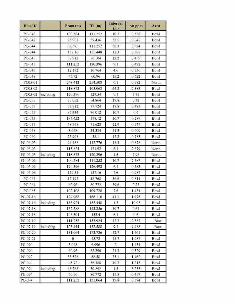
Hole ID From (m) To (m)Interval
(m)Au ppm Area
PC-040 100.584 111.252 10.7 0.538 Bowl
PC-042 25.908 59.436 33.5 0.642 Bowl
PC-044 60.96 111.252 50.3 0.924 Bowl
PC-044 137.16 155.448 18.3 0.368 Bowl
PC-045 57.912 70.104 12.2 0.459 Bowl
PC-045 111.252 120.396 9.1 0.492 Bowl
PC-046 12.192 16.764 4.6 0.736 Bowl
PC-048 45.72 60.96 15.2 0.622 Bowl
PC05-01 248.412 254.508 6.1 0.782 North
PC05-02 118.872 163.068 44.2 2.383 Bowl
PC05-02 including 120.396 129.54 9.1 7.75 Bowl
PC-055 35.052 54.864 19.8 0.32 Bowl
PC-055 57.912 77.724 19.8 0.483 Bowl
PC-055 85.344 96.012 10.7 0.4 Bowl
PC-055 187.452 198.12 10.7 0.289 Bowl
PC-057 48.768 71.628 22.9 0.747 Bowl
PC-058 3.048 24.384 21.3 0.609 Bowl
PC-060 25.908 38.1 12.2 0.783 Bowl
PC-06-03 94.488 112.776 18.3 0.878 North
PC-06-03 115.824 121.92 6.1 2.679 North
PC-06-03 including 118.872 120.396 1.5 7.96 North
PC-06-06 100.584 111.252 10.7 2.387 Bowl
PC-06-06 120.396 126.492 6.1 0.583 Bowl
PC-06-06 129.54 137.16 7.6 0.987 Bowl
PC-064 12.192 48.768 36.6 0.811 Bowl
PC-064 60.96 80.772 39.6 0.73 Bowl
PC-065 102.108 109.728 7.6 1.431 Bowl
PC-07-16 124.968 166.116 41.1 1.975 Bowl
PC-07-16 including 153.924 155.448 1.5 10.05 Bowl
PC-07-18 132.588 143.256 10.7 0.61 Bowl
PC-07-18 146.304 152.4 6.1 0.6 Bowl
PC-07-19 111.252 153.924 42.7 2.587 Bowl
PC-07-19 including 123.444 132.588 9.1 9.488 Bowl
PC-07-20 131.064 173.736 42.7 1.461 Bowl
PC-07-21 0 45.72 45.7 1.087 Bowl
PC-090 3.048 6.096 3 1.431 Bowl
PC-090 60.96 82.296 21.3 0.529 Bowl
PC-092 33.528 68.58 35.1 1.462 Bowl
PC-094 45.72 56.388 10.7 1.213 Bowl
PC-094 including 48.768 50.292 1.5 5.253 Bowl
PC-094 60.96 80.772 19.8 0.497 Bowl
PC-094 111.252 131.064 19.8 0.374 Bowl

Hole ID From (m) To (m)Interval
(m)Au ppm Area
PC-094 140.208 181.356 41.1 0.359 Bowl
PC-096 48.768 77.724 29 0.236 Bowl
PC-096 92.964 150.876 57.9 0.56 Bowl
PC-098 57.912 80.772 22.9 0.327 Bowl
PC-098 86.868 97.536 10.7 1.38 Bowl
PC-098 including 88.392 94.488 6.1 2.275 Bowl
PC-100 79.248 108.204 29 1.106 Bowl
PC-100 including 99.06 103.632 4.6 3.427 Bowl
PC-111 79.248 105.156 25.9 0.461 North
PC-111 111.252 131.064 19.8 0.414 North
PC-112 76.2 85.344 9.1 0.607 North
PC-114 51.816 65.532 13.7 0.377 North
PC-121 158.496 175.26 16.8 1.504 North
PC-124 35.052 59.436 24.4 0.406
PC-126 89.916 106.68 16.8 0.37
PC-128 89.916 92.964 3 1.447 North
PC-128 105.156 118.872 13.7 0.833 North
PC-129 25.91 68.58 42.7 0.468 North
PCD-02 92.964 96.622 3.7 1.648 Bowl