a profile of noida - university of reading · · 2011-11-15a profile of noida: ... greater noida,...
TRANSCRIPT

A PROFILE OF NOIDA: A New Town in the National
Capitol Region of India
Robert B Potter and
Ashok Kumar
Geographical Paper No.174
A PROFILE OF NOIDA:
A New Town in the National Capital Region of India
Robert B Potter Ashok Kumar
Geographical Paper No 174
February 2004
The authors are respectively Professor of Human Geography and Director of Research at the School
of Human and Environmental Sciences at The University of Reading Email: [email protected]
and
Associate Professor of Planning at the School of Planning and Architecture, New Delhi
Email [email protected]
Series Editor: A M Mannion

Introduction: Urban Growth and New Towns
Due to the ample employment opportunities offered by major metropolitan areas they
act as strong attraction points for people seeking urban livelihoods that promise better
lifestyles than rural/agricultural employment (Potter and Sinha, 1990). The resulting
process of continuous in-migration leads to the sustained expansion of the built-up
zones surrounding metropolitan areas. These forces have been part of the tremendous
expansion of built-up areas in what is referred to as the National Capital Region
(NCR) of India, centred on Delhi. The NCR is now one of the world's largest built-
up urbanised zones. It was estimated that Delhi’s total population was 12.8 million by
2001. The latest provisional census estimates reported in the press put Delhi's
population at 13.2 million in 2001.
Many factors have contributed to the in-migration of people to Delhi from
other parts of the country over the last fifty years, and especially over the last two
decades. First, the Hindu population fled from the state of Punjab in large numbers
as a result of political unrest in the 1980s. The north-eastern states and the state of
Jammu and Kashmir have also contributed to the in-migration of people from these
states to Delhi. Most important of all, a constant stream of people continues to
migrate to Delhi in search of employment, particularly from the states of Uttar
Pradesh, Bihar and Madhya Pradesh.
The Delhi Development Authority recognised this trend in the 1980s, and
proposed increasing the density of the Delhi Metropolitan Area (DMA) through the
development of towns in the DMA region, in order to accommodate the burgeoning
population of Delhi (Government of India, 1990). It was argued that the population
coming to Delhi could be stopped and redirected to these new towns if adequate
infrastructure was provided. Accordingly, a number of new towns, among them
Noida, Greater Noida, Dwarka, and South City have been planned and developed in
2

the National Capital Region (NCR) of India. The present paper chronicles the
development of Noida, and presents the first major account of the settlement in an
academic context, although an earlier descriptive note has been published by one of
the present authors (Potter and Sinha, 1990).
Apart from Delhi’s exploding population, the city was also facing the problem
of the increasing incursion of non-conforming industrial activities in prime residential
areas. Planners were aware that between 1962 and 1990, a large number of polluting
industries had located in residential areas in complete violation of planning policies
and development norms. The planners were armed with alternatives. First, they
could relocate industries in newly planned industrial zones outside Delhi. In fact,
such proposals were included in the Master Plan for Delhi 1981-2001, but were never
fully implemented. One reason for this non-implementation was that the NCR
planners did not indicate the particular industrial areas where the relocation of
polluting activities could take place. As is discussed below, another alternative
available to the Delhi planners was that industries from non-conforming areas could
be relocated to new urban areas. However, the DDA planners tended to look inwards
and never seized the opportunity of shifting existing industrial activities to new
settlements. It can be argued that a general failure of co-ordination between the DDA
and the New Okhla Industrial Development Authority (NOIDA) had adverse
implications for Delhi, which could not implement its policy of industrial relocation
aimed at getting rid of polluting industries from residential areas. However, the new
town of Noida was created as an industrial town because of the attraction of new
industrial enterprises of both foreign and Indian origin.
In this paper the development of the new town of Noida is chronicled. At the
outset, two predominant views about the origin of Noida are examined, and at the
same time, some basic facts about the new town are included. An historical overview
of the planning process adopted by the development authority to create the new town
is then provided. The economic and demographic aspects of the town are
subsequently explained, and chronicled in respect of the land-use pattern of the town.
3

Before providing some concluding remarks in the last section, a comprehensive
analysis of the potentials and constraints of the new town of Noida is presented.
The Origins of The New Town Before considering the origin of Noida, reflection on the location of the city is
relevant. The New Okhla Industrial Area falls entirely within the newly created
district of Gautam Budha Nagar. The new town includes some 80 revenue villages,
of which 65 lie in Dadri tehsil, formerly in the district of Ghaziabad, and 15 villages
in Sikandrabad tehsil, formerly in the district of Bulandshahr. The Notified Area
comprises a total of 20,316 hectares. It is located close to the metropolitan city of
Delhi and lies along the eastern and south-eastern boundaries of the National Capital
Territory of Delhi (Figure 1). It falls within the Delhi Metropolitan Area and thus
Noida enjoys the status of a DMA town within the policy framework of the Regional
Plan of the National Capital Region. The area also forms part of the U. P. Sub-region
of NCR (Town and Country Planning Department of Uttar Pradesh, 1992). The
center of Noida lies only 15 kms from Connaught Place, the commercial heart of
Delhi. The regional setting of the town and its broad structure are indicated in
Figure 1.
4

Figure 1: Revised Master Plan for Noida for the year 2021
5

The Official Noida
Officially, Noida, the city came into existence on 17 April 1976 when the Uttar
Pradesh state government notified 36 villages on the eastern periphery of the National
Capital Territory of Delhi under section 3 (i) of the Uttar Pradesh Industrial Area
Development Act 1976. The city was named after the newly created autonomous
development authority, the New Okhla Industrial Development Authority or NOIDA.
The authority was entrusted with the task of preparing and implementing the master
plan to ensure the regulated development of the town, with particular reference to the
incorporation of small-scale industry. As already noted, the principal objective of
NOIDA was to create a new planned industrial town, which would attract industry
from non-conforming areas in Delhi (Potter and Sinha, 1990). The Master Plan for
Delhi focused on the time frame 1981 to 2001. It was specifically noted that:
The walled city contains industrial units using acids, chemicals and inflammable materials, and [pursuing] trades like plastics and rexine etc. which are noxious and hazardous. The first requirement of the area is that such industries and trades should be shifted on priority to the extensive industrial areas and areas specifically earmarked for these trades (Government of India, 1990: 8).
The Delhi planners expected that by decentralising economic activity from the
national capital, they would also be able to reduce in-migration to the city. Second, a
new town close to the national capital would provide additional areas for meeting the
residential needs of Delhi residents who could not buy houses in the city, due to high
prices or the non-availability of apartments. NOIDA set out to achieve these
objectives by providing developed sites for 10,000 small-scale industrial units in the
initial stages. It was estimated that this would provide jobs for 41,000 industrial
6

workers. NOIDA proposed that ultimately 375, 000 people would live in the new
town by 2011 (New Okhla Industrial Development Authority, 1978).
However, before the master plan could be implemented, experts dealing with
industry challenged its fundamental assumptions. It was argued that the plot sizes for
small-scale industries were too large and worker densities too low. NOIDA accepted
these arguments and the size of plots was reduced accordingly. Consequently, more
industries could be accommodated within the same area. Such revisions meant that
over five times the original employment estimates could be provided. Thus, 220,000
rather than 41,000 workers could be employed on the basis of a workers’
participation rate of 27.5 percent. The overall density of the new town was fixed at
148 persons per hectare. Thus, the projected population of Noida was put at one
million inhabitants.
Seeking solutions to the metropolitan woes of Delhi may be the official reason
for the existence of Noida. However, even if the official government line is accepted,
this is only half the truth. Indeed it seems to be a constructed argument, witnessed
by the fact that the first Master Plan for Noida was enforced in 1978, while the
Master Plan for Delhi was not implemented until August 1990. Thus, it is necessary
to explain what happened after the National Emergency of 1975.
Noida and the National Emergency of 1975
The other distinct set of ideas about the creation of Noida is linked with the State of
Emergency that was declared in 1975. All democratic institutions in India came to a
standstill during the emergency of 1975, and the then Prime Minister, Mrs. Indira
Gandhi, and her oldest son, Mr. Sanjay Gandhi, were all powerful. It was well-
known that Sanjay Gandhi, together with his supporters in the bureaucracy, including
7

the present Minister of Urban Development Mr. Jagmohan, wanted to clear the
national capital of its slums, squatters and polluting industries.
Overnight, they literally ordered thousands of people out of Delhi to resettlement
colonies (see Dupont et al, 2000; Tarlo, 2000). They also called for new towns such
as Noida to act as agents in shifting polluting industries from various parts of Delhi,
but in particular, Old Delhi. While the lack of civil rights meant they could easily
force poor people to move to the resettlement colonies, it was difficult for them to
enforce the migration of polluting industries to Noida. This reflected two factors.
First, by 1977 Noida was established, and work had been completed to provide
physical infrastructure, but the state of emergency had been lifted. This was done
before holding the national elections, in which the government of Mrs. Indira Gandhi
was routed. The incoming government, which opposed the state of emergency, was
not the least interested in this unfinished agenda. Delay also occurred in the approval
of the First Master Plan for Noida, which after amendments, was only approved
in 1983.
The Planning Process
After initial wrangling, an Expert Committee was set up to formulate a development
strategy for the Noida area. The Committee recommended that the new town should
be planned for some 4,000 small-scale industrial units, which would provide
employment for 80,000 industrial workers. Considering the number of workers and
also the new town population proposed by the NCR of 550,000 by the year 2001, the
population of Noida was fixed at 500,000 persons and the area for the new town was
calculated at 3,360 hectares. In addition to appropriate transport facilities to link the
8

new town with Delhi and other neighbouring cities such as Ghaziabad, it was
envisaged that the internal transport system would also be connected with the
proposed mass rapid transit system of Delhi.
Incorporating the recommendations of the Expert Committee, a Revised
Master Plan was prepared for Noida in 1979, which was again revised in 1982 in
response to the rapidly changing development scenario of the area. The Authority
approved the revised plan in 1983 for public notification. However, the Plan was not
publicly notified. The planners of NOIDA argued that since there was no
requirement in the Industrial Development Act 1976 to invite public reactions and
objections, it would not be sensible to do so before finally seeking approval of the
Plan from the Development Board of the Authority. Instead, a review of the Plan
was ordered as 20 years had passed since the plan was prepared, and also since
considerable changes had taken place in the land-use pattern and socio-economic
profile of the area.
In the meantime, a statutory plan for the National Capital Region, of which
Noida is a part, was finalised and has been enforced since 1988. The Master Plan for
Delhi 1981-2001 was also finalised by the Delhi Development Authority and
enforced in August 1990. Both these Plans have significant implications for the
development potential of Noida. Within the framework of the NCR Plan, Noida was
given the status of a DMA town with an assigned population of 550,000 by the year
2001 and 1.1 million by 2011. The final population figures for Noida could change
as the NCR Plan is also being reviewed presently (Ansari et al, 2000). It is expected
that the assigned population for Noida will be reduced, at least in the mid-term.
Another development, which will have far reaching implications for the growth
potential of Noida, is the Development of Greater Noida on a contiguous territory
east of the river Hindon. As Noida, Ghaziabad, Faridabad and Gurgoan are close by,
9

this sub-region has become hypersensitive to urbanisation. Construction of the Noida
Toll Bridge and various existing road and rail links has considerably enhanced the
accessibility of this area and journeys between these settlements and Delhi have
become far more comfortable. This is particularly true of linkages between Noida,
Greater Noida and eastern and southern Delhi. As new population constantly migrates
to the area, the urbanised zone is continuing to expand. This process of urbanisation
emphasises that once a direction of urban growth picks up momentum, it becomes
very difficult to reduce sprawl in spite of the fact that sites may not be entirely
suitable for expanding a new town. Thus, on the ground there is no talk of stopping or
reducing the growth of Noida. Instead NOIDA has recently prepared a master plan,
which proposes the following objectives (Ansari et al, 2000: 3):
Within the framework of policies for the development of the NCR and the
U.P. Sub- regional Plan, and taking into consideration the development pressures
due to the creation of Greater Noida, to achieve the integrated development of
Noida and its environs, with a future growth of population up to the year 2021,
and in the process revise the Master Plan-2001 for Noida prepared and approved
in 1989;
To capitalise on the area’s high growth potential due to its proximity to the
metropolitan city of Delhi and public investment expenditure not only in the area
but also its environs;
To promote small-scale industrial work opportunities at places which are well
suited for such activities and which provide a conducive environment for people
to work and enjoy a good quality of life.
10

As already noted, in perpetuating urbanisation, the ‘sister’ new town of Greater
Noida has been planned. Before its designation, sporadic occupance could be seen in
the area. Some academic institutions have already been established in Greater Noida.
It is argued that since the area is located on the periphery of the fertile hinterland of
Haryana and Western Uttar Pradesh, it should benefit from this overall prosperity.
The Government of Uttar Pradesh has decided to acquire about 70,000 hectares for
planned urban development, with a view to curbing haphazard development in this
area. For this purpose, the State Government has created the Greater Noida
Development Authority, which has now prepared a master plan for the development
of the new town of Greater Noida for an eventual population of 300,000.
Notably, both the master plans prepared so far have been completed by external
planning consultants. When the first plan was being prepared by the external
consultants it was argued that the newly created authority did not have enough trained
planners to do the job. But 22 years after the enforcement of the first master plan, the
New Okhla Industrial Development Authority still does not seem to have enough
planners; therefore, once again external consultants were hired to prepare the master
plan. At the present time, the authority has over ten full-time planners, plus
associated human resources and infrastructure. It would appear that the authority
hires consultants in order to gain legitimacy for its proposals, which have not
involved public participation. Political intervention in the consultants’ work was
observed at all stages of the preparation of the new master plan.
11

The Demographic, Economic and Land Use
Characteristics of Noida
Demographic Characteristics
According to the Census of India 1981, just under 37,000 persons lived in the town of
Noida in 1981. By the year 1991, Noida was classified as a Census Town and its
population had increased four times to 146,514 persons. The 1991 Census further
revealed that in addition to the population in the developed urban limits of Noida,
34,489 persons were to be found living in the villages. Thus, the total population of
what is officially regarded as the notified Noida area was 181,003 persons. This
means that the population of Noida grew by nearly 300 per cent from 1981 to 1991.
This is not surprising as this period represented the takeoff stage of the new town. It
was estimated that the population of Noida had increased to 211,534 persons by 1995
(Saha and Rao, 1995: 19). The 2001 Census data for Uttar Pradesh have not yet been
published, but unofficial estimates put the population of Noida at 350,000. Thus, the
town has achieved only half of the population target set for it by the NCR Board for
2001. These statistics tell a story of a new town whose growth rate may have been
relatively high, but not high enough to meet the planned threshold.
Several reasons explain why Noida has not achieved its population threshold
for 2001. The first reason is the sudden, but expected, occurrence of urban
development in the neighbouring Haryana state, leading to large-scale private sector
development in Gurgaon, a district as close to Delhi as Noida. Further, unlike Noida,
urban development in Gurgaon has encountered relatively few site problems.
Second, the NCR had over-estimated the population of Noida. Realising this,
recently the NCR Board has revised its estimate of 550,000 to be achieved by 2005.
12

On the political front, Uttar Pradesh, of which Noida is a part, is an unstable state
from the point of view of security, while Gurgaon faces no such problems.
Therefore, people tend first to search for housing or commercial spaces in Gurgaon,
before considering Noida. The situation is further exacerbated by the fact that as
much as 20 per cent of the total population lives in clusters (jhuggi) and another 48
per cent in the urban villages. Both areas are unplanned and suffer from a serious
lack of basic services such as sewerage, piped water, drainage and power. Therefore,
investors would be reluctant to consider Noida as their first option when other equally
good sites near Delhi are available.
In the initial stages of development of a new town, the percentage of people in
the working age group (15 to 60 years) generally constitutes over 65 per cent. Within
this age group, some 46 per cent generally fall between 15-40 years. However, a
study recently found that children under 15 years constituted 32 per cent of the
population of Noida, and the working age group from 15-60 years was 61 per cent,
while persons above 60 accounted for only 7 per cent. Thus as the new town grows,
the nature of its population in various age groups tends to change (Saha and Rao,
1995: 41). The sex ratio also shows an increase as a new town develops from one
stage to another. Noida had 782 females per 1,000 males in 1991, which has risen to
895 in 1995. This demonstrates that new town migrant workers are now joined by
their families as well as new occupants arriving in the town. Consequently
demographic indicators such as age and sex ratios remain largely skewed during the
initial stages of new town development.
Noida displays an atypical new town profile in respect of literacy levels.
Every third person in Noida was classified as illiterate in 1991 (Census of India,
1991). This compares very unfavourably with the national literacy rate of 73 per
cent. One reason for this low literacy rate is that Noida has attracted a large number
13

of migrants, mostly illiterate, from the surrounding villages and small towns (Saini et
al, 1988).
Economic Characteristics
Thirty two per cent of the total population of Noida was classified as workers in
1991. A major segment of the workforce comprises industrial operatives, who
constitute 29.47 per cent of the total. The highest percentage of workers (31.01 per
cent) are engaged in service occupations, with another 14.54 per cent in trade and
commerce, 9.11 per cent in construction, 4.22 per cent in transport and
communication and 11.65 per cent in primary activities (see Table 1). The data show
that the percentage of workers in primary activities is quite high. However, this
figure is likely to decline as the urbanised area grows and more opportunities open up
in the secondary and tertiary sectors. Consequently, it can be said that the
percentage of workers in the transport, trade and commercial sectors increases, as the
city’s economic base is modernised. Table 1. Distribution of workers in the urban
area of Noida, 1991
Table 1. Distribution of workers in the urban area of Noida, 1991 Category Male Female Total PercentCultivators 3,365 60 3,425 7.09Agriculture Labourers 1,722 60 1,782 3.68Livestock, Forestry, Fishing & Allied activities 389 25 414 0.86Mining and Quarrying 11 1 12 0.02Manufacturing in household industries 579 47 626 1.29Manufacturing other than household industries 12,750 869 13,619 28.18Construction 4,023 381 4,404 9.11Trade and Commerce 6,660 364 7,024 14.54Transport, Storage and Communication 1,974 65 2,039 4.22Other Services 12,807 2,188 14,995 31.01
Total 44,280 4,060 48,340 100.00 Source: Census of India (1991).
14

As for the objective of creating a new town in order to shift small-scale industry from
Delhi, this has not been achieved. Instead, Noida has attracted new industries and has
become just like any other regular new town. The number of workers engaged in
industry is almost equal to the number of workers employed in other services. If
those employed in trade and commerce, construction, transport and communication,
and other services are added together, more than 43 per cent of total workers are
shown to be engaged in these sectors (see Table 2).
Table 2. Distribution of workers in Noida, 1991
Category Noida Urban Area
Noida Notified Area
Total Percent Total PercentCultivators 3,425 7.09 8,160 14.23Agriculture Labourers 1,782 3.68 2,973 5.18Live stock, Forestry, Fishing & Allied activities 414 0.86 515 0.90Mining and Quarrying 12 0.02 18 0.03Manufacturing and Processing in household industries
626 1.29 722 1.26
Manufacturing and Processing other than household industries
13,619 28.18 14,492 25.27
Construction 4,404 9.11 4,596 8.02Trade and Commerce 7,024 14.54 7,500 13.08Transport, Storage and Communication 2,039 4.22 2,234 3.90Other Services 14,995 31.01 16,136 28.13Total 48,340 100.00 57,346 100.00
Source: Census of India (1991).
A comparative examination of the Noida urban area and the Noida notified
area (see Tables 1 and 2) reveals the essentially rural economic character of the
Noida notified area. Thus, workers engaged in the primary sector amount to 14 per
cent of the total workforce in the Noida notified area, and 7 per cent in the Noida
urban area. In contrast the share of workers in the manufacturing and service sectors
is not noticeably lower in the Noida Notified Area, showing that workers engaged in
these sectors are more uniformly distributed through space.
15

Noida predominantly houses small-scale industries. Out of a total of 3,197
small-scale units there are only 235 medium- and large-scale units in Noida. In total,
these industries provide employment for 86,000 workers. NOIDA intends to develop
an additional 336 hectares of industrial land in sectors 63, 64 and 65 along National
Highway No. 24. About 168 hectares of the proposed area have already been
acquired, and the remaining 168 hectares will be acquired soon (see Table 3). The
predominant industry in Noida is hosiery and garment manufacture. This is followed
by the manufacture of paper and paper products and printing, machinery and machine
tools, and electric machinery appliances.
Table 3. Industrial Units and Employment in Noida in Small Scale, Medium and Large Scale Industries, 1998 Industrial Category Number of Units EmploymentFood Products 59 1,193Beverages and Tobacco Products 52 1,452Cotton Textiles 44 898Jute Textiles 26 568Wool and Silk Synthetics Products 37 780Hosiery and Garments 758 13,788Timber and Wood Products 92 1,973Paper and Paper Products and Printing 405 8,627Leather and Leather Products 168 2,879Rubber Plastic and Petroleum 501 8,710Chemicals and Chemicals Products 82 3,397Non Ferrous Metals 39 1,397Ferrous Metals 56 1,562Metals Products 104 3,012Machinery and Machine Tools 288 8,615Electric Machinery Appliances 342 10,224Transport Equipments 149 7,414Electronic Industries 243 8,488Other Industrial Miscellaneous 377 3,674
Total 3,802 88,654 Source: Ansari et al (2000: 13).
Besides the above, another 280 hectares of industrial land in sectors 80 and 81
are proposed for development. Of this, about 50 per cent of the land has already been
16

acquired and another 50 per cent has already been notified under section 4/17 and
6/17 of the Land Acquisition Act 1984. The land acquired is already being developed
and the allocation procedures have been initiated.
Presently, the following types of industrial units are being attracted to Noida:
Electrical Home Appliances, Machinery, Ready-made Garments, Paper Products,
Electronics, Rubber/Plastic Products, Dies, Tools and Machinery, Wooden Furniture,
Leather Products, Beverages and Food Products. In the future, the industries that are
likely to be attracted to Noida are Electronics, Electrical Goods, Ready-made
Garments, Plastic Moulds, Packing Materials, Dies, Tools and Machinery, and Steel
Fabrication. The type of industry is likely to change from predominantly small-scale
to predominantly medium- and large- scale. This scenario will develop because of
the economic liberalisation policies adopted by the Government of India since 1991.
Consequently, the industrialists have begun to prefer investing in medium- and large-
scale industries.
Land Use: is it an industrial township?
Land-use patterns clearly reflect the economic character of the town and the priorities
of the state government. In 1998 one quarter of the land was put to industrial use (see
Table 4). In contrast only 0.8 per cent represents commercial land. At first glance it
would be surprising to see the area under commercial use shrink from 132 hectare in
1995 to 36 hectare in 1998, as shown in table 4. However, on discussion with the
authors of the reports from which these data are derived, we came to the conclusion
that the reports have defined commercial areas in very different fashions. While Saha
and Rao (1995) included both existing and planned commercial areas (where only the
site is developed after providing trunk services), Ansari et al (2000) in their
calculations included only fully developed and functioning commercial areas known
17

as Atta. The main commercial centre (i.e. the CBD) is still not developed in Noida,
but as the city grows and the authorities have money to spare or alternatively enter
into some form of agreement with the private sector, this area will be developed. At
present, people are largely dependent on Delhi for their commercial needs. Further,
the authority has far less developed areas meant for social facilities, such as schools
and recreational places like parks to be used by the general population. On the
contrary, it has developed two recreational areas which are largely for the wealthy: a
rose garden along the River Yamuna near sector 15, and a golf course located
immediately to the south east of sector 37. The new town seems to be being used by
the state government in order to make quick money by selling industrial and
residential land.
Table 4. Proposed Land Use of Noida, 2011 and 2021
Land Use Existing Land Use, 1998
2011 (as per the Master Plan)
2011 (revised proposals)
2021
Area (hectare)
% Area (hectare)
% Area (hectare)
% Area (hectare)
%
Residential 1,607 35.5 3,240 38.5 4,263 43.5 5,994 41.3Commercial 36 0.8 660 7.8 318 3.2 524 3.6Industrial 1,092 24.1 1,896 22.5 1,950 19.9 2,235 15.4Institutional 571 12.6 782 9.3 801 8.2 1,344 9.3Recreation 208 4.6 540 6.4 1,177 12.0 1,776 12.2Transport 1,013 22.4 1,302 15.5 1,298 13.2 2,644 18.2
Total 4,527 100.0 8420 100.0 9,807 100.0 14,517 100.0 Source: Ansari et al (2000: 44).
Personal discussions with Professor J.H. Ansari, the Principal Consultant for
the latest Plan for Noida revealed that Noida has far exceeded its targets of
developing those land uses which will fetch the authorities large sums of money in a
short period of time (Table 5). That is why more industrial, institutional and transport
uses have been developed, while little money has been put into social infrastructure.
18

Notwithstanding, the development of industrial use also fits with their mandate of
creating an industrial city.
Table 5. Growth of the New Town, 1998 Land Use 1995 1998 2011 (proposed) Area
(hectare) Percent Area
(hectare) Percent Area
(hectare) Percent
Residential 1,131 42.15 1,607 35.5 3,672 47.14Commercial 132 4.92 36 0.8 431 5.53Industrial 811 30.23 1,092 24.1 985 12.65Transport 365 13.60 1,013 22.4 941 12.08Institutional 152 5.70 571 12.6 536 6.89Recreational --- --- 208 4.6 --- ---
Total 2,683 100.0 4,527 100.0 8,420 100.0 Source: Ansari et al (2000: 44); Saha and Rao (1995: 31) and New Okhla Industrial Development Authority (1978).
The area has two distinct types of land-use patterns. On the one hand, there is
the planned industrial town of Noida, where major industrial sectors have been
developed in two phases: the Okhla Industrial Development Area Phase I and Okhla
Industrial Development Area Phase II. The complimentary residential, commercial,
recreational, institutional and other urban use areas have also been developed in large
parts of the town in the form of sectors. On the other hand, the remaining area of the
town is in the process of being developed. Saha and Rao (1995: 28) found that out of
the proposed development of 95 sectors by 2011 included in the Master Plan, 44
sectors had been developed by 1995.
Noida has become an industrial town in a phased manner. In the first phase,
393 hectares of industrial land extending over 12 industrial sectors was developed.
This provided 480 developed industrial plots. In the second phase, 127 hectares of
industrial land were developed which provided 260 developed industrial plots.
Simultaneously, under the extension scheme of the development of Noida Phase-II,
19

132 hectares of industrial land was developed, which provided for 462 developed
industrial plots. In the third phase, sectors 57 to 60 were created whereby 206
hectares of industrial land was developed, which provided 922 developed industrial
plots. During this phase, the export promotion zone was also established in the area
located close to Noida Phase-II, in which about 115 hectares of industrial land was
developed, in the form of 214 plots. As a result, a total of 970 hectares of industrial
land was developed leading to the provision of 6,658 plots under Phase-I, Phase-II,
Phase-II (Extension), Phase-III and the Export Promotion Zone Development
Schemes. As noted previously, this is new industry, and the number of non-
conforming industries in Delhi has not declined. While not attracting much industry
from Delhi, Noida has been successful in providing people from Delhi with
residences. For example, in 1995 out of the total in-migrants to Noida, 59 per cent
have come from Delhi (Saha and Rao, 1995: 35).
The Development of Noida: Potentials and Constraints
Environmental Issues
Each new town is built following a careful site selection process. Various site
characteristics are taken into consideration including the topographical features, the
availability of water, soil characteristics and climate. It is highly desirable that the
site selected is not bowl-shaped, as sewage and storm water cannot easily be drained
from such a morphological unit. The mixing of sewage with drinking water supplies
can obviously result in the outbreak of water-borne diseases. Flooding could become
another very real risk to the inhabitants of such a settlement (Marsh, 1978; Feldman
and Lemon, 1996).
20

A major section of eastern Delhi, but more particularly the area occupied by
Noida, are in the Yamuna River basin. Thus, Noida was effectively reclaimed after
the construction of embankments along the River Yamuna. There is still a fear that
the floodwaters of the River Yamuna could breach the embankments, leading to
widespread loss of life and property. A second and more serious threat is that posed
by the disposal of the liquid wastes of the city. Noida can store liquid wastes for only
a limited period of time, before having to dispose of these into the Rivers Yamuna or
Hindon. Both rivers lie on higher ground than Noida itself. Therefore, the only
alternative is to dispose of liquid wastes mechanically, which is exorbitantly
expensive. In fact, NOIDA has already spent large sums of money installing several
heavy duty diesel pumps with a capacity of 1,000 cubic centimetres per second.
These are used to remove water during periods of saturation (Das and Kant, 1980: 8).
Problems also arise as a result of the fact that the city stands on a gradual
slope, varying from 0.2 to 0.1 per cent from north-east to south-west. The maximum
altitude is 204 meters above mean sea level near the village of Parthala Khanjarpur in
the north east. The minimum elevation is 196 meters above mean sea level near
Garhi village in the south-western section of the urban area. The Noida Drain, a
major channel passes directly through the new town, via the southern part of the city,
and finally falls into the River Yamuna upstream of the Yamuna Hindon confluence.
This drain is presently being used as a channel to drain liquid wastes, including
sewage and storm water flows from most parts of Noida. Another drain flows
through sectors 14, 15 and 16 and falls into the River Yamuna south west of
Sector 16.
At the present time, however, sewage is left to mix with storm water in the
open drains and mixes with ground water. This is one of the main causes of the
increasing incidence of water-borne diseases during the monsoon season (see
21

Photographs 1 and 2). As a result, the general sanitary and hygienic conditions of
the area are relatively poor. Cases of malaria and diarrhoea are reported every
summer during the monsoons when rainwater accumulates and is mixed with sewage,
creating dangerous cesspools. Noida has created a partial sewerage system in the
town. However, while the sewerage system exists in the built up areas of the city,
these pipes then convert into open drainage channels outside the built up sectors.
Photograph 1: Waste products adjacent to a water course in Noida
It must be stressed that the general level of the site is lower than the high flood level
of the River Yamuna. It is only due to the construction of the embankments along the
Rivers Yamuna and Hindon that flooding in the area is prevented. However, the
generally low level of the site is a constraint for effective storm water and sewage
disposal. In any case the site of Noida was declared a part of the Delhi green belt in
22

the early 1960s, when the first Master Plan for Delhi was prepared (Das and Kant,
1980).
Photograph 2: Waste products mix with ground water in Noida
Such problems are further exacerbated by the fact that in the north-western
part of Noida, a major drain, the Hindon Cut has been constructed and this is used by
Delhi’s irrigation authorities to divert the excess flood waters of the Rohini into the
Yamuna. This cut merges with the River Yamuna near the western parts of the town.
It is contended that Noida cannot sustain a rainfall intensity in excess of 1.885
centimetres per hour, nor a surface runoff coefficient in excess of 0.53 (Gupta, 2000:
53). Both these conditions are experienced, and pose a constant danger to the town.
The situation suggests that greenfield areas should be retained. However, rather than
exercising such restraint, the market-centred approach to planning adopted in Noida
is moving in the other direction and pressing hard for the extension of the built-up
23

areas. If the new master plan is fully implemented, Noida will have roughly three
times the built up area it had in 1998 (Ansari et al, 2000: 44).
Water Supply
Noida receives its water supplies from tube wells dug deep underground. In fact, the
water reserves are excellent and more than adequate to meet the future demand.
However, the quality of water is poor. Water is brackish with a high degree of
dissolved solids. Residents take water from Delhi at least for drinking purposes.
Those who are well off tend to buy bottled water for drinking purposes. People
generally complain that their coolers, geysers and electric kettles corrode very
quickly due to the hardness of the water. This situation deteriorates further for those
who drink the local water during rains when sewage mixes with water supplies and a
large number of water borne diseases are normally reported during the monsoon.
These problems entail additional costs for living a normal life in the city.
Rural Settlements in the Notified Noida
Noida started out as a rural settlement and in 1981 it had only 36,972 inhabitants,
which was effectively the combined population of the villages. By 1991 Noida had
shaped into a new town with a total population exceeding 140,500 and it was
declared a census town. By 1995, it was estimated that the population of Noida was
in excess of 200,000 (Saha and Rao, 1995). When the 2001 Census data are
published, they are likely to reveal that the population of Noida has reached at least
350,000.
The eighty villages formed an important part of the Noida Notified Area.
Those villages which have been engulfed as the city has grown are referred to as
24
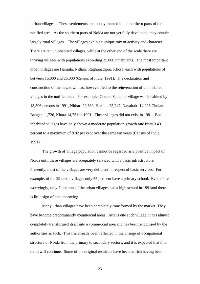
‘urban villages’. These settlements are mostly located in the northern parts of the
notified area. As the southern parts of Noida are not yet fully developed, they contain
largely rural villages. The villages exhibit a unique mix of activity and character.
There are ten uninhabited villages, while at the other end of the scale there are
thriving villages with populations exceeding 25,000 inhabitants. The most important
urban villages are Haraula, Nithari, Raghunathpur, Khora, each with populations of
between 15,000 and 25,000 (Census of India, 1991). The declaration and
construction of the new town has, however, led to the rejuvenation of uninhabited
villages in the notified area. For example, Choura Sadatpur village was inhabited by
13,506 persons in 1991, Nithari 22,630, Haraula 25,247, Nayababs 14,226 Cholara
Banger 11,726, Khora 14,751 in 1991. These villages did not exist in 1981. But
inhabited villages have only shown a moderate population growth rate from 0.49
percent to a maximum of 8.82 per cent over the same ten years (Census of India,
1991).
The growth of village population cannot be regarded as a positive impact of
Noida until these villages are adequately serviced with a basic infrastructure.
Presently, most of the villages are very deficient in respect of basic services. For
example, of the 29 urban villages only 55 per cent have a primary school. Even more
worryingly, only 7 per cent of the urban villages had a high school in 1991and there
is little sign of this improving.
Many urban villages have been completely transformed by the market. They
have become predominantly commercial areas. Atta is one such village, it has almost
completely transformed itself into a commercial area and has been recognised by the
authorities as such. This has already been reflected in the change of occupational
structure of Noida from the primary to secondary sectors, and it is expected that this
trend will continue. Some of the original residents have become rich having been
25

compensated for their land by the authorities and having also developed residential
plots in the town.
Issues of Accessibility
Accessibility to Noida is good, although it can only be reached by road. For example,
the Dadri-Surajpur-Chalera (DSC) road connects the city with Sikandrabad and
Dadri. The Mathura Road or NH-2 connects the city with Faridabad and other cities
to the south and south-west. The NH-24 by-pass facilitates access to Ghaziabad,
Delhi and other parts of north India. Further, the Kondli Road running through
Sector VIII and Sector IX serves to link Noida with eastern Delhi and Ghaziabad.
Photograph 3: A section of the Faridabad-Noida-Ghaziabad expressway
26

One very important transport project has further enhanced the accessibility of
Noida to Delhi. This is the Faridabad-Noida-Ghaziabad (FNG) expressway (see
Photograph 3 and 4). Ansari et al (2000) observe that this expressway will result in
increasing real estate prices in areas along and around the bridge. This may well
serve to boost the sagging real estate market of Noida. The City authorities are
engaged with the railway authorities in order to progress the proposed railway link
from the planning to implementation stage. This rail link will connect Noida to
Tughlakabad in South Delhi and to Ghaziabad and the Grand Chord of Northern
Railway. It is contended that “with these important rail and road projects in the
offing, there is no doubt that Noida will inevitably become part of the enveloping
conurbation which will ultimately comprise Greater Noida, Ghaziabad, Faridabad,
and South Delhi as a composite urban monolith” (Ansari et al, 2000).
Photograph 4: A section of the Faridabad-Noida-Ghaziabad expressway
27

Proximity to the National Capital Territory of Delhi
The development potential of Noida town emanates from its proximity to Delhi and
its intense interaction with the national capital. A recent RITES study found that out
of a total of 40,000 trips per day originating from Noida, 56 per cent are destined for
Delhi (RITES, 1995: 77). It is another important fact that Noida lies in the midst of a
rich agricultural belt extending over western Uttar Pradesh and Haryana, and is
surrounded by prospeous cities like Ghaziabad, Sikandrabad, Bulandshahr and
Khurja in Uttar Pradesh and Faridabad and Ballabhgarh in Haryana. Thirdly, the
planned town of Greater Noida is fast coming up in south-eastern parts of Noida,
located immediately across the River Hindon. All the towns and cities surrounding
Noida are thus growing with a strong industrial base. The emerging job
opportunities are attracting workers, some of whom are taking up residence in Noida.
Consequently, the town is experiencing continuous population growth.
Recent studies conducted by the School of Planning and Architecture, New
Delhi, have revealed that Noida is also attracting considerable office employment
(Saha and Rao, 1995 and Ansari et al, 2000). Since available office space has
become increasingly scarce in Delhi, many businessmen, even though resident in
Delhi, are setting-up offices in Noida because the rents are still in an affordable
range. Employees in these offices also find living in Noida more convenient. At the
next stage it is expected that the businessmen themselves will shift to Noida. In
addition Noida is also a convenient place to live for many people who are employed
in Delhi because they have been able to find purchased or rented accommodation
because of relatively cheap land prices. Due to these factors, and also considering the
fact that the provision of facilities in Noida and transport linkages with Delhi are
bound to increase in the short run, the rate of growth of population is likely to be
sustained or even accelerate in the future.
28

However, in the long run, it is likely that the bridges across the River
Yamuna, despite being widened and increased in number, will become choked with
traffic and it may become difficult to cross the river in reasonable time, unless the
area is connected to Delhi by a Mass Rapid Transit System (MRTS). Thus
transportation across the River Yamuna may become a major limiting factor in the
development of Noida.
Questions of Governance
Named after the development authority (“NOIDA”), the new town does not even
have a name of its own (“Noida”). While almost the entire country has elected urban
and local governments as a consequence of the Seventy Third and Seventy Fourth
Amendments to the Constitution of India since 1992, even after 25 years of existence,
Noida is still governed by the bureaucrats forming the development authority,
appointed by the State Government of Uttar Pradesh. The general public has little or
no influence over the city’s present policies. For example, there has been no avenue
available to Noida’s inhabitants for participating in the master planning process.
Despite Noida’s proximity to the capital, its accessibility and its growth, it has
not been able to attract as many multinational companies as Gurgaon. Gurgoan lies
on Highway number 8, the economic lifeline of the country and equals Noida’s
accessibility advantage. Second, Noida is part of the politically unstable Uttar
Pradesh area, where governments rarely complete their full term. Third, the private
sector has a very limited role in urban development in Uttar Pradesh, whereas private
enterprises have long been allowed to assemble land and develop towns in Haryana,
of which Gurgoan forms a part.
29

Concluding Comments
Although it was touted as a solution to the population growth problem of the city of
Delhi by the planners of the DDA, the NCR and the state government of Uttar
Pradesh, the new town of Noida basically remains a creation of the National
Emergency of 1975. Despite this twist concerning the origin of Noida, the town has
made some progress in terms of attaining the character of an industrial town, although
this has undoubtedly been made more difficult by the liberalisation policies of the
1990s, which have led to industrial and commercial spaces becoming available
elsewhere in the sub-region. However, the town has been unable to achieve its
population threshold of 550,000 set by its big brother, the National Capital Region
Board. The Board has now set a revised population target of 650,000 for Noida by
2005, and this seems more likely to be achieved. While Noida has advantages of
accessibility to the region and proximity to Delhi, these advantages have to be set
against problems of law and order, the safety of the inhabitants and the volatile
political environment created by those who seem to be beyond the control of the state
government.
References Ansari, J.H., Sharma, A.K., Shaheer, M., Mahavir and Prakash, P. (2000) Revised Master Plan for Noida – 2021, School of Planning and Architecture, New Delhi. Das, S. and Kant, S. (1980) Noida Regional Setting, Survey and Analysis of New Okhla Industrial Development Area – A Report on the Regional Aspects, School of Planning and Architecture, New Delhi. Dupont, V., Tarlo, E. and Vidal, D. (eds.) (2000) Delhi: Urban Space and Human Destinies, Manohar Publishers and Centre De Sciences Humaines, New Delhi.
30

Feldman, J.H. and Lemon Jr., R.L. (1996) ‘Site Analysis and Site Selection’, in Sidney O. Dewberry and Davis (eds.) Land Development Handbook, Planning, Engineering and Surveying, McGraw Hill, New York. Government of India (1990) Master Plan for Delhi, the Gazette of India Extraordinary, Part II - Section 3 - Sub - Section (ii), Union Ministry of Urban Affairs and Employment, New Delhi. Gupta, M. (2000) A GIS Approach to Land Use Planning for Drainage and Flood Control, a Case Study of Noida, Graduate Planning Thesis, Department of Physical Planning, School of Planning and Architecture, New Delhi. Marsh, W.M. (1978) Environmental Analysis for Land Use and Site Selection, McGraw Hill, New York. New Okhla Industrial Development Authority (1978) Master Plan of New Okhla Industrial Development Area – 1976-1992, New Okhla Industrial Development Authority Noida. Potter, R.B. and Sinha, R. (1990) Noida: a planned industrial township south-east of Delhi, Geography, Vol.75, Part 1, pp.63-65. RITES (1995) Transportation Study for Noida, Greater Noida and Ghaziabad, RITES, a Government of India Enterprise, New Delhi. Saha, S.K. and Rao, P.S.N. (1995) Noida: Surveys 1995 for the Revision of Master Plan 2011, School of Planning and Architecture, New Delhi. Saini, N.S., Ranganathan, N. Ansari, J.H. and Chatterji, M.N. (1988) Socio-economic and Traffic and Transportation Study for Noida Master Plan, School of Planning and Architecture, New Delhi. Tarlo, E. (2000) ‘Welcome to History: A Resettlement Colony in the Making’, in Dupont, V., Tarlo, E. and Vidal, D. (eds.) Delhi: Urban Space and Human Destinies, Manohar Publishers and Centre De Sciences Humaines, New Delhi. Town and Country Planning Department of Uttar Pradesh (1992) Sub-Regional Plan 2001, UP sub-region, National Capital Region, Town and Country Planning Department of Uttar Pradesh, Lucknow.
31