a preliminary report to the pacific fishery …
TRANSCRIPT

1
A PRELIMINARY REPORT TO THE PACIFIC FISHERY MANAGEMENT COUNCIL
ESSENTIAL FISH HABITAT REVIEW COMMITTEE
December 1, 2011
A CHARACTERIZATION OF DEEP-SEA CORAL AND SPONGE COMMUNITIES
ON THE CONTINENTAL SHELF OF NORTHERN WASHINGTON,
OLYMPIC COAST NATIONAL MARINE SANCTUARY,
USING A REMOTELY OPERATED VEHICLE IN 2008
Ed Bowlby1, Mary Sue Brancato
2, Jennifer Bright
1, Katie Brenkman
1 and James Boutillier
3
1NOAA Olympic Coast National Marine Sanctuary, Port Angeles, WA
2NOAA International MPA Capacity Building Program
3Dept. of Fisheries and Oceans Canada , Nanaimo, BC
INTRODUCTION AND SCIENTIFIC OBJECTIVES
Deep-sea corals (DSC), particularly structure forming corals, are biogenic habitats and are
recognized as slow-growing, long-lived and fragile, making them and their associated organisms
vulnerable to human-induced impacts, particularly from physical disturbances (NRC 2002;
Hourigan et al. 2007; NOAA 2010). The extent of habitat degradation resulting from these
threats is largely unknown although there is increasing information on significant impacts in
some areas. Activities that can directly impact deep coral communities include fishing using
bottom-tending fishing gear, deep coral harvesting, oil and gas and mineral exploration and
production, and submarine cable/pipeline deployment. Invasive species, climate change and
ocean acidification represent additional serious threats.
Submersible and ROV surveys for deep-sea habitats in Olympic Coast National Marine
Sanctuary (OCNMS) started in the year 2000 to investigate potential impacts to the benthic
habitat caused by trenching operations to lay fiber optic cable in OCNMS (Brancato and Bowlby

2
2005). The stony coral Lophelia pertusa was discovered in the sanctuary in 2004 (Hyland et al.
2005). Large gorgonian coral patches were identified in 2006 during a more extensive research
cruise dedicated to observing deep-sea corals (Brancato et al. 2007).
The Olympic 2 Conservation Area was created in 2006 as part of West Coast groundfish
Essential Fish Habitat (EFH) areas (http://www.pcouncil.org/wp-
content/uploads/EFH_maps.pdf), partially based on DSC data. Olympic 2 covers approximately
159 square nautical miles, or about 7 percent of OCNMS. The 2004 discovery of the stony coral
Lophelia pertusa in the sanctuary (Hyland et al. 2005) was a contributing factor in the Pacific
Fishery Management Council's (PFMC) decision on some boundaries of the Conservation Area.
These EFH closed areas were identified by PFMC and are intended to minimize to the extent
practicable the adverse effects of fishing on groundfish EFH. New information on the locations,
densities, and condition of DSCs and their role as EFH within these proposed conservation areas
would not only help to fill scientific data gaps, but would provide new information pertinent to
pending management considerations (via provisions of Magnuson-Stevens Act and/or the
National Marine Sanctuaries Act). EFH Conservation Areas are closed to specific types of
fishing. For Olympic 2 bottom trawling is prohibited for all non-treaty fisheries.
The specific objectives of our research were to:
1. Survey and characterize the distribution, abundance, and condition of deep-sea coral and
sponge communities in OCNMS;
2. Quantify fish and invertebrate associations with DSC to help understand the value of DSC as
habitat;
3. Collect limited DSC and sponge specimens to confirm taxonomic identification;
4. Make visual observations of sea floor substratum to ground-truth and to refine habitat
classifications derived from side scan and/or multibeam sonar data.

3
STUDY SITE
The study area is located in OCNMS, which is off the western coast of Washington state (Figure
1). The sanctuary boundary follows the international border with Canada in the north, an
offshore boundary approximating the 200m bathymetric contour, and the southern boundary
northwest of Grays Harbor. OCNMS therefore covers most of the continental shelf in northern
Washington. The offshore boundaries, which extend seaward 40 to 70 km (24 to 45 miles), also
cross the heads of three major submarine canyons, in places reaching a maximum depth of over
1,400 meters (4,500 feet). OCNMS spans 8,259 square kilometers (3,189 square miles) of
marine waters off Washington.
Figure 1. Map of the Olympic Coast National Marine Sanctuary showing shelf and canyon
bathymetric relief off the Washington coast of the United States.

4
Because gorgonian and stony corals generally recruit to hard substrates, side scan sonar data
were reviewed by OCNMS scientists to delineate potential hard-bottom substrates to serve as
ROV dive targets (Intelmann et al. 2007). Potential hard-bottom features were initially identified
from side scan sonar mosaics for which habitat classification had not yet been conducted. These
hard-bottom approximations based on side scan data represented the population of known
potential coral-sponge habitat in the sanctuary.
In addition to the side scan sonar imagery, multibeam bathymetry and backscatter was also
queried for the purpose of limiting dive depths and evaluating bathymetric relief. However only
small portions of the sanctuary have been mapped using high resolution multibeam since
multibeam surveys off the Washington coast had been restricted, until recently, due to Navy
classified areas (Intelmann et al. 2007).
We used these acoustic maps of hard bottom areas to select 48 candidate ROV dive sites as areas
of potential coral and sponge habitat for the 2006 DSC survey (Brancato et al. 2007). Some of
the remaining candidate sites that were not surveyed in 2006 were part of this 2008 survey effort
(Figure 2).
Figure 2. Proposed ROV dive sites for 2008 in relation to the Olympic 2 EFH Conservation
Area.

5
The Juan de Fuca trough and canyon revealed many of the hard bottom features we looked for.
They wind their way southwestward from the Strait of Juan de Fuca (Figure 1). The upper part of
this feature – the Juan de Fuca Trough – is a complex, glacially carved, underwater fjord-like
system. Farther offshore the trough becomes the Juan de Fuca Canyon that cuts across the outer
continental shelf and slope, terminating in deep water at the base of the continental slope. Most
of our dive targets were located along the Juan de Fuca Trough, consisting largely of glacial
deposits; some sites included glacial erratic boulders left either by the retreat of the Cordilleran
ice sheet from Canada and the Olympic Peninsula, or carried to their location by icebergs from
the sheet and deposited on the primarily sand or silt shelf substrate.
Analysis of seafloor substrate data used for groundfish EFH designation in 2006, limited as it
was, indicated that approximately six percent of OCNMS was hard substrate with potential to
host biologically structured habitat. Of this estimated hard substrate, 29 percent was within the
Olympic 2 EFH conservation area (Figure 3, from NOAA 2011). More recent surveys by
OCNMS researchers with ROV and acoustic surveys have documented corals and other
biologically-structured habitat in additional areas (Brancato et al. 2007), which indicates that this
preliminary analysis may underestimate the historic or current distribution of biogenic habitat.
Figure 3. Potential historic distribution of biologically structured habitat associated with hard
substrate overlaid on Olympic 2 EFH Conservation Area (data from Curt Whitmire, NOAA, as
recorded in NOAA 2011).

6
FIELD SURVEY METHODS
Canadian Coast Guard vessel John P. Tully ROPOS ROV
ROV surveys were conducted 24 hours/day with alternating 12 hour shifts of science and ROV
teams. The Canadian Scientific Submersible Facility supplied the ROPOS ROV, which operated
off the Canadian Coast Guard vessel John P. Tully.
The ROV survey followed scientific protocols previously established by OCNMS and NCCOS
(Hyland et al. 2005; Brancato et al. 2007). Pre-selected transect lines spaced 40m apart were
developed for each of the sites in order for the ROPOS ROV to run quantitative video surveys,
operating at depths between 105-360 meters. Protocol included limited sampling of portions of
coral colonies that would confirm taxonomic identification, genetics, and for use in aging
studies; limited sponge sampling occurred as well. Post-processing of video records would
characterize distribution and abundance of coral and sponge species across substratum types and
to determine species associations. Although quantitative video analysis for fish has not been
completed to date, fish species were identified during invertebrate analysis, when feasible.
7
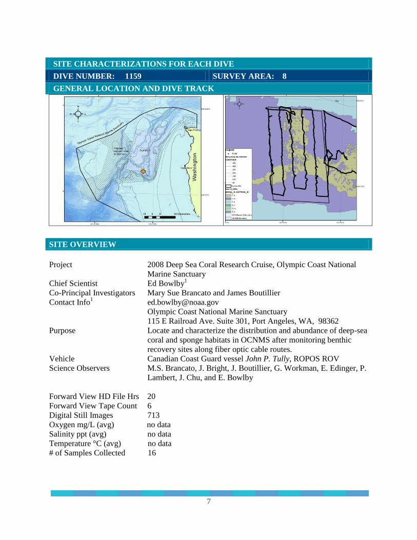
SITE CHARACTERIZATIONS FOR EACH DIVE
DIVE NUMBER: 1159 SURVEY AREA: 8
GENERAL LOCATION AND DIVE TRACK
SITE OVERVIEW
Project 2008 Deep Sea Coral Research Cruise, Olympic Coast National
Marine Sanctuary Chief Scientist Ed Bowlby
1
Co-Principal Investigators Mary Sue Brancato and James Boutillier Contact Info
Olympic Coast National Marine Sanctuary
115 E Railroad Ave. Suite 301, Port Angeles, WA, 98362
Purpose Locate and characterize the distribution and abundance of deep-sea
coral and sponge habitats in OCNMS after monitoring benthic
recovery sites along fiber optic cable routes. Vehicle Canadian Coast Guard vessel John P. Tully, ROPOS ROV Science Observers M.S. Brancato, J. Bright, J. Boutillier, G. Workman, E. Edinger, P.
Lambert, J. Chu, and E. Bowlby
Forward View HD File Hrs 20
Forward View Tape Count 6
Digital Still Images 713
Oxygen mg/L (avg) no data
Salinity ppt (avg) no data
Temperature °C (avg) no data
# of Samples Collected 16

8
DIVE NUMBER: 1159 SURVEY AREA: 8
SITE DATA
Start Date 7/10/2008
End Date 7/10/2008
Minimum Bottom Depth (m) -222.4
Maximum Bottom Depth (m) -347.4
Start Bottom (GMT) 02:12:00
End Bottom (GMT) 22:29:00
Start Latitude N 48° 7' 57.407"
Start Longitude W 125° 5' 46.115"
End Latitude N 48° 7' 56.848"
End Longitude W 125° 5' 26.434"
Bottom Current (kts) 0.75 (estimated)
Bottom Current Direction W
IMAGE GALLARY
IMAGE A: Lophelia, Desmophyllum and
Primnoa in cobble mud habitat
N 48° 7' 40.3464", W 125° 5' 28.6656"
IMAGE B: Paragorgia arborea pacifica on
boulder in mud cobble habitat
N 48° 7' 52.7736", W 125° 5' 45.3912"
IMAGE C: Paragorgia arborea pacifica on
cobble habitat
N 48° 7' 49.0224", W 125° 5' 25.5768"
IMAGE D: Primnoa pacifica colony on a
boulder in cobble habitat
N 48° 7' 41.6892", W 125° 5' 28.68"

9
DIVE NUMBER: 1159 SURVEY AREA: 8
PHYSICAL ENVIRONMENT
Habitats
The total area surveyed at site 8 was 14,831 m2. This site was predominantly mud seafloor (69%
of total area) mostly associated with cobble and pebbles. The dive also traversed areas where
cobble on mud was the dominant habitat type (14%) and a steep, high relief mud wall.
mud cobble
32%
mud pebble
29%
cobble mud
14%
wall
10%
mud
8%
other
7%
Habitats Surveyedarea = 14,831 m²

10
DIVE NUMBER: 1159 SURVEY AREA: 8
BIOLOGICAL ENVIRONMENT
Corals
More than 4,500 individual corals were observed at site 8 for a mean density of 316 individual
corals/1,000 m2. Coral species diversity was high, with at least 10 coral species identified
including the gorgonians Paragorgia arborea pacifica, Primnoa pacifica, Plumarella longispina,
and various Swiftia species. Also at this site were numerous Stylaster sp. hydrocorals and the
giant cup coral Desmophyllum dianthus.
Stylaster sp.
69%
Swiftia
pacifica
15%
Swiftia beringi
6% Paragorgia
arborea
pacifica
5%
Desmophyllum
dianthus
2%
other corals
3%
Density of Corals316 corals / 1,000 m²
Color Code Coral Groups Counts
Stylaster sp. 3,214
Swiftia pacifica 732
Swiftia beringi 284
Paragorgia arborea pacifica 225
Desmophyllum dianthus 102
Plumarella longispina 100
Primnoa pacifica 11
Lophelia pertusa clusters 9
Swiftia spauldingi 4
Pennatulacea 1

11
DIVE NUMBER: 1159 SURVEY AREA: 8
BIOLOGICAL ENVIRONMENT
Sponges
The mean density of sponges at site 8 was 15 individuals/1,000 m2. Globular/ball sponges
comprised 78% of sponges, and several other structural morphs of sponge were identified.
Other invertebrate observations included crinoids (Florometra serratissima), urchins
Strongylocentrotus fragilis and S. pallidus, various sea star species, red ophiuroid brittle stars,
zoanthids, shrimp, whelks, an octopus (Benthoctopus sp.), and sea pens.
globular
78%
shelf
8%
cloud
4%
Farrea
4%boot
2%
single tube
2%
other
sponges
2%
Density of Sponges15 sponges / 1,000 m²
Color Bar Class Structural Morphs Count
Demosponges globular 171
Demosponges shelf 17
Demosponges cloud 10
Hexactinellids farrea 9
Hexactinellids boot 5
Demosponges single tube 4
Hexactinellids encrusting 2
Hexactinellids cloud 1
Demosponges multi-tube 1

12
DIVE NUMBER: 1159 SURVEY AREA: 8
BIOLOGICAL ENVIRONMENT
Fishes
Fish were observed throughout the dive site, including multiple rockfish species, flatfish, Pacific
halibut (Hippoglossus stenolepis), lingcod (Ophiodon elongatus), thorneyhead (Sebastolobus
sp.), and skate.
Scientific Name Common Name
Sebastes helvomaculatus rosethorn rockfish
Sebastes crameri darkblotched rockfish
Sebastes babcocki redbanded rockfish
Sebastolobus sp. thorneyhead
Hippoglassus strenolepis Pacific halibut
Pleuronectidae sp. multiple flatfish
Rajidae skates
Ophiodon elongatus lingcod
Eptatretus sp. hagfish
Anoplopoma fimbria sablefish
Scyliorhinidae cat sharks
Agonidae poachers
Hydrolagus colliei spotted ratfish
ADDITIONAL COMMENTS
Transects were run at 80 m spacing due to encountering mostly mud/cobble and mud/pebble
substrate.

13
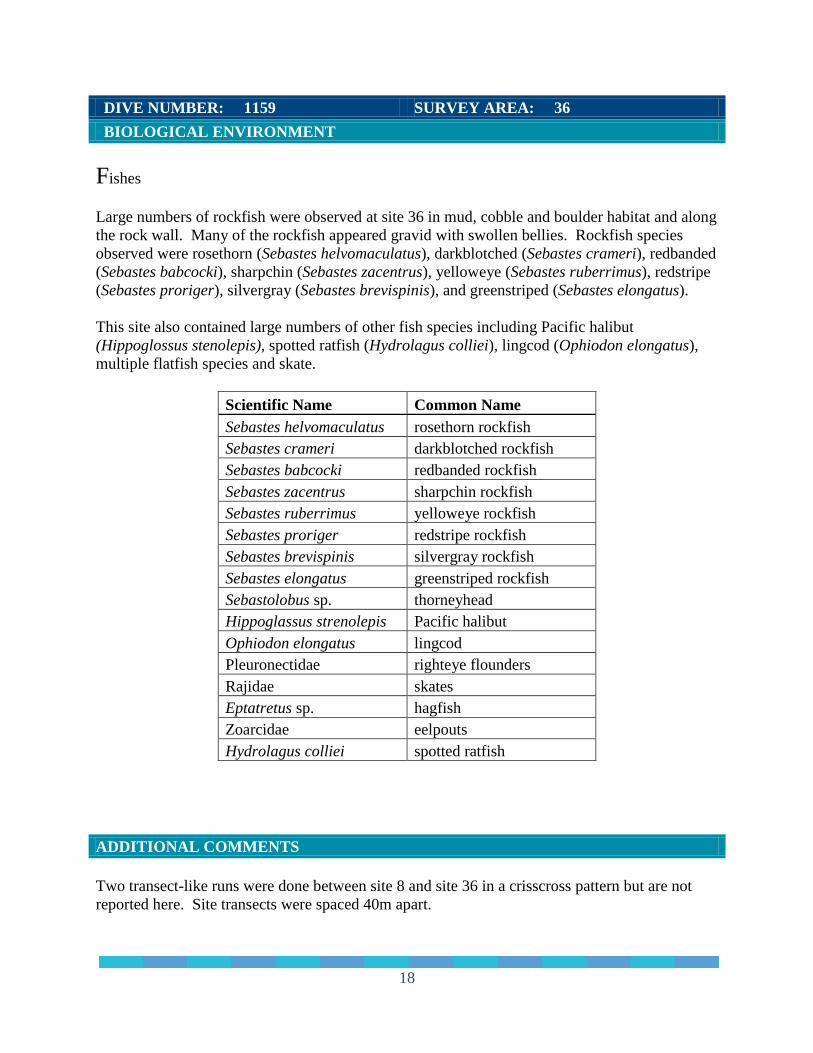
DIVE NUMBER: 1159 SURVEY AREA: 36
GENERAL LOCATION AND DIVE TRACK
SITE OVERVIEW
Project 2008 Deep Sea Coral Research Cruise, Olympic Coast National
Marine Sanctuary Chief Scientist Ed Bowlby
1
Co-Principal Investigators Mary Sue Brancato and James Boutillier Contact Info
Olympic Coast National Marine Sanctuary
115 E Railroad Ave. Suite 301, Port Angeles, WA, 98362
Purpose Locate and characterize the distribution and abundance of deep-sea
coral and sponge habitats in OCNMS after monitoring benthic
recovery sites along fiber optic cable routes. Vehicle Canadian Coast Guard vessel John P. Tully, ROPOS ROV Science Observers M.S. Brancato, J. Bright, J. Boutillier, G. Workman, E. Edinger, P.
Lambert, J. Chu, and E. Bowlby
Forward View HD File Hrs 20
Forward View Tape Count 6
Digital Still Images 156
Oxygen mg/L (avg) no data
Salinity ppt (avg) no data
Temperature °C (avg) no data
# of Samples Collected 8

14
DIVE NUMBER: 1159 SURVEY AREA: 36
SITE DATA
Start Date 7/10/2008
End Date 7/10/2008
Minimum Bottom Depth (m) -105.5
Maximum Bottom Depth (m) -302.3
Start Bottom (GMT) 02:12:00
End Bottom (GMT) 22:29:00
Start Latitude N 48° 7' 45.078"
Start Longitude W 125° 4' 37.571"
End Latitude N 48° 7' 56.938"
End Longitude W 125° 4' 27.289"
Bottom Current (kts) 0.2-0.5 (estimated)
Bottom Current Direction variable
IMAGE GALLARY
IMAGE A: Lophelia and Desmophyllum on a
wall in hard substrate
N 48° 7' 51.69", W 125° 4' 34.9068"
IMAGE B: Swiftia beringi and Farrea sp. (white
glass sponge) on a wall in soft substrate
N 48° 7' 53.2164", W 125° 4' 37.0992"
IMAGE C: Muricedes coral in mud habitat
N 48° 7' 58.3104", W 125° 4' 36.6204"
IMAGE D: Anemone, rockfish, coral (Muricedes
sp.), and whelk with eggs on boulder in pebble
mud habitat
N 48° 7' 46.3764", W 125° 4' 35.6052"

15
DIVE NUMBER: 1159 SURVEY AREA: 36
PHYSICAL ENVIRONMENT
Habitats
The total area surveyed at site 36 was 7,048 m2. This dive traversed several geological habitat
types, including low relief habitats where pebble and mud were predominant (63% of total area),
seafloor where cobble dominated (18%), and a high relief, steep rock wall with areas of
unconsolidated material containing burrows (13%). Cobble boulder habitat was located on a
sloped area (9%).
cobble
boulder
5%
cobble
4%
cobble
pebble
9%
mud
6%
mud pebble
19%
pebble
cobble
21%
pebble
mud
10%
pebble
7% wall
13%other
6%
Habitats Surveyedarea = 7,048 m²

16
DIVE NUMBER: 1159 SURVEY AREA: 36
BIOLOGICAL ENVIRONMENT
Corals
Predominant corals were the small, orange cup coral Balanophyllia elegans (60% of all corals
identified), and the giant cup coral Desmophyllum dianthus (21%). Also identified were two
Swiftia species (11%) and a few Plumarella longispina (3%), as well as a few Muriceides sp.
clusters. This site included a long rock wall hosting colonies of Lophelia pertusa, but along the
wall was unconsolidated material with burrows and evidence of slides.
Balanophyllia
elegans
60%
Desmophyllum
dianthus
21%
Swiftia beringi
8%
Scleraxonian
3%
Plumarella
longispina
3%
Swiftia pacifica
3%others
2%
Density of Corals112 corals / 1,000 m²
Color Code Coral Groups Counts
Balanophyllia elegans 470
Desmophyllum dianthus 168
Swiftia beringi 65
Scleraxonia 27
Plumarella longispina 21
Swiftia pacifica 20
Lophelia pertusa clusters 8
unknown coral 4
Swiftia spauldingi 1
Stylaster sp. 1
Paragorgia arborea pacifica 1

17
DIVE NUMBER: 1159 SURVEY AREA: 36
BIOLOGICAL ENVIRONMENT
Sponges
Both Demosponge and Hexactinellids were observed throughout the site. The dominant
structural sponge morphs were shelf sponges (27% of total), branching sponge (25%), and cloud
sponges (22%). The glass sponge Farrea occa, ball sponges and a few encrusting sponges also
were observed.
Other invertebrate species observed included crinoids (Florometra serratissima), brittle stars, sea
cucumbers (Parastichopus leukothele, P. californicus, and Psolus sp.), squat lobsters (Munida
quadrispina), sea urchins, various anemones and sea stars, and fields of zoanthids.
shelf
27%
branching
25%
cloud
22%
farrea
12%
globular
9%
encrusting
3%other
2%
Density of Sponges94 sponges / 1,000 m²
Color Bar Class Structural Morphs Count
Demosponge shelf 181
Demosponge branching 168
Hexactinellids cloud 148
Hexactinellids farrea occa 81
Demosponge globular 57
Hexactinellids encrusting 18
Demosponge multi-tube 5
Hexactinellids boot 3
Demosponge vase 3
Demosponge single tube 2
18
DIVE NUMBER: 1159 SURVEY AREA: 36
BIOLOGICAL ENVIRONMENT
Fishes
Large numbers of rockfish were observed at site 36 in mud, cobble and boulder habitat and along
the rock wall. Many of the rockfish appeared gravid with swollen bellies. Rockfish species
observed were rosethorn (Sebastes helvomaculatus), darkblotched (Sebastes crameri), redbanded
(Sebastes babcocki), sharpchin (Sebastes zacentrus), yelloweye (Sebastes ruberrimus), redstripe
(Sebastes proriger), silvergray (Sebastes brevispinis), and greenstriped (Sebastes elongatus).
This site also contained large numbers of other fish species including Pacific halibut
(Hippoglossus stenolepis), spotted ratfish (Hydrolagus colliei), lingcod (Ophiodon elongatus),
multiple flatfish species and skate.
Scientific Name Common Name
Sebastes helvomaculatus rosethorn rockfish
Sebastes crameri darkblotched rockfish
Sebastes babcocki redbanded rockfish
Sebastes zacentrus sharpchin rockfish
Sebastes ruberrimus yelloweye rockfish
Sebastes proriger redstripe rockfish
Sebastes brevispinis silvergray rockfish
Sebastes elongatus greenstriped rockfish
Sebastolobus sp. thorneyhead
Hippoglassus strenolepis Pacific halibut
Ophiodon elongatus lingcod
Pleuronectidae righteye flounders
Rajidae skates
Eptatretus sp. hagfish
Zoarcidae eelpouts
Hydrolagus colliei spotted ratfish
ADDITIONAL COMMENTS
Two transect-like runs were done between site 8 and site 36 in a crisscross pattern but are not
reported here. Site transects were spaced 40m apart.

19
DIVE NUMBER: 1160 SURVEY AREA: 14
GENERAL LOCATION AND DIVE TRACK
SITE OVERVIEW
Project 2008 Deep Sea Coral Research Cruise, Olympic Coast National
Marine Sanctuary Chief Scientist Ed Bowlby
1
Co-Principal Investigators Mary Sue Brancato and James Boutillier Contact Info
Olympic Coast National Marine Sanctuary
115 E Railroad Ave. Suite 301, Port Angeles, WA, 98362
Purpose Locate and characterize the distribution and abundance of deep-sea
coral and sponge habitats in OCNMS after monitoring benthic
recovery sites along fiber optic cable routes. Vehicle Canadian Coast Guard vessel John P. Tully, ROPOS ROV Science Observers M.S. Brancato, J. Bright, J. Boutillier, G. Workman, E. Edinger, P.
Lambert, J. Chu, and E. Bowlby
Forward View HD File Hrs 11
Forward View Tape Count 4
Digital Still Images 571
Oxygen mg/L (avg) 1.75
Salinity ppt (avg) 33.957
Temperature °C (avg) 6.47
# of Samples Collected 2

20
DIVE NUMBER: 1160 SURVEY AREA: 14
SITE DATA
Start Date 7/11/2008
End Date 7/11/2008
Minimum Bottom Depth (m) -105.6
Maximum Bottom Depth (m) -115.1
Start Bottom (GMT) 01:51:00
End Bottom (GMT) 13:34:00
Start Latitude N48° 10' 3.339"
Start Longitude W125° 22' 15.270"
End Latitude N48° 10' 34.236"
End Longitude W125° 22' 26.307"
Bottom Current (kts) 2-3 (estimated)
Bottom Current Direction: SE
IMAGE GALLARY
IMAGE A: Swiftia beringi and sponge
assemblage on sand pebble habitat
N 48° 10' 2.9748", W 125° 22' 15.9852"
IMAGE B: Field of sponge assembage on
sand gravel covered wall
N 48° 10' 16.9392", W 125° 22' 9.0120"
IMAGE C: Orange sea pen (Ptilosarcus
gurneyi) on sand habitat
N 48° 10' 49.9620", W 125° 22' 6.4200"
IMAGE D: Rockfish above sponge assembage
on sand gravel habitat
N 48° 10' 4.3428", W 125° 22' 36.1200"

21
DIVE NUMBER: 1160 SURVEY AREA: 14
PHYSICAL ENVIRONMENT
Habitats
The total area surveyed at site 14 was 27,168 m², the majority of which consisted of low relief
areas of predominately sand (65% of total area) with little rugosity. Larger geological features
included small boulder (14%), boulder sand (6%), and sand boulder (14%) habitats. There were
small areas of sand slope, mud terrace, and sand waves.
sand gravel
36%
sand pebble
22%
sand
boulder
14% boulder
14%
sand
7%boulder
sand
6%
other
1%
Habitats Surveyedarea = 27,168 m²

22
DIVE NUMBER: 1160 SURVEY AREA: 14
BIOLOGICAL ENVIRONMENT
Corals
The mean coral density at site 14 was 253 individuals/1,000 m2. This site was dominated by
smaller coral specimens in the sponge fields, with Swiftia beringi the predominant species (89%
of all corals). Swiftia pacifica and Leptogorgia sp. were also found.
Swiftia
beringi
89%
Swiftia
pacifica
10%other
1%
Density of Corals253 corals / 1,000 m²
Color Code Coral Groups Counts
Swiftia beringi 6,117
Swiftia pacifica 668
Leptogorgia sp. 80
Ptilosarcus gurneyi 2
Pennatulacea 2

23
DIVE NUMBER: 1160 SURVEY AREA: 14
BIOLOGICAL ENVIRONMENT
Sponges
The mean sponge density at site 14 was 529 individuals/1,000 m2. Many sponges observed at
site 14 were found in multi-species assemblages (55% of all sponges observed), growing in
clumps ≤ 20 cm across, separated by approximately 40 cm. Both Demosponges and
Hexactinellids were found in these sponge assemblages. Where boulders were present, lunar
sponges (a globular/ball morph that can be identified as Latrunculia sp.) were the dominant
sponge species and large rockfish were present. Various structural morphs were found,
including white and yellow cloud, branching, and brown globular sponges.
Other invertebrates found at the site were crinoids (Florometra serratissima) and sea cucumbers
(Parastichopus leukothele and P. californicus).
sponge
assemblage
55%
lunar
36%cloud
5%encrusting
3%
other
1%
Density of Sponges529 sponges / 1,000 m²
Color Code Class Structural Morphs Count
mixture sponge assemblage 7,925
Demosponge lunar (Latrunculia sp.)-globular morph 5,256
Hexactinelids cloud 693
Demosponge encrusting 384
Hexactinelids boot 87
Demosponge single tube 9
Demosponge globular 6
Demosponge branching 2
Demosponge multi-tube 1

24
DIVE NUMBER: 1160 SURVEY AREA: 14
BIOLOGICAL ENVIRONMENT
Fishes
Rockfish species observed in the boulder areas were canary (Sebastes pinniger), rosethorn
(Sebastes helvomaculatus), greenstriped (Sebastes elongatus) and tiger (Sebastes nigrocinctus).
Small, unidentified rockfish species (possibly juvenile) were observed in close approximation
with some sponges. Other fish observations were of juvenile lingcod (Ophiodon elongatus) and
juvenile flatfish.
Scientific Name Common Name
Sebastes helvomaculatus rosethorn rockfish
Sebastes ruberrimus yelloweye rockfish
Sebastes pinniger canary rockfish
Sebastes nigrocinctus tiger rockfish
Ophiodon elongatus lingcod
Hydrolagus colliei spotted ratfish
Pleuronectidae righteye flounders
ADDITIONAL COMMENTS
Transects were run at 80 m spacing.

25
DIVE NUMBER: 1162 SURVEY AREA: 10
GENERAL LOCATION AND DIVE TRACK
SITE OVERVIEW
Project 2008 Deep Sea Coral Research Cruise, Olympic Coast National
Marine Sanctuary Chief Scientist Ed Bowlby
1
Co-Principal Investigators Mary Sue Brancato and James Boutillier Contact Info
Olympic Coast National Marine Sanctuary
115 E Railroad Ave. Suite 301, Port Angeles, WA, 98362
Purpose Locate and characterize the distribution and abundance of deep-sea
coral and sponge habitats in OCNMS after monitoring benthic
recovery sites along fiber optic cable routes. Vehicle Canadian Coast Guard vessel John P. Tully, ROPOS ROV Science Observers M.S. Brancato, J. Bright, J. Boutillier, G. Workman, E. Edinger, P.
Lambert, J. Chu, and E. Bowlby
Forward View HD File Hrs 11
Forward View Tape Count 6
Digital Still Images 165
Oxygen mg/L (avg) 1.611
Salinity ppt (avg) 34.04
Temperature °C (avg) 6.14
# of Samples Collected 8

26
DIVE NUMBER: 1162 SURVEY AREA: 10
SITE DATA
Start Date 7/12/2008
End Date 7/13/2008
Minimum Bottom Depth (m) -260.3
Maximum Bottom Depth (m) -270.3
Start Bottom (GMT) 15:35:00
End Bottom (GMT) 07:32:00
Start Latitude N48° 8' 24.314"
Start Longitude W125° 11' 26.299"
End Latitude N48° 8' 25.170"
End Longitude W125° 11' 32.959"
Bottom Current (kts) 0.5 (estimated)
Bottom Current Direction: NE
IMAGE GALLARY
IMAGE A: Primnoa pacifica on cobble sand
habitat
N 48° 8' 26.556", W 125° 11' 28.6296"
IMAGE B: Paragorgia arborea pacifica on
cobble sand habitat
N 48° 8' 26.1816", W 125° 11' 27.7584"
IMAGE C: Coral-fish community with
habtitat transition boulder to cobble sand
N 48° 8' 25.7316", W 125° 11' 31.3188"
IMAGE D: Boulder covered with Stylaster in
boulder sand habitat
N 48° 8' 25.512", W 125° 11' 28.428"

27
DIVE NUMBER: 1162 SURVEY AREA: 10
PHYSICAL ENVIRONMENT
Habitats
The total area surveyed at site 10 was 2,481 m2. The site was dominated by low relief sand (52%
of total area) and sand pebble habitat (8%), where brittle stars were abundant. Patches of sand
waves were noted. The site also included areas with rugosity where cobble (20%) or boulders
(13%) were present.
sand
52%
sand cobble
12% sand pebble
8% sand
boulder
8%
cobble sand
8%
boulder
sand
5%
other
7%
Habitats Surveyedarea = 2,481 m²

28
DIVE NUMBER: 1162 SURVEY AREA: 10
BIOLOGICAL ENVIRONMENT
Corals
Corals at site 10 were dominated by fields of the hydrocoral Stylaster sp., and also included
Swiftia pacifica and large gorgonians (Primnoa pacifica and Paragorgia arborea pacifica).
Numerous large dead coral stalks were noted in sand boulder habitat.
Stylaster sp.
84%
Primnoa
pacifica
7%
other corals
9%
Density of Corals36 corals / 1,000 m²
Color Code Coral Groups Counts
Stylaster sp. 76
Primnoa pacifica 6
Swiftia pacifica 4
Paragorgia arborea pacifica 4

29
DIVE NUMBER: 1162 SURVEY AREA: 10
BIOLOGICAL ENVIRONMENT
Sponges
The only sponges located at site 10 were two boot sponges.
Other invertebrates identified were crinoids (Florometra serratissima), brittle stars and small
shrimps on the Primnoa branches.
boot
100%
Density of Spongessponges = 1 / 1,000 m²
Color Code Class Structural Morphs Count
Hexactinellids boot 2

30
DIVE NUMBER: 1162 SURVEY AREA: 10
BIOLOGICAL ENVIRONMENT
Fishes
Fish species observed included rosethorn (Sebastes helvomaculatus), darkblotched (Sebastes
crameri) and redbanded (Sebstes babcocki) rockfish, and thorneyhead (Sebastolobus sp.). Other
observations included Pacific halibut (Hipppoglassus strenolepis), multiple flounder species and
skate.
Scientific Name Common Name
Sebastes helvomaculatus rosethorn rockfish
Sebastes crameri darkblotched rockfish
Sebastes babcocki redbanded rockfish
Sebastolobus sp. thorneyhead
Hippoglassus strenolepis Pacific halibut
Pleuronectidae righteye flounders
Rajidae skates
ADDITIONAL COMMENTS
Site 10 was incompletely surveyed in 2006 due to vessel time running out. Rocky substrates
were found in the SW corner of the site, with large Primnoa colonies. The site was resurveyed
in 2008 to complete quantitative transects.

31
DIVE NUMBER: 1162 SURVEY AREA: 38
GENERAL LOCATION AND DIVE TRACK
SITE OVERVIEW
Project 2008 Deep Sea Coral Research Cruise, Olympic Coast National
Marine Sanctuary Chief Scientist Ed Bowlby
1
Co-Principal Investigators Mary Sue Brancato and James Boutillier Contact Info
Olympic Coast National Marine Sanctuary
115 E Railroad Ave. Suite 301, Port Angeles, WA, 98362
Purpose Locate and characterize the distribution and abundance of deep-sea
coral and sponge habitats in OCNMS after monitoring benthic
recovery sites along fiber optic cable routes. Vehicle Canadian Coast Guard vessel John P. Tully, ROPOS ROV Science Observers M.S. Brancato, J. Bright, J. Boutillier, G. Workman, E. Edinger, P.
Lambert, J. Chu, and E. Bowlby
Forward View HD File Hrs 11
Forward View Tape Count 6
Digital Still Images 580
Oxygen mg/L (avg) 1.561
Salinity ppt (avg) 34.04
Temperature °C (avg) 6.1
# of Samples Collected 9

32
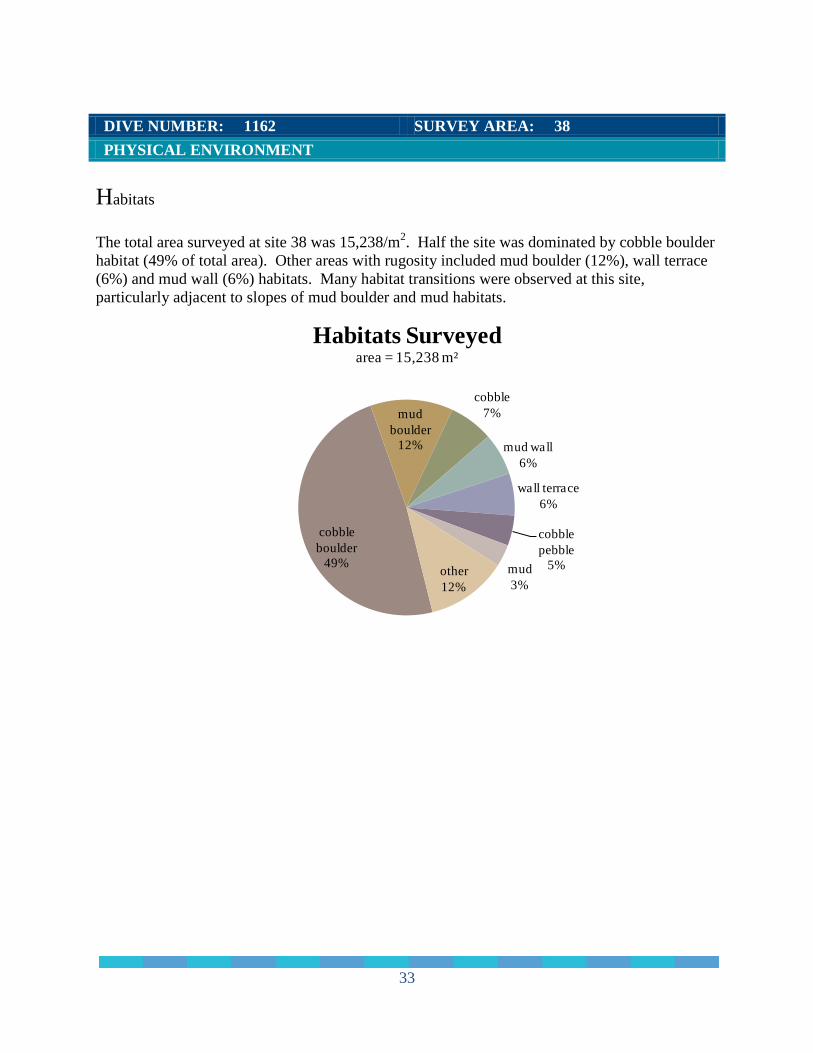
DIVE NUMBER: 1162 SURVEY AREA: 38
SITE DATA
Start Date 7/12/2008
End Date 7/13/2008
Minimum Bottom Depth (m) -230.4
Maximum Bottom Depth (m) -359.3
Start Bottom (GMT) 15:35:00
End Bottom (GMT) 07:32:00
Start Latitude N48° 8' 25.249"
Start Longitude W125° 11' 28.440"
End Latitude N48° 8' 29.981"
End Longitude W125° 11' 12.859"
Bottom Current (kts) no data
Bottom Current Direction no data
IMAGE GALLARY
IMAGE A: Primnoa pacifica on cobble
boulder habitat
N 48° 8' 26.4012", W 125° 11' 16.4256"
IMAGE B: Plumarella longispina and
crinoids on cobble pebble habitat
N 48° 8' 34.8792", W 125° 10' 49.4472"
IMAGE C: Heterochone calyx and
Desmophyllum diantus on steep mud wall
N 48° 8' 38.5656", W 125° 10' 38.1072"
IMAGE D: Primnoa pacifica and Pacific
halibut on mud boulder habitat
N 48° 8' 35.8836", W 125° 10' 39.288"
33
DIVE NUMBER: 1162 SURVEY AREA: 38
PHYSICAL ENVIRONMENT
Habitats
The total area surveyed at site 38 was 15,238/m2. Half the site was dominated by cobble boulder
habitat (49% of total area). Other areas with rugosity included mud boulder (12%), wall terrace
(6%) and mud wall (6%) habitats. Many habitat transitions were observed at this site,
particularly adjacent to slopes of mud boulder and mud habitats.
cobble
boulder
49%
mud
boulder
12%
cobble
7%
mud wall
6%
wall terrace
6%
cobble
pebble
5%mud
3%other
12%
Habitats Surveyedarea = 15,238 m²

34
DIVE NUMBER: 1162 SURVEY AREA: 38
BIOLOGICAL ENVIRONMENT
Corals
More than 7,700 individual corals were counted at site 38, for a mean density of 505 corals/1,000
m2. The most abundant coral species at site 38 was Stylaster sp. (88% of coral individuals),
which was commonly found growing in boulder fields. A unique feature of site 38 was a box
canyon surrounded by high mud terraced walls with a large Primnoa pacifica growing at the
entrance to the canyon (Image A). This site was also a new documented area of Lophelia
pertusa. Other coral species included Swiftia pacifica, Paragorgia arborea pacifica, Primnoa
pacifica and Plumarella longispina. The giant cup coral Desmophyllum dianthus dominated the
terraced walls along with some clusters of Lophelia pertusa in the box canyon. At least one
white Paragorgia with pink polyps was also found.
Stylaster sp.
88%
Desmophyllum
dianthus
6%
Swiftia pacifica
2%
Paragorgia
arborea
pacifica
2%Primnoa
pacifica
1%
other
1%
Density of Corals505 corals / 1,000 m²
Color Code Coral Groups Counts
Stylaster sp. 6,807
Desmophyllum dianthus 477
Swiftia pacifica 168
Paragorgia arborea pacifica 110
Primnoa pacifica 75
Swiftia spauldingi 25
Swiftia beringi 20
Lophelia pertusa 19
Plumarella longispina 7

35
DIVE NUMBER: 1162 SURVEY AREA: 38
BIOLOGICAL ENVIRONMENT
Sponges
Cloud sponges were the most abundant sponge, comprising 51% of all sponges found. Farrea
occa, a glass sponge, was also common (25%). Other sponge morphs observed were boot
sponges (11%), ball sponges (10%) and vase sponges (3%).
Other invertebrate species present were pom pom anemones (Liponema sp.) and red ophiuroid
brittle stars.
cloud
51%
Farrea occa
25%
boot
11%globular
10%
vase
3%
Density of Spongessponges = 4 / 1,000 m²
Color Code Class Structural Morphs Count
Hexactinellids cloud 31
Hexactinellids farrea 15
Hexactinellids boot 7
Demosponge globular 6
Demosponge vase 2
36
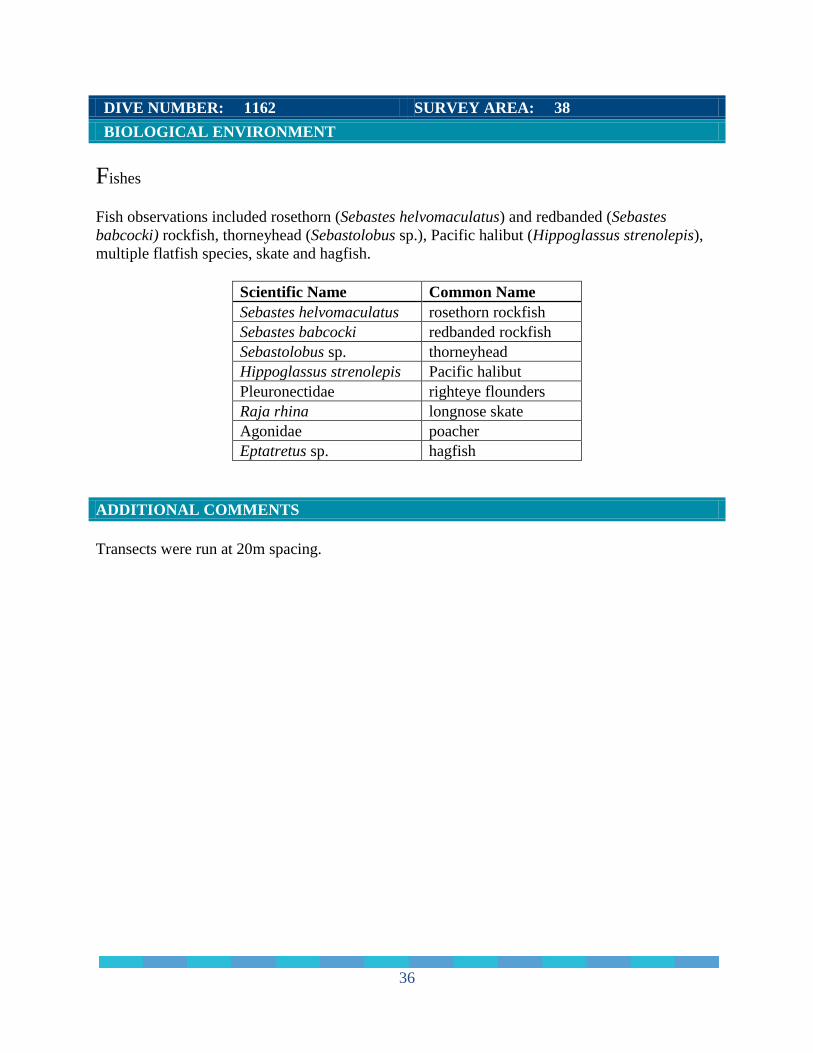
DIVE NUMBER: 1162 SURVEY AREA: 38
BIOLOGICAL ENVIRONMENT
Fishes
Fish observations included rosethorn (Sebastes helvomaculatus) and redbanded (Sebastes
babcocki) rockfish, thorneyhead (Sebastolobus sp.), Pacific halibut (Hippoglassus strenolepis),
multiple flatfish species, skate and hagfish.
Scientific Name Common Name
Sebastes helvomaculatus rosethorn rockfish
Sebastes babcocki redbanded rockfish
Sebastolobus sp. thorneyhead
Hippoglassus strenolepis Pacific halibut
Pleuronectidae righteye flounders
Raja rhina longnose skate
Agonidae poacher
Eptatretus sp. hagfish
ADDITIONAL COMMENTS
Transects were run at 20m spacing.
37
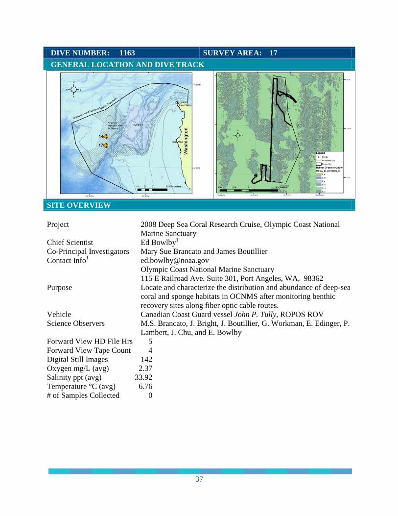
DIVE NUMBER: 1163 SURVEY AREA: 17
GENERAL LOCATION AND DIVE TRACK
SITE OVERVIEW
Project 2008 Deep Sea Coral Research Cruise, Olympic Coast National
Marine Sanctuary Chief Scientist Ed Bowlby
1
Co-Principal Investigators Mary Sue Brancato and James Boutillier Contact Info
Olympic Coast National Marine Sanctuary
115 E Railroad Ave. Suite 301, Port Angeles, WA, 98362
Purpose Locate and characterize the distribution and abundance of deep-sea
coral and sponge habitats in OCNMS after monitoring benthic
recovery sites along fiber optic cable routes. Vehicle Canadian Coast Guard vessel John P. Tully, ROPOS ROV Science Observers M.S. Brancato, J. Bright, J. Boutillier, G. Workman, E. Edinger, P.
Lambert, J. Chu, and E. Bowlby
Forward View HD File Hrs 5
Forward View Tape Count 4
Digital Still Images 142
Oxygen mg/L (avg) 2.37
Salinity ppt (avg) 33.92
Temperature °C (avg) 6.76
# of Samples Collected 0

38
DIVE NUMBER: 1163 SURVEY AREA: 17
SITE DATA
Start Date 7/13/2008
End Date 7/13/2008
Minimum Bottom Depth (m) -112.5
Maximum Bottom Depth (m) -121.14
Start Bottom (GMT) 11:32:00
End Bottom (GMT) 16:04:00
Start Latitude N48° 6' 56.831"
Start Longitude W125° 22' 23.488"
End Latitude N48° 7' 59.295"
End Longitude W125° 22' 11.799"
Bottom Current (kts) 0.25 (estimated)
Bottom Current Direction NNW
IMAGE GALLARY
IMAGE A: Yelloweye rockfish (Sebastes
ruberrimus) in boulder habitat
N 48° 7' 6.0888", W 125° 22' 20.5824"
IMAGE B: Green lunar sponges
(Latrunculia sp.) and crinoids on boulder
habitat
N 48° 7' 19.4196", W 125° 22' 15.4416"
IMAGE C: Encrusting white sponge on boulder
habitat
N 48° 7' 43.7268", W 125° 22' 15.7440"
IMAGE D: Crinoid covered boulder on
boulder habitat
N 48° 7' 12.4032", W 125° 22' 15.2220"

39
DIVE NUMBER: 1163 SURVEY AREA: 17
PHYSICAL ENVIRONMENT
Habitats
The total area surveyed at site 17 was 14,690/m2. The site consisted of boulder and boulder
cobble habitat interspersed with areas of pebble and cobble. Multiple fish species were
observed, primarily in the boulder fields. A relatively small area of large sand waves was also
found, with few invertebrates or fish present.
boulder
30%boulder
cobble
6%
cobble
15%
cobble
boulder
12%pebble
11%pebble
boulder
9%
pebble
cobble
3%
pebble
gravel
11%
other
3%
Habitats Surveyedarea = 14,690 m²

40
DIVE NUMBER: 1163 SURVEY AREA: 17
BIOLOGICAL ENVIRONMENT
Corals
Relatively few corals were observed at site 17, with a mean coral density of 25 individuals/1,000
m2. Swiftia beringi were the predominant coral species (91% of corals identified), found
primarily on boulders. Swiftia pacifica was also observed on boulders.
Swiftia
beringi
91%
Swiftia
pacifica
9%
Density of Corals25 corals / 1,000 m²
Color Code Coral Groups Counts
Swiftia beringi 332
Swiftia pacifica 34

41
DIVE NUMBER: 1163 SURVEY AREA: 17
BIOLOGICAL ENVIRONMENT
Sponges
The green lunar sponge (Latrunculia sp.), a globular sponge primarily found on boulders, was
the most abundant sponge, comprising 93% of all sponges found. Other sponge morphs at site
17 were encrusting, boot and cloud sponges.
Other invertebrates observed included crinoids (Florometra serratissima), sea cucumbers
(Parastichopus leukothele and P. californicus), various sea star species, red ophiuroid brittle
stars, and a few anemones.
globular
93%
encrusting
5%
boot
2%cloud
0%
Density of Sponges55 sponges / 1,000 m²
Color Code Class Structural Morphs Count
Demosponges globular 761
Hexactinellids encrusting 40
Hexactinellids boot 15
Hexactinellids cloud 4

42
DIVE NUMBER: 1163 SURVEY AREA: 17
BIOLOGICAL ENVIRONMENT
Fishes
Most of the species diversity at site 17 occurred in the boulder areas where rockfish were
abundant. Rockfish species observed included yelloweye (Sebastes ruberrimus), tiger
(S. nigrocinctus), yellowtail (S. flavidus), rosethorn (S helvomaculatus), redstripe (S. proriger),
and canary (S. pinniger). Other fish species included lingcod (Ophiodon elongatus), spotted
ratfish (Hydrolagus colliei), cat shark and flounders.
Scientific Name Common Name
Sebastes helvomaculatus rosethorn rockfish
Sebastes flavidus yellowtail rockfish
Sebastes ruberrimus yelloweye rockfish
Sebastes pinniger canary rockfish
Sebastes nigrocinctus tiger rockfish
Sebastes proriger redstripe rockfish
Ophiodon elongatus lingcod
Hydrolagus colliei spotted ratfish
Apristurus sp. cat shark
Pleuronectidae righteye flounders
ADDITIONAL COMMENTS
ROV transects were spaced 80m apart due to time constraints to complete the large area. Seven
transects were completed. One perpendicular transect was surveyed to traverse anticipated
habitat transitions.
In 2006, site 17 was attempted but only one transect was completed due to the proximity of
commercial fishing vessels in the area, which forced termination of the survey.

43
DIVE NUMBER: 1164 SURVEY AREA: 35
GENERAL LOCATION AND DIVE TRACK
SITE OVERVIEW
Project 2008 Deep Sea Coral Research Cruise, Olympic Coast National
Marine Sanctuary Chief Scientist Ed Bowlby
1
Co-Principal Investigators Mary Sue Brancato and James Boutillier Contact Info
Olympic Coast National Marine Sanctuary
115 E Railroad Ave. Suite 301, Port Angeles, WA, 98362
Purpose Locate and characterize the distribution and abundance of deep-sea
coral and sponge habitats in OCNMS after monitoring benthic
recovery sites along fiber optic cable routes. Vehicle Canadian Coast Guard vessel John P. Tully, ROPOS ROV Science Observers M.S. Brancato, J. Bright, J. Boutillier, G. Workman, E. Edinger, P.
Lambert, J. Chu, and E. Bowlby
Forward View HD File Hrs 3
Forward View Tape Count 2
Digital Still Images 94
Oxygen mg/L (avg) 1.92
Salinity ppt (avg) 33.96
Temperature °C (avg) 6.48
# of Samples Collected 2
44
DIVE NUMBER: 1164 SURVEY AREA: 35
SITE DATA
Start Date 7/13/2008
End Date 7/13/2008
Minimum Bottom Depth (m) -114.3
Maximum Bottom Depth (m) -302.0
Start Bottom (GMT) 18:52:00
End Bottom (GMT) 21:58:00
Start Latitude N 48° 6' 4.997"
Start Longitude W 125° 2' 8.436"
End Latitude N 48° 6' 6.628"
End Longitude W 125° 2' 3.385"
Bottom Current (kts) 0.5 (estimated)
Bottom Current Direction W
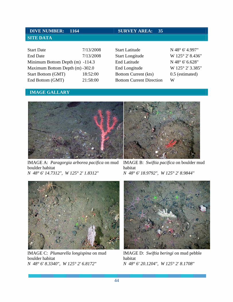
IMAGE GALLARY
IMAGE A: Paragorgia arborea pacifica on mud
boulder habitat
N 48° 6' 14.7312", W 125° 2' 1.8312"
IMAGE B: Swiftia pacifica on boulder mud
habitat
N 48° 6' 18.9792", W 125° 2' 8.9844"
IMAGE C: Plumarella longispina on mud
boulder habitat
N 48° 6' 8.3340", W 125° 2' 6.8172"
IMAGE D: Swiftia beringi on mud pebble
habitat
N 48° 6' 20.1204", W 125° 2' 8.1708"

45
DIVE NUMBER: 1164 SURVEY AREA: 35
PHYSICAL ENVIRONMENT
Habitats
The total area surveyed at site 35 was 10,566 m². Most of the site consisted of areas of low relief
mud pebble (28% of total area), pebble cobble (10%), mud (4%), pebble mud (4%), and mud
cobble (3%). Mud boulder (18%) and pebble boulder (5%) habitat was interspersed with habitat
transitions to high relief mud walls and/or mud terraces (25%).
mud
4%
mud bouder
18%
mud cobble
3%
mud pebble
28%
mud wall
25%
other
3%
pebble
boulder
5%
pebble
cobble
10%
pebble mud
4%
Habitats Surveyedarea = 10,566 m²

46
DIVE NUMBER: 1164 SURVEY AREA: 35
BIOLOGICAL ENVIRONMENT
Corals
Approximately 100 corals were observed at site 35, for a mean density of 9 individual
corals/1,000 m2. Two Swiftia species were observed at this site - S. beringi (61% of all corals
observed) and S. pacifica (37%). One colony of Plumarella longispina and one colony of
Paragorgia arborea pacifica were observed.
Swiftia
beringi
61%
Swiftia
pacifica
37%
Plumarella
longispina
1%
Paragorgia
arborea
pacifica
1%
Denisty of Corals9 corals / 1,000 m²
Color Code Coral Groups Counts
Swiftia beringi 58
Swiftia pacifica 35
Plumarella longispina 1
Paragorgia arborea pacifica 1

47
DIVE NUMBER: 1164 SURVEY AREA: 35
BIOLOGICAL ENVIRONMENT
Sponges
The mean sponge density at site 35 was 46 sponges/1,000 m2. Three predominant sponge
morphs were observed. The branching sponge morph was the most abundant (39% of all
sponges observed) followed by the globular morph (34%) and cloud morph (26%).
Other invertebrate species consisted of crinoids (Florometra serratissima), various sea star
species, sea cucumbers (Parastichopus leukothele and P. californicus), and anemones.
branching
39%
globular
34%
cloud
26%
other
1%
Density of Sponges46 sponges / 1,000 m²
Color Code Class Structural Morphs Count
Demosponge branching 192
Demosponge globular 166
Hexactinellids cloud 125
Hexactinellids encrusting 2
Hexactinellids boot 1
Demosponge single tube 1

48
DIVE NUMBER: 1164 SURVEY AREA: 35
BIOLOGICAL ENVIRONMENT
Fishes
Rockfish were observed throughout the site, including rosethorn (Sebastes helvomaculatus),
darkblotched (Sebastes crameri), and greenstriped (Sebastes elongates). Rockfish were observed
on boulders and resting on finer substrate. A few rockfish appeared gravid, with extended
abdomens.
Other fish observed were Pacific halibut (Hippoglassus strenolepis), lingcod (Ophiodon
elongates), flounders (Pleuronectidae), and spotted ratfish (Hydrolagus colliei).
Scientific Name Common Name
Sebastes helvomaculatus rosethorn rockfish
Sebastes elongatus greenstriped rockfish
Sebastes crameri darkblotched rockfish
Sebastolobus sp. thorneyhead
Rajidae skate
Ophiodon elongatus lingcod
Hydrolagus colliei spotted ratfish
Hippoglassus strenolepis Pacific halibut
Eptatretus sp. hagfish
Pleuronectidae righteye flounders
ADDITIONAL COMMENTS
A total of 5 transects were completed, spaced 40m apart.

49
DIVE NUMBER: 1165 SURVEY AREA: 39
GENERAL LOCATION AND DIVE TRACK
SITE OVERVIEW
Project 2008 Deep Sea Coral Research Cruise, Olympic Coast National
Marine Sanctuary Chief Scientist Ed Bowlby
1
Co-Principal Investigators Mary Sue Brancato and James Boutillier Contact Info
Olympic Coast National Marine Sanctuary
115 E Railroad Ave. Suite 301, Port Angeles, WA, 98362
Purpose Locate and characterize the distribution and abundance of deep-sea
coral and sponge habitats in OCNMS after monitoring benthic
recovery sites along fiber optic cable routes. Vehicle Canadian Coast Guard vessel John P. Tully, ROPOS ROV Science Observers M.S. Brancato, J. Bright, J. Boutillier, G. Workman, E. Edinger, P.
Lambert, J. Chu, and E. Bowlby
Forward View HD File Hrs 5
Forward View Tape Count 2
Digital Still Images 498
Oxygen mg/L (avg) 34.04
Salinity ppt (avg) 1.38
Temperature °C (avg) 6.02
# of Samples Collected 11

50
DIVE NUMBER: 1165 SURVEY AREA: 39
SITE DATA
Start Date 7/14/2008
End Date 7/14/2008
Minimum Bottom Depth (m) -287.3
Maximum Bottom Depth (m) -349.9
Start Bottom (GMT) 01:39:00
End Bottom (GMT) 07:03:00
Start Latitude N 48° 8' 40.376"
Start Longitude W 125° 11' 5.276"
End Latitude N 48° 8' 36.163"
End Longitude W 125° 11' 9.048"
Bottom Current (kts) 1 (estimated)
Bottom Current Direction W
IMAGE GALLARY
IMAGE A: Primnoa pacifica on mud boulder
habitat
N 48° 8' 36.1968", W 125° 11' 9.0744"
IMAGE B: Primnoa pacifica on mud boulder
habitat
N 48° 8' 41.4744", W 125° 10' 57.7164"
IMAGE C: White Primnoa with crinoids on
mud boulder habitat
N 48° 8' 38.0508", W 125° 11' 2.2236"
IMAGE D: Paragorgia arborea pacifica on
mud boulder habitat
N 48° 8' 43.8504", W 125° 10' 55.9524"

51
DIVE NUMBER: 1165 SURVEY AREA: 39
PHYSICAL ENVIRONMENT
Habitats
The total area surveyed at site 39 was 7,722 m². This highly diverse site consisted of multiple
areas of habitat transitions. A high relief mud wall occupied approximately 7% of the total area.
Areas of mud slopes (8%) were interspersed with areas of low relief mud pebble (17%), mud
cobble and cobble substrates. Additionally, there were areas of rugosity including mud boulder
patches (27%) and multiple areas of cobble boulder habitat (21%).
boulder
5%
cobble
boulder
21%
cobble
3%mud boulder
27%
mud cobble
3%
mud
8%
mud pebble
17%
mud wall
7%other
9%
Habitats Surveyedarea = 7,722 m²

52
DIVE NUMBER: 1165 SURVEY AREA: 39
BIOLOGICAL ENVIRONMENT
Corals
More than 2,000 individual corals were observed at this site, with a mean density of 266
corals/1,000 m2. The most abundant coral observed at site 39 was the hydrocoral Stylaster sp.
(77% of all individual corals), which was typically found on cobble habitat. Diversity of corals
at site 39 was augmented by the gorgonians Paragorgia arborea pacifica, white Paragorgia with
pink polyps, Primnoa pacifica, a white Primnoa and various Swiftia species. Additional coral
species observed were the giant cup coral Desmophyllum dianthus. Another observation was of
very small corals on a few boulders which could possible indicate coral recruitment. Seven large
dead corals were observed, as well as areas of dead coral stalks.
Stylaster sp.
77%
Swiftia
pacifica
15%
Desmophyllum
dianthus
3%
Swiftia
spauldingi
2%
Paragorgia
arborea
pacifica
2%
other corals
1%
Density of Corals266 corals / 1,000 m²
Color Code Coral Groups Counts
Stylaster sp 1,573
Swiftia pacifica 309
Desmophyllum dianthus 65
Swiftia spauldingi 49
Paragorgia arborea pacifica 35
Primnoa pacifica 15
Swiftia beringi 10
Muriceides sp. 2
Plumarella longispina 1

53
DIVE NUMBER: 1165 SURVEY AREA: 39
BIOLOGICAL ENVIRONMENT
Sponges
Although coral density was relatively high, few sponges were observed at site 39. Sponge
species observed included boot sponges (possibly Rhabdocalyptus dawsoni) and, most notably,
areas containing the reef building farrea morph (possibly Farrea occa).
There was a relatively high diversity of invertebrates at this site, including pom pom (Liponema
sp.) and fly trap (Hormathidae sp.) anemones, sea cucumbers (Parastichopus leukothele and P.
californicus), red ophiuroid brittle stars, basket stars (Gorgonocephalus sp.), and an octopus
(Benthoctopus sp.)
Farrea
53%
boot
23%
encrusting
12%
cloud
6%
single tube
6%
Density of Sponges2 sponges / 1,000 m²
Color Code Class Structural Morphs Count
Hexactinellids farrea 9
Hexactinellids boot 4
Hexactinellids encrusting 2
Hexactinellids cloud 1
Demosponge single tube 1
54
DIVE NUMBER: 1165 SURVEY AREA: 39
BIOLOGICAL ENVIRONMENT
Fishes
Rockfish species observed at this highly diverse site were rosethorn (Sebastes helvomaculatus),
darkblotched (Sebastes crameri), and redbanded (Sebastes babcocki). Other fishes observed
included thorneyhead (Sebastolobus sp.), and Pacific halibut (Hippoglassus strenolepis) as well
as multiple flatfish species.
Scientific Name Common Name
Sebastes helvomaculatus rosethorn rockfish
Sebastes crameri darkblotched rockfish
Sebastes babcocki redbanded rockfish
Sebastolobus sp. thorneyhead
Hippoglassus strenolepis Pacific halibut
Pleuronectidae righteye flounders
Rajidae skates
Eptatretus sp. hagfish
Anoplopoma fimbria sablefish
Scyliorhinidae cat sharks
Agonidae sp. poacher
ADDITIONAL COMMENTS
Five transect lines were run at a 20m spacing.
55
ACKNOWLEDGEMENTS
We would like to acknowledge the Univ. of Washington for allowing the use of their high
definition camera on the ROV, and to Lisa Etherington and Michael Carver of Cordell Bank
NMS for the loan of their Horita and x-keys equipment. We also appreciated the loan of extra
lasers for the ROV cameras from Mary Yoklavich (NMFS/SWFSC) and Waldo Wakefield
(NMFS/NWFSC).
The hospitality and ship handling of the officers and crew of the Canadian Coast Guard Ship
John P. Tully made for a safe and successful cruise. And we greatly appreciated the very
professional team operating the ROPOS ROV (Keith Shepherd, Keith Tamburri, Ian Murdock,
Vincent Auger, James Illman, Dan Cormany, Ruben Mills and Ray Morgan).
The success of this mission was due in no small part to the diligence of the other members of the
science party which included Greg Workman (DFO), Wolf Carolsfeld (DFO), Evan Edinger
(Memorial Univ. of Newfoundland), Phil Lambert (Royal British Columbia Museum), Jackson
Chu (Univ. Alberta) and Jonathon Rose (Univ. British Columbia).
REFERENCES
Boury-Esnault, N, and Klaus Rutzler (editors). 1997. Thesaurus of Sponge Morphology.
Smithsonian Contributions to Zoology, number 596.
Brancato, M.S. and C.E. Bowlby. 2005. Survey of fishing gear and fiber optic cable impacts to
benthic habitats in the Olympic Coast National Marine Sanctuary. Pages 629-630 in P.W. Barnes
and J.P. Thomas, editors. Benthic habitats and the effects of fishing. American Fisheries Society,
Symposium 41, Bethesda, Maryland.
Brancato, M.S., C.E. Bowlby, J. Hyland, S.S. Intelmann, and K. Brenkman. 2007. Observations
of Deep Coral and Sponge Assemblages in Olympic Coast National Marine Sanctuary,
Washington. Cruise Report: NOAA Ship McArthur II Cruise AR06-06/07. Marine
Sanctuaries Conservation Series NMSP-07-03. U.S. Department of Commerce, National
Oceanic and Atmospheric Administration, National Marine Sanctuary Program, Silver
Spring, MD. 48 pp. http://sanctuaries.noaa.gov/science/conservation/bowlby.html
Cook, S.E., B. Burd, and K.W. Conway. 2008. Status of the glass sponge reefs in the Georgia
Basin. Mar Environ Res 66:S80–S86.
Greene, H.G., M.M. Yoklavich, R.M. Starr, V.M. O'Connell, W.W. Wakefield, D.E. Sullivan,
J.E. McRea Jr, and G.M. Cailliet. 1999. A classification scheme for deep seafloor habitats.
Marine benthic habitats and their living resources: monitoring, management and applications
to Pacific Island countries. Oceanologica Acta 22:663-678.
Hourigan, TF, SE Clarke, G Dorr, AW Bruckner, S Brooke, and RP Stone. 2007. Deep Coral
Ecosystems of the United States: Introduction and National Overview, pp. 1-64. In: SE

56
Lumsden, Hourigan TF, Bruckner AW and Dorr G (eds.) The State of Deep Coral
Ecosystems of the United States. NOAA Technical Memorandum CRCP-3. Silver Spring,
MD 365 pp. http://coris.noaa.gov/activities/deepcoral_rpt/
Hyland, J., C. Cooksey, E. Bowlby, M.S. Brancato, and S. Intelmann. 2005. A Pilot Survey of
Deepwater Coral/Sponge Assemblages and their Susceptibility to Fishing/Harvest Impacts at
the Olympic Coast National Marine Sanctuary (OCNMS). Cruise Report for NOAA Ship
McARTHUR II Cruise AR-04-04: Leg 2. NOAA Technical Memorandum NOS NCCOS
15. NOAA/NOS Center for Coastal Environmental Health and Biomolecular Research,
Charleston, SC. 13 p. http://www.coastalscience.noaa.gov/documents/ar0404leg2.pdf
Intelmann, S.S., G.R. Cochrane, C.E. Bowlby, M.S. Brancato, and J. Hyland. 2007. Survey
report of NOAA Ship McArthur II cruises AR-04-04, AR-05-05 and AR-06-03: Habitat
classification of side scan sonar imagery in support of deep-sea coral/sponge explorations at
the Olympic Coast National Marine Sanctuary. Marine Sanctuaries Conservation Series
MSD-07-01. U.S. Department of Commerce, National Oceanic and Atmospheric
Administration, National Marine Sanctuary Program, Silver Spring, MD. 50 pp.
http://sanctuaries.noaa.gov/science/conservation/mcarthur.html
Leys, S.P., K. Wilson, C. Holeton, H.M. Reiswig, W.C. Austin, and V. Tunnicliffe. 2004.
Patterns of glass sponge (Porifera, Hexactinellida) distribution in coastal waters of British
Columbia. Canada. Mar. Ecol. Prog. Ser., 283:133-149
National Oceanic and Atmospheric Administration (NOAA). 2010a. NOAA Strategic Plan for
Deep-Sea Coral and Sponge Ecosystems: Research, Management, and International
Cooperation. Silver Spring, MD: NOAA Coral Reef Conservation Program. NOAA
Technical Memorandum CRCP 11. 67 pp. http://coris.noaa.gov/activities/deepsea_coral/
National Oceanic and Atmospheric Administration (NOAA). 2011. Olympic Coast National
Marine Sanctuary Final Management Plan and Environmental Assessment. Office of
National Marine Sanctuaries. Silver Spring, MD.
National Research Council (NRC). 2002. Effects of trawling and dredging on seafloor habitat.
National Academy Press, Washington, D.C. 136 pp.
Stone, R.P., H. Lehnert, and H. Reiswig. 2011. A guide to the deep-water sponges of the
Aleutian Island Archipelago. NOAA Professional Paper 12:1-216.
Whitmire, C.E. and M.E. Clarke. 2007. State of the U.S. Deep Coral Ecosystems in the United
States Pacific Coast: California to Washington, pp. 109-154. In: SE Lumsden, Hourigan TF,
Bruckner AW and Dorr G (eds.) The State of Deep Coral Ecosystems of the United States.
NOAA Technical Memorandum CRCP-3. Silver Spring, MD 365 pp.