a paleoethnobotanical analysis of three formative period
TRANSCRIPT

Washington University in St. LouisWashington University Open Scholarship
All Theses and Dissertations (ETDs)
1-1-2011
A Paleoethnobotanical Analysis of Three FormativePeriod Wankarani Sites Located in the Departmentof Oruro, BoliviaBrieAnna Langlie
Follow this and additional works at: https://openscholarship.wustl.edu/etd
This Thesis is brought to you for free and open access by Washington University Open Scholarship. It has been accepted for inclusion in All Theses andDissertations (ETDs) by an authorized administrator of Washington University Open Scholarship. For more information, please [email protected].
Recommended CitationLanglie, BrieAnna, "A Paleoethnobotanical Analysis of Three Formative Period Wankarani Sites Located in the Department of Oruro,Bolivia" (2011). All Theses and Dissertations (ETDs). 529.https://openscholarship.wustl.edu/etd/529

WASHINGTON UNIVERSITY IN SAINT LOUIS
Department of Anthropology
A Paleoethnobotanical Analysis of
Three Formative Period Wankarani Sites
Located in the Department of Oruro, Bolivia
by
BrieAnna Sylvia Langlie
A thesis presented to the
Graduate School of Arts and Sciences
of Washington University in
partial fulfillment of the
requirements for the
degree of Master of Arts
December 2011
Saint Louis, Missouri

ii
Abstract
The Wankarani people are often cited as an example of early camelid pastoralism
in South America. However, research on early camelid pastoralism has ignored the
importance of plants, especially the cultivation of domesticated plants in this region. The
Wankarani people lived in the central altiplano of the south-central Andes during the
Formative period (2000 B.C.-A.D. 400). Previous research has assumed that the
Wankarani people were cultivating domestic plants. This research explores the evidence
for both wild and domesticated plant use among the Wankarani while furthering the
understanding of the development of subsistence strategies of pastoralists cultures.
Using paleoethnobotanical methods of analysis of samples from three different
sites, this research identifies wild plant use and domesticated plant use of the Wankarani.
The samples analyzed were derived from excavations carried out in 2008 in the
Department of Oruro, Bolivia by José Capriles, a doctoral candidate at Washington
University in St. Louis. These data provide insight into the importance of the plant
economy during the Formative period in the central altiplano.
The identification of carbonized parenchyma (plant storage tissue) and seeds
confirm that the Wankarani people cultivated tubers and Chenopodium plants.
Furthermore, the high quantities of remains of these plants at all three sites are evidence
that they were important components of the Wankarani economy. Preliminary analysis
of chenopod seed demonstrates the cultivation of at least two domesticated Chenopodium
species. In addition, a fungus that grew on tubers was identified. High quantities of

iii
carbonized tubers and fungus fragments indicate that the Wankarani struggled with a
plant pathogen. These data confirm the importance of wild and domesticated plant use
among the Wankarani peoples and the importance of plants to pastoral populations in the
highlands of the Andes.

iv
Acknowledgements
I would like to thank my advisors Gayle J. Fritz and David L. Browman for their
guidance and support throughout this process. I am grateful to José M. Capriles for
providing me with opportunity to study these samples and support as a friend and
colleague. I thank Maria C. Bruno for aiding in analysis, identification, and continued
support. I would also like to thank the archaeology faculty at Washington University for
providing me with comments on an earlier draft. I am indebted to Christine A. Hastorf
for introducing me to paleoethnobotany and her continuous encouragement. I thank my
classmates who provided feedback and support throughout this project. A special thanks
to Amanda J. Landon, Robert N. Spengler, Clarissa Cagnato, and David Mixter for
helping me to navigate graduate school and this research. I would like to thank my
family for their encouragement and support.

v
TABLE OF CONTENTS
Abstract i
Acknowledgements iii
Table of Contents iv
List of Figures viii
List of Tables x
Introduction 1
Research Goals 3
The Wankarani and Agropastoralism 5
Chronology of the Southern Andes 5
The Archaic Period 6
The Formative Period 7
The Tiwanaku/Jachakala Period 7
Wankarani Complex Background 9
Wankarani Agropastoralism 11
Economy and Trade 15
The Study Region: Iroco 17
Geography and Ecology 17
Contextualizing the Sites 17
Methods 22
Field Methods 22
Excavation Methods and Sampling Strategies 22

vi
Flotation Method 23
Laboratory Method 23
Methods of Quantification 25
Ubiquity 25
Frequency 25
Density 25
Diversity 26
Botanical Taxonomy and Uses 27
Sources of Deposition 27
Direct Resource Use 27
Indirect Resource Use 28
Seed Rain 29
Categories of Plant Use 29
Food Plants 32
Cactaceae 32
Chenopodium spp. 34
Parenchyma and Tubers 41
Aquatic Plants 43
Cyperaceae 43
Ruppia Sp. 45
Enriched Soil Taxa 46
Malvaceae 46
Fabaceae 47
Wild Taxa 48
Poaceae 49

vii
Plantago sp. 50
Lepidium sp. 51
Other Taxa 52
Wood 52
Dung 53
Fungus 53
Unknown or Unidentifiable Specimens 57
Results 57
KCH11 57
Irucirca or KCH21 60
KCH56 71
Comparing Results 75
Ubiquity 75
Density 78
Diversity 80
Discussion 81
Food Plants 82
Absence of Exotic Plants 83
Camelid Grazed Patterns and Recovered Seeds 83
Fungus and Parenchyma/Tubers 84
Wankarani Response to Paleopathology 87
Conclusions 88
References Cited 94
Appendix A: Data 105
Appendix B: Images of Unknown and Unidentifiable Specimens 109

viii
Appendix C: Chenopod Data 114
Appendix D: Sorting Form 117

ix
List of Figures
1. Map of the altiplano. Iroco is the study region. The Wankarani people inhabited the area surrounding Lake Uru Uru and Lake Poopó. 3
2. Temporal chronology for the Department of Oruro, Bolivia. 5
3. Map plots the locations of KCH11, KCH21, and KCH56. 21
4. Image of archaeological Opuntia sp. seed (locus # 4124/4). 34
5. Image of archaeological Cactoideae seed (locus #4124/4). 34
6. Image of archaeological Chenopodium sp. seed (locus #4162/1). 41
7. Image of archaeological Cyperaceae seed (locus #4162/1). 45
8. Image of archaeological Ruppia sp. seed (locus #4131/1). 46
9. Image of archaeological Malvaceae seed (locus #4162/1). 49
10. Image of archaeological Fabaceae seed (locus # 4162/1). 48
11. Image of archaeological Poaceae seed (locus # 4162/1). 50
12. Image of archaeological Lepidium sp. (locus # 4120/1). 52
13. Image of archaeological fungus (locus #4067/1). 56
14. Image of archaeological fungus attached to charred tuber (locus #4121/1). 56
15. Composite plan of Unit N1757 E42111 from site KCH11 (from Capriles 2008:25, Figure 10). 58 16. Map of KCH21 highlighting the four units excavated in 2007 and three of the four areas from where archaeobotanical were analyzed (from Capriles 2008:34, Figure 16). 61 17. Map of the lowest stratum of Unit N3276E5484 (from Capriles 2008:47, Figure 26). 67 18. Map of the second level of occupation at KCH56 (from Capriles 2008:31, Figure 14). 71 19. Displays ubiquity as expressed as a percentage presence. 76

x
20. Depicts ubiquity expressed as a percentage of presence comparing contexts. 78
21. Depicts standardized density of macrobotanical specimens/L. 79
22. Depicts standardized density of macrobotanical specimens/L. 80
23. Depicts diversity between sites and contexts using the Shannon-Weaver Index. 81
Appendix B: Images of Unknown and Unidentifiable Specimens
1. Image of Unknown Specimen #1 (locus # 4120/1). This is probably not a seed. 108 2. Image of Unknown Specimen #2 (locus # 4120/1). This might be a peduncle 108 but it is very clinkered due to charring. 3. Image of Unknown Specimen #3 (locus # 4120/1). This appears to be part of a seed casing. It is hollowed out on one side. 109 4. Image of Unknown Specimen #4 (locus # 4131/1). This might be a Plantago sp. seed, but is very large and clinkered from charring. 109 5. Image of Unknown Specimen #6 (locus # 4162/1). 110 6. Image of Unknown Specimen #7 (locus # 4067/1). 110 7. Image of Unknown Specimen #8 (locus # 4067/1). 111 8. Image of Unknown Specimens #9 (locus # 4067/1). They appear to be grass seeds but under the microscope they look very clinkered. 111
9. Image of Unknown Specimen #10 (locus # 4121/1). 112

xi
List of Tables
1. Ubiquity (% presence) of categories and percentage frequency of seed types. 30 2. Raw counts of macrobotanical data from KCH21, KCH56, and KCH11. 31 3. Density/L of macrobotanical remains from KCH21. 59 4. Density/L of macrobotanical remains from unit N3290E5474 and the
density of L. 4067/1 from unit N3295E54674. 63 5. Density/L of macrobotanical remains from unit N3272E5468. 66 6. Density/L of macrobotanical remains from unit N3276E5484. 70 7. Density/L of macrobotanical remains from unit N6341E5595. 74
Appendix A
1. AMS dates from the sites (Capriles 2011, Table 6.1). 104
2. Ubiquity expresses as presence (X), and absence ( ). 105
3. Density expressed as taxon/L of analyzed soil. 106
4. Diversity expressed using the Shannon-Weaver Index calculated by site and context. 107
Appendix C
1. Chenopod Analysis Data 113

1
A PALEOETHNOBOTANICAL ANALYSIS OF
THREE FORMATIVE PERIOD WANKARANI SITES
LOCATED IN THE DEPARTMENT OF ORURO, BOLIVIA
The austere environment of the south-central Andes appears to be a formidable
place to live, but a group we call the Wankarani people (2000 B.C.–A.D. 400) are a
testament to the capacity for human adaptation to the elements. They employed a
successful subsistence strategy and adapted to the harsh environment as agropastoralists
by exploiting domesticated animals and plants. Archaeological research notes that
camelids were foundational in their economy both as a source of food and an icon of
ritual culture (Bermann and Estévez 1995; Rose 2001). Researchers cite stone tool
technologies such as stone hoes as evidence of agricultural activity, and conclude these
data indicate that the Wankarani were agropastoralists who farmed quinoa and potatoes
(McAndrews 1998; Fox 2007). However, analysis of stone tools is only a proxy for
agricultural activity, and previous research fails to provide conclusive evidence of
cultivated plants. I present a report of the tangible evidence of Wankarani plant
subsistence and farming activities based on the archaeobotanical record. Furthermore, I
explore how the Wankarani peoples used their plant economy as an opportunity to
maintain their survival and reduce the risks of living in an arid and difficult environment.
The major goal of this research is to address the gap in the archaeological
literature regarding plant use by members of the Wankarani Complex. Research shows
that the Wankarani people were participants in the major transitions that occurred during
the pivotal chronological transitions between hunter-gatherers and state-level society,

2
including the development of agriculture (Langlie et al. 2011). This report examines the
Wankarani plant economy in detail. I use these data to address hypotheses regarding
adaptation to a marginal high-desert environment. Browman (1997) points out that a
cornerstone of Andean pastoralism involved reducing short-term and long-term risks
created by the environment. Adapting to life in a harsh environment invariably includes
strategies to minimize risk. Plant use for subsistence is a crucial component of adaptation
and risk reduction for the survival of both humans and herd animals.
This research is an analysis of 21 paleoethnobotanical samples from three
contemporaneous archaeological sites (KCH11, KCH21, and KCH56) of the Formative
period in the Iroco Region, Department of Oruro, Bolivia (see Figure 1). José Capriles, a
Ph.D. candidate from Washington University in St. Louis, excavated these sites for his
dissertation project. The results of this study complement his dissertation by addressing
research goals including identifying varied use areas of the three different sites,
subsistence practices, and interactions of Wankarani people with the local environment.

3
Figure 1. Map of the altiplano. Iroco is the study region. The Wankarani people
inhabited the area surrounding Lake Uru Uru and Lake Poopó.
Research Goals
First, I discuss the analysis of plant remains from the sites to address questions
regarding plant-based subsistence practices. Were the Wankarani peoples cultivating
domesticated plants? How much were they utilizing plants other than domestic crops?
To answer these questions, I compare presence and abundance of the cultivated plant taxa
to wild and non-food taxa.

4
Second, I contextualize the ecology of recovered plants to learn how the
Wankarani people exploited different ecological zones. Were they gathering plants from
lacustrine environments or drier ecological zones? Camelid dung is commonly used as
fuel source in the altiplano. Dung burning carbonizes and preserves plant material
consumed and digested by camelids. Archaeobotanical analysis of these carbonized plant
materials also reveals grazing and herding practices.
Third, I analyze how the Wankarani people utilized space and architecture at the
sites based on the variable distribution of botanical data. I extrapolate on the data from
Capriles’ (2008) report on the preliminary interpretations of spatial use. Using density,
ubiquity, and diversity, I compare pits, hearths, and a possible corral. Samples from
inside and outside of structures are included in analysis. Plant use is contextualized in
different areas of the site that involved charred plant deposits (cooking, warming, and
refuse).
Fourth, I compare variations among the three sites using ubiquity and density of
taxa, in an effort to determine if Wankarani people practiced similar plant-based
subsistence patterns and interacted with the landscape in a similar manner.
Fifth, I contextualize the aforementioned data within the broader Wankarani
Complex theoretical framework. Specifically, I examine how agriculture complemented
a pastoral subsistence strategy, minimizing risk in a risky environment. This part of my
analysis identifies the role and importance of the plant economy in the central altiplano.

5
The Wankarani and Agropastoralism
Chronology of the Southern Andes
Contextualizing the cultural evolution of the Wankarani peoples involves an
understanding of what came chronologically before and after. In the southern altiplano,
the Wankarani occupied the time period between the Archaic period and the
Tiwanaku/Jachakala period (Figure 2). The people of the Wankarani lived during a time
referred to as the Formative period in Bolivia, and they were part of the transition to
agriculture and plant domestication in the Andes.
1100 Jachakala/Tiwanaku
400? A.D.
0 Formative B.C. (Wankarani)
2000 Archaic
8000 Figure 2. Temporal chronology for the Department of Oruro, Bolivia (Beaule
2002:35; Bermann and Estévez Castillo 1995; Fox 2007:24).

6
The Archaic Period. The Archaic period (8000-2000 B.C.) is identified
archaeologically by a hunter-gatherer subsistence strategy and no evidence of a ceramic
tradition. Only limited research has been conducted on the Archaic period in the Bolivian
altiplano, and no research has been conducted on the plant economy of the time period.
Recent archaeological investigations have revealed human presence in the region as early
as 10,900 B.C. during the Late Pleistocene period (Capriles and Albarracin-Jordan 2011).
During the latter part of the Archaic time period there was a marked increase in the
number of people inhabiting the landscape. In the southern altiplano, hunter-gatherer
groups relied heavily on the wild camelids that still inhabit in the region (McAndrews
1998:61). In the northern part of the altiplano, where considerably more research has
been conducted, evidence of an increase in camelid hunting (previously considered
evidence of domestication) is present as early as 4000 B.C. (Aldenderfer 1989:147; Kent
1982; McAndrews 1998:61). Mengoni and Yacobaccio (2006:239) stated that camelid
hunting escalated throughout the Archaic period. Recent pan-Andean archaeological
evidence reveals that Andean camelid domestication occurred somewhere between 4400
and 3000 B.P. corresponding to the end of the Archaic period and beginning of the
Formative period Oruro (Mengoni and Yacobaccio 2006:239).
In addition to hunting wild camelids, Archaic period peoples of the altiplano
invariably relied on wild plant collecting as a dietary supplement. Although no
archaeobotany has been conducted on the Archaic period in the altiplano, I subsume,
following Rindos (1984) that a long gathering tradition in the region familiarized
populations with the local plants; agriculture was an intensification of the interactions
between humans and plants. Based on Formative period archaeobotanical research

7
(Bruno 2008), I speculate that natural stands of Chenopodium spp. and cactus provided
part of the foundation of the hunter-gatherers’ subsistence economy during the Archaic
period that continued into the Formative period.
The Formative Period. An increase in herding and agricultural activities in the
altiplano during the Archaic, made it possible to live in settlements. The settling of the
landscape marks the transition between the Archaic period and the Formative period. The
Wankarani Complex is chronologically situated within the Formative period in the
southern altiplano (2000 B.C.-A.D. 400). There are no known dates in Bolivia that
indicate the beginning of the Formative in the Wankarani region. Several researchers
have suggested 2000 B.C. as the beginning of the Formative period based on
archaeological dates obtained from nearby culture groups (Beaule 2002:35; Bermann and
Estévez Castillo 1993:314; Fox 2007:24). A.D. 400 is considered the end of the
Formative period; but this date is currently ambiguous in the archaeological literature.
McAndrews (2005:33) considers the end of Formative period in Oruro occurred between
A.D. 250 and A.D. 500. Beaule (2002:35) relates that in the nearby La Joya region, the
Formative period ended around A.D. 150. Regardless, people of the Wankarani Complex
began to settle in sedentary villages during the Formative period in Oruro (Rose 2001:V)
as part of the transition to an agropastoral subsistence strategy. Settlement and
agropastoralism during the early part of the Formative period in the altiplano coincided
with the onset of a ceramic tradition (Bermann and Estévez Castillo 1995:389).
The Tiwanaku/Jachakala Period. In the Oruro region, the end of the Wankarani
Complex and the Formative period is marked by a change in settlement patterning and
ceramic styles called the Tiwanaku/Jachakala period (A.D. 400 - 1100). In the northern
8
area of the altiplano, just south of Lake Titicaca, the pristine state called Tiwanaku
coalesced into an urban city during this time period. Bermann and Estévez Castillo
(1993) reported that the central altiplano Jachakala culture was influenced by the rise of
Tiwanaku. Current evidence indicates that the Jachakala culture is not a colony of
Tiwanaku; the Jachakala descended from the Wankarani and were incorporated into the
Tiwanaku state (Browman 1997:240).
A change in settlement patterns marks the transition between the Wankarani
Formative period and the Tiwanaku/Jachakala period. Research has identified an
apparent increase in settlement size and the amount of land occupied during the
Tiwanaku period in the central altiplano (Beaule 2002). The type-site called Jachakala
differs significantly from the Formative period Wankarani Complex in three ways: the
site of Jachakala is not a mound; Tiwanaku-style pottery appears in the archaeological
assemblage; and architecture and settlement patterns changed (Bermann and Estévez
Castillo 1993:333).
The Jachakala did trade with Tiwanaku. Beaule’s (2002) research at the site
Jachakala corroborates Browman’s theory (1997) that the Jachakala participated in long-
distance exchange networks. Browman proposes that the Tiwanaku period settlements in
the central altiplano were way stations, facilitating llama caravan trade between the
lowlands and Tiwanaku. Recovered artifacts from the site Jachakala confirm this theory.
Limited research has been conducted on the Jachakala culture group. Current
understanding indicates that the Jachakala were a local culture group that maintained
economic and lithic traditions of the Wankarani. The Jachakala were influenced and

9
incorporated into the Tiwanaku State. Future research will determine the extent of the
Tiwanaku influence in the central altiplano.
Wankarani Complex Background
The people of the Wankarani Complex lived in sedentary villages in the central
area of the high Bolivian plateau known as the altiplano, in the southern Department of
La Paz, and the northern Department of Oruro (McAndrews 1998:63). During the mid-
20th century the Wankarani people were called the Megalithic Culture by Ibarra Grasso
(1965) and the Mound Culture by Wasson (1967). It was believed that Wankarani
settlements were clearly identifiable on the barren landscape by earthen mounds.
Excavated mounds reveal that they are the accumulative result of long-term occupation,
consisting of adobe and refuse. Mounds are generally between two and six meters high
(McAndrews 1998:91) and can cover up to two hectares (Fox 2007:6). Notably,
Wankarani settlements are usually strategically located near fresh water and between hills
that afford shelter from the harsh winds (Ponce Sanginés 1970). Hills also provided
protection to agricultural lands from the strong altiplano winds (McAndrews 1998).
Typical architecture on the mounds consists of several circular structures, organized into
a “village” settlement pattern (Bermann 1995:389; Fox 2007:7-8; Ponce Sanginés 1970).
Between 80 and 4,000 people inhabited a single village settlement (Bermann and Estévez
Castillo 1995:389). Bermann and Estévez Castillo often refer to Wankarani settlements
as villages; however, the upper end of their population estimates indicates that some
villages burgeoned into settlements the size of towns.

10
Villages or towns were dispersed across the landscape in a distinct settlement
pattern. Research has identified a pattern of fissioning that is referred to as a
“parent/daughter” settlement pattern in the Wankarani Complex. McAndrews (1998:180)
suggests that the larger mounds (both in horizontal and vertical dimensional space)
represent the progenitors of the smaller settlements, and in turn, the smaller settlements
fissoned from the larger ones. Later, I return to this discussion of settlement patterning,
and apply it as a model that influences subsistence and risk-reduction strategies.
Architectural styles of the Wankarani settlements are similar across the central
altiplano. Excavations in mounds recovered structures that range from circular (Ponce
Sanginés 1970) to oval (Bermann and Estévez Castillo 1995:390). Stone foundations and
adobes mark the walls of structures in the archaeological record (Bermann and Estévez
Castillo 1995:390; Wasson 1967). Ethnographic research and archaeological evidence
shows that the roofs of structures were made of straw (Bermann and Estévez Castillo
1995:391). Visible floors consisted of compressed soil. Resurfacing of the floors was
common and the process is evident in the stratigraphy of excavated structures (Bermann
and Estévez 1995:391; Ponce Sanginés 1970).
Wankarani material culture included undecorated ceramics (with rare decorated
items), weaving tools (needles made of bone called wichuñas and spindle whorls made of
ceramic), and stone tools (grinders, scrapers, and bifaces) (Ponce Sanginés 1970;
Bermann1995:389; Fox 2007; Janusek 2008:69-70). Evidence of long distance trade was
marked by the presence of basalt bifaces, obsidian stone tools, and Pacific marine shell.
The closest basalt source was probably over 150 km to the south (Bermann and Estévez
Castillo 1995:395; Rose 2001:117), and the closest obsidian sources seem to have ranged

11
between 200-400 km to the north (Janusek 2008:70; Rose 2001:40). Marine shells,
including shell pendants, indicate that the Wankarani people traded with the Pacific coast
(Fox 2007:218). The distant origins of trade goods are evidence of Wankarani
involvement in a large trade network across swaths of the Andes.
Wankarani ritual culture is prominently marked in the archaeological record by
the presence of large, stone-tenoned llama head effigies, sometimes measuring up to
approximately one meter (López Rivas 1959; Guerra 1977; McAndrews 1998:65;
Condarco, 1959:204-205; Ponce Sanginés 1970). Reptile head sculptures have also been
recovered, indicating heterogenity in Wankarani ceremonial tradition (Fox 2007:249).
Ceramic tubes/trumpets (of unknown use), ceramic spoons, and bone flutes are further
evidence of Wankarani ritual and ceremonial activity (Bermann and Estévez Castillo
1995:392; Rose 2001:209). The ceramic tubes or trumpets recovered by Bermann and
Estévez Castillo are reminiscent of artifacts regularly recovered in the Titicaca Basin
from the Formative period Pajano (also called Pa-Ajanu) religious tradition. In the
Pajano religion, archaeologists have considered trumpets as important ritual
paraphernalia (Janusek 2008:82). Based on archaeological evidence, the Wankarani and
the people who practiced Pajano religion interacted.
Several excavated tombs reveal patterns in Wankarani burial practices. The tombs
are almost identical in architecture, body interment, and location, and they are encircled
by rocks and covered with a single large stone slab. Bodies were recovered from the
tombs in a flexed position, and tombs are either situated in the mounds or right next to
them (Ponce Sanginés 1970). As of yet, there is no evidence of social stratification based
on grave goods (Fox 2007:232).

12
In summary, previous excavations of mounds and groups of structures reveal that
the Wankarani peoples lived in both small and relatively large settlements. There is
minimal evidence of social stratification among the Wankarani Complex from previously
excavated structures and burials. Fox (2007:6) stated: “In contrast to its neighbors in the
Titicaca Basin to the north, Wankarani society appears to have maintained a village-level
of organization for as long as two millennia, from at least as early as 1500 B.C. until
perhaps as late as A.D. 400. The very long-lived nature of the Wankarani Complex has
led archaeologists to characterize this society as an essentially conservative, stable
adaptation to the marginal environment of the southern altiplano.”
Wankarani Agropastoralism
The Wankarani are often referred to as pastoralists and agropastoralists in
archaeological reports, publications, and books. Recovered tenoned stone llama head
effigies indicate that camelids were important in Wankarani culture and iconographically
permeated ritual activity. Previous excavations directly affirm a subsistence strategy
based at least in part on camelid pastoralism. Large quantities of camelid bones have
been recovered from several Wankarani sites (Bermann 1995; Ponce Sanginés 1970; Fox
2007; Rose 2001). Camelids were domesticated in the southern Andes between 4400 and
3000 B.P. (Mengoni and Yacobaccio 2006:239), and thus it is inferred that the presence
of abundant camelid bones in Wankarani assemblages points to the herding of
domesticated camelids.
Two species of camelids were domesticated in the Andes: the llama (Lama
glama) and the alpaca (Vicugna pacos). These animals were used as sources of “meat,

13
hide, fiber, dung … and beasts of burden” (Mengoni and Yacobaccio 2006:228). The
wild relatives of domesticated camelids were hunted, and camelid utilization increased
throughout the Archaic period of the southern Andes. According to Mengoni and
Yacobaccio (2006:239), camelids represented 85-100 % of the faunal assemblage in the
south-central Andes from 5300-3000 B.P. The intensification of camelid procurement in
the faunal assemblage coincides with the emergence of the Wankarani culture.
Rigorous archaeological sampling and analysis of fauna by Capriles (2011)
indicates that the Wankarani relied heavily on wild animals to supplement their camelid-
based diet. He found evidence that fish and birds were important sources of food for the
Wankarani people. The Wankarani relied on both wild and domesticated animals for
sustenance.
Andean pastoralism is an economic strategy that is still practiced today.
Pastoralism is defined as an economic strategy in which humans depend on domesticated
animal products for subsistence, and they organize their lifeways around tending to their
herds. Often pastoralists are thought of as primarily nomadic peoples who mobilize their
herds to seasonally graze in the most abundant pastures. However, ethnographic studies
in Africa identify that some groups relocate their herds and settlements several years
apart, rather than annually (Gifford-Gonzalez 2005:188). Pastoralists can also be
sedentary. The Wankarani are considered a sedentary pastoralist culture (Browman
1981:410). Evidence of seasonal migration among the Wankarani peoples has not been
identified in the archaeological record.

14
Archaeological evidence confirms the camelid-based pastoral economy of the
Wankarani Complex. However, archaeobotanical research is seriously lacking. Pure
pastoralists, or people who subsist only on their herd animals and do not practice any type
of plant cultivation are rare in the Andes, based on ethnographic research (Browman
1983:242). It is highly probable that the Wankarani also practiced some form of
agriculture. In 1970, Ponce Sanginés speculated that the Wankarani cultivated potatoes
and quinoa based on the presence of stone hoe fragments. He came to these conclusions
in the absence of archaeobotanical evidence. Research continues to focus on the analyses
of recovered agricultural tools and their correlation to activities in an attempt to diagnose
the presence of agriculture in the Wankarani Complex region. McAndrews (1998:182)
uses stone tools as a proxy for agricultural activity. He infers that a greater density of
bifaces and retouched flakes correlates with higher amounts of agricultural activity.
McAndrews’ research and analysis, however, lacks any direct botanical evidence.
Furthermore, in his study Fox (2007: 176-181) notes a decrease in ground stones and an
increase in basalt bifaces as a proxy for an increase in agricultural intensity. Fox’s
agricultural inferences, like those of McAndrews and Ponce Sanginés, are based solely on
lithic artifacts.
In an in-depth study on the neighboring Formative culture group of Chiripa
(1500–200 B.C.), Whitehead (2007:48) states: “No substantial paleoethnobotanical work
has been completed for any Wankarani sites. Paleoethnobotanical work in the area south
of the Lake Titicaca area would be a great contribution to understanding the pattern of
plant use for the Bolivian Formative.” This research addresses Whitehead’s statement by
exploring the direct macrobotanical evidence of the Wankarani Complex and offers a

15
preliminary insight into the plant-based subsistence strategy and ecological interactions
of the Wankarani Complex.
Economy and Trade.
Two major models have been proposed for the political coalescence of the
Tiwanaku state, which I briefly mention here. These models implicate the Wankarani
peoples in the socioeconomic evolution of the region. The first model states that trade
between the Tiwanaku core and peripheral colonies in the lowlands intensified and was
ultimately organized at the central core and trade was facilitated by llama caravans
(Browman 1978). The second model relates that as rituals and feasting escalated,
peripheral peoples were incorporated into the religious/political system centered at
Tiwanaku (Hastorf et al. 2006). Maize (Zea mays L.) and exotic ritual plants such as
coca (Erythroxylum coca Lam.) that could only be grown in lower altitudes are plants
that may be at the core of both models (Hastorf 2008).
Ethnographic research in the Andes has noted the importance of camelid caravans
in the historical era (Browman 1971:193-194), which is analogous to their importance to
the Tiwanaku state. The Wankarani pastoralists might have led the camelid caravans that
facilitated exchange between remote regions and the altiplano. Presence of foreign
goods in the Wankarani region and the presence of Wankarani goods in remote regions
indicate that the Wankarani participated in reciprocal exchange networks. The
Wankarani peoples used lithics and other material goods procured from non-local
sources. Researchers have identified material goods present in Formative period sites in
distant regions (including salt and craft items) that were derived from the Wankarani

16
region (Janusek 2008:72; Rivera 2001:21-24). These goods might be evidence of the
earliest caravan networks in the altiplano. Such trade networks are fundamental to the
aforementioned models concerning the rise of Tiwanaku. Temporal and spatial
understanding of the time period when plant commodities were initially exchanged and of
who was facilitating the exchange will help further clarify these models, while revealing
the role of the Wankarani in these exchanges.
The high altitude, dry and cold weather, and saline soils make it nearly impossible
to grow maize in the altiplano. However, research at Tiwanaku demonstrates that maize
was prevalent, and it was recovered in large quantities throughout the city’s residential
and elite complexes. Maize played a significant role in feasting activities (Wright et al.
2003). This large quantity of maize must have been grown at lower elevations with less
harsh ecologies. Maize was brought into Tiwanaku from Cochabamba and Moquegua,
based on distinct morphologies of cobs and kernels of archaeological specimens (Hastorf
et al. 2006). Additionally, coca was imported by caravans from the eastern slopes of the
Andes in a region called the yungas. Coca was an important ritual plant at Tiwanaku
(Hastorf 2008:550). Both maize and coca play an important role in Hastorf’s feasting
model of socio-religious incorporation of distant people in the Tiwanaku empire.
The Tiwanaku facilitated trade networks of llama caravans, which are the
cornerstones of Browman and Hastorf’s models about the rise of Tiwanaku. Currently,
there is no evidence of the beginning of these caravans. The Wankarani people were
accomplished pastoralists who participated in elaborate trade networks, which may have
been facilitated by llama caravans led by these people. If the Wankarani facilitated the
earliest caravans, I expect to find imported plant commodities in the Wankarani

17
archaeobotanical assemblage. Conversely, a lack of maize and other exotic plant taxa
indicates that the Wankarani were not involved in this trade network. If this is the case,
then maize, coca, and other exotic plants were not economic concerns in the altiplano
until the Tiwanaku period.
The Study Region: Iroco
Geography and Ecology
The altiplano is located between the western and eastern cordilleras that form the
western and eastern boundaries of the plateau. The altiplano extends from southern Peru
to northern Chile. The prehistory of the region is closely intertwined with climate and
ecology. The climate of the Andes has remained relatively stable from 5,000 B.C. to the
present (McAndrews 1998:56; Moseley 1992).
The Lake Titicaca drainage basin is located in the northern portion of the
altiplano. Five percent of the excess water from Lake Titicaca drains southward, down
the Desaguadero River (the rest evaporates due to the harsh tropical sun and altitude), and
empties into Lake Uru Uru and Lake Poopó in the central region of the altiplano in the
area, where the Wankarani people once lived (Janusek 2008:37). Several other small
rivers, streams and tributaries provide additional runoff for Lake Uru Uru and Lake
Poopó.

18
The three sites in this study are located on the eastern shores of Lake Uru Uru and
west of the modern town of Oruro, in a region called Iroco (see Figure 1). The elevation
of Oruro is approximately 3,800 masl (Sempertegui et al. 2005:16). The ecology of the
Iroco region and the central altiplano is composed of arid grasslands that stretch across
the flat plains. Ridges and rocky hills are strewn across the plain (Capriles 2011:41). A
chain of hills borders the Iroco region to the east, and the Karakollu River, a tributary of
Lake Uru Uru, forms the western boundary of the region (Capriles 2008:45). Therefore,
a gradient of microenvironments of vegetation grow in the rocky hillsides and seasonally
in the floodplain flanking the Karakollu River.
The ecology of Iroco is highly dependent on several climatic variables including
altitude, solar radiation, water, soil, wind, and variable temperatures (Rose 2001:23;
Sempertegui et al. 2005). These variables have mandated economic cultural adaptation.
The temperature is quite cold, averaging 10˚ C (Sempertegui et al. 2005:16), and
fluctuates 11 degrees seasonally (Rose 2001:23). Frosts are common in the region and
occur all year long. During the dry season between April and November, frosts limits
agricultural activity.
Rainfall in the Iroco region is extremely low and seasonally variable, ranging
between 300 and 375 mm per year (Sempertegui et al. 1992:16). During the rainy season
(December-March), episodic rainfall threatens to drown agricultural fields (Fox 2007:18).
Low seasonal rainfall and annual periods of flooding further limit agricultural activity in
the Iroco region.

19
Furthermore, rainfall has varied annually in the Andean region as the result of the
ENSO system (El Niño-Southern Oscillation). Episodic ENSO events occurred almost
predictable every seven year causing massive droughts and climatic variation. Recorded
in the Quelccaya ice core taken from the top of a mountain in the southern Peruvian
Andes, evidence of periodic variation in precipitation has been recorded and tentatively
linked to ENSO (Thompson et al. 1984:50-53). Rainfall from year-to-year is highly
variable and unpredictable (Fox 2007:22). As a result, economic activity needs to be able
to cope with fluxes in annual precipitation in an already harsh ecology.
The soil composition of the area further limits agricultural production in Iroco.
The soil is sandy, coarse, infertile, and low in organic composition. Soils in the region
are salt-encrusted (Janusek 2008:72), which limits the diversification and development of
native vegetation and cultivation of crops plants. Closer to the lake, lacustrine soils are
richer, consisting of clay and silt, and higher organic content (Sempertegui et al.
2005:27). The infertile and saline soil composition in Iroco further restricts agricultural
activities.
Contextualizing the Sites
The Iroco region was initially investigated as part of the Environmental Impact
Assessment of the Kori Chaca mine (Inti Raymi Mining Company) located near the city
of Oruro (Albarracin-Jordan 2005). This study involved identifying archaeological sites
that were impacted by mining activities. Capriles (2008) expanded upon these data by
intensely surveying the region as a part of his doctoral dissertation. Based on survey
data, three Formative period Wankarani Complex sites were chosen for excavations in
20
the Iroco region: KCH 21, formally known as Irucirca, KCH56, and KCH11 (Capriles
2008). I analyzed macrobotanical samples from each of the three sites.
All three sites, which are plotted in Figure 3, are located in proximity to Lake Uru
Uru, a five-meter deep, shallow and salinous lake that is drainage of Lake Titicaca.
Irucirca is mound located in the plains between the hills and the Karakollu River, which
is a freshwater tributary that flows into Lake Uru Uru. Irucirca covers an expanse of
approximately 0.55 hectares of land, and the mound measures approximately 1 meter
vertically (Capriles 2011:114). KCH56 is located on the northwest side of a hill. This
site covers approximately 2.54 hectares of land, and the occupation area measures 1.5
meters vertically above the surrounding land (Capriles 2008:129). KCH11 is mound
located in an alluvial plain. It covers approximately 0.85 hectares of land and stands 2.5
meters tall (Capriles 2008:133).
All three sites date between 200 B.C. and A.D. 400. Irucirca was previously
excavated in 2005 by Dr. Juan Albarracin-Jordan as part of a study that sought to assess
the impact of mining on archaeological sites (Albarracin-Jordan 2005). The sites are on
the eastern shores of Lake Uru Uru, just west of the town Oruro (see Figure 1). During
the 2007 excavation season, four units were excavated at KCH21, one unit at KCH11,
and one unit at KCH56, which are plotted in Figure 3. Excavations of the
contemporaneous Formative period sites yielded round structures, burials, and a possible
corral.

21
Figure 3. Map plots the locations of KCH11, KCH21, and KCH56 (image from
Langlie and Capriles 2011).
Based on AMS dates, KCH21 and KCH56 are contemporaneous, dating to the
latter part of the Formative period. KCH 56 dates to 61 BC, based on one AMS obtained
from the floor of the second occupation. The calibrated parameters for KCH21 date
between 200 B.C. and A.D. 200, which is supported by nine AMS dates from various pit
and hearth contexts. Two dates were obtained from burials at KCH11, which revealed
later dates as well, corresponding to the Tiwanaku/Jachakala period. Table 1 in
Appendix A outlines these dates.
Botanical data of the sites are presented before expounding on the details of the
excavations. This order allows for the interpretation of the possible uses of
macrobotanical remains at the sites and interpretations of macrobotanical data within
specific contexts.

22
Methods
In the summer of 2010, I was hand delivered samples from José Capriles and
began laboratory analysis. In the Washington University in St. Louis
Paleoethnobotanical Laboratory, I sorted and analyzed 19 samples under the mentorship
of my advisor Dr. Gayle J. Fritz. I identified 3,109 carbonized macrobotanical specimens
that included 1,152 carbonized seeds and 1,957 carbonized fragments of other specimens
(ie. wood and unidentifiable seeds). I finished sorting the Iroco samples in January 2011.
Additionally, Dr. Maria C. Bruno sorted two samples (Locus # 4086/1 and 4129/1) in her
Bolivian lab, which are included in this analysis. In these two samples Bruno identified
2,130 specimens that include 1,759 carbonized seeds and 371 carbonized fragments of
other specimens. In total, there are 21 samples composed of 5,239 specimens that
include 2,911 seeds in this analysis, which includes the two samples that Bruno sorted.
The two samples analyzed by Dr. Bruno contained all of the same taxa that I identified,
(except for Plantago sp. seeds, which may be an issue of deposition) indicating that the
identification procedures are congruent.
Field Methods
Excavation and Sampling Strategy. Excavations methods were set forth and
implemented by José Capriles and Dr. Juan Albarracin-Jordan, modeled after Bandy and
Hastorf (1999), and adapted to the ecology and stratigraphy present at the sites. Field
methods included the excavation of four by four meter units or smaller oriented to the

23
north. The units were intentionally positioned based on surface architecture to reveal
spatial organization of the sites, and collect samples of associated cultural artifacts
(Capriles 2008:210). Capriles and Albarracin-Jordan implemented fine grain recovery
techniques including but not limited to macrobotanical remains, phytoliths, pollen,
zooarchaeological remains, and micromorphological samples.
Macrobotanical flotation samples were collected from every feature and
depositional event (Capriles 2008:22). Termed blanket sampling, this method is a
decidedly powerful analytical and practical sampling strategy (Pearsall 2000:66-67).
Excavators collected 10 liter samples of soil for macrobotanical analysis whenever
possible. Sample size was determined by using a pre-measured and marked bucket.
Sample volumes ranged between three and 11 liters and averaged 9.4 liters.
Flotation Method. Macrobotanical samples were processed and floated by Dr.
Nicole C. Couture and Dr. Maria C. Bruno at the Archaeological Project of Mollokontu.
A modified version of Watson’s (1976) SMAP machine was used to float the samples.
Geological mesh measuring 0.5 mm separated the heavy fraction from the silt, and the
light fraction was captured in chiffon fabric. Ninety-four macrobotanical samples were
excavated, processed, and floated.
Laboratory Methods
Under the advice of José Capriles, I selected 19 samples from three different
context types (pits, hearths, and a possible corral) for laboratory analysis based on the
importance of their context. I followed standard paleoethnobotanical procedures for
sorting and analyzing the samples, as outlined below.

24
I measured the total weight of each sample in grams. Then, using USDA
geological sieves, I separated the samples into four sizes: larger than 2.00 mm (from the
2.00 mm mesh sieve), larger than 1.00 mm (from the 1.00 mm mesh sieve), larger than
0.5 mm (from the 0.5 mm mesh sieve), and smaller than 0.5 mm (from the pan). I
recorded the weight of each of these fractions, labeled, and placed them in a tin for
sorting. Then, I sorted each sample using a stereoscopic light microscope with a
magnification range of 10X-40X.
Carbonized seeds were identified based on scientific taxonomic terminology to
the levels of family, sub-family, genus, and species. For sorted fraction that was larger
than 2.00 mm, I sorted all identifiable carbonized organic fragments, including woody
fragments, seeds, and parenchyma (which is plant storage tissue such as tubers). For
fractions smaller than 2.00 mm I sorted and identified carbonized seeds. I scanned the
fraction in the pan (less than 0.5 mm), however only unidentifiable and incomplete seeds
were present in this fraction so I did not separate them from the non-botanical material. I
excluded noncarbonized botanical materials from analysis, because the antiquity of these
materials cannot be verified. I placed noncarbonized and other small artifacts in the
original bag for curation.
Woody specimens smaller than 2.00 mm fractions were not removed, because it is
difficult to identify wood to genus and species below this fraction. Furthermore, there
have been no studies of Andean wood to do date that enable wood identification. Often
archaeologists think of wood as a derived from trees. The wood in this study is likely
from woody shrubs, because trees are scarce in the altiplano. Parenchyma was not sorted
from below the 2.00 mm fraction. Wood fragments (larger than 2.00 mm) and

25
parenchyma fragments (larger than 2.00 mm) were identified and counted. Seeds were
identified and counted as closely as possible to scientific family, genus, and species. All
data and information were recorded on sorting forms (Appendix D), which also includes
relevant site and sample information (i.e. location of sample, locus, volume etc.). Other
pertinent data were also noted on the Sorting Form, such as the presence of small snails,
fish scales, bones, and/or other small artifacts. Finally, these data were entered into a
Microsoft Excel spreadsheet. Identified macrobotanical specimens were labeled and
placed in gelatin capsules or small tins and curated along with the rest of the sample in
the original bag. These samples will be returned to José Capriles and curated in Bolivia,
along with other excavated artifacts from excavations.
Methods of Quantification
This study utilizes four primary quantitative methods of analysis: frequency,
ubiquity, density, and diversity. These measures are employed to identify and compare
depositional events at the levels of context, unit, site, and intra-site analysis.
Ubiquity [Expressed as Percentage Presence]. Ubiquity is an index of absence
and presence. Ubiquity expressed as percentage presence is measured by adding the total
number of samples a taxon is present in, dividing it by the total number of samples, and
multiplying by 100. Ubiquity disregards absolute counts and, therefore, partially
mitigates the impact of preservation and recovery issues (in comparison to standardized
density) (Popper 1988:60-61). In accordance with Popper, I use this measurement to
quantify variations in the presence and absence of taxa between contexts and between
sites.

26
Frequency [Expressed as Percentage]. Frequency measures the percent of each
seed type in the analyzed assemblage. I calculated frequency by summing the seeds of a
taxon (for a site or a context) and dividing by the total number of seeds analyzed for an
assemblage.
Density [Standardized Absolute Counts]. Density is the measure of the sum of
the specimens of a taxon divided by liters of soil floated (Miller 1988:72-73; Pearsall
2000:196). This measurement accounts for the variance in soil sample size (Miller
1988:73). Density presents an alternative tool to frequency to quantify taxa distribution
throughout the sites, because it measures the quantity of plant usage or deposition in
discrete contexts. Density can also be used to reveal intensity of deposition, which
Pearsall (1983:129) directly correlates with intensity of occupation. I use this
measurement to look at intensity of deposition between contexts between sites. I
calculated density by adding the count of a plant taxon for each locus (absolute count)
and dividing by the volume (liters floated).
Diversity. This measurement accounts for total number of species and the relative
evenness of each species (Pearsall 2000:209). “High diversity results when a large
number of species are evenly distributed, that is, when it is difficult to predict what a
randomly selected item would be. Low diversity in the number of species present is low
when one or a few species account for most of the population (Pearsall 2000:210). To
measure diversity, I employ the Shannon-Weaver index commonly used in
archaeobotany. Adopted from Popper (1988:67), the equation used is as follows:

27
H=Sum (Nj/N)log(Nj/N)
Where N=total number of seeds in the site or context
Nj=total number of seeds of taxon j in the site or context
Botanical Taxonomy and Uses
During laboratory analysis, I identified and employed 13 scientific and taxonomic
categories that include: Cactaceae, Chenopodium sp., Lepidium sp., Cyperaceae,
Malvaceae, Fabaceae, Plantago sp., Poaceae, Ruppia sp., tuber/parenchyma, fungus,
dung, and wood. Additionally, I encountered nine unknown and/or unidentifiable seed
categories. Images of these are in the Appendix 2.
In this section I provide a brief synopsis of depositional sources, botanical
identification, and possibly usages. I present qualitative and quantitative botanical data
first, so that I can use these data more effectively in my analysis of the sites.
Sources of Deposition
Here, I focus on both the plants present at the site and possible sources of
deposition. Further discussion of deposition is included in quantitative analysis.
The three sites analyzed from Iroco show little evidence of post-abandonment
disturbance. Furthermore, all specimens in this study are archaeological, and their source
of carbonization and deposition occurred during the Wankarani occupation because there
is no evidence of modern occupation. Minnis (1981:144) identifies three possible

28
sources of prehistoric macrobotanical deposition: direct resource use; indirect resource
use; and seed rain, which I discuss in relation to this study.
Direct Resource Use. This is defined as the result of “collection, processing, and
use/consumption” (Minnis 1981:145). Hearths are an example of direct resource use.
Cooked plants intended for consumption often spill into fires and are preserved. Direct
resource use of macrobotanicals can be identified in primary or secondary contexts. A
hearth is a primary context, whereas a midden is a secondary context.
Dung used for fuel is also direct resource use. Miller (1991) notes that, in high
altitude areas, dung is often used for fuel. As a pastoral population, the Wankarani most
likely used dung for fuel, similar to their neighbors in the northern altiplano at Chiripa
(Bruno 2008:474; Whitehead 2007:229). Dung of large mammals, like camelids, often
contains large amounts of whole seeds and is a likely source for many of the carbonized
seeds in this assemblage. Hastorf and Wright (1999) conducted an experimental
archaeological study, during which they charred various animals’ dung from across the
Andes. In addition to camelid dung, goat and other Old World animals’ dung were
included in their study. Inclusion of Old World animals’ dung in these data is not
directly analogous to the Wankarani Complex assemblage. However, Hastorf and Wright
(1999) present useful qualitative evidence for identifying dung used for fuel at
archaeological sites in the Andes; therefore, I have included their findings in my
description of individually identified taxa.
Indirect Resource Use. Indirect resource use of plants can represent both primary
(in hearths) and secondary (in pits) depositional contexts. Minnis (1981:145) describes

29
this as the “result of the use of the plant, not the seed.” Plants used for architecture, such
as thatching for roofs, etc., are in this category. Plants used for fuel, such as shrubs and
trees, represent other sources of indirect resource use.
Seed Rain. This source of deposition is defined as “accidental preservation of the
prehistoric seed rain unrelated to any use of the seeds or plant” (Minnis 1981:145). Wind
is often a source of seed rain, because many plant seeds have natural aeolian dispersal
mechanisms that can convey them directly into anthropogenic environments. Minnis
identified seed rain as plant remains not used by humans that accidentally blow into fires.
In this study, I expand the definition of seed rain to include charred seeds that are carried
by the wind and accidentally deposited and preserved in a non-anthropogenic location.
For example, in an open-air hearth a strong wind may carry small charred seeds a short
distance across the site.
Categories of Plant Use
For analytical purposes, I grouped the identified botanical taxa into five categories
based on human use or ecological preference of the plants: food plants, wild plants, plants
that prefer aquatic ecological zones, taxa that prefer enriched soils, and other. I
compared relative density of botanical taxa to each other, because no previous research
has quantified macrobotanicals from Wankarani sites. Ubiquity and frequency are
depicted in Table 1. Counts of plant remains are depicted in Table 2.
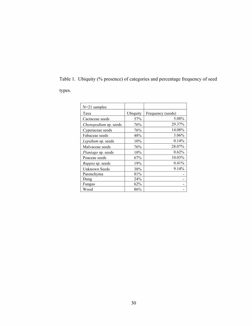
30
Table 1. Ubiquity (% presence) of categories and percentage frequency of seed
types.
N=21 samples Taxa Ubiquity Frequency (seeds) Cactaceae seeds 57% 5.08% Chenopodium sp. seeds 76% 29.37% Cyperaceae seeds 76% 14.08% Fabaceae seeds 48% 3.06% Lepidium sp. seeds 10% 0.14% Malvaceae seeds 76% 28.07% Plantago sp. seeds 10% 0.62% Poaceae seeds 67% 10.03% Ruppia sp. seeds 19% 0.41% Unknown Seeds 38% 9.14% Parenchyma 81% - Dung 24% - Fungus 62% - Wood 86% -
31
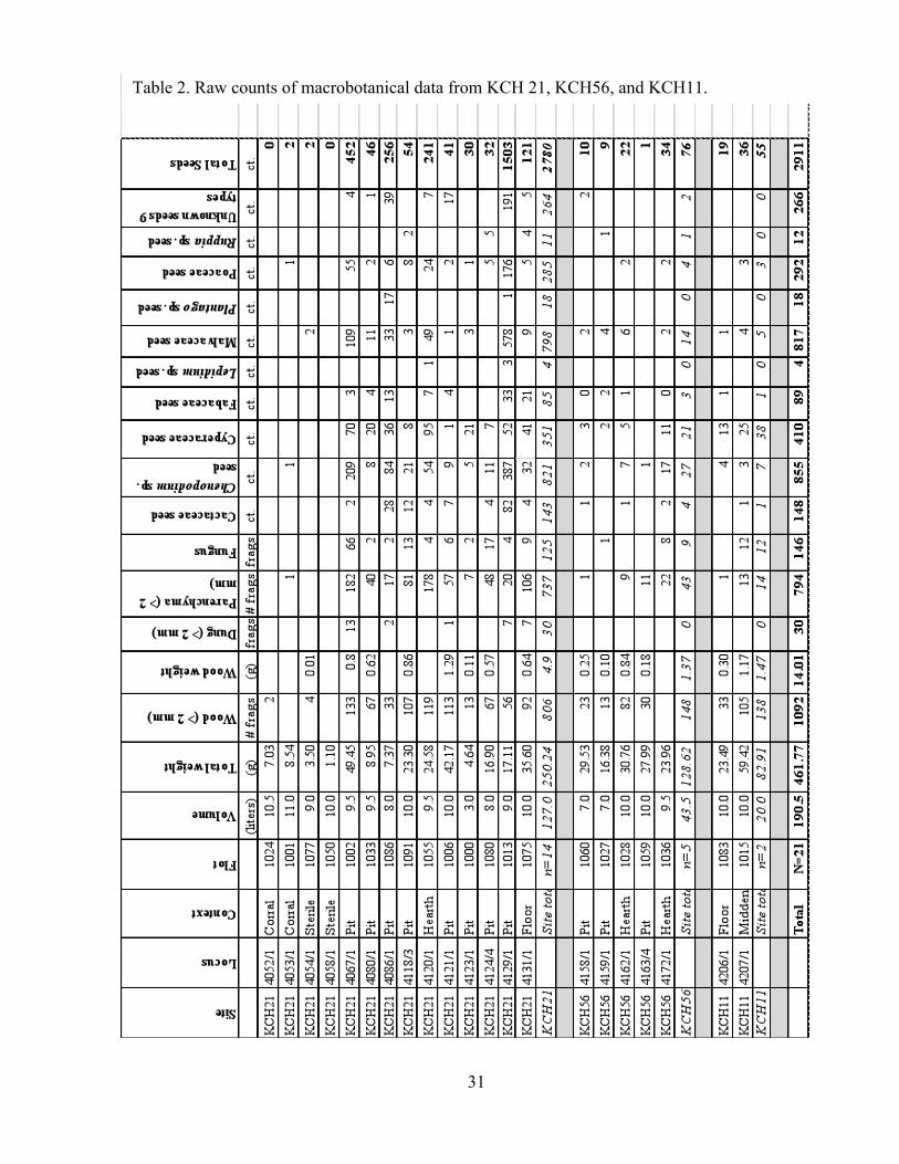
Table 2. Raw counts of macrobotanical data from KCH 21, KCH56, and KCH11.

32
Food Plants
The presence of the taxa Cactaceae, Chenopodium sp., and parenchyma/tuber
can be attributed to their use as a human food resource, although the consumption and
preservation of each taxon are distinct. The presence of Cactaceae and Chenopodium sp.
can also be due to camelid dung used for fuel.
Cactaceae. I identified 148 Cactaceae or cactus seeds. The ubiquity of cactus is
57%, the percentage frequency is 5.08%, and density is 0.63 seeds/L. The relatively high
ubiquity of cactus shows that it was common in the Iroco assemblages; however, the
percentage frequency and density indicate that the seeds were comparatively less
common than other taxa.
Several cacti have been identified in a botanical survey of the Iroco region
including Echinoposis maximiliana Heyder, Opuntia boliviana Salm-Dyck, Opuntia
soehrensii Britton & Rose, and Trichocereus pasacana (Sempertegui et al. 2005). In this
analysis, I identified one type of cactus seed in the Opuntoideae sub-family and one in the
Cactoideae sub-family. For analytical purposes, I grouped these types into their
common family because they were probably consumed (by humans or camelids) or used
in a similar manner.
Opuntoideae seeds are “comparatively large … flattish-subcircular … with a
distinct groove parallel to the margin[s]” (Martin and Barkley 1961:184). Bruno
(2008:227) collected an economic cactus in northern Bolivia, on the Taraco Peninsula
identified as an Opuntoideae, Maihueniopsis cf. boliviana (Sam-Dyck) Kiesling, and
wrote that the seeds are “round or globular in shape and have three thick ridges that meet

33
at a single point.” In both description and photographic comparison, this species appears
most similar to the Opuntoideae type encountered in this assemblage (Figure 4).
The identified archaeological cactoideae seeds are large and globular, with a
pointed hilum, and a smooth seed coat (Figure 5). Currently, I am only able to correlate
this seed to scientific sub-family.
Members of the cactus family have several known direct and indirect uses in the
Andes, including the use of spines for tools, the dried stems for fuel (specifically in the
Oruro region), as a hedge plant to keep animals away from granaries, and the fruits for
human and animal food (Browman 1989:153; Whitehead 2007:176). The seeds of the
fruits would not be carbonized if the spines were used for tools or the dried stems were
used for fuel, because these uses do not involve contact with fire. Thus, I can rule out
these uses. Browman (1989:153) notes that “cactus fruits have been exploited for food at
least [for] 10,000-8000 years” in the Central Andes. Bruno (2008:226) adds that
camelids forage for cactus fruits, and Hastorf and Wright (1999:218) identified charred
cactus seeds in modern dung burned for fuel. Previous researchers have documented
direct and indirect resource use of cactus, both of which are plausible scenarios for
Wankarani cactus use. I am currently unable to determine the difference between human
or camelid deposition; however, based on these ethnographic and research data, the
presence of cactus in this assemblage is attributed to fruits consumed for food. Humans
consumed the fruits and either deliberately or unintentionally disposed of the seeds in
fires, which led to their preservation and recovery. Foraging camelids consumed cactus
fruits, and seeds were preserved through the process of dung burning.

34
Figure 4. Image of archaeological Opuntia sp. seed (locus # 4124/4).
Figure 5. Image of archaeological Cactoideae seed (locus # 4124/4).
Chenopodium spp. Domesticated and cultivated in the Andes, quinoa and kañawa
(sometimes spelled cañihua) are important economic grains in the Amaranthaceae
family. This genus contains several other wild and domesticated species native to the
altiplano. Bruno identified 473 chenopod seeds and I identified 382. A total of 855
chenopod seeds are included in this analysis, with a ubiquity of 76%, percentage
frequency of 29.37%, and density of 4.48 seeds/L. The comparatively high ubiquity,

35
percentage frequency (representing the largest portion of seed taxa), and density of
chenopod seeds demonstrate that it is one of the most important taxa in the archaeological
Iroco assemblage.
Over the last decade Maria Bruno spearheaded research on defining the
characteristics of modern chenopod species seeds (Bruno 2001; Bruno 2006:43; Bruno
and Whitehead 2003). She analyzed both modern domesticated and wild varieties
including Chenopodium quinoa, Chenopodium quinoa var. melanospermum,
Chenopodium pallidicaule, and Chenopodium ambrosioides. Identifying domesticated
and wild varieties of chenopods in the archaeological assemblage is an integral part of
understanding how the Wankarani interacted with their landscape. For example, were the
Wankarani people farming or were they collecting wild plants?
Martin and Barkley (1961:151) describe Chenopodiaceae seeds as “circular-
lenticular…[with] a notch or groove at one point on the margin [that] varies from evident
to obscure” (see Figure 6). More specifically, these fruits have a central perisperm with
an embryo wrapping around the periphery, terminating in what is referred to as a beak
(where the radicle and seed leaves meet).
Bruno (2006:32) states that Andean varieties of chenopods thrive in disturbed
ecological zones. Camelid herding creates opportune environments for chenopod
cultivation, because the feces enrich the soil. Browman (1989:143) notes that
domesticated Andean chenopods are well adapted to high altitudes, frost, drought, and
saline soils. He also states that kañawa (as compared to quinoa) grows well at higher

36
altitudes and can grow under conditions where there is less water - exactly the case in the
Iroco region.
Chenopodium quinoa Willd. (quinoa) is the best known domesticate in this genus,
because it is a modern food staple. Today, quinoa is grown and consumed throughout the
Andes, and increasingly, it is consumed throughout the modern world (Hellin and
Higman 2003:90). Current research indicates that quinoa cultivation in the Titicaca Basin
dates to at least 1500 B.C. (Bruno 2001; Bruno 2006:43; Bruno and Whitehead 2003).
A second domesticated species, Chenopodium pallidicaule Aellen, is called
kañawa in the Andes. Research has paid far less attention to this domesticate. However,
currently Maria C. Bruno is working on deciphering its unique characteristics that
resulted from human selective pressures. Kañawa grows well in drier regions, as stated
above.
Chenopodium quinoa var. melanospermum Hunkizer is known commonly as
quinoa negra, or in local dialect, ajara, due to its black color. This species often grows
as a weed in quinoa fields and can be seen in packaged quinoa (its black color standing
out). Chenopodium ambrosioides Aellen is called paiko and is a wild chenopod that has
not exhibited traits of human selective pressures.
The domestication processes of Andean Chenopodium spp. plants have been
under increasing scrutiny (Bruno 2001; Bruno 2006; Bruno and Whitehead 2003).
Selection by humans through various processes including increased management of wild
stands, cultivation, and intensification of chenopod production, to marked phenotypic
changes during the southern Formative period in the south-central Andes. Specifically,

37
Bruno and Whitehead (2001) note the increase in seed diameter size during the Formative
periods. Chenopodium spp. studies have used fruit size, fruit shape, testa texture, testa
thickness, and beak prominence to identify human selection pressures. Under selective
pressures of cultivation, seed size of chenopods has been shown to increase (Browman
1989:143-148; Bruno 2001, 2006; Bruno and Whitehead 2003). This increase in size was
the result of what Harlan (1975) has identified as seedbed competition, where the larger
seeds outcompete smaller seeds under cultivation. Furthermore, decrease in relative testa
thickness (the seed coat) is an indicator of human-induced selective pressures (Smith
1989:1568).
The earliest evidence of domesticated chenopod cultivation is documented at
Wankarani and Chiripa archaeological sites in the altiplano. A unique semi-
domesticated, morphological chenopod seed type from a hearth at the Formative period
Wankarani site, La Barca, was excavated by Marc Bermann and William Castellón
Condarco (Langlie et al. 2011). This morphological type dates to 1200 B.C., much
earlier than the Iroco samples. A study on Chenopodium domestication at the site of
Chiripa located in the Lake Titicaca basin reveals evidence of phenotypic change
associated with human selection pressures by 1500 B.C. (Bruno and Whitehead
2003:350). These two studies reveal that chenopods were cultivated across the altiplano
region during the early part of the Formative period.
Identifying signatures of chenopod domestication entails a multivariate approach
that includes the use of scanning electron microscopy (SEM) and analysis of the above-
described attributes. Without conducting a comprehensive analysis using SEM, it is

38
difficult to determine if the seeds analyzed were domesticated or wild. However, I
provide some preliminary insights into the status of the Iroco chenopods.
I collected data on four attributes of 219 chenopod seeds from the Iroco site
including seed diameter size, presence of a testa (seed coat), testa texture, and relative
testa thickness. These data are presented in Appendix C, Table 1. I gathered these data
using an ocular micrometer in a light microscope under magnification of 10X-40X.
The diameter range of the 68 seeds with a visible testa is 0.6 mm-1.7 mm and the
mean diameter is 1.08 mm. Bruno (2008:207) notes that diameter alone is not an
indicator of domestication status of Andean chenopods. Rather, the ranges between the
wild and domesticated varieties overlap too much to establish domestication status only
on a measurement of diameter.
Testa thickness was visible on seeds with a cracked or partial testa. Based on my
previous chenopod seed analysis experience and with the guidance of Dr. Fritz I
categorized testa thickness into two categories: relatively thick and relatively thin. These
categories correlate thick-testa chenopod seeds to wild or weedy species and thin-testa
chenopod seeds to domesticated species. I estimate that the thick-testa chenopod seeds in
this study have testa thicknesses larger than 10 µm and the thin-testa seeds have testa
thicknesses that range from 0-10 µm. Of the 47 chenopod seeds with a visible testa
thickness, 26 seeds had a thick testa, and 21 seeds had a thin testa. The thick-testa
chenopods are likely quinoa negra (Chenopodium quinoa var. melanospermum) the
weedy variety that coevolved alongside quinoa or paiko (Chenopodium ambrosioides) a
species. The testa thickness of modern negra ranges from 22-51 µm, and paiko testa

39
thickness ranges from 11-14.5 µm (Bruno 2006:38-39). The thin-testa chenopods likely
represent either domesticated quinoa (testa thickness range 1.2-3.75 µm) or domesticated
kañawa (testa thickness range 4.25-7.5 µm) (Bruno 2006:38-39). Furthermore, I
identified 146 chenopods without visible testa. Seed coats of seeds with identifiable testa
are sturdier than those of thin testa seeds and hold up better after carbonization. The seed
coats may have readily burned away during firing leaving identifiable chenopods seeds’
endosperms, leaving identifiably remnants of domesticated thin-testa varieties.
Testa texture, although difficult to identify without an SEM, provided further
insight into the presence of cultivated varieties in the Iroco region. I identified testa
texture using the light microscope and used the same classifications as Bruno (2006).
Sixteen chenopod seeds had a fairly smooth seed coat and a canaliculate testa texture
around the beak. This testa texture resembles a modern wild variety of Chenopodium sp.
plant collected from the Titicaca Basin (Bruno 2008:299). It is also similar to an
unknown archaeological taxon identified by Bruno (2008:305) that she has suggested is
an intermediary form of kañawa that exhibits phenotypic change due to the early stages
of human selection pressures. Four seeds had a canaliculate testa texture that looks like
modern kañawa seeds (Bruno 2006:40). Sixteen seeds exhibited a smooth testa texture
similar to modern quinoa (Bruno 2006:40). Twelve seeds had a reticulate testa texture
similar to modern quinoa negra (Bruno 2006:40). Only one seed had a punctuate testa
texture similar to paiko.
Only 12 chenopod seeds were smooth and thin coated. The seed diameter of
these 12 seeds ranged from 0.7-1.0 mm with a mean diameter of 0.87 mm. The
combination of these traits is evidence that these 12 smooth and thin testa chenopod seeds

40
are from plants that are either domesticated quinoa or semi-domesticated quinoa. They
might be semi-domesticated because they had a relatively small diameter compared to
modern quinoa.
Three seeds had the combined traits of a smooth testa and a canaliculate testa
texture around the beak. These three seeds ranged in diameter from 1.0-1.2 mm. Based
on the combination of these attributes, these three seeds, if Bruno’s (2008:305)
hypothesis is correct, are from kañawa that is in the early stages of domestication.
Two seeds exhibited the combined traits of a canaliculate testa texture and a thin
seed coat. These two seeds were also comparably small to their modern cognate,
kañawa, ranging from 0.9-1.3mm. Based on the combination of testa texture and testa
thickness, these two seeds are kañawa.
Twenty-five chenopod seeds had a thick testa. The thick testa chenopod seeds are
either wild or weedy varieties with varying testa textures.
The Iroco chenopod assemblage is composed of a mixture of domesticated and
wild or weedy types of chenopods. The large quantity of seeds that lack a testa (n=146)
are likely correlated with thin-testa cultivated varieties such as quinoa. Humans and/or
their herded animals consumed both domesticated and wild chenopod seeds.
The Wankarani macrobotanical assemblage is composed of both direct and
indirect resource use of chenopods. Camelids grazed on natural stands of chenopods or
in Wankarani fields and enriched the soils with their dung. Subsequently, wild or
domesticated varieties of chenopods ended up charred and preserved through camelid
dung burning. Browman (1989:165) notes that it is a common practice to parch or dry

41
out chenopods in ceramic vessels for storage. Chenopodium spp. seeds became charred
during parching, spilled into the fire during cooking, or were disposed of in fires if they
were no longer edible.
Figure 6. Image of archaeological Chenopodium sp. (locus #4162/1).
Parenchyma and Tubers. I identified 794 carbonized parenchyma/tuber
specimens; ubiquity is 81% and density is 4.17 fragements/L. The comparatively high
ubiquity and density of parenchyma/tubers indicates that it was an important part of the
Wankarani plant assemblage.
Several tubers and roots were domesticated or semi-domesticated as food sources
in the Andes, including the potato (Solanum tuberosum), oca (Oxalis tuberosum),
mashwa (Tropaeolum tuberosum), ulluco (Ullucus tuberosus), and maca (Lepidium
meyenii) (Flores et al. 2003; Pearsall 2008:107). These plants are adapted to
environments with poor soils, constant erosion, and unpredictable rainfall and
temperatures, characteristic of the steep slopes of the Andes (Flores et al. 2003:161).

42
Although little is known about the process of domestication of the majority of these
plants, recent genetic research has begun to unravel the history of the potato (Spooner et
al. 2005) and oca (Emshwiller 2006). Browman (1989:149) notes that the charred
remains of possibly domesticated potato have been recovered dating to 6000 B.C. from a
site called Chilca. Researchers have identifed the earliest evidence of oca cultivation
dating to 9000-10,000 B.P., but it is more plausible that it was domesticated between
4000-1000 B.P. (Emshwiller 2006). Although domestication the data regarding tuber
domestication is scant and outdated in the archaeological literature, the dates for potato
and oca domestication precede the Formative period in the Iroco region. I do not rule out
the possibility that the Wankarani people were collecting wild tubers. Based on the early
dates recorded for tuber domestication, it is highly probable that the Wankarani people
were cultivating domesticated tuber species.
All the above-mentioned tubers and roots are boiled and/or mashed in preparation
for consumption. Furthermore, it is a common practice to freeze-dry potatoes (chuño),
using the cold nights of the Andes. The processing technique involved in making chuño
extracts poisonous glycoalkoloids present in some varieties of wild and domesticated
potatoes (Johns 1989:509) .
Tubers and root crops are rarely preserved in the archaeological record. Pearsall
(2000:157) states that “the most likely source … of tubers are those discarded as spoiled
… and any accidentally charred during roasting.” Although it is easy to identify
carbonized parenchyma, it is extremely difficult to determine the plant taxon. Hundreds
of colloquial varieties of potatoes of varying morphologies are known in the Andes,
which make it even more difficult to identify the scientific genus and species of

43
parenchyma/tuber fragments. An organized cellular structure and non-uniform shape
allowed at the very least for a degree of identification of carbonized parenchyma/tuber
fragments (Pearsall 2000). Future research using more advance techniques and
technologies, such as scanning electron microscopy, may reveal the identities of the tuber
taxa present in the Iroco macrobotanical assemblage. Parenchyma/tubers were charred
and preserved as the result of refuse disposal (which I will return to later in analysis) or
cooking accidents.
Aquatic Plants
The presence of fish bones and scales (Capriles 2008) and the presence of the
taxa Cyperaceae and Ruppia sp. are evidence that the Wankarani peoples regularly
exploited aquatic or lacustrine ecological zones. The dung burning experiments
conducted by Hastorf and Wright (1998) identified seeds of these taxa. Thus, I conclude
that Cyperaceae and Ruppia sp. seeds were carbonized and deposited from camelid dung
used for fuel.
Cyperaceae. Sedge seeds are “generally ovate in outline and ... plano-convex to
lens shaped … [with a] blunt or pointed style base (Martin and Barkley 1961:137).” The
seeds identified in this taxon measure from 0.8-1.3 mm in length and 0.5-1.0 in width,
and the style was pronounced. I identified 410 Cyperaceae seeds; ubiquity is 76%,
percentage frequency is 14.08%, and density is 2.15 seeds/L. The comparatively high
ubiquity, percentage frequency, and density suggest that Cyperaceae was a common and
essential plant in the Wankarani plant assemblage. Unable to differentiate species,
Bruno (2008:233) argues that the Cyperaceae seeds from archaeological contexts on the

44
Taraco peninsula were Schoenoplectus sp., Carex sp., or Scirpus sp. She notes that these
species all grow in moist soil conditions (Figure 7).
Schoenoplectus californicus is a plant species cultivated in the Andes that has
many uses. Its common name is totora, and it is the only species of Cyperaceae to grow
in the shallow waters of lakes (Bruno 2008:233). Totora is a perennial aquatic sedge
(Banack et al. 2004:11); ethnographic research establishes that it is collected from wild
stands and intensively cultivated (Banack et al. 2004:12; Orlove 1991:6). Bruno
(2008:234) and Browman (1989:150-151) note that totora is commonly consumed as
food. The white juicy rhizome located at the base is the part of the plant that is
consumed. Totora can also be used as thatching for roofing material, boats, mats, tools,
cordage, and animal fodder (Browman 1989:151; Whitehead 2007:207; Orlove 1991:6).
In addition to totora, Bruno (2008:256) notes that several other Cyperaceae
species grow in the altiplano including Carex cf. maclaviana d’Urv., Eleocharis
albibracteata Nees & Meyrn ex. Kunth, Schoenoplectus totora, Carex cf. pinetorum
Liebm., Cyperus sesierioides H.B.K., Scirpus deserticola Phil., and Scirpus rigidus
(Steed.) Boeckl. Bruno (2008: 255) collected several seed heads of totora, none of which
produced any mature seeds for comparison. Currently I am unable identify this seed type
to genus and, as a result, have placed these seeds in the Cyperaceae family.
Unable to identify whether Cyperaceae seeds are wild or managed totora makes it
difficult to assess its use (especially as direct and indirect resource use e.g., humans
consuming rhizomes and discarding the seed heads or burning construction materials).
Hastorf and Wright (Hastorf and Wright 1998:218) note the presence of charred

45
Cyperaceae seeds in modern dung burned for fuel. Camelids foraged for Cyperaceae
plants, but I cannot determine if these seeds are totora. If the seeds are totora, it is
possible that it was cultivated as camelid fodder. A limited family level identification of
Cyperaceae further limits analyses regarding Wankarani cultivation and consumption of
totora.
Figure 7. Image of archaeological Cyperaceae seed (locus # 4162/1).
Ruppia sp. With the assistance of Christine Hastorf and Maria Bruno, I identified
Ruppia sp. seeds (Figure 8). Ruppia sp. is commonly known as a ditch grass. I
identified 12 Ruppia sp. seeds; ubiquity is 19%, percentage frequency is 0.41%, and
density is 0.07 seeds/L. This taxon is comparatively less important in the Wankarani
economy, which is evident in the relatively low ubiquity, percentage frequency, and
density of seeds. Ruppia sp. is an aquatic plant taxon that was carbonized through
indirect resource use in camelid dung burned for fuel or as seed rain (Christine A. Hastorf
and Maria C. Bruno, pers. comm. 2011).
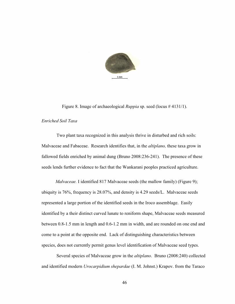
46
Figure 8. Image of archaeological Ruppia sp. seed (locus # 4131/1).
Enriched Soil Taxa
Two plant taxa recognized in this analysis thrive in disturbed and rich soils:
Malvaceae and Fabaceae. Research identifies that, in the altiplano, these taxa grow in
fallowed fields enriched by animal dung (Bruno 2008:236-241). The presence of these
seeds lends further evidence to fact that the Wankarani peoples practiced agriculture.
Malvaceae. I identified 817 Malvaceae seeds (the mallow family) (Figure 9);
ubiquity is 76%, frequency is 28.07%, and density is 4.29 seeds/L. Malvaceae seeds
represented a large portion of the identified seeds in the Iroco assemblage. Easily
identified by a their distinct curved lunate to reniform shape, Malvaceae seeds measured
between 0.8-1.5 mm in length and 0.6-1.2 mm in width, and are rounded on one end and
come to a point at the opposite end. Lack of distinguishing characteristics between
species, does not currently permit genus level identification of Malvaceae seed types.
Several species of Malvaceae grow in the altiplano. Bruno (2008:240) collected
and identified modern Urocarpidium shepardae (I. M. Johnst.) Krapov. from the Taraco

47
Peninsula. Tarsa tenella was identified near Iroco in a botanical survey (Sempertegui et
al. 2005:80). Browman (1989:152) notes that Notoriche sp. and Malvastrum sp. grow
well in “disturbed areas” (irrigation ditches, fallow fields) around Lake Titicaca. All of
the aforementioned altiplano Malvaceae species thrive in disturbed and enriched soils
(Browman 1989:151-152; Bruno 2008:241; Sempertegui et al. 2005:80). The presence
of this taxon (especially in such robust numbers) correlates to the presence of enriched
soils in proximity to the three Wankarani sites. Hastorf and Wright (1998:218) identified
charred Malvaceae seeds in modern dung burned for fuel. Based on this ethnographic
research, Malvaceae seeds were carbonized and deposited at the three Wankarani sites in
camelid dung burned for fuel.
Figure 9. Image of archaeological Malvaceae seed (locus # 4162/1).
Fabaceae. This seed type appears to be Trifolium amabile, a wild legume in the
Fabaceae family; but without a reference collection from the Iroco region I hesitate to
identify this taxon to genus (Figure 10). None of the seeds had a distinguishable seed
coat that might aid in a genus or species level identification. I identified 89 Fabaceae
seeds; ubiquity is 48%, percentage frequency is 3.06%, and density is 0.47 seeds/L. The

48
seeds measure 1.2 mm-2.0 mm in length and 0.5-1.3 mm in width. The identified
Fabaceae seeds are mitten shaped and oblong.
In the central altiplano, Bruno (2008:235-237) identified a small legume as the
taxon Trifolium amabile H.B.K. Based on gross morphology the seeds in the analyzed
Iroco samples appear similar. Trifolium sp. species grow readily and vigorously in
disturbed and agricultural soils, which lends evidence to cultivation activities (Bruno
2008:236). Brack Egg (1999) notes that in the Andes livestock often consume wild
legumes. Hastorf and Wright (1999:218) found that wild legumes are a common plant
taxon in dung burned for fuel. Following Bruno’s (2008) hypothesis, Fabaceae seeds
were carbonized and deposited at the Wankarani sites through dung or plants burned for
fuel (indirect resource use).
Figure 10. Image of archaeological Fabaceae seed (locus # 4162/1).
Wild Taxa
The wild taxa category consists of plants that occur naturally in the region,
including Poaceae, Lepidium sp., and Plantago sp. The most likely entrance into the
archaeological record was through camelid dung burned for fuel.

49
Poaceae. The grass family is composed solely of wild taxa in the altiplano (and
is a relatively large and diverse family. I identified 410 Poaceae seeds; ubiquity is 67%,
frequency is 10.03%, and density is 2.15 seeds/L. In the Wankarani assemblage grass
seeds are common based on ubiquity, but only moderately important based on frequency
and density. Figure 11 depicts a representative archaeological seed. Specimens grouped
in this taxon varied in morphology and size. The grass seeds identified measure from
0.8-2.2 mm in length and 0.4-1.3 mm in width. The larger seeds have a ventral sulcus
characteristic of the grass genus Stipa sp. The smaller grass seeds are rod-shaped and
lack any distinct sulci.
Whitehead (2007:222) mentions that near Puno, on the north-western side of Lake
Titicaca, 24 genera of grasses have been identified including 85 species of grass. Bruno
(2008:246) identified at least 23 species growing in the southern basin of Lake Titicaca,
some of which are introduced Old World grasses. She also mentions that the “ichus” are
genera in the altiplano that thrive in drier areas (Figure 9). These species include Stipa
ichu, Stipa leptostachya, and Stipa pseudoichu. Grass species identified in a botanical
survey of the Iroco region include: Nasella meyeniana (Trin&Rupr.) Parodi, Asistida
enoides Hack., Bromus catharticus Valh., Eragrostis uvula (Schrad.) Needs., Chondrsum
simplex (Lag.) Kunth., Stipa ichu, Dactylic glomeration L., Fistula orthophylla Pig., and
Bromus catharticus Valh. (Sempertugui et al. 2005). Due to similarities in morphologies
and sheer number of species in the altiplano grasses, I only identify this seed type to the
family level.
Ethnographic research identifies Ichus as a documented camelid forage food in
the altiplano (Bruno 2008:246). They are also used as fodder, fuel, rope, and fiber

50
(Whitehead 2007:224). The plethora of other grass species are also currently used for
animal forage, fodder, basketry, and construction material (for thatching and roofing
material) (Bruno 2008:246-247; Whitehead 2007:224). The identified charred Poaceae
seeds may have been attached to stems and leaves used as construction material that was
accidentally or intentionally burned. Based on the abundant amount of charred grass
seeds, a more likely hypothesis is that this taxon of seeds was charred in camelid dung
burned as fuel or grass used for fuel.
Figure 11. Image of archaeological Poaceae seed (locus # 4162/1).
Plantago sp. This taxon is a member of the scientific botanical family
Plantaginaceae commonly called the plantain family. I identified 18 Plantago sp. seeds;
ubiquity is 10%, frequency is 0.62%, and density is 0.11 seeds/L. The identified
Plantago sp. seeds are plump, with thick margins (Bruno 2008:243), and they are
“hollowed out like a boat” on one side (Martin and Barkley 1961:199). The seeds are
oblong and compressed lengthwise. The identified seeds measure 1.0-1.8 mm in length
and 0.6-1.2 mm in width. The species Plantago sericea R&P is a likely candidate for the

51
identified archaeological seeds because it currently grows in the study region
(Sempertegui et al. 2005:27). Bruno (2008:244) points out that the preferred habitat for
the genus is undisturbed soils.
Llanten, a variety of Plantago sp. identified in the modern period in the northern
altiplano region around Lake Titicaca, has several medical uses; the presence of this
taxon in the archaeological assemblage at Chiripa, as early as 1300 B.C. might be the
result of its medicinal value (Browman 1989:152-153). Although difficult to determine,
the presence of carbonized Plantago sp. seeds in the Iroco archaeological assemblage is
more likely due to camelid dung burned for fuel than medicinal use.
Lepidium sp. This genus is in the mustard family (Brassicaceae, formally known
as Cruciferae). I identified only 4 Lepidium sp. seeds; ubiquity is 10%, frequency is
0.14%, and density is 0.02 seeds/L. Low ubiquity, frequency, and density of this taxon is
evidence that Lepidium sp. is of minor significance in the Iroco assemblage. Plantago sp.
seeds are “elongated [with a] folded embryo that gives the seed an ellipsoid shape (Bruno
2008:223).” The end of one portion of the embryo is sharp and the other is enlarged
(Figure 12). At this time, I am unable to identify this seed type to species. Lepidium
chichicara Desv. is the only species of Lepidium that has been identified in the study
region (Sempertegui et al. 2005:68). Furthermore, botanists (Sempertegui et al. 2005)
note that this species is known to be toxic to animals. Lepidium meyenii is an Andean
domesticated root crop called maca not very widely grown in the current period (Flores et
al. 2003:163); so the presence of this seed could represent cultivation of maca. A more
likely scenario is that camelids foraged for the wild species that currently grows in the
study region, or a relative of the same genus, and the seeds were carbonized in dung used

52
for fuel. The extremely low occurrence of this seed may be attributed to the fact that the
local Lepidium sp. plants are toxic so camelids avoided its consumption.
Figure 12. Image of archaeological Lepidium sp. seed (locus #4120).
Other Taxa
Wood, dung, and fungus represent categories that do not fit elsewhere in my
analysis. Woody shrubs and dung were likely used as a source of fuel.
Wood. Carbonized fragments of woody stem were commonly recognized during
analysis. I identified 1,092 wood fragments. Wood fragments are present in 86% of the
samples, with a density of 5.56 specimens/L. High ubiquity and density point to a
significant importance of woody plants in the analyzed archaeological samples. There
are remarkably few species of trees in the altiplano. Browman (1989:155) states that
Lepidophyllum sp. and Baccharis sp. known commonly as tolas (also spelled thola) are
woody shrubs that grow in the northern portion of the altiplano. The shrubs are used as a
common source of fuel in fires. He also states that the roots of tolas are less commonly

53
consumed as a famine food, the leaves are used in teas and tonics, and they have a few
medicinal uses. The recovered woody fragments may be the result these modern uses,
however it is more likely woody products were used to fuel fires.
Dung. I identified 30 fragments of dung in this study. This category was present
in 33% of the samples, with a density of 0.25 fragments/L. The sheer presence of charred
dung fragments indicates that it was used for fuel. I did not identify any complete pellets;
however, there were several fragments that appeared characteristically dung-like. These
fragments were identified by their unorganized cellular structure, brownish-black color,
and contents of organic fragments. The identification of carbonized dung fragments
indicates that the Wankarani people used camelid dung as a source of fuel in fires. These
data complement the large proportion of charred wild seeds that were contained within
the dung fuel. Dung was not routinely preserved and recovered, because the organic
elements were burned in the fire and only the seeds preserved. The comparatively small
amounts of dung in the analyzed samples may also be attributed to recovery methods.
Charred dung is fragile and might have disintegrated to unidentifiable even smaller
fragments during recovery, flotation, and laboratory analysis.
Fungus. Fungus was an unexpected, non-plant find in the archaeological samples
from the Iroco region. Fungi are distinct from plants because they lack chlorophyll (the
green pigment/molecule in plants that allows for photosynthesis which is how plants
capture and produce energy from the sun) (Bessey 1950:2). The cell walls of fungi are
made of chitin (the same element in the exoskeletons of bugs), whereas plants are made
of cellulose. These attributes of fungi lead to their distinct parasitic mode of reproduction
and survival (Bessey 1950:2). The carbonized fungus in this study was identified by the

54
distinct honeycomb pattern when viewed from the top (Figure 14). Turned on its side,
the fungal body appear to be a collection of tubes (Figure 13). A single tube is called the
hypha, with more than one tube known as hyphae. The tightly bunched group of hyphae
as a unit makes up the fungal body called the mycelium. The mycelium is an unbranched
tubular structure that is only a few millimeters in length. Composed of numerous strands
of hyphae, the mycelium is a structure of the fungus that feeds off an external host.
Some fungi kill the host, while others maintain a balanced relationship, only extracting
enough nutrients to reproduce (Agrios 2005:72). The hyphae are the structures in fungi
that contain the spores, which are released and distributed for reproduction of the fungi
(Bessey 1950:3).
An entire field of biology, mycology, is devoted to the study of fungi. While a
non-specialist in this field, I acknowledge my shortcomings in identification and I have
sought aid in this endeavor. Dr. Fritz and I initially identified carbonized mycelia in the
analyzed samples. These specimens range from 0.5 mm-2 mm in length and are
approximately 2 mm in diameter. The host of the fungus was later identified as a tuber.
Mycelia are attached to the exterior part of the tuber (Figure 14); but as previously
mentioned, it is nearly impossible to identify fragmented parenchyma/tuber to family,
genus, or species.
Dr. James Bradeen from the University of Minnesota Plant Pathology Department
referred me to a “classically trained mycologist”, Dr. William Kirk, a professor in the
Plant Pathology Department at Michigan State University. Initial correspondence with
these specialists suggested that the fungus was Phytopthora infestans, the culprit of the
Potato Famine in Ireland that lead eventually led to the starvation and death of roughly

55
one million people due to crop failure in the 1840’s. There is a debate in the mycology
world over the origins of this pathology. One group of researchers believes that P.
infestans is from Mexico, while the other groups argues that it is from the Andes. Based
on the presence of resistance genes and genotypic diversity in Solanum spp., Grunwald
and Flier (2005) contend that the origins of P. infestans was in the central highlands of
Mexico. However, mitochondrial and nuclear genetics research by Gómez-Alipzar et al.
(2006) suggests that P. infestans evolved symbiotically in the same place that the potato
was domesticated - the Andes. This would place the Wankarani fungus directly in the
middle of this debate and would offer evidence of an Andean origin. Every mycologist
that I have communicated with was excited by this potential find and without hesitation
identified the archaeological fungus as P. infestans.
Further examination of photographs by Dr. Kirk has revealed that it is unlikely
that this fungus is P. infestans, based on the gross morphology of the mycelium. The
mycelium “of P. infestans is very delicate and tend not to be present on the outside of the
tuber” (William Kirk, Personal Communication 2011).
Currently, I am unable to determine the genus of this fungus. Future research and
collaboration with mycologists and plant pathologists will hopefully lead to an
identification of the species of this archaeological fungus.

56
Figure 13. Carbonized archaeological fungus specimen, with arrows pointing to
the prominent hyphae (locus # 4067/1).
Figure 14. Image of carbonized archaeological fungus attached to a tuber (locus #
4121/1).

57
Unknown or Unidentifiable Seeds. Nine unknown specimen types were identified
and photographed. Some of these specimens are too clinkered to identify and might be
unrecognizable grass seeds. Of the 266 unknown or unidentifiable specimens in this
study, 230 were in the two samples analyzed by Dr. Maria C. Bruno in Bolivia. I do not
have access to them for further study. Images can be found in Appendix B.
Results
In this section I explain the location and contexts of recovered botanical remains
from the three Wankarani sites. I offer scenarios of deposition within the contexts of the
three sites.
KCH11
A 4 X 4 meter unit was excavated in the central area of the mound at KCH11 (Figure
15). Two groupings of rocks that possibly contained tombs were noted on the surface
before excavations began (Capriles 2008:23-26). Three tombs were excavated, which are
illustrated in Figure 15. These burials were AMS dated to after the Tiwanaku period
(A.D. 800-1000), and no botanical samples were analyzed associated with the tombs. I
focused analysis on Formative period contexts. A small semi-circular structure and floor
composed of clay was identified in the northeastern area of the unit (Capriles 2011:136).
This floor was heavily disturbed (Capriles 2008:23). Calibrated AMS dates indicate that

58
the structure dates to 24 B.C.-A.D.94 (Capriles 2011:137). I analyzed two
paleoethnobotanical samples from the Formative period structure.
Figure 15. Composite plan of Unit N1757 E4211 from site KCH11 (From Capriles
2008:25, Figure 10). The circle indicates the location of sample L. 4206/1.

59
Table 3. Density/L of macrobotanical remains from KCH11.
Plant Resources Site KCH11 KCH11 KCH11 KCH11 Locus 4206/1 4206/1 4207/1 4207/1 Context Floor Floor Midden Midden
# seeds/frags Density/L
# seeds/frags Density/L
Volume 10 L 10 L 10 L 10 L Food plants Cactaceae seeds - - 1 0.10 Chenopodium sp. seeds 4 0.40 3 0.30 Parenchyma/Tuber frags. 1 0.10 13 1.30 Aquatic plants Cyperaceae seeds 13 1.30 25 2.50 Ruppia sp. seeds - - - - Enriched soil plants Malvaceae seeds 1 0.10 4 0.40 Fabaceae seeds 1 Wild plants Poaceae seeds - - 3 0.03 Plantago sp. seeds - - - - Lepidium sp. seeds - - - - Other taxa Wood frags. 33 3.30 105 10.50 Dung frags. - - - - Fungus frags. - - 12 1.20 Total 19 5.30 166 16.60
I analyzed two samples from KCH 11: L. 4206/1 and L. 4207/1. The raw counts
and densities of the recovered macrobotanical remains are displayed in Table 3. Sample
L. 4206/1 came from the eastern area of the unit and was recovered from a surface or
floor associated with the edge of the exposed structure. This sample contained a low
density of carbonized botanical material. Small amounts of food taxa, enriched soils
taxa, and wood might be evidence that cooking activity took place within the structure.

60
The floor was probably cleaned and these taxa accidentally deposited. Sample L. 4207/1
was labeled as a midden and dates to the Formative period. This context also revealed a
comparatively low density of botanical taxa. However, 105 wood fragments were
identified, indicating that carbonized refuse from hearths may have been disposed of in
the midden.
Irucirca or KCH21
Broad exposure excavations at Irucirca uncovered 413 m2 (Figure 16). A
possible corral and several structures that appear to be houses and domestic spaces were
exposed. Capriles’ (2008:93) “objectives for the excavations were twofold: (1) sample
the floor inside the possible corral, to identify the activities conducted inside the structure
and (2) sample a wide variety of domestic context that were not previously excavated,
employing fine-grained recovery techniques.”
Two areas of a possible corral were intensively excavated (Figure 16) that include
a 2 x 2 m (four square meters) unit in the center of the corral, and a 1 x 4 meter (four
square meters) unit in the northern portion extending from inside the corral wall to
outside the wall (Capriles 2008:34, Figure 16). I analyzed four samples from the center
of the corral and one sample from a pit located adjacent to the exterior of the corral wall.
The center portion of the corral (unit N3290E5474) revealed a very low density of
cultural debris. Four macrobotanical samples were analyzed from the center portion of
the possible corral including loci #’s 4058/1, 4054/1, 4053/1, and 4052/1. The raw
counts and densities of these samples are presented in Table 4.

61
Figure 16. Map of KCH21 the three units excavated in 2007 are circled and
labeled with corresponding analyzed archaeobotanical samples (from Capriles
2008:34, Figure 16).
Culturally sterile soil was reached in the lowest stratum, identified by a sandy,
deep orange matrix. Sample L. 4058/1 was from the culturally sterile level. The density
of this sample is 0 specimens/L, which supports the excavators’ interpretations that this
level is culturally sterile. Above the sterile soil was an organic, silty stratum of fill
material. This stratum contained two circular pits, which were probably the result of
burrowing animals and was also interpreted as culturally sterile (Capriles 2008:36).
Sample L. 4054/1 from this level was analyzed for macrobotanicals and revealed four

62
wood fragments and a two Malvaceae seeds. The low density of these remains can be
attributed to wind-borne seed rain from nearby burning activities, or the seeds are
evidence of bioturbation. The recovery of these remains indicates that this level was not
culturally sterile and is associated with the Wankarani Complex occupation of the site.
Sample L. 4053/1 was taken from the stratum above sample L 4054/1, above the
organic fill event, and below the corral floor. It consisted of a sandy matrix with organic
inclusions. Three carbonized remains (a grass seed, a parenchyma/tuber fragment, and a
chenopod seed) were recovered from this sample. Similar to L. 4054/1, the charred
remains were deposited as seed rain from a nearby fire, or the seeds are evidence of
bioturbation. The floor of the corral was identified above this stratum and it consisted of
a gray clay matrix. The base of the floor was uneven; however, the surface was very flat
and level. Small holes, which appeared to have been caused by burrowing beetles, were
apparent on the surface of the floor. I analyzed sample L. 4052/1 from the corral floor.
Two fragments of wood were identified in this sample. Once again, it is probable that
these charred remains were deposited by seed rain from a nearby fire, or are the result of
bioturbation. On top of the floor, there was an aeolian deposit of a natural sandy fill
layer that preserved and capped the site (Capriles 2008;36-37).
The botanical remains present in the described corral samples maybe the result of
camelids consuming and defecating charred botanical remains. The seeds likely represent
seed rain blown in from other activity areas. Additionally, the remains may represent
construction events of culturally derived soils that were used to level out the corral area
but were obtained from other activity areas in the site.

63
Table 4. Density/L of macrobotanical remains in unit N3290E5474 and L. 4067 from unit
N3295E5474.

64
The 1 x 4 meter unit in the northern portion of the corral (unit N3295E5474)
straddled both the interior and exterior of the corral, which is illustrated in Figure 16.
The corral wall was delimited by two rows of limestone blocks that measured 70 cm x 70
cm (Capriles 2008:39). On the outside of the corral, middens and fill strata were
identified. Capriles identified fish bones and bird bones in this area. Several pits were
identified intermittently between clay levels (Capriles 2008:37). Macrobotanical sample
L. 4067/1 sample was recovered from outside the corral, below several levels of refuse
and clay. The results of the analysis of L. 4067/1 are presented in Table 4. This sample
was taken from an “X”-shaped pit, and revealed 88.63 specimens/L. The high density of
this sample contrasts with the sparseness of samples analyzed from inside the corral. The
high density of parenchyma/tuber (19.16 specimens/L), Chenopodium sp. (22.00
seeds/L), and the presence of Cactaceae is evidence that the X-shaped pit context is a
disposal area from a cooking fire. The presence of the Cyperaceae, Malvaceae,
Fabaceae, and Poaceae indicate that camelid dung was burned for fuel, which is further
supported by the presence of dung. The high density of wood (14.00 specimens/L)
suggests that the original fire was also fueled by wood. Based on the recovered materials
and the excavators’ identification that this area was a pit, this is a secondary depositional
refuse area located adjacent to the corral.
Eight semi-circular to circular shaped structures were exposed during excavations
south of the corral. The architecture of these structures was composed of adobe walls and
clay floors, and they ranged from 2.4-3.7 meters in diameter (Capriles 2011:118-119).
Three of these structures contained a central hearth. A couple of hearths were also

65
excavated adjacent to the outside of the structures (Capriles 2011:12). Numerous pits
were located inside and outside the structures, indicating that domestic activity took place
both inside and outside (Capriles 2011:120-121
Four structures were intensively sampled from the southwest area of the site
(N3272E5468). This unit was identified as an exterior surface occupation level, with
two associated hearths, a secondarily deposited sandstone statue, and a high density of
cultural debris. Further excavations revealed a lower and thus earlier complex, of four
separate structures/houses depicted in Figure 17 (Capriles 2008). In the northern sector
of this unit, 11 pits of various shapes and sizes intersected the surface of the clay
occupation zone and they extended down to sterile soil. Based on contents recovered
during excavations (one pit contained fish bones) and location on the periphery of the
mound, Capriles suggests that the function of these pits was for refuse disposal (Capriles
2008:41-43).
Two macrobotanical samples from pits in this unit were sorted and analyzed.
Density and raw counts of these samples are presented in Table 5. Sample L. 4080/1 was
taken from a circular and cylindrical shaped pit in the northwestern area of the unit, and
high densities of fish bones were noted during excavations. Charred food plant remains
were not very dense in this pit (Cactaceae 0.00 seeds/L, Chenopodium sp. 0.84 seeds/L,
and parenchyma/tuber 4.21 specimens/L). Charred wood fragments had the highest
density (7.05 specimens/L), which indicated that woody plants were used for fuel. The
presence of fungus and parenchyma/tuber points to the destruction (intentional or
unintentional) of diseased tubers in the original burning event. However, the location and
contents of the pit suggest that it was used for secondary deposit of refuse from a fire, not

66
necessarily associated with cooking as indicated by the low density of food taxa. Sample
L. 4086/1, which was sorted by Dr. Bruno, was taken from an adjacent circular pit. In
comparison to the other pits in this unit, this sample revealed much higher densities of
charred seeds and a lower density of parenchyma/tuber fragments (chenopods 10.5
seeds/L, parenchyma/tuber 2.13 fragments/L). This pit was likely used for refuse
disposal from a cooking fire. .
Table 5. Density/L of recovered macrobotanical remains in unit N3272E5468.
Plant Resources Site KCH21 KCH21 KCH21 KCH21 Locus 4080/1 4080/1 4086/1 4086/1 Context Pit Pit Pit Pit
# seeds/frags Density/L
# seeds/frags Density/L
Volume 9.5 L 9.5 L 8 L 8 L Food plants Cactaceae seeds - - 28 3.50 Chenopodium sp. seeds 8 0.84 84 10.50 Parenchyma/Tuber frags. 40 4.21 17 2.13 Aquatic plants Cyperaceae seeds 20 7.37 36 4.50 Ruppia sp. seeds - - - - Enriched soil plants Malvaceae seeds 11 11.47 33 4.13 Fabaceae seeds 4 0.42 13 1.63 Wild plants Poaceae seeds 2 0.21 6 0.75 Plantago sp. seeds - - 17 2.13 Lepidium sp. seeds - - - - Other taxa 67 7.05 33 4.13 Wood frags. - - 2 0.25 Dung frags. 2 0.21 2 0.25 Fungus frags. 152 16.21 248 33.88 Total 306 16.21 519 33.88

67
A complex stratigraphic sequence associated with domestic architecture was
excavated in the 4 x 4 m unit (N3276E5484) in the southeast area of the site depicted in
Figure 17. Four distinct circular structures were identified in the earliest occupation level
of this unit. The walls of the structures were identified as compacted earth, which could
be weathered adobe. Between the structures, there was a patio area with poorly defined
walls that contained several pits. Capriles (2008:48) believes that the pits between the
structures were used for storage and/or refuse.
Figure 17. Map of the lowest stratum of Unit N3276 E5484 and the locations noted in
circles of the sorted macrobotanical samples (from Capriles 2008:47, Figure 26)

68
Seven macrobotanical samples were sorted and analyzed from this unit, one from
a hearth, one from fill, and five from pits. Based on the location, shape, and
macrobotanical analysis of the five analyzed, these features were secondary refuse
deposits. The densities of these samples are presented in Table 6. Capriles (2008) notes
that some of these pits might have been use for storage. The analyzed pits were used
primarily for refuse disposal based on the recovered macrobotanical remains.
Sample L. 4118/3 was taken from a semi-circular shaped ash-pit located in the
northeastern portion of the site. The location of this sample was outside of Structure 2
and adjacent to the patio. Based on the low density of charred food plants (Cactaceae 1.2
seeds/L and Chenopodium sp. 2.1 seeds/L), the original fire event was probably not a
cooking fire.
Sample L. 4120/1 was taken from a hearth located in the outside patio area. The
hearth was relatively dense in food plant taxa (Chenopodium sp. 5.68 seeds/L and
parenchyma/tuber 18.74 specimens/L), which indicates that it was used for cooking.
Additionally, it was very dense in aquatic plants (Cyperaceae10 seeds/L) and plants that
thrive in rich disturbed soils (Malvaceae 5.16 seeds/L). These data indicate that it might
have also been used for food processing, and the charred plant remains are the result of
camelid dung burned for fuel.
Sample L. 4121/1 was taken from a round refuse pit located in-between Structure
2 and Structure 4. The density and composition of this pit was remarkably similar to the
sample analyzed from pit L.4118/3. The macrobotanical data indicate that both of these
69
pits look like they are the result of cleaning out and disposing refuse from hearths not
used for cooking activities.
Sample L. 4123/1 was taken from the southern portion of the unit, and was
adjacent to Structure 2 and Structure 4. Excavators recovered this sample from a round
storage pit (Capriles 2008:50, Table 2). Sample L. 4124/4 was taken from a round
storage pit next to L. 4123/1. These samples are also similar in composition. The low
density of charred food remains indicates that these pits were used for the disposal of
refuse from hearths not used for cooking activities.
Sample L. 4129/1, which was sorted by Dr. Bruno, had the highest seed density of
the analyzed samples, with a total of 1,503 seeds. This sample was taken from a pit
located in the northwestern area of the unit, located in the outdoor patio area between the
structures. This sample was extremely dense, in edible seed remains (Chenopodium sp.
43 seeds/L, Cactaceae 6.89 seeds/L), but relatively low in parenchyma/tuber (2.22
specimens/L). The high density of edible seed remains is evidence that this pit is likely
composed of refuse from a cooking hearth. Furthermore, its proximity to the open-air
hearth (L.4120/1) indicates that the patio was used as a cooking area.
Sample L. 4131/1 was taken from the floor inside Structure 2. The
macrobotanicals identified were similar in density to the other analyzed refuse pits. This
might indicate that a small hearth was used to warm up the structures and the carbonized
materials (with low densities of food) were disposed of in the small pits between the
structures.

70
Table 6. Density of recovered macrobotanical remains in unit N3276 E5484.

71
KCH56
A circular structure containing four distinct levels of occupation was excavated at
KCH56, which is depicted in Figure 18. The walls of the structure were composed of
large stones lined with adobes. Five macrobotanical samples were analyzed from contexts
associated with this structure and the density/L is presented in Table 7.
Figure 18. Map of the second level of occupation at KCH56 (from Capriles
2008:31, Figure 14).

72
In the earliest stratum of occupation of the structure two small hearths were
identified inside the walls of the structure, and it is hypothesized that they were used as a
source of heat (Capriles 2008:28). Sample L. 4172/1 was taken from one of these hearths.
Analysis revealed that this sample contained a low density of food plant remains
(Cactaceae 0.21 seeds/L, Chenopodium sp. 1.79 seeds/L, and parenchyma/tuber 2.32
specimens/L). Additionally, the density of carbonized seeds in the hearth was quite low
(6.74 specimens/L). While it is possible that this hearth was used for small amounts of
cooking activity, it is probable that it was used as a small warming fire inside the
structure. Camelid dung was likely used for fuel, based on the absence of wood, and the
presence of wild plant remains.
A refuse pit was identified in the southwest wall of the second level of occupation
of the structure, and it contained well-preserved camelid bones. A hearth was identified
in the middle of the structure in the second stratum of occupation. This level is depicted
in Figure 18, with the hearth labeled Fogón. Density and counts are presented in Table 7.
Sample L. 4163/4 was from the refuse pit adjacent to southern wall of the structure and
excavations here recovered camelid bones. The density of this sample was extremely
low (4.2 specimens/L). Notably, three fragments/L of wood were identified. I
hypothesize that this pit is the result of a wood-fueled fire, and may be associated with
the disposal of the camelid bones. But limited botanical depositional activity took place
in this area of the structure. Sample L. 4162/1 was taken from the hearth located in the
center of the structure. This sample was not very dense (11.3 specimens/L). I propose
that this hearth is the result of fire used to warm the structure rather than for cooking
purposes.

73
A patio or courtyard was identified adjacent to the outside of the western portion
of the structure, which contained two refuse pits that were circular and cylindrical in
shape (Capriles 2008:31-33). Samples L. 4158/1 and L. 4159/1 were taken from outside
the western area of the structure. Both of these samples were from distinct refuse pit
contexts, and both revealed comparatively low densities of carbonized plant taxa (4.57
specimens/L and 1.43 specimens/L). These pits may present evidence for the cleaning
and disposal of warming fires (the hearth) located inside the structure.

74
Table 7. Density of macrobotanical remains from unit N6341E5595.

75
Comparing Results
In this section, I make a few broad scale comparisons between contexts and
between sites. I use the data to compare botanical deposition in an effort to gain insight
into how different areas and structures of the site were used and as a tool to identify
variability within and between sites. I choose to focus analysis on comparing hearths,
pits, and the corral contexts to better understand how these areas were used.
Additionally, I have excluded the two floor samples and the midden sample from this part
of analysis because the sample sizes (n=2 for floors) is too small. I have further
categorized the plant taxa into food plants that humans might have eaten and non-food
plants that camelids probably ate. By analyzing the data this way, I am able to identify
how much of the plant assemblage might be attributed to human foodways and how much
is attributed to camelid dung used for fuel.
Ubiquity
The ubiquity of the 13 macrobotanical categories expressed as percentage of
samples in which they are present is displayed in Figure 19. Lepidium sp. seeds and
Plantago sp. seeds were only found in 10% or two samples, both from KCH56,
indicating that these plants were of limited use. Food categories including Chenopodium
sp., Cactaceae, and parenchyma/tuber were very common, present in more than half of
the analyzed samples, and at all three sites. This is evidence that tubers/parenchyma and
Chenopodium spp. were important plants in the Wankarani economy. Also, the

76
moderately high ubiquity of Cactaceae (57%) indicates that humans might have been
consuming the fruits.
Dung fragments were not dense and were completely absent from the samples
analyzed from KCH11. Dung was present in 33% of the samples from KCH21. Wood
had a high ubiquity, occurring at all three sites in 86% of the samples. The low ubiquity
of dung and the high ubiquity of wood may suggest that shrubs were commonly used as a
fuel source. I reiterate that carbonized dung is fragile and easily disintegrates. Dung
fragments might have broken apart during the original fire, secondary refuse activity
(cleaning out of hearths), excavations, flotation, in transport to the US, or during
laboratory analysis. However, the high ubiquity percentage of non-food taxa, which
camelids commonly consume, were primarily burned and preserved in dung. The
carbonized seeds of non-food taxa are signature of dung burning.
Figure 19. Ubiquity as expressed as a percentage presence.
0% 10% 20% 30% 40% 50% 60% 70% 80% 90%
100%
Percen
t Presen
ce

77
Fungus and parenchyma/tuber were common, occurring in 62% and 81% of the
samples respectively. The high occurrence of these taxa might be linked to intentional
destruction of infected portions of the tubers. Furthermore, fungus and parenchyma/tuber
were present at all three sites, suggesting that this parasitic taxon is widespread in the
Iroco region.
Context comparison of ubiquity is depicted in Figure 20, which focuses analysis
on pits, hearths, and corrals. The data presented in this graph are skewed by small
sample sizes of hearths and corral contexts. Only Cactaceae., Chenopodium sp.,
Malvaceae, Plantago sp., parenchyma/tuber, and wood were present in low ubiquities in
corral contexts, further reinforcing the identification of this structure as a corral due to the
absence of other fire related activities. This graph reveals that food plant taxa
(Cactaceae, Chenopodium sp., and parenchyma/tuber) were present in all three hearths.
The high ubiquity of food types in hearths might suggest that hearths were used for
cooking activities.
All 13 taxa were present in the pits (albeit in lower percentages compared to the
hearths). High ubiquity of these materials in the pits could be attributed to the larger
sample size (n=13). Dung, Ruppia sp., and Plantago sp. were absent from the hearths.
The absence of dung in pits might be due to the pits representing secondary refuse.
Charred dung fragments are fragile in nature and may have broken up into unidentifiable
fragments upon secondary deposition.

78
Figure 20. Ubiquity expressed as percentage of presence comparing contexts. Floors
(n=2), the midden(n=1), and sterile context (n=1) are excluded from the chart due to
small sample sizes, which obscures analysis (midden n=1 so ubiquity would be either
100% or 0%).
Density
Density--or specimens per liter of analyzed soils--is presented in Figures 21 and
22. Corral contexts were very sparse (1.12 specimens/L). Lack of major identifiable
burning activities in the corral lends further support to the possibility that the structure
was used as a corral. These data indicate that the corral-like structure was not used for
activities that involve fire. The low density of seeds in the corral is likely the result of
charred seeds blowing into the area as seed rain.

79
Pit contexts represent the highest standardized density of macrobotanical
specimens (35.09 specimens /L). The high density of pits is likely due to what the pits
were used for. As previously mentioned, they were likely used as places of refuse
disposal, leading me to conclude that they represent several burning events and/or several
depositional events that led to their higher density that hearths. Hearths were also
relatively dense in charred macrobotanicals (24.78 specimens per liter of soil). This
density is attributed to primary use of the hearths as areas of burning activity.
Figure 21. Density of macrobotanical specimens/L. Floors, midden, and sterile contexts
are excluded from the chart due to small sample sizes that obscures analysis.
Comparing pits to hearths in Figure 22 reveals that pits contained a higher density
of non-food plants, whereas an analysis of hearths revealed a higher density of food
plants. This indicates that pits represent refuse activity of hearths used for more fire
related activities other than cooking. For example, it is possible that when the Wankarani
0.00
5.00
10.00
15.00
20.00
25.00
30.00
35.00
40.00
Pits n=11 Hearths n=3 Corrals n=3 Total N=21
Specim
ens pe
r liter of soil

80
people cleaned their hearths, they disposed of both warming hearths and cooking hearths
into the same refuse pit. Fuel (wood and dung) was comparatively less dense per liter of
soil than food and non-food plants, which suggest that the fires were fueled by dung that
was too fragile to preserve.
Figure 22. Density of macrobotanical specimens/L comparing pits and hearths. Fuel in
this chart includes dung and wood.
Diversity
Diversity is depicted in Figure 23. This graph shows that a comparatively larger
number of species are more evenly distributed at KCH21 (H=0.89), as compared to
KCH56 (H=0.65) and KCH11 (H=0.51). A larger number of species is also more
evenly distributed in pits than hearths. . Most likely, the difference between the sites
and between pits and hearths is due to sample size difference. This might be attributed to
simple fact that the number of samples analyzed from KCH21 and pits was significantly
more than the other sites; there is an expected increase in richness correlated with number
0
2
4
6
8
10
12
14
16
Pits n=11 Hearths n=3
Specim
ens pe
r liter of soil
Food Plants
Non-‐Food
Fuel

81
of analyzed samples, and thus diversity. It is also possible that the observed diversity
differences are a product of sampling error. However, the diversity index may be due to
the fact that the intensity of deposition of charred taxa was higher at KCH56 (as shown
by density values) than the other sites, and higher in pits than hearths. An interpretation
of this variability is that pits are composed of the disposal of several burning events from
hearths used for various activities.
Figure 23. Diversity between sites and contexts using the Shannon-Weaver Index. This
data is presented in Appendix A Table 5.
Discussion
This dataset provides researchers with a preliminary report of the plant economy
of the Wankarani Complex and thus the ancient inhabitants’ relationship with the local
0.00
0.10
0.20
0.30
0.40
0.50
0.60
0.70
0.80
0.90
1.00
KCH11 n=2 KCH21 n=14 KCH56 n=5 Pit n=11 Hearth n=3
H

82
ecology. Although limited in scope by the sample size (N=21), several important
findings have been revealed. These included the confirmed presence of a tuber and
Chenopodium sp. based agricultural economy, camelid grazing patterns, and the
unexpected presence of a pathological fungus. Furthermore, the widespread presence of
pits at the site is associated with refuse activities. In this section, I explore the breadth of
these findings.
Food Plants
Chenopodium spp. seeds (n=855 seeds, ubiquity=76%, and frequency=29.37%)
were common and abundant at all three sites. Cactus seeds were moderately common,
present in 57% of the samples, but not very abundant (n=148 seeds). Furthermore,
analysis of the morphology of Chenopodium seeds indicates that the Wankarani people
were cultivating kañawa and probably quinoa. These data support the hypothesis that
Chenopodium spp. and tubers were essential foods in the Wankarani peoples’ diet. In
addition to growing cultigens chenopods, wild chenopods were also important. The
Wankarani people were either gathering wild chenopods, or their camelid herds were
grazing on wild chenopods while the dung was used to fuel fires. Analysis of the thick-
testa chenopods points to human or animal interaction with wild stands of chenopods.
The chenopods are also evidence of the importance of wild plants to the economy of the
Wankarani.
It is highly plausible that Wankarani peoples complemented their chenopod and
tuber diet with foraged cactus fruits. Cactus fruits could have been consumed as a sweet
and tasty complement to an agropastoral diet; and because of the large size of the seeds,

83
they were discarded and regularly preserved in fires (similar to spitting seeds out of
grapes or watermelons). Alternatively, cactus seeds might have entered the site through
camelid dung burned as fuel. There is no evidence of collection of other wild-harvested
human food resources
Tubers and chenopod seeds are essential and storable carbohydrate-rich plant
foods, complementing a protein-rich camelid diet. During lean times between harvests,
camelids provided protein and sustenance, which lends to a seasonally stable food
economy. In order to minimize risk, cultivation of hearty crops supplemented the
Wankarani pastoral subsistence strategies. The adaptability, both seasonally and
environmentally, allowed the Wankarani to survive in an otherwise harsh environment.
Absence of Exotic Plants
The presence of foreign lithic materials at other Wankarani sites indicates that the
Wankarani participated in long-distance trade. The absence of exotic plants or plant
commodities in the archaeobotanical record such as maize, coca, or chili peppers is
evidence that these materials were not important to the Wankarani peoples. Furthermore,
this supports the hypothesis that these items only became valuable during the rise and
consolidation of the Tiwanaku state (Hastorf et al. 2006). Alternatively, the small sample
size of this study possibly excluded contexts containing exotic plant remains. Future
research on the Wankarani plant economy will shed light on importance of trade during
the Formative period.
Camelid Grazing Patterns and Recovered Seeds

84
The ubiquity and density of grasses, Malvaceae, Plantago sp., Lepidium sp., and
Cyperaceae in the total assemblage is indirect evidence of the use of camelid dung for
fuel. Diversity of these taxa were higher in pits (H=.89) than in hearths (H=.73). The
plants that were carbonized and preserved represent grazing activity. The various taxa
identified suggest that a range of ecological zones were exploited by camelids.
Two taxa were present that indicate camelid interaction with aquatic plant
resources (Ruppia sp. and Cyperaceae). Ponce Sanginés (1970) and others mention that
Wankarani settlements were strategically located in proximity to fresh water. The Iroco
sites in this study are located in proximity to Lake Uru Uru. Camelids likely visited
lacustrine environments where they consumed fresh water for hydration; and while
drinking, they grazed on aquatic plants.
Malvaceae and Fabaceae thrive in disturbed and organically rich soils in the
altiplano. The presence of a Malvaceae seed type and a Fabaceae seed type (probably
Trifolium sp.) at all three sites with a relative high density (4.21 seeds/liter of soil) might
be indicative of agricultural activities. Furthermore, humans promoted camelid grazing
in fields because dung would have inherently enriched the pastoral soils. Disturbed
fallow agriculture fields and feces-enriched fields created a prime environment for plants
such as Malvaceae and Fabaceae to thrive. Fallow fields regularly enriched by grazing
and defecating camelids would have promoted the growth of these plants.
Fungus and Parenchyma/Tubers
The fungus was identified in samples from all three sites. It was present in 81%
of the samples and common in both hearths and pits. The density was comparatively

85
moderate (1.2 specimens/liter of soil in pits, 0.42 specimens/liter of soil in hearths, and
0.78 specimens/liter of soil in total). Furthermore, there appears to be a correlation
between the presence of parenchyma/tuber and fungus. In all samples containing
carbonized fungus, parenchyma/tuber was identified. I attribute this correlation to the
intentional destruction of infected tubers. In this section I present hypotheses regarding
the presence and destruction of infected tubers.
Destruction of blighted tubers can be attributed to a conscious avoidance of
fungus containing mycotoxins that are poisonous compounds hazardous to humans and
animals. There are several species of mycotoxin fungi. Some mycotoxins are “proven
carcinogens, may disrupt the immune system, and may retard the growth of animals or
humans that consume them” (Agrios 2005:39). If the fungus was poisonous, the high
incidence of charred tubers and fungus fragments might be attributed to avoidance and
destruction of infected tubers.
Parenchyma/tuber was denser in hearths (7.32 specimens/L) than in pits (4.6
specimens/L). The converse is true for Chenopodium sp., which was denser in pits (7.5
seeds/L) than in hearths (2.72 seeds/L). I believe that this is in part due to the intentional
destruction of the diseased tubers, whereas Chenopodium sp. was unintentionally burned
due to accidental spilling or in dung burned for fuel.
I propose two possible scenarios for the transmission of the tuber fungus. The
first scenario is relatively simple. The fungus is transmissible and resulted from storage
issues. Mold grew on the tubers because they were improperly stored for lengths of time.
Often, food spoils and mold grows on food in refrigerators in modern kitchens. Tubers in

86
antiquity were subject to similar storage issues. The pattern of refuse and burning of
infected tubers is attributed to peoples’ awareness that the tubers spoiled, and they
disposed of the moldy portions in fires. This scenario is plausible; however, the practice
of freeze-drying potatoes into chuño easily solves the storage issue. Chuño contains no
water, and is not susceptible to mold. The earliest evidence of chuño production has been
documented in the altiplano at the site Chiripa in a level predating 400 B.C. Soils that
supplement a chuño diet and eliminate toxins found in potatoes were identified and cited
as possible evidence of chuño production during the Formative period at Chiripa
(Browman 1983:35; Browman and Gunderson 1993:415). Based on archaeological
evidence of Wankarani interactions with Chiripa, it is plausible that the Wankarani also
knew how to mitiagate potato storage related mold issues by freeze-drying their potatoes.
The second scenario for fungus identified in this assemblage is that the blight is
analogous to pathologies in human and animal populations that are associated with the
transition to agriculture and sedentary life ways.
Cohen (1989:122) states that ethnographic comparisons between hunter-
gatherers and farmers in the same location reveal that farmers suffer higher rates of
parasitism. With the onset of sedentism during the transition to agriculture, larger groups
of people living together provided a situation similar to a petrie dish for disease and
infections to spread and thrive. Epidemiologists suggest that tuberculosis and leprosy
likely afflicted hunter-gatherers, but they are “primarily [diseases] of dense urban
population.” (Cohen 1989:136) In other words, early sedentary populations resulted in
larger groups of people living together, thus facilitating the spread of diseases among
humans.

87
The same petrie dish scenario played out among animal populations during the
agricultural transition, which resulted in increased disease and pathology. In the Andes,
disease has been used as an indicator of early camelid management and corralling.
Wheeler (1984:405) documents a temporal increase in the occurrence of infant camelid
skeletons and uses this as an index of transitioning to domestication at the Telermachay
rock shelter in Peru. This research links Clostridium perfingens, a bacterium that causes
infant death in modern domesticated camelids, to demographic changes in the
zooarchaeological record. This bacterium is caused by dirty corrals that facilitate its
growth and transmission (Wheeler 1984).
Sedentism and animal management practices contributed to the rapid transmission
rate of disease. The high incidence of the fungus in the Iroco Wankarani macrobotanical
assemblage is attributed to the petrie dish scenario involving favorable conditions for the
increase in pathologies among humans and animal population. During the transition to
agricultural life ways, plant populations were also affected.
Both scenarios for the transmission of the tuber fungus are plausible. The
identification of this fungus at all three sites points to the fact that the fungus was a
regional problem rather than an isolated incident. The high density of tubers and fungus
indicates that the fungus was considered a problem, and the solution was to burn it.
Wankarani Response to Plant Pathology. Currently, there is no other
archaeological evidence that supports the theory of an economic hardship resulting from
this tuber blight. Neither starvation nor emigration is evident in the archaeological
literature about the Wankarani. Alternatively, it seems that the Wankarani peoples

88
continued to inhabit the region successfully throughout the Formative period. In part,
this was due to the Wankarani peoples’ adaptive subsistence strategy. My research has
suggested that the Wankarani had a diverse plant and animal economy, composed of
camelids, chenopods, foraged cactus fruits, and tubers. The Wankarani people were able
to subsist on Chenopodium sp. when their tuber crop failed, and their camelid herds were
able to forage grass and other unaffected plants. Furthermore, the Wankarani people
potentially subsisted on other tuber species such as oca, potatoes, or maca, when the
disease-prone tuber crop was infected. It is quite possible that certain tuber species were
resistant to the fungus, while others were more vulnerable.
Conclusions
Returning to my original research goals, I offer a synthesis of how each of these
was addressed in this study. I conclude with a brief interpretation about how the plant
subsistence strategy of the Wankarani Complex complemented pastoralism and social
and political interactions.
My first goal was to identify the subsistence strategy of the Wankarani by
conducting a paleoethnobotanical analysis. This research offers tangible evidence of
agricultural activities of the Wankarani. Chenopodium spp. and tubers were cultivated
and important components of the Wankarani economy. Chenopodium spp. analysis
revealed that kañawa and quinoa were probably both cultivated.

89
Fox (2007) believes that Wankarani agriculture intensified through time, based on
the increase in density of stone hoes. Future paleoethnobotanical research will either
strengthen or fail to support Fox’s hypothesis.
My second goal in this study was to identify how the Wankarani were interacting
with their environment. The Wankarani were exploiting lacustrine ecological zones,
based on the identification of recovered Cyperaceae and Ruppia sp. seeds. The
identification of wild and charred plant remains indicates that the Wankarani people
grazed their herds in natural and cultivated ecological zones.
My third objective was to identify intra-site macrobotanical deposition patterns
and the use of architecture and space. Hearths inside structures appear to have been used
more for warmth than for cooking. The archaeobotanical evidence analyzed from the
hearth between structures indicated that cooking activities likely took place outside. The
numerous pits were composed of the refuse from hearths.
The extremely low density of carbonized plant remains in samples L. 4042/1,
4053/1, 4054/1, and 4058/1 supports the hypothesis that this area of the site was used as a
corral. Chang and Koster (1986) conducted ethnographic research on animal pens, which
notes that low artifact density is a signature of animal corrals. The low densities (or the
lacking evidence of other activities) support the hypothesis that this enclosed space was
as a camelid corral. Future micromorphological research that identifies chemical
signatures of long-term accumulation of urine and dung in the corral area may shed light
on the use of the space.

90
My fourth goal was to identify regional variation. Data presented in this study
reveal limited evidence of inter-site variation in plant subsistence strategies. More
samples need to be analyzed to make these broader conclusions.
And finally, I addressed the fact that Wankarani subsistence strategies were an
adaptation to the environment that reduced risk. The most important evidence that my
research offers to the larger body of Andean archaeological literature is that that
Wankarani were agropastoralists. Tangible, paleoethnobotanical evidence in the form of
identified charred seeds and other specimens confirm that the Wankarani practiced
agriculture. Economically, both wild and cultivated plants played an important role in
Wankarani subsistence. An agropastoral subsistence strategy reduced risk for the
Wankarani peoples in an otherwise difficult environment.
The Wankarani people were the first culture group to live in permanent and
sedentary settlements in the central altiplano. Subsistence and diet decisions were a
fundamental aspect of the transition from a nomadic hunter-gatherer lifestyle to a
sedentary lifeway. Choosing where to settle was one of the first decisions the Wankarani
peoples had to make during this transition. Understanding the economy of the Wankarani
unravels how these decisions were made. Browman’s (1974) ethnographic analysis of
camelid herders in the Andes points out that pastoralists live in and exploit environments
suitable for grazing, such as grasslands with natural and plentiful water supplies. Based
on the evidence of cultivated plants in the Iroco archaeobotanical assemblage, the
Wankarani also had to consider environments appropriate for agriculture. Settlements
were strategically located in places acceptable for both agriculture and herding.

91
Past research has explored the importance of pastoralism in the Wankarani
economy. Camelids were an invaluable portion of the Wankarani diet. These animals
are naturally adapted to exploit the highland grasslands of the Andes where agriculture is
difficult (Browman 1974:188). Research has focused on the importance of camelids in
the Wankarani economy, because the central altiplano is opportune for pastoralism.
However, in modern pastoral groups in the Andes up to 50% of the diet of humans is
composed of non-domesticated animals, and plants are critical components according to
Browman (1974). Evidence of agriculture among the Wankarani indicates that cultivated
plants complemented a pastoral economy. This research provides evidence that plant
foods such as tubers and chenopods were a critical component of the Wankarani
economy.
An agropastoral economy is a better-adapted risk reduction strategy than a strictly
pastoral economy. The life cycles of plants and animals are different, and plants and
animals are vulnerable to different ecological variables. If a crop is lost due to climate
variations such as drought or temperature fluctuations, camelid meat could be substituted
in the interim. Camelids are less susceptible to short-term climate variations than plants.
Herds take years to recuperate their numbers. While a herd is recuperating due to strain
from crop failure, annual crops can be substituted in the diet (Browman 1974:189). This
flexible and complementary system of agropastoralism is an attuned adaptation to the
central altiplano.
Ethnographic research documents that agropastoralism in the Andes aims to
reduce risk, rather than maximize yields (Browman 1987). While past research has
identified the antiquity of pastoralism and sedentary lifeways in the central altiplano, this

92
paleoethnobotanical report identifies the antiquity of a complementary agropastoral
system. The origins of this risk-reduction strategy herald back to the beginnings of
sedentary lifeways in the Andes to the Wankarani culture. I have demonstrated that as
suggested previously by Fox (2007:176-181), McAndrews (1998:182), and Ponce
Sanginés (1970) the Wankarani were agropastoralists, and that their subsistence choices
were attuned to inter-annual environmental fluctuations that are common in the region.
McAndrews (1998) theorizes that community fissioning was common among the
Wankarani. The maintenance of small-scale communities allowed for rapid local
response to the unpredictable and harsh environment. This small-scale level of socio-
political organization also allowed for localized response to botanical pathology. Local
peoples were able to adapt to blighted tuber crop years, which might explain why other
researchers have not detected the blight. In accordance with studies of African
pastoralism (Marshall 1990), these data indicate Wankarani agro-pastoralism is a resilient
adaptation to the local ecological conditions. Localized, small-scale response allowed for
resilient decision-making policies that were flexible to the marginal environmental
conditions.
The absence of traded plant commodities indicates that the Wankarani diet was
self-sufficient. Self-sufficiency among the settlements allowed for a certain degree of
independence. Other lines of evidence (such as foreign lithics) indicate that the
Wankarani were involved in a large web of exchange. While I do not negate this
possibility, my research indicates that they did not regularly consume exotic plants.
Furthermore, the absence of maize suggests that caravan plant trade (at least in this
region) did not intensity until after the Formative period.

93
Unexpectedly, this study revealed the presence of regional tuber blight. The
transition to agriculture was difficult and fraught with many challenges, including
responding to crop disease and issues regarding storage. The identification of this fungus
raises many questions. What species of fungus is it, and how invasive was it? How
widespread was it? How did it affect the Wankarani economy? Are there any signs of
economic hardship as a result? This research study offers preliminary insights into
tangible evidence of the subsistence strategies of the Wankarani Complex. Furthermore,
it raises a plethora of other questions that can only be answered by future
paleoethnobotanical research.

94
References Cited
Agrios, George N.
2005 Plant Pathology. 5th ed. Elsevier Academic Press, Burlington.
Albarracin-Jordan, Juan
2005 Empresa Minera Inti Raymi, Proyecto Kori Chaca: Estudio de Evaluación de
Impacto Arqueológico (EEIAR). Final Report Submitted to the National Unit of
Archaeology of Bolivia, La Paz.
Aldenderfer, Mark S.
1989 The Archaic Period in the South-Central Andes. Journal of World Prehistory
3:117-158.
1998 Montane Foragers: Asana and the South-Central Andean Archaic. Univeristy of
Iowa Press, Iowa City.
Banack, Sandra A., Xanic J. Rondón, and WIldredo Diaz-Huamanchuma
2004 Indigenous Cultivation and Conservation of Totora (Schoenoplectus californicus,
Cyperaceae) in Peru. Economic Botany 58(1):11-20.
Beaule, Christine B.
2002 Late Intermediate Period Political Economy and Household Organization at
Jachakala, Bolivia. Ph.D. dissertation. Department of Anthropology, University of
Pittsburgh, Pittsburgh.
Bessey, Ernst A.
1950 Morphology and Taxonomy of Fungi. Blakiston, Philadelphia.
Bermann, Marc, and José Estevéz Castillo

95
1993 Jachakala: A New Archaeological Complex of the Department of Oruro, Bolivia.
Annals of Carnegie Museum 62(4):311-340.
1995 Domestic Artifact Assemblages and Ritual Activities in Bolivian Formative.
Journal of Field Archaeology 22(4):389-398.
Brack Egg, Antonio
1999 Diccionario Enciclopédico de Plantas Útiles del Perú. Centro de Estudios
Regionales Andinos Bartolomé de la Casas, Cusco.
Browman, David L.
1974 Pastoral Nomadism in the Andes. Current Anthropology 15(2)188-196.
1978 Toward the development of the Tiahuanaco (Tiwanaku) state. In Advances in
Andean Archaeology, edited by David L. Browman, pp. 327-349. The Hague:
Mouton Publishers.
1981 New Light on Andean Tiwanaku. American Scientist 69(4):408-419.
1983 Aspectos de Nutricion Prehistorica en la Cuenca del Lago Titicaca. Dialogo
Andino 2:27-42.
1987 Agro-pastoral risk management in the central Andes. Research in Economic
Anthropology 8:171-200.
1989 Chenopod Cultivation, Lacustrine Resources, and Fuel Use at Chiripa. In The
Missouri Archaeologist 47:137-172.
1997 Pastoral Risk Perception and Risk Definitions for Altiplano Herders. Nomadic
Peoples 1(1):22-36.
Browman, David L., and James N. Gunderson

96
1993 Altiplano Comestible Earths: Prehistoric and Historic Geophagy of Highland Peru
and Bolivia. Geoarchaeology 8(5)413-438.
Bruno, Maria C.
2001 Formative Agriculture? The Status of Chenopodium Domestication and
Intensification at Chiripa, Bolivia (1,500 B.C.-100 B.C.). Master’s Thesis,
Department of Anthropology, Washington University in Saint Louis, Saint Louis.
2006 A Morphological Approach to Documenting Chenopodium Domestication in the
Andes. In Documenting Domestication: New Genetic and Archaeological Paradigms,
edited by Melinda A. Zeder, Daniel G. Bradley, Eve Emshwiller, and Bruce D. Smith,
pp. 32-45. University of Calirfornia Press, Berkeley.
2008 WARANQ WARANQA: Ethnobotanical Perspectives on Agricultural
Intensification in the Lake Titicaca Basin. Ph.D. dissertation, Department of
Anthropology, Washington University in Saint Louis, Saint Louis.
Bruno, Maria C., and William T. Whitehead
2003 Chenopodium Cultivation and Formative period Agriculture at Chiripa, Bolivia.
Latin American Antiquity 14:339-355.
Capriles, José M.
2008 Proyecto Arqueológico en Iroco Temporada 2007. Informe de Avance de
Investigación Presentado a la Unidad Nacional de Arqueología de Bolivia, La Paz.
2011 The Economic Organization of Early Camelid Pastoralism in the Andean
Highlands of Bolivia. Unpublished Ph.D. dissertation, Department of Anthropology,
Washington University in Saint Louis, Saint Louis.

97
Capriles, José M., and Juan Albarracin-Jordan
2011 Late Pleistocene Human Occupation in Highland Bolivia: Archaeological
Evidence from the Sora River Caves. Paper presented at the 76th Annual Meeting of
the Society for American Archaeology, Sacramento.
Chang, Claudia, and Harold A. Koster
1986 Beyond BonesL Toward an Archaeology of Pastoralism. Advances in
Archaeological Method and Theory 9:97-148.
Cohen, Mark N.
1989 Health and the Rise of Civilization. Yale University, New Haven.
Condarco, Luis
1959 Archaeological Notes on the Oruro Region, Bolivia. Ethnos 3(4):202-207.
Emshwiller, Eve
2006 Origins of Polyploid Crops: The Example of the Octoploid Tuber Crop Oxalis
tuberosa. In Documenting Domestication: New Genetic and Archaeological
Paradigms, edited by Melinda A. Zeder, Daniel G. Bradley, Eve Emshwiller and
Bruce D. Smith, pp. 153-170. University of California Press, Berkeley.
Flores, Hector E., Travis S. Walker, Rejane L. Guimareães, Harsh Pal Bais, and Jorge M.
Vivanco
2003 Andean Root and Tuber Crops: Underground Rainbows. HortScience 38(2):161-
167.
Fox, Jason R.

98
2007 Time and Process in an Early Village Settlement System on the Bolivian Southern
Altiplano. Ph.D. dissertation, Department of Anthropology, University of Pittsburgh,
Pittsburgh.
Gifford-Gonzalez, Diane
2005 Pastoralism and its Consequences. In African Archaeology: A Critical
Introduction. Edited by Ann Brower Stahl, pp. 187-224. Blackwell Publishing,
London.
Gómez-Alpizar, Luis, Ignazio Carbone, and Jean Beagle Ristaino
2006 An Andean Origin of Phytopthora infestans inferred from Mitochrondrial and
Nuclear Gene Genealogis. Proceedings of the National Academy of Science
104(9):3306-3311.
Grunwald, Niklaus J., and Wilbert G. Flier
2005 The Biology of Phytopthora infestans at Its Center of Origin. Annual Review of
Phytopathology 43:171-190.
Guerra, Luis
1977 El Arte en la Prehistoria Orureña. Los Amigos del Libro, La Paz.
Hastorf, Christine A.
2008 The Formative period in the Titicaca Basin. In Handbook of South American
Archaeology, edited by Helaine Silverman and William H. Isbell, pp. 545-562.
Springer Science + Business Media, LLC, New York.
Hastorf, Christine A., and Matthew S. Bandy
1999 Excavation Methods and Field Procedures. In Early Settlement at Chiripa,
Bolivia: Research of the Taraco Archaeological Project, edited by Christine A.
99
Hastorf, pp. 29-30. Contributioin of the University of California Archaeological
Research Facility, University of California-Berkeley, Berkeley.
Hastorf, Christine A., William T. Whitehead, Maria C. Bruno, and Melanie Wright
2006 The Movements of Maize into Middle Horizon Tiwanakau, Bolivia. In Histories
of Maize: Multidisciplinary Approaches to the Prehistory, Linguistics, Biogeography,
Domestication, and Evolution of Maize, edited by Robert Tykot John Staller, and
Bruce Benze, pp. 429-448 Academic Press, Oxford.
Hastorf, Christine A., and Melanie F. Wright
1998 Interpreting Wild Seeds from Archaeological Sites: A Dung Charring Experiment
from the Andes. Journal of Ethnobiology 18(2):211-227.
Hellin, Jon, and Sophie Higman
2003 Feeding the Market: South American Famers, Trade, and Globilzation. Kumarian
Press, London.
Ibarra Grasso, Dick Edgar
1965 Prehisotria de Bolivia. Editorial Los Amigos del Libro, La Paz.
Janusek, John Wayne
2008 Ancient Tiwanaku: Case Studies in Early Societies. Cambridge University Press,
Cambridge.
Johns, Timothy
1989 A Chemical-Ecological Model of Root and Tuber Domestication in the Andes. In
Foraging and Farming: The Evolution of Plant Exploitation, edited by David R.
Harris and Gordon C. Hillman, pp. 504-519. Unwin-Hyman, London.

100
Kent, Jonathan D.
1982 The Domestication and Exploitation of the South American Camelids: Methods of
Analysis and their Application to Circum-Lacustrine Archaeological Sites in Bolivia
and Peru. PhD dissertation, Department of Anthropology, Washington University in
Saint Louis, Saint Louis.
Langlie, BrieAnna S., and José M. Capriles
2011 Plants in a Pastoral Economy: Macrobotanical Analysis of a Fomative Wankarani
Site. Paper presented at the 76th Annual Meetings of the Society for American
Archaeology, Sacramento.
Langlie, BrieAnna S., Christine A. Hastorf, Maria C. Bruno, Marc Bermann, Renée M.
Bonzani, and William Castellón Condarco
2011 Diversity in Andean Chenopodium Domestication: Describing a New
Morphological Type from La Barca, Bolivia 1300-1250BC (Department of Oruro).
Society for Ethnobiology, in press.
Lennstrom, Heidi A., and Christine A. Hastorf
1992 Testing Old Wives' Tales in Paleoethnobotany: A Comparison of Bulk and Scatter
Sampling Schemes from Pancán, Peru. Journal of Archaeological Science 19:205-
229.
López Rivas, Eduardo
1959 Arqueología del Departamento de Oruro, Cantón Machacamarca. Notas de
Arqueologí a Boliviana 2:1-14.
Marshall, Fiona

101
1990 Origins of Specialized Pastoral Production in East Africa. American
Anthropologist 92(4):873-894.
Martin, Alexander C. , and William D. Barkley
1961 Seed Identification Manual. University of California Press, Berkeley.
McAndrews, Timothy L.
2005 Wankarani Settlemetn Systems in Evolutionary Perspective: A Study in Early
Village-Based Society and Long-Term Cultural Evolution in the South-Central
Andean Altiplano. In University of Pittsburgh Memoirs in Latin American
Archaeology No. 15, Pittsburgh.
McAndrews, Timothy L.
1998 Early Village-Based Society and Long-Term Cultural Evolution in the South-
Central Andean Altiplano. Ph.D. dissertation, Department of Anthropology,
University of Pittsburgh, Pittsburgh.
Mengoni, Guillermo L. Goñalons, and Hugo D. Yacobaccio
2006 The Domestication of South American Camelids: A View from the South-Central
Andes. In Documenting Domestication: New Genetic and Archaeological Paradigms,
edited by Melinda A. Zeder, Daniel G. Bradley, Eve Emshwiller and Bruce D. Smith,
pp. 228-272. University of California Press, Berkeley.
Métraux, Alfred, and Heinz Lehmann
1937 Archéologie de la Province d'Oruro, Bolivie (Mounds de Belén) Journal de la
Société des Américanistes 29:147-155.
Miller, Naomi F.

102
1988 Ratios in Paleoethnobotanical Analysis. In Current Paleoethnobotany: Analytical
Methods and Cultural Interpretations of Archaeological Plant Remains edited by and
Christine A. Hastorf and Virginia S. Popper, pp. 71-85. The University of Chicago
Press, Chicago.
Minnis, Paul E.
1981 Seeds in Archaeological Sites: Sources and Some Interpretive Problems.
American Antiquity 46(1):143-152.
Moseley, Michael E.
1992 The Incas and Their Ancestors. 1st ed. Thames and Hudson, London.
Orlove, Benjamin S.
1991 Mapping Reeds and Reading Maps: The Politics of Representation in Lake
Titicaca. American Ethnologist 18(1):3-38.
Pearsall, Deborah M.
1983 Evaluating the Stability of Subsistence Strategies by Use of Paleoethnobotanical
Data. Journal of Ethnobiology 3(2):121-137.
2000 Paleoethnobotany : A Handbook of Procedures. 2nd ed. Academic Press, San
Diego.
2008 Plant Domestication and the Shift to Agriculture. In Hankdbook of South
American Archaeology, edited by Helaine Silverman and William H. Isbell, pp. 105-
120. Springer, New York.
Ponce Sanginés, Carlos

103
1970 Las Culturas Wankarani y Chiripa y su Relación con Tiwanaku. Academica
Nacional de Ciencias de Bolivia, La Paz.
Popper, Virginia S.
1988 Selecting Quantitative Measurements in Paleoethnobotany. In Current
Paleoethnobotany: Analytical Methods and Cultural Interpretations of
Archaeological Plant Remains, edited by Virginia S. Popper and and Christine A.
Hastorf, pp. 53-71. The University of Chicago Press, Chicago.
Reitz, Elizabeth J., and Elizabeth S. Wing
1999 Zooarchaeology. 2nd ed. Cambridge University Press, Cambridge.
2008 Zooarchaeology. 3rd ed. Cambridge University Press, Cambridge.
Rindos, David
1984 The origins of Agriculture: An Evolutionary Perspective. Academic Press,
Orlando.
Rivera, Mario A.
2001 The Prehistory of Northern Chile: A Synthesis. Journal of World Prehistory
5(1):1-47.
Rose, Courtney E.
2001 Household and Community Organization of a Formative Period, Bolivian
Settlement. Ph.D. dissertation, Department of Anthropology, University of Pittsburgh,
Pittsburgh.
Sempertegui, Angela C., Eva G. Bahoz, Elizabeth L. Canelas, and Isabel M. Cáceres
2005 Más allá de las pajas y epinsas: Biodiversidad en el Municipio de Oruro
(Communidades Cochirarya - Iroco - Chuzekery). Latinas Editores, Oruro.

104
Smith, Bruce D.
1989 Origins of Agriculture in Eastern North America. Science 246(4837):1566-1571.
Spooner, David M., Karen McLean, Gavin Ramsay, Robbie Waugh, and Glenn J. Bryan
2005 A single domestication for potato based on multilocus amplified fragment length
polymorphism genotyping. Proceedings of the National Academy of Sciences of the
United States of America 102(41):14694-14699.
Thompson, Lonnie G., Ellen Moseley-Thompson, and Benjamín Morales Arnao
1984 El Niño-Southern Oscillation Events Recorded in the Stratigraphy of the Tropical
Quelccaya Ice Cap, Peru. Science 26(4670):50-53.
Wasson, John
1967 Investigaciones Preliminares en los “Mounds” de Oruro. Khana 38:145-156.
Watson, Patty Jo
1976 In Pursuit of Prehistoric Subsistence: A Comparative Account of Some
Contemporary Flotation Techniques. Mid-Continental Journal of Archaeology
1(1):77-100.
Whitehead, William T.
2007 Exploring the Wild and Domestic: Paleoethnobotany at Chiripa, A Formative Site
in Bolivia. Ph.D. dissertation, Department of Anthropology, University of California-
Berkeley, Berkeley.
Wright, Melanie F., Heidi A. Lennstrom, and Christine A. Hastorf
2003 Prehispanic Plant Use and Agriculture at Tiwanaku: Social and Political
Implications. In Tiwanaku and it Hinterlands, edited by Alan L. Kolata, pp. 384-403.
Vol. 2. Smithsonian Institution Press, Washington, D.C.

105
Appendix A
Table 1. AMS dates from the sites (From Capriles 2011, Table 6.1).
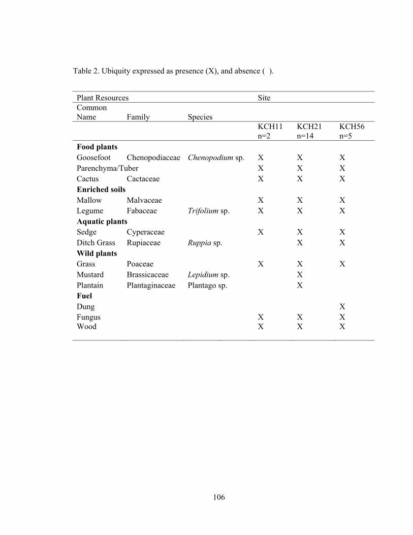
106
Table 2. Ubiquity expressed as presence (X), and absence ( ).
Plant Resources Site Common Name Family Species
KCH11 n=2
KCH21 n=14
KCH56 n=5
Food plants Goosefoot Chenopodiaceae Chenopodium sp. X X X Parenchyma/Tuber X X X Cactus Cactaceae X X X Enriched soils Mallow Malvaceae X X X Legume Fabaceae Trifolium sp. X X X Aquatic plants Sedge Cyperaceae X X X Ditch Grass Rupiaceae Ruppia sp. X X Wild plants Grass Poaceae X X X Mustard Brassicaceae Lepidium sp. X
Plantain Plantaginaceae Plantago sp. X Fuel Dung X Fungus X X X Wood X X X

107
Table 3. Density expressed as taxon/L of analyzed soil.
Plant Resources
Total N=21
Food Plants Cactaceae 0.68 Chenopodium sp. 4.52 Parenchyma/Tuber 4.05 Non-Food Cyperaceae 2.32 Fabaceae 0.46 Lepidium sp. 0.02 Malvaceae 4.32 Plantago sp. 0.11 Poaceae 1.42 Ruppia sp. 0.07 Fungus 0.78 Fuel Dung 0.15 Wood 5.56 Total Density 24.59

108
Table 4. Diversity expressed using the Shannon-Weaver Index calculated by site and context.
Site Context KCH11 n=2
KCH21 n=14
KCH56 n=5
Pit n=11
Hearth n=3
0.51 0.89 0.65 0.89 0.73

109
Appendix B:
Image of Unknown Seeds and Macrobotanical Specimens
Figure 1. Image of Unknown Specimen #1 (locus # 4120/1). This is probably not a seed.
Figure 2. Image of Unknown Specimen #2 (locus # 4120/1). This might be a peduncle but it is very clinkered due to charring.

110
Figure 3. Image of Unknown Specimen #3 (locus # 4120/1). This appears to be part of a seed casing. It is hollowed out on one side.
Figure 4. Image of Unknown Specimen #4 (locus # 4131/1). This might be a Plantago sp. seed, but is very large and clinkered from charring.

111
Figure 5. Image of Unknown Specimen #6 (locus # 4162/1).
Figure 6. Image of Unknown Specimen #7 (locus # 4067/1).

112
Figure 7. Image of Unknown Specimen #8 (locus # 4067/1).
Figure 8. Image of Unknown Specimens #9 (locus # 4067/1). They appear to be grass seeds but under the microscope they look very clinkered.

113
Figure 9. Image of Unknown Specimen #10 (locus # 4121/1).

114
Appendix C: Chenopod Data
Table 1: Chenopod analysis data
Site Locus Seeds without a testa
Testa Diameter (mm)
Testa Thickness
Testa Texture
KCH21 4131/1 34 KCH21 4131/1 Reticulate KCH21 4131/1 1.2 Thick Canaliculate KCH21 4131/1 1.2 Thick Reticulate KCH21 4131/1 1.1 Thick Reticulate KCH21 4131/1 1.1 Reticulate KCH21 4131/1 0.9 Reticulate KCH21 4131/1 1.1 Reticulate KCH21 4131/1 Thin Smooth/canaliculate beak KCH21 4131/1 1.3 Smooth KCH21 4131/1 1.2 Smooth KCH21 4131/1 0.8 Thin Smooth KCH21 4131/1 0.8 Smooth KCH21 4131/1 0.9 Thin Smooth KCH21 4131/1 1 Thin Smooth KCH21 4131/1 0.7 Smooth KCH21 4131/1 0.7 Thin Smooth KCH21 4131/1 1 Thin Smooth KCH21 4131/1 0.9 Smooth KCH21 4131/1 1 Smooth KCH21 4131/1 28 KCH21 4131/1 1.4 Thin Reticulate KCH21 4131/1 1.1 Thin Reticulate KCH21 4131/1 1.2 Reticulate KCH21 4131/1 1.4 Reticulate KCH11 4206/1 3 KCH11 4206/1 1.7 Thick Reticulate KCH56 4162/1 3 KCH56 4162/1 1.2 Thick KCH56 4162/1 1 Thin Smooth KCH21 4121/1 22 KCH21 4121/1 1 Thin Smooth/canaliculate beak KCH21 4121/1 1.1 Smooth/canaliculate beak KCH21 4121/1 1.2 Thin Smooth/canaliculate beak KCH21 4121/1 1.1 Smooth/canaliculate beak KCH21 4121/1 1.1 KCH21 4121/1 1.1 Thin Punctuate KCH21 4121/1 1.4 Thin Reticulate

115
Site Locus Seeds without a testa
Testa Diameter (mm)
Testa Thickness
Testa Texture
KCH21 4121/1 0.8 Thick Smooth KCH21 4121/1 0.9 Thick Smooth KCH21 4121/1 1.2 Thick Smooth KCH21 4121/1 0.7 Smooth KCH21 4121/1 0.7 Thin Smooth KCH21 4121/1 0.9 Thin Smooth KCH21 4121/1 0.8 Thin Smooth KCH21 4121/1 0.9 Thin Smooth
KCH21 4124/4 1.5 Smooth/canaliculate beak
KCH21 4124/4 1.3 Thin Canaliculate KCH21 4124/4 8 1.4 KCH21 4124/4 0.7 Thick Smooth KCH21 4124/4 1 Thick Smooth KCH21 4124/4 1.2 Smooth KCH21 4124/4 1.1 Smooth KCH21 4124/4 1.2 Canaliculate KCH21 4124/4 1.1 Reticulate KCH21 4124/4 1.1 Reticulate KCH21 4124/4 1.2 Reticulate KCH21 4124/4 1 Reticulate KCH21 4124/4 1.3 Reticulate KCH21 4124/4 22 KCH11 4202/1 1 KCH11 4202/1 3 KCH21 4120/1 22 KCH21 4120/1 0.9 Thin Canaliculate KCH21 4120/1 0.6 Smooth KCH21 4120/1 1.1 Thick Smooth KCH21 4120/1 1.1 Thick Reticulate KCH21 4120/1 1.2 Thick Reticulate KCH21 4120/1 1.3 Thick Reticulate KCH21 4120/1 1.1 Thick Reticulate KCH21 4120/1 1 Thick Reticulate
KCH21 4120/1 0.7 Thick Smooth/canaliculate beak
KCH21 4120/1 1 Thick Smooth/canaliculate beak
KCH21 4120/1 1 Thick Smooth/canaliculate beak
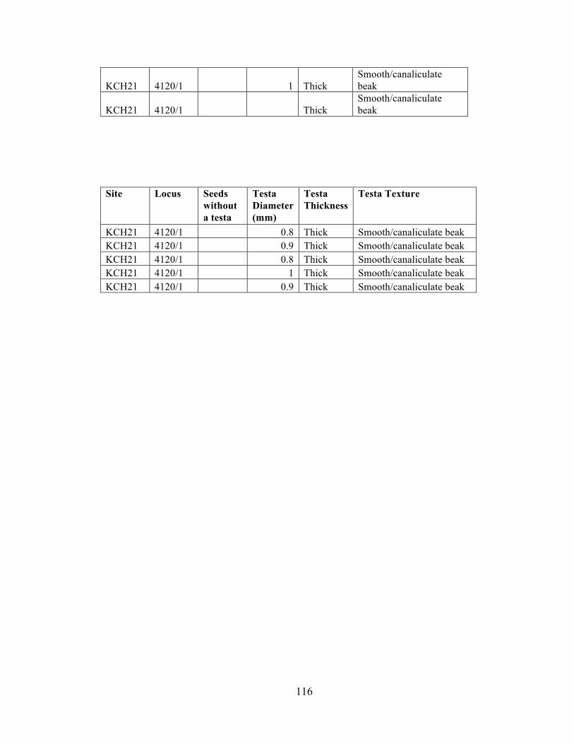
116
KCH21 4120/1 1 Thick Smooth/canaliculate beak
KCH21 4120/1 Thick Smooth/canaliculate beak
Site Locus Seeds without a testa
Testa Diameter (mm)
Testa Thickness
Testa Texture
KCH21 4120/1 0.8 Thick Smooth/canaliculate beak KCH21 4120/1 0.9 Thick Smooth/canaliculate beak KCH21 4120/1 0.8 Thick Smooth/canaliculate beak KCH21 4120/1 1 Thick Smooth/canaliculate beak KCH21 4120/1 0.9 Thick Smooth/canaliculate beak

117
Appendix D
Sorting Form
KCH ___ Flot #____________________
Botanical Analysis Form Locus #__________________
Sorter______________________ Volume__________________
Date Sorted____/_____/2010__ N__________ E__________
Total Weight_________________
> 2.0mm LF Weight_________________
Species Count Weight Notes
Chenopod ____________ _____________ _______________________
Poaceae ____________ _____________ _______________________
Wood ____________ _____________ _______________________
____________ ____________ _____________ _______________________
____________ ____________ _____________ _______________________
____________ ____________ _____________ _______________________
>1.0mm LF Weight_________________
Species Count Weight Notes
Chenopod ____________ _____________ _______________________
Cyperaceae ____________ _____________ _______________________
Fabaceae ____________ _____________ _______________________
Malvaceae ____________ _____________ _______________________
Poaceae ____________ _____________ _______________________
Solanaceae ____________ _____________ _______________________
____________ ____________ _____________ _______________________

118
____________ ____________ _____________ _______________________
____________ ____________ _____________ _______________________
____________ ____________ _____________ _______________________
>0.5mm LF Weight_________________
Chenopod ____________ _____________ _______________________
Cyperaceae ____________ _____________ _______________________
Fabaceae ____________ _____________ _______________________
Malvaceae ____________ _____________ _______________________
Poaceae ____________ _____________ _______________________
Solanaceae ____________ _____________ _______________________
____________ ____________ _____________ _______________________
____________ ____________ _____________ _______________________
____________ ____________ _____________ _______________________
Notes:
________________________________________________________________________
________________________________________________________________________
________________________________________________________________________
________________________________________________________________________
________________________________________________________________________
________________________________________________________________________
________________________________________________________________________
________________________________________________________________________
________________________________________________________________________
________________________________________________________________________