a new approach for the morphological segmentation of high-resolution … › benedikt ›...
TRANSCRIPT
IEEE TRANSACTIONS ON GEOSCIENCE AND REMOTE SENSING, VOL. 39, NO. 2, FEBRUARY 2001 309
A New Approach for the Morphological Segmentationof High-Resolution Satellite Imagery
Martino Pesaresi and Jon Atli Benediktsson, Member, IEEE
Abstract—A new segmentation method based on the morpho-logical characteristic of connected components in images is pro-posed. Theoretical definitions of morphological leveling and mor-phological spectrum are used in the formal definition of a mor-phological characteristic. In multiscale segmentation, this charac-teristic is formalized through the derivative of the morphologicalprofile. Multiscale segmentation is particularly well suited for com-plex image scenes such as aerial or fine resolution satellite images,where very thin, enveloped and/or nested regions must be retained.The proposed method performs well in the presence of both low ra-diometric contrast and relatively low spatial resolution. Those fac-tors may produce a textural effect, a border effect, and ambiguityin the object/background distinction. Segmentation examples forsatellite images are given.
Index Terms—High-resolution satellite imagery, leveling, math-ematical morphology, morphological segmentation.
I. INTRODUCTION
I N THIS paper, a new segmentation method is proposed.The proposed method uses the residuals of morphological
opening and closing transforms based on a geodesic metric.The proposed approach may be considered analogous toregion growing techniques. However, in contrast to the use ofstatistical local properties as in region growing approaches,the proposed method uses a pixel similarity rule based onthe morphological characteristic of connected components inimages. In the proposed approach the morphological residualsbetween the original grey-level function and the compositionof a granulometry and an anti-granulometry by reconstructionare used to build a morphological profile function. Recenttheoretical advances in mathematical morphology, such asthe definitions of leveling and themorphological spectrum,form a theoretical framework for the formal definition of themorphological profile function. This function is interpreted asa fuzzy membership function related to a set of morphologicalcharacteristics of the connected components in the image. Alabeling phase is then formalized using a decision rule basedon the greatest value of the derivative of the morphologicalprofile function.
The proposed approach is different from standard morpholog-ical segmentation approaches which are based on an edge-detec-tion phase (watershed line extraction on a gradient image). The
Manuscript received October 28, 1999; revised May 2000.M. Pesaresi is with the European Commission, Space Applications Insti-
tute, Environmental and Geo-Information Unit, Ispra, Varese, Italy (e-mail: [email protected]).
J. A. Benediktsson is with the Department of Electrical and Computer Engi-neering, University of Iceland, Reykjavik, Iceland (e-mail: [email protected]).
Publisher Item Identifier S 0196-2892(01)01159-7.
proposed method can be applied with both single-scale and mul-tiscale approaches. Therefore, the original contribution of thepaper is the definition of a morphological segmentation method,which avoids gradient computation and can be applied either tosingle-scale or multiscale image processing problems.
The proposed method is particularly well suited for the seg-mentation of complex image scenes such as aerial or fine-res-olution satellite images. In segmentation of such scenes, verythin, enveloped and/or nested regions may have to be retained.Therefore, edge-detection based on gradient computation doesnot perform well for such scenes. The proposed method alsoperforms well in the presence of both low radiometric contrastand relatively low spatial resolution, which may produce a tex-tural effect, a border effect, and ambiguity in object/backgrounddistinction. All these factors are critical and lead to an instabilityeffect if segmentation methods based on an edge-detection ap-proach are applied.
The paper is organized as follows. In Section II, some basicconcepts of the mathematical morphology approach to imageanalysis are reviewed. The general context that justifies the pro-posed method is discussed in Section III. Section IV contains theextension of the region growing approach to multiscale imagesegmentation. Application examples of segmentation processesapplied to satellite images are given in Section V. Finally, con-clusions are drawn in Section VI.
II. I MAGE PROCESSING BY AMORPHOLOGICALAPPROACH
Mathematical morphology is the name of a collection of op-erators based on set theory and defined on an abstract structureknown as an infinite lattice. These operators were first system-atically examined by Matheron and Serra in the 1960s and arean extension of Minkowski’s set theory [1], [2]. Morphologicaloperators include erosion, dilation, opening, closing, rank fil-ters (including median filters), top hat transforms, and other de-rived transforms. These operations can be defined on binary orgreyscale images in any number of dimensions. They can also bedefined with Euclidean (isotropic) or non-Euclidean (geodesic)metrics.
The main application areas for the tools of mathematical mor-phology have been medical imaging, material sciences, and ma-chine vision, where morphological transformations are partic-ularly useful for image analysis and image enhancement. Inthe processing of satellite remote sensing data, mathematicalmorphology has until recently only had sporadic applications.There, it is mainly known for its binary and Euclidean opera-tors that have been used for post-classification procedures like“salt-and-pepper” removal or other visual enhancement proce-dures.
0196–2892/01$10.00 © 2001 IEEE
310 IEEE TRANSACTIONS ON GEOSCIENCE AND REMOTE SENSING, VOL. 39, NO. 2, FEBRUARY 2001
A. Morphological Transforms
1) Definitions and Notation:A complete lattice is a math-ematical structure that can formalize an ordering relation, andthe two basic operations infimum () and supremum (). Fora particular set, the infimum is the greatest lower bound andthe supremum is the smallest upper bound. Now let us considertransformations defined on a complete lattice.
A transformation is called
1) increasingif and only if it preserves order,2) idempotentif and only if ,3) a morphological filter, if it is increasing and idempotent.Following a usual notation, is an underlying digital grid of
any type in the subset of . Also, is the set ofneighbors of a pixel with respect to the grid , andis the morphological transformation of using as a struc-turing element (SE). Since the subgraph of an-dimensionalimage corresponds to a one-dimensional (1-D) set, 1-DSEs can be used to investigate the morphology of-dimensionalimage structures. However, it is often recommended to use-di-mensional SEs in order to be independent from the image greyscaling, and in order to work with faster algorithms. These latterSEs are referred to asflat SEs because they are only of twodimensions in the case of two-dimensional (2-D) images. Onthe contrary, 1-D SEs are calledvolumetric, nonflat, orgreyscaleSEs [3].
2) Euclidean Transforms:Let us assume that we have a flatstructuring element that corresponds to the neighborhood
. Then, the erosion of the grey level function using thestructuring element is defined by the infimum of the valuesof the grey level function in the neighborhood
(1)
Dilation is similarly defined by the supremum of the neigh-boring values and the value of as
(2)
Classically,opening is defined as the result of erosion fol-lowed by dilation using the same SE
(3)
Similarly, closing is defined as the result of dilation followedby erosion with the same SE
(4)
One of the characteristics of opening and closing operatorsis that they erase structures that are smaller than the SE. If agreyscale image is interpreted as a topographical relief, thenopening cuts peaks. In contrast, closing fills valleys that aresmaller than the SE (have a thinner support). This effect canbe observed by the computation of the residual between thefiltered image and the original image in thetop hat transform
(5)
and theinverse top hat(or bot-hat) transform
(6)
B. Different Metrics
Morphological transformations can either use a clas-sical Euclidean metric or a non-Euclidean geodesic metric(with geodesictransforms andreconstructionmorphologicalfiltering). Reconstruction filters form an important class ofmorphological and connected filters [4], [5]. The reconstructionfilters have been proven to be very useful for image processing[6] since they do not introduce discontinuities, and therefore,preserve the shapes observed in input images. In other words,the nonisotropic metric used in morphological transformationsby reconstruction makes these transformations not sensitive tonoise. Another effect of the nonisotropic metric is that their SEis adaptive and does not introduce much shape noise in bothfiltering and detection of structures.
1) Geodesic Transforms:Equations (3) and (4) use anisotropic metric where the shape and size of the SE is a constantfor all points in the domain of , independent of thestructures present in the image. Basic dilation and erosiontransforms can also be formalized with the notion of geodesicdistance. Given a set (or a mask), the geodesic distancebetween two pixels and is the length of the shortest pathin , which joins and . Let be a discreteset and let . Then it is possible to define an elementarygeodesic dilation (and similarly erosion) of inside withan SE of minimal size; SE (defined as only one step inthe grid ). A standard dilation of size one followed by anintersection is defined by
(7)
where is the binary Euclidean dilation of the setusing SE .
In the greyscale case, the geodesic greyscale dilation ofinside based on the elementary SE is the infimum ofthe elementary dilation of and the value of
(8)
For computational purposes, it is interesting to note thatgeodesic dilation of a given size can also be obtained byiterating elementary geodesic dilations
(9)
By duality, similar observations can be made for the erosiontransform.
2) Reconstruction:The reconstruction of fromis obtained by the iterative use of an elementary
geodesic dilation of inside until idempotence is achieved[7]
(10)

PESARESI AND BENEDIKTSSON: MORPHOLOGICAL SEGMENTATION OF HIGH-RESOLUTION SATELLITE IMAGERY 311
For a greyscale image with a flat SE, the union operator in (10)is equivalent to a supremum operation. Then the greyscalere-construction of the image (also called themask) from
(also called themarker) is obtained by the iterative use of el-ementary greyscale geodesic dilations ofunder until idem-potence is reached, i.e.,
(11)
The definition of greyscaledual reconstructionby erosion issimilar to (11). Let and be two greyscale images definedon the same domain and such that . The dual greyscalereconstruction of the image from the image is ob-tained by iterating the greyscale geodesic erosion ofaboveuntil idempotence is reached, i.e.,
(12)
C. Watershed Segmentation
Watershed line detection [8] is the main tool of mathematicalmorphology used for image segmentation. Watershed segmen-tation was introduced in image analysis by Beucher and Lan-tuéjoul [9] and defined mathematically by both Meyer [10] andNajman and Schmitt [11]. However, except for a few simplecases where the target object is brighter than the background orvice versa, watershed segmentation cannot be applied directly.Generally, the method is applied to images that have been trans-formed by a gradient-like operator based on a measure of thelocal slope of the grey level function. Watershed extraction gen-erally means the thinning of a gradient image with a homotopictransformation. It also involves the detection of basins as regionsand crest lines as boundaries for these regions. For these reasons,a watershed approach generally leads to finding the structures inan image based on an edge-detection strategy. The standard ap-proach in watershed segmentation causes severe over-segmen-tation, which may be difficult to overcome. This over-segmen-tation is due on the one hand to the presence of irrelevant localminima and local maxima in the image. On the other hand, it isalso due to the presence of texture effects derived by the spa-tial interaction between the size of the object in the scene andthe spatial resolution of the sensor. Since watershed segmenta-tion depends on gradient calculus, a common (linear) approachto overcome the over-segmentation effect is to filter the inputimage with a low-pass filter prior to gradient extraction. By that,the final number of regions is decreased, but all relevant highfrequency (spatial) information will be lost.
The standard nonlinear solution to the over-segmentationproblem was introduced by Meyer and Beucher [8]. Theirsolution is a marker selection followed with flooding of therelief formed by the gradient obtained from these markers. Themarker detection is the main problem with this approach. Ifthere is no external information available, the marker detectionproblem is generally solved by morphologically filtering(usually by geodesic closing) the gradient image. Then the
filtered gradient is thresholded. In (4), closing is defined bymorphological dilation followed by erosion in (4). Therefore,the watershed-plus-marker approach assumes that the localminima of the gradient, which are smaller (thinner) than theSE, are not relevant. The same applies to grey level edges withvalues less than a given threshold.
All the abovementioned approaches assume that the regionof interest for detection is large and homogenous relative to thespatial and spectral resolution of the sensor. Consequently, theseapproaches are very hard to apply in segmentation of texturedor very complex scenes. They also often lead to results that arenot stable.
III. COMPARISON OFOPENING AND CLOSING BY
RECONSTRUCTION
The segmentation of urban scenes detected by satellite sen-sors is an excellent example of the inadequacy of the large-and-homogeneous region approach. In satellite remote sensing, thespatial resolution of commercial sensors currently reaches 55 to 2 2 m per pixel. For these resolutions, the heterogeneity(different adjacent materials and spectral response) and geo-metrical complexity (small objects, 3-D/shadow effects) of theurban scenes may produce texture effects in images for struc-tures that can be one to two pixels wide. Urban applicationsmay also require the detection of very thin, or complex, elon-gated, and nested structures. At a given sensor resolution wherethere is not a clear distinction between the object and the back-ground, the standard approach to morphological segmentationmay be inadequate. In those situations, any attempt to find somekind of an edge of a structure has as an effect on the productionof “surfaces of edges,” where most of the pixels are connoted as“border pixels.”
It is well known that there are two fundamentally differentstrategies for image segmentation: edge detection and regiongrowing. Even though the standard approach to morphologicalsegmentation is dependent on edge-detection, it is possible toconsider a different morphological approach to the segmenta-tion problem. The idea here is to try to characterize image struc-tures by their morphological intrinsic characteristics instead ofusing their boundaries. In a hypothetical approach using a mor-phological region-growing technique, the border of a detectedstructure can be of size zero, thus avoiding the aforementionedsurface-of-edges problems in segmentation of complex imagery.Therefore, a structure or an “object” in the image could be aconnected component (region of pixels) with the same charac-teristics, measured by some kind of a morphological operator.
It is a common practice to use the opening and closing trans-forms in order to isolate bright (opening) and dark (closing)structures in images, where bright/dark means brighter/darkerthan the surrounding structures in the image. In order to isolatestructures with a thinner support than a given SE, a widely ap-plied technique is to take the residuals of the opening, closing,and original images by thetop hat(5) andinverse top hat(6)transforms. Consequently, the idea is to use a composition ofopening and closing transforms in order to build a definition forthe morphological characteristics.

312 IEEE TRANSACTIONS ON GEOSCIENCE AND REMOTE SENSING, VOL. 39, NO. 2, FEBRUARY 2001
A. Definition of Leveling
The composition of opening and closing operations by recon-struction has recently been formalized asleveling. Leveling wasintroduced in [12]–[14] starting from the combination of twospatially connected operators:monotone planingsand flatten-ings [15]. Applications of leveling techniques include object-oriented image compression, but an important feature of lev-eling is that it can be applied to an original image producing out-puts at different levels of simplification. Object-oriented imagecompression also takes advantage of the fact that after levelingan image only has flat connected components. Leveling tech-niques are well documented in the literature. Therefore, they areonly introduced here briefly for clarification purposes.
From (3), (4), (11), and (12), it is possible to define openingand closing transforms by reconstruction.Opening by recon-structionis obtained by using (11) for the reconstruction of theerosion under the original image. Similarly,closing by recon-struction is obtained by using (12) for dual reconstruction ofthe dilation above the original image. Based on (3) and (11),opening by reconstruction can be defined by
(13)
In a similar fashion, closing by reconstruction can be definedbased on (4) and (12) by
(14)
Opening and closing by reconstruction can be considered aslower-leveling (opening) and upper-leveling (closing)operations [13]. A function is an upper-leveling of a function
if and only if for any couple of connected neighboring pixels( ), the following applies:
(15)
Similarly, a function is a lower-leveling of a function if andonly if for any couple of connected neighboring pixels (),the following applies:
(16)
It is possible to show [14] that all connected components in theupper-leveling function are flat where , while in the lowerleveling, the same occurs where . A function is called aleveling of a function if it is both an upper and lower levelingof .
The algorithm proposed in Meyer [13] for the computation ofleveling requires a preliminary definition of two disjoint setsand . Those two sets delimit two partitions of the image, whereeither reconstruction by opening or reconstruction by closing ofa marker is applied. This is achieved by the use of the minimumvalue in the destination lattice for the opening and the maximumvalue for the closing. Consequently, the leveling is defined by
(17)
The requirement of preliminarily partitioning the image intotwo sets and is the main problem with the leveling ap-proach. That problem is solved in [13] with a marker-gradientflooding method. However, the solution in [13] has the afore-mentioned problems related to the edge-detection approach.Therefore, some alternative solutions are presented in the nextsections.
B. Definition of Morphological Characteristics
Following the approach proposed here, a structure or an“object” in an image is defined as a connected componentof pixels sharing the same morphological characteristics. Anidea proposed here is to use the residuals obtained from theoriginal image and its leveling for a measure of those charac-teristics. The simpler and intuitive taxonomy of morphologicalcharacteristics could, for a given spatial domain, be the set
at concave convex . It is referred to here asthe local curvature of the grey level function surface, where agiven SE determines the spatial domain.
In order to define the morphological characteristics, we pro-pose an alternative to Meyer’s leveling algorithm. We will basethis alternative on fuzzy logic, thus avoiding the problem of theex-ante partition of the two complementary setsand in(17). Let the residuals between any opening by reconstruction(or closing by reconstruction) and their original function be in-terpreted as a measure of the relative brightness of the structure(or relative darkness). Then, one membership functioncan bewritten relative to the class “convex” and another membershipfunction relative to the class “concave”
(18)
(19)
The leveling algorithm can now be rewritten as a decision rulebased on the greatest value of the membership function
(20)In this perspective, given an image with a grey level functionand an SE , the segmented imageof the characteristic can
simply be a tessellation of three different labels like “convex” ,
“concave” , and “flat” as
(21)
For this segmented image, pixels where the lower leveling is
strictly lower than the original imageare labeled , and pixelswhere the upper leveling is strictly greater thanare labeled as
. Pixels labeled have maintained the same value ofin boththe upper and lower leveling. Therefore, those pixels have beenindifferent to the erosion/dilation-reconstruction process with a

PESARESI AND BENEDIKTSSON: MORPHOLOGICAL SEGMENTATION OF HIGH-RESOLUTION SATELLITE IMAGERY 313
Fig. 1. Simulation of the proposed segmentation method over a strip of 31 pixels. (a) Dilation off(x) by a structuring element of five pixels. (b) Erosion off(x)by the same SE as in (a). (c) Upper-leveling off(x) as dual reconstruction of the dilation abovef(x). (d) Lower-leveling off(x) by reconstruction of the erosion
underf(x). (e) Segmentation based on (21) withk = 1, k = � 1, k = 0. (f) Segmentation based on (22) with� = 2.
given SE of size , where can be considered as the spatialdomain of the characteristic function .
1) Softer Object/Background Distinction:In case of uncer-tainty or ambiguity in distinguishing between scene foregroundand background, it is also possible to soften the conditions ofthe morphological characteristics by rewriting (21) as
(22)
for a given level of contrast ( 0). With 0, (21) and(22) are equivalent. On the other hand, by increasing the value of
, the level of necessary contrast is increased in order to avoidthe labeling of the pixels with the “flat” label. Thus, the level
could be interpreted as a threshold used in distinguishing be-tween the foreground and background of the image.
C. Example
In Fig. 1, the application of the proposed method is shown fora strip of 31 pixels having associated signal values in the discreterange [1, , 10]. Fig. 1(a) and (b) shows the selection phasefor the dilation [Fig. 1(a)] and erosion [Fig. 1(b)] markers of the
original grey level function. Fig. 1(c) and (d) show the dual re-construction of the dilation and the reconstruction of the erosionas upper-leveling [Fig. 1(c)] and lower-leveling [Fig. 1(d)] of theoriginal function. Fig. 1(e) and (f) represent the segmentation ofthe original function with 0 [Fig. 1(e)] and 2 [Fig. 1(f)],
where 1, 1, 0. Note that pixels with indicesfrom 11 to 14 are strictly flat at the given size of SE (five pixels).Also, note the increase of the size of the flat areas with the in-creasing value of . Pixels with indices from four to ten showa low contrast for this SE size. They are assigned a “flat” labelif the value of is augmented. Because of the nonlinear natureof this approach, structures that have a greater contrast thanmaintain exactly the same behavior in the segmentation (pixelswith indices from 18 to 31). This mechanism can be useful ifwe want, for a given spatial domain, to distinguish the responsedue to the presence of structures in an image from the signalproduced by noise.
IV. M ULTISCALE EXTENSION
As described previously, segmentation using residuals ob-tained from the original grey level function and a compositionof operations of opening and closing by reconstruction requiresthe definition of the spatial domain where the method is applied

314 IEEE TRANSACTIONS ON GEOSCIENCE AND REMOTE SENSING, VOL. 39, NO. 2, FEBRUARY 2001
in terms of a SE size. Some structures may have a high responsefor a given SE size and a lower response for other SE sizes. Thatdepends on the interaction between the SE size and the size ofthe structure. Sometimes we know ex-ante the size of the struc-tures that is to be detected. However, that is often not possible,and then a single-SE-size approach appears to be too simplistic.Therefore, it may be a good idea to use a range of different SEsizes in order to explore a range of different hypothetical spa-tial domains. Consequently, the best response of the structuresin the image will be used for segmentation. Given our proposedsegmentation method, it is straightforward to extend the sameconcept to multiscale processing.
Theoretically, the intuitive idea of multiscale morphologicalcharacteristics can be interpreted as a variation of the notion ofa morphological spectrum. It can be defined as an extension oftheopening spectrumstudied by Haralicket al. [16] or thepat-tern spectrumdefined in Maragos [17]. Both are based on thedefinition of some kind of granulometry [18] for the openingspectrum. This means that an image sequence is created by thecomputation of the differences between successive images ina granulometry generated by a flat SE family with an integralindex set. Applications of variations of the morphological spec-trum have been proposed for image noise reduction [19] andpseudo band-pass image decomposition [20].
The definition of leveling is stricter than that of the morpho-logical spectrum. The reason is that leveling requires openingand closing operations made by reconstruction. In contrast, themorphological spectrum can also be extracted by compositionof Euclidean opening and closing operations. Given the afore-mentioned theoretical similarities, the idea of the multiscale seg-mentation based on the derivative of the morphological profile(DMP) is developed in the following section.
A. Definition
Let the vector be theopening profileat the point ofthe image defined by
(23)
and let the vector be theclosing profileat the point ofthe image defined by
(24)
Herefor 0 by the definition of opening and closing by recon-struction. Given (23) and (24), the opening profile can also bedefined as a granulometry made with opening by reconstruction,while the closing profile can be defined as an antigranulometrymade with closing by dual reconstruction. The derivative of themorphological profile is defined as a vector where the measureof the slope of the opening-closing profile is stored for everystep of an increasing SE series.
The derivative of the opening profile is defined as thevector
(25)
By duality, the derivative of the closing profile is thevector
(26)In general, the derivative of the morphological profile , orthe DMP can be written as the vector
(27)
for an arbitrary integer with equal to the total number ofiterations.
Given all of the above, the morphological multiscale charac-teristic of the image at the point can be defined as the SEsize with the greatest associated value in the followingfunc-tion:
(28)Equation (28) can be rewritten in order to maintain informa-
tion about the type of structure that is to be detected. In orderto do that, themultiscale-opening characteristic of theimage at the point can be defined by
(29)
Similarly, themultiscale-closing characteristiccan be definedby
(30)
With these definitions, an algorithm for multiscale segmentationof the image , based on its characteristic, can be written by ageneralization of (21) and (22) as
(31)
In (31), the label of the morphological characteristic is theiteration code of the opening or closing series that correspondto the greatest value of the derivative. If this greatest derivativevalue is strictly equal for both the opening and the closing series,the “flat” label is applied. In this sense, an image structure is aset of connected pixels or a connected component with the samevalue of . The function takes the following values.
1) In the range in case of prevalently“convex” regions.
2) In the range in case of prevalently“concave” regions.
3) 0 in case of prevalently “flat” or morpho-logically “indifferent” regions for all the used sizes of
.Finally, in a similar fashion to what was done when (22) was
derived, (31) can be extended for the case of a contrast thresholdfor a structure
(32)

PESARESI AND BENEDIKTSSON: MORPHOLOGICAL SEGMENTATION OF HIGH-RESOLUTION SATELLITE IMAGERY 315
Fig. 2. Derivative of the morphological profile relative to different points in a densely built-up area. (a) Original piece of IRS-1C satellite scenewith 5� 5 m ofspatial resolution. (b) Commercial building. (c) Small street (d) Residential building. (e) Small green area.
Fig. 3. Morphological decomposition of the image in Fig. 2 by using the derivative of the opening and closing profiles. The images have been visually enhanced.The derivative has been calculated relative to a series generated by six iterations of the elementary SE (size= 3� 3 pixels).
B. Example
Thegeneralideaunderlyingtheproposedsegmentationmethodis that the derivative curve is some type of a structural ormorphologicalsignature thatcanbeusedfor thepixeldiscrimina-tion by morphological criteria. The structural or morphologicalsignature is analogous to the spectral signature approach of themultispectral satellite images. Figs. 2 and 3 show the multiscalederivative of the morphological profile for a small sample ofsatellite image from a densely built-up area (sensor: IRS-1Cpanchromatic, 5 5 m of spatial resolution). In this example, arangeofsizesofSEswasused.Thisrangewasderivedbasedonsix
iterationsoftheelementaryeight-connectedSE[using(9)],whichproducesaSEsizerangefrom33upto13 13pixels.
Fig. 2 shows the derivative curve for four representative ob-jects: a commercial building, a street inside urban texture, aresidential building, and a green area. The histograms on theright show the level of the derivative relative to the opening andclosing series for every step of the iteration. Note how the be-havior of the derivative curve stores information aboutboth the type and the size of the connected components insidethe image. Connected components that are brighter than theiradjacent components have a function that is unbalanced tothe right (opening series), while darker connected components

316 IEEE TRANSACTIONS ON GEOSCIENCE AND REMOTE SENSING, VOL. 39, NO. 2, FEBRUARY 2001
Fig. 4. (Top) Portion of an IRS-1C panchromatic scene over a densely built-up area from Milan, Italy (1998, ANTRIX, SIE, Euromap). (Bottom) The histogramof the IRS-1C image. The image covers an area of 4� 4 km with a resolution of 5� 5 m (800� 800 pixels). The image has been enhanced for visualization bymin–max histogram stretching.
show a function that is unbalanced to the left (closing se-ries). The point where takes the maximum value is usedto record the size of SE, which gives maximum response. Con-sequently, this point gives a good indication of the size of thestructure in the given spatial domain range, which can be usedin the definition of the proposed . That is in contrast tothe decomposition of electromagnetic signals by spectral slices,which is common for multispectral images. It can be noted inFig. 3 how the proposed multiscale derivative approach decom-poses the image by the morphological criteria.
V. APPLICATIONS
A. Previous Experiments
The idea to use a composition of opening transforms fora morphological segmentation of satellite data was proposedsome time ago for the detection of different urban structures[21], [22]. In the experiments in [21], [22], segmentation labelswere obtained after the arithmetic summing of an openingseries with an increasing SE. The method is only applicableto Boolean maps (binary or 2 grey-level images), and it does
PESARESI AND BENEDIKTSSON: MORPHOLOGICAL SEGMENTATION OF HIGH-RESOLUTION SATELLITE IMAGERY 317
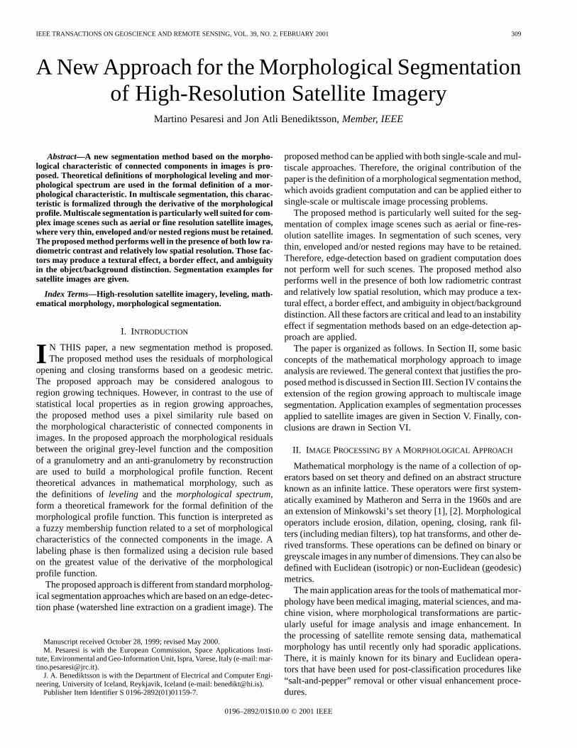
Fig. 5. Segmentation of the image in Fig. 4 by single-scale leveling (21). The
utilized SE is an octagon of diameterd = 35 m (seven pixels) withk = white,
k = black, andk = medium grey.
not use geodesic metric. More recently, Pesaresi and Kanel-lopoulos [23] used a composition of geodesic opening andclosing operations of different sizes in order to build a mor-phological profile. Then, they used a neural network approachfor the classification of structures. The difference betweentheir method and the method proposed here is that in [23], theabsolute residual between the original image and the opened orclosed one was used as a morphological characteristic function.Therefore, the method in [23] cannot be used for multiscalesegmentation since it limits the explored spatial domain by arestraint range of SEs. The method proposed here is both moregeneral and more robust than all the methods above. That willbe demonstrated by the following application examples.
B. Application Examples
Examples of the application of the proposed method are nowgiven for the segmentation of two satellite high-resolution datasets. The satellite imagery is taken from a densely built-up area(Milan, Italy) and from an agricultural area connoted by scat-tered settlement (NE of Athens, Greece). Both data sets wererecorded by the IRS-1C panchromatic sensor, which has groundspatial resolution of 5 5 m . The images used in the experi-ments are a sub-sample of 800800 pixels (4 km 4 km) ofsurface from an original scene of about 15 00015 000 pixels(75 km 75 km).
1) Example 1: Fig. 4 shows the subsampled image fromMilan. It is easy to note the relatively poor dynamic range of thedata recorded by the sensor. As a consequence, the frequencyhistogram is concentrated around grey level 50. Relevantobjects in urban remote sensing applications, such as buildings
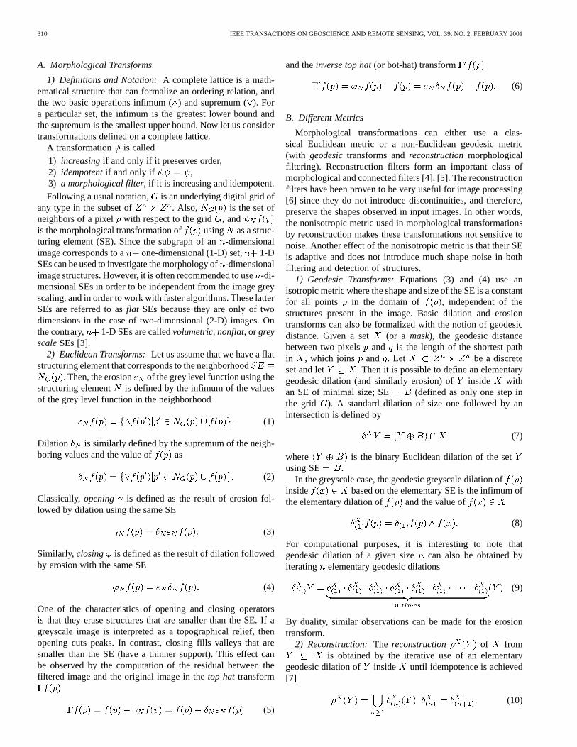
Fig. 6. Portion of IRS-1C panchromatic scene over an agricultural andscattered settlement area NE of Athens, Greece, 1998 (ANTRIX, SIE,Euromap). The image covers an area of 4� 4 km with a resolution of 5� 5m meters (800� 800 pixels). The image has been enhanced for visualizationby min–max histogram stretching.
and streets, can have a thickness of 1 to 2 pixels in images witha comparable resolution to the resolution of this image. Mostof the pixels in such images are placed between the bordersof different ground objects. Therefore, the dynamic rangecan be critical if it is needed to apply standard morphologicalsegmentation based on contour detection.
Fig. 5 shows the results of the application of the proposedmethod for segmentation. In this experiment, the single-scaleapproach in (21) was used. Consequently, the reconstruction ofthe erosion under the original image and the dual reconstructionof the dilation above the original image were composed usingonly one SE size. Both erosion and dilation were done with aSE equal to an octagon of diameter 7 pixels (35 m on theground), which is close in dimension to the most relevant ob-jects in the scene (buildings, roads). White, black, and medium
grey pixels were labeled by the segmentation procedure as,
, and , respectively. By looking at Fig. 5, it can be noted thatthe segmentation method appears to correctly detect most of therelevant regions. In the figure, the urban structure is well high-lighted even though it is very complex. It is also interesting thatbuildings generally appear labeled as radiometric “convex” cur-vature, while roads appear to be labeled as radiometric “con-cave” curvature. This can be useful for a successive automaticclassification phase. Finally, note that most of the commercialbuildings on the bottom right of the image have been labeled asradiometric “flat.” That occurred because the dimension of theutilized SE is smaller than the size of the object.
2) Example 2: Fig. 6 shows the subsampled image from ascattered settlement on the N-E of Athens, Greece. It is easy
318 IEEE TRANSACTIONS ON GEOSCIENCE AND REMOTE SENSING, VOL. 39, NO. 2, FEBRUARY 2001
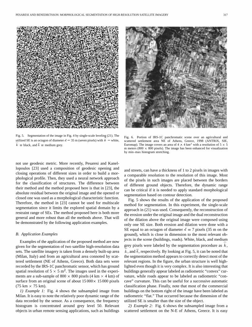
to note the co-presence in the scene of objects/regions of dif-ferent sizes. As a consequence, the multi-scale approach de-fined in (31) was applied. Fig. 7 shows the segmentation results.The spatial domain explored in this experiment was given by arange of 10 increasing octagonally-shaped SE’s with a diam-eter ranging from 7 pixels (45 meters) up to 61 pixels (305 me-ters). The step from iteration to iteration was equal to6 pixels (30 m.). Consequently, the final number of labels was
, including the “flat” label. In Fig. 7, thefunction took values as follows:
1) In the range in case of prevalently“convex” regions.
2) In the range in case of prevalently“concave” regions.
3) 0 in case of prevalently “flat” or morpholog-ically “indifferent” regions for all the used sizes of SE[1,
10].In the segmented image, both large regions and small ones
were retained without an undesired loss of detail. Similarfindings were observed for nested, thin, and complex regions.It is interesting to note that the proposed multiscale approachseemed to have a hierarchical effect. Large regions appear tohave the same label. Also, no over-segmentation effect wasdetected due to the presence of nonrelevant local minima andlocal maxima, which is usual in classical segmentation by thewatershed approach.
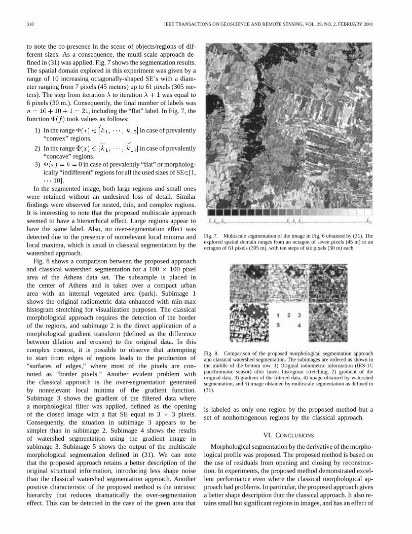
Fig. 8 shows a comparison between the proposed approachand classical watershed segmentation for a 100100 pixelarea of the Athens data set. The subsample is placed inthe center of Athens and is taken over a compact urbanarea with an internal vegetated area (park). Subimage 1shows the original radiometric data enhanced with min-maxhistogram stretching for visualization purposes. The classicalmorphological approach requires the detection of the borderof the regions, and subimage 2 is the direct application of amorphological gradient transform (defined as the differencebetween dilation and erosion) to the original data. In thiscomplex context, it is possible to observe that attemptingto start from edges of regions leads to the production of“surfaces of edges,” where most of the pixels are con-noted as “border pixels.” Another evident problem withthe classical approach is the over-segmentation generatedby nonrelevant local minima of the gradient function.Subimage 3 shows the gradient of the filtered data wherea morphological filter was applied, defined as the openingof the closed image with a flat SE equal to 3 3 pixels.Consequently, the situation in subimage 3 appears to besimpler than in subimage 2. Subimage 4 shows the resultsof watershed segmentation using the gradient image insubimage 3. Subimage 5 shows the output of the multiscalemorphological segmentation defined in (31). We can notethat the proposed approach retains a better description of theoriginal structural information, introducing less shape noisethan the classical watershed segmentation approach. Anotherpositive characteristic of the proposed method is the intrinsichierarchy that reduces dramatically the over-segmentationeffect. This can be detected in the case of the green area that
Fig. 7. Multiscale segmentation of the image in Fig. 6 obtained by (31). Theexplored spatial domain ranges from an octagon of seven pixels (45 m) to anoctagon of 61 pixels (305 m), with ten steps of six pixels (30 m) each.
Fig. 8. Comparison of the proposed morphological segmentation approachand classical watershed segmentation. The subimages are ordered as shown inthe middle of the bottom row. 1) Original radiometric information (IRS-1Cpanchromatic sensor) after linear histogram stretching, 2) gradient of theoriginal data, 3) gradient of the filtered data, 4) image obtained by watershedsegmentation, and 5) image obtained by multiscale segmentation as defined in(31).
is labeled as only one region by the proposed method but aset of nonhomogenous regions by the classical approach.
VI. CONCLUSIONS
Morphological segmentation by the derivative of the morpho-logical profile was proposed. The proposed method is based onthe use of residuals from opening and closing by reconstruc-tion. In experiments, the proposed method demonstrated excel-lent performance even where the classical morphological ap-proach had problems. In particular, the proposed approach givesa better shape description than the classical approach. It also re-tains small but significant regions in images, and has an effect of

PESARESI AND BENEDIKTSSON: MORPHOLOGICAL SEGMENTATION OF HIGH-RESOLUTION SATELLITE IMAGERY 319
intrinsic hierarchy that reduces dramatically the over-segmenta-tion problem of the classical approach.
The drawback of the proposed method concerns the necessityof looking at a range of increasing opening and closing by recon-struction operations, which may cause a heavy computationalburden. As a consequence, for images with very large and homo-geneous regions, it is possible that a gradient-plus-watershed ap-proach may be more efficient, since it does not need to explore avery wide range of different SE sizes. For the above reasons, themethod presented here is particularly suited for segmentation ofcomplex image scenes such as aerial or satellite images wherevery thin, enveloped, and/or nested regions must be retained. Itis also well suited for images with low radiometric contrast andrelatively low spatial resolution, which produce textural effects,border effects, and ambiguity in the object/background distinc-tion. All these factors are critical and can lead to instability ef-fects if segmentation methods based on the edge-detection ap-proach are used.
Currently, our work is focused on the extension of the pro-posed approach by improving the morphological characteristicdetection. The proposed formula for the morphological charac-teristic assumes a “simple” behavior of the morphological pro-file where each structure is supposed to have only one significantderivative maximum. In more complex environments, it is pos-sible that some structures may have more than one significantderivative maximum. These complex environments can have agreater explored spatial domain range, occurrence of nested re-gions at different grey levels, and/or presence of spatial period-icity. In these cases, it is possible to make the characteristic func-tion more sophisticated by using any distribution-free classi-fication procedures such as neural network classifiers.
ACKNOWLEDGMENT
The authors would like to thank C. Lavalle of the EC JRCSpace Applications Institute, SSSA Unit, for providing theIRS-1C data used in the Milano experiment.
REFERENCES
[1] J. Serra,Image Analysis and Mathematical Morphology. London,U.K.: Academic, 1982.
[2] , “Introduction to mathematical morphology,”Comput. Vis.,Graph., Image Process., vol. 35, pp. 283–305, 1986.
[3] P. Soille, Morphological Image Analysis: Principles and Applica-tions. Berlin, Germany: Springer-Verlag, 1999.
[4] J. Serra and P. Salembier, “Connected operators and pyramids,”Proc.SPIE, vol. 2030, pp. 65–76, 1993.
[5] J. Crespo, J. Serra, and R. Schafer, “Theoretical aspects of morpholog-ical filters by reconstruction,”Signal Process., vol. 47, pp. 201–225,1995.
[6] P. Salembier and J. Serra, “Multiscale image segmentation,” inProc.SPIE, vol. 1818, 1992, pp. 620–631.
[7] L. Vincent, “Graphs and mathematical morphology,”Signal Process.,no. 16, pp. 365–388, 1989.
[8] F. Meyer and S. Beucher, “Morphological segmentation,”J. Vis.Commun. Image Represent., vol. 11, pp. 21–46, 199.
[9] S. Beucher and C. Lantuejoul, “Use of watersheds in contour detection,”in Int. Workshop Image Processing, Real-Time Edge and Motion Detec-tion/Estimation. Rennes, France: CCETT/IRISA, Sept. 1979.
[10] F. Meyer, “Integrals, gradients and watershed lines,” inProc. Mathemat-ical Morphology and Its Applications to Signal Processing, Barcelona,Spain, May 1993, pp. 70–75.
[11] L. Najman and M. Schmitt, “Definition and some properties of the wa-tershed of a continuous function,” inProc. Mathematical Morphologyand Its Applications to Signal Processing, Barcelona, Spain, May 1993,pp. 75–81.
[12] F. Meyer, “Morphological connected mapping with scale space prop-erties,” Tech. Rep., Centre Morphologie Math., Fontainebleau, France,1997.
[13] , “From connected operators to levelings,” inMathematical Mor-phology and Its Applications to Image and Signal Processing, H. J. A.M. Heijmans and B. T. M. Roerdink, Eds. Dordrecht, The Netherlands:Kluwer, 1998, pp. 191–198.
[14] , “The levelings,” inMathematical Morphology and its Applica-tions to Image and Signal Processing, H. J. A. M. Heijmans and B.T. M. Roerdink, Eds. Dordrecht, The Netherlands: Kluwer, 1998, pp.199–206.
[15] G. Matheron, “Les nivellements,” Tech. Rep., Centre MorphologieMath., Fontainebleau, France, 1997.
[16] R. M. Haralick, E. R. Dougherty, and P. L. Katz, “Model-based mor-phology: The opening spectrum,” inin Advances in Image Analysis, Y.Mahavieh and R. C. Gonzales, Eds. Bellingham, WA: SPIE, 1992.
[17] P. Maragos, “Pattern spectrum and multiscale shape representation,”IEEE Trans. Pattern Anal. Machine Intell., vol. 11, pp. 701–716, 1989.
[18] E. J. Kraus, H. J. A. M. Heijmans, and E. R. Dougherty, “Greyscalegranulometries compatible with spatial scaling,”Signal Process., vol.34, pp. 1–17, 1993.
[19] R. A. Peters, “A new algorithm for image noise reduction usingmathematical morphology,”IEEE Trans. Image Processing, vol. 4, pp.554–568, 1995.
[20] , “Morphological pseudo bandpass image decomposition,”J. Elec-tron. Imag., vol. 5, pp. 198–213, 1996.
[21] M. Pesaresi, “Analisi numerica dello spazio edificato nella città diffusa,”Tech. Rep., IUAV DAEST, Venice, Italy, 1993.
[22] A. Bianchin and M. Pesaresi, “Outils de morphologie mathématique ap-pliquée aux images satellite pour l’analyze de l’urbanization diffuse,”in Proc. Conf. EGIS-MARI 94, Paris, France, Mar. 29–Apr. 1, 1994, pp.2085–2094.
[23] M. Pesaresi and I. Kannellopulos, “Detection of urban features usingmorphological based segmentation and very high resolution remotelysensed data,” inMachine Vision and Advanced Image Processing inRemote Sensing, I. Kanellopoulos, G. G. Wilkinson, and T. Moons,Eds. Berlin, Germany: Springer-Verlag, 1999, pp. 271–284.
Martino Pesaresi received the M.A. degree in townand regional planning (“Tesi di Laurea in Urbanis-tica”) from the Istituto Universitario di Architetturadi Venezia (IUAV), Venice, Italy, in 1992.
From 1993 to 1997, he worked as IndividualConsultant, specializing in the application of G.I.S.and remote sensing technologies in the fields ofurban analysis and urban planning. In particular, hecollaborated on a variety of research projects andteaching activities with IRES, the former CentroInterdipartimentale di Cartografia e Fotogrammetria
(CICaF), the Dipartimento di Analisi Economica e Sociale del Territorio(DAEST), and the Dipartimento di Urbanistica (DU) of the IUAV, and theDipartimento di Progettazione Urbanistica (DPU), Pescara University, Pescara,Italy. Since 1996, he has been a Lecturer of Spatial Statistics, Corso di Diplomain Sistemi Informativi Territoriali (CDSIT), IUAV. Among others, he has hadadvice activity with the Veneto Region Administration, Italy, the Master Planof Durazzo, Albania, and the Master Plan of El Salvador, El Salvador. Othercollaborations with private companies include INSIEL S.P.A., Udine, Italy, andT.S.A. S.R.L., Padova, Italy, for design and implementation of advanced imageprocessing procedures, and GRETA Econometrics S.R.L., Venice, Italy, fordesign of G.I.S.-based geomarketing product. Since 1998, he has been workingwith a research contract at the European Commission, Space ApplicationsInstitute, Environment and Geo-information Unit, Ispra, Italy. His researchinterests are pattern analysis, mathematical morphology, image fusion, andvisualization applied to high resolution remotely sensed data.
Mr. Pesaresi received the ERASMUS study grant from the Centre d’Analyzeet de Mathématique Sociales (CAMS) of the École des Hautes Etudes enSciences Sociales (EHESS), Paris, France, from 1991 to 1992, and theCOMETT study grant from the Laboratoire d’Informatique Appliquée (LIA)of the ORSTOM, paris, France, from 1992 to 1993.

320 IEEE TRANSACTIONS ON GEOSCIENCE AND REMOTE SENSING, VOL. 39, NO. 2, FEBRUARY 2001
Jon Atli Benediktsson (S’84–M’90–SM’99)received the cand. scient. degree in electrical engi-neering from the University of Iceland, Reykjavik, in1984, and the M.S.E.E. and Ph.D. degrees from theSchool of Electrical Engineering, Purdue University,West Lafayette, IN, in 1987 and 1990, respectively.
He is currently Professor of electrical and com-puter engineering, University of Iceland, and waswith the University’s Laboratory for InformationTechnology and Signal Processing from 1984 to1985. From 1985 to 1991, he was affiliated with
the School of Electrical Engineering and the Laboratory for Applications ofRemote Sensing (LARS), Purdue University. He has held visiting positionswith the Joint Research Centre, European Commision, Ispra, Italy, Denmark’sTechnical University (DTU), Lyngby, Denmark, and the School of Electricaland Computer Engineering, Purdue University. His research interests are inpattern recognition, neural networks, remote sensing, image processing, andsignal processing, and he has published extensively in those fields.
Dr. Benediktsson received the 1991 Stevan J. Kristof Award from LARS asoutstanding graduate student in remote sensing, and from 1996 to 1999, heserved as the Chairman of the IEEE Geoscience and Remote Sensing Society’sTechnical Committee of Data Fusion. He was the recipient of the 1997 IcelandicResearch Council’s Outstanding Young Researcher Award. He is an AssociateEditor of the IEEE TRANSACTIONS ONGEOSCIENCE ANDREMOTE SENSING. Heis a member of the International Neural Network Society (INNS) and Tau BetaPi.