a more detailed definition of each alternative, including ... process, ... this allows both fta and...
TRANSCRIPT

May 2012 2-12-1
2.0 Alternatives ConsideredThe National Environmental Policy Act (NEPA) of 1969 requires a comparisonof alternatives to satisfy a project’s purpose and need. Additionally, the FTANew Starts/Small Starts Program requires an alternatives analysis to supportthe selection of a Locally Preferred Alternative (LPA). As part of the projectdevelopment process, FTA requires the development of a TransportationSystems Management (TSM) alternative that can serve as a baseline alternativefor comparison to the proposed build alternative. A TSM alternative providesfor modest investments that can improve the existing transit system withouthigher capital investments. This allows both FTA and decision-makers anopportunity to compare alternatives to see if similar transit benefits can beachieved with a lower capital investment.
To meet both the NEPA and New Starts/Small Starts requirements, theColumbia Pike Transit Initiative is evaluating four alternatives, ranging ininvestment levels, which seek to address the transportation needs of thecorridor. The alternatives include:
No Build AlternativeTSM 1 Alternative – Enhanced BusTSM 2 Alternative – Articulated BusStreetcar Build Alternative
This chapter is organized into two parts. The first section provides descriptivedefinitions of the alternatives, including their physical and operationalcharacteristics as well as estimated capital and operations costs. The secondsection describes the previously considered Streetcar Build Alternative DesignOptions, related to the western terminus.
2.1 Definition of AlternativesThis section describes the four evaluated alternatives: No Build, TSM 1, TSM 2,and Streetcar Build. Table 2.1-1 provides a brief summary of the keycharacteristics associated with each alternative, while Table 2.1-3 provides amore detailed comparison of the transit characteristics of each alternative.
The No Build Alternative includes all existing and future transit and highwaytransportation facilities and projects anticipated to be operational by the year2030. The TSM Alternatives are intended to provide mobility improvementswithout constructing a new transit guideway. Lower-cost investmentimprovements to improve transit bus service could include, re-routing ofexisting bus routes and consolidation of bus stops along the alignment. Forpurposes of this project, two TSM Alternatives are presented for evaluationand differ in terms of fare collection, vehicle capacity, and station stopamenities. Lastly, the Streetcar Build Alternative proposes a fixed guidewaysolution to address the corridor transportation needs.
A more detailed definition of each alternative, including additionaloperational and physical characteristics of each alternative, is available inVolume II: Detailed Definition of Alternatives Technical Memorandum.
Table 2.1-1: Overview of AlternativesNo
Build TSM 1 TSM 2Streetcar
BuildPlanned Service EnhancementsIncreased Span of ServiceConsolidated Stop Locationsalong Columbia PikeImproved Service Coverage (toand from Skyline)Off-vehicle Fare Collection andMulti-door BoardingIncreased Vehicle PassengerCapacityFull Program of Stop Upgrades(Including transfer center andnear- level boarding)Rail Vehicles and AssociatedPerformance Characteristics
2.1.1 No Build AlternativeNEPA requires consideration of a No Build Alternative to provide a basis forcomparison of the alternatives. The No Build Alternative includes existinghighway and transit networks, plus committed transportation improvementswithin the corridor. These transportation improvements are listed in thefollowing documents:
Metropolitan Washington Council of Governments (MWCOG) 2009Financially Constrained Long-Range Transportation Plan (CLRP) forthe National Capital Region;MWCOG FY2010-2015 Transportation Improvement Program (TIP) forthe Washington Metropolitan Region;Fairfax County’s FY2010-FY2014 CIP;Arlington County’s FY2009-FY2014 Capital Improvement Program(CIP);Arlington County Columbia Pike Multimodal Street ImprovementsProject 2011; andArlington County Columbia Pike Super Stops Program 2011.
Any such improvements that are anticipated to occur by 2030, the projecthorizon year, whether physical or operational, are assumed to be part of theNo Build Alternative. Improvements anticipated to occur by 2015 are alsoidentified to serve as a basis for comparison for the Streetcar Build Alternativein its opening year. All projects included in the No Build Alternative are listedand described in Table 2.1-2.
Columbia Pike Transit Initiative Alternatives Analysis/Environmental Assessment – Volume I2-2
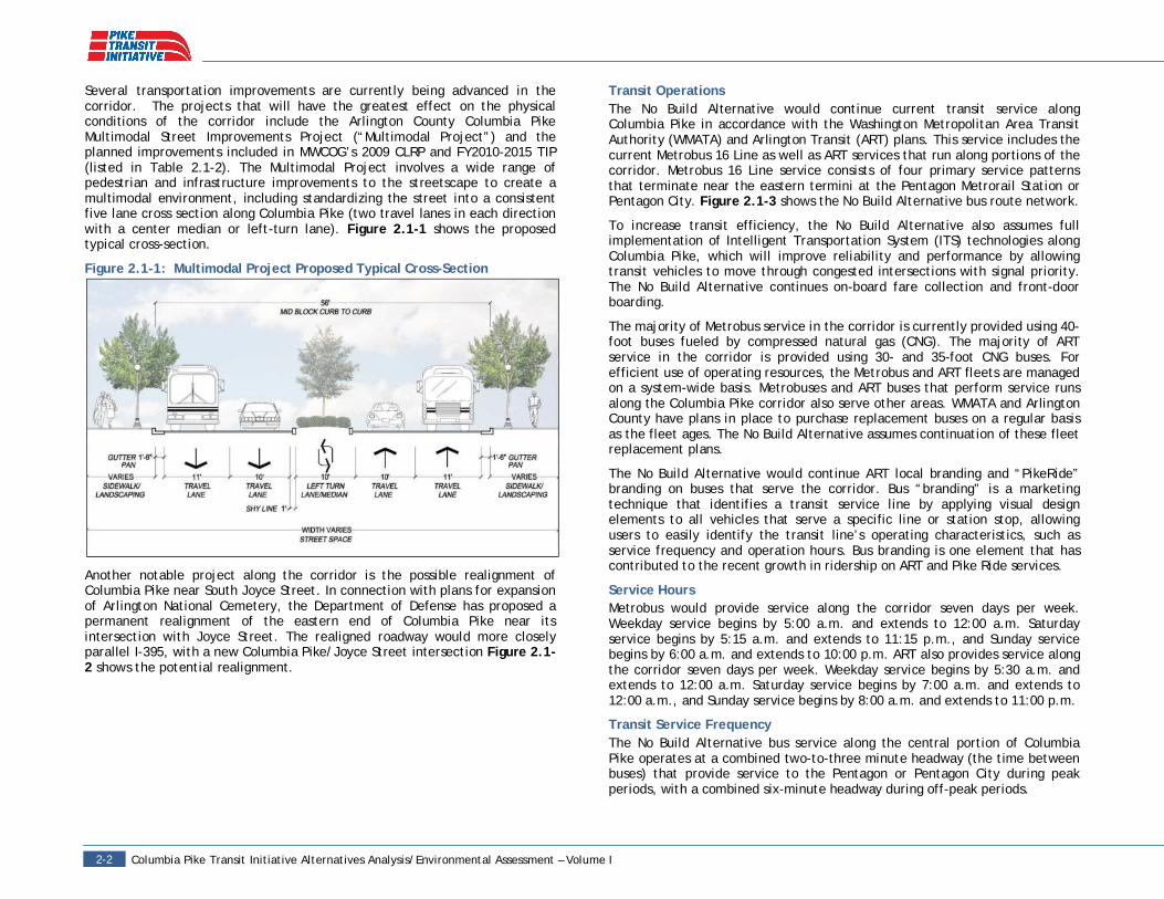
Several transportation improvements are currently being advanced in thecorridor. The projects that will have the greatest effect on the physicalconditions of the corridor include the Arlington County Columbia PikeMultimodal Street Improvements Project (“Multimodal Project”) and theplanned improvements included in MWCOG’s 2009 CLRP and FY2010-2015 TIP(listed in Table 2.1-2). The Multimodal Project involves a wide range ofpedestrian and infrastructure improvements to the streetscape to create amultimodal environment, including standardizing the street into a consistentfive lane cross section along Columbia Pike (two travel lanes in each directionwith a center median or left-turn lane). Figure 2.1-1 shows the proposedtypical cross-section.
Figure 2.1-1: Multimodal Project Proposed Typical Cross-Section
Another notable project along the corridor is the possible realignment ofColumbia Pike near South Joyce Street. In connection with plans for expansionof Arlington National Cemetery, the Department of Defense has proposed apermanent realignment of the eastern end of Columbia Pike near itsintersection with Joyce Street. The realigned roadway would more closelyparallel I-395, with a new Columbia Pike/Joyce Street intersection Figure 2.1-2 shows the potential realignment.
Transit OperationsThe No Build Alternative would continue current transit service alongColumbia Pike in accordance with the Washington Metropolitan Area TransitAuthority (WMATA) and Arlington Transit (ART) plans. This service includes thecurrent Metrobus 16 Line as well as ART services that run along portions of thecorridor. Metrobus 16 Line service consists of four primary service patternsthat terminate near the eastern termini at the Pentagon Metrorail Station orPentagon City. Figure 2.1-3 shows the No Build Alternative bus route network.
To increase transit efficiency, the No Build Alternative also assumes fullimplementation of Intelligent Transportation System (ITS) technologies alongColumbia Pike, which will improve reliability and performance by allowingtransit vehicles to move through congested intersections with signal priority.The No Build Alternative continues on-board fare collection and front-doorboarding.
The majority of Metrobus service in the corridor is currently provided using 40-foot buses fueled by compressed natural gas (CNG). The majority of ARTservice in the corridor is provided using 30- and 35-foot CNG buses. Forefficient use of operating resources, the Metrobus and ART fleets are managedon a system-wide basis. Metrobuses and ART buses that perform service runsalong the Columbia Pike corridor also serve other areas. WMATA and ArlingtonCounty have plans in place to purchase replacement buses on a regular basisas the fleet ages. The No Build Alternative assumes continuation of these fleetreplacement plans.
The No Build Alternative would continue ART local branding and “PikeRide”branding on buses that serve the corridor. Bus “branding” is a marketingtechnique that identifies a transit service line by applying visual designelements to all vehicles that serve a specific line or station stop, allowingusers to easily identify the transit line’s operating characteristics, such asservice frequency and operation hours. Bus branding is one element that hascontributed to the recent growth in ridership on ART and Pike Ride services.
Service HoursMetrobus would provide service along the corridor seven days per week.Weekday service begins by 5:00 a.m. and extends to 12:00 a.m. Saturdayservice begins by 5:15 a.m. and extends to 11:15 p.m., and Sunday servicebegins by 6:00 a.m. and extends to 10:00 p.m. ART also provides service alongthe corridor seven days per week. Weekday service begins by 5:30 a.m. andextends to 12:00 a.m. Saturday service begins by 7:00 a.m. and extends to12:00 a.m., and Sunday service begins by 8:00 a.m. and extends to 11:00 p.m.
Transit Service FrequencyThe No Build Alternative bus service along the central portion of ColumbiaPike operates at a combined two-to-three minute headway (the time betweenbuses) that provide service to the Pentagon or Pentagon City during peakperiods, with a combined six-minute headway during off-peak periods.

May 2012 2-32-3
Service frequencies by destination are listed below:
Pentagon City: An average of 11 Metrobus buses per hour during peakperiods and four buses per hour during off-peak periods run alongColumbia Pike from Jefferson Street to the Pentagon City Metrorailstation.Pentagon: Combined service frequency, including Metrobus and ARTservice, averages approximately 15 buses per hour during peak-periods and 6 buses per hour during off-peak periods, along ColumbiaPike from Jefferson Street to the Pentagon Metrorail station.Downtown Washington, DC: An average of 11 Metrobus buses perhour during peak periods run along Columbia Pike to Farragut Square(bypassing the Pentagon and Pentagon City).Ballston/Court House/Rosslyn: An average of 10 ART buses per hourrun throughout the day along Columbia Pike to Court House orRosslyn.
Station StopsThe No Build Alternative assumes that bus service in the corridor will continueto use existing stops, which are located at most intersections, approximately1/8 mile apart. The alternative also assumes full implementation of ArlingtonCounty’s Super Stops program, which includes 24 enhanced stops alongColumbia Pike. Super Stops will be approximately 90 to 120 feet in length (toaccommodate two buses simultaneously) and include real-time passengerinformation, and improved shelters and waiting areas.
FacilitiesA small park-and-ride lot owned by Arlington County exists along the corridor,located at Columbia Pike and Four Mile Run Drive adjacent to an existingPikeRide bus stop, and would continue to provide parking under the No BuildAlternative.
Metrobus 16 Line vehicles would continue to be stored and maintained at theWMATA Four Mile Run Bus Garage, located at the intersection of South EadsStreet and South Glebe Road in southeast Arlington County. ART buses wouldcontinue to be stored and maintained at the ART House bus operationsfacility, located at South Eads Street and 32nd Street South, adjacent to theWMATA Four Mile Run Bus Garage.
Operating Cost EstimatesBased on the WMATA average cost per platform hour (the total number ofhours that buses are on the road), the annual No Build Alternative operationand maintenance (O&M) costs are estimated to be $14.4 million in 2011 dollarsand $16.7 million in 2016 dollars.1
1 The estimated 2016 O&M costs assume a 3% annual inflation rate for cost per platformhour for years 2012 through 2016.

Columbia Pike Transit Initiative Alternatives Analysis/Environmental Assessment – Volume I2-4
Table 2.1-2: Current and Planned Projects Along the Corridor and Included in the No Build AlternativeProject and Lead Agency Project Definition/Key Elements TimelineBaileys Crossroads Streetscape Improvements(Fairfax Co.)
Landscaping, lighting, and sidewalk construction (based on roadwaycross-section developed in the Baileys Crossroads Planning Study). Fairfax Co. CIP, ongoing.
Columbia Pike Super Stops (Arlington Co.)
Construct larger bus shelters with electronic and printedinformation, wireless access, enhanced lighting and new securityfeatures, improved landscape treatments and sidewalks,accommodation of off-vehicle fare payment vending machines.Implementation along Columbia Pike from Navy Annex to GreenbrierStreet.
Arlington Co. CIP 2009, constructionstarted 2011.
Columbia Pike Multimodal Street Improvements(Arlington Co.)
Street improvements to Columbia Pike with the goal of providing astandardized street cross-section (two travel lanes in each directionwith a center median or left-turn lane), on-street parking, bicycleaccommodations, wider sidewalks, enhanced pedestrian crossings,landscaped median areas, and street trees where practicable.Implementation along the entire Columbia Pike Corridor.
80% funded ($70M) in the current TIP, willbe fully funded for Fiscal Year 2013;phased construction.
Bus Information Technology Deployment andSignal Prioritization (Arlington Co.)
Install a Bus Transit Signal Priority technology at Columbia Pikesignalized intersections.
TIP, ongoing. Technology alreadyinstalled at 10 intersections.
Transit, Intelligent Transportation Systems (ITS)(Arlington Co.)
Establish a communications network for transit vehicles, trafficsignals and control centers to improve performance and reliabilityas well as safety.
TIP, Arlington Co. CIP, ongoing.
Columbia Pike Streetscape Improvements(Arlington Co.) Landscaping, lighting, and sidewalk construction. TIP, ongoing.
Bicycle Path Construction (Arlington Co.) Construct bicycle path from Joyce Street to Army Navy Drive andArmy Navy Drive to 12th Street.
Expected to be included in Arlington Co.’snext CIP.
Shared Use Path Construction (Arlington Co.)Construct shared use path to connect Washington Boulevard path toAir Force Memorial and existing path to Pentagon along ColumbiaPike.
CLRP 2013.
Pentagon City Multimodal Improvements(Arlington Co.)
Includes improvements to bus circulation, pedestrian and passengeramenities, traffic turning movements, signal improvements, ITStechnologies, and streetscape in the Pentagon City area.
TIP, Arlington Co. CIP 2013.
Washington Boulevard (VA 27) Bridge andInterchange (Virginia Department ofTransportation (VDOT))
Interchange modifications and bridge replacement. TIP, Arlington Co. CIP 2013; CLRP 2013.
Realignment of Columbia Pike at Joyce Street(Arlington Co. and Department of Defense)
In connection with plans for expansion of Arlington NationalCemetery, the Department of Defense has been negotiating withArlington County a permanent realignment of the eastern end ofColumbia Pike near its intersection with Joyce Street.
Ongoing negotiations.

May 2012 2-52-5
Figure 2.1-2: Potential Columbia Pike Realignment at Joyce Street

Columbia Pike Transit Initiative Alternatives Analysis/Environmental Assessment – Volume I2-6
Figure 2.1-3: No Build Alternative Route Network

May 2012 2-72-7
2.1.2 Transportation Systems Management 1 Alternative-Enhanced BusFor purposes of this project, two TSM Alternatives are presented forevaluation. The TSM 1 Alternative– Enhanced Bus (“TSM 1 Alternative”)includes a number of enhancements to the No Build Alternative bus networkthat would focus service on high-density development along the corridor. Allprojects assumed under the No Build Alternative would be included in the TSM1 Alternative.
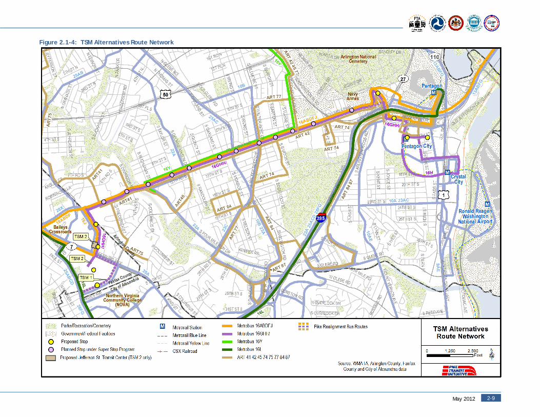
Transit OperationsThe TSM 1 Alternative assumes similar service provided under the No BuildAlternative with WMATA Metrobus and ART lines, but alters the bus routes toimprove service to Skyline by extending the 16G and 16H routes. The Metrobus16G route, which now terminates in Columbia Heights West, would beextended to the Skyline area to provide an additional connection between thisarea and Columbia Pike. Service would be extended down Leesburg Pike andterminate along George Mason Drive. This modification would remove the 16Gfrom the Columbia Heights West area of Arlington, which is currently servedby the 16G and the ART 41. ART 41 service would be increased to offset theservice lost from the rerouting of the 16G. Figure 2.1-4 shows the routenetwork and stop locations.
The TSM 1 Alternative would require purchasing five 40-foot (standard)Metrobus buses. Similar to the No Build Alternative, the TSM 1 Alternativeincludes on-board fare collection and front-door boarding.
In addition to the branding described in the No Build Alternative, the PentagonCity “trunk” lines (16G, 16H, 16J) would be specially branded to distinguishthem from other Metrobus buses operating in the corridor. In addition, linesthat serve the Pentagon (16A, 16B, and 16D) and the express service lines todowntown Washington (16Y and 16F) would apply “Metro Extra” branding,which would include special painting to designate Metrobus express routes.
Service HoursMetrobus and ART would provide service along the corridor seven days perweek. The TSM 1 Alternative would modify the span of bus service of the 16Gand H lines to more closely match Metrorail opening and closing times toprovide connections to early and late Metrorail trains. For the Metrobus 16Gand H Lines, weekday service would begin by 5:30 a.m. and extend to 1:00a.m. Saturday service would begin by 6:30 a.m. and extend to 1:00 a.m., andSunday service would begin by 6:00 a.m. and extend to 11:30 p.m. Servicehours of all other routes are maintained identical to the No Build Alternative.
Transit Service FrequencyThe TSM 1 Alternative bus service along the central portion of Columbia Pikeoperates at a combined two-to-three minute headway that provides service tothe Pentagon or Pentagon City during peak periods, with a combined fourminute headway during off-peak periods.
Compared to the No Build Alternative, the TSM 1 Alternative provides oneadditional bus per hour to Pentagon City during the peak periods and sixadditional buses during non-peak periods. The TSM 1 Alternative also providesfour additional buses per hour from Columbia Heights West to Court Housethroughout the day.
Service frequencies by destination are listed below:
Pentagon City: An average of 12 Metrobus buses per hour during peakperiods and four buses per hour during off-peak periods run alongColumbia Pike from Jefferson Street to the Pentagon City MetrorailStation.Pentagon: Combined service frequency, including Metrobus and ARTservice, averages 15 buses per hour during peak periods and six busesper hour during off-peak periods along Columbia Pike from JeffersonStreet to the Pentagon Metrorail Station.Downtown Washington, DC: An average of 11 Metrobus buses perhour during peak periods run along Columbia Pike to Farragut Square(bypassing the Pentagon and Pentagon City).Ballston/Court House/Rosslyn: An average of 10 ART buses per hourrun throughout the day along Columbia Pike to Court House orRosslyn.
Station StopsThe TSM 1 Alternative would consolidate many of the existing bus stops toimprove corridor travel time. Bus stop locations along Columbia Pike would beapproximately ¼ to ½ mile apart. Stop locations are shown in Figure 2.1-4.
The TSM 1 Alternative assumes full implementation of the Arlington CountySuper Stops program, which includes 24 enhanced stops along Columbia Pike.Additional consolidated stops that are not on Columbia Pike (in the Skylinearea and in Pentagon City) would be standard, non-enhanced stops.
FacilitiesPark-and-ride and bus maintenance facilities would be the same as in the NoBuild Alternative.
Capital and Operating Cost EstimatesThe estimated capital cost for the TSM 1 Alternative is $4 million in 2011dollars and $5 million in 2015 dollars (midpoint of construction). Theestimated operations and maintenance costs are $20.1 million in 2011 dollarsand $23.3 million in 2016 dollars.
Columbia Pike Transit Initiative Alternatives Analysis/Environmental Assessment – Volume I2-8
2.1.3 Transportation Systems Management 2 Alternative-Articulated BusThe TSM 2 Alternative- Articulated Bus (“TSM 2 Alternative”) includes thetransit operation changes assumed under the TSM 1 Alternative, plusenhancements that increase transit efficiency and improve travel time.Similar to the TSM 1 Alternative, the TSM 2 Alternative includes bus operationsin mixed traffic, consolidated stops, and improved service to Skyline. Incontrast with the TSM 1 Alternative, the TSM 2 Alternative includes off-vehiclefare collection, multi-door boarding, and upgraded stops and passengeramenities—features typically associated with an Arterial Bus Rapid Transitsystem. This is the best that transit can be improved in the corridor withoutbuilding a fixed guideway. All projects assumed under the No BuildAlternative would be included in the TSM 2 Alternative.
Transit OperationsLike the TSM 1 Alternative, the TSM 2 Alternative includes the serviceprovided under the No Build Alternative with WMATA Metrobus and ART lines,but alters the bus routes to improve service to Skyline by extending the 16Gand 16H routes. The TSM 2 Alternative alignment would be similar to the TSM1 Alternative; however, TSM 2 Alternative terminates at the Skyline Complex,to provide a more direct link to the center of activity. Figure 2.1-4 shows theroute network.
The TSM 2 Alternative includes several changes from the TSM 1 Alternative toincrease transit capacity and improve transit efficiency. To increase transitcapacity, the TSM 2 Alternative would require purchasing 18 60-footarticulated Metrobus buses to deploy on the 16G and 16H routes. Articulatedbuses would replace the existing standard buses on the 16G and 16H routes;all other routes would continue to use standard buses, as described under theNo Build and TSM 1 Alternatives. It is assumed for this analysis that WMATAwould operate the TSM 2 Alternative articulated buses. Standard 40-foot buseswould be deployed on all other WMATA routes. To improve transit efficiencyand minimize dwell time, the TSM 2 Alternative includes off-vehicle farecollection with proof of payment and multi-door boarding and alighting.
Bus branding would be the same as described in the TSM 1 Alternative.
Service HoursService hours would be the same as described in the TSM 1 Alternative.
Transit Service FrequencyTransit service frequency would be the same as described in the TSM 1Alternative, operating at a combined two-to-three minute headway that
provides service to the Pentagon or Pentagon City during peak periods, with acombined four-minute headway during off-peak periods. Due to off-vehiclefare collection, corridor travel times are shorter; therefore, the same levels oftransit service are provided in a more efficient manner.
Station StopsUnder the TSM 2 Alternative, all consolidated bus stops along the fullalignment (including those in the Skyline area and in Pentagon City) would beimplemented with platform sizes and amenities similar to those proposed inthe Arlington County Super Stops program. Stops would have 90 to 120-footlong platforms and would incorporate off-vehicle fare collection machines toimprove transit efficiency. Stops would also provide real-time passengerinformation and improved shelters and waiting areas. Stop locations would bethe same as those proposed in the TSM 1 Alternative with the exception of thestop at the Jefferson Street Transit Center (described in more detail below)and the western terminus stop location, which would be located in the SkylineComplex.
FacilitiesThe TSM 2 Alternative would include the addition of a new intermodal transitcenter called the Jefferson Street Transit Center. To provide increased transitpassenger convenience, the facility would include a 200-space surface park-and-ride lot, daily and short-term parking spaces, bays for connecting buses,and a curbside pick-up/drop-off area. The facility would be located in thelarge existing parking area of the shopping center west of Jefferson Streetnear the intersection with Leesburg Pike, subject to agreements with propertyowners.
Because it is assumed for this analysis that WMATA would operate thearticulated Metrobus buses, articulated buses would be stored and maintainedat WMATA’s Cinder Bed Road Bus Operations and Maintenance Facility.Standard buses would continue to be stored and maintained at the existingFour Mile Run Bus Garage.
Capital and Operating Cost EstimatesThe estimated capital cost for the TSM 2 Alternative is $47 million in 2011dollars and $53 million in 2015 dollars (midpoint of construction). Theestimated operations and maintenance cost for the TSM 2 Alternative is $19.4million in 2011 dollars and $22.5 million in 2016 dollars.
May 2012 2-92-9
Figure 2.1-4: TSM Alternatives Route Network

Columbia Pike Transit Initiative Alternatives Analysis/Environmental Assessment – Volume I2-10
2.1.4 Streetcar Build AlternativeTransit OperationsThe Streetcar Build Alternative would include both a modern streetcar serviceand continued bus service between the Skyline area of Fairfax County andPentagon City in Arlington County. The streetcar alignment would run alongthe length of Columbia Pike from Jefferson Street to Joyce Street andterminate in Pentagon City at 12th Street and South Eads Street. If ColumbiaPike were realigned near South Joyce Street, the streetcar alignment wouldfollow the realigned street. A Construction Staging and Permanent EquipmentStorage Site in the vicinity of the existing Navy Annex would also beconstructed. Figure 2.1-5 shows the streetcar alignment, station stops,facilities, and background bus service, while Figure 2.1-6 shows only thestreetcar alignment, station stops, and facilities. All projects assumed underthe No Build Alternative would be included in the Streetcar Build Alternative.
Streetcar vehicles would operate mostly in mixed traffic within the outsidetravel lanes along Columbia Pike and in the inner lanes along Jefferson Streetand throughout Pentagon City. The only areas where streetcar vehicles wouldoperate in exclusive right-of-way would be on short segments near thewestern and eastern termini.
The Streetcar Build Alternative would introduce changes to increase transitcapacity and improve transit efficiency. The alternative would modify theproject area bus network to reflect the addition of streetcar service alongColumbia Pike. Standard buses would be deployed on all bus routes. The keychanges to the bus network would be the removal of the bus lines that followthe same routing as the proposed streetcar service (16G and 16H). MetrobusLine 16J(PC) would also be added, which provides service from Culmore andSkyline to Pentagon City.
The Streetcar Build Alternative would require purchasing 13 modern streetcarvehicles. The Streetcar Build Alternative includes off-vehicle fare collectionwith proof of payment and multi-door boarding and alighting.
In addition to the branding strategies described under the No BuildAlternative, special streetcar branding for Pentagon City service would beapplied. Similar to the TSM Alternatives, “Metro Extra” branding would beapplied to the Pentagon lines and express service lines to DowntownWashington (16Y, 16F).
Service HoursStreetcar, Metrobus, and ART service would be provided along the corridorseven days per week. The Streetcar Build Alternative would provide streetcarservice to closely match Metrorail opening and closing times to provideconnections to early and late Metrorail trains. Metrobus and ART service wouldbe provided along the corridor seven days per week. On a weekday, streetcarservice would begin by 5:30 a.m. and extend to 1:00 a.m. Saturday servicewould begin by 6:30 a.m. and extend to 1:00 a.m., and Sunday service would
begin by 6:00 a.m. and extend to 11:30 p.m. All other routes service hours aremaintained identical to the No Build Alternative.
Transit Service FrequencyOverall, streetcar and bus service frequency would provide the samecombined headways to the Pentagon or Pentagon City Metrorail station duringpeak and off-peak periods as described in the TSM Alternatives.
Service frequencies by destination are listed below:
Pentagon City: An average of 10 streetcar vehicles per hour and twoMetrobus buses per hour run throughout the day along Columbia Pikefrom Jefferson Street to the Pentagon City Metrorail Station.Pentagon: Combined service frequency, including Metrobus and ARTservice, averages approximately 15 buses per hour during peakperiods and six buses per hour during off-peak periods along ColumbiaPike from Jefferson Street to the Pentagon Metrorail Station.Downtown Washington, DC: An average of 11 Metrobus buses perhour during peak-periods run along Columbia Pike to Farragut Square(bypassing the Pentagon and Pentagon City).Ballston/Court House/Rosslyn: An average of 10 ART buses per hourrun throughout the day along Columbia Pike to Court House orRosslyn.
Station StopsBus and streetcar stops would be consolidated (in a manner comparable to theTSM Alternatives) and would be located approximately ¼ to ½ mile apart.Platform design would be similar in design to the Super Stops, with improvedshelter areas and amenities. Passenger station stops would consist of a 90 to120-foot boarding area with a low platform to accommodate near-levelboarding. Curbside stops would be able to accommodate a streetcar vehicleand 40-foot bus, simultaneously. Station stops would also provide real-timepassenger information. As noted under “Transit Operations,” the station stopswould include additional fare collection and boarding amenities.
FacilitiesThe use of an electrified streetcar would require placement of an overheadcontact wire system; five traction power substations (TPSS) would be locatedalong the alignment. The proposed locations of the TPSSs are shown in Figure2.1-6.
The system would require a vehicle O&M facility with an operations controlcenter. The O&M facility would be located in Pentagon City at 12th Street andSouth Eads Street where daily maintenance will be performed. As needed,vehicle “mid-life” overhauls and heavy repairs would involve transportingvehicles to an existing maintenance facility capable of completing this work,such as light rail transit facilities in Baltimore, Maryland, and Norfolk, Virginia.
Bus maintenance facilities would be the same as assumed in the No BuildAlternative.

May 2012 2-112-11
If Columbia Pike were realigned near South Joyce Street, the streetcaralignment would follow the realigned street. A Construction Staging andPermanent Storage Site in the vicinity of the existing Navy Annex would alsobe constructed.
Park-and-ride facilities would be the same as under the TSM 2 Alternative,which would include a small, existing park-and-ride facility near Four Mile Runas well as the new Jefferson Street Transit Center, as described in the TSM 2Alternative subsection on “Facilities.”
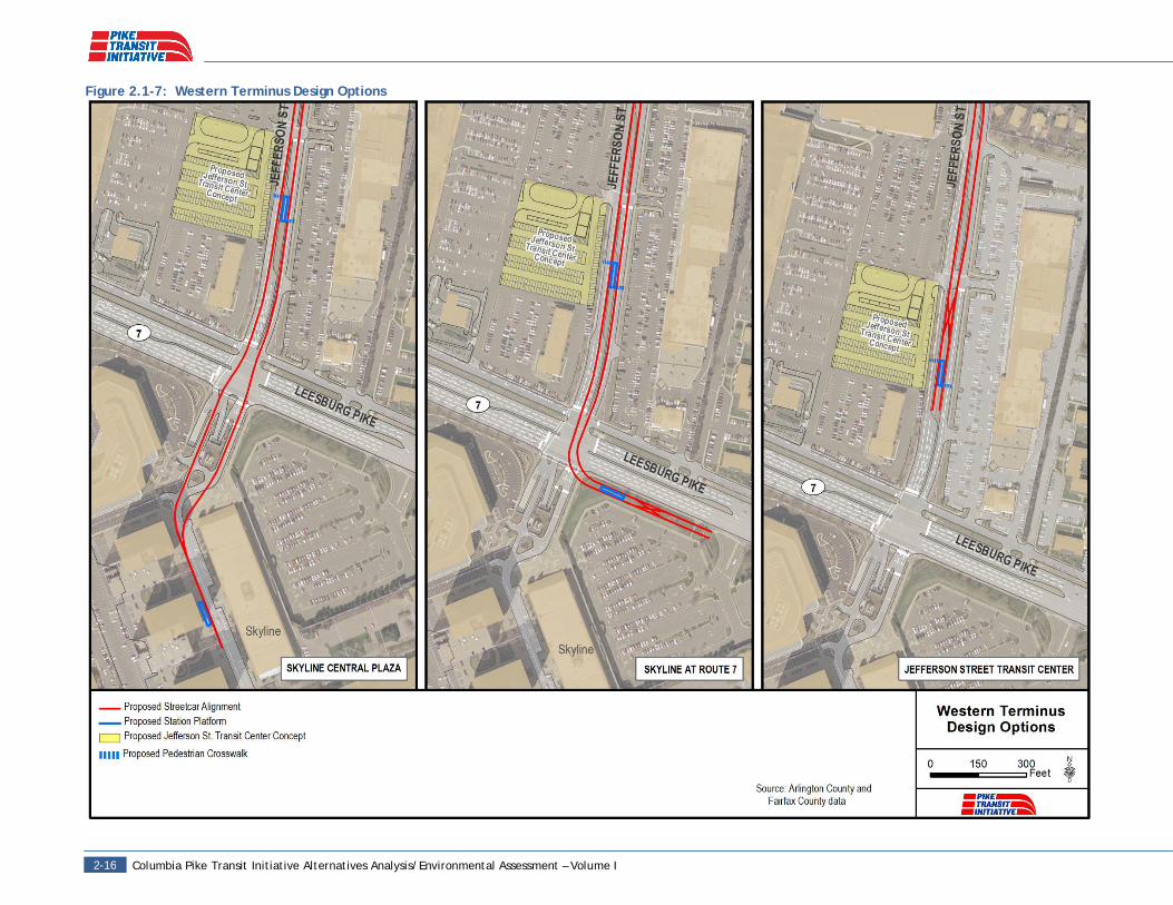
Western Terminus Design OptionsThe Streetcar Build Alternative has three design options for the westernterminus:
Skyline Central PlazaSkyline Route 7Jefferson Street Transit Center
The Skyline Central Plaza design option extends the streetcar alignment overLeesburg Pike (also referred to as “Route 7”) and into the center of theSkyline Complex. The Skyline Route 7 design option is similar in that thealignment crosses Leesburg Pike; however, the station stop would be locatedin front of the Skyline complex. The Jefferson Street Transit Center designoption terminates in the median adjacent to the proposed Jefferson StreetTransit Center and does not cross Leesburg Pike. Figure 2.1-7 shows the threewestern terminus design options.
Additional Engineering RequirementsThis alternative would require superstructure and substructure improvementsto the bridge over Four Mile Run. At the eastern terminus, the streetcar wouldcross over the Pentagon City Metrorail Station; thus, the project would needto perform further construction analysis at this location. If implemented, theSkyline Central Plaza design option would require extensive deckrehabilitation and substructure reinforcement related to the proposed stationstop location. In addition, the Skyline Route 7 design option would requireretained fill along a portion of Leesburg Pike.
Capital and Operating Cost EstimatesThe capital cost estimate for the Streetcar Build Alternative is contingent onthe western terminus design option, but would range from $214-231 million in2011 dollars and $242-261 million in 2015 dollars (midpoint of construction).Estimated operations and maintenance costs would range from $19.4-$25.5million in 2011 dollars and $22.5-$29.6 million in 2016 dollars (Refer toTechnical Memoranda on Operations & Maintenance Cost Estimates and CapitalCost Estimates in Volume II, Chapter 15).

Columbia Pike Transit Initiative Alternatives Analysis/Environmental Assessment – Volume I2-14
Figure 2.1-5: Streetcar Alignment and Background Bus Service Route Network

May 2012 2-152-15
Figure 2.1-6: Streetcar Alignment and Facilities
Columbia Pike Transit Initiative Alternatives Analysis/Environmental Assessment – Volume I2-16
Figure 2.1-7: Western Terminus Design Options

May 2012 2-172-17
Table 2.1-3: Characteristics of AlternativesNo Build TSM 1 TSM 2 Streetcar Build
Vehicle Fleet Type* Standard buses Standard busesStandard buses; Articulatedbuses on selected routes:16G, 16H
Streetcars and standardbuses
Total Vehicles per hour (peak): 39 44 44 44Total Vehicles per hour (off-peak) 16 26 26 26
To Pentagon (peak) 15 15 15 15
To Pentagon (off-peak) 6 6 6 6
To Pentagon City (peak) 11 12 12(10 articulated buses)
12(10 streetcar vehicles)
To Pentagon City (off-peak) 4 10 10 (10 articulated buses)
10(10 streetcar vehicles)
To Other Destinations (peak)13
(7 WMATA buses;6 ART buses)
17(7 WMATA buses;
10 ART buses)
17(7 WMATA buses;
10 ART buses)
17(7 WMATA buses;
10 ART buses)
To Other Destinations (off-peak) 6(ART buses)
10(ART buses)
10(ART buses)
10(ART buses)
Average Service Frequency
Along Columbia Pike 2-3 min peak;6 min off-peak
2-3 min peak;4 min off-peak Same as TSM 1 Same as TSM 1
To Pentagon 4 min peak;10 min off-peak Same as No Build Same as No Build Same as No Build
To Pentagon City 5.5 min peak;15 min off-peak
5 min peak;6 min off-peak Same as TSM 1 Same as TSM 1
Fare collection SmarTrip and cash: on-vehicle payment Same as No Build
Off-vehicle payment andvalidation; on-boardrandom inspections
Same as TSM 2
Transit Stops
Stops located at mostintersections,approximately 1/8 mileapart
Consolidated stops located1/4 to 1/2 mile apartalong corridor
Same as TSM 1 Same as TSM 1
Implementation of Super Stops Program Yes Yes Yes YesEnhanced Stops not along Columbia Pike No No Yes YesBoarding Areas Raised along Columbia Pike Same as No Build Raised along full alignment Same as TSM 2Boarding and Alighting Front door boarding Same as No Build All door boarding Same as TSM 2
Park-and-Ride FacilityExisting Site at ColumbiaPike and Four Mile RunDrive
Same as No Build
• Existing Site at ColumbiaPike and Four Mile RunDrive• Jefferson Street TransitCenter
Same as TSM 2
*Unless otherwise noted, peak-period vehicles are standard 35-foot or 40-foot buses.
Columbia Pike Transit Initiative Alternatives Analysis/Environmental Assessment – Volume I2-18
2.2 Streetcar Build Alternative Design Optionsrelated to O&M FacilitiesIn order to operate and maintain a streetcar system, an operations andmaintenance (O&M) facility is required for storage and maintenance ofstreetcar vehicles and on-site control of system operations. At the onset of thecurrent study, three locations for an O&M facility were identified. The threelocations for a possible Streetcar Build O&M facility yielded variations in thealignment in order to reach the proposed sites. During the evaluation of thesesites, an additional O&M site was presented for evaluation, yielding anotherdesign option. The four identified Streetcar Build Design Options are listedbelow and shown in Figure 2.2-1.
Design Option A (North Tract)Design Option B (Pentagon City)Design Option C (Northern Virginia Community College (“NOVA”) viaGeorge Mason Drive)Design Option D (NOVA via Route 7)
These initial Streetcar Build Design Options were evaluated using the followingfactors:
Ability to meet the stated purpose and need of the project;Stakeholder feedback;Environmental constraints;Right-of-Way needs; andEngineering constraints.
Each of the initial Streetcar Build Design Options was determined to meet theproject’s purpose and need. The stakeholder feedback, environmentalconstraints, and engineering constraints for each Streetcar Build Design Optionare discussed below and summarized in Table 2.2-1.
Design Option A (North Tract)Design Option A proposed an O&M facility at the North Tract site along OldJefferson Davis Highway at the eastern end of the project and north of CrystalCity. During preliminary discussions, the North Tract location property ownersstated that they were unwilling to sell their property. Environmental concernsfor this design option include the acquisition and displacement of onebusiness, and the known hazardous waste sites documented in the vicinity ofthe site. Design Option A would require 5.3 acres of right-of-way. No uniqueengineering constraints were identified for the North Tract Site.
Design Option B (Pentagon City)Design Option B proposed an O&M facility within a mixed-use developmentarea, centrally located in Pentagon City. During preliminary discussions, thePentagon City property owners expressed openness to the concept of an O&Mfacility at this location and interest in potential joint development of the site.Environmental concerns at this location include proximity to the historicChesapeake & Ohio (C&O)/Alexandria Canal, potential noise impacts to nearby
sensitive receptors, and property acquisition in the vicinity of the O&Mfacility. Design Option B would require 4.9 acres of right-of-way. No uniqueengineering constraints were identified for the Pentagon City Site.
Design Option C (NOVA via George Mason Drive)Design Option C proposed an O&M facility on the Northern Virginia CommunityCollege Campus (NOVA) via George Mason Drive from Skyline. This designoption proposed accessing the proposed O&M facility site via a portion of theSkyline Condominiums property. During preliminary discussions, the SkylineCondominium property owners stated that they opposed this design option anduse of their properties. Environmental concerns for this design option includean adjacent private park, potential impacts to nearby water resources, andnoise impacts to minority and low-income populations. Design Option C wouldrequire 10.4 acres of right-of-way. Unique engineering constraints include apossible structural enclosure of tracks between the Skyline Condominiums andMcDonalds and another structure across a stream to connect to Dawes Avenue.
Design Option D (NOVA via Route 7)Design Option D proposed the same O&M facility on the NOVA campus asDesign Option C, via a different alignment along Route 7 from Skyline. DesignOption D would require slightly less right-of-way, then Design Option C at 10.1acres. This design option would have the same issues as those described forDesign Option C.
Screening ResultsBased primarily on stakeholder feedback, right-of-way needs, uniqueengineering constraints, and environmental concerns, initial Design Options A,C and D were not advanced for further evaluation at this time. Design OptionB is the initial Streetcar Build design option advancing for further evaluation inthis AA/EA.

May 2012 2-19
Figure 2.2-1: Initial Streetcar Build Alternative Design Options

Columbia Pike Transit Initiative Alternatives Analysis/Environmental Assessment – Volume I2-20
Table 2.2-1: Initial Streetcar Build Alternative Design Option Screening Matrix
Design Option Stakeholder Feedback Environmental Constraints Engineering ConstraintsRight-of-Way Needs
(Total ROW) Status
Option A(North Tract)
Owner unwilling to sellproperty for use as an O&MFacility
Property acquisitionIdentified known hazardouswaste sites in vicinity ofO&M facility
None 5.3 acres Not advanced forfurther evaluation
Option B(PentagonCity)
Discussions with propertyowners and ArlingtonCounty
Historic C&O Canal nearproposed O&M facilityPotential noise impacts
None 4.9 acres Advanced for furtherevaluation
Option C(NOVA viaGeorge MasonDr.)
Opposition to design optionfrom nearby propertyowners
Private park near proposedalignmentPotential noise impacts onminority and low-incomepopulationsPotential stream andwetland impacts
Possible structuralenclosure of tracksbetween SkylineCondominiums andMcDonalds*Structure across stream toDawes Avenue
10.4 acres Not advanced forfurther evaluation
Option D NOVAvia Rt. 7
Opposition to design optionfrom nearby propertyowners
Private park near proposedalignmentPotential noise impacts onminority and low-incomepopulationsPotential stream andwetland impacts
Possible structuralenclosure of tracksbetween SkylineCondominiums andMcDonalds*Structure across stream toDawes Avenue
10.1 acres Not advanced forfurther evaluation
*Contingent on selected western terminus design option