a modern canyon-fed sandy turbidite system of the...
TRANSCRIPT

Introduction On the continental margin offshore Norway LowerTertiary sandy turbidites form oil and gas reservoirs inboth the North Sea (Enjolras et al. 1986; Dreyer et al.2004) and the Norwegian Sea (Gjelberg et al. 2001;Smith & Möller 2003; Möller et al. 2004). Sandyturbidites have also been drilling targets in the BarentsSea (Knutsen & Larsen 1996; Ryseth et al. 2003).Experience from these and other studies have, however,shown that the existence of stratigraphic traps, asexemplified by sandy turbidites, may be difficult topredict. This is probably partly because the naturalvariability in continental margin turbidite systems isgreater than can be encompassed in a few simple modeltypes based on facies schemes or tectonic setting (e.g.Piper & Normark 2001; Kenyon et al. 2002).
In order to address this problem additional infor-mation on sandy turbidite systems can be obtainedfrom the study of modern analogues. Here we presenthigh-resolution seismic, side-scan and core data from amodern turbidite system in the Lofoten Basin, Norwe-gian Sea; the Andøya Canyon - Lofoten Basin Channel(Fig. 1). The aim is to elucidate the morphology,architecture and sedimentary processes of this system.
Physiography The Lofoten Basin is situated in the north-easternNorwegian Sea (Fig. 1). The basin is bounded by thewestern Barents Sea continental slope, the northNorwegian continental slope, the Northern VøringPlateau slope, the Jan Mayen Fracture Zone, and part ofthe mid-oceanic spreading ridge (the Mohns Ridge).The deepest part of the basin is located to the south andsouthwest where water depth exceeds more than 3000m. The basin asymmetry is due to the thick wedge ofprograding Late Cenozoic sediments off the westernBarents Sea (Vorren et al. 1991; Faleide et al. 1996;Dahlgren et al. 2005).
The adjacent continental margin has a narrow shelf, arelatively steep slope and a thin succession of Cenozoicsediments; thus it is sediment starved in markedcontrast to the margin further south (Dahlgren et al.2002) and north (Vorren et al. 1991). For instance,sediment drifts inferred to consist of deep-water faciesequivalent to the Miocene – Early Pliocene Kai and LatePliocene – Pleistocene Naust formations offshore mid-Norway (Laberg et al. 2005) occur as isolated patcheson the slope (Laberg et al. 2001). Also, only a verylimited amount of glacigenic sediments (the Naust
NORWEGIAN JOURNAL OF GEOLOGY A modern canyon-fed sandy turbidite system 267
A modern canyon-fed sandy turbidite system of theNorwegian Continental Margin
Jan Sverre Laberg, Tore O. Vorren, Neil H. Kenyon, Mikhail Ivanov & Espen S. Andersen
Laberg, J.S., Vorren, T.O., Kenyon, N.H., Ivanov, M., Andersen, E.S.: A modern canyon-fed sandy turbidite system of the Norwegian ContinentalMargin. Norwegian Journal of Geology, Vol. 85, pp. 267-277. Trondheim 2005, ISSN 029-196X.
The sedimentary processes and evolution of a presumably old but still relatively recent active canyon-fed sandy turbidite system on the Norwegiancontinental margin, the Andøya Canyon - Lofoten Basin Channel system, were studied using high-resolution seismic, deep-towed side-scan sonarrecords and cores (gravity and vibro cores). The canyon has a length of about 40 km and represents a continental slope incision of up to 1100 m.From the canyon mouth, a deep-sea channel up to 30 m deep and 3 km wide continues for approximately 200 km into the deepest part of theLofoten Basin. The most recent activity of this system was deposition of coarse-grained sediments from turbidity currents as indicated by sedi-ment waves on the canyon floor, thin sand layers within the levees and a sandy lobe at the channel mouth. From this modern system we suggestthat there are a number of features that could be of relevance for hydrocarbon exploration of deep-water turbidite systems: a) this canyon-fed sys-tem probably received sand from piracy of shelf sediments and/or canyon wall erosion, b) the sandy deposits are located in the deepest part of thebasin, about 200 km outside the canyon mouth, c) the sandy lobe is connected to the source area by a straight channel with poorly developedmud-rich levees, d) the sandy deposits have a sheet-like or tabular geometry, e) post-depositional deformation of the sand could be widespreadsuggesting rapid sand deposition. Thus, modern, canyon-fed sandy turbidite systems provide additional data relevant for future hydrocarbon pro-specting in deep-water areas.
Jan S. Laberg, Tore O. Vorren, Department of Geology, University of Tromsø, NO-9037 Tromsø, Norway (E-mail: [email protected]); Neil H.Kenyon, National Oceanography Centre, Empress Dock, Southampton SO14 3ZH, UK; M. Ivanov, UNESCO Centre for Marine Geology and Geophy-sics, Moscow State University, Moscow 119899, Russia; Espen S. Andersen; Norsk Hydro ASA, N-0246 Oslo, Norway
Formation) have been deposited in this area due to thebarrier (and consequently damming effect) of theLofoten islands mountain chain. Ice draining from theeast was routed southwest through Vestfjorden, contin-uing west through Trænadjupet where the ice frontreached the shelf break and large amounts of sedimentswere released on to the slope (Laberg et al. 2002).
Database High-resolution, single channel seismic data (Fig. 2)were acquired by RV Jan Mayen of the University ofTromsø in 2002 using an airgun array of two 0,6 litresleeve guns. The filter setting of the Geopulse Receiverwas 100-700 Hz. The seismic records revealed a pene-tration of up to 2 sec two-way travel time (TWT) and avertical resolution of up to 1-2 m. High resolution,deep-towed side-scan sonar data (using the RussianMAK system at 30 and 100 kHz) co-registered with subbottom profiles (5kHz) and the cores (gravity andvibro cores) were acquired during Leg 1 of TrainingThrough Research (TTR) 13 in 2003 using the Russianresearch vessel Professor Logachev.
The Andøya Canyon Morphology and evolution
The Andøya Canyon is an approximately 40 km long(lower termination at 15˚ E), straight, downslope-oriented canyon located where the average continentalslope gradient is more than 4˚ (Fig. 2). On the upperslope, the canyon is characterised by a V-shaped cross-section, steep walls, and the width between canyonshoulders is about 8 km (Fig. 3a). The sidewallmorphology is relatively smooth (Fig. 3a) but irregularareas occur (see Laberg et al. 2000). The canyon is up to1100 m deep and has an outer shelf incision of about 6km. Such a morphology was considered by Shepard &Dill (1966) to be typical of submarine canyons. Furtherdownslope the canyon has a U-shaped cross-section,and is up to 25 km wide. The canyon floor is locatedabout 900 m below the shoulders (Fig. 3b). In this areathe canyon walls and floor are dominated by anirregular relief.
From the above observations and results from modernanalogues (e.g. Shepard 1981) we suggest a combina-tion of processes responsible for canyon formation. Theincision in the upper V-shaped, part of the canyon wasprobably caused by a combination of processes inclu-ding downslope flowing turbidity currents generatedfrom mass wasting in the headwall and sidewall areas,piracy of winnowed shelf sediments, bottom currentsand/or upwelling within the canyon. The latter process
has recently been shown to occur in this area(Skardhamar & Svendsen 2004) but its effect on theseabed sediments is not known.
In the lower part of the canyon, retrogressive sidewallcollapse due to sliding/slumping seems to have beenactive as indicated by the wider, U-shaped cross-sectionand irregular relief. Thus the Andøya Canyon mayexemplify canyon formation both by downslopeerosion from fluid flow processes and sidewall andheadwall retrogressive sliding and slumping, aspreviously have been shown for low-latitude canyons(Shepard 1981; Pratson et al. 1994; Pratson & Coakley1996). A more detailed presentation of the canyonmorphology is given by Laberg et al. (submitted).
Deposits from turbidity currents are found as a thicklevee on the northern flank of the canyon mouth (Fig.3c) and flanking the Lofoten Basin Channel, althoughtheir development is much less pronounced for thelatter area. The levee is particularly well developed onthe right side (looking downslope) of the canyonmouth due to 1) the marked reduction in slopegradient, and 2) the channel turns almost 90˚ west.Both of these factors probably led to a decrease in flowvelocity and sediment overspill, deflected to the rightby the Coriolis force.
The fact that a channel continues from the mouth ofthe canyon into the deepest part of the basin indicatesthat the current velocity was still high enough for atleast some of the currents to be erosional after passingthe base of the slope. This hypothesis is also supportedby the fact that the Lofoten Basin Channel is a straightchannel which is also a characteristic of erosional flows(Kneller 2003). No meandering has been seen (e.g.Dowdeswell et al. 1996).
Weichselian and Holocene processes
Side-scan sonar and cores reveal details about the mostrecent evolution of the canyon. Side-scan sonar datacrossing the canyon mouth at the base of the slopedisplay a more than 1 km wide sediment wave field,covering about half the canyon floor (Fig. 4). The wavesare oriented transverse to flow direction, and have awavelength of some tens of meters. However, this mayvary both along and across the floor, as in the case withother similar canyons, such as the Eastern Valleysediment wave field of the Laurentian Fan (HughesClarke et al. 1990). The sediment wave field is drapedby some tens of centimetres of mud.
Coring of the sediment waves was not successful.However, information gained from comparablesettings, such as the Eastern Valley of the LaurentianFan (Hughes Clarke et al. 1990) as well as in canyonsoffshore Corsica and Sardinia (Kenyon et al. 2002),
268 J. S. Laberg et al. NORWEGIAN JOURNAL OF GEOLOGY

269NORWEGIAN JOURNAL OF GEOLOGY A modern canyon-fed sandy turbidite system
Fig. 2: 3D model of the morphology of the studied part of the Andøya Canyon as seen from NNE based on the single channel seismic data. Loca-tion of the single channel seismic lines is indicated by the red lines. The location of Figs. 3a-c and 4 is shown. See Fig. 1b for location of the figure.
Fig. 1: (a) Bathymetric map showing the location of the study area (from The International Bathymetric Chart of the Arctic Ocean (Jakobssonet al., 2000)), and (b) the location of the Andøya Canyon - Lofoten Basin Channel system and sandy lobe at the channel mouth. Location ofFigures 2 (box) 5a, 5b, 5d, 6-8 is indicated.

270 J. S. Laberg et al. NORWEGIAN JOURNAL OF GEOLOGY
Fig. 3: High-resolution seis-mic profiles crossing theupper (a), middle (b) andlowermost part of the canyon(c). M = multiple. For loca-tion, see Fig. 2.

suggests that sand, gravel and possibly pebbles are likelyto comprise the sediment waves (see also Wynn et al.2002 for a further discussion). This leads us to proposethat the sediment waves in the canyon mouth area arecomposed of coarse-grained sediments deposited byturbidity currents.
Support for this interpretation is the fact that coresrecovered from levee deposits consist of sand layersinterbedded with hemipelagic and/or turbiditic mud(Figs. 5a and b). The sand layers, inferred to be turbidites,show that at least some of the turbidity currentstransported sand in suspension, implying that coarsersediments were transported in the lower part of thecurrent (as bedload). If deposited from turbiditycurrent overspill, some of the coarse-grained turbiditycurrents had a thickness of more than 100 m. This isprobably not extreme, as modern in situ measurementsof canyon-confined turbidity currents have shownsediment plumes reaching 170 m above the canyonfloor (Xu et al. 2004).
In conclusion, the Andøya Canyon is probably an oldfeature formed by a combination of processes. Morerecent activity seems to have been by coarse-grainedturbidity currents. Present day activity in this system isnot known.
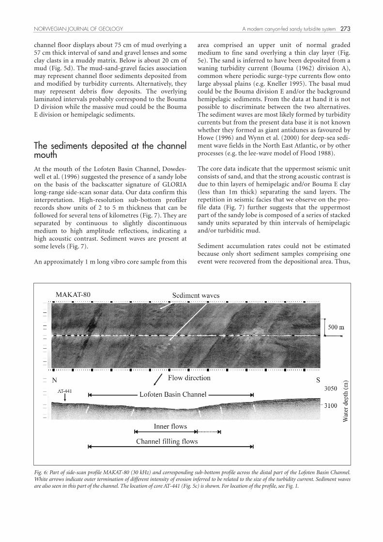
The distal channel Turbidity currents initiated in the Andøya Canyonmoved up to 200 km through the Lofoten BasinChannel to end up in the deepest part of the LofotenBasin (Fig. 1). The distal part of the channel is about 3km wide and some tens of meters deep (Fig. 6). Thechannel morphology, showing different levels oferosion, suggests that some of the currents filled thewhole channel while others were restricted to thecentral, deepest part. Transverse bedforms, inferred tobe sediment waves with a wavelength < 100 m, alsoimply sediment deposition from and modification byturbidity currents.
Levees are not well developed in this area. A shortgravity core sample from the northern channel flankwas composed of two massive, fine-grained sand layersinterbedded with bioturbated mud (Fig. 5c). Thisindicates the sandy nature of the most recent currents,which we interpret to have been at least 25 m thick inorder to spill over the channel. The mud could be theBouma division E and/or the background hemipelagicsediments. Separating the two is difficult from thepresent database.
Slightly further into the basin a core sample from the
271NORWEGIAN JOURNAL OF GEOLOGY A modern canyon-fed sandy turbidite system
Fig. 4: Part of side-scan profile MAKAT-85 (30 kHz) across the lowermost part of the Andøya Canyon (and corresponding sub-bottom profile) sho-wing the sediment wave field occupying about 50 % of the canyon floor in this area. A collapsed part of the levee is also seen. See Fig. 3 for location.

272
Fig. 5: Sediment samples from levee deposits (a-c), the channel floor(d), and the depositional lobe (e). WD = water depth where sample wasobtained. For location of the cores, see Fig. 1 (a-b, d), 6 (c) and 7 (e).
J. S. Laberg et al. NORWEGIAN JOURNAL OF GEOLOGY
channel floor displays about 75 cm of mud overlying a57 cm thick interval of sand and gravel lenses and someclay clasts in a muddy matrix. Below is about 20 cm ofmud (Fig. 5d). The mud-sand-gravel facies associationmay represent channel floor sediments deposited fromand modified by turbidity currents. Alternatively, theymay represent debris flow deposits. The overlyinglaminated intervals probably correspond to the BoumaD division while the massive mud could be the BoumaE division or hemipelagic sediments.
The sediments deposited at the channelmouth At the mouth of the Lofoten Basin Channel, Dowdes-well et al. (1996) suggested the presence of a sandy lobeon the basis of the backscatter signature of GLORIAlong-range side-scan sonar data. Our data confirm thisinterpretation. High-resolution sub-bottom profilerrecords show units of 2 to 5 m thickness that can befollowed for several tens of kilometres (Fig. 7). They areseparated by continuous to slightly discontinuousmedium to high amplitude reflections, indicating ahigh acoustic contrast. Sediment waves are present atsome levels (Fig. 7).
An approximately 1 m long vibro core sample from this
area comprised an upper unit of normal gradedmedium to fine sand overlying a thin clay layer (Fig.5e). The sand is inferred to have been deposited from awaning turbidity current (Bouma (1962) division A),common where periodic surge-type currents flow ontolarge abyssal plains (e.g. Kneller 1995). The basal mudcould be the Bouma division E and/or the backgroundhemipelagic sediments. From the data at hand it is notpossible to discriminate between the two alternatives.The sediment waves are most likely formed by turbiditycurrents but from the present data base it is not knownwhether they formed as giant antidunes as favoured byHowe (1996) and Wynn et al. (2000) for deep-sea sedi-ment wave fields in the North East Atlantic, or by otherprocesses (e.g. the lee-wave model of Flood 1988).
The core data indicate that the uppermost seismic unitconsists of sand, and that the strong acoustic contrast isdue to thin layers of hemipelagic and/or Bouma E clay(less than 1m thick) separating the sand layers. Therepetition in seismic facies that we observe on the pro-file data (Fig. 7) further suggests that the uppermostpart of the sandy lobe is composed of a series of stackedsandy units separated by thin intervals of hemipelagicand/or turbiditic mud.
Sediment accumulation rates could not be estimatedbecause only short sediment samples comprising oneevent were recovered from the depositional area. Thus,
273NORWEGIAN JOURNAL OF GEOLOGY A modern canyon-fed sandy turbidite system
Fig. 6: Part of side-scan profile MAKAT-80 (30 kHz) and corresponding sub-bottom profile across the distal part of the Lofoten Basin Channel.White arrows indicate outer termination of different intensity of erosion inferred to be related to the size of the turbidity current. Sediment wavesare also seen in this part of the channel. The location of core AT-441 (Fig. 5c) is shown. For location of the profile, see Fig. 1.

274 J. S. Laberg et al. NORWEGIAN JOURNAL OF GEOLOGY
Fig. 7: Part of side-scan profile MAKAT-81 (100 kHz) and corresponding sub-bottom profile across the proximal part of the sandy lobe (located inFig. 1). Individual seismic units reach a thickness of 2 - 5 m. The side-scan data reveal a patchy signature; high backscatter patches within a lowbackscatter matrix. The location of core AT-440 (Fig. 5e) is indicated.
Fig. 8: Part of side-scan profile MAKAT-81 (100 kHz) showing details of the high backscatter patches where enclosing circular low backscatter fea-tures are inferred to be sand volcanoes. For location, see Fig. 1.

it is presently not known whether the Andøya Canyon -Lofoten Basin Channel system represents a sediment-starved system as has been suggested for the OrmenLange turbidite system offshore SW Norway (Smith &Möller 2003).
100 kHz side-scan sonar records from the depositionalarea show high backscatter patches within a lowbackscatter matrix. Some of the patches are highbackscatter zones enclosing low backscatter circles upto 10-15 m in diameter (Figs. 7 and 8). The origin ofthese circular features is enigmatic. Our hypothesis isthat they represent sand volcanoes related to dewate-ring following rapid deposition of the Bouma A divi-sion sands, and collapse due to unstable grain packing.Further studies are needed in order to verify the originof these features.
Relevance for hydrocarbon explorationof turbidite systems Although there is a large variability in continentalmargin turbidite systems the large mud-rich submarinefans have so far received most attention (e.g. Kenyon etal. 2002). From the modern canyon-channel system pre-sented here we suggest that there are a number of featu-res that could be of relevance for hydrocarbon explora-tion of deep-water turbidite systems. In particular:
1. Sediment source. This study documents the presence
of canyon-fed turbidite systems on the Norwegiancontinental margin. As there is no identifiable fluvialcontribution, the sediments probably originated fromreworking of Cenozoic and possibly also Mesozoic sandcomprising the modern shelf succession (Sigmond1992) outcropping in the canyon (Fig. 9). In addition,sand may have originated from piracy of shelfsediments presently transported along the shelf andupper slope by the Norwegian current (Holtedahl &Bjerkli 1975; Kenyon 1986) (Fig. 9). This canyon-fedturbidite system differs from the fluvial input model(delta front turbidites) as favoured by Gjelberg et al.(2001) for the Ormen Lange reservoir sand. Thissuggests that a range of feeder systems and associatedturbidite systems may have existed in the Cenozoicoffshore Norway.
2. Location of sand deposits. In contrast to otherpreviously described canyon systems in a passivemargin setting (e.g. Kenyon et al. 2002) the sandy lobein the Lofoten Basin is not located at the canyon mouthat the base of the slope but c. 200 km to the southwestin the deepest part of the basin (Fig. 9). Thus sand maynot always be located at the canyon mouth, but may berouted further into the basin. What factors control thelocation of the sandy lobe is not known in detail, butturbidity current velocity is probably one importantfactor.
3. Connection to the source area. The sandy lobe isconnected to the source area by a straight channel withpoorly developed mud-rich levees except at the canyon
275NORWEGIAN JOURNAL OF GEOLOGY A modern canyon-fed sandy turbidite system
Fig. 9: Schematic sketch of a modern slope canyon – basin channel and attached sandy lobe depositional system, Norwegian Sea. See text forfurther discussion.

mouth where the channel makes a sharp 90˚ turn (seeabove) (Fig. 9). Detection of this kind of low reliefchannel may be difficult on conventional multichannelseismic profiles. Thus the lack of detectable channels inancient systems may not preclude the presence of sandyturbidites in the deepest part of the paleo-basin.
4. Depositional architecture. High-resolution seismiclines running from the channel mouth into the basindisplay several laterally continuous 2 - 5 m thick unitsthinning (1 - 3 m) into the basin suggesting a sheet-likeor tabular geometry of the sand (Fig. 9).
5. Post-depositional sand deformation. As indicated bythe possible sand volcanoes (Fig. 9) post-depositionaldeformation of the sand could be widespread sugges-ting rapid sand deposition. Water escape structureshave also been reported from cores penetrating theOrmen Lange reservoir sand (Smith & Möller 2003).
Conclusions 1) A canyon-fed sandy turbidite system, the AndøyaCanyon - Lofoten Basin Channel and attached sandylobe has been identified on the Norwegian continentalmargin.
2) This presumably old system has been active relativelyrecently as indicated by sediment waves on the canyonfloor, thin sand layers within the levees and a sandylobe composed of thin, stacked sheet sands at thechannel mouth.
3) This system offers additional evidence that a range ofprocesses control sand deposition in turbidite systems.The Andøya Canyon systems main characteristics are:1) the shelf/upper slope source area, 2) the distal basinlocation of sandy deposits, 3) their connection to thesource area through a long straight channel, 4) thelobate/sheet geometry of the sandy deposits, and 5)post-depositional deformation of the sand.
Acknowledgement: We would like to thank the masters, officers, crewand students on RV Jan Mayen and RV Professor Logachev for their helpin data collection, UNESCO-IOC for their support of the TrainingThrough Research project, European Commissions 5th Frameworkproject EUROSTRATAFORM (EVK3-CT-2002-00079), and theSEABED project (joint industry project of the Norwegian DeepwaterProgram) (NHT-B44-VK09546-00) for financial support. We wouldalso like to thank J.P. Holm and T. Midtun who produced some of thefigures, T. Thorsnes, Geological Survey of Norway for providing themap for Fig. 1b, and S. Guidard for processing the sleeve-gun seismicdata. In depth comments by the journal referees Martyn Stoker andTove Nielsen, and thorough editing by Guest Editor Ole J. Martinsenhelped to improve the paper.
References
Bouma, A.H. 1962: Sedimentology of some flysch deposits: a graphicapproach to facies interpretation. Elsevier, Amsterdam, 168 pp.
Dahlgren, K.I.T., Vorren T.O. & Laberg, J.S. 2002: Late Quaternary gla-cial development of the mid-Norwegian margin – 65 to 68˚ N.Marine and Petroleum Geology 19, 1089-1113.
Dahlgren, K.I.T., Vorren, T.O., Stoker, M.S., Nielsen, T., Nygård, A. &Sejrup, H.P. 2005. Late Cenozoic prograding wedges on the NWEuropean margin: their formation and relationship to tectonicsand climate. Marine and Petroleum Geology 22, 1089-1110.
Dowdeswell, J.A., Kenyon, N.H., Elverhøi, A., Laberg, J.S., Hollender,F.-J., Mienert, J. & Siegert, M.J. 1996: Large-scale sedimentation onthe glacier-influenced Polar North Atlantic margins: long-rangeside-scan sonar evidence. Geophysical Research Letters 23, 3535-3538.
Dreyer, T., Bujak, J., Brunstad, H., Ramberg, J. & Søyseth, L. 2004:Mixed deep- and shallow-water depositional model for the FortiesSandstone Member in the south Central Graben, North Sea. Nor-wegian Journal of Geology 84, 191-233.
Enjolras, J.M., Gouadain, J., Mutti, E. & Pizon, J. 1986: New turbiditicmodel for the Lower Tertiary sands in the south Viking Graben. In:Spencer, A.M. et al. (eds.): Habitat of hydrocarbons on the Norwe-gian continental shelf. Graham & Trotman, London, 171-178.
Faleide, J.I., Solheim, A., Fiedler, A., Hjelstuen, B.O., Andersen, E.S. &Vanneste, K. 1996: Late Cenozoic evolution of the western BarentsSea – Svalbard continental margin. Global and Planetary Change12, 53-74.
Flood, R.D. 1988: A lee wave model for deep-sea mudwave activity.Deep-Sea Research 35, 973-983.
Gjelberg, J.G., Enoksen, T., Kjærnes, P., Mangerud, G., Martinsen, O.J.,Roe, E. & Vågnes, E. 2001: The Maastrichtian and Daniandepositional setting along the eastern margin of the Møre Basin(mid-Norwegian Shelf): implications for reservoir development ofthe Ormen Lange Field. In: O.J. Martinsen and T. Dreyer (eds.):Sedimentary environments offshore Norway – Palaeozoic to Recent.NPF Special Publication 10, 421-440, Elsevier Science B.V.,Amsterdam.
Holtedahl, H., & Bjerkli, K. 1975: Pleistocene and recent sediments ofthe Norwegian continental shelf (62˚-71˚ N), and the NorwegianChannel area. Norges Geologiske Undersøkelser, 316, 241-252.
Howe, J.A. 1996: Turbidite and contourite sediment waves in the nor-thern Rockall Trough, North Atlantic Ocean. Sedimentology 43,219-234.
Hughes Clarke, J.E., Shor, A.N., Piper, D.J.W. & Mayer, L.A. 1990:Large-scale current-induced erosion and deposition in the path ofthe 1929 Grand Banks turbidity current. Sedimentology 37, 613-629.
Jakobsson, M., Cherkis, N.Z., Woodward, J., Macnab, R. & Coakley, B.2000: A new grid of Arctic bathymetry aids scientists and mapma-kers; Eos, Transactions, American Geophysical Union 81, p. 89, 93,96.
Kenyon, N.H. 1986: Evidence from bedforms for a strong polewardcurrent along the upper continental slope of Northwest Europe.Marine Geology 72, 187-198.
Kenyon, N.H., Klaucke, I., Millington, J. & Ivanov, M.K. 2002: Sandysubmarine canyon-mouth lobes on the western margin of Corsicaand Sardinia, Mediterranean Sea. Marine Geology 184, 69-84.
Kneller, B. 1995: Beyond the turbidite paradigm: physical models fordeposition of turbidites and their implications for reservoir pre-diction. In: Hartley, A.J., Prosser, D.J. (eds.): Characterization ofdeep marine clastic systems. Geological Society of London, SpecialPublication 94, 31-49.
Kneller, B. 2003: The influence of flow parameters on turbidite slopechannel architecture. Marine and Petroleum Geology 20, 901-910.
Knutsen, S.-M. & Larsen, K.-B. 1996: Late Pliocene sand ridges at the
276 J. S. Laberg et al. NORWEGIAN JOURNAL OF GEOLOGY

western margin of the Barents Sea – do they monitor Late Plioceneglaciations? Global and Planetary Change 12, 159-169.
Laberg, J.S., Dahlgren, K.I.T., Vorren, T.O., Haflidason, H. & Bryn, P.2001: Seismic analyses of Cenozoic contourite drift developmentin the Northern Norwegian Sea. In: Rebesco, M. and Stow, D.A.V.(Eds.): Seismic expression of contourites and related deposits. MarineGeophysical Researches 22, 401-416.
Laberg, J.S., Guidard, S., Mienert, J., Vorren, T.O., Haflidason, H. &Nygård, A. Submitted: Morphology and morphogenesis of a high-latitude canyon; the Andøya Canyon, Norwegian Sea.Marine Geology.
Laberg, J.S., Stoker, M.S., Dahlgren, K.I.T., de Haas, H., Haflidason, H.,Hjelstuen, B.O., Nielsen, T., Shannon, P.M., Vorren, T.O., vanWeering, T.C.E., Ceramicola, S. 2005. Cenozoic alongslopeprocesses and sedimentation on the NW European Atlanticmargin. Marine and Petroleum Geology 22, 1069-1088..
Laberg, J.S., Vorren, T.O. and Knutsen, S.-M. 2002: The Lofoten Drift,Norwegian Sea. In: Stow, D.A.W., Pudsey, C.J., Howe, J.A., Fauge-res, J.-C. and Viana, A. (Eds.): Deep-water contourite systems:modern drifts and ancient series, seismic and sedimentary characte-ristics. Geological Society, London, Memoirs 22, 57-64.
Laberg, J,S., Vorren, T.O., Dowdeswell, J.A., Kenyon, N.H. & Taylor, J.2000: The Andøya Slide and the Andøya Canyon, north-easternNorwegian-Greenland Sea. Marine Geology 162, 259-275.
Möller, N.K., Gjelberg, J.G., Martinsen, O., Charnock, M.A., Færseth,R.B., Sperrevik, S., Cartwright, J.A. 2004: A geological model forthe Ormen Lange hydrocarbon reservoir. Norwegian Journal ofGeology 84, 169-190.
Piper, D.J.W. & Normark, W.R. 2001: Sandy fans – from Amazon toHueneme and beyond. American Association of Petroleum Geolo-gists Bulletin 85, 1407-1438.
Pratson, L.F. & Coakley, B.J. 1996: A model for the headward erosionof submarine canyons induced by downslope-eroding sedimentflows. Geological Society of America Bulletin 108, 225-234.
Pratson, L.F., Ryan, W.B.F., Mountain, G.S. & Twichell, D.C. 1994:Submarine canyon initiation by downslope-eroding sedimentflows: evidence in late Cenozoic strata on the New Jersey continen-tal slope. Geological Society of America Bulletin 106, 395-412.
Ryseth, A., Augustson, J.H., Charnock, M., Haugerud, O., Knutsen, S.-M., Midbøe, P.S., Opsal, J.G. & Sundsbø, G: 2003. Cenozoic strati-graphy and evolution of the Sørvestnaget Basin, southwesternBarents Sea. Norwegian Journal of Geology 83, 107-130.
Shepard, F.P. 1981: Submarine canyons: multiple causes and long-termpersistence. American Association of Petroleum Geologists Bulletin65, 1062-1077.
Shepard, F.P. & Dill, R.F. 1966: Submarine canyons and other sea val-leys. Rand McNalley & Co, Chicago, 381 pp.
Sigmond, E.M.D. 1992: Bedrock map of Norway and adjacent oceanareas. Scale 1:3 million. Geological Survey of Norway.
Skardhamar, J. & Svendsen, H. 2004: Circulation and shelf-oceaninteraction off North Norway. In: Skardhamar, J.: Variability in cir-culation and hydrography in North Norwegian coastal waters. Dr.Scient. Thesis, University of Tromsø, Norway.
Smith, R. & Möller, N. 2003: Sedimentology and reservoir modellingof the Ormen Lange field, mid Norway. Marine and Petroleum Geo-logy 20, 601-613.
Vorren, T.O., Richardsen, G., Knutsen, S.-M. & Henriksen, E. 1991:Cenozoic erosion and sedimentation in the western Barents Sea.Marine and Petroleum Geology 8, 317-340.
Wynn, R.B., Piper, D.J.W. & Gee, M.J.R. 2002: Generation and migra-tion of coarse-grained sediment waves in turbidity current chan-nels and channel-lobe transition zones. Marine Geology 192, 59-78.
Wynn, R.B., Weaver, P.P.E., Ercilla, G., Stow, D.A.V. & Masson, D.G.2000: Sedimentary processes in the Selvage sediment-wave field,NE Atlantic: new insights into the formation of sediment waves byturbidity currents. Sedimentology 47, 1181-1197.
Xu, J.P., Noble, M.A. & Rosenfeld, L.K. 2004: In-situ measurements ofvelocity structure within turbidity currents. Geophysical ResearchLetters 31, L09311, doi: 10.1029/2004GL019718.
277NORWEGIAN JOURNAL OF GEOLOGY A modern canyon-fed sandy turbidite system