6 urban design
TRANSCRIPT
Chapter 6
West Gate Tunnel Project | Environment Effects Statement 6-1
6 Urban design
6.1 Introduction This chapter describes the urban design concept for the West Gate Tunnel Project developed by Project Co. The urban design concept has been developed through a competitive tender process for the design and construction of the West Gate Tunnel Project and would be embedded in project planning, technical solutions, detailed design and all aspects of design implementation.
This chapter articulates the guiding urban design vision for the development of the West Gate Tunnel Project and its integration with the surrounding precincts and communities. It outlines the attributes, principles and key considerations that have provided the basis for a consistent and high quality approach to architectural, landscape and urban design across the project.
The urban design concept for the project demonstrates a holistic, integrated, high quality and innovative design response to the delivery of major transport infrastructure. The application of the concept across the West Gate Tunnel Project would generate benefits for the road corridor and road users, for local areas affected by the project and – more broadly – for greater Melbourne and regional Victoria. The concept has a particular focus on delivering a positive legacy for the fast growing western area of metropolitan Melbourne, including the creation of new public open spaces and the use of unique design features that reflect and contribute to the evolving character of the area.
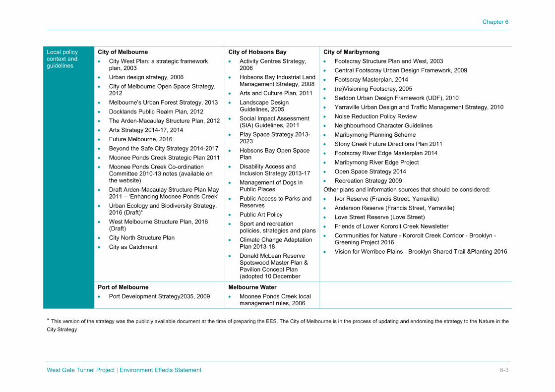
6.2 Policy context A range of legislation, policies and guidelines provide guidance for urban design at Commonwealth, State and local government levels. Table 6-1 summarises those most relevant to the West Gate Tunnel Project.
The project’s alignment with this policy context is described in section 6.7 of this chapter. Further detail relating to legislation and policy is provided separately in Attachment I Legislation and policy report.

Chapter 6
6-2 West Gate Tunnel Project | Environment Effects Statement
Table 6-1 Urban design legislation, policy and guidelines
Commonwealth policy and guidelines
Creating Places for People Creating Places for People is a ‘protocol’ developed by the Australian Government and is the result of ‘two years of collaboration between peak community and industry organisations, and governments at all levels’. It is intended as a guidance document for ‘anybody who has an interest in our built environment’.
Victorian policy and guidelines
Plan Melbourne, Metropolitan Planning Strategy Plan Melbourne, issued by the Department of Environment, Land, Water and Planning, defines a framework to better direct and harness Melbourne’s growth up until 2050. The Victorian Government recently updated Plan Melbourne to ensure that it keeps pace with the city’s population growth and reflects the Government’s focus on improving housing choice and affordability, increasing jobs and liveability, integrating public transport and infrastructure and addressing climate change. In relation to the West Gate Tunnel Project corridor, the key themes of Plan Melbourne focus on the protection of residential scale and character, assisting ‘reasonable’ commercial growth and better connecting the workforce to centres of employment. Urban Design Charter, 2009 The Urban Design Charter is a commitment by the Victorian Government to make cities and towns in Victoria more liveable through good urban design. The Charter identifies twelve principles as essential qualities for the functioning of good public environments and for making places that are valued and significant for those who use them. These principles have been considered in the development of the urban design principles and objectives for the West Gate Tunnel Project. Transport Integration Act 2010 The TI Act is the central statute for the transport portfolio in Victoria. The TI Act supports the development of an integrated and sustainable transport system in Victoria that contributes to an inclusive, prosperous and environmentally responsible state. An evaluation of the West Gate Tunnel Project against the TI Act’s objectives and principles is provided in Chapter 9 Meeting our obligations. Office of the Victorian Government Architect, Good Design + Transport, Issue 05, 2012 The Office of the Victorian Government Architect has developed clear and comprehensive urban design principles. These principles have been considered in the development of the urban design vision and principles for the West Gate Tunnel Project.
Chapter 6
West Gate Tunnel Project | Environment Effects Statement 6-3
Local policy context and guidelines
City of Melbourne • City West Plan: a strategic framework
plan, 2003 • Urban design strategy, 2006 • City of Melbourne Open Space Strategy,
2012 • Melbourne’s Urban Forest Strategy, 2013 • Docklands Public Realm Plan, 2012 • The Arden-Macaulay Structure Plan, 2012 • Arts Strategy 2014-17, 2014 • Future Melbourne, 2016 • Beyond the Safe City Strategy 2014-2017 • Moonee Ponds Creek Strategic Plan 2011 • Moonee Ponds Creek Co-ordination
Committee 2010-13 notes (available on the website)
• Draft Arden-Macaulay Structure Plan May 2011 – ‘Enhancing Moonee Ponds Creek’
• Urban Ecology and Biodiversity Strategy, 2016 (Draft)*
• West Melbourne Structure Plan, 2016 (Draft)
• City North Structure Plan • City as Catchment
City of Hobsons Bay • Activity Centres Strategy,
2006 • Hobsons Bay Industrial Land
Management Strategy, 2008 • Arts and Culture Plan, 2011 • Landscape Design
Guidelines, 2005 • Social Impact Assessment
(SIA) Guidelines, 2011 • Play Space Strategy 2013-
2023 • Hobsons Bay Open Space
Plan • Disability Access and
Inclusion Strategy 2013-17 • Management of Dogs in
Public Places • Public Access to Parks and
Reserves • Public Art Policy • Sport and recreation
policies, strategies and plans • Climate Change Adaptation
Plan 2013-18 • Donald McLean Reserve
Spotswood Master Plan & Pavilion Concept Plan (adopted 10 December
City of Maribyrnong • Footscray Structure Plan and West, 2003 • Central Footscray Urban Design Framework, 2009 • Footscray Masterplan, 2014 • (re)Visioning Footscray, 2005 • Seddon Urban Design Framework (UDF), 2010 • Yarraville Urban Design and Traffic Management Strategy, 2010 • Noise Reduction Policy Review • Neighbourhood Character Guidelines • Maribyrnong Planning Scheme • Stony Creek Future Directions Plan 2011 • Footscray River Edge Masterplan 2014 • Maribyrnong River Edge Project • Open Space Strategy 2014 • Recreation Strategy 2009 Other plans and information sources that should be considered: • Ivor Reserve (Francis Street, Yarraville) • Anderson Reserve (Francis Street, Yarraville) • Love Street Reserve (Love Street) • Friends of Lower Kororoit Creek Newsletter • Communities for Nature - Kororoit Creek Corridor - Brooklyn -
Greening Project 2016 • Vision for Werribee Plains - Brooklyn Shared Trail &Planting 2016
Port of Melbourne • Port Development Strategy2035, 2009
Melbourne Water • Moonee Ponds Creek local
management rules, 2006
* This version of the strategy was the publicly available document at the time of preparing the EES. The City of Melbourne is in the process of updating and endorsing the strategy to the Nature in the City Strategy

Chapter 6
6-4 West Gate Tunnel Project | Environment Effects Statement
6.3 Urban design vision The urban design vision for the West Gate Tunnel Project is to:
achieve urban design excellence through genuinely innovative and high quality design, responsive and effective urban integration, positive connections within the neighbourhoods through which it passes and a positive contribution for local communities and for greater Melbourne.
In realising this vision, the West Gate Tunnel Project would build upon and extend the significant legacy and reputation for high quality public infrastructure that has been established in Victoria. The project would contribute to a sense of identity and pride for Melbourne’s west, serve local and regional road users, and provide a positive net benefit for communities and metropolitan residents.
The vision incorporates the following attributes.
Regional focus of the vision • A consistently high quality, innovative, enduring urban design concept that contributes to
Melbourne’s reputation for design excellence in the public realm
• An approach to urban development that seeks to promote regionally significant urban renewal opportunities and development of activity centres through the provision of appropriate access and a functional relationship
• A sequence of significant thresholds or ‘moments’ at key junctions and interchanges along the journey that can be ‘read’ in conjunction with Melbourne’s broader freeway network
• A contribution to the creation of a sustainable urban corridor and enhancement of a network of open spaces and cycle and pedestrian routes
• A unifying concept and coherent sense of journey for users of the road and the regional cycle and pedestrian network.
Local focus of the vision • Locally responsive, sensitive urban, architectural and landscape design solutions that provide
increased amenity and positive benefits in addressing design issues and opportunities in all areas affected by the project
• Enhancement of a sense of threshold and connection for local active and passive mode transport routes, including shared use paths, and for public spaces intersecting with or affected by the project
• Contribution to positive, memorable local experiences and enhanced amenity for users of adjoining public spaces and for land uses abutting the project boundary
• Solutions that acknowledge, support and improve local journeys and activities that intersect with the project
• Contribution to the creation of local ‘green’ urban networks and enhancements of public open spaces and streets, including connectivity, accessibility and usefulness as a community asset
• Provision of inclusive, safe spaces where accessibility and active or passive use is not impacted by pollution (noise and emissions)
• Improved connections that contribute to a sustainable public and private transport network.

Chapter 6
West Gate Tunnel Project | Environment Effects Statement 6-5
The urban design vision has guided the development of Project Co’s urban design concept for the West Gate Tunnel Project. The EPRs adopted for the project would require Project Co to continue to respond to the vision during detailed design development (refer to section 6.8 for further details).
6.4 Urban design principles Eight urban design principles were developed to assist in achieving a uniformly high standard of urban design quality and integration. These principles (listed in the table below) have been considered in developing the urban design concept for the project. The EPRs would require Project Co to continue to respond to these principles during the project’s detailed design phase.
Table 6-2 Urban design principles
Urban design principle Description
Urban integration Integrate the project corridor with the surrounding urban and open space fabric to provide a better integrated environment that serves both the community and road users
Identity Provide a distinctive set of urban design elements that create identity for the project corridor, while recognising and enhancing the character of neighbourhoods and precincts through which the freeway passes
Connectivity and wayfinding
Provide legible and distinctive experiences for local communities and road users through application of appropriate urban design and landscape treatments
Resilience and sustainability
Assist the West Gate Tunnel Project to become sustainable, enduring and resilient by implementing environmentally sustainable design that minimises environmental impacts and providing a design that is enduring and functional for generations to come
Amenity Provide improved amenity for local communities, places and environs
Vibrancy Conserve and enhance safe public spaces through well considered and integrated design
Safety Create safe environments that assist in the development of a series of connected and resilient communities
Accessibility Support accessible and inclusive environments so that positive activation and contribution to prosperity, well-being and the perception of care within communities is developed
Chapter 6
6-6 West Gate Tunnel Project | Environment Effects Statement
6.5 Key considerations The following key considerations were identified to guide the development of the urban design concept for the project. These include historical, current and future urban landscape contexts.
Table 6-3 Key design considerations
Key considerations Key findings/attributes
Previous settlement patterns
Decline in previous industrial land use and gradual change to residential and neighbourhood activity centre scale commercial land use in Footscray, Seddon, Yarraville, Flemington and Kensington. Consolidation of the Port of Melbourne and concentration of the heavy industry within the Port and Dynon Road areas. Improvement of Maribyrnong River’s water quality and rejuvenation of the river edge open space leading to an increase in community and property value (economic and social) along the corridor.
Municipal boundaries
Five municipalities directly affected by the project: Cities of Brimbank, Hobsons Bay, Maribyrnong, Melbourne and Wyndham. Two local municipalities indirectly affected by the project: Cities of Moonee Valley and Port Phillip.
Existing land use
West of the Maribyrnong River, there are a variety of land uses, typified by current and post-industrial sites separating existing and developing residential areas. East of the Maribyrnong River, the land uses are far less varied, dominated by industrial and port uses. Given current and historic land use, open space and general public amenity are largely absent. Open space is becoming more valuable. There is a significant amount of urban development expected adjacent to the corridor in the next 20 years. The road edge interface along the freeway corridor is uneven and variable in quality. Some built elements along the edge of the road corridor do not engage with the freeway and present poorly. Noise barriers, retaining walls and fencing along the corridor have little consistency and vary in quality. There are significant areas of parkland and creek reserves adjoining the freeway. These vary from highly urban zones under viaducts and bridges to more open parkland and recreational spaces.
Future land use A number of urban renewal areas in the vicinity of the road corridor would require a functional relationship with the project. Critical to the successful development of the E-Gate site is the pedestrian connection from North Melbourne Station to the site and a high quality Footscray Road address. Footscray Road disconnects the E-Gate site from Docklands. The future mixed-use development of the E-Gate site should also see improved pedestrian connections between E-Gate, Docklands and North and West Melbourne. There would be a significant change to the scale and density of the urban fabric abutting the freeway in key locations. Many developments would result in new built form close to the edge of the road corridor. Roadside advertising is likely to increase with denser commercial developments. The potential for growing visual clutter emphasises the need for bold and consistent themes in the road and infrastructure design to assist with wayfinding and road safety. Much of the buffer space within the freeway right of way would be removed with the addition of new traffic lanes. This would increase the reliance on borrowed landscapes adjoining the freeway for visual amenity.

Chapter 6
West Gate Tunnel Project | Environment Effects Statement 6-7
Key considerations Key findings/attributes
View analysis Key view lines identified through an initial review of the project corridor, including at: Geelong Road, Millers Road, Williamstown Road, West Gate Bridge looking west, Francis Street, Whitehall Street, Shepherds Bridge, Footscray Road, Dynon Road and North Melbourne Station.
Existing motorway, road and urban design elements
The existing West Gate Freeway corridor lacks the large scale sculptural features that characterise the major roads leading into Melbourne. CityLink characteristically demonstrates a strong road marking approach typical of recent major urban road projects. Marking of this type provides wayfinding and contribution to local identity for both the road user and local communities. However, along this corridor, plantations of mature canopy trees mark the interchanges. Overall, a range of urban design elements of varying quality sit within the road reservation and mark the journey for commuters as they travel along the West Gate Freeway. These elements improve wayfinding, create a sense of identity and engage the road user. However, west of the West Gate Bridge there is limited urban design coherence and the road corridor is not distinguished by any clear sense of identity. New urban design elements would be considered relative to existing elements and be of a high visual quality commensurate with the freeway’s role as a regional link. New urban design elements would be designed to respect the local character along the corridor while improving identity, coherence, visual amenity and wayfinding.
Existing noise wall types
There is no consistent or coordinated overall design theme for noise barrires across the corridor. There is a need to balance the desire for visual variety with consistency. Some noise barriers are reaching the end of their lifespan and will require replacement. There is a loosely established colour theme along sections of the corridor. Some noise barriers block important views to cultural or natural features. Noise barriers have a considerable visual impact on adjacent communities, including residents, open space users and cyclists.
Planting and vegetation zones
Freeway planting typically lacks consistency and there is no established theme guiding the design of the landscape. The existing mature Eucalypts located within the freeway reservation provide high visual amenity for drivers and the adjoining local communities. These trees also contribute to biodiversity, habitat and environmental quality. Every attempt would be made to retain them or replace and augment them with similar viable native trees. Space available for planting within the corridor is limited and would become even more so into the future as the road widens. Plant establishment and growth along the freeway corridor is compromised by modified soils and low available soil moisture. A limited suite of plants would perform adequately in these site conditions. The success of inter planting within established planting areas has been variable, with competition for water with the existing vegetation a significant cause of plant failure. Low scale viable mixes would be established to assist in preventing weed infestation and to enhance environmental and visual quality.
Open space, waterways and shared use paths
Melbourne has an established pedestrian and cycling network with scope to extend and improve connections. Government policy aims to strengthen the safety and participation of cyclists and pedestrians across Melbourne. Open space and large parklands adjacent to the freeway have a significant influence on the amenity of the corridor. They provide much needed open space for residents and would be maintained and strengthened. The West Gate Freeway abuts the sensitive environs of Kororoit Creek, Stony Creek and the Maribyrnong River. Minimising the intrusion of the freeway through environmental protection and restoration, and ensuring cross-corridor connectivity, visual amenity and biodiversity, is vital. Future works with the potential to impact Moonee Ponds Creek and Stony Creek should adhere to the recommendations in the Moonee Ponds Creek Strategic Plan (2011), City of Melbourne Open Space Strategy (2012) and the Stony Creek Future Directions Plan (2011).

Chapter 6
6-8 West Gate Tunnel Project | Environment Effects Statement
Key considerations Key findings/attributes
Geology, soils and climate
Soils are likely to be highly variable due to extensive areas of cut and fill associated with road construction and other development works along the road corridor. Natural soils along the motorway corridor west of the Maribyrnong River are predominantly fine textured soils, which are susceptible to compaction with low infiltration rates. The combination of highly modified soils, low effective rainfall and forecast climate change limits the range of plant species suitable for the project corridor. East of the Maribyrnong River the natural soils become slightly sandier however the clay content makes this area prone to compaction. The heavily disturbed nature of the area to the east of the Maribyrnong River provides poor condition for plant growth and drainage. Site preparation, particularly soil compaction alleviation, and batter design are critical for good plant establishment and performance. Retaining walls may be used to create more favourable areas for plant growth, by increasing the volume of loose soil for root growth and reducing the steepness of the batters. Soil pH testing and conditioning is likely to be important to ensure Corymbia and Eucalyptus species perform well and are not prone to iron deficiency. All opportunities would need to be explored to passively irrigate landscapes with storm water. In areas where there is limited available land in the road reserve, investigation should be made as to whether adjacent land holders are interested in harvesting water for re-use on their land.
6.6 Project Co’s urban design concept The urban design concept developed by Project Co aims to create an elegant and integrated segment of transport infrastructure that echoes and celebrates Melbourne’s past, reflects the western region’s rich history and strong sense of community and connection, and fits seamlessly into the existing fabric of the city.
This section outlines key cultural and landscape responses that have generated the overarching design language and palette constituting the urban design concept for the project. It then describes the key urban design initiatives and approaches at major locations and for the main elements, moving from west to east along the corridor.
6.6.1 Cultural response The urban design concept responds to the key considerations set out in section 6.5 and to historical and cultural references embedded in the western region and greater area west of central Melbourne.
A key and underpinning reference that informs the whole of the urban design approach is a strong connection with Victorian Aboriginal culture. This is embodied in the overarching wayfinding philosophy, which is aligned with the historical role of landscape features such as scar trees in Aboriginal culture, through to the use of abstracted shapes, design elements and motifs that reflect the culture and significant markings of Victorian Aboriginal people and acknowledge their connection to the Country. Further detailed consultation with local Traditional Owner Groups would be undertaken during detailed design development to ensure the concept is culturally authentic, sensitive and appropriate.

Chapter 6
West Gate Tunnel Project | Environment Effects Statement 6-9
Victorian Aboriginal cultural references and markings would be reflected in design motifs and features adopted across the project design. These would be integrated in the architectural language, expression, detail and patterns proposed for recurring structures including bridge piers, parapets and screens, and noise barriers, and also in major defining elements such as the tunnel portals. These structures are located at key ‘moments’ and wayfinding points along the West Gate Tunnel Project corridor.
While grounded in Victoria’s Aboriginal heritage, the design concept would also reflect non-indigenous cultural and historical references, including the long maritime history associated with the Port of Melbourne and the waterways of the west, the industrial history of the inner west and the Surf Coast (a key destination for westbound traffic along the corridor).
6.6.2 Landscape response The environmental context and landscape character of the project corridor and the surrounding land through which the West Gate Tunnel Project would pass has also been a key consideration in developing the urban design concept for the project.
The landscaping design for the project aims to improve the landscape quality, biodiversity, resilience and sustainability of the road corridor and affected/adjoining areas, while also establishing a sense of connectivity to iconic features of Melbourne’s western region. These features include the western plains, local creeks and waterways, the busy port environment and extensive indigenous and non-indigenous cultural heritage. This sense of connectivity would be achieved in a number of ways, including through:
• Design references to the journey into Melbourne along the Princes Freeway, including the he western plains, Surf Coast and the You Yangs
• New landscaping and planting along the four creeks and rivers crossed by the West Gate Tunnel Project: Kororoit Creek, Stony Creek, the Maribyrnong River and Moonee Ponds Creek
• Enhancements to the local landscape, with extensive native vegetation planting being undertaken along riparian corridors and within the project corridor
• Improved links for pedestrians and cyclists as a result of new and upgraded walking and cycling connections and crossings, including completing the Federation Trail.
Acknowledging the relative shortage and importance of public open space, and the growing need for public open space due to population increases to serve communities in Melbourne’s west, the urban design concept provides for the creation of an additional 8.9 hectares of landscaped parkland, wetland and community and recreation facilities at several locations along the West Gate Tunnel Project corridor. This would include:
• A new park (approximately 3 hectares) on the south side of the westbound southern tunnel portal and upgraded park and playground to the east of The Avenue
• A new parkland and a wetland at Whitehall Street (approximately 2.8 hectares)
• Additional public open space land (approximately 1.7 hectares) north of West Gate Bridge, south of Stony Creek and east of Williamstown railway line
• Additional open space land (approximately 1.4 hectares) north of Footscray Road and west of Moonee Ponds Creek, subject to landowner agreement.

Chapter 6
6-10 West Gate Tunnel Project | Environment Effects Statement
6.6.3 Urban design references Urban design references have been adopted to generate an authentic, relevant and coherent project identity. These references are shown in Figure 6-1 and include:
• Well-recognised Aboriginal elements such as: fishing nets, eel traps, canoe shapes
• Iconic maritime references including: nets, ropes, shipping containers
• Regional geographical landmarks such as the granite ridges of the You Yangs and the rolling surf of the Surf Coast − a key destination for many users of the project.
These design references have been used to establish a palette of materials, abstracted patterns and motifs. They would be applied in a cohesive and strategic way across the project to create a West Gate Tunnel Project ‘identity’ at a regional scale that has significance within Melbourne’s context of high quality infrastructure projects, while reflecting local culture and history and integrating with existing road infrastructure.
The EES Map Book provides examples of how the design references have been integrated into the West Gate Tunnel Project urban design context.
Figure 6-1 Key cultural references for the West Gate Tunnel Project urban design concept
Victorian Aboriginal design references Geographical and maritime design references
6.6.4 Project structures, features and elements This section outlines the application of the urban design concept to key project structures, features and elements. Further details and plans are contained in the EES Map Book.
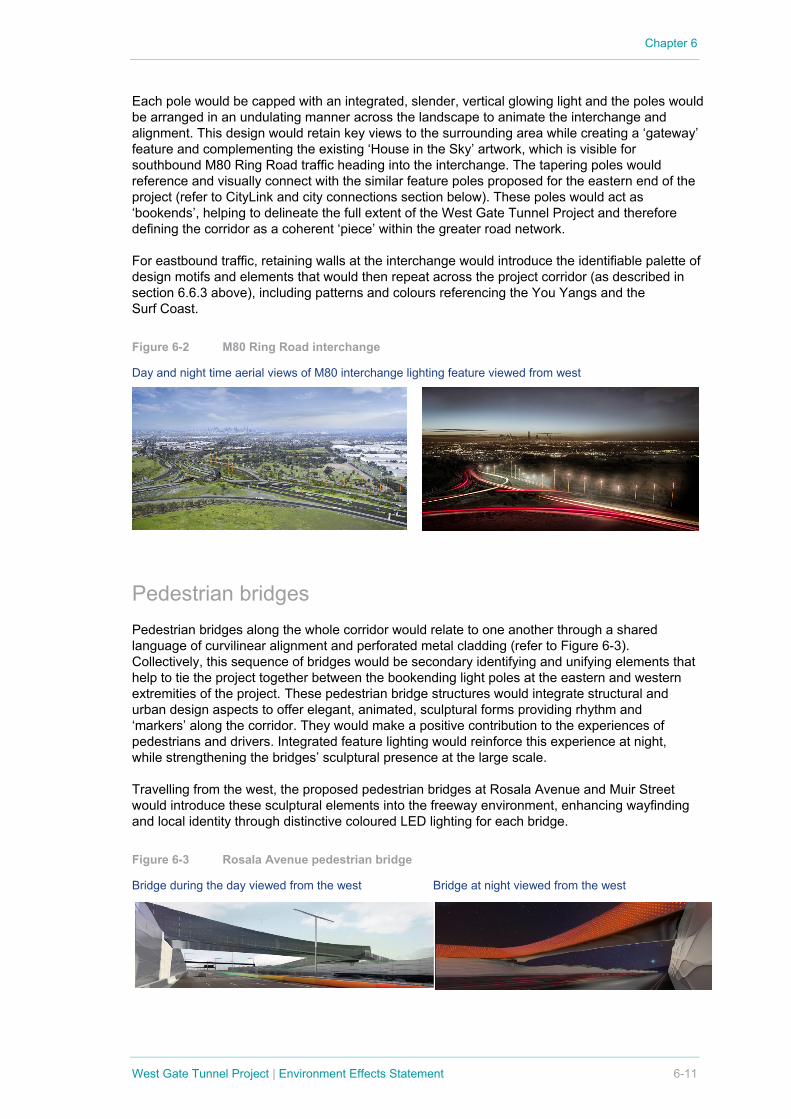
M80 Ring Road interchange The urban design concept acknowledges that the project’s interchange with the M80 Ring Road would be a crucial decision-making and threshold point for users of the West Gate Tunnel Project. The concept proposes to mark the interchange and the alignment of the West Gate Tunnel Project in this location with a series of tapering steel poles of varying height that would visually punctuate and define the interchange along the southern edge (refer to Figure 6-2).
Chapter 6
West Gate Tunnel Project | Environment Effects Statement 6-11
Each pole would be capped with an integrated, slender, vertical glowing light and the poles would be arranged in an undulating manner across the landscape to animate the interchange and alignment. This design would retain key views to the surrounding area while creating a ‘gateway’ feature and complementing the existing ‘House in the Sky’ artwork, which is visible for southbound M80 Ring Road traffic heading into the interchange. The tapering poles would reference and visually connect with the similar feature poles proposed for the eastern end of the project (refer to CityLink and city connections section below). These poles would act as ‘bookends’, helping to delineate the full extent of the West Gate Tunnel Project and therefore defining the corridor as a coherent ‘piece’ within the greater road network.
For eastbound traffic, retaining walls at the interchange would introduce the identifiable palette of design motifs and elements that would then repeat across the project corridor (as described in section 6.6.3 above), including patterns and colours referencing the You Yangs and the Surf Coast.
Figure 6-2 M80 Ring Road interchange
Day and night time aerial views of M80 interchange lighting feature viewed from west
Pedestrian bridges Pedestrian bridges along the whole corridor would relate to one another through a shared language of curvilinear alignment and perforated metal cladding (refer to Figure 6-3). Collectively, this sequence of bridges would be secondary identifying and unifying elements that help to tie the project together between the bookending light poles at the eastern and western extremities of the project. These pedestrian bridge structures would integrate structural and urban design aspects to offer elegant, animated, sculptural forms providing rhythm and ‘markers’ along the corridor. They would make a positive contribution to the experiences of pedestrians and drivers. Integrated feature lighting would reinforce this experience at night, while strengthening the bridges’ sculptural presence at the large scale.
Travelling from the west, the proposed pedestrian bridges at Rosala Avenue and Muir Street would introduce these sculptural elements into the freeway environment, enhancing wayfinding and local identity through distinctive coloured LED lighting for each bridge.
Figure 6-3 Rosala Avenue pedestrian bridge
Bridge during the day viewed from the west Bridge at night viewed from the west

Chapter 6
6-12 West Gate Tunnel Project | Environment Effects Statement
Noise barriers The urban design concept recognises that the need for noise attenuation provides an opportunity to extend the palette of visual elements while simultaneously mitigating traffic noise and protecting private and community space. The concept proposes high quality, textured, precast, off-white concrete panels with coloured acrylic panels incorporating pale blue and green sections that draw on the project’s cultural and landscape design references.
The scale of the pre-cast pattern and fixing details would vary from the freeway side to the community side to reflect the different scales of experience (refer to Figure 6-4). A finer-grained pattern would be provided on the community side, to ensure appropriateness to the local area and human scale. Transparent acrylic panels would reduce the potential for overshadowing to private open spaces, complement local and natural features or views and provide access to sunlight, particularly for residential areas adjacent to the freeway. From the freeway side, viewed at speed, the larger scale pattern would reference the western region’s undulating hills and rolling surf to suggest the maritime imagery of a giant uncoiled rope.
Figure 6-4 Noise barriers
Freeway side viewed from the east Community side viewed from the south
New parkland at Precinct 15 The proposed public open space (approximately three hectares) south of the West Gate Tunnel Project and in the north of the proposed Precinct 15 urban renewal site on Blackshaws Road would present a buffer between future residential development on that site and the freeway (refer to Figure 6-5). A proposed shared use path adjacent to the park and beneath the freeway would improve pedestrian and cycling connectivity. A new neighbourhood park with play facilities, north of Watson Street, would improve access to open space and amenity for local residents.

Chapter 6
West Gate Tunnel Project | Environment Effects Statement 6-13
Figure 6-5 Plan of Precinct 15 and southern portal (westbound)
Southern portal The southern portals would be located at two separate locations: the eastbound portal would extend from west of Williamstown Road and the westbound portal would extend from approximately 1.2 kilometres west of the inbound portal. This would create a buffer between existing residential areas and these new structures, minimising the impact on residential areas. The proposed new public open space area south of the West Gate Tunnel Project (as described above) would further reduce impacts. This new park would be an important community asset, contributing to landscape quality and tree canopy.
The southern portal and ventilation structure would be an integrated sculptural form projecting above the freeway. The design’s form, language and expression draws on the ‘netting/eel trap’ motif, referencing Melbourne’s Aboriginal and maritime heritage. Along with the northern portal, the structure would be a key component in the memorable and unified identity proposed for the West Gate Tunnel Project. The proposed design would also contribute to and enhance local identity and highlight the motifs of the project’s urban design concept.
The form has been scaled to respond to its environment, with integrated feature lighting enhancing this status at night. The use of laminated timber would give an elegant and innovative aspect to the structures while improving sustainability through lower embodied energy and carbon sequestration.
Figure 6-6 Southern portal
Aerial view of portal, looking east Portal entry at night, looking east
PARKLAND PORTAL NEIGHBOURHOOD PARK
N
Chapter 6
6-14 West Gate Tunnel Project | Environment Effects Statement
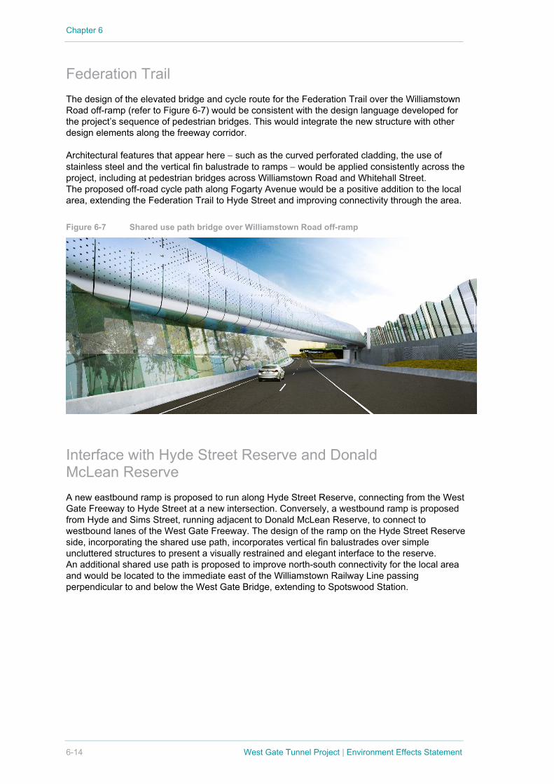
Federation Trail The design of the elevated bridge and cycle route for the Federation Trail over the Williamstown Road off-ramp (refer to Figure 6-7) would be consistent with the design language developed for the project’s sequence of pedestrian bridges. This would integrate the new structure with other design elements along the freeway corridor.
Architectural features that appear here − such as the curved perforated cladding, the use of stainless steel and the vertical fin balustrade to ramps − would be applied consistently across the project, including at pedestrian bridges across Williamstown Road and Whitehall Street. The proposed off-road cycle path along Fogarty Avenue would be a positive addition to the local area, extending the Federation Trail to Hyde Street and improving connectivity through the area.
Figure 6-7 Shared use path bridge over Williamstown Road off-ramp
Interface with Hyde Street Reserve and Donald McLean Reserve A new eastbound ramp is proposed to run along Hyde Street Reserve, connecting from the West Gate Freeway to Hyde Street at a new intersection. Conversely, a westbound ramp is proposed from Hyde and Sims Street, running adjacent to Donald McLean Reserve, to connect to westbound lanes of the West Gate Freeway. The design of the ramp on the Hyde Street Reserve side, incorporating the shared use path, incorporates vertical fin balustrades over simple uncluttered structures to present a visually restrained and elegant interface to the reserve. An additional shared use path is proposed to improve north-south connectivity for the local area and would be located to the immediate east of the Williamstown Railway Line passing perpendicular to and below the West Gate Bridge, extending to Spotswood Station.

Chapter 6
West Gate Tunnel Project | Environment Effects Statement 6-15
Figure 6-8 Hyde Street Reserve interface
Plan of Hyde Street Reserve
View of off-ramp from Hyde Street Reserve, from the south
Tunnels The urban design concept for the tunnels is based on ensuring a clean, uncluttered tunnel interior that is animated by lighting (refer to Figure 6-9). Simple, off-white metal panels illuminated by programmable, coloured LED lighting within the tunnels would provide a highly flexible solution that is easily maintained. Surges of colour along the tunnel journey would create an engaging driver experience while minimising distraction, and offer the opportunity to highlight points of interest modulating the journey, providing visual breaks and contributing to safety by assisting with keeping drivers alert. Programming would enable the use of special colours and lighting sequences for key events and special dates where appropriate.
N
HYDE ST RESERVE

Chapter 6
6-16 West Gate Tunnel Project | Environment Effects Statement
Figure 6-9 Driver view of tunnel interior
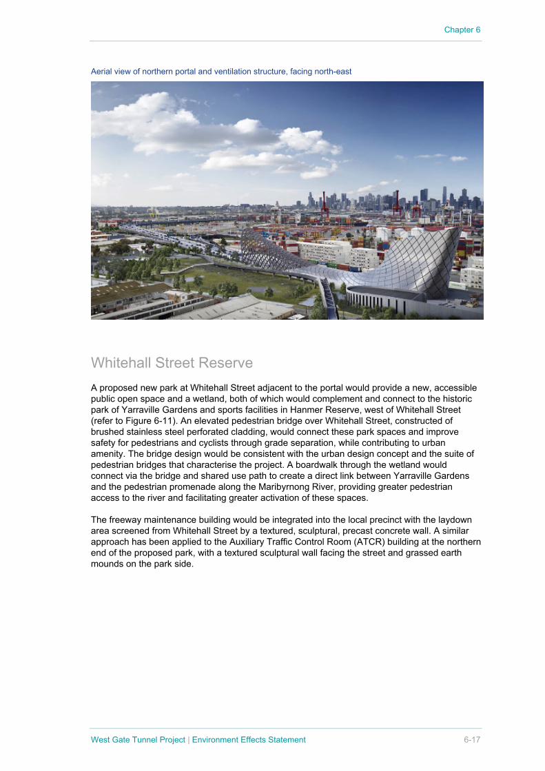
Northern portal The northern portal and ventilation structures are proposed to be located to the east of Whitehall Street in Yarraville, and are not immediately proximate to residential areas.
The northern portal structure and ventilation building design directly relate to the design for the southern portals and ventilation structures, forming two of the major defining elements of the West Gate Tunnel Project’s identity and bookending the tunnel experience for road users (refer to Figure 6-10). The northern portal would comprise a ‘large portal net’ more than 120 metres long and 35 metres wide, consistent with that provided at the southern portals. Integrated feature lighting would enhance the sculptural form and presence of the structures at night, and the use of laminated timber would provide an innovative, sustainable and defining character to the structure.
The portal structure would be integrated with the ventilation structure to create a curved form that references Aboriginal bark canoe shapes. The strong foundation in Victorian Aboriginal culture through abstracted design references would enhance local and regional identity while contributing to the historical narrative of the urban design concept.
Figure 6-10 Northern portal
Portal entrance heading south into tunnel Portal entrance heading south into tunnel
Chapter 6
West Gate Tunnel Project | Environment Effects Statement 6-17
Aerial view of northern portal and ventilation structure, facing north-east
Whitehall Street Reserve A proposed new park at Whitehall Street adjacent to the portal would provide a new, accessible public open space and a wetland, both of which would complement and connect to the historic park of Yarraville Gardens and sports facilities in Hanmer Reserve, west of Whitehall Street (refer to Figure 6-11). An elevated pedestrian bridge over Whitehall Street, constructed of brushed stainless steel perforated cladding, would connect these park spaces and improve safety for pedestrians and cyclists through grade separation, while contributing to urban amenity. The bridge design would be consistent with the urban design concept and the suite of pedestrian bridges that characterise the project. A boardwalk through the wetland would connect via the bridge and shared use path to create a direct link between Yarraville Gardens and the pedestrian promenade along the Maribyrnong River, providing greater pedestrian access to the river and facilitating greater activation of these spaces.
The freeway maintenance building would be integrated into the local precinct with the laydown area screened from Whitehall Street by a textured, sculptural, precast concrete wall. A similar approach has been applied to the Auxiliary Traffic Control Room (ATCR) building at the northern end of the proposed park, with a textured sculptural wall facing the street and grassed earth mounds on the park side.

Chapter 6
6-18 West Gate Tunnel Project | Environment Effects Statement
Figure 6-11 Whitehall Street Reserve
Plan of Whitehall Street Reserve
Maribyrnong River bridge and under-croft The proposed structures over the Maribyrnong River would comprise a main bridge and two ramps connecting to MacKenzie Road on the eastern riverbank (refer to Figure 6-12). The bridge design comprises a façade system of glass reinforced panels to encase the viaduct structures, featuring an intricate ‘eel skin’ design. This design draws on the defining suite of abstracted cultural references developed for the project (refer to section 6.6.3) and would contribute to local and regional identity as a major threshold point, while maintaining consistency with the overall urban design palette. The main bridge would be off-white with coloured highlights, in contrast to the MacKenzie Road ramps that are intended to be more recessive and would be clad in a charcoal coloured façade system.
The landscape design for the waterfront from Lyons Street north to Shepherds Bridge seeks to enhance local amenity and contribute to realising Maribyrnong City Council’s aspirations for an active public realm along the Maribyrnong River. Tree planting and paving would reflect the principles of the Maribyrnong River Masterplan and opportunities would be explored in consultation with Maribyrnong City Council to make positive use of the hard paved areas of the new structure’s under-croft. Possible uses may include climbing walls, basketball courts, skate parks and other facilities. The best approach to activating these areas in ways that respond to and serve community needs would be resolved in consultation with Maribyrnong City Council.
N
HANMER RESERVE

Chapter 6
West Gate Tunnel Project | Environment Effects Statement 6-19
Figure 6-12 Maribyrnong River bridge structures
Plan of bridge
View of bridge looking east View of bridge under-croft looking east
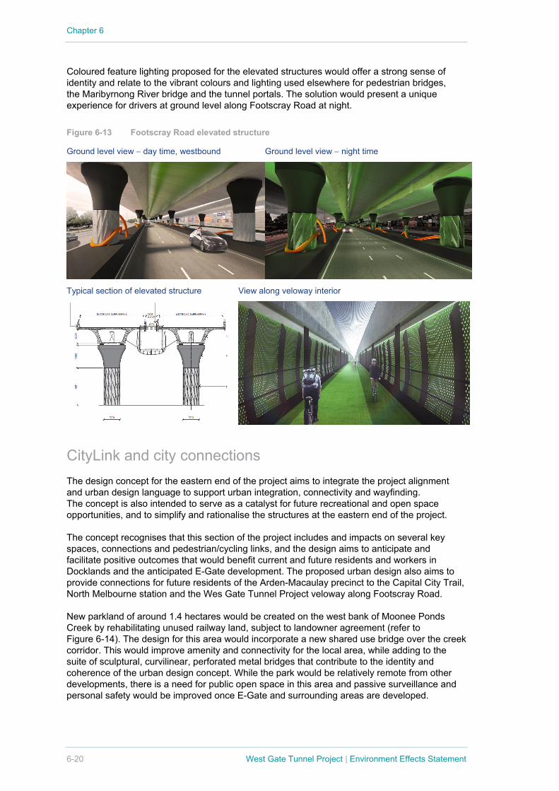
Footscray Road elevated structure The proposed alignment of the elevated structure locates the West Gate Tunnel Project in the centre of the Footscray Road corridor. This location would respond to both the current context and defer to anticipated future development on the urban renewal sites to the north. This alignment would also retain existing trees on the northern and southern medians and enable additional tree plantings, in keeping with a ‘boulevard’ design concept for Footscray Road. Figure 6-13 shows the proposed Footscray Road elevated structure.
The structural design comprises twin rows of piers. This span arrangement would retain the opportunity for future development of public transport services along the corridor. The design aims to reduce the visual clutter potentially associated with two rows of piers and provide an elegant base structure. Using the piers as a ‘virtual forest’, an intertwining sculptural rope motif would create a visual link between the piers and barriers to animate the journey.
A dedicated bicycle path (veloway) would be suspended between the elevated structures, providing a unique, commuter-focused cycling corridor between Footscray and Docklands. This would also free-up space at grade to allow for planting of new trees along Footscray Road to increase tree canopy and strengthen the ‘boulevard’ effect. The existing shared use path on the southern side of Footscray Road would be maintained for pedestrians and enhanced with new trees and landscaped areas.
Chapter 6
6-20 West Gate Tunnel Project | Environment Effects Statement
Coloured feature lighting proposed for the elevated structures would offer a strong sense of identity and relate to the vibrant colours and lighting used elsewhere for pedestrian bridges, the Maribyrnong River bridge and the tunnel portals. The solution would present a unique experience for drivers at ground level along Footscray Road at night.
Figure 6-13 Footscray Road elevated structure
Ground level view − day time, westbound Ground level view − night time
Typical section of elevated structure View along veloway interior
CityLink and city connections The design concept for the eastern end of the project aims to integrate the project alignment and urban design language to support urban integration, connectivity and wayfinding. The concept is also intended to serve as a catalyst for future recreational and open space opportunities, and to simplify and rationalise the structures at the eastern end of the project.
The concept recognises that this section of the project includes and impacts on several key spaces, connections and pedestrian/cycling links, and the design aims to anticipate and facilitate positive outcomes that would benefit current and future residents and workers in Docklands and the anticipated E-Gate development. The proposed urban design also aims to provide connections for future residents of the Arden-Macaulay precinct to the Capital City Trail, North Melbourne station and the Wes Gate Tunnel Project veloway along Footscray Road.
New parkland of around 1.4 hectares would be created on the west bank of Moonee Ponds Creek by rehabilitating unused railway land, subject to landowner agreement (refer to Figure 6-14). The design for this area would incorporate a new shared use bridge over the creek corridor. This would improve amenity and connectivity for the local area, while adding to the suite of sculptural, curvilinear, perforated metal bridges that contribute to the identity and coherence of the urban design concept. While the park would be relatively remote from other developments, there is a need for public open space in this area and passive surveillance and personal safety would be improved once E-Gate and surrounding areas are developed.

Chapter 6
West Gate Tunnel Project | Environment Effects Statement 6-21
A new wetland would be established adjacent to the Dynon Road bridge, which would treat stormwater run-off prior to it entering Moonee Ponds Creek, and contribute to biodiversity, sustainability and resilience.
The urban design concept in this area includes a sequence of tapering feature poles positioned along selected elevated structures to create an aligned ‘gateway’ feature at the eastern end of the project. This would provide a tangible visual connection with the light pole installation at the M80 Ring Road interchange at the western end of the project, ‘bookending’ the project and delineating the extent of the West Gate Tunnel Project.
The design of the Wurundjeri Way extension ramps would incorporate the refined pier design used for Footscray Road and a deck design that repeats the abstracted netting motif adopted across the project. This would tie the element into the coherent urban design palette, while offering a specific local solution to animate the under-croft.
Figure 6-14 CityLink and city connections features
Plan of Moonee Ponds Creek precinct
View of City Gateway feature looking east Wurundjeri Way extension
N WATERFRONT CITY

Chapter 6
6-22 West Gate Tunnel Project | Environment Effects Statement
View of shared use path from Dynon Road View of shared use path near Dynon Road
View of pedestrian bridge over Footscray Road near Docklands
6.6.5 Landscape and trees The proposed design would enhance and make a significant contribution to landscape, amenity and recreational and open space values along the project corridor by:
• Providing new open space areas (including at Whitehall Street Reserve, Precinct 15, Hyde Street Reserve and Moonee Ponds Creek) that complement existing parkland, improve local amenity and extend the green infrastructure of the west
• Improving access to parkland and open space through the expansion of the shared use path network
• Rehabilitating existing open space areas such as the Hyde Street Reserve
• Providing high quality interfaces between the project and sensitive environments, including residential areas and open spaces
• Creating new vantage points with expansive views of the port area and city skyline from new infrastructure, such as the elevated roadways
• Incorporating water sensitive urban design features along the length of the project corridor, including the new wetland environment in the Whitehall Street Reserve.
Chapter 6
West Gate Tunnel Project | Environment Effects Statement 6-23
The project offers amenity improvements through planting of around 17,500 trees (replacing 3,370 to be removed). The tree replacement strategy includes a combination of around 4,000 advanced trees (up to 2.5 metre in height), 13,500 tubestock trees and 900,000 understorey plantings. This ratifies a project commitment to replace removed trees at a minimum 3:1 ratio. This would significantly enhance the existing canopy cover across the project corridor.
As the project passes through a highly varied landscape, the proposed plantings would be drawn from locally appropriate native and indigenous species. Plantings would be selected in consultation with local councils and other stakeholders to ensure they are suitable for local conditions, reflect local policies and strategies, and contribute to urban design and environmental outcomes. If successfully established and maintained, these plantings would make a positive contribution to the enhancement of amenity, microclimate and habitat values within the corridor and would mitigate landscape and visual impacts.
Remnant vegetation removed for the project would be offset in line with the Permitted Clearing of Native Vegetation – Biodiversity Assessment Loss Guidelines.
6.7 Alignment with policy context Local policies, plans and guidelines have been considered and integrated into the urban design concept for the project. This includes:
• Incorporating the principles of the Maribyrnong River Masterplan into the design of the public open space under the Maribyrnong River bridges, including increasing tree canopy cover and creating a large grass gathering space and smaller seating areas
• Reflecting a ‘boulevard’ concept for Footscray Road as a gateway to and from the city’s west
• Upgrading areas along Moonee Ponds Creek in line with City of Melbourne Open Space Strategy by rehabilitating unused railway land to create new parkland, subject to landowner agreement
• Supporting the City of Melbourne’s future plans for the E-Gate and Arden-Macaulay urban renewal sites by providing for improved walking and cycling connectivity around these sites (refer to box below)
• Incorporating localised water sensitive urban design treatments that reflect local plans and strategies, including the proposed new wetland area at the northern portal and planted stormwater detention ponds to aid in groundwater recharge and water reuse
• Developing plans for open space areas and shared use paths that align with local open space networks and active transport plans, such as Hobsons Bay City Council’s proposed extension of the Kororoit Creek Trail.

Chapter 6
6-24 West Gate Tunnel Project | Environment Effects Statement
6.8 Urban design performance requirements The EPRs for the project would require Project Co to continue to respond to the urban design vision and principles during the project’s detailed design phase to:
• Protect and, where practicable, improve access to and amenity for potentially affected residents, open space, social and community infrastructure and commercial facilities
• Minimise, to the extent practicable, landscape and visual impacts and maximise opportunities for enhancement of public amenity, open space and facilities
• Protect access to and amenity for potentially affected business and commercial facilities, where practicable.
The EPRs would also require Project Co to implement the principles of Crime Prevention Through Environmental Design.
Enhancement opportunities for assets such as open space and community facilities, and for activating spaces beneath elevated structures, would be managed in consultation with relevant stakeholders. Refinement of design details for residential or business interfaces would be managed in consultation with affected householders, businesses and local councils.
The EPRs also set performance objectives for detailed design matters such as light spillage, vegetation screening and the preparation and implementation of a Landscaping Plan in consultation with local councils. The Landscaping Plan would be required to achieve a replacement tree canopy of equal or greater size as the existing canopy and to protect the long-term viability of replacement plantings.
In response to community feedback, project-specific noise objectives have been set for the West Gate Tunnel Project and defined in the EPRs. In achieving these objectives (including providing noise attenuation), Project Co would give consideration to the urban design vision and principles.
The EPRs are provided in Chapter 8 Environmental Management Framework.
Supporting urban renewal The urban design concept recognises the importance of facilitating positive outcomes for planned urban renewal sites along the project corridor. Precinct 15 in Altona North and the Bradmill site in Yarraville would be enhanced with improved pedestrian and cycling paths connecting across the freeway corridor and linking to the Federation Trail. Small parks and cycling facilities along the Federation Trail would increase open space and improve amenity to the local area. The alignment of the elevated structure along Footscray Road would enhance the flower market site, allowing space for trees between the elevated roadway and future development. Access to the elevated veloway would provide a safe cycling route between Footscray, Docklands and the central city. A large new park and wetland at Whitehall Street would connect to Yarraville Gardens and sports facilities at Hanmer Reserve. New linear parkland along the eastern bank of Moonee Ponds Creek would maintain and enhance access and views from the planned E-Gate site to the creek. New pedestrian bridges over Whitehall Street, Moonee Ponds Creek and Footscray Road would connect E-Gate to Docklands, Footscray and beyond. The design of the elevated roads north of E-Gate would safeguard a future pedestrian and cycling link from the Docklands to the Arden Macaulay urban renewal precinct.
Chapter 6
West Gate Tunnel Project | Environment Effects Statement 6-25
6.9 Meeting the Scoping Requirements The urban design concept developed by Project Co has considered the evaluation objectives set out in the Scoping Requirements for the project. Implementing the proposed design concept and the EPRs would:
• Acknowledge, respect and contribute to the character and integrity of existing built form and public realm in the immediate and broader neighbourhood of the project works (built form) − such as employing a defined palette of culturally and historically relevant motifs and patterns and appropriate scaling of elements and their expression at road and community interfaces
• Reinforce, enhance and/or complement valued aspects of the existing and evolving urban environment, including nearby urban renewal precincts (built form) − such as creating new parkland along Whitehall Street that complements the historic park of Yarraville Gardens and the sports facilities in Hanmer Reserve
• Establish a significant gateway into Melbourne (built form) − such as defining a clear, culturally and historically relevant series of major sculptural elements along the freeway corridor including portal structures and pedestrian bridges
• Maintain community connections or replace connections that may be disrupted by the project (social, business, land use, public safety and infrastructure) − such as developing direct and safe pedestrian and cycling links from Whitehall Street to the Maribyrnong River to replace and enhance existing links along Youell Street and Lyons Street, and replacing and enhancing existing pedestrian bridges at Rosala Avenue and Muir Street with new, sculptural pedestrian bridges and paths through adjacent parkland
• Minimise potential adverse effects on valued urban landscapes and views, and on landscape character and environmental values (landscape, visual and recreational values) − such as developing 8.9 hectares of new public open space, replacing the existing tree canopy at a minimum ratio of three trees for one tree removed across the project corridor, providing high quality interfaces between the project and sensitive environments and creating new vantage points with expansive views of the port area and city skyline
• Establish opportunities for future restoration of public open space areas (landscape, visual and recreational values)− such as aligning the Hyde Street off-ramp on the north side of the West Gate Freeway away from Stony Creek and providing pedestrian and cycling links across Stony Creek, to maximise future opportunities for the development of the Hyde Street Reserve into a significant and well-connected open space for local communities
• Contribute to the protection of surface water quality during the project's operation through the use of WSUD (hydrology and water quality) − such as establishing retention ponds and WSUD initiatives in the new Whitehall Street Reserve.
6.10 Urban design drawings and plans Plans and drawings depicting the urban design concept for the project are included in the EES Map Book, and Development and Urban Design Plans.