environmental assessment and urban design study chapter 6
TRANSCRIPT

Gardiner Expressway and Lake Shore Boulevard EastReconfigurationEnvironmental Assessment and Urban Design StudyChapter 6: Description of Undertaking and EffectsAssessment
DILLON CONSULTING LIMITED, PERKINS+WILL, MORRISON HERSHFIELD,HARGREAVES ASSOCIATES
AMENDED APRIL 2017

DESCRIPTION OF UNDERTAKING AND EFFECTS ASSESSMENT | AMENDED APRIL 2017
DILLON CONSULTING LIMITED, PERKINS+WILL, MORRISON HERSHFIELD, HARGREAVES ASSOCIATES6-I
Contents6.0 Description of Undertaking and Effects Assessment 6-1
6.1 Description of the Preferred Undertaking 6-1
6.2 Operations and Maintenance Activities ........................................... 6-9
6.3 Retirement Activities .................................................................... 6-9
6.4 Planned Public Realm Improvements ........................................... 6-11
6.4.1 Don Roadway to Leslie Street Public Realm .................... 6-19
6.5 Effects to the Environment ......................................................... 6-19
6.5.1 Effects Assessment Approach ....................................... 6-19
6.5.2 Effects Assessment ..................................................... 6-20
6.6 Consideration of Source Water Protection ..................................... 6-67
6.7 Consideration of Climate Change ................................................. 6-68
6.8 Coordination With Other Projects - Cumulative Effects ................... 6-72
6.9 Advantages and Disadvantages ................................................... 6-74
6.10 Commitments and Monitoring of the Undertaking .......................... 6-80

DESCRIPTION OF UNDERTAKING AND EFFECTS ASSESSMENT | AMENDED APRIL 2017
DILLON CONSULTING LIMITED, PERKINS+WILL, MORRISON HERSHFIELD, HARGREAVES ASSOCIATES6-II
List of Figures
Figure 6-1: Gardiner Elements Requiring Removal ................................................... 6-4
Figure 6-2: Gardiner Deck Removal (2001) East of Logan Avenue ............................ 6-5
Figure 6-3: Alignment of New Expressway Link with Don Valley Parkway ................. 6-6
Figure 6-4: Lake Shore Boulevard Design East of Don River .................................... 6-10
Figure 6-5: Example Rendering of Pedestrian and Multi-Use Trail (east ofSherbourne Street looking west) ......................................................... 6-14
Figure 6-6: Example Rendering of Intersection Improvements (Cherry Streetand Lake Shore Boulevard) ................................................................... 6-17
Figure 6-7: Hybrid 3 Conceptual Design Plan between Cherry Street andDon Roadway (Keating Channel Precinct) ............................................. 6-18
Figure 6-8: Preferred Undertaking – Keating Channel Precinct ConceptualDevelopment Concept .......................................................................... 6-53
List of Tables
Table 6-1: Construction Period - Project/Environmental Component Interaction .... 6-22
Table 6-2: Construction Period Net Effects .............................................................. 6-25
Table 6-3: Operations Net Effects .......................................................................... 6-41
Table 6-4: Project Advantages and Disadvantages ................................................ 6-75
Table 6-5: Construction Effects Monitoring ............................................................... 6-82
Table 6-6: EA Commitments and Compliance Monitoring ......................................... 6-85
Table 6-7: Additional Commitments Resulting from Final EA Report Review ............. 6-92

DESCRIPTION OF UNDERTAKING AND EFFECTS ASSESSMENT | AMENDED APRIL 2017
DILLON CONSULTING LIMITED, PERKINS+WILL, MORRISON HERSHFIELD, HARGREAVES ASSOCIATES6-1
6.0 Description of Undertaking andEffects Assessment
6.1 Description of the Preferred UndertakingOn March 30, 2016 Toronto City Council endorsed the City Staff recommendation for theHybrid 3 alternative design that was supported by the technical analysis and public consultationprocess undertaken during the alternative design phase of study. As such, the Hybrid 3alternative design is the preferred undertaking for the Gardiner East Project.
The Gardiner East Project includes five distinct components:
1) The rehabilitation of the existing Gardiner Expressway deck from Jarvis Street to CherryStreet.
2) The removal of the existing expressway east of Cherry Street and the construction of anew expressway link with the Don Valley Parkway (DVP).
3) The construction of a realigned Lake Shore Boulevard from Cherry Street to DonRoadway with new ramps to and from the Gardiner Expressway.
4) Reconstruction of Lake Shore Boulevard east of the Don River to Logan Avenue includinga reconstructed Don River bridge.
5) Public Realm Improvements from Jarvis Street to Leslie Street.
All items above except item 1) form the undertaking for which an EA approval under the EAA isbeing sought. Item 1) does not require EA approval and does not form part of the undertakingfor which an approval under the EAA is being sought. The combination of the infrastructurechanges noted in items 2), 3) and 4) along with the public realm improvements as per item 5)provide the complete picture of how the Study Area will transform as a result of the GardinerEast undertaking.

DESCRIPTION OF UNDERTAKING AND EFFECTS ASSESSMENT | AMENDED APRIL 2017
DILLON CONSULTING LIMITED, PERKINS+WILL, MORRISON HERSHFIELD, HARGREAVES ASSOCIATES6-2
The undertaking described in this EA Report has been developed to a conceptual level of detailonly. Some aspects of the undertaking may therefore require refinements or changes betweenEA approval and implementation that is planned to begin in 2020. As described in Chapter 8.0some of the refinements and/or changes to the undertaking may result from detailed designwork and/or be desired because of other planned developments and other projects in the StudyArea. Changes to the undertaking could also result from roadway and corridor operations andmaintenance activities as described further below in Section 6.1.1. As a result, it is importantto appreciate that some amount of flexibility is required with the concept design of thisundertaking. To allow for this flexibility, EA Amendment procedures have been included as partof this EA which are described in Chapter 8.0. Further, the Project co-proponents commit toconstructing the undertaking as per the detailed design that is to be developed.
The following describes the key elements of the undertaking:
West of Cherry Street Gardiner Deck Rehabilitation
West of Cherry Street only, the elevated Gardiner deck is to be replaced. This work would beundertaken as part of the broader Gardiner Strategic Rehabilitation Program managed by City ofToronto Transportation Services. There would be no significant changes to the expresswaysupport structure and/or ramps (with the exception of a proposed change to the Jarvis Streeteastbound off-ramp that is to be reduced in length as per the Lower Yonge Precinct Plan). Forthis section, the City is contemplating an accelerated deck replacement approach whereby newgirders and deck segments would be prefabricated in advance, at a remote facility, and thentransported to the site and placed in their final locations, using crane hoisting equipment. Theexisting deck would be saw-cut in sections and each deck section, together with the supportinggirders, would be hoisted and removed utilizing the same equipment used to handle theprefabricated components. The timing for these works is currently projected for the 2020-2025period.
West of Cherry Street, Lake Shore Boulevard will remain in its current configuration withmodifications to streetscaping and minor intersection improvements at Jarvis Street,Sherbourne Street and Parliament Street. Along the north side of Lake Shore Boulevard there willbe the addition of a new east-west multi-use trail. Public space improvements will be designedalong the north and south sides of Lake Shore Boulevard to create a more inviting pedestrianenvironment. The details of public realm, streetscaping and trail configuration will be definedthrough additional study.

DESCRIPTION OF UNDERTAKING AND EFFECTS ASSESSMENT | AMENDED APRIL 2017
DILLON CONSULTING LIMITED, PERKINS+WILL, MORRISON HERSHFIELD, HARGREAVES ASSOCIATES6-3
East of Cherry Street Gardiner Removal and New LinkConstruction
The existing elevated Gardiner Expressway that runs east of Cherry Street, including theconnecting ramps to the DVP and the Logan ramps that are located east of the Don River, wouldbe demolished. This would include the removal of the deck, bent/pier caps and piers/supportcolumns. The existing column/pier support footings would require removal only if they are inconflict with any proposed new underground works, including earthworks required forlandscaping, along the existing Gardiner corridor between the Don River and Cherry Street andunderneath the existing DVP ramps. Figure 6-1 below illustrates the existing Gardinercomponents that will require removal.

DESCRIPTION OF UNDERTAKING AND EFFECTS ASSESSMENT | AMENDED APRIL 2017
DILLON CONSULTING LIMITED, PERKINS+WILL, MORRISON HERSHFIELD, HARGREAVES ASSOCIATES6-4
Figure 6-1: Gardiner Elements Requiring Removal

DESCRIPTION OF UNDERTAKING AND EFFECTS ASSESSMENT | AMENDED APRIL 2017
DILLON CONSULTING LIMITED, PERKINS+WILL, MORRISON HERSHFIELD, HARGREAVES ASSOCIATES6-5
It is anticipated that the expressway would be removed through mechanical means. Removalwould likely require mechanical splitting, concrete sawing and drilling, use of pneumaticbreakers or other percussive tools to break up the concrete for removal by smaller bucketloading vehicles. Blasting will not be allowed. The photograph in Figure 6-2 illustrates thedemolition of the Gardiner’s east end, east of Logan Avenue, which was removed in 2001. Thedebris from removal would be hauled away by truck to an appropriate disposal area. It isanticipated that the existing steel girders would be recycled.
Figure 6-2: Gardiner Deck Removal (2001) East of Logan Avenue
A new elevated expressway link would be constructed between the Gardiner at Cherry Streetand the DVP, including new ramps over the Don River to connect the Gardiner with theDVP. This would include the construction of a new support structure that includes bent capsand support piers/columns with footings and piles to support the new deck. The new elevatedexpressway would consist of 2 lanes in each direction. It is recommended that wider right(outside) shoulders be provided on the ramps (2.5 m). Wider shoulders will provide space forsafety and emergency purposes. Figure 6-3 illustrates the proposed alignment of the newexpressway link between Cherry Street and the DVP, through the Keating Channel Precinct, andshows the approximate location of the support piers. Future detailed design work will confirmthe design of the facility.

DESCRIPTION OF UNDERTAKING AND EFFECTS ASSESSMENT | AMENDED APRIL 2017
DILLON CONSULTING LIMITED, PERKINS+WILL, MORRISON HERSHFIELD, HARGREAVES ASSOCIATES6-6
Figure 6-3: Alignment of New Expressway Link with Don Valley Parkway

DESCRIPTION OF UNDERTAKING AND EFFECTS ASSESSMENT | AMENDED APRIL 2017
DILLON CONSULTING LIMITED, PERKINS+WILL, MORRISON HERSHFIELD, HARGREAVES ASSOCIATES6-7
To facilitate the tighter 130 m radius ramp that allows for a more northern alignment of theexpressway through the Keating Channel Precinct and to accommodate the reconfiguredDVP/Gardiner roadway/ramp combination plus the exit and entrance ramps to Don Roadway atthis location, it will be necessary to lengthen the Metrolinx rail bridge that extends over the DVPto provide for the appropriate bridge spans. Figure 6-3 on the previous page indicates thelocation of the existing Metrolinx rail bridge and the bridge lengthening required. The existingbridge at this location is a four span bridge with a wide west side span over the Don River andthree smaller spans east of the river. Based on the concept design of the undertaking, it isanticipated that the bridge would need to be reconstructed to replace the three eastern spanswith new spans that have a total width of approximately 35 m. The design for the bridgereconstruction is to be confirmed during detailed design. Metrolinx has been an importantstakeholder in this study and provided input to this EA process including recommendedmitigation measures related to the bridge widening. A letter was received from Metrolinx datedMay 12, 2016 outlining coordination expectations for input and reviews of designs, stagingplans and specification that may relate to or affect the rail corridor or rail infrastructure as theproject proceeds. Metrolinx will need to be consulted with during the detailed design andconstruction stages to ensure that disruption to rail traffic is minimized as much as possible.Coordination with Metrolinx will be ongoing to understand Metrolinx planned works in theStudy Area and manage project integration.
The new alignment of the expressway also includes the construction of two new access rampsthat would be located east of Cherry Street connecting the Gardiner with the realigned LakeShore Boulevard (see Figure 6-3). A new 2-lane eastbound off-ramp and a new 2-lanewestbound on-ramp would be constructed. These ramps would each be supported by a bridgestructure that would be integrated with the structure to support the main expressway deck.
An example description of construction staging with how the Gardiner Expressway will bedemolished and the new expressway constructed between Cherry Street and the DVP/DonRoadway is provided in Appendix D, Construction Staging Report. Included are schematicdiagrams showing proposed detour roads. The construction staging considered for the EAprovides one example of how the staging may occur. This will be refined during future detaileddesign work in consultation with other major construction projects occurring in the Study Areaat the same time.
Other project components associated with the new expressway alignment include therequirement for additional speed reduction measures and advisory signage on the DVP andGardiner informing drivers of the 50 km/h ramp speed in advance of the tighter ramp curves. It

DESCRIPTION OF UNDERTAKING AND EFFECTS ASSESSMENT | AMENDED APRIL 2017
DILLON CONSULTING LIMITED, PERKINS+WILL, MORRISON HERSHFIELD, HARGREAVES ASSOCIATES6-8
is expected that speed transition zones will need to be created in advance of the ramps to slowvehicles down in steps from 90 km/h to 70 km/h to 50 km/hr.
Lake Shore Boulevard Realignment
This project component involves the development of a new alignment for Lake Shore Boulevardbetween Cherry Street and the Don Roadway, in the Keating Channel Precinct. The roadwaywould be developed as a six-lane cross section with a potential new future intersection withMunition Street should it be extended north from Villiers Island into the Keating ChannelPrecinct (as proposed in the Lower Don Lands TSMP EA). This realignment of Lake ShoreBoulevard is consistent with the Keating Channel Precinct Plan.
The existing road surface of Lake Shore Boulevard that runs along the north edge of the KeatingChannel, between Cherry Street and Don Roadway, would be removed. Further treatment ofthis area would be completed separately as per the Keating Channel Precinct Plan. Public realmimprovements include the implementation of additional green space, pedestrian connections,streetscaping, landscaping and cycling connections throughout the Keating Channel Precinct.The public realm improvements will build on the infrastructure improvements of realigning theGardiner and Lake Shore Boulevard through this area so as to enhance the Keating ChannelPrecinct.
East of the Don River, after the removal of the overhead Logan Avenue ramps, Lake ShoreBoulevard would be rebuilt into a landscaped 6-lane boulevard with generousmedians. Figure 6-4 provides a cross section of the roadway through this section. Theroadway would connect and transition into the existing at-grade Lake Shore Boulevard just eastof where the existing Logan ramps touch down – roughly at Booth Street.
Lake Shore Boulevard/Don River Bridge
The Lake Shore Boulevard Bridge over the Don River will need to be rebuilt to provide sufficientwidth for: 6 travel lanes, an eastbound left turn lane to access the northbound Don Roadway/DVP, a multi-use trail, and sidewalk.
It is noted that modifications to the Lake Shore Boulevard bridge over the Don River have beenpreviously proposed in the approved EA reports for the Lower Don Lands Master Plan, KeatingChannel Precinct Environmental Study Report and the Don Mouth Naturalization and Port LandsFlood Protection Project (DMNP Project). The previous studies identified that the new Lake ShoreBoulevard-Don River bridge would involve retaining the existing bridge and providing three newspans to the west to accommodate the widening of the Don River Mouth in order to provide the

DESCRIPTION OF UNDERTAKING AND EFFECTS ASSESSMENT | AMENDED APRIL 2017
DILLON CONSULTING LIMITED, PERKINS+WILL, MORRISON HERSHFIELD, HARGREAVES ASSOCIATES6-9
Don Mouth flood protection, and sediment and debris management works. The selection ofthis bridge modification option in those studies was based, for the most part, on the existenceof the overhead Gardiner Expressway structure in the immediate bridge area as per the currentcondition.
With the removal of the overhead Gardiner Expressway in the vicinity of the Lake ShoreBoulevard-Don River bridge, there may be other opportunities for bridge re-design /modifications to improve river conveyance and sediment management operations north andsouth of Lake Shore Boulevard. This could include the raising of the future Lake ShoreBoulevard-Don River bridge soffit and reducing the number of piers to support the structure.This could further enhance the Don River Mouth naturalization efforts. It is recommended thatmore detailed examination be completed on this opportunity in coordination with TRCA duringfuture detailed design work.
In addition to rebuilding the Lake Shore Boulevard-Don River bridge crossing, the industrial railspur connection that links the rail facilities west of the Don River to the east and provides railaccess to the Port Lands area will be maintained. This will involve constructing a new railcrossing over the Don River. For the purposes of this EA it has been assumed that a separaterail bridge structure located immediately north of the new Lake Shore Boulevard-Don Riverbridge would be constructed. It may be possible to integrate the rail bridge into thereconstructed Lake Shore Boulevard bridge. This will be explored as part of detailed design. Inaddition, opportunities to raise the soffit height of the railway spur bridge will also be exploredat detailed design in coordination with TRCA and the appropriate stakeholders.
6.2 Operations and Maintenance ActivitiesOnce constructed the project will be subject to routine City of Toronto roadway operations andmaintenance activities that would include for example: snow clearing and de-icing, road androadway structure condition inspections, roadway surface repairs, lane marking repainting,traffic monitoring, road accident assessments, minor roadway design changes to respond totraffic demands and patterns, etc.
6.3 Retirement ActivitiesThe Gardiner and Lake Shore Boulevard are expected to have a lifespan of at least 100 years.Decommissioning or retirement of these roadways is not currently anticipated.

DESCRIPTION OF UNDERTAKING AND EFFECTS ASSESSMENT | AMENDED APRIL 2017
DILLON CONSULTING LIMITED, PERKINS+WILL, MORRISON HERSHFIELD, HARGREAVES ASSOCIATES6-10
Figure 6-4: Lake Shore Boulevard Design East of Don River

DESCRIPTION OF UNDERTAKING AND EFFECTS ASSESSMENT | AMENDED APRIL 2017
DILLON CONSULTING LIMITED, PERKINS+WILL, MORRISON HERSHFIELD, HARGREAVES ASSOCIATES6-11
6.4 Planned Public Realm ImprovementsThis section presents public realm improvements proposed for the corridor. The project co-proponents are committed to improving the public realm adjacent to Lake Shore Boulevard, andcarefully coordinating public realm improvements with adjacent city-building efforts in thestudy area, including future planning and development of the Keating Channel Precinct. Theimprovements outlined here require further refinement and detailed design through futurestudy as directed by Council. The City intends to issue in 2017 a Public Realm Phasing andImplementation Plan for the Gardiner East corridor that will form part of the Gardiner StrategicPlan detailed design and project delivery. This Public Realm Phasing and Implementation Planwill be linked to other planning and development processes, such as the Keating ChannelPrecinct Plan review. The recommended corridor public realm improvements recognize thefollowing:
● For the western segment (Jarvis Street to Cherry Street), through the alternativesolutions phase of the EA study, it was determined that there would be no significantinfrastructure changes to the corridor west of Cherry Street. At the June 10, 2015City Council Meeting, Council recommended that the western segment of theGardiner-Lake Shore Boulevard corridor be maintained with the full traffic functionthat exists today (retaining the same number of roadway lanes and ramps). Althoughthere will be no major infrastructure changes, there will be improvements to thepublic realm in this area through streetscaping, a multi-use trail and modificationsto the intersections. These improvements will focus on enhancing the pedestrianexperience, improving pedestrian crossings, connecting a new east-west multi-usetrail on the north side of Lake Shore Boulevard, and providing improved hard andsoft landscaping along the underutilized edges of Lake Shore Boulevard.
● Between Cherry Street and the Don River, the planned public realm improvementscomplement the infrastructure changes for the proposed undertaking (Hybrid 3, therecommended preferred alternative design for this section). With the realignment ofLake Shore Boulevard and the new configuration for the Gardiner Expresswaythrough this area, in concert with the planning and development of a new mixed-usewaterfront community in the Keating Channel Precinct, there will be a significanttransformation and opportunities for improved public realm that includes prominentnew public space. This includes streetscaping and landscaping throughout thenetwork of new streets proposed in the area, improved Keating Channel publicspace, additional open space and significant streetscaping along the opened up Lake

DESCRIPTION OF UNDERTAKING AND EFFECTS ASSESSMENT | AMENDED APRIL 2017
DILLON CONSULTING LIMITED, PERKINS+WILL, MORRISON HERSHFIELD, HARGREAVES ASSOCIATES6-12
Shore Boulevard that will have improved access to light and air. Through this areawill also be the new east-west multi-use trail north of Lake Shore Boulevard.
● For the section from Don Roadway to Logan Avenue, for the undertaking the existingLogan Ramps would be removed and Lake Shore Boulevard would be rebuilt withinthe same road right-of-way. This rebuilt boulevard would connect with the existingLake Shore Boulevard east of Logan Avenue. Lake Shore Boulevard is a six-laneboulevard from just east of Logan Avenue to Leslie Street. To the west, the rebuiltroadway would connect with the proposed realigned Lake Shore Boulevard at thecurrent Don River bridge location (which will also be a six-lane roadway).Streetscaping improvements will be made on both the north and south sides of LakeShore Boulevard to improve what exists today and to provide new pedestrianconnections. The existing multi-use trail on the north side of Lake Shore Boulevardwill remain in this area. Opportunities to improve the public realm throughlandscaping and improved pedestrian crossings are encouraged.
It is important to note that the corridor east of Cherry Street passes through a part of thewaterfront that is undergoing extensive study that will result in changes to land use and thetransportation network. In particular, the plans for the neighbourhoods on either side of LakeShore Boulevard east of the Don Roadway (Port Lands and South of Eastern) are still beingdeveloped and will influence the public realm and streetscape design of Lake ShoreBoulevard. This includes the potential for new north-south street intersections, transit andcycling connections. This EA study has included, where possible, consideration for thesedeveloping plans and the design allows for some flexibility to accommodate futuremodifications if needed. Improvements to public realm throughout the corridor will need to becoordinated with relevant precinct plans and planning frameworks to provide a consistentdesign language that achieves the public realm revitalization goals for the waterfront. Thepublic realm improvements recommended in this EA will be confirmed and refined through acoordination effort led by the co-proponents (which will occur under separate study from thisEA). More detailed plans for public realm design throughout the Gardiner – Lake ShoreBoulevard corridor should include consideration for opportunities to maintain a high-qualitypublic realm in the vicinity of an elevated expressway. This may include considerations formanaging effects of winter salt applications, managing potential impacts to landscaping andpublic space related to stormwater management and surface runoff contaminants, as well asopportunities to improve the pedestrian and cycling experience related to noise and air quality.

DESCRIPTION OF UNDERTAKING AND EFFECTS ASSESSMENT | AMENDED APRIL 2017
DILLON CONSULTING LIMITED, PERKINS+WILL, MORRISON HERSHFIELD, HARGREAVES ASSOCIATES6-13
Although Lake Shore Boulevard has unique public realm conditions depending on the segmentof the Study Area, there are elements of the public realm design plans that extend throughoutthe study corridor. These include pedestrian and cycling network connections, streetscapeimprovements and open space concepts as described below.
Corridor-Wide Design Elements - Common elements of the design plans throughout thecorridor include a continuous and connected pedestrian and cycling network, a continuousnetwork of open spaces and public realm improvements through hard and soft landscaping,and public art.
Pedestrian Network and Cycling Connections - Extending the length of the Study Area is aproposed new multi-use trail. The trail would be located along the north side of Lake ShoreBoulevard. Along this north side would also be an associated greenway which varies in sizedepending on both the dimensions of the space available, and the edge condition associatedwith Metrolinx’s adjacent rail corridor infrastructure.
Key north-south connections across the corridor that link into the new multi-use trail alongLake Shore Boulevard include planned or proposed improvements on Yonge Street, SherbourneStreet, and Cherry Street. As the Villiers Island Precinct, Port Lands and South of Eastern areaplans evolve, additional important north-south connections across the corridor are anticipated.
The pedestrian network will also be enhanced through the implementation of continuoussidewalks along the north and south sides of Lake Shore Boulevard, where possible. Improvedpedestrian connections will enhance connectivity throughout the Central Waterfront andbetween the planned precincts. As a key principle of the CWSP, improved pedestrianconnections will be prioritized throughout the Study Area with attention paid to howconnections may facilitate the revitalization of the waterfront.
Figure 6-5 provides an example rendering of what the multi-use trail could look like in thewestern section of the Study Area between Jarvis Street and Cherry Street.

DESCRIPTION OF UNDERTAKING AND EFFECTS ASSESSMENT | AMENDED APRIL 2017
DILLON CONSULTING LIMITED, PERKINS+WILL, MORRISON HERSHFIELD, HARGREAVES ASSOCIATES6-14
Figure 6-5: Example Rendering of Pedestrian and Multi-Use Trail (east of Sherbourne Street looking west)
EXISTING
PROPOSED
DESCRIPTION OF UNDERTAKING AND EFFECTS ASSESSMENT | AMENDED APRIL 2017
DILLON CONSULTING LIMITED, PERKINS+WILL, MORRISON HERSHFIELD, HARGREAVES ASSOCIATES6-15
Open Space/Linear Greenway - A system of new open space referred to as a greenway isproposed along the north edge of Lake Shore Boulevard for the entire extent of the studycorridor. The greenway would include primarily passive recreational spaces to provide animproved balance of green space including tree planting among the road infrastructure toenhance the pedestrian experience. There may be locations where more active recreational usessuch as small skateboard parks would be possible.
Public Realm, Public Art and Animation - There are many public realm design interventions thatcan be applied throughout the Study Area that do not require infrastructure changes. Theseinclude landscaping, public art installations and animation of the existing public realm andopen spaces with temporary market space, pedestrian squares, light, and artinstallations. Planning for public art along the corridor would occur through separate City andWaterfront Toronto public art plans and implementation tools.
Streetscaping – Improved streetscaping will be completed throughout the corridor on the northand south sides of Lake Shore Boulevard. This may include tree planting/landscaping and acontinuous pedestrian sidewalk on the south and north sides of the street.
Intersection Improvements – At the existing Lake Shore Boulevard intersections throughout thecorridor (at Jarvis Street, Sherbourne Street, Parliament Street, and Cherry Street), improvementswill be made to:
● Regularize the intersections where possible to reduce pedestrian crossing distancesand improve the legibility of the intersection movements for drivers;
● Reduce turning lanes to improve walkability;
● Provide texture to road surface to demark pedestrian crossing areas. This can bedone in coordination with line painting (including zebra markings);
● Add bollards to the pedestrian refuge medians to provide additional safety andseparation between pedestrians and vehicles;
● Implement north-south curb enlargements that will allow for bike lanes to beincorporated;
● Increase the setback of intersection stop lines to support safe pedestrian crossings;and,
● Implement hard and soft landscaping along Lake Shore Boulevard to improve thepedestrian and cycling experience.
DESCRIPTION OF UNDERTAKING AND EFFECTS ASSESSMENT | AMENDED APRIL 2017
DILLON CONSULTING LIMITED, PERKINS+WILL, MORRISON HERSHFIELD, HARGREAVES ASSOCIATES6-16
An example rendering of potential intersection improvements is provided in Figure 6-6. Someof the improvements noted above have already been made (e.g. at Sherbourne Street).
Public Realm Phasing and Implementation Strategy – A phasing and implementation strategy forthe corridor will be completed to provide a coordinated and consistent approach to deliveringpublic realm within the corridor. The strategy will identify opportunities to integrate withcomplementary projects within or proximate to the Gardiner East EA Study Area. The strategywill include a phasing plan and will identify how proposed public realm improvements can bestbe coordinated among other initiatives including the Port Lands Planning Framework and theKeating Channel Precinct Plan. In addition, the Keating Channel Precinct Plan will need to bereviewed to reflect the Gardiner East EA undertaking. Figure 6-7 presents a conceptual plan forthe improvements in the Keating Channel Precinct along Lake Shore Boulevard between CherryStreet and the Don Roadway.

DESCRIPTION OF UNDERTAKING AND EFFECTS ASSESSMENT | AMENDED APRIL 2017
DILLON CONSULTING LIMITED, PERKINS+WILL, MORRISON HERSHFIELD, HARGREAVES ASSOCIATES6-17
Figure 6-6: Example Rendering of Intersection Improvements (Cherry Street and Lake Shore Boulevard)
EXISTING
PROPOSED

DESCRIPTION OF UNDERTAKING AND EFFECTS ASSESSMENT | AMENDED APRIL 2017
DILLON CONSULTING LIMITED, PERKINS+WILL, MORRISON HERSHFIELD, HARGREAVES ASSOCIATES6-18
Figure 6-7: Hybrid 3 Conceptual Design Plan between Cherry Street and Don Roadway (Keating Channel Precinct)

DESCRIPTION OF UNDERTAKING AND EFFECTS ASSESSMENT | AMENDED APRIL 2017
DILLON CONSULTING LIMITED, PERKINS+WILL, MORRISON HERSHFIELD, HARGREAVES ASSOCIATES6-19
6.4.1 Don Roadway to Leslie Street Public Realm
East of the Don River, the Gardiner Expressway will be removed and a boulevard design will beconstructed for Lake Shore Boulevard. The design of the boulevard will generally mirror thedesign of Lake Shore Boulevard east of Carlaw Avenue. Improvements to the design mayinclude:
● Enhanced tree planting;
● A wider pedestrian median for pedestrian refuge to cross the boulevard;
● Improved paving materials and line painting (including zebra markings) to differentiateintersection crossings and pedestrian, cycling and automobile spaces;
● Enhanced landscaping on the north edge supporting the multi-use trail; and,
● Improved pedestrian sidewalk on the south side of the street.
The public realm plan for the section of Lake Shore Boulevard east of the Don Roadway will becoordinated with the plans for the Port Lands and South of Eastern area.
6.5 Effects to the Environment
6.5.1 Effects Assessment Approach
The provincial EA process requires proponents to identify and describe in detail the potentialeffects on the environment from the proposed undertaking as well as the measures that wouldbe implemented to reduce or possibly avoid those effects. The assessment uses a broaddefinition of environment, as stipulated in the Ontario EA Act, which includes natural, social,economic and cultural components.
The impact assessment has been developed to provide a certain degree of flexibility in projectdesign and how it would be constructed. This flexibility is required to accommodate potentialchanges to the conceptual design, construction methods, and baseline conditions including theevolution of other planned projects in the Study Area. These potential changing circumstanceswould be considered during the detailed design and construction phases of the project. Theapproach to accommodate these potential changes is provided in Chapter 8 which includes anoutline as to how identified project design changes will be considered, including theassessment of effects from those changes to ensure the integrity of the EA.

DESCRIPTION OF UNDERTAKING AND EFFECTS ASSESSMENT | AMENDED APRIL 2017
DILLON CONSULTING LIMITED, PERKINS+WILL, MORRISON HERSHFIELD, HARGREAVES ASSOCIATES6-20
The effects assessment was completed for the near-term construction period and the long-term operation period. The construction period is expected to last for approximately six years(2020-2025). For the assessment of construction effects, it has been assumed that currentbaseline conditions would exist. It is noted that the area to be subject to the most significantconstruction activity, Cherry Street to Don Roadway/DVP, consists of lands that are largelyvacant. This is also the area in which part of the DMNP will occur. The construction effectsassessment considers the coordination of the Gardiner East undertaking and the DMNPundertaking should these two projects be constructed during a similar time period. Thisincludes consideration for how traffic detours will be planned and constructed to accommodatethe construction of both projects. The long-term operations period assumes that full build-outof the Study Area has been achieved, including the naturalization and habitat restoration of theDon River.
In completing the assessment of effects, mitigation measures have been identified to minimizeor reduce the identified adverse environmental effects. These identified mitigation measuresform part of the commitments for this undertaking.
6.5.2 Effects Assessment
The assessment of the undertaking was based on evaluation criteria and measures that weredeveloped by the co-proponents and the Consulting Team that reflect the Study Area, projectcharacteristics and the input received from stakeholders through the course of the EAstudy. Unlike the previous evaluation steps of the EA (e.g., evaluation of alternative solutionsand alternative designs), these criteria are not comparative as we are not comparing facilities.Rather, these criteria provide structure to the assessment of project effects to help in theidentification of measures to reduce these effects. The effects assessment was also completedto aid in the assessment of the advantages and disadvantages of the project that is presented inSection 6.6. For each of the criteria, one or more measures were developed. The measuresspecify the data to be collected and/or the effects to be assessed for each criterion. Thecriteria reflect the four study lenses, Transportation and Infrastructure, Urban Design,Economics and Environment, and are organized on the basis of the following criteria groups:
● Transportation
● Public Safety
● Planning and Urban Design
● Social and Health
● Natural Environment

DESCRIPTION OF UNDERTAKING AND EFFECTS ASSESSMENT | AMENDED APRIL 2017
DILLON CONSULTING LIMITED, PERKINS+WILL, MORRISON HERSHFIELD, HARGREAVES ASSOCIATES6-21
● Cultural Resources
● Economics
Table 6-1 identifies the effects (environmental interactions) that are expected to occur for eachof the major project construction activities. The table focuses on the interaction of constructionactivities and not the operations of the facilities. Based on the construction period interactionspresented in Table 6-1, Table 6-2 presents a summary of the projected project constructionrelated effects, proposed mitigation measures and identifies the net residual effects. Table 6-3presents a summary of the projected project operations period related effects, proposedmitigation and monitoring measures, and identifies net residual effects.
Following Tables 6-1-6-3, detailed subsections provide a summary description of the morenotable effects of the project by each of the seven criteria groups noted above. Thisdescription is organized by the construction and operation periods.

DESCRIPTION OF UNDERTAKING AND EFFECTS ASSESSMENT | AMENDED APRIL 2017
DILLON CONSULTING LIMITED, PERKINS+WILL, MORRISON HERSHFIELD, HARGREAVES ASSOCIATES6-22
Table 6-1: Construction Period - Project/Environmental Component Interaction
Not Affected (NA), Positive Interaction (+), Negative Interaction (-)Table 6-1: Construction Period – Project/Environmental Component Interaction
Project Activity(Construction)
ConstructionSupport Facilities
(e.g., StagingAreas,
Casting/AssemblyYards, ConcreteBatch Plant, etc.)
VegetationRemoval /Protection
TopsoilRemoval/
Stockpiling /Disposal
UtilityRelocations
Constructionof Road
Detours andTemporary
TrafficFacilities
Removal ofGardiner/DVPRamp Decks
andSuperstructure
Installation ofBridge
Superstructureand Deckworks(including for
new DonRiver/LSB &Rail Bridges)
Roadworksand Retaining
Walls
ElectricalWorks
(Signals,Illumination)
Installation ofPublic Realm& Streetscape
Elements
Installation ofSignage and
LaneMarkings
Auto travel timedelays
NA NA NA NA - - - - - NA -
Transit travel delays NA NA NA - - - - - NA NA NAImpact to pedestrianMovement
NA NA NA - - - - - NA - NA
Impact to cyclistmovement
NA NA NA - - - - - NA - NA
Safety risks topedestrians
NA NA NA NA - - - - NA - NA
Safety risks tocyclists
NA NA NA NA - - - - NA - NA
Safety risks tomotorists
NA NA NA NA - - - - NA NA NA
Impact with otherprojects andinitiatives
NA NA NA - - - - - NA - NA
Change in views andviewscapes
- - - - - - - - NA NA NA
Effects fromcontaminated soildisturbance
NA NA - - - - - - - - NA
Change in air quality - - - - - - - - NA NA NAChange in noiselevels
- - - - - - - - - - -
Vibration effects NA NA NA NA - - - - NA NA NATraffic diversioneffects onneighbourhoods
NA NA NA NA - - - - NA NA NA
Impacts on NA NA NA NA NA NA - - NA - NA

DESCRIPTION OF UNDERTAKING AND EFFECTS ASSESSMENT | AMENDED APRIL 2017
DILLON CONSULTING LIMITED, PERKINS+WILL, MORRISON HERSHFIELD, HARGREAVES ASSOCIATES6-23
Table 6-1: Construction Period – Project/Environmental Component InteractionProject Activity(Construction)
ConstructionSupport Facilities
(e.g., StagingAreas,
Casting/AssemblyYards, ConcreteBatch Plant, etc.)
VegetationRemoval /Protection
TopsoilRemoval/
Stockpiling /Disposal
UtilityRelocations
Constructionof Road
Detours andTemporary
TrafficFacilities
Removal ofGardiner/DVPRamp Decks
andSuperstructure
Installation ofBridge
Superstructureand Deckworks(including for
new DonRiver/LSB &Rail Bridges)
Roadworksand Retaining
Walls
ElectricalWorks
(Signals,Illumination)
Installation ofPublic Realm& Streetscape
Elements
Installation ofSignage and
LaneMarkings
recreation useLoss of terrestrialfeatures & habitat
- - - NA NA NA NA NA NA NA NA
Disruption toterrestrial features &habitat
- - NA - - NA - - NA - NA
Loss of aquaticfeatures & habitat
NA NA NA NA NA - - NA NA NA NA
Disruption toaquatic features &habitat
- - - NA - - - NA NA NA NA
Change in surfacewater quality fromstorm run-off
- - - NA - - - NA NA - NA
Impact on Don Riverflood conveyance
NA NA NA NA - - - NA NA NA NA
Potential for changeto microclimate/heat island effect
NA - NA NA NA NA NA NA NA NA NA
Ability toaccommodate stormevent changes fromclimate change
NA NA NA NA NA NA NA NA NA NA NA
Removal of builtheritage features
NA NA NA NA NA NA NA NA NA NA NA
Change to culturallandscape
NA NA NA NA NA NA NA NA NA NA NA
Impact onarchaeologicalresources
- NA - - - NA - - NA NA NA
Impact on FirstNations People and
NA NA NA NA NA NA NA NA NA NA NA

DESCRIPTION OF UNDERTAKING AND EFFECTS ASSESSMENT | AMENDED APRIL 2017
DILLON CONSULTING LIMITED, PERKINS+WILL, MORRISON HERSHFIELD, HARGREAVES ASSOCIATES6-24
Table 6-1: Construction Period – Project/Environmental Component InteractionProject Activity(Construction)
ConstructionSupport Facilities
(e.g., StagingAreas,
Casting/AssemblyYards, ConcreteBatch Plant, etc.)
VegetationRemoval /Protection
TopsoilRemoval/
Stockpiling /Disposal
UtilityRelocations
Constructionof Road
Detours andTemporary
TrafficFacilities
Removal ofGardiner/DVPRamp Decks
andSuperstructure
Installation ofBridge
Superstructureand Deckworks(including for
new DonRiver/LSB &Rail Bridges)
Roadworksand Retaining
Walls
ElectricalWorks
(Signals,Illumination)
Installation ofPublic Realm& Streetscape
Elements
Installation ofSignage and
LaneMarkings
activitiesImpacts to goodsmovement
NA NA NA - - - - - - - -
Impact on downtownmobility
NA NA NA NA - - - NA NA NA NA
Impact on localbusiness activity
NA NA NA NA NA - - - NA NA NA

DESCRIPTION OF UNDERTAKING AND EFFECTS ASSESSMENT | AMENDED APRIL 2017
DILLON CONSULTING LIMITED, PERKINS+WILL, MORRISON HERSHFIELD, HARGREAVES ASSOCIATES6-25
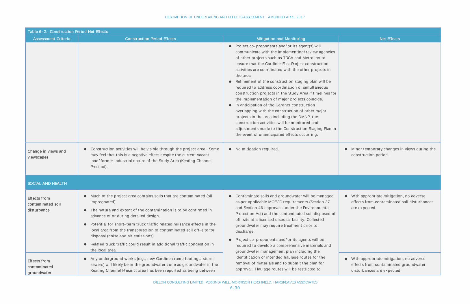
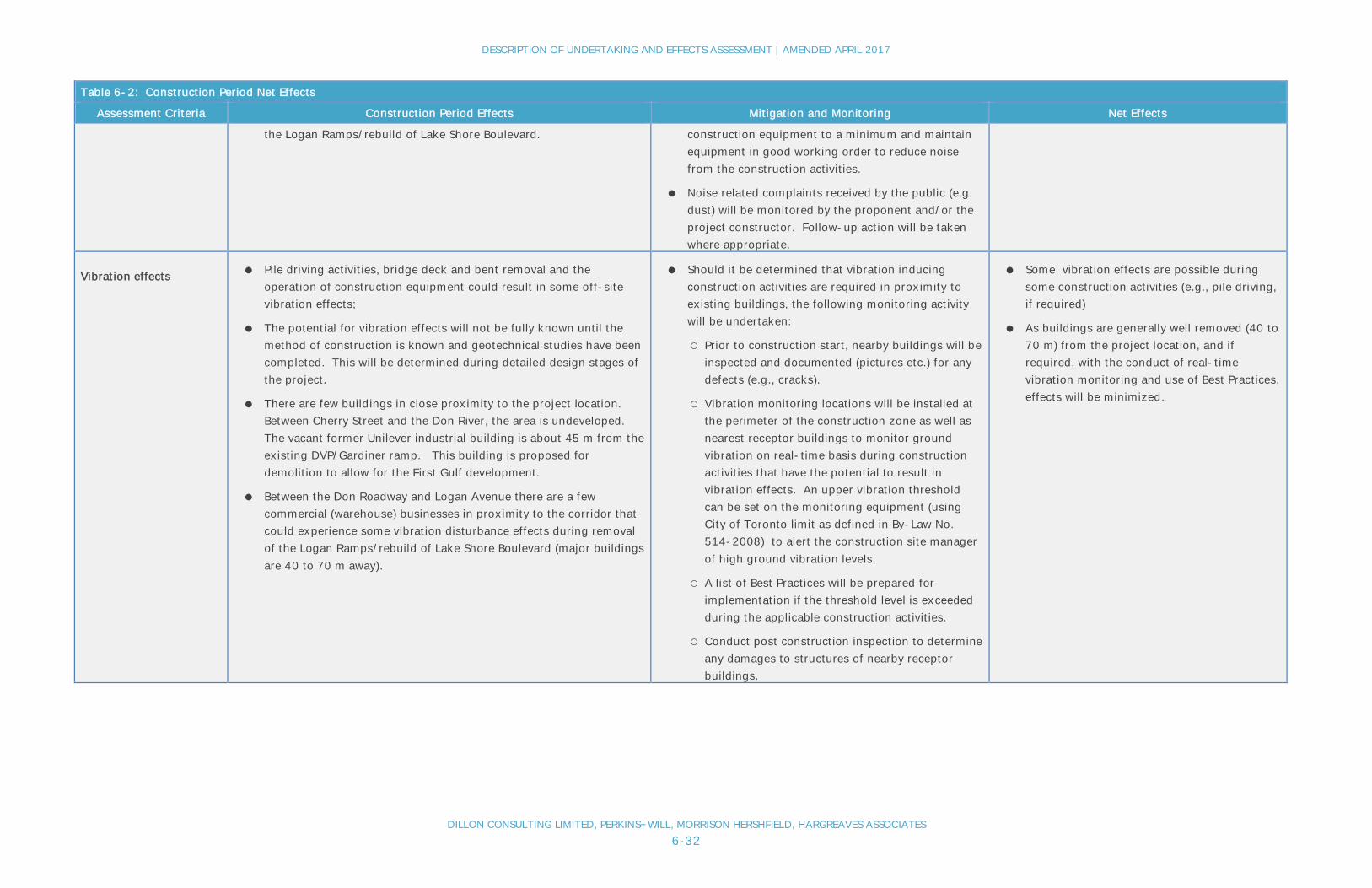
Table 6-2: Construction Period Net Effects
Table 6-2: Construction Period Net Effects
Assessment Criteria Construction Period Effects Mitigation and Monitoring Net Effects
TRANSPORTATION
Impact to auto travel timeThe degree of impacts to auto travel times will depend on theconstruction staging/phasing and traffic management approach adoptedby the Contractor. Potential travel and access effects and impacts andissues include the following:
● Safety considerations will preclude the removal of major deck panelsand substructure components over live traffic or public / inhabitedareas. This will require the periodic shut down of lanes and/orsections of Lake Shore Boulevard during deck removal.
● Sections of expressway and surface roads will require lane reductionsor complete shut down during periods of construction of the newbridge decks and related facilities. This is expected to involvesections of the Gardiner, Don Valley Parkway, Don Roadway, CherryStreet and Lake Shore Boulevard.
● The total number of available east-west lanes in the Gardiner – LakeShore Boulevard corridor will be reduced during construction due tothe need to provide sufficient working areas for the new constructionwork.
● It is expected that auto travel time delays will occur during theseperiods.
● Access to/from the site by construction vehicles could alsocontribute to additional traffic congestion in the local area. Nearbyaccess to DVP and Gardiner expected to minimize constructionvehicle disturbance effects on the local community.
● The contractor will be required to maintain a specifiedminimum number of total east-west lanes open totraffic throughout the construction period. This willlikely involve the construction of temporary lanes onother area roads as operating lanes are shut down forconstruction. Traffic will be directed to use otherexisting and/or widened roadways and constructeddetour roads during these periods. See draftConstruction Phasing Plan for proposed detour roads(subject to finalization during detailed design).
● Advanced notification and signing will advisemotorists of lane reductions and closures.
● New construction work can be staged to allow theexisting Gardiner corridor to remain partiallyoperational during construction.
● Example, possible staged construction and theintroduction of temporary works/local detour routesinclude the following:
o Early replacement of the eastern spans ofthe Metrolinx rail bridge over the DonRiver/DVP will allow the establishment of awidened Don Roadway as a new, temporaryexit/entrance to the DVP while the existingDVP-Gardiner ramps are removed;
o Phased construction of portions of new LakeShore Boulevard and the new Lake ShoreBoulevard-Don River bridge to allowmaximize use for east-west traffic during;
o Establish a Commissioners Street and/orVilliers Street detour routing to divert LakeShore Boulevard traffic around the GardinerEast Ramp structures and the Lake ShoreBoulevard-Don River bridge. This mayinclude the construction of a new, temporarycrossing of the Keating Channel east of
● Temporary travel time delays to auto usersdue to lane reductions and temporary roadclosures.

DESCRIPTION OF UNDERTAKING AND EFFECTS ASSESSMENT | AMENDED APRIL 2017
DILLON CONSULTING LIMITED, PERKINS+WILL, MORRISON HERSHFIELD, HARGREAVES ASSOCIATES6-26
Table 6-2: Construction Period Net Effects
Assessment Criteria Construction Period Effects Mitigation and Monitoring Net Effects
Cherry Street;o Staged removal and construction of existing
Gardiner deck and DVP ramps to allow trafficto use existing deck lanes duringconstruction;
o Widen the Jarvis-Gardiner ramps to twolanes to facilitate access.
● Carry out as much of the bridge deck demolition workas possible on weekends/overnight to avoid the needto shut down sections of the Lake Shore Boulevardduring the busier weekday periods
● Traffic vehicle delay will be monitored by the projectproponent (City of Toronto). Adjustments to thetraffic management plan and construction activity willbe made accordingly where possible to minimizedelays.
● Construction delays to emergency vehicle service(EMS, fire, police etc.) will be minimized by:
o Regular communication with EmergencyServices during construction;
o Meeting with Emergency Services prior toconstruction start;
o A requirement in the construction contractfor a, “Emergency Service ProviderNotification,” to notify Emergency Services inadvance of construction start and prior toany full closures.
Impact to transit travel ● There are no transit facilities located on the Gardiner-Lake ShoreBoulevard corridor in the Study Area. As such there will be no directimpact to transit operations.
● Transit routes utilizing Cherry Street through the Gardiner-LakeShore Boulevard corridor (e.g., Route 172) may be affected by trafficrestrictions due to overhead bridge works.
● The project requires the widening of the Metrolinx Don River/DVPRail Bridge underpass and may also require relocation of utilitiesadjacent to the Metrolinx rail corridor (e.g., hydro tower on west sideof Don River). And while major disruptions to GO Train service are to
● Advanced warning and advertising will advise transitusers of possible travel time delays during periods ofroad closures.
● Co-proponents to explore with transit providers,including Metrolinx and Toronto Transit Commission,potential to increase service levels during theseperiods.
● Co-proponents to coordinate with Metrolinx re:opportunities for joint work on site related to trackupgrades so as to minimize impacts to rail service.
● Potential for periodic/temporary increase intransit travel times including on Cherry Streetsouth of Lake Shore Boulevard.

DESCRIPTION OF UNDERTAKING AND EFFECTS ASSESSMENT | AMENDED APRIL 2017
DILLON CONSULTING LIMITED, PERKINS+WILL, MORRISON HERSHFIELD, HARGREAVES ASSOCIATES6-27
Table 6-2: Construction Period Net Effects
Assessment Criteria Construction Period Effects Mitigation and Monitoring Net Effects
be avoided, there is the potential for some minor delays.
● During periods of traffic detouring, other nearby roadways couldexperience increase in auto traffic volumes which could lead toslower street transit travel (e.g., for King and Queen Streets).
● Commuters may opt to use transit instead of driving during periodsof road closures which could put more user pressure on the transitsystem.
● Project proponent will work with transit providers(TTC and Metrolinx) to ensure that potential increasein service demands are being met and undertakemonitoring of impact on bus and street car travelfrom traffic diversion onto other near-by City streets.
Impact to rail (freight)transportation
● The project requires the construction of a new rail spur bridge overthe Don River (north of Lake Shore Boulevard-Don River bridge) andwill require either the establishment of temporary rail works/bridgecrossing or temporary closure of the existing spur line, depending onfinalizing rail access needs to the east of the Don River.
● Co-proponents to explore with freight rail users thepotential to reduce rail spur line use duringconstruction periods as needed.
● Co-proponents to coordinate with TRCA and otherstakeholders to integrate changes to the Port Landsrail spur with DMNP works related to sedimentmanagement area integration and weir installationworks.
● Potential for short periods of closures orlimited use of existing rail spur line may benecessary as new and/or temporary rail spurbridge facilities are put in place.
Impact to pedestrianmovement
● Existing pedestrian activity in the area is located on Cherry Street andon the Lower Don River trail system situated on the north side ofLake Shore Boulevard through the Keating Channel Precinct,including a Don River crossing. Pedestrians using these pathways willbe impacted during construction. Refer to the “Impact to CyclistMovements” section below for details.
● Any pedestrian travel will be restricted at times through the KeatingChannel Precinct and along the Lake Shore Boulevard corridorbetween Cherry Street and Logan Avenue and along Cherry Streetthrough the Gardiner area during construction – particularly duringdemolition of the elevated expressway.
● It is recommended that the path link to the LowerDon River trail system be temporarily relocatedduring construction when new works conflict with thecurrent location. This will require that somesegments of the path be shifted north of the new DVPramps.
● It is recommended that the path connecting to theeast be temporarily established along the proposedVilliers Street and/or Commissioners Street detourroute. This will divert pathway users south on CherryStreet to Villiers Street and/or Commissioners Streetto reconnect with the pathway via Don Roadway northto Lake Shore Boulevard.
● Appropriate signage will be implemented to identifydetour routes at the time of temporaryroadway/sidewalk closures. In addition, closureevents and restricted access will be minimized to thegreatest extent possible to facilitate pedestrianmovement during construction.
● Some short periods of closures to existingpathways may be necessary as new, temporarypathway facilities are put in place.
● The establishment of temporary pathwaysthrough the area may increase the trip lengthwhich could be a negative impact tocommuters.

DESCRIPTION OF UNDERTAKING AND EFFECTS ASSESSMENT | AMENDED APRIL 2017
DILLON CONSULTING LIMITED, PERKINS+WILL, MORRISON HERSHFIELD, HARGREAVES ASSOCIATES6-28
Table 6-2: Construction Period Net Effects
Assessment Criteria Construction Period Effects Mitigation and Monitoring Net Effects
Impact to cyclistmovement
● No impacts to the Martin Goodman Trail have been identified.
● The path connecting to the Lower Don River trail system is currentlysituated north of Lake Shore Boulevard through the Keating ChannelPrecinct and a branch off of this provides path access across the DonRiver (via a separate bridge crossing) to run along the north side ofLake Shore Boulevard. Both of these links will be impacted by theproposed works as they are situated where new facilities will belocated.
● Cyclist travel along Cherry Street could be impacted by construction –particularly during demolition of the elevated expressway.
● It is recommended that the path link to the LowerDon River trail system be temporarily relocatedduring construction when new works conflict with thecurrent location. This will require that somesegments of the path be shifted north of the new DVPramps.
● It is recommended that the path connecting to theeast be temporarily established along the proposedVilliers Street and/or Commissioners Street detourroute. This will divert pathway users south on CherryStreet to Villiers Street and/or Commissioners Streetto reconnect with the pathway via Don Roadway northto Lake Shore Boulevard.
● Appropriate signage shall be implemented to identifydetour routes at the time of temporary pathwayclosures. In addition, closure events and restrictedaccess will be minimized to the greatest extentpossible to facilitate cyclist movement duringconstruction.
● Some short periods of closures to existingpathways may be necessary as new, temporarypathway facilities are put in place.
● The establishment of temporary pathwaysthrough the area may increase the trip lengthwhich could be a negative impact tocommuters.
PUBLIC SAFETY
Safety risks topedestrians
● Pedestrians will be required to use temporary facilities during theconstruction period, including those that are on-road rather than thecurrent off-road pathways.
● Pedestrians could be at risk from the movement of constructionrelated vehicles and equipment on public roadways.
● Temporary pathway facilities will be designed toaddress safety issues (e.g., appropriate path widths,barriers to separate cyclist/pedestrians from vehicletraffic).
● Construction staging will minimize overall impacts tomotorists, residents and trail/pathway users.
● Appropriate signage and public communication shallbe implemented to identify detour routes at the timeof temporary roadway/pathway/sidewalk closures.
● Closure events of roadways and pathways will beminimized to the greatest extent possible to facilitatevehicle, cyclist and pedestrian movement through thearea during construction.
● The following measures are recommended for further
● Through appropriate mitigation, safety risksto pedestrians are expected to be largelyavoided.
Safety risks to cyclists ● Cyclists will be required to use temporary facilities during theconstruction period, including those that are on-road rather than thecurrent off-road trails.
● Cyclists could be at risk from the movement of construction relatedvehicles and equipment on public roadways.
● Through appropriate mitigation, safety risksto cyclists are expected to be largely avoided.
Safety risks to motorists ● Motorists could be at risk from the movement of construction relatedvehicles and equipment on public roadways.
● Motorists will be initially unfamiliar with detour roads which couldinclude some unconventional road configurations.
● Through appropriate mitigation, safety risksto auto users are expected to be largelyavoided.

DESCRIPTION OF UNDERTAKING AND EFFECTS ASSESSMENT | AMENDED APRIL 2017
DILLON CONSULTING LIMITED, PERKINS+WILL, MORRISON HERSHFIELD, HARGREAVES ASSOCIATES6-29
Table 6-2: Construction Period Net Effects
Assessment Criteria Construction Period Effects Mitigation and Monitoring Net Effects
assessment in the detailed design phase of theproject:
o Provision of appropriate signage;
o Lowering posted speed on approach mainline(with visual clues);
o Implementation of crash attenuators;
o Provision of flatter vertical curves to improvesight lines;
o Provision of end of queue detection systems inareas with potential ramp queuing;
o Further shoulder widening on the DVP-Gardinerramps;
● Investigation for increasing the length of speedchange lanes on the Don Valley Parkway and on theGardiner associated with the proposed ramps.
PLANNING AND URBAN DESIGN
Impact with otherprojects and initiatives
● The current Gardiner construction period is forecasted to be 2020 to2025.
● There are many other projects proposed in the Study Area (bothpublic and private) that could proceed to construction at the sametime that the Gardiner project is to be constructed including forexample the DMNP, Cherry Street realignment, Metrolinx RegionalExpress Rail Program/rail bridge track expansion and the First GulfDevelopment.
● The project has the potential for impact on the implementation ofthese other projects should the construction periods overlap.
● There is the potential for cumulative effects on the surroundingcommunity for several projects being constructed at the same time.
● Many of the other projects/plans are in the control ofthe project co-proponents.
● Assess the potential for project overlaps (time andspace) to determine potential conflicts and/or thepotential to re-package infrastructure works toimprove coordination amongst projects and eliminateissues.
● Project co-proponents and/or its agent(s) tocoordinate with City Transportation Services.
● City and/or its agent(s) is required to apply forpermit(s) to coordinate planned lane, pathway androadway closures to manage impacts to a host ofusers, including pedestrians, cyclists, transit, andmotor vehicles.
● Liaise with transit, police, and other EmergencyServices, and provide feedback and guidance tocontractors. The project co-proponents and/or itsagent(s) are responsible for notifying impactedresidents and businesses.
● With proper coordination and management ofthe numerous area construction projects, thenet negative effects should be minimal.
DESCRIPTION OF UNDERTAKING AND EFFECTS ASSESSMENT | AMENDED APRIL 2017
DILLON CONSULTING LIMITED, PERKINS+WILL, MORRISON HERSHFIELD, HARGREAVES ASSOCIATES6-30
Table 6-2: Construction Period Net Effects
Assessment Criteria Construction Period Effects Mitigation and Monitoring Net Effects
● Project co-proponents and/or its agent(s) willcommunicate with the implementing/review agenciesof other projects such as TRCA and Metrolinx toensure that the Gardiner East Project constructionactivities are coordinated with the other projects inthe area.
● Refinement of the construction staging plan will berequired to address coordination of simultaneousconstruction projects in the Study Area if timelines forthe implementation of major projects coincide.
● In anticipation of the Gardner constructionoverlapping with the construction of other majorprojects in the area including the DMNP, theconstruction activities will be monitored andadjustments made to the Construction Staging Plan inthe event of unanticipated effects occurring.
Change in views andviewscapes
● Construction activities will be visible through the project area. Somemay feel that this is a negative effect despite the current vacantland/former industrial nature of the Study Area (Keating ChannelPrecinct).
● No mitigation required. ● Minor temporary changes in views during theconstruction period.
SOCIAL AND HEALTH
Effects fromcontaminated soildisturbance
● Much of the project area contains soils that are contaminated (oilimpregnated).
● The nature and extent of the contamination is to be confirmed inadvance of or during detailed design.
● Potential for short-term truck traffic related nuisance effects in thelocal area from the transportation of contaminated soil off-site fordisposal (noise and air emissions).
● Related truck traffic could result in additional traffic congestion inthe local area.
● Contaminate soils and groundwater will be managedas per applicable MOECC requirements (Section 27and Section 46 approvals under the EnvironmentalProtection Act) and the contaminated soil disposed ofoff-site at a licensed disposal facility. Collectedgroundwater may require treatment prior todischarge.
● Project co-proponents and/or its agents will berequired to develop a comprehensive materials andgroundwater management plan including theidentification of intended haulage routes for theremoval of materials and to submit the plan forapproval. Haulage routes will be restricted to
● With appropriate mitigation, no adverseeffects from contaminated soil disturbancesare expected.
Effects fromcontaminatedgroundwater
● Any underground works (e.g., new Gardiner/ramp footings, stormsewers) will likely be in the groundwater zone as groundwater in theKeating Channel Precinct area has been reported as being between
● With appropriate mitigation, no adverseeffects from contaminated groundwaterdisturbances are expected.

DESCRIPTION OF UNDERTAKING AND EFFECTS ASSESSMENT | AMENDED APRIL 2017
DILLON CONSULTING LIMITED, PERKINS+WILL, MORRISON HERSHFIELD, HARGREAVES ASSOCIATES6-31
Table 6-2: Construction Period Net Effects
Assessment Criteria Construction Period Effects Mitigation and Monitoring Net Effects
1.5 m and 2.5 m below surface and fluctuating very little throughoutthe year. Such works will likely need to pump ground water to keepthe excavations dry while the underground works areinstalled/constructed.
● There is the potential that the groundwater encountered iscontaminated (with PHCs, PAHs and inorganic substances).
appropriate roads to minimize local area impacts.Any collected ground water collection and treatmentrequirements will be identified.
● A provincial Permit to Take Water may be required ifthe extent of pumping is above 50,000 litres of waterper day, which is expected. This will result in thepumping and potential ground water effects comingunder MOECC review and approval requirements.
Change in air quality ● The set-up and use of on-site construction facilities such as concretebatch plants and the operation of construction equipment will resultin air emission from use of internal combustion engines.
● Excavation of soils could result in an increase in dust/particulatematter in the local area.
● Between Cherry Street and the Don River, the area is undeveloped.The closest receptors are located to north of the Metrolinx railcorridor (West Don Lands). The closest sensitive receptors are about300 m away.
● Between the Don Roadway and Logan Avenue there are a fewcommercial (warehouse) businesses in proximity to the corridor thatcould experience some air quality effects during removal of theLogan Ramps/rebuild of Lake Shore Boulevard.
● The introduction of on-site construction facilitiessuch as batch plants potentially have the effect ofreducing truck traffic on area roads by keeping theexternal delivery of materials such as concrete to aminimum.
● Air emissions from any construction point sourcessuch as batch plants may require an EnvironmentalCompliance Approval from the MOECC andsubsequent monitoring.
● Apply water and dust suppressants duringconstruction to protect air quality due to dust.
● Contractors are required to keep idling ofconstruction equipment to a minimum and maintainequipment in good working order to reduceemissions from the construction activities.
● Air quality related complaints received by the public(e.g. dust) will be monitored by the proponent and/orthe project constructor. Follow-up action will betaken were appropriate.
● Temporary and localized air quality effects areanticipated (e.g., dust).
● Effects will be minimal as receptors aregenerally well removed from the projectlocation.
Change in noise levels ● Pile driving activities, bridge deck and bent removal and theoperation of construction equipment will result in noise generation.
● Between Cherry Street and the Don River, the area is undeveloped.The closest receptors are located to north of the Metrolinx railcorridor (West Don Lands). The closest sensitive receptors are about300 m away.
● Between the Don Roadway and Logan Avenue there are a fewcommercial (warehouse) businesses in proximity to the corridor thatcould experience some noise disturbance effects during removal of
● Contractor operational constraints related toconstruction noise will be incorporated into thecontract documents.
● Construction activities throughout the project willconform to current municipal noise by-laws givingdue consideration to such factors as the time of day,proximity and size of equipment and type ofoperation.
● Contractors are required to keep idling of
● Temporary and localized noise effects areanticipated.
● Effects will be minimal as receptors aregenerally well removed from the projectlocation.
DESCRIPTION OF UNDERTAKING AND EFFECTS ASSESSMENT | AMENDED APRIL 2017
DILLON CONSULTING LIMITED, PERKINS+WILL, MORRISON HERSHFIELD, HARGREAVES ASSOCIATES6-32
Table 6-2: Construction Period Net Effects
Assessment Criteria Construction Period Effects Mitigation and Monitoring Net Effects
the Logan Ramps/rebuild of Lake Shore Boulevard. construction equipment to a minimum and maintainequipment in good working order to reduce noisefrom the construction activities.
● Noise related complaints received by the public (e.g.dust) will be monitored by the proponent and/or theproject constructor. Follow-up action will be takenwhere appropriate.
Vibration effects ● Pile driving activities, bridge deck and bent removal and theoperation of construction equipment could result in some off-sitevibration effects;
● The potential for vibration effects will not be fully known until themethod of construction is known and geotechnical studies have beencompleted. This will be determined during detailed design stages ofthe project.
● There are few buildings in close proximity to the project location.Between Cherry Street and the Don River, the area is undeveloped.The vacant former Unilever industrial building is about 45 m from theexisting DVP/Gardiner ramp. This building is proposed fordemolition to allow for the First Gulf development.
● Between the Don Roadway and Logan Avenue there are a fewcommercial (warehouse) businesses in proximity to the corridor thatcould experience some vibration disturbance effects during removalof the Logan Ramps/rebuild of Lake Shore Boulevard (major buildingsare 40 to 70 m away).
● Should it be determined that vibration inducingconstruction activities are required in proximity toexisting buildings, the following monitoring activitywill be undertaken:
○ Prior to construction start, nearby buildings will beinspected and documented (pictures etc.) for anydefects (e.g., cracks).
○ Vibration monitoring locations will be installed atthe perimeter of the construction zone as well asnearest receptor buildings to monitor groundvibration on real-time basis during constructionactivities that have the potential to result invibration effects. An upper vibration thresholdcan be set on the monitoring equipment (usingCity of Toronto limit as defined in By-Law No.514-2008) to alert the construction site managerof high ground vibration levels.
○ A list of Best Practices will be prepared forimplementation if the threshold level is exceededduring the applicable construction activities.
○ Conduct post construction inspection to determineany damages to structures of nearby receptorbuildings.
● Some vibration effects are possible duringsome construction activities (e.g., pile driving,if required)
● As buildings are generally well removed (40 to70 m) from the project location, and ifrequired, with the conduct of real-timevibration monitoring and use of Best Practices,effects will be minimized.

DESCRIPTION OF UNDERTAKING AND EFFECTS ASSESSMENT | AMENDED APRIL 2017
DILLON CONSULTING LIMITED, PERKINS+WILL, MORRISON HERSHFIELD, HARGREAVES ASSOCIATES6-33
Table 6-2: Construction Period Net Effects
Assessment Criteria Construction Period Effects Mitigation and Monitoring Net Effects
Traffic diversion effectson neighbourhoods
● During construction and periods when traffic detours are in place,traffic diversion into local neighbourhoods is possible as driversattempt to find less congested routes in/out of the downtown area.
● This traffic diversion, that is expected to be temporary, could resultin some increased traffic disturbance effects.
● Appropriate signage shall be implemented to identifyappropriate detour routes during construction.
● Traffic infiltration monitoring undertaken as requiredby the project co-proponents.
● Traffic turn restrictions may be put in place to limittraffic infiltration into neighbours if identified as aproblem.
● Any traffic infiltration effects will betemporary.
● With appropriate mitigation and monitoring,traffic infiltration effects into localneighbourhoods can be managed.
Impacts on recreationuse and tourism
● During construction, use of existing paths through the KeatingChannel Precinct will be restricted and/or construction activity couldresult in noise/air quality effects to users of the path.
● Potential for delays to travel to major events (e.g. sporting, tradeshows, entertainment shows, etc..) in downtown area when travellingfrom/to north and east of the downtown and to travel to events heldin the Port Lands/East Bayfront/Keating area. As these events arelargely during non-peak periods, delays are expected to bemoderate.
● Temporary pathways will be put in place for use bycyclists/pedestrians during periods whenconstruction disrupts existing pathways in the area.
● Appropriate signage shall be implemented to identifydetour routes at the time of temporaryroadway/sidewalk closures. In addition, closureevents and restricted access to local residents and/orbusinesses shall be minimized to the greatest extentpossible to facilitate cyclist and pedestrian movementduring construction.
● Work with major event organizers and timeconstruction activity to minimize travel delays andwork with transit providers to ensure that travelalternatives exist.
● Potential for some temporary disruption torecreation trail users from noise/dust andtemporary trail closures.
● Potential for travel delay to visitors of majorevents.
NATURAL ENVIRONMENT
Loss of terrestrialfeatures & habitat
● The realignment of Lake Shore Boulevard and the expresswayconnection east of Cherry Street will result in the removal ofapproximately 2.5 ha of low quality vegetation that consists primarilyof urban species and non-native invasive species that areregenerating in former industrial properties (a “tank farm” facilitywas located on these lands in the recent past).
● Much if not all of this low quality vegetation will not exist under thefuture baseline condition as it would be removed as a result of newland development as per the approved Keating Channel Precinct Planand as a result of the implementation of the EA approved Don MouthNaturalization Project. The DMNP will result in the alteration of lands
● Construction contract will include provisions toprotect wildlife encountered during construction.
● Salvage plants for replanting were appropriate and apractical.
● To avoid impact to breeding birds, clearing ofvegetation to occur outside the period of April 1 toAugust 15. Alternatively, if tree clearing is requiredin this period a nest survey is required by an avianbiologist to locate any active nests.
● Creation of new green space along north side of the
● Loss of approximately 2.5 ha of poor qualityvegetation.
● The net impact is considered to be lowconsidering the low amount of terrestrialhabitat to be removed and the low quality ofthis habitat.

DESCRIPTION OF UNDERTAKING AND EFFECTS ASSESSMENT | AMENDED APRIL 2017
DILLON CONSULTING LIMITED, PERKINS+WILL, MORRISON HERSHFIELD, HARGREAVES ASSOCIATES6-34
Table 6-2: Construction Period Net Effects
Assessment Criteria Construction Period Effects Mitigation and Monitoring Net Effects
on the west side of the Don River to develop the sedimentmanagement facility.
● Urban wildlife that inhabits these areas would be expected torelocate (e.g., birds, raccoons, coyotes, squirrels). Potentially intothe Don Valley system that is nearby.
realigned Gardiner-Lake Shore Boulevard as per thepublic realm concept for the undertaking will result inthe creation of new habitat.
● Co-proponents will integrate with the Port LandsBiodiversity Strategy that is currently being developed(part of the Port Lands Framework Plan), whichincludes components to develop and protect wildlifecorridors through the development of the Port Lands.
Disruption to terrestrialfeatures & habitat
● There is no valued terrestrial habitat in the immediate vicinity of theproject that is expected to be affected by the project.
● No specific mitigation required other thanimplementation of standard construction bestmanagement practices (BMPs) to minimize off sitedisturbance effects.
● Low potential for disruption to terrestrialhabitat due to a lack of habitat in the vicinityof the project.
Loss of aquatic features& habitat
● The construction of the following new facilities have the potential forloss of aquatic habitat:
o Construction of new DVP-Gardiner ramp columns in theDon River. Two new columns are to be constructed in theriver with a diameter of approximately 1.5m each. Tominimize construction impacts it is recommended thatthese columns be extended to bedrock (approximately 10 mbelow ground level) eliminating the need to construct alocal footing for each column in the river. Suchcolumn/caisson construction will require in-river works witha slightly larger footprint than the column, approximately3.0 m diameter, with installation/drilling likely from abarge. This will result in a construction disruption foot printof about 7m2 per column, or a total habitat disruption areaof 14.0 m2 during construction. There will be a net gain ofpermanent habitat of approximately 8 m2 as a result of thenew columns being smaller than the existing ones;
o Lake Shore Boulevard – Don River bridge widening (andraising if possible) (note that work and impacts associatedwith the proposed Lake Shore Boulevard bridge over theDon River are documented in previous EA reports for theLower Don Lands Master Plan, Keating Channel PrecinctEnvironmental Study Report and the Don MouthNaturalization and Port Lands Flood Protection Project).
● The removal of the east end of the Gardiner deck and columns (i.e.,
● Apply stormwater run-off BMPs.
● Prepare and follow a spills response plan forconstruction activity in proximity to open water areas.
● The construction contract will include specialprovisions related specifically to fish and fish habitat(Timing of In-Water Work and Additional Measures toAvoid Serious Harm to Fish under the Fisheries Act).This will also require coordination with TRCA.
● To protect sensitive life stages/processes ofmigratory and resident fish, in water work will beconducted between July 1st to March 31st.
● Fish screens shall be used on all dewatering intakepipes to protect fish, if required.
● Consult with Aquatic Habitat Toronto to identifypermitting requirements, assess monitoring needsand develop offsetting plan.
● Permanent destruction of 4 m2 of low qualityaquatic habitat (the existing columns impactapproximately 12 m2). There will be a net gainof permanent habitat of approximately 8 m2
as a result of the new columns being smallerthan the existing ones which will be removed.

DESCRIPTION OF UNDERTAKING AND EFFECTS ASSESSMENT | AMENDED APRIL 2017
DILLON CONSULTING LIMITED, PERKINS+WILL, MORRISON HERSHFIELD, HARGREAVES ASSOCIATES6-35
Table 6-2: Construction Period Net Effects
Assessment Criteria Construction Period Effects Mitigation and Monitoring Net Effects
"Logan Ramps") will not result in any loss of aquatic features orhabitat as the east end of the Gardiner is located directly over LakeShore Boulevard in the Don River crossing area and the supportcolumns are integrated with the columns supporting Lake ShoreBoulevard. As with the demolition of the DVP-Gardiner rampscolumns, appropriate demolition procedures are required tominimize the loss of aquatic habitat.
Disruption to aquaticfeatures & habitat
● The following construction activities have the potential for disruptionto aquatic habitat:
o Demolition the existing DVP ramps and Gardiner bridgedecks of the Don River and the elevated expressway alongthe north side of the Keating Channel;
o Demolition of the existing DVP-Gardiner rampcolumns/piers in the Don River;
o Construction of new DVP-Gardiner ramp columns in theDon River;
o Placement of a temporary bridge across the Keating Channelto accommodate a temporary detour road;
o Widening/reconstruction of the Lake Shore Boulevard – DonRiver bridge (note that Work and impacts associated withthe proposed Lake Shore Boulevard bridge over the DonRiver are documented in previous EA reports for the LowerDon Lands Master Plan, Keating Channel PrecinctEnvironmental Study Report and the Don MouthNaturalization and Port Lands Flood Protection Project).
● Aquatic habitat quality in the Don Mouth area and Keating Channel isconsidered to be poor.
● From the above construction activities, there is potential fortemporary disturbance to aquatic species and habitat in the DonMouth and Keating Channel during construction from run-off andsedimentation effects, spills and from demolition debris falling intothe river.
● Consult with Aquatic Habitat Toronto to identifypermitting requirements and mitigation strategy (toinclude Don River and Keating Channel).
● Implement an Erosion and Sediment Control plan asoutlined for the criterion below.
● Temporary disruption of aquatic habitat inDon River mouth and Keating Channel.
● The effect will be of short duration, localizedand minimized through implementation ofmitigation strategy..
Change in surface waterquality from storm run-off
● During construction, particular during period when soil is excavatedor exposed, there is the potential for run-off effects into local waterbodies including the mouth of the Don River and the KeatingChannel.
● Develop and implement an erosion and sedimentcontrol (ESC) plan to mitigate impacts to the DonRiver and Keating Channel, and associated riparianhabitat. These measures should contain theconstruction area and include measures such as:
● With the implementation of the mitigationmeasures, adverse effects to surface waterquality during construction will be minimal.
● Any effects will be temporary, short durationand localized.

DESCRIPTION OF UNDERTAKING AND EFFECTS ASSESSMENT | AMENDED APRIL 2017
DILLON CONSULTING LIMITED, PERKINS+WILL, MORRISON HERSHFIELD, HARGREAVES ASSOCIATES6-36
Table 6-2: Construction Period Net Effects
Assessment Criteria Construction Period Effects Mitigation and Monitoring Net Effects
○ All disturbed areas will be stabilized with rock ortopsoil and seed/mulch to prevent future erosion
○ Appropriate erosion and sediment controlmeasures (e.g., silt fencing) must be installedalong exposed surfaces around the work area toprevent sediment-laden runoff from entering thesurrounding water body.
○ Erosion and scour control material to be placed onthe existing banks (not on the creek bed) underthe bridges will be free of fines and placed gentlyin calm weather so as to not create sedimentplumes.
○ Erosion and sediment control measures will be leftin place until all exposed soils have beenstabilized.
○ Handling of fuel, excess materials and debris willbe properly managed on-site and removed as perthe standard construction practices necessary toprotect the water body.
○ All materials used or generated (e.g., organics,soils, woody debris, temporary stockpiles,construction debris, etc.) will be temporarilystored, handled and disposed of during sitepreparation, construction and clean-up in amanner that prevents entry into the water body.
● Minimize demolition debris from entering the water.
● ESC measures will be monitored regularly and/orafter every 10 mm or greater rainfall event as theycould require periodic cleaning, maintenance and/orre-construction. If deficiencies are found, they will berepaired and/or replaced promptly.
● Grading, placement of topsoil and seedingspecifications to be implemented to decrease theerosion potential and promote suitable nativevegetation regeneration.
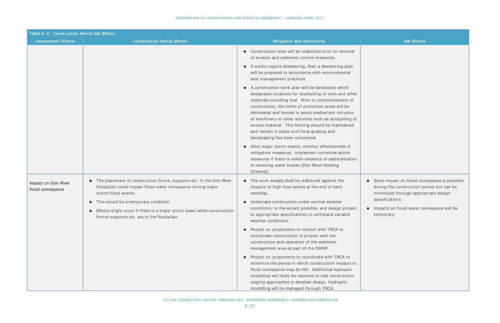
DESCRIPTION OF UNDERTAKING AND EFFECTS ASSESSMENT | AMENDED APRIL 2017
DILLON CONSULTING LIMITED, PERKINS+WILL, MORRISON HERSHFIELD, HARGREAVES ASSOCIATES6-37
Table 6-2: Construction Period Net Effects
Assessment Criteria Construction Period Effects Mitigation and Monitoring Net Effects
● Construction sites will be stabilized prior to removalof erosion and sediment control measures.
● If works require dewatering, then a dewatering planwill be prepared in accordance with environmentalbest management practices.
● A construction work plan will be developed whichdesignates locations for stockpiling of soils and othermaterials including fuel. Prior to commencement ofconstruction, the limits of protection areas will bedelineated and fenced to avoid inadvertent intrusionof machinery or other activities such as stockpiling ofexcess material. This fencing should be maintainedand remain in place until final grading andlandscaping has been completed.
● After major storm events, monitor effectiveness ofmitigation measures. Implement corrective actionmeasures if there is visible evidence of sedimentationin receiving water bodies (Don River/KeatingChannel).
Impact on Don Riverflood conveyance
● The placement of construction forms, supports etc. in the Don Riverfloodplain could impact flood water conveyance during majorstorm/flood events.
● This would be a temporary condition.
● Effects might occur if there is a major storm event while constructionforms/supports etc. are in the floodplain.
● The work area(s) shall be stabilized against theimpacts of high flow events at the end of eachworkday.
● Undertake construction under normal weatherconditions, to the extent possible, and design projectto appropriate specifications to withstand variableweather conditions.
● Project co-proponents to consult with TRCA tocoordinate construction of project with theconstruction and operation of the sedimentmanagement area as part of the DMNP.
● Project co-proponents to coordinate with TRCA tominimize the period in which construction impacts toflood conveyance may be felt. Additional hydraulicmodelling will likely be required to test constructionstaging approaches in detailed design. Hydraulicmodelling will be managed through TRCA.
● Some impact on flood conveyance is possibleduring the construction period but can beminimized through appropriate designspecifications.
● Impacts on flood water conveyance will betemporary.

DESCRIPTION OF UNDERTAKING AND EFFECTS ASSESSMENT | AMENDED APRIL 2017
DILLON CONSULTING LIMITED, PERKINS+WILL, MORRISON HERSHFIELD, HARGREAVES ASSOCIATES6-38
Table 6-2: Construction Period Net Effects
Assessment Criteria Construction Period Effects Mitigation and Monitoring Net Effects
● In coordination with TRCA, monitor effectiveness ofDon River flood conveyance during storm/floodevents should they occur during period of in-riverwork. Removal of existing Gardiner support piers aspart of the demolition activities may contribute toimproved flood conveyance.
Potential for change tomicroclimate/ heat islandeffect
● Not applicable to the construction period.
Ability to accommodatestorm event changesfrom climate change
● Adequate storm controls will be put in place during construction aspreviously described for “Change in surface water quality from stormrun-off”.
● As construction is to occur in the near term and will be temporary,significant changes in storm events as a result of climate change arenot anticipated.
● The ability of the stormwater controls toaccommodate storm events will be monitored.
● In the event that climate change results in differentstorm characteristics, changes will be made to thestorm control system.
● No net adverse effects as a result of climatechange with appropriate controls andmonitoring in place.
CULTURAL RESOURCES
Removal of built heritagefeatures
● Based on findings of the Heritage Baseline Conditions Report for the Gardiner East EA, there are no cultural heritage resources within the existing or proposed right-of-way associatedwith the undertaking. Nonetheless, an assessment will be conducted (post EA outcome) to identify opportunities to document the elevated expressway structure for archival purposesprior to its partial demolition and reconstruction.
Change to culturallandscape
● No cultural landscapes are impacted. The undertaking is located in the Keating Channel Precinct further removed from the water (Keating Channel) than the existing elevated expresswayand located closer to the elevated Metrolinx rail corridor to the north.
Impact on archaeologicalresources
● The project is largely located on areas of historical lakefill that havebeen subject to extensive past historical development activity.
● Based on the completed Stage 1 Archaeological Assessment, becauseof the historical development activities in the area, there is nopotential for the survival of Aboriginal archaeological resources inprimary contexts.
● Potential for impact on nineteenth-early twentieth centurydevelopment features including Toronto Dry Docks, Toronto Ironworks and British American Oil.
● Prior to construction, once detailed design has beencompleted which will finalize project componentlocation (e.g., location of support piers), completearchaeological investigations on areas of excavationrequired for the project.
● Should deeply buried archaeological resources beuncovered, the co-proponents and/or its agent(s)shall immediately notify MTCS. The OntarioCemeteries Act applies to discovery of unmarkedhuman remains.
● With the completion of additionalarchaeological investigations, adverse effectson any remaining archaeological features arenot anticipated.

DESCRIPTION OF UNDERTAKING AND EFFECTS ASSESSMENT | AMENDED APRIL 2017
DILLON CONSULTING LIMITED, PERKINS+WILL, MORRISON HERSHFIELD, HARGREAVES ASSOCIATES6-39
Table 6-2: Construction Period Net Effects
Assessment Criteria Construction Period Effects Mitigation and Monitoring Net Effects
Impact on First Nationspeople and activities
● Impacts of First Nations people are not anticipated. The project areais not known to be used by Aboriginal communities for traditionalactivities. Due to historical land use activities, the potential toencounter intact Aboriginal artefacts is virtually nil. Consultationwith interested First Nations groups is on-going.
● If required, additional First Nations mitigationactivities to be determined.
● No net adverse effects on First Nations peopleor activities anticipated.
● Continue consultations with First Nations thathave an interest in the project.
ECONOMICS
Impacts to goodsmovement
● Significant portions of the project can be constructed with impacts toexisting road traffic
● Sections of expressway and surface roads will require shut downduring periods of project construction (e.g., to remove overheadinfrastructure and to connect the new ramps to DVP lanes).
● This is expected to include sections of the Gardiner, Don Roadwayand Lake Shore Boulevard.
● It is expected that some truck travel time delays will occur duringthese periods.
● Local commercial entities that rely on truck traffic willreceive advance notice of road closure/detourperiods.
● Truck traffic will be detoured onto existing roadwaysand constructed detour roads during these periods.Construction Phasing Plan outlines proposed detourroads which are to be finalized during detaileddesign.
● Traffic detouring to be coordinated with otherprojects that might be under construction during thesame period such as the DMNP Project.
● The construction phasing plan proposes the need forand location of detour roads.
● Consult with local area commercial trucking operatorsin development of the traffic detour plan.
● Monitor and review traffic detour plan with input fromlocal commercial trucking operators.
● Delays to truck traffic movement will betemporary and minimized as much as possible
● Provision of detour roads will minimize theeffect.
Impact on downtownmobility
● During periods of road closures/detours, access the downtown byvehicle will take longer and be more inconvenient.
● This might dissuade some people from coming to the downtownarea.
● Advance notifications of road closure periods androad detour and transit options will be made well inadvance through various forms of media.
● Traffic will be detoured onto existing roadways andconstructed detour roads during these periods.Construction phasing plan outlines proposed detourroads which are to be finalized during detaileddesign.
● The construction phasing plan proposes the need for
● Delays to traffic movement will be temporaryand minimized as much as possible.
● Transit options to access the downtown willbe available and possibly enhanced.
● Provision of detour roads will minimize theeffect.

DESCRIPTION OF UNDERTAKING AND EFFECTS ASSESSMENT | AMENDED APRIL 2017
DILLON CONSULTING LIMITED, PERKINS+WILL, MORRISON HERSHFIELD, HARGREAVES ASSOCIATES6-40
Table 6-2: Construction Period Net Effects
Assessment Criteria Construction Period Effects Mitigation and Monitoring Net Effects
and location of detour roads.
● Transit will remain as an option to access thedowntown and enhanced transit service may bewarranted for periods of time when there aresignificant road closures. The project co-proponentsto work with transit agencies such as GOTransit/Metrolinx. It is noted that GO Transit usageincreased during periods of recent lane closures ofthe Gardiner West.
Impact on local businessactivity
● During the removal of the Logan Ramps, access along Lake ShoreBoulevard could be reduced at times which could affect a few localbusinesses that are located east of the Don River.
● Air quality (dust), noise and vibration effects could result tobusinesses (2 or 3) located along the Lake Shore Boulevard corridoreast of the Don Roadway and to the car dealership located on theeast side of the DVP, north of the rail corridor.
● Construction of Lake Shore Boulevard-Don River bridge andassociated rail spur bridge may result in impacts to rail operationsthat serve local port operations and Toronto Water Ashbridges BayTreatment Plant.
● Access to area businesses will be maintained duringconstruction.
● Businesses will be notified well in advance ofconstruction timing and any road closures/accesslimitations.
● Temporary closure of the rail spur Don River crossingwill be done in consultation with rail spur usersincluding the Toronto Port Authority and AshbridgesBay Treatment Plant.
● Appropriate construction BMPs will be implementedto minimize dust and noise disturbance effects duringconstruction.
● Monitor and review traffic detour plan with input fromlocal commercial trucking operators.
● Any impacts on access and disturbances willbe temporary.
● Effects are expected to be largely minimizedthrough mitigation.

DESCRIPTION OF UNDERTAKING AND EFFECTS ASSESSMENT | AMENDED APRIL 2017
DILLON CONSULTING LIMITED, PERKINS+WILL, MORRISON HERSHFIELD, HARGREAVES ASSOCIATES6-41
Table 6-3: Operations Net Effects
Table 6-3: Operations Net Effects
Effects AssessmentCriteria
Operations Period Effects Mitigation and Monitoring Net Effects
TRANSPORTATION
Impact to auto traveltime
● In the AM period, compared to the Do Nothing base condition, theProject will result in longer auto travel times for east to west trips.Traffic modelling projects an increase of 3 minutes during the AMpeak hour.
● In the PM period, compared to the Do Nothing base condition, theProject will result in travel time increase for trips originating in thedowntown and destined to the east (i.e., along Lake ShoreBoulevard).
● Auto travel time increases are not projected for travel to and fromareas north and west of the downtown.
● During non-peak travel periods, travel time delay will be less thanduring the peak period forecasts.
● The co-proponents and transit providers are planningimprovements to the City/Regional transit system includingfor example the Metrolinx RER program and WaterfrontTransit Re-Set program.
● Existing and enhanced transit provide alternativetransportation means into the downtown as an alternativemode of travel.
● Pathway system will be enhanced including a new pathwaythat will run along the north side of Lake Shore Boulevard asfar as Jarvis or Yonge Street). This will also provide analternate mode of travel into the downtown.
● City to monitor traffic operations and make adjustments asrequired (e.g. traffic signal timing) to optimize the flow oftraffic through corridor.
● Commuters from/to the east that continueto travel to the downtown by automobilewill experience delays in the order of 3 minduring peak periods.
● It is estimated that about 90% of downtownAM commuters will have delays of less than2 min with the project in place.
Impact to transit travel ● No impacts to transit operations are projected during the projectoperations period.
● The project might entice some auto users to use the transit systemto commute to downtown.
● The project is consistent with the Waterfront LRT project andfacilitates the possibility to bring LRT into the Keating ChannelPrecinct should Queens Quay be extended east of Cherry Street.
● No additional specific mitigation proposed. ● No long term negative net effects to transittravel.
Impact to pedestrianmovement
● The project provides for new/improved multi-use pathways thatwill improve pedestrian travel through the Study Area – inparticular the removal of the elevated expressway along the northside of the Keating Channel will facilitate an improved pedestrianpromenade through this area. Further the provision of a multi-usepathway east of Cherry Street along the north side of Lake ShoreBoulevard will promote pedestrian travel through the corridor.
● No additional specific mitigation proposed. ● No long term negative net effects topedestrians.
● Positive effect through improved/newplanned multi-use pathway through thecorridor and planned intersectionimprovements.

DESCRIPTION OF UNDERTAKING AND EFFECTS ASSESSMENT | AMENDED APRIL 2017
DILLON CONSULTING LIMITED, PERKINS+WILL, MORRISON HERSHFIELD, HARGREAVES ASSOCIATES6-42
Table 6-3: Operations Net Effects
Effects AssessmentCriteria
Operations Period Effects Mitigation and Monitoring Net Effects
Impact to cyclistmovement
● The project provides for new/improved multi-use pathways thatwill improve facilitate cycling through the Study Area. Theprovision of a multi-use pathway east of Cherry Street along thenorth side of Lake Shore Boulevard will promote cyclist travelthrough the corridor. This facility will link with north-south cyclefacilities along Cherry, Sherbourne and Yonge Streets. Theexisting cycle paths east of Cherry St will be improved and linkedwith the Don Valley cycle route.
● No additional specific mitigation proposed. ● No long term negative net effects tocyclists.
● Positive effect through improved/newplanned multi-use pathway through thecorridor and planned intersectionimprovements.
PUBLIC SAFETY
Safety risks topedestrians
● Safety risks to pedestrians are reduced as a result of: the removalof sections of the overhead expressway (Logan Ramps) that willimprove sight lines, proposed improvements to key Lake ShoreBoulevard intersections (e.g., Don Roadway), and the developmentof an off road multi-use pathway through the corridor.
● City has committed to undertake a safety review of the Lake ShoreBoulevard/Jarvis Street intersection that could lead to furtherimprovements to this intersection for pedestrians.
● No additional specific mitigation proposed. ● No long term negative net effects topedestrian safety.
● Positive effect through improved/newplanned multi-use pathway through thecorridor and planned intersectionimprovements.
Safety risks to cyclists ● Safety risks to cyclists are reduced as a result of: the removal ofsections of the overhead expressway (Logan Ramps) that willimprove sight lines, proposed improvements to key Lake ShoreBoulevard intersections (e.g., Don Roadway), and the developmentof an off road multi-use pathway through the corridor.
● City has committed to undertake a safety review of the Lake ShoreBoulevard/Jarvis Street intersection that could lead to furtherimprovements to this intersection for cyclists.
● No additional specific mitigation proposed. ● No long term negative net effects to cyclistsafety.
● Positive effect through improved/newplanned multi-use pathway through thecorridor and planned intersectionimprovements.
Safety risks tomotorists
● The proposed Gardiner-DVP ramps are to be developed at a60 km/hr design speed (speed limit posting of 50 km/hr).
● The required reduction in vehicle speed from 90 km/hr to50 km/hr is greater than typical for directional ramps.
● City to monitor roadway operations to ensure that motorvehicle accident/incident rates are within typical norms.
● With the implementation of appropriatesafety measures into the design of thefreeway facility, safety risks to motoristsare expected to be minimized to acceptablelevels.

DESCRIPTION OF UNDERTAKING AND EFFECTS ASSESSMENT | AMENDED APRIL 2017
DILLON CONSULTING LIMITED, PERKINS+WILL, MORRISON HERSHFIELD, HARGREAVES ASSOCIATES6-43
Table 6-3: Operations Net Effects
Effects AssessmentCriteria
Operations Period Effects Mitigation and Monitoring Net Effects
PLANNING AND URBAN DESIGN
Consistency withsecondary/ precinctplans
● The project is consistent with the Keating Channel Precinct Plan.
● The relocation of the Gardiner-DVP ramps north of the currentalignment allows for a development plan with direct connection tothe Keating Channel.
● The project co-proponents will review and update the KeatingChannel Precinct Plan to reflect the new northern alignment for theGardiner-DVP ramps.
● Redevelopment in the Keating Channel Precinct is to occur afterconstruction of the project is complete.
● No mitigation warranted. ● No net negative effects, as construction isto occur in advance of redevelopment in theKeating Channel Precinct.
Consistency/impactwith other projectsand initiatives
● Once operational the project is not expected to have negativeimpacts on other projects in the area.
● No mitigation warranted. ● No adverse effects on other projects.
Change in views andviewscapes
● The relocation of the Gardiner-DVP ramps further north will leadto improvements of views over the Don River mouth and along theKeating Channel.
● Improvements to the Lake Shore Boulevard streetscape and publicspaces in the corridor will lead to improvements in the viewscape.
● No mitigation warranted. ● No adverse effects on views andviewscapes.
● Project will result in improvements to viewsand viewscapes along the north edge of theKeating Channel and over the Don Rivermouth, particularly in combination of theplanned DMNP Project.
● Removal of the Logan ramps will improveviews across Lake Shore Boulevard andcomplement development plans for theFirst Gulf site that is located north of theLogan Ramps/east of the Don River.
SOCIAL AND HELATH
Effects fromcontaminated soildisturbance
● No interaction with contaminated soil during operations. ● No mitigation warranted. ● No adverse effects pertaining tocontaminated soil;
Effects fromcontaminatedgroundwater
● No interaction with contaminated groundwater during operations. ● No mitigation warranted. ● No adverse effects pertaining tocontaminated groundwater.

DESCRIPTION OF UNDERTAKING AND EFFECTS ASSESSMENT | AMENDED APRIL 2017
DILLON CONSULTING LIMITED, PERKINS+WILL, MORRISON HERSHFIELD, HARGREAVES ASSOCIATES6-44
Table 6-3: Operations Net Effects
Effects AssessmentCriteria
Operations Period Effects Mitigation and Monitoring Net Effects
Change in air quality ● The future volume of traffic within the corridor with the project inplace is forecasted to be similar to the base case Maintain (DoNothing).
● As a result, no additional air quality effects are anticipated ascompared to the future base case scenario.
● No mitigation warranted. ● No additional long term adverse effects onair quality.
Change in noise levels ● The future volume of traffic within the corridor with the Project inplace is forecasted to be similar to the base case Maintain (DoNothing).
● Future development plans for the Keating Channel Precinct andareas east of the Don River will be finalized to reflect newalignment/configuration of the expressway.
● Considering the above, and the modelled future noise levels forreceptors in the vicinity of the corridor (see Appendix I), thechange in noise levels over the base case will not be noticeableover forecasted future base case levels.
The City of Toronto’s Official Plan Policy 2.2.4 requires that newdevelopment on lands adjacent to existing and plannedtransportation corridors and facilities be compatible with, andsupportive of, the long-term purpose of the corridors andfacilities and be designed to avoid, mitigate or minimize negativeimpacts on, or from, the transportation corridors and facilities.
Future land development proposals in the vicinity of theundertaking (the Hybrid) will need to satisfy City of Toronto noisestudy requirements, which often includes: the completion of anoise impact study for many development applications, includingZoning Bylaw Amendments, Site-specific Zoning Bylaws, Site PlanControl, Plans of Subdivision and Consent to Sever. Noise ImpactStudies are to explore the following matters:
· Impact of noise generated by the development on thesurrounding environment;
· Impact of noise from the surrounding environment(including transportation sources) on the development;
· Impact of noise generated by the development on itself;and,
· Mitigation measures to reduce the anticipated negativenoise impacts.
The City of Toronto Development Guide includes terms ofreference for the preparation of a noise impact study(http://www1.toronto.ca/static_files/CityPlanning/PDF/noise.pdf).
This Guide requires the consideration of Ministry of theEnvironment’s (now MOECC) minimum standards for noise
● No additional long term adverse noiseeffects.
● Relocation of expressway away from theKeating Channel will be positive for theVilliers Island development from reducedroadway noise levels.

DESCRIPTION OF UNDERTAKING AND EFFECTS ASSESSMENT | AMENDED APRIL 2017
DILLON CONSULTING LIMITED, PERKINS+WILL, MORRISON HERSHFIELD, HARGREAVES ASSOCIATES6-45
Table 6-3: Operations Net Effects
Effects AssessmentCriteria
Operations Period Effects Mitigation and Monitoring Net Effects
impacts for stationary uses, road and rail traffic, and air traffic, asapplicable and references Noise Assessment Criteria in Land UsePlanning Publication LU-131.
Vibration effects ● The future volume of traffic within the corridor with the Project inplace is forecasted to be similar to the base case Maintain (DoNothing).
● Future development plans for the Keating Channel Precinct andareas east of the Don River will be finalized to reflect newalignment/configuration of the expressway.
● As a result, no additional vibration effects are anticipated ascompared to the future base case scenario.
● No mitigation warranted. ● No adverse effects pertaining to vibration.
Traffic diversioneffects onneighbourhoods
● Once operational, the facility is not expected to result in anyadditional traffic infiltration into local neighbourhoods.
● No mitigation warranted other than routine traffic patternmonitoring by City Transportation.
● No adverse effects pertaining to trafficinfiltration.
Impacts on recreationuse and tourism
● The project, through the development of a new multi-use pathalong Lake Shore Boulevard will benefit recreation opportunities.
● No additional traffic delay to downtown area for visitors ascompared to the future Do Nothing.
● No additional mitigation warranted. ● No adverse impacts on recreation use ortourism activity.
● New multi-use path will lead to positiveeffects.
● Project will enhance opportunity to developa waterfront promenade along the northedge of the Keating Channel which providesa new recreation experience in the localarea.
NATURAL ENVIRONMENT
Loss of terrestrialfeatures & habitat
● No loss of terrestrial habitat during operations.
● The project, through proposed landscaping along the Lake ShoreBoulevard will result in an increase of the tree canopy.
● No specific mitigation warranted. ● No adverse effect on terrestrial featuresduring operations.
● The project will result in a positive effectthrough proposed landscaping along theLake Shore Boulevard.
Disruption toterrestrial features &habitat
● No additional disruption to habitat during operations. ● New plantings will be monitored after they are installed toensure that they are thriving. Plants will be replaced wherenecessary.
● No adverse effects to terrestrial habitat.

DESCRIPTION OF UNDERTAKING AND EFFECTS ASSESSMENT | AMENDED APRIL 2017
DILLON CONSULTING LIMITED, PERKINS+WILL, MORRISON HERSHFIELD, HARGREAVES ASSOCIATES6-46
Table 6-3: Operations Net Effects
Effects AssessmentCriteria
Operations Period Effects Mitigation and Monitoring Net Effects
Loss of aquaticfeatures & habitat
● No loss of aquatic habitat during operations. ● No specific mitigation warranted. ● No adverse effect on aquatic featuresduring operations.
Disruption to aquaticfeatures & habitat
● With improved storm control systems in place, and relocation ofexpressway away from the Keating Channel, less effect to waterquality/aquatic habitat are expected.
● No specific mitigation warranted. ● The project will result in a positive effectthrough relocated of the expressway fromthe Keating Channel allow for furtheropportunities of shoreline/aquatic habitatenhancement.
Change in surfacewater quality fromstorm run-off
● The removal of the elevated expressway and Lake Shore Boulevardaway from the north edge of the Keating channel is expected tocontribute to improved water quality in the channel.
● As well, the new infrastructure provides the opportunity to installimproved storm collection and treatment prior to discharge.
● No additional mitigation warranted beyond storm- watermanagement system that is to be put in place.
● No additional adverse effects to waterquality in local water bodies.
● Potential for improvement to water qualityin local water bodies.
Impact on Don Riverflood conveyance
● The new ramp location and height over the Don River has beendesigned to meet TRCA flood conveyance requirements andsediment and debris management operations.
● Complete final design for the ramps in consultation with theTRCA to meet flood conveyance and sediment and debrismanagement requirements.
● No additional adverse effects to floodconveyance.
Potential for change tomicroclimate/ heatisland effect
● The project is expected to result in a similar, if not less amount, ofimpervious paved areas that would contribute to an urban heatisland effect considering the removal of the Logan Ramps.
● The proposed landscape plan, including the planting of streettrees along the corridor would provide additional shading reducingheat island effects.
● No additional mitigation warranted beyond thelandscape/public realm plan that is proposed by the co-proponents including the proposed extensive canopy ofstreet trees along the rebuilt sections of Lake ShoreBoulevard (approximately east of future Munition Streetintersection).
● No net negative effects. Potential forpositive effects as a result of thecommitment for corridor plantings andremoval of Logan Ramps.
Ability toaccommodate stormevent changes fromclimate change
● The design of the elevated expressway will include opportunitiesto allow more water to drain from the elevated surfaces (deckdrains) to accommodate storm events (greater rainfall andintensities). Storm sewers would still be sized for the 2 year stormbut the deck drains would allow for greater opportunity for surfacedrainage from the major system storm.
● Complete final design of the Gardiner deck drains to ensurethat storm events can be accommodated/ managed.
● No net negative effects. The reconstructedsection of the elevated Gardiner betweenCherry Street and the DVP will have lesselevated surface than the existing structureand will provide improved drainage tomanage storm events.
CULTURAL RESOURCES
Removal of builtheritage features
● No impacts during operations period. ● Not required; ● No impacts during operations period.

DESCRIPTION OF UNDERTAKING AND EFFECTS ASSESSMENT | AMENDED APRIL 2017
DILLON CONSULTING LIMITED, PERKINS+WILL, MORRISON HERSHFIELD, HARGREAVES ASSOCIATES6-47
Table 6-3: Operations Net Effects
Effects AssessmentCriteria
Operations Period Effects Mitigation and Monitoring Net Effects
Change to culturallandscape
● No impacts during operations period. ● Not required; ● No impacts during operations period.
Impact onarchaeologicalresources
● No impacts during operations period. ● Not required; ● No impacts during operations period.
Impact on First NationPeople and activities
● Impacts on First Nations people are not anticipated. The projectarea is not known to be used by Aboriginal communities fortraditional activities. Consultation with interested First Nationsgroups is on-going.
● Continue consultations with First Nations that have aninterest in the project.
● No net adverse effects on First Nationspeople or activities anticipated.
ECONOMICS
Impacts to goodsmovement
● In the AM period, compared to the Do Nothing base condition, theProject will result in longer auto travel times for east to west trips.Traffic modelling projects an increase of 3 minutes during the AMpeak hour.
● In the PM period, compared to the Do Nothing base condition, theProject will result in travel time increase for trips originating in thedowntown and destined to the east.
● Travel times for truck trips originating/destined from theWaterfront/Port Lands area are not expected to be significantlyaffected with the provision of new Gardiner access ramps locatedeast of Cherry Street.
● Truck travel time increases are not projected for travel to and fromareas north and west of the downtown.
● No specific mitigation recommended.
● City Transportation to work with those entities involved withGoods Movement to ensure that adequate access to roadnetwork is provided.
● Based on the forecasted future travel times,impacts to the movement of goods in theproject area are expected to be minimaland well within variation of typical traveltimes.
Impact on downtownmobility
● No negative impact on downtown mobility once the facility isconstructed and operational.
● No specific mitigation recommended.
● Improved future transit system expected to improvedowntown mobility.
● Effects on downtown mobility expected tobe minimal.
Impact on localbusiness activity
● Access to businesses to be maintained.
● No long-term negative impacts to businesses are anticipated.
● No specific mitigation warranted. ● No long-term negative impacts tobusinesses are anticipated.
DESCRIPTION OF UNDERTAKING AND EFFECTS ASSESSMENT | AMENDED APRIL 2017
DILLON CONSULTING LIMITED, PERKINS+WILL, MORRISON HERSHFIELD, HARGREAVES ASSOCIATES6-48
6.5.2.1 Transportation
Construction Period
During the construction period, the main potential effects relate to delays to road traffic as aresult of temporary roadway closures and impacts to pedestrians and cyclists due to temporaryclosures of the existing pathway through the Keating Channel Precinct as well as the pathwayalong the north side of Lake Shore Boulevard east of the Don River.
Through the Keating Channel Precinct, much of the new roadway infrastructure can beconstructed without impact to road traffic. However, for the connection of the ramps to theDVP, the demolition of the existing elevated expressway including the Logan Ramps, and forthe connection of the new elevated section to the remaining section of the Gardiner at CherryStreet, road detouring will be required. An initial road detour plan has been developed aspresented in the project description above (also see Appendix D, Construction StagingReport). This is an example detour plan. More detailed construction staging planning, includingthe location of road detours, will need to be developed in concert with the detailed design ofthe undertaking. Despite the best efforts to detour traffic, delays to road traffic will occur,particularly during the AM and PM peak commuting periods. Other roads including surfacestreets such as Richmond Street/Adelaide Street can expect increased traffic volumes duringroad closure periods. The project co-proponents will widely communicate road closure/detourperiods and encourage commuters to use public transit or travel during off-peak periods asmuch as possible. The City and/or its agent(s) will monitor traffic conditions and makeadjustments to the traffic management plan accordingly.
Similarly, users of the existing pedestrian/cyclist connections located on Cherry Street, on theLower Don River trail system situated on the north side of Lake Shore Boulevard through theKeating Channel Precinct, including the Don River crossing, will be affected. Sections of thesepathways will require closure at periods (e.g., demolition) to ensure that the public is not atrisk. To mitigate these effects, it is recommended that a temporary path through the KeatingChannel Precinct to the Lower Don River trail system be created that runs outside of theconstruction area (i.e., run close to the rail corridor).

DESCRIPTION OF UNDERTAKING AND EFFECTS ASSESSMENT | AMENDED APRIL 2017
DILLON CONSULTING LIMITED, PERKINS+WILL, MORRISON HERSHFIELD, HARGREAVES ASSOCIATES6-49
It is also recommended that the multi-use pathway connecting to the east (that includes a DonRiver crossing) be temporarily established along the proposed Villiers Street and/orCommissioners Street detour route. (Note that this detour route needs to be confirmed duringthe refinement of the construction staging plan.) This will divert pathway users south on CherryStreet to Commissioners and/or Villiers Street to reconnect with the pathway via Don Roadwaynorth to Lake Shore Boulevard. These pathway detours will increase the length of the trip forcyclists and as a result, a decrease in their usage is possible, although auto traffic delays as aresult of road closures may make cycling an attractive alternative.
Section 6.5 of this report includes consideration for cumulative effects. Due to the number ofredevelopment projects being planned in and adjacent to the Study Area, a review of cumulativeeffects considers the coordination of traffic management during construction as it relates to thevarious projects that the co-proponents are undertaking.
Operations Period
The removal of the Logan Ramps will add travel time to those travelling to/from the east (i.e.,south Scarborough and the Beach communities that regularly use Lake Shore Boulevard). Travelto/from the north and the west will not be affected. Traffic modelling forecasts that travel timein the AM peak hour will increase by about three minutes over future baselineconditions. Planned transit improvements such as the Metrolinx RER program and the subwayrelief line will provide alternatives for commuters. It is noted that even under the future DoNothing condition, auto travel times will increase as a result of growth in background trafficvolumes due to population and employment increases in the city, including in the Port Landsarea.
Access between the elevated Gardiner Expressway and Lake Shore Boulevard will be providedthrough the new Cherry Street ramps in the Keating Channel Precinct.
For pedestrians and cyclists, once fully operational the project would include a continuousmulti-use pathway that extends from Jarvis Street east along the north side of Lake ShoreBoulevard and connecting to the existing Don Valley trail and the path that exists east of theDon River. With this new multi-use pathway, pedestrian and cycling access through thecorridor will be improved over the existing condition.

DESCRIPTION OF UNDERTAKING AND EFFECTS ASSESSMENT | AMENDED APRIL 2017
DILLON CONSULTING LIMITED, PERKINS+WILL, MORRISON HERSHFIELD, HARGREAVES ASSOCIATES6-50
6.5.2.2 Public Safety
Construction Period
All major infrastructure construction projects present some risk to the public. Construction willbe staged to ensure public safety. As an example, access below the elevated expresswaysections will be restricted during demolition. Vehicles will be detoured away from theconstruction areas as per the traffic management plan that is to be developed in greater detailby the project co-proponents and its agent(s). There will be appropriate signage andnotifications to ensure that drivers are well aware of the detour plans and timing. Similarly,pedestrians and cyclists will be diverted off of existing paths through the area onto temporarypaths and detour roads. It is also important that worker safety be maintained. Health and safetyplans to maintain staff safety on-site during construction will be required prior to thecommencement of construction activities.
Operations Period
The project will involve tighter ramp radii (130 m) at a slower design speed that the currentramps that connect the Gardiner with the DVP. As a result, there is the potential for drivers toexpect higher Gardiner-DVP ramp speeds than the posted design speed - 90 km/hr speed limitto transition to a 50km/hr speed limit. In developing the alternative designs, Dillon completed asafety assessment of the design alternatives. In addition, an independent safety audit of theHybrid Alternatives was completed by AECOM. The safety review focused on the rampgeometry connecting the Gardiner and DVP as well as the new ramp connection to the east ofCherry Street that are included in each of the Hybrid alternative designs. Input from this reviewresulted in some revisions being made to the alternative designs. AECOM’s safety review andDillon’s response to it are available in Appendix S. The following measures are recommendedfor further assessment in the detailed design phase of the project:
● Provision of appropriate signage;
● Lowering posted speed on approach mainline (with visual clues);
● Implementation of crash attenuators;
● Provision of flatter vertical curves to improve sight lines;
● Provision of end of queue detection systems in areas with potential ramp queuing;
● Further shoulder widening on the Gardiner-DVP ramps; and,
● Investigation for increasing the length of speed change lanes on the DVP and theGardiner associated with the proposed ramps.

DESCRIPTION OF UNDERTAKING AND EFFECTS ASSESSMENT | AMENDED APRIL 2017
DILLON CONSULTING LIMITED, PERKINS+WILL, MORRISON HERSHFIELD, HARGREAVES ASSOCIATES6-51
With appropriate mitigation, including signage and speed deceleration zones, the ramps can bedesigned to an acceptable level of safety.
Once operational with the new off-road multi-use pathway in place, as well as the proposedLake Shore Boulevard intersection improvements, safety levels for pedestrian and cyclists will beimproved over future baseline conditions. In particular, the removal of the Logan ramps willimprove sight lines at grade along Lake Shore Boulevard.
6.5.2.3 Planning and Urban Design
Construction Period
The area to be subject to the most change from the project includes the Keating ChannelPrecinct (Cherry Street to Don Roadway) and the section of Lake Shore Boulevard that extendsabout 575 m east of the Don Roadway (to Booth Street). The Keating Channel Precinct landseast of Cherry Street consist largely of publicly-owned vacant former industrial lands that areplanned for future development as per the Keating Channel Precinct Plan. The precinct isexpected to remain vacant during the project construction period and as such there will be nodirect impact on planned land use in the immediate area as a result of the undertaking. East ofthe Don Roadway, the First Gulf property (at 21 Don Roadway) is currently being planned forredevelopment. The timing for this development is unknown and approvals for this site havenot yet been obtained. It is not anticipated that the removal of the Logan Ramps/re-build ofLake Shore Boulevard will have direct impact on the First Gulf property development.
The project will require a section of the First Gulf site immediately to the east of the DonRoadway. This land is required to facilitate the tighter radius of the DVP-Gardiner rampsallowing for a more northern alignment through the Keating Channel Precinct. This requiredarea is also proposed for a future flood protection berm which is needed to allow the First Gulfdevelopment to proceed. There may be an opportunity to integrate the Don Roadwayrealignment into the flood protection features which will be determined as part of the detaileddesign work for the Project. The co-proponents will work with First Gulf and TRCA in thefinalization of land requirements and acquisition to support the project.
It is noted that there are other planned projects/developments proposed in the project area thatcould proceed during the period of time that the Gardiner East Project is to be constructed(2020-2025). In particular, the Lower Don Lands and DMNP Project detailed design andimplementation, which is being led by Waterfront Toronto in cooperation with TRCA and theCity, will lead to a major transition of the mouth of the Don River, Lower Don Lands, Port Lands

DESCRIPTION OF UNDERTAKING AND EFFECTS ASSESSMENT | AMENDED APRIL 2017
DILLON CONSULTING LIMITED, PERKINS+WILL, MORRISON HERSHFIELD, HARGREAVES ASSOCIATES6-52
and South of Eastern area and has some areas of physical overlap with the Gardiner EastProject. Other planned future projects in the project area include the Cherry Street realignment,the Metrolinx RER Program/rail bridge track expansion, the Don River and Central WaterfrontProject, the Port Lands and South of Eastern redevelopment, and the First Gulf development. Toavoid conflict with the development of these other planned projects, should they proceed toimplementation at the same time as the Gardiner East project is being constructed, it will beimportant for the project co-proponents to collaborate with the agencies/interests that areinvolved with these other projects. In most cases the project co-proponents are also leadingthese other projects and as such coordination within and between Waterfront Toronto and theCity will be required to manage construction and implementation.
Operations Period
Once construction is complete and operational, the realignment of the elevatedexpressway/Lake Shore Boulevard and removal of the Logan Ramps will allow for a majortransition to the Keating Channel Precinct as well as to the lands that parallel the north andsouth sides of the existing Logan ramps. With the realignment of the expressway connectiontowards the north edge of the Keating Channel Precinct and removal of the Logan Ramps, keyachievements of the project include the ability to:
● Develop an unencumbered water’s edge promenade along the north edge of theKeating Channel;
● Create a new Keating Channel Precinct community with direct access the water –conceptual plans illustrate that approximately 7.5 acres of public development landswith direct access to the water will be created with an estimated value of $72m-$83M;
● Extend Queens Quay east of Cherry Street allowing for the creation of a pedestrianfriendly street;
● Develop Villiers Island well removed from an elevated expressway; and,
● Develop the First Gulf site with connection to a 2-way Lake Shore Boulevard free ofoverhead ramps/expressway.
Figure 6-8 shows a draft development concept for the Keating Channel Precinct with the projectin place. This is to be finalized through a review and update of the Keating Channel PrecinctPlan that the project co-proponents will undertake once the MOECC has approved the GardinerEast EA.

DESCRIPTION OF UNDERTAKING AND EFFECTS ASSESSMENT | AMENDED APRIL 2017
DILLON CONSULTING LIMITED, PERKINS+WILL, MORRISON HERSHFIELD, HARGREAVES ASSOCIATES6-53
Figure 6-8: Preferred Undertaking – Keating Channel Precinct Conceptual Development Concept

DESCRIPTION OF UNDERTAKING AND EFFECTS ASSESSMENT | AMENDED APRIL 2017
DILLON CONSULTING LIMITED, PERKINS+WILL, MORRISON HERSHFIELD, HARGREAVES ASSOCIATES6-54
6.5.2.4 Social and Health
Construction Period
This criteria is primarily concerned with impacts to residents and users of recreationfacilities. Also considered was the potential for impact on tourism activity. The project area isprimarily vacant land that is well removed from existing residences, formal recreation features,and institutions (e.g., schools). The closest residences are in the newly created West Don Landsdevelopment that is located north of the rail corridor, approximately 200 m away from the newnorthern alignment of the Gardiner Expressway east of Cherry Street. There are no institutionaluses in close proximity to the project that might be affected. Planned facilities (e.g., on VilliersIsland) would not likely be constructed and operating during the Gardiner East projectconstruction period. There is the potential for typical construction disruption effects includingnoise, dust and vibration. A construction management plan will be developed by theconstructor to minimize these effects. Due to the absence of social features in proximity to theproject location and the ability to mitigate effects, adverse effects to residents and institutionsare not expected.
During periods of road closures, there is potential for traffic patterns to change, particularlyduring peak travel periods as drivers look for faster routes to the downtown. This could resultin additional traffic infiltration into residential neighbourhoods. The South Riverdale/ Riversidecommunity is potentially susceptible to this. During road closure/detour periods, the City willneed to monitor traffic patterns and potentially implement measures such as turn restrictions tominimize effects to local neighbourhoods. Impacts to travel from/to the north and east of thedowntown will largely occur during peak AM and PM travel periods. Travel to/from the west ofthe downtown will be largely unaffected. Delays during non-peak periods and weekends arealso possible although they are not expected to be as significant due to lower traffic volumesduring these periods.
DESCRIPTION OF UNDERTAKING AND EFFECTS ASSESSMENT | AMENDED APRIL 2017
DILLON CONSULTING LIMITED, PERKINS+WILL, MORRISON HERSHFIELD, HARGREAVES ASSOCIATES6-55
Tourism and Recreation Impacts
For those travelling from the north or east, delays are possible during major events in thedowntown area including sporting events, major trade shows, exhibitions etc.. These eventscan be major tourist draws to the City. As the timing of these events are known in advance, it islikely possible to coordinate construction activity and road closures to minimize travel delayduring these periods. As well, to minimize the effects, visitors will be encouraged to usetransit, stay downtown etc. The project proponents will work with transit agencies andtransportation service providers (e.g. bus companies) to ensure that they are aware of roadclosures/detours so that adequate travel alternatives exist for travel to/from the downtownduring major events.
There are no specific permanent tourist attractions in the project vicinity that would be directlyimpacted during construction. On occasion the East Bay Front/Keating/Port Lands area can besued for temporary events that would attract visitors to the area. These events are set up onvacant properties (e.g., south of Gardiner/west of Cherry Street or south of CommissionersStreet south along Cherry Street. The former Hearn generating Station has also been used forevents such for Luminato. These events can last a single day or several weeks. The events aretypically held in the evenings or weekends. It will be important to maintain access to theseevents. The project proponent will work with the event organizers to ensure that delays areminimized during the construction period.
The only existing recreation feature of note is the Martin Goodman Trail to the Don Valley Trailand the pathway (Lower Don Recreation Trail) that runs along the north side of Lake ShoreBoulevard east of the Don Roadway. Users of this trail will experience some effects, includingnuisance effects, temporary trail closures and perhaps longer required travel distances throughprovided detours. These effects are previously described under the Transportation criteriagroup.
The only other recreation feature of note that could be affected is McCleary Park that is situatedon the south side of Lake Shore Boulevard where the Logan Ramps touch down. There are twobaseball diamonds at this Park. Users of this park could experience nuisance type effects(noise/dust) and could face access restrictions, although alternative access to this park ispossible via Commissioners and Bouchette Streets.

DESCRIPTION OF UNDERTAKING AND EFFECTS ASSESSMENT | AMENDED APRIL 2017
DILLON CONSULTING LIMITED, PERKINS+WILL, MORRISON HERSHFIELD, HARGREAVES ASSOCIATES6-56
Operations Period
Once operational, the project is expected to not result in any greater effects to social featuressuch as residents, recreation feature (trail) users or tourists as compared to the Do Nothingunder future baseline conditions. Road traffic is a major contributor to noise and air quality inthe project area and the proposed project is not expected to result in a material change totraffic volumes or patterns in the area. The Keating Channel Precinct will be developed, andresidential building located in recognition of the new realigned expressway and Lake ShoreBoulevard.
6.5.2.5 Natural Environment - Habitat
Construction Period
The realignment of Lake Shore Boulevard and the Expressway connection east of Cherry Streetwill result in the removal of about 2.5 ha low quality vegetation that consist primarily of urbanspecies and non-native invasive species that are regenerating in former industrial properties (atank farm was previously located on the site – see previous Figure 3-8). Section 3.1.2describes the affected vegetation communities which were characterized from vegetationsurveys completed to support the Don Mouth Naturalization Project (DMNP) EA and the KeatingChannel Precinct EA. The removal of the Logan Ramps located east of Don Roadway will notresult in the removal of any notable vegetation as works are contained within an existing roadright-of-way.
Most if not all of the low quality vegetation that exists in the Keating Channel Precinct will notexist under the future baseline condition as it will be removed as a result of new landdevelopment as per the approved Keating Channel Precinct Plan and as a result of theimplementation of the EA approved DMNP. New greenspace lands are to be created as a resultof this plan. The DMNP will result in the alteration of lands on the west side of the lower DonRiver to support the proposed sediment management facility.
In addition to the loss of the above noted vegetation, there would also be the temporarydisplacement of some urban tolerant wildlife species (e.g., birds, raccoons, coyotes, squirrels).Wildlife is expected to relocate to other natural areas in the Don Valley system that is nearby.

DESCRIPTION OF UNDERTAKING AND EFFECTS ASSESSMENT | AMENDED APRIL 2017
DILLON CONSULTING LIMITED, PERKINS+WILL, MORRISON HERSHFIELD, HARGREAVES ASSOCIATES6-57
Mitigation related to loss of vegetation and displacement of wildlife during construction isoutlined in Table 6-2. As an example, to protect birds and comply with the Migratory BirdConvention Act (MBCA), vegetation will be cleared outside of the migratory bird nesting season(April 1 to August 15). Alternatively, if clearing needs to occur during this period, prior to theremoval of vegetation, the area will be surveyed by an avian biologist to confirm thepresence/absence of active nests. If breeding bird activity (e.g. nests, nest building, etc.) areencountered, works should not continue in the location of the nest until after August 15, or assoon as it has been determined that the young have fledged and left the nesting site.
The creation of new green space from plantings along the north side of realigned Gardiner-Lake Shore Boulevard as per the public realm concept for the undertaking will result in thecreation of new habitat. As well, during the construction phase, the project co-proponents willalso coordinate with the Port Lands Biodiversity Strategy team to identify opportunities forenhancement of identified wildlife migration corridors.
Aquatic habitat in the Don River mouth area and Keating Channel is similarly degraded.Although these areas are important migration corridors to spring and fall spawning fishspecies, the existing habitat to support aquatic life beyond acting as a migration corridor islimited. These watercourses are affected by urban run-off in the Don River catchment area andare actively dredged to remove sediment. Further, the shoreline largely consists of sheet pilesand lacks riparian habitat. The project will result in the permanent removal of about 4 m2 oflow quality aquatic habitat from the placement of new expressway piers in the river. There are12 m2 of existing pier structures currently located in the river which would be removed. Assuch, there would be a total net gain of 8 m2 of aquatic habitat area with the removal of theexisting larger sized piers and replacement of new smaller sized piers. Pending therequirements of Fisheries Act authorization, compensation for loss habitat may be providedwhich could be integrated into the DMNP Project. On-site compensation opportunities would becoordinated with TRCA before considering off-site compensation. It is noted that the DMNPProject will significantly improve the ecological function of the lower Don River. Projectimplementation, which could overlap with the construction of the Gardiner East project, wouldlead to further disturbances/alteration of this poor quality habitat.

DESCRIPTION OF UNDERTAKING AND EFFECTS ASSESSMENT | AMENDED APRIL 2017
DILLON CONSULTING LIMITED, PERKINS+WILL, MORRISON HERSHFIELD, HARGREAVES ASSOCIATES6-58
Disturbance/alteration of habitat is also possible from storm run-off from the constructionsite. An erosion/sedimentation management plan will be developed by the co-proponentsand/or its agents and is to include the best management practices (BMPs) as outlined in Table6-2. The detailed erosion/sediment management plan should include information on thepossible impairment of flood conveyance during construction based on the final constructabilityapproach that will be prepared. Integration with the DMNP Project implementation will berequired to manage sedimentation issues. The project co-proponents and/or its agent(s), incoordination with TRCA, will identify an approach that allows for Lower Don River and KeatingChannel sediment management operations to occur and will undertake hydraulic modellingduring detailed design to minimize possible short-term impacts related to erosion/sedimentation.
The effectiveness of these measures will be monitored after storm events to ensure they areeffective and corrective actions taken if necessary. With these measures it is expected thatadverse negative effects to the local watercourses can be minimized.
Operations Period
Once the project is operational, compared to the existing/future baseline condition, therewould be a net improvement to terrestrial environment through the green space/ landscaping/public realm improvements that have been committed to by the project co-proponents. Inaddition, once the project is operational, the co-proponents will coordinate internally with thePort Lands Biodiversity Strategy team to continue the implementation of habitat improvements.Similarly, with the relocation of Lake Shore Boulevard and the elevated expressway away fromthe Keating Channel and implementation of improved stormwater management (as is describedin Section 6.5.2.6 below), and localized habitat improvements, there is the potential forimproved water quality in the channel. As well, the relocation of the connection ramps furthernorth than their current location is also considered beneficial to future sediment managementactivities required to support the future re-naturalized Don River mouth area.
6.5.2.6 Natural Environment - Stormwater
Stormwater Management Plan Context
Responsible management of stormwater is considered as part of the potential environmentalimpacts of the preferred alternative. Improperly managed stormwater runoff can lead to thedeterioration of natural resources due to poor water quality, increases in runoff volumes due tolack of appropriate controls and adverse impacts to the built landform and adjacentdevelopment. The City’s efforts to revitalize the Toronto waterfront require sustainable
DESCRIPTION OF UNDERTAKING AND EFFECTS ASSESSMENT | AMENDED APRIL 2017
DILLON CONSULTING LIMITED, PERKINS+WILL, MORRISON HERSHFIELD, HARGREAVES ASSOCIATES6-59
stormwater management measures that are designed to meet the appropriate regulatorycriteria.
Under existing conditions, and as detailed in the 2014 Gardiner East EA StormwaterManagement Baseline Conditions Report (Appendix G) drainage from the Gardiner Expresswayis collected in depressed basins or “hoppers” which either outlet via direct connections to theexisting storm sewer system or discharge to the ground. It is assumed that minor systemrunoff from Lake Shore Boulevard is directed into existing storm sewers via catch basins withinthe roadway, with minimal water quality treatment.
Due to the conceptual stage of design and lack of detailed information, a hydrologic/hydraulicassessment to quantify the potential impacts of the preferred alternative has not beencompleted. An increase or decrease in flows under for the preferred alternative cannot beconfirmed at this stage, however, it is understood that the total footprint of the road rights-of-way (ROW) for the Gardiner Expressway and Lake Shore Boulevard are expected to remainapproximately the same as existing, therefore substantial increases to the total impervious areaare unlikely. Consequently, the deviation of peak flows and volumes from existing levels areanticipated to be minimal; however, it is recommended that this be confirmed duringsubsequent detailed design stages. The proposed public realm improvements within the roadright-of-way (ROW) may contribute to natural methods of stormwater management includingrunoff attenuation and retention, further mitigating the effect of any potential impacts.
It is expected that a level of water quality treatment will need to be undertaken under thepreferred alternative, however the sizing or recommendation of specific water quality treatmentfacilities (e.g. oil-grit separators, end-of-pipe stormwater ponds) has not been undertaken atthis stage in order to give designers flexibility on the specific types of SWM measures used toachieve the required level of treatment. During subsequent stages, it is expected thatappropriate water quality treatment measures will be put in place, taking into consideration thefactors of the preferred alternative and study area, including availability of space, the long-termsustainability and efficiency of proposed measure, and the ability to use existing infrastructureas much as possible.
Any proposed stormwater management measures will be integrated with adjacent developmentand any other proposed modifications from studies and Environmental Assessments (EAs)within the area. All measures proposed will be reviewed and designed in consultation with theMOECC and other regulatory agencies such as TRCA and City of Toronto to ensure theappropriate policies, procedures and protocol are being followed.

DESCRIPTION OF UNDERTAKING AND EFFECTS ASSESSMENT | AMENDED APRIL 2017
DILLON CONSULTING LIMITED, PERKINS+WILL, MORRISON HERSHFIELD, HARGREAVES ASSOCIATES6-60
Further, it is noted that the current concept design, which has been reviewed by TRCA, will haveno material impact on Don River flood conveyance. The final design will need to be reviewed byTRCA in coordination with Waterfront Toronto and the City to confirm this. The removal of thecolumns that support the Logan Ramps have the potential to benefit flood conveyance byproviding further flexibility in the redesign of the Lake Shore Boulevard-Don River bridgewidening that is required to support the DMNP Project.
Construction Period
The potential effects of stormwater runoff during construction on surface water quality areexpected to be mitigated by the implementation and monitoring measures as outlined inTable 6-2. Examples of these measures include development of an erosion and sedimentcontrol (ESC) plan outlining best practices for managing sediment-laden runoff, specificationsfor topsoil placement and post-construction seeding to decrease erosion potential and on-going monitoring of ESC and temporary SWM measures to ensure minimal effects to surfacewater quality during construction. It is recommended that temporary SWM measures that can beconverted to permanent SWM measures be explored.
Operations Period
Stormwater management (SWM) and drainage considerations for the preferred alternative havebeen prepared for the three segments of the Gardiner Expressway – Lake Shore Boulevardcorridor. The focus of recommendations relates to the management of stormwater from theLake Shore Boulevard right-of-way (ROW) and the elevated Gardiner Expressway structure.
Recommendations for each segment of the study area reflect the minimum standards fordrainage and flood management measures to be considered in the detailed design of theundertaking, specifically water balance, water quality and water quantity requirements. Inaddition, recommendations have been identified that will support the long term sustainability ofthe study area in the management of stormwater runoff.
With the proposed reconfiguration of Lake Shore Boulevard and the realignment of the GardinerExpressway east of Cherry Street, there is an opportunity to include innovative and sustainableSWM measures that will complement the redevelopment of the Toronto waterfront as asustainable and resilient community. Opportunities to better manage and utilize stormwatershould be considered in all aspects of the detailed design process for the undertaking so as toachieve measureable flood reduction improvements that utilize water as a resource and supportlow impact development (LID).

DESCRIPTION OF UNDERTAKING AND EFFECTS ASSESSMENT | AMENDED APRIL 2017
DILLON CONSULTING LIMITED, PERKINS+WILL, MORRISON HERSHFIELD, HARGREAVES ASSOCIATES6-61
The recommended use of LID measures within the ROW for management of major and minorsystem flows can allow for additional conveyance and storage capacity, as well as stormwaterrunoff attenuation and water quality treatment. These measures could include stormwaterplanters, enhanced grass swales and perforated pipe systems which can provide a level ofimprovement to meet the quantity, quality and water balance requirements. As a basis forachieving a sustainable ROW design, it is recommended that the detailed design of Lake ShoreBoulevard consider SWM approaches to achieve a long term 80% Total Suspended Solids (TSS)removal rate for runoff from the ROW. This would be an enhanced level of sediment removalthat may be considered higher than historical practices for road design, however it isrecommended as a goal to achieve as a level of pre-treatment for stormwater runoff from theROW.
Example of a Stormwater Planter. Source: City of Philadelphia, Green Streets Design Manual

DESCRIPTION OF UNDERTAKING AND EFFECTS ASSESSMENT | AMENDED APRIL 2017
DILLON CONSULTING LIMITED, PERKINS+WILL, MORRISON HERSHFIELD, HARGREAVES ASSOCIATES6-62
The 80% TSS removal efficiency is based on requirements by the MOECC for redevelopment /development properties discharging to the natural environment. The MOECC sets the 80%removal rate as an "enhanced protection level" for sediment-laden stormwater runoff whichdischarges to a sensitive receiving watercourse (e.g. sensitive aquatic habitat). The City ofToronto Wet Weather Flow Management Guidelines (WWFMG) and TRCA also use this guidelinefor redevelopment sites. Where appropriate and where conditions are not favourable topractically achieve 80% TSS removal, consideration can be given to the application of treatmenttrain approach or a lower level of TSS removal (e.g.60% TSS removal described as basic level and70% TSS removal described as normal level). Specifically, TSS removal can be challenging toachieve as LID measures such as grassed swales can provide less than 80% removal rate owingto site specific characteristics such as soil infiltration rate, groundwater levels, and others.
Segment 1 – Jarvis Street to Cherry Street
The majority of infrastructure for both the Gardiner Expressway and Lake Shore Boulevard is toremain unchanged, no major infrastructure changes are proposed to this section as part of theundertaking. It is assumed that minor system runoff from Lake Shore Boulevard is directed intoexisting storm sewers via catch basins within the roadway, with minimal water qualitytreatment. It is expected that this will remain the case; however, the level of water qualitytreatment provided for runoff generated within the ROW under existing conditions should bereviewed under detailed design as part of the Gardiner Deck replacement program to ensurethat the criteria prescribed in the City’s WWFMG are satisfied.
In areas where public realm improvements and landscaping are proposed along the Lake ShoreBoulevard corridor to replace the current gravel/bare ground cover (and where the discharge iscurrently directed to the ground), there may be opportunities to re-direct portions of roadrunoff via curb let-downs to the newly landscaped areas and use LID measures such as raingardens, bioretention areas and bioswales within the ROW to provide natural treatment andfiltration, in a manner that maintains as much as possible existing flow pathways and outlets.The selection and design of LID options for these areas should be undertaken during detaileddesign of the public realm improvements.

DESCRIPTION OF UNDERTAKING AND EFFECTS ASSESSMENT | AMENDED APRIL 2017
DILLON CONSULTING LIMITED, PERKINS+WILL, MORRISON HERSHFIELD, HARGREAVES ASSOCIATES6-63
Currently, major system (overland) flows from the Gardiner Expressway are understood tooverflow onto the ground adjacent to Lake Shore Boulevard, which is expected to continue to bethe case under the proposed reconfiguration. The approach to managing overland flowadjacent to Lake Shore Boulevard involve confirming that the grading/topography of theexisting area provides opportunities to direct overland runoff towards an appropriate outlet,low depressional area and/or to potential bioswales within the ROW, while maintaining existingflow paths. Overland runoff from Lake Shore Boulevard is to be reviewed to ensure compliancewith the City’s WWFMG and opportunities for stormwater management improvements should bestudied further during detailed design. Standards for design of LIDs include MOECC StormwaterManagement Planning and Design Manual (2003) and the Toronto Region ConservationAuthority (TRCA)/Credit Valley Conservation (CVC) Low Impact Development StormwaterManagement Planning and Design Guide (2010).
Segment 2 – Cherry Street to Don Roadway
There are numerous opportunities to incorporate innovative SWM with stormwater managementin this segment. As outlined in the 2010 Keating Channel Precinct Plan, Lake Shore BoulevardEast is expected to be generously landscaped and can therefore incorporate the use of LIDmeasures to create features that are visually appealing, educational and functional from a SWMperspective. Similar to Segment 1, the use of bioswales, bioretention areas, and/or rain gardensmay all be applied within the ROW of this segment to provide water quality treatment for therunoff from Lake Shore Boulevard and/or the Gardiner Expressway.
The use of native vegetation/plantings within these features can provide aesthetic, socio-cultural and environmental benefits. There may be opportunities to install infiltration pits at theoutlets of hopper discharge locations to allow for the dispersion of flows from the GardinerExpressway. Other potential LID measures that can be incorporated into the landscaped areainclude sand filters and perforated pipe systems as well as street trees/plantings such as SilvaCells. The high groundwater table within the study area (i.e. between 1-2 m from the surface)may impact the use of infiltration measures but does not entirely preclude them. It isrecommended that the infiltration capacity of the soils should be further evaluated beforeselection of infiltration-dependent LIDs.

DESCRIPTION OF UNDERTAKING AND EFFECTS ASSESSMENT | AMENDED APRIL 2017
DILLON CONSULTING LIMITED, PERKINS+WILL, MORRISON HERSHFIELD, HARGREAVES ASSOCIATES6-64
The objective of the SWM system for the redesigned segment of Lake Shore Boulevard throughthe Keating Channel Precinct is to maintain existing drainage patterns, while adequatelyaccounting for external area flows from streets and networks that direct flows to Lake ShoreBoulevard as the main overland route. Directing major and minor system flows into the SWMfeatures in the landscaped areas (e.g. enhanced grass swales) could provide an opportunity tominimize the size of storm sewers. In addition to landscaping techniques, other ways tomanage stormwater runoff include the use of permeable pavements on sidewalks and/orpathways and sub-surface storage.
A key consideration for this area will be to ensure that the redesigned segments of Lake ShoreBoulevard and the Gardiner Expressway take into account regional flood protection and floodprotection for the built form requirements, as outlined in the Don Mouth Naturalization andPort Lands Flood Protection Project EA (DMNP EA) report. Another key consideration is thestorm runoff flow rate which will be intercepted through the Inner Harbour Tunnel for treatmentin the future.
The proposed SWM measures may need to consider restrictions to swale depths, drainage pathsand outlets, and the placement of storm sewers and other utilities to ensure they align with theregional flood protection measures recommended in the DMNP EA. During detailed design,coordination with TRCA should be completed to identify specific design requirements for theproposed SWM measures. At a minimum, the major and minor SWM systems for the redesignedLake Shore Boulevard have to meet the City’s WWFMG and MOECC Stormwater ManagementPlanning and Design Manual criteria for water balance, water quantity and water quality. TheCity’s WWFMG also provides road classifications and the associated maximum overland flowdepth that should be followed.
Segment 3 – Don Roadway to Leslie Street
The emphasis for this segment will focus on incorporating SWM improvements for Lake ShoreBoulevard, as there will not be an elevated Gardiner Expressway structure east of the Don River.This segment falls within the study area for the Port Lands Transportation and Servicing MasterPlan (Port Lands TSMP) and, as such, SWM objectives for both studies will be integrated toensure that the proposed measures are appropriately aligned. Similar to Segment 2, therecommended use of LID measures should feature prominently as part of the proposed SWMmeasures for this segment. In keeping with the preferred “Water As A Resource” alternative forthe TSMP, the proposed SWM measures will be designed to showcase water and highlightnatural SWM design principles. As being considered by the Port Lands TSMP, this section ofLake Shore Boulevard may require re-grading to provide an appropriate overland flow route andprevent excessive ponding on the roadway. Any recommended upgrades to the minor system
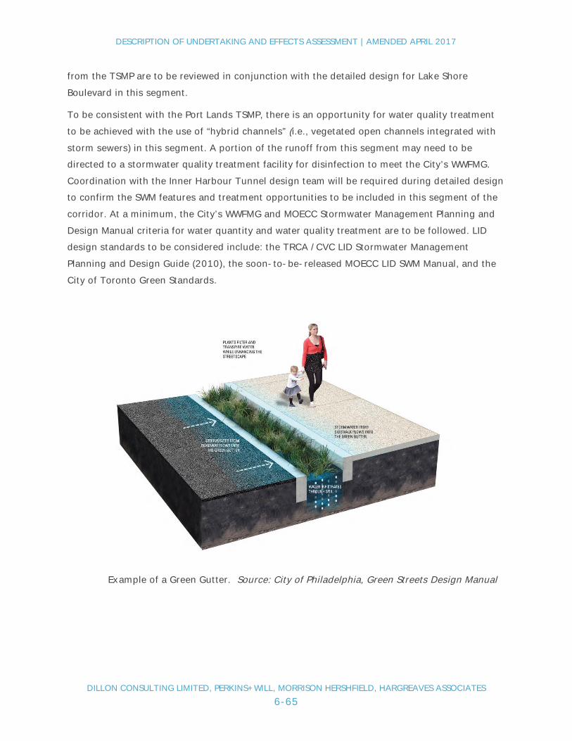
DESCRIPTION OF UNDERTAKING AND EFFECTS ASSESSMENT | AMENDED APRIL 2017
DILLON CONSULTING LIMITED, PERKINS+WILL, MORRISON HERSHFIELD, HARGREAVES ASSOCIATES6-65
from the TSMP are to be reviewed in conjunction with the detailed design for Lake ShoreBoulevard in this segment.
To be consistent with the Port Lands TSMP, there is an opportunity for water quality treatmentto be achieved with the use of “hybrid channels” (i.e., vegetated open channels integrated withstorm sewers) in this segment. A portion of the runoff from this segment may need to bedirected to a stormwater quality treatment facility for disinfection to meet the City’s WWFMG.Coordination with the Inner Harbour Tunnel design team will be required during detailed designto confirm the SWM features and treatment opportunities to be included in this segment of thecorridor. At a minimum, the City’s WWFMG and MOECC Stormwater Management Planning andDesign Manual criteria for water quantity and water quality treatment are to be followed. LIDdesign standards to be considered include: the TRCA /CVC LID Stormwater ManagementPlanning and Design Guide (2010), the soon-to-be-released MOECC LID SWM Manual, and theCity of Toronto Green Standards.
Example of a Green Gutter. Source: City of Philadelphia, Green Streets Design Manual

DESCRIPTION OF UNDERTAKING AND EFFECTS ASSESSMENT | AMENDED APRIL 2017
DILLON CONSULTING LIMITED, PERKINS+WILL, MORRISON HERSHFIELD, HARGREAVES ASSOCIATES6-66
6.5.2.7 Cultural Resources
Construction Period
Much of the project area consists of lakefill and lands that have been significantly altered byland development activities in the late 1800s and early 1900s. More recently, lands that areaffected by the undertaking in the Keating Channel Precinct were used for industrial purposes(e.g. tank farm). As outlined in the Cultural Heritage Baseline Report (Appendix C – Figure C),there are no cultural heritage resources located in the project footprint. Nonetheless, anassessment will be conducted (post EA outcome) to identify opportunities to document theelevated expressway structure for archival purposes prior to its partial demolition andreconstruction.
Based on the completed Stage 1 Archaeological Assessment (Appendix D), because of thehistorical development activities in the area where construction of the undertaking is proposed,there is limited potential for the survival of Aboriginal archaeological resources in primarycontexts. There is however the potential for impact on nineteenth-early twentieth centurydevelopment features including Toronto Dry Docks, Toronto Iron Works and British AmericanOil. Once detailed design has been completed, and the areas of excavation identified (e.g., forthe expressway support piers) further archaeological assessment is warranted to confirm thepotential for any features to exist. Additional recovery and/or preservation measures may bewarranted.
Operations Period
No effects to cultural heritage resources or archaeological features would occur during theoperation period.
6.5.2.8 Economics
Construction Period
There will be no direct removal or displacement of existing businesses as a result of theproject. During periods of road closures, there could be delays to truck traffic travellingthrough the area similar to what automobile users would experience as previously describedunder the Transportation criteria group. Detour roads will be provided and advancewarnings/communications of road closure periods.
Regarding downtown mobility, travel between the downtown and the east will take longerduring construction. Travel during non-peak periods and through different modes will beencouraged.

DESCRIPTION OF UNDERTAKING AND EFFECTS ASSESSMENT | AMENDED APRIL 2017
DILLON CONSULTING LIMITED, PERKINS+WILL, MORRISON HERSHFIELD, HARGREAVES ASSOCIATES6-67
Businesses adjacent to Lake Shore Boulevard east of the Don Roadway may experience someconstruction nuisance effects and temporary access restrictions. These businessowners/operators will be advised of the construction activity and mitigation plans will bedeveloped with their input to minimize negative effects to them.
Regarding the construction of the Lake Shore Boulevard-Don River bridge and rail spur bridge,there is potential for short-term temporary impacts to port related businesses that use rail carswhich utilize the rail bridge. This includes the Ashbridges Bay Treatment Plant. The project co-proponents and/or its agents will work with these businesses to minimize impacts duringconstruction and coordinate rail needs during temporary construction disturbances.
Operations Period
During operations, future economic effects of the project are largely related to increased traveltimes as compared to the future Do Nothing condition. As previously described, trafficmodelling work forecasts an increased travel time of three minutes for travel from the eastduring the AM peak hour. Travel time increases during non-peak periods are expected to beless. Travel to/from the north and west are unaffected and the project will maintain acontinuous freeway link between the Gardiner and DVP facilitating regional movement of goods.
The provision of new access ramps in the Keating Channel Precinct just east of Cherry Streetwill facilitate Gardiner access for businesses located in the Port Lands.
It is noted that future travel times in the corridor will increase without the project in placebecause of expected growth in background traffic volumes.
6.6 Consideration of Source Water ProtectionSource water protection is the protection of any untreated water which is used as a source formunicipal drinking water. Drinking water is best protected by taking an approach that usesmultiple barriers to prevent contamination from affecting drinking water. This approachincludes taking actions to prevent contamination of source water, using adequate watertreatment and distribution systems, undertaking water testing and training of water managers.

DESCRIPTION OF UNDERTAKING AND EFFECTS ASSESSMENT | AMENDED APRIL 2017
DILLON CONSULTING LIMITED, PERKINS+WILL, MORRISON HERSHFIELD, HARGREAVES ASSOCIATES6-68
Within the Study Area there are no source wellhead protection areas and no issue contributingareas (ICA is a documented, existing problem with the quality of the source water). However,there is a concern that flooding from the Don River east towards Leslie Street could potentiallyimpact source water. This would be considered an “Event Based” source water protectionconcern as it relates to major storm events. The Event Based modelling for the area east of theDon River and south of Eastern Avenue has shown that a disinfection interruption at theAshbridges Bay Treatment Plant could cause a plant by-pass discharge to the lake and be apotential drinking water threat. Although this is a potential given existing flood potential in theStudy Area (without the implementation of the DMNP), the proposed undertaking does notappear to negatively impact this threat as there is an overall reduction in impervious area dueto infrastructure changes and therefore there are no additional protection measuresrecommended. The implementation of the DMNP will be the most significant contributor toaddressing the Event Based source water protection concern that exists east of the Don River.
6.7 Consideration of Climate ChangeThe project co-proponents recognize that future climate changes could have impacts on itsservices, operations, and infrastructure. As a result, over the last 10 years, the co-proponentshave undertaken several climate change related initiatives. In 2007, City Council unanimouslyadopted Toronto's Climate Change Action Plan. The plan sets bold targets for the reduction ofgreenhouse gas emissions, and outlined actions that would see the city and its residents,businesses and communities reduce emissions, clean the air and create a sustainable energyfuture. Using 1990 as the baseline year, the City has a target to reduce greenhouse gasemissions (GHGs) by 80% by 2050. Initiatives to help met this target include: providingincentives to make buildings more energy efficient, cutting landfill gas emissions, promotingbike usage through the bike sharing program and cycling network planning process, increasingthe city’s tree canopy, and expanding of the public transit system.
Waterfront Toronto is also active in the reduction of GHGs in relation to the redevelopment ofthe city’s waterfront. Through its Minimum Green Building Requirements, Waterfront Torontorequires that all projects achieve a minimum of LEED® Gold certification, including LEED®certification credits in energy efficiency, water efficient landscaping, water use reduction, on-site renewable energy generation and measurement and verification. Other requirementsinclude electric vehicle infrastructure, bicycle parking, green roofs, and waste management.

DESCRIPTION OF UNDERTAKING AND EFFECTS ASSESSMENT | AMENDED APRIL 2017
DILLON CONSULTING LIMITED, PERKINS+WILL, MORRISON HERSHFIELD, HARGREAVES ASSOCIATES6-69
In 2008, the City released Ahead of the Storm – Development of a Climate Change AdaptationStrategy. This report outlines a number of actions that will improve the city's resilience toclimate change and extreme weather events. The report recognizes that the City’s Wet WeatherFlow Master Plan (WWFMP) is Toronto’s “single most relevant policy” for climate changeadaptation.
Further, in 2012 the City released its Future Weather & Climate Driver Study. This studypresents predictions of future climate conditions for the city for the purpose of informingpresent and future infrastructure decisions. The study results indicate that while the averagenumber of snow storms in the winter is predicted to decrease and the number of storms in thesummer is predicted decrease as well. However, extreme rainstorm events in the summer willbe more extreme resulting in the maximum amount of rainfall expected in a single day and inany single hour to more than double. There will be a smaller number of storm events but onaverage each storm will produce a higher amount of precipitation.
In 2015, the Subcommittee on Climate Change Mitigation and Adaptation was established bythe Parks and Environment Committee to report on a review of City policies, expert advice andinternational best practices to mitigate and adapt to climate change.
Climate change has been considered in this EA through the consideration of:
● Effects on Climate Change: effects of the undertaking on climate change; and,
● Effects from Climate Change: effects of climate change on the undertaking.
This assessment was conducted considering input received from MOECC staff as well as theconsideration of current best practice regarding climate change integration in EA.
Effects on Climate Change
The following describes how potential effects of the undertaking on climate change wereconsidered in the EA.
Regarding the alternatives evaluation, GHGs were estimated through modelling of thealternative solutions: Maintain, Improve, Replace, and Remove. The results of the assessmentwere considered in the comparative evaluation of the alternatives. GHGs were not modelled forthe alternative designs as all three Hybrid alternatives would generate similar if not the sametraffic volumes and patterns and as such, there would not be a difference in the amount ofGHGs generated for each of the alternative designs.

DESCRIPTION OF UNDERTAKING AND EFFECTS ASSESSMENT | AMENDED APRIL 2017
DILLON CONSULTING LIMITED, PERKINS+WILL, MORRISON HERSHFIELD, HARGREAVES ASSOCIATES6-70
It is noted that the project will not encourage greater use of automobiles and as such will notcontribute to a greater amount of GHGs over future baseline conditions. In fact, the removal ofthe Logan Ramps that is part of the preferred undertaking will result in a reduction in someroad capacity and as a result, might entice the use of alternate modes of travel.
A major benefit of the project is that it enhances new development opportunities in the KeatingChannel Precinct which is close to the downtown core and provides an alternative to livingfurther away with greater commuting distances. The Keating Channel Precinct is within an easycycling distance to the downtown and will be connected with transit. The project alternativeshave been evaluated and the preferred undertaking conceptually designed and assessed on theassumption that planned transit projects will be in place to provide people with an alternativemode of transportation that has a lower carbon footprint than automobile travel. This includesthe proposed waterfront LRT project that is planned to run in parallel to the Gardiner- LakeShore Boulevard corridor. The preferred undertaking also allows for an extension of QueensQuay Boulevard East that might allow for the extension of transit into the Keating ChannelPrecinct that was not practical under the Maintain alternative.
As part of the preferred undertaking, the project co-proponents have committed to theconstruction of a new off-road multi-use pathway/bikeway along Lake Shore Boulevard thatwould extend from the Don Roadway to at least Jarvis Street. This new pathway wouldcomplement the existing Martin Goodman Trail that extends south of the study corridor alongQueens Quay. The Lake Shore Boulevard multi-use pathway would provide a more directcommuter route for cyclists and connect with the existing multi-use trail that extends east ofthe Don River. With this new multi-use pathway, improved connections with the surroundingpedestrian/cycling network and with proposed improvements for pedestrian/cycling crossingsat intersections, it is hoped that a larger number of commuters will be attracted to active modesof transportation, further reducing reliance on automobiles and encouraging healthycommunities. In addition, during future detailed design work, consideration will be given todesigning this pathway with features that will encourage people to cycle/walk in variousweather conditions or feel safe should extreme weather suddenly arise. Examples may includeshade to protect users on extremely hot days, designed to minimize snow and iceaccumulation, and allow for adequate snow clearing, also ensure no sections are flood-prone.

DESCRIPTION OF UNDERTAKING AND EFFECTS ASSESSMENT | AMENDED APRIL 2017
DILLON CONSULTING LIMITED, PERKINS+WILL, MORRISON HERSHFIELD, HARGREAVES ASSOCIATES6-71
The project will involve the demolition of a section of the existing elevated expressway and as aresult, a considerable amount of demolition debris will be available. To reduce the amount ofnew material for project construction and reduce the project carbon footprint, the project co-proponents will explore the potential to reuse some of the construction debris in new road andtrail construction. This might involve crushing the old concrete to create granular material thatcould be used in new roadway construction. Cost, timing and suitability of this material wouldneed to be considered in any decision to re-use this demolition material.
Finally, the project includes a commitment to “green” the corridor which includes plantingsalong the multi-use pathway (where feasible given the presence of the elevated expressway).With the relocation of the Expressway through the Keating Channel Precinct and the removal ofthe Logan Ramps, the project will allow for an extensive greening of the corridor from about themiddle of the Keating Channel Precinct through to Leslie Street. The greening of the corridorwill be a positive net improvement over future baseline conditions.
Effects of Climate Change
The project by its nature is not considered to be overly susceptible to changing climateconditions and certainly is not any more susceptible than the future Do Nothing baselinecondition. The new elevated section of the expressway is not prone to flooding and thelocation of the realigned section of Lake Shore Boulevard will not be any more susceptible thanthe current alignment that runs along the Keating Channel. With the planned flood protectionworks associated with the DMNP, the flood risk in the Keating Channel Precinct would be furtherreduced and as a result, the flood risk to Lake Shore Boulevard would be reduced.
The project will be constructed using the latest advancements in concrete use/manufacturingfor both the elevated and at-grade road sections and as a result, is expected to have a lifespanapproaching 100 years unlike the current facility which has had about a 50-year lifespan. Theproject will be designed to withstand extreme weather events, more frequent freeze/thawcycles, and to better withstand the effects of roadway salting (chlorides) which is a majorcontributor to the deterioration of concrete and steel reinforcements.

DESCRIPTION OF UNDERTAKING AND EFFECTS ASSESSMENT | AMENDED APRIL 2017
DILLON CONSULTING LIMITED, PERKINS+WILL, MORRISON HERSHFIELD, HARGREAVES ASSOCIATES6-72
Climate change modelling for the project area indicates the potential for larger and morefrequent storm events which could contribute to greater amounts of runoff to be managed. Thestormwater management system will be designed to meet the City Wet Weather FlowManagement Guidelines. Furthermore, the City, through a Resilient City Working Group, hasidentified several adaptation actions including the use of bio-retention and low impactdevelopment within rights-of way. These options to manage stormwater will be consideredduring the detailed design phase of the project. As a possible climate change adaptationmeasure, run-off from the Gardiner could be directed to the planned new green space areanorth of Lake Shore Boulevard for reuse/infiltration. This serves as an alternative to theoversizing of infrastructure including storm sewers to managed high flow events.
6.8 Coordination With Other Projects - CumulativeEffects
Cumulative environmental effects include the combination of adverse effects from theundertaking with effects from other future projects or activities that are planned to be carriedout within the same time period and physical space. In identifying future projects to include inthe cumulative environmental effects assessment, projects that are "certain" and "reasonablyforeseeable" have been considered. These include projects that have approved plans or projectsthat have plans/studies underway. The main projects that may contribute to cumulative effectsin the Study Area are:
● DMNP Project;
● Future development as identified in the Lower Don Lands Master Plan, includingVilliers Island Precinct Plan;
● Future Development as identified in the Port Lands and South of Eastern Area MasterPlan, including the First Gulf site;
● Don River and Central Waterfront Project; and,
● Cherry Street Realignment.
The main potential cumulative effect associated with these projects is from overlappingconstruction periods which could contribute to increased disturbance effects to the surroundingarea and additional traffic delay. Once operational, adverse cumulative effects from theseprojects are not expected.

DESCRIPTION OF UNDERTAKING AND EFFECTS ASSESSMENT | AMENDED APRIL 2017
DILLON CONSULTING LIMITED, PERKINS+WILL, MORRISON HERSHFIELD, HARGREAVES ASSOCIATES6-73
The DMNP Project will provide the critical infrastructure changes needed to manage flood riskto the Port Lands and South of Eastern areas. Without the DMNP the redevelopment of theseareas cannot proceed. The timing for construction of the DMNP is still being confirmed butthere is the potential that both the Gardiner East project and the DMNP could have overlappingconstruction periods. Construction for the Gardiner East undertaking will be coordinated withthe DMNP construction so as to minimize combined effects. In particular, this applies toconstruction related effects of works occurring in the Don River, around the banks of the DonRiver and along the Don Roadway north of Lake Shore Boulevard. Specific consideration will beneeded for erosion/sediment management control. This includes the sediment managementactivities required in the Don River and Keating Channel during construction. Hydraulicmodelling of construction staging is to be completed with TRCA. Once both of these projectsare constructed, the simultaneous operation of these two projects is not anticipated to result incumulative effects.
The Port Lands and South of Eastern Transportation and Servicing Master Plan (in progress) andthe Lower Don Lands Master Plan (complete) and Villiers Island Precinct Plan (in progress)include population and employment, land use, servicing and transportation changes that willchange the existing conditions in the eastern sections of the Study Area. The timing for theconstruction of these new communities is uncertain. As they require the completion of theDMNP, it is likely that construction activities would occur after the Gardiner East project hasbeen completed. If there is the potential for development activity to occur in the same timeframe as the Gardiner East project, then there would be the need to coordinate constructionactivities with the Gardiner East undertaking so as to limit the potential for cumulative effects.
The Don River and Central Waterfront Project includes a 25-year implementation plan for aseries of major servicing projects that will provide solutions to address the problem ofstormwater and combined sewer overflow discharges in the city (this is in addition to the floodprotection provided through the DMNP). The projects include underground infrastructure thatwill capture and treat polluted stormwater and combined sewer overflows before they enterToronto's waterways. They also include upgrades to the Don Sanitary Trunk Sewer system,including twinning of the Lower Don River / Coxwell Bypass Sanitary Trunk Sewer. Other worksinclude an Inner Harbour Tunnel in Lake Ontario, a pumping station, new underground verticalstorage shafts, and a new Wet Weather Flow Treatment facility. Not all of the works occur withinthe Study Area and the phasing for implementing the projects extends over 25 years. As such,the project co-proponents and its agents will need to coordinate construction activities relatedto the two projects in the areas where overlap is possible. The primary focus will be the Don

DESCRIPTION OF UNDERTAKING AND EFFECTS ASSESSMENT | AMENDED APRIL 2017
DILLON CONSULTING LIMITED, PERKINS+WILL, MORRISON HERSHFIELD, HARGREAVES ASSOCIATES6-74
River, Inner Harbour and Port Lands improvements. Cumulative effects will be limited throughthe coordinated planning of these construction projects.
The co-proponents are aware of the potential that the redevelopment of the waterfront and PortLands could result in multiple years of ongoing construction. As all of the planned andapproved projects in the Study Area undergo construction, there may be cumulative effects toresidents and businesses if construction is ongoing for multiple years. There is recognition thatconsiderations will need to be made to manage cumulative impacts to residents and businessesthat result from ongoing construction. Efforts will be made to:
● Keep the public and businesses informed of construction activities on an ongoingbasis (including location and schedules for construction);
● Ensure opportunities are available for the public and businesses to provide feedbackregarding construction related concerns;
● Review opportunities to stagger construction years and phases so as to limitcontinuous construction in one area;
● Review opportunities to coordinate construction activities proposed along individualtransportation corridors so as to reduce construction timelines and limit therequirement to commence multiple construction projects in one corridor overconsecutive years;
● Coordinate with transit authorities including Metrolinx and TTC to reduce impacts totransit operations and coordinate future transit construction projects in the StudyArea; and
● Review construction methods on an on-going basis to identify opportunities for newtechniques or the use of new technologies that may reduce construction timelines.
6.9 Advantages and DisadvantagesThe overall advantages and disadvantages of the Gardiner Expressway and Lake ShoreBoulevard East EA and Urban Design project are presented in this chapter. Advantages arepositive net effects to the natural and socio-economic environment, while disadvantages arenegative net effects. The purpose of this chapter is to provide an overall conclusion as towhether, in comparison with the “Do Nothing” Alternative, the negative net effects of the projectare acceptable, based on a balanced assessment against the positive net effects.

DESCRIPTION OF UNDERTAKING AND EFFECTS ASSESSMENT | AMENDED APRIL 2017
DILLON CONSULTING LIMITED, PERKINS+WILL, MORRISON HERSHFIELD, HARGREAVES ASSOCIATES6-75
Table 6-4 presents an analysis of the advantages and disadvantages of the project organizedby study lens and which draws on the assessment of effects and recommended mitigationmeasures as presented previously in Tables 6.2 and 6.3.
Table 6-4: Project Advantages and Disadvantages
Study Lens Advantages Disadvantages
Environment Potential for improvement to water qualityand habitat in the Keating Channel byremoving the expressway away from it andthe installation of improved storm runoffcontrols.
Construction nuisance/disturbance effectsare minimal as the project area is yet to bedeveloped and receptors are well removedfrom the construction area.
Provides opportunities to better complementthe planned DMNP Project.
Public realm, green space and corridorplantings will increase the amount of qualityvegetation/habitat in the area.
Some potential for temporaryconstruction nuisance effects(noise/dust) to users of thepathways through KeatingChannel Precinct and McClearyPark (during removal of LoganRamps).
Loss of a minimal amount of poorquality terrestrial and aquatichabitat.
Potential for some temporarysedimentation effects to localwater bodies (Don River andKeating Channel) fromconstruction site runoff duringstorm events.
Potential negative short-termimpacts on Don River floodconveyance during constructionuntil final weirs and bridges havebeen put in place.
Potential short-term impacts onDon River sediment managementoperations during constructionmay need to be mitigated/avoided.

DESCRIPTION OF UNDERTAKING AND EFFECTS ASSESSMENT | AMENDED APRIL 2017
DILLON CONSULTING LIMITED, PERKINS+WILL, MORRISON HERSHFIELD, HARGREAVES ASSOCIATES6-76
Study Lens Advantages Disadvantages
Urban Designand Planning
Allows for transformation of the KeatingChannel Precinct and the redevelopment ofapproximately 7.5 acres of public lands withdirect access to the water (Keating Channel).
Allows for the development of anunencumbered water’s edge promenadealong the north side of the Keating Channel.
Removes the barrier of the elevatedexpressway through Keating ChannelPrecinct allowing better connections throughthe waterfront from the Port Lands throughto East Bayfront.
Makes the planned Villiers Island communitymore attractive by relocating the elevatedexpressway away from it.
Removal of the Logan Ramps opens updevelopment opportunities along Lake ShoreBoulevard east of the Don Roadway includingthe First Gulf development which lies to thenorth of the corridor. Provides potential fordevelopment with direct access to Lake ShoreBoulevard.

DESCRIPTION OF UNDERTAKING AND EFFECTS ASSESSMENT | AMENDED APRIL 2017
DILLON CONSULTING LIMITED, PERKINS+WILL, MORRISON HERSHFIELD, HARGREAVES ASSOCIATES6-77
Study Lens Advantages Disadvantages
TransportationandInfrastructure
Maintains continuous freeway connectionbetween the DVP and the Gardiner while alsoproviding a connection that replaces andgreatly improves the structure’s life span.The existing structure in this area requiressignificant rehabilitation if it were to bemaintained.
The removal of the Logan ramps eliminatesthe need to ever complete/budget for therehabilitation or maintenance on that stretchof the expressway.
Temporary road traffic delaysduring periods of road closuresduring construction - mostsignificant during peak travelperiods.
Temporary detouring of thepedestrian/cycling pathwaythrough the Keating ChannelPrecinct will increase traveldistances.
Potential for short-term trafficinfiltration into residentialneighbourhoods during periods ofroad closures.
Potential for temporary effects toMetrolinx rail service duringwidening of the rail bridgeunderpass.
Increase in travel time during thepeak period for travel betweendowntown and the east (southScarborough).
Economics Maintains freeway connection and providesaccess to the Gardiner allowing for themovement of goods.
Keating Channel Precinct public lands salesrevenue estimated at approximately $70 to$80 M.
Complements the First Gulf landdevelopment proposal which is projected togenerate in excess of 25,000 jobs serving asa major economic catalyst to the Port Lands.
Additional cost of $154 million(NPV) over the Maintain option(Do nothing).
Requirement for some privateproperty acquisition (from theFirst Gulf site).
Removal of Logan Ramps willlengthen truck travel to the east.
Potential for temporary effects tobusinesses in the Port Lands andAshbridges Bay Treatment Plantduring construction of rail spurbridge over Don River.

DESCRIPTION OF UNDERTAKING AND EFFECTS ASSESSMENT | AMENDED APRIL 2017
DILLON CONSULTING LIMITED, PERKINS+WILL, MORRISON HERSHFIELD, HARGREAVES ASSOCIATES6-78
Also to be considered is the extent to which the project achieves the study goals that werearticulated in the EA Terms of Reference. The extent to which these goals are achieved with theproject are presented below:
Goal 1 - Revitalize the Waterfront - The improvements planned for the corridor contribute tothe revitalization of the waterfront and complement other planned waterfront improvementssuch as the DMNP, Keating Channel Precinct Plan, Lower Don Lands Plan including Villiers IslandPrecinct Plan, and Port Lands and South of Eastern Master Plan. Planned improvements to thepublic realm will further support waterfront revitalization by improving the pedestrian andcycling experience throughout the corridor. Goal 2 - Reconnect the City to the Lake - Therelocation of the Gardiner away from the north edge of the Keating Channel provides anopportunity to connect the Keating Channel Precinct to the water in a manner that was notpreviously imagined - it achieves city building objectives. The relocation of the GardinerExpressway through the Keating Channel Precinct also facilitates improved waterfrontconnections between the Keating Channel Precinct, East Bayfront and the Port Lands. In additionto the improvements realized in the Keating Channel Precinct, the planned improvements at keyLake Shore Boulevard intersections between Jarvis Street and Cherry Street will facilitate betternorth-south connections to the waterfront for pedestrians and cyclists coming to/from thedowntown area.
Goal 3 - Balance modes of Travel - The development of a new multi-use pathway along thenorth edge of Lake Shore Boulevard will encourage active modes of travel into/from thedowntown. The multi-use trail will be coordinated with public realm improvements (e.g.,streetscaping) as well as with other planned pedestrian/cycling facilities in the Study Area toimprove the overall experience and encourage more active transportation in the area. Theproject results in some reduction on road capacity which might lead to the adoption of othermodes of transportation by auto users not wanting further delay to their auto-based commute.This may also encourage other modes of goods movement such as rail.

DESCRIPTION OF UNDERTAKING AND EFFECTS ASSESSMENT | AMENDED APRIL 2017
DILLON CONSULTING LIMITED, PERKINS+WILL, MORRISON HERSHFIELD, HARGREAVES ASSOCIATES6-79
Goal 4 - Achieve Sustainability - The project involves the creation of significant improved/newgreen space that would lie north of the Lake Shore Boulevard creating a new green ribbon. Inaddition, tree plantings are proposed along the Lake Shore Boulevard corridor, particularly fromthe future Munition Street intersection east. The project will also result reduced infrastructurein the Don River which will reduce pressures on stormwater management and sedimentmanagement facilities. The design of the new Gardiner Expressway-DVP connection through theKeating Channel Precinct will also provide opportunities to consider the use of more sustainableconstruction materials. Further, the detailed design process will consider opportunities toimprove the management of stormwater runoff from the new Gardiner-DVP connection. Finally,with improved stormwater controls associated with the relocation of the Gardiner away from thewater’s edge, improvements to surface water quality are possible. Future detailed design workpresents further opportunities to explore the use of sustainable design techniques.
Most of the project’s negative effects will occur during the construction period and, as such,will be temporary. Adverse effects on the natural environment are minimal considering the lowquality of existing habitat in the project vicinity. Similarly, there are few negative social impactsdue to an absence of receptors in the project area. The most notable effects are increasedtravel times for commuters during project construction when road closures will occur. Travelbetween the downtown and the northern and eastern parts of the city will be affected. Once theproject is constructed and operational, the only negative effects of note are the increased traveltime for auto commuters between the downtown and the east during peak travel periods(average increase of three minutes in the AM peak hour). It is noted that 90% of the downtowncommuters will not experience any change in their peak period travel time as a result of theproject.
DESCRIPTION OF UNDERTAKING AND EFFECTS ASSESSMENT | AMENDED APRIL 2017
DILLON CONSULTING LIMITED, PERKINS+WILL, MORRISON HERSHFIELD, HARGREAVES ASSOCIATES6-80
In contrast, the project offers many city building advantages and fulfills to some extent all ofthe study goals as defined in the EA ToR. Further, the public has indicated strong support forthe Hybrid 3 alternative (as the preferred alternative design) and City of Toronto Council andthe Waterfront Toronto Board have also provided support for the project. In conclusion, thenegative net effects of the Gardiner East project, many of which will occur during constructionand are temporary, are considered to be offset by the positive contributions of the Project,including the opportunity to develop the Keating Channel Precinct with direct access to thewater, the creation of new public realm space, contributing to the creation of a betterconnected waterfront, complementing other major projects such as DMNP Project and PortLands development, providing additional trees/plantings within the Lake Shore Boulevardcorridor, complementing major private sector development projects including the First Gulfdevelopment, and promoting alternative modes of transportation through the provision of anew multi-use pathway.
6.10 Commitments and Monitoring of the UndertakingA monitoring plan has been developed for both environmental effects monitoring (seeSection 6.10.1) as well as EA compliance monitoring (see Section 6.10.2). The monitoringactivities will cover all phases of the undertaking including detailed design, construction, andoperations and maintenance. The results of these monitoring activities, including any requiredfollow-up activities will be documented and made available to the Ministry of the Environmentand Climate Change upon request in accordance with their Code of Practice for Preparing andReviewing Environmental Assessments in Ontario, January 2014.
6.10.1 Effects Monitoring
An effects monitoring strategy was developed based on the impact assessments carried out forthe undertaking to ensure that the predicted net negative effects are not exceeded, thatunexpected negative effects are addressed, and that the predicted benefits are realized.
Table 6-5 summarizes the construction period environment effects monitoring to be carriedout in relation to the mitigation measures that have been developed to address the potentialadverse environmental effects of the undertaken.
The operations period of the undertaking will largely involve the use of the roadway by vehicles.Effects from the use of the roadway are largely related to vehicle noise. As previously noted inTable 6-3, the City requires the consideration of traffic related noise as part of land useplanning and development approval processes. Development activity in the vicinity of theundertaking (Hybrid) will need to satisfy to these requirements.

DESCRIPTION OF UNDERTAKING AND EFFECTS ASSESSMENT | AMENDED APRIL 2017
DILLON CONSULTING LIMITED, PERKINS+WILL, MORRISON HERSHFIELD, HARGREAVES ASSOCIATES6-81
Also, as previously described in Section 6.2, once constructed the project will be subject toroutine City of Toronto roadway operations and maintenance activities that would include forexample: snow clearing and de-icing, road and roadway structure condition inspections,roadway surface repairs, lane marking repainting, traffic monitoring, road accidentassessments, minor roadway design changes to respond to traffic demands and patterns, etc.No environmental effects of note are expected from these operations and maintenanceactivities and thus, effects monitoring is not required.
6.10.2 Environmental Compliance Monitoring
The project proponents have made a number of commitments based on the impactassessments carried out and in response to issues raised and comments received during the EA.A monitoring plan was developed to ensure that the EA commitments made are fulfilled. Thesecommitments have been grouped either as “General” or by individual environmentalcomponent. Table 6-6 outlines the EA commitments.

DESCRIPTION OF UNDERTAKING AND EFFECTS ASSESSMENT | AMENDED APRIL 2017
DILLON CONSULTING LIMITED, PERKINS+WILL, MORRISON HERSHFIELD, HARGREAVES ASSOCIATES6-82
Table 6-5: Construction Effects Monitoring
Table 6-5: Construction Effects Monitoring
Transportation
During construction, roads closures couldresult in delay to vehicle users, particularlyduring peak travel periods
Monitor traffic vehicle delay and adjust the Construction Phasing Plan/Traffic ManagementPlan, where possible, to minimize delays.
Traffic flow may not be fully optimized During operations period, City to monitor traffic operations and make adjustments asrequired (e.g. traffic signal timing) to optimize the flow of traffic through corridor as wellas monitor vehicle incident rates to ensure that the roadway is operating at a safe level ofservice.
Public Safety
As with all roadways, there is the potential fortraffic incidents
Once project is operational, City to monitor rate and nature of traffic incidents and makenecessary revisions including for example: speed change warnings, speed decelerationzones, etc.
Planning and Urban Design
During construction, there is the potential forconflict with the implementation of otherproject proposed for the project study area
Monitor the construction activities to determine potential conflicts with other projects andmake adjustments to the Construction Staging Plan in the event of unanticipated effectsoccurring. This will include working with TRCA regarding the planned DMNP.
Social and Health
Construction activities could result in localnoise and dust disturbances
Monitor public noise and dust complaints and take follow-up action as necessary.

DESCRIPTION OF UNDERTAKING AND EFFECTS ASSESSMENT | AMENDED APRIL 2017
DILLON CONSULTING LIMITED, PERKINS+WILL, MORRISON HERSHFIELD, HARGREAVES ASSOCIATES6-83
Table 6-5: Construction Effects Monitoring
Some construction activities such as piledriving have the potential to result in groundvibrations that could lead to structural impactson nearby buildings.
Implement a vibration monitoring program including:· Inspection and documentation (pictures etc.) of nearby buildings for any defects (e.g.,
cracks) prior to construction.· Conduct real-time monitoring of ground vibration at the perimeter of the construction
zone and nearest receptors during construction.· Prepare a list of Best Practices for implementation if the vibration threshold level is
exceeded (City of Toronto limit as defined in By-Law No. 514-2008) during theapplicable construction activities.
· Conduct post construction inspection to determine any damages to structures ofnearby receptor buildings.
Any soil contamination encountered duringconstruction would be disposed of, remediatedand/or monitored in accordance with obtainingSection 27 and Section 46 approvals under theEnvironmental Protection Act (EPA).
Monitoring may be required depending upon the conditions of approval associated withobtaining Section 27 and Section 46 approvals under the EPA.
During construction, road closures could leadto increases of traffic infiltration into onto localstreets and increase traffic relateddisturbances.
Monitor traffic infiltration in adjacent neighbourhoods during construction. Monitor andrespond to any complaints received by residents.

DESCRIPTION OF UNDERTAKING AND EFFECTS ASSESSMENT | AMENDED APRIL 2017
DILLON CONSULTING LIMITED, PERKINS+WILL, MORRISON HERSHFIELD, HARGREAVES ASSOCIATES6-84
Table 6-5: Construction Effects Monitoring
Natural Environment
Direct loss of aquatic habitat (Don River) fromnew pier construction is minimized.
Monitoring during construction will be conducted by a Qualified Environmental Inspectorand/or a Fisheries Specialist where a Fisheries Act Authorization is required.
During construction, there could be anincrease in sedimentation into local water waysfrom exposed soil surfaces.
Monitor effectiveness of surface water run-off mitigation measures after major storms andimplement corrective action measures if there is visible evidence of sedimentation inreceiving water bodies (Don River/Keating Channel).
Ramp related construction works in the DonRiver could obstruct river flow during floodevents.
In coordination with TRCA, monitor effectiveness of Don River flood conveyance duringstorm/flood events should they occur during periods of in-river work.
New plantings associated with the public realmplan may not all survive.
New plantings will be monitored after they are installed to ensure that they are thriving.Plants will be replaced, where necessary, according to standard warranty periods withproject contractors.
Cultural Resources
Potential for impact to archaeologicalresources
Monitoring may be required during construction subject to detailed archaeologicalassessment of excavated areas.
Economic
Road closures during construction could delaythe movement of goods through the corridor.
Monitor and review traffic detour plan with input from local commercial trucking operators.

DESCRIPTION OF UNDERTAKING AND EFFECTS ASSESSMENT | AMENDED APRIL 2017
DILLON CONSULTING LIMITED, PERKINS+WILL, MORRISON HERSHFIELD, HARGREAVES ASSOCIATES6-85
Table 6-6: EA Commitments and Compliance Monitoring
Table 6-6: EA Commitments and Compliance Monitoring
General
The undertaking will be constructed according to the final detailed design thatwill be developed.
Chapter 6
Sec. 6.1
The City, or its agent, will monitor theconstruction of the undertaking to ensurethat it is consistent with the final detaileddesign.
Continue to consult with the key landowners, the public and other stakeholdersto ensure awareness of project construction.
Chapter 6Table 6-2
Communication with the public andstakeholders will continue through detaileddesign and construction. This will include theposting of notifications and as required,direct contact with affected landowners.
Continue to engage with First Nations who have an interest in the project and todetermine the need for any construction related mitigation.
Chapter 6Table 6-2
Communication with First Nations willcontinue through detailed design andconstruction.
Coordinate with City Transportation Services and others including:
· Liaising with transit, police, and other Emergency Services, and providingfeedback and guidance to contractors.
Communicating with the implementing agencies of other projects such asTRCA and Metrolinx to ensure that the Gardiner East Project constructionactivities are coordinated with the other projects in the area.
Chapter 6Table 6-2
Coordination will continue through detaileddesign and construction.

DESCRIPTION OF UNDERTAKING AND EFFECTS ASSESSMENT | AMENDED APRIL 2017
DILLON CONSULTING LIMITED, PERKINS+WILL, MORRISON HERSHFIELD, HARGREAVES ASSOCIATES6-86
Table 6-6: EA Commitments and Compliance Monitoring
Transportation
Finalize the Construction Phasing Plan/Traffic Management Plan during detaileddesign to outline proposed roadway lane and sidewalk closures and detourroutes.
Chapter 6Table 6-2
These plans will be completed during detaileddesign and be revised as needed duringconstruction.
Provide advanced notification and signage to advise motorists, transit users,pedestrians and cyclists of lane and sidewalk reductions and closures andidentify appropriate detour routes.
Chapter 6Table 6-2
Public notification and signage will beimplemented during construction.
If construction is undertaken by a third party, the constructor is to apply forpermit(s) to coordinate planned lane, pathway and roadway closures.
Chapter 6Table 6-2
As needed during construction.
Carry out as much of the bridge deck demolition work as possible onweekends/overnight to avoid the need to shut down sections of the Lake ShoreBoulevard during the busier weekday periods.
Chapter 6Table 6-2
As possible during construction.
Minimize construction delays to emergency vehicle service (EMS, fire, police etc.)by:
· Regular communication with Emergency Services during construction;· Meeting with Emergency Services prior to construction start;· A requirement in the construction contract for a, “Emergency Service
Provider Notification,” to notify Emergency Services in advance ofconstruction start and prior to any full closures.
Chapter 6Table 6-2
Liaison with emergency service providers willcontinue through detailed design andconstruction.

DESCRIPTION OF UNDERTAKING AND EFFECTS ASSESSMENT | AMENDED APRIL 2017
DILLON CONSULTING LIMITED, PERKINS+WILL, MORRISON HERSHFIELD, HARGREAVES ASSOCIATES6-87
Table 6-6: EA Commitments and Compliance Monitoring
Work with transit providers (TTC and Metrolinx) to explore potential service levelincrease during construction. Undertake monitoring of impact on bus and streetcar travel from traffic diversion onto other City streets.
Chapter 6Table 6-2
Liaison will continue through detailed designand construction. Make adjustments toconstruction timing, road closures and roaddetours where practical if transit serviceimpacts are occurring.
Work with transit providers on future improvements and enhancements toimprove transit as an alternate mode of travel into the downtown.
Chapter 6Table 6-2
This action is ongoing.
Coordinate with Metrolinx re: opportunities for joint work on site related to trackupgrades so as to minimize impacts to rail service.
Chapter 6Table 6-2
Coordination will occur through detaileddesign and construction.
Explore potential to reduce Portlands rail spur line use during constructionperiods and coordinate changes to the rail spur works with DMNP works.
Chapter 6Table 6-2
Coordination will occur through detaileddesign and construction.
Provide an enhanced pathway system as an alternate mode of travel into thedowntown.
Chapter 6
Sec. 6.2
This will be an outcome of theimplementation of the undertaking.
Complete a more detailed assessment to confirm appropriate road safetymeasures to be included as part of the facility design including for example:provision of appropriate signage, lowering posted speed; implementation ofcrash attenuators, increasing the length of speed change lanes on the Don ValleyParkway and Gardiner, etc..
Chapter 6Table 6-2
This will be undertaken during detaileddesign.
Public Safety
Further assess roadway safety requirements as part of detailed design (e.g.posted speeds, crash attenuators, shoulder widening, etc.).
Chapter 6Table 6-2
To be completed during detailed design.
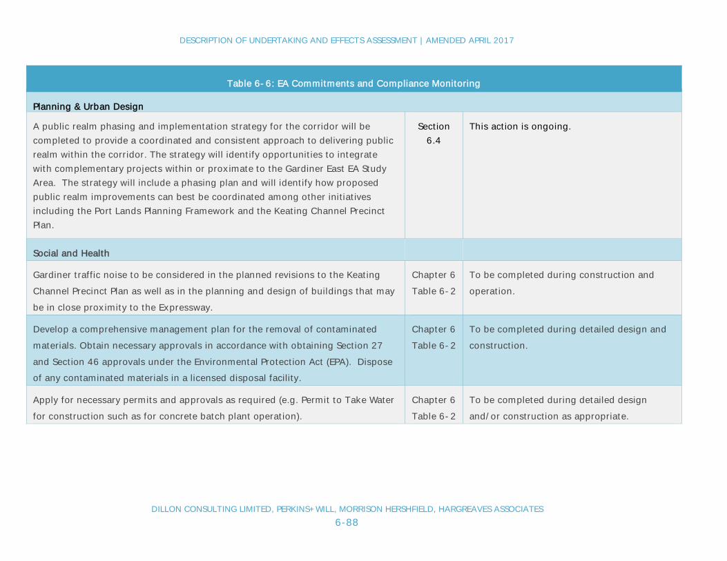
DESCRIPTION OF UNDERTAKING AND EFFECTS ASSESSMENT | AMENDED APRIL 2017
DILLON CONSULTING LIMITED, PERKINS+WILL, MORRISON HERSHFIELD, HARGREAVES ASSOCIATES6-88
Table 6-6: EA Commitments and Compliance Monitoring
Planning & Urban Design
A public realm phasing and implementation strategy for the corridor will becompleted to provide a coordinated and consistent approach to delivering publicrealm within the corridor. The strategy will identify opportunities to integratewith complementary projects within or proximate to the Gardiner East EA StudyArea. The strategy will include a phasing plan and will identify how proposedpublic realm improvements can best be coordinated among other initiativesincluding the Port Lands Planning Framework and the Keating Channel PrecinctPlan.
Section6.4
This action is ongoing.
Social and Health
Gardiner traffic noise to be considered in the planned revisions to the KeatingChannel Precinct Plan as well as in the planning and design of buildings that maybe in close proximity to the Expressway.
Chapter 6Table 6-2
To be completed during construction andoperation.
Develop a comprehensive management plan for the removal of contaminatedmaterials. Obtain necessary approvals in accordance with obtaining Section 27and Section 46 approvals under the Environmental Protection Act (EPA). Disposeof any contaminated materials in a licensed disposal facility.
Chapter 6Table 6-2
To be completed during detailed design andconstruction.
Apply for necessary permits and approvals as required (e.g. Permit to Take Waterfor construction such as for concrete batch plant operation).
Chapter 6Table 6-2
To be completed during detailed designand/or construction as appropriate.

DESCRIPTION OF UNDERTAKING AND EFFECTS ASSESSMENT | AMENDED APRIL 2017
DILLON CONSULTING LIMITED, PERKINS+WILL, MORRISON HERSHFIELD, HARGREAVES ASSOCIATES6-89
Table 6-6: EA Commitments and Compliance Monitoring
Apply best management construction practices to minimize dust and noiseincluding:
· Use of water and dust suppressants during construction when appropriate tominimize dust.
· Requiring contractors to keep idling of construction equipment to a minimumand maintain equipment in good working order.
Chapter 6Table 6-2
To be completed during construction.
Conform to applicable municipal construction noise and vibration by-laws. Chapter 6Table 6-2
To be completed during construction.
Work with major event organizers to minimize travel delays during major tourismevents.
Chapter 6Table 6-2
To be completed during construction.
Natural Environment
Prepare and follow a spills response plan for construction activity in proximity toopen water areas.
Chapter 6Table 6-2
To be completed during construction.
Include special provisions in the construction including provisions to:
· protect wildlife encountered during construction.· conduct in-water work between July 1st to March 31st
Chapter 6Table 6-2
To be completed during construction.
Salvage plants for replanting were appropriate. Chapter 6Table 6-2
To be completed during construction.
Consult with Aquatic Habitat Toronto to identify permitting requirements andmitigation strategy. Aquatic habitat Toronto will also be consulted with todetermine any aquatic monitoring requirements.
Chapter 6Table 6-2
Consultation will occur through detaileddesign and construction.

DESCRIPTION OF UNDERTAKING AND EFFECTS ASSESSMENT | AMENDED APRIL 2017
DILLON CONSULTING LIMITED, PERKINS+WILL, MORRISON HERSHFIELD, HARGREAVES ASSOCIATES6-90
Table 6-6: EA Commitments and Compliance Monitoring
Integrate with the Port Lands Biodiversity Strategy. Chapter 6Table 6-2
To be considered during detailed design andconstruction.
Create new green space/habitat along north side of the realigned Gardiner-LakeShore Boulevard as per the public realm concept for the undertaking.
Chapter 6
Sec. 6.2
This will be an outcome of theimplementation of the undertaking.
Fish screens shall be used on all dewatering intake pipes to protect fish, ifrequired.
Chapter 6Table 6-2
To be completed during construction.
Develop and implement an erosion and sediment control plan to mitigate impactsto the Don River and Keating Channel during construction.
Chapter 6Table 6-2
To occur through detailed design andconstruction.
Cultural Resources
Complete archaeological investigation on areas of excavation. Chapter 6Table 6-2
To be completed prior to constructionactivities.
Conduct heritage assessment of the Gardiner to identify opportunities todocument the elevated expressway structure for archival purposes prior to itspartial demolition and reconstruction.
Chapter 6Table 6-2
To be complete prior to constructionactivities.
Economic
Consult with local area commercial trucking operators in development of thetraffic management/detour plan.
Provide advanced notice about road closures/detours to commercial entities whorely on truck traffic and others who rely on mobility in the downtown area.
Chapter 6Table 6-2
Consultations to be undertaken duringdetailed design. Advanced notice of roadclosures/detours will be provided throughconstruction.

DESCRIPTION OF UNDERTAKING AND EFFECTS ASSESSMENT | AMENDED APRIL 2017
DILLON CONSULTING LIMITED, PERKINS+WILL, MORRISON HERSHFIELD, HARGREAVES ASSOCIATES6-91
Table 6-6: EA Commitments and Compliance Monitoring
Maintain access to area businesses during construction and provide advancednotification of road closures/access limitations.
Chapter 6Table 6-2
Access will be maintained and/or providedduring construction.

DESCRIPTION OF UNDERTAKING AND EFFECTS ASSESSMENT | AMENDED APRIL 2017
DILLON CONSULTING LIMITED, PERKINS+WILL, MORRISON HERSHFIELD, HARGREAVES ASSOCIATES6-92
Based on the comments received from the public and agencies on the released Final EA Report, Table 6-7 outlines additional EAcommitments to be implemented by the project co-proponents.
Table 6-7: Additional Commitments Resulting from Final EA Report Review
Table 6-7: Additional Commitments Resulting from Final EA Report Review
General The co-proponents shall adhere to and ensure adherence by the project constructor(s) or contractor(s) to allenvironmental mitigation and monitoring commitments listed in the EA report as applicable.
Species at Risk Screening The co-proponents will complete a Species at Risk (SAR) screening as part of the future design stage work. Ifnecessary, applicable mitigation will be put in place. The Ministry of Natural Resources and Forestry will beconsulted.
Archaeology As per the completed Stage 1 Archaeological Assessment Report, construction excavations in the area of thepotential Euro-Canadian archaeological resources will be subject to a program of archaeological monitoring todocument any remains, if any, prior to their removal.
Cultural Heritage As per the completed Cultural Heritage Resource Assessment Report, the identified cultural heritage resources inthe project area should be further evaluated as part of future project design work to describe their specific culturalvalue/cultural heritage attributes and to develop mitigation measures if applicable.
First Nation Engagement Letters of correspondence noted in the EA Report but omitted from Appendix B are now included. Also included inAppendix B are the notes from a meeting held with the Mississaugas of the New Credit First Nation in 2016. Theproject co-proponents will continue to engage with indigenous communities who have expressed an interest in theproject and will notify these communities of any archaeological findings that may be encountered duringconstruction.
Agency Engagement TRCA and Hydro One will be invited to participate in the multi-agency coordinating committee that has beenestablished to plan the various projects within the Don Mouth area. One of the goals of this committee will be tominimize impact and disruption to TRCA’s planned initiatives and Hydro One’s assets.

DESCRIPTION OF UNDERTAKING AND EFFECTS ASSESSMENT | AMENDED APRIL 2017
DILLON CONSULTING LIMITED, PERKINS+WILL, MORRISON HERSHFIELD, HARGREAVES ASSOCIATES6-93
Table 6-7: Additional Commitments Resulting from Final EA Report Review
Coordination with DonMouth Naturalizationand Port Lands FloodProjection EA
The design and mapping developed through the recent due diligence work for the DMNP EA, that includesadvancing the facility design, will be considered in the advancement of the design for the Gardiner East project.