5. summary of geophysical data from the sulu and … · 5. summary of geophysical data from the...
TRANSCRIPT
Rangin, C., Silver, E., von Breymann, M. T., et al., 1990Proceedings of the Ocean Drilling Program, Initial Reports, Vol. 124
5. SUMMARY OF GEOPHYSICAL DATA FROM THE SULU AND CELEBES SEAS1
K. Hinz2 and M. Block2
INTRODUCTION
A diversity of geophysical data exist from the Sulu and Ce-lebes seas. Two seismic refraction profiles and magnetic surveysswere made by the Vema in 1967 (Murauchi et al., 1973). In 1974the Comité d'Etudes Petroliers Marines conducted a multichan-nel seismic survey across the Sulu Sea (Mascle and Biscarrat,1978). The Federal Institute for Geosciences and Natural Re-sources (BGR) collected 10,315 km of multichannel seismicdata in parallel with magnetic and gravimetric measurements inthe Sulu Sea and 580 km in the Celebes Sea on six cruises duringthe period from 1977 to 1987 (Table 1; Hinz et al., 1986; Dür-baum and Hinz, 1983). The oil industry surveyed approximately18,000 km of multichannel seismic (MCS) data on the westernSulu shelf from 1965 to 1974 (Bell and Jessop, 1974).
Aeromagnetic measurements were carried out over the north-west Sulu Sea shelf (Bosum et al., 1972), and the U.S. NavalOceanographic Office conducted a Project Magnet aeromag-netic survey of the central region of the Sulu Sea in 1987.
Heat-flow measurements (Tables 2 and 3) and Sonobuoy seis-mic refraction measurements (Tables 4 and 5) were made in theSulu Sea.
STRUCTURAL UNITS OF THE SOUTHEASTERNSULU BASIN
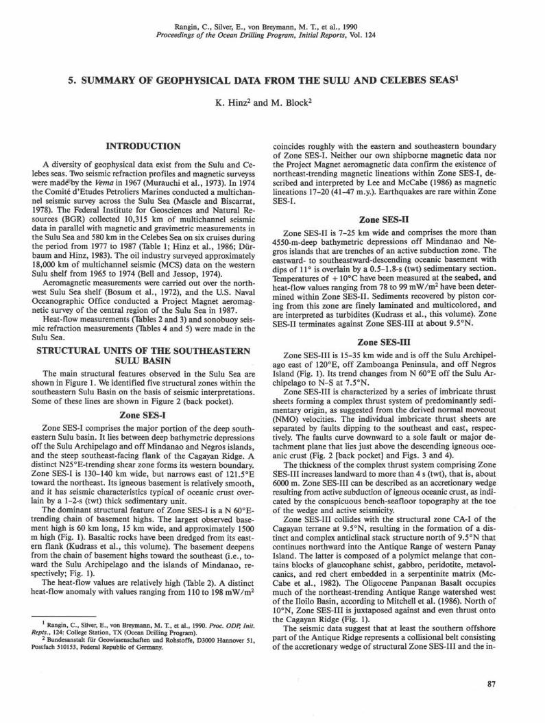
The main structural features observed in the Sulu Sea areshown in Figure 1. We identified five structural zones within thesoutheastern Sulu Basin on the basis of seismic interpretations.Some of these lines are shown in Figure 2 (back pocket).
Zone SES-I
Zone SES-I comprises the major portion of the deep south-eastern Sulu basin. It lies between deep bathymetric depressionsoff the Sulu Archipelago and off Mindanao and Negros islands,and the steep southeast-facing flank of the Cagayan Ridge. Adistinct N25°E-trending shear zone forms its western boundary.Zone SES-I is 130-140 km wide, but narrows east of 121.5°Etoward the northeast. Its igneous basement is relatively smooth,and it has seismic characteristics typical of oceanic crust over-lain by a 1-2-s (twt) thick sedimentary unit.
The dominant structural feature of Zone SES-I is a N 60°E-trending chain of basement highs. The largest observed base-ment high is 60 km long, 15 km wide, and approximately 1500m high (Fig. 1). Basaltic rocks have been dredged from its east-ern flank (Kudrass et al., this volume). The basement deepensfrom the chain of basement highs toward the southeast (i.e., to-ward the Sulu Archipelago and the islands of Mindanao, re-spectively; Fig. 1).
The heat-flow values are relatively high (Table 2). A distinctheat-flow anomaly with values ranging from 110 to 198 mW/m2
Rangin, C , Silver, E., von Breymann, M. X, et al., 1990. Proc. ODP, Init.Repts., 124: College Station, TX (Ocean Drilling Program).
2 Bundesanstalt fur Geowissenschaften und Rohstoffe, D3000 Hannover 51,Postfach 510153, Federal Republic of Germany.
coincides roughly with the eastern and southeastern boundaryof Zone SES-I. Neither our own shipborne magnetic data northe Project Magnet aeromagnetic data confirm the existence ofnortheast-trending magnetic lineations within Zone SES-I, de-scribed and interpreted by Lee and McCabe (1986) as magneticlineations 17-20 (41-47 m.y.). Earthquakes are rare within ZoneSES-I.
Zone SES-IIZone SES-II is 7-25 km wide and comprises the more than
4550-m-deep bathymetric depressions off Mindanao and Ne-gros islands that are trenches of an active subduction zone. Theeastward- to southeastward-descending oceanic basement withdips of 11° is overlain by a 0.5-1.8-s (twt) sedimentary section.Temperatures of + 10°C have been measured at the seabed, andheat-flow values ranging from 78 to 99 mW/m2 have been deter-mined within Zone SES-II. Sediments recovered by piston cor-ing from this zone are finely laminated and multicolored, andare interpreted as turbidites (Kudrass et al., this volume). ZoneSES-II terminates against Zone SES-III at about 9.5°N.
Zone SES-IIIZone SES-III is 15-35 km wide and is off the Sulu Archipel-
ago east of 120°E, off Zamboanga Peninsula, and off NegrosIsland (Fig. 1). Its trend changes from N 60°E off the Sulu Ar-chipelago to N-S at 7.5°N.
Zone SES-III is characterized by a series of imbricate thrustsheets forming a complex thrust system of predominantly sedi-mentary origin, as suggested from the derived normal moveout(NMO) velocities. The individual imbricate thrust sheets areseparated by faults dipping to the southeast and east, respec-tively. The faults curve downward to a sole fault or major de-tachment plane that lies just above the descending igneous oce-anic crust (Fig. 2 [back pocket] and Figs. 3 and 4).
The thickness of the complex thrust system comprising ZoneSES-III increases landward to more than 4 s (twt), that is, about6000 m. Zone SES-III can be described as an accretionary wedgeresulting from active subduction of igneous oceanic crust, as indi-cated by the conspicuous bench-seafloor topography at the toeof the wedge and active seismicity.
Zone SES-III collides with the structural zone CA-I of theCagayan terrane at 9.5°N, resulting in the formation of a dis-tinct and complex anticlinal stack structure north of 9.5°N thatcontinues northward into the Antique Range of western PanayIsland. The latter is composed of a polymict melange that con-tains blocks of glaucophane schist, gabbro, peridotite, metavol-canics, and red chert embedded in a serpentinite matrix (Mc-Cabe et al., 1982). The Oligocene Panpanan Basalt occupiesmuch of the northeast-trending Antique Range watershed westof the Iloilo Basin, according to Mitchell et al. (1986). North of10°N, Zone SES-III is juxtaposed against and even thrust ontothe Cagayan Ridge (Fig. 1).
The seismic data suggest that at least the southern offshorepart of the Antique Ridge represents a collisional belt consistingof the accretionary wedge of structural Zone SES-III and the in-
87
K. HINZ, M. BLOCK
Table 1. Multichannel seismic, magnetic, and gravimetric surveys in the Celebes and Sulu seas.
Year
1974
1977
1982
1983
1984
1986
1987
Vessel/country
Lady GlorittaFranceValdiviaF.R. GermanySonneF.R. GermanySonneF.R. GermanyExploraF.R. GermanyExploraF.R. GermanySonneF.R. Germany
Celebes Sea
1987 SonneGermany
Cruise
CEPM
VA-16
SO-23
SO-27
BGR-84
BGR-86
SO-49
SO-49
Seismic source
Volume(in.3)
Vaporchoc
900
1,562
1,562
3,512
2,756
1,562
1,562
No. ofguns
3
10
10
31
28
10
10
Receiver
Streamerlength (m)
2,400
2,400
2,4001,2002,400
3,000
3,000
2,400
2,400
No. ofchannels
24
24
241224
60
60
48
48
Coverage(%)
2,400
2,400
2,4001,2002,400
3,000
3,000
2,400
2,400
Sonobuoystation
no.
7
14
Gravityand
magnetics
G, M
G, M
G, M
G, M
G, M
G, M
Σ
Totalsurvey(km)
- 600
1,955
3,300
227
1,041
1,672
2,120
580
11,495
ferred volcanic Zone CA-I. North of 10°N, this complex colli-sional belt is juxtaposed and even thrust onto the CagayanRidge (Fig. 1).
Zone SES-IV
Zone SES-IV comprises an area of a particularly pronouncedstructural style. The 15-30-km wide zone extends over 300 kmfrom the continental margin of southern Panay in the north, to-ward 7°30'S in the south (Fig. 1). Because of the lack of MCSdata, it is uncertain whether this zone exists beneath the north-ern frontal portion of the Sulu Archipelago.
Zone SES-IV is characterized by three superimposed tec-tonic-stratigraphic units overlying actively subducting oceanicbasement. The dominant tectonic-stratigraphic unit is a regionalsplinter characterized by high-amplitude reflections at the topand the base, and interval velocities of >4.5 km/s. The thick-ness of this regional splinter increases from less than 0.5 s (twt)at the front to 2.2 s (twt) toward the central Philippine Islands.Our seismic data strongly suggest that the splinter forms the"backstop" against which the previously discussed Zone SES-III accretes by the development of imbricate thrust sheets andsimultaneous duplex-type shortening within the zone. By thisprocess, mass is added to Zone SES-III resulting in thickeningand progressive seaward growth of the zone as well as simultane-ous uplift of the splinter.
The inferred oceanic crust slab is overlain by a sedimentaryapron up to 2.4 s (twt) thick. The individual sedimentary se-quence boundaries of this apron have a gentle dip of about 8°toward the east and downlap onto the top of the splinter (Fig.2). Above the inferred hinge zone between the oceanic crustalsplinter and the Philippine island arc (i.e. Zone SES-V) theapron sediments are folded and thrusted, resulting in the build-up of a complex anticlinal structure (Figs. 3 and 4). North of9.5°N the sedimentary apron and also the underlying inferredoceanic crustal slab are affected by collision-related backthrust-ing. Apparently the sedimentary apron continues northwardinto the Iloilo basin of central Panay, which contains lime-stones, coarse clastic sediments, and interbedded basalt flowsof Oligocene-lower Miocene age, overlain by a middle Mioceneto Pliocene sequence of fine-grained sandstone and shale (Mc-Cabe et al., 1982).
Heat-flow values ranging from 45 to 70 mW/m2 have beendetermined within Zone SES-IV, and the depths of the seismicepicenters are less than 75 km.
Zone SES-V
Zone SES-V comprises the western slope and shelf of NegrosIsland and of the Zamboanga Peninsula. A sedimentary apronwith variable thickness ranging from a few hundred meters to2.8 s (twt) overlies an acoustic basement complex, the surface ofwhich is often characterized by a high-amplitude, discontinuousreflection horizon (Figs. 3 and 4).
The distinct acoustic basement complex of Zone SES-V pre-sumably represents subsided parts of the Cretaceous melangebasement, including overlying Oligocene to Miocene volcanicrocks of the Zamboanga Peninsula and of Negros Island. Themelange basement of Zamboanga Peninsula includes chloriteand hornblende schists, metasandstone, phyllite, slate, marble,Cretaceous limestone, volcanic rocks, and lenses of serpentin-ized peridotite (Hamilton, 1979). Cretaceous sandstone, shale,spilite, and pillow basalt crop out in the southwest part of Ne-gros Island, which otherwise consists mostly of Neogene andes-itic volcanic rocks and their intrusive equivalents and derivativevolcaniclastic sedimentary rocks (Hamilton, 1979).
REFERENCES
Bell, R. M., and Jessop, R.G.C., 1974. Exploration and geology of thewest Sulu Basin, Philippines. APEA J., 14:21-28.
Block, M., and Steinmann, D., 1988a. Geothermal studies. In Kudrass,H. R., et al. (Eds.), Geological, Geochemical and Geothermal In-vestigations in the Sulu Sea/Phillipines (SO 49). BGR Rep. 102042,Pt. 3 (Hannover, F. R. Germany).
Block, M., and Steinmann, D., 1988b. Geothermal studies. In Kudrass,H. R., et al. (Eds.), Geological, Geochemical and Geothermal In-vestigations in the Sulu Sea/Phillipines (SO 58). BGR Rep. 104774,Pt. 2 (Hannover, F. R. Germany).
Bosum, W., Fernandez, E., Kind, E., and Theodoro, C , 1972. Aero-magnetic survey of the Palawan Sulu offshore of the Philippines.CCOP Tech. Bull., 6:141-160.
Dürbaum, H. J., and Hinz, K., 1983. SEATAR-related geophysicalstudies of the BGR in the Southwest Pacific. Transactions, Circum-Pacific Energy and Mineral Resources Conference, 3rd, August1982, Honolulu, HI, 129-133.

GEOPHYSICAL DATA SUMMARY
Hamilton, W., 1979. Tectonics of the Indonesian region. U.S. Geol.Surv. Prof. Pap., 1078.
Hinz, K., Kempter, E.H.K., Schlüter, H. U., 1986. The southern Pala-wan Balabac area: an accreted or non-accreted terrane? Proc. AsianCouncil on Petroleum (ASCOPE) Conference and Exhibition, 3rd,Dec. 1985, Kuala Lumpur, Malaysia, 2:48-72.
Hinz, K., and Schlüter, H. U., 1985. Geology of Dangerous Grounds,South China Sea, and the continental margin off Southwest Pala-wan—results of Sonne cruises, SO23 and SO27. Energy, 10:297-315.
Lee, C. S., and McCabe, R., 1986. The Banda-Celebes Sulu Basin: atrapped piece of Cretaceous-Eocene oceanic crust. Nature, 322:51-54.
Ludwig, W. J., Kumar, N., and Houtz, R. E., 1979. Profiler-sonobuoymeasurements in the South China Sea basin. J. Geophys. Res., 84:3505-3518.
McCabe, P. R., Almasco, J., and Diegor, W., 1982. Geologic and paleo-magnetic evidence for a possible Miocene collision in western Panay,central Philippines. Geology, 10:325-329.
Mascle, A., and Biscarrat, P. A., 1978. The Sulu Sea: a marginal basinin Southeast Asia. In Watkins, J. S., Montadert, L., and Dickerson,P. W., (Eds.), Geological and Geophysical Investigation of Conti-nental Margins. AAPG Mem., 29:373-381.
Mitchell, A.H.G., Hernandez, E, and De la Cruz, A. P., 1986. Ceno-zoic evolution of the Philippine Archipelago. J. Southeast AsianEarth ScL, 1:3-22.
Murauchi, S., Ludwig, W. J., Den, N., Hotta, H., Asanuma, T., Yoshii,T., Kubotera, A., and Hagiwara, K., 1973. Structure of the Sulu Seaand Celebes Sea. /. Geophys. Res., 78:3437-3447.
Nagasaka, K., Francheteau, J., and Kishii, T., 1970. Terrestrial heatflow in the Celebes and Sulu seas. Mar. Geophys. Res., 1:99-103.
Sclater, J. G., Karig, D., Lawver, L. A., and Louden, K., 1976. Heatflow, depth, and crustal thickness of the marginal basins of theSouth Philippine Sea. J. Geophys. Res., 81:309-318.
Ms 124A-105
Table 2. Geothermal measurements in the southeast Sulu Sea Basin.
Numbersource
I /A2/A3/A4/B5/B6/B7/B8/C9/C
10/C11/C12/C13/C14/C15/C16/C17/D18/D19/D20/D21/D22/D23/D24/D25/D26/D27/D28/D29/D30/D31/D32/D33/D34/D35/D36/D37/D38/D39/D40/D41/D42/D43/D44/D45/D46/D
Name ofstation
Circle 15Circle 16Circle 17A 181A 182T01T 0 2HF 67/1HF 67/2HF69HF 76/1HF 76/2HF 81/1HF 81/2HF92HF9741HF-141HF-250HF-150HF-25OHF-350HF-455HF-155HF-255HF-355HF-455HF-555HF-655HF-760HF61HF62HF68HF70HF75HF79HF-179HF-281HF84HF85HF87HF91HF92HF99HF100HF103HF
Location
N
7°40.0'8°21.1'7°43.4'7°17.6'6°41.0'8°17.5'8°25.8'
9°26.622'9°26.493'9°21.406'9°16.687'9°16.611'8°09.808'8°09.902'
8°01.43'8°11.00'9°56.09'9°56.51'9°16.35'9°16.46'9°16.34'9°16.37'9°23.42'9°22.02'9°22.64'9°22.66'9°22.37'9°22.09'9°21.70'9°14.10'9°09.2'
9°05.26'8°49.80'8°49.80'9°21.19'8°24.50'8°24.70'7°59.70'8°08.60'8°09.03'8°02.50'8°15.6O'8°12.75'8°09.00'8°08.77'8°09.24'
E
121°28.0'120°56.4'119°34.8'119°45.9'120°09.0'120°50.2'121°43.1'
121°54.619'121°54.628'121°38.678'121°32.067'121°32.103'121°36.383'121°36.336'121°56.96'119°28.32'121°39.09'121°39.57'121°29.84'121°30.12'121°30.41'121°30.87'121°40.14'121°39.83'121°39.54'121°39.00'121°38.47'121°37.97'121°37.43'121°25.40'
121°17.1'121°11.44'121°20.00'121°35.40'121°35.74'121°10.46'121°10.70'121°15.00'121°39.00'121°41.49'121°53.90'121°30.57'121°34.15'121°44.50'121°47.40'121°38.70'
Waterdepth(m)
4974429536753801364139324857402340174635464246504804483539863564375837554379439844204494456746114611458545704659469640633693392033504726470042704270432048704870390644604560468044984870
Gradient(°C/cm × 103)
1.061.071.231.081.021.030.310.480.491.091.912.091.601.480.561.070.400.341.661.792.111.390.980.990.921.091.041.161.110.380.761.030.401.711.091.091.081.290.900.980.581.111.280.970.781.38
Conductivity(cal/cm s• °C×103)
in situ core
2.1 (assumed)2.1 (assumed)2.1 (assumed)1.74 (assumed)— 1.74
1.90 (assumed)1.90 (assumed)2.23 2.052.13 2.052.17 2.102.30 2.182.27 2.182.15 2.142.17 2.142.84 2.431.97 1.912.21 —2.15 —2.18 (assumed)2.18 —2.18 (assumed)2.27 —2.22 —2.51 —2.40 —2.19 —2.17 —2.11 —2.15 (assumed)2.14 —2.04 —2.15 (assumed)2.01 —2.18 —2.15 (assumed)2.05 —2.03 —2.05 —2.09 —2.08 —2.26 —2.12 —2.11 —2.00 —1.95 —2.11 —
Heat Flow
(µcal/cm s)
2.22.32.61.901.771.960.591.071.042.374.394.743.443.211.592.110.880.733.623.904.603.162.182.482.212.392.262.452.390.811.552.210.803.732.342.232.192.641.872.041.312.352.701.941.522.91
(mW/m2)
9296
10879748225454399
18319814313466883730
15116319213191
104929994
1029934659234
155989391
11078855598
1138163
121
Sources: A = Nagasaka et al., 1970; B = Sclater et al., 1976; C = Sonne cruise SO-49, Block and Steinmann, 1988a; and D = Sonnecruise SO-58, Block and Steinmann, 1988b.
89
K. HINZ, M. BLOCK
Table 3. Geothermal measurements in the northwest Sulu Sea Basin.
Numbersource
47/C48/C49/C50/C51/C
Name ofstation
HF 46/1HF 46/2HF51/1HF 51/2HF 114
10°10°10°10°8°
Location
N
01.395'01.352'21.308'21.077'04.411'
120120121121118
E
°29.474'°29.637'°20.763'°20.363'°19.156'
Waterdepth(m)
1542154211671170461
Gradient(°C/cm ×103)
0.710.740.820.800.50
Conductivity(cal/cm s• °C×103)
in situ
1.942.102.062.082.32
core
2.142.141.951.952.06
Heat Flow
(µcal/cm s)
1.381.551.691.661.16
(mW/m2)
5865706948
Source: C = Sonne cruise SO-49, Block and Steinmann, 1988a.
Table 4. Refraction seismic and Sonobuoy measurements in the northwest Sulu Sea.
Nameof
station
Profile 15
307C12
3O8C12
43C14
SB-I
SB-II
SB-III
SB-IV
SB-V
SB-VI
SB-VII
SB-VIII
SB-IX
SB-XH
SB-XIII
SB-20
SB-22
SB-23
Source
A
B
B
B
C
C
C
C
C
C
c
c
c
c
c
D
D
D
Location
N
09°29'O8°51'
07°15.2'
06°50.8'
07°57.0'
10° 14.49'
10°20.98'
10°00.29'
09°44.02'
09°18.07'
08°44.84'
08°25.59
08°22.40'
08°55.23'
09°03.82'
09°21.32'
08°59.49'
09°28.72'
09°47.02'
E
119°09'
118°05.6'
118=15.3'
HT UJ
119°50.62'
120°05.46'
120°36.31'
119°51.89'
118°49.92'
119°16.09'
118°15.8O'
118°34.16'
119°24.92'
119°23.72'
119°15.96'
119°20.62'
119°58.98'
120°27.20'
Waterdepth(m)
20302030
90
80
190
110
190
1540
1170
1970
2000
810
1590
1970
1920
2000
2000
1340
1540
hi1.90*3.001.10
2.201.18
2.101.13
2.150.51
1.920.10
1.740.05
2.301.59
2.121.48
1.901.12
1.940.76
2.000.49
1.960.92
2.371.65
2.392.04
1.740.91
1.600.64
1.550.57
1.580.56
v2
3.104.580.70
2.951.03
2.550.49
2.40L01
2.240.48
1.970.28
2.770.70
2.551.35
2.210.04
2.320.15
2.320.93
2.381.43
2.870.12
2.830.17
1.830.09
2.100.53
2.300.59
1.800.12
ll4.82*1.294.16
3.451.35
3.201.54
2.601.26
3.890.18
2.720.73
3.472.06
3.020.35
2.422.18
3.060.85
2.680.82
3.00
3.681.67
3.220.43
2.150.59
2.900.70
2.500.75
2.300.63
v4h4
5.653.773.79
3.85
4.20
4.90
4.250.94
2.951.38
4.03
3.541.72
4.211.29
3.661.59
3.160.51
4.632.74
3.811.91
2.38
3.252.26
2.70
2.801.11
6.72
4.761.49
3.940.34
4.161.85
4.95
4.440.94
3.581.13
5.19
4.44
4.55
3.80
5.86
4.5
6.66
4.86
3.74
v7 v8hy hg
Note: V = seismic velocity in km/s (V* = assumed velocity), and h = thickness in kilometers, of the isovelocity layersderived from the seismic measurements.
Sources: A = Murauchi et al., 1973; B = Ludwig et al., 1979; C = Sonne cruise SO-23, H. S. Schroder, unpubl. data;and D = Valdivia cruise VA-16, H. Schroder, unpubl. data.
90
GEOPHYSICAL DATA SUMMARY
Table 5. Refraction seismic and Sonobuoy measurements in the southeast Sulu Sea.
Nameof
station
Profile 16
Profile 17
309C12
310C12
41C14
42C14
215V28
SBX
SB XI
Source
A
A
B
B
B
B
B
C
C
0707
0606
06
05
05
05
07
06
06
Location
N
°48'
°43'
°27.9'
°59.8'
"38.5
°49.8*
°54.2'
°12.33'
°21.57'
120120
121121
118
119
119
119
120
119
119
E
°04'°30'
°38'
°52.8'
°20.2'
°48.8
°53.6'
°06.7'
°08.47'
°25.87'
Waterdepth(m)
39004270
5050
620
980
470
540
4040
670
2950
v,hi
2.00*0.531.10
2.00*0.050.11
2.051.10
1.900.79
1.67*0.73
1.8*1.10
1.74*0.43
1.750.50
1.830.92
v2
3.4*2.242.04
3.511.341.81
2.450.41
2.051.12
2.35*1.73
2.65
2.28*0.48
2.050.21
3.001.34
v3h3
6.414.013.86
5.182.921.85
2.750.61
2.85
4.45
3.14*0.89
2.200.77
3.940.82
v4h4
8.28
6.165.025.02
3.100.39
4.60
2.551.01
4.670.64
7.19
3.500.65
2.753.67
5.50
h 6
3.80
4.903.25
v7 v8h7 h8
7.50
Note: V = seismic velocity in km/s (V* = assumed velocity), and h = thickness in kilometers of the isovelocity layers de-rived from the seismic measurements.
Sources: A = Murauchi et al., 1973; B = Ludwig et al., 1979; and C = Sonne cruise SO-23, H. Schroder, unpubl. data.
10°N
6°
SESV
O 49-07/OES IV
Laparan RidgeDent Graben
SO 49-02
120°E 122°
Figure 1. Structural map of the southeast Sulu Sea based on seismic line interpretation.
124°
Normal fault
Reverse and
thrust fault
Inferred strike
slip faults
Seamount
91

K. HINZ, M. BLOCK
NW
_ Zone
SESIIZone SES ZoneSESIV
& Λ M vλ\
V V Oceanic crustv v v
V V V
Figure 3. Interpretation of Line SO49-06 (SP-255-1000) showing presence of a crustal splinter in the Sulu Sea Trench inner wall (location onFig. 1).
986 945 907 867 828 789 748 706 665 623 582 540 498 455 411 365 319 2732300 2200 2100 2000 1900 1800 1700 1600 1500 1400 1300 1200 1100 1000 900 800 700 600
10
Figure 4. Seismic record of Line SO49-06 (SP-255-1000). Location on Figure 1.
92