5 1.5 0 1 planning for container handling facilities in the
TRANSCRIPT

Government of Western AustraliaDepartment for Planning and Infrastructure
Prop
osed
Kw
inan
a O
uter
Har
bour
Prop
osed
Priv
ate
Port
KWINANA
COCKBURN
ROCKINGHAM
ROCKINGHAM
PATTERSON
THO
MAS
RUSS
ELL
HAMMOND
BEEL
IAR
NORT
H
LAKE
LYON
WAT
TLEU
P
ANKE
TELL
ROCKINGHAM
RU
SSEL
L
BEACH
MANDURAH
ROAD
ROAD
ROAD
RO
AD
ROAD
RO
AD
ROAD
RO
AD
ROAD
RO
AD
RO
AD
ROAD
ROADROAD
FREEWAY
DRIV
E
Coc
kbur
n So
und
Coog
ee
Yang
ebup
Mun
ster
Beel
iar
Atw
ell
Succ
ess
Hend
erso
n
Wat
tleup
Ham
mon
d Pa
rk
Aubi
n G
rove
Man
doga
lup
Hope
Val
ley
Nava
l Bas
e
Post
ans
Med
ina
Calis
ta
Jand
akot
Wan
di
Thom
sons
Lak
e
Lake
Coo
gee
Bang
anup
Lak
e
RO
WLE
YR
OAD
r
East
Roc
king
ham
Indu
stria
l Are
a
Aust
ralia
n M
arin
eCo
mpl
ex
Kwin
ana
Indu
stria
lAr
ea
Kwin
ana
inte
rmo
de
l fre
ight
term
ina
l - fl
yer
Kw
ina
na
Inte
rmo
de
l Te
rmin
al S
tud
y
01
N
Base
info
rmat
ion
supp
lied
by D
LI P
A 23
-200
3
NB:
MR
S de
tail
is a
sim
plifi
catio
n of
zon
es a
nd
Lege
nd
Zone
s
kilo
met
res
0.5
1.5
rese
rvat
ions
as
amen
ded
to F
ebru
ary
2008
Rese
rved
land
s
ntw
-map
17\ \
proj
ects
\pol
\tran
s_in
dpas
s_tra
ns\
KITS
\v8_
Kwin
ana_
inte
rnod
al_t
erm
inal
_fly
erA3
.dgn
Prod
uced
by
Proj
ect M
appi
ng S
ectio
n,M
appi
ng a
nd G
eoSp
atia
l Dat
a Br
anch
,D
epar
tmen
t for
Pla
nnin
g an
d In
frast
ruct
ure,
on b
ehal
f of t
he W
este
rn A
ustra
lian
Plan
ning
Com
mis
sion
, Per
th, W
A A
pril
2009
park
s an
d re
crea
tion
wat
erw
ays
prim
ary
regi
onal
road
s
othe
r reg
iona
l roa
ds
publ
ic p
urpo
ses
urba
n
urba
n de
ferre
d
priv
ate
recr
eatio
n
rura
l
rura
l - w
ater
pro
tect
ion
Hop
e Va
lley
Wat
tleup
proj
ect a
rea(
Latit
ude
32)
railw
ay li
ne
prop
osed
por
t ins
talla
tion
mai
n ac
cess
road
cada
stre
railw
ays
and
port
inst
alla
tions
indu
stria
l and
spec
ial i
ndus
trial
Latit
ude
32 -
Futu
re In
dust
ry A
rea
(Gen
eral
Indu
stry
, Com
mer
cial
Cen
tre,
Eco-
indu
stry
, Bus
ines
s Pa
rk)
Site
iden
tifie
d by
gov
ernm
ent a
s
faci
lity
and
rela
ted
uses
prop
osed
inte
rmod
alte
rmin
al s
ite
pote
ntia
lly s
uita
ble
for i
nter
mod
al
Kwina
na in
term
odel
freigh
t ter
mina
l
Planning for Container Handling Facilities in the Cockburn/Kwinana Area
BackgroundOver the past two years the Western Australian Planning Commission has been undertaking studies to determine a suitable site for an intermodal terminal (for the transfer of containers) in the Kwinana/ Cockburn area.
This intermodal terminal would be designed to meet the future needs of the State and is intended to be a long term focus i.e. a 30 year time frame.
In late 2008, the Minister for Planning released a report which evaluated a number of possible sites for the intermodal terminal.
Because the State Government had already identified 1400 hectares for the Latitude 32 industry zone (for general industry, transport industry, a commercial centre, eco-industry and business park) , this was also deemed as a suitable site for the intermodal terminal.
Based on this decision, the Department for Planning and Infrastructure (DPI) sought comment from residents, industry groups and other stakeholders over a three-month public comment period in early 2009.
Some 320 submissions were received and these are now in the process of being reviewed, to help guide further decisions about the proposed terminal, its location and design.
This information sheet has now been developed to provide some information to the community about intermodal terminals and how they operate and respond to points raised during the public comment period.
Common questionsWhat is an intermodal terminal?An intermodal freight terminal is a site used to transfer freight from one mode of transport to another, together with all the necessary support services and activities.Currently in Perth there are a number of intermodal terminals in operation, mainly in the Kewdale/Forrestfield area.An intermodal terminal usually consists of:Core terminal – this is the area where trains and trucks assemble for the transfer of containers. This is also where containers are stored and handled for dispatch to retail outlets etc.Terminal support areas – this is the land located next to the terminal that supports the terminal activities. These may include transport operations and warehousing.Industry park/cluster development – this is land which contains businesses and industry that benefit from direct access to an intermodal terminal. Transfer of goods to other locations within WA and Australia may take place from these businesses.Intermodal terminals are set up to be as fast and efficient as possible. They are designed to be well-ordered and easily maintained to support the systematic movement of goods.
What type of freight will be transferred through the proposed terminal?The proposed terminal will support the transfer of many types of goods commonly used by households and businesses.Rail services will typically transport individual items such as machinery, containers packed with a range of goods and general freight, such as building products. Nearly all the freight will be for domestic/consumer use such as food products, manufactured goods and various industry inputs.However, in the long term if this intermodal terminal is identified for cargoes that require special approvals then the carrier will have to comply with strict management guidelines as determined by the relevant government regulations.
How many trains will use the intermodal terminal?At the moment there are approximately 125 trains per week that use the Cockburn/Kewdale line which transfer approximately 5 million net tonnes per year.Initially, once the intermodal terminal is developed, this train traffic will increase by 1-2 trains per day.By 2030 it is anticipated that there will be an increase to 5-6 trains per day.The trains that arrive from the Eastern States often tend to be 1.8 km long and hence carry a significant number of containers. Because of their length, the number of trains using the track is minimised.
How tall will the containers on the train be?There has been some incorrect information released to the public that the trains will transport containers that will be double stacked i.e. up to 6 m high.While double stacking of containers is common practice on long haul routes, there are a number of bridges and low power lines along the Kewdale-Cockburn line, which restrict the height of container trains to single stacking.
Will truck traffic increase in the area?The road network around the Latitude 32 industry zone currently supports significant freight traffic, including bulk products, containers and general freight. The development of a terminal would likely occur over many years. The current primary road network is designed to handle more traffic as industrial development occurs in the area.Containers moving to and from a new terminal will be transferred to many destinations north, south, east and west of the area. While final connections to the road network are still to be determined, it is intended to funnel traffic into and out of the proposed terminal onto roads that are purpose-built for truck traffic i.e. Rowley Road.This will ensure that access to and from the Kwinana Freeway and the future Fremantle Outer Harbour can occur with minimal disruption to residential areas.Future traffic increases will be in line with population growth and transport and industry development. Predicted upper limits for traffic are not likely to be reached in the foreseeable future, and certainly not in the next 15-20 years.
When will the terminal be developed?There are no immediate plans to construct the proposed Kwinana intermodal terminal.Current intermodal terminal operations, mainly in Kewdale/Forrestfield, will eventually come under pressure from increased road traffic and physical site constraints.The government is simply trying to plan ahead to ensure that adequate land is put aside for the possible future development of a terminal in the Kwinana/Cockburn area.
How will the government deal with concerns for the environment?The Latitude 32 Master Plan clearly sets out enivriomental guidelines for developing in the Latitude 32 area. In particular, the master plan has stringent requirements relating to air quality, noise, site contamination and water management that any operator of an intermodal facility in the area would have to comply with.
What about landowners in the area who are directly affected by the development of a terminal?A number of options will be made available to landowners who may be directly impacted by the future development of the proposed intermodal terminal.The government will work very closely with landowners immediately affected by the terminal, to ensure they are fully aware of any decisions made and have access to fair and equitable options.Consultation with landowners and other stakeholders is already underway. This will continue until after a final decision is made.
What happens next?DPI is currently reviewing the submissions that were received during the public comment period.A number of alternative sites have been indicated as part of these submissions and DPI is in the process of evaluating their merits. In addition DPI will be undertaking further traffic and noise investigations in relation to these nominated sites.It is intended that the DPI will engage with local residents, transport industry groups, other stakeholders and local governments in the area over the next 3-4 months to discuss these alternative sites and their suitability.More information about the process will be released closer to the time.
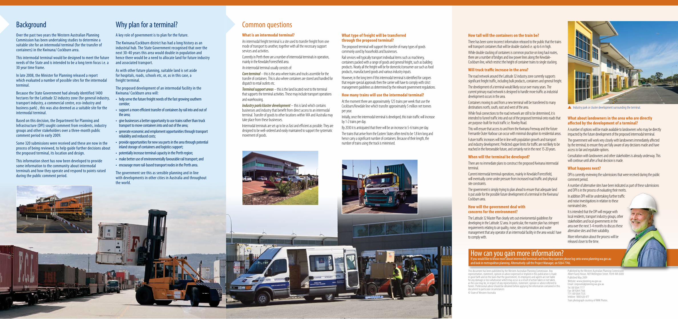
Industry park or cluster development surrounding the terminal.
Why plan for a terminal?A key role of government is to plan for the future.
The Kwinana/Cockburn district has had a long history as an industrial hub. The State Government recognised that over the next 30-40 years this area would double in population and hence there would be a need to allocate land for future industry and associated transport.
As with other future planning, suitable land is set aside for hospitals, roads, schools etc, or, as in this case, a freight terminal.
The proposed development of an intermodal facility in the Kwinana/ Cockburn area will:• helpservethefuturefreightneedsofthefastgrowingsouthern
corridor;• supportamoreefficienttransferofcontainersbyrailintoandoutof
the area;• givebusinessesabetteropportunitytousetrainsratherthantruck
transport to move containers into and out of the area; • generateeconomicandemplomentopportunitiesthroughtransport
reliability and reduced costs;• provideopportunitiesfornewseaportsintheareathroughpotential
inland storage of containers and logistics support;• potentiallyincreaseterminalcapacityinthePerthregion;• makebetteruseofenvironmentallyfavourablerailtransport;and• encouragemorerail-basedtransportnodesinthePertharea.
The government see this as sensible planning and in line with developments in other cities in Australia and throughout the world.
This document has been published by the Western Australian Planning Commission. Any representation, statement, opinion or advice expressed or implied in this publication is made in good faith and on the basis that the government, its employees and agents are not liable for any damage or loss whatsoever which may occur as a result of action taken or not taken, as the case may be, in respect of any representation, statement, opinion or advice referred to herein. Professional advice should be obtained before applying the information contained in this document to particular circumstances© State of Western Australia
Published by the Western Australian Planning Commission Albert Facey House, 469 Wellington Street. Perth WA 6000Published May 2009Website: www.planning.wa.gov.au Email: [email protected] Tel: 08 9264 7777 Fax: 08 9264 7566 TTY: 08 9264 7535 Infoline: 1800 626 477Train photograph courtesy of RMK Photos.
How can you gain more information?If you would like to know more about intermodal terminals and how they operate please log onto www.planning.wa.gov.au and look in metropolitan planning. Alternatively call the Project Manager, on 9264 7746.