4. neogene tectonic evolution of the celebes-sulu …the neogene tectonic evolution of the...
TRANSCRIPT
Silver, E. A., Rangin, C , von Breymann, M. T., et al., 1991Proceedings of the Ocean Drilling Program, Scientific Results, Vol. 124
4. NEOGENE TECTONIC EVOLUTION OF THE CELEBES-SULU BASINS: NEW INSIGHTSFROM LEG 124 DRILLING1
Claude Rangin2 and Eli A. Silver3
ABSTRACT
The Neogene tectonic evolution of the Celebes-Sulu basins is discussed on the basis of representative seismicprofiles, published industrial wells, and Leg 124 drilling results. The study is also based on geological data collectedall around the margins of these basins. A synthetic cross section was built from the South China Sea to Sulawesi,and correlation of the major magmatic and tectonic events was attempted. We suggest that these basins and theirmargins (Celebes-Sulu block) collided with the rifted margin of China (Reed Bank) around 16 Ma. A main event ofsubmarine pyroclastic emplacement coincided with this collision. The Sulu Basin probably opened in a back-arcposition for the Cagayan volcanic arc in early Miocene time. Incipient closing of the Sulu and Celebes basins, stillpresently active, is documented within their sedimentary cover.
INTRODUCTION
The marginal basins of the western Pacific region havereceived previous attention from deep-sea drilling, but untilnow southeast Asian basins not clearly related to back-arcextensional processes have been largely ignored. The Sulu,Celebes, and Banda seas are located at the junction of threeconverging major plates (Eurasia, Philippine Sea, and Aus-tralia, Fig. 1). The depositional history of these basins canprovide important constraints on their tectonic evolution(opening and presently active closing processes). Drillingthese Southeast Asian basins has provided new data on thenature and age of their basement and consequently on theirorigin.
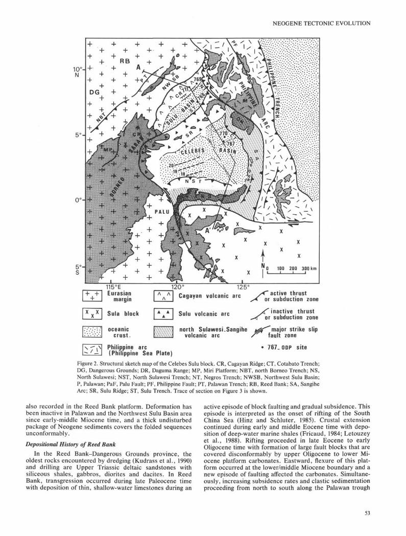
This paper integrates the drilling results of Leg 124 withgeological data collected around the margins of these basins tomore fully analyze their depositional and tectonic evolution.We discuss the evolution of the Sulu and Celebes basins alonga cross section from Palawan (P) to the north arm of Sulawesi(NS in Figs. 2 and 3). Correlation of stratigraphic data is madeusing the Berggren et al., (1985) time scale. We examine thetiming of events, including opening of the Sulu Sea, timing ofCagayan volcanic activity, collision of Palawan and surround-ing areas, and major pulses of uplift and initiation of trenches.We use drill sites 767 to 771, published information onindustrial wells, seismic data, and land observations to con-struct the section. A major purpose of drilling Leg 124 was touse the basin stratigraphy to interpret the regional tectonichistory. This paper focuses on the Neogene.
TECTONIC FRAMEWORK OF THECELEBES-SULU BASINS
Regional Tectonic Setting of the Basins in SoutheastAsia
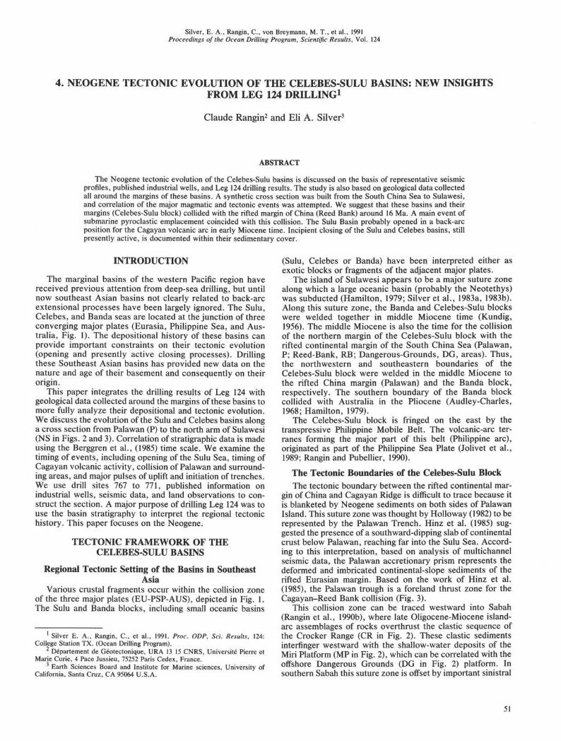
Various crustal fragments occur within the collision zoneof the three major plates (EU-PSP-AUS), depicted in Fig. 1.The Sulu and Banda blocks, including small oceanic basins
1 Silver E. A., Rangin, C , et al., 1991. Proc. ODP, Sci. Results, 124:College Station TX. (Ocean Drilling Program).
2 Département de Géotectonique, URA 13 15 CNRS, Université Pierre etMarie Curie, 4 Pace Jussieu, 75252 Paris Cedex, France.
3 Earth Sciences Board and Institute for Marine sciences, University ofCalifornia, Santa Cruz, CA 95064 U.S.A.
(Sulu, Celebes or Banda) have been interpreted either asexotic blocks or fragments of the adjacent major plates.
The island of Sulawesi appears to be a major suture zonealong which a large oceanic basin (probably the Neotethys)was subducted (Hamilton, 1979; Silver et al., 1983a, 1983b).Along this suture zone, the Banda and Celebes-Sulu blockswere welded together in middle Miocene time (Kundig,1956). The middle Miocene is also the time for the collisionof the northern margin of the Celebes-Sulu block with therifted continental margin of the South China Sea (Palawan,P; Reed-Bank, RB; Dangerous-Grounds, DG, areas). Thus,the northwestern and southeastern boundaries of theCelebes-Sulu block were welded in the middle Miocene tothe rifted China margin (Palawan) and the Banda block,respectively. The southern boundary of the Banda blockcollided with Australia in the Pliocene (Audley-Charles,1968; Hamilton, 1979).
The Celebes-Sulu block is fringed on the east by thetranspressive Philippine Mobile Belt. The volcanic-arc ter-ranes forming the major part of this belt (Philippine arc),originated as part of the Philippine Sea Plate (Jolivet et al.,1989; Rangin and Pubellier, 1990).
The Tectonic Boundaries of the Celebes-Sulu BlockThe tectonic boundary between the rifted continental mar-
gin of China and Cagayan Ridge is difficult to trace because itis blanketed by Neogene sediments on both sides of PalawanIsland. This suture zone was thought by Holloway (1982) to berepresented by the Palawan Trench. Hinz et al. (1985) sug-gested the presence of a southward-dipping slab of continentalcrust below Palawan, reaching far into the Sulu Sea. Accord-ing to this interpretation, based on analysis of multichannelseismic data, the Palawan accretionary prism represents thedeformed and imbricated continental-slope sediments of therifted Eurasian margin. Based on the work of Hinz et al.(1985), the Palawan trough is a foreland thrust zone for theCagayan-Reed Bank collision (Fig. 3).
This collision zone can be traced westward into Sabah(Rangin et al., 1990b), where late Oligocene-Miocene island-arc assemblages of rocks overthrust the clastic sequence ofthe Crocker Range (CR in Fig. 2). These clastic sedimentsinterfinger westward with the shallow-water deposits of theMiri Platform (MP in Fig. 2), which can be correlated with theoffshore Dangerous Grounds (DG in Fig. 2) platform. Insouthern Sabah this suture zone is offset by important sinistral
51
C. RANGIN, E. A. SILVER
20°N-
00-
1O°S-
:•:/.;•;•; i N D I A N ;•': : V :/:v: :v :•: ;•'•.• . . .v. .•:••.OCEAN.••.•'.•::••:•.•.;.•
Eurasian Plate
Australian Plate
<^f-T/ Philippine Sea Plate
X XX X
mBanda block
Celebes-Sulu block
y active convergent zone
inactive convergent zone
major strike slip fault
ocean floor
110°E 120" 130"
Figure 1. Location of the Celebes-Sulu block within the tectonic framework of surrounding major plates inSoutheast Asia.
strike-slip faults that may connect (Rangin et al., 1990b) withthe Palu Fault of Sulawesi (Hamilton, 1979).
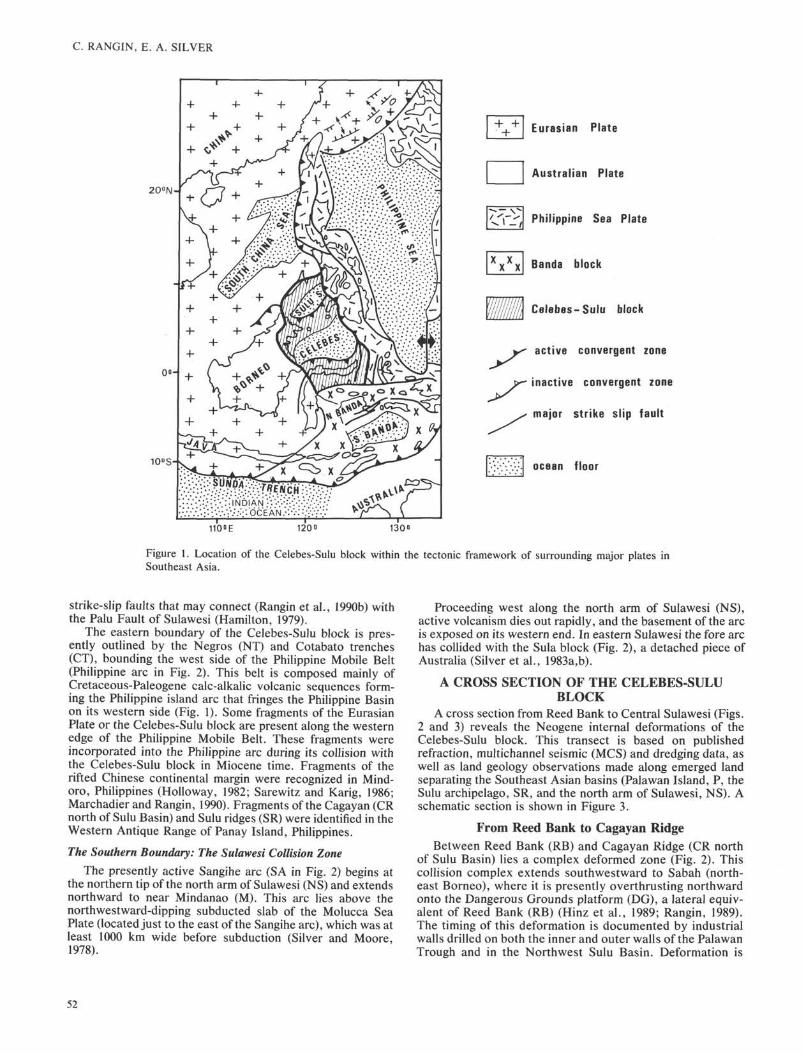
The eastern boundary of the Celebes-Sulu block is pres-ently outlined by the Negros (NT) and Cotabato trenches(CT), bounding the west side of the Philippine Mobile Belt(Philippine arc in Fig. 2). This belt is composed mainly ofCretaceous-Paleogene calc-alkalic volcanic sequences form-ing the Philippine island arc that fringes the Philippine Basinon its western side (Fig. 1). Some fragments of the EurasianPlate or the Celebes-Sulu block are present along the westernedge of the Philippine Mobile Belt. These fragments wereincorporated into the Philippine arc during its collision withthe Celebes-Sulu block in Miocene time. Fragments of therifted Chinese continental margin were recognized in Mind-oro, Philippines (Holloway, 1982; Sarewitz and Karig, 1986;Marchadier and Rangin, 1990). Fragments of the Cagayan (CRnorth of Sulu Basin) and Sulu ridges (SR) were identified in theWestern Antique Range of Panay Island, Philippines.
The Southern Boundary: The Sulawesi Collision Zone
The presently active Sangihe arc (SA in Fig. 2) begins atthe northern tip of the north arm of Sulawesi (NS) and extendsnorthward to near Mindanao (M). This arc lies above thenorthwestward-dipping subducted slab of the Molucca SeaPlate (located just to the east of the Sangihe arc), which was atleast 1000 km wide before subduction (Silver and Moore,1978).
Proceeding west along the north arm of Sulawesi (NS),active volcanism dies out rapidly, and the basement of the arcis exposed on its western end. In eastern Sulawesi the fore archas collided with the Sula block (Fig. 2), a detached piece ofAustralia (Silver et al., 1983a,b).
A CROSS SECTION OF THE CELEBES-SULUBLOCK
A cross section from Reed Bank to Central Sulawesi (Figs.2 and 3) reveals the Neogene internal deformations of theCelebes-Sulu block. This transect is based on publishedrefraction, multichannel seismic (MCS) and dredging data, aswell as land geology observations made along emerged landseparating the Southeast Asian basins (Palawan Island, P, theSulu archipelago, SR, and the north arm of Sulawesi, NS). Aschematic section is shown in Figure 3.
From Reed Bank to Cagayan RidgeBetween Reed Bank (RB) and Cagayan Ridge (CR north
of Sulu Basin) lies a complex deformed zone (Fig. 2). Thiscollision complex extends southwestward to Sabah (north-east Borneo), where it is presently overthrusting northwardonto the Dangerous Grounds platform (DG), a lateral equiv-alent of Reed Bank (RB) (Hinz et al., 1989; Rangin, 1989).The timing of this deformation is documented by industrialwalls drilled on both the inner and outer walls of the PalawanTrough and in the Northwest Sulu Basin. Deformation is
52
NEOGENE TECTONIC EVOLUTION
10°HN
5°Hs
x x ×
115°EEurasian
margin
Sula block
oceaniccrust.
Philippine arc(Philippine Sea
Λ ΛΛ
A AA
WAPlate)
120° 125°Cagayan volcanic arc /* active thrust
or subduction zone
Sulu volcanic arc
north Sulawesi.Sangihevolcanic arc
inactive thrustor subduction zone
major strike slipfault zone
• 767.ODP site
Figure 2. Structural sketch map of the Celebes Sulu block. CR, Cagayan Ridge; CT, Cotabato Trench;DG, Dangerous Grounds; DR, Daguma Range; MP, Miri Platform; NBT, north Borneo Trench; NS,North Sulawesi; NST, North Sulawesi Trench; NT, Negros Trench; NWSB, Northwest Sulu Basin;P, Palawan; PaF, Palu Fault; PF, Philippine Fault; PT, Palawan Trench; RB, Reed Bank; SA, SangiheArc; SR, Sulu Ridge; ST, Sulu Trench. Trace of section on Figure 3 is shown.
also recorded in the Reed Bank platform. Deformation hasbeen inactive in Palawan and the Northwest Sulu Basin areasince early-middle Miocene time, and a thick undisturbedpackage of Neogene sediments covers the folded sequencesunconformably.
Depositional History of Reed Bank
In the Reed Bank-Dangerous Grounds province, theoldest rocks encountered by dredging (Kudrass et al., 1990)and drilling are Upper Triassic deltaic sandstones withsiliceous shales, gabbros, diorites and dacites. In ReedBank, transgression occurred during late Paleocene timewith deposition of thin, shallow-water limestones during an
active episode of block faulting and gradual subsidence. Thisepisode is interpreted as the onset of rifting of the SouthChina Sea (Hinz and Schluter, 1985). Crustal extensioncontinued during early and middle Eocene time with depo-sition of deep-water marine shales (Fricaud, 1984; Letouzeyet al., 1988). Rifting proceeded in late Eocene to earlyOligocene time with formation of large fault blocks that arecovered disconformably by upper Oligocene to lower Mi-ocene platform carbonates. Eastward, flexure of this plat-form occurred at the lower/middle Miocene boundary and anew episode of faulting affected the carbonates. Simultane-ously, increasing subsidence rates and clastic sedimentationproceeding from north to south along the Palawan trough
53
C. RANGIN, E. A. SILVER
SOUTH CHINA PALAWAN
ABOABO C O R A L S E A ., CABAYAN SULU SEARIDGE
769 SULU TRENCH
NORTH SULAWESI EASTI SULAWESI
GORONTALOBASIN 4 *
middle-to-lateNeogene sediments
g = a Paleogene -early NeogeneESzëü carbonates and elastics
r—-i Reed Bank-Palawan block r-—iCagayanr + l =rifted margin of China I A Λ I block EZI iorth Sulawesi
block1 Australiani autochton
Figure 3. Simplified cross section of the Celebes-Sulu block.
(Fricaud, 1984) flooded the carbonate platform. Conglomer-ates of reworked carbonates, cherts, and ultramafic rocksindicate uplift and erosion of north Palawan at that time.
Depositional and Tectonic History of the Palawan-NorthwestSulu Basin
Hinz et al. (1985) demonstrated that the top of the upperOligocene-lower Miocene carbonates of Reed Bank-Danger-ous Grounds extends under the Palawan wedge. Conse-quently, the Palawan Trench was formed by an elastic down-warp of the crust as a result of isostatic compensation for thethick overthrust deformed wedge. In this wedge only theNeogene deformation is well documented and the deformationfront is covered unconformably by middle Miocene sediments(Holloway, 1982; Fricaud, 1984; Hinz et al., 1985). Similarly,both the southernmost thrust slices of this accretionary wedgeand Cagayan Ridge are covered unconformably by middleMiocene sediments in the Northwest Sulu Basin (Beddoes,1976; Mascle and Biscarrat, 1978; Rangin, 1989). On bothsides of Palawan Island the same regional unconformity wasidentified on seismic profiles (Hinz et al., 1985). It forms thetop of the deformed, very thick rock complex underlying thewestern and eastern slopes of central and south Palawan andthe Northwest Sulu Basin.
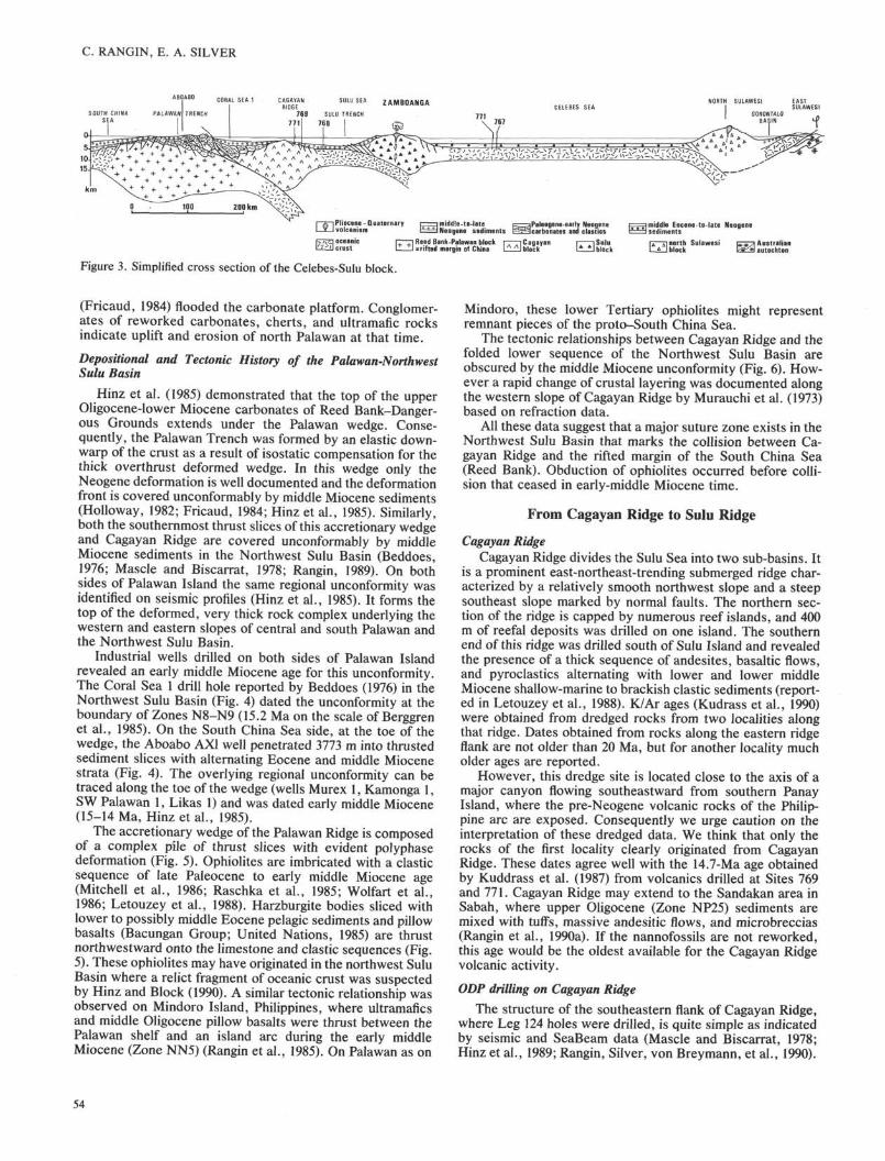
Industrial wells drilled on both sides of Palawan Islandrevealed an early middle Miocene age for this unconformity.The Coral Sea 1 drill hole reported by Beddoes (1976) in theNorthwest Sulu Basin (Fig. 4) dated the unconformity at theboundary of Zones N8-N9 (15.2 Ma on the scale of Berggrenet al., 1985). On the South China Sea side, at the toe of thewedge, the Aboabo AX1 well penetrated 3773 m into thrustedsediment slices with alternating Eocene and middle Miocenestrata (Fig. 4). The overlying regional unconformity can betraced along the toe of the wedge (wells Murex 1, Kamonga 1,SW Palawan 1, Likas 1) and was dated early middle Miocene(15-14 Ma, Hinz et al., 1985).
The accretionary wedge of the Palawan Ridge is composedof a complex pile of thrust slices with evident polyphasedeformation (Fig. 5). Ophiolites are imbricated with a clasticsequence of late Paleocene to early middle Miocene age(Mitchell et al., 1986; Raschka et al., 1985; Wolfart et al.,1986; Letouzey et al., 1988). Harzburgite bodies sliced withlower to possibly middle Eocene pelagic sediments and pillowbasalts (Bacungan Group; United Nations, 1985) are thrustnorthwestward onto the limestone and clastic sequences (Fig.5). These ophiolites may have originated in the northwest SuluBasin where a relict fragment of oceanic crust was suspectedby Hinz and Block (1990). A similar tectonic relationship wasobserved on Mindoro Island, Philippines, where ultramaficsand middle Oligocene pillow basalts were thrust between thePalawan shelf and an island arc during the early middleMiocene (Zone NN5) (Rangin et al., 1985). On Palawan as on
Mindoro, these lower Tertiary ophiolites might representremnant pieces of the proto-South China Sea.
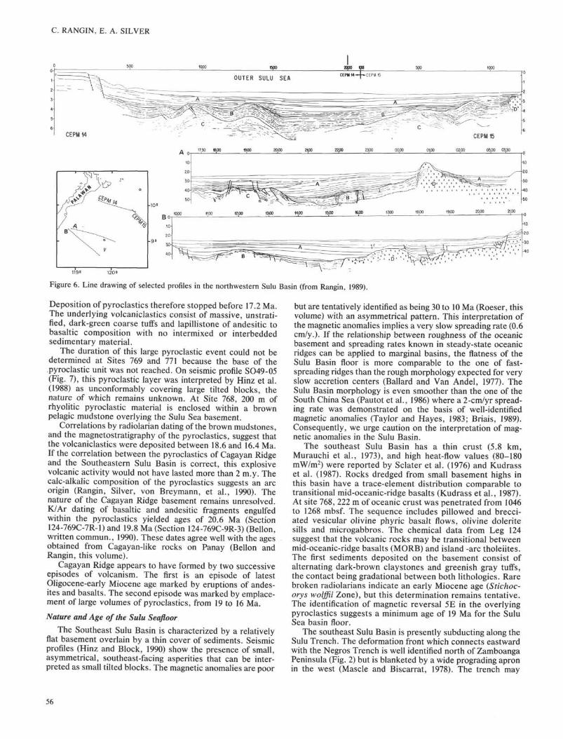
The tectonic relationships between Cagayan Ridge and thefolded lower sequence of the Northwest Sulu Basin areobscured by the middle Miocene unconformity (Fig. 6). How-ever a rapid change of crustal layering was documented alongthe western slope of Cagayan Ridge by Murauchi et al. (1973)based on refraction data.
All these data suggest that a major suture zone exists in theNorthwest Sulu Basin that marks the collision between Ca-gayan Ridge and the rifted margin of the South China Sea(Reed Bank). Obduction of ophiolites occurred before colli-sion that ceased in early-middle Miocene time.
From Cagayan Ridge to Sulu Ridge
Cagayan Ridge
Cagayan Ridge divides the Sulu Sea into two sub-basins. Itis a prominent east-northeast-trending submerged ridge char-acterized by a relatively smooth northwest slope and a steepsoutheast slope marked by normal faults. The northern sec-tion of the ridge is capped by numerous reef islands, and 400m of reefal deposits was drilled on one island. The southernend of this ridge was drilled south of Sulu Island and revealedthe presence of a thick sequence of andesites, basaltic flows,and pyroclastics alternating with lower and lower middleMiocene shallow-marine to brackish clastic sediments (report-ed in Letouzey et al., 1988). K/Ar ages (Kudrass et al., 1990)were obtained from dredged rocks from two localities alongthat ridge. Dates obtained from rocks along the eastern ridgeflank are not older than 20 Ma, but for another locality mucholder ages are reported.
However, this dredge site is located close to the axis of amajor canyon flowing southeastward from southern PanayIsland, where the pre-Neogene volcanic rocks of the Philip-pine arc are exposed. Consequently we urge caution on theinterpretation of these dredged data. We think that only therocks of the first locality clearly originated from CagayanRidge. These dates agree well with the 14.7-Ma age obtainedby Kuddrass et al. (1987) from volcanics drilled at Sites 769and 771. Cagayan Ridge may extend to the Sandakan area inSabah, where upper Oligocene (Zone NP25) sediments aremixed with tuffs, massive andesitic flows, and microbreccias(Rangin et al., 1990a). If the nannofossils are not reworked,this age would be the oldest available for the Cagayan Ridgevolcanic activity.
ODP drilling on Cagayan Ridge
The structure of the southeastern flank of Cagayan Ridge,where Leg 124 holes were drilled, is quite simple as indicatedby seismic and SeaBeam data (Mascle and Biscarrat, 1978;Hinz et al., 1989; Rangin, Silver, von Breymann, et al., 1990).
54
NEOGENE TECTONIC EVOLUTION
ABOABO-A 1 XDm .
N W
late . Oligoceneearly . Miocene
carbonates
early to earlymiddle Miocene elastics
= Thrust contactU = Unconformity
- - 3 0 0 0 m
TD \3772.8m
ABOABO-A.1.X
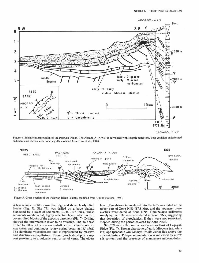
Figure 4. Seismic interpretation of the Palawan trough. The Aboabo A IX well is correlated with seismic reflectors. Post-collision undeformedsediments are shown with dots (slightly modified from Hinz et al., 1985).
NNWREED BANK
ESEPALAWANTROUGH
sediments
M • L • ImbricatedMiocene
Pagasa Fm ./ (L .M. Miocene) Φ
-J. L_
o o q^o o o o 0 0 0 0 " ? ?
Nido
limestone
L . Eocene
L . Miocene
PALAWAN RIDGE
Bacungan group .
Harzburgite
SlPaul
limestone
NW SULUBASIN
zburgite J „
M.U. Eocene
conglomerate
mudstone
10 20km
Figure 5. Cross section of the Palawan Ridge (slightly modified from United Nations, 1985).
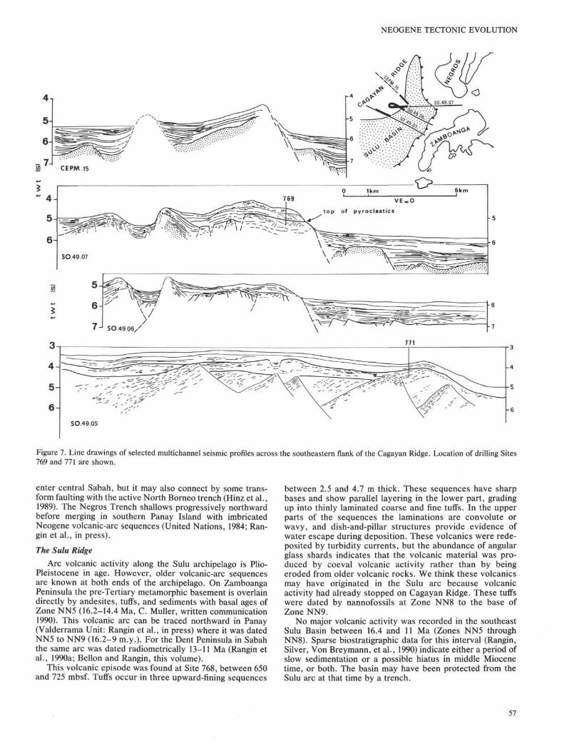
A few seismic profiles cross the ridge and show clearly tiltedblocks (Fig. 7). Site 771 was drilled on a large plateaublanketed by a layer of sediments 0.3 to 0.5 s thick. Thesesediments overlie a flat, highly reflective layer, which in turncovers tilted blocks of the acoustic basement (Fig. 7). Drillingshowed the intermediate layer to be volcanic. The hole wasdrilled to 100 m below seafloor (mbsf) before the first spot corewas taken and continuous rotary coring began at 145 mbsf.The dominant volcaniclastic unit is represented by massiveand structureless lapillistone. These pyroclastic deposits sug-gest proximity to a volcanic vent or set of vents. The oldest
layer of mudstone intercalated into the tuffs was dated at theupper part of Zone NN3 (17.8 Ma), and the youngest pyro-clastics were dated at Zone NN5. Hemipelagic sedimentsoverlying the tuffs were also dated at Zone NN5, suggestingthat deposition of pyroclastics, if they were not reworked,stopped during the period covered by Zone NN5.
Site 769 was drilled on the southeastern flank of CagayanRidge (Fig. 7). Brown claystone of early Miocene (radiolar-ian) age (probable Stichocorys wolffii Zone) lies above thevolcaniclastics. Pelagic sedimentation is indicated by a lowsilt content and the presence of manganese micronodules.
55
C. RANGIN, E. A. SILVER
OUTER SULU SEA
7.30 WflO βpO 2000 21ßO 22J0 2300 0000 0100 02.00 03.00 03,30
ßflO MflO 1500 «flθ 1700 18.00 19.00 20O0 21.00
1190 1200
Figure 6. Line drawing of selected profiles in the northwestern Sulu Basin (from Rangin, 1989).
Deposition of pyroclastics therefore stopped before 17.2 Ma.The underlying volcaniclastics consist of massive, unstrati-fied, dark-green coarse tuffs and lapillistone of andesitic tobasaltic composition with no intermixed or interbeddedsedimentary material.
The duration of this large pyroclastic event could not bedetermined at Sites 769 and 771 because the base of thepyroclastic unit was not reached. On seismic profile SO49-05(Fig. 7), this pyroclastic layer was interpreted by Hinz et al.(1988) as unconformably covering large tilted blocks, thenature of which remains unknown. At Site 768, 200 m ofrhyolitic pyroclastic material is enclosed within a brownpelagic mudstone overlying the Sulu Sea basement.
Correlations by radiolarian dating of the brown mudstones,and the magnetostratigraphy of the pyroclastics, suggest thatthe volcaniclastics were deposited between 18.6 and 16.4 Ma.If the correlation between the pyroclastics of Cagayan Ridgeand the Southeastern Sulu Basin is correct, this explosivevolcanic activity would not have lasted more than 2 m.y. Thecalc-alkalic composition of the pyroclastics suggests an arcorigin (Rangin, Silver, von Breymann, et al., 1990). Thenature of the Cagayan Ridge basement remains unresolved.K/Ar dating of basaltic and andesitic fragments engulfedwithin the pyroclastics yielded ages of 20.6 Ma (Section124-769C-7R-1) and 19.8 Ma (Section 124-769C-9R-3) (Bellon,written commun., 1990). These dates agree well with the agesobtained from Cagayan-like rocks on Panay (Bellon andRangin, this volume).
Cagayan Ridge appears to have formed by two successiveepisodes of volcanism. The first is an episode of latestOligocene-early Miocene age marked by eruptions of andes-ites and basalts. The second episode was marked by emplace-ment of large volumes of pyroclastics, from 19 to 16 Ma.
Nature and Age of the Sulu Seafloor
The Southeast Sulu Basin is characterized by a relativelyflat basement overlain by a thin cover of sediments. Seismicprofiles (Hinz and Block, 1990) show the presence of small,asymmetrical, southeast-facing asperities that can be inter-preted as small tilted blocks. The magnetic anomalies are poor
but are tentatively identified as being 30 to 10 Ma (Roeser, thisvolume) with an asymmetrical pattern. This interpretation ofthe magnetic anomalies implies a very slow spreading rate (0.6cm/y.). If the relationship between roughness of the oceanicbasement and spreading rates known in steady-state oceanicridges can be applied to marginal basins, the flatness of theSulu Basin floor is more comparable to the one of fast-spreading ridges than the rough morphology expected for veryslow accretion centers (Ballard and Van Andel, 1977). TheSulu Basin morphology is even smoother than the one of theSouth China Sea (Pautot et al., 1986) where a 2-cm/yr spread-ing rate was demonstrated on the basis of well-identifiedmagnetic anomalies (Taylor and Hayes, 1983; Briais, 1989).Consequently, we urge caution on the interpretation of mag-netic anomalies in the Sulu Basin.
The southeast Sulu Basin has a thin crust (5.8 km,Murauchi et al., 1973), and high heat-flow values (80-180mW/m2) were reported by Sclater et al. (1976) and Kudrasset al. (1987). Rocks dredged from small basement highs inthis basin have a trace-element distribution comparable totransitional mid-oceanic-ridge basalts (Kudrass et al., 1987).At site 768, 222 m of oceanic crust was penetrated from 1046to 1268 mbsf. The sequence includes pillowed and brecci-ated vesicular olivine phyric basalt flows, olivine doleritesills and microgabbros. The chemical data from Leg 124suggest that the volcanic rocks may be transitional betweenmid-oceanic-ridge basalts (MORB) and island -arc tholeiites.The first sediments deposited on the basement consist ofalternating dark-brown claystones and greenish gray tuffs,the contact being gradational between both lithologies. Rarebroken radiolarians indicate an early Miocene age (Stichoc-orys wolffii Zone), but this determination remains tentative.The identification of magnetic reversal 5E in the overlyingpyroclastics suggests a minimum age of 19 Ma for the SuluSea basin floor.
The southeast Sulu Basin is presently subducting along theSulu Trench. The deformation front which connects eastwardwith the Negros Trench is well identified north of ZamboangaPeninsula (Fig. 2) but is blanketed by a wide prograding apronin the west (Mascle and Biscarrat, 1978). The trench may
56
NEOGENE TECTONIC EVOLUTION
7J SO.49.06y
-6
-7
SO49.05
Figure 7. Line drawings of selected multichannel seismic profiles across the southeastern flank of the Cagayan Ridge. Location of drilling Sites769 and 771 are shown.
enter central Sabah, but it may also connect by some trans-form faulting with the active North Borneo trench (Hinz et al.,1989). The Negros Trench shallows progressively northwardbefore merging in southern Panay Island with imbricatedNeogene volcanic-arc sequences (United Nations, 1984; Ran-gin et al., in press).
The Sulu Ridge
Arc volcanic activity along the Sulu archipelago is Plio-Pleistocene in age. However, older volcanic-arc sequencesare known at both ends of the archipelago. On ZamboangaPeninsula the pre-Tertiary metamorphic basement is overlaindirectly by andesites, tuffs, and sediments with basal ages ofZone NN5 (16.2-14.4 Ma, C. Muller, written communication1990). This volcanic arc can be traced northward in Panay(Valderrama Unit: Rangin et al., in press) where it was datedNN5 to NN9 (16.2-9 m.y.). For the Dent Peninsula in Sabahthe same arc was dated radiometrically 13-11 Ma (Rangin etal., 1990a; Bellon and Rangin, this volume).
This volcanic episode was found at Site 768, between 650and 725 mbsf. Tuffs occur in three upward-fining sequences
between 2.5 and 4.7 m thick. These sequences have sharpbases and show parallel layering in the lower part, gradingup into thinly laminated coarse and fine tuffs. In the upperparts of the sequences the laminations are convolute orwavy, and dish-and-pillar structures provide evidence ofwater escape during deposition. These volcanics were rede-posited by turbidity currents, but the abundance of angularglass shards indicates that the volcanic material was pro-duced by coeval volcanic activity rather than by beingeroded from older volcanic rocks. We think these volcanicsmay have originated in the Sulu arc because volcanicactivity had already stopped on Cagayan Ridge. These tuffswere dated by nannofossils at Zone NN8 to the base ofZone NN9.
No major volcanic activity was recorded in the southeastSulu Basin between 16.4 and 11 Ma (Zones NN5 throughNN8). Sparse biostratigraphic data for this interval (Rangin,Silver, Von Breymann, et al., 1990) indicate either a period ofslow sedimentation or a possible hiatus in middle Miocenetime, or both. The basin may have been protected from theSulu arc at that time by a trench.
57
C. RANGIN, E. A. SILVER
3i
4
en~ 5
I 67-
Figure 8. Multichannel seismic and single-channel seismic line drawings along the northeastern margin of the Celebes Sea.
From Sulu Ridge to Celebes Basin
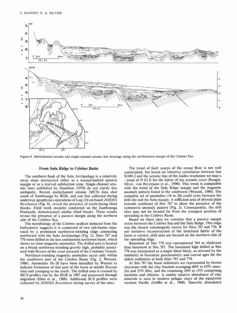
The southern flank of the Sulu Archipelago is a relativelysteep slope interpreted either as a normal-faulted passivemargin or as a starved subduction zone. Single-channel seis-mic lines published by Hamilton (1979) do not clarify thisambiguity. Recent multichannel seismic (MCS) data shotsouth of Zamboanga by BGR, and one line collected duringunderway geophysics operations of Leg 124 on board JOIDESResolution (Fig. 8), reveal the presence of south-facing tiltedblocks. Field work recently conducted on the ZamboangaPeninsula, demonstrated similar tilted blocks. These resultsreveal the presence of a passive margin along the northernside of the Celebes Sea.
The morphology of the Celebes seafloor deduced from thebathymetry suggests it is composed of two sub-basins sepa-rated by a prominent northwest-trending ridge connectingnorthward with the Sulu Archipelago (Fig. 2). Sites 767 and770 were drilled in the less sedimented northwest basin, whichshows no clear magnetic anomalies. The drilled area is locatedon a broad northwest-trending gravity high, probably associ-ated with flexure of the crust seaward of the Cotabato Trench.
Northeast-trending magnetic anomalies occur only withinthe southwest part of the Celebes Basin (Fig. 2, Weissel,1980). Anomalies 18-20 have been identified by Weissel toindicate formation of that part of the basin in middle Eocenetime and younging to the south. The drilled area is crossed byMCS profiles run by the BGR in 1987 and processed throughmigration (Hinz et al., 1988). Additional SCS profiles werecollected by JOIDES Resolution during survey of the sites.
The trend of fault scarps of the ocean floor is not wellconstrained, but based on tentative correlation between lineSO49-2 and the seismic line of the Joides resolution we map a- trend of N 63 E for the fabric of the oceanic crust (Rangin,Silver, von Breymann et al., 1990). This trend is compatiblewith the trend of the Sulu Ridge margin and the magneticanomaly pattern found to the southwest (Weissel, 1980). Thecomplete set of anomalies (18 to 20) could exist between thedrill site and the Sulu margin. A sufficient area of abyssal plainextends southeast of Site 767 to allow the presence of thesymmetric anomaly pattern (Fig. 2). Consequently, the drillsites may not be located far from the youngest position ofspreading in the Celebes Basin.
Based on these data we consider that a passive marginexists between the Celebes Sea and the Sulu Ridge. This ridgewas the closest volcanogenic source for Sites 767 and 770. Ifour tentative reconstruction of the structural fabric of thebasin is correct, drill sites are located on the northern side ofthe spreading ridge.
Basement of Site 770 was encountered 364 m shallowerthan basement at Site 767. The basement high drilled at Site770 was interpreted as a major tilted block, as attested by thesimilarity in basement geochemistry and coeval ages for theoldest sediments at both Sites 767 and 770.
At Site 767 the basal sediments are represented by brownclaystone with the clay fraction averaging 60% to 65% smec-tite and 25% illite, and the remaining 10% to 15% comprisingkaolinite and chlorite. A similar relative abundance of clayminerals is seen in modern pelagic clays of the equatorialwestern Pacific (Griffin et al., 1968). Smectite abundance
58

NEOGENE TECTONIC EVOLUTION
(derived from alteration of volcanic products, mainly ashes) isless dominant in the red claystones than in the Neogenesection where volcanic ashes are randomly distributed andoften preserved. These claystones contain very low amountsof terrestrial organic matter (Bertrand et al., this volume) oreven of continental minerals such as phyllosilicates (Nicot etal., this volume). This suggests the deposition of these brownclaystones in an environment not far from a continent butprotected from terrestrial and volcanogenic input.
The proximity of the Sulu Ridge could demonstrate thatthis arc was not active during the spreading history of theCelebes Sea. At Site 767, the core directly overlying basementcontains intervals with abundant but poorly preserved radio-larians of late middle Eocene age. The assemblage closelyresembles the type late middle Eocene assemblage of thePodocyrtis chalara Zone (Riedel and San Filippo, 1970) to thePodocyrtis goetheana Zone.
Basement was encountered at 786 mbsf at Site 767 and 422mbsf at Site 770. Seven flow units were identified at Site 770.Basalt flows are intruded by two dolerite sills near the base ofthe section. The flows are pillow basalts, breccias, and veinedand brecciated basalts. All samples analyzed are tholeiitic,and geochemistry indicates strong MORB affinity.
Celebes Sea to North Arm of SulawesiAlong the northern margin of the north arm of Sulawesi
seismic reflection lines show increasing width of the accre-tionary wedge toward the west (Silver et al., 1983). The timingof movement along this thrust zone is not well determined.Volcanic-arc activity is widespread along the north arm ofSulawesi, which is truncated at its western end by the PaluFault (Fig. 2). This thrust belt behaves as if it were pinned onits eastern end. Volcanic activity decreases westward to theManado area, where active volcanoes indicate ongoing sub-duction of the Molucca Sea. In the west, where the roots ofthe island arc are exposed, large granodiorites were datedearly to early middle Miocene (15 to 18.8 Ma: Ratman et al.,1976; Bellon et al., this volume) the probable time for un-roofing and crystallization of plutons. These plutons intrudeolder volcanics dated at 22 Ma (Bellon et al., this volume).
This old island arc is unconformably covered by a secondphase of arc volcanism dated from 7 to 4 Ma. The youngingmagnetic anomalies toward the south in the Celebes Basinimply a minimum destruction of between 150 and 350 km ofoceanic crust along this northern Sulawesi subduction zone,which has been supported by island-arc activity since 7 Ma.Older volcanism and plutonism can be interpreted as thesubduction of the Molucca Sea (or the Tethys) before collisionof this volcanic arc with the Sula block (Hamilton, 1979).
In the Celebes Basin no significant volcanic- arc activityis recorded in the basal brown pelagic mudstone depositedfrom middle Eocene to early Miocene time. Only a colorchange (brown-red at the base to green above) in thesedeep-sea sediments at Site 767 was observed at a pointrepresenting about 18.5 Ma. Despite this color change, thegreen claystone has a clay composition similar to the under-lying pelagic brown claystone (Silver and Rangin, this vol-ume). Consequently, the early stage of Cagayan volcanicactivity is not recorded in the Celebes Sea by a change inclay mineralogy during the Paleogene.
The color change in these deep-sea sediments could repre-sent an increase in sediment supply to the basin from the samesource, which caused sediment to be buried rapidly enough toprevent significant oxidation by bottom water (Smith, thisvolume). The 18.5-Ma age represents approximately the timeof arrival of the first quartz turbidites at Site 767. Theseturbidities older than the Cagayan-Palawan collision cannot
have their source in Sabah, but are (coeval) with crystalliza-tion ages of granodiorites in the north arm of Sulawesi. Thesequartz-rich turbidites could have been provided by erosion ofthese granodiorites following uplift and collision of this arcwith the Sula Platform. This fits well with the end of the firstphase of volcanic activity dated at 22 Ma. The change in colorof the deep-sea sediments at Site 767 around 18.5 Ma could beexplained by an overflow of smectite-rich sediments in thebasin provided by the erosion of the arc.
CORRELATION OF NEOGENE SEDIMENTARY,MAGMATIC, AND TECTONIC EVENTS ACROSS
THE CELEBES-SULU BLOCKStratigraphic correlations across the Celebes-Sulu block
allow us to differentiate key periods for its tectonic evolution.The main marker is the collision of the Cagayan Ridge (thenorthern boundary of the Celebes-Sulu block) with Eurasia(the rifted Palawan margin), which initiated the still- activeprocess of the closing of the Celebes and Sulu marginal basins.We will deal first with the origin of the Sulu Basin beforediscussing the closing history of the Celebes and Sulu basinsas it is recorded in the drill holes and the geology of theirmargins. The origin of the Celebes Sea is discussed in acompanion paper (Silver and Rangin, this volume).
Origin of the Sulu BasinA main problem concerning the tectonic evolution of this
area deals with the opening of the Sulu Sea. Drilling at Site 768indicated a minimum age of 19 Ma for initiation of spreading inthis basin. This age is coeval with volcanic- arc activity alongthe Cagayan arc, suggesting that the basin opened in aback-arc position. The highly volatile contents and the trace-element characteristics of this basement indicate an arc-related origin (Rangin, Silver, von Breymann, et al., 1990).
The duration of Cagayan arc volcanic activity remainsuncertain and appears to be limited to a short interval oftime, 22 to 15 Ma, or less. Traces of arc volcanic activityoccur in the basal 43 m above basement at Sulu Basin Site768. There, thin beds of fine tuffs with thick to thin planarlaminations are interbedded with dark-brown hemipelagicclaystone. Consequently, this basin probably opened in aback-arc setting. However, no volcanic-arc sequences olderthan Zone NN5 occur in the Zamboanga Peninsula, makingthe Sulu Ridge an unlikely candidate as a remnant volcanicarc for Cagayan Ridge. Additionally, only thin layers ofvolcanic-arc material were found interbedded with the ba-salts of the basement at Site 768. Much larger amounts ofvolcaniclastic material are found interbedded with basalts inintra-arc marginal basins such as the Ogasawara-Bonin arc(Taylor, Fujioka et al., 1990).
Poor constraints on the age of the oldest sediments at Site768, and their slow sedimentation rate, suggest that the basincould have opened before the Cagayan Ridge volcanicactivity was initiated. This alternative hypothesis implies anorigin for the Southeast Sulu Basin analogous to that of theSouth China Sea, independent of back-arc spreading pro-cesses. However the arc tholeiitic signature of the southeastSulu Basin crust and the possible erosion of the remnantvolcanic-arc sequences in the Zamboanga Peninsula favorthe first hypothesis.
Cagayan-Reed Bank Collision and Closing of theCelebes-Sulu Basins
Once the Celebes-Sulu block had docked and amalgam-ated to the rifted margin of China (Palawan-Reed Bank) 15Ma, the basins began to subduct along their southern andeastern margins. New trenches were created, such as the
59
C. RANGIN, E. A. SILVER
PALAWAN TROUGH
ABOAβO 1xPANAY
ZAMBOANGACABAH
16.4M5C~1 magneti5D
frββnHβmipelagics
ErosionSulu arcVolcanism 2πdphase
North Sulawesi Volcanism 2 phaseAnd Sulu arc 2ndphase
Brownpelagicmudstonβ
Sulu arc Volcanism 1stphase
• Bellon and Rangin this volume
+ Bellon leg. 124 this volume
*Kudrass et al 1990
N Cagayan Volcanis _" || 'L | Reefal limestone
—— | Hemipelagic sediments
i l l r l Claystones and marls
udstone
Sandstones
Folded sedimentsVolcanism
i m North SulawesVolcanism 1 s t phaseand Intrusives
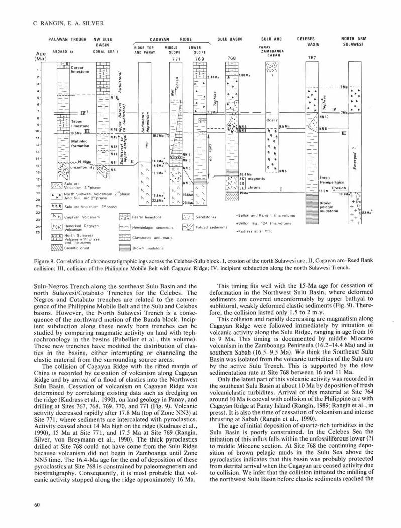
Figure 9. Correlation of chronostratigraphic logs across the Celebes-Sulu block. I, erosion of the north Sulawesi arc; II, Cagayan arc-Reed Bankcollision; III, collision of the Philippine Mobile Belt with Cagayan Ridge; IV, incipient subduction along the north Sulawesi Trench.
Sulu-Negros Trench along the southeast Sulu Basin and thenorth Sulawesi/Cotabato Trenches for the Celebes. TheNegros and Cotabato trenches are related to the conver-gence of the Philippine Mobile Belt and the Sulu and Celebesbasins. However, the North Sulawesi Trench is a conse-quence of the northward motion of the Banda block. Incip-ient subduction along these newly born trenches can bestudied by comparing magmatic activity on land with teph-rochronology in the basins (Pubellier et al., this volume).These new trenches have modified the distribution of elas-tics in the basins, either interrupting or channeling theclastic material from the surrounding source areas.
The collision of Cagayan Ridge with the rifted margin ofChina is recorded by cessation of volcanism along CagayanRidge and by arrival of a flood of elastics into the NorthwestSulu Basin. Cessation of volcanism on Cagayan Ridge wasdetermined by correlating existing data such as dredging onthe ridge (Kudrass et al., 1990), on-land geology in Panay, anddrilling at Sites 767, 768, 769, 770, and 771 (Fig. 9). Volcanicactivity decreased rapidly after 17.8 Ma (top of Zone NN3) atSite 771, where sediments are intercalated with pyroclastics.Activity ceased about 14 Ma high on the ridge (Kudrass et al.,1990), 15 Ma at Site 771, and 17.5 Ma at Site 769 (Rangin,Silver, von Breymann et al., 1990). The thick pyroclasticsdrilled at Site 768 could not have come from the Sulu Ridgebecause volcanism did not begin in Zamboanga until ZoneNN5 time. The 16.4-Ma age for the end of deposition of thesepyroclastics at Site 768 is constrained by Paleomagnetism andbiostratigraphy. Consequently, it is most probable that vol-canic activity stopped along the ridge approximately 16 Ma.
This timing fits well with the 15-Ma age for cessation ofdeformation in the Northwest Sulu Basin, where deformedsediments are covered unconformably by upper bathyal tosublittoral, weakly deformed clastic sediments (Fig. 9). There-fore, the collision lasted only 1.5 to 2 m.y.
This collision and rapidly decreasing arc magmatism alongCagayan Ridge were followed immediately by initiation ofvolcanic activity along the Sulu Ridge, ranging in age from 16to 9 Ma. This timing is documented by middle Miocenevolcanism in the Zamboanga Peninsula (16.2-14.4 Ma) and insouthern Sabah (16.5-9.5 Ma). We think the Southeast SuluBasin was isolated from the volcanic turbidites of the Sulu arcby the active Sulu Trench. This is supported by the slowsedimentation rate at Site 768 between 16 and 11 Ma.
Only the latest part of this volcanic activity was recorded inthe southeast Sulu Basin at about 10 Ma by deposition of freshvolcaniclastic turbidites. Arrival of this material at Site 764around 10 Ma is coeval with collision of the Philippine arc withCagayan Ridge at Panay Island (Rangin, 1989; Rangin et al., inpress). It is also the time of cessation of volcanism and intensethrusting at Sabah (Rangin et al., 1990).
The age of initial deposition of quartz-rich turbidites in theSulu Basin is poorly constrained. In the Celebes Sea theinitiation of this influx falls within the unfossiliferous lower (?)to middle Miocene section. At Site 768 the continuing depo-sition of brown pelagic muds in the Sulu Sea above thepyroclastics indicates that this basin was probably protectedfrom detrital arrival when the Cagayan arc ceased activity dueto collision. We infer that the collision initiated the infilling ofthe northwest Sulu Basin before clastic sediments reached the
60
NEOGENE TECTONIC EVOLUTION
Southwest Sulu Basin. On Cagayan Ridge, where dilution offossils due to terrigenous influx is low (Site 771), the firstfine-grained turbidites were deposited at a time approximatingthe boundary between Zones NN5 and NN6 (14.4 Ma).
The peak in turbidite sedimentation in the late middleMiocene (Zone NN9, 9.5 Ma) is coeval all across the Sulu andCelebes basins. This peak coincides with cessation of volca-nism along the Sulu arc at Sabah (Fig. 9). It is also the time ofcollision of Cagayan Ridge with the Philippine arc at Panay(dated by cessation of volcanism). The most evident sourcefor massive supply of quartz-rich elastics was Sabah, wherethe Crocker Formation has been exposed since early middleMiocene time. The apex of this clastic sedimentation in bothbasins corresponds with deposition of the Sebahat Formationof southern Sabah, a molasse deposit dated at Zone NN8(Rangin et al., 1990a). The numerous coal fragments found inthese turbidities at Sites 767 and 768 have sources either in thecoal-rich deposits of the middle Miocene circular basins ofSabah or in the coal deposits of the Lumbog Formation ofZamboanga (Antonio, 1972).
This massive turbidite event may have been enhanced bya fall of global sea level at that time (Haq et al., 1988),facilitating the rapid exposure and erosion of the alreadydeformed Crocker sediments on Sabah. This event is alsodocumented at Site 769 by the presence of carbonates(nannofossil marls) and by deposition of the Tabon Lime-stone in the Palawan trough. In the northwest Sulu Basin atransition from an upper bathyal to a sublittoral environmentalso attests to this sea-level change. Here the unconformitydescribed by Beddoes (1976) in the Coral Sea 1 well can beextended to the top of layer B (Fig. 6A). Consequently, themiddle to late Miocene boundary is an important period forthe Celebes-Sulu block, marked by deformation and signif-icant sea-level rise.
Clastic arrival suddenly stopped around 8.5 Ma in theCelebes Basin. This cessation corresponds to deposition ofabundant tephras. This explosive volcanic-arc marker wasalso found at Site 769 around 7.5 Ma (Pubellier et al., thisvolume). This age fits quite well with the second phase ofvolcanism along the north arm of Sulawesi (Fig. 9). At Site768, terrigenous input was active up to 5.5 Ma, masking bydilution the incipient arrival of the tephras. We interpret thistephra event as renewal of volcanic activity along the northarm of Sulawesi, due to newly created subduction along thenorth Sulawesi Trench. The coeval waning of the terrige-nous supply to the Celebes Basin can be explained bychanneling of the clastic sediments from Borneo along thisnew trench. Thus a minimum age for the tectonic activityalong that trench is 7.5 Ma.
After onset of collision at Palawan, compression within theCelebes-Sulu block was first accommodated along the SuluTrench, inducing incipient closing of the basins and subduc-tion of the Sulu Basin. This event was followed by a south-ward jump to the north arm of Sulawesi, initiating subductionof the Celebes Basin.
A MODEL FOR THE NEOGENE EVOLUTION OFTHE CELEBES-SULU BLOCK
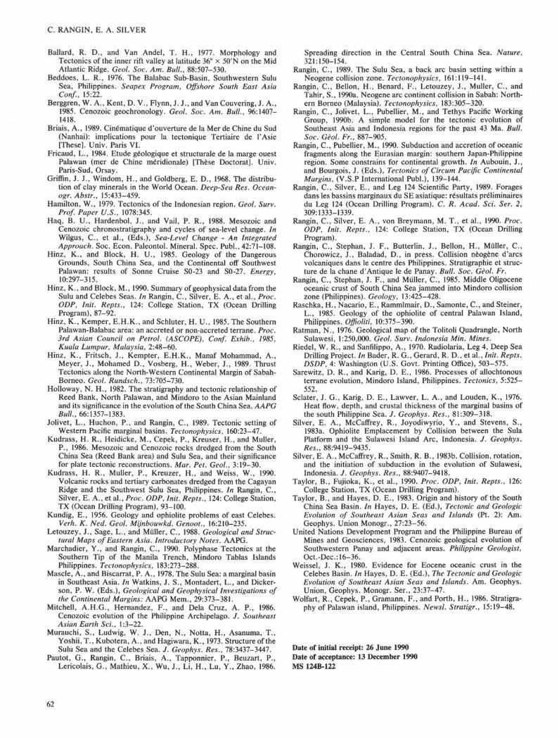
We propose a simple scenario for the Neogene evolution ofthe Celebes-Sulu block (Fig. 10). At the end of early Miocenetime the southern margin of the Celebes-Sulu block collidedwith the Banda block in central Sulawesi. This collisioninduced rapid subduction and closing of the proto-SouthChina Sea along the northern margin of the Celebes-Sulublock, and the Cagayan volcanic arc was rapidly built. Agesolder than 22 Ma cannot be demonstrated for this subduction,suggesting that the proto-South China Sea was subducted in a
few million years (Rangin et al., 1990b). This timing indicatesthat the proto- South China Sea was smaller and narrowerthan originally proposed by Taylor and Hayes (1983).
Two hypotheses for the origin of the southeastern SuluBasin are presented in Figure 10. The first favors a back-arcorigin (A). The second scenario (B) suggests that the SuluSea Basin predated the Cagayan and opened along theEurasian margin, analogous with the South China Sea. Thefirst hypothesis is supported by the back-arc geochemicalsignature of the Southwestern Sulu Basin crust, and thesecond by absence of remnant volcanic-arc sequences alongthe Sulu Ridge.
The end of the proto-South China Sea subduction andincipient collision of the Cagayan arc with the rifted Palawanfragment of China induced a large outpouring of pyroclastics,covering the whole Cagayan Ridge. These volcanics wererapidly remobilized as turbidites and deposited in the south-east Sulu Basin. This explosive volcanism could be explainedby a large volume of interstitial water in the proto-South ChinaSea sediments involved in the Palawan subduction zone.Volcanism along Cagayan Ridge decreased rapidly andstopped completely in early middle Miocene time.
The cessation of volcanism can be easily correlated withcessation of deformation in the northwest Sulu Basin andPalawan Trench.
1. In middle Miocene time, deformation affected the inte-rior of the block. The Sulu Sea subducted southward along theSulu arc from 15 to 10 Ma, and the northwest Sulu Basintrapped the elastics resulting from the Cagayan-Reed Bankcollision.
2. In early late Miocene time, collision of the Sulu arc withEurasia at Sabah and Panay induced massive quartz turbiditedeposition in both basins. This collision was enhanced by asea-level drop at that time, facilitating erosion of terranessurrounding the basins.
3. In the middle late Miocene, major renewal of volcanic-arc activity in north Sulawesi is interpreted as the incipientsouthward subduction of the Celebes Basin.
Correlations of Leg 124 drilling data with on-land geologyillustrate how the Celebes-Sulu block was progressively de-formed, first along its margin, then in the interior. Subsequentand progressive deformation toward the south of the interiorof this block mainly has been accommodated by short-livedsubduction zones. Deciphering the closing history of thesemarginal basins provides basic information for the incipientstage of mountain building. The closing of these basins pre-dates the expected collision between Eurasia and Australiaand sheds some light on the preliminary stages of largecontinent collision, such as India-Eurasia and Africa-Europe.
ACKNOWLEDGMENTSWe are indebted to K. Hinz for providing us with migrated
seismic profiles, and to D. E. Karig and J. M. Parsons forcritical reviews of this manuscript. Silver acknowledges theUnited States Science Advisory Committee and the FrenchCNRS for support of data analysis and manuscript prepara-tion. Rangin acknowledges INSU and CNRS through its"Oceanoscope" committee for support of this work.
REFERENCES
Antonio, L. R., 1972. Geology and Mineral Resources of East CentralZamboanga Peninsula, Mindanao, Philippines. Phil. Bur. Min.Rep.
Audley-Charles, M. G., 1968. The geology of the Portugese Timor.Mem. Geol. Soc. London, 4:1-76.
61
C. RANGIN, E. A. SILVER
Ballard, R. D., and Van Andel, T. H., 1977. Morphology andTectonics of the inner rift valley at latitude 36° × 50'N on the MidAtlantic Ridge. Geol. Soc. Am. Bull., 88:507-530.
Beddoes, L. R., 1976. The Balabac Sub-Basin, Southwestern SuluSea, Philippines. Seapex Program, Offshore South East AsiaConf., 15:22.
Berggren, W. A., Kent, D. V., Flynn, J. J., and Van Couvering, J. A.,1985. Cenozoic geochronology. Geol. Soc. Am. Bull., 96:1407-1418.
Briais, A., 1989. Cinématique d'ouverture de la Mer de Chine du Sud(Nanhai): implications pour la tectonique Tertiaire de 1'Asie[These]. Univ. Paris VI.
Fricaud, L., 1984. Etude géologique et structurale de la marge ouestPalawan (mer de Chine méridionale) [These Doctorat]. Univ.Paris-Sud, Orsay.
Griffin, J. J., Windom, H., and Goldberg, E. D., 1968. The distribu-tion of clay minerals in the World Ocean. Deep-Sea Res. Ocean-ogr. Abstr., 15:433-459.
Hamilton, W., 1979. Tectonics of the Indonesian region. Geol. Surv.Prof. Paper U.S., 1078:345.
Haq, B. U., Hardenbol, J., and Vail, P. R., 1988. Mesozoic andCenozoic chronostratigraphy and cycles of sea-level change. InWilgus, C , et al., (Eds.), Sea-Level Change - An IntegratedApproach. Soc. Econ. Paleontol. Mineral. Spec. Publ., 42:71-108.
Hinz, K., and Block, H. U., 1985. Geology of the DangerousGrounds, South China Sea, and the Continental off SouthwestPalawan: results of Sonne Cruise S0-23 and SO-27. Energy,10:297-315.
Hinz, K., and Block, M., 1990. Summary of geophysical data from theSulu and Celebes Seas. In Rangin, C., Silver, E. A., et al., Proc.ODP, Init. Repts., 124: College Station, TX (Ocean DrillingProgram), 87-92.
Hinz, K., Kemper, E.H.K., and Schluter, H. U., 1985. The SouthernPalawan-Balabac area: an accreted or non-accreted terrane. Proc.3rd Asian Council on Petrol. (ASCOPE), Conf. Exhib., 1985,Kuala Lumpur, Malaysia, 2:48-60.
Hinz, K., Fritsch, J., Kempter, E.H.K., Manaf Mohammad, A.,Meyer, J., Mohamed D., Vosberg, H., Weber, J., 1989. ThrustTectonics along the North-Western Continental Margin of Sabah-Borneo. Geol. Rundsch., 73:705-730.
Holloway, N. H., 1982. The stratigraphy and tectonic relationship ofReed Bank, North Palawan, and Mindoro to the Asian Mainlandand its significance in the evolution of the South China Sea. AAPGBull., 66:1357-1383.
Jolivet, L., Huchon, P., and Rangin, C , 1989. Tectonic setting ofWestern Pacific marginal basins. Tectonophysics, 160:23-47.
Kudrass, H. R., Heidicke, M., Cepek, P., Kreuser, H., and Muller,P., 1986. Mesozoic and Cenozoic rocks dredged from the SouthChina Sea (Reed Bank area) and Sulu Sea, and their significancefor plate tectonic reconstructions. Mar. Pet. Geol., 3:19-30.
Kudrass, H. R., Muller, P., Kreuzer, H., and Weiss, W., 1990.Volcanic rocks and tertiary carbonates dredged from the CagayanRidge and the Southwest Sulu Sea, Philippines. In Rangin, C ,Silver, E. A., et al., Proc. ODP, Init. Repts., 124: College Station,TX (Ocean Drilling Program), 93-100.
Kundig, E., 1956. Geology and ophiolite problems of east Celebes.Verh. K. Ned. Geol. Mijnbouwkd. Genoot., 16:210-235.
Letouzey, J., Sage, L., and Muller, C , 1988. Geological and Struc-tural Maps of Eastern Asia. Introductory Notes. AAPG.
Marchadier, Y., and Rangin, C , 1990. Polyphase Tectonics at theSouthern Tip of the Manila Trench, Mindoro Tablas IslandsPhilippines. Tectonophysics, 183:273-288.
Mascle, A., and Biscarrat, P. A., 1978. The Sulu Sea: a marginal basinin Southeast Asia. In Watkins, J. S., Montadert, L., and Dicker-son, P. W. (Eds.), Geological and Geophysical Investigations ofthe Continental Margins: AAPG Mem., 29:373-381.
Mitchell, A.H.G., Hernandez, F., and Dela Cruz, A. P., 1986.Cenozoic evolution of the Philippine Archipelago. J. SoutheastAsian Earth Sci., 1:3-22.
Murauchi, S., Ludwig, W. J., Den, N., Notta, H., Asanuma, T.,Yoshii, T., Kubotera, A., and Hagiwara, K., 1973. Structure of theSulu Sea and the Celebes Sea. J. Geophys. Res., 78:3437-3447.
Pautot, G., Rangin, C , Briais, A., Tapponnier, P., Beuzart, P.,Lericolais, G., Mathieu, X., Wu, J., Li, H., Lu, Y., Zhao, 1986.
Spreading direction in the Central South China Sea. Nature,321:150-154.
Rangin, C , 1989. The Sulu Sea, a back arc basin setting within aNeogene collision zone. Tectonophysics, 161:119-141.
Rangin, C , Bellon, H., Benard, F., Letouzey, J., Muller, C , andTahir, S., 1990a. Neogene arc continent collision in Sabah: North-ern Borneo (Malaysia). Tectonophysics, 183:305-320.
Rangin, C , Jolivet, L., Pubellier, M., and Tethys Pacific WorkingGroup, 1990b. A simple model for the tectonic evolution ofSoutheast Asia and Indonesia regions for the past 43 Ma. Bull.Soc. Gèol. Fr., 887-905.
Rangin, C , Pubellier, M., 1990. Subduction and accretion of oceanicfragments along the Eurasian margin: southern Japan-Philippineregion. Some constrains for continental growth. In Aubouin, J.,and Bourgois, J. (Eds.), Tectonics of Circum Pacific ContinentalMargins, (V.S.P International Publ.), 139-144.
Rangin, C , Silver, E., and Leg 124 Scientific Party, 1989. Foragesdans les bassins marginaux du SE asiatique: résultats préliminairesdu Leg 124 (Ocean Drilling Program). C. R. Acad. Sci. Ser. 2,309:1333-1339.
Rangin, C , Silver, E. A., von Breymann, M. T., et al., 1990. Proc.ODP, Init. Repts., 124: College Station, TX (Ocean DrillingProgram).
Rangin, C , Stephan, J. F., Butterlin, J., Bellon, H., Muller, C ,Chorowicz, J., Baladad, D., in press. Collision nèogène d'arcsvolcaniques dans le centre des Philippines. Stratigraphic et struc-ture de la chane d'Antique le de Panay. Bull. Soc. Gèol. Fr.
Rangin, C , Stephan, J. F., and Muller, C , 1985. Middle Oligoceneoceanic crust of South China Sea jammed into Mindoro collisionzone (Philippines). Geology, 13:425-428.
Raschka, H., Nacario, E., Rammlmair, D., Samonte, C , and Steiner,L., 1985. Geology of the ophiolite of central Palawan Island,Philippines. Offioliti, 10:375-390.
Ratman, N., 1976. Geological map of the Tolitoli Quadrangle, NorthSulawesi, 1:250,000. Geol. Surv. Indonesia Min. Mines.
Riedel, W. R., and Sanfilippo, A., 1970. Radiolaria, Leg 4, Deep SeaDrilling Project. In Bader, R. G., Gerard, R. D., et al., Init. Repts.DSDP, 4: Washington (U.S. Govt. Printing Office), 503-575.
Sarewitz, D. R., and Karig, D. E., 1986. Processes of allochtonousterrane evolution, Mindoro Island, Philippines. Tectonics, 5:525-552.
Sclater, J. G., Karig, D. E., Lawver, L. A., and Louden, K., 1976.Heat flow, depth, and crustal thickness of the marginal basins ofthe south Philippine Sea. J. Geophys. Res., 81:309-318.
Silver, E. A., McCaffrey, R., Joyodiwyrio, Y., and Stevens, S.,1983a. Ophiolite Emplacement by Collision between the SulaPlatform and the Sulawesi Island Arc, Indonesia. J. Geophys.Res., 88:9419-9435.
Silver, E. A., McCaffrey, R., Smith, R. B., 1983b. Collision, rotation,and the initiation of subduction in the evolution of Sulawesi,Indonesia. J. Geophys. Res., 88:9407-9418.
Taylor, B., Fujioka, K., et al., 1990. Proc. ODP, Init. Repts., 126:College Station, TX (Ocean Drilling Program).
Taylor, B., and Hayes, D. E., 1983. Origin and history of the SouthChina Sea Basin. In Hayes, D. E. (Ed.), Tectonic and GeologicEvolution of Southeast Asian Seas and Islands (Pt. 2): Am.Geophys. Union Monogr., 27:23-56.
United Nations Development Program and the Philippine Bureau ofMines and Geosciences, 1983. Cenozoic geological evolution ofSouthwestern Panay and adjacent areas. Philippine Geologist,Oct.-Dec: 16-36.
Weissel, J. K., 1980. Evidence for Eocene oceanic crust in theCelebes Basin. In Hayes, D. E. (Ed.), The Tectonic and GeologicEvolution of Southeast Asian Seas and Islands. Am. Geophys.Union, Geophys. Monogr. Ser., 23:37-47.
Wolfart, R., Cepek, P., Gramann, F., and Porth, H., 1986. Stratigra-phy of Palawan island, Philippines. Newsl. Stratigr., 15:19-48.
Date of initial receipt: 26 June 1990Date of acceptance: 13 December 1990MS 124B-122
62
NEOGENE TECTONIC EVOLUTION
NW ReedBank
Cagayan Sulu Zamboanga. CELEBES N.Sulawesi SE
Block
scs Reed Bank p. SCSCagayan
RidgeSulu
Block.
RBCR Sulu , \Basin J CELEBES BASIN
^-^s A j///...
8M.Y.
Figure 10. Interpretive diagram for the evolution of the Celebes-Sulu block during the Neogene. Two distincthypotheses are proposed for the origin of the Sulu Basin A and B; see explanation in text).
63