3.10 land use and planning - granicus
TRANSCRIPT

3. Environmental Setting, Impacts, and Mitigation Measures
Imperial County Planning & Development Services Department 3.10-1 ESA / 211326 Cluster I Solar Power Project Draft Environmental Impact Report December 2011
3.10 Land Use and Planning
This section identifies potential project impacts that may affect land use and planning. It also describes the environmental and regulatory settings and discusses the need for mitigation measures where applicable.
3.10.1 Environmental Setting Local
On-site Land Uses As described in Chapter 2, Project Description, the project sites are located in an unincorporated area of Imperial County, north of the City of Calipatria (see Figures 2-1 and 2-2). The separate solar sites that comprise the Cluster I Solar Farm Project are owned by 8minuteenergy Renewables LLC.
Calipatria I
This site is roughly square in shape. Numerous agricultural fields in current crop production occupy the subject site. No wetlands are located within one mile of the subject property. Regional access to the project site is by SR-111 and SR-115. Local access is provided to the site by Blair Road and Sinclair Road. The fields are classified as Farmland of Statewide Importance. The zoning of land on this location varies and includes the following four designations: A2 (General Agriculture); A2U (General Agriculture/Urban Zone); A2G (General Agriculture/Geothermal Overlay); and A2GU (General Agriculture/Geothermal Overlay/Urban Zone). The Calipatria I site is subdivided into four agricultural parcels (see Appendix S) as follows:
Parcel 1 or A: Consists of approximately 147.7 acres and is zoned A2 and A2G.
Parcel 2 or B: Consists of approximately 159.2 acres and is zoned A2.
Parcel 3 or C: Consist of approximately 141.7 acres and is zoned A2U and A2GU.
Parcel 4 or D: Consists of approximately 160.4 acres and is zoned A2.
Midway I
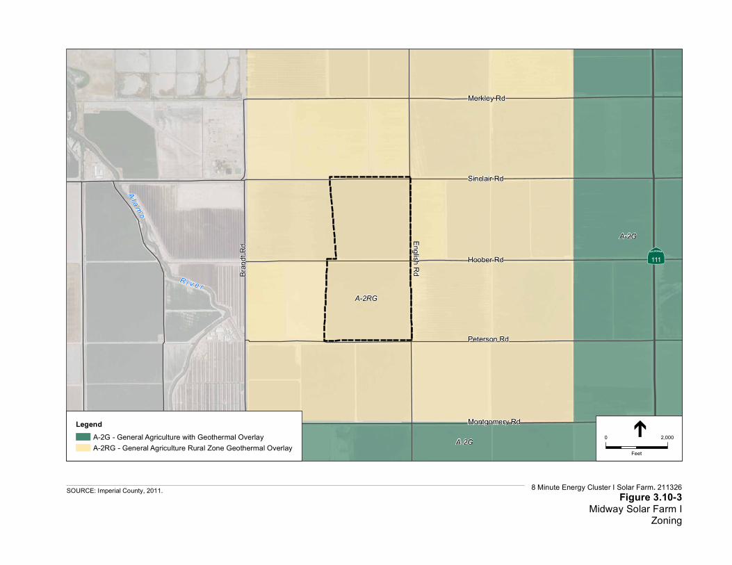
Midway I is comprised of two agricultural fields that are currently in crop production. The fields are classified as Farmland of Statewide Importance and are currently zoned A2RG (General Agriculture/Rural Zone/Geothermal Overlay). A paved road (Sinclair) bounds the northern boundary of the site and dirt roads bound the remaining boundaries of the site. A dirt road (Hoober Road), with a concrete lined canal (“J” Lateral) and a drainage ditch, bisect the property. The site is about 2.5 miles northwest of the Cliff Hatfield Memorial Airport; however, the subject site is not located within an Airport Compatibility Zone.
Midway II
Midway II is comprised of five 160-acre irrigated agricultural fields that are currently in crop production. The fields are classified as Farmland of Statewide Importance and their current zoning designations are A2R (General Agriculture/Rural Zone) and A2RG (General Agriculture/Rural Zone/Geothermal Overlay). A paved road (English) bounds the western

3. Environmental Setting, Impacts, and Mitigation Measures 3.10 Land Use and Planning
Imperial County Planning & Development Services Department 3.10-2 ESA / 211326 Cluster I Solar Power Project Draft Environmental Impact Report December 2011
boundary of the site and dirt roads abut the remaining boundaries of the site. Two dirt roads (Peterson and Montgomery Road), with concrete lined canals (“H” and “I” Laterals) and drainage ditches, bisect the property. A concrete lined canal (“G” Lateral) abuts the southern boundary of the site (Lindsey Road). A 92KV overhead transmission line runs adjacent to the western boundary of the site along the west side of English Road. Hoober Road (dirt) and a concrete lined canal (“J” Lateral) form the northern boundary of the site.
Table 3.10-1 gives a summary of the project sites’ assessor’s parcel numbers, existing zoning, existing land use designations, and acreage. Figures 3.10-1 through 3.10-4 provide an illustration of the General Plan Land Use designations and existing zoning designations for each separate solar facility site and their associated surrounding area.
TABLE 3.10-1 PROJECT SITES’ ASSESSOR’S PARCEL NUMBERS, EXISTING ZONING,
EXISTING LAND USE DESIGNATIONS, AND ACREAGE
Solar Site APN Land Use Ordinance General Plan Acres
Calipatria I (Subdivided)
023-020-012 (north half)
Parcel 1 or A: A2 and A2G
Parcel 2 or B: A2
Agriculture Parcel 1 or A: 147.7
Parcel 2 or B: 159.2
023-020-016 Parcel 3 or C: A2U and A2GU
Parcel 4 or D: A2
Parcel 3 or C: 141.7
Parcel 4 or D: 160.4
Midway I 022-130-008-000 A2RG 326
Midway II 022-130-005-000 A2RG, A2G 321
022-160-005-000 482
SOURCE: Imperial County, 2011.

Alamo R
iver
111
115
8 Minute Energy Cluster I Solar Farm . 211326
Figure 3.10-1Existing General Plan
Land Use Designations
SOURCE: Imperial County; GlobeXplorer; ESA, 2011.
Calipatria
Project Location
Agriculture
Special Purpose Facility
Urban Area
0 1
Miles

A-2
A-2G
A-3
A-2U
A-2U / A2GU
M-1U
8 Minute Energy Cluster I Solar Farm. 211326Figure 3.10-2
Calipatria Solar Farm IZoning
SOURCE: Imperial County, 2011.
LegendA-2 - General AgricultureA-2GU - Limited Agriculture with Geothermal Overlay in Urban AreaA-2G - General Agriculture with Geothermal OverlayA-2U - General Agriculture in Urban AreaA-3 - Heavy AgricultureM-1U - Light Industrial in Urban Area
0 2,000
Feet
ÄÅ111
City of Calipatria
Lindsey Rd
Wilkinson RdBlair Rd
Carrick RdYoung Rd
A-2RG
A-2G
A-2G
8 Minute Energy Cluster I Solar Farm. 211326Figure 3.10-3
Midway Solar Farm IZoning
SOURCE: Imperial County, 2011.
LegendA-2G - General Agriculture with Geothermal OverlayA-2RG - General Agriculture Rural Zone Geothermal Overlay
0 2,000
Feet
ÄÅ111
Peterson Rd
Hoober Rd
Sinclair Rd
Merkley Rd
English RdBran
dt Rd
A l a m o
R i v e r
Montgomery Rd

A-2G
A-2RG A-2G A-3GA-2RG A-2G
A-2G
A-2RG A-2G A-3
A-3
A-2
A-3G
8 Minute Energy Cluster I Solar Farm. 211326Figure 3.10-4
Midway Solar Farm IIZoning
SOURCE: Imperial County, 2011.
LegendA-2 - General AgricultureA-2G - General Agriculture with Geothermal OverlayA-2RG - General Agriculture Rural Zone Geothermal OverlayA-3 - Heavy AgricultureA-3G - Heavy Agriculture with Geothermal Overlay
0 2,000
Feet
ÄÅ111Peterson Rd
Hoober Rd
Sinclair Rd
Montgomery Rd
Engli
sh R
d
Bran
dt Rd
Lindsey Rd

3. Environmental Setting, Impacts, and Mitigation Measures 3.10 Land Use and Planning
Imperial County Planning & Development Services Department 3.10-7 ESA / 211326 Cluster I Solar Power Project Draft Environmental Impact Report December 2011
Surrounding Land Uses Calipatria I
Calipatria I is surrounded by agricultural lands with the exception of the southwest corner of the site, which borders the City of Calipatria. The Union Pacific railroad runs along the western border of the subject site. The site is located about one half mile northeast of the Cliff Hatfield Memorial Airport. The site is also located within the airport planning area/airport influence area for Cliff Hatfield Memorial Airport as defined in the ALUCP, Imperial County Airports (Imperial County, 1996). The site is partially located within Zone B-1 “Approach/Departure Zone and Adjacent to Runway” and Zone C “Common Traffic Pattern” which are defined in Chapter 2 of the ALUCP.
The Calipatria I site lies 1.5 miles to the south from the planned 230 kV Midway-Bannister transmission line and is bisected by the 92 kV “J” line, enabling connection of the project to the grid. To the south of the Calipatria I site the “J” line runs west for 0.5 mile before continuing south into the City of Calipatria. Parcels directly to the north of the Calipatria I site are fully encumbered by a Williamson Act contract. Parcels directly to the south of the Calipatria I site are agricultural land within the City of Calipatria sphere of influence and parcels within the Calipatria city limits. A portion of the parcels northwest of the Calipatria I site are encumbered by Williamson Act contract(s) and the uncontracted land in that section is publicly owned by the IID. The western section of land from the Calipatria I site is partially encumbered by Williamson Act contract. The southwestern section of land from the Calipatria I site is located within the City of Calipatria city limits. The northeast section of land from the Calipatria I site is fully encumbered by Williamson Act contract(s).
Midway I
Properties surrounding the Midway I site are agricultural lands. A geothermal power plant with steam turbines and cooling towers is located approximately one half mile northwest of the subject site on the north side of Sinclair Road. Brandt Cattle (large feedlot) is located approximately one half mile west southwest of the subject site west of Brandt Road. The Alamo River is located just over one half mile west of the subject site. The site is about 2.5 miles northwest of the Cliff Hatfield Memorial Airport (General Aviation Traffic Only and light commercial jets/prop jets). The subject site is not located within an Airport Compatibility Zone.
Midway II
Properties surrounding the Midway II site are agricultural lands. A farming house and yard are located adjacent to the southwest corner of the subject site. A commercial algae farm (shallow ponds) is located approximately 1 mile east of the subject site. Brandt Cattle (large feedlot) is located approximately 1 mile west of the subject site.
Specifically, the section (approximately 640 acres) to the northwest of the Midway II site consists of five parcels with three of the parcels lying within a 100-year floodzone. The section to the northeast of the Midway II site consists of seven parcels. Two of these parcels are being utilized for commercial operations (Algae Farm). The section to the west of the Midway II site consists of five parcels with three of the parcels lying within a 100-year floodzone. The remaining parcel two parcels are owned by the City of Calipatria. The section to the east of the Midway II site consists
3. Environmental Setting, Impacts, and Mitigation Measures 3.10 Land Use and Planning
Imperial County Planning & Development Services Department 3.10-8 ESA / 211326 Cluster I Solar Power Project Draft Environmental Impact Report December 2011
of four parcels with two of the parcels owned by the IID. One parcel in this section of land is fully encumbered by a Williamson Act contract. The section to the southwest of the Midway II site consists of eleven parcels with six of the parcels encumbered by a Williamson Act contracts. Two of the remaining parcels lie within a 100-year floodzone. The section to the south of the Midway II site consists of four parcels with two of the parcels publicly owned by the IID. One of the parcels is already a part of a separately proposed solar farm. The section to the southeast of the Midway II site consists of twelve parcels with three of the parcels encumbered by a Williamson Act contracts. Two of the other parcels lie within the City of Calipatria Sphere of Influence. Additionally, one of the other parcels is already a part of a separately proposed solar farm.
TABLE 3.10-2 SURROUNDING SITES’ ZONING AND EXISTING LAND USE DESIGNATIONS
Solar Site Direction Land Use Ordinance General Plan
Calipatria I North A3 Agriculture
South A2U Urban Area
East A2 Agriculture
West A2G, A2GU Agriculture / Urban Area
Midway I North A2RG Agriculture
South A2RG Agriculture
East A2RG Agriculture
West A2RG Agriculture
Midway II North A2RG Agriculture
South A2G Agriculture
East A2G Agriculture
West A2RG Agriculture
SOURCE: Imperial County, 2011.
3.10.2 Regulatory Framework Local
County of Imperial General Plan The purpose of the Imperial County General Plan is to direct growth, particularly urban development, to areas where public infrastructure exists or can be provided, where public health and safety hazards are limited, and where impacts to the County’s abundant natural, cultural, and economic resources can be avoided. Ten elements comprise the County of Imperial General Plan. These elements are: Land Use; Housing; Circulation and Scenic Highways; Noise; Seismic and Public Safety; Conservation and Open Space; Agricultural; Geothermal/Alternative Energy and Transmission; and, Water, and Parks and Recreation Element. Together, these elements satisfy the seven mandatory general plan elements as established in the California GC. Goals, objectives, and implementing policies and actions programs have been established for each of the elements.

3. Environmental Setting, Impacts, and Mitigation Measures 3.10 Land Use and Planning
Imperial County Planning & Development Services Department 3.10-9 ESA / 211326 Cluster I Solar Power Project Draft Environmental Impact Report December 2011
The General Plan designated for the solar energy facility portion of the project site is “Agriculture.” The County identifies agricultural land as a form of open space. According to the Conservation and Open Space Element of the General Plan, open space is “any parcel or area of land or water, which is essentially unimproved and devoted to one of the following categories of uses: Preservation of Natural Resources; Managed Production of Resources; Outdoor Recreation; and, Protection of the Public Health and Safety.” As such, there are outdoor recreational activities including hunting, bike riding, walking, and bird watching that can take place in agricultural areas.
An analysis of the project’s consistency with the General Plan policies for land relevant to the Proposed Action is provided in Table 3.10-4 below. A detailed analysis of the project’s consistency with the General Plan goals, objectives and policies regarding Agriculture is provided in Section 3.2 Agricultural Resources of this EIR.
Imperial County Land Use Ordinance, Title 9 The Imperial County Board of Supervisors adopted the Land Use Ordinance on November 24, 1998 (County of Imperial 2010). The purpose of Title 9, the Land Use Ordinance for the County of Imperial, is to provide comprehensive land use regulations for all unincorporated areas of Imperial County, including the establishment of zoning areas. These regulations are adopted to promote and protect the public health, safety, and general welfare through the orderly regulation of land uses throughout the unincorporated areas of the county.
As depicted in Figures 3.10-2 through 3.10-4, the three solar energy facility site locations that comprise the proposed project are zoned A2 (General Agriculture); A2U (General Agriculture/Urban Zone); A2G (General Agriculture/Geothermal Overlay); A2RG (General Agriculture Rural Zone/Geothermal Overlay); and A2GU (General Agriculture/Geothermal Overlay/Urban Zone). “The purpose of the A2, [40 Acre minimum] Zone is to designate areas that are suitable and intended primarily for agricultural uses (limited) and agricultural related compatible uses” (County of Imperial, 1998). Section 90508.02 of the Land Use Ordinance lists many uses that are permitted in the A2 zone, but that require a CUP. Included in these uses are the following:
Electrical generation plants (less than 50 MW)
Electrical power generating plant, excluding nuclear or coal fired
Electrical substations in an electrical transmission system (500 kV/230 kV/161 kV)
Facilities for the transmission of electrical energy (100-200 kV)
Major facilities relating to the generation and transmission of electrical energy, provided such facilities are not, under State or Federal law, to be approved exclusively by an agency or agencies of the State and/or Federal governments and provided that such facilities shall be approved subsequent to coordination and review with the IID for electrical matters
Geothermal test facilities, Intermediate projects, and major exploratory wells
Solar energy electrical generator

3. Environmental Setting, Impacts, and Mitigation Measures 3.10 Land Use and Planning
Imperial County Planning & Development Services Department 3.10-10 ESA / 211326 Cluster I Solar Power Project Draft Environmental Impact Report December 2011
Section 90508.07 of the Land Use Ordinance applies a 120-foot height limit to all nonresidential structures within the A2 zone. Specifically, Sections 90508.07 (C) states, “Non-Residential structures and commercial communication towers shall not exceed one hundred twenty (120) feet in height, and shall meet ALUC Plan requirements.”
Adjacent Areas Land Use Designations Land surrounding the Midway I and Midway II sites and land to the north and east of the Calipatria I site is designated as Agriculture; land to the west of the Calipatria site is designated as Agriculture as well as Urban Area. Land immediately to the south of the Calipatria I site is designated Urban Area (see Figure 3.10-1). The Agriculture Land Use designation is intended to preserve lands for agricultural production and related industries including aquaculture, ranging from light to heavy agriculture. Packing and processing of agricultural products may also be allowed in certain areas and other uses necessary or supportive of agriculture. The Agriculture category includes most of the central irrigated area known as the Imperial Valley, the Bard/Winterhaven Valley and the south end of the Palo Verde Valley. The land use element of the Imperial County General Plan also designates portions of the surrounding areas as an Urban Area (as previously indicated), which is characterized by urban services, including public water and sewer systems, and contains a broad range of residential, commercial, and industrial uses.
Regional Comprehensive Plan and Regional Transportation Plan The SCAG Intergovernmental Review (IGR) section, part of the Environmental Planning division of Planning and Policy, is responsible for performing consistency review of regionally significant local plans, projects, and programs. Regionally significant projects are required to be consistent with SCAG’s adopted regional plans and policies such as the Regional Comprehensive Plan and the Regional Transportation Plan. The criteria for projects of regional significance are outlined in CEQA Guidelines Sections 15125 and 15206. According to the SCAG IGR Procedures Handbook, “new or expanded electrical generating facilities and transmission lines” are regionally significant projects. Table 3.10-3 provides a summary of the project’s consistency with the SCAG intergovernmental review policies.
Imperial County ALUCP The ALUCP sets forth the criteria and policies, which the Imperial County Airport Land Use Commission will use in assessing the compatibility between the principal airports in Imperial County and proposed land use development in the areas surrounding them. The emphasis of the Plan is on review of local general and specific plans, zoning ordinances, and other land use documents covering broad geographic areas.
State law empowers the Commission to review additional types of land use “actions, regulations, and permits” involving a question of airport/land use compatibility if either: (1) the Commission and the local agency agree that these types of individual projects shall be reviewed by the Commission (Section 21676.5 (b)); or, (2) the Commission finds that a local agency has not revised its general plan or specific plan or overruled the Commission and the Commission requires that the individual projects be submitted for review (Section 21676.5 (a)). The

3. Environmental Setting, Impacts, and Mitigation Measures 3.10 Land Use and Planning
Imperial County Planning & Development Services Department 3.10-11 ESA / 211326 Cluster I Solar Power Project Draft Environmental Impact Report December 2011
Commission shall review “any request for variance from a local agency’s height limitation ordinance.” (ALUCP pg. 2-3)
TABLE 3.10-3 PROJECT CONSISTENCY WITH SOUTHERN CALIFORNIA ASSOCIATION OF
GOVERNMENTS IGR POLICIES
SCAG IGR Policies Consistency with IGR Policies Analysis
Policy 3.05: Encourage patterns of urban development and land use which reduce costs on infrastructure construction and make better use of existing facilities.
Consistent The three separate solar sites that constitute the proposed project are consistent with this policy. The project is a renewable energy project and would not discourage patterns of urban development and land use, which reduce costs on infrastructure.
Policy 3.14: Support local plans to increase density of future development located at strategic points along the regional commuter rail, transit systems, and activity centers.
Consistent The proposed project sites would not increase the density of future development, because the projects are renewable energy projects and not residential developments. As such, the proposed projects are consistent with this policy.
Policy 3.16: Encourage developments in and around activity centers, transportation corridors, underutilized infrastructure systems, and areas needing recycling and redevelopment.
Consistent The proposed project sites are renewable energy projects that would provide an additional source of energy for the surrounding area. The proposed project sites would not discourage developments in and around activity centers, transportation corridors, underutilized infrastructure systems, and areas needing recycling and redevelopment; as such, it is consistent with this policy.
Policy 3.17: Support and encourage settlement patterns which contain a range of urban densities.
Consistent The proposed project sites would not increase urban densities, because the project sites are renewable energy projects and not residential developments. As such, the proposed project sites are consistent with this policy.
Policy 3.18: Encourage planned development in locations least likely to cause adverse environmental impact.
Consistent Direct, indirect, and cumulative impacts resulting from the proposed project sites have been identified and mitigated as described in the appropriate sections of this EIR.
RTP G6: Encourage land use and growth patterns that complement our transportation investments and improve the cost-effectiveness of expenditures.
Consistent See discussion under Policy 3.16 above.
GV P1.1: Encourage transportation investments and land use decisions that are mutually supportive.
Consistent See discussion under Policy 3.16 above.

3. Environmental Setting, Impacts, and Mitigation Measures 3.10 Land Use and Planning
Imperial County Planning & Development Services Department 3.10-12 ESA / 211326 Cluster I Solar Power Project Draft Environmental Impact Report December 2011
SCAG IGR Policies Consistency with IGR Policies Analysis
GV P4.2: Focus development in urban centers and existing cities.
Consistent The proposed project sites are renewable energy project and not a residential or commercial development project that would need to focus its development in urban centers or existing cities. However, the solar energy facility sites would be developed in Imperial County on land designated as agriculture because this is an allowable use within this zone. As such, proposed project sites are consistent with this policy.
GV P4.3: Develop strategies to accommodate growth that uses resources efficiently, eliminate pollution and significantly reduce waste.
Consistent See discussion under Policy 3.18 above.
3.10.3 Impacts and Mitigation Measures This section evaluates the potential project impacts that may affect land use and planning. It describes the methods used to determine potential impacts and lists the thresholds used to conclude whether an impact would be significant.
Methodology
The potential impacts associated with the proposed project are evaluated on a qualitative basis through a comparison of the existing land use and the proposed land uses. The change in the land use on the project site is significant if the effect described under the Thresholds of Significance below occurs as a result of the proposed actions. The evaluation of project impacts is based on professional judgment, analysis of the County’s land use policies and the significance criteria established in Appendix G of the CEQA Guidelines, which the County has determined appropriate for this EIR.
Thresholds of Significance
The Imperial County CEQA Implementation Document and Imperial County Environmental Checklist identify the following criteria, as established in Appendix G of the CEQA Guidelines, to determine if a project could potentially have a significant adverse affect on land use and planning if it would:
Conflict with any applicable land use plan, policy, or regulation of an agency with jurisdiction over the project (including, but not limited to, the general plan, specific plan, local coastal program, or zoning ordinance) adopted for the purpose of avoiding or mitigating an environmental effect.
The following criteria were eliminated from the EIR scope of analysis based on the findings made in the IS/NOP published for the proposed project. Please refer to Appendix A of this EIR for a

3. Environmental Setting, Impacts, and Mitigation Measures 3.10 Land Use and Planning
Imperial County Planning & Development Services Department 3.10-13 ESA / 211326 Cluster I Solar Power Project Draft Environmental Impact Report December 2011
copy of the IS/NOP and additional information regarding these issue areas. A project could have a have a significant adverse affect on land use if it would:
Physically divide an established community, or
Conflict with any applicable HCP or natural community conservation plan.
Project Impacts
Impact 3.10-1: Would the project conflict with any applicable land use plan, policy, or regulation of an agency with jurisdiction over the project (including, but not limited to, the general plan, specific plan, local coastal program, or zoning ordinance) adopted for the purpose of avoiding or mitigating an environmental effect?
Imperial County General Plan Solar energy facilities are not referenced specifically in the Land Use Element of the Imperial County General Plan, other than a statement in the Imperial County Land Use Element that “Electrical and other energy generating facilities are heavy industrial uses, except geothermal, hydroelectric, wind, solar facilities may be regulated differently than other types of power plants by implementing zoning.” However, the Land Use Element recognizes that geothermal plants, a similar use to the extent that it represents a renewable energy resource, are permitted uses within the “Agriculture” land use category, so long as a CUP is issued and environmental review is completed. The three solar facility sites as part of the proposed project would require issuance of a CUP (CUPs#10-0034, 10-0036 and 10-0037) and an environmental analysis.
The Land Use Compatibility Matrix (Table 4 of the Land Use Element) identifies land designated with an “Agriculture” land use are compatible with lands zoned A2. The proposed project is a conditionally permitted use under the A2 zone, and is considered consistent with the “Agriculture” land use designation. No General Plan land use amendment would be required for construction and operation of the proposed project. Table 3.10-4 provides an analysis of the proposed solar facility’s consistency with applicable General Plan policies. The proposed solar facility and access road is considered to be in substantial conformance with the goals and objectives of the General Plan. A California court (Court of Appeal, Fourth District, Division 2, California) ruled on land use consistency when the activity was not specifically identified in the General Plan and said “An action, program, or project is consistent with the general plan if, considering all its aspects it will further the objectives and policies of the general plan and not obstruct their attainment” (Corona-Norco Unified School Dist. V. City of Corona (1993) 17 Cal.App.4th 985.944 [emphasis added]).
The County identifies agricultural land as a form of open space. According to the Land Use Element of the General Plan, the permitted uses and standards on agricultural lands include open space/recreation. “Open space and recreation land uses within this category consists of environmentally sensitive areas, parks, fault zones, floodways and floodplains, agricultural lands, and areas designated for the managed production of mineral resources.” The project would temporarily change the use of the three sites from agricultural land to three solar facilities. As such, although no formerly-designated recreational uses would be removed, there may be some

3. Environmental Setting, Impacts, and Mitigation Measures 3.10 Land Use and Planning
Imperial County Planning & Development Services Department 3.10-14 ESA / 211326 Cluster I Solar Power Project Draft Environmental Impact Report December 2011
TABLE 3.10-4 PROJECT CONSISTENCY WITH IMPERIAL COUNTY GENERAL PLAN
POLICIES FOR LAND USE
General Plan Policies Project Consistency
Agriculture
Policy The County of Imperial finds that farmland is one of its most vital resources. Continued preservation of this resource is paramount. The County is committed to the Williamson Act and its ideals of preserving Farmland. Since 2000 the County has put over 126,000 acres into the program. The purpose of the Williamson Act is to establish long term (10 year perpetual) contracts for the preservation of farmland. The Department of Conservation finds that “…a loss of agricultural land represents a permanent reduction in the State’s agricultural land resources…” (November 2005 letter). As a way to mitigate this potential significant impact, the County concurs with the Department of Conservation’s stance on preserving additional farmland to replace the loss of farmland resulting from development.
The project sites would not change the general plan designations or zone for the properties – each solar site location would remain designated and zoned for agricultural purposes. Moreover, the Applicant would restore the lands to their present states upon project conclusion, which would make the lands again available for any viable agricultural uses. Nevertheless, the development of a PV solar power plant would, at a minimum, constitute a temporary use of agricultural lands for the life of plant operations as previously mentioned.
The General Plan covers the unincorporated area of the County and is not site specific, however, a majority of the privately owned land is located in the area identified by the General Plan as “Agriculture,” which is also the predominate area where Burrowing Owls create habitats, typically in the brims and banks of agricultural fields.
Protocol level surveys for this species have been conducted on all three project sites for the Cluster I Solar Farm. This species is found within all three sites. Implementation of the proposed mitigation measures in Section 3.4, Biological Resources would reduce potential impacts to burrowing owl to a level that is considered less than significant.
Urban Areas
A primary concern for new development in Urban Areas, particularly those which are adjacent to incorporated cities, is the adequacy of existing public services and facilities, and the level of infrastructure improvements proposed by new development.
The proposed project will provide the required infrastructure improvements and will comply with design and improvement standards as required. Refer to the relevant sections within this EIR for further discussion of public services and infrastructure being provided as part of this project.
The proposed project is anticipated to result in a reduction in water demand and use. Water will be required for PV panel washing, operations dust control, domestic water use and water treatment under regular maintenance routines. To meet these water needs it is proposed that raw water will be sourced from an IID canal and a water system and a small water treatment plant will be placed near each of the three O&M buildings to provide onsite de-ionized water for panel washing. Each of the solar projects will also obtain a portion of the landowners’ water allocation from the IID if a cover crop is used for dust control. Domestic wastewater from the operations and maintenance building is expected to be limited in volume due to the few staff members required on-site. This wastewater will be treated via an on-site septic systems and leach fields. The annual water usage is estimated to be 6 percent of the current allocation.
limited recreational utility lost associated with the agriculture fields as a result of the development of the proposed project on these three sites. However, any current recreational activity on these three active farmlands is limited, and would be restricted to those with legal access to this privately held property. As such, the temporary use of agricultural lands as it affects recreational use at this location is not considered to be significant under CEQA.

3. Environmental Setting, Impacts, and Mitigation Measures 3.10 Land Use and Planning
Imperial County Planning & Development Services Department 3.10-15 ESA / 211326 Cluster I Solar Power Project Draft Environmental Impact Report December 2011
County of Imperial Land Use Ordinance The proposed project would include constructing and operating a solar energy facility on three separate sites, associated electrical transmission lines, and improvements to existing dirt access roads for access into each of the sites. Development of the solar facility is subject to the County’s Land Use Ordinance. Pursuant to Title 9, Division 5, Chapter 8, “Solar energy electrical generator,” “Electrical power generating plant,” “Major facilities relating to the generation and transmission of electrical energy,” and “Resource extraction and energy development,” are uses that are permitted in the A2 zone subject to approval of a CUP from the County of Imperial.
Williamson Act The project sites cover approximately 1,738 acres in areas designated and zoned for agricultural uses under the County’s General Plan and Land Use Ordinance. Agricultural lands lie to the immediate north, south, east and west of the project site locations. The parcels of land are designated as Farmland of Statewide Importance under the State Department of Conservation FMMP (2006 mapping).
The project sites would not change the general plan designations or zone for the properties –each solar site location would remain designated and zoned for agricultural purposes. Moreover, the Applicant would restore the lands to their present states upon project conclusion, which would make the lands again available for any viable agricultural uses. Nevertheless, the development of a PV solar power plant would, at a minimum, constitute a temporary use of agricultural lands for the life of plant operations as previously mentioned. To help preserve the agricultural attributes of the properties, the option to grow a cover crop is included to help maintain the underlying farming soil in the event the project sites are converted back in to farming at some future date and as a form of dust control. Specifically, salt grass, a hardy adaptable perennial native grass that can live in very harsh climates, could be capable of growing in semi-shaded areas beneath the PV panels as well as full sunlight). The Applicant has estimated proposed water usage to be up to approximately 160 acre feet per year to provide for irrigating the cover crop at the project site locations.
The project sites contain approximately 1,412 acres of property that are under Williamson Act contracts. Specifically, the Calipatria I and Midway II solar sites are encumbered by a Williamson Act contract. Actions have been taken by the County to terminate these contracts for noncompliance with Williamson Act requirements related to agricultural production. A cancellation of that contract is required for the land used to site the projects. Petitions for Cancellation of Contracts to be remove the Calipatria I and Miway II solar sites from the agriculture preserve were filed on January 11, 2011 and February 25, 2011 respectively.
The development of the project could meet the Williamson Act standard and state law requirements for use of agricultural land. The project would be consistent with the surrounding agricultural uses and the general plan and zoning designations for the property. Cancellation is not likely to result in the removal of adjacent lands from agricultural use because the proposed use is a temporary solar farm. Typically cancellation of a Williamson act contract in an area may result in the removal of adjacent lands if the proposed use for the property is an incompatible use or is a use that encourages leap frog development. The types of development projects that in other
3. Environmental Setting, Impacts, and Mitigation Measures 3.10 Land Use and Planning
Imperial County Planning & Development Services Department 3.10-16 ESA / 211326 Cluster I Solar Power Project Draft Environmental Impact Report December 2011
parts of the state have resulted in the removal of adjacent lands from agricultural use have included traditional residential and commercial development. Solar farms unlike typical residential or commercial development projects do not encourage the premature removal of adjacent lands because solar farms, as part of their approval and development, generally do not involve the construction of backbone infrastructure (water and sewer) that would accelerate or encourage leap frog development. Additionally, the cancellation is unlikely to be the cause or the removal of additional property from agricultural use because:
Agricultural operations in the County of Imperial have occurred on parcels of land with or without agricultural contracts regardless of whether those parcels are located within or outside of an agricultural preserve. Therefore, the cancellation of this contract is not likely to result in the removal of adjacent lands from agricultural use.
Backbone Infrastructure (water and sewer) is not being proposed nor is required as part of these solar projects.
Locating the solar farms within the agricultural properties could be found to be a compatible use in the agricultural preserve and county as a whole. More specifically, the state department of conservation has indicated that in some instances counties like the County of Imperial may determine solar farms to be a compatible use with the underlying agricultural use. The County of Imperial could make this analysis whether the proposed solar farm significantly interferes with the underlying county-wide agricultural operation.
Locating the solar farm in this area would not significantly interfere with the county-wide agricultural operations. More specifically, the removal of these lands from agricultural productions would represent a small percentage of the total amount of land devoted to agricultural production in the County. The removal of this land is not likely to result in the removal of adjacent lands from agricultural use.
For the above-stated reasons, the cancellation of the contract for this property will not result in the removal of adjacent lands from agricultural use.
Cancellation of a Williamson Act contract requires action by the Board of Supervisors. The Board must make appropriate findings before the contracts can be cancelled. Because the proposed project serves vital public interests, it would be appropriate to consider the required public interest findings:
1. that other public concerns substantially outweigh the objectives of the Williamson Act; and,
2. that there is no proximate, noncontracted land which is both available and suitable for the proposed use, or, that development of the contracted land would provide more contiguous patterns of urban development (GC Section 51282(c)).
The proposed project meets the first public interest finding by providing renewable energy, which helps the State meet the requirements of the RPS (SB 1078 of 2002, SB 107 of 2006, and Executive Order S-14-08) and the Global Warming Solutions Act of 2006 (AB 32). It meets the second public interest finding because:

3. Environmental Setting, Impacts, and Mitigation Measures 3.10 Land Use and Planning
Imperial County Planning & Development Services Department 3.10-17 ESA / 211326 Cluster I Solar Power Project Draft Environmental Impact Report December 2011
1. There are few available lands in Imperial Valley which are located within close proximity to the Midway-Bannister transmission line’s infrastructure. More distant sites would require more extensive use of high-voltage powerlines, with their attendant environmental impacts. Several other potential solar power projects in the vicinity of the project site would similarly take advantage of their proximity to this transmission line, leaving limited areas for relocation of the project while remaining close to the Midway-Bannister transmission line.
2. There are few lands in the vicinity which are more suitable for the project—similar to the project site, nearby sites are also farmed or are subject to the Williamson Act contracts or have biologically sensitive areas. Biological sensitivity, particularly related to areas used for bird nesting and scavenging, would affect any site on the scale of the proposed project in the region.
In nine years all Williamson Act Contracts in the County of Imperial will expire because the County Board of Supervisors in 2010 directed County staff to file notices of Non-Renewal for all active Williamson Act Contracts in the County. This policy direction by the County Board of Supervisors in essence determined that the cancellation of Williamson Act Contracts would not and could not have an effect of removing land from agricultural production.
ALUCP, Imperial County Airports The Calipatria I solar farm site is located within the airport planning area/airport influence area for Cliff Hatfield Memorial Airport as defined in the Airport Land Use Compatibility Plan, Imperial County Airports (Imperial County, 1996). The Calipatria I solar farm site is partially located within airport compatibility Zone B-1 “Approach/Departure Zone and Adjacent to Runway” and airport compatibility Zone C “Common Traffic Pattern”. The Midway I and Midway II solar farm sites are located outside the defined airport planning area/airport influence area for Cliff Hatfield Memorial Airport.
Compatibility criteria that apply to land use development projects proposed in compatibility zones B-1 and C are defined in Chapter 2 of the ALUCP (See Table 2A). As presented in Table 2A “Compatibility Criteria”, noise sensitive land uses including residences, schools, religious institutions, and hospitals are normally not acceptable land uses within airport compatibility Zone B-1. Similarly, land uses that involve storage of highly flammable materials, are sources of steam or smoke, or that could cause glare or distracting lights are generally discouraged in Zone B-1. Noise sensitive land uses and high intensity land uses (i.e., commercial land uses that support large numbers of people per acre) are normally not acceptable land uses within Zone C.
The Imperial County ALUC generally reviews local land use actions/projects when there is a potential issue of compatibility with airport activities. As part of the Conditional Use Process, the applicant was required to obtain a determination from the ALUC regarding the consistency of the proposed project with land use policies and standards adopted by the Imperial County ALUC and described in the Airport Land Use Compatibility Plan, Imperial County Airports (Imperial County, 1996). The ALUC held a public hearing on the Calipatria I site (70SM 8ME/CUP #10-0034) on May 18, 2011 and found the project inconsistent with the 1996 ALUCP. Specifically, the ALUC

3. Environmental Setting, Impacts, and Mitigation Measures 3.10 Land Use and Planning
Imperial County Planning & Development Services Department 3.10-18 ESA / 211326 Cluster I Solar Power Project Draft Environmental Impact Report December 2011
found that the development plan for the Calipatria I site did not reserve sufficient open space areas for emergency landing of aircraft using the nearby Cliff Hatfield Memorial Airport.
Upon further review (in October 2011), the ALUC determined the Calipatria I solar site (as well as the Midway I and Midway II sites) was consistent with the land use policies and standards adopted by the Imperial County ALUC and described in the Airport Land Use Compatibility Plan, Imperial County Airports (Imperial County, 1996) due to the fact that the southern portion of the western parcel of the Calipatria I site would be left in a state of farmable land, thus meeting the required amount of open space. As such, the Calipatria I solar farm was not anticipated to conflict with the goals and policies of the adopted ALUCP. Development of a PV solar farm on the Calipatria I site would also be a compatible land use given the passive nature of the proposed land use, the absence of tall buildings and structures, and the fact that glare analyses conducted by the Good Company for the three solar farms indicated that there would be no impacts to aircraft operations at Cliff Hatfield Memorial Airport. Therefore, project impacts on the Imperial County land use plan, policies and agency regulation with jurisdiction over the project adopted for the purpose of avoiding or mitigating an environmental effect are considered less than significant.
Mitigation: None required.