30th street corridor shared-use trail
TRANSCRIPT
30th Street Corridor Shared-Use Trail Preliminary Feasibility Study
30th Street Corridor Shared-Use Trail Preliminary Feasibility Study September 2020
30th Street Corridor Shared-Use Trail Preliminary Feasibility Study
1
30th Street Corridor Shared-Use Trail Preliminary Feasibility Study
September 2020
In partnership with:
30th Street Corridor Shared-Use Trail Preliminary Feasibility Study
2
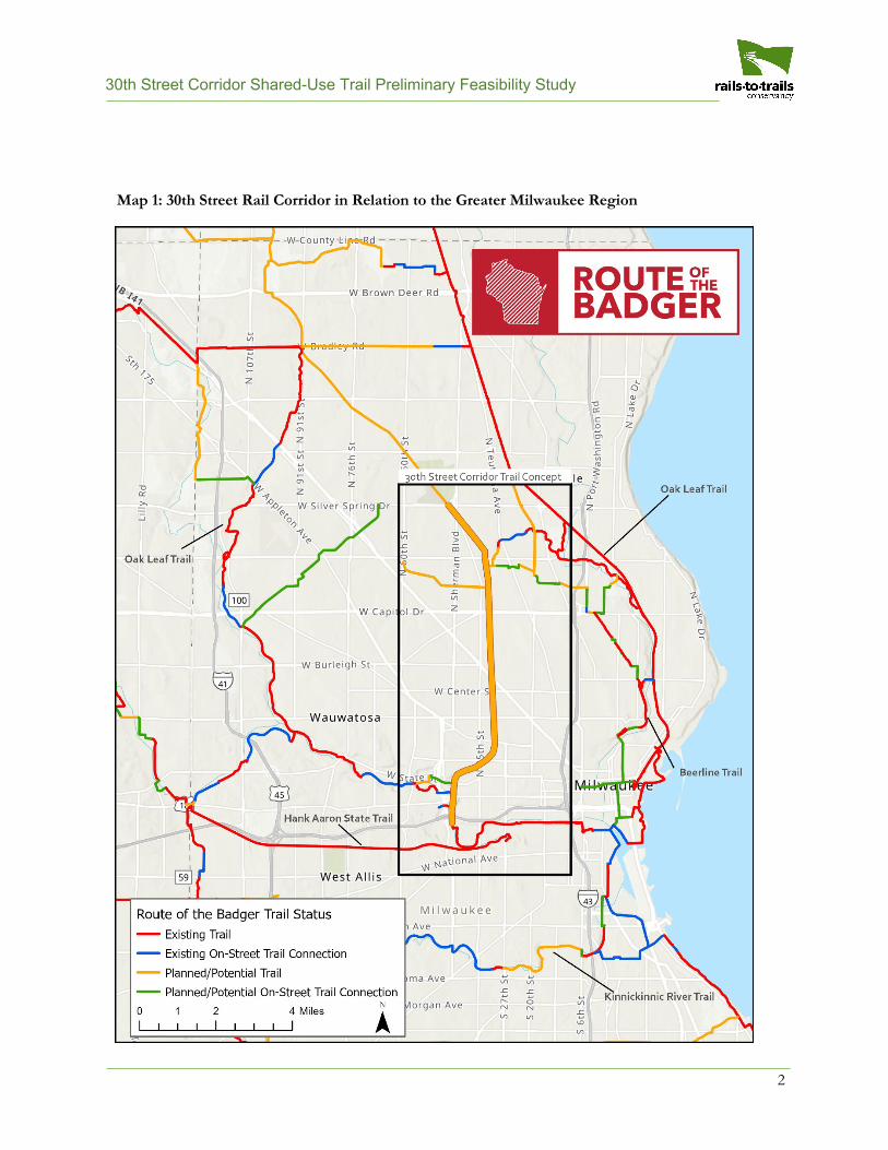
Map 1: 30th Street Rail Corridor in Relation to the Greater Milwaukee Region
30th Street Corridor Shared-Use Trail Preliminary Feasibility Study
3
Table of Contents Executive Summary ................... 4 Introduction ............................... 5
BikeAble Study ............................... 5 Project Scope ................................. 6 Project Location .............................. 6 Railroad Improvement and Infrastructure Ownership ................ 6 Review of Existing Plans ................ 6
Segment Analysis ...................... 9
Northern Segment .......................... 9 Central Segment ........................... 11 Southern Segment ........................ 13
Technical Details ..................... 15
Parcels Along Corridor That Access Rail Line ........................................ 15 Summary of Pinch Points ............. 16
Implementation ........................ 18
Cost Considerations ..................... 18 Commuter Rail Considerations ..... 22
Preliminary Acquisition and Easement Needs ........................... 22 Timeline Considerations ................ 22 Maintenance .................................. 22 Collaboration ................................. 22
Equitable Development Plan ... 23 Funding Opportunities and Sources…………………………….. 24 Conclusion ............................... 26 Appendices .............................. 27
A: Case Studies—Rail-with-Trail Precedents .................................... 27 B: Analysis of Existing Bridges ...... 30
Acknowledgements
This report was created in partnership with jurisdictional agencies and nongovernmental organizations in and around Milwaukee, including:
• City of Milwaukee• Havenwoods Economic Development Corporation• Milwaukee County• Milwaukee Metropolitan Sewerage District (MMSD)• Near West Side Partners• Northwest Side Community Development Corporation (NWSCDC)• Rails-to-Trails Conservancy (RTC)• 30th Street Industrial Corridor Corporation• Urban Ecology Center• Villard Avenue Business Improvement District• Wisconsin Department of Transportation (WisDOT)
Cover Photo
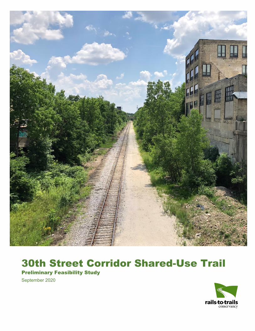
View of the 30th Street Corridor in Milwaukee, looking south from the North Avenue Bridge (taken in July 2020) | Photo courtesy Rails-to-Trails Conservancy
30th Street Corridor Shared-Use Trail Preliminary Feasibility Study
4
Executive Summary The 30th Street Industrial Corridor has a rich history as an industrial and manufacturing employment hub west and northwest of downtown Milwaukee, particularly for Milwaukee’s African American community. The neighborhoods that grew as a result of the post-war economic boom once had one of the highest standards of living for African Americans in the United States.
Due to globalization, changes in labor structure, the closing of factories, technological changes, persistent segregation, discriminatory policies and practices, and various other factors, the area has seen declining property values, significant unemployment, high crime rates and a legacy of brownfields. Despite these socioeconomic challenges, community stakeholders including nonprofit organizations, business associations, resident groups and local government agencies have been working together to build momentum for positive changes and implement projects in the corridor.
A low-volume active rail line travels through the corridor, providing an opportunity to develop a shared-use trail paralleling the rail line (also known as a “rail-with-trail”). According to a recent analysis by Rails-to-Trails Conservancy (RTC), 4 in 10 Milwaukee residents lack good bike routes that can connect them to grocery stores, schools, libraries and hospitals within two miles, while 6 in 10 lack routes to get to an employment center within the same distance. Such a trail could offer nearby residents a safe place to be active outside and active transportation options to employment and education centers around the area.
RTC’s BikeAble study, which measured residents’ connectivity to trails, determined that completing a trail along the 30th Street rail corridor is the most important trail investment in the Milwaukee region in terms of creating more equitable trail access for users of all races, ethnic groups, and
incomes. BikeAble is discussed in more detail in the Introduction section of this report.
This study analyzes the feasibility of a shared-use trail along the 30th Street rail corridor as part of the Route of the Badger initiative to answer important technical questions that will likely arise as project development continues. This study also sets the stage for a community process to define how a trail could best meet community needs.
Local support has been expressed for considering commuter rail along the rail corridor at some point in the future. Commuter rail would unlikely be able to share the existing track(s) with the active heavy rail line; however, installation of the shared-use trail would not prevent conversion to commuter rail where necessary. A proper study of the feasibility of commuter rail to utilize the rail corridor should be conducted if the commuter rail concept advances.
This study finds that a shared-use trail project along the 30th Street rail corridor is feasible and that various on-street connections are possible to fill gaps where the corridor is narrow or obstructed. The next step for a potential trail project is to craft and implement an equitable development strategy that will incorporate neighborhood leadership on the intersectional issues at play in the neighborhoods around the 30th Street rail corridor. If a trail project moves forward from there, funding would need to be acquired for the design and engineering process of a trail, which would then inform the construction costs and timeline for eventual trail construction. A Working Group consisting of members of 12 different organizations collaborated to develop this study, and the potential development of a trail will rely on continued collaboration of these organizations and many more across the region.
30th Street Corridor Shared-Use Trail Preliminary Feasibility Study
5
Introduction For more than a century, various industries thrived in the 30th Street Industrial Corridor, including tanneries, breweries, automotive and machine tool manufacturers. Housing was built around these factories for their workers, and the neighborhoods that grew as a result of this economic boom once had one of the highest standards of living for African Americans in the United States.
Over the past five decades, however, Milwaukee has seen a decline in its traditional manufacturing base as companies have outsourced internationally or moved to suburban industrial parks, resulting in a 40% drop in the number of manufacturing jobs. Many African Americans arrived in Milwaukee just before deindustrialization took place. The subsequent disappearance of manufacturing jobs, in combination with institutionalized segregation, White flight to the suburbs and disinvestment in segregated urban communities, resulted in high levels of racial disparities that continue to actively disadvantage Black communities.
However, the neighborhoods that surround the 30th Street Corridor are resilient and diverse and include many assets like homeowners, large and small businesses, churches, schools and community organizations who are working together to improve the community. The Corridor serves as a thread that connects people, industry, neighborhoods and opportunities.
This study analyzes the feasibility of a shared-use trail paralleling the rail line (also known as a “rail-with-trail”) along the 30th Street rail corridor as part of the Route of the Badger initiative—see Map 1. Since 2014, the Route of the Badger project, conceived by Rails-to-Trails Conservancy (RTC), has worked to connect established trails in Southeast Wisconsin into a world-class trail system. This study also sets the stage for a community process to define how the trail could best meet community needs. Opportunities to construct a trail outside of the rail corridor are
also presented in this report, and as such, a trail may not be entirely adjacent to the rail line in a “rail-with-trail.” In this report, “rail-with-trail” is used when specifically referencing the concept of constructing a trail adjacent to an active rail line, and “shared-use trail” or “trail” in general is used when talking about the project as a whole.
A BikeAble Study of Opportunity, Equity and Connectivity RTC conducted a study, Reconnecting Milwaukee—A BikeAble Study of Opportunity, Equity and Connectivity, exploring current access for walking and biking to employment centers and schools as well as the impact that potential plans for new trails could have on the city.
To understand how trails were distributed from an equity perspective, RTC defined “neighborhoods experiencing inequality” in Milwaukee—those where a concentration of the population lives under the poverty line, is unemployed, does not have a high school degree, does not own a vehicle, and/or is either largely African American or Hispanic. The data were conclusive that these neighborhoods disproportionately lack access to biking and walking facilities. Many of these neighborhoods overlap the 30th Street Corridor.
One of the key findings of the study is that 8% of the people living in neighborhoods experiencing inequality were within 2 miles of an existing trail access point compared to 24% of all residents living in Milwaukee. By adding a trail along the 30th Street Corridor and an addition to the Kinnickinnic River Trail, access will increase to 66% for neighborhoods experiencing inequality and to 59% for the entire city, which will help provide access to education, jobs and recreation across Milwaukee. This opportunity means the number of Milwaukee residents in these neighborhoods that can safely access a trail will rise from 25,000 to 200,000. The 30th Street Corridor trail would be the most significant trail investment in the Milwaukee region to increase equitable access to trails.
30th Street Corridor Shared-Use Trail Preliminary Feasibility Study
6
Project Scope The primary intent of this report is to focus on the feasibility of a non-motorized, shared-use trail to fit within the footprint of the 30th Street rail corridor. Nonprofit neighborhood organizations, the City of Milwaukee and Milwaukee County have many goals for the corridor’s redevelopment, including neighborhood cleanup and revitalization, industrial and employment growth, future commuter rail efforts and restorative justice. This study will address these elements to varying degrees.
The rail corridor currently houses a low-traffic active freight rail line that serves businesses along the corridor and is expected to do so well into the future. Appendix A includes examples of existing rail-with-trail projects that safely accommodate trail and active rail in the same corridor with appropriate safety precautions. In addition to the existing freight rail, a commuter rail line may run parallel on a separate set of tracks in the future.
A “Working Group” of leaders from across Milwaukee, Milwaukee County and the state of Wisconsin was formed to answer the technical questions about the trail concept’s feasibility before bringing the vision to the community. With these questions answered in this report, a process to move the project to the next phase is described, which should include community engagement through an equitable development plan.
Project Location The 30th Street rail corridor follows the Glendale Line, a rail line that parallels 30th Street for a significant portion. The project extents for this study begin to the north at Havenwoods State Forest at W. Silver Spring Drive and end to the south at the connection to the Hank Aaron State Trail just north of Selig Drive near Miller Park. The rail corridor is roughly 6.7 miles. A trail within this rail corridor would provide a vital connection to the Oak Leaf Trail, the Hank Aaron State Trail and a future extension of the Beerline Trail. According to RTC’s 2019 study of trail
connectivity, when trail connections are made, usage increases between 40% and 80%.
A trail along the rail corridor would be an important link of the Route of the Badger, which has the potential to transform Southeast Wisconsin’s trails into a 700-miles-plus premier interconnected trail network, sparking new waves of outdoor tourism, spurring economic opportunity, promoting healthier lifestyles, and bridging gaps in communities for a more socially equitable and vibrant region.
Railroad Improvement and Infrastructure Ownership The infrastructure and railroad property within the 30th Street Industrial Corridor are owned, managed and leased by various entities including Canadian Pacific Railway, the state of Wisconsin, Wisconsin & Southern Railroad and the East Wisconsin Counties Railroad Consortium. In addition, there are a number of public and private landowners who control private rail sidings (discussed in more detail in the Technical Details section). Over the length of the corridor, responsibility and land ownership vary greatly and are often difficult to determine. The design for this project has the opportunity to identify the necessary partners who will be responsible for maintenance and site cleanup.
Review of Existing Plans The 30th Street Corridor has been the focus of multiple planning efforts throughout the past decade. The time spent and resources dedicated to producing these planning documents reflect the importance of retaining and redeveloping the industrial corridor. This section lists the available citywide, regional and statewide planning efforts that involve the 30th Street Corridor. Related initiatives that can inform the continued planning and design for 30th Street Corridor redevelopment are also included.
30th Street Corridor Shared-Use Trail Preliminary Feasibility Study
7
30th Street Corridor Area
• Connecting the Corridor: A Near NorthSide Strategic Action Plan (in progress,2020 adoption expected); City ofMilwaukee
• Garden Homes Neighborhood Plan, 2019update; 30th Street Industrial CorridorCorporation
• 30th Street Industrial Corridor GreenwayCorridor Report, 2015; MilwaukeeMetropolitan Sewerage District (MMSD)
• 30th Street Corridor Stormwater Study,2014; MMSD
• Century City Tri-Angle NeighborhoodPlan, 2014; Century City Tri-AngleNeighborhood Association
• EPA Assessment Funding Final Report,30th Street Industrial Corridor, 2012;Wisconsin Department of NaturalResources (WDNR)
• 30th Street Corridor EconomicDevelopment Master Plan, 2011; City ofMilwaukee
Citywide
• Milwaukee Pedestrian Plan, 2019; City ofMilwaukee
• A Place in the Neighborhood: An Anti-Displacement Plan for NeighborhoodsSurrounding Downtown Milwaukee,2018; City of Milwaukee
• Comprehensive Outdoor Recreation Plan:2016–2021, 2016; City of Milwaukee
• MKE United Greater Downtown ActionAgenda, 2016
• Growing Prosperity: An Action Agendafor Economic Development, 2014; Cityof Milwaukee
• ReFresh Milwaukee (Sustainability Plan),2013; City of Milwaukee
• Milwaukee by Bike, 2010; City ofMilwaukee
• Off-Street Bikeway Study: Milwaukee’sBest Opportunities for Trail Expansion,2006; City of Milwaukee and BikeFederation of Wisconsin
• City of Milwaukee Comprehensive Plano Fond du Lac & North Area Plan,
update in progresso Menomonee Valley Area Plan, 2015o Near North Area Plan, 2009o Washington Park Area Plan, 2006o Near West Area Plan, 2004
Regional
• Vision 2050, 2016 (amendment inprogress); Southeastern WisconsinRegional Planning Commission(SEWRPC)
• Regional Green Infrastructure Plan, 2013;MMSD
• Milwaukee County Trails Network Plan,2007; Milwaukee County
Statewide
• Wisconsin Rail Plan 2030, 2014; WDNR• Wisconsin Trails Network Plan, 2003;
WDNR
30th Street Corridor Shared-Use Trail Preliminary Feasibility Study
8
About Rails-to-Trails Conservancy Rails-to-Trails Conservancy (RTC) is America’s largest trails organization—with a grassroots community of more than 1 million—dedicated to connecting people and communities by creating a nationwide network of public trails, many from former rail lines. RTC serves as the national voice for the nation’s 34,000+ miles of shared-use trails, and 8,000+ miles of potential trails ready to be built, with the goal of creating more walkable, bikeable communities. Connect with RTC at railstotrails.org and @railstotrails on Facebook, Twitter and Instagram.
The 30th Street Corridor Shared-Use Trail is a potential segment of the Route of the Badger, one of RTC’s eight TrailNationTM projects that demonstrate the outcomes that trail networks deliver in every type of community. The Route of the Badger has the potential to transform Southeast Wisconsin’s trails into a 700-miles-plus premier trail network, sparking new waves of outdoor tourism, spurring economic development, promoting healthier lifestyles, and bridging gaps in communities for a more socially equitable and vibrant region. Learn more about the Route of
the Badger at railstotrails.org/routeofthebadger and RTC’s network-building initiative at trailnation.org.
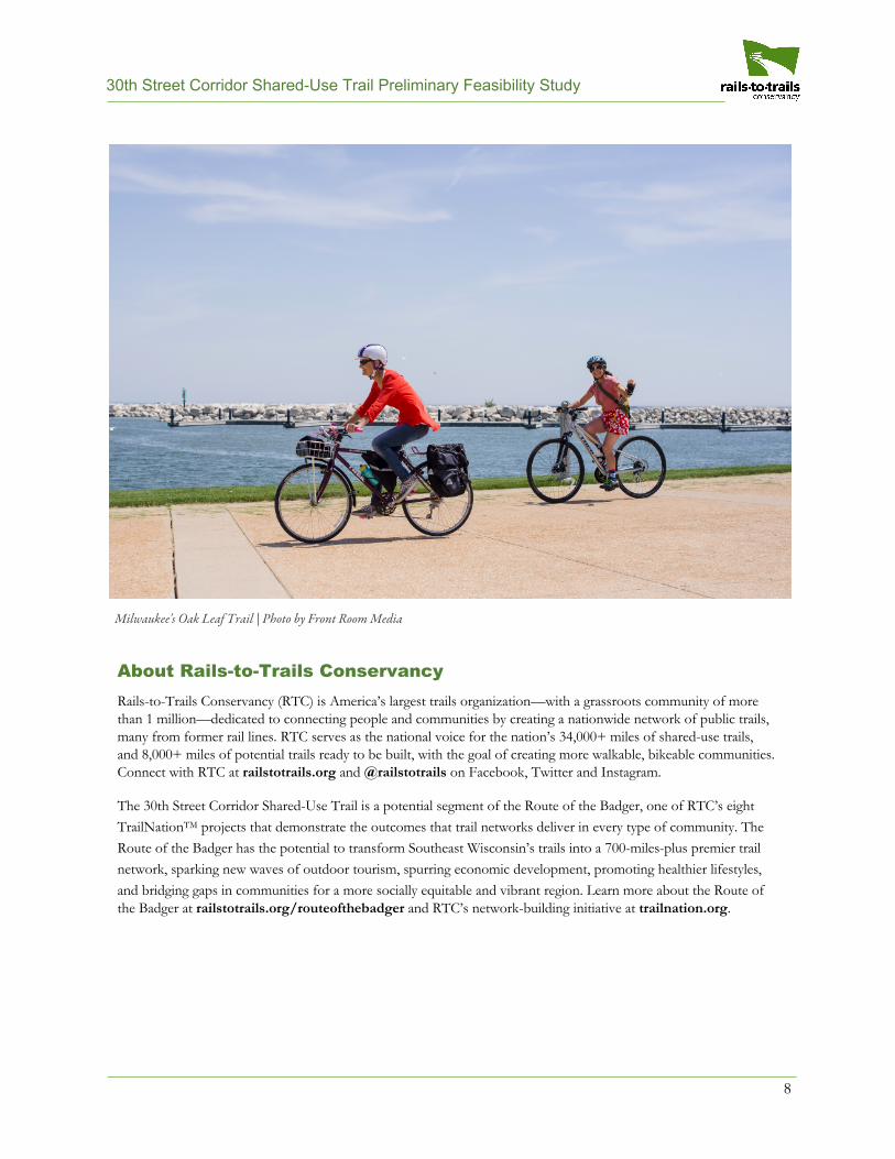
Milwaukee's Oak Leaf Trail | Photo by Front Room Media
30th Street Corridor Shared-Use Trail Preliminary Feasibility Study
9
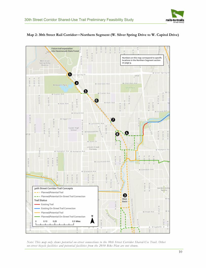
Segment Analysis The 30th Street rail corridor can be divided into three roughly 2-mile segments, traveling between Havenwoods State Forest and the Hank Aaron State Trail south of Interstate 94. The entire rail corridor is approximately 6.7 miles.
Northern Segment (Havenwoods State Forest to W. Capitol Drive) The Northern Segment is roughly 2.3 miles between Havenwoods State Forest (north of W. Silver Spring Drive) and W. Capitol Drive—see Map 2 for more details. This segment of the 30th Street rail corridor is mostly at-grade, save for a few bridges and their ascents that carry the rail corridor over the existing street grid. Those bridges are explored in more detail in Appendix B.
Opportunities and Points of Interest
Havenwoods State Forest is a major point of interest at the northern end of the rail corridor. A trail that connects into Havenwoods State Forest should include a safe crossing of W. Silver Spring Drive (1 on Map 2).
McGovern Park, just south of W. Silver Spring Drive, provides a potential option to route a trail around a tight section of the rail corridor (2). Milwaukee County Parks has expressed interest in helping to facilitate this connection. Other local parks in or near the Northern Segment include Smith and Custer, which could be significant attractions to and from a trail. Likewise, a branch of the Boys & Girls Clubs of America lies just west of the rail corridor and could draw significant trail use as well.
Just south of W. Hampton Avenue, Milwaukee Metropolitan Sewerage District (MMSD) owns a portion of land on the west side of the rail corridor along Lincoln Creek, and land south of Lincoln Creek that will be transformed into a 2-acre public space and a large stormwater basin (3). MMSD will be working with the community on the design, and a trail will be included in those
discussions. A trail would be compatible with the public space; a trail closer to Lincoln Creek and near the basin could help route the trail away from any conflicts with the rail corridor.
Numerous businesses in the Northern Segment could serve trail users, including those in the Villard Avenue Business Improvement District.
An on-street connection along W. Cameron Avenue (4) could connect a trail along the 30th Street rail corridor to the Oak Leaf Trail.
Challenges
Following the rail corridor in the northern section of this segment would likely require three at-grade crossings of the active rail corridor—at N. Hopkins Street (5), a spur near W. Rohr Avenue (6) and at N. 37th Street (7). Conflicts betweentrail users and automobile traffic could be avoidedthrough design changes and additional signage.
At W. Fairmount Avenue, the rail tracks begin to multiply to access spurs and a wide railyard (8). It would be wise to avoid this section with on-street options if possible or work to relocate and condense the existing tracks to allow a potential trail to run on the far eastern or western portion of the rail corridor.
While a shared-use trail is preferable to accommodate all kinds of users, on-street routing options exist that could provide connections to local businesses and residential areas and/or bypass difficult sections of the rail corridor.
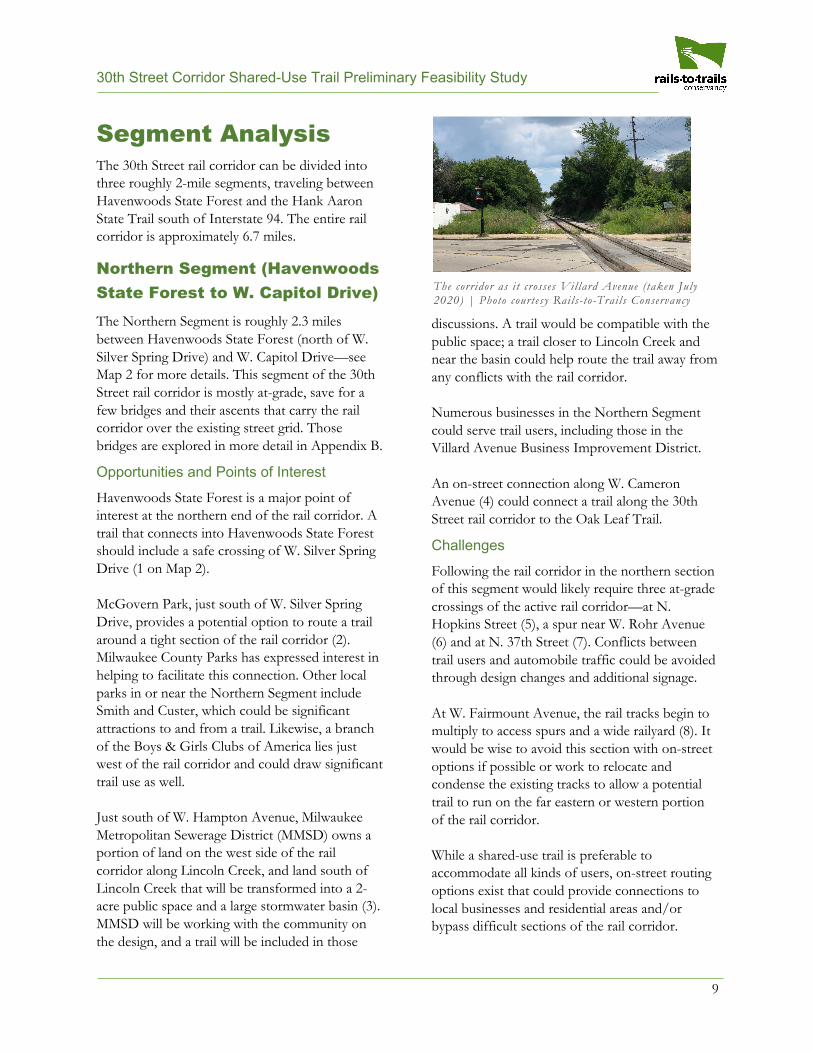
The corridor as i t crosses Vil lard Avenue (taken July 2020) | Photo courtesy Rails- to-Trai ls Conservancy
30th Street Corridor Shared-Use Trail Preliminary Feasibility Study
10
Note: This map only shows potential on-street connect ions to the 30th Street Corridor Shared-Use Trai l . Other on-street bicyc le faci l i t ies and potential faci l i t ies from the 2010 Bike Plan are not shown.
Map 2: 30th Street Rail Corridor—Northern Segment (W. Silver Spring Drive to W. Capitol Drive)
30th Street Corridor Shared-Use Trail Preliminary Feasibility Study
11
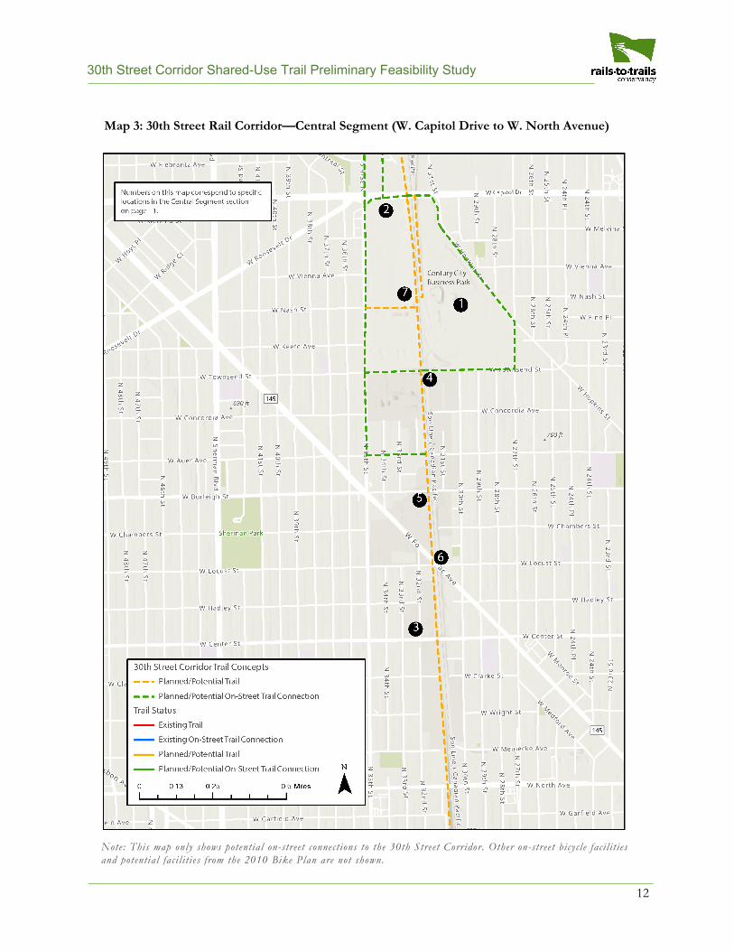
Central Segment (W. Capitol Drive to W. North Avenue) The Central Segment is roughly 2 miles between W. Capitol Drive and W. North Avenue—seeMap 3 for more details. This segment of the 30thStreet Corridor is mostly at-grade, save for a fewbridges that carry the rail corridor over theexisting street grid. Those bridges are explored inmore detail in Appendix B.
Opportunities and Points of Interest
In 2009, the City acquired 84 acres of the former A.O. Smith/Tower Automotive site and conducted demolition, remediation and infrastructure upgrades, establishing the Century City Business Park (1 on Map 3). Nine of the 15 parcels are zoned for heavy industrial uses, and the remaining six are zoned for light industrial or commercial uses. Five businesses are currently operating on the site. Additional public and private sites are available, creating more than 100 acres available for redevelopment right along the rail line—a unique opportunity.
The 30th Street Industrial Corridor Corporation and Business Improvement District #37 (commonly referred to as The Corridor) have been working on economic development in the area for nearly three decades. The City, in partnership with The Corridor, purchased a large parcel southeast of the intersection of W. Capitol Drive and N. 35th Street (2). With a public access easement in place, future development of this site
could help provide trail access at the northern section of the Central Segment.
Within the Central Segment, Scott Crawford Inc. is developing a $59 million project located on the former Briggs & Stratton property (3). The development will cover almost 7 acres, including a 197-unit apartment complex that would havedirect access to the trail if it is completed.
Additionally, there are multiple potential at-grade access sites within the Central Segment.
Local parks in or near the Central Segment include Moody, Butterfly, Metcalfe and Sherman, which could be significant attractions to and from a trail.
Challenges
The bridges that carry the rail corridor over the street grid at W. Townsend Street (4), W. Burleigh Street (5) and W. Locust Street (6) are tight with the existing rail lines. Opportunities to relocate tracks on the existing bridges or expand the width of these bridges could be considered to explore trail access across the bridges.
Likewise, the section between W. Capitol Drive and W. Townsend Street is also tight, with development closely abutting the rail corridor on both sides (7). Adding to this challenge, this area has the most active private users on the corridor. A full analysis of the pinch points along the rail corridor is explored in the Technical Details section of this report.
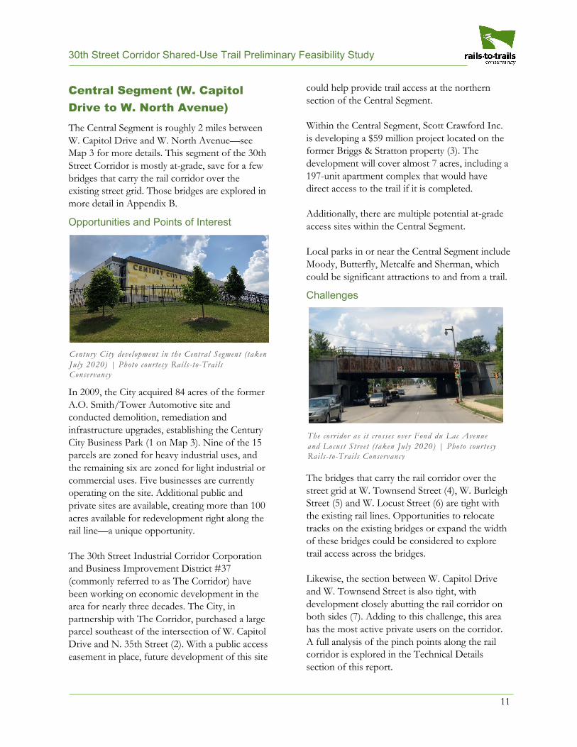
The corridor as i t crosses over Fond du Lac Avenue and Locust Street ( taken July 2020) | Photo courtesy Rails- to-Trai ls Conservancy
Century City development in the Central Segment (taken July 2020) | Photo courtesy Rails- to-Trai ls Conservancy
30th Street Corridor Shared-Use Trail Preliminary Feasibility Study
12
Note: This map only shows potential on-street connect ions to the 30th Street Corridor. Other on-street bicyc le faci l i t ies and potential fac i l i t ies from the 2010 Bike Plan are not shown.
Map 3: 30th Street Rail Corridor—Central Segment (W. Capitol Drive to W. North Avenue)
30th Street Corridor Shared-Use Trail Preliminary Feasibility Study
13
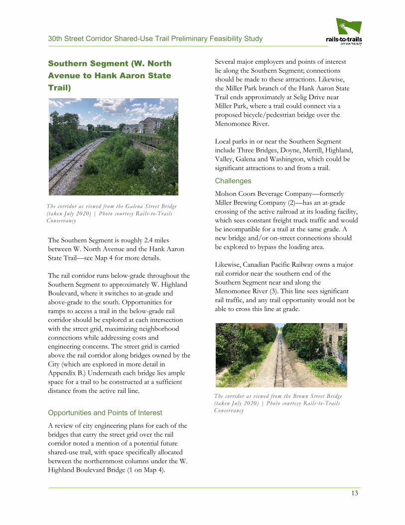
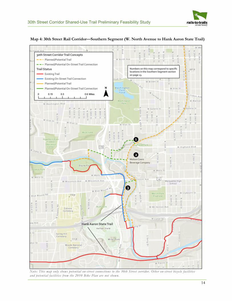
Southern Segment (W. North Avenue to Hank Aaron State Trail)
The Southern Segment is roughly 2.4 miles between W. North Avenue and the Hank Aaron State Trail—see Map 4 for more details.
The rail corridor runs below-grade throughout the Southern Segment to approximately W. Highland Boulevard, where it switches to at-grade and above-grade to the south. Opportunities for ramps to access a trail in the below-grade rail corridor should be explored at each intersection with the street grid, maximizing neighborhood connections while addressing costs and engineering concerns. The street grid is carried above the rail corridor along bridges owned by the City (which are explored in more detail in Appendix B.) Underneath each bridge lies ample space for a trail to be constructed at a sufficient distance from the active rail line.
Opportunities and Points of Interest
A review of city engineering plans for each of the bridges that carry the street grid over the rail corridor noted a mention of a potential future shared-use trail, with space specifically allocated between the northernmost columns under the W. Highland Boulevard Bridge (1 on Map 4).
Several major employers and points of interest lie along the Southern Segment; connections should be made to these attractions. Likewise, the Miller Park branch of the Hank Aaron State Trail ends approximately at Selig Drive near Miller Park, where a trail could connect via a proposed bicycle/pedestrian bridge over the Menomonee River.
Local parks in or near the Southern Segment include Three Bridges, Doyne, Merrill, Highland, Valley, Galena and Washington, which could be significant attractions to and from a trail.
Challenges
Molson Coors Beverage Company—formerly Miller Brewing Company (2)—has an at-grade crossing of the active railroad at its loading facility, which sees constant freight truck traffic and would be incompatible for a trail at the same grade. A new bridge and/or on-street connections should be explored to bypass the loading area.
Likewise, Canadian Pacific Railway owns a major rail corridor near the southern end of the Southern Segment near and along the Menomonee River (3). This line sees significant rail traffic, and any trail opportunity would not be able to cross this line at grade.
The corridor as viewed from the Galena Street Bridge (taken July 2020) | Photo courtesy Rails- to-Trai ls Conservancy
The corridor as viewed from the Brown Street Bridge (taken July 2020) | Photo courtesy Rails- to-Trai ls Conservancy
30th Street Corridor Shared-Use Trail Preliminary Feasibility Study
14
Note: This map only shows potential on-street connect ions to the 30th Street corridor. Other on-street bicyc le faci l i t ies and potential fac i l i t ies from the 2010 Bike Plan are not shown.
Map 4: 30th Street Rail Corridor—Southern Segment (W. North Avenue to Hank Aaron State Trail)
30th Street Corridor Shared-Use Trail Preliminary Feasibility Study
15
Technical Details Decisions on exactly where and how a shared-use trail could be built through the 30th Street rail corridor will be impacted by a variety of technical details. This section provides facts about the existing uses along the rail corridor and the pinch points that could impact if and how a trail is constructed in the rail corridor. These facts support the need for a rigorous community engagement process to help make decisions on how to use this information moving forward.
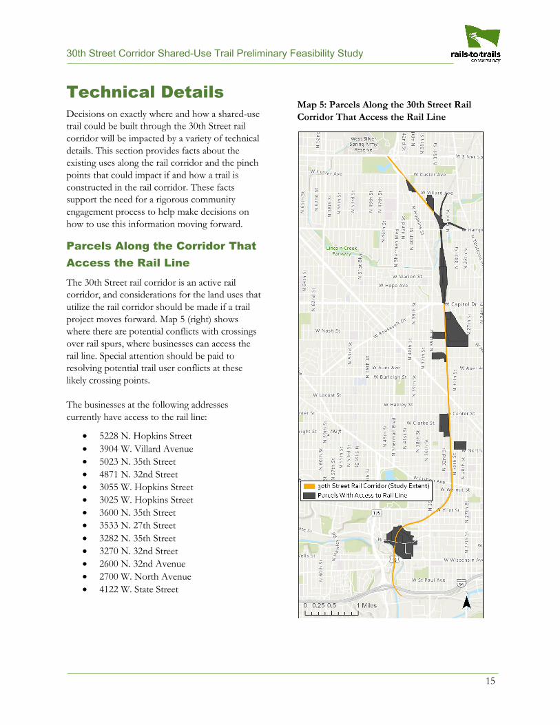
Parcels Along the Corridor That Access the Rail Line The 30th Street rail corridor is an active rail corridor, and considerations for the land uses that utilize the rail corridor should be made if a trail project moves forward. Map 5 (right) shows where there are potential conflicts with crossings over rail spurs, where businesses can access the rail line. Special attention should be paid to resolving potential trail user conflicts at these likely crossing points.
The businesses at the following addresses currently have access to the rail line:
• 5228 N. Hopkins Street• 3904 W. Villard Avenue• 5023 N. 35th Street• 4871 N. 32nd Street• 3055 W. Hopkins Street• 3025 W. Hopkins Street• 3600 N. 35th Street• 3533 N. 27th Street• 3282 N. 35th Street• 3270 N. 32nd Street• 2600 N. 32nd Avenue• 2700 W. North Avenue• 4122 W. State Street
Map 5: Parcels Along the 30th Street Rail Corridor That Access the Rail Line
30th Street Corridor Shared-Use Trail Preliminary Feasibility Study
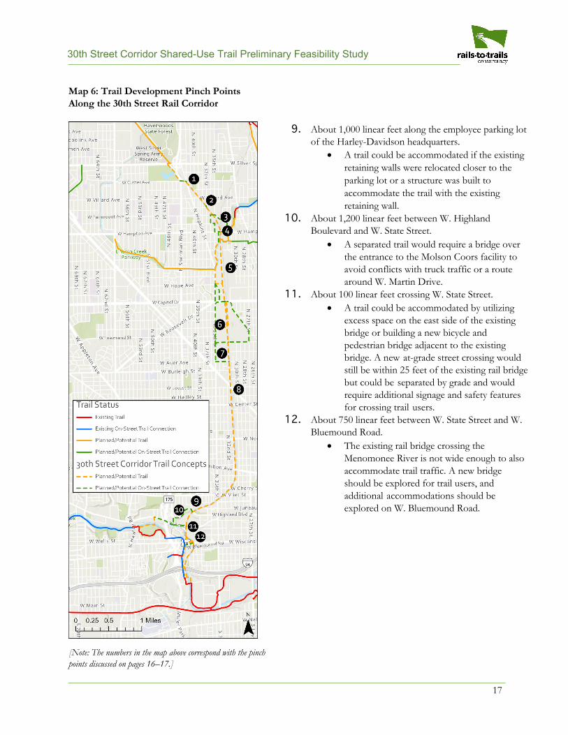
Summary of Pinch Points To better understand the feasibility of a trail along the rail corridor, the Working Group identified certain pinch points where a shared-use trail would be tight. The following is a summary of the major pinch points along the 30th Street rail corridor, though it is not an exhaustive list and engineering and design may uncover additional pinch points. Pinch points include locations where the nearest edge of a trail would be within 25 feet of the centerline of the nearest railroad track. Several locations may require routing away from the rail corridor to find sufficient space (or may make more sense given the layout of the neighborhood and logical egress points).
Additionally, if commuter rail is implemented on the corridor at some point, there would likely need to be another set of tracks. This could increase the number of pinch points along the corridor. Thus, it is important to consider safe, well-designed on-street or off-rail corridor alternatives throughout the route.
A map (Map 6) of these pinch points with corresponding numbers can be found on page 18.
1. About 1,600 linear feet between W. Custer Avenue and W. Villard Avenue.• The rail corridor is narrow. The east side of the tracks could accommodate a trail abutting
the rail. There is also a rail spur roughly at W. Rohr Avenue that would require a crossing.2. About 50 linear feet between N. 37th Street and W. Fairmount Avenue.
• Development and the presence of rail spurs make the east side of the tracks tight for a trail.The west side of the tracks could accommodate a trail more than 25 feet away and still fitwithin the existing footprint.
3. About 1,300 linear feet between W. Fairmount Avenue and W. Hampton Avenue.• Several tracks branch off in this area, and a trail on the east side of the tracks would be
hindered by the existence of northbound tracks. The farthest west track would need to bemoved to the east by about 15 feet to accommodate a trail between the rail line and theexisting development footprint.
4. About 100 linear feet crossing the bridge over W. Hampton Avenue.• The existing bridge over W. Hampton Avenue includes developable space in the center of
the bridge. The farthest west track would need to be moved to the east by about 15–20 feetto accommodate a trail.
5. About 1 mile between W. Hampton Avenue and W. Capitol Drive.• This section would likely be routed away from the rail corridor, given the complexity of
multiple rail tracks and the availability of public land on the west side of the rail corridor.6. About 2,000 feet between W. Capitol Drive and W. Townsend Street.
• This section is narrow, given the rail corridor’s placement adjacent to industrial buildings. Anat-grade crossing of the railroad tracks exists at a Milwaukee Department of Public Works(DPW) facility that could facilitate a west to east crossing. On-street opportunities should beexplored through here.
7. About 800 linear feet between W. Townsend Street and W. Burleigh Street.• The east side of the tracks is narrow, but the west side could accommodate a trail 25 or more
feet away.8. About 1,300 linear feet between W. Burleigh Street and W. Locust Street.
• The west side of the tracks is narrow, but the east side could accommodate a trail 25 or morefeet away.
16
30th Street Corridor Shared-Use Trail Preliminary Feasibility Study
17
9. About 1,000 linear feet along the employee parking lotof the Harley-Davidson headquarters.
• A trail could be accommodated if the existingretaining walls were relocated closer to theparking lot or a structure was built toaccommodate the trail with the existingretaining wall.
10. About 1,200 linear feet between W. HighlandBoulevard and W. State Street.
• A separated trail would require a bridge overthe entrance to the Molson Coors facility toavoid conflicts with truck traffic or a routearound W. Martin Drive.
11. About 100 linear feet crossing W. State Street.• A trail could be accommodated by utilizing
excess space on the east side of the existingbridge or building a new bicycle andpedestrian bridge adjacent to the existingbridge. A new at-grade street crossing wouldstill be within 25 feet of the existing rail bridgebut could be separated by grade and wouldrequire additional signage and safety featuresfor crossing trail users.
12. About 750 linear feet between W. State Street and W.Bluemound Road.
• The existing rail bridge crossing theMenomonee River is not wide enough to alsoaccommodate trail traffic. A new bridgeshould be explored for trail users, andadditional accommodations should beexplored on W. Bluemound Road.
[Note: The numbers in the map above correspond with the pinch points discussed on pages 16–17.]
Map 6: Trail Development Pinch Points Along the 30th Street Rail Corridor
30th Street Corridor Shared-Use Trail Preliminary Feasibility Study
18
Implementation This study lays the groundwork for the next steps in the potential development of a shared-use trail along the 30th Street rail corridor—including community engagement and the potential subsequent design, engineering and construction. As such, the information in this report is preliminary to help facilitate those conversations. Cost estimates included below stem from previous studies and should be understood as high-level guidance.
Note that it is assumed that all portions of this project will be compliant with the Americans with Disabilities Act (ADA) to provide access to the trail to all people of all abilities.
Cost Considerations Though detailed designs for a trail along the 30th Street rail corridor would be created in a future stage of this project, it will be helpful to the planning process to estimate the potential costs of various aspects of the project. Below are ranges of cost estimates for likely elements of a trail along the rail corridor. (This is not an exhaustive list.) These estimates are derived from actual costs of recent trails built in and around Milwaukee and other examples of similar trails built around the country. It is premature to develop a cost estimate of full trail build-out until there is an equitable community process to determine if there is community support for this project and what the community would like it to look like. Actual costs for a trail along the rail corridor will need to be determined through future design phases and may vary from the costs included below.
Initial Site Cleanup and Preparation
Recent examples (2019) of clearing and excavation costs for a 10-foot-wide asphalt trail in Milwaukee
Street rail corridor will vary, given the topography of a sub-grade corridor, the dense vegetation that has grown on the sides of the rail corridor and the potential difficulty of getting construction equipment into the rail corridor.
Depending on the final design, there are certain areas where removal or relocation of railroad track should be considered. Bids on track removal for the Beerline Trail show $16–$78 per linear foot, and depending on the impact on railroad operations, track relocation could cost around $350 per linear foot, per the Wisconsin Department of Transportation (WisDOT).
Trail Surface
Given that this potential trail project is in a highly urbanized area, asphalt and concrete are ideal surfacing types. Recent examples (2019) of construction costs for a 10-foot-wide asphalt trail in Milwaukee County (the Oak Leaf Trail in Kohl Park and Bender Park) show approximately $300,000 per mile. Costs to surface the trail with concrete are not significantly different from costs for asphalt. Considerations should be given to separating walking and biking travel along the trail where possible, which would widen the trail beyond 10 feet and thus increase the costs.
Ramp Building
A key to the success of the trail along the 30th Street rail corridor is creating access points throughout the corridor. Ramps at intersections with the street grid are logical places to provide some of these access points. A thorough review of each intersecting street and the potential network of trails will help reveal the best locations for ADA-compliant ramps between the street grid and the trail. Along the Oak Leaf Trail at North Avenue, a ramp was recently constructed, costing approximately $250,000.
30th Street Corridor Shared-Use Trail Preliminary Feasibility Study
19
Bridge Building
Several new bridges of various sizes will be required to fully connect the rail corridor for a shared-use trail. New bridges are preferable for crossing W. Silver Spring Drive and over the Molson Coors Beverage Company loading dock. Bridges will be needed for one to two crossings over the Menomonee River. Additional bridges may be recommended at several other locations, to be determined through the community process and design and engineering phases. Bicycle and pedestrian bridge examples per WisDOT between 2016 and 2018 show a range from $125 to $450 per square foot. Using an estimate of $200 per square foot for a new bridge over W. Silver Spring Drive, for example, would yield an estimated cost of about $630,000. Actual costs would be determined through a proper design and engineering process.
Bridge Repair
The 30th Street rail corridor travels at or above grade for 4.4 miles, while it travels below grade for approximately 1.2 miles. Where the rail corridor is below-grade, 11 bridges carrying the local street grid cross over the rail corridor. And where the rail corridor is above-grade, 10 bridges carry the rail line over the local street grid or waterways.
These bridges vary in age, size (length, width and height), state of repair and ownership. Of the 11 bridges that cross over the rail corridor, only four were built or reconstructed after 2000. An engineering analysis should confirm that all bridges are in a state of good repair, particularly the ones built before 2000, and do not need restoration to allow for a trail to pass under them. Bridge stability analyses could be conducted by the City of Milwaukee, Milwaukee County and/or WisDOT engineers using existing staff resources, or a consulting firm could be contracted at an additional price. Appendix B describes the existing bridges in more detail.
Separation From Railroad Tracks
Though not universally required, some type of physical separation between the trail and the tracks should be considered, especially in areas where the trail could be routed particularly close to the active rail line. A helpful delineation of space provides visual cues on where people are encouraged to travel and where they should not be present.
Other successful examples of rails-with-trails have provided physical separation through fencing (chain-link, wood, etc.), vegetation (trees, shrubbery), low walls and other barriers. Each comes with its own cost considerations, both in construction and maintenance. Chain-link fencing is one of the least expensive options ($48–$63 per linear foot of 6-foot-high fencing) but is easily damaged and may not provide an inviting look and feel. Vegetation can make for an attractive buffer but requires significant landscaping maintenance to remove branch, leaf and root encroachment on the trail and rail line. Costs for additional separation types should continue to be researched.
Stormwater Management and Green Infrastructure
Through the booming industrial development of the land occupied by the 30th Street Corridor and the subsequent decline of the manufacturing economy, the detrimental effects can be measured across numerous metrics including water quantity and quality. The natural flow paths and systems for managing stormwater were buried and redirected. Building the trail inevitably will add more pavement and land shaping to an area that is highly impervious and extremely transformed through its history.
Implementing the Milwaukee Metropolitan Sewerage District (MMSD) Fresh Coast initiative of “managing water where it falls” through green infrastructure (GI) will improve the standard of living in the corridor in a sustainable manner that has numerous secondary health and quality of life benefits. A GI stormwater management approach
30th Street Corridor Shared-Use Trail Preliminary Feasibility Study
20
through trail development will catalyze the use of GI in the design of adjacent and intersecting green space expansion projects on public and private property. Permeable pavement should be used in strategically placed sections to capture and store stormwater from areas larger than the pavement footprint, increasing the benefit-to-cost ratio. While permeable pavement may not be cost-effective to apply to all paved areas, bioretention, native plantings and stormwater trees should be utilized for concentrated green management of stormwater runoff of trail and adjacent surfaces. The GI features will increase much needed green space in the corridor and provide inviting naturalized buffers between paved streetscapes and public recreational spaces that do not currently exist.
Utilizing a GI-based stormwater management strategy for trail and adjacent areas reshaped through construction supports the overarching objective to improve the standard of living in the area in a triple-bottom-line sustainable manner. The 2013 MMSD Regional Green Infrastructure Plan (MMSD RGIP) cites numerous studies that show an enhanced connection to the natural environment contributes to the health and safety of residents, providing benefits such as crime reduction, reduced stress, increased recreational opportunities and improved aesthetics.
In addition to the socioeconomic-environmental benefits to implementing a green stormwater management plan for trail development, MMSD and the City of Milwaukee have recently revised stormwater regulations regionally and locally, lowering the threshold for which GI is required when impervious area is added to a new development. The MMSD RGIP also outlines recommendations for GI quantitatively by watershed (Milwaukee River north of W. Townsend Avenue and the Menomonee River south of W. Townsend Avenue for the 30th Street Corridor) as well as by land use, the most useful perspective for trail planning.
Most applicable to this study, the MMSD plan recommends porous pavement, bioretention, stormwater trees and native landscaping. As outlined in the 2019 MMSD GI Costs and Incentives in Metropolitan Milwaukee Final Report, typical unit construction costs for these GI practices are $13/square foot (SF) for bioretention, $14/SF for permeable pavement, $9/SF for native plantings and $400/SF for stormwater trees. When unit costs for GI features are considered for trail design, the “capture value” needs to be considered for an accurate benefit/cost analysis. The capture value as defined in the 2019 MMSD report is the assumed capture ratio in gallons of stormwater per SF of GI feature installed. It should be noted that MMSD counts capture value in any given storm—not on an annual basis. The average capture values for various GI types are:
• Bioretention: 7.5 gallons/SF• Permeable pavement: 3–5 gallons/SF• Native plantings: 0.4 gallons/SF• Stormwater trees: 25 gallons per tree
Maintenance costs for GI are less understood; however, typical estimates will be emerging within the planning and design schedule of the trail as adoption of GI is rapidly increasing in the region. GI design should be completed with aesthetic preferences and maintenance resources in mind. Additionally, maintenance specifications need to be clear and not generalized. In 2020, MMSD released a Green Infrastructure Operations and Maintenance manual that can be used to guide maintenance activities.
Lighting
Trail lighting that is well placed, properly installed and frequently maintained can improve visibility, increase overall trail access and convenience, and give trail users a sense of security while passing through at night. Lighting must be included in the design along the entire length of the trail.
30th Street Corridor Shared-Use Trail Preliminary Feasibility Study
21
According to the American Association of State Highway and Transportation Officials’ (AASHTO) Guide for the Development of Bicycle Facilities, lights on a trail should, at the very least, be installed at the following locations:
• In a tunnel or at overpasses (always)• At trailheads• At bridge entrances and exits• In public gathering places• Along streets• At crosswalks• Where the path crosses another path or sidewalk• On signage
Lighting costs from recent trail projects along the North and East Basins in Milwaukee average about $116 per linear foot, per MMSD. The lighting is grid powered, utilizing dark-sky LED lights.
Project Management, Planning and Design
Overhead costs are a significant portion of a trail project, including project management, community outreach, planning and design, construction management and state review. Using the Oak Leaf Trail budgets from 2019, estimates of these costs range from $185,000 to $218,000 per mile.
Other Costs
Various trail features like benches, water fountains, trash cans, emergency telephones, trail counters and wayfinding signage should be considered for the trail. These features will not add significantly to the cost of the project, but will be important to making the trail as useful as possible for the greatest number of people. For instance, a recent trail counter installed on the Oak Leaf Trail cost about $18,000 for initial installation.
Community elements like art, street furniture and presentation spaces could be considered as a percentage of the final project total to ensure the community is well-represented in this project. Community desires for these kinds of trail features would be assessed during the equitable development plan process, and costs will be determined following that process.
30th Street Corridor Shared-Use Trail Preliminary Feasibility Study
22
Commuter Rail Considerations Local support has been expressed for considering a commuter rail along the rail corridor sometime in the future. While this report is not suited to study the feasibility of incorporating commuter rail into the rail corridor, it is important to include the subject in this report as it would have significant impact on the use of the space within the rail corridor.
Commuter rail would unlikely be able to share the existing track(s) with the active heavy rail line. In many locations along the rail corridor, sufficient right-of-way exists to co-locate the active rail line, a new commuter line and a shared-use trail. However, the rail corridor is too narrow in other locations to accommodate all three uses. Should commuter rail move forward, portions of the shared-use trail could be routed to the on-street network at pinch points. Installation of the shared-use trail would not prevent conversion to commuter rail where necessary. A proper study of the feasibility of commuter rail to utilize the rail corridor should be conducted if the commuter rail concept advances.
Preliminary Acquisition and Easement Needs In its review of the rail corridor, the Working Group explored the opportunity for a potential trail to remain entirely within publicly owned land. Access easements and property acquisition to connect to the rail corridor or bring the trail off the rail corridor will require additional reviews on potential needs.
Timeline Considerations Following the completion of this study, several important steps would be undertaken before a trail project could come to reality along the rail corridor. A rigorous community process would help to engage neighborhood residents and learn their desires, which could take a year or longer to do correctly (see the Equitable Development Plan section). If a trail project moved forward from there, funding would need to be acquired for the design and engineering process, which would then inform the construction costs, for which additional fundraising would need to be undertaken.
Maintenance
To provide the kind of high-quality trail experience that the 30th Street rail corridor deserves, maintenance of a completed facility should be considered at every step of the process. Local agencies and other stakeholders must determine maintenance responsibilities. The funding of this long-term maintenance should also be incorporated into the long-range budgeting process.
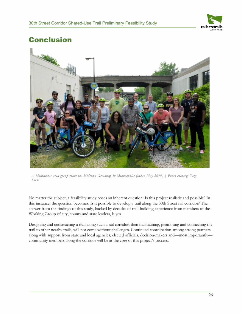
Collaboration The variety of property owners and jurisdictional authorities throughout the 30th Street rail corridor includes federal, state, county and city agencies as well as multiple private landowners and businesses. The development of a trail is an opportunity to identify the partners that would need to collaborate to make a project like this happen.
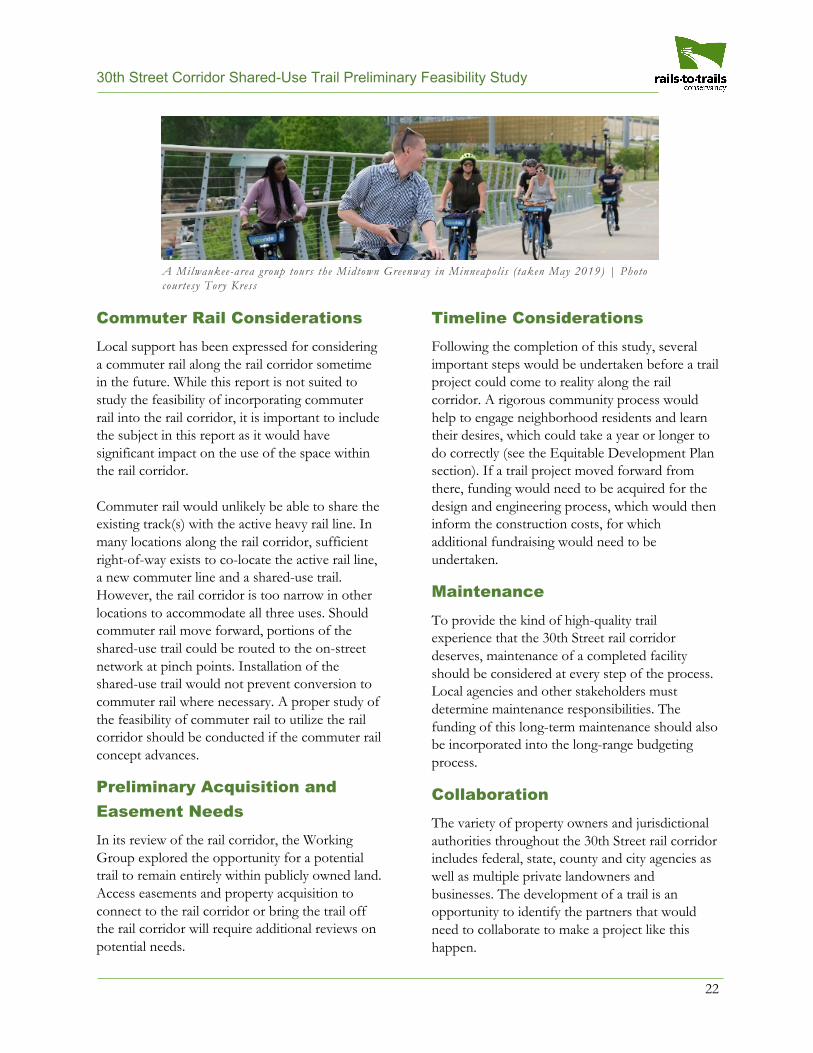
A Milwaukee-area group tours the Midtown Greenway in Minneapol is ( taken May 2019) | Photo courtesy Tory Kress
30th Street Corridor Shared-Use Trail Preliminary Feasibility Study
23
A next step in making the trail come closer to fruition is the creation of an equitable development plan that will ensure that the future shared-use trail project is a driver of broad and long-term benefits for current residents of the 30th Street Corridor. The corridor is experiencing renewed investment in community redevelopment, and the effort to create a shared-use trail in the neighborhood is one such redevelopment effort and should be tied into all of the interconnected neighborhood investments. By following a community-driven and vetted equitable development process, residents and a broad swath of nonprofit, public and private sector current and future partners can be inspired to not only create a world-class public space but ensure it is developed in an equitable manner.
The plan will proactively outline strategies and policies that can be collectively developed and implemented by a broad spectrum of partners representing multiple sectors across the city to ensure that the neighborhoods along the corridor stand to benefit from the trail project. These future partners will be part of the necessary ecosystem to deliver on the equitable development plan’s strategies. Such strategies will be developed and defined by residents and citywide partners and will likely touch on interconnected outcomes such as affordable housing, workforce and small business development, and arts, culture and outdoor space access.
The Working Group recommends that a “Project Team” be established to set expectations grounded in reality around how the 30th Street shared-use trail project can support equitable development and coordinate with other community redevelopment efforts. Potential partners on this project team would include community leaders, multisector grassroots leaders, city and county planners, and researchers.
The Project Team will be the driver of the equitable development planning process in support of the early planning efforts around the 30th Street shared-use trail project. The plan will prioritize community ideas, concerns, timelines and deep engagement within the neighborhoods
surrounding the corridor. The equitable development plan is a launch point, a community-driven process that will enable the City of Milwaukee and Milwaukee County as well as the state of Wisconsin to proceed confidently in allocating resources to build the trail project, and doing so in a way that fully supports and benefits the surrounding community. The Project Team will also start discussions with landowners adjacent to the corridor to determine their interest in such a project.
The Project Team will work directly with residents and other community partner groups. The Project Team will tap into existing community meetings, events and gatherings as well as host (or co-host) neighborhood meetings to both inform and engage community members in the project and to gather their input and ideas for the future trail and equitable development in their neighborhood. The goal is for neighborhood groups and residents to determine the highest priorities and outcomes for the equitable development plan.
Some of the equitable development plan work may take place before a vaccine for COVID-19 is developed, which may require changing neighborhood engagement strategies. Such strategies could include a combination of digital and analog, utilizing several methods to reach the most people. The heart of these strategies will focus on developing deep relationships with a few community ambassadors. The Project Team could identify community ambassadors and spend time getting to know them virtually or via phone. Ambassadors would help the Project Team to spread the word about the project and to virtually gather more residents and community groups for their input.
The equitable development plan is the deliverable for the next phase of trail development exploration. If the trail project has the support to move forward, funding will need to be identified and acquired for the design, engineering, construction and long-term maintenance of the project.
Equitable Development Plan
30th Street Corridor Shared-Use Trail Preliminary Feasibility Study
24
Various state and federal programs exist that could help provide funding for a trail project along a redeveloping 30th Street rail corridor.
Freight Rail Preservation Program
The Wisconsin Department of Transportation (WisDOT) administers the Freight Rail Preservation Program, which provides grants of up to 80% of the cost to rehabilitate rail facilities, including tracks and bridges that are on publicly owned rail lines.
• https://wisconsindot.gov/Pages/doing-bus/local-gov/astnce-pgms/aid/frpp.aspx
Freight Railroad Infrastructure Improvement Program
WisDOT administers the Freight Railroad Infrastructure Improvement Program, which provides loans of up to 100% of the cost of rail projects that connect an industry to the national railroad system; make improvements to enhance transportation efficiency, safety and intermodal freight movement; accomplish line rehabilitation; and develop the economy.
• https://wisconsindot.gov/Pages/doing-bus/local-gov/astnce-pgms/aid/friip.aspx
BUILD
The U.S. Department of Transportation (USDOT) administers the Better Utilizing Investments to Leverage Development (BUILD) Transportation Discretionary Grants program. BUILD grants are for planning and capital investment in surface transportation infrastructure and are awarded on a competitive basis for projects that have a significant local or regional impact, including roads, bridges, transit, rail, ports or intermodal transportation.
• https://www.transportation.gov/BUILDgrants
Brownfields Programs
The U.S. Environmental Protection Agency (EPA) provides various grants and loans through the Brownfields Program that may be used for the expansion, redevelopment or reuse of a brownfield, a property whose expansion, redevelopment or reuse may be complicated by the presence or potential presence of a hazardous substance, pollutant or contaminant. Cleaning up and reinvesting in these properties protects the environment, reduces blight, and takes development pressures off green spaces and working lands.
• https://www.epa.gov/brownfields/types-brownfields-grant-funding
The Wisconsin Economic Development Corporation also administers a Brownfields Grant Program, providing funding to local governments, businesses, nonprofits and individuals for redeveloping commercial and industrial sites that have been adversely impacted by environmental contamination. This program helps convert contaminated sites into productive properties that are attractive and ready for redevelopment.
• https://wedc.org/wp-content/uploads/2018/11/Brownfields-Grant-Program.pdf
Funding Opportunities and Sources
30th Street Corridor Shared-Use Trail Preliminary Feasibility Study
25
Transportation Alternatives Program
WisDOT administers the Transportation Alternatives Program (TAP), which funds projects that increase multimodal transportation options and enhance communities and the environment. Federal funds administered through this program provide up to 80% of costs for a wide variety of projects such as bicycle and pedestrian facilities (for example, shared-use trails), landscaping or streetscaping, and the preservation of historic transportation structures.
• https://wisconsindot.gov/Pages/doing-bus/local-gov/astnce-pgms/aid/tap.aspx
Recreational Trails Program
The Wisconsin Department of Natural Resources (WDNR) administers the Recreational Trails Program (RTP), which allows municipal governments and incorporated organizations to receive reimbursement of up to 50% of eligible project costs for the development and maintenance of recreational trails and trail-related facilities for both motorized and non-motorized recreational trail uses.
• https://dnr.wi.gov/Aid/RTP.html
Stormwater Management and Green Infrastructure
Every year, the Milwaukee Metropolitan Sewerage District (MMSD) invites both public and private sector organizations that plan to install Green Infrastructure (GI) strategies on their property within eligible municipalities to submit applications for partnership funding through its Green Infrastructure Partnership Program.
• https://www.mmsd.com/what-we-do/green-infrastructure/funding-programs
The Great Lakes Restoration Initiative accelerates efforts to protect and restore the Great Lakes, the largest system of fresh surface water in the world.
• https://www.glri.us/funding#grant-opps
The Fund for Lake Michigan helps sustain the lake on behalf of the people and places that depend on it. The goal of the fund is to have a deep, positive impact on the health of Lake Michigan and on the communities of Wisconsin, now and into the future. Its grants support organizations and communities committed to enhancing the lake’s health through projects with both immediate and long-term benefits.
• https://fundforlakemichigan.org/mission-values
30th Street Corridor Shared-Use Trail Preliminary Feasibility Study
Conclusion
No matter the subject, a feasibility study poses an inherent question: Is this project realistic and possible? In this instance, the question becomes: Is it possible to develop a trail along the 30th Street rail corridor? The answer from the findings of this study, backed by decades of trail-building experience from members of the Working Group of city, county and state leaders, is yes.
Designing and constructing a trail along such a rail corridor, then maintaining, promoting and connecting the trail to other nearby trails, will not come without challenges. Continued coordination among strong partners along with support from state and local agencies, elected officials, decision-makers and—most importantly—community members along the corridor will be at the core of this project’s success.
A Milwaukee-area group tours the Midtown Greenway in Minneapol is ( taken May 2019) | Photo courtesy Tory Kress
26
30th Street Corridor Shared-Use Trail Preliminary Feasibility Study
Appendices • Appendix A: Case Studies—Rail-with-Trail Precedents• Appendix B: Analysis of Existing Bridges
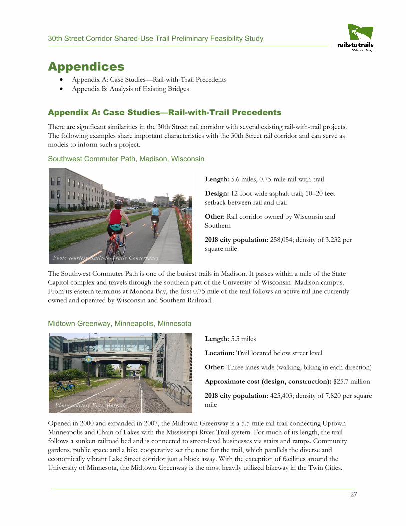
Appendix A: Case Studies—Rail-with-Trail Precedents There are significant similarities in the 30th Street rail corridor with several existing rail-with-trail projects. The following examples share important characteristics with the 30th Street rail corridor and can serve as models to inform such a project.
Southwest Commuter Path, Madison, Wisconsin
The Southwest Commuter Path is one of the busiest trails in Madison. It passes within a mile of the State Capitol complex and travels through the southern part of the University of Wisconsin–Madison campus. From its eastern terminus at Monona Bay, the first 0.75 mile of the trail follows an active rail line currently owned and operated by Wisconsin and Southern Railroad.
Midtown Greenway, Minneapolis, Minnesota
Opened in 2000 and expanded in 2007, the Midtown Greenway is a 5.5-mile rail-trail connecting Uptown Minneapolis and Chain of Lakes with the Mississippi River Trail system. For much of its length, the trail follows a sunken railroad bed and is connected to street-level businesses via stairs and ramps. Community gardens, public space and a bike cooperative set the tone for the trail, which parallels the diverse and economically vibrant Lake Street corridor just a block away. With the exception of facilities around the University of Minnesota, the Midtown Greenway is the most heavily utilized bikeway in the Twin Cities.
Photo courtesy Rails- to-Trai ls Conservancy
Photo courtesy Kate Morgan
Length: 5.6 miles, 0.75-mile rail-with-trail
Design: 12-foot-wide asphalt trail; 10–20 feet setback between rail and trail
Other: Rail corridor owned by Wisconsin and Southern
2018 city population: 258,054; density of 3,232 per square mile
Length: 5.5 miles
Location: Trail located below street level
Other: Three lanes wide (walking, biking in each direction)
Approximate cost (design, construction): $25.7 million
2018 city population: 425,403; density of 7,820 per square mile
27
30th Street Corridor Shared-Use Trail Preliminary Feasibility Study
28
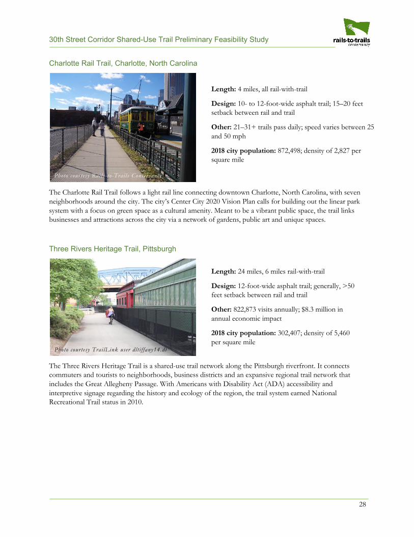
Charlotte Rail Trail, Charlotte, North Carolina
The Charlotte Rail Trail follows a light rail line connecting downtown Charlotte, North Carolina, with seven neighborhoods around the city. The city’s Center City 2020 Vision Plan calls for building out the linear park system with a focus on green space as a cultural amenity. Meant to be a vibrant public space, the trail links businesses and attractions across the city via a network of gardens, public art and unique spaces.
Three Rivers Heritage Trail, Pittsburgh
The Three Rivers Heritage Trail is a shared-use trail network along the Pittsburgh riverfront. It connects commuters and tourists to neighborhoods, business districts and an expansive regional trail network that includes the Great Allegheny Passage. With Americans with Disability Act (ADA) accessibility and interpretive signage regarding the history and ecology of the region, the trail system earned National Recreational Trail status in 2010.
Photo courtesy Trai lLink user dlt i f fany14.dt
Photo courtesy Rails- to-Trai ls Conservancy
Length: 4 miles, all rail-with-trail
Design: 10- to 12-foot-wide asphalt trail; 15–20 feet setback between rail and trail
Other: 21–31+ trails pass daily; speed varies between 25 and 50 mph
2018 city population: 872,498; density of 2,827 per square mile
Length: 24 miles, 6 miles rail-with-trail
Design: 12-foot-wide asphalt trail; generally, >50 feet setback between rail and trail
Other: 822,873 visits annually; $8.3 million in annual economic impact
2018 city population: 302,407; density of 5,460 per square mile
30th Street Corridor Shared-Use Trail Preliminary Feasibility Study
29
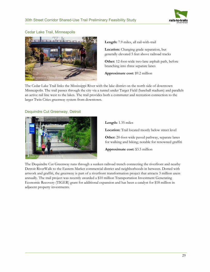
Cedar Lake Trail, Minneapolis
The Cedar Lake Trail links the Mississippi River with the lake district on the north side of downtown Minneapolis. The trail passes through the city via a tunnel under Target Field (baseball stadium) and parallels an active rail line west to the lakes. The trail provides both a commuter and recreation connection to the larger Twin Cities greenway system from downtown.
Dequindre Cut Greenway, Detroit
The Dequindre Cut Greenway runs through a sunken railroad trench connecting the riverfront and nearby Detroit RiverWalk to the Eastern Market commercial district and neighborhoods in between. Dotted with artwork and graffiti, the greenway is part of a riverfront transformation project that attracts 3 million users annually. The trail project was recently awarded a $10 million Transportation Investment Generating Economic Recovery (TIGER) grant for additional expansion and has been a catalyst for $18 million in adjacent property investments.
Photo courtesy Laura Stark
Photo courtesy Three Rivers Park Distric t
Length: 7.9 miles, all rail-with-trail
Location: Changing grade separation, but generally elevated 5 feet above railroad tracks
Other: 12-foot-wide two-lane asphalt path, before branching into three separate lanes
Approximate cost: $9.2 million
2018 city population: 425,403; density of 7,820 per square mile
Length: 1.35 miles
Location: Trail located mostly below street level
Other: 20-foot-wide paved pathway, separate lanes for walking and biking; notable for renowned graffiti
Approximate cost: $3.5 million
2018 city population: 672,662; density of 4,852 persquare mile
30th Street Corridor Shared-Use Trail Preliminary Feasibility Study
30
Appendix B: Analysis of Existing Bridges A series of bridges either carry the local street grid over the 30th Street rail corridor or carry the 30th Street rail corridor over the local grid or other at-grade features.
Local Road Bridges Over Rail Corridor
A total of 11 local road bridges cross over the 30th Street rail corridor. Below is a list of all 11 bridges, north to south, including ownership, clearance width and important notes for future trail development opportunities within the rail corridor. All dimensions are approximate.
• W. North Avenueo Ownership: City of Milwaukeeo Widest point of clearance: 31 feet, 7¾ inches from westernmost support pier to centerline of
single existing railroad track.o Notes: Bridge was reconstructed in 2014, width between support piers was widened from 30
feet, 9¾ inches to 51 feet, 11 inches.• W. Brown Street
o Ownership: City of Milwaukeeo Widest point of clearance: 28 feet, 6 inches from westernmost support pier to centerline of single
existing railroad track.o Notes: Bridge was reconstructed in 2017, width between support piers was widened from 30
feet, 9½ inches to 51 feet, 9½ inches.• W. Lisbon Avenue
o Ownership: City of Milwaukeeo Widest point of clearance: 33 feet from westernmost support pier to centerline of single existing
railroad track.o Notes: Bridge was reconstructed in 2014, width between support piers was widened from 38
feet, 3 inches to 60 feet.• W. Walnut Street
o Ownership: City of Milwaukeeo Widest point of clearance: 27 feet between westernmost support pier to western edge of existing
railroad track.o Notes: Bridge was reconstructed in 1989, width between support piers was widened from 32
feet to 50 feet.• W. Galena Street
o Ownership: City of Milwaukeeo Widest point of clearance: 35 feet between the westernmost and center support piers (anticipated
to accommodate “future light rail track” in the plans from 1998); 25 feet between thecenterline of the existing rail line and the easternmost support pier.
o Notes: Bridge was reconstructed in 1998, and one support pier was removed. The widthbetween the easternmost support piers now stands at 40 feet to accommodate a “futuretrack,” according to the 1998 plans. Similarly, width between the westernmost support pierswas widened to 35 feet to accommodate “future light rail track.”
30th Street Corridor Shared-Use Trail Preliminary Feasibility Study
31
• W. Cherry Street
o Ownership: City of Milwaukee o Widest point of clearance: 36 feet between the westernmost and center support piers (anticipated
to accommodate “future light rail track” in the plans from 1998); 25 feet between the centerline of the existing rail line and the easternmost support pier.
o Notes: Bridge was reconstructed in 1998, width between the easternmost support piers was widened from 36 feet, 9 inches to 40 feet to accommodate a “future track.” Width between the westernmost support piers was widened from 23 feet, 6 inches to 36 feet to accommodate “future track LRT.”
• W. Vliet Street o Ownership: City of Milwaukee o Notes: Bridge was reconstructed in 1985, width between the support piers was widened from
34 feet to 63 feet. • N. 35th Street
o Ownership: City of Milwaukee o Widest point of clearance: 20 feet o Notes: Bridge was reconstructed in 1990, width between support piers was widened from 35
feet to 60 feet. • W. Highland Boulevard
o Ownership: City of Milwaukee o Notes: The city reconstructed this bridge in 2008. Engineering plans show a 14-foot clearance
between a bridge pier and an MSE (mechanically stabilized earth) retaining wall designated for a “future bike path.”
• W. Wisconsin Avenue o Ownership: City of Milwaukee o Notes: The City reconstructed this bridge in 1992. There are several wide locations where a
trail could cross under this bridge. • W. Bluemound Road
o Ownership: City of Milwaukee o Widest point of clearance: 20 feet between the railroad tracks and the westernmost support pier;
76 feet, 3 inches between the remaining piers that do not also carry railroad tracks between them.
o Notes: Bridge was reconstructed in 1983. Eleven support piers were reduced to three.
30th Street Corridor Shared-Use Trail Preliminary Feasibility Study
32
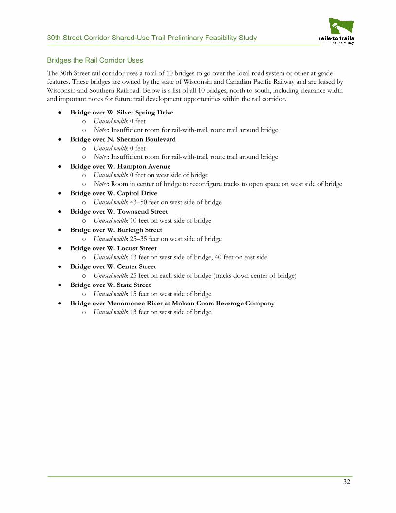
Bridges the Rail Corridor Uses
The 30th Street rail corridor uses a total of 10 bridges to go over the local road system or other at-grade features. These bridges are owned by the state of Wisconsin and Canadian Pacific Railway and are leased by Wisconsin and Southern Railroad. Below is a list of all 10 bridges, north to south, including clearance width and important notes for future trail development opportunities within the rail corridor.
• Bridge over W. Silver Spring Driveo Unused width: 0 feeto Notes: Insufficient room for rail-with-trail, route trail around bridge
• Bridge over N. Sherman Boulevardo Unused width: 0 feeto Notes: Insufficient room for rail-with-trail, route trail around bridge
• Bridge over W. Hampton Avenueo Unused width: 0 feet on west side of bridgeo Notes: Room in center of bridge to reconfigure tracks to open space on west side of bridge
• Bridge over W. Capitol Driveo Unused width: 43–50 feet on west side of bridge
• Bridge over W. Townsend Streeto Unused width: 10 feet on west side of bridge
• Bridge over W. Burleigh Streeto Unused width: 25–35 feet on west side of bridge
• Bridge over W. Locust Streeto Unused width: 13 feet on west side of bridge, 40 feet on east side
• Bridge over W. Center Streeto Unused width: 25 feet on each side of bridge (tracks down center of bridge)
• Bridge over W. State Streeto Unused width: 15 feet on west side of bridge
• Bridge over Menomonee River at Molson Coors Beverage Companyo Unused width: 13 feet on west side of bridge