corridor 35-43 section 368 energy corridor … 35-43 section 368 energy corridor regional reviews...
TRANSCRIPT
Corridor 35-43 Section 368 Energy Corridor Regional Reviews - Region 3 May 2018
1
Corridor 35-43 Windermere Corridor
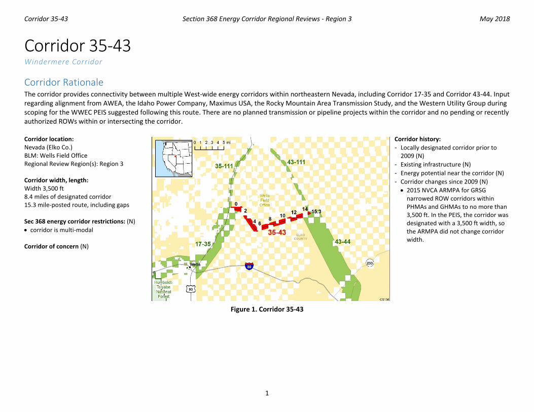
Corridor Rationale The corridor provides connectivity between multiple West-wide energy corridors within northeastern Nevada, including Corridor 17-35 and Corridor 43-44. Input regarding alignment from AWEA, the Idaho Power Company, Maximus USA, the Rocky Mountain Area Transmission Study, and the Western Utility Group during scoping for the WWEC PEIS suggested following this route. There are no planned transmission or pipeline projects within the corridor and no pending or recently authorized ROWs within or intersecting the corridor. Corridor location: Nevada (Elko Co.) BLM: Wells Field Office Regional Review Region(s): Region 3 Corridor width, length: Width 3,500 ft 8.4 miles of designated corridor 15.3 mile-posted route, including gaps Sec 368 energy corridor restrictions: (N) • corridor is multi-modal Corridor of concern (N)
Corridor history: - Locally designated corridor prior to
2009 (N) - Existing infrastructure (N) - Energy potential near the corridor (N) - Corridor changes since 2009 (N) • 2015 NVCA ARMPA for GRSG
narrowed ROW corridors within PHMAs and GHMAs to no more than 3,500 ft. In the PEIS, the corridor was designated with a 3,500 ft width, so the ARMPA did not change corridor width.
Figure 1. Corridor 35-43

Corridor 35-43 Section 368 Energy Corridor Regional Reviews - Region 3 May 2018
2
Keys for Figures 1 and 2
Figure 2. Corridor 35-43 and nearby electric transmission lines and pipelines

Corridor 35-43 Section 368 Energy Corridor Regional Reviews - Region 3 May 2018
3
Conflict Map Analysis
Figure 3. Map of Conflict Areas in Vicinity of Corridor 35-43
Figure 3 reflects a comprehensive resource conflict assessment developed to enable the Agencies and stakeholders to visualize a corridor’s proximity to environmentally sensitive areas and to evaluate options for routes with lower potential conflict. The potential conflict assessment (low, medium, high) shown in the figure is based on criteria found on the WWEC Information Center at www.corridoreis.anl.gov. To meet the intent of the Energy Policy Act and the Settlement Agreement siting principles, corridors may be located in areas where there is potentially high resource conflict; however, where feasible, opportunity for corridor revisions should be identified in areas with potentially lower conflict.
Visit the 368 Mapper for a full view of the Potential conflict map (https://bogi.evs.anl.gov/section368/portal/)

Corridor 35-43 Section 368 Energy Corridor Regional Reviews - Region 3 May 2018
4
Figure 4. Corridor 35-43, Corridor Density Map
Figure 4 shows the density of energy use to assist in evaluating corridor utility. ROWs granted prior to the corridor designation (2009) are shown in grey; ROWs granted after corridor designation are shown in blue; and pending ROWs under current review for approval are shown in turquoise. Note the ROW density shown for the corridor is only a snapshot that does not fully illustrate remaining corridor capacity. Not all ROWs have GIS data at the time this abstract was developed. BLM and USFS agencies are currently improving their ROW GIS databases and anticipate more complete data in the near future.

Corridor 35-43 Section 368 Energy Corridor Regional Reviews - Region 3 May 2018
5
General Stakeholder Feedback on Corridor Utility Stakeholders questioned the utilization of the corridor and suggested a preferred location might be co-located with the existing 1-80 corridor.
Corridor Review Table The table below captures details of the Agencies’ review of the energy corridor. Consideration of the general corridor siting principles of the 2012 Settlement Agreement framed each corridor review, to identify potential improvements to maximize corridor utility and minimize impacts on the environment. Initial Agency analysis is provided to facilitate further discussion during stakeholder workshops.
CORRIDOR 35-43 REVIEW TABLE
ID Agency Agency Jurisdiction
County Primary Issue
Corridor Location (by Milepost [MP]) Source Agency Review and Analysis1, 2
ENVIRONMENTAL RESOURCE ISSUES Specially Designated Areas 35-43 .001
BLM Wells FO Elko, NV California NHT MP 0 GIS Analysis: NHT intersects corridor.
There is an opportunity for the Agencies to consider adding an IOP for NSTs and NHTs to ensure appropriate consideration occurs with proposed development within the energy corridor. (2)
35-43 .002
BLM Wells FO Elko, NV Four Trails Feasibility Study
MP 0 GIS Analysis: study trail intersects corridor.
Ecology 35-43 .003
BLM Wells FO Elko, NV GRSG (BLM and USFS sensitive species) NVCA GRSG PHMA NVCA GRSG GHMA
MP 0 to MP 4 and MP 12 to MP 15 MP 4 to MP 12
RFI: delete/replace the corridor-there is 100% overlap with GRSG PACs. GIS Analysis: GRSG PHMAs intersect corridor. GIS Analysis: GRSG GHMA intersects corridor. Comment on abstract: apply a 4-mi buffer around corridor. This corridor contains 45,523 acres of priority GRSG habitat and 52,694 acres of general GRSG habitat. These categories of habitat are essential for the GRSG life cycle.
There is a potential opportunity to shift the entire corridor approximately 7 mi south to align with the existing road and or existing 138-kV transmission line. This shift would still provide east/west energy connectivity while further reducing potential impacts on GRSG PHMA. (2)

Corridor 35-43 Section 368 Energy Corridor Regional Reviews - Region 3 May 2018
6
CORRIDOR 35-43 REVIEW TABLE
ID Agency Agency Jurisdiction
County Primary Issue
Corridor Location (by Milepost [MP]) Source Agency Review and Analysis1, 2
Comment on abstract: Delete/replace the corridor: 100% overlap with GRSG PACs. Corridor intersects with GRSG PHMAs and PACs.
35-43 .004
BLM Wells FO Elko, NV GRSG leks MP 1 MP 15
Comment on abstract: 2 active leks, and 2 unknown status leks. 1 GRSG lek with a currently unknown activity status. These sites are crucial for breeding season. Unknown status means that more information or data needs to be collected at this time, but this is likely to be a significant area for breeding.
There is a potential opportunity to shift the entire corridor approximately 7 mi south to align with the existing road and or existing 138-kV transmission line. This shift would still provide east/west energy connectivity while further reducing potential impacts to GRSG leks. (2)
35-43 .005
Special status species
Not specified. Comment on abstract: Additional species not identified in the corridor abstract may be present: Clover Valley Speckled Dace, Independence Valley Speckled Dace, Lahontan Cutthroat Trout, and Whitebark Pine. Conduct further analysis to determine the presence of abovementioned species.
This corridor location within the current range where these species may occur is not easily resolved or avoided by corridor-level planning because alternate routes would still require siting through the current range of these species. Further analysis to determine the presence of these species occurring within the area will be considered outside of corridor-level planning. (3)
35-43 .006
BLM Wells FO Elko, NV Pronghorn Antelope MP 6 Comment on abstract: these areas have been identified as crucial winter habitat for Pronghorn Antelope and should be avoided if at all possible.
Ungulate winter habitat is an important consideration but further analysis of this species is not a consideration for corridor-level planning. (3)
Visual Resources 35-43 .007
BLM Wells FO Elko, NV VRM Class II MP 3
GIS Analysis: VRM Class II area and corridor intersect.
There is an opportunity for the Agencies to consider adding an IOP related to Visual Resources to ensure

Corridor 35-43 Section 368 Energy Corridor Regional Reviews - Region 3 May 2018
7
CORRIDOR 35-43 REVIEW TABLE
ID Agency Agency Jurisdiction
County Primary Issue
Corridor Location (by Milepost [MP]) Source Agency Review and Analysis1, 2 appropriate consideration occurs with
proposed development within the energy corridor. (2)
35-43 .008
BLM Wells FO Elko, NV VRM Class IV MP 0 to MP 1, MP 2 to MP 15
GIS Analysis: VRM Class IV areas and corridor intersect.
The existing corridor location best meets the siting principles. (1)
Land Use Concerns Military and Civilian Aviation 35-43 .009
BLM Wells FO Elko, NV Utah Test and Training Range
Entire corridor Comment on corridor: corridor is adjacent to the Utah Test and Training Range Operations. All Restricted Airspace needs to be avoided due to hazardous operations and access to any sites. Height should be no higher than existing structures if outside the Restricted Airspace.
The concern related to MTRs is noted and the adherence to existing IOP regarding coordination with DoD would be required to ensure this potential conflict is considered at the appropriate time. In addition, there is an opportunity to consider a revision to the existing IOP to include height restrictions for corridors in the vicinity of DoD training routes. (2)
1 Projects proposed in the corridor would be reviewed during their ROW application review process and would adhere to Federal laws, regulations, and policy. 2 (1) = confirm existing corridor best meets siting principles; (2) = identify opportunities to improve corridor placement or IOPs; (3) = acknowledge concern not easily resolved or
avoided by corridor-level planning.
Abstract Acronyms and Abbreviations ARMPA = Approved Resource Management Plan Amendment; AWEA: American Wind Energy Association; BLM = Bureau of Land Management; ESA = Endangered Species Act; FO = Field Office; GHMA = General Habitat Management Area; GIS = geographic information system; GRSG = Greater Sage-grouse; IOP = interagency operating procedure; MP = milepost; NHT = National Historic Trail; NST = National Scenic Trail; NVCA = Nevada and Northeastern California; PAC = Priority Area for Conservation; PHMA = Priority Habitat Management Area; PEIS = Programmatic Environmental Impact Statement; RFI = request for information; ROW = right-of-way; USFS = U.S. Forest Service; USFWS = U.S. Fish and Wildlife Service; VRM = Visual Resource Management; WWEC = West-wide Energy Corridor.