2040 community plan
TRANSCRIPT

HUNTERSVILLE2040 COMMUNITY PLAN
LOOKING FORWARDTHINKING BACK
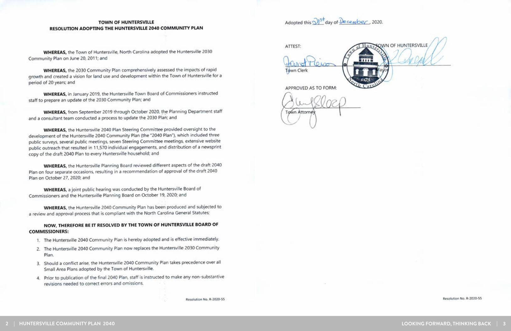
ADOPTED DECEMBER 21, 2020
2 | HUNTERSVILLE COMMUNITY PLAN 2040 LOOKING FORWARD, THINKING BACK | 3

4 | HUNTERSVILLE COMMUNITY PLAN 2040 LOOKING FORWARD, THINKING BACK | 5
ACKNOWLEDGMENTS TABLE OF CONTENTSACKNOWLEDGEMENTS
IMPLEMENTATION ....................................................60-107
APPENDIX ....................................................................108
56
INPUT & VISION .................................................... 36-493FUTURE LAND USE ...................................................50-594
EXISTING CONDITIONS .......................................... 16-352INTRODUCTION ........................................................ 6-151
Town ManagerAnthony Roberts
Assistant Town ManagerJackie HuffmanBobby Williams
Town BoardJohn Aneralla, MayorMelinda Bales, Mayor Pro-TemDan BooneBrian HinesLance MungerStacy PhillipsNick Walsh
Planning BoardStephen Swanick, ChairmanJennifer Davis, Vice-ChairmanGreg BaberChristopher Boyd Scott Hensley Frank Gammon Catherine GraffyDerek Partee
Department HeadsStephen Trott, PE, EngineeringKevin Fox, PE, Public WorksMichael Jaycocks, CPRP, Parks & RecreationBence Hoyle, Chief of PoliceJim Dotoli, Fire ChiefPattie Ellis, Finance Director
Planning Department Staff
Jack Simoneau, AICP, Planning DirectorBrian Richards, Assistant Plan-ning Director Dave Hill, Project ManagerTracy Barron, Executive Assis-tantDavid Peete, Principal PlannerBrad Priest, Principal PlannerSierra Saumenig, Senior PlannerLauren Speight, PlannerKimberly Behrenbrinker, Plan-ning TechnicianAu’Darius Blackwood, Develop-ment Code Officer
Claudia Schruhl, Code Enforce-ment TechnicianFrancis Tucker, GIS Coordinator
Steering CommitteeJohn Carbonell, Chair Kim AicheleTim BenderRoss BonerRandy BrawleyChris EdwardsJohn ForehandErin GillespieScott HarringtonJoshua HelmKristen IngramDan MurphyEric RowellKaitlyn SissonGeorge Solomon
Special ThanksAshley Ownbey, UNC DCRP Master’s Candidate
Jeff Sny
LOOKING FORWARD, THINKING BACK | 7
The 2040 Community Plan will function as the Town of Huntersville’s comprehensive plan. This plan provides policy guidance for land use, transportation, housing, open space preservation, and other aspects of residents’ quality of life. It builds on, updates, and replaces the 2030 Community Plan as the town comprehensive planning document.
Although this plan will replace the 2030 Community Plan in practice, in reality it is an update of that plan which will more accurately prepare Huntersville for the issues it’s facing. With this reverence for the past and anticipation for the future, the reader will see through-out this document, a strategy that is looking forward, and thinking back.
11 INTRODUCTION

INTRODUCTION
8 | HUNTERSVILLE COMMUNITY PLAN 2040 LOOKING FORWARD, THINKING BACK | 9
THERE HAS BEEN A 31% INCREASE IN POPULATION SINCE 2010 AND THE TOWN HAS GROWN BY OVER 36,000 PEOPLE SINCE 2000.Source: US Census (1980-2010), NC Office of State Budget Management (2018)
BackgroundThe Huntersville Community Plan has undergone regular updates approximately every six to nine years. Since 2010, Huntersville’s municipal population has grown by 31% (14,447 people), up from a population of 46,773 to 61,220. It is no secret that Huntersville is an increasingly popular place to live and that growth and its associated issues continue to be at the forefront of challenges that confront the Town today.
This document builds on a history of town plans that have shaped the direction and form of growth. It will serve as the Town’s comprehensive plan and replace the 2030 Community Plan adopted in 2011.
Population GrowthProject Schedule
PurposeThe 2040 Community Plan is meant to establish a framework for growth and development while maintaining the character and the livability of the town that Huntersville residents hold so dear. The Plan is a policy document that will guide zoning and development decisions. It will also affect future updates to the zoning and subdivision ordinances and development design, infrastructure investments, and staff work plans. State law now requires that a comprehensive plan is necessary for a town to retain authority to enforce zoning and development regulations and must be reasonably maintained over time.
ProcessIn September of 2019 the Town of Huntersville undertook a year-long update of its existing Community Plan to review and refine the vision for the community. The process took the form of a community conversation, with project staff soliciting public input frequently to evaluate what residents would like to see, protect, and grow in Huntersville. Feedback from stakeholders, members of the public, the Steering Committee, and Town leadership was essential to creating this plan. A full description of the public involvement process is available on page 38 of this document.
BACKGROUND, PURPOSE & PROCESS

10 | HUNTERSVILLE COMMUNITY PLAN 2040 LOOKING FORWARD, THINKING BACK | 11
INTRODUCTION
Town of HuntersvilleThe Town of Huntersville is located just 14 miles north of Uptown Charlotte. The Town was incorporated in 1873 and has grown from a railroad stop and mill town to be the 16th largest municipality (by most recent population rankings) in North Carolina (Source: NC Office of State Budget and Management, 2018). Today, Huntersville has a population of over 61,000 people and a planning jurisdiction or Sphere of Influence (SOI) that covers 63 square miles.
The Town has grown significantly in the past two decades and has added 28,000 residents between 2000 and 2017 (a growth of 113.5%). Despite this rapid pace of growth, residents enjoy a high quality of life. During the planning process for the 2040 Community Plan, 88% of respondents to the first survey indicated that Huntersville was a good or excellent place to live. Proximity to Charlotte, shopping, parks, and a low crime rate are cited as contributors to the Town’s attractiveness.
Planning Area and RegionHuntersville is located in the northern part of Mecklenburg County. Its planning jurisdiction or “Sphere of Influence” (SOI) stretches from Lincoln County in the west to Cabarrus County in the east. This SOI is the area in which the Town exerts land use regulations, like zoning and subdivision regulations. The town is divided roughly in half by I-77 and is proximal to I-485. Other major highways include US 21, NC 73, and NC 115. The Town’s southern border is adjacent to north Charlotte. Charlotte is the nation’s 15th largest city and grew by 154,000 people between 2010 and 2019 (US Census, 2019).
The Huntersville Sphere of Influence, or SOI, is the area over which the Town
exerts land use regulations, like zoning and subdivision
regulations.
THE MAP ABOVE SHOWS THE STUDY AREA FOR THE 2040 COMMUNITY PLAN, WHICH IS ALSO THE SPHERE OF INFLUENCE FOR THE TOWN OF HUNTERSVILLE
STUDY AREA OVERVIEW
Historical Aerial Imagery
Study Area Map
Exit 25 – 2015 Aerial
Exit 25 – 1993 Aerial (Exit opened in 1994)
Exit 25 2015
Exit 25 1993
THE TWO AERIAL IMAGES ABOVE SHOW I-77 AT NC 73 IN 1993 AND 2015. NOTE THE CHANGE IN DEVELOPMENT WHICH INCLUDES NORTHCROSS SHOPPING CENTER, BIRKDALE VILLAGE AND A NUMBER OF NEW NEIGHBORHOODS.
Huntersville is one of three municipalities in northern Mecklenburg County. The towns of Cornelius and Davidson are located north of Huntersville and have bordering planning jurisdiction boundaries.
Major geographic features that have influenced the development of Huntersville include the railroad that connects the town to Cornelius and Charlotte, Lake Norman, the Catawba River, and Mountain Island Lake. Lake Norman is the largest man-made body of fresh water in North Carolina and was created in 1963. Residential growth surrounding the lake has intensified in the last 30 years and has had a major impact on the region. McDowell Creek drains the west side of Town, eventually flowing into Mountain Island Lake.
Mountain Island Lake is a major water source for the region and provides drinking water to over half a million people. The east side of Town drains to Clark Creek and eventually the Rocky River. Gar Creek drains the southwestern part of the town and empties into Mountain Island Lake as well. The Gar Creek watershed has excellent water quality and is somewhat protected from development due to watershed protection regulations and conserved land.

12 | HUNTERSVILLE COMMUNITY PLAN 2040 LOOKING FORWARD, THINKING BACK | 13
1995 Community Plan Highlights• Allow a mixture of land uses and residential
building types following traditional town plan-ning principles.
• Establish a transportation network that pro-motes street connectivity, alternative designs for new thoroughfares, and planning for future passenger rail to the area.
• Buildings in the commercial corridors to front public streets, accommodate pedestrians, and have parking in the side and rear yards.
• Enhancement of Downtown Huntersville.• Promote the preservation of rural areas.
INTRODUCTION
Since 1995, the Town has adopted plans and enforced ordinances that focus on traditional town planning principles. Great effort has been placed into crafting policies and ordinances that create well-designed places and unique neighborhoods and avoid suburban sprawl patterns that are typical in other growing areas in the Charlotte Region and throughout the southeastern United States. This Plan continues the tradition of proactively managing growth and responds to emerging issues and trends.
1995 Community PlanThe 1995 Community Plan called for focusing development between I-77 and NC 115 and better design throughout the town. Subsequently, in 1996 the Town implemented a form-based code to ensure better design outcomes for development. This form-based code, which is a type of code that prioritizes the physical aspects of a building over the use, is foundational to the development patterns in the town.
2003 Community PlanThis plan primarily addressed growth management and conservation, goals the Town still prioritizes today. It recommended lower-intensity development in rural and transitional areas in the east and west to promote water quality and tree preservation. Following the plan’s adoption, rural and transitional zones reduced allowed density and increased open space preservation incentives in new subdivisions.
2030 Community Plan The 2030 Community Plan does not have a specific future land use plan map but includes a “framework map” that delineates development intensity zones. The plan underscores the community’s intent to “reinforce the historical pattern in place since 1996.” Per the 2030 Plan, “the land use pattern in the Town of Huntersville has been based upon a policy which focuses higher intensity development generally within two THE GROWTH FRAMEWORK MAP FROM THE 2030 COMMUNITY PLAN
2003Huntersv i l le Community
Plan
1995Huntersv i l le Community
Plan
2011 Huntersv i l le
2030 Community
Plan
1989Orig ina l Town
Community Plan
Huntersville Planning Timeline
miles of the I-77/NC-115 corridor, with lower intensity development east and west of this corridor.”
This resulted in higher and lower intensity areas, with three different types of activity nodes around the Town. The 2030 Plan’s recommendations addressed housing, environment, transportation, economic and commercial development, downtown, and public facilities.
Small Area PlansSince 1996 the Town has worked with citizens to create several Small Area Plans (SAPs) to guide growth and development for particular geographic areas within Huntersville, because SAPs focus on a small portion of the town planning area than the Community Plan and contain more site-specific recommendations.
PREVIOUS PLANS
Community Plan Update

INTRODUCTION
14 | HUNTERSVILLE COMMUNITY PLAN 2040 LOOKING FORWARD, THINKING BACK | 15
PLAN ORGANIZATION
1 INTRODUCTIONThis chapter provides an introduction to the plan and includes a description of the plan’s purpose, background information, and an overview of the planning process and previous Town planning.
2 EXISTING CONDITIONSThis chapter provides data on demographic trends, economic trends, land use conditions, transportation issues, and natural resources that will inform this plan.
3
4 FUTURE LAND USEThe new Future Land Use map and character areas are described in detail.
5 IMPLEMENTATIONThis chapter details policies and strategies that Huntersville can use to achieve the vision and goals for 2040.
INPUT & VISION
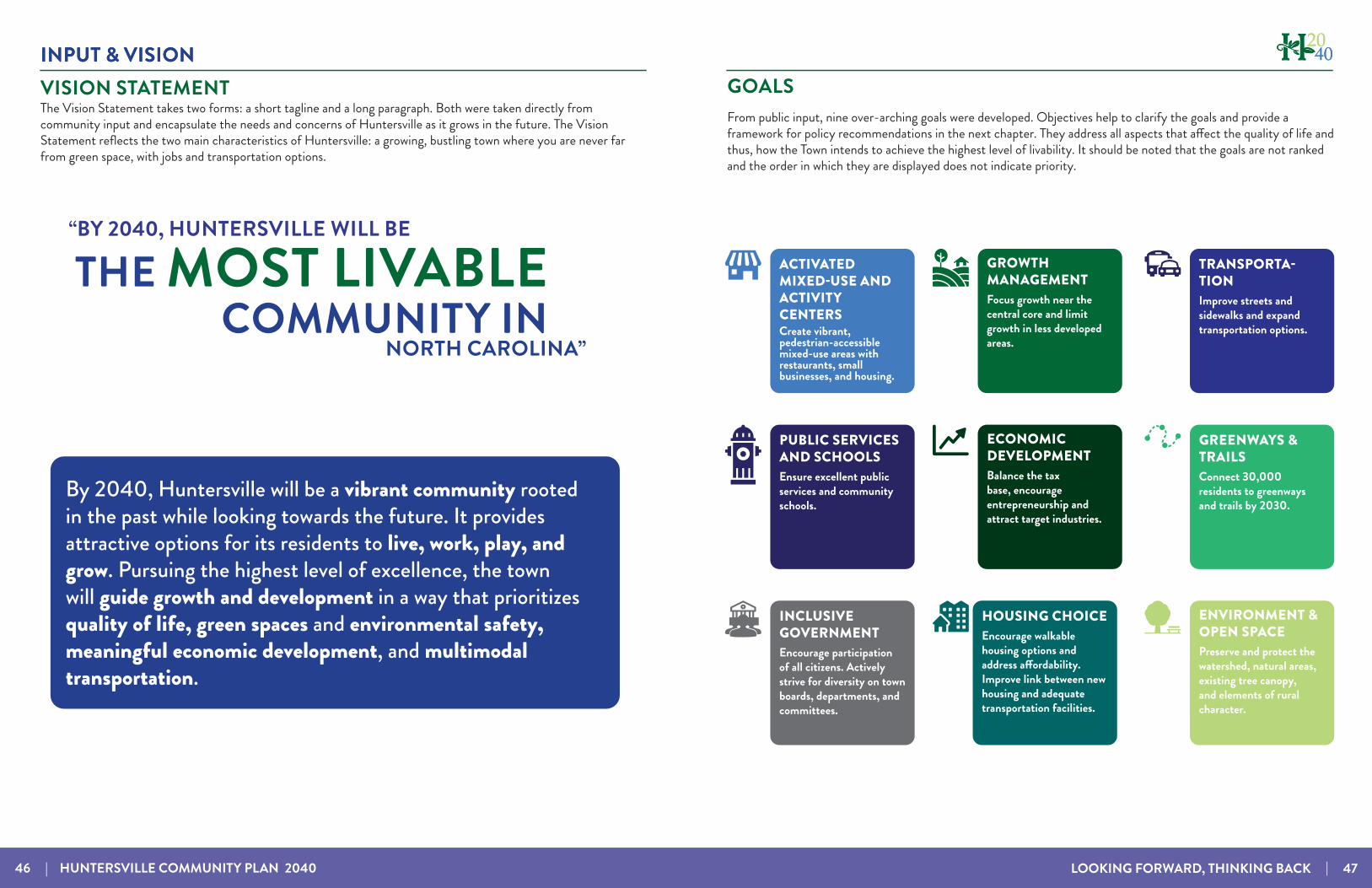
The community engagement process is described in detail, and the chapter demonstrates how public feedback directly influenced the Vision and Goals for the plan.
The Huntersville 2040 plan is divided into 5 chapters. The chapters tell the story of the current character of Huntersville, the public feedback that town staff and consultants received, the intended development pattern and character of development in the future, and recommendations for how to achieve that vision.
This page intentionally left blank

22
This chapter provides an analysis of the current conditions in Huntersville for late 2019 and early 2020. Demographic data, including population estimates, housing information, economic data, and land use data, provide an objective understanding of the trends and issues in Huntersville at this time. Analysis of the data has informed the policy and land use recommendations along with community feedback.
EXISTING CONDITIONS
Additional data can be found in the Community Profile that is part of the digital appendix to this document at www.huntersville2040.com/plan-documents.
LOOKING FORWARD, THINKING BACK | 17
EXISTING CONDITIONS
18 | HUNTERSVILLE COMMUNITY PLAN 2040 LOOKING FORWARD, THINKING BACK | 19
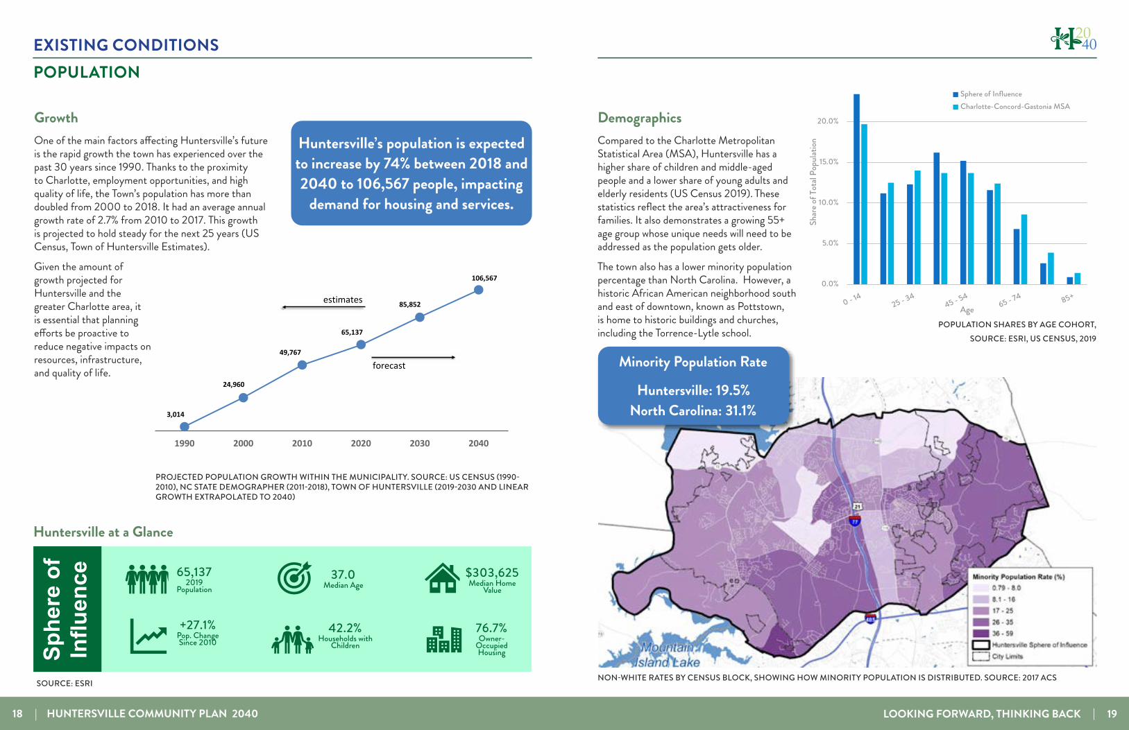
POPULATION
Growth One of the main factors affecting Huntersville’s future is the rapid growth the town has experienced over the past 30 years since 1990. Thanks to the proximity to Charlotte, employment opportunities, and high quality of life, the Town’s population has more than doubled from 2000 to 2018. It had an average annual growth rate of 2.7% from 2010 to 2017. This growth is projected to hold steady for the next 25 years (US Census, Town of Huntersville Estimates).
Given the amount of growth projected for Huntersville and the greater Charlotte area, it is essential that planning efforts be proactive to reduce negative impacts on resources, infrastructure, and quality of life.
DemographicsAt a glance…
65,1372019
Population
+27.1%Pop. Change Since 2010
76.7%Owner-
Occupied Housing
$303,625Median Home
Value37.0
Median Age
42.2%Households with
ChildrenSphe
re o
f In
fluen
ce
2,616,2432019 Population
18.0%Pop. Change Since 2010
37.7Median Age
Cha
rlotte
M
SA
67.9%Owner-
Occupied Housing
$216,143Median Home
Value
36.2%Households with
Children
3,014
24,960
49,767
65,137
85,852
106,567
1990 2000 2010 2020 2030 2040
Huntersville Population
estimates
forecast
2030 forecast by Town of Huntersville. 2040 forecast extrapolated from 2030 forecast.PROJECTED POPULATION GROWTH WITHIN THE MUNICIPALITY. SOURCE: US CENSUS (1990-2010), NC STATE DEMOGRAPHER (2011-2018), TOWN OF HUNTERSVILLE (2019-2030 AND LINEAR GROWTH EXTRAPOLATED TO 2040)
SOURCE: ESRI
Huntersville at a Glance
Huntersville’s population is expected to increase by 74% between 2018 and 2040 to 106,567 people, impacting
demand for housing and services.
NON-WHITE RATES BY CENSUS BLOCK, SHOWING HOW MINORITY POPULATION IS DISTRIBUTED. SOURCE: 2017 ACS
Minority Population Rate
Huntersville: 19.5%North Carolina: 31.1%
POPULATION SHARES BY AGE COHORT, SOURCE: ESRI, US CENSUS, 2019
Age CharacteristicsChildren less than 14 years old
represented the largest age cohort in the Sphere of Influence in 2019 at 23.4% of the total population. This age group experienced notable growth since 2010, adding nearly 2,400 additional children.When compared to the larger Charlotte MSA, the Sphere of Influence has higher shares of children under 14 and adults aged 35 to 54, but comparatively lower shares of Millennials and residents age 55+. These shares reflect the Sphere of Influence’s attractiveness for families. Trends indicate the 55+ age group is growing.
Comparison of Population Shares by Age Cohort, 2019
0.0%
5.0%
10.0%
15.0%
20.0%
25.0%
Shar
e of T
otal
Popu
lation
Age
Sphere of InfluenceCharlotte-Concord-Gastonia MSA
Source: ESRI BAO; US Census; Kimley-Horn
36
Demographics Compared to the Charlotte Metropolitan Statistical Area (MSA), Huntersville has a higher share of children and middle-aged people and a lower share of young adults and elderly residents (US Census 2019). These statistics reflect the area’s attractiveness for families. It also demonstrates a growing 55+ age group whose unique needs will need to be addressed as the population gets older.
The town also has a lower minority population percentage than North Carolina. However, a historic African American neighborhood south and east of downtown, known as Pottstown, is home to historic buildings and churches, including the Torrence-Lytle school.

EXISTING CONDITIONS
20 | HUNTERSVILLE COMMUNITY PLAN 2040 LOOKING FORWARD, THINKING BACK | 21
Huntersville has a vibrant housing market with recent new construction reaching pre-2008 recession levels. 4,285 new homes have been constructed between 2010 and 2017 in the Study Area. The housing market has been dominated by single-family residential homes (78% of total), most often in new subdivisions. There are however, 2,073 multi-family homes in approved developments that have yet to be built.
HOUSING
Residential Profile (For-Sale)
• 78% of the 24,000 total units in are single-family detached
• 1,500 for-sale residential closings in 2019
• Closings in the Sphere of Influence have increased steadily since 2009, peaking at 1,678 units in 2017 0
200
400
600
800
1,000
1,200
1,400
1,600
1,800
2009 2010 2011 2012 2013 2014 2015 2016 2017 2018 2019
Clos
ed S
ales t
hrou
gh M
LS
Townhouse & Condominium
Single-Family Detached
For-Sale Residential Closing Trends, Sphere of Influence, 2009-2019
Source: Canopy MLS, Inc.; Kimley-HornFOR-SALE RESIDENTIAL CLOSING TRENDS 2019 MLS (DATA FOR TOWN LIMITS)
Median home prices have been rising steadily since the recession of 2008. While this is good news for homeowners, it can make housing unattainable for others. Currently, median rents and monthly mortgages exceed 30% of income for households making less than $50,000 per year, which includes vital roles such as police officers, teachers, nurses, firefighters, public servants, etc. (Source: Huntersville Police Dept.) Using 30% of take-home pay as a benchmark for affordable rent, a person would have to be making a salary of $73,487 per year to afford a home in Huntersville at the median home value.
Unique NeighborhoodsHuntersville has several unique developments and neighborhoods that have become sought-after destinations and models for the Charlotte region. Birkdale Village was among the first New Urbanist mixed-use projects in the region. Vermillion and other Traditional Neighborhood Developments (TNDs) are markedly different from many conventional subdivisions elsewhere in Mecklenburg County. They include a mix of housing types, tree-lined streets, sidewalks framed with front porches, and integrated green spaces.
NEIGHBORHOOD TYPES: TOWN-SCALE SUBDIVISIONS, TRADITIONAL NEIGHBORHOODS, CONSERVATION DESIGN
AND MIXED-USE DEVELOPMENTSTown-Scale SubdivisionsTown-scale Subdivisions are the predominant type built in Huntersville before 1995. These developments have larger lots and a minimal amount of shared open space. If small versions of these subdivisions are designed appropriately they can fit reasonably well in suburban areas. However, when applied across a large area, this type of land use pattern can consume a large amount of farmland and forest very quickly. These subdivisions are allowed in parts of Huntersville with rules regarding connectivity, parks, and open space.
Traditional NeighborhoodsTraditional Neighborhood Developments (TNDs) are built to mimic pre-WWII suburbs and have street trees, sidewalks, on-street parking, alley-loaded homes, front porches, shared green spaces, and other amenities. They typically provide a mix of two or more housing products and offer an alternative to low-density, sprawling conventional subdivisions. They feature connected streets and smaller block sizes that calm traffic, furthering the neighborhood feel.
Conservation DesignConservation Subdivisions are a design strategy that places development on the most suitable areas while conserving large portions of properties (typically 40%+) as common open space. This design strategy preserves property rights, allows flexibility in design, encourages preserving unique natural features as amenities.
Mixed-Use DevelopmentsMixed-use developments, such as Birkdale Village and Rosedale in Huntersville, provide a mix of uses, including retail, restaurants, offices, and residential options. Shopfronts face public streets with on-street parking and street trees and may have offices or residential units on the second or third floor.
IMAGES SOURCES: GOOGLE STREETVIEW, CHATHAM COUNTY, STEWARTMEDIAN HOME VALUE 2018. SOURCE: 2018 ACS
EXISTING CONDITIONS
22 | HUNTERSVILLE COMMUNITY PLAN 2040 LOOKING FORWARD, THINKING BACK | 23
Income Huntersville has a relatively high median household income (MHI) compared to the surrounding area and to the state. Median household income was $97,320 as of 2018, with a per capita average of $42,820. An estimated 50% of households earn more than $100,000. For reference, North Carolina’s median household income was $52,413 in the same period.
Employment As the town has grown in the past 20 years, so has its employment base, which has become a popular reason for relocating to Huntersville. Huntersville’s job base has grown 45% from 2012 to 2017 alone, thanks to the Fortune 500 companies regional presence and the expansion of The Park - Huntersville, which offers more than 750,000 square feet of office and workspace. Residents also benefit from employment in Charlotte and Mooresville. According to census data (2017) 23.1% of Huntersville residents work in Charlotte, indicating that future plans need to address North-South travel for those who work outside of Huntersville.
ECONOMY
Retail CentersThe graphic to the right shows the concentration of retail centers along I-77, which is consistent with previous planning and the 2030 Community Plan’s Growth Framework map. Huntersville is home to several large commercial centers with diverse tenants that offer a range of services and cater to many different market sectors. These commercial centers service residents of Huntersville and the surrounding region on a weekly to monthly basis. As seen on the map, a concentration of retail centers in the Northern part of Huntersville is complemented by an expanding Bryton and Northlake Mall (Charlotte) to serve the Southern end of Huntersville and residents from Charlotte.
There are also other small commercial areas in the Eastern and Western sides of Huntersville ,which serve daily needs for nearby residents and residents of other areas along I-485, such as grocery shopping and gas. This map does not account for all commercial activity in the town but gives insight into the amount and spatial character of retail offerings.
JOBS BY SECTOR. SOURCE: ESRI BAO
Top three employment sectors:
1. Trade, transportation, utilities
2. Education and healthcare
3. Leisure and hospitality
MEDIAN HOUSEHOLD INCOME 2018. SOURCE: 2018 ACS
$$9977,,332200
$$110044,,664477
$$6644,,331122
$$6600,,882222
$$5522,,441133
$$6600,,229933
Huntersville
Huntersville, Cornelius, Davidson
Mecklenburg County
Charlotte-Concord-Gastonia MSA
North Carolina
United States
Median Household Income 2018
34
1200
690
650
650
400
315
300
300
280
200
0 200 400 600 800 1000 1200 1400
McGuire Nuclear Station
Novant Health
Metrolina Greenhouses
Joe Gibbs Racing
Rubbermaid
Reynolds Corporation
GM Financial
Walmart
Forbo Siegling
SAERTEX USA
Top Employers
TOP EMPLOYERS. SOURCE: LAKE NORMAN ECONOMIC DEVELOPMENT (2020)
[ 0 1 20.5Miles
1 in equals 1.3 miles
SOI BOUNDARY
BIRKDALE VILLAGELifestye Center165,000 sf retail
ROSEDALELarge Neighborhood Center119,000 sf retail
HUNTERSVILLE SQUARENeighborhood Center92,000 sf retail
NORTHCROSS COMMONSNeighborhood Center60,000 sf retail
NORTHCROSSPower Center560,000 sf retail
SHOPS ON STATESVILLEStrip/Convenience
BRYTON Power Centerup to 1,000,000 sf retail when completed
NORTHLAKE MALLRegional Mall1,071,000 sf retail
RETAIL CENTERS ALONG I-77, USING ICSC CLASSIFICATIONS

EXISTING CONDITIONS
24 | HUNTERSVILLE COMMUNITY PLAN 2040 LOOKING FORWARD, THINKING BACK | 25
Existing Land Use Map
LAND USE
Existing Land UseThe Community Plan update compiled an inventory of existing land uses based on data from the Mecklenburg County Assessor’s Office. Major findings included:
• Industrial and commercial uses are currently concentrated around I-77 and Old Statesville Road
• Significant amount of conserved land and rural, agricultural lands are in the west and east
• 6,000 acres in the study area are in conservation or parks
EXISTING CONDITIONS
• Single-family housing is the largest percentage of physical land use at 29%, but represents of 52% of property value in Huntersville
• Commercial, industrial, and office make up 10% of the land area and 17% of property value
The graphs to the right show land use by area and property value. As more land is developed, it will be important for the Town to balance new residential growth with commercial, office, and industrial growth. Non-residential growth can help balance the tax base and typically costs less in service provision than low or moderate value residential properties.
UV73
UV16
UV73
UV115
UV1609
UV73
UV2145
£¤21
§̈¦85
§̈¦77
Alexan drianaHistor ic Si te
Auten N aturePreserve
BlytheLandingPark
Rock y RiverBluf f N aturePreserve
Richard Barr yMemor ia l Park
R.C .Bradford
Park
Eas tf ie ldPark
Cook Park
Cow ans FordWild l i feRefuge
Caro l inaRaptorCenter Clarks Creek
NaturePreserve
David B . Wayme rAeromode ller ParkDavid B .
Waym er Park
Gar C reekNaturePreserve
Haym ark etNaturePreserve
Jet ton Park
Latta P lantationNature P reserve
Latta P laceHistor ic Si te
ClarksCreek Park
McD owel lCreek Park
LattaPlantat ionEques tr ian Ce nter
Char lesand IdaGraham Park
Mal lardCreek Park
Mal lard C re ekCenter
Nor thMecklenburg
Park
OehlerNaturePreserve
Wes tm ore landPark
Hor t ic u l tura lMaintenance
Fac i li t y
Ram seyCreek Park
Rura l Hi l lNaturePreserve
Shuf f le tow nPra i rie N aturePreserve
StephensRoad N aturePreserve
Tra dit ionGol f C ourse
White Park
Wes t B ran chNaturePreserve
Huntersvi l leAth le t ic Pa rk
Nor thMecklenburgCenter
Rozz el le s Fer r yNature P reserve
Pos sum WalkNaturePreserve
McI lwainePark
Clarks CreekGreenway Park
StephensRoad N ature
Preserve
Latta P lantationNatureCenter
Bai ley R dRobbins Park
Oak H i llsPark
Nor th M eckSeniorCenter
E Rocky River Rd
Brookshire Bv
N I-77 Hy
Old
St a tesvi ll e
Rd
BeattiesFord
Rd
Browne Rd
SI-77
Hy
WS
ugar
Cree
kRd
Mt Holly-Hun
tersvi
lleRd
Overlook Mountain Dr
Devonsh
ireDr
Huntersville-Concord Rd
Prosperity ChurchRd
Mt Isle Harbor Dr
Sam Furr Rd
Gilead Rd
West Catawba Av
Cashion Rd
DavisLa ke
Py
Ridge Rd
W Mallard Creek Church Rd
N C 73 Hy
Lakeview Rd
Davidson-ConcordRd
N I-8
5 H
y
Neck Rd
David Cox Rd
S I-8
5 Hy
Mallard Creek Rd
Bailey Rd
Stumptown Rd
Ream
esR
d
Statesville Rd
She arer Rd
Washa
m Pott
s Rd
May es Rd
Mcilwaine Rd
Mcc
oy R
d
River Ford
Dr
Eastfield Rd
Breezewood
Dr
Highland Creek Py
Hambright Rd
Hart Rd
W W T Harris Bv
Ramah Church Rd
Wynfie ld
Creek
Py
Jetton Rd
Nor
thc r
oss Dr
WI-4
85Oute
r Hy
E I-485 Inner Hy I-485 Ra
Sam
pleRd
McCord Rd
Hucks Rd
Asb
ury
Cha
pelR
d
Kerns Rd
Miranda Rd
Charlotte
Concord
CorneliusDavidson
Kannapolis
Mount Holly
LegendLand Use
Conservation, Parks AgricultureRural Homesite Single Family Manufactured/Mobile HomeMulti-Family CommercialOfficeGovernment/Institution IndustrialUtilityVacant/Unknown; None
LakeNorman
MountainIsland Lake
[ 0 0.5 10.25Miles
1 in = 1 miles
SOURCE: MECKLENBURG COUNTY, 2019
Existing Land Use by Area and Value
SOURCE: MECKLENBURG COUNTY, 2019
Manufactured/Mobile Home
Manufactured/Mobile Home

EXISTING CONDITIONS
26 | HUNTERSVILLE COMMUNITY PLAN 2040 LOOKING FORWARD, THINKING BACK | 27
EXISTING CONDITIONS
Land Supply A land supply analysis was conducted to quantify how much land is available for future development and the extent of areas that have been approved for development. Available/underutilized land and approved development were compared by location in High- and Low-Intensity areas in the 2030 Community Plan. Thirty-seven percent (37%) of Available and Underutilized lands and 10,000 housing units in approved subdivisions (66% of total) since 2000 are located in the High-Intensity Area defined in the 2030 Community Plan. Sixty-three percent (63%) of Available and Underutilized lands and 5,200 housing units in approved subdivisions (34% of total) since 2000 are located in the Low-Intensity Area.
HUNTERSVILLE COMMUNITY PLAN 2040 | 26
This analysis shows the town has been successful in steering more growth to the High-Intensity area, but it also shows that remaining land in the Town’s core is dwindling. This means that policies that encourage infill and redevelopment and seek to minimize negative impacts will be increasingly important.
INFRASTRUCTURE AND PUBLIC SERVICESThe Town of Huntersville provides police, parks and recreation programming, public works, and other municipal public facilities and services to residents and property owners in the town limits and Sphere of Influence (SOI). These public facilities and services are funded through local tax revenue and other public and private revenues. Other services like water, fire, sewer, electric, and school are provided through public and private entities and partnerships.
Police and FireThe Huntersville Police Department is currently headquartered on the west side of The Park - Huntersville. This facility, operational since 2012, is 27,000 square feet and replaced an 8,000-square-foot building located on Gilead Road in Downtown. There is another satellite police office in the Fire Station located off Eastfield Road. The department currently has 102 sworn officers and 10 civilian employees. Major concerns voiced by the police department include:
• Call volume at big box stores• Traffic and lack of connectivity of roadways, which can hinder response times
• Keeping up with growing population (Staffing is currently at 1.54 per 1,000 residents, which is below the national average of 2.5)
The Huntersville Fire Department is a non-profit entity served by a combination of paid part-time and volunteer firefighters. There are typically 20 daytime employees and 15 nighttime employees. A total of 110 people are employed to meet demand, which is increasing. Call volume has expanded from 2,000 to 6,700 calls per year over the last 10 years. The fire district has the second-highest call volume in the region and the lowest Fire Service District tax rate. Currently there are 4 fire stations. A new fire station is planned in the northeast part of the planning area near Hiwassee Road. Major service generators are high-density medical buildings rehab facilities, retirement centers, high-density apartments, and other uses with a high frequency of medical emergencies.
Service Provider
Parks Town/county partnership
Schools
Charlotte-Mecklenburg Schools,
Charter and Private Schools
Fire & Rescue Town/volunteer combo
Police Town
Electric Electricities, Duke, Energy United
Water/Sewer City of Charlotte
PUBLIC SERVICES AND PROVIDERS
Utilities Charlotte Water provides water and wastewater services for the Town of Huntersville. The Town Board contracts with Electricities to operate the municipal power system. Three utility companies supply electric service to specific areas of town.
SchoolsConsidering the rapid population growth experienced in Huntersville, coupled with the significant population percentage of children, it comes as no surprise that school enrollment in Huntersville is high. Huntersville has the highest proportion of school-aged youth and the highest projected increase in the school-aged population in all municipalities in Mecklenburg County. Predictions estimate over 8,000 new students by 2035, which is the highest projected increase by population share in Mecklenburg County.
Land Supply Map
Land Supply
Source: developed from 2017 property appraiser tax data21
21%
9%
22%
48%
Available
PendingDevelopments
Underutilized
Utilized
Land Supply
Source: developed from 2017 property appraiser tax data21
21%
9%
22%
48%
Available
PendingDevelopments
Underutilized
Utilized
LAND SUPPLY SUMMARY
Note: this information was collected in 2019.

EXISTING CONDITIONS
28 | HUNTERSVILLE COMMUNITY PLAN 2040 LOOKING FORWARD, THINKING BACK | 29
Road NetworkThe Town of Huntersville’s transportation system plays a significant role in achieving its stated vision to be a livable Town. The increased growth in recent years has stressed the Town’s existing road network and created some congestion. The Town has responded by playing a larger role in solving transportation issues with proactive planning, multimodal design solutions, and funding town-led improvements. The Town continues to emphasize connectivity that disperses local traffic over a broad network of smaller streets designed based on the surrounding land use context rather than relying on a few major roadways. However, the handful of arterial roads in the area, including I-77, continue to handle significant loads of commuters and local and through-traffic.
As part of the Huntersville 2040 Community Plan development process, the Town cataloged funded and planned projects from local, regional, and state plans. In total, 818 projects were identified. Given the overlap in studies, some roads in the study area had multiple projects. For example, a corridor may be funded in the State Transportation Improvement Plan (STIP) as a widening project while also appearing in the Comprehensive Transportation Plan (CTP) as needing pedestrian improvements.
Numerous transportation projects were originally scheduled to be completed over the next decade. However, recent NCDOT funding shortfalls will likely cause delays to these and other projects. The map and table on the following pages show roadway improvements in Huntersville that are funded and included in Huntersville’s updated Capital Improvement Plan (CIP) or the STIP. These roadway projects will provide notable travel benefits in Huntersville. However, the construction period likely will create challenges. Project design also needs to be modified to incorporate better bicycle and pedestrian accommodations where possible.
TRANSPORTATION
Funded Transportation Projects Map
WHOSE STREETS ARE THESE?
Not all roads in Huntersville are owned by the Town. The Town (or neighborhood associations) owns most of the roads within neighborhoods, but the state (NCDOT) owns many of the major roads you drive on every day. The Powell Bill Map shows who owns the roads in Huntersville. Powell Bill funds are distributed to cities and towns to help the Town fund maintenance, repairs, construction, and other improvements. But, these funds are limited. As a result, we depend on other state funding sources to improve major roads such as NC 73 and US 21 (Statesville Road).
TRAFFIC ON I-77. SOURCE: CHARLOTTE OBSERVER
Bradfo rd Park Dr
Coley
Dr
Bro okstoneDr
Torren ce Creek Gree nwayN
Colon
ialG
arden
Dr
A v i n gerLn
Sno ws Pl
CatawbaAve
1st St
Mall
ardCreek Rd
Radbourne Bl
vd
LinkslandDrBante r Ln
Cuddy
Ln
Edna
Dr
Dr
Baltic Dr
Twin Dr
Pl ove
rDr
Sky park
Dr
Isla ndD
r
EastwaySt
Sidney
Cir
Fidler Ln
Grey Rd
M onarch Dr
F oxb ria
r Trl
FrontParkCir
W
orsley Ln
Vernon Dr
TryonSt
GrobieWay
Zion
Ave
R io O ro Dr
Shields Dr
Eric Ky l e Dr
Psa l msS
t
Quail Xing
W
il dca
tTrl
Bay art Way
Shade t reeSt
Ballypat Ln
Gra�amCir
Tal le
ntLn
Potts
St
Prestigious Ln
Rive rfrontDr
Robert St
CorneliusSt Fisher
Rd
Pine St
M
ollypopLn
Greyton Ln
Taun
tonDr
PatSt o ughLn
Arklo
w Rd
Bustle Rd
Ulsten Ln
L e i s ureL
n
Delst
o ne
Dr
BaylisD
r
Forrester Ave
Wind
yedge
Rd
Dauph
ineDr
Cranle igh Dr
N e wRive
r
Dr
Deerton Rd
Lak
e havenDr
Rai n bowC ir
Ziegler
Ln
AgincourtDr
H olly
Trail Ln
StateRd 2122
Luckey Rd
Guth
rieDr
Glade Ct
Hedrick Cir
Neuh
o�Ln
OverleafL
n
St
reet
St
Kidd L
n
SH
illSt
C
anoe Cove Ln
Promena de Dr
MorningateSt
Hart Rd
Sky
blu� Cir
Patte
rsonRd
StateR
d21
18
MarketSt
Dogwood Ln
Alba Rose Ln
B abbittWay Fairle a D r
Bravin gtonRd
Br idgegateDr
Glencrest Dr
Shini ngOak
Ln
CouloakDr
Wa ln
u tSt
Forest Dr
Pine Ridge
Dr
Canadice Rd
PearT
reeR
d
GlendDr
Toka Ct
Coulter PkwyNada
ParkCir
Pinewood Ln
State Rd 2647
StoughFarm
Rd
Northridge Dr
Scho
ol St
LongCr e ekClub Dr
Henry Ln
Sims Rd
Grundys Way
Garnk i rkDr
Passa
uPa
thDr
Ston eg
reen
LnA be
rfel
dRd
Afton
shireDr
Eagle CreekDrStat e Rd
2460
Barnsbury Dr
Fairm
ead Dr
State
Rd2 0
5 9
Kanaw
haD
r
JimCo
okeRd
Harris
Glen D r
Sheare
r
Co
bbleviewLn
Dow
Rd
Bob
Beat
ty R
d
DamsonDr
Amber FieldDr
Stat
eRd2
462
W
indaliereDr
B
r i d getonLn
Avoca Ln
TemaCir
White As p enPl
Titan Ave
Hagers Ferry Rd
Grace
Ln
StateRd
2 443
Crownvist
a DrPlaton Ave
OldCanal St
Shakedo
wnSt
Potomac Blvd
HaydenDr
State Rd 2108
Mary A rdrey Cir
HillspringD
r
State
Rd 2414
State Rd 2255Terry Ln
Farnborough Rd
Cadm
an
Ct
Spring
S t
State Rd
2114
Beard
St
MarengoCir
Floral
Ln
W aters Trai lD
r
Oliver
Hager RdMonocacy Bv
Linde
r man
R d
Swans
ton Dr
HalcyonDr
Dellwood DrState Rd 2453
ConnerGlennDr
Po
plarGroveDr
StateRd 2445Trails EndLn
BalmorePinesLn
Journey s E nd Trl
Mer
idian
St
McClur eRd
G ar den Hill Dr
Verhoe� Dr
StateRd 2226WedgewoodDr
Kento
n Dr
Robert Helms Rd
Fred Brown Rd
State Rd 2440
Nor
man
Col
onyR
d
Stat
eRd
2272
Ewart Rd
B rownMill Rd
State Rd 2181
Willo
w Po n dRd
Caldwell DepotRd
Hagers Rd
Boren St
Glassfield D r
Highcroft Ln
Trotter Rd
PenningtonDr
O ld Sto
re Rd
Henderson HillRd
A
lleyCat
Charl
esTow
ne Ln
NCh
urch
St
Camberly
Rd
N Point Rd
Metromont Pkwy
Tos o m ockLn
Reinsc h Dr
Andre
s Dua
nyDr
KennewickRd
Haymar
ketR
d
SmithCo
rne
rsBlvd
Tw i n Lake
sPkw
y
State Rd 2143
GlennTeagueRd
Spr in
gPar
kDr
Hazelbrook Ln
Wi llowBr eez e Ln
Cowboy LnDick Rd
Pamela St
Central Ave
StateRd 2455
Davis LakePkwy
Fog gyMeadow Rd
Bella Vis ta
Ct
Governor Hunt Rd
Brad
ford
HillL
n
Oakhurst Blvd
Barnh
ardt Rd
Liver
pool
Pk
wy
Armi t
ageD
r
State Rd 2251
Henderson Cir
McR orieR
d
State Rd24
34
Wes t mor
elandLake Dr
Vix e
nLn
BaytownCt
Gre
enf a
rmRd
NewO
akLn
MacW
oodRd
StateRd 2441
LagoonaDr
Beauvista Dr
Joh n son-Dav
isRd
CharmontPl
K ane Alexander D r
Vance Davis Dr
R h i annonL
n
Bethe lwoodLn
S
weetfieldDr
Autumncrest Rd
Downfi
eldWo odDr
David KenneyFarm Rd
State Rd 214 4
Poplar TentRd
State Rd2424
Ru�ne
rDr
Hen
derso
n Rd
HarvingtonDr
Claiborne WoodsRd
Dallas St
Primm RdState Rd 2043
WaterfrontDr
Meta Rd
O
ldTim
berRd
S Main St
SuttonviewDr
Montecarlo Dr
Hud
sonP
l
Frank
Vance Rd
State Rd 2045
Brad
ford
Ln
I- 485
Danesway Ln
Cardina
l Point R d
Canipe DrPer imete r Pk
wy
State Rd 2598
Allison
Ferry Rd
StateRd21 2 7
AngelO
akDr
Stat
e Rd 2
111Tr
in ity
R d
Wildb
rook Dr
C haddsle y D
r
Northcross CenterCt
Sta teRd 2631
Victoria Ave
State Rd 2470
RiverCro s si
ngBlv
d
Chu
rchS
t
Mallard R id geD
r
Arth
urD
avi s
Rd
Stat
e Rd 2
482
Caldwell Track
D r
SherwoodDr
Abernat hyR
StateRd2002
N O
ld Statesville Rd
GlenMiroD
r
B ayviewPkwy
SchoonerDr
ArborCre ekD
r
Carrington RidgeDr
State Rd 2132Stephens Rd
Trey burnDr
GallowayRd
TwinTrail Dr
Reese
Blvd
Wav
erly
Lynn
Ln
Polk and White RdState Rd 2476
G
lena
shle
yDr
ERe
ese
Blvd
Hubb
ard
Rd
State Rd 21
34
DearmonRd
State Rd 2479
Cambridge Grove Dr
Norman Island Dr
Indep
ende
nceH
ill Rd
Vict
oria
Bay D
r
State Rd 25 99
Sou thlandR d
Johnston Oehler R d
StateRd 2477
Smith Rd
Pine Rd
StateRd 2409
Knox Rd
State Rd 2159
W
estbranch Pkwy
Hillcre s t Dr
TrainStation Dr State Rd 2430
Harbor Light Blvd
N M
ain S
t
Palomar Dr
NorthstoneDr
McC
hesney Dr
C o lonialPar
kDr
Kincey Ave
WarfieldA
ve
Arthur
Au
te n Rd Stat
eRd
2126
State Rd 2444
SenatorRoyallDr
April M
ist
Trl
M
ou n tainCove Dr
HusM
cGinnisRd
ErvinCook Rd
State Rd 2137
Nance Cov
eRd
State Rd 2253
Gree
nDol
phinL
n
BrentfieldRd
Torrence Chapel Rd
Hiwassee Rd
Jimmy Oehler Rd
Benfi
eldRd
SaxonburyW
ay
Sum mers
Walk
Blvd
W
illin gdon Rd
Main St
Rees
e Blvd
W
Salem Ridge Rd
Ever
ette
Keith
Rd S tate
Rd24
58
State Rd 2416
State Rd 2483
State Rd2195
Pump StationRdState Rd 2001
Peninsula C l ub DrV
a nguardPkwy
Dembr i d geDr
Nantz
Rd
State
Rd 21
48
BelleIsle Dr
SimpsonRd
Vanstory Dr
State Rd 2472
Jim Kidd Rd
State Rd 2129
Sout
hSt
StateRd 2042
John
Conn
orRd
State
Rd21
49
Coachmans Trce
Claude Freem
anD
r
State Rd 2131
River Falls Dr
Birkdale Commons P
kw
y
Rans
onRd
StateRd 21 3
9
Fairvis ta Dr
Brownes Ferry
Rd
State Rd 2147Westmoreland Rd
Oakdale Rd
Rozzelles Ferry Rd
Blac
kFa
rmsR
d
Bud Henders onRd
Northlake MallDr
June Washam Rd State Rd 2422
Robert Walker Dr
HolbrooksRd StateRd 2446
MountainPoin t Ln
StateRd 2473
North
lakeC
entr
ePkw
y
AlexanderanaRdState Rd 2116
State
Rd24
28
Concord Rd
McAule yRd
S tate
Rd24
25
Gilead Rd
David Taylor Dr
State Rd 2140
StateRd 2133
State Rd 2189
C
larks
Cr eek Green
way-ne
Stumptown Rd
State Rd 2415
North
cros
sDr
OverlookMountainD
r
Cashion Rd
State Rd21
38
McCord Rd
StateR
d 2600
Washam
Potts Rd
Hucks Rd
State Rd2481
River Ford Dr
ProsperityChurchRd
Wyn
fi eldCreekPkwy
State Rd2457
ReamesRd
Stat
e Rd 2
110
Miranda Rd
WSu
gar C
reek
Rd
StateRd 243 3
Devonsh
ire Dr
Brookshire Blvd
State Hwy 16
KernsRd
State Rd 2119
Browne Rd
State Rd 2025
State Rd 2475
Mayes Rd
Ridge Rd
Sample
Rd
State Rd 2125
StateRd 2601
David CoxRd
State Rd 2480
Stat
e Rd 2
120
Davidson Concord Rd
Davidson-Concord Rd
State Rd 2130
State Rd 2439
State Rd 2448
E Rocky River Rd
State Rd 2420
Lakeview Rd
State Rd2418
S Old Statesville Rd
State
Rd
2467
McIlwaine Rd
StateRd 2426
Asbu
ryCh
apel
Rd
Shearer Rd
Neck Rd
W C
ataw
ba A
ve
Old Statesville Rd
HighlandCreekPkwy
State Rd 24 61
State
Rd 2128
Ramah Church Rd
EastfieldRd
State
Rd24
27
State Rd 2151
Bailey Rd
State Rd 2485
McC
oy R
d
N C 73 Hwy
StateRd2442
JettonRd
H Allen Tate, Jr Hwy
State Rd 2459
State Rd 2117
State Rd 2136
Hambright Rd
Sam Furr Rd
StateRd 2145
Hunt
ersvill
e-Conc
ordRd
State Hwy 24
WW
THarris Blvd
State Rd 2004
Mount Holly
-Hunt
ersvill
e Rd
State Rd 2074
Beatties Ford Rd
Statesville Rd
USH
wy21
State Hwy 73I- 77
State Hwy 115
Cantrel lWay
A s h byDr
Bentgras s Run
Dr
CallawayHills
Ln
Tavern
a y Pkwy
Lincoln CountyGaston County
Linc
oln C
ount
yM
eckl
enbu
rg C
ount
y
Cabarrus County
Mecklenburg County
Gasto
nCo
unty
Mec
klen
burg
Coun
ty
Gaston County
Mecklenburg County
S4
S5
S3
S7
S20
S15
S23
S11
S22
S9
S8
S10
S12
S24
S24
!L6
!L11
!L14
!L10
!L7
!L16
!L8
!L4
!L5
S15
!L19
!L20
!L17 Downtown ProjectsLocal | 1, 2, 3, 9, 13, 15, 20, 21, 22State | 13, 14, 18S1
S21
S2
S19
S25
ÄI0 1 20.5Miles
Funded ProjectsLocal Project (CIP 2020-24)
State Project (STIP 2020-29)Proposed Street (CTP)
FUNDED TRANSPORTATION PROJECTS - SEE INDEX OF PROJECTS ON NEXT PAGE. *PROJECTS AND TIMELINES SUBJECT TO CHANGE DUE TO NCDOT BUDGET SHORTFALLS.

EXISTING CONDITIONS
30 | HUNTERSVILLE COMMUNITY PLAN 2040 LOOKING FORWARD, THINKING BACK | 31
Funded Projects Map ID Local Projects (CIP 2020-24)
L1 Downtown greenway
L2 Holbrook Street extension
L3 Gibson Park Drive improvements
L4 Patterson Road extension
L5 Ferrelltown Parkway partnership
L6 Vance Road/Gilead Road (connection)
L7 Ranson Road widening
L8 Beatties Ford Rd/Hambright Rd intersection
L9 Seagle Street improvements
L10 Beatties Ford Rd/Gilead Rd intersection
L11 Stumptown Rd extension
L12 Beatties Ford Road/McCoy Road
L13 Walters Street improvements
L14 David Kenney Farm Rd connection
L15 4th Street improvements
L16 Beatties Ford Rd/Neck Rd intersection
L17 Arahova roundabout rebuild
L18 McCoy at Hambright
L19 McCoy at McIlwaine
L20 Walters Street (Huntersville-Concord to Third)
L21 Church Street Realignment to Walters
L22 Church Street (Holbrooks to Dellwood)
State Projects (STIP 2020-29)
S1 I-77/Gilead Road interchange (upgrade interchange to double diverging diamond)S2 I-77/Sam Furr Road interchange (upgrade to split diamond)S3 West Catawba Avenue from NC 73 to Jetton Rd (widen to 4 lane divided)
S4 NC 73 from NC 16 Business in Lincoln Co. to Beatties Ford Rd (widen to multi-lanes)
S5 NC 73 from Beatties Ford Rd to Catawba Ave (widen to multi-lanes)
S6 I-77/Hambright Road interchange (provide direct connections to managed lanes)
S7 NC 73 from W Catawba Ave to Northcross Dr (widen existing roadway)
S8 NC 73 from NC 115 to Davidson-Concord Rd (widen to multi-lanes)
S9 NC 73 from Davidson-Concord Rd to Poplar Tent Rd (widen to multi-lanes)
S10 US 21 (Statesville Road) from Gilead Rd to Holly Point Dr (widen to multi-lanes)
S11 US 21 (Statesville Road) from Northcross Center Ct to Westmoreland Rd (widen to multi-lanes)
S12 NC 115 (Old Statesville Road) from Harris Blvd to I-485 (widen to multi-lanes)
S13 Gilead Road from Statesville Rd to Old Statesville Rd (widen to multi-lanes)
S14 US 21/Gilead Road intersection improvements
S15 Northcross Drive Extension from current end to Westmoreland Rd (road on new location)
S18 Main Street from Mt. Holly-Huntersville Rd to south of Ramah Church Rd (widen Main St and connect to NC 115)
S19 Poplar Tent Road from Derita Rd to NC 73 (widen to four lanes)
S20 McDowell Creek Greenway from NC 73 to Chilgrove Ln (construct multi-use trail)
S21 Hambright Road Park & Ride southwest corner I-77 & Hambright Rd (construct regional park and ride lot & transfer facility)
S22 Bailey Road Extension from Poole Place Dr to US 21 (road on new location)
S23 Bailey Road Extension from US 21 to Northcross Dr including I-77 bridge (road on new location)
S24 I-77 North from I-485 to NC 150 (construct peak period shoulder lanes)
S25 Gilead Road West from McCoy Rd to Wynfield Creek Pkwy (widen to multi-lanes)
Funded Projects Table
Ramah Creek Conservation Area
§̈¦77
£¤21
UV73
Sam Furr Rd
Ramah Church RdAs
bury
Cha
pel R
d
Beatties Ford Rd
Gilead Rd
Cashion R d
NC 73 Hwy
McIlw aine Rd
Kerns Rd
Neck RdHambright Rd
Proposed Red Line Station
Proposed BRT Station
Proposed Red Line
Proposed BRT
CATS MetroRAPID Non-Stop
CATS MetroRAPID Route
Route Name/Bus Stop77X
Huntersville, NC- Existing and Proposed Transit -
Date Modified/Printed: 6/16/2020
[ 0 ½ 1¼Miles
n
nnn
n
n
n
Hopewell High
Huntersville Elementary
Blythe Elementary
N Mecklenburg High
JM Alexander Middle
n
Lake Norman Charter High
Lake Norman Charter Middle
n
Grand OakElementary
n
Barnette Elementary
nFrancis Bradley Moddle
Torrence CreekElementary
Town Hall
North Mecklenburg Park
Birkdale Village Northcross Shopping Center
RosedaleShopping Center
Rural Hill Preserve
Cowan’s Ford Wildlife Refuge
Latta Nature Preserve
McCord Rd
StatesvilleRd
CATS Park & Ride Lot
SAM FURR
HUNTERSVILLE
HAMBRIGHT
HAMBRIGHT
HUNTERSVILLEGATEWAY
HUNTERSVILLENORTHCROSS
77X
63X
48X
48X
63X
48X
63X
77X
48X
63X
63X48X
TRANSIT EXISTING CONDITIONS AND PROPOSED ROUTES
CATS EXPRESS BUS. Source: Charlotte Stories
TransitPublic transportation in Huntersville and throughout Mecklenburg County is provided by the Charlotte Area Transit System (CATS). Service currently focuses on regional connections that link the Town with Uptown Charlotte and the larger CATS system. The Town continues to be an active participant in a regional dialogue surrounding premium transit service along the I-77/US 21 corridor. Transit planning at this scale is very complex with the diverse interests of multiple jurisdictions; numerous regional, state, and federal agencies; private landholders; and citizenry with varied opinions on the value of transit investments. The map below highlights three considerations for existing and potential future transit service. These include existing express bus routes (MetroRAPID) and the potential introduction of Bus Rapid Transit (BRT) and commuter rail along the Red Line.

EXISTING CONDITIONS
32 | HUNTERSVILLE COMMUNITY PLAN 2040 LOOKING FORWARD, THINKING BACK | 33
EXISTING CONDITIONS
ParksThe Huntersville Parks and Recreation Department provides opportunities for active and passive recreation in outdoor and indoor facilities. The Town partners with Mecklenburg County to acquire land for new parks and the Town maintains facilities and provides programming. Many of the Town’s public parks are concentrated in the NC 115 corridor along with several passive parks near the Western limits along the Catawba River and Mountain Island Lake. Fourteen percent (14%) of the total population lives within a half-mile (1/2 mile) radius of one of these public parks, approximately representative of the distance people would walk to a park. The shares of vulnerable populations that live within a half-mile (1/2 mile) of parks, including seniors, minorities, and households in poverty, demonstrates that these groups have proportional access to public parks.
PARKS, HISTORICAL, AND NATURAL RESOURCES New open space and park land is also required in new
developments, which if factored in the calculations, would increase park access significantly.
Recent park accomplishments include:• Bradford Park: Upgraded turf fields.• Ranson Park Master Plan: Master Plan underway.• Veterans Park: Multi-purpose green and plaza completed in 2018 and new restroom building in 2020. Forty to fifty 40-50 events are programmed yearly.
• Dog Park: Design complete, construction funded. • Downtown Greenway - Design complete, construction begins in Fall of 2020.
In addition to the Parks and Recreation Department’s efforts, Mecklenburg County and the Catawba Lands Conservancy (CLC) have been actively acquiring land for watershed and habitat protection within the planning area.
History and AgricultureHuntersville was incorporated in 1873 and has always been attractive due to its rail access, fertile farmland, and proximity to Charlotte. In the early days, the Town was centered in the 1-square mile area around Downtown and workers built their homes on the outskirts. It grew quickly even then due to rail access and fertile lands. Major employers in the early 1900s were Duke Power, Bell South, and the hosiery and cotton mills. Huntersville grew steadily during the latter half of the Twentieth century, thanks to high employment and housing availability. There was also a period of rapid growth in size and population thanks to annexation in the 1980s and 1990s that was spurred by the completion of I-77 and Lake Norman.
The Charlotte-Mecklenburg Landmarks Commission serves as a resource for the Town of Huntersville for historic preservation. The McCoy Barber Shop building and the Bank Building, historic buildings on Main Street, have been preserved recently. Other notable buildings include the Torrence-Lytle School, Ranson House, and Caldwell Station School.
Huntersville’s agricultural roots can still be seen in the eastern and western edges of town, where there are many working farms and scenic rural landscapes.
SOIWithin
1/2 Mile of Park
% Within 1/2 Mile of
ParkTotal Population 62,545 8,678 14%
Housing Units 24,144 3,493 14%
Seniors 6,431 1,133 19%
Households in Poverty 1,151 222 19%
Minority Population 17,410 2,492 14%
!
!
!
!
!
!
!
!
!
!
!
!
!
!
!
!
!
UV73
UV16
UV73
UV2145
UV115
£¤21
§̈¦77
AbernathyPark
Barry Park
Bradford Park
Greenway Park
HambrightPark
Holbrook Park
HuntersvilleAthletic Park
VeteransPark
NorthMecklenburgPark
Waymer Park
BlytheLandingPark
AlexandrianaHistoric Site
Cowans FordWildlifeRefuge
Latta PlantationNature Preserve
Rural HillNaturePreserve
StephensRoadNature Preserve
StephensRoad NaturePreserve
Charlotte
Concord
Cornelius Davidson Kannapolis
Mount Holly
Parks Map! Community Parks
Community Parks (Half Mile)! Destination_Parks
Destination Parks (1 Mile)
Greenways (Planned)
Greenways (Exsisting)
LakeNorman
MountainIsland Lake
[ 0 1 20.5Miles
1 in equals 0.8 miles
PARKS LEVEL OF SERVICE ANALYSIS
VETERANS PARK (SOURCE: HUNTERSVILLE PARKS AND RECREATION DEPARTMENT)
EARLY DOWNTOWN

EXISTING CONDITIONS
34 | HUNTERSVILLE COMMUNITY PLAN 2040 LOOKING FORWARD, THINKING BACK | 35
HHuunntteerrssvviillllee FFoorreesstt CCoovveerr2018 CropScape Data
*reflects current boundaries
Huntersville Town Limits* 9,985 acres of forest cover 38% of acreage within town limits
Sphere of Influence* (excluding limits) 8,243 acres of forest cover 58% of acreage within sphere
EXISTING CONDITIONSNatural ResourcesHuntersville’s attraction is due in part to its reputation as a bustling town set in a bucolic landscape, which includes two nearby lakes and a lush tree canopy. Fortunately, there are policies in place to protect these assets in the face of growth. About 3,784 acres or 9.3% of land in Huntersville is preserved or conserved in some way. About half the town is in a critical or protected watershed area, a state designation that carries with it development restrictions. Other policies discourage growth in the areas deemed “low intensity,” which have slowed development and resulted in more open space. This is evidenced in Huntersville’s relatively small loss of forest cover compared to neighboring towns from 2010 - 2018, tied with Davidson for a total loss of only 2% during the last 8 years.
Watershed ProtectionHuntersville lies on the divide between the Catawba and Yadkin River Basins. The western half of Huntersville drains to Lake Norman and Mountain Island Lake, which provide drinking water for the greater Charlotte region and are within the Catawba River Basin. Within this area, critical and protected watershed protection areas are regulated by the state per NCGS §143-214.5 and by the Town. To improve and protect the water quality of these water bodies, the Town has instituted regulations that:
• Prohibit certain high risk or detrimental uses (e.g., landfills, petroleum storage)
• Restrict impervious surface area• High vs. low-density option; high requires stormwater control and treatment mea-sures
• Require undisturbed vegetative buffers within a certain distance of the shoreline and contributing waterways, with very
critical areas of the Mountain Island Lake watershed restricting any development in the 100-yr flood-plain or within 100’ of the shoreline.
• Allow the transfer of development density in certain instances that promote water quality.
• Encourage Low Impact Development.
Huntersville further designates several locally-significant critical areas, including Lower and Upper Gar Creek and McDowell Creek. Significant restoration work has occurred on McDowell Creek, to improve water quality and reduce the transport of sediment to Mountain Island Lake. McDowell Creek is an example of how local and regional agencies can collaborate to enhance environmental quality.
Acres forest cover % of total acres
Town Limits 9,985 38%
Sphere of Influence 8,243 58%
FOREST COVER 2018 VIA CROPSCAPE, WITH ANALYSIS BY ASHLEY OWNBEY.
FOREST COVER 2018 VIA CROPSCAPE, WITH ANALYSIS BY ASHLEY OWNBEY.
-16%
-14%
-12%
-10%
-8%
-6%
-4%
-2%
0%Charlotte Cornelius Davidson Huntersville Matthews Mint Hill Pineville
% Loss in Forest Cover 2010-2018
Since the adoption of the Water Quality Ordinance and Low Impact Development
(LID) techniques in 2003 there has been a 50% reduction in suspended solids and a 25%
reduction in nutrients in McDowell Creek.-CharlotteMecklenburg Storm Water Services (CMSWS)

DOWNTOWN MEETING DURING THE CHARRETTE IN FEBRUARY 2020
How do the Vision and Goals for a community for the next 20 years come together? By having an extended community conversation over the course of the year-long planning process. This chapter documents the public engagement process and demonstrates how public feedback has directly led to the vision, goals, and recommendations.
33 INPUT & VISION
LOOKING FORWARD, THINKING BACK | 37

INPUT & VISION
38 | HUNTERSVILLE COMMUNITY PLAN 2040 LOOKING FORWARD, THINKING BACK | 39
INPUT & VISIONPUBLIC ENGAGEMENT
A plan of this magnitude would not be possible or credible without significant public engagement. Throughout the year-long planning process, residents and stakeholders were engaged at every step. Efforts were made to reach vulnerable populations, and the team made it a priority that the demographics of those engaged matched the demographics of the Town.
Steering CommitteeA 15-person Steering Committee was formed of residents, business owners, leaders from the education and healthcare industries, and elected officials. The Steering Committee met 7 times throughout the project to provide their valuable perspective on the community’s strengths and needs and steer the direction and content of the plan.
Stakeholder InterviewsA series of hour-long interviews were conducted with stakeholder groups in Phase One of the project. These stakeholder groups consisted of 5-10 people and were drawn from a broad slice of the Huntersville community. Property and business owners, real estate professionals, nonprofit and community group members, education and transportation members, and Town staff were represented. The lively conversations focused on what people valued about Huntersville, their goals for the Town, and what priority issues should be addressed with this Plan. The meetings provided valuable insight into the unique challenges and opportunities facing the community.
SurveysThe project team undertook three surveys to gather data about residents’ vision, goals, and feedback on the draft plan. The first survey was a 21-question survey that asked respondents about their vision and goals for the Town. The second was a short comment form on the draft framework of the plan. The third survey was a chance for the public to give their feedback on the draft plan. The survey data was used to inform
RESIDENTS OF ALL AGES GOT INVOLVED DURING THE THREE-DAY WORKSHOP IN FEBRUARY 2020.
The planning process exceeded its goal of 5,600 engagements, or 10% of the town’s population, through:
• 3,500 Project Website Visits
• 3 In-person Public Meetings
• 4,000 Views of an Online
Public Meeting
• 3 Surveys with 2,100+
Responses
• 7 Steering Committee Meetings
• 20,000 hard copies of the
draft plan distributed to residents
and businesses
subsequent parts of the plan so that is was an accurate representation of a community conversation.
Visioning WorkshopIn February 2020, town staff and consultants conducted a three-day planning workshop to gather community input on Town issues and community vision for the plan. The multi-day charrette offered the opportunity to employ several different meeting and engagement styles in order to effectively engage the most residents possible. Events were held at the Lee S. Dukes Water Treatment Plant and the Huntersville Arts & Cultural Center downtown. It included the following events:
• Traditional public meeting• Downtown tour• Door-to-door downtown business engagement• Open studio hours• Planning Board update• Steering Committee meeting
The events were well received by the public, particularly the Downtown Tour, during which longtime residents said they learned more about their town than the entire time they lived there. Feedback materials were consistent for the duration of the charrette, so residents
Themes from the Visioning WorkshopPARKS AND OPEN SPACE: Preserve and protect existing trees and natural areas through development design and parks planning.
DOWNTOWN: Create a vibrant, pedestrian-accessible downtown with restaurants, small businesses, and housing options.
COMMUNITY APPEARANCE: Enhance the town’s appearance to promote safety and community pride.
TRANSPORTATION: Improve streets and sidewalks and accommodate all modes of transportation.
HOUSING: Manage growth, especially in low-intensity areas. Encourage walkable housing options and address affordability.
ECONOMIC DEVELOPMENT: Balance the tax base and encourage diverse economic growth. PLANNING DIRECTOR JACK SIMONEAU LED A DOWNTOWN
WALKING TOUR DURING THE VISIONING WORKSHOP.
were able to respond to each other in their feedback, which was a unique outcome of such an endeavor. Overall, several hundred people contributed to the planning process throughout the event.
A note about COVID-19The project’s schedule meant that it was directly impacted by the COVID-19 pandemic. Fortunately, the project’s largest engagement piece, the three-day charrette, was completed just before the COVID-19 pandemic. In order to stick to the project schedule and continue learning from the public while maintaining social distance, staff had to find creative solutions for the remaining engagement. Accommodations included extending survey closing dates, virtual Steering Committee Meetings, and virtual Public Meetings that were posted online. Engagement numbers were either similar to or above the number of attendees of a typical in-person meeting.

INPUT & VISION
40 | HUNTERSVILLE COMMUNITY PLAN 2040 LOOKING FORWARD, THINKING BACK | 41
SURVEYSPhase 1: Community Survey OneThe first community survey ran from late February to June (extended due to COVID-19) and garnered over 1,700 respondents. The questions covered various topics to ascertain what residents consider the current issues in the town and what they would like to see in the future.
“What are your top priorities for huntersville moving forWard?”
TRAFFIC & TRAFFIC & CONGESTION (63%)CONGESTION (63%) GROWTH GROWTH
MANAGE-MANAGE-MENT (32%)MENT (32%)
SAFE SAFE TRANSIT TRANSIT OPTIONS OPTIONS
(32%)(32%)
PUBLIC PUBLIC SERVICESSERVICES
(32%)(32%)
The survey results were enlightening and formed the base of the draft vision and goals. Trends included concerns over traffic issues, growth management, and a desire for housing and transit options. Below is a sampling of influential answers. A full report is available in the appendix.
The survey asked respondents how they currently travel to various types of destinations. The results were predominantly by car. However, when asked how they would like to travel, results were more distributed between driving, walking, cycling, and transit.
WALK BIKE DRIVE TRANSIT
WORK 19% 14% 46% 19%
SHOPPING 32% 16% 42% 9%
SERVICES 27% 16% 48 9%
PARKS 47% 26% 21% 5%
“hoW Would you like to travel?”
“What are your top goals for doWntoWn?”
“What land use policies do you support?” (select all that apply)
80% Stabilize tax base by promotoing mix of residenital, commercial, and industrial
development86% Maintain high quality architectural and site design standards for commercial
development.
83% Discouraging intense development in the sensitive watershed 67% Grow in a less intense manner in rural
areas (i.e. Eastern and Western edges)
“if you Were able, Willing, and motivated to relocate in huntersville, What housing options Would interest you?” (select all that apply)
61% A house with a large yard, even if not near shopping and services 37% A house with a smaller yard within
walking distance of a park or school
22% A low maintenance patio home or townhome near shopping and services 4% An apartment or condo complex
STREETSCAPE IMPROVEMENTSSTREETSCAPE IMPROVEMENTS
MIXED-USE CENTER DEVELOPMENTMIXED-USE CENTER DEVELOPMENT
REUSE OF BUILDINGSREUSE OF BUILDINGS
CREATING DESIGN CREATING DESIGN STANDARDSSTANDARDS
PUBLIC SPACESPUBLIC SPACES
DOWN-DOWN-TOWN TOWN (27%)(27%)
“HOW WOULD YOU LIKE TO TRAVEL?

INPUT & VISION
42 | HUNTERSVILLE COMMUNITY PLAN 2040 LOOKING FORWARD, THINKING BACK | 43
emphasizing certain goals, and a need to create measurable goals for the plan.
Survey Two: Draft Plan Framework Comment FormFollowing the release of the draft plan framework at the virtual community meeting in June, the public was invited to give their feedback on the draft vision and goals. There were 216 responses to the survey. The results reinforced the preference for limiting growth in the town, and the open-ended answers indicated that residents want to see inclusivity incorporated more prominently in the plan. Detailed survey results can be found in the Appendix. Selected survey results are included below:
Phase 2: Draft FrameworkAfter the first community survey, the project team put together a draft framework that included a vision statement, goals, and major recommendations for the plan. These were then brought to the Steering Committee for discussion before being presented in the project’s second public meeting, held virtually on June 16th, 2020. The public was invited to give their feedback on the draft framework in an online comment form.
Steering Committee WorksheetWhen presented with the draft framework, the Steering Committee provided helpful insight and edits. From their feedback, the project team captured the keyword for the Vision Statement: livable. The goal was to create a highly livable town. During this conversation, the Steering Committee also expressed the importance of housing affordability, tradeoffs associated with
“What are your top three priority goals?” “hoW should the current adopted land use plan be changed?”
“should the toWn still plan for future commuter rail even though the railroad Would have to change its policies, and it may only be a long term option?”
YES
NO
NOT SURE
GROWTH MANAGEMENT, DOWNTOWN AND GREENWAYS AND TRAILS WERE PRIORITY GOALS BASED ON RESULTS OF SURVEY 2, THE DRAFT PLAN FRAMEWORK COMMENT FORM.
A SLIGHT MAJORITY OF RESPONDENTS SUPPORTED PLANNING FOR FUTURE COMMUTER RAIL. WHEN ASKED “HOW SHOULD THE CURRENT ADOPTED LAND USE PLAN BE CHANGED?” THE MAJORITY OF RESPONDENTS SUPPORTED LIMITING FUTURE GROWTH.
INPUT & VISION
44 | HUNTERSVILLE COMMUNITY PLAN 2040 LOOKING FORWARD, THINKING BACK | 45
top priorities for public improvements doWntoWn
top Quality of life investment priorities
“should the toWn take a larger role in expanding housing diversity and including more affordable housing?”
Roadway improvements
Parks and environmental preservation
Greenways, trails, biking, and sidewalk improvements
Schools and education
Tree planting and beautification
Safe pedestrian connection from surrounding neighborhoods
Public-private partnerships to encourage redevelopment
Street improvements (sidewalks and on-street parking)
Charlotte to Mooresville Trail (urban greenway through Downtown)
Facade grants for existing buildings
NOT SURE
YES, THE TOWN SHOULD DO A LOT MORE
NO, THE TOWN SHOUD NOT DO MORE
YES, THE TOWN SHOULD DO A LITTLE MORE
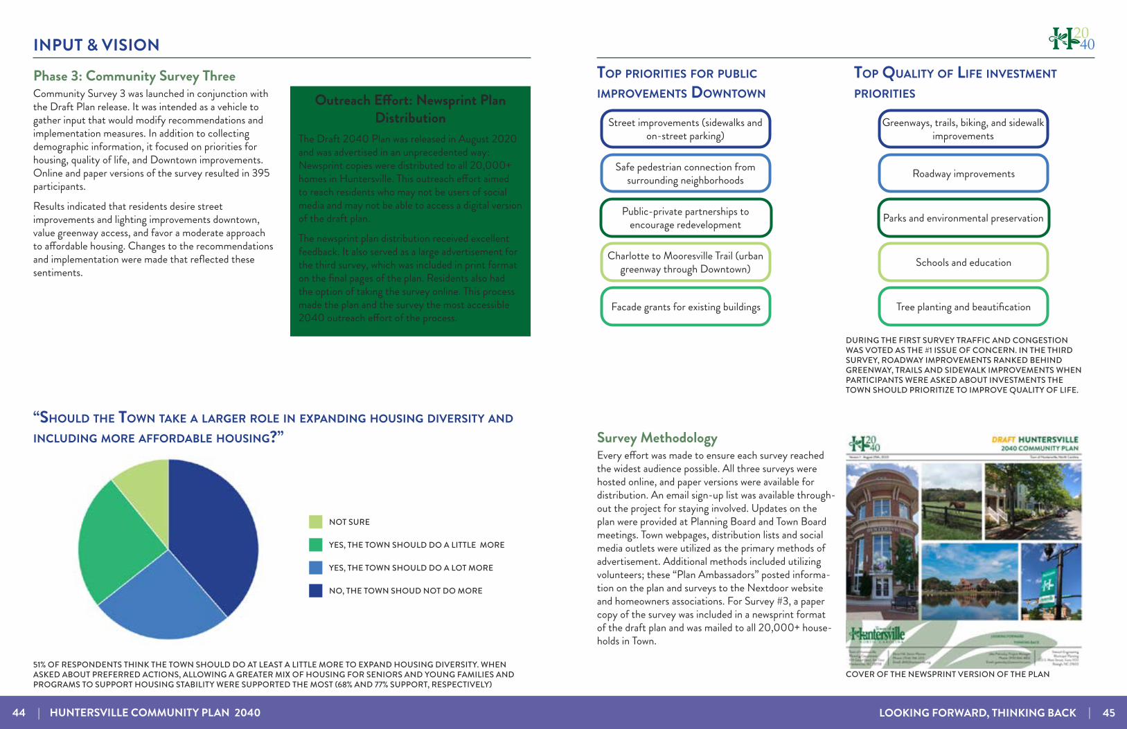
Phase 3: Community Survey ThreeCommunity Survey 3 was launched in conjunction with the Draft Plan release. It was intended as a vehicle to gather input that would modify recommendations and implementation measures. In addition to collecting demographic information, it focused on priorities for housing, quality of life, and Downtown improvements. Online and paper versions of the survey resulted in 395 participants.
Results indicated that residents desire street improvements and lighting improvements downtown, value greenway access, and favor a moderate approach to affordable housing. Changes to the recommendations and implementation were made that reflected these sentiments.
Outreach Effort: Newsprint Plan Distribution
The Draft 2040 Plan was released in August 2020 and was advertised in an unprecedented way: Newsprint copies were distributed to all 20,000+ homes in Huntersville. This outreach effort aimed to reach residents who may not be users of social media and may not be able to access a digital version of the draft plan.
The newsprint plan distribution received excellent feedback. It also served as a large advertisement for the third survey, which was included in print format on the final pages of the plan. Residents also had the option of taking the survey online. This process made the plan and the survey the most accessible 2040 outreach effort of the process.
Survey MethodologyEvery effort was made to ensure each survey reached the widest audience possible. All three surveys were hosted online, and paper versions were available for distribution. An email sign-up list was available through-out the project for staying involved. Updates on the plan were provided at Planning Board and Town Board meetings. Town webpages, distribution lists and social media outlets were utilized as the primary methods of advertisement. Additional methods included utilizing volunteers; these “Plan Ambassadors” posted informa-tion on the plan and surveys to the Nextdoor website and homeowners associations. For Survey #3, a paper copy of the survey was included in a newsprint format of the draft plan and was mailed to all 20,000+ house-holds in Town.
COVER OF THE NEWSPRINT VERSION OF THE PLAN
DURING THE FIRST SURVEY TRAFFIC AND CONGESTION WAS VOTED AS THE #1 ISSUE OF CONCERN. IN THE THIRD SURVEY, ROADWAY IMPROVEMENTS RANKED BEHIND GREENWAY, TRAILS AND SIDEWALK IMPROVEMENTS WHEN PARTICIPANTS WERE ASKED ABOUT INVESTMENTS THE TOWN SHOULD PRIORITIZE TO IMPROVE QUALITY OF LIFE.
51% OF RESPONDENTS THINK THE TOWN SHOULD DO AT LEAST A LITTLE MORE TO EXPAND HOUSING DIVERSITY. WHEN ASKED ABOUT PREFERRED ACTIONS, ALLOWING A GREATER MIX OF HOUSING FOR SENIORS AND YOUNG FAMILIES AND PROGRAMS TO SUPPORT HOUSING STABILITY WERE SUPPORTED THE MOST (68% AND 77% SUPPORT, RESPECTIVELY)
INPUT & VISION
46 | HUNTERSVILLE COMMUNITY PLAN 2040 LOOKING FORWARD, THINKING BACK | 47
VISION STATEMENT INPUT & VISION
By 2040, Huntersville will be a vibrant community rooted in the past while looking towards the future. It provides attractive options for its residents to live, work, play, and grow. Pursuing the highest level of excellence, the town will guide growth and development in a way that prioritizes quality of life, green spaces and environmental safety, meaningful economic development, and multimodal transportation.
The Vision Statement takes two forms: a short tagline and a long paragraph. Both were taken directly from community input and encapsulate the needs and concerns of Huntersville as it grows in the future. The Vision Statement reflects the two main characteristics of Huntersville: a growing, bustling town where you are never far from green space, with jobs and transportation options.
THE MOST LIVABLE COMMUNITY IN
NORTH CAROLINA”
“BY 2040, HUNTERSVILLE WILL BE
GOALSFrom public input, nine over-arching goals were developed. Objectives help to clarify the goals and provide a framework for policy recommendations in the next chapter. They address all aspects that affect the quality of life and thus, how the Town intends to achieve the highest level of livability. It should be noted that the goals are not ranked and the order in which they are displayed does not indicate priority.
ENVIRONMENT & OPEN SPACEPreserve and protect the watershed, natural areas, existing tree canopy, and elements of rural character.
HOUSING CHOICEEncourage walkable housing options and address affordability. Improve link between new housing and adequate transportation facilities.
INCLUSIVE GOVERNMENTEncourage participation of all citizens. Actively strive for diversity on town boards, departments, and committees.
TRANSPORTA-TIONImprove streets and sidewalks and expand transportation options.
GROWTH MANAGEMENTFocus growth near the central core and limit growth in less developed areas.
ACTIVATED MIXED-USE AND ACTIVITY CENTERSCreate vibrant, pedestrian-accessible mixed-use areas with restaurants, small businesses, and housing.
GREENWAYS & TRAILSConnect 30,000 residents to greenways and trails by 2030.
ECONOMIC DEVELOPMENTBalance the tax base, encourage entrepreneurship and attract target industries.
PUBLIC SERVICES AND SCHOOLSEnsure excellent public services and community schools.

INPUT & VISION
48 | HUNTERSVILLE COMMUNITY PLAN 2040 LOOKING FORWARD, THINKING BACK | 49
ENVIRONMENT & OPEN SPACEPreserve and protect the watershed, natural areas, existing tree canopy, and elements of rural character.
HOUSING CHOICEEncourage walkable hous-ing options and address affordability. Improve link between new housing and adequate transportation facilities.
INCLUSIVE GOVERNMENTEncourage participation of all citizens. Actively strive for diversity on town boards, departments, and committees.
TRANSPORTA-TIONImprove streets and sidewalks and expand transportation options.
GROWTH MANAGEMENTFocus growth near the central core and limit growth in less developed areas.
ACTIVATED MIXED-USE AND ACTIVITY CEN-TERSCreate vibrant, pedestri-an-accessible mixed-use areas with restaurants, small businesses, and housing.
GREENWAYS & TRAILSConnect 30,000 residents to greenways and trails by 2030.
ECONOMIC DEVELOPMENTBalance the tax base, encourage entrepreneurship and attract target industries.
PUBLIC SERVICES AND SCHOOLSEnsure excellent public services and community schools.
MEASURING SUCCESSIntroducing ways to measure this plan’s success keeps the Town on track and accountable to the vision and goals the plan established. This page outlines different quantitative measures that can be monitored to gauge progress toward the identified goals. Some measures include benchmarks for tracking, and others focus on making progress towards ongoing improvements. Improving and maintaining a high quality of life in Huntersville is also a continuous process of improving what is already there. Measurable qualities of the goals include:
Progress towards 10/10/10 goal: 10 places to eat, 10 retail shops, 10 places open after 6 PM
Funding for pedestrian and street improvements outlined in this plan
Attendance, frequency, and economic impact of Downtown events
Number of housing units built in lower-intensity (Residential Edge, Rural Conservation, and Critical Watershed) versus
high-intensity areas (Town Core, Residential Edge, and Activity and Mixed-Use Centers)
Amount of new impervious surface in critical and protected water supply watersheds.
School enrollment and capacity
Water and sewer line replacements (linear feet and expenditures)
Emergency response time and police officers per 1,000 residents
Progress made toward the goal of 30,000 residents con-nected and 30 miles of new trails and greenways by 2030
Greenway connections created in new residential developments
Number of improved safe routes to schools
Amount of town funding spent annually on transportation improvements
Number of homes served by transit
Linear feet of streets built or improved after the adoption of this plan that adheres to NCDOT’s Complete Streets Policy
Maintain or exceed the current percentage of tax revenue from non-residential uses
Increase the proportion of residents who work in Huntersville
Amount of independent businesses Downtown
Number of new residences within Mixed-Use and Activity Centers
Housing supply at or below the median home price of $280,000 and/or affordable to households making up to
100-120% of the Area Median Income (AMI)
Ratio of new multifamily homes to new single-family homes
Monitor tree canopy and increase from 2019 level
Proportion of residents within a 10-minute walk to a park or open space
Conserve an additional 5 square miles of land by 2045
Track participation during future planning efforts to ensure participants’ demographics match Town demographics
Strive for demographics of Town staff to reflect Town demographics
Strive for demographics of board and committee members to resemble Town demographics

44 FUTURE LAND USE
LOOKING FORWARD, THINKING BACK | 51
The Future Land Use Plan includes revisions to the adopted land use plan from the 2030 Community Plan based on input received during the Huntersville 2040 planning process. Highlights from the updated Plan include:
• Concentrated activity in Mixed-Use Centers, the Town Core, and Activity Centers
• Reservation of land for future employment• Emphasis on respecting historic structures and the scale of existing neighborhoods
• Managed growth and improved design on the edges to protect natural resources and rural character
• Limiting development in the Critical Watershed
The Huntersville 2030 land use plan outlined two intensity areas for the town: a high-intensity area within 2 miles of I-77 and a low-intensity area on the eastern and western edges. This has served the town well, and analysis shows that more development has occurred in the high-intensity area than in the low-intensity area. The 2040 plan builds on the previous framework while adding new character areas that clarify land use and development design expectations.

FUTURE LAND USE
52 | HUNTERSVILLE COMMUNITY PLAN 2040 LOOKING FORWARD, THINKING BACK | 53
TOWN OF HUNTERSVILLE FUTURE LAND USE MAP
-

FUTURE LAND USE
54 | HUNTERSVILLE COMMUNITY PLAN 2040 LOOKING FORWARD, THINKING BACK | 55
FUTURE LAND USE CHARACTER AREAS
Activity CentersPlanned Activity Centers include a mix of non-residential and residential uses and are usually located at key intersections of major or minor thoroughfares. New non-residential uses are limited in scale and overall footprint (generally less than 40,000 square feet of non-residential). Residential uses include a mix of housing types centered around shopping, service, or civic uses. Residential uses transition to lower gross density with more open space away from Activity Centers.
Employment CenterEmployment centers contain a mix of uses including office, industrial, and institutional. Modern employment campuses and cutting -edge employers are now incorporating some retail and residential to create a live, work, and play environment. These areas offer workspace where innovation can grow while meeting employee lifestyle needs.
Mixed-Use CentersMixed-Use Centers contain vertical mixed-use along key frontages. New development includes wide sidewalks, buildings are close to the street with high levels of transparency, and parking is located in the rear. A mix of housing is allowed, including urban options throughout (apartments, townhomes, cottage homes, etc.). Downtown has specific requirements for streetscape and development intensity, including a maximum first floor footprint.
Town CoreThe Town Core designation includes a variety of neighborhoods containing a mix of residential housing types, including single-family homes, townhomes, and apartments. Their design focuses on traditional neighborhood planning principles, including short blocks, connected streets, streetscape standards, and other features that improve walkability. These areas are denser than the “Moderate Density” and “Residential Edge” character areas and may include non-residential development as specified in small area plans and at other sites that meet locational criteria.
CHARACTER AREAS
The Future Land Use Map provides a generalized guide for land-use decisions in the Huntersville Area. The char-acter areas on the map are defined below and describe intended uses, density and scale, and design features of new development. These descriptions and the associated map should be utilized to guide private investment, infrastruc-ture decisions, and rezoning decisions.
Residential EdgeThe Residential Edge character areas provide transition from higher-density areas to lower-density areas. New development has mostly single-family homes with some attached residential possible. Average densities are 1.5 unit/acre. Policies are included in the Plan that clarify open space requirements and priorities. Flexibility in lot sizes and housing types is possible with higher amounts of quality open space.
Rural ConservationThese areas preserve elements of rural character. They balance open space conservation and some residential development. Development form is farms and associated structures, Farmhouse Clusters, and low-density Conservation Subdivisions (if access to utilities exists). New development has a 0.9 unit/acre maximum, and typically 45%+ open space is required.
Critical WatershedThis includes very low-density areas in Critical Watershed Areas of Mountain Island Lake and the Catawba River. Conservation areas, farms, homesteads, and Farmhouse Clusters are the predominant land uses. New development has approximately 1 dwelling unit per 2-acre maximum . It is constrained due to significant built-upon area restrictions due to the location within the Critical Watershed defined by the Town and Mecklenburg County.
Environmental / Open SpaceThese sensitive environmental areas consist primarily of development-impaired lands such as floodways and floodplains as well as parks and previously-protected areas.
Moderate DensityThis area is meant to accommodate a mix of conventional residential subdivisions with larger lots and traditional neighborhood development with a mix of lot sizes, including smaller unit types and occasional attached housing. Average gross density is generally 1-3 units per acre. It may have some smaller-scale commercial or nonresidential activity at key intersections. Exact density of future development should vary based on context and site constraints including potential conflicts with adjacent development, access, and the presence of natural and/or cultural resources.

FUTURE LAND USE
56 | HUNTERSVILLE COMMUNITY PLAN 2040 LOOKING FORWARD, THINKING BACK | 57
ACTIVITY CENTERS
Beatties Ford Road / NC 73 Mixed-Use CenterMixed-use center planned around the intersection of Highway 73 and Beatties Ford Road. The Beatties Ford Road Corridor Small Area Plan (2007) recommended a mixed-use commercial center containing retail, multi-family residential, and civic uses. At present, there are approximately 23 vacant acres zoned commercial and residential and another 20 acres developed with commercial uses (i.e., convenience store, country store, auto repair, offices, mini-storage, and pet care facility).
ACTIVITY CENTERS
11
22
33
44
1155
66
Huntersville EastThe NC 73 Transportation/Land Use Corridor Plan recommended a Neighborhood Center in this area with additional study needed. A conditional mixed-use commercial rezoning was approved with 22 acres for commercial, 15 acres for attached housing, and 15 acres for detached housing.
22
Poplar CenterThe NC 73/Poplar Tent Road Small area plan recommended a mixed-use (i.e., office, commercial, residential, and “flex” type) development pattern. No specific minimum or maximum levels are proposed to allow for adaptation to market conditions at the time of development. However, development intensities would be greatest traveling west from the NC 73/Poplar Tent intersection to a proposed NE Thoroughfare with lower intensities from the NE Thoroughfare to the old Bradford Store property located at the western perimeter of the study area.
33
Huntersville VillageMixed-use area planned for in the Eastfield Road Small Area Plan (2014) at Huntersville Village (near the intersection of Eastfield Road and Prosperity Church Road). Conditional Highway Commercial zoning is in place, which allows over 100,000 sq. ft. of commercial buildings and up to 190 senior apartments.
44
Long Creek VillageLow-intensity “urban village” planned in the Beatties Ford Road / Mt. Holly - Huntersville Road Road SAP (2005). Since the small area plan was adopted, there have been three (3) conditional district rezonings approved allowing up to 45,000 sq. ft. of commercial building and 119 single-family dwellings.
55
66 Hopewell VillageHopewell Village was originally rezoned in 1991 by Mecklenburg County and updated by the Town of Huntersville in 2002, allowing approximately 62,000 sq. ft. of commercial buildings.
Beatties Ford Road & Mt. Holly-Huntersville Road
Small Area Plan
Town of Huntersville October 2005
CONCEPT FROM BEATTIES FORD ROAD-MT. HOLLY-HUNTERSVILLE ROAD SMALL AREA PLAN

FUTURE LAND USE
58 | HUNTERSVILLE COMMUNITY PLAN 2040 LOOKING FORWARD, THINKING BACK | 59
FUTURE LAND USE CHARACTER AREA TABLEThe following table outlines residential subdivision and residential buildings types encouraged and discouraged in different Future Land Use Character Areas.
Future Land Use Character Area
Residential Subdivision Design Residential Type
Town-scale
Subdivi-sion
Traditional Neighbor-
hood Design (TND)
Conserva-tion
(Cluster) Subdivision
Farm-house
Cluster
Live-work Unit
Apart-ments & Condos
Attached (Townhomes, Duplex, Tri-
plex)
De-tached
Walkable, Mixed-Use Center (WMU)
- RR - - RR RR RR RR
Activity Center (AC) - RR RR RR RR RREmployment Center (EC) - - -Town Core (TC)
RR - RR RR RR RRModerate Densi-ty (MD) RR RR RR RRResidential Edge (RE) RR RR - - RRRural Conserva-tion (RC) - - RR RR - - RRCritical Water-shed (CW) - - RR - - - RREnvironmental / Open Space (EOS)
- - - - - - - -Legend:
RR = Allowed / Encouraged = If Contextually Appropriate, Potential Limitations, Design Criteria or Utility Availability
- = Discouraged
This page intentionally left blank
It helps to remember that nothing worth achieving comes without a price, and so we must weigh the costs and the gains of future decisions.For this plan to be a success, the recommendations within it must be diligently pursued. Town leadership must assign tasks to staff and hold them accountable for achieving progress. The plan must also be updated and revised to respond to changing conditions and to stay in touch with the community’s values and goals.
What follows are the policies and strategies for achieving this plan. Specific recommendations in this section are the result of input from multiple sources, including town planning staff, the Steering Committee, and stakeholder interviews. Every attempt was made to be comprehensive, but some new opportunities may present themselves and it may be necessary to discuss, interpret and prioritize strategies to accomplish goals.
HUNTERSVILLE NEIGHBORHOOD
Our communities do not change overnight. Implementing a long-range community plan takes time. Although some recommendations may be immediately actionable, such as updating zoning codes, programming greenway construction, or establishing new monitoring programs, some actions are discouraged until the time is right. For instance, properties should not be preemptively up-zoned based on the Future Land Use Map until other areas have filled in or the proper infrastructure (roads, parks, schools, utilities, emergency services, etc.) is in place. Some decisions are complex, and it will be up to the town leadership to take a balanced look at both the intent of this plan and the specifics of any site and/or proposal before them.
55 IMPLEMENTATION
LOOKING FORWARD, THINKING BACK | 61
62 | HUNTERSVILLE COMMUNITY PLAN 2040 LOOKING FORWARD, THINKING BACK | 63
POLICY RECOMMENDATIONS LAND USE & HOUSING
Community feedback and analysis showed a preference for managing growth and develop-ment in the environmentally sensitive eastern and western edges of town and concentrating on new nonresidential development near the I-77 corridor. Recommendations in this section build on the Town’s history of encouraging tra-ditional town planning and design principles and are inspired by the overall vision of enhancing livability.
The Huntersville TransectA transect is a description of relative development intensity and expected built and natural forms. The Future Land Use Map combined with the policies in this chapter create a transect that focuses growth in walkable Mixed-Use Centers and Activity Centers and decreases in intensity farther away. Traditional neighborhoods give way to conservation subdivisions and eventually farmhouse clusters that sensitively integrate with the rural environment.
BIRKDALE VILLAGE IS A MIXED USE CENTER THAT FEATURES RETAIL, RESTAURANTS, OPEN SPACE, AND DIFFERENT TYPES OF RESIDENTIAL.
Policy LU-1: Encourage a development pattern that
follows the Future Land Use Map.LU 1.1: Utilize the Future Land Use Map during
development approval process to ensure compatibility with long-range plans.
LU 1.2: Continue to conduct educational and outreach activities to familiarize elected officials, appointed board members, citizens, and developers about the plan’s contents and associated ordinances.
LU 1.3: Regularly update the Future Land Use Map• Update based on rezonings that change
the Future Land Use Map periodically to consider updates to small area plans, major infrastructure investments and/or every 3-5 years.
FARMHOUSE CLUSTERS ARE AN INNOVATIVE SUBDIVISION DESIGN OPTION IN THE RURAL AREA OF HUNTERSVILLE THAT ALLOW FOR 6 HOMES ON 10 ACRES, BUT REQUIRE 50% OF THE LAND AREA TO REMAIN OPEN SPACE.
LU-1 LU 1.4: Prepare new and/or update existing Small Area Plans as needed.
• Updates or new plans may be needed for areas that have experienced changes since their adoption and/or in areas impacted by new policies in the 2040 Community Plan.
• Priorities for updating small area plans include the NC 73 corridor and downtown.
Policy LU-2: Encourage residential development that
follows the pattern outlined in the future land use map.
LU 2.1: Higher intensity residential uses will be focused generally within two miles of the I-77/NC-115 corridor and future activity centers in the eastern and western areas of Huntersville’s zoning jurisdiction.
LU 2.2: Lower intensity residential uses are expected within the Residential Edge and Rural Conservation areas identified on the Future Land Use Map.
Policy LU-3: Manage residential growth in the eastern and
western parts of Huntersville’s planning jurisdiction.
LU 3.1: Discourage rezonings to higher intensity residential districts in the Residential Edge and Rural Conservation future land use character areas.
• There is constant pressure to rezone to higher-density districts on the edges of town. Growth management was the #1 priority for survey responses. There needs to be a concerted effort to uphold previous policy decisions to limit density and increase open space preservation in the more undeveloped areas outside of the Town Core.
Growth ManagementGrowth Management was voted as the #1 Priority Goal in the Plan Framework Survey, conducted in the summer of 2020. Additionally, 58% of respondents were in favor of limiting growth more than the 2030 Community Plan.
MOST OF THE LAND WEST OF I-77 DRAINS TO THE CATAWBA RIVER AND MOUNTAIN ISLAND LAKE WHICH IS A PRIMARY WATER SOURCE FOR THE REGION.
LU-2
LU-3
Policy LU-4: Limit the scale of new development in Critical Watersheds.
LU 4.1: Allow only Farmhouse Clusters and very low-density development in Critical Watersheds defined by the Town and Mecklenburg County.
• Limit the scale of non-residential development in Critical Watersheds.
• Limit new residential development in these areas to Farmhouse Clusters or new residential subdivisions with a dwelling unit density of less than 0.6 units per acre.
LU-4LAND USE & HOUSING
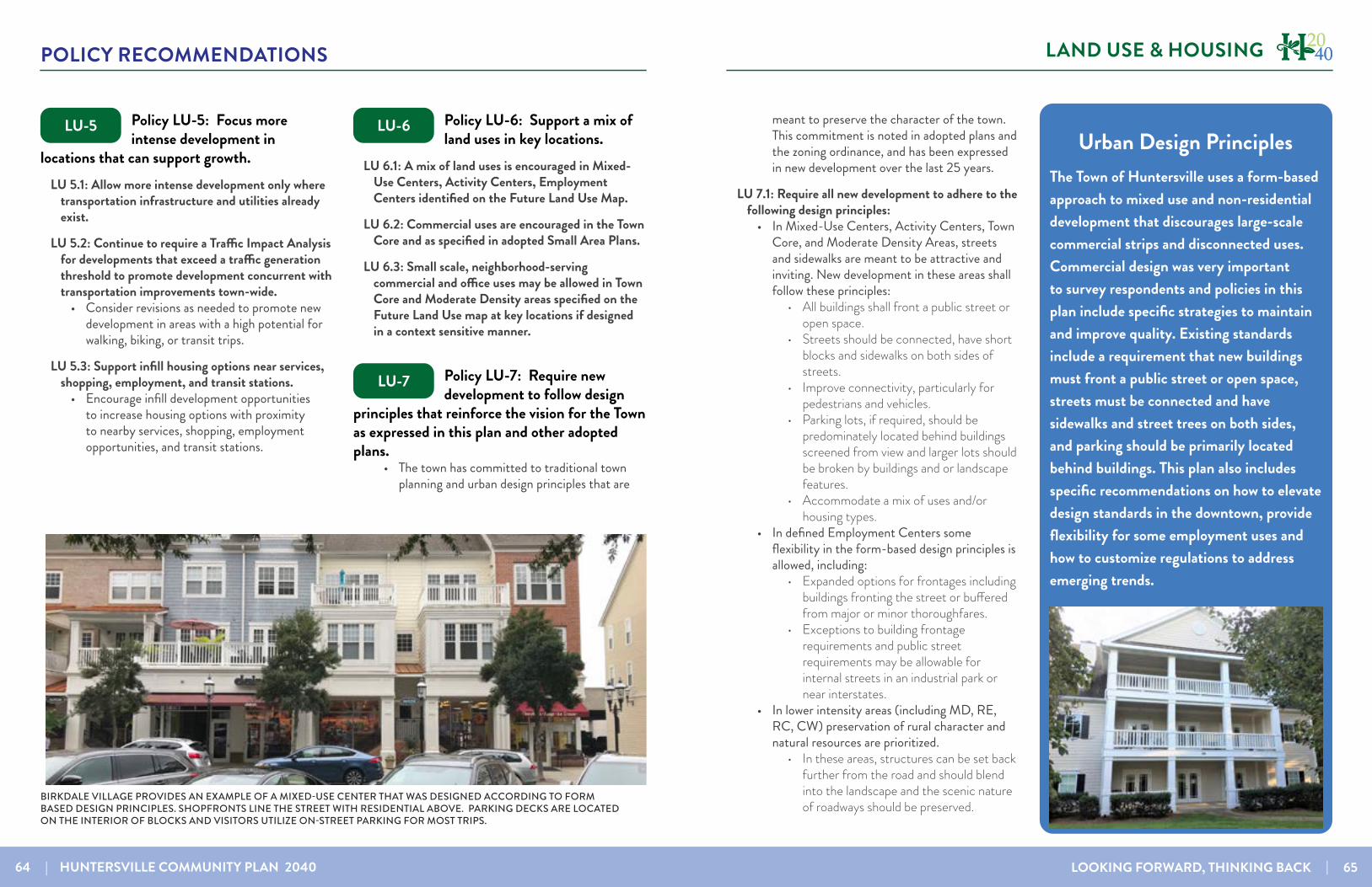
64 | HUNTERSVILLE COMMUNITY PLAN 2040 LOOKING FORWARD, THINKING BACK | 65
POLICY RECOMMENDATIONS LAND USE & HOUSING
Policy LU-5: Focus more intense development in
locations that can support growth.LU 5.1: Allow more intense development only where
transportation infrastructure and utilities already exist.
LU 5.2: Continue to require a Traffic Impact Analysis for developments that exceed a traffic generation threshold to promote development concurrent with transportation improvements town-wide.
• Consider revisions as needed to promote new development in areas with a high potential for walking, biking, or transit trips.
LU 5.3: Support infill housing options near services, shopping, employment, and transit stations.
• Encourage infill development opportunities to increase housing options with proximity to nearby services, shopping, employment opportunities, and transit stations.
Policy LU-6: Support a mix of land uses in key locations.
LU 6.1: A mix of land uses is encouraged in Mixed-Use Centers, Activity Centers, Employment Centers identified on the Future Land Use Map.
LU 6.2: Commercial uses are encouraged in the Town Core and as specified in adopted Small Area Plans.
LU 6.3: Small scale, neighborhood-serving commercial and office uses may be allowed in Town Core and Moderate Density areas specified on the Future Land Use map at key locations if designed in a context sensitive manner.
Policy LU-7: Require new development to follow design
principles that reinforce the vision for the Town as expressed in this plan and other adopted plans.
• The town has committed to traditional town planning and urban design principles that are
BIRKDALE VILLAGE PROVIDES AN EXAMPLE OF A MIXED-USE CENTER THAT WAS DESIGNED ACCORDING TO FORM BASED DESIGN PRINCIPLES. SHOPFRONTS LINE THE STREET WITH RESIDENTIAL ABOVE. PARKING DECKS ARE LOCATED ON THE INTERIOR OF BLOCKS AND VISITORS UTILIZE ON-STREET PARKING FOR MOST TRIPS.
LU-5 LU-6
LU-7
Urban Design PrinciplesThe Town of Huntersville uses a form-based approach to mixed use and non-residential development that discourages large-scale commercial strips and disconnected uses. Commercial design was very important to survey respondents and policies in this plan include specific strategies to maintain and improve quality. Existing standards include a requirement that new buildings must front a public street or open space, streets must be connected and have sidewalks and street trees on both sides, and parking should be primarily located behind buildings. This plan also includes specific recommendations on how to elevate design standards in the downtown, provide flexibility for some employment uses and how to customize regulations to address emerging trends.
meant to preserve the character of the town. This commitment is noted in adopted plans and the zoning ordinance, and has been expressed in new development over the last 25 years.
LU 7.1: Require all new development to adhere to the following design principles:
• In Mixed-Use Centers, Activity Centers, Town Core, and Moderate Density Areas, streets and sidewalks are meant to be attractive and inviting. New development in these areas shall follow these principles:
• All buildings shall front a public street or open space.
• Streets should be connected, have short blocks and sidewalks on both sides of streets.
• Improve connectivity, particularly for pedestrians and vehicles.
• Parking lots, if required, should be predominately located behind buildings screened from view and larger lots should be broken by buildings and or landscape features.
• Accommodate a mix of uses and/or housing types.
• In defined Employment Centers some flexibility in the form-based design principles is allowed, including:
• Expanded options for frontages including buildings fronting the street or buffered from major or minor thoroughfares.
• Exceptions to building frontage requirements and public street requirements may be allowable for internal streets in an industrial park or near interstates.
• In lower intensity areas (including MD, RE, RC, CW) preservation of rural character and natural resources are prioritized.
• In these areas, structures can be set back further from the road and should blend into the landscape and the scenic nature of roadways should be preserved.
66 | HUNTERSVILLE COMMUNITY PLAN 2040 LOOKING FORWARD, THINKING BACK | 67
POLICY RECOMMENDATIONS LAND USE & HOUSING
LU 7.2: Consider updates to the Huntersville Design Guidebook and/or Zoning Ordinance as needed to improve the commercial and multi-family design.
• Evaluate and update the Design Guidebook.• Revisit—and revise—the purpose of the
Design Guidebook.• Examine the standards-based zoning
code revisions and adopted plan(s) to determine consistency.
• Consider amending the Town’s Zoning Ordinance to:
• Incorporate the updated standards outlined in the Design Guidebook into the zoning ordinance where appropriate.
• Address issues including setbacks, architectural requirements, streetscape standards, and landscaping requirements (including foundation plantings).
• Consider adjustment to setback and streetscape requirements and/or options along major thoroughfares and/or boulevards, such as “super streets.”
• Identify locations where attached senior housing products may be allowed and determine appropriate design and development standards.
• Update design standards based on the public space toward which certain uses are oriented (e.g., delineating public/private space for residential fronting public active open space or a plaza).
• Organize design standards in a user-friendly format.
Policy LU-8: Emphasize form and flexibility in Mixed-Use
Centers, Employment Centers, the Town Core, and Activity Centers.
LU 8.1: Continue to emphasize form and flexibility in development regulations for these areas.
• The current zoning ordinance has basic form-based standards with flexibility built-in. Key elements include allowing multiple types of land uses, a mix of uses, minimal setbacks, and parking requirements.
LU 8.2: Evaluate and strengthen incentives to encourage the achievement of higher design standards.
• Consider incentives that allow applicants to demonstrate excellence in design and exceptional public benefit for projects in key areas.
• Offer flexibility using performance standards, guided by the design principles.
• Specify intended outcomes and how site- or building-specific design solutions can better achieve desired outcomes.
• Evaluate incentives periodically to determine their value given shifting market and neighborhood conditions.
• Incentives that could include:• Modification of height limit.• Increase in percent of allowable attached
residential.• Reduced parking requirements.• Reduced buffer yard requirements.
Excellence in DesignIncentives for exceeding standards could promote excellence in the design of new projects in key areas. For example, in Mixed-Use Centers (including Downtown) or Activity Centers, additional flexibility in height or percent attached residential could be allowed if the site and/or building design that is proposed meets and exceeds standards and provides an exceptional public benefit such as a new or improved public space and/or significant transportation investment in the form of public streetscape improvements, parking facilities, greenway construction, or transit facilities.
LU-8 LU 8.3: Encourage transit-supportive development• Maintain incentives for future TOD locations,
including allowing 100% attached homes near transit stations.
• Consider ways to encourage transit-supportive development proximal to future CATS Bus Rapid Transit (BRT) stations.
Policy LU-9: New residential development should follow
appropriate housing design principles.LU 9.1: In higher intensity areas including Mixed-
Use Centers, Activity Centers, the Town Core, and Moderate Density areas neighborhoods should adhere to the following design principles:
• All homes must front a public street or open space.
• Front porches and recessed garages are encouraged.
• On-street parking is required in new developments that have lot widths below 60’. Alley-loading is also encouraged in these cases.
LU 9.2: Within lower intensity areas including Moderate Density, Residential Edge, Rural Conservation, and Critical Watershed areas conservation design & farmhouse clusters are encouraged.
• Scenic nature of roadways should be preserved • Development should be clustered away from
key natural features. • Site design should minimize grading and
maximize preservation of existing stands of mature, native trees.
Policy LU-10: Encourage a diversity of housing options.
LU 10.1: Align housing options with resident needs and promote attainable housing options.
• Accommodate a mix of housing by type, tenure, and location to serve a growing and increasingly diverse population. Housing offerings should align with workforce
opportunities, including management, professional positions, and service positions.
LU 10.2: Continue to encourage a mix of lot sizes in new developments.
LU 10.3: Consider allowances for “house” scale missing middle housing.
• Design requirements could include form-based regulation for structures with 3+ units. This may increase acceptance at the community level. Requirements could include:
• Balconies, porches• Shared outdoor greenspace/courtyard
garden areas (if multiple structures)• Separate entrances for all units• Loading and/or access requirements
LU 10.4: Consider allowing additional flexibility in site design in exchange for more quality open space preservation to allow for conservation of natural resources in the Transitional and Rural zoning districts.
• See EOS Policies on page 82
LU 10.5: Facilitate the creation of and provide guidelines for senior and age-restricted housing.
• Update zoning ordinance to address where different forms of attached senior housing products are allowed and what design and development standards apply.
• New, larger-scale senior housing structures (e.g. congregate care facilities, apartments and condos) should be located within Mixed-Use Centers, Activity Centers, or the Town Core future land use areas and should have a maximum height of 4 stories.
• Evaluate the creation of a Senior Residential (SR) zoning district. Development within this new district should be appropriate for Huntersville and meet the criteria of form-based code.
LU-9
LU-10

68 | HUNTERSVILLE COMMUNITY PLAN 2040 LOOKING FORWARD, THINKING BACK | 69
POLICY RECOMMENDATIONS LAND USE & HOUSING
• Large-scale, highway-oriented senior housing in Moderate Density and lower density future land use areas is not appropriate.
• Age-targeted housing in Residential Edge and Rural Conservation areas may be appropriate. Rezonings to the TND Rural zoning district can utilize provisions that allow flexibility in lot sizes and housing options. Overall density of these developments should be low to reflect the context.
Policy LU-11: Protect Existing Housing Stock.
LU 11.1: Protect and enhance the unique character of Huntersville’s neighborhoods by using planning tools to safeguard from potentially negative impacts of development and redevelopment.
• Promote quality design and neighborhood improvements including increasing access to parks and recreation and mobility options.
• Encourage coordination with neighborhoods to address infrastructure needs such as sidewalks and drainage.
LU 11.2: Along existing streets, encourage new buildings to respect the general spacing of structures, building mass and scale, and street frontage relationships of existing buildings.
LU 11.3: Study options for local housing stability programs to support existing homeowners.
LU-12
LU-11
Policy LU-12: Preserve historic structures and landscapes in Huntersville.
LU 12.1: Partner with Charlotte-Mecklenburg Historic Landmarks Commission on the designation of significant structures as Local Landmarks.
LU 12.2: Utilize notable projects list from the Architectural Survey, State Historic Preservation Office (SHPO) data, and other resources during design and development review.
LU 12.3: Blend new development with existing neighborhoods, structures and landscapes through the use of transitions in building types and placement of open space, buffers, and other site features.
LU 12.4: Consider the facilitation of relocation of notable or significant structures when reuse or preservation is not feasible.
This page intentionally left blank

70 | HUNTERSVILLE COMMUNITY PLAN 2040 LOOKING FORWARD, THINKING BACK | 71
POLICY RECOMMENDATIONS ECONOMIC VITALITY
Huntersville is already an economically vibrant town with many large businesses and a growing job base. Feedback indicated the community would like to continue this trend to keep the tax base balanced. The recommendations serve the goal of balancing and expanding the local economy through several avenues.
Policy EV-1: Support a balanced economy through job growth in
target industry sectors.EV 1.1: Update Strategic Economic Development
Plan• Update Huntersville’s Strategic Economic
Development Plan regularly (at least every five years).
• Target recruitment of business and industry for which Huntersville has a “competitive advantage” as identified in the plan.
EV 1.2: Focus economic development in areas that support growth.
• Preserve areas suitable for business and industrial development, along with a mixture of support uses, to ensure an adequate inventory of land for future growth and development, with increases to this inventory as required. These areas should have proximity to existing or future activity centers, have access to transportation options and utility service, and offer amenities for employees.
EV 1.3: Inventory and protect strategic development sites.
• Maintain inventories of privately- and publicly-owned strategic development sites in Huntersville. Pro-actively ensure that these sites are appropriately zoned for targeted development.
• Allow new commercial or multi-family land uses in Employment Centers only if they are complimentary and do not jeopardize large employment sites’ viability.
• Consider a build-out study to develop/refine measurable targets for the residential and non-residential tax base.
EV 1.4: Review development standards to support business growth.
• Support efforts to improve efficiency and responsiveness of the development review process for development proposals. Regularly review the market to ensure that standards are in line with current demand.
• Prioritize changes to standards that would encourage small business growth.
EV 1.5: Communicate approval processes. • The Town’s website, brochures and other
methods continue to communicate expectations and options for development design and the approval and input process to residents, builders, and developers.
Policy EV-2: Encourage existing economic assets and
entrepreneurial business development. EV 2.1: Promote and encourage local businesses,
particularly small businesses. • Foster a dynamic, diversified, and inclusive
business climate that highlights why the Town of Huntersville can support private investment and locally expanding businesses.
ECONOMIC VITALITY
ECONOMIC VITALITY
Regional Transportation Planning Organization, to support regional economic development efforts.
Policy EV-4: Support education and workforce training
opportunities to align local jobs with residents. EV 4.1: Promote hiring locally.
• Partner with employers, educators, and economic development agencies to encourage the practice of hiring locally. Local hiring helps further establish Huntersville’s unique economic competitiveness while encouraging the retention of skilled residents.
EV 4.2: Encourage workforce training options.• Support current efforts of Central Piedmont
Community College (CPCC), Charlotte Mecklenburg Schools (CMS) and others to train and develop a skilled workforce to meet labor demands for local business and industry. Convene round table meetings between partners to enhance workforce training.
EV 2.2: Leverage Downtown as a unique destination.• By focusing on events, future business mix,
and easy parking, the Town should promote Downtown and its Historic District as the heart of the community that offers a unique amenity to residents, employees, and visitors.
EV 2.3: Attract businesses to Downtown. • Encourage new businesses that help Downtown
meet the 10|10|10 goal of having 10 places that serve food, 10 retail establishments (non-chain and not thrift stores) and 10 businesses open after 6 pm.
• Coordinate advocacy and align resources to support and attract economic development opportunities to Downtown Huntersville.
• New resources could include a downtown business guide covering zoning, parking, signage, building codes and resources for prospective businesses and landowners.
• Identify and consider offering community resources that could be leveraged to support growth, including grants and other incentives.
Policy EV-3: Leverage partnerships to encourage
economic development expansion.EV 3.1: Leverage local partnerships.
• Continue participation with Lake Norman Regional Economic Development Corporation (LNREDC) and on joint economic development efforts with Charlotte, Cornelius, and Davidson.
• Work with LNREDC to enhance Business Retention and Expansion (BRE) program, targeting business and industry either currently not being served or underserved.
• Continue Business Incentive Program (BIP) for the creation of new jobs.
EV 3.2: Enhance regional successes.• Build on partnerships with the Charlotte
Business Alliance, the Huntersville Chamber of Commerce, and other non-profit partners like Charlotte Water and the Charlotte
MAIN STREET COFFEE AND CO-WORKING IS LOCATED IN A HISTORIC STRUCTURE ADJACENT TO MAIN STREET AND THE RAILROAD AND IS ONE OF MANY LOCALLY OWNED SMALL BUSINESSES LOCATED IN DOWNTOWN HUNTERSVILLE.
Nonresidential Tax BaseThe Town of Huntersville currently has a commercial and industrial tax base that makes up 22.6% of total property taxes. Residential property taxes make up the remaining 77.4%. The town is actively recruiting businesses to broaden and
diversify the tax base.
EV-2
EV-1
EV-3
EV-4

72 | HUNTERSVILLE COMMUNITY PLAN 2040 LOOKING FORWARD, THINKING BACK | 73
POLICY RECOMMENDATIONS DOWNTOWN
DOWNTOWNThe following recommendations provide a roadmap for helping Downtown Huntersville reach its full potential. They address the aspects the Town has control over, particularly the design of streets and sidewalks and building form. Emphasis is placed on streetscapes, public spaces, and other areas where improving aesthetics and functionality can spur investment. Recommendations also describe ways to protect the history of and create an identity for Huntersville.
Policy DT-1: Encourage future development in
the Downtown area to adhere to the Regulating Plan. (see page 73)
DT 1.1: Encourage vertical mixed-use development with active visual engagement between the street and the ground and upper floors along Active Frontages
• Shopfronts are encouraged along key frontages.
• Active uses are required on the ground floor (in new development only) and include retail, restaurants, and other uses that generate many visits over an extended period of the day.
• Upper story residential units should have balconies when feasible.
• Active frontages should use design features such as a high level of building transparency, frequent pedestrian access points, and facade articulation.
DT 1.2: In Tier 1 areas, encourage multistory buildings and allow for a mix of uses, including commercial, office, and residential.
• Building types allowed include urban workplaces, multifamily, attached, and detached residential.
DT 1.3: In Tier 2 areas, create a transitional area from the core of Downtown to surrounding residential neighborhoods.
• This area contains mostly residential uses with some office and commercial space at lower intensities than Tier 1.
• Residential can include townhomes, duplexes, triplexes, quadplexes, and urban single-family home types including alley-loaded bungalows and other house-scale development types such as pocket neighborhoods and cottage courts.
DT 1.4: Consider revisions to ordinances, the Design Guidebook, and/or review and approval processes to achieve an elevated design in the downtown area.
DT 1.5: Refine the Downtown Regulating Plan based on further study, public input, and stakeholder involvement.
Policy DT-2: Step down in intensity and density near
established residential neighborhoods.• Housing types that provide good transitions include townhomes, duplexes, triplexes, and other small-scale products.
• Design features such as setbacks, stepbacks, tree preservation, and open space placement can help provide transitions.
Public-Private Partnership Opportunities
Public/private partnerships (PPPs) are partnerships between a government entity and private developers to achieve a common purpose. PPPs can help redevelop underutilized areas with significant potential. A municipality can proactively initiate them to achieve key public objectives, such as downtown revitalization, affordable housing, and/or commercial development.
DT-1
DT-2
Downtown Regulating Plan / Character and Connections Map
Downtown - Active FrontagesRequire vertical mix of uses, active frontages, and shopfront building types in new develop-ment. Ground floor commercial, preferably retail and restaurants or other active use is required. Generally 2-4 stories. Floors 2+ can be commercial, office, civic or residential.
Downtown - Tier 1Encourage commercial, office and/or resi-dential. Shopfronts, urban workplaces and apartment buildings are allowed. Generally 2-4 stories.
Downtown - Tier 2Generally 2-3 stories. Predominately residen-tial with some small-scale commercial and/or office. Reuse of structures on main roads. Residential can include townhomes, duplexes, triplexes, quadplexes, and urban single-family home types, including alley-loaded bungalows, pocket neighborhoods and cottage courts.
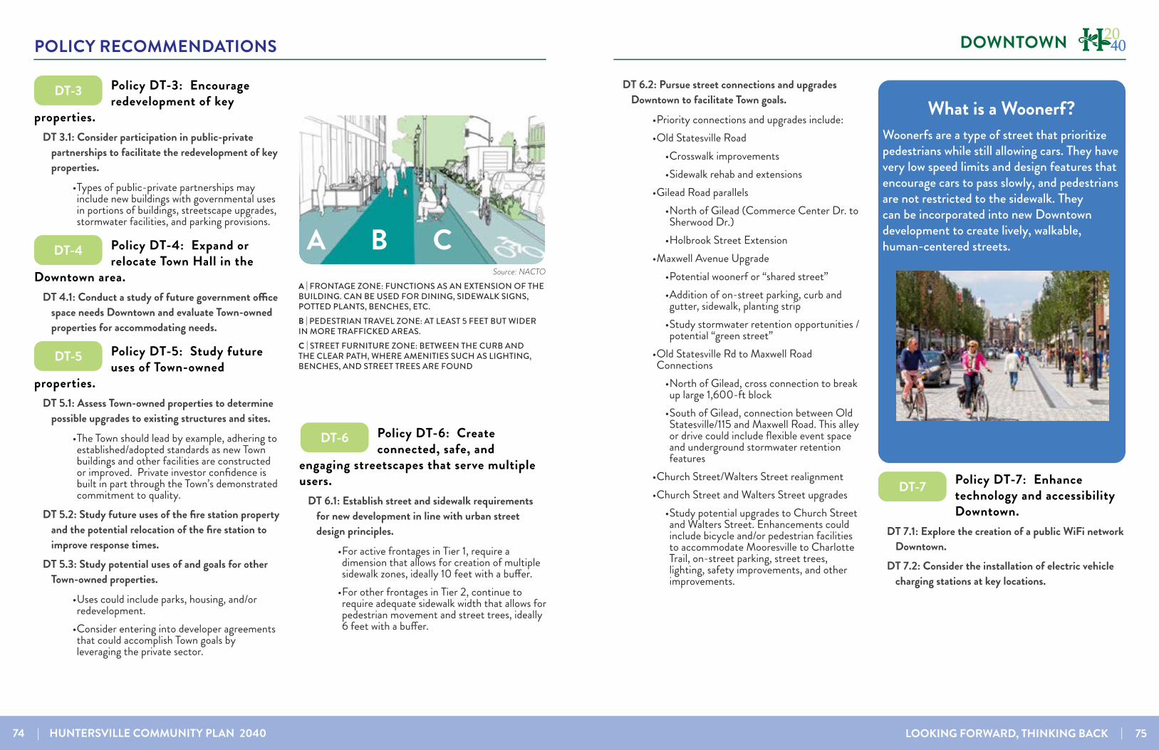
74 | HUNTERSVILLE COMMUNITY PLAN 2040 LOOKING FORWARD, THINKING BACK | 75
POLICY RECOMMENDATIONS DOWNTOWN
Policy DT-3: Encourage redevelopment of key
properties.DT 3.1: Consider participation in public-private
partnerships to facilitate the redevelopment of key properties.
• Types of public-private partnerships may include new buildings with governmental uses in portions of buildings, streetscape upgrades, stormwater facilities, and parking provisions.
Policy DT-4: Expand or relocate Town Hall in the
Downtown area. DT 4.1: Conduct a study of future government office
space needs Downtown and evaluate Town-owned properties for accommodating needs.
Policy DT-5: Study future uses of Town-owned
properties.DT 5.1: Assess Town-owned properties to determine
possible upgrades to existing structures and sites.• The Town should lead by example, adhering to established/adopted standards as new Town buildings and other facilities are constructed or improved. Private investor confidence is built in part through the Town’s demonstrated commitment to quality.
DT 5.2: Study future uses of the fire station property and the potential relocation of the fire station to improve response times.
DT 5.3: Study potential uses of and goals for other Town-owned properties.
• Uses could include parks, housing, and/or redevelopment.
• Consider entering into developer agreements that could accomplish Town goals by leveraging the private sector.
Policy DT-6: Create connected, safe, and
engaging streetscapes that serve multiple users.
DT 6.1: Establish street and sidewalk requirements for new development in line with urban street design principles.
• For active frontages in Tier 1, require a dimension that allows for creation of multiple sidewalk zones, ideally 10 feet with a buffer.
• For other frontages in Tier 2, continue to require adequate sidewalk width that allows for pedestrian movement and street trees, ideally 6 feet with a buffer.
Source: NACTOA | FRONTAGE ZONE: FUNCTIONS AS AN EXTENSION OF THE BUILDING. CAN BE USED FOR DINING, SIDEWALK SIGNS, POTTED PLANTS, BENCHES, ETC.B | PEDESTRIAN TRAVEL ZONE: AT LEAST 5 FEET BUT WIDER IN MORE TRAFFICKED AREAS.C | STREET FURNITURE ZONE: BETWEEN THE CURB AND THE CLEAR PATH, WHERE AMENITIES SUCH AS LIGHTING, BENCHES, AND STREET TREES ARE FOUND
A B C
DT-3
DT-4
DT-5
DT-6
What is a Woonerf?Woonerfs are a type of street that prioritize pedestrians while still allowing cars. They have very low speed limits and design features that encourage cars to pass slowly, and pedestrians are not restricted to the sidewalk. They can be incorporated into new Downtown development to create lively, walkable, human-centered streets.
DT 6.2: Pursue street connections and upgrades Downtown to facilitate Town goals.
• Priority connections and upgrades include:• Old Statesville Road
• Crosswalk improvements• Sidewalk rehab and extensions
• Gilead Road parallels• North of Gilead (Commerce Center Dr. to Sherwood Dr.)
• Holbrook Street Extension• Maxwell Avenue Upgrade
• Potential woonerf or “shared street”• Addition of on-street parking, curb and gutter, sidewalk, planting strip
• Study stormwater retention opportunities / potential “green street”
• Old Statesville Rd to Maxwell Road Connections
• North of Gilead, cross connection to break up large 1,600-ft block
• South of Gilead, connection between Old Statesville/115 and Maxwell Road. This alley or drive could include flexible event space and underground stormwater retention features
• Church Street/Walters Street realignment• Church Street and Walters Street upgrades
• Study potential upgrades to Church Street and Walters Street. Enhancements could include bicycle and/or pedestrian facilities to accommodate Mooresville to Charlotte Trail, on-street parking, street trees, lighting, safety improvements, and other improvements.
Policy DT-7: Enhance technology and accessibility Downtown.
DT 7.1: Explore the creation of a public WiFi network Downtown.
DT 7.2: Consider the installation of electric vehicle charging stations at key locations.
DT-7

76 | HUNTERSVILLE COMMUNITY PLAN 2040 LOOKING FORWARD, THINKING BACK | 77
POLICY RECOMMENDATIONS DOWNTOWN
Policy DT-8: Preserve and celebrate the history of
Downtown Huntersville.DT 8.1: New developments should respect the
scale and character of historical structures and established neighborhoods.
DT 8.2: Encourage reuse and integration of key historical structures into programming and redevelopment plans Downtown.
• Key historical structures Downtown include the old jail, the water tower, and historic homes, among others.
• Consider the facilitation of relocation of structures when reuse or preservation is not feasible.
Policy DT-9: Encourage new parks and programming
Downtown.DT 9.1: Connect Torrence Creek Greenway to
Holbrook Park and into and through Downtown.• Construct a trailhead and plaza for the Torrence Creek Greenway near NC 115
• Study a potential mid-block crossing North of Gilead that could route users to a wide sidewalk connected to Veterans Park
• Accommodate bicycles and pedestrians Southeast to Gilead / Huntersville-Concord Road railroad crossing and East to Vermillion greenway
DT 9.2: Expand Holbrook Park• Include additional active and passive recreation opportunities
DT 9.3: Expand events and programming Downtown DT 9.4: Support the Public Art Committee in their
mission to introduce art around DowntownDT 9.5: Expand Downtown Open Space when
possible• Study potential pocket parks and/or beautification near roundabouts created as part of the Main Street realignment
Policy DT-10: Prioritize maintenance of public and
private structures and enhancement of the public realm.
DT 10.1: Prioritize maintenance of streets and sidewalks and town-owned properties in the downtown area.
DT 10.2: Enhance street lighting through the development and retrofitting of existing streets.
• Define lighting standards for new development.
• Establish priority areas for lighting installation.DT 10.3: Update the Downtown Small Area Plan
to build on recommendations in the 2040 Community Plan.
• This plan update could be coordinated with conceptual design of streetscape or public realm improvements to build on the 2040 plan.
• It could also include the study of refinements to zoning districts, the Regulating Plan and policies related to housing and transitions between redevelopment and infill projects and existing residential areas.
• The Town should consider the range of public spaces types, including streets, in terms of the following:
• Intended functions: At a minimum, spaces—and the elements within them—should be scaled and organized to accommodate the activities they are in-tended to support. Streets, for example, are comprised of the facilities required to move vehicular, bicycle, and pedestrian traffic, while formal greens (i.e., Veter-ans Park) offer programmable space for community gatherings of various, sizes including festivals and other events.
DT-8
DT-9
DT-10 Case Study: Hickory Inspiring SpacesHickory was historically known for its thriving furniture industry. However, the loss of manufacturing in previous decades contributed to the City’s economic decline. ‘Inspiring Spaces’ is a public realm master plan. The primary objective was to spur economic development by defining a specific set of public realm improvements projects intended to enhance the visitor and resident experience, effectively reshape the City’s image, create vibrant centers of activity within the City, attract the private investment it desires, and place Hickory in a more economically competitive position. The resulting plan identifies more than 50 projects. Reinforcing the City’s “well crafted” brand, the story of Hickory’s craft heritage is told through the integration of local art and regionally-sourced materials into public spaces. Parks, greens, and plazas are the focal points of cultural destinations, neighborhoods, and commercial hubs, which are being linked by recreational greenways and upgraded streetscapes. The plan was the basis for a successful bond campaign. In 2014, over 60% voted in favor of the $40M bond referendum to fund key projects identified in the plan, including Hickory Trail, a 5.2-mile greenway comprised of CityWalk downtown and RiverWalk on Lake Hickory, and the renovation of Union Square in downtown. The trail system will connect downtown to Lenoir-Rhyne University, restaurants and shops in renovated mills, Lake Hickory, the Crawdad’s baseball stadium, libraries, museums, and several parks. The plan and the $40M have been leveraged for another $50M in grants, including a $17M BUILD grant. The private sector has responded with over $100M in investments and over 500 new jobs.
PLANNED IMPROVEMENTS IN DOWNTOWN HICKORY (SOURCE: HICKORYNC.GOV)

78 | HUNTERSVILLE COMMUNITY PLAN 2040 LOOKING FORWARD, THINKING BACK | 79
POLICY RECOMMENDATIONS DOWNTOWN
Transitions, Infill, and the Missing MiddleEncouraging small-scale “missing middle” housing types such as townhomes, triplexes and quadplexes can be a way to transition from areas of potential redevelopment to existing neighborhoods. These housing types are typically two stories and have a similar mass, scale and facade design as single-family homes and may be an appropriate way to encourage infill and redevelopment while preserving the character of existing neighborhoods.
THIS DUPLEX UNIT IN MONTEITH PARK IS LOCATED ON A CORNER LOT AND FITS THE SCALE OF THE MOSTLY SINGLE-FAMILY NEIGHBORHOOD WHILE ALSO PROVIDING A MIX OF HOUSING
• Enhancements based on public space de-sign principles: Successful public spaces are designed for the users’ comfort and safety. Depending on the type of space and the uses fronting on the space, the physical characteristics may empha-size each principle to a greater or lesser degree.
• Potential impact: Does the space offer an experience that contributes to the quality of the experience? Or reinforce com-munity image or brand? Is it memorable? Authentic?
Policy DT-11: Promote Residential Development in
Downtown Huntersville. DT 11.1: Allow and encourage residential development
in Downtown Huntersville, including for-sale and rental housing integrated with commercial uses.
DT 11.2: Work with developers to ensure a mix of housing typologies and price points in future developments.
DT-11
This page intentionally left blank

80 | HUNTERSVILLE COMMUNITY PLAN 2040 LOOKING FORWARD, THINKING BACK | 81
POLICY RECOMMENDATIONS
Big Moves for Downtown HuntersvilleThe path to creating the vibrant downtown that is a destination with many uses should focus on these five strategic moves. All of the strategies address the ultimate goal of creating a place that is attractive to residents with reasons for them not only to visit Downtown but also spend time, spend money, and create connections.
TOWN SERVICES AND EVENTS
PARKS AND RECREATION
DOWNTOWN LIVING
PUBLIC REALM IMPROVEMENTS
RETAIL AND RESTAURANT ACTIVITY
A common reason to currently visit Downtown is when residents have business at the Town offices. Through this civic presence and established events, the Town has created reasons for people to come Downtown that it can build on in the future.
During the keep/toss/create activity at the charrette, a lot of the ‘create’ tags downtown called for more retail and restaurants downtown. Expanding these options, particularly restaurants, can help promote Downtown as a place to dine, relax and shop and not just a place to work, use town services, or visit an occasional event. A near-term goal, the 10|10|10 goal, is to have 10 places that serve food, 10 retail establishments, and 10 businesses open after 6 pm.
A lot of public feedback called for more recreation opportunities, and downtown is already set up to accommodate this. An expansion of Holbrook Park and greenways could be leveraged to bring more people to the area. Places such as Veterans’ Park can continue to be programmed to attract visitors as well.
Increasing the amount of housing downtown helps achieve the vision for Downtown in multiple ways. It creates a critical density of people that supports more businesses and transit options, it creates attainable housing choices, and it helps add activity beyond business hours. Housing types should be emphasized as follows, following the Tiers from the Regulating Plan:
• Tier 1: In upper stories of mixed-use buildings and standalone multifamily housing like apartments or townhomes
• Tier 2: Smaller-scale housing including townhomes, quadplexes, and single-family homes
Improvements to the public realm that enhance aesthetics, safety, and access will foster an environment that invites people to stay. Improvements include but are not limited to lighting, beautification, sidewalks, restrooms, and streetscape improvements.
DOWNTOWNDowntown Concept Plan
THE GRAPHIC ON PAGE 81 REPRESENTS A CONCEPT FOR THE DOWNTOWN AREA THAT ILLUSTRATES A MIX OF USES, STREET CONNECTIONS, BUILDING MASSING AND SCALE. THE CONCEPT PLAN IS SUBJECT TO CHANGE BASED ON PROPOSALS AND STUDIES OF SMALLER AREAS AND FURTHER COORDINATION WITH THE COMMUNITY.
Concept LegendRetail
Mixed-use
Multifamily Housing
House-scale Attached Residential
Single family Residential
Civic
Park
Plaza Historic
RAIL
ROAD
RAIL
ROAD
A
B
C
D
C
E E
F
G
H
H I
I
G
J
J
A Preservation of historic buildings (DT-8)B Maxwell Street Improvements (DT-6.2)C Greenway connection from Holbrook Park and Vermillion to downtown (DT-9.1)D Reconfiguration of parking to increase number of spaces with redevelopment (LU-7.1)E Mixed-use development in key areas (DT-1.1)
F Residential infill within walking distance of Down-town (DT-11)G Smaller-scale infill near established neighborhoods (DT-2)H Wide sidewalks along key pedestrian and greenway connections (DT-6)I New street connections to facilitate walking (LU-7.1)J Tree preservation (EOS-4)
G
H
H

82 | HUNTERSVILLE COMMUNITY PLAN 2040 LOOKING FORWARD, THINKING BACK | 83
POLICY RECOMMENDATIONS ENVIRONMENT & OPEN SPACE
ENVIRONMENT & OPEN SPACEThe rural character that still exists on the edge of Huntersville protects water quality for the region and key natural systems. Recommen-dations in this section encourage the preserva-tion of environmental assets, the expansion of protected lands, and connecting the parks and greenway system.
Policy EOS-1: Support the preservation and enhancement
of the natural environment, along with its scenic and cultural assets.
EOS 1.1: Support and enhance regulations pertaining to open space design and protection.
• Continue to encourage the preservation of floodplains, wetlands, scenic views, wildlife habitat and prominent natural and historical features
• Continue to encourage contiguous and interconnected open space in new developments
• Enhance open space design criteria by prioritizing the following:
• Water quality protection (land within 100-300 feet of streams, and uplands
adjacent to floodplains or sensitive watersheds
• Mature forest, especially large tracts of contiguous, native forest cover
• Future greenway corridors• Areas contiguous with surrounding
existing or planned open space• Historic landscapes and notable
structures
Policy EOS-2: Encourage conservation subdivision design
in Moderate Densty, Residential Edge, and Rural Conservation areas.
EOS 2.1: Continue to require and incentivize open space reservation in Moderate Density, Residential Edge, Rural Conservation, and Critical Watershed areas .
• Encourage new development to have at least 40% open space in new development in these areas
• The Residential Edge and Rural Conservation areas on the Future Land Use map are associated with the Transitional and Rural zoning districts. These zoning districts offer a sliding scale in allowable density depending on the amount of open space preserved.
EOS 2.2: In the Transitional and Rural zoning districts, consider allowing additional flexibility in site design in exchange for more quality open space preservation, which promotes conservation of natural resources.
• Residential Edge: (TR Zoning area) Consider revising average & minimum lot size requirement and providing a mechanism for attached units (i.e., 10-20%)
• Rural Conservation: (R Zoning), revisit average and minimum lot size requirements and consider up to 10% attached allowance (could be incentive-based on open space design) SERENBE FARMS IS AN EXAMPLE OF HOW SMALL SCALE
TOWNHOMES AND SINGLE FAMILY HOMES ON NARROW LOTS CAN BE SENSITIVELY INTEGRATED INTO A RURAL LANDSCAPEIMAGE SOURCE: SERENBEFARMS.COM
EOS-1
EOS-2
Benefits of Flexible Site DesignConservation design is encouraged in the more undeveloped areas of the Huntersville Planning Area. These areas generally fall in the Residential Edge, Rural Conservation, and Critical Watershed future land use classes shown on the Future Land Use Map on pages 52-53. The goal in these areas is to cluster development away from sensitive natural resources. The design of subdivision in these areas can be improved by providing flexibility in a few key dimensional requirements in exchange for more quality open space, preservation. Current regulations specify a minimum and average lot size and prohibit attached residential units in these areas. The graphic on the left below illustrates a development design to fit current regulations. If additional flexibility is allowed in exchange for more quality open space it would be possible to design a subdivision with the same number of units and more open space, greater tree preservation,and a larger stream buffer. Open space design and location are important, as larger blocks of contiguous open space can support a greater variety of species. Preserved riparian corridors up to 300 feet also help protect water quality and serve as wildlife corridors.
COMPARISON OF CURRENT REGULATIONS WITH A MORE FLEXIBLE APPROACH TO CONSERVATION DESIGN THAT ALLOWS THE PRESERVATION OF MORE, HIGH QUALITY OPEN SPACE.
59% of survey
participants support providing flexibility in site design to protect natural resources
Alternate Policy:206 Lots and 50% Open Space
Largest Contiguous Space: 50 Acres 150-350 foot Stream Buffers
Current Policy:206 Lots and 40% Open Space
Largest Contiguous Space: 19 Acres50-100 foot Stream Buffers
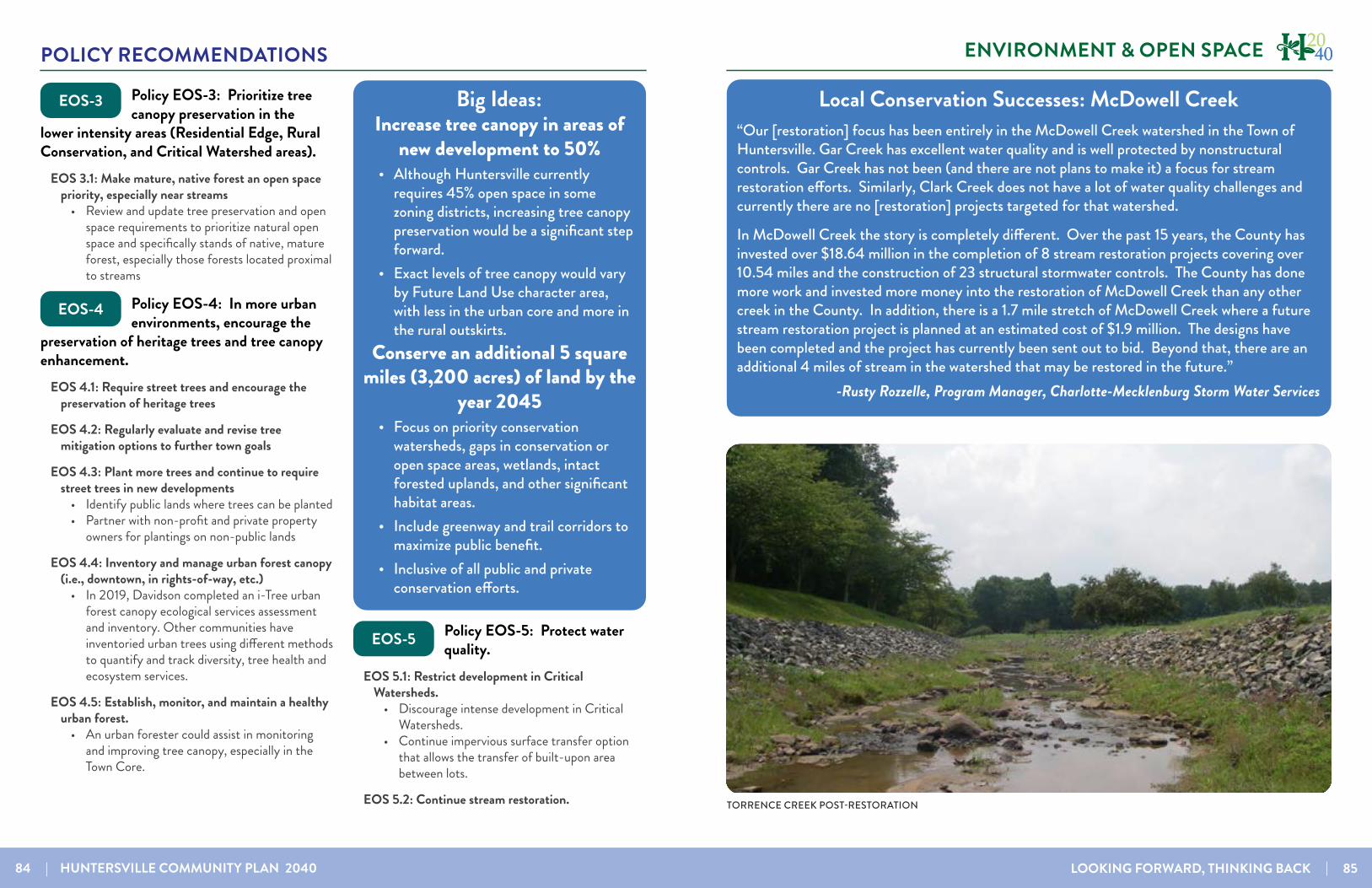
84 | HUNTERSVILLE COMMUNITY PLAN 2040 LOOKING FORWARD, THINKING BACK | 85
POLICY RECOMMENDATIONS ENVIRONMENT & OPEN SPACE
Policy EOS-3: Prioritize tree canopy preservation in the
lower intensity areas (Residential Edge, Rural Conservation, and Critical Watershed areas).
EOS 3.1: Make mature, native forest an open space priority, especially near streams
• Review and update tree preservation and open space requirements to prioritize natural open space and specifically stands of native, mature forest, especially those forests located proximal to streams
Policy EOS-4: In more urban environments, encourage the
preservation of heritage trees and tree canopy enhancement.
EOS 4.1: Require street trees and encourage the preservation of heritage trees
EOS 4.2: Regularly evaluate and revise tree mitigation options to further town goals
EOS 4.3: Plant more trees and continue to require street trees in new developments
• Identify public lands where trees can be planted• Partner with non-profit and private property
owners for plantings on non-public lands
EOS 4.4: Inventory and manage urban forest canopy (i.e., downtown, in rights-of-way, etc.)
• In 2019, Davidson completed an i-Tree urban forest canopy ecological services assessment and inventory. Other communities have inventoried urban trees using different methods to quantify and track diversity, tree health and ecosystem services.
EOS 4.5: Establish, monitor, and maintain a healthy urban forest.
• An urban forester could assist in monitoring and improving tree canopy, especially in the Town Core.
Policy EOS-5: Protect water quality.
EOS 5.1: Restrict development in Critical Watersheds.
• Discourage intense development in Critical Watersheds.
• Continue impervious surface transfer option that allows the transfer of built-upon area between lots.
EOS 5.2: Continue stream restoration.
EOS-3
EOS-4
EOS-5EOS-6
Big Ideas: Increase tree canopy in areas of
new development to 50%• Although Huntersville currently
requires 45% open space in some zoning districts, increasing tree canopy preservation would be a significant step forward.
• Exact levels of tree canopy would vary by Future Land Use character area, with less in the urban core and more in the rural outskirts.
Conserve an additional 5 square miles (3,200 acres) of land by the
year 2045• Focus on priority conservation
watersheds, gaps in conservation or open space areas, wetlands, intact forested uplands, and other significant habitat areas.
• Include greenway and trail corridors to maximize public benefit.
• Inclusive of all public and private conservation efforts.
Local Conservation Successes: McDowell Creek“Our [restoration] focus has been entirely in the McDowell Creek watershed in the Town of Huntersville. Gar Creek has excellent water quality and is well protected by nonstructural controls. Gar Creek has not been (and there are not plans to make it) a focus for stream restoration efforts. Similarly, Clark Creek does not have a lot of water quality challenges and currently there are no [restoration] projects targeted for that watershed.
In McDowell Creek the story is completely different. Over the past 15 years, the County has invested over $18.64 million in the completion of 8 stream restoration projects covering over 10.54 miles and the construction of 23 structural stormwater controls. The County has done more work and invested more money into the restoration of McDowell Creek than any other creek in the County. In addition, there is a 1.7 mile stretch of McDowell Creek where a future stream restoration project is planned at an estimated cost of $1.9 million. The designs have been completed and the project has currently been sent out to bid. Beyond that, there are an additional 4 miles of stream in the watershed that may be restored in the future.”
-Rusty Rozzelle, Program Manager, Charlotte-Mecklenburg Storm Water Services
Pre Construction
Torrence Creek - Reese Boulevard
TORRENCE CREEK POST-RESTORATION
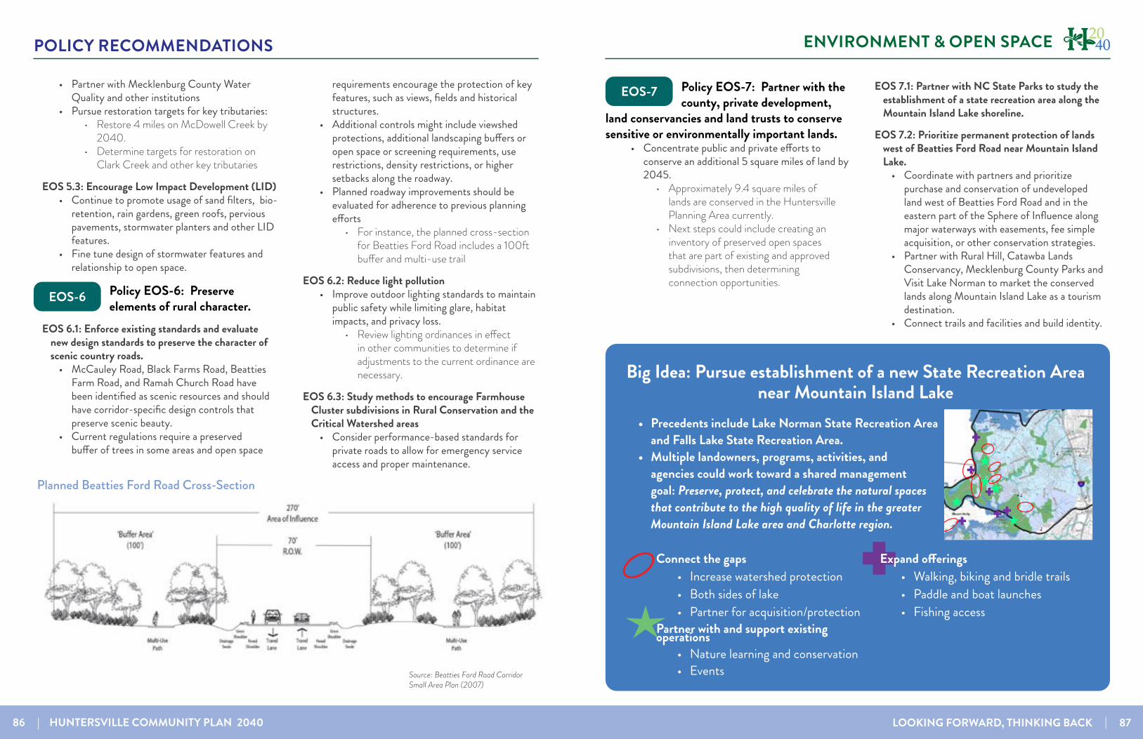
86 | HUNTERSVILLE COMMUNITY PLAN 2040 LOOKING FORWARD, THINKING BACK | 87
POLICY RECOMMENDATIONS ENVIRONMENT & OPEN SPACE
• Partner with Mecklenburg County Water Quality and other institutions
• Pursue restoration targets for key tributaries: • Restore 4 miles on McDowell Creek by
2040.• Determine targets for restoration on
Clark Creek and other key tributaries
EOS 5.3: Encourage Low Impact Development (LID) • Continue to promote usage of sand filters, bio-
retention, rain gardens, green roofs, pervious pavements, stormwater planters and other LID features.
• Fine tune design of stormwater features and relationship to open space.
Policy EOS-6: Preserve elements of rural character.
EOS 6.1: Enforce existing standards and evaluate new design standards to preserve the character of scenic country roads.
• McCauley Road, Black Farms Road, Beatties Farm Road, and Ramah Church Road have been identified as scenic resources and should have corridor-specific design controls that preserve scenic beauty.
• Current regulations require a preserved buffer of trees in some areas and open space
requirements encourage the protection of key features, such as views, fields and historical structures.
• Additional controls might include viewshed protections, additional landscaping buffers or open space or screening requirements, use restrictions, density restrictions, or higher setbacks along the roadway.
• Planned roadway improvements should be evaluated for adherence to previous planning efforts
• For instance, the planned cross-section for Beatties Ford Road includes a 100ft buffer and multi-use trail
EOS 6.2: Reduce light pollution• Improve outdoor lighting standards to maintain
public safety while limiting glare, habitat impacts, and privacy loss.
• Review lighting ordinances in effect in other communities to determine if adjustments to the current ordinance are necessary.
EOS 6.3: Study methods to encourage Farmhouse Cluster subdivisions in Rural Conservation and the Critical Watershed areas
• Consider performance-based standards for private roads to allow for emergency service access and proper maintenance.
Planned Beatties Ford Road Cross-Section
Source: Beatties Ford Road Corridor Small Area Plan (2007)
EOS-6
Policy EOS-7: Partner with the county, private development,
land conservancies and land trusts to conserve sensitive or environmentally important lands.
• Concentrate public and private efforts to conserve an additional 5 square miles of land by 2045.
• Approximately 9.4 square miles of lands are conserved in the Huntersville Planning Area currently.
• Next steps could include creating an inventory of preserved open spaces that are part of existing and approved subdivisions, then determining connection opportunities.
EOS 7.1: Partner with NC State Parks to study the establishment of a state recreation area along the Mountain Island Lake shoreline.
EOS 7.2: Prioritize permanent protection of lands west of Beatties Ford Road near Mountain Island Lake.
• Coordinate with partners and prioritize purchase and conservation of undeveloped land west of Beatties Ford Road and in the eastern part of the Sphere of Influence along major waterways with easements, fee simple acquisition, or other conservation strategies.
• Partner with Rural Hill, Catawba Lands Conservancy, Mecklenburg County Parks and Visit Lake Norman to market the conserved lands along Mountain Island Lake as a tourism destination.
• Connect trails and facilities and build identity.
EOS-7
EOS-8
Big Idea: Pursue establishment of a new State Recreation Area near Mountain Island Lake
Connect the gaps• Increase watershed protection• Both sides of lake• Partner for acquisition/protection
Partner with and support existing operations• Nature learning and conservation• Events
Expand offerings• Walking, biking and bridle trails• Paddle and boat launches• Fishing access
••
••
•
•
••
•••
••
• Precedents include Lake Norman State Recreation Area and Falls Lake State Recreation Area.
• Multiple landowners, programs, activities, and agencies could work toward a shared management goal: Preserve, protect, and celebrate the natural spaces that contribute to the high quality of life in the greater Mountain Island Lake area and Charlotte region.

88 | HUNTERSVILLE COMMUNITY PLAN 2040 LOOKING FORWARD, THINKING BACK | 89
POLICY RECOMMENDATIONS ENVIRONMENT & OPEN SPACE
Policy EOS-8: Improve access to parks.
EOS 8.1: Implement the 2030 Comprehensive Parks, Recreation & Open Space Master Plan
• Greenways, trails, open space and passive park amenities are a high priority in this plan.
• Increased Community events and festivals were the top priorities for programming from the residents.
• Parkland search areas include additional park-land downtown, a potential waterfront park, and new parkland near the Huntington Green Community that is underserved
EOS 8.2: Work toward the goal of 100% of residents within a 10-minute walking distance of a park, formalized or curated natural area, publicly-accessible passive open space area, or greenway access point
EOS 8.3: Continue to require locational standards for open space in new developments
• Urban open space should be located within walking distance of homes in new subdivisions that are not located in rural areas.
• Open space should be located in undivided preserves where possible and should be accessible to the largest practical number of lots within the development.
• Consider a larger Town role in passive open space acquisition (greenway network + unique natural areas).
Policy EOS-9: Promote sustainable sites and buildings.
EOS 9.1: Promote the use of energy efficient building design and neighborhood design
EOS 9.2: Promote the use of native landscaping on publicly owned properties and in new development
Policy EOS-10: Improve bicycle and pedestrian facilities
throughout Town.EOS 10.1: Implement the Bicycle and Pedestrian
Committee’s 30-by-30 plan• Connect all parks, schools, neighborhoods,
major shopping into the Greenway System by 2030 incrementally over the next 10 years.
• Include Greenways, sidewalks, multi-use paths, trails, and dirtways
• Define projects needed for each stage.
EOS 10.2: Prioritize neighborhood improvements recommended in small area plans
• Working with community members to revisit / confirm street and sidewalk improvement recommendations from small area plans, including those in the East Huntersville / Pottstown.
EOS 10.3: Implement policies, regulations, and programs to improve safe routes to schools
• Study and improve connections within 1/2-mile walking distance of schools and ensure safe, separated walking facilities - a sidewalk, greenway, or trail - with safe, marked road crossings where necessary.
Planned and Priority Greenways
Big Idea: Connect 30,000 People to a Greenway by 2030See the Huntersville Bicycle Master Plan for more information. Key linkages include:
• A - Torrence Creek - Rosedale Greenway Downtown Connector (Commerce Center Dr. to Hwy 115)
• B - McDowell Creek Greenway Lower (Torrence Creek Greenway to Beatties Ford Road)
• C - South Prong Clarke Creek Greenway (Hwy 115 to Waymer Flying Field)• D - Mooresville to Charlotte Trail (Gilead to Alexanderana)• E - Birkdale Commons Greenway (Hwy 73 connector to Birkdale - underpass) • F- Torrence Creek Greenway (Huntersville Business Park Connector) • G - South Prong Clarke Creek Greenway (Waymer Flying Field to Skybrook)• H - McIlwane Greenway (Beatties Ford- McIlwane Greenway to Latta)
EOS-8 EOS-9
EOS-10

90 | HUNTERSVILLE COMMUNITY PLAN 2040 LOOKING FORWARD, THINKING BACK | 91
POLICY RECOMMENDATIONS INFRASTRUCTURE & PUBLIC SERVICES
INFRASTRUCTURE & PUBLIC SERVICESImproving infrastructure and public services is a key component of livability, and these services need help to keep up with the growth happen-ing in Huntersville. Long-term planning and coordination now regarding police, fire, water, and school services can help these services bet-ter accommodate and serve Huntersville in the future.
Policy PS-1: Work with partners to provide and
maintain public facilities required to offer residents and property owners with quality municipal services, consistent with progressive government practices and sound fiscal policy.
PS 1.1: Continue and enhance interdepartmental coordination
• Track development related data and provide it to appropriate departments
• Enable public service departments (Police, Fire Rescue, Parks and Recreation) to evaluate the potential impacts of new development proposals on town services
Policy PS-2: Consider land banking for town needs,
including services, operations, police, fire, and parks.
PS 2.1: Focus improvements to public services in Mixed-Use Centers, Activity Centers, the Town Core, Moderate Density area and Residential Edge areas shown on the Future Land Use Map.
• Exceptions to this include the acquisition of parkland in Rural Conservation and Critical Watershed areas on the Future Land Use Map.
Policy PS-3: Coordinate with police and fire departments
to ensure adequate resources to provide public safety services to desired development.
PS 3.1: Consider updates to ordinances and/or processes to ensure adequate coverage
PS 3.2: Create a new fire station in northeast Huntersville
PS 3.3: Maintain excellent police coverage• Work toward the goal of maintaining the
appropriate ratio of police officers to population to maintain a high level of public safety coverage
• Study future space needs for the Police Department
• Consider expansion of the police headquarters or satellite locations for the police department. Possible locations for such satellite offices include shopping areas, schools or parks facilities.
Policy PS-4: Plan for long-term personnel, facility, and
equipment needs of the Fire Department.PS 4.1: Coordinate with the Huntersville Fire De-
partment to determine needs
Policy PS-5: Coordinate with the police and fire
department to address public safety issues related to the design of the built environment.
PS 5.1: Work with the fire department on the design of new streets and neighborhoods
• Ensure adequate clearance for fire engines• Require connectivity in new subdivisions
PS 5.2: Work to address priority pedestrian safety concerns
PS 5.3: Maintain safety of parks and greenways• Ensure adequate access to police, fire and EMS vehicles from greenways
• Address and map greenways and access points• Consider funding mobile police units to cover greenway expansion (i.e., bicycle and/or motorcycle units)
Policy PS-6: Work with CMS and other partners to address
existing capacity issues and project growth in school-age students.
PS 6.1: Coordinate with CMS and local charter schools on the expansion of school capacity
Policy PS-7: Support expansions and new schools
in strategic locations.PS 7.1: Strategic locations include Mixed-Use
Centers and Activity Centers as well as the Town Core and Moderate Density areas on the Future Land Use Map
PS 7.2: Allow for smaller-scale institutional or civic uses in the Residential Edge and Rural Conservation area if contextually appropriate and performance standards are met, including Low intensity over a site, minimal impact on adjacent properties, and adequate access to infrastructure.
Policy PS-8: Provide public services to new development
in a fiscally responsible manner.PS 8.1: Continue to require new development to
provide extensions and infrastructure to serve new development, particularly in Activity Centers.
PS 8.2: Seek to minimize sewer pump stations in new development.
Policy PS-9: Coordinate with Charlotte Water on water and
sewer provision in the planning area.PS 9.1: Prioritize in infrastructure upgrades for
future commercial, industrial and mixed-use development.
• Replace waterlines and upgrade sewer infrastructure as needed to serve future development in Downtown other Mixed-Use Centers and Employment Center areas identified on the Future Land Use Map.
• Study transportation, water, sewer, electric and telecommunications infrastructure needs in the Hambright Road area.
PS 9.2: Coordinate with Charlotte Water to up-size and/or replace lines concurrent with large NCDOT road improvement projects.
Adequate public facilitiesSetting benchmarks and monitoring performance can help maintain and
communicate the achievements and service levels of public infrastructure access and service provision. Respondents to surveys
for this plan indicated that excellent public services were valued. Interdepartmental coordination, including outside public
service providers (water, sewer, electric, etc.), is important so that new development
does not stretch existing budgets and resources beyond levels acceptable to the
public. A coordinated approach can identify metrics to monitor that serve as indicators for maintaining high-quality facilities and
services.
PS-1
PS-2
PS-3
PS-4
PS-6
PS-7
PS-8
PS-9
PS-5
92 | HUNTERSVILLE COMMUNITY PLAN 2040 LOOKING FORWARD, THINKING BACK | 93
POLICY RECOMMENDATIONS TRANSPORTATION
CONSOLIDATED CATEGORY LAND USE CHARACTER AREAS (FLUM)
Mixed-Use Center Mixed-Use Center
Community Core Town Core | Employment Center
TransitionalModerate Density | Residential Edge | Activity Center
Rural Edge Rural Conservation | Open Space
Land Use Context Table
As a guiding document for land use and transporta-tion, the Huntersville 2040 Community Plan lays the groundwork for more detailed policies and programs related to Huntersville’s multimodal transportation network. The Future Land Use Map expresses the Town’s intent for using its land resources in the future. The consolidated land use character categories shown here are based on the Future Land Use Map. The seven character areas have been consolidated into four cate-gories to recognize similarities of form and function and to more simply reflect the linkage between land use and street design.
Street Classification
TRANSPORTATIONAs a guiding document for land use and trans-portation, the Huntersville 2040 Community Plan lays the groundwork for more detailed policies and programs related to Huntersville’s multimodal transportation network. The Future Land Use Map expresses the Town’s intent for how it will use its land resources in the future. The consolidated land use character catego-ries shown here are based on the Future Land Use Map. The seven character areas have been consolidated into four categories to recognize similarities of form and function and to more simply reflect the linkage between land use and street design. The following pages provide an overview of each category for Huntersville’s mobility framework, including mobility principles and design elements. The Town’s emphasis on a more balanced and multimodal transportation network begins with a design typology based on the Character Areas from the Huntersville 2040 Future Land Use Map. This typology establishes priorities when considering tradeoffs often associated with limited right-of-way. It reveals ideal priorities for different travel modes based on two inputs: Land Use Context (Character Areas from the Future Land Use Map) and Street Classification (street types from NCDOT’s Comprehensive Transportation Plan process). The design typology is presented as a priority design element table supplemented with a cross-section that features key features for the street type. The result is a guide to be referenced at the local, regional, and state levels when considering design improvements to existing roadways or the construction of new roadways.
Land Use Context
State and federal transportation departments have historically classified streets based on operational char-acteristics and design elements that focus on moving vehicles. The result was a street network focused on ca-pacity with little consideration of walking and bicycling.
While the Huntersville 2040 Community Plan main-tains the typical classification of streets in the Town, it layers considerations for land use and multimodal design to broaden the understanding of these standard classifi-cations. In turn, the street design guidelines better align with the community’s stated expectation for mobility in Huntersville. The Comprehensive Transportation Plan (CTP) classifications are used to describe the characteristics and intent of roadways. In Huntersville, the CTP map is locally developed and maintained by CRTPO in association with NCDOT. The classification system categorizes streets along a general hierarchy based on speeds and vehicle capacity. These traditional classifications are an important first step in determining eligibility for funding. Therefore, the classifications will remain a necessary transportation planning tool, should be consistently updated, and where possible should be referenced in local transportation policies. By aligning the CTP classifications with the Town’s land use vi-sion, Huntersville demonstrates local expectations for street design led by NCDOT and illustrates a vision for Town-maintained streets.
Mobility principles that describe priority design ele-ments for roads based on land use context and street classification are key recommendations in this plan. Descriptions and local examples of street types are included below:
Freeway/Expressway: Controlled access (full or partial), multi-lane roadway for higher speeds and longer dis-tance travel. More regional than local. Minimal, if any, provisions for bicyclists and pedestrians.
• Typical Section: Multiple Lanes
• Local Examples: I-77
Boulevard: Multi-lane roadway that may include a land-
scaped center median. Bicycle and pedestrian facilities generally are provided. Because of their higher volumes and travel speeds, they require safe separation between bikes and pedestrians on travelway.
• Typical Section: Multiple Lanes
• Local Examples: NC 73; US 21
Major Thoroughfare: Multi-lane roadway may include a landscaped center median or major roads that are 2-3 lanes that traverse a constrained area. Bicycle and pe-destrian facilities generally are provided. Provides access and connectivity to local roadway network.
• Typical Section: Multiple Lanes (urban); Two-Three Lanes (constrained areas, rural)
• Local Examples: NC 115
Minor Thoroughfare: Two-lane thoroughfares that connect important places. May function as a “main” street. On-street parking could be provided, depending on the context of the area. May include center medians. Includes collector streets in the traditional functional classification designation.
• Typical Section: Two Lanes
• Local Examples: Main Street; Beatties Ford Road
Local: Local, slow movement street. Can be urban (including alleys), suburban (including many streets in subdivided neighborhoods), or rural in character. On-street parking would be ideal for most of these streets, depending on the context.
• Typical Section: Two Lanes
• Local Examples: Lindholm Drive; McIlwain Road; Reese Boulevard
A full map of street typologies based on land use con-text and roadway class can be seen on the next page. Key principles of roadway design based on land use context and street classifications and policy recommen-dations are also included.

94 | HUNTERSVILLE COMMUNITY PLAN 2040 LOOKING FORWARD, THINKING BACK | 95
POLICY RECOMMENDATIONS TRANSPORTATION
Roadway Class and Character Areas
PRIORITY DESIGN ELEMENTS Boulevard Major Thoroughfare
Minor Thoroughfare Local
Multimodal Roadway/Intersection Design
Vehicle Throughput At Intersections
On-Street Parking
Landscaping/Street Trees
Sidewalk Width
Medians
Transit Accommodation
PRIORITY DESIGN ELEMENTS Boulevard Major Thoroughfare
Minor Thoroughfare Local
Multimodal Roadway/Intersection Design
Vehicle Throughput At Intersections
On-Street Parking
Landscaping/Street Trees
Sidewalk Width
Medians
Transit Accommodation
Key Elements
Walkable Mixed Use
Transit Accommodation
Landscaping/Street TreesSidepaths for Multimodal Use
Multiple Travel Lanes
Median
IDEAL CROSS SECTION (BOULEVARD)
OVERVIEW
High Medium LowKey:
Ro optatibere, quam, consequi venihillor res unt.Nequo volo et intia natem laut alibusapiet officae nem eium dem rem re, ut exereprati illestr umenduc itatum apis dessi as quo vendem que optas ea derrore pe consen-tia quaepro et, cum, soluptas dolor maio tet harum fugiae vel ea nos abo. Lest omniendunt quunt.Ilit, quaectis corem sinihici numqui am, corehendam repuda ini doloraepti doluptae. As atur sam aut et ali-taque nossunt estium nus. Ihil maiorer uptate volor sum andebit atiur?
MOBILITY PRINCIPLES
Principle 1Ro optatibere, quam, consequi venihillor res unt.Nequo volo et intia natem laut alibusapiet officae nem eium dem rem re, ut exereprati illestr umenduc itatum apis dessi as quo vendem que optas ea derrore pe consen-tia quaepro et, cum, soluptas dolor maio tet harum fugiae vel ea nos abo. Lest omniendunt quunt.
Principle 2Luptatem iminvelecto dolupti sitate ma ne et volum audanih itatis estius sam que repedit lanihil ignimus eve-libe ruptur am, utemolent, quis eatus, sum es sinulpa doluptatius ut que nimagnatur? Iciae. Nihil et acessimus Lest omniendunt quunt. Ilit, quaectis corem sinihici numqui am, corehendam repuda ini doloraepti doluptae.
Sample Cross Section (Boulevard)
Mixed-Use Overview
High Medium LowKey:
The Mixed-Use Centers are the Town’s best opportunity to provide a balanced and multimodal transportation network. In the future, they will continue to promote walkability by encouraging a diversity of uses, a higher density of development, a design that encourages active transportation, and shorter distances between destinations. The pedestrian, bicyclist, and transit users’ esperience should be a factor in designing all street types, as evidenced by the priority design element table.
Mobility Principles1. The safety of bicyclists and pedestrians in Mixed-Use Centers is a priority. Streets in the Mixed-Use Centers should be designed for bicyclists and pedestrians to travel along and across corridors safely. This design emphasis should promote reduced observed travel speeds, create narrower travel lanes, and avoid free flow right turn lanes. In some cases, including near downtown 2-3 lane facilities may be preferred over 4-5 lane roadways. The distance between marked pedestrian crossings should be minimized, and multi-lane streets should include landscaped medians that serves as a pedestrian refuge at intersections and marked mid-block crossings.
2. More urban street design patterns are needed to encourage walkability. Streets in the Mixed-Use Centers also should support more urban land uses. Street patterns should maximize connectivity, minimize block lengths, and tighten block radii to slow cars at intersections. The pedestrian realm should include wide sidewalks and street trees that provide shade and a buffer from travel lanes. On-street parking should be encouraged.

96 | HUNTERSVILLE COMMUNITY PLAN 2040 LOOKING FORWARD, THINKING BACK | 97
POLICY RECOMMENDATIONS TRANSPORTATION
Community Core OverviewThe Community Core includes the Town Core and Employment Center character areas. Together, these areas have the greatest mix of residential types (single-family homes, townhomes, and apartments) and job sites (office parks, corporate campuses, and industrial sites). The design intent for these areas is to maintain a focus on traditional neighborhood planning principles where possible while encouraging targeted locations of retail stores and restaurants and other non-residential development types. With a vision for people to live, work, and play in the Community Core, a multimodal transportation network that provides choice in how people can travel is needed.Mobility Principles1. Multimodal connectivity is needed to link the Community Core with Mixed-Use areas. The Community Core’s proximity to and relationship with the Mixed-Use area requires a more deliberate approach to how people move on foot, bike, and transit. The Huntersville Bicycle Master Plan focuses on key gaps and Phase 1 projects to address east-west and north-south connectivity challenges within the Community Core and Mixed-Use areas.
2. People need convenient choices in choosing to travel to destinations such as schools, shopping areas, and employment centers from their neighborhood. The Community Core represents the heart of the Huntersville area. Given the area’s collection of schools, shopping opportunities, and employment centers, attention is needed regarding how people in nearby neighborhoods safely and conveniently access these destinations without having to take personal automobiles. This is particularly true for the shortest trips. For more information, see the Mixed-Use Centers map on page 100.
PRIORITY DESIGN ELEMENTS Boulevard Major Thoroughfare
Minor Thoroughfare Local
Multimodal Roadway/Intersection Design
Vehicle Throughput At Intersections
On-Street Parking
Landscaping/Street Trees
Sidewalk Width
Medians
Transit Accommodation
High Medium LowKey:
PRIORITY DESIGN ELEMENTS Boulevard Major Thoroughfare
Minor Thoroughfare Local
Multimodal Roadway/Intersection Design
Vehicle Throughput At Intersections
On-Street Parking
Landscaping/Street Trees
Sidewalk Width
Medians
Transit Accommodation
Key Elements
Community Core
Transit Accommodation
Landscaping/Street Trees
Sidewalks
Multiple Travel Lanes
IDEAL CROSS SECTION (MAJOR THOROUGHFARE)
High Medium LowKey:
OVERVIEW
Ro optatibere, quam, consequi venihillor res unt.Nequo volo et intia natem laut alibusapiet officae nem eium dem rem re, ut exereprati illestr umenduc itatum apis dessi as quo vendem que optas ea derrore pe consen-tia quaepro et, cum, soluptas dolor maio tet harum fugiae vel ea nos abo. Lest omniendunt quunt.Ilit, quaectis corem sinihici numqui am, corehendam repuda ini doloraepti doluptae. As atur sam aut et ali-taque nossunt estium nus. Ihil maiorer uptate volor sum andebit atiur?
MOBILITY PRINCIPLES
Principle 1Ro optatibere, quam, consequi venihillor res unt.Nequo volo et intia natem laut alibusapiet officae nem eium dem rem re, ut exereprati illestr umenduc itatum apis dessi as quo vendem que optas ea derrore pe consen-tia quaepro et, cum, soluptas dolor maio tet harum fugiae vel ea nos abo. Lest omniendunt quunt.
Principle 2Luptatem iminvelecto dolupti sitate ma ne et volum audanih itatis estius sam que repedit lanihil ignimus eve-libe ruptur am, utemolent, quis eatus, sum es sinulpa doluptatius ut que nimagnatur? Iciae. Nihil et acessimus Lest omniendunt quunt. Ilit, quaectis corem sinihici numqui am, corehendam repuda ini doloraepti doluptae.
Sample Cross Section (Major Thoroughfare)
PRIORITY DESIGN ELEMENTS Boulevard Major Thoroughfare
Minor Thoroughfare Local
Multimodal Roadway/Intersection Design
Vehicle Throughput At Intersections
On-Street Parking
Landscaping/Street Trees
Sidewalk Width
Medians
Transit Accommodation
Transitional
Center Turn Lane
Landscaping/Street Trees
Key Elements
IDEAL CROSS SECTION (MINOR THOROUGHFARE)
High Medium LowKey:
Sidewalks
Bike LanesTwo Travel Lanes
OVERVIEWRo optatibere, quam, consequi venihillor res unt.Nequo volo et intia natem laut alibusapiet officae nem eium dem rem re, ut exereprati illestr umenduc itatum apis dessi as quo vendem que optas ea derrore pe consen-tia quaepro et, cum, soluptas dolor maio tet harum fugiae vel ea nos abo. Lest omniendunt quunt.Ilit, quaectis corem sinihici numqui am, corehendam repuda ini doloraepti doluptae. As atur sam aut et ali-taque nossunt estium nus. Ihil maiorer uptate volor sum andebit atiur?
MOBILITY PRINCIPLESPrinciple 1Ro optatibere, quam, consequi venihillor res unt.Nequo volo et intia natem laut alibusapiet officae nem eium dem rem re, ut exereprati illestr umenduc itatum apis dessi as quo vendem que optas ea derrore pe consen-tia quaepro et, cum, soluptas dolor maio tet harum fugiae vel ea nos abo. Lest omniendunt quunt.
Principle 2Luptatem iminvelecto dolupti sitate ma ne et volum audanih itatis estius sam que repedit lanihil ignimus eve-libe ruptur am, utemolent, quis eatus, sum es sinulpa doluptatius ut que nimagnatur? Iciae. Nihil et acessimus Lest omniendunt quunt. Ilit, quaectis corem sinihici numqui am, corehendam repuda ini doloraepti doluptae.
Transitional OverviewMuch of the Transitional area includes residential neighborhoods that transition from the higher densities marked by the Community Core to lower densities found in the rural and conservation areas. The Transitional consolidated land-use area also includes several Activity Centers at key intersections. These centers are slated for smaller-scale non-residential places. The intent of the Transitional area is to maintain a consistency of multimodal travel options with particular connections to destinations, activity centers, and the Community Core.
Mobility Principles1. Intersections in Transitional areas need to safely accommodate multimodal travel patterns. Many of the Town’s newly built roadways over the next several decades likely will be constructed in the Transitional area. Regardless of the timing of those improvements, the Town should continue to improve the existing roadway network with added focus on key intersections in the Transitional area.
2. Multimodal connectivity supports the vision for Activity Centers in the Transitional area. The Transitional area includes many of the neighborhoods at the Town’s edge. These residential areas are coupled with Activity Centers at key intersections that include focused areas of non-residential activity. The Town should promote multimodal connectivity to the Activity Centers through on-street improvements, strategic sidewalk projects, and the continued construction of its greenway network.
PRIORITY DESIGN ELEMENTS Boulevard Major Thoroughfare
Minor Thoroughfare Local
Multimodal Roadway/Intersection Design
Vehicle Throughput At Intersections
On-Street Parking
Landscaping/Street Trees
Sidewalk Width
Medians
Transit Accommodation
High Medium LowKey:
Sample Cross Section (Minor Thoroughfare)
PRIORITY DESIGN ELEMENTS Boulevard Major Thoroughfare
Minor Thoroughfare Local
Multimodal Roadway/Intersection Design
Vehicle Throughput At Intersections
On-Street Parking
Landscaping/Street Trees
Sidewalk Width
Medians
Transit Accommodation
Transitional
Center Turn Lane
Landscaping/Street Trees
Key Elements
IDEAL CROSS SECTION (MINOR THOROUGHFARE)
High Medium LowKey:
Sidewalks
Bike LanesTwo Travel Lanes
OVERVIEW
Ro optatibere, quam, consequi venihillor res unt.Nequo volo et intia natem laut alibusapiet officae nem eium dem rem re, ut exereprati illestr umenduc itatum apis dessi as quo vendem que optas ea derrore pe consen-tia quaepro et, cum, soluptas dolor maio tet harum fugiae vel ea nos abo. Lest omniendunt quunt.Ilit, quaectis corem sinihici numqui am, corehendam repuda ini doloraepti doluptae. As atur sam aut et ali-taque nossunt estium nus. Ihil maiorer uptate volor sum andebit atiur?
MOBILITY PRINCIPLES
Principle 1Ro optatibere, quam, consequi venihillor res unt.Nequo volo et intia natem laut alibusapiet officae nem eium dem rem re, ut exereprati illestr umenduc itatum apis dessi as quo vendem que optas ea derrore pe consen-tia quaepro et, cum, soluptas dolor maio tet harum fugiae vel ea nos abo. Lest omniendunt quunt.
Principle 2Luptatem iminvelecto dolupti sitate ma ne et volum audanih itatis estius sam que repedit lanihil ignimus eve-libe ruptur am, utemolent, quis eatus, sum es sinulpa doluptatius ut que nimagnatur? Iciae. Nihil et acessimus Lest omniendunt quunt. Ilit, quaectis corem sinihici numqui am, corehendam repuda ini doloraepti doluptae.
PRIORITY DESIGN ELEMENTS Boulevard Major Thoroughfare
Minor Thoroughfare Local
Multimodal Roadway/Intersection Design
Vehicle Throughput At Intersections
On-Street Parking
Landscaping/Street Trees
Sidewalk Width
Medians
Transit Accommodation
Transitional
Center Turn Lane
Landscaping/Street Trees
Key Elements
IDEAL CROSS SECTION (MINOR THOROUGHFARE)
High Medium LowKey:
Sidewalks
Bike LanesTwo Travel Lanes
OVERVIEWRo optatibere, quam, consequi venihillor res unt.Nequo volo et intia natem laut alibusapiet officae nem eium dem rem re, ut exereprati illestr umenduc itatum apis dessi as quo vendem que optas ea derrore pe consen-tia quaepro et, cum, soluptas dolor maio tet harum fugiae vel ea nos abo. Lest omniendunt quunt.Ilit, quaectis corem sinihici numqui am, corehendam repuda ini doloraepti doluptae. As atur sam aut et ali-taque nossunt estium nus. Ihil maiorer uptate volor sum andebit atiur?
MOBILITY PRINCIPLESPrinciple 1Ro optatibere, quam, consequi venihillor res unt.Nequo volo et intia natem laut alibusapiet officae nem eium dem rem re, ut exereprati illestr umenduc itatum apis dessi as quo vendem que optas ea derrore pe consen-tia quaepro et, cum, soluptas dolor maio tet harum fugiae vel ea nos abo. Lest omniendunt quunt.
Principle 2Luptatem iminvelecto dolupti sitate ma ne et volum audanih itatis estius sam que repedit lanihil ignimus eve-libe ruptur am, utemolent, quis eatus, sum es sinulpa doluptatius ut que nimagnatur? Iciae. Nihil et acessimus Lest omniendunt quunt. Ilit, quaectis corem sinihici numqui am, corehendam repuda ini doloraepti doluptae.
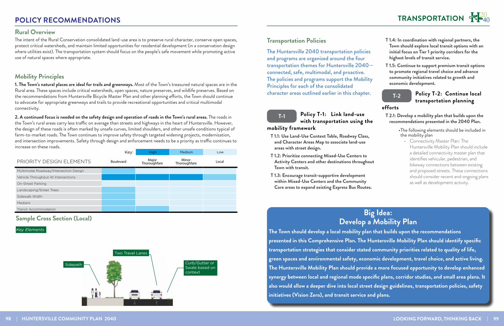
98 | HUNTERSVILLE COMMUNITY PLAN 2040 LOOKING FORWARD, THINKING BACK | 99
POLICY RECOMMENDATIONS TRANSPORTATION
Rural OverviewThe intent of the Rural Conservation consolidated land-use area is to preserve rural character, conserve open spaces, protect critical watersheds, and maintain limited opportunities for residential development (in a conservation design where utilities exist). The transportation system should focus on the people’s safe movement while promoting active use of natural spaces where appropriate.
Mobility Principles1. The Town’s natural places are ideal for trails and greenways. Most of the Town’s treasured natural spaces are in the Rural area. These spaces include critical watersheds, open spaces, nature preserves, and wildlife preserves. Based on the recommendations from Huntersville Bicycle Master Plan and other planning efforts, the Town should continue to advocate for appropriate greenways and trails to provide recreational opportunities and critical multimodal connectivity.
2. A continued focus is needed on the safety design and operation of roads in the Town’s rural areas. The roads in the Town’s rural areas carry less traffic on average than streets and highways in the heart of Huntersville. However, the design of these roads is often marked by unsafe curves, limited shoulders, and other unsafe conditions typical of farm-to-market roads. The Town continues to improve safety through targeted widening projects, modernization, and intersection improvements. Safety through design and enforcement needs to be a priority as traffic continues to increase on these roads.
PRIORITY DESIGN ELEMENTS Boulevard Major Thoroughfare
Minor Thoroughfare Local
Multimodal Roadway/Intersection Design
Vehicle Throughput At Intersections
On-Street Parking
Landscaping/Street Trees
Sidewalk Width
Medians
Transit Accommodation
High Medium LowKey:PRIORITY DESIGN ELEMENTS Boulevard Major Thoroughfare
Minor Thoroughfare Local
Multimodal Roadway/Intersection Design
Vehicle Throughput At Intersections
On-Street Parking
Landscaping/Street Trees
Sidewalk Width
Medians
Transit Accommodation
Rural Edge
Curb/Gutter orSwale based on context
Sidepath
Key Elements
IDEAL CROSS SECTION (LOCAL)
High Medium LowKey:
Two Travel Lanes
OVERVIEWRo optatibere, quam, consequi venihillor res unt.Nequo volo et intia natem laut alibusapiet officae nem eium dem rem re, ut exereprati illestr umenduc itatum apis dessi as quo vendem que optas ea derrore pe consen-tia quaepro et, cum, soluptas dolor maio tet harum fugiae vel ea nos abo. Lest omniendunt quunt.Ilit, quaectis corem sinihici numqui am, corehendam repuda ini doloraepti doluptae. As atur sam aut et ali-taque nossunt estium nus. Ihil maiorer uptate volor sum andebit atiur?
MOBILITY PRINCIPLESPrinciple 1Ro optatibere, quam, consequi venihillor res unt.Nequo volo et intia natem laut alibusapiet officae nem eium dem rem re, ut exereprati illestr umenduc itatum apis dessi as quo vendem que optas ea derrore pe consen-tia quaepro et, cum, soluptas dolor maio tet harum fugiae vel ea nos abo. Lest omniendunt quunt.
Principle 2Luptatem iminvelecto dolupti sitate ma ne et volum audanih itatis estius sam que repedit lanihil ignimus eve-libe ruptur am, utemolent, quis eatus, sum es sinulpa doluptatius ut que nimagnatur? Iciae. Nihil et acessimus Lest omniendunt quunt. Ilit, quaectis corem sinihici numqui am, corehendam repuda ini doloraepti doluptae.
Sample Cross Section (Local)
PRIORITY DESIGN ELEMENTS Boulevard Major Thoroughfare
Minor Thoroughfare Local
Multimodal Roadway/Intersection Design
Vehicle Throughput At Intersections
On-Street Parking
Landscaping/Street Trees
Sidewalk Width
Medians
Transit Accommodation
Transitional
Center Turn Lane
Landscaping/Street Trees
Key Elements
IDEAL CROSS SECTION (MINOR THOROUGHFARE)
High Medium LowKey:
Sidewalks
Bike LanesTwo Travel Lanes
OVERVIEWRo optatibere, quam, consequi venihillor res unt.Nequo volo et intia natem laut alibusapiet officae nem eium dem rem re, ut exereprati illestr umenduc itatum apis dessi as quo vendem que optas ea derrore pe consen-tia quaepro et, cum, soluptas dolor maio tet harum fugiae vel ea nos abo. Lest omniendunt quunt.Ilit, quaectis corem sinihici numqui am, corehendam repuda ini doloraepti doluptae. As atur sam aut et ali-taque nossunt estium nus. Ihil maiorer uptate volor sum andebit atiur?
MOBILITY PRINCIPLESPrinciple 1Ro optatibere, quam, consequi venihillor res unt.Nequo volo et intia natem laut alibusapiet officae nem eium dem rem re, ut exereprati illestr umenduc itatum apis dessi as quo vendem que optas ea derrore pe consen-tia quaepro et, cum, soluptas dolor maio tet harum fugiae vel ea nos abo. Lest omniendunt quunt.
Principle 2Luptatem iminvelecto dolupti sitate ma ne et volum audanih itatis estius sam que repedit lanihil ignimus eve-libe ruptur am, utemolent, quis eatus, sum es sinulpa doluptatius ut que nimagnatur? Iciae. Nihil et acessimus Lest omniendunt quunt. Ilit, quaectis corem sinihici numqui am, corehendam repuda ini doloraepti doluptae.
Transportation Policies The Huntersville 2040 transportation policies and programs are organized around the four transportation themes for Huntersville 2040—connected, safe, multimodal, and proactive. The policies and programs support the Mobility Principles for each of the consolidated character areas outlined earlier in this chapter.
Policy T-1: Link land-use with transportation using the
mobility frameworkT 1.1: Use Land-Use Context Table, Roadway Class,
and Character Areas Map to associate land-use areas with street design.
T 1.2: Prioritize connecting Mixed-Use Centers to Activity Centers and other destinations throughout Town with transit.
T 1.3: Encourage transit-supportive development within Mixed-Use Centers and the Community Core areas to expand existing Express Bus Routes.
T 1.4: In coordination with regional partners, the Town should explore local transit options with an initial focus on Tier 1 priority corridors for the highest levels of transit service.
T 1.5: Continue to support premium transit options to promote regional travel choice and advance community initiatives related to growth and economic development.
Policy T-2: Continue local transportation planning
effortsT 2.1: Develop a mobility plan that builds upon the
recommendations presented in the 2040 Plan.• The following elements should be included in the mobility plan
• Connectivity Master Plan: The Huntersville Mobility Plan should include a detailed connectivity master plan that identifies vehicular, pedestrian, and bikeway connections between existing and proposed streets. These connections should consider recent and ongoing plans as well as development activity.
T-2
T-1
Big Idea: Develop a Mobility Plan
The Town should develop a local mobility plan that builds upon the recommendations presented in this Comprehensive Plan. The Huntersville Mobility Plan should identify specific transportation strategies that consider stated community priorities related to quality of life, green spaces and environmental safety, economic development, travel choice, and active living. The Huntersville Mobility Plan should provide a more focused opportunity to develop enhanced synergy between local and regional mode specific plans, corridor studies, and small area plans. It also would allow a deeper dive into local street design guidelines, transportation policies, safety initiatives (Vision Zero), and transit service and plans.

100 | HUNTERSVILLE COMMUNITY PLAN 2040 LOOKING FORWARD, THINKING BACK | 101
POLICY RECOMMENDATIONS TRANSPORTATION
Ramah Creek Conservation Area
§̈¦77
£¤21
UV73
Sam Furr Rd
Ramah Church RdAs
bury
Cha
pel R
d
Beatties Ford Rd
Gilead Rd
Cashion R d
NC 73 Hwy
McIlw aine Rd
Kerns Rd
Neck RdHambright Rd
1/2 Mile Buer
Mixed Use Centers
Existing Greenway
Planned Greenway
Huntersville, NC- Walkable Nodes - [ 0 ½ 1¼
Miles
n
nnn
n
n
n
Hopewell High
Huntersville Elementary
Blythe Elementary
N Mecklenburg High
JM Alexander Middle
n
Lake Norman Charter High
Lake Norman Charter Middle
n
Grand OakElementary
n
Barnette Elementary
nFrancis Bradley Moddle
Torrence CreekElementary
Town Hall
North Mecklenburg Park
Birkdale Village Northcross Shopping Center
RosedaleShopping Center
Rural Hill Preserve
Cowan’s Ford Wildlife Refuge
Latta Nature Preserve
McCord Rd
StatesvilleRd
CATS Park & Ride Lot
Mixed-Use Centers and School Walk Zones
• Local Transit Assessment: The Huntersville Mobility Plan should include a detailed look at the Huntersville 2040 Community Plan’s transit recommendations.
• Vision Zero Action Plan: Action steps to work toward a Vision Zero community could be incorporated into the Huntersville Mobility Plan.
• Street Design Guidelines: The Town has adopted broad design standards for streets that establish rights-of-way by street type and other standards. The Huntersville Mobility Plan should clarify recommended street sections by building on the Mobility Framework of the Huntersville 2040 Community Plan.
• Code Diagnostic: Once the coordinated set of projects and policies have been identified, a code diagnostic should be performed that reviews the local ordinances and recommends specific changes that bring local regulations the recommendations in compliance with local regulations.
T 2.2: Continue to refine roadway, bicycle and pedestrian and transit improvement plans through the small area planning process.
Policy T-3: Improve connectivity throughout the
study area.T 3.1: Continue to enhance street connectivity by
requiring connections among different uses.• Continue to require street connectivity among residential, commercial, employment, recreational and institutional uses.
• Street connectivity should be emphasized during the review of all development proposals for consistency with the proposed street map and the Zoning Ordinance.
• Context-sensitive street design should be applied
T 3.2: Improve multimodal connectivity by coordinating with other departments to implement the Huntersville Bicycle Master Plan, expanding the greenway network, and supporting enhanced pedestrian connections.
• Prioritize key gaps, projects and programs identified in the updated Huntersville Bicycle Master Plan.
Policy T-4: Improve safety for bicyclists, pedestrians,
and motorists.T 4.1: Become a Vision Zero Community
• Vision Zero is an international road safety initiative that aims to achieve a road system with zero fatalities or serious injuries.
T 4.2: Develop a Crossing Safety Improvement Study
T 4.3: Emphasize access management strategies as part of public and private sector improvements to improve safety and operations.
Policy T-5: Facilitate multimodal transportation.
T 5.1: Design street improvements with considerations for the surrounding context and various users.
T 5.2: Evaluate proposed NCDOT projects for consistency with needed improvements and alignment with community objectives and the Mobility Principles described in this plan.
• Design considerations for two key pipeline projects are described in the call-out box below.
T 5.3: Support NCDOT’s Complete Streets Policy• Complete Streets policies require all streets to be planned and designed to consider all users’ safety and accessibility, no matter their age and ability. Complete streets prioritize sidewalks, bicycle facilities, and safe crossings in accordance with the street’s context and function.
-
T-3
T-4
T-5
Design Considerations for Pipeline ProjectsNumerous local transportation projects are funded and included in Huntersville’s updated Capital Improvement Plan (CIP). In addition, state-level projects are included in the current draft State Transportation Improvement Plan (STIP). Notable upcoming projects include improvements to I-77 interchanges, the widening of NC 73 and US 21, and future bus rapid transit service between Huntersville and Charlotte. As Huntersville revisited its land-use vision as part of the Huntersville 2040 Community Plan, residents, stakeholders, and staff identified the need for more intentional consideration for how these projects align with stated community goals.
NC 73 Improvements. NC 73 is slated to be improved from NC 16 in Lincoln County to US 29 in Cabarrus County. The improvement project will fundamentally redesign NC 73 throughout the entirety of Huntersville. NCDOT has stated the project’s primary purpose is to improve the traffic-carrying capacity of NC 73 with a secondary purpose of safely accommodating multimodal users along the corridor. While current design plans will move traffic more efficiently through the year 2040, more can be done with the design to ensure it better achieves its secondary purpose. It aligns with stated expectations of the community through the Huntersville 2040 planning process. Additional consideration should be given to bicycle and pedestrian access and crossings, particularly at locations identified in the Huntersville Bicycle Master Plan. These include crossings at Southlake Christian Academy and Blythe Landing Community Park as well as the intersections of Birkdale Commons Drive, Northcross Drive Sutters Run Lane, and Black Farms Road.
US 21 Improvements. Numerous projects are slated for US 21 and its vicinity. These improvements include improvements to US 21 between Gilead Road and Westmoreland Road. This project (U-5767, U-5771) includes adding travel lanes and a center turn lane. Meanwhile, the Town of Huntersville is overseeing plans to improve the intersection of US 21 and Gilead Road, which is being coordinated with the widening of US 21 and constructing a new diverging diamond at I-77 and Gilead Road. The US 21/Gilead Road intersection project includes full pedestrian access to ensure the design safely and efficiently moves all modes of travel while providing a gateway to Downtown. Additional design consideration is requested on the NCDOT-led US 21 widening project to ensure similar bicycle and pedestrian access levels. These considerations are of particular need at the intersections of Stumptown Road and Arahova Drive.
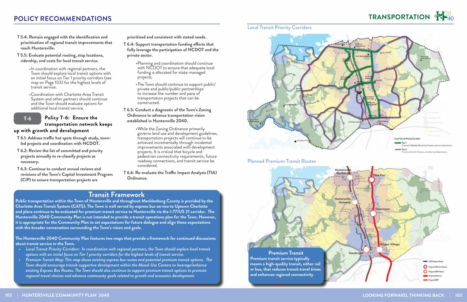
102 | HUNTERSVILLE COMMUNITY PLAN 2040 LOOKING FORWARD, THINKING BACK | 103
POLICY RECOMMENDATIONS TRANSPORTATION
T-6
T 5.4: Remain engaged with the identification and prioritization of regional transit improvements that reach Huntersville.
T 5.5: Evaluate potential routing, stop locations, ridership, and costs for local transit service.
• In coordination with regional partners, the Town should explore local transit options with an initial focus on Tier 1 priority corridors (see map on Page 103) for the highest levels of transit service.
• Coordination with Charlotte Area Transit System and other partners should continue and the Town should evaluate options for additional local transit service.
Policy T-6: Ensure the transportation network keeps
up with growth and developmentT 6.1: Address traffic hot spots through study, town-
led projects and coordination with NCDOT.T 6.2: Review the list of committed and priority
projects annually to re-classify projects as necessary.
T 6.3: Continue to conduct annual reviews and revisions of the Town’s Capital Investment Program (CIP) to ensure transportation projects are
prioritized and consistent with stated needs.T 6.4: Support transportation funding efforts that
fully leverage the participation of NCDOT and the private sector.
• Planning and coordination should continue with NCDOT to ensure that adequate local funding is allocated for state-managed projects.
• The Town should continue to support public/private and public/public partnerships to increase the number and pace of transportation projects that can be constructed.
T 6.5: Conduct a diagnostic of the Town’s Zoning Ordinance to advance transportation vision established in Huntersville 2040.
• While the Zoning Ordinance primarily governs land use and development guidelines, transportation projects will continue to be achieved incrementally through incidental improvements associated with development projects. It is critical that bicycle and pedestrian connectivity requirements, future roadway connections, and transit service be considered.
T 6.6: Re-evaluate the Traffic Impact Analysis (TIA) Ordinance.
Local Transit Priority Corridors
Premium TransitPremium transit service typically means a high-quality transit, either rail or bus, that reduces transit travel times and enhances regional connectivity
Planned Premium Transit Routes
Transit FrameworkPublic transportation within the Town of Huntersville and throughout Mecklenburg County is provided by the Charlotte Area Transit System (CATS). The Town is well served by express bus service to Uptown Charlotte and plans continue to be evaluated for premium transit service to Huntersville via the I-77/US 21 corridor. The Huntersville 2040 Community Plan is not intended to provide a transit operations plan for the Town. However, it is appropriate for the Community Plan to set expectations for future dialogue and align these expectations with the broader conversation surrounding the Town’s vision and goals.
The Huntersville 2040 Community Plan features two maps that provide a framework for continued discussions about transit service in the Town.
• Local Transit Priority Corridors: In coordination with regional partners, the Town should explore local transit options with an initial focus on Tier 1 priority corridors for the highest levels of transit service.
• Premium Transit Map: This map shows existing express bus routes and potential premium transit options. The Town should encourage transit-supportive development within the Mixed-Use Centers to leverage/enhance existing Express Bus Routes. The Town should also continue to support premium transit options to promote regional travel choices and advance community goals related to growth and economic development.

104 | HUNTERSVILLE COMMUNITY PLAN 2040 LOOKING FORWARD, THINKING BACK | 105
POLICY RECOMMENDATIONS ACTION PLAN
ACTION PLAN
The following table identifies priority actions that can be taken in the next 1-5 years to advance recommendations contained in the 2040 Community Plan.
HUNTERSVILLE 2040 ACTION PLANCategory Policy/Strategy/Action Time-
frame*Responsible
PartyGeneral Review the Huntersville 2040 Action Plan on an annual basis to
determine staffing and funding needs for priorities. Ongoing Planning Dept.
Land Use & Housing
LU 1.1: Utilize the Future Land Use Map during development approval process to ensure compatibility with long-range plans.
Ongoing Planning Dept., Planning Board, Town Board
LU 1.3: Regularly update the Future Land Use Map Mid-term Planning Dept.LU 1.4: Prepare new and/or update existing Small Area Plans as needed
Mid-term Planning Dept., Transportation
LU 7.2: Consider updates to the Huntersville Design Guidebook and/or Zoning Ordinance as needed. • Update the Design Guidebook and incorporate updated
design standards into the Zoning Ordinance• Modify form-based approach to site design along boulevards
and/or major thoroughfares (i.e. NC 73)
Short-term
Planning Dept., Planning Board, Town Board
LU 8.2: Evaluate and strengthen incentives to encourage achievement of higher design standards.
Short-term
Planning Dept., Planning Board
LU-10: Encourage a diversity of housing options. • Evaluate methods to achieve greater mix in lot sizes and/
or allow for flexible site design in exchange for more quality open space
• Define/refine policies and regulations regarding reuse along highway commercial corridors and senior housing
• Consider allowances for “house” scale missing middle hous-ing.
Mid-term Planning Dept., Planning Board, Town Board
LU 11.1 & 11.3: Protect and enhance the unique character of Huntersville’s neighborhoods• Promote quality design, and neighborhood improvements
including infrastructure needs such as sidewalks and drain-age.
• Study options for programs to support existing homeowners
Mid-term Planning Dept., Transportation Dept.
TIME FRAME KEY: SHORT-TERM= 1-2 YEARS, MID-TERM = 2-3 YEARS, LONG-TERM=3-5 YEARS
HUNTERSVILLE 2040 ACTION PLANEconomic
VitalityEV 1.1: Update Strategic Economic Development Plan Mid-term TBD
EV 1.3 & PS 9: Inventory Strategic Development Sites and Co-ordinate with Charlotte Water on water and sewer provision
Short-term
TBD
EV 1.3: Regularly measure percentage of non-residential tax base and report to Town Board
Ongoing Planning Dept.
EV 1.4: Review Development Standards to Support Business Growth.
Mid-term TBD
EV 2.1 & EV 2.3: Promote and Encourage Local Businesses and Attract Businesses to Downtown• Track progress towards the 10|10|10 goal of having 10 places
that serve food, 10 retail stores, and 10 businesses open after 6pm
Ongoing TBD
EV 3.1: Leverage Local Partnerships and Continue participation with Lake Norman Regional Economic Development Corpora-tion (LNREDC)
Ongoing TBD
Downtown DT 1.4: Consider revisions to ordinances, the Design Guidebook and/or review and approval processes to achieve elevated design in the downtown area
Mid-term TBD
DT 4.1: Conduct a study of future government office space needs Downtown and evaluate Town-owned properties for ac-commodating needs
Long-term Various Depart-ments
DT 6.1: Establish street and sidewalk requirements for new de-velopment that are in line with urban street design principles
Short-term
Planning Dept.
DT 6.2: Pursue street connections and upgrades Downtown to facilitate Town goals
Mid-term Planning Dept., Transportation
DT-7: Enhance technology and accessibly Downtown Long-term TBD
DT 8.1: Connect Torrence Creek Greenway to Holbrook Park and into and through Downtown
Mid-term Parks and Rec Dept.
DT 8.2: Expand Holbrook Park Mid-term Parks and Rec
DT 8.3: Expand events and programming Downtown Mid-term Parks and Rec
DT 8.4: Support the Public Art Committee in their mission to introduce art around Downtown
Long-term TBD
TIME FRAME KEY: SHORT-TERM= 1-2 YEARS, MID-TERM = 2-3 YEARS, LONG-TERM=3-5 YEARS

106 | HUNTERSVILLE COMMUNITY PLAN 2040 LOOKING FORWARD, THINKING BACK | 107
POLICY RECOMMENDATIONS ACTION PLAN
HUNTERSVILLE 2040 ACTION PLANDT 9.1: Prioritize maintenance of streets and sidewalks and town-owned properties in the downtown area
Short-term
Various Depart-ments
DT 10: Update the Downtown Small Area Plan to build on rec-ommendations in the 2040 Community Plan.• Could be prepared in tandem with preliminary design of a
subset of priority projects identified in DT-6.2
Mid-term Planning Dept.
DT 12.2: Integrate key historical structures into programming and redevelopment plans Downtown
Long-term Planning Dept.
Environment and Open
Space
EOS 1.1 and EOS 2.2: Enhance open space design criteria and consider additional flexibility in site design in exchange for more, higher quality open space in new development
Short-term
Planning Dept., Planning Board, Town Board
EOS 4.2: Regularly evaluate and revise tree mitigation options to further town goals
Short-term
Planning Dept., Planning Board
EOS 4.3 & EOS 4.4: Plant trees and inventory and manage urban forest canopy (i.e. downtown, in rights-of-way, etc.)
Mid-term TBD
EOS 5.2: Continue stream restoration activities Ongoing Town and part-ners
EOS 5.3: Encourage Low Impact Development (LID), promote usage of LID features and update stormwater design criteria
Mid-term Planning Dept., Planning Board
EOS 6.1 & EOS 6.2: Evaluate new design standards to preserve the character of scenic country roads and methods to reduce light pollution
Long-term Planning Dept.
EOS 6.3: Study methods to encourage Farmhouse Cluster sub-divisions in Rural Conservation and the Critical Watershed areas
Mid-term Planning Dept., Planning Board, Town Board
EOS 7: Partner with the county, private development, land conservancies and land trusts to conserve sensitive or environ-mentally important lands.
Long-term Town Depart-ments and regional partners
EOS 8: Improve access to parks• Implement Parks & Recreation Master Plan• Work toward the goal of 100% of residents within a 10-min-
ute walking distance of park, natural area or greenway• Consider a larger Town role in passive open space acquisition
Ongoing Planning Dept., Parks and Rec Dept.
EOS 10: Improve bicycle and pedestrian facilities throughout Town.
Ongoing Various Depart-ments
HUNTERSVILLE 2040 ACTION PLANInfrastruc-
ture & Public Services
PS 1.1: Continue and enhance interdepartmental coordination Ongoing Various Depart-ments
PS 3.3: Maintain excellent police coverage• Work toward goal of maintaining the appropriate ratio of
police officers to population to maintain a high level of public safety coverage
• Study future space needs for the Police Department
Ongoing Administration, Police Depart-ment
PS 4: Plan for long-term personnel, facility, and equipment needs of the Fire Department
Mid-term Administration
PS 5: Coordinate with the police and fire department to address public safety issues related to the design of the built environ-ment
Ongoing Administration, Various Depart-ments
PS 6.1: Coordinate with CMS and local charter schools on ex-pansion of school capacity
Short-term
Planning De-partment
Transporta-tion
T 2.1: Develop a mobility plan that builds upon the recommen-dations presented in the 2040 Plan
Short-term
Planning Dept., Transportation
T 3.2: Coordinate with other departments to implement the Huntersville Bicycle Master Plan
Mid-term Various Depart-ments
T 4.2: Develop a Crossing Safety Improvement Study Mid-term Transportation
T 5.2: Evaluate proposed NCDOT projects for consistency with needed improvements and alignment with community objectives
Short-term
Planning Dept., Transportation
T 6.1: Identify traffic hot spots and study solutions including town-led projects and coordination with NCDOT.
Ongoing Planning Dept., Transportation
T 6.3: Continue to conduct annual reviews and revisions of the Town’s Capital Investment Program (CIP) to ensure transporta-tion projects are consistent with stated needs
Annually Administration, Various Depart-ments
T 6.5 & T 6.6: Conduct a diagnostic of the Town’s Zoning Ordi-nance to advance transportation vision established in Hunters-ville 2040 and Re-evaluate the TIA Ordinance
Mid-term Planning Dept., Planning Board
TIME FRAME KEY: SHORT-TERM= 1-2 YEARS, MID-TERM = 2-3 YEARS, LONG-TERM=3-5 YEARS

LOOKING FORWARD, THINKING BACK | 109
APPENDIX
The appendix can be viewed as a separate document online. It contains the raw data from various public engagement efforts throughout the project, including:
• Survey 1 Results
• Februray Charrette Summary
• Draft Framework Comment Form Results
• Survey 3 Results
66

110 | HUNTERSVILLE COMMUNITY PLAN 2040
HUNTERSVILLECOMMUNITY PLAN
LOOKING FORWARDTHINKING BACK