· 2019-09-01 · table of contents basinbookreport-fy2010 v2.10 production nov 9.rpt
TRANSCRIPT

Manasota Basin
Projects
December 2010

Table of ContentsBasinBookReport-FY2010 v2.10 Production Nov 9.rpt.............................................................................................................................. 1
On-Going Activities
Z010 - Boards & Executive Services - Manasota Basin.................................................................................................... 1
Z030 - Planning - Manasota Basin.................................................................................................................................... 2
Z050 - Information Resources - Manasota Basin.............................................................................................................. 3
Z060 - Communications - Manasota Basin....................................................................................................................... 4
Z090 - Community Affairs - Manasota Basin..................................................................................................................... 5
Z300 - Resouce Data and Restoration Department - Manasota Basin............................................................................. 6
Z500 - Resource Projects - Manasota Basin..................................................................................................................... 7
Z600 - Operations - Manasota Basin................................................................................................................................ 8
Z700 - Land Resources - Manasota Basin........................................................................................................................ 9
Property Appraiser & Tax Collector Commissions
Z910 - Commissions - Manasota Basin............................................................................................................................ 10
Reserves
H100 - Water Supply and Resource Development Reserve - Manasota Basin................................................................ 11
Z930 - Contingencies - Manasota Basin........................................................................................................................... 12
Save Our Rivers (SOR) Reimbursable Projects
S005 - Myakka River......................................................................................................................................................... 13
S019 - Edward W. Chance Reserve................................................................................................................................. 14
S024 - Upper Myakka River Watershed............................................................................................................................ 15
S030 - RV Griffin Reserve................................................................................................................................................. 16
S031 - Myakka Prairie....................................................................................................................................................... 17
S032 - Little Manatee River............................................................................................................................................... 18
S041 - Myakkahatchee Creek........................................................................................................................................... 19
S042 - Tampa Bay Estuarine Ecosystem.......................................................................................................................... 20
S099 - Save Our Rivers Administration............................................................................................................................. 21
SA05 - Deer Prairie Creek................................................................................................................................................. 23
SA19 - Lake Manatee Lower Watershed Upland Restoration #1...................................................................................... 24
SA31 - Myakka State Forest Hydrologic Rstr.................................................................................................................... 26
SA42 - Terra Ceia Boat Ramp.......................................................................................................................................... 28
SB05 - Myakka River Deer Prairie Creek Preserve Wetland Restoration......................................................................... 29

SB19 - Edward W. Chance Reserve Hydrologic Rstr....................................................................................................... 30
SB31 - Myakka River State Park-Myakka Prairie Tract Wetland Restoration................................................................... 32
Surface Water Improvement & Management (SWIM) Projects
W020 - SWIM Plan Implementation - Tampa Bay............................................................................................................. 33
W027 - Tampa Bay Estuary Program............................................................................................................................... 35
W028 - Bay Soundings...................................................................................................................................................... 38
W030 - Tampa Bay Watch Field Trip Program................................................................................................................. 40
W226 - City of Anna Maria-Implementation of BMPs........................................................................................................ 42
W312 - Tampa Bay Habitat Restoration............................................................................................................................ 45
W331 - Biennial Seagrass Mapping of Tampa Bay, Sarasota Bay, Charlotte Harbor...................................................... 47
W348 - Terra Ceia Isles Habitat Restoration..................................................................................................................... 50
W358 - Tom Bennett Park................................................................................................................................................. 53
W364 - Palmetto Estuary.................................................................................................................................................. 55
W394 - FELTS Preserve Restoration................................................................................................................................ 57
W501 - SWIM Plan Implementation - Charlotte Harbor.................................................................................................... 59
W506 - CHEC Charlotte Harbor/Lemon Bay SWIM Watershed Education....................................................................... 61
W509 - Alligator Creek In-Stream Restoration.................................................................................................................. 64
W521 - Charlotte Harbor Water Quality Monitoring........................................................................................................... 66
W526 - Charlotte Harbor National Estuary Program......................................................................................................... 68
W547 - Water Quality in the Peace and Myakka Basins, Charlotte Harbor, and Lemon Bay........................................... 71
W552 - Sarasota County Pollutant Model Development................................................................................................... 73
W558 - Venice Hatchett Creek Stormwater Facility.......................................................................................................... 75
W601 - SWIM Plan Implementation - Sarasota Bay......................................................................................................... 77
W602 - Neal Preserve Environmental Restoration............................................................................................................ 79
W603 - Ungarelli Preserve................................................................................................................................................ 81
W604 - Phillippi Creek In-stream Restoration................................................................................................................... 83
W611 - Sarasota Bay Spoil Island Restoration Project..................................................................................................... 85
W612 - Sarasota Bay Estuary Program............................................................................................................................ 88
W613 - Sarasota-Catfish Creek SW Facility-Phase II....................................................................................................... 90
W616 - Sarasota Bay Habitat Restoration........................................................................................................................ 93

W617 - Sarasota Imp. BMPs Coastal Basin Beach Road................................................................................................. 95
W619 - Perico Preserve Environmental Restoration......................................................................................................... 97
W620 - Pelican Cove Stormwater Retrofit......................................................................................................................... 99
W621 - Little Sarasota Bay Water Quality Management Plan........................................................................................... 101
W622 - Sarasota Bay Water Quality Management Plan................................................................................................... 103
W623 - Holmes Beach Stormwater Retrofit...................................................................................................................... 105
W624 - Red Bug Slough Restoration................................................................................................................................ 107
W625 - Runaway Bay - Sarasota Bay Coast Line Restoration......................................................................................... 109
W626 - Blackburn Point Park Addition.............................................................................................................................. 111
W627 - Bradenton Beach Stormwater Retrofits................................................................................................................ 113
Basin Initiatives
B074 - Manatee - WMPlan Braden River.......................................................................................................................... 115
B099 - Quality of Water Improvement Program - Manasota Basin................................................................................... 119
B131 - Hotel/Motel/Restaurant Water Conservation Program (Water CHAMP/PRO)....................................................... 121
B136 - Florida Automated Weather Network (FAWN) Data Dissemination and Education.............................................. 124
B183 - (Complete) Sarasota County Model Review.......................................................................................................... 126
B229 - Field Evaluation of Bahiadwarf, For Water Use Efficiency, Turf Quality, Mowing Requirement and Persi............ 128
B238 - Crop Coefficients and Water Use for Peppers in Southwest Florida..................................................................... 130
B239 - Determine Water Requirements For Genetically Altered Lantana Camara Nursery and Landscape Plants......... 132
B240 - Reducing Water Consumption in Polyethylene-Mulched Tomato and Pepper Fields after Methyl Bromide Pha.. 134
B246 - Water Conservation/FFL Regional Builder/Developer Specialist.......................................................................... 136
B256 - Automated Citrus Irrigation Management to Reduce Water Consumption............................................................ 139
B264 - Citrus Irrigation Management to Increase Young Tree Growth & Productivity on Flatwoods Ridge Soils............ 141
B265 - Optimizing Irrigation For Shade Tree Production.................................................................................................. 143
B273 - MFL Stream Diversion and Assessment Project................................................................................................... 145
B274 - Salt Water Intrusion Monitoring Network............................................................................................................... 147
B277 - Florida Water Star.................................................................................................................................................. 149
B310 - Manatee - Maintenance of Watershed Parameters and Models........................................................................... 152
B315 - Sarasota - Maintenance of Watershed Parameters and Models........................................................................... 154
B620 - Mapping and GIS................................................................................................................................................... 156

B630 - Field Operations 021............................................................................................................................................. 158
B733 - FFL Manatee County............................................................................................................................................. 159
B735 - FFL Sarasota County............................................................................................................................................. 162
P259 - Youth Water Resources Education........................................................................................................................ 164
P268 - Public Education.................................................................................................................................................... 167
Water Supply & Resource Development
H008 - Lake Hancock Lake Level Modification................................................................................................................. 172
H009 - Lake Hancock Outfall Structure P-11 Replacement.............................................................................................. 175
H015 - FARMS Back-Plug Program.................................................................................................................................. 177
H017 - Facilitating Agricultural Resource Management Systems Program...................................................................... 179
H024 - Upper Peace River Resource Development.......................................................................................................... 181
H048 - Myakka River Watershed Initiative........................................................................................................................ 185
H051 - PR/MRWSA Reg Integ Loop Sys Phase 2 Interconnect....................................................................................... 188
H052 - PR/MRWSA Reg Integ Loop Sys Phase 3A Interconnect..................................................................................... 190
H059 - City of Bradenton Reservoir Expansion................................................................................................................. 192
H069 - PR/MRWSA Reg Loop System Ph 1A.................................................................................................................. 194
H079 - PRMRWSA Investigation of Brackish Groundwater Development........................................................................ 196
H086 - Manatee County Regional 10 MG Reclaimed Water Storage Tank Project.......................................................... 198
H088 - Pilot Treatment Study and Intermediate Well for Dona Bay Water Supply Project............................................... 200
H089 - Flatford Swamp Hydrologic RestorationImplementation...................................................................................... 202
H093 - Manatee County Regional 10 MG RW Storage SW-2........................................................................................... 204
H532 - CFI USA, Inc. Venus II Grove................................................................................................................................ 206
H538 - FFD Land Company.............................................................................................................................................. 208
H583 - 4 Star Tomato - Long Creek Farm......................................................................................................................... 210
H597 - Sun Fire Nurseries, LLC........................................................................................................................................ 212
H599 - C & D Fruit and Vegetable Company, Inc............................................................................................................. 213
H605 - WFA LAnd Company, Inc. - Reservoir Project...................................................................................................... 215
Cooperative Funding Projects - Ongoing
K114 - Bradenton - ASR Program..................................................................................................................................... 217
K120 - North Port - Water ASR - Phase V........................................................................................................................ 220
K253 - Manatee - Imp. BMPs Wares Creek...................................................................................................................... 223
K269 - Sarasota Co. - N. Sarasota Co. Reclaimed Water ASRs...................................................................................... 226
K883 - North Port WMPlan Big Slough............................................................................................................................. 228
L007 - Manatee - WMPlan Buffalo Canal/Frog Creek....................................................................................................... 230
L010 - Manatee - WMPlan Gamble Creek........................................................................................................................ 233
L015 - Sarasota County Surface Water Monitoring Program............................................................................................ 236
L019 - Sarasota - Update W. Para. & County Maintained Models.................................................................................... 238
L200 - Bradenton - Wares Creek Bridge Replacement..................................................................................................... 241
L206 - FYN Builder/Dev Charlotte, Manatee, Sarasota.................................................................................................... 244
L210 - Implementation of BMPs - Phillippi Creek/Celery Fields........................................................................................ 246
L238 - SEC Southern Coastal Watershed Education........................................................................................................ 248
L520 - Around the Bend Nature Tours Manatee/Sarasota................................................................................................ 251
L604 - Manatee - WMPlan Little Manatee River............................................................................................................... 253
L608 - Palmetto Reclaimed Water ASR............................................................................................................................ 256
L610 - Sarasota County - Watershed Plan: Lemon Bay................................................................................................... 258
L611 - Sarasota County - Watershed Plan: Roberts Bay.................................................................................................. 260
L614 - Sarasota Imp. BMPs Matheny Creek..................................................................................................................... 262
L615 - Sarasota Imp. BMPs Alligator Creek...................................................................................................................... 264
L618 - Sarasota - Watershed Management Plan: Coastal Fringe..................................................................................... 266
L624 - Venice Imp. BMPs Hatchett Creek-Venice............................................................................................................ 268
L693 - Water Exhibits in the Glazer Children's Museum of Tampa................................................................................... 270
L867 - Sarasota County GIS Dataset Development.......................................................................................................... 272
L874 - Aqua Utilities Reuse Transmission - Eastern Lakewood Ranch............................................................................ 274
L949 - (Completed) Manatee County Water Conservation Program................................................................................ 276
N014 - The Florida Aquarium Watershed Education Initiative.......................................................................................... 278
N082 - City of North Port Myakkahatchee Creek Water Treatment Plant RBF/RO Reliability Project.............................. 280
N084 - City of North Port Reuse Storage Tank and High Service Pump Station.............................................................. 282
N107 - Braden River Soil Moisture Sensor Rebate Program............................................................................................ 284
N115 - Manatee County Indoor Water Conservation Project............................................................................................ 286
N139 - Low Impact Development Manual......................................................................................................................... 288

N151 - Manatee County NAVD88 Vertical Control Densification...................................................................................... 290
N181 - Science Curriculum Enhancement Program......................................................................................................... 292
N188 - City of Bradenton NAVD88 Vertical Control Densification..................................................................................... 294
N206 - G.WIZ Water Wonders Workshop......................................................................................................................... 296
N218 - Englewood Reclaimed Water Supply Project........................................................................................................ 298
N231 - Manatee County Toilet Rebate Project - Phase IV................................................................................................ 300
N255 - Beach Water Quality Project................................................................................................................................. 302
N263 - Manatee County - Watershed Evaluation.............................................................................................................. 304
N276 - LID Implementation at Venice East Blvd............................................................................................................... 306
N277 - City of North Port Reclaimed Water Transmission Expansion.............................................................................. 308
N306 - Sarasota County - Englewood CRA Stormwater Retrofit...................................................................................... 310
N325 - Manatee County Toilet Rebate Program Phase V................................................................................................ 312
FEMA - Map Modernization Projects
M110 - Manatee - FEMA Map Modernization................................................................................................................... 314
M115 - Sarasota - FEMA Map Modernization................................................................................................................... 316
M118 - FEMA Map Modernization Management Support................................................................................................. 320
Z010
Boards & Executive Services - Manasota Basin
Project Type On-Going Activities
AORs Strategic Initiatives
Basin(s) Alafia River, Hillsborough River, Northwest Hillsborough, Coastal Rivers, Pinellas-Anclote River,
Withlacoochee River, Peace River, Manasota
N/ACooperator(s)
Project Manager KAVOURAS, LOU
Task Manager(s)
Status Ongoing
DescriptionThe Boards and Executive Services Department provides administrative support to the Basin Board. These support
activities include noticing, scheduling and preparing the agenda and minutes for regular and special meetings and
workshops. Other functions include preparing meeting and travel arrangements and correspondence for Board
members. The Deputy Executive Director for Outreach, Planning and Board Services is the primary staff liaison for
members. The Deputy also assists with the conduct of meetings, works with the Governor's staff to ensure the legal
constitution of Boards, coordinates with appropriate staff to ensure follow up on meeting issues, conducts new
member orientation and ensures compliance with the Sunshine Laws. In addition, the Deputy and staff coordinate
Board field trips, including planning, scheduling, meals, logistics and arranging for staff support. This budget item also
provides funds for equipment and facility rental, legal advertisements for meeting notices, miscellaneous office
supplies and printing and Board member travel reimbursements (e.g., meals, conference registration, mileage, etc.).
Status As Of: March 13, 2007
As of this date, this project will not show an update. Ongoing project details are shown in the project description.
021 - Manasota Basin 1
Z030
Planning - Manasota Basin
Project Type On-Going Activities
AORs Strategic Initiatives
Basin(s) Alafia River, Hillsborough River, Northwest Hillsborough, Coastal Rivers, Pinellas-Anclote River,
Withlacoochee River, Peace River, Manasota
Cooperator(s)
Project Manager DAVIES, DIANNE
Task Manager(s)
Status Ongoing
DescriptionPlanning is an Executive support function responsible for long-range comprehensive planning and near-term strategic
planning. Department staff administer the Comprehensive Watershed Management initiative; provide Basin Board
support; and assist the Basin Board with development of resource management priorities.
BenefitsPlanning Department staff support the Basin Board through the following tasks. Project Management Database project
worksheets that are used in the Budget Notebook for each Basin Board meeting are reviewed to ensure accuracy and
completeness. Planning staff work with project managers to identify any significant issues and resolve any
discrepancies. Staff take the lead in preparing for joint Governing and Basin Board Planning Workshops and for the
Basin Board's Annual Planning Workshop. Basin Board meetings are attended and presentations are made to the
Board on an as-needed basis. Staff often coordinate responses to issues raised during meetings. Staff respond to
Board Member questions and requests via oral and written communications. Staff assist Basin Board members by
creating and providing presentations on Basin-specific issues. At the Board's request, research is conducted and
special issues are presented during Board meetings. Department staff assist the Community Affairs Coordinators with
Cooperative Funding kick-off meetings held for local governments and other potential cooperators. Assistance is
provided for new Board member orientations.
Status As Of: March 13, 2007
As of this date, this project will not show an update. Ongoing project details are shown in the project description.
021 - Manasota Basin 2
Z050
Information Resources - Manasota Basin
Project Type On-Going Activities
AORs Strategic Initiatives
Basin(s) Alafia River, Hillsborough River, Northwest Hillsborough, Coastal Rivers, Pinellas-Anclote River,
Withlacoochee River, Peace River, Manasota
Cooperator(s)
Project Manager LEWIS, JIM
Task Manager(s)
Status Ongoing
DescriptionVideo production and conferencing staff provides audio-visual, archive tape, and video teleconferencing support for
Basin Board and Governing Board meetings, including staff presentations. Audio-visual staff provides support for
annual Basin Board planning workshops, and the semiannual Governing Board/Basin Board planning workshops, as
well as other non-regularly scheduled workshops not held in a District office, as needed. Based on the time devoted to
these activities, including travel, the appropriate salary percentage is allocated to each Basin Board.
Status As Of: March 13, 2007
As of this date, this project will not show an update. Ongoing project details are shown in the project description.
021 - Manasota Basin 3

Z060
Communications - Manasota Basin
Project Type On-Going Activities
AORs Strategic Initiatives
Basin(s) Alafia River, Hillsborough River, Northwest Hillsborough, Coastal Rivers, Pinellas-Anclote River,
Withlacoochee River, Peace River, Manasota
N/ACooperator(s)
Project Manager MOLLIGAN, MICHAEL
Task Manager(s)
Status Ongoing
DescriptionThe Communications Department is an Executive support function responsible for a broad range of activities that
support the District's mission, Governing and Basin boards, and other departments. Departmental functions include
projects funded by the Governing and Basin boards, such as public information and media coordination; youth and
public education programs and initiatives in coordination with local governments and other community organizations;
promotion of sound water conservation practices; presentation of projects to the Basin boards in the budget adoption
process; and graphics support for Basin Board presentations. Communications Department staff support the Basin
Board through the following tasks. Basin Board meetings are attended on an as-needed basis to make presentations,
answer questions, and participate in budget discussions. Reponses are prepared to answer Board Member questions
and requests via oral and written communications. Educational materials are developed, reviewed, updated, promoted,
and distributed. Assistance is provided to cooperators to develop education projects that support the District's mission.
Education and grant programs are promoted at schools and to cooperators. Support is provided to the Basin Board
Education Committee. Media contact summaries and articles are disseminated. The District's web site is maintained.
Status As Of: March 13, 2007
As of this date, this project will not show an update. Ongoing project details are shown in the project description.
021 - Manasota Basin 4
Z090
Community Affairs - Manasota Basin
Project Type On-Going Activities
AORs Strategic InitiativesManagement Srvc. Management Services
Basin(s) Alafia River, Hillsborough River, Northwest Hillsborough, Coastal Rivers, Pinellas-Anclote River,
Withlacoochee River, Peace River, Manasota
Cooperator(s)
Project Manager RATHKE, DAVID
Task Manager(s)
Status Ongoing
DescriptionBasin Board funds budgeted are for the administration and coordination of the Cooperative Funding program, including
conducting cooperator workshops, processing applications, communicating with applicants and participating in project
ranking. Basin Board funds are budgeted for the Community Affairs Program Manager (CAPM) to attend and
participate in Basin Board meetings and new Board member orientations and briefings and for the CAPM's responses
to Board member information requests, as well as other "as needed" services to the Basin Board.
Status As Of: March 13, 2007
As of this date, this project will not show an update. Ongoing project details are shown in the project description.
021 - Manasota Basin 5
Z300
Resouce Data and Restoration Department - Manasota Basin
Project Type On-Going Activities
AORs Strategic Initiatives
Basin(s) Alafia River, Hillsborough River, Northwest Hillsborough, Coastal Rivers, Pinellas-Anclote River,
Withlacoochee River, Peace River, Manasota
Cooperator(s)
Project Manager DEHAVEN, ERIC
Task Manager(s)
Status Ongoing
DescriptionThe Resource Data and Restoration Department is involved in the collection, management, and analysis of water
resource data and the development and implementation of restoration projects to improve resource conditions. The
Department includes five sections comprised of professional and technical staff with oversight from an administrative
section. The FARMS Section is involved in the implementation of innovative agricultural water conservation and
alternative supply projects that are designed to reduce ground water withdrawals and improve water quality within the
Southern Water Use Caution Area (SWUCA). The Water Quality Monitoring Program (Section) performs water quality
sampling and analysis for a number of long-term ground and surface-water monitoring efforts, as well as specific,
short-term projects that investigate water quality issues. The Geohydrologic Data Section supports the Regional
Observation Monitor Well Program (ROMP) and the Quality of Water Improvement Program (QWIP), which provide
hydrogeologic data and well construction services. The Chemistry Laboratory Section conducts the water quality
analysis for District-related projects (Cooperative Funding and initiatives) and programs (regulation). Finally, the
Surface Water Improvement and Management (SWIM) Section is responsible for implementing the SWIM legislation
which requires that the water management districts prepare and maintain a priority list of water bodies requiring
management action for restoration or preservation; write management plans consistent with the rules established by
the Department of Environmental Protection; and implement the plans.
Status As Of: March 13, 2007
As of this date, this project will not show an update. Ongoing project details are shown in the project description.
021 - Manasota Basin 6

Z500
Resource Projects - Manasota Basin
Project Type On-Going Activities
AORs Strategic InitiativesWater Quality Water Quality Maintenance and ImprovementFlood Protection Floodplain ManagementWater Supply Alternative Water SupplyNatural Systems Minimum Flows and Level Establishment and Monitoring
Basin(s) Alafia River, Hillsborough River, Northwest Hillsborough, Coastal Rivers, Pinellas-Anclote River,
Withlacoochee River, Peace River, Manasota
Cooperator(s)
Project Manager HAMMOND, MARK
Task Manager(s)
Status Ongoing
DescriptionThe Resource Projects Department addresses issues related to water supply, flood protection, water quality, and
natural systems and consists of the Conservation & Utility Outreach, Ecologic Evaluation,
Engineering, Environmental, Hydrologic Evaluation, and Water Supply and Resource Development sections. The
District's goal for water supply is to ensure an adequate supply of the water resource to provide for all existing and
future reasonable and beneficial uses while protecting and maintaining water resources and related natural systems.
The Department's efforts involve activities associated with the regional water supply planning, alternative water
supplies, conservation, and reclaimed water strategic initiatives. The District's goal for flood protection is to minimize
flood damage to protect people, property, infrastructure and investment. The Department's efforts primarily involve
activities associated with the floodplain management strategic initiative and support for the flood and emergency
response initiative. The District's goal for natural systems is to preserve, protect, and restore natural systems in order
to support their natural hydrologic and ecologic functions. The Department's efforts involve minimum flows and levels
and wetland system restoration. The District's goal for water quality is to protect and improve water quality to sustain
the environment, economy and quality of life. The Department's efforts involve diagnostic, monitoring and
implementing water quality improvement projects. The funds budgeted here are for coordinating the Water Supply
and Resource Development Program, Water Resource Assessment Projects, Minimum Flows and Levels Program,
Watershed Management Program, FEMA Map Modernization, and Cooperative Funding Programs, as-requested
attendance at citizen meetings, and those unforeseen basin analyses which occur during the year. The Department
works on ongoing projects and reviews, evaluates, and ranks each Fiscal Year's Cooperative Funding projects related
to water supply, water quality, natural systems, and flood protection. Staff makes recommendations regarding these
projects, and other items proposed in each year's budget. Staff also works to address any budget issues identified at
Basin Board meetings. The funds budgeted here are for staff time related to coordinating those activities that do not
relate to specific budgeted projects. These include the staff time of the Director, managers and several staff.
Status As Of: March 13, 2007
As of this date, this project will not show an update. Ongoing project details are shown in the project description.
021 - Manasota Basin 7
Z600
Operations - Manasota Basin
Project Type On-Going Activities
AORs Strategic Initiatives
Basin(s) Alafia River, Hillsborough River, Northwest Hillsborough, Coastal Rivers, Pinellas-Anclote River,
Withlacoochee River, Peace River, Manasota
Cooperator(s)
Project Manager HOLTKAMP, MIKE
Task Manager(s)
Status Ongoing
DescriptionThe Operations Department consists of six sections including Administration, Field Operations, Aquatic Plant
Management, Hydrologic Data, Structure Operations and Mapping and GIS. The Administration section provides
support for departmental management, planning, budgeting, and clerical functions. The Field Operations section is
responsible for maintenance and restoration of all District-owned lands including fence construction, mowing, culvert
installations, road and bridge maintenance and construction, fire line maintenance, prescribed burn support, erosion
control, and well site preparation/restoration. The Aquatic Plant Management section is responsible for aquatic and
ditch bank vegetation management operations on District flood control systems, the control of exotic aquatic plants on
natural waters throughout the District, and the control of aquatic vegetation around water control structures and lake
level gauges. Additionally, the Aquatic Plant Management section controls/eradicates infestations of upland invasive
species including Brazilian pepper, Australian pine, cogongrass and tropical soda apple on all District-owned
conservation lands. The Hydrologic Data section is responsible for designing, installing, and maintaining data
collection sites in support of the District's resource monitoring and technical analysis, as well as data analysis and
database management. The Structure Operations section inspects, operates, maintains, and repairs all District-owned
flood and water conservation structures as well as salinity barriers throughout the District. This section also directs and
operates the District's Emergency Operations Center (EOC), which is part of a state and nationwide storm tracking
and emergency response network.The Mapping and GIS section is responsible for providing and maintaining all
mapping and Geographical Information System database support. Included in this project are administrative salary
allocations associated with overseeing field operations and maintenance, aquatic plant management, emergency
operations, Supervisory Control and Data Acquisition (SCADA), and structure operations programs throughout the
Basin, as applicable. Funds expended have been to prepare for Basin Board meetings as required or provide data to
Board members, local agencies or the public.
Status As Of: May 12, 2009
Ongoing project details are shown in the project description.
021 - Manasota Basin 8

Z700
Land Resources - Manasota Basin
Project Type On-Going Activities
AORs Strategic Initiatives
Basin(s) Alafia River, Hillsborough River, Northwest Hillsborough, Coastal Rivers, Pinellas-Anclote River,
Withlacoochee River, Peace River, Manasota
Cooperator(s)
Project Manager SUTTON, ERIC
BLASCHKA, STEVEN, MILLER, WILL, LOVE, KEVIN, WALSH, TOMTask Manager(s)
Status Ongoing
DescriptionThe Land Resources Department consists of five sections, including Administration, Land Acquisition, Land
Management, Survey, and Land Use and Protection. The Administration section provides support for departmental
management, planning, budgeting and clerical functions. The Land Acquisition section acquires lands as set forth in
the District's Florida Forever Workplan. These lands are acquired for various functions including flood control, water
storage and management, conservation and protection of water resources, aquifer recharge and recovery, water
resource development, and preservation of wetlands, streams, lakes, and other natural systems. The Land
Management section is responsible for the management and protection of natural and cultural resources on District
lands. Major functions include natural systems restoration, prescribed burning, forest management, exotic species
control, and monitoring. The Survey section is responsible for providing land surveying assistance in support of various
projects and programs within the District. The Land Use and Protection section is responsible for land use activities on
District lands including development of recreational trails and facilities, monitoring of public and private uses,
management of the security officer program and maintaining visitor safety. Included in this project are activities on
District-managed lands purchased with funds other than Florida Forever, Preservation 2000 and Save Our Rivers such
as surveying costs (salaries and equipment rental), miscellaneous land use requests (salaries), resource protection
(utilities and maintenance) and structural flood control projects.
Status As Of: March 13, 2007
As of this date, this project will not show an update. Ongoing project details are shown in the project description.
021 - Manasota Basin 9
Z910
Commissions - Manasota Basin
Project Type Prop. App.&Tax Coll.
AORs Strategic InitiativesManagement Srvc. Management Services
Basin(s) Alafia River, Hillsborough River, Northwest Hillsborough, Coastal Rivers, Pinellas-Anclote River,
Withlacoochee River, Peace River, Manasota
Cooperator(s)
Project Manager PILCHER, LINDA
LINSBECK, CATHY, CACIOPPO, MIKETask Manager(s)
Status Ongoing
DescriptionThese funds pay the commissions due to the counties within the Basin for tax collection and property appraisals.
Status As Of: November 01, 2010
During the one month ended October 31, 2010, $19,927 was remitted in commissions to Property Appraisers and Tax
Collectors. Property Appraiser and Tax Collector commissions are statutorily prescribed and are based on property tax
levies and collections, respectively. Amounts collected in excess of the underlying Property Appraiser and Tax Collector
budgets are returned to the Basin as excess fees. Excess fees not recorded as accounts receivable as of September 30,
2010 are reflected as current FY2011 revenue.
021 - Manasota Basin 10
H100
Water Supply and Resource Development Reserve - Manasota Basin
Project Type Reserves
AORs Strategic InitiativesWater Quality Water Quality Maintenance and ImprovementWater Supply Regional Water Supply Planning
Basin(s) Alafia River, Hillsborough River, Northwest Hillsborough, Coastal Rivers, Pinellas-Anclote River,
Peace River, Manasota
Cooperator(s)
Project Manager HERD, KEN
Task Manager(s)
Status Ongoing
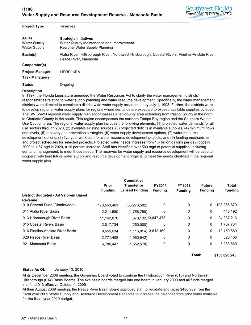
DescriptionIn 1997, the Florida Legislature amended the Water Resources Act to clarify the water management districts'
responsibilities relating to water supply planning and water resource development. Specifically, the water management
districts were directed to complete a district-wide water supply assessment by July 1, 1998. Further, the districts were
to develop regional water supply plans for regions where demands are expected to exceed available supplies by 2020.
The SWFWMD regional water supply plan encompasses a ten-county area extending from Pasco County in the north
to Charlotte County in the south. This region encompasses the northern Tampa Bay region and the Southern Water
Use Caution area. The regional water supply plan includes the following elements: (1) projected water demands for all
use sectors through 2020, (2) available existing sources, (3) projected deficits in available supplies, (4) minimum flows
and levels, (5) recovery and prevention strategies, (6) water supply development options, (7) water resource
development options, (8) five-year work plan for water resource development projects, and (9) funding mechanisms
and project schedules for selected projects. Projected water needs increase from 1.4 billion gallons per day (bgd) in
2000 to 1.67 bgd in 2020, a 19 percent increase. Staff has identified over 500 mgd of potential supplies, including
demand management, to meet these needs. The reserves for water supply and resource development will be used to
cooperatively fund future water supply and resource development projects to meet the needs identified in the regional
water supply plan.
District Budgeted - Ad Valorem Based
Revenue
010 General Fund (Districtwide) 108,266,879 0 (65,276,582) 173,543,461 0 0
011 Alafia River Basin 443,192 0 (1,768,788) 2,211,980 0 0
013 Hillsborough River Basin 24,337,216 0 (673,132) 11,162,870 0 13,847,478
015 Coastal Rivers Basin 1,767,734 0 (250,000) 2,017,734 0 0
016 Pinellas-Anclote River Basin 12,150,889 0 (1,116,914) 9,655,634 0 3,612,169
020 Peace River Basin 820,466 0 (1,950,942) 2,771,408 0 0
021 Manasota Basin 5,233,869 0 (1,552,578) 6,786,447 0 0
$153,020,245 Total:
Prior
Funding
Cumulative
Transfer or
Lapsed Funding Funding Funding
2011 FY 2012 FY Future
Funding
Total
Funding
Status As Of: January 13, 2010
At its December 2008 meeting, the Governing Board voted to combine the Hillsborough River (013) and Northwest
Hillsborough (014) Basin Boards. The two basin boards merged into one board in January 2009 and all funds merged
into fund 013 effective October 1, 2009.
At their August 2009 meeting, the Peace River Basin Board approved staff to liquidate and lapse $486,939 from the
fiscal year 2009 Water Supply and Resource Development Reserves to increase the balances from prior years available
for the fiscal year 2010 budget.
021 - Manasota Basin 11

Z930
Contingencies - Manasota Basin
Project Type Reserves
AORs Strategic InitiativesManagement Srvc. Management Services
Basin(s) Alafia River, Hillsborough River, Northwest Hillsborough, Coastal Rivers, Pinellas-Anclote River,
Withlacoochee River, Peace River, Manasota
Cooperator(s)
Project Manager PILCHER, LINDA
LINSBECK, CATHY, CACIOPPO, MIKETask Manager(s)
Status Ongoing
DescriptionFunds are budgeted for contingencies to be used at the Board's discretion. The goal is to set aside an amount equal to
approximately 5 percent (2.5 percent minimum target) of the ad valorem based budget (ad valorem taxes plus interest
plus balance forward multiplied by 5 percent).
Status As Of: November 01, 2010
To date, the Basin Board has not allocated any of its contingency funds.
021 - Manasota Basin 12
S005
Myakka River
Project Type SOR
AORs Strategic InitiativesWater Quality Water Quality Maintenance and ImprovementFlood Protection Floodplain ManagementNatural Systems Natural Systems Conservation and Restoration
Basin(s) Manasota
Cooperator(s)
Project Manager LOVE, KEVIN
NELSON, BRIAN, SOWDERS, GINA, GREEN, STEPHANIE, MILLER, WILL, HAGBERG,
JEFFREY
Task Manager(s)
Status Ongoing
DescriptionA majority of the lands within the Myakka River Save Our Rivers project were jointly purchased with the State of
Florida's Conservation and Recreation Lands (CARL) program (Myakka State Forest). Lands within the project area
are characterized by a variety of natural lands and lands altered by development including mesic pine flatwoods, oak
hammocks, shell mounds, prairie hammock and improved pasture. The project area includes portions of the Myakka
River and its floodplain forests. Lands included within the Myakka State Forest are managed by the State of Florida's
Division of Forestry (DOF). The DOF has made the following recreational improvements/amenities available on the
property: 13 miles of marked shared use trails for bicycling, horseback riding and hiking, and primitive camping.
BenefitsPursuant to Section 373.1391(1)(a), Florida Statutes, lands within the project are managed and maintained in such a
way as to ensure a balance between public access, general public recreational purposes, and restoration and
protection of their natural state and condition.
Costs
The FY2010 budget consists of salaries and operational costs for public use management, resource monitoring,
resource protection, road and bridge maintenance, exotic plant control, recreation equipment, 175 acres of firelane
maintenance, 220 acres of chopping, 75 acres of road maintenance; and contractual services for 465 hours of
security. The FY2011 budget request consists of salaries and operational costs for public use management, resource
monitoring, resource protection, road and bridge maintenance, exotic plant control, a trail counter, 142 acres of
firelane maintenance, 150 acres of chopping, 73 acres of road maintenance, 13 days of prescribed burning and six
culverts; and contractual services for 689 hours of security. Costs for these activities are reimbursable through the
state's Water Management Lands Trust Fund.
District Budgeted - Outside Revenue
(SOR)
010 General Fund (Districtwide) 0 0
021 Manasota Basin 0 113,859
Funding Funding
2011 FY 2012 FY
Status As Of: October 22, 2010
No significant activity this period.
021 - Manasota Basin 13
S019
Edward W. Chance Reserve
Project Type SOR
AORs Strategic InitiativesWater Quality Water Quality Maintenance and ImprovementNatural Systems Natural Systems Conservation and RestorationFlood Protection Floodplain Management
Basin(s) Peace River, Manasota
Cooperator(s)
Project Manager LOVE, KEVIN
NELSON, BRIAN, SOWDERS, GINA, VANGELDER, WILL, MILLER, WILL, GREEN, STEPHANIE,
HAGBERG, JEFFREY
Task Manager(s)
Status Ongoing
DescriptionIn 2007, the former Lake Manatee Reserve, was dedicated and renamed as the Edward W. Chance Reserve, in honor
of departed Governing Board member, Ed Chance. The Reserve extends over a large area which includes narrow
floodplain forests and native pine lands surrounded by vast areas of rangeland, improved pastures, croplands, and
citrus groves. Lands purchased within this project protect an existing regional water resource, protect floodplains, and
restore adjoining wetlands in the headwaters. Hiking is available on the property and horseback riding is allowed by a
special use permit. Management units include the Rutland Ranch and Gilley Creek Tracts.
BenefitsPursuant to Section 373.1391(1)(a), Florida Statutes, lands within the project are managed and maintained in such a
way as to ensure a balance between public access, general public recreational purposes, and restoration and
protection of their natural state and condition.
Costs
The FY2010 budget consists of salaries and operational costs for public use management, resource monitoring,
resource protection, road and bridge maintenance, exotic plant control, recreation equipment, 226 acres of firelane
maintenance, 70 acres of hydro-ax maintenance, 149 acres of road maintenance, two culverts, and 25 days of
prescribed burning; and contractual services for 41 acres of recreational mowing and 435 hours of security. The
FY20101 budget request consists of salaries and operational costs for public use management, resource monitoring,
resource protection, road and bridge maintenance, exotic plant control, a trail counter, entrance sign, picnic tables and
fire rings for a new campground, 238 acres of firelane maintenance, 30 acres of hydro-ax maintenance, 149 acres of
road maintenance, six culverts, and 25 days of prescribed burning; and contractual services for 41 acres of
recreational mowing and 648 hours of security. Costs for these activities are reimbursable through the state's Water
Management Lands Trust Fund.
District Budgeted - Outside Revenue
(SOR)
010 General Fund (Districtwide) 0 0
021 Manasota Basin 0 200,349
Funding Funding
2011 FY 2012 FY
Status As Of: October 25, 2010
No significant activity this period.
021 - Manasota Basin 14
S024
Upper Myakka River Watershed
Project Type SOR
AORs Strategic InitiativesWater Quality Water Quality Maintenance and ImprovementFlood Protection Floodplain ManagementNatural Systems Natural Systems Conservation and Restoration
Basin(s) Manasota
Cooperator(s)
Project Manager LOVE, KEVIN
NELSON, BRIAN, SOWDERS, GINA, VANGELDER, WILL, MILLER, WILL, GREEN, STEPHANIE,
HAGBERG, JEFFREY
Task Manager(s)
Status Ongoing
DescriptionThe Upper Myakka River Watershed project is located in Manatee County and includes forested floodplain swamps
and marshes along the upper portions of the Myakka River watershed. The headwater swamps function as retention
and detention areas for local drainage. Wetland forests and adjoining uplands provide treatment of surface runoff.
Access to the property is limited since the project lands are often flooded, which is not conducive to recreational trail
development. However, the property contains narrow flatwoods roads and jeep trails that can be used for hikers during
dry weather.
BenefitsPursuant to Section 373.1391(1)(a), Florida Statutes, lands within the project are managed and maintained in such a
way as to ensure a balance between public access, general public recreational purposes, and restoration and
protection of their natural state and condition.
Costs
The FY2010 budget consists of salaries and operational costs for public use management, resource monitoring,
resource protection, road and bridge maintenance, exotic plant control, recreation equipment, 20 acres of firelane
maintenance, 13 acres of road maintenance, and 4 days of prescribed burning; and contractual services for 18 acres
of recreational mowing and 435 hours of security. The FY2011 budget request consists of salaries and operational
costs for public use management, resource monitoring, resource protection, road and bridge maintenance, exotic
plant control, an entrance sign, 20 acres of firelane maintenance, 13 acres of road maintenance, and 4 days of
prescribed burning; and contractual services for 18 acres of recreational mowing and 662 hours of security. Costs for
these activities are reimbursable through the state's Water Management Lands Trust Fund.
District Budgeted - Outside Revenue
(SOR)
010 General Fund (Districtwide) 0 0
021 Manasota Basin 0 41,784
Funding Funding
2011 FY 2012 FY
Status As Of: October 25, 2010
No significant activity this period.
021 - Manasota Basin 15
S030
RV Griffin Reserve
Project Type SOR
AORs Strategic InitiativesWater Quality Water Quality Maintenance and ImprovementFlood Protection Floodplain ManagementWater Supply Regional Water Supply PlanningNatural Systems Natural Systems Conservation and Restoration
Basin(s) Peace River, Manasota
Peace River/Manasota Regional Water Supply Auth.Cooperator(s)
Project Manager LANE, CHUCK
NELSON, BRIAN, LANE, CHUCK, ELLIOTT, PAUL, MILLER, WILL, GREEN, STEPHANIE,
HAGBERG, JEFFREY
Task Manager(s)
Status Ongoing
DescriptionThe RV Griffin Reserve is located in DeSoto and Sarasota Counties and includes lands supporting and surrounding
the existing facilities at the Peace River/Manasota Regional Water Supply Authority treatment plant. Lands in the
project area include mixed hardwood forests along the river; however, the majority of the lands consist of pine
flatwoods, rangelands, pastures and pine plantations. The project supports and protects present potable water
supplies. Land management has recently been delegated to the Water Supply Authority. Recreational
activities/amenities include 21 miles of shared-use trails available for bicycling, horseback riding and hiking. A
3,804-acre conservation easement is known as the Lewis Longino Preserve.
BenefitsPursuant to Section 373.1391(1)(a), Florida Statutes, lands within the project are managed and maintained in such a
way as to ensure a balance between public access, general public recreational purposes, and restoration and
protection of their natural state and condition.
Costs
The FY2010 budget and the FY2011 budget request within the Peace River Basin consists of contract coordination
and monitoring for management of the land by the Peace River/Manasota Regional Water Supply Authority; within the
Manasota Basin the funds are for monitoring the conservation easement over the Lewis Longino Preserve.
Costs for these activities are reimbursable through the state's Water Management Lands Trust Fund.
District Budgeted - Outside Revenue
(SOR)
010 General Fund (Districtwide) 0 0
020 Peace River Basin 0 2,637
021 Manasota Basin 0 2,221
Funding Funding
2011 FY 2012 FY
Status As Of: January 28, 2010
Staff is communicating with the National Wild Turkey Federation and the Florida Fish and Wildlife Conservation
Commission to coordinate a special youth recreation opportunity on the Reserve. Annual inspection was conducted on
the Lewis Longino Conservation Easement, no violations were observed.
021 - Manasota Basin 16
S031
Myakka Prairie
Project Type SOR
AORs Strategic InitiativesWater Quality Water Quality Maintenance and ImprovementFlood Protection Floodplain ManagementNatural Systems Natural Systems Conservation and Restoration
Basin(s) Manasota
Florida State ParksCooperator(s)
Project Manager MILLER, WILL
SOWDERS, GINA, GREEN, STEPHANIE, LOVE, KEVINTask Manager(s)
Status Ongoing
DescriptionLands within the Myakka Prairie project are characterized by the region's flat topography and include landscapes of
extensive shrub and brushlands, pine flatwoods and pastures. Numerous isolated freshwater marshes dot the site's
flatlands. The project provides surface water detention and natural water quality treatment of overland sheet flow. The
Myakka Prairie is adjacent to lands within the Myakka River State Park and is managed by the State¿s Division of
Recreation and Parks. Recreational development/amenities on the property made available by the Division of
Recreation and Parks include several miles of hiking, bicycling and horseback riding trails. District land management
activities primarily consist of exotic species control.
BenefitsPursuant to Section 373.1391(1)(a), Florida Statutes, lands within the project are managed and maintained in such a
way as to ensure a balance between public access, general public recreational purposes, and restoration and
protection of their natural state and condition.
Costs
The FY2010 budget and the FY2011 budget request is for salaries for staff to coordinate management responsibilities
and to monitor the management agreement with the Division of Recreation and Parks . Costs for these activities are
reimbursable through the state's Water Management Lands Trust Fund.
District Budgeted - Outside Revenue
(SOR)
021 Manasota Basin 0 3,337
Funding Funding
2011 FY 2012 FY
Status As Of: July 12, 2010
No significant activity this period.
021 - Manasota Basin 17
S032
Little Manatee River
Project Type SOR
AORs Strategic InitiativesWater Quality Water Quality Maintenance and ImprovementFlood Protection Floodplain ManagementNatural Systems Natural Systems Conservation and Restoration
Basin(s) Alafia River, Manasota
Hillsborough CountyCooperator(s)
Project Manager LOVE, KEVIN
NELSON, BRIAN, SOWDERS, GINA, VANGELDER, WILL, MILLER, WILL, KRUK, COLLEEN,
HAGBERG, JEFFREY
Task Manager(s)
Status Ongoing
DescriptionThe Little Manatee River project, located in Hillsborough and Manatee Counties, contains parcels of land along the
Little Manatee riverine corridor from downstream estuarine waters, to the river's headwaters. Dense forest dominates
the land along the river's floodplain with the adjoining uplands being comprised of a mixture of pine flatwoods, mixed
hardwoods and shrub and brushlands. The District has entered into an interlocal agreement with Hillsborough County
wherein the County has lead responsibility for lands jointly purchased by Hillsborough County and the District.
Recreational improvements/amenities made available by the County include: canoe landing sites adjacent to five
primitive campsites along the river; fishing; and hiking trails. District land management activities consist of road
stabilization, prescribed burning, natural systems restoration, mowing and recreational development/maintenance.
BenefitsPursuant to Section 373.1391(1)(a), Florida Statutes, lands within the project are managed and maintained in such a
way as to ensure a balance between public access, general public recreational purposes, and restoration and
protection of their natural state and condition.
Costs
The FY2010 budget consists of salaries and operational costs for public use management, resource monitoring,
resource protection, road and bridge maintenance, 50 acres of firelane maintenance, 20 acres of chopping, 42 acres
of hydro-ax restoration and maintenance, 25 acres of road mowing, eight days of prescribed burning; and contractual
services for 18 acres of recreational mowing and 435 hours of security. The FY2011 budget request consists of
salaries and operational costs for public use management, resource monitoring, resource protection, road and bridge
maintenance and 30 acres of hydro-ax restoration and maintenance. Costs for these activities are reimbursable
through the state's Water Management Lands Trust Fund.
District Budgeted - Outside Revenue
(SOR)
011 Alafia River Basin 0 46,367
021 Manasota Basin 0 91,472
Project Funds Not Budgeted by the
District
Hillsborough County 0 0
Funding Funding
2011 FY 2012 FY
Status As Of: October 01, 2010
Aquatic Plant Management Section staff treated 100 acres infested with cogongrass. Land use staff evaluating request
from Hillsborough County for easement on property within Little Manatee Project.
021 - Manasota Basin 18
S041
Myakkahatchee Creek
Project Type SOR
AORs Strategic InitiativesWater Quality Water Quality Maintenance and ImprovementFlood Protection Floodplain ManagementNatural Systems Natural Systems Conservation and Restoration
Basin(s) Manasota
Cooperator(s)
Project Manager MILLER, WILL
SOWDERS, GINA, GREEN, STEPHANIE, LOVE, KEVINTask Manager(s)
Status Ongoing
DescriptionThe Myakkahatchee Creek project area consists of oak/cabbage palm hammock dominated banks along the southern
portions of the creek, isolated marshes and improved pastures within the upland portions and mixed natural lands
scattered throughout. The main surface water feature, Myakkahatchee Creek, is a 21.5-mile long tributary creek of the
Myakka River. Lands are managed by Sarasota County.
BenefitsSince the lands within the project were purchased in less-than-fee simple, no land management activities are required.
Costs
The FY2010 budget and FY2011 budget request consists of annual conservation easement monitoring, contract
monitoring, and 50% reimbursement of land management costs to Sarasota County for their management of jointly
owned lands within the project.
Costs for this activity are reimbursable through the state's Water Management Lands Trust Fund.
District Budgeted - Outside Revenue
(SOR)
010 General Fund (Districtwide) 0 0
021 Manasota Basin 0 40,033
Project Funds Not Budgeted by the
District
Other 0 0
Funding Funding
2011 FY 2012 FY
Status As Of: November 02, 2010
No significant activity this period.
021 - Manasota Basin 19

S042
Tampa Bay Estuarine Ecosystem
Project Type SOR
AORs Strategic InitiativesWater Quality Water Quality Maintenance and ImprovementNatural Systems Natural Systems Conservation and Restoration
Basin(s) Alafia River, Pinellas-Anclote River, Manasota
Hillsborough County, Florida State ParksCooperator(s)
Project Manager MILLER, WILL
SOWDERS, GINA, LOVE, KEVIN, VANGELDER, WILL, KRUK, COLLEEN, HAGBERG, JEFFREYTask Manager(s)
Status Ongoing
DescriptionThe Tampa Bay Estuarine Ecosystem project furthers the Tampa Bay Surface Water Improvement and Management
(SWIM) plan. Approximately half the project consists of mangroves and salt marsh which dominate the northern
project area along Bishop Harbor and the western area associated with the tidal bays of Moses Hole, Clambar Bay
and Williams Bayou. The natural upland and wetland habitats within the project area provide natural water quality
treatment of overland flows before reaching the receiving waters of Tampa Bay. A majority of lands within the Tampa
Bay Estuarine Ecosystem project were jointly purchased with the State or local governments. Under an agreement
with the State, the Department of Environmental Protection's Division Recreation and Parks is the lead land manager
for the Terra Ceia tract. Hillsborough County manages the Bullfrog Creek and Port Redwing tracts, and Pinellas
County manages the Clam Bayou tract.
BenefitsPursuant to Section 373.1391(1)(a), Florida Statutes, lands within the project are managed and maintained in such a
way as to ensure a balance between public access, general public recreational purposes, and restoration and
protection of their natural state and condition.
Costs
The FY2010 budget consists of salaries and operational costs for public use management, resource monitoring,
resource protection, road and bridge maintenance, recreation equipment, nine acres of road mowing, two days of
prescribed burning; and contractual services for 271 acres of recreational mowing. The FY2011 budget request
consists of salaries and operational costs for public use management, resource monitoring, resource protection, road
and bridge maintenance, recreation equipment, nine acres of road mowing, two days of prescribed burning; and
contractual services for 271 acres of recreational mowing. Costs for these activities are reimbursable through the
state's Water Management Lands Trust Fund.
District Budgeted - Outside Revenue
(SOR)
011 Alafia River Basin 0 21,038
016 Pinellas-Anclote River Basin 0 0
021 Manasota Basin 0 18,990
Project Funds Not Budgeted by the
District
Hillsborough County 0 0
Funding Funding
2011 FY 2012 FY
Status As Of: September 08, 2010
No significant activity this period
021 - Manasota Basin 20

S099
Save Our Rivers Administration
Project Type SOR
AORs Strategic InitiativesWater Quality Water Quality Maintenance and ImprovementFlood Protection Floodplain ManagementWater Supply ConservationNatural Systems Natural Systems Conservation and Restoration
Basin(s) General Fund (District), Alafia River, Hillsborough River, Northwest Hillsborough, Coastal Rivers,
Pinellas-Anclote River, Withlacoochee River, Peace River, Manasota
Cooperator(s)
Project Manager SUTTON, ERIC
NELSON, BRIAN, WALSH, TOM, MILLER, WILL, HAGBERG, JEFFREY, LOVE, KEVINTask Manager(s)
Status Ongoing
DescriptionThe Save Our Rivers Administration project contains monies for those items not attributable to one unique project
during the budget cycle. Examples are studies affecting all conservation lands, preparation of resource evaluation
reports, heavy equipment used solely on conservation lands, overtime, staff time, vehicle charges and equipment
rental.
BenefitsPursuant to Section 373.1391(1)(a), Florida Statutes, lands within the project are managed and maintained in such a
way as to ensure a balance between public access, general public recreational purposes, and restoration and
protection of their natural state and condition.
Costs
The FY2010 budget includes salaries, central garage charges, tree removal in cases where trees fall from District
property onto adjoining owners' property in the Coastal and Hillsborough Basins, and aerial flights to view exotics
species in the General Fund, and Hillsborough, Peace and Manasota Basins. Costs for these activities are 100
percent reimbursed through the state's Water Management Lands Trust Fund.
District Budgeted - Ad Valorem Based
Revenue
013 Hillsborough River Basin - Ad
Valorem Revenue
0 9,519
016 Pinellas-Anclote River Basin - Ad
Valorem Revenue
0 4,311
District Budgeted - Outside Revenue
(SOR)
010 General Fund (Districtwide) 0 1,118,761
011 Alafia River Basin 0 4,519
013 Hillsborough River Basin 0 0
015 Coastal Rivers Basin 0 9,519
016 Pinellas-Anclote River Basin 0 0
019 Withlacoochee River Basin 0 9,519
020 Peace River Basin 0 7,719
021 Manasota Basin 0 7,719
Funding Funding
2011 FY 2012 FY
021 - Manasota Basin 21
S099
Save Our Rivers Administration
Status As Of: March 12, 2009
With the exception of the District fund, the Save Our Rivers (SOR) Administration project is used primarily to budget
monies for SOR, Preservation 2000 and Florida Forever (reimbursable) projects. Generally, funds are not charged to this
project, but transferred to other reimbursable projects within the Basin. An example is overtime. Staff knows at budget
time that overtime will be required within the basins for work on SOR projects, but does not know for which projects, so
monies will be budgeted in S099. When overtime is used later in the year, the monies will show as being spent for the
actual project the staff member worked on (i.e., S009- Starkey, S016 - Weekiwachee Preserve, etc.). In the District funds
monies are primarily used for SOR program administration, purchase of equipment and contractual services.
021 - Manasota Basin 22
SA05
Deer Prairie Creek
Project Type SOR
AORs Strategic InitiativesWater Quality Water Quality Maintenance and ImprovementFlood Protection Floodplain ManagementNatural Systems Natural Systems Conservation and Restoration
Basin(s) Manasota
NoneCooperator(s)
Project Manager LOVE, KEVIN
FOX, AUGUST, NELSON, BRIAN, GREEN, STEPHANIE, HAGBERG, JEFFREY, MILLER, WILL,
SOWDERS, GINA
Task Manager(s)
Status Ongoing
DescriptionAll lands within the project are jointly owned by the District and Sarasota County. Lands within the project area are
characterized by a variety of natural lands and lands altered by development including mesic pine flatwoods, oak
hammocks, shell mounds, prairie hammock and improved pasture. The project area includes portions of the Myakka
River and its floodplain forests. Lands within Deer Prairie Creek are jointly managed by the District and Sarasota
County. The District is lead manager for prescribed burning, natural systems restoration, exotics control and timber
management. The County is lead manager for land use and management plan development, public recreation,
education and land use requests, wildfire response, resource monitoring, cattle grazing and security.
BenefitsPursuant to Section 373.1391(1)(a), Florida Statutes, lands within the project are managed and maintained in such a
way as to ensure a balance between public access, general public recreational purposes, and restoration and
protection of their natural state and condition.
Costs
The FY2010 budget consists of salaries and operational costs for resource monitoring, resource protection, road and
bridge maintenance, exotic plant control, 304 acres of firelane maintenance, 200 acres of chopping, 100 acres of
hydro-ax restoration and maintenance, 172 acres of road maintenance, and 15 days of prescribed burning.
The FY2011 budget request consists of salaries and operational costs for resource monitoring, resource protection,
road and bridge maintenance, exotic plant control, 251 acres of firelane maintenance, 200 acres of chopping, 18 acres
of road maintenance, four culverts and 15 days of prescribed burning.
Costs for these activities are reimbursable through the state's Water Management Lands Trust Fund.
District Budgeted - Outside Revenue
(SOR)
021 Manasota Basin 0 155,062
Funding Funding
2011 FY 2012 FY
Status As Of: November 02, 2010
No significant activity this period.
021 - Manasota Basin 23
SA19
Lake Manatee Lower Watershed Upland Restoration #1
Project Type SOR
AORs Strategic InitiativesNatural Systems Natural Systems Conservation and Restoration
Basin(s) Manasota
Cooperator(s)
Project Manager VANGELDER, WILL
Task Manager(s)
Status Ongoing
DescriptionIn 1991 the Governing Board authorized the acquisition of lands within the Lake Manatee Lower Watershed project in
Manatee County. The Lake Manatee Lower Watershed extends over a large area that includes narrow floodplain
forests and native pinelands surrounded by vast areas of rangeland, improved pastures, croplands, and citrus groves.
Lands purchased within this project protect an existing regional water resource, protect floodplains, and restore
adjoining wetlands in the headwaters. To date 7,932 acres have been acquired in fee simple within the project, with an
additional 11,046 approved for future fee simple acquisition. In 2002, 149 wetland acres were restored via the Florida
Department of Transportation (FDOT) mitigation program. In FY2005 through FY2010, approximately 324 acres of
former farm field are proposed for restoration back to upland vegetation communities, including scrub, scrubby
flatwoods and dry prairie. The site is the largest contiguous altered site on the tract and ranked as a high priority for
restoration. In FY2005, site work began in preparation for re-vegetation of a 25-acre portion of the site to serve as a
pilot project to test planting methods. A grower was contracted to propagate plant materials for the project, including
palmettos, and three species of scrub oaks, totaling 18,500 plants. The re-vegetation of this site will expand a five-acre
remnant scrub patch that currently supports a family of scrub-jays. This pilot phase of the project was completed in
July 2006. Subsequent monitoring has indicated that the pilot results have exceeded target levels.
BenefitsPursuant to Section 373.1391(1)(a), Florida Statutes, lands within the project are managed and maintained in such a
way as to ensure a balance between public access, general public recreational purposes, and restoration and
protection of their natural state and condition.
Costs
Funds were included in the FY2008 budget to conduct phase 2 of the project, which included plant material and
planting labor to re-vegetate approximately 46 acres of the site. Plant species, stocking rates and planting methods will
be similar to those proving successful on the pilot phase. Future restoration efforts on the remainder of the site will be
conducted in annual stages over an approximately four-year period.Funds in the FY2009 and FY2010 budgets are for
salaires and central garage charges. Costs for these activities are 100 percent reimbursed through the Water
Management Lands Trust Fund.
District Budgeted - Outside Revenue
(SOR)
021 Manasota Basin 0 11,971
Funding Funding
2011 FY 2012 FY
Critical Project Milestones ActualProjected Amended
Phase 1RFB 9/1/04 9/1/04
Install Plants 7/31/06 7/31/06
Award Contract 12/1/07 12/1/04
Phase 2RFB 10/1/07 11/1/07
Award Contract 12/1/07 9/1/07
021 - Manasota Basin 24

SA19
Lake Manatee Lower Watershed Upland Restoration #1
Install Plants 7/31/09
Phase 3RFB 10/1/08 10/15/08
Award Contract 12/1/08 4/21/08
Install Plants 7/31/10
Phase 4RFB 10/1/09
Award Contract 12/1/09
Install Plants 7/31/11
Status As Of: February 28, 2010
No significant activities this period.
021 - Manasota Basin 25
SA31
Myakka State Forest Hydrologic Rstr
Project Type SOR
AORs Strategic InitiativesNatural Systems Natural Systems Conservation and Restoration
Basin(s) Manasota
Cooperator(s)
Project Manager RHINESMITH, PHILIP
Task Manager(s)
Status Ongoing
DescriptionThe District's Governing Board approved the Hydrologic and Wetlands Restoration of District-owned Lands initiative at
their January 2004 meeting. The initiative focuses on 2 goals which are: A) recovering the functions of water storage
and conveyance in impacted wetlands and streams; and B) recapturing the benefits of water quality and wildlife habitat
formerly provided by the impacted system in its undisturbed state. The Myakka State Forest Hydrologic Restoration
project is located in the Myakka State Forest in Sarasota County. The property is currently managed as a passive
recreational facility by the Department of Agriculture and Consumer Services-Division of Forestry. The surface water
impacts are to two separate creek systems both of which contribute surface water flows to Lemon Bay. These include
Ainger Creek and Oyster Creek. Based on the results of the post restoration surface water modeling accomplished
during the first phase of the project, a total of 122 acres of wetlands will be restored. The restoration includes the
installation of ditch plugs and the construction of a weir structure at the extreme southern boundary of the property to
restore the normal flows to Oyster Creek.
BenefitsThe project will restore the functions of water storage and conveyance of Oyster Creek, Ainger Creek and numerous
isolated herbaceous wetlands, and recapture the benefits of water quality and wildlife habitat formerly provided by the
impacted system in its undisturbed state.
Costs
The design and permitting for the project will be completed at a cost of $75,082 and construction at an estimated cost
of $295,925 using previously budgeted funds. The funding table below includes District staff time, travel and central
garage charges. These activities are reimbursed at 100 percent from the state's Water Management Lands Trust
Fund.
District Budgeted - Outside Revenue
(SOR)
021 Manasota Basin 0 9,318
Funding Funding
2011 FY 2012 FY
Critical Project Milestones ActualProjected Amended
1. Project DesignFeasibility and Analysis Report Complete 8/31/07 1/1/08
Design Complete 10/31/08 3/15/10
1A. Permit Exemption FDEPStart Construction-Phase 1 Removal of Salinity Barrier 8/13/09 11/25/09
Complete Construction-Removal of Salinity Barrier 10/31/09 12/4/09
2. PermittingPermitting Commence 12/31/08 9/30/10
Permitting Complete 1/31/09 10/25/10
3. ConstructionConstruction Commence 2/28/09 1/11/12
021 - Manasota Basin 26
SA31
Myakka State Forest Hydrologic Rstr
Construction Complete 5/31/09 6/11/12
Status As Of: October 20, 2010
The consultant completed the final restoration plan which identified three distinct areas where minor modifications to the
ditch network will result in rehydration of degraded wetlands. These include: removal of a tidal salinity barrier to restore
natural tidal fluctuation to the lower portions of Ainger Creek; installation of a berm on the south side of the forest to
restore normal flows through Oyster Creek; and installation of a series of ditch plugs in the ditches connecting wetlands
in the south-eastern portions of the forest. District staff presented the restoration plan to the "Myakka State Forest
Liaison Committee" at their 04/22/2008 meeting with a favorable response. ACTION TO DATE: DELAYED. The District
selected King Engineering to finish the surface water modeling for the project and complete the design, permitting and
construction services. The model verification will require more time to complete than originally budgeted. There are
however certain elements of the project that can be accomplished by permit exemption. Part of the construction plan is to
remove a salinity barrier that interrupts flows of Ainger Creek. The District applied for and received a minor activities
exemption (de minimis) from the Florida Department of Environmental Protection (FDEP) for this. The exemption allowed
District crews to begin construction and accomplish a portion of the project. The District's contractor, American
Construction, completed the removal of the salinity barrier on December 4, 2009. King Engineering continues to make
progress on the design phase and has reached the 60% design phase. The District will schedule a public meeting with
adjacent property owners and interested parties to take place October 27, 2010. In the original plan, the project
construction was to be completed using District crews and equipment. Because of increased demands on Operations
staff, construction will now be bid out to a private contractor. This requires additional design work and assembling a bid
package and proposal for a Request for Bid. This will likely delay the project 1-year from the original date.
021 - Manasota Basin 27
SA42
Terra Ceia Boat Ramp
Project Type SOR
AORs Strategic InitiativesNatural Systems Natural Systems Conservation and Restoration
Basin(s) Manasota
Florida Department of Environmental Protection, Manatee CountyCooperator(s)
Project Manager MILLER, WILL
SOWDERS, GINATask Manager(s)
Status Ongoing
DescriptionThe boat ramp at the Terra Ceia State Park in Manatee County will consist of a launch and parking for approximately
20 vehicles. The boat ramp will be located on Bishop Harbor on the Terra Ceia State Park jointly by the District and
State of Florida. There currently exists an unimproved launch on the property. Surface Water Improvement and
Management (SWIM) program restoration plans require that the launch and parking be relocated to facilitate plan
implementation. Relocation will meet regional needs for boat launching facilities.
BenefitsPursuant to Section 373.1391(1)(a), Florida Statutes, lands within Preserve are managed and maintained in such a
way as to ensure a balance between public access, general public recreational purposes, and restoration and
protection of their natural state and condition.
Costs
Funding will be split between Manatee County, the Florida Department of Environmental Protection and the District.
Design and permitting is estimated to cost $150,000, with the District and Manatee County splitting the costs. The
District's portion of the funds are available from the Water Management Lands Trust Fund. It is anticipated that
construction will be funded by other entities.
District Budgeted - Outside Revenue
(SOR)
021 Manasota Basin 0 0
Funding Funding
2011 FY 2012 FY
Status As Of: September 08, 2010
FDEP has requested an extension to the permitting deadline to evaluate and consider dredging needs for the boat ramp.
021 - Manasota Basin 28

SB05
Myakka River Deer Prairie Creek Preserve Wetland Restoration
Project Type SOR
AORs Strategic InitiativesNatural Systems Natural Systems Conservation and Restoration
Basin(s) Manasota
Cooperator(s)
Project Manager RHINESMITH, PHILIP
GREEN, STEPHANIETask Manager(s)
Status Ongoing
DescriptionThe project includes the hydrologic restoration of impacted natural drainage conveyances and altered emergent
marshes. Past agricultural practices of previous landowners have altered the site's hydrology increasing the discharge
from the wetlands. The restoration will provide increased hydroperiods in the isolated wetlands and increase the
habitat value of the wetlands. The FY2011 funds will be for design and permitting. Construction and construction
management will be budgeted for in FY2012-13.
BenefitsThe restoration will provide enhancement to the site's wetlands and increased habitat value for fish and wildlife.
Costs
The total project cost is $200,000 and will be used to hire a consultant for design and permitting. Funds for
construction will be requested in FY2012-13. The District funding amounts shown in the table below include staff
salary, travel and central garage charges.
District Budgeted - Outside Revenue
(SOR)
021 Manasota Basin 0 202,107
Funding Funding
2011 FY 2012 FY
Critical Project Milestones ActualProjected Amended
1. Project DevelopmentField Meeting with District's land manager 7/7/10
2. Design and PermittingBegin Design 2/15/11
End Design 6/16/11
Permit Application FDEP/USACE 7/20/11
Status As Of: October 20, 2010
To accomplish the project, an RFP will be developed to secure the services of a design/engineering consulting firm to
complete a feasibility and alternatives analysis of the site. It is anticipated that this will occur in January 2011.
021 - Manasota Basin 29

SB19
Edward W. Chance Reserve Hydrologic Rstr
Project Type SOR
AORs Strategic InitiativesNatural Systems Natural Systems Conservation and Restoration
Basin(s) Manasota
Cooperator(s)
Project Manager RHINESMITH, PHILIP
Task Manager(s)
Status Ongoing
DescriptionThe District's Governing Board approved the Hydrologic and Wetlands Restoration of District-Owned Lands initiative at
their January 2004 meeting. The project focuses on 2 goals which are: A) recovering the functions of water storage
and conveyance in impacted wetlands and streams; and B) recapturing the benefits of water quality and wildlife habitat
formerly provided by the impacted system in its undisturbed state. To accomplish this goal, the District will retain the
engineering and environmental services of PBS&J to complete a feasibility and alternatives analysis for the site. The
restoration site is located in the District's Edward W. Chance Reserve (formerly known as the Rutland Ranch). The
property is currently managed by the District for passive recreation and natural resource protection. There are many
isolated wetlands throughout the project area. The impacts to wetland systems are a result of linear ditches
constructed to facilitate drainage off-site thereby improving lands for row crops.
BenefitsThe project will recover the functions of water storage and conveyance of Gilley Creek and numerous isolated
herbaceous wetlands and recapture the benefits of water quality and wildlife habitat formerly provided by the impacted
system in its undisturbed state.
Costs
The design and permitting for the project will be completed at a cost of $75,439 and construction will be completed at
an additional cost of $236,475. The total project cost is estimated to be $311,914. The funding table below includes
additional funds for construction District staff time, travel and central garage charges. These activities are reimbursed
at 100 percent from the state's Water Management Lands Trust Fund.
District Budgeted - Outside Revenue
(SOR)
021 Manasota Basin 0 10,242
Funding Funding
2011 FY 2012 FY
Critical Project Milestones ActualProjected Amended
1. DesignFesibility and Analysis Report Complete 8/31/06 2/21/08
Design Complete 10/31/09 3/15/10
1A Construction Under ExemptionAg Ditch Ponds and Fill Begin 9/15/09 9/15/09
Ag Ditch Ponds and Fill Complete 11/15/09 11/15/09
2. PermittingPermitting Commence 12/31/09 12/23/10
Permitting Complete 1/30/10 2/9/11
3. ConstructionConstruction Commence 2/28/10 3/14/12
Construction Complete 6/1/10 6/13/12
021 - Manasota Basin 30
SB19
Edward W. Chance Reserve Hydrologic Rstr
Status As Of: October 20, 2010
The consultant completed the final restoration plan which identified three distinct areas where minor modifications to the
ditch network will result in rehydration of degraded wetlands. ACTION TO DATE: DELAYED. King Engineering, the
District's environmental consultant on the project is working on the Final report and permitting documents. Part of the
construction plan was to fill several upland agricultural ditches that are no longer contributing surface water to Gilley
Creek. Instead of incorporating this into the ERP, the District was able to apply for and receive a de minimis exemptions
from the Florida Department of Environmental Protection (FDEP) for minor activities which included the filling of 2.4 miles
of agricultural ditches. The District received a Nationwide 27 Permit from the Army Corps of Engineers. One of the
conditions of the NW 27 was for the District to create two mitigation ponds to compensate for the loss of foraging habitat
that the agricultural ditches provided for wood storks, a federally listed species. District crews completed the construction
in November 2009. The two mitigation ponds were planted in February 2010. In the original plan, the project construction
was to be completed using District crews and equipment. Because of increased demands on Operations staff,
construction will now be bid out to a private contractor. This requires additional design work and assembling a bid
package and proposal for a Request for Bid. This will likely delay the project 1-year from the original date.
The District will hold a public meeting with adjacent property owners on November 4, 2010. This serves two purposes;
(1) it allows the District to qualify for a Noticed General Permit through the Florida Department of Environmental
Protection and (2) it provides information to adjacent landowners and interested parties that the restoration/rehydration
will not increase the flood risk to adjacent properties.
021 - Manasota Basin 31
SB31
Myakka River State Park-Myakka Prairie Tract Wetland Restoration
Project Type SOR
AORs Strategic InitiativesNatural Systems Natural Systems Conservation and Restoration
Basin(s) Manasota
Cooperator(s)
Project Manager ZAJAC, CHRIS
RHINESMITH, PHILIPTask Manager(s)
Status Ongoing
DescriptionThe Myakka River State Park-Myakka Prairie Tract is located just south of the Myakka River State Park. The
restoration includes the filling of ditches which interconnect the site's isolated wetlands. The ditches alter the
hydroperiods in individual wetlands thereby reducing their hydroperiod. The project is endorsed by the Florida
Department of Environmental Protection who is responsible for the management of the State Park.
BenefitsThe restoration project will provide enhancement to the site's wetlands and increase habitat value for fish and wildlife.
Costs
The total project cost is $100,000 and will be used to hire a consultant for design and permitting. Funds for
construction will be requested in FY2012-13. The District funding amounts shown in the table below include staff
salary, travel and central garage charges.
Additional Information
The Myakka Prairie Tract is approximately 8,275 acres and was purchased by the District in 1994 using Preservation
2000 funds. The Florida Fish and Wildlife Conservation Commission (FWC) has listed the property as having priority
wetlands habitat for the Florida Sandhill Crane, Black Bear and American Alligator. The FWC has also identified
strategic habitat for wading birds and two bird rookeries on site.
District Budgeted - Outside Revenue
(SOR)
021 Manasota Basin 0 104,349
Funding Funding
2011 FY 2012 FY
Critical Project Milestones ActualProjected Amended
1. Project DevelopmentProject Awarded to Consultant 10/20/10
Contract Development 12/15/10
2. Design and PermittingDesign Begin 3/16/11
Design Completed 7/20/11
Permit Applications FDEP/USACE 9/14/11
Status As Of: October 20, 2010
District staff met on site on July 7, 2010 with representatives from the Myakka River State Park to discuss potential sites
for restoration on the Myakka Prairie Tract. A second site visit will be scheduled in November to discuss additional
restoration sites within the property. To accomplish the project, an RFP will be developed to secure the services of a
design/engineering consulting firm to complete a feasibility and alternatives analysis of the site. It is anticipated that this
will occur in January 2011.
021 - Manasota Basin 32
W020
SWIM Plan Implementation - Tampa Bay
Project Type SWIM
AORs Strategic InitiativesWater Quality Water Quality Maintenance and ImprovementNatural Systems Natural Systems Conservation and Restoration
Basin(s) Alafia River, Hillsborough River, Northwest Hillsborough, Pinellas-Anclote River, Manasota
Tampa Bay Estuary ProgramCooperator(s)
Project Manager KAUFMAN, KRIS
Task Manager(s)
Status Ongoing
DescriptionThis project provides for the implementation, periodic review, and update of the Tampa Bay Surface Water
Improvement and Management (SWIM) Plan. The plan was originally prepared in 1988 and updated in 1992 and
1999. Development and update of the SWIM plan is completed in coordination with involved stakeholders and
governmental agencies and includes: an assessment of implementation progress, development of new projects
(rationale and justification), and determination of pertinent Pollutant Load Reduction Goals (PLRG). Additionally, this
project provides for the implementation of projects identified in the Tampa Bay SWIM Plan; including water quality
assessments necessary for SWIM plan implementation, periodic Tampa Bay Estuary Program (TBEP) Technical
Advisory Committee meetings, contract development, invoicing, project presentations, site visits and other relevant
tasks.
BenefitsA SWIM Plan must be developed and approved before state SWIM funds can be spent on restoration, protection or
management activities.
Costs
The FY2011 ongoing costs for the Tampa Bay SWIM Plan Implementation are funded 25 percent from the
Pinellas-Anclote River, 25 percent from the Manasota, 25 percent from the Hillsborough River, and 25 percent from
the Alafia River Basin Boards. District funds shown in the table include staff salaries.
Additional Information
In 1987, the Florida Legislature established the Surface Water Improvement and Management (SWIM) Act having
recognized that water quality and habitat in surface waters throughout the state have degraded or were in danger of
being degraded. The Act requires the five water management districts to maintain a priority list of water bodies of
regional or statewide significance within their boundaries, and develop plans and programs for the improvement of
those water bodies. Tampa Bay was identified by the Legislature in the SWIM Act as the highest priority on the
District's SWIM priority list. To date, ten SWIM water bodies in the District have had plans developed and approved by
the state. Several plans have been updated one or more times as required by the Act.
021 - Manasota Basin 33

W020
SWIM Plan Implementation - Tampa Bay
District Budgeted - Ad Valorem Based
Revenue
011 Alafia River Basin 132,268 12,500 0 98,215 0 21,553
013 Hillsborough River Basin 107,705 12,500 (25,000) 98,652 0 21,553
014 Northwest Hillsborough Basin 74,686 0 0 74,686 0 0
016 Pinellas-Anclote River Basin 133,709 12,500 0 99,656 0 21,553
021 Manasota Basin 132,755 12,500 0 98,702 0 21,553
District Budgeted - Outside Revenue
State Trust Funds (SWIM) 193,160 0 (25,000) 218,160 0 0
State Trust Funds (SWIM) - Prior 2006 236,306 0 0 236,306 0 0
WMLTF (SWIM) - Prior Year Funds 44,220 0 0 44,220 0 0
$1,054,809 Total:
Prior
Funding
Cumulative
Transfer or
Lapsed Funding Funding Funding
2011 FY 2012 FY Future
Funding
Total
Funding
Critical Project Milestones ActualProjected Amended
1. Critical Project MilestonesTampa Bay SWIM Plan Update 2/8/99 2/8/99
Next Update of SWIM Plan 12/31/06 12/31/11
2. Critical Project MilestonesUSF Stable Isotope Analysis Purchase Order Opened 8/25/05 8/25/05
Coordination Meeting for Isotopic Investigation of OTB Pollutants 4/15/07 4/15/07
Expiration of Purchase Order 12/31/07 12/31/07
3. Critical Project MilestonesDesign and implementation of Tampa Bay Shallow Water Sampling 1/31/08 2/29/08 2/25/08
3. Critical Project MilestonesCompletion of first year of Tampa Bay Shallow Water Sampling 12/31/08 12/31/08
Completion of second year of Tampa Bay Shallow Water Sampling 12/31/09 12/31/09
Status As Of: November 02, 2010
Coordination and implementation of the Tampa Bay Shallow Water Quality Evaluation is complete. The final monthly
sampling event was held December 2009. The data is currently being integrated into the District's EDMS/Adapt program
and will be made available for analysis. Evaluations of TBEP's existing monitoring programs and discussions of other
cooperative implementation opportunities will continue to be reviewed through participation in the TAC and subcommittee
meetings. Coordination with the TBEP is ongoing to gather expert advise and relevant information related to the
modeling and assessment of Old Tampa Bay. The coordination and information gathering will provide support for
development of the FY11 Old Tampa Bay Assessment RFP (W200 and W201).
021 - Manasota Basin 34
W027
Tampa Bay Estuary Program
Project Type SWIM
AORs Strategic InitiativesWater Quality Water Quality Maintenance and ImprovementNatural Systems Natural Systems Conservation and Restoration
Basin(s) Alafia River, Hillsborough River, Pinellas-Anclote River, Manasota
Tampa Bay Estuary Program, Tampa Bay Estuary ProgramCooperator(s)
Project Manager GARCIA, LIZANNE
CRAW, VERONICA, SEACHRIST, JENNETTETask Manager(s)
Status Ongoing
DescriptionThis project provides funding for the Tampa Bay Estuary Program (TBEP) as outlined in the Interlocal Agreement
which established the TBEP as a independent special district in 1998. The District participates in three main areas.
First the District's SWIM program, funded by the basin boards and State, carries out the projects that will address
water quality and habitat restoration within the bay. Second, the basin boards and State have contributed funding to
the TBEP since 1990 to carry out the administration and implement projects identified in the TBEP Comprehensive
Conservation and Management Plan. And finally, the District provides staff to sit on the technical, management and
policy (Governing Board Member) boards and the Nitrogen Management Consortium of the program. The District's
annual budget includes funding support to the TBEP and District staff salaries, travel and central garage to administer
the project, which includes attending board meetings and other workshops and invoicing.
BenefitsThis project's support of the Tampa Bay Estuary Program creates an opportunity for a cohesive effort between the
District, TBEP and other state and local agencies to implement resource management decisions and restoration
activities. Additionally, this project provides for leveraging funding between the partners.
Costs
The District has provided funding to the TBEP on an annual basis since 1990. The District's annual funding
commitment to the TBEP is $138,335. Prior to FY2010, the District share was split between State SWIM funds (50%)
and the Basin Boards (50%). In FY2011, the District's funding is funded 100% by the Basin Boards. The
FY2011 funding is split 25 percent ($34,583.75) from the Pinellas-Anclote River, 25 percent ($34,583.75) from the
Manasota, 25 percent ($34,583.75) from the Hillsborough River, and 25 percent ($34,583.75) from the Alafia River
Basin Boards. District funds are used to implement projects outlined in the Annual Workplan. District funds shown in
the table include staff salaries.
Additional Information
TBEP Background: In 1987, the Florida Legislature established the Surface Water Improvement and Management
Program (SWIM) Act having recognized that water quality and habitat in surface waters through out the state have
degraded or are in danger of being degraded. The Act requires the District maintain a priority list of waterbodies of
regional or statewide significance within their boundaries. The Act listed Tampa Bay as the District's number one
priority. Subsequently, in 1990, the United States Environmental Protection Agency identified Tampa Bay as an
estuary of Federal Significance and included it in the National Estuary Program. As a result of this designation, the
Tampa Bay National Estuary Program (TBNEP) was established in 1991 (with the District as a founding partner) to
assist the region in developing a comprehensive plan for the restoration and protection of Tampa Bay. The TBNEP
developed the first Comprehensive Conservation and Management Plan (CCMP) for Tampa Bay in 1996 which
included measurable goals for restoring seagrasses and related targets for reducing nitrogen discharges to the bay.
The parties unanimously adopted a "hold the line" target on nitrogen discharges that capped the load at a level that
would ensure adequate water clarity and light to sustain seagrass recovery. In August 1996, the NEP's governmental
partners joined with key industries in the Tampa Bay region to create a unique public/private partnership known as the
Tampa Bay Nitrogen Management Consortium (Consortium) for the express purpose of developing a Consortium
Action Plan to meet the "hold the line" target. The original Consortium Action Plan consisted of more than 100 projects
which collectively reduced or precluded nitrogen discharges to the bay by an estimated 134 tons/year between 1995
and 1999. In 1998, local government and agency partners in the TBNEP executed the Tampa Bay Estuary Program
Interlocal Agreement reinforcing their commitment to the NEP and its purpose (at which time the NEP became the
Tampa Bay Estuary Program or TBEP). Parties to the Interlocal Agreement include the U.S. Environmental Protection
Agency (EPA), Florida Department of Environmental Protection (FDEP), the District, Hillsborough, Manatee and
Pinellas counties and the cites of St. Petersburg, Tampa and Clearwater. The Interlocal Agreement requires that
parties provide annual funding to the TBEP, develop an agency action plan and to participate as a member of the
Consortium. Later in 1998, the public and private entities in the Consortium executed the "Resolution of the Nitrogen
021 - Manasota Basin 35
W027
Tampa Bay Estuary Program
Management Consortium Adopting the 1995-1999 Nitrogen Management Action Plan and Committing to its
Implementation" (1998 Resolution). This resolution was presented to the five Basin Boards that represented Tampa
Bay (Alafia River, Northwest Hillsborough, Hillsborough River, Pinellas-Anclote River, and Manasota) and the
Governing Board at their meetings in June 1998 and the Governing Board approved this resolution and the District's
Action Plan June 23, 1998. Tampa Bay Total Maximum Daily Load (TMDL) Status: In 1998, pursuant to the federal
Clean Water Act, FDEP submitted a TMDL for nitrogen for Tampa Bay to the EPA. The TMDL is based on the annual
average total nitrogen loading to major bay segments estimated by the TBEP. These loadings are seen as the
maximum loadings that can occur and still meet the seagrass restoration goals. EPA approved the submitted TMDL
June 18, 1998. In 1999, the Florida Legislature passed the Florida Watershed Restoration Act which established the
state's TMDL process. This Act allows for stakeholders to show that existing or proposed pollution control programs
will provide "Reasonable Assurance" (RA) that impaired water bodies will meet their designated uses. If FDEP accepts
the documentation for RA, then the water body will not be included on the Verified List for Impaired Waters and will not
require the development of a TMDL. Subsequently, the TBEP and the Consortium developed and submitted a RA
document to the FDEP in 2002, based on the Consortium Action Plan. The document provided the FDEP with a
complete description of the Tampa Bay Nitrogen Management Strategy. The TBEP also provided FDEP with a copy of
the 1998 Resolution that committed both private and public partners to the projects identified in their action plans. The
FDEP accepted the 2002 RA document submitted by the TBEP and the Consortium as adequate to address nutrient
impairment in Tampa Bay segments, and removed Tampa Bay segments from the State's 303(d) list for 2002-2007.
Fertilizer Ordinance: The Estuary Program, through a consensus driven stakeholder process, developed a Model
Fertilizer Use Ordinance that is now being considered by several communities in the Tampa Bay region. The
ordinance is intended to reduce nitrogen pollution from stormwater flowing into the bay and other surface waters.
TBEP scientists estimate that a 50% compliance rate with the ordinance could reduce the amount of nitrogen entering
Tampa Bay each year by 84 tons.
District Budgeted - Ad Valorem Based
Revenue
011 Alafia River Basin 165,607 34,584 0 94,181 0 36,842
013 Hillsborough River Basin 165,607 34,584 0 94,181 0 36,842
014 Northwest Hillsborough Basin 57,684 0 0 57,684 0 0
016 Pinellas-Anclote River Basin 165,607 34,584 0 94,181 0 36,842
021 Manasota Basin 165,606 34,584 0 94,180 0 36,842
District Budgeted - Outside Revenue
State Trust Funds (SWIM) 288,408 0 0 288,408 0 0
WMLTF (SWIM) - Prior Year Funds 7,648 0 0 7,648 0 0
Project Funds Not Budgeted by the
District
Local Government Partners 1,679,990 0 0 1,393,325 0 286,665
US EPA 3,402,983 0 0 2,602,983 0 800,000
$6,099,140 Total:
Prior
Funding
Cumulative
Transfer or
Lapsed Funding Funding Funding
2011 FY 2012 FY Future
Funding
Total
Funding
Critical Project Milestones ActualProjected Amended
FY2010 Annual Workplan Critical Project MilestonesFY2010 Draft Agreement to Management Services 10/1/09 10/27/09
FY2010 Agreement fully executed 11/12/09 1/14/10
021 - Manasota Basin 36

W027
Tampa Bay Estuary Program
FY2010 First 1/2 payment 12/31/09 2/1/10 2/1/10
FY2010 Second 1/2 payment 3/1/10 3/12/10
FY2010 End of Contract 9/30/10 9/30/10
FY2011 Annual Workplan Critical Project MilestonesFY2011 Draft Agreement to Management Services 6/2/10 5/18/10
Agreement fully executed 10/1/10 10/4/10
FY2011 First 1/2 payment 12/1/10
FY2011 Second 1/2 Payment 3/1/11
End of Contract 9/30/11
Status As Of: November 02, 2010
FY2011 Annual Work Plan: The FY2011 workplan has been executed. TBEP Nitrogen Management Consortium
(Consortium): The NMC hasn't met since the last update. In December 2007, 40+ public and private participants in the
Tampa Bay Nitrogen Management Consortium proactively committed to develop an equitable process to propose TN
load allocations to all sources consistent with the TMDL. The RA Document was completed and the FDEP approved the
technical changes to the document. Compliance will be calculated annually for point sources and every 5 years part of
the RA Plan updates for non-point sources. FDEP proposed a Final Order on August 11, 2010 for the Tampa Bay
WQBEL (water quality-based effluent limitations). It provides TN limits for point source discharges into Tampa Bay based
on the Final 2009 Reasonable Assurance Addendum. The agency action is considered final if not challenged within 21
days. Numeric Nutrient Criteria (NNC): The Consortium is continuing to meet to review and participate in the
development of Numeric Nutrient Criteria for FDEP and EPA. The TBEP and Consortium requested that USEPA accept
and recognize the Consortium's TN and TP loads as Interim Estuarine Numeric Nutrient Loading Targets. The TBEP
Policy Board/elected officials sent a letter to EPA (dated 3/18/10) endorsing the request of the NMC that EPA accept and
finalize the TN and TP loads as the protective loads for the TB estuary. NMC discussed having Janicki develop local bay
segment specific DPVs to submit to EPA this summer to replace the values proposed by EPA in January 2010. This
work would need to be completed before June 2010 in order to be considered in advance of the publication of the final
rule in October 2010. Group agreed to effort in concept; Janicki drew up scope of work and budget for this exercise.
However, on June 7, 2010, EPA and the Plaintiffs filed a Joint Notice to the Court of Extension of Consent Decree
Deadlines that recognized that peer review should be conducted prior to proposing or soliciting additional comment on
the criteria for estuarine and coastal waters. Therefore, the following timeline changes were agreed upon:
o Publication of proposed regulations for coastal and estuarine waters was changed from January 14, 2011 to November
14, 2011.
o Final rulemaking for coastal and estuarine waters was changed from October 15, 2011 to August 15, 2012.
o Draft and Final rulemaking on DPVs by November 2011 and August 2012, respectively.
The Consortium provided recommended methodology for Numeric Nutrient Criteria for estuaries to EPA in July 2010.
Subsequently, EPA was to submit these draft methods to "peer review". It was recently discovered that EPA will not
attach the provided draft methods document for review by the Science Advisory Board; however, the document is
referenced within the master EPA methods document. There was a Joint Meeting between FDEP, SW Florida NEP
TACs and NMC on Sept. 2nd to discuss draft estuarine numeric nutrient criteria. Janicki presented the results of his
effort to develop bay segment-specific TN and TP concentrations consistent with the TN and TP loads recommended
previously. EPA has sought input from the NEP on several specific topics including: consideration of spatial and temporal
variability, non-anthropogenic exceptions (hurricanes, El Nino, etc.), and how to address bayous and tidal creeks.
021 - Manasota Basin 37

W028
Bay Soundings
Project Type SWIM
AORs Strategic InitiativesWater Quality Water Quality Maintenance and ImprovementWater Supply ConservationNatural Systems Natural Systems Conservation and Restoration
Basin(s) Alafia River, Hillsborough River, Pinellas-Anclote River, Manasota
Tampa Bay Regional Planning CouncilCooperator(s)
Project Manager HARROUN, AMY
Task Manager(s)
Status Proposed
DescriptionThis Surface Water Improvement and Management (SWIM) project consists of a full-color, 16-page, quarterly
environmental journal that provides important information on issues affecting Tampa Bay, its watershed and the
natural resources of the Tampa Bay region. The Bay Soundings publication supports the Tampa Bay SWIM plan and
is consistent with the Tampa Bay Estuary Program goals. Through the education efforts of Bay Soundings, residents in
the Tampa Bay area learn about the restoration and preservation of SWIM water bodies. This free publication is
distributed throughout Pasco, Pinellas, Hillsborough and Manatee counties to government and non-government
agencies, local attractions, private businesses, environmental clubs, schools, libraries, elected officials and sponsors.
District staff sits on the editorial board and provides story ideas featuring District projects that meet the editorial focus
of the publication. Bay Soundings' web site is www.tbsoundings.com.
BenefitsBay Soundings enhances the District's educational outreach efforts on Tampa Bay by helping to increase the readers'
knowledge of local environmental issues. Each edition of this publication features one or more topics pertaining to
District projects or areas of responsibility. SWIM water bodies are often featured in the publication's articles.
Costs
The total cost for the FY2011 project is $45,000 with the District requested to contribute $22,500 (Alafia River $2,250;
Hillsborough River $7,875; Pinellas-Anclote River $7,425; Manasota $4,950). The publication's circulation has
increased from 25,000 to 30,000 copies distributed each issue. In addition the web site is reporting 35,000 hits per
month. The cost benefit for all four copies of an annual subscription is $.75. Adding web site hits brings the cost
to $.04 per impression.
Additional Information
The total cost of the FY2010 project is $45,000 with the District contributing $22,500 (Alafia River $2,250; Hillsborough
River $7,875; Pinellas-Anclote River $7,425; Manasota $4,950). No state SWIM funds were available to be applied to
this project. The publication's circulation of 25,000 copies per printing (four times a year), brings the cost benefit ratio
to $.90 per resident.
021 - Manasota Basin 38

W028
Bay Soundings
District Budgeted - Ad Valorem Based
Revenue
011 Alafia River Basin 8,165 0 0 5,915 0 2,250
013 Hillsborough River Basin 25,828 0 0 17,953 0 7,875
014 Northwest Hillsborough Basin 5,040 0 0 5,040 0 0
016 Pinellas-Anclote River Basin 31,801 0 0 24,376 0 7,425
021 Manasota Basin 19,978 0 0 15,028 0 4,950
District Budgeted - Outside Revenue
State Trust Funds (SWIM) 45,806 0 0 45,806 0 0
Project Funds Not Budgeted by the
District
Tampa Bay Regional Planning Council 22,500 0 0 22,500 0 0
$159,118 Total:
Prior
Funding
Cumulative
Transfer or
Lapsed Funding Funding Funding
2011 FY 2012 FY Future
Funding
Total
Funding
Critical Project Milestones ActualProjected Amended
FY2008Winter issue 2/20/08 2/20/08
Spring issue 5/20/08 5/20/08
Summer issue 8/20/08 7/29/08
Fall issue 11/20/08 10/17/08
FY2009PO opened 10/1/08 10/20/08
Winter issue 2/20/09 2/5/09
Spring issue 5/20/09 5/18/09
Summer issue 8/20/09 8/20/09
Fall issue 11/20/09 11/20/09
FY2010PO opened 10/1/09 10/1/09
Winter issue 2/20/10 2/20/10
Spring issue 5/20/10 5/7/10
Summer issue 8/20/10 8/6/10
Fall issue 11/20/10
FY2011PO opened 11/12/10
Status As Of: October 21, 2010
ACTION TO DATE: On time. The summer issue was distributed ahead of schedule. Staff contributed to a story for the
fall issue about Tampa Bay habitat restoration projects. The fall issue is on track to be completed before its deadline.
021 - Manasota Basin 39

W030
Tampa Bay Watch Field Trip Program
Project Type SWIM
AORs Strategic InitiativesWater Quality Water Quality Maintenance and ImprovementNatural Systems Natural Systems Conservation and Restoration
Basin(s) Alafia River, Hillsborough River, Pinellas-Anclote River, Manasota
Tampa Bay WatchCooperator(s)
Project Manager HULL, MARY MARGARET
Task Manager(s)
Status Ongoing
DescriptionThis Surface Water Improvement and Management (SWIM) project educates elementary, middle and high school
students about estuarine science and empowers them to act as stewards of the Tampa Bay estuary by combining
classroom curriculum with 300 hands-on field experiences in and around Tampa Bay Watch's Marine Science
Center. The programming includes students and teachers in Hillsborough and Manatee counties as well as serving
schools throughout Pinellas County. In FY2011, the program continues to include the educational field experiences,
classroom presentations, teacher training, coastal plantings, oyster reef enhancement efforts and coastal cleanups,
while adding a pilot comprehensive program evaluation of student learning with no cost increases. The program
evaluation assesses the efficacy of understanding and retention of estuarine science and environmental literacy as
well as awareness and behavioral changes due to exposure and progressive experiences linked with
the programming. Overall efforts provide restoration of approximately eight acres of coastal and near-shore habitat,
build and install 300 new oyster domes and construct approximately 600 linear feet of new oyster shell bars. The
program's effectiveness is measured with student pre/posttests, journal work and teacher surveys.
BenefitsThe purpose of this program is to implement an environmental education initiative in Tampa Bay. Tampa Bay was
identified as the highest priority on the District's SWIM priority list in 1988. The program's goals are to
educate students and teachers about the importance of estuarine habitats and restoration efforts and to empower
them to become lifelong stewards of Tampa Bay. The cooperator continues to look for ways to innovate the program
and implement improvements. A three-year comprehensive pilot study with three to five participating middle
schools will track students' progression and learning from sixth through eighth grade. With expansion of the programs
(in FY2009) into Hillsborough and Manatee counties and the addition of Bay Grasses in Classes, this project features a
more comprehensive environmental education restoration initiative, reaching a proposed 12,600 students and adults
during FY2011. A 32% gain in student knowledge has been documented through pre/posttest analyses.
Costs
The total cost of the FY2011 program is $307,170, with the District contributing $147,850 (Alafia River $14,785;
Hillsborough River $36,963; Pinellas-Anclote River $88,710; Manasota $7,392). The dollar amount allocated for each
contributing Basin Board is determined by the participating schools within each basin. District funds are used for
program implementation, 300 field trips, three teacher training workshops, aquatic supplies, equipment and field
guides. The program will reach 12,600 students and adults at a cost to the District of $11.73 per person, 28% lower
than other comparable youth education projects. The cost per participant contact hour is $2.05, 31% lower than the
youth education average. The budget lines below include costs for staff to manage the project.
Additional Information
The FY2010 total project cost was $307,500, with the District contributing $147,850 (Alafia River $29,570;
Hillsborough River $29,570; Pinellas-Anclote River $73,925; Manasota $14,785). The dollar amount allocated for each
contributing Basin Board is determined by the participating schools within each basin. District funds are used for
program implementation, 300 field trips, three teacher training workshops, aquatic supplies, and equipment and field
guides. The program is reaching 12,600 students and adults at a cost to the District of $11.73 per person. Cooperator
has reduced the District's cost per person by 8% from FY2009 ($12.80) to FY2011 ($11.73) by increasing reach and
reducing each field trip costs by $20. The District has supported this project since FY2007.
021 - Manasota Basin 40
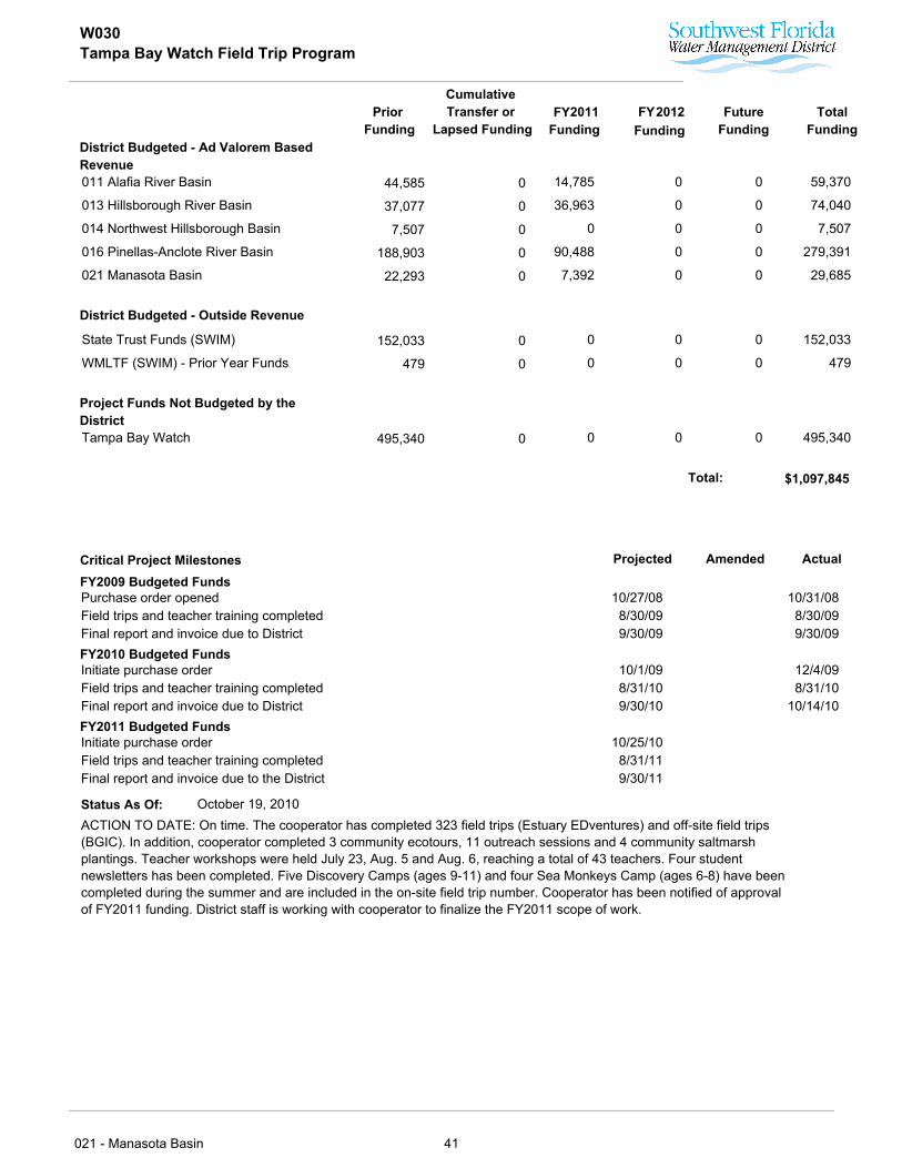
W030
Tampa Bay Watch Field Trip Program
District Budgeted - Ad Valorem Based
Revenue
011 Alafia River Basin 59,370 0 0 44,585 0 14,785
013 Hillsborough River Basin 74,040 0 0 37,077 0 36,963
014 Northwest Hillsborough Basin 7,507 0 0 7,507 0 0
016 Pinellas-Anclote River Basin 279,391 0 0 188,903 0 90,488
021 Manasota Basin 29,685 0 0 22,293 0 7,392
District Budgeted - Outside Revenue
State Trust Funds (SWIM) 152,033 0 0 152,033 0 0
WMLTF (SWIM) - Prior Year Funds 479 0 0 479 0 0
Project Funds Not Budgeted by the
District
Tampa Bay Watch 495,340 0 0 495,340 0 0
$1,097,845 Total:
Prior
Funding
Cumulative
Transfer or
Lapsed Funding Funding Funding
2011 FY 2012 FY Future
Funding
Total
Funding
Critical Project Milestones ActualProjected Amended
FY2009 Budgeted FundsPurchase order opened 10/27/08 10/31/08
Field trips and teacher training completed 8/30/09 8/30/09
Final report and invoice due to District 9/30/09 9/30/09
FY2010 Budgeted FundsInitiate purchase order 10/1/09 12/4/09
Field trips and teacher training completed 8/31/10 8/31/10
Final report and invoice due to District 9/30/10 10/14/10
FY2011 Budgeted FundsInitiate purchase order 10/25/10
Field trips and teacher training completed 8/31/11
Final report and invoice due to the District 9/30/11
Status As Of: October 19, 2010
ACTION TO DATE: On time. The cooperator has completed 323 field trips (Estuary EDventures) and off-site field trips
(BGIC). In addition, cooperator completed 3 community ecotours, 11 outreach sessions and 4 community saltmarsh
plantings. Teacher workshops were held July 23, Aug. 5 and Aug. 6, reaching a total of 43 teachers. Four student
newsletters has been completed. Five Discovery Camps (ages 9-11) and four Sea Monkeys Camp (ages 6-8) have been
completed during the summer and are included in the on-site field trip number. Cooperator has been notified of approval
of FY2011 funding. District staff is working with cooperator to finalize the FY2011 scope of work.
021 - Manasota Basin 41

W226
City of Anna Maria-Implementation of BMPs
Project Type SWIM
AORs Strategic InitiativesWater Quality Water Quality Maintenance and ImprovementFlood Protection Floodplain Management
Basin(s) Manasota
City of Anna MariaCooperator(s)
Project Manager PRESTON, MATT
Task Manager(s)
Status Ongoing
DescriptionThe City of Anna Maria has submitted this multi-phase cooperative funding project to implement water quality and
flood protection best management practices (BMPs) in the Lower Tampa Bay Watershed, part of Tampa Bay and
Sarasota Bay, SWIM waterbodies. The project will impact four areas within the City totaling approximately 124 acres:
1) North Bay/Tarpon Basin, 2) North Shore/Jacaranda Basin, 3) South Drive/South Bay Area, and 4)
Crescent/Gulf/Willow Basin. All four basins outfall into the internal canals of Anna Maria, which in turn discharge into
Lower Tampa Bay. With FY2007 funding the work on the Implementation of BMPs (Phase 1) includes the following
tasks: design, development of construction documents, construction permitting, bidding and contractor selection,
construction of the BMPs and construction engineering and inspection for the Crescent/Gulf/Willow improvement area.
The BMPs will address level of service (LOS) deficiencies. The flood protection and water quality improvements
include 10-ft wide shallow dry retention swales with ditch blocks, various diameter HDPE/RCP pipe, inlet/control
structures and BMP baffle structures (one at each basin outfall location). The swales will provide treatment of
stormwater runoff through percolation and evaporation while the baffle structures will provide treatment through
sedimentation, filtration and skimming. The City submitted a request for FY2008 and FY2009 funding to complete the
implementation of BMPs in the final three areas.
BenefitsThe City of Anna Maria has initiated a program to provide capital improvement projects that will improve both the water
quality and flood protection LOS provided by the City's surface water management system. The overall effect of the
improvements will be a reduction in pollutant loadings to the internal man-made canal system (classified as
Outstanding Florida Waters), Anna Maria Sound, Sarasota Bay, and Tampa Bay. The anticipated increase in flood
protection LOS will be through an increase in storage and conveyance capacity. The stormwater filtration devices
being proposed will provide suspended solids removal from stormwater runoff that previously discharged directly into
the canal/bay system.
Costs
The total budget amount for this project is $1.47 million with the Distict and the City of Anna Maria each contributing
half. The FY2009 project cost is $225,600, with the City and the District each contributing half ($112,800). The District
share is split between the Manasota Basin Board ($56,400) and State SWIM ($56,400). The probable construction
costs for this project are based on the BMP alternative analysis developed by the cooperator. The District funding
amounts shown in the table below include staff salary, travel and central garage.
Additional Information
Since 1950, approximately 50 percent of Tampa Bay's natural shoreline and approximately 40 percent of Sarasota
Bay's intertidal wetland habitat has been lost due to development and reduction in water quality. This resulted in a
decline in the aesthetic, recreational, and commercial value of the bay, as well as loss of habitat for native plants and
animals. The SWIM Plans for Tampa Bay and Sarasota Bay outline goals to restore habitat throughout the bay areas
and reduce pollutant loads entering the bays. The improvements will be made in City owned alleys and right of ways.
The funding should complete the following tasks for Phase 2 (North Bay/Tarpon Basin, North Shore/Jacaranda Basin,
and South Drive/South Bay improvement areas): design, development of construction documents, construction
permitting, bidding and contractor selection, construction of the BMPs and construction engineering and inspection.
021 - Manasota Basin 42
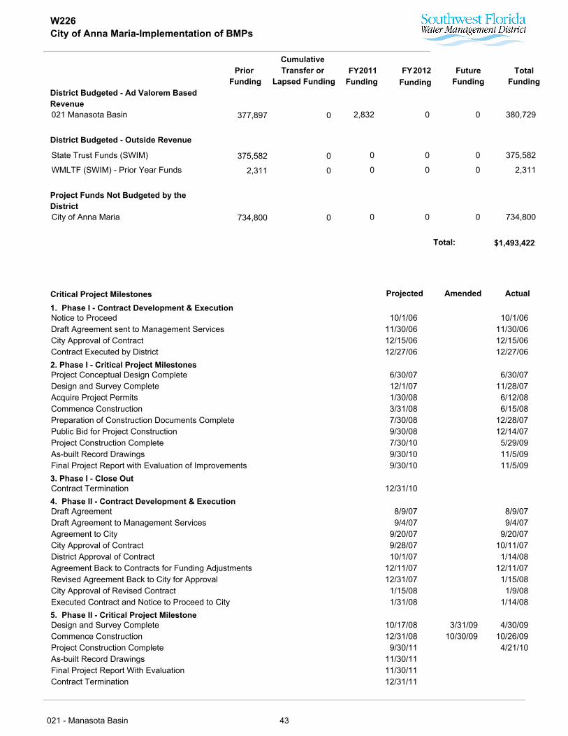
W226
City of Anna Maria-Implementation of BMPs
District Budgeted - Ad Valorem Based
Revenue
021 Manasota Basin 380,729 0 0 377,897 0 2,832
District Budgeted - Outside Revenue
State Trust Funds (SWIM) 375,582 0 0 375,582 0 0
WMLTF (SWIM) - Prior Year Funds 2,311 0 0 2,311 0 0
Project Funds Not Budgeted by the
District
City of Anna Maria 734,800 0 0 734,800 0 0
$1,493,422 Total:
Prior
Funding
Cumulative
Transfer or
Lapsed Funding Funding Funding
2011 FY 2012 FY Future
Funding
Total
Funding
Critical Project Milestones ActualProjected Amended
1. Phase I - Contract Development & ExecutionNotice to Proceed 10/1/06 10/1/06
Draft Agreement sent to Management Services 11/30/06 11/30/06
City Approval of Contract 12/15/06 12/15/06
Contract Executed by District 12/27/06 12/27/06
2. Phase I - Critical Project MilestonesProject Conceptual Design Complete 6/30/07 6/30/07
Design and Survey Complete 12/1/07 11/28/07
Acquire Project Permits 1/30/08 6/12/08
Commence Construction 3/31/08 6/15/08
Preparation of Construction Documents Complete 7/30/08 12/28/07
Public Bid for Project Construction 9/30/08 12/14/07
Project Construction Complete 7/30/10 5/29/09
As-built Record Drawings 9/30/10 11/5/09
Final Project Report with Evaluation of Improvements 9/30/10 11/5/09
3. Phase I - Close OutContract Termination 12/31/10
4. Phase II - Contract Development & ExecutionDraft Agreement 8/9/07 8/9/07
Draft Agreement to Management Services 9/4/07 9/4/07
Agreement to City 9/20/07 9/20/07
City Approval of Contract 9/28/07 10/11/07
District Approval of Contract 10/1/07 1/14/08
Agreement Back to Contracts for Funding Adjustments 12/11/07 12/11/07
Revised Agreement Back to City for Approval 12/31/07 1/15/08
City Approval of Revised Contract 1/15/08 1/9/08
Executed Contract and Notice to Proceed to City 1/31/08 1/14/08
5. Phase II - Critical Project MilestoneDesign and Survey Complete 10/17/08 3/31/09 4/30/09
Commence Construction 12/31/08 10/30/09 10/26/09
Project Construction Complete 9/30/11 4/21/10
As-built Record Drawings 11/30/11
Final Project Report With Evaluation 11/30/11
Contract Termination 12/31/11
021 - Manasota Basin 43

W226
City of Anna Maria-Implementation of BMPs
Status As Of: October 29, 2010
Phase I and Phase II construction is complete. The City is working with District Regulation on some minor compliance
issues for Phase I. It is anticipated that all final reports and project closeout will be completed prior to the end of the year.
021 - Manasota Basin 44

W312
Tampa Bay Habitat Restoration
Project Type SWIM
AORs Strategic InitiativesWater Quality Water Quality Maintenance and ImprovementNatural Systems Natural Systems Conservation and Restoration
Basin(s) Alafia River, Hillsborough River, Northwest Hillsborough, Pinellas-Anclote River, Manasota
Cooperator(s)
Project Manager HENNINGSEN, BRANDT
Task Manager(s)
Status Ongoing
DescriptionTampa Bay, in 1987, was identified by the Legislature in the Surface Water Improvement and Management (SWIM)
Act of as the top priority on the District's SWIM priority list. This project provides funds for general support to SWIM
habitat restoration efforts for Tampa Bay. Funds are provided for equipment rental, equipment repair/maintenance,
advertising/public notices, parts and supplies, etc. Limited project construction expenses are also budgeted under this
activity code. Additionally, this project includes funds for exotic plant maintenance at the habitat restoration sites.
Lastly, funds for this project allow planning of future projects, and facilitate SWIM involvement with various
environmental committees and task forces (e.g., various committees of the Tampa Bay Estuary Program, etc.)
BenefitsThis project is important for meeting management goals of SWIM and the Tampa Bay Estuary Program (TBEP).
Coordination and planning of existing and future projects is a critical component of long term success of both
programs. If funds are not allocated, then SWIM's ability to successfully perform their habitat restoration projects for
Tampa Bay will be compromised. Accordingly, the District will not be meeting its (and the TBEP's) goals to restore
important habitats (and improve water quality) for the bay, habitats which have suffered great losses because of land
development and other human uses of the resource.
Costs
The FY2011 costs are funded 25 percent from the Pinellas-Anclote River, 25 percent from the Manasota, 25 percent
from the Hillsborough River, and 25 percent from the Alafia River Basin Boards. State SWIM funds will not
be available during FY2011. District funds shown in the table include staff salaries. District funds shown in the table
include staff salaries, travel and central garage.
Additional Information
Tampa Bay is the District's top priority Surface Water Improvement and Management (SWIM) program waterbody, is
a category I (most in need of restoration) under the State's Unified Watershed Assessment and Watershed
Restoration Priorities, and is considered an "estuary of national significance" with the designation of the Tampa Bay
(National) Estuary Program. Since 1950, about 50 percent of the bay's natural shoreline and 40 percent of its
seagrass acreage were lost as a result of physical destruction and water quality impairment. This resulted in a decline
in the aesthetic, recreational, and commercial value of the bay, as well as a loss of habitat for native plants and
animals.
021 - Manasota Basin 45
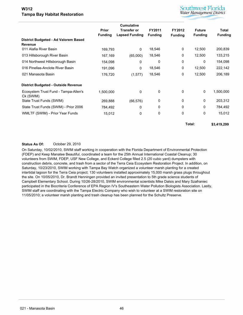
W312
Tampa Bay Habitat Restoration
District Budgeted - Ad Valorem Based
Revenue
011 Alafia River Basin 200,839 12,500 0 169,793 0 18,546
013 Hillsborough River Basin 133,215 12,500 (65,000) 167,169 0 18,546
014 Northwest Hillsborough Basin 154,098 0 0 154,098 0 0
016 Pinellas-Anclote River Basin 222,142 12,500 0 191,096 0 18,546
021 Manasota Basin 206,189 12,500 (1,577) 176,720 0 18,546
District Budgeted - Outside Revenue
Ecosystem Trust Fund - Tampa-Allen's
Ck (SWIM)
1,500,000 0 0 1,500,000 0 0
State Trust Funds (SWIM) 203,312 0 (66,576) 269,888 0 0
State Trust Funds (SWIM) - Prior 2006 784,492 0 0 784,492 0 0
WMLTF (SWIM) - Prior Year Funds 15,012 0 0 15,012 0 0
$3,419,299 Total:
Prior
Funding
Cumulative
Transfer or
Lapsed Funding Funding Funding
2011 FY 2012 FY Future
Funding
Total
Funding
Status As Of: October 29, 2010
On Saturday, 10/02/2010, SWIM staff working in cooperation with the Florida Department of Environmental Protection
(FDEP) and Keep Manatee Beautiful, coordinated a team for the 25th Annual International Coastal Cleanup; 30
volunteers from SWIM, FDEP, USF New College, and Eckerd College filled 2.5 (20 cubic yard) dumpsters with
construction debris, concrete, and trash from a sector of the Terra Ceia Ecosystem Restoration Project. In addition, on
Saturday, 10/23/2010, SWIM working with Tampa Bay Watch organized a volunteer marsh planting for a created
intertidal lagoon for the Terra Ceia project; 130 volunteers installed approximately 15,000 marsh grass plugs throughout
the site. On 10/05/2010, Dr. Brandt Henningen provided an invited presentation to 5th grade science students of
Campbell Elementary School. During 10/26-28/2010, SWIM environmental scientists Mike Dalsis and Mary Szafraniec
participated in the Biocriteria Conference of EPA Region IV's Southeastern Water Pollution Biologists Association. Lastly,
SWIM staff are coordinating with the Tampa Electric Company who wish to volunteer at a SWIM restoration site on
11/05/2010; a volunteer marsh planting and trash cleanup has been planned for the Schultz Preserve.
021 - Manasota Basin 46
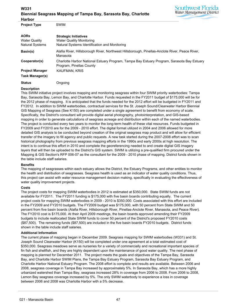
W331
Biennial Seagrass Mapping of Tampa Bay, Sarasota Bay, Charlotte
HarborProject Type SWIM
AORs Strategic InitiativesWater Quality Water Quality MonitoringNatural Systems Natural Systems Identification and Monitoring
Basin(s) Alafia River, Hillsborough River, Northwest Hillsborough, Pinellas-Anclote River, Peace River,
Manasota
Charlotte Harbor National Estuary Program, Tampa Bay Estuary Program, Sarasota Bay Estuary
Program, Pinellas County
Cooperator(s)
Project Manager KAUFMAN, KRIS
Task Manager(s)
Status Ongoing
DescriptionThis SWIM initiative project involves mapping and monitoring seagrass within four SWIM priority waterbodies: Tampa
Bay, Sarasota Bay, Lemon Bay, and Charlotte Harbor. Funds requested in the FY2011 budget of $175,000 will be for
the 2012 phase of mapping. It is anticipated that the funds needed for the 2012 effort will be budgeted in FY2011 and
FY2012. In addition to SWIM waterbodies, contractual services for the St. Joseph Sound/Clearwater Harbor Biennial
GIS Mapping of Seagrass (See K150) are completed under a single agreement to benefit from economy of scale.
Specifically, the District's consultant will provide digital aerial photography, photointerpretation, and GIS-based
mapping in order to generate calculations of seagrass acreage and distribution within each of the named waterbodies.
The project is conducted every two years to monitor the long-term health of these vital resources. Funds budgeted in
FY2009 and FY2010 are for the 2009 - 2010 effort. The digital format utilized in 2004 and 2006 allowed for more
detailed GIS analysis to be conducted beyond creation of the original seagrass map product and will allow for efficient
transfer of the imagery to fill agency and public requests. A new task started during the 2007-2008 effort was to scan
historical photography from previous seagrass mapping efforts in the 1990s and early 2000s at high resolution. The
intent is to continue this effort in 2010 and complete the georeferencing needed to and create digital GIS imagery
layers that will then be uploaded to the District's GIS system. SWIM is utilizing a pre-qualified firm procured under the
Mapping & GIS Section's RFP 006-07 as the consultant for the 2009 - 2010 phase of mapping. District funds shown in
the table include staff salaries.
BenefitsThe mapping of seagrasses within each estuary allows the District, the Estuary Programs, and other entities to monitor
the health and distribution of seagrasses. Seagrass health is used as an indicator of water quality conditions. Thus,
this project can assist with water resource management decision making, specifically in evaluating the effectiveness of
water quality improvement projects.
Costs
The project costs for mapping SWIM waterbodies in 2012 is estimated at $350,000. State SWIM funds are not
available for FY2011. The FY2011 funding is $175,000 with five basin boards contributing equally. The current
project costs for mapping SWIM waterbodies in 2009 - 2010 is $350,000. Costs associated with this effort are included
in the FY2009 and FY2010 budgets. The FY2009 budget was $175,000, with 50 percent from State SWIM and 50
percent from five basin boards (Alafia River, Hillsborough River, Pinellas-Anclote River, Manasota, and Peace River).
The FY2010 cost is $175,000. At their April 2009 meetings, the basin boards approved amending their FY2009
budgets to include reallocated State SWIM funds to cover 50 percent of the District's proposed FY2010 costs
($87,500). The remaining funds ($87,500) are included in the five basin boards FY2010 budgets. District funds
shown in the table include staff salaries.
Additional Information
The current phase of mapping began in December 2009. Seagrass mapping for SWIM waterbodies (W331) and St.
Joseph Sound Clearwater Harbor (K150) will be completed under one agreement at a total estimated cost of
$350,000. Seagrass meadows serve as nurseries for a variety of commercially and recreational important species of
fin fish and shellfish, and they are highly dependent upon the maintenance of good water quality. The next phase of
mapping is planned for December 2011. The project meets the goals and objectives of the Tampa Bay, Sarasota
Bay, and Charlotte Harbor SWIM Plans, the Tampa Bay Estuary Program, Sarasota Bay Estuary Program, and
Charlotte Harbor National Estuary Program. The 2008 effort is complete and results are available. Between 2006 and
2008, seagrass coverage in Tampa Bay increased by approximately 5%. In Sarasota Bay, which has a more highly
urbanized watershed than Tampa Bay, seagrass increased 28% in coverage from 2006 to 2008. From 2006 to 2008,
Lemon Bay seagrass coverage increased by 5%. The only SWIM waterbody to experience a loss in coverage
between 2006 and 2008 was Charlotte Harbor with a 5% decrease.
021 - Manasota Basin 47
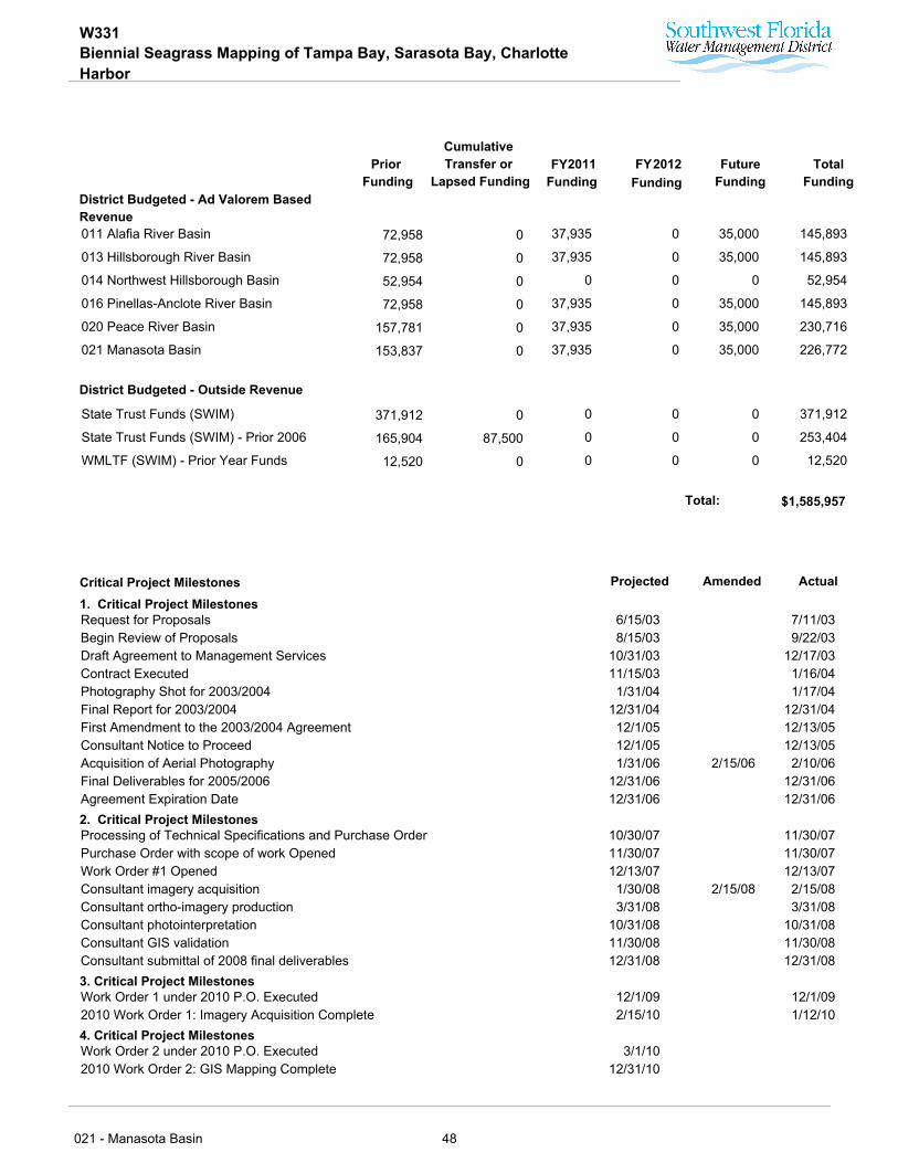
W331
Biennial Seagrass Mapping of Tampa Bay, Sarasota Bay, Charlotte
Harbor
District Budgeted - Ad Valorem Based
Revenue
011 Alafia River Basin 145,893 35,000 0 72,958 0 37,935
013 Hillsborough River Basin 145,893 35,000 0 72,958 0 37,935
014 Northwest Hillsborough Basin 52,954 0 0 52,954 0 0
016 Pinellas-Anclote River Basin 145,893 35,000 0 72,958 0 37,935
020 Peace River Basin 230,716 35,000 0 157,781 0 37,935
021 Manasota Basin 226,772 35,000 0 153,837 0 37,935
District Budgeted - Outside Revenue
State Trust Funds (SWIM) 371,912 0 0 371,912 0 0
State Trust Funds (SWIM) - Prior 2006 253,404 0 87,500 165,904 0 0
WMLTF (SWIM) - Prior Year Funds 12,520 0 0 12,520 0 0
$1,585,957 Total:
Prior
Funding
Cumulative
Transfer or
Lapsed Funding Funding Funding
2011 FY 2012 FY Future
Funding
Total
Funding
Critical Project Milestones ActualProjected Amended
1. Critical Project MilestonesRequest for Proposals 6/15/03 7/11/03
Begin Review of Proposals 8/15/03 9/22/03
Draft Agreement to Management Services 10/31/03 12/17/03
Contract Executed 11/15/03 1/16/04
Photography Shot for 2003/2004 1/31/04 1/17/04
Final Report for 2003/2004 12/31/04 12/31/04
First Amendment to the 2003/2004 Agreement 12/1/05 12/13/05
Consultant Notice to Proceed 12/1/05 12/13/05
Acquisition of Aerial Photography 1/31/06 2/15/06 2/10/06
Final Deliverables for 2005/2006 12/31/06 12/31/06
Agreement Expiration Date 12/31/06 12/31/06
2. Critical Project MilestonesProcessing of Technical Specifications and Purchase Order 10/30/07 11/30/07
Purchase Order with scope of work Opened 11/30/07 11/30/07
Work Order #1 Opened 12/13/07 12/13/07
Consultant imagery acquisition 1/30/08 2/15/08 2/15/08
Consultant ortho-imagery production 3/31/08 3/31/08
Consultant photointerpretation 10/31/08 10/31/08
Consultant GIS validation 11/30/08 11/30/08
Consultant submittal of 2008 final deliverables 12/31/08 12/31/08
3. Critical Project MilestonesWork Order 1 under 2010 P.O. Executed 12/1/09 12/1/09
2010 Work Order 1: Imagery Acquisition Complete 2/15/10 1/12/10
4. Critical Project MilestonesWork Order 2 under 2010 P.O. Executed 3/1/10
2010 Work Order 2: GIS Mapping Complete 12/31/10
021 - Manasota Basin 48

W331
Biennial Seagrass Mapping of Tampa Bay, Sarasota Bay, Charlotte
HarborStatus As Of: November 02, 2010
The 2010 purchase order is open and the first work order for the 2010 effort was executed December 2009. Imagery for
all waterbodies was captured by January 12, 2010. The second work order for photointerpretation and GIS based
mapping was executed in March 2010. Final imagery deliverables were submitted, approved, and are available to the
public and District staff. A photointerpretation kick-off meeting was in May 2010 and GIS mapping is underway. Field
verification work with the Consultant will be completed in November allowing for completion of map delineation. A draft
map meeting and the post map production classification accuracy assessment will be conducted in late November.
021 - Manasota Basin 49

W348
Terra Ceia Isles Habitat Restoration
Project Type SWIM
AORs Strategic InitiativesNatural Systems Natural Systems Conservation and RestorationWater Quality Water Quality Maintenance and Improvement
Basin(s) Manasota
Florida Department of Environmental ProtectionCooperator(s)
Project Manager HENNINGSEN, BRANDT
DALSIS, MIKETask Manager(s)
Status Ongoing
DescriptionThe Terra Ceia Aquatic and Park Preserves habitat enhancement and restoration project, a SWIM initiative, is located
in the southeastern reaches of Tampa Bay (Manatee County). This large, multi-phased project is being cooperatively
implemented with the Florida Department of Environmental Protection (FDEP). Currently, the project involves 2,308
acres of publicly owned land (Terra Ceia Isles and the Peanut Lake parcel, with an additional 2,900 acres included in
the District's five year acquisition plan. Accordingly, this project has the potential of encompassing at least 5,200 acres
and will require multiple years of funding, planning, and implementation. Project updates focus primarily on just the
1,745 acre Terra Ceia Isles parcel, although updates will be given on progress within Peanut Lake lands and
concerning additional land purchases and potential future phases. It is anticipated that the majority of this project will
be performed by private contractors.
BenefitsThis project will be important in meeting management plan goals of SWIM and the Tampa Bay Estuary Program
(TBEP). The current project involves the enhancement, restoration, and management of an estimated 700 acres of
various habitats typical of coastal ecosystems (i.e., habitat mosaics): estuarine and freshwater wetlands, transitional
habitats, and uplands. Salinity gradients and low salinity habitats will be emphasized to improve fisheries production.
Accordingly, the project will provide valuable habitats for Tampa Bay fisheries and other coastal species. Portions of
this are true restoration in that sections of the site historically were bay bottom and intertidal wetlands that were filled to
create a proposed finger-fill subdivision. In addition, strides to meet bay water quality goals of both SWIM and TBEP
will be addressed via improved stormwater treatment. Improved habitat values and the addition of habitat acreages will
provide opportunities for many differing species of coastal wildlife, inclusive of commercial and sportfishing species,
bird populations, a host of invertebrate species (crabs, shrimp, oysters, etc.), and small mammals.
Costs
Total cost estimate for Terra Ceia Isles is $9,400,000 and is being budgeted over multiple fiscal years. Note: exotic
plant control funds (S042) have annually been budgeted under Land Resources Department using Save Our Rivers
dollars; these funds have been included here to give a more complete picture of the restoration effort. Proposed
FY2011 funds ($956,307) are for construction of additional project phases and will include staff salaries, travel, and
central garage. Traditionally, District funds have been split 50/50 between the Manasota Basin Board and State SWIM
Fund, but State SWIM funds are not available for FY2011. Future phases associated with additional land acquisition
will require future funding.
Additional Information
Tampa Bay is the District's top priority Surface Water Improvement and Management (SWIM) program waterbody, is
a category I (most in need of restoration) under the State's Unified Watershed Assessment and Watershed
Restoration Priorities, and is considered an "estuary of national significance" with the designation of the Tampa Bay
(National) Estuary Program. Since 1950, about 50 percent of the bay's natural shoreline and 40 percent of its
seagrass acreage were lost as a result of physical destruction and water quality impairment. This resulted in a decline
in the aesthetic, recreational, and commercial value of the bay, as well as a loss of habitat for native plants and
animals.
021 - Manasota Basin 50

W348
Terra Ceia Isles Habitat Restoration
District Budgeted - Ad Valorem Based
Revenue
021 Manasota Basin 3,723,708 2,300,000 (748,423) 1,191,960 0 980,171
041 Florida Forever/SOR/P2000 216,189 0 0 216,189 0 0
District Budgeted - Outside Revenue
Ecosystem Trust - Terra Ceia Habitat
Rstr (SWIM)
2,312,500 0 0 2,312,500 0 0
Nat'l Fish & Wildlife - Terra Ceia
(SWIM)
300,000 0 0 300,000 0 0
NOAA - Terra Ceia 2,000,000 0 0 2,000,000 0 0
State Trust Funds (SWIM) (417,558) 0 (748,424) 330,866 0 0
State Trust Funds (SWIM) - Prior 2006 1,276,234 0 0 1,276,234 0 0
WMLTF (SWIM) - Prior Year Funds 10,269 0 0 10,269 0 0
$9,421,342 Total:
Prior
Funding
Cumulative
Transfer or
Lapsed Funding Funding Funding
2011 FY 2012 FY Future
Funding
Total
Funding
Critical Project Milestones ActualProjected Amended
1. Critical Project Milestones30% wetland design plans 9/30/02 9/30/04 12/1/04
Draft Phase 3 upland restoration RFB 8/1/04 4/15/04
Release Phase 3 upland restoration contract 9/1/04 8/13/04
Award Phase 3 upland restoration contract 11/1/04 12/2/04
Complete 60% wetland design plans 4/30/05 8/1/05 8/9/05
Submit Environmental Permit Applications 12/31/05 2/1/06
Complete 100% wetland design plans 12/31/05 12/22/05
Draft wetland construction RFB 12/31/05 12/22/05
Release Wetland Construction RFB 1/31/06 1/13/06
Negotiate/process/execute const. contract 6/15/06 9/4/06
Complete Phase 3 upland restoration 7/31/06 9/30/06 9/29/06
Complete Phase 1 wetland construction 6/15/08 12/31/08 12/15/08
Status As Of: October 29, 2010
Two volunteer events were coordinated by SWIM for portions of the Terra Ceia Ecosystem Restoration Project: 1)
SWIM, FDEP, and Keep Manatee Beautiful organized a team of 30 volunteers to participate in the 25th Annual
International Coastal Cleanup (10/02/2010). Volunteers from SWIM, FDEP, USF New College, and Eckerd College filled
2.5 (20 cubic yard) dumpsters with construction debris, concrete, and trash from a coastal upland portion of the project.
2) SWIM and Tampa Bay Watch coordinated 130 volunteers who installed 15,000 plugs of marsh grasses in a created
tidal lagoon (10/23/2010). USGS and USF staff have completed the Frog Creek Hydrodynamic Modeling Study,
evaluating if proposed 1-3 creek offline intertidal lagoons would deleteriously affect the existing salinity regime of the
creek. Project data and conclusions were profiled in a presentation by USF-USGS, with the final draft report to be
submitted to SWIM and FDEP during November 2010. Study results indicate that construction of three offline lagoons
along Frog Creek could increase creek salinities by an average of 1-2 parts-per-thousand; biologists will now determine if
they feel such a shift would be deleterious to existing habitat values of the creek. SWIM and FDEP staff will review the
final report and determine the proper course of action to be taken concerning whether the lagoons should or should not
be built; if the decision is made to not build the lagoons, the three areas will be restored as coastal uplands. Phase 6
Upland Restoration continues, and the contractor has completed about 75% of the 158 acre effort; after removal of all
non-native plants, native vegetation will be installed throughout the thirteen upland sectors. Concerning the 24 acre site
("airplane site") cleared of its original Brazilian pepper and Australian pine forests, SWIM's opinion is to allow the area to
become a grassed prairie (currently occurring); efforts to vegetate the site have been marginally successful, apparently
021 - Manasota Basin 51

W348
Terra Ceia Isles Habitat Restoration
due to the quality of the soils (recycled excavate), resulting in poor survivorship of installed grass seed, pine trees, and
saw palmetto. Upland Phase 5 contractor (Environmental Aquatic Control, Inc.) continues to perform quarterly site
maintenance (two years remain); the site offers challenges to meet concerning the abundant nuisance and non-native
plant populations. FDEP still has not resolved an alternative road solution to the Drunkard Lane section in need of
closing. SWIM continues to suggest that FDEP establish a new path using geoweb and/or crushed granite; FDEP is still
considering the recommendation. FDEP is partnering with SWFWMD Land Resources and has reactivated hog control
for the site; feral hog populations have been significantly growing over the last year, the hogs inflicting troublesome
damage to restored upland and wetland habitats. FDEP continued to address their plans for the revamped Bishop
Harbor Boat ramp and are still in permitting. ACTION TO DATE: On-time; Phase 5 upland restoration contract awarded;
construction commenced during May 2009. Phase 6 upland restoration has commenced.
021 - Manasota Basin 52

W358
Tom Bennett Park
Project Type SWIM
AORs Strategic InitiativesWater Quality Water Quality Maintenance and ImprovementNatural Systems Natural Systems Conservation and RestorationFlood Protection Floodplain Management
Basin(s) Manasota
Manatee CountyCooperator(s)
Project Manager POWERS, STEPHANIE
Task Manager(s)
Status Ongoing
DescriptionThis project is in response to a request from Manatee County to restore and enhance approximately 75 acres of
intertidal and freshwater wetland and upland habitat along the Manatee River. Tom Bennett Park is a 180-acre site that
was purchased in 2003 by Manatee County and the Florida Communities Trust. The project plan targets the
restoration of degraded salt marsh habitat and associated coastal maritime forest on adjacent hummocks through
minor regrading, nuisance and exotic species eradication, and supplemental plantings. The creation of freshwater,
ephemeral wetlands throughout the property is also anticipated. The County will be the lead agency for the project.
BenefitsUpon completion, the project will provide significant benefits to habitat and water quality. The County also plans to
provide passive recreational and educational opportunities to the public.
Costs
The total project cost is approximately $4.4 million, which includes $3.9 million for land acquisition. The County
contributed $1.5 million for the land purchase and has budgeted $260,000 for design and construction. The District's
FY2010 contribution is $60,000, of which 50% ($30,000) is from the Manasota Basin Board and 50% ($30,000) is from
State SWIM funds. The County will request additional funds for construction in FY2012. District funds shown in the
table include staff salaries.
Additional Information
Since 1950, approximately 50 percent of the bay's natural shoreline has been lost due to development and reduction
in water quality. This resulted in a decline in the aesthetic, recreational, and commercial value of the bay, as well as a
loss of habitat for native plants and animals. The SWIM Plan for Tampa Bay outlines goals to restore habitat
throughout the bay area and reduce pollutant loads entering Tampa Bay. The objectives of this project are consistent
with these goals.
District Budgeted - Ad Valorem Based
Revenue
021 Manasota Basin 234,223 200,000 0 31,885 0 2,338
District Budgeted - Outside Revenue
WMLTF (SWIM) - Prior Year Funds 31,885 0 0 31,885 0 0
Project Funds Not Budgeted by the
District
Manatee County 260,000 0 0 260,000 0 0
$526,108 Total:
Prior
Funding
Cumulative
Transfer or
Lapsed Funding Funding Funding
2011 FY 2012 FY Future
Funding
Total
Funding
021 - Manasota Basin 53

W358
Tom Bennett Park
Critical Project Milestones ActualProjected Amended
Contract Development and ExecutionReceive Scope of Work from Cooperator 9/16/09 12/4/09
Draft Agreement to Management Services 10/1/09 2/15/10 3/15/10
Agreement Returned from Management Services 10/22/09 7/15/10 8/16/10
Agreement Sent to Cooperator 10/29/09 7/25/10 8/18/10
Signed Agreement Returned from Cooperator 11/30/09 9/15/10
Agreement Fully Executed 12/15/09 10/1/10
Contract ExpirationProject Close Out 12/31/11
Status As Of: November 01, 2010
An agreement was submitted to Manatee County for review and signature on 8/18/10. Once the signed agreement
returns from the County, the documents will be forwarded to the Executive Director for final execution.
021 - Manasota Basin 54
W364
Palmetto Estuary
Project Type SWIM
AORs Strategic InitiativesWater Quality Water Quality Maintenance and ImprovementNatural Systems Natural Systems Conservation and Restoration
Basin(s) Manasota
PalmettoCooperator(s)
Project Manager DALSIS, MIKE
HAGBERG, JANIETask Manager(s)
Status Ongoing
DescriptionThis project is a District initiated cooperative project. Over the past ten years the City of Palmetto purchased 11.75
acres of various coastal habitats near the mouth of the Manatee River. The parcel contains various estuarine habitats
that transition to coastal uplands. The restoration project expaned to include an addtional 18 acre park referred to as
"Wayside Park" adjacent to the south and east of the 11.75 acres acquired by the City of Palmetto. This is a
multi-phase project with the 30 acre Phase 1 restoration completed in 2000. The proposed Phase 2 is an extension of
Phase 1 and will restore an additional 7.86 acres of coastal habitat adjacent and to the north of Phase I. Habitat values
of the parcel have been severely compromised due to dredge and fill impacts, illegal dumping, untreated stormwater,
and dominance of most of the uplands by non-native vegetation (i.e., Brazilian pepper, Australian pine, melaleuca).
Based on field investigations, portions of the site will require only non-native plant removal/native plant enhancement,
while others will require excavation/regrading to create new/restored open water and intertidal habitats. The City of
Palmetto is interested in partnering with the District on Phase 2 of this coastal restoration project which is envisioned
to enhance coastal uplands and restore intertidal and open water wetlands. The project site will become a component
of the Palmetto Estuary Nature Park to the south.
BenefitsThis project has been and will continue to be important in meeting management goals of SWIM and the Tampa Bay
Estuary Program (TBEP), including multiple phases providing low salinity habitats that create valuable nursery grounds
for breeding. Improved habitat values and the addition of habitat acreages will provide opportunities for many differing
species of coastal wildlife, inclusive of commercial and sportfishing species, bird populations, a host of invertebrate
species (crabs, shrimp, oysters, etc.), reptiles, amphibians, and small mammals. In addition, the site will become a
part of the "Palmetto Estuary Nature Park", an increasingly popular destination for the public to visit for nature activities
(canoeing/kayaking, fishing, bird watching, etc.).
Costs
Total project cost for Phase 1 was $525,000 including land acquisition by the City of Palmetto. The total estimated
project cost for the Phase 2 project is $100,000 and has been requested in FY2011 from the Manasota Basin Board.
District funds shown in table include staff salaries, travel, and central garage charges.
Additional Information
Tampa Bay is the District's top priority Surface Water Improvement and Management (SWIM) program waterbody, is
a category I (most in need of restoration) under the State's Unified Watershed Assessment and Watershed
Restoration Priorities, and is considered an "estuary of national significance" with the designation of the Tampa Bay
Estuary Program. Since 1950, about 50 percent of the bay's natural shoreline and 40 percent of its seagrass acreage
were lost as a result of physical destruction and water quality impairment. This resulted in a decline in the aesthetic,
recreational, and commercial value of the bay, as well as a loss of habitat for native plants and animals. The 2000
Phase 1 project was the 2001 Environmental Project of the Year as honored by the Future of the Region Awards
program of the Tampa Bay Regional Planning Council.
021 - Manasota Basin 55
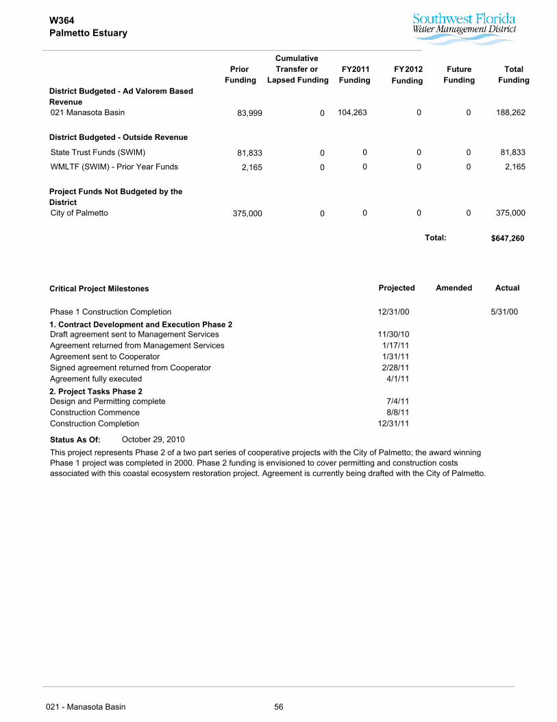
W364
Palmetto Estuary
District Budgeted - Ad Valorem Based
Revenue
021 Manasota Basin 188,262 0 0 83,999 0 104,263
District Budgeted - Outside Revenue
State Trust Funds (SWIM) 81,833 0 0 81,833 0 0
WMLTF (SWIM) - Prior Year Funds 2,165 0 0 2,165 0 0
Project Funds Not Budgeted by the
District
City of Palmetto 375,000 0 0 375,000 0 0
$647,260 Total:
Prior
Funding
Cumulative
Transfer or
Lapsed Funding Funding Funding
2011 FY 2012 FY Future
Funding
Total
Funding
Critical Project Milestones ActualProjected Amended
Phase 1 Construction Completion 12/31/00 5/31/00
1. Contract Development and Execution Phase 2Draft agreement sent to Management Services 11/30/10
Agreement returned from Management Services 1/17/11
Agreement sent to Cooperator 1/31/11
Signed agreement returned from Cooperator 2/28/11
Agreement fully executed 4/1/11
2. Project Tasks Phase 2Design and Permitting complete 7/4/11
Construction Commence 8/8/11
Construction Completion 12/31/11
Status As Of: October 29, 2010
This project represents Phase 2 of a two part series of cooperative projects with the City of Palmetto; the award winning
Phase 1 project was completed in 2000. Phase 2 funding is envisioned to cover permitting and construction costs
associated with this coastal ecosystem restoration project. Agreement is currently being drafted with the City of Palmetto.
021 - Manasota Basin 56
W394
FELTS Preserve Restoration
Project Type SWIM
AORs Strategic InitiativesWater Quality Water Quality Maintenance and ImprovementNatural Systems Natural Systems Conservation and Restoration
Basin(s) Manasota
Manatee County Audubon SocietyCooperator(s)
Project Manager LOPEZ, MANNY
Task Manager(s)
Status Ongoing
DescriptionThis project will restore important habitat and improve water quality functions on the FELTS Preserve which drains into
Terra Ceia Bay and ultimately discharges into Tampa Bay, a District SWIM waterbody. Through the removal of exotic
vegetation and planting of native vegetation, this project will result in restoration and enhancement of up to 5.5 acres of
freshwater wetlands, plus enhancement of 8.5 acres of adjacent uplands located within the 28.5 acre preserve. Much
of the project site has been altered over time, primarily through ditching and draining to create improved pasture for
agricultural purposes. The site is important because the general area is rapidly being converted from agricultural to
residential development and much of the habitat has been fragmented by construction of roads. Vegetative diversity is
relatively low in the existing water features due to the establishment of monocultures by invasive and exotic plants. A
mosaic of diverse habitat types is proposed, including emergent marsh, existing hardwood swamp and hammock and
ponded features.
BenefitsBest management practices will be implemented through planting of emergent and submergent plant species and the
management and control of invasive exotics. Water quality benefits will be achieved and monitored as the enhanced
site will provide for pollutant filtration and nutrient uptake through the creation of the proposed littoral shelves, as well
as buffering against erosion. The project location will also offer exceptional habitat value through the creation of
feeding platforms for wading birds.
Costs
The total cost of the project is $196,900. In FY2006, the District contributed $29,500 shared evenly by SWIM and the
Manasota Basin Board. The FY2006 application requested $40,400 but the Manatee Audubon was unable to acquire
that amount for a match. Earthmoving was accomplished by grants from U.S. Fish & Wildlife Service and National
Fish & Wildlife Foundation at a cost of $23,070. The FY2008 project cost was $32,600, with the Manatee Audubon
and the District each contributing half ($16,300). The District's share was split between the Manasota Basin Board
($8,150) and State SWIM ($8,150). The FY2009 project cost was $28,700, with Manatee Audubon and the District
each requested to contribute half ($14,350). The District share was split between the Manasota Basin Board ($7,175)
and State SWIM ($7,175). The FY2010 project cost is $18,000 with Manatee Audubon and the District each
contributing half ($9,000). Total funding in the table below includes staff salary, travel and central garage.
Additional Information
The FELTS Preserve, owned by Manatee County Audubon, is located at 4600 24th Avenue, East Palmetto in north
Manatee County within the Manatee River Watershed. A professional management plan has been completed by Ed
Freeman, then with the Nature Conservancy when contracted by Manatee Audubon. The Mana-Teens, Native Plant
Society, Manatee River Garden Club and others have helped to inventory plants on site, control exotic plants by
manual removal and minimal chemical means, and performed additional habitat improvement primarily on the
uplands. Five and one-half wetland acres have been planted and eight and one-half acres of pasture was restored in
FY2008. Chemical and mechanical control for invasive exotic plants has been implemented on approximately 17.5
acres and a monthly maintenance program is underway. Audubon is re-creating littoral areas around the enhanced
ponds by planting some 14,200 plants. Manatee Audubon will guarantee survival of 85% of planted material. In
FY2009, Manatee Audubon did a littoral shelf planting of 3 acres, installed 90 plants in a 17-acre upland area and
continued with exotic control.
021 - Manasota Basin 57

W394
FELTS Preserve Restoration
District Budgeted - Ad Valorem Based
Revenue
021 Manasota Basin 55,990 0 0 53,753 0 2,237
District Budgeted - Outside Revenue
State Trust Funds (SWIM) 43,868 0 0 43,868 0 0
WMLTF (SWIM) - Prior Year Funds 885 0 0 885 0 0
Project Funds Not Budgeted by the
District
Manatee County Audubon Society 47,150 0 0 47,150 0 0
National Fish and Wildlife Foundation 10,000 0 0 10,000 0 0
Other 58,600 0 0 58,600 0 0
USFWS 12,000 0 0 12,000 0 0
$228,493 Total:
Prior
Funding
Cumulative
Transfer or
Lapsed Funding Funding Funding
2011 FY 2012 FY Future
Funding
Total
Funding
Critical Project Milestones ActualProjected Amended
1. Consultant Agreement Development and ExecutionScope of Work Developed 8/24/09 8/18/09
Scope sent to finance for Purchase Order 8/31/09 12/2/09
2. Project TasksPlantings 8/28/10 11/30/10
Maintenance 9/5/10 11/30/10
3. Close OutFinal Report and Invoice 9/6/10 12/15/10
3. Contract TerminationProject Completion 9/27/10 12/31/10
Status As Of: October 25, 2010
The revised purchase order for the FY2010 scope has been issued. The Manatee County Audubon Society submitted
invoices for FY2009 and they were reviewed and paid. A portion of the invoices were not eligible for reimbursement due
to the date of the work done and the scope not covering the work performed. The Manatee County Audubon Society did
not request funding for FY2011. Requests for reimbursement for work completed in FY2010 are pending.
021 - Manasota Basin 58
W501
SWIM Plan Implementation - Charlotte Harbor
Project Type SWIM
AORs Strategic InitiativesWater Quality Water Quality Maintenance and ImprovementNatural Systems Natural Systems Conservation and Restoration
Basin(s) Peace River, Manasota
Charlotte Harbor National Estuary ProgramCooperator(s)
Project Manager GARCIA, LIZANNE
KAUFMAN, KRISTask Manager(s)
Status Ongoing
DescriptionThis project provides for the administration and implementation of projects as outlined in the SWIM Plan for Charlotte
Harbor. Administration and implementation includes assessment of implementation progress, a review and refinement
of the Pollutant Load Reduction Goal (PLRG) for the waterbody, periodic SWIM Advisory Committee meetings, new
project development (rationale and justification), development of relevant contracts and Requests for Proposals,
invoicing, project related presentations, field visits, and miscellaneous duties as they arise.
BenefitsThis project's support of the Charlotte Harbor SWIM Plan creates an opportunity for a cohesive effort between the
District, the CHNEP, and other state and local agencies to better implement resource management decisions and
restoration activities. Historically, SWIM projects have been eligible for state matching funds with the state funding 50
percent of the project costs and the District funding the remaining 50 percent. In FY2011, SWIM projects are funded
100 percent by Basin Funds, specifically, the Peace River and/or Manasota Basin Boards, depending on the project
location within the Charlotte Harbor watershed.
Costs
The FY 2010 ongoing costs for the Charlotte Harbor SWIM Plan Implementation were funded 50 percent from the
State SWIM Program and the balance was funded by the Peace River and Manasota Basin Boards. The FY2011
ongoing costs for the Charlotte Harbor SWIM Plan Implementation are funded from the Manasota Basin and the
Peace River Basin Boards. There are no State SWIM Program funds available in FY2011. District funds shown in the
table include staff salary, travel and central garage.
Additional Information
In 1987, the Florida Legislature established the Surface Water Improvement and Management (SWIM) Act having
recognized that water quality and habitat in surface waters throughout the state have degraded or were in danger of
being degraded. The Act requires the five water management districts to maintain a priority list of water bodies of
regional or statewide significance within their boundaries, and develop plans and programs for the improvement of
those water bodies. To date, ten SWIM water bodies in the District have had plans developed and approved by the
state. Several plans have been updated one or more times as required by the Act. The Charlotte Harbor SWIM Plan
was first approved in 1993 and last updated in November 2000. Since the first plan, the District has initiated a number
of restoration and diagnostic assessment projects. Included within these are: 1) implementation of a water quality
monitoring program, 2) development of a pollutant loading model, 3) investigation of a resource-based pollutant load
reduction goal, 4) assessment of toxin levels, 5) identification of cumulative impacts to freshwater inflow reductions, 6)
seagrass mapping efforts, 7) various habitat restoration projects, and 8) involvement in numerous public outreach and
education activities.
021 - Manasota Basin 59
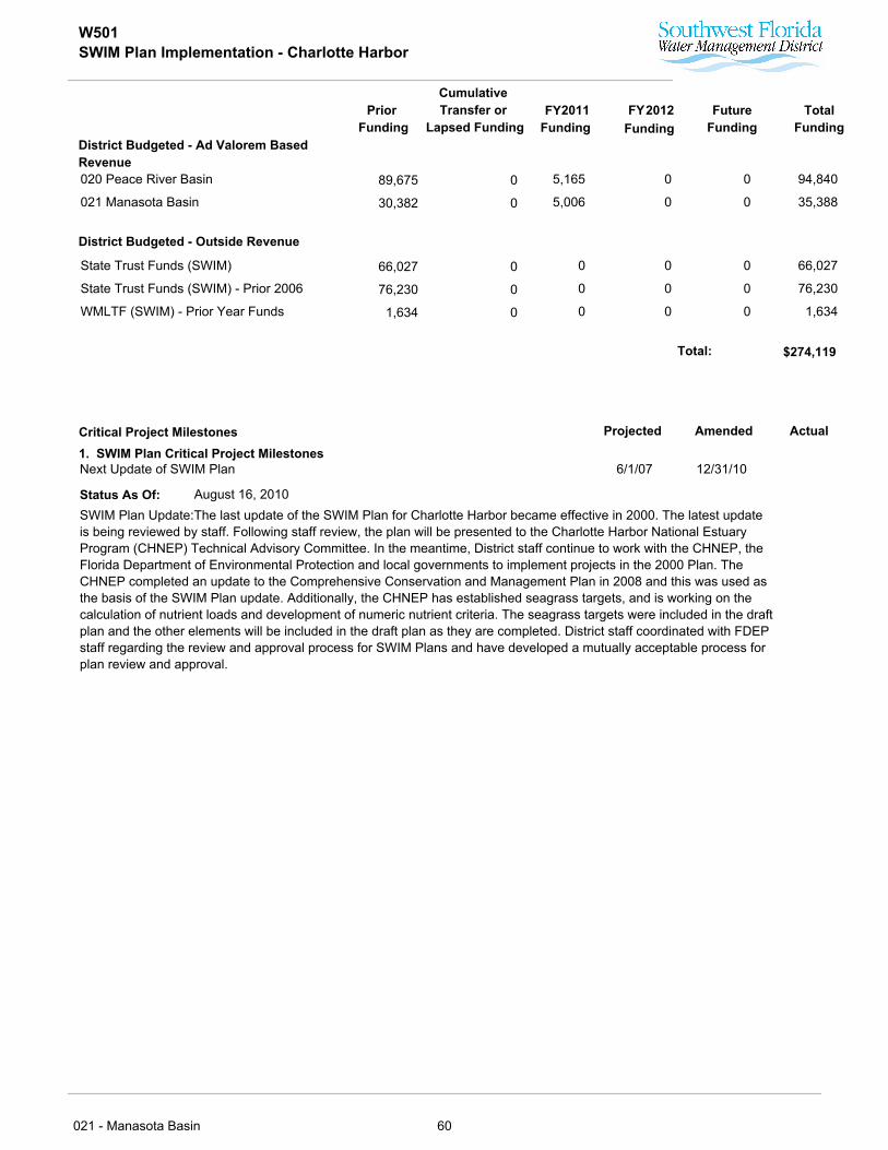
W501
SWIM Plan Implementation - Charlotte Harbor
District Budgeted - Ad Valorem Based
Revenue
020 Peace River Basin 94,840 0 0 89,675 0 5,165
021 Manasota Basin 35,388 0 0 30,382 0 5,006
District Budgeted - Outside Revenue
State Trust Funds (SWIM) 66,027 0 0 66,027 0 0
State Trust Funds (SWIM) - Prior 2006 76,230 0 0 76,230 0 0
WMLTF (SWIM) - Prior Year Funds 1,634 0 0 1,634 0 0
$274,119 Total:
Prior
Funding
Cumulative
Transfer or
Lapsed Funding Funding Funding
2011 FY 2012 FY Future
Funding
Total
Funding
Critical Project Milestones ActualProjected Amended
1. SWIM Plan Critical Project MilestonesNext Update of SWIM Plan 6/1/07 12/31/10
Status As Of: August 16, 2010
SWIM Plan Update:The last update of the SWIM Plan for Charlotte Harbor became effective in 2000. The latest update
is being reviewed by staff. Following staff review, the plan will be presented to the Charlotte Harbor National Estuary
Program (CHNEP) Technical Advisory Committee. In the meantime, District staff continue to work with the CHNEP, the
Florida Department of Environmental Protection and local governments to implement projects in the 2000 Plan. The
CHNEP completed an update to the Comprehensive Conservation and Management Plan in 2008 and this was used as
the basis of the SWIM Plan update. Additionally, the CHNEP has established seagrass targets, and is working on the
calculation of nutrient loads and development of numeric nutrient criteria. The seagrass targets were included in the draft
plan and the other elements will be included in the draft plan as they are completed. District staff coordinated with FDEP
staff regarding the review and approval process for SWIM Plans and have developed a mutually acceptable process for
plan review and approval.
021 - Manasota Basin 60
W506
CHEC Charlotte Harbor/Lemon Bay SWIM Watershed Education
Project Type SWIM
AORs Strategic InitiativesWater Quality Water Quality Maintenance and ImprovementWater Supply ConservationNatural Systems Natural Systems Conservation and RestorationFlood Protection Floodplain Management
Basin(s) Peace River, Manasota
Charlotte Harbor Environmental CenterCooperator(s)
Project Manager STERNBERGER, VIRGINIA
Task Manager(s)
Status Ongoing
DescriptionThis Surface Water Improvement and Management project with the Charlotte Harbor Environmental Center provides
public involvement and water quality education opportunities to 4,300 residents in the Charlotte Harbor/Lemon Bay
watersheds. The program's goal is to foster a sense of stewardship and encourage actions that benefit the watershed
through focused education/outreach programs. The FY2011 program components include a volunteer water quality
monitoring program, estuary wading trips, water school workshop for local residents, community events, speaking
programs, estuary boat trips, hiking trips, develop and implement an Adopt-A-Pond program, reprint and distribution of
"Keep it Clean" Lemon Bay booklets, and reprint and distribution of "Watershed" Lemon Bay DVDs. Effectiveness will
be measured by number of participants, number of materials distributed, pre- and posttests and surveys.
BenefitsThe Peace River discharges into Charlotte Harbor, a SWIM priority water body and a designated "estuary of national
significance." The project fosters a sense of stewardship for the Peace River, Charlotte Harbor, Lemon Bay and
related freshwater resources through focused education opportunities for public participation and schools. The
program provides an opportunity for comparison of different areas within the Charlotte Harbor and Lemon Bay
watersheds. These programs are consistent with the District's watershed management and watershed education
initiatives. Education was named as a priority by the Manasota and Peace River basin boards. CHEC has the expertise
and experience to provide quality education in a variety of methods leading to increased knowledge and behavior
modificiation among participants.
Costs
The total cost of the FY2011 project is $79,171, with the District contributing $39,215 (Peace River Basin Board
$31,372, Manasota Basin Board $7,843). District funds will pay for materials and program expenses. Each basin's
share is based on anticipated work within that basin. The program is projected to reach 4,300 residents at a cost to the
District of $9.12 per person. Although the cost per person is relatively high, the cost per contact hour is 38 percent
lower than average reflecting the hands-on and long-term nature of the program. The budget lines below include costs
for staff to manage the project.
Additional Information
The total cost of the FY2010 project was $89,446, with the District contributing $39,250. The District's share was split
between the Peace River Basin Board ($16,283), the Manasota Basin Board ($3,342) and State SWIM (19,625).
District funding was used for materials and program expenses. Each basin's share was based on work completed
within that basin. The program reached 4,230 residents at a cost to the District of $9 per person. The District has
supported this project since FY2000.
021 - Manasota Basin 61

W506
CHEC Charlotte Harbor/Lemon Bay SWIM Watershed Education
District Budgeted - Ad Valorem Based
Revenue
020 Peace River Basin 139,711 0 0 108,339 0 31,372
021 Manasota Basin 55,287 0 0 45,912 0 9,375
District Budgeted - Outside Revenue
State Trust Funds (SWIM) 78,877 0 0 78,877 0 0
State Trust Funds (SWIM) - Prior 2006 76,737 0 0 76,737 0 0
WMLTF (SWIM) - Prior Year Funds 20,371 0 0 20,371 0 0
Project Funds Not Budgeted by the
District
Charlotte Harbor Environmental Center 211,115 0 0 171,159 0 39,956
$582,098 Total:
Prior
Funding
Cumulative
Transfer or
Lapsed Funding Funding Funding
2011 FY 2012 FY Future
Funding
Total
Funding
Critical Project Milestones ActualProjected Amended
FY2008 Budgeted FundsInitiate purchase order 10/1/07 10/31/07 10/31/07
First task report due 12/31/07 12/11/07
Second task report due 3/31/08 3/31/08
Third task report due 6/30/08 6/16/08
Fourth task report due 9/16/08 9/29/08 9/29/08
Project close 11/14/08 3/31/09 3/31/09
FY2009 Budgeted FundsInitiate purchase order 10/1/08 12/4/08 12/4/08
First task report 12/31/08 12/29/08
Second task report 3/31/09 3/31/09
Third task report due 6/30/09 6/30/09
Fourth task report due 9/30/09 9/30/09
Project close 11/20/09 11/20/09
FY2010 Budgeted FundsInitiate purchase order 10/12/09 11/24/09 11/24/09
First task report due 12/31/09 1/5/10 1/5/10
Second task report 3/31/10 2/11/10
Third task report 6/30/10 6/30/10
Fourth task report 9/15/10 10/22/10 10/22/10
Project close 9/30/10 11/30/10
FY2011 Budgeted FundsInitiate purchase order 10/1/10 11/1/10
First task report 12/31/10
Second task report 3/31/11
Third task report 6/30/11
Fourth task report 9/30/11
Project close 11/18/11
Status As Of: August 17, 2010
ACTION TO DATE: On time. To date, the following tasks have been completed on the FY2010 scope of work: 2
volunteer water quality monitoring program workshops (37 participants), 2 speaking sessions (41 participants), 20
021 - Manasota Basin 62

W506
CHEC Charlotte Harbor/Lemon Bay SWIM Watershed Education
Journey through the Estuary boat trips (214 participants), 8 land-based hiking trips (107 participants), 40 wading trips
(771 participants), 12 speaking engagements (322 participants), reprinted and distributed 1,000 copies of the Lemon Bay
DVD, reprinted and distributed 500 copies of the Lemon Bay booklet, educational display at 12 events (3,080
participants) and SWIM Water School (34 participants). The FY2011 scope of work is being drafted.
021 - Manasota Basin 63
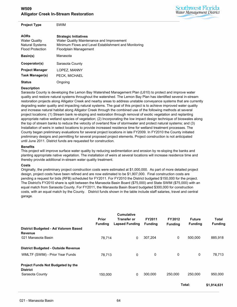
W509
Alligator Creek In-Stream Restoration
Project Type SWIM
AORs Strategic InitiativesWater Quality Water Quality Maintenance and ImprovementNatural Systems Minimum Flows and Level Establishment and MonitoringFlood Protection Floodplain Management
Basin(s) Manasota
Sarasota CountyCooperator(s)
Project Manager LOPEZ, MANNY
PECK, MICHAELTask Manager(s)
Status Ongoing
DescriptionSarasota County is developing the Lemon Bay Watershed Management Plan (L610) to protect and improve water
quality and restore natural systems throughout the watershed. The Lemon Bay Plan has identified several in-stream
restoration projects along Alligator Creek and nearby areas to address unstable conveyance systems that are currently
degrading water quality and impacting natural systems. The goal of this project is to achieve improved water quality
and increase natural habitat along Alligator Creek through the combined use of the following methods at several
project locations: (1) Stream bank re-sloping and restoration through removal of exotic vegetation and replanting
appropriate native wetland species of vegetation; (2) Incorporating the low impact design technique of bioswales along
the top of stream banks to reduce the velocity of overland flow of stormwater and protect natural systems; and (3)
Installation of weirs in select locations to provide increased residence time for wetland treatment processes. The
County began preliminary evaluations for several project locations in late FY2009. In FY2010 the County initiated
preliminary designs and permitting for several proposed project elements. Project construction is not anticipated
until June 2011. District funds are requested for construction.
BenefitsThis project will improve surface water quality by reducing sedimentation and erosion by re-sloping the banks and
planting appropriate native vegetation. The installation of weirs at several locations will increase residence time and
thereby provide additional in-stream water quality treatment.
Costs
Originally, the preliminary project construction costs were estimated at $1,000,000. As part of more detailed project
design, project costs have been refined and are now estimated to be $1,907,000. Final construction costs are
pending a request for bids (RFB) scheduled for FY2011. For FY2010 the District budgeted $150,000 for the project.
The District's FY2010 share is split between the Manasota Basin Board ($75,000) and State SWIM ($75,000) with an
equal match from Sarasota County. For FY2011, the Manasota Basin Board budgeted $300,000 for construction
costs, with an equal match by the County. District funds shown in the table include staff salaries, travel and central
garage.
District Budgeted - Ad Valorem Based
Revenue
021 Manasota Basin 885,918 500,000 0 78,714 0 307,204
District Budgeted - Outside Revenue
WMLTF (SWIM) - Prior Year Funds 78,713 0 0 78,713 0 0
Project Funds Not Budgeted by the
District
Sarasota County 950,000 250,000 0 150,000 250,000 300,000
$1,914,631 Total:
Prior
Funding
Cumulative
Transfer or
Lapsed Funding Funding Funding
2011 FY 2012 FY Future
Funding
Total
Funding
021 - Manasota Basin 64

W509
Alligator Creek In-Stream Restoration
Critical Project Milestones ActualProjected Amended
1. Contract Development & ExecutionDevelop Draft Agreement with Sarasota County 10/30/09 3/31/10 3/31/10
Agreement to Contracts Administration 11/25/09 4/5/10 4/19/10
Execution of Agreement by Sarasota County 12/21/09 7/30/10 7/27/10
Execution of Agreement by SWFWMD 1/4/10 8/5/10 8/2/10
Notice to Proceed 1/5/10 8/5/10 8/4/10
2. Design & PermittingSubmit ERP Application 5/25/10 5/25/10
90% Plans Completed 7/30/10 9/30/10
ERP Permit Issued 9/30/10 11/15/10
3. ConstructionBegin Construction 1/10/11 6/1/11
End Construction 8/15/12
Status As Of: October 27, 2010
The agreement between the District and Sarasota County was fully executed on August 2, 2010 with Notice to Proceed
issued on August 4, 2010. The agreement covers construction of the approved and permitted projects. Design plans and
the ERP permit application have been completed. Permits authorizing project construction were issued in September
2010. Sarasota County is in the process of prioritizing project elements for implementation and has begun preparing bid
documents for a request for bids (RFB) tentatively scheduled for early 2011. The construction phase of the project is not
anticipated to begin until June 2011.
021 - Manasota Basin 65
W521
Charlotte Harbor Water Quality Monitoring
Project Type SWIM
AORs Strategic InitiativesWater Quality Water Quality Monitoring
Basin(s) Peace River, Manasota
Florida Fish and Wildlife Conservation Commission, Charlotte CountyCooperator(s)
Project Manager KAUFMAN, KRIS
SZAFRANIEC, MARYTask Manager(s)
Status Ongoing
DescriptionThis project is an ongoing SWIM Initiative to monitor water quality in Charlotte Harbor, a SWIM priority waterbody and
designated estuary of national significance. The purpose of the water quality monitoring is to establish a long-term
database of water quality conditions within the estuary to provide essential data for planning and management of
habitat restoration and water quality improvement projects. The District began collecting and analyzing monthly water
quality samples from Charlotte Harbor in 1993. In 2000, the District worked with staff from Charlotte County (County)
and the Florida Fish and Wildlife Conservation Commission (FFWCC) to develop an implementation plan for long-term
water quality monitoring. As a result of these discussions, the District, County, and FFWCC agreed to cooperatively
monitor water quality in Charlotte Harbor. The District and the FFWCC are responsible for collection of 25 samples per
month. The County is responsible for analyzing each sample for 11 water quality parameters, including nutrients, color
and turbidity. The District is responsible for estuarine water quality data compilation, quality assurance/quality control,
updates to a District approved database and upload of the data to the State's STOrage and RETrieval (STORET)
database.
BenefitsThe project created a multi-agency cooperative effort that provides a long-term water quality dataset to assist in
establishing the health of the Charlotte Harbor study area and provide information on changes in water quality.
Costs
The FY2010 project budget is $38,250. The FY2011 project budget is $48,250, which includes additional data
management services for $10,000 that in prior fiscal years had been performed by Charlotte Harbor Environmental
Center under W547. The Peace River Basin Board is funding $36,187.50 and Manasota Basin Boards is funding
$12,062.50. District funds shown in the table include staff salaries.
Additional Information
Charlotte Harbor is generally viewed as one of the most productive estuarine systems in southwest Florida. Although it
is appropriately considered a healthy system, problems exist in the areas of hydrologic alterations, water quality
degradation, and habitat loss. The SWIM Plan for Charlotte Harbor focus on management strategies for the Peace
and Myakka Rivers, in addition to Charlotte Harbor proper, to reduce point and non-point source pollution and to
preserve and restore habitat. The objectives of this project are consistent with these strategies. This coordinated effort
involves two separate agreements: 1) an agreement between the District and the County outlining responsibilities of
both parties but does not involve the transfer of funds, and 2) an agreement between the District and the FFWCC
outlining sampling services and reimbursement rates for water quality monitoring.
021 - Manasota Basin 66
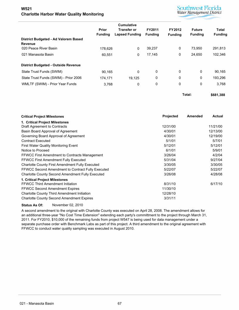
W521
Charlotte Harbor Water Quality Monitoring
District Budgeted - Ad Valorem Based
Revenue
020 Peace River Basin 291,813 73,950 0 178,626 0 39,237
021 Manasota Basin 102,346 24,650 0 60,551 0 17,145
District Budgeted - Outside Revenue
State Trust Funds (SWIM) 90,165 0 0 90,165 0 0
State Trust Funds (SWIM) - Prior 2006 193,296 0 19,125 174,171 0 0
WMLTF (SWIM) - Prior Year Funds 3,768 0 0 3,768 0 0
$681,388 Total:
Prior
Funding
Cumulative
Transfer or
Lapsed Funding Funding Funding
2011 FY 2012 FY Future
Funding
Total
Funding
Critical Project Milestones ActualProjected Amended
1. Critical Project MilestonesDraft Agreement to Contracts 12/31/00 11/21/00
Basin Board Approval of Agreement 4/30/01 12/13/00
Governing Board Approval of Agreement 4/30/01 12/19/00
Contract Executed 5/1/01 5/7/01
First Water Quality Monitoring Event 5/12/01 5/12/01
Notice to Proceed 6/1/01 5/9/01
FFWCC First Amendment to Contracts Management 3/26/04 4/2/04
FFWCC First Amendment Fully Executed 5/31/04 9/27/04
Charlotte County First Amendment Fully Executed 3/30/05 3/30/05
FFWCC Second Amendment to Contract Fully Executed 5/22/07 5/22/07
Charlotte County Second Amendment Fully Executed 3/26/08 4/28/08
1. Critical Project MilestonesFFWCC Third Amendment Initiation 8/31/10 6/17/10
FFWCC Second Amendment Expires 11/30/10
Charlotte County Third Amendment Initiation 12/28/10
Charlotte County Second Amendment Expires 3/31/11
Status As Of: November 02, 2010
A second amendment to the original with Charlotte County was executed on April 28, 2008. The amendment allows for
an additional three-year "No Cost Time Extension" extending each party's committment to the project through March 31,
2011. For FY2010, $10,000 of the remaining funds from project W547 is being used for data management under a
separate purchase order with Benchmark Labs as part of this project. A third amendment to the original agreement with
FFWCC to conduct water quality sampling was executed in August 2010.
021 - Manasota Basin 67
W526
Charlotte Harbor National Estuary Program
Project Type SWIM
AORs Strategic InitiativesWater Quality Water Quality Maintenance and ImprovementNatural Systems Natural Systems Conservation and Restoration
Basin(s) Peace River, Manasota
Cooperator(s)
Project Manager GARCIA, LIZANNE
KAUFMAN, KRIS, GARCIA, LIZANNE, POWERS, STEPHANIETask Manager(s)
Status Ongoing
DescriptionThis project provides for the funding of the Annual Workplan for the Charlotte Harbor National Estuary Program
(CHNEP). The District participates in three main areas. First the District's SWIM program, usually funded by the basin
boards and State, carries out the projects that will address water quality and habitat restoration within the Harbor.
Second, the District has contributed annual funding to the CHNEP since 1997 to carry out the administration and
implement of projects identified in the CHNEP Comprehensive Conservation and Management Plan. And finally, the
District provides staff to sit on the technical, management and policy (Governing or Basin Board member) committees
of the program. The District's annual budget includes funding support to the CHNEP and District staff salaries, travel
and central garage to administer the project, which includes attending board meetings and other workshops and
invoicing.
BenefitsThis project's support of the CHNEP creates an opportunity for a cohesive effort between the District, CHNEP and
other state and local agencies to implement resource management decisions and restoration activities. Additionally,
this project provides for leveraging funding between the partners. Projects contained within the CHNEP Annual
Workplan address management issues concerning hydrologic alterations, water quality degradation, and habitat loss
within the Peace and Myakka River watersheds and the Charlotte Harbor estuary.
Costs
The District has provided funding to the CHNEP on an annual basis since 1997. The District's annual funding
commitment for the CHNEP has been $110,000. Prior to FY2011, the District share was split between the Manasota
Basin Board (12.5%) and the Peace River Basin Board (37.5%) and State SWIM funds (50%). In FY2011, the
District's share of $83,750 will be funded 33 percent ($27,500) by the Mansota Basin Board and 67 percent ($56,250)
by the Peace River Basin Board. District funds are used to implement projects outlined in the Annual Workplan.
District funds shown in the table include staff salaries.
Additional Information
In 1987, the Florida Legislature established the Surface Water Improvement and Management (SWIM) Act, having
recognized that water quality and habitat in surface waters through out the state have degraded or were in danger of
being degraded. The Act requires the District to maintain a priority list of waterbodies of regional or statewide
significance within their boundaries. Charlotte Harbor is designated as a priority waterbody. Charlotte Harbor was
identified by the United States Environmental Protection Agency (USEPA) in 1995 as an estuary of Federal
Significance and subsequently included in the National Estuary Program. As a result of this designation, the Charlotte
Harbor National Estuary Program was established to assist the region in developing a comprehensive plan for the
restoration and protection of Charlotte Harbor. Partners in the CHNEP include the Southwest Florida and South
Florida Water Management Districts, USEPA, Florida Department of Environmental Protection, other state and federal
agencies, and local governments from the watershed. The goals and strategies for the Harbor are identified in the
Comprehensive Conservation and Management Plan (CCMP) for Charlotte Harbor which provides guidance to each
entity on their contribution to restore the Harbor. Since 1993, the District has completed several habitat restoration
projects and diagnostic assessments, including seagrass mapping, water quality monitoring, and development of a
pollutant load reduction goal for the Harbor.
021 - Manasota Basin 68

W526
Charlotte Harbor National Estuary Program
District Budgeted - Ad Valorem Based
Revenue
020 Peace River Basin 548,652 82,500 0 407,758 0 58,394
021 Manasota Basin 194,485 27,500 0 137,508 0 29,477
District Budgeted - Outside Revenue
State Trust Funds (SWIM) 239,574 0 0 239,574 0 0
State Trust Funds (SWIM) - Prior 2006 368,701 0 0 368,701 0 0
WMLTF (SWIM) - Prior Year Funds 59,891 0 0 59,891 0 0
Project Funds Not Budgeted by the
District
CHNEP 1,394,475 0 0 1,307,725 0 86,750
FDEP 225,000 0 0 150,000 0 75,000
Local Government Partners 307,250 0 0 193,750 0 113,500
PRMRWSA 15,000 0 0 10,000 0 5,000
SFWMD 130,000 0 0 80,000 0 50,000
US EPA 2,041,750 0 0 1,441,750 0 600,000
$5,524,778 Total:
Prior
Funding
Cumulative
Transfer or
Lapsed Funding Funding Funding
2011 FY 2012 FY Future
Funding
Total
Funding
Critical Project Milestones ActualProjected Amended
FY2007 Annual Workplan Critical Project MilestonesFY2007 Contract with CHNEP Executed 4/1/07 6/11/07
FY2007 Contract Close Out 12/31/09 7/21/10
FY2008 Annual Workplan Critical Project MilestonesFY2008 Contract with CHNEP Executed 12/1/07 8/26/08
FY2008 Contract Close Out 12/31/10 8/16/10
FY2009 Annual Workplan Critical Project MilestonesFY2009 Contract with CHNEP Executed 12/1/08 12/18/09
FY2009 Contract Close Out 12/31/11
FY2010 Annual Workplan Critical Project MilestonesFY2010 Contract with CHNEP Executed 2/1/10 2/23/10
FY2010 Contract Closeout 12/31/12
FY2011 Annual Workplan Critical Project MilestonesFY2011 Contract with CHNEP Executed 11/1/10
FY2011 Contract Closeout 12/31/13
Status As Of: October 21, 2010
FY2009 Contract: The FY2009 agreement was executed on December 13, 2009 and expires 12/31/2011. Projects
include fisheries monitoring in Lemon Bay, additional work by Mote Marine Laboratory to evaluate light attenuation by
algae attached to seagrass (epiphytes), setting seagrass targets and finalizing the water quality targets necessary to
maintain seagrass health. District staff have been participating in the development of the scope of work and subsequent
development of seagrass targets. Final reports for water quality targets and nutrient loading have been received and
approved by the District. FY2010 Contract: The FY2010 agreement was executed February 24, 2010 and expires
12/31/2012. Projects include an update of the triennial status and trends for water quality throughout the Charlotte Harbor
watershed, staff support and the development of estuarine nutrient criteria. District staff approved a line item budget
revision to this agreement to move funds from the triennial status and trends project to FY2010 existing project to
021 - Manasota Basin 69

W526
Charlotte Harbor National Estuary Program
complete development of Numeric Nutrient Criteria. Completion of the triennial water quality status and trends will be
deferred until the FY2011 agreement. FY2011 Contract: District and CHNEP staff have agreed on the projects to be
included in the FY2011 agreement. They are the development of a Water Atlas for the Charlotte Harbor watershed, staff
support and completion of the triennial water quality status and trend. Management Conference: The Management and
Policy Committees met in August 2010. Items on the agenda of interest to the District included amendment of the annual
work plan to shift funds in the FY2010 workplan from the triennial review to complete the numeric nutrient criteria by the
deadline encouraged by the EPA, and approval of the various reports included in the annual workplan. The next
meetings of the Management and Policy Committees are in November 2010 respectively.
021 - Manasota Basin 70
W547
Water Quality in the Peace and Myakka Basins, Charlotte Harbor,
and Lemon BayProject Type SWIM
AORs Strategic InitiativesWater Quality Water Quality Monitoring
Basin(s) Peace River, Manasota
Charlotte Harbor Environmental Center, Charlotte Harbor Environmental CenterCooperator(s)
Project Manager SZAFRANIEC, MARY
KAUFMAN, KRISTask Manager(s)
Status Ongoing
DescriptionThis project was in response to a funding request from Charlotte Harbor Environmental Center (CHEC) for on-line
publication of water quality maps and graphs. Water quality data from various sources collected within the Peace River
Basin, Myakka River Basin, Charlotte Harbor, and Lemon Bay were included in the maps. The project involved
mapping and graphing of District Peace and Myakka River basin water quality data on the CHEC website. In FY2005,
the project expanded its coverage to include Sarasota County's Northern Lemon Bay water quality sampling effort,
Florida Department of Environmental Protection (FDEP) volunteer water quality project, and FDEP Lemon Bay
monitoring network. A FY2009 cooperative funding request was received for continuation of the display of the project's
sixth year of multi-agency monitoring.
BenefitsInformation provided through this project offered technical support for environmental management activities conducted
by the District's SWIM Program, FDEP, the Peace River/ Manasota Regional Water Supply Authority, the Charlotte
Harbor National Estuary Program, and other local and regional organizations. Publication of the data in the STORET
databases and website provided an historical record of the changes in water quality within each system.
Costs
The FY2009 budget is $66,000, with the Charlotte Harbor Environmental Center and the District each contributing half
($33,000). The District share is split between State SWIM ($33,000), the Peace River Basin ($16,500), and the
Manatsota Basin ($4,125). The cost to each basin board is determined by its watershed's (Peace River and Myakka
River watersheds) relative influence on water quality in Charlotte Harbor. District funds shown in the table include staff
salaries. The District and CHEC agreed to reduce the scope of work to only cover the CHEC website display of water
quality mapping and graphing for a total cost of $28,000, with the District and CHEC each contributing half ($14,000).
$10,000 of the remaining funds were used for the data management under a separate purchase order with
Benchmark Labs. The Basin Boards approved the transfer of remaining funds for CHEC's fourth grade education
project.
Additional Information
Since 2003, the CHEC has been presenting the results of these efforts on its web site www.checflorida.org/chec/water
quality, allowing the public and scientists to view the results in terms of both status and trends in water quality. The
cooperative project wa executed through purchase orders and associated scopes of work. The SWIM Plan for
Charlotte Harbor focuses on management strategies for the Peace and Myakka Rivers, in addition to Charlotte Harbor
proper, to reduce point and non-point source pollution and to preserve and restore habitat. The objectives of this
project are consistent with these strategies.
021 - Manasota Basin 71
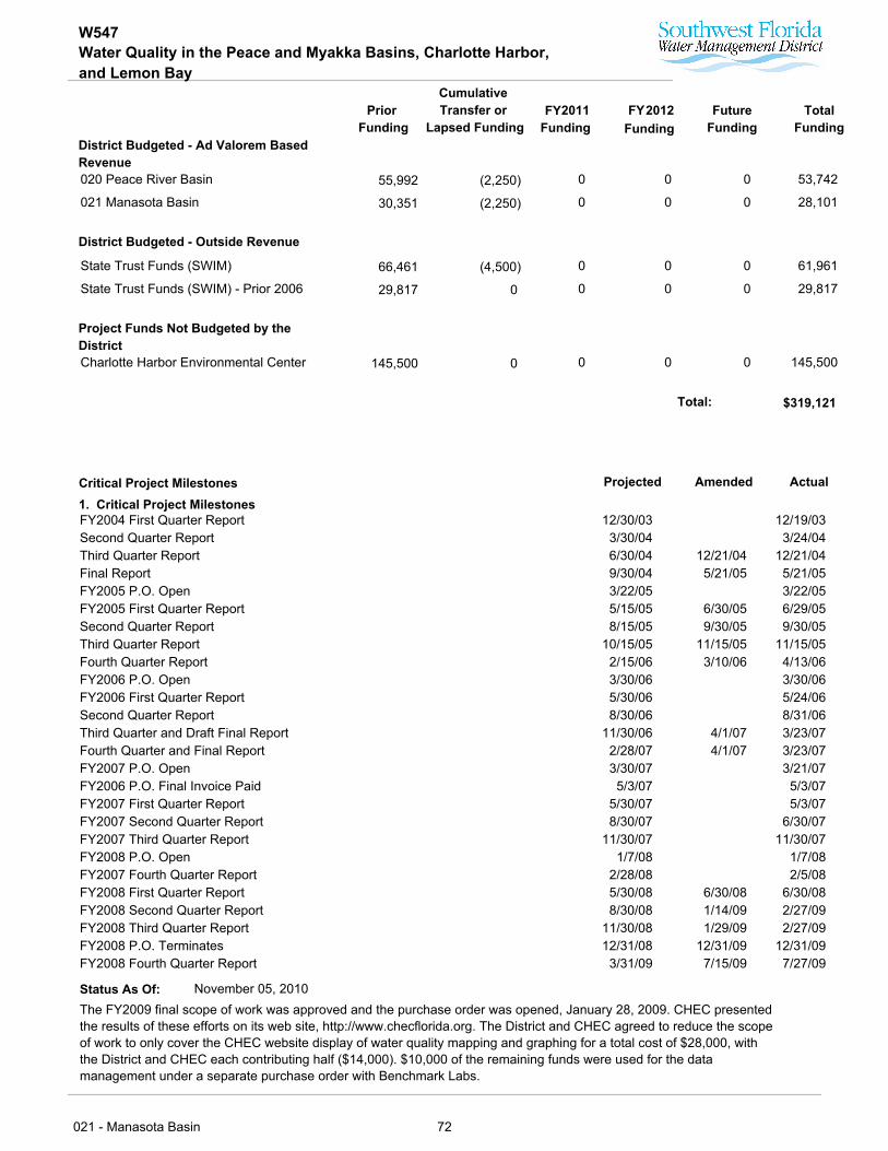
W547
Water Quality in the Peace and Myakka Basins, Charlotte Harbor,
and Lemon Bay
District Budgeted - Ad Valorem Based
Revenue
020 Peace River Basin 53,742 0 (2,250) 55,992 0 0
021 Manasota Basin 28,101 0 (2,250) 30,351 0 0
District Budgeted - Outside Revenue
State Trust Funds (SWIM) 61,961 0 (4,500) 66,461 0 0
State Trust Funds (SWIM) - Prior 2006 29,817 0 0 29,817 0 0
Project Funds Not Budgeted by the
District
Charlotte Harbor Environmental Center 145,500 0 0 145,500 0 0
$319,121 Total:
Prior
Funding
Cumulative
Transfer or
Lapsed Funding Funding Funding
2011 FY 2012 FY Future
Funding
Total
Funding
Critical Project Milestones ActualProjected Amended
1. Critical Project MilestonesFY2004 First Quarter Report 12/30/03 12/19/03
Second Quarter Report 3/30/04 3/24/04
Third Quarter Report 6/30/04 12/21/04 12/21/04
Final Report 9/30/04 5/21/05 5/21/05
FY2005 P.O. Open 3/22/05 3/22/05
FY2005 First Quarter Report 5/15/05 6/30/05 6/29/05
Second Quarter Report 8/15/05 9/30/05 9/30/05
Third Quarter Report 10/15/05 11/15/05 11/15/05
Fourth Quarter Report 2/15/06 3/10/06 4/13/06
FY2006 P.O. Open 3/30/06 3/30/06
FY2006 First Quarter Report 5/30/06 5/24/06
Second Quarter Report 8/30/06 8/31/06
Third Quarter and Draft Final Report 11/30/06 4/1/07 3/23/07
Fourth Quarter and Final Report 2/28/07 4/1/07 3/23/07
FY2007 P.O. Open 3/30/07 3/21/07
FY2006 P.O. Final Invoice Paid 5/3/07 5/3/07
FY2007 First Quarter Report 5/30/07 5/3/07
FY2007 Second Quarter Report 8/30/07 6/30/07
FY2007 Third Quarter Report 11/30/07 11/30/07
FY2008 P.O. Open 1/7/08 1/7/08
FY2007 Fourth Quarter Report 2/28/08 2/5/08
FY2008 First Quarter Report 5/30/08 6/30/08 6/30/08
FY2008 Second Quarter Report 8/30/08 1/14/09 2/27/09
FY2008 Third Quarter Report 11/30/08 1/29/09 2/27/09
FY2008 P.O. Terminates 12/31/08 12/31/09 12/31/09
FY2008 Fourth Quarter Report 3/31/09 7/15/09 7/27/09
Status As Of: November 05, 2010
The FY2009 final scope of work was approved and the purchase order was opened, January 28, 2009. CHEC presented
the results of these efforts on its web site, http://www.checflorida.org. The District and CHEC agreed to reduce the scope
of work to only cover the CHEC website display of water quality mapping and graphing for a total cost of $28,000, with
the District and CHEC each contributing half ($14,000). $10,000 of the remaining funds were used for the data
management under a separate purchase order with Benchmark Labs.
021 - Manasota Basin 72

W552
Sarasota County Pollutant Model Development
Project Type SWIM
AORs Strategic InitiativesWater Quality Water Quality Maintenance and ImprovementNatural Systems Natural Systems Conservation and Restoration
Basin(s) Manasota
Sarasota CountyCooperator(s)
Project Manager LOPEZ, MANNY
GARCIA, LIZANNETask Manager(s)
Status Ongoing
DescriptionThis project involves developing a pollutant loading model to be used to assess pollutant loading to Sarasota County
surface waters. This project includes the following activities: inventory existing land uses and best management
practices (BMP) facilities by watershed sub-basin and incorporate information within GIS feature classes; inventory
hydrologic input data by watershed sub-basin for model documentation; characterize wet season and dry season
runoff volume input data by watershed sub-basin for model verification; develop models by watershed through
expanding input data with the above criteria; process model results for tabulating wet season and dry season pollutant
loading summary; create model/mapping geodatabase for future County application needs; and perform field sampling
within each bay watershed for use in model validation. The model is expected to discern the portion of water clarity
conditions (chlorophyll, color, and suspended solids) that are caused by human activities rather than those caused by
weather or climatic events.
BenefitsThe pollutant load model will generate monthly loads based on daily rainfall data enabling a correlation to be made
between the monthly loads and the ongoing monthly bay water quality data that can then be used to propose
alternative chlorophyll criteria to the Florida DEP for Sarasota County bays. In addition, this model will provide the
detail and reliability needed for local support of legitimate TMDL program load reductions. Also, as more sampling data
is incorporated, the model will become more reliable to justify (via a cost-benefit analysis) the appropriate project in the
proper location that will provide an improvement in water quality.
Costs
The original total project cost was $1,725,814, with the District's share $862,907 and the County's share $862,907,
funded over two fiscal years FY2006 and FY2007. The District budgeted $431,907 in FY2006 with the Manasota Basin
Board providing $215,954 and the State SWIM fund providing $215,953. Sarasota County provided $431,907 for
FY2006. Funding for FY2007 included $431,000 from the District with the Manasota Basin Board providing $215,500
and the State SWIM fund providing $215,500. For FY2007 Sarasota County was to provide $431,000. However, on
March 2, 2007 the County indicated it wished to withdraw the request for FY2007 funding. The revised total project
cost is now $863,814. FY2007 funds budgeted by the District were released to the basin's budget. The current
agreement funded with FY2006 funds will complete the current project scope. The District funding amounts listed in
the table include staff salaries, travel and central garage charges.
Additional Information
Potential model outputs and design features will be reviewed by the Technical Advisory Committee of the Sarasota
Bay Estuary Program. The model will guide the County's and District's management activities associated with water
quality for the systems noted above. The proposed pollutant loading model can be used in conjunction with outputs
from the existing hydrologic and hydraulic stormwater model to produce event specific pollutant loads.
021 - Manasota Basin 73

W552
Sarasota County Pollutant Model Development
District Budgeted - Ad Valorem Based
Revenue
021 Manasota Basin 447,637 0 0 442,795 0 4,842
District Budgeted - Outside Revenue
Ecosystem Trust Fund - Sarasota Pollut
(SWIM)
200,000 0 0 200,000 0 0
State Trust Funds (SWIM) 242,793 0 0 242,793 0 0
Project Funds Not Budgeted by the
District
Sarasota County 431,907 0 0 431,907 0 0
$1,322,337 Total:
Prior
Funding
Cumulative
Transfer or
Lapsed Funding Funding Funding
2011 FY 2012 FY Future
Funding
Total
Funding
Critical Project Milestones ActualProjected Amended
1. Contract Development & ExecutionContract Executed 5/15/06 5/31/06
Notice to Proceed Sent 5/31/06 5/31/06
First Ammendment Approved - Time Extension 6/15/07 6/6/07
2. Critical Project MilestonesDraft Verification Monitoring Plan 12/10/06 2/10/07 1/30/07
Draft Model Design Memorandum 1/10/07 7/15/07 7/15/07
Final Verification Monitoring Plan 3/30/07 7/30/07 7/30/07
Final Model Design Memorandum 4/30/07 9/30/08 10/30/08
Draft Model Operation Manual 10/30/07 1/30/09 1/30/09
Final Functional Model 11/30/07 6/15/09 6/15/09
Final Model Operation Manual/Final Report 12/15/07 5/25/09 6/15/09
No-Cost Time Extension Approved 1/10/09 3/30/09 1/30/09
No-Cost Time Extension Approved 2/5/10 2/12/10
2. Critical Project MilestonesBegin Revised Water Quality Sampling (5 sites) 3/1/10 3/1/10
Contract Expiration 8/31/11
Status As Of: October 25, 2010
Currently, the model is fully operational. Project team members met for model discussions and reviews of pending
issues, in particular the absence of flow-weighted samples. Additional storm sampling to develop additional data suitable
for incorporation into the model began in April 2010, following instrumentation of 5 sites for water sample collection and
flow measurements . Project team members viewed the sampling installations in late March 2010 and have been
reviewing the results of storm events starting in May and continuing through August. Data from all the required storm
events were successfully collected. The additional storm sampling was conducted at no additional project cost. To date,
the monitoring data collected suggests that in developed areas with grassy swales, the quality of runoff is enhanced by
the stormwater treatment provided by the swales. Analyses of the data and final report are forthcoming by the end of
2010.
021 - Manasota Basin 74
W558
Venice Hatchett Creek Stormwater Facility
Project Type SWIM
AORs Strategic InitiativesWater Quality Water Quality Maintenance and ImprovementFlood Protection Emergency Flood ResponseNatural Systems Natural Systems Conservation and Restoration
Basin(s) Manasota
City of VeniceCooperator(s)
Project Manager NORTON, NANCY
Task Manager(s)
Status Ongoing
DescriptionThis multi-year funded project was originally funded in FY2008 by the City of Venice, which is the lead agency for
implementing the stormwater retrofit and habitat restoration goals of this effort. The project is associated with the
implementation of Best Management Practices (BMPs) for the City's Hatchett Creek Basin Master Plan and the
Sarasota County unified local mitigation strategy. This project includes the following tasks: land acquisition, design,
development of construction documents, construction permitting, bidding and contractor selection, and construction
engineering and inspection during construction of the BMPs. In 2007, the City purchased a 1.33 acre parcel at 1155
US 41 Bypass South, to be converted to a stormwater pond to provide additional storage and water quality treatment
for a 16.6 acre drainage area. The BMP will address water quality improvements, stormwater management level of
service deficiencies and natural systems restoration along approximately 200 linear feet of intertidal shoreline of
Hatchett Creek.
BenefitsCompletion of this project improves stormwater quality prior to discharging into Hatchett Creek, restores approximately
200 linear feet of intertidal shoreline, and will provide an increased stormwater management level of service on East
Venice Avenue and neighboring areas.
Costs
The total project cost is $1,850,000, and the requested District share is $300,000 ($150,000 from the Manasota Basin
Board and $150,000 from State SWIM), of which $150,000 was requested in FY2008 for design and construction and
$150,000 in FY2009 for construction. The City of Venice purchased a 1.33 acre parcel in 2007 for $1,250,000 and the
District funds match the City funding for design and construction. District funds shown in the table include staff
salaries.
Additional Information
This project is located within the geographic boundaries of the Charlotte Harbor National Estuary Program and the
Charlotte Harbor SWIM Plan. Charlotte Harbor is generally viewed as one of the most productive estuarine systems in
Southwest Florida. Although it is appropriately considered a healthy system, problems exist in the areas of hydrologic
alterations, water quality degradation, and habitat loss. The SWIM Plan for Charlotte Harbor focus on management
strategies for the Peace and Myakka Rivers, in addition to Charlotte Harbor proper, to reduce point and non-point
source pollution and to preserve and restore habitat. Charlotte Harbor is a District priority Surface Water Improvement
and Management (SWIM) program waterbody and is considered an "estuary of national significance" with the
establishment of the Charlotte Harbor National Estuary Program (CHNEP). Water quality data and seagrass mapping
efforts suggest that Charlotte Harbor's water quality is not degrading, and its fisheries' habitats are mostly stable.
However, data collected since its SWIM designation in 1993 indicate the system experiences annual algae blooms
that appear to be related to elevated nutrient concentrations. The Hatchett Creek Stormwater Facility project is
consistent with the water quality improvement goals of the District's SWIM Plan for Charlotte Harbor and the Charlotte
Harbor National Estuary Program's CCMP. The City will manage the project and the District project manager must
approve any agreements to accomplish project tasks.
021 - Manasota Basin 75

W558
Venice Hatchett Creek Stormwater Facility
District Budgeted - Ad Valorem Based
Revenue
021 Manasota Basin 155,811 0 0 152,747 0 3,064
District Budgeted - Outside Revenue
State Trust Funds (SWIM) 151,701 0 0 151,701 0 0
WMLTF (SWIM) - Prior Year Funds 1,045 0 0 1,045 0 0
Project Funds Not Budgeted by the
District
City of Venice 1,550,000 0 0 1,550,000 0 0
$1,858,557 Total:
Prior
Funding
Cumulative
Transfer or
Lapsed Funding Funding Funding
2011 FY 2012 FY Future
Funding
Total
Funding
Critical Project Milestones ActualProjected Amended
Contract Development and ExecutionDraft Agreement sent to Management Services 1/29/08 2/7/08
Draft Agreement returned from Management Services 2/20/08 3/11/08
Agreement sent to Cooperator 2/27/08 3/12/08
Signed Agreement returned from Cooperator 3/27/08 4/11/08
Agreement fully executed 4/10/08 4/21/08
Notice to Proceed 4/15/08 4/25/08
Critical Project MilestonesComplete Design and Permitting 4/25/09 3/20/09
Bidding and Contractor Selection 7/25/09 9/1/09 9/27/09
Building Demolition 9/25/09 1/9/09
Commence Construction 11/25/09 12/31/09 2/23/10
Complete Construction 8/25/10 12/31/10
Contract Close-Out 10/25/10 12/31/10
Construction Contract Termination 12/25/10
Agreement Expiration 3/25/11
Status As Of: October 22, 2010
The City of Venice completed building demolition for the project site in January 2009, 8 months ahead of schedule. The
City completed design and received an environmental resource permit (ERP) from SWFWMD for the proposed work
March 20, 2008. Escalating construction costs delayed project construction while the City requested and received
additional funding from FEMA. On May 27, 2009 the City provided 100% plans to the District. The City combined this
project, Hatchett Creek Stormwater Facility, with L624, Implementation of BMP's Hatchett Creek in their request for bids.
Bids were opened November 17, 2009. Bid responses required a public meeting to determine bid award
recommendation. The City issued a notice to proceed to the Contractor on February 23, 2010. The construction contract
allowed 210 days to complete construction. ACTION TO DATE: The stormwater pond is complete. Utility conflicts as
storm piping was upgraded and directed to the stormwater pond took more time than anticipated. The City requested a
time extension to complete construction. Construction is on schedule to meet the revised completion milestone.
021 - Manasota Basin 76
W601
SWIM Plan Implementation - Sarasota Bay
Project Type SWIM
AORs Strategic InitiativesWater Quality Water Quality Maintenance and ImprovementNatural Systems Natural Systems Conservation and Restoration
Basin(s) Manasota
Sarasota County, Sarasota Bay Estuary Program, Manatee CountyCooperator(s)
Project Manager GARCIA, LIZANNE
POWERS, STEPHANIE, KAUFMAN, KRISTask Manager(s)
Status Ongoing
DescriptionThis project provides for the administration and implementation of projects as outlined in the SWIM Plan for Sarasota
Bay. Administration and implementation includes assessment of implementation progress, a review and refinement of
the Pollutant Load Reduction Goal (PLRG) for the waterbody, periodic SWIM Advisory Committee meetings, new
project development (rationale and justification), development of relevant contracts and Requests for Proposals,
invoicing, project related presentations, field visits, and miscellaneous duties as they arise.
BenefitsThis project's support of the Sarasota Bay SWIM Plan creates an opportunity for a cohesive effort between the District,
and other state and local agencies to better implement resource management decisions and restoration activities.
Historically, SWIM projects have been eligible for state matching funds with the state funding 50 percent of the project
costs and the District funding the remaining 50 percent. In FY2011, all projects within the Sarasota Bay SWIM
watershed are funded 100 percent by the Manasota Basin Board as no State SWIM funds will be available.
Costs
The FY2010 ongoing costs for the Sarasota Bay SWIM Plan Implementation were funded 50 percent from the
Manasota Basin and 50 percent from the State SWIM Program and include staff salary, travel and central garage. In
FY2011, ongoing costs for the Sarasota Bay SWIM Implementation are funded 100 percent from the Manasota Basin.
There are no State SWIM Program funds available in FY2011.
Additional Information
In 1987, the Florida Legislature established the Surface Water Improvement and Management (SWIM) Act having
recognized that water quality and habitat in surface waters throughout the state have degraded or were in danger of
being degraded. The Act requires the five water management districts to maintain a priority list of water bodies of
regional or statewide significance within their boundaries, and develop plans and programs for the improvement of
those water bodies. To date, ten SWIM water bodies in the District have had plans developed and approved by the
state. Several plans have been updated one or more times as required by the Act. The Sarasota Bay SWIM Plan was
first approved in 1997 and last updated in 2002. Since the first plan, the District has initiated a number of restoration
and diagnostic assessment projects. Included within these are: 1) investigation of toxic loading sources to the Bay, 2)
seagrass mapping 3) habitat restoration, 4) development of stormawater master plans 5) various habitat restoration
projects, 6) construction of artificial reefs and oyster reefs and 7) involvement in numerous public outreach and
education activities.
021 - Manasota Basin 77
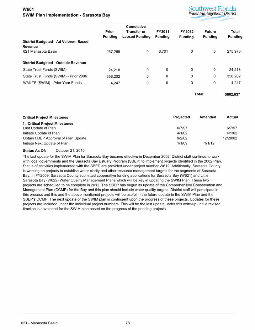
W601
SWIM Plan Implementation - Sarasota Bay
District Budgeted - Ad Valorem Based
Revenue
021 Manasota Basin 275,970 0 0 267,269 0 8,701
District Budgeted - Outside Revenue
State Trust Funds (SWIM) 24,218 0 0 24,218 0 0
State Trust Funds (SWIM) - Prior 2006 358,202 0 0 358,202 0 0
WMLTF (SWIM) - Prior Year Funds 4,247 0 0 4,247 0 0
$662,637 Total:
Prior
Funding
Cumulative
Transfer or
Lapsed Funding Funding Funding
2011 FY 2012 FY Future
Funding
Total
Funding
Critical Project Milestones ActualProjected Amended
1. Critical Project MilestonesLast Update of Plan 6/7/97 6/7/97
Initiate Update of Plan 4/1/02 4/1/02
Obtain FDEP Approval of Plan Update 9/2/02 12/20/02
Initiate Next Update of Plan 1/1/09 1/1/12
Status As Of: October 21, 2010
The last update for the SWIM Plan for Sarasota Bay became effective in December 2002. District staff continue to work
with local governments and the Sarasota Bay Estuary Program (SBEP) to implement projects identified in the 2002 Plan.
Status of activities implemented with the SBEP are provided under project number W612. Additionally, Sarasota County
is working on projects to establish water clarity and other resource management targets for the segments of Sarasota
Bay. In FY2009, Sarasota County submitted cooperative funding applications for Sarasota Bay (W621) and Little
Sarasota Bay (W622) Water Quality Management Plans which will be key in updating the SWIM Plan. These two
projects are scheduled to be complete in 2012. The SBEP has begun its update of the Comprehensive Conservation and
Management Plan (CCMP) for the Bay and this plan should include water quality targets. District staff will participate in
this process and this and the above mentioned projects will be useful in the future update to the SWIM Plan and the
SBEP's CCMP. The next update of the SWIM plan is contingent upon the progress of these projects. Updates for these
projects are included under the individual project numbers. This will be the last update under this write-up until a revised
timeline is developed for the SWIM plan based on the progress of the pending projects.
021 - Manasota Basin 78

W602
Neal Preserve Environmental Restoration
Project Type SWIM
AORs Strategic InitiativesWater Quality Water Quality Maintenance and ImprovementNatural Systems Natural Systems Conservation and Restoration
Basin(s) Manasota
Manatee CountyCooperator(s)
Project Manager POWERS, STEPHANIE
Task Manager(s)
Status Ongoing
DescriptionThis project is in response to a cooperative funding request from Manatee County to restore and enhance habitat on
119 acres of intertidal wetlands and uplands in west central Manatee County. The land was purchased in July 2005 by
Manatee County for $9 million. The proposed restoration will target the creation and enhancement of open water,
intertidal habitats, and coastal uplands. Exotic plants such as Australian Pine and Brazilian Pepper will be removed
and replaced with both planted and naturally recruiting native species. Under the current agreement, the County is
responsible for managing the construction contract and will be responsible for the long-term operation and
maintenance of the site. The District is providing project management overview of construction progress.
BenefitsUpon completion, the project will provide significant benefits to habitat through the removal of exotic plant species and
replanting of native vegetation. Hydrologic alterations will also improve the habitat and water quality of the site and
provide limited stormwater treatment of waters entering Tampa Bay and Sarasota Bay. Because the project site drains
to both Tampa Bay and to Sarasota Bay, this project will benefit both systems.
Costs
The total project cost is $9,650,000. The District's contribution is $500,000, which is being split 50/50 between the
Manasota Basin Board ($250,000) and State funds ($250,000). Manatee County is matching the District's contribution
with $9 million used for the land purchase. District funds will be used for the construction phase of the project. District
funds shown in the table include staff salaries.
Additional Information
Since 1950, approximately 50 percent of Tampa Bay's natural shoreline and approximately 40 percent of Sarasota
Bay's intertidal wetland habitat has been lost due to development and reduction in water quality. This resulted in a
decline in the aesthetic, recreational, and commercial value of the bay, as well as a loss of habitat for native plants
and animals. The SWIM Plans for Tampa Bay and Sarasota Bay outline goals to restore habitat throughout the bay
areas and reduce pollutant loads entering the bays. The objectives of this project are consistent with these goals.
021 - Manasota Basin 79

W602
Neal Preserve Environmental Restoration
District Budgeted - Ad Valorem Based
Revenue
021 Manasota Basin 334,802 0 0 332,096 0 2,706
District Budgeted - Outside Revenue
Ecosystem Trust Fund - Sarasota Bay
Rstr (SWIM)
250,000 0 0 250,000 0 0
State Trust Funds (SWIM) 80,749 0 0 80,749 0 0
WMLTF (SWIM) - Prior Year Funds 1,345 0 0 1,345 0 0
Project Funds Not Budgeted by the
District
Manatee County 9,000,000 0 0 9,000,000 0 0
$9,666,896 Total:
Prior
Funding
Cumulative
Transfer or
Lapsed Funding Funding Funding
2011 FY 2012 FY Future
Funding
Total
Funding
Critical Project Milestones ActualProjected Amended
1. Contract Development and ExecutionDraft Agreement to Management Services 5/14/07 7/5/07
Draft Agreement returned from Management Services 6/4/07 8/22/07
Agreement to Cooperator 6/8/07 8/24/07
Signed Agreement from Cooperator 7/9/07 10/23/07
Agreement Fully Executed 7/26/07 10/31/07
Notice to Proceed 8/1/07 11/6/07
2. Project TasksCompletion of Design and Permitting 10/31/08 10/31/10
Construction Complete 12/31/09 7/31/11
3. Agreement Expiration DatesContract Expiration 12/31/08 12/31/11
Status As Of: November 03, 2010
The County put this project on hold for an extended period of time. A project kick off meeting was held on March 31,
2010. The 30% design plans were submitted to the District on August 26, 2010.
021 - Manasota Basin 80
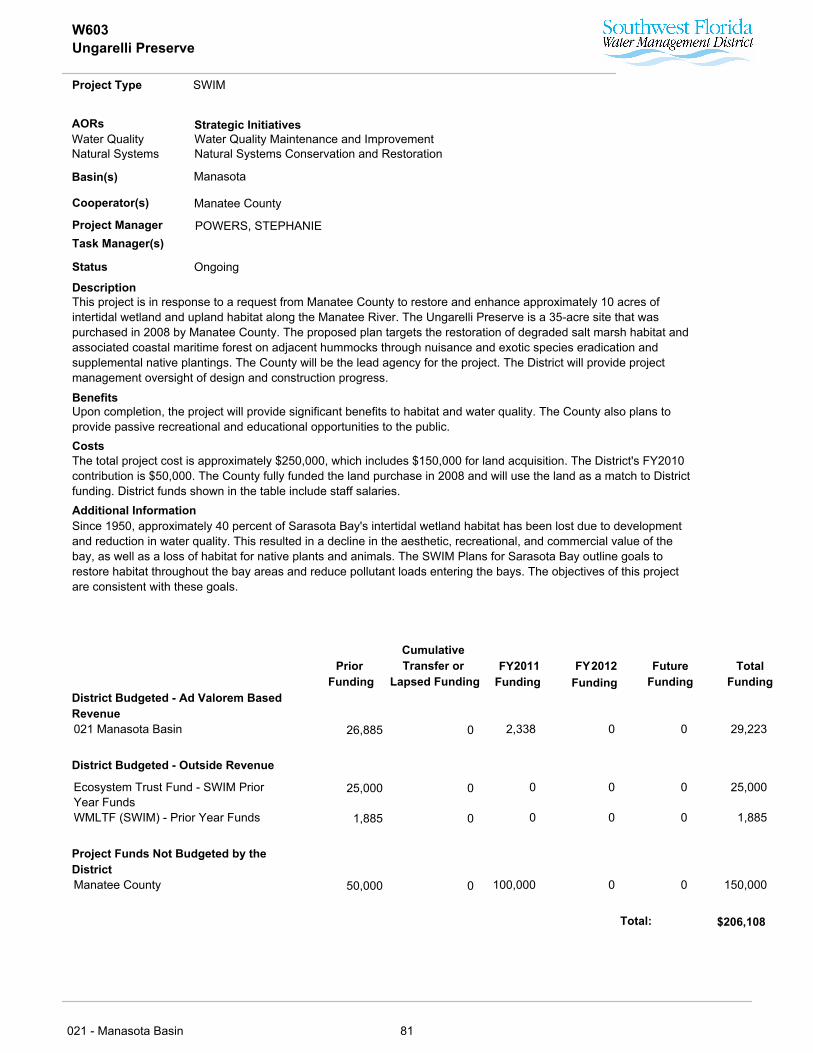
W603
Ungarelli Preserve
Project Type SWIM
AORs Strategic InitiativesWater Quality Water Quality Maintenance and ImprovementNatural Systems Natural Systems Conservation and Restoration
Basin(s) Manasota
Manatee CountyCooperator(s)
Project Manager POWERS, STEPHANIE
Task Manager(s)
Status Ongoing
DescriptionThis project is in response to a request from Manatee County to restore and enhance approximately 10 acres of
intertidal wetland and upland habitat along the Manatee River. The Ungarelli Preserve is a 35-acre site that was
purchased in 2008 by Manatee County. The proposed plan targets the restoration of degraded salt marsh habitat and
associated coastal maritime forest on adjacent hummocks through nuisance and exotic species eradication and
supplemental native plantings. The County will be the lead agency for the project. The District will provide project
management oversight of design and construction progress.
BenefitsUpon completion, the project will provide significant benefits to habitat and water quality. The County also plans to
provide passive recreational and educational opportunities to the public.
Costs
The total project cost is approximately $250,000, which includes $150,000 for land acquisition. The District's FY2010
contribution is $50,000. The County fully funded the land purchase in 2008 and will use the land as a match to District
funding. District funds shown in the table include staff salaries.
Additional Information
Since 1950, approximately 40 percent of Sarasota Bay's intertidal wetland habitat has been lost due to development
and reduction in water quality. This resulted in a decline in the aesthetic, recreational, and commercial value of the
bay, as well as a loss of habitat for native plants and animals. The SWIM Plans for Sarasota Bay outline goals to
restore habitat throughout the bay areas and reduce pollutant loads entering the bays. The objectives of this project
are consistent with these goals.
District Budgeted - Ad Valorem Based
Revenue
021 Manasota Basin 29,223 0 0 26,885 0 2,338
District Budgeted - Outside Revenue
Ecosystem Trust Fund - SWIM Prior
Year Funds
25,000 0 0 25,000 0 0
WMLTF (SWIM) - Prior Year Funds 1,885 0 0 1,885 0 0
Project Funds Not Budgeted by the
District
Manatee County 150,000 0 0 50,000 0 100,000
$206,108 Total:
Prior
Funding
Cumulative
Transfer or
Lapsed Funding Funding Funding
2011 FY 2012 FY Future
Funding
Total
Funding
021 - Manasota Basin 81
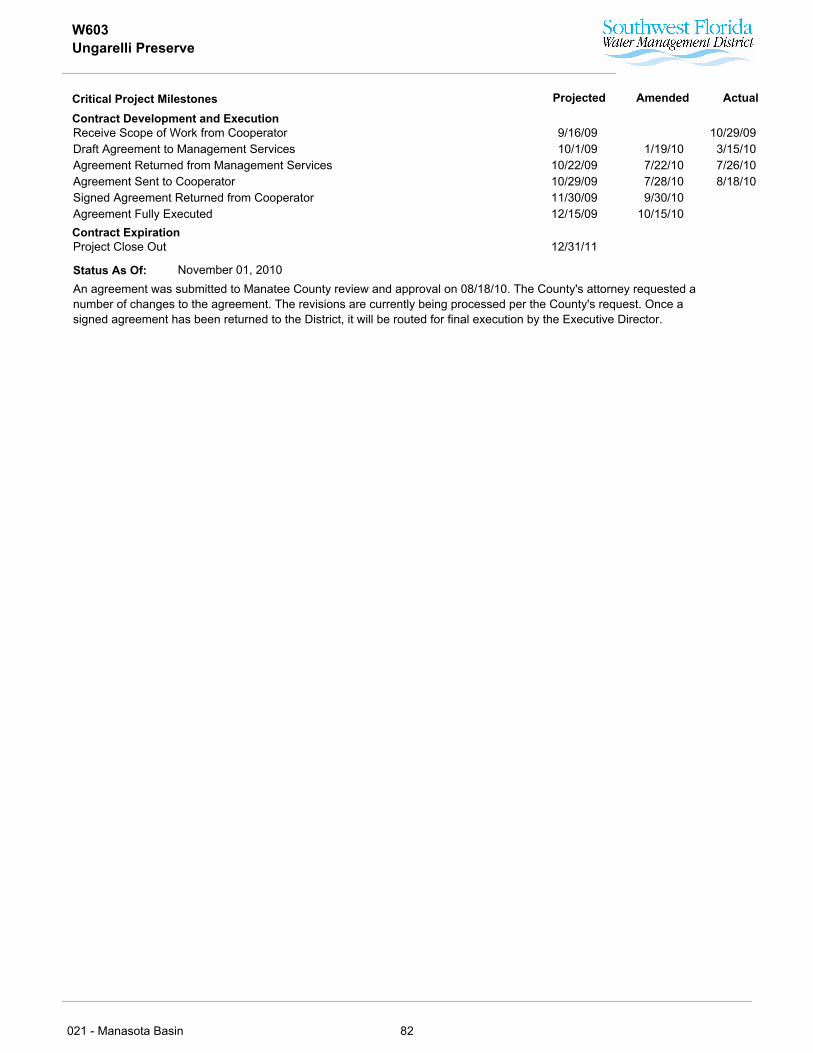
W603
Ungarelli Preserve
Critical Project Milestones ActualProjected Amended
Contract Development and ExecutionReceive Scope of Work from Cooperator 9/16/09 10/29/09
Draft Agreement to Management Services 10/1/09 1/19/10 3/15/10
Agreement Returned from Management Services 10/22/09 7/22/10 7/26/10
Agreement Sent to Cooperator 10/29/09 7/28/10 8/18/10
Signed Agreement Returned from Cooperator 11/30/09 9/30/10
Agreement Fully Executed 12/15/09 10/15/10
Contract ExpirationProject Close Out 12/31/11
Status As Of: November 01, 2010
An agreement was submitted to Manatee County review and approval on 08/18/10. The County's attorney requested a
number of changes to the agreement. The revisions are currently being processed per the County's request. Once a
signed agreement has been returned to the District, it will be routed for final execution by the Executive Director.
021 - Manasota Basin 82

W604
Phillippi Creek In-stream Restoration
Project Type SWIM
AORs Strategic InitiativesWater Quality Water Quality Maintenance and ImprovementNatural Systems Minimum Flows and Level Establishment and MonitoringFlood Protection Emergency Flood Response
Basin(s) Manasota
Sarasota CountyCooperator(s)
Project Manager LOPEZ, MANNY
PECK, MICHAELTask Manager(s)
Status Ongoing
DescriptionSarasota County is developing the Roberts Bay North Watershed Management Plan (see L611), to protect and
improve water quality and restore natural systems throughout the watershed. This plan has identified several in-stream
restoration projects along Phillippi Creek (and nearby areas) to address unstable systems that are currently degrading
water quality and impacting natural systems. The goal of this project is to achieve measurable, improved water quality
and increase natural habitat along Phillippi Creek through the combined use of the following methods at five project
locations: 1) stream bank resloping and removal of exotic vegetation and replanting appropriate native species of
vegetation, 2) incorporating the low impact design technique of bioswales along the top of stream banks to reduce the
velocity of overland flow of stormwater and protect natural systems, 3) creating wetland treatment systems to restore
habitat at the confluence of stream branches, 4) constructing sediment sumps to reduce the amount of nutrient
transport associated with unstable systems, and 5) installation of weirs in select locations to provide increased
residence time for wetland treatment processes. The County began preliminary evaluations for several project
locations in late FY2009. In FY2010 the County initiated designs and permitting for several proposed project
elements. Project construction is not anticipated until FY2011. District funds are requested for construction. Current
estimated construction costs are around $1,350,000 but will be further refined during design. Sarasota County
anticipates requesting additional funding to complete construction.
BenefitsUpon implementation, this project will improve surface water quality by reducing sedimentation and erosion through
bank re-sloping and stabilization with appropriate native vegetation. The installation of weirs at several locations will
increase residence time and thereby provide additional in-stream water quality treatment.
Costs
Originally, the preliminary project construction costs were estimated at $1,350,000. As part of more detailed project
design, project costs have been further refined and are currently estimated to be $2,100,000. Final construction costs
are pending a request for bids (RFB) scheduled for FY2011. For FY2010, Sarasota County requested the District
contribute $600,000 with the County originally contributing $400,000. Due to budget constraints, in FY2010 the District
budgeted $150,000 for the project with an equal match from the County. The District's FY2010 share is split between
the Manasota Basin Board ($75,000) and State SWIM ($75,000). For FY2011, the District's Manasota Basin budgeted
$400,000 for project construction with an equal match of $400,000 from Sarasota County. To date, the District and
Sarasota County together have budgeted $1,100,000 for project construction. District funds shown in the table include
staff salaries and travel charges.
Additional Information
In 1987, the Florida Legislature established the Surface Water Improvement and Management (SWIM) Act having
recognized that water quality and habitat in surface waters throughout the state have degraded or were in danger of
being degraded. The Act requires the five water management districts to maintain a priority list of water bodies of
regional or statewide significance within their boundaries, and develop plans and programs for the improvement of
those water bodies. To date, ten SWIM water bodies in the District have had plans developed and approved by the
state. Several plans have been updated one or more times as required by the Act. The Sarasota Bay SWIM Plan was
first approved in 1997 and last updated in 2002. Since the first plan, the District has initiated a number of restoration
and diagnostic assessment projects. Included within these are: 1) investigation of toxic loading sources to the Bay, 2)
seagrass mapping 3) habitat restoration, 4) development of stormwater master plans, 5) various habitat restoration
projects, 6) construction of artificial reefs and oyster reefs, and 7) involvement in numerous public outreach and
education activities.
021 - Manasota Basin 83

W604
Phillippi Creek In-stream Restoration
District Budgeted - Ad Valorem Based
Revenue
021 Manasota Basin 985,055 500,000 0 77,995 0 407,060
District Budgeted - Outside Revenue
WMLTF (SWIM) - Prior Year Funds 77,994 0 0 77,994 0 0
Project Funds Not Budgeted by the
District
Sarasota County 1,050,000 250,000 0 150,000 250,000 400,000
$2,113,049 Total:
Prior
Funding
Cumulative
Transfer or
Lapsed Funding Funding Funding
2011 FY 2012 FY Future
Funding
Total
Funding
Critical Project Milestones ActualProjected Amended
1. Contract Development & ExecutionDevelop Draft Agreement with Sarasota County 10/16/09 3/31/10 3/31/10
Agreement to Contract Administration 11/13/09 4/12/10 4/19/10
Execution of Agreement by Sarasota County 12/11/09 8/10/10
Execution of Agreement by SWFWMD 12/18/09 8/20/10
Issue Notice to Proceed 12/30/09 8/20/10
2. Project ConstructionBegin Construction 10/1/10 6/6/11
End Construction 11/30/11 10/15/12
Status As Of: October 27, 2010
The agreement between the District and Sarasota County was fully executed on August 2, 2010 with Notice to Proceed
issued on August 4, 2010. The agreement covers construction of the approved permitted projects. Design plans and the
ERP permit application have been completed. Permits authorizing project construction were issued in September 2010.
Sarasota County is in the process of prioritizing project elements for implementation and has begun preparing bid
documents for a request for bids (RFB) tentatively scheduled for early 2011. Construction of the project is not scheduled
to begin until June 2011.
021 - Manasota Basin 84
W611
Sarasota Bay Spoil Island Restoration Project
Project Type SWIM
AORs Strategic InitiativesWater Quality Water Quality Maintenance and ImprovementNatural Systems Natural Systems Conservation and Restoration
Basin(s) Manasota
Sarasota County, Sarasota County Watershed ManagementCooperator(s)
Project Manager GARCIA, LIZANNE
Task Manager(s)
Status Ongoing
DescriptionThis project originally proposed to restore degraded habitat on three groups of islands in Sarasota Bay, a SWIM
priority water body. The islands were Bird Colony Islands, Jim Neville Marine Preserve and Palmer Point Park. These
islands have been impacted by spoil deposition from the dredging of the Intracoastal Waterway, and have been
colonized by exotic vegetation consisting mostly of Australian pines and Brazilian peppers. The project proposes to
restore habitat through the removal of exotic vegetation, excavation of tidal channels and excess spoil, planting of
native vegetation and shoreline stabilization. The project at Bird Colony Islands was primarily focused on shoreline
stabilization while the other two projects focused more on comprehensive coastal ecosystem restoration. Due to the
significant construction cost estimate for the Jim Neville Marine Preserve and a shortfall in expected federal funding
the cooperative funding agreement was amended to remove the Jim Neville Preserve Marine Preserve site from this
project. The County is responsible for design and construction of the projects. District funding from prior fiscal years
(FY) has been used for construction of the Bird Colony Islands Project. FY2009 funding will be used for construction of
the Palmer Point Park project.
BenefitsThese projects focus on intertidal hydrologic restoration, removal of exotic vegetation, and re-vegetation with native
plants to increase and improve wildlife habitat. This habitat restoration project is consistent with and specifically
identified in the the Sarasota Bay SWIM Plan, 2002.
Costs
The total project cost is approximately $2.6 million. The District share totals $945,000 with $402,500 from the
Manasota Basin Board, $322,500 from State SWIM and $220,000 in State Appropriations. The county's share totals
$1,608,453, with $637,953 from the county, $300,000 from the West Coast Inland Navigation District, $520,500 from a
Jacksonville Community Foundation Grant and $150,000 from the United State Army Corps of Engineers. District
funds shown in the table include staff salaries.
Additional Information
Since 1950, approximately 40 percent of Sarasota Bay's intertidal wetland habitat has been lost due to development
and reduction in water quality. This resulted in a decline in the aesthetic, recreational, and commercial value of the
bay, as well as a loss of habitat for native plants and animals. The SWIM Plan for Sarasota Bay outlines goals to
restore habitat throughout the bay areas and reduce pollutant loads entering the bays. The objectives of this project
are consistent with these goals.
021 - Manasota Basin 85
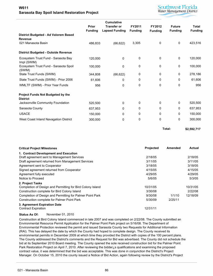
W611
Sarasota Bay Spoil Island Restoration Project
District Budgeted - Ad Valorem Based
Revenue
021 Manasota Basin 423,516 0 (66,622) 486,833 0 3,305
District Budgeted - Outside Revenue
Ecosystem Trust Fund - Sarasota Bay
Impl (SWIM)
120,000 0 0 120,000 0 0
Ecosystem Trust Fund - Sarasota Spoil
(SWIM)
100,000 0 0 100,000 0 0
State Trust Funds (SWIM) 278,186 0 (66,622) 344,808 0 0
State Trust Funds (SWIM) - Prior 2006 61,606 0 0 61,606 0 0
WMLTF (SWIM) - Prior Year Funds 956 0 0 956 0 0
Project Funds Not Budgeted by the
District
Jacksonville Community Foundation 520,500 0 0 520,500 0 0
Sarasota County 637,953 0 0 637,953 0 0
USACE 150,000 0 0 150,000 0 0
West Coast Inland Navagation District 300,000 0 0 300,000 0 0
$2,592,717 Total:
Prior
Funding
Cumulative
Transfer or
Lapsed Funding Funding Funding
2011 FY 2012 FY Future
Funding
Total
Funding
Critical Project Milestones ActualProjected Amended
1. Contract Development and ExecutionDraft agreement sent to Management Services 2/18/05 2/18/05
Draft agreement returned from Management Services 3/11/05 3/11/05
Agreement sent to Cooperator 3/18/05 3/18/05
Signed agreement returned from Cooperator 4/15/05 4/15/05
Agreement fully executed 4/29/05 4/29/05
Notice to Proceed 5/6/05 5/3/05
2. Project TasksCompletion of Design and Permitting for Bird Colony Island 10/31/05 10/31/05
Construction complete for Bird Colony Island 3/30/08 2/22/08
Completion of Design and Permitting for Palmer Point Park 9/30/08 1/1/10 12/18/09
Construction complete for Palmer Point Park 5/30/09 2/25/11
3. Agreement Expiration DateContract Expiration 12/31/11
Status As Of: November 01, 2010
Construction at Bird Colony Island commenced in late 2007 and was completed on 2/22/08. The County submitted an
Environmental Resource Permit Application for the Palmer Point Park project on 5/16/08. The Department of
Environmental Protection reviewed the permit and issued Sarasota County two Requests for Additional Information
(RAI). This has delayed the date by which the County had hoped to complete design. The County received its
environmental permits in December 2009 at which time they provided the District with copies of the 100 percent plans.
The County addressed the District's comments and the Request for Bid was advertised. The County did not schedule the
bid at its September 2010 Board meeting. The County opened the sole received construction bid for the Palmer Point
Park Restoration Project on April 7, 2010. After reviewing the bidder¿s qualifications and examining the proposed
contract value, it was determined that the bid was acceptable. This was done in conjunction the District's Project
Manager. On October 15, 2010 the county issued a Notice of Bid Action, again following review by the District's Project
021 - Manasota Basin 86
W611
Sarasota Bay Spoil Island Restoration Project
Manager. The County was recently approached by the US Army Corps of Engineers about the possibility of resuming the
previous County/Federal interaction on Spoil Island Restoration under the Federal Section 1135 Program. This requires
that the County sign a Project Partnership Agreement with the Corps to formalize the expectations for cost-sharing,
among other things. At this time, County legal staff is working with Corps legal staff to finalize the language of the
Agreement. The County has been advised that the Palmer Point Park Restoration Project can serve as in-kind match for
the Corps¿ Agreement, but only if the construction contract is issued after the Partnership Agreement is executed. At this
time, the County does not have a firm date to take the Partnership Agreement to the County Commission, so they are
unable to estimate their construction start date. County staff is proceeding to prepare the Palmer Point Park Restoration
construction contract for Commission action, but will wait to set a presentation date until after the Commissioners have
acted on the Corps¿ Agreement. At that time, they will be able to establish a reliable date for start of construction. The
District has informed the County that they will need to request an extension to the internal deadlines for this project. The
agreement does not expire until December 31, 2011.
021 - Manasota Basin 87

W612
Sarasota Bay Estuary Program
Project Type SWIM
AORs Strategic InitiativesWater Quality Water Quality Maintenance and ImprovementNatural Systems Natural Systems Conservation and Restoration
Basin(s) Manasota
Sarasota Bay Estuary ProgramCooperator(s)
Project Manager GARCIA, LIZANNE
Task Manager(s)
Status Ongoing
DescriptionThis project provides funding for the Sarasota Bay Estuary Program (SBEP) as outlined in the Interlocal Agreement
which established the SBEP as a independent special district in 2005. The District participates in three main areas.
First the District's SWIM program carries out the projects that will address water quality and habitat restoration within
the bay. Second, the District, through the Manasota Basin Board and State have contributed annual funding to the
SBEP since 1990 to carry out the administration and implement of projects identified in the SBEP Comprehensive
Conservation and Management Plan. And finally, the District provides staff to sit on the technical, management and
policy (Governing Board member) committees of the program. The District's annual budget includes funding support to
the SBEP and District staff salaries, travel and central garage to administer the project, which includes attending board
meetings and other workshops and invoicing.
BenefitsThis project's support of the Sarasota Bay Estuary Program creates an opportunity for a cohesive effort between the
District, SBEP and other state and local agencies to implement resource management decisions and restoration
activities. Additionally, this project provides for leveraging funding between the partners.
Costs
The District has provided funding to the SBEP on an annual basis since 1990. The District's annual funding
commitment for the SBEP is $133,000. Prior to FY2011, the District share was split between the Manasota Basin
Board (50%, $66,500) and State SWIM (50%, $66,500) funds. In FY2011, the District's share of $133,000 is funded
100 percent by the Manasota Basin Board. District funds are used to implement projects outlined in the Annual
Workplan. District funds in the table include staff salaries, travel and central garage.
Additional Information
In 1987, the Florida Legislature established the Surface Water Improvement and Management Program. (SWIM) Act
having recognized that water quality and habitat in surface waters through out the state have degraded or in danger of
being degraded. The Act requires the District maintain a priority list of waterbodies of regional or statewide
significance within their boundaries. Sarasota Bay is designated as a priority waterbody. Sarasota Bay was identified
by the United States Environmental Protection Agency in 1989 as an estuary of Federal Significance and subsequently
included in the National Estuary Program. As a result of this designation, the Sarasota Bay National Estuary Program
was established in 1989 to assist the region in developing a comprehensive plan for the restoration and protection of
Sarasota Bay. In 2004, the "National" designation was dropped from the program name as a result of the execution of
an interlocal agreement between the program partners. The Interlocal Agreement commits the partners to an annual
funding commitment. Partners in the SBEP include the District, USEPA, Florida Department of Environmental
Protection, Sarasota and Manatee counties, the cities of Sarasota and Bradenton, and the town of Longboat Key. The
goals and strategies for the Bay are identified in the Comprehensive Conservation and Management Plan (CCMP) for
Sarasota Bay which provides the guidance for each entity on their contribution to restore the Bay. Since 1998, the
District and other partners have completed several habitat restoration projects and diagnostic assessments, including
seagrass mapping, assessment of atmospheric deposition and identification of toxic load sources in the Bay.
021 - Manasota Basin 88
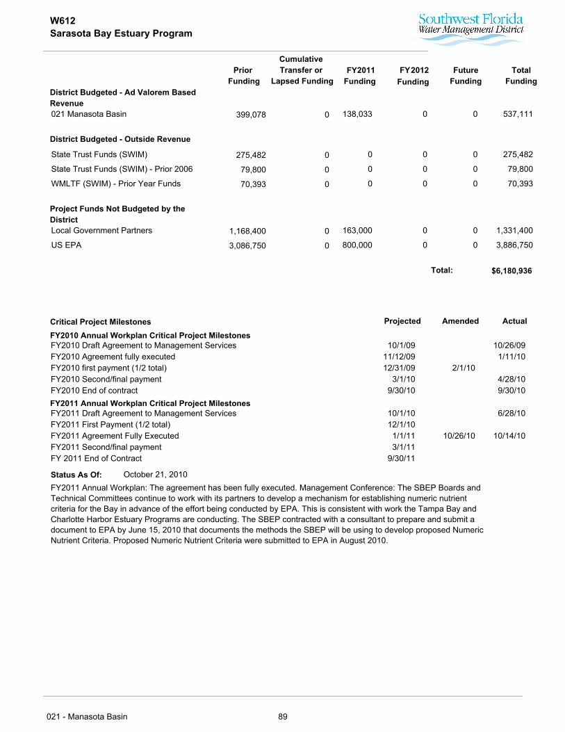
W612
Sarasota Bay Estuary Program
District Budgeted - Ad Valorem Based
Revenue
021 Manasota Basin 537,111 0 0 399,078 0 138,033
District Budgeted - Outside Revenue
State Trust Funds (SWIM) 275,482 0 0 275,482 0 0
State Trust Funds (SWIM) - Prior 2006 79,800 0 0 79,800 0 0
WMLTF (SWIM) - Prior Year Funds 70,393 0 0 70,393 0 0
Project Funds Not Budgeted by the
District
Local Government Partners 1,331,400 0 0 1,168,400 0 163,000
US EPA 3,886,750 0 0 3,086,750 0 800,000
$6,180,936 Total:
Prior
Funding
Cumulative
Transfer or
Lapsed Funding Funding Funding
2011 FY 2012 FY Future
Funding
Total
Funding
Critical Project Milestones ActualProjected Amended
FY2010 Annual Workplan Critical Project MilestonesFY2010 Draft Agreement to Management Services 10/1/09 10/26/09
FY2010 Agreement fully executed 11/12/09 1/11/10
FY2010 first payment (1/2 total) 12/31/09 2/1/10
FY2010 Second/final payment 3/1/10 4/28/10
FY2010 End of contract 9/30/10 9/30/10
FY2011 Annual Workplan Critical Project MilestonesFY2011 Draft Agreement to Management Services 10/1/10 6/28/10
FY2011 First Payment (1/2 total) 12/1/10
FY2011 Agreement Fully Executed 1/1/11 10/26/10 10/14/10
FY2011 Second/final payment 3/1/11
FY 2011 End of Contract 9/30/11
Status As Of: October 21, 2010
FY2011 Annual Workplan: The agreement has been fully executed. Management Conference: The SBEP Boards and
Technical Committees continue to work with its partners to develop a mechanism for establishing numeric nutrient
criteria for the Bay in advance of the effort being conducted by EPA. This is consistent with work the Tampa Bay and
Charlotte Harbor Estuary Programs are conducting. The SBEP contracted with a consultant to prepare and submit a
document to EPA by June 15, 2010 that documents the methods the SBEP will be using to develop proposed Numeric
Nutrient Criteria. Proposed Numeric Nutrient Criteria were submitted to EPA in August 2010.
021 - Manasota Basin 89
W613
Sarasota-Catfish Creek SW Facility-Phase II
Project Type SWIM
AORs Strategic InitiativesWater Quality Water Quality Maintenance and ImprovementFlood Protection Floodplain ManagementWater Supply Alternative Water SupplyNatural Systems Minimum Flows and Level Establishment and Monitoring
Basin(s) Manasota
Sarasota County, Sarasota County Watershed ManagementCooperator(s)
Project Manager LOPEZ, MANNY
THORNTON, SHELLEYTask Manager(s)
Status Ongoing
DescriptionThis FY2005 project was completed in June 2010 to implement Best Management Practices (BMPs) for the Catfish
Creek Watershed which drains into Sarasota Bay, a District SWIM water body. The Catfish Creek watershed covers
an area of approximately 6.22 square miles and is located in Sarasota County. Implementation of BMPs included
design, development of construction documents, construction permitting, land acquisition, bidding, contractor
selection, construction of the BMPs and construction engineering and inspection. Final implementation included the
construction of one stormwater treatment pond totaling 23.75 acres. The County's prior funding includes the property
purchased by the County for the project. With FY2005 funds and additional funds provided in FY2008 and FY2009,
work on the Implementation of BMPs was completed in March 2010. The constructed facility was transferred to
operational status in June 2010.
BenefitsThe combined pond acreage of the completed facility is sufficiently large that stormwater runoff from approximately
810 acres of watershed will receive adequate treatment to meet design criteria for existing stormwater regulations and
will improve water quality by increasing residence time.
Costs
The original total budget for the project was $10,381,397 which includes land costs of $1,788,129. Project
construction costs were originally estimated at $6,100,000. The In FY2005 the District's budgeted share for
construction was $2,500,000 split 40/60 between the Manasota Basin Board ($1,000,000) and State SWIM
($1,500,000). Sarasota County's share in prior years was $6,229,949 in addition to a FDEP grant for
$504,413. Sarasota County contributed $275,000 to the project in FY2008 with the District providing a matching
contribution shared evenly between the Manasota Basin Board ($137,500) and State SWIM ($137,500). The
County requested the final $275,000 in FY2009 (shared evenly between the Manasota Basin Board ($137,500) and
State SWIM ($137,500) and contributed an equal amount. Project construction was completed in June 2010 under
budget. A total of $914,042.80 was returned to the basin budget. The total District funding reflected in the table below
includes staff salary, travel and central garage costs.
021 - Manasota Basin 90

W613
Sarasota-Catfish Creek SW Facility-Phase II
District Budgeted - Ad Valorem Based
Revenue
021 Manasota Basin 1,303,136 0 0 1,299,637 0 3,499
District Budgeted - Outside Revenue
State Trust Funds (SWIM) 291,165 0 0 291,165 0 0
State Trust Funds (SWIM) - Prior 2006 1,500,000 0 0 1,500,000 0 0
WMLTF (SWIM) - Prior Year Funds 2,734 0 0 2,734 0 0
Project Funds Not Budgeted by the
District
Florida Department of Environmental
Protection
504,413 0 0 504,413 0 0
Sarasota County 6,779,949 0 0 6,779,949 0 0
$10,381,397 Total:
Prior
Funding
Cumulative
Transfer or
Lapsed Funding Funding Funding
2011 FY 2012 FY Future
Funding
Total
Funding
Critical Project Milestones ActualProjected Amended
1. Contract Development & ExecutionDraft Agreement for Construction to Management Services 11/19/04 12/19/04
Agreement returned from Management Services 12/9/04 1/7/05
Agreement returned from Executive Review 12/17/04 1/14/05
Agreement to Sarasota County 12/27/04 1/19/05
Execution by District 1/31/05 1/31/05
Sarasota County Approval of Agreement 2/8/05 4/26/05 4/26/05
Draft SWIM Agreement for Construction to Management Services 7/26/05 8/17/05
Agreement returned from Management Services 8/12/05 9/19/05
Agreement returned from Executive Review 9/1/05 9/21/05
Agreement to Sarasota County 9/4/05 9/23/05
Sarasota County Approval of Agreement 11/30/05 11/8/05 11/8/05
Execution by District 12/15/05 12/2/05
Notice to Proceed 1/31/07 12/2/05
2. Contract Development & ExecutionPrepare Amendment for FY2008 Funding 8/28/07 8/28/07
Amendment to County for Approval 11/30/07 1/15/08 1/4/08
Amendment Approved by County 3/1/08 3/11/08 3/18/08
Amendment Approved by District 5/22/08 3/25/08
Notice to Proceed 5/26/08 9/30/08 9/10/08
2. Critical Project MilestonesPermits Issued 3/11/04 7/3/07
Construction Begins 4/30/08 2/28/09 10/1/08
Construction Substantially Completed 1/31/10 9/30/09 12/15/09
As-Builts Received and Approved 4/30/10 9/30/10 8/16/10
Maintenance Plan Received 4/30/10 7/30/10 7/1/10
Final Project Report 4/30/10 9/30/10 8/16/10
3. Close OutContract Termination 5/31/10 1/31/11 9/1/10
Status As Of: October 25, 2010
All project construction at the Catfish Creek stormwater treatment facility was completed by March 2010. Operational
021 - Manasota Basin 91

W613
Sarasota-Catfish Creek SW Facility-Phase II
Status was granted on June 10, 2010. The Project Maintenance Plan was completed and submitted along with final
signed and sealed as-built drawings and the Project Plan Report. Final invoices for reimbursement were processed for
payment and contract closure scheduled for late September 2010. Project construction was completed under budget,
returning $914,042.80 to the basin budget. ACTIONS-TO-DATE: Project Completed - Project was completed ahead of
schedule and under budget in September 2010.
021 - Manasota Basin 92
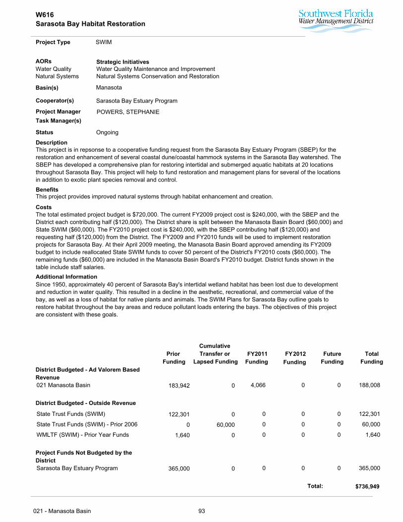
W616
Sarasota Bay Habitat Restoration
Project Type SWIM
AORs Strategic InitiativesWater Quality Water Quality Maintenance and ImprovementNatural Systems Natural Systems Conservation and Restoration
Basin(s) Manasota
Sarasota Bay Estuary ProgramCooperator(s)
Project Manager POWERS, STEPHANIE
Task Manager(s)
Status Ongoing
DescriptionThis project is in repsonse to a cooperative funding request from the Sarasota Bay Estuary Program (SBEP) for the
restoration and enhancement of several coastal dune/coastal hammock systems in the Sarasota Bay watershed. The
SBEP has developed a comprehensive plan for restoring intertidal and submerged aquatic habitats at 20 locations
throughout Sarasota Bay. This project will help to fund restoration and management plans for several of the locations
in addition to exotic plant species removal and control.
BenefitsThis project provides improved natural systems through habitat enhancement and creation.
Costs
The total estimated project budget is $720,000. The current FY2009 project cost is $240,000, with the SBEP and the
District each contributing half ($120,000). The District share is split between the Manasota Basin Board ($60,000) and
State SWIM ($60,000). The FY2010 project cost is $240,000, with the SBEP contributing half ($120,000) and
requesting half ($120,000) from the District. The FY2009 and FY2010 funds will be used to implement restoration
projects for Sarasota Bay. At their April 2009 meeting, the Manasota Basin Board approved amending its FY2009
budget to include reallocated State SWIM funds to cover 50 percent of the District's FY2010 costs ($60,000). The
remaining funds ($60,000) are included in the Manasota Basin Board's FY2010 budget. District funds shown in the
table include staff salaries.
Additional Information
Since 1950, approximately 40 percent of Sarasota Bay's intertidal wetland habitat has been lost due to development
and reduction in water quality. This resulted in a decline in the aesthetic, recreational, and commercial value of the
bay, as well as a loss of habitat for native plants and animals. The SWIM Plans for Sarasota Bay outline goals to
restore habitat throughout the bay areas and reduce pollutant loads entering the bays. The objectives of this project
are consistent with these goals.
District Budgeted - Ad Valorem Based
Revenue
021 Manasota Basin 188,008 0 0 183,942 0 4,066
District Budgeted - Outside Revenue
State Trust Funds (SWIM) 122,301 0 0 122,301 0 0
State Trust Funds (SWIM) - Prior 2006 60,000 0 60,000 0 0 0
WMLTF (SWIM) - Prior Year Funds 1,640 0 0 1,640 0 0
Project Funds Not Budgeted by the
District
Sarasota Bay Estuary Program 365,000 0 0 365,000 0 0
$736,949 Total:
Prior
Funding
Cumulative
Transfer or
Lapsed Funding Funding Funding
2011 FY 2012 FY Future
Funding
Total
Funding
021 - Manasota Basin 93

W616
Sarasota Bay Habitat Restoration
Critical Project Milestones ActualProjected Amended
1. Contract Development and ExecutionDraft agreement Sent to Management Services 9/12/07 1/3/08
Agreement Returned from Management Services 10/3/07 2/20/08
Agreement Sent to Cooperator 10/10/07 2/28/08
Signed Agreement Returned from Cooperator 11/7/07 4/1/08 3/24/08
Agreement Fully Executed 11/21/07 4/15/08 4/7/08
Notice To Proceed 11/27/07 4/30/08 4/9/08
1. Contract Development and ExecutionFirst Amendment to Original Agreement 4/1/09 4/17/09
Status As Of: November 01, 2010
Additional projects are being chosen for implementation under this agreement with SBEP. As they are chosen, District
staff will evaluate the projects and objectives to ensure they coincide with District and SWIM Program goals.
021 - Manasota Basin 94
W617
Sarasota Imp. BMPs Coastal Basin Beach Road
Project Type SWIM
AORs Strategic InitiativesWater Quality Water Quality Maintenance and ImprovementFlood Protection Floodplain Management
Basin(s) Manasota
Sarasota County, Sarasota County Watershed ManagementCooperator(s)
Project Manager PRESTON, MATT
Task Manager(s)
Status Ongoing
DescriptionThis project is in response to a cooperative funding request from Sarasota County. This regional initiative conforms
with, and furthers, the implementation of the Sarasota Bay's CCMP, SWFWMD's Southern Coastal Watershed CWM
Plan, and Sarasota County's Comprehensive Plan. The project is designed to improve water quality standards and
reduce street flooding on Beach Road located in the Sarasota Bay Coastal basin. The water quality in the drainage
piping system along Beach Road near Siesta Key Public Beach does not meet water quality standards and has
impacted the Public Beach through a ditch outfall system to the Gulf of Mexico. This project entails the design and
construction of a stormwater treatment system to protect the public health and safety to meet recreational water quality
standards. A feasibility study report was completed in January 2006. The design includes construction of a linear
estuarine lagoon system for stormwater biological treatment, removal of the existing outfall ditch crossing the public
beach and rerouting the treated stormwater discharge to the Grand Canal. Alternate ideas for a stormwater vault
system will be considered. A stormwater pump station will be planned with an in-line UV treatment system to kill
bacteria. The project is expected to improve water quality by increasing the residence time in the new lagoon system.
BenefitsThe project will be designed to take stormwater runoff that presently discharges across Siesta Key Beach and redirect
it through a water quality treatment marsh and discharge to a residential canal system that connects with Sarasota
Bay. The primary benefits of the project would be reduced flooding on Beach Road with water quality improvement
from biological contamination and natural systems enhancement.
Costs
The total project cost is $2,227,000. The County had a feasibility study completed in January 2006 at a cost of $77,000
and budgeted $200,000 for design in FY2007, leaving a balance of $1,950,000 estimated to be required for the
construction of the project. Sarasota County contributed $487,500 to the project in FY2008 while the District provided
a matching contribution shared evenly between the Manasota Basin Board ($243,750) and State SWIM ($243,750).
The County requested the remaining funding in FY2009, with the County and the District each contributing half
($487,500). Since the County could not commit to spending all of the funding in FY2009, they contributed half of the
requested amount or $243,750 in FY2009 and the District contributed $243,750 split evening between the Manasota
Basin Board ($121,875) and State SWIM ($121,875). The FY2010 project cost is $487,500 with the District and the
County each contributing half ($243,750). At their April 8, 2009 meeting, the Manasota Basin Board approved
amending its FY2009 budget to include reallocated State SWIM funds to cover 50 percent of the District's FY2010
costs ($121,875). The remaining funds ($121,875) are included in the Manasota Basin Board's FY2010 budget.
District funds shown in the table include staff salaries.
Additional Information
This regional initiative conforms with, and furthers, the implementation of the Sarasota Bay's CCMP, SWFWMD's
Southern Coastal Watershed CWM Plan, and Sarasota County's Comprehensive Plan.
021 - Manasota Basin 95
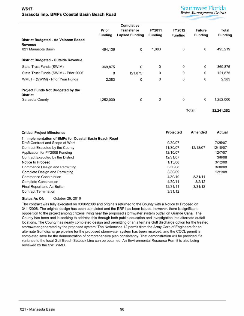
W617
Sarasota Imp. BMPs Coastal Basin Beach Road
District Budgeted - Ad Valorem Based
Revenue
021 Manasota Basin 495,219 0 0 494,136 0 1,083
District Budgeted - Outside Revenue
State Trust Funds (SWIM) 369,875 0 0 369,875 0 0
State Trust Funds (SWIM) - Prior 2006 121,875 0 121,875 0 0 0
WMLTF (SWIM) - Prior Year Funds 2,383 0 0 2,383 0 0
Project Funds Not Budgeted by the
District
Sarasota County 1,252,000 0 0 1,252,000 0 0
$2,241,352 Total:
Prior
Funding
Cumulative
Transfer or
Lapsed Funding Funding Funding
2011 FY 2012 FY Future
Funding
Total
Funding
Critical Project Milestones ActualProjected Amended
1. Implementation of BMPs for Coastal Basin Beach RoadDraft Contract and Scope of Work 9/30/07 7/25/07
Contract Executed by the County 11/30/07 12/18/07 12/18/07
Application for FY2009 Funding 12/10/07 12/7/07
Contract Executed by the District 12/31/07 3/6/08
Notice to Proceed 1/15/08 3/12/08
Commence Design and Permitting 3/30/08 3/30/08
Complete Design and Permitting 3/30/09 12/1/08
Commence Construction 4/30/10 8/31/11
Complete Construction 4/30/11 3/2/12
Final Report and As-Builts 12/31/11 3/31/12
Contract Termination 3/31/12
Status As Of: October 29, 2010
The contract was fully executed on 03/06/2008 and originals returned to the County with a Notice to Proceed on
3/11/2008. The original design has been completed and the ERP has been issued, however, there is significant
opposition to the project among citizens living near the proposed stormwater system outfall on Grande Canal. The
County has been and is seeking to address this through both public education and investigation into alternate outfall
locations. The County has nearly completed design and permitting of an alternate Gulf discharge option for the treated
stormwater generated by the proposed system. The Nationwide 12 permit from the Army Corp of Engineers for an
alternate Gulf discharge pipeline for the proposed stormwater system has been received, and the CCCL permit is
completed save for the demonstration of comprehensive plan consistency. That demonstration will be provided if a
variance to the local Gulf Beach Setback Line can be obtained. An Environmental Resource Permit is also being
reviewed by the SWFWMD.
021 - Manasota Basin 96

W619
Perico Preserve Environmental Restoration
Project Type SWIM
AORs Strategic InitiativesWater Quality Water Quality Maintenance and ImprovementNatural Systems Natural Systems Conservation and Restoration
Basin(s) Manasota
Manatee CountyCooperator(s)
Project Manager POWERS, STEPHANIE
Task Manager(s)
Status Ongoing
DescriptionThis project is in response to a FY2009 cooperative funding request from Manatee County to restore and enhance
approximately 57 acres of intertidal wetlands and uplands in west central Manatee County. The land was purchases in
June 2007 by Manatee County for $6 million. The proposed restoration will target the creation and enhancement of
open water, intertidal, and coastal upland habitats. Exotic plants such as Australian Pine and Brazilian Pepper will be
removed and replaced with both planted and naturally recruiting native species. The funding request for FY2009 is to
complete an existing resource investigation and restoration project design.
BenefitsUpon completion, the project will provide significant benefits to habitat through the removal of exotic species and
replanting of native vegetation. Improved hydrologic conditions will also improve the habitat and water quality of the site
and provide limited stormwater treatment of waters entering both Tampa Bay and Sarasota Bay. Because the project
site drains to both Tampa Bay and Sarasota Bay, this project will benefit both systems.
Costs
The total project cost is $6,450,000. The FY2009 project cost is $450,000, which is being split 50/50 between
Manasota Basin Board ($225,000) and State SWIM funds ($225,000). Manatee County is matching the District's
contribution with the $6 million used for land purchase. District funds for FY2009 will be used for the Design and
Permitting phase of the project.The remaining funds for construction would be budgeted in future years and contingent
upon Basin approval. District funds shown in the table include staff salaries.
Additional Information
Since 1950, approximately 50 percent of Tampa Bay's natural shoreline and approximately 40 percent of Sarasota
Bay's intertidal wetland habitat has been lost due to development and reduction in water quality. This resulted in a
decline in the aesthetic, recreational, and commercial value of the bay, as well as a loss of habitat for native plants
and animals. The SWIM Plans for Tampa Bay and Sarasota Bay outline goals to restore habitat throughout the bay
areas and reduce pollutant loads entering the bays. The objectives of this project are consistent with these goals.
District Budgeted - Ad Valorem Based
Revenue
021 Manasota Basin 231,762 0 0 229,098 0 2,664
District Budgeted - Outside Revenue
State Trust Funds (SWIM) 228,141 0 0 228,141 0 0
WMLTF (SWIM) - Prior Year Funds 956 0 0 956 0 0
Project Funds Not Budgeted by the
District
Manatee County 6,000,000 0 0 6,000,000 0 0
$6,460,859 Total:
Prior
Funding
Cumulative
Transfer or
Lapsed Funding Funding Funding
2011 FY 2012 FY Future
Funding
Total
Funding
021 - Manasota Basin 97
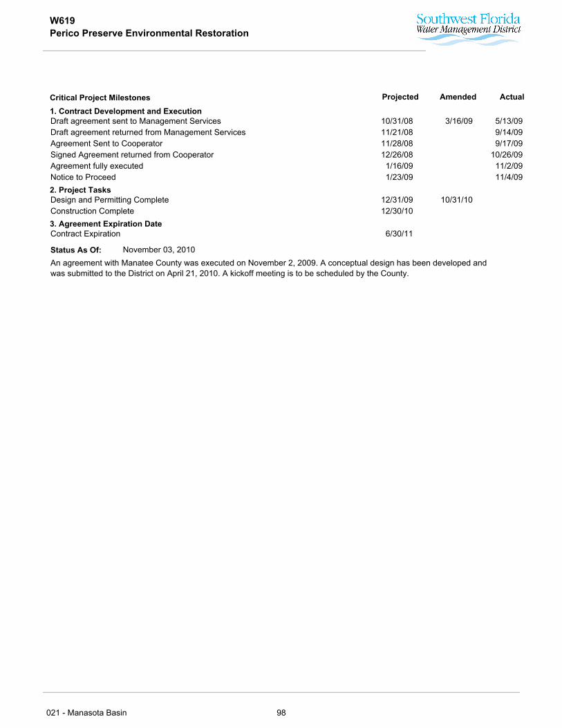
W619
Perico Preserve Environmental Restoration
Critical Project Milestones ActualProjected Amended
1. Contract Development and ExecutionDraft agreement sent to Management Services 10/31/08 3/16/09 5/13/09
Draft agreement returned from Management Services 11/21/08 9/14/09
Agreement Sent to Cooperator 11/28/08 9/17/09
Signed Agreement returned from Cooperator 12/26/08 10/26/09
Agreement fully executed 1/16/09 11/2/09
Notice to Proceed 1/23/09 11/4/09
2. Project TasksDesign and Permitting Complete 12/31/09 10/31/10
Construction Complete 12/30/10
3. Agreement Expiration DateContract Expiration 6/30/11
Status As Of: November 03, 2010
An agreement with Manatee County was executed on November 2, 2009. A conceptual design has been developed and
was submitted to the District on April 21, 2010. A kickoff meeting is to be scheduled by the County.
021 - Manasota Basin 98

W620
Pelican Cove Stormwater Retrofit
Project Type SWIM
AORs Strategic InitiativesWater Quality Water Quality Maintenance and Improvement
Basin(s) Manasota
Sarasota County, Pelican CoveCooperator(s)
Project Manager NORTON, NANCY
Task Manager(s)
Status Ongoing
DescriptionThis project is in response to a FY2009 cooperative funding request from Pelican Cove Condominium Association.
Pelican Cove is a Sarasota County Neighborhood Environment Stewardship Team (NEST) community which has
begun to retrofit stormwater BMPs in the 1970's property. This project involves the design and construction of berms to
redirect the flow of stormwater runoff into detention areas and swales designed to reduce the amount of flow and
pollutants entering Little Sarasota Bay by as much as 80% to 90%. The project will provide treatment for stormwater
from approximately 20 acres of Pelican Cove Condominiums. Maintenance will be provided by Pelican Cove
Condominium Association which has a staff of over 40 grounds and maintenance employees. Additional
funding requested in FY2011 will provide longer stormwater retention times by diverting some of the stormwater runoff
to an existing stormwater pond located at an adjacent development.
BenefitsThe stormwater treatment system will redirect stormwater runoff from approximately 20 acres of the site, reducing
nutrients and sediments that currently flow untreated to Little Sarasota Bay.
Costs
The total project cost is $45,000. The FY2009 project cost is $35,000, with the Pelican Cove Condominium
Association and the District each contributing half ($17,500). The District share is split between the Manasota Basin
Board ($8,750) and State SWIM ($8,750). In FY2011, the Association requested additional funding, increasing the
project budget by $10,000, with the Pelican Cove Condominium Association and the District each contributing half
($5,000). The District portion is funded by the Manasota Basin Board. District funds shown in the table includes staff
salaries.
Additional Information
Since 1950, approximately 50 percent of Tampa Bay's natural shoreline and approximately 40 percent of Sarasota
Bay's intertidal wetland habitat has been lost due to development and reduction in water quality. This resulted in a
decline in the aesthetic, recreational, and commercial value of the bay, as well as a loss of habitat for native plants
and animals. The SWIM Plans for Tampa Bay and Sarasota Bay outline goals to restore habitat throughout the bay
areas and reduce pollutant loads entering the bays. The objectives of this project are consistent with these goals.
021 - Manasota Basin 99
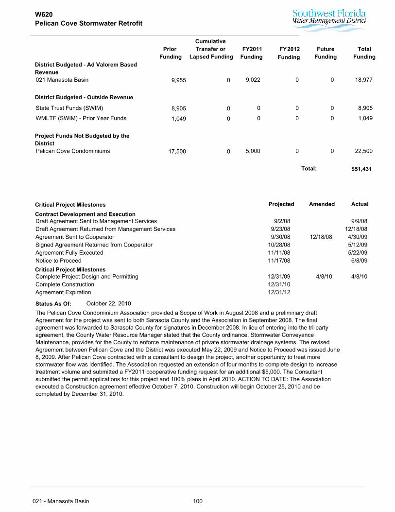
W620
Pelican Cove Stormwater Retrofit
District Budgeted - Ad Valorem Based
Revenue
021 Manasota Basin 18,977 0 0 9,955 0 9,022
District Budgeted - Outside Revenue
State Trust Funds (SWIM) 8,905 0 0 8,905 0 0
WMLTF (SWIM) - Prior Year Funds 1,049 0 0 1,049 0 0
Project Funds Not Budgeted by the
District
Pelican Cove Condominiums 22,500 0 0 17,500 0 5,000
$51,431 Total:
Prior
Funding
Cumulative
Transfer or
Lapsed Funding Funding Funding
2011 FY 2012 FY Future
Funding
Total
Funding
Critical Project Milestones ActualProjected Amended
Contract Development and ExecutionDraft Agreement Sent to Management Services 9/2/08 9/9/08
Draft Agreement Returned from Management Services 9/23/08 12/18/08
Agreement Sent to Cooperator 9/30/08 12/18/08 4/30/09
Signed Agreement Returned from Cooperator 10/28/08 5/12/09
Agreement Fully Executed 11/11/08 5/22/09
Notice to Proceed 11/17/08 6/8/09
Critical Project MilestonesComplete Project Design and Permitting 12/31/09 4/8/10 4/8/10
Complete Construction 12/31/10
Agreement Expiration 12/31/12
Status As Of: October 22, 2010
The Pelican Cove Condominium Association provided a Scope of Work in August 2008 and a preliminary draft
Agreement for the project was sent to both Sarasota County and the Association in September 2008. The final
agreement was forwarded to Sarasota County for signatures in December 2008. In lieu of entering into the tri-party
agreement, the County Water Resource Manager stated that the County ordinance, Stormwater Conveyance
Maintenance, provides for the County to enforce maintenance of private stormwater drainage systems. The revised
Agreement between Pelican Cove and the District was executed May 22, 2009 and Notice to Proceed was issued June
8, 2009. After Pelican Cove contracted with a consultant to design the project, another opportunity to treat more
stormwater flow was identified. The Association requested an extension of four months to complete design to increase
treatment volume and submitted a FY2011 cooperative funding request for an additional $5,000. The Consultant
submitted the permit applications for this project and 100% plans in April 2010. ACTION TO DATE: The Association
executed a Construction agreement effective October 7, 2010. Construction will begin October 25, 2010 and be
completed by December 31, 2010.
021 - Manasota Basin 100
W621
Little Sarasota Bay Water Quality Management Plan
Project Type SWIM
AORs Strategic InitiativesWater Quality Water Quality Maintenance and ImprovementNatural Systems Natural Systems Conservation and RestorationFlood Protection Floodplain Management
Basin(s) Manasota
Sarasota County Watershed Management, Sarasota CountyCooperator(s)
Project Manager GARCIA, LIZANNE
Task Manager(s)
Status Ongoing
DescriptionThis project will develop a water quality management plan for Little Sarasota Bay that includes the Little Sarasota Bay,
Elligraw Bayou, Holiday Bayou, Clower Creek, Catfish Creek, North Creek, South Creek and direct runoff to the bay
from Siesta Key and Casey Key. The plan will focus on water resource issues such as restoration of historic or more
natural hydrologic regimes in the basin, and improvements to water quality and habitat. Through this plan, the County
and District will work with the Sarasota Bay Estuary Program and its partners to develop water quality and habitat
restoration goals and identify projects that will assist in meeting these goals. The plan will include short term and long
term projects for improvements that may include wastewater reuse, stormwater reuse, smart growth, revised land
development standards, sediment control, wetland or floodplain restoration, flood level abatement, aquifer protection,
and restoration of natural flow regimes. The County will post deliverables and reports on the Sarasota County Water
Atlas website. Additionally, the plan will identify the monitoring needed to evaluate the progress made toward meeting
the established goals.
BenefitsDevelopment of this plan will assist the District in its update of the SWIM Plan for Sarasota Bay by developing pollutant
load reduction goals and specific projects to meet those goals. Implementation of the plan by Sarasota County and
others will result in protecting and restoring water quality and natural systems within the watershed of Little Sarasota
Bay.
Costs
The total estimated cost for the development of the Water Quality Management Plan is $600,000. This multi-year
funded project is funded over three fiscal years beginning in FY2009. The FY2009 and FY2010 total costs were
$400,000 with the District and Sarasota each contributing one-half ($200,000). The District's FY2009 and FY2010
share is split evenly between the Manasota Basin Board ($100,000) and State SWIM funds ($100,000).
Sarasota County requested and the Manasota Basin Board included $100,000 in its FY2011 budget to match
$100,000 by the County. FY2009 funds are for compiling and evaluating all existing studies, models and data,
identifying pollutant sources and development of a data collection plan. FY2010 funds are for modeling watershed
pollutant loads and evaluating alternatives, and FY2011 funds are for completing a draft and final plan. District funds
shown in the table include staff salaries, travel and central garage.
Additional Information
Since 1950, approximately 40 percent of Sarasota Bay's intertidal wetland habitat has been lost due to development
and reduction in water quality. This resulted in a decline in the aesthetic, recreational, and commercial value of the
bay, as well as a loss of habitat for native plants and animals. The SWIM Plans for Sarasota Bay outline goals to
restore habitat throughout the bay areas and reduce pollutant loads entering the bays. The objectives of this project
are consistent with these goals.
021 - Manasota Basin 101

W621
Little Sarasota Bay Water Quality Management Plan
District Budgeted - Ad Valorem Based
Revenue
021 Manasota Basin 218,091 0 0 110,795 0 107,296
District Budgeted - Outside Revenue
State Trust Funds (SWIM) 29,820 0 0 29,820 0 0
State Trust Funds (SWIM) - Prior 2006 75,000 0 75,000 0 0 0
WMLTF (SWIM) - Prior Year Funds 5,974 0 0 5,974 0 0
Project Funds Not Budgeted by the
District
Sarasota County 300,000 0 0 200,000 0 100,000
$628,885 Total:
Prior
Funding
Cumulative
Transfer or
Lapsed Funding Funding Funding
2011 FY 2012 FY Future
Funding
Total
Funding
Critical Project Milestones ActualProjected Amended
1. Cooperator Contract Development and ExecutionDraft Agreement sent to Management Services 10/1/08 1/29/09
Agreement Returned from Management Services 10/15/08 2/16/09
Agreement sent to Cooperator 10/15/08 2/25/09
Signed Agreement Returned from Cooperator 10/29/08 3/13/09 3/20/09
Agreement Fully Executed 11/7/08 3/16/09 3/27/09
2. Project TasksCompile and evaluate existing data, identify projects, outline final report 6/1/11
Final Report 6/1/12
3. Cooperative Agreement ExpirationAgreement Expiration 12/31/12
Status As Of: October 22, 2010
The cooperative funding agreement was fully executed in March 2009. A kick-off meeting with the County was held May
5, 2009. At the meeting, the selection of a consultant to conduct the study and a timeline was discussed. The County
issued the Request for Professional Services for this project in November 2009 and a ranking meeting was held on
January 7, 2010 to develop the ranked list for presentation to the County Commission. County and District staff have
negotiated fees and the Scope of Work with the consultant. A final scope and fee was approved by the District and
County staff in August 2010. However, due to delays on the County's end, the agreement was not scheduled at the
September 2010 Board of County Commissioners meeting. It has been rescheduled to November 30, 2010. This will
also delay the project and the County will be requesting revisions to the schedule once the agreement is approved by the
County Commission. However, at this time the District project manager is not optimistic that this project will be complete
by the deadline in the County/District agreement and a future no cost time extension amendment may be needed.
021 - Manasota Basin 102

W622
Sarasota Bay Water Quality Management Plan
Project Type SWIM
AORs Strategic InitiativesWater Quality Water Quality Maintenance and ImprovementNatural Systems Natural Systems Conservation and RestorationFlood Protection Floodplain Management
Basin(s) Manasota
Sarasota County Watershed Management, Sarasota CountyCooperator(s)
Project Manager GARCIA, LIZANNE
Task Manager(s)
Status Ongoing
DescriptionThis project will develop a water quality management plan for Sarasota Bay that includes the watersheds within
Sarasota County for Sarasota Bay, Hudson Bayou, Whitaker Bayou, Lido Key, and direct runoff to the bay. The plan
will focus on water resource issues such as restoration of historic or more natural hydrologic regimes in the basin, and
improvements to water quality and habitat. Through this plan, the County and District will work with the Sarasota Bay
Estuary Program and its partners to develop water quality and habitat restoration goals and identify projects that will
assist in meeting these goals. The plan will include short term and long term projects for improvements that may
include wastewater reuse, stormwater reuse, smart growth, revised land development standards, sediment control,
wetland or floodplain restoration, flood level abatement, aquifer protection, and restoration of natural flow regimes. The
County will post deliverables and reports on the Sarasota County Water Atlas website. Additionally, the plan will
identify the monitoring needed to evaluate the progress made toward meeting the established goals.
BenefitsDevelopment of this plan will assist the District in its update of the SWIM Plan for Sarasota Bay by developing pollutant
load reduction goals and specific projects to meet those goals. Implementation of the plan by Sarasota County and
others will result in protecting and restoring water quality and natural systems within the watershed of Sarasota Bay.
Costs
The total estimated cost for the development of the Water Quality Management Plan is $600,000. This multi-year
funded project is funded over three fiscal years beginning in FY2009. The FY2009 and FY2010 total costs were
$400,000 with the District and Sarasota each contributing one-half ($200,000). The District's FY2009 and FY2010
share is split evenly between the Manasota Basin Board ($100,000) and State SWIM funds
($100,000). Sarasota County requested and the Manasota Basin Board included $100,000 in its FY2011 budget to
match $100,000 budgeted by the County. FY2009 funds are for compiling and evaluating all existing studies, models
and data, identifying pollutant sources and development of a data collection plan. FY2010 funds are for modeling
watershed pollutant loads and evaluating alternatives, and FY2011 funds are for completing and draft and final plan.
District funds shown in the table include staff salaries, travel and central garage.
Additional Information
Since 1950, approximately 40 percent of Sarasota Bay's intertidal wetland habitat has been lost due to development
and reduction in water quality. This resulted in a decline in the aesthetic, recreational, and commercial value of the
bay, as well as a loss of habitat for native plants and animals. The SWIM Plans for Sarasota Bay outline goals to
restore habitat throughout the bay areas and reduce pollutant loads entering the bays. The objectives of this project
are consistent with these goals.
021 - Manasota Basin 103

W622
Sarasota Bay Water Quality Management Plan
District Budgeted - Ad Valorem Based
Revenue
021 Manasota Basin 218,091 0 0 110,795 0 107,296
District Budgeted - Outside Revenue
State Trust Funds (SWIM) 29,820 0 0 29,820 0 0
State Trust Funds (SWIM) - Prior 2006 75,000 0 75,000 0 0 0
WMLTF (SWIM) - Prior Year Funds 5,974 0 0 5,974 0 0
Project Funds Not Budgeted by the
District
Sarasota County 300,000 0 0 200,000 0 100,000
$628,885 Total:
Prior
Funding
Cumulative
Transfer or
Lapsed Funding Funding Funding
2011 FY 2012 FY Future
Funding
Total
Funding
Critical Project Milestones ActualProjected Amended
1. Cooperator Contract Development and ExecutionDraft Agreement sent to Management Services 10/1/08 1/29/09
Agreement Returned from Management Services 10/15/08 2/16/09
Agreement sent to Cooperator 10/15/08 2/25/09
Signed Agreement Returned from Cooperator 10/29/08 3/13/09
Agreement Fully Executed 11/7/08 3/16/09
2. Project TasksCompile evaluate existing data, identify projects 6/1/11 4/1/12
Final Report 6/29/12 9/1/12
3. Cooperative Agreement ExpirationAgreement Expiration 12/31/12
Status As Of: October 21, 2010
The agreement was fully executed in March 2009. A kick-off meeting with the County was held May 5, 2009. The District
and County staff prepared a Request for Professional Services and it is was advertised December 22, 2009 and eight
proposals were received. The ranking committee (which the District project manager participated in) met on March 8,
2010 to rank the proposals. A final Scope and Fee was provided by the consultant on June 22, 2010. The agreement
with the consultant was approved by the Board of County Commissioners in July 2010. Due to the lengthy process for
securing a consultant, the County has requested a revision to internal deadlines for completion of preliminary tasks. The
District's project manager has approved this request and the new deadlines are reflected in the milestones section of this
write-up. The kick-off meeting with the consultant and the County was held on September 28, 2010 and a watershed tour
was held on October 11, 2010. A District communications staff member and the District's project manager met with the
County Project manager and the County's Communications staff on October 19, 2010 to brainstorm ways to get the
community more involved in development of the plan. District Communications staff sent various information to the
County as a follow-up to the meeting.
021 - Manasota Basin 104
W623
Holmes Beach Stormwater Retrofit
Project Type SWIM
AORs Strategic InitiativesWater Quality Water Quality Maintenance and ImprovementNatural Systems Natural Systems Conservation and RestorationFlood Protection Floodplain Management
Basin(s) Manasota
Holmes BeachCooperator(s)
Project Manager PRESTON, MATT
Task Manager(s)
Status Ongoing
DescriptionThis project is in response to a cooperative funding request from the City of Holmes Beach. The project will impact two
drainage basins within the City of Holmes Beach totaling approximately 107 acres. Both basins have a total of 16
outfall locations that discharge into the finger canals within the City, which discharge into Sarasota Bay. The objective
of this project is to reduce pollutants being received by Sarasota Bay by improving the water quality discharge to the
bay and reduce flooding within the basins. The project includes the construction of multiple small retention areas
throughout the basin. Additional improvements will include reconstruction of the city owned land to accommodate
shallow grassed swales and installation of new baffle box structures at each outfall location. The swales and retention
areas provide treatment of stormwater through percolation and evaporation. Treated stormwater will discharge into the
bay through the new baffle structures which provide additional treatment through sedimentation, filtration and
skimming.
BenefitsThis project will improve the water quality and flood protection by removing pollutants and increasing storage and
conveyance capacity. The stormwater filtration devices being proposed will provide suspended solids removal from
stormwater runoff that previously discharged directly into the canal/bay system. The project is anticipated to reduce
TSS by 80%.
Costs
The total project budget is $1,026,000, of which the City and the District are funding half ($513,000). The FY2010
project cost is $253,230 with the City contributing $171,000 and the District contributing $82,230. The District's
FY2010 share is split between the Manasota Basin Board ($41,115) and State SWIM ($41,115). The FY2011 project
budget is $346,270 with the City contributing $171,000 and the District contributing $175,270. The District's FY2011 is
funded by the Manasota Basin Board. Additional future funds will be required for construction. District funds shown in
the table include staff salaries.
Additional Information
The State of Florida has designated Sarasota Bay as an OFW. In 1997, a Sarasota Bay Surface Water Improvement
and Management (SWIM) Plan was created to outline a series of research and/or restoration projects that will allow
for the preservation and continued restoration of the health of Sarasota Bay. The goals of the SWIM plan include
improvement of water transparency in Sarasota Bay to decrease the quantity and increase the quality of stormwater
runoff to Sarasota Bay, to restore shoreline habitats in Sarasota Bay and to continue monitoring programs in Sarasota
Bay. This project will help to accomplish those objectives and increase the overall health, welfare and safety of the
residents living within these basins.
021 - Manasota Basin 105

W623
Holmes Beach Stormwater Retrofit
District Budgeted - Ad Valorem Based
Revenue
021 Manasota Basin 477,239 255,500 0 43,499 0 178,240
District Budgeted - Outside Revenue
Ecosystem Trust Fund - SWIM Prior
Year Funds
41,115 0 0 41,115 0 0
WMLTF (SWIM) - Prior Year Funds 2,383 0 0 2,383 0 0
Project Funds Not Budgeted by the
District
City of Holmes Beach 513,000 0 0 171,000 171,000 171,000
$1,033,737 Total:
Prior
Funding
Cumulative
Transfer or
Lapsed Funding Funding Funding
2011 FY 2012 FY Future
Funding
Total
Funding
Critical Project Milestones ActualProjected Amended
Design and Permitting Completion 11/30/10
Commence Construction 3/31/11
Complete Construction 3/31/12
As-Built Drawings and Final Report 6/30/12
Status As Of: October 29, 2010
Design is underway and currently 90% complete. The original scope of this project included the construction of a new
retention area at the southwest intersection of 62nd Street and Flotilla Drive. However, after receiving survey data and
reviewing the existing conditions at that location, it has been determined that it is not a feasible site for a retention area
as the topography is higher than much of the surrounding area. A significant retention area is to be provided at the end of
63rd Street along with multiple other retention areas and swales throughout the basin, which will meet the intent of the
project in providing treatment and attenuation for stormwater runoff.
021 - Manasota Basin 106
W624
Red Bug Slough Restoration
Project Type SWIM
AORs Strategic InitiativesWater Quality Water Quality Maintenance and ImprovementFlood Protection Floodplain ManagementNatural Systems Natural Systems Conservation and Restoration
Basin(s) Manasota
Sarasota CountyCooperator(s)
Project Manager PRESTON, MATT
Task Manager(s)
Status Ongoing
DescriptionThis project is in response to a cooperative funding request from Sarasota County. Sarasota County and SWFWMD
are jointly developing the Roberts Bay North Watershed Management Plan which has identified the Red Bug Slough
Restoration project to improve water quality and restore habitat in the watershed. This project was also identified in the
2002 Sarasota Bay SWIM Plan to improve the quality of stormwater runoff to Sarasota Bay. Red Bug Slough is a
tributary to Philippi Creek, which eventually discharges to Roberts Bay, and is part of the larger Sarasota Bay system.
The Red Bug Slough basin is 600 acres and includes a series of four interconnected lakes: West Clark Lake, East
Clark Lake, Mirror Lake and Red Bug Slough Lake. There are four proposed restoration components identified for
design that will partially restore a historical wetland, enhance native plant communities, and improve the quality of
water entering Phillippi Creek and ultimately Sarasota Bay.
BenefitsThe project will create additional storage within the watershed and, thereby, provide an improved level of service for
flooding. The project will also provide improved water quality treatment by increasing residence times and providing
additional biological treatment through restoration of historical marshes and creation of new wetland systems within
Red Bug Sough. This will improve the quality of water entering Phillippi Creek and ultimately Sarasota Bay, and will
have a positive impact on waterbodies on the TMDL verified list for the Sarasota Bay Group 3 segments, including
Roberts Bay for nutrients and Chl (a); and Phillippi Creek for coliform bacteria.
Costs
The total project budget is $1,000,000, of which the County and the District are each funding half ($500,000). Sarasota
County has budgeted $250,000 for FY2010 and $250,000 for FY2011. The District budgeted $400,000 for FY2010.
The District's FY2010 share is split between the Manasota Basin Board ($200,000) and State SWIM ($200,000). The
District's FY2011 budget includes $100,000, which is funded by the Manasota Basin Board. District funds shown in the
table include staff salaries.
Additional Information
Since 1950, approximately 40 percent of Sarasota Bay's intertidal wetland habitat has been lost due to development
and reduction in water quality. This resulted in a decline in the aesthetic, recreational, and commercial value of the
bay, as well as a loss of habitat for native plants and animals. The SWIM Plans for Sarasota Bay outline goals to
restore habitat throughout the bay areas and reduce pollutant loads entering the bays. The objectives of this project
are consistent with these goals.
021 - Manasota Basin 107
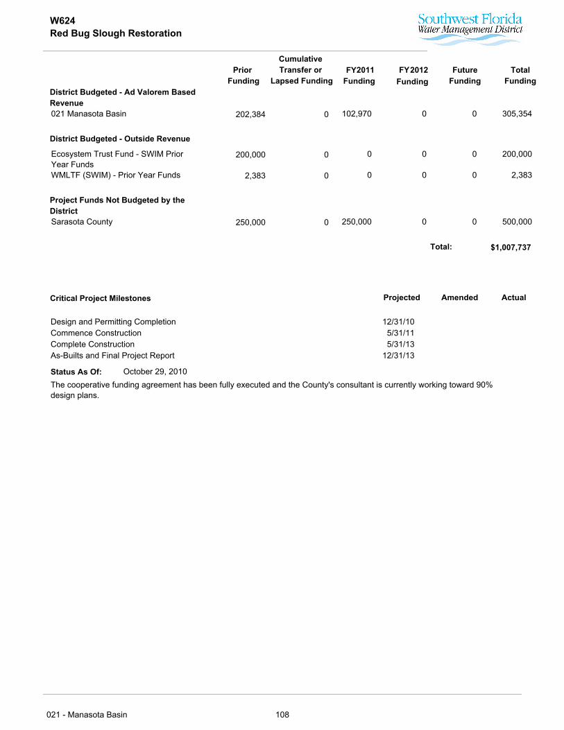
W624
Red Bug Slough Restoration
District Budgeted - Ad Valorem Based
Revenue
021 Manasota Basin 305,354 0 0 202,384 0 102,970
District Budgeted - Outside Revenue
Ecosystem Trust Fund - SWIM Prior
Year Funds
200,000 0 0 200,000 0 0
WMLTF (SWIM) - Prior Year Funds 2,383 0 0 2,383 0 0
Project Funds Not Budgeted by the
District
Sarasota County 500,000 0 0 250,000 0 250,000
$1,007,737 Total:
Prior
Funding
Cumulative
Transfer or
Lapsed Funding Funding Funding
2011 FY 2012 FY Future
Funding
Total
Funding
Critical Project Milestones ActualProjected Amended
Design and Permitting Completion 12/31/10
Commence Construction 5/31/11
Complete Construction 5/31/13
As-Builts and Final Project Report 12/31/13
Status As Of: October 29, 2010
The cooperative funding agreement has been fully executed and the County's consultant is currently working toward 90%
design plans.
021 - Manasota Basin 108

W625
Runaway Bay - Sarasota Bay Coast Line Restoration
Project Type SWIM
AORs Strategic InitiativesWater Quality Water Quality Maintenance and ImprovementNatural Systems Natural Systems Conservation and RestorationFlood Protection Emergency Flood Response
Basin(s) Manasota
Runaway Bay Condominium AssociationCooperator(s)
Project Manager NORTON, NANCY
Task Manager(s)
Status Ongoing
DescriptionThis project is in response to a FY2010 Cooperative Funding request from Runaway Bay Condominium Association.
Runaway Bay is a waterfront condominium association located between Gulf Drive North and Sarasota Bay. The
objective of this project is to restore approximately 900 linear feet of shoreline. This project will also reduce pollutants
being received by Sarasota Bay. Through the years, this shoreline has experienced serious erosion which has
negatively impacted the habitat and wetland function. Best Management Practices will be implemented to remove
non-permitted structures and sea walls, restore the shoreline and improve water quality. Runaway Bay will be
responsible for ongoing maintenance once the project is completed.
BenefitsImplementation of restoration practices on the Runaway Bay Condominium's 900 linear feet of Sarasota Bay shoreline
will restore shoreline habitat and improve water quality.
Costs
The total project budget is $80,000, with Runaway Bay Condominium Association and the District each contributing
half ($40,000). The District's share is split between the Manasota Basin Board ($20,000) and State SWIM ($20,000).
District funds shown in the table include staff salaries.
Additional Information
Since 1950, approximately 40 percent of Sarasota Bay's intertidal wetland habitat has been lost due to development
and reduction in water quality. This resulted in a decline in the aesthetic, recreational, and commercial value of the
bay, as well as a loss of habitat for native plants and animals. The SWIM Plan for Sarasota Bay outlines goals to
restore habitat throughout the bay area and reduce pollutant loads entering the bay. The objectives of this project are
consistent with these goals.
District Budgeted - Ad Valorem Based
Revenue
021 Manasota Basin 24,587 0 0 21,516 0 3,071
District Budgeted - Outside Revenue
WMLTF (SWIM) - Prior Year Funds 21,516 0 0 21,516 0 0
Project Funds Not Budgeted by the
District
Runaway Bay Condominium
Association
139,000 0 0 139,000 0 0
$185,103 Total:
Prior
Funding
Cumulative
Transfer or
Lapsed Funding Funding Funding
2011 FY 2012 FY Future
Funding
Total
Funding
021 - Manasota Basin 109
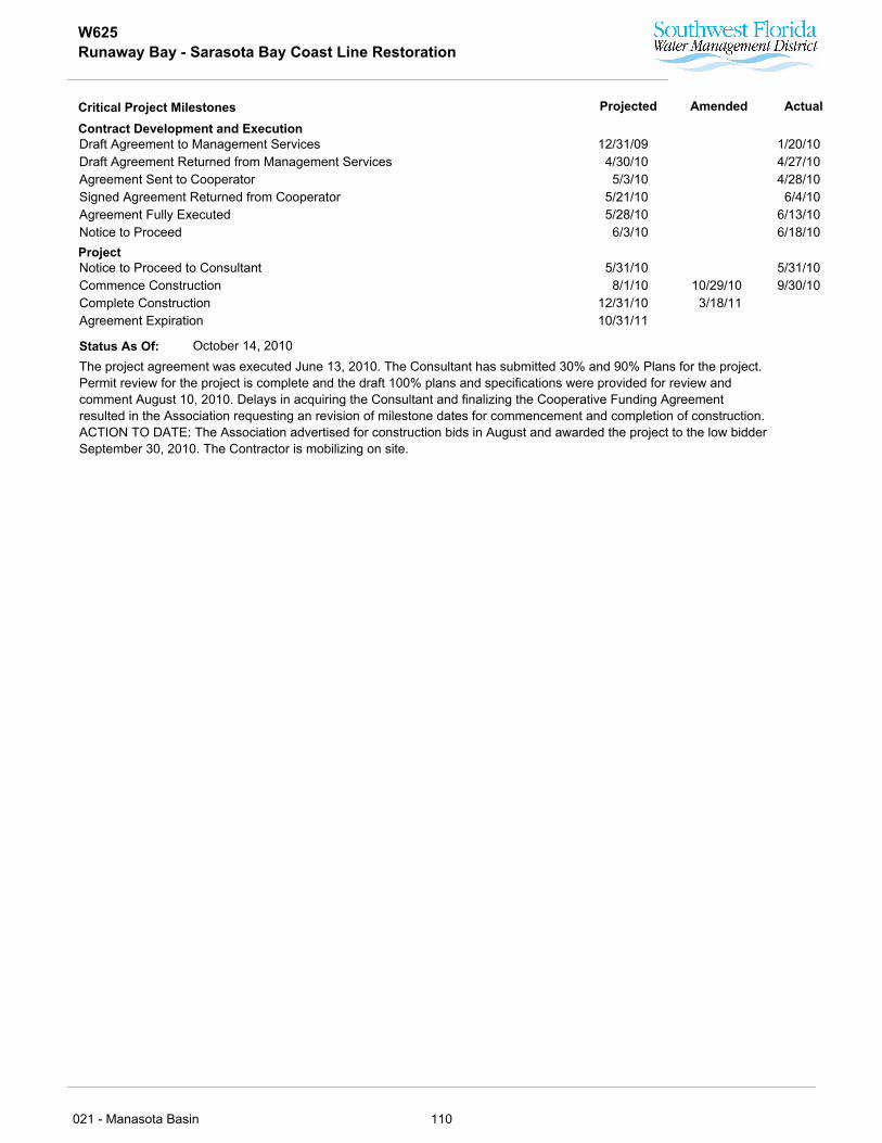
W625
Runaway Bay - Sarasota Bay Coast Line Restoration
Critical Project Milestones ActualProjected Amended
Contract Development and ExecutionDraft Agreement to Management Services 12/31/09 1/20/10
Draft Agreement Returned from Management Services 4/30/10 4/27/10
Agreement Sent to Cooperator 5/3/10 4/28/10
Signed Agreement Returned from Cooperator 5/21/10 6/4/10
Agreement Fully Executed 5/28/10 6/13/10
Notice to Proceed 6/3/10 6/18/10
ProjectNotice to Proceed to Consultant 5/31/10 5/31/10
Commence Construction 8/1/10 10/29/10 9/30/10
Complete Construction 12/31/10 3/18/11
Agreement Expiration 10/31/11
Status As Of: October 14, 2010
The project agreement was executed June 13, 2010. The Consultant has submitted 30% and 90% Plans for the project.
Permit review for the project is complete and the draft 100% plans and specifications were provided for review and
comment August 10, 2010. Delays in acquiring the Consultant and finalizing the Cooperative Funding Agreement
resulted in the Association requesting an revision of milestone dates for commencement and completion of construction.
ACTION TO DATE: The Association advertised for construction bids in August and awarded the project to the low bidder
September 30, 2010. The Contractor is mobilizing on site.
021 - Manasota Basin 110

W626
Blackburn Point Park Addition
Project Type SWIM
AORs Strategic InitiativesWater Quality Water Quality Maintenance and ImprovementNatural Systems Natural Systems Conservation and Restoration
Basin(s) Manasota
Sarasota CountyCooperator(s)
Project Manager LOPEZ, MANNY
PECK, MICHAELTask Manager(s)
Status Ongoing
DescriptionThis cooperative funding project is to enhance stormwater treatment in the park by adding Low Impact Development
(LID) techniques for stormwater treatment where feasible, including permeable pavers, porous concrete, and
biofiltration. Sarasota County purchased Blackburn Point Park Addition to meet the needs of the County's
Comprehensive Plan objectives for public water access, open space, and recreational opportunities. Blackburn Point
Park Addition is a 10.94 acre parcel located at 477 Blackburn Point Road in Osprey, Florida and is the primary
landward access to Casey Key. The eastern portion of the park will provide boat launch access to Blackburn Bay and
the western portion will provide boat launch access to Little Sarasota Bay (SWIM designated waterbody). Park
development and construction of permanent recreational facilities will require implementation of a stormwater
treatment system. Stormwater management is challenging in this area because of its proximity to bay
waters which may require treatment of additional volumes to safeguard nearby bay waters. District funding will be used
to cost-share in stormwater treatment enhancements over and above what is needed to meet permitting
requirements.
BenefitsThe project will be designed to enhance stormwater treatment through implementation of Low Impact Development
(LID) techniques. Water quality treatment will be enhanced through a series of LID techniques that will be compatible
with the park setting and require less structural components.
Costs
The estimated total project cost is $540,000. For FY2010 the District has budgeted $100,000 for the project with an
equal match from Sarasota County. The District's FY2010 share is split between the Manasota Basin Board ($50,000)
and State SWIM ($50,000). For FY2011, the Manasota Basin Board budgeted $170,000 for construction of LID
elements with an equal match from Sarasota County. District funds shown in the table include staff salaries, travel
and central garage.
Additional Information
Economic feasibility and permittability: All aspects of the final design will require extensive permitting. The District will
require an Environmental Resource Permit and may require a Water Use Permit. The District may claim jurisdiction
over any wetlands or other surface waters that may be found on site and the Army Corps of Engineers will be copied
for concurrent review. The Florida Department of Environmental Protection (DEP) will require water and sewer permits
and will be coordinated with Sarasota County and the Health Department. A Generic Permit for Stormwater Discharge
from Large and Small Construction Activities is required in accordance with DEP regulations. Several public
workshops regarding the park's development have been held and the input was utilized in the creation of the concept
plan to date. The Sarasota County Development Review Committee provided comments on the concept plan on April
7, 2008 and will review the project development plans.
021 - Manasota Basin 111
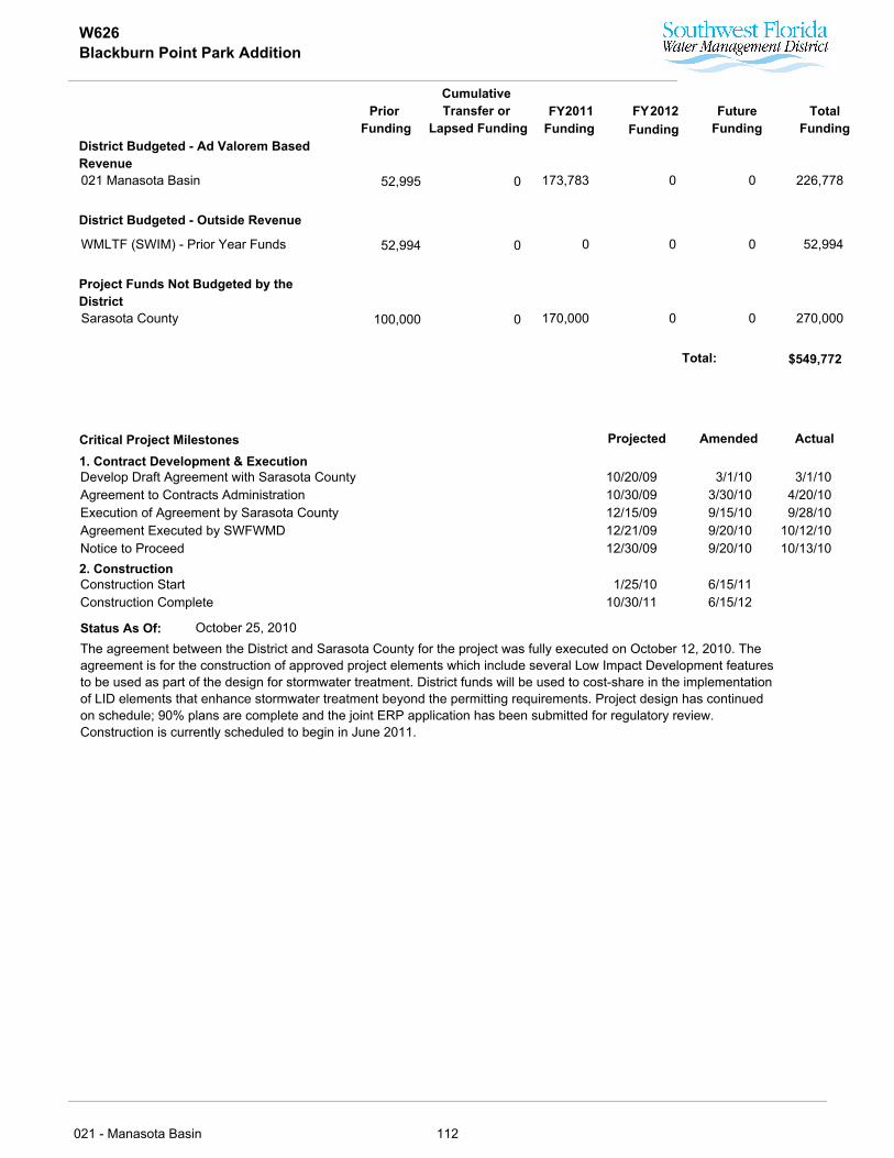
W626
Blackburn Point Park Addition
District Budgeted - Ad Valorem Based
Revenue
021 Manasota Basin 226,778 0 0 52,995 0 173,783
District Budgeted - Outside Revenue
WMLTF (SWIM) - Prior Year Funds 52,994 0 0 52,994 0 0
Project Funds Not Budgeted by the
District
Sarasota County 270,000 0 0 100,000 0 170,000
$549,772 Total:
Prior
Funding
Cumulative
Transfer or
Lapsed Funding Funding Funding
2011 FY 2012 FY Future
Funding
Total
Funding
Critical Project Milestones ActualProjected Amended
1. Contract Development & ExecutionDevelop Draft Agreement with Sarasota County 10/20/09 3/1/10 3/1/10
Agreement to Contracts Administration 10/30/09 3/30/10 4/20/10
Execution of Agreement by Sarasota County 12/15/09 9/15/10 9/28/10
Agreement Executed by SWFWMD 12/21/09 9/20/10 10/12/10
Notice to Proceed 12/30/09 9/20/10 10/13/10
2. ConstructionConstruction Start 1/25/10 6/15/11
Construction Complete 10/30/11 6/15/12
Status As Of: October 25, 2010
The agreement between the District and Sarasota County for the project was fully executed on October 12, 2010. The
agreement is for the construction of approved project elements which include several Low Impact Development features
to be used as part of the design for stormwater treatment. District funds will be used to cost-share in the implementation
of LID elements that enhance stormwater treatment beyond the permitting requirements. Project design has continued
on schedule; 90% plans are complete and the joint ERP application has been submitted for regulatory review.
Construction is currently scheduled to begin in June 2011.
021 - Manasota Basin 112
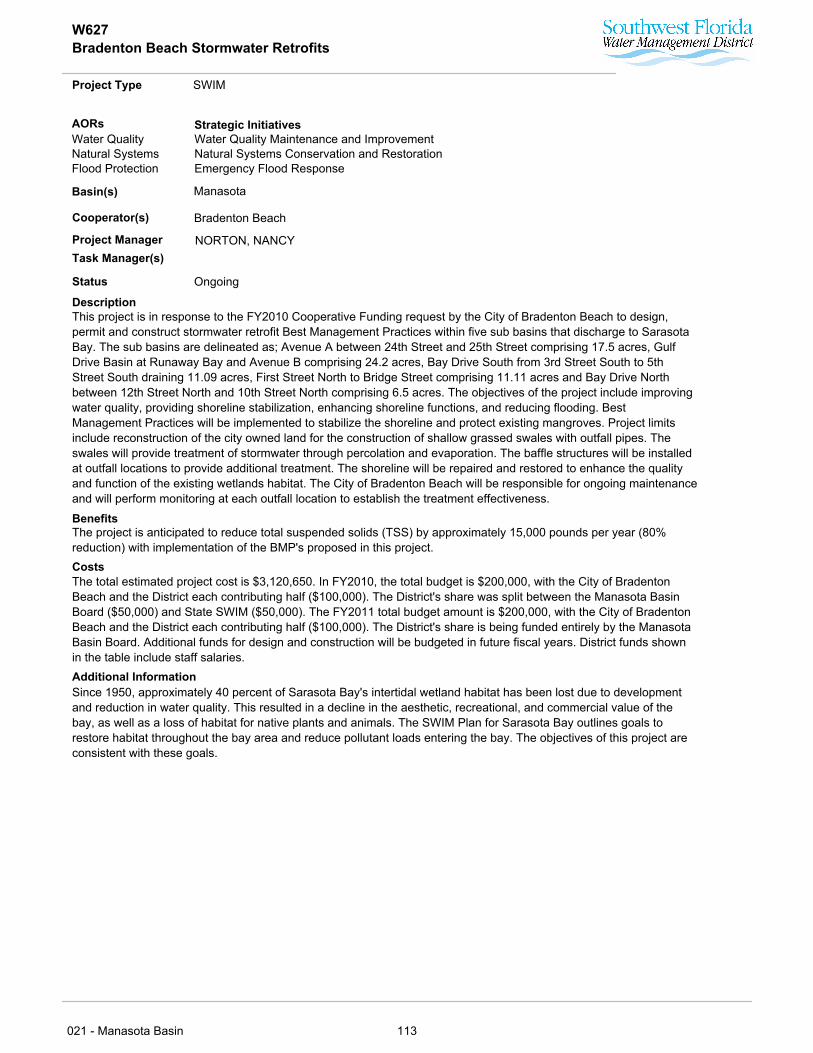
W627
Bradenton Beach Stormwater Retrofits
Project Type SWIM
AORs Strategic InitiativesWater Quality Water Quality Maintenance and ImprovementNatural Systems Natural Systems Conservation and RestorationFlood Protection Emergency Flood Response
Basin(s) Manasota
Bradenton BeachCooperator(s)
Project Manager NORTON, NANCY
Task Manager(s)
Status Ongoing
DescriptionThis project is in response to the FY2010 Cooperative Funding request by the City of Bradenton Beach to design,
permit and construct stormwater retrofit Best Management Practices within five sub basins that discharge to Sarasota
Bay. The sub basins are delineated as; Avenue A between 24th Street and 25th Street comprising 17.5 acres, Gulf
Drive Basin at Runaway Bay and Avenue B comprising 24.2 acres, Bay Drive South from 3rd Street South to 5th
Street South draining 11.09 acres, First Street North to Bridge Street comprising 11.11 acres and Bay Drive North
between 12th Street North and 10th Street North comprising 6.5 acres. The objectives of the project include improving
water quality, providing shoreline stabilization, enhancing shoreline functions, and reducing flooding. Best
Management Practices will be implemented to stabilize the shoreline and protect existing mangroves. Project limits
include reconstruction of the city owned land for the construction of shallow grassed swales with outfall pipes. The
swales will provide treatment of stormwater through percolation and evaporation. The baffle structures will be installed
at outfall locations to provide additional treatment. The shoreline will be repaired and restored to enhance the quality
and function of the existing wetlands habitat. The City of Bradenton Beach will be responsible for ongoing maintenance
and will perform monitoring at each outfall location to establish the treatment effectiveness.
BenefitsThe project is anticipated to reduce total suspended solids (TSS) by approximately 15,000 pounds per year (80%
reduction) with implementation of the BMP's proposed in this project.
Costs
The total estimated project cost is $3,120,650. In FY2010, the total budget is $200,000, with the City of Bradenton
Beach and the District each contributing half ($100,000). The District's share was split between the Manasota Basin
Board ($50,000) and State SWIM ($50,000). The FY2011 total budget amount is $200,000, with the City of Bradenton
Beach and the District each contributing half ($100,000). The District's share is being funded entirely by the Manasota
Basin Board. Additional funds for design and construction will be budgeted in future fiscal years. District funds shown
in the table include staff salaries.
Additional Information
Since 1950, approximately 40 percent of Sarasota Bay's intertidal wetland habitat has been lost due to development
and reduction in water quality. This resulted in a decline in the aesthetic, recreational, and commercial value of the
bay, as well as a loss of habitat for native plants and animals. The SWIM Plan for Sarasota Bay outlines goals to
restore habitat throughout the bay area and reduce pollutant loads entering the bay. The objectives of this project are
consistent with these goals.
021 - Manasota Basin 113

W627
Bradenton Beach Stormwater Retrofits
District Budgeted - Ad Valorem Based
Revenue
021 Manasota Basin 1,432,995 1,275,575 0 52,449 0 104,971
District Budgeted - Outside Revenue
WMLTF (SWIM) - Prior Year Funds 52,448 0 0 52,448 0 0
Project Funds Not Budgeted by the
District
City of Bradenton Beach 1,645,075 0 0 269,500 1,275,575 100,000
$3,130,518 Total:
Prior
Funding
Cumulative
Transfer or
Lapsed Funding Funding Funding
2011 FY 2012 FY Future
Funding
Total
Funding
Critical Project Milestones ActualProjected Amended
Contract Development and ExecutionDraft Agreement to Management Services 12/17/09 12/17/09
Draft Agreement Returned from Management Services 1/8/10 2/11/10
Agreement Sent to Cooperator 1/15/10 2/11/10
Signed Agreement Returned from Cooperator 2/15/10 5/19/10
Agreement Fully Executed 2/26/10 5/20/10
Notice to Proceed 3/5/10 5/21/10
ProjectEffective Date 11/30/09 11/30/09
Agreement Expiration 12/31/14
Project Phase 1Commence Construction 10/31/10
Complete Construction 4/30/11
Project Phase 2Commence Construction 10/31/11
Complete Construction 4/30/12
Project Phase 3Commence Construction 10/31/12
Complete Construction 4/30/13
Status As Of: October 22, 2010
The City scheduled a pre-application meeting with SWFWMD in January. The agreement was sent to the City of
Bradenton Beach for execution on February 11, 2010. It was presented to the City Council in April 2010 and fully
executed May 20, 2010. The Consultant completed design in August and the City held a public meeting August 23, 2010.
Project bids are due on October 25, 2010. The City anticipates awarding the construction contract on November 2, 2010
which may delay construction commencement a week beyond the scheduled date.
021 - Manasota Basin 114

B074
Manatee - WMPlan Braden River
Project Type Basin Initiatives
AORs Strategic InitiativesFlood Protection Floodplain ManagementWater Supply Alternative Water SupplyNatural Systems Minimum Flows and Level Establishment and Monitoring
Basin(s) Manasota
City of Bradenton, Sarasota County, Manatee CountyCooperator(s)
Project Manager NGUYEN, NAM
Task Manager(s)
Status Ongoing
DescriptionThis multi-year funded project is to perform the 1) Topographic Information, 2) Watershed Evaluation, and 3)
Watershed Management Plan elements of the District's Watershed Management Program (WMP) for the BRADEN
RIVER Watershed beginning at the Bill Evers Reservoir dam and progressing upstream in southwestern Manatee
County. The watershed occupies approximately 59.0 square miles within southern Manatee County and ultimately
discharges into Manatee River and Tampa Bay, a SWIM waterbody. The WMP will address watershed issues of rapid
growth, flood damage, and water supply. Residential development is occurring in the upper portions of the watershed
where Federal Emergency Management Agency (FEMA) flood level information is suspect. In addition, competition for
the surface water resource has increased as a result of residential development within the watershed. Surface water
runoff is currently used as a potable supply for the City of Bradenton via the Bill Evers Reservoir. In the future, surface
water use will be expanded through the use of stormwater as a non-potable source for irrigation of new residential
developments.
BenefitsThe WMP provides a method to evaluate the capacity of a watershed to protect, enhance, and restore water quality
and natural systems, while achieving flood protection. The information developed provides the science for the District's
Resource Management and Environmental Resource Permitting (ERP). It assists local governments: 1) With their land
management responsibilities by establishing a level of service and developing Best Management Practices (BMPs) to
address level of service deficiencies and 2) Provides a Geodatabase and projected results from watershed model
simulations for floodplain management and water quality management .
Costs
The current budget amount for this project is $1.279 million, of which the District's share is $654,000 funded by the
Manasota Basin. Manatee County is contributing $379,700, Sarasota County is contributing $89,200, and the City of
Bradenton is contributing $156,100. FY2009 funding includes $200,000 with the Manasota Basin funding $114,500
and revenue of $69,800 from Manatee County and $15,700 from Sarasota County. Previously approved FY2005
funding included $110,000 with the Manasota Basin funded $55,000 and revenue of $31,600 from Manatee County,
$7,500 from Sarasota County, and $15,900 from the City of Bradenton. Previously approved FY2004 funding included
$280,500 with revenue of $157,300 from Manatee County, $33,000 from Sarasota County, and $90,200 from the City
of Bradenton. Previously approved FY2003 funding included $484,500 with the Manasota Basin funded $280,500 and
revenue of $121,000 from Manatee County, $33,000 from Sarasota County, and $50,000 from the City of Bradenton.
Previously approved FY2002 funding included $204,000 with the Manasota Basin funded $204,000. When each
element is completed the project budget may require refinement based on the information gathered. The District
funding amounts shown in the table include staff salaries.
Additional Information
A WMP includes five major elements: 1) Topographic Information, 2) Watershed Evaluation, 3) Watershed
Management Plan, 4) Implementation of Best Management Practices, and 5) Maintenance of Watershed Parameters
and Models. Implementing elements of the WMP with local governments is one of the Comprehensive Watershed
Management (CWM) initiative strategies and one of the District's Strategic Priorities. A cooperative funding revenue
agreement with Manatee County, Sarasota County, and the City of Bradenton has been executed as a multi-year
funded project. District staff is managing the project and has entered into a consultant services agreement to
accomplish project tasks. As part of the project, a surface water capacity assessment will be performed concurrently
with the Watershed Management Plan to evaluate surface water management policies and their effect on existing
users, water quantity, and water quality. Future cooperative funding requests and agreements will be required for
establishment of LOS, the analysis of BMP alternatives, the Implementation of BMPs, and Maintenance of Watershed
Parameters and Models.
021 - Manasota Basin 115

B074
Manatee - WMPlan Braden River
District Budgeted - Ad Valorem Based
Revenue
021 Manasota Basin 849,663 0 0 840,975 0 8,688
District Budgeted - Outside Revenue
Bradenton - WMPlan Braden River
(B074)
156,100 0 0 156,100 0 0
Manatee - WMPlan Braden River
(B074)
379,683 0 0 379,683 0 0
Sarasota - WMPlan Braden River
(B074)
89,217 0 0 89,217 0 0
$1,474,663 Total:
Prior
Funding
Cumulative
Transfer or
Lapsed Funding Funding Funding
2011 FY 2012 FY Future
Funding
Total
Funding
Critical Project Milestones ActualProjected Amended
1. Critical Project MilestonesRecognition of District, Basin Board, City & County on reports 12/17/02
2. Cooperative AgreementCoop Agreement Executed by Manatee County 5/30/02 12/17/02
Coop Executed by Sarasota County 5/30/02 3/11/03
Coop Executed by City of Bradenton 5/30/02 3/17/03
Coop Executed by the District 7/30/02 4/23/03
Execute Amendment #1 to Cooperative Agmt 1/30/05 1/27/05
Execute Expired Coop. Agreement 2003REV0020-A 1/31/07 3/7/07
Execute Expired Coop. Agreement 2003REV0020-B 1/31/08 7/9/08
Execute new Coop. Agrmt. (2003REV0020-C) 2/26/10 3/15/10
Cooperative Agmt Close-out 9/30/11
2. Cooperative AgreementExecute new Coop. Agrmt. (2003REV0020-D) 9/30/10
3. Consultant Services AgreementExecute new Consultant Agrmt. (03CONC00015-B) 6/15/09 6/15/09
3. Consultant Services AgreementExecuted Consultant Agmt 7/20/03 7/21/03
Notice to Proceed 7/20/03 7/21/03
Commence Element 1, Digital Topographic Information 7/21/03 7/21/03
Commence Element 2, Watershed Evaluation 7/21/03 7/21/03
Complete Element 1, Digital Topographic Information 5/11/04 7/1/05
Execute Amendment #1 to Consultant Agmt 12/29/04 12/29/04
Complete Element 2, Watershed Evaluation 1/21/05 7/21/06
Commence Element 3, Watershed Management Plan 1/21/05 12/15/04
Execute Expired Consultant Agmt (03CONC00015-A) 9/21/06 8/29/06
Execute Amendment #1 to Expired Consultant Agmt (03CONC00015-A) 1/31/08 1/28/08
Complete Element 3, Watershed Management Plan 5/31/11
Consultant Agmt Close-out 5/31/11
Status As Of: October 26, 2010
A Request for Proposals was advertised on October 4, 2002 to perform the Braden River Watershed Management
Program from which 8 responses were received. Singhofen and Associates (SAI) was chosen as the top consultant and
board recommendation to negotiate and enter into a contract with SAI. The Cooperative Funding Agreement between the
021 - Manasota Basin 116
B074
Manatee - WMPlan Braden River
District, the City of Bradenton, and Manatee and Sarasota Counties was executed on April 23, 2003. The First
Amendment to the Revenue Agreement to include additional FY2005 funds was executed on January 27, 2005.
Likewise, the amendment to the Consultant Services Agreement with Singhofen and Associates (SAI) was executed and
was effective as of December 1, 2004. The consultant services agreement has been amended to extend the contract
termination date and revise the project schedule. The cooperative agreement has, likewise, been amended to extend the
contract termination date to December 31, 2007. SAI's Work Order #2 was executed on February 11, 2004. Work Order
#2 tasks include a detailed watershed reconnaissance, the development of a Digital Terrain Model that represents the
current watershed conditions, and a subbasin and watershed connectivity inventory in GIS database format. SAI has
completed all the deliverables for Work Order #2, which includes recent color orthophotographs, digital topographic
information, GIS geodatabase of field reconnaissance/secondary survey data to date (40% effort), and supporting
documentation for the selection of storm events for model calibration and verification. Work Order #3 with SAI, to
complete the Watershed Evaluation element and begin development of the Watershed Management Plan, has been
executed. Notice to Proceed on Work Order #3 was effective as of December 15, 2004. Work Order #4 for the Phase 1
survey effort was executed on March 28, 2006. All task and deliverables under Work Order #4 are completed. SAI has
completed the draft final Watershed Evaluation report under Work Order #3 and additional staff comments are being
addressed. Work Order #5 for the surface water resource assessment has been executed and is currently in progress.
The consultant team has prepared a spreadsheet water budget to quantify the amount of water entering the Bill Evers
Reservoir and will serve as an input to the water quality model that is currently being calibrated. This model and
associated write-up have been transmitted to the District and local cooperators for review and comments. The draft
report on the water quality modeling effort is still being completed by the sub-consultant. The consultant is currently
developing a refined schedule and budget to complete remaining tasks. Both schedule and budget are contingent upon
collecting field measurements for remaining cross sections and hydraulic features. Two additional work orders will be
developed to complete the project--first for the remaining survey/field measurements and the second to complete the
Watershed Management Plan. SAI has selected a survey firm and is currently developing the detail scope of work,
including how the information will be delivered. Both the consultant services agreement and the cooperative agreement
for this project will need to be amended because it does not appear that the project will be completed by the end of
December 2007. The surface water resource assessment final reports (quantity & quality) are being reviewed by District
staff and cooperators. Work Order #6 is currently being developed to complete the remaining survey/field measurements
(Phase 2). The cooperative agreement and consultant services agreement have been finalized for execution, to extend
from December 31, 2007 to December 31, 2008. The surface water resource assessment (SWRA) final reports review
comments from District staff and cooperators are being addressed by the consultants. The cooperative agreement is
being routed to the cooperators for execution to extend from December 31, 2007 to January 31, 2009. The consultant
services agreement has been executed by the District on January 28, 2008. The consultant has developed a refined
schedule and budget to complete remaining tasks. Two additional work orders will be developed to complete the project-
-first for the public notification, limited public meetings with large property owners or consultant firms, and watershed
parameterization and the second to finish out the Watershed Management Plan. An additional funding of $220,000 has
been requested for FY2009 to complete the project. This cost is associated with the increased survey costs, significantly
more structures in watershed than anticipated and costs to cover public involvement not in original scope. District staff is
currently developing a letter asking the cooperators for their participation in contributing to the requested additional
funding. The consultants are near completion with the SWRA final reports, addressing comments from the District and
the cooperators. Work Order #6 - Phase 2 of the survey/field measurements has been executed and the consultant has
been given notice to proceed, May 28, 2008. The requested additional funding for FY2009 to complete the project has
been refined from $220,000 to $200,000. This additional amount will be shared among Manatee County, Sarasota
County and the District. City of Bradenton is unable to contribute and their portion of contribution will be splitted among
the remaining 3 sources. The cooperative agreement to extend the expiration date to January 31, 2009 has been
executed on July 9, 2008. The SWRA water quality report has been finalized. The water quantity portion is being updated
by the consultant. The consultant is near completion with WO#6, Phase 2 of the survey. Work Order #7, deliverable 1
was submitted to the District on July 14, 2008. The District provided comments to the consultant on December 9, 2008.
The consultant is currently evaluating the inclusion of the hydraulic features for some of the 192 small ponds, where
construction drawings do exist. The consultant will provide to the District a GIS layer summarizing the findings. A new
cooperative agreement, extending the termination date to September 30, 2010, has been sent to the cooperators for
signatures. Likewise, a new consultant agreement, extending the termination date to June 30, 2010, has been sent to
SAI for signature. The SWRA final reports - Quantity & Quality have been sent to the cooperators. The final deliverable
for survey phase 2, WO#6 has been submitted to the District on May 14, 2009. The new cooperative agreement is still
being routed for signatures. It's currently with Sarasota County. The new consultant agreement with SAI has been
executed on 6/15/09. The last deliverable for WO#7 has been submitted to the District and the District has completed the
review. SAI is addressing the District's comments at the moment and a GoTo meeting will be set up to discuss the
results. SAI and the District will begin coordination for WO#8 to finish the remaining tasks of the project. The new
cooperative agreement is being routed to the City of Bradenton for signature. SAI has submitted WO#8, Deliverable #1
021 - Manasota Basin 117
B074
Manatee - WMPlan Braden River
on 12/23/09. District staff is reviewing the deliverable. Review comments from the 12/23/09 submittal were sent off to
SAI. SAI has made some revisions to the model parameters. District will be having a GoTo meeting with SAI on 6/24/10
to address the other comments. The new cooperative agreement is being routed to all parties for execution. The
agreement will extend the expiration date to September 30, 2011. SAI estimated WO#8, deliverable 2 to be submitted
September 21, 2010. Current Status: SAI submitted WO#8, deliverable 2 on 10/14/10. District's Engineering and
Sarasota Regulation staff are currently reviewing the deliverable.
021 - Manasota Basin 118
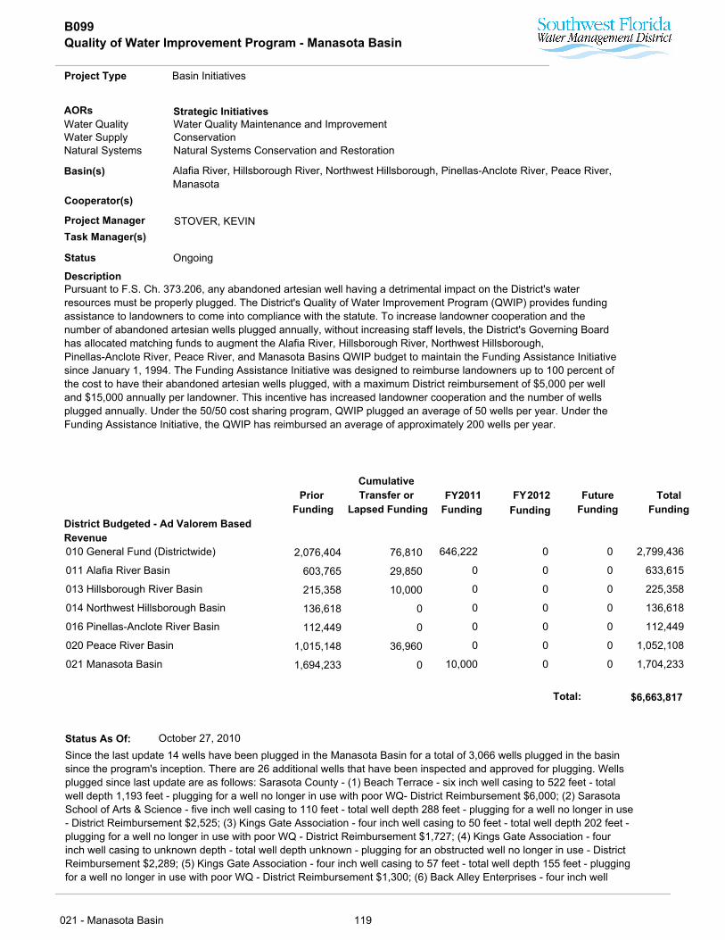
B099
Quality of Water Improvement Program - Manasota Basin
Project Type Basin Initiatives
AORs Strategic InitiativesWater Quality Water Quality Maintenance and ImprovementWater Supply ConservationNatural Systems Natural Systems Conservation and Restoration
Basin(s) Alafia River, Hillsborough River, Northwest Hillsborough, Pinellas-Anclote River, Peace River,
Manasota
Cooperator(s)
Project Manager STOVER, KEVIN
Task Manager(s)
Status Ongoing
DescriptionPursuant to F.S. Ch. 373.206, any abandoned artesian well having a detrimental impact on the District's water
resources must be properly plugged. The District's Quality of Water Improvement Program (QWIP) provides funding
assistance to landowners to come into compliance with the statute. To increase landowner cooperation and the
number of abandoned artesian wells plugged annually, without increasing staff levels, the District's Governing Board
has allocated matching funds to augment the Alafia River, Hillsborough River, Northwest Hillsborough,
Pinellas-Anclote River, Peace River, and Manasota Basins QWIP budget to maintain the Funding Assistance Initiative
since January 1, 1994. The Funding Assistance Initiative was designed to reimburse landowners up to 100 percent of
the cost to have their abandoned artesian wells plugged, with a maximum District reimbursement of $5,000 per well
and $15,000 annually per landowner. This incentive has increased landowner cooperation and the number of wells
plugged annually. Under the 50/50 cost sharing program, QWIP plugged an average of 50 wells per year. Under the
Funding Assistance Initiative, the QWIP has reimbursed an average of approximately 200 wells per year.
District Budgeted - Ad Valorem Based
Revenue
010 General Fund (Districtwide) 2,799,436 0 76,810 2,076,404 0 646,222
011 Alafia River Basin 633,615 0 29,850 603,765 0 0
013 Hillsborough River Basin 225,358 0 10,000 215,358 0 0
014 Northwest Hillsborough Basin 136,618 0 0 136,618 0 0
016 Pinellas-Anclote River Basin 112,449 0 0 112,449 0 0
020 Peace River Basin 1,052,108 0 36,960 1,015,148 0 0
021 Manasota Basin 1,704,233 0 0 1,694,233 0 10,000
$6,663,817 Total:
Prior
Funding
Cumulative
Transfer or
Lapsed Funding Funding Funding
2011 FY 2012 FY Future
Funding
Total
Funding
Status As Of: October 27, 2010
Since the last update 14 wells have been plugged in the Manasota Basin for a total of 3,066 wells plugged in the basin
since the program's inception. There are 26 additional wells that have been inspected and approved for plugging. Wells
plugged since last update are as follows: Sarasota County - (1) Beach Terrace - six inch well casing to 522 feet - total
well depth 1,193 feet - plugging for a well no longer in use with poor WQ- District Reimbursement $6,000; (2) Sarasota
School of Arts & Science - five inch well casing to 110 feet - total well depth 288 feet - plugging for a well no longer in use
- District Reimbursement $2,525; (3) Kings Gate Association - four inch well casing to 50 feet - total well depth 202 feet -
plugging for a well no longer in use with poor WQ - District Reimbursement $1,727; (4) Kings Gate Association - four
inch well casing to unknown depth - total well depth unknown - plugging for an obstructed well no longer in use - District
Reimbursement $2,289; (5) Kings Gate Association - four inch well casing to 57 feet - total well depth 155 feet - plugging
for a well no longer in use with poor WQ - District Reimbursement $1,300; (6) Back Alley Enterprises - four inch well
021 - Manasota Basin 119

B099
Quality of Water Improvement Program - Manasota Basin
casing to 115 feet - total well depth 196 feet - plugging for a well no longer in use - District Reimbursement $1,419: (7)
Nam Chu Pun - four inch well casing to 42 feet - total well depth 80 feet - plugging for a well no longer in use - District
Reimbursement $783; (8) Peter Bumpus - four inch well casing to 77 feet - total well depth 632 feet - plugging for an
obstructed well no longer in use - District Reimbursement $5,392; (9) Tervis Tumbler - four inch well casing to 57 feet -
total well depth 118 feet - plugging for a well no longer in use - District Reimbursement $993; (10) JSCP, LLC - four inch
well casing to 64 feet - total well depth unknown feet - plugging for an obstructed well no longer in use - District
Reimbursement $696; (11) Jack Benson - four inch well casing to 63 feet - total well depth 120 feet - plugging for a well
no longer in use - District Reimbursement $1,003; (12) Ronald Allison - four inch well casing to 39 feet with a total well
depth of 51 feet - plugging for a well no longer in use - District reimbursement $624: Manatee County (1) Phillip
Schamberger - four inch well casing to 130 feet with a total depth 173 ft - plugging for a well no longer in use - District
Reimbursement $1,411; (2) Evelio Bosque - four inch well casing to unknown depth - total well depth 183 feet - plugging
for an obstructed well no longer in use with poor WQ - District Reimbursement $1,439;
021 - Manasota Basin 120
B131
Hotel/Motel/Restaurant Water Conservation Program (Water
CHAMP/PRO)Project Type Basin Initiatives
AORs Strategic InitiativesWater Quality Water Quality Maintenance and ImprovementWater Supply Conservation
Basin(s) General Fund (District), Alafia River, Hillsborough River, Coastal Rivers, Pinellas-Anclote River,
Withlacoochee River, Peace River, Manasota
Cooperator(s)
Project Manager ALTMAN, MELISSA
ALTMAN, MELISSATask Manager(s)
Status Ongoing
DescriptionThis Basin Initiative (BI) project provides education to hotel/motel management and guests with the goal of reducing
water use. The District provides printed materials to all participating properties to assist owners/managers in
determining ways to save water through their properties' operational processes, including, but not limited to, a towel
and linen reuse program. To build on the success of Water CHAMP, the District created the Water Program for
Restaurant Outreach (Water PRO) to promote water conservation in restaurants. The CHAMP coordinator will
promote the program through the Florida Restaurant and Lodging Association, partnerships with utility companies,
direct mail and site visits to association members and independent restaurants. Materials include a button for wait staff
to wear declaring that the restaurant serves water only upon request, information tabletop displays, children's coloring
sheets, coasters and bathroom mirror cling stickers promoting water conservation to be placed on bathroom
mirrors. Both Water CHAMP and PRO are measured for effectiveness by number of participating properties. In
addition, Water CHAMP has proven its success by conducting two water audits on participating properties in 2003 and
2008.
BenefitsWater CHAMP provides the tools and education needed to help hotel/motel staff and guests learn to conserve water.
This program measures the effectiveness of this education effort via actual water savings. A five-year program water
audit was conducted in cooperation with 16 utility companies to determine the program's level of water savings. The
audit compared water consumption of 115 Water CHAMP participants before the program's implementation in 2002 to
the amount used in 2007. The Districtwide audit showed that participants saved an average of 17 gallons of water per
occupied room per day. Based on the audit results and occupancy rates, it is projected that more than 186 million
gallons of water was saved by participating properties in 2010. In addition to water savings, this program has
successfully prompted a change in water-use behavior as well as increased knowledge and awareness of the need for
water conservation to protect the water resources.
Costs
The total cost for the FY2011 program is $90,436 (District $7,436; Alafia River $5,370; Hillsborough River $18,593;
Coastal Rivers $6,994; Pinellas-Anclote River $19,906; Withlacoochee River $6,048; Peace River $13,858; Manasota
$12,231). District funds are used for CHAMP/PRO properties in the Green Swamp Basin. Funds will be used to
pay for salary and associated costs, travel, printed materials and costs to educate the audience and promote the
programs through advertising, workshops, tradeshows, professional memberships, etc. The dollar amount allocated
per basin is based on anticipated work within that basin. Based on the average number of guests exposed to the
program, the estimated per person cost for the program is less than $.01. As the program grows, the cost per person
decreases. The cost benefit for the project, using the total cost amortized over five years, is $0.47 per thousand
gallons of water.
Additional Information
The total cost of the FY2010 program was $83,692 (District - $7,768; Alafia River - $3,941; Hillsborough River -
$13,274; Coastal Rivers - $6,866; Pinellas-Anclote - $16,613; Withlacoochee River - $6,107; Peace River - $15,113;
Manasota - $14,010.) The District has supported this project since FY2002. Survey results show a 96 percent
approval rating from hotel/motel guests.
021 - Manasota Basin 121
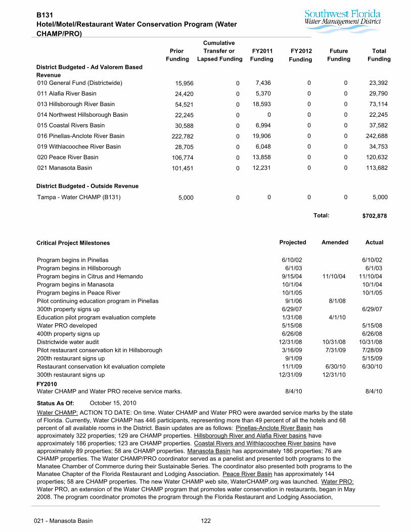
B131
Hotel/Motel/Restaurant Water Conservation Program (Water
CHAMP/PRO)
District Budgeted - Ad Valorem Based
Revenue
010 General Fund (Districtwide) 23,392 0 0 15,956 0 7,436
011 Alafia River Basin 29,790 0 0 24,420 0 5,370
013 Hillsborough River Basin 73,114 0 0 54,521 0 18,593
014 Northwest Hillsborough Basin 22,245 0 0 22,245 0 0
015 Coastal Rivers Basin 37,582 0 0 30,588 0 6,994
016 Pinellas-Anclote River Basin 242,688 0 0 222,782 0 19,906
019 Withlacoochee River Basin 34,753 0 0 28,705 0 6,048
020 Peace River Basin 120,632 0 0 106,774 0 13,858
021 Manasota Basin 113,682 0 0 101,451 0 12,231
District Budgeted - Outside Revenue
Tampa - Water CHAMP (B131) 5,000 0 0 5,000 0 0
$702,878 Total:
Prior
Funding
Cumulative
Transfer or
Lapsed Funding Funding Funding
2011 FY 2012 FY Future
Funding
Total
Funding
Critical Project Milestones ActualProjected Amended
Program begins in Pinellas 6/10/02 6/10/02
Program begins in Hillsborough 6/1/03 6/1/03
Program begins in Citrus and Hernando 9/15/04 11/10/04 11/10/04
Program begins in Manasota 10/1/04 10/1/04
Program begins in Peace River 10/1/05 10/1/05
Pilot continuing education program in Pinellas 9/1/06 8/1/08
300th property signs up 6/29/07 6/29/07
Education pilot program evaluation complete 1/31/08 4/1/10
Water PRO developed 5/15/08 5/15/08
400th property signs up 6/26/08 6/26/08
Districtwide water audit 12/31/08 10/31/08 10/31/08
Pilot restaurant conservation kit in Hillsborough 3/16/09 7/31/09 7/28/09
200th restaurant signs up 9/1/09 5/15/09
Restaurant conservation kit evaluation complete 11/1/09 6/30/10 6/30/10
300th restaurant signs up 12/31/09 12/31/10
FY2010Water CHAMP and Water PRO receive service marks. 8/4/10 8/4/10
Status As Of: October 15, 2010
Water CHAMP: ACTION TO DATE: On time. Water CHAMP and Water PRO were awarded service marks by the state
of Florida. Currently, Water CHAMP has 446 participants, representing more than 49 percent of all the hotels and 68
percent of all available rooms in the District. Basin updates are as follows: Pinellas-Anclote River Basin has
approximately 322 properties; 129 are CHAMP properties. Hillsborough River and Alafia River basins have
approximately 186 properties; 123 are CHAMP properties. Coastal Rivers and Withlacoochee River basins have
approximately 89 properties; 58 are CHAMP properties. Manasota Basin has approximately 186 properties; 76 are
CHAMP properties. The Water CHAMP/PRO coordinator served as a panelist and presented both programs to the
Manatee Chamber of Commerce during their Sustainable Series. The coordinator also presented both programs to the
Manatee Chapter of the Florida Restaurant and Lodging Association. Peace River Basin has approximately 144
properties; 58 are CHAMP properties. The new Water CHAMP web site, WaterCHAMP.org was launched. Water PRO:
Water PRO, an extension of the Water CHAMP program that promotes water conservation in restaurants, began in May
2008. The program coordinator promotes the program through the Florida Restaurant and Lodging Association,
021 - Manasota Basin 122
B131
Hotel/Motel/Restaurant Water Conservation Program (Water
CHAMP/PRO)partnerships with utility companies, direct mail and site visits to individual restaurants. Currently, there are 279
restaurants participating in Water PRO. A packet with new materials was mailed to all Water PRO participants. The
packet included a Water PRO door cling, a guide book to best management practices that save water, and a bilingual
poster.
021 - Manasota Basin 123

B136
Florida Automated Weather Network (FAWN) Data Dissemination
and EducationProject Type Basin Initiatives
AORs Strategic InitiativesWater Quality Water Quality Maintenance and ImprovementWater Supply Conservation
Basin(s) General Fund (District), Alafia River, Hillsborough River, Northwest Hillsborough, Coastal Rivers,
Pinellas-Anclote River, Withlacoochee River, Peace River, Manasota
University of FloridaCooperator(s)
Project Manager COHEN, RON
Task Manager(s)
Status Ongoing
DescriptionThe FAWN project started in 1997 and the District's involvement with the project started in 2003. This project collects
and distributes weather and climatic data, and has an educational component to teach the public how to use the data
to conserve water. Funding for the project was distributed over several years and is needed to continue data collection
and dissemination. In FY2009 FAWN is planning additional weather schools, fact sheets and enhanced irrigation
management tools. These elements will help conserve water and reduce fertilizer leaching.
BenefitsIncrease the growers' knowledge and provide climatic data to help them reduce water use. The amount of water saved
will be a function of the number of acres planted and their water use, which will change annually based on market and
climatic conditions. Estimated savings are in excess of one billion gallons of water and $500,000 per hour. Therefore
during a cold winter where growers could use cold protection five (5) to ten (10) nights, annual savings could be as
much as ten billion gallons of water and $5 million to producers. Few winters require no cold protection, and it would be
reasonable to assume this management tool would average saving five billion gallons of water and $2.5 million
annually. The key to realizing these water use savings is educating the public through schools, written material, trade
shows, etc. In addition to collecting the data, FAWN information is used for workshops and other public events to help
teach the public the significance of weather and climatic data for water conservation and how to use the data. An
in-depth weather school is held annually. FAWN has developed a youth training curriculum. In FY2008-2009 FAWN
will enhance its urban program, develop more educational components and add new weather tools.
Costs
The FY2008 budget includes $100,000 for the FAWN project. Half this funding ($50,000) will come from general
revenue and the remaining amount will be divided evenly between the eight Basin Boards with each budgeting $6,250.
Additional Information
The Florida Automated Weather Network (FAWN) has been a successful, on-going, multi Agency (IFAS, FDAC,
SFWMD, SJRWMD, and Industry) project with about a $500,000 annual budget. They are asking for continued
funding in FY2008. The other cooperators have not yet determined their level of continued support for FAWN.
FAWN's weather data has been used by local Emergency Management personal to supplement the District's and
other sources' climatic data. The project was first funded by the Peace River Basin Board and later expanded to the
Manasota Basin Board. This proposal is to expand the project into the Hillsborough River, Alafia and Withlacoochee
Basin Boards. FAWN has recently received new commitments for additional funds from FDACS, SFWMD and
SJRWMD. FAWN was created in 1997 with a legislative appropriation to the University of Florida, Institute of Food
and Agricultural Sciences (UF/IFAS). These funds were used to create infrastructure and to establish 11 weather sites
that were incorporated with a small UF/IFAS network of five sites in Central Florida. Over the next few years there is a
plan to expand FAWN's network to 33 sites. In 2002 additional funding was obtained from the Florida Division of
Emergency Management to complete the system and in 2003 the Peace River Basin Board recognized the
significance of FAWN and provided a $5,000 grant. A year later the Peace River and the Manasota Basin Boards
entered into a three-year agreement to provide FAWN with $15,000 per year. These funds were to help continue
FAWN's data collection efforts and to expand the program's educational components. That same year FDACS,
SJRWMD and SFWMD approved funds for FAWN. Currently there are 10 FAWN sites within the District located at:
Arcadia, Balm, Bradenton, Bronson, Brooksville, Dover, Frostproof, Lake Alfred, Ona and Sebring. In addition there
are several sites surrounding the District that provide useful information to the citizens of the District. Current and
historical climatic data from these sites, and FAWN irrigation tools, can be accessed on the web at:
http://fawn.ifas.ufl.edu/. The FAWN program was developed to provide real time weather information to help Florida
citizens make informed weather related decisions. This information is used to help conserve water and protect
Florida's natural systems. Irrigators use FAWN data to help determine when and how much to water. Also, FAWN
data is used to assist individuals to determine when to turn off irrigation systems used for cold protection. Urban and
agricultural chemical applicators use FAWN to help make decisions relative to the application of chemicals and
021 - Manasota Basin 124

B136
Florida Automated Weather Network (FAWN) Data Dissemination
and Educationfertilizer. FAWN has been expanded to provide on-line water/irrigation management tools that require weather inputs.
Examples of these tools include insect and disease control, cold protection, irrigation, nutrient management and many
more. The District's Agricultural Advisory Committee has expressed their support for the FAWN program. In addition
to the current tools, FAWN is working with University of Florida scientists to develop others. Some of the studies
already funded by the District will be used to enhance the FAWN program. For example, the Wet Bulb Irrigation Cut
Off management tool has been able to allow strawberry, citrus, fern, vegetable, ornamental growers and home owners
determine when it is safe to shut off irrigation systems used for cold protection.
District Budgeted - Ad Valorem Based
Revenue
010 General Fund (Districtwide) 387,500 0 0 287,500 0 100,000
011 Alafia River Basin 23,437 0 0 23,437 0 0
013 Hillsborough River Basin 23,438 0 0 23,438 0 0
014 Northwest Hillsborough Basin 23,437 0 0 23,437 0 0
015 Coastal Rivers Basin 23,438 0 0 23,438 0 0
016 Pinellas-Anclote River Basin 23,437 0 0 23,437 0 0
019 Withlacoochee River Basin 23,438 0 0 23,438 0 0
020 Peace River Basin 38,437 0 0 38,437 0 0
021 Manasota Basin 38,438 0 0 38,438 0 0
$605,000 Total:
Prior
Funding
Cumulative
Transfer or
Lapsed Funding Funding Funding
2011 FY 2012 FY Future
Funding
Total
Funding
Critical Project Milestones ActualProjected Amended
FY2007 Governing Board Notification 1/2/07 1/1/07
Basin Board Notification 1/3/07 1/3/07
FY2006 Project Ends 3/1/07 3/1/07
FY2007 Data Collection 12/1/07 12/1/07
FY2007 Completion Report 2/27/08 3/1/08
FY2007 Project Ends 2/28/08 7/31/08 7/31/08
FY2008 Contract to Cooperator 3/1/08 2/26/08
FY2007 No Cost Time Extension 3/31/08 3/31/08
FY2009 Contract to Cooperator 10/1/08 10/1/08
FY2008 Data Collection 12/31/08 12/31/08
FY2008 Project Ends 2/28/09 8/31/09
FY2009 Data Collection Ends 12/31/09 9/30/10
FY2009 Completion Report 2/1/10 8/31/10
Status As Of: October 13, 2010
Waiting for completion reports.
021 - Manasota Basin 125
B183
(Complete) Sarasota County Model Review
Project Type Basin Initiatives
AORs Strategic InitiativesFlood Protection Floodplain Management
Basin(s) Manasota
Cooperator(s)
Project Manager MCCLUNG, GORDON
Task Manager(s)
Status Completed
DescriptionThis FY2004 Basin Initiative project is to determine the validity of 17 of Sarasota County's watershed models for
possible incorporation into the District's ERP review process in evaluating off-site adverse impacts from proposed
developments. The model reviews are being conducted through the District's Watershed Management Program
(WMP) to determine whether the 17 watershed models have sufficient resolution and accuracy to be used by the
District as best available information in its Environmental Resource Permit (ERP) review process. The models must
have sufficient resolution and accuracy to project differences in flows and water surface elevations under pre- and
post- development conditions. No detailed review is to be performed to determine errors and omissions regarding data
development. The following watershed models are being reviewed: Little Sarasota (including Matheny Creek, Elligraw
Bayou, Clower Creek, Holiday Bayou, Catfish Creek, North Creek, and South Creek), Sarasota ( including Hudson
Bayou and Whitaker Bayou), Dona/Roberts (including Curry Creek, Shakett Creek, Fox Creek, Cow Pen Slough, and
Hatchett Creek), and Lemon (including Woodmere Creek, Forked Creek, Alligator Creek, Gottfried Creek, and Ainger
Creek). If a model receives a satisfactory review, it will be recommended for acceptance by the District. If a
satisfactory review is not obtained, then the model will be recommended for updating to correct the deficiencies
identified in the review report. Funding in FY2004 completes the project.
BenefitsThe model reviews provide information on accuracy and level of detail of the Sarasota County watershed plans and
suitability of the information for ERP permitting. The project also provides information in support of an associated
project to update the Sarasota County Watershed Management Plans (see project L019).
Costs
The total budgeted amount for this project is $500,000, provided in FY2004. The District is funding the entire amount
through the Manasota Basin Board. Similar funding was provided by the Manasota Basin Board in FY2003 for the
Phillippi Creek Watershed Model Review (B127). The District funding amounts shown in the table include staff
salaries.
Additional Information
Sarasota County has developed the watershed models to evaluate the effectiveness of their stormwater management
infrastructure, and develop capital improvements that prevent off-site adverse impact, and to review proposed
development projects that are 35 acres or greater in size, with respect to off-site flood impacts. The County
incorporates the revised parameters (i.e., conveyance, storage changes, and runoff alterations) into the watershed
models to verify that no off-site adverse impacts will occur, and maintains the watershed parameters to update the
models. In addition to the County's review, the District independently, through the Environmental Resource Permit
(ERP) process, reviews proposed land use alterations and stormwater alterations using different criteria to
demonstrate that there are no changes in the pre- and post-peak runoff rates, and that crucial 100-year floodplain
storage is not diminished. This project is a Basin Initiative managed by District staff.
District Budgeted - Ad Valorem Based
Revenue
021 Manasota Basin 507,246 0 0 507,246 0 0
$507,246 Total:
Prior
Funding
Cumulative
Transfer or
Lapsed Funding Funding Funding
2011 FY 2012 FY Future
Funding
Total
Funding
021 - Manasota Basin 126

B183
(Complete) Sarasota County Model Review
Critical Project Milestones ActualProjected Amended
1. Critical Project MilestonesRecognition of District and Basin Board on reports 8/12/03
Manasota Basin Board Approval of Assignments 8/12/03 8/12/03
Assign Watershed Models to "Short Listed" Firms 8/20/03 8/20/03
Governing Board Approval of Assignments 8/26/03 8/26/03
Begin Consultant Contracts and Fee Negotiations 9/10/03 9/10/03
Execute Consultant Contracts 3/5/04 3/8/04
Draft Report Submittal (for all watersheds) 11/23/04 9/30/05
Final Submittal of Deliverables (for all watersheds) 3/31/05 6/29/07
Complete Project 1/3/06 6/29/07 6/29/07
Status As Of: January 07, 2008
All final reports have been received.
021 - Manasota Basin 127
B229
Field Evaluation of Bahiadwarf, For Water Use Efficiency, Turf
Quality, Mowing Requirement and PersiProject Type Basin Initiatives
AORs Strategic InitiativesWater Quality Water Quality Maintenance and ImprovementWater Supply Conservation
Basin(s) Hillsborough River, Peace River, Manasota
University of FloridaCooperator(s)
Project Manager COHEN, RON
Task Manager(s)
Status Ongoing
DescriptionLawn and landscape is one of the largest permitted and actual uses of water in the District. Most of this water is used
for turf grass irrigation. It is estimated that about 50% of per capita use is for exterior irrigation. As growth in the District
continues the demand for lawn irrigation will too. In addition, sod production and the associated water use will also
increase. This multi agency year research project will investigate a potentially viable drought tolerant alternative to
current popular grass varieties.
BenefitsResults from this project can be used to reduce and conserve urban turf irrigation, agricultural pasture and sod
production water use. Reduced irrigation will reduce the runoff potential and water quality impacts. The District will use
results from this project in its conservation, planning and regulation programs.
Costs
This multi-agency, 3-year project will cost $317,500. Part of the project cost ($160,000 - $53,333 annually) will come
from a Consortium for Plant Biotechnology Research (CPBR - http://www.cpbr.org) grant. The remaining funds will be
divided evenly between the Hillsborough River, Manasota and Peace River Basin Boards. Each Basin Board will
budget $13,125 in FY2006, FY2007, FY2008 and FY2009.
Additional Information
Part of the project's funding will come from the Consortium for Plant Biotechnology Research (CPBR -
http://www.cpbr.org). Overall project costs have been reduced because of the ability to leverage previous CPBR and
USDA grants that funded the initial research. Bahiagrass (Paspalum notatum Flugge) is a low input, drought tolerant
and disease resistant warm season turfgrass used for residential lawns, pastures and along highways in the
Southeastern US. However turf quality of currently available Bahiagrass cultivars is poor, due to prolific seedhead
production, open growth habit and light green color. Recent laboratory research has developed a generation of
transgenic Bahiagrass (Bahiadwarf) over-expressing a gibberellic acid catabolizing enzyme (GACE) for improved turf
characteristics and reduced mowing requirement. Bahiadwarf prototypes have displayed characteristics such as
denser growth habit, reduced seed head production and reduced mowing requirement, that make this plant more
attractive for public use. A recently funded USDA project has added multiple drought stress protective genes to the
Bahiadwarf, enhancing the plant's environmental friendliness. This project with the University of Florida, IFAS will
investigate and document the drought tolerance of the Bahiadwarf under field conditions. They will compare the
Bahiadwarf to the industry standard St. Augustine grass and wildtype Bahiagrass. To further enhance the Bahiadwarf,
additional transgenic Bahiagrass lines with an improved drought stress response will be generated and compared to
St. Augustine grass and wildtype Bahiagrass. In the second and third year of the project, they will evaluate water use
efficiency, turf quality, mowing requirement and persistence under different irrigation regimes.
021 - Manasota Basin 128

B229
Field Evaluation of Bahiadwarf, For Water Use Efficiency, Turf
Quality, Mowing Requirement and Persi
District Budgeted - Ad Valorem Based
Revenue
013 Hillsborough River Basin 52,500 0 0 52,500 0 0
020 Peace River Basin 52,500 0 0 52,500 0 0
021 Manasota Basin 52,500 0 0 52,500 0 0
$157,500 Total:
Prior
Funding
Cumulative
Transfer or
Lapsed Funding Funding Funding
2011 FY 2012 FY Future
Funding
Total
Funding
Critical Project Milestones ActualProjected Amended
Agreement to Contracts 8/1/05 8/1/05
Agreement to Cooperator 11/1/05 11/1/05
District Executes Agreement 12/1/05 12/1/05
Notice to Proceed 1/1/06 1/1/06
Basin Board Notification 1/1/06 1/1/06
Governing Board Notification 2/1/06 2/1/06
Year 1. Data Collection 12/1/06 12/1/06
Year 2. Data Collection 12/1/07 12/1/07
Year 3. Data Collection 12/1/08 12/31/08
No Cost Time Extension 6/5/09 6/5/09
Completion Report 9/1/09 5/31/11
Project Ends 1/1/10 1/31/12
Status As Of: October 13, 2010
4/30/10 - 9/1/2005 - Agreement is being processed by the District. 11/1/2005 - Agreement is being processed by the
District. 12/30/2005 - Agreement mailed to cooperator. 1/11/2006 - Cooperator reviewing agreement. 1/23/2006 - Notice
to proceed mailed to IFAS. 3/1/2006 Mobilizing staff and equipment. 4/17/2006 - Data Collection 6/12/2006 - Update
Agreement (Scope of Work) to incorporate enhanced data collection equipment. 8/16/2006 - Data Collection. 10/12/2006
- Data Collection. 12/4/2006 - Data Collection. 2/28/2007 - Reviewed report, project continuing as designed. 5/1/2007 -
Plant damage because of herbicide, project continuing as designed. 7/6/2007 - Data Collection. 11/1/2007 - Reviewed
task report. 1/2/2008 - Project continuing as planned. 2/29/2008 - Project continuing as planned. 5/1/2008 - Project
continuing as planned. 7/1/2008 - Data collection, project continuing as planned. 9/1/2008 - Data collection, project
continuing as planned. 11/1/2008 - Data collection, project continuing as planned 3/6/2009 - Data collection, project
continuing as planned. 5/31/2009 - Processing no cost time extension to develop a grass that will be easier to produce.
12/22/2009 - Reviewed task completion report. 4/30/10 - Data collection project continuing as planned. 6/22/2010 - Data
collection project continuing as planned. 10/2010 - Data collection project continuing as planned
021 - Manasota Basin 129

B238
Crop Coefficients and Water Use for Peppers in Southwest Florida
Project Type Basin Initiatives
AORs Strategic InitiativesWater Supply Conservation
Basin(s) Alafia River, Hillsborough River, Withlacoochee River, Peace River, Manasota
University of FloridaCooperator(s)
Project Manager COHEN, RON
Task Manager(s)
Status Ongoing
DescriptionPeppers are one of the major row crops grown in the District and in some regions, second only to tomatoes. The
actual amount of water these crops use is based on soils, growing season and climatic conditions. To improve the
crops' water use efficiency and to help conserve water, it is important for the grower and the District to know exactly
how much water the crops require. This lysimeter study will determine how much water pepper plants in Southwest
Florida need, determine crop coefficients and an irrigation schedule to help growers.
BenefitsCurrently there are over 8,000 acres directly permitted for pepper production and an additional 17,000 acres that might
be in a rotation with pepper. These sites are permitted for about 16.5 Mgd (27 Mgd for rotational sites). The number of
acres planted and their water use will change annually based on market and climatic conditions. Assuming that results
from this project will help reduce 10% of that water, the savings could be about 1.7 Mgd. Added benefits to this project
include a potential reduction in pollutant loading and information for AGMOD.
Costs
This two-year project will cost $135,000. These costs will be divided between the five basin boards that have the most
acres permitted for pepper production. Project costs have been prorated between the Alafia (49%), Hillsborough River
(19%), Manasota (15%), Peace River (8%) and the Withlacoochee River (9%) Basin Boards. Basin Board funds will
be budgeted in FY2007, FY2008 and FY2009. Alafia River will budget $21,891, Hillsborough River will budget $8,514,
Manasota will budget $4,257, Peace River will budget $3,649 and the Withlacoochee River will budget $6,689 each
year.
Additional Information
Currently, the District and the growers use water use values developed outside of Florida. Although these values
seem to be reasonable, local crop coefficients could help enhance irrigation scheduling and reduce water use. In
addition, the crop coefficients will help decrease the transport of nutrients into the ground and surface water. Water
use within the District is expected to increase by 2020. It is anticipated that a large portion of this increased demand
will be met by water conservation. Since agricultural water use accounts for the largest fraction of the total permitted
water amount in the District, efforts are needed to develop methods to help this water use sector reduce their water
use.
District Budgeted - Ad Valorem Based
Revenue
011 Alafia River Basin 65,673 0 0 65,673 0 0
013 Hillsborough River Basin 25,542 0 0 25,542 0 0
019 Withlacoochee River Basin 20,067 0 0 20,067 0 0
020 Peace River Basin 10,947 0 0 10,947 0 0
021 Manasota Basin 12,771 0 0 12,771 0 0
$135,000 Total:
Prior
Funding
Cumulative
Transfer or
Lapsed Funding Funding Funding
2011 FY 2012 FY Future
Funding
Total
Funding
021 - Manasota Basin 130

B238
Crop Coefficients and Water Use for Peppers in Southwest Florida
Critical Project Milestones ActualProjected Amended
Agreement to Contracts 8/1/06 5/1/07
Agreement to Cooperator 11/1/06 6/1/07
District Executes Agreement 12/1/06 8/31/07
Notice to Proceed 1/1/07 8/31/07
Basin Board Notification 2/1/07 10/31/07
Year 1. Data Collection 12/1/08 11/30/08
Year 2. Data Collection 12/1/09 12/22/09
Year 3. Data Collection 12/1/10
Project Ends 12/31/11
Status As Of: October 13, 2010
4/30/10 - 8/15/2006 - Develop agreement. 12/4/2006 - Reviewed draft scope of work. 2/28/2007 - Processing agreement.
5/1/2007 - Agreement in legal for review. 7/6/2007 - Waiting for IFAS to execute the Agreement. 8/31/2007 - Notice to
Proceed has been issued to IFAS. 11/1/2007 - - Data collection continuing as planned. 1/9/2007 - Data collection
continuing as planned. 2/29/2008 - Data collection continuing as planned. 5/1/2008 - Data collection continuing as
planned. 7/1/2008 - Dormant for summer. 9/1/2008 - Field preparation for new growing season. 11/1/2008 - Data
collection, project continuing as planned 12/17/2008 - Data collection, project continuing as planned 3/6/2009 - Data
collection, project continuing as planned. 4/20/2009 - Data collection, project continuing as planned. 4/20/2009 - Data
collection, project continuing as planned. 6/10/2009 - Data collection, project continuing as planned 12/22/2009 -
Dormant for winter. 4/30/10 - Data collection project continuing as planned. 6/22/2010- Data collection project continuing
as planned. 10/2010 - Data collection project continuing as planned
021 - Manasota Basin 131
B239
Determine Water Requirements For Genetically Altered Lantana
Camara Nursery and Landscape PlantsProject Type Basin Initiatives
AORs Strategic InitiativesWater Quality Water Quality Maintenance and ImprovementWater Supply ConservationNatural Systems Natural Systems Conservation and Restoration
Basin(s) Alafia River, Hillsborough River, Peace River, Manasota
University of FloridaCooperator(s)
Project Manager COHEN, RON
Task Manager(s)
Status Ongoing
DescriptionA large amount of water is permitted for nursery and landscape irrigation. With the increase of urban development it is
anticipated that the overall permitted amount for these uses will also increase. To reduce water use for landscape
irrigation and to conserve water, the District has been promoting Florida Friendly principles. One of the first and most
important principles of this practice is the selection and use of drought-tolerant plants (Koske and Owings). The intent
of this project is to develop a drought tolerant variety of Lantana camara; and determining its water needs for nursery
production and urban landscapes.
BenefitsIt is estimated that each year Florida nurseries sell as many as 40 million Lantana plants to other states, of those
plants about 5 million are grown within the District. The number of acres planted and their water use will change
annually based on market and climatic conditions. To quantify an estimated water savings from this project lets
assume one Lantana plant covers 12 square feet (3 ft x 4 ft) and the proposed Lantana plants will save 150 gallons of
water a year, thus these plants could save as much as 750 million gallons of water a year for this District.
Costs
This three-year project will cost $112,790. Currently over 80% of the District's permitted container nursery production
occurs within the jurisdictional region of four basin boards. Funding for this project is prorated between them (Alafia
River (22%), Manasota (22%), Hillsborough River (28%) and Peace River (28%)) boards. The Nursery industry has
provided $12,890 for this project and the Alafia Basin Board will budget $7,350, Hillsborough River will budget $9,350,
Manasota will budget $7,350 and the Peace River will budget $9,350 in FY2007; and $33, 250 (Alafia River - $7,315,
22% , Manasota - $7,315, 22%, Hillsborough River $9,310, 28% and Peace River $9,310, 28%) in both FY2008 and
FY2009.
Additional Information
In the past the industry has provided seed money to start this project and they are supportive of this proposal. Drought
tolerant plants develop various mechanisms that allow them to survive droughts, and stay green while producing
flowers without much water. Lantana depressa and Lantana involucrata are some of the best drought tolerant plants
available and are among the few plants recommended for desert landscaping in Arizona (City of Tucson; Hedding;
Master gardeners of the University of Arizona Pima County Extension Services). In addition they have been used
widely in many other states such as California (UC Sacramento County Extension) and Nevada (Southern Nevada
Water Authority) for landscape water conservation. Lantana depressa and Lantana involucrate are not widely used in
Florida.Several lantana species exist in Florida. Lantana depressa and Lantana involucrata provide year-round color,
use little irrigation, have excellent salt tolerance (Beaulieu), attracts butterflies (Schaefer et al., 2002) and
hummingbirds (Beaulieu), and have limited fertilization and pesticide requirements (Beaulieu; Owings, 2004), which
helps to reduce pollutant loading. Because of these attributes, Lantana depressa and Lantana involucrata, are
recommended for water saving in Florida landscapes (South Florida Water Management District). However, adoption
of these species of Lantana has been poor because they do not have appealing growth habits and flower colors.
Homeowners, nurseryman and landscapers prefer growing Lantana camara. This species of Lantana offers a
spectrum of long-lasting colors and is widely used in the U.S. (Koske and Owings; Russ, 2004). In Florida, Lantana
camara varieties produce abundance of viable pollen and hybridize with Florida's native species, Lantana depressa,
contaminating the native species' gene pool. Consequently, they have been listed as a Category I invasive species by
the Florida Exotic Pest Plant Council (http://www.fleppc.org/). Category I invasive species are defined as invasive
exotics that are altering native plant communities by displacing native species, changing community structures or
ecological functions, or hybridizing with natives. IFAS, FDACS and other entities do not recommend producing or
growing Category I invasive species plants. Genetic sterilization of Lantana camara could control its invasiveness,
thus protecting Florida's native species and ecosystems. Also, it will allow it to be used widely in public and residential
landscapes for water conservation and butterfly attraction. Thus conserving water and reducing pollutant loading into
021 - Manasota Basin 132
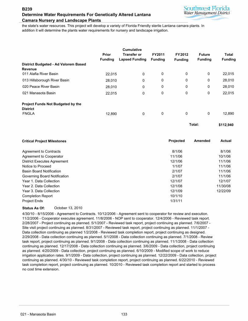
B239
Determine Water Requirements For Genetically Altered Lantana
Camara Nursery and Landscape Plantsthe state's water resources. This project will develop a variety of Florida Friendly sterile Lantana camara plants. In
addition it will determine the plants water requirements for nursery and landscape irrigation.
District Budgeted - Ad Valorem Based
Revenue
011 Alafia River Basin 22,015 0 0 22,015 0 0
013 Hillsborough River Basin 28,010 0 0 28,010 0 0
020 Peace River Basin 28,010 0 0 28,010 0 0
021 Manasota Basin 22,015 0 0 22,015 0 0
Project Funds Not Budgeted by the
District
FNGLA 12,890 0 0 12,890 0 0
$112,940 Total:
Prior
Funding
Cumulative
Transfer or
Lapsed Funding Funding Funding
2011 FY 2012 FY Future
Funding
Total
Funding
Critical Project Milestones ActualProjected Amended
Agreement to Contracts 8/1/06 8/1/06
Agreement to Cooperator 11/1/06 10/1/06
District Executes Agreement 12/1/06 11/1/06
Notice to Proceed 1/1/07 11/1/06
Basin Board Notification 2/1/07 11/1/06
Governing Board Notification 2/1/07 11/1/06
Year 1. Data Collection 12/1/07 12/1/07
Year 2. Data Collection 12/1/08 11/30/08
Year 3. Data Collection 12/1/09 12/22/09
Completion Report 10/1/10
Project Ends 1/31/11
Status As Of: October 13, 2010
4/30/10 - 8/15/2006 - Agreement to Contracts. 10/12/2006 - Agreement sent to cooperator for review and execution.
11/2/2006 - Cooperator executes agreement. 11/8/2006 - NOP sent to cooperator. 12/4/2006 - Reviewed task report.
2/28/2007 - Project continuing as planned. 5/1/2007 - Reviewed task report, project continuing as planned. 7/6/2007 -
Site visit project continuing as planned. 8/31/2007 - Reviewed task report, project continuing as planned. 11/1/2007 -
Data collection continuing as planned 1/2/2008 - Reviewed task completion report, project continuing as designed.
2/29/2008 - Data collection continuing as planned. 5/1/2008 - Data collection continuing as planned. 7/1/2008 - Review
task report, project continuing as planned. 9/1/2008 - Data collection continuing as planned. 11/1/2008 - Data collection
continuing as planned. 12/17/2008 - Data collection continuing as planned. 3/6/2009 - Data collection, project continuing
as planned. 4/20/2009 - Data collection, project continuing as planned. 6/10/2009 - Modified scope of work to reduce
irrigation application rates. 9/1/2009 - Data collection, project continuing as planned. 12/22/2009 - Data collection, project
continuing as planned. 4/30/10 - Reviewed task completion report, project continuing as planned. 6/22/2010 - Reviewed
task completion report, project continuing as planned. 10/2010 - Reviewed task completion report and started to process
no cost time extension.
021 - Manasota Basin 133
B240
Reducing Water Consumption in Polyethylene-Mulched Tomato and
Pepper Fields after Methyl Bromide PhaProject Type Basin Initiatives
AORs Strategic InitiativesWater Supply ConservationFlood Protection Floodplain Management
Basin(s) Alafia River, Peace River, Manasota
University of FloridaCooperator(s)
Project Manager COHEN, RON
Task Manager(s)
Status Ongoing
DescriptionTomato and pepper producers use methyl bromide (MBr) to fumigate their beds before production. About 50 to 95% of
the MBr that is injected in to the soil can eventually enter the atmosphere and damage the earth's ozone layer. EPA's
Clean Air Act (Amendments of 1990) requires that MBr and other similar chemicals be phased out. The loss of MBr
has a major impact on the production practices of tomato and pepper producers in our District and can cause an
increase in their water use. This project will provide the water use information needed to address this change in
technology.
BenefitsWater use information from this project will be used by growers to save water and in the District's conservation,
planning and permitting programs. This will help preserve ground water, reduce off-site discharge of pesticides and
nutrients and flooding and improve water quality. Currently there are about 152,000 acres in the District that are
permitted for the production of tomatoes and peppers. These sites are permitted for about 335 Mgd. The number of
acres planted and their water use will change annually based on market and climatic conditions. Assuming that results
from this project will help reduce at a minimum 5% of the permitted water, the savings would be about 17 Mgd.
Costs
This project will cost $150,000. About 98% of the permitted tomato and pepper production is divided between three
basin boards. Project costs have been prorated between the Alafia (22%), Manasota (67%), and Peace River (11%)
Basin Boards. Funds will be budgeted in FY2007 and FY2008, Alafia will budget $33,500, Manasota will budget
$11,000 and the Peace River will budget $5,500 each year.
Additional Information
Tomato and pepper production relies on a relatively large quantity of water to provide the necessary soil moisture to
establish, grow and harvest both crops. These commodities are grown with either seepage or seepage plus drip
irrigation. Both systems require constant irrigation to maintain the water table relatively shallow during crop
establishment, which reduces the soil storage, increases the risks of flooding, off-site discharge and nutrient leaching.
A quick calculation of the irrigation volumes required to produce one acre of tomato indicates that between 4 and 6
ac-inches per acre of water are used to establish and maintain the crop with seepage irrigation. Most existing
recommendations for tomato and pepper production were generated when MBr was a viable option for bed
fumigation. Also, relatively inexpensive low density-polyethylene mulch (LDPE) was used and current environmental
regulations about water run-off and nutrient leaching were not always considered in research projects. Current
production practices have changed considerably since past water and production requirements were developed. This
project will look at the new technology and changes in growing practices. The University of Florida and the State of
Florida have started a vigorous campaign to address the phase out of MBr and the development of Best Management
Practices (BMP). Within that context, the use of new developments in fumigation techniques and mulch materials that
tend to reduce water use makes sense. Current MBr alternatives, such as 1,3-dichloropropene + chloropicrin (1,3-D +
Pic; Telone C-35) and methyl iodide (MI; Midas), have poor efficacy against soil borne pests when applied in saturated
soils, as it was customary for MBr, because these molecules can bind more tightly to water molecules than MBr.
Another reason that justifies exploring reduced water irrigation programs is the use of higher retentive mulch films
(virtually impermeable (VIF) and metalized films). These mulches retain more moisture in the planting beds than
previous materials, which adds another component to fumigant and water management in tomato and pepper
production. No defendable scientific research has been conducted in Florida to reduce water irrigation volumes for
tomato and pepper by combining the lower water requirement of new fumigants and the higher water retention of new
mulch films. This project will determine the effect of varying water management regimes on tomato and pepper
production, and assess the effect of high retentive mulches and MBr alternatives on the water volumes necessary for
tomato and pepper irrigation.
021 - Manasota Basin 134

B240
Reducing Water Consumption in Polyethylene-Mulched Tomato and
Pepper Fields after Methyl Bromide Pha
District Budgeted - Ad Valorem Based
Revenue
011 Alafia River Basin 100,500 0 0 100,500 0 0
020 Peace River Basin 16,500 0 0 16,500 0 0
021 Manasota Basin 33,000 0 0 33,000 0 0
$150,000 Total:
Prior
Funding
Cumulative
Transfer or
Lapsed Funding Funding Funding
2011 FY 2012 FY Future
Funding
Total
Funding
Critical Project Milestones ActualProjected Amended
Agreement to Contracts 8/1/06 8/26/06
Agreement to Cooperator 11/1/06 10/1/06
District Executes Agreement 12/1/06 11/1/06
Notice to Proceed 1/1/07 11/1/06
Basin Board Notification 2/1/07 11/1/06
Governing Board Notification 2/1/07 11/1/06
Year 1. Data Collection 12/1/07 12/1/07
Year 2. Data Collection 12/1/08 11/30/08
Completion Report - Estimated 6/1/09 6/30/10
Project Ends 10/31/09 11/30/10
Year 3. Data Collection 12/1/09 1/1/10 12/22/09
Status As Of: October 13, 2010
4/30/10 - 8/15/2006 - Agreement to Contracts. 10/12/2006 - Agreement is being reviewed by Legal. 11/8/2006 - Sent
notice to proceed. 12/4/2006 - Field preparation. 2/28/2007 - Data collection project continuing as planned. 5/1/2007 -
Data collection project continuing as planned. 7/6/2007 - Dormant for summer. 8/31/2007 - Reviewed task completion
report. Project continuing as designed. 11/1/2007- Data collection project continuing as planned. 1/2/2008 - Field
preparation for next season. 2/29/2008 - Data collection continuing as planned. 5/1/2008 - Data collection continuing as
planned. 7/1/2008 - Dormant for summer. 9/1/2009 Field preparation for new season. 11/1/2008 - Data collection, project
continuing as planned. 12/1/2008 - Data collection, project continuing as planned 2/23/09 - Execute no cost time
extension. 4/20/2009 - Data collection, project continuing as planned 6/10/2009 - Project dormant for summer. 9/1/2009 -
Starting last season. 12/22/2009 - Field preperation for next season. 4/30/10 - Reviewed task 7 completion report.
6/22/2010 - Project continuing as planned. 10/2010 Waiting for completion report.
021 - Manasota Basin 135

B246
Water Conservation/FFL Regional Builder/Developer Specialist
Project Type Basin Initiatives
AORs Strategic InitiativesWater Quality Water Quality Maintenance and ImprovementWater Supply ConservationNatural Systems Natural Systems Conservation and Restoration
Basin(s) Alafia River, Hillsborough River, Coastal Rivers, Pinellas-Anclote River, Withlacoochee River,
Peace River, Manasota
Cooperator(s)
Project Manager DURELL, SYLVIA
Task Manager(s)
Status Ongoing
DescriptionThe Water Conservation/FFL Regional Builder/Developer specialist, a Basin Initiative project, promotes
implementation of indoor and outdoor water conservation primarily for the Florida Water StarSM program through
education to members of the building industry, landscape professionals, government employees and green building
groups. Effectiveness is measured by the number of professional landscapers and irrigation system installers who
incorporate the FWS criteria in their projects. Education is accomplished through one-on-one outreach, site visits,
trainings and promotion of the programs' benefits at meetings of industry groups and local governments.
BenefitsThe program educates members of the building industry, landscape professionals, government employees and green
building groups on the water conservation and water quality protection benefits of environmental landscaping best
management practices, especially as part of the FWS program criteria. The specialist also supports FFL coordinators
with outreach to builders and developers in their individual counties.
Costs
The total cost of the FY2011 program is $77,500 (Alafia River $5,425; Hillsborough River $18,600; Coastal Rivers
$6,975; Pinellas-Anclote River $17,825; Withlacoochee River $5,425; Peace River $11,625; Manasota $11,625).
Funding provides for the specialist's position and for travel for outreach to all basins. The dollar amount allocated for
each contributing basin is based on population. The budget lines below include costs for staff to manage the project.
Additional Information
The total cost of the FY2010 program was $77,500 (Alafia River $5,425; Hillsborough River $18,600; Coastal Rivers
$6,975; Pinellas-Anclote River $17,825; Withlacoochee River $5,425; Peace River $11,625; Manasota $11,625).
FY2010 was the third year of funding for this outreach. Education is based on the Florida Water Star criteria and
landscape best management practices, which reference the nine principles of the Florida-Friendly
LandscapingTM program of the University of Florida/Institute of Food and Agricultural Sciences.
District Budgeted - Ad Valorem Based
Revenue
011 Alafia River Basin 31,951 0 0 24,911 0 7,040
013 Hillsborough River Basin 80,616 0 0 59,594 0 21,022
014 Northwest Hillsborough Basin 21,134 0 0 21,134 0 0
015 Coastal Rivers Basin 40,181 0 0 31,591 0 8,590
016 Pinellas-Anclote River Basin 100,529 0 0 81,897 0 18,632
019 Withlacoochee River Basin 36,885 0 0 29,845 0 7,040
020 Peace River Basin 72,396 0 0 59,156 0 13,240
021 Manasota Basin 66,611 0 0 53,371 0 13,240
$450,303 Total:
Prior
Funding
Cumulative
Transfer or
Lapsed Funding Funding Funding
2011 FY 2012 FY Future
Funding
Total
Funding
021 - Manasota Basin 136
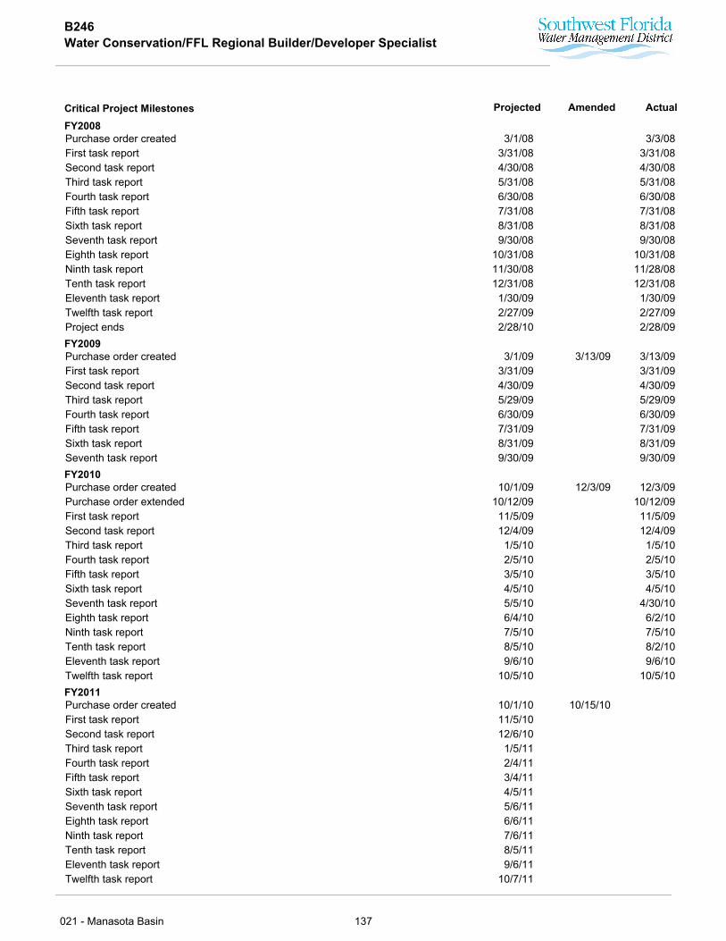
B246
Water Conservation/FFL Regional Builder/Developer Specialist
Critical Project Milestones ActualProjected Amended
FY2008Purchase order created 3/1/08 3/3/08
First task report 3/31/08 3/31/08
Second task report 4/30/08 4/30/08
Third task report 5/31/08 5/31/08
Fourth task report 6/30/08 6/30/08
Fifth task report 7/31/08 7/31/08
Sixth task report 8/31/08 8/31/08
Seventh task report 9/30/08 9/30/08
Eighth task report 10/31/08 10/31/08
Ninth task report 11/30/08 11/28/08
Tenth task report 12/31/08 12/31/08
Eleventh task report 1/30/09 1/30/09
Twelfth task report 2/27/09 2/27/09
Project ends 2/28/10 2/28/09
FY2009Purchase order created 3/1/09 3/13/09 3/13/09
First task report 3/31/09 3/31/09
Second task report 4/30/09 4/30/09
Third task report 5/29/09 5/29/09
Fourth task report 6/30/09 6/30/09
Fifth task report 7/31/09 7/31/09
Sixth task report 8/31/09 8/31/09
Seventh task report 9/30/09 9/30/09
FY2010Purchase order created 10/1/09 12/3/09 12/3/09
Purchase order extended 10/12/09 10/12/09
First task report 11/5/09 11/5/09
Second task report 12/4/09 12/4/09
Third task report 1/5/10 1/5/10
Fourth task report 2/5/10 2/5/10
Fifth task report 3/5/10 3/5/10
Sixth task report 4/5/10 4/5/10
Seventh task report 5/5/10 4/30/10
Eighth task report 6/4/10 6/2/10
Ninth task report 7/5/10 7/5/10
Tenth task report 8/5/10 8/2/10
Eleventh task report 9/6/10 9/6/10
Twelfth task report 10/5/10 10/5/10
FY2011Purchase order created 10/1/10 10/15/10
First task report 11/5/10
Second task report 12/6/10
Third task report 1/5/11
Fourth task report 2/4/11
Fifth task report 3/4/11
Sixth task report 4/5/11
Seventh task report 5/6/11
Eighth task report 6/6/11
Ninth task report 7/6/11
Tenth task report 8/5/11
Eleventh task report 9/6/11
Twelfth task report 10/7/11
021 - Manasota Basin 137

B246
Water Conservation/FFL Regional Builder/Developer Specialist
Status As Of: October 13, 2010
ACTION TO DATE: On time. Among other efforts, Angela Maraj, the water conservation/FYN regional builder/developer
specialist, (1) Presented a comparison of the criteria of three "green" programs used in Florida: FWS, Florida Green
Building Coalition (FGBC) and Leadership in Energy and Environmental Design (LEED) to approximately 70 attendees at
the Sustainable Communities Conference in Sarasota. This presentation led to contact with an architect on a commercial
job in Englewood who is interested in FWS commercial program, a commitment from a high performance, award-winning
builder to do FWS in his new residential projects and preliminary talks with the director of planning for the City of North
Port who is interested in FWS training for his staff. (2) Created training materials for and promoted two "Designing
Florida Water Star Landscapes" workshops for landscape designers. The Oct. 20 workshop was held at the Hillsborough
County Extension office and attracted 16 people. Approximately 27 people have registered for the Oct. 26 workshop,
which will be held at the Sarasota County Extension office. (3) Evaluated six landscapes for FWS. (4) Reviewed
SJRWMD's new Water-Wise plant database and will oversee the creation of a plant index for UF's newly printed "FFL
Guide to Plant Selection and Landscape Design."
021 - Manasota Basin 138
B256
Automated Citrus Irrigation Management to Reduce Water
ConsumptionProject Type Basin Initiatives
AORs Strategic InitiativesWater Quality Water Quality Maintenance and ImprovementWater Supply ConservationFlood Protection Floodplain Management
Basin(s) Alafia River, Hillsborough River, Peace River, Manasota
University of FloridaCooperator(s)
Project Manager COHEN, RON
Task Manager(s)
Status Ongoing
DescriptionAgriculture is the largest permitted water use in the District and citrus production is the largest of those permitted uses.
Over 366MGD are permitted for citrus irrigation and most of that water use is in the SWUCA. This project will help
citrus growers reduce their water use by developing tools to automate and improve irrigation scheduling. These tools
can be used by the District's FARMS program to further expand their conservation efforts. Although citrus acres have
been on the decline it seems to have reached a stabilizing point. With the increase in the recent price of citrus the
District might even see an increase in the number of acres. The permitted acres for citrus is still relatively high and
even a minor reduction in water use or fertilizer application could have a significant impact on the District's water
resources. The proposed project will investigate the use of new low-cost automatic irrigation pump controllers with
wireless remote monitoring and control. This low cost system (<$1,000) will enable growers to optimize the irrigation
scheduling and remotely manage over 100 acres. In addition the project will develop and compare new and improved
irrigation scheduling tools for citrus trees, particularly for automated systems. In the past the District has funded
several citrus irrigation projects. With the introduction on new technology some of the old information is no longer
applicable and some of the information needs to be incorporated into new technology. Where applicable this project
will build on past projects and use new technology to help reduce water and fertilizer use.
BenefitsThe actual water savings will depend on acres planted climatic and growing conditions. Assuming a 1% savings this
would amount to about a 3.7 million gallons per day reduction of ground water in an area of water use concern. The
reduced water use would make more water available for other uses and reduce the amount of funds that need to be
invested in alternative water supplies. An added benefit to this project will be that improved irrigation would improve
fertilizer use, which will reduce the amount of nutrients available to runoff and pollute the District's water bodies. Also
the project's information will provide the FARMs program with another tool to help reduce ground water use.
Costs
This will be a four year project and the total cost will be $150,000. Project costs are divided between four Basin Boards
based on the percent water permitted for citrus production within their watersheds. The following is the annual cost
break down by Basin Board: Alafia $4,500, Hillsborough River $4,000, Peace River $38,500 and Manasota $3,000 for
FY2008, FY2009 and FY2010.
Additional Information
Improved irrigation scheduling can conserve large volumes of water. Since current irrigation scheduling tools are
unreliable, growers are prone to over-irrigate to eliminate any risk of drought stress. Manually operated irrigation
systems are not adaptable to more efficient frequent, small irrigations or night-time irrigations due to logistics, conflicts
in schedules, and the inconvenience factor. Irrigation durations are most often rounded up, rather than down, even
after accounting for all these factors. Probability of rainfall is almost never considered and some irrigation systems are
even run during rain events. Over-irrigation and nutrient leaching consequently deplete and degrade our limited water
resources. The high cost of commercially available automatic control systems has, unfortunately, prevented their
widespread acceptance and use. Since often less than 100 acres are supplied per pump, quite commonly a grower
will have multiple well pumps to automate in a citrus grove. At a cost to automate of more than $20,000 per pump, the
financial burden is prohibitive, even with cost sharing. In addition, commercial automatic controllers have a limited
ability to interface with available soil moisture sensors or with more advanced scheduling tools such as simulation
models. Without adequate inputs, the full potential of automatic controllers cannot be realized. There is a great need
to develop low-cost automatic irrigation pump controllers to reliably schedule irrigation.
021 - Manasota Basin 139

B256
Automated Citrus Irrigation Management to Reduce Water
Consumption
District Budgeted - Ad Valorem Based
Revenue
010 General Fund (Districtwide) 50,000 0 0 50,000 0 0
011 Alafia River Basin 9,000 0 0 9,000 0 0
013 Hillsborough River Basin 8,000 0 0 8,000 0 0
020 Peace River Basin 77,000 0 0 77,000 0 0
021 Manasota Basin 6,000 0 0 6,000 0 0
$150,000 Total:
Prior
Funding
Cumulative
Transfer or
Lapsed Funding Funding Funding
2011 FY 2012 FY Future
Funding
Total
Funding
Critical Project Milestones ActualProjected Amended
Agreement To Contracts 10/1/07 8/30/07
Agreement To IFAS 10/15/07 10/15/07
Notice To Proceed 12/31/07 12/31/07
Data Collection Yr. 1 12/31/08 12/18/08
Data Collection Yr 2 12/31/09 12/22/09
Data Collection Yr. 3 12/31/10
Grower's Field Day 12/15/11
Completion Report 3/1/12
Agreement Ends 12/31/12
Status As Of: October 13, 2010
4/30/10 - 8/31/2007 - Reviewed final scope of work. 11/1/2007 - Agreement mailed to cooperator for review and
execution. 1/2/2008 - Notice to proceed sent to IFAS 3/7/2008 - Mobilizing equipment. 5/1/2008 - Reviewed task I report.
Project continuing as planned. 7/1/2008 - Data collection project continuing as planned. 9/1/2008 - Data collection project
continuing as planned. 11/1/2008 - Data collection project continuing as planned. 12/17/2008 - Data collection project
continuing as planned 3/6/2009 - Data collection project continuing as planned. 4/20/2009 - Data collection project
continuing as planned 6/10/2009 - Data collection project continuing as planned. 12/22/2009 - Data collection project
continuing as planned. 4/30/10 - Data collection project continuing as planned. 6/22/2010 - Data collection project
continuing as planned. 10/2010 - Data collection project continuing as planned
021 - Manasota Basin 140

B264
Citrus Irrigation Management to Increase Young Tree Growth &
Productivity on Flatwoods Ridge SoilsProject Type Basin Initiatives
AORs Strategic InitiativesWater Quality Water Quality Maintenance and ImprovementWater Supply Conservation
Basin(s) Alafia River, Hillsborough River, Peace River, Manasota
University of FloridaCooperator(s)
Project Manager COHEN, RON
Task Manager(s)
Status Ongoing
DescriptionDue to Citrus Greening, Canker and labor issues the industry has had the University develop different techniques for
economical production of citrus in Florida. On of the most promising techniques, which includes high density planting
of smaller trees, was developed in Spain and commercialized in South Africa, Australia and California. This project will
develop irrigation and nutrient management recommendations for this new method of production to help conserve
water and reduce nutirent loading. Although recent citrus acres have declined District wide, it is still the largest
permitted agricultural water use. Also, with the decline in development and recent price increases, more citrus growers
are planning to expand their operations; therefore, it is important to help find ways for citrus producers to conserve
water. This water conservation project will utilize information developed in Spain and commercialized in South Africa,
Australia and California. The University will investigate and develop new cultural technology including changes to plant
density, nutrient and irrigation management. Plants will be grown with an intensive fertigation management technique
that is designed to provide essentially a non-limiting environment to those roots. This new fertilizer program will require
changes to existing irrigation management programs.
BenefitsCitrus production is the largest agricultural land use in the District. This project will help citrus producers conserve
water and reduce pollutant loading for fertilizer leaching. In addition, the information could be used by the District's
FARMS program to help design better BMP cost share systems. The amount of water saved will be a function of the
number of acres planted and their water use, which will change annually based on market and climatic conditions.
Costs
The project costs have been reduced from $182,500 to $122,300 because some of the ridge elements were removed.
Additional Information
Yield fundamentally drives profit for Florida citrus growers and is thus the key element to a grower's financial success.
Yield is tied directly to tree density and growth rate and is a simple function of numbers of trees and the related total
canopy volume over the unit area. Research over the last several decades has proven that growth of young trees and
productivity of both young and mature trees benefit from high frequency low volume irrigation. Improved tree growth
from intensive irrigation management could reduce the time required from planting to economic breakeven production,
thus provide management options in light of current devastating diseases such as Canker and Huanglongbing (citrus
greening). Florida growers have adopted Best Management Practices (BMPs) that reduce nutrient leaching by limiting
the amount of fertilizer that can be applied, and the time of year when fertilizer can be applied. These BMPs are based
on research under low-intensity management systems. However, production systems that combine grove design and
irrigation management to increase yield and grove operational efficiency have not been studied. High density plantings
of sweet oranges on low-vigor rootstocks have known advantages, but their long-term behavior and changes in the
functional relationship of tree density, growth rate, and yield over time are not well understood. The central hypothesis
of this project is improved and consistent early yields, with increased tree density on low vigor trees and/or improved
irrigation/nutrient management systems that would provide proactive management options in light of current
devastating diseases such as Canker and Huanglongbing (citrus greening). Growers normally achieve their expected
return on investment within 15 to 20 years of planting. If those goals would occur sooner (e.g., 10 to 12 years) through
increased early yields, the grower would benefit even if the grove declines over time due to the diseases mentioned
above and must be replanted. By knowing how to irrigate and manage their irrigation with this new method of
production, the grower would conserve water and reduce the amount of fertilizer thats being leached from the plant
root zone while maintaining an economical viable crop.
021 - Manasota Basin 141

B264
Citrus Irrigation Management to Increase Young Tree Growth &
Productivity on Flatwoods Ridge Soils
District Budgeted - Ad Valorem Based
Revenue
010 General Fund (Districtwide) 73,000 0 0 36,500 0 36,500
011 Alafia River Basin 3,336 0 0 3,336 0 0
013 Hillsborough River Basin 2,979 0 0 2,979 0 0
020 Peace River Basin 28,106 0 0 28,106 0 0
021 Manasota Basin 2,079 0 0 2,079 0 0
$109,500 Total:
Prior
Funding
Cumulative
Transfer or
Lapsed Funding Funding Funding
2011 FY 2012 FY Future
Funding
Total
Funding
Critical Project Milestones ActualProjected Amended
Develop Contract 10/1/08 10/1/08
Notice To Proceed 1/2/09 10/30/08
No Cost Amendment 3/1/09 3/1/09
Year 1 - Data Collection 12/30/09 12/22/09
Year 2 - Data Collection 12/30/10
Year 3 - Data Collection 12/30/11
Growers Field Day 7/31/12
Journal Publication 7/31/12
Year 4 - Data Collection 12/30/12
Completion Report 10/31/13
Contract Ends 6/30/14
Status As Of: December 22, 2009
4/30/10 - 11/1/2008 - Contract to IFAS for review. 12/18/2008 - Wait for University to return executed agreement.
4/20/2009 - Data collection continuing as planned 6/10/2009 - Data collection continuing as planned 9/1/2009 - modified
agreement to reduce scope and project costs. 12/22/2009 - Reviewed task completion report. 4/30/10 - Data collection
project continuing as planned 6/22/2010 - 4/30/10 - Project continuing as planned.
021 - Manasota Basin 142

B265
Optimizing Irrigation For Shade Tree Production
Project Type Basin Initiatives
AORs Strategic InitiativesWater Quality Water Quality Maintenance and ImprovementWater Supply ConservationFlood Protection Floodplain Management
Basin(s) Alafia River, Hillsborough River, Withlacoochee River, Peace River, Manasota
University of FloridaCooperator(s)
Project Manager COHEN, RON
Task Manager(s)
Status Ongoing
DescriptionThere are over 5,000 acres of nursery production in the central part of the District and typically they are permitted for
about 1.7 million gallons of water per acre. With the increase of urban development, it is anticipated that the number of
nursery acres will increase and landscape water use will too. This project will investigate ways to reduce nursery and
landscape irrigation by studying the relationships between moderate water stress, photosynthesis and shoot growth of
trees. The goal of the project is to develop irrigation management strategies that take advantage of gas exchange
properties occurring at moderate water stress. These strategies would be linked to the ongoing projects modeling tree
water use based on ETo, further increasing the level of irrigation precision of non-production situations beyond that
which will come from the ETo projects. Plant growth is a two stage process. First, new cells are produced by
meristematic tissues. Second, these cells enlarge. The first phase mainly requires new cellular components which are
derived from photosynthesis and absorbed minerals. The principal requirement for the second phase of growth, cell
enlargement, is hydrostatic (turgor) pressure. Plant water status, mainly as it affects cell turgor pressure, is the primary
driving force in this second phase. In pecans, nearly all leaf expansion occurred at night (Anderson, 1989). This is the
time when water stress in plants is the lowest, and water status and turgor pressure are the highest. This is
hypothesized as the primary reason cyclic irrigation of containerized plants accelerates growth, in that it results in
higher turgor pressures during the night by making more water available in the root ball late in the day. While this
information on leaf expansion was reported in the scientific literature over 10 years ago, it was never pursued much
further and will be investigated in this project.
BenefitsInformation from this project will help nursery producers, commercial landscapers and homeowners reduce water use.
The amount of water saved will be a function of the number of acres planted and their water use, which will change
annually based on market and climatic conditions. Assuming an annual 5% water savings from only nursery
production, there would be a total of about 1.9 mgd savings on permitted water use. In addition, information form this
project can be used by the District's FARMS program to help promote water conservation.
Costs
This four year project will cost the District a total of $83,875. Funding for this project is prorated between five Basin
Boards (Peace River - 23%, Hillsborough River 22%, Alafia - 18%, Manasota 18% and Withlacoochee 11%) based on
the number of permits for nursery production in their watershed. In FY2009, FY2010, FY2011, and FY2012 the Basin
Boards will budget each year: Peace River $5,159, Hillsborough River $5,008, Alafia River $4,103, Manasota $4,103
and Withlacoochee River $2,595.
Additional Information
Recently, data collection of a project at MREC supported by the Southwest Florida WMD, Horticultural Research
Institute and others quantified the daily water use of live oak and red maple to 7-inch calipers, and Nellie R. Stevens
holly to 5-inch calipers. Preliminary modeling of red maple reported a high correlation of predicted and actual water
loss based on a algorithm incorporating reference evapotranspiration (ETo) and trunk cross sectional area just below
the first major branch (Beeson, 2007). A project with a similar goal using D.D. Blanchard magnolia, Aliee, Chinese elm
and slash pine is currently in the second year. Maximum plant growth occurs when transpiration is maximum because
transpiration and photosynthesis are tightly linked. Reductions in stomata aperture reduce the flow of carbon dioxide
into leaves and water out of leaves. However, for the limited number of tree species studied, slight to moderate
reductions in stomatal aperture cause no to small reductions in photosynthesis, but resulted in relatively large
reductions in transpiration. Thus under moderate water stress, trees and woody plants, in general, tend become more
water efficient with little reduction in photosynthesis (Noble, 1999).
021 - Manasota Basin 143
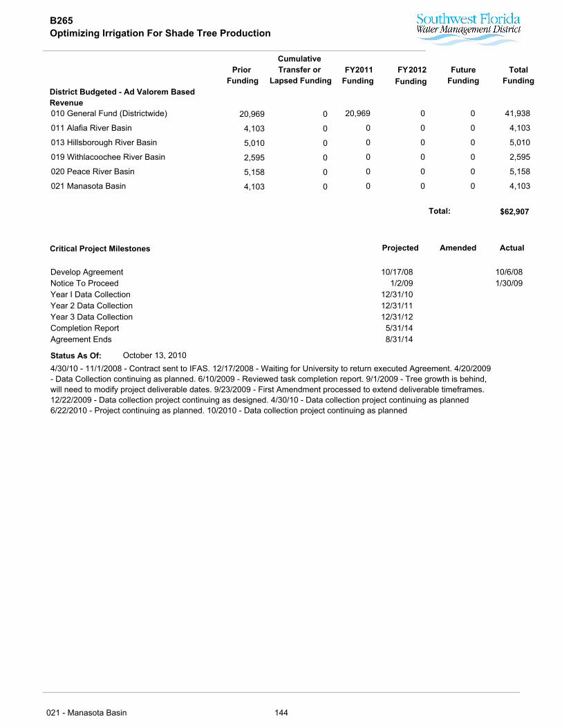
B265
Optimizing Irrigation For Shade Tree Production
District Budgeted - Ad Valorem Based
Revenue
010 General Fund (Districtwide) 41,938 0 0 20,969 0 20,969
011 Alafia River Basin 4,103 0 0 4,103 0 0
013 Hillsborough River Basin 5,010 0 0 5,010 0 0
019 Withlacoochee River Basin 2,595 0 0 2,595 0 0
020 Peace River Basin 5,158 0 0 5,158 0 0
021 Manasota Basin 4,103 0 0 4,103 0 0
$62,907 Total:
Prior
Funding
Cumulative
Transfer or
Lapsed Funding Funding Funding
2011 FY 2012 FY Future
Funding
Total
Funding
Critical Project Milestones ActualProjected Amended
Develop Agreement 10/17/08 10/6/08
Notice To Proceed 1/2/09 1/30/09
Year I Data Collection 12/31/10
Year 2 Data Collection 12/31/11
Year 3 Data Collection 12/31/12
Completion Report 5/31/14
Agreement Ends 8/31/14
Status As Of: October 13, 2010
4/30/10 - 11/1/2008 - Contract sent to IFAS. 12/17/2008 - Waiting for University to return executed Agreement. 4/20/2009
- Data Collection continuing as planned. 6/10/2009 - Reviewed task completion report. 9/1/2009 - Tree growth is behind,
will need to modify project deliverable dates. 9/23/2009 - First Amendment processed to extend deliverable timeframes.
12/22/2009 - Data collection project continuing as designed. 4/30/10 - Data collection project continuing as planned
6/22/2010 - Project continuing as planned. 10/2010 - Data collection project continuing as planned
021 - Manasota Basin 144
B273
MFL Stream Diversion and Assessment Project
Project Type Basin Initiatives
AORs Strategic InitiativesWater Supply Alternative Water SupplyNatural Systems Minimum Flows and Level Establishment and Monitoring
Basin(s) Alafia River, Hillsborough River, Northwest Hillsborough, Coastal Rivers, Pinellas-Anclote River,
Withlacoochee River, Peace River, Manasota
Cooperator(s)
Project Manager MORALES, JON
Task Manager(s)
Status Ongoing
DescriptionTo further validate existing stream Minimum Flows and Levels (MFL) methodology consistent with peer review
recommendation. A frequent focus of criticism of the MFL methodology applied by the District to rivers and estuaries
is the use of a 15 percent habitat loss criterion as a threshold for assessing "significant harm." Quoting from the peer
review of the Braden River MFL, the panel noted:
" The draft report describes the metrics used to define the limit at which further withdrawals would be significantly
harmful to the water resources or ecology of the area as stated in Florida statutes. The authors note that significant
harm was not defined in statute. The District chose to interpret significant harm as the loss of flows associated with
fish passage and maximization of stream bottom habitat with the least amount of flow and quantifiable reductions in
habitat. Overall, this is a reasonable approach from an ecological perspective and likely satisfies the intent of the
statute. The authors state that, [in] general, instream flow analysts consider a loss of more than 15% habitat, as
compared to undisturbed or current conditions, to be a significant impact on that population or assemblage. The
authors further note, in our opinion, correctly, that there are few `bright lines which can be relied upon to judge when
`significant harm occurs. Rather loss of habitat in many cases occurs incrementally as flow decline, often without a
clear inflection point or threshold. Nevertheless, the 15% habitat loss criterion remains one of the least rigorous, most
subjective aspects of the District's approach to setting MFLs. Justification for this threshold is based on common
professional practice in interpreting the results of PHABSIM analyses (Gore at al. 2002), a review of relevant literature
where reported percentage changes ranged from 10 to 33%, and on previous peer reviews that found the 15%
threshold to be reasonable and prudent, especially given the absence of clear guidance in the statute or in the
scientific literature on levels of change that would constitute significant harm (e.g., Shaw et al. 2005). The draft upper
Braden report continues the District's practice of using a 15% change in habitat availability as the threshold for defining
significant harm and now applies this threshold broadly to include both spatial and temporal loss of habitat or
connectivity. The Panel again acknowledges that the use of this criterion is rational and pragmatic, but also recognizes
that the specific value of 15% is subjective and has only modest validation or support from the primary literature. . . . .
More importantly, however, is the need for the District to commit the resources necessary to validate the presumption,
that a 15% decrease in spatial or temporal habitat availability or a 15% increase in violations of the low-flow threshold,
does not cause significant harm. "
This project represents the best means for validating the effect that a given flow reduction has on available habitat and
the biota of a stream segment. District staff proposes to locate an acceptable stream segment in order to conduct
controlled diversions from a defined stream segment in order to evaluate the impact that a range of flow and habitat
reductions has on the biota (e.g., fishes, macroinvertebrates) and water resource values. It is envisioned that such a
project will require a number of years to complete (possibly a decade), and an annual commitment of significant
resources to accomplish.
BenefitsIf implemented, this project will provide as definitive a test of the 15 percent habitat loss criterion as is practical under
field conditions, and the results will be widely applicable to stream assessments and the development of environmental
flows though out the country.
Costs
Funding in FY2010 is currently for $150,000 to be funded by the Governing Board. A small amount has been
budgeted for parts and supplies and travel. Total requested funding for FY2011 is $150,000.00.
021 - Manasota Basin 145
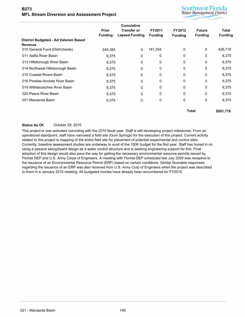
B273
MFL Stream Diversion and Assessment Project
District Budgeted - Ad Valorem Based
Revenue
010 General Fund (Districtwide) 426,718 0 0 245,384 0 181,334
011 Alafia River Basin 9,375 0 0 9,375 0 0
013 Hillsborough River Basin 9,375 0 0 9,375 0 0
014 Northwest Hillsborough Basin 9,375 0 0 9,375 0 0
015 Coastal Rivers Basin 9,375 0 0 9,375 0 0
016 Pinellas-Anclote River Basin 9,375 0 0 9,375 0 0
019 Withlacoochee River Basin 9,375 0 0 9,375 0 0
020 Peace River Basin 9,375 0 0 9,375 0 0
021 Manasota Basin 9,375 0 0 9,375 0 0
$501,718 Total:
Prior
Funding
Cumulative
Transfer or
Lapsed Funding Funding Funding
2011 FY 2012 FY Future
Funding
Total
Funding
Status As Of: October 29, 2010
This project is now activated coinciding with the 2010 fiscal year. Staff is still developing project milestones. From an
operational standpoint, staff have narrowed a field site (Gum Springs) for the execution of this project. Current activity
related to this project is mapping of the entire field site for placement of potential experimental and control sites.
Currently, baseline assessment studies are underway to avail of the 150K budget for the first year. Staff has honed in on
using a passive swing/board design as a water control structure and is seeking engineering support for this. Final
adoption of this design would also pave the way for getting the necessary environmental resource permits issued by
Florida DEP and U.S. Army Corps of Engineers. A meeting with Florida DEP scheduled last July 2009 was receptive to
the issuance of an Environmental Resource Permit (ERP) based on certain conditions. Similar favorable responses
regarding the issuance of an ERP was also received from U.S. Army Corp of Engineers when the project was described
to them in a January 2010 meeting. All budgeted monies have already been encumbered for FY2010.
021 - Manasota Basin 146
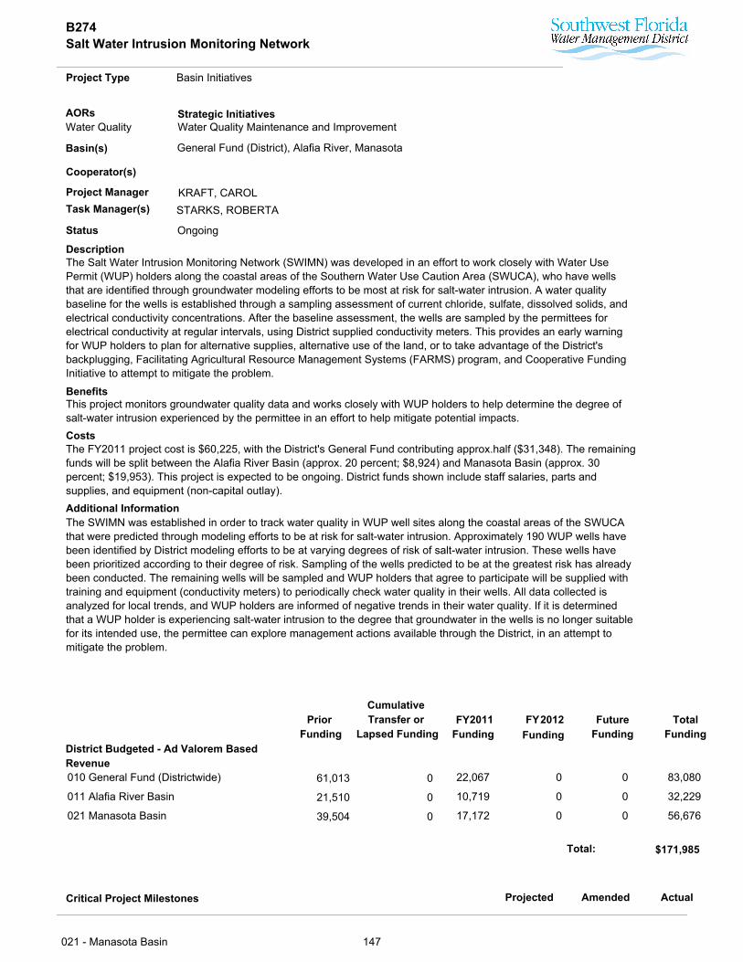
B274
Salt Water Intrusion Monitoring Network
Project Type Basin Initiatives
AORs Strategic InitiativesWater Quality Water Quality Maintenance and Improvement
Basin(s) General Fund (District), Alafia River, Manasota
Cooperator(s)
Project Manager KRAFT, CAROL
STARKS, ROBERTATask Manager(s)
Status Ongoing
DescriptionThe Salt Water Intrusion Monitoring Network (SWIMN) was developed in an effort to work closely with Water Use
Permit (WUP) holders along the coastal areas of the Southern Water Use Caution Area (SWUCA), who have wells
that are identified through groundwater modeling efforts to be most at risk for salt-water intrusion. A water quality
baseline for the wells is established through a sampling assessment of current chloride, sulfate, dissolved solids, and
electrical conductivity concentrations. After the baseline assessment, the wells are sampled by the permittees for
electrical conductivity at regular intervals, using District supplied conductivity meters. This provides an early warning
for WUP holders to plan for alternative supplies, alternative use of the land, or to take advantage of the District's
backplugging, Facilitating Agricultural Resource Management Systems (FARMS) program, and Cooperative Funding
Initiative to attempt to mitigate the problem.
BenefitsThis project monitors groundwater quality data and works closely with WUP holders to help determine the degree of
salt-water intrusion experienced by the permittee in an effort to help mitigate potential impacts.
Costs
The FY2011 project cost is $60,225, with the District's General Fund contributing approx.half ($31,348). The remaining
funds will be split between the Alafia River Basin (approx. 20 percent; $8,924) and Manasota Basin (approx. 30
percent; $19,953). This project is expected to be ongoing. District funds shown include staff salaries, parts and
supplies, and equipment (non-capital outlay).
Additional Information
The SWIMN was established in order to track water quality in WUP well sites along the coastal areas of the SWUCA
that were predicted through modeling efforts to be at risk for salt-water intrusion. Approximately 190 WUP wells have
been identified by District modeling efforts to be at varying degrees of risk of salt-water intrusion. These wells have
been prioritized according to their degree of risk. Sampling of the wells predicted to be at the greatest risk has already
been conducted. The remaining wells will be sampled and WUP holders that agree to participate will be supplied with
training and equipment (conductivity meters) to periodically check water quality in their wells. All data collected is
analyzed for local trends, and WUP holders are informed of negative trends in their water quality. If it is determined
that a WUP holder is experiencing salt-water intrusion to the degree that groundwater in the wells is no longer suitable
for its intended use, the permittee can explore management actions available through the District, in an attempt to
mitigate the problem.
District Budgeted - Ad Valorem Based
Revenue
010 General Fund (Districtwide) 83,080 0 0 61,013 0 22,067
011 Alafia River Basin 32,229 0 0 21,510 0 10,719
021 Manasota Basin 56,676 0 0 39,504 0 17,172
$171,985 Total:
Prior
Funding
Cumulative
Transfer or
Lapsed Funding Funding Funding
2011 FY 2012 FY Future
Funding
Total
Funding
Critical Project Milestones ActualProjected Amended
021 - Manasota Basin 147
B274
Salt Water Intrusion Monitoring Network
Kick-Off Meeting 8/28/08 8/28/08
Project status meeting 2/23/10 2/23/10
Complete Baseline Sampling of Candidate Wells 9/30/11
Provide conductivity meter training and support to select well owners 9/30/11
Status As Of: October 28, 2010
Reviews of associated WUPs and subsequent sampling of wells are currently ongoing. Staff is also currently evaluating
operation and training for conductivity meters for associated WUP holders. Conductivity meter training and subsequent
result reporting has been established with three WUP holders.ACTION-TO-DATE: On-going
021 - Manasota Basin 148

B277
Florida Water Star
Project Type Basin Initiatives
AORs Strategic InitiativesWater Quality Water Quality Maintenance and ImprovementWater Supply ConservationNatural Systems Natural Systems Conservation and Restoration
Basin(s) General Fund (District), Alafia River, Hillsborough River, Coastal Rivers, Pinellas-Anclote River,
Withlacoochee River, Peace River, Manasota
Cooperator(s)
Project Manager DURELL, SYLVIA
Task Manager(s)
Status Ongoing
DescriptionThe Florida Water StarSM (FWS) program was originated by the St. Johns River Water Management District
(SJRWMD). SJRWMD's original program, now known as FWS Silver, was used as a base for this District to create a
higher-tier version. The FWS Gold, Silver and Commercial programs are now being promoted in this District. The
certification programs provide incentives to builders and developers and encourage indoor and outdoor water
efficiency and water quality protection. They are designed to increase the knowledge level of the building industry
about water efficient building practices and to provide educational resources and incentives to make these practices
common to the marketplace. The FWS rating system is integrated into the landscape evaluation component of the
Florida Green Building Coalition's certification program and has consistency with national green building programs
such as the Leadership in Energy and Environmental Design (LEED) by the U.S. Green Building Council and Energy
Star® from the Environmental Protection Agency. As of the fourth quarter of FY2010, 53 properties have been certified
FWS Gold and one property has been certified through the FWS Commercial program, which is currently being
piloted. This is the third year of the FWS program. In FY2011, staff anticipates increased interest in Commercial
certifications.
BenefitsThe program's objectives are to increase the knowledge level of efficient indoor and outdoor water use and to provide
educational resources and incentives to promote water conservation practices. Up to 50 percent of all household water
is used outside the home and inefficient or incorrectly installed irrigation can waste thousands of gallons of water each
month. Indoors, inefficient shower fixtures use an average of five gallons per minute. A leaking toilet can waste more
than 200 gallons in a single day. The FWS program criteria provide guidelines to follow that will positively impact water
resources when the program is successfully implemented. Because of the program's high profile and the involvement
of the water management districts, it is of high interest to the target audience. By providing an incentive for builders,
developers and homeowners that encourages them to incorporate best management practices, the District realizes
water savings and water quality protection. Changes in behavior occur when a builder signs a contract with the District
to build houses according to the FWS criteria, and agrees thereafter to include water conserving elements into future
projects. Owners of new or retrofitted FWS properties receive the benefits of the indoor and outdoor water-conserving
elements of the program and can promote the certification as a marketing edge at time of resale. The program's close
partnership with the Florida Green Building Coalition (FGBC) resulted in FWSG outdoor water conservation criteria
being incorporated into the FGBC standards.
Costs
The total cost of the FY2011 program is $93,365, with the District contributing $48,100 and the Basin Boards
contributing $45,265 (Alafia River $3,388; Hillsborough River $11,563; Coastal Rivers $4,350; Pinellas-Anclote River
$11,094; Withlacoochee River $3,388; Peace River $7,236; Manasota $7,246). Overall program costs have decreased
slightly since FY2010. The dollar amount allocated per contributing basin is based on population. Funding provides for
salary and travel for a project coordinator to manage the program, support for education outreach and contractual
services related to the delivery of the program. The budget lines below include costs for staff to manage the project.
Additional Information
The total cost of the FY2010 program was $94,500, with the District contributing $47,250 and the Basin Boards
contributing $47,250 (Alafia River $3,500; Hillsborough River $12,000; Coastal Rivers $4,500; Pinellas-Anclote River
$11,500; Withlacoochee River $3,500; Peace River $7,500; Manasota $7,500). FY2010 was the second year of
funding for the FWS program. FWS programs support the Governor's Climate Change Initiative by promoting public
protection, wise use and management of natural resources.
021 - Manasota Basin 149
B277
Florida Water Star
District Budgeted - Ad Valorem Based
Revenue
010 General Fund (Districtwide) 154,086 0 0 103,564 0 50,522
011 Alafia River Basin 14,555 0 0 9,553 0 5,002
013 Hillsborough River Basin 36,545 0 0 22,561 0 13,984
014 Northwest Hillsborough Basin 5,061 0 0 5,061 0 0
015 Coastal Rivers Basin 15,869 0 0 11,520 0 4,349
016 Pinellas-Anclote River Basin 39,507 0 0 26,799 0 12,708
019 Withlacoochee River Basin 15,552 0 0 10,550 0 5,002
020 Peace River Basin 29,376 0 0 19,712 0 9,664
021 Manasota Basin 26,791 0 0 17,931 0 8,860
$337,342 Total:
Prior
Funding
Cumulative
Transfer or
Lapsed Funding Funding Funding
2011 FY 2012 FY Future
Funding
Total
Funding
Critical Project Milestones ActualProjected Amended
FY2009Request for quotes issued 10/15/08 10/15/08
Purchase order/scope of work created 11/15/08 11/12/08
First task report 11/30/08 11/30/08
Second task report 12/30/08 12/30/08
FWS/FWSG certifier training 1/16/09 1/16/09
Third task report 1/30/09 1/30/09
Fourth task report 2/27/09 2/27/09
First home kick-off event 3/25/09 3/25/09
Fifth task report 3/31/09 3/31/09
Second house certified 4/17/09 4/17/09
Sixth task report 4/30/09 5/4/09 5/4/09
Seventh task report 5/29/09 5/29/09
Eighth task report 6/30/09 6/30/09
Ninth task report 7/31/09 7/31/09
Third house certified 8/18/09 8/18/09
Tenth task report 8/31/09 8/31/09
Eleventh task report 9/30/09 9/30/09
Twelfth task report 10/30/09 11/5/09 11/5/09
Project complete 10/31/09 12/15/09 12/15/09
FY2010First task report 12/4/09 12/4/09
Second task report 1/5/10 1/5/10
Third task report 2/5/10 2/5/10
Fourth task report 3/5/10 3/5/10
Fifth task report 4/5/10 4/8/10 4/8/10
Sixth task report 5/5/10 5/5/10
Seventh task report 6/4/10 6/4/10
Eighth task report 7/5/10 7/5/10
Ninth task report 8/5/10 8/4/10
Tenth task report 9/6/10 9/6/10
021 - Manasota Basin 150

B277
Florida Water Star
Eleventh task report 10/5/10 10/5/10
FY2011Purchase order created 10/1/10 10/15/10 10/15/10
First task report 11/5/10
Second task report 12/6/10
Third task report 1/5/11
Fourth task report 2/4/11
Fifth task report 3/4/11
Sixth task report 5/5/11
Seventh task report 5/6/11
Eight task report 6/6/11
Ninth task report 7/6/11
Tenth task report 8/5/11
Eleventh task report 9/6/11
Twelfth task report 10/7/11
Status As Of: October 21, 2010
ACTION TO DATE: On time. On 3/25/2009, a model home in the Glencairn Cottages community in Dunedin (Pinellas
County) was the first house to be certified as FWSG in the District and the state. As of today, there have been 66 homes
and one commercial building certified at the Gold level. The District has certified 78 percent of all FWS certified
properties statewide. Certification Levels: The Gold, Silver and Commercial levels of the FWS program are promoted in
this District. Education: (1) Two "Designing Florida Water Star Landscapes" workshops were planned this quarter. The
Oct. 20 workshop was held at the Hillsborough County Extension office and attracted 16 people. Approximately 30
people have registered for the Oct. 26 workshop, which will be held at the Sarasota County Extension office. (2) Staff
participated in the American Institute of Architects ReNew Tampa event on October 2. (3) A presentation on how FWS
aligns with other green building programs was presented by staff to 70 participants on Oct. 7 at the Sustainable
Communities Conference in Sarasota. (6) Staff participated in the Disruptive Technologies Panel at the 2nd Annual
Tampa Bay Green Business Summit with Mayor Pam Iorio on Oct. 13. Partners: (1) The Pasco County School system
has expressed its intent to sign a participation agreement. This agreement includes six new schools that have achieved
LEED certification as well as a remodeling project in conjunction with the U.S. Green Building Council and the Tampa
Bay Rays. (2) Habitat for Humanity for East and Central Pasco County has signed a participation agreement. They build
6-8 homes annually. (3) SJRWMD's has expanded its on-line Water-Wise plant database to include approximately 800
plants, trees and shrubs. The searchable database will be the primary source for plants in a water-conserving landscape
for participants in the FWS program.
021 - Manasota Basin 151

B310
Manatee - Maintenance of Watershed Parameters and Models
Project Type Basin Initiatives
AORs Strategic InitiativesWater Quality Water Quality Maintenance and ImprovementFlood Protection Floodplain Management
Basin(s) Manasota
Cooperator(s)
Project Manager NGUYEN, NAM
HAMMOND, MARK, BROWN, GWEN, WEVER, DONNA, MCCLUNG, GORDONTask Manager(s)
Status Ongoing
DescriptionThis is a basin initiative to fund the Maintenance of Watershed Parameters and Models element of the District's
Watershed Management Program (WMP) in Manatee County. This process will be applied to watersheds where the
parameters and model(s) were developed or updated based on the District's Guidelines and Specifications (G&S) and
where parameters from Environmental Resource Permitting (ERP) submittals can be converted to the District's GIS
system until a model is developed. Funding will be required each year to continue maintenance. With proposed
funding the work of capturing watershed parameter changes resulting from approved ERPs, and updates to
topographic, soils and land use information will continue throughout the District. The funding will also support the peer
review and public outreach process on the preliminary floodplain results, and presenting the results to Governing
Board for approval.
BenefitsA WMP provides a method to evaluate the capacity of a watershed to protect, enhance, and restore water quality and
natural systems, while achieving flood protection. The information developed assists local governments with their land
management responsibilities by establishing a level of service and developing Best Management Practices (BMPs) to
address level of service deficiencies. In addition, the information provides the District with the best available
information to evaluate adverse impacts and mitigation of floodplain impacts for proposed ERPs. The most up to date
information about the watershed will be available through the continuous maintenance of watershed parameters in the
GIS database: as ERP permits are approved, new information is provided to the District through aerial topographic
mapping and the public review and comment period. If a watershed model has not been developed, the maintenance
of parameters in the GIS processes the information in a format that will save time and funding when the watershed is
modeled.
Costs
For FY2011 the funding distribution for Manatee county is as follows: Governing Board $60,872 and Manasota Basin
Board $60,872. There is no revenue from Manatee County. Previously approved FY2010 funding included $67,635
from Governing Board and $67,635 from Manasota Basin Board. The budget is based on the projected number of
approved ERP permits and the average development area within each Basin. Local government matching funds are
equally matched by Governing Board and Basin Board funds. The Governing Board is also providing funds specifically
to address public meetings and unforeseen issues with projecting the floodplains to be used in the FEMA mapping
process. The projected annual funding amount for Manatee County ranges from $200,000 to $250,000. The District
funding amounts shown in the table includes staff salaries.
Additional Information
A WMP includes five major elements: 1) Topographic Information, 2) Watershed Evaluation, 3) Watershed
Management Plan, 4) Implementation of Best Management Practices, and 5) Maintenance of Watershed Parameters
and Models. Implementing elements of the WMP with local governments is one of the District's Strategic Priorities.
After the Topographic Information, Watershed Evaluation and Management Plan elements are completed; the
watershed parameters and models require continuous maintenance to simulate the watershed's characteristics as the
land form changes. The watershed's parameters change with the continued growth experienced in the District. If
continued maintenance of the models is not performed, the watershed parameters and model will no longer represent
the system. This limits their value in the areas of ERP and flood protection programs. A revenue agreement will be
developed with each community contributing funds towards maintenance. The District will manage the project and
enter into purchase orders and agreements to accomplish project tasks. Future funding will be required each fiscal
year to continue maintenance of watershed parameters and models. In the future those local governments with the
technical abilities to perform the maintenance activities will be encouraged to manage this effort. The District will
provide funding assistance to communities that can and those that cannot provide matching funds. Matching funds will
be requested from the Federal Emergency Management Agency (FEMA) for this basin initiative. Failure to provide
ongoing maintenance will diminish the return on the investment the District has made in their respective Watershed
021 - Manasota Basin 152

B310
Manatee - Maintenance of Watershed Parameters and Models
Management Plans.
District Budgeted - Ad Valorem Based
Revenue
010 General Fund (Districtwide) 129,276 0 0 68,404 0 60,872
021 Manasota Basin 128,507 0 0 67,635 0 60,872
$257,783 Total:
Prior
Funding
Cumulative
Transfer or
Lapsed Funding Funding Funding
2011 FY 2012 FY Future
Funding
Total
Funding
Status As Of:
021 - Manasota Basin 153

B315
Sarasota - Maintenance of Watershed Parameters and Models
Project Type Basin Initiatives
AORs Strategic InitiativesWater Quality Water Quality Maintenance and ImprovementFlood Protection Floodplain Management
Basin(s) General Fund (District), Manasota
Cooperator(s)
Project Manager TURNER, DAWN
WEVER, DONNA, MCCLUNG, GORDONTask Manager(s)
Status Ongoing
DescriptionThis is a basin initiative to fund the Maintenance of Watershed Parameters and Models element of the District's
Watershed Management Program (WMP) in Sarasota County. This process will be applied to watersheds where the
parameters and model(s) were developed or updated based on the District's Guidelines and Specifications (G&S) and
where parameters from Environmental Resource Permitting (ERP) submittals can be converted to the District's GIS
system until a model is developed. Funding will be required each year to continue maintenance. With proposed
funding the work of capturing watershed parameter changes resulting from approved ERPs, and updates to
topographic, soils and land use information will continue throughout the District. The funding will also support the peer
review and public outreach process on the preliminary floodplain results, and presenting the results to Governing
Board for approval.
BenefitsA WMP provides a method to evaluate the capacity of a watershed to protect, enhance, and restore water quality and
natural systems, while achieving flood protection. The information developed assists local governments with their land
management responsibilities by establishing a level of service and developing Best Management Practices (BMPs) to
address level of service deficiencies. The information also provides the District with the best available information to
evaluate adverse impacts and mitigation of floodplain impacts for proposed ERPs. In addition, as ERP permits are
approved, new information is provided to the District through aerial topographic mapping and the public review and
comment period. If a watershed model has not been developed, the maintenance of parameters in the GIS processes
will allow the ERP information to be captured in a format that will save time and funding when the watershed is
modeled. As a result, the most up to date information about the watershed will be available in the District's GIS
database.
Costs
The budget is based on the projected number of approved ERP permits and the average development area within
each Basin. The Governing Board is also providing funds specifically to address public meetings and unforeseen
issues with projecting the floodplains to be used in the FEMA mapping process. For FY2010 the funding distribution
for Sarasota county is as follows: Governing Board $64,420; and Manasota Basin $64,420. For FY2011 the funding
distribution for Sarasota county is as follows: Governing Board $57,978; and Manasota Basin $57,978. Future funding
represents an annual cost to continue maintenance.
Additional Information
A WMP includes five major elements: 1) Topographic Information, 2) Watershed Evaluation, 3) Watershed
Management Plan, 4) Implementation of Best Management Practices, and 5) Maintenance of Watershed Parameters
and Models. Implementing elements of the WMP with local governments is one of the District's Strategic Priorities.
After the Topographic Information, Watershed Evaluation and Management Plan elements are completed; the
watershed parameters and models require continuous maintenance to simulate the watershed's characteristics as the
land form changes. The watershed's parameters change with the continued growth experienced in the District. If
continued maintenance of the models is not performed, the watershed parameters and model will no longer represent
the system. This limits their value in supporting the District's Resource Regulation and flood protection programs.
A revenue agreement will be developed with each community contributing funds towards maintenance. The District
will manage the project and enter into purchase orders and agreements to accomplish project tasks. Future funding
will be required each fiscal year to continue maintenance of watershed parameters and models. In the future those
local governments with the technical abilities to perform the maintenance activities will be encouraged to manage this
effort. The District will provide funding assistance to communities that can manage maintenance; and accept
cooperative funding from those that cannot. Matching funds will also be requested from the Federal Emergency
Management Agency (FEMA) for this basin initiative. Failure to provide ongoing maintenance will diminish the return
on the investment the District has made in their respective Watershed Management Plans.
021 - Manasota Basin 154
B315
Sarasota - Maintenance of Watershed Parameters and Models
District Budgeted - Ad Valorem Based
Revenue
010 General Fund (Districtwide) 187,587 64,420 0 65,189 0 57,978
021 Manasota Basin 198,038 64,420 0 69,356 0 64,262
$385,625 Total:
Prior
Funding
Cumulative
Transfer or
Lapsed Funding Funding Funding
2011 FY 2012 FY Future
Funding
Total
Funding
Status As Of: October 08, 2010
Sarasota Co. Maintenance: Previously performed under B206. B315 funds will be used to update Watershed
Management Plans for the Hudson Bayou, Whitaker Bayou, Roberts Bay, Alligator Creek, Island of Venice, and Big
Slough watersheds. Project funds may also being used to perform Peer and Public review of the models, and generate
Digital Flood Insurance Rate Maps (DFIRMS). The County has requested that the model results for 7 certified County
watershed models be presented to the public for review and comment prior to use in the generation of DFIRMs. The
County has also requested that the District prepare the materials needed to present the model results at the public
meetings. B315 and B300 funds may be used to cover these costs. Refinements are being made to some of the certified
models, and the results will need to be re-mapped. Gaps and overlaps between modeled areas are being addressed,
and transition zones and unnumbered Zone A areas are being delineated within the certified County model areas.
FY2011 funds will be used to cover these costs.
021 - Manasota Basin 155
B620
Mapping and GIS
Project Type Basin Initiatives
AORs Strategic InitiativesFlood Protection Emergency Flood ResponseNatural Systems Natural Systems Identification and MonitoringWater Quality Water Quality MonitoringNatural Systems Minimum Flows and Levels RecoveryManagement Srvc. Management ServicesWater Supply Regional Water Supply PlanningWater Supply Reclaimed WaterWater Supply Alternative Water SupplyWater Quality Water Quality Maintenance and ImprovementNatural Systems Natural Systems Conservation and RestorationNatural Systems Minimum Flows and Level Establishment and MonitoringFlood Protection Floodplain Management
Basin(s) General Fund (District), Alafia River, Hillsborough River, Northwest Hillsborough, Coastal Rivers,
Pinellas-Anclote River, Withlacoochee River, Peace River, Manasota
Cooperator(s)
Project Manager DICKS, STEVE
DICKS, STEVETask Manager(s)
Status Ongoing
DescriptionThis is a continuing initiative with the goal of providing Geographic Information System (GIS), aerial photo
interpretation and photogrammetric mapping services to support Governing and Basin Board activities. GIS support
includes the input, management, analysis and distribution of spatial data, the design and implementation of databases,
software training and map production. Aerial photo interpretation includes land use and cover mapping in support of
land acquisition, Surface Water Improvement and Management (SWIM), engineering, planning and environmental
studies. Photogrammetric support includes the mapping of topographic information, collection of aerial photographs
and satellite imagery and the production of digital orthophotographs. This program also supports the distribution of
data to the public and routine maintenance activities. The annual budget includes administrative costs for salaries,
travel, training, plotting and photographic supplies, maps and other data purchases, etc.
BenefitsMapping and GIS has been a continuing activity since 1987 and is required to support the District's GIS, digital
orthophoto, aerial mapping and other data collection, maintenance and management activities. The District's GIS
database is an integral component of planning, engineering, regulatory, and land acquisition and management
activities. In a rapidly growing area such as the District, continued maintenance and expansion is needed for the GIS
database to meet new demands and is required to protect the historical investment in the system. The data are
currently accessed by over 450 District staff using the ArcGIS software, and serves as the foundation for the Water
Management and Land Resources Information Systems. Additionally, the data collected by the Mapping and GIS
Section are viewable and downloadable from the District's Internet web site.
Costs
In addition to salaries, plotting or printing supplies, office supplies and travel or training the approved FY2011 budget
for the Governing Board funding includes: Administrative Assistant Contractor ($30,633), GIS Programming
Contractor ($220,000), Parcel Updates $48,000). Funding in the Basin Boards is for salaries only.
021 - Manasota Basin 156
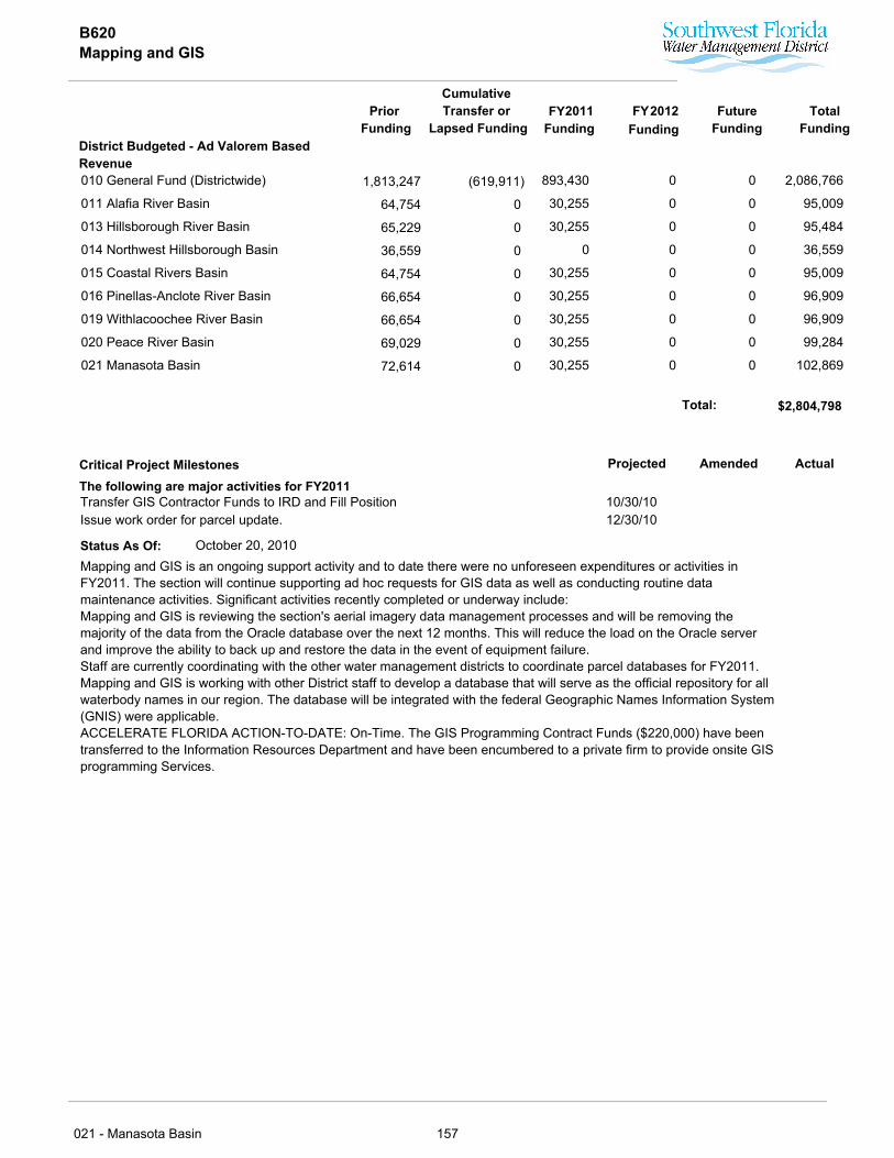
B620
Mapping and GIS
District Budgeted - Ad Valorem Based
Revenue
010 General Fund (Districtwide) 2,086,766 0 (619,911) 1,813,247 0 893,430
011 Alafia River Basin 95,009 0 0 64,754 0 30,255
013 Hillsborough River Basin 95,484 0 0 65,229 0 30,255
014 Northwest Hillsborough Basin 36,559 0 0 36,559 0 0
015 Coastal Rivers Basin 95,009 0 0 64,754 0 30,255
016 Pinellas-Anclote River Basin 96,909 0 0 66,654 0 30,255
019 Withlacoochee River Basin 96,909 0 0 66,654 0 30,255
020 Peace River Basin 99,284 0 0 69,029 0 30,255
021 Manasota Basin 102,869 0 0 72,614 0 30,255
$2,804,798 Total:
Prior
Funding
Cumulative
Transfer or
Lapsed Funding Funding Funding
2011 FY 2012 FY Future
Funding
Total
Funding
Critical Project Milestones ActualProjected Amended
The following are major activities for FY2011Transfer GIS Contractor Funds to IRD and Fill Position 10/30/10
Issue work order for parcel update. 12/30/10
Status As Of: October 20, 2010
Mapping and GIS is an ongoing support activity and to date there were no unforeseen expenditures or activities in
FY2011. The section will continue supporting ad hoc requests for GIS data as well as conducting routine data
maintenance activities. Significant activities recently completed or underway include:
Mapping and GIS is reviewing the section's aerial imagery data management processes and will be removing the
majority of the data from the Oracle database over the next 12 months. This will reduce the load on the Oracle server
and improve the ability to back up and restore the data in the event of equipment failure.
Staff are currently coordinating with the other water management districts to coordinate parcel databases for FY2011.
Mapping and GIS is working with other District staff to develop a database that will serve as the official repository for all
waterbody names in our region. The database will be integrated with the federal Geographic Names Information System
(GNIS) were applicable.
ACCELERATE FLORIDA ACTION-TO-DATE: On-Time. The GIS Programming Contract Funds ($220,000) have been
transferred to the Information Resources Department and have been encumbered to a private firm to provide onsite GIS
programming Services.
021 - Manasota Basin 157
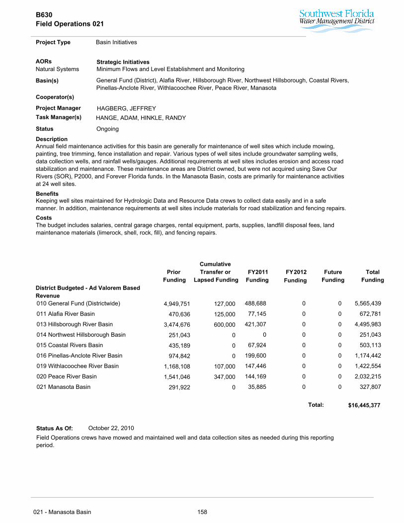
B630
Field Operations 021
Project Type Basin Initiatives
AORs Strategic InitiativesNatural Systems Minimum Flows and Level Establishment and Monitoring
Basin(s) General Fund (District), Alafia River, Hillsborough River, Northwest Hillsborough, Coastal Rivers,
Pinellas-Anclote River, Withlacoochee River, Peace River, Manasota
Cooperator(s)
Project Manager HAGBERG, JEFFREY
HANGE, ADAM, HINKLE, RANDYTask Manager(s)
Status Ongoing
DescriptionAnnual field maintenance activities for this basin are generally for maintenance of well sites which include mowing,
painting, tree trimming, fence installation and repair. Various types of well sites include groundwater sampling wells,
data collection wells, and rainfall wells/gauges. Additional requirements at well sites includes erosion and access road
stabilization and maintenance. These maintenance areas are District owned, but were not acquired using Save Our
Rivers (SOR), P2000, and Forever Florida funds. In the Manasota Basin, costs are primarily for maintenance activities
at 24 well sites.
BenefitsKeeping well sites maintained for Hydrologic Data and Resource Data crews to collect data easily and in a safe
manner. In addition, maintenance requirements at well sites include materials for road stabilization and fencing repairs.
Costs
The budget includes salaries, central garage charges, rental equipment, parts, supplies, landfill disposal fees, land
maintenance materials (limerock, shell, rock, fill), and fencing repairs.
District Budgeted - Ad Valorem Based
Revenue
010 General Fund (Districtwide) 5,565,439 0 127,000 4,949,751 0 488,688
011 Alafia River Basin 672,781 0 125,000 470,636 0 77,145
013 Hillsborough River Basin 4,495,983 0 600,000 3,474,676 0 421,307
014 Northwest Hillsborough Basin 251,043 0 0 251,043 0 0
015 Coastal Rivers Basin 503,113 0 0 435,189 0 67,924
016 Pinellas-Anclote River Basin 1,174,442 0 0 974,842 0 199,600
019 Withlacoochee River Basin 1,422,554 0 107,000 1,168,108 0 147,446
020 Peace River Basin 2,032,215 0 347,000 1,541,046 0 144,169
021 Manasota Basin 327,807 0 0 291,922 0 35,885
$16,445,377 Total:
Prior
Funding
Cumulative
Transfer or
Lapsed Funding Funding Funding
2011 FY 2012 FY Future
Funding
Total
Funding
Status As Of: October 22, 2010
Field Operations crews have mowed and maintained well and data collection sites as needed during this reporting
period.
021 - Manasota Basin 158

B733
FFL Manatee County
Project Type Basin Initiatives
AORs Strategic InitiativesWater Quality Water Quality Maintenance and ImprovementWater Supply ConservationNatural Systems Natural Systems Conservation and Restoration
Basin(s) Manasota
Manatee County Cooperative Extension ServiceCooperator(s)
Project Manager DURELL, SYLVIA
Task Manager(s)
Status Ongoing
DescriptionThe University of Florida changed the name of the Florida Yards & Neighborhoods (FYN) program to the
Florida-Friendly LandscapingTM (FFL) program. The change was made to enhance recognition of the education
outreach as the term Florida-Friendly Landscaping becomes more widely known throughout the state. In FY2011,
specific education will be provided to these targeted audiences: (1) School students and teachers will receive
information on their personal connection to watersheds; (2) Residents will be offered workshops, presentations, event
displays and a county-wide event a variety of water and conservation topics, additional demonstration landscape sites
will be planted at highly visible locations so that the public has an opportunity to view efficient irrigation, mulching, and
landscaping best management practices; and the landscape assistance program will continue its in-office
consultations with homeowners (3) Homeowner associations boards and members will be offered programs on the
FFL principles and how the principles can be integrated into association maintenance practices; (4) Civic organizations
members will receive educational presentations that focus on one water conservation and stormwater runoff; (5)
Professional landscape architects and contractors will be reached through the Green Industry's FFL Best Management
Practices trainings and be offered educational workshops that provide CEUs; (6) Manatee County government
staff will be supported in the implementation of FFL in building projects (7) Builders and developers will be provided
landscape and irrigation plans review and information on the Florida Water StarSM program. The FFL Manatee
County project has been moved from the Cooperative Funding (L510) budget category to Basin Initiative (B733). The
move reflects the value of FFL education to water resources. The level of county support is being maintained.
BenefitsIn past years, approximately 24,485 people have received education annually at presentations, workshops, classes
and exhibits and through one-on-one interactions and printed education materials distribution. In
addition, approximately 1 million people have been exposed each year to education through mass media outlets, such
as newspaper articles, web media and county government television programming. In FY2011, specific education will
be provided to school students and teachers, county residents, homeowner associations boards and members, civic
organization members, professional landscape architects and contractors, Manatee County government staff and
builders and developers. Effectiveness is measured by number of people reached at educational programs and events
and behavior change feedback from participants.
Costs
The total cost of the FY2010 program is $110,000, with the District contributing $50,000 (Manasota). Program costs
have remained stable since FY2009. District funds support the salary and benefits for the coordinator. The program is
expected to reach 24,000 Manatee County residents at a cost to the District of approximately $2.08 per person. The
budget lines below include costs for staff to manage the project.
Additional Information
The total cost of the FY2010 program was $110,000, with the District contributing $50,000 (Manasota). The
District has funded this program since 2007. Education is based on the nine Florida-Friendly Landscaping principles
that were created by the University of Florida/Institute of Food and Agricultural Sciences (UF/IFAS): Right Plant, Right
Place, Water Efficiently, Fertilize Appropriately, Mulch, Attract Wildlife, Manage Yard Pests Responsibly, Recycle,
Reduce Stormwater Runoff and Protect the Waterfront.
021 - Manasota Basin 159

B733
FFL Manatee County
District Budgeted - Ad Valorem Based
Revenue
021 Manasota Basin 52,422 0 0 0 0 52,422
Project Funds Not Budgeted by the
District
Manatee County 60,000 0 0 0 0 60,000
$112,422 Total:
Prior
Funding
Cumulative
Transfer or
Lapsed Funding Funding Funding
2011 FY 2012 FY Future
Funding
Total
Funding
Critical Project Milestones ActualProjected Amended
FY2008Purchase order created 10/1/07 10/18/07
First task report 1/31/08 1/31/08
Second advisory committee meeting 4/14/08 4/14/08
Second task report 4/30/08 4/17/08
Third advisory committee 7/21/08 7/21/08
Third task report 7/31/08 7/31/08
Fourth advisory committee meeting 9/18/08 10/15/08 10/15/08
Fourth task report 9/30/08 10/15/08 10/15/08
Project complete 9/30/08 9/30/08
FY2009Purchase order created 10/1/08 11/1/08 10/27/08
First task report 1/30/09 1/30/09
Second advisory committee meeting 4/14/09 4/30/09
Second task report 4/30/09 4/30/09
Third advisory committee meeting 7/14/09 7/14/09
Third task report 7/31/09 7/31/09
Project complete 9/30/09 9/30/09
Fourth task report 10/31/09 12/31/09
FY2010Purchase order created 10/12/09 11/16/09 11/16/09
First task report 1/29/10 1/29/10
Second advisory committee meeting 4/20/10 4/20/10
Second task report 4/30/10 4/30/10
Third advisory committee 7/20/10 7/20/10
Third task report 7/30/10 7/30/10
Project complete 9/30/10 9/30/10
Fourth task report 10/29/10 10/19/10
FY2011Create purchase order 10/1/10 10/11/10 10/11/10
First advisory committee meeting 10/28/10 10/28/10
First task report 1/31/11
Second advisory committee meeting 2/15/11
Second task report 4/29/11
Third advisory committee meeting 5/17/11
Third task report 7/29/11
Fourth advisory committee meeting 9/20/11
Project complete 9/30/11
Fourth task report 9/30/11
Fourth task report 10/31/11
021 - Manasota Basin 160
B733
FFL Manatee County
Status As Of: October 29, 2010
ACTION TO DATE: On time. The following outreach was accomplished by the Manatee County FYN coordinator,
Michelle Atkinson, in the fourth task period of FY2010: 33 workshops/presentations attracting 580 people; 759 individual
contacts; 2 contacts attributable to District messaging; 15 contacts with members and boards of homeowner
associations; 30 building/green industries/FWSG contacts; 8 programs reaching 297 youth; 1,740 pieces of educational
literature distributed; 1 newsletter article published potentially creating 4,215 impressions; 52,828 web site visitors and 66
hours contributed by 31 volunteers. Classes on rain barrels and composting are popular and are offered regularly. This
quarter 24 55-gallon rain barrels were purchased. In 2010, 98 55-gallon rain barrels were purchased. With rain events,
barrels could have been utilized to capacity eight times yielding a 440 gallon savings per resident and a 43,112 gallon
savings in all. The District's Watch the Weather, Wait to Water campaign message was included in all presentations in
July through September.
021 - Manasota Basin 161
B735
FFL Sarasota County
Project Type Basin Initiatives
AORs Strategic InitiativesWater Quality Water Quality Maintenance and ImprovementWater Supply ConservationNatural Systems Natural Systems Conservation and Restoration
Basin(s) Manasota
Sarasota County Extension ServiceCooperator(s)
Project Manager DURELL, SYLVIA
Task Manager(s)
Status Ongoing
DescriptionThe University of Florida changed the name of the Florida Yards & Neighborhoods (FYN) program to the
Florida-Friendly LandscapingTM (FFL) program. The change was made to enhance recognition of the education
outreach as the term Florida-Friendly Landscaping becomes more widely known throughout the state. In FY2011,
specific education will be provided to these targeted audiences: (1) Homeowners will learn about rain barrels and
cisterns, irrigation system and rain sensor management, seasonal irrigation time clock adjustments, capping irrigation
heads in areas with mature plants, installing micro-irrigation components, composting, rain garden installation and
proper plant selection and installation. (2) Staff/associates in retail plant nurseries will be educated on the basics of
FFL irrigation system management and use of rain barrels and cisterns. (3) Garden club and plant society members
will learn the basics of FFL and how to use rain barrels and cisterns. (4) Youth will learn about
stormwater runoff through demonstrations with the Enviroscape Nonpoint Source Pollution Model, how to use rain
barrels and cisterns and benefits of composting. The FFL Sarasota County project has been moved from the
Cooperative Funding (N143) budget category to Basin Initiative (B735). The move reflects the value of Florida-Friendly
LandscapingTM education to water resources and the integral role FYN plays in this education. The level of county
support is expected to be maintained.
BenefitsFY2011 is the second year of District partnering in funding FFL education to homeowners and students in Sarasota
County. Outreach includes presentations, workshops, one-on-one interactions, exhibits, school visits, electronic and
web media, and printed education materials. Education increases knowledge and promotes behavior change in
landscaping practices resulting in conservation of water and protection of water quality and natural systems.
Effectiveness will be measured by the number of program attendees and behavior change feedback from participants.
Costs
The total cost of the FY2011 program is $115,600, with the District contributing $50,000 (Manasota). Program costs
remain the same as in FY2010. District funds support salary, benefits and professional training for the coordinator.
The Sarasota Bay Estuary Program has committed $10,000 toward program materials. The program is expected to
reach 28,000 county residents at a cost to the District of approximately $1.79 per person. The budget lines below
include costs for staff to manage the project.
Additional Information
The total cost of the FY2010 program was $115,600, with the District contributing $50,000 (Manasota). The Sarasota
Bay Estuary Program provided $10,000 toward program materials. Education is based on the nine Florida-Friendly
Landscaping principles that were created by the University of Florida/Institute of Food and Agricultural Sciences
(UF/IFAS): Right Plant, Right Place, Water Efficiently, Fertilize Appropriately, Mulch, Attract Wildlife, Manage Yard
Pests Responsibly, Recycle, Reduce Stormwater Runoff and Protect the Waterfront.
021 - Manasota Basin 162

B735
FFL Sarasota County
District Budgeted - Ad Valorem Based
Revenue
021 Manasota Basin 51,615 0 0 0 0 51,615
Project Funds Not Budgeted by the
District
Sarasota Bay Estuary Program 10,000 0 0 0 0 10,000
Sarasota County 55,000 0 0 0 0 55,000
$116,615 Total:
Prior
Funding
Cumulative
Transfer or
Lapsed Funding Funding Funding
2011 FY 2012 FY Future
Funding
Total
Funding
Critical Project Milestones ActualProjected Amended
FY2010Purchase order created 10/12/09 10/7/09
First advisory committee meeting 1/21/10 1/21/10
First task report 1/29/10 1/29/10
Second advisory committee meeting 4/14/10 4/14/10
Second task report 4/30/10 4/21/10
Third advisory committee meeting 7/15/10 7/15/10
Third task report 7/30/10 7/30/10
Fourth task report 10/29/10 10/13/10 10/13/10
FY2011Purchase order created 10/1/10 10/5/10 10/5/10
First project manager meeting 11/11/10
First task report 1/31/11
Second task report 4/29/11
Second project manager meeting 6/14/11
Third task report 7/29/11
Project complete 9/30/11
Fourth task report 10/31/11
Status As Of: October 11, 2010
ACTION TO DATE: On time. The following outreach was accomplished by Sarasota County FYN coordinator, Angela
Antonucci, in the fourth task period of FY2010: 14 workshops/educational events with 211 attendees; 4182 contacts via
telephone, email and office visits; 46 contacts attributable to District messaging; 2 information booths in retail centers
attracting 36 people; 3,152 web site visitors; 3 events for 7 youth; 15 media promotions potentially reaching 147,000
viewers per event and 949 pieces of printed educational materials distributed and 12,343 electronic materials downloads.
Approximately 144 hours were donated by 17 volunteers. Four homeowner yards were reviewed for Florida-Friendly Yard
recognitions this quarter and 31 City of North Port public landscape sites were evaluated for Florida Green Government
certification. Thirty-three pre- and post tests completed during the rain barrel workshops showed a knowledge gain of 46
percent. From November, 2009 through June, 2010, 562 rain barrels were sold. Potential water savings (562 x 55
gallons per barrel) equals 30,910 gallons if rain barrels were filled once.
021 - Manasota Basin 163
P259
Youth Water Resources Education
Project Type Basin Initiatives
AORs Strategic InitiativesWater Quality Water Quality MonitoringWater Supply ConservationNatural Systems Natural Systems Identification and MonitoringFlood Protection Floodplain Management
Basin(s) General Fund (District), Alafia River, Hillsborough River, Northwest Hillsborough, Coastal Rivers,
Pinellas-Anclote River, Withlacoochee River, Peace River, Manasota
Cooperator(s)
Project Manager HULL, MARY MARGARET
UNSER, SALLY, KUSHMER, KAYLIE, TORRUSIO, MARYTask Manager(s)
Status Ongoing
DescriptionThis Basin Initiative provides funding for a variety of water resources education programs to county school districts,
private schools, homeschool groups and nonformal educators. Program components consist of teacher training
workshops, grants for classroom projects, field trips, online curriculum tools and publications for students and
educators. Teacher workshops are conducted by District staff and/or educators who have been trained by District
staff. Workshops include information about the District and the basins, as well as basic hydrology and water
management issues. Training sessions provide teachers with background information, materials, experiences and
opportunities to explore topics of importance in the basin. Participants evaluate the effectiveness of teacher
workshops, providing another method of improving performance. The Splash! school grant program provides
funds to teachers for classroom projects on water quality, water conservation, alternative sources, water supply or
watersheds. The program's goal is to provide hands-on water education that teaches students about their local
watersheds and the freshwater resources within them. Classroom projects are designed to increase knowledge and
understanding of the impacts of human activities on the water resources in their basin and to effect behavior change in
regard to water resources conservation and protection. Outcomes are assessed through teacher/student contact
hours learning about water resources, pre- and post-assessment scores, sample student work generated from the
project, video or photographic documentation, and final reports by teachers and representative students. Grant
recipients are required to participate in annual sharing days, which provide an opportunity for school grant participants
to showcase their projects and provide model programs for other teachers who would like to implement water projects
in their classrooms. Publications and online curriculum tools provide teachers and students with a variety of
educational resources including student newsletters and curricula with accompanying teacher's guides, watershed
excursions, coloring activity sheets, posters, bookmarks, the Classroom Water Conservation Challenge and World
Water Monitoring Day activities. The District also provides kits and boxes specific to water conservation (the grades
K-3 Water Conservation Kit) and watersheds (the grades K-3 Watershed Resource Box and the grades 3-5
Watershed Education Resources Box) that teach students about the importance of water conservation and healthy
watersheds, while meeting Sunshine State Standards and preparing students for the Florida Comprehensive
Assessment Test. Each of these resources includes a big book, several smaller books, a teacher's guide and other
tools and materials used for role-playing and demonstrations. Each county has received kits and boxes for circulation,
and these materials are available through the Splash! school grant program.
BenefitsThe Youth Water Resources Education program continues to help the District meet its mission by providing students,
teachers and families with classroom materials and opportunities for hands-on learning experiences that equip them to
make informed decisions about water resources. Throughout coordination of the District's youth education program,
strong partnerships have been developed throughout public school districts, private schools, homeschool networks,
science centers, museums and organizations, colleges and universities, state departments, local governments, girl
and boy scout groups, boys and girls clubs, environmental education providers as well as numerous non-formal
educational centers.
Costs
The FY2011 budget for youth education totals $906,000. Funding is shared among the basins as follows: Alafia River
$58,900; Hillsborough River $189,650; Coastal Rivers $59,200; Pinellas-Anclote River $256,250; Withlacoochee River
$59,200; Peace River $195,550; Manasota $87,250. The General Fund provides an additional $12,000 in funding
support. This program directly reached 355,053 students and teachers in FY2010 through programs, outreach,
teacher workshops and school grants. An additional 20,360 students and 1,018 teachers received District youth
education publications and curriculum tools during FY2010. Because most, if not all, of those involved in youth
education programs also receive publications, a conservative estimate puts District outreach (355,053) at 43 percent
021 - Manasota Basin 164

P259
Youth Water Resources Education
of the students and teachers in the District (817,644) at a cost of $2.55 per person. Budget lines below include costs
for staff to manage the projects.
Additional Information
The FY2010 budget for youth education was $906,000. Funding was shared among the basins as follows: Alafia River
$58,900; Hillsborough River $189,650; Coastal Rivers $59,200; Pinellas-Anclote River $256,250; Withlacoochee River
$59,200; Peace River $195,550; Manasota $87,250. Staff reached a total of 355,053 students and educators in
FY2010 through programs, school grants and outreach. A total of 184 school grants were completed, impacting more
than 99,218 students. Water resources education program agreements with 13 separate school boards impacted
more than 38,514 students and teachers. The 25 teacher workshops involved 469 teachers who will reach more than
27,438 students per year. More than 702,619 pieces of youth education materials were distributed to students and
teachers throughout the District. In FY2010, the Youth Education Section continued its three-year program evaluation
to determine successful program elements, to identify ways to improve impact and to develop effective ways to impart
behavior change. The comprehensive evaluation conducted by an outside evaluator will conclude in FY2011.
District Budgeted - Ad Valorem Based
Revenue
010 General Fund (Districtwide) 411,567 0 0 322,627 0 88,940
011 Alafia River Basin 638,099 0 0 566,689 0 71,410
013 Hillsborough River Basin 1,470,616 0 0 1,263,418 0 207,198
014 Northwest Hillsborough Basin 488,873 0 0 488,873 0 0
015 Coastal Rivers Basin 639,578 0 0 566,134 0 73,444
016 Pinellas-Anclote River Basin 2,937,195 0 0 2,660,136 0 277,059
019 Withlacoochee River Basin 630,191 0 0 558,377 0 71,814
020 Peace River Basin 1,730,345 0 0 1,511,506 0 218,839
021 Manasota Basin 889,369 0 0 775,135 0 114,234
District Budgeted - Outside Revenue
Hillsborough - Youth & Water Rstr Edu
(P259)
50,000 0 0 50,000 0 0
$9,885,833 Total:
Prior
Funding
Cumulative
Transfer or
Lapsed Funding Funding Funding
2011 FY 2012 FY Future
Funding
Total
Funding
Critical Project Milestones ActualProjected Amended
FY2009 Budgeted FundsProgram commence for school board agreements 8/1/08 8/1/08
Mini-grants selected 10/15/08 10/10/08
Mini-grant projects complete 5/30/09 5/29/09
School board agreement program complete 7/30/09 7/30/09
Final reports submitted to District 8/30/09 8/30/09
FY2010 Budgeted FundsProgram commence for school board agreements 8/3/09 8/28/09 8/28/09
Splash! school grants selected 10/16/09 10/16/09
Splash! school grant projects complete 5/29/10 5/28/10
School board agreement program complete 7/30/10 7/30/10
Final reports submitted to District 8/31/10 8/26/10
FY2011 Budgeted FundsSchool board education programs commence 9/10/10 9/10/10
Splash! school grants selected 10/15/10 10/15/10
021 - Manasota Basin 165
P259
Youth Water Resources Education
Splash! school grant projects complete 5/31/11
School board education programs complete 8/31/11
Status As Of: October 19, 2010
ACTION TO DATE: On time. Outreach: (1) The youth outreach specialist visited two schools during the month of
October, teaching approximately 214 students and 27 educators. (2) Staff represented the District at All Saints'
Academy's Outdoor Classroom dedication in Winter Haven on October 14. The District has contributed funding to the
Outdoor Classroom through the Splash! school grant program. (3) The youth education team visited one school and one
special event during the month of October, reaching an estimated 700 students and 10 educators. Splash! School
Grants: The Splash! school grants have been awarded for the 2010-2011 school year. The District received 253
applications and is providing grants to 204 teachers. School grants will occur in the following 14 counties: Charlotte,
Citrus, DeSoto, Hernando, Highlands, Hillsborough, Levy, Manatee, Marion, Pasco, Pinellas, Polk, Sarasota and Sumter.
Grant implementation meetings took place in each county from Oct. 25 to Nov. 10. School Board Coordination: (1) On
October 5 staff conducted a teleconference with Land Resources staff and Sumter County School District personnel to
discuss involvement in the District's efforts to partner with Florida Fish and Wildlife Conservation Commission (FWC)
and the Wildlife Foundation of Florida (WFF) to develop a Youth Center on Flying Eagle Preserve in Citrus County. (2)
Staff conducted a teleconference on October 7 with Land Resources staff and Citrus County School District personnel to
discuss involvement in the District's efforts to partner with the FWC and WFF to develop a Youth Center on Flying Eagle
Preserve. (3) Staff coordinated the Get Outside! event at Potts Preserve on October 23 with Citrus, Marion and Sumter
school districts. A total of 9,470 invitations were sent to 13 public schools to go home with students and invite families
and friends to this outdoor event on District lands. (4) The District will provide funding through 13 school board
agreements to implement water resources education programs for K-12 students and educators for the 2010-2011
school year. Teacher Training: Planning is underway for an upcoming Project WET workshop on November 5 for
approximately 60 education majors at the University of South Florida/Tampa. The workshop will be facilitated by Youth
Education staff and offered as part of the Suncoast Area Teacher Training Honors Program. Publications: Approximately
40,700 youth publications have been distributed during fiscal year 2011. More than 627,900 youth education materials
have been distributed this calendar year.
021 - Manasota Basin 166

P268
Public Education
Project Type Basin Initiatives
AORs Strategic InitiativesWater Quality Water Quality Maintenance and ImprovementFlood Protection Floodplain ManagementWater Supply ConservationNatural Systems Natural Systems Conservation and Restoration
Basin(s) Alafia River, Hillsborough River, Coastal Rivers, Pinellas-Anclote River, Withlacoochee River,
Peace River, Manasota
Cooperator(s)
Project Manager PUTNAM, BETH
ALTMAN, MELISSA, STERNBERGER, VIRGINIA, ROE, MELISSA, HARROUN, AMY, DURELL,
SYLVIA
Task Manager(s)
Status Ongoing
DescriptionThis Basin Initiative provides funding for several projects designed to inform and educate the public about the
importance of managing and protecting the water resources. All programs align directly with one or more of the
District's areas of responsibilities, with the District's strategic plan and with Basin Board priorities. The District's broad
range of public education programs and materials reflect the variety of backgrounds and interests of the District's
residents and visitors. Some projects are implemented Districtwide with support from all Basin Boards, while some are
basin-specific and supported only by the Basin Board(s) that will benefit from the project(s). Nearly half (48%) of the
funding is budgeted for Districtwide public service advertising. Other Districtwide programs include educational
material development, surveys and other research/evaluation measures, Florida-Friendly LandscapingTM education,
and translation services for Spanish materials. A major District initiative launched Sept. 26, 2009, and continuing in
FY2011 is the "Get Outside!" campaign promoting stewardship of District lands. Basin-specific programs reflect
differing priorities as well as unique opportunities. Examples are Community Education Grants (approximately 24% of
the budget), watershed education programs, exhibits and signage, special events and partnerships with local
environmental education centers, nonprofits and others. Two basin-specific projects in FY2011 are Polk County Lakes
Education/Action Drive ($18,084) and Adopt-A-Pond Pasco ($10,000).
BenefitsThe programs listed benefit the District through an increase in awareness and understanding of water management
and water resource issues, as well as an increase in behaviors that conserve and protect the District's water resources
and watersheds. Partnerships with local groups and organizations allow the District to leverage resources and extend
reach.
Costs
Funding for public education is budgeted within the basins for FY2011 as follows: Alafia River -- $52,223; Hillsborough
River -- $195,417; Coastal Rivers -- $62,056; Pinellas-Anclote River -- $184,035; Withlacoochee River -- $66,096;
Peace River -- $129,099; Manasota -- $95,289. In addition, the Governing Board contributes $933,212 to
support public education efforts, $525,000 of which is allocated to public service advertising. Basin Board and General
Fund contributions in FY2011 for public service advertising total $902,010. The cost/benefit of those reached via public
service advertising is measured in impressions and is projected to cost the District less than eight hundredths of a
cent per impression. P268 funds support a variety of education and outreach efforts Districtwide. Based on the total
number of people reached through the public education materials and programs in FY2009 (1.8 million people), the
cost/benefit ratio for the remaining amount budgeted for public education in FY2011 is approximately $0.45 per
person. Budget lines below include costs for staff to manage the projects.
Additional Information
Funding for public education was budgeted within the basins for FY2010 as follows: Alafia River - $59,493;
Hillsborough River - $228,648; Coastal Rivers - $67,517; Pinellas-Anclote River - $257,106; Withlacoochee River -
$87,079; Peace River - $154,423; Manasota - $102,715. In addition, the Governing Board contributed $942,490 to
support public education efforts, $525,000 of which was for public service advertising. Funds support a variety of
educational and outreach efforts Districtwide. Budget lines below include costs for staff to manage the projects.
FY2010 accomplishments include: (1) Completed the District's most successful public service advertising campaign to
date; the"Skip A Week" campaign resulted in a reported 19% increase in those who skipped a week of irrigation
during the cooler months, saving up to 1.2 billion gallons of water in two months. (2) Managed 108 projects involving
755,000 people directly in the conservation and protection of water resources, including 44,000 people directly
involved in watershed education focusing on reducing human impacts to water quality. (3) Promoted the District
message to more than 127,000 people at special events. (5) Reached approximately 150,000 through District
021 - Manasota Basin 167
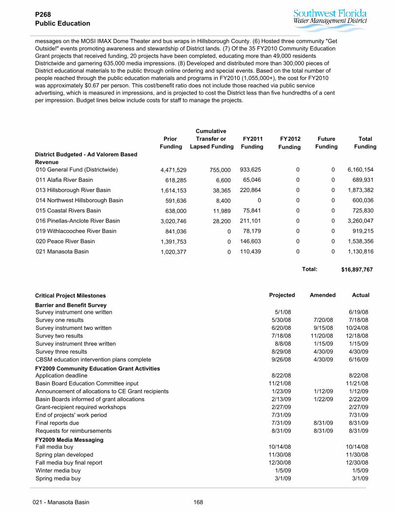
P268
Public Education
messages on the MOSI IMAX Dome Theater and bus wraps in Hillsborough County. (6) Hosted three community "Get
Outside!" events promoting awareness and stewardship of District lands. (7) Of the 35 FY2010 Community Education
Grant projects that received funding, 20 projects have been completed, educating more than 49,000 residents
Districtwide and garnering 635,000 media impressions. (8) Developed and distributed more than 300,000 pieces of
District educational materials to the public through online ordering and special events. Based on the total number of
people reached through the public education materials and programs in FY2010 (1,055,000+), the cost for FY2010
was approximately $0.67 per person. This cost/benefit ratio does not include those reached via public service
advertising, which is measured in impressions, and is projected to cost the District less than five hundredths of a cent
per impression. Budget lines below include costs for staff to manage the projects.
District Budgeted - Ad Valorem Based
Revenue
010 General Fund (Districtwide) 6,160,154 0 755,000 4,471,529 0 933,625
011 Alafia River Basin 689,931 0 6,600 618,285 0 65,046
013 Hillsborough River Basin 1,873,382 0 38,365 1,614,153 0 220,864
014 Northwest Hillsborough Basin 600,036 0 8,400 591,636 0 0
015 Coastal Rivers Basin 725,830 0 11,989 638,000 0 75,841
016 Pinellas-Anclote River Basin 3,260,047 0 28,200 3,020,746 0 211,101
019 Withlacoochee River Basin 919,215 0 0 841,036 0 78,179
020 Peace River Basin 1,538,356 0 0 1,391,753 0 146,603
021 Manasota Basin 1,130,816 0 0 1,020,377 0 110,439
$16,897,767 Total:
Prior
Funding
Cumulative
Transfer or
Lapsed Funding Funding Funding
2011 FY 2012 FY Future
Funding
Total
Funding
Critical Project Milestones ActualProjected Amended
Barrier and Benefit SurveySurvey instrument one written 5/1/08 6/19/08
Survey one results 5/30/08 7/20/08 7/18/08
Survey instrument two written 6/20/08 9/15/08 10/24/08
Survey two results 7/18/08 11/20/08 12/18/08
Survey instrument three written 8/8/08 1/15/09 1/15/09
Survey three results 8/29/08 4/30/09 4/30/09
CBSM education intervention plans complete 9/26/08 4/30/09 6/16/09
FY2009 Community Education Grant ActivitiesApplication deadline 8/22/08 8/22/08
Basin Board Education Committee input 11/21/08 11/21/08
Announcement of allocations to CE Grant recipients 1/23/09 1/12/09 1/12/09
Basin Boards informed of grant allocations 2/13/09 1/22/09 2/22/09
Grant-recipient required workshops 2/27/09 2/27/09
End of projects' work period 7/31/09 7/31/09
Final reports due 7/31/09 8/31/09 8/31/09
Requests for reimbursements 8/31/09 8/31/09 8/31/09
FY2009 Media MessagingFall media buy 10/14/08 10/14/08
Spring plan developed 11/30/08 11/30/08
Fall media buy final report 12/30/08 12/30/08
Winter media buy 1/5/09 1/5/09
Spring media buy 3/1/09 3/1/09
021 - Manasota Basin 168
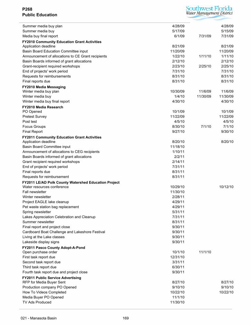
P268
Public Education
Summer media buy plan 4/28/09 4/28/09
Summer media buy 5/17/09 5/15/09
Media buy final report 6/1/09 7/31/09 7/31/09
FY2010 Community Education Grant ActivitiesApplication deadline 8/21/09 8/21/09
Basin Board Education Committee input 11/20/09 11/20/09
Announcement of allocations to CE Grant recipients 1/22/10 1/11/10 1/11/10
Basin Boards informed of grant allocations 2/12/10 2/12/10
Grant-recipient required workshops 2/23/10 2/25/10 2/25/10
End of projects' work period 7/31/10 7/31/10
Requests for reimbursements 8/31/10 8/31/10
Final reports due 8/31/10 8/31/10
FY2010 Media MessagingWinter media buy plan 10/30/09 11/6/09 11/6/09
Winter media buy 1/4/10 11/30/09 11/30/09
Winter media buy final report 4/30/10 4/30/10
FY2010 Media ResearchPO Opened 10/1/09 10/1/09
Pretest Survey 11/22/09 11/22/09
Post test 4/5/10 4/5/10
Focus Groups 8/30/10 7/1/10 7/1/10
Final Report 9/27/10 9/30/10
FY2011 Community Education Grant ActivitiesApplication deadline 8/20/10 8/20/10
Basin Board Committee input 11/18/10
Announcement of allocations to CEG recipients 1/10/11
Basin Boards informed of grant allocations 2/2/11
Grant recipient required workshops 2/14/11
End of projects' work period 7/31/11
Final reports due 8/31/11
Requests for reimbursement 8/31/11
FY2011 LE/AD Polk County Watershed Education ProjectWater resources conference 10/29/10 10/12/10
Fall newsletter 11/30/10
Winter newsletter 2/28/11
Project EAGLE lake cleanup 4/29/11
Pet waste station bag replacement 4/29/11
Spring newsletter 5/31/11
Lakes Appreciation Celebration and Cleanup 7/31/11
Summer newsletter 8/31/11
Final report and project close 9/30/11
Cardboard Boat Challenge and Lakeshore Festival 9/30/11
Living at the Lake classes 9/30/11
Lakeside display signs 9/30/11
FY2011 Pasco County Adopt-A-PondOpen purchase order 10/1/10 11/1/10
First task report due 12/31/10
Second task report due 3/31/11
Third task report due 6/30/11
Fourth task report due and project close 9/30/11
FY2011 Public Service AdvertisingRFP for Media Buyer Sent 8/27/10 8/27/10
Production company PO Opened 9/10/10 9/10/10
How To Videos Completed 10/22/10 10/22/10
Media Buyer PO Opened 11/1/10
TV Ads Produced 11/30/10
021 - Manasota Basin 169
P268
Public Education
Print advertising produced 12/3/10
Spring Media Buy Plan Complete 2/1/11
Spring Media Buy Begins 2/15/11
Spring Media Buy Ends 5/16/11
Spring Media Buy Final Report Complete 7/15/11
FY2011 Public Service Advertising - ResearchResearch consultant PO opened 9/15/10 9/15/10
Pretest survey conducted 1/14/11
Posttest survey conducted 5/31/11
Focus groups 8/5/11
Final research report received 9/30/11
Pilot Irrigation ProjectFinish focus group research 9/30/07 9/30/07
Take test meter readings of pilot neighborhoods 9/30/07 10/24/07
Finish survey research 2/28/08 5/1/08 6/9/08
Develop pilot project plans 5/31/08 9/30/08 10/6/08
Begin pilot project in designated neighborhoods 7/1/08 12/1/08 12/1/08
Take meter read #1 7/31/08 12/30/08 12/30/08
Take meter read #2 8/31/08 1/31/09 2/9/09
Take meter read #3 9/30/08 3/20/09 4/10/09
Evaluate pilot program based on meter readings 10/15/08 10/15/10 7/30/10
Begin phase two with needed revisions 1/1/09 7/1/09 7/1/09
Take meter read #1 1/31/09 7/31/09 7/31/09
Take meter read #2 2/28/09 8/31/09 9/15/09
Take meter read #3 3/30/09 9/30/09 12/10/09
Pilot end date 3/31/09 9/30/10 7/30/10
WWIPP Phase IIConduct campaign with pretest 7/31/09 9/30/09 10/1/09
Evaluate program impact with posttest 6/30/10 10/31/10
Final report and fact sheet due 8/31/10 12/31/10
Status As Of: October 22, 2010
Community Education Grants (CEG) : The FY2011 CEG program received 46 applications Districtwide, requesting
$203,490. Staff has recommending funding for 29 projects, totaling $119,086. Basin Board Education Committee
members will receive CEG packets including applications and summaries for review in November. February Basin Board
packets will include a list of awardees. The grant implementation period runs from March through July 2011.
Florida-Friendly LandscapingTM Education (FFL): (1) The state office of the UF/FFL program and DEP recently
published a new resource for Florida gardeners, Florida-Friendly Landscaping Guide to Plant Selection & Landscape
Design. The 104-page book features sample landscape designs and information and color photos of more than 350
plants and trees. (2) SJRWMD has launched a searchable Water Wise plant web database that contains more than 750
plants and trees. "Get Outside!" Campaign: Since the campaign began Sept. 26, 2009, the revised web page has
received more than 57,000 views from more than 26,000 unique visitors. The Recreation Guide to the Southwest Florida
Water Management District Lands was also revised and more than 28,000 copies have been distributed since the
campaign began. The District hosted the fourth community event Oct. 23, 2010, at Potts Preserve in Citrus County.
Activities included boat tours on the Withlacoochee River, hiking tours, live animal presentations and other displays and
activities that promote the District's protection of land and water resources. To increase awareness, the "Get Outside!"
campaign will be advertised from October through the end of January on 30 buses in Hillsborough County as part of the
District's partnership with Lamar Advertising. Public Service Advertising: (1) The FY2011 campaign will focus on
appropriate fertilizer use. Seven Florida-friendly fertilizing how-to videos were completed in late October. Television ads
were produced in late-October for November completion. The campaign is planned to run mid-February through mid-May
2011. (2) The RFP for the FY2011 media buyer was awarded and the purchase order was opened at the end of October.
Research: The FY2011 fertilizer pre-campaign survey questions are being drafted. A final draft of the survey will be
reviewed and the survey will be conducted in January 2011, just prior to the campaign. Watershed/Water Quality
Education: The District's watershed education efforts focus on specific behaviors, such as reducing fertilizer and
pesticide use, maintaining septic systems, conserving water, disposing of trash appropriately and picking up and
disposing of pet waste. (1) The Adopt-A-Pond Pasco scope of work is currently in the development process. (2) On
October 12, the Lakes Education/Action Drive held its annual water resources conference titled Taking Action for Water
Resource Sustainability "The Watershed Approach ." This workshop reached 55 people who learned about management
021 - Manasota Basin 170

P268
Public Education
actions for current and future water resource sustainability. The workshop was recorded by the City of Lakeland and is
available for viewing on the city's site www.Lakelandgov.net. Special Events: The District participates in special events
throughout the year as part of its outreach efforts. At some events, the District supplies a restroom trailer that promotes
the District's message through signage and its sound systems. To increase reach, in FY2010 the Communications
Department formed and coordinated a public outreach team that includes more than 50 District staff from a variety of
departments and service offices. Team members will staff booths and make presentations at approximately 28 events in
FY2011. Of these events, seven include the restroom trailer.
021 - Manasota Basin 171
H008
Lake Hancock Lake Level Modification
Project Type WS&R Dev.
AORs Strategic InitiativesWater Supply Regional Water Supply PlanningNatural Systems Minimum Flows and Levels Recovery
Basin(s) General Fund (District), Alafia River, Peace River, Manasota
Cooperator(s)
Project Manager DOWNING, HARRY
BLASCHKA, STEVEN, HILL, CHERYL, SMITH, RANDY, LETASI, SCOTTTask Manager(s)
Status Ongoing
DescriptionThe Lake Hancock Lake Level Modification Project is part of the proposed strategy for achieving minimum flows and
levels recovery for the upper Peace River established by the District. The goal of the Lake Level Modification Project is
to store water by raising the control elevation of the existing outflow structure on Lake Hancock and to slowly release
the water during the dry season to help meet the minimum flow requirements in the upper Peace River between
Bartow and Zolfo Springs. Historically, Lake Hancock fluctuated more than a foot higher than it has during the past
several decades. The project proposes to increase the normal operating level from 98.7 feet to 100.0 feet National
Geodetic Vertical Datum (NGVD) by modifying the P-11 outfall structure. See H009 (Lake Hancock Outfall Structure
P-11 Modification) for a description of that project. This proposed project will further the District's recent efforts to
restore minimum flows in the upper Peace River, which is a major component of the District's SWUCA Recovery Plan.
As such, it is funded as a Water Supply and Resource Development (WSRD) project.
BenefitsRaising the normal operating water level of Lake Hancock to 100.0 feet NGVD will provide the storage to increase the
number of days the upper Peace River will meet minimum flows. This includes providing up to 25 cfs for sink losses
within the river. It was also determined that raising of the operating level along with other District projects will help
restore wetland function for several hundred acres of contiguous lands to Lake Hancock.
Costs
This is a multi-year funded project. Funding for this project is shared by the Governing Board (50 percent), Peace
River Basin Board (25 percent), Alafia River Basin Board (12.5 percent) and Manasota Basin Board (12.5 percent).
Basin Board funding percentages are based on Alafia, Manasota, and Peace Basin impacts to the loss of flows from
the upper Peace River Watershed from ground-water withdrawals. As of 2010, the District has budgeted $8,942,000 of
which $1,600,000 is from State Appropriations, Ecosystem Trust Fund and Water Protection and Sustainability Trust
Fund. For continued funding of future project steps, District staff is requesting $3,000,000 in FY2011 for implementing
the project, broken down as follows: Governing Board $1,500,000, Peace River Basin Board $750,000, Manasota and
Alafia River Boards each $375,000. The funding is for design, permitting, and construction of drainage improvement
projects necessary to raise the operating level of the Lake to 100 feet NGVD. Land costs are not included.
In additional to H008, $2,500,000 was funded in FY2003 and another $2,500,000 in FY2009 through field
operations (Project H009) for the replacement of the P-11 structure.
Additional Information
This project is being conducted in 3 Steps: Step (1) provided the preliminary evaluations and incremental probable
costs for raising the normal high operating levels of Lake Hancock to 99.5, 100.0, and the target 100.5 feet from the
current level of 98.7 feet. Step (1) is complete with a recommended target level up to 100.0 feet. The results of Step 1
were presented to the boards with a staff recommendation for moving forward with Step (2) of the project in October
2004. Step (2) involves the generation of the detailed information necessary to submit a complete Conceptual
Environmental Resource Permit (ERP) Application, and to specifically identify impacts to private lands for acquisition
and other mitigation needs (environmental, facilities, etc). Major components of the Conceptual ERP include: pre and
post condition analysis; private property, dwelling, environmental, and infrastructure mitigation; outfall structure
operation characteristics; and an anticipated fluctuation schedule for the Lake. Step (2) is complete and the
Conceptual ERP was received on June 14, 2007. Step (3) is the implementation of the mitigation components as
specified in the Conceptual ERP. The Project will be coordinated with H014 which will look at improving water quality
released from the lake.
021 - Manasota Basin 172
H008
Lake Hancock Lake Level Modification
District Budgeted - Ad Valorem Based
Revenue
010 General Fund (Districtwide) 5,997,006 1,287,000 (759,254) 3,909,068 0 1,560,192
011 Alafia River Basin 1,509,469 321,750 (187,500) 983,996 0 391,223
020 Peace River Basin 3,104,118 643,500 (375,000) 2,055,676 0 779,942
021 Manasota Basin 1,506,381 321,750 (187,500) 980,908 0 391,223
District Budgeted - Outside Revenue
Ecosystem Trust Fund - Lk Hancock Lk
Level
1,050,000 0 0 1,050,000 0 0
State Approp - WRAP - Prior Year
Funds
1,750,000 0 1,500,000 250,000 0 0
Water Protection & Sust T.F. (Surface
Wtr Rstr)
300,000 0 0 300,000 0 0
$15,216,974 Total:
Prior
Funding
Cumulative
Transfer or
Lapsed Funding Funding Funding
2011 FY 2012 FY Future
Funding
Total
Funding
Critical Project Milestones ActualProjected Amended
1. Step (1) Preliminary Evaluation1. Preliminary Identification of Potentially Affected Parcels 10/30/02 10/30/02
2. Advertise Request for Proposals 12/20/02 12/20/02
3. Select and Approve Consulting Firm 12/30/02 12/30/02
4. Develop Project Scope of Work 12/30/02 2/27/03
5. Begin Contract Negotiations 2/27/03 3/15/03
6. Enter into Contract 5/23/03 5/14/03
7. Provide Preliminary Results 4/28/04 6/15/04
8. Board Action for Step (2) 9/27/04 10/26/04
2. Step(2) Preliminary Design and Conceptual Permitting1. Amend Contract with BCI, Inc. for Conceptual Permitting 11/3/04 11/3/04
2. Permitting of NCLF Phase III Expansion 3/29/05 3/29/05
3. NCLF Evaluation for Project Effects 3/31/05 12/20/05
4. Develop Project Mitigation Strategies 6/30/05 12/30/05
5. Approve Mitigation Strategies 8/30/05 7/25/06
6. Submit CERP Application 10/14/05 8/31/06
7. Obtain CERP 3/31/06 6/14/07
8. Board Authorization of Project 9/25/07 9/25/07
9. USACE Notice of Intent 9/26/07 12/12/07
3. Step (3) P-11 Design and Construction1. Post P-11 Request For Proposals 3/31/08 2/8/08
2. Select P-11 Engineering Firm 6/30/08 6/6/08
3. Execute Agreement - P-11 Engineering Firm 8/31/08 10/8/08
4. Notice to Proceed - P-11 Engineering Firm 9/15/08 10/29/08
5. 30% P-11 Design Completion (Conceptual) 3/8/09 3/20/09 3/20/09
6. 60% P-11 Design Completion 7/8/09 10/1/09 7/20/09
7. Submit P-11 Environmental Resource Permit 8/1/09 10/30/09 1/29/10
8. 90% P-11 Design Completion 10/8/09 11/30/09 11/24/09
9. Final P-11 Design Completion 1/8/10 4/30/10 5/24/10
10. Post P-11 Request For Bids 2/15/10 5/14/10 8/6/10
11. Select P-11 Lowest Responsive Bidder 5/15/10 12/3/10
12. Execute Agreement - P-11 Construction Contractor 6/30/10 1/7/11
13. Notice to Proceed - P-11 Construction Contractor 7/1/10 1/14/11
021 - Manasota Basin 173
H008
Lake Hancock Lake Level Modification
14. P-11 Construction Commences 8/1/10 2/25/11
15. P-11 Construction Completion 12/31/11
3. Step (3) Cemetery Drainage Improvements1. Complete Design Alternative Analysis 3/31/10 7/13/10
2. Submit Environmental Resource Permit 10/29/10
3. Complete Design Plans & Specifications 11/30/10
4. Begin Construction 2/28/11
5. Complete Construction 8/31/11
3. Step (3) Jacque Lee Lane & HWY 5401. Complete Design Alternative Analysis 8/2/10 8/31/10 8/12/10
2. Submit Environmental Resource Permit 11/30/10
3. Complete Design Plans & Specifications 12/31/10
4. Begin Construction 4/22/11
5. Complete Construction 12/30/11
3. Step (3) Lake Lena Run1. Complete Design Alternative Analysis 8/31/10 12/31/10
2. Submit Environmental Resource Permit 10/29/10
3. Complete Design Plans & Specifications 12/31/10
4. Begin Construction 5/31/11
5. Complete Construction 12/30/11
3. Step (3) OFP Flow Way1. Complete Design Alternative Analysis 8/31/10 12/31/10
2. Complete Design Plans & Specifications 12/31/10
3. Begin Construction 4/29/11
4. Complete Construction 9/30/11
3. Step (3) Parkway Pond Modification1. Submittal of FDOT Permits 11/19/07 3/31/10 7/16/10
2. Complete Design 5/31/10 7/16/10
3. Submit Environmental Resource Permit Modification to FDEP 6/30/10 5/26/10
4. Post Request for Bids 11/30/10
5. Award Contract & Notice to Proceed 2/15/11
6. Begin Construction 2/21/11
7. Complete Construction 2/25/11
Status As Of: October 28, 2010
Status History: The Preliminary Evaluation Report (Step 1) for Lake Hancock by BCI, Inc., is complete and was
approved by the Governing Board in October 2004 for initiating preliminary design and conceptual permitting to raise the
lake operating level from 98.7 to 100.0 feet (Step 2). With the approval of the Governing Board (October 26, 2004),
District staff amended the contract and entered into a Work Order with BCI Engineers and Scientists, Inc. to begin Step
(2) of the project on November 3, 2004. The Governing Board at their January 24, 2006 meeting authorized staff to
submit a conceptual ERP application to the FDEP and the United States Army Corps of Engineers to raise the control
elevation up to 100 feet NGVD to help meet the low flow requirements of the upper Peace River, upon reaching
agreement through a Memorandum of Agreement (MOA) with Polk County. The Board authorized staff to develop a
MOA with Polk County for the Lake Level Modification Project. With the approval of the MOA by the District at the July
2006 meeting, a Conceptual ERP application was submitted to FDEP on August 31, 2006 for permitting. A Conceptual
ERP was received from FDEP on June 14, 2007. The USACE Public Notice of Intent to permit was completed in
December 2007 and approval was later received in April 2008. District staff have met with affected property owners in
August and September, 2007 to discuss (1) project effects, (2) whether their property would be needed to implement the
project, and (3) Board meetings and schedules. Current Status: Land Resources is currently negotiating with private land
owners and purchasing their properties when successful negotiations are achieved. District staff is currently working on
FDOT permits for Highway 540 and the Polk Parkway, and has contracted with BCI, Engineers and Scientists, Inc. to
implement (Step 3), the design, permitting, and development of construction documents for mitigation required upstream
of the P-11 Structure. The District has contracted the engineering consulting firm DMK & Associates to design the new
Lake Hancock Outfall Structure (P-11). DMK has completed the P-11 design plans and the District has received an ERP
to construct the new P-11 structure from FDEP which was issued on March 2, 2010. The construction of the P-11
Structure is being rebid in November 2010. ACTION-TO-DATE: On-time, this project already has an accelerated
schedule and District staff will continue to make sure the project tasks are being completed on schedule.
021 - Manasota Basin 174

H009
Lake Hancock Outfall Structure P-11 Replacement
Project Type WS&R Dev.
AORs Strategic InitiativesFlood Protection Floodplain ManagementNatural Systems Minimum Flows and Levels Recovery
Basin(s) General Fund (District), Alafia River, Peace River, Manasota
Cooperator(s)
Project Manager LETASI, SCOTT
LETASI, SCOTT, SMITH, RANDY, BARTLETT, MIKE, GANUN, JIMTask Manager(s)
Status Ongoing
DescriptionFunding under Project H009 is provided for the replacement of the Lake Hancock P-11 Water Control Structure. This
project is directly related to Project H008, Lake Hancock Lake Level Modification. Project H009 is contingent on the
successful completion of Project H008 in 3 steps: Step (1) provide the preliminary evaluations and incremental
probable costs for raising the normal high operating levels of Lake Hancock to 99.5, 100.0, and the target 100.5 feet
from the current level of 98.7 feet. Step (1) is complete with a recommended target level up to 100.0 feet. The results
of Step 1 were presented to the boards with a staff recommendation for moving forward with Step (2) of the project in
October 2004. Step (2) involves the generation of the detailed information necessary to submit a complete Conceptual
Environmental Resource Permit (ERP) Application, and to specifically identify impacts to private lands for acquisition
and other mitigation needs (environmental, facilities, etc). Major components of the Conceptual ERP include: pre and
post condition analysis; private property, dwelling, environmental, and infrastructure mitigation; outfall structure
operation characteristics; and an anticipated fluctuation schedule for the Lake. Step (3) is the implementation of the
mitigation components as specified in the Conceptual ERP. Costs for design, ERPs, and construction for
environmental and infrastructure mitigation requirements have not been determined. Once these steps have been
completed, construction documents will be completed for the replacement of Structure P-11 and the District will post a
request for bids. Funding for this project is shared by the Governing Board (50 percent), Peace River Basin Board (25
percent), Alafia River Basin Board (12.5 percent) and Manasota Basin Board (12.5 percent). Basin Board funding
percentages are based on Alafia, Manasota, and Peace Basin impacts to the loss of flows in the Upper Peace River
Watershed from ground-water withdrawals.
BenefitsRaising the normal operating water level of Lake Hancock to 100.0 feet NGVD will provide the storage to increase the
number of days the upper Peace River will meet the minimum flows from 70 percent to 87 percent and provide up to
25 cfs of recharge to the Upper Floridan aquifer through sinks. It was also determined that raising of the operating level
along with other District projects will help restore wetland function for several hundred acres of contiguous lands to
Lake Hancock. Project H009 will involve the actual replacement of the present control structure to achieve these goals.
Costs
The probable cost are projected to be a total of $5,000,000 for this structural replacement project. This cost does not
include any land acquisition costs. Funds encumbered under Project H009 were approved in FY2003 in the amount of
$2,500,000 and an additional $2,500,000 was approved in the FY2009 for implementing the structure replacement
project. The FY2009 funds are from the West Central Florida Water Restoration Action Plan FY2009 State funds. The
FY2003 and FY2009 funds do not include any land acquisition cost.
021 - Manasota Basin 175
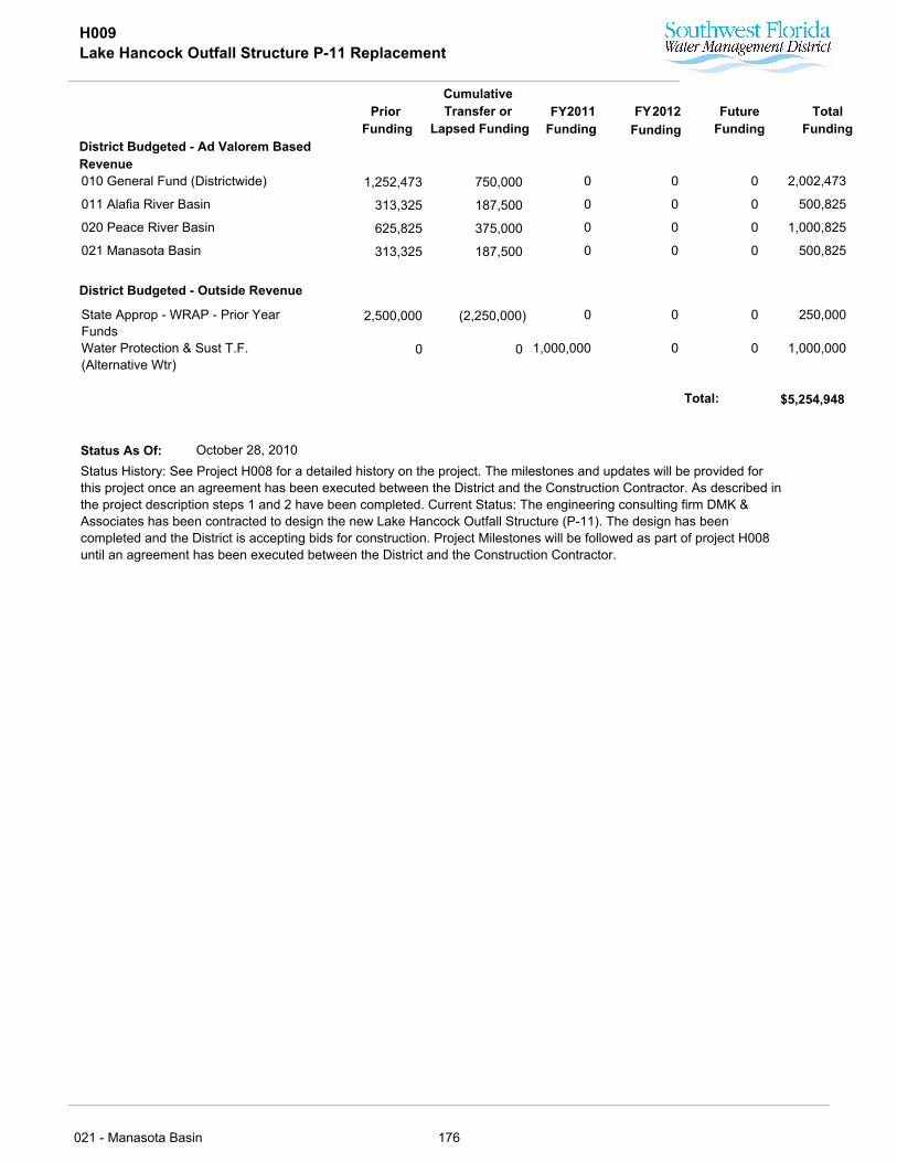
H009
Lake Hancock Outfall Structure P-11 Replacement
District Budgeted - Ad Valorem Based
Revenue
010 General Fund (Districtwide) 2,002,473 0 750,000 1,252,473 0 0
011 Alafia River Basin 500,825 0 187,500 313,325 0 0
020 Peace River Basin 1,000,825 0 375,000 625,825 0 0
021 Manasota Basin 500,825 0 187,500 313,325 0 0
District Budgeted - Outside Revenue
State Approp - WRAP - Prior Year
Funds
250,000 0 (2,250,000) 2,500,000 0 0
Water Protection & Sust T.F.
(Alternative Wtr)
1,000,000 0 0 0 0 1,000,000
$5,254,948 Total:
Prior
Funding
Cumulative
Transfer or
Lapsed Funding Funding Funding
2011 FY 2012 FY Future
Funding
Total
Funding
Status As Of: October 28, 2010
Status History: See Project H008 for a detailed history on the project. The milestones and updates will be provided for
this project once an agreement has been executed between the District and the Construction Contractor. As described in
the project description steps 1 and 2 have been completed. Current Status: The engineering consulting firm DMK &
Associates has been contracted to design the new Lake Hancock Outfall Structure (P-11). The design has been
completed and the District is accepting bids for construction. Project Milestones will be followed as part of project H008
until an agreement has been executed between the District and the Construction Contractor.
021 - Manasota Basin 176
H015
FARMS Back-Plug Program
Project Type WS&R Dev.
AORs Strategic InitiativesWater Quality Water Quality Maintenance and ImprovementNatural Systems Natural Systems Conservation and Restoration
Basin(s) Alafia River, Peace River, Manasota
Cooperator(s)
Project Manager BRUMBAUGH, DAVID
Task Manager(s)
Status Ongoing
DescriptionPunta Gorda's in-stream drinking water reservoir is sustained by Class I surface water bodies comprised of the Shell
and Prairie Creek watersheds. In 2000, the City of Punta Gorda contacted FDEP and the District with concerns for
declining water quality trends observed in the reservoir. Investigations indicated that irrigation pumping from deep
wells was a primary source adversely impacting the watersheds through degraded agricultural runoff, ultimately
leading to a decline in water quality of the Punta Gorda reservoir downstream. In 2002, the Back-Plug Program was
initiated primarily to improve water quality in the watershed systems of the SWUCA. The back-plug program was
included in the Facilitating Agricultural Resources Management Systems (FARMS) Program in 2005.
BenefitsWell back-plugs may become a procedure recommended for agricultural growers wanting to significantly improve crop
yields by decreasing highly mineralized sources of groundwater used for irrigation, and to mitigate potential impacts to
public surface water supplies.
Costs
Qualifying landowners are reimbursed up to a maximum of $6,500 per well for back-plug procedures, with final
amounts of reimbursement determined by borehole dimensions of the back-plugged interval. The Shell, Prairie, and
Joshua Creek (SPJC) watersheds are considered priority areas for this program.
Additional Information
A brochure and webpage is available from SWFWMD summarizing the FARMS Back-Plug Program.
District Budgeted - Ad Valorem Based
Revenue
010 General Fund (Districtwide) 740,617 0 (30,000) 742,418 0 28,199
011 Alafia River Basin 67,080 0 0 62,389 0 4,691
020 Peace River Basin 611,216 0 (133,547) 727,836 0 16,927
021 Manasota Basin 50,972 0 0 44,388 0 6,584
$1,469,885 Total:
Prior
Funding
Cumulative
Transfer or
Lapsed Funding Funding Funding
2011 FY 2012 FY Future
Funding
Total
Funding
Status As Of: October 27, 2010
A total of 67 wells have been back-plugged in the SWUCA overall to date, with 50 of these wells located in the SPJC
priority watersheds. Analytical results for samples collected from the 48 back-plugged wells in the SPJC area indicated
conductivity, total dissolved solids (TDS) and chloride were decreased by 47%, 48% and 66%, respectively, with
pumping yields reduced by 23% as a result of back-plugging procedures. For the 17 wells in the SWUCA (outside of the
SPJC area), seven wells were back-plugged in the Peace River watershed, six in the Alafia River watershed, two in the
Manatee River watershed, one in the Myakka River watershed, and one in the Horse Creek watershed. Analytical results
for all back-plugged wells combined in the SWUCA indicated conductivity, TDS and chloride were decreased by 46%,
46% and 62%, respectively. Combined SWUCA pumping yields were reduced by 24% as a result of back-plugging
021 - Manasota Basin 177

H015
FARMS Back-Plug Program
procedures. Routine monitoring results of select back-plugged wells so far have indicated sustained improvements to the
quality of groundwater used for irrigation purposes.
021 - Manasota Basin 178
H017
Facilitating Agricultural Resource Management Systems Program
Project Type WS&R Dev.
AORs Strategic InitiativesWater Quality Water Quality Maintenance and ImprovementWater Supply Alternative Water Supply
Basin(s) General Fund (District), Alafia River, Hillsborough River, Northwest Hillsborough, Coastal Rivers,
Pinellas-Anclote River, Withlacoochee River, Peace River, Manasota
Cooperator(s)
Project Manager ORENDORFF, BILL
Task Manager(s)
Status Ongoing
DescriptionThe Facilitating Agricultural Resource Management Systems (FARMS) Program is an agricultural Best Management
Practice (BMP) cost-share reimbursement program. The program is a public/private partnership developed by the
District and the Florida Department of Agriculture and Consumer Services (FDACS). The purpose of the FARMS
initiative is to provide an incentive to the agricultural community, within the District, to implement agricultural BMPs that
will provide resource benefits that include water quality improvement; reduced Upper Floridan aquifer withdrawals;
and/or conserve, restore, or augment the area's water resources and ecology. FARMS is intended to assist in the
implementation of the District's Regional Water Supply Plan.
BenefitsThe goal for the FARMS Program is to offset 40 mgd of ground water within the District by 2025. Ground water use
reductions not only benefit the Upper Floridan aquifer but also can improve surface water quality in areas where
ground water is highly mineralized. According to the District's Water Management Information System (WMIS), there
are 6,395 permitted agricultural permits in the District, with a combined permitted annual average daily ground water
quantity of 699,485,000 gpd. Since actual use of permitted quantities is dependent on hydrologic conditions, one of the
main goals of the FARMS program is to provide cost-share that helps reduce ground water use, regardless of
hydrologic conditions. Therefore, FARMS projects not only offset ground water use with surface water but also try to
increase the overall efficiency of irrigation water use. Each project's performance is tracked to determine its
effectiveness. To date, total ground water offset accomplished through the FARMS Program by District funding has
cost $1.40 per 1000 gallons.
Costs
From the inception of the FARMS Program through FY2009 a total of $18,299,146 has been spent on FARMS
projects with $7,778,096, or 42.5 percent coming from the farming participants and $10,521,050, or 57.5 percent, from
public funding through the FARMS budget. Public funding sources for total project reimbursement is as follows: Basin
Boards - 10.6 percent, Governing Board - 11.5 percent, State Appropriations - 28.9 percent, and FDACS - 6.5 percent.
Cost-share project expenditures to date and projected through FY2011 is as follows: Fund 010 General Fund -
$4,572,711; Fund 011 Alafia river BAsin - $571,459; Fund 013 Hhillsborough River Basin - $1,024,131; Fund 015
Coastal Rivers BAsin - $2,403; Fund 019 Withlacoochee River Basin - $167,795; Fund 020 Peace River Basin -
$1,803,573; Fund 021 Manasota Basin - $1,482,944; FDACS - $1,198,721; Ecosystem Trust Fund - $1,833,591; State
Approp-WRAP - $14,085; Applicant Contribution - $3,086,014; for a total expenditure of $15,757,427.
Additional Information
FARMS also funds a limited amount of non-project related outreach activities and data collection efforts in support of
the Program. These include: IFAS Flatwood Citrus BMP Implementation. The District will provide $50,000 to this
project for three years for a total of $150,000. This is an outreach effort by IFAS that furthers the goals of FARMS
Program in the SPJC watersheds, in addition to growers within Manatee, Hardee, Sarasota, DeSoto, and Charlotte
Counties IFAS Row Crop BMP Implementation. The District will provide $50,000 to this project for two years, and
$55,000 in the final year for a total of $155,000. This is also an outreach effort by IFAS that furthers the goals of
FARMS Program in Hillsborough, Manatee, Hardee, Sarasota, DeSoto, and Charlotte Counties. Finally for the Upper
Myakka Surface-Water Quality Monitoring Network - funding for the deployment of data sondes at seven USGS gage
sites in the UMRW has been approved. The network will assist in better understanding agricultural impacts on Flatford
Swamp and in determining the effectiveness of FARMS projects.
021 - Manasota Basin 179

H017
Facilitating Agricultural Resource Management Systems Program
District Budgeted - Ad Valorem Based
Revenue
010 General Fund (Districtwide) 4,710,303 0 (2,351,154) 5,240,865 0 1,820,592
011 Alafia River Basin 571,459 0 (143,450) 412,097 0 302,812
013 Hillsborough River Basin 1,024,131 0 (20,758) 220,115 0 824,774
015 Coastal Rivers Basin 2,403 0 0 0 0 2,403
019 Withlacoochee River Basin 167,795 0 (20,836) 165,834 0 22,797
020 Peace River Basin 1,803,573 0 (1,359,112) 2,639,602 0 523,083
021 Manasota Basin 1,608,444 0 190,429 1,364,366 0 53,649
District Budgeted - Outside Revenue
DACS - FARMS (H017) 1,198,721 0 (218,695) 1,417,416 0 0
Ecosystem Trust Fund - FARMS 1,564,060 0 (3,435,940) 5,000,000 0 0
State Approp - WRAP - Prior Year
Funds
19,735 0 (1,380,265) 1,400,000 0 0
Project Funds Not Budgeted by the
District
Applicant Contribution 3,086,014 0 0 3,086,014 0 0
$15,756,638 Total:
Prior
Funding
Cumulative
Transfer or
Lapsed Funding Funding Funding
2011 FY 2012 FY Future
Funding
Total
Funding
Status As Of: October 29, 2010
The FARMS Program has 93 ongoing Board Approved projects in six of the District's nine Basins. Projected offset from
the board approved projects is 15,690,348 gallons per day (gpd). Peace River Basin The Peace River Basin has 57
board approved ongoing FARMS projects with a projected offset of 9,894,455 gpd. Of the 57 projects in this Basin, 38
are operational. Eight projects are under construction in this basin, and eleven more are in the contracting process. The
Peace River Basin includes the Shell, Prairie, and Joshua Creek (SPJC) watershed, which is one of two priority areas
designated for the FARMS Program. Thirty seven of the 57 projects, including twenty six of the operational projects, are
within the SPJC Priority area. Manasota Basin The Manasota Basin has fourteen board approved projects with a
projected offset of 4,358,450 gpd. Of the fourteen projects in the Manasota Basin, nine are now operational, one is under
construction and four are in the contracting process. The Manasota Basin includes the other FARMS priority area, the
Upper Myakka River Watershed. Seven of the fourteen projects are in the Upper Myakka River Watershed priority area,
including six of the operational projects. Hillsborough River Basin The Hilllsborough River Basin has six board
approved FARMS Projects with projected offsets of 496,583 gpd. Three projects are now operational and the other three
projects are in the contracting process. Green Swamp Basin FARMS has two projects in the basin. One project is
operational and the other project is in the contracting process. Alafia River Basin The Alafia Basin has ten board
approved projects with projected offsets of 796,115 gpd. Five projects are operational, one project is under construction
and four are in the contracting phase. Withlacoochee River Basin. The Withlacoochee River Basin has four board
approved projects with projected offsets of 29,145 gpd. Two projects are newly operational and the other two are in the
contracting process. FARMS is also providing partial funding for four regional projects. These projects are being
coordinated through the Florida Department of Agriculture and Consumer Services. Three of them will help implement
BMP programs for citrus growers and row crop farmers, and the other is the Mini-FARMS program that is described in
greater detail under project number H529.
021 - Manasota Basin 180
H024
Upper Peace River Resource Development
Project Type WS&R Dev.
AORs Strategic InitiativesWater Supply Alternative Water SupplyNatural Systems Minimum Flows and Levels Recovery
Basin(s) Alafia River, Peace River, Manasota
Cooperator(s)
Project Manager TURNER, DAWN
Task Manager(s)
Status Ongoing
DescriptionThis project involves the identification and evaluation of potential water resource development projects in the upper
Peace River watershed above Zolfo Springs. The vehicle to accomplish this is the District's Watershed Management
Program (WMP). The project includes performing the 1) Topographic Information, 2) Watershed Evaluation, and 3)
Watershed Management Plan elements of the WMP. Work on the Topographic Information, Watershed Evaluation,
and Watershed Management Plan tasks for the area contributing flow to the river between the confluence with the
Peace Creek Canal and the Highway 640 bridge crossing in Homeland are nearing completion. FY2007 funds are
being used to perform Watershed Evaluation tasks for the area contributing flow to the river between the Highway 640
bridge crossing in Homeland and Zolfo Springs. These tasks include the collection of hydrologic and hydraulic
information for both the existing condition and the committed future condition reflected in approved reclamation plans.
FY2008 funds were used to evaluate a potential surface water storage area adjacent to the river. FY2009 and FY2010
funds will be used to further evaluate potential surface water storage facilities, and perform Topographic Information,
Watershed Evaluation, and Watershed Management Plan tasks. Future funding will be needed to complete the
Topographic Information, Watershed Evaluation, and Watershed Management Plan tasks for the area between
Homeland and Zolfo Springs. Preferred Best Management Practices (BMPs) will be further developed through the
Implementation of BMPs process under separate activity codes, and will require additional funding.
BenefitsThe water resource development projects that are ultimately selected for implementation will enhance low flows, water
quality, and natural systems within the upper Peace River.
Costs
The anticipated project cost is $2,760,000. For FY2010, $250,000 of project funding is appropriated in the following
Basin budgets: Governing Board ($125,000), Peace River Basin ($62,500), Alafia River Basin ($31,250), and the
Manasota Basin ($31,250). However, the project will be discontinued after current work order assignments are
completed. All of the FY2010 funds will be returned to the respective Basin budgets. Howeer, this will not be
reflected in the Funding section until after the new fiscal year begins on October 1, 2010. For FY2009, $250,000 was
appropriated in the following budgets: Governing Board ($125,000), Peace River Basin ($62,500), Alafia River Basin
($31,250), and the Manasota Basin ($31,250). $41,142 of the FY2009 funds were used to obtain LiDAR for an area
within the river floodplain that was inundated when the original LiDAR data was obtained. The remaining FY2009
funds were used for the technical evaluation of suitable water storage areas adjacent to the Peace River, and to
optimize design opportunities for MFL recovery. For FY2008, $250,000 was appropriated in the following budgets:
Governing Board ($125,000), Peace River Basin ($62,500), Alafia River Basin ($31,250), and the Manasota Basin
($31,250). $200,000 was used for an evaluation of a potential surface water storage area. The remaining $50,000 of
FY2008 funds were allowed to lapse. For FY2007, $250,000 was appropriated in the following budgets: Governing
Board ($125,000), Peace River Basin ($62,500), Alafia River Basin ($31,250), and the Manasota Basin ($31,250). In
FY2007, $250,000 in revenue will be received from state appropriations and distributed as follows: Governing Board
($125,000), Peace River Basin ($62,500), Alafia River Basin ($31,250), and the Manasota Basin ($31,250).For
FY2006, $250,000 was appropriated in the following budgets: Governing Board ($125,000), Peace River Basin
($62,500), Alafia River Basin ($31,250), and the Manasota Basin ($31,250). In FY2006, $250,000 in revenue will be
received from Water Protection and Sustainability Trust Fund and distributed as follows: Governing Board ($125,000),
Peace River Basin ($62,500), Alafia River Basin ($31,250), and the Manasota Basin ($31,250). For FY2005, $500,000
was appropriated in the following budgets: Governing Board ($250,000), Peace River Basin ($125,000), Alafia River
Basin ($62,500), and the Manasota Basin ($62,500). In 2005, an additional $360,000 was transferred to this project for
design and permitting of an above grade surface water reservoir. However, these funds were liquidated in
FY2010. For FY2004, $150,000 was appropriated in the Governing Board budget. The District funding amounts shown
in the table include staff salaries.
Additional Information
021 - Manasota Basin 181
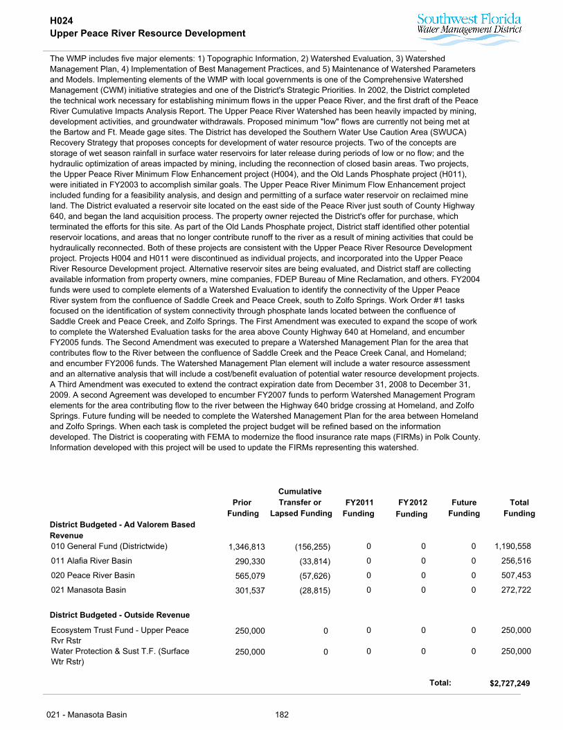
H024
Upper Peace River Resource Development
The WMP includes five major elements: 1) Topographic Information, 2) Watershed Evaluation, 3) Watershed
Management Plan, 4) Implementation of Best Management Practices, and 5) Maintenance of Watershed Parameters
and Models. Implementing elements of the WMP with local governments is one of the Comprehensive Watershed
Management (CWM) initiative strategies and one of the District's Strategic Priorities. In 2002, the District completed
the technical work necessary for establishing minimum flows in the upper Peace River, and the first draft of the Peace
River Cumulative Impacts Analysis Report. The Upper Peace River Watershed has been heavily impacted by mining,
development activities, and groundwater withdrawals. Proposed minimum "low" flows are currently not being met at
the Bartow and Ft. Meade gage sites. The District has developed the Southern Water Use Caution Area (SWUCA)
Recovery Strategy that proposes concepts for development of water resource projects. Two of the concepts are
storage of wet season rainfall in surface water reservoirs for later release during periods of low or no flow; and the
hydraulic optimization of areas impacted by mining, including the reconnection of closed basin areas. Two projects,
the Upper Peace River Minimum Flow Enhancement project (H004), and the Old Lands Phosphate project (H011),
were initiated in FY2003 to accomplish similar goals. The Upper Peace River Minimum Flow Enhancement project
included funding for a feasibility analysis, and design and permitting of a surface water reservoir on reclaimed mine
land. The District evaluated a reservoir site located on the east side of the Peace River just south of County Highway
640, and began the land acquisition process. The property owner rejected the District's offer for purchase, which
terminated the efforts for this site. As part of the Old Lands Phosphate project, District staff identified other potential
reservoir locations, and areas that no longer contribute runoff to the river as a result of mining activities that could be
hydraulically reconnected. Both of these projects are consistent with the Upper Peace River Resource Development
project. Projects H004 and H011 were discontinued as individual projects, and incorporated into the Upper Peace
River Resource Development project. Alternative reservoir sites are being evaluated, and District staff are collecting
available information from property owners, mine companies, FDEP Bureau of Mine Reclamation, and others. FY2004
funds were used to complete elements of a Watershed Evaluation to identify the connectivity of the Upper Peace
River system from the confluence of Saddle Creek and Peace Creek, south to Zolfo Springs. Work Order #1 tasks
focused on the identification of system connectivity through phosphate lands located between the confluence of
Saddle Creek and Peace Creek, and Zolfo Springs. The First Amendment was executed to expand the scope of work
to complete the Watershed Evaluation tasks for the area above County Highway 640 at Homeland, and encumber
FY2005 funds. The Second Amendment was executed to prepare a Watershed Management Plan for the area that
contributes flow to the River between the confluence of Saddle Creek and the Peace Creek Canal, and Homeland;
and encumber FY2006 funds. The Watershed Management Plan element will include a water resource assessment
and an alternative analysis that will include a cost/benefit evaluation of potential water resource development projects.
A Third Amendment was executed to extend the contract expiration date from December 31, 2008 to December 31,
2009. A second Agreement was developed to encumber FY2007 funds to perform Watershed Management Program
elements for the area contributing flow to the river between the Highway 640 bridge crossing at Homeland, and Zolfo
Springs. Future funding will be needed to complete the Watershed Management Plan for the area between Homeland
and Zolfo Springs. When each task is completed the project budget will be refined based on the information
developed. The District is cooperating with FEMA to modernize the flood insurance rate maps (FIRMs) in Polk County.
Information developed with this project will be used to update the FIRMs representing this watershed.
District Budgeted - Ad Valorem Based
Revenue
010 General Fund (Districtwide) 1,190,558 0 (156,255) 1,346,813 0 0
011 Alafia River Basin 256,516 0 (33,814) 290,330 0 0
020 Peace River Basin 507,453 0 (57,626) 565,079 0 0
021 Manasota Basin 272,722 0 (28,815) 301,537 0 0
District Budgeted - Outside Revenue
Ecosystem Trust Fund - Upper Peace
Rvr Rstr
250,000 0 0 250,000 0 0
Water Protection & Sust T.F. (Surface
Wtr Rstr)
250,000 0 0 250,000 0 0
$2,727,249 Total:
Prior
Funding
Cumulative
Transfer or
Lapsed Funding Funding Funding
2011 FY 2012 FY Future
Funding
Total
Funding
021 - Manasota Basin 182
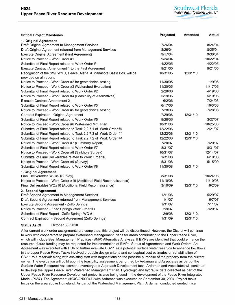
H024
Upper Peace River Resource Development
Critical Project Milestones ActualProjected Amended
1. Original AgreementDraft Original Agreement to Management Services 7/26/04 8/24/04
Draft Original Agreement returned from Management Services 8/26/04 8/25/04
Execute Original Agreement (First Agreement) 9/17/04 9/30/04
Notice to Proceed - Work Order #1 9/24/04 10/22/04
Submittal of Final Report related to Work Order #1 4/22/05 4/22/05
Execute Contract Amendment 1 to the First Agreement 9/21/05 9/21/05
Recognition of the SWFWMD, Peace, Alafia & Manasota Basin Bds. will be
provided on all reports
10/31/05 12/31/10
Notice to Proceed - Work Order #2 for geotechnical testing 11/30/05 1/9/06
Notice to Proceed - Work Order #3 (Watershed Evaluation) 11/30/05 11/17/05
Submittal of Final Report related to Work Order #2 2/28/06 4/19/06
Notice to Proceed - Work Order #4 (Feasibility of Alternatives) 5/19/06 5/19/06
Execute Contract Amendment 2 6/2/06 7/24/06
Submittal of Final Report related to Work Order #3 6/17/06 10/3/06
Notice to Proceed - Work Order #5 for geotechnical testing 7/28/06 7/28/06
Contract Expiration - Original Agreement 7/29/06 12/31/10
Submittal of Final Report related to Work Order #5 9/28/06 3/27/07
Notice to Proceed - Work Order #6 Watershed Mgt. Plan 10/31/06 10/25/06
Submittal of Final Report related to Task 2.2.7.1 of Work Order #4 12/22/06 2/21/07
Submittal of Final Report related to Task 2.2.7.3 of Work Order #4 12/22/06 12/31/10
Submittal of Final Report related to Task 2.2.7.2 of Work Order #4 12/22/06 12/31/10
Notice to Proceed - Work Order #7 (Summary Report) 7/20/07 7/20/07
Submittal of Final Report related to Work Order #7 8/31/07 8/31/07
Notice to Proceed - Work Order #8 (Sinkhole Survey) 10/31/07 12/14/07
Submittal of Final Deliverables related to Work Order #8 1/31/08 6/10/08
Notice to Proceed - Work Order #9 (Survey) 5/31/08 5/15/09
Submittal of Final Report related to Work Order #6 11/30/08 12/31/10
1. Original AgreementFinal Deliverables WO#9 (Survey) 8/31/08 10/24/08
Notice to Proceed - Work Order #10 (Additional Field Reconnaissance) 11/10/08 11/10/08
Final Deliverables WO#10 (Additional Field Reconnaissance) 3/10/09 12/31/10 9/2/09
2. Second AgreementDraft Second Agreement to Management Services 12/1/06 5/29/07
Draft Second Agreement returned from Management Services 1/1/07 6/7/07
Execute Second Agreement - Zolfo Springs 1/31/07 7/11/07
Notice to Proceed - Zolfo Springs Work Order #1 2/9/07 7/20/07
Submittal of Final Report - Zolfo Springs WO #1 2/9/08 12/31/10
Contract Expiration - Second Agreement (Zolfo Springs) 1/31/09 12/31/10
Status As Of: October 08, 2010
After current work order assignments are completed, this project will be discontinued. However, the District will continue
to work with cooperators to prepare Watershed Management Plans for areas contributing to the Upper Peace River,
which will include Best Management Practices (BMP) Alternative Analyses. If BMPs are identified that could enhance the
resource, future funding may be requested for Implementation of BMPs. Status of Agreements and Work Orders: An
Agreement was executed with HDR to further evaluate CS-11 as a potential surface water reservoir to enhance low flows
in the upper Peace River. Tasks involved probable design criteria and conceptual cost estimates on rehabilitation of
CS-11 to a reservoir along with assisting staff with negotiations on the possible purchase of the property from the current
owner. The evaluation will build upon the feasibility assessment performed by Ardaman and Associates as part of the
Surface Water Resource Assessment Inventory and Approach Development task. Ardaman and Associates will continue
to develop the Upper Peace River Watershed Management Plan. Hydrologic and hydraulic data collected as part of the
Upper Peace River Resource Development project is also being used in the development of the Peace River Integrated
Model (P687). The Agreement (#04CON00047) with Ardaman was executed on September 30, 2004. Project tasks
focus on the area above Homeland. As part of the Watershed Management Plan, Ardaman conducted geotechnical
021 - Manasota Basin 183
H024
Upper Peace River Resource Development
testing and surface water modeling to evaluate potential reservoir sites. The Ardaman evaluations indicate CS-11 could
be modified to function as a surface water reservoir. The tasks associated with Work Orders #1, #2, #3, #5, #7, #8, & #9
have been completed, and associated final deliverables have been approved. Tasks related to Work Orders #4, #6, &
#10 are on-going. A draft of the first of 3 reports related to Work Order #4 was received on January 26, 2007. Staff
reviewed the draft, and provided comments to the consultant on January 30, 2007. Data collection for Work Order #6 has
been completed. The final report related to Work Order #6 was due on November 30, 2008. However a time extension
was granted until December 31, 2009. Work Order #7 was issued on July 20, 2007 for the preparation of a summary
report to consolidate recent geotechnical and engineering evaluation information regarding the feasibility of using CS-11
as a water storage area for MFL recovery. The water discharged back into the river will need to be of sufficient quantity to
overcome the influence of sinkholes in and adjacent to the streambed in order to meet MFLs in the upper river. A draft
summary report was received in August 2007. Comments were provided to the consultant. Final version of the WO#7
summary report received May 27, 2009. Work Order #8 was executed on December 14, 2007 to survey sinkhole areas
to determine if low flows can be redirected around the sinkhole features, and to identify the hydraulic control elevation in
the streambed that may be backing water up into these features. An evaluation of the survey data will be conducted as
part of the SWUCA Recovery - Upper Peace Karst Berms (H064) project. Please refer to the PIMS entry for H064 for
further information on that project. Work Order #9 was developed to collect survey data for several cross-sections and
bridge crossings within the upper Peace River and two of its tributaries, Bear Branch and Six Mile Creek. Notice to
Proceed was issued on May 15, 2008. Notice to Proceed for Work Order #10 was issued on November 10, 2008. Work
Order #10 includes the collection of additional survey information within the City of Bartow for areas that discharge to the
Peace River. This work has been completed. The Fourth Amendment to Agreement 04CON00062 was executed to add
$243,500 in FEMA funds for tasks related to the delineation of the 100 year floodplain for the Upper Peace River above
Homeland, and to perform peerand public review of the model results. Notice to Proceed for Work Order #11 was issued
on January 28, 2010 to perform the floodplain analysis and delineation tasks using the FEMA funds. A second consultant
services agreement (#07CC0000062) was developed to focus on the area contributing flow to the river between
Homeland and Zolfo Springs. The Second Agreement was executed on July 11, 2007. Work Order #1 was issued
against the Second Agreement on July 20, 2007; and involves the completion of Watershed Evaluation tasks for the area
between Homeland and Zolfo Springs. Status History: The first contract, (#04CON00047), currently encumbers $150,000
of FY2004 funds, $500,000 of FY2005 funds, and $500,000 of FY2006 funds. The Second Agreement,
(#07CC0000062), encumbers $500,000 of FY2007 funds. $200,000 in FY2008 funding was used to retain HDR to further
evaluation the use of CS-11. The remaining $50,000 in FY2008 funds was liquidated. $250,000 was budgeted in
FY2009. $360,000 of H004 Upper Peace River Minimum Flow Enhancement project funds were transferred to this
project to retain a consultant to perform detailed geotechnical analyses, obtain topographic information, prepare
cost/benefit analyses, prepare preliminary and final design plans, and obtain permits needed to construct a reservoir.
The H004 funds were previously Board encumbered. The amount shown in the Prior Funding column of the funding table
has been revised to reflect the funds transferred from the H004 project. Tasks associated with the Ardaman Work
Orders #1, #2, #3, #5, #7, #8, #9, and #10 have been completed, and associated final deliverables have been approved.
Tasks related to Ardaman Work Orders #4, #6, and #11 are on-going. The draft watershed model and GIS deliverables
were received on July 1, 2010, and are being reviewed by District staff. As of this writing, the following has been
expended: $786,237 has been invoiced and paid in accordance with the Original Agreement with Ardaman; $404,159
has been invoiced, and $292,362 has been paid in accordance with the Second Agreement with Ardaman; and $41,142
has been expended to obtain additional LiDAR data. Of the $250,000 in FY2009 funding, $15,000 will be used to retain a
consultant to provide technical support in responding to questions on the conceptual design for CS-11; $41,142 will be
used to obtain topographic information for an area that was inundated when the LiDAR data was obtained. An additional
$3,350 was added to the HDR contract to finish technical support for CS-11 land negotiations and $10,000 was added as
contingency in case any new issues arise.
021 - Manasota Basin 184
H048
Myakka River Watershed Initiative
Project Type WS&R Dev.
AORs Strategic InitiativesWater Quality Water Quality Maintenance and ImprovementFlood Protection Floodplain ManagementWater Supply Alternative Water SupplyNatural Systems Natural Systems Conservation and Restoration
Basin(s) General Fund (District), Peace River, Manasota
Cooperator(s)
Project Manager MORRIS, LISANN
STARKS, ROBERTA, SZAFRANIEC, MARY, ARNOLD, DAVE, SMITH, RANDY, RIALS, MARKTask Manager(s)
Status Ongoing
DescriptionThe Myakka River Watershed is approximately 600 square miles in size and spans about 66 miles from Myakka Head
to its outfall in Charlotte Harbor. It includes portions of several counties including Hardee, Desoto and Charlotte with
the majority of the watershed located in Manatee and Sarasota counties. The 34-mile segment of the Myakka River in
Sarasota county has been designated a Wild and Scenic River by the State of Florida and, together with the estuarine
portions of the river, it is designated an Outstanding Florida Water by the Florida Department of Environmental
Protection. The river is the second largest source of freshwater inflow for Charlotte Harbor, which is generally viewed
as one of the most productive estuaries in Southwest Florida and is a SWIM waterbody. This Initiative is a
comprehensive project that will illustrate the effects of land use conversions and alterations and evaluate best
management practices (BMPs) for restoration alternatives. The objective of this initiative is to restore water quality,
natural system, and floodplain impacts in the watershed in ways that can also provide a benefit to water supplies in the
Southern Water Use Caution Area (SWUCA). The Topographic Information, Watershed Evaluation, and Watershed
Management Plan elements of the District's Watershed Management Program (WMP) are included in this initiative.
This effort will build upon existing data and analyses as well as the Sarasota County Lower Myakka Watershed
Management Plan, K487, and the City of North Port Big Slough Watershed Management Plan, K883. Evaluation will
also be performed on existing and proposed activities within the watershed to address long-term water resource
issues.
BenefitsThe Initiative will determine how alternations have affected these systems, evaluate potential water resource impacts
from land use changes, and provide some alternatives to better manage the water resource within the Myakka River
watershed.
Costs
The estimated cost for the WMP of the Initiative is approximately $4.9 million. Costs for FY2011 are only staff salaries,
and water quality monitoring lab costs, though the contract will need a no-cost time extension because review of
LiDAR processing on the terrain has slowed down the Watershed Evaluation tasks. Funding History: At its February
21, 2006 meeting, the Governing Board transfered funds ($500,000) from the Water Supply and Resource
Development reserves to hire consultants to obtain digital topographic information using LiDAR in eastern Manatee
County ($380,000) and to initiate the water budget analysis for the Upper Myakka watershed ($120,000). The FY2007
funding ($2 million) continued the Upper Myakka water budget, the Watershed Evaluation for the entire watershed,
and initiate the Watershed Management Plan element within the Upper Myakka. The $2 million FY2007 budget was
funded as follows: $575,000 from the Governing Board, $517,500 from the Manasota Basin Board, $57,500 from the
Peace River Basin Board, and $850,000 from state appropriations. In FY2008, $1.77 million was budgeted to
complete the Watershed Evaluation element, continue the Watershed Management Plan element. The FY008 funding
was divided as follows: $635,000 from the Governing Board, $571,500 from the Manasota Basin Board, $63,500 from
the Peace River Basin Board, and $500,000 from the State Funding. The funding distribution is Governing Board
(50%), Manasota Basin Board (45%) and Peace River Basin Board (5%). Contracting for independent, peer review of
the Water Budget for the Upper Myakka and the purchase of the necessary software licenses for the MikeSHE model
were accomplished with FY2008 funds. The remaining $765,000 in funding is being used to complete the Watershed
Management Plan through the Alternatives Analysis. Because this project was able to secure State Funding for
FY2009 in the amount of $1,000,000, additional funds were not needed leverage Ad valorum funding budgeted in
previous fiscal years was used to match the state grant. When each element is completed, the project budget and
scope may require refinement based on the information gathered. The District funding amounts shown in the table
include staff salaries. Future funding will be required for implementation of selected BMPs.
Additional Information
021 - Manasota Basin 185
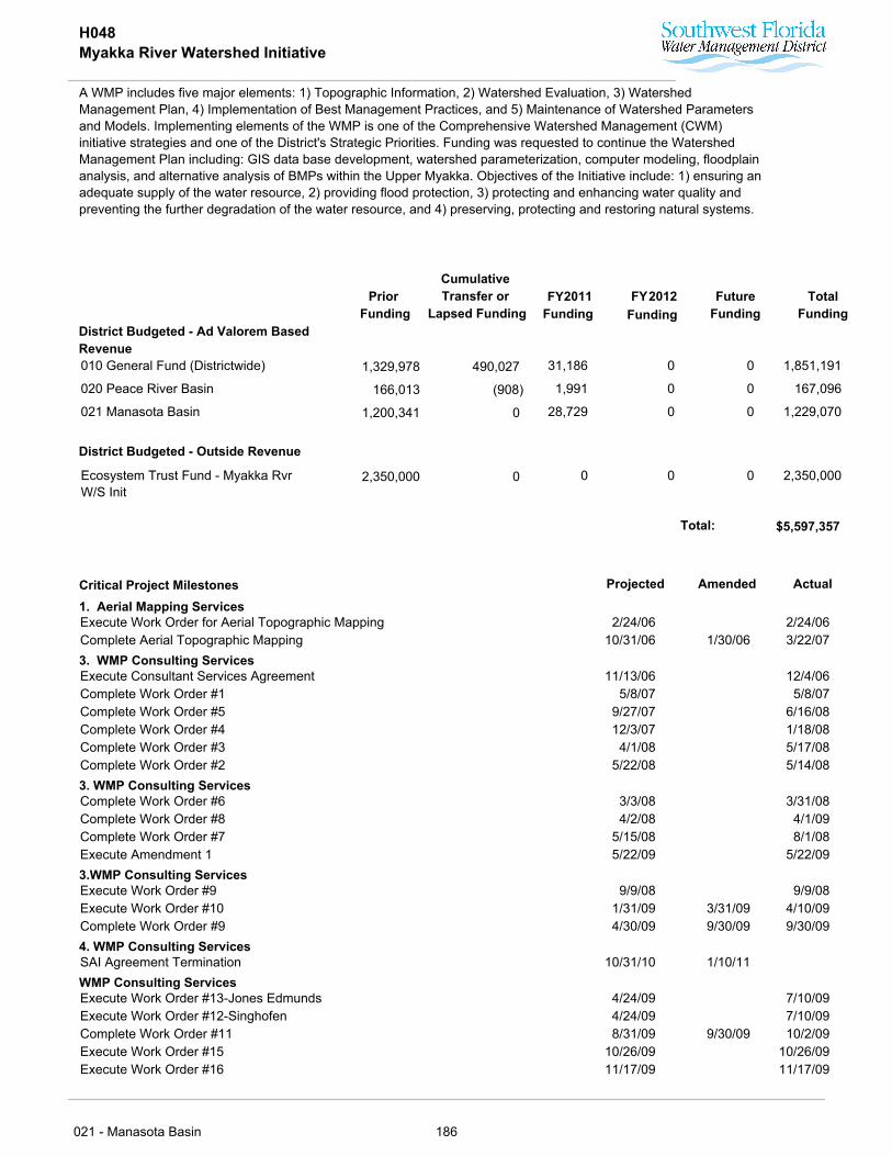
H048
Myakka River Watershed Initiative
A WMP includes five major elements: 1) Topographic Information, 2) Watershed Evaluation, 3) Watershed
Management Plan, 4) Implementation of Best Management Practices, and 5) Maintenance of Watershed Parameters
and Models. Implementing elements of the WMP is one of the Comprehensive Watershed Management (CWM)
initiative strategies and one of the District's Strategic Priorities. Funding was requested to continue the Watershed
Management Plan including: GIS data base development, watershed parameterization, computer modeling, floodplain
analysis, and alternative analysis of BMPs within the Upper Myakka. Objectives of the Initiative include: 1) ensuring an
adequate supply of the water resource, 2) providing flood protection, 3) protecting and enhancing water quality and
preventing the further degradation of the water resource, and 4) preserving, protecting and restoring natural systems.
District Budgeted - Ad Valorem Based
Revenue
010 General Fund (Districtwide) 1,851,191 0 490,027 1,329,978 0 31,186
020 Peace River Basin 167,096 0 (908) 166,013 0 1,991
021 Manasota Basin 1,229,070 0 0 1,200,341 0 28,729
District Budgeted - Outside Revenue
Ecosystem Trust Fund - Myakka Rvr
W/S Init
2,350,000 0 0 2,350,000 0 0
$5,597,357 Total:
Prior
Funding
Cumulative
Transfer or
Lapsed Funding Funding Funding
2011 FY 2012 FY Future
Funding
Total
Funding
Critical Project Milestones ActualProjected Amended
1. Aerial Mapping ServicesExecute Work Order for Aerial Topographic Mapping 2/24/06 2/24/06
Complete Aerial Topographic Mapping 10/31/06 1/30/06 3/22/07
3. WMP Consulting ServicesExecute Consultant Services Agreement 11/13/06 12/4/06
Complete Work Order #1 5/8/07 5/8/07
Complete Work Order #5 9/27/07 6/16/08
Complete Work Order #4 12/3/07 1/18/08
Complete Work Order #3 4/1/08 5/17/08
Complete Work Order #2 5/22/08 5/14/08
3. WMP Consulting ServicesComplete Work Order #6 3/3/08 3/31/08
Complete Work Order #8 4/2/08 4/1/09
Complete Work Order #7 5/15/08 8/1/08
Execute Amendment 1 5/22/09 5/22/09
3.WMP Consulting ServicesExecute Work Order #9 9/9/08 9/9/08
Execute Work Order #10 1/31/09 3/31/09 4/10/09
Complete Work Order #9 4/30/09 9/30/09 9/30/09
4. WMP Consulting ServicesSAI Agreement Termination 10/31/10 1/10/11
WMP Consulting ServicesExecute Work Order #13-Jones Edmunds 4/24/09 7/10/09
Execute Work Order #12-Singhofen 4/24/09 7/10/09
Complete Work Order #11 8/31/09 9/30/09 10/2/09
Execute Work Order #15 10/26/09 10/26/09
Execute Work Order #16 11/17/09 11/17/09
021 - Manasota Basin 186
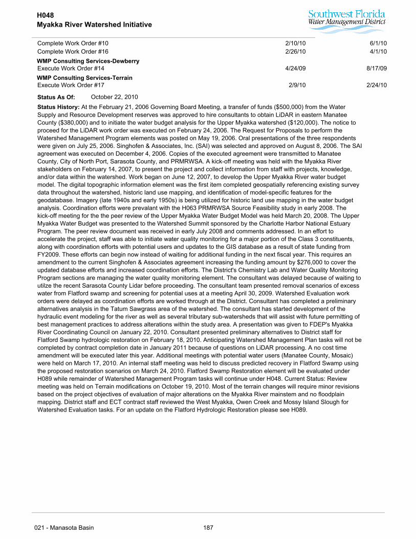
H048
Myakka River Watershed Initiative
Complete Work Order #10 2/10/10 6/1/10
Complete Work Order #16 2/26/10 4/1/10
WMP Consulting Services-DewberryExecute Work Order #14 4/24/09 8/17/09
WMP Consulting Services-TerrainExecute Work Order #17 2/9/10 2/24/10
Status As Of: October 22, 2010
Status History: At the February 21, 2006 Governing Board Meeting, a transfer of funds ($500,000) from the Water
Supply and Resource Development reserves was approved to hire consultants to obtain LiDAR in eastern Manatee
County ($380,000) and to initiate the water budget analysis for the Upper Myakka watershed ($120,000). The notice to
proceed for the LiDAR work order was executed on February 24, 2006. The Request for Proposals to perform the
Watershed Management Program elements was posted on May 19, 2006. Oral presentations of the three respondents
were given on July 25, 2006. Singhofen & Associates, Inc. (SAI) was selected and approved on August 8, 2006. The SAI
agreement was executed on December 4, 2006. Copies of the executed agreement were transmitted to Manatee
County, City of North Port, Sarasota County, and PRMRWSA. A kick-off meeting was held with the Myakka River
stakeholders on February 14, 2007, to present the project and collect information from staff with projects, knowledge,
and/or data within the watershed. Work began on June 12, 2007, to develop the Upper Myakka River water budget
model. The digital topographic information element was the first item completed geospatially referencing existing survey
data throughout the watershed, historic land use mapping, and identification of model-specific features for the
geodatabase. Imagery (late 1940s and early 1950s) is being utilized for historic land use mapping in the water budget
analysis. Coordination efforts were prevalant with the H063 PRMRWSA Source Feasibility study in early 2008. The
kick-off meeting for the the peer review of the Upper Myakka Water Budget Model was held March 20, 2008. The Upper
Myakka Water Budget was presented to the Watershed Summit sponsored by the Charlotte Harbor National Estuary
Program. The peer review document was received in early July 2008 and comments addressed. In an effort to
accelerate the project, staff was able to initiate water quality monitoring for a major portion of the Class 3 constituents,
along with coordination efforts with potential users and updates to the GIS database as a result of state funding from
FY2009. These efforts can begin now instead of waiting for additional funding in the next fiscal year. This requires an
amendment to the current Singhofen & Associates agreement increasing the funding amount by $276,000 to cover the
updated database efforts and increased coordination efforts. The District's Chemistry Lab and Water Quality Monitoring
Program sections are managing the water quality monitoring element. The consultant was delayed because of waiting to
utilze the recent Sarasota County Lidar before proceeding. The consultant team presented removal scenarios of excess
water from Flatford swamp and screening for potential uses at a meeting April 30, 2009. Watershed Evaluation work
orders were delayed as coordination efforts are worked through at the District. Consultant has completed a preliminary
alternatives analysis in the Tatum Sawgrass area of the watershed. The consultant has started development of the
hydraulic event modeling for the river as well as several tributary sub-watersheds that will assist with future permitting of
best management practices to address alterations within the study area. A presentation was given to FDEP's Myakka
River Coordinating Council on January 22, 2010. Consultant presented preliminary alternatives to District staff for
Flatford Swamp hydrologic restoration on February 18, 2010. Anticipating Watershed Management Plan tasks will not be
completed by contract completion date in January 2011 because of questions on LiDAR processing. A no cost time
amendment will be executed later this year. Additional meetings with potential water users (Manatee County, Mosaic)
were held on March 17, 2010. An internal staff meeting was held to discuss predicted recovery in Flatford Swamp using
the proposed restoration scenarios on March 24, 2010. Flatford Swamp Restoration element will be evaluated under
H089 while remainder of Watershed Management Program tasks will continue under H048. Current Status: Review
meeting was held on Terrain modifications on October 19, 2010. Most of the terrain changes will require minor revisions
based on the project objectives of evaluation of major alterations on the Myakka River mainstem and no floodplain
mapping. District staff and ECT contract staff reviewed the West Myakka, Owen Creek and Mossy Island Slough for
Watershed Evaluation tasks. For an update on the Flatford Hydrologic Restoration please see H089.
021 - Manasota Basin 187

H051
PR/MRWSA Reg Integ Loop Sys Phase 2 Interconnect
Project Type WS&R Dev.
AORs Strategic InitiativesWater Supply Alternative Water Supply
Basin(s) General Fund (District), Peace River, Manasota
Peace River/Manasota Regional Water Supply Auth.Cooperator(s)
Project Manager FERGUSON, JOHN
ARMSTRONG, BRIANTask Manager(s)
Status Ongoing
DescriptionThe Regional Integrated Loop System project is a series of transmission pipelines that will be developed to regionally
transfer and deliver water from existing and future alternative supplies to demand centers within the Peace River
Manasota Regional Water Supply Authority's four county region. The Phase 2 Interconnect project is a component of
the Regional Integrated Loop System that will provide needed regional transmission capacity between the Peace
River Water Treatment Plant (WTP) and the City of North Port. The transmission line will be a 36-to-42 inch diameter
pipeline extending approximately 7 miles from the Peace River Facility, generally along the existing 36-inch regional
transmission main (RTM) corridor to Serris Boulevard, where it will interconnect with the City of North Port's
transmission/distribution system. In addition to serving the City of North Port, Phase 2 provides back-up capacity to
the existing 36-inch RTM, and comprises a critical segment for the extension of future loop system sub-phases to the
City of North Port's Myakkahatchee Creek WTP, the Englewood Water District (Phase 2B,) and Sarasota
County's Carlton WTP (Phase 2A.) The design transmission capacity is 13 mgd.
BenefitsThis initial segment of the Phase 2 Interconnect will allow the City of North Port to receive additional water from the
Authority's recently expanded Shell Creek WTP. The City currently requires this project to transmit the quantities of
water they are contracted to purchase from the Authority in FY2012. Development of additional segments will further
integrate regional resources; maximize surface water for public supply; provide rotational capacity and the ability to rest
sources; provide for reserve capacity for emergency transfers; provide alternatives to the development of groundwater
in the Southern Water Use Caution Area (SWUCA); and better match supply, demand and financial investment on a
regional basis. The use of alternative sources with the maximization of surface water for public supply is consistent
with the District's Regional Water Supply Plan.
Costs
The total estimated cost for the H051 Phase 2 Interconnect Project is $15,400,000. The requested District share is
$7,700,000 divided between the Governing Board, $3,850,000 (50%); Manasota Basin, $2,810,500 (36.5%); and the
Peace River Basin, $1,039,500 (13.5%). The District budgeted funds in FY2007 and FY2008, however those funds
lapsed at the end of their fiscal years because the project was postponed. The lapsed funds are represented below
under "Prior Funding" and "Cumulative Transfers." A remaining $3,015 in staff time from this period is still reflected in
the total funding below.
District funding in FY2010 was: General Fund $1,500,000; Manasota $500,000; Peace River $200,000; for a total of
$2,200,000.
District funding in FY2011 is: General Fund $2,308,493, Manasota $2,280,199, Peace River $427,672, for a total of
$5,016,364. Additionally for FY2011, Water Protection and Sustainablity Trust Funds (WPSTF) are scheduled in the
amount of $166,301. The WPSTF will be applied to construction costs only and will equally reduce the Authority's and
District's shares. Anticipated District shares of the WPSTF are Governing Board ($41,508), Peace River Basin Board
($11,207), and Manasota Basin Board ($30,301.)
Funds will be used for design and construction of the interconnect. The future funds identified for the project are
contingent upon approval of such amounts by the District Governing Board and Basin Boards in the annual budgets.
The long-term project cost of all additional Phase 2 segments joining the Englewood Water District, City of Venice,
and the Carlton WTP has been estimated at $82,400,000 (Authority CIP Projection, 3/9/2010.)
Additional Information
The Intergrated Loop System Feasibility/Routing Study was issued by the Authority in June 2006. The
Feasibility/Routing Study identified the preferred loop pipeline routing, environmental impacts, major connection
points, preliminary pipe sizing, proposed schedule of project phasing, and time frames for construction. The Study's
recommended Phase 2 route connects the Peace River WTP with the Myakkahatchee Creek WTP and then branches
into two segments: one segment loops northwest to Sarasota County's Carlton WTP, and the other segment runs
southwest connecting to public water systems of the Englewood Water District and the City of Venice. In June 2007,
the Authority contracted King Engineering for Phase 2 project design services. In August 2007, the Authority Board
021 - Manasota Basin 188
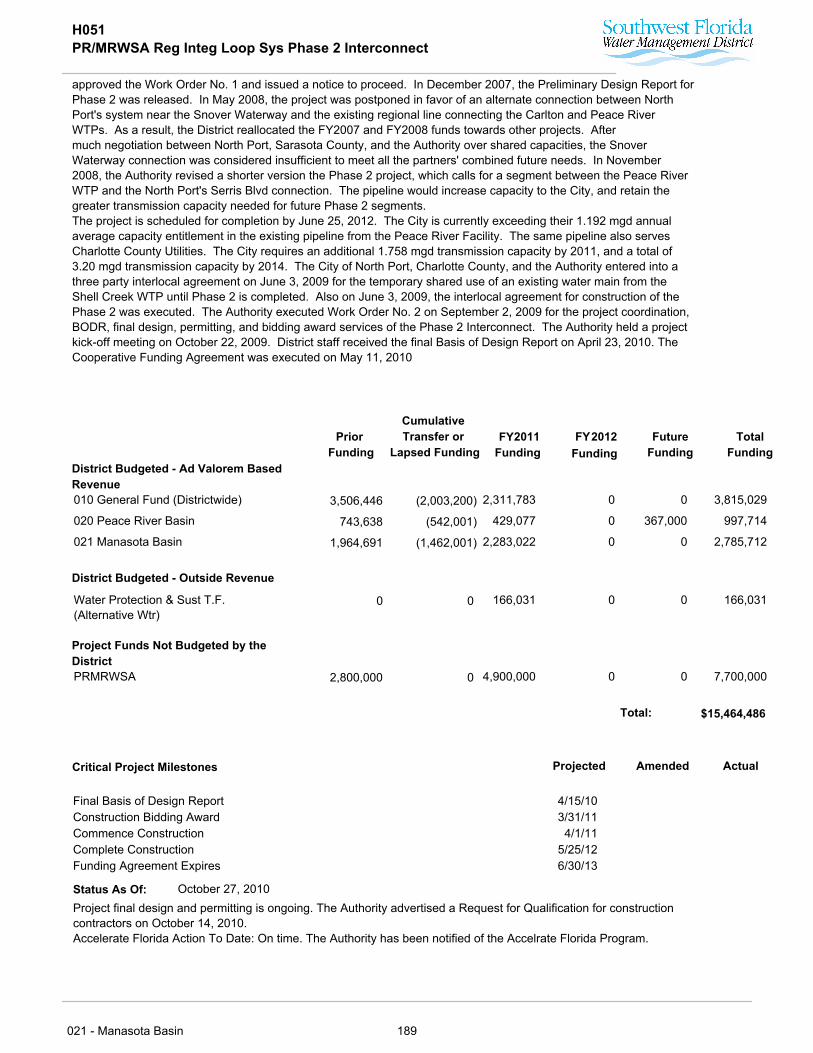
H051
PR/MRWSA Reg Integ Loop Sys Phase 2 Interconnect
approved the Work Order No. 1 and issued a notice to proceed. In December 2007, the Preliminary Design Report for
Phase 2 was released. In May 2008, the project was postponed in favor of an alternate connection between North
Port's system near the Snover Waterway and the existing regional line connecting the Carlton and Peace River
WTPs. As a result, the District reallocated the FY2007 and FY2008 funds towards other projects. After
much negotiation between North Port, Sarasota County, and the Authority over shared capacities, the Snover
Waterway connection was considered insufficient to meet all the partners' combined future needs. In November
2008, the Authority revised a shorter version the Phase 2 project, which calls for a segment between the Peace River
WTP and the North Port's Serris Blvd connection. The pipeline would increase capacity to the City, and retain the
greater transmission capacity needed for future Phase 2 segments.
The project is scheduled for completion by June 25, 2012. The City is currently exceeding their 1.192 mgd annual
average capacity entitlement in the existing pipeline from the Peace River Facility. The same pipeline also serves
Charlotte County Utilities. The City requires an additional 1.758 mgd transmission capacity by 2011, and a total of
3.20 mgd transmission capacity by 2014. The City of North Port, Charlotte County, and the Authority entered into a
three party interlocal agreement on June 3, 2009 for the temporary shared use of an existing water main from the
Shell Creek WTP until Phase 2 is completed. Also on June 3, 2009, the interlocal agreement for construction of the
Phase 2 was executed. The Authority executed Work Order No. 2 on September 2, 2009 for the project coordination,
BODR, final design, permitting, and bidding award services of the Phase 2 Interconnect. The Authority held a project
kick-off meeting on October 22, 2009. District staff received the final Basis of Design Report on April 23, 2010. The
Cooperative Funding Agreement was executed on May 11, 2010
District Budgeted - Ad Valorem Based
Revenue
010 General Fund (Districtwide) 3,815,029 0 (2,003,200) 3,506,446 0 2,311,783
020 Peace River Basin 997,714 367,000 (542,001) 743,638 0 429,077
021 Manasota Basin 2,785,712 0 (1,462,001) 1,964,691 0 2,283,022
District Budgeted - Outside Revenue
Water Protection & Sust T.F.
(Alternative Wtr)
166,031 0 0 0 0 166,031
Project Funds Not Budgeted by the
District
PRMRWSA 7,700,000 0 0 2,800,000 0 4,900,000
$15,464,486 Total:
Prior
Funding
Cumulative
Transfer or
Lapsed Funding Funding Funding
2011 FY 2012 FY Future
Funding
Total
Funding
Critical Project Milestones ActualProjected Amended
Final Basis of Design Report 4/15/10
Construction Bidding Award 3/31/11
Commence Construction 4/1/11
Complete Construction 5/25/12
Funding Agreement Expires 6/30/13
Status As Of: October 27, 2010
Project final design and permitting is ongoing. The Authority advertised a Request for Qualification for construction
contractors on October 14, 2010.
Accelerate Florida Action To Date: On time. The Authority has been notified of the Accelrate Florida Program.
021 - Manasota Basin 189
H052
PR/MRWSA Reg Integ Loop Sys Phase 3A Interconnect
Project Type WS&R Dev.
AORs Strategic InitiativesWater Supply Alternative Water Supply
Basin(s) General Fund (District), Peace River, Manasota
Peace River/Manasota Regional Water Supply Auth.Cooperator(s)
Project Manager FERGUSON, JOHN
ARMSTRONG, BRIANTask Manager(s)
Status Ongoing
DescriptionThe Regional Integrated Loop System Program is a series of transmission pipelines that will be developed to regionally
transfer and deliver water from existing and future alternative supplies to demand centers within the Peace River
Manasota Regional Water Supply Authority's (Authority) four county region. This project, Phase 3A, is for the
construction of a pipeline from Sarasota County's Carlton Water Treatment Facility westward across the Myakka
River, northward along Cow Pen Slough, where it will connect to an existing County utility line. Eventually the
interconnect will extend northward into Manatee County once all phases have been completed.
BenefitsDevelopment of this project will further integrate regional resources; maximize surface water for public supply; provide
rotational capacity and the ability to rest sources; provide for reserve capacity for emergency transfers; provide
alternatives to the development of groundwater in the Southern Water Use Caution Area; and better match supply,
demand and financial investment on a regional basis.
Costs
The total cost for the Phase 3A Project has been revised by amendment from $42,570,000 to $27,484,240 (eligible
costs) due to a realized construction bid that was much lower than anticipated.
The current Basin and Governing Board funding to date (FY 2007 through FY 2011 and including the amendment
reduction and WPSTF adjustments) is $13,659,104 and is divided as: Governing Board $6,829,552 (50 percent,)
Manasota Basin $4,985,573 (36.5 percent,) and Peace Basin $1,843,979 (13.5 percent.) An additional $166,031 in
WPSTF funds was transferred to the project in FY2011 to complete the District funding. The WPSTF funds are for
construction only and equally reduce both the District and Authority shares.
The funding section below does not reflect a $5,339,220 liquidation of funds in July 2010 based on the amendment
reduction, nor a $71,809 lapse from the General Fund and Manasota Basin ($41,508 and $30,301 respectively) to
balance shares replaced by WPSTF funds in October 2010.
District shares are fully encumbered. District funding will be used for the design and construction of the pipeline, and
for additional storage and pumping at the Carlton WTP.
Additional Information
This project is to provide potable water service to areas of northern Sarasota County and Manatee County. Phase 3A
is the initial segment in the overall Integrated Regional Loop System Phases 3 and 4. Subsequent interconnect
expansions (Loop System Phases 3B, 4A and 4B) will connect to the surface water treatment facility on Lake Manatee
and a treatment plant on University Parkway, and will allow regional water delivery service to communities in Sarasota
and Manatee Counties. Total cost for the entire Phase 3 & 4 program is estimated at $145,100,000 based on the
Authority's CIP schedule dated March, 2010. Major components of Phase 3A include above ground storage, a
pumping station and approximately nine miles of 48-inch diameter transmission pipeline.
The pipeline route is generally from the Carlton Water Treatment Plant westward across the Myakka River following
an established utility corridor; west along Laurel Road, north along Knights Trail Road, and parallel along Cow Pen
Slough to a point near the Central County Landfill and State Road 681. Components co-located at the Carlton Water
Treatment Plant would include a pumping station with a 10 mgd capacity and 10 mg of above-ground storage. It is
anticipated that a recently constructed 5 million gallon above ground storage tank will be acquired by the Authority.
The transmission capacity of the pipeline will have a minimum design capacity of 37 mgd. Future upgrades to the
pumping station will be needed to reach that capacity. Phase 3A will provide an additional water delivery point to
Sarasota County and the potential for an inter-tie between the Authority's RTS and the City of Venice water system.
On April 2008, District staff received the Preliminary Engineering Basis of Design Report for Phases 3A and 3B. The
Cooperative Funding Agreement between the District and the Authority for Phase 3A was executed on November 10,
2008. The Agreement is back-dated to July 25, 2007 and expires on November 1, 2011. The Interlocal Agreement
between the Authority and Sarasota County was signed by the County on March 32, 2009 and by the Authority on April
1, 2009. On June 3, 2009, the Authority board approved a work order for final design services of a new 5 million gallon
storage tank to be located at the Carlton WTP. The FDEP Myakka Wild and Scenic River permit was acquired on
021 - Manasota Basin 190

H052
PR/MRWSA Reg Integ Loop Sys Phase 3A Interconnect
August 5, 2009. The FDEP drinking water construction permit was acquired on August 24, 2009. The FDOT utility
permit was received on July 2, 2009. The USACOE permits were issued on July 30, 2009. A FDEP environmental
resource permit was issued October 10, 2009. The project design is complete. The Authority selected the low bid
contractor at their Board meeting on December 17, 2009, at a cost of $18,385,256. The construction costs were much
lower than anticipated. The construction notice to proceed was issued on February 19, 2010.
The First Amendment to the Cooperative Funding Agreement was executed on July 6, 2010. The amendment
updated the task schedule and project completion deadlines, reduced project funding in accordance to low
construction costs, updated contractual language regarding the reimbursement of funding if project is not completed,
and extended the contract expiration to September 30, 2012. Subsequent to the amended costs, the District liquidated
surplus funding in excess of project shares; $3,812,948 to Governing Board and $1,598,081 to the Manasota Basin.
District Budgeted - Ad Valorem Based
Revenue
010 General Fund (Districtwide) 10,657,508 0 (3,000) 10,657,218 0 3,290
020 Peace River Basin 1,850,844 0 (2,001) 1,717,211 0 135,634
021 Manasota Basin 6,594,786 0 (2,001) 6,593,964 0 2,823
District Budgeted - Outside Revenue
Water Protection & Sust T.F.
(Alternative Wtr)
166,031 0 0 0 0 166,031
Project Funds Not Budgeted by the
District
PR/MRWSA 13,659,107 0 0 13,659,107 0 0
$32,928,276 Total:
Prior
Funding
Cumulative
Transfer or
Lapsed Funding Funding Funding
2011 FY 2012 FY Future
Funding
Total
Funding
Critical Project Milestones ActualProjected Amended
Preliminary Design / Basis of Design - Phase 3 7/31/08 3/31/08
Final Design - Phase 3A 3/31/09 10/31/10 10/20/09
Permitting / Property Aquisition - Phase 3A 4/30/09 7/31/10
Commencement of Construction 6/1/09 8/1/10 2/17/10
Substantial Completion of Construction 5/31/10 9/30/11
Project Completion 11/30/10 3/31/12
Contract Expires 11/1/11 9/30/12
Status As Of: October 28, 2010
Construction is ongoing and on schedule. The storage tank at the Carlton WTP is nearly complete, and contractors are
beginning work on the pump station. Pipeline sections along Knights Trail Road have been installed. Vaults for tunneling
under the Myakka River are being prepared on both river banks, and tunneling is expected to commence in late
November 2010.The final land easements have been provided by the City of Venice in September 2010. The City is
providing the easements in return for detailed road work, landscaping, and post-construction restoration at the Myakka
River Park on Laurel Road. The Authority has met the contractual rquirements for reimburement and the District is
processing the Authority's pay requests.
Accelerate Florida Update: Notice was sent to PRMRWSA regarding the Accelerate Florida Initiative. Project is
currently under construction. and on time with the amended schedule.
021 - Manasota Basin 191
H059
City of Bradenton Reservoir Expansion
Project Type WS&R Dev.
AORs Strategic InitiativesWater Supply Alternative Water Supply
Basin(s) General Fund (District), Manasota
City of BradentonCooperator(s)
Project Manager MORRIS, LISANN
Task Manager(s)
Status Ongoing
DescriptionThis is an ongoing Cooperative Funding project requested by the City of Bradenton to develop an alternative water
supply project that will provide additional storage capacity at the Bill Evers Reservoir and capture excess flow from the
Braden River during the wet season's high flow periods. The project is for the design, permitting and construction of an
upland, offstream storage facility on City-owned property adjacent to the City's water supply reservoir. The proposed
facility will be made of earthen dike construction and includes a raw water intake at the existing reservoir plus pumping
and piping for filling the new storage facility; systems to provide turnover and prevent stratification and stagnation of
water in the new storage facility; and equipment and piping for withdrawing water from the new storage facility.
BenefitsThis project is also consistent with the SWUCA Recovery Plan and the District's Regional Water Supply Plan in
providing supply from an alternative source (surface water). The project will help the City meet their future demands
and has the potential to reduce demand on the Upper Floridian aquifer.
Costs
The total estimated cost for the H059 Raw Water Storage is $17,372,000. The requested District share is $8,686,000
divided between the General fund $4,343,000 (50%); Manasota Basin 4,343,000 (50%). Water Protection and
Sustainablility Trust Funds (WPST) in the amount of $43,541 were transferred into the project. These WPST funds will
be split evenly between the District and City decreasing construction costs accordingly. Funding requested for FY2011
is: General fund $1,003,000, Manasota $1,003,000, for a total of $2,006,000. Funds will be used for construction of the
facility. When each phase (such as design\permitting) is completed the project budget and scope and schedule may
require refinement based on the information gathered. The future funds identified for the project are contingent upon
approval of such amounts by the District Governing Board and Manasota Basin Board in their annual budgets.
Additional Information
At their March 2006 meeting, the Governing Board established a policy regarding Cooperative Funding for potable
water supply projects submitted by local governments in areas served by a water supply authority (WSA). Funding
criteria is dependent on whether or not the local government is a member\customer of the WSA. The City of
Bradenton is located in the service area of the Peace River/Manasota Regional Water Supply Authority (Authority), but
is not a member of the Authority. The City must coordinate their water supply needs with the Authority so that they are
consistent with regional plans. Affirmative written documentation from the Authority supporting the project must
accompany the City's application. The Authority supplied a written statement in early May 2006 indicating coordination
with the City and consistency of the project with the Authority's regional plan.The City proposed to increase the size of
the reservoir storage area from 580 to 755 million gallons because of the uncertainty of arsenic mobilization and ASR.
Without ASR, the projection for raw water supply capacity must increase to 2.62 MGD to meet demands through
2025. Because of recent positive results in the ASR project and current economic conditions, the City has indicated
they may return to the original 580 million gallons storage area.
021 - Manasota Basin 192
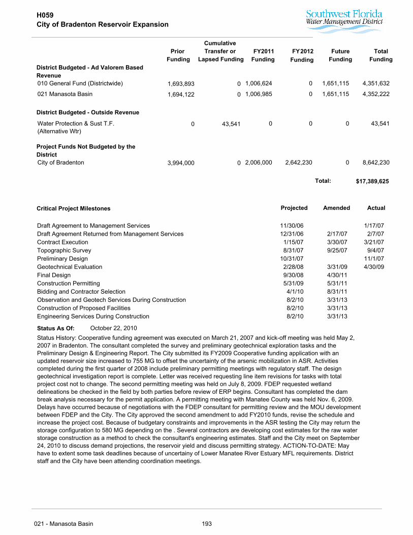
H059
City of Bradenton Reservoir Expansion
District Budgeted - Ad Valorem Based
Revenue
010 General Fund (Districtwide) 4,351,632 1,651,115 0 1,693,893 0 1,006,624
021 Manasota Basin 4,352,222 1,651,115 0 1,694,122 0 1,006,985
District Budgeted - Outside Revenue
Water Protection & Sust T.F.
(Alternative Wtr)
43,541 0 43,541 0 0 0
Project Funds Not Budgeted by the
District
City of Bradenton 8,642,230 0 0 3,994,000 2,642,230 2,006,000
$17,389,625 Total:
Prior
Funding
Cumulative
Transfer or
Lapsed Funding Funding Funding
2011 FY 2012 FY Future
Funding
Total
Funding
Critical Project Milestones ActualProjected Amended
Draft Agreement to Management Services 11/30/06 1/17/07
Draft Agreement Returned from Management Services 12/31/06 2/17/07 2/7/07
Contract Execution 1/15/07 3/30/07 3/21/07
Topographic Survey 8/31/07 9/25/07 9/4/07
Preliminary Design 10/31/07 11/1/07
Geotechnical Evaluation 2/28/08 3/31/09 4/30/09
Final Design 9/30/08 4/30/11
Construction Permitting 5/31/09 5/31/11
Bidding and Contractor Selection 4/1/10 8/31/11
Observation and Geotech Services During Construction 8/2/10 3/31/13
Construction of Proposed Facilities 8/2/10 3/31/13
Engineering Services During Construction 8/2/10 3/31/13
Status As Of: October 22, 2010
Status History: Cooperative funding agreement was executed on March 21, 2007 and kick-off meeting was held May 2,
2007 in Bradenton. The consultant completed the survey and preliminary geotechnical exploration tasks and the
Preliminary Design & Engineering Report. The City submitted its FY2009 Cooperative funding application with an
updated reservoir size increased to 755 MG to offset the uncertainty of the arsenic mobilization in ASR. Activities
completed during the first quarter of 2008 include preliminary permitting meetings with regulatory staff. The design
geotechnical investigation report is complete. Letter was received requesting line item revisions for tasks with total
project cost not to change. The second permitting meeting was held on July 8, 2009. FDEP requested wetland
delineations be checked in the field by both parties before review of ERP begins. Consultant has completed the dam
break analysis necessary for the permit application. A permitting meeting with Manatee County was held Nov. 6, 2009.
Delays have occurred because of negotiations with the FDEP consultant for permitting review and the MOU development
between FDEP and the City. The City approved the second amendment to add FY2010 funds, revise the schedule and
increase the project cost. Because of budgetary constraints and improvements in the ASR testing the City may return the
storage configuration to 580 MG depending on the . Several contractors are developing cost estimates for the raw water
storage construction as a method to check the consultant's engineering estimates. Staff and the City meet on September
24, 2010 to discuss demand projections, the reservoir yield and discuss permitting strategy. ACTION-TO-DATE: May
have to extent some task deadlines because of uncertainy of Lower Manatee River Estuary MFL requirements. District
staff and the City have been attending coordination meetings.
021 - Manasota Basin 193
H069
PR/MRWSA Reg Loop System Ph 1A
Project Type WS&R Dev.
AORs Strategic InitiativesWater Supply Alternative Water Supply
Basin(s) General Fund (District), Peace River, Manasota
Peace River/Manasota Regional Water Supply Auth.Cooperator(s)
Project Manager FERGUSON, JOHN
ARMSTRONG, BRIANTask Manager(s)
Status Ongoing
DescriptionThe Regional Integrated Loop System project is a series of transmission pipelines that will be developed to regionally
transfer and deliver water from existing and future alternative supplies to demand centers within the Peace River
Manasota Regional Water Supply Authority's four county region. Phase 1A of this project connects the water supply
systems of the Authority, Charlotte County and the City of Punta Gorda. Construction of the interconnect consists of
approximately 12 miles of a 24 inch diameter line interconnecting the Shell Creek facility to the Peace River facility,
and includes a sub-aqueous crossing of the lower Peace River. The project will have a minimum design capacity of 6
mgd.
BenefitsDevelopment of this project will integrate regional resources; maximize surface water for public supply; provide
rotational capacity and the ability to rest sources; provide for reserve capacity for emergency transfers; provide
alternatives to the development of groundwater in the Southern Water Use Caution Area (SWUCA); and better match
supply, demand, and financial investment on a regional basis.
Costs
The total estimated cost for the Phase 1A project is $19,015,000, with the requested District's share being
$12,007,500. The District funding is divided between the Governing Board, $6,003,750 (50%); the Manasota Basin
Board, $4,382,738 (36.5%); and the Peace River Basin Board, $1,621,012 (13.5%). Ad Valorum shares were
budgeted in FY2008, and funding received from the West Central Florida Water Restoration Action Plan (WRAP) was
applied in FY2009. $5,000,000 in WRAP funding was budgeted proportionally between Basins in place of Ad Valorum
funding.
Additional Information
The Phase 1A pipeline was designed as an alternative to two separately proposed pipelines: Loop System Phase 1
(H050) to interconnect the Peace River and Shell Creek water treatment plants via an extension southward along
US-17, and the Charlotte County Emergency Interconnect (L636) consisting of a sub-aqueous crossing of the Peace
River. Discussions were initiated in 2006 to combine the projects and achieve the benefits of both pipelines. The
revised and expanded pipeline (H069), was approved by both Charlotte County and the Authority Board in June 2006.
This expanded pipeline is designed to bidirectionally transfer up to 6 mgd between the Authority, Charlotte County,
and Punta Gorda. The pipeline will deliver water to four key delivery points in Charlotte County Utility's (CCU)
distribution system, and has the potential to tie into CCU's system south of the Peace River.
The Authority Board awarded the design consultant contract for Phase 1A in September 2007, and issued a notice to
proceed on October 17, 2007. The Preliminary Engineering Report was received in February 2008. The Cooperative
Funding Agreement between the District and Authority was executed in September 2008. The contract period is
back-dated to July 25, 2007 and remains in effect through February 1, 2012. The final Basis of Design Report was
received on December 3, 2009.
Charlotte County has already installed and put into service the 0.6 mile long northernmost segment, which runs from
the DeSoto/Charlotte County border southward to a new shopping center. The Authority intends to purchase this
segment and anticipates the sale transfer to be eligible for funding. South of the Peace River, an approximately 2 mile
segment utilizes the City of Punta Gorda's existing 30" transmission main. A pumping station and 0.5 mg of storage
will be located between the Peace River crossing and the Punta Gorda segments.
At the Charlotte County BOCC meeting on October 13, 2009, The County Board denied a formal Authority request to
construct the interconnect within the County, resulting in a three month project postponement. A settlement
between the County and the Authority was approved in January 2010. The agreement states that the County will not
contribute funding for segments in Punta Gorda, east of the pumping station. Due to this and other design/permitting
related delays, an amendment to the Cooperative Funding Agreement was prepared by the District to extend the
contract expiration to December 31, 2012. The amendment also extends the task completion deadlines, and updates
contractual language for reimbursement of funds if the project is not completed. The amendment was executed on
July 19, 2010. A few property segments along the pipeline corridor are still under acquisition.
021 - Manasota Basin 194
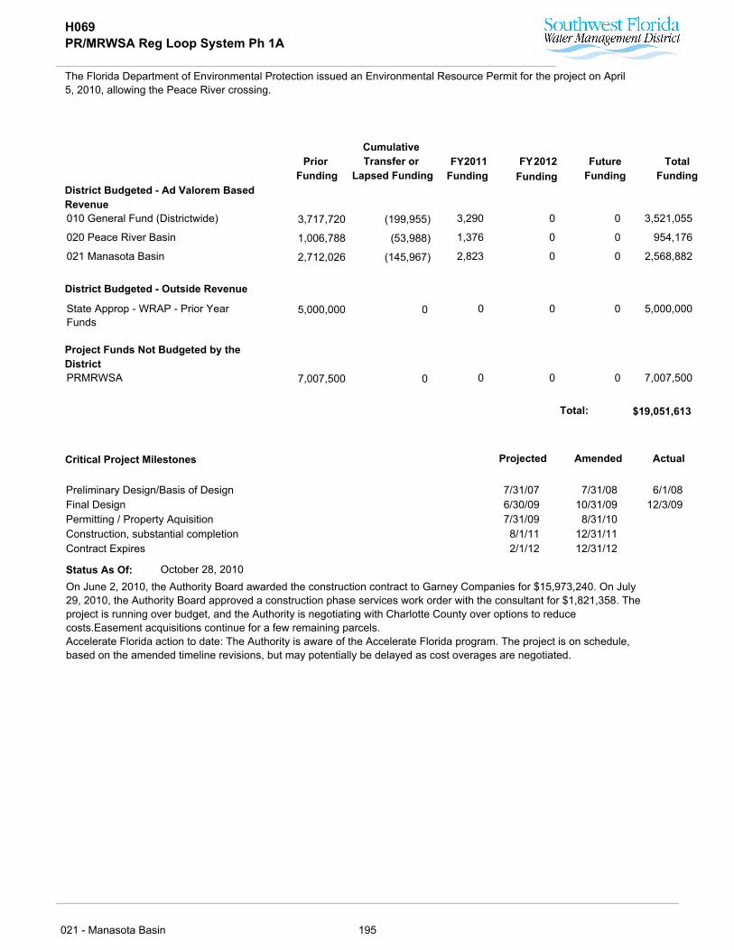
H069
PR/MRWSA Reg Loop System Ph 1A
The Florida Department of Environmental Protection issued an Environmental Resource Permit for the project on April
5, 2010, allowing the Peace River crossing.
District Budgeted - Ad Valorem Based
Revenue
010 General Fund (Districtwide) 3,521,055 0 (199,955) 3,717,720 0 3,290
020 Peace River Basin 954,176 0 (53,988) 1,006,788 0 1,376
021 Manasota Basin 2,568,882 0 (145,967) 2,712,026 0 2,823
District Budgeted - Outside Revenue
State Approp - WRAP - Prior Year
Funds
5,000,000 0 0 5,000,000 0 0
Project Funds Not Budgeted by the
District
PRMRWSA 7,007,500 0 0 7,007,500 0 0
$19,051,613 Total:
Prior
Funding
Cumulative
Transfer or
Lapsed Funding Funding Funding
2011 FY 2012 FY Future
Funding
Total
Funding
Critical Project Milestones ActualProjected Amended
Preliminary Design/Basis of Design 7/31/07 7/31/08 6/1/08
Final Design 6/30/09 10/31/09 12/3/09
Permitting / Property Aquisition 7/31/09 8/31/10
Construction, substantial completion 8/1/11 12/31/11
Contract Expires 2/1/12 12/31/12
Status As Of: October 28, 2010
On June 2, 2010, the Authority Board awarded the construction contract to Garney Companies for $15,973,240. On July
29, 2010, the Authority Board approved a construction phase services work order with the consultant for $1,821,358. The
project is running over budget, and the Authority is negotiating with Charlotte County over options to reduce
costs.Easement acquisitions continue for a few remaining parcels.
Accelerate Florida action to date: The Authority is aware of the Accelerate Florida program. The project is on schedule,
based on the amended timeline revisions, but may potentially be delayed as cost overages are negotiated.
021 - Manasota Basin 195
H079
PRMRWSA Investigation of Brackish Groundwater Development
Project Type WS&R Dev.
AORs Strategic InitiativesWater Supply Alternative Water Supply
Basin(s) General Fund (District), Peace River, Manasota
Peace River/Manasota Regional Water Supply Auth.Cooperator(s)
Project Manager MORRIS, LISANN
FERGUSON, JOHNTask Manager(s)
Status Ongoing
DescriptionThis alternative water supply project is proposed to provide 3 mgd of brackish groundwater in 2021 timeframe. The
new capacity is needed to meet regional reliability targets and growing regional needs. The first step in the process will
be to evaluate the RV Griffin Reserve and Peace River Facility Site (PRF) for brackish groundwater development and
concentrate disposal options. This preliminary investigation will look at feasibility and cost estimates at the PRF
focusing on the intermediate aquifer and the upper most portion of the Floridan. A key component in this project will be
the evaluation of disposal options for reverse osmosis concentrate. This project is the first phase of the Regional
Resource Development Program described below under Additional Information.
BenefitsThe 3 mgd of alternative water supplies will be an initial element in the Regional Resource Development Program.
Completion of this project will assist in achieving the regional resource management and water supply goals within the
four county area (Manatee, Sarasota, DeSoto and Charlotte) including: maximizing use of surface water for public
supply; providing rotational capacity and the ability to blend and rest sources; providing reserve capacity for emergency
transfers; providing alternatives to the development of groundwater in the Southern Water Use Caution Area
(SWUCA); and optimizing financial investments in water supply infrastructure on a regional basis.
Costs
The estimated cost for this initial preliminary investigation is $1,800,000. In FY2009 $600,000 was allocated to the
project from the West-Central Florida Water Restoration Action Plan (WRAP)Fund. Proposed funding split is evenly
between the Authority, District and WRAP funding. The requested District share would be $300,000(50%) from the
Governing Board, $219,000 from the Manasota Basin Board and $81,000 from the Peace River Basin Board. The
District funds would be allocated evenly over FY2011 and FY2012. The FY2011 funding request is for $300,000, and
is divided as follows: Governing Board ($150,000), Manasota Basin Board ($109,500), and the Peace River Basin
Board ($40,500). Funding will be used for preliminary design activities associated with a brackish groundwater source
on PRF, RV Griffin Reserve property and injection well exploration. The future funds identified for the project are
contingent upon approval of such amounts by the District Basin and Governing Boards in the annual budgets. The
total estimated cost to develop the 3 mgd is $45,000,000.
Additional Information
The Peace River Manasota Regional Water Supply Authority (Authority) is comprised of Charlotte, DeSoto, Manatee
and Sarasota counties. In accordance with its Master Water Supply Contract, the Authority is obligated to timely
develop and deliver new water supply sources and facilities to meet the needs of its customers. New supplies will be
a mix of brackish groundwater development at or near existing production facilities, and surface water development
projects in one or more of the following resource areas: Shell/Prairie Creek basin, Cow-Pen Slough/Dona Bay, Upper
Myakka/Flatford areas.To date, the Authority has executed Memoranda of Understanding (MOUs) with DeSoto
County, Sarasota County, the City of Punta Gorda and the Englewood Water District to investigate potential
partnerships in developing these and other proposed sources. Costs associated with potential future phases will be
determined as these partnerships develop.
021 - Manasota Basin 196

H079
PRMRWSA Investigation of Brackish Groundwater Development
District Budgeted - Ad Valorem Based
Revenue
010 General Fund (Districtwide) 326,852 150,000 0 19,633 0 157,219
020 Peace River Basin 90,335 40,500 0 6,196 0 43,639
021 Manasota Basin 236,307 109,500 0 12,596 0 114,211
District Budgeted - Outside Revenue
State Approp - WRAP - Prior Year
Funds
600,000 0 0 600,000 0 0
Project Funds Not Budgeted by the
District
PR\MRWSA 600,000 0 0 60,000 373,000 167,000
$1,853,494 Total:
Prior
Funding
Cumulative
Transfer or
Lapsed Funding Funding Funding
2011 FY 2012 FY Future
Funding
Total
Funding
Critical Project Milestones ActualProjected Amended
Execute Cooperative Funding Agreement 10/1/10 9/30/10
Consultant Selection 11/3/10
Consultant Contract Award 12/16/10
Notice to Proceed to Consultant 1/3/11
Complete Project 9/30/12
Status As Of: October 18, 2010
Status History: On November 5, 2008, the options from the H063 Feasibility Study were formally presented to the
Authority board. These options include: 1)three potential reservoir sites in the Upper Myakka Basin and a new surface
water treatment facility, yielding 10 mgd;2) three potential reservoir sites by Shell and Prairie creeks and expansion of the
existing facility on Shell Creek, for an additional 12 to 20 mgd;3) the Dona Bay option of diverting water from Cow Pen
Slough to a reservoir on the Venice Minerals site, then transmitting stored water to a surface water treatment expansion
at the Carlton plant, yielding an additional 5 to 15 mgd; and the development of new or existing brackish groundwater
wells to yield an estimated 5-6 mgd. $600,000 in WRAP funds has been budgeted by the District for the development of
the selected project. A funding agreement between the District and Authority was executed in December 2008 to secure
these funds. With the current funding, they are looking to do some brackish groundwater exploration after a consultant is
chosen for the next phase. Memorandums of Understanding (MOU) are being developed for water supply projects with
potential partners to assist with the development and scheduling of future water sources. At the June 3, 2009
PRMRWSA Board Meeting MOUs with the City of Punta Gorda and DeSoto County were approved. At the July 2009
meeting, MOUs were executed with the Sarasota County and the City of Englewood. The next step then in the process is
to develop a contract for the specific project providing details of items such as operation, ownership etc. As discussions
continue on the development of agreements through the various MOUs, the Authority intends to move forward with a
preliminary design/investigation for brackish water on RV Griffin and the Peace River Facility. Results should determine
whether a disposal well for RO concentrate is feasible in the area. Authority staff requested their Board approve
extensions on the Sarasota and DeSoto County MOUs. The Authority and the City of Englewood were successful in an
agreement to make idle production capacity available to the Authority if needed closing that MOU. The Punta Gorda
MOU expired.Current Status: Because initial funds to start the brackish water investigation are included in the Authority's
FY2011 budget the notice to proceed to the successful bidder is not anticipated until December 2010 to get through the
Authority's consultant selection process. A cooperative funding agreement was approved by the Authority at their
September Meeting and executed by the District at the end of September 2010. Five submittals were made to the
Authority in response to the RFP advertised.
021 - Manasota Basin 197

H086
Manatee County Regional 10 MG Reclaimed Water Storage Tank
ProjectProject Type WS&R Dev.
AORs Strategic InitiativesWater Quality Water Quality Maintenance and ImprovementWater Supply Alternative Water Supply
Basin(s) Manasota
Manatee CountyCooperator(s)
Project Manager MCGOOKEY, SCOTT
Task Manager(s)
Status Ongoing
DescriptionThis project will construct the first of four 10 Million Gallon (MG) reclaimed water storage tanks in support of the
Manatee County Agricultural Reuse System (MARS). MARS is a regional system that consists of the over 21 miles of
transmission lines that interconnect Manatee County's three regional Wastewater Treatment Facilities (WWTF). The
MARS system supplies reclaimed water for irrigation of agricultural, residential, and recreational customers, thereby
decreasing dependence on potable groundwater. New residential developments, some with golf courses, have been
replacing agricultural demand and many are planned or under construction along the transmission route. These
developments are potential customers of the MARS System. The MARS system is designed to distribute over 30 mgd.
Currently the County relies on one 3 MG tank at the Spencer Parrish Pumping Station and one .75 MG tank at it's
North Wastewater Reclamation Facility to meet peak demand. Wastewater plant peak flows are processed during the
daytime and used primarily at night. This condition requires the county system to have sufficient tank storage to meet
the nightime peak demand. The addition of this 10 MG tank, and three more planned 10 MG tanks, will better enable
the County's regional system to provide for the nightly peak demand events, without comprimising pressure and water
quality. This tank will be located at the County's Southwest Wastewater Reclamation Facility.
BenefitsThis 10 MG reclaimed water storage tank will better enable the County to accommodate its customer base as it
evolves from purely agriculture to a mix including residential. The storage will assist the county in providing reclaimed
water for irrigation purposes throughout its system to its customers during nightly peak demand events, without
comprimising pressure and water quality.
Costs
The total project construction costs are estimated to be $4,500,000. The District's share is $2,250,000 or fifty percent,
of which $1,125,000 was budgeted from the Governing Board and $1,125,000 was budgeted from the Manasota Basin
Board in FY2010. The cost benefit cannot be calculated, since the project addresses system storage and efficiency,
and offsets will be associated with future related transmission projects.
Additional Information
The proposed 10 MG Reclaim Water Storage Tank is an enhancement to the existing Manatee County Agricultural
Reclaim System (MARS). This system reduces demand for public potable water for irrigation, improves overall
utilization of existing SWFWMD water resources and provides on demand high quality irrigation water for our urban
and agricultural customers. MARS is an integral part of Manatee County water conservation program. The County's
overall program includes existing metering and loss reduction programs, water conservation rate structures, urban
and agricultural reclaim water irrigation supply, public education, SWUCA based level of service for water supply at
110 gpfcpd, land development codes requiring non-potable sources for irrigation in new developments, water supply
protection ordinances and the use of aquifer storage and recovery for potable and potentially reclaim waters.
021 - Manasota Basin 198

H086
Manatee County Regional 10 MG Reclaimed Water Storage Tank
Project
District Budgeted - Ad Valorem Based
Revenue
010 General Fund (Districtwide) 1,128,150 0 0 1,126,563 0 1,587
021 Manasota Basin 1,128,150 0 0 1,126,563 0 1,587
Project Funds Not Budgeted by the
District
Manatee County 2,250,000 0 0 2,250,000 0 0
$4,506,300 Total:
Prior
Funding
Cumulative
Transfer or
Lapsed Funding Funding Funding
2011 FY 2012 FY Future
Funding
Total
Funding
Critical Project Milestones ActualProjected Amended
Execute CFI Agreement 3/11/10 3/24/10
Award Bid Ground Storage Tank 3/16/10 3/16/10
Start Construction 5/31/10 4/27/10
Complete Construction 11/30/11
Status As Of: October 28, 2010
The agreement with Manatee County was executed on March 24, 2010. Award of the construction contract was given to
Beach Construction Company on April 13, 2010. The Notice to Proceed was issued to Beach Construction Co. effective
April 27, 2010. The pre-construction meeting was held on April 22, 2010 at the Manatee Co. SWWRF. The 10 MG
reclaimed water storage tank is under construction. The foundation and sides of the tank are complete and the top is
being formed. Work started on the yard piping in September 2010 and is ongoing. The District budgeted $1,125,000 and
the Manasota Basin Board budgeted $1,125,000 in FY2010 for a total funding commitment of $2,250,000. To date,
$808,346 has been reimbursed.
021 - Manasota Basin 199
H088
Pilot Treatment Study and Intermediate Well for Dona Bay Water
Supply ProjectProject Type WS&R Dev.
AORs Strategic InitiativesWater Quality Water Quality Maintenance and ImprovementWater Supply Alternative Water SupplyNatural Systems Natural Systems Conservation and Restoration
Basin(s) General Fund (District), Peace River, Manasota
Sarasota CountyCooperator(s)
Project Manager MORRIS, LISANN
HEYL, MIKETask Manager(s)
Status Ongoing
DescriptionThis project includes construction and testing of an intermediate test well and a pilot treatment study to determine the
most technical and economical options for treating surface and groundwater proposed as part of Dona Bay water
supply project. The overall objective of the Dona Bay water supply project is to decrease excess freshwater flows to
Dona Bay and provide an alternative source of water within the Southern Water Use Caution Area. This project will
provide the necessary information to determine the feasibility of moving forward with treatment options for
implementation and construction of the Dona Bay Water Supply project.
BenefitsThe Pilot Treatment Study and Intermediate test well will provide technical and economic information on how to best
treat surface water and groundwater sources in the most efficient and effective manner. Actual bench-scale testing of
treatment technologies will benefit future regional water supplies and assist in determining the feasiblity of moving
forward with the second phase of the Dona Bay Water Supply project.
Costs
The total estimated cost for this project is $2,095,000, less than the original budget estimate (approximately $185,000
less) and the District is requested to fund 50 percent ($1,047,500). The District funding will be divided between the
Governing Board (50 percent) and the Manasota Basin Board (50 percent). The funding approved in FY2010 includes
$500,000 from the Governing Board and $250,000 from the Manasota Basin Board, for a total of $750,000 in District
funding. The request for FY2011 for the pilot treatment study\intermediate test will complete the District's funding
share of $297,500. The future funds identified for the project are contingent upon approval of such amounts by the
District Governing Board and the Manasota Basin Board in their annual budgets.
Additional Information
The Dona Bay Watershed Management Plan (DBWMP) was finalized in June 2007 (L493). This project is a portion of
the first phase in an overall plan to reduce excess freshwater flows directed into Dona Bay by the Cow Pen Canal that
was constructed in the late 1960s. Excess freshwater flows have decreased the seasonal salinity concentrations
necessary for estuarine dependent flora and fauna. The plan is to divert, store and transport excess freshwater flows
from Cow Pen Slough prior to discharge into the Dona Bay Estuary, which could provide an alternative water supply in
the SWUCA as well as environmental benefits to the bay. Water from Cow Pen Slough would ultimately be
transported to Sarasota County's Carlton Facility for treatment and distribution. Potential water supply capacity is
estimated in 3, 5, 10, and 15 mgd phases and Sarasota County has already begun design and permitting for other
elements of the larger Dona Bay Water Supply Project such as: West Pinelands restoration, the new weir in Cow Pen
Slough, phased modifications of the Venice Minerals mine to a reservoir, and the conveyance from the new weir to
Venice Minerals. The PRMRWSA provided a letter indicating regional interest in the Pilot Treatment Study Task
making it eligible for Governing Board and Peace River Basin Board funding. Though the Memorandum of
Understanding was extended for two years, Sarasota County and the PRMRWSA continue working through Dona Bay
Project agreement issues.
021 - Manasota Basin 200

H088
Pilot Treatment Study and Intermediate Well for Dona Bay Water
Supply Project
District Budgeted - Ad Valorem Based
Revenue
010 General Fund (Districtwide) 588,807 0 0 514,017 0 74,790
020 Peace River Basin 4,944 0 0 4,944 0 0
021 Manasota Basin 584,376 0 0 259,593 0 324,783
Project Funds Not Budgeted by the
District
Sarasota County 1,047,500 0 0 1,047,500 0 0
$2,225,627 Total:
Prior
Funding
Cumulative
Transfer or
Lapsed Funding Funding Funding
2011 FY 2012 FY Future
Funding
Total
Funding
Critical Project Milestones ActualProjected Amended
Initiate Pilot Treatment Study 6/25/10 10/1/10
MOU agreement with Authority 7/27/10 7/27/12
Status As Of: October 18, 2010
The County forwarded the draft Request for Professional Services on December 11, 2009 for review on the Pilot
Treatment Study component for this project. Because two challenges were received on the Request for Services (RFS)
for the Pilot Treatment Study advertising for consultant services was delayed. Both the Authority and District participated
in some fashion in the review of the submittals. The Authority provided a letter indicating regional interest in the Pilot
Treatment Study Task making it eligible for Governing Board and Peace River Basin Board funding. The County
re-advertised the Pilot Treatment Study on April 14, 2010. Submittals were received from the consultants on May 13,
2010. Consultant chosen for the Pilot Treatment Study was Carollo Engineering. Current Status: Kick-off meeting for the
drilling contractor was held on September 22, 2010 at the County offices. Applied Drilling Engineering, Inc. (ADE) has
completed the surficial aquifer monitor well and the Permeable Zone 3 test production well. The Kick-off meeting for the
Treatability study consultant was held on October 28, 2010.
021 - Manasota Basin 201
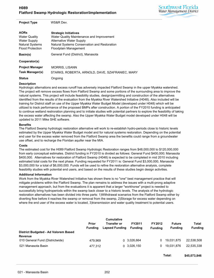
H089
Flatford Swamp Hydrologic Restoration\Implementation
Project Type WS&R Dev.
AORs Strategic InitiativesWater Quality Water Quality Maintenance and ImprovementWater Supply Alternative Water SupplyNatural Systems Natural Systems Conservation and RestorationFlood Protection Floodplain Management
Basin(s) General Fund (District), Manasota
Cooperator(s)
Project Manager MORRIS, LISANN
STARKS, ROBERTA, ARNOLD, DAVE, SZAFRANIEC, MARYTask Manager(s)
Status Ongoing
DescriptionHydrologic alternations and excess runoff has adversely impacted Flatford Swamp in the upper Myakka watershed.
The project will remove excess flows from Flatford Swamp and some portions of the surrounding area to improve the
natural systems. This project will include feasibility studies, design/permitting and construction of the alternatives
identified from the results of the evaluation from the Myakka River Watershed Initiative (H048). Also included will be
training for District staff on use of the Upper Myakka Water Budget Model (developed under H048) which will be
utilized to track performance of the proposed BMPs after construction. A portion of the FY2010 funding is anticipated
to continue wetland restroration planning and to initiate studies with potential partners to explore the feasibility of taking
the excess water affecting the swamp. Also the Upper Myakka Water Budget model developed under H048 will be
updated to 2011 Mike SHE software.
BenefitsThe Flatford Swamp hydrologic restoration alternative will work to re-establish hydro-periods close to historic levels
estimated by the Upper Myakka Water Budget model and for natural systems restoration. Depending on the potential
end user for the excess water removed from the Flatford Swamp area the benefits could range from a groundwater
use offset, and to recharge the Floridan aquifer near the MIA.
Costs
The estimated cost for the H089 Flatford Swamp Hydrologic Restoration ranges from $48,000,000 to $120,000,000
from early conceptual estimates. District funding in FY2010 is divided as follows: General Fund $400,000; Manasota
$400,000. Alternatives for restoration of Flatford Swamp (H048) is expected to be completed in mid 2010 including
estimated total costs for the next phase. Funding requested for FY2011 is: General Fund $3,000,000, Manasota
$3,000,000 for a total of $6,000,000. Funds will be used to refine the restoration alternative analysis, complete
feasibility studies with potential end users, and based on the results of these studies begin design activities.
Additional Information
Work from the Myakka River Watershed Initiative has shown there is no "one" best management practice that will
mitigate problems within the Flatford Swamp. The plan remains to address the issues with a multi-prong adaptive
management approach, but from the evaluations it is apparent that a larger "workhorse" project is needed to
successfully bring hydroperiods within the swamp back closer to a historic levels. The analysis of the hydrologic
restoration alternatives has been divided into three parts: 1)Withdrawal scenarios from the Flatford Swamp either by
diverting flow before it reaches the swamp or removal from the swamp, 2)Storage for excess water depending on
where the end user of the excess water is located, 3)transmission and water quality treatment to potential users.
District Budgeted - Ad Valorem Based
Revenue
010 General Fund (Districtwide) 22,538,508 19,031,875 0 479,969 0 3,026,664
021 Manasota Basin 22,535,338 19,031,876 0 477,312 0 3,026,150
$45,073,846 Total:
Prior
Funding
Cumulative
Transfer or
Lapsed Funding Funding Funding
2011 FY 2012 FY Future
Funding
Total
Funding
021 - Manasota Basin 202
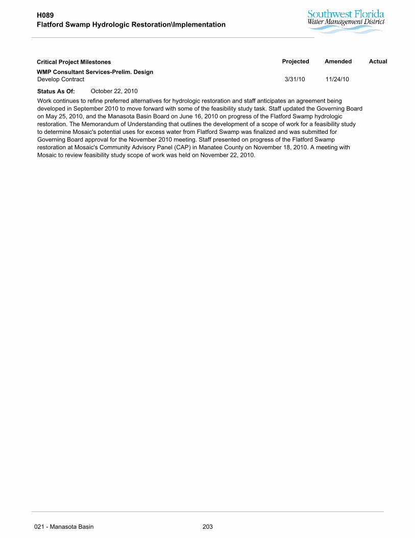
H089
Flatford Swamp Hydrologic Restoration\Implementation
Critical Project Milestones ActualProjected Amended
WMP Consultant Services-Prelim. DesignDevelop Contract 3/31/10 11/24/10
Status As Of: October 22, 2010
Work continues to refine preferred alternatives for hydrologic restoration and staff anticipates an agreement being
developed in September 2010 to move forward with some of the feasibility study task. Staff updated the Governing Board
on May 25, 2010, and the Manasota Basin Board on June 16, 2010 on progress of the Flatford Swamp hydrologic
restoration. The Memorandum of Understanding that outlines the development of a scope of work for a feasibility study
to determine Mosaic's potential uses for excess water from Flatford Swamp was finalized and was submitted for
Governing Board approval for the November 2010 meeting. Staff presented on progress of the Flatford Swamp
restoration at Mosaic's Community Advisory Panel (CAP) in Manatee County on November 18, 2010. A meeting with
Mosaic to review feasibility study scope of work was held on November 22, 2010.
021 - Manasota Basin 203
H093
Manatee County Regional 10 MG RW Storage SW-2
Project Type WS&R Dev.
AORs Strategic InitiativesWater Supply Alternative Water SupplyWater Quality Water Quality Maintenance and Improvement
Basin(s) Manasota
Manatee CountyCooperator(s)
Project Manager MCGOOKEY, SCOTT
Task Manager(s)
Status Ongoing
DescriptionThis project will design and construct the second of four 10 Million Gallon (MG) reclaimed water storage tanks in
support of the Manatee County Agricultural Reuse System (MARS). MARS is a regional system that consists of the
over 21 miles of transmission lines that interconnect Manatee County's three regional Wastewater Treatment Facilities
(WWTF). The MARS system supplies reclaimed water for irrigation of agricultural, residential, and recreational
customers, thereby decreasing dependence on potable groundwater. New residential developments, some with golf
courses, have been replacing agricultural demand and many are planned or under construction along the transmission
route. These developments are potential customers of the MARS System. The MARS system is designed to distribute
over 30 mgd. Currently the County relies on one 3 MG tank at the Spencer Parrish Pumping Station and one .75 MG
tank at its North Wastewater Reclamation Facility to meet peak demand. Wastewater plant peak flows are processed
during the daytime and used primarily at night. This condition requires the county system to have sufficient tank
storage to meet the nighttime peak demand. The District and County are in the process of constructing the first 10MG
reclaimed water ground storage tank (H086) at the Southwest Wastewater Reclamation Facility with FY2010 funding.
The addition of this second 10 MG tank, and two more planned 10 MG tanks, will better enable the County's regional
system to provide for the nightly peak demand events, without compromising pressure and water quality. This tank will
also be located at the County's Southwest Wastewater Reclamation Facility.
BenefitsThis 10 MG reclaimed water storage tank will better enable the County to accommodate its customer base as it
evolves from purely agriculture to a mix of customers, including residential. The storage will assist the county in
providing reclaimed water for irrigation purposes throughout its system to its customers during nightly peak demand
events, without comprimising pressure and water quality.
Costs
The total project design and construction costs are estimated to be $5,000,000. The District's share is $2,500,000 or
fifty percent, of which $625,000 from the Governing Board and $625,000 from the Manasota Basin Board was
budgeted in FY2011 and the county will request $625,000 from the Governing Board and $625,000 from the Manasota
Basin Board in FY2012. The cost benefit cannot be calculated, since the project addresses system storage and
efficiency, and offsets will be associated with future related transmission projects. The total project cost includes
$500,000 for design and $4,500,000 for construction. Future funds identified for the project are contingent upon the
approval by the District in their annual budgets.
Additional Information
The proposed second 10 MG Reclaim Water Storage Tank is an enhancement to the existing Manatee County
Agricultural Reclaim System (MARS). This system reduces demand for public potable water for irrigation, improves
overall utilization of existing SWFWMD water resources and provides on demand high quality irrigation water for our
urban and agricultural customers. MARS is an integral part of Manatee County water conservation program. The
County's overall program includes existing metering and loss reduction programs, water conservation rate structures,
urban and agricultural reclaim water irrigation supply, public education, SWUCA based level of service for water
supply at 110 gpfcpd, land development codes requiring non-potable sources for irrigation in new developments, water
supply protection ordinances and the use of aquifer storage and recovery for potable and potentially reclaimed waters.
021 - Manasota Basin 204
H093
Manatee County Regional 10 MG RW Storage SW-2
District Budgeted - Ad Valorem Based
Revenue
010 General Fund (Districtwide) 1,251,516 625,000 0 0 0 626,516
021 Manasota Basin 1,251,516 625,000 0 0 0 626,516
Project Funds Not Budgeted by the
District
Manatee County 2,500,000 0 0 0 1,250,000 1,250,000
$5,003,032 Total:
Prior
Funding
Cumulative
Transfer or
Lapsed Funding Funding Funding
2011 FY 2012 FY Future
Funding
Total
Funding
Critical Project Milestones ActualProjected Amended
Execute CFI Agreement 12/30/10
Start Design of RW Storage Tank 1/31/11
Complete Design of RW Storage Tank 6/30/11
Start Construction RW Storage Tank 8/31/11
Complete Construction RW Storage Tank 11/30/12
Status As Of: October 27, 2010
The County submitted the project plan (Exhibit B) of the Cooperative Funding Initiative (CFI) agreement to the District on
October 19, 2010. The District is processing the draft CFI agreement.
021 - Manasota Basin 205
H532
CFI USA, Inc. Venus II Grove
Project Type WS&R Dev.
AORs Strategic InitiativesWater Quality Water Quality Maintenance and ImprovementWater Supply Alternative Water Supply
Basin(s) Manasota
Cooperator(s)
Project Manager ESTES, CAROLE
Task Manager(s)
Status Ongoing
DescriptionThe project as proposed by CFI USA, Inc. is to reduce the withdrawal of groundwater through the construction and
operation of a five acre surface water irrigation reservoir. The reduction in groundwater use will benefit the Upper
Floridan aquifer system by replacing Upper Floridan withdrawals with recovered tailwater and surface water. FARMS
project components consist of one surface water irrigation pump station, filtration, and the piping necessary to connect
the surface water reservoir system to the existing irrigation system. The CFI USA Venus II Grove is located in Manatee
County. The property drains into the east fork of the Manatee River. This project will collect and reuse water from the
property and surrounding watershed. The Water Use Permit for this grove authorizes groundwater withdrawals up to
214,400 gallons per day (gpd) for the irrigation of 245 acres of citrus from two Upper Floridan aquifer wells. The
moving annual average indicates that CFI USA, Inc. is currently using 216,668 gpd or 101 percent of its permitted
quantities, but below the permitted drought quantity of 264,600 gpd. The proposed project involves water quantity
BMPs which qualifies for a 50 percent cost-share reimbursement rate under the FARMS Program.
BenefitsFARMS projects calculate a cost benefit based on the term of the proposed contract (generally five years) and
compare it to model farms listed in the Regional Water Supply Plan. Using an estimate of 33 percent savings of
permitted quantities for this phase, or approximately 70,500 gpd, yields a daily cost of $3.13 per thousand gallons of
groundwater reduced over the proposed five-year contract term, and $0.94 per thousand gallons of groundwater
reduced over a thirty-year term. Both projected values for groundwater savings costs are within the guidelines for the
generally accepted average cost savings per thousand gallons for the implementation of improved irrigation techniques
and alternative supply use for flatwood citrus operations.
Costs
Total project costs are estimated at $430,000, with FARMS eligible costs up to a not-to-exceed limit of $180,000 (100
percent of FARMS eligible not to exceed 50 percent of total project costs). Of this amount, $45,000 will be from Fund
010 General Fund, $45,000 will be from the Manasota Basin Board, and $90,000 will be from the Ecosystem Trus
Fund appropriation to FARMS.
District Budgeted - Ad Valorem Based
Revenue
010 General Fund (Districtwide) 45,000 0 45,000 0 0 0
021 Manasota Basin 45,000 0 45,000 0 0 0
District Budgeted - Outside Revenue
Ecosystem Trust Fund - FARMS 90,000 0 90,000 0 0 0
$180,000 Total:
Prior
Funding
Cumulative
Transfer or
Lapsed Funding Funding Funding
2011 FY 2012 FY Future
Funding
Total
Funding
021 - Manasota Basin 206

H532
CFI USA, Inc. Venus II Grove
Status As Of: October 13, 2010
Construction is complete on this project, data on surface water use should be available in November, 2010.
ACTION-TO-DATE: On-Time
021 - Manasota Basin 207
H538
FFD Land Company
Project Type WS&R Dev.
AORs Strategic InitiativesWater Quality Water Quality Maintenance and ImprovementWater Supply Conservation
Basin(s) Manasota
FFD Land Company, Inc.Cooperator(s)
Project Manager ESTES, CAROLE
Task Manager(s)
Status Ongoing
DescriptionThe project as constructed by FFD Land Company was intended to reduce Upper Floridan groundwater withdrawals
through the use of an integrated system that will include a weather station, evapotranspiration sensors, soil moisture
sensors, and automated pump control. FFD's tomato farm is located on the East Fork of the Manatee River, upstream
from Lake Manatee. Lake Manatee is a major source of drinking water for Manatee County. The existing Water Use
Permit (WUP) is divided into Farm 1, Farm 4, and Farm 4A. The pertinent portion of the WUP is Farm 4 and 4A. For
this portion of the property, the WUP authorizes an annual average groundwater withdrawal of 1,989,800 gallons per
day (gpd), for the irrigation of tomatoes. Since 1990, FFD Land Company, Inc. has averaged groundwater withdrawals
of 63 percent of permitted quantities. The project will reduce Upper Floridan groundwater withdrawals and, therefore,
the project qualifies for a 50 percent cost-share reimbursement rate under the FARMS Program.
BenefitsFARMS projects calculate a cost benefit based on the projected offset of Upper Floridan groundwater quantities, total
project cost, and the term of the proposed contract. Using an estimated five percent savings of permitted quantities, or
approximately 94,940 gpd, yields a daily cost of $1.59 per thousand gallons of groundwater reduced over the proposed
five-year contract term, and $0.48 per thousand gallons of groundwater reduced over a thirty-year term. p; Both values
are below the model farm average cost of $1.93 per thousand gallons saved, and within the guidelines for the
generally accepted average cost savings per thousand gallons for the implementation of alternative supplies and
improved irrigation techniques for row crop operations.
Costs
Total project costs were $72,353, with the FARMS eligible reimbursement of $36,676. Of this amount, $9,169 was
from Fund 010 General Fund, $9,169 was from Fund 021 Manasota Basin Board, and $18,338 was from the
Ecosystems Trust Fund appropriation to FARMS.
District Budgeted - Ad Valorem Based
Revenue
010 General Fund (Districtwide) 9,942 0 9,942 0 0 0
021 Manasota Basin 9,942 0 9,942 0 0 0
District Budgeted - Outside Revenue
Ecosystem Trust Fund - FARMS 19,883 0 19,883 0 0 0
$39,767 Total:
Prior
Funding
Cumulative
Transfer or
Lapsed Funding Funding Funding
2011 FY 2012 FY Future
Funding
Total
Funding
Critical Project Milestones ActualProjected Amended
Project ConstructionContract Execution 1/7/07 1/7/07
Construction Completion 7/31/08
021 - Manasota Basin 208
H538
FFD Land Company
Project ContractContract Completion 7/31/13
Status As Of: October 13, 2010
This project became operational in December 2007. The project has offset groundwater pumping by an annual average
of 220,064 gpd or 231.89 percent of the projected offset of 94,900 gpd.
ACTION-TO-DATE: On-time
021 - Manasota Basin 209

H583
4 Star Tomato - Long Creek Farm
Project Type WS&R Dev.
AORs Strategic InitiativesNatural Systems Natural Systems Conservation and RestorationWater Supply Alternative Water SupplyWater Quality Water Quality Maintenance and Improvement
Basin(s) Manasota
Cooperator(s)
Project Manager ESTES, CAROLE
Task Manager(s)
Status Ongoing
DescriptionThe project as proposed by 4 Star Tomato is to reduce Upper Floridan aquifer withdrawals and improve natural system
conditions in the UMRW. This will be accomplished through retention of irrigation and stormwater runoff as well as a
seepage interception system along the farm boundary adjacent to Long Creek. FARMS components include culverts
with risers to retain water in a series of six stair-stepped storage areas; approximately 5,700 feet of drainpipe, an
automatically operated pump station, and approximately 5,500 of pressure pipe to convey seepage water to an
up-gradient storage area. In addition, a network of data loggers will record water levels both inside the farm and
outside the seepage interception system to document the efficacy of the project. Long Creek Farm, is a 1,240-acre
farm located adjacent to Long Creek, which drains into the Myakka River north of State Road 70 in eastern Manatee
County. The Water Use Permit (WUP) authorizes an annual average groundwater withdrawal of 920,800 gallons per
day (gpd) to irrigate 651 acres of potatoes and tomatoes. Since September 2006, an average of 90 percent of the
permitted quantities have been used for crop irrigation. The proposed project involves water quantity and natural
systems improvement in the UMRW BMPs which qualifies for a 75 percent cost-share reimbursement rate under the
FARMS Program Rule.
BenefitsFARMS projects calculate a cost benefit based on the term of the proposed contract (generally five years) and
compare it to model farms listed in the Regional Water Supply plan. This project is expected to offset approximately
100,000 gpd in Upper Floridan aquifer quantities which yields a daily cost of $1.57 per thousand gallons of
groundwater reduced over the proposed five-year contract term, and $0.47 per thousand gallons of groundwater
reduced over a thirty-year term. Both values are within the guidelines for the generally accepted average cost savings
per thousand gallons for the implementation of alternative supplies and improved water control for vegetable and row
crop operations.
Costs
Total project costs are estimated at $157,900, with FARMS eligible costs up to a not-to-exceed limit of $102,000. Of
this amount, $10,764 will be from Fund 010 General Fund; $10,765 will be from Fund 021 Manasota Basin Board; and
$80,471 will be from the Ecosystem Trust Fund appropriations to FARMS.
District Budgeted - Ad Valorem Based
Revenue
010 General Fund (Districtwide) 10,765 0 10,765 0 0 0
021 Manasota Basin 10,764 0 10,764 0 0 0
District Budgeted - Outside Revenue
Ecosystem Trust Fund - FARMS 80,471 0 80,471 0 0 0
$102,000 Total:
Prior
Funding
Cumulative
Transfer or
Lapsed Funding Funding Funding
2011 FY 2012 FY Future
Funding
Total
Funding
021 - Manasota Basin 210

H583
4 Star Tomato - Long Creek Farm
Status As Of: October 13, 2010
Construction is in progress.
ACTION-TO-DATE: On-Time
021 - Manasota Basin 211
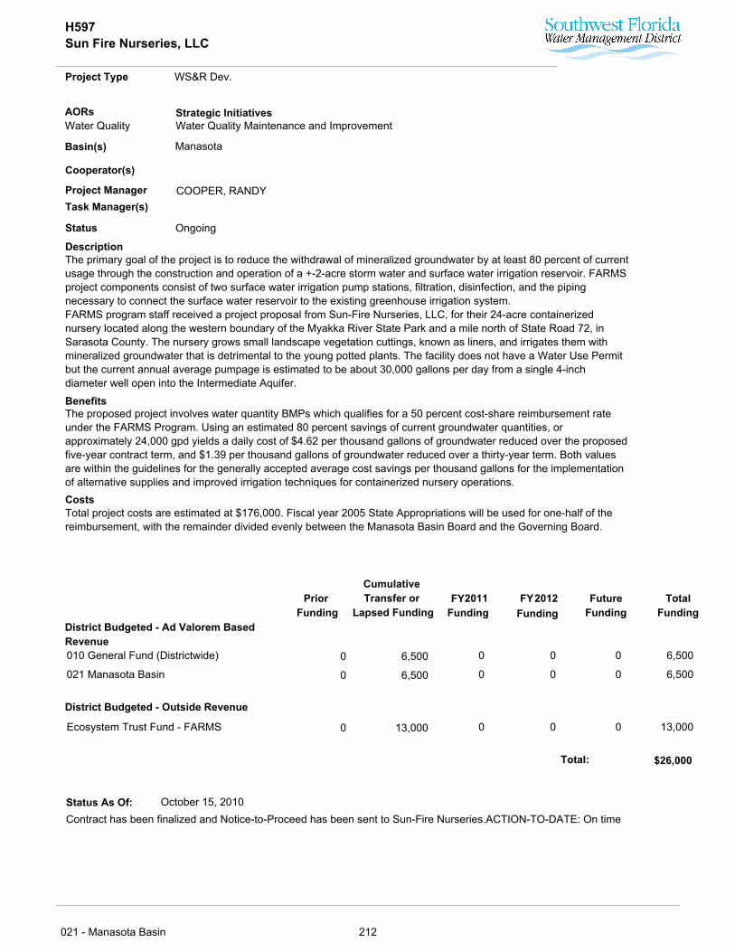
H597
Sun Fire Nurseries, LLC
Project Type WS&R Dev.
AORs Strategic InitiativesWater Quality Water Quality Maintenance and Improvement
Basin(s) Manasota
Cooperator(s)
Project Manager COOPER, RANDY
Task Manager(s)
Status Ongoing
DescriptionThe primary goal of the project is to reduce the withdrawal of mineralized groundwater by at least 80 percent of current
usage through the construction and operation of a +-2-acre storm water and surface water irrigation reservoir. FARMS
project components consist of two surface water irrigation pump stations, filtration, disinfection, and the piping
necessary to connect the surface water reservoir to the existing greenhouse irrigation system.
FARMS program staff received a project proposal from Sun-Fire Nurseries, LLC, for their 24-acre containerized
nursery located along the western boundary of the Myakka River State Park and a mile north of State Road 72, in
Sarasota County. The nursery grows small landscape vegetation cuttings, known as liners, and irrigates them with
mineralized groundwater that is detrimental to the young potted plants. The facility does not have a Water Use Permit
but the current annual average pumpage is estimated to be about 30,000 gallons per day from a single 4-inch
diameter well open into the Intermediate Aquifer.
BenefitsThe proposed project involves water quantity BMPs which qualifies for a 50 percent cost-share reimbursement rate
under the FARMS Program. Using an estimated 80 percent savings of current groundwater quantities, or
approximately 24,000 gpd yields a daily cost of $4.62 per thousand gallons of groundwater reduced over the proposed
five-year contract term, and $1.39 per thousand gallons of groundwater reduced over a thirty-year term. Both values
are within the guidelines for the generally accepted average cost savings per thousand gallons for the implementation
of alternative supplies and improved irrigation techniques for containerized nursery operations.
Costs
Total project costs are estimated at $176,000. Fiscal year 2005 State Appropriations will be used for one-half of the
reimbursement, with the remainder divided evenly between the Manasota Basin Board and the Governing Board.
District Budgeted - Ad Valorem Based
Revenue
010 General Fund (Districtwide) 6,500 0 6,500 0 0 0
021 Manasota Basin 6,500 0 6,500 0 0 0
District Budgeted - Outside Revenue
Ecosystem Trust Fund - FARMS 13,000 0 13,000 0 0 0
$26,000 Total:
Prior
Funding
Cumulative
Transfer or
Lapsed Funding Funding Funding
2011 FY 2012 FY Future
Funding
Total
Funding
Status As Of: October 15, 2010
Contract has been finalized and Notice-to-Proceed has been sent to Sun-Fire Nurseries.ACTION-TO-DATE: On time
021 - Manasota Basin 212
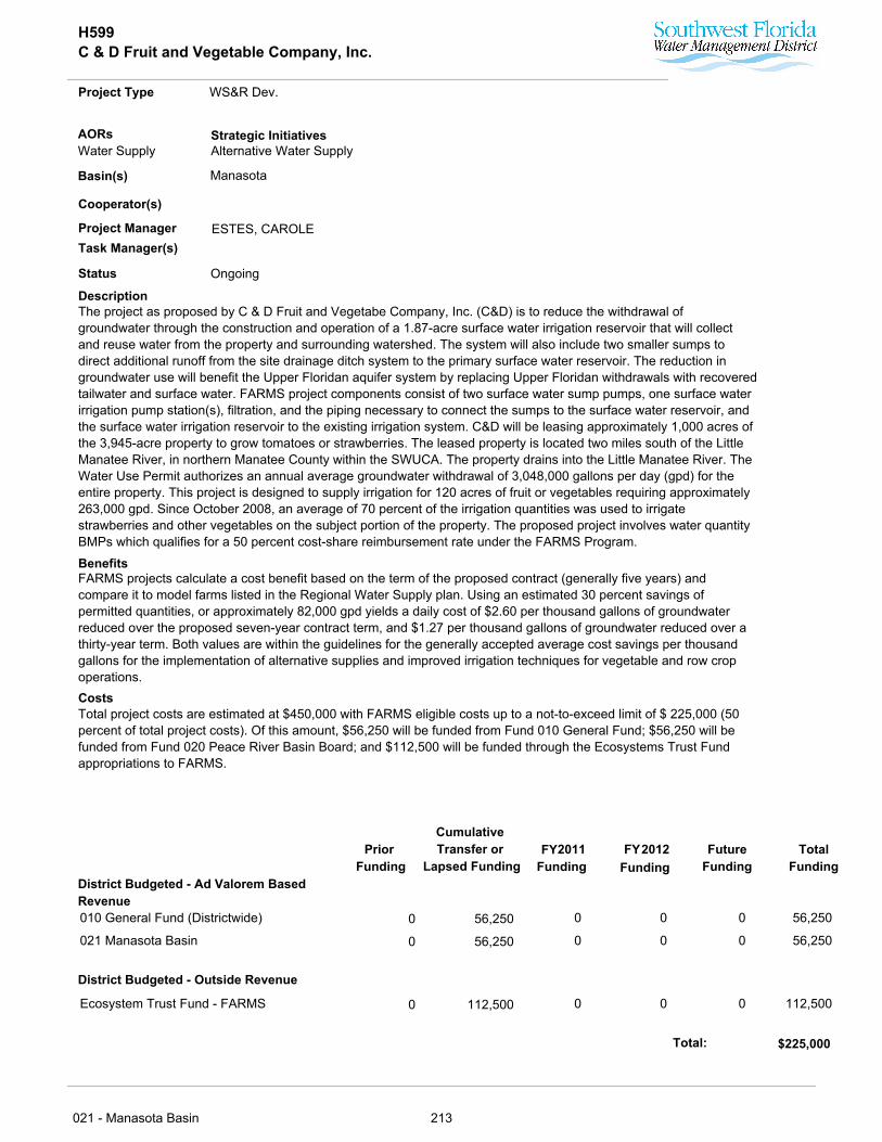
H599
C & D Fruit and Vegetable Company, Inc.
Project Type WS&R Dev.
AORs Strategic InitiativesWater Supply Alternative Water Supply
Basin(s) Manasota
Cooperator(s)
Project Manager ESTES, CAROLE
Task Manager(s)
Status Ongoing
DescriptionThe project as proposed by C & D Fruit and Vegetabe Company, Inc. (C&D) is to reduce the withdrawal of
groundwater through the construction and operation of a 1.87-acre surface water irrigation reservoir that will collect
and reuse water from the property and surrounding watershed. The system will also include two smaller sumps to
direct additional runoff from the site drainage ditch system to the primary surface water reservoir. The reduction in
groundwater use will benefit the Upper Floridan aquifer system by replacing Upper Floridan withdrawals with recovered
tailwater and surface water. FARMS project components consist of two surface water sump pumps, one surface water
irrigation pump station(s), filtration, and the piping necessary to connect the sumps to the surface water reservoir, and
the surface water irrigation reservoir to the existing irrigation system. C&D will be leasing approximately 1,000 acres of
the 3,945-acre property to grow tomatoes or strawberries. The leased property is located two miles south of the Little
Manatee River, in northern Manatee County within the SWUCA. The property drains into the Little Manatee River. The
Water Use Permit authorizes an annual average groundwater withdrawal of 3,048,000 gallons per day (gpd) for the
entire property. This project is designed to supply irrigation for 120 acres of fruit or vegetables requiring approximately
263,000 gpd. Since October 2008, an average of 70 percent of the irrigation quantities was used to irrigate
strawberries and other vegetables on the subject portion of the property. The proposed project involves water quantity
BMPs which qualifies for a 50 percent cost-share reimbursement rate under the FARMS Program.
BenefitsFARMS projects calculate a cost benefit based on the term of the proposed contract (generally five years) and
compare it to model farms listed in the Regional Water Supply plan. Using an estimated 30 percent savings of
permitted quantities, or approximately 82,000 gpd yields a daily cost of $2.60 per thousand gallons of groundwater
reduced over the proposed seven-year contract term, and $1.27 per thousand gallons of groundwater reduced over a
thirty-year term. Both values are within the guidelines for the generally accepted average cost savings per thousand
gallons for the implementation of alternative supplies and improved irrigation techniques for vegetable and row crop
operations.
Costs
Total project costs are estimated at $450,000 with FARMS eligible costs up to a not-to-exceed limit of $ 225,000 (50
percent of total project costs). Of this amount, $56,250 will be funded from Fund 010 General Fund; $56,250 will be
funded from Fund 020 Peace River Basin Board; and $112,500 will be funded through the Ecosystems Trust Fund
appropriations to FARMS.
District Budgeted - Ad Valorem Based
Revenue
010 General Fund (Districtwide) 56,250 0 56,250 0 0 0
021 Manasota Basin 56,250 0 56,250 0 0 0
District Budgeted - Outside Revenue
Ecosystem Trust Fund - FARMS 112,500 0 112,500 0 0 0
$225,000 Total:
Prior
Funding
Cumulative
Transfer or
Lapsed Funding Funding Funding
2011 FY 2012 FY Future
Funding
Total
Funding
021 - Manasota Basin 213
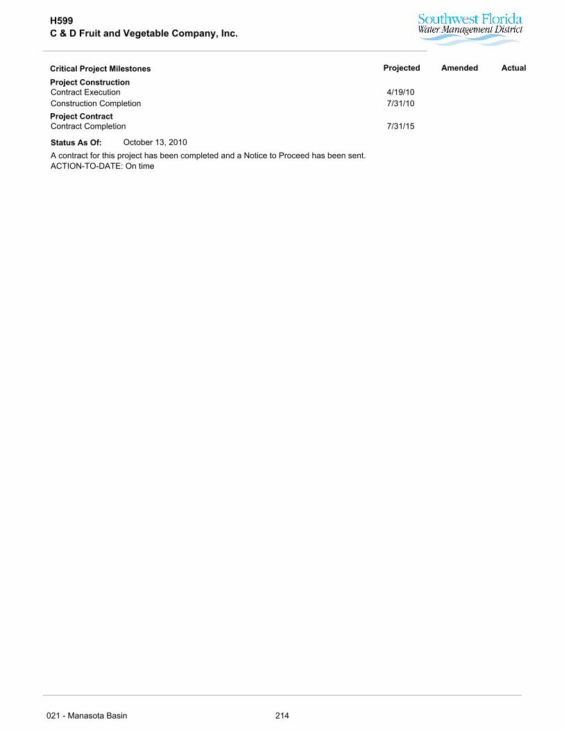
H599
C & D Fruit and Vegetable Company, Inc.
Critical Project Milestones ActualProjected Amended
Project ConstructionContract Execution 4/19/10
Construction Completion 7/31/10
Project ContractContract Completion 7/31/15
Status As Of: October 13, 2010
A contract for this project has been completed and a Notice to Proceed has been sent.
ACTION-TO-DATE: On time
021 - Manasota Basin 214
H605
WFA LAnd Company, Inc. - Reservoir Project
Project Type WS&R Dev.
AORs Strategic InitiativesWater Supply Alternative Water Supply
Basin(s) Manasota
Cooperator(s)
Project Manager ESTES, CAROLE
Task Manager(s)
Status Ongoing
DescriptionThe project as proposed by WFA Land Company, Inc. is to reduce the withdrawal of groundwater through the
construction of a surface water pump station to utilize surface water in an existing 13.5-acre tailwater reservoir. The
reduction in groundwater use will benefit Upper Floridan aquifer system by replacing groundwater withdrawals with
recovered tailwater and surface water. FARMS project components consist of a surface water irrigation pump station,
filtration, and the piping necessary to connect the surface water reservoir to the existing irrigation system. WFA Land
Company, Inc., Grove 64 is a 2,140-acre citrus and row crop farm located on the north fork of the Manatee River, in
eastern Manatee County. The property is within the SWUCA and lies along the eastern boundary of the Most Impacted
Area (MIA). This project will collect and reuse water from the property and surrounding watershed. The Water Use
Permit authorizes an annual average groundwater withdrawal of 2,271,000 gallons per day (gpd) to irrigate 2,140
acres of the citrus with under tree spray and tomatoes with drip irrigation. Since May 1992, groundwater use has
averaged 2,352,759 gpd, and while this is more than annual average permitted quantities, it is less than permitted
drought quantities. The proposed project involves water quantity BMPs which qualifies for a 50 percent cost-share
reimbursement rate under the FARMS Program.
BenefitsFARMS projects calculate a cost benefit based on the term of the proposed contract (generally five years) and
compare it to model farms listed in the Regional Water Supply plan. Using an estimated five percent savings of
permitted quantities that are not already being offset with previous phases of work at the WFA Land Company site, or
approximately 105,000 gpd yields a daily cost of $ 0.45 per thousand gallons of groundwater reduced over the
proposed five-year contract term, and $0.14 per thousand gallons of groundwater reduced over a thirty-year term. Both
values are within the guidelines for the generally accepted average cost savings per thousand gallons for the
implementation of alternative supplies and improved irrigation techniques for flatwood citrus or row crop operations.
Costs
Total project costs are estimated at $75,000, with FARMS eligible costs up to a not-to-exceed limit of $37,500 ( 50
percent of total project costs). Of this amount, $9,375 will be funded through Fund 010 General Fund; $9,375 will be
funded through Fund 021 Manasota Basin Board; and $18,750 will be funded through the Ecosystem Trust Fund
appropriations to FARMS.
District Budgeted - Ad Valorem Based
Revenue
010 General Fund (Districtwide) 9,375 0 9,375 0 0 0
021 Manasota Basin 9,375 0 9,375 0 0 0
District Budgeted - Outside Revenue
Ecosystem Trust Fund - FARMS 18,750 0 18,750 0 0 0
$37,500 Total:
Prior
Funding
Cumulative
Transfer or
Lapsed Funding Funding Funding
2011 FY 2012 FY Future
Funding
Total
Funding
021 - Manasota Basin 215
H605
WFA LAnd Company, Inc. - Reservoir Project
Status As Of: October 15, 2010
The contract with WFA Grove 64 Reservoir has been finalized and a Notice-to-Proceed Letter has been sent to the
grower.
ACTION-TO-DATE: On-time
021 - Manasota Basin 216
K114
Bradenton - ASR Program
Project Type Cooperative Funding
AORs Strategic InitiativesWater Supply Alternative Water Supply
Basin(s) Manasota
City of BradentonCooperator(s)
Project Manager ELLISON, DON
Task Manager(s)
Status Ongoing
DescriptionThis project is to permit and construct up to three additional monitoring wells, and perform two additional cycle tests at
the City of Bradenton's Downtown aquifer storage and recovery (ASR) site. The project is a continuation of the City's
Downtown ASR project that is located at the High Service Pump Station (HSPS) in Downtown Bradenton and will
provide 1.5 mgd of potable water during the 100-day dry season. The wells will be constructed to address FDEP
monitoring requirements for sites mobilizing arsenic in the subsurface. These wells are estimated to be about 550 feet
deep and completed into the aquifer storage zone, and will be located within several hundred feet of the ASR well. The
wells are being required by the FDEP. Funding requested for the project includes engineering fees for the required
Area of Review analysis, an update to the Well Inventory, and additional storage zone monitoring wells required by
FDEP. Funding is also being requested to modify FDEP permit No.133098-074-UC/MN for construction of the
additional monitoring wells; for the design, bid, award, construction and testing of up to three additional monitoring
wells; and for the extension of Cycle Testing to include Cycles 7 and 8.
BenefitsThis project is expected to provide 1.5 mgd potable supply during a typical 100 day dry season which is needed to help
the city provide a more reliable source of water during periods of low flow in Braden River. The information from this
project will also support the Districts efforts to find methods to minimize arsenic mobilization in the aquifer during ASR
activities.
Costs
The total cost for all prior and ongoing project work is $2,684,250 ($1,342,125 each) and is contained in two separate
contracts. The first contract was completed in October 2005 and covered the construction and testing of an ASR well
and monitoring well for a total amount of $1,625,000 ($812,500 each). The second contract was initiated in FY 2007
and covers the construction of up to three new monitoring wells and continuation of cycle testing through FY2010 for a
total amount of $1,059,250 ($529,625 each). With the allocation of $101,650 from the Water Protection Sustainability
Trust Fund Program, the City's and District's equal shares of the second contract have been reduced to $478,800
each. The District's budget as it appears below does not reflect the $655,000 that was funded in FY2000 and prior
years, nor the $529,625 that was transferred into the project in FY2006 from project L513, the City's reservoir ASR
site.
Additional Information
The existing ASR well (1.5 mgd injection/recovery capacity) and piping was constructed in 2003 with cooperative
funding from the District. The City has completed 6 cycle tests as required by Florida Department of Environmental
Protection (FDEP) permit No.133098-074-UC/MN. Cycle test results have identified arsenic mobilization in the
subsurface and further plans for cycle testing is on hold until a new approach to control the arsenic mobilization
problem within acceptable Drinking Water Standards is developed. Continuation of cycles tests 7 and 8 is on hold until
the City identifies an acceptable approach, the additional monitoring wells at this point are to identify the extent of
arsenic contamination in the aquifer. The City has one storage zone monitoring well offsite with arsenic exceeding the
Drinking Water Standard of 10 ppb.
021 - Manasota Basin 217

K114
Bradenton - ASR Program
District Budgeted - Ad Valorem Based
Revenue
021 Manasota Basin 778,853 0 448,350 311,555 0 18,948
District Budgeted - Outside Revenue
Water Protection & Sust T.F.
(Alternative Wtr)
101,650 0 101,650 0 0 0
Project Funds Not Budgeted by the
District
City of Bradenton 687,125 0 0 687,125 0 0
$1,567,628 Total:
Prior
Funding
Cumulative
Transfer or
Lapsed Funding Funding Funding
2011 FY 2012 FY Future
Funding
Total
Funding
Critical Project Milestones ActualProjected Amended
1. Critical Project MilestonesDistrict Recognition/Signage: YES 10/1/00 10/1/00
2. First Contract for ASR well Construction and Cycles 1-6Preparation of Plans and Specs 10/1/00 10/30/02 10/30/02
Permitting 9/1/01 9/30/02 9/30/02
Well Construction 1/1/02 11/20/03 11/20/03
ASR Cycle Testing Through Cycle 6 2/1/02 12/20/04 10/1/05
First Contract Amendment 2/25/02 5/3/02
Final Report 3/28/02 7/20/05 10/1/05
Project Complete 5/27/02 9/20/05 10/1/05
Contract Termination 10/1/02 10/1/05 10/1/05
3. Second Contract (Pending) for Montioring Wells and Additional Cycle TestsTask 1 Cycle 6a Recovery and Design Equipment Upgrades 6/30/06 6/30/06
Task 2 SZMW-3 Design, Permitting 10/30/06 12/30/09
Request Basin Board Transfer of Funds 12/30/06 12/30/06
Contract Execution 1/30/07 1/24/07
Task 3 SZMW-3 Construction 10/30/07 12/30/09
Task 4 Cycle Test 7 10/30/08 12/20/07
Task 5 Feasibility Study Update 10/30/08
Task 6 SZMW-4 & SZMW-5 Design, Permitting, Construction 5/30/09
Task 7 SZMW-4 and SZMW-5 Construction 10/30/09
Task 8 Cycle Tests 8 and 9 10/30/10
Task 9 Final Report, Application for Operations Permit 10/30/11
Second ContractContract Completion Date 12/30/11
Status As Of: August 17, 2010
The scope of work for the first contract to construct and test an ASR well at the Downtown Booster Station site has been
completed and all submittals have been received. Arsenic concentrations exceeding the drinking water standard (DWS)
were observed in the monitoring well 200 feet away at the end of the cycle test 6. This new data indicates that the arsenic
standard would be exceeded at the property line 75 feet away. In response to the arsenic mobilization issue at this site
the City, FDEP, and District have been developing strategies to address the issue. Part of the strategy developed was to
install additional monitoring wells and to continue cycle testing to demonstrate that the arsenic issue is limited in extent
and not posing a threat to the aquifer. The strategy was, at the time consistent with guidance received from the FDEP
indicating that as long as the arsenic concentrations were below the DWS at the property boundary, the site would be
eligible for an operational permit. The City submitted a request for FY2007 funding through the District's Cooperative
Funding Program to proceed with this additional work. Because of the urgent need to address the arsenic mobilization
021 - Manasota Basin 218

K114
Bradenton - ASR Program
issue, the City made a request to the Manasota Basin Board at it's April 2006 meeting to transfer $550,000 in FY2006
funds from the City's ASR project at the Evers Reservoir (L513) for use in this project. The request was approved by the
Basin Board at it's April meeting and the City has thus withdrawn their FY2007 cooperative funding application. The
District and City have executed the contract for this additional testing. Since that time the FDEP has changed their
position on permitting ASR facilities with the arsenic issue and is now indicating that any site with arsenic anywhere that
exceeds the DWS would not be permitted for operational use. The only option at this time is to explore pre-treatment of
the injection water to produce compatible water qualities between the injectant and the native water in the aquifer.
Recognizing this requirement, the District approached the City with a request to participate in a pre-treatment study to
remove dissolved oxygen and other oxidants from the injection water which are suspected of being the primary causes of
the arsenic mobilization. The property line monitoring well(s) will still be necessary, but it is contingent on the
implementation of the pre-treatment option. The scope of work for the pre-treatment option has been developed by the
City and bids have been awarded for construction under a separate contract. The city received their UIC permit renewal
and consent order in October 2008. Installation of the degasification system was completed in September 2008 and the
performance test of the degas system was completed in September and October. The degas system performed as
designed and passed the final inspection. In October the city continued recovery of water from the ASR well to remove
any remaining arsenic mobilized by earlier cycle tests. This over recovery effort was successful at returning arsenic
concentrations to less than 5.0 ug/l; this is approximately the natural background concentration for arsenic in the aquifer.
Injection of the first de-oxygenated water into the aquifer began on December 2, 2008 at approximately 1.0 mgd. The
system had to be shut down after two weeks of operation due to a ruptured degasification chamber which has since been
replaced. The dry conditions have left the city with very little extra water for cycle testing at this time and cycle testing is
being postponed until the wet season begins in June 2009. Recovery of the 6 million gallons of degassed water stored in
December 2008 was completed in May 2009. The full scale cycle test (140 mg cycle test) began in August 2009. As a
result preliminary results obtained from water quality sampling during the recharge portion of the test won't be available
until the end of January 2011. The storage portion of the cycle test will last until September 2010, and the recovery
portion of the test will start in September 2010 and continue through January 2011. We should know by the end of
February 2011 whether degasification is effective at controlling arsenic mobilization.
021 - Manasota Basin 219
K120
North Port - Water ASR - Phase V
Project Type Cooperative Funding
AORs Strategic InitiativesWater Supply Alternative Water Supply
Basin(s) Manasota
City of North Port, City of North Port - Public UtilitiesCooperator(s)
Project Manager KELLEY, MIKE
Task Manager(s)
Status Ongoing
DescriptionThis project consists of an Aquifer Storage and Recovery (ASR) Program in the City of North Port to create an
alternative water supply by treating excess wet season flows from Myakkahatchee Creek and storing it in the
mineralized Floridan aquifer. The location is downtown North Port at the water treatment plant. The goal of the project
is to develop a 1.5 million gallon per day dry season supply. FY2008 funding is for Phase V of the project which is for
the installation and testing of a degasification system and for the injection and recovery of treated water, cycle test 4.
Longer duration cycle tests will follow. These cycle tests should determine the effectiveness of removing dissolved
oxygen from injected water on arsenic mobilization in the aquifer and recovered water. Phase V will finish this project.
BenefitsThe goal of this ASR project is to develop a 1.5 million gallons per day (mgd) dry season supply (equivalent to an
annual average of 410,000 mgd). ASR is an effective method of optimizing the supply of water available from the
Myakkahatchee Creek. Combined with the City's allocation from the Peace River/Manasota Regional Water Supply
Authority (PR/MRWSA), this ASR project has the potential to enable the City of North Port to meet its needs until
approximately 2014.
Costs
The FY2010 funding request for $60,000 is to continue FDEP required sampling and testing of water quality in the
monitor wells while the project is on stand by (through 2010/2011). This project will continue when we have favorable,
recovery water quality results from the cycle testing at the Bradenton ASR site. The estimated total cost to conduct
Phase V of the project is $619,000 and will be shared by the Manasota Basin Board and the City of North Port on a
50/50 cost-share basis ($309,500 each). The Basin's contribution will be provided as follows: $75,000 previously
approved in the Basin's FY2007 budget; $126,000 that is in the FY2008 budget; and the remaining $108,500 is in the
FY2009 and future budget years. Funding for FY2009 is combined with approved funding for FY2008 to expand Phase
V of the project to monitor and finish cycle test 4, and run additional longer cycle tests at the City's ASR site. The total
cost of the project is approximately $2,000,000 including prior phases I-IV and funding through FY2010. The Manasota
Basin Board and the City of North Port each contributed about $1,000,000.
Additional Information
Phase I determined ASR was the most effective method of optimizing the supply of water available from North Port
Utility's only local source, the Myakkahatchee Creek. The objective of Phase I was to determine the feasibility of ASR
at the North Port water treatment facility, and compare its merits and disadvantages with those of other forms of water
storage, primarily aboveground facilities. During Phase II, the City's consultant designed the ASR well system and
acquired construction and water use permits from the FDEP and the District. They also applied for a Class V injection
well permit from the FDEP. Phase III included construction and testing of the ASR well and monitor wells, and project
report writing. Phase III was initiated July 2001 and is complete. Line item adjustments have been made to Phase III to
change the focus of this ASR project from treated raw water to fully treated potable water ASR. Cycle tests one and
two were included in Phase III. Phase IV of the City's pilot ASR Program includes engineering services, hydrogeologic
field work, data collection and analysis, laboratory analytical services and completion report to accommodate the third
cycle test as required by the FDEP UIC permit for the project. The third cycle test was not included, as it was not
anticipated to be required by the FDEP at the time the Phase III agreement was finalized. The Phase III agreement is
being extended to 12/31/2005 to allow sufficient time to complete all activities related to finalization of the second cycle
test. Completion of the cycle test was hampered for a couple of reasons. First, the start of the injection portion of the
test was delayed due to a lack of water when the city was providing emergency water supplies to the PR/MRWSA
after Hurricane Charley hit the area in August 2004. The second major reason was the fact that the recovery portion of
the test was halted prematurely when the recovered water, which was directly discharged into Myakkahatchee Creek,
exceeded the standard for arsenic concentration of 50 micrograms/liter (ug/L). The DEP was contacted and the
second cycle test is considered complete. A third cycle test began 8/2/2005 and injected a million gallons per day of
treated water for 75 days which was to remain in storage 30 days. Recovery is delayed due to the construction of a lift
station to pump recovered water to the wastewater treatment plant because initial recovered water is anticipated to
021 - Manasota Basin 220

K120
North Port - Water ASR - Phase V
exceed the 50 ug/L arsenic limit. When recovered water quality is below 50 ug/L arsenic the discharge will be to
Myakkahatchee Creek. The recovered water during Cycle Test 3 was all discharged into the sanitary sewer system.
The arsenic levels remained above the maximum contaminate level (10 ug/l) in the recovered water. The FDEP
construction and testing permit is complete for Cycle Tests 4 through 6.
District Budgeted - Ad Valorem Based
Revenue
021 Manasota Basin 1,049,941 0 0 1,044,451 0 5,490
Project Funds Not Budgeted by the
District
City of North Port 1,024,070 0 0 1,024,070 0 0
$2,074,011 Total:
Prior
Funding
Cumulative
Transfer or
Lapsed Funding Funding Funding
2011 FY 2012 FY Future
Funding
Total
Funding
Critical Project Milestones ActualProjected Amended
1. PHASE IBoard Approval of Contract 11/24/98 11/24/98
Execute Contract 1/11/99 1/11/99
Feasibility Report Completed 10/28/99 10/28/99
Contract Termination 12/31/99 12/31/99
2. PHASE IIBoard Approval of Contract 4/25/00 4/25/00
Board Approval of Contract 6/19/00 6/19/00
Contract Termination 6/19/01 6/19/01
3. PHASE IIIBasin Board Approval of Agreement 5/16/01 5/16/01
Governing Board Approval of Agreement 5/31/01 5/31/01
Contract Executed 7/20/01 8/8/01
FDEP Permitting (Construction and Testing) 7/31/01 7/31/01
Well Construction and Testing Completed 8/15/02 3/1/03
ASR Cycle Testing Completed 11/15/03 9/30/05
Final Report 12/31/03 12/31/05 12/31/05
Contract Termination 12/31/03 12/31/05 12/31/05
4. PHASE IVBasin Board Approval of Agreement 12/15/03
Governing Board Approval of Agreement 12/15/03
Contract Executed 9/1/04 9/27/04
Final Report 12/31/05 12/31/07 12/14/07
Contract Termination 12/31/05 12/31/07 12/31/07
FDEP Permit Required ASR Cycle 3 Testing Completed 8/15/06 12/15/06 12/15/06
5. PHASE VCooperative Funding Agreement 3/1/08 3/1/08
Status As Of: October 29, 2010
Communications were held with the City of North Port Utilities and their consultants. We have mailed a draft contract
amendment to North Port. It will modify the budget to allow for more monitoring and change the completion date to
December 31, 2013. Groundwater sampling and testing from monitor wells are ongoing. The water quality has returned
to ambient conditions and the ASR well flow has been shut off. The consultant is working on the coordination, design
review and engineering of the degasification equipment. A meeting is planned for November 2010 to discuss new
021 - Manasota Basin 221

K120
North Port - Water ASR - Phase V
advances in pretreatment for ASR injection water. ACTION-TO-DATE: Delayed. An information request concerning the
Accelerate Florida Program was mailed to the cooperator on October 15, 2008. District follow-up email on January 12,
2009 prompted an email from Jennifer Desrosiers, North Port Business Manager, January 29, 2009. She sent a
spreadsheet of preliminary action plans for projects with District funding. She stated that she was eager to accelerate
North Port projects. Specific to this ASR project she says "This project is being monitored pursuant to our SWFWMD
contract and we are awaiting the results of the pre-treatment study being conducted at the Bradenton ASR project site to
remove dissolved oxygen and other oxidants from the injection water to mitigate the arsenic problem."
021 - Manasota Basin 222

K253
Manatee - Imp. BMPs Wares Creek
Project Type Cooperative Funding
AORs Strategic InitiativesFlood Protection Floodplain Management
Basin(s) Manasota
Manatee CountyCooperator(s)
Project Manager FRIES, GEORGE
Task Manager(s)
Status Ongoing
DescriptionThis is a multi-year funded project to perform the Implementation of Best Management Practices (BMPs) element of
the District's Watershed Management Program (WMP) for the Wares Creek Watershed. Implementation of BMPs
includes the following tasks: design, development of construction documents, construction permitting, land acquisition,
bidding and contractor selection, construction of the BMPs and construction engineering and inspection. Wares Creek
is an intermediate-scale system that conveys stormwater from a 6.23 square mile watershed that flows from the
unincorporated areas of Manatee County north through the City of Bradenton before discharging to the Manatee River.
The Wares Creek Flood Protection Project is a joint effort between Manatee County (County) and the United States
Army Corps of Engineers (USACE), as authorized by the U.S. Congress in the Water Resources Development Act of
1996, to reduce flood damage within the Cedar Hammock (Wares Creek) Drainage Basin located in west central
Manatee County. The USACE has proposed channel widening and bank stabilization of Wares Creek to reduce flood
levels to within-bank for a storm event of a 10-year magnitude. Wares Creek channel improvements will begin at the
confluence of Wares Creek with the Manatee River and end at the 44th Avenue West crossing (Cortez Road).
BenefitsThe project will provide additional capacity within the stream banks and, thereby, provide an improved level of service.
These improvements will address structure flooding along Wares Creek by providing flood protection for homes
currently inundated and damaged during the 10-year flood event. Based on an analysis prepared by the USACE, the
project will provide a positive benefit/cost ratio.
Costs
The total projected cost for this project, as estimated by Manatee County, is $46.9 million of which the District's share
is $12,576,828. The County will also contribute $12,576,828. Additional funding of $3,050,000 will be provided by the
Florida DEP and $18.7 million will be provided by the US Army Corps of Engineers. Funding for this project has been
provided in the Manasota Basin Board budgets for FY2000 ($346,000); FY2001 ($862,000); FY2002 ($431,000);
FY2004 ($892,500); FY2005 ($500,000); FY2006 ($3,000,000); FY2007 ($2,000,000); and FY2008 ($2,885,036) for a
total funding commitment through FY2008 of $10,916,536. Future funding of $1,660,292 will be required to complete
the District's obligation to fund the project. The future funds identified for the project are contingent upon approval of
such amounts by the District Governing Board and Basin Board in the annual budget(s). When each element is
completed the project budget and scope may require refinement based on the information gathered. The District
funding amounts shown in the table include staff salaries.
Additional Information
The WMP includes five major elements: 1) Topographic Information, 2) Watershed Evaluation, 3) Watershed
Management Plan, 4) Implementation of BMPs, and 5) Maintenance of Watershed Parameters and Models.
Implementing elements of the WMP with local governments is one of the District's Strategic Priorities. The WMP
provides a method to evaluate the capacity of a watershed to protect, enhance and restore water quality and natural
systems while achieving flood protection. This project involves the Implementation of BMPs. In FY2000 the Basin
Board agreed to participate with Manatee County in the project by providing one-half of the County's required share of
5% of the total project cost. The Basin Board budgeted $346,000 in FY2000 and a cooperative funding agreement
was executed. A second cooperative funding agreement was developed in FY2001 for the Wares Creek Project for
rights-of-way and easement acquisitions necessary to construct the creek enhancements. In FY2005 the County
requested additional funding for right-of-way and easement acquisition because of the steady increase in land values
in Manatee County since the original estimate was developed in 1996. The Board budgeted the additional funds and
the agreement was amended to incorporate these funds. For FY2006 the County requested that the project scope be
amended to incorporate the additional construction work needed to extend the project to the Manatee River and to
provide additional funding for easement acquisitions and project construction. The Basin Board, at its April 2005
meeting, agreed to this change in scope and scale of the project. For FY2007 the county sought additional funding to
be applied towards the land acquisition and easement expenses and the non-federal share of construction including
dredging of the lower Wares Creek between the Manatee Avenue Bridge and the Manatee River. A new cooperative
021 - Manasota Basin 223
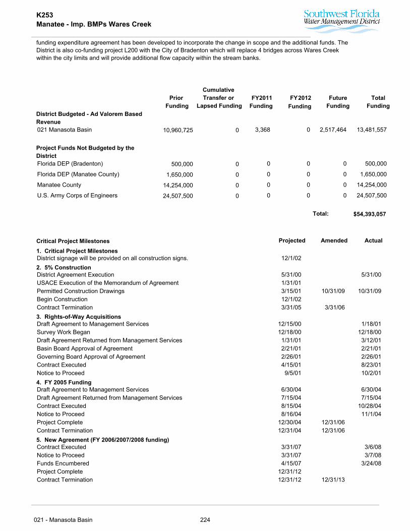
K253
Manatee - Imp. BMPs Wares Creek
funding expenditure agreement has been developed to incorporate the change in scope and the additional funds. The
District is also co-funding project L200 with the City of Bradenton which will replace 4 bridges across Wares Creek
within the city limits and will provide additional flow capacity within the stream banks.
District Budgeted - Ad Valorem Based
Revenue
021 Manasota Basin 13,481,557 2,517,464 0 10,960,725 0 3,368
Project Funds Not Budgeted by the
District
Florida DEP (Bradenton) 500,000 0 0 500,000 0 0
Florida DEP (Manatee County) 1,650,000 0 0 1,650,000 0 0
Manatee County 14,254,000 0 0 14,254,000 0 0
U.S. Army Corps of Engineers 24,507,500 0 0 24,507,500 0 0
$54,393,057 Total:
Prior
Funding
Cumulative
Transfer or
Lapsed Funding Funding Funding
2011 FY 2012 FY Future
Funding
Total
Funding
Critical Project Milestones ActualProjected Amended
1. Critical Project MilestonesDistrict signage will be provided on all construction signs. 12/1/02
2. 5% ConstructionDistrict Agreement Execution 5/31/00 5/31/00
USACE Execution of the Memorandum of Agreement 1/31/01
Permitted Construction Drawings 3/15/01 10/31/09 10/31/09
Begin Construction 12/1/02
Contract Termination 3/31/05 3/31/06
3. Rights-of-Way AcquisitionsDraft Agreement to Management Services 12/15/00 1/18/01
Survey Work Began 12/18/00 12/18/00
Draft Agreement Returned from Management Services 1/31/01 3/12/01
Basin Board Approval of Agreement 2/21/01 2/21/01
Governing Board Approval of Agreement 2/26/01 2/26/01
Contract Executed 4/15/01 8/23/01
Notice to Proceed 9/5/01 10/2/01
4. FY 2005 FundingDraft Agreement to Management Services 6/30/04 6/30/04
Draft Agreement Returned from Management Services 7/15/04 7/15/04
Contract Executed 8/15/04 10/28/04
Notice to Proceed 8/16/04 11/1/04
Project Complete 12/30/04 12/31/06
Contract Termination 12/31/04 12/31/06
5. New Agreement (FY 2006/2007/2008 funding)Contract Executed 3/31/07 3/6/08
Notice to Proceed 3/31/07 3/7/08
Funds Encumbered 4/15/07 3/24/08
Project Complete 12/31/12
Contract Termination 12/31/12 12/31/13
021 - Manasota Basin 224

K253
Manatee - Imp. BMPs Wares Creek
Status As Of: October 25, 2010
Status History: County staff appeared before the Manasota Basin Board at the April 2005 meeting and requested an
amendment to the cooperative funding agreement to permit the County to use the Land Acquisition and Easement
funding for construction as well as easement acquisition. As discussed by County staff, the cost of the entire project was
estimated, at that time, to exceed $55,000,000. County staff made a presentation to the Basin Board at its July 2007
meeting to discuss project status, estimated cost and direction. County staff is continuing the acquisition of land and
easements necessary for the project. The County has submitted four requests for reimbursement for land and easement
acquisition which have been approved. The Board of County Commissioners (BCC) authorized staff to begin eminent
domain proceedings against Bradenton Tropic Palms Mobile Home Park. The County has taken possession of the
former City Hall site (now in private ownership) located at Manatee Avenue and Wares Creek for use as a temporary
spoil storage site. An amendment to the Cooperative Funding Agreement, revising the project budget and providing
funding for the acquisition of the former Bradenton City Hall property for dewatering of the dredged materials, has been
executed. The FDEP has issued the required permit for the project. The County and the ACOE are planning to dispose
of the dewatered dredged material at the County landfill. The cost and funding source for this disposal have not been
decided upon at this time. Land acquisition for the most southerly (upstream) phase of the work has begun now that the
FDEP permit is in place. The USACE and the FDEP completed negotiating conditions of the Project Partnership
Agreement (PPA) in July 2010. These negotiations were expected to be completed by July 2009, then by April 2010.
Bidding and Contractor selection are expected in the fall of 2010 with construction commencing in early 2011.
ACTION-TO-DATE: Delayed. The PPA has been executed by both parties. Bidding is now expected to occur in early
2011 with construction to follow a few months later.
021 - Manasota Basin 225

K269
Sarasota Co. - N. Sarasota Co. Reclaimed Water ASRs
Project Type Cooperative Funding
AORs Strategic InitiativesWater Quality Water Quality Maintenance and ImprovementWater Supply Reclaimed Water
Basin(s) Manasota
Sarasota CountyCooperator(s)
Project Manager MCGOOKEY, SCOTT
Task Manager(s)
Status Ongoing
DescriptionThis project consists of the design, permitting, and construction of three 1.2 mgd reclaimed water aquifer storage and
recovery (ASR) wells with ultra-violet (UV) disinfection. These ASRs will be constructed at the County's Central County
Wastewater Treatment Facility (WWTF). The ASRs will provide wet weather storage for the County's Northern
Regional Reuse System, consisting of four interconnected county WWTFs's and a interconnection with the City of
Sarasota's Reuse System.
BenefitsThe project will provide storage of approximately 1,200,000 gpd for 120 days or 144 million gallons per year for each of
three proposed ASR wells for a total of 432 million gallons per year stored. This will yield a flow of approximately
888,000 gpd of reclaimed water to offset existing ground-water withdrawals and potable service and better serve
existing reclaimed water users such as Palmer Ranch, Manor Care of Boynton Beach, Plaza Oaks, Silver Oak, and the
Hamptons Development.
Costs
The total project cost is estimated to be $6,443,546, and the District's share is requested to be 50 percent, or
$3,221,773. The Manasota Basin has funded $2,011,743 so far, between FY2000 and FY2007, and the WPSTF
provided $164,864 in FY2006/7, for a total of $2,176,607 already budgeted for the project. The Manasota Basin will
fund $1,127,598 in future years. The cost, amortized at 8 percent over 30 years, is $1.75 per thousand gallons of
traditional water offset. Any additional funds are for staff time. The future funds identified for the project are contingent
upon approval of such amounts by the District Governing and Basin Boards in the annual budget(s).
Additional Information
This is a multi-year project that will expand Sarasota County's reclaimed water system by providing wet weather
storage for the interconnected reclaimed water systems of the Sarasota County and City of Sarasota. This regional
system has five wastewater treatment plants with a permitted capacity of 18.5 mgd and a reuse flow of 5.4 mgd that
are now interconnected. This wet weather storage will increase the system's efficiency. Cost history: The original
project was submitted to the SWFWMD in 1998 and was approved for multi-year funding beginning in FY2000 and
ending in FY2005 with a total cost of $3,030,000. Following a lengthy hearing resulting in DEP issuing a permit to
proceed with construction of the first of three ASR wells, a first amendment was approved in 2006, which increased
the total cost and apportioned the District's share as follows: Cost Breakout: FY2000 = $100,000 FY2001 = $550,000
FY2002 = $390,000 FY2003 = $405,000 FY2006 = $311,607 ($286,743 ad valorem $24,864 WPSTF) FY2007 =
$420,000 ($280,000 ad valorem $140,000 WPSTF) FY2010 = $350,000 FY2011 = $350,000 and FY2012 = $427,598.
The County has updated the costs, revised the timeline and also determined that split flow UV disinfection is needed
for this project to ensure that water quality can consistently meet drinking water standards prior to injection into the
aquifer. An added benefit of installing UV disinfection is documented effectiveness in treating water borne pathogens
that are not amenable to chlorine disinfection. The cost of the UV disinfection system for each well is estimated at
$580,000. Of the total project cost of $6,443,546, approximately 83 percent ($5,320,247) is expected to be needed for
construction, and the remainder ($1,123,299) for design and administration.
021 - Manasota Basin 226
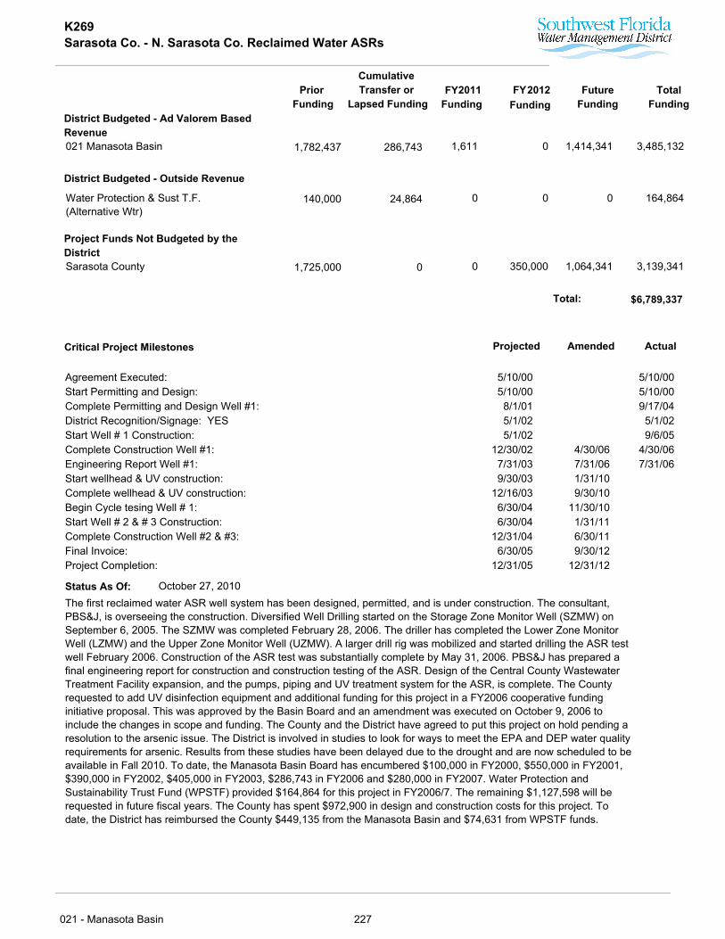
K269
Sarasota Co. - N. Sarasota Co. Reclaimed Water ASRs
District Budgeted - Ad Valorem Based
Revenue
021 Manasota Basin 3,485,132 1,414,341 286,743 1,782,437 0 1,611
District Budgeted - Outside Revenue
Water Protection & Sust T.F.
(Alternative Wtr)
164,864 0 24,864 140,000 0 0
Project Funds Not Budgeted by the
District
Sarasota County 3,139,341 1,064,341 0 1,725,000 350,000 0
$6,789,337 Total:
Prior
Funding
Cumulative
Transfer or
Lapsed Funding Funding Funding
2011 FY 2012 FY Future
Funding
Total
Funding
Critical Project Milestones ActualProjected Amended
Agreement Executed: 5/10/00 5/10/00
Start Permitting and Design: 5/10/00 5/10/00
Complete Permitting and Design Well #1: 8/1/01 9/17/04
District Recognition/Signage: YES 5/1/02 5/1/02
Start Well # 1 Construction: 5/1/02 9/6/05
Complete Construction Well #1: 12/30/02 4/30/06 4/30/06
Engineering Report Well #1: 7/31/03 7/31/06 7/31/06
Start wellhead & UV construction: 9/30/03 1/31/10
Complete wellhead & UV construction: 12/16/03 9/30/10
Begin Cycle tesing Well # 1: 6/30/04 11/30/10
Start Well # 2 & # 3 Construction: 6/30/04 1/31/11
Complete Construction Well #2 & #3: 12/31/04 6/30/11
Final Invoice: 6/30/05 9/30/12
Project Completion: 12/31/05 12/31/12
Status As Of: October 27, 2010
The first reclaimed water ASR well system has been designed, permitted, and is under construction. The consultant,
PBS&J, is overseeing the construction. Diversified Well Drilling started on the Storage Zone Monitor Well (SZMW) on
September 6, 2005. The SZMW was completed February 28, 2006. The driller has completed the Lower Zone Monitor
Well (LZMW) and the Upper Zone Monitor Well (UZMW). A larger drill rig was mobilized and started drilling the ASR test
well February 2006. Construction of the ASR test was substantially complete by May 31, 2006. PBS&J has prepared a
final engineering report for construction and construction testing of the ASR. Design of the Central County Wastewater
Treatment Facility expansion, and the pumps, piping and UV treatment system for the ASR, is complete. The County
requested to add UV disinfection equipment and additional funding for this project in a FY2006 cooperative funding
initiative proposal. This was approved by the Basin Board and an amendment was executed on October 9, 2006 to
include the changes in scope and funding. The County and the District have agreed to put this project on hold pending a
resolution to the arsenic issue. The District is involved in studies to look for ways to meet the EPA and DEP water quality
requirements for arsenic. Results from these studies have been delayed due to the drought and are now scheduled to be
available in Fall 2010. To date, the Manasota Basin Board has encumbered $100,000 in FY2000, $550,000 in FY2001,
$390,000 in FY2002, $405,000 in FY2003, $286,743 in FY2006 and $280,000 in FY2007. Water Protection and
Sustainability Trust Fund (WPSTF) provided $164,864 for this project in FY2006/7. The remaining $1,127,598 will be
requested in future fiscal years. The County has spent $972,900 in design and construction costs for this project. To
date, the District has reimbursed the County $449,135 from the Manasota Basin and $74,631 from WPSTF funds.
021 - Manasota Basin 227
K883
North Port WMPlan Big Slough
Project Type Cooperative Funding
AORs Strategic InitiativesWater Quality Water Quality Maintenance and ImprovementFlood Protection Emergency Flood Response
Basin(s) Peace River, Manasota
City of North PortCooperator(s)
Project Manager ARNOLD, DAVE
Task Manager(s)
Status Ongoing
DescriptionThis is a multi-year funded cooperative project with the City of North Port to perform 1) Topographic Information, 2)
Watershed Evaluation, and 3) Watershed Management Plan elements of the District's Watershed Management
Program (WMP) for the portion of the Big Slough watershed area lying within the City of North Port. The project
includes detailed study of 60 square miles within the City, and approximate study of the 135 square mile remainder of
the Big Slough watershed to obtain its influence on conveyance of runoff through the City. Issues in the watershed
include land alterations, flood protection, natural systems preservation, water quality preservation, protection and
enhancement of the City's surface water reservoir, and protection of the downstream Charlotte Harbor estuary.
FY2003-2006 funding is budgeted to complete the Topographic Information, Watershed Evaluation, Watershed
Management Plan elements. Topographic information includes the acquisition of data and development of the terrain
features in the Geodatabase to be used in the Watershed Evaluation. The Watershed Evaluation includes collection of
existing data, GIS processing of the terrain features to establish catchments and connectivity, field reconnaissance,
refinement of the terrain features and development of the hydraulic element point features. The Watershed
Management Plan element includes: development of watershed parameters for a specific use, GIS processing,
computer modeling, floodplain and water quality analysis, surface water resource assessment, establishment of LOS,
and BMP alternative analysis.
BenefitsThe WMP provides a method to evaluate the capacity of a watershed to protect, enhance, and restore water quality
and natural systems, while achieving flood protection. The information developed provides the science for the District's
Resource Management and Environmental Resource Permitting (ERP). It assists local governments: 1) With their land
management responsibilities by establishing a level of service and developing Best Management Practices (BMPs) to
address level of service deficiencies. 2) Provides a Geodatabase and projected results from watershed model
simulations for floodplain and water quality management.
Costs
The total budgeted amount for this project is $1,280,000, of which the District's share is $640,000 provided by the
Manasota Basin. The City is contributing $640,000. Multi-year funding is over FY2003-2006 is budgeted to complete
the project. When each element is completed the project budget may require refinement based on the information
gathered.
Additional Information
The WMP includes five major elements: 1) Topographic Information, 2) Watershed Evaluation, 3) Watershed
Management Plan, 4) Implementation of Best Management Practices, and 5) Maintenance of Watershed Parameters
and Models. In accordance with Board approval, a cooperative funding revenue agreement with the City of North Port
was developed as a multi-year funded project contingent on the approval of future funding to complete WMP elements
through the Watershed Management Plan. This required cooperative funding requests each year in FY2003-2006 to
accumulate the project budget. The District is managing the project and entering into purchase orders and
agreements to accomplish project tasks. Future cooperative funding requests and agreements will be required for
Implementation of BMPs, and the Maintenance of Watershed Parameters and Models. The District is cooperating
with FEMA to modernize the flood insurance rate maps (FIRMs) in Sarasota County. Information developed with this
project will be used to update the FIRMs representing this watershed.
021 - Manasota Basin 228

K883
North Port WMPlan Big Slough
District Budgeted - Ad Valorem Based
Revenue
021 Manasota Basin 680,831 0 0 678,487 0 2,344
District Budgeted - Outside Revenue
North Port - Watershed Mgmt Program
(K883)
640,000 0 0 640,000 0 0
$1,320,831 Total:
Prior
Funding
Cumulative
Transfer or
Lapsed Funding Funding Funding
2011 FY 2012 FY Future
Funding
Total
Funding
Critical Project Milestones ActualProjected Amended
1. Critical Project MilestonesDraft Agreement to Management Services 12/15/02 1/16/03
Basin Board Approval of Agreement 12/15/02 2/1/03
Draft Agreement Returned from Management Services 1/31/03 2/28/03
Governing Board Approval of Agreement 2/28/03 2/1/03
Cooperator Contract Executed 4/15/03 4/29/03
Consultant Contract Executed 10/1/03 7/29/03
Notice to Proceed to Consultant 10/1/03 8/27/03 8/27/03
Watershed Evaluation Commence 10/1/03 8/27/03 8/27/03
Watershed Evaluation Completion 1/1/05 4/1/05 4/19/05
Watershed Plan Commence 1/1/05 4/1/05 4/20/05
Watershed Plan Completion (project complete) 6/1/06 12/31/10
Project Close-out 6/1/07 3/31/11
Status As Of: August 31, 2010
Status History: The cooperative funding agreement was approved by the Basin and Governing Boards in February 2003.
Since then the agreement has been reviewed and executed by the City and the District. District staff negotiated a
contract with Ardaman and Associates, one of the consultants pre-qualified for performing watershed plans, for services
to be completed with the FY2003-2004 funding. Notice-to-proceed was issued, effective the date of the project kick-off
meeting (08/27/2003). Ardaman and Associates submitted the first set of deliverables, consisting of annotated base
maps, GIS coverages, and summary letter of data collection results in December 2003. Since then Ardaman and
Associates has: (1) completed the watershed field reconnaissance; (2) is continuing to develop the GIS database and
hydrologic and hydraulic inventories; (3) completed the field survey; (3) completed watershed parameterization and
model development. The late delivery of the Sarasota County 2007 LiDAR topographic mapping caused delays in this
project, but Ardaman now has the mapping and is proceeding without delay. Current Status: The project is complete
through the Floodplain Analysis deliverables. Via model maintenance project L315 Ardaman is working to update the
watershed based on topography and land use changes that occurred between the 2004 and 2007 Sarasota County
LiDAR mapping dates. This includes the process for QA/QC review, peer review, public review/comments, and
Governing Board approval. After the Governing Board approves the submittal of floodplain results to FEMA for updating
the Sarasota County FIS, Ardaman will make any needed revisions to the the Level of Service and preliminary BMP
Analysis deliverables, and proceed with the BMP analysis task.
021 - Manasota Basin 229
L007
Manatee - WMPlan Buffalo Canal/Frog Creek
Project Type Cooperative Funding
AORs Strategic InitiativesWater Quality Water Quality Maintenance and ImprovementFlood Protection Floodplain ManagementNatural Systems Minimum Flows and Level Establishment and Monitoring
Basin(s) Manasota
Manatee CountyCooperator(s)
Project Manager NGUYEN, NAM
Task Manager(s)
Status Ongoing
DescriptionThis multi-year funded project is to perform the 1) Topographic Information, 2) Watershed Evaluation, and 3)
Watershed Management Plan elements of the District's Watershed Management Program (WMP) for the BUFFALO
CANAL/FROG CREEK Watershed. The watershed occupies approximately 18.8 square miles in northwestern
Manatee County and discharges into Terra Ceia Bay, an Outstanding Florida Water. The watershed is experiencing
rapid development without the benefits of a detailed Watershed Management Plan.
BenefitsThe WMP provides a method to evaluate the capacity of a watershed to protect, enhance, and restore water quality
and natural systems, while achieving flood protection. The information developed provides the science for the District's
Resource Management and Environmental Resource Permitting (ERP). It assists local governments: 1) With their land
management responsibilities by establishing a level of service and developing Best Management Practices (BMPs) to
address level of service deficiencies and 2) Provides a Geodatabase and projected results from watershed model
simulations for floodplain management and water quality management.
Costs
The current budget amount for this project is $400,000, of which the District's share is $200,000 funded by the
Manasota Basin. The County is contributing $200,000. In FY2004, each party funded $50,000 for the project. The
remaining funds were funded in FY2005. When each element is completed the project budget and scope may require
refinement based on the information gathered. The District funding amounts shown in the table include staff salaries.
Additional Information
A WMP includes five major elements: 1) Topographic Information, 2) Watershed Evaluation, 3) Watershed
Management Plan, 4) Implementation of Best Management Practices, and 5) Maintenance of Watershed Parameters
and Models. Implementing elements of the WMP with local governments is one of the Comprehensive Watershed
Management (CWM) initiative strategies and one of the District's Strategic Priorities. A cooperative funding revenue
agreement with Manatee County was developed as a multi-year funded project to complete the WMP elements
through the Watershed Management Plan. The District is managing the project and will enter into purchase orders
and agreements to accomplish project tasks. Future cooperative funding requests and agreements will be required for
a BMP alternative analysis, the Implementation of BMPs, and Maintenance of Watershed Parameters and Models.
With prior year funding the Topographic Information and Watershed Evaluation should be completed. With FY2005
funding the work on the Watershed Management Plan element began and should be completed. Work on Watershed
Management Plan element includes the following tasks: survey, data management and development of watershed
parameters, GIS processing, computer modeling, floodplain analysis, and establishment of LOS.
021 - Manasota Basin 230
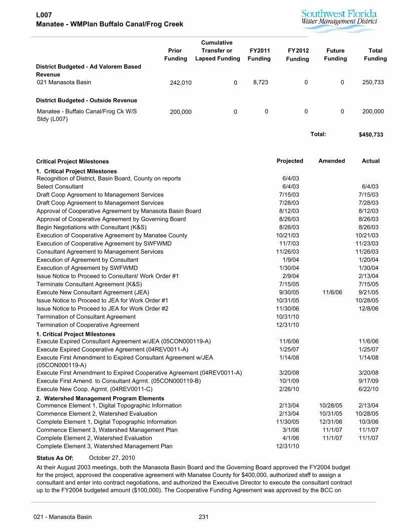
L007
Manatee - WMPlan Buffalo Canal/Frog Creek
District Budgeted - Ad Valorem Based
Revenue
021 Manasota Basin 250,733 0 0 242,010 0 8,723
District Budgeted - Outside Revenue
Manatee - Buffalo Canal/Frog Ck W/S
Stdy (L007)
200,000 0 0 200,000 0 0
$450,733 Total:
Prior
Funding
Cumulative
Transfer or
Lapsed Funding Funding Funding
2011 FY 2012 FY Future
Funding
Total
Funding
Critical Project Milestones ActualProjected Amended
1. Critical Project MilestonesRecognition of District, Basin Board, County on reports 6/4/03
Select Consultant 6/4/03 6/4/03
Draft Coop Agreement to Management Services 7/15/03 7/15/03
Draft Coop Agreement to Management Services 7/28/03 7/28/03
Approval of Cooperative Agreement by Manasota Basin Board 8/12/03 8/12/03
Approval of Cooperative Agreement by Governing Board 8/26/03 8/26/03
Begin Negotiations with Consultant (K&S) 8/26/03 8/26/03
Execution of Cooperative Agreement by Manatee County 10/21/03 10/21/03
Execution of Cooperative Agreement by SWFWMD 11/7/03 11/23/03
Consultant Agreement to Management Services 11/26/03 11/26/03
Execution of Agreement by Consultant 1/9/04 1/20/04
Execution of Agreement by SWFWMD 1/30/04 1/30/04
Issue Notice to Proceed to Consultant/ Work Order #1 2/9/04 2/13/04
Terminate Consultant Agreement (K&S) 7/15/05 7/15/05
Execute New Consultant Agreement (JEA) 9/30/05 11/6/06 9/21/05
Issue Notice to Proceed to JEA for Work Order #1 10/31/05 10/28/05
Issue Notice to Proceed to JEA for Work Order #2 11/30/06 12/8/06
Termination of Consultant Agreement 10/31/10
Termination of Cooperative Agreement 12/31/10
1. Critical Project MilestonesExecute Expired Consultant Agreement w/JEA (05CON000119-A) 11/6/06 11/6/06
Execute Expired Cooperative Agreement (04REV0011-A) 1/25/07 1/25/07
Execute First Amendment to Expired Consultant Agreement w/JEA
(05CON000119-A)
1/14/08 1/14/08
Execute First Amendment to Expired Cooperative Agreement (04REV0011-A) 3/20/08 3/20/08
Execute First Amend. to Consultant Agrmt. (05CON000119-B) 10/1/09 9/17/09
Execute New Coop. Agrmt. (04REV0011-C) 2/26/10 6/22/10
2. Watershed Management Program ElementsCommence Element 1, Digital Topographic Information 2/13/04 10/28/05 2/13/04
Commence Element 2, Watershed Evaluation 2/13/04 10/31/05 10/28/05
Complete Element 1, Digital Topographic Information 11/30/05 12/31/06 10/3/06
Commence Element 3, Watershed Management Plan 3/1/06 11/1/07 11/1/07
Complete Element 2, Watershed Evaluation 4/1/06 11/1/07 11/1/07
Complete Element 3, Watershed Management Plan 12/31/10
Status As Of: October 27, 2010
At their August 2003 meetings, both the Manasota Basin Board and the Governing Board approved the FY2004 budget
for the project, approved the cooperative agreement with Manatee County for $400,000, authorized staff to assign a
consultant and enter into contract negotiations, and authorized the Executive Director to execute the consultant contract
up to the FY2004 budgeted amount ($100,000). The Cooperative Funding Agreement was approved by the BCC on
021 - Manasota Basin 231
L007
Manatee - WMPlan Buffalo Canal/Frog Creek
October 21, 2003, and was executed on November 23, 2003. Keith & Schnars was selected to perform the consultant
services associated with the Buffalo Canal/Frog Creek Watershed Management Program. The agreement and Work
Order #1 with Keith & Schnars were executed on January 30, 2004, and February 11, 2004, respectively. Under the first
work order, Keith and Schnars performed a basic Watershed Evaluation, identified voids in the current topographic
information, and prepared a cost estimate to complete the Topographic Information, Watershed Evaluation, and
Watershed Management Plan elements. Work Order #1 tasks were completed. The consultant services agreement with
Keith & Schnars has been terminated, and staff has negotiated a new agreement with Jones Edmunds & Associates to
complete the project within the original schedule and budget. Agreement with JEA to complete the Watershed Evaluation
and the Watershed Management Plan tasks was executed on September 21, 2005. The first work order with JEA has
been executed to complete the existing watershed feature data evaluation and assembly and 80% of the hydrologic
feature inventory, hydraulic feature inventory, and field reconnaissance. Under this work order JEA will begin tasks that
are not contingent upon the LiDAR deliverables. Additionally, staff executed a work order with one of the District's
approved aerial mapping vendors to develop digital topographic information for the entire watershed using LiDAR. The
watershed was flown in conjunction with the Peace River topographic mapping project (P692). The digital topographic
information has been approved by the District and has been transmitted to JEA to complete this project. Submitted
deliverables for Work Order #1 have been reviewed by staff. An amendment to the JEA agreement has been executed
on November 6, 2006, to revise the project schedule and amend the contract termination date. Additionally, the
cooperative funding agreement has been amended to extend the contract termination date. A second work order with
JEA has been executed to complete the Watershed Evaluation and the Watershed Management Plan. JEA has
submitted the first deliverable, Digital Topographic Information, under Work Order #2 for review. Work Order #2,
Deliverable 1 has been reviewed by District staff. Deliverables 2 & 3, as part of the Watershed Evaluation, are anticipated
to be submitted mid May. Work Order #2, Deliverable 2 has been submitted and is currently under review by District
staff. The remaining tasks under Watershed Evaluation, Work Order #2, Deliverables 3 to 5, were submitted to the
District for review. An update meeting was held with the consultant and Manatee County on November 13, 2007 and
Jones Edmunds showed the project progress thru Watershed Evaluation. Work Order #2, Deliverables 6 and
7-Surveying, has been completed and is currently under review with District staff. The cooperative funding agreement
and the consultant services agreement have been amended to extend the contract termination date from December 31,
2007 to December 31, 2008. District staff has completed the review for Work Order #2, Deliverables 3 thru 7 and
comments have been sent to the consultant to address. Consultant is 90% complete with work pertaining to Work Order
#2, Invoice 8 - Watershed Parameterization. Work Order #2, Invoice 8 - Watershed Parameterization is currently under
review by the District. The District has provided comments to the consultant on Work Order #2, Invoice 8 - Watershed
Parameterization. They are to be addressed in the next submittal. Currently, the consultant is wrapping up the model
development and floodplain delineation tasks. Both tasks are projected to be completed by December 31, 2008. An
extension to the cooperator and consultant agreements is required to complete the Level of Service task, which will
follow the additional tasks of peer review, public notification/meeting, 45-day review and comment period to the project,
as part of a separate agreement. Work Order #2, Invoices 9 & 10 deliverable was submitted on January 10, 2009.
Review comments were discussed with JEA on January 27, 2009. A resubmittal of Work Order #2, Invoices 9 & 10
deliverable was submitted on May 18, 2009. A new cooperator agreement, extending the termination date to December
31, 2009 has been sent to Manatee County for signature. Likewise, a new consultant agreement, extending the
termination date to October 31, 2009 has been sent to JEA and executed on January 29, 2009 by the District. A final
submittal of Work Order #2, Invoice 10 was submitted on August 14, 2009. A discussion of this submittal, along with the
usage of a multi-day storm will be held with the County September 8, 2009. A first amendment to the JEA agreement has
been sent to them for signature, extending the expiration date to October 31, 2010. Likewise, an amendment to the
cooperative agreement will need to be done to extend the expiration date. A purchase order for peer review has been
executed to bring on Engineering & Applied Science, Inc. to conduct peer review of floodplain results. JEA has submitted
WO#6, Invoice #4 deliveralbe on 12/08/09. District staff completed the review and comments were sent back to JEA on
12/21/09. Comments were addressed by JEA on 1/4/10. Peer review presentation to Engineering & Applied Science, Inc.
was completed on 2/11/10. Post-peer review meeting #1 is scheduled for 2/25/10. Peer review comments were given to
JEA and they were addressed on 4/20/2010. An open house to present the preliminary floodplain to the public is planned
for the first week of June 2010. An open house to present the preliminary floodplain to the public was held on 6/15/10.
Comments from the public were sent to JEA to address at the moment. JEA has addressed the public comments.
Revised model & floodplain delineations were submitted 8/12/10. Staff plans to request Governing Board on 9/28/10, as
a consent item, to submit watershed results to FEMA. Current Status: JEA has addressed remaining comments from the
public, peer review consultant and Sarasota Regulation staff. Revised model & floodplain delineations were submitted
10/18/10. Manatee County approved information to develop FIRMs 9/13/10. Governing Board approved authorization to
submit watershed study data to FEMA to develop FIRMs 10/26/10. Level of Service (LOS) report will be submitted
10/28/10.
021 - Manasota Basin 232
L010
Manatee - WMPlan Gamble Creek
Project Type Cooperative Funding
AORs Strategic InitiativesWater Quality Water Quality Maintenance and ImprovementFlood Protection Floodplain ManagementNatural Systems Minimum Flows and Level Establishment and Monitoring
Basin(s) Manasota
Manatee CountyCooperator(s)
Project Manager NGUYEN, NAM
Task Manager(s)
Status Ongoing
DescriptionThis multi-year funded project is to perform the 1) Topographic Information, 2) Watershed Evaluation, and 3)
Watershed Management Plan elements of the District's Watershed Management Program (WMP) for the GAMBLE
CREEK Watershed. The watershed occupies approximately 56 square miles in northern Manatee County and
discharges into the Manatee River. The watershed is experiencing rapid development without the benefits of a detailed
Watershed Management Plan.
BenefitsThe WMP provides a method to evaluate the capacity of a watershed to protect, enhance, and restore water quality
and natural systems, while achieving flood protection. The information developed provides the science for the District's
Resource Management and Environmental Resource Permitting (ERP). It assists local governments: 1) With their land
management responsibilities by establishing a level of service and developing Best Management Practices (BMPs) to
address level of service deficiencies and 2) Provides a Geodatabase and projected results from watershed model
simulations for floodplain management and water quality management.
Costs
The current budget amount for this project is $900,000, of which the District's share is $450,000 funded by the
Manasota Basin. The County is contributing $450,000. Each party funded $125,000, $200,000, and $125,000 for the
project in FY2004, FY2005, and FY2006 respectively. When each element is completed the project budget and scope
of work may be refined based on the information gathered. The District funding amounts shown in the table include
staff salaries.
Additional Information
A WMP includes five major elements: 1) Topographic Information, 2) Watershed Evaluation, 3) Watershed
Management Plan, 4) Implementation of Best Management Practices, and 5) Maintenance of Watershed Parameters
and Models. Implementing elements of the WMP with local governments is one of the Comprehensive Watershed
Management (CWM) initiative strategies and one of the District's Strategic Priorities. A cooperative funding revenue
agreement with Manatee County was developed as a multi-year funded project to complete the WMP elements
through the Watershed Management Plan. The District is managing the project and will enter into purchase orders
and agreements to accomplish project tasks. Future cooperative funding requests and agreements will be required for
a BMP alternative analysis, the Implementation of BMPs, and Maintenance of Watershed Parameters and Models.
With FY2004 and FY2005 year funding the Topographic Information and Watershed Evaluation should be completed.
With FY2005 funding the work on the Watershed Management Plan element began and should be completed with
FY2006 funds. Work on Watershed Management Plan element will include the following tasks: survey, data
management and development of watershed parameters, GIS processing, computer modeling, floodplain analysis,
and establishment of LOS.
021 - Manasota Basin 233

L010
Manatee - WMPlan Gamble Creek
District Budgeted - Ad Valorem Based
Revenue
021 Manasota Basin 504,322 0 0 495,599 0 8,723
District Budgeted - Outside Revenue
Manatee - Gamble Ck W/S Mgmt Plan
(L010)
450,000 0 0 450,000 0 0
$954,322 Total:
Prior
Funding
Cumulative
Transfer or
Lapsed Funding Funding Funding
2011 FY 2012 FY Future
Funding
Total
Funding
Critical Project Milestones ActualProjected Amended
1. Critical Project MilestonesRecognition of District, Basin Board, County on reports 6/4/03 6/4/03
Select Consultant 6/4/03 6/4/03
Draft Coop Agreement to Management Services 7/15/03 7/15/03
Approval of Cooperative Agreement by Manasota Basin Board 8/12/03 8/12/03
Approval of Cooperative Agreement by Governing Board 8/26/03 8/26/03
Begin Negotiations with Consultant 8/26/03 8/26/03
Execution of Cooperative Agreement by Manatee County 10/21/03 10/21/03
Execution of Cooperative Agreement by SWFWMD 11/23/03 11/23/03
Consultant Agreement to Management Services 11/26/03 11/26/03
Execution of Agreement by Consultant 2/6/04 2/2/04 2/2/04
Execution of Agreement by SWFWMD 2/13/04 2/18/04
Issue Notice to Proceed to Consultant/ Work Order #1 2/13/04 2/25/04
Requisition to Encumber FY2006 Funds 10/18/05 10/18/05
First Amendment to Consultant Agreement 10/31/05 10/17/05
Execution of Consultant's Work Order #2 by SWFWMD 11/18/05 5/29/07 5/29/07
Execution of Consultant's Work Order #3 by SWFWMD 7/9/07 7/9/07
Execution of Consultant's Work Order #4 by SWFWMD 3/28/08 5/27/08
Termination of Consultant Agreement 5/31/11
Termination of Cooperative Agreement 10/1/11
1. Critical Project MilestonesExecute Expired Consultant Agreement (04CONC00013-A) 3/20/07 3/20/07
Execute Expired Cooperative Agreement (04REV0010-A) 6/14/07 6/14/07
Execute First Amendment to Expired Consultant Agreement (04CONC00013-A) 9/15/08 9/15/08
Execute First Amendment to Expired Cooperative Agreement (04REV0010-A) 12/29/08 12/29/08
Execute Third Amend. to Consultant Agrmt. (04CONC00013-A) 10/1/09 9/17/09
Execute New Coop. Agrmt. (04REV0010-B) 10/1/09 1/14/10
Execute First Amendment to Coop. Agrmt. (04REV0010-B) 10/1/10
2. Watershed Management Program ElementsCommence Element 1, Digital Topographic Information 2/25/04 2/25/04
Commence Element 2, Watershed Evaluation 5/25/04 2/25/04
Complete Element 1, Digital Topographic Information 11/30/05 2/25/06 12/1/07
Complete Element 2, Watershed Evaluation 5/1/06 12/25/06 12/1/07
Commence Element 3, Watershed Management Plan 5/1/06 2/25/07 11/1/07
Complete Element 3, Watershed Management Plan 10/1/11
Status As Of: October 27, 2010
At their August 2003 meetings, both the Manasota Basin Board and the Governing Board approved the FY2004 budget
for the project, approved the cooperative agreement with Manatee County for $900,000, authorized staff to assign a
consultant and enter into contract negotiations, and authorized the Executive Director to execute the consultant contract
up to the FY2004 budgeted amount ($250,000). The Cooperative Funding Agreement was approved by the BCC on
021 - Manasota Basin 234
L010
Manatee - WMPlan Gamble Creek
October 21, 2003, and was executed on November 23, 2003. PBS&J was selected to perform the consultant services
associated with the Gamble Creek Watershed Management Program. The agreement and Work Order #1 with PBS&J
were executed on February 18, 2004, and February 25, 2004, respectively. Under the first work order, PBS&J performed
a basic Watershed Evaluation, identified voids in the current topographic information, and prepare a cost to complete the
Topographic Information, Watershed Evaluation, and Watershed Management Plan elements. The consultant has
submitted the report on the preliminary evaluation of the watershed and probable costs to complete the first three
elements of the WMP. The First Amendment to the PBS&J's services agreement was executed on October 17, 2005, to
amend the compensation and budget to included approved FY2005 and FY2006 funds. Work Order #2 will complete the
Watershed Evaluation. Work Order #2 was executed on November 18, 2005. Additionally, a work order to develop digital
topographic information for the entire watershed using LiDAR has been executed with 3001, Inc. The watershed was
flown in conjunction with the Peace River topographic mapping project (P692). By doing so, the project realized a
significant cost savings. Aerial mapping deliverables have been approved by Staff. Work Order #3 to collect all remaining
field measurements has been developed, but staff is waiting on supplementary information to be provided by the
consultant. Completion of the Watershed Evaluation and commencement on the Watershed Management Plan have
been delayed due to delays in the digital topographic information development. Both the consultant services agreement
and cooperative agreement are being amended to extend the contract termination date. The agreement with PBS&J has
been extended to October 8, 2008. A project status meeting was held on April 27, 2007 to assess Work Order #2 and set
up Work Order #3. Consultant's field crews have had difficulties gaining access to farm properties to complete field
measurements and therefore delaying the completion of Work Order #2. Work Order #2 will be amended for the work
that could not be done and Work Order #3 will be developed to wrap up the Watershed Evaluation and commence the
Watershed Management Plan. Work Order #3 was executed on 7/9/07. Deliverable 1 of Work Order #3 is anticipated in
September 2007. Work Order #3, Deliverables 1 thru 3, covering the processing of LiDAR data to generate a TIN/DEM,
wrapping up the work for Watershed Evaluation and surveys as part of the Watershed Management Plan has been
delivered to the District for review. District staff is wrapping up the review for Work Order #3, Deliverables 1 thru 3 and
comments will be send to the consultant thereafter. More time was taken for this review is a result of the implemented
increase level of effort to better QA/QC the submittal. The consultant has been instructed to prepare Work Order #4 and
to arrange a project update meeting with Manatee County. A project status meeting with Manatee County was held on
May 14, 2008. Work Order #4 has been signed by the District and a notice to proceed has been given to the consultant,
May 29,2008. Work Order #4, Deliverables 1 thru 3 was delivered to the District on August 22, 2008. A stakeholders
meeting was held on October 8, 2008 at the Manatee County Public Works Department. The 20 largest property owners
and local engineering consultants in the area were invited. The purpose of the meeting was to present our findings from
the work that PBS&J has done thru the Watershed Evaluation element and to get their input based on their knowledge of
the area. Work Order #4, Deliverable 4 was submitted to the District on November 4, 2008. The District's comments for
deliverables 1 thru 4 of Work Order 4 were sent to PBS&J to address. Work Order #4, Deliverable 5 - Calibrated
computer model was submitted to the District on May 1, 2009. The District is currently reviewing the submittal and a
meeting at Manatee County has been set up for May 20, 2009 for the consultant to discuss the model and present the
preliminary floodplain. District & Manatee County comments to Work Order #4, Deliverable 5 were sent to PBS&J on
7/14/09 to address. The District has selected Royal Consulting Services, Inc. to perform the peer review of floodplain
results produced by PBS&J. PBS&J agreement will be modify to reduce by $33,000, to be used for the peer review. A
second amendment to the cooperative agreement is currently being routed for signatures, extending the expiration date
to October 1, 2010. A third amendment to PBS&J agreement is being routed for signatures, reducing the project budget
by $33,000 to be used to hire Royal Consulting Services, Inc. to peer review the floodplain results. District and Manatee
County has provided comments to PBS&J Work Order #4, Deliverable 5. PBS&J is currently addressing those
comments. A new cooperative agreement with Manatee County was executed on 1/14/10, extending the expiration date
to October 1, 2010. A third amendment to PBS&J agreement was executed on 9/17/09. In reviewing PBS&J's WO#4,
Invoice #6 deliverable, District staff has questioned the modeling technique used by PBS&J on certain part of the
watershed. Since then, PBS&J has brought on Streamline Technologies, Inc. to evaluate and give opinion on the
adequacy of the H&H conditions used. A summary report about the findings was completed on January 13, 2010 by
Stremline Technologies, Inc. PBS&J is currently in the process of modifying the data & model to address those
comments. PBS&J is updating the data & model based on comments received from Streamline Technologies, Inc.
PBS&J submitted revised model & floodplain 7/22/10. First amendment to cooperative agreement is currently routed for
execution. Amendment is to extend expiration date to 10/1/11. Current Status: PBS&J is addressing District's comments
on 7/22/10 deliverable.
021 - Manasota Basin 235
L015
Sarasota County Surface Water Monitoring Program
Project Type Cooperative Funding
AORs Strategic InitiativesWater Quality Water Quality Maintenance and Improvement
Basin(s) Manasota
Sarasota CountyCooperator(s)
Project Manager LOPEZ, MANNY
Task Manager(s)
Status Ongoing
DescriptionThis project from Sarasota County is for continued rainfall and stream gauge data collection and analysis at 13 surface
water monitoring sites. The County has been collecting rainfall and stream gauge data at the same sites and has
requested to continue collecting the data for the development of the stage-discharge curves for these sites. The
data were previously used for developing MFL's. The project also included the continuation of field measurements for
one more year to quantify sites influenced by tidal fluctuations. The data and analyses will be used to improve
watershed model calibration and verification, and to quantify freshwater flows to the bays and estuaries. Data
collection results and analyses will support several ongoing projects including pollutant loading, TMDL studies, and
Community Rating System.
BenefitsThe project is intended to provide daily watershed discharge information at 13 sites. The County has funded the field
measurements for 13 sites since August 2004. The District cooperatively funded field measurements in 2004 and has
continued to fund the project since 2007. Continued collection of rainfall and stream stage data in FY2008, FY2009,
and FY2010 have supported several projects including the development of watershed plans for Lemon Bay and
Roberts Bay.
Costs
The total funding that has been approved for this project by the Manasota Basin Board and Sarasota County through
FY2010 is $1,250,000. Sarasota County contributed $130,000 in FY2003. The Manasota Basin Board budgeted
$75,000 in FY2004 and FY2005, $200,000 in FY2006, $100,000 in FY2007 and FY2008, and $60,000 in FY2009 and
FY2010. The County provided an equal match for each year except FY2005 and FY2006. The funds that were
budgeted by the District for FY2005 and FY2006 were returned to the Basin as the County was unable to come up with
their match. This is reflected in the table below as a cumulative transfer in the amount of $216,303. Due to a budget
shortfall, Sarasota County was unable to come up with their FY2010 funding portion of $60,000. The FY2010 contract
was written for a total of $85,500, split equally between the District and the County, instead of the budgeted amount of
$120,000. Once approved by the Sarasota County Board of Commissioners, the District will reimburse the county
with $42,750. The District funding amounts shown in the table include staff salaries, travel and central garage charges.
Additional Information
The stations sampled provided data for the Dona and Roberts Bay study, pollutant loading, and TMDL studies. The
data are also used for the Community Rating System for FEMA flood insurance and watershed impacts due to
development and surface water availability studies. Recently, the data collected have been used in the development
of the watershed plans for Lemon Bay and Roberts Bay.
021 - Manasota Basin 236
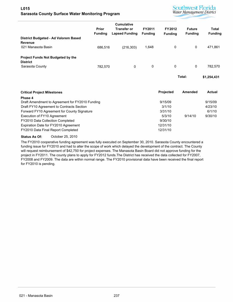
L015
Sarasota County Surface Water Monitoring Program
District Budgeted - Ad Valorem Based
Revenue
021 Manasota Basin 471,861 0 (216,303) 686,516 0 1,648
Project Funds Not Budgeted by the
District
Sarasota County 782,570 0 0 782,570 0 0
$1,254,431 Total:
Prior
Funding
Cumulative
Transfer or
Lapsed Funding Funding Funding
2011 FY 2012 FY Future
Funding
Total
Funding
Critical Project Milestones ActualProjected Amended
Phase 4Draft Amendment to Agreement for FY2010 Funding 9/15/09 9/15/09
Draft FY10 Agreement to Contracts Section 3/1/10 4/23/10
Forward FY10 Agreement for County Signature 3/31/10 6/1/10
Execution of FY10 Agreement 5/3/10 9/14/10 9/30/10
FY2010 Data Collection Completed 9/30/10
Expiration Date for FY2010 Agreement 12/31/10
FY2010 Data Final Report Completed 12/31/10
Status As Of: October 25, 2010
The FY2010 cooperative funding agreement was fully executed on September 30, 2010. Sarasota County encountered a
funding issue for FY2010 and had to alter the scope of work which delayed the development of the contract. The County
will request reimbursement of $42,750 for project expenses. The Manasota Basin Board did not approve funding for the
project in FY2011. The county plans to apply for FY2012 funds.The District has received the data collected for FY2007,
FY2008 and FY2009. The data are within normal range. The FY2010 provisional data have been received the final report
for FY2010 is pending.
021 - Manasota Basin 237
L019
Sarasota - Update W. Para. & County Maintained Models
Project Type Cooperative Funding
AORs Strategic InitiativesFlood Protection Floodplain Management
Basin(s) Manasota
Sarasota CountyCooperator(s)
Project Manager TURNER, DAWN
Task Manager(s)
Status Ongoing
DescriptionThis is a multi-year funded project to perform the Digital Topographic Information, Watershed Evaluation, Watershed
Management Plan, and Maintenance of Watershed Parameters and Models elements of the District's Watershed
Management Program (WMP) for multiple watersheds within Sarasota County. The County area is approximately 570
square miles and includes 28 watersheds. The Topographic Information, Watershed Evaluation and Watershed
Management Plan elements were completed by the cooperator for 18 watersheds before implementation of the
District's Watershed Management Program Guidelines and Specifications (G&S). Through agreements 06C00000087,
07C00000105, and 07C00000105-A, the County prepared Digital Topographic Information for inland areas, and
performed maintenance of County watershed models to reflect capital improvement projects (CIPs) and land
alterations approved through County and District permitting. The maintained models are being used to prepare Flood
Insurance Rate Maps (FIRMs) for Sarasota County. With FY2011 funding, the County will perform Maintenance of
Watershed Parameters and Models to address comments produced by the District, County, and Federal Emergency
Management Agency during review of model results and preliminary FIRMs, and to reflect completed projects. The
County wishes to perform maintenance of the watershed parameters and model(s) to reflect approved County capital
improvement projects (CIPs) and developments 35 acres or greater in size or with 8 acres or more of proposed
impervious cover.
BenefitsThe WMP provides a method to evaluate the capacity of a watershed to protect, enhance, and restore water quality
and natural systems, while achieving flood protection. The information developed provides the science for the District's
Resource Management and Environmental Resource Permitting (ERP). It assists local governments: 1) With their land
management responsibilities by establishing a level of service and developing Best Management Practices (BMPs) to
address level of service deficiencies. 2) Provides a Geodatabase and projected results from watershed model
simulations for floodplain management and water quality management. The continuous maintenance of watershed
parameters in the GIS database as land alterations are made and permits are approved will provide the most up to
date information about the watershed.
Costs
The total budget amount for this project varies by year depending on the County's anticipated need for maintenance of
the watershed parameters and models. For FY2005, the District and County each funded $356,666 to perform
updates to the Little Sarasota Bay watershed and Dona Bay watershed models and perform maintenance. For
FY2007, the District share is $356,666 and will be funded entirely by the Manasota Basin. The County will contribute
$766,667. For FY2008, the total maintenance budget is $400,000 with the Manasota Basin and County each
contributing $200,000. $400,000 ($200,00 District's share) was also approved for FY2009. However, in November
2008, the County notified District staff they will not accept the FY2009 funds. Instead, they continued the project with
funds remaining from previous years. For FY2010, the total maintenance budget is $400,000 with the Manasota Basin
and County each contributing $200,000. For FY2011, the total maintenance budget is $400,000 with the Manasota
Basin and County each contributing $200,000. Annual funding requests and ranking will be required to continue
maintenance of watershed parameters and the models. The District funding amounts shown in the table include staff
salaries. The future funds identified for the project are contingent upon approval of such amounts by the Manasota
Basin Board in the annual budget.
Additional Information
A WMP includes five major elements: 1) Topographic Information, 2) Watershed Evaluation, 3) Watershed
Management Plan (develop and update), 4) Implementation of Best Management Practices, and 5) Maintenance of
Watershed Parameters and Models. Implementing elements of the WMP with local governments is one of the
District's Strategic Priorities. The County completed Watershed Management Plans for 18 watersheds throughout
1999-2002. The update process began in FY2003 with the update of the Whitaker Bayou Watershed Management
Plan (see K872). Approved funds for both the Whitaker Bayou Watershed Management Plan and the Myakka River
Watershed Management Plan (K487) are reflected in the prior funding below. The FY2004 funding amount includes
021 - Manasota Basin 238

L019
Sarasota - Update W. Para. & County Maintained Models
the costs to develop digital topographic information for the entire county using LiDAR technology, to update portions of
the existing models to the District's G+S, and to maintain the models. Development of the topographic information and
the model updates will be performed in conjunction with the FEMA Map Modernization project for Sarasota County
(see M115). District FY2004 funds were used to develop the topographic information, approximately $1,079,500 of the
$2,000,000 in FEMA funds from the M115 project are going towards updating the models and flood insurance rate
maps, and Sarasota County's FY2004 funds were used to incorporate recent County CIP and private developments
greater than 35 acres in size or with more than 8 acres of proposed impervious cover. With FY2005 funding the model
updates in association with the FEMA Map Modernization project (M115) are continuing, additional coastal areas are
being added into the models. With FY2007 funds maintenance will continue to update additional watersheds to the
District's G+S. FY2008, FY2010, and FY2011 funding will support maintenance activities. A cooperative funding
expenditure agreement with the County, or a contract amendment, as appropriate, will be developed each year
contingent on the approval of funding. A cooperative funding request will be required from the County each fiscal year.
The County will manage the update and maintenance of the models, where the District's project manager must
approve any agreements to accomplish project tasks.
District Budgeted - Ad Valorem Based
Revenue
021 Manasota Basin 3,492,869 1,000,000 (556,666) 2,846,880 0 202,655
District Budgeted - Outside Revenue
FEMA Coop Tech Partner Agreemnt 1,079,500 0 0 1,079,500 0 0
Project Funds Not Budgeted by the
District
Sarasota County 4,948,333 600,000 0 3,948,333 200,000 200,000
$9,520,702 Total:
Prior
Funding
Cumulative
Transfer or
Lapsed Funding Funding Funding
2011 FY 2012 FY Future
Funding
Total
Funding
Critical Project Milestones ActualProjected Amended
1. Critical Project MilestonesReference Project M115 for milestones for FY2004 funding 12/31/04
Recognition of District, Basin Board, County on reports 12/31/09
2. FY2005 Cooperative Funding AgreementAgreement to Management Services 1/30/05 1/18/05
Negotiate FY2005 Cooperative Funding Agreement with County 4/1/05 11/7/05
Board of County Commissioners Approval 3/21/06 4/11/06
Contract Execution 5/15/06 5/4/06
Notice to Proceed 5/15/06 5/4/06
Contract Termination 6/30/08 6/30/09
3. FY2007 Cooperative Funding AgreementNegotiate FY2007 Cooperative Funding Agreement 8/1/07 7/30/07
FY2007 Agreement to Management Services 8/1/07 8/1/07
Board of County Commissioners Approval 9/30/07 9/25/07
Contract Execution 10/15/07 10/23/07
Submit Requisition for FY2008 Funding 11/9/07 1/25/08
Contract Termination 12/31/09
3. FY2007 Cooperative Funding AgreementFirst Amendment to Management Services 9/30/08 1/8/09
County Commission Approval of 1st Amendment 12/1/08 2/11/09
Execute First Amendment 12/31/08 2/19/09
021 - Manasota Basin 239

L019
Sarasota - Update W. Para. & County Maintained Models
4. FY2010 Cooperative Funding AgreementAgreement to Management Services 12/9/09 12/9/09
County Commission Approval of Agreement 4/15/10
Execute FY2010 Agreement 4/30/10 3/31/10
Status As Of: October 08, 2010
Reference project M115 for status of topographic information and model updates performed by the District with FY2004
funding. Both the Manasota Basin Board and Governing Board approved changing the management of the FY2004
funds from the County to the District, using the $420,000 in Basin Board funds to update Watershed Management Plans
in conjunction with the FEMA Map Modernization project, and using FEMA funds to serve as the match for the Basin
Board's FY2004 funds. Cooperative Funding Agreement 06C00000087 encumbers FY2005 and FY2006 funds
($713,332 total, $356,666 District's share). Under the agreement two coastal areas that were not previously studied will
be incorporated into the appropriate watershed models. Because the County's existing watershed models were
developed prior to the District's WMP G&S, staff has had to negotiate a compromise on how the G&S will be satisfied. In
addition, seventeen recent developments will be incorporated into existing watershed models as routine maintenance
activities. The agreement and associated documents were approved by the Sarasota BOCC on April 11, 2006, and were
executed by the District on May 4, 2006. A Second Agreement, No. 07C00000105 was executed, and encumbers
FY2007 and FY2008 funds ($356,666 and $200,000 respectively). The First Amendment to Agreement #07C00000105
was executed to expand the scope of work to include updates to the Upper Myakka River/Howard Creek and Lower
Myakka River watersheds. In 2007, the Florida Department of Emergency Management (FDEM) obtained LiDAR
topographic data for the coastal portion of the County. Consequently, Agreement 07C00000105 includes the
development of LiDAR topographic data for the rest of the County, which has come to be called the "Buy-Up" area. Both
the FDEM data and the LiDAR data for the Buy-Up area were scheduled to be complete in January 2008. The LiDAR
data for both areas was only recently delivered (August 2008), 8 months after the anticipated delivery date. The LiDAR
data was finally approved for use on October 10, 2008. Please refer to M115 for further information regarding the
resulting impacts to the Sarasota Map Modernization project schedule. Current Status: The maintenance reports
associated with the a number of developments have been submitted related to the cooperative agreement using FY2005
funds. Project status meetings have been held with the County's consultants regarding the updates being performed for
Little Sarasota Bay and Dona Bay. The County's consultants are completing the Watershed Evaluation element for their
respective basin areas. In addition, funding will also be allocated for maintenance activities associated with CIPs and
approved developments and to update the existing models based on comments provided by the District, County, and/or
FEMA during the review of the preliminary FIRMs for Sarasota County. For Agreement #06C00000087, a total of
$337,591 of the $356,000 in District funds has been invoiced and paid. The First Amendment to the Agreement
06C00000087 extended the contract expiration date from June 30, 2008 to June 30, 2009. The second Agreement
(Agreement #07C00000105) encumbers FY2007 funds, ($356,666), & FY2008 funds, ($200,000). The First Amendment
to Agreement 07C00000105 was executed to add the Upper and Lower Myakka River watersheds to the list of County
watershed models that may be updated. County staff notified the District they will not have the matching funds for this
project in FY2009. Therefore, the FY2009 funding ($400,000 total, $200,000 District share) has not been added to the
Agreement. $400,000 ($200,000 District's share) in FY2010 has been added to the Agreement, making the total value of
the agreement $1,513,332 ($756,666 District's share). Aerial mapping of the portion of the County not covered by the
State of Florida Department of Emergency Management's LiDAR mapping project has been completed to support
maintenance. However, delivery of the final LiDAR topographic information was delayed over 10 months. For Agreement
# 07C00000105, a total of $662,841 of the $756,666 in District funds has been invoiced paid.
021 - Manasota Basin 240
L200
Bradenton - Wares Creek Bridge Replacement
Project Type Cooperative Funding
AORs Strategic InitiativesFlood Protection Floodplain Management
Basin(s) Manasota
City of BradentonCooperator(s)
Project Manager FRIES, GEORGE
Task Manager(s)
Status Ongoing
DescriptionThis is a multi-year funded project to perform the Implementation of Best Management Practices (BMPs) element of
the District's Watershed Management Program (WMP) for the Wares Creek Watershed. Implementation of BMPs
includes the following tasks: design, development of construction documents, construction permitting, land acquisition,
bidding and contractor selection, construction of the BMPs and construction engineering and inspection. The
watershed is highly urbanized and covers an area of approximately 2.41 square miles (1,546 acres) and is located in
the City of Bradenton and Manatee County. The City of Bradenton is proposing to replace 4 bridges over Wares
Creek. They are the 9th Ave. West, 12th Ave. West, 14th Ave. West, and 17th Ave. West bridges. In addition,
improvements to existing stormwater facilities that discharge into Wares Creek at the 20th Street West Stormwater
Management System will be constructed as part of this project. These BMPs were evaluated as part the City of
Bradenton Comprehensive Stormwater Management Study funded by the City, and selected for implementation in the
BMP alternative analysis. The proposed improvements are also included in the City's Five-Year Capital Improvement
Plan. Prior years funding was provided for topographic surveying, geotechnical investigation, hydraulic and hydrologic
modeling, design of the 4 bridges, construction of the 9th Avenue Bridge, construction of the 12th Avenue Bridge,
design of the 20th Street West Stormwater Management System and to begin construction of the 14th Avenue Bridge.
For FY2011 funding is requested to complete construction of the 14th Avenue Bridge and to begin construction of the
20th Street West Stormwater Management System.
BenefitsThese BMPs are in conjunction with the $55,000,000 United States Army Corps of Engineer's (USACE) Cedar
Hammock (Wares Creek) Flood Control Channel improvements project, in which the USACE will dredge and widen
the creek to provide an increased level of flood protection. The District is co-funding the Wares Creek project with
Manatee County (K253) to provide the local sponsor's funding obligation. The USACE did not participate in funding the
replacement of the City's bridges or improvements to the City's existing stormwater systems. The bridge replacements
target flood protection on an intermediate conveyance way, and address the local government's level of service
deficiencies by reducing flood levels where the bridges are over topped, homes damaged, and private property and
streets are flooded.
Costs
The projected cost for this project is $7,800,000 of which the District's multi-year share is $3,900,000 and the City's
share is $3,900,000. Funding for this project was provided in the Manasota Basin Board budgets of FY2005 ($50,000);
FY2006 ($200,000); FY2007 ($500,000); FY2008 ($500,000); FY2009 ($500,000); and FY2010 ($500,000) for a total
funding commitment to date of $2,250,000. For FY2011, the City is requesting $500,000 in cooperative funding and
the City will provide $500,000 in matching funds. The probable construction costs for this project are based on a BMP
alternative analysis developed by the cooperator. When each element is completed the projected may require
refinement based on information gathered and unforeseen circumstances. The District funding amounts shown in the
table includes staff salaries. The future funds identified for the project are contingent upon approval of such amounts
by the District Governing Board and Basin Board in the annual budget(s).
Additional Information
The WMP includes five major elements: 1) Topographic Information, 2) Watershed Evaluation, 3) Watershed
Management Plan, 4) Implementation of BMPs, and 5) Maintenance of Watershed Parameters and Models.
Implementing elements of the WMP with local governments is one of the District's Strategic Priorities. The WMP
provides a method to evaluate the capacity of a watershed to protect, enhance, and restore water quality and natural
systems while achieving flood protection. A cooperative funding expenditure agreement with the City has been
developed contingent on the approval of future funding to complete the Implementation of BMPs. With FY2005
funding the work on the Implementation of BMPs began and included the following tasks: topographic surveys,
geo-technical investigations, hydrologic and hydraulic investigation and preparation of a preliminary design report. For
FY2006 funding was requested for development of the construction documents and obtaining permits for the four
bridges. For FY2007 funding was requested to begin construction of the 9th Avenue Bridge, for construction
021 - Manasota Basin 241
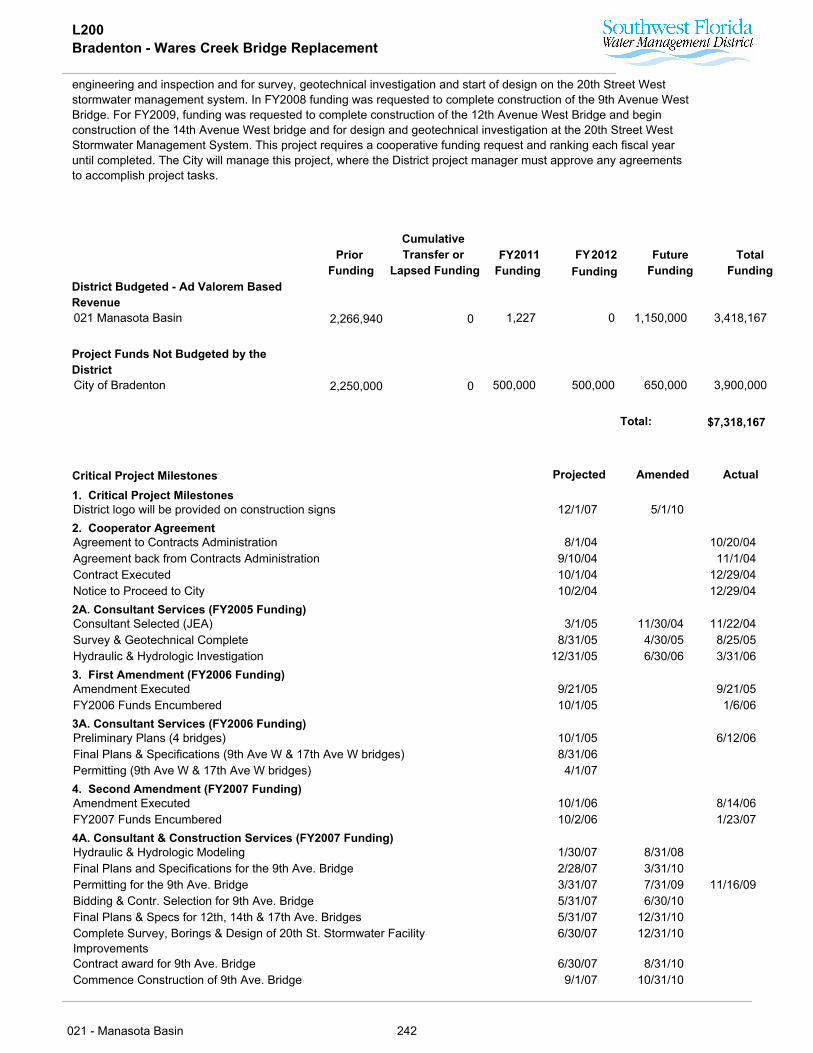
L200
Bradenton - Wares Creek Bridge Replacement
engineering and inspection and for survey, geotechnical investigation and start of design on the 20th Street West
stormwater management system. In FY2008 funding was requested to complete construction of the 9th Avenue West
Bridge. For FY2009, funding was requested to complete construction of the 12th Avenue West Bridge and begin
construction of the 14th Avenue West bridge and for design and geotechnical investigation at the 20th Street West
Stormwater Management System. This project requires a cooperative funding request and ranking each fiscal year
until completed. The City will manage this project, where the District project manager must approve any agreements
to accomplish project tasks.
District Budgeted - Ad Valorem Based
Revenue
021 Manasota Basin 3,418,167 1,150,000 0 2,266,940 0 1,227
Project Funds Not Budgeted by the
District
City of Bradenton 3,900,000 650,000 0 2,250,000 500,000 500,000
$7,318,167 Total:
Prior
Funding
Cumulative
Transfer or
Lapsed Funding Funding Funding
2011 FY 2012 FY Future
Funding
Total
Funding
Critical Project Milestones ActualProjected Amended
1. Critical Project MilestonesDistrict logo will be provided on construction signs 12/1/07 5/1/10
2. Cooperator AgreementAgreement to Contracts Administration 8/1/04 10/20/04
Agreement back from Contracts Administration 9/10/04 11/1/04
Contract Executed 10/1/04 12/29/04
Notice to Proceed to City 10/2/04 12/29/04
2A. Consultant Services (FY2005 Funding)Consultant Selected (JEA) 3/1/05 11/30/04 11/22/04
Survey & Geotechnical Complete 8/31/05 4/30/05 8/25/05
Hydraulic & Hydrologic Investigation 12/31/05 6/30/06 3/31/06
3. First Amendment (FY2006 Funding)Amendment Executed 9/21/05 9/21/05
FY2006 Funds Encumbered 10/1/05 1/6/06
3A. Consultant Services (FY2006 Funding)Preliminary Plans (4 bridges) 10/1/05 6/12/06
Final Plans & Specifications (9th Ave W & 17th Ave W bridges) 8/31/06
Permitting (9th Ave W & 17th Ave W bridges) 4/1/07
4. Second Amendment (FY2007 Funding)Amendment Executed 10/1/06 8/14/06
FY2007 Funds Encumbered 10/2/06 1/23/07
4A. Consultant & Construction Services (FY2007 Funding)Hydraulic & Hydrologic Modeling 1/30/07 8/31/08
Final Plans and Specifications for the 9th Ave. Bridge 2/28/07 3/31/10
Permitting for the 9th Ave. Bridge 3/31/07 7/31/09 11/16/09
Bidding & Contr. Selection for 9th Ave. Bridge 5/31/07 6/30/10
Final Plans & Specs for 12th, 14th & 17th Ave. Bridges 5/31/07 12/31/10
Complete Survey, Borings & Design of 20th St. Stormwater Facility
Improvements
6/30/07 12/31/10
Contract award for 9th Ave. Bridge 6/30/07 8/31/10
Commence Construction of 9th Ave. Bridge 9/1/07 10/31/10
021 - Manasota Basin 242
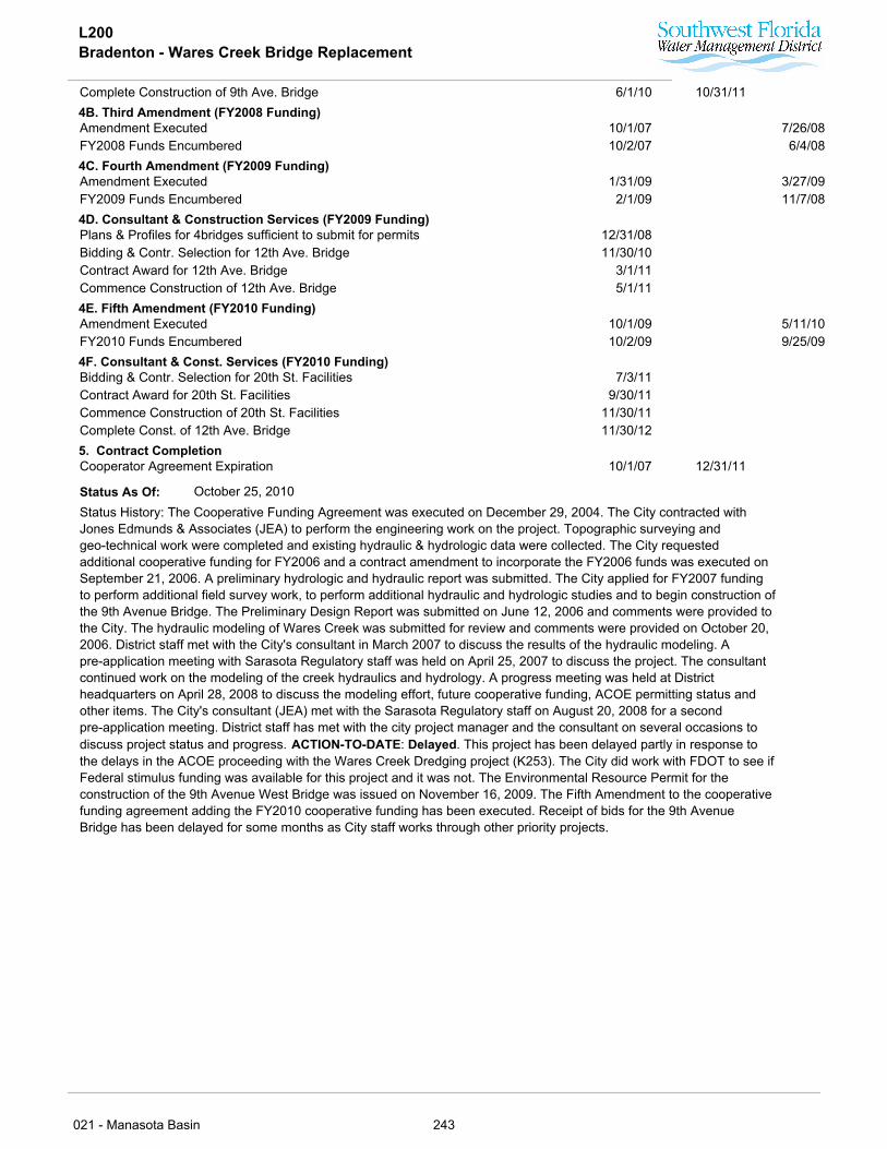
L200
Bradenton - Wares Creek Bridge Replacement
Complete Construction of 9th Ave. Bridge 6/1/10 10/31/11
4B. Third Amendment (FY2008 Funding)Amendment Executed 10/1/07 7/26/08
FY2008 Funds Encumbered 10/2/07 6/4/08
4C. Fourth Amendment (FY2009 Funding)Amendment Executed 1/31/09 3/27/09
FY2009 Funds Encumbered 2/1/09 11/7/08
4D. Consultant & Construction Services (FY2009 Funding)Plans & Profiles for 4bridges sufficient to submit for permits 12/31/08
Bidding & Contr. Selection for 12th Ave. Bridge 11/30/10
Contract Award for 12th Ave. Bridge 3/1/11
Commence Construction of 12th Ave. Bridge 5/1/11
4E. Fifth Amendment (FY2010 Funding)Amendment Executed 10/1/09 5/11/10
FY2010 Funds Encumbered 10/2/09 9/25/09
4F. Consultant & Const. Services (FY2010 Funding)Bidding & Contr. Selection for 20th St. Facilities 7/3/11
Contract Award for 20th St. Facilities 9/30/11
Commence Construction of 20th St. Facilities 11/30/11
Complete Const. of 12th Ave. Bridge 11/30/12
5. Contract CompletionCooperator Agreement Expiration 10/1/07 12/31/11
Status As Of: October 25, 2010
Status History: The Cooperative Funding Agreement was executed on December 29, 2004. The City contracted with
Jones Edmunds & Associates (JEA) to perform the engineering work on the project. Topographic surveying and
geo-technical work were completed and existing hydraulic & hydrologic data were collected. The City requested
additional cooperative funding for FY2006 and a contract amendment to incorporate the FY2006 funds was executed on
September 21, 2006. A preliminary hydrologic and hydraulic report was submitted. The City applied for FY2007 funding
to perform additional field survey work, to perform additional hydraulic and hydrologic studies and to begin construction of
the 9th Avenue Bridge. The Preliminary Design Report was submitted on June 12, 2006 and comments were provided to
the City. The hydraulic modeling of Wares Creek was submitted for review and comments were provided on October 20,
2006. District staff met with the City's consultant in March 2007 to discuss the results of the hydraulic modeling. A
pre-application meeting with Sarasota Regulatory staff was held on April 25, 2007 to discuss the project. The consultant
continued work on the modeling of the creek hydraulics and hydrology. A progress meeting was held at District
headquarters on April 28, 2008 to discuss the modeling effort, future cooperative funding, ACOE permitting status and
other items. The City's consultant (JEA) met with the Sarasota Regulatory staff on August 20, 2008 for a second
pre-application meeting. District staff has met with the city project manager and the consultant on several occasions to
discuss project status and progress. ACTION-TO-DATE: Delayed. This project has been delayed partly in response to
the delays in the ACOE proceeding with the Wares Creek Dredging project (K253). The City did work with FDOT to see if
Federal stimulus funding was available for this project and it was not. The Environmental Resource Permit for the
construction of the 9th Avenue West Bridge was issued on November 16, 2009. The Fifth Amendment to the cooperative
funding agreement adding the FY2010 cooperative funding has been executed. Receipt of bids for the 9th Avenue
Bridge has been delayed for some months as City staff works through other priority projects.
021 - Manasota Basin 243

L206
FYN Builder/Dev Charlotte, Manatee, Sarasota
Project Type Cooperative Funding
AORs Strategic InitiativesWater Quality Water Quality Maintenance and ImprovementWater Supply ConservationNatural Systems Natural Systems Conservation and Restoration
Basin(s) Peace River, Manasota
Manatee County Cooperative Extension Service, Charlotte County, Sarasota Bay Estuary
Program, Sarasota County, Charlotte Harbor National Estuary Program, Manatee County
Cooperator(s)
Project Manager DURELL, SYLVIA
Task Manager(s)
Status Completed
DescriptionThis program provided education on Florida-friendly landscaping primarily to builders, developers and landscape and
irrigation professionals through conferences, workshops, one-on-one interactions, newspaper articles, electronic
media and distribution of printed materials. The coordinator also certified the landscape section of the model homes
being reviewed for the Florida Green Building Coalition's certification criteria. Because new home building declined and
to enhance consistency, outreach to builders, developers and landscape professionals has been consolidated under
the Florida Water Star GoldSM program (B277). For that reason, and at staff's request, Manatee County withdrew its
application for funding of the FYN Charlotte, Manatee, Sarasota Builder/Developer program for FY2010.
BenefitsReognizing that the majority of decisions concerning new landscapes are made by builders, developers, landscape
and irrigation professionals, this program benefitted water resources by promoting the use of the nine Florida Yards &
Neighborhoods principles to that audience. Approximately 5,000 builders, developers, landscape and irrigation
specialists and realtors received education annually on Florida-friendly landscaping and best management practices
through personal meetings and workshops.
Costs
The total cost of the FY2009 project was $141,000, with the District contibuting $70,500, (Manasota $52,875): (Peace
River $17,625). District funds supported the contracted outreach coordinator's salary, travel, training, materials and
office expenses. Manatee County provided in-kind support for administrative and supervisory support, office expenses
including a computer, telephone, office supplies and promotional materials. Budget lines below included costs for staff
to manage the project.
Additional Information
The District funded education outreach to builders and developers in the tri-county area from FY2005 to FY2009.
Education was based on the nine Florida-friendly landscapingTM principles that were created by the University of
Florida/Institute of Food and Agricultural Sciences for the FYN program: Right Plant, Right Place, Water Efficiently,
Fertilize Appropriately, Mulch, Attract Wildlife, Manage Yard Pests Responsibly, Recycle, Reduce Stormwater Runoff
and Protect the Waterfront. Education outreach for the six months the FY2009 program was active includes the
following: 27 group presentations/workshops to 80 people; 1,378 contacts with individuals; 177 building or green
industry contacts; 22 FWSG contacts; 203 HOA,COA contacts; 3 realtor contacts; 1 exhibit attracting 30,000 people;
900 pieces of educational materials distributed and 4 newsletter articles that potentially reached 1,050 people per
issue and 5 newspaper articles that potentially reached 276,101 people.
021 - Manasota Basin 244
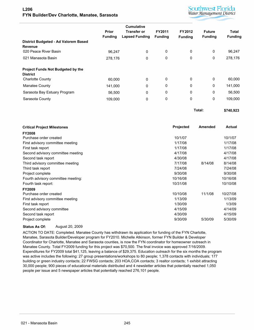
L206
FYN Builder/Dev Charlotte, Manatee, Sarasota
District Budgeted - Ad Valorem Based
Revenue
020 Peace River Basin 96,247 0 0 96,247 0 0
021 Manasota Basin 278,176 0 0 278,176 0 0
Project Funds Not Budgeted by the
District
Charlotte County 60,000 0 0 60,000 0 0
Manatee County 141,000 0 0 141,000 0 0
Sarasota Bay Estuary Program 56,500 0 0 56,500 0 0
Sarasota County 109,000 0 0 109,000 0 0
$740,923 Total:
Prior
Funding
Cumulative
Transfer or
Lapsed Funding Funding Funding
2011 FY 2012 FY Future
Funding
Total
Funding
Critical Project Milestones ActualProjected Amended
FY2008Purchase order created 10/1/07 10/1/07
First advisory committee meeting 1/17/08 1/17/08
First task report 1/17/08 1/17/08
Second advisory committee meeting 4/17/08 4/17/08
Second task report 4/30/08 4/17/08
Third advisory committee meeting 7/17/08 8/14/08 8/14/08
Third task report 7/24/08 7/24/08
Project complete 9/30/08 9/30/08
Fourth advisory committee meeting: 10/16/08 10/16/08
Fourth task report: 10/31/08 10/10/08
FY2009Purchase order created 10/10/08 11/1/08 10/27/08
First advisory committee meeting 1/13/09 1/13/09
First task report 1/30/09 1/3/09
Second advisory committee 4/15/09 4/14/09
Second task report 4/30/09 4/15/09
Project complete 9/30/09 5/30/09 5/30/09
Status As Of: August 20, 2009
ACTION TO DATE: Completed. Manatee County has withdrawn its application for funding of the FYN Charlotte,
Manatee, Sarasota Builder/Developer program for FY2010. Michelle Atkinson, former FYN Builder & Developer
Coordinator for Charlotte, Manatee and Sarasota counties, is now the FYN coordinator for homeowner outreach in
Manatee County. Total FY2009 funding for this project was $70,500. The final invoice was approved 7/16/2009.
Expenditures for FY2009 total $41,125, leaving a balance of $29,375. Education outreach for the six months the program
was active includes the following: 27 group presentations/workshops to 80 people; 1,378 contacts with individuals; 177
building or green industry contacts; 22 FWSG contacts; 203 HOA,COA contacts; 3 realtor contacts; 1 exhibit attracting
30,000 people; 900 pieces of educational materials distributed and 4 newsletter articles that potentially reached 1,050
people per issue and 5 newspaper articles that potentially reached 276,101 people.
021 - Manasota Basin 245
L210
Implementation of BMPs - Phillippi Creek/Celery Fields
Project Type Cooperative Funding
AORs Strategic InitiativesWater Quality Water Quality Maintenance and ImprovementFlood Protection Emergency Flood ResponseNatural Systems Minimum Flows and Level Establishment and Monitoring
Basin(s) Manasota
Sarasota CountyCooperator(s)
Project Manager LOPEZ, MANNY
PRESTON, MATTTask Manager(s)
Status Ongoing
DescriptionThis is a multi-year funded project to perform the Implementation of Best Management Practices (BMPs) element of
the District's Watershed Management Program (WMP) for the Phillippi Creek Watershed. The watershed covers an
area of approximately 56 square miles and is located in Sarasota County (County). This BMP will be implemented in
the Celery Fields improvement area and specifically includes construction of additional storage to the existing south
cell of the Celery Fields Regional Stormwater Facility. Implementation of the BMP includes the following tasks:
construction and construction engineering and inspection. The proposed BMP will address level of service
deficiencies. In addition, 120-acres of the southern cell pond of Celery Fields will be excavated to create a wetland
habitat that will provide natural systems benefits.
BenefitsThe project will provide additional storage within the watershed and, thereby, provide an improved level of service.
These improvements will address structure flooding downstream along Phillippi Creek by providing flood protection for
15 homes currently inundated and damaged during a 100-year flood event. Based on an Expected Damages Analysis,
the expected flood damages to be mitigated by the project for a 100-year flood event is approximately $2.17 million.
This project is also expected to improve water quality through increased residence times.
Costs
The total budget for this project is $16,708,221. The FDEP is providing the County with a grant of $10,079,880 toward
the project. The District's original funding contribution for the project was $2,903,060, funded entirely by the Manasota
Basin over fiscal years 2005 -2008. In August 2010, the Manasota Basin Board approved a request from Sarasota
Co. to reduce the basin's funding contribution to $1,829,665. The County's funding contribution is $3,696,560. The
final (actual) project costs are anticipated to be under budget. The District funding amounts shown in the table include
staff salaries, travel and central garage.
Additional Information
A WMP includes five major elements: 1) Topographic Information, 2) Watershed Evaluation, 3) Watershed
Management Plan, 4) Implementation of Best Management Practices, and 5) Maintenance of Watershed Parameters
and Models. Implementing elements of the WMP with local governments is one of the Comprehensive Watershed
Management (CWM) initiative strategies. A WMP provides a method to evaluate the capacity of a watershed to
protect, enhance, and restore water quality and natural systems, while achieving flood protection. This project involves
the Implementation of BMPs which includes design, development of construction documents, construction permitting,
land acquisition, bidding and contractor selection, construction of the BMPs and construction engineering and
inspection. The County is managing the project, and the District project manager must approve any agreements to
accomplish project tasks.
021 - Manasota Basin 246

L210
Implementation of BMPs - Phillippi Creek/Celery Fields
District Budgeted - Ad Valorem Based
Revenue
021 Manasota Basin 2,932,781 0 0 2,929,463 0 3,318
Project Funds Not Budgeted by the
District
Florida Department of Environmental
Protection
10,079,880 0 0 10,079,880 0 0
Sarasota County 4,383,560 0 0 4,383,560 0 0
$17,396,221 Total:
Prior
Funding
Cumulative
Transfer or
Lapsed Funding Funding Funding
2011 FY 2012 FY Future
Funding
Total
Funding
Critical Project Milestones ActualProjected Amended
1. Contract Development and ExecutionDraft Agreement to Management Services 1/7/04 1/6/05
Negotiate Cooperative Funding Agreement with County 9/27/04 1/3/05
Draft Agreement returned from Management Services 2/1/05 1/14/05
Board of County Commissioners Approval 4/1/05 2/22/05
Notice to Proceed 5/1/05 3/4/05
Requisition to Encumber FY2006 Funds 10/18/05 10/18/05
Draft Amendment to Management Services 12/15/06 5/31/07 7/16/07
Draft Amendment returned from Management Services 1/22/07 6/30/07 8/2/07
Board of County Commissioners Approval 2/28/07 7/30/07 9/25/07
Execute Amendment 3/30/07 8/31/07 10/9/07
Requisition to Encumber FY2008 Funds 10/30/07 10/30/07
2. Critical Project MilestonesAlternatives Analysis Complete 4/30/05 3/4/05
Acquire All Permits, Government Approvals, & Real Property Rights for Project 8/26/05 3/30/09 6/1/09
Complete Design and Permitting 10/11/05 5/30/09 6/10/09
Bidding and Contractor Selection 3/13/06 7/30/09 7/7/09
Commence Construction 3/18/06 9/30/09 9/28/09
Complete Construction 1/12/07 2/28/11
Construction Site Signage RecognizingFunding 12/15/07 9/30/09 12/21/09
3. Project Close OutSubmit As-Builts 2/11/07 5/30/11
Contract Termination 12/31/07 11/30/11
Status As Of: October 25, 2010
Excavation of the additional stormwater storage areas is ongoing and remains on schedule. Excavated material
stockpiled in several areas has been used in the construction of containment berms and to create the permanent soil
mound. Several water control structures (gates) have been completed. Planting for the mitigation and wetland creation
areas began in September 2010 and is nearing completion. On May 27, 2010 Sarasota County requested the District
reduce its funding for the project as a result of lower project construction costs. The County requested the District's share
be reduced to $1,829,665, reflecting a reduction of $1,073,395 that would be returned to the basin for use in the FY2011
budget. The County's request to reduce the District's funding obligation to $1,829,665 was approved by the Manasota
Basin Board at their August meeting. District staff continue to discuss with Sarasota Co. changes in funding allocations
for construction engineering and inspections, as part of potential reductions to the District's overall funding obligations.
ACTIONS-TO-DATE: On Schedule. Project construction is ongoing and is scheduled for substantial completion in
February 2011.
021 - Manasota Basin 247

L238
SEC Southern Coastal Watershed Education
Project Type Cooperative Funding
AORs Strategic InitiativesWater Quality Water Quality Maintenance and ImprovementFlood Protection Floodplain ManagementWater Supply ConservationNatural Systems Natural Systems Conservation and Restoration
Basin(s) Manasota
Science and Environment Council of SarasotaCooperator(s)
Project Manager STERNBERGER, VIRGINIA
Task Manager(s)
Status Ongoing
DescriptionThis Cooperative Funding Initiative project is a continuation of the SEC program designed to work collaboratively with
its members to convene policy discussions and enhance public understanding about water and watershed
conservation based on science. The FY2011 program components include two decision-maker and policymaker
workshops on water and low-impact development (LID). The first workshop will identify local water and LID issues. The
second will refine and come to a consensus on solutions. The SEC also plans to enhance the general public's
understanding of watersheds by producing four three-minute videos focusing on outdoor experiences. The videos will
provide ideas for nature-based activities and explain the connection people have to the health of their watershed. The
videos will be shown on the Discover Natural Sarasota and on select SEC member web sites. Adding to mobile phone
messages created in FY2009, SEC plans to create five additional messages to provide up-to-date information
about watershed issues. Lastly, the SEC will again coordinate a Watershed Awareness Week in Sarasota County. The
program was developed by SEC to enhance the general public's understanding of watersheds in Sarasota County and
to show how their actions as stewards can help protect water resources. Evaluation will be conducted by SEC member
organizations and will include surveys, attendance statistics, number of web site hits, an assessment of visitor
comments (written and voice), and number of promotional brochures distributed.
BenefitsThis program educates 181,700 residents on how productivity and vitality of natural systems, storm water, water
supply, wastewater and land use impact the watershed. The program will build on previously successful education
components to engage discussion between decision-makers and policymakers on water use and LID and enhance the
public's understanding of how they affect the watershed in Sarasota County.
Costs
The total cost of the FY2011 project is $120,000, with the District contributing $60,000 (Manasota). SEC's match is
in-kind services from its member organizations. District funds will pay for implementing a two-part workshop, creating
four three-minute video for web site posting, producing five mobile phone audio messages and coordinating
Watershed Awareness Week in Sarasota County. The program is expected to reach 181,700 residents at a cost to the
District of $.33 per person, well below average for public education programs. The budget lines below include costs for
staff to manage the project.
Additional Information
The FY2010 total project cost was $120,000, with the District contributing $60,000 (Manasota). District funding was
used to develop a two-part decision makers workshop, a 20-minute video and Watershed Awareness Week. The
project reached 181,700 residents at a cost to the District of $.33 per resident.
021 - Manasota Basin 248

L238
SEC Southern Coastal Watershed Education
District Budgeted - Ad Valorem Based
Revenue
020 Peace River Basin 3,300 0 0 3,300 0 0
021 Manasota Basin 270,826 0 0 208,655 0 62,171
Project Funds Not Budgeted by the
District
Science and Environment Council of
Sarasota County
279,000 0 0 219,000 0 60,000
$553,126 Total:
Prior
Funding
Cumulative
Transfer or
Lapsed Funding Funding Funding
2011 FY 2012 FY Future
Funding
Total
Funding
Critical Project Milestones ActualProjected Amended
FY2008 Budgeted FundsInitiate purchase order 10/1/07 1/14/07 1/14/07
Outdoor interpretive signs complete 10/15/08 10/15/08
Indoor educational kiosk panels complete 10/15/08 10/15/08
Educational brochures complete 10/15/08 10/15/08
Watershed Awareness Week talk-back boards 10/31/08 11/28/08 11/7/08
Watershed Awareness Week 10/31/08 11/28/08 11/7/08
FY2009 Budgeted FundsInitiate purchase order 10/1/08 2/27/09 2/27/09
Outdoor interpretive signs installed 9/30/09 9/30/09
Mobile messages complete 9/30/09 7/31/09
Brochure complete 9/30/09 9/30/09
Decision-makers workshop 9/30/09 6/5/09
Watershed Awareness Week talk-back boards 10/30/09
Watershed Awareness Week 10/30/09 10/30/09 10/30/09
Project close 10/30/09 10/30/09
FY2010 Budgeted FundsInitiate purchase order 10/1/09 11/30/09 11/30/09
Decision-makers workshop complete 6/30/10 6/30/10
Video complete 9/30/10 6/30/10 6/30/10
Watershed Awareness Week 10/25/10 10/25/10
Project close 10/31/10
FY2011 Budgeted fundsInitiate purchase order 10/29/10
Decision-makers workshop 6/30/11
Five mobile phone messages complete 9/1/11
Four short videos complete 9/1/11
Project close 11/30/11
Watershed Awareness Week 11/30/11
Status As Of: October 20, 2010
ACTION TO DATE: On time. The annual Watershed Awareness Week was renamed to "WOW! Water Opportunities
Week," and took place October 17-24. The week included a variety of educational activities at Mote Marine Laboratory
and Aquarium, New College, Historic Spanish Point and various local parks. To gain local government commitment to
watershed protection, SEC coordinated with Sarasota County to declare October 17-24, 2010, as "WOW! Water
Opportunities Week." The week's events were advertised through a brochure, news releases and word of mouth. Final
numbers of event attendees are being calculated. A 20-minute DVD titled, Our Watershed, Our Responsibility, has been
produced. Additionally, ten 90-second DVDs have been produced, each focusing on a water-related topic and SEC
member programs addressing that topic. The short DVDs will be shown via the Internet, and the 20 minute DVD will be
021 - Manasota Basin 249

L238
SEC Southern Coastal Watershed Education
distributed to the public and shown at SEC member events and on Access Channel 19. Two workshops on low-impact
development (LID) and water conservation were convened for decision-makers in Sarasota County on May 27th and
June 3rd. Forty-six people attended the workshops and participated in group discussions about priorities, challenges and
possible solutions to LID and water conservation issues. A summary of the workshops has been provided to participants.
021 - Manasota Basin 250

L520
Around the Bend Nature Tours Manatee/Sarasota
Project Type Cooperative Funding
AORs Strategic InitiativesWater Quality ConservationNatural Systems Natural Systems Identification and Monitoring
Basin(s) Peace River, Manasota
Around the Bend Nature ToursCooperator(s)
Project Manager TORRUSIO, MARY
Task Manager(s)
Status Ongoing
DescriptionThis Cooperative Funding Initiative (CFI) project will educate students and adults about local environmental systems.
Around the Bend Nature Tours provides more than 2,000 students and teachers with site-specific programs that focus
on watersheds and include various Manatee and Sarasota County Conservation Lands and SWFWMD lands
(including Emerson Point Park, Riverview Pointe, Rye Wilderness Park, Duette Park or any SWFWMD area that is
deemed appropriate). These environmental education programs benefit students, parents, teachers and homeschool
groups and use Around the Bend Nature Tours guides and materials. The program's effectiveness is measured
through student pre/posttest data and teacher evaluation. Most recent data provided demonstrates a significant 37.5%
increase in knowledge gain.
BenefitsThis program adresses watershed education and natural systems through hands-on field study programs for youth and
adults. Additionally, some field trip sites are on District-owned lands, so promotion of the District's land stewardship
efforts and Get Outside! campaign will be included in the programming. Cooperator has a long history with the District
and is well versed in Florida's standards-based education guidelines. This program also works with many homeschool
groups, a target audience with which the District's youth education staff would like a greater reach.
Costs
The total cost of the FY2011 program is $105,315, with the District contributing $27,840 (Manasota). The project will
reach 2,040 people at a cost to the District of $13.65 per person (approximately 20% lower than the average youth
education programming) and $3.41 per participant contact hour. Budget line below includes cost for staff to manage
the project.
Additional Information
The total cost of the FY2010 program was $76,390, with the total cost to the District $27,940, all from the Manasota
Basin. Around the Bend Nature Tours anticipates reaching 2,475 people at a cost to the District of $11.29 per person.
The cost reduction in FY2010 reflects a decrease in the number of District-funded field trips from 50 to 46. Budget
lines include cost for staff to manage the project. These environmental education programs benefited students,
parents, teachers and homeschool groups and utilized Around the Bend Nature Tours guides and materials. The
program's effectiveness was measured through student pre/posttest data and a teacher evaluation tool. The District
has supported this project since FY2006.
021 - Manasota Basin 251
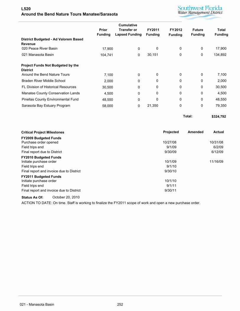
L520
Around the Bend Nature Tours Manatee/Sarasota
District Budgeted - Ad Valorem Based
Revenue
020 Peace River Basin 17,900 0 0 17,900 0 0
021 Manasota Basin 134,892 0 0 104,741 0 30,151
Project Funds Not Budgeted by the
District
Around the Bend Nature Tours 7,100 0 0 7,100 0 0
Braden River Middle School 2,000 0 0 2,000 0 0
FL Division of Historical Resources 30,500 0 0 30,500 0 0
Manatee County Conservation Lands 4,500 0 0 4,500 0 0
Pinellas County Environmental Fund 48,550 0 0 48,550 0 0
Sarasota Bay Estuary Program 79,350 0 0 58,000 0 21,350
$324,792 Total:
Prior
Funding
Cumulative
Transfer or
Lapsed Funding Funding Funding
2011 FY 2012 FY Future
Funding
Total
Funding
Critical Project Milestones ActualProjected Amended
FY2009 Budgeted FundsPurchase order opened 10/27/08 10/31/08
Field trips end 9/1/09 6/2/09
Final report due to District 9/30/09 6/12/09
FY2010 Budgeted FundsInitiate purchase order 10/1/09 11/16/09
Field trips end 9/1/10
Final report and invoice due to District 9/30/10
FY2011 Budgeted FundsInitiate purchase order 10/1/10
Field trips end 9/1/11
Final report and invoice due to District 9/30/11
Status As Of: October 20, 2010
ACTION TO DATE: On time. Staff is working to finalize the FY2011 scope of work and open a new purchase order.
021 - Manasota Basin 252
L604
Manatee - WMPlan Little Manatee River
Project Type Cooperative Funding
AORs Strategic InitiativesWater Quality Water Quality Maintenance and ImprovementNatural Systems Minimum Flows and Level Establishment and MonitoringFlood Protection Floodplain Management
Basin(s) Manasota
Manatee CountyCooperator(s)
Project Manager NGUYEN, NAM
Task Manager(s)
Status Not Funded
DescriptionThis multi-year funded project is to perform the 1) Topographic Information, 2) Watershed Evaluation, and 3)
Watershed Management Plan elements of the District's Watershed Management Program (WMP) for the LITTLE
MANATEE RIVER Watershed. The watershed occupies approximately 79.0 square miles within northern Manatee
County and discharges into Tampa Bay, a SWIM waterbody. The watershed is beginning to experience rapid
residential development to the west of Interstate 75 that is expected to expand to the east in the near future.
Topographic information includes the acquisition of data and development of the terrain features in the Geodatabase
to be used in the Watershed Evaluation. The Watershed Evaluation includes collection of existing data, GIS
processing of the terrain features to establish catchments and connectivity, field reconnaissance, refinement of the
terrain features and development of the hydraulic element point features. The Watershed Management Plan element
includes: development of watershed parameters for a specific use, GIS processing, computer modeling, floodplain and
water quality analysis, surface water resource assessment, establishment of LOS, BMP alternative analysis.
BenefitsThe WMP provides a method to evaluate the capacity of a watershed to protect, enhance, and restore water quality
and natural systems, while achieving flood protection. The information developed provides the science for the District's
Resource Management and Environmental Resource Permitting (ERP). It assists local governments: 1) With their land
management responsibilities by establishing a level of service and developing Best Management Practices (BMPs) to
address level of service deficiencies. 2) Provides a Geodatabase and projected results from watershed model
simulations for floodplain and water quality management.
Costs
The current budget amount for this project is $1 million, of which the District's share is $500,000 to be funded by the
Manasota Basin. The County will contribute $500,000. Previously approved FY2007 funding included $500,000 from
the Basin's budget with a revenue from Manatee County for $250,000. Previously approved FY2008 funding included
$500,000 from the Basin's budget with a revenue from Manatee County for $250,000. Due to the recent tax cuts,
Manatee County has notified us that they are not able to contribute the $250,000 as originally planned for FY2008.
When each element is completed the project budget and scope may require refinement based on the information
gathered. The District funding amounts shown in the table include staff salaries.
Additional Information
A WMP includes five major elements: 1) Topographic Information, 2) Watershed Evaluation, 3) Watershed
Management Plan, 4) Implementation of Best Management Practices, and 5) Maintenance of Watershed Parameters
and Models. Implementing elements of the WMP with local governments is one of the Comprehensive Watershed
Management (CWM) initiative strategies and one of the District's Strategic Priorities. The District has been working
with the County for several years through the Watershed Management Program Coordination to develop a five year
implementation schedule by watershed based on their projected funding levels, and funding available from others for
example FEMA or State appropriations. A cooperative funding revenue agreement with Manatee County has been
developed as a multi-year funded project contingent on the approval of future funding to complete the WMP elements
through the Watershed Management Plan. This is a multi-year funded project that will require a cooperative funding
request each fiscal year until completed. If approved, this project will be ranked as a 1A project in future fiscal years.
The District will manage the project and will enter into work orders and agreements to accomplish project tasks.
Future cooperative funding requests and agreements will be required for a BMP alternative analysis, the
Implementation of BMPs, and the Maintenance of Watershed Parameters and Models.
021 - Manasota Basin 253

L604
Manatee - WMPlan Little Manatee River
District Budgeted - Ad Valorem Based
Revenue
021 Manasota Basin 99,501 0 (428,702) 519,610 0 8,593
District Budgeted - Outside Revenue
Manatee - WMPlan Little Manatee River
(L604)
71,300 0 (428,700) 500,000 0 0
$170,801 Total:
Prior
Funding
Cumulative
Transfer or
Lapsed Funding Funding Funding
2011 FY 2012 FY Future
Funding
Total
Funding
Critical Project Milestones ActualProjected Amended
1. Critical Project MilestonesRecognition of the SWFWMD, Manasota Basin Board and Manatee County will
be included on all reports
9/29/06
Select Consultant 9/29/06 9/29/06
Develop Draft Agreement with Manatee County 11/20/06 11/30/06
Cooperative Funding Agreement to Contract Administration 11/27/06 12/8/06
Execution of Cooperative Agreement by Manatee County 12/29/06 1/23/07
Execution of Cooperative Agreement by SWFWMD 1/19/07 1/25/07
Begin Negotiations with Consultant 1/30/07 2/8/07
Execution of Consultant Agreement by SWFWMD 9/30/07
Issue Notice to Proceed to Consultant/ Work Order #1 9/30/07
Requisition to Encumber FY2008 Funds 10/1/07 10/1/07
Termination of Cooperative Agreement 3/1/10 3/1/10
Termination of Consultant Agreement 3/1/10
Status As Of: February 22, 2010
Notice of anticipated funding has been sent to County's project manager. A meeting has been requested to discuss
scope of work and consultant selection. District and Manatee County staff met on October 12, 2006, to discuss the
proposed scope of work and specific project needs. Hillsborough County had developed a model for the watershed that
the District recently reviewed under Project B126. The model and the results of the District's independent review will
serve as the base for the Watershed Management Plan within the Manatee County portion of the watershed. District staff
are currently negotiating with one of its pre-selected vendors to complete aerial topographic mapping for the portions of
the watershed that currently do not have digital topographic information. Boyle Engineering Corp. has been selected as
the consulting firm to perform this project. The Cooperative Funding Agreement was executed on 1/25/2007. Mapping
and GIS staff is putting together a Work Order with Earth Data to begin aerial topographic mapping for portions of the
watershed that currently do not have digital topographic information. District staff will begin talks with Boyle Engineering
and will be putting together a consultant agreement. A Work Order was executed with Earth Data for the aerial
topographic mapping work. District staff initiated communication with Boyle Engineering on 2/8/07 to begin the consultant
services agreement process. A draft consultant services agreement has been sent to Boyle for review. Boyle
Engineering provided Fee Schedule for their team. A consultant agreement is being routed through our contract, legal
sections for review. County's project manager has indicated that due to recent tax cuts they will not be able to contribute
the $250,000 as originally planned for FY2008. District staff has met with County on 8/21/07 to develop a work plan to
move the project forward using only the FY2007 fundings. Boyle Engineering has submitted a project budget for review.
District staff is finishing the consultant services agreement and will be working with the consultant to develop Work Order
#1. The consultant services agreement has been placed on hold by the Department's Director due to the reprioritization
of projects within the department. The LiDAR data acquisition by Earth Data is in its final phase and will be delivered to
the District mid January 2008. The consultant services agreement is still on hold and the consultant has been notified of
the situation. We're still waiting for the delivery of the LiDAR data acquisition by Earth Data. The LiDAR acquisition has
been completed and the data is available for usage as of 04/29/2008. The consultant services agreement with Boyle
Engineering for the watershed management plan will be delay until further notice to enable Manatee County to shift
FY2007 funding contribution to other higher priority projects. It is anticipated that the project will be terminated and any
left over funds will be balance forward. The District is reviewing the project budget to identify how much has been spent
and what the remaining funds are. The District will notify Manatee County once these figures are completed. Current
021 - Manasota Basin 254
L604
Manatee - WMPlan Little Manatee River
Status: The project is terminated. Finance has liquidated $357,402 that was encumbered to the agreement to allow the
dollars to lapse.
021 - Manasota Basin 255

L608
Palmetto Reclaimed Water ASR
Project Type Cooperative Funding
AORs Strategic InitiativesWater Quality Water Quality Maintenance and ImprovementWater Supply Reclaimed Water
Basin(s) Manasota
PalmettoCooperator(s)
Project Manager MCGOOKEY, SCOTT
Task Manager(s)
Status Ongoing
DescriptionThis project consists of the design, construction, permitting, ultraviolet (UV) disinfection, cycle testing, and operational
permitting for a 1.2 mgd reclaimed water Aquifer Storage Recovery (ASR) well for the City of Palmetto. The ASR well
will be located at the City's Wastewater Treatment Facility (WWTF). This ASR well will help reduce the demands on
potable water supplies and eliminate the need for surface water discharge of excess reclaimed water to Terra Ceia
Bay.
BenefitsThis reclaimed water ASR well will store an estimated 144 million gallons of reclaimed water during wet weather
periods to help offset future groundwater supply. The City is projecting a new irrigation demand of 2.2 million gallons
per day (mpd) from approximately 3,696 additional residential units from planned developments by 2010. Reclaimed
water flows normally discharged from the City's WWTF to Terra Ceia Bay will be stored in the ASR well.
Costs
The total project cost is $2,340,000 and the District's share is requested to be $1,134,000. The Manasota Basin
contributed $389,000 in FY2007 and $272,000 in FY2008. The WPSTF contributed $72,000 in FY2007 and $136,000
in FY2008. The Manasota Basin will asked to provide $405,000 in additional funds in FY2011. No cost-benefit is
calculated for this project, as it will be associated with other reclaimed water projects this storage will support. The
future funds identified for the project are contingent upon approval of such amounts by the District Governing and
Basin Boards in the annual budget(s).
Additional Information
The City of Palmetto completed a reclaimed water ASR feasibility study in October 2005 that recommended the City
develop a reclaimed water ASR to provide wet weather storage at the Palmetto WWTF site. The City is prepared to
move forward with the construction and permitting of a test well. If this ASR well is successful, one additional
reclaimed water ASR well is planned at the WWTF site. The City has been in communication with Manatee County
and the City of Bradenton about the future development of a regional system and, depending on the results of those
communications, this project could ultimately be an integral part of a more regional system. Of the total project cost of
$2,340,000, approximately 79 percent ($1,850,000) is expected to be needed for construction, and the remainder
($490,000) for design and administration.
021 - Manasota Basin 256

L608
Palmetto Reclaimed Water ASR
District Budgeted - Ad Valorem Based
Revenue
021 Manasota Basin 1,083,410 405,000 0 676,799 0 1,611
District Budgeted - Outside Revenue
Water Protection & Sust T.F.
(Alternative Wtr)
208,000 0 0 208,000 0 0
Project Funds Not Budgeted by the
District
City of Palmetto 1,066,000 0 0 661,000 405,000 0
$2,357,410 Total:
Prior
Funding
Cumulative
Transfer or
Lapsed Funding Funding Funding
2011 FY 2012 FY Future
Funding
Total
Funding
Critical Project Milestones ActualProjected Amended
Draft Agreement to Contract Administration: 9/30/06 9/30/06
Agreement Executed / Notice to Proceed: 11/30/06 1/24/07
Start construction of reclaimed water ASR: 9/1/07 3/5/08
Complete construction of reclaimed water ASR: 8/30/10
Start Cycle Testing: 9/1/10
Complete Cycle Testing & Obtain Operational Permit: 12/31/10
Final Invoice: 4/30/11
Contract Termination: 6/30/11
Status As Of: October 27, 2010
The agreement with the City was executed on January 24, 2007. The public hearing for the draft FDEP ASR construction
permit was held on January 23, 2007. The FDEP ASR Construction Permit was issued in April 2007. The City of
Palmetto has agreed with the District to construct the Storage Zone Monitor Well (SZMW) / Exploratory Well as the first
well. This will allow us to gather information about the target aquifer, a drinking water aquifer, and a lower aquifer to
determine if it's suitable for ASR development. If that lower zone is not a drinking water aquifer, and it's suitable for ASR,
it may allow us to bypass the arsenic requirements for ASRs in the drinking water aquifers. The consultant has prepared
the bid specifications for the exploratory well and the City advertised the project for bidding to select a driller. The bid
opening occurred on January 9, 2008. Hausinger and Associates Inc. was the lowest bidder. The City approved the
contract with Hausinger and Associates Inc. on February 18, 2008. Construction started March 5, 2008 on the
exploratory well. The pilot hole was drilled to 1040 feet in depth. It was determined by the consultant that the lower zone,
a non USDW zone, is not suitable for ASR development. The decision was made to perform all water quality and
geological tests and back plug this well to a depth of about 520 feet bls. This well was completed and will be the Storage
Zone Monitor Well (SZMW) for this ASR. The ASR will need to be constructed in the Swuannee Limestone aquifer which
is between 400 and 520 feet bls. A technical memorandum on the exploratory/SZMW was completed and submitted to
FDEP in December 2008. The project has been placed on hold pending the results of the District's arsenic pretreatment
study at the City of Bradenton ASR project which has been delayed due to the drought and is now scheduled to be
available in Fall 2010. To date, the District has reimbursed the City $223,809 for it's share of design and construction of
the exploratory/SZMW.
021 - Manasota Basin 257
L610
Sarasota County - Watershed Plan: Lemon Bay
Project Type Cooperative Funding
AORs Strategic InitiativesWater Quality Water Quality Maintenance and ImprovementFlood Protection Floodplain ManagementNatural Systems Natural Systems Conservation and Restoration
Basin(s) Manasota
Sarasota CountyCooperator(s)
Project Manager LOPEZ, MANNY
GARCIA, LIZANNETask Manager(s)
Status Ongoing
DescriptionThe purpose of this project is to develop a comprehensive watershed plan for Lemon Bay. The plan will focus on water
resource issues such as restoration of historic or more natural hydrologic regimes in the basin, improvements to water
quality and habitat restoration. The plan will attempt to identify ways to reduce excess flows into the bay, and thereby
assist in reducing pollutant loads, improving water quality and habitat conditions. The Lemon Bay watershed includes
several localities of concern with regard to documented declining water quality trends: elevated nutrients for Alligator
Creek and Forked Creek, elevated nutrients and low dissolved oxygen levels for Gottfried Creek, and elevated
nutrients from direct run-off to Lemon Bay. These areas of concern suggest a need to develop and implement ways to
reduce nutrient loading from the watershed. An essential element of the project will be updating and fine-resolution
improvements to the current AdICPR flood model.
BenefitsThis regional initiative promotes and furthers the implementation of the Sarasota Bay CCMP, SWFWMD's Southern
Coastal Watershed CWM Plan, and Sarasota County's Comprehensive Plan. The Lemon Bay Watershed
Management Plan will be developed in cooperation with the District, the DEP Lemon Bay Aquatic Preserve Program,
the Charlotte Harbor National Estuary Program, the Lemon Bay League, the DEP Bureau of Watershed Management,
and all other interested stakeholders.
Costs
The total cost of plan development is $600,000. The District's share is $300,000, and the County's share is $300,000.
The FY2007 budget is $300,000 with the District and County each contributing half ($150,000). For FY2007, the
District's share is split between the Manasota Basin Board ($75,000) and the State's Water Protection and
Sustainability Trust Fund ($75,000). The FY2008 budget is $300,000 with the County and the District each contributing
half ($150,000). The District's FY2008 share is funded entirely by the Manasota Basin Board. The District funding
amounts shown in the table include staff salaries, travel and central garage charges.
Additional Information
The completed plan along with recommendations will be presented to the Board of County Commissioners, and will
include short-term and long-term projects for improvements that may include wastewater reuse, stormwater reuse,
smart growth, revised land development standards, sediment control, wetland or floodplain restoration, flood level
abatement, aquifer protection, and restoration of natural flow regimes. Development of the plan will include formation
of a watershed stakeholders group working through the Neighborhood Environmental Stewardship Team (NEST)
program to encourage public participation in the process.
021 - Manasota Basin 258

L610
Sarasota County - Watershed Plan: Lemon Bay
District Budgeted - Ad Valorem Based
Revenue
021 Manasota Basin 254,436 0 0 249,749 0 4,687
District Budgeted - Outside Revenue
Water Protection & Sust T.F. (Surface
Wtr Rstr)
75,000 0 0 75,000 0 0
Project Funds Not Budgeted by the
District
Sarasota County 300,000 0 0 300,000 0 0
$629,436 Total:
Prior
Funding
Cumulative
Transfer or
Lapsed Funding Funding Funding
2011 FY 2012 FY Future
Funding
Total
Funding
Critical Project Milestones ActualProjected Amended
1. Contract Development & ExecutionDevelop Draft Agreement with Sarasota County 11/30/06 3/15/07 4/15/07
Cooperative Funding Agreement to Contract Administration 12/15/06 4/20/07 4/20/07
Execution of Cooperative Agreement by Sarasota County 4/15/07 5/31/07 6/26/07
Execution of Agreement by SWFWMD 4/30/07 7/15/07 7/20/07
Issue Notice to Proceed 5/5/07 7/30/07 7/20/07
2. Critical Project MilestonesLiterature Search and Review (Draft) 1/30/08 3/30/08 3/30/08
Watershed Characterization (Draft) 3/15/08 5/30/08 6/30/08
Develop / Review Sediment Abatement Projects 6/30/08 6/30/08
Prepare Working Draft of Watershed Plan for Review 7/30/09 8/3/09
Review of Working Draft by Project Team - Completed 9/14/09 7/30/10
Project Complete 8/31/10
Status As Of: October 27, 2010
The final version of the Lemon Bay Watershed Management Plan was completed in late September 2010. The plan
includes a review of water resources issues and conditions throughout the watershed, and their influence and
relationship to conditions in Lemon Bay - the principal focus and prominent resource of interest for the plan. The
watershed plan is organized along the typical major areas of water resource interest: water quality, water supply, natural
systems and flood protection. The plan includes extensive reviews and analyses of existing data (e.g., water quality,
seagrass extent, surface flows, etc.) to determine trends and assess resource conditions and problem areas (e.g.,
nutrient loading, TMDL issues). Findings were used to develop resource management strategies for both protection and
enhancement of conditions within the watershed. The plan includes a series of projects (conceptual design) proposed for
implementation. The Lemon Bay plan will be presented to the Sarasota County Board of Commissioners in the near
future.
021 - Manasota Basin 259
L611
Sarasota County - Watershed Plan: Roberts Bay
Project Type Cooperative Funding
AORs Strategic InitiativesWater Quality Water Quality Maintenance and ImprovementFlood Protection Floodplain ManagementNatural Systems Natural Systems Conservation and Restoration
Basin(s) Manasota
Sarasota CountyCooperator(s)
Project Manager LOPEZ, MANNY
GARCIA, LIZANNE, HEYL, MIKETask Manager(s)
Status Ongoing
DescriptionThe purpose of this project is to develop a comprehensive Watershed Plan for Roberts Bay. The plan will focus on
water resources issues such as restoration of historic or more natural hydrologic regimes in Roberts Bay, and
improvements to water quality and habitat restoration. The plan will attempt to identify ways to reduce flow volumes
into the Bay, and thereby assist in reducing pollutant loads and improving water quality. The Roberts Bay watershed
includes two localities of concern with regard to documented declining water quality trends: increasing trends of
historic chlorophyll a levels at Roberts Bay, and elevated nutrient levels based on Trophic State Index (TSI) for West
Clark Lake. Conditions at both of these localities indicate a need to reduce nutrient loading from the watershed. An
essential element of the project will be updating and improving the existing AdICPR flood model and pollutant loading
model.
BenefitsDevelopment of the plan will allow the County to consolidate and update goals and objectives from the District's SWIM
Plan and the Sarasota Bay Estuary Program (SBEP) into one strategy that would include comprehensive monitoring of
water quality and pollutant loads, detailed mapping, flood and pollutant load modeling, and prioritized practical project
proposals to improve water quality, restore natural run-off regimes, provide water supply, and protect natural
resources.
Costs
The total cost for plan development is $600,000. The District's share is $300,000, and the County's share is $300,000.
The FY2007 budget is $300,000, with the District and County each contributing half ($150,000). For FY2007, the
District's share is split between the Manasota Basin Board ($75,000) and the State's Water Protection and
Sustainability Trust Fund ($75,000). The FY2008 budget is $300,000 with the County and the District each contributing
half ($150,000). The District's FY2008 share is funded entirely by the Manasota Basin Board. The District funding
amounts shown in the table include staff salaries, travel and central garage charges.
Additional Information
Development of the plan included formation of a watershed stakeholders group working through the Neighborhood
Environmental Stewardship Team (NEST) program to encourage public participation in the process. The completed
plan will be presented to the Board of County Commissioners for adoption, and will include short-term and long-term
projects for improvements that may include wastewater reuse, stormwater reuse, smart growth, revised land
development standards, sediment control, wetland or floodplain restoration, flood level abatement, aquifer protection,
and restoration of natural flow regimes.
021 - Manasota Basin 260
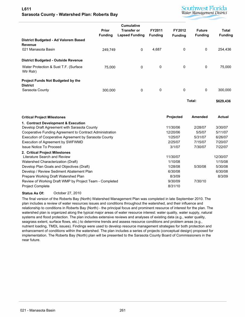
L611
Sarasota County - Watershed Plan: Roberts Bay
District Budgeted - Ad Valorem Based
Revenue
021 Manasota Basin 254,436 0 0 249,749 0 4,687
District Budgeted - Outside Revenue
Water Protection & Sust T.F. (Surface
Wtr Rstr)
75,000 0 0 75,000 0 0
Project Funds Not Budgeted by the
District
Sarasota County 300,000 0 0 300,000 0 0
$629,436 Total:
Prior
Funding
Cumulative
Transfer or
Lapsed Funding Funding Funding
2011 FY 2012 FY Future
Funding
Total
Funding
Critical Project Milestones ActualProjected Amended
1. Contract Development & ExecutionDevelop Draft Agreement with Sarasota County 11/30/06 2/28/07 3/30/07
Cooperative Funding Agreement to Contract Administration 12/20/06 5/5/07 5/11/07
Execution of Cooperative Agreement by Sarasota County 1/25/07 5/31/07 6/26/07
Execution of Agreement by SWFWMD 2/25/07 7/15/07 7/20/07
Issue Notice To Proceed 3/1/07 7/30/07 7/22/07
2. Critical Project Milestones Literature Search and Review 11/30/07 12/30/07
Watershed Characterization (Draft) 1/10/08 1/15/08
Develop Plan Goals and Objectives (Draft) 1/28/08 5/30/08 5/30/08
Develop / Review Sediment Abatement Plan 6/30/08 6/30/08
Prepare Working Draft Watershed Plan 8/3/09 8/3/09
Review of Working Draft WMP by Project Team - Completed 9/30/09 7/30/10
Project Complete 8/31/10
Status As Of: October 27, 2010
The final version of the Roberts Bay (North) Watershed Management Plan was completed in late September 2010. The
plan includes a review of water resources issues and conditions throughout the watershed, and their influence and
relationship to conditions in Roberts Bay (North) - the principal focus and prominent resource of interest for the plan. The
watershed plan is organized along the typical major areas of water resource interest: water quality, water supply, natural
systems and flood protection. The plan includes extensive reviews and analyses of existing data (e.g., water quality,
seagrass extent, surface flows, etc.) to determine trends and assess resource conditions and problem areas (e.g.,
nutrient loading, TMDL issues). Findings were used to develop resource management strategies for both protection and
enhancement of conditions within the watershed. The plan includes a series of projects (conceptual design) proposed for
implementation. The Roberts Bay (North) plan will be presented to the Sarasota County Board of Commissioners in the
near future.
021 - Manasota Basin 261
L614
Sarasota Imp. BMPs Matheny Creek
Project Type Cooperative Funding
AORs Strategic InitiativesWater Quality Water Quality Maintenance and ImprovementFlood Protection Floodplain Management
Basin(s) Manasota
Sarasota CountyCooperator(s)
Project Manager SMITH, RANDY
Task Manager(s)
Status Ongoing
DescriptionThis is a multi-year funded project to perform the Implementation of Best Management Practices (BMPs) element of
the District's Watershed Management Program (WMP) for the Matheny Creek Watershed in Sarasota County.
This project will be implemented in the Siesta Heights improvement area. Intense rainfall combined with inadequate
drainage facilities and high tides cause frequent flooding within the improvement area. The Siesta Heights culvert
system will be enlarged and include grassed swales above the proposed storm drains and a Nutrient Separating Baffle
Box to provide water quality treatment. This project includes construction of the BMP only. The proposed BMP will
address level of service deficiencies and improve water quality.
BenefitsThe project is expected to meet level of service criteria during a 25-year storm event that eliminates structural flooding
of four structures and improves roadway access by improving conveyance. The project is also expected to improve
water quality with increased grassed swale storage and installation of a baffle box sediment trap. According to the
County, the project will provide approximately $833,000 in present-value flood mitigation benefits assuming a 50-year
useful life.
Costs
The original total project cost was anticipated to be $1,100,000, of which the District's share is $425,000 and the
County's share is $675,000. The District appropriated $212,500 in their FY2007 and FY2008 budgets. The District's
share is being funded entirely by the Manasota Basin Board. The project bids came in much lower than expected and
the revised total project cost is $826,419.69. The County received a FEMA Hazard Mitigation Grant for the project in
the amount of $373,043.16. The project budget is being refined according to Board Policy 130-4. Because of the
lower than expected bids and the FEMA Grant it is anticipated that the District and County will each contribute
$226,688.27 towards the project. When each task is completed the project budget may require refinement based on
the information gathered. The District funding amounts shown in the table include staff salaries, travel and central
garage charges.
Additional Information
The WMP includes five major elements: 1)Topographic Information, 2)Watershed Evaluation, 3)Watershed
Management Plan, 4)Implementation of BMPs, and 5)Maintenance of Watershed Parameters and Models.
Implementing elements of the WMP with local governments is one of the Comprehensive Watershed Management
(CWM) initiative strategies. The probable construction cost for this project was based on the BMP alternative analysis
developed by the County in its Matheny Creek Basin Master Plan. The County previously budgeted funds for the
project design, development of construction documents, construction permitting, land acquisition, and bidding and
contractor selection. Work will be performed in current County and Florida Department of Transportation rights-of-way.
A cooperative funding expenditure agreement with County was developed as a multi-year funded project contingent on
the approval of future funding to complete the Implementation of BMPs. The County will manage the project, where
the District project manager must approve any agreements to accomplish project tasks.
021 - Manasota Basin 262
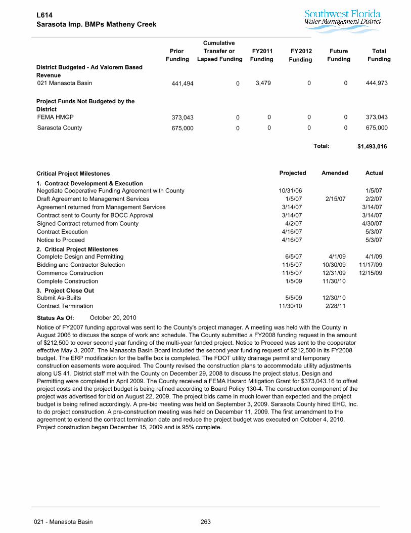
L614
Sarasota Imp. BMPs Matheny Creek
District Budgeted - Ad Valorem Based
Revenue
021 Manasota Basin 444,973 0 0 441,494 0 3,479
Project Funds Not Budgeted by the
District
FEMA HMGP 373,043 0 0 373,043 0 0
Sarasota County 675,000 0 0 675,000 0 0
$1,493,016 Total:
Prior
Funding
Cumulative
Transfer or
Lapsed Funding Funding Funding
2011 FY 2012 FY Future
Funding
Total
Funding
Critical Project Milestones ActualProjected Amended
1. Contract Development & ExecutionNegotiate Cooperative Funding Agreement with County 10/31/06 1/5/07
Draft Agreement to Management Services 1/5/07 2/15/07 2/2/07
Agreement returned from Management Services 3/14/07 3/14/07
Contract sent to County for BOCC Approval 3/14/07 3/14/07
Signed Contract returned from County 4/2/07 4/30/07
Contract Execution 4/16/07 5/3/07
Notice to Proceed 4/16/07 5/3/07
2. Critical Project MilestonesComplete Design and Permitting 6/5/07 4/1/09 4/1/09
Bidding and Contractor Selection 11/5/07 10/30/09 11/17/09
Commence Construction 11/5/07 12/31/09 12/15/09
Complete Construction 1/5/09 11/30/10
3. Project Close OutSubmit As-Builts 5/5/09 12/30/10
Contract Termination 11/30/10 2/28/11
Status As Of: October 20, 2010
Notice of FY2007 funding approval was sent to the County's project manager. A meeting was held with the County in
August 2006 to discuss the scope of work and schedule. The County submitted a FY2008 funding request in the amount
of $212,500 to cover second year funding of the multi-year funded project. Notice to Proceed was sent to the cooperator
effective May 3, 2007. The Manasota Basin Board included the second year funding request of $212,500 in its FY2008
budget. The ERP modification for the baffle box is completed. The FDOT utility drainage permit and temporary
construction easements were acquired. The County revised the construction plans to accommodate utility adjustments
along US 41. District staff met with the County on December 29, 2008 to discuss the project status. Design and
Permitting were completed in April 2009. The County received a FEMA Hazard Mitigation Grant for $373,043.16 to offset
project costs and the project budget is being refined according to Board Policy 130-4. The construction component of the
project was advertised for bid on August 22, 2009. The project bids came in much lower than expected and the project
budget is being refined accordingly. A pre-bid meeting was held on September 3, 2009. Sarasota County hired EHC, Inc.
to do project construction. A pre-construction meeting was held on December 11, 2009. The first amendment to the
agreement to extend the contract termination date and reduce the project budget was executed on October 4, 2010.
Project construction began December 15, 2009 and is 95% complete.
021 - Manasota Basin 263
L615
Sarasota Imp. BMPs Alligator Creek
Project Type Cooperative Funding
AORs Strategic InitiativesWater Quality Water Quality Maintenance and ImprovementFlood Protection Floodplain Management
Basin(s) Manasota
Sarasota CountyCooperator(s)
Project Manager SMITH, RANDY
Task Manager(s)
Status Ongoing
DescriptionThis is a multi-year funded project to perform an element of the District's Watershed Management Program (WMP) for
the Implementation of Best Management Practices (BMPs) in the Alligator Creek Watershed. The watershed covers
an area of approximately 10.7 square miles and is located in Sarasota County. This project will implement several
improvements in the following areas: 1) Banyan Drive - culverts and pond expansion with wetland plantings, 2)
Briarwood area - upsizing of culverts and outfall pipe, 3) Bal Harbour Drive - stormwater collection system, 4) Venice
East Drive - modify the control structure at Heron Lakes, and 5) Venice East Boulevard - installation of box culvert.
Several of the roadways contiguous to these improvement areas become impassable during the 10, 25, and 100-year
storm events that result in a health and welfare threat to residents by creating changes in traffic flow and emergency
vehicle routing. In addition, the project is expected to improve water quality by installing several Nutrient Separating
Baffle Boxes to reduce non-point source pollutant loads. This project is also expected to improve water quality by
increasing residence time through conversion of the old Briarwood wastewater treatment percolation ponds into
stormwater ponds and by expanding the existing lake system storage capacity. This project includes construction of
the BMP only.
BenefitsThe project is expected to meet level of service criteria during a 25-year storm event, improving roadway access by
increasing conveyance and providing additional storage in the watershed. The project is also expected to improve
water quality by increasing residence times and installing several Nutrient Separating Baffle Boxes to reduce non-point
source pollutant loads. According to the County, the project will provide approximately $2.3 million in present-value
flood mitigation benefits assuming a 50-year useful life.
Costs
The revised project cost is $3,475,000. The District appropriated $750,000 in their FY2007 budget and $375,000 in
their FY2008 budget for a total funding commitment of $1,125,000. The District's share is being funded entirely by the
Manasota Basin Board. The County budgeted $2,345,000 over FY2006, FY2007, and FY2008. When each task is
completed the project budget may require refinement based on the information gathered. The District funding amounts
shown in the table include staff salaries, travel and central garage charges.
Additional Information
The WMP includes five major elements: 1) Topographic Information, 2) Watershed Evaluation, 3) Watershed
Management Plan, 4) Implementation of BMPs, and 5) Maintenance of Watershed Parameters and Models.
Implementing elements of the WMP with local governments is one of the Comprehensive Watershed Management
(CWM) initiative strategies. The probable construction cost for this project was based on the BMP alternative analysis
developed by the County in its Alligator Creek Basin Master Plan. The County previously budgeted funds for the
project design, development of construction documents, construction permitting, land acquisition, and bidding and
contractor selection. The County will be required to acquire easements in order to implement the BMPs. A cooperative
funding expenditure agreement with County was developed as a multi-year funded project contingent on the approval
of future funding to complete the Implementation of BMP's. The County will manage the project, where the District
project manager must approve any agreements to accomplish project tasks.
021 - Manasota Basin 264
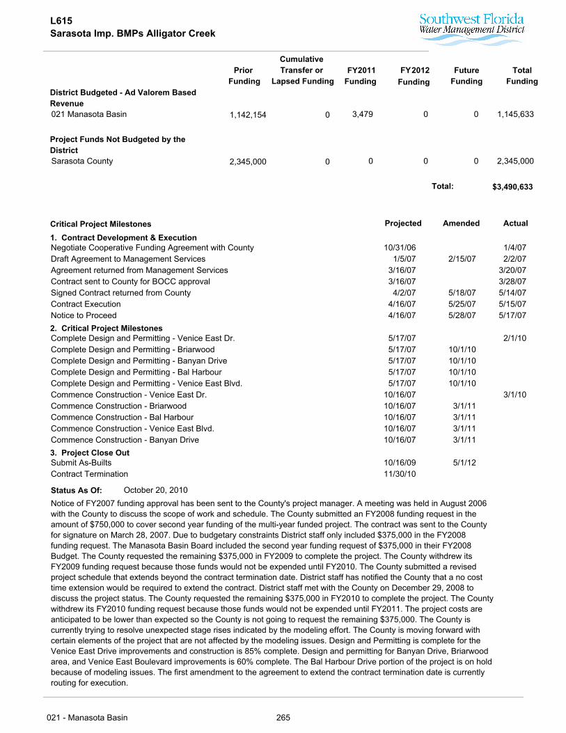
L615
Sarasota Imp. BMPs Alligator Creek
District Budgeted - Ad Valorem Based
Revenue
021 Manasota Basin 1,145,633 0 0 1,142,154 0 3,479
Project Funds Not Budgeted by the
District
Sarasota County 2,345,000 0 0 2,345,000 0 0
$3,490,633 Total:
Prior
Funding
Cumulative
Transfer or
Lapsed Funding Funding Funding
2011 FY 2012 FY Future
Funding
Total
Funding
Critical Project Milestones ActualProjected Amended
1. Contract Development & ExecutionNegotiate Cooperative Funding Agreement with County 10/31/06 1/4/07
Draft Agreement to Management Services 1/5/07 2/15/07 2/2/07
Agreement returned from Management Services 3/16/07 3/20/07
Contract sent to County for BOCC approval 3/16/07 3/28/07
Signed Contract returned from County 4/2/07 5/18/07 5/14/07
Contract Execution 4/16/07 5/25/07 5/15/07
Notice to Proceed 4/16/07 5/28/07 5/17/07
2. Critical Project MilestonesComplete Design and Permitting - Venice East Dr. 5/17/07 2/1/10
Complete Design and Permitting - Briarwood 5/17/07 10/1/10
Complete Design and Permitting - Banyan Drive 5/17/07 10/1/10
Complete Design and Permitting - Bal Harbour 5/17/07 10/1/10
Complete Design and Permitting - Venice East Blvd. 5/17/07 10/1/10
Commence Construction - Venice East Dr. 10/16/07 3/1/10
Commence Construction - Briarwood 10/16/07 3/1/11
Commence Construction - Bal Harbour 10/16/07 3/1/11
Commence Construction - Venice East Blvd. 10/16/07 3/1/11
Commence Construction - Banyan Drive 10/16/07 3/1/11
3. Project Close OutSubmit As-Builts 10/16/09 5/1/12
Contract Termination 11/30/10
Status As Of: October 20, 2010
Notice of FY2007 funding approval has been sent to the County's project manager. A meeting was held in August 2006
with the County to discuss the scope of work and schedule. The County submitted an FY2008 funding request in the
amount of $750,000 to cover second year funding of the multi-year funded project. The contract was sent to the County
for signature on March 28, 2007. Due to budgetary constraints District staff only included $375,000 in the FY2008
funding request. The Manasota Basin Board included the second year funding request of $375,000 in their FY2008
Budget. The County requested the remaining $375,000 in FY2009 to complete the project. The County withdrew its
FY2009 funding request because those funds would not be expended until FY2010. The County submitted a revised
project schedule that extends beyond the contract termination date. District staff has notified the County that a no cost
time extension would be required to extend the contract. District staff met with the County on December 29, 2008 to
discuss the project status. The County requested the remaining $375,000 in FY2010 to complete the project. The County
withdrew its FY2010 funding request because those funds would not be expended until FY2011. The project costs are
anticipated to be lower than expected so the County is not going to request the remaining $375,000. The County is
currently trying to resolve unexpected stage rises indicated by the modeling effort. The County is moving forward with
certain elements of the project that are not affected by the modeling issues. Design and Permitting is complete for the
Venice East Drive improvements and construction is 85% complete. Design and permitting for Banyan Drive, Briarwood
area, and Venice East Boulevard improvements is 60% complete. The Bal Harbour Drive portion of the project is on hold
because of modeling issues. The first amendment to the agreement to extend the contract termination date is currently
routing for execution.
021 - Manasota Basin 265
L618
Sarasota - Watershed Management Plan: Coastal Fringe
Project Type Cooperative Funding
AORs Strategic InitiativesWater Quality Water Quality Maintenance and ImprovementFlood Protection Floodplain ManagementNatural Systems Natural Systems Conservation and Restoration
Basin(s) Manasota
Sarasota CountyCooperator(s)
Project Manager LOPEZ, MANNY
TURNER, DAWNTask Manager(s)
Status Ongoing
DescriptionThis multi-year funded project is to perform the: 1) Topographic Information, 2) Watershed Evaluation, and 3)
Watershed Management Plan elements of the District's Watershed Management Program (WMP) for several coastal
watersheds in Sarasota County. Watershed Management Plans will be updated for 1) the North Roberts Bay Coastal
Watershed, 2) the Lemon Bay Coastal Watershed, and 3) portions of the Sarasota Bay, Little Sarasota Bay,
Dona/Roberts Bay Coastal Watersheds. Combined, these Coastal Watershed areas cover approximately 25 square
miles within the County. The only areas excluded from Sarasota's Coastal Fringe are a small portion of the Little
Sarasota Bay Coastal (Vamo Road area) Basin and the Lyons Bay portion of the Dona Bay Coastal Basin, which are
currently being developed under a separate contract. The Coastal Fringe Watershed updates include developing
portions of the Watershed Management Program, as defined by the District, beginning with the North Roberts Bay
Coastal Watershed as Phase 1. The North Roberts Bay Coastal Watershed is approximately 5.9 square miles in the
coastal fringe of the Phillippi Creek and Matheny Creek Basins, including Siesta Key from Midnight Pass to Siesta
Drive. Phase 2 includes the Lemon Bay Coastal Watershed, which is approximately 7.2 square miles, excluding the
area outside of the County. Phase 3 includes portions of the Sarasota Bay, Little Sarasota Bay, Dona/Roberts Bay
Coastal Watersheds. The total area in Phase 3 is approximately 9.2 square miles. These areas currently do not have
the benefit of a Watershed Management Plan.
BenefitsThe WMP provides a method to evaluate the capacity of a watershed to protect, enhance, and restore water quality
and natural systems, while achieving flood protection. The information developed provides the science for the District's
Resource Management and Environmental Resource Permitting (ERP). It assists local governments: 1) with their land
management responsibilities by establishing a level of service and developing Best Management Practices (BMPs) to
address level of service deficiencies and 2) by providing a geodatabase and projected results from watershed model
simulations for floodplain management and water quality management through the Total Maximum Daily Loads
(TMDL) process for their National Pollution Discharge Elimination System (NPDES) permit requirements.
Costs
The estimated total budget amount for this multi-year project is $1,966,632, of which the District's share is $983,316 to
be funded over several fiscal years. For FY2007, the Manasota Basin Board originally budgeted $500,000 with an
equal match from Sarasota County. However, Sarasota County was only able to fund $246,491 of the original
$500,000. Correspondingly, the District only encumbered $246,491 in FY2007 as part of the cooperative funding
agreement. For FY2008, the Manasota Basin Board budgeted and encumbered $200,000 into the cooperative
agreement. However, because of budget shortfalls, Sarasota County was unable to provide any funding in
FY2008. For FY2009 Sarasota County encumbered $34,422 for project work. The District only budgeted staff time for
FY2009. In FY2010 Sarasota County budgeted $200,00 for project work; the District budgeted $39,031 in FY2010 in
order to reach the same level of funding. For FY2011 the Manasota Basin Board approved $200,000 in funding
with Sarasota County providing an equal match of $200,000. Requests for future funding are anticipated in FY2012.
As each project element is completed the project budget may require refinement based on the information gathered.
The future funds identified for the project are contingent upon approval of such amounts by the Manasota Basin Board
in the annual budget. The District funding amounts shown in the table include staff salaries, travel and central garage
charges.
Additional Information
A WMP includes five major elements: 1) Topographic Information, 2) Watershed Evaluation, 3) Watershed
Management Plan, 4) Implementation of Best Management Practices, and 5) Maintenance of Watershed Parameters
and Models. Implementing elements of the WMP with local governments is one of the Comprehensive Watershed
Management (CWM) initiative strategies. Future funding will be required in future years in order to complete
development the Watershed Management Plan for the Sarasota Bay Coastal watershed including: survey, GIS data
021 - Manasota Basin 266
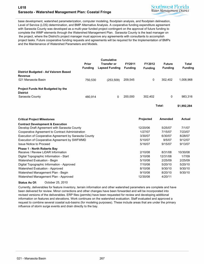
L618
Sarasota - Watershed Management Plan: Coastal Fringe
base development, watershed parameterization, computer modeling, floodplain analysis, and floodplain delineation,
Level of Service (LOS) determination, and BMP Alternative Analysis. A cooperative funding expenditure agreement
with Sarasota County was developed as a multi-year funded project contingent on the approval of future funding to
complete the WMP elements through the Watershed Management Plan. Sarasota County is the lead manager on
the project, where the District's project manager must approve any agreements with consultants to accomplish
project tasks. Future cooperative funding requests and agreements will be required for the Implementation of BMPs
and the Maintenance of Watershed Parameters and Models.
District Budgeted - Ad Valorem Based
Revenue
021 Manasota Basin 1,008,968 302,402 (253,509) 750,530 0 209,545
Project Funds Not Budgeted by the
District
Sarasota County 983,316 0 0 480,914 302,402 200,000
$1,992,284 Total:
Prior
Funding
Cumulative
Transfer or
Lapsed Funding Funding Funding
2011 FY 2012 FY Future
Funding
Total
Funding
Critical Project Milestones ActualProjected Amended
Contract Development & ExecutionDevelop Draft Agreement with Sarasota County 12/20/06 5/25/07 7/1/07
Cooperative Agreement to Contract Administration 1/27/07 7/15/07 7/23/07
Execution of Cooperative Agreement by Sarasota County 3/30/07 6/30/07 8/28/07
Execution of Cooperative Agreement by SWFWMD 5/10/07 9/5/07 9/12/07
Issue Notice to Proceed 5/16/07 9/15/07 9/13/07
Phase 1 - North Roberts BayReceive / Review LiDAR Information 2/10/08 8/31/08 10/30/08
Digital Topographic Information - Start 3/10/08 12/31/08 1/7/09
Watershed Evaluation - Begin 5/10/08 2/25/09 2/25/09
Digital Topographic Information - Approved 7/10/08 5/20/10 5/20/10
Watershed Evaluation - Approved 8/10/08 9/30/10 9/30/10
Watershed Management Plan - Begin 9/10/08 8/20/10 9/30/10
Watershed Management Plan - Approved 12/30/08 4/20/11
Status As Of: October 25, 2010
Currently, deliverables for feature inventory, terrain information and other watershed parameters are complete and have
been delivered for review. Minor corrections and other changes have been forwarded and will be incorporated into
revised versions of the deliverables. ERP files (permits) have been requested for review and developing additional
information on features and elevations. Work continues on the watershed evaluation. Staff evaluated and approved a
request to combine several coastal sub-basins (for modeling purposes). These include areas that are under the primary
influence of storm surge events and drain directly to the bay.
021 - Manasota Basin 267
L624
Venice Imp. BMPs Hatchett Creek-Venice
Project Type Cooperative Funding
AORs Strategic InitiativesWater Quality Water Quality Maintenance and ImprovementFlood Protection Emergency Flood Response
Basin(s) Manasota
City of VeniceCooperator(s)
Project Manager SMITH, RANDY
NORTON, NANCYTask Manager(s)
Status Ongoing
DescriptionThis project is to perform the Implementation of Best Management Practices (BMPs) element of the District's
Watershed Management Program (WMP) for the Hatchett Creek Watershed in Sarasota County. This BMP will be
implemented in the Venice Avenue improvement area. The existing stormwater system on Venice Avenue, U.S. 41
Bypass and Warfield Avenue is undersized and causes flooding of the roadways. Venice Avenue and U.S. 41 Bypass
are evacuation routes and Warfield Avenue is an access road for the City of Venice Utilities Department, a water
treatment plant and area businesses. Extensive flooding causes the closure of the Warfield Avenue and U.S. 41
Bypass intersection 3 to 4 times a year when daily rainfall exceeds 3 inches. The proposed stormwater system will be
designed to handle a 100-year, 24-hour rainfall event. The existing stormwater system on Warfield Avenue will be
enlarged and replaced with new curb inlets, connector pipes and outfall pipes. Two additional curb inlets and
connector pipes will be added at the intersection of U.S. 41 Bypass and Venice Avenue. In addition, stormwater will be
directed to the retention pond at East Venice Avenue and Warfield Avenue. The existing pond may require
modification due to the added water volume being treated. With FY2007 funding the work on the Implementation of
BMPs will begin and includes the following tasks: evaluation, design, development of construction documents,
construction permitting, bidding and contractor selection, and construction of the BMPs.
BenefitsThe project will improve level of service deficiencies by improving conveyance and providing additional storage within
the watershed. The project is also expected to improve water quality by repairing the damaged stormwater pipes that
are seeping sediment into the system and increasing residence times in the storage area.
Costs
The total budget amount for this project is $351,670, of which the District's share is $175,835. The District's share was
funded entirely by the Manasota Basin in FY2007. The City contributed $175,835 over FY2007 and FY2008. When
each task is completed the project budget may require refinement based on the information gathered. The District
funding amounts shown in the table include staff salaries, travel and central garage charges.
Additional Information
The WMP includes five major elements: 1) Topographic Information, 2) Watershed Evaluation, 3) Watershed
Management Plan, 4) Implementation of BMPs, and 5) Maintenance of Watershed Parameters and Models.
Implementing elements of the WMP with local governments is one of the Comprehensive Watershed Management
(CWM) initiative strategies. Future funding to complete the project will be provided by the City that will satisfy its
cooperative funding match requirements. The City will manage the project, where the District project manager must
approve any agreements to accomplish project tasks.
021 - Manasota Basin 268
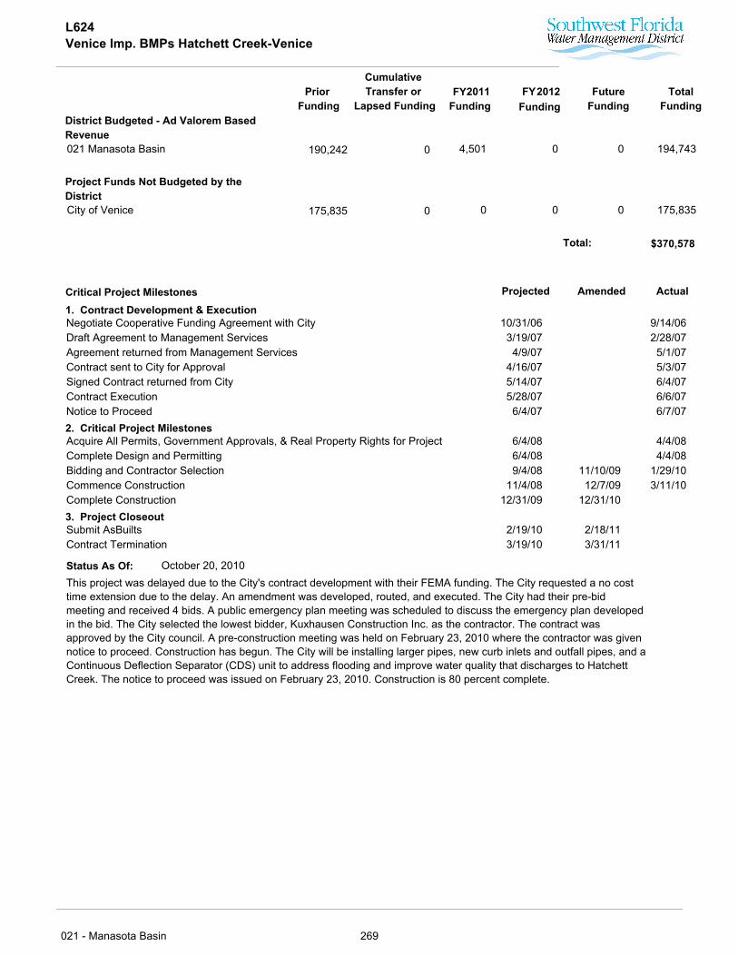
L624
Venice Imp. BMPs Hatchett Creek-Venice
District Budgeted - Ad Valorem Based
Revenue
021 Manasota Basin 194,743 0 0 190,242 0 4,501
Project Funds Not Budgeted by the
District
City of Venice 175,835 0 0 175,835 0 0
$370,578 Total:
Prior
Funding
Cumulative
Transfer or
Lapsed Funding Funding Funding
2011 FY 2012 FY Future
Funding
Total
Funding
Critical Project Milestones ActualProjected Amended
1. Contract Development & ExecutionNegotiate Cooperative Funding Agreement with City 10/31/06 9/14/06
Draft Agreement to Management Services 3/19/07 2/28/07
Agreement returned from Management Services 4/9/07 5/1/07
Contract sent to City for Approval 4/16/07 5/3/07
Signed Contract returned from City 5/14/07 6/4/07
Contract Execution 5/28/07 6/6/07
Notice to Proceed 6/4/07 6/7/07
2. Critical Project MilestonesAcquire All Permits, Government Approvals, & Real Property Rights for Project 6/4/08 4/4/08
Complete Design and Permitting 6/4/08 4/4/08
Bidding and Contractor Selection 9/4/08 11/10/09 1/29/10
Commence Construction 11/4/08 12/7/09 3/11/10
Complete Construction 12/31/09 12/31/10
3. Project CloseoutSubmit AsBuilts 2/19/10 2/18/11
Contract Termination 3/19/10 3/31/11
Status As Of: October 20, 2010
This project was delayed due to the City's contract development with their FEMA funding. The City requested a no cost
time extension due to the delay. An amendment was developed, routed, and executed. The City had their pre-bid
meeting and received 4 bids. A public emergency plan meeting was scheduled to discuss the emergency plan developed
in the bid. The City selected the lowest bidder, Kuxhausen Construction Inc. as the contractor. The contract was
approved by the City council. A pre-construction meeting was held on February 23, 2010 where the contractor was given
notice to proceed. Construction has begun. The City will be installing larger pipes, new curb inlets and outfall pipes, and a
Continuous Deflection Separator (CDS) unit to address flooding and improve water quality that discharges to Hatchett
Creek. The notice to proceed was issued on February 23, 2010. Construction is 80 percent complete.
021 - Manasota Basin 269
L693
Water Exhibits in the Glazer Children's Museum of Tampa
Project Type Cooperative Funding
AORs Strategic InitiativesWater Quality Water Quality MonitoringFlood Protection Floodplain ManagementWater Supply ConservationNatural Systems Natural Systems Identification and Monitoring
Basin(s) Alafia River, Hillsborough River, Northwest Hillsborough, Coastal Rivers, Pinellas-Anclote River,
Withlacoochee River, Peace River, Manasota
The Children's Museum of TampaCooperator(s)
Project Manager HULL, MARY MARGARET
Task Manager(s)
Status Ongoing
DescriptionThe Glazer Children's Museum of Tampa has relocated to a new museum site in Riverfront Park in downtown Tampa.
This multi-year project is part of the City of Tampa's efforts to revitalize the downtown business district. This is the third
and final phase of a project to develop and install water exhibits in the museum. In FY2007, the District funded the
planning and development phase for interactive water exhibits. FY2008 funds paid for detailed specifications,
structural engineering, fabrication of support structure, construction of entrances, partial platform construction and
other expenses related to fabrication. In the conceptual phase, District staff and BBEC members were included in
several planning sessions for the design of the interactive water exhibits to ensure they incorporate the District's
message. The Water's Journey exhibit is a multi-story climbing structure where visitors "become" a drop of water and
move through the exhibit, starting deep within the aquifer, eventually penetrating the surface, which would then
become the watershed, climbing through trees to the upland area. The other District exhibit, originally conceptualized
as a bank, is evolving during the planning process to better reflect research on how children learn from exhibits.
Several concepts are being discussed for the interactive water conservation exhibit. Children would be provided
with the opportunity to make decisions and see the consequences of those decisions. The exhibit would convey the
importance of rainfall to the District's water supply by showing rainfall's effect on aquifer levels. Children would then be
presented with a variety of ways water is used in and around the home. They would be able to make decisions about
using water-conserving practices and watch how individual actions combine to impact the District's water supply. The
FY2009 funding is for exhibit construction and installation. The museum is scheduled to open to the public in late
September 2010.
BenefitsThe exhibits are multidisciplinary and designed to engage diverse learning styles. The museum is projected to draw
100,000 people annually. The interactive water exhibits address three elements of the District's AORs -- water supply,
water quality and natural systems -- in simple, easy-to-understand terms. Additionally, this project targets children ages
0-10 years and accompanying adults. This segment of the population was identified in an independent evaluation of
the District's youth education program as one to which the District needed to expand its reach. This project helps
accomplish this goal.
Costs
The total cost of the project (including building construction and all exhibits throughout the museum) is estimated to be
$20 million. The total contribution from the District, including FY2007, FY2008 and FY2009, is $617,442. In FY2007,
the basins shared $112,500 for the planning and development phase for interactive water exhibits. FY2008 funds were
for detailed specifications, structural engineering, fabrication of support structure, construction of entrances, partial
platform construction and other expenses related to fabrication. FY2009 funds are for completion of the exhibit
fabrication, installation and education program development. Phase 3 FY2009 funding request of $252,471 is
allocated as follows:
Alafia River: 12% $29,968;
Hillsborough River: 27% $68,900;
Northwest Hillsborough: 15% $37,340;
Coastal Rivers: 9% $22,249;
Pinellas-Anclote: 14% $35,396;
Withlacoochee River: 5% $12,821;
Peace River: 8% $20,550;
Manasota: 10% $25,247.
The funding splits for this project are based on cooperator-supplied projections of museum attendance. This project
anticipates reaching 100,000 people per year at a cost (for the total project, all phases) to the District of $6.18 per
021 - Manasota Basin 270

L693
Water Exhibits in the Glazer Children's Museum of Tampa
person. Typical museum exhibits have a 10-year life span. This project, therefore, has the potential to reach 1 million
visitors over a 10-year period at a cost to the District of $0.62 per person. The budget lines below include costs for
staff to manage the project.
District Budgeted - Ad Valorem Based
Revenue
011 Alafia River Basin 74,786 0 0 74,786 0 0
013 Hillsborough River Basin 171,265 0 0 171,265 0 0
014 Northwest Hillsborough Basin 94,255 0 0 94,255 0 0
015 Coastal Rivers Basin 49,738 0 0 49,738 0 0
016 Pinellas-Anclote River Basin 98,917 0 0 98,917 0 0
019 Withlacoochee River Basin 30,290 0 0 30,290 0 0
020 Peace River Basin 49,534 0 0 49,534 0 0
021 Manasota Basin 58,115 0 0 58,115 0 0
Project Funds Not Budgeted by the
District
Glazer Children's Museum of Tampa 5,522,920 0 0 5,522,920 0 0
Other Funding Sources 19,091,102 0 0 19,091,102 0 0
$25,240,922 Total:
Prior
Funding
Cumulative
Transfer or
Lapsed Funding Funding Funding
2011 FY 2012 FY Future
Funding
Total
Funding
Critical Project Milestones ActualProjected Amended
FY2007 Budgeted FundsFY2007 purchase order opened 4/30/07 4/26/07
Confirmation and layout of exhibits in building 6/30/07 6/30/07
Schematic design and fabrication documents 12/30/07 12/14/07
FY2008 Budgeted FundsFY2008 contract executed 5/15/08 9/15/08 9/10/08
Project meeting with Museum staff and architect 7/6/09 7/6/09
FY2008 components completed 12/31/09 2/26/10 2/26/10
FY2009 Budgeted FundsFY2009 contract executed 9/1/09 10/30/09 11/4/09
Building construction complete 3/1/10 3/26/10 3/26/10
Exhibits installed 7/1/10 9/1/10 9/1/10
FY2009 components completed 8/1/10 12/17/10
Museum grand opening 9/30/10 9/25/10 9/25/10
Status As Of: October 19, 2010
ACTION TO DATE: On time. Cooperator held the Donor Gala on September 23. All Governing and Basin Board
members were invited to attend the Gala. The public grand opening was September 25. Staff is working with the Director
of Education to finalize project deliverables.
021 - Manasota Basin 271
L867
Sarasota County GIS Dataset Development
Project Type Cooperative Funding
AORs Strategic InitiativesWater Quality Water Quality Maintenance and ImprovementFlood Protection Floodplain Management
Basin(s) General Fund (District), Manasota
Sarasota CountyCooperator(s)
Project Manager TURNER, DAWN
TURNER, DAWN, FITOS, EKATERINA, DICKS, STEVETask Manager(s)
Status Completed
DescriptionSarasota County Environmental Services is creating and maintaining a comprehensive Geographic Information
System (GIS) database to support surface water modeling and stormwater asset management functions. This project
enhances the quality of the data supporting modeling activities by gathering accurate locations and characteristics of
key stormwater assets. Among many potential applications, these data will aid in the development and management of
watershed management plans through hydrologic model maintenance/updates and point and non-point pollutant
source identification. The funding will be used to enhance the County's current stormwater infrastructure database that
consists of control structures, inlets, pipes, pipelines, ditches, swales and retention/detention ponds. These data will be
used by the County to generate and maintain a common database that will support water quality, hydrologic and
hydraulic models. This database will also be compatible with the District's GIS database standards.
BenefitsDrainage infrastructure is a critical component in the calibration and verification of hydrologic and hydraulic models.
When fully calibrated, these models generate accurate stage-area relationships, allowing County staff to generate
precise floodplain maps needed to estimate flood risks. When paired with topographic data, Sarasota County will be
able to move ahead with Federal Emergency Management Agency Map Modernization efforts. The improved database
will allow the County to initiate proactive flood protection measures that include the rapid assessment and identification
of potential flooding hot spots, and development of complex what-if scenarios. The database will also support water
quality management efforts to ensure fishable and swimable waters. County staff will be better equipped to identify and
model key water monitoring locations within coastal watersheds.
Costs
Costs for FY2009 include $100,000 from the Manasota Basin Board and $150,000 from Sarasota County. The cost of
the project through FY2008 is $306,742. The Manasota Basin Board is contributing $100,000 and Sarasota County is
$206,742. For FY2010, $100,000 has been allocated in the Manasota Basin Board budget, and Sarasota County will
provide $900,000. The future funds identified for the project are contingent upon approval of such amounts by the
Manasota Basin Board in the annual budget. Additional costs are associated with staff time required to manage the
project.
Additional Information
As part of the hydrologic model and for the purposes of this project, horizontal survey data collection refers to
structures such as pump stations, weirs, ponds and wetlands which combine to form part of a drainage infrastructure.
By collecting this information through the means of a horizontal survey the data can be used for more accurate
modeling in the event of severe weather impacts or for planning purposes due to urbanization.
021 - Manasota Basin 272
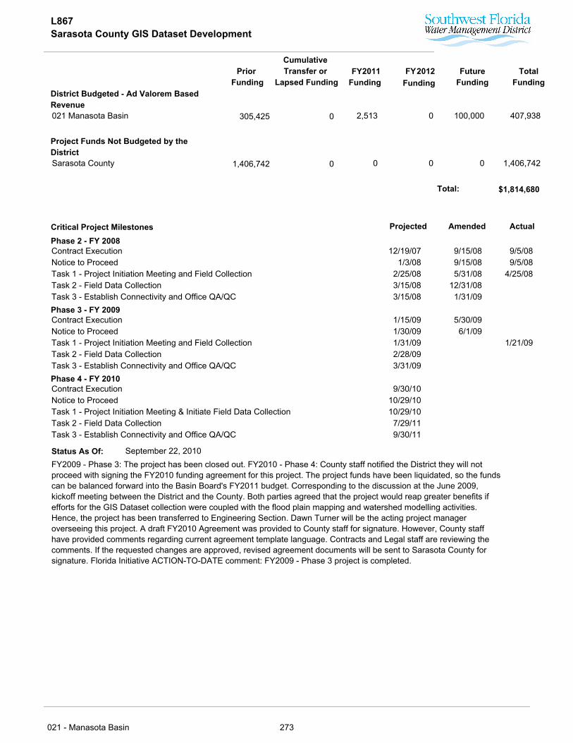
L867
Sarasota County GIS Dataset Development
District Budgeted - Ad Valorem Based
Revenue
021 Manasota Basin 407,938 100,000 0 305,425 0 2,513
Project Funds Not Budgeted by the
District
Sarasota County 1,406,742 0 0 1,406,742 0 0
$1,814,680 Total:
Prior
Funding
Cumulative
Transfer or
Lapsed Funding Funding Funding
2011 FY 2012 FY Future
Funding
Total
Funding
Critical Project Milestones ActualProjected Amended
Phase 2 - FY 2008Contract Execution 12/19/07 9/15/08 9/5/08
Notice to Proceed 1/3/08 9/15/08 9/5/08
Task 1 - Project Initiation Meeting and Field Collection 2/25/08 5/31/08 4/25/08
Task 2 - Field Data Collection 3/15/08 12/31/08
Task 3 - Establish Connectivity and Office QA/QC 3/15/08 1/31/09
Phase 3 - FY 2009Contract Execution 1/15/09 5/30/09
Notice to Proceed 1/30/09 6/1/09
Task 1 - Project Initiation Meeting and Field Collection 1/31/09 1/21/09
Task 2 - Field Data Collection 2/28/09
Task 3 - Establish Connectivity and Office QA/QC 3/31/09
Phase 4 - FY 2010Contract Execution 9/30/10
Notice to Proceed 10/29/10
Task 1 - Project Initiation Meeting & Initiate Field Data Collection 10/29/10
Task 2 - Field Data Collection 7/29/11
Task 3 - Establish Connectivity and Office QA/QC 9/30/11
Status As Of: September 22, 2010
FY2009 - Phase 3: The project has been closed out. FY2010 - Phase 4: County staff notified the District they will not
proceed with signing the FY2010 funding agreement for this project. The project funds have been liquidated, so the funds
can be balanced forward into the Basin Board's FY2011 budget. Corresponding to the discussion at the June 2009,
kickoff meeting between the District and the County. Both parties agreed that the project would reap greater benefits if
efforts for the GIS Dataset collection were coupled with the flood plain mapping and watershed modelling activities.
Hence, the project has been transferred to Engineering Section. Dawn Turner will be the acting project manager
overseeing this project. A draft FY2010 Agreement was provided to County staff for signature. However, County staff
have provided comments regarding current agreement template language. Contracts and Legal staff are reviewing the
comments. If the requested changes are approved, revised agreement documents will be sent to Sarasota County for
signature. Florida Initiative ACTION-TO-DATE comment: FY2009 - Phase 3 project is completed.
021 - Manasota Basin 273
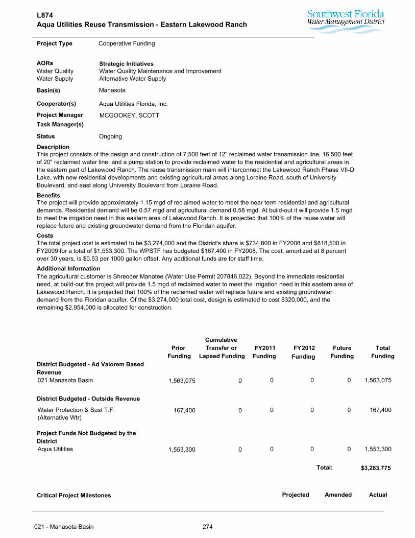
L874
Aqua Utilities Reuse Transmission - Eastern Lakewood Ranch
Project Type Cooperative Funding
AORs Strategic InitiativesWater Quality Water Quality Maintenance and ImprovementWater Supply Alternative Water Supply
Basin(s) Manasota
Aqua Utilities Florida, Inc.Cooperator(s)
Project Manager MCGOOKEY, SCOTT
Task Manager(s)
Status Ongoing
DescriptionThis project consists of the design and construction of 7,500 feet of 12" reclaimed water transmission line, 16,500 feet
of 20" reclaimed water line, and a pump station to provide reclaimed water to the residential and agricultural areas in
the eastern part of Lakewood Ranch. The reuse transmission main will interconnect the Lakewood Ranch Phase VII-D
Lake, with new residential developments and existing agricultural areas along Loraine Road, south of University
Boulevard, and east along University Boulevard from Loraine Road.
BenefitsThe project will provide approximately 1.15 mgd of reclaimed water to meet the near term residential and agricultural
demands. Residential demand will be 0.57 mgd and agricultural demand 0.58 mgd. At build-out it will provide 1.5 mgd
to meet the irrigation need in this eastern area of Lakewood Ranch. It is projected that 100% of the reuse water will
replace future and existing groundwater demand from the Floridan aquifer.
Costs
The total project cost is estimated to be $3,274,000 and the District's share is $734,800 in FY2008 and $818,500 in
FY2009 for a total of $1,553,300. The WPSTF has budgeted $167,400 in FY2008. The cost, amortized at 8 percent
over 30 years, is $0.53 per 1000 gallon offset. Any additional funds are for staff time.
Additional Information
The agricultural customer is Shreoder Manatee (Water Use Permit 207846.022). Beyond the immediate residential
need, at build-out the project will provide 1.5 mgd of reclaimed water to meet the irrigation need in this eastern area of
Lakewood Ranch. It is projected that 100% of the reclaimed water will replace future and existing groundwater
demand from the Floridan aquifer. Of the $3,274,000 total cost, design is estimated to cost $320,000, and the
remaining $2,954,000 is allocated for construction.
District Budgeted - Ad Valorem Based
Revenue
021 Manasota Basin 1,563,075 0 0 1,563,075 0 0
District Budgeted - Outside Revenue
Water Protection & Sust T.F.
(Alternative Wtr)
167,400 0 0 167,400 0 0
Project Funds Not Budgeted by the
District
Aqua Utilities 1,553,300 0 0 1,553,300 0 0
$3,283,775 Total:
Prior
Funding
Cumulative
Transfer or
Lapsed Funding Funding Funding
2011 FY 2012 FY Future
Funding
Total
Funding
Critical Project Milestones ActualProjected Amended
021 - Manasota Basin 274
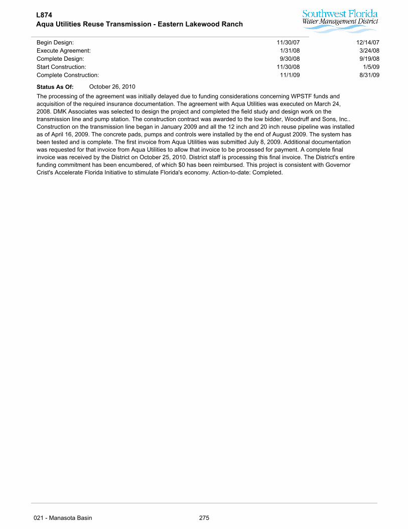
L874
Aqua Utilities Reuse Transmission - Eastern Lakewood Ranch
Begin Design: 11/30/07 12/14/07
Execute Agreement: 1/31/08 3/24/08
Complete Design: 9/30/08 9/19/08
Start Construction: 11/30/08 1/5/09
Complete Construction: 11/1/09 8/31/09
Status As Of: October 26, 2010
The processing of the agreement was initially delayed due to funding considerations concerning WPSTF funds and
acquisition of the required insurance documentation. The agreement with Aqua Utilities was executed on March 24,
2008. DMK Associates was selected to design the project and completed the field study and design work on the
transmission line and pump station. The construction contract was awarded to the low bidder, Woodruff and Sons, Inc..
Construction on the transmission line began in January 2009 and all the 12 inch and 20 inch reuse pipeline was installed
as of April 16, 2009. The concrete pads, pumps and controls were installed by the end of August 2009. The system has
been tested and is complete. The first invoice from Aqua Utilities was submitted July 8, 2009. Additional documentation
was requested for that invoice from Aqua Utilities to allow that invoice to be processed for payment. A complete final
invoice was received by the District on October 25, 2010. District staff is processing this final invoice. The District's entire
funding commitment has been encumbered, of which $0 has been reimbursed. This project is consistent with Governor
Crist's Accelerate Florida Initiative to stimulate Florida's economy. Action-to-date: Completed.
021 - Manasota Basin 275

L949
(Completed) Manatee County Water Conservation Program
Project Type Cooperative Funding
AORs Strategic InitiativesWater Supply Alternative Water Supply
Basin(s) Manasota
Manatee CountyCooperator(s)
Project Manager MCGOOKEY, SCOTT
Task Manager(s)
Status Completed
DescriptionThis project consists of offering financial incentives to single-family, multi-family, and commercial customers for
replacing conventional toilets with water-conserving equivalents. This project will target the replacement of
approximately 900 conventional toilets with ultra-low volume (ULV) toilets, which use up to 1.6 gallons per flush (gpf).
In addition, approximately 900 low-flow showerheads will be provided to participating customers to replace
conventional showerheads. The project will provide rebates for toilets at $100 per fixture. This proposed project is the
second phase to the Manatee County Indoor Water Conservation Project (L601) funded in FY2007.
BenefitsThis FY2008 project is anticipated to save an estimated 17,250 gallons of water per day or 6,296,250 gallons per year.
Costs
The total project cost is $126,144. The Manasota Basin Board funding share of 50 percent is $63,072 in FY2008.
Manatee County's 50 percent share is $63,072. The cost amortized at 8 percent over 20 years, is $2.07 per thousand
gallons. The savings is calculated using a weighted average due to the varying life expectancies of the different water
saving equipment.
Additional Information
In addition to providing financial assistance for the installation of low flow toilets, a goal of this project is to educate all
program participants on methods of indoor water conservation and proper maintenance practices to ensure low flow
toilets remain a water conservative fixture. Educational materials on flapper replacement and other water conservation
techniques will be disseminated to all program particpants. The county plans to hire a consultant to administer the
project. In regard to low flow showerheads, the county plans to initiate a showerhead exchange or new showerhead
inspection program to verify the replacement of high volume showerheads.
District Budgeted - Ad Valorem Based
Revenue
021 Manasota Basin 87,255 0 0 86,498 0 757
Project Funds Not Budgeted by the
District
Manatee County 63,072 0 0 63,072 0 0
$150,327 Total:
Prior
Funding
Cumulative
Transfer or
Lapsed Funding Funding Funding
2011 FY 2012 FY Future
Funding
Total
Funding
Critical Project Milestones ActualProjected Amended
Program Implementation 4/1/08 6/30/08
Complete Rebates 6/30/09 3/2/09
Distribution Report 7/30/09 7/9/09
Final Report 9/30/10 6/28/10
021 - Manasota Basin 276
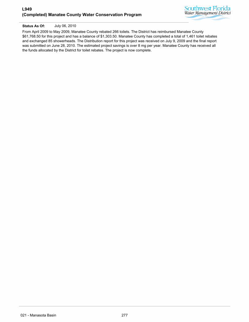
L949
(Completed) Manatee County Water Conservation Program
Status As Of: July 06, 2010
From April 2009 to May 2009, Manatee County rebated 266 toilets. The District has reimbursed Manatee County
$61,768.50 for this project and has a balance of $1,303.50. Manatee County has completed a total of 1,461 toilet rebates
and exchanged 85 showerheads. The Distribution report for this project was received on July 9, 2009 and the final report
was submitted on June 28, 2010. The estimated project savings is over 8 mg per year. Manatee County has received all
the funds allocated by the District for toilet rebates. The project is now complete.
021 - Manasota Basin 277
N014
The Florida Aquarium Watershed Education Initiative
Project Type Cooperative Funding
AORs Strategic InitiativesWater Quality Water Quality Maintenance and ImprovementWater Supply ConservationNatural Systems Natural Systems Conservation and Restoration
Basin(s) Alafia River, Hillsborough River, Coastal Rivers, Pinellas-Anclote River, Withlacoochee River,
Peace River, Manasota
The Florida Aquarium, Inc.Cooperator(s)
Project Manager UNSER, SALLY
Task Manager(s)
Status Ongoing
DescriptionThis Cooperative Funding Initiative (CFI) project will educate teachers and students about Florida's water resources
and natural environment. The Florida Aquarium, which is a major area attraction that attracted 670,000 visitors in FY
2009, will implement a water resources education initiative that focuses on three distinct programs for elementary,
middle and high school students and teachers. These programs are outlined below and include: What's in Your
Watershed? summer camp, Science Education at Sea (SEAS) teacher training program and Regional Ocean
Conference for Students (ROCS) workshop for teachers and students. While the ongoing initiative primarily reaches
students and teachers throughout Hillsborough County, it also draws schools from Pinellas, Pasco and Manatee
counties. What's in Your Watershed? is a summer camp program designed to teach the importance of the Tampa Bay
watershed to low-income, at-risk upper elementary and middle school students from local YMCAs and Boys and Girls
Clubs in Hillsborough County. The camp will provide an opportunity for youth to engage in interactive role-playing to
learn about watersheds, water quality, water conservation and habitat protection. Throughout the ongoing program,
each student takes part in three field explorations within the Tampa Bay watershed. The What's in Your Watershed?
program will be evaluated through a portfolio of student work, student and parent evaluation of the program using a
written survey, instructor evaluation of the program and student pre/post assessments. SEAS is a teacher education
program that will provide workshops for elementary, middle and high school teachers, focusing on estuaries and
incorporating the learning objectives of the Florida Comprehensive Assessment Test. It allows teachers to explore
current and future environmental issues and challenges facing those resources. The SEAS program evaluation will
include a combination of pre/post assessments, workshop surveys and teacher journals. The proposed ROCS
workshop component will give 60 middle and high school students and 15 teachers the opportunity to study several
major water quality issues associated with local watersheds. Students will identify the issues and create action plans
that are achievable and beneficial for the environment. SWIM staff participate in this conference.The ROCS workshop
will be evaluated through pre/post assessments. Independent evaluation by Pandion systems for the ROCS
component previously found that 86% of the teachers agreed that the project was a valuable addition to their student's
education.
BenefitsThe cooperator estimates that the FY2011 program will reach 223 students and teachers directly and 6,800 students
indirectly. ROCS will provide an intensive workshop experience for high school students, providing opportunities for
them to explore current environmental issues in the Tampa Bay watershed and use critical thinking to develop
strategies for solutions to the impacts and create action plans to be used within their communitites. "What's in Your
Watershed?" summer camp addresses the important priority of getting traditionally underserved, inner-city youth
outside to explore the Tampa Bay watershed. They learn important but simple actions that they can take back to their
families to increase water conservation at home.
Costs
The total cost of the FY2011 project is $43,346 with the District contributing $20,331 (Alafia River $5,136; Hillsborough
River $10,700; Coastal Rivers $1,070; Pinellas-Anclote River $1,285; Withlacoochee River $1,070; Manasota $1,070).
Staff removed the project from the Peace River Basin Board's budget with the cooperator's agreement. The dollar
amount allocated per basin is determined by the number of participants that will participate in the programming from
each basin. District funding is for a summer camp, teacher training programs and a workshop for teachers and
students. The program will reach 223 students and teachers directly and 6,800 students indirectly at a cost to the
District of $2.92 per person and $1.56 per contact hour. Budget lines below includes costs to manage projects.
Additional Information
The District has supported this project since FY2009.
The total FY2010 project cost was $44,741, with the District contributing $21,402 (Alafia River $5,174; Hillsborough
River $10,686; Coastal Rivers $1,108; Pinellas-Anclote River $1,109; Withlacoochee River $1,109; Peace River
021 - Manasota Basin 278
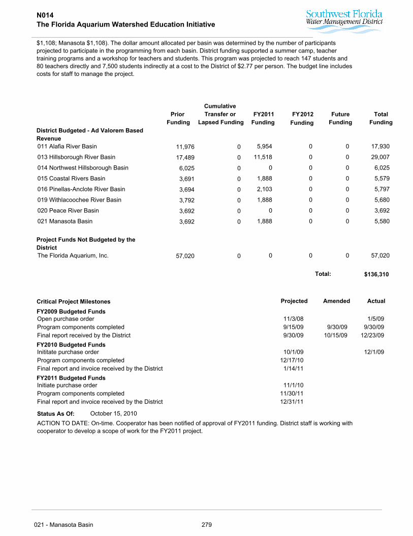
N014
The Florida Aquarium Watershed Education Initiative
$1,108; Manasota $1,108). The dollar amount allocated per basin was determined by the number of participants
projected to participate in the programming from each basin. District funding supported a summer camp, teacher
training programs and a workshop for teachers and students. This program was projected to reach 147 students and
80 teachers directly and 7,500 students indirectly at a cost to the District of $2.77 per person. The budget line includes
costs for staff to manage the project.
District Budgeted - Ad Valorem Based
Revenue
011 Alafia River Basin 17,930 0 0 11,976 0 5,954
013 Hillsborough River Basin 29,007 0 0 17,489 0 11,518
014 Northwest Hillsborough Basin 6,025 0 0 6,025 0 0
015 Coastal Rivers Basin 5,579 0 0 3,691 0 1,888
016 Pinellas-Anclote River Basin 5,797 0 0 3,694 0 2,103
019 Withlacoochee River Basin 5,680 0 0 3,792 0 1,888
020 Peace River Basin 3,692 0 0 3,692 0 0
021 Manasota Basin 5,580 0 0 3,692 0 1,888
Project Funds Not Budgeted by the
District
The Florida Aquarium, Inc. 57,020 0 0 57,020 0 0
$136,310 Total:
Prior
Funding
Cumulative
Transfer or
Lapsed Funding Funding Funding
2011 FY 2012 FY Future
Funding
Total
Funding
Critical Project Milestones ActualProjected Amended
FY2009 Budgeted FundsOpen purchase order 11/3/08 1/5/09
Program components completed 9/15/09 9/30/09 9/30/09
Final report received by the District 9/30/09 10/15/09 12/23/09
FY2010 Budgeted FundsInititate purchase order 10/1/09 12/1/09
Program components completed 12/17/10
Final report and invoice received by the District 1/14/11
FY2011 Budgeted FundsInitiate purchase order 11/1/10
Program components completed 11/30/11
Final report and invoice received by the District 12/31/11
Status As Of: October 15, 2010
ACTION TO DATE: On-time. Cooperator has been notified of approval of FY2011 funding. District staff is working with
cooperator to develop a scope of work for the FY2011 project.
021 - Manasota Basin 279
N082
City of North Port Myakkahatchee Creek Water Treatment Plant
RBF/RO Reliability ProjectProject Type Cooperative Funding
AORs Strategic InitiativesWater Supply Alternative Water Supply
Basin(s) Manasota
City of North Port - Public UtilitiesCooperator(s)
Project Manager FERGUSON, JOHN
ARMSTRONG, BRIAN, FERGUSON, JOHNTask Manager(s)
Status Ongoing
DescriptionThis is a reliability/supply project designed for treating brackish water using reverse osmosis (RO) and riverbank
filtration (RBF) to produce up to 1.5 mgd finished water. The water will be used for blending at the City's existing
surface water facility, the Myakkahatchee Creek Water Treatment Plant (MCWTP.) The project allows North Port to
operate their existing MCWTP year round and meet required total dissolved solids (TDS)standards. The City is
currently operating under a Department of Environmental Protection (DEP) variance for exceeding TDS that expires on
July 2012. The project provides additional supply for blending at the MCWTP, bringing the total finished potable water
supply capacity to 3.5 mgd.
BenefitsDevelopment of this project will allow the Myakkahatchee Creek facility to operate year round, meet TDS requirements
and develop additional alternative water supplies within the SWUCA.
Costs
The total project cost of the RBF/RO project is now estimated at $13,100,000. This cost includes pilot studies and
existing facility upgrades paid solely by the City of North Port. The District eligible costs are $12,100,000 for the RBF
and RO facilities, with the requested District share being $6,050,000. District funding is provided entirely by the
Manasota Basin Board, and will be used for the design and construction of the RBF system and the RO facility. The
City has accrued $9,000,000 in project funds from previous years in preparation for the project, and is able to match
the funding request.
District funding budgeted to date (FY2009 and FY2010) is $1,400,000 from the Manasota Basin Board. The City's
FY2011 funding request is for $2,500,000, however additional funding was not recommended by staff for the following
reasons:
Prior District funding reduces the project's unit production cost below wholesale water costs for the region.
The project is required to achieve compliance with the DEP's consent order.
The District has recently invested in other supply development projects in the region that are available to the City.
Additional Information
The objective of this project is to increase the reliability of the MCWTP and meet water quality regulations. The
MCWTP is located at the confluence of Myakkahatchee Creek and the Cocoplum canal and is permitted to withdraw
from both water bodies, but both sources exhibit considerable seasonal variability in flow and water quality. The
MCWTP currently operates under a DEP issued water quality variance for TDS (allowing up to 1,000 mg/l) which
expires on July 25, 2012, after which 500 mg/l will be the TDS limit. Annual average production at the MCWTP has
varied from 1.0 to 1.5 mgd in recent years. The City estimates that without the variance, annual average production
would be limited to approximately 0.5 mgd, and the MCWTP may be inoperable for weeks at a time. The City has
stated that continued operation of the MCWTP may not be economically viable without RO permeate for
blending, requiring them to consider decommissioning the facility and purchasing additional water from a regional
supplier and/or develop brackish groundwater wellfields.
In July 2008, the City completed a Water Treatment Plant Enhancement Study to evaluate treatment alternatives that
would increase the reliability and water quality of the MCWTP. The Study proposed the integration strategy of the
RBF-RO facility, including preliminary pilot test results evaluating reverse osmosis (RO) in combination with riverbank
filtration (RBF) pre-treatment for reducing TDS and sulfate. According to the study, 1.5 mgd (max day) from the RO
facility could be blended with water from the existing system to meet the regulatory limit of 500 mg/l TDS to provide a
total of 3.5 mgd. This would allow the MCWTP to operate on a consistent and year-round basis instead of being
limited to seasonal operation. The City of North Port completed the four-month pilot-scale test of the RBF-RO system
and published the pilot study in October 2008.
The Cooperative Funding Agreement between the District and the City for the RBF/RO project was executed on
March 17, 2009. On May 28, 2009, The City selected McKim & Creed as the consultant for permitting, design, and
construction management services. The consultant proposed using a series of horizontal wells parallel to the
021 - Manasota Basin 280
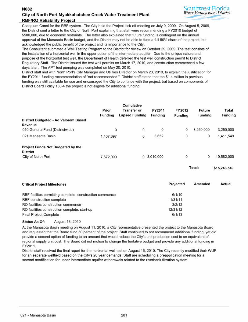
N082
City of North Port Myakkahatchee Creek Water Treatment Plant
RBF/RO Reliability ProjectCocoplum Canal for the RBF system. The City held the Project kick-off meeting on July 9, 2009. On August 5, 2009,
the District sent a letter to the City of North Port explaining that staff were recommending a FY2010 budget of
$500,000, due to economic restraints. The letter also explained that future funding is contingent on the annual
approval of the Manasota Basin budget, and the District may not be able to fund a full 50% share of the project, but
acknowledged the public benefit of the project and its importance to the City.
The Consultant submitted a Well Testing Program to the District for review on October 29, 2009. The test consists of
the installation of a horizontal well in the upper potion of the intermediate aquifer. Due to the unique nature and
purpose of the horizontal test well, the Department of Health deferred the test well construction permit to District
Regulatory Staff. The District issued the test well permits on March 17, 2010, and construction commenced a few
days later. The APT test pumping was completed on May 20, 2010.
District staff met with North Port's City Manager and Utilities Director on March 23, 2010, to explain the justification for
the FY2011 funding recommendation of "not recommended." District staff stated that the $1.4 million in previous
funding was still available for use and encouraged the City to continue with the project, but based on components of
District Board Policy 130-4 the project is not eligible for additional funding.
District Budgeted - Ad Valorem Based
Revenue
010 General Fund (Districtwide) 3,250,000 3,250,000 0 0 0 0
021 Manasota Basin 1,411,549 0 0 1,407,897 0 3,652
Project Funds Not Budgeted by the
District
City of North Port 10,582,000 0 0 7,572,000 0 3,010,000
$15,243,549 Total:
Prior
Funding
Cumulative
Transfer or
Lapsed Funding Funding Funding
2011 FY 2012 FY Future
Funding
Total
Funding
Critical Project Milestones ActualProjected Amended
RBF facilites permitting complete, construction commence 6/1/10
RBF construction complete 1/31/11
RO facilities construction commence 3/2/12
RO facilities construction complete, start-up 12/31/12
Final Project Complete 6/1/13
Status As Of: August 18, 2010
At the Manasota Basin meeting on August 11, 2010, a City representative presented the project to the Manasota Board
and requested that the Board fund 50 percent of the project. Staff continued to not recommend additional funding, yet did
provide a second option of funding to an amount that would reduce the City's unit production cost to an equivalent of
regional supply unit cost. The Board did not motion to change the tentative budget and provide any additional funding in
FY2011.
District staff received the final report for the horizontal well test on August 16, 2010. The City recently modified their WUP
for an separate wellfield based on the City's 20 year demands. Staff are scheduling a preapplication meeting for a
second modification for upper intermediate aquifer withdrawals related to the riverbank filtration system.
021 - Manasota Basin 281
N084
City of North Port Reuse Storage Tank and High Service Pump
StationProject Type Cooperative Funding
AORs Strategic InitiativesWater Supply Alternative Water SupplyWater Quality Water Quality Maintenance and Improvement
Basin(s) Manasota
City of North Port - Public Utilities, City of North PortCooperator(s)
Project Manager MCGOOKEY, SCOTT
Task Manager(s)
Status Ongoing
DescriptionThis project will construct a 2.5 million gallon ground storage tank and design and expand the high service pump
station by adding a 3.3 mgd pump. The benefits of this project will include improving system pressures, peak demand
storage capacity, expand the customer base of the reuse system, and will provide a higher level of service to the
customers. The Heron Creek Development (531,300 gallons per day [gpd]) has 2350 Equivalent Residential
Connections and a golf course. The reuse supply contract between the City and Heron Creek is for up to 500,000 gpd
of reclaimed water. The City currently provides an average of 200,000 gpd to Heron Creek with the existing system.
With the new tank and high service pump they will be able to provide the additional 300,000 gpd to Heron Creek and
provide reclaimed water to additional future customers.
BenefitsThe City plans to increase reuse flows to the Heron Creek Development by approximately 0.3 mgd to provide an offset
of 0.18 mgd of existing and future groundwater use by residential, commercial, and golf course customers. This project
will also provide the infrastructure that will enable the City to serve four additional customers with approximately 1.6
mgd of reclaimed water when additional lines are constructed. The project supports the City's Reuse Master Plan and
will allow the City to meet the demands of future growth in the City's service area.
Costs
The total project cost is $2,102,500 and the District's share is requested to be fifty percent or $1,051,250. The City
plans to spend $202,500 in FY2009 and the Manasota Basin Board has budgeted $101,250 which is fifty percent. The
Manasota Basin has been requested to provide $950,000 in additional funds in FY2010. The cost, amortized at 8
percent over 30 years is $3.38 per 1000 gallons offset. The future funds identified for the project are contingent upon
approval of such amounts by the District Governing and Basin Boards in the annual budget(s).
Additional Information
This project is to implement one of the recommendations of the City's Reuse Master Plan, supported and funded by
SWFWMD. The City of North Port's existing WWTP is permitted to provide 1.88 mgd of public access reclaimed water
to the customers of the system, which consist primarily of two major golf courses, the new City Complex, the North
Port Skate Park, roadway medians, and several bulk residential users. Growth in North Port has resulted in the need
for two additional WWTPs that will be constructed over the next 5-10 years, the West Villages District (WVID) WWTP
and the Panacea WWTP. Both of these two facilities will be designed to provide public access reclaimed quality water
to the customers in the region. In addition, the existing City's WWTP will be expanded to 7.0 mgd within the next 5
year period; therefore, the permitted capacity will be modified to reflect the new reclaimed water availability. This
project will allow the City to provide future reclaimed water service to the following new customers: *The Primary
School, Middle School and High School along Price Boulevard - 0.6 mgd *The Police Training Center on Price
Boulevard - 0.1 mgd *The Sembler Development and Butler Park - 0.7 mgd *Existing Residential and Commercial
Areas along Pan American Boulevard - 0.2 mgd Demands by these new customers will serve to increase reclaimed
water use by nearly 1.6 million gallons per day (mgd).
021 - Manasota Basin 282

N084
City of North Port Reuse Storage Tank and High Service Pump
Station
District Budgeted - Ad Valorem Based
Revenue
021 Manasota Basin 1,054,302 0 0 1,054,302 0 0
Project Funds Not Budgeted by the
District
City of North Port 1,051,250 0 0 1,051,250 0 0
$2,105,552 Total:
Prior
Funding
Cumulative
Transfer or
Lapsed Funding Funding Funding
2011 FY 2012 FY Future
Funding
Total
Funding
Critical Project Milestones ActualProjected Amended
Start Construction Storage Tank 7/1/08 7/1/08
Complete Construction Storage Tank 3/31/09 4/30/09
Start Pump Station Design 3/31/09 4/10/09
Complete Pump Station Design 7/15/09 8/19/09
Start Construction Pump Station 10/1/09 10/1/09
Complete Construction of Pump Station 12/31/09 5/31/10 5/31/10
Status As Of: October 27, 2010
The District received the project scope of work from the City on December 11, 2008. A draft of the agreement was sent
to the City for review on December 31, 2008. The City's comments have been incorporated into the draft agreement. The
agreement was executed February 19, 2009. The construction of the storage tank started July 1, 2008 and was
completed April 2009. The design of the pump station started April 10, 2009 and was completed August 19, 2009. The
City has the contractor, that is currently upgrading the WWTP, constructing the pump station to reduce costs by
eliminating mobilization and demobilization costs. The pump station was scheduled to start October 1, 2009 and be
complete by December 31, 2009, however, the pump was delayed and was delivered and installed in May 2010. The City
has requested the "Complete Construction of the Pump Station" date be changed to May 31, 2010. The project is now
complete. The City has submitted the final invoice to the District for processing. The District budgeted $101,250 in
FY2009 and $950,000 in FY2010 for a total funding commitment of $1,051,250. To date, $834,044 has been reimbursed
to the City by the District.
021 - Manasota Basin 283
N107
Braden River Soil Moisture Sensor Rebate Program
Project Type Cooperative Funding
AORs Strategic InitiativesWater Supply Conservation
Basin(s) Manasota
Braden River Utilities, Bradenton River UtilitiesCooperator(s)
Project Manager MUSICARO, MELISSA
Task Manager(s)
Status Ongoing
DescriptionThe project consists of providing rebates for the installation of up to 400 soil moisture sensor (SMS) devices to control
irrigation for existing and new residential and non-residential customers in the Lakewood Ranch Development. The
project objective is to reduce irrigation water use and conserve water resources. Braden River Utilities will monitor the
water use and savings for the participating homes, and compare it to that of non-participating homes as part of the
project evaluation to determine water savings. The project will include rebates of up to $495 for eligible customers for
the installation of SMS systems. The utility will administer the program and implement the following measures: work
with homeowners and businesses to install SMS systems, install master meters on 2 subdivisions irrigation mains to
track water use, and use of the Field Guide to Soil Moisture Sensor Use in Florida. BRU will work with the local
Manatee Extension Service office to conduct follow up inspections for the installed SMS devices. Manatee County
Extension will also monitor and document the condition of the landscapes.
BenefitsThe water savings benefit is to be determined.
Costs
The total project cost is $200,000, and the Manasota Basin Board approved funding in the amount $100,000 in
FY2009. The cost benefit is to be determined.
Additional Information
BRU proposed this project as a means to save water, as well as to evaluate this method of water conservation for
potential implementation in future development in Lakewood Ranch. District and BRU staff have refined project scope
details to ensure information about water use of project participants can be compared to water use of non-participants
to help both BRU and the District make decisions about promoting the use of soil moisture sensors. The number of
project participants may be reduced since the District is solely funding the water meter for monitoring the
non-participating homes.
District Budgeted - Ad Valorem Based
Revenue
021 Manasota Basin 105,650 0 0 102,866 0 2,784
Project Funds Not Budgeted by the
District
Braden River Utilities 100,000 0 0 100,000 0 0
$205,650 Total:
Prior
Funding
Cumulative
Transfer or
Lapsed Funding Funding Funding
2011 FY 2012 FY Future
Funding
Total
Funding
Critical Project Milestones ActualProjected Amended
Draft Agreement to Contracts Administration 8/3/09 8/11/09
Draft Agreement returned from Contracts Administration 9/30/09 9/23/09
Contract Executed 9/30/10 10/20/10
021 - Manasota Basin 284

N107
Braden River Soil Moisture Sensor Rebate Program
Notice to Proceed 9/30/10 10/27/10
Sensor Installation Commence 1/31/11
Data Collection Evaluation Complete 3/31/13
Contract Termination 12/31/13
Status As Of: October 29, 2010
The agreement was developed and the District project manager and cooperator finalized the scope of work in July 2009.
At that time, critical elements with the scope of work appeared to have been resolved. The draft scope includes customer
surveys at the completion of the project to gauge customer satisfaction with the devices and the overall project. District
staff asked Braden River Utilities (BRU) to request a letter from Manatee County Extension, with Manatee County
Extension accepting the responsibility of completing certain project tasks. The scope tasks Manatee County Extension
Service with the following: conduct follow-up inspections of landscapes, confirm proper installation of soil moisture
sensors, conduct educational workshop for participants. District staff received the letter mentioned above. The
agreement had not yet been executed due to BRU staff changeover and a more recent request in May 2010 to add an
additional brand of soil moisture sensor device that is not currently in the agreement. District staff had requested the
utility provide a letter explaining how this revision would enhance the project and to provide documented water savings
for this device in the residential sector. In August 2010, BRU decided not to request to add the additional sensor to this
current agreement, and agreed to sign the agreement. The agreement was executed on October 20, 2010.
021 - Manasota Basin 285
N115
Manatee County Indoor Water Conservation Project
Project Type Cooperative Funding
AORs Strategic InitiativesWater Supply Alternative Water Supply
Basin(s) Manasota
Manatee CountyCooperator(s)
Project Manager MCGOOKEY, SCOTT
Task Manager(s)
Status Ongoing
DescriptionThis project consists of offering rebates to single-family, multi-family, and commercial customers for replacing
conventional toilets (3.5 gallons per flush or greater) with water-conserving equivalents. This project will replace 900
conventional toilets with ultra-low volume (ULV) toilets, which use up to 1.6 gallons per flush (gpf) or High Efficiency
Toilets (HET's) that use up to 1.28 gpf. The project will provide up to $100 rebates for toilets with a maximum of two
toilets per unit. This proposed project is the third phase to the Manatee County Indoor Water Conservation Project
which was originally funded in FY2007.
BenefitsThis FY2009 project is estimated to save 20,079 gallons per day (gpd), or 7,328,835 gallons per year.
Costs
The total project cost is $126,144. The Manasota Basin Board has funded 50 percent, or $63,072, in FY2009.
Manatee County's share is $63,072. The cost amortized at 8 percent over 20 years, is $1.46 per thousand gallons.
The savings is calculated using a weighted average due to the varying life expectancies of the different water saving
equipment.
Additional Information
Manatee County currently services over 90,000 potable water accounts and anticipates continued growth over the
next 20 years. This program is an indoor conservation component to Manatee County's existing Water Conservation
Incentive Program for the County's retail water customers. The program also addresses the Manatee County Board of
County Commissioner's policies on water conservation and is supported by the Utilities recent development of a
conservation based tiered rate structure for potable water. One year of account-level metered water-use data prior to
and one year of metered water use after the retrofit installation will be collected as the raw data for the final savings
analysis. Manatee County Utilities will provide actual billing data and ensure 100 percent fixture inspection. This
project will also institute an educational program designed to assist customers in long-term maintenance related to
water savings, such as selecting parts for repairs, leak detection and choosing proper replacement flapper models for
their HET or ULV toilets. This effort will ensure the retrofit fixture will remain a water-conserving fixture for its
life-expectancy. Bi-monthly status reports will be provided to the District to update project accomplishments.
District Budgeted - Ad Valorem Based
Revenue
021 Manasota Basin 72,476 0 0 70,158 0 2,318
Project Funds Not Budgeted by the
District
Manatee County 63,072 0 0 63,072 0 0
$135,548 Total:
Prior
Funding
Cumulative
Transfer or
Lapsed Funding Funding Funding
2011 FY 2012 FY Future
Funding
Total
Funding
Critical Project Milestones ActualProjected Amended
021 - Manasota Basin 286

N115
Manatee County Indoor Water Conservation Project
Execute Agreement 5/1/09 5/1/09
Start Rebates 5/18/09 5/15/09
Final Distribution report 8/31/10 6/28/10
Final Report 9/30/11
Status As Of: October 27, 2010
The agreement was executed May 1, 2009 and the project started May 15, 2009. The County has issued a total of 1,094
toilet rebates by the end of November 2009. The County has met the agreeded amount of 900 toilet rebates. The County
has continued to process rebates at it's own expense and now has a total of 2096 as of April 2010. The County
reguested it's first reimbursement September 15, 2009. The second and final invoice was processed for payment by the
District on January 28, 2010. The final distribution report was completed June 28, 2010. The final report is scheduled to
be submitted July 2011. To date, the District has reimbursed $62,398.09 of the $63,072 budgeted for this project. There
is a balance of $673.91.
021 - Manasota Basin 287
N139
Low Impact Development Manual
Project Type Cooperative Funding
AORs Strategic InitiativesWater Quality Water Quality Maintenance and ImprovementNatural Systems Natural Systems Conservation and Restoration
Basin(s) Manasota
Sarasota CountyCooperator(s)
Project Manager ZAJAC, CHRIS
Task Manager(s)
Status Ongoing
DescriptionThis project will expand upon an existing Low Impact Development (LID) manual that was created in 2008 by Sarasota
County. The County requested cooperative funding in FY2010 to add three more sections to the manual. The new
sections will include vegetated filter strips, soil amendments and tree box planters. The Sarasota County
Comprehensive Plan states that the County shall provide design standards for LID measures to mitigate the effect of
impervious surfaces and stormwater pollutants on increased runoff volumes. LID design measures may include, but
are not limited to, bioretention areas, porous pavement, roof gardens, rainwater/stormwater recycling, etc. To initiate
the effort, Sarasota County contracted with the engineering firm of Jones Edmonds and Associates, Inc. (JEA) to
complete an assessment of possible LID techniques that may be effective in Sarasota County. In September 2007, the
assessment was completed and focused on three main categories (1) practices that promote infiltration, (2)
non-structural practices that help minimize or control runoff generation, and (3) practices that promote reuse. The
County has developed a design standards manual specific to the Sarasota County area. The manual was completed in
September 2008 and includes design specifications, construction requirements, potential pollutants to be removed,
and site limitations for four techniques; detention with biofiltration, pervious pavements, stormwater reuse, and
greenroofs. The County is currently expanding the manual by adding two new sections on bioretention for high water
table conditions and cisterns for rainwater harvesting.
BenefitsThe technologies promoted in the manual will reduce potable water use needed to support landscapes by using
cisterns, rain barrels and rain gardens. These technologies will also protect natural systems by reducing the load of
non-point source pollutants and reduce runoff entering receiving waterbodies while promoting recharge to the aquifer.
Costs
The total project cost is $130,000. In FY2010 the Manasota Basin Board will fund $65,000 while the cooperator will
match $65,000. The District funding amounts shown in the table include staff salary, travel and central garage
charges.
Additional Information
The District's Strategic Program Office Department has been involved in the development of the LID manual and has
provided training to District and County staff. The first training was held on December 19, 2008 and the second on
January 30, 2009. The District is currently developing a spreadsheet tool to assist with permitting the LID technologies
included in the manual.
District Budgeted - Ad Valorem Based
Revenue
021 Manasota Basin 71,950 0 0 68,852 0 3,098
Project Funds Not Budgeted by the
District
Sarasota County 65,000 0 0 65,000 0 0
$136,950 Total:
Prior
Funding
Cumulative
Transfer or
Lapsed Funding Funding Funding
2011 FY 2012 FY Future
Funding
Total
Funding
021 - Manasota Basin 288
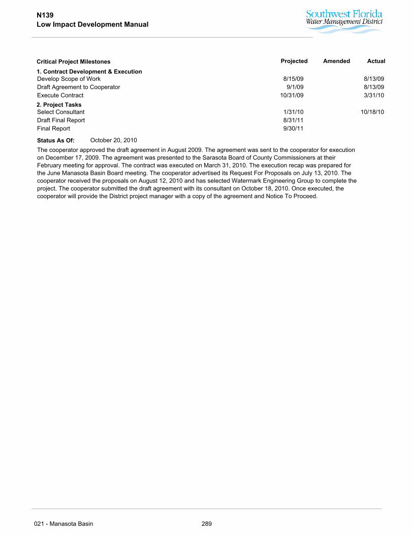
N139
Low Impact Development Manual
Critical Project Milestones ActualProjected Amended
1. Contract Development & ExecutionDevelop Scope of Work 8/15/09 8/13/09
Draft Agreement to Cooperator 9/1/09 8/13/09
Execute Contract 10/31/09 3/31/10
2. Project TasksSelect Consultant 1/31/10 10/18/10
Draft Final Report 8/31/11
Final Report 9/30/11
Status As Of: October 20, 2010
The cooperator approved the draft agreement in August 2009. The agreement was sent to the cooperator for execution
on December 17, 2009. The agreement was presented to the Sarasota Board of County Commissioners at their
February meeting for approval. The contract was executed on March 31, 2010. The execution recap was prepared for
the June Manasota Basin Board meeting. The cooperator advertised its Request For Proposals on July 13, 2010. The
cooperator received the proposals on August 12, 2010 and has selected Watermark Engineering Group to complete the
project. The cooperator submitted the draft agreement with its consultant on October 18, 2010. Once executed, the
cooperator will provide the District project manager with a copy of the agreement and Notice To Proceed.
021 - Manasota Basin 289
N151
Manatee County NAVD88 Vertical Control Densification
Project Type Cooperative Funding
AORs Strategic InitiativesWater Quality ConservationWater Supply Regional Water Supply PlanningNatural Systems Minimum Flows and Level Establishment and MonitoringFlood Protection Floodplain Management
Basin(s) Manasota
Manatee CountyCooperator(s)
Project Manager OWENS, JIM
Task Manager(s)
Status Ongoing
DescriptionThe establishment of an accurate and easily accessible vertical control survey network is an important component in
the development of updated Federal Emergency Management Agency Flood Insurance Rate Maps (FEMA FIRM). The
District, in cooperation with the National Geodetic Survey and the Florida Department of Environmental Protection, has
completed the Districtwide vertical control densification. This project further enhances the existing vertical control
network to support FEMA FIRM mapping, topographic data collection and modeling activities. The newly-established
vertical control network allows the District and local governments to transition from the older and less accurate vertical
control survey network known as the National Geodetic Vertical Datum of 1929 to the more accurate North American
Vertical Datum of 1988 (NAVD88) system. In Manatee County this includes running level loops and establishing bench
marks based on NAVD88 along state and county roadways. This project enables the surveying community to make an
orderly transition to NAVD88 and allows Manatee County to be on the same vertical datum as the District and to
comply with the federal surveying and mapping requirements. This project densifies the NAVD88 vertical control in
Manatee County and compliments the District's NAVD88 migration project.
BenefitsDensification of benchmarks supports the development of Watershed Management Plans for Polk County thus
contributing to flood protection, natural systems, water quality and water supply. Manatee County participates in the
National Flood Insurance Program administered by FEMA and requires that all finished floor elevations be above the
100 year floodplain. This project is a key component in meeting this requirement. Also, the establishment and
implementation of the NAVD 1988 enables more accurate elevations and mapping throughout the District, and the
conversion to the modern vertical datum allows the ability to establish accurate and reliable elevations using Global
Positioning System (GPS) technology. Manatee County is a participant in FEMA's Community Rating System and has
a Class 6 rating. A major emphasis of this project is to help Manatee County move from a Class 6 to a Class 5
Community System Rating with FEMA. Manatee County is also coordinating this project with the City of Bradenton and
the City of Palmetto.
Costs
The total cost for contractual services in the proposed FY2011 Cooperative Funding Initiative is $150,000 where the
costs are to be split evenly (50%/50%) between the District and the County. Cost to the Manasota Basin Board will be
$75,000. The County is lead for this project, and the District will reimburse the County for 50 percent of the contractual
services costs not to exceed $75,000. Additional costs are associated with staff time required to manage the project.
This is the second year of the project. Total cost for contractual services in the FY2010 Cooperative Funding
Agreement was $150,000 were the costs are being split (50%/50%) evenly between the District and the County. Cost
to the Manasota Basin Board is $75,000. The County is the lead for this project, and the District will reimburse the
County 50 percent of the project costs not exceeding $75,000. Additional costs are associated with staff time required
to manage the project.
Additional Information
This project is to be administered by the County. The vertical control network survey work is being completed by
qualified professional surveying and mapping consultants. All newly-established vertical control network data produced
by this project will be made available through Internet access via LABINS web site and the Manatee County web site.
The original CFI project N264 was merged with N151 being that this is the second year of mapping.
021 - Manasota Basin 290
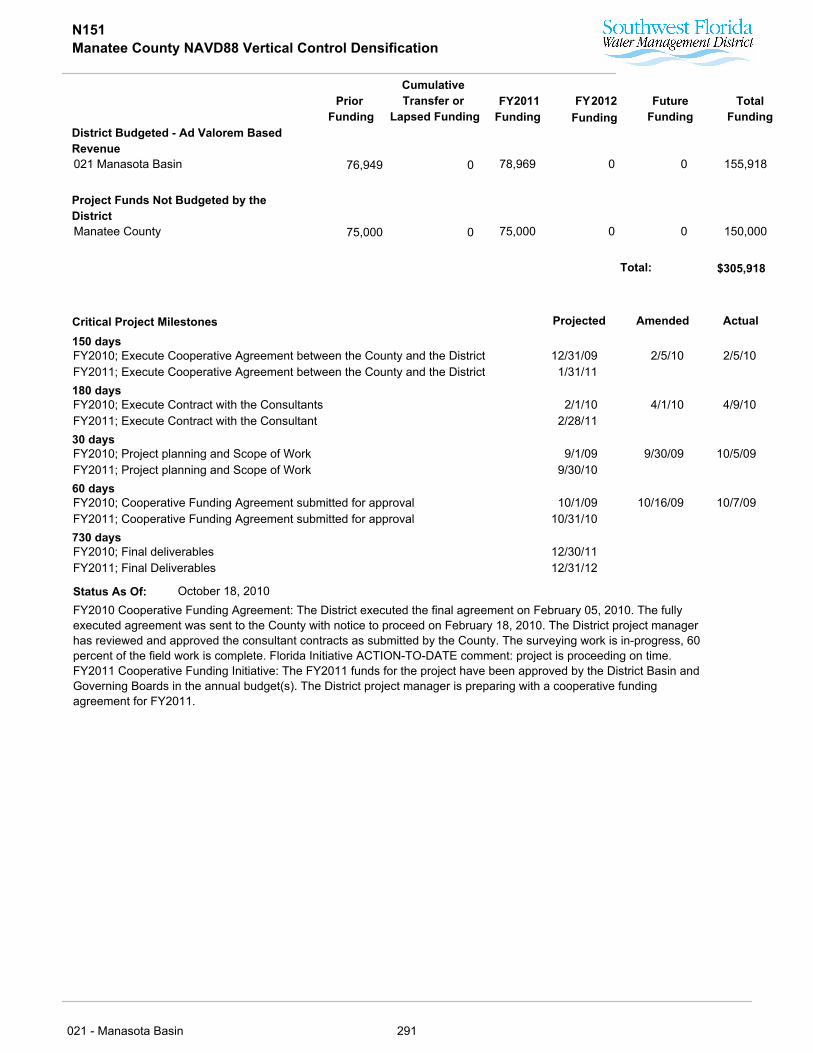
N151
Manatee County NAVD88 Vertical Control Densification
District Budgeted - Ad Valorem Based
Revenue
021 Manasota Basin 155,918 0 0 76,949 0 78,969
Project Funds Not Budgeted by the
District
Manatee County 150,000 0 0 75,000 0 75,000
$305,918 Total:
Prior
Funding
Cumulative
Transfer or
Lapsed Funding Funding Funding
2011 FY 2012 FY Future
Funding
Total
Funding
Critical Project Milestones ActualProjected Amended
150 daysFY2010; Execute Cooperative Agreement between the County and the District 12/31/09 2/5/10 2/5/10
FY2011; Execute Cooperative Agreement between the County and the District 1/31/11
180 daysFY2010; Execute Contract with the Consultants 2/1/10 4/1/10 4/9/10
FY2011; Execute Contract with the Consultant 2/28/11
30 daysFY2010; Project planning and Scope of Work 9/1/09 9/30/09 10/5/09
FY2011; Project planning and Scope of Work 9/30/10
60 daysFY2010; Cooperative Funding Agreement submitted for approval 10/1/09 10/16/09 10/7/09
FY2011; Cooperative Funding Agreement submitted for approval 10/31/10
730 daysFY2010; Final deliverables 12/30/11
FY2011; Final Deliverables 12/31/12
Status As Of: October 18, 2010
FY2010 Cooperative Funding Agreement: The District executed the final agreement on February 05, 2010. The fully
executed agreement was sent to the County with notice to proceed on February 18, 2010. The District project manager
has reviewed and approved the consultant contracts as submitted by the County. The surveying work is in-progress, 60
percent of the field work is complete. Florida Initiative ACTION-TO-DATE comment: project is proceeding on time.
FY2011 Cooperative Funding Initiative: The FY2011 funds for the project have been approved by the District Basin and
Governing Boards in the annual budget(s). The District project manager is preparing with a cooperative funding
agreement for FY2011.
021 - Manasota Basin 291
N181
Science Curriculum Enhancement Program
Project Type Cooperative Funding
AORs Strategic InitiativesWater Quality Water Quality MonitoringWater Supply ConservationNatural Systems Natural Systems Identification and Monitoring
Basin(s) Manasota
Science and Environment Council of SarasotaCooperator(s)
Project Manager TORRUSIO, MARY
Task Manager(s)
Status Ongoing
DescriptionThis Cooperative Funding Initiative (CFI) project's goal is to enhance student awareness about local water and
watershed conservation based on science. The components of the project are a teacher workshop to provide tools for
teachers to integrate water-related lessons into their curriculum, in-class instruction and a series of three or six field
trips to SEC member sites. The program is offered to Sarasota County science students in grades 6-12 and geared for
the on-level student. Student participants engage in inquiry-based activities, lessons and interaction with science
professionals and technicians. In-class instruction takes place several days before each field trip and serves as an
orientation to the field trip site, introduction to the lesson and discussion of careers in the field. The goal is that
students, through participating in the program, will understand the importance of preserving and managing our
watershed. While not all will choose science or water-related careers, they will have a better understanding of the role
scientists and water managers play. Evaluation includes student pre- and post-testing, and teacher evaluation forms.
Because the FY2010 project has not met expectations, at its June 16 meeting, the Manasota Basin Board approved
the cooperator's requested changes to the FY2010 project and extended the funding through the 2010-2011 school
year to attract more classroom participation. Since the FY2011 proposed project is based on a model that has not met
expectations, and because the FY2010 funding is being extended into FY2011, staff did not recommend funding the
FY2011 proposal.
BenefitsThe project's goal is to provide comprehensive science education opportunities to Sarasota County students in
grades 6 through 12. The basin has prioritized partnering with science-based organizations and the SEC is a group of
non-profit and government organizations that operate or support conservation and science-based facilities. SEC's
mission is to promote science, conservation and environmental issues in Sarasota County for maintaining and
improving quality of life through education, public outreach, demonstration, information gathering and analysis, and
special projects. By collaborating on projects, the SEC can offer services and provide educational materials that no
one organization can do alone. Through collaboration, the collective knowledge and expertise of all the organizations
allows SEC to strengthen science curriculum. Through this initiative, the focus of curriculum enhancement will be
water-related. The program is based on results of a two-year research study at Booker High School.
Costs
The total FY2010 project cost is $66,800, with the District contributing $33,400 (Manasota). District funding is used to
fund field trips, transportation, teacher workshop stipends, promotion materials, program evaluation and
administration. It is offered to Sarasota County science students in grades 6-12 and geared for the on-level
student.The program is projected to reach 390 students and 14 teachers at a cost to the District of $82.67 per
participant.
Additional Information
The SEC partners/contributors include Aquarian Quest, Charlotte Harbor Environmental Center, Crowley Museum and
Nature Center, Florida West Coast Resource Conservation and Development Council, Friends of Myakka River,
Friends of Oscar Scherer State Park, G.WIZ, Historic Spanish Point, Lemur Conservation Foundation, Marie Selby
Botanical Gardens, Mote Marine Laboratory, New College, Ringling College of Art and Design, Sarasota Bay Estuary
Program, Sarasota Audubon, Sarasota Conservation Foundation, Sarasota County Extension and Florida House
Learning Center and Sarasota County Government.
021 - Manasota Basin 292

N181
Science Curriculum Enhancement Program
District Budgeted - Ad Valorem Based
Revenue
021 Manasota Basin 33,400 0 0 33,400 0 0
Project Funds Not Budgeted by the
District
Science & Environmental Council of
Sarasota (SEC)
66,800 0 0 33,400 0 33,400
$100,200 Total:
Prior
Funding
Cumulative
Transfer or
Lapsed Funding Funding Funding
2011 FY 2012 FY Future
Funding
Total
Funding
Critical Project Milestones ActualProjected Amended
FY2010 Budgeted FundsInitiate purchase order 10/1/09 12/4/09
Complete lesson plans, activities for pre-visits and field trips 1/29/10 9/30/10
Promote field trip packages to teachers 2/26/10 2/26/10
Schedule field trips 2/26/10 9/30/10
Teacher workshop 3/15/10 9/30/10
Conduct pre-visits and field trips 5/28/10 5/28/10
Student and teacher assessments 5/28/10 5/28/10
Evaluate and refine program 8/16/10 8/16/10
Conduct pre-visits and field trips 10/29/10 9/15/10
Final report and invoice due to District 11/20/10 9/30/11
Status As Of: October 20, 2010
ACTION TO DATE: On time. In the 2010-2011 school year, one teacher and his class of 43 students from Sarasota High
School have attended a field trip to Marie Selby Botanical Gardens. The class has completed all students assessments
and the teacher has completed the teacher assessment. Two teachers from Suncoast Polytechnical High School and
one teacher from Woodland Middle School are working to schedule field trips as well.
021 - Manasota Basin 293
N188
City of Bradenton NAVD88 Vertical Control Densification
Project Type Cooperative Funding
AORs Strategic InitiativesWater Quality Water Quality Maintenance and ImprovementWater Supply Regional Water Supply PlanningNatural Systems Minimum Flows and Level Establishment and MonitoringFlood Protection Floodplain Management
Basin(s) Manasota
City of BradentonCooperator(s)
Project Manager OWENS, JIM
Task Manager(s)
Status Ongoing
DescriptionThe establishment of an accurate and easily accessible vertical control survey network is an important component in
the development of updated Federal Emergency Management Agency Flood Insurance Rate Maps (FEMA FIRM). The
District, in cooperation with the National Geodetic Survey and the Florida Department of Environmental Protection, has
completed the Distict-wide vertical control densification. This project further enhances the existing vertical control
network to support FEMA FIRM mapping, topographic data collection and modeling activities. The newly-established
vertical control network allows the District and local governments to transition from the older and less accurate vertical
control survey network known as the National Geodetic Vertical Datum of 1929 to the more accurate North American
Vertical Datum of 1988 (NAVD88) system. In the City of Bradenton this includes running level loops and establishing
bench marks based on NAVD88 along city roadways. This project enables the surveying community to make an
orderly transition to NAVD88 and will allow the City of Bradenton to be on the same vertical datum as the District and
to comply with the federal surveying and mapping requirements. This project densifies the NAVD88 vertical control in
the City of Bradenton and compliments the District's NAVD88 migration project. The City of Bradenton will coordinate
all vertical control surveying with Manatee County (N151).
BenefitsDensification of benchmarks supports the development of Watershed Management Plans for Polk County thus
contributing to flood protection, natural systems, water quality and water supply. The City of Bradenton participates in
the National Flood Insurance Program administered by FEMA and requires that all finished floor elevations be above
the 100 year floodplain. This project is a key component in meeting this requirement. Also, the establishment and
implementation of the NAVD 1988 enables more accurate elevations and mapping throughout the District, and the
conversion to the modern vertical datum allows the ability to establish accurate and reliable elevations using Global
Positioning System (GPS) technology.
Costs
Total cost for contractual services in FY2010 Cooperative Funding Agreement is $136,600 where the costs are being
split (50%/50%) evenly between the District and the City of Bradenton. Cost to the Manasota Basin Board is $68,300.
The City is the lead for this project, and the District will reimburse the County 50 percent of the contractual services
costs not exceeding $68,300. Additional costs are associated with staff time required to manage the project.
Additional Information
This project will be administered by the City of Bradenton. The vertical control network survey work will be completed
by qualified professional surveying and mapping consultants. All newly-established vertical control network data
produced by this project will be made available through Internet access via LABINS web site and the Manatee County
web site.
021 - Manasota Basin 294

N188
City of Bradenton NAVD88 Vertical Control Densification
District Budgeted - Ad Valorem Based
Revenue
021 Manasota Basin 70,249 0 0 70,249 0 0
Project Funds Not Budgeted by the
District
City of Bradenton 68,300 0 0 68,300 0 0
$138,549 Total:
Prior
Funding
Cumulative
Transfer or
Lapsed Funding Funding Funding
2011 FY 2012 FY Future
Funding
Total
Funding
Critical Project Milestones ActualProjected Amended
150 daysExecute Cooperative Agreement between the County and the District 12/31/09 2/26/10 3/12/10
180 daysExecute Contract with the Consultants 2/1/10 3/26/10 5/14/10
30 daysInitial Project Planning and Develop the Scope of Work 9/1/09 11/9/09
60 daysSubmit cooperative agreement for approval 10/1/09 10/16/09 11/13/09
730 daysFinal deliverables 12/30/11
Status As Of: September 29, 2010
The City of Bradenton approved and signed the FY2010 Cooperative Funding Agreement on February 24, 2010. The
District executed the agreement on March 12, 2010. The District project manager met with the City of Bradenton staff for
a kick-off meeting on March 31, 2010. The District project manager has reviewed and approved the consultant contracts
as submitted by the County. The surveying work is in-progress, 30 percent of the field work is complete. Florida Initiative
ACTION-TO-DATE comment: project is proceeding on time.
021 - Manasota Basin 295
N206
G.WIZ Water Wonders Workshop
Project Type Cooperative Funding
AORs Strategic InitiativesWater Quality ConservationNatural Systems Natural Systems Identification and Monitoring
Basin(s) Manasota
G.WIZ-The Science MuseumCooperator(s)
Project Manager TORRUSIO, MARY
Task Manager(s)
Status Ongoing
DescriptionThis Cooperative Funding Initiative (CFI) project will educate students and adults in Sarasota County about
conservation and protection of local environmental resources. The project targets 138 adults and 1,380 students in
grades 5-7 in Sarasota County. The program's purpose is to excite students about science in an informal educational
setting that encourages curiosity and understanding through hands-on activities about water quality, water
conservation and protection of water resources. Overall, the program proposes to increase student awareness and
knowledge of water resources with the ultimate goal that they become engaged stewards of our natural resources. The
project's success is measured by pre/post student assessments as well as teacher evaluations.
BenefitsThis project will provide students with hands-on experiences with water resources. The District will benefit from
Sarasota County students having a better understanding of conservation and preservation of water resources and be
better prepared for future decision-making.
Costs
The total cost of the FY2011 project is $68,404, with the District contribution reduced from $38,839 to $18,300
(Manasota). District funding is for 30 field trips, including bus transportation and student scholarships for admission
costs into the museum. The program will reach 1,380 students and 138 adults at a cost to the District of $12.06 per
person.
Additional Information
The total cost of the FY2010 project was $71,124, with the District's Manasota Basin Board contributing $38,839.
District funding was used to fund 32 field trips, transportation and workshop supplies. The program reached 1,600
students and 168 adults. The project educates students and adults in Sarasota County about conservation and
protection of local environmental resources. FY2010 is the first year the District has supported this project through the
Cooperative Funding Initiative.
District Budgeted - Ad Valorem Based
Revenue
021 Manasota Basin 57,916 0 0 39,616 0 18,300
Project Funds Not Budgeted by the
District
G.WIZ 32,285 0 0 32,285 0 0
WCIND 53,645 0 0 0 0 53,645
$143,846 Total:
Prior
Funding
Cumulative
Transfer or
Lapsed Funding Funding Funding
2011 FY 2012 FY Future
Funding
Total
Funding
Critical Project Milestones ActualProjected Amended
FY2010 Budgeted FundsInitiate purchase order 10/1/09 10/12/09
021 - Manasota Basin 296
N206
G.WIZ Water Wonders Workshop
Educational workshops begin 11/2/09 11/20/09
Educational workshops end 7/30/10 5/18/10
Final report and invoice due to the District 8/31/10 8/19/10
FY2011 Budgeted FundsInitiate purchase order 10/1/10
Educational workshops begin 10/4/10
Educational workshops end 7/29/11
Final report and invoice due to the District 8/31/11
Status As Of: October 20, 2010
ACTION TO DATE: On time. Staff is working to finalize the FY2011 Scope of Work and open a new purchase order.
021 - Manasota Basin 297
N218
Englewood Reclaimed Water Supply Project
Project Type Cooperative Funding
AORs Strategic InitiativesWater Quality ConservationWater Supply Alternative Water Supply
Basin(s) Peace River, Manasota
Englewood Water DistrictCooperator(s)
Project Manager MCGOOKEY, SCOTT
Task Manager(s)
Status Ongoing
DescriptionThis project consists of the design and construction of a supplemental reclaimed water supply well and the
modification of the intake structure at the onsite reuse pond at the Englewood WRF to provide additional dry weather
irrigation supplies. Reclaimed water is produced at the Englewood WRF, which serves portions of Charlotte and
Sarasota counties. Current reclaimed water storage includes a 1 MG above ground storage tank, wet weather storage
ponds (onsite and offsite), and a fully permitted ASR system. The ASR well provides 0.5 mgd of reclaimed water
during peak demand periods and has become a critical component of the reuse system. Without previous SWFWMD
funding assistance for the ASR program, EWD reuse would not be as efficient and connection of many current
customers would not have been possible. Installing an additional supply well into the ASR storage zone will increase
the rate at which stored water can be recovered during peak demand. A well approximately 600 feet in depth is
required, along with a pump and appurtenances to produce an additional 0.5 mgd, or about 15 mg of water during
each peak month used. Re-engineering the onsite wet weather pond will more effectively utilize available storage and
freshwater in the surficial aquifer at the WRF. Lowering the pump intake from the existing pond will provide additional
water for irrigation. Reuse demands during dry weather periods often exceed the available supply. This project will
provide additional reuse supply to existing customers during peak demand periods. These customers include Lemon
Bay Golf, Oyster Creek Golf, and Rotunda West Utilities in Charlotte County and Myakka Pines Golf, Englewood
Sports Park, Boca Royale Golf, and Gran Paradiso Subdivision in Sarasota County.
BenefitsThe project will provide approximately 82,192 gpd of additional reuse supply that will be used evenly between the
identified customers in Charlotte and Sarasota Counties. This project will offset approximately 61,644 gpd. The
cost/benefit ratio for the total estimated project cost of $260,000 averaging 61,644 gpd using an 8% annual interest
rate amortized over 30 years is $1.02/1000 gallons.
Costs
The total cost of the project is estimated at $260,000. Since the benefits are evenly split between customers in the
Peace and Manasota Basins, EWD is requesting $65,000 from each Basin Board for a total of $130,000 (50%) in
FY2010 funding. Design costs are estimated at $60,000 and construction at $200,000.
Additional Information
Without previous SWFWMD funding assistance for the ASR program, EWD reuse would not be as efficient and
connection of many current customers would not have been possible. This project will further increase this efficiency
and help EWD meet existing contracted amounts. EWD won the 2008 FWEA David York Award for small facilities (<
5 mgd), another example of the benefits that the previous funding assistance has had. Reuse demands during dry
weather periods often exceed the available supply. Additional reuse customers have been identified but the ability to
serve these users during peak demand periods will be problematic without additional supplemental sources. With the
lack of available fresh groundwater or surface water EWD is faced with developing alternative supplemental sources.
Supplemental sources currently identified include the following: Installing an additional supply well into the ASR
storage zone to increase the rate at which stored water can be recovered. A well approximately 600 feet in depth is
required, along with a pump and appurtenances to produce an additional 0.5 mgd, or about 15 mg of water during
each peak month used. Re-engineering the onsite wet weather pond to more effectively utilize available storage and
freshwater in the surficial aquifer at the WRF. Lowering the pump intake from the existing pond will provide additional
water for golf course irrigation to Lemon Bay Golf Course, and may allow EWD to add other golf course storage ponds
to be supplied from this pond. EWD advertises and helps enforce the District's watering restrictions, aids in
xeriscaping education, and have imposed a steep graduated rate structure to discourage high water usage. The EWD
has a policy requiring any new significant development desiring utilities to include a reclaimed water irrigation system
in its infrastructure. EWD's reuse customers are conservation minded and only use the water deemed necessary to
adequately maintain the irrigated area.
021 - Manasota Basin 298
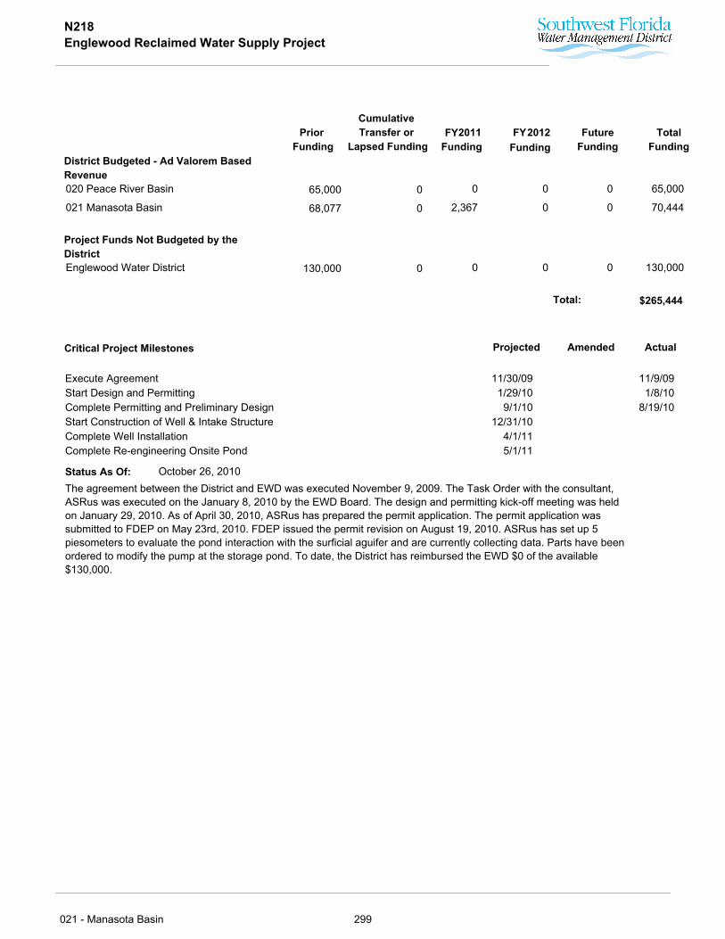
N218
Englewood Reclaimed Water Supply Project
District Budgeted - Ad Valorem Based
Revenue
020 Peace River Basin 65,000 0 0 65,000 0 0
021 Manasota Basin 70,444 0 0 68,077 0 2,367
Project Funds Not Budgeted by the
District
Englewood Water District 130,000 0 0 130,000 0 0
$265,444 Total:
Prior
Funding
Cumulative
Transfer or
Lapsed Funding Funding Funding
2011 FY 2012 FY Future
Funding
Total
Funding
Critical Project Milestones ActualProjected Amended
Execute Agreement 11/30/09 11/9/09
Start Design and Permitting 1/29/10 1/8/10
Complete Permitting and Preliminary Design 9/1/10 8/19/10
Start Construction of Well & Intake Structure 12/31/10
Complete Well Installation 4/1/11
Complete Re-engineering Onsite Pond 5/1/11
Status As Of: October 26, 2010
The agreement between the District and EWD was executed November 9, 2009. The Task Order with the consultant,
ASRus was executed on the January 8, 2010 by the EWD Board. The design and permitting kick-off meeting was held
on January 29, 2010. As of April 30, 2010, ASRus has prepared the permit application. The permit application was
submitted to FDEP on May 23rd, 2010. FDEP issued the permit revision on August 19, 2010. ASRus has set up 5
piesometers to evaluate the pond interaction with the surficial aguifer and are currently collecting data. Parts have been
ordered to modify the pump at the storage pond. To date, the District has reimbursed the EWD $0 of the available
$130,000.
021 - Manasota Basin 299
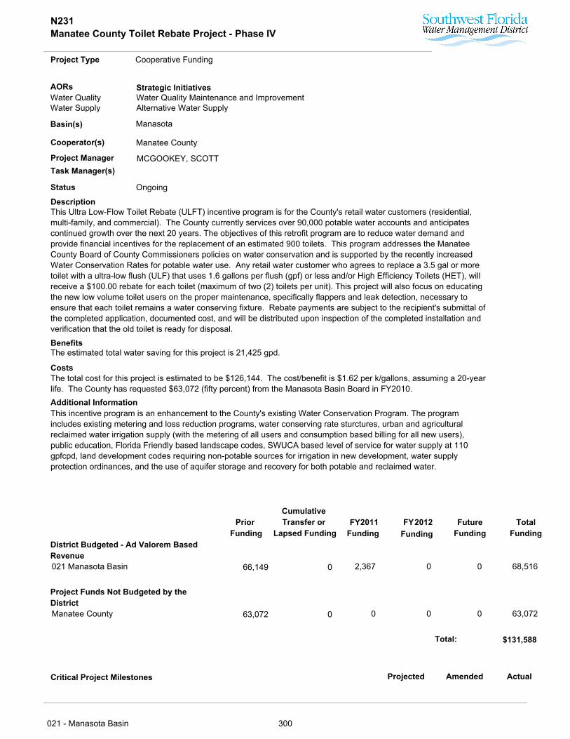
N231
Manatee County Toilet Rebate Project - Phase IV
Project Type Cooperative Funding
AORs Strategic InitiativesWater Quality Water Quality Maintenance and ImprovementWater Supply Alternative Water Supply
Basin(s) Manasota
Manatee CountyCooperator(s)
Project Manager MCGOOKEY, SCOTT
Task Manager(s)
Status Ongoing
DescriptionThis Ultra Low-Flow Toilet Rebate (ULFT) incentive program is for the County's retail water customers (residential,
multi-family, and commercial). The County currently services over 90,000 potable water accounts and anticipates
continued growth over the next 20 years. The objectives of this retrofit program are to reduce water demand and
provide financial incentives for the replacement of an estimated 900 toilets. This program addresses the Manatee
County Board of County Commissioners policies on water conservation and is supported by the recently increased
Water Conservation Rates for potable water use. Any retail water customer who agrees to replace a 3.5 gal or more
toilet with a ultra-low flush (ULF) that uses 1.6 gallons per flush (gpf) or less and/or High Efficiency Toilets (HET), will
receive a $100.00 rebate for each toilet (maximum of two (2) toilets per unit). This project will also focus on educating
the new low volume toilet users on the proper maintenance, specifically flappers and leak detection, necessary to
ensure that each toilet remains a water conserving fixture. Rebate payments are subject to the recipient's submittal of
the completed application, documented cost, and will be distributed upon inspection of the completed installation and
verification that the old toilet is ready for disposal.
BenefitsThe estimated total water saving for this project is 21,425 gpd.
Costs
The total cost for this project is estimated to be $126,144. The cost/benefit is $1.62 per k/gallons, assuming a 20-year
life. The County has requested $63,072 (fifty percent) from the Manasota Basin Board in FY2010.
Additional Information
This incentive program is an enhancement to the County's existing Water Conservation Program. The program
includes existing metering and loss reduction programs, water conserving rate sturctures, urban and agricultural
reclaimed water irrigation supply (with the metering of all users and consumption based billing for all new users),
public education, Florida Friendly based landscape codes, SWUCA based level of service for water supply at 110
gpfcpd, land development codes requiring non-potable sources for irrigation in new development, water supply
protection ordinances, and the use of aquifer storage and recovery for both potable and reclaimed water.
District Budgeted - Ad Valorem Based
Revenue
021 Manasota Basin 68,516 0 0 66,149 0 2,367
Project Funds Not Budgeted by the
District
Manatee County 63,072 0 0 63,072 0 0
$131,588 Total:
Prior
Funding
Cumulative
Transfer or
Lapsed Funding Funding Funding
2011 FY 2012 FY Future
Funding
Total
Funding
Critical Project Milestones ActualProjected Amended
021 - Manasota Basin 300
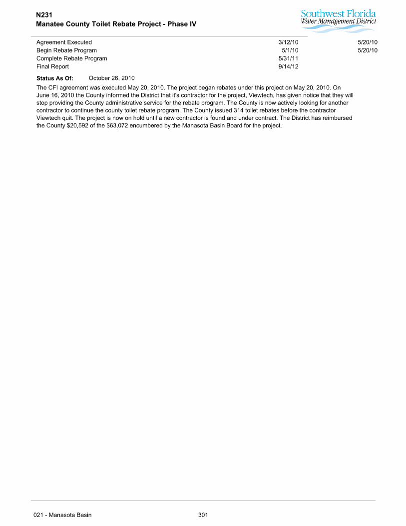
N231
Manatee County Toilet Rebate Project - Phase IV
Agreement Executed 3/12/10 5/20/10
Begin Rebate Program 5/1/10 5/20/10
Complete Rebate Program 5/31/11
Final Report 9/14/12
Status As Of: October 26, 2010
The CFI agreement was executed May 20, 2010. The project began rebates under this project on May 20, 2010. On
June 16, 2010 the County informed the District that it's contractor for the project, Viewtech, has given notice that they will
stop providing the County administrative service for the rebate program. The County is now actively looking for another
contractor to continue the county toilet rebate program. The County issued 314 toilet rebates before the contractor
Viewtech quit. The project is now on hold until a new contractor is found and under contract. The District has reimbursed
the County $20,592 of the $63,072 encumbered by the Manasota Basin Board for the project.
021 - Manasota Basin 301

N255
Beach Water Quality Project
Project Type Cooperative Funding
AORs Strategic InitiativesFlood Protection Floodplain ManagementWater Quality Water Quality MonitoringWater Quality Water Quality Maintenance and Improvement
Basin(s) Manasota
City of VeniceCooperator(s)
Project Manager SMITH, RANDY
Task Manager(s)
Status Ongoing
DescriptionThis FY2011 cooperative funding project is to investigate the cause of high levels of Enterococci and Fecal Coliform
entering Venice Beach and to design one or more Best Management Practices (BMPs). The City of Venice has
eleven stormwater outfalls that collect from the Venice Island Basin and discharge directly to the Gulf of Mexico. After
a 2008 spring rain event, Venice Beach experienced high readings of Enterococci and Fecal Coliform resulting in
public beach closures. This project includes source sampling, research, determining the source of contamination, and
the design of one or more BMPs to resolve the issue. Possible solutions to the problem include modification of outfall
to allow for more attenuation before it discharges to the Gulf of Mexico, public education on non-point source pollution,
stormwater retention modification, deep gulf pumped discharge and storm pipe lining and/or replacement.
BenefitsThis project will improve water quality that discharges into the Gulf of Mexico by locating the source of bacterial
contamination and designing one or more BMPs to be implemented in second phase of the project.
Costs
The total projected cost for the project is $120,000, of which the District's share is $60,000 with an equal match from
the City. The District funding amounts shown in the table include staff salaries, travel and central garage charges.
Additional Information
The City has taken steps to isolate contaminant sources. The first series of water quality testing shows elevated
Enterococci and Fecal Coliform levels in Flamingo Ditch and Deertown Gulley. Both have levels exceeding acceptable
limits with the highest levels found in Flamingo Ditch. Additional water samples were taken at various points along
Flamingo Ditch to try and isolate a source. The utilities department and stormwater division performed pipe inspection
in the area around the ditch to isolate any infiltration. The City is proceeding to perform DNA microbial analysis, with
one upstream and one downstream sample from Flamingo Ditch and one downstream sample from Deertown Gulley.
District Budgeted - Ad Valorem Based
Revenue
021 Manasota Basin 62,296 0 0 0 0 62,296
Project Funds Not Budgeted by the
District
City of Venice 60,000 0 0 0 0 60,000
$122,296 Total:
Prior
Funding
Cumulative
Transfer or
Lapsed Funding Funding Funding
2011 FY 2012 FY Future
Funding
Total
Funding
Critical Project Milestones ActualProjected Amended
1. Contract Development & ExecutionNegotiate Cooperative Funding Agreement with City 8/1/10 8/1/10
Draft Agreement to Management Services 9/1/10 11/1/10
021 - Manasota Basin 302
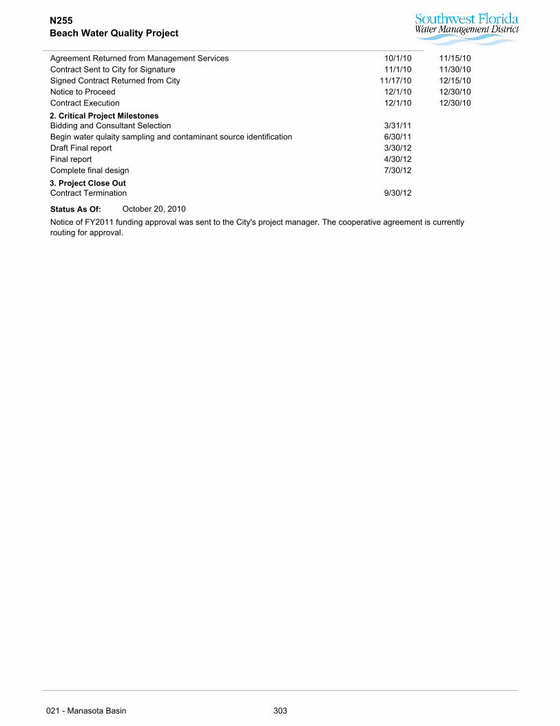
N255
Beach Water Quality Project
Agreement Returned from Management Services 10/1/10 11/15/10
Contract Sent to City for Signature 11/1/10 11/30/10
Signed Contract Returned from City 11/17/10 12/15/10
Notice to Proceed 12/1/10 12/30/10
Contract Execution 12/1/10 12/30/10
2. Critical Project MilestonesBidding and Consultant Selection 3/31/11
Begin water qulaity sampling and contaminant source identification 6/30/11
Draft Final report 3/30/12
Final report 4/30/12
Complete final design 7/30/12
3. Project Close OutContract Termination 9/30/12
Status As Of: October 20, 2010
Notice of FY2011 funding approval was sent to the City's project manager. The cooperative agreement is currently
routing for approval.
021 - Manasota Basin 303

N263
Manatee County - Watershed Evaluation
Project Type Cooperative Funding
AORs Strategic InitiativesFlood Protection Floodplain ManagementWater Quality Water Quality Maintenance and Improvement
Basin(s) Manasota
Lynn Townsend & Associates, LLC., Manatee CountyCooperator(s)
Project Manager NGUYEN, NAM
Task Manager(s)
Status Ongoing
DescriptionThis is a multi-year funded project to perform the 1) Topographic information, 2) Watershed Evaluation, 3) Watershed
Management Plan elements of the District's Watershed Management Program (WMP). Topographic information
includes the acquisition of data and development of the terrain features in the Geodatabase to be used in the
Watershed Evaluation. The Watershed Evaluation includes collection of existing data, GIS processing of the terrain
features to establish catchments and connectivity, field reconnaissance, refinement of the terrain features and
development of the hydraulic element point features. The Watershed Management Plan element includes:
development of watershed parameters for a specific use, GIS processing, computer modeling, floodplain and water
quality analysis, peer review, public notification/meeting, surface water resource assessment, establishment of LOS,
and BMP alternative analysis. FY2011 funding is to perform the Watershed Evaluation element starting with the
development of the hydraulic element point features.
BenefitsThe WMP provides a method to evaluate the capacity of a watershed to protect, enhance, and restore water quality
and natural systems, while achieving flood protection. The information developed provides the science for the District's
Resource Management and Environmental Resource Permitting (ERP). It assists local governments: 1) With their land
management responsibilities by establishing a level of service and developing Best Management Practices (BMPs) to
address level of service deficiencies. 2) Provides a Geodatabase and projected results from watershed model
simulations for floodplain and water quality management.
Costs
The projected cost for this project is $770,000, of which the District's share is $385,000. The District's share is from
the Manasota Basin. Manatee County will contribute $370,000. The Island communities (City of Anna Maria, City of
Bradenton Beach and City of Holmes Beach) will contribute $15,000. The FY2011 funding is $400,000 with the
Manasota Basin funding $200,000 and revenue of $185,000 from Manatee County and $15,000 from the Island
communities. This is the first year of funding for the project. The District funding amounts shown in the table include
staff salaries. Future funds identified for the project are contingent upon approval of such amounts by the Basin Board
in the annual budget. When each element is completed the projected cost may require refinement based on
information gathered and unforeseen circumstances.
Additional Information
The Watershed Management Program (WMP) includes five major elements: 1) Topographic information, 2)
Watershed Evaluation, 3) Watershed Management Plan, 4) Implementation of Best Management Practices, and 5)
Maintenance of Watershed Parameters and Models. Implementing elements of the WMP with local governments is
one of the District's Strategic Priorities. The District is a cooperating technical partner (CTP) with FEMA. The
floodplain results developed will be used to update the flood insurance rate map (FIRM) panels. The District has been
working with the County for several years through the Watershed Management Program Coordination Document to
develop a five year implementation schedule by watershed based on their projected funding levels, and funding
available from FEMA and State appropriations. A cooperative funding revenue agreement with the County will be
developed as a multi-year funded project contingent on the approval of future funding to complete the project. This
project requires a cooperative funding request and ranking each fiscal year until completed. The District will manage
the project and enter into work orders and agreements to accomplish project tasks. Future cooperative funding
requests and agreements will be required for the Implementation of BMPs and Maintenance of Watershed
Parameters and Models.
021 - Manasota Basin 304
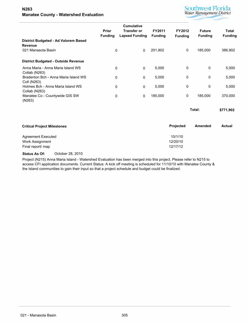
N263
Manatee County - Watershed Evaluation
District Budgeted - Ad Valorem Based
Revenue
021 Manasota Basin 386,902 185,000 0 0 0 201,902
District Budgeted - Outside Revenue
Anna Maria - Anna Maria Island WS
Collab (N263)
5,000 0 0 0 0 5,000
Bradenton Bch - Anna Maria Island WS
Coll (N263)
5,000 0 0 0 0 5,000
Holmes Bch - Anna Maria Island WS
Collab (N263)
5,000 0 0 0 0 5,000
Manatee Co - Countywide GIS SW
(N263)
370,000 185,000 0 0 0 185,000
$771,902 Total:
Prior
Funding
Cumulative
Transfer or
Lapsed Funding Funding Funding
2011 FY 2012 FY Future
Funding
Total
Funding
Critical Project Milestones ActualProjected Amended
Agreement Executed 10/1/10
Work Assignment 12/20/10
Final report/ map 12/17/12
Status As Of: October 28, 2010
Project (N215) Anna Maria Island - Watershed Evaluation has been merged into this project. Please refer to N215 to
access CFI application documents. Current Status: A kick off meeting is scheduled for 11/10/10 with Manatee County &
the Island communities to gain their input so that a project schedule and budget could be finalized.
021 - Manasota Basin 305
N276
LID Implementation at Venice East Blvd.
Project Type Cooperative Funding
AORs Strategic InitiativesWater Quality Water Quality Maintenance and ImprovementNatural Systems Natural Systems Conservation and Restoration
Basin(s) Manasota
Sarasota CountyCooperator(s)
Project Manager ZAJAC, CHRIS
Task Manager(s)
Status Ongoing
DescriptionThis FY2011 cooperative funding project is for the implementation of Low Impact Development (LID) technologies
along Venice East Blvd. in Sarasota County. A variety of LID techniques will be constructed along portions of Venice
East Blvd. to improve stormwater treatment. This area currently receives little to no treatment of stormwater prior to
discharge into Alligator Creek and Lemon Bay. Both Alligator Creek and Lemon Bay have been listed as impaired for
nutrients by the Florida Department of Environmental Protection. This project entails the construction of up to 13
stormwater treatment areas along Venice East Blvd., including but not limited to, the use of soil amendments and
bioretention. Water quality sampling will be conducted after construction of the proposed stormwater treatment areas
to determine the effectiveness of LID technologies in removing nutrients from stormwater. The District funds will be
used for construction and post-construction water quality monitoring only. Sarasota County will complete design and
acquire all necessary permits without District funding assistance.
BenefitsThis project will result in the implementation of BMPs to improve the quality of water discharging into Alligator Creek
and Lemon Bay. The project will also provide data on the effectiveness of LID technologies to remove nutrients from
stormwater.
Costs
Estimated total project cost for design, permitting, construction and post-construction water quality monitoring is
$920,000. Sarasota County contributed $150,000 in prior years for project design and permitting. The estimated cost
for construction and post-construction water quality monitoring is $770,000. The Manasota Basin Board budgeted
$230,000 in FY2011 with an equal match from the County. It is anticipated Sarasota County will request $155,000 in
FY2012 (with an equal match) in order to complete construction and post-construction water quality monitoring. Future
funds identified for the project are contingent upon approval of such amounts by the Manasota Basin Board in the
annual budgets. The District funding amounts shown in the table include staff salaries, travel and central garage.
Additional Information
Sarasota County developed a LID manual specific to conditions in Sarasota County in 2008. The County received
cooperative funding from the Manasota Basin Board in FY2010 (N139) to add three more sections to the manual. The
technologies promoted in the manual will reduce potable water use, increase pollutant removal efficiencies, and
protect and restore natural systems. Some of the technologies promoted in the manual include; use of cisterns,
bioretention areas, use of soil amendments, recycling of rainwater, green roofs and pervious pavement. This project
includes post-construction water quality monitoring to determine the effectiveness of LID technologies in removing
nutrients from stormwater. The Sarasota Regulation Department has requested this data which will be used in
assisting their staff on future requests regarding the implementation of LID technologies. Sarasota County has
completed 60% design for the proposed stormwater treatment areas along Venice East Blvd. The County will
complete design and obtain the necessary permits prior to construction.
021 - Manasota Basin 306
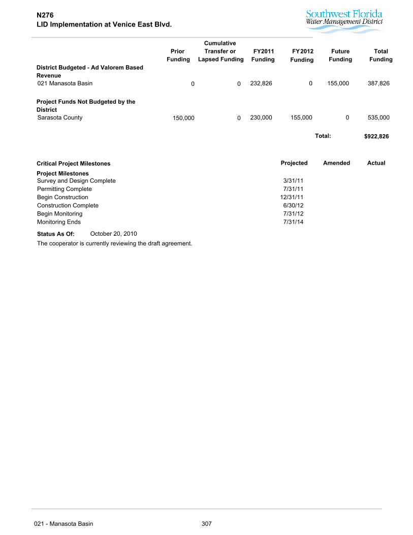
N276
LID Implementation at Venice East Blvd.
District Budgeted - Ad Valorem Based
Revenue
021 Manasota Basin 387,826 155,000 0 0 0 232,826
Project Funds Not Budgeted by the
District
Sarasota County 535,000 0 0 150,000 155,000 230,000
$922,826 Total:
Prior
Funding
Cumulative
Transfer or
Lapsed Funding Funding Funding
2011 FY 2012 FY Future
Funding
Total
Funding
Critical Project Milestones ActualProjected Amended
Project MilestonesSurvey and Design Complete 3/31/11
Permitting Complete 7/31/11
Begin Construction 12/31/11
Construction Complete 6/30/12
Begin Monitoring 7/31/12
Monitoring Ends 7/31/14
Status As Of: October 20, 2010
The cooperator is currently reviewing the draft agreement.
021 - Manasota Basin 307
N277
City of North Port Reclaimed Water Transmission Expansion
Project Type Cooperative Funding
AORs Strategic InitiativesWater Supply Reclaimed WaterWater Quality Water Quality Maintenance and Improvement
Basin(s) Manasota
City of North PortCooperator(s)
Project Manager MCGOOKEY, SCOTT
Task Manager(s)
Status Ongoing
DescriptionThis project includes the design and construction of approximately 22,000 feet of 16 to 24 inch reclaimed water
transmission line to replace over 1.3 mgd of groundwater/potable water used for irrigation. This is an extension the
City's Reclaimed Water System and supports the City's Reuse Master Plan . The new reclaimed water customers
include the Gardens of the Five Senses; Glenallen Elementary School and soccer fields; Narramore Sports Park;
Police training course; North Port High School; Heron Creek Middle School; Butler Park; and the future Youth
Community Center.
BenefitsThe City plans to provide over 1.3 mgd of reclaimed water to the Gardens of the Five Senses; Glenallen Elementary
School and soccer fields; Narramore Sports Park; Police training course; North Port High School; Heron Creek Middle
School; Butler Park; and the future Youth Community Center to offset approximately 0.8 mgd of existing and future
groundwater use.
Costs
The total project cost is $3,890,000 and the District's share is requested to be fifty percent or $1,945,000. The City
plans to spend $389,000 in FY2011 and the Manasota Basin Board has budgeted fifty percent or $194,500. The
Manasota Basin is being requested to provide $1,750,500 in additional funds in FY2012. The future funds identified for
the project are contingent upon approval of such amounts by the District Basin and Governing Boards in the annual
budget(s). The cost, amortized at 8 percent over 30 years is $1.56 per 1000 gallons offset.
Additional Information
In 2007 the City of North Port and the Southwest Florida Water Management District (SWFWMD) entered into an
agreement to fund the City of North Port Reuse Master Plan Project L629. One of the objectives of the project was to
provide preliminary designs and recommendations for the expansion of the reclaimed system. The City of North Port
adopted this Reuse Master Plan, which set forth a program of capital improvements designed to expand the reclaimed
water transmission system. The City entered into a contract with SWFWMD to fund the construction of a reclaimed
water storage tank in 2009, which will provide the necessary storage capacity to serve future customers. The City of
North Port has one of the lowest per-capita water use rates in the region, approximately 76 gallons per-capita per day
(gpdc). This can be attributed to an extensive conservation program which includes a tiered-rate structure, a reuse
water program, a toilet rebate program, community and educational efforts, irrigation enforcement, and the pursuit of
floodplain management. Reuse water is provided to golf courses, residential developments, the government complex,
commercial businesses and roadway medians. The City is expanding reuse in accdordance with the 2007 Reuse
Master Plan to offset potable water use. Water conservation is enforced by issuing tickets and fines for irrigation
violations. The conservation program offers brochures and literature, conservation classes for children at schools and
several neighborhood associations, and conservation displays at the Business Expo, the North Port Library and public
buildings. The City hosts special events such as a Florida Friendly Landscaping seminar and the Environmental Fair
at the Garden of the Five Senses. The City's website provides specific information on water conservation and the
City's Consumer Confidence Report (CCR) includes a section on water conservation that is sent to all utility
customers. Floodplain management projects include watershed hydraulic modeling to evaluate effective best
management practices and alternatives in the Big Slough, Myakkahatchee and Charlotte Harbor Watersheds,
stormwater management education, evaluation of flood control structure within the City's stormwater canal system, a
stormwater study to assess projects and funding, and continued maintenance programs for debris and vegetation
removal from the City waterways. In addition, in November 2007, the City of North Port passed Ordinance No.
2007-45, Fertilizer and Landscape Management, in an effort to protect the quality of the City's potable water.
021 - Manasota Basin 308

N277
City of North Port Reclaimed Water Transmission Expansion
District Budgeted - Ad Valorem Based
Revenue
021 Manasota Basin 1,948,839 1,750,500 0 0 0 198,339
Project Funds Not Budgeted by the
District
North Port 1,945,000 0 0 0 1,750,500 194,500
$3,893,839 Total:
Prior
Funding
Cumulative
Transfer or
Lapsed Funding Funding Funding
2011 FY 2012 FY Future
Funding
Total
Funding
Critical Project Milestones ActualProjected Amended
Start Survey, Design, and Permitting 3/31/11
Complete Survey, Design, and Permitting 12/31/11
Start construction 3/31/12
Complete construction 10/31/13
Status As Of: October 15, 2010
The City submitted the project plan (Exhibit B) for the Cooperative Funding Initiative (CFI) agreement on October 5,
2010. The District is processing the CFI agreement.
021 - Manasota Basin 309

N306
Sarasota County - Englewood CRA Stormwater Retrofit
Project Type Cooperative Funding
AORs Strategic InitiativesWater Quality Water Quality MonitoringWater Quality Water Quality Maintenance and Improvement
Basin(s) Manasota
Sarasota CountyCooperator(s)
Project Manager PECK, MICHAEL
Task Manager(s)
Status Ongoing
DescriptionThis project is for the construction of a stormwater retrofit system to provide stormwater treatment for both the existing
development in the Englewood commercial district as well as future redevelopment. Untreated stormwater runoff from
51 acres of this 71 acre urban drainage area currently discharges directly into the Lemon Bay Aquatic Preserve (an
Outstanding Florida Water). The Gottfried Creek watershed receives untreated stormwater runoff from the remaining
20 acres. This project will provide stormwater treatment, reduce or eliminate the need to provide individual stormwater
treatment systems on each parcel, locate the system within the current public right-of-way or on publicly owned
properties, and most importantly eliminate or minimize direct runoff into the Lemon Bay Aquatic Preserve. This
stormwater retrofit project will utilize Low Impact Development (LID) technologies as opposed to existing traditional
practices to meet the stormwater needs of the Englewood Community Redevelopment Area (CRA) commercial
district. In addition to providing stormwater treatment utilizing LID technologies, water quality monitoring and
educational outreach components will also be included. Water quality sampling will be conducted to evaluate the
effectivenes of the LID technologies in removing nutrients from stormwater.
BenefitsUntreated stormwater runoff from the Englewood CRA commercial district currently discharges directly into the Lemon
Bay Aquatic Preserve (an Outstanding Florida Water). This retrofit project will provide stormwater treatment for the
entire Englewood CRA commercial district (including eventual complete build-out and redevelopment), as well as
reduce or eliminate direct discharge of untreated runoff to bay. As a result, the project will improve the water quality of
the Lemon Bay Aquatic Preserve. The project will also provide data, via water quality monitoring, on the nutrient
removal efficiency of the LID technologies implemented.
Costs
The preliminary estimate of FY2011 total project cost is $1,500,000. Sarasota County will fund half of the project cost
($750,000), and the Manasota Basin will contribute the other half ($750,000). Updated cost estimates will be
calculated during the final design phase of the project. District funds in the table below include salary, travel, and
central garage charges.
Additional Information
The Englewood Community Redevelpment Area (CRA) commercial district is located along Dearborn Street west of
Indiana avenue (SR 776) in Sarasota County. The outlook on future development and redevelopment within the
commercial district is challenged by the prospect of having to provide individual stormwater systems on each parcel,
which would greatly inhibit the maximized use of available property and inhibit growth/redevelopment. Sarasota
County wishes to provide a stormwater treatment system to address the existing development within the commercial
district and thus any future redevelopment of the area as well. This stormwater retrofit project will utilize LID
technologies as opposed to existing traditional practices, made possible by Sarasota County's parallel process of
developing an LID Manual and a conceptual agreement with District regulatory staff to consider permit applications
using LID technologies in lieu of traditional BMPs. The result will be an innovative, real-world, commercial retrofit
project which will implement existing or new LID technologies and allow them to be studied and evaluated on a long
term basis.
021 - Manasota Basin 310

N306
Sarasota County - Englewood CRA Stormwater Retrofit
District Budgeted - Ad Valorem Based
Revenue
021 Manasota Basin 752,434 0 0 0 0 752,434
Project Funds Not Budgeted by the
District
Sarasota County 750,000 0 0 0 0 750,000
$1,502,434 Total:
Prior
Funding
Cumulative
Transfer or
Lapsed Funding Funding Funding
2011 FY 2012 FY Future
Funding
Total
Funding
Critical Project Milestones ActualProjected Amended
1. Contract Development & ExecutionSubmit Cooperative Funding Application 12/1/09 12/1/09
Draft agreement sent to Cooperator 8/30/10 9/30/10 9/21/10
Draft Agreement Sent to Management Services 9/6/10 9/30/10 9/24/10
Draft agreement returned from Management Services 10/8/10 10/22/10
Signed agreement returned from Cooperator 10/29/10 11/12/10
Agreement fully executed 11/5/10 11/19/10
Notice to Proceed 11/8/10 11/22/10
2. Design & PermittingRequest for Bids 11/26/10 3/25/11
Bid Selection & Award 2/11/11 5/27/11
3. ConstructionWater Quality Monitoring Begins 3/4/11 6/17/11
Commence Construction 3/25/11 7/31/11
Complete Construction 6/30/11 7/31/12
Water Quality Monitoring Ends 8/31/12
4. Project CloseoutFinal Inspection 9/28/12
Contract Termination 11/30/12
Status As Of: October 20, 2010
Project funding was included in the Manasota Basin Board's final FY2011 budget. Sarasota County received permits for
the project design on 8/31/10. The County's consultant is finalizing necessary zoning and easement changes, and is
preparing final construction plans concurrently. The District's Project Manager has coordinated with the County's Project
Manager to finalize scope of work and contract documents, and an agreement is currently routing for approval here at
the District.
021 - Manasota Basin 311
N325
Manatee County Toilet Rebate Program Phase V
Project Type Cooperative Funding
AORs Strategic InitiativesWater Supply ConservationWater Quality Water Quality Maintenance and Improvement
Basin(s) Manasota
Manatee CountyCooperator(s)
Project Manager MCGOOKEY, SCOTT
Task Manager(s)
Status Ongoing
DescriptionThis project is Phase V of the County's Ultra Low-Flow Toilet Rebate (ULFT) incentive program. The program is
available for Manatee County's retail water customers (residential, multi-family, and commercial). The County currently
services over 90,000 potable water accounts and anticipates continued growth over the next 20 years. The objectives
of this retrofit program are to reduce water demand and provide financial incentives for the replacement of an
estimated 1,500 toilets. This program addresses the Manatee County Board of County Commissioners policies on
water conservation and is supported by the recently increased Water Conservation Rates for potable water use. Any
retail water customer who agrees to replace a 3.5 gal or more toilet with a ultra-low flush (ULF) that uses 1.6 gallons
per flush (gpf) or less and/or High Efficiency Toilets (HET) using 1.38 gpf or less, will receive a $100.00 rebate for
each toilet (maximum of two (2) toilets per unit). This project will also focus on educating the new low volume toilet
users on the proper maintenance, specifically flappers and leak detection, necessary to ensure that each toilet remains
a water conserving fixture. Rebate payments are subject to the recipient's submittal of the completed application,
documented cost, and will be distributed upon inspection of the completed installation and verification that the old toilet
is ready for disposal.
BenefitsThe estimated total water saving value of the project is 33,465 gpd.
Costs
The total cost for this project is estimated to be $217,500. The Manasota Basin Board has budgetd $108,750 (fifty
percent) in FY2011. The cost/benefit is $1.78 per k/gallons, assuming a 20-year life.
Additional Information
This toilet rebate program is an enhancement to the County's existing Water Conservation Program. The County's
Water Conservation Program includes existing metering and loss reduction programs, water conserving rate
sturctures, urban and agricultural reclaimed water irrigation supply (with the metering of all users and consumption
based billing for all new users), public education, Florida Friendly based landscape codes, SWUCA based level of
service for water supply at 110 gpfcpd, land development codes requiring non-potable sources for irrigation in new
development, water supply protection ordinances, and the use of aquifer storage and recovery for both potable and
reclaimed water. Through Phase III of the County's Toilet Rebate Program and the 47,000 eligible properties in the
county, 3,851 rebates have been issued saving over 65,600 gpd.
District Budgeted - Ad Valorem Based
Revenue
021 Manasota Basin 111,831 0 0 0 0 111,831
Project Funds Not Budgeted by the
District
Manatee County 108,750 0 0 0 0 108,750
$220,581 Total:
Prior
Funding
Cumulative
Transfer or
Lapsed Funding Funding Funding
2011 FY 2012 FY Future
Funding
Total
Funding
021 - Manasota Basin 312
N325
Manatee County Toilet Rebate Program Phase V
Critical Project Milestones ActualProjected Amended
Advertise project 1/3/11
Execute agreement with District 5/1/11
Begin Phase V Toilet Rebate Program 5/16/11
Complete Rebate Program FY 2011 1/31/13
Status As Of: October 27, 2010
The County has lost it's contractor for the toilet rebate program and this project is on hold. An RFB is being processed by
the County to obtain a new contractor. This project will continue and the agreement between the District and County
processed when a contractor is secured.
021 - Manasota Basin 313

M110
Manatee - FEMA Map Modernization
Project Type FEMA/Map Mod.
AORs Strategic InitiativesFlood Protection Floodplain Management
Basin(s) Manasota
Federal Emergency Management AgencyCooperator(s)
Project Manager LETASI, SCOTT
NGUYEN, NAMTask Manager(s)
Status Not Funded
DescriptionThis project is to perform Federal Emergency Management Agency (FEMA) flood insurance rate map (FIRM)
modernization which includes 1) Topographic Information, 2) Watershed Evaluation, and 3) Watershed Management
Plan elements of the District's Watershed Management Program (WMP) for numerous Manatee County watersheds.
The County covers an area of approximately 762 square miles. Under this project the FIRMs will reflect updated flood
hazard risk areas and be modernized to a digital product.
BenefitsThe WMP provides a method to evaluate the capacity of a watershed to protect, enhance, and restore water quality
and natural systems, while achieving flood protection. The information developed provides the science for the District's
Resource Management and Environmental Resource Permitting (ERP). It assists local governments: 1) With their land
management responsibilities by establishing a level of service and developing Best Management Practices (BMPs) to
address level of service deficiencies. 2) Provides a Geodatabase and projected results from watershed model
simulations for floodplain management and water quality management. The FIRMs are used by local governments for
land management and building permitting to satisfy the minimum requirements of the National Flood Insurance
Program.
Costs
The total budget amount for this project is $900,000. FEMA is expected to contribute all the funds for the project in
FY2008. When each element is completed the project budget will be refined based on the information gathered.
Additional Information
The WMP includes five major elements: 1) Topographic Information, 2) Watershed Evaluation, 3) Watershed
Management Plan, 4) Implementation of Best Management Practices, and 5) Maintenance of Watershed Parameters
and Models. Implementing elements of the WMP with local governments is one of the Comprehensive Watershed
Management (CWM) initiative strategies and one of the District's Strategic Priorities. The District is cooperating with
FEMA to modernize the FIRMs in Manatee county. Information developed with this project will be used to update and
modernize the FIRMs for the entire county. Staff has worked with the FEMA to improve and formalize the District's
relationship with a federal agency that shares flood protection responsibilities. FEMA and the District executed a
Cooperating Technical Partners (CTP) Memorandum of Agreement on September 14, 2001. As a CTP, the District is
eligible for federal grants and matching funds to further efforts to modernize the flood insurance rate maps (FIRMs).
The District executed a Mapping Activity Statement with FEMA that identifies costs, responsibilities, and specific
activities to complete the FEMA Map Modernization effort for watersheds in Manatee county. The District will
coordinate with the local government(s), will manage the project, and will enter into purchase orders and agreements
to accomplish project tasks. With FEMA funding several tasks of the Watershed Evaluation and Watershed
Management Plan elements for priority watersheds within the County will be accomplished. Watersheds will be
prioritized based on the needs of the local governments and the District. Because of funding constraints some
watersheds will not be studied in detail. The risk information from the current FIRMs will be transferred to the
modernized, digital maps. These watersheds will be studied in detail when additional funding is available through the
cooperative funding process. Work on the Watershed Management Plan element for the priority watersheds will
include the following tasks: survey, data management and development of watershed parameters, GIS processing,
computer modeling, and floodplain analysis. Future cooperative funding request(s) will be required to complete
remaining Watershed Evaluation and Watershed Management Plan tasks (e.g. LOS determination, surface water
resource assessment, and BMP alternative analysis).
021 - Manasota Basin 314
M110
Manatee - FEMA Map Modernization
District Budgeted - Ad Valorem Based
Revenue
010 General Fund (Districtwide) 879 0 0 879 0 0
District Budgeted - Outside Revenue
FEMA Coop Tech Partner Agreemnt 900,000 0 0 900,000 0 0
$900,879 Total:
Prior
Funding
Cumulative
Transfer or
Lapsed Funding Funding Funding
2011 FY 2012 FY Future
Funding
Total
Funding
Status As Of: September 01, 2009
Status Update: This project is currently on hold. The District has not received funding from FEMA; therefore the project
can not be started.
021 - Manasota Basin 315

M115
Sarasota - FEMA Map Modernization
Project Type FEMA/Map Mod.
AORs Strategic InitiativesFlood Protection Floodplain Management
Basin(s) General Fund (District), Manasota
Federal Emergency Management AgencyCooperator(s)
Project Manager TURNER, DAWN
Task Manager(s)
Status Ongoing
DescriptionThis project is to perform Federal Emergency Management Agency (FEMA) flood insurance rate map (FIRM)
modernization which includes 1) Topographic Information, 2) Watershed Evaluation, and 3) Watershed Management
Plan elements of the District's Watershed Management Program (WMP) for numerous Sarasota county watersheds.
The county covers an area of approximately 570 square miles. Under this project the FIRMs will reflect updated flood
hazard risk areas and be modernized to a digital product.
BenefitsThe WMP provides a method to evaluate the capacity of a watershed to protect, enhance, and restore water quality
and natural systems, while achieving flood protection. The information developed provides the science for the District's
Resource Management and Environmental Resource Permitting (ERP). It assists local governments: 1) With their land
management responsibilities by establishing a level of service and developing Best Management Practices (BMPs) to
address level of service deficiencies. 2) Provides a Geodatabase and projected results from watershed model
simulations for floodplain management and water quality management. The FIRMs are used by local governments for
land management and building permitting to satisfy the minimum requirements of the National Flood Insurance
Program.
Costs
The total budget amount for this project is $2.42 million. FEMA is contributing $2 million for the project. $420,000 in
Manasota Basin Board funds approved in FY2004 for project L019 were used towards updating the digital topographic
information for the entire County in conjunction with this FEMA map modernization effort. When each element is
completed the project budget will be refined based on the information gathered.
Additional Information
The WMP includes five major elements: 1) Topographic Information, 2) Watershed Evaluation, 3) Watershed
Management Plan, 4) Implementation of Best Management Practices, and 5) Maintenance of Watershed Parameters
and Models. Implementing elements of the WMP with local governments is one of the Comprehensive Watershed
Management (CWM) initiative strategies and one of the District's Strategic Priorities. The District is cooperating with
FEMA to modernize the FIRMs in Sarasota County. Information developed with this project will be used to update and
modernize the FIRMs for the entire county. Staff has worked with the FEMA to improve and formalize the District's
relationship with a federal agency that shares flood protection responsibilities. FEMA and the District executed a
Cooperating Technical Partners (CTP) Memorandum of Agreement on September 14, 2001. As a CTP, the District is
eligible for federal grants and matching funds to further efforts to modernize the flood insurance rate maps (FIRMs).
The District executed a Mapping Activity Statement with FEMA that identifies costs, responsibilities, and specific
activities to complete the FEMA Map Modernization effort for watersheds in Sarasota county. The District will
coordinate with the local government(s), will manage the project, and will enter into purchase orders and agreements
to accomplish project tasks. With FEMA funding several tasks of the Watershed Evaluation and Watershed
Management Plan elements for priority watersheds within the county will be accomplished. Watersheds will be
prioritized based on the needs of the local governments and the District. Because of funding constraints some
watersheds will not be studied in detail. The risk information from the current FIRMs will be transferred to the
modernized, digital maps. These watersheds will be studied in detail when additional funding is available through the
cooperative funding process. Work on the Watershed Management Plan element for the priority watersheds will
include the following tasks: survey, data management and development of watershed parameters, GIS processing,
computer modeling, and floodplain analysis. FEMA is responsible for working with the local communities for the
adoption of the DFIRMs. Future cooperative funding request(s) will be required to complete remaining Watershed
Evaluation and Watershed Management Plan tasks (e.g. LOS determination, surface water resource assessment, and
BMP alternative analysis).
021 - Manasota Basin 316

M115
Sarasota - FEMA Map Modernization
District Budgeted - Ad Valorem Based
Revenue
010 General Fund (Districtwide) 104,874 0 0 90,639 0 14,235
District Budgeted - Outside Revenue
FEMA Coop Tech Partner Agreemnt 2,000,000 0 0 2,000,000 0 0
$2,104,874 Total:
Prior
Funding
Cumulative
Transfer or
Lapsed Funding Funding Funding
2011 FY 2012 FY Future
Funding
Total
Funding
Critical Project Milestones ActualProjected Amended
1. FEMA Cooperative AgreementCooperating Technical Partners Memorandum of Agreement 9/14/01 9/14/01
Cooperating Technical Partners Agreement Executed 8/12/02 8/12/02
Mapping Activity Statement Executed 9/30/03 9/26/03
01A - Scoping 8/30/04 8/30/04
02 - Digital Topographic Data Development 10/1/04 5/31/11
03 - Independent QA/QC of Topographic Information 11/1/04 5/31/11
01C - Review of Existing Info, Reconnaissance, & Field Surveys 2/1/05 5/31/11
04 - Hydrology 2/1/05 5/31/11
06 - Hydraulics 2/1/05 5/31/11
05 - Independent QA/QC of Hydrology 3/1/05 5/31/11
07 - Independent QA/QC of Hydraulics 3/1/05 5/31/11
08 - Floodplain Mapping (Detailed & Redelineation) 4/1/05 5/31/11
09 - Independent QA/QC of Floodplain Mapping 5/2/05 5/31/11
10 - Base Map Acquisition and Preparation 5/2/05 5/31/11
11 - DFIRM Production 6/1/05 5/31/11
12 - Merge Revised and Effective Flood Hazard Data 6/1/05 5/31/11
12A - Application of DFIRM Graphic and Database Specs 6/1/05 5/31/11
13 - Issue Preliminary DFIRMs and FIS to Communities 9/2/05 5/31/11
01B - Outreach 10/1/05 5/31/11
14 - Post-Preliminary Processing (by FEMA) 12/2/05 5/31/11
2. Watershed Update Consultant (BCI)Execute Consultant Contracts for Watershed Updates 6/18/03 6/11/04
Execute Consultant Contract for Digital Topo Information 1/9/04 1/9/04
Contract Termination for Watershed Updates 1/8/07 1/8/08 1/8/08
3. Watershed Update Consultant (JEA)Execute Consultant Contracts for Watershed Updates 6/1/04 6/10/04
Execute First Amendment 3/31/06 3/13/06
Contract Termination for Watershed Updates 6/26/06 5/31/10 5/31/10
First Amendment to 04CONC0000040-C 5/15/08 5/31/10 5/31/10
4. DFIRM Consultant Agreement (URS)Execute Consultant Contract for DFIRM Production 1/9/04 1/15/04
Contract Termination for DFIRM Production 1/14/07 9/30/11
Status As Of: October 08, 2010
1. FEMA: In March 2008, staff submitted a request to FEMA to request additional time to revise and update the
watershed models based on quality assurance reviews performed by the District, the County, local governments, and the
District's consultants. The request was approved, and the performance period was extended to March 31, 2009. Further
revisions, verification, and additions are necessary to appropriately represent the hydrologic and hydraulic characteristics
of the watersheds, and reflect 2007 terrain data. Additional time is also required to complete subsequent reviews, public
outreach on the preliminary floodplain information, and to accommodate a public review and comment period. An
additional time extension request was submitted to FEMA to extend the performance period through May 31, 2010. That
021 - Manasota Basin 317
M115
Sarasota - FEMA Map Modernization
time extension was also approved. However, as the models have been undergoing peer and public review, additional
issues have been identified that need to be addressed. In addition, the County wished to hold public meetings to present
the results of 7 models that the County submitted for use in creating the DFIRMs. The District has requested that the
period of performance be extended to May 31, 2011 to complete this work. Awaiting approval from FEMA. 2. Watershed
Updates (BCI): The agreement with BCI was executed on January 8, 2004 to conduct the scoping activity, and generate
digital topographic information (DTI) via LiDAR for the entire county. Notice to proceed (NTP) for Work Order (WO) #1
was issued effective January 15, 2004. WO#2 to perform the scoping activity was executed on February 8, 2004; and
NTP was issued effective January 15, 2004. Delivery of DTI was delayed for well over a year. The delay impacted the
schedules of all the other elements and consultants contributing to this project. Project scoping was completed in August
2004. The First Amendment to BCI's agreement was executed to include updates to the County's existing Dona/Roberts
Bay and Lemon Bay watershed models to reflect the new DTI, convert models from NAVD29 to NAVD88, and begin
updating the Ainger and Forked Creek models to the District's G&S. BCI completed the conversion for its assigned
watersheds and deliverables were received on January 23, 2006. The BCI Agreement was amended as of February 13,
2007 to extend the contract termination date to January 8, 2008. BCI WO#4 was executed to allow BCI to complete
remaining update tasks. Draft models and associated GIS data for Roberts Bay (including Curry Creek & Hatchet Creek),
Alligator Creek, and the Island of Venice were received on October 14, 2008. The submittal was reviewed by District
staff, and comments were provided to BCI on December 12, 2008. Revised deliverables were received, and the model
was presented to a Peer Consultant on October 20, 2009. The models were further refined, and the results presented at
Public Meetings held on January 5 and 6, 2010. Comments have been received from the public, County staff, and the
Sarasota Regulation Department. The models are currently being revised to address these comments. Submittal of the
revised model and GIS deliverables is anticipated in November 2010. The $750,400 in FEMA funds encumbered to the
agreement with BCI has been expended. $910,725 in B206 funding is being used to completed the models, and the peer
and public review process; of which $522,104 has been expended to date. 3. Watershed Updates (JEA): Agreement
JEA was executed and WO#1 issued to update the existing Little Sarasota and Sarasota watershed model. JEA
completed conversion of these models from NGVD29 to NAVD88. WO #2 was then executed to begin the update of the
Phillippi Creek watershed parameters and model to the District's G&S. The consultant services agreement with JEA was
amended to include floodway analyses and ArcHydro tool development to automate repetitive hydrologic and hydraulic
modeling tasks (M118). The First Amendment to JEA's agreement was executed on March 13, 2006. WO#3 was
executed on May 16, 2006 for the conceptual design of ArcHydro tools. WO#4 was executed on May 8, 2007 to develop
the ArcHydro tool for Irregular Weirs. WO #5 was executed to perform limited updates to the remaining Sarasota Bay
and Little Sarasota Bay models, and convert the lower Myakka River model to NAVD88. Draft deliverables were
submitted for WO #5. WO #6 was issued to update the Hudson and Whitaker Bayou models to reflect 2007 terrain data
and incorporate ERP information. The Hudson and Whitaker models were presented to a Peer Consultant on September
16, 2009. The model was refined to address the peer review comments, and the model results were presented at a
Public Meeting on December 9, 2010. Comments have been received from the public, County staff, and the Sarasota
Regulation Department. The model is currently being revised to address the comments. Submittal of the revised model
and GIS deliverables for Hudson Bayou is anticipated mid-July 2010, and for Whitaker Bayou in August 2010. $729,550
of the FEMA funds have been encumbered to the agreement with JEA, all of which has been expended. $255,581 in
B206 funding are being used to complete the models, and the peer and public review process, of which $167,691 has
been expended to date. 4. DFIRM Production (URS): The agreement with URS Southern was executed on January 15,
2004, to produce the countywide Digital Flood Insurance Rate Maps (DFIRMs) and Flood Insurance Study (FIS), and to
support public outreach. The URS Agreement was amended twice, ultimately extending the contract expiration date from
July 14, 2008 to June 1, 2010. WO #1 was executed on February 16, 2004 to identify the data to be used for DFIRM
production, and prepare a detailed approach and project outline. URS completed these tasks. WO #2 was executed to
prepare the base maps and perform outreach. URS submitted draft base maps and redelineations for review and
approval in February 2009. District, FEMA, County, and local government staff reviewed the information and provided
comments to URS in April 2009. Staff executed WO#3 with URS to incorporate the final deliverables from model updates
and the Big Slough WMPlan (K883) to produce the preliminary DFIRMs and FIS. A meeting/conference call was held on
June 29, 2007 between all consultants associated with the project to coordinate schedules, review deliverable
requirements, and identify points of contact. URS was asked to stop work on production of the preliminary DFIRMs until
model updates are completed. On March 24, 2008 WO#3 was re-issued to reflect the work completed before the stop
work order. NTP for WO#4 was issued on June 5, 2008 for the preparation of the DFIRMs, DFIRM database, and FIS
report using the watershed models that are currently under development, and watershed models previously developed by
the County. Several of the County models were not originally signed and sealed by a professional engineer. The County
retained professional engineers to review and certify the models. The following County models have now been certified
and provided to the URS to include on the draft maps: Lemon Bay, Cow Pen Slough, Phillippi Creek, Little Sarasota Bay,
Lower Myakka River, Upper Myakka/Howard Creek, and a USGS study of the Myakka mainstem. To date, URS has
completed delineating all of the County's certified models except the USGS model of the Myakka mainstem. District and
County staff are currently reviewing the associated deliverables. $520,000 of the FEMA funds have been encumbered to
021 - Manasota Basin 318

M115
Sarasota - FEMA Map Modernization
the agreement with URS, all of which has been expended. $213,757 in B206 funding has been added to the agreement
to cover the cost of including the County's certified models and participate in public meetings, of which $43,314 has been
expended to date.
021 - Manasota Basin 319
M118
FEMA Map Modernization Management Support
Project Type FEMA/Map Mod.
AORs Strategic InitiativesFlood Protection Floodplain Management
Basin(s) General Fund (District), Alafia River, Hillsborough River, Northwest Hillsborough, Coastal Rivers,
Pinellas-Anclote River, Withlacoochee River, Peace River, Manasota
Federal Emergency Management AgencyCooperator(s)
Project Manager TURNER, DAWN
Task Manager(s)
Status Ongoing
DescriptionThis project is to provide management support for Federal Emergency Management Agency (FEMA) flood insurance
rate map (FIRM) modernization projects throughout the District (please reference projects M101-M116). Under these
Map Modernization projects the FIRMs will reflect updated flood hazard risk areas and be modernized to a digital
product. The updated flood hazard risk areas are being developed by the District through the 1) Topographic
Information, 2) Watershed Evaluation, and 3) Watershed Management Plan elements of the District's Watershed
Management Program (WMP). Map Modernization management support (MMMS) funds supplement the ongoing
activities already being performed by staff including, but not limited to coordination and effort in building partnerships,
information technology systems, program management planning, hydrologic and hydraulic review, and outreach.
BenefitsThe WMP provides a method to evaluate the capacity of a watershed to protect, enhance, and restore water quality
and natural systems, while achieving flood protection. The information developed provides the science for the District's
Resource Management and Environmental Resource Permitting (ERP). It assists local governments: 1) With their land
management responsibilities by establishing a level of service and developing Best Management Practices (BMPs) to
address level of service deficiencies. 2) Provides a Geodatabase and projected results from watershed model
simulations for floodplain management and water quality management. The FIRMs are used by local governments for
land management and building permitting to satisfy the minimum requirements of the National Flood Insurance
Program.
Costs
The total amount for MMMS is $1,013,240 to be funded by FEMA. The District has received a total of $713,240 in
FEMA MMMS to date that has been included in the Governing Board's FY2005, FY2006, and FY2007 budgets as
revenue. District Staff anticipate an additional $150,000 to be funded by FEMA for ongoing MMMS activities in both
FEMA's FY2008 and FY2009 ($300,000 in total). Each year FEMA notifies the District how much funding is available
for MMMS. The District funding amounts shown in the table represents staff salaries.
Additional Information
The WMP includes five major elements: 1) Topographic Information, 2) Watershed Evaluation, 3) Watershed
Management Plan, 4) Implementation of Best Management Practices, and 5) Maintenance of Watershed Parameters
and Models. Implementing elements of the WMP with local governments is one of the Comprehensive Watershed
Management (CWM) initiative strategies and one of the District's Strategic Priorities. The District is cooperating with
FEMA to modernize the FIRMs throughout the District. Staff has worked with the FEMA to improve and formalize the
District's relationship with a federal agency that shares flood protection responsibilities. FEMA and the District
executed a Cooperating Technical Partners (CTP) Memorandum of Agreement on September 14, 2001. As a CTP,
the District is eligible for federal grants and matching funds to further efforts to modernize the FIRMs. Each year the
District enters into a cooperative agreement with FEMA for MMMS funding that defines the activities that will be
performed. $250,000 in funding (grant EMA-2004-CA-5038) for FY2005 is being used to provide a meeting facilitator
for ongoing coordination meetings between the water management districts, FEMA Region 4, and the Florida
Department of Community Affairs; develop a District-wide FIRM paneling scheme; determine the feasibility of
expanding the District's role in distributing digital FIRMs to the public; maintaining the digital FIRMs; and revising the
FIRMs simultaneously with the ERP application review. For FY2005, a total of $300,000 was actually budgeted in the
General Fund with associated revenue. The $50,000 difference between expected funding and actual was rolled into
the FY2006 budget. For FY2006 FEMA has granted (EMA-2005-CA-5244) the five water management districts
$120,000 in MMMS to hire an outreach facilitator and develop design storm rainfall depth criteria for the entire State.
The District will manage the project and contract with consultants on behalf of the other water management districts.
In addition, the District received additional MMMS ($144,000) in FY2006 to support outreach efforts, allow the District
to develop quality control/quality assurance tools, and support staff travel to meetings and conferences related to this
effort. For FY2007, the District has received $129,620 from FEMA (grants EMA-2006-CA-5631 and
EMA-2006-CA-5624) for continued travel support, outreach efforts, management assistance, and an XML-based
021 - Manasota Basin 320
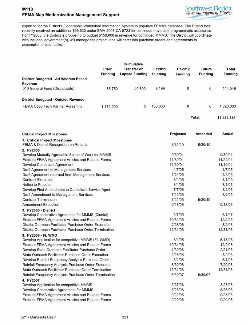
M118
FEMA Map Modernization Management Support
export to for the District's Geographic Watershed Information System to populate FEMA's database. The District has
recently received an additional $69,620 under EMA-2007-CA-5723 for continued travel and programmatic assistance.
For FY2008, the District is proposing to budget $150,000 in revenue for continued MMMS. The District will coordinate
with the local government(s), will manage the project, and will enter into purchase orders and agreements to
accomplish project tasks.
District Budgeted - Ad Valorem Based
Revenue
010 General Fund (Districtwide) 114,549 0 40,600 65,750 0 8,199
District Budgeted - Outside Revenue
FEMA Coop Tech Partner Agreemnt 1,320,000 0 0 1,170,000 0 150,000
$1,434,549 Total:
Prior
Funding
Cumulative
Transfer or
Lapsed Funding Funding Funding
2011 FY 2012 FY Future
Funding
Total
Funding
Critical Project Milestones ActualProjected Amended
1. Critical Project MilestonesFEMA & District Recognition on Reports 3/31/10 9/30/10
2. FY2005Develop Mutually Agreeable Scope of Work for MMMS 9/30/04 9/30/04
Execute FEMA Agreement Articles and Related Forms 11/30/04 11/24/04
Develop Consultant Agreement 11/30/04 11/19/04
Draft Agreement to Management Services 1/7/05 1/7/05
Draft Agreement returned from Management Services 1/21/05 2/4/05
Contract Execution 3/4/05 3/1/05
Notice to Proceed 3/4/05 3/1/05
Develop First Amendment to Consultant Service Agmt 7/7/06 8/2/06
Draft Amendment to Management Services 7/12/06 8/2/06
Contract Termination 7/21/06 9/30/10
Amendment Execution 9/18/06 9/18/06
3. FY2006 - DistrictDevelop Cooperative Agreement for MMMS (District) 6/7/05 6/1/07
Execute FEMA Agreement Articles and Related Forms 10/31/05 12/2/05
District Outreach Facilitator Purchase Order Execution 2/28/06 3/2/06
District Outreach Facilitator Purchase Order Termination 12/31/06 12/31/06
3. FY2006 - FL WMDDevelop Application for competitive MMMS (FL WMD) 6/1/05 5/18/05
Execute FEMA Agreement Articles and Related Forms 10/31/05 12/2/05
Develop State Outreach Facilitator Purchase Order 1/30/06 2/21/06
State Outreach Facilitator Purchase Order Execution 2/28/06 3/2/06
Develop Rainfall Frequency Analysis Purchase Order 6/1/06 6/1/06
Rainfall Frequency Analysis Purchase Order Execution 6/30/06 7/20/06
State Outreach Facilitator Purchase Order Termination 12/31/06 12/31/06
Rainfall Frequency Analysis Purchase Order Termination 6/30/07 9/30/07
4. FY2007Develop Application for competitive MMMS 3/27/06 3/27/06
Develop Cooperative Agreement for MMMS 5/26/06 5/26/06
Execute FEMA Agreement Articles and Related Forms 9/22/06 9/28/06
Execute FEMA Agreement Articles and Related Forms 9/22/06 9/29/06
021 - Manasota Basin 321
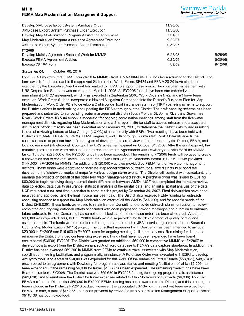
M118
FEMA Map Modernization Management Support
Develop XML-base Export System Purchase Order 11/30/06
XML-base Export System Purchase Order Execution 11/30/06
Develop Map Modernization Program Assistance Agreement 7/31/07
Map Modernization Program Assistance Agreement Execution 9/30/07
XML-base Export System Purchase Order Termination 9/30/07
FY2008Develop Mutally Agreeable Scope of Work for MMMS 6/25/08 6/25/08
Execute FEMA Agreement Articles 6/25/08 6/25/08
Execute 76-10A Form 7/3/08 8/12/08
Status As Of: October 08, 2010
FY2005: A fully executed FEMA Form 76-10 to MMMS Grant, EMA-2004-CA-5038 has been returned to the District. The
form awards funds pursuant to the approved Statement of Work. Forms SF424 and FEMA 20-20 have also been
executed by the Executive Director and transmitted to FEMA to support these funds. The consultant agreement with
URS Corporation Southern was executed on March 1, 2005. All FY2005 funds have been encumbered via an
amendment to URS' agreement, which was executed in September 2006. Work Orders #1, #2, and #3 have been
executed. Work Order #1 is to incorporate a Hazard Mitigation Component into the District's Business Plan for Map
Modernization. Work Order #2 is to develop a District-wide flood insurance rate map (FIRM) paneling scheme to support
the District's efforts in modernizing and updating the FIRMs throughout the District. The draft paneling scheme has been
prepared and submitted to surrounding water management districts (South Florida, St. Johns River, and Suwannee
River). Work Orders #3 & #4 supply a moderator for ongoing coordination meetings among staff from the five water
management districts regarding Map Modernization and a Sharepoint site for staff to access minutes and associated
documents. Work Order #5 has been executed as of February 23, 2007, to determine the District's ability and resulting
issues of reviewing Letters of Map Change (LOMC) simultaneously with ERPs. Two meetings have been held with
District staff (MAN, TPA-REG, RPM), FEMA Region 4, and Hillsborough County staff. Work Order #6 directs the
consultant team to present how different types of developments are reviewed and permited by the District, FEMA, and
local government (Hillsborough County). The URS agreement expired on October 31, 2008. After the grant expired, the
remaining project funds were released, and re-encumbered to Agreements with Dewberry and with ESRI for MMMS
tasks. To date, $225,000 of the FY2005 funds have been expended. The remaining FY2005 funds will be used to create
a conversion tool to convert District GIS data into FEMA Data Capture Standards format. FY2006: FEMA provided
$144,000 in FY2006 for MMMS. An additional $120,000 was also provided by FEMA for the five water management
districts. These funds were approved to facilitate Map Modernization outreach for all five districts to support the
development of statewide isopluvial maps for various design storm events. The District will contract with consultants and
manage the projects on behalf of the other four water management districts. A purchase order was issued to UCF for
$60,000 to begin resolving design rainfall depth differences between WMDs. UCF has completed the literature review,
data collection, data quality assurance, statistical analysis of the rainfall data, and an initial spatial analysis of the data.
UCF requested a no-cost time extension to complete the project by December 30, 2007. Final deliverables have been
received and approved, and the final invoice has been paid. The District also received FEMA funidng for outreach
consulting services to support the Map Modernization effort of all the WMDs ($45,000), and for specific needs of the
District ($48,000). These funds were used to retain Bender Consulting to provide outreach planning support to review
completed and ongoing outreach efforts associated with each project and provide messages and direction to enhance
future outreach. Bender Consulting has completed all tasks and the purchase order has been closed out. A total of
$93,000 was expended. $63,000 in FY2006 funds were also provided for the development of quality control and
assurance tools. The funds were encumbered through an amendment to JEA's service agreements for the Sarasota
County Map Modernization (M115) project. The consultant agreement with Dewberry has been amended to include
$20,000 in FY2006 and $15,000 in FY2007 funds for ongoing meeting facilitators services. Remaining funds are to
reimburse the District for video conferencing expenses. Funds that have not been expended have been board
encumbered ($3000). FY2007: The District was granted an additional $60,000 in competitive MMMS for FY2007 to
develop tools to export from the District enhanced ArcHydro database to FEMA's data capture standards. In addition, the
District has been awarded $69,200 in MMMS from FEMA to continue travel associated with Map Modernization,
coordination meeting facilitation, and programmatic assistance. A Purchase Order was executed with ESRI to develop
ArcHydro tools, and a total of $60,000 was expended for this work. Of the remaining FY2007 funds ($53,961), $48,674 is
encumbered to an agreement with Dewberry for progammatic assistance and meeting facilitation, of which $3,209 has
been expended. Of the remaining $6,000 for travel, $1,063 has been expended. The remaining travel funds have been
Board encumberd. FY2008: The District received $69,620 in FY2008 funding for ongoing programmatic assistance
($63,620), and to reimburse the District for travel expenses related to Map Modernization projects ($6,000). FY2009:
FEMA notified the District that $69,000 in FY2009 FEMA funding has been awarded to the District, and this amoung has
been included in the District's FY2010 budget. However, the associated 76-10A form has not yet been received from
FEMA. To date, a total of $782,860 has been provided by FEMA for Map Modernization Management Support, of which
$518,136 has been expended.
021 - Manasota Basin 322

The Southwest Florida Water Management District (District) does not discriminate on the basis of disability. This nondiscrimination policy involves every aspect of the District's functions, including access to and participation in the District's programs and activities. Anyone requiring reasonable accommodation as provided for in the Americans with Disabilities Act should contact the District's Human Resources Director, 2379 Broad Street, Brooksville, Florida, 34604-6899; (352) 796-721 or 1-800-423-1476 (FL only), ext. 4702; TDD (FL only)1-800-231-6103; or email [email protected].