2016 on site review report
TRANSCRIPT

by Hassan Radoine
2016 On Site Review Report
Tabiat Pedestrian Bridge
Architect Diba Tensile Architecture
ClientNosazi Abbassabad Co.
Design2009-2010
Completed2014
Tehran, Iran
4518.IRA


1
Tabiat Pedestrian Bridge Tehran, Iran
I. Introduction
Tabiat Bridge is considered today to be one the strategic landmarks in the city of Tehran. It is a 270-metre-long pedestrian bridge, spanning a valley and connecting two public parks on each side of the Modarres Highway, one of the major highways in the city. Designed with the idea to become a “place to stay” rather than “to pass”, the Bridge stands out as an innovative contemporary architectural and engineering design in a most strategic location. This location enables the passer-by to get out of the nightmare of the traffic jam that is Tehran to overlook the whole city, with its spectacular background scene of the Alborz Mountains. With its sense of complexity and serendipity, the Bridge generates different experiences in day- and night-time for users who experience it as a revolutionary masterpiece in a time of political and economic crisis. Deriving its meaning from its name Tabiat (originally an Arabic word, tabi’a, that means nature in the Farsi language), the Bridge engenders an unprecedented revolution in how bridges can be designed for empowering the pedestrian movement and not that of vehicles.
II. Contextual Information
A. Brief historical background
In 1975, Mohammad Reza Shah, the leader of Iran, inaugurated the construction of a ceremonial urban centre in northern Tehran. The proposed plan, prepared by Llewelyn Davies International, consisted of a large plaza and two boulevards lined with governmental and commercial buildings. But the Shah’s vision was never realised and construction was soon halted with eruption of protests that led to the fall of the Pahlavi monarchy in 1979. The Llewelyn Davies plan was not the first proposal for the site. It was initially included in Tehran’s master plan, prepared jointly by Victor Gruen and Farmanfarmaian Associates (1966-70). In late 1973, Louis Kahn [as well as Kenzo Tange] were solicited to prepare a proposal, which was never finished, as Kahn died in March 1974. Underlying all these proposals was a yearning to create a modernised, acculturated and apolitical urban middle class. The trajectory of these plans demonstrates how the demand for rapid modernisation obliterated alternative voices and led, ultimately, to the “tragedy of development” (as it was characterised in the Master’s Thesis of Farshid Emami at Massachusetts Institute of Technology, June 2011).
The area where the Bridge is located is called the Abbasabad Hills. It covers an area of 560 hectares with a special topographic characteristic that makes it different from all its surrounding city texture, and the residential developments around it couldn’t expand on this hilly area. After the Islamic revolution in 1979 and following the eight years of Iran-Iraq war, as the construction in the country restarted in late 80s to early 90s, there were a few more proposals by local firms and eventually the final master plan which was confirmed for these areas was to make all these lands into green low-rise public spaces. In the latest master plan (done by the office of Seyed Hadi Mirmiran, called Naqsh-e-Jahan Pars) which is about maximising pedestrian movement and minimising the motor-vehicle entries to the site, there are pedestrian connections between the two parks and this is where the necessity of having a pedestrian bridge between the two parks was initiated.

2
B. Local architectural character
The Bridge connects two green parks, and it is among the rare places in Tehran where one can still experience nature. Most families come for picnics in this preserved natural setting, escaping the hectic traffic and the city’s density. Thus, the prevailing character of this site is a green landscape with few architectural and urban infringements. However, there was a landscape project that was implemented by the same design office that did Tabiat Bridge, and it was the beginning of the whole project of restructuring this area as an attraction zone for Tehranis to experience nature and open-air community life.
The Bridge is located on a site with a very different character compared with its very approximate surroundings. The Abbasabad Hills are surrounded with zones of residential, office and commercial areas typical of Tehran, close to Vanak Square. The Vanak area is one of the important junctures in Tehran and the midpoint for some of the city’s highways such as the Jahan Kudak (now Haghani), Chamran, Hemmat and Modarres.
C. Climatic conditions
Tehran’s climate is a local steppe climate with little rainfall during the year. It is semi-arid with an average annual temperature of 16.4°C, and an average annual rainfall of 220 mm, as shown below:
Tehran climate graph
Precipitation is the lowest in July, with an average of 1 mm.
Most of the precipitation falls in January, averaging 36 mm.
Tehran temperature graph
At an average temperature of 29.3°C, July is the hottest month of the year. January is the coldest month, with temperatures averaging 2.8°C

3
The Abbasabad area is located in a site where there are several springs of water that comes from the mountain, and hence it is greener compared to most other parts of Tehran. The site of the project is located in a valley that is like a continuous corridor from north to south, and usually there is a continuous fresh breeze, even in summer time.
D. Site and surroundings
The Bridge spans the valley and is located in a hilly area with much green space. The whole area is dedicated to low-rise, green cultural and public leisure spaces. Abo Atash Park leading to other parks is on the west, and Taleghani Park, leading to the Museum of Holy Defence is on the other side.
E. Topography
The Abbasabad Hills provide a sloping green landscape that provides an architecture of its own. It was this topography that hindered the reach of urbanisation to this zone as it is technically not suitable for construction, and it is a kind of a preserved green zone. In the lower part of the hills the Modarres Highway passes from north to south. The highest point of Taleghani Park on the east is 48 metres higher than the highway level, but the Bridge connects to Taleghani Park at a height of 28 metres. Abo Atash is lower compared to Taleghani and has a relatively flat surface, and where the Bridge connects to it is 24 metres higher than the highway level.
III. Programme
A. History of the inception of the project
In the latest master plan which is currently under implementation at the site, there were different pedestrian bridges projected to make the connection between the hills which were separated by the highways. Based on this master plan, the directors of the Abbasabad area launched an architectural competition, and invited companies who had experience in the engineering of bridge design to participate.
B. How were the architects and specialists chosen?
In 2008, once many of the projects in the Abbasabad area were under construction and development, such as Abo Atash Park, the Museum of Holy Defence and many others, the need for connecting the two sides of Modarres Highway was becomng more apparent. So the directors of the area decided to launch an invitation for a competition where they invited companies who had experience in designing bridges. There were 13 companies invited, four of them were selected to continue after the first phase of the competition and, eventually, the final design was selected after further development in the second phase of the competition.
C. General programme objectives
The brief of the competition to design a bridge aimed to:
• Provide a pedestrian connection between the two sides of Modarres Highway. • Create an architectural and engineering landmark that enhances the identity of Tehran.• Design a bridge that celebrates the pedestrian experience and not the vehicular one.
4
D. Functional requirements
The bridge has to be a place to stay, considering the two parks on the sides and also the open view towards south and north. It has to invite users to walk through, and retain them for sitting and viewing experiences. It was also about minimising the footprint of the project on the site, with a minimal number of columns and finding the points with a minimal number or no trees. Integration of architecture and structure was another aspect that the architects considered deeply. Designed on a curvilinear path, the bridge was intended to avoid a one-point perspective and to make it possible for the users to discover the path on their own. These added orientations by the architects made the final design well-anchored in the site and its environs. In the end, it came to be a sculptural form that responds to the clients’ exigencies but with an outcome as a monumental landmark.
IV. Description
A. Building data
• Total length of the Bridge: approx. 269 m • Spans from east to west: 68 m-94 m-68 m-39 m • Total surface area of the Bridge: 7’950 m2
• Total surface area of the Bridge and the relevant surrounding landscape, toilets, mechanical rooms, etc.: 9’880 m2
• Ground level (mechanical rooms, washrooms, etc.): 1’300 + 70 + 375 + 185 m2
• Level 1 Bridge: 2’622 m2
• Level 1 Landscape: 250 m2
• Level 2 Bridge: 3’492 m2
• Level 2 Landscape: 550 + 310 m2
• Level 3 Bridge: 726 m2
• Resysta surface area: 6’700 m2
• Green surface area: 570 m2
• Steel weight: approx. 1’800 tons • Number of steel pipes and other sections: 3’700
B. Evolution of design concepts
Response to physical constraints
The project is married to the topography of the sloping site. The hills and their curves oscillate the structures and surfaces of the Bridge, and transmit their topographic lines to the other park on the opposite side. On the west, where the Bridge connects to Abo Atash Park, the entrance opens up to 60 metres, providing a plaza. Approaching the Bridge from Abo Atash Park it is not possible to see any structural elements of the Bridge; all that is seen are the wooden decks and handrails with the forest-like Taleghani Park in the background. The plaza makes it possible for the Bridge to blend with the park in a way that makes it not apparent where the park ends and where the Bridge starts.
5
Points with no trees or with a minimal number of trees were selected as the start, the end and the column locations of the Bridge, in order to avoid removing trees at the heavily wooded site. The form of the columns resembles these trees, so making it possible to have a minimal footprint on the ground but, as with trees, opening up with branches so that it can offer a broad span.
Response to user requirements
The architects’ design went further than just designing a pedestrian bridge, and turned it into a successful public space. With its numerous benches and seating areas, restaurants and cafes, the Bridge greatly nurtures the pedestrian connection. It is defining a new type of space, in which the design is responding directly to users’ needs while opening unhindered vistas all around to view the city of Tehran.
Purely formal aspects Despite the complexity of the whole structure, the form is based on a very orderly geometry, which is only
visible once the different layers of structure are seen in plans and elevations. The Bridge is fully made by its steel structure, and all its elements of engineering and architecture are fully integrated. The steel elements, though, are formed in a way that makes a three-dimensional truss with a dynamic form.
C. Structure, materials, technology
Structural systems
Tabiat Bridge is 270 metres long, and consists of a three-dimensional truss. The Bridge is mounted on tree-shaped columns, which are considered as an intermediate support. Due to the significant length of span, using beams with considerable amount of web is inevitable. Therefore, by selecting truss beams, the required stiffness of the beams is provided and, at the same time, the space through the truss can be used for architectural purposes to boost the design concept.
The analysis of structure is realised with the finite element method by use of STRAUS software.
The standards considered for the calculations of the Bridge are as following:
• En 1991 Eurocode 1 “ Actions on structures”• En 1992 Eurocode 2 “ Design of concrete structure”• En 1993 Eurocode 3 “ Design of steel structure”• En 1997 Eurocode 7 “ Design of steel structure”• Iranian National Building Code, Part 6 “Design loads”
In the structural design of Tabiat Bridge, the dead load is considered to be 300 kg/m2. However, at the bottom floor, by taking into account the possible location of restaurants, cafés or any type of shops, the dead load has a value of 600 kg/m2. According to the codes, the live load is considered to be 500 kg/m2 on the principal floor where it is possible to have a continuous dense crowd and 250 kg/m2 on the ramps, where a continuous dense crowd is improbable. The snow load of 150 kg/m2 applies only on the top floor. The wind-load analysis of the Bridge structure is made considering the European standard code rules. The value of the basic wind velocity for the site is 28 m/s. Thus, it is worth mentioning that the effects of structural vibrations due to vortex shedding and galloping were studied during the design process.

6
The seismic assessment is made with a spectral-response analysis. The response spectrum used to analyse the seismic load is calculated in accord with Iranian codes. The thermal load taken in to account is equal to a thermal deference about 60 degrees. Therefore, an expansion joint, in order to safely absorb the heat and vibration caused by earthquakes, has been included each side of the Bridge.
In this project, the structure and the architectural design are completely integrated in a way that all the elements (pipes) that are visible are structural elements, but at the same time they are producing all the spaces and providing the architectural complexity of the spaces and the circulations in an intricately designed ensemble.
Materials
Structural members: steel grade S355J2G3
• Infill materials The structural beams were covered by the layers listed below on the paved areas: - Metal deck - Concrete - Two layers of sound insulation - Water insulation - Plastic pedestal - Box 80 x 40 x 3 mm - Box 40 x 40 x 3 mm - Joist - Resysta paving. See: http://www.resysta.com/en/material-resysta.html
The green areas are made up of the typical green roof layer:
• Renderings and paint finishes: - Primer: Epoxy (zinc-rich), thickness: 60 microns - Middle layer: Epoxy (poly amide), thickness: 140 microns - Final layer: Polyurethane, thickness: 40 microns - The silver colour was selected in order to have a neutral colour which reflects its surrounding and is
not in contrast with the sky, mountains and the cityscape in the background.
Construction technology
Due to the complex form of the project, each of the elements had to be cut in a different shape, and this was carried out partly by CNC machine and partly by printing the unrolled shape from the 3D model. The pipes were cut, sandblasted and painted with the premium in the steel workshop, then delivered to the site. Elements were partly welded on site up to a weight that the cranes could lift. The site next to the highway under the bridge was covered and equipped to be the construction site. First the pipes of the columns were installed and welded on site. Later on, a continuous working platform was built by means of a huge amount of space frame to make a space on top of the highway in a way that the traffic flow would not be interrupted. Due to the level of complexity of the structure, there were many surveying cameras to check all the coordinates of all the elements, and once the structure was fully welded, it was painted with the next layers. The paving, green spaces and handrails were done afterwards.

7
Building services, site utilities
The majority of the spaces of the Bridge are the open spaces of walking, seating and wandering. There is a café in the centre of the Bridge, and there are two restaurants on the two ends of the Bridge on level 1, and level 2 provides the ceiling above. The idea of having a restaurant on one side and a café-gallery on the other side was the origin of the design.
The mechanical rooms are built on the ground adjacent to these restaurants and are integrated with the landscape design of the surroundings. The washrooms that are supposed to serve the Bridge are located in Abo Atash Park, around 60-70 metres away from the Bridge. The construction site under the Bridge, which had a water-ponding problem was covered by a geotextile and turned into an artificial lake just under the main column, which makes a nice reflection of the Bridge and adds to the beauty of the view which is seen when facing north
B. Origin of
Technology
The technology used in constructing the Bridge is local though some raw materials are imported. CNC-cut steel pipes were welded to each other. The cranes may have been purchased from abroad but in general there was not a specific technology imported from abroad, and the work was fully done by an Iranian contractor, sub-contractors and labour.
Materials
• The steel pipes were imported from China. • The Resysta Paving was imported from Germany through Dubai. • All the rest of the materials were supplied locally from Iran.
Labor force
Iran
Professionals
• Architects: Iran• Contractors: Iran• Consultants: All the consultants were from Iran, except for the structural engineers, Maffeis Engineering, who were from Italy• Others.

8
V. Construction Schedule and Costs
A. History of project design and implementation
• Two-phase Competition: Summer and autumn 2008 • Commission and start of design development: September 2009 • Major design: ended in December 2010, but as the work went on, the details of the project were developing along with the construction until last day • Start of construction: October 2010
B. Totalcostsandmainsourcesoffinancing
The financing was done by the municipality of Tehran.
During the four years of construction of this Bridge, the Iranian national currency has fluctuated significantly due to economic crisis, so the exchange rate used in the Economics Section is, as follows, based on the dates that costs have been implemented:
2010-11:1 USD = 12’047 IRR 2012: 1 USD = 26’078 IRR 2013-14:1 USD = 33’232 IRR
Average: 1 USD = (12’047+26’078+33’232)/3 = 23’785 IRR
As for the initial budget, considering the rate in 2010 1 USD = 12’047 IRR:
Initial budget in 2010: 310’015’000’000 IRR equalled 25’733’000 USD With the average of the 4 years: 310’015’000’000 IRR equals 13’034’000 USD Final cost: 432’426’000’000 IRR equals 18’180’000 USD
C. Comparative costs
Milad Tower was built in 2000-2009, the cost was between 450-500 million USD (Tabiat Bridge 18 million USD) (for the cost of Milad Tower, in Farsi, see: http://alef.ir/vdcezf8w7jh8f7i.b9bj.html?277010).
This is a multi-purpose tower in Tehran, Iran. It is the sixth-tallest tower and the17th-tallest freestanding structure in the world. The tower is a part of a complex called the International Trade and Convention Centre of Tehran. The complex also includes a five-star hotel, a convention centre, a world trade centre and an IT park. In the top floors of the tower, fire-immune areas were built as a refuge zone, an observation deck, a cafeteria, a public art gallery, an open observation deck, a revolving restaurant, telecommunication floors, a VIP restaurant, mechanical floors and a sky dome. (See: Wikipedia)
Milad Tower is located in a place where the only access is by private car, there is no proper public transport access to it. People also have to pay in order to go on top of it on the viewing deck, the restaurant is also relatively expensive, and all the concerts or exhibitions that happen there cater to a certain class of society, the class who are above the middle class; whereas the Bridge is completely free for everyone to use, no

9
matter what their income, and also they do not have to have a specific reason to visit it, as the spaces are more like spaces of freedom.
Sadr Highway second level: Making a second level (bridge) with total length of 10 kilometres (including access ramps) on top of the existing Sadr Highway, finished in 2013, was a huge project that happened contemporary to the Tabiat Bridge. The cost for that was 1’428’000’000 USD which led to much criticism it as it equals the budget spent in all the past years to build the network of Tehran metro lines. Considering the heavy traffic and pollution of Tehran, with this budget the Tehran metro network could have become twice as extensive. Even now, this highway is still a place of heavy traffic jams, with no positive social, cultural or economic advantages
1’428 million USD for Sadr Bridge vs. 18 million USD for the Tabiat, i.e., almost 80 times more.
D. Qualitative analysis of costs
18’180’000 USD/9880 m2 = 1’840 USD per m2
This surface area includes all the landscaping, WC and mechanical rooms, and restaurant extensions, as the total cost was for all these areas.
E. Maintenance
The ongoing daily maintenance of the Bridge includes the lighting and the plants that are checked and taken care of every day. The welds and paint are checked on a monthly basis.
VI. Technical Assessment A. Functional assessment
The project offers a well-articulated spatial configuration with high functional organisation geared towards pedestrian use. It combines the intricacy underlying the whole monumental structure with a design outcome and a set of decks that foster human activities and motions.
The Bridge becomes therefore a public space for people to gather, walk, interact and entertain. To retain users on the Bridge, several services were set in place, such as restaurants, cafés, resting benches, etc.
B. Climatic performance
Climatic performance, ventilation, etc.
Most of the area of the Bridge (level 2 and level 3 is open space), but level 1 is completely covered by level 2 and so becomes a covered space. This provides a level that is all shade and cool during sunny days, and in sunny or rainy weather, people mainly use this level. This makes the Bridge useable and open in almost any climatic condition. At each end of level one there is a restaurant. These restaurants are the only “closed” spaces of the bridge. They have all glass walls on four sides, and have their own cooling/heating ventilation systems.

10
Orientation
The Bridge spans from east to west. The continuous ramps that connect all the levels are placed on the south end of the Bridge for two main reasons:
• For level 2, to provide some shade • The view to the north and the mountains is much nicer than the one to the south, so the north view is
completely open on both levels.
Lighting
During the day the Bridge does not need any lighting as it i fully utilises daylight. During the night there are two types of interior lighting. One is the continuous lighting inside the handrails and the other comes from ball-lights inside the green space. The colourful exterior lighting was done by the client without the approval of the designers and it hinders the original design look at night.
C. Response to treatment of water and rainfall
The Bridge is designed with very slight slopes to be able to provide its sinuous shape as well as the possibility of having two or three levels. The slopes are organised in a way that their lowest parts are under the location of the columns. In this way the water is collected from all three levels and the drain pipes go down adjacent to the columns.
D. Environmental response
The site of the Bridge is covered by trees and the columns and the starting point of the Bridge on Taleghani Park was selected because of the way that they are located in places with a minimal number of, or no trees.
On the side of Abo Atash Park where the Bridge opens 60 metres, there are three holes opened up to let the existing trees continue to grow. Despite all but one of these trees having to be removed, as it was impossible to keep them during construction, more trees were planted to grow back afterwards. In the places that it was inevitable to construct with the presence of the Bridge, existing trees were removed and replaced in other spots on the site.
E. Choice of materials, level of technology
The selected material of the steel was based on the structural engineers’ instruction S355J2G3 in a way that it can take all the loads, including thermal load. This grade of steel needed for the pipes’ sections was not available in Iran and was purchased and transported from China.
The decking material is from Germany, called “Resysta”. It is a 100% recyclable composite wood made of fibre-reinforced hybrid material produced from approximately 60% rice husks, 22% common salt and 18% mineral oil, which makes it both environmentally friendly as well as extremely weather-resistant against sun, rain, snow or salt water. At the same time, Resysta requires minimal care and offers the look and feel of wood.

11
The colour that was selected for the Bridge was the original colour without extra paint in order to avoid the colour fading of the paving. In this way, while the Bridge ages, the change of the paving does not change, like many wood-covered pavings or buildings.
F. Response to, and planning for, emergency situations There are two emergency exit stairs going down the two main columns evacuating on the two sides of the
highway.
Earthquakes have been taken into consideration by the structural engineers; there are two expansion joints with flexible connections to foundations, and the rest of the Bridge is all welded, acting as one piece of structure.
The loading was done in a way that an emergency vehicle can ride on the Bridge if needed.
There are fire-fighting pipes and stations all along the Bridge for fire situations.
G. Ageing and maintenance problems
Rainwater can affect the paint and needs to be taken care of by the monthly maintenances.
H. Design features
The main elements of the Bridge are round pipes, the largest being 610 mm in diameter and 52 mm in thickness. Foundations are made with standard piles 25 m long.
I. Impact of the project on the site
The Bridge brings so many people to the site each day that it has increased the need for more parking at the site that, the client claims, is under construction now.
J. Durability and long-time viability of the project
As claimed by the client, the Bridge is intended to stay for 100 years or more. But no proof was delivered.
K. Interior design and furnishing
There are different types of seating areas on the Bridge.
• The benches: there is one type of bench repeated on all the levels on the Bridge. It is made of the same material as the paving making it seem as if it is the floor that folds up and forms the bench. This design works perfectly with the fact that all parts of the Bridge are sloped, and a bench with a matching leg height could be used on the sloped areas. The leg of the bench is designed with a double-curved shape, the seating area of the bench gets wide on one side and narrow on the other. This makes it possible for people to use the bench in so many different ways. They can sit on two sides, they can lay down or they can sit with feet straight. The Bridge can fit around 10 people or more at once.
12
• On level 2 where the Bridge gets wider in plan (and where level 3 on top shades it) ,on top of the first column there is a stepped seating area like a stage where people can sit on the north. In the same location on level 1 ,there is a café which was supposed to use the steps for seating. The café was not designed by the architects and the seating is not working as it was originally designed.
• The interior design of the restaurants was completely out of the hands of the designers; the client and the tenant hired their own interior designers without asking for advice from the architects.
VII. Users
A. Descriptionofthosewhouseorbenefitfromtheproject
One of the successes of this project is that it is open to all the public, no restrictions on age, gender, etc. It provides spaces from very open to very intimate, and this boosts the choice to adapt it to different users’ needs.
B. Response to project by clients, users, community, etc.
The project is well received by people who live in Tehran and those who come to visit Tehran from other cities or countries. It is possible to find positive feedback on websites such as Trip Advisor or Foursquare. It has become a recognisable landmark.
What do architectural professionals and the cultural “intelligentsia” think about the project?
The project is appreciated from many points of view: the architectural form, its acting as a public space, material selection and execution and the way it blends in with the topography and the site:
Mohammad Mohammadzadeh, an architect, author and critic, told Al Jazeera that projects like Araghian’s “reveal a huge capacity in the emerging generation of architects, who have been willing to form a progressive trend in Iran”.
Arash Mozafari, an architect who works in Canada and Iran, said Tehran needs more public spaces like Tabiat: “I believe this project has a really wonderful design”, he said. “It is not just a bridge. It is a popular public space, an urban space for pedestrians”. He said that while Pol-e-Tabiat is being mentioned alongside Azadi and Milad Towers as symbols of Tehran, “these are not comparable” because the towers represent something more political, whereas Pol-e-Tabiat “is for the people and nature”. He also praised Araghian as a “talented young architect”. And that “we will hear more from her. She knows the methods of design and engineering very well, and she is a very hard worker, qualities one can hardly find these days”.
The above was from Al Jazeera: http://www.aljazeera.com/indepth/features/2015/04/award-winning-bridge-connecting-iranians-150414121934153.html
Mohammad Reza Nikhbakht ( Architect, Critic, Jury Member for Memar Award, 2015)
“What is important about Tabiat Bridge is that it is clear that during its design its audience is not an architectural competition or the elite community of architects, but it has people and specifically ‘pedestrians’ as its main audience, hence its social impact prevails over any other aspects of it.

13
Even though most probably the number of cars that pass under the Bridge daily is higher than the number of the pedestrians who walk on it, it is obvious from the design that instead of articulating the exterior form the Bridge, what the designers were focusing on during their design was the experience of the pedestrians who walk on it and not the people inside the cars riding under it.
The sequences of spaces, the walking trail and seating areas, they are all designed in order to create a good-quality experience of the place for anyone who is wandering on the Bridge. This quality has been achieved by creating interconnected multiple layers, on curvilinear paths, which provides infinite views and perspectives to the views of the outsides. Even though the Bridge is looking outwards to the surrounding views, again it is designed with an inward approach to make the place pleasant also internally.
There may be some points about details or execution which could have been better, of course there could have been certain limitations and obligation in those terms, but these points are insignificant when looking at the whole of the project, its architectural design and its social impact.”
Seyyed Mohammad Beheshti, Aga Khan Award winner, Architect, Architectural and Cultural Critic, Jury Member of Tabiat Bridge Competition, 2008
“Tabiat Bridge is significant from different points of view:
• The Abbasabad area is on a very strategic location in metropolitan Tehran, and this has been always mentioned for decades, both in the master-plan studies of Tehran and in studies on cultural spaces. Historically this area is been always recognised as most important and with the most potential to become a centre for public space and a place for people’s social interactions.
Before the opening of the Bridge in 2014, we already had the same experience in a smaller scale at Abo Atash Park, just adjacent to the Bridge where, as soon as it was inaugurated in 2009, it was filled by people and very well-received, something that has not happened to any other park.
This revealed the potential of this location, one that makes it different from any other point in Tehran.
• Comparing Tabiat Bridge to any other bridges built in Tehran and other cities in Iran during contemporary times, all the bridges are designed only to provide a connection in order for people to pass and cross a river or a road, whereas Tabiat Bridge, inspired by a historical example – Khajoo Bridge in Isfahan – is a ‘destination’ by itself.
• What is brilliant about this inspiration is that it is taking the essence of this historical bridge; ‘the bridge as a destination and a public space’ with a very contemporary look and material and form, yet by no means is it mimicking any formal aspects of its historical precedent.
• Another important aspect of this Bridge is that it is revealing all the beauties and values of Tehran which are hidden under the dust of chaos, pollution, traffic and ongoing constructions.
Values such as the view towards the Alborz Mountains, the large green space of Taleghani Park, the cityscape of Tehran and the massive open space towards sky. In other words, once someone is on the Bridge, they can see all and only the values of Tehran all at once.”

14
What is the popular reaction to the project?
The popular reaction is that people are proud to show that this project is being built in their city by young Iranian architects in a time that Tehran is under tremendous pressure from high density, traffic, pollution, crowdedness and a rapid urbanisation that devours all green spaces.
Women specifically feel proud, as the lead designer of the project is a woman. It is a proof of how powerful and successful women can be in contemporary Iran.
According to one interviewed user, “I feel the Bridge like a suspended street where I feel I am walking on a flying carpet”.
What do neighbours and those in the immediate vicinity think about the project?
The neighbours are very happy as the Bridge and its environs create an elevated human experience in a well-designed landscape where the mechanical and the natural go hand in hand.
VIII. Persons Involved
Client: Nosazi Abbasabad Co.
• Managing Director of 2008-2010: Behnam Atabaki • Deputy to Managing Director: Ghasem Amouzandeh• Head of Architectural Department: Seyed Javad Mirhosseini
Architectural Design:
• Competition phase 1: Leila Araghian• Competition phase 2: Leila Araghian, Alireza Behzadi, Sahar Yasaei• Design development in parallel with structural engineers: Leila Araghina• Design development associate: Sahar Yasaei• Preliminary detail design: Leila Araghian, Sahar Yasaei• Furniture design: Leila Araghian, Farhad Elahi
Consultants:
• Structural engineering: Maffeis Engineering Massimo Maffeis, Marco Grigoletto, Loris Frizon• Detail eesign during construction according to contractors limitations and available materials: Homa Soleimani, Mina Nikoukalam, Alireza Behzadi• Site supervision from Diba Company: Alireza Behzadi, Payam Golfeshan, Nader Naghipour, Adel Mohammadi

15
Mechanical engineer: Aram ShahriariElectrical engineer: Mahmoud AbdolhasaniContractor: Shahid Rajaei Co.Construction company: Azar Teif Sepahan Co.Executive manager (structure): Mojtaba Keshtkar
IX. Bibliography
• Architizer: A+Awards 2015, Architizer Book, Phaidon, 2015• Mahmoudabadi, Maziar, The Three Architectural Icons of Tehran, Creative Artists Foundation Magazine,
2015
International Press
• Tabiat, le pont de tous les desirs (special issue on Iran), Le Point, 03/2016• 2015 A+ Awards, CNN-Architizer, 10/2015 • Humans of New York Facebook Page, 9/2015• Corriere Della Sera, 2015-07• The Bridge to Tehran’s Architectural Future, The Guardian, 4/2015• The award-winning bridge connecting Iranians, Al Jazeera, 4/2015• Tabiat Bridge, Annews_5, 5/2015• Archdaily- Tabiat Bridge, Archdaily, 11/2014• Bridge Update 126, 9/2014
National Press • Leia Araghian interview, Shargh Newspaper, 4/2015• A Stop in the Sky-Leila Araghian Narrates About The Bridge, Hamshahri-Memari, 8/2012• Bridge Construction, Hamshahri_Tabiat, 10/2012
• Tehran does not have Bridges yet: Alireza-Behzadi_Interview, Hamshahri Memari, 8/2012
Hassan RadoineMay 2016


!.
¯
Pakistan
Turkey
AfghanistanIraq
Armenia Azerbaijan
Turkmenistan
Saudi Arabia
Kuwait
I R A N
CASPIAN SEA
PERSIAN GULF
GULF OF OMAN
Tehran
Qatar
UAE

Site area
South Elevation
Long section though ramps
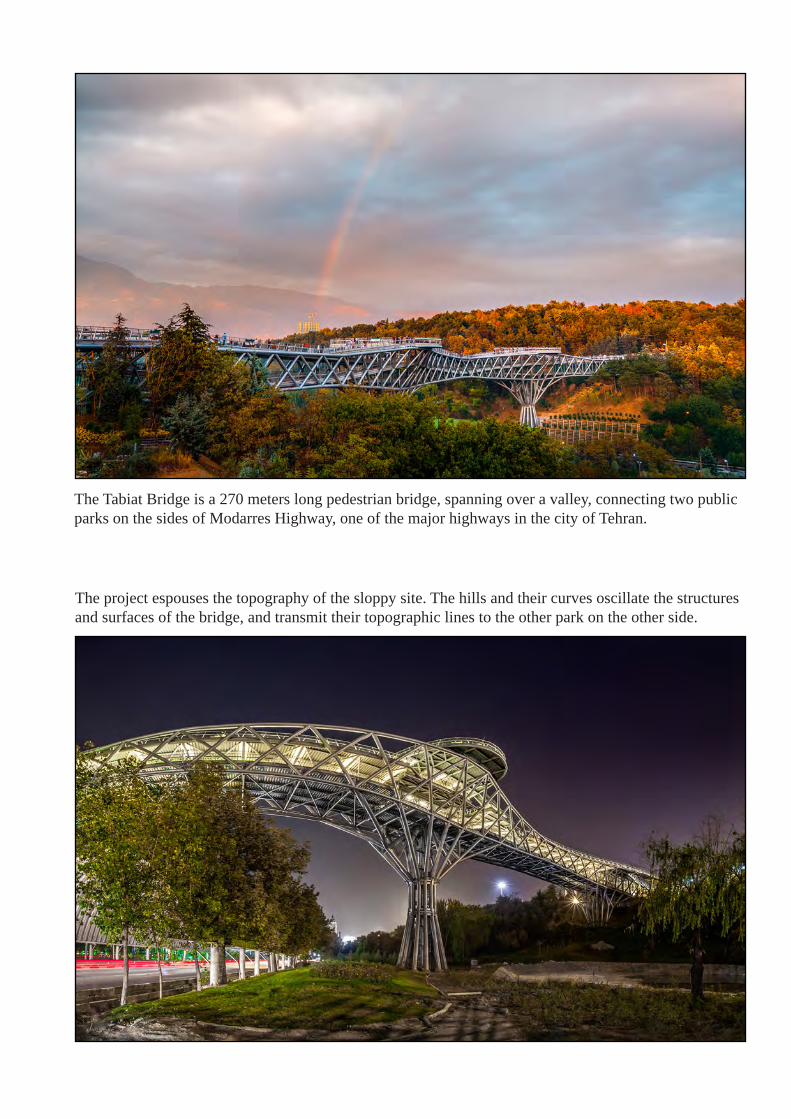
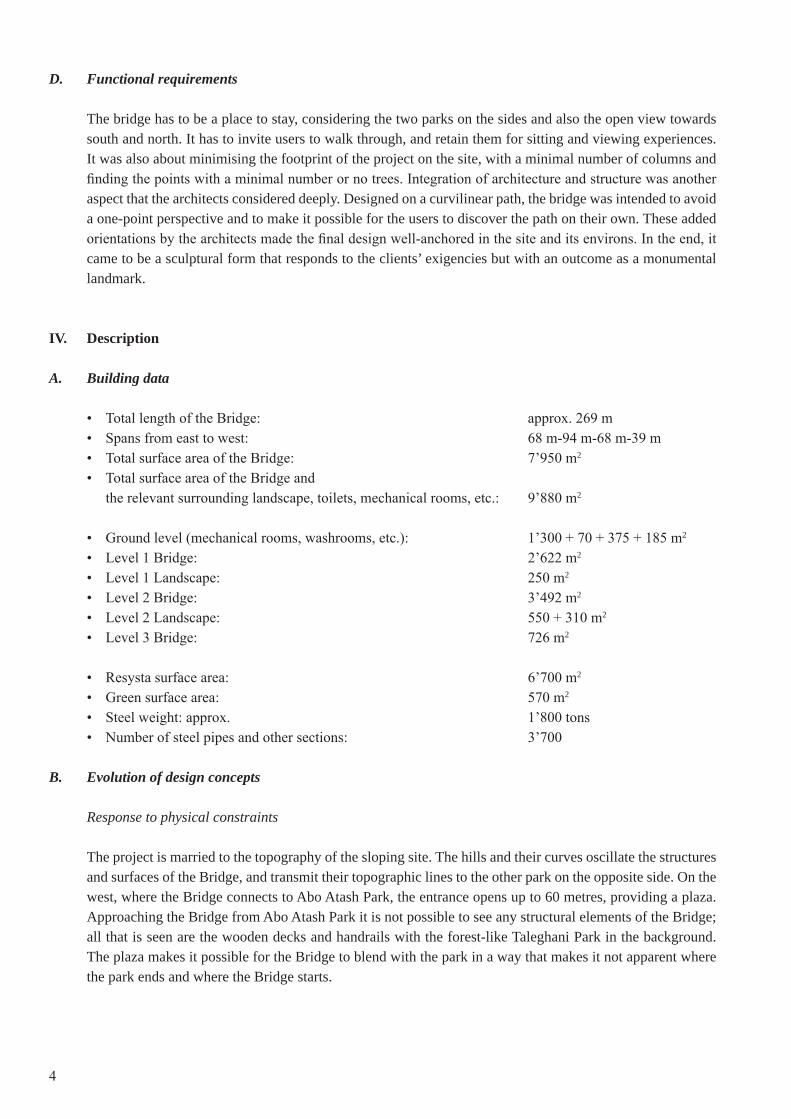
The Tabiat Bridge is a 270 meters long pedestrian bridge, spanning over a valley, connecting two public parks on the sides of Modarres Highway, one of the major highways in the city of Tehran.
The project espouses the topography of the sloppy site. The hills and their curves oscillate the structures and surfaces of the bridge, and transmit their topographic lines to the other park on the other side.
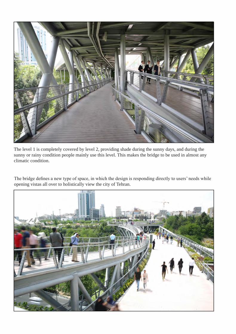
The level 1 is completely covered by level 2, providing shade during the sunny days, and during the sunny or rainy condition people mainly use this level. This makes the bridge to be used in almost any climatic condition.
The bridge defines a new type of space, in which the design is responding directly to users’ needs while opening vistas all over to holistically view the city of Tehran.
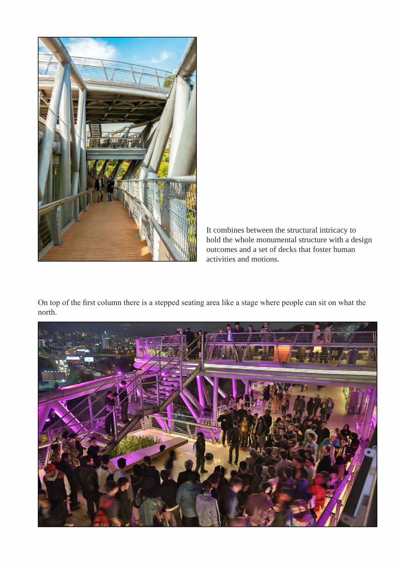
It combines between the structural intricacy to hold the whole monumental structure with a design outcomes and a set of decks that foster human activities and motions.
On top of the first column there is a stepped seating area like a stage where people can sit on what the north.

With its numerous benches and seating areas, restaurants, and cafes, the bridge nurtures greatly the pedestrian connection.
The bridge becomes a public space for people to gather, walk, interact, and entertain.