five-year review report · appendix h site inspection checklist ... psep puget sound estuary...
TRANSCRIPT
FIVE-YEAR REVIEW REPORT
Wyckoff/Eagle HarborSuperfund Site
Bainbridge Island, Washington
September 2002
PREPARED BY:
United States Environmental Protection AgencyRegion 10
Seattle, Washington
Approved by: Date:
_____________________________ _________________Michael F. Gearheard, DirectorEnvironmental Cleanup Office
iii
TABLE OF CONTENTS
Section Page
List of Figures . . . . . . . . . . . . . . . . . . . . . . . . . . . . . . . . . . . . . . . . . . . . . . . . . . . . . . . . . . . . . . . . vList of Tables . . . . . . . . . . . . . . . . . . . . . . . . . . . . . . . . . . . . . . . . . . . . . . . . . . . . . . . . . . . . . . . . viList of Appendices . . . . . . . . . . . . . . . . . . . . . . . . . . . . . . . . . . . . . . . . . . . . . . . . . . . . . . . . . . . . viiList of Acronyms and Abbreviations . . . . . . . . . . . . . . . . . . . . . . . . . . . . . . . . . . . . . . . . . . . . . viiiExecutive Summary . . . . . . . . . . . . . . . . . . . . . . . . . . . . . . . . . . . . . . . . . . . . . . . . . . . . . . . . . . . xiFive-Year Review Summary Form . . . . . . . . . . . . . . . . . . . . . . . . . . . . . . . . . . . . . . . . . . . . . . . xiii
I. INTRODUCTION . . . . . . . . . . . . . . . . . . . . . . . . . . . . . . . . . . . . . . . . . . . . . . . . . . . . . 1
Purpose of the Review . . . . . . . . . . . . . . . . . . . . . . . . . . . . . . . . . . . . . . . . . . . . . . . . . 1Authority for Conducting the Five-Year Review . . . . . . . . . . . . . . . . . . . . . . . . . . . . . 1Who Conducted the Five-Year Review . . . . . . . . . . . . . . . . . . . . . . . . . . . . . . . . . . . . 1Other Review Characteristics . . . . . . . . . . . . . . . . . . . . . . . . . . . . . . . . . . . . . . . . . . . . 2
II. SITE CHRONOLOGY . . . . . . . . . . . . . . . . . . . . . . . . . . . . . . . . . . . . . . . . . . . . . . . . . 2
III. BACKGROUND . . . . . . . . . . . . . . . . . . . . . . . . . . . . . . . . . . . . . . . . . . . . . . . . . . . . . . 7
Physical Characteristics . . . . . . . . . . . . . . . . . . . . . . . . . . . . . . . . . . . . . . . . . . . . . . . . 7Land and Resource Use . . . . . . . . . . . . . . . . . . . . . . . . . . . . . . . . . . . . . . . . . . . . . . . . 8
Current Land Use . . . . . . . . . . . . . . . . . . . . . . . . . . . . . . . . . . . . . . . . . . . . 8Reasonably Anticipated Future Land Uses . . . . . . . . . . . . . . . . . . . . . . . . 9Reasonably Anticipated Future Resource Uses . . . . . . . . . . . . . . . . . . . . 10Groundwater Classification and Basis . . . . . . . . . . . . . . . . . . . . . . . . . . . 11Current Groundwater Use . . . . . . . . . . . . . . . . . . . . . . . . . . . . . . . . . . . . 12
History of Contamination . . . . . . . . . . . . . . . . . . . . . . . . . . . . . . . . . . . . . . . . . . . . . 13Initial Response . . . . . . . . . . . . . . . . . . . . . . . . . . . . . . . . . . . . . . . . . . . . . . . . . . . . . 14Basis for Taking Action . . . . . . . . . . . . . . . . . . . . . . . . . . . . . . . . . . . . . . . . . . . . . . . 15
West Harbor Operable Unit . . . . . . . . . . . . . . . . . . . . . . . . . . . . . . . . . . . 15East Harbor Operable Unit . . . . . . . . . . . . . . . . . . . . . . . . . . . . . . . . . . . 16Soil Operable Unit . . . . . . . . . . . . . . . . . . . . . . . . . . . . . . . . . . . . . . . . . . 17Groundwater Operable Unit . . . . . . . . . . . . . . . . . . . . . . . . . . . . . . . . . . 17
IV. REMEDIAL ACTIONS . . . . . . . . . . . . . . . . . . . . . . . . . . . . . . . . . . . . . . . . . . . . . . . 19
iv
Remedy Selection . . . . . . . . . . . . . . . . . . . . . . . . . . . . . . . . . . . . . . . . . . . . . . . . . . . . 19West Harbor Operable Unit . . . . . . . . . . . . . . . . . . . . . . . . . . . . . . . . . . . 19East Harbor Operable Unit . . . . . . . . . . . . . . . . . . . . . . . . . . . . . . . . . . . 21Soil and Groundwater Operable Units . . . . . . . . . . . . . . . . . . . . . . . . . . . 22
TABLE OF CONTENTS(Continued)
Section Page
Remedy Implementation . . . . . . . . . . . . . . . . . . . . . . . . . . . . . . . . . . . . . . . . . . . . . . 26West Harbor Operable Unit . . . . . . . . . . . . . . . . . . . . . . . . . . . . . . . . . . . 26
Upland . . . . . . . . . . . . . . . . . . . . . . . . . . . . . . . . . . . . . . . . . . . . . 27Sediments . . . . . . . . . . . . . . . . . . . . . . . . . . . . . . . . . . . . . . . . . . . 29Habitat Restoration . . . . . . . . . . . . . . . . . . . . . . . . . . . . . . . . . . . 34
East Harbor Operable Unit . . . . . . . . . . . . . . . . . . . . . . . . . . . . . . . . . . . 34Phase I . . . . . . . . . . . . . . . . . . . . . . . . . . . . . . . . . . . . . . . . . . . . . 35Phase II . . . . . . . . . . . . . . . . . . . . . . . . . . . . . . . . . . . . . . . . . . . . . 35Phase III . . . . . . . . . . . . . . . . . . . . . . . . . . . . . . . . . . . . . . . . . . . . 36
Soil and Groundwater Operable Units . . . . . . . . . . . . . . . . . . . . . . . . . . . 37Groundwater Treatment Plant and Extraction System . . . . . . . . 37Sheet Pile Containment Wall . . . . . . . . . . . . . . . . . . . . . . . . . . . . 38Habitat Mitigation Beach Construction . . . . . . . . . . . . . . . . . . . . 40Contaminated Soil Removal . . . . . . . . . . . . . . . . . . . . . . . . . . . . . 40Steam Injection Pilot Study . . . . . . . . . . . . . . . . . . . . . . . . . . . . . 41
System Operations/O&M . . . . . . . . . . . . . . . . . . . . . . . . . . . . . . . . . . . . . . . . . . . . . 43
V. PROGRESS SINCE THE LAST FIVE-YEAR REVIEW . . . . . . . . . . . . . . . . . . . . 44
VI. FIVE-YEAR REVIEW PROCESS . . . . . . . . . . . . . . . . . . . . . . . . . . . . . . . . . . . . . . 44
Administrative Components of the Five-Year Review Process . . . . . . . . . . . . . . . . . 44Community Notification and Involvement . . . . . . . . . . . . . . . . . . . . . . . . . . . . . . . . 44Document Review . . . . . . . . . . . . . . . . . . . . . . . . . . . . . . . . . . . . . . . . . . . . . . . . . . . 46Data Review . . . . . . . . . . . . . . . . . . . . . . . . . . . . . . . . . . . . . . . . . . . . . . . . . . . . . . . . 46
West Harbor Sediment Remediation Monitoring . . . . . . . . . . . . . . . . . . . 46East Harbor Subtidal Sediment Cap Monitoring . . . . . . . . . . . . . . . . . . . 47Treatment Plant Performance and Compliance Monitoring . . . . . . . . . . . 48
v
Groundwater Levels Monitoring . . . . . . . . . . . . . . . . . . . . . . . . . . . . . . . 49Site Inspection . . . . . . . . . . . . . . . . . . . . . . . . . . . . . . . . . . . . . . . . . . . . . . . . . . . . . . 50
West Harbor Operable Unit . . . . . . . . . . . . . . . . . . . . . . . . . . . . . . . . . . . 50East Harbor Operable Unit . . . . . . . . . . . . . . . . . . . . . . . . . . . . . . . . . . . 50Soil and Groundwater Operable Units . . . . . . . . . . . . . . . . . . . . . . . . . . . 51
Interviews . . . . . . . . . . . . . . . . . . . . . . . . . . . . . . . . . . . . . . . . . . . . . . . . . . . . . . . . . . 54
vi
TABLE OF CONTENTS(Continued)
Section Page
VII. TECHNICAL ASSESSMENT . . . . . . . . . . . . . . . . . . . . . . . . . . . . . . . . . . . . . . . . . . 54
Question A: Is the remedy functioning as intended by the decision documents? . . . 54West Harbor Operable Unit . . . . . . . . . . . . . . . . . . . . . . . . . . . . . . . . . . . 54East Harbor Operable Unit . . . . . . . . . . . . . . . . . . . . . . . . . . . . . . . . . . . 55
Subtidal Sediment Cap . . . . . . . . . . . . . . . . . . . . . . . . . . . . . . . . . 55Intertidal Areas . . . . . . . . . . . . . . . . . . . . . . . . . . . . . . . . . . . . . . . 56
Soil and Groundwater Operable Units . . . . . . . . . . . . . . . . . . . . . . . . . . . 59Groundwater Treatment Plant and Extraction System . . . . . . . . 59Contaminated Soil Removal . . . . . . . . . . . . . . . . . . . . . . . . . . . . . 61Sheet Pile Containment Wall . . . . . . . . . . . . . . . . . . . . . . . . . . . . 61Steam Injection Pilot Study . . . . . . . . . . . . . . . . . . . . . . . . . . . . . 62Institutional Controls . . . . . . . . . . . . . . . . . . . . . . . . . . . . . . . . . . 62
Question B: Are the exposure assumptions, toxicity data, cleanup levels, andremedial action objectives (RAOs) used at the time of remedy selection still valid? . 62
West Harbor Operable Unit . . . . . . . . . . . . . . . . . . . . . . . . . . . . . . . . . . . 62East Harbor, Soil, and Groundwater Operable Units . . . . . . . . . . . . . . . . 62
Question C: Has any other information come to light that could call into questionthe protectiveness of the remedy? . . . . . . . . . . . . . . . . . . . . . . . . . . . . . . . . . . . . . . . 63
West Harbor Operable Unit . . . . . . . . . . . . . . . . . . . . . . . . . . . . . . . . . . . 63East Harbor, Soil, and Groundwater Operable Units . . . . . . . . . . . . . . . . 64
Treatment Plant Lifespan . . . . . . . . . . . . . . . . . . . . . . . . . . . . . . . 64Integrity of the Aquitard . . . . . . . . . . . . . . . . . . . . . . . . . . . . . . . 64East Harbor Sediment Cap . . . . . . . . . . . . . . . . . . . . . . . . . . . . . . 65
VIII. ISSUES . . . . . . . . . . . . . . . . . . . . . . . . . . . . . . . . . . . . . . . . . . . . . . . . . . . . . . . . . . . . . 66
IX. RECOMMENDATIONS AND FOLLOW-UP ACTIONS . . . . . . . . . . . . . . . . . . 67
Recommendations Based on Community Involvement . . . . . . . . . . . . . . . . . . . . . . . 68West Harbor Operable Unit . . . . . . . . . . . . . . . . . . . . . . . . . . . . . . . . . . . . . . . . . . . . 69East Harbor Operable Unit . . . . . . . . . . . . . . . . . . . . . . . . . . . . . . . . . . . . . . . . . . . . 70Soil and Groundwater Operable Units . . . . . . . . . . . . . . . . . . . . . . . . . . . . . . . . . . . . 71

vii
X. PROTECTIVENESS STATEMENT(S) . . . . . . . . . . . . . . . . . . . . . . . . . . . . . . . . . . 71
XI. NEXT REVIEW . . . . . . . . . . . . . . . . . . . . . . . . . . . . . . . . . . . . . . . . . . . . . . . . . . . . . . 72
viii
LIST OF FIGURES
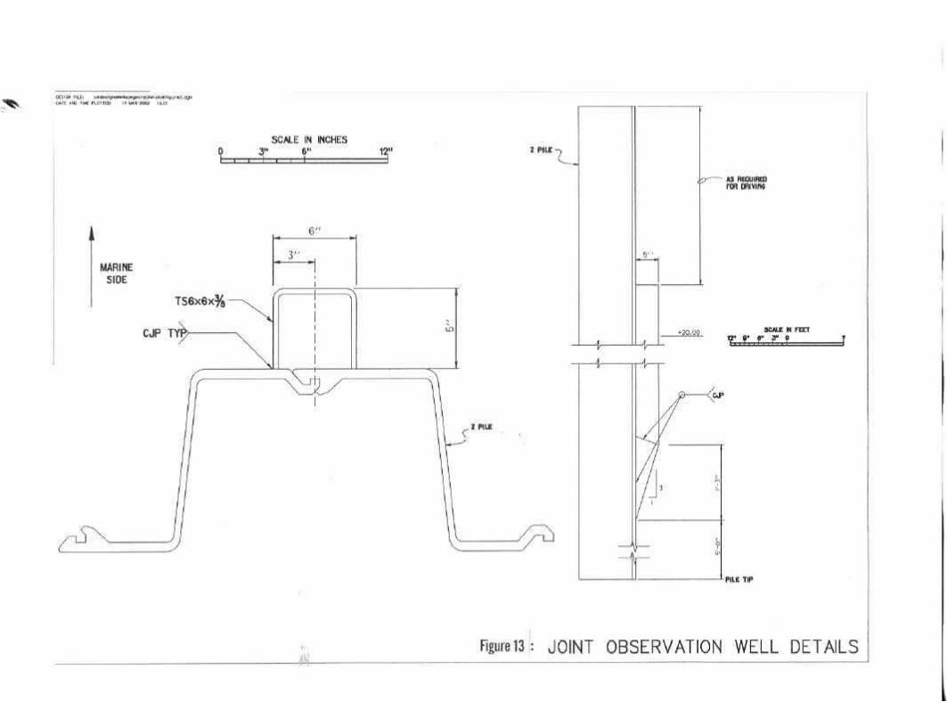
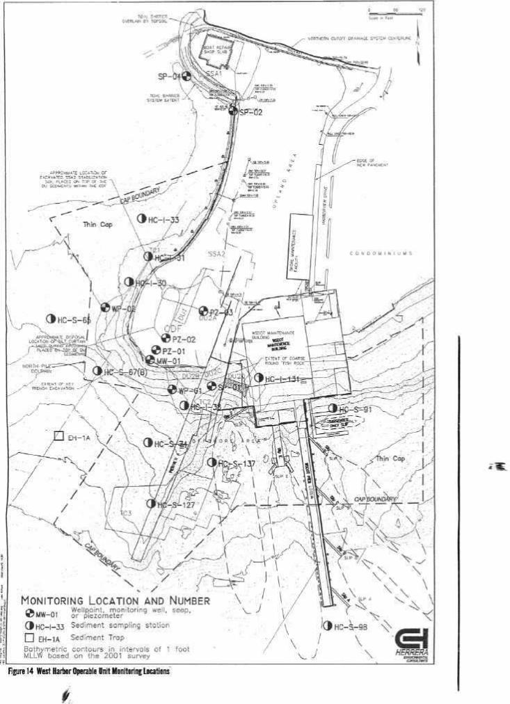
Figure 1 Wyckoff/Eagle Harbor Superfund SiteFigure 2 City of Bainbridge Island Map - Configuration of Wyckoff SiteFigure 3 City of Bainbridge Island Map - Preferred Alternative: Public ParklandFigure 4 Delineation of Non-Potable Water in Upper AquiferFigure 5 Location of Sheet Pile Containment Wall and On-site Water Supply WellFigure 6 Soil and Groundwater Operable UnitsFigure 7 Approximate Extent of LNAPL and DNAPL in the Upper Aquifer GroundwaterFigure 8 Phase II and III Sediment CapFigure 9 Cross Section of Off-Shore Sheet Pile WallFigure 10 Pilot Area Surface Vapor CapFigure 11 Injection and Extraction Wells Within the Pilot AreaFigure 12 Joint Observation Well LocationsFigure 13 Joint Observation Well DetailsFigure 14 West Harbor Operable Unit Monitoring Locations
ix
LIST OF TABLES
Table 1Summary of Baseline Risk Adjacent to the Wyckoff PropertyTable 2Average Exposure, Maximum Exposure Concentration, and Associated Risk Values for
Chemicals of Concern in SoilTable 3Maximum Exposure Concentration and Associated Risk Values for Chemicals of Concern
in GroundwaterTable 4Groundwater Cleanup Levels for Protection of Human Health and the Marine
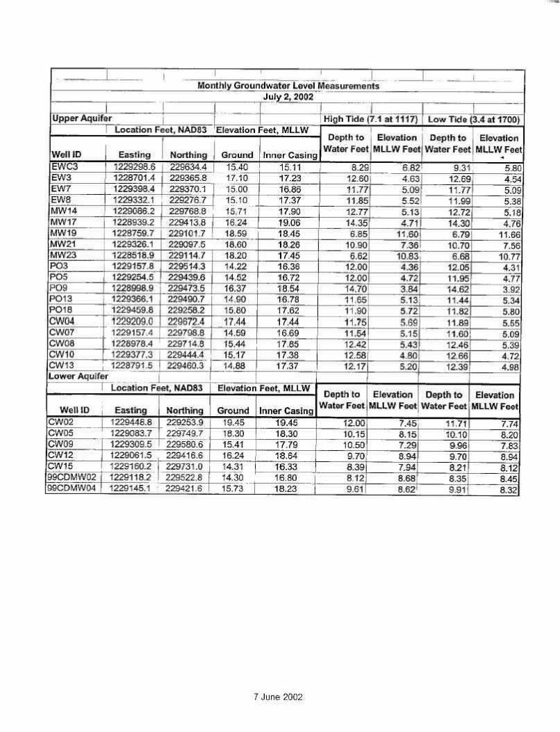
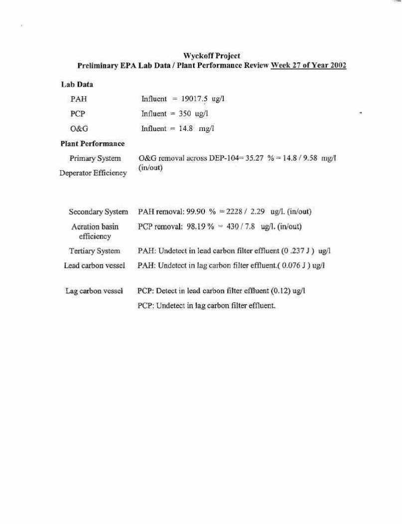
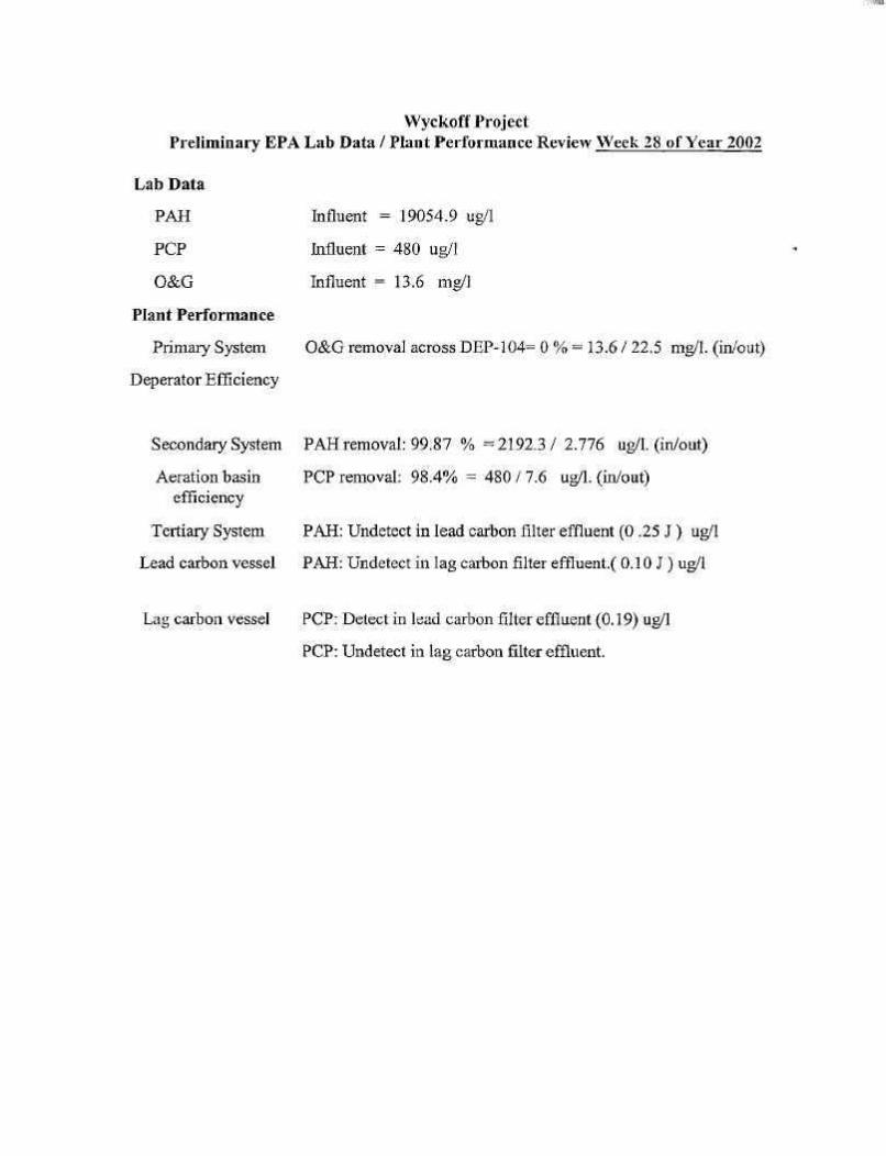
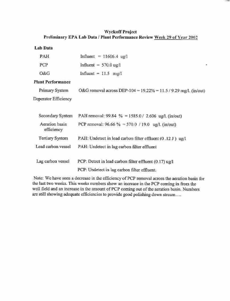
EnvironmentTable 5Estimate of Maximum Allowable Pore-Water Concentrations of COCsTable 6Soil Cleanup LevelsTable 7Performance Monitoring Analytical SuiteTable 8Effluent Discharge Monitoring Frequency and Sensitivity RequirementsTable 9June 2002 Water Level DataTable 10 July 2002 Water Level Data

x
LIST OF APPENDICES
Appendix A State of Washington National Pollution Discharge Elimination System(NPDES) Requirements
Appendix B February and August 2002 Fact Sheets Appendix C Mid-March 2002 Display AdAppendix D Interview QuestionsAppendix E Interview Responses and NotesAppendix F June 13, 2002 Public Meeting Record of Items DiscussedAppendix G List of Documents ReviewedAppendix H Site Inspection ChecklistAppendix I Site PhotographsAppendix J Monthly Groundwater Extraction and Treatment System
Operations Report, July 2002
xi
LIST OF ACRONYMS AND ABBREVIATIONS
ABC Association of Bainbridge CommunitiesAOC Administrative Order on ConsentARAR Applicable or Relevant and Appropriate StandardASIL Acceptable Source Impacts LevelASTM American Society for Testing and MaterialsATB asphalt-treated base
bgs below ground surfaceBMP Best Management PracticesBNA base/neutral and acid extractable
CDF Confined Disposal FacilityCERCLA Comprehensive Environmental Response, Compensation, and
Liability ActCFR Code of Federal RegulationsCIC Community Involvement CoordinatorCLARC Cleanup Levels and Risk CalculationsCOC Chemical of ConcernCY cubic yards
DAF Dissolved Air FlotationDNAPL Dense Non-Aqueous Phase LiquidDNR Washington State Department of Natural ResourcesDOT Washington State Department of TransportationDTS Distributed Temperature SensorsDW Dangerous Waste
Ecology Washington State Department of EcologyEPA U.S. Environmental Protection AgencyERA Expedited Response ActionESA Endangered Species Act
FS Feasibility Study
gpm gallons per minute
xii
HAET High Apparent Effects ThresholdHDPE High Density PolyethyleneHHRA Human Health Risk AssessmentHPAH High Molecular Weight Polycyclic Aromatic HydrocarbonHPO Hydrous/Pyrolysis/Oxidation
LIST OF ACRONYMS AND ABBREVIATIONS(Continued)
IAG Interagency AgreementICP Institutional Controls PlanITTAP In-situ Thermal Technologies Advisory PanelIRIS Integrated Risk Information System
LNAPL Light Non-Aqueous Phase LiquidLPAH Low Molecular Weight Polycyclic Aromatic HydrocarbonLS/PA Log Storage/Peeler Area
MCL Maximum Contaminant LevelMCUL Minimum Cleanup Levelmg/kg milligrams per kilogrammg/L milligrams per literMLLW Mean lower low waterMTCA Model Toxics Control Act
NA Not ApplicableNAPL Non-Aqueous Phase LiquidNCP National Contingency PlanNMFS National Marine Fisheries ServiceNOAA National Oceanic and Atmospheric AdministrationNPDES National Pollution Discharge Elimination SystemNPL National Priorities ListNRRB National Remedy Review Board
O&M Operation and MaintenanceOMMP Operations, Maintenance, and Monitoring PlanOMI Operations and Maintenance InternationalOU Operable Unit
xiii
PAH Polycyclic Aromatic HydrocarbonPCB Polychlorinated BiphenylPCC Pollution Control CommissionPCP Pentachlorophenolppb parts per billionPPE personal protective equipmentppm parts per millionPRP potentially responsible partyPSAPCA Puget Sound Air Pollution Control AgencyPSDDA Puget Sound Dredged Disposal Analysis
LIST OF ACRONYMS AND ABBREVIATIONS(Continued)
PSEP Puget Sound Estuary ProgramPSR Pacific Sound ResourcesPV pore volumePVC polyvinyl chloride
RAGS Risk Assessment Guidance for SuperfundRAO Remedial Action ObjectiveRCRA Resource Conservation and Recovery ActRI Remedial InvestigationRME Reasonable Maximum ExposureROD Record of DecisionRPM Remedial Project Manager
SARA Superfund Amendments and Reauthorization ActSMS Sediment Management StandardsSQS Sediment Quality StandardsSSC Superfund State Contract
TDS total dissolved solidsTOC total organic carbonTPAH Total Polycyclic Aromatic HydrocarbonTSDF Treatment, Storage and Disposal Facility
UAO Unilateral Administrative OrderUSACE U.S. Army Corps of Engineers
xiv
U.S.C United States Code
VOC Volatile Organic Compound
WAC Washington Administrative CodeWDFW Washington State Department of Fish and WildlifeWHOU West Harbor Operable UnitWQS Water Quality Standards
µg/kg micrograms per kilogramµg/L micrograms per liter

xv
EXECUTIVE SUMMARY
The Wyckoff/Eagle Harbor Superfund Site is located on the east side of Bainbridge Island, incentral Puget Sound, Washington. The site includes a former wood-treating facility, called theWyckoff facility, contaminated sediments in adjacent Eagle Harbor, and other upland sources ofcontamination to the harbor, including a former shipyard. The site is divided into four operableunits (OUs): West Harbor, East Harbor, and the Soil and Groundwater of the Wyckoff facility.
The remedies for each of the operable units include the following:
West Harbor Operable Unit - Evaluation and control of upland sources of contamination,excavation and upland disposal of mercury-contaminated sediments, and placement ofclean sediment cap over areas of concern. The September 1992 Record of Decision(ROD) was amended in December 1995 to include construction of a nearshore fill andconfined disposal facility in intertidal areas adjacent to the former shipyard property tohold hotspot sediments, and implementation of contaminant source control measures atthe former shipyard property to prevent soil contaminants from entering Eagle Harborthrough groundwater seeps or surface water runoff. The trigger for this five-year reviewwas the actual start of West Harbor OU remedy construction in April 1997.
East Harbor Operable Unit - In 1993 and 1994, EPA placed clean sediments over a 54-acre hotspot area as part of a non-time-critical removal action. The September 1994 RODcalled for monitoring and maintaining the existing sediment cap and capping remainingsubtidal areas of concern, monitoring the success of natural recovery in intertidal areas,enhancing existing institutional controls to reduce public exposure to contaminated fishand shellfish, and demolishing in-water structures.
Soil & Groundwater Operable Units - An interim ROD was issued in September 1994 forthe Groundwater OU which focused on the actions necessary to contain contaminatedgroundwater to the Wyckoff site, i.e., replace the existing treatment plant, maintain andupgrade the extraction system, install a physical barrier, and seal on-site drinking waterwells that could act as conduits for migration of contaminants to deeper aquifers.
In February 2000, EPA issued a final ROD for the Soil and Groundwater OUsconditionally selecting thermal remediation (i.e., steam injection) as the cleanup remedy. This remedy included constructing a sheet pile wall around the highly contaminatedFormer Process Area, conducting a pilot study to test the effectiveness of steam injection,
xvi
consolidating contaminated soil from outside to within the Former Process Area,monitoring the lower aquifer groundwater, and implementing institutional controls. If thesteam injection pilot study does not meet performance goals, then the contingency of sitecontainment will be implemented. The containment remedy would consist of a surfacesoil cap over the Former Process Area, containment of contaminated groundwater andNAPL with a sheet pile wall and extraction system, and construction of a replacementtreatment plant for ongoing treatment of contaminated groundwater.
This five-year review found that where the remedial actions have been constructed for WestHarbor, East Harbor, Soil, and Groundwater OUs, the work was done in accordance with therequirements of the Records of Decision. The soil and upper aquifer groundwater within theFormer Process Area and the East Beach intertidal area remain contaminated and will continue tobe addressed by EPA. However, the constructed remedies are functioning as designed. Someissues remain and follow-up actions will have to be implemented to ensure ongoingprotectiveness of human health and the environment (see Five-Year Review Summary Form,below). The immediate threats have been addressed. EPA will continue to monitor the remediesthat are in place, monitor the East Beach, and continue to operate the steam injection pilotproject, as well as the site-wide groundwater treatment plant and extraction system.
1
Wyckoff/Eagle Harbor Superfund SiteBainbridge Is land, WashingtonFirst Five-Year Review Report
I. INTRODUCTION
Purpose of the Review
The purpose of five-year reviews is to determine whether the remedy at a site is protective of humanhealth and the environment. The methods, findings, and conclusions of reviews are documented in Five-Year Review reports. In addition, Five-Year Review reports identify issues found during the review, ifany, and recommendations to address them.
Authority for Conducting the Five-Year Review
The U.S. Environmental Protection Agency (EPA) prepared this five-year review pursuant to theComprehensive Environmental Response, Compensation, and Liability Act of 1980 (CERCLA) §121 andthe National Contingency Plan (NCP). CERCLA §121 states:
If the President selects a remedial action that results in any hazardous substances, pollutants, orcontaminants remaining at the site, the President shall review such remedial action no less oftenthan each five years after the initiation of such remedial action to assure that human health and theenvironment are being protected by the remedial action being implemented. In addition, if uponsuch review it is the judgement of the President that action is appropriate at such site in accordancewith section [104] or [106], the President shall take or require such action. The President shallreport to the Congress a list of facilities for which such review is required, the results of all suchreviews, and any actions taken as a result of such reviews.
EPA interpreted this requirement further in the NCP; 40 CFR §300.430(f)(4)(ii) states:
If a remedial action is selected that results in hazardous substances, pollutants, or contaminants

2
remaining at the site above levels that allow for unlimited use and unrestricted exposure, the leadagency shall review such action no less often than every five years after the initiation of the selectedremedial action.
Who Conducted the Five-Year Review
EPA Region 10 has conducted a five-year review of the remedial actions implemented at theWyckoff/Eagle Harbor Superfund site on Bainbridge Island, Washington. This review was conducted forthe entire site from March 2002 through September 2002. This report documents the results of thereview.
The U.S. Army Corps of Engineers (USACE) and CH2M Hill provided support to EPA in the dataanalysis and evaluation of remedy protectiveness for this five-year review. The USACE also conductedthe site inspection on behalf of EPA.
Other Review Characteris tics
This is the first five-year review for the Wyckoff/Eagle Harbor Superfund site. The triggeringaction for this review was the actual start of construction for the West Harbor Operable Unit inApril 1997. The five-year review is required due to the fact that hazardous substances,pollutants, or contaminants remain at the site above levels that allow for unlimited use andunrestricted exposure.
II. SITE CHRONOLOGY
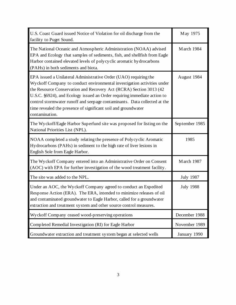
Event Date
Pollution Control Commission (PCC) reported direct discharge of oilymaterial from the wood-treating facility to Puget Sound; oil observed onbeach adjacent to the facility.
December 1952
EPA began investigating the property due to reports of oil observed on thebeach adjacent to the Wyckoff property.
1971
EPA and the Washington Department of Ecology (Ecology) reported oilseepage to Eagle Harbor and required Wyckoff Company to takeimmediate action to determine the source and reduce or eliminate seepage.
April 1972
3
U.S. Coast Guard issued Notice of Violation for oil discharge from thefacility to Puget Sound.
May 1975
The National Oceanic and Atmospheric Administration (NOAA) advisedEPA and Ecology that samples of sediments, fish, and shellfish from EagleHarbor contained elevated levels of polycyclic aromatic hydrocarbons(PAHs) in both sediments and biota.
March 1984
EPA issued a Unilateral Administrative Order (UAO) requiring theWyckoff Company to conduct environmental investigation activities underthe Resource Conservation and Recovery Act (RCRA) Section 3013 (42U.S.C. §6924), and Ecology issued an Order requiring immediate action tocontrol stormwater runoff and seepage contaminants. Data collected at thetime revealed the presence of significant soil and groundwatercontamination.
August 1984
The Wyckoff/Eagle Harbor Superfund site was proposed for listing on theNational Priorities List (NPL).
September 1985
NOAA completed a study relating the presence of Polycyclic AromaticHydrocarbons (PAHs) in sediment to the high rate of liver lesions inEnglish Sole from Eagle Harbor.
1985
The Wyckoff Company entered into an Administrative Order on Consent(AOC) with EPA for further investigation of the wood treatment facility.
March 1987
The site was added to the NPL. July 1987
Under an AOC, the Wyckoff Company agreed to conduct an ExpeditedResponse Action (ERA). The ERA, intended to minimize releases of oiland contaminated groundwater to Eagle Harbor, called for a groundwaterextraction and treatment system and other source control measures.
July 1988
Wyckoff Company ceased wood-preserving operations December 1988
Completed Remedial Investigation (RI) for Eagle Harbor November 1989
Groundwater extraction and treatment system began at selected wells January 1990
4
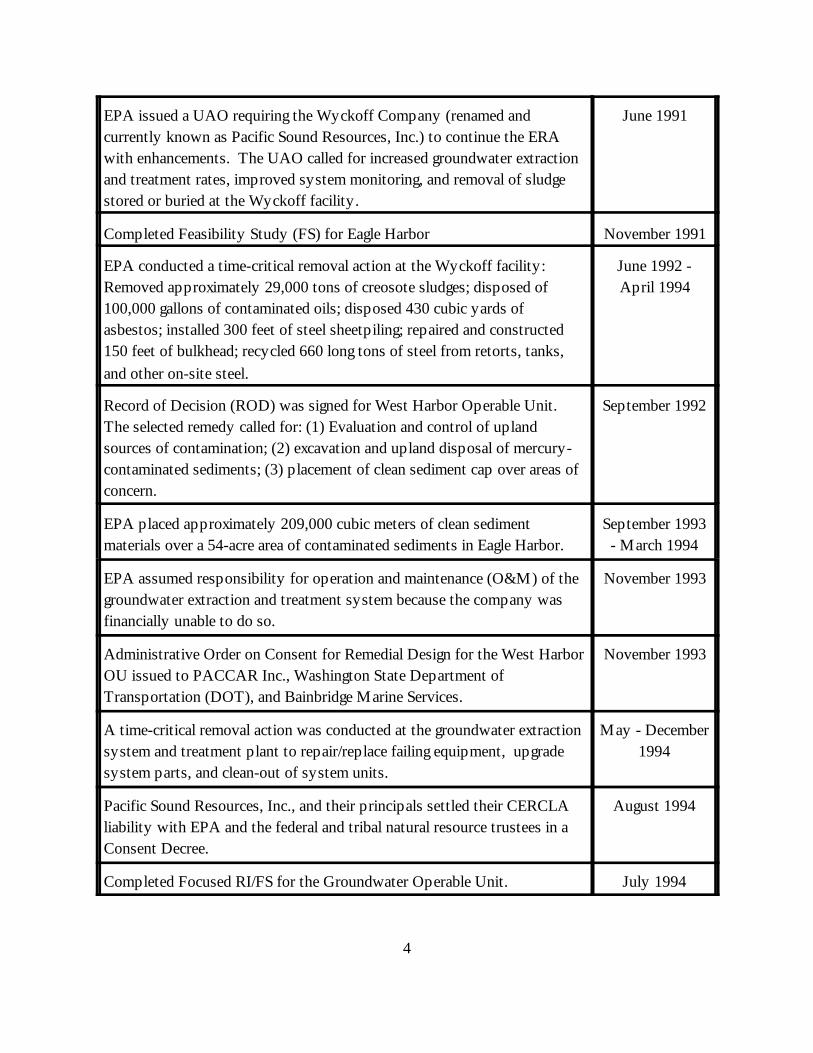
EPA issued a UAO requiring the Wyckoff Company (renamed andcurrently known as Pacific Sound Resources, Inc.) to continue the ERAwith enhancements. The UAO called for increased groundwater extractionand treatment rates, improved system monitoring, and removal of sludgestored or buried at the Wyckoff facility.
June 1991
Completed Feasibility Study (FS) for Eagle Harbor November 1991
EPA conducted a time-critical removal action at the Wyckoff facility: Removed approximately 29,000 tons of creosote sludges; disposed of100,000 gallons of contaminated oils; disposed 430 cubic yards ofasbestos; installed 300 feet of steel sheetpiling; repaired and constructed150 feet of bulkhead; recycled 660 long tons of steel from retorts, tanks,and other on-site steel.
June 1992 -April 1994
Record of Decision (ROD) was signed for West Harbor Operable Unit. The selected remedy called for: (1) Evaluation and control of uplandsources of contamination; (2) excavation and upland disposal of mercury-contaminated sediments; (3) placement of clean sediment cap over areas ofconcern.
September 1992
EPA placed approximately 209,000 cubic meters of clean sedimentmaterials over a 54-acre area of contaminated sediments in Eagle Harbor.
September 1993- March 1994
EPA assumed responsibility for operation and maintenance (O&M) of thegroundwater extraction and treatment system because the company wasfinancially unable to do so.
November 1993
Administrative Order on Consent for Remedial Design for the West HarborOU issued to PACCAR Inc., Washington State Department ofTransportation (DOT), and Bainbridge Marine Services.
November 1993
A time-critical removal action was conducted at the groundwater extractionsystem and treatment plant to repair/replace failing equipment, upgradesystem parts, and clean-out of system units.
May - December1994
Pacific Sound Resources, Inc., and their principals settled their CERCLAliability with EPA and the federal and tribal natural resource trustees in aConsent Decree.
August 1994
Completed Focused RI/FS for the Groundwater Operable Unit. July 1994
5
EPA issued Interim ROD for the Groundwater Operable Unit, whichincluded the following elements: (1) Replace the existing treatment plant;(2) evaluate, maintain, and upgrade the existing extraction system; (3)install a physical barrier, i.e., a slurry wall to prevent further releases ofcontaminants to Eagle Harbor and Puget Sound; (4) seal on-site wells.
September 1994
EPA completed the ROD for the East Harbor Operable Unit, whichincluded the following elements: (1) Monitor and maintain existingsediment cap; additional capping in remaining subtidal areas of concern; (2)monitor the success of natural recovery in intertidal areas; (3) enhanceexisting institutional controls to reduce public exposure to contaminatedfish and shellfish; (4) demolish in-water structures.
September 1994
Signed Superfund State Contract (SSC) with the Washington Departmentof Ecology for Groundwater OU Interim Remedial Action.
November 1994
RI Field Investigations for the Soil and Groundwater Operable Units 1994 & 1995
EPA sealed and abandoned 12 on-site wells, including two deep drinkingwater wells, due to concerns that they could provide conduits for migrationof contaminants to the deep aquifers.
January - June1995
Seven original extraction wells were abandoned and replaced by eight newgroundwater extraction wells; additional treatment plant upgrades includingpiping replacement, carbon handling, and installation of dewatering press.
June - December1995
West Harbor OU ROD Amendment. The amendment included thefollowing changes to the 1992 ROD: (1) Construction of a nearshore filland confined disposal facility (CDF) in intertidal areas adjacent to theformer shipyard property. Hotspot sediments will be placed inside theCDF and capped with clean material and asphalt; (2) implementation ofcontaminant source control measures at the former shipyard propertyacquired by DOT, to prevent soil contaminants from entering Eagle Harborthrough groundwater seeps or surface water runoff.
December 1995
Non-time critical removal action: Site structures were demolished anddebris removed and disposed off-site.
January - June1996
6
West Harbor OU potentially responsible parties (PRPs) constructed theremedy at the old shipyard in accordance with the December 1995 RODAmendment. Upland construction included: (1) soil stabilization of twoupland “hot spot” areas; (2) installation of a tidal barrier system adjacentto the landfill located in the northwest corner of the upland area; (3)installation of a cutoff drainage system along the northern boundary of thesite to intercept and cutoff surface and shallow subsurface water run-on;and (4) installation of an asphalt concrete cap across the former BainbridgeMarine Services upland. Sediment construction included: (1) removal,treatment, and disposal offsite of DU1 sediments (those that exceeded theDangerous Waste [DW] criteria); (2) removal and disposal in an on-siteconfined disposal facility (CDF) of hot spot sediments containing morethan 5 mg/kg total mercury; (3) backfill sediment dredge areas to pre-existing grade elevations; (4) placement of a thick cap (1 meter) oversediments containing >2.1 mg/kg mercury; and (5) placement of a thin cap(15 centimeters) over sediments exceeding chemical or biological cleanupstandards. In addition, new aquatic habitat was constructed to mitigate lossof 0.9 acres from remedial construction. This new habitat includedenhancing the face of the CDF berm face and the surface of the tidal flowbarrier and sediment cap with gravel/cobble layers.
March -December 1997
EPA issued a Water Quality Certification for the West Harbor OUremedial work.
April 1997
West Harbor OU PRPs provided the Suquamish Tribe with $110,000 forclam enhancements and other restoration projects performed by the Tribe.
Summer 1997
West Harbor OU PRPs constructed a 2-acre Schel-chelb Estuary at thesouth shore of Bainbridge Island (“South Bainbridge Estuarine Wetland andStream Restoration Site”) (planting occurred during February through lateSpring 1998).
Summer 1997 -Spring 1998
Completed removal of upland subsurface structures, such as processpiping, utility lines, foundations, concrete pads, and asphaltic concrete.
November 1997
EPA issued a “final” Proposed Plan which preferred containment as thecleanup strategy for soil and groundwater.
November 1997
7
Completed design for a replacement treatment plant. The plant was notconstructed pending a final decision regarding the Groundwater OUremedy.
July 1998
Long-term O&M associated with the containment strategy were of concernto the Department of Ecology; EPA evaluated thermal technologies forpossible application at Wyckoff: Conducted laboratory studies, metseveral times with the In-situ Thermal Technologies Advisory Panel(ITTAP), evaluated results of various other thermal technologies studiesand site demonstrations.
1998 - 1999
Region 10 presented thermal technologies evaluation activities andproposed new remedy for removal of contaminants in the soil andgroundwater at Wyckoff to the National Remedy Review Board (NRRB).
July 1998
West Harbor OU PRPs established a 0.6-acre eelgrass planting siteimmediately west of West Harbor OU CDF and cap.
September -October 1998
Completed Focused Feasibility Study Comparative Analysis ofContainment and Thermal Technologies
April 1999
West Harbor OU PRPs repaired 3 feet deep by 2 feet wide by 5 feet longdepression that developed in surface of CDF during March - April 1999
June 1999
Completed Conceptual Design for thermal remediation of the Soil andGroundwater OUs.
September 1999
EPA issued a second Proposed Plan for the Wyckoff Soil andGroundwater OUs. This Proposed Plan replaced the November 1997Proposed Plan and presented a change in the cleanup strategy. EPA’spreferred remedy in this plan (now the selected cleanup remedy) focusedon an innovative technology, called steam injection, to actively removecontaminants from the soil and groundwater.
September 1999
Completed removal of the West Dock. December 1999
8
EPA issued Record of Decision (ROD) for Wyckoff Soil and GroundwaterOUs conditionally selecting steam injection as the cleanup remedy. Components of this remedy include: (1) Constructing a sheet pile wallaround the highly contaminated zone of the Former Process Area; (2)conducting a pilot study to test the applicability and effectiveness ofsteam injection; (3) consolidating hot spots from the Former LogStorage/Peeler Area to the Former Process Area; (4) monitoring the loweraquifer groundwater; (5) implementing institutional controls
February 2000
Signed Superfund State Contract (SSC) with the Washington Departmentof Ecology for Soil and Groundwater OUs.
May 2000
Completed the following construction activities: installed over 1,800 linealfeet of sheet pile containment wall around the Former Process Area;installed 530 lineal feet of sheet pile wall within a 1-acre area of the site forthe steam injection pilot study; created 2 acres of habitat beach to mitigatefor habitat loss resulting from construction of the outer sheet pile wall;extended the existing sediment cap by an additional 15 acres.
February 2001
Completed the following construction activities: vapor cap over the steaminjection pilot area, all 16 injection wells and seven extraction wells, over600 thermal monitoring devices, boiler building; on-site water well forboiler feed water; removed additional 10,000 cubic yards of contaminatedsoil (20,000 CY of contaminated soil were removed during habitat beachconstruction) to complete cleanup of the Former Log Storage/Peeler Area;complete capping in Eagle Harbor - more materials were placed extendingout several hundred feet from the Wyckoff property to form a gentlysloping beach which connects the habitat beach to the west with existingintertidal areas to the east.
February 2002
Completed the following construction activities: modifications to theexisting groundwater treatment plant for treatment of new waste streamsextracted from the steam injection pilot area; installation of boiler, watersoftening equipment, heat exchangers, thermal oxidizer, compressor,injection and extraction pumps and associated conveyance pumps andpiping, and other pilot system equipment in the boiler building and withinthe pilot area; and start-up for all new equipment.
September 2002
III. BACKGROUND

9
Physical Characteris tics
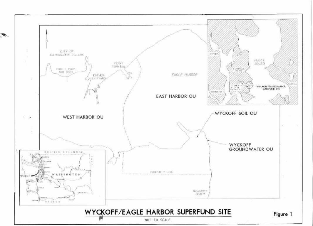
The Wyckoff/Eagle Harbor Superfund site is located on the east side of Bainbridge Island, incentral Puget Sound, Washington (Figure 1). The site includes an inactive wood-treating facility,called the Wyckoff facility, contaminated sediments in adjacent Eagle Harbor, and other uplandsources of contamination to the harbor, including a former shipyard. The site is currently dividedinto four operable units (Figure 1).
The harbor supports several fish resources. Coho and chum salmon once used the creek on thenorth shore to spawn, and fingerlings have been released there periodically. The creek at the headof the harbor is a salmon nursery, and it is possible that the drainage on the south side is used asa chum spawning ground and nursery. Eagle Harbor may also be a spawning ground for surfsmelt and Pacific sand lance (Washington Department of Fish and Wildlife, 1992). Other fish andinvertebrates present in the harbor include several flat fish species, rockfish, pile perch, codlingcod, crabs, and shrimp. Several shellfish species are present in intertidal and subtidal areas.
Endangered species of concern for the Wyckoff site and surrounding marine habitats includePuget Sound chinook, bull trout, Stellar sea lion, bald eagle, and marbled murrelet.
Land and Resource Use
Current Land Use
More than 20,000 people live on Bainbridge Island. Land use on Bainbridge Island is principallyresidential, with some commercial and industrial use. An urban area, formerly the City ofWinslow (population 2,800), lies on the north shore of the Harbor. Residences, commercialcenters, a city park, several marinas, a Washington State Ferry repair yard, a bulkhead enterprise,and a ferry terminal characterize the northern shoreline. The western and southern shores areprimarily lined with residences, farms, marinas, and a boatyard. On the south shore at the harbormouth, the former wood-treating facility extends into the harbor on fill.
A significant use of the harbor is ferry transport of vehicles and passengers between the City ofBainbridge Island and Seattle. Currently, approximately twenty-four runs are made per day. The harbor is also used for moorage of pleasure boats, house boats, and working boats. Fishing,crabbing, and clam-digging were common recreational activities until 1985, when the Bremerton-Kitsap County Health District issued a health advisory to address bacterial and chemicalcontamination of seafood in Eagle Harbor. The advisory, recommending against the harvest and
10
consumption of fish and shellfish, has significantly reduced recreational harvest of seafood fromthe harbor.
Eagle Harbor is within the usual and accustomed fishing area of the Suquamish Tribe, whosereservation is located on the Kitsap Peninsula north of Bainbridge Island. The Suquamish Triberetains the right to harvest fish and marine invertebrates and to have fishery resource habitat areasprotected within the Suquamish Tribe’s usual and accustomed fishing area.
Wood treating operations at the Wyckoff site ceased in 1988. By October 1997, EPA hadremoved all structures and buildings at the site, with the exception of the existing pump-and-treatsystem.
The current zoning of the Wyckoff property is Water-Dependent Industrial. Uses under thecurrent zoning may include retail commercial, indoor entertainment, cultural and governmentfacilities, associated parking, agriculture, boatyards, marine sales and repair.
Reasonably Anticipated Future Land Uses
The Wyckoff Superfund Site is scheduled for a comprehensive plan amendment by the City ofBainbridge Island. In 1996, a citizen committee was formed by then mayor, Janet West, to studyfuture land use for the Wyckoff property. A report, entitled Recommended Zoning for the Site ofthe Former Wyckoff Creosote Facility, Wyckoff Zoning Advisory Committee (August 7, 1996),was accepted by the Bainbridge Island City Council. The recommendations were based on theassumptions that the contamination would be contained in place, i.e., the contaminatedgroundwater would be contained using a slurry wall and the contaminated soil would be capped.
The 1996 Bainbridge Island Zoning Advisory Committee recommendations were:
Residential Use in the Hillside Area (Approximately 39 acres)Single family and multi-family residential.
Mixed-Use Water-Dependent/Water-Related Commercial in the Former LogStorage/Peeler Area (Approximately 10 acres)
11
Water related commercial uses including marina, boatyard with haul-out facility, marinesales and repair, marine related sales, and restaurants. Emphasis is on water-dependentuses.
Open Space Recreational Uses in the Former Process Area (Approximately 8 acres)Limited to public recreational uses including vegetated areas, pedestrian/bike trails,playgrounds, restroom facilities, recreational shelters, parking and potential museumstructure.
Since then, EPA has altered the property’s characteristics and has changed the cleanup approachfrom containment to a more aggressive cleanup of the soil and groundwater using an innovativesteam injection technology. It is possible that there will be flexibility in future land uses based onthe cleanup that may be achieved, including but not limited to, residential use for large portions ofthe Wyckoff property.
In 2001, the City re-evaluated the original report and assumptions and made newrecommendations to the Planning Commission and City Council as part of the WyckoffComprehensive Plan Amendment process. In June 2001, the City issued an updated report tothe 1996 Wyckoff Zoning Advisory Report, entitled Recommended Land Use for the FormerWyckoff Creosote Facility.
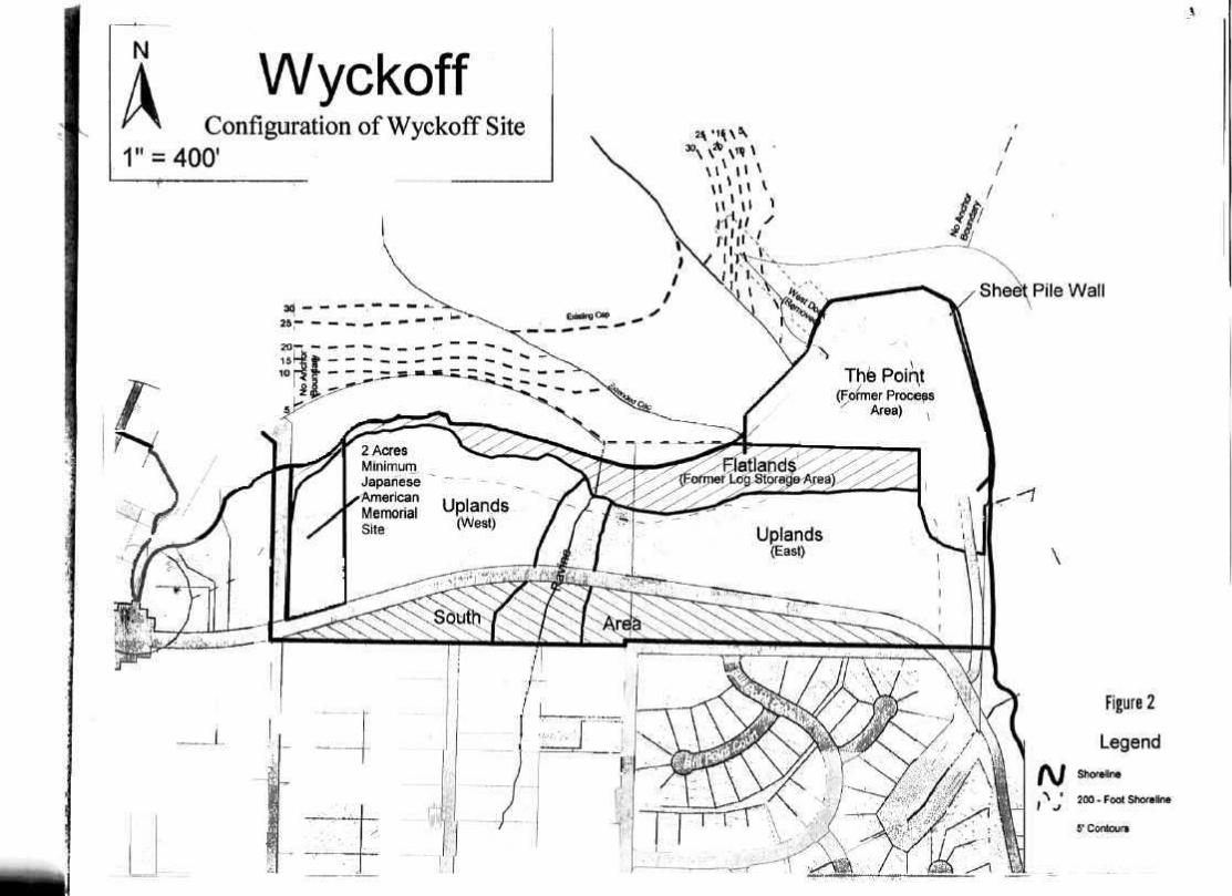
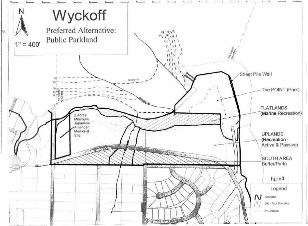
The “Preferred Alternative” from the 2001 report promotes the use of the entire property aspublic parkland. The City recognizes that public ownership is fundamental to this alternativeand is currently pursuing financial and political support for purchase of the property:(See Figures 2 and 3)
North Area - Approximately 42 acresPoint: Approximately 11.5 acres to be developed as active park, retaining views andproviding public access to the water.Flatlands: Approximately 8 acres of waterfront parkland with trail and beach access,protected shoreline habitat and also including development of active public marinerelated uses, providing a public dock, boathouse and other boating facilities. Consideration should also be given to a cross-harbor foot ferry.Uplands: Aproximately 22 acres
• West Uplands - A minimum of 2 acres adjacent to Taylor Avenue wouldbe devoted to a Japanese American Memorial in honor of those citizensincarcerated during World War II. Vehicular access to the Wyckoff
12
property on the western boundary of the site would be limited to providea buffer between the active uses and the memorial.• Ravine - This area would primarily serve as a natural wildlife corridorconnecting to the habitat beach.• East Uplands - The main vehicular entrance to the park, parking andservice uses would be sited here, including buildings serving as interpretive,educational, historical or cultural centers.• Trail - A trail link through the Uplands would connect to Eagle Harbor,the Uplands, the Japanese American Memorial, the Point and the marineactivities along the shoreline.
South Area - Approximately 7.5 acres left undeveloped to serve as a buffer between thepark and existing residential neighborhoods.
Reasonably Anticipated Future Resource Uses
In 2001, EPA created over two acres (approximately 1,200 lineal feet) of new beach habitat onthe western portion of the site significantly enhancing the habitat and ecosystem function at theWyckoff site. The beach mitigates for the habitat lost by the offshore construction of the sheetpile wall. Construction of the habitat area involved removing old bulkheads, removing a total of40,000 cubic yards of soil, and contouring soil along the shoreline. A layer of “fish mix”, ormaterial with the grain size preferred by salmon and smelt, was placed on the newly createdbeach. Creation of the mitigation beach, combined with the new intertidal habitat resulting fromthe completion of the sediment capping, restored approximately 2,500 feet of cleaninterconnected beach habitat for endangered species - including Chinook salmon and bull trout -smelt, shellfish, birds and small mammals. In late 2001, additional beach material was placed overthe rip rap at the top of the habitat beach to improve overall habitat function. EPA also plantedover 2,000 native trees, shrubs, plants and grasses in a 20-foot habitat buffer extending from thetop of the beach inland.
EPA is considering the potential for a vegetated buffer along the entire Wyckoff shoreline aftercleanup is complete to protect the intertidal and subtidal remedy and to support and protectfunctions of nearshore habitat. A healthy native riparian zone or buffer provides woody debris,cover, and insects to the upper beach for juvenile salmonids. This buffer would also be intendedto separate critical habitat from nearby development and human activity. Buffers reduce impactsfrom stormwater runoff by stabilizing soils, providing erosion control, and filtering suspendedsolids. The buffer would also provide essential habitat for upland shoreline wildlife for use infeeding, breeding and rearing, as well as necessary cover from predators.
13
In March 2001, EPA solicited comments from the public on the potential use of vegetated bufferareas along the Wyckoff shoreline after cleanup. EPA received favorable responses regardingbuffer zones at the site including resolutions from the Bainbridge Island City Council and theBainbridge Island Park & Recreation District. EPA also received correspondence from theSuquamish Tribe, the National Marine Fisheries Services of NOAA, the U.S. Fish and WildlifeService, and the Washington State Department of Fish and Wildlife calling for and advocating thecreation of buffer zones at The Wyckoff site. EPA is currently in the process of drafting aPreliminary Institutional Controls Plan (ICP) detailing performance standards that must be metby the landowner under local control and oversight, to protect the intertidal and subtidal areas,which are part of the site’s cleanup remedy.
Future resource uses of Eagle Harbor and the Washington State Department of Transportation(DOT) ferry terminal is anticipated to remain the same. The No Anchor Zone, established byEPA, the Washington State Department of Natural Resources (DNR), and the U.S. Coast Guard,to protect the subtidal cap in Eagle Harbor will be maintained.
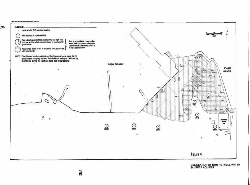
Groundwater Classification and Basis
Both Class II and Class III groundwater exist at Wyckoff (EPA Guidelines for Ground-WaterClassification, Final Draft, December 1986). Class III groundwater occurs where saltwaterintrusion raises total dissolved solids (TDS) concentrations above 10,000 mg/L. Class IIgroundwater occurs above and upgradient of the 10,000 mg/L boundary. (see Figure 4)
Upper Aquifer. Groundwater in the upper aquifer underneath the Former Process Area isnot currently extracted for potable, agricultural, or industrial purposes, due to saltwaterintrusion caused by tidal flushing. High salinity levels are anticipated to remain in thefuture. The Washington State Department of Ecology has determined the upper aquifergroundwater in the Former Process Area to be non-potable because it is significantlyaffected by salinity and will not be used as a future source of drinking water. Theassignment of Class III to the upper aquifer groundwater beneath the Former ProcessArea is consistent with EPA’s definition of a potential source of drinking water.
The upper aquifer beneath the Former Log Storage/Peeler Area does not serve as a currentsource of drinking water. However, this aquifer could potentially be potable.
Lower and Deep Aquifers. The upper groundwater aquifer is separated from the loweraquifer by a low-permeability layer (aquitard). Data gathered during the remedialinvestigation and during exploratory drilling by the U.S. Army Corps of Engineers
14
indicate that the low-permeability layer is continuous with thickness generally rangingfrom 10 to 40 feet, although it may be as thin as four feet in isolated locations and/or maycontain interbedded sand layers.
Groundwater in the lower aquifer (approximately 80 to 200 feet below ground surface) isconsidered potable although this aquifer has never been used for drinking water on thisproperty.
Additionally, there are deep confined aquifers that are located from approximately 200feet to 1,500 feet or more below ground surface. These aquifers are also potable and wereused in the past by the Wyckoff Company to provide water for on-site operations withexcess sent to nearby residents on Rockaway Beach to be used for drinking waterpurposes. EPA sealed and abandoned two deep drinking water wells (located at 500 feetand 800 feet bgs) in 1995 due to concerns that they could provide conduits for migrationof contaminants to the deep aquifers.
Current Groundwater Use
Two community drinking-water supply systems are located in the immediate vicinity of theWyckoff property: the Bill Point wells and the South Eagle Harbor Supply Well. The Bill PointWells are located upgradient on the hillside south of the Wyckoff property; drinking water isobtained from two to four wells that are each completed at depths of 150 to 160 feet belowground surface (bgs). Quarterly sampling was conducted from 1988 to 1994 at these wells todetermine if they were impacted by the Wyckoff operations. An assessment of the analyticalresults indicated that some extremely low levels of organics existed in these wells, however,concentrations were extremely low, and in most cases several orders of magnitude below the moststringent drinking water levels. Several inorganic chemicals (metals) have also been detected. However, metals have not been used at the Wyckoff facility as part of wood-preservingoperations. Furthermore, the Bill Point wells are also located upgradient of the contamination atWyckoff, and there is no interconnection between the Bill Point aquifers and the upper(contaminated) aquifer beneath the Wyckoff site. Therefore, EPA ceased the sampling programin 1994. The South Eagle Harbor Supply Well is located about one-half mile west of theWyckoff property and is completed at a depth of approximately 600 feet bgs. This well wasconstructed to provide a replacement water supply for the Rockaway Beach community.
In January 2002, EPA completed construction and testing of an on-site water supply well. Thiswell was constructed outside of the contaminated zone on the Wyckoff property (Figure 5). Thepurpose of the well is to provide a water source for conversion to steam in the boiler during the
15
steam injection pilot project and for other site operation uses. The water well was completedwithin an aquifer system between the depths of 460 and 500 feet below ground surface (bgs). During construction of the well, necessary casing reductions occurred only within low-permeability zones (i.e., aquitards) to prevent communication between the aquifers and toprotect the deep aquifers.
Pump test results show that the on-site water supply well can provide 200 gallons per minute(gpm) with very minimal or no effect on nearby water supply systems. EPA monitored the BillPoint water supply system and the City’s South Eagle Harbor well located on Taylor Avenueduring the pumping test. Salinity measurements during the pump test indicated there was noseawater intrusion in the on-site water supply well. No exceedances of drinking water criteriawere noted in the water supply well, nor were contaminants associated with the site detected ineither the South Eagle Harbor or Bill Point wells.
History of Contamination
From the early 1900s through 1988, a succession of companies treated wood at the Wyckoffproperty for use as railroad ties and trestles, telephone poles, pilings, docks, and piers. Initiallythe poles were treated by wrapping with burlap and asphalt, but by 1910 pressure treatmentbegan with creosote/bunker oil. The Wyckoff wood-preserving plant was one of largest in theUnited States, and its products were sold throughout the nation and the rest of the world. Wood-preserving operations included: (1) the use and storage of creosote, pentachlorophenol, solvents,gasoline, antifreeze, fuel and waste oil, and lubricants; (2) management of process wastes; (3)wastewater treatment and discharge; and (4) storage of treated wood and wood products.
The main features of the wood-treating operation included: (1) a process area, which includednumerous storage tanks and process vessels such as retorts; (2) a log storage and log peeler area;and (3) a treated log storage area.
There is little historic information about the waste management practices at the Wyckoff facility. Prior to reconstruction of the Wyckoff facility in the 1920s, it is reported that logs were floatedin and out of a lagoon that once existed at the site. The lagoon has since been filled. Treated logswere also transported to and from the facility at the former West Dock via a transfer table pit,and the chemical solution that drained from the retorts after a treating cycle went directly on theground and seeped into the soil and groundwater below the surface. This practice began aroundthe mid-1940s until operations ceased in 1988. Wastewater was also discharged into EagleHarbor for many years, and the practice of storing treated pilings and timber in the watercontinued until the late 1940s. Further site contamination occurred due to drips from treated
16
poles and sloppy handling of used treatment product. The log storage area was primarily used tostore untreated wood.
Groundwater and soils at the wood-treating facility are contaminated with chemicals from thewood treatment process, primarily creosote-derived polycyclic aromatic hydrocarbons (PAHs),pentachlorophenol (PCP), aromatic carrier oils, and dioxins/furans. Over the last 12 years ofoperating the on-site extraction system and treatment plant, EPA has removed approximately100,000 gallons of non-aqueous phase liquids (NAPL) from the ground and treated over 370million gallons of contaminated groundwater. It is estimated that 1 million gallons of NAPL stillremain in the subsurface.
Sediments in areas of Eagle Harbor are contaminated with PAHs and other organic compounds, aswell as with metals, primarily mercury. The wood treating facility is the major source of PAH tothe East Harbor through both past operating practices and contaminant transport through thesubsurface. An additional source of contaminants to Eagle Harbor was created when sludge fromtanks and sumps was used as fill material between an old and new bulkhead at the Wyckoff sitein the 1950s. In the West Harbor, PAH contamination in nearshore sediments appear to be fromcombustion products, minor spills, and pilings and piers, while subtidal PAH contamination inthe West Harbor is believed to reflect a combination of these sources, disposal practices at theformer shipyard (Figure 1), and releases from the Wyckoff property. Elevated concentrations ofmetals, particularly near the former shipyard, are associated with past shipyard operations,including the application, use, and removal (by sandblasting) of bottom paints and antifoulants.
Initial Response
Due to reports of oil observed on the beach, EPA began investigating the property in 1971. In1984, EPA issued an order requiring the Wyckoff Company to conduct environmentalinvestigations. Data collected at the time revealed the presence of significant soil andgroundwater contamination. Numerous other investigations were conducted at this site prior toinitiation of the RI/FS. The Wyckoff Company, EPA, the Washington Department of Ecology(Ecology), and the National Oceanic and Atmospheric Administration (NOAA) all investigatedother aspects of the site in the early to mid-1980s under regulatory authority other thanComprehensive Environmental Response Compensation and Liability Act (CERCLA) authority. Although work was conducted under Resource Recovery and Conservation Act (RCRA)authority, the site was not considered a treatment, storage and disposal facility (TSDF).
The site, including Eagle Harbor, the wood-treating facility, and other sources of contamination toEagle Harbor, was listed on the Superfund National Priorities List (NPL) in July 1987. In July
17
1988, the Wyckoff Company was ordered by EPA to install groundwater extraction wells and agroundwater treatment plant in an effort to halt continuing release of wood-treating contaminantsto Eagle Harbor.
A settlement with the Wyckoff Company was embodied in a Consent Decree entered in FederalDistrict Court in August 1994. The Decree creates the Pacific Sound Resources (PSR)Environmental Trust into which the heirs of the Wyckoff Company founders, owners andoperators placed all ownership rights and shares in the Company to allow the Trust to maximizeliquidation of all company assets, including nonwood-treating holdings, for the benefit of theenvironment. The beneficiaries of the Trust are the United States Department of Interior,National Oceanic and Atmospheric Administration (NOAA) of the Department of Commerce,and the Suquamish and Muckleshoot Tribes, as Natural Resource Trustees, as well as EPA (theSuperfund trust fund) for reimbursement of CERCLA remedial costs. A memorandum ofagreement was entered into by the beneficiaries of the Trust to ensure that settlement proceedswould be applied toward both environmental response and natural resource restoration goals.
The groundwater pump-and-treat systems were put online in 1990. In November 1993, EPAassumed control of the site and operation of the systems and discovered that both the treatmentplant and extraction systems were in a state of disrepair. New extraction wells were installed toreplace the original seven and a variety of operational and process improvements were made tothe treatment system.
The systems have been effective in recovering large amounts of oily creosote in the form of non-aqueous phase liquid, or NAPL, and in helping to control the migration of contaminants from thegroundwater to the Harbor. The extracted groundwater contaminated with elevated levels ofPAHs and PCP is treated at the plant so it can be safely discharged through an outfall to PugetSound.
Other actions taken to deal with the contamination include demolition and removal of thebuildings, structures, above ground and underground storage tanks, underground foundations andpiping, and the removal of asbestos, sludge, and some heavily contaminated soil. In the EastHarbor, a 54-acre sediment cap was placed over contaminated subtidal sediments in 1993 and1994.
Basis for Taking Action
West Harbor Operable Unit

18
Intertidal samples from Eagle Harbor were found to exceed the maximum concentrationsmeasured at background locations for a number of metals (copper, lead, zinc, cadmium, andarsenic). The greatest number of metals detected and the highest concentrations were detectednear the former shipyard on the north shore. Subtidal mercury concentrations exceeded maximumbackground values by between two and twenty times throughout the harbor and wereparticularly high near the former shipyard.
PAH concentrations were extremely high in intertidal sediments adjacent to the Wyckoff facility(East Harbor OU) and, to a lesser extent, near the ferry terminal (West Harbor OU). SedimentPAH concentrations adjacent to the former shipyard in the West Harbor were lower, but werestill higher than at intertidal background stations. Subtidal samples showed heavy PAHcontamination in the East Harbor, with several high values near the former shipyards in the WestHarbor. Estimated average concentrations of HPAH, the high molecular weight subgroup ofPAH compounds, were highest north of the Wyckoff facility and in the central harbor, and weresignificantly higher than background values. Concentrations of total PAH (TPAH) and lowmolecular weight PAH (LPAH) follow the same general pattern. Contamination bypentachlorophenol is not widespread.
Human populations potentially exposed to contamination include children and adults whoconsume contaminated fish and/or shellfish, and individuals, particularly children, who might beexposed to contaminated intertidal sediments through dermal exposure (skin contact) or incidentalingestion. Risks from four exposure routes were calculated, including ingestion of contaminatedclams and crabs, ingestion of contaminated fish, ingestion of contaminated intertidal sediments,and dermal contact with contaminated intertidal sediments. Marine organisms potentiallyexposed to contaminated sediments include sediment-dwelling organisms in three majortaxonomic groups: mollusca (e.g., clams), polychaeta (worms), and crustacea (e.g., amphipods).
Human health risks for Eagle Harbor are primarily associated with the consumption of shellfish. The Eagle Harbor human health risk assessment used a high (95th percentile) fish and shellfishingestion rate, computed from the 1988 Puget Sound Estuary Program (PSEP) study of seafoodconsumption in Puget Sound. The high rate for shellfish consumption was estimated to be 21.5grams per day, equivalent to a 1/3-pound serving a week. The fish consumption rate was 95.1grams/day for fish. This rate corresponds to 230 servings of 1/3-pound of fish over the course ofa year. (The study estimated that an average consumer eats at most 30 such servings of fish andthree such servings of shellfish per year). The high rates were used for the reasonable maximumexposure (RME) assumption for adults. These assumptions were modified to develop ingestionrates for children, based on body weight ratios.
19
In the West Harbor, the cancer risks in the 10-3 range were associated with clam tissues fromareas near the ferry terminal and the former shipyard.
East Harbor Operable Unit
Chemical concentrations in Eagle Harbor sediments and seafood were elevated with respect tobackground locations. However, human health risk estimates for exposure to sedimentcontaminants through dermal contact and sediment ingestion are within or below EPA’s range ofacceptable risks (EPA’s acceptable risk range is from 1 in 10,000 (1x10⁻⁴) to 1 in 1,000,000 (1x10-
6)). For seafood ingestion, calculated cancer risks are generally between 10-4 and 10-6 at bothEagle Harbor and background locations. Consumption of shellfish from specific areas (such asnear the Wyckoff property) results in risk above 10-4.
The bioassays for acute toxicity indicated that sediments from many sampled locations in theEast Harbor were toxic to amphipods, oyster larvae, or both. The bioassay responses were mostsevere in areas of high PAH contamination, such as areas of the East Harbor north of theWyckoff facility. Additional evidence of biological effects in Eagle Harbor includes theprevalence of liver lesions and tumor in English sole, as documented by NOAA. This andlaboratory research citing the effects of PAH and other sediment contaminants on marineorganisms add to the evidence suggesting potential damage to Eagle Harbor marine life. Table 1summarizes the baseline risk (i.e., health risk prior to any cleanup activities) adjacent to theWyckoff property.
Soil Operable Unit
The Soil OU is divided into three components, the Former Log Storage/Peeler Area, the FormerProcess Area, and Well CW01 Area (Figure 6). There is widespread near-surface and subsurfacesoil contamination in these areas, with very elevated levels of contamination in the FormerProcess Area. The contaminants of concern (COCs) in soil are nine PAHs (benzo(a)anthracene,benzo(a)pyrene, benzo(b&k)fluoranthene, chrysene, dibenz(a,h)anthracene, indeno(1,2,3-cd)pyrene, benzo(b)fluoranthene, benzo(k)fluoranthene, and naphthalene), pentachlorophenol,and dioxins/furans. The primary contributor to cancer risk through soil ingestion by futureresidents (the residential exposure scenario was evaluated in the baseline human health riskassessment) is benzo(a)pyrene, a carcinogenic PAH. The remaining carcinogenic high molecularweight PAHs, or HPAHs, PCP, and dioxins make up the rest. The primary contributor to non-cancer risk is naphthalene with a calculated hazard quotient of 22.8. Table 2 summarizes theaverage exposure, maximum exposure concentration, and associated risk values for chemicals ofconcern in the Soil OU.
20
Groundwater Operable Unit
The Groundwater Operable Unit includes the soil and groundwater in the saturated zone beneaththe Soil Operable Unit (Figure 6). The Groundwater OU is composed of two water-bearingzones separated by a layer of low-permeability material, called the aquitard. These water-bearingzones (i.e., the upper and lower aquifers) consist of sand and gravel with variable amounts of silt. The aquitard is comprised of stiff marine silt and dense to hard glacial material. The aquitard iscontinuous throughout the site; its thickness varies from 10 feet to 40 feet, but may be as thin asfour feet in isolated areas, and in some locations, contain interbedded sand layers.
In the development of cleanup alternatives, the Groundwater OU was divided into three areas: the upper aquifer beneath the Former Process Area, the upper aquifer beneath the Former LogStorage/Peeler Area, and the lower aquifer (Figure 6).
Light non-aqueous phase liquid (LNAPL) “pools” have been located in the upper aquifer beneaththe Former Process Area at maximum thicknesses up to 13 feet. Dense non-aqueous phase liquid(DNAPL) “pools” have been measured at maximum thicknesses up to 14 feet. Prior toinstallation of the sheet pile wall in 2001, seeps of NAPL into the intertidal area were observedalong the eastern and northern shoreline. The seeps appeared to coincide with observations ofLNAPL in groundwater on-site. DNAPL pools were observed (and periodically removed bydivers) on the harbor floor in the Log Rafting Area west of the large dock (former West Dock). L- and DNAPL are present everywhere in the upper aquifer groundwater within the FormerProcess Area, as well as in the intertidal areas (Figure 7).
Data from the Remedial Investigation (June 1997) and subsequent investigations by the U.S.Army Corps of Engineers indicate that there are approximately 1 million gallons of NAPL in theupper aquifer of the Former Process Area. The low-permeability layer (aquitard) helps tominimize the downward vertical migration of DNAPL to the lower aquifer.
The NAPL present at the Wyckoff OUs consists mostly of a mixture of creosote,pentachlorophenol, and/or aromatic carrier oils. Creosote was used by itself in the early years ofwood-treatment production. Later, it was mixed with aromatic carrier oils to obtain deeperpenetration of preservative in the wood. Beginning in 1957, pentachlorophenol becamecommercially available for wood-preserving operations and was mixed with aromatic carrier oils.
1 Dioxins/furans were detected in the NAPL samples, but not in the dissolved-phasegroundwater.
21
The contaminants of primary concern in the upper aquifer groundwater are thirteen polycyclicaromatic hydrocarbons (PAHs), pentachlorophenol (PCP), and dioxins/furans1, which are presentin the groundwater in the form of mobile NAPL, dissolved constituents, and residual NAPL heldin soil pore spaces. Volatile organics and base/neutral and acid extractables (BNAs) are alsopresent in the groundwater, however, for purposes of cleanup, they are assumed to be co-locatedwith the PAHs.
Samples collected from the upper aquifer beneath the Former Process Area were not included inthe human health risk assessment due to the aquifer being classified as non-potable. The upperaquifer south and west of the Former Process Area and the lower aquifer groundwater areassumed to be potential sources of drinking water. In the upper aquifer groundwater south andwest of the Former Process Area, the excess cancer risk from ingestion of groundwater by futureresidents ranges from 5x10⁻⁶ to 4x10⁻⁴, with the higher values found near the Former ProcessArea. In general, the primary contributors to cancer risk in groundwater are benzo(a)pyrene,benzo(a)anthracene, benzo(b)fluoranthene, and benzo(b)anthracene. Table 3 summarizes themaximum exposure concentration and associated risk values for chemicals of concern ingroundwater.
In lower-aquifer groundwater, two of the four wells that were included in the risk assessmentdisplayed an excess cancer risk of greater than 10-5 but lower than 10-4. However, subsequentfield investigations revealed that one of those two wells (CW12) was not screened in the loweraquifer. As a result, data from this well may be representative of either the upper aquifer orcontaminant levels penetrating high permeability zones of the aquitard, but not the lower aquifer.
22
IV. REMEDIAL ACTIONS
EPA organized the Wyckoff/Eagle Harbor Superfund Site into four operable units (OUs)(Figure 1):
• Operable Unit 1: The East Harbor OU (PAH contaminated subtidal and intertidalsediments in Eagle Harbor; Record of Decision, September 1994)
• Operable Unit 2: The Wyckoff Soil OU (PAH, PCP, and dioxins/furanscontaminated unsaturated soil; Record of Decision, February 2000)
• Operable Unit 3: The West Harbor OU (metals, primarily mercury, contaminatedsubtidal and intertidal sediments in Eagle Harbor, and uplandsources; Record of Decision, September 1992, amended December1995)
• Operable Unit 4: The Wyckoff Groundwater OU (the saturated soil andgroundwater beneath the Soil OU; Record of Decision, February2000)
Remedy Selection
West Harbor Operable Unit
The cleanup goals and objectives for the West Harbor OU are to achieve the State of WashingtonSediment Quality Standards (SQS) and reduction of contaminants in fish and shellfish to levelsprotective of human health and the environment. While these goals represent a conceptual targetcondition, the measurable site-specific objective is the State of Washington SedimentManagement Standards minimum cleanup level (MCUL), and achievement of the MCUL was theprimary focus of remedial action in this OU. The MCUL must be achieved in the top tencentimeters of sediment throughout the West Harbor within ten years after the completion ofactive sediment remediation or within ten years from control of significant sources to areaspredicted to naturally recover.
In order to define areas requiring specific types of remedial action, the objectives above weresupplemented by three EPA objectives:
23
1) to address sediments containing 5 mg/kg (dry weight) or more of mercury, as a meansof source control;
2) to address intertidal sediments containing 1,200 µg/kg (dry weight) or more of HPAH. Shellfish in such areas contained carcinogenic HPAH above EPA acceptable levels forprotection of human health;
3) to address predicted biological impacts, minimize potential sediment resuspension, andlimit biological uptake in areas where sediment concentrations of mercury exceed 2.1mg/kg mercury dry weight. The sediment concentration of 2.1 mg/kg (dry weight) is morethan three times the MCUL and is the High Apparent Effects Threshold (HAET) formercury. (This is the sediment concentration of mercury above which Puget Sound testsediments have always failed acute toxicity tests for both amphipods and oyster larvaeand have demonstrated chronic benthic effects).
Contaminated sediments containing 5 mg/kg or more of mercury were considered a “principalthreat” at this operable unit. The selected remedy addressed this principal threat by requiringremoval of these sediments from the marine environment.
The major components of the selected remedy for the West Harbor OU include:
• Further evaluation and control of potential upland sources of contamination to WestHarbor sediments;
• Excavation, solidification/stabilization (if necessary), and upland disposal ofsediments exceeding 5 mg/kg mercury (dry weight);
• Placement of a cap of clean sediment over areas of high concern for adverse biologicaleffects and potential contaminant resuspension and bioaccumulation;
• Thin-layer placement of clean sediments to enhance sediment recovery in areas ofmoderate concern;
• Natural recovery and monitoring in areas predicted to achieve the long-term sedimentcleanup objective without sediment remedial action;
• Continued institutional controls to protect human health from exposure tocontaminated fish and shellfish; and
24
• Long-term environmental monitoring to evaluate the effectiveness of the remedy.
In December 1995, EPA issued an amendment incorporating the following changes to theSeptember 1992 ROD:
• Construct a nearshore fill and confined disposal facility (CDF) in intertidal areasadjacent to the former shipyard property. Hotspot sediments were to be placedinside the CDF and capped with clean material and asphalt. This fill would create 0.9acres of additional land so that the Washington State Department of Transportation(DOT) could reserve one acre of the property for private boatyard or other water-dependent operations. To compensate for habitat lost as a result of the nearshoreCDF, DOT would:
– Enhance the outer wall of the nearshore CDF with a layer of gravel and/orsmall pebble to provide favorable habitat (about 0.19 acre) for barnaclesand mussels. The habitat would resemble habitat lost at the fill site.
– Restore 0.6 acre of eelgrass immediately west of the nearshore fill. Eelgrass provides high quality habitat for juvenile fish and other marinelife.
– Construct a 2-acre estuarine salt marsh habitat at the South BainbridgeEstuarine Wetland and Stream Restoration Site (ultimately named Schel-chelb Estuary), near Lynwood Center.
– Furnish the Suquamish Tribe with materials for a 1.5-acre Manila clamenhancement project.
In addition, DOT would transfer 6 to 8 acres of tideland from the Washington StateDepartment of Transportation to the Suquamish Tribe.
• Implement contaminant source control measures at the former shipyard propertyacquired by DOT, to prevent soil contaminants from entering Eagle Harbor throughgroundwater seeps or surface water runoff. These measures include: the treatment ofheavily contaminated soils in two areas; capping of property soils with asphalt;diversion of surface water and groundwater; construction of a shoreline barrier tominimize seawater movement through contaminated soils; implementation of
25
pollution prevention practices; and access restrictions. These measures would meetState of Washington soil cleanup standards for industrial land use.
East Harbor Operable Unit
The primary remedial action objective for the East Harbor sediments is achievement of theSediment Quality Standards (SQS) and reduction of contaminants in fish and shellfish to levelsprotective of human health and the environment. In the subtidal areas, active remediation isrequired if the top ten centimeters of sediment contain contaminant concentrations above theMCUL at the completion of upland source control. For the intertidal sediments, the surface tencentimeters must achieve the MCUL within ten years from control of significant sources to theseareas.
The objective of the MCUL is supplemented by an objective of concentrations of 1,200 µg/kg(dry weight) HPAHs, developed by EPA to address human health risks from consumption ofcontaminated shellfish in intertidal areas. This objective requires that intertidal sediment highmolecular weight PAH (HPAH) concentrations must not exceed 1,200 µg/kg (dry weight).
Over 50 acres of heavily contaminated subtidal sediments in the East Harbor were capped toaddress documented adverse biological effects and free-phase oily contamination. This actionwas conducted under CERCLA removal authorities and was completed prior to the Record ofDecision, signed in September 1994. The selected remedy incorporated the existing sediment capand addressed remaining areas of contamination in the East Harbor with a phased cleanupapproach.
The first phase was to be completed concurrent with ongoing EPA efforts to control sources ofcontamination from the adjacent Wyckoff facility. Initial East Harbor actions included:
• enhancement of existing institutional controls to reduce public exposure tocontaminated fish and shellfish and to protect the existing cap;
• monitoring and maintenance of the existing cap;
• environmental monitoring to assess the effectiveness of source control efforts; and
• other actions necessary to ensure protection of human health and the environment,such as demolition of in-water structures, identification of potential nearshoresediment hot spots, and evaluation of contaminant breakdown rates.
26
Once significant upland sources of contamination to nearshore and intertidal areas as well assubtidal contaminated areas of the East Harbor have been controlled, final sediment cleanup in theEast Harbor would commence.
Soil and Groundwater Operable Units
In September 1994, EPA issued an interim ROD for groundwater, which included the followingelements:
• Replacement of the existing treatment plant. The design of a new treatment plantbegan in late 1996 and was completed in July 1998, but the plant was not constructedpending a final remedy for the Groundwater OU.
• Evaluation, maintenance, and upgrade of the existing extraction system/hydraulicbarrier operations. These activities have been completed.
• Evaluation of the performance of the existing extraction system and installation of aphysical barrier, if needed. Because of continued releases to Eagle Harbor and PugetSound despite ongoing pumping, a slurry wall was proposed as the most appropriatekind of barrier.
• Sealing of on-site water supply wells. These activities have been completed.
Future land use is unknown at this time. It is possible that some areas of the site may beresidential, while others may include recreational uses. Because residential cleanup standards arethe most protective, they were chosen as a goal for the soil at this site. Remedial actionobjectives for cleanup of the soil must address potential impacts to human residents who couldbe exposed to contaminants via ingestion, inhalation, or dermal contact.
Remedial action objectives (RAOs) for the Soil OU, as identified in the February 2000 ROD, are:
• Prevent human exposure through direct contact (ingestion, inhalation, or dermalcontact) with contaminated soil.
• Prevent storm water runoff containing contaminated soil from reaching Eagle Harbor.
27
Remedial action objectives for cleanup of NAPL in the groundwater at Wyckoff must address impacts to marine water quality, surface water quality, and sediments in Eagle Harbor.
Humans have a negligible risk of direct contact on-site with groundwater at Wyckoff. Groundwater in the upper aquifer underlying the Former Process Area is not extracted now forpotable, agricultural, or industrial purposes due to the high salinity levels (see GroundwaterClassification and Basis, above). Site-specific groundwater contaminant concentration limits thatare protective of the environment and human health were developed and can be found in Table 4. Calculated pore-water concentrations of COCs are presented in Table 5. These limits are to bemet at the mudline (i.e., at the points where groundwater flows into surface water). The risks inthe other two groundwater areas (the upper aquifer beneath the Former Log Storage/Peeler Areaand the lower aquifer) are generally acceptable as most are below 10-5 risk. Where the riskexceeds 10-5, the groundwater is in close proximity to the upper aquifer groundwater beneath theFormer Process Area.
The remedial action objectives for the Groundwater OU are:
• Reduce the NAPL source and the quantity of NAPL leaving the upper aquifer beneaththe Former Process Area sufficiently to protect marine water quality, surface water,and sediments (e.g., ensure the quantity of NAPL leaving the site will not adverselyaffect aquatic life and sediments). Site-specific groundwater contaminantconcentration limits for the upper aquifer groundwater will be met at the mudline.
• Ensure contaminant concentrations in the upper aquifer groundwater leaving theFormer Process Area will not adversely affect marine water quality, and aquatic life insurface water and sediment.
• Protect humans from exposure to groundwater containing contaminant concentrationsabove MCLs.
• Protect the groundwater outside the Former Process Area and in the lower aquifers,which are potential drinking water sources.
The remedial action objectives for groundwater also support the objectives for sedimentsidentified in the 1994 Record of Decision for the East Harbor Operable Unit.
The following are major components of the selected remedy for the Soil and Groundwater OUs:
28
• Construct a sheet pile wall around the highly contaminated area of the Former ProcessArea to minimize potential flow of contaminants to Eagle Harbor during remediation.
• Conduct a pilot study to test the applicability and effectiveness of thermalremediation, i.e., steam injection. The pilot study was designed and will beimplemented with the ability to expand to the full-scale system.
EPA developed performance expectations in the February 2000 ROD for the pilotstudy that correspond to the final cleanup goals. If the pilot study reasonablyachieves the following performance expectations, EPA believes that full-scaleremediation is likely to be successful:
– Remove substantially all the mobile free-product NAPL from the pilottreatment area.
– Reasonably predict that the post-treatment dissolved concentrations thatmove from the site to Eagle Harbor and Puget Sound would not exceedmarine water quality/criteria, surface water quality, and sediment standardsat the mudline. EPA believes that thermal effects will contribute tosignificantly enhance rates of biodegradation and hydrouspyrolysis/oxidation (HPO) of NAPL constituents dissolved ingroundwater before they can move to sensitive receptors or environments,thus potentially eliminating the need for a long-term remediation presenceat this site.
– Attain the Washington State Model Toxics Control Act (MTCA) cleanuplevels in surface soil within the pilot study area. If MTCA soil cleanuplevels are not likely to be attained, EPA may still implement full-scaleremediation but will consider a combination of actions for the soil whichmay include a soil cap, institutional controls, or other measures integratedinto the future site use to ensure long-term human health andenvironmental protection.
• If the pilot study is successful (Scenario 1) at meeting performance expectations, then:
– Consolidate contaminated hot spots from the Former Log Storage/PeelerArea (LS/PA) and the Well CW01 Area (approximately 40,000 cubicyards) within the Former Process Area. EPA began soil
29
removal/consolidation activities in December 2000, prior to completion ofthe pilot project, because soil needed to be excavated in the Former LS/PAfor construction of the habitat mitigation beach (see RemedyImplementation, Soil and Groundwater OUs). In late 2001, EPA beganremoval of remaining contaminated soil from the Former LS/PA and theWell CW01 Area. Soil removal activities were completed in February2002.
– Remediate the soil and groundwater within the Former Process Area byfull-scale thermal treatment.
– Construct a vapor cover over the treatment area (the Former Process Area)to enhance recovery of contaminated vapors, minimize emissions to theatmosphere, and reduce odors.
– Monitor biodegradation, oxidation, and other thermally-enhancedattenuation processes in soil and groundwater during and after activethermal treatment is completed to confirm whether further reductions incontaminant concentrations are being achieved.
• If the pilot study is not successful (Scenario 2), then:
– Implement the contingency remedy, which would consist of a surface soilcap over the Former Process Area, containment of contaminatedgroundwater and NAPL with a sheet pile wall and extraction system, andconstruction of a replacement treatment plant for ongoing treatment ofcontaminated groundwater.
30
• Common elements of Scenarios 1 and 2:
– Monitor both the upper groundwater aquifer outside of the FormerProcess Area and the lower aquifer beneath the entire site to identifytrends in groundwater data and ensure that contaminant levels are notincreasing and for decreasing trends.
– Establish institutional controls to:
T Ensure that the upper aquifer groundwater outside the FormerProcess Area and the lower aquifer remain unused until protectivelevels are reached.
T Ensure that the upper aquifer groundwater within the FormerProcess Area remains unused due to contaminants that may remainafter thermal treatment or will remain as part of the contingencyremedy. This portion of the upper aquifer is also not potable dueto high salinity levels.
T Restrict site use to reduce the risk of direct exposure to surfacesoil, if necessary.
If successful, Thermal Remediation could provide permanent protection to human health and theenvironment. This alternative could remove substantially all mobile non-aqueous phase liquids,the principle threat. If successful, this alternative would be a cost-effective and permanentsolution to contamination at the Wyckoff Soil and Groundwater Operable Units (OUs).
Remedy Implementation
West Harbor Operable Unit
The West Harbor OU consists of two areas: one at and adjacent to the old shipyard whereremedial construction was performed in 1997 and where mercury was the principal threat, and asecond area under the Ferry Terminal where heavy polycyclic aromatic hydrocarbons (HPAHs)were above Washington State Sediment Management Standards but were at concentrations thatwere expected to naturally degrade to below risk-based criteria within 10 years, as allowed underthe Sediment Management Standards.
31
The West Harbor OU remedial construction was completed during the summer of 1997. Theremedy consisted of upland remedial actions, sediment remedial actions, and habitat restoration. Completion of these activities, described below, provide the basis for the final remedyimplementation of the West Harbor OU. The overall goal of the remedy was to bring the WestHarbor into compliance with the Washington State Sediment Management Standards (WAC 173-204).
For all remedial construction activities, surveying was conducted prior to start of work to stakeout areas for construction; during construction to measure, document, and verify the lateral andvertical extent of excavations, structures, earthwork drawings; and after construction wascomplete to verify the final grades. This effort included regular grade checks during earthworkactivities and subgrade preparation, and hydrographic surveys for offshore areas before, during,and after dredging and capping activities were completed. Capping surveys were done by anindependent surveyor.
Upland: The upland remedy was implemented to control source areas on the former shipyardproperty to prevent soil contaminants from entering Eagle Harbor. Upland remedial actionsconsisted of:
• Source control through soil stabilization of two upland “hot spot” areas;
• Installation of a tidal barrier system adjacent to the landfill located in thenorthwest corner of the upland area to minimize the potential for seepsthat could impact capped sediments;
• Installation of a cutoff drainage system along the northern boundary of thesite to intercept and cutoff surface and shallow subsurface water run-on;
• Installation of an asphalt concrete cap across the former Bainbridge MarineServices upland to minimize the potential for soils to run off to cappedsediments.
Soil Stabilization. The intent of the soil stabilization work was to stabilize the upperthree feet of soils in two areas, significantly reducing the leachability and permeability ofthe soils. Stabilization also minimized the potential for erosion by increasing thestructural strength of the soil and serving as a low permeability cap over the soils. Stabilization consisted of solidification of the upper 3 feet of soil in the two source areaswith a pozzolan-Portland cement system. The soil was excavated and screened to remove
32
material greater than 2 inches in diameter that could interfere with pug mill stabilizationoperations. Materials greater than 2 inches in diameter were disposed of off-site atOlympic View Landfill. Following excavation, verification soil samples were taken fromthe excavation faces to determine if additional excavation was necessary. At the firstexcavation, four verification samples were taken and were below action levels, so nofurther excavation was needed. At the second excavation, a total of 14 samples weretaken. The action levels were 10,000 mg/kg copper, 10 mg/kg mercury, and 6,000 mg/kgzinc. During treatment, samples were taken of the production runs to confirm mixperformance. Treated soils were placed back in the excavation, and quality assurancetesting (for density and moisture content) was performed during placement of the treatedsoils.
Tidal Barrier. The tidal barrier lines the slope of the former landfill at the old shipyard. The objective of the tidal barrier was to protect the slope against erosion and washout andto contain landfill constituents such as copper, lead, and zinc, by controlling the tidalexchange to relatively deep landfill materials. The tidal barrier consists of a speciallywoven double-layer geotextile synthetic fabric with voids that was laid over ageomembrane layer on the existing slope and then pumped full of concrete grout to form astable mat. The tidal barrier is anchored by a key trench at the base of the landfill slope. Topsoil was placed over a portion of the tidal barrier system as required by thespecifications. The location of the key trench was determined by core sampling toconfirm the presence of a 3-foot thickness of sediment over the landfill. The location ofthe anchor trench and lateral extent of the geomembrane and concrete mat were establishedand controlled during construction using a laser plane survey instrument.
North Cutoff Trench. The objective of the northern cutoff trench was to interceptseasonal shallow groundwater flowing south above the glacial till unit and to divert it tothe ravine on the west side of the site so that it does not contact the remediated area. Thecutoff trench was excavated along the north boundary of the site, at the base of the soilslope on the north side of the existing pedestrian footpath. The excavation was made atleast one foot into the glacial till. The trench bottom and downgradient (south) side of theexcavation were lined with a geomembrane under a geotextile. The drainage pipe wasslotted high density polyethylene (HDPE), and was backfilled with clean pea gravel. Theexcavated grade of the trench was controlled during construction using a laser planesurvey instrument. Geologists confirmed that the trench was completed in the till.
Grading and Paving. Finally, the upland areas (including the soil stabilization areas)were graded and paved with asphaltic concrete to provide an impermeable cap over the
33
underlying soils to prevent infiltration of surface water and precipitation. Prior topaving, the boat repair shop (adjacent to the former landfill at the northwest corner of thesite) was torn down. Salvageable materials were separated from non-salvageablematerials; demolition debris was disposed of at Olympic View Landfill. The area pavedincludes the boat repair shop concrete foundation, the soil stabilization areas, and theCDF (essentially all upland areas of the former shipyard that are not currently beneath abuilding). Surface water from the paved areas drains through catch basins and a stormwater drainage system that discharges to Eagle Harbor. The Site is also fenced.
Underground Storage Tank Removal. In addition, prior to remedial construction, twounderground storage tanks were removed from the former shipyard site (10,000 gallondiesel and 1,000 gallon gasoline). A third underground storage tank was discovered duringremedial construction (10,000 gallon bunker oil). All tanks were removed in accordancewith Ecology underground storage tank guidelines. Verification samples taken from thesides of the excavations showed no constituents remain above Ecology criteria.
Sediments: Sediment remedial actions were conducted to remediate the sediments so that theycould come into compliance with the Washington State Sediment Management StandardsMinimum Cleanup Levels within 10 years of active remediation, as allowed in the regulations.Intertidal and subtidal sediment remedial actions consisted of:
• removal, treatment, and disposal offsite of DU1 sediments (those that exceeded theDangerous Waste [DW] criteria);
• removal and disposal in an on-site confined disposal facility (CDF) of principal threathot spot sediments containing more than 5 mg/kg total mercury;
• backfilled dredged areas to pre-existing grade elevations; • placement of a thick cap (1 meter) over sediments containing >2.1 mg/kg mercury; • placement of a thin cap (15 centimeters) over sediments exceeding chemical or
biological cleanup standards; and • sediment armoring.
Removal of DU1 Sediments. The purpose of DU1 sediments removal was to remove anddispose of offsite those sediments that potentially exceeded the dangerous waste criteria(WAC 173-303-100). These sediments were removed from intertidal and subtidal areas andfrom within the footprint of the CDF. Sediments were excavated using land-based equipmentsuch as a backhoe. Verification samples were taken from the sidewalls and base of theexcavation to verify that remaining sediments were below dangerous waste criteria. Theexcavated sediments were then stabilized in the on-site pug mill using a Portland cementmixture. The stabilized mixture was allowed to cure on-site and then was sampled to

34
determine disposal. The stabilized mixture passed the testing and was not a dangerous waste,so it was disposed of at Olympic View Landfill.
Removal of Principal Threat Sediments. Sediments containing greater than 5 mg/kg totalmercury were defined as principal threats for the West Harbor OU. Sediments were removedfrom hot spot areas containing more than 5 mg/kg total mercury. These sediments wereremoved using either land-based methods (during extreme low tides) or were dredged using aclamshell bucket.
Contaminated sediments in the nearshore area were removed during extreme low tide usingconventional excavation methods (e.g., front-end loaders). The initial boundaries weredetermined using conventional range/survey techniques and were delineated using flagging andcorner stakes. The required excavation depth was determined by the contractor by measuringdown from the survey tag using a story pole and measuring tape. Contaminated sedimentsfrom nearshore areas (those excavated using land-based techniques) were stockpiled fordewatering on the asphalt-treated base work area (ATB pad, which drained to a sump thatwas pumped to storage tanks), prior to offloading to the CDF using a backhoe.
Prior to dredging, a survey was performed of the area to be dredged. A dredge plan and cutsequence to achieve the required dredge depth was produced by the contractor. Section linesshowing the required excavation depth plus overall dredge allowance were transferred to a cutplan used by the dredge operator in determining the horizontal and vertical extent of thedredge cut. During dredging, hot spot material was removed in overlapping cuts along thedredge’s swing path. Dredging depth was determined by siting bucket wires marked in 1foot, 5 foot, and 10 foot increments. The dredge depth was corrected for tides, which werecontinuously monitored using a Hazen electronic tide gauge. Once the area ahead of thedredge was excavated to required excavation grade, the dredge would set ahead to begin it’snext cut sequence. To move ahead, the dredge would elevate it’s spuds and “crab” forwardby paying in on an extended derrick with grounded bucket. Once in position to begin it’s nextcut sequence the dredge would drop its spuds to the harbor floor, effectively holding thedredge and material barge in position.
The dredge operator minimized sediment resuspension by reducing the rate at which a fullbucket was retrieved through the water column. A silt curtain that allowed for tidalfluctuations extended from the water surface to the harbor floor and was in place around theperimeter of the dredging operation at all times. Contaminated sediments were stockpiled fordewatering on a barge, prior to offloading to the CDF a clam shell.
35
Surveys were conducted before, during, and after excavation to determine the area excavatedand depth dredged. Surveys were conducted using conventional range/survey techniques(during extreme low tides); lead line soundings (for subtidal areas during construction); andhydrographic techniques (before and after dredging and capping). The hydrographic surveyswere conducted using a single frequency depth sounder to acquire the vertical depth and adifferential global positioning system to obtain the horizontal position. The depth sounderand positioning system were integrated with Hypack survey and navigational software sothat the x,y,z survey data was recorded in real time on a data collector. The depth data wascorrected for tide, which was continuously monitored using a Hazen electronic tide gauge.
Sediment samples were taken within the excavated and dredged locations after sedimentremoval and dredging was complete to verify that sediments remaining in Eagle Harbor werebelow MCUL. After this verification was complete, clean materials were placed to bring thecontours back to the original grade.
Water quality was monitored before, during, and after dredging. Water quality measurementsduring construction were established in the EPA-issued Water Quality Certification to assurecompliance with the Clean Water Act Section 401. Measures to protect water quality duringdredging and cap placement include (1) use of a silt curtain around the area being dredged, (2)reducing the rate at which the dredge bucket was retrieved through the water column, (3)limiting the rate of material placement for capping. During dredging, eight turbidity anddissolved oxygen samples were taken daily from four locations (top and bottom of watercolumn) around the area being dredged.
Confined Disposal Facility. Excavated sediments were placed in the CDF up to a height of8.7 ft MLLW (design elevation 10 feet MLLW), below the water table. Contaminatedsediments were placed in the CDF so that they would remain in a fully saturated, anoxic stateso that methyl mercury (a bioavailable form of mercury) could not develop. The CDF wasdesigned to contain contaminated dredged material, and contains a fill berm and liner underapproximately 5 feet of clean fill soils and asphalt pavement. Sediments within the CDF areconfined below the water table (below 10 feet MLLW). The CDF is designed to separate thecontaminants from the environment, and provide additional working area for DOT.
In order to construct the CDF, Pier B at the south end of the site was torn down. The pilesfrom Pier B were cut off 2 feet below the mud line within the foot print of the CDF toprevent the overlying liner from being damaged by the piles during construction. Otheronshore pilings were cutoff using a chainsaw; offshore pilings were pulled out using avibratory hammer. Debris was disposed of offsite at Olympic View Landfill.
36
Prior to dredging, the CDF perimeter containment berm was constructed. First, a key trenchwas constructed along the offshore edge of the berm footprint. The intent of the trench wasto removed soft subgrade soils that, if left in place, may have adversely affected the overalllong-term seismic stability of the berm. The materials excavated from the key trench wereplaced in the inner half of the containment berm. Approximately 25 ecology blocks (largeconcrete blocks) were placed near the middle of the berm footprint to retain dredged keymaterial and remain permanently within the berm. The berm was created using training dikesalong the inner and outer edges of the berm which were filled with select fill material. Theselect fill material was compacted with a vibratory roller following placement of each lift. Thetop of geomembrane was keyed into a trench on the inner side of the CDF berm and securedin place by additional ecology blocks. After completion of the berm, a gravel habitatenhancement cap was placed on the outer slope up to 12 feet elevation to provide habitatand quarry spalls were placed above this (riprap).
An HDPE liner was placed across the bottom and inside slopes of the CDF to maintain staticgroundwater elevation within the CDF at 10 feet MLLW. Adjacent membrane edges wereoverlapped 3 feet. A geotextile was placed under the liner on the slopes to protect the linerfrom the rocks of the training dike.
The elevation, slopes, grade, and lateral extent of the CDF berm were regularly checked duringconstruction using a laser plane survey instrument. No water was discharged from the insideof the CDF during placement of dredged sediment, so water quality monitoring was notneeded during this procedure. Compaction of select fill in the berm and buffer material overplaced sediment was tested in the field during construction using a nuclear dosimeter.
37
Sediment Capping. Sediments were capped based on the concentration remaining in the in-place sediments. The intent of the sediment capping activities was:
• to isolate residual mercury-contaminated, marine sediments from thesurrounding water body and
• to effectively lower the sediment concentrations in the biologically active zone(top 10 cm, approximately 6 inches).
All cap material was obtained from the Lone Star quarry in Steilacoom, WA; Jack CeweLimited; and Fred Hills Facility in Poulsbo, WA.
Once removal of principal threat hot spot sediments had been verified by post-verificationsediment sampling, areas of “moderate concern” (between 2.1 mg/kg and 5 mg/kg mercury)and “low concern” (between 0.59 and 2.1 mg/kg mercury) were covered with thick and thincaps of clean sediment, respectively. The thick cap consisted of a minimum of 30 inches ofcapping material with 6 inches overplacement allowance, plus a minimum of 6 inches of gravelcap with a 6 inch overplacement allowance. The thin cap consisted of a minimum of 6 inchesof capping material with 6 inches overplacement allowance, plus a minimum of 6 inches ofgravel cap with a 6 inch overplacement allowance. Although the initial requirements includedan additional 6 inches of gravel armor on top of certain portions of the cap to prevent erosioncaused by Washington State Ferries vessels, the contractor was able to obtain 4-inch-minuscapping material that allowed the cap to perform as the armor. The final design depth of thecaps was 36 inches for the thick cap and 6 inches for the thin cap (the biologically activezone).
The caps were placed (1) mechanically by dropping the sediments using a clamshell dredgebucket, (2) hydraulically by washing the clean sediment off of barges using a high pressurewater jet, and (3) (in portions of the thick cap adjacent to the shore) by land-based methodssuch as using backhoes. Monitoring methods used to assure that the cap was placed asdesigned were the same as those used to determine that the area dredged was as designed.
Capping using the clamshell method was performed by grabbing material from the materialbarge and swinging the full clamshell to the cap area ahead of the dredge. The clamshell wasswung as deep as possible in the water column while still providing some level of visibilityfor placement control. Generally, the clamshell bucket was swung just below the waterlineand opened a small amount to allow the material to fall out over a controlled swing path. Thecap material fell through the water column and settled over the cap area. To account forfactors such as loss of fines in suspension and positioning inaccuracies, the contractor
38
typically placed an additional 12 inches of capping material over thick cap areas and 6 inchesof capping material over thin cap areas. During construction lead-line soundings were made todetermine cap thickness. In addition, post-cap surveys were performed using hydrographicand topographic electronic surveying methods to identify capped areas not meeting requiredthickness. Additional material was added to these areas, and additional post-cap soundingswere performed over the “low spots” to verify that all capped areas had the required capthickness.
Hydraulic placement was used to place the cap material located under Pier A and the DOTdock. The hydraulic placement technology used a centrifugal pump mounted on a deck bargeto transport a capping material slurry to the areas under the docks. The water for the slurrywas obtained from the harbor through a pump intake on the side of the barge. The cappingmaterial was placed in a hopper above the pump and introduced to create the slurry on thedischarge side of the pump. The slurry was pumped through a 100’ HDPE pipe. Thedischarge end of the pipe was capped and a 6’ wide by 36” long slit was cut in the upperportion of the pipe near the end. The slurry discharge was controlled manually by two linesattached to the end of the pipe. The slurry was placed approximately 3 to 6 feet below thewater surface over the intended capping area. The slurry discharged upward initially aboutone to two feet then gradually fell through the water column and settled on the harbor floor. EPA requested that water quality monitoring be performed to address observations ofturbidity created by the hydraulic cap placement techniques. Water quality monitoring wasimplemented for the remaining hydraulic capping effort; no non-compliance discharge eventswere found during the remainder of the hydraulic capping period. Water quality samples forturbidity and dissolved oxygen were taken from the edge of the compliance zone boundaryand within the mixing zone from three depths: surface, middle, and bottom.
Hydraulic method capping thickness was monitored by both placement of a known volume ofmaterial over a known area between pilings with allowances for an additional foot over thickcap areas to account for losses and placement inaccuracies. In addition, pre- and post-caplead line soundings were made. Additional material was added until the minimum requiredthickness was achieved.
Land-based placement was used in the intertidal areas accessible from land during extreme lowtides. Capping was performed using Bobcats and small backhoes. About half of the land-based capping work was performed adjacent to the docks. To minimize sloughing andfacilitate a safe work environment, excavations were immediately capped. In general, theexcavation/capping sequence proceeded from west to east, allowing the Bobcats to transportclean material over the stable capped surface. Care was taken to minimize mixing of the
39
capping material with the excavated hot spot material. Where spillage of the contaminatedmaterial occurred over a capped area, the affected capping material was removed and replacedwith clean material. In addition, approximately 32 CY of coarse round “fish rock” at andbelow the –3 feet MLLW contour was placed underneath the dock area to mitigate the effectsof scour due to DOT vessel prop wash.
Pre-cap, post-cap, and quality control surveys were performed using hydrographic andtopographic methods for offshore and under dock capping, respectively to verify thatadequate cap thicknesses had been placed.
Habitat Restoration: In order to compensate for the loss of 0.9 acres of aquatic habitat when theCDF was built, the PRPs performed various habitat restoration activities. These activitiesincluded:
• enhancement of the face of the CDF berm face with gravel/cobble layers(approximately 0.2 acres);
• an attempt to establish a 0.6-acre eelgrass planting site immediately west of WestHarbor OU CDF and cap;
• construction of a 2-acre Schel-chelb Estuary at the south shore of Bainbridge Island;• providing the Suquamish Tribe with $110,000 for clam enhancements and other
restoration projects performed by the Tribe.
Habitat mitigation completed as part of the 1997 West Harbor Operable Unit (WHOU) remedialwork included construction of on-site gravel/cobble habitat layers on the seaward face of the CDFduring construction. In addition, the contractor also enhanced an additional 0.2 acres of habitatby placing gravel/cobble layers on the surface of the tidal flow barrier during construction of thetidal barrier (see above).
A 0.6-acre eelgrass transplant site was established immediately west of the CDF and cap inSeptember-October 1998, after water quality surveys and laboratory experiments in 1997indicated that this location would support eelgrass growth. Approximately 10,000 eelgrassshoots were planted in 1998. Monitoring of the eelgrass was to be conducted over 4 years todetermine survival and spread (see below). The eelgrass did not survive, and additional habitatmitigation is required.
The Schel-chelb estuarine mitigation site is located at the southwestern end of Bainbridge Island,2.1 miles southwest of the Superfund Site. It is the site of a previously existing estuary that wasfilled in during road construction around 1900. The mitigation site is designed and constructed tobe a naturally functioning wetland. The site provides one acre of upland buffer and two acres of
40
tidal inundated estuarine wetland. The wetland is divided into mudflat, low salt marsh, and highsalt marsh habitats. A freshwater component is provided by the restored stream which emptiesinto the north end of the mitigation site. The south end of the site is connected to Puget Soundvia a 40-foot long, 24-inch diameter culvert. Construction of the estuary was completed in earlysummer of 1997, and was planted from February through late spring 1998.
East Harbor Operable Unit
The East Harbor Subtidal Cap was completed in three phases over seven years, and whenappropriate and necessary, was coordinated with activities on the Soil and Groundwater OUs. Completion of the subtidal cap and intertidal activities described below provide the basis for thefinal remedy implementation of the East Harbor OU.

41
Phase I: EPA issued an Action Memorandum for a non-time-critical removal action on June 15,1993. EPA limited the removal action to those heavily PAH-contaminated marine sediments inthe East Harbor OU where sediment toxicity had been documented by the remedial investigationand where NAPL have been observed on the Harbor sediment surface. Clean sediments werebeneficially used from a federal dredging project in the Snohomish River near Everett,Washington. This material underwent chemical and biological testing under the Puget SoundDredged Disposal Analysis (PSDDA) program, and was found suitable for open-waterplacement. The U.S. Army Corps of Engineers (USACE), through an interagency agreement(IAG) with EPA, coordinated the design, implementation, and oversight of cap construction andmonitoring. Sediment placement activities began September 1993, and concluded in March 1994.
The objective of the removal action was to bring surface sediments located in the East Harbor OUinto compliance with the Washington State Sediment Management Standards Minimum CleanupLevels (WAC 173-204-520). Placement of clean dredged sands over the contaminated sedimentsmet that objective and also accomplished the following:
• Isolate the contaminated sediments, blocking vertical migration of contaminants.• Effectively lower the sediment contaminant levels in the biologically active zone,
defined by the results of the RI/FS as the upper 10 centimeters (cm).• Provide a clean substrate for recolonization by benthic infaunal organisms.
The goal of placement was to cover the contaminated sediments with a uniform 3 foot layer ofclean sediments. Approximately 275,000 cubic yards (cy) of dredged material was placed in theEast Harbor, covering over 54 acres, to complete the removal action. Two placement methodswere used: (1) washing from the deck of a barge with a high-pressure water jet. This method ofplacement minimized the amount of re-suspension of contaminated sediments or “splashing” ofNAPL up into the water column by reducing the impact velocity of falling cap material; and (2)split-hull barge with restricted opening angle on the barge.
Phase II: In 2000-2001, EPA extended the original sediment cap by an additional 15 acres in anearshore area adjacent to the former Wyckoff facility, known as the log-rafting area. This areawas not remediated during Phase I due to a lack of upland source control at the time. Effortswere made to obtain appropriately-sized capping materials from nearby navigational dredgingprojects. However, due to scheduling conflicts and cost, approximately 120,000 cubic yards ofborrow material was purchased from Glacier Northwest quarry located in Dupont, Washington. The cap extended from the 1994 cap’s approximate 3-foot thickness contour (locatedapproximately 900 ft offshore) to the Wyckoff facility’s northern shoreline (Figure 8). The capmaterial was washed from flat-deck barges with a high-pressure water jet as the barge
42
continuously moved (by tug) to avoid excessive placement at one location. Similar to the firstphase of the cap, this method assured that the sediments fell gradually to minimize resuspensionof contaminants into the water column, while allowing placement of a relatively uniform layer ofmaterial over a large area.
Phase III: In early 2002, EPA placed an additional 50,000 cubic yards of clean borrow materialin a shallow subtidal area to create intertidal habitat to form a continuous intertidal beach alongthe Eagle Harbor shoreline (Figure 8). This area is known as the Intertidal Cap and connects thenew habitat beach to the west (created to mitigate for the construction of the sheet pile wall (seebelow)), with existing intertidal areas to the east. This area is sloped from the shoreline at +13feet mean lower low water (MLLW) to approximately -15 feet MLLW. This cap also finalizedcoverage of contaminated sediments in the former log-rafting area. Dredged material was notsuitable for this phase of the cap due to placement by conveyor from a barge. Borrow materialfrom the Glacier Northwest quarry located in Dupont, Washington was utilized. The majority ofthe cap was constructed with material similar in size to that used for the Phase II cap and themitigation beach. A surface layer of “fish mix” was added to assure continuity with themitigation beach. On the east side of the Phase III cap area, larger material including cobbles wasadded to maintain consistency with the naturally occurring materials in that area.
For each phase of capping, the following monitoring methods were used to assure that the capwas placed as designed and that water quality standards were met. The designed cap thicknessand known area of coverage provided an estimate of the total volume of material required. Theposition of the barges were determined using a differential global position satellite systemdisplayed to the tug operator in “real time” on a laptop computer located in the tug wheelhouse. The barge locations were updated every 30 seconds. As new locations were added, the tugoperator maneuvered to create uniform coverage. Every minute, barge positions were recordedon-board the tug and, via radio link, at the U.S. Army Corps of Engineers Seattle office, wherethe positions were plotted and connected to create barge track lines. The density of track linesand the known quantity of material placed over the time during which the track line were plottedwere used to estimate areas that needed additional material or areas to be avoided because theyhad already received material. The success of this placement method was critically dependent onthe ability to monitor and record barge positions.
The extent and thickness of the accumulated cap material were monitored using bathymetricsurveys. Bathymetric surveys were carried out to assure that capping material accumulated in amanner that led to the desired coverage and cap configuration. Consecutive surveys of pre- andpost-construction bathymetric measurements were also used to confirm that the desiredthickness of capping material was placed over the entire area of concern.
43
All water quality measurements during construction were established in the EPA issued WaterQuality Certification to assure compliance with the Clean Water Act Section 401. Measures toprotect water quality during cap placement included: (1) placement of sorbent booms, (2)temporarily stopping work if measurements indicated that water quality (turbidity or dissolvedoxygen) was being jeopardized, and (3) limiting the rate of material placement. Turbidity anddissolved oxygen measurements at three locations were used to the extent practicable toaccomplish real-time monitoring, after an initial sampling of the water to gather baseline data.
44
Soil and Groundwater Operable Units
Groundwater Treatment Plant and Extraction System: As summarized above, interim remediesselected in the September 1994 Groundwater OU Interim ROD are either completed or are on-hold. The existing groundwater treatment plant and reconstructed extraction system continues tobe operational. The extraction system of seven active wells provides an average pumping rate of35 gallons per minute (gpm) 24 hours per day, seven days per week. Ongoing extraction andtreatment of contaminated groundwater is necessary to maintain an inward gradient within thecontaminated upper aquifer and an upward gradient from the lower aquifer to the upper aquifer. The primary purpose of the extraction system and treatment plant is to maintain hydrauliccontrol of the upper aquifer by pumping and treating of contaminated groundwater. Thesecondary purpose is to recover creosote product (NAPL) from the subsurface. The extractionsystem and treatment plant continues to remove approximately 200-300 gallons of L- andDNAPL per month, and treats approximately 2 million gallons of contaminated groundwater permonth, respectively. To date, the extraction system has recovered approximately 100,000gallons of NAPL and the treatment plant has treated over 370 million gallons of extractedcontaminated groundwater.
While the treatment plant and extraction system are currently operational, both systems continueto require extensive preventative and corrective maintenance. In many cases, pumps in theextraction system and treatment plant have reached the end of their service lives and requirerebuilding. Corrosion and chemical incompatibility between the original materials of constructionand site contaminants and conditions contribute to ongoing maintenance issues. In preparationfor the steam injection pilot study, an aggressive pump rebuild schedule was implemented. Othercomponents of the treatment system require extensive maintenance or replacement in the nearfuture for the existing system to remain operational. These maintenance activities include:
• Repair or replacement of the existing depurator (primary treatment) in the treatmentplant. The depurator has largely ceased to function since January 2002 and has beenreplaced in preparation for the steam injection pilot study.
• Replacement of the biofilter tank (T-205), which is badly corroded and is showingindications of structural failure.
• Replacement of polyvinyl chloride (PVC) piping within the treatment plant that hasdegraded due to contact with hydrocarbon-contaminated groundwater.
45
• Replacement of filter media in the multimedia filters which are becoming clogged withsolids from the activated sludge component of the treatment system.
• Removal of sludge and repair to two large equilization tanks (T-401 and T-402),which have not been serviced for the last 12 years and were damaged in the February2001 earthquake.
Despite these maintenance challenges, the treatment system continues to operate at a high rate ofefficiency. This is particularly true of the activated sludge component of the system. Theactivated sludge system represents the treatment plant’s secondary treatment that utilizesmicrobiological activity to treat contaminated groundwater. Since January 2002, the biologicaltreatment system has consistently reduced PAH concentrations by 99% and PCP concentrationsby greater than 98%. This high removal efficiency has drastically reduced the amount ofactivated carbon consumed in the treatment plant’s tertiary system (granular activated carbon). Effluent discharge limits to Puget Sound have never been exceeded.
Sheet Pile Containment Wall: In addition to the extraction/treatment system, a physical barrierhas been constructed to reduce the migration of contaminants from the Wyckoff facility to EagleHarbor and Puget Sound. Two sheet pile walls were constructed on the Wyckoff site fromNovember 2000 to February 2001: a 1,870-foot-long outer wall along the shoreline surroundingthe Former Process Area, and a 536-foot-long inner wall surrounding the steam injection pilottest area to prevent recontamination during and after the pilot project (Figure 5). Driving depthsvaried from 25 to 90 feet for the outer wall and 15 to 45 feet for the inner wall. The toe of thewalls were keyed a minimum of 4 to 5 feet into the upper surface of the underlying glacial till (oraquitard). The aquitard is a highly impermeable barrier between the upper and lower aquifersthat minimizes the migration of creosote product into the lower aquifer. The outer wall wasconstructed 10 to 35 feet seaward from the shoreline near the toe of the riprap along the easternand northeastern shoreline and just beyond the bulkheads along the western side of the site(Figure 9). This alignment was developed to avoid debris and buried obstacles the sheet pilesmay encounter during construction. The resulting total intertidal and subtidal habitat loss wasapproximately 0.69 acre. The space between the piles and the shoreline was backfilled with cleansilty sand excavated from the Former Log Storage/Peeler Area. (See Habitat Mitigation BeachConstruction, below).
In the event that the steam injection pilot project does not meet performance goals, the outersheet pile wall will remain in-place and form the principal component of the containment remedy.
46
EPA selected the British Steel Frodingham interlock for its tight joint to minimize leakage ofcontaminants into the surrounding surface water. The British Steel Z-section No. 5 piles,meeting American Society for Testing and Materials (ASTM) A572, Grade 50 steel, was selectedfor its strength and driveability in the existing soil conditions at Wyckoff. Joint sealants were notused in the interlock joints for a number of reasons: (1) up to 95 foot driving depths, (2) drivingthrough 20 to 30 feet of dense cobbles, (3) a 10 foot tidal fluctuation, and (4) the potential site-wide use of steam injection. Polymer, elastomeric and bituminous seals are not capable ofmaintaining an intact seal when subjected to thermal conditions and cementitious products willnot maintain integrity when exposed to thermal gradients. However, to further reduce leakagethrough the sheet pile joints, every other sheet pile pair were welded at the joints prior toinstallation, thereby reducing the rates of potential leakage by half.
Approximately 200,000 square feet of sheet pile was required for the outer containment wall andpilot area wall. This quantity required two mill rollings and approximately four months fromtime of placing the order to delivery on-site. Construction began in early November 2000. Theconstruction schedule was established, in part, due to significant concerns voiced by the nearbycommunity of noise impacts. The community requested a winter construction season when theyare more likely to be indoors with windows and doors closed. However, construction had to becompleted by February 15, 2001 when no in-water work is allowed due to Endangered SpeciesAct (ESA) requirements. EPA completed construction of the sheet pile wall on February 14,2001.
The sheet pile walls were constructed as cantilever walls, meaning that support for the walls isprovided solely by the interaction between the driven piles and the surrounding soil. Over themajority of the wall alignment, geotechnical investigations indicated the site soils were competentenough to maintain the walls’ vertical position without large anchoring systems. The installationof anchoring systems would have required extensive excavation in highly contaminated soils andNAPL-containing strata. Installation costs would have increased along with potential exposureof construction workers to site contaminants.
On the western segment of the outer wall alignment, sediments were not competent to providestructural support for a cantilever wall. As a result, an engineered embankment comprised ofquarry spalls was designed and constructed outside the wall to provide additional support. During construction, the sheet pile wall was driven to the embedment depth. Once the sheet pilewas in place, the embankment stone was placed outside the wall at the same time random backfillwas placed against the wall on the inside. The goal was to load both sides of the wallsimultaneously to maintain the placed sheet pile’s vertical position.
47
The sheet piles were driven using both impact and vibratory hammers. A 500 horse powervibratory hammer was used to start the sheets and drive them to the interface with the underlyingglacial till layer (aquitard layer). The vibratory hammer was selected to reduce noise impacts tothe surrounding community and turned out to be the more productive installation method. A40,000 foot-pound hydraulic impact hammer was used to drive sheet piles to the designedembedment depth in the aquitard layer. In addition, the vibratory hammer was replaced with theimpact hammer when soil conditions reduced driving progress to less than 1 foot per minute. This was done to avoid fusing of the interlock joints, which tended to occur when drivingprogress slowed using the vibratory hammer.
Some major concerns during construction of the sheet pile were the possible mobilization ofNAPL from the Wyckoff property to Eagle Harbor, possible impacts to two listed threatenedspecies under the ESA, possible impacts to water quality, and possible noise impacts to thesurrounding community and the environment. On-site controls that were implemented to avoidor minimize potential impacts included limitations on the construction hours, control ofinstallation methods (i.e., the vibratory hammer provided a quieter method of installation than theimpact hammer), water quality monitoring, and the installation of temporary geotextile fences inthe water in the former log-rafting area (a subtidal area of significant NAPL contamination on theharbor floor directly adjacent to the site). Floating containment booms were also available on-sitefor deployment offshore along with sorbent material. Booms and spill cleanup material weredeployed on several occasions in response to releases during construction.
Habitat Mitigation Beach Construction: To offset this habitat loss associated with the sheet pilewall construction and to enhance existing shoreline functions of Eagle Harbor and the adjacentPuget Sound shoreline, EPA created a total of 1,154 feet (approximately 2 acres) of intertidalbeach along the western portions of the property (in the north portion of the Former LogStorage/Peeler Area).
Approximately 40,000 cubic yards (20,000 of which was contaminated) of upland soil wasexcavated and approximately 1,000 linear feet of deteriorated bulkhead was removed to create thehabitat beach. The uncontaminated soil was used as backfill behind the sheet pile wall (betweenthe wall and the shoreline) and the contaminated material was consolidated within the FormerProcess Area inside the confines of the sheet pile wall. Once the soil was removed, the newsloped surface was covered with imported sediments with a grain size preferred by endangeredspecies and smelt. The finished beach provided additional habitat at a 1:10 slope up to anapproximate elevation of +11 to +15 mean lower low water (MLLW). The riparian zone orupland edge of the newly created intertidal beach was planted with over 2,000 native plants,
48
shrubs, trees, and grasses to provide a buffer and natural transition from the beach to theshoreline.
The project increased the area of available forage fish-spawning habitat; provided feeding, resting,and habitat for migrating salmonids; and provided a connecting corridor between existing habitatswithin Eagle Harbor and Puget Sound.
Contaminated Soil Removal: As mentioned above, 20,000 cubic yards of contaminated soil wasremoved from the Former Log Storage/Peeler Area (LS/PA) during creation of the habitat beach. The newly exposed soil surface within the habitat beach construction area met the standards ofthe Washington State Model Toxics Control Act (MTCA) Method B cleanup levels for PAHs,PCP, and dioxins/furans (Table 6). An additional 9,620 cubic yards of contaminated soil wasremoved subsequent to the construction of the habitat beach. This material was located south ofthe beach construction area in the Former LS/PA and in the Well CW01 Area on the hillside southof the Former Process Area. A combination of confirmation samples collected during thecontaminated soil removal and characterization data collected during the effort to refine soilremoval areas is being used to demonstrate compliance with the MTCA Method B cleanup levelsacross the site outside the Former Process Area.
The February 2000 ROD for the Soil and Groundwater OUs originally indicated that the removalof contaminated soil from the Former Log Storage/Peeler Area and the Well CW01 Area would becompleted after the steam injection pilot study performance assessment was completed. Improved soil delineation data reduced the estimated quantity of contaminated soil requiringremediation. Due to the presence of heavy earth-moving equipment on-site for the constructionof the thermal pilot infrastructure, an opportunity developed to complete the removal of thereduced quantity of remaining contaminated soil in the Former LS/PA and the Well CW01 Areaahead of schedule. This early removal was consistent with the remedial objectives for the SoilOU in preventing human exposure with contaminated soil by dramatically decreasing the area ofsoil contamination and consolidated all contaminated media in the Former Process Area. Excavated areas in the Former LS/PA were backfilled with a combination of clean borrow materialimported to the site mixed with clean native soil stockpiles that remained after the constructionof the habitat mitigation beach. The excavated area in the vicinity of Well CW01 was graded toapproximately the natural slope of the hillside.
Steam Injection Pilot Study: Steam injection was first developed by the petroleum industry in the1930s to enhance the recovery of oils from reservoirs. In petroleum industry applications, steamis injected to lower the viscosity of heavy oils and to increase volatility of light oils. In the late1980s, this technology was used for soil and aquifer remediation, and has been found to be very
49
effective with persistent compounds such as creosote. A heat source is delivered via injectionwells enhancing recovery of contaminants by: (1) reducing the viscosity of contaminants, (2)increasing the contaminant vapor pressures, (3) increasing contaminant solubilities, and (4)increasing microbial degradation and enhancing hydrous pyrolysis oxidation (contaminants mixwith oxygen, and in the presence of heat, oxidize into carbon dioxide and water). Extraction wellsare placed within and surrounding the contaminated zone to collect the contaminants in the formsof water, vapor, and oily product.
The February 2000 ROD selected thermal remediation, specifically steam injection, as thecleanup alternative for the soil and groundwater operable units. The cleanup is to be conductedin two phases, with the pilot study being the first phase. If the pilot study reasonably achievesthe performance goals, then EPA will make the decision to expand the project to full-scale (i.e.,site-wide) steam injection remediation. However, if the pilot study does not reasonably achievethe performance expectations (see Remedy Selection, Soil and Groundwater OUs, above), EPAmay conclude that full-scale remediation is not likely to achieve the cleanup goals for the site. Ifthis determination is made, the contingency remedy of containment with a soil cap, sheet pilewall (already in-place), and replacement treatment plant will be implemented.
A 536-foot-long sheet pile wall was constructed to form a 1-acre area for the Steam InjectionPilot Project (Figure 5). The total surface area of the pilot study is approximately 38,000 squarefeet. The total treatment volume is approximately 35,300 cubic yards and an estimated 60,000gallons of NAPL is within the confines of the pilot area sheet pile wall. The purpose of thissheet pile wall is to prevent recontamination of the treated area and to gain project informationsuch as leakage rates and heat transfer through the wall.
In addition to the sheet pile wall, the pilot study system components are fully constructed and steaminjection equipment start-up and testing began on September, 16 2002. Steam injection operations willbegin by the end of September. The steaming phase is scheduled to last for a period of 6 to 8 monthswith an additional 6 months of continued contaminant extraction, for an operation period ofapproximately one year. EPA will evaluate the data at the conclusion of the pilot project and willmake the decision regarding final Former Process Area soil and upper aquifer groundwater cleanupsometime during the beginning of fiscal year 2004. The pilot study project includes the followingmajor components, as discussed in further detail below: vapor cap, heat plant (boiler, feed water, fuelsource), injection and extraction wells, heat exchangers/condensers, water treatment system, andmonitoring and process control.
Vapor Cap. The purposes of the vapor cap are to prevent potential escape of vapors, to aid in theremoval of contaminants from the unsaturated soil, and to improve steam flow through near-surfacecontaminated soil. The vapor cap (from the bottom up) consists of an 8-inch thick gravel layercontaining 4-inch diameter horizontal steel pipes for collection of vapors at the surface of the
50
vadose (unsaturated) soil, a 6-inch protective soil layer, a high-density polyethylene (HDPE)geomembrane layer, a 12-inch protective soil layer, and finally, a 6-inch gravel layer to allow formovement of drill rigs over the surface of the vapor cover (Figure 10).
Heat Plant. The heat plant consists of a 27,600 pound mass/hour (lbm/hr) 800 horse power firetube boiler. The boiler is housed in a pre-fabricated “boiler building” along with heat exchangers,boiler blow down tanks, water softening equipment, a deaerator, liquid ring vacuum pumps, acompressor, and several conveyance pumps. Approximately 50 gallons per minute (gpm) of wateris withdrawn from the on-site water well to produce steam for injection. Low sulfur (<0.5%) dieselfuel oil is used as boiler fuel source. During periods of maximum steam injection, the boiler willconsume approximately 5,400 gallons of fuel per day with an estimated total fuel usage of 260,000gallons to heat up the pilot area and deliver 2 pore volume (PV) equivalent of condensate to thesubsurface.
Injection and Extraction Wells. There are 16 injection wells and seven extraction wells within thepilot area (Figure 11) comprising a total of seven treatment zones/polygons. The injected steamtemperature is approximately 120oC with the goal of heating the pilot area to a soil temperature of110oC. Pressure cycling will begin when steam has penetrated all extraction wells and most of thetreatment zone is heated to maximum temperatures. The primary objective of pressure cycling isto optimize contaminant recovery by maintaining an economical mixture of groundwater and steamin the aquifer.
Heat Exchangers/Condensers. Liquid-liquid heat exchangers and condensers will be used to heatthe boiler feed water to 80oC for conversion to steam. Hot extracted liquids (and hot condensate)are pumped to two liquid-liquid heat exchangers and cooled from approximately 90oC to 40oC. Hotextracted vapors are condensed and cooled from approximately 90oC to 40oC using a condenser.
51
The vapors that do not condense (non-condensable vapors) are conveyed to the vapor treatmentsystem within the boiler, with a thermal oxidizer providing vapor treatment when the boiler is notin operation.
Water Treatment System. The existing wastewater treatment plant was modified to accommodatetreatment of liquid waste streams from the pilot study operation, in addition to continuingtreatment of contaminated groundwater extracted from the rest of the Former Process Area. Modifications included installation of a dissolved air flotation (DAF) unit, removal of unusedequipment, and replacement of all PVC piping with HDPE. Treated effluent will meet thesubstantive requirements of the State of Washington National Pollution Discharge EliminationSystem (NPDES) permit (Appendix A) prior to discharge via an outfall to Puget Sound. Based onmixing model analysis, the effluent would comply with the water quality for temperature.
Monitoring and Process Control. EPA will monitor the following during the pilot study:
• Thermal monitoring using thermocouples (467 monitoring points) and distributedtemperature sensors (DTS) (169 monitoring points) to evaluate heating effectiveness,determine location and direction of steam fronts, and steam patterns.
• Community and environmental impacts monitoring which include boiler emissions, noise, airquality, nearshore marine habitat thermal effects, and the lower aquifer.
• Compliance monitoring of the treatment plant effluent discharge and boiler emissions toensure compliance with regulatory protocols.
• Process monitoring for diagnostics and process control of the various steam injectionoperation systems.
• Microbial degradation studies to assess the survivability of microorganisms following steamtreatment and the ability of microorganisms to continue to exhibit degradation of residualcontamination.
System Operations /O&M
For detailed discussion relating to System Operations and O&M, see Section VI, Five-Year ReviewProcess (Data Review; Site Inspection), and Section VII, Technical Assessment.
Annual System Operations/O&M Costs
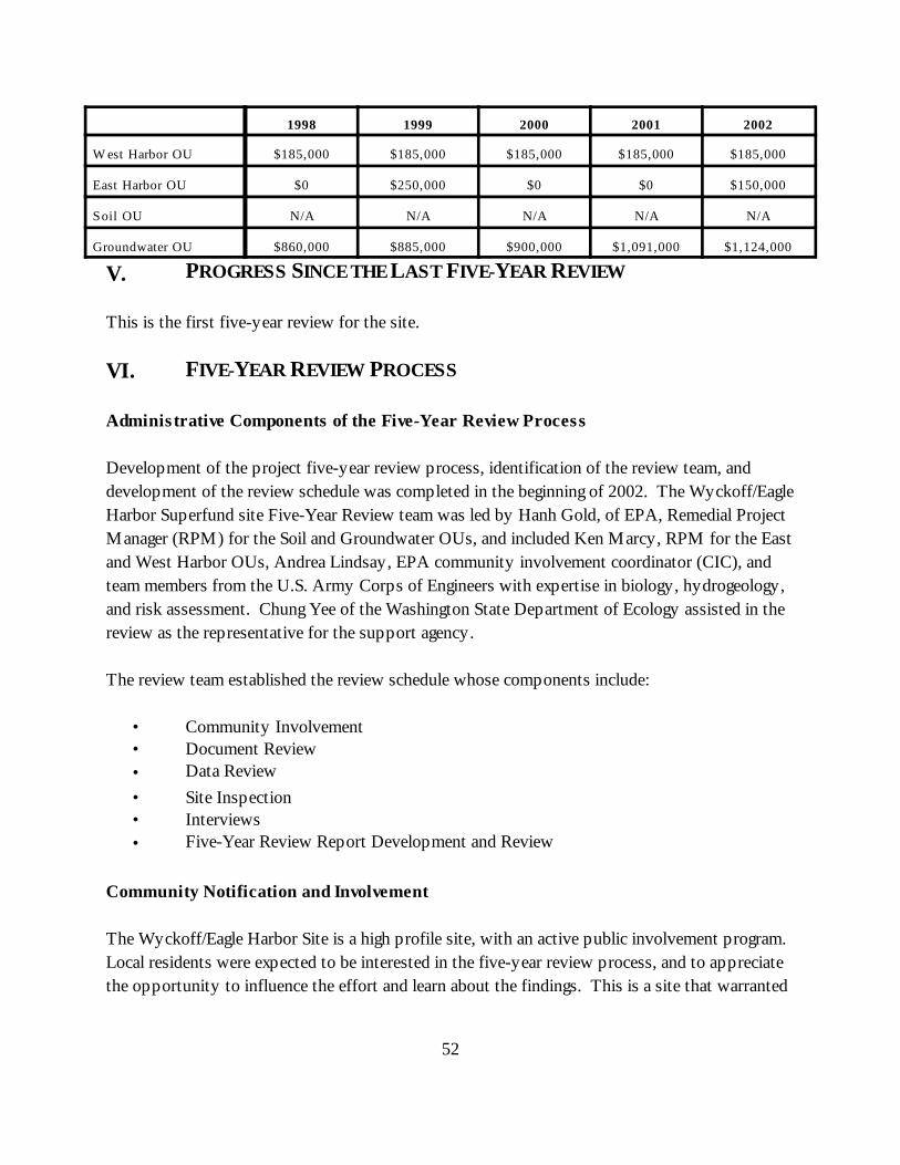
52
1998 1999 2000 2001 2002
W est Harbor OU $185,000 $185,000 $185,000 $185,000 $185,000
East Harbor OU $0 $250,000 $0 $0 $150,000
Soil OU N/A N/A N/A N/A N/A
Groundwater OU $860,000 $885,000 $900,000 $1,091,000 $1,124,000
V. PROGRESS SINCE THE LAST FIVE-YEAR REVIEW
This is the first five-year review for the site.
VI. FIVE-YEAR REVIEW PROCESS
Adminis trative Components of the Five-Year Review Process
Development of the project five-year review process, identification of the review team, anddevelopment of the review schedule was completed in the beginning of 2002. The Wyckoff/EagleHarbor Superfund site Five-Year Review team was led by Hanh Gold, of EPA, Remedial ProjectManager (RPM) for the Soil and Groundwater OUs, and included Ken Marcy, RPM for the Eastand West Harbor OUs, Andrea Lindsay, EPA community involvement coordinator (CIC), andteam members from the U.S. Army Corps of Engineers with expertise in biology, hydrogeology,and risk assessment. Chung Yee of the Washington State Department of Ecology assisted in thereview as the representative for the support agency.
The review team established the review schedule whose components include:
• Community Involvement• Document Review• Data Review• Site Inspection• Interviews• Five-Year Review Report Development and Review
Community Notification and Involvement
The Wyckoff/Eagle Harbor Site is a high profile site, with an active public involvement program. Local residents were expected to be interested in the five-year review process, and to appreciatethe opportunity to influence the effort and learn about the findings. This is a site that warranted
53
a more intensive communication program for the five-year review process than the minimumoutlined in EPA’s Comprehensive Five-Year Review Guidance, June 2001.
As such, the plan for involving the community in review activities took a multi-prongedapproach. It included a meeting with the Association of Bainbridge Communities (ABC), twofact sheets, newspaper ads, direct interviews with selected island residents and local officials, anda public meeting. These activities are summarized below.
In response to requests from the community, EPA made the draft Five-Year Review Reportavailable for informal public review for 18 days. EPA did not receive any comments from thecommunity, however, the City of Bainbridge Island provided several comments, which have beenincorporated into the final Five-Year Review report.A summary of the final report will be mailed in a fact sheet to the community. An ad will alsoannounce its availability. The final report will be placed in the local information repository andon the site’s web page at http://yosemite.epa.gov/r10/cleanup.nsf/sites/wyckoff.
Fact Sheets. In February 2002, EPA issued a fact sheet which provided an update about siteactivities and recent accomplishments, and introduced the Five-Year Review. The fact sheet,mailed to about 700 island residents, invited readers to contact EPA to provide information ordiscuss the review. In August 2002, EPA issued a comprehensive fact sheet containingresponses to frequently asked questions by the community about the Wyckoff/Eagle HarborSuperfund Site. Copies of the fact sheets are included in Appendix B. The fact sheets were alsomade available on the site’s web page.
Meeting with Association of Bainbridge Communities. On March 19, 2002, EPA met with ABCto discuss the five-year review process. EPA provided a brief overview, with specific emphasison the community involvement piece of the process. The group previewed and commented onthe potential questions for interviews, discussed alternative methods of information collection,and generally discussed the process.
Newspaper Ad. EPA ran newspaper display ads in two local papers during mid-March 2002. The ads introduced the Five-Year Review, invited suggestions, and solicited information relatedto the review. The text of the ads is included in Appendix C.
Interviews. In April 2002, EPA conducted informal interviews with one adjacent resident, oneresident across the bay, and one community activist. Additionally, interviews were conductedwith a representative from the Bremerton-Kitsap County Health District, the City of BainbridgeIsland, and the Suquamish Tribe. The NOAA Restoration Center, the Washington State
54
Department of Natural Resources (DNR), and the Washington State Department of Fish andWildlife (WDFW) (the Natural Resource Agencies) also provided input to the five-year review. Interviews with residents took place by telephone. Interviews were free-flowing, covered onlyquestions relevant to the particular interviewee, and were open-ended in terms of topics. Adocument which outlines the background information provided and the range of questions askedduring the interviews is included in Appendix D. Notes from interviews with the City ofBainbridge Island, the Suquamish Tribe, and input from the Natural Resource Agencies areincluded in Appendix E. Notes from community interviews are also enclosed in Appendix E. (Itshould be noted that EPA conducted nearly a dozen personal interviews with communitymembers in June and July of 2000 to learn about local concerns and perceptions about the site. The results of those interviews are summarized in the Community Involvement Plan Update,dated November 2000. Those interviews have some relevance in terms of characterizingcommunity impacts and have been considered as part of this five-year review process.)
Public Meeting. On June 13, 2002, EPA hosted a public meeting to give an update about siteactivities and to engage community members in a discussion about the Five-Year Review. About20 people attended the meeting. The meeting was announced via mailer and in local newspaperads. A broad range of issues was raised by residents. Topics included potential nuisance issues,questions about site activities and project schedules, and environmental considerations. Aninformal record of items discussed at the meeting is summarized in Appendix F.
Document Review
This five-year review consisted of a review of relevant documents including treatment plant andextraction system performance and compliance data, O&M records and monitoring data fromremoval and remedial actions. Remedial action objectives (RAOs), applicable relevant andappropriate requirements (ARARs), and cleanup standards, as listed in Record of Decisions fromall four operable units, were also reviewed. Appendix G includes a list of documents that werereviewed as part of the Five-Year Review.
Data Review
West Harbor Sediment Remediation Monitoring
Data have been gathered for four years since the implementation of the West Harbor OU remedyin accordance with the Operations, Maintenance, and Monitoring Plan (OMMP) (Hart Crowser,1997). The OMMP describes the long-term monitoring, maintenance, and contingency planprogram for soil and sediment remediation at the West Harbor OU. Routine monitoring (e.g.,
55
quarterly, semiannual, or annual monitoring/inspections) have been performed at the site and aredocumented in annual reports (see Section VII, Technical Assessment, for a summary ofmonitoring results). Monitoring and inspection activities have included:
• Upland Containment and Best Management Practices (BMPs): site inspections,storm water inspections;
• Water Quality: groundwater monitoring, piezometer monitoring, seep sampling;• Sediment Quality: surface sediment sampling, sediment trap deploy/collect,
bathymetric survey;• Tissue Quality: fish tissue sampling; and• Habitat Performance: habitat survey, eelgrass monitoring, Schel-chelb monitoring.
Upland Containment and BMPs. The upland area will continue to be inspected annually foradequate site access controls and signs (e.g., “no shellfishing” signs) and condition of thefencing, asphalt concrete cap, and shoreline. Inspection and maintenance procedures will bein accordance with the OMMP. Also, storm water Best Management Practices will bereviewed on an annual basis.
Water Quality Monitoring. Based on OMMP guidance and monitoring results, waterquality monitoring is no longer required at the monitoring well, the seep located under Pier A,or the well points. Water quality monitoring will be conducted annually to verify remedialdesign predictions of limited contaminant mobility within the CDF and to verify theeffectiveness of upland source control actions. Water quality monitoring will continue to beconducted at the monitoring well and at all seeps with a discharge greater than 1 gpm. Waterlevels in the piezometers (inside and outside the CDF berm) will be measured immediatelybefore and after groundwater and seep sampling.
Sediment Quality. Sediment quality will be conducted during Year 8 (2005) in accordancewith the OMMP. Sediment quality will consist of surface sediment sampling, sediment trapmonitoring, and bathymetric survey of the cap area. Although sediment trap monitoring isnot required based on past monitoring results, sediment trap data is useful for interpretingsurface sediment data. Sediment sampling will also be performed at the Intertidal HPAHArea located under and adjacent to the Bainbridge Island Ferry Terminal to verify theanticipated natural recovery of HPAH in sediments.
Tissue Quality. Sediment and shellfish tissue monitoring will be conducted during Year 8(2005) at the Intertidal HPAH Area. The purpose of this monitoring is to verify the
56
anticipated natural recovery of HPAH concentrations in sediments and to document thatsediments and tissue do not exceed risk-based chemical criteria identified in the OMMP.
Habitat Performance. Formal (quantitative) monitoring of the Schel-chelb Estuary and theHarper Estuary (the reference site) will be conducted during Year 7 of estuary monitoring(2003) and Year 10 of estuary monitoring (2006). Monitoring methods will be conducted inaccordance with the revised construction/restoration plan (DOT and Hart Crowser 1998) andEPA-approved revisions to the vegetation monitoring methods. In addition, informalmonitoring and maintenance (including removal of invasive species) of the Schel-chelbEstuary will be conducted annually.
Based on OMMP guidance and monitoring results, low tide and video surveys of the cap areawill not occur in the future. Due to the failure of the eelgrass planting site, a contingenthabitat mitigation project will be initiated that will likely include monitoring.
Historically, groundwater elevations within the CDF have been below 10 feet MLLW, but above8.7 feet MLLW. Although the design of the CDF indicates that the water level was to bemaintained at 10 feet MLLW, water levels in the CDF are acceptable down to 8.7 feet MLLW,since all hot spot sediments were placed below 8.7 feet MLLW. Therefore, hot spot sedimentsshould remain in a saturated anoxic environment. As indicated above, this will continue to bemonitored.
East Harbor Subtidal Sediment Cap Monitoring
Three monitoring events have been completed on Phase I of the subtidal sediment cap (1995,1997, 1999) in accordance with the ten year Operations, Maintenance, and Monitoring Plan(OMMP, EPA 1995). The original OMMP goals were: (1) to evaluate the effectiveness of theinitial removal action (Phase I cap), (2) to confirm or update data collected during the RI/FS andinitial remedial action in those areas not remediated under the Phase I capping event, and (3) toevaluate reductions in contaminant sources to the East Harbor OU. It was intended that furtherremedial design/action and subsequent long-term monitoring would occur before the end of theten-year time period outlined in the 1995 OMMP. (See also Section VII, Technical Assessment,for additional discussion regarding subtidal sediment cap and intertidal area monitoring)
Treatment Plant Performance and Compliance Monitoring
Treatment plant performance monitoring is conducted weekly from seven sampling points withinthe plant. Samples are collected and analyzed for a suite of analytes to effectively monitor the
57
active portions of the treatment process (Table 7). The analysis includes measurement ofchemical concentrations across the three major components of the treatment system to evaluatethe treatment efficiency of each (primary, secondary and tertiary). Currently, treatmentefficiency across the depurator (primary treatment) is erratic, ranging from 0% - 20%. Treatmentefficiency across activated sludge tank (biological secondary treatment) is exceptionally high,ranging between 98% - 99% for PAHs and PCP. Historically, the secondary system was notvery efficient, however, once EPA assumed operation of the plant in 1993, this component of theoverall system was optimized and now provides the majority of contaminant reduction. Theactivated carbon system (tertiary system) provides polishing of the effluent prior to discharge.
The most critical samples collected in the performance-monitoring program are used to evaluatecontaminant concentrations across the lead carbon vessel. These samples provide early warningthat carbon loading is approaching the breakthrough threshold that may require bringing a freshcarbon vessel on-line. The criterion used to determine if a carbon vessel needs to be changed is tocompare effluent concentrations of PAHs and PCP across the lead carbon vessel. If theconcentration of PAHs and PCP in the lead carbon vessel effluent is over 75% of theconcentrations entering the lead carbon vessel, a fresh vessel is brought on-line. This provides fora conservative yet reliable method for assuring that discharge limits are not exceeded.
Compliance monitoring requirements are identified in both the 1988 Consent Decree and the 1991Unilateral Administrative Order with the Wyckoff Company. These requirements were furthermodified in the February 2000 ROD for the Soil and Groundwater OUs. The discharge limits areconsistent with the fresh water aquatic criteria concentrations established in the National ToxicsRule (40 CFR 131.6). The current discharge limits and sampling frequency are provided in Table8. Once steam injection begins during the thermal remediation pilot project, compliance samplingwill be increased from weekly to daily for the first two weeks. After the first two weeks, thesampling frequency will shift to bi-weekly for the remainder of the first quarter of thermaloperations. The change in sample frequency was instituted at the request of the Washington StateDepartment of Ecology (see also Appendix A).
Effluent discharge limits to Puget Sound have never been exceeded. Total PAH concentrations inplant effluent typically vary between 5-10 µg/L without an exceedance of any individualcompound. PCP effluent concentrations range between 0.01-0.1 µg/L based on the weeklycompliance sampling.
In addition to chemical samples, effluent toxicity samples are collected both quarterly andannually. Quarterly samples are used to conduct a chronic toxicity test for bivalve larvae witheither blue mussel (Mytilus Sp.) or Pacific oyster (Cassostrea gigas). Annual samples are used to
58
conduct the acute toxicity test for estuarine fish with Inland Silversides (Menidia beryllina).Results of both annual and quarterly biomonitoring tests have consistently demonstratedcompliance with Washington State discharge limits for toxicity as described in WAC 173-205-020.
Groundwater Levels Monitoring
Groundwater levels are currently monitored monthly to provide Project Managers and technicalteam members with data to verify hydraulic control of the site is maintained. The collection ofwater level data from the upper aquifer was initiated upon near completion of the sheet pilecontainment wall construction in late January 2001. Leakage of the entire sheet pile containmentwall was estimated to be about 1 gallon per minute (gpm) with an estimated rainfall infiltration,wall leakage, upland recharge, and lower aquifer recharge of about 20 gpm. As a result, waterlevels in the upper aquifer were anticipated to increase rapidly after installation of the wall. Monthly water-level measurements from upper and lower aquifer monitoring wells continue tobe collected to support decision-making regarding groundwater extraction system operation. Prior to installation of the sheet pile wall, water level measurements were collected quarterly.
The existing treatment system staff under direction of the USACE Site Manager accomplishesmonthly field data collection. Water-level data is converted into elevations, organized in a tableand interpolated for presentation as water level surface elevation figures (See Tables 9 and 10 forthe June and July 2002 Water Level Data, respectively). The data is then analyzed by theUSACE Project Hydrogeologist and presented in the monthly operations report.
Procedures for the collection of water level data include:
• All water levels are measured and recorded to an accuracy of one hundredth of a foot.• All water levels are measured at the same location on the inner casing each time.• All upper aquifer monitoring well measurements are collected within one hour with
lower aquifer monitoring well measurements collected concurrently.• Monitoring wells suspected of containing LNAPL are measured last. LNAPL
thickness is not measured and the top of the LNAPL will be substituted for waterlevel. (Since the NAPL and groundwater densities are similar, the top of NAPLshould be nearly the same as the effective groundwater elevation.)
• Well condition will be recorded including presence of LNAPL, recent vault floodingand damage.
59
Water level monitoring is currently conducted from 19 upper aquifer monitoring wells distributedacross the Former Process Area and the portion of the Log Storage/Peeler Area directly south ofthe Former Process Area. Lower aquifer water level data is collected from all 7 existingmonitoring wells completed in the Former Process Area. In addition to the monthly water leveldata collected from the monitoring wells across the site, the O&M staff record water levels fromthe active extraction wells during normal inspection rounds on a weekly basis.
Site Inspection
The site inspection was conducted on April 9, 2002 by Travis Shaw, U.S. Army Corps ofEngineers Site Manager and Cliff Leeper, Lead Operator for Operations and MaintenanceInternational (OMI), sub-contractor for O&M of the groundwater treatment plant and extractionsystem. The purpose of the site inspection is to assess the protectiveness of the remedy,including the presence of fencing and gates to restrict access, the status of institutional controls,the condition of the site, and the status of the sheet pile wall and groundwater treatment plantand extraction system. A complete walk-through of the groundwater treatment plant facilitieswas conducted. The scope of this comprehensive inspection was to verify current status of theexisting system, identify maintenance issues, confirm that all documentation associated with siteoperations and training was current, and to gather information from the plant operators regardingissues that might potentially impact the protectiveness of the remedy.
Observations and issues are summarized in the Site Inspection Checklist, which is included inAppendix H. Photographs documenting site conditions are in Appendix I.
West Harbor Operable Unit
Visual inspection of the surface of the confined disposal facility (CDF) and tidal barrier indicatethat they remain in place and functional. Sampling data and sediment surveys of the cappedareas confirm that the remedy is functioning well. Fencing and site access is adequatelycontrolled by DOT and “no shellfishing” signs are well maintained. The Schel-chelb habitatestuary continues to provide viable habitat, however, the eelgrass habitat project west of theCDF did not survive.
East Harbor Operable Unit
Sampling data from the 1993-1994 (Phase I) sediment cap indicate that the cap is physicallystable, is containing contaminated sediments, and is providing quality habitat. Additional
60
sediment capping occurred between 2000 and 2002 (Phases II and III). Monitoring of all cappedareas and the entire intertidal area surrounding the site will commence in the fall 2002.
Significant contamination still exists in the East Beach intertidal area. At low tides, NAPL seepsare evident in several locations. At this time, containment of NAPL from the upland source hasbeen achieved by the installation of the sheet pile wall. Although the containment has reduced oreliminated the flow of NAPL from the upland to the intertidal area, significant NAPL remains inthe East Beach sediments (outside of the sheet pile wall) and will continue to seep for some time. Initial estimates produced during the design of the sheet pile wall estimated that NAPL seepswould continue for up to 24 months after installation of the containment wall. Subsequentinvestigations indicate that the reservoir of NAPL within the sediments is far larger thanpreviously thought. Consequently, seep activity may continue for a longer period of time thaninitially estimated.
Despite the existence of NAPL seeps in the intertidal area, habitat function of the East Beacharea appears to be good beyond the immediate vicinity of the seeps. Eelgrass meadows existfrom approximately 0 MLLW to beyond -3.5 MLLW. The eelgrass beds appear healthy withthe presence of both characteristic epiphyte grazers and upper trophic level consumers. Continued monitoring of the East Beach intertidal area will occur with surface sampling under theEast Harbor OU Long-Term Monitoring Operations, Maintenance and Monitoring Plan. Inaddition, if full scale thermal remediation is implemented site-wide, a Thermal Effects Study willoccur within 1-2 years of thermal treatment and provide additional data on the benthiccommunity adjacent to the Wyckoff facility, including the East Beach intertidal area.
Soil and Groundwater Operable Units
Wyckoff Facility Conditions: Generally, the treatment buildings and trailers are in good condition. Over the last year, many of the deteriorating wood stairways used to access site trailers werereplaced with newer metal stairs. A new building was constructed this year to house themechanical equipment and boiler required for the steam injection pilot study. In addition, a newpump house was constructed to enclose the new on-site water supply well. The threedilapidated residences on the site were recently demolished. These residences were in very poorcondition and represented a significant hazard to trespassers and transients.
The condition of the monitoring wells on-site varies considerably. Several are heavily fouled orhave degraded due to construction materials that are incompatible with site contaminants. Conversely, several of the newer wells installed on-site appear to be in good condition. Currently, monitoring wells are only routinely sampled to determine water levels. This data is
61
used to confirm that hydraulic control is being maintained by the existing liquid extractionsystem. Prior to beginning steam injection, both upper and lower aquifer wells will be sampledto establish a contaminant baseline. Since all but two monitoring wells are within the fencesecuring the Former Process Area, individual wells do not have locking well caps. Recentremedial actions outside the perimeter of the Former Process Area have increased access to thetwo wells outside the fenced portion of the site. Locking well caps will be acquired for these twowells (MW-23 and CW01).
Fencing around the Former Process Area restricts access to the most heavily contaminatedportion of the site. Fencing along the northwestern portion were expanded in August 2002.Completion of the Phase III cap, which created an intertidal beach along the northwestern portionof the sheet pile wall, made this area accessible. Authorized Personnel Only and No Trespassingsigns are posted at all access points. Despite these measures, occasional vandalism has been aproblem, particularly graffiti. The recently completed demolition of the three abandoned houseson-site is anticipated to make the site less of an attractive feature for vandals. In addition, thepole gate at the intersection of the parking lot driveway and the main city arterial leading to thesite has been repaired and is now locked each night. These measures will prevent access to theparking lot after work hours and will hopefully reduce vandalism at the treatment plant.
Surface drainage continues to be an issue during storm events, particularly since the installation ofthe sheet pile containment wall. Storm water issues have been exacerbated by the movement ofcontaminated soil from the western portion of the site. Consolidation of excavated contaminatedsoil within the Former Process Area eliminated low areas that provided holding areas for stormwater. In response, berms have been constructed around the extraction wells located in low-lyingareas of the site to prevent flooding of the extraction wells. In addition, the frequency of waterlevel measurements has been increased to provide site managers with the data required to morefully monitor fluid levels and vary extraction rates to maintain hydraulic control as storm waterinfiltrates the area within the sheet pile wall.
Treatment Plant and Extraction System: The biggest challenge to operations of the existingtreatment and extraction system is corrective maintenance, which results in high operating andmaintenance costs. The materials of construction in the treatment plant and the originalextraction systems were selected by the PRP. In many cases, the materials were subject todegradation by contaminants being treated by the plant or suffered from corrosion due to the highsalinity of upper aquifer groundwater, and deteriorating equipment nearing the end of theirservice life. As a result, portions of the extraction and treatment system have required unusuallyhigh O&M costs to replace components either chemically degraded or corroded from contactwith brackish influent groundwater. EPA dedicated significant resources to rebuilding all seven ofthe original extraction wells during the mid-1990s to address incompatibility problems and
62
increase extraction efficiency. In addition, an accelerated pump re-build program was initiated toprepare the existing treatment facility for higher operating flow rates anticipated during the steaminjection pilot project. EPA also implemented additional major maintenance, repair, andreplacement of equipment in the treatment plant in August 2002 to ensure that the system willcontinue to function during the steam injection pilot project and through the period in whichEPA will make a decision regarding the final groundwater remedy (i.e., full-scale thermalremediation or containment).
Many of the tanks in the treatment plant have experienced accelerated rates of corrosion, whichhas reduced wall thickness in some of the large equalization tanks. Of particular concern is theold biofilter tank (T-205), which is used as a wet-well for the P-205 pumps. This tank is heavilycorroded and is showing signs of structural instability and failure. This tank will be replacedprior to the beginning of steam injection. Several of the tanks were also damaged during theNisqually earthquake last year (February 2001). Repairs to the effluent tank (T-303) wererecently completed and work to clean, seal and re-secure the equalization tanks (T-401 and T-402) were completed in August 2002.
Compliance and performance samples for operation of the existing groundwater treatment plantare collected by the O&M contractor and shipped to the EPA Region 10 Laboratory atManchester on a weekly basis. Preliminary data is reported by the laboratory within the sameweek to provide the plant operators with timely information regarding effluent dischargechemistry. Final data packages, including a Data Quality Assurance Report are submitted toEPA and USACE approximately 30 days after sample collection. The USACE Site Manager alsosubmits monthly system operations reports to EPA. The July Groundwater Extraction andTreatment System Operations Report is included in Appendix J. There have been no significantdata quality issues since EPA assumed operation of the systems in 1993.
Hydraulic Control: Generally, the existing treatment and extraction systems are performing asintended in maintaining hydraulic control of the Former Process Area. Evidence for effectivecontainment is provided by the monthly groundwater level measurements. Tables 9 and 10 showthe water level measurements in the upper and lower aquifers for June and July 2002,respectively. Based on this data, the hydraulic control has been maintained across the FormerProcess Area. Indications are that pumping from the existing extraction system is sufficient toinduce an inward gradient (towards the extraction wells) within the contaminated upper aquiferand an upward gradient from the lower aquifer to the upper aquifer. The level of hydrauliccontrol is further supported by the presence of the sheet pile wall, which provides a physicalbarrier to both NAPL and dissolved phase contaminant migration from the Former Process Areato Puget Sound and Eagle Harbor.
63
Contaminant concentrations in groundwater are not declining due to several factors. First,installation of the sheet pile wall provides a physical barrier that prevents the intrusion ofseawater into the upper aquifer during high tides. Consequently, less mixing of groundwater isoccurring, which has reduced the dilution of contaminated groundwater. Secondly, the presenceof a physical barrier has potentially increased the efficiency of the existing wells in capturingboth contaminated groundwater and NAPL. This is indicated by the increase in contaminantconcentrations in groundwater and increased NAPL recovery over the last 9 months.
The key to maintaining hydraulic control of the site is to continue operation of the existingtreatment and extraction system. This task is complicated by the poor condition of severaltreatment plant components. The spare parts list for the facility needs to be expanded andupgraded to assure that critical parts are on-site in the event an unanticipated failure results in theneed to shut down the treatment plant. The O&M contractor was tasked with identifying keycomponents that could result in a shut down of the extraction system or the treatment plant andto develop a critical parts list. Development of that list is completed and acquisition of criticalparts will be completed prior to the start of steam injection within the pilot area.
Sheet Pile Containment Wall: The sheet pile containment wall appears to be in good conditionwithout any visible signs of settlement or alignment displacement. Approximately 3 monthsafter installation, a modified pumping test was conducted at the monitoring wells installed at 8locations along the outer sheet pile wall. The conductivity of the wall was higher than anticipatedduring design but consistent with published data on other sheet pile walls using interlockingjoints. It is anticipated that the interlock joints will continue to become less permeable over timedue to clogging with fine soil particles. In addition, the sheet pile wall monitoring wells arechecked for NAPL intrusion with an oil/water interface probe. NAPL intrusion was not detectedacross any of the interlock joints monitored. (See also Section VII, Technical Assessment,Question A, Sheet Pile Containment Wall.)
Interviews
In April 2002, EPA conducted informal interviews with selected community members and with arepresentative from the Bremerton-Kitsap County Health District (see Community Notificationand Involvement, above). In May 2002, EPA conducted interviews with representatives fromthe City of Bainbridge Island and the Suquamish Tribe. The NOAA Restoration Center, theWashington State Department of Natural Resources (DNR), and the Washington StateDepartment of Fish and Wildlife (WDFW) (the Natural Resource Agencies) provided input to
64
the five-year review in August 2002. Notes from interviews with the City of Bainbridge Island,the Suquamish Tribe, and input from the Natural Resource Agencies are included in Appendix E.
VII. TECHNICAL ASSESSMENT
Question A: Is the remedy functioning as intended by the decis ion documents?(See Section IV, Remedial Actions, Remedy Implementation, for a detailed description of theremedies for each operable unit.)
West Harbor Operable Unit
In general, the results of monitoring indicate that overall the remedy is functioning as designed:
• Water quality monitoring indicates that, with few exceptions, levels of mercuryremain below the criteria. Dissolved mercury concentrations - the most importantindicator of remedy performance - have remained well below the criteria. Totalmercury, in some instances has exceeded the criteria, but the correlation betweenthese exceedances and turbidity levels is consistent. Results of water qualitymonitoring indicate that the CDF is performing well.
• Control of groundwater upland of the containment area, and control of surfacerunoff has been consistently maintained through upkeep of the cut off drain, andthrough maintenance of the asphalt cap and oil/water separators.
• Visual inspection of the tidal barrier and the berm face continue to confirm the fact
that they remain viable and in place.
• Sediment surveys and sampling confirm that capped areas remain in place and thatconcentrations of contaminants remain, by and large, below the criteria.
• Monitoring of the Schel-chelb habitat estuary continues to indicate that the site isfunctioning well and providing viable habitat.
However, two areas need to be addressed:
• Seeps in the area of the old landfill contain constituents above water quality criteria,and;
• Eelgrass west of the CDF has not survived, so additional habitat mitigation is needed.
65
These areas are discussed below under Recommendations and Follow-up Actions. Fencing andsite access is adequately controlled by DOT and “no shellfishing” signs are well maintained.
East Harbor Operable Unit
Subtidal Sediment Cap. At this time, the following information exists regarding the cap:
• The majority of the Phase I subtidal cap is effective in terms of physical stability,providing quality habitat, and meeting Washington State Sediment ManagementStandards criteria;
• Data pertaining to the uncapped areas of the harbor was collected in September 2001and Phase II and III final remedial activities in those areas were finished in 2002; and
• Migration of the upland contaminant source has been minimized by installation of asheet pile wall (see Sheet Pile Containment Wall discussion, below).
Results indicate that site conditions and cap performance meet the environmental performancestandards of the East Harbor ROD for the northern portion of the subtidal cap.
A permanent Regulated Navigation Area, also known as a No Anchor Zone, was established byEPA, the Washington State Department of Natural Resources (DNR), and the U.S. Coast Guardin 1999 to preserve the integrity of the subtidal sediment cap and prohibit activities that woulddisturb the seabed such as anchoring, dredging, or laying cable. The regulated navigation area isenforced by the U.S. Coast Guard. Four signs were placed by DNR on buoys in the harbordesignating the regulated navigation area. This fall, EPA will be posting additional signage nearthe mouth of Eagle Harbor restricting activities that might disturb the subtidal sediment cap. EPA is also coordinating with the Harbor Master to ensure that obvious violations do not occur.
Since the initial five years of sampling indicates that no criteria have been exceeded, continuedmonitoring in the northern portion of the cap will not occur with the exception of confirmationsamples and bathymetry. Confirmation sampling will provide final evidence that Phase II and IIIcapping activities have not negatively disturbed the original cap area. Bathymetric surveys willcontinue to occur over the entire cap area. Results from two specific sampling locations in thesouthern portion of the Phase I cap indicated degraded conditions over time (see discussionregarding Question C, below). A lack of source control and unknown subsurface conditionslimited interpretation of monitoring results meant to determine potential mechanisms of
66
recontamination or degradation. Therefore, the southern portion of the Phase I subtidal cap willcontinue to be monitored. Areas remediated in Phase II and III will also be monitored in futureevents. Additionally, the update to the 1995 OMMP is currently being finalized to allow a morefocused monitoring strategy over the next ten years. The first sampling to be conducted under theupdated OMMP will occur in the fall of 2002.
Intertidal Areas. Four intertidal areas exist around the perimeter of the Wyckoff site. The areasare artificially separated for monitoring purposes but together represent continuous intertidalhabitat surrounding the site. The areas are described here in an east to west direction:
• Area 1, known as the East Beach, contains significant contaminant seeps and wasidentified in the 1994 East Harbor ROD for monitored natural recovery, after uplandsource control has been achieved;
• Area 2, known as the North Shoal, is naturally occurring and contains very minimalcontamination;
• Area 3, known as the intertidal cap, was created during the capping of highlycontaminated subtidal sediments in the former log-rafting area; and
• Area 4, known as the mitigation beach, is adjacent to the intertidal cap and wascreated as mitigation for habitat taken during installation of the sheet pile wall.
The entire intertidal area surrounding the facility will be included in future monitoring eventsunder the revised OMMP.
Physical stability of the entire intertidal area will be monitored with topographical surveys. Thebeach profiles provide measures of the instantaneous conditions of the intertidal area at the timeof the survey. To assess time-integrated changes in intertidal sediment distribution, dyed ortraceable synthetic sediments may be placed at discreet locations in the intertidal areas andmonitored for dispersion. This data will augment the profiles of intertidal beach elevations.
The entire intertidal and riparian area will also be surveyed for wildlife use. Comprehensivepresence/absence surveys for use by birds, mammals, and fish will occur twice yearly for the firstfive years.
East Beach. At this time, significant contamination still exists in the East Beach portion ofthe East Harbor intertidal area. Previous studies suggest the following: (1) it is not likely that
67
unaided natural recovery will achieve cleanup objectives in the ten year time period stated inthe ROD, (2) remedial alternatives are either ineffective, costly, or more harmful to humanhealth or the environment than existing conditions, (3) it is unknown how potentialtemperature changes resulting from possible upland thermal remediation will affect naturalrecovery efforts in the intertidal area, (4) conclusions about contaminant flux may notaccurately reflect physical conditions affecting contaminant transport on the intertidal areas.
EPA will continue to monitor contaminant concentrations in the top ten (10) centimeters ofthe East Beach intertidal sediments to determine if natural recovery, aided by source controland upland thermal remediation, can achieve the cleanup goals established in the ROD. EPAwill reassess current information after the start of upland thermal remediation (if thistechnology is implemented site-wide) to determine the state of the beach and if additionalstudies are necessary.
The remedial action objectives for intertidal surface sediments (top 10 cm) are the MCUL forPAHs with an EPA developed supplemental objective of 1,200 µg/kg (dry weight) total highmolecular weight polycyclic aromatic hydrocarbons (HPAH). The supplemental cleanupobjective was instituted to address human health risks from consumption of contaminatedshellfish in intertidal areas. Intertidal sediments must meet both objectives within 10 years ofsignificant upland source control, which occurred on February 15, 2001. (See discussion onsheet pile wall construction, above.)
In 1997, a natural recovery study was conducted for the East Beach intertidal area to assessthe viability of this alternative at meeting cleanup objectives. The study concluded that: (1)although bacterial communities in the East Harbor OU intertidal sediments are capable ofdegrading PAHs, microbial degradation alone will likely not achieve the cleanup goalsdescribed in the ROD for the East Harbor across the full range of PAH concentrationsmeasured in all intertidal sediments; (2) sediments that do not contain free product in theintertidal area north and east of the Wyckoff facility have the potential to achieve the MCULremediation goal within ten years for LPAHs but not HPAHs. However, sediments thatcurrently contain free-flowing NAPL will probably not meet the LPAH or HPAHremediation goals; and (3) sediments contaminated with HPAHs above the supplementalcleanup goal (1,200 µg/kg dry weight) are likely to persist well beyond the ten-year naturalrecovery period.
In 1999 and 2001, EPA conducted investigative sampling on the East Beach to assess thevertical and lateral extent of contamination for evaluation of the appropriate remedial actionsin the intertidal area. Due to the continuous nature and depth of contamination on the East
68
Beach, excavation of hot spots is no longer considered a viable alternative. The investigationsdetermined that the area of required excavation is approximately 13,000 cubic yards. Theextent and depth of excavation are too large for technically practicable removal withoutsignificant ecosystem impacts, human exposure, and high costs.
East Beach area monitoring will focus on collecting data required to determine contaminantconcentrations in the top 10 cm of sediment (zone of compliance). Monitoring will includevisual inspections of the area to determine the presence or absence of intertidal seeps,analysis of surface sediments to determine existing contaminant concentrations and evaluateLPAH model predictions, and analysis of subsurface samples between 0 and -2 ft MLLW.
The overall purpose of the East Beach monitoring is to determine:
• If contaminant concentrations decrease over time and if so, evaluate the rate ofnatural recovery
• Ecological baseline risk (post upland source control) by collecting clam tissuesamples for analysis
• The effect of possible upland thermal remediation (temperature increase in theintertidal area) on natural recovery
• If the East Beach area will naturally recover within the 10 year time framestated in the ROD, and
• The stability of the East Beach over time.
North Shoal. The North Shoal area will be monitored for elevation changes, visual seeps andhabitat functionality at the same times that these activities occur in adjacent areas. Althoughthe north shoal has been relatively stable over time, consistent surveys along with adjacentareas will provide information regarding littoral drift throughout the entire intertidal area. Although mobile NAPL exists on the north shoal at depths below 15 feet MLLW, visibleseeps have not been observed in the majority of this area. One seep has been periodicallyvisible on the east side of the north shoal and is likely related to the visible seeps on the northend of the East Beach. It is assumed that the amount of overlying material on the north shoalacts as a “natural cap” to contain the NAPL at depth.
69
To assure that the North Shoal area does not contain contaminants in the top 10 cm ofsediment, 4-6 surface sediment samples will be collected and analyzed during the 2002monitoring event. To confirm that the North Shoal area remains clean and that the EastHarbor ROD requirements are met, surface sediment samples will also be collected andanalyzed during a later monitoring event.
Intertidal Cap. The intertidal cap will be monitored in the fall of 2002 for the first time sinceit was placed. The intertidal cap is approximately 3-20 feet thick and was designed for twopurposes: (1) to cover highly contaminated subtidal sediments from the southern portion ofthe 1994 cap to the shoreline, and (2) to connect adjacent intertidal areas and providecontinuous intertidal habitat along the Wyckoff shoreline. It therefore performs bothsediment cap and habitat functions. The intertidal cap will be monitored for: (1) physicalstability, (2) habitat functionality, and (3) surface contaminant concentrations to evaluateecological and human health risks. The first two functions will be monitored as described forthe North Shoal (see above). Ecological and human health risks will be monitored asdescribed above for the East Beach.
Habitat Mitigation Beach. The mitigation beach will be monitored in the fall of 2002 for thefirst time since it was placed. In general, the mitigation beach will be monitored to provideinformation on gradual changes in the engineered design and/or habitat use over time. It isexpected that beach sediments will vary in elevation due to tides, large storms, and othernaturally occurring events over time. It is also expected that habitat use will vary with time,buffer zone successional/growth stage, and uncontrollable events such as weather and humanactivities in adjacent areas. However, large or unexpected changes will act as triggers to EPAto investigate and determine if additional remedial actions are necessary.
The mitigation beach area will be monitored to determine: (1) physical stability, and (2)habitat functionality including a visual survey of plantings in the buffer zone and the entireintertidal area. Buffer zone plants will require watering during dry summer months for thefirst year and during times of drought for the next 2 years. In addition, periodic refuse pick-up will occur throughout the intertidal area surrounding the site. Collection and analysis ofsurface sediments will not be part of the monitoring program. Sediments used to constructthe mitigation beach were chemically tested prior to construction of the beach and determinedto be free of contamination and suitable for intertidal habitat creation.
Numerous signs warning about the danger associated with the consumption of fish and shellfishfrom the harbor and adjacent beaches are prominently displayed around the site perimeter inmultiple languages. The fish and shellfish advisory was originally issued by the Bremerton-
70
Kitsap County Health District. EPA communicated the advisory by posting and maintaining thewarning signs. Access to the beach areas are also restricted to the extent possible by signs.
Soil and Groundwater Operable Units
Groundwater Treatment Plant and Extraction System. The existing groundwater treatment plantand extraction system is functioning as intended. In many regards, the existing treatment andextraction system is achieving many of the remedial action objectives of the GroundwaterOperable Unit despite the fact that it represents only a partially complete remedy. Incombination with the sheet pile containment wall, the existing groundwater treatment plant andextraction system is ensuring that contaminant concentrations in the upper aquifer groundwaterare not leaving the Former Process Area. Evidence to support this is provided by the monthlywater level monitoring conducted across the Former Process Area. This monitoring indicates thatthe current pumping rates are maintaining hydraulic control across the site by producing aninward gradient (towards the extraction wells) within the contaminated upper aquifer and anupward gradient from the lower aquifer to the upper aquifer. The containment of contaminatedgroundwater eliminates adverse impacts to marine water quality, aquatic life, and the loweraquifer. In addition, the contaminated upper aquifer groundwater is not being used for humanconsumption or any industrial purpose, which eliminate human contact with contaminatedgroundwater with the exception of potential exposure to site workers.
The existing treatment and extraction system also addresses the remedial objective for thereduction of the NAPL source and quantity of NAPL leaving the upper aquifer beneath theFormer Process Area. Approximately 100,000 gallons of NAPL has been recovered by theexisting extraction system since the system began operation in 1990. Combined with the sheetpile wall, the upland source of NAPL migration to the marine environment surrounding the sitehas been effectively controlled. However, it is estimated that the NAPL that had migrated off-site prior to installation of the sheet pile wall will continue to be released from sediments on theeastern shoreline for the next 24 months (see the previous discussion of the East Beach). Sincethe existing extraction system is not expected to remove large quantities of NAPL, which is theprinciple threat at the site, the more aggressive remedy represented by thermal remediation isnecessary to fully achieve a significant reduction in NAPL, if it is a feasible technology.
Groundwater extracted from beneath the Former Process Area to maintain hydraulic control ofthe site is treated to meet the standards of the February 2000 ROD for the Soil and GroundwaterOperable Units, which describes discharge limits for the existing groundwater treatment system. The existing treatment plant has treated and discharged to Puget Sound approximately 370million gallons of groundwater without exceeding any contaminant or water quality standards.
71
Ambient air quality emissions impact was estimated in 1997 at the treatment plant using an airdispersion modeling program. Results were compared to the Acceptable Source Impacts Levels(ASILs) presented under the Puget Sound Air Pollution Control Agency (PSAPCA) RegulationIII. No exceedances were indicated for volatile organic compounds (VOCs). No ASILs wereexceeded for PAHs or PCP based on air emissions for the aeration basin. Some exceedances fornaphthalene and PCP were indicated at the depurator. Therefore, respirators were used by on-site workers when tank maintenance was performed. The depurator has since been replaced by adissolved air flotation unit (DAF) (see next paragraph). Additional air monitoring will occurduring the steam injection pilot project.
While the current extraction and treatment system is successfully meeting many of the remedialobjectives for the site, the success may be short term. The original materials of construction ofboth systems were selected by the PRP and have proven to be incompatible with both theenvironment and contaminants found on site. The location of the site adjacent to Puget Soundand Eagle Harbor results in brackish groundwater within the upper aquifer groundwater treatedby the existing system. Consequently, many of the tanks, pipes and pumps in the treatmentplant have experienced accelerated rates of corrosion. In addition, many of the pipe runs in theoriginal extraction and treatment system were constructed of PVC, which degrades afterprolonged contact with site contaminants. As a result, O&M costs have increased to addresscorrective maintenance problems. This situation has been partially mitigated by preparations forthe steam injection pilot project to replace or rebuild potions of the existing system most in needof maintenance. For example, a depurator provides the primary treatment component of theexisting treatment system. The depurator has largely ceased to function over the last 6 months.Fortunately, increased contaminant concentrations anticipated during the steam injection pilotoperations required replacement of the depurator with a more efficient DAF unit. EPArecognizes that the existing treatment and extraction system will require replacement as part ofeither a final containment remedy or implementation of thermal treatment site-wide.
Contaminated Soil Removal. As discussed in Section IV, Remedial Actions - RemedyImplementation, contaminated soil from the Former Log Storage/Peeler Area and the Well CW01Area were removed and consolidated within the Former Process Area prior to completion of thepilot study project. EPA is currently working with state counterparts at the Washington StateDepartment of Ecology to demonstrate compliance with MTCA Method B cleanup levels forsoils across the site outside of the Former Process Area. Once confirmed, the areas of the siteoutside the Former Process Area would meet all of the remedial objectives for the Soil OU. Contaminated surface soil remaining on-site is within a fenced perimeter that preventsuncontrolled access and eliminates potential chemical exposure to the public. The only potentialhuman exposure is to site workers, who receive training consistent with the Site Specific Health
72
and Safety Plan and use appropriate personal protective equipment (PPE) when engaged inactivities that could result in contact with contaminated media.
Sheet Pile Containment Wall. The sheet pile wall is functioning as intended and is meeting thegoal of limiting lateral migration of contaminants into Eagle Harbor and Puget Sound. Sheet pileleakage was evaluated in April 2001. In order to obtain direct measurements of sheet pile leakage,joint observation wells were installed, during construction, every 200 feet along both the outerand pilot area walls. The joint observation wells consist of 6-inch-wide by 5-inch-deep steelchannels (5.25 inch by 4.625 inch inside dimensions) welded over the pile interlock, on theseaward side of the sheet pile wall (Figures 12 and 13). The joint observation wells cover theentire interlock from the top of the pile to 5 feet above the bottom of each pile.
Sheet pile leakage rates are influenced by several factors:• Joint (interlock) geometry• Deformation as a result of driving or lateral displacement of piles• Joint-sealing materials• Plugging of interlocks by soil during driving, or sedimentation in interlocks after
installation.
Since thermal treatment methods will be used for the Wyckoff site, sealants were not used in thepile interlocks.
Pumping tests were performed on all of the joint observation wells in April 2001 to assess thehydraulic conductivity of the Frodingham No. 5 sheet pile walls. Based on the results, theoverall average equivalent hydraulic conductivity of the sheet pile walls installed at the Wyckoffsite is consistent with published test data. In addition, the absence of NAPL in the jointobservation wells during the testing indicates the wall itself may be adequate as is, if needed forlong-term containment. Finally, the hydraulic conductivity of the outer wall should decreasewith time as interlock sedimentation proceeds and as finer sediments are introduced to theinterlocks.
Steam Injection Pilot Study. Construction of the steam injection pilot study is substantiallycompleted. Equipment start-up and testing began on September 16, 2002 with full operationtargeted to begin by the end of September. At this time, the system cannot be evaluated todetermine if the remedy is functioning as intended by the decision document (the February 2000ROD).
73
Institutional Controls. As mentioned above, the contaminated upper aquifer groundwater withinthe Former Process Area is not being used for human consumption or any industrial purpose. The sheet pile wall and fencing around the Former Process Area restricts access to the mostcontaminated portion of the site. Additional fencing was installed in August 2002 to discourageaccess to the facility via the beach at low tides. All access points to the facility are secured withlocked gates and signs. These institutional control measures will continue to be maintained andenforced by EPA.
As discussed under Section III, Background - Initial Response, the Wyckoff facility is held underan Environmental Trust established by the 1994 Consent Decree. It is possible that the Trustwill liquidate this property within the next several years. EPA will ensure that measures are inplace to restrict the use of the upper aquifer groundwater outside the Former Process Area andthe lower aquifer until protective levels are reached. EPA will also ensure that the upper aquifergroundwater within the Former Process Area remains unused due to contaminants that mayremain after thermal treatment or will remain as part of the contingency remedy.
Question B: Are the exposure assumptions , toxicity data, cleanup levels , and remedialaction objectives (RAOs) used at the time of remedy selection s till valid?
West Harbor Operable Unit
Cleanup levels, RAOs and all criteria and assumptions used in the design, implementation andmonitoring of the West Harbor OU remain valid and protective.
East Harbor, Soil, and Groundwater Operable Units
Generally, the exposure assumptions, toxicity data, cleanup levels and remedial action objectivesused at the time of the remedy selection are still valid. While the State of Washington has revisedthe Model Toxics Control Act or MTCA regulations, these changes do not call into question theprotectiveness of the selected remedy, and thus, the ARARs and cleanup levels do not need to bechanged.
The original Human Health Risk Assessment (HHRA) for the site was conducted prior to theformal adoption of the Risk Assessment Guidance for Superfund (RAGS). Despite this, theHHRA detailed in the original RI/FS did use exposure factors consistent with the guidance. Inaddition, both average and Reasonable Maximum Exposures (RMEs) scenarios were calculatedfor each exposure pathway. Consequently, the underlying methods used to characterize
74
exposure to site contaminants remain valid even though the HHRA was scoped and conductedapproximately eight years ago.
Review of toxicity data did not uncover any changes in toxicity factors for contaminants ofconcern used in the HHRA with two exceptions. Both the reference dose for chronic oralexposure and the reference concentration for inhalation exposure for naphthalene were updated inthe Integrated Risk Information System (IRIS) database in September 1998. IRIS is the primarytoxicity data source used in human health risk assessments. However, this change does not alterthe protectiveness or validity of the HHRA used to support the selected remedy sincenaphthalene was already one of the primary non-cancer risk drivers for soil and groundwaterexposure scenarios. In addition, EPA is in the process of re-evaluating the exposure and humanhealth risks associated with dioxins and related compounds. This reassessment is still in draftform and may need to be considered during the next five-year review.
Cleanup levels listed in the September 1994 and February 2000 RODs are still valid andprotective for the East Harbor OU and Soil and Groundwater OUs, respectively.
Question C: Has any other information come to light that could call into question theprotectiveness of the remedy?
West Harbor Operable Unit
As indicated above, monitoring of the West Harbor OU has revealed that certain seeps in the areaof the old landfill contain constituents above water quality criteria. Based on the consistentexceedances for these constituents, EPA has tasked DOT, per the contingency strategy outlinedin the site OMMP, to propose options for mitigating this seep water discharge. Seep mitigationoptions will be presented to EPA for review and consideration by October 2002.
While this is an issue which must be addressed, it does not call into question the protectivenessof the remedy as a whole. The remedy, as designed and implemented, is functioning well. Thecontaminated seep water discharge discussed above is the result of tidal outflow in areas beyondthe extent of the tidal barrier or berm. In short, the upland cut-off drainage system and the tidalbarrier, as all constructed elements of the remedial action, are performing the tasks for which theywere designed. Additional steps will be taken by DOT to extend the overall remedy and mitigatethe contaminated seep discharge.
East Harbor, Soil, and Groundwater Operable Units
75
Several issues may impact the long-term protectiveness of the remedy. These issues include:
• Service life of the existing groundwater treatment plant and extraction system locatedon the former Wyckoff facility.
• Integrity of the aquitard providing natural containment beneath the Former ProcessArea of the Soil and Groundwater OUs.
• Monitoring of the existing subtidal sediment cap in the East Harbor OU.
As discussed above and in Appendix H (Site Inspection Checklist), the service life and continuedmaintenance challenges of the existing groundwater treatment plant are well established concernsat the site. The other two items listed above are more recent issues that have developed duringthe course of either pre-design or pre-construction investigations and during Long-TermMonitoring of the sediment cap.
Treatment Plant Lifespan
Since EPA assumed responsibility and operations of the treatment plant and extraction system in1993, significant repair, maintenance, and replacement of system components have beenimplemented. However, major concerns exist regarding the long-term viability and functionalityof the systems. Much of the equipment have reached or are nearing the end of their service life. Although EPA will be replacing some tanks, pipes, and equipment within the treatment plant aspart of preparation for the steam injection pilot study, the goal is to keep the plant operationaluntil a final groundwater remedy is constructed. Regardless of whether EPA expands thermalremediation to full-scale site-wide or if the containment remedy is implemented, the treatmentplant will have to be replaced. However, the new system may be different in size and treatmentcomponents depending on the final groundwater remedy. Until the decision is made and the newtreatment system is designed and constructed, the current system must operate untilapproximately the year 2005.
Integrity of the Aquitard
Available data indicates that the aquitard generally ranges from 10 to 40 feet in thickness. Thereare isolated areas where the aquitard may be as little as 4 feet thick, but borings in those areasappear to have terminated in sand lenses within the aquitard and not in the lower aquifer itself. Boring logs indicate considerable variability in the amount of sand present in the aquitard. Ineither case (thin aquitard or presence of sand lenses), the competence of the aquitard should be
76
regarded as uncertain in isolated locations. A thin aquitard may prove to be less of a barrier toNAPL migration than would be the case for most of the site. Similarly, depending on the degreeof interconnection, the presence of sand lenses could provide preferential pathways for NAPLmigration. It should be noted that two monitoring wells (99CD-MW02 and 99CD-MW04),completed during the NAPL Field Investigation conducted in 1999, were installed in boringswhere NAPL was observed within a few feet of the lower aquifer. To date, though, there is noevidence to indicate that NAPL has completely penetrated the aquitard. The lower aquifer willbe monitored monthly during the first several months of the pilot steam injection project andquarterly once steam injection has ceased. Based on laboratory studies, density of NAPLdecreases with increasing temperature, thus, it is believed that DNAPL would become less denseand would tend to float (i.e., become LNAPL). Coupled that evidence with aggressivecontaminant extraction and monitoring during operations, it is not anticipated that contaminantswill be pushed further into or through the aquitard. If EPA decides not to implement thermalremediation across the entire Former Process Area, then a more complete evaluation of theaquitard may need to be completed to ensure protection of the lower aquifer from NAPLintrusion over the long-term.
East Harbor Sediment Cap
In general, the sediment cap is performing as intended to isolate contaminated sediments andprovide high quality habitat. However, surface and subsurface PAH concentrations haveincreased over time at three locations. Surface PAH concentrations increased at two samplinglocations on the sediment cap (T8-4 and T9-2) out of a total of 25 sampled locations. Statisticalanalysis of the data suggest that the pattern of contamination found at these locations does notoccur elsewhere on the cap, and that surface contamination is likely to be localized around thesetwo areas.
Subsurface sediment PAH concentrations increased at the two locations above plus oneadditional location (T7-10, T8-4, T9-2) out of a total of eight locations. The subsurfacecontamination increased with increasing depth in the cap. Several processes could produce thissubsurface contaminant profile, including potential upward vertical migration of contaminantsfrom the native sediment into the cap, mixing of the contaminated material with cap sedimentsduring cap construction and/or physical mixing of the contaminated native sediments with capsediments through post-construction, and intrusive activities such as anchor drags and boatmoorings. In addition, during the monitoring periods in which this data was collected, sourcecontrol had not yet been achieved, therefore, direct contamination was also possible.

77
Although this data indicates localized surface and subsurface contamination at three sampledlocations, it does not appear to be indicative of the entire cap area. Overall, most samplinglocations show little or no change in surface and subsurface PAH concentrations. All three of thelocations discussed here received additional cap material during the Phase II and III cappingevents and will be evaluated again during the next round of monitoring scheduled to begin in thefall 2002.
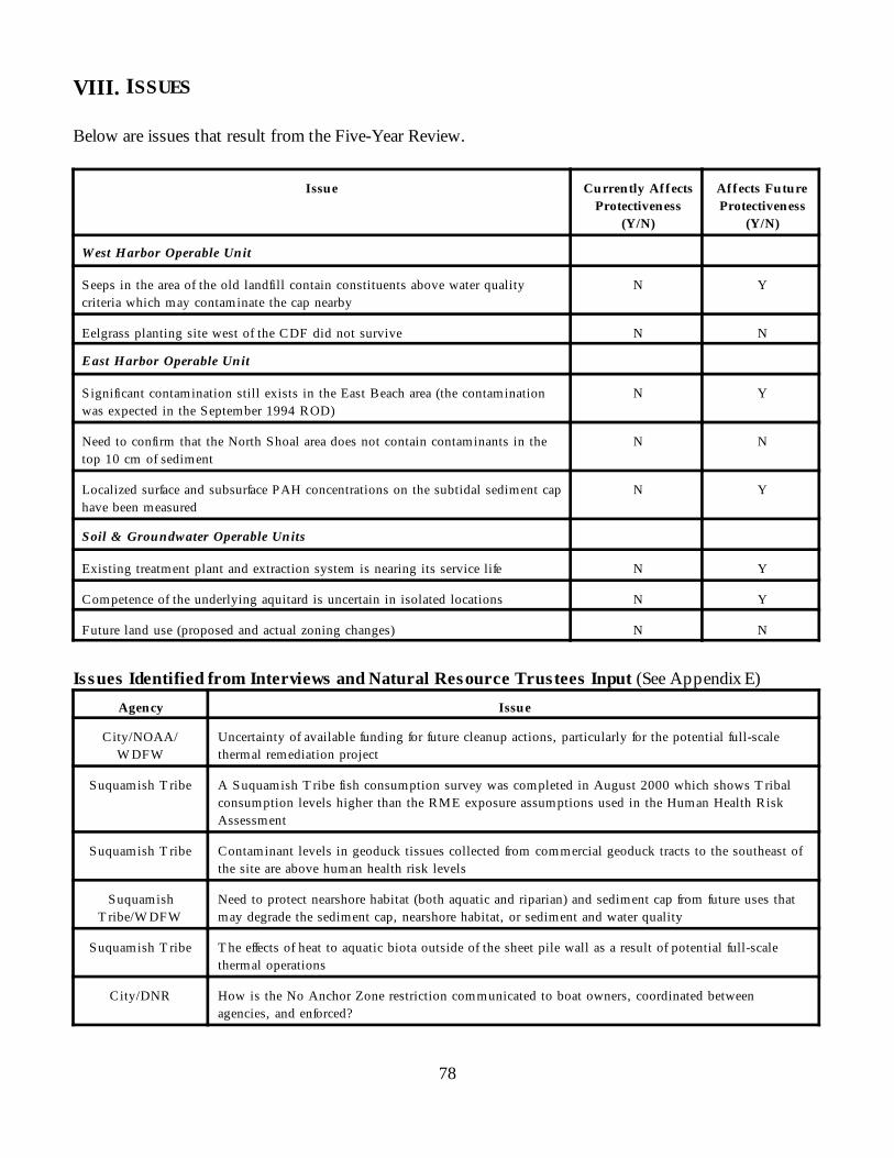
78
VIII. ISSUES
Below are issues that result from the Five-Year Review.
Issue Currently AffectsProtectiveness
(Y/N)
Affects FutureProtectiveness
(Y/N)
West Harbor Operable Unit
Seeps in the area of the old landfill contain constituents above water qualitycriteria which may contaminate the cap nearby
N Y
Eelgrass planting site west of the CDF did not survive N N
East Harbor Operable Unit
Significant contamination still exists in the East Beach area (the contaminationwas expected in the September 1994 ROD)
N Y
Need to confirm that the North Shoal area does not contain contaminants in thetop 10 cm of sediment
N N
Localized surface and subsurface PAH concentrations on the subtidal sediment caphave been measured
N Y
Soil & Groundwater Operable Units
Existing treatment plant and extraction system is nearing its service life N Y
Competence of the underlying aquitard is uncertain in isolated locations N Y
Future land use (proposed and actual zoning changes) N N
Issues Identified from Interviews and Natural Resource Trustees Input (See Appendix E)Agency Issue
City/NOAA/W DFW
Uncertainty of available funding for future cleanup actions, particularly for the potential full-scalethermal remediation project
Suquamish T ribe A Suquamish T ribe fish consumption survey was completed in August 2000 which shows T ribalconsumption levels higher than the RME exposure assumptions used in the Human Health RiskAssessment
Suquamish T ribe Contaminant levels in geoduck tissues collected from commercial geoduck tracts to the southeast ofthe site are above human health risk levels
SuquamishT ribe/W DFW
Need to protect nearshore habitat (both aquatic and riparian) and sediment cap from future uses thatmay degrade the sediment cap, nearshore habitat, or sediment and water quality
Suquamish T ribe T he effects of heat to aquatic biota outside of the sheet pile wall as a result of potential full-scalethermal operations
City/DNR How is the No Anchor Zone restriction communicated to boat owners, coordinated betweenagencies, and enforced?
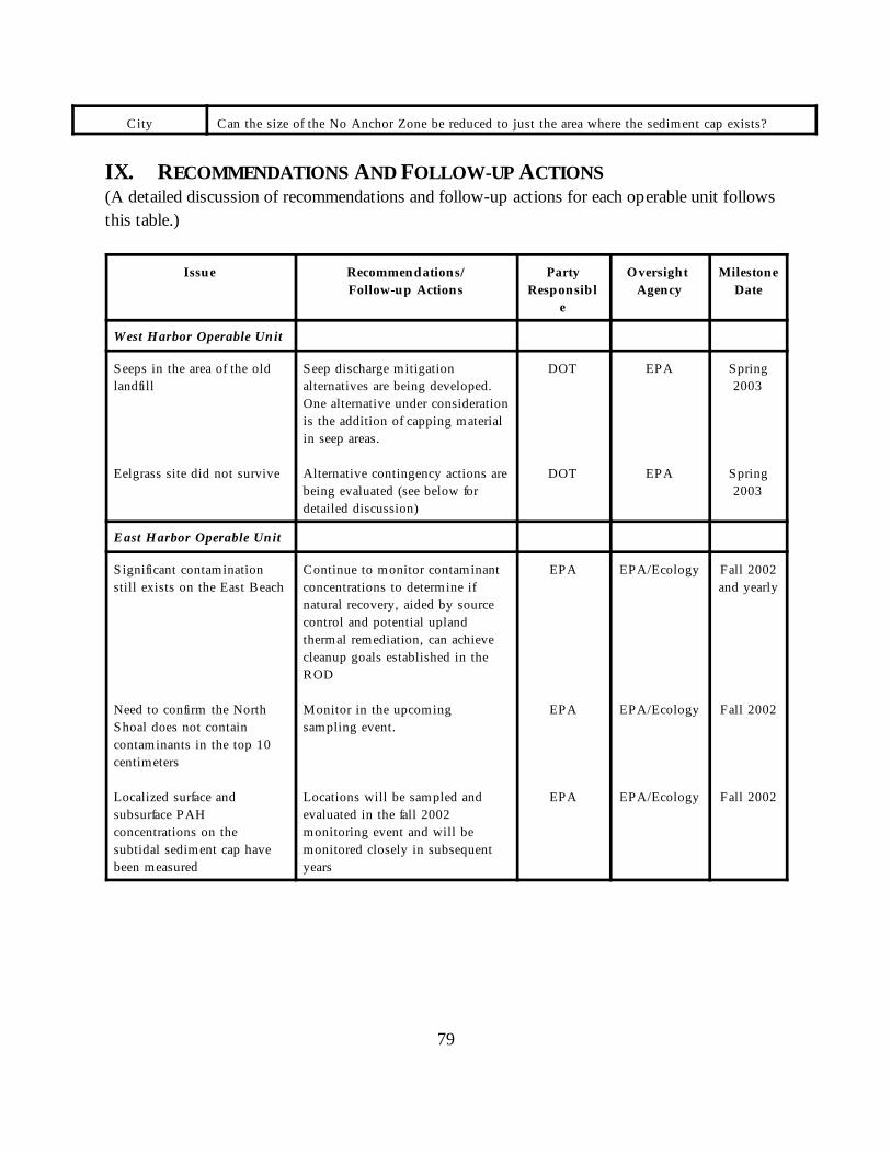
79
City Can the size of the No Anchor Zone be reduced to just the area where the sediment cap exists?
IX. RECOMMENDATIONS AND FOLLOW-UP ACTIONS(A detailed discussion of recommendations and follow-up actions for each operable unit followsthis table.)
Issue Recommendations/Follow-up Actions
PartyResponsibl
e
Oversight Agency
MilestoneDate
West Harbor Operable Unit
Seeps in the area of the oldlandfill
Eelgrass site did not survive
Seep discharge mitigationalternatives are being developed. One alternative under considerationis the addition of capping materialin seep areas.
Alternative contingency actions arebeing evaluated (see below fordetailed discussion)
DOT
DOT
EPA
EPA
Spring2003
Spring2003
East Harbor Operable Unit
Significant contaminationstill exists on the East Beach
Need to confirm the NorthShoal does not containcontaminants in the top 10centimeters
Localized surface andsubsurface PAHconcentrations on thesubtidal sediment cap havebeen measured
Continue to monitor contaminantconcentrations to determine ifnatural recovery, aided by sourcecontrol and potential uplandthermal remediation, can achievecleanup goals established in theROD
Monitor in the upcomingsampling event.
Locations will be sampled andevaluated in the fall 2002monitoring event and will bemonitored closely in subsequentyears
EPA
EPA
EPA
EPA/Ecology
EPA/Ecology
EPA/Ecology
Fall 2002and yearly
Fall 2002
Fall 2002
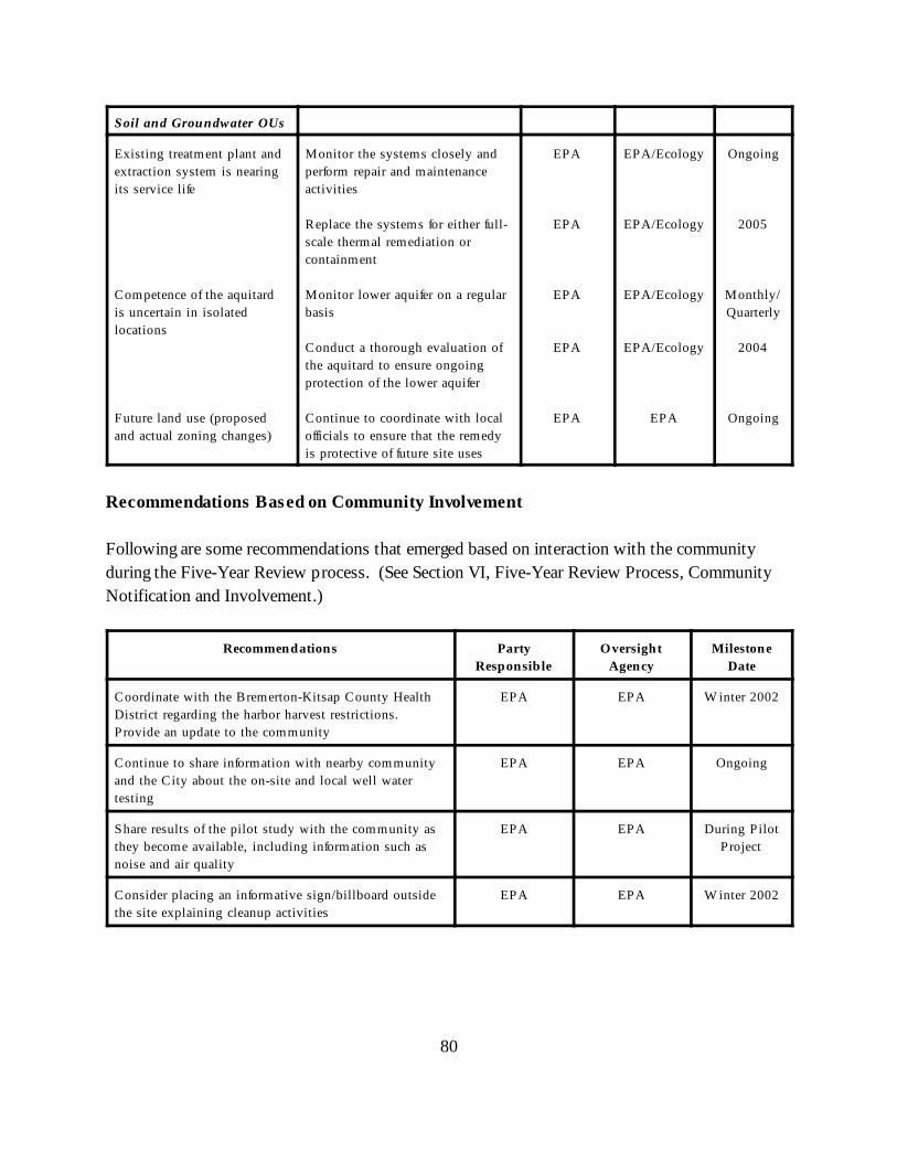
80
Soil and Groundwater OUs
Existing treatment plant andextraction system is nearingits service life
Competence of the aquitardis uncertain in isolatedlocations
Future land use (proposedand actual zoning changes)
Monitor the systems closely andperform repair and maintenanceactivities
Replace the systems for either full-scale thermal remediation orcontainment
Monitor lower aquifer on a regularbasis
Conduct a thorough evaluation ofthe aquitard to ensure ongoingprotection of the lower aquifer
Continue to coordinate with localofficials to ensure that the remedyis protective of future site uses
EPA
EPA
EPA
EPA
EPA
EPA/Ecology
EPA/Ecology
EPA/Ecology
EPA/Ecology
EPA
Ongoing
2005
Monthly/Quarterly
2004
Ongoing
Recommendations Based on Community Involvement
Following are some recommendations that emerged based on interaction with the communityduring the Five-Year Review process. (See Section VI, Five-Year Review Process, CommunityNotification and Involvement.)
Recommendations PartyResponsible
OversightAgency
MilestoneDate
Coordinate with the Bremerton-Kitsap County HealthDistrict regarding the harbor harvest restrictions. Provide an update to the community
EPA EPA W inter 2002
Continue to share information with nearby communityand the City about the on-site and local well watertesting
EPA EPA Ongoing
Share results of the pilot study with the community asthey become available, including information such asnoise and air quality
EPA EPA During P ilotProject
Consider placing an informative sign/billboard outsidethe site explaining cleanup activities
EPA EPA W inter 2002
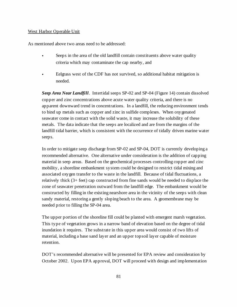
81
West Harbor Operable Unit
As mentioned above two areas need to be addressed:
• Seeps in the area of the old landfill contain constituents above water qualitycriteria which may contaminate the cap nearby, and
• Eelgrass west of the CDF has not survived, so additional habitat mitigation is
needed.
Seep Area Near Landfill. Intertidal seeps SP-02 and SP-04 (Figure 14) contain dissolvedcopper and zinc concentrations above acute water quality criteria, and there is noapparent downward trend in concentrations. In a landfill, the reducing environment tendsto bind up metals such as copper and zinc in sulfide complexes. When oxygenatedseawater come in contact with the solid waste, it may increase the solubility of thesemetals. The data indicate that the seeps are localized and are from the margins of thelandfill tidal barrier, which is consistent with the occurrence of tidally driven marine waterseeps.
In order to mitigate seep discharge from SP-02 and SP-04, DOT is currently developing arecommended alternative. One alternative under consideration is the addition of cappingmaterial in seep areas. Based on the geochemical processes controlling copper and zincmobility, a shoreline embankment system could be designed to restrict tidal mixing andassociated oxygen transfer to the waste in the landfill. Because of tidal fluctuations, arelatively thick (3+ feet) cap constructed from fine sands would be needed to displace thezone of seawater penetration outward from the landfill edge. The embankment would beconstructed by filling in the existing nearshore area in the vicinity of the seeps with cleansandy material, restoring a gently sloping beach to the area. A geomembrane may beneeded prior to filling the SP-04 area.
The upper portion of the shoreline fill could be planted with emergent marsh vegetation. This type of vegetation grows in a narrow band of elevation based on the degree of tidalinundation it requires. The substrate in this upper area would consist of two lifts ofmaterial, including a base sand layer and an upper topsoil layer capable of moistureretention.
DOT’s recommended alternative will be presented for EPA review and consideration byOctober 2002. Upon EPA approval, DOT will proceed with design and implementation
82
of the remedy under EPA oversight. A full schedule for design and implementation willbe contained in the proposed alternative presentation.
Eelgrass Habitat Restoration. A 0.6-acre eelgrass transplant site was establishedimmediately west of the CDF and cap in September-October 1998, after water qualitysurveys and laboratory experiments in 1997 indicated that this location would supporteelgrass growth. This mitigation is required for filling the intertidal area duringconstruction of the CDF, as part of the original remedy. Approximately 10,000 eelgrassshoots were planted in 1998, and an additional 220 shoots were planted in April 2000. All eelgrass was lost by August 2000. The eelgrass bed failed, in large part, due to thepersistent presence of algae, which prevented light from reaching the newly plantedeelgrass. Eight alternative contingency actions for habitat mitigation were evaluated byEPA, Ecology, Washington State Department of Fish and Wildlife, U.S. Fish and WildlifeService, NOAA, and the Washington State Department of Natural Resources. Optionscurrently under consideration include:
• A ravine delta salt marsh restoration would consist of filling the existing intertidalriprap area adjacent to the West Harbor eelgrass planting site to restore gentlysloping beach and salt marsh habitat that likely existed historically in this area. This project has a high probability of success, is on site and cost effective, andcould concurrently address metals contamination at seep SP-02;
• The Schel-chelb Estuary wetland connection project would connect an existing 5-10 acre freshwater wetland that currently discharges to the Rich Passage (througha small outfall that periodically plugs) to the Schel-chelb Estuary. While theSchel-chelb is an existing mitigation project, the wetland connection is a new facetof that project that would provide saltwater connection to an adjacent fresh watermarsh. This project offers the highest potential for overall habitat functiondevelopment, has a high probability of success, and is cost effective;
• The Milwaukee Dock substrate restoration would consist of filling in a formernavigation channel (the dock was removed more than 10 years ago) to a levelconsistent with adjacent eelgrass meadows. The Milwaukee Dock area is locatedoff the eastern shore of the Wyckoff property in Puget Sound. This project has amoderate probability of success; and
• Eelgrass planting, such as at the Milwaukee Dock site or adjacent to the Wyckoffsite, which has a moderate probability of success.
83
One of these alternatives will be selected, implemented, and monitored to ensure that adequatehabitat mitigation has been performed for the habitat lost by the CDF construction.
East Harbor Operable Unit
Additional capping was placed in the locations where increased vertical concentrations werenoted in deep cores. These locations will be sampled and evaluated in the next monitoring eventand will be monitored closely in subsequent years. If continued monitoring events reveal thatlocalized impacts are occurring within the cap versus general surface cap disturbances, thencontinued maintenance will be performed per the September 1994 ROD.
EPA will monitor the North Shoal and East Beach intertidal sediments in the upcoming fall 2002monitoring event to assess contaminant concentrations in the top 10 centimeters. The EastBeach intertidal sediments will also be monitored to determine if natural recovery, aided bysource control and upland thermal remediation (if remedy is implemented), can achieve thecleanup goals established in the ROD. EPA will reassess current information after the start ofupland thermal remediation to determine the condition of the beach and if additional studiesand/or actions are necessary.
Soil and Groundwater Operable Units
The existing treatment plant and extraction system will have to be monitored closely and repairand maintenance activities should be continued to ensure its functionality and to maintainhydraulic control within the Former Process Area until a final groundwater and soil remedy isconstructed (either full-scale thermal remediation or containment), currently estimated to be bythe year 2005. Additionally, if the containment remedy is implemented, a more completeevaluation of the aquitard may need to be completed to ensure protection of the lower aquiferfrom NAPL intrusion. In any case, the lower aquifer will be monitored on a regular basis toensure contaminant levels are not increasing.
X. PROTECTIVENESS STATEMENT(S)
The remedies for all four operable units are expected to be protective of human health and theenvironment. All immediate threats at the site have been addressed through containment ofcontaminated soil and groundwater with a pump-and-treat system and sheet pile wall, removaland consolidation of contaminated soil, removal and capping of sediments, and the installation of
84
fencing and warning/fish advisory signs. Long-term protectiveness of the remedial actions will beverified by additional monitoring and data collection. West Harbor Operable Unit
The remedies have met, and with the implementation of additional actions to address the seeps inthe area of the old landfill, are expected to meet the cleanup goals. Institutional controls areeffective in controlling access to the upland areas and fish advisories are in place. East Harbor Operable Unit
The remedies are expected to meet the cleanup goals. Exposure pathways that could result inunacceptable risks are being controlled. Institutional controls are preventing exposure tocontaminated East Beach intertidal sediments and the ingestion of contaminated fish and shellfish.
85
Soil and Groundwater Operable Units
With the exception of the soil and upper aquifer groundwater within the Former Process Area, inwhich a final remedy will be designed and constructed once results from the steam injection pilotproject have been evaluated, the remedies that are in place have met, or are expected to meet thecleanup goals. In the interim, exposure pathways that could result in unacceptable risks are beingcontrolled. Site controls are preventing exposure to contaminated soil and groundwater. Thefinal soil and groundwater remedy for the Former Process Area is expected to be in-place by2005.
XI. NEXT REVIEW
The next five-year review for the Wyckoff/Eagle Harbor Superfund Site is required by September26, 2007, five years from the date of this review.
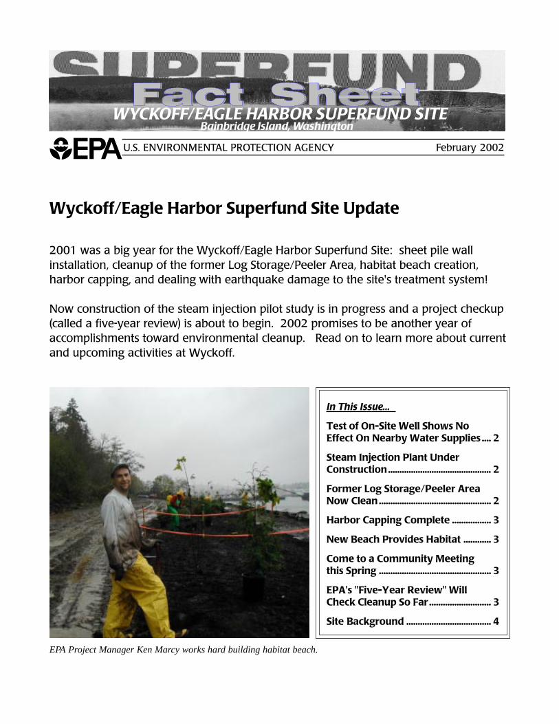
Wyckoff/Eagle Harbor Superfund Site February 2002
1
Wyckoff/Eagle Harbor Superfund Site Update
2001 was a big year for the Wyckoff/Eagle Harbor Superfund Site: sheet pile wallinstallation, cleanup of the former Log Storage/Peeler Area, habitat beach creation,harbor capping, and dealing with earthquake damage to the site's treatment system!
Now construction of the steam injection pilot study is in progress and a project checkup(called a five-year review) is about to begin. 2002 promises to be another year ofaccomplishments toward environmental cleanup. Read on to learn more about currentand upcoming activities at Wyckoff.
U.S. ENVIRONMENTAL PROTECTION AGENCY February 2002
In This Issue...
Test of On-Site Well Shows NoEffect On Nearby Water Supplies .... 2
Steam Injection Plant UnderConstruction............................................. 2
Former Log Storage/Peeler AreaNow Clean ................................................. 2
Harbor Capping Complete ................. 3
New Beach Provides Habitat ............ 3
Come to a Community Meetingthis Spring ................................................. 3
EPA's "Five-Year Review" WillCheck Cleanup So Far........................... 3
Site Background ..................................... 4
EPA Project Manager Ken Marcy works hard building habitat beach.
WYCKOFF/EAGLE HARBOR SUPERFUND SITEBainbridge Island, Washington
Wyckoff/Eagle Harbor Superfund Site February 2002
2
Test of On-Site Well Shows No Effect on Nearby Water Supplies
A water source will be needed for use in the boiler during steam injection. In early January EPAcompleted construction and testing of an on-site well. The water well is screened to a depth of 500feet below ground surface. Preliminary pump test results show that the well can provide 200gallons per minute (gpm) with no effect on nearby water supply systems. EPA monitored the BillPoint water supply system and the City's well located on Taylor Avenue during the pumping test.EPA worked closely with the Bill Point community and the City of Bainbridge Island throughout thewater supply evaluation process. Chemistry samples were also collected during the test. Samplingdata will be available in March.
As currently scheduled, the active steam injection period of the pilot project will be conductedbetween October 2002 and April 2003 (i.e., EPA will withdraw water from the aquifer during thisperiod of time to create steam for injection into the ground). Most of this period of active waterwithdrawal will occur during the wettest months of the year. Also, while the on-site water well hasthe capacity to pump at 200 gpm, EPA will require only an initial withdrawal of 150 gpm during thefirst several weeks of startup. After the initial startup period, water use will be reduced to an esti-mated 50-70 gpm of water during most of the steaming phase.
Steam Injection Plant Under Construction
The small-scale study of thermal treatment technology is nowunder construction, and could be operational by this fall. Thepurpose of this "pilot" study is to evaluate the performance ofsteam injection at the Wyckoff site. Steam will be pumpedinto the ground, and contaminants will be extracted. EPAexpects to run the pilot system about a year. If the test issuccessful, EPA will move on to full-scale cleanup.
EPA has completed construction of a vapor cap over the studyarea. The vapor cap will prevent escape of vapors duringsystem operation and will aid in soil cleanup. The vapor capis about three feet thick. It includes a horizontal vapor collec-tion layer, a geomembrane layer, and clean fill materials atthe surface.
All 16 injection wells and seven extraction wells have beeninstalled in the pilot area, as well as 75% of the thermalmonitoring devices. Equipment for the steam injection plantwill be delivered within the next several months. Equipmentincludes a boiler, a heat exchanger, tanks, pumps and pipes.Truck traffic for equipment delivery is expected to be light.
You may have noticed that a large building is being con-structed on site. This building will be used to house the boilerand other operational equipment to minimize noise during thesteam operation.
Former Log Storage/Peeler Area Now Clean
EPA completed cleanup of thewestern portion of the sitebehind the newly created habitatbeach, known as the former LogStorage/Peeler Area. About40,000 cubic yards of soil(20,000 of which was contami-nated) were removed last year aspart of the construction of thehabitat beach.
This year, EPA removed another10,000 cubic yards of contami-nated soil. All the contaminatedsoil was consolidated within theformer process area for latercleanup, and excavated areasbackfilled with clean soil.
Cleanup of the western portionof the site meets the State ofWashington Department ofEcology's stringent residentialcleanup standards.
Wyckoff/Eagle Harbor Superfund Site February 2002
3
Harbor Capping Complete
Construction of the Eagle Harbor cap is com-plete! The cap, which involved placing cleansediment over contaminated areas of theharbor floor, was completed in three stages.In 1993 and 1994, a 52-acre subtidal area wascapped with about three feet of clean sediment.This area has been monitored closely sinceinstallation and is performing well.
In 2000 and 2001, EPA completed a 15-acre capextending from the southern boundary of theearlier cap to the Wyckoff property, after con-taining creosote seepage with a sheetpile wall.This area of cap is also about three feet thick.In the last few months, more material wasplaced extending out several hundred feet fromthe Wyckoff property to form a gently slopingbeach which connects a habitat beach to thewest with existing intertidal areas to the east.A monitoring plan for capped areas is beingrevised, with monitoring of all capped areasresuming this year.
New Beach Provides Habitat
EPA recently created over two acres of newbeach habitat on the western portion of thesite. The beach makes up for habitat lostduring sheet pile wall installation. Constructionof the habitat area involved removing oldbulkheads, and removing and contouring soilalong the shoreline. The clean soil that wasremoved has been used to backfill behind thesheet pile wall. Contaminated material wasremoved and consolidated on the area of thesite targeted for thermal cleanup. Once the soilwas removed, a layer of "fish mix," or materialwith the grain size preferred by endangeredspecies and smelt, was placed on the newlycreated beach. Creation of this site connectsexisting smelt habitat to the west and a newbeach to the east, created as part of the cap-ping project.
During the 2001/2002 construction season,additional beach material was placed over therip rap at the top of the beach to improveoverall habitat function. This winter, EPAplanted a 20-foot habitat buffer extending fromthe top of the beach inland with a wide varietyof native trees, shrubs, plants and grasses.
continued on page 4
Come to aCommunity Meeting
this Spring
EPA plans to host an informal communitymeeting sometime in Spring 2002. EPAProject Managers will provide an updateon Wyckoff activities, discuss the Five-YearReview, and answer questions from com-munity members. Watch for a postcard inthe mail with scheduling details soon.
EPA's "Five-Year Review"Will Check Cleanup So Far
EPA conducts regular checkups, called five-yearreviews, on certain Superfund sites. EPA looksat sites where cleanup is finished or wherecleanup activity is still happening after fiveyears. In both cases, EPA checks the site tomake sure the cleanup continues to protectpeople and the environment.
The review at Wyckoff will be comprehensive.It will look at both the east and west portions ofthe harbor, where cleanup is essentially finished.It also will look at the groundwater and soil atthe Wyckoff site, where cleanup activities are inprogress. An EPA team with support from theCorps of Engineers will conduct the review,answer your questions, and share the results.
Wyckoff/Eagle Harbor Superfund Site February 2002
4
Early in 2002, the team will collect informationabout the site, including information on recentsite activities and the cleanup. They will reviewthe laws that apply and inspect the site. Theywill talk with the people who have been work-ing at the site, as well as state, tribal and localofficials. EPA also will seek information fromsome local residents. The team will check tosee if cleanup activities continue to operateproperly, and may take additional samples.In Spring 2002, EPA will host a communitymeeting where the public will have a chanceto learn more about the review and provideinformal input.
The team will use the information to decidewhether or not the community and the environ-ment are safe from contaminated material andhow the community is affected by site cleanupactivities. Once the team finishes the five-yearreview later this year, they will write a report.This report will include background on the siteand cleanup activities, describe the review,explain the results, and include recommenda-tions to fix any problems found during thereview.
The final report, scheduled to be completed thisfall, will be placed in the information repositoryat the Bainbridge Island Library. A summarywill be mailed in a fact sheet to communitymembers. After the review, the site managerswill monitor the site to be sure any problemsidentified by the review team are fixed. As longas contaminated materials remain at the site,EPA will do a review every five years.
If you would like to discuss the five-year reviewwith EPA, or have information that may beuseful to reviewers, please call any of thecontacts listed on page 5.
Site Background
EPA listed Wyckoff/Eagle Harbor as aSuperfund site in 1987. The formerWyckoff wood treating facility, locatedat the mouth of Eagle Harbor onBainbridge Island, operated from thevery early 1900's to 1988. Soils at thefacility, and groundwater beneath thefacility, are severely contaminated.
Contaminants include creosote andother wood treatment compounds.About 1 million gallons of creosoteproduct remain in the site's soil andgroundwater. These contaminantspose a risk to public health and theenvironment.
A groundwater extraction and treatmentsystem has been operated on site since1990. However, contaminants were stillmoving into the marine environmentuntil a sheet pile wall was installed in2001. EPA will use thermal treatmenttechnologies to clean up remaining soiland groundwater contamination.
In Eagle Harbor, bottom sediments wereseverely contaminated with chemicalsfrom wood-treating and shipyard opera-tions. A public health advisory recom-mends against eating fish and shellfishfrom the harbor. From 1993 to 2002,contaminated sediments in variouslocations were capped with cleanmaterial.
continued from page 3
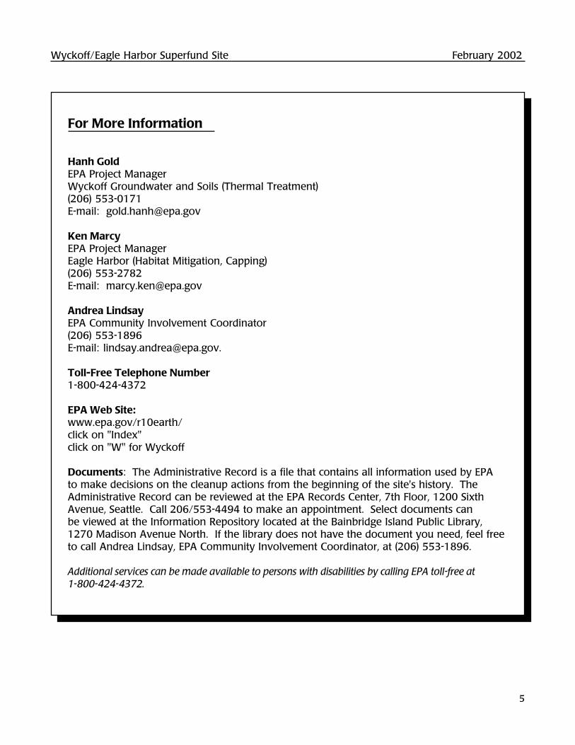
Wyckoff/Eagle Harbor Superfund Site February 2002
5
For More Information
Hanh GoldEPA Project ManagerWyckoff Groundwater and Soils (Thermal Treatment)(206) 553-0171E-mail: [email protected]
Ken MarcyEPA Project ManagerEagle Harbor (Habitat Mitigation, Capping)(206) 553-2782E-mail: [email protected]
Andrea LindsayEPA Community Involvement Coordinator(206) 553-1896E-mail: [email protected].
Toll-Free Telephone Number1-800-424-4372
EPA Web Site:www.epa.gov/r10earth/click on "Index"click on "W" for Wyckoff
Documents: The Administrative Record is a file that contains all information used by EPAto make decisions on the cleanup actions from the beginning of the site's history. TheAdministrative Record can be reviewed at the EPA Records Center, 7th Floor, 1200 SixthAvenue, Seattle. Call 206/553-4494 to make an appointment. Select documents canbe viewed at the Information Repository located at the Bainbridge Island Public Library,1270 Madison Avenue North. If the library does not have the document you need, feel freeto call Andrea Lindsay, EPA Community Involvement Coordinator, at (206) 553-1896.
Additional services can be made available to persons with disabilities by calling EPA toll-free at1-800-424-4372.

Wyckoff/Eagle Harbor Superfund Site Update
Answering Community Questions About Wyckoff/Eagle Harbor
In June, EPA hosted a community information meeting about the Wyckoff/Eagle HarborSuperfund Site. Besides updating the community on site activities, the meeting also gaveproject representatives a chance to hear directly from residents about their concerns. This factsheet summarizes issues discussed at the meeting and raised by residents in recent conversa-tions with EPA. It also previews upcoming steam activity at Wyckoff, and includes an editorialnote from the Association of Bainbridge Communities. As always, if you have a question orissue that has not yet been addressed, feel free to contact anyone listed on the last page.
U.S. ENVIRONMENTAL PROTECTION AGENCY August 2002
WYCKOFF/EAGLE HARBOR SUPERFUND SITEBainbridge Island, Washington
In This Issue...
Wyckoff: Ramping Up for Steam .......... 1
Answering Community Questions ........ 2
Five Year Report Available for Review Soon ............................................. 6
Site Background ........................................... 6
A Note From Association of Bainbridge Communities ..................... 7
For More Information ................................ 8
Wyckoff: Ramping Up for Steam
In addition to testing the technology's effec-tiveness, the pilot also gives EPA (and theneighboring community) a chance to learnmore about practical operation issues. Forexample, through the test, EPA will have abetter handle on noise or other nuisances, andcan take measures in advance of full scaleoperation. In the meantime, EPA has alreadytaken significant measures to limit noise andother potential nuisances. A surface cap hasbeen installed to collect any vapors from thesite. Truck traffic is expected to be light.
Boiler arrives at Wyckoff Site. Steaming begins in September.
Watch for plenty of activity at Wyckoff this fall, asEPA reaches another major milestone toward sitecleanup. The pilot steam injection plant ramps upthis September, beginning the study of thermal treat-ment. Steam will be pumped into the ground andcontaminants extracted. The pilot system will runfor about a year. If the test is successful, EPA willmake the decision to move on to full scale cleanup.

Wyckoff/Eagle Harbor Superfund Site August 2002
2
Answering Community Questions
Another part of the equation is the potentialcosts and inherent risk of creosote productreaching the lower aquifer. An estimated onemillion gallons of creosote product still remainin the ground at the site. The clay "aquitard"layer that separates the contaminated aquiferfrom the lower aquifer is continuous. Itsthickness generally ranges from 10 to 40 feet.However, it may be as thin as four feet inisolated areas, and in some locations, containinterbedded sand layers.
There is evidence that creosote product haspenetrated the aquitard through a pathwaywithin the sand lenses, but has not reached thelower aquifer. Based on field explorations, italso appears that there is a serious aquitardstructural flaw located near the center of thesite, possibly due to seismic activity.
Given the magnitude of contamination atWyckoff and the questionable integrity of theunderlying aquitard layer, the containmentremedy would be used only if the steam injec-tion pilot project fails to meet performanceobjectives (however, only until a better tech-nology is available that will provide a morepermanent solution).
4. What will be the configuration of the site'saccess roads, and what traffic safety mea-sures will be put in place?
During the steam injection phase of the pilot study(6-8 months), up to four fuel deliveries by truckwill be made to the site each week. The truckswill enter the site at Creosote Place NE, the site'smain access road. Given the low truck trafficvolume, EPA does not plan to reconfigure the site'smain access road, and no additional traffic safetymeasures are planned. The exact schedule oftruck deliveries is not known at this time.
1. Is the new beach open for recreation? Whatmeasures will be put in place to protect thebeach?
Although contamination on the western portionof the site has been removed and consolidatedin the former process area, the habitat beach,and all the beaches around the site, remain partof the Wyckoff/Eagle Harbor Superfund site.For now, these beaches are restricted to publicaccess. EPA is considering posting additionalsigns to alert walkers and boaters to the factthat beaches around the site are restricted.
2. Is funding for the cleanup assured?
The steam injection pilot project is fully funded,with funding assured through September of2003. Beyond 2003, EPA will depend on yearlyCongressional appropriations for continuedcleanup efforts.
3. What is the cost/benefit comparison ofcontainment versus cleanup? Why is EPAnot simply capping the site as was done atGasworks Park?
The estimated cost of containment with a sheetpile wall, a new pump-and-treat system, and sur-face soil cap is about $28,500,000. This estimateincludes capital costs plus 30 years of operationand maintenance (O&M). The estimated present-worth cost of full-scale thermal cleanup isabout $46,000,000 (capital plus 10 years O&M).However, this cost difference does not reflect thefact that the pump-and-treat system would needto be operated and maintained, and occasion-ally replaced, in perpetuity, to preserve theintegrity of the containment remedy. Overthe long term, it is cost effective to proceedinstead with contaminant removal and cleanup.
Wyckoff/Eagle Harbor Superfund Site August 2002
3
5. Is the site's water well in the same aquifer asother wells? Will monitoring occur duringthe pilot to ensure that nearby wells are notimpacted? What about water supply ifcleanup goes full-scale?
No, the well that provides water for the cleanupis in a separate aquifer from those used by localwells, except for one city well. The South EagleHarbor Well, located on Taylor Avenue, drawswater from the same aquifer (GlaciomarineAquifer). The well at the cleanup site drawswater from a small portion of the aquifer, ataround 500 feet. Pump tests of the well showvery minimal or no effect on nearby watersupply systems. EPA monitored the Bill Pointwater supply system and the South EagleHarbor well during the pumping test.Contaminants associated with the Wyckoffsite were not detected in either well.
EPA plans to conduct another round of water leveland chemistry sampling of the Bill Point and SouthEagle Harbor wells during the steam injectionphase of the pilot operation, scheduled tobegin in September 2002 and continuing throughspring 2003. This sampling will provide moreinformation about any effects on nearby wellsfrom the steam injection operations.
The onsite water supply will be used during thepilot phase of the project. EPA will re-evaluatewater supply options for the full-scale project.
6. Where does the water go after it is used fortreatment?
After contaminated water is treated at the site'sgroundwater treatment plant, it will be dischargedfrom an outfall to Puget Sound, in the samemanner as it is discharged now. The dischargewill meet the substantive requirements of thestate's National Pollution Discharge EliminationSystem (NPDES).
7. Will there be intrusive lighting at night?
No, there will not be intrusive lighting at night.There will be some minimal lighting for sitesafety and security purposes.
8. How loud will the diesel boiler be? How areyou containing sound? Why diesel? Will itsmell or harm air quality or present a healthissue? How will fumes be contained? Canenergy be reclaimed or reused? How muchfuel will be required?
The boiler has been delivered to the site and ishoused in the "boiler building." It is difficult atthis time, prior to boiler startup, to predict howloud the boiler operation will be. We expect theboiler building to minimize noise. EPA is alsoevaluating sound mitigation measures withinthe building, such as constructing enclosuresaround the louder pieces of mechanical equip-ment. If noise levels still exceed state regula-tions, EPA will take additional measures, such asincreasing the level of insulation in the entirebuilding.
Diesel is being used because it is an efficient fuelsource and is cost-effective. The fuel selected foruse at this site is a low-sulfur (less than 0.5%)diesel fuel. Air emissions will be monitored withinthe first two weeks of boiler operation to demon-strate compliance with air quality regulations.More monitoring will be conducted if results showa potential problem with emissions. Air near thetreatment plant and within the pilot area will alsobe monitored on a regular basis.
Initial estimates of boiler emissions are farbelow both Federal and State reporting re-quirements. In fact, many public facilities onBainbridge Island use similar boiler plants forheating. Until recently, oil-fired boilers similar tothe one at the Wyckoff site heated BainbridgeIsland High School.
Answering Community Questions, continued
Wyckoff/Eagle Harbor Superfund Site August 2002
4
The design of the steam injection systemincludes features to reduce overall energyrequirements. For example, hot liquids ex-tracted from the pilot area will be used to pre-heat boiler feed water. This reduces theamount of energy required to produce steamwhile decreasing the energy required to coolthe extracted liquids before treatment.
During pilot steam injection operations, theboiler will require a maximum of 20,000 gallonsof fuel per week. The pilot study is expected touse about 200,000 gallons of fuel. At this time,our rough estimate is that at most, 15,600gallons of fuel will be needed per day forfull-scale steam injection operation.
9. How long will the sheetpile wall last?
The sheet pile wall is designed to last for 30years. If we proceed to full-scale thermalcleanup and we meet cleanup goals, then thesheet pile wall could be cut off at the mudlineor removed and the shoreline restored to itsnatural condition.
10. Is the pilot wall as deep as the mainperimeter wall?
Both the pilot area wall and the perimeter wallare seated at least 4 to 5 feet into the uppersurface of the underlying aquitard layer. Sincethe aquitard is sloped from south to north, thepilot area wall does not extend as deep into thesubsurface. The pilot area wall is about 15 to45 feet deep, and the perimeter wall depthsvary from 25 to 90 feet.
11. How long will it take to heat the site? Howlong will the site take to cool down? WillEagle Harbor be heated by the steamproject? Will habitat be affected by heator by the wall's presence?
The pilot area likely will be heated within 2 to 4weeks after steam injection begins. Modelingdata indicate that cooling down after the full-scale project would take about two years.
If full-scale steam injection takes place, conser-vative modeling results show that marine life couldbe affected by heat within 10 meters of the wall.Data from the pilot project will help quantifypossible impacts of heat on intertidal habitat loss,including eelgrass beds, and changes in the wayhabitat is used by marine life.
The presence of the sheetpile wall may affect sedi-ment and water, which in turn affect intertidal habi-tat. Effects could include scour along the base ofthe wall, changes in grain size, and an increase inwave energy. Of the three possible effects, scouris the least likely to occur. In general, scour troughsalong vertical walls have not been observed andattempts to measure have been inconclusive.Changes in sediment grain size due to sedimentmovement along the wall will be analyzed. Sincethe sheet pile wall presents a vertical face, it is ex-pected to divert waves away from the shoreline,changing wave patterns at high and storm tides.
Effects on eelgrass are unknown but are notexpected to be large. Baseline information onthe extent and density of eelgrass was collectedbefore the sheetpile wall was installed. If eel-grass meadows appear to be changing, moreextensive monitoring will occur.
Answering Community Questions, continued
Wyckoff/Eagle Harbor Superfund Site August 2002
5
12. How deep will steam be injected? Will heatpush contaminants down into or throughthe protective clay barrier (aquitard)?
Steam will be injected to the surface of theaquitard layer, which in the area of the pilot studyis about 10 to 40 feet deep. Laboratory testsindicate that creosote product becomes less densewhen heated. That means heavier oils thatotherwise tend to sink in the aquifer wouldbecome lighter and float on the aquifer table.As a result, and through careful monitoring dur-ing operations, we do not anticipate that contami-nants will be pushed into or through the aquitard.
13. How long will the pilot test last? If the pilotis successful, how soon will you move on tofull scale treatment? How long would fullscale treatment take?
The pilot project will last about one year, fromSeptember 2002 to September 2003. If the pilotproject meets project objectives, we will mostlikely expand the project to site-wide, full-scalesteam injection (dependent on funding). Basedon the best scenario, designs of the full-scaleproject will be performed in 2004. Operationswill begin sometime in late 2005. Active steam-ing will take place from 2005 to 2008, followedby about 5 years of continued contaminantextraction and treatment (2008-2013).
14. What provisions have been made forhistoric preservation at the site?
Prior to demolition of onsite structures in 1997,EPA produced a Historic American EngineerRecord report. The report included a narrativeand photo documentation, although the buildings
demolished were deemed not "eligible for listingin the National Register." The documentationmet the requirements of the Historic AmericanEngineering Record standards. It also compliedwith EPA's Memorandum of Agreement with theWashington State Historic Preservation Officer andthe Advisory Council on Historic Preservation.
Documentation was sent to the Prints andPhotographs Division of the Library of Congress.A complete set of the original documentation wasalso provided to the Bainbridge Island HistoricalSociety for use in their museum. An archeo-logical assessment was also conducted inconsultation with the Suquamish Tribe.
15. Is EPA still planning a potential bufferaround the site?
EPA is drafting land use controls that will requireany future land owner of the Wyckoff site toensure that intertidal habitat functions are main-tained and protected. A vegetated habitat bufferis an effective way to protect the intertidal areathat has been remediated and enhanced as partof the Eagle Harbor cleanup. The concept of avegetated buffer was also supported, in large part,by citizens of Bainbridge Island in response to arequest for comment issued by EPA in March of2001. Any measures that are taken to protectthe intertidal habitat around the Wyckoff site,including a vegetated buffer, will be undertakenand maintained by the future owner of the site.
16. Can the stream at the west end of the sitebe put back on the surface?
There are no plans to put the stream back onthe surface of the site.
Answering Community Questions, continued
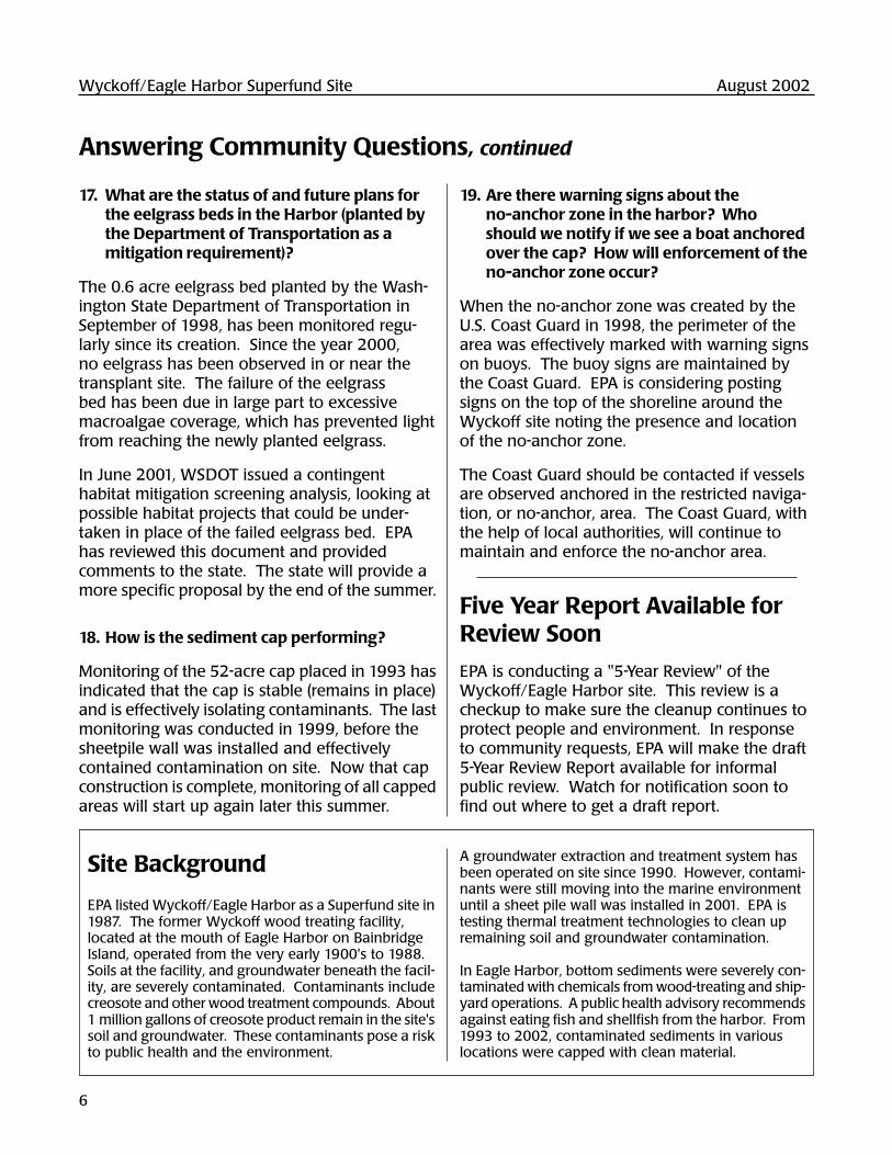
Wyckoff/Eagle Harbor Superfund Site August 2002
6
17. What are the status of and future plans forthe eelgrass beds in the Harbor (planted bythe Department of Transportation as amitigation requirement)?
The 0.6 acre eelgrass bed planted by the Wash-ington State Department of Transportation inSeptember of 1998, has been monitored regu-larly since its creation. Since the year 2000,no eelgrass has been observed in or near thetransplant site. The failure of the eelgrassbed has been due in large part to excessivemacroalgae coverage, which has prevented lightfrom reaching the newly planted eelgrass.
In June 2001, WSDOT issued a contingenthabitat mitigation screening analysis, looking atpossible habitat projects that could be under-taken in place of the failed eelgrass bed. EPAhas reviewed this document and providedcomments to the state. The state will provide amore specific proposal by the end of the summer.
18. How is the sediment cap performing?
Monitoring of the 52-acre cap placed in 1993 hasindicated that the cap is stable (remains in place)and is effectively isolating contaminants. The lastmonitoring was conducted in 1999, before thesheetpile wall was installed and effectivelycontained contamination on site. Now that capconstruction is complete, monitoring of all cappedareas will start up again later this summer.
19. Are there warning signs about theno-anchor zone in the harbor? Whoshould we notify if we see a boat anchoredover the cap? How will enforcement of theno-anchor zone occur?
When the no-anchor zone was created by theU.S. Coast Guard in 1998, the perimeter of thearea was effectively marked with warning signson buoys. The buoy signs are maintained bythe Coast Guard. EPA is considering postingsigns on the top of the shoreline around theWyckoff site noting the presence and locationof the no-anchor zone.
The Coast Guard should be contacted if vesselsare observed anchored in the restricted naviga-tion, or no-anchor, area. The Coast Guard, withthe help of local authorities, will continue tomaintain and enforce the no-anchor area.
Answering Community Questions, continued
Five Year Report Available forReview Soon
EPA is conducting a "5-Year Review" of theWyckoff/Eagle Harbor site. This review is acheckup to make sure the cleanup continues toprotect people and environment. In responseto community requests, EPA will make the draft5-Year Review Report available for informalpublic review. Watch for notification soon tofind out where to get a draft report.
Site Background
EPA listed Wyckoff/Eagle Harbor as a Superfund site in1987. The former Wyckoff wood treating facility,located at the mouth of Eagle Harbor on BainbridgeIsland, operated from the very early 1900's to 1988.Soils at the facility, and groundwater beneath the facil-ity, are severely contaminated. Contaminants includecreosote and other wood treatment compounds. About1 million gallons of creosote product remain in the site'ssoil and groundwater. These contaminants pose a riskto public health and the environment.
A groundwater extraction and treatment system hasbeen operated on site since 1990. However, contami-nants were still moving into the marine environmentuntil a sheet pile wall was installed in 2001. EPA istesting thermal treatment technologies to clean upremaining soil and groundwater contamination.
In Eagle Harbor, bottom sediments were severely con-taminated with chemicals from wood-treating and ship-yard operations. A public health advisory recommendsagainst eating fish and shellfish from the harbor. From1993 to 2002, contaminated sediments in variouslocations were capped with clean material.
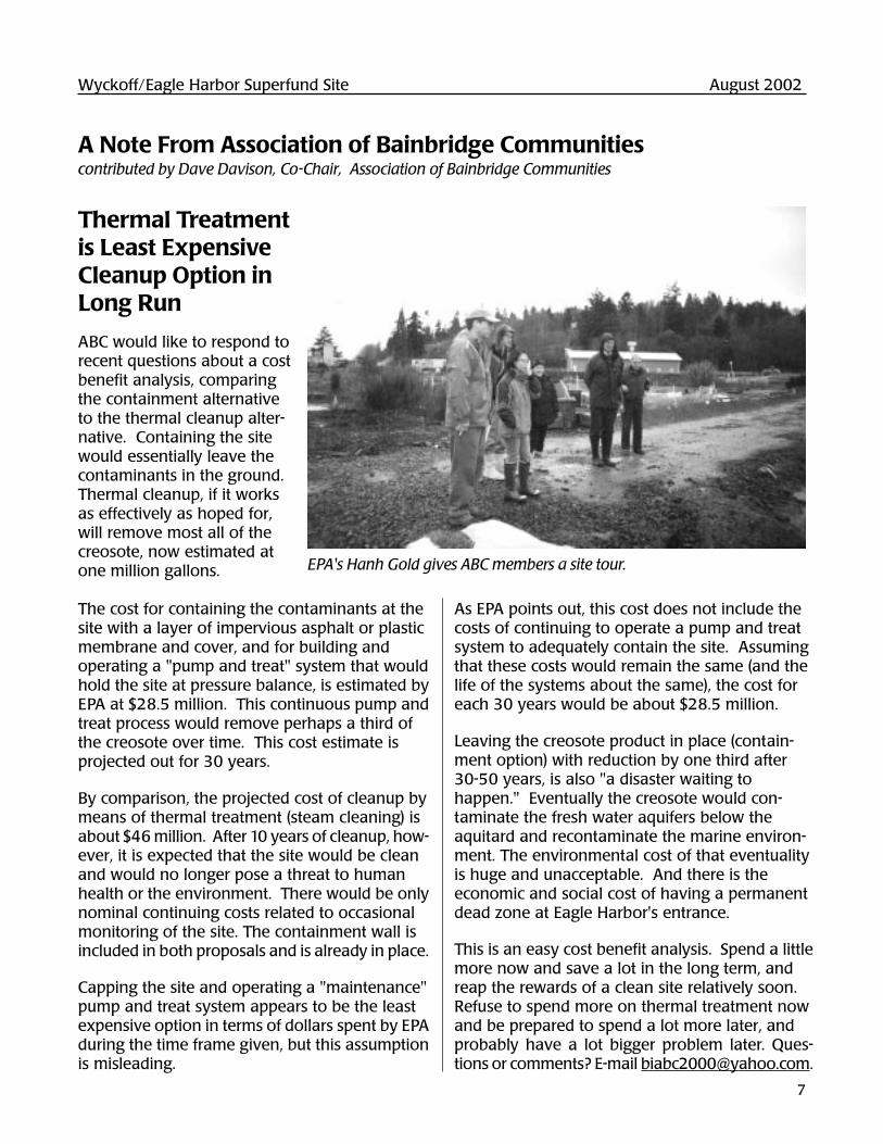
Wyckoff/Eagle Harbor Superfund Site August 2002
7
A Note From Association of Bainbridge Communitiescontributed by Dave Davison, Co-Chair, Association of Bainbridge Communities
As EPA points out, this cost does not include thecosts of continuing to operate a pump and treatsystem to adequately contain the site. Assumingthat these costs would remain the same (and thelife of the systems about the same), the cost foreach 30 years would be about $28.5 million.
Leaving the creosote product in place (contain-ment option) with reduction by one third after30-50 years, is also "a disaster waiting tohappen." Eventually the creosote would con-taminate the fresh water aquifers below theaquitard and recontaminate the marine environ-ment. The environmental cost of that eventualityis huge and unacceptable. And there is theeconomic and social cost of having a permanentdead zone at Eagle Harbor's entrance.
This is an easy cost benefit analysis. Spend a littlemore now and save a lot in the long term, andreap the rewards of a clean site relatively soon.Refuse to spend more on thermal treatment nowand be prepared to spend a lot more later, andprobably have a lot bigger problem later. Ques-tions or comments? E-mail [email protected].
EPA's Hanh Gold gives ABC members a site tour.
Thermal Treatmentis Least ExpensiveCleanup Option inLong Run
ABC would like to respond torecent questions about a costbenefit analysis, comparingthe containment alternativeto the thermal cleanup alter-native. Containing the sitewould essentially leave thecontaminants in the ground.Thermal cleanup, if it worksas effectively as hoped for,will remove most all of thecreosote, now estimated atone million gallons.
The cost for containing the contaminants at thesite with a layer of impervious asphalt or plasticmembrane and cover, and for building andoperating a "pump and treat" system that wouldhold the site at pressure balance, is estimated byEPA at $28.5 million. This continuous pump andtreat process would remove perhaps a third ofthe creosote over time. This cost estimate isprojected out for 30 years.
By comparison, the projected cost of cleanup bymeans of thermal treatment (steam cleaning) isabout $46 million. After 10 years of cleanup, how-ever, it is expected that the site would be cleanand would no longer pose a threat to humanhealth or the environment. There would be onlynominal continuing costs related to occasionalmonitoring of the site. The containment wall isincluded in both proposals and is already in place.
Capping the site and operating a "maintenance"pump and treat system appears to be the leastexpensive option in terms of dollars spent by EPAduring the time frame given, but this assumptionis misleading.
EPA Web Site:www.epa.gov/r10earth/click on "Index"click on "W" for Wyckoff
Documents: The Administrative Record is a filethat contains all information used by EPA tomake decisions on the cleanup actions from thebeginning of the site's history. The AdministrativeRecord can be reviewed at the EPA RecordsCenter, 7th Floor, 1200 Sixth Avenue, Seattle.Call 206/553-4494 to make an appointment.Select documents can be viewed at the Infor-mation Repository located at the BainbridgeIsland Public Library, 1270 Madison AvenueNorth. If the library does not have the documentyou need, feel free to call Andrea Lindsay,EPA Community Involvement Coordinator,at (206) 553-1896.
Additional services can be made available to persons withdisabilities by calling EPA toll-free at 1-800-424-4372.
For More Information
Hanh GoldEPA Project ManagerWyckoff Groundwater and Soils (Thermal Treatment)(206) 553-0171E-mail: [email protected]
Ken MarcyEPA Project ManagerEagle Harbor (Habitat Mitigation, Capping)(206) 553-2782E-mail: [email protected]
Andrea LindsayEPA Community Involvement Coordinator(206) 553-1896E-mail: [email protected].
Toll-Free Telephone Number1-800-424-4372
Text of display ad run in mid-March 2002
Wyckoff/Eagle Harbor Superfund SiteEPA Review Will Check Cleanup So Far
Draft Report Out for Public Review
The U.S. Environmental Protection Agency is about to begin a “five-year review” of the Wyckoff/EagleHarbor Superfund Site on Bainbridge Island. The site is severely contaminated with wood treatmentcompounds, and cleanup is in progress. EPA, with support from the Corps of Engineers, will do thereview to make sure that the cleanup completed so far is working and that people and the environmentare protected as work continues.
Reviewers will look at the completed work in the harbor and intertidal beaches, and at the formerWyckoff property where groundwater and soil are still contaminated. The team will collect siteinformation, review laws, consult with officials and community members, and possibly take samples. The final report and recommendations will be available this fall.
A community meeting to provide a status of site cleanup and discuss the five-year review process andpublic participation will be scheduled later this spring, but your suggestions are welcome now. Information that may be useful to EPA includes comments on what you believe should be included inthe review, your impressions of the cleanup work, how the cleanup has affected you, localdevelopments that might affect site work, environmental concerns, and so on. To discuss the review orto be added to the mailing list, call Andrea Lindsay, 206/553-1896. To learn more about Wyckoff,visit www.epa.gov/r10earth/ (click on Index, click on W for Wyckoff).

Wyckoff/Eagle Harbor Superfund SiteFive-Year Review, March 2002
Community Interview Questions for Informal Discussion
Background:• EPA is required by law to do a site checkup, called a five year review.• EPA is checking to make sure that people and the environment are safe from contaminated
material and to learn more about how the community is affected by site cleanup work.• This review will include the East and West Harbor and the Wyckoff site.• EPA is collecting information about the site from many places: reviewing laws and data,
talking with government and Tribal officials, and talking with community members• EPA will prepare an official report by September.• The report will include recommendations to fix any problems found during the review.
Answers to the following questions will help EPA prepare the report and make anyrecommendations for things that need to be addressed. We would like to have an informaldiscussion with a variety of community members to find out....• Are there community issues that we haven’t addressed yet?• Are there questions we still need to answer for the community?• Are there problems which need fixing?
1. What is your overall impression of the project? Are you satisfied with the cleanup thus far?
2. Do you think progress is being made toward cleanup?
3. What effects have site operations had on you and your community? Have there been anynuisances for you?
4. Are you aware of any incidents at the site such as vandalism or trespassing?
5. Perhaps in a decade this site will be cleaned up. Already substantial progress has been made. Wehave a harbor capped with clean sediments, a new beach, the contaminants are now contained, andpart of the land is clean. What do these changes mean for you and your community?
6. Have you been well informed by EPA on site progress? Have you been surprised by any siteactivities? Should EPA do anything differently to inform and involve the public about site work?
7. Have you contacted any EPA employees regarding Wyckoff? Who? Were they responsive? Did they address your concerns? Would you contact them again?
8. Do you have any suggestions, comments, or recommendations regarding the site’s management or

operation?
7. Do you have any other suggestions for EPA as we move forward with the 5-year review?

Wyckoff/Eagle Harbor Superfund SiteFive-Year Review, May 2002
City of Bainbridge IslandInterview Questions for Discussion
Background:• EPA is required by law to do a site checkup, called a five year review.• EPA is checking to make sure that people and the environment are safe from contaminated
material and to learn more about how the City of Bainbridge Island is affected by sitecleanup work.
• This review will include the harbor and the Wyckoff site.• EPA is collecting information about the site from many places: reviewing laws and data,
talking with state and local government, community members, and Tribal officials.• EPA will prepare an official report by September.• The report will include recommendations to fix any problems found during the review.
Answers to the following questions will help EPA prepare the report and make anyrecommendations for things that need to be addressed. We would like to have an informaldiscussion with the City to find out....
• What are your impressions of the cleanup?• What are your environmental concerns?• Are there City issues that we haven’t addressed yet?• How has the cleanup affect the City?• Are there remaining questions we still need to answer for the City regarding the cleanup?• Are there problems which need fixing?
1. What is your overall impression of the project? Are you satisfied with the cleanup thus far?
2. Do you think progress is being made toward cleanup?
3. What effects have site operations had on the City? Have there been any nuisances for you?
4. Perhaps in a decade this site will be cleaned up. Already substantial progress has been made. Wehave a harbor capped with clean sediments, a new beach, the contaminants are now contained, andpart of the land is clean. What do these changes mean for the City and its community?
5. Have you been well informed by EPA on site progress? Have you been surprised by any siteactivities? Should EPA do anything differently to inform and involve the City about site work?
6. Do you have any suggestions, comments, or recommendations regarding the site’s management or

operation?
7. Do you have any other suggestions for EPA as we move forward with the 5-year review?
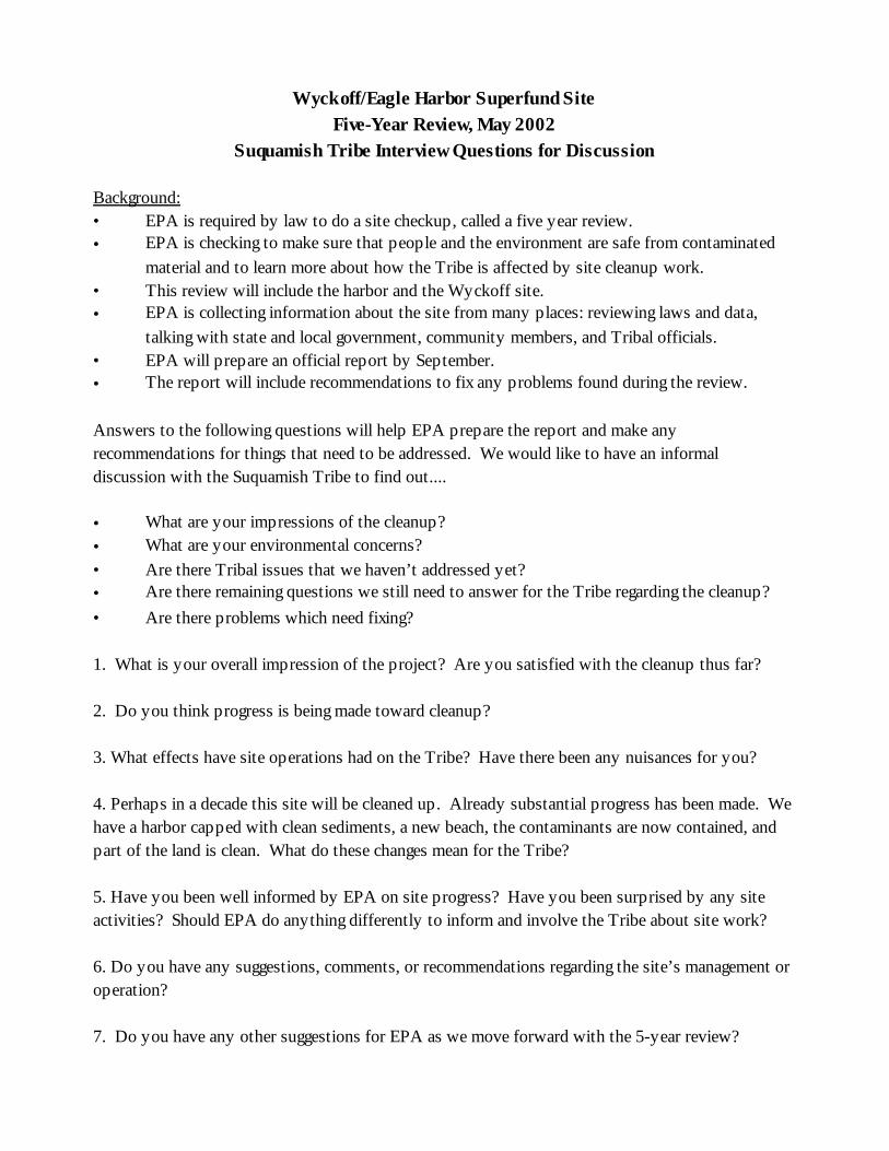
Wyckoff/Eagle Harbor Superfund SiteFive-Year Review, May 2002
Suquamish Tribe Interview Questions for Discussion
Background:• EPA is required by law to do a site checkup, called a five year review.• EPA is checking to make sure that people and the environment are safe from contaminated
material and to learn more about how the Tribe is affected by site cleanup work.• This review will include the harbor and the Wyckoff site.• EPA is collecting information about the site from many places: reviewing laws and data,
talking with state and local government, community members, and Tribal officials.• EPA will prepare an official report by September.• The report will include recommendations to fix any problems found during the review.
Answers to the following questions will help EPA prepare the report and make anyrecommendations for things that need to be addressed. We would like to have an informaldiscussion with the Suquamish Tribe to find out....
• What are your impressions of the cleanup?• What are your environmental concerns?• Are there Tribal issues that we haven’t addressed yet?• Are there remaining questions we still need to answer for the Tribe regarding the cleanup?• Are there problems which need fixing?
1. What is your overall impression of the project? Are you satisfied with the cleanup thus far?
2. Do you think progress is being made toward cleanup?
3. What effects have site operations had on the Tribe? Have there been any nuisances for you?
4. Perhaps in a decade this site will be cleaned up. Already substantial progress has been made. Wehave a harbor capped with clean sediments, a new beach, the contaminants are now contained, andpart of the land is clean. What do these changes mean for the Tribe?
5. Have you been well informed by EPA on site progress? Have you been surprised by any siteactivities? Should EPA do anything differently to inform and involve the Tribe about site work?
6. Do you have any suggestions, comments, or recommendations regarding the site’s management oroperation?
7. Do you have any other suggestions for EPA as we move forward with the 5-year review?
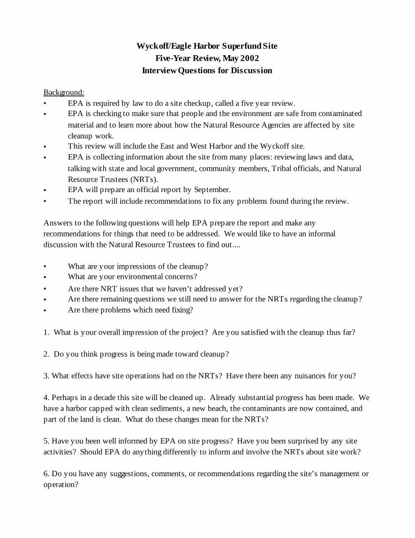
Wyckoff/Eagle Harbor Superfund SiteFive-Year Review, May 2002
Interview Questions for Discussion
Background:• EPA is required by law to do a site checkup, called a five year review.• EPA is checking to make sure that people and the environment are safe from contaminated
material and to learn more about how the Natural Resource Agencies are affected by sitecleanup work.
• This review will include the East and West Harbor and the Wyckoff site.• EPA is collecting information about the site from many places: reviewing laws and data,
talking with state and local government, community members, Tribal officials, and NaturalResource Trustees (NRTs).
• EPA will prepare an official report by September.• The report will include recommendations to fix any problems found during the review.
Answers to the following questions will help EPA prepare the report and make anyrecommendations for things that need to be addressed. We would like to have an informaldiscussion with the Natural Resource Trustees to find out....
• What are your impressions of the cleanup?• What are your environmental concerns?• Are there NRT issues that we haven’t addressed yet?• Are there remaining questions we still need to answer for the NRTs regarding the cleanup?• Are there problems which need fixing?
1. What is your overall impression of the project? Are you satisfied with the cleanup thus far?
2. Do you think progress is being made toward cleanup?
3. What effects have site operations had on the NRTs? Have there been any nuisances for you?
4. Perhaps in a decade this site will be cleaned up. Already substantial progress has been made. Wehave a harbor capped with clean sediments, a new beach, the contaminants are now contained, andpart of the land is clean. What do these changes mean for the NRTs?
5. Have you been well informed by EPA on site progress? Have you been surprised by any siteactivities? Should EPA do anything differently to inform and involve the NRTs about site work?
6. Do you have any suggestions, comments, or recommendations regarding the site’s management oroperation?

7. Do you have any other suggestions for EPA as we move forward with the 5-year review?
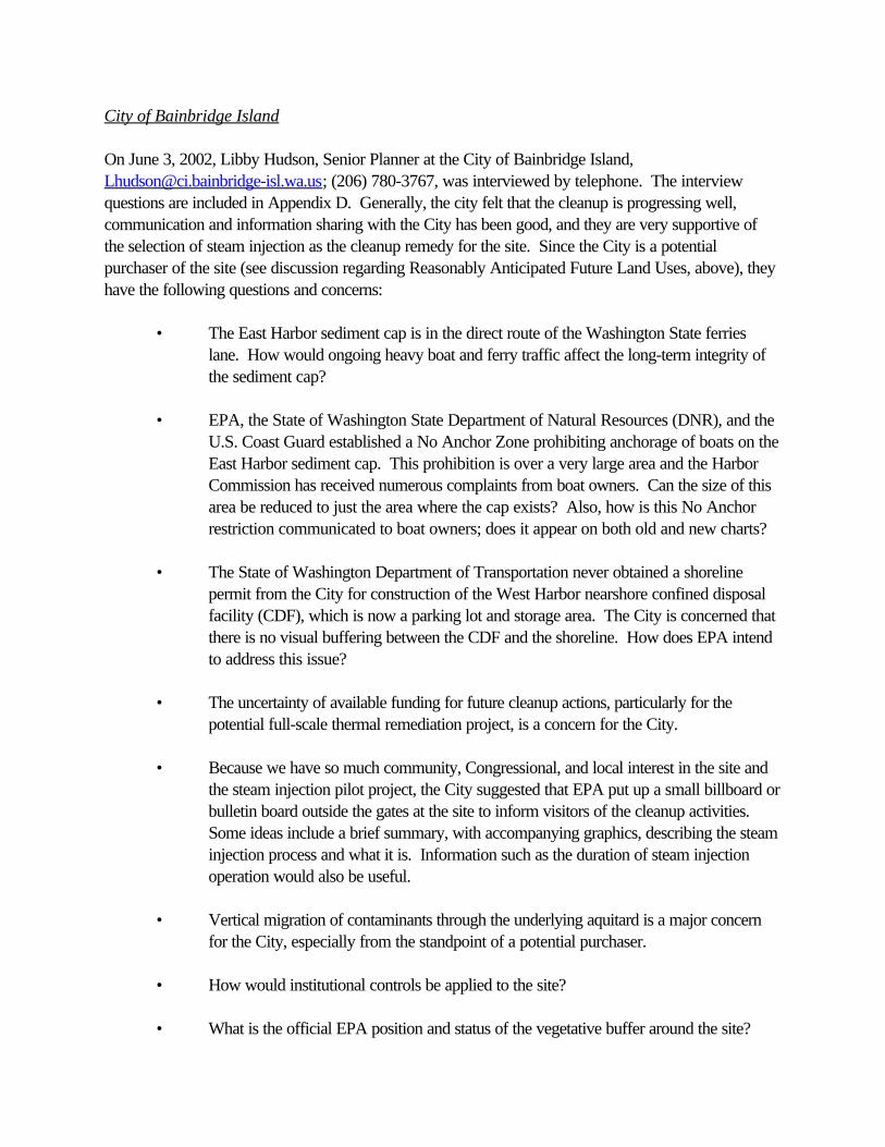
City of Bainbridge Island
On June 3, 2002, Libby Hudson, Senior Planner at the City of Bainbridge Island,[email protected]; (206) 780-3767, was interviewed by telephone. The interviewquestions are included in Appendix D. Generally, the city felt that the cleanup is progressing well,communication and information sharing with the City has been good, and they are very supportive ofthe selection of steam injection as the cleanup remedy for the site. Since the City is a potentialpurchaser of the site (see discussion regarding Reasonably Anticipated Future Land Uses, above), theyhave the following questions and concerns:
• The East Harbor sediment cap is in the direct route of the Washington State ferrieslane. How would ongoing heavy boat and ferry traffic affect the long-term integrity ofthe sediment cap?
• EPA, the State of Washington State Department of Natural Resources (DNR), and theU.S. Coast Guard established a No Anchor Zone prohibiting anchorage of boats on theEast Harbor sediment cap. This prohibition is over a very large area and the HarborCommission has received numerous complaints from boat owners. Can the size of thisarea be reduced to just the area where the cap exists? Also, how is this No Anchorrestriction communicated to boat owners; does it appear on both old and new charts?
• The State of Washington Department of Transportation never obtained a shorelinepermit from the City for construction of the West Harbor nearshore confined disposalfacility (CDF), which is now a parking lot and storage area. The City is concerned thatthere is no visual buffering between the CDF and the shoreline. How does EPA intendto address this issue?
• The uncertainty of available funding for future cleanup actions, particularly for thepotential full-scale thermal remediation project, is a concern for the City.
• Because we have so much community, Congressional, and local interest in the site andthe steam injection pilot project, the City suggested that EPA put up a small billboard orbulletin board outside the gates at the site to inform visitors of the cleanup activities. Some ideas include a brief summary, with accompanying graphics, describing the steaminjection process and what it is. Information such as the duration of steam injectionoperation would also be useful.
• Vertical migration of contaminants through the underlying aquitard is a major concernfor the City, especially from the standpoint of a potential purchaser.
• How would institutional controls be applied to the site?
• What is the official EPA position and status of the vegetative buffer around the site?
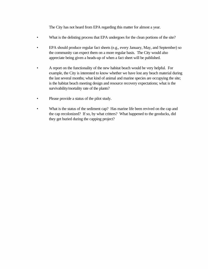
The City has not heard from EPA regarding this matter for almost a year.
• What is the delisting process that EPA undergoes for the clean portions of the site?
• EPA should produce regular fact sheets (e.g., every January, May, and September) sothe community can expect them on a more regular basis. The City would alsoappreciate being given a heads-up of when a fact sheet will be published.
• A report on the functionality of the new habitat beach would be very helpful. Forexample, the City is interested to know whether we have lost any beach material duringthe last several months; what kind of animal and marine species are occupying the site;is the habitat beach meeting design and resource recovery expectations; what is thesurvivability/mortality rate of the plants?
• Please provide a status of the pilot study.
• What is the status of the sediment cap? Has marine life been revived on the cap andthe cap recolonized? If so, by what critters? What happened to the geoducks, didthey get buried during the capping project?
The Suquamish Tribe
On June 25, 2002, EPA met with Rich Brooks, Biologist, [email protected]; (360) 394-5250, and Charlie Sigo, Tribal Council Member, of the Suquamish Tribe at the Wyckoff/Eagle HarborSuperfund site for a site walk and to discuss their impression of the cleanup and any concerns they mayhave. The Suquamish Tribe’s overall impression of cleanup activities at the Wyckoff/Eagle Harbor siteis very positive. The Tribe supports using thermal treatment remediation at the Wyckoff site and otherremedial actions that have been conducted at the operable units. The Tribe recognizes the efforts of theRemedial Project Managers in developing a positive government working relationship and forimplementing actions that support the protection and enhancement of Tribal trust and cultural resources. The Tribe also appreciates the cultural resources assessment work conducted at the site and theMemorandum of Understanding between the Tribe and EPA for the inadvertent discovery of culturalresources.
The Tribe is interested in protecting Tribal trust resources, Treaty-reserved rights, and culturalresources that are of religious or cultural importance to the Tribe. Environmental concerns the Tribehas at the site include:
• The vertical and horizontal extent of PAH contamination within and adjacent to the“East Beach” area.
• Contaminant levels in fishery resources above acceptable human health levels forsubsistence users. A Suquamish Tribe fish consumption survey was completed inAugust 2000 and show Tribal consumption levels higher than the Reasonable MaximumExposure (RME) exposure assumptions used in the human health risk assessments.
• Contaminant levels in geoduck tissues above human health risk levels. Commercialgeoduck tracts #07700 and #07650 are to the east of the Wyckoff/Eagle HarborSuperfund site. A 1997 Washington State Department of Health document,“Assessment of Geoduck Chemical Contamination Adjacent to Eagle Harbor”,indicated PAH contamination concerns and recommended geoduck tissue and sedimentsamples be collected from the proposed harvest area. Geoduck resources within thesecommercial tracts are important to the Suquamish Tribe.
• Biological effects to marine species exposed to PAH sediment concentrations above2,000 ppb (dry weight).
• The protection of nearshore habitat and the sediment cap from future uses that maydegrade the sediment cap, nearshore habitat, or sediment and water quality.
• Establishing and maintaining an adequate native vegetative buffer width within thenearshore area of the site.

• Thermal effects to aquatic biota outside of the sheet pile wall as a result of thermaltechnology operations at the site.
• EPA Region 10 not receiving adequate funding for future Wyckoff/Eagle Harborcleanup actions, including but not limited to, the potential full-scale thermal remediationproject, long-term monitoring activities, and East Harbor remedial actions.
National Oceanic and Atmospheric Administration (NOAA)
Email transmittal from: Robert ClarkNOAA Restoration [email protected](206) 526-4338August 9, 2002
While it would be nice to have the upland pilot and cleanup moving a little faster, Ken Marcy's clean upof the aquatic lands have been very good. He has incorporated NOAA's input into his designs andkept us informed of changes. His design for the capping and intertidal restoration was environmentallysensitive and exceeded minimum compensation to allow for ESA recovery through EPA's commitmentto the "conservation" clause in Sec. 7.a.l of the Endangered Species Act. From NOAA RestorationCenter's point of view and a decade of experience of working with EPA on Superfund cleanups, I haveno criticisms of the progress or of the ultimate benefits to our trustee resources. Just keep pushing EPAHQs to keep the momentum (and funding) moving forward.
Washington State Department of Natural Resources (DNR)
Email transmittal from: Chris Hanlon-MeyerNatural Resource Section AdministratorDNR Aquatic Resources [email protected](360) 902-1676August 20, 2002
Here are some thoughts that staff within the Washington Department of Natural Resources AquaticResources Division (DNR) have in response to your Wyckoff/Eagle Harbor Superfund Site Five-YearReview, May 2002, Interview Questions for Discussion. While some of our comments may not directlyaddress the questions that you presented, we believe that we identified some notable issues. Weappreciate the attention that EPA is giving to remedial action progress at superfund sites. Our hope isthat our comments will help EPA during the final implementation of the cleanup.
1. What is your overall impression of the project? Are you satisfied with the cleanup thus far?
Regarding the pilings that were cut off and said to be maintained below the mudline; all or mostof them appear to be exposed.
The contaminated sediment cap was designed as a test-cap. When will EPA decide on thefinal remedy?
2. Do you think progress is being made toward cleanup?
No comment
3. What effects have site operations had on the NRTs? Have there been any nuisances for you?
No comment
4. Perhaps in a decade this site will be cleaned up. Already substantial progress has been made. Wehave a harbor capped with clean sediments, a new beach, the contaminants are now contained, andpart of the land is clean. What do these changes mean for the NRTs?
Regarding ongoing site management and operations, how will "no anchor" provisions becoordinated and enforced.
The contingency mitigation needed as a result of the eel grass mitigation failure should beimplemented near term. Additionally, because the original mitigation failed, greater mitigationshould be required now than was originally required.
EPA has communicated well and openly accepted input, even at late stages (e.g. steamsparging comments).
The contaminated sediment cap is designed to isolate contaminants left in place (not removedor cleaned up). As long as the cap and contaminated sediments are left in place, state ownedaquatic land is encumbered, and there is a risk of contaminant release (cap failure). Thepresumption of question #4 is that capping contaminated sediments is "cleanup." DNRconsiders contaminated sediment caps as not a full cleanup, but a temporary measure to reducerisk to human health and the environment.
5. Have you been well informed by EPA on site progress? Have you been surprised by any siteactivities? Should EPA do anything differently to inform and involve the NRTs about site work?
Yes, there has been good communication and regular status reports. DNR was surprised thatthe in-water sediment migration was not as controlled as expected. On-beach machiningoperations and visible in-water sediment translocation was observed and visitors footwear wasrequired to be decontaminated, yet there were no best management practices employed tocontrol contaminant migration (via surface runoff, etc.)
6. Do you have any suggestions, comments, or recommendations regarding the sites management oroperation?
No Comment
7. Do you have any other suggestions for EPA as we move forward with the 5-year review?
We suggest that EPA provide a monitoring report, completion report, or status report to theNRTs prior to the next five-year review so that information could be used in their review.
DNR is interested in getting copies of any monitoring reports, completion reports or statusreports as they are produced. Please change the current DNR trustee contact information tothe following: Chris Hanlon-Meyer, Department of Natural Resources, Aquatic ResourcesDivision, 1111 Washington St. SE, P.O. Box 47027, Olympia, WA, 98504-7027
Thank you for your patience in giving us the opportunity to give our input. We look forward to thecontinued success of this cleanup.
Washington State Department of Fish and Wildlife (WDFW)
Email transmittal from: Randy CarmanWDFW Habitat [email protected](360) 902-2415August 20, 2002
Here are my brief comments on cleanup efforts at Wyckoff/Eagle in response to your request.
Overall, the cleanup effort appears to be progressing quite well and WDFW appreciates the effortsEPA has made to coordinate and communicate details of the ongoing activities at the site with naturalresource agency representatives. Given the complexity of the contamination problems at the site, EPAhas done an admirable job of developing an integrated strategy (e.g., capping and thermal remediation)that should provide long term benefits to fish and wildlife resources that utilize the site.
WDFW supports using thermal remediation as the most feasible alternative for extracting the largeamount of NAPL that currently remains at the site. We are concerned, however, that EPA may notcontinue to receive adequate funding to fully implement the cleanup action at the site. Given thetremendous efforts to date at the site, including the large financial expenditures, and the high potentialfor a successful cleanup, it would be quite disappointing to WDFW if funding problems precludedcompletion of this important project.
Although communication from EPA regarding site activities has been quite good, it has been nearly ayear since our last meeting to review progress at the site. So, for example, we have not been informedof how the caps have been performing, or how the "habitat" beach may have changed since itsconstruction (erosion, accretion, etc.). In addition, we provided comments on the merits of developingand maintaining a vegetated shoreline buffer at the site, but have not heard what EPA has planned forthe nearshore upland areas of the site in regard to this issue.
Finally, our greatest interest is ensuring that, once the site is remediated, adequate protections areimplemented to prevent future degradation of nearshore habitat and sediment caps at the site. Thelong-term integrity of nearhsore habitats at the site (both aquatic and riparian) is necessary to providehigh quality functions for fish and wildlife that frequent the area. To this end, the Natural ResourceTrustees developed a set of restoration goals (finalized Oct. 12, 2001) to address conditions at the sitethat largely influence natural resource functions. These restoration goals provide the foundation for along term strategy that should be developed for the site to ensure the persistence of high quality habitatfor natural resources at the site.
Thank you for the opportunity to provide comments on the continuing progress at the Wyckoff/EagleHarbor Superfund site.
Notes from Community Interviews
(Please note: this document is based hand-written notations and is not intended to be a formal transcriptof the interviews.)
Jessie Hey, Resident across the water from the site 4/8/02
She sees it from a distance; Looks great visually.Concerned that she’s not familiar with toxic elements — how does it affect my beach? How clean isthe beach? When can we dig clams and catch crabs again? As a family they used to do that. Ignorance was bliss then. 40 years here.
Can’t say if progress is being made until they can dig clams again. The site looks too tidy, now-- thecleanup is too neat. The chaos of the working site is gone now; people used to work there, it was aproductive part of our community.
No longer bothered by lights. Never considered it a real problem because she knows it would pass. Should already be close to being cleaned up. 10 years seems long.
Concerns: Future noise. Wind direction is an issue for noise. SE winds blow her way. How willcleanup happen (described steam pilot).
It’s not a working site. What’s the plan for the future? In terms of the new beach, people might tend tomess up the beach - need to consider that - making garbage cans available. Keep it clean.
No problem staying informed. Knows the job has to be done. Has contacted us & EPA has beenresponsive. Not a complainer - likes to be constructive. Appreciate the cleanup. Miss thesmokestack and the working site - home grown employment.
Would like to see a day storage; places people could make money that are environmentally sensitive -not just a park. Would like city to get some of the property. Maybe a passenger only ferry.
Will call in September if it’s noisy when the study begins.
Charles Schmid, Community Activist and ABC Member 4/19/02
- Going well, but slower than expected- Fairly satisfied. Except disappointed that EPA is not using waste water treatment effluent.- Noted lack of formal response to public input on buffer zone.- Disappointed to see plumes still coming up outside the wall.- Pleased with the beach. - Citizens and EPA share optimism about new plans.
- Shocked to learn how much contamination–1 million gallons!- Looking toward restoration of the site to a cleaner site for humans, plants, and animals.- Supports Japanese Memorial. The restoration is not just for Japanese Americans but for the Islandand its environment.
-Feels well informed. Especially through Technical Assistance Grant (TAG) meetings and site tours. Appreciated Travis and Hanh taking the group around the site.-Disappointed on the effluent decision. Other than that, feels EPA is responsive and inclusive.-Regarding interviews, multiple choice would be better. It lets you know what people don’t know. Random Survey. Otherwise just “Good guys, Bad guys.” Compile comments and don’t know howyou’ve done.-Aware that nuisances may be an issue: noise, traffic, lights.-Encouraged EPA to share compiled results of this effort with ABC.-West Harbor - eelgrass navigation. Would like to see a report on its success. -Was other mitigation successful? Ferry Terminal maintenance. Asphalt area. What’s happened withthat? Just being used as parking lot. Confused what was actually done.-What are the effects of the sheet pile on the plants/salmon/habitat right outside the wall? Because it isnot a beach but a sheer face.
Susan Johnson, Adjacent Resident 4/15/02
New beach is great, huge!
Wondering about cost benefit of steam. Lots of money to sink into ground for questionable long termbenefit. She says she is speaking for about 15 people/taxpayers, who are also wondering.
Many people say, “gasworks is now a park and it was just capped.” That was enough. Why do weneed to go to the level of clean we’re trying to achieve? Cap could be enough here too, especially ifit’s a park?
For the park - less cleanup should be required than residential standards! She supports the park.
Nuisances - endured the pounding. Knew it would end. But the steam cleaning is a different story–itcould last for a decade or more (which seems forever). What will be the sound impact? This is awhole new operation, and we’ve no idea of impact. Cautious about what this means. Very anxious.
Aggravations at night - noise. Occasionally “refrigerator noise” when the pumps switch, a hum.
Corps and EPA incredibly responsive. So great.
Lights during concrete pouring for shed were on until after midnight. Was not notified in advance.
What things are day/season/forever things? Needs heads up and to know in advance the length ofdisturbance. Starting to feel irritable; it’s been going on for 5 years already.
Water supply issues are acute because it is an island. Was the bill point well tested? Unclear if theirbaseline has been established. How much ongoing monitoring will happen during pilot? How does the1 year test relate to the 10 year reality? More testing, reassurance, and communication is better.
Graffiti and vandalism - called 911 one night and it took them 1.5 hours to get there! Called 3 times. Smashing glass on site. Wish historical buildings were out of there. There are 50 feral cats & lots ofparties.
EPA has been very responsive. Trimmed growth in the way of the views, good. Coordinated with theTrustee. Communication among all partners - EPA/Corps/Trustee - just excellent! Kudos on thecommunication and timely responses.
Funding issue. Superfund costs---are we on the right trajectory given the current funding climate?
People are aware of what’s going on. Site visit was much appreciated and very helpful.All “Asks have been answered”.
Remaining questions about the final disposition of the land.
Sean Oldkin, Bremerton Kitsap County Health District, Poulsbo Office 04/02
! Need to be clear about what are the pathways to endanger people’s health.
! Posting & maintaining those signs - the health district does this. Is the content of the signscomplete and accurate? Currently very general. EPA input welcome on the sign content. Alsoare locations of signs adequate?
! State Dept of Health. Could look into whether shell fish tissue monitoring is in order to revisithealth advisory. Still likely potential for exposure. Could assist w/signs if any changes arewarranted.
! Are Asian Pacific Islander harvesters active there?

WYCKOFF COMMUNITY INFORMATION MEETINGQuestions and Issues
JUNE 13, 2002
Can we use the beach now for recreation?Are you going to water the new plantings?Is the site well in same aquifer as other wells?Where does the water go after it’s used for treatment?How will you contain sound on the emergency generator?Lights?Will trucks run when school busses are running?How loud will diesel boiler be?Smell of diesel? Air quality?How long will the wall last? Ultimate disposition?How long it take to heat the site?Are there other sites using this technology?Is pilot wall as deep as other wall?Will Eagle Harbor be heated up by steam project? Habitat affected?How deep will we inject?Will heat push contaminants down into/thru aquitard?Takes 2 years for soil to cool down?If successful how soon will you move to full scale?Diesel fumes from boiler to be contained?Full scale would be 3x the fuel?What does boiler fuel exhaust compare to?How much fuel to be used? - compared to ferry consumption? Emissions?Health issues? Can energy be reclaimed? Reused?Can stream be put back on the surface?Offer a community review opportunity of the draft 5-Year Review report.Extraordinary effort so far - come so far - beach is reclaiming nature quickly. An 80 year problemdoesn’t bring a 3 day solution. Let’s be patient.Technology is innovative and exciting. This is an example of government doing something right. Laudable. EPA has decommissioned road. Thanks for sensitivity.Dangerous intersection - so some disagree that road decommissioning is a good idea. Would like tosee improvement to safety at that intersection. Can use the road for public beach access? Site looks good. Tremendous change in appearance. Beach is beautiful.
Marine algae monitoring - what are the results?Riprap on the whole length of beach is not proper. (Riprap is now buried; issue is resolved.)ABC pleased with progress.Planted eelgrass? Where is the eel grass at low tide? Are you working with UW on eelgrass? Need tostudy wall and eelgrass interaction. DOT eelgrass West Harbor has failed? Provide an update. Let’s
ask for another mitigation! ABC wants to be involved in mitigation decisions.How will wall affect eelgrass beds?Setting the riparian buffer - asked citizens for input and never heard back. There were manycomments. Why not in a report?Marine Traffic - are there warning signs about no-anchor zone? Who should we notify if we see a boatanchored over the cap? How thick is the cap? How enforcement of no-anchor zone occur?ABC is supportive of EPA and Corp progress. Remember only 3 years ago the plan was for a cap. One million gallons is a time bomb. Community should be supportive of cleanup. The real objective iscleanup. ABC asked for changes in design features, regarding noise, air pollution, lighting, water useissues. ABC has a major issue with EPA on water source - Should have used effluent instead of usingfreshwater - makes no sense. EPA did not include ABC early enough on the issue. Fisheries’concerns made it difficult. ABC also pushed for propane - cleaner. Cost issues probably defeated thatsolution. Even complying with standards, there will be air pollution. EPA has been open and listenedto us. Wish they implemented more of our ideas.Historic preservation - could have used old buildings as office space; buildings on site from 1880sshould be preserved.EPA is doing so much good. Some people focus too much on criticism of petty things.Creosote piles from main dock are seeping creosote - why didn’t you pull those? (When pulled, therewas huge release of creosote). But leaving the piles in place goes against the clean up goal.Cap effective and stable? Preventing hydrocarbons from coming to the surface?
From comment cards:“For such a difficult cleanup area, I think it is going remarkably well. I’m aware of most environmentalproblems and do what I can to help.”
“I’m impressed by the work being done.”
“EPA needs a cultural resource specialist!”
“1. Stream should be re-established on the surface.2. Rip rap should be replaced or mitigated with various sizes intermediate cobble.3. When will we know if “steam cleaning” will proceed and if so for how long?4. Can the public access any portions of the beach? If so, how? Is there a procedure?5. Several questions about intertidal areas—marine algae monitoring and observed changes (esp.Laminaria); cobble new formation on east side s. of steel wall.6. Access to uplands for tree inventory7. Preservation of historic buildings - supt.’s residence, a worker’s residence? (NPS will be furiouswith you!)8. Is funding assured to complete the cleanup? If not, how much funding is assured? Is there any chancethis will not be completed?9. Duration of pilot project?10. I have an idea for a “mitigation” project if one is needed.
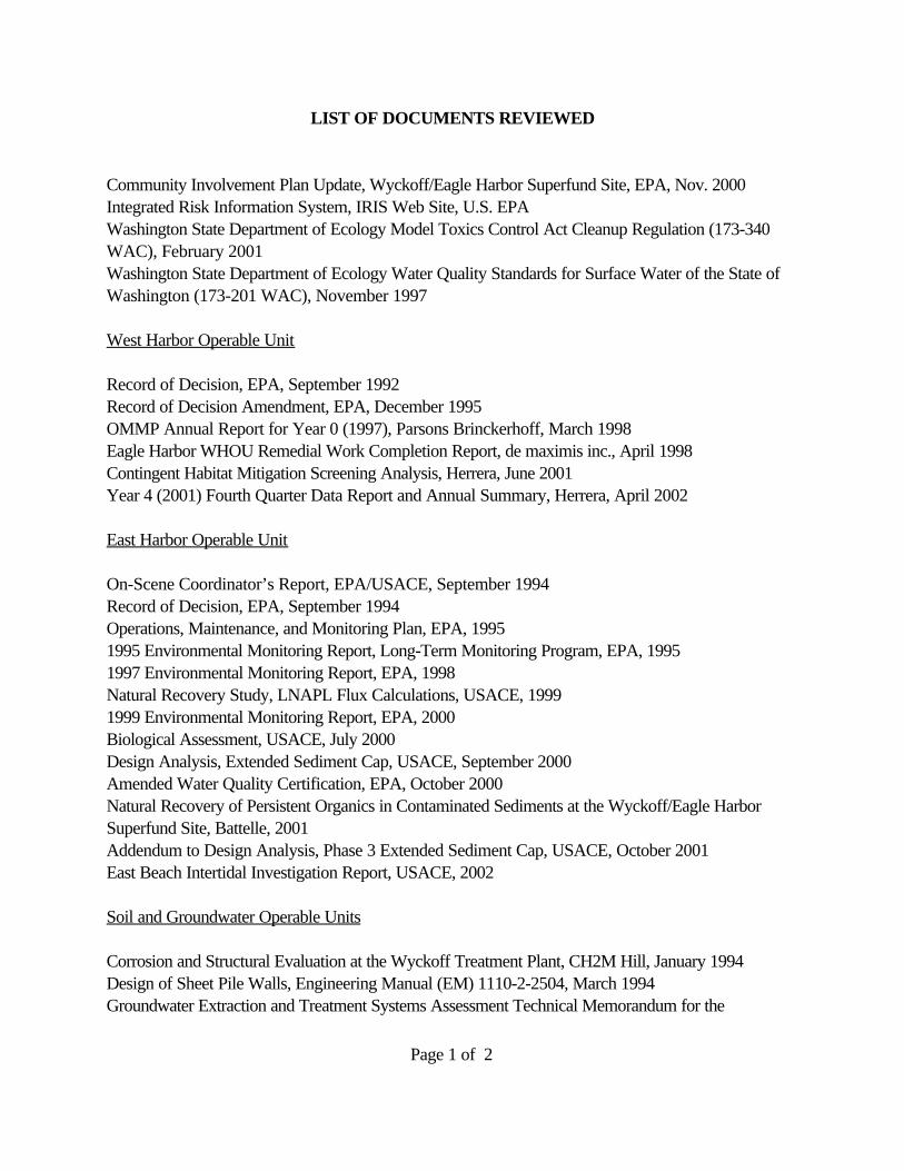
Page 1 of 2
LIST OF DOCUMENTS REVIEWED
Community Involvement Plan Update, Wyckoff/Eagle Harbor Superfund Site, EPA, Nov. 2000Integrated Risk Information System, IRIS Web Site, U.S. EPAWashington State Department of Ecology Model Toxics Control Act Cleanup Regulation (173-340WAC), February 2001Washington State Department of Ecology Water Quality Standards for Surface Water of the State ofWashington (173-201 WAC), November 1997
West Harbor Operable Unit
Record of Decision, EPA, September 1992Record of Decision Amendment, EPA, December 1995OMMP Annual Report for Year 0 (1997), Parsons Brinckerhoff, March 1998Eagle Harbor WHOU Remedial Work Completion Report, de maximis inc., April 1998Contingent Habitat Mitigation Screening Analysis, Herrera, June 2001Year 4 (2001) Fourth Quarter Data Report and Annual Summary, Herrera, April 2002
East Harbor Operable Unit
On-Scene Coordinator’s Report, EPA/USACE, September 1994Record of Decision, EPA, September 1994Operations, Maintenance, and Monitoring Plan, EPA, 19951995 Environmental Monitoring Report, Long-Term Monitoring Program, EPA, 19951997 Environmental Monitoring Report, EPA, 1998Natural Recovery Study, LNAPL Flux Calculations, USACE, 19991999 Environmental Monitoring Report, EPA, 2000Biological Assessment, USACE, July 2000Design Analysis, Extended Sediment Cap, USACE, September 2000Amended Water Quality Certification, EPA, October 2000Natural Recovery of Persistent Organics in Contaminated Sediments at the Wyckoff/Eagle HarborSuperfund Site, Battelle, 2001Addendum to Design Analysis, Phase 3 Extended Sediment Cap, USACE, October 2001East Beach Intertidal Investigation Report, USACE, 2002
Soil and Groundwater Operable Units
Corrosion and Structural Evaluation at the Wyckoff Treatment Plant, CH2M Hill, January 1994Design of Sheet Pile Walls, Engineering Manual (EM) 1110-2-2504, March 1994Groundwater Extraction and Treatment Systems Assessment Technical Memorandum for the
Page 2 of 2
Wyckoff/Eagle Harbor Superfund Site, CH2M Hill, April 1994Interim Record of Decision, EPA, Groundwater Operable Unit, September 1994Operations and Maintenance Manual, Sections 10 and 11, CH2M Hill (Draft), January 1995Engineering Evaluation and Cost Analysis for Site Structures, CH2M Hill, April 1995Interim Operations Plan, Groundwater Extraction System, CH2M Hill, March 1997Technical Memorandum, Ground Water Treatment Plant Air Emission Characterization, Wyckoff/Eagleharbor Superfund Site, CH2M Hill, September 1997Thermal Effects Study Management Plan, USACE, July 1999Sheet Pile Drive Test Report, USACE, October 1999Record of Decision, EPA, February 2000Sampling and Analysis Plan, Wyckoff Facility and Groundwater Operable Units, Wyckoff/Eagle harborSuperfund Site, Prepared by URS Greiner in association with CH2M Hill, June 2000Biological Assessment, USACE, July 2000Design Analysis, Sheet Pile Containment Wall, USACE, September 2000Amended Water Quality Certification, EPA, October 2000Health and Safety Plan, Wyckoff Superfund Site, CH2M Hill, October 2000 RevisionRemedial Action Management Plan, Sheet Pile Installation, Habitat Mitigation Beach Construction,Wyckoff/Eagle Harbor Superfund Site, Prepared by Bay West, Inc. for Seattle District Corps ofEngineers and EPA region 10, October 2000Sheet Pile Hydraulic Conductivity Report, USACE, March 2001Remedial Action Management Plan, Site Infrastructure Support, Wyckoff/Eagle Harbor SuperfundSite, Prepared by Marine Vacuum Service, Inc. for Seattle District, Corps of Engineers and EPARegion 10, July 25, 2001Design Analysis, Thermal Remediation Pilot Study, USACE, August 2001Wyckoff Treatment Plant Monthly Operations Reports, CH2M Hill, Feb-Dec 1998; Sept. 2001Wyckoff Treatment Plant Monthly Operations Reports, USACE, Jan-June 2002Management Plan for Thermal Remediation Pilot Construction, Wyckoff/Eagle Harbor Superfund Site,Prepared by Pease Construction, Inc. for Seattle District, Corps of Engineers and EPA Region 10,February 2002On-Site Water Supply Well Report, USACE, June 2002Design Analysis Amendment, Thermal Remediation Pilot Study, August 2002
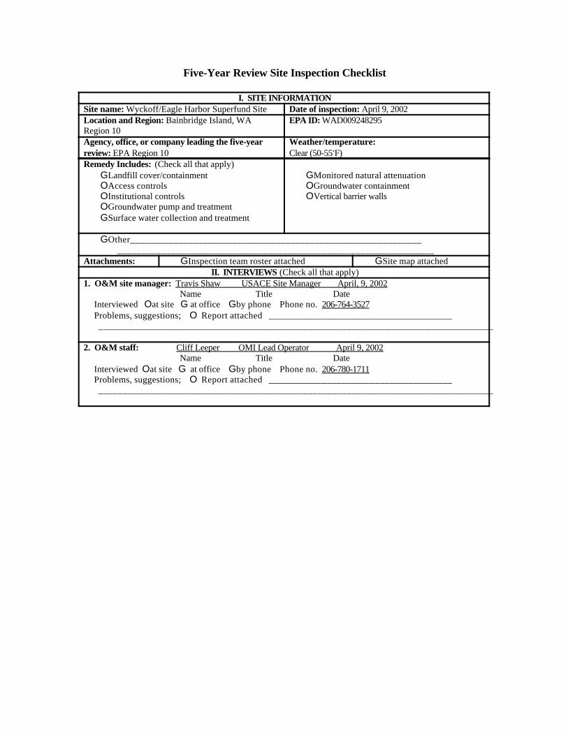
Five-Year Review Site Inspection Checklist
I. SITE INFORMATIONSite name: Wyckoff/Eagle Harbor Superfund Site Date of inspection: April 9, 2002Location and Region: Bainbridge Island, WARegion 10
EPA ID: WAD009248295
Agency, office, or company leading the five-yearreview: EPA Region 10
Weather/temperature:Clear (50-55<F)
Remedy Includes: (Check all that apply)GLandfill cover/containmentOAccess controlsOInstitutional controlsOGroundwater pump and treatmentGSurface water collection and treatment
GMonitored natural attenuationOGroundwater containmentOVertical barrier walls
GOther____________________________________________________________
_________________________________________________________________Attachments: GInspection team roster attached GSite map attached
II. INTERVIEWS (Check all that apply)1. O&M site manager: Travis Shaw USACE Site Manager April, 9, 2002 Name Title Date Interviewed Oat site G at office Gby phone Phone no. 206-764-3527 Problems, suggestions; O Report attached ______________________________________ _________________________________________________________________________________
2. O&M staff: Cliff Leeper OMI Lead Operator April 9, 2002 Name Title Date Interviewed Oat site G at office Gby phone Phone no. 206-780-1711 Problems, suggestions; O Report attached ______________________________________ _________________________________________________________________________________
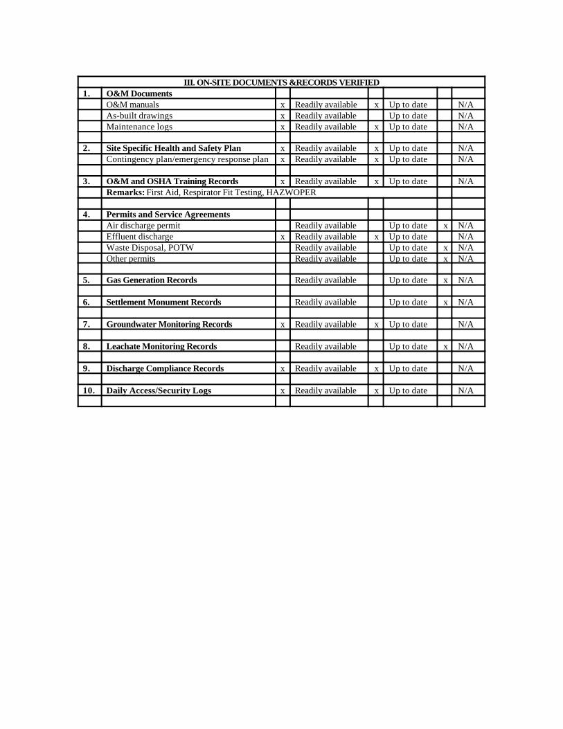
III. ON-SITE DOCUMENTS &RECORDS VERIFIED1. O&M Documents
O&M manuals x Readily available x Up to date N/AAs-built drawings x Readily available Up to date N/AMaintenance logs x Readily available x Up to date N/A
2. Site Specific Health and Safety Plan x Readily available x Up to date N/AContingency plan/emergency response plan x Readily available x Up to date N/A
3. O&M and OSHA Training Records x Readily available x Up to date N/ARemarks: First Aid, Respirator Fit Testing, HAZWOPER
4. Permits and Service AgreementsAir discharge permit Readily available Up to date x N/AEffluent discharge x Readily available x Up to date N/AWaste Disposal, POTW Readily available Up to date x N/AOther permits Readily available Up to date x N/A
5. Gas Generation Records Readily available Up to date x N/A
6. Settlement Monument Records Readily available Up to date x N/A
7. Groundwater Monitoring Records x Readily available x Up to date N/A
8. Leachate Monitoring Records Readily available Up to date x N/A
9. Discharge Compliance Records x Readily available x Up to date N/A
10. Daily Access/Security Logs x Readily available x Up to date N/A
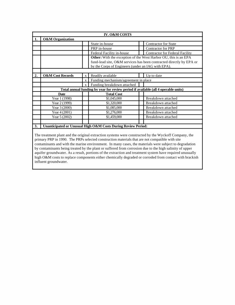
IV. O&M COSTS1. O&M Organization
State in-house Contractor for StatePRP in-house Contractor for PRPFederal Facility in-house Contractor for Federal FacilityOther: With the exception of the West Harbor OU, this is an EPAfund-lead site, O&M services has been contracted directly by EPA orby the Corps of Engineers (under an IAG with EPA).
2. O&M Cost Records x Readily available Up to datex Funding mechanism/agreement in placex Funding breakdown attached
Total annual funding by year for review period if available (all 4 operable units)Date Total Cost
Year 1 (1998) $1,045,000 Breakdown attachedYear 2 (1999) $1,320,000 Breakdown attachedYear 3 (2000) $1,085,000 Breakdown attachedYear 4 (2001) $1,276,000 Breakdown attachedYear 5 (2002) $1,459,000 Breakdown attached
3. Unanticipated or Unusual High O&M Costs During Review Period:
The treatment plant and the original extraction systems were constructed by the Wyckoff Company, theprimary PRP in 1990. The PRPs selected construction materials that are not compatible with sitecontaminants and with the marine environment. In many cases, the materials were subject to degradationby contaminants being treated by the plant or suffered from corrosion due to the high salinity of upperaquifer groundwater. As a result, portions of the extraction and treatment system have required unusuallyhigh O&M costs to replace components either chemically degraded or corroded from contact with brackishinfluent groundwater.
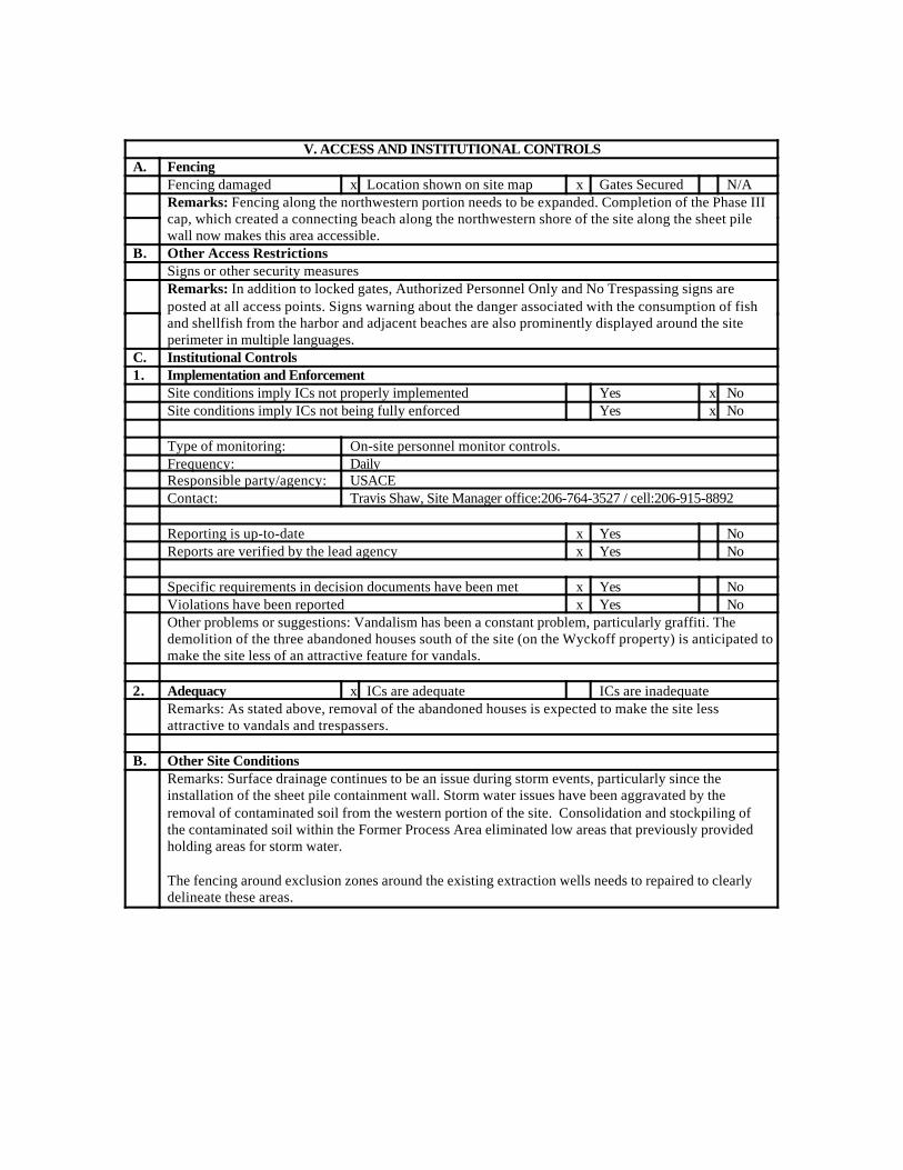
V. ACCESS AND INSTITUTIONAL CONTROLSA. Fencing
Fencing damaged x Location shown on site map x Gates Secured N/ARemarks: Fencing along the northwestern portion needs to be expanded. Completion of the Phase IIIcap, which created a connecting beach along the northwestern shore of the site along the sheet pilewall now makes this area accessible.
B. Other Access RestrictionsSigns or other security measuresRemarks: In addition to locked gates, Authorized Personnel Only and No Trespassing signs areposted at all access points. Signs warning about the danger associated with the consumption of fishand shellfish from the harbor and adjacent beaches are also prominently displayed around the siteperimeter in multiple languages.
C. Institutional Controls1. Implementation and Enforcement
Site conditions imply ICs not properly implemented Yes x NoSite conditions imply ICs not being fully enforced Yes x No
Type of monitoring: On-site personnel monitor controls.Frequency: DailyResponsible party/agency: USACEContact: Travis Shaw, Site Manager office:206-764-3527 / cell:206-915-8892
Reporting is up-to-date x Yes NoReports are verified by the lead agency x Yes No
Specific requirements in decision documents have been met x Yes NoViolations have been reported x Yes NoOther problems or suggestions: Vandalism has been a constant problem, particularly graffiti. Thedemolition of the three abandoned houses south of the site (on the Wyckoff property) is anticipated tomake the site less of an attractive feature for vandals.
2. Adequacy x ICs are adequate ICs are inadequateRemarks: As stated above, removal of the abandoned houses is expected to make the site lessattractive to vandals and trespassers.
B. Other Site ConditionsRemarks: Surface drainage continues to be an issue during storm events, particularly since theinstallation of the sheet pile containment wall. Storm water issues have been aggravated by theremoval of contaminated soil from the western portion of the site. Consolidation and stockpiling ofthe contaminated soil within the Former Process Area eliminated low areas that previously providedholding areas for storm water.
The fencing around exclusion zones around the existing extraction wells needs to repaired to clearlydelineate these areas.
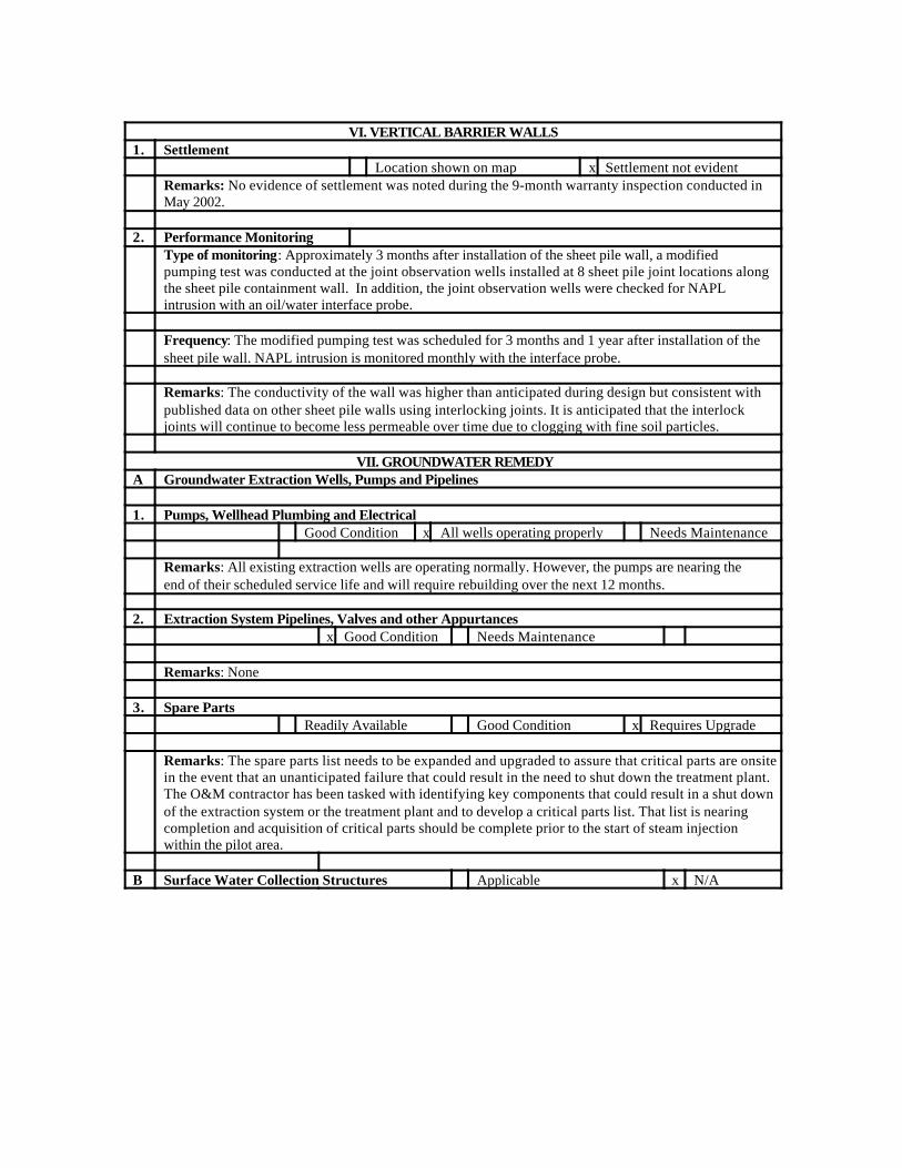
VI. VERTICAL BARRIER WALLS1. Settlement
Location shown on map x Settlement not evidentRemarks: No evidence of settlement was noted during the 9-month warranty inspection conducted inMay 2002.
2. Performance MonitoringType of monitoring: Approximately 3 months after installation of the sheet pile wall, a modifiedpumping test was conducted at the joint observation wells installed at 8 sheet pile joint locations alongthe sheet pile containment wall. In addition, the joint observation wells were checked for NAPLintrusion with an oil/water interface probe.
Frequency: The modified pumping test was scheduled for 3 months and 1 year after installation of thesheet pile wall. NAPL intrusion is monitored monthly with the interface probe.
Remarks: The conductivity of the wall was higher than anticipated during design but consistent withpublished data on other sheet pile walls using interlocking joints. It is anticipated that the interlockjoints will continue to become less permeable over time due to clogging with fine soil particles.
VII. GROUNDWATER REMEDYA Groundwater Extraction Wells, Pumps and Pipelines
1. Pumps, Wellhead Plumbing and ElectricalGood Condition x All wells operating properly Needs Maintenance
Remarks: All existing extraction wells are operating normally. However, the pumps are nearing theend of their scheduled service life and will require rebuilding over the next 12 months.
2. Extraction System Pipelines, Valves and other Appurtancesx Good Condition Needs Maintenance
Remarks: None
3. Spare PartsReadily Available Good Condition x Requires Upgrade
Remarks: The spare parts list needs to be expanded and upgraded to assure that critical parts are onsitein the event that an unanticipated failure that could result in the need to shut down the treatment plant.The O&M contractor has been tasked with identifying key components that could result in a shut downof the extraction system or the treatment plant and to develop a critical parts list. That list is nearingcompletion and acquisition of critical parts should be complete prior to the start of steam injectionwithin the pilot area.
B Surface Water Collection Structures Applicable x N/A
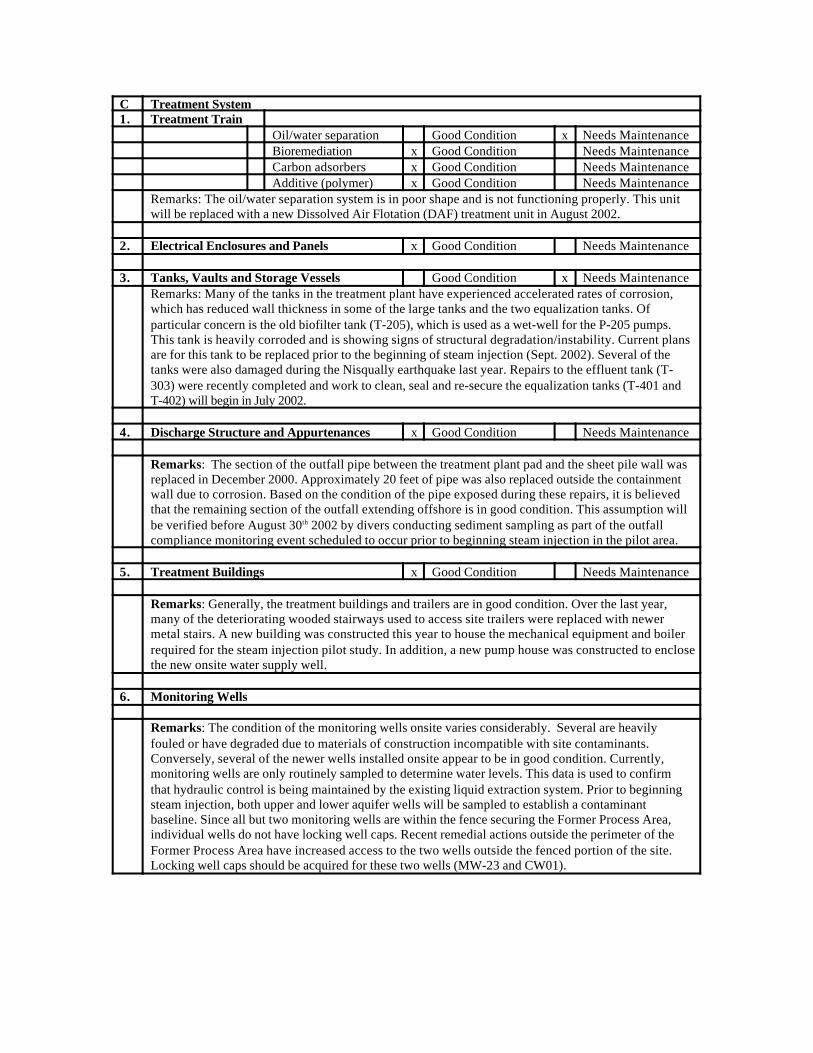
C Treatment System1. Treatment Train
Oil/water separation Good Condition x Needs MaintenanceBioremediation x Good Condition Needs MaintenanceCarbon adsorbers x Good Condition Needs MaintenanceAdditive (polymer) x Good Condition Needs Maintenance
Remarks: The oil/water separation system is in poor shape and is not functioning properly. This unitwill be replaced with a new Dissolved Air Flotation (DAF) treatment unit in August 2002.
2. Electrical Enclosures and Panels x Good Condition Needs Maintenance
3. Tanks, Vaults and Storage Vessels Good Condition x Needs MaintenanceRemarks: Many of the tanks in the treatment plant have experienced accelerated rates of corrosion,which has reduced wall thickness in some of the large tanks and the two equalization tanks. Ofparticular concern is the old biofilter tank (T-205), which is used as a wet-well for the P-205 pumps.This tank is heavily corroded and is showing signs of structural degradation/instability. Current plansare for this tank to be replaced prior to the beginning of steam injection (Sept. 2002). Several of thetanks were also damaged during the Nisqually earthquake last year. Repairs to the effluent tank (T-303) were recently completed and work to clean, seal and re-secure the equalization tanks (T-401 andT-402) will begin in July 2002.
4. Discharge Structure and Appurtenances x Good Condition Needs Maintenance
Remarks: The section of the outfall pipe between the treatment plant pad and the sheet pile wall wasreplaced in December 2000. Approximately 20 feet of pipe was also replaced outside the containmentwall due to corrosion. Based on the condition of the pipe exposed during these repairs, it is believedthat the remaining section of the outfall extending offshore is in good condition. This assumption willbe verified before August 30th 2002 by divers conducting sediment sampling as part of the outfallcompliance monitoring event scheduled to occur prior to beginning steam injection in the pilot area.
5. Treatment Buildings x Good Condition Needs Maintenance
Remarks: Generally, the treatment buildings and trailers are in good condition. Over the last year,many of the deteriorating wooded stairways used to access site trailers were replaced with newermetal stairs. A new building was constructed this year to house the mechanical equipment and boilerrequired for the steam injection pilot study. In addition, a new pump house was constructed to enclosethe new onsite water supply well.
6. Monitoring Wells
Remarks: The condition of the monitoring wells onsite varies considerably. Several are heavilyfouled or have degraded due to materials of construction incompatible with site contaminants.Conversely, several of the newer wells installed onsite appear to be in good condition. Currently,monitoring wells are only routinely sampled to determine water levels. This data is used to confirmthat hydraulic control is being maintained by the existing liquid extraction system. Prior to beginningsteam injection, both upper and lower aquifer wells will be sampled to establish a contaminantbaseline. Since all but two monitoring wells are within the fence securing the Former Process Area,individual wells do not have locking well caps. Recent remedial actions outside the perimeter of theFormer Process Area have increased access to the two wells outside the fenced portion of the site.Locking well caps should be acquired for these two wells (MW-23 and CW01).
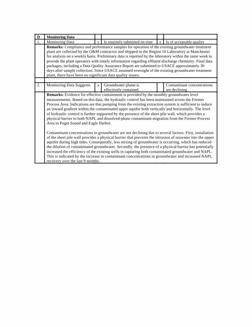
D Monitoring Data1. Monitoring Data x Is routinely submitted on time x Is of acceptable quality
Remarks: Compliance and performance samples for operation of the existing groundwater treatmentplant are collected by the O&M contractor and shipped to the Region 10 Laboratory at Manchesterfor analysis on a weekly basis. Preliminary data is reported by the laboratory within the same week toprovide the plant operators with timely information regarding effluent discharge chemistry. Final datapackages, including a Data Quality Assurance Report are submitted to USACE approximately 30days after sample collection. Since USACE assumed oversight of the existing groundwater treatmentplant, there have been no significant data quality issues.
2. Monitoring Data Suggests x Groundwater plume iseffectively contained
Contaminant concentrationsare declining
Remarks: Evidence for effective containment is provided by the monthly groundwater levelmeasurements. Based on this data, the hydraulic control has been maintained across the FormerProcess Area. Indications are that pumping from the existing extraction system is sufficient to inducean inward gradient within the contaminated upper aquifer both vertically and horizontally. The levelof hydraulic control is further supported by the presence of the sheet pile wall, which provides aphysical barrier to both NAPL and dissolved-phase contaminant migration from the Former ProcessArea to Puget Sound and Eagle Harbor.
Contaminant concentrations in groundwater are not declining due to several factors. First, installationof the sheet pile wall provides a physical barrier that prevents the intrusion of seawater into the upperaquifer during high tides. Consequently, less mixing of groundwater is occurring, which has reducedthe dilution of contaminated groundwater. Secondly, the presence of a physical barrier has potentiallyincreased the efficiency of the existing wells in capturing both contaminated groundwater and NAPL.This is indicated by the increase in contaminant concentrations in groundwater and increased NAPLrecovery over the last 9 months.