2014 awra annual water resources conference november 5
TRANSCRIPT

2014 AWRA Annual Water Resources Conference November 5, 2014 Tysons Corner, VA

HEC-RAS Overview, History, & Future
How HEC-RAS Works
Model Development ◦ Standard FEMA Assumptions
◦ Building A Model
◦ FEMA Levels of Study
Model Results & Outputs
Leveraging FEMA HEC-RAS Models ◦ Ways to leverage
◦ How to acquire FEMA Models

• HEC-RAS is the most frequently used and widely accepted model for developing FEMA flood profiles and mapping.
• There are hundreds of thousands of models that have
been developed to support FEMA Flood Insurance Studies throughout the United States.
• Flood studies don’t just generate models, but also
produce valuable supporting data: • Terrain (LiDAR & Contours) • Survey • Field investigation data
• Models and supporting data are available to the public.

HEC-RAS is a River Analysis System modeling software, developed
by U.S. Army Corps of Engineers, Hydrologic Engineering Center
“HEC-RAS”
What can we do with the software?
Perform One-Dimensional Hydraulic Models
• Steady & Unsteady Flow Analysis
• Sediment Transport Analysis
• Water Quality Analysis
• Hydraulic Design
• and much, much more…
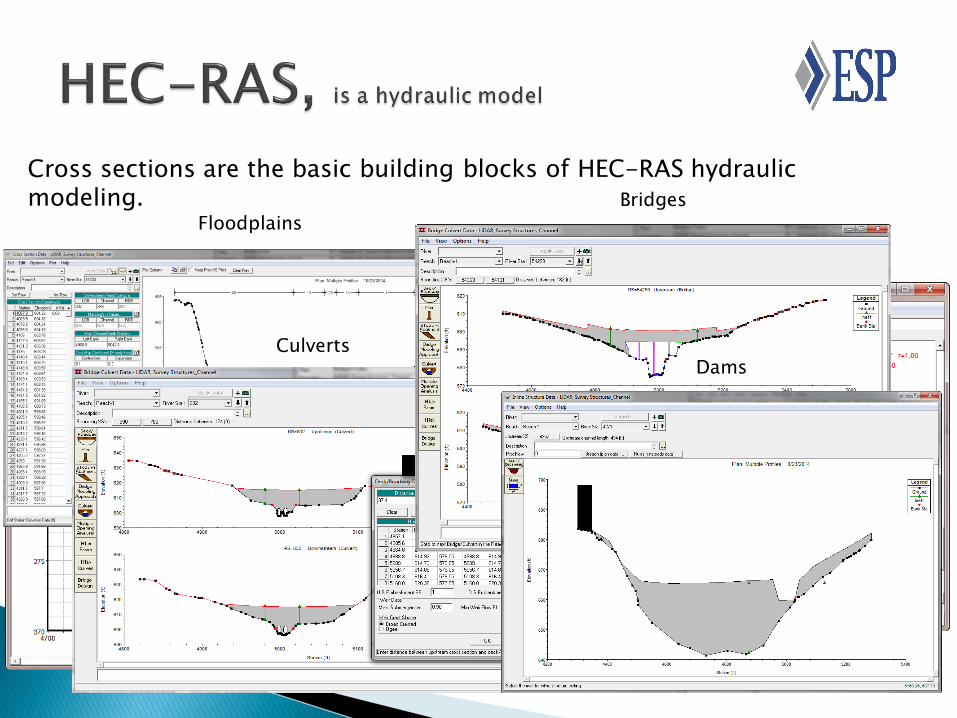
Cross sections are the basic building blocks of HEC-RAS hydraulic modeling.
Floodplains
Culverts
Bridges
Dams

OldGen
(HEC-2)
NexGen
(HEC-RAS)

HEC-RAS 5.0 will offer combined 1D and 2D modeling, including the ability to model hydraulic structures inside of 2D flow areas.

One-dimensional Hydraulic Model (1-D)
A mathematical model that computes hydraulic conditions of flow for a constant discharge and only calculates the hydraulics in terms of flow depth variations and velocity in the direction of the stream line.
Flow Path

HEC-RAS basic methodology is to compare energy between cross sections to determine the water surface elevation of the next section. This is referred to as a direct step method calculation. Basic Equations are:
Z: elevation of the bottom of the channel
Y: elevation of the water surface
V: flow velocity
: coefficient
g: gravity
he: head losses
A: area of cross section
Energy Equation e
2
1111
2
2222 h
g2
VYZ
g2
VYZ
Continuity Equation 1122 AVAV

HEC-RAS Basic Assumptions:
1. Cross sections have one water surface elevation (WSE) along the entire length.
2. Average water velocity and depth is adequate to determine WSE.
3. Water only flows perpendicular to the cross section.
4. Flow “Q” is constant in any given set of calculations.
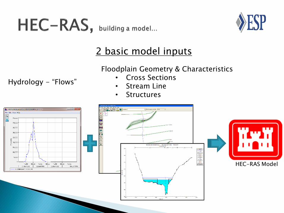
2 basic model inputs
HEC-RAS Model
Hydrology - “Flows”
Floodplain Geometry & Characteristics • Cross Sections • Stream Line • Structures

Two main sources of flows are:
Regression Hydrology Rainfall-Runoff Modeling
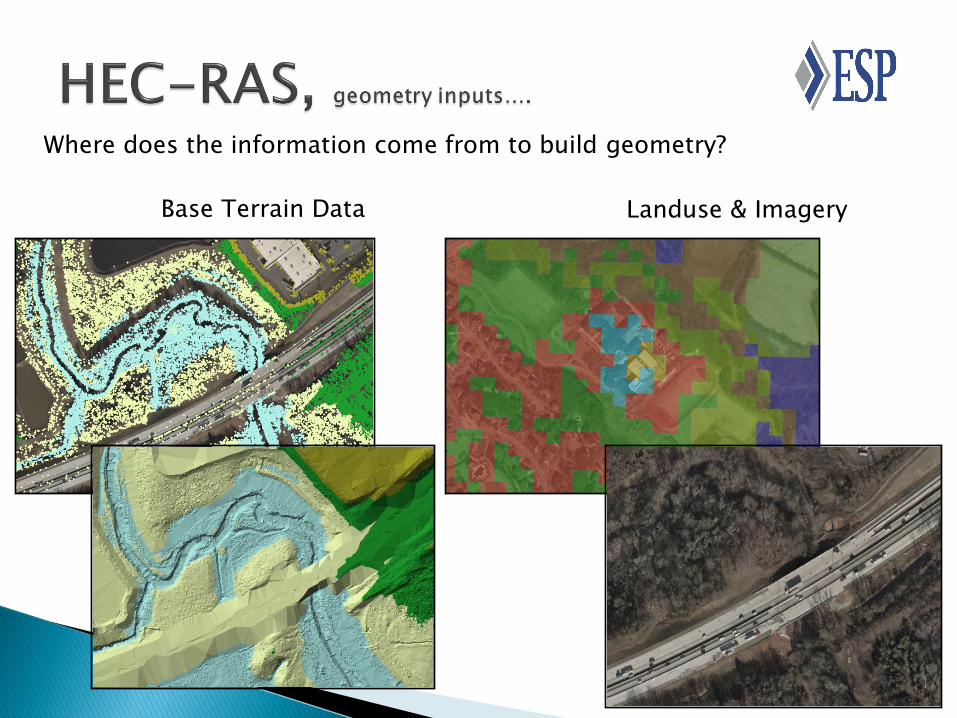
Where does the information come from to build geometry?
Base Terrain Data Landuse & Imagery

Where does the information come from to build these models?
Survey & As-builts Field Visits
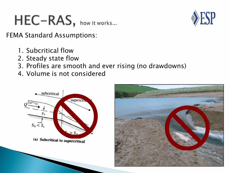
FEMA Standard Assumptions:
1. Subcritical flow 2. Steady state flow 3. Profiles are smooth and ever rising (no drawdowns) 4. Volume is not considered

FEMA study methods
Study Method
Detailed Methods
Limited Detail Studies Methods
Approximate Methods
Redelineated (Detailed)
Products (Results)
Floodplains, BFEs, & Floodway
Floodplain & BFEs Floodplain
Updated Floodplains,
Unchanged BFEs & Floodway
Base Terrain
High-quality LiDAR or survey
High-quality LiDAR or survey
Typically DEM Newer and original
Terrain
Channel Geometry
Surveyed Channels
No survey for channels
No survey for channels
Existing Model
Structure Geometry
Surveyed Structures
Limited structure survey
No surveyed structures
Existing Model
Flow Data Regression or Rainfall-runoff
Regression or Rainfall-runoff
Regression Existing Flow Data
Model Availability
Definitely Yes If you’re lucky Often HEC-2

HEC-RAS has over 20 standard output results table

Outputs can be visualized in plan or profile views

Water Surface Profiles can be converted to mapping products
Profiles are combined with a terrain model (DEM or TIN) to delineate Special Flood Hazard Areas.
• Floodplains • Depth Grids • Velocity Grids • Elevation (BFE) Grids • Etc…
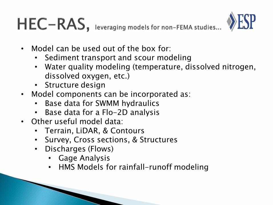
• Model can be used out of the box for: • Sediment transport and scour modeling • Water quality modeling (temperature, dissolved nitrogen,
dissolved oxygen, etc.) • Structure design
• Model components can be incorporated as: • Base data for SWMM hydraulics • Base data for a Flo-2D analysis
• Other useful model data: • Terrain, LiDAR, & Contours • Survey, Cross sections, & Structures • Discharges (Flows)
• Gage Analysis • HMS Models for rainfall-runoff modeling

FEMA Library All models and data (if available)
Fee to research and collect data
http://www.fema.gov/plan/prevent/fhm/st_order.shtm
Map Service Center
Maps and Mapping Products
Effective DFIRMs
GIS Layers for cross sections, floodplains, depth grids, etc.
http://msc.fema.gov

First places to look:
• Local community floodplain
administrator
• State or County Agency
(Emergency Management,
Department of Environment &
Resources)
• Local CTP (Cooperating
Technical Partner/State)
https://www.fema.gov/cooperating
-technical-partners-ctp-
program/cooperating-technical-
partners-ctp-program
•

Data is becoming more readily available.
Download Models for:
NC & AL @ NC Flood Risk Information System - http://fris.nc.gov/fris/Home.aspx
TX @ Harris Flood Control District - http://www.hcfcd.org/m3/
WV @ WV Flood Tool - http://www.mapwv.gov/flood/
Joseph C. Kirby, P.E., CFM Technical Director, Water Resources & GIS
ESP Associates, P. A.
5121 Kingdom Way – Suite 208
Raleigh, NC 27607
www.espassociates.com