20121129 graphite exploration case study -...
TRANSCRIPT
AIRBORNE SURVEYS WORLDWIDE SKYTEM SURVEYS APS TEL: +45 8620 2050 WWW.SKYTEM.COM
TOFTELEDET 18 VAT: 27704379 [email protected]
8330 BEDER, DENMARK
Graphite Exploration Case Study
Location: Commodity: Exploration Challenge: SkyTEM Solution: Result:
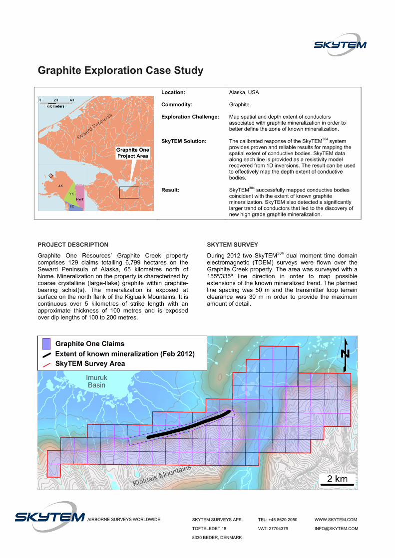
Alaska, USA Graphite Map spatial and depth extent of conductors associated with graphite mineralization in order to better define the zone of known mineralization. The calibrated response of the SkyTEM304 system provides proven and reliable results for mapping the spatial extent of conductive bodies. SkyTEM data along each line is provided as a resistivity model recovered from 1D inversions. The result can be used to effectively map the depth extent of conductive bodies. SkyTEM304 successfully mapped conductive bodies coincident with the extent of known graphite mineralization. SkyTEM also detected a significantly larger trend of conductors that led to the discovery of new high grade graphite mineralization.
PROJECT DESCRIPTION
Graphite One Resources’ Graphite Creek property comprises 129 claims totalling 6,799 hectares on the Seward Peninsula of Alaska, 65 kilometres north of Nome. Mineralization on the property is characterized by coarse crystalline (large-flake) graphite within graphite-bearing schist(s). The mineralization is exposed at surface on the north flank of the Kigluaik Mountains. It is continuous over 5 kilometres of strike length with an approximate thickness of 100 metres and is exposed over dip lengths of 100 to 200 metres.
SKYTEM SURVEY
During 2012 two SkyTEM304 dual moment time domain electromagnetic (TDEM) surveys were flown over the Graphite Creek property. The area was surveyed with a 155º/335º line direction in order to map possible extensions of the known mineralized trend. The planned line spacing was 50 m and the transmitter loop terrain clearance was 30 m in order to provide the maximum amount of detail.

SURVEY RESULTS
The SkyTEM data are delivered as a resistivity model generated from a series of 1D inversions. The hot colours in the 25 m resistivity depth slice (shown below) indicate the spatial distribution of less resistive (more conductive) material within the survey area. The northern trend (solid blue line) suggests a significant increase in the size of the previously known mineralized zone (dashed blue line). Based on this information Graphite One carried out a sampling and mapping program to determine the size of the mineralized zone. The results of the sampling program confirmed the presence of graphite along the trend of conductors mapped by the SkyTEM304 survey. This has made it possible for Graphite One to increase the length of the known mineralized trend from 5 km to 18 km.
A drill program was also carried out to determine the depth extent of the mineralization exposed at surface. Results from three holes (plotted on right) show an excellent correlation with the resistivity section from the flight line closest to section AA’. The intervals on the drill traces highlighted in red indicate average graphitic carbon (Cg) content greater the 4%. These intervals are coincident with the low resistivity zone recovered by the inversion yet again highlighting SkyTEM’s ability to map conductors associated with graphite mineralization.
PROJECT STATUS (OCT 2012)
As a result of their 2012 exploration program Graphite One has verified that the 18 km long conductor detected by the SkyTEM304 system is directly related to wide scale, high grade, graphite mineralization. It has been confirmed by drilling that width and depth of mineralization are in excess of 250 metres.
“…the system remains open along strike and depth as defined by the geophysics and
mapping, confirming the strength and continuity of this deposit.”
Anthony HustonPresident and Director
Graphite One Resources
The data presented was collected by the SkyTEM304. SkyTEM also offers the SkyTEM508 – our most powerful system yet. The SkyTEM508 is focused on mineral mapping and has an increased transmitter moment of approximately 500,000 NIA with 8 turns on a 500 m2 loop. System development is based on extensive experience with earlier SkyTEM systems and possesses the same unique features with regard to calibrated accuracy, repeatability, noise suppression and compre-hensive, continuous monitoring of system parameters.
Data and permission to publish kindly provided by:
<
GPH:TSX-V