2011 mississippi emergency management agency … · the mississippi emergency management agency is...
TRANSCRIPT

www.msema.org
2011
P.O. Box 5644 Pearl, MS 39288 601-933-6884Office of Mitigation / FPM Bureau
QUICKGUIDE
Mississippi Emergency Management Agency

MISSISSIPPI QUICK GUIDE1
The Floodplain Management Quick Guide was originally prepared by our friends and neighbors in Missouri, Alabama, and Illinois. These states have graciously allowed it to be edited and modified for use in Mississippi. Copyright laws do not apply. The development of this Quick Guide was supported by funding from our partners at the Federal Emergency Management Agency. The contents may not necessarily reflect the views and policies of the Federal government.
Questions and comments can be directed to the Office of Mitigation in the Mississippi Emergency Management Agency at 601-933-6884. We encourage any comments and suggestions for improvements to this Guide.
The Mississippi Floodplain Management Desk Reference for Community Administrators and other publications on floodplain management are available from MEMA, and other documents are available from FEMA. Please contact us if you have questions or need further assistance.
About This Guide
www.msema.org
2011
P.O. Box 5644 Pearl, MS 39288 601-933-6884
Office of Mitigation / FPM Bureau
QUICKGUIDE
Mississippi Emergency Management Agency

MISSISSIPPI QUICK GUIDE2
The Mississippi Emergency Management Agency is pleased to provide this Quick Guide to you, the citizen whose home or business is located within the State’s floodplain as an information tool.
We regulate the floodplain to:
■ Protect people and property.
■ Ensure that Federal flood insurance and disaster assistance are available.
■ Save tax dollars.
■ Reduce future flood losses.
Floods have been, and continue to be, the most destructive natural disaster in terms of economic loss to thecitizens of Mississippi. Since 1978, Mississippi flood insurance policy holders have received more than $2.8billion in claims payments.
With more than 5.2 million acres in floodplain (over 15% of the State’s total), Mississippi has the 5th largestfloodplain in the United States. We can no longer afford the “destruction-rebuild cycle” in which we findourselves today.
Introduction

MISSISSIPPI QUICK GUIDE3
It will flood, damage will occur, and there will be adverse impacts upon the citizens, local governments, and the state government from both physical and financial damages. Keeping these facts in mind, the best tools to protect the public are flood risk identification (maps), promotion of flood risk reduction methods, and flood risk awareness education.
Our state is vulnerable to riverine/stream flooding, flash flooding, coastal flooding, and drainage floods. One in six acres in Mississippi is found within the delineated floodplain, which equates to 5.2 million acres. Historically, major flood events occur every two to three years. Whether or not you or your community have experienced a flood or any other type of damaging event within the floodplain, it will happen, and you must be prepared to plan for and respond to such events.
Many people simply do not realize that they live in or have built in potentially hazardous areas. Perhaps they are new to the area, or have lived in a house for years without experiencing a flood. It is interesting to ponder that people are not willing to drop fire insurance (which has only a 9% chance of occurring over a 30-year mortgage compared to a 26% chance of flooding), but are generally opposed to carrying flood insurance for their largest personal asset.
A flood is truly a time of crisis. Being prepared through personal and community mitigation actions and by carrying sufficient flood insurance on your or your community’s property is your best bet to “weather the storm.”
Background

MISSISSIPPI QUICK GUIDE4
Flood losses within Mississippi have increased from $278 million in 2004 to $2.8 billion in 2010. This trend emphasizes that flood damages are less a natural occurrence, than a true consequence of our individual and social choices, which are to develop and live in our state’s large floodplain. For this reason, people living in the high risk flood zone, below dams, or behind levees must understand their residual flood risk. Consider that the probability of a flood, dam failure, or levee failure is generally low; but the consequences of such an event to public safety and property loss is catastrophic.
Every homeowner, business owner, and renter should carry flood insurance for their building and/or contents. Federally backed flood insurance is available in every community which participates in the National Flood Insurance Program (NFIP).
Unfortunately, it is only after a flood that many people discover that their property insurance does not cover flood damages. Every building within the state of Mississippi is located within a mapped flood zone – some zones are low risk, some moderate, and some are designated as high risk. These high risk zones (beginning with the letter ‘A’ or ‘V’ on the community Flood Insurance Rate Maps) make up the 1% annual chance floodplain, which is commonly referred to as “the floodplain.” Approximately 30% of all flood damages occur in low risk zones, commonly described as “outside the floodplain.” The annual insurance premiums for these low risk zones can equate to less than $1 per day.
Flood Insurance

MISSISSIPPI QUICK GUIDE5
The 300+ NFIP member communities in Mississippi regulate the floodplain to:
■ Protect people and property
■ Ensure that Federally backed flood insurance and disaster assistance are available
■ Save tax dollars
■ Reduce future flood losses
To participate in the NFIP, the individual community agrees to:
■ Adopt and Enforce a flood damage prevention ordinance
■ Require permits for all types of development in the floodplain
■ Require FEMA Elevation Certificates to document compliance
■ Require new or improved residential structures and manufactured homes to be elevated to or above the Base Flood Elevation (1% chance flood)
■ Conduct field inspections and cite any violations to the community’s ordinance
■ Require non-residential structures to be elevated or floodproofed
■ Assure that building sites are reasonably safe from flooding
■ Carefully consider requests for variances
■ Advise FEMA when updates to the community Flood Insurance Rate Maps are needed
Floodplain Management: Introduction

MISSISSIPPI QUICK GUIDE6
Floodplain Management: Introduction
Some of the activities that require permits within the floodplain:
■ New construction
■ Additions to existing structures
■ Substantial improvement to existing structures
■ Placing manufactured homes
■ Subdivision development
■ Temporary buildings and accessory structures
■ Agricultural buildings
■ Parking or storage of recreational vehicles
■ Storing of materials, including gas/liquid tanks
■ Roads, bridges, and culverts
■ Fill, grading, excavation, mining, and dredging
■ Stream alteration

MISSISSIPPI QUICK GUIDE7
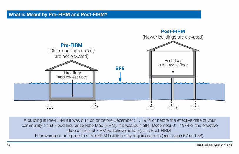
Structures are looked at as being either pre or post-FIRM in floodplain management. (FIRM stands for Flood Insurance Rate Map) What is meant by Pre-FIRM and Post-FIRM? If a building is Pre-FIRM, it was built on or before December 31, 1974 or before the effective date of your community’s first FIRM. It is Post-FIRM if it was built after December 31, 1974 or the effective date of the first FIRM (whichever is later). Other important definitions are below:
Addition (to an existing building) means any walled and roofed expansion to the perimeter of height of a building. In many communities, any addition to an existing building is considered to be new construction. If the addition is more than 50% of the market value of the structure, then the addition and the existing structure are new construction and must meet the base flood elevation (and any freeboard) requirements.
Base Flood means the flood having a one percent chance of being equaled or exceeded in any given year (also called the “one percent chance flood”).
Floodway means the channel of a river or other watercourse and the adjacent land areas that must be reserved in order to discharge the base flood without cumulatively increasing the water surface elevation more than one foot. Development in a floodway requires a “No Rise” certification submission by an engineer.
Freeboard means a factor of safety, usually expressed in feet above the base flood elevation. Communities are encouraged to adopt 18 inches of freeboard to account for the one foot rise built into the concept of designating a floodway, where floodways have not been designated.
Floodplain Management: A Few of the Basic Definitions

MISSISSIPPI QUICK GUIDE8
Letter of Map Amendment (LOMA) is an amendment based on technical data showing that a property was incorrectly included in a designated high risk flood zone, was not elevated by fill (only by a natural grade elevation), and will not be inundated by the one percent chance flood. A LOMA amends the effective FIRM and establishes that a specific property is not located in the high risk flood zone. The FEMA MT-EZ form is used to apply for a LOMA.
Letter of Map Revision (LOMR) is a revision based on technical data that, usually due to manmade changes, shows changes to flood zones, flood elevations, floodplain and floodway delineations, and planimetric features. A LOMR-F is a determination concerning whether a structure or parcel has been elevated by fill above the base flood and is, therefore, excluded from the high risk flood zone. The FEMA MT-1 or MT-2 forms are used to apply for a LOMR.
Lowest floor means the lowest floor of the lowest enclosed area (including basement). An unfinished or flood resistant enclosure, used solely for parking of vehicles, building access, or storage, in an area other than a basement, is not considered a building’s lowest floor, provided that such enclosure is not built so as to render the structure in violation of the non-elevation provisions of the flood damage prevention ordinance.
New construction means a structure (or an addition to an existing structure) for which the start of construction commenced on or after the effective date of the floodplain management regulation adopted by a community and any subsequent improvements to such structure or addition.
Floodplain Management: A Few of the Basic Definitions

MISSISSIPPI QUICK GUIDE9
Floodplain Management: A Few of the Basic Definitions
One percent flood (the famously misunderstood 100-Year flood) is the flood that has a one percent chance of being equaled or exceeded in any given year. Any flood zone that begins with the letter ‘A’ or ‘V’ is subject to inundation by the one percent flood. (Think of a large mouthed jar filled with 99 white marbles and one blue marble. Each day pull out a marble, look at it and then place it back in the jar and stir them up. The blue marble represents the one percent chance flood.)
Structure, for floodplain management purposes, means a walled and roofed building, including a gas or liquid storage tank that is principally above ground, as well as a manufactured home.
Substantial damage means damage of any origin sustained by a structure whereby the cost of restoring the structure to it’s before damage condition would equal or exceed 50 percent of the market value of the structure before the damage occurred.
Substantial improvement means any combination of reconstruction, rehabilitation, or other improvement of a structure taking place over a community specified timeframe, in which the cumulative percentage of improvement equals or exceeds 50 percent of the current market value of the structure before the “start of construction’ of the improvement.

MISSISSIPPI QUICK GUIDE10
With the passage of the National Flood Insurance Act of 1968, the U.S. Congress established the National Flood Insurance Program (NFIP), the world’s first (and only) government flood insurance program. (Congress intended this program to spread flood loss across a large national pool of policyholders, and not burden taxpayers as a whole with the bill to assist those who developed within the nation’s floodplains or those who suffered flood losses regardless of their location.) The NFIP is unique as a Federal program in that the authority to implement is held at the local level. The NFIA of 1968 was followed by the Flood Disaster Protection Act of 1973, the National Flood Insurance Reform Act of 1994, and the National Flood Insurance Act of 2004.
The Legislature of the state of Mississippi has in Title 17, Chapter 1, Mississippi Code of 1972 Annotated delegated the responsibility to local government units to adopt regulations designed to promote the public health, safety, and general welfare of its citizenry. The local community Flood Damage Prevention Ordinances is predicated upon this statuary authority.
The NFIP was originally administered by the U.S. Department of Housing and Urban Development until 1979, when the Federal Emergency Management Agency was created. Each state is required to identify a State Coordinating Office, which is charged with the oversight of the
Floodplain Management in Mississippi: The Basic Facts

MISSISSIPPI QUICK GUIDE11
Floodplain Management in Mississippi: The Basic Facts
program within the state borders. The Floodplain Management Bureau of the Mississippi Emergency Management Agency is that designated coordinating office.
The FPM Bureau has oversight responsibility for the 300+ NFIP member communities within the state of Mississippi, to include the subgroup of 20+ Community Rating System (CRS) members. This oversight includes evaluating, monitoring, providing technical assistance and compliance reviews (pursuing corrective actions as needed) for the communities.
Additionally, the Bureau has partnered with the Mississippi Department of Environmental Quality and a contract engineering group to produce digital flood insurance rate maps for the entire state. With these updated maps, which are available in digital and paper format, communities can better identify and regulate development in their floodplain.The local community (County, City, Town, or Village governments) agree to adopt the federally provided Flood Insurance Rate Map and to adopt, administer, and enforce a Flood Damage Prevention Ordinance.

MISSISSIPPI QUICK GUIDE12
If it is found that a community is not fulfilling its agreement with the Federal government, in regard to enforcing its ordinance, several things can happen.
■ If the community is a member of the CRS program, it can be retrograded to Class 10 and flood policyholders will lose their premium discounts.
■ The community can be placed on probation. This is a formal notification to the community that FEMA regards its program to be non-compliant with the minimum standards of the NFIP. An additional $50 dollar premium will be charged on policies sold or renewed during the probation period.
■ The community is subject to suspension unless it corrects program deficiencies and remedies all violations by the compliance deadlines set during the probation period.
■ Subrogation can occur. This is an action brought by FEMA when flood damages have occurred, flood insurance has been paid, and… all or part of the damage can be attributed to acts or omissions by a community or other third party. FEMA then sues the third party to recover flood insurance claims it has paid.
■ Insurance agents who write NFIP policies in a suspended community will find that FEMA is not required to pay any flood loss claims, only to refund any premiums paid.
What Enforcement Actions Can Be Taken Against a Community?

MISSISSIPPI QUICK GUIDE13
After a community has undergone a compliance inspection and deficiencies have been identified, corrective actions can include:
■ Provide missing floodplain development permit information;
■ Rescind permits for structures not yet built or in early stages of construction;
■ Demolish or modify non-compliant structures or remove fill in floodway;
■ Seek civil / criminal penalties, and;
■ Submit information to FEMA to initiate Section 1316 action.
Section 1316 of the National Flood Insurance Act of 1968 designates a process for denying flood insurance to structures in violation of local floodplain management regulations. A community must exhaust all other available enforcement actions such as stop-work-orders, fines, and court actions before pursuing the 1316 process. The community:
■ Declares a structure in violation of its ordinance and notifies FEMA;
■ FEMA denies flood insurance for the structure, and;
■ If the structure is later brought into compliance, then the flood insurance restriction can be removed by FEMA.
What Corrective Measures Can Be Taken By a Community?
MISSISSIPPI QUICK GUIDE14
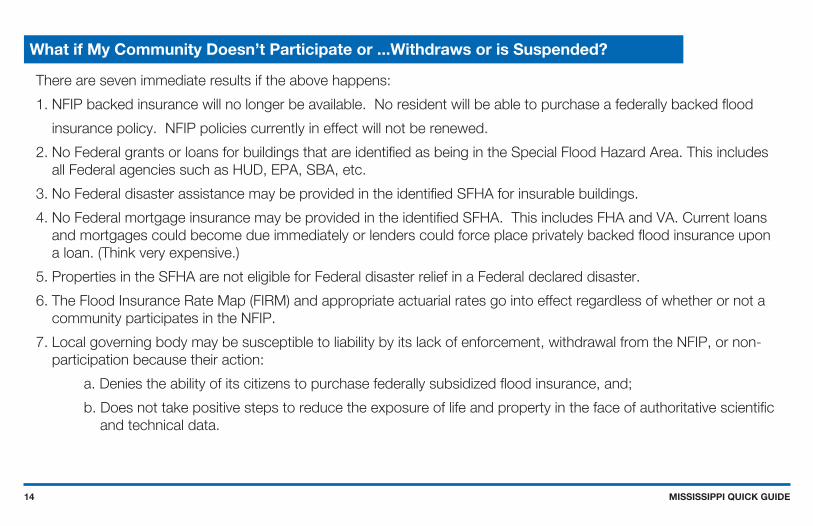
There are seven immediate results if the above happens:
1. NFIP backed insurance will no longer be available. No resident will be able to purchase a federally backed flood
insurance policy. NFIP policies currently in effect will not be renewed.
2. No Federal grants or loans for buildings that are identified as being in the Special Flood Hazard Area. This includes all Federal agencies such as HUD, EPA, SBA, etc.
3. No Federal disaster assistance may be provided in the identified SFHA for insurable buildings.
4. No Federal mortgage insurance may be provided in the identified SFHA. This includes FHA and VA. Current loans and mortgages could become due immediately or lenders could force place privately backed flood insurance upon a loan. (Think very expensive.)
5. Properties in the SFHA are not eligible for Federal disaster relief in a Federal declared disaster.
6. The Flood Insurance Rate Map (FIRM) and appropriate actuarial rates go into effect regardless of whether or not a community participates in the NFIP.
7. Local governing body may be susceptible to liability by its lack of enforcement, withdrawal from the NFIP, or non-participation because their action:
a. Denies the ability of its citizens to purchase federally subsidized flood insurance, and;
b. Does not take positive steps to reduce the exposure of life and property in the face of authoritative scientific and technical data.
What if My Community Doesn’t Participate or ...Withdraws or is Suspended?

MISSISSIPPI QUICK GUIDE15
Summary
So, why are our daily struggles with floodplain management and the National Flood Insurance Program so important to our citizens? It is the very prosperity and viability of our citizens and communities which makes them so. The NFIP, which provides the federal umbrella for floodplain management, flood insurance, and flood hazard identification, is a vital cog in the local community’s resilience and sustainability programs. As the saying goes, “Disaster Preparedness Saves Lives and Property.”
Key Information
■ Online state specific FPM information can be obtained at www.msema.org
■ Flood Smart website www.floodsmart.gov
■ National Flood Insurance information 1-888-379-9531

MISSISSIPPI QUICK GUIDE16
The National Flood Insurance Program was created by Congress in 1968 to protect lives and property and to reduce the financial burden of providing disaster assistance. The NFIP is administered by the Federal Emergency Management Agency. Nationwide, over 20,000 communities participate in the NFIP — including most of Mississippi’s floodprone communities.
The NFIP is based on a mutual agreement between the federal government and communities. Communities that participate agree to regulate floodplain development according to certain criteria and standards.
The partnership involves:
■ Flood Insurance - Property owners in participating communities are eligible to purchase federal flood insurance for buildings and contents.
■ Flood Hazard Maps - In partnership with FEMA, the state produces flood maps in accordance with FEMA standards. The maps are used by communities, insurance agents and others.
■ Regulations - Communities must adopt and enforce minimum floodplain management regulations so that development, including buildings, is undertaken in ways that reduce exposure to flooding.
National Flood Insurance Program

MISSISSIPPI QUICK GUIDE17
The NFIP’s Community Rating System is a voluntary program that provides communities the opportunity to reduce flood insurance premiums for its citizens. Communities in the regular phase of the NFIP may apply to participate in the CRS. To participate the community must commit to implement and certify activities that contribute to reduced flood risk. Examples of actions communities can take to reduce the cost of flood insurance premiums include:
■ Inform people about floodplain management, flood hazards, flood insurance and flood protection.
■ Monitor flood conditions, issue warnings and coordinate flood response activities.
■ Preserve open space in the floodplain.
■ Enact and enforce higher standards for safer development.
■ Maintain the flood carrying and storage capacity of drainage systems.
■ Undertake engineering studies and develop floodplain maps and flood data.
■ Obtain grants to buy out or elevate houses or to floodproof businesses.
Property owners in 20+ Mississippi communities with a “Class 9” or better CRS rating receive discounts rangingfrom 5% to 25% for properties in a Special Flood Hazard Area (SFHA) and 5% to 10% for properties not in a
SFHA. For detailed information about the CRS program go to http://training.fema.gov/EMIWeb/CRS/.
NFIP Community Rating System

MISSISSIPPI QUICK GUIDE18
Who needs flood insurance? EVERYONE! Every homeower, business owner, and renter in one of Mississippi’s more than 300+ communities participating in the National Flood Insurance Program may purchase a flood insurance policy - regardless of the location of the structure.
Unfortunately, it’s usually after a flood that most people discover that their property insurance does not cover flood damages. Every building is located within a flood zone - some zones are high risk, some are low risk. Approximately 30% of all flood damages occur in low risk zones, commonly described as “outside the mapped flood zone.
MEMA and the Association of Floodplain Managers of Mississippi urges you to protect your financial future by getting a flood insurance policy. To purchase a policy, call you insurance agent. To get the name of an agent in your community, call the NFIP’s toll free number 1-888-FLOOD29.
Flood Insurance is Your Best Protection

MISSISSIPPI QUICK GUIDE19
To participate in the National Flood Insurance Program, your community agrees to:
■ Adopt and enforce a flood damage prevention ordinance.
■ Require permits for all types of development in the floodplain (see page 28).
■ Require Elevation Certificates to document compliance (see pages 37 and 38).
■ Require new or improved residential structures and manufactured homes to be elevated to or above the BFE.
■ Conduct field inspections and cite any violations to the community’s Flood Damage Prevention Ordinance.
■ Require non-residential structures to be elevated or floodproofed.
■ Assure that building sites are reasonably safe from flooding.
■ Carefully consider requests for variance.
■ Advise FEMA when updates to flood maps are needed.
Community Responsibilities

MISSISSIPPI QUICK GUIDE20
Understanding the Riverine Floodplain
For floodplains with Base Flood Elevations, check the Flood Insurance Study (FIS) to find the Flood Profile which shows water surface elevations for the different frequency floods (see page 23).
StreamChannel
FringeFringeFloodway
Special Flood Hazard Area
DefinitionsTerms and
The Special Flood Hazard Area (SFHA) is the portion of the floodplain subject to inundation by the base flood and/or flood related erosion hazards. SFHAs are shown on FIRMs as Zones A, AE, AH, AO, AR, and VE.
See page 21 to learn more aboutthe floodway, the area of floodplain where floodwaters usully flow faster and deeper.
See page 24 to learn more aboutthe coastal floodplain.

MISSISSIPPI QUICK GUIDE21
DefinitionsTerms and
The Floodway is the channel of a river or other water course and the adjacent land areas that must be reserved in order to pass the base flood discharge without increasing flood depths.
Computer models of the floodplainare used to simulate “encroachment” or fill in the flood fringe in order to predict where and how much the base flood elevation would increase if the floodplain is allowed to be filled.
Understanding the Floodway
Before a local permit can be issued for proposed development in the floodway, a “No Rise/No Impact” certification form must be submitted (see page 42). You may need a qualified engineer to make sure your proposed project won’t
increase or decrease flooding.
Simulated Encroachment
SimulatedEncroachment
SimulatedEncroachment
*Surcharge not to exceed 1.0 foot [FEMA requirement]
FloodFringe
FloodFringe
StreamChannel
Surcharge*
Special Flood Hazard Area
Floodway
Area of floodplain that could beused for development by raising ground
Flood elevation beforeencroachment
Line = Flood elevation before encoachment
Line = Flood elevation after encoachment
A
A
B
B
C
C
D
D

MISSISSIPPI QUICK GUIDE22
Understanding the Riverine Floodplain
The floodway is the area where most conveyance and high velocity flows occur.
The new DFIRMs combine counties andincorporated municipalities, so matchingacross boundaries isn’t a problem.
Zone X (unshaded) is all otherareas (formerly C Zone)
Zone X (shaded) shows areasaffected by the 500-yearflood (formerly B Zone)
The Floodway is the
Zone AE is the 100-year (1%-annual-chance)floodplain
“cross-hatched” area
1
3
4
5
2
5
Base Flood Elevation (BFE)Water surface elevation(in this example 292 ft above datum).

MISSISSIPPI QUICK GUIDE23
Use the Riverine Flood Profile to Determine BFEs
Flood profiles can be usedto determine the BFE at aspecific site. Profiles alsoshow estimated water surface elevations for floodsother than the 100-yearflood.
On the Flood InsuranceRate Map, locate your siteby measuring the distancealong the center line of thestream channel from a crosssection, for example,
or .
Scale that distance on the Flood Profile and read upto the profile of interest,then across to determinethe elevation.(Answer: 223 feet)Stream distance in feet above confluence
4000
220
210
200
5000 6000 7000 8000 9000 10000 11000
1
1
1 2
2
Ro
adE F

MISSISSIPPI QUICK GUIDE24
DefinitionsTerms and
The Coastal High Hazard Area (V Zone) is the area of the special flood hazard that extends from offshore to the inland limit of a primary frontal dune along an open coast and any other area subject to high velocity wave action from storms or seismic sources. The area is designated on the FIRM as Zone VE.
The term Coastal AE Zone meansthe portion of the SFHA landward of the V Zone or landward of a shoreline that does not have a mapped V Zone. The principle sources of flooding are not riverine, but are associated with astronomical tides, storm surge, seiches, or tsunamis. Coastal AE Zones between the landward limit of the 1.5 ft breaking wave and the V Zone can be regulated as V Zones.
Understanding the Coastal Floodplain
V ZONE COASTAL AE ZONE A ZONE X ZONE
Wave Height ≥ 3 ft Wave Height ≥ 1.5 ft
Shoreline Sand Beach Buildings OverlandWind Fetch
VegetatedRegion
Limit of1.5 ft wave
Limit of1% Flood
BFE IncludingWave Effects
Properly ElevatedBuilding
100-YearStillwater Elevation
Datum(e.g. NAVD)
Unelevated BuildingConstructed Before Community Entered the NFIP

MISSISSIPPI QUICK GUIDE25
FLOOD HAZARD ZONESZone A and Zone AE are subject to floodingby the base or 100-year flood(1% annual chance), and waves less than 3 feet.
1
2
3
4
5
Shaded Zone X is subject to flooding by the 500-year flood(0.2% annual chance).
Zone X is all other areas.
Zone VE are where waves are expected to be3 feet or more.
Limit of Moderate Wave Action (LiMWA)where waves are expected to be 1.5 feet.
In undeveloped Coastal Barrier Resource Areas (COBRA),NFIP insurance is not available for new or substantially improved
structures built after November 16, 1990.
The Flood Insurance Rate Map (Coastal)

MISSISSIPPI QUICK GUIDE26
If you need help in determining the BFE, check with your community permit office.
Unnumbered A Zone
Topographic mapscan be used toestimate theBase FloodElevation (BFE).
Unnumbered A zones are drawn based on existing information, not engineering studies. FEMA checked with the U.S. Army Corps of Engineers, the U.S. Geological Survey, the State, local offices, and historic records. When existing information was lacking, an approximate analysis was performed.

MISSISSIPPI QUICK GUIDE27
Check FEMA’s Flood Hazard Mapping web site for more information about map revisions concerning homeowners, engineers, and surveyors.
Informationwww.fema.gov/hazard/map/lomc
Formswww.fema.gov/business/nfip/forms
InformationImportant
Letters of Map Change (LOMC)
There Are Three Primary Types of Letters of MapChange (LOMC) Issued by FEMA
Letter of Map Amendment (LOMA) is an official amendment to an effective FIRM that may be issued when a property owner provides additional technical information, such as natural ground elevation relative to the SFHA and the building. Lenders may waive the flood insurance requirement if the LOMA documents a structure is on ground above the mapped floodplain.
Letter of Map Revision (LOMR) is an official revision to an effective FIRM that may be issued to change flood insurance risk zones, floodplain and boundary delineations, BFEs and/or other map features. Lenders may waive the flood insurance requirement if the approved map revision shows structures to be outside the SFHA.
Letter of Map Revision Based on Fill (LOMR-F) is an official revision to an effective FIRM that is issued to document FEMA’s determination that a structure or parcel of land has been elevated by fill above BFE, and therefore is no longer in the SFHA. Lenders may waive the flood insurance requirement if the LOMR-F shows a structure on fill is above the BFE.
1.
2.
3.

MISSISSIPPI QUICK GUIDE28
If your land is shown on the maps as “in” the floodplain, but your building site is higher than the BFE... get asurveyor or engineer to to complete a FEMA elevation certificate (EC). Submit the EC with an application to
FEMA and a LOMA may be issued (see page 27). This is the only way to remove the requirements to purchaseflood insurance. Keep the certificate with your deed, it will help future buyers.
Is Your Building Site Higher Than the BFE?
BFE
Sealed Signature
Lowest naturalground next tobuilding

MISSISSIPPI QUICK GUIDE29
YOU NEED PERMITS FOR OF ALL THESE ACTIVITIES.
Some of the Activities Requiring Permits:
■ New Construction.
■ Additions to existing structures.
■ Substantially improving existing structures.
■ Placing manufactured (mobile) homes.
■ Subdivision development.
■ Temporary buildings and accessory structures.
■ Agricultural buildings.
■ Parking or storage of recreational vehicles.
■ Storing materials, including gas/liquid tanks.
■ Roads, bridges and culverts.
■ Fill, grading, excavation, mining and dredging.
■ Stream alteration.

MISSISSIPPI QUICK GUIDE30
Safe Uses Of The Floodplain
Let the floodplain do its job - if possible, keep it natural open space. Other low damge uses include: recreational areas, playgrounds, reforestation, parking, gardens, pasture, accessory structures, and created wetlands.
All land sudivided into lots, some lots partially in the floodplain, setbacks to
keep homesites on high ground.RECOMMENDED
Floodplain land put into public/common open space, net density
remains, lot sizes reduced and setbacks modified to keep homesites on high ground.
RECOMMENDED
All land subdivided into lots, some homesites and lots partially or entirely
in the floodplain.NOT RECOMMENDED
MISSISSIPPI QUICK GUIDE31
What is Meant by Pre-FIRM and Post-FIRM?
A building is Pre-FIRM if it was built on or before December 31, 1974 or before the effective date of yourcommunity’s first Flood Insurance Rate Map (FIRM). If it was built after December 31, 1974 or the effective
date of the first FIRM (whichever is later), it is Post-FIRM.Improvements or repairs to a Pre-FIRM building may require permits (see pages 57 and 58).
First floorand lowest floor
First floorand lowest floor
BFE
Post-FIRM(Newer buildings are elevated)
Pre-FIRM(Older buildings usually
are not elevated)

MISSISSIPPI QUICK GUIDE32
CAUTION! Nature doesn’t read maps! Major storms and flash floods can cause flooding that rises higher than the BFE. Consider Safety - protect your home or business by building higher.
See page 36 to see how this will save you money on your Flood insurance.
Nature Doesn’t Read Maps!
InformationImportant
Many people don’t understand just how risky the floodplain can be. There is a 26% chance that a home in the SFHA will flood during a 30 year mortgage period. The chance that a major fire will occur during the same period is only 9%!
500-yearelevation(0.2% annual
chance) 100-yearelevation(1% annual
chance) 10-yearelevation(10% annual
chance)

MISSISSIPPI QUICK GUIDE33
Very specific conditions must be satisfied to justify a variance:
■ Good and sufficient cause
■ Unique site conditions
■ Hardship related to property use (not the person)
■ If in a floodway, no increase in flood level
A variance that allows construction below the BFE does not waive the lender flood insurance requirement. Flood insurance will be very expensive - perhaps as high as $25 for $100 of coverage (see page 36)!
Think carefully about seeking a variance to build below the Base Flood Elevation. Not only will your propertybe more likely to get damaged, but insurance will be very costly. If your community has a pattern of granting
variances inconsistent with the local ordinance, sanctions can be imposed - costing you even more!
Think Carefully Before You Seek a Variance
BFE
Post-FIRM building,not elevated
Insurance $2,000+/year
Lowest floorbelow BFE
MISSISSIPPI QUICK GUIDE34
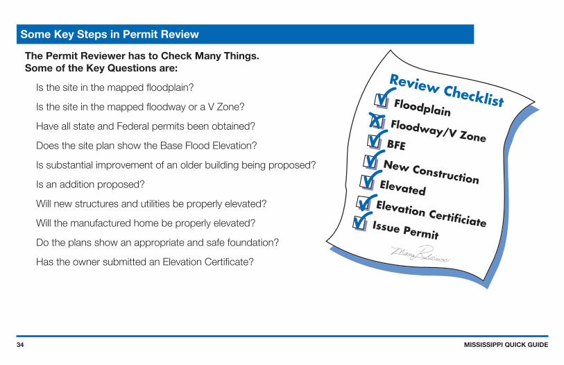
The Permit Reviewer has to Check Many Things.Some of the Key Questions are:
Is the site in the mapped floodplain?
Is the site in the mapped floodway or a V Zone?
Have all state and Federal permits been obtained?
Does the site plan show the Base Flood Elevation?
Is substantial improvement of an older building being proposed?
Is an addition proposed?
Will new structures and utilities be properly elevated?
Will the manufactured home be properly elevated?
Do the plans show an appropriate and safe foundation?
Has the owner submitted an Elevation Certificate?
Some Key Steps in Permit Review

MISSISSIPPI QUICK GUIDE35
Carefully Complete the Permit Application
Good information will lead to better construction and less exposure to furture flood damage.

MISSISSIPPI QUICK GUIDE36
InformationImportant
Freeboard: Go the Extra Foot
NOTE: Flood Insurance rates and various fees change from time to time. Rather than specific costs for insurance, this figure gives a feel for how much difference just a foot or two can make. Building owners will save insurance money if they elevate above BFE. But more impressive is how the cost of insurance can more than double if the building is only one foot below BFE.
REMEMBER!The community may be able to grant a variance , but the owner will probably still be required to buy flood insurance. Imagine trying to sell a house if the bank requires insurance that costs over $2,000 a year!
Want to save some money and have peace of mind at the same time? Then add Freeboard to build higher than the minimum elevation requirement! Freeboard is a factor of safety, usually one to three feet above BFE.
House A on pilingsPost-FIRM in V Zone$250,000 insurance on the building$85,000 insurance on contents
House B on vented crawlspacePost-FIRM in A Zone with BFE$100,000 insurance on the building$40,000 insurance on contents
House C MFH on reinforced pilingsPost-FIRM in A Zone with BFE$40,000 insurance on unit$20,000 insurance on contents
Submit toFEMA if 2
or more feetbelow BFE
Annual Flood Insurance Cost
Low
est
Flo
or
Rel
ativ
e to
BFE
BFE
+2
+1
-1
-2
$1,000 $2,000 $3,000 $4,000 $5,000 $6,000
A
B
C

MISSISSIPPI QUICK GUIDE37
■ The Elevation Certificate (EC) is a FEMA form, download a copy from
http://www.fema.gov/business/nfip/forms.shtm.
■ The EC must be completed and sealed by a registered surveyor or engineer when the floodplain has BFEs.
■ A community official may complete the EC for sites in unnumbered A zones.
■ It can be used to show that sites are natural ground above Base Flood Elevation (see page 28).
■ It is used to verify that buildings are elevated properly (see page 39).
■ Insurance agents use the EC to write flood insurance policies.
■ By itself, the EC cannot be used to waive the requirement to purchase flood insurance. See page 27 to learn about Letters of Map Amendment (LOMA).
What is the Elevation Certificate and How is it Used?

MISSISSIPPI QUICK GUIDE38
You will get a blank Elevation Certificate form when you get your permit. You must have a surveyor or engineer fill it out and seal it. The Elevation Certificate includes diagrams for eight building types. Several points must be surveyed.
What is the Elevation Certificate and How is it Used?
SECTION C - BUILDING ELEVATION INFORMATION (SURVEY REQUIRED)
C1. Building elevations are based on: Construction Drawings* Building Under Construction* Finished Construction *A new Elevation Certificate will be required when construction of the building is complete.
C2. Elevations – Zones A1-A30, AE, AH, A (with BFE), VE, V 1-V30, V (with BFE), AR, AR/A, AR/AE, AR/A1-A30, AR/AH, AR/AO. Complete Items C2.a-g below according to the building diagram specified in Item A7.
Benchmark Utili zed Vertical Datum
Conversion/Comments Check the measuremen t used.
a) Top of bottom floor (in cluding basement, crawl space, or enclosure floor) . feet meters (Puerto Rico only) b) Top of the next higher floor . feet meters (Puerto Rico only) c) Bottom of the lowest horizontal structural member (V Zones only) . feet meters (Puerto Rico only) d) Attached garage (top of slab) . feet meters (Puerto Rico only) e) Lowest eleva tion of machine ry or equipment servicing the building . feet meters (Puerto Rico only) (Describe type of equipment in Comments) f) Lowest adjacen t ( finished) grade (LAG) . feet meters (Puerto Rico only) g) Highest adjacent (f inished) grade (HAG) . feet meters (Puerto Rico only)
X
286 0
N/AN/A
286
0
0
5
5282
282286
X
XX
XX
NGVD 29None
RM 166
Elevation Certificate (partial)
In this example, the BFE is 285.
The slab-on-grade house was elevatedon fill 1’ above the BFE, and thevented garage is 2.5’ below BFE.
COMPACTED FILL
Attached garage
Flood opening
Electrical boxwired fromceiling
Water heaterelevated on aplatform
BFE

MISSISSIPPI QUICK GUIDE39
If you get a permit to build in the floodplain, you will given an Elevation Certificate form. As soon as your Lowest Floor is set, get the form filled out and sealed by a surveyor or engineer.
This form is IMPORTANT! It proves that you built correctly, and it can be used to get the lowest cost flood insurance.
Paperwork is Important for You and Your Community
Lowest Floor means the lowest floor of the lowest enclosed area(including basement). An unfinished or flood resistant enclosure(that is not a basement) is not the lowest floor if the enclosure is builtas required in the local ordinance (see pages 47 and 51), whichincludes limited uses.
COMPACTED FILL

MISSISSIPPI QUICK GUIDE40
Your community may ask for certification of the elevation, compaction, slope and slope protection materials. Your engineer or design professional can find more information in FEMA’s technical guidance for Letter or Map Revision
based on Fill (FEMA Form MT-1) and tin NFIP Technical Bulletin #10.
Earthen fill used to raise the ground above the flood elevation must be placed properly so that it does not erode or slump when water rises. For safety and to meet floodplain requirements, floodplain fill should:
■ Be good clean soil, free of large rocks, construction debris, and woody material (stumps, roots).
■ Have graded side slopes not steeper than
■ 2:1, (one foot of vertical rise for every 2 feet of horizontal extent); flatter slopes are recommended. If steeper than 2 to 1 engineering analysis is required.
■ Be machine compacted to 95 percent of the maximum density (determined by a design professional).
■ Have slopes protected against erosion (vegetation for “low” velocities, durable materials for “high” velocities determined by a design professional).
■ Compacted fill should extend 10 to 15 feet beyond the building walls before dropping below BFE.
Compaction of Floodplain Fill
BFE
COMPACTED FILL
1’2’ min
MISSISSIPPI QUICK GUIDE41
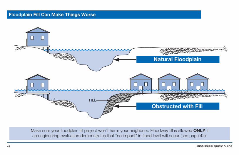
Make sure your floodplain fill project won’t harm your neighbors. Floodway fill is allowed ONLY ifan engineering evaluation demonstrates that “no impact” in flood level will occur (see page 42).
Floodplain Fill Can Make Things Worse
Natural Floodplain
Obstructed with FillFILL

MISSISSIPPI QUICK GUIDE42
■ Floodways can be dangerous because water may flow very fast.
■ A LOMR is required unless there is no increase or decrease to the floodway or flood elevations.
■ Any increase in BFE will require a CLOMR and a follow-up LOMR - there has been a change to the floodplain.
■ The “No-Rise / No-Impact” certificate must be signed, sealed, and dated.
■ An engineer must evaluate the hydraulic / hydrologic impact of proposed development.
The engineering analysis must be based on technical data from the effective flood study.Save time and money - don’t build in the Floodway!
The Floodway “No-Rise / No-Impact” Certificate
the fact that proposed
at published
, dated
and will not impact the base flood elevations, floodway elevations, and floodway widths at theunpublished cross-sections in the area of the proposed development.
cross sections in the Flood Insurance Study for,
(Name of community) (Date)
elevations, floodway elevations, and floodway widths on(Name of Stream)
will not impact the base flood(Name of Development)
This document is to certify that I am duly qualified engineer licensed to practice in the State of. It is to further certify that the attached technical data supports
(State)
Approved
Title
FOR COMMUNITY USE ONLY:Community Approval
Disapproved
Community Official’s Name Community Official’s Signature
Name
Title
SEAL, SIGNATURE AND DATE Address
Floodway “No-Rise / No-Impact” Certification

MISSISSIPPI QUICK GUIDE43
The Floodway delineates that portion of the SFHA that must be reserved to convey the Base Flood without increasing the water surface elevation more than the amount specified in the Floodway Table.
Floodway Data Tables
The Flood Insurance Study (FIS) has a Floodway Table for every waterway that was studied by detailed methods for which floodways were delineated.
This is the only readily available velocity data to use in computations of hydrodynamic loads.
Computed BFE (rounded values are shown on the FIRM).
Amount of allowable increase - not more than 1-foot at any location.
Floodway Base Flood Water Surface ElevationWIDTH(FEET)
SECTION AREA(SQUARE FEET)
MEAN VELOCITY(FEET PERSECOND)
REGULATORY WITHOUTFLOODWAY
WITH FLOODWAY INCREASE
124 44 41 52 68
209 125 176 205 247
1.01.61.11.00.8
391.1395.5396.6398.4398.5
391.1395.5396.6398.4398.5
392.1396.3397.4399
399.1
1.00.80.80.60.6

MISSISSIPPI QUICK GUIDE44
CAUTION! Enclosures (including crawlspaces) have some special requirements, see page 47.NOTE: When the walking surface of the lowest floor is at the minimum elevation, under floor utilities are not allowed.
When developing in the V Zone, structures must meet different requirements (see page 48).
How to Elevate Your Floodplain Structure
Service equipmentsuch as utilities andelectrical circuits,above flood level
Opening oneach wall allowwater to flow inand drain out
Service equipmentsuch as utilities and
electrical circuits
COMPACTED FILL
LOWEST FLOOR
1
AT LEAST 10’-15’ BEYOND HOUSE
Enclosed areaused only forparking, access,or limited storage
Elevate on Foundation WallsElevate on Fill
BFE
MISSISSIPPI QUICK GUIDE45
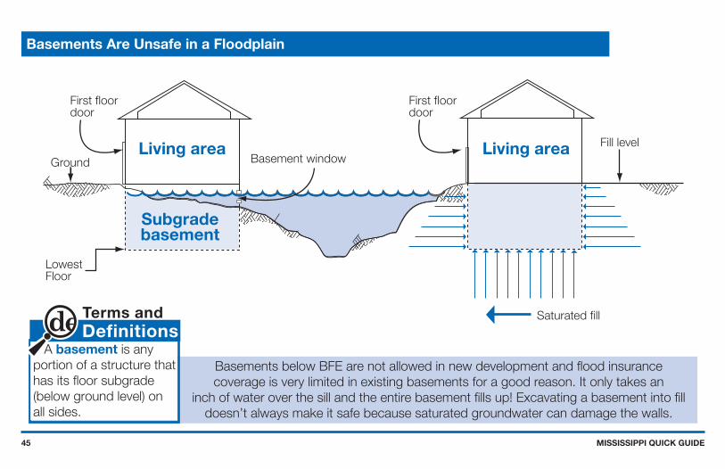
Basements Are Unsafe in a Floodplain
DefinitionsTerms and
A basement is any portion of a structure that has its floor subgrade(below ground level) on all sides.
Basements below BFE are not allowed in new development and flood insurancecoverage is very limited in existing basements for a good reason. It only takes an
inch of water over the sill and the entire basement fills up! Excavating a basement into filldoesn’t always make it safe because saturated groundwater can damage the walls.
First floordoor
First floordoor
Basement windowGround
LowestFloor
Fill level
Saturated fill
Living area
Subgradebasement
Living area

MISSISSIPPI QUICK GUIDE46
Experience shows that manufactured homes are easily damaged. As little
as one foot of water can cause substantial damage.
Dry stacked blocks are not acceptable - they will NOT
withstand a flood.
BFEGround
Helical ground anchors
Secured tobuilt-in frameanchors
Elevatedutilityplatform
Concretefilledblock
#5 metaldowels
8”min.
3- #4reinforcedeach way
Concretefooterbelowfrost line
Manufactured Homes Deserve Special Attention
Manufactured homes must be anchored to resist flotation, collapse, or lateralmovement by being tied down in accordance with the Rules and Regulationsfor the State Uniform Standards Code for the Factory-Built Homes Law,Regulation MH-5, §75-49-1 through §75-49-21, MS Code, 1972, annotated January 1, 2006.

MISSISSIPPI QUICK GUIDE47
Solid perimeter wall foundations can enclose flood-prone space. A crawlspace is a good way to elevatejust a couple of feet. In all cases the following are required: openings/vents, elevated utilities,
flood resistant material, and limitation on use.
Enclosures Below BFE (A Zone Only)
BFE
Crawlspacebuilding
Note:
LowestFloor Interior ground
level at or aboveoutside grade
No more than 1’above ground
At least two floodopenings on different sides
Total opening area is1 sq. in. per sq. ft.A 25’ x 45’ buildingneeds 1125 sq. inchesof openings

MISSISSIPPI QUICK GUIDE48
Typical Elevation Methods for Coastal Construction
In V Zones, design requirements will be determined by your architect or engineer based on your site, includinghow your structure will be elevated and how deep the foundation elements will extend. Your community
will require a V Zone Building and Performance Certificate (see page 49).
Wood or metal piles installed to proper depth Concrete columns on spread footersReinforced masonry or
Elevate on pilings Elevate on columns
BFE
Utilities onplatform
Lowest floorSee details onpage 50

MISSISSIPPI QUICK GUIDE49
The V Zone Certificate
A registered professional engineer or architect must review and/or prepareyour building design, as well as complete the V Zone certification for anynew construction, substantial improvement, or the repair of a substantiallydamaged structure.RESOURCES: Coastal Construction Manual (FEMA 55CD), June 2000; Homebuilders Guideto Coastal Construction (FEMA 499), March 2005; Recommended ResidentialConstruction for the Gulf Coast (FEMA 550), 2006.
3
6 X
ON ,selip doow nevirD
sriats nepo TPECXE snoitcurtsbo
17
16
16
1
2
3
6
CantileveredUtilityPlatform

MISSISSIPPI QUICK GUIDE50
Strap
Clip
Coastal buildings may be exposed to both hurricane winds and floodwaters, so they must be built to holdtogether during storms. The details above are some examples of wind and water resistant construction. Your
architect or engineer will determine the types of conections required for the roof, building, and foundation.
Coastal Structures Must Resist Wind and Water Forces

MISSISSIPPI QUICK GUIDE51
Enclosures Below V Zone Structures
Do not modify an enclosure below an elevated V Zone building! Not only is it a violation of your community’s regulations, but your flood insurance will be very expensive. The floor of the enclosure will become the “bottom floor” or “lowest floor” for insurance and floodplain management purposes (see page 36).
InformationImportant
Avoid building an enclosure under your V Zone structure. If you must enclose a small area, your community will require:
■ Walls must be designed to collapse or “breakaway” under storm and flood conditions.
■ Flood resistant materials.
■ Utility wires and pipes should not go through or be attached to breakaway walls.
■ Enclosed area is to be used only for parking, building access, or storage.
■ No bathrooms, utility rooms, or electric service below BFE.
■ Size limited to 299 square feet (higher regulatory standard) and greater insurance savings.
Floor joists
Breakawaywall
Breakawaywall
Floorsupportbeam
Verticalfoundation member

MISSISSIPPI QUICK GUIDE52
Utility Service for Structures
Whether inside an attached garage or outside the building, all utilities, appliances, and equipment must beelevated above the BFE or protected against flood damage. Utilities include plumbing, electrical, gas lines,
fuel tanks, and heating and air conditioning equipment.
BFE
InformationImportant
GuidanceState SpecificMS
Fuel and propane tanks may cause explosions and pollution risks during flood conditions. Even shallow water can create large buoyant force on tanks, so extra care must be taken to ensure that all tanks are anchored.
Containers of 2,000 gallons of water capacity or less shall not be mounted with the outside bottom of the container shell more than five (5) feet above the surface of the ground.(NFPA #58, Section 6.6.3.1(f))
Fuel or propane tankanchored on platform
Fuel or propane tankanchored to prevent flotation
Heat pump or A/Con platform

MISSISSIPPI QUICK GUIDE53
Post-disaster assessments show that buried septic systems and mounded septic systems in Special FloodHazard Areas are frequently exposed and/or displaced. In addition to compromising their subsequent use, damage to these systems can release their contents. Consequently, they should be located either outside areas subject to erosion during a base flood, or below the depth of expected erosion.
Elevated/mounded septic systems can require significant volumns of fill, which, if placed under or immediately adjacent to buildings, are likely to deflect velocity waters to nearby properties during a storm event.
Septic tanks are regulated by the Mississippi State Department of Health.
Septic Tanks
Plumbing vent
Septic tank
Leachfield/drainfield
Groundwater

MISSISSIPPI QUICK GUIDE54
Accessory (Appurtenant) Structures
Even small buildings are “development” and premits or variances with noted conditions are required. They mustbe elevated, anchored, and built to withstand flood damage.
CAUTION! Remember, Everything inside is likely to get wet when flooding occurs.
DefinitionsTerms and
Accessory (Appurtenant)Structure means a structure that is located on the same parcel of land as a principle structure and whose use is incidental to the use of the principle structure. Accessory structures should be no more than a minimal initial investment, may not be used for human habitation, and must be designed to minimize flood damage. Examples: detached garages, carports, storage sheds, pole barns, and hay sheds.
■ Cannot be modified for a different use in the future
■ Used only for parking or storage
■ Flood openings / vents
■ Built of flood resistant materials
■ Elevated utilities
■ Anchored to resist floating
■ Not habitable
■ Document floor elevationBFE
Elevatedutilities
Flood openings

MISSISSIPPI QUICK GUIDE55
Recreational Vehicles
Camping near the water?Ask the Campground or RV Park operator about flood warnings and plans for safe evacuations.
InformationImportant
In a flood hazard area, an RV must:
■ Be licensed and titled as an RV or park model (not as a permanent residence).
■ Be built on a single chassis.
■ Have inflated tires and be self-propelled or towable by light truck.
■ Have no attached deck, porch, or shed.
■ Be used for temporary recreational camping, travel, or seasonal use (no more than 180 days).
■ Be less than 400 sq ft in area (measured at largest horizontal projection).
■ Have quick-disconnect sewage, water, and electrical connectors.
RVs that do not meet these conditions must be installed and elevated like a manufactured home,including a permanent foundation and tie-down (see page 46).

MISSISSIPPI QUICK GUIDE56
Agricultural Structures
The best flood protection is to elevate agricultural structures, but certain types can be approvedby variance if they are “wet floodproofed”.
Pole frame buildings.
Steel grain bins.
Steel frame corn cribs.
General purpose feeding barnsopen on one side.
Livestock confinement buildings.
Poultry houses.
Dairy Operations.
Other similar livestock operations.
Farm houses are NOTagricultural structures.
GuidanceState SpecificMS
InformationImportant
Non-elevated agricutural structures must be considered on a site-specific basis and may be permitted onlyby variance. Applicants must show that sites are in “wide,expansive floodplain areas” and no other alternative locationoutside of the floodplain exists.
Variances are allowed for:
Variances are not allowed for:

MISSISSIPPI QUICK GUIDE57
Planning to Improve Your Floodplain Structure?
InformationImportant
Floodplain buildings can be improved or altered, but special rules may apply!
If the cost of an addition to a Pre-FIRM structure is less than 50% of it’s market value, only the addition is required to be built above the BFE. Check with your local permit office.
The cost to correct previously cited violations of state or local health, sanitary, or safety codes to provide safe living conditions can be excluded.
Alteration of a registered historic structure is allowed, as long as it will continue to meet the criteria for listing as a registered historic structure.
DefinitionsTerms and
Substantial Improvement means any reconstruction, rehabilitation, addition, or other improvement of a structure, the cost of which equals or exceeds 50% of the market value of the structure before the start of construction of the improvement.
This term includes structures which have incurred Substantial Damage, regardless of the actual repair work performed (see page 58).
Houseelevated oncrawlspace
Before improvementsBuilding market value = $40,500 After improvements
Cost of improvements = $38,000

MISSISSIPPI QUICK GUIDE58
What About After Damage?
A permit is required to repair substantial damage from any cause - Fire, flood, wind, or even a truckrunning into a building. Check with your permit office to be sure.
You will be asked to provided a detailed cost estimate for repairs.For more information about elevating an existing building on crawlspace see page 61.
Pre-damage buildingMarket value = $40,500 Permit/elevation required
Repair = 62%
MISSISSIPPI QUICK GUIDE59
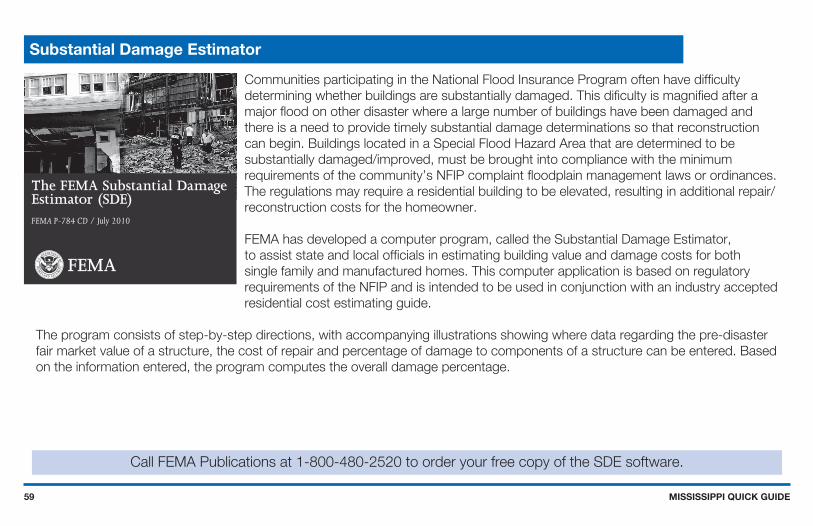
Communities participating in the National Flood Insurance Program often have difficulty determining whether buildings are substantially damaged. This dificulty is magnified after a major flood on other disaster where a large number of buildings have been damaged and there is a need to provide timely substantial damage determinations so that reconstruction can begin. Buildings located in a Special Flood Hazard Area that are determined to be substantially damaged/improved, must be brought into compliance with the minimum requirements of the community’s NFIP complaint floodplain management laws or ordinances. The regulations may require a residential building to be elevated, resulting in additional repair/reconstruction costs for the homeowner.
FEMA has developed a computer program, called the Substantial Damage Estimator, to assist state and local officials in estimating building value and damage costs for both single family and manufactured homes. This computer application is based on regulatory requirements of the NFIP and is intended to be used in conjunction with an industry accepted residential cost estimating guide.
The program consists of step-by-step directions, with accompanying illustrations showing where data regarding the pre-disaster fair market value of a structure, the cost of repair and percentage of damage to components of a structure can be entered. Based on the information entered, the program computes the overall damage percentage.
Call FEMA Publications at 1-800-480-2520 to order your free copy of the SDE software.
Substantial Damage Estimator
The FEMA Substantial DamageEstimator (SDE)FEMA P-784 CD / July 2010

MISSISSIPPI QUICK GUIDE60
Increased Cost of Compliance, or ICC, coverage is part of most Standard Flood Insurance Policies. Claims for ICC benefits are filed separately from your claim for contents or building loss. If eligible, you can collect up to $30,000 to help cover the cost of bringing your home or business into compliance with current flood damage prevention ordinance.
You are eligible to file for ICC if your property is in a SFHA and if your community Floodplain Administrator determines one of the following:
Your property is “substantially damaged” by flooding.. This means that your community says the cost to repair your flooded building is 50 percent or more of its pre-disaster market value.
Your property sustained “repetitive damage.” This term applies to homes or businesses that were damaged by flooding twice in the past 10 years, where the cost of repairing the flood damage, on average, equaled or exceeded 25 percent of the property market value at the time of each flood. Also, there must have been flood insurance claim payments for each
of the two flood losses, and the community’s flood damage prevention ordinance must have a repetitive loss provision.
ICC funding can be used to elevate or demolish homes, relocate them to higher ground, or floodproofing of non-residential structures. Also, when participating in a community sponsored, FEMA funded mitigation project, the policyholder may assign ICC benefits to the community to integrate into the project. The community then becomes responsible for submitting all of the appropriate paperwork.
Paying for Post Flood Compliance - ICC
Detailed information on ICC is available at www.fema.gov/plan/prevent/floodplain/ICC.shtm and in the FEMApublication Interim Guidance for State and Local Officials - Increased Cost of Compliance Coverage (FEMA 301).
Elevate
Floodproof
Relocate Demolish

MISSISSIPPI QUICK GUIDE61
Elevating a Pre-FIRM Structure
This one way to elevate an existing building to comply with floodplain regulations.The state and FEMA can help with more information and options.
The finished project
The foundation wallsare extended as thehouse is raised, andpermanent openings
for floodwaterare created
After openings aremade in the foundationwalls, steel I-beams are
installed below thefloor joists
Existingfloorjoists
Originalgroundsurface
Temporarysteel liftingbeam
Jack Openings cut for I-beams
Existing foundation wall
Existing floor
Temporary steelsupport beams
I-beam openings filledwith concrete block
Newpermanent openingsfor floodwaters Newly extended
foundation wall
Floodlevel
Depending on finalheight of extended
foundation, areaunder house may be
used for parking,storage, or access

MISSISSIPPI QUICK GUIDE62
Small Levees and Floodwalls Can Protect Pre-FIRM Structures
In areas where flood waters are not expected to be deep, sometimes individual building can be protected byearthen leeves or concrete floodwalls. You must get a permit for those protection measures, and extra
care must be taken if the site is in a floodway (see pages 41 and 42). A berm or floodwall cannot be used toprotect a new or substantially improved structure, or one that is repaired after substantial damage.
IMPORTANT! These protective measures WILL NOT reduce your flood insurance premium!
Earthen berm
Sump and pump for internal drainage Sewer backflow valve
Concrete floodwall

MISSISSIPPI QUICK GUIDE63
Authorized under Section 404 of the Stafford Act, the Hazard Mitigation Grant Program, administered by the Federal Emergency Management Agency, provides grants to states, and states provide subgrants to eligible applicants, to implement long-term hazard mitigation measures after a major disaster declaration. The purpose of the program is to reduce the loss of life and property due to natural disasters and to enable mitigation measures to be implemented during the immediate recovery from a disaster.
Participation in HMGP acquisition projects is totally voluntary: jurisdictions are not required to apply for funds and homeowners are not required to sell. Funding is 75% federal share, 25% non-federal share. The program is administered by Emergency Management. Eligible HMGP project applicants include state agencies, county and city governments, certain private non-profit organizations and indian tribes or authorized tribal organizations. Individuals must work through their local government.
Acquisition and demolition of substantially damaged buildings located in the Special Flood Hazard Area is the first priority for HMGP project funding in Mississippi because it is a permanent mitigation solution to the potential future risk of damage from the 1% or greater annual chance flood. HMGP is the primary funding source to purchase substantially damaged property in the SFHAs.
Communities offer to buy private property at pre-disaster fair market value and clear the land. Properties that have been damaged or even completely destroyed can still be purchased at pre-disaster fair market value. All structures purchased are demolished and the deed to HMGP acquired land must contain a restriction ensuring that the community owned land remains in perpetuity as open space.
Limited funding for acquisitions is also available in other FEMA Hazard Mitigation Assistance grant programs. For more information go to: www.fema.gov/government/grant/fs_mit_grant_prog.shtm.
Floodprone Property Acquisition Projects

MISSISSIPPI QUICK GUIDE64
Mitigation Projects
Some projects are more costlythan others - but can provide more protection.
After floods, some communities demolish and re-build structures that were severely damaged. Structures havebeen lifted up on higher foundations, and others have been moved to safer high ground.
When participating in a community sponsored, FEMA funded mitigation Project, the policyholder may assign ICCbenefits to the community to integrate into the project. The community then becomes responsible for
submitting all of the appropriate paperwork.

MISSISSIPPI QUICK GUIDE65
Common Acronyms
ARC - American Red Cross
BFE - Base Flood Elevation
EC - Elevation Certificate
FEMA - Federal Emergency Management Agency
FIRM - Flood Insurance Rate Map
FIS - Flood Insurance Study
ICC - Increased Cost of Compliance
MEMA - Mississippi Emergency Management Agency
NFIP - National Flood Insurance Program
SFHA - Special Flood Hazard Area
Useful Resources
Internet Links
Family Disaster Planningwww.redcross.org/services/disaster
Repairing Your Flooded Home, ARC and FEMAwww.fema.gov/rebuild/recover/resources.shtm
MEMA Floodplain Managementwww.msema.org
NFIP Publicationswww.fema.gov/business/nfip/libfacts.shtm

MISSISSIPPI QUICK GUIDE66
■ For flood information and permitting, call your community’s building permit office, planning department, or the NFIP State Coordinator at (601) 933-6884.
■ Information is available from MEMA on the internet at www.msema.org.
■ For information about flood reduction programs, call the State Hazard Mitigation Officer at (601) 933-6884.
■ To order FEMA flood maps, learn more about flood maps, and the Status of Map Change Requests call FEMA’s Map Service Center at 1(800) 358-9616 or order online at www.msc.fema.gov/.
■ Order printed copies of FEMA publication from the FEMA Distribution Center at 1(800) 480-2520.
■ FEMA’s has publications online; many are posted in Portable Document Format (.PDF). For more information visit www.fema.gov.
■ To learn about flood insurance, call your insurance agent. Most insurance companies can write an NFIP policy for you. If you need more help, call the National Flood Insurnace Program’s toll free number, 1(800) CALL FLOOD, ext.445, to get the name of an agent in your area who does write flood insurance.
■ To get the best flood insurance rates, call a local surveyor to complete an Elevation Certificate.
Want to Learn More?