interpreting federal emergency management … federal emergency management agency flood ......
TRANSCRIPT

Interpreting Federal Emergency Management Agency Flood Maps and
Studies in the Coastal Zone
Rebecca Haney Coastal Geologist MA CZM
John Grace Coastal Engineer FEMA Region 1

flooding storm surge
Storm Effects
overwash erosion


Overview of Guidance Document
• Flood zone definitions • How flood zones are mapped • Flood Insurance Rate Map (FIRM) updates • Limitations of FIRMs • Delineating flood zones on site plans • State Standards • Beyond the FIRMs: When to consider additional
information • Requesting changes to FIRMs

National Flood Insurance Program • FEMA produces Flood Insurance
Studies (FIS) and Flood Insurance Rate Maps (FIRMs) for the National Flood Insurance Program (NFIP)
• The FIS and FIRMs identify the areas where communities must regulate development to participated in the NFIP
• The FIS and FIRMs are used to determine where flood insurance is required as a condition of a federally insured loan, and to determine flood insurance rates and premiums.

Base Flood
• The flood having a one percent chance of being equaled or exceeded in a given year. – Also known as the 100 year flood, 1%-annual-
chance flood, special flood hazard area. • Base floodplain is identified on the FIRM
as A Zone (A, AE, AH, AO) or V Zone (V, VE)

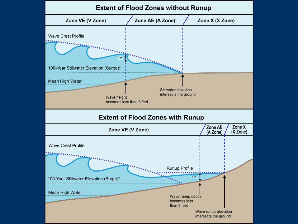
FEMA Flood Zone Definitions • Zone VE (V1-30) – Areas of 100-year coastal flood with velocity waves
Wave height 3 feet or greater Wave runup depth 3 feet or greater Within primary frontal dune (first dune landward of the beach)
• Zone AE (A1-30) – Areas of 100-year flood; flood elevations May be coastal or riverine Coastal can contain up to 2.9 feet wave height Coastal flood elevations at top of wave envelope
• Coastal A Zone (MoWA) – Portion of A Zone with 1.5 – 3.0’ waves. Separated from the rest of the A Zone by the LiMWA
• Zone AO – “Overwash” areas with flow depths of 1 to 3 feet Generally coastal with sloping ground Flow velocities can vary greatly Flow paths are typically not well defined
• Zone A – Areas of 100-year flood; NO flood elevations given • Shaded Zone X (B) – Areas of 500-year flood • Unshaded Zone X (C) – “Areas of minimal flooding”

Coastal A Zones • Coastal A Zone is a subset of the A Zone,
separated from the rest of the A Zone by the Limit of Moderate Wave Action (LiMWA)
• FEMA has determined that buildings built to traditional A Zone standards receive structural damage under these conditions.
• MA Coastal A Zone Maps refine the delineations on the FIRMs to reflect the most current FEMA guidance for mapping Coastal A Zones.
• The proposed 9th Edition State Building Code adopts more stringent standards for Coastal A Zones.

FEMA Flood Zones
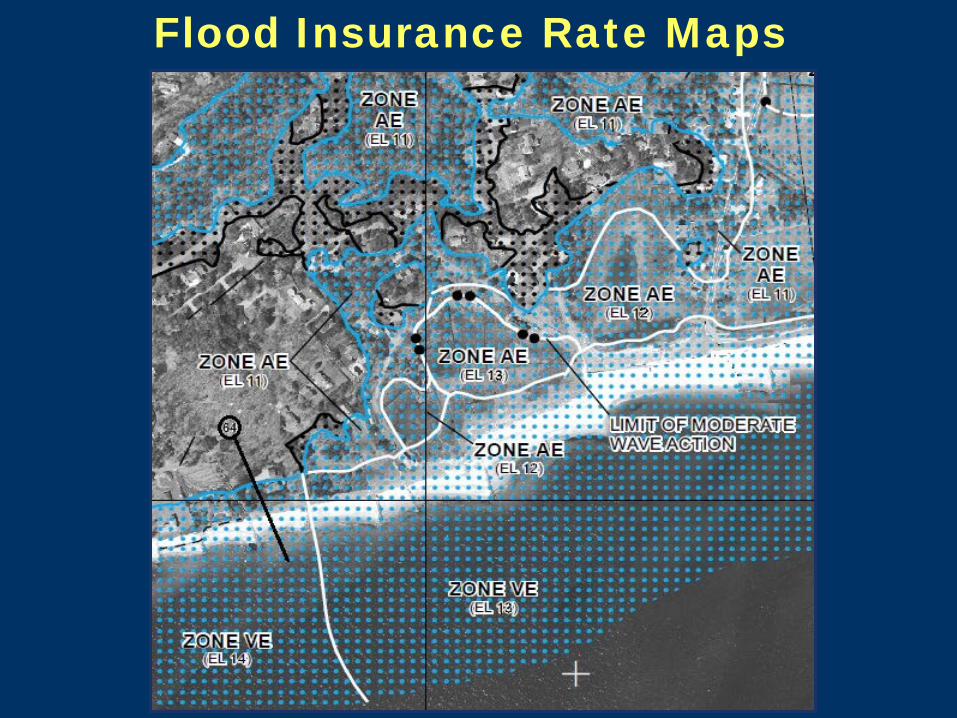
Flood Insurance Rate Maps
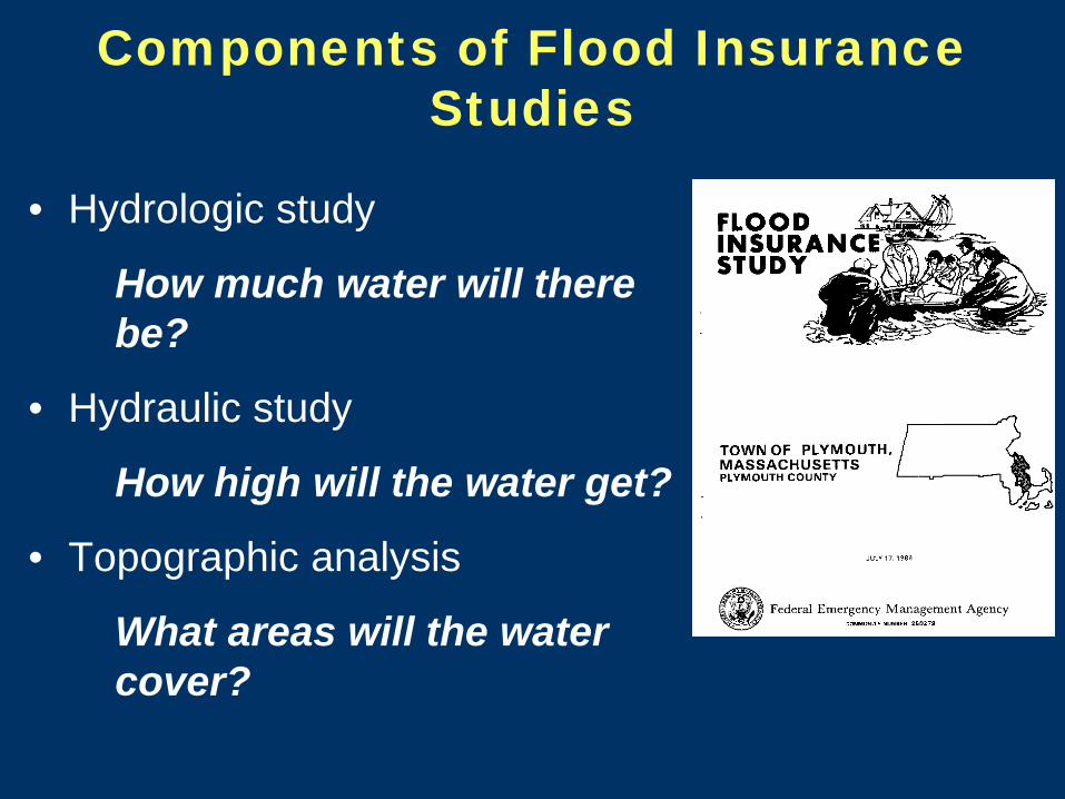
Components of Flood Insurance Studies
• Hydrologic study
How much water will there be?
• Hydraulic study
How high will the water get?
• Topographic analysis
What areas will the water cover?

Detailed Study – Coastal Analysis
• Stillwater Level (storm surge) + Wave Set-up • Overland Wave Propagation • Wave Runup and Overtopping • Primary Frontal Dune
Coastal analysis - includes 4 main components:

General Points to Consider • Maps are a graphic representation of engineering data
• Detailed information generated only at specific locations
• Effective maps may not have all current techniques incorporated
Graphic: FEMA
Transect

Different Levels of Updates • Conversion
– Digital format – New datum
• Redelineation – Use new topography to redraw boundaries
• Restudy – Revised analysis/new flood study (typically done for a portion of a community or
county) • Refer to the Flood Insurance Study to determine
what was done when.

Delineating (or Reviewing a Delineation of) Flood Zones on Site Plans
V Zone/A Zone boundary • Can’t be determined by ground elevation • Must use the location of the boundary on the FIRM • What is shown on the FIRM can be based on:
– Wave height – Wave runup – Splash zone behind a coastal engineering
structure (typically 30’ from the seaward face) – Primary Frontal Dune
• Use the same technique to delineate the LiMWA line


Delineating (or Reviewing Delineation of) Flood Zones on Site Plans
A Zone/X Zone boundary (landward extent of 1% chance flood)
• Use flood and ground elevations – Use same datum for all elevations
• Newer FIRMs typically referenced to NAVD 88 – Use best available topography (e.g., site survey,
LIDAR) – Flood elevation of the most landward flood zone – BFE on FIRMs is rounded to the nearest foot – Stillwater or Total Water Level is provided to the
nearest tenth in the FIS

Delineating (or Reviewing Delineation of) Flood Zones on Site Plans
• A/X Boundary continued • Identify the BFE on the FIRM for the most landward A
Zone • Look at the Total Water Level number in the FIS • If the number for TWL can be rounded to the whole
number BFE on the FIRM, then use the higher of these two numbers.
• If the TWL cannot be rounded to the BFE on the FIRM, then compare the BFE to the stillwater level without setup. If the SWL can be rounded to the BFE, use the higher of the two.
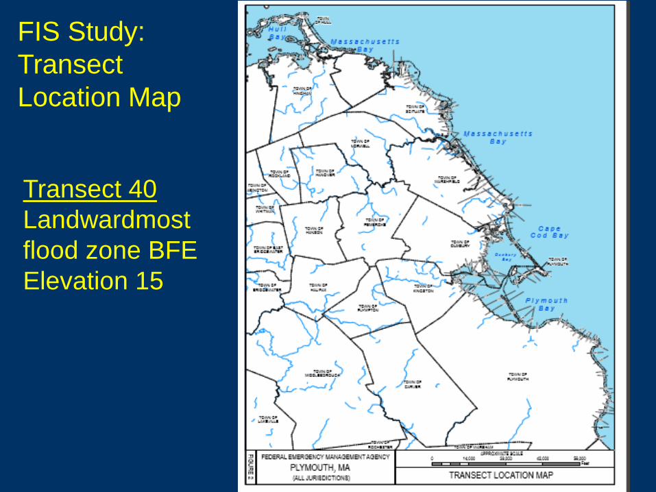
FIS Study: Transect Location Map
Transect 40 Landwardmost flood zone BFE Elevation 15

Base Flood Elevation = 15 Total Water Level from FIS = 15.3

Landwardmost flood zone elevation 15 Total Water Level from FIS = 15.6 Stillwater level = 9.5

Delineating (or Reviewing Delineation of) Flood Zones on Site Plans
• A/X Boundary continued • Identify the BFE on the FIRM for the most landward A
Zone AE Elevation 15 • Look at the Total Water Level number in the FIS 15.3 • If the number for TWL can be rounded to the whole
number BFE on the FIRM, then use the higher of these two numbers. Yes, use 15.3
• If the TWL cannot be rounded to the BFE on the FIRM, then compare the BFE to the stillwater level without setup. If the SWL can be rounded to the BFE, use the higher of the two.

Delineating (or Reviewing a Delineation of) Flood Zones on Site Plans
“Invisible A Zone”

State Standards • Massachusetts 8th Edition Building Code
– Use effective FIRMs • Proposed 9th Edition Code
– Use preliminary FIRMs after Letter of Final Determination issued by FEMA
• Title 5 – Use effective or preliminary FIRMs, except in
primary frontal dunes • Wetlands Protection Act Regulations
– Use best available information for determining the extent of Land Subject to Coastal Storm Flowage, including effective and preliminary FIRMs, current landform condition, credible information regarding the extent of flooding.

When to Consider Additional Information
LSCSF: land subject to any inundation caused by coastal storms up to and including that caused by the 100-year storm, surge of record or storm of record, whichever is greater.
Use best professional judgment to determine whether
information submitted is credible – Photographs that show flooding with recognizable
landmark – Field measurements and engineering data
overlain on topographic data, with cross-sections.

Primary Frontal Dunes • First dune along the
shoreline. • By FEMA definition,
the Velocity Zone includes the entire primary frontal dune
• Most FIRMs updated to include pfds.
• Use the flood zone on the FIRMs unless the landform has changed significantly since the detailed analysis was conducted.

FEMA Erosion Assessment
Primary frontal dune < 540 ft2
Primary frontal dune > 540 ft2
5-28
• Current Zone V mapping procedures require that a dune have a minimum frontal dune reservoir (seaward cross-section of dune above 100-year stillwater level) of 540 square feet (ft2) to withstand erosion during base flood.
• FEMA P-55 recommends a frontal dune reservoir of at least 1,100 ft2
to prevent dune removal during base flood.
Graphic: FEMA

Additional Sources of Information • Massachusetts
Shoreline Change Project
• National Weather Service Sea Lake and Overland Surge from Hurricanes (SLOSH)
• Sea Level Rise guidance
• StormSmart Coasts Assessing Vulnerability of Coastal Areas

Requesting a Change to FIRMs
• Letter of Map Amendment (LOMA) – Interpretation of what the current FIRM depicts for
a specific site • Letter of Map Revision (LOMR)
– Request to change the FIRM based on new, site-specific data and engineering analysis.
• Do not use a flood zone less restrictive than the FIRM until the written LOMC decision is issued by FEMA. – https://www.fema.gov/change-flood-zone-
designation-online-letter-map-change

Acknowledgements
Co-authored by Richard Zingarelli, former NFIP Coordinator for the Department of Conservation and Recreation, Flood Hazard Management Program
Received technical input from FEMA Region 1 Printing funded by a FEMA Hazard Mitigation Grant,
Award No. HMGP 1895-08

Resources • FEMA Effective, Preliminary, Pending & Historic Flood
Maps, Letters of Map Change and Flood Studies: https://msc.fema.gov/
• Flood Map Changes – https://www.fema.gov/change-flood-zone-designation-online-letter-map-change
• StormSmart Coasts: http://stormsmartcoasts.org – Sea Level Rise Guidance
http://www.mass.gov/eea/docs/czm/stormsmart/slr-guidance-2013.pdf
– Interpreting Federal Emergency Management Agency Flood Maps and Studies in the Coastal Zone
http://www.mass.gov/eea/agencies/czm/program-areas/stormsmart-coasts/interpreting-fema-maps.html
• Sea Lake and Overland Surges from Hurricanes (SLOSH) http://www.nhc.noaa.gov/surge/slosh.php


Coastal Flood Analysis • Stillwater elevation: predicted elevation of water, including storm surge • Wave runup: height above stillwater reached by swash (including surge) • Wave setup: elevated water level associated with waves coming ashore, but not fully receding.