2010 annual report - alaska department of natural resources
TRANSCRIPT

ROCK CREEK MINE &
BIG HURRAH PROJECT
2010 ANNUAL REPORT
Submitted To:
Alaska Department of Environmental Conservation
&
Alaska Department of Natural Resources
Submitted By:
Alaska Gold Company P.O. Box 640 Nome, Alaska 99762 March 1, 2011

2010 ADEC & ADNR Annual Report
Alaska Gold Company
Rock Creek Mine and Big Hurrah Project Page i
Contents
1.0 Introduction 1
2.0 Project Overview 4
2.1 Rock Creek Mine 4
2.2 Big Hurrah Site 8
2.3 Environmental Policy 8
2.4 Regulatory Requirements 8
2.4.1 WMP No. 2003-DB0051 10
2.4.2 RPA No. F20069578 10
3.0 Rock Creek Mine Activities 11
3.1 Disturbance and Reclamation 11
3.2 Development Rock Stockpiles 11
3.3 Organic Stockpiles 12
3.4 Paste Tailings Storage Facility 12
3.5 Solid Waste Landfill 13
3.6 Inspections 14
3.7 TSF Seepage Collection System 14
3.8 Land Application 14
3.9 Recycle Water Pond 17
4.0 Storm Water Management 17
5.0 Water Treatment Plant 23
6.0 Injection Well Field 23
7.0 Reportable Spills 25
8.0 Monitoring (Analytical) 26
8.1 Contained Water 27
8.1.1 Tailings Storage Facility 28
8.1.2 Recycle Water Pond 28
8.1.3 TSF Seepage Collection System 29
8.1.4 Pit Lake 29
8.2 Surface Water 29
8.2.1 Rock Creek Mine 30
8.2.2 Big Hurrah 31
8.3 Groundwater 32
8.3.1 TSF Monitoring Wells 32
8.3.2 RWP Monitoring Wells 35
8.3.3 IWF Monitoring Wells 35
8.3.4 Other Groundwater Monitoring Wells 36
8.4 Water Treatment Plant 36
8.5 Cyanide Monitoring of Tailings 38
8.6 Development Rock Stockpile Seepage Analysis 38
8.7 Geochemical Characterization 38
8.8 Other Water Quality Monitoring 38
9.0 Visual Monitoring 38
9.1 Tailings Storage Facility 39
9.1.1 TSF Dam 39

2010 ADEC & ADNR Annual Report
Alaska Gold Company
Rock Creek Mine and Big Hurrah Project Page ii
9.1.2 TSF Seepage Collection System 39
9.1.3 Thickener 40
9.1.4 Support Structures 40
9.1.5 Water Surface 40
9.2 Recycle Water Pond 41
9.2.1 Leak Collection and Recovery System 41
9.2.2 Water Surface 42
9.2.3 Pond Liner 43
9.3 Monitoring Wells 43
9.3.1 Visual Inspections 44
9.3.2 Groundwater Elevations 44
9.4 Pit Dewatering Wells 49
9.5 SPCC - Containment 49
9.6 Air Quality 49
9.7 Wildlife 50
10.0 Financial Responsibility 50
11.0 References 50
Tables
Table 1: Reporting Requirements 2
Table 2: Regulatory Instruments 9
Table 3: Disturbed and Reclaimed Area 11
Table 4: Rock Creek Organic Stockpile Volumes 12
Table 5: Daily Land Application Rates 15
Table 6: Reportable Spills 26
Table 7: Water Chemistry Parameters 27
Table 8: Contained Water Sampling Locations 28
Table 9: Surface Water Sampling Locations at Rock Creek 30
Table 10: Surface Water Summary 30
Table 11: Surface Water Sampling Locations at Big Hurrah 32
Table 12: Rock Creek Groundwater Sample Locations 32
Table 13: TSF Monitoring Well Summary 33
Table 14: IWF Monitoring Well Summary 36
Table 15: Groundwater Monitoring Well Locations 44
Figures
Figure 1: Rock Creek Mine and Big Hurrah Site Regional Location 4
Figure 2: Rock Creek Site Map 6
Figure 3: Rock Creek Mine Mill Facilities 7
Figure 4: Land Application Area 16
Figure 5: Rock Creek Mine SWPPP Structures 18
Figure 6: Rock Creek Realignment Project Photo 20

2010 ADEC & ADNR Annual Report
Alaska Gold Company
Rock Creek Mine and Big Hurrah Project Page iii
Figure 7: Rock Creek Realignment Project Photo 20
Figure 8: Rock Creek Realignment Project Photo 20
Figure 9: Rock Creek Realignment Project Photo 20
Figure 10: Rock Creek Mine Hydroseeding Area Map 22
Figure 11: Rock Creek Mine Injection Well Field Map 25
Figure 12: Main Sump + South Sump Combined Flow Data 40
Figure 13: TSF Pond Elevation Change 41
Figure 14: RWP Hydrologic Data 43
Figure 15: Lower IWF Groundwater Elevations 46
Figure 16: Upper IWF Groundwater Elevations 47
Figure 17: Recycle Water Pond Groundwater Elevations 48
Figure 18: TSF Groundwater Elevations 49
Appendices
Appendix A: Water Chemistry Data
Appendix B: RWP Flow Data
Appendix C: Injection Rate Data
Appendix D: Sump Flow Data
Appendix E: WTP Flow Data
2010 ADEC & ADNR Annual Report
Alaska Gold Company
Rock Creek Mine and Big Hurrah Project Page iv
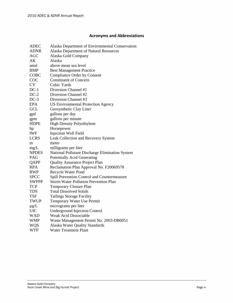
Acronyms and Abbreviations ADEC Alaska Department of Environmental Conservation
ADNR Alaska Department of Natural Resources
AGC Alaska Gold Company
AK Alaska
amsl above mean sea level
BMP Best Management Practice
COBC Compliance Order by Consent
COC Constituent of Concern
CY Cubic Yards
DC-1 Diversion Channel #1
DC-2 Diversion Channel #2
DC-3 Diversion Channel #3
EPA US Environmental Protection Agency
GCL Geosynthetic Clay Liner
gpd gallons per day
gpm gallons per minute
HDPE High Density Polyethylene
hp Horsepower
IWF Injection Well Field
LCRS Leak Collection and Recovery System
m meter
mg/L milligrams per liter
NPDES National Pollutant Discharge Elimination System
PAG Potentially Acid Generating
QAPP Quality Assurance Project Plan
RPA Reclamation Plan Approval No. F20069578
RWP Recycle Water Pond
SPCC Spill Prevention Control and Countermeasure
SWPPP Storm Water Pollution Prevention Plan
TCP Temporary Closure Plan
TDS Total Dissolved Solids
TSF Tailings Storage Facility
TWUP Temporary Water Use Permit
µg/L micrograms per liter
UIC Underground Injection Control
WAD Weak Acid Dissociable
WMP Waste Management Permit No. 2003-DB0051
WQS Alaska Water Quality Standards
WTP Water Treatment Plant
2010 ADEC & ADNR Annual Report
Alaska Gold Company
Rock Creek Mine and Big Hurrah Project Page 1
1.0 Introduction
This annual report has been prepared by Alaska Gold Company (AGC), a wholly owned
subsidiary of NovaGold Resources, Inc. (NovaGold), in accordance with Section 1.9 of Alaska
Department of Environmental Conservation (ADEC) Waste Management Permit (WMP) No.
2003-DB0051 and Alaska Department of Natural Resources (ADNR) Reclamation Plan
Approval (RPA) No. F20069578. For purposes of efficiency and avoiding duplication, AGC has
prepared one annual report to address the requirements of both the WMP and RPA. This report
is based solely on information generated by AGC.
Although the Rock Creek Mine and Big Hurrah site are permitted jointly, the two are located
over 40 miles apart. In 2010, activities were focused on the Rock Creek Mine with only minor
activities involving surface water sampling conducted at the Big Hurrah site over the same
period. Accordingly, this annual report primarily summarizes activities at the Rock Creek Mine.
The Rock Creek Mine was placed into Care and Maintenance status in November 2008
continuing through 2010. The following activities took place at the Rock Creek Mine in 2010:
All development rock generated was used for construction purposes; no development
rock stockpiles were constructed.
Upgraded components of the Storm Water Management System, including diversion
channels. Specifically, the pre-mining flows in Rock and Albion creeks were restored.
Updated the Storm Water Pollution Prevention Plan (SWPPP).
Disposed of approved wastes in the Rock Creek inert solid waste landfill in accordance
with WMP.
Continued injection of treated mine wastewater from the Tailings Storage Facility (TSF).
Plugged and abandoned one injection well (Well #25).
Continued seasonal land application of TSF water using evaporative sprayers, trade
named Land Sharks.
Operated the Water Treatment Plant (WTP) providing more than 500 gallons per minute
(gpm) treatment capacity and ensuring long-term compliance with effluent limits for
injected water.
Continued surface and groundwater monitoring programs, including analytical sampling
and visual inspections.
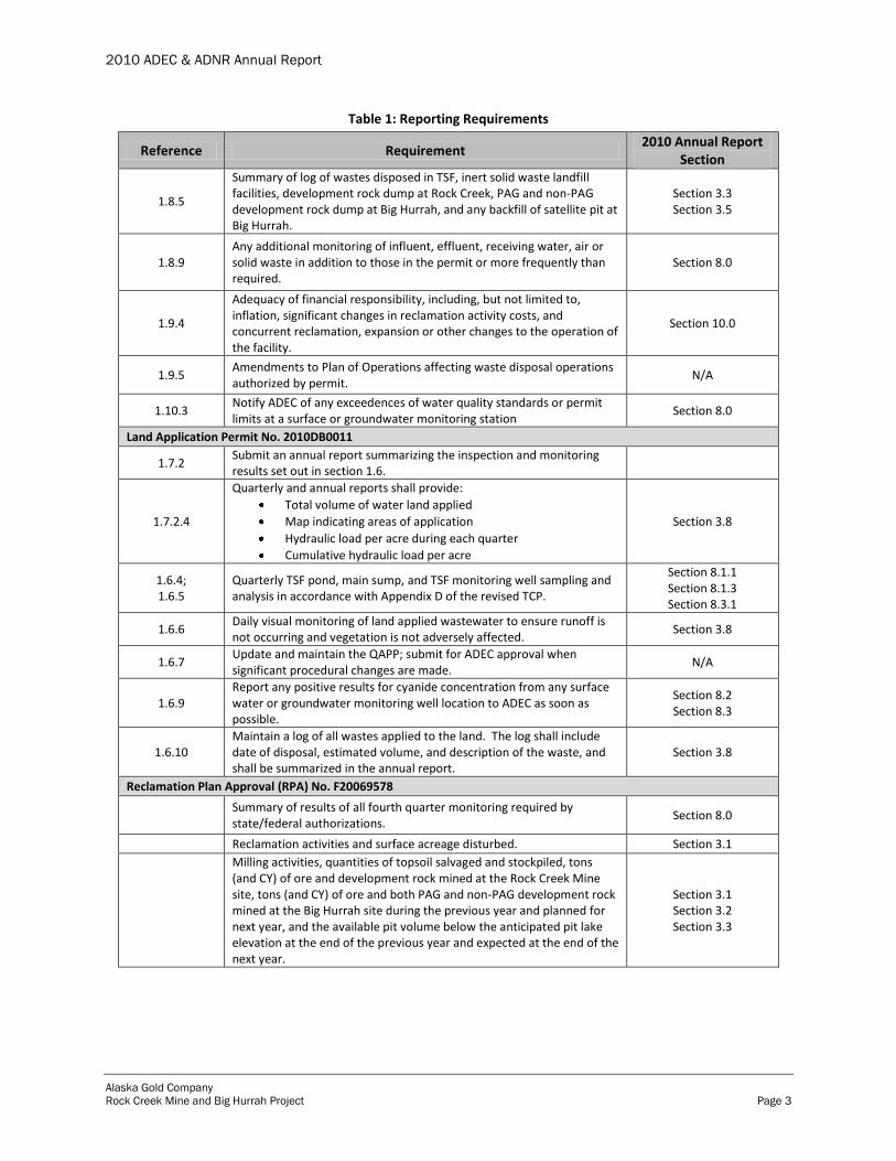
Table 1 summarizes WMP and RPA reporting requirements and the relevant sections of this
report containing additional discussions of AGC’s compliance with each.

2010 ADEC & ADNR Annual Report
Alaska Gold Company
Rock Creek Mine and Big Hurrah Project Page 2
Table 1: Reporting Requirements
Reference Requirement 2010 Annual Report
Section
Waste Management Permit (WMP) No. 2003-DB0051
1.9.1 Submit an annual report summarizing the inspection and monitoring results set out in Section 1.8:
1.8.1.1
Weekly visual monitoring: Signs of damage at facilities; above-grade portions of groundwater
monitoring devices; visible portions of liners; containment structures and retaining walls; erosion control/diversion structures; waste escaping or leachate; unauthorized waste disposal; violations of permit conditions.
As per Certificate of Reasonable Assurance (AK 0605-05AA), Item (8): Include monitoring of adequacy and effectiveness of Storm Water Management Best Management Practices in weekly visual monitoring required in the WMP.
Section 9.0
1.8.1.2 Surface water monitoring near the sites to ensure that water quality standards are not exceeded outside the waste management areas.
Section 8.2
1.8.1.3 Quarterly groundwater/seep sampling and analyses. Section 8.3
1.8.1.4 Monitoring of treated pit dewatering wastewater prior to injection to ensure permit limits are met.
Section 8.4
1.8.1.5 Geochemical monitoring of development rock and tailings samples from Rock Creek Mine to ensure that there is low potential for production of leachate that is acidic and/or contains elevated levels of metals.
Section 8.7
1.8.1.6 Monitoring of paste tailings prior to placement in the TSF (and water recycled to the TSF or contained in the recycle water pond) to ensure that limitations in Sections 1.2.3 and 1.2.4 are met.
1
Section 8.5
1.8.1.7 Geochemical monitoring of development rock produced at Big Hurrah designed to detect and segregate PAG development rock as per Section 1.7.1.2.
Section 8.7
1.8.1.8 Monitoring of seepage, leachate, runoff and downgradient groundwater of the PAG development rock storage area.
N/A2
1.8.1.9 Fluid management monitoring plan including a water accounting of the quantity of seepage through the TSF and treated pit dewatering wastewater discharged to the injection wells.
Section 3.5.2 Section 3.7 Section 3.6
1.8.1.10 Wildlife monitoring as required in Section 1.4.16. Section 9.7
1.8.1.11 Water quality monitoring of the recycle water pond. Section 9.2
1.8.2.2 Submit updated QAPP annually (or whenever changes to methods or labs used occur).
Section 8.0
1.8.2.4 Inspections of TSF in conformance with Operations, Maintenance and Emergency Action Manual approved by ADNR.
Section 9.1
1.8.4 Samples from any groundwater well or surface water monitoring location that had a positive result for cyanide (previously reported to ADEC).
Section 8.0
1 The requirements outlined in WMP Section 1.8.1.6 have been modified in the above table to include water recycled to the TSF or contained in the RWP. Section 1.8.1.6 states to monitor paste tailings to ensure the limitations in Sections 1.2.3 and 1.2.4 are met. Section 1.2.4 refers to
cyanide limitations on recycled water.
2 Monitoring of seepage, leachate, runoff, and downgradient groundwater of the PAG development rock storage area will be implemented when this development rock storage area is constructed.
2010 ADEC & ADNR Annual Report
Alaska Gold Company
Rock Creek Mine and Big Hurrah Project Page 3
Table 1: Reporting Requirements
Reference Requirement 2010 Annual Report
Section
1.8.5
Summary of log of wastes disposed in TSF, inert solid waste landfill facilities, development rock dump at Rock Creek, PAG and non-PAG development rock dump at Big Hurrah, and any backfill of satellite pit at Big Hurrah.
Section 3.3 Section 3.5
1.8.9 Any additional monitoring of influent, effluent, receiving water, air or solid waste in addition to those in the permit or more frequently than required.
Section 8.0
1.9.4
Adequacy of financial responsibility, including, but not limited to, inflation, significant changes in reclamation activity costs, and concurrent reclamation, expansion or other changes to the operation of the facility.
Section 10.0
1.9.5 Amendments to Plan of Operations affecting waste disposal operations authorized by permit.
N/A
1.10.3 Notify ADEC of any exceedences of water quality standards or permit limits at a surface or groundwater monitoring station
Section 8.0
Land Application Permit No. 2010DB0011
1.7.2 Submit an annual report summarizing the inspection and monitoring results set out in section 1.6.
1.7.2.4
Quarterly and annual reports shall provide:
Total volume of water land applied
Map indicating areas of application
Hydraulic load per acre during each quarter
Cumulative hydraulic load per acre
Section 3.8
1.6.4; 1.6.5
Quarterly TSF pond, main sump, and TSF monitoring well sampling and analysis in accordance with Appendix D of the revised TCP.
Section 8.1.1 Section 8.1.3 Section 8.3.1
1.6.6 Daily visual monitoring of land applied wastewater to ensure runoff is not occurring and vegetation is not adversely affected.
Section 3.8
1.6.7 Update and maintain the QAPP; submit for ADEC approval when significant procedural changes are made.
N/A
1.6.9 Report any positive results for cyanide concentration from any surface water or groundwater monitoring well location to ADEC as soon as possible.
Section 8.2 Section 8.3
1.6.10 Maintain a log of all wastes applied to the land. The log shall include date of disposal, estimated volume, and description of the waste, and shall be summarized in the annual report.
Section 3.8
Reclamation Plan Approval (RPA) No. F20069578
Summary of results of all fourth quarter monitoring required by state/federal authorizations.
Section 8.0
Reclamation activities and surface acreage disturbed. Section 3.1
Milling activities, quantities of topsoil salvaged and stockpiled, tons (and CY) of ore and development rock mined at the Rock Creek Mine site, tons (and CY) of ore and both PAG and non-PAG development rock mined at the Big Hurrah site during the previous year and planned for next year, and the available pit volume below the anticipated pit lake elevation at the end of the previous year and expected at the end of the next year.
Section 3.1 Section 3.2 Section 3.3

2010 ADEC & ADNR Annual Report
Alaska Gold Company
Rock Creek Mine and Big Hurrah Project Page 4
Table 1: Reporting Requirements
Reference Requirement 2010 Annual Report
Section
As built map submitted with annual report showing current development of all facilities within project area described in the Rock Creek Mine Plan of Operations Volume 4, including cleared and grubbed areas, topsoil or growth medium stockpiles, roads, PAG and non-PAG waste rock dumps, material sites, tailings facility, facility construction, and un-reclaimed exploration disturbance.
Section 2.1
Adequacy of financial responsibility - inflation, changes in reclamation cost, concurrent reclamation, expansion or other changes to operation of facility.
Section 10.0
2.0 Project Overview
The Rock Creek Mine and Big Hurrah site are located on the Seward Peninsula along the west
coast of Alaska (figure 1).
Figure 1: Rock Creek Mine and Big Hurrah Site Regional Location
2.1 Rock Creek Mine
The Rock Creek Mine is located approximately six miles north of Nome in the Snake River
drainage on private lands owned by Sitnasuak Native Corporation (surface rights), Bering Straits
2010 ADEC & ADNR Annual Report
Alaska Gold Company
Rock Creek Mine and Big Hurrah Project Page 5
Native Corporation (sub-surface rights), and AGC. Mine facilities currently include an open pit,
TSF, explosive storage areas, injection well field (IWF), organic stockpiles, storm water
diversion channels, and mine roads (figure 2). Support facilities include the mill/gold recovery
plant, maintenance shop, administration and mine dry buildings, warehouse, WTP, reagent
storage locations, recycle water pond (RWP), and fuel storage locations (figure 3).
While in Care and Maintenance status, the Rock Creek Mine operates two 12-hour shifts per day,
365 days per year.

2010 ADEC & ADNR Annual Report
Alaska Gold Company
Rock Creek Mine and Big Hurrah Project Page 6
Figure 2: Rock Creek Site Map

2010 ADEC & ADNR Annual Report
Alaska Gold Company
Rock Creek Mine and Big Hurrah Project Page 7
Figure 3: Rock Creek Mine Mill Facilities
2010 ADEC & ADNR Annual Report
Alaska Gold Company
Rock Creek Mine and Big Hurrah Project Page 8
2.2 Big Hurrah Site
The Big Hurrah site is located approximately 42 miles east of Nome in the Solomon River
watershed on land owned by AGC. The Solomon Native Corporation owns the surface rights to
the surrounding land.
2.3 Environmental Policy
AGC follows the corporate governance of NovaGold, which recognizes environmental
management as a corporate priority. NovaGold employees place a great emphasis on preserving
the environment for future generations and recognize the extensive benefits that are shared by the
employees, shareholders and surrounding communities when the Rock Creek Mine is operated
according to the highest standards for safety and environmental responsibility. NovaGold
adopted the following Statement of Principles to establish corporate-wide standards of
excellence that are applied during all stages of exploration, development, mining and closure:
NovaGold will communicate its commitment to excellence in environmental performance
to its subsidiaries, employees, contractors, other agents and the communities in which it
operates.
All new activities and operations will be managed to ensure compliance with applicable
laws and regulations. In the absence of regulation, best management practices will be
applied to minimize environmental risk.
Remediation and mitigation of historical mining impacts on properties acquired by
NovaGold will be managed through cooperative involvement of NovaGold with previous
owners, government agencies and the community.
To achieve its commitment to environmental excellence, NovaGold will use an
environmental management system that ensures prioritization, planning, implementation,
monitoring and accurate reporting.
NovaGold will strive to minimize releases to the air, land or water and will ensure
appropriate treatment and disposal of waste.
NovaGold will allocate the necessary resources to meet its reclamation and
environmental obligations.
NovaGold will continuously seek opportunities to improve its environmental
performance through adherence to these principles.
NovaGold will regularly report progress to its employees, shareholders and the
communities in which it operates.
2.4 Regulatory Requirements
The Rock Creek Mine and Big Hurrah sites are regulated primarily by the State of Alaska, with
oversight by federal agencies. The various permits, approvals and authorizations in effect during
2010 are listed in table 2. The Compliance Order by Consent (COBC) No. 2009-0748-50-8078
was terminated April 1, 2010 when AGC achieved full compliance with the COBC's terms.
2010 ADEC & ADNR Annual Report
Alaska Gold Company
Rock Creek Mine and Big Hurrah Project Page 9
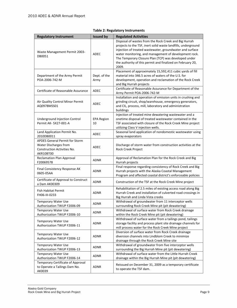
Table 2: Regulatory Instruments
Regulatory Instrument Issued by Regulated Activities
Waste Management Permit 2003-DB0051
ADEC
Disposal of wastes from the Rock Creek and Big Hurrah projects to the TSF, inert solid waste landfills, underground injection of treated wastewater, groundwater and surface water monitoring, and management of development rock. The Temporary Closure Plan (TCP) was developed under the authority of this permit and finalized on February 20, 2009.
Department of the Army Permit POA-2006-742-M
Dept. of the Army
Placement of approximately 15,592,411 cubic yards of fill material into 346.5 acres of waters of the U.S. for development, operation and reclamation of the Rock Creek and Big Hurrah projects
Certificate of Reasonable Assurance ADEC Certificate of Reasonable Assurance for Department of the Army Permit POA-2006-742-M
Air Quality Control Minor Permit AQ0978MSS01
ADEC
Installation and operation of emission units in crushing and grinding circuit, shop/warehouse, emergency generators, and CIL, process, mill, laboratory and administration buildings
Underground Injection Control Permit AK- 5X27-001-A
EPA Region 10
Injection of treated mine dewatering wastewater and a onetime disposal of treated wastewater contained in the TSF associated with closure of the Rock Creek Mine project utilizing Class V injection wells.
Land Application Permit No. 2010DB0011
ADEC Seasonal land application of nondomestic wastewater using spray evaporators
APDES General Permit for Storm Water Discharges from Construction Activities No. AKR10BT00
ADEC Discharge of storm water from construction activities at the Rock Creek Project
Reclamation Plan Approval F20069578
ADNR Approval of Reclamation Plan for the Rock Creek and Big Hurrah projects
Final Consistency Response AK 0605-05AA
ADNR Final response regarding consistency of Rock Creek and Big Hurrah projects with the Alaska Coastal Management Program and affected coastal district’s enforceable policies
Certificate of Approval to Construct a Dam AK00309
ADNR Construction of the TSF at the Rock Creek Mine project
Fish Habitat Permit FH06-III-0233
ADNR Rehabilitation of 2.5 miles of existing access road along Big Hurrah Creek and installation of culverted road crossings in Big Hurrah and Linda Vista creeks
Temporary Water Use Authorization TWUP F2006-09
ADNR Withdrawal of groundwater from 11 interceptor wells surrounding Rock Creek Mine pit (pit dewatering)
Temporary Water Use Authorization TWUP F2006-10
ADNR Withdrawal of surface water from Rock Creek drainage within the Rock Creek Mine pit (pit dewatering)
Temporary Water Use Authorization TWUP F2006-11
ADNR Withdrawal of surface water from a tailings pond, tailings storage facility and process plant site drainage channels for mill process water for the Rock Creek Mine project
Temporary Water Use Authorization TWUP F2006-12
ADNR Diversion of surface water from Rock Creek drainage diversion channels into Lindblom Creek to minimize drainage through the Rock Creek Mine site
Temporary Water Use Authorization TWUP F2006-13
ADNR Withdrawal of groundwater from five interceptor wells surrounding the Big Hurrah Mine pit (pit dewatering)
Temporary Water Use Authorization TWUP F2006-14
ADNR Withdrawal of surface water from the Little Hurrah Creek drainage within the Big Hurrah Mine pit (pit dewatering)
Temporary Certificate of Approval to Operate a Tailings Dam No. AK0039
ADNR Reissued on December 31, 2009 as a temporary certificate to operate the TSF dam.
2010 ADEC & ADNR Annual Report
Alaska Gold Company
Rock Creek Mine and Big Hurrah Project Page 10
Table 2: Regulatory Instruments
Regulatory Instrument Issued by Regulated Activities Compliance Order by Consent (COBC) No. 2009-0748-50-8078 (terminated April 1, 2010)
ADEC Established requirements for water management at the Rock Creek Mine through upgrading WTP treatment capacity and reducing water levels in the TSF.
In addition to the permits, approvals and authorizations listed in table 2, AGC must comply with
other state and federal laws including, but not limited to, state regulations regarding spill
reporting, water quality standards, mining, reclamation and solid waste management, Resource
Conservation and Recovery Act (RCRA), Emergency Planning and Community Right-to-Know
Act (EPCRA), Toxic Substances Control Act (TSCA), Clean Air Act (CAA), and Clean Water
Act (CWA).
2.4.1 WMP No. 2003-DB0051
ADEC issued WMP No. 2003-DB0051 to AGC on August 9, 2006. The WMP includes a
requirement to submit quarterly and annual reports and regulates the following:
Tailings disposal to the TSF at the Rock Creek Mine
Inert solid waste disposal to solid waste landfill facilities at the Rock Creek Mine and Big
Hurrah site
Underground injection of treated mine wastewater at Rock Creek Mine and Big Hurrah
site
Groundwater and surface water monitoring at the Rock Creek Mine and Big Hurrah site
Storage of potentially acid generating (PAG) development rock prior to disposal in the pit
at closure at the Big Hurrah site
Hazardous chemical storage and containment at the Rock Creek Mine and Big Hurrah
site
Reclamation and closure activities at the Rock Creek Mine and Big Hurrah site
The final Temporary Closure Plan (TCP) (February 20, 2009) was developed under the WMP
and specifically addresses activities during the temporary closure period. Subsequent revisions
approved by ADEC modified the TCP's monitoring and reporting requirements for the Rock
Creek site. The most recent revision was approved on April 26, 2010.
ADEC issued COBC No. 2009-0748-50-8078 to AGC to establish requirements for treatment
and discharge of TSF water via the WTP and IWF. The COBC was terminated on April 1, 2010
when all requirements were met.
2.4.2 RPA No. F20069578
ADNR (Division of Mining, Land and Water) issued RPA No. F20069578 for the Rock Creek
Mine and Big Hurrah site to AGC on August 9, 2006. The RPA was issued in accordance with
Alaska Statutes 27.19 (Reclamation) and 38.05 (Alaska Lands Act), and Alaska Administrative
Code Title 11, Chapter 97 (Mining Reclamation). The RPA requires AGC to submit an annual
report documenting the following activities:

2010 ADEC & ADNR Annual Report
Alaska Gold Company
Rock Creek Mine and Big Hurrah Project Page 11
Financial assurances
Review of geochemical characterization and water quality data
Stockpiling of organic materials
Geochemical characterization of development rock
Waste rock handling
Fuel and hazardous substance management
Reclamation and mine closure
Environmental audits
3.0 Rock Creek Mine Activities
Activities at the Rock Creek Mine in 2010 were directly related to the mine’s Care and
Maintenance status and consisted of TSF water management, WTP upgrades, IWF rehabilitation
and optimization, treated water injection, TSF pond water land application, maintenance of and
improvements to the existing storm water diversion channels, and continued implementation of
best management practices (BMPs). These activities are discusses in the following sections.
3.1 Disturbance and Reclamation
Wetland and upland areas disturbed at the Rock Creek Mine during 2010 totaled 0.85 acres;
15.07 upland acres were reclaimed during 2010 (table 3). The cumulative disturbed area,
including disturbances prior to 2010, totals 424.71 acres with 20.07 upland acres reclaimed (table
3).
Table 3: Disturbed and Reclaimed Area
Year
Area (Acres)
Wetlands Uplands
Disturbed Replaced Disturbed Reclaimed
2008 0 0 42 5
Cumulative - End of 2008 241 0 139 5
2009 0.92 0 .94 0
Cumulative – End of 2009 241.92 0 181.94 5
Net Disturbance– End of 2009 241.92 176.94
2010 0.51 0 0.34 15.07
Cumulative – End of 2010 242.43 0 182.28 20.07
Net Disturbance – End of 2010 242.43 162.21
3.2 Development Rock Stockpiles

2010 ADEC & ADNR Annual Report
Alaska Gold Company
Rock Creek Mine and Big Hurrah Project Page 12
Development rock from the Rock Creek Mine was used entirely for construction activities; no
stockpiles were constructed in 2010.
3.3 Organic Stockpiles
No material was placed in or removed from organic stockpiles #1, #2, or #3 during 2010 (table
4). Material placed prior to 2010 will be used in future reclamation activities.
Table 4: Rock Creek Organic Stockpile Volumes
Description Units Stockpile #1 Stockpile #2 Stockpile #3 Total
Total Capacity m3 1,225,000 185,000 640,000 2,050,000
Total Volume End of 2008 m3 487,482 40,962 625,973 1,294,237
End of 2008 Capacity Remaining m
3 737,518 180,962 14,207 755,763
% 60% 2% 2% 37%
Volume Placed - 2009 m3 30,351 0 1,719 32,070
Total Volume End of 2009 m3 517,833 180,962 627,512 1,326,307
End of 2009 Capacity Remaining m
3 707,167 4,038 12,488 723,693
% 58% 2% 2% 35%
Volume Placed – 2010 m3 0 0 0 0
Total Volume End of 2010 m3 517,883 180,962 627,512 1,326,307
End of 2009 and 2010 Capacity Remaining
m3 707,167 4,038 12,488 723,693
% 58% 2% 2% 35%
3.4 Paste Tailings Storage Facility
ADNR issued a Certificate of Approval (No. AK00309) to AGC to operate the Rock Creek TSF
dam on July 7, 2008. The State of Alaska suspended the Certificate in December 2008 when the
Rock Creek Mine status was changed to Care and Maintenance. ADNR issued a Temporary
Certificate of Approval (No. AK00309) to AGC to operate the TSF dam on December 31, 2009.
An investigation of surface irregularities on the slope of the TSF that were documented during
the 2009 annual dam safety inspection was performed by AMEC staff between August 16 and
August 24, 2010. Tasks performed during the inspection and evaluation of the surface
deformations included; cutting open the geomembrane at select location to expose the surface of
the liner bedding; documenting the condition of the liner bedding material and geometry of the
surface; repairing the exposed liner bedding as needed; repairing and performing Quality Control
testing on the geomembrane repair; and performing a complete visual inspection of all the
exposed geomembrane at the TSF to identify and repair defects or damage. AMEC determined
that settlement along the upstream slope of the TSF embankment was responsible for the surface
deformation features and they do not pose a significant risk to the structure of the dam. A report
was prepared by AMEC to describe the inspection activities and findings of the field inspection
(AMEC, September 2010).

2010 ADEC & ADNR Annual Report
Alaska Gold Company
Rock Creek Mine and Big Hurrah Project Page 13
As required by the Certificate of Approval, AMEC also completed a stability evaluation of the
TSF under current conditions. In a report submitted to ADNR in October 2010, AMEC
concluded that, based upon the engineering evaluation performed, the TSF is stable in its current
configuration and is performing as expected considering it is being operated as a water storage
facility instead of a paste tailings storage facility as originally designed. High phreatic levels do
not exist within the facility and the seepage collection system is efficiently capturing seepage and
groundwater from within the embankment.
Slope stability evaluations confirm the embankment is stable under both static and seismic
conditions with little deformation anticipated under the maximum design earthquake (MDE)
seismic event. Although initial settlement of the embankment was higher than anticipated after
initially commissioning the TSF, it does not pose a threat to overtopping or significantly
decreasing the freeboard beyond acceptable levels. Furthermore, the settlements have
significantly decreased and if thawing continues to permeate throughout the embankment, large
settlements are not anticipated as the field testing performed to date indicates a relatively dense
fill with lower propensity for frozen fill placed at greater depths within the embankment.
Furthermore, quarterly crest settlements are now occurring at very low levels (<0.3 inches) as
evidenced by settling monument data and are anticipated to be negligible within a year.
Overall, AMEC demonstrated that: (1) the TSF is not in danger of experiencing catastrophic
failure in the immediate or foreseeable future, (2) the facility can operate safely under current
conditions, (3) the seepage collection system varies from the initial design, but has increased
capacity and water velocity and is anticipated to successfully continue to route seepage water
without major concern for piping fines, and (4) the thermal and seepage regimes will reach a
steady-state condition in which a majority of the embankment will reside in a thawed
environment with the exception of the downstream foundation with seepage becoming relatively
stable if the facility continues to retain storm water. Ultimately, reduction in retained water
levels as predicted by water balance modeling will reduce the phreatic level, encourage
permafrost within the facility, and reduce overall seepage levels.
AMEC recommended that the ongoing geotechnical monitoring activities continue so that the
assumptions and conclusions contained in the report could be revised and verified in the future.
NovaGold continues to conduct geotechnical monitoring of the TSF consistent with AMEC's
recommendations and the requirements of the Certificate of Approval.
3.5 Solid Waste Landfill
On September 7, 2009 AGC developed an inert materials landfill as permitted under the WMP.
AGC continued to place material into the landfill throughout 2010. As of December 31, 2010
Cell 1 was closed. Cell 2 was opened in June 2010 and closed in September 2010. Cell 3 was
opened in September 2010 and remained active the remainder of the year.
Items discarded to Cells 1 and 2 during 2010 include:
Scrap wood/pallets/empty spools Scrap liner rolls and bare plastic liner tubes

2010 ADEC & ADNR Annual Report
Alaska Gold Company
Rock Creek Mine and Big Hurrah Project Page 14
Scrap steel and cleaned, crushed barrels Wire rope Scrap galvanized pipe
Scrap HDPE pipe Carbon bags and scrap wood Burned and crushed filters
Items discarded to Cell 3 during 2010 include:
Scrap wood and pallets Old tarps
Scrap plastics Miscellaneous scrap steel pipes and parts
3.6 Inspections
AGC staff conduct weekly visual inspections of the TSF to identify any unusual conditions such
as evidence of excessive deformation or crest cracking, embankment sloughing or deformation,
erosion channel formation in the embankment slope, embankment toe erosion, and excessive
seepage at the embankment toe or slope. Staff also record data from field monitoring
instrumentation during the weekly inspection.
3.7 TSF Seepage Collection System
During 2009, AGC constructed a seepage collection system at the TSF dam's downstream toe
consisting of flexible drain pipe backfilled with drain rock. The seepage collection sumps were
lined with a geosynthetic clay liner (GCL), filled with drain rock and capped with GCL.
Water collected in the sump is conveyed by gravity to one of two collection sumps (Main and
South). South sump water is pumped to the Main Sump through a 3-inch insulated, heat-traced
high density polyethylene (HDPE) pipeline by a 7.5 horse-power (hp) submersible pump. Main
Sump water is pumped by a 30 hp electric pump over the top of the TSF and back into the basin
through a 6-inch heat-traced HDPE pipeline. 2010 sump flow data are presented in appendix D.
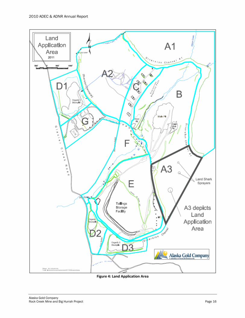
3.8 Land Application
ADEC issued a permit to dispose of non-domestic wastewater by land application to AGC on
August 6, 2010. AGC land applied wastewater from the Main and South sumps to area A3 of the
Rock Creek Mine site (figure 4) using two Land Shark evaporator-sprayer units. The two Land
Shark units were placed on a relatively flat bench approximately 2/3 up the A3 hillside. The
larger unit emits a fine mist spray at a rate of 125 gpm while the smaller unit has a maximum
capacity of 45 gpm. Each unit can rotate the spray direction 360 degrees.
According to the BMPs, the units and the spray field area were visually monitored twice daily at
a minimum. Spray units were rotated as necessary to adjust the spray angle according to the
wind speed and direction and if any significant deposition was observed. The AGC staff person
conducting the visual inspection recorded the estimated wind speed and direction along with any
findings regarding the piping, pumps, sprayers, and blower fans in a central log. This procedure
was established to provide AGC staff with current information about any equipment
malfunctions, such as broken pipes or power outages to the blower fans, and minimize the risk of
uncontrolled runoff or discharge to the ditches and area streams.

2010 ADEC & ADNR Annual Report
Alaska Gold Company
Rock Creek Mine and Big Hurrah Project Page 15
Land application began on August 8, 2010 and ceased September 28, 2010 when falling ambient
temperatures led to accumulating snow in the spray field. Over 28 days of operation, the Land
Shark units disposed of approximately 2.3 million gallons of wastewater to the A3 area (table 5).
In summary, the Land Shark units operated reliably and without any significant incident or
breakdown. Table 5: Daily Land Application Rates
Date Time of
Operation (Hours)
Average Daily Application Rate (GPM)
Volume Applied
(Gallons)
Land Application Rate (Gallons per Acre
1)
8/9/2010 7.5 6 9,000 3,000 - 9,000
8/10/2010 24 56 81,000 27,700 - 81,000
8/11/2010 24 43 62,100 20,700 - 62,100
8/12/2010 24 55 79,200 26,400 - 79,200
8/13/2010 24 30 43,650 14,550 - 43,650
8/14/2010 17.5 13 18,600 6,20 - 18,600
8/17/2010 12 65 46,678 15,563 - 46,678
8/18/2010 15 74 66,275 22,097 - 66,275
8/19/2010 4 0 52,296 17,433 - 52,296
8/19/2010 15.5 63 58,815 19,610 - 58,815
8/20/2010 24 96 138,676 46,233 - 138,676
8/21/2010 24 95 136,246 45,423 - 136,246
8/22/2010 24 100 143,696 47,907 - 143,696
8/23/2010 10 89 53,350 17,787 - 53,350
8/31/2010 10 89 53,310 17,773 - 53,310
9/1/2010 12.8 90 69,127 23,047 - 69127
9/17/2010 8.75 74 39,071 13,027 - 39,071
9/18/2010 24 76 109,516 36,513 - 109,513
9/19/2010 24 74 106,656 35,560 - 106,656
9/20/2010 13.4 68 54,777 18,263 - 54,777
9/21/2010 4.5 0 43,656 14,553 - 43,656
9/22/2010 24 89 128,816 42,947 - 128,816
9/23/2010 24 93 133,696 44,573 - 133,969
9/24/2010 24 92 132,866 44,297 - 132,866
9/25/2010 24 88 126,976 42,333 - 126,976
9/26/2010 24 88 126,786 42,270 - 126,786
9/27/2010 24 90 129,016 43,013 - 129,016
9/28/2010 10 81 48,460 16,157 - 48,460
Total Gallons Applied 2,292,310 1Hydraulic loading: It is not possible to measure the volume of water evaporated from the spray. The
estimated range of volumes in table 5 assume no evaporation and that the spray occurred over a 1 to 3 acre area.
2010 ADEC & ADNR Annual Report
Alaska Gold Company
Rock Creek Mine and Big Hurrah Project Page 16
Figure 4: Land Application Area

2010 ADEC & ADNR Annual Report
Alaska Gold Company
Rock Creek Mine and Big Hurrah Project Page 17
3.9 Recycle Water Pond
The RWP is a synthetically lined retention pond designed to capture runoff from the plant site
and TSF decant water. Over time, leaks were detected in the primary liner from small punctures.
Rather than remove and reinstall the primary liner, AGC installed a secondary liner as an
overlayment, with a leak collection and recovery system (LCRS) placed between the liners. An
additional synthetic underliner is installed below the primary and secondary liners. The
interstitial water volume (between the primary and secondary liners) from the LCRS is
continuously pumped back to the RWP, with total flow volumes recorded each day (appendix B).
The LCRS leak rate design criteria is 492 gallons per day (gpd). Data show that, at some points
during the first quarter of 2010, the recorded flow rate exceeded the design criteria. After March
6, 2010 flow rates had returned to below the design criteria with no evidence of leakage through
the liner system.
AGC conducts daily visual inspections of the RWP and liner systems, and routinely samples
contained water for cyanide (total and WAD). Data show that water from the RWP, as discussed
in Section 8.1.2, is not adversely impacting groundwater quality in the immediate vicinity of the
RWP.
In August 2010, AMEC completed an inspection of the exposed geomembrane at the RWP,
including inspecting the pipe channel between the RWP and the plant site. At the RWP, this
inspection extended from the pond crest down to the water elevation which was 143.71 feet.
One hole was found in the RWP primary geomembrane which was patched at the time of the
inspection. In addition to the visual inspection of the geomembrane, a review of the LCRS
pumping data was also performed. This was completed in order to determine if contained water
in the pond was reporting to the leak detection system and if so, could an elevation range be
isolated to assist in locating the leak. Data was reviewed for the period of January 1, 2009 to
July 25, 2010. No water was pumped from the LCRS after March 6, 2010. Between March 6
and July 25, 2010 the pond elevation varied between 126 feet above mean sea level (amsl) (7.5
feet of water depth) to 147.2 feet amsl (28.7 feet of water depth).
Given the available data and the inspection of the exposed geomembrane, AMEC believes the
RWP primary geomembrane and LCRS are functioning as intended. At the time of the
inspection, it was planned to perform construction activities on the reclaim system at the RWP in
2011. The results of the AMEC inspection were shared with ADNR Dam Safety and
Construction Unit. Given the fact that future work was planned at the RWP in 2011 and no
correlation between pond water level and geomembrane leakage could be determined, it was
agreed that the RWP did not have to be drained and fully inspected in 2010. At the time of
future work, a thorough inspection of the entire geomembrane will be performed. The future
inspection could include a hydro-test of the pond.
4.0 Storm Water Management

2010 ADEC & ADNR Annual Report
Alaska Gold Company
Rock Creek Mine and Big Hurrah Project Page 18
Figure 5: Rock Creek Mine SWPPP Structures
2010 ADEC & ADNR Annual Report
Alaska Gold Company
Rock Creek Mine and Big Hurrah Project Page 19
On May 15, 2010 AGC staff observed a breach in diversion channel #1 (DC-1). Ultimately it
was determined that the channel was damaged for several hundred feet down-channel from
Albion Creek. At approximately 500 feet down-channel from the Albion Creek intercept the
channel developed a leak. The breach resulted in melt water running down the Rock Creek
drainage below the intercept point and continuing to the Rock Creek Causeway. AGC
immediately initiated temporary repairs, which included removal of existing snow and ice from
the channel to minimize further runoff; plugging breaches with a mixture of dirt, rock and
bentonite; installing a 60-mil HDPE liner over the affected area; slope stabilization; and general
site cleanup. Temporary repairs were inspected frequently to ensure stability until permanent
repairs to the channel could be completed.
AGC determined the most appropriate permanent solution to prevent future upsets would be to
restore Rock and Albion creeks to their natural channels. Permanent repairs began on October
13, 2010 with the realignment of Rock Creek. This process began with modifications to the
access road (berms) and additional BMP installation (double line of silt fences) in the area to
control runoff during the realignment project. Fill material that had been placed in the Rock
Creek channel during DC-1 construction was removed to reestablish the natural drainage (figure
6). The excavated channel was then contoured to approximate the surrounding topography and
promote more gradual drainage (figure 7). Blasted rock was used as backfill material and was
tracked into the constructed channel bottom along the downstream portion (approximately 1/3 of
the channel) to provide a stable channel foundation and a smooth transition to the existing
channel. Woven geotextile were placed in the channel over the dredged backfill material and
secured with an anchor trench prior to riprap installation (figures 8 & 9).
On October 29, 2010 AGC began construction of the Rock Creek diversion across the DC-1
channel to redirect Rock Creek to the newly constructed channel. Material was placed in thin
lifts and compacted by track walking. A toe drain was also constructed along the upstream and
downstream edges of the dam to allow natural drainage water to be channeled around the fill
area. Rock fill was placed along the downstream face to reinforce the structure and mitigate any
erosion. Drain rock was placed on the upstream face of the embankment. Permanent
realignment of Rock Creek was completed on October 30, 2010.

2010 ADEC & ADNR Annual Report
Alaska Gold Company
Rock Creek Mine and Big Hurrah Project Page 20
Figure 6. View upstream during Rock Creek realignment
Figure 7. View North during fill excavation and slope shaping for Rock Creek realignment
Figure 8. Geotextile installation in new Rock Creek channel
Figure 9. Riprap placement in new Rock Creek Channel
AGC continued permanent repairs on November 2, 2010 with the realignment of Albion Creek.
Excavated fill material was transported by haul truck to a stockpile near the staging area at the
top of the magazine access road. Additional fill was placed in the lower end of the channel to
build up a suitable subgrade. Four panels of woven geotextile were laid out over the subgrade,
secured with an anchoring trench, and covered with riprap to grade. The existing settling pond at
Albion Creek was filled in and restored to match the grade of Albion Creek where it entered the
settling pond. Drain rock was placed where the access road crossed Albion Creek and tracked.
Permanent realignment of Albion Creek was completed on November 11, 2010.
During 2010, AGC performed routine maintenance of diversion channel #2 (DC-2) channel,
access road and outfall, including slope stabilization and riprap replacement. During the 2010

2010 ADEC & ADNR Annual Report
Alaska Gold Company
Rock Creek Mine and Big Hurrah Project Page 21
spring breakup, minor erosion was observed on the west side of the DC-2 outfall near the
bottom. Water had eroded the bank along the bottom and uphill side of the placed riprap.
Replacement riprap was installed at the affected area to improve stability on September 29, 2010.
The west side of the access road near the DC-2 outfall had additional fill placed along the
embankment and was re-sloped, compacted, and graded to stabilize the embankment and buttress
it from potential failure. Work was initiated on September 27, 2010 and completed on
September 29, 2010.
During 2010, AGC performed routine maintenance of the diversion channel #3 (DC-3) channel
and outfall, including hydroseeding the channel and outfall embankments, and installing
additional riprap (100 feet) above the thickener to minimize erosion. Riprap installation was
completed on October 22, 2010.
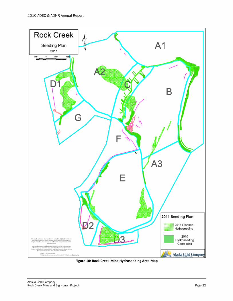
Finally, during 2010, AGC undertook hydroseeding throughout the site to provide for final slope
stabilization. The hydroseeding activities undertaken in 2010 and the activities planned for 2011
are shown in figure 10.
2010 ADEC & ADNR Annual Report
Alaska Gold Company
Rock Creek Mine and Big Hurrah Project Page 22
Figure 10: Rock Creek Mine Hydroseeding Area Map
2010 ADEC & ADNR Annual Report
Alaska Gold Company
Rock Creek Mine and Big Hurrah Project Page 23
Turbidity levels in Rock and Lindblom Creek were lower during spring 2010 as compared to
2008 and 2009, demonstrating the continued effectiveness of implemented BMPs and sediment
controls.
5.0 Water Treatment Plant
The Rock Creek WTP began 2010 with a number of challenges with the main oxidation unit, the
ozone generator. The first quarter water quality data showed inconsistent treatment due to
insufficient oxidation or over oxidation. Because of the difficulties, and for ease of maintenance
and operational reliability, AGC decided to purchase and install a calcium hypochlorite system.
The hypochlorite system dissolves calcium hypochlorite tablets into a dilute solution which is
then injected into the raw water stream. The injection rate is based off of the plant flow set
points and the desired oxidation-reduction potential (ORP). The system is much easier for the
operators to handle, more reliable, and much safer. The system is also a more cost effective
method of oxidation than the ozone generator.
Another major upgrade to the WTP in 2010 was the addition of a sodium hydroxide bulk
unloader system and batching circuit. To reduce the risk of potential chemical incidents, AGC
purchased and installed a bulk unloader and batching system that allows the WTP operators to
batch sodium hydroxide into a batch tank and then transfer from the batch tank to the day tank by
the push of a button.
AGC has also installed two new 7.5 hp pumps to replace two existing 15 hp pumps. The existing
15 hp pumps ran in tandem to maintain a constant feed pressure to the microfilters. The existing
pumps were replaced with two 7.5 hp pumps, one in service and one a redundant spare. The new
setup only requires the use of one pump to maintain the pressure and deliver the full design
capacity of the WTP.
The water quality for the second and third quarter was aided by the influent surface runoff. The
influx of surface runoff increased the total volume of the TSF but diluted the metals content.
In the fourth quarter, the WTP was more difficult to operate due to rising metals concentrations.
AGC put into practice heightened monitoring procedures to help maintain consistent water
quality. During the fourth quarter, pH and ORP values were recorded and monitored on a 2 hour
basis. Cleaning procedures were also implemented to effectively maintain equipment that could
foul due to heavy constituent loadings.
WTP Flow data for 2010 are presented in appendix E.
6.0 Injection Well Field
The Rock Creek Mine IWF is operated as authorized by Underground Injection Control (UIC)
Permit No. AK-5X27-001-A, issued by the U.S. Environmental Protection Agency (EPA)-
Region 10. The IWF is also regulated by ADEC WMP No. 2003-DB0051, which incorporates
many of the same conditions as the UIC permit. During the temporary closure period, AGC

2010 ADEC & ADNR Annual Report
Alaska Gold Company
Rock Creek Mine and Big Hurrah Project Page 24
operates the IWF to dewater the TSF and reduce the water elevation behind the TSF dam to an
acceptable level. ADEC authorized AGC to commence underground injection on May 15, 2009.
The combined operational capacity of the 29 injection wells (Well #25 has been plugged and
abandoned) in the upper and lower well fields (figure 11) is 500 gpm. During 2010, the system
operated at a combined average injection rate of approximately 323 gpm, with 18 to 23 wells
active at any time. At this injection rate, AGC was able to effectively manage water contained in
the TSF. Injection continued throughout 2010 except for a planned shutdown from April 30 to
May 22, 2010 when water levels in the TSF were low. Injection resumed when meltwater
inflows to the TSF increased the water level.
Other activities performed during 2010 included:
Implemented an online database to store daily well field operational data, including
injection rates, pressures, water levels, and water quality data. This information is shared
in real time with AGC's contractors to better facilitate monitoring of IWF performance.
Evaluated IWF operations using a MODFLOW-based model of the site to minimize head
increases in the injection zone.
Abandoned and plugged Well #25 on September 25, 2010 after surface mounding was
observed. AGC submitted a Well Plugging and Abandonment Report to EPA on October
15, 2010.
Routine maintenance of 20 wells to purge standing water and remove sediment buildup.
Approximately 750 to 1000 gallons were purged from each well into a portable tank.
Captured purge water was transported to and disposed of in the WTP sump from which it
goes directly to the RWP.
Injection rate data for 2010 are presented in Appendix C. A spreadsheet of complete daily
recorded injection well data including inflator pressure, injection pressure, instantaneous
injection rate, and totalizer readings is proved as an attachment to this report.

2010 ADEC & ADNR Annual Report
Alaska Gold Company
Rock Creek Mine and Big Hurrah Project Page 25
Figure 11: Rock Creek Mine Injection Well Field Map
7.0 Reportable Spills
There were seven reportable spills at the Rock Creek Mine in 2010 (table 6). Spilled substances
were related to construction and maintenance activities, and included hydraulic oil and used oil.
None of the spills were greater than 10 gallons and were reported to DEC as part of monthly spill
reporting requirements. All spills were cleaned up immediately.

2010 ADEC & ADNR Annual Report
Alaska Gold Company
Rock Creek Mine and Big Hurrah Project Page 26
Table 6: Reportable Spills
Item Spilled Date Potential Responsible
Party Location Quantity Cause
Hydraulic Oil 4/28/2010 Alaska Gold Company Rock Creek 2-3 gallons Blown hydraulic hose on CAT 320 excavator
Hydraulic Oil 9/8/2010 Alaska Gold Company Rock Creek 4 gallons Hydraulic line failed on equipment.
Hydraulic Oil 10/11/2010 Alaska Gold Company Rock Creek 1 gallon Hose leak on Hitachi 270 excavator
Hydraulic Oil 10/14/2010 Alaska Gold Company Rock Creek 9 gallons Hose leak on CAT 330 excavator
Hydraulic Oil 11/12/2010 Alaska Gold Company Rock Creek 4 gallons Broken hydraulic line on Hitachi 270 excavator
Hydraulic Oil 11/14/2010 Alaska Gold Company Rock Creek 4.5 gallons Failed hydraulic line on drill rig
Used Oil 12/14/2010 Alaska Gold Company Rock Creek 2 gallons 55 gallon drum punctured with fork lift
8.0 Monitoring (Analytical)
AGC conducts a range of analytical monitoring activities to demonstrate compliance with WMP
No. 2003-DB0051 and UIC Permit No. AK-5X27-001-A by sampling various water sources,
development rock, and paste tailings. Because the Rock Creek Mine was in Care and
Maintenance status during 2010, analytical monitoring focused almost entirely on water sources.
The specific monitoring requirements and sampling frequencies are contained in the Rock Creek
Monitoring Plan (November 2008) and the final TCP (revised April 26, 2010). The most recent
TCP revision contains modifications to the sampling frequencies for surface, contained, and
ground water (see Appendix D, Table D.1 in the TCP).
The analytical monitoring program for water is divided into four separate categories: contained,
ground, surface, and treated water. Each category is discussed in more detail below. In addition
to required sampling events, AGC collected additional water samples not subject to specific
compliance requirements. These additional samples include: multiple water samples from
various points in the WTP to optimize performance; pit lake water to characterize water
chemistry for potential future treatment and disposal; and CIL tank process water to determine
appropriate treatment methods. The data is available for review upon request.
With the exception of some conventional parameters analyzed in the field by AGC staff (e.g.,
pH, temperature, turbidity), all water chemistry samples are analyzed by a contract laboratory
(SGS North America Inc.) in Anchorage for the pollutants listed in table 7.
Analytical data for samples collected from Rock Creek monitoring locations are graphically
represented in appendices A1-A23. These appendices are limited to show results for parameters
for which at least two detectable results were observed during 2010. Complete analytical data
and lab reports are available from AGC. Water chemistry data spreadsheets for complete results
from Rock Creek 2010 sampling are provided as an attachment to this report.

2010 ADEC & ADNR Annual Report
Alaska Gold Company
Rock Creek Mine and Big Hurrah Project Page 27
Table 7: Water Chemistry Parameters
Parameter Ground Water
Surface Water
Contained Water
Treated Water
Aluminum* X X X X
Antimony* X X X X
Arsenic* X X X X
Barium* X X X X
Beryllium* X X X X
Cadmium* X X X X
Calcium* X X X X
Chromium* X X X X
Cobalt* X X X X
Copper* X X X X
Iron* X X X X
Lead* X X X X
Magnesium* X X X X
Manganese* X X X X
Molybdenum* X X X X
Nickel* X X X X
Phosphorus* X X X X
Potassium* X X X X
Selenium* X X X X
Silicon* X X X X
Silver* X X X X
Sodium* X X X X
Strontium* X X X X
Thallium* X X X X
Tin* X X X X
Titanium* X X X X
Vanadium* X X X X
Zinc* X X X X
pH X X X X
Conductivity X X X X
Total Dissolved Solids X X X X
Alkalinity X X X X
Ammonia-N X X X
Chloride X X X X
Fluoride X X X X
Sulfate X X X X
Sulfide X
Cyanide (total) X X X X
Cyanide (WAD) X X X X
Mercury X X X
Total Suspended Solids X X X
Nitrate/Nitrite-N X X X X *Metals analyzed for total and dissolved concentrations
8.1 Contained Water
Contained water sampling is conducted on a quarterly basis and includes sampling of the TSF
Pond, RWP, South Sump, Main Sump, Main Pit Lake, and RWP Underliner (table 8). The TSF
Pond, South Sump, and Main Sump samples are used to monitor water quality in the TSF water
management system while the RWP and RWP Underliner samples are used to evaluate the

2010 ADEC & ADNR Annual Report
Alaska Gold Company
Rock Creek Mine and Big Hurrah Project Page 28
integrity of the RWP system. AGC is not required to monitor the Main Pit Lake, but collects
samples of the pit water to establish background chemistry of storm water runoff from the pit
surfaces. Main Pit Lake samples are only collected when the water surface is ice free.
There are no contained water systems at the Big Hurrah site.
Table 8: Contained Water Sampling Locations
Sample ID Collection Location Summer Collection Location Winter
TSF Pond Directly from TSF pond when unfrozen Port on WTP influent line prior to untreated water tank
RWP Port on recirculation loop above pond culverts
Port on recirculation loop above pond culverts
RWP Underliner Port on recirculation loop above pond culverts
Port on recirculation loop above pond culverts
South Sump Directly from sump culvert using bailer Directly from sump culvert using bailer
Main Sump Directly from sump culvert using bailer If covered – from port on TSF return line in TSF pump connex
Main Pit Lake Directly from main pit lake Not sampled when ice covered
8.1.1 Tailings Storage Facility
The TSF Pond is sampled quarterly. Under ice-free conditions, samples are collected directly
from the TSF Pond. During colder months the pond surface is frozen over, and the samples are
collected from a port on the WTP influent line just prior to the untreated water tank. Samples
collected from the TSF are not subject to limitations in the WMP. The data is used primarily to
evaluate trends in the influent concentration to the WTP in order to plan for any necessary
operational changes to the WTP processes.
Analytical data for the TSF pond monitoring samples is reported in appendix A1.
8.1.2 Recycle Water Pond
Water from the RWP and RWP Underliner are sampled quarterly. RWP samples are collected
from ports on the recirculation loop immediately above the pond culverts. Samples are collected
from the RWP Underliner pump to determine if any RWP water is reaching groundwater through
breaches in the primary and secondary liners. The LCRS installed between the primary and
secondary liners is designed to collect small leakage volumes from between the liners and pump
it back to the RWP before reaching the RWP Underliner. The RWP Underliner was not sampled
in the first and second quarter of 2010 because the underliner pump was not operational. A
comparison of RWP and RWP Underliner analytical data demonstrates that RWP water is not
breaching the liner system or adversely impacting groundwater quality.
Water contained in the RWP may not exceed WAD cyanide levels of 25 mg/L for any one
sample, nor may the 90th
percentile of all samples exceed 10 mg/L (WMP Section 1.2.4). All
2010 RWP samples had non-detectable results or were below lab reporting limits for WAD
cyanide (figure 56 in appendix A2). Samples collected from the RWP Underliner were also well
below the permit limits.

2010 ADEC & ADNR Annual Report
Alaska Gold Company
Rock Creek Mine and Big Hurrah Project Page 29
Analytical data for RWP and RWP Underliner monitoring samples are reported in appendices
A2 and A3.
8.1.3 TSF Seepage Collection System
The TSF seepage collection system includes the South and Main sumps below the TSF dam.
Water is recycled to the TSF dam directly from the Main Sump only; water from the South Sump
is pumped to the Main Sump. Both sumps are sampled on a quarterly basis directly from the
sump culverts using bailers. During winter months, the main sump culvert may become
inaccessible due to snow buildup and the sample is then collected from a port in the pump-back
line located in the TSF pump conex on the crest of the dam.
Water recycled to the TSF may not exceed a WAD cyanide level of 25 mg/L for any one sample,
nor may the 90th
percentile of all samples exceed 10 mg/L (WMP Section 1.2.4). In 2010, all
water samples collected from the Main Sump had non-detectable results or were below lab
reporting limits for WAD cyanide (figure 49 in appendix A5). There are no other permit limits
that apply to the sump water.
Analytical data for Main and South sump monitoring samples are reported in appendices A4 and
A5. This data is primarily used to monitor their input to the TSF and project potential changes in
TSF water chemistry that could affect WTP treatment performance.
8.1.4 Pit Lake
There have been no mining activities in the main pit during the temporary closure period, and the
pit was not actively dewatered during 2010. The main pit has been allowed to fill with storm
water runoff creating the pit lake. There are no requirements to monitor pit lake water chemistry,
but AGC has continued to collect quarterly samples from the pit lake during periods of open
water in order to continue documenting the quality of storm water that comes in contact with the
pit surfaces.
Analytical data for Main Pit Lake monitoring samples are reported in appendix A6. AGC also
continues to monitor water levels in the Main Pit Lake. As of December 6, 2010 the water
elevation in the pit was 284.23 feet, a significant decrease from 2009 levels. There is no
anticipated need to actively pump water from the pit at this time.
8.2 Surface Water
Surface water at the Rock Creek Mine is sampled monthly when flow is present. In addition, 3
regional surface water samples are collected in the vicinity of the Rock Creek Mine each quarter
during periods of open flow.
2010 ADEC & ADNR Annual Report
Alaska Gold Company
Rock Creek Mine and Big Hurrah Project Page 30
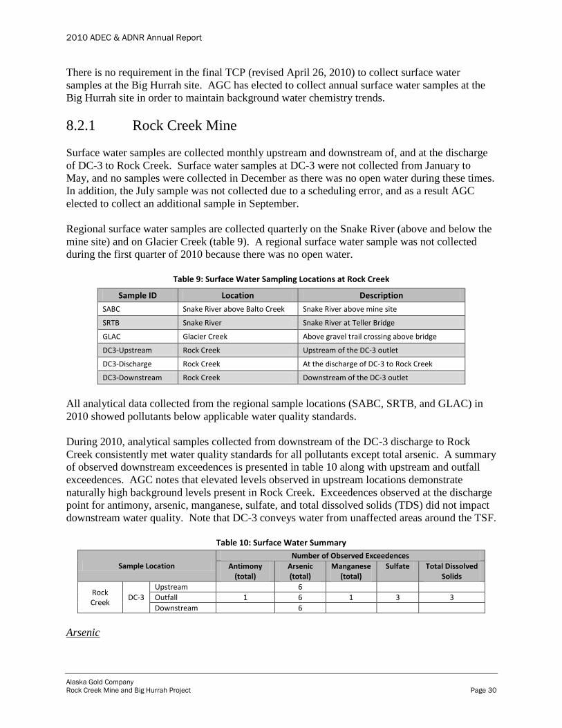
There is no requirement in the final TCP (revised April 26, 2010) to collect surface water
samples at the Big Hurrah site. AGC has elected to collect annual surface water samples at the
Big Hurrah site in order to maintain background water chemistry trends.
8.2.1 Rock Creek Mine
Surface water samples are collected monthly upstream and downstream of, and at the discharge
of DC-3 to Rock Creek. Surface water samples at DC-3 were not collected from January to
May, and no samples were collected in December as there was no open water during these times.
In addition, the July sample was not collected due to a scheduling error, and as a result AGC
elected to collect an additional sample in September.
Regional surface water samples are collected quarterly on the Snake River (above and below the
mine site) and on Glacier Creek (table 9). A regional surface water sample was not collected
during the first quarter of 2010 because there was no open water.
Table 9: Surface Water Sampling Locations at Rock Creek
Sample ID Location Description
SABC Snake River above Balto Creek Snake River above mine site
SRTB Snake River Snake River at Teller Bridge
GLAC Glacier Creek Above gravel trail crossing above bridge
DC3-Upstream Rock Creek Upstream of the DC-3 outlet
DC3-Discharge Rock Creek At the discharge of DC-3 to Rock Creek
DC3-Downstream Rock Creek Downstream of the DC-3 outlet
All analytical data collected from the regional sample locations (SABC, SRTB, and GLAC) in
2010 showed pollutants below applicable water quality standards.
During 2010, analytical samples collected from downstream of the DC-3 discharge to Rock
Creek consistently met water quality standards for all pollutants except total arsenic. A summary
of observed downstream exceedences is presented in table 10 along with upstream and outfall
exceedences. AGC notes that elevated levels observed in upstream locations demonstrate
naturally high background levels present in Rock Creek. Exceedences observed at the discharge
point for antimony, arsenic, manganese, sulfate, and total dissolved solids (TDS) did not impact
downstream water quality. Note that DC-3 conveys water from unaffected areas around the TSF.
Table 10: Surface Water Summary
Sample Location Number of Observed Exceedences
Antimony (total)
Arsenic (total)
Manganese (total)
Sulfate Total Dissolved Solids
Rock Creek
DC-3
Upstream 6
Outfall 1 6 1 3 3
Downstream 6
Arsenic
2010 ADEC & ADNR Annual Report
Alaska Gold Company
Rock Creek Mine and Big Hurrah Project Page 31
Arsenic is naturally present at elevated levels throughout the Snake River valley, particularly in
the Rock Creek drainage, as demonstrated by the fact that all Rock Creek samples collected
during 2010 showed concentrations above the water quality standard (10 µg/L). SRK Consulting
conducted a natural condition analysis verifying the ubiquitous nature of arsenic in the Rock
Creek vicinity (SRK 2008). AGC notes that there are no trends showing that the mine is causing
any elevation of arsenic levels beyond naturally occurring conditions in the area.
AGC reported arsenic exceedences to ADEC by memoranda dated October 5, November 23, and
December 6, 2010 in which background arsenic levels were discussed.
Antimony and Manganese
Single exceedences of antimony and manganese water quality standards were observed in the
DC-3 outfall sample collected on September 9, 2010. AGC reported these exceedences to
ADEC by memo dated November 23, 2010, noting that the values for each parameter appeared
to be anomalous when compared to previous sampling data. Furthermore, the downstream
sample collected on the same day did not exhibit similarly elevated levels for antimony and
manganese.
Sulfate and Total Dissolved Solids
The results for sulfate and TDS in the DC-3 outfall discharge show exceedences of water quality
standards for 3 sampling events on September 9, September 20, and October 15, 2010. AGC
reported these exceedences to ADEC by memo dated November 23, 2010. Past data indicates
that sulfate and TDS experience seasonal fluctuations approaching or exceeding water quality
standards and later return to lower levels. The exceedences at the discharge location did not
contribute to downstream water quality exceedences.
Analytical data for samples collected from Rock Creek surface water locations are reported in
appendices A7-A12. These appendices are limited to show results for parameters for which at
least two detectable results were observed during 2010.
8.2.2 Big Hurrah
Surface water is monitored yearly at 6 locations on and around the Big Hurrah site (table 11).
Complete analytical data and lab reports of all samples collected from Big Hurrah surface water
locations are available on file at the Rock Creek Mine Environmental Department.

2010 ADEC & ADNR Annual Report
Alaska Gold Company
Rock Creek Mine and Big Hurrah Project Page 32
Table 11: Surface Water Sampling Locations at Big Hurrah
Sample ID Location Description
BHBL Lower Big Hurrah Creek Big Hurrah Creek below mine site
BHRU Upper Big Hurrah Creek Big Hurrah Creek above mine site
HUFF Huff Creek Huff Creek tributary to Big Hurrah Creek above mine site
LHRL Lower Little Hurrah Creek Mouth of Little Hurrah Creek below proposed pit
LHRU Upper Little Hurrah Creek Little Hurrah Creek above proposed pit
LIDA Linda Vista Creek Linda Vista Creek tributary to Big Hurrah below mine site
8.3 Groundwater
AGC’s groundwater monitoring program was developed to determine whether TSF seepage or
injection to the IWF contribute to exceedences of applicable water quality standards. Additional
wells are monitored down-gradient of the RWP to identify leaks and below the Rock Creek Mine
to identify broad changes to groundwater chemistry from the entire site (table 12). Monitoring
wells designated as “A” or “B” refer to deep and shallow collection points for the same well.
Groundwater samples are collected quarterly from each well. Some wells are dry or contain too
little water for purging at certain times of the year as groundwater levels seasonally fluctuate.
No groundwater monitoring is required at the Big Hurrah site during the temporary closure
period.
Table 12: Rock Creek Groundwater Sample Locations
Well Sample ID Location Description
MW03-05 Above Rock Creek Culvert Background Monitoring Well
MW06-08A,B South TSF dam/South of South Sump TSF Monitoring Well
MW06-09A,B West TSF dam/West of Main Sump TSF Monitoring Well
MW06-10A,B Between North TSF and Rock Creek TSF Monitoring Well
MW07-11 West of Injection Well Field Down gradient of Injection Well Field
MW08-14A,B South of Recycle Water Pond Down gradient of Recycle Water Pond
MW08-15 West of Injection Well Field Down gradient of Injection Well Field
MW09-17 Southwest of Injection Well Field Down gradient of Injection Well Field
8.3.1 TSF Monitoring Wells
There are 6 groundwater sampling points down-gradient of the TSF: MW06-08A/B, MW06-
9A/B, and MW06-10A/B. Samples are collected from each sample point quarterly as specified
in the TCP (revised TCP Table D.1). The TCP was revised on April 26, 2010 to reflect a change
in groundwater monitoring frequency. Prior to May, TSF monitoring wells were sampled on a
monthly basis. Throughout 2010, wells MW06-08B and MW06-10B were dry and no samples
were collected at these points.
2010 ADEC & ADNR Annual Report
Alaska Gold Company
Rock Creek Mine and Big Hurrah Project Page 33
The TCP incorporates specific upper tolerance limits (UTLs) for key parameters in the
groundwater which are based on initial assessment of background constituent of concern (COC)
concentrations, and are intended to assess whether TSF seepage is reaching the monitoring wells
(TCP Table D.3). When either the UTL or the water quality standard is exceeded, AGC must
initiate corrective actions and follow-up monitoring to address any water quality issues (WMP
1.2.10 and 1.10.3).
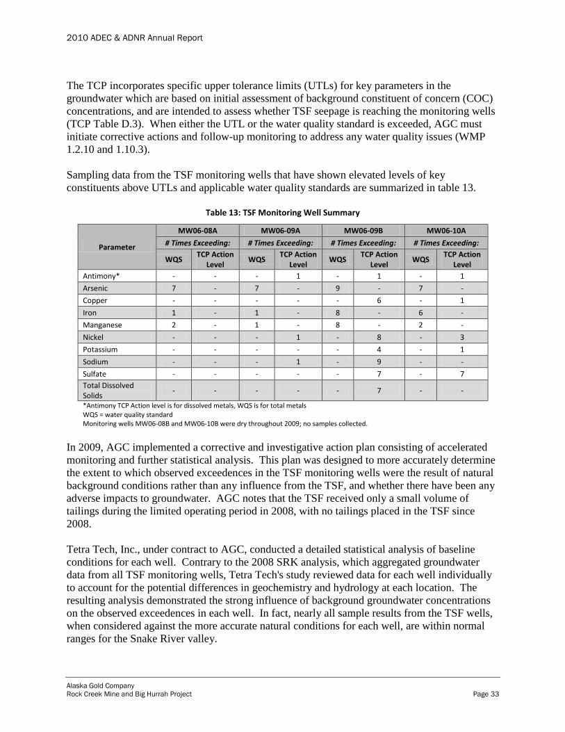
Sampling data from the TSF monitoring wells that have shown elevated levels of key
constituents above UTLs and applicable water quality standards are summarized in table 13.
Table 13: TSF Monitoring Well Summary
Parameter
MW06-08A MW06-09A MW06-09B MW06-10A
# Times Exceeding: # Times Exceeding: # Times Exceeding: # Times Exceeding:
WQS TCP Action
Level WQS
TCP Action Level
WQS TCP Action
Level WQS
TCP Action Level
Antimony* - - - 1 - 1 - 1
Arsenic 7 - 7 - 9 - 7 -
Copper - - - - - 6 - 1
Iron 1 - 1 - 8 - 6 -
Manganese 2 - 1 - 8 - 2 -
Nickel - - - 1 - 8 - 3
Potassium - - - - - 4 - 1
Sodium - - - 1 - 9 - -
Sulfate - - - - - 7 - 7
Total Dissolved Solids
- - - - - 7 - -
*Antimony TCP Action level is for dissolved metals, WQS is for total metals WQS = water quality standard Monitoring wells MW06-08B and MW06-10B were dry throughout 2009; no samples collected.
In 2009, AGC implemented a corrective and investigative action plan consisting of accelerated
monitoring and further statistical analysis. This plan was designed to more accurately determine
the extent to which observed exceedences in the TSF monitoring wells were the result of natural
background conditions rather than any influence from the TSF, and whether there have been any
adverse impacts to groundwater. AGC notes that the TSF received only a small volume of
tailings during the limited operating period in 2008, with no tailings placed in the TSF since
2008.
Tetra Tech, Inc., under contract to AGC, conducted a detailed statistical analysis of baseline
conditions for each well. Contrary to the 2008 SRK analysis, which aggregated groundwater
data from all TSF monitoring wells, Tetra Tech's study reviewed data for each well individually
to account for the potential differences in geochemistry and hydrology at each location. The
resulting analysis demonstrated the strong influence of background groundwater concentrations
on the observed exceedences in each well. In fact, nearly all sample results from the TSF wells,
when considered against the more accurate natural conditions for each well, are within normal
ranges for the Snake River valley.

2010 ADEC & ADNR Annual Report
Alaska Gold Company
Rock Creek Mine and Big Hurrah Project Page 34
AGC submitted the detailed results of the Tetra Tech study to ADEC on April 27, 2010. This
submittal proposed specific trigger levels for each well based on the higher of the water quality
standard or the well-specific background level. AGC continues to report exceedences of water
quality standards or UTLs as required under WMP section 1.2.10; however, AGC only performs
further corrective action beyond monitoring when these well-specific background levels have
been exceeded.
The TCP UTLs for various key parameters were exceeded on a regular basis in all TSF
monitoring wells except for MW06-8A. It is important to note that although the UTLs were
exceeded, there was no exceedence of applicable water quality standards for these same
parameters, and AGC did not take any further corrective action as a result. Exceedences of water
quality standards and associated corrective actions are discussed below.
Arsenic
Exceedences of water quality standards for total arsenic were consistently observed in TSF
monitoring wells. AGC reported these exceedences to ADEC by memoranda dated October 5
and December 16, 2010. All exceedences were below natural background levels established for
these wells with the exception of the MW06-9A sample collected on August 27, 2010. The total
arsenic level for MW06-9A (101 µg/L) was slightly above the established background level (93
µg/L). AGC re-sampled this well on September 30, 2010 to verify the accuracy of this single
anomalous result. The re-sample result showed total arsenic (82.3 µg/L) was within natural
background levels established for this well and within observed ranges for the Snake River
valley. AGC continues to sample TSF monitoring wells on a quarterly basis.
Iron
Total iron levels in TSF monitoring wells vary in individual wells and show evidence of seasonal
fluctuations when reviewing historic data. Each monitoring well experienced occasional
exceedences of water quality standards in 2010. AGC reported these exceedences to ADEC by
memoranda dated October 5 and December 16, 2010. Although most observed exceedences
were within historical observed ranges, wells MW06-8A and MW06-9A showed anomalously
high total iron (1.09 mg/L and 2.44 mg/L respectively) values in August 2010. As a result, AGC
re-sampled these wells on September 30, 2010 in order to verify the accuracy of the data. Re-
sample results for wells MW06-8A and MW06-9A showed total iron levels (0.751 mg/L and
0.199 mg/L respectively) were below water quality standards and within expected ranges for
these wells. There are no established background values for total iron for TSF monitoring wells.
Manganese
Total manganese exceedences for TSF monitoring wells observed during 2010 were reported to
ADEC by memoranda dated October 5 and December 16, 2010. Total manganese values above
water quality standards and established background levels were observed in the August 2010
samples for MW06-10A (71 µg/L) and MW06-9A (463 µg/L) and November 2010 samples for
MW06-9B (756 µg/L). Each well was re-sampled as a result of the exceedences. Re-sample

2010 ADEC & ADNR Annual Report
Alaska Gold Company
Rock Creek Mine and Big Hurrah Project Page 35
results for MW06-10A (33.7 µg/L) and MW06-9A (43.2 µg/L) showed total manganese levels
were within water quality standards and expected ranges observed for these wells.
Re-sample results for total manganese in MW06-9B (961 µg/L) remained high and well above
historically observed levels for this well. AGC contracted HydroGeo, Inc. to conduct a
geochemical and hydrologic investigation of MW06-9B, MW06-9A, and the Main Sump, which
has elevated manganese levels, and has been considered up-gradient of these wells. HydroGeo,
Inc. did not find any relationship between elevated manganese in the Main Sump and monitoring
wells MW06-9A/B. Specifically, water level data show that groundwater appears to move from
the wells towards the Main Sump rather than in the other direction. AGC submitted the
HydroGeo technical memo to ADEC on February 16, 2011.
Analytical data for TSF monitoring well samples are reported in appendices A13-A16.
8.3.2 RWP Monitoring Wells
There is one deep and one shallow groundwater monitoring well (MW08-14A/B) down-gradient
of the RWP. These locations are monitored to identify possible leaks from the RWP and RWP
underliner. Monitoring well MW08-14B was not sampled during the second and fourth quarter
of 2010 because there was insufficient water in the well for proper well purging following
established quality assurance methods outlined in the Rock Creek Monitoring Plan (November
2008) Quality Assurance Project Plan (QAPP).
Analytical data for RWP monitoring well samples are reported in appendices A17-A18. No
adverse trends were identified in the well data for 2010.
8.3.3 IWF Monitoring Wells
Three monitoring wells are located down-gradient of the IWF. Two wells (MW08-15A and
MW07-11) are converted injection test wells completed in bedrock and are located along the
west side of the Glacier Creek Road, north of the mine entrance gate, and down-gradient of the
lower IWF. MW07-11 is located north of MW08-15A. One well (MW09-17) is located
southwest of the mine haul road, and down-gradient of the upper IWF. MW09-17 is a
replacement monitoring well installed in bedrock which replaces the original monitoring well
MW03-07 that collapsed due to permafrost activity.
Samples are collected from each sample point quarterly as specified in the final TCP (revised
April 26, 2010). The TCP was revised on April 26, 2010 to reflect a change in groundwater
monitoring frequency. Prior to May 2010, IWF monitoring wells were sampled on a monthly
basis.
Unlike the TSF, the TCP does not include specific action levels for the IWF wells. In 2010,
sample results showed elevated levels above applicable water quality standards for; arsenic, iron,
and manganese as shown in Table 14.
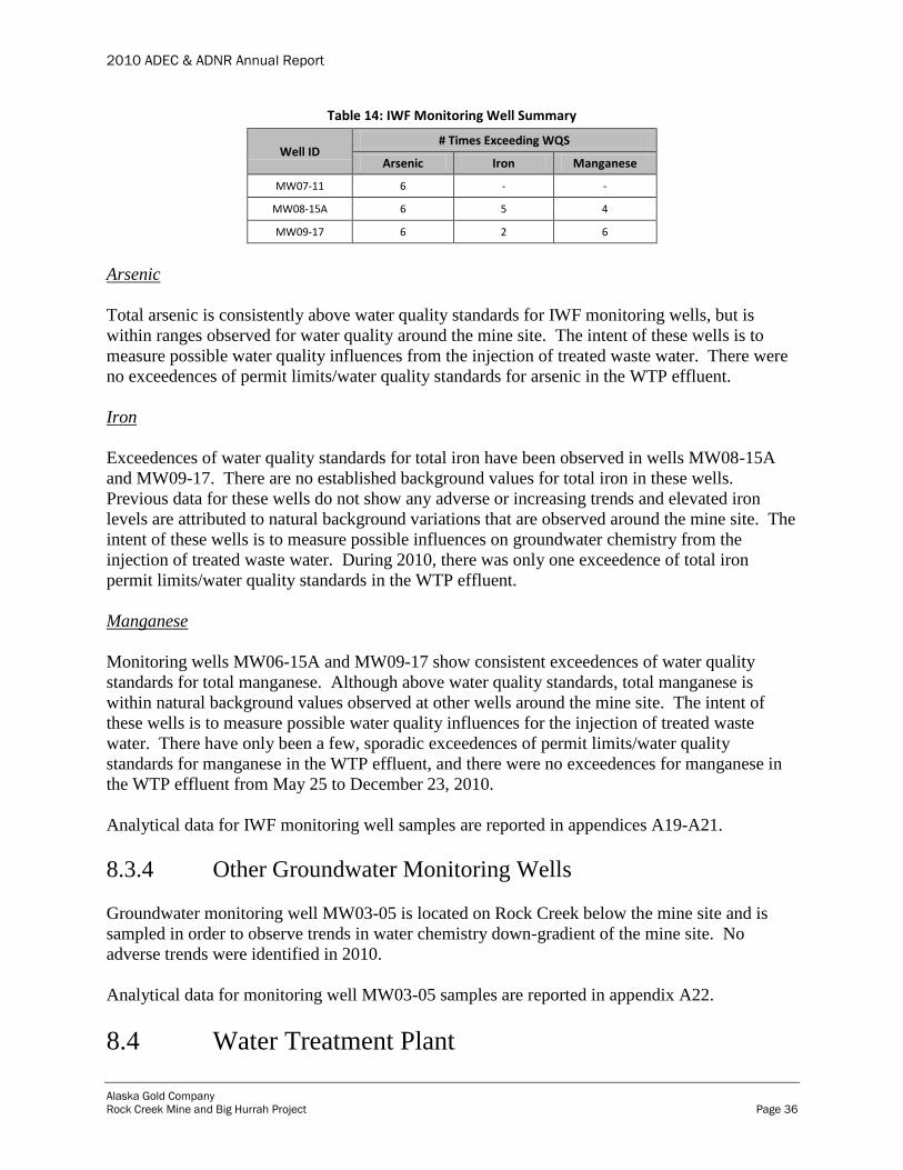
2010 ADEC & ADNR Annual Report
Alaska Gold Company
Rock Creek Mine and Big Hurrah Project Page 36
Table 14: IWF Monitoring Well Summary
Well ID # Times Exceeding WQS
Arsenic Iron Manganese
MW07-11 6 - -
MW08-15A 6 5 4
MW09-17 6 2 6
Arsenic
Total arsenic is consistently above water quality standards for IWF monitoring wells, but is
within ranges observed for water quality around the mine site. The intent of these wells is to
measure possible water quality influences from the injection of treated waste water. There were
no exceedences of permit limits/water quality standards for arsenic in the WTP effluent.
Iron
Exceedences of water quality standards for total iron have been observed in wells MW08-15A
and MW09-17. There are no established background values for total iron in these wells.
Previous data for these wells do not show any adverse or increasing trends and elevated iron
levels are attributed to natural background variations that are observed around the mine site. The
intent of these wells is to measure possible influences on groundwater chemistry from the
injection of treated waste water. During 2010, there was only one exceedence of total iron
permit limits/water quality standards in the WTP effluent.
Manganese
Monitoring wells MW06-15A and MW09-17 show consistent exceedences of water quality
standards for total manganese. Although above water quality standards, total manganese is
within natural background values observed at other wells around the mine site. The intent of
these wells is to measure possible water quality influences for the injection of treated waste
water. There have only been a few, sporadic exceedences of permit limits/water quality
standards for manganese in the WTP effluent, and there were no exceedences for manganese in
the WTP effluent from May 25 to December 23, 2010.
Analytical data for IWF monitoring well samples are reported in appendices A19-A21.
8.3.4 Other Groundwater Monitoring Wells
Groundwater monitoring well MW03-05 is located on Rock Creek below the mine site and is
sampled in order to observe trends in water chemistry down-gradient of the mine site. No
adverse trends were identified in 2010.
Analytical data for monitoring well MW03-05 samples are reported in appendix A22.
8.4 Water Treatment Plant

2010 ADEC & ADNR Annual Report
Alaska Gold Company
Rock Creek Mine and Big Hurrah Project Page 37
The WTP treats water from the TSF for injection to the IWF. Injected water is subject to
effluent limitations contained in UIC Permit Section 7, which are also incorporated into WMP
Section 1.6. WTP effluent samples are collected weekly directly from the injection well line just
past the booster pump. Weekly effluent samples collected for water chemistry analysis are
analyzed by SGS labs in Anchorage for parameters listed in table 7, and daily effluent samples
are monitored for physical parameters (pH, conductivity, and temperature) using a hand held
multi-meter.
During 2010, weekly sampling data showed several isolated exceedences of permit limits for
manganese, periods of elevated TDS, and in the early part of the year "false positives" for WAD
cyanide. Occasional, non-continuous exceedences of WTP effluent pH were also identified
during daily checks. Apart from these isolated issues, the WTP has performed as intended and
effluent limits were consistently met in 2010.
Manganese
The manganese exceedences are attributed to ORP upsets related to ozone plant operational and
chemical dosing issues in early 2010 as well as elevated influent manganese levels in the spring.
Plant upgrades including decommissioning the ozone generator, installing a caustic bulk loading
unit, and installing a hypo-chlorite dosing system have resulted in improved treatment
performance with no manganese exceedences in WTP effluent from May 25 to December 23,
2010.
TDS
The periods of elevated TDS are related to increases in TDS in the influent water as the TSF
level drops to low levels. At these low levels, less fresh water dilution is available to balance the
higher TDS levels in the sump water. The elevated TDS levels are between 500 and 600 mg/L
during late winter and early spring months. Prior to the exceedences, NovaGold informed
ADEC of their expected occurrence and its desire to continue pumping and treating water from
the TSF to minimize the water level prior to spring break-up. There is no viable approach to
treating TDS in the WTP.
WAD Cyanide
AGC observed exceedences of the WAD cyanide limit (0.0052 mg/L) in WTP effluent in early
2010. A follow-up investigation indicated that this exceedence was likely a false positive reading
that can result from chemical addition, specifically hypochlorite and ferric chloride, both of
which are used in the treatment process and have the potential to induce false positives. AGC
collected paired samples at points before and after chemical addition to determine what role, if
any, ferric chloride and hypochlorite might be playing in the WAD cyanide readings. As
expected, WAD cyanide levels in WTP influent (TSF pond water) were undetected while
elevated levels were observed following chemical treatment. AGC notes that total cyanide values
were undetected in both pre- and post-treatment samples, further supporting the false positive
explanation and demonstrating that WAD cyanide is not actually present in WTP effluent.

2010 ADEC & ADNR Annual Report
Alaska Gold Company
Rock Creek Mine and Big Hurrah Project Page 38
AGC consulted with its contract laboratory (SGS Labs) to develop a modified sample collection
procedure that neutralizes residual chlorine in the effluent sample and reduces the potential for
further false positive readings. The pre-treatment procedure for WAD cyanide samples of WTP
effluent now involves collection in a 250mL bottle with no preservative and pre-treatment with a
15g aliquot of ascorbic acid. The pre-treated sample is then transferred to a 250mL bottle
containing NaOH preservative as required for WAD cyanide samples. Beginning on April 15,
2010 AGC implemented this pre-treatment procedure and no further WAD cyanide false positive
reading were observed.
Analytical data for WTP effluent monitoring samples are reported in appendix A23.
8.5 Cyanide Monitoring of Tailings
There is no monitoring of cyanide in tailings during the temporary closure period.
8.6 Development Rock Stockpile Seepage Analysis
There are no development rock stockpiles at Rock Creek or Big Hurrah. All development rock
at Rock Creek was used in mine construction. There was no mining at Big Hurrah.
8.7 Geochemical Characterization
There is no geochemical characterization data to report. There is no mining activity while the
mine is in temporary closure.
8.8 Other Water Quality Monitoring
In accordance with ADEC WMP 2003-DB0051, ADEC must be notified in the next quarterly
report of any water quality monitoring that is conducted beyond what is required in the
monitoring plan.
As part of the continuous monitoring and optimization of the WTP in 2010, AGC collected
various water samples of WTP influent, in-stream, and effluent water for total and dissolved
metals analysis. AGC also collected samples of CIL tank water in order to determine treatment
options, pit lake water to characterize storm water run-off in contact with mineralized pit rock
which may require future treatment and disposal, and background groundwater sampling of well
MW09-16 which may be used as a monitoring well for future IWF expansions. Sample data is
available for review upon request.
9.0 Visual Monitoring

2010 ADEC & ADNR Annual Report
Alaska Gold Company
Rock Creek Mine and Big Hurrah Project Page 39
Daily and weekly visual monitoring was conducted on the Rock Creek Mine facilities regulated
under the WMP 2003-DB0051. Monitoring of erosion control structures and diversion structures
was conducted in accordance with the SWPPP.
Copies of the daily inspections and activities reports are available from AGC for review upon
request.
9.1 Tailings Storage Facility
The following sections describe the day-to-day visual monitoring of the TSF. As described in
Section 3.4, in 2010, AGC completed a comprehensive engineering evaluation of the TSF. This
evaluation showed that the facility is stable under current operation conditions.
9.1.1 TSF Dam
Visual inspections of the TSF include: inspections of the dam for signs of seeps, settlement,
cracking, and unusual observations; continuous recording of seepage collection system volumes;
continuous recording of thickener discharge amounts; inspections of support structures such as
pipes, plumbing, etc.; and daily measurements of the pond water surface elevation. The
conditions have been recorded on the daily TSF Inspection Log as per the Rock Creek Tailings
Operation and Maintenance (O&M) manual. The inspection log is available upon request.
9.1.2 TSF Seepage Collection System
The TSF seepage collection system (Main and South sumps) was visually inspected each day to
ensure that no abnormal event has occurred. The sumps, pipe line and pumps were inspected
each day. Flow meters were read and recorded (figure 12).

2010 ADEC & ADNR Annual Report
Alaska Gold Company
Rock Creek Mine and Big Hurrah Project Page 40
Figure 12: Main Sump + South Sump Combined Flow Data
9.1.3 Thickener
Paste tailings are not discharged from the thickener during the temporary closure period; visual
inspections are not conducted.
9.1.4 Support Structures
The TSF dam structure, along with the liner is visually inspected daily and repaired as needed.
The conditions have been recorded on the daily TSF Inspection Log as per the Rock Creek
Tailings (O&M) manual. The inspection log is available on request.
9.1.5 Water Surface
The water surface elevations have been recorded on the daily TSF Inspection Log as per the
Rock Creek Tailings O&M manual. After the expanded well field became fully operational in
November 2009, the water level in the TSF has consistently been lowered at a higher rate than
predicted by the theoretical site water balance. The COBC was terminated on April 1, 2010
when the TSF water elevation fell below 140 feet. The TSF elevation data for 2010 is presented
in figure 13.
80
180
280
380
480
580
680
GP
MMain Sump + South Sump Combined Flow Data

2010 ADEC & ADNR Annual Report
Alaska Gold Company
Rock Creek Mine and Big Hurrah Project Page 41
Figure 13: TSF Pond Elevation Change
9.2 Recycle Water Pond
Visual inspections of the RWP include: continuous monitoring of volumes pumped from the
LCRS; recording of volumes pumped from groundwater wells RPW-01 and RPW-02; daily
recording of the pond surface water elevation; and inspections of the pond liner for signs of
compromise.
9.2.1 Leak Collection and Recovery System
The LCRS design criteria is not to exceed 492 gpd. The LCRS recorded volumes were greater
than 492 gpd from January 4 to January 24, 2010 and again on January 31, 2010. The LCRS
recovered volume dropped to zero by March 7, 2010. The LCRS pump was not working for 20
days in July 2010 and was replaced. No further leakage was recovered by the LCRS in 2010
while the pump was in operation.
In the past it was assumed that there was a correlation between the groundwater level and the
LCRS volume. It was presumed that when groundwater elevation is higher than 123 feet amsl,
136.00
138.00
140.00
142.00
144.00
146.00
148.00
150.00
Ele
vati
on
(fe
et)
TSF Pond Elevation Change
2010 ADEC & ADNR Annual Report
Alaska Gold Company
Rock Creek Mine and Big Hurrah Project Page 42
groundwater begins to infiltrate the LCRS. Thus, to avoid this infiltration, pumping of RPW-02
and the RWP underliner pump was intended to maintain a groundwater elevation below 123 feet
amsl.
The groundwater elevation was above 125 feet amsl in the monitoring wells surrounding the
RWP from January through the middle of February 2010. Water levels rose again to that level
during August 2010, and stayed high through December 2010 (figure 14). However, in 2010, the
LCRS only had recovered volumes from January through March; no leakage was recovered after
March 6, 2010. This indicates that there is little if any correlation between flow in the LCRS and
a groundwater elevation above 123 feet amsl.
As part of an engineering evaluation of the RWP liner, the LCRS was evaluated by AMEC and
found to be working as intended. Refer to section 3.9 for a complete discussion.
9.2.2 Water Surface
Currently, AGC monitors groundwater elevations daily at four wells near the RWP to note any
instances of upwelling, decreasing water levels, or other abnormalities. RPW-01 and RPW-02
are pumping wells, MW08-14A is a deep monitoring well screened in bedrock, and MW08-14B
is a shallow monitoring well screened mostly in glacial till. Water levels near the RWP depend
strongly on pumping from the two pumping wells, RPW-01 and RPW-02. Only RPW-02 is
being pumped to keep groundwater near the RWP at a lower than natural level. Pumping is
needed to keep the water levels below the elevation of the RWP liner to avoid upward
groundwater pressure on the liner. Normal water levels without pumping are probably similar to
the highest measured water levels.
The figures below show groundwater elevations for 2010. Groundwater elevations were highest
from September through October 2010.
The Rock Creek Tailings O&M manual specify an operating water level in the RWP be
maintained at 139 feet elevation in order to accommodate storm water run-off from the mill site.
As shown in figure 14, the target level of 139 feet was exceeded periodically during 2010. When
in operations, this level would be maintained through the recycling of process water throughout
the mill plant facility. During temporary closure Care and Maintenance operation, AGC does not
maintain continuous pumping of the RWP to the TSF, and therefore periodically batches RWP
pond water to the TSF when higher levels are reached. The RWP level is monitored on a daily
basis to ensure adequate storage for any potential storm water run-off.
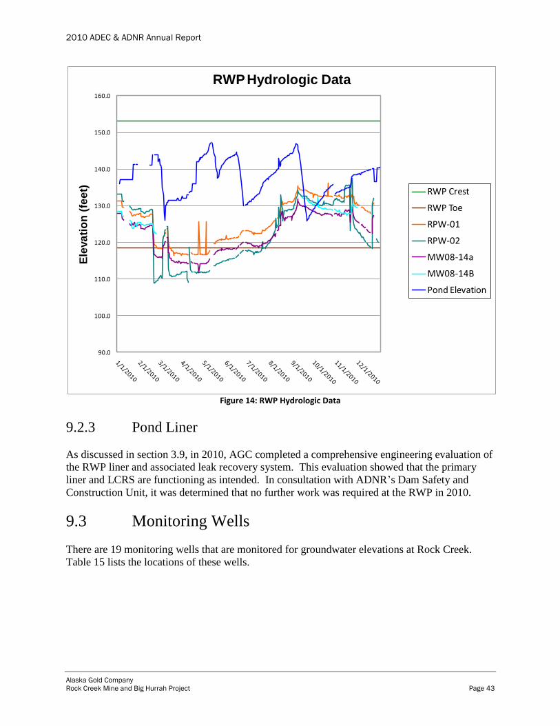
2010 ADEC & ADNR Annual Report
Alaska Gold Company
Rock Creek Mine and Big Hurrah Project Page 43
Figure 14: RWP Hydrologic Data
9.2.3 Pond Liner
As discussed in section 3.9, in 2010, AGC completed a comprehensive engineering evaluation of
the RWP liner and associated leak recovery system. This evaluation showed that the primary
liner and LCRS are functioning as intended. In consultation with ADNR’s Dam Safety and
Construction Unit, it was determined that no further work was required at the RWP in 2010.
9.3 Monitoring Wells
There are 19 monitoring wells that are monitored for groundwater elevations at Rock Creek.
Table 15 lists the locations of these wells.
90.0
100.0
110.0
120.0
130.0
140.0
150.0
160.0
Ele
va
tio
n (
fee
t)RWP Hydrologic Data
RWP Crest
RWP Toe
RPW-01
RPW-02
MW08-14a
MW08-14B
Pond Elevation

2010 ADEC & ADNR Annual Report
Alaska Gold Company
Rock Creek Mine and Big Hurrah Project Page 44
Table 15: Groundwater Monitoring Well Locations
Well ID Location Description
MW08-14a Downgradient RWP (deep) RWP water table monitoring
MW08-14b Downgradient RWP (shallow) RWP water table monitoring
RPW-01 North side RWP RWP water table monitoring
RPW-02 East side RWP RWP water table monitoring
MW06-8a South of TSF (deep) TSF water table monitoring
MW06-8b South of TSF (shallow) TSF water table monitoring
MW06-9a West of TSF (deep) TSF water table monitoring
MW06-9b West of TSF (shallow) TSF water table monitoring
MW06-10a North of TSF (deep) TSF water table monitoring
MW06-10b North of TSF (shallow) TSF water table monitoring
MW07-11 Downgradient Lower IWF IWF water table monitoring
MW08-15 Downgradient Lower IWF IWF water table monitoring
MW09-16 Downgradient Lower IWF IWF water table monitoring
Pilot Hole #20 North of Lower IWF IWF water table monitoring
MW09-17 Downgradient Upper IWF IWF water table monitoring
MW03-04 Upgradient Upper IWF IWF water table monitoring
PW-06 South of Upper IWF IWF water table monitoring
PW-08 South of Upper IWF IWF water table monitoring
JEFF Downgradient Upper IWF IWF water table monitoring
9.3.1 Visual Inspections
TSF monitoring wells are required to be visually inspected on a quarterly basis. As part of the
groundwater monitoring program all sampled monitoring wells are visually inspected at the time
of groundwater sampling. No damage or unusual conditions were observed in 2010 during these
inspections.
9.3.2 Groundwater Elevations
AGC monitors groundwater elevations daily at nine wells near the IWF to note any instances of
upwelling or other abnormalities.
MW07-11, MW08-15A, MW09-16 and Pilot Hole #20 are located below the IWF. MW07-11
and MW08-15A are converted injection test wells completed in bedrock and are located along
the west side of Glacier Creek Road, north of the mine entrance. Groundwater elevation
measurements in Pilot Hole #20 started in June 2010. The hole was plugged and sealed in
September 2010.
Injection in well #32 influences water levels in well MW08-15a. Injection well #32 is the
farthest south of the injection wells, and is located immediately up-gradient from well MW08-
15A. In monitoring well MW08-15A, water levels vary by more than 20 feet. Water levels rose
very suddenly in March 2010, when water was injected for two days in well #32. The second

2010 ADEC & ADNR Annual Report
Alaska Gold Company
Rock Creek Mine and Big Hurrah Project Page 45
rise occurred in May 2010, when injection was restarted. A sudden drop in water levels in
September 2010 corresponds to a day when injection was turned off. In December 2010, water
levels were still higher than in December 2009, as injection continued through December 2010
(figure 15).
Wells MW07-11 and MW09-16 show water levels increasing during the summer months, and
decreasing during the winter months. The range is approximately 5 feet between summer and
winter. Since total injection is similar in winter as in summer, this increase in water levels may
reflect normal seasonal trends (figure 16).
Pilot Hole #20 was monitored for 3 months (June, July, and August) and water levels were
generally constant during that period (figure 15).
Wells MW03-04, MW09-17, JEFF and PW-06 and PW-08 are also used to monitor groundwater
levels in the area of the Upper IWF. Well PW-06 is located west and cross-gradient of the
injection wells, and well PW-08 is located down-gradient of the well field. Measurements in
MW03-04 were restarted on February 16, 2010 subsequent to the well freezing on December 6,
2009. Electrical power reached well MW09-17 on October 21, 2010, and a heat trace and
transducer were installed. Well JEFF was frozen from February 10, 2010 until June 29, 2010,
and refroze on October 31, 2010.
Historic water levels in monitoring well MW03-04 show seasonal increases in the summers of
2004 and 2005 before any injection started. In 2010 water levels increased from April to May,
but the water level decrease in the fall was much smaller (figure 16). This rise in water levels
may be caused by injection, and future close observation of this well is warranted.
Water levels in PW-06 and PW-08 also show some increase in water levels during the summer
months, with water levels decreasing again in the fall (figure 16).
Not enough data have been collected for MW03-07 and its replacement well MW09-17 to
discern any trends (figure 16).
Water levels in the monitoring wells near the Lower IWF have always been below the ground
surface elevation, indicating that the injection activities have not over-pressurized the
groundwater system. In the Upper IWF, water levels in wells MW03-04, JEFF, and MW09-17
(MW03-07) are very close to or at ground elevation. Historic data show that water levels in
wells MW03-04 and MW03-07 were at ground level during summer 2004, thus, groundwater in
this area is naturally very close to the ground surface, and the high water levels are not caused by
injection. No historic data are available for well JEFF; however, its location is close to Rock
Creek which indicates that groundwater levels are naturally close to the surface.

2010 ADEC & ADNR Annual Report
Alaska Gold Company
Rock Creek Mine and Big Hurrah Project Page 46
Figure 15: Lower IWF Groundwater Elevations
40.00
60.00
80.00
100.00
120.00
140.00
160.00
Elev
atio
ns
(fe
et)
Lower IWF - Groundwater Elevations
MW07-11
MW07-11 ground
MW08-15
MW08-15 ground
MW09-16
MW09-16 ground
Pilot Hole #20
Pilot Hole #20 ground

2010 ADEC & ADNR Annual Report
Alaska Gold Company
Rock Creek Mine and Big Hurrah Project Page 47
Figure 16: Upper IWF Groundwater Elevations
AGC also monitors groundwater elevations at monitoring wells below the RWP and TSF. No
anomalies or upwellings were observed in these wells during 2010 (figures 17 & 18).
100.00
150.00
200.00
250.00
300.00
350.00
400.00
450.00
Elav
atio
ns
(fe
et)
Upper IWF - Groundwater Elevations
MW03-04
MW03-04 ground
PW-6
PW-6 ground
PW-8
PW-8 ground
MW09-17
MW09-17 ground
Jeff
Jeff ground
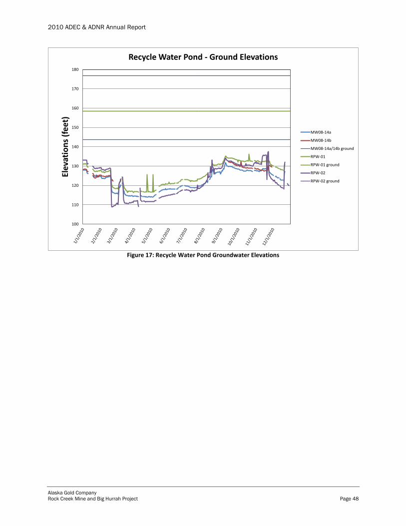
2010 ADEC & ADNR Annual Report
Alaska Gold Company
Rock Creek Mine and Big Hurrah Project Page 48
Figure 17: Recycle Water Pond Groundwater Elevations
100
110
120
130
140
150
160
170
180El
evat
ion
s (f
eet
)Recycle Water Pond - Ground Elevations
MW08-14a
MW08-14b
MW08-14a/14b ground
RPW-01
RPW-01 ground
RPW-02
RPW-02 ground
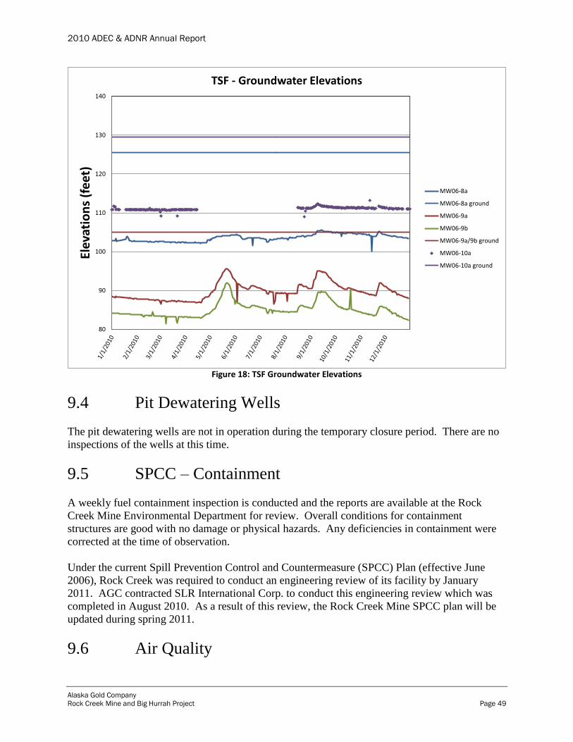
2010 ADEC & ADNR Annual Report
Alaska Gold Company
Rock Creek Mine and Big Hurrah Project Page 49
Figure 18: TSF Groundwater Elevations
9.4 Pit Dewatering Wells
The pit dewatering wells are not in operation during the temporary closure period. There are no
inspections of the wells at this time.
9.5 SPCC – Containment
A weekly fuel containment inspection is conducted and the reports are available at the Rock
Creek Mine Environmental Department for review. Overall conditions for containment
structures are good with no damage or physical hazards. Any deficiencies in containment were
corrected at the time of observation.
Under the current Spill Prevention Control and Countermeasure (SPCC) Plan (effective June
2006), Rock Creek was required to conduct an engineering review of its facility by January
2011. AGC contracted SLR International Corp. to conduct this engineering review which was
completed in August 2010. As a result of this review, the Rock Creek Mine SPCC plan will be
updated during spring 2011.
9.6 Air Quality
80
90
100
110
120
130
140
Elev
atio
ns
(fe
et)
TSF - Groundwater Elevations
MW06-8a
MW06-8a ground
MW06-9a
MW06-9b
MW06-9a/9b ground
MW06-10a
MW06-10a ground

2010 ADEC & ADNR Annual Report
Alaska Gold Company
Rock Creek Mine and Big Hurrah Project Page 50
Inspections of the ambient air boundary signage are required monthly under the TCP. Any
broken signs or signs knocked over by high wind were fixed when identified during routine
inspections. During the summer months, the emergency contact phone number on all of the
ambient air boundary signs was updated.
9.7 Wildlife
Numerous wildlife observations were made in 2010, including reindeer, moose, fox, bear,
muskoxen, and nesting ravens. There were no reported wildlife mortalities in 2010. Current
policy is to contact the Safety or Environmental Office when wildlife is observed. A list of
wildlife observations is kept on file at the mine site. AGC worked with the local Fish and Game
office in dealing with any potential wildlife problems including: wildlife hazing, removal of
abandoned raven nests, injured animals, and rabid fox encounters.
10.0 Financial Responsibility
AGC has posted a Reclamation Bond in the amount of $6,844,700.00 which is backed by an
Irrevocable Standby Letter of Credit between AGC and Wells Fargo Bank. The current
Reclamation Bond amount of $6,844,700.00 was approved by the agencies in 2007.
As part of the annual financial review conducted by NovaGold, AGC has clarified that the entire
bond amount remains available for Rock Creek Mine.
In 2010, at the request of ADNR, AGC updated its closure cost estimate for the Rock Creek
Mine under current conditions. A revised estimate of $8,412,000.00 with supporting
documentation was submitted to ADNR on May 17, 2010. As of the end of 2010, ADNR was
still reviewing the revised closure cost estimate.
11.0 References
Alaska Gold Company, 2009. Rock Creek Mine and Big Hurrah Project ADEC and ADNR
Annual Report 2008.
AMEC, September 2010. Alaska Gold Company Rock Creek Tailings Storage Facility 2010
Geotechnical Investigation
AMEC, October 2010. Alaska Gold Company Tailings Storage Facility NID # (AK00309) 2010 Final
Engineering Evaluations
SRK, 2008. Rock Creek Mine and Big Hurrah Project Nome, Alaska.
SRK, November 2008. Monitoring Plan.
Tetra Tech, 2010. NPDES Construction General Permit Storm Water Pollution Prevention Plan,
Revised February 2010. Alaska Gold Company Rock Creek Project, Nome, Alaska.
Tetra Tech RTW, 2009, Operation and Maintenance Manual for Rock Creek Mine Wastewater
Treatment Plant for NovaGold