2000-2001 esd annual report
DESCRIPTION
In this report, we present summaries of many of our current research projects. While it is not a complete accounting, it is representative of the nature and breadth of our research effort. We hope that you will be as excited about our research as we are.TRANSCRIPT


Disclaimer
This document was prepared as an account of work sponsored by the United States Government.While this document is believed to contain correct information, neither the United States Governmentnor any agency thereof, nor The Regents of the University of California, nor any of their employees,makes any warranty, express or implied, or assumes any legal responsibility for the accuracy, complete-ness, or usefulness of any information, apparatus, product, or process disclosed, or represents that itsuse would not infringe privately owned rights. Reference herein to any specific commercial product,process, or service by its trade name, trademark, manufacturer, or otherwise, does not necessarily con-stitute or imply its endorsement, recommendation, or favoring by the United States Government or anyagency thereof, or The Regents of the University of California. The views and opinions of authorsexpressed herein do not necessarily state or reflect those of the United States Government or anyagency thereof, or The Regents of the University of California.
Ernest Orlando Lawrence Berkeley National Laboratory is an equal opportunity employer.
Earth Sciences DivisionBerkeley Lab
Annual Report2000–2001
Disclaimer

EARTH SCIENCES DIVISIONANNUAL REPORT
2000–2001
ERNEST ORLANDO LAWRENCE
BERKELEY NATIONAL LABORATORY
University of CaliforniaBerkeley, California 94720
Prepared for the U.S. Department of Energy under Contract No. DE-AC03-76SF00098.
3-5 Title-Org_TOC.qxd 8/31/09 4:33 PM Page i

Earth Sciences DivisionBerkeley Lab
Annual Report2000–2001
ii
ESD ORGANIZATION CHART
3-5 Title-Org_TOC.qxd 8/31/09 4:33 PM Page ii

A PERSPECTIVE FROM THE DIVISION DIRECTOR 1
RESOURCE DEPARTMENTS 3
HYDROGEOLOGY AND RESERVOIR DYNAMICS 5
GEOPHYSICS AND GEOMECHANICS 7
GEOCHEMISTRY 9
MICROBIAL ECOLOGY AND ENVIRONMENTAL ENGINEERING 11
RESEARCH PROGRAMS 13
FUNDAMENTAL AND EXPLORATORY RESEARCH 15
Geochemistry and Isotope Constraints in Oil Hydrogeology 17B. Mack Kennedy, Tom Torgersen, and Thijs van Soest
Computation of Seismic Waveforms in Complex Media: Carbon Dioxide Sequestration Imaging 18Valeri A. Korneev and Gennady M. Goloshubin
Wave Propagation through a Porous Medium Containing Two Immiscible Fluids 19W.-C. Lo, Garrison Sposito, and Ernest L. Majer
Mechanical and Acoustic Properties of Weakly Cemented Granular Rocks 20Seiji Nakagawa and Larry R. Myer
Decomposition of Scattering and Intrinsic Attenuation in Rock with Heterogeneous Multiphase Fluids 21Kurt T. Nihei, Toshiki Watanabe, Seiji Nakagawa, and Larry R. Myer
Density Functional Theory Calculations on the Structures of 2:1 Clay Materials 22Sung-Ho Park, Garrison Sposito, Rebecca Sutton, and Jeffery A. Greathouse
Numerical Simulation Studies of Multiphase Flow Dynamics during CO2 Disposal into Saline Formations 23Karsten Pruess and Julio Garcia
Modeling of Hydromechanical Changes Associated with Brine Aquifer Disposal of CO2 24Jonny Rutqvist and Chin-Fu Tsang
Fracture Surface-Zone Flow and the Sorptivity-Permeability Relation 25Tetsu K. Tokunaga and Jiamin Wan
Reactive Chemical Transport in Structured Porous Media: X-ray Microprobe and Micro-XANES Studies 26Tetsu K. Tokunaga, Jiamin Wan, Terry Hazen, Mary Firestone, Stephen R. Sutton,Egbert Schwartz, Matthew Newville, and Keith R. Olson
Joint Inversion for Mapping Subsurface Hydrological Parameters 27Hung-Wen Tseng and Ki Ha Lee
Partitioning of Clay Colloids to Gas-Water Interfaces 28Jiamin Wan and Tetsu K. Tokunaga
Earth Sciences DivisionBerkeley Lab
Annual Report2000–2001
iii
TABLE OF CONTENTS
3-5 Title-Org_TOC.qxd 8/31/09 4:33 PM Page iii

FUNDAMENTAL AND EXPLORATORY RESEARCH (CONTINUED)
Fe3+ Sorption on Quartz Surfaces: Grazing Incidence X-Ray Analysis 29Glenn A. Waychunas, Rebecca Reitmeyer, and James A. Davis
The Geometry of Zn Complexation on Ferrihydrite 30Glenn A. Waychunas, Christopher C. Fuller, and James A. Davis
Structural Analysis of Sulfate in Schwertmannite 31Glenn A. Waychunas, Samuel J. Traina, Jerry R. Bigham, and Satish C.B. Myneni
Numerical Simulation to Study Mineral Trapping for CO2 Disposal in Deep Aquifers 32Tianfu Xu, John A. Apps, and Karsten Pruess
Development of a High-Performance Massively Parallel TOUGH2 Code 33Keni Zhang, Yu-Shu Wu, Karsten Pruess, and Chris Ding
NUCLEAR WASTE 35
Fractures and UZ Processes at Yucca Mountain 37Jennifer J. Hinds and Gudmundur S. Bodvarsson
Moisture Monitoring along a Nonventilated Section of Tunnel at Yucca Mountain 38Rohit Salve
Systematic Hydrologic Characterization of the Topopah Spring Lower Lithophysal Unit 39Paul Cook, Yvonne Tsang, Rohit Salve, and Barry Freifeld
Automated Seepage Testing at Niche 5, Exploratory Studies Facility, Yucca Mountain 40Robert C. Trautz
Seepage into Drifts Located in a Lithophysal Zone 41Stefan Finsterle, C. F. Ahlers, Paul J. Cook, and Yvonne Tsang
Impact of Rock Bolts on Seepage 42C. F. Ahlers
Seepage Enhancement Resulting from Rockfall 43Guomin Li and Chin-Fu Tsang
Upscaling of Constitutive Relations in Unsaturated, Heterogenous Porous Media 44Hui Hai Liu and Gudmundur S. Bodvarsson
Constitutive Relations for Unsaturated Flow in a Fracture Network 45Hui Hai Liu and Gudmundur S. Bodvarsson
Capillary-Barrier Effects in Unsaturated Fractured Rocks of Yucca Mountain 46Yu-Shu Wu, Lehua Pan, Jennifer Hinds, and Gudmundur S. Bodvarsson
Earth Sciences DivisionBerkeley Lab
Annual Report2000–2001
iv
Table of Contents
3-5 Title-Org_TOC.qxd 8/31/09 4:33 PM Page iv

NUCLEAR WASTE (CONTINUED)
An Improvement to DCPT: The Particle-Transfer Probability as a Function of Particle’s Age 47Lehua Pan and Gudmundur S. Bodvarsson
Thermal-Loading Studies Using the Unsaturated Zone Model 48Charles B. Haukwa, Sumit Mukhopadhay, Yvonne Tsang, and Gudmundur S. Bodvarsson
Understanding the Irregular Data from the Large Block Test 49Sumit Mukhopadhyay
Modeling of Thermal-Hydrologic-Chemical Laboratory Experiments 50Patrick F. Dobson, Timothy J. Kneafsey, Eric Sonnenthal, and Nicolas Spycher
Mountain-Scale Coupled Thermal-Hydrologic-Chemical Processes aroundthe Potential Nuclear Waste Repository at Yucca Mountain 51Eric Sonnenthal, Charles Haukwa, and Nicolas Spycher
Temperature Effects on Seepage Fluid Compositions at Yucca Mountain 52Nicolas Spycher and Eric Sonnenthal
Coupling of TOUGH2 and FLAC3D for Coupled Thermal-Hydrologic-Mechanical Analysisunder Multiphase Flow Conditions 53Jonny Rutqvist, Yu-Shu Wu, Chin-Fu Tsang, and Gudmundur S. Bodvarsson
Modeling of Coupled Thermal-Hydrologic-Mechanical Processes at Yucca Mountain 54Jonny Rutqvist and Chin-Fu Tsang
Yellowstone as an Analog for Thermal-Hydrologic-Chemical Processes at Yucca Mountain 55Patrick F. Dobson, Timothy J. Kneafsey, Ardyth Simmons, and Jeffrey Hulen
U-Series Transport Studies at Peña Blanca, Mexico, Natural Analog Site 56Ardyth M. Simmons and Michael T. Murrell
Developing an Effective-Continuum Site-Scale Model for Flow and Transport in Fractured Rock 57Christine Doughty and Kenzi Karasaki
Simulating Infiltration at the Large-Scale Ponded Infiltration Test, INEEL 58André Unger, Ardyth Simmons, and Gudmundur S. Bodvarsson
ENERGY RESOURCES 59
Integrated Reservoir Monitoring Using Seismic and Crosswell Electromagnetics 61G. Michael Hoversten
High-Speed 3D Hybrid Elastic Seismic Modeling 62Valeri A. Korneev and Charles A. Rendleman
Frequency-Dependent Seismic Attributes of Poorly Consolidated Sands 63Kurt T. Nihei, Zhuping Liu, Seiji Nakagawa, Larry R. Myer, Liviu Tomutsa, and James W. Rector
Earth Sciences DivisionBerkeley Lab
Annual Report2000–2001
v
Table of Contents
3-5 Title-Org_TOC.qxd 8/31/09 4:33 PM Page v
ENERGY RESOURCES (CONTINUED)
Imaging, Modeling, Measuring, and Scaling of Multiphase Flow Processes 64Liviu Tomutsa and Tadeusz Patzek
Single-Well Seismic Imaging 65Ernest L. Majer, Roland Gritto, and Thomas M. Daley
Tube-Wave Suppression for Single-Well Imaging 66Thomas M. Daley, Roland Gritto, and Ernest L. Majer
Fracture Quantification in Gas Reservoirs 67Ernest L. Majer, Thomas M. Daley, Larry Myer, Kurt Nihei, and Seiji Nakagawa
Semi-Automatic System for Waterflood Surveillance 68Tadeusz Patzek and Dmitriy B. Silin
Gas-Production Scenarios from Hydrate Accumulations at the Mallik Site, McKenzie Delta, Canada 69George J. Moridis, Karsten Pruess, and Larry R. Myer
Dynamic Reservoir Characterization through the Use of Surface Deformation Data 70Donald W. Vasco and Kenzi Karasaki
Reactive-Chemical-Transport Simulaton to Study Geothermal Production with Mineral Recovery 71Tianfu Xu, Karsten Pruess, Minh Pham, Christopher Klein, and Subir Sanyal
Non-Condensable Gases: Tracers for Reservoir Processes in Vapor-Dominated Geothermal Systems 72Alfred Truesdell and Marcelo Lippmann
A Model of the Subsurface Structure at the Rye Patch Geothermal ReservoirBased on Surface-to-Borehole Seismic Data 73Roland Gritto, Thomas M. Daley, and Ernest L. Majer
Electromagnetic Methods for Geothermal Exploration 74Ki Ha Lee, Hee Joon Kim, and Mike Wilt
The Yangbajing Geothermal Field, Tibet: Heat Source and Fluid Flow 75Ping Zhao, B. Mack Kennedy, David L. Shuster, Ji Dor, Ejun Xie, and Shaoping Du
ENVIRONMENTAL REMEDIATION TECHNOLOGY 77
Isotope Tracking of Water Infiltration through the Unsaturated Zone at Hanford 79Mark E. Conrad and Donald J. DePaolo
Fuzzy-Systems Modeling of In Situ Bioremediation of Chlorinated Solvents 80Boris Faybishenko and Terry C. Hazen
Experimental Investigation of Aerobic Landfill Biodegradation 81Terry C. Hazen, Sharon E. Borglin, Peter T. Zawislanski, and Curtis M. Oldenburg
Earth Sciences DivisionBerkeley Lab
Annual Report2000–2001
vi
Table of Contents
3-5 Title-Org_TOC.qxd 8/31/09 4:33 PM Page vi

ENVIRONMENTAL REMEDIATION TECHNOLOGY (CONTINUED)
Subsurface Imaging for Characterizing Heterogeneity Affecting Microbial-Transport Properties in Sediments 82Ernest L. Majer, Susan Hubbard, Kenneth H. Williams, John E. Peterson, and Jinsong Chen
High-Resolution Imaging of Vadose Zone Transport Using Crosswell Radar andSeismic Methods: Results of Tests at the Hanford (Washington) Sisson and Lu Site 83Ernest L. Majer, John E. Peterson, Kenneth H. Williams, and Thomas M. Daley
Ex Situ Treatment of MTBE-Contaminated Groundwater in Fluidized Bed Reactors 84Keun-Chan Oh and William Stringfellow
Numerical Simulation of Landfill Biodegradation Processes 85Curtis M. Oldenburg, Sharon E. Borglin, and Terry C. Hazen
Water-Table Rise Correlates with TCE Increase at a Contaminated Site 86Curtis M. Oldenburg, Preston D. Jordan, Jennifer Hinds, and Barry M. Freifeld
Fluid Flow, Heat Transfer, and Solute Transport at Hanford Tank SX-108:A Summary Report on Modeling Studies 87Karsten Pruess, Steve B. Yabusaki, Carl I. Steefel, and Peter C. Lichtner
A Decision Support System for Adaptive Real-Time Management of Seasonal Wetlands in California 88Nigel W. T. Quinn and W. Mark Hanna
A New Method of Well-Test Analysis Using Operational Data 89Dmitriy B. Silin and Chin-Fu Tsang
Fast Flow in Unsaturated Coarse Sediments 90Tetsu K. Tokunaga, Jiamin Wan, and Keith Olson
Diffusion-Limited Biotransformation of Metal Contaminants in Soil Aggregates: Chromium 91Jiamin Wan, Tetsu K.Tokunaga, Terry C. Hazen, Egbert Schwartz, Mary K. Firestone, Stephen R. Sutton,Matthew Newville, Keith R. Olson, Antonio Lanzirotti, and William Rao
Colloid Formation during Leakage of Hanford Tank-Waste Liquid into Underlying Vadose Zone Sediments 92Jiamin Wan, Tetsu Tokunaga, Eduardo Saiz, Keith Olson, and Rex Couture
Land Disposal of Seleniferous Sediments: A Pilot-Scale Test 93Peter T. Zawislanski, Sally M. Benson, Robert TerBerg, and Sharon E. Borglin
CLIMATE VARIABILITY AND CARBON MANAGEMENT 95
The GEO-SEQ Project 97Larry R. Myer and Sally M. Benson
Borehole Seismic Monitoring of CO2 Injection in a Diatomite Reservoir 98Thomas M. Daley, Ernest L. Majer, and Roland Gritto
Earth Sciences DivisionBerkeley Lab
Annual Report2000–2001
vii
Table of Contents
3-5 Title-Org_TOC.qxd 8/31/09 4:33 PM Page vii

CLIMATE VARIABILITY AND CARBON MANAGEMENT (CONTINUED)
Capacity Investigation of Brine-Bearing Sands for Geologic Sequestration of CO2 99Christine Doughty, Karsten Pruess, Sally M. Benson, Christopher T. Green,Susan D. Hovorka, and Paul R. Knox
Crosswell Imaging at the Weyburn Field for CO2 Tracking 100Ernest L. Majer and Valeri Korneev
Pilot Study Investigations of CSEGR 101Curtis M. Oldenburg and Sally M. Benson
An Intercomparison Study of Simulation Models for Geologic Sequestration of CO2 102Karsten Pruess, Chin-Fu Tsang, David H.-S. Law, and Curtis M. Oldenburg
The California Water Resources Research and Applications Center 103Norman L. Miller, Kathy Bashford, George Brimhall, Susan Kemball-Cook, William E. Dietrich,John Dracup, Jinwon Kim, Phaedon C. Kyriakidis, Xu Liang, and Nigel W.T. Quinn
Modeling the Water Resource and Environmental Impacts of Climate Variability on the San Joaquin Basin 104Norman L. Miller, Nigel W. T. Quinn, John Dracup, Jinwon Kim, and Richard Howitt
Applications of Remotely Sensed Data for Seasonal Climate Predictions in East Asia and Southwest United States 105Jinwon Kim, Norman L. Miller, R.C. Bales, and L.O. Mearns
The DOE Water Cycle Initiative Pilot: Modeling and Analysis of Seasonal and Event Variability at the Walnut River Watershed 106Norman L. Miller, Mark S. Conrad, Donald J. DePaolo, and Inez Fung
Carbon Monitoring at the ARM Southern Great Plains Site 107William Riley, Margaret Torn, Marc Fischer, David Billesbach, and Joe Berry
Isotopic Analysis of Carbon Cycling and Sequestration in a California Grassland 108Margaret Torn, M. Rebecca Shaw, and Chris Field
EARTH SCIENCES DIVISION PUBLICATIONS 2000–2001 109
EARTH SCIENCES DIVISION STAFF 2000–2001 115
Earth Sciences DivisionBerkeley Lab
Annual Report2000–2001
viii
Table of Contents
3-5 Title-Org_TOC.qxd 8/31/09 4:33 PM Page viii

Global population growth and increased industrializationa re placing stronger demands on our earth’s energ y, mineral,and water resources, and are adding to concerns about whetherwe, as a global society, will be able to sustain economic gro w t hand maintain a clean and safe environment for future genera-tions. Not surprisingly, the importance of the earth and eco-system sciences in shaping our future grows larger than ever.Not only must earth scientists continue to address the issues thatw e re so pressing during the past century—secure and plentifule n e rgy and water re s o u rces, remediation of contaminatedg round and surface waters, and prediction of natural geologich a z a rds—but now we must face the challenges of the 21stc e n t u r y. Growing concentrations of greenhouse gases in thea t m o s p h e re and the need for safe and secure nuclear wastemanagement have emerged as two important concerns faced byour nation and others around the world. As one of the U.S.Department of Energy’s national laboratories, it is the missionof Ernest Orlando Lawrence Berkeley National Laboratory(Berkeley Lab) to provide a robust scientific foundation to betterunderstand and identify solutions to these pressing issues.
Our long-standing scientific strengths and fundamentalre s e a rch in hydrogeology and reservoir engineering, geophysicsand geomechanics, geochemistry, microbial ecology, and envi-ronmental engineering provide the foundation for all of ourp rograms. Building on this scientific foundation, we performapplied earth science re s e a rch and technology development tosupport the Department of Energy in a number of its pro g r a mareas, namely:
• Nuclear Waste Management—theoretical, experimentaland simulation studies of the unsaturated zone at Yu c c aMountain, Nevada
• E n e rgy Resources—collaborative projects with industry todevelop or improve technologies for the exploration andproduction of oil, gas, and geothermal reservoirs
• E n v i ronmental Remediation Te c h n o l o g y — i n n o v a t i v etechnologies for containing and remediating metals,radionuclides, chlorinated solvents, and energ y - re l a t e dcontaminants in soils and groundwaters
• Climate Change and Carbon Management—geologicsequestration of carbon dioxide, carbon cycling in theoceans and terrestrial biosphere, and regional climatemodeling which are the cornerstones of a major new divi-
sional re s e a rch thrust related to understandingand mitigating the effects of increased gre e n-house gas concentrations in the atmosphere
This year has been another exciting and productive one forour division. During the reporting period, we have made gre a tstrides in all our ongoing re s e a rch programs, particularly in thenewer areas of regional climate change and its impact on surfaceand gro u n d w a t e r, and the sequestration of carbon dioxide ingeologic, terrestrial, and oceanic systems.
In this report, we present summaries of many of our currentre s e a rch projects. While it is not a complete accounting, it isre p resentative of the nature and breadth of our re s e a rch eff o r t .We hope that you will be as excited about our re s e a rch as we are .
ORGANIZATION OF THIS REPORTThis report is divided into five sections that correspond to
the major research programs in the Earth Sciences Division:• Fundamental and Exploratory Research• Nuclear Waste• Energy Resources• Environmental Remediation Technology• Climate Variability and Carbon Management
These programs draw from each of our disciplinary depart-ments: Microbial Ecology and Environmental Engineering,Geophysics and Geomechanics, Geochemistry, and Hydro -geology and Reservoir Dynamics. Short descriptions of thesedepartments are provided as introductory material. A list ofpublications for the period June 2000 to June 2001, along with alisting of our personnel, are appended to the end of this report.
ACKNOWLEDGMENTSThe Earth Sciences Division consists of 60 scientists and
engineers, another 25 faculty scientists with joint Berkeley Lab-UC Berkeley appointments, and approximately 50 scientific andtechnical support persons. We gratefully acknowledge thesupport of our major sponsors in the Department of Energ y,which include the Office of Science, the Office of Fossil Energ y,the Office of Energy Efficiency and Renewable Energ y, the Off i c eof Civilian Radioactive Waste Management, and the Office ofE n v i ronmental Management. We also appreciate the supportreceived from other federal agencies such as the Bureau ofReclamation, the Department of Defense, the Enviro n m e n t a lP rotection A g e n c y, and NASA. Lastly, we must also acknowl-edge and thank our industrial collaborators who provide bothfinancial and in-kind support through various partnership proj-ects, and who bring additional ideas, data, and experience to ourdivision.
Earth Sciences DivisionBerkeley Lab
Annual Report2000–2001
1
A PERSPECTIVE FROM
THE DIVISION DIRECTOR
Norman Goldstein
THE EARTH SCIENCES DIVISION
AR_Main_Overview-rev.qxd 8/28/09 6:25 PM Page 1

Earth Sciences DivisionBerkeley Lab
Annual Report2000–2001
This page is intentionally left blank.
2
AR_Main_Overview-rev.qxd 8/28/09 6:25 PM Page 2

RESOURCE DEPARTMENTS
EARTH SCIENCES DIVISION ANNUAL REPORT 2000–2001
HYDROGEOLOGY AND RESERVOIR DYNAMICS
GEOPHYSICS AND GEOMECHANICS
GEOCHEMISTRY
MICROBIAL ECOLOGY AND ENVIRONMENTAL ENGINEERING
3
AR 5a_Resource Departments.qxd 8/28/09 7:35 PM Page 3

Earth Sciences DivisionBerkeley Lab
Annual Report2000–2001
This page is intentionally left blank.
4
AR 5a_Resource Departments.qxd 8/28/09 7:35 PM Page 4
The Hydrogeology and Reservoir Dynamics Department(HRD) is one of the world’s most active re s e a rch groups in thefields of hydrogeology and reservoir engineering. Specificresearch areas include the following:
CONTAMINANT HYDROLOGYWork conducted in this area covers various theoretical, exper-
imental, and field studies, including a detailed evaluation andremediation of subsurface contamination at Berkeley Lab. In thismultiyear program, the geologic and hydrogeologic stru c t u re ofthe site was characterized in detail. Plumes of gro u n d w a t e rcontamination were identified, and the extent and sources ofcontamination were determined. Various technologies, bothestablished and emerging, are being tested to determine theirremediative effectiveness for the Berkeley Lab site. The pre s e n c eof dense nonaqueous-phase liquids in fine-grained, low-perme-ability material makes aquifer cleanup at Berkeley Lab a verychallenging task. The work involves geologists, hydro g e o l o g i s t s ,geophysicists, and hydrogeochemists in a multidisciplinary ef-fort, characteristic of many HRD re s e a rch pro j e c t s .
Other efforts in this area include understanding some of theconceptual issues governing tracer transport in hetero g e n e o u smedia (with particular emphasis on the effect of variable satu-ration regimes), developing advanced numerical and semi-analytical models for transport studies of solutes and colloids inp o rous and fractured complex geologic media, and advancingwell-test techniques and bore h o l e - m e a s u rement methods toidentify and estimate formation parameter values. A n o t h e rsubject in which HRD has considerable experience is theemplacement of in situ barriers using a new generation of mate-rials (such as gels) to contain the contaminant plume. This expe-rience manifests itself both in the choice of barrier materials andthe optimization of emplacement strategy.
UNSATURATED ZONE HYDROLOGYWhile the majority of re s e a rch in HRD in unsaturated zone
h y d rology is stimulated by the need to understand flow andtransport in the unsaturated zone at Yucca Mountain, Nevada,efforts are also underway to study flow and transport in uncon-ventional unsaturated zones. Field measurements from activeflow experiments along with monitoring of ambient conditionsin the Exploratory Studies Facility (ESF) at Yucca Mountainremain the primary focal point for re s e a rch in HRD. Resultsf rom the broad field campaign of testing in the ESF are the objectof analysis by advanced theoretical and numerical appro a c h e s ,including chaotic-flow models. In addition, observations in thefield have inspired new laboratory work to be carried out atBerkeley Lab on rock samples from the ESF. We are also increas-ingly active in studies of contaminant migration and re m e d i a-tion in the unsaturated zone of the Hanford site. As forunconventional unsaturated zones, HRD is investigating theflow and transport of CO2 in deep geologic formations such asdepleted natural-gas reservoirs, as well as flow, transport, andbiodegradation in landfills, a man-made unsaturated zone.
FRACTURE AND STOCHASTIC HYDROLOGYFor more than two decades, HRD has been active in the field
of fracture hydro l o g y, being one of the first groups to develop af r a c t u re-network model and a channeling model of flowt h rough variable-aperture fracture systems, and to applyannealing modeling to fracture hydro l o g y. Our work is charac-terized by close interaction between modeling and field dataevaluation, with complementary laboratory studies. This workcontinues and has been further generalized to re s e a rch intos t rongly heterogeneous media, including studies withstochastic-continuum and double-permeability models. Work inHRD demonstrated flow-channeling phenomena in both 3Dsaturated and unsaturated media. Furthermore, new field meas-
Earth Sciences DivisionBerkeley Lab
Annual Report2000–2001
5
HYDROGEOLOGY AND
RESERVOIR DYNAMICS
RESOURCE DEPARTMENT
Chin-Fu Tsang
AR_HRD_Overview.qxd 9/1/09 7:10 PM Page 5

u rement techniques are being developed to measure stro n g l yvarying permeabilities in boreholes and along underg ro u n dtunnels. The former includes the further advancement of thedynamic borehole fluid-logging method developed at BerkeleyLab some years ago. The latter includes so-called systematictesting, which is a repeated set of experiments at re g u l a r l yspaced distances along an underground tunnel to provide unbi-ased data for stochastic modeling.
FLOW AND TRANSPORT MODELINGHRD has a long history in numerical modeling of flow and
transport in geologic media. A suite of numerical models usingfinite-element, finite-diff e rence, and integrated finite-diff e re n c emethods has been developed. The most well-tested and appliedcomputer code is the TOUGH family of simulators, which calcu-lates flow and transport of multiphase, multicomponent fluidsin complex fractured porous media under isothermal andnonisothermal conditions. A number of equation-of-state pack-ages have been developed for diff e rent fluids appropriate fore n v i ronmental, nuclear waste disposal, oil and gas, and geot-hermal reservoir applications. Associated with these codes arethe iTOUGH codes, which perform inverse calculations ofparameter estimation for such complex systems.
C u r rent development involves a new code that implementsreactive chemistry into the TOUGH codes. This includes bothhomogeneous reactions, such as aqueous complexation and re d o xreactions, and heterogeneous reactions, such as ion exchange,adsorption, mineral dissolution and precipitation, and gas disso-lution and exsolution. The new code is called TO U G H R E A C T,which has already been applied to analyze several sets of real fielddata with success. Work is also underway on a new code calledTMVOC, which enhances T2VOC for multicomponent mixture sof volatile organic chemicals.
The coupling of mechanical stress and temperature eff e c t sof permeability in fractured rock is important for injectiontesting, stimulation of oil and gas reservoirs as well as geot-hermal reservoirs, and nuclear waste repository performance.HRD’s work involves the development of a coupled thermal-h y d rologic-mechanical (THM) simulator for modeling of fullycoupled HM processes in saturated and unsaturated media.Another effort has involved the coupling of two powerfulexisting codes, TOUGH2 and the industry-standard codeFLAC3D. The latter calculates mechanical and THM pro c e s s e sin soil and rock mechanics. The joining of these two codes intoone, named TOUGH-FLAC, gives us a new capability for
a d d ressing these coupled THM problems. So far, we haveapplied the TOUGH-FLAC code to THM problems related tothe potential radioactive waste repository at Yucca Mountainand to CO2 injection into deep brine aquifers.
RESERVOIR ENGINEERINGHRD is also very active in the study of oil and gas re s e r v o i r s
as well as geothermal reservoirs. This includes optimization andc o n t rol theory to maximize fluid production through a hydro f r a c-turing process, using injection wells. Advanced and unconven-tional well-test methods to determine and characterize pro d u c t i o nzones have been developed. Quasi-static and dynamic pore -network simulators are being implemented to understanddrainage and imbibition processes in reservoir rocks duringflooding operations. Depositional models are being constru c t e dand studied using distinct-element methods. Micro m e c h a n i c a lmodels of rock damage under compaction are studied and cali-brated with experimental results, while the dynamics of nonequi-librium co- and counterc u r rent imbibition are also being studied.
An interesting application for these studies is diatomaceousfields, which re p resent potentially billions of barrels of high-quality oil. However, production from the diatomites requires asecondary recovery process because of their low permeability,even though they have high poro s i t y. As a result, re s e a rch intorock damage in primary production and flooding is beingconducted to explore optimal production strategies. Joint inver-sions of 3D electromagnetic geophysical data and reservoir dataare performed. We are also developing stabilized finite-elementmethods for modeling multiphase flow in fractured poro u smedia. A novel treatment of the unresolved subgrid scales wasre q u i red for better numerical solutions of difficult problems thatinvolve shock and boundary-layer formation.
FUNDING Funding for HRD comes primarily from the U.S. Department
of Energ y, including: Office of Science, Office of Basic Energ yScience, Geosciences Research Program; Office of Biological andE n v i ronmental Research; Assistant Secretary for Energ yE fficiency and Renewable Energ y, Office of Wind andGeothermal Technologies; Office of Civilian Radioactive Wa s t eManagement; and the Assistant Secretary for Enviro n m e n t a lManagement. The department also receives funding supportf rom the U.S. Environmental Protection A g e n c y. Other fundingis provided through the Laboratory Directed Research andDevelopment program at Berkeley Lab.
Earth Sciences DivisionBerkeley Lab
Annual Report2000–2001
6
Hydrogeology and Reservoir Dynamics Department
AR_HRD_Overview.qxd 9/1/09 7:10 PM Page 6

The Geophysics and Geomechanics Department performs awide variety of work, ranging from fundamental to appliedresearch.
SCIENTIFIC THRUSTSThe department is organized into three diff e rent re s e a rc h
areas:• Seismology (including the Center for Computational
Seismology)• Electrical and Potential Methods• Rock and Soil PhysicsThese groups work closely together to address issues in
subsurface imaging over a wide range of scales. The scientifict h rusts have been in joint inversion, wave propagation incomplex media (seismic and electromagnetic), coupled-pro c e s sdefinition, and heterogeneity definition. New areas of re s e a rc ha re in fluid imaging and “smart” reservoir exploitation. Much ofthe work focuses on developing and applying high-re s o l u t i o ngeophysical methods to derive physical, chemical, and biolog-ical properties affecting flow and transport in hetero g e n e o u smedia. A prime example is the work funded by the Departmentof Energy’s Natural and Accelerated Bioremediation Researc h(NABIR) program for bacterial injection work. Another primarythrust involves using geophysical methods for fracture quantifi-cation. This thrust is evident in the range of studies (from funda-mental to applied) that we carry out for DOE’s Fossil Energ y,E n v i ronmental Restoration, Nuclear Waste, and Geothermalprograms.
The Geophysics and Geomechanics Department is uniquewithin the national laboratory and academic communities inhaving equally strong theoretical, modeling, lab, field/data ac-quisition, and pro c e s s i n g / i n t e r p retation capabilities. Thedepartment also works very closely with industrial partners inoil and gas and geothermal applications. This both stre n g t h e n sthe applied work and provides feedback into the fundamentalstudies.
INTEGRATED APPROACH TO FUTURE WORKThe future thrusts of the department are to continue to
develop, test, and apply high-resolution geophysical methodsnot only for characterizing static properties of the subsurface,but for estimating dynamic properties as well. We plan toaccomplish this through an integrated effort of theoretical, labo-r a t o r y, and field programs. A specific thrust will be in the jointuse of seismic and electrical methods for subsurface imagingand fluid-properties characterization. We have found that toa d d ress complex issues such as site remediation, flow and trans-port in fracture systems, vadose zone transport, CO2 s e q u e s t r a-tion, and reservoir stimulation, we must use an integratedapproach to geophysics and geomechanics.
FUNDINGThe work of the Geophysics and Geomechanics Department
is derived from a variety of U.S. Department of Energy andWork For Others sources. The primary sources of funding arethe DOE’s Office of Science (Basic Energy Sciences/ChemicalSciences and Office of Biological and Environmental Researc h ) ,O ffice of Fossil Energ y. Other funding sources include the U.S.E n v i ronmental Protection A g e n c y, U.S. Air Force Office ofScientific Research, and the U.S. Geological Survey’s EarthquakeH a z a rd Reduction Program. Support has also been re c e i v e df rom a variety of oil and service companies, including BP,Chevron, Conoco, Exxon, Schlumberger, and Shell Oil.
Earth Sciences DivisionBerkeley Lab
Annual Report2000–2001
7
GEOPHYSICS AND GEOMECHANICS
RESOURCE DEPARTMENT
Ernest L. Majer
AR_G&G_Overview.qxd 9/1/09 7:18 PM Page 7

Earth Sciences DivisionBerkeley Lab
Annual Report2000–2001
This page is intentionally left blank.
8
AR_G&G_Overview.qxd 9/1/09 7:18 PM Page 8

The Earth Sciences Division’s Geochemistry Departmentcombines expertise in chemical and isotopic analysis, moleculare n v i ronmental science, mineralogy, and multiscale data-gath-ering methodology to enable geochemical characterization ofearth systems from the macroscopic to the molecular. Thedepartment comprises four groups with complementary inter-ests and capabilities.
AQUEOUS GEOCHEMISTRYStudies in this group address issues of contaminant seques-
tration and migration in the environment, mineral-fluid re a c-tions, and various aspects of aqueous solutions. Recent workincludes characterization of the selenium speciation, transport,and reaction rates within soil horizons at the KestersonR e s e r v o i r, a site where national attention is focused as a result ofselenium poisoning of wildlife related to agricultural ru n o ff .Related investigations examine arsenic transport and re d o xreactions in soils, and microbial effects on the speciation of sele-nium in hydrologic systems. The important but overlookedeffects of the vadose zone air-water interface on the transport ofcolloids has been identified and quantified by department scien-tists.
Fundamental studies on the nature of the aqueous solu-tion/mineral interface and on the stru c t u re of near- a q u e o u ssolvated ions and colloids are also being performed. The aim ofthese studies is to provide improved modeling capability forcontaminant migration, weathering, sediment transfer, ionexchange, and nutrient cycles. Current work includes: molec-u l a r-dynamics modeling of the interlayer-solvated cations inclays; studies of the solvation environment of contaminant andnutrient molecules in aqueous solution; determination of themolecular identity of initial iron oxide precipitates on quartzsurfaces; and characterization of environmentally importantminerals via simulation, x-ray scattering, and x-ray spec-t roscopy methods. Many of these efforts involve newly devel-oped capabilities utilizing synchrotron x-ray sources. Importantnew work on the aqueous behavior of humic and fulvic acids,h y d roxyl speciation near cations in water, and the nature ofo rganic contaminants on mineral surfaces has been carried outrecently at Berkeley Lab’s Advanced Light Source.
ISOTOPE GEOCHEMISTRYThe Isotope Geochemistry group operates
the Center for Isotope Geochemistry, which wasestablished in 1988 and includes six important
analytical facilities: stable isotope and noble gas isotope labora-tories; a soil carbon laboratory; an analytical chemistry labora-tory; the Inductively Coupled Plasma Multi-Collector MagneticSector mass spectrometry laboratory, and a thermal-ionizationmass spectrometry laboratory located on the UC Berkeleycampus. We also have an affiliation with the cosmogenic isotopelaboratory in UC Berkeley’s Space Sciences Laboratory. Thesefacilities provide state-of-the-art characterization of all types ofearth materials for re s e a rch throughout the department ande l s e w h e re in the division. Further, they support the Center'sgoals of finding new ways to utilize isotopic ratio methods tostudy earth processes, and applying isotopic and chemicalanalysis procedures to specific environmental and energy prob-lems of national interest.
C u r rent re s e a rch programs include: (1) the development ofmodels that use isotopic composition data from element pairs influids to constrain fluid flow rates, water-mineral reaction rates,and the geometry and spacing of fractures in rock matrices; (2)the development and application of noble gas isotopes asnatural tracers for injectate return in geothermal reservoirs andas natural tracers for fluid source and movement in hydro-carbon and geothermal systems; (3) the geochemical monitoringand analysis of large-scale experiments simulating the effects ofnuclear waste heat generation within the nuclear repository inYucca Mountain, Nevada; (4) the application of helium andneodymium isotopes to determine magma-chamber re c h a rg erates in areas having possible volcanic hazards or the potentialfor geothermal energy extraction; (5) the development of C, N,and O isotope techniques for quantifying in situ bioremediationand environmental restoration; and (6) the use of carbonisotopes to quantify rates of organic carbon cycling and storagee fficiency in soils, the impact of climate change on carboncycling, and linkages between carbon, water, and nitro g e ncycles. A new program is underway to study Fe isotope varia-tions as a tracer in the oceanic and terrestrial Fe cycles.
ATMOSPHERE AND OCEAN SCIENCES The focus of this group is on the characterization of condi-
tions and chemical components in the oceans and atmosphere ,and the development of process models using these inputscombined with other hydrospheric data to explain and pre d i c tclimatic change. The group operates the NASA-sponsore dCalifornia Water Resources Research and Applications Centerand the DOE Center for Research on Ocean CarbonSequestration. Both of these centers have made significantp ro g ress in program development in the ESD GeochemistryDepartment.
The California Water Resources Research and A p p l i c a t i o n sCenter has maintained a suite of re s e a rch and operational toolsfor weather forecasts, climate prediction, and basic re s e a rch. The
Earth Sciences DivisionBerkeley Lab
Annual Report2000–2001
9
GEOCHEMISTRY
RESOURCE DEPARTMENT
Donald J. DePaolo
AR_GEO_Overview.qxd 8/31/09 5:18 PM Page 9

in the division brings together essential pieces of the pro b l e m ,including hydrological processes in the unsaturated zone, ther-modynamics and kinetics of geochemical processes, and isotopiceffects.
Current projects include:1. Simulation and analysis of an ongoing large-scale under-
g round thermal test. Planning and design of future under-ground thermal testing and sample collection.
2. P rediction of the coupled thermal-hydro l o g i c a l - c h e m i c a lp rocesses around potential waste-emplacement tunnelsand concomitant changes in water and gas chemistry,mineralogy, and flow.
3. Analysis of geochemical data from Yucca Mountain toconstrain models of flow and transport in the unsaturatedzone.
4. Development of models for reactive-transport in unsatu-rated systems and improvements in the reactive-transportcode TOUGHREACT developed at Berkeley Lab.
5. Evaluation and development of improved thermody-namic and kinetic databases for water- rock interactionmodeling.
6. R e s e a rch on natural analogue sites, including (a) analysisof continuously cored intervals from the Yellowstone geot-hermal system to assess effects of mineral alteration onf r a c t u re and matrix permeability, (b) study of flow, trans-port, and secondary mineralization at Peña Blanca,Mexico, (c) anthropogenic analogues, such as those at theIdaho National Engineering and Environmental Lab-o r a t o r y. A c o m p rehensive review of natural analogues isalso underway.
7. Simulation and analysis of lab experiments of boiling infractured tuff.
8. Modeling of CO2 sequestration.9. Evaluation of solvent extraction using ro o m - t e m p e r a t u re
ionic liquids to strip and recover hazardous org a n i ccontaminants dissolved in ground and surface waters.
FUNDINGFunding for the Geochemistry Department comes from a
variety of sources, including: the U.S. Department of Energ y,O ffice of Science, Office of Basic Energy Sciences, Divisions ofMaterials Sciences, and Engineering and Geosciences; DOEO ffice of Environmental Management, Office of Science andTechnology; Office of Energy Efficiency and Renewable Energ y,O ffice of Utility Technologies, Office of GeothermalTechnologies; Office of Biological and Environmental Researc h ;DOE Office of Civilian Radioactive Waste Management; U.S.E n v i ronmental Protection Agency; U.S. Navy; NationalA e ronautics and Space Administration, Office of Space Scienceand NASA Earth Enterprise; National Science Foundation,O ffice of Polar Programs; the University of California Campus-Laboratory Collaboration Hydrology Project; NationalOceanographic Partnership Program (administered by theO ffice of Naval Research); National Oceanic and A t m o s p h e r i cAdministration, Office of Global Programs ofthe U.S. Department of Commerce, and theL a b o r a t o r y - D i rected Research andDevelopment Program at Berkeley Lab.
c o re hydroclimate and impacts team has expanded, with newprojects from the California Energy Commission, CALFED, andthe DOE Water Cycle Initiative. Numerous ongoing collabora-tions include: streamflow simulations with the National Oceanic& Atmospheric Administration’s California Nevada RiverF o recast Center; ru n o ff contaminant monitoring and manage-ment with the U.S. Bureau of Reclamation; development of land-s l i d e - h a z a rd prediction models with faculty at UC Berkeley;development of snow-cover and snow-water equivalent mapsfor California with UC Santa Barbara; and development of as h a red information distribution system with the U.S.Department of Energy’s Accelerated Climate Pre d i c t i o nInitiative (DOE/ACPI) collaborators. Outreach activities for thisyear have included a scientific exchange program withAmazonTech.
Ocean-carbon cycle science has grown significantly at BerkeleyLab in the last year, with major new initiatives in the laboratory andat sea. Last year, the DOE Center for Research on Ocean CarbonSequestration (DOCS) was established here, with co-hosting atL a w rence Livermore National Laboratory. The center's mission isto provide answers to scientific questions needed to evaluate thef e a s i b i l i t y, effectiveness, and environmental/geochemical conse-quences of proposed methods to enhance the transfer of CO2 f ro mfossil fuel combustion into the ocean. DOCS collaborators includescientists from Massachusetts Institute of Te c h n o l o g y, RutgersU n i v e r s i t y, Scripps Institution of Oceanography, Moss LandingMarine Laboratories, Monterey Bay Aquarium Research Institute,and the Pacific International Center for High Technology Researc h .
Berkeley Lab is now an ocean-going institution. In the pasty e a r, Lab scientists led several cruises from Scripps Institution ofOceanography in San Diego to test new optical carbon sensorsand low-power, long-lived, robotic profiling floats for long-termcarbon cycle monitoring. The robot floats and related platformsthat can glide through seawater (or navigate) are designed to filla major gap in at-sea observations of the ocean's biologicalsystems and how they respond to natural and human perturba-tions. In April this year, the program realized a stunning opera-tional success when it deployed the first pair of robotic profilingobservers instrumented with carbon biomass sensors in thestormy North Pacific Ocean 1,000 miles west of Seattle. Thefloats, which cycle between the surface and depths as great as1,000 m three times every two days, are still operating and arerelaying their data in real time to Berkeley Lab. In the nearf u t u re, the team will participate in SoFeX, an NSF-DOE-fundedexperiment to evaluate the biotic and carbon system response ofthe nutrient-rich A n t a rctic Circumpolar Current to iron addi-tion.
GEOCHEMICAL TRANSPORTA major effort of this group is the simulation and study of
coupled mineral-water-gas reactive transport in unsaturatedp o rous media—particularly in fractured rock under boilingconditions. This work has focused mostly on predicting ther-mally driven processes accompanying the potential emplace-ment of high-level nuclear waste at Yucca Mountain, Nevada,and on the understanding of the evolution of the natural hydro-geochemical system and such controlling factors as water infil-tration and water- rock interaction. Collaboration among others
Earth Sciences DivisionBerkeley Lab
Annual Report2000–2001
10
Geochemistry Department
AR_GEO_Overview.qxd 8/31/09 5:18 PM Page 10

SCIENTIFIC FOCUS AREASThe Microbial Ecology and Environmental Engineering
Department (MEEED) maintains the highest quality and highestvisibility for its research and development in two areas:
1. Real-time direct environmental assessment2. Biological treatment, bioremediation, and natural attenua-
tionThese two R&D areas are largely integrated, but contain
some domains that are not inclusive. These two areas areconsidered MEEED’s core competencies. (Note: MEEED is alsoincreasingly interested in adding bioprocessing as anotherresearch focus area in the near future.)
REAL-TIME DIRECT ENVIRONMENTAL ASSESSMENT
The last decade has seen a revolution in information tech-nology and in the power of microprocessors. It has also seen aquantum leap in the use of physical, chemical, and biologicalsensors, as ever-more-sensitive detection techniques have beenmarried to these powerful data processing engines. The field ofenvironmental assessment has only recently awakened to thepotential that these new sensors offer. It has also becomepainfully obvious over the past decade that the dynamics andtrue understanding of functional biogeochemical processes in alltypes of environments cannot be fully understood withoutdirect physical, chemical, and biological measurements. Indeed,what goes on in the sampling device and sample bottle aftercollection may have nothing to do with the functional dynamicsof the original environment that the sample was taken from,thereby affecting our fundamental understanding of that envi-ronment and how to characterize, monitor, and control it.Hence, real-time direct environmental assessment is an area inwhich MEEED—with its unique facilities in the Center forEnvironmental Biotechnology, engineering, molecular biology,chemistry facilities, and access to the Advanced Light Sourceand the Center for Isotope Geochemistry—can demonstrateunique R&D capability.
Berkeley Lab has long provided scientific leadership in thedisciplines of experimental physics, physical chemistry, geology,hydrology, geochemistry, molecular biology, modeling, and(more recently) natural attenuation and bioremediation tech-nologies. Hence, MEEED is well situated to capitalize on theLab’s strengths while advancing the science in real-time directenvironmental assessment. Specific focus areas include: real-time field sampling and monitoring, field sampling technolo-gies, environmental sensors, environmental modeling anddecision support systems, biogeochemical analysis (samplecollection; microbial physiology; molecular-level analysesincluding DNA sequencing and terminal restriction-fragment-length polymorphism [T-RFLP] analysis; fatty-acid methyl esteranalysis; signature lipid biomarker analysis; synchrotron-basedx-ray, Fourier Transform infrared [FTIR], and x-ray spectromi-croscopy techniques; stable isotopic analysis), and environ-mental risk assessment.
BIOLOGICAL TREATMENT, BIOREMEDIATION,AND NATURAL ATTENUATION
Biological treatment, bioremediation, and natural attenua-tion has been a rapidly growing area of science over the pastdecade. The acceptance of natural attenuation as a solution forcleaning up contaminated sites, and DOE’s recognition that theywill have long-term stewardship issues that they must addressat the most contaminated sites, has greatly increased theurgency for basic and applied research related to microbialecology and biogeochemistry. This type of research is trulyenabling for natural attenuation, since characterization, predic-tions, and verification monitoring require a strong scientificbasis. Natural attenuation is viewed as the best solution forcleaning up many waste sites and will save billions of dollars incleanup costs. Bioremediation, both in situ and ex situ, have alsoenjoyed strong scientific growth, in part due to the increased useof natural attenuation, since most natural attenuation resultsfrom biodegradation. Bioremediation and natural attenuation
Earth Sciences DivisionBerkeley Lab
Annual Report2000–2001
11
RESOURCE DEPARTMENT
MICROBIAL ECOLOGY AND
ENVIRONMENTAL ENGINEERING
Terry C. Hazen

are also seen as a solution for emerging contaminant problems(e.g., methyl-tert-butyl ether [MTBE], endocrine disrupters,landfill stabilization, mixed waste biotreatment, and biologicalcarbon sequestration).
MEEED scientists and engineers are recognized leaders inthe field of biological treatment, bioremediation, and naturalattenuation. The Center for Environmental Biotechnologyprovides the primary facilities used by MEEED, including state-of-the-art equipment for microbiology and environmental engi-neering. MEEED investigators have extensive experience in bothwater treatment and bioremediation, especially co-metabolicbiodegradation and the treatment of inhibitory compounds. Inaddition to basic research, MEEED investigators have beeninvolved in various aspects of more than 60 field demonstra-tions and deployments, and have five patents in this area thatare licensed to more than 30 companies. The types of contami-nants in which MEEED investigators have expertise includechlorinated solvents, petroleum hydrocarbons, polynucleararomatic hydrocarbons, ketones, MTBE, TNT, inorganicnitrogen (NO3, NH4), tritium, Pu, Np, Cr, and U. TheBiotreatment, Bioremediation and Natural Attenuation area hasboth basic research and field application foci for the MEEED.The basic research foci are co-metabolism, biotreatability,biotransformation kinetics, and modeling of biogeochemicalprocesses. Field-application foci are co-metabolic techniques,
biogeochemical assessment techniques, and modeling of attenu-ation and environmental fate.
FUNDINGMEEED personnel are funded by DOE Programs in (1) the
Office of Science, Office of Biological and EnvironmentalResearch (OBER) (Natural and Accelerated BioremediationResearch Program); (2) the Office of Environmental Manage-ment, Offices of Science and Technology (EM50) (SubsurfaceContaminants Focus Area) and Environmental RestorationProgram (EM40); (3) the Office of Fossil Research, the PetroleumEnvironmental Research Forum, and (4) the National NuclearSecurity Administration, Office of Nonproliferation Researchand Engineering (NN20). In addition, support is obtained fromthe Department of Defense, U.S. Army Corps of Engineers, forthe Bioremediation Education Science and Technology (BEST)Program; the Department of the Interior, Bureau of LandManagement, and Bureau of Reclamation under the CALFEDprogram, for bioreactor treatment of groundwater containingMTBE obtained from a remediation company, as well as severalprojects with remediation companies using DOE-patented tech-nologies for in situ bioremediation. MEEED personnel are alsofunded by Berkeley Lab’s Laboratory Directed Research andDevelopment Program in the area of aerobic bioreactor studiesof landfills.
Earth Sciences DivisionBerkeley Lab
Annual Report2000–2001
12
Microbial Ecology and Environmental Engineering Department

FUNDAMENTAL AND EXPLORATORY RESEARCH
NUCLEAR WASTE
ENERGY RESOURCES
ENVIRONMENTAL REMEDIATION TECHNOLOGY
CLIMATE VARIABILITY AND CARBON MANAGEMENT
RESEARCH PROGRAMS
EARTH SCIENCES DIVISION ANNUAL REPORT 2000–2001
13

Earth Sciences DivisionBerkeley Lab
Annual Report2000–2001
This page is intentionally left blank.
14

The Fundamental and Exploratory Research Program(FERP) covers fundamental earth sciences research conducted insupport of the Department of Energy’s science mission. Thismission includes research in the natural sciences to provide abasis for new and improved energy technologies and for under-standing and mitigating the environmental impacts of energydevelopment and use. FERP also includes exploratory researchin important new energy and environmental topics conductedunder the Laboratory Directed Research and Development(LDRD) program. The scientific insights and breakthroughsachieved in FERP often become the underpinnings for projectsthat support DOE’s applied research and development programoffices.
Over the years, the basic earth sciences research program atBerkeley Lab has focused on three broad earth sciences prob-lems:
1. Fundamental studies of chemical and mass transport ingeologic media, with special reference to predictivemodeling of multiphase, multicomponent, nonisothermalfluid flow in saturated and unsaturated fractured rocks
2. The development of new isotopic techniques for under-standing the nature of a broad range of global processes—from the relatively short-term effects of natural fluidmigration in the crust to longer-term (i.e., 10–20 thousandyears) global climate variations
3. Fundamental studies in the propagation of seismic/acoustic and broadband electromagnetic waves throughgeologic media, with emphasis on new computationaltechniques for high-resolution imaging of near-surfaceand crustal structures (such as possible fracture flowpaths) and for inferring the types of fluids present in poresand fractures
Results from these research endeavors have had a majorimpact on applied energy, environmental, and radioactive wastemanagement programs. Current research projects are brieflydescribed here.
CHEMICAL AND MASS TRANSPORT INVESTIGATIONS
Current research in this area is focused on colloid transportin unsaturated porous media and rock fractures, chemical trans-port in structure porous media, unsaturated fast flow in frac-tured rock, and production and evaluation of coupled processesfor CO2 in aquifers. Our recent colloid research has been focusedon quantifying the partitioning of surface-active colloids at theair-water interfaces. Much effort has been devoted to character-izing surface accumulations of colloids. We have recently devel-oped a simple dynamic method to quantify colloid-surfaceexcesses at air-water interfaces without requiring assumptionsconcerning the thickness of interfacial regions.
The studies of chemical transport in structured porousmedia have focused on Cr(VI) diffusion and reduction to Cr (III)within natural soil aggregates, to test the validity of our previ-ously reported results from synthetic soil aggregates.Experiments were conducted on intact aggregates of Altamontclay. Work on unsaturated fast flow in fractured rock concernswater films on fracture surfaces under near-zero (negative)matric potentials and examines the possibility of fast, unsatu-rated flow under “tension.” We showed that at matric potentialsgreater than that needed to saturate the rock matrix, transmis-sive water films can develop on fracture surfaces.
In the work on prediction and evaluation of coupledprocesses for CO2 disposal in aquifers, the accuracy of publisheddata and correlations for thermophysical properties of CO2(density, viscosity, enthalpy) is being evaluated for the range ofpressure and temperature conditions of interest in aquiferdisposal. Suitable correlations are being implemented in ourmultipurpose simulator TOUGH2. Pre-existing models for CO2dissolution in aqueous fluids are being enhanced by incorpo-rating salinity and fugacity effects. Special techniques are alsobeing developed for describing the movement of sharp CO2-water interfaces during immiscible displacement of saline brinesby CO2.
Earth Sciences DivisionBerkeley Lab
Annual Report2000–2001
15
FUNDAMENTAL AND
EXPLORATORY RESEARCH
RESEARCH PROGRAM
Ernest L. Majer

ISOTOPE GEOCHEMISTRYThe Center for Isotope Geochemistry (CIG) is a state-of-the-
art analytical facility established in 1988 to measure the concen-trations and isotopic compositions of elements in rocks,minerals, and fluids in the earth’s crust, atmosphere, andoceans. Fundamental research conducted at this center isdirected at finding new ways to use isotopic information tostudy earth processes, such as long-term climate changes, and atpredicting the chemical transport of mantle-derived or deepcrustal fluids as they move through the crust.
One of the major problems being studied at CIG is how toestimate fluid-solid reaction rates in natural-groundwaterhigher-temperature geothermal conditions, particularly as theserates affect mineral dissolution and secondary mineral precipi-tation. ESD researchers are developing novel ways of estimatingreaction rates by using isotopic tracers (primarily Sr, but also Uand Nd) to determine solid-fluid exchange rates in variousnatural situations. Scientists are able to derive the “reactionlength,” a parameter that depends on the ratio of isotope trans-port by diffusion and advection to the reaction rate. The ultimateobjective is to understand the microscopic (as well as pore-scaleand mesoscale) characteristics of natural systems that have beencharacterized in terms of "field scale" reaction-rate measures. Anintermediate goal is to establish empirically the natural range offluid-solid reaction rates.
ADVANCED COMPUTATION FOR EARTH IMAGING
The Center for Computational Seismology (CCS) was createdin 1983 as the Berkeley Lab and UC Berkeley nucleus for seismicresearch related to data processing, advanced imaging, and visu-alization. In recent years, a great deal of cross-fertilizationbetween seismologists and other geophysicists and hydrogeolo-gists has developed within the division, resulting in collabora-tions on a wide variety of fundamental imaging problems. Aprimary thrust in this research has been to jointly developseismic and electrical methods for understanding fluid flow andproperties within the subsurface. In addition, fundamental
studies on improved inversion and modeling of complex mediain 3D are being carried out to analyze such effects as matrixhetergeneity fluid flow and anisotropy. Applications range fromsmall-scale environmental problems to oil and gas reservoirs.
ROCK PHYSICSA variety of rock and soil science experiments are being
conducted through ESD’s Geoscience Measurements Facility,which supports both field and laboratory work. In one newlaboratory project, researchers are studying the compaction andfracturing of weakly cemented granular rocks. This study exam-ines the effect of micromechanical properties of weak granularrock on macroscopic properties such as load-displacementresponse, ultimate strength, and failure mode. In a second study,a fundamental investigation of scattering and intrinsic attenua-tion of seismic waves in rock with heterogeneous distributionsof fluids and gas is being conducted. This research represents adeparture from past rock-physics studies on seismic attenuation,in that the emphasis here is not a detailed study of a specificattenuation mechanism, but rather to investigate theoretical andlaboratory methods for obtaining separate estimates of scat-tering and intrinsic attenuation in rock with heterogeneouspore-fluid distributions.
FUNDINGFunding for research in FERP comes from a variety of
sources. These include (primarily) the U.S. Department ofEnergy’s Office of Science, Office of Basic Energy Sciences,Division of Chemical Sciences, Geosciences, and Biosciences; theOffice of Biological and Environmental Research; and theAssistant Secretary for Fossil Energy, Office of Natural Gas andPetroleum Technology, through the National PetroleumTechnology Office, Natural Gas and Oil Technology Partnership.Funding is also provided by the Laboratory Directed Researchand Development Program at Berkeley Lab. Additional supportcomes from DOE’s Office of Environmental ManagementScience Program.
Earth Sciences DivisionBerkeley Lab
Annual Report2000–2001
16
Fundamental and Exploratory Research

RESEARCH OBJECTIVESThis research project evaluates the sources and processes
that provide, dissolve, and distribute noble gases (He, Ne, Ar,Kr, Xe) and noble-gas isotopes among liquid hydrocarbon,gaseous hydrocarbon, and aqueous phases. On a basin or fieldscale, this information is used to evaluate hydrocarbon sourcesand characteristics, groundwater end-members, and migrationprocesses, mechanisms, and time scales over which theseprocesses occur.
APPROACHThe mechanisms, processes, and time scales of fluid flow in
sedimentary basins are fundamental questions in the earthsciences, with direct application to exploration and exploitationstrategies for energy and mineral resources. This project inves-tigates the noble-gas composition of hydrocarbon samples on abasin and field scale, where adequate commercial productionand ancillary information are available, to provide a test of theuse and applicability of noble gases to delineate end members,migration mechanism, and migration paths for hydrocarbons.
ACCOMPLISHMENTSProduction fluid from the North Sea’s Snorre and Statfjord
oil fields show clear geographical correlation in their noble-gasisotope and abundance characteristics. Mixing relationshipscoupled with the geographical compositionaltrends (Figures 1 and 2) suggest that (1) bothreservoirs were filled with oil from a commonsource, (2) with migration into each reservoir,the inherited noble gases from the hydrocarbonsource area are diluted with noble gases fromthe existing in situ reservoir fluids, and (3) fluidflow was from a direction contrary to existingmigration scenarios. The fluid in each reservoirhad a different in situ noble gas composition,and the differences may be related to theregional tectonics. Specifically, the VikingGraben, a zone of active extension, may be thesource of the 3He-enriched mantle-derivedfluids found in the Snorre reservoir.
SIGNIFICANCE OF FINDINGSThe unique aspects of noble-gas geochem-
istry have led to a better understanding ofprocesses related to the occurrence and distri-bution of hydrocarbon resources in large sedi-mentary basins. A better understanding ofwhich hydrocarbon source areas contribute tothe different reservoirs within larger hydro-
carbon provinces constrains migration pathways, reservoirfilling sequences, and existing (and often uncertain) migrationmodels, potentially leading to new oil-producing prospects andhitherto unexplored fields.
RELATED PUBLICATIONSKennedy, B.M., and T. Torgersen, Multiple atmospheric noble
gas components in hydrocarbon reservoirs: A study of theNorthwest Shelf, Delaware Basin, SE New Mexico, GeochimCosmochim Acta, 2001 (submitted).
Torgersen, T and B.M. Kennedy, Air-Xe enrichments in Elk Hillsoil field gases: role of water in migration and storage, EarthPlanet. Sci. Lett. 167, 239–253, 1999.
Van Soest, M., T. Torgersen, and B.M. Kennedy, Rare gas isotopicand elemental constraints on oil migration and hydrogeo-logical processes: The Statfjord, Snorre, and Gullfaks Fields,Norwegian North Sea, Proc. Goldschmidt Conference,Cambridge, September 2000.
ACKNOWLEDGMENTSThis project is supported by the Director, Office of Science,
Office of Basic Energy Sciences, Division of Chemical Sciences,Geosciences, and Biosciences, of the U.S. Department of Energyunder Contract No. DE-AC03-76-SF00098.
GEOCHEMISTRY AND ISOTOPE CONSTRAINTS IN OIL HYDROGEOLOGYB. Mack Kennedy, Tom Torgersen,1 and Thijs van Soest
1Department of Marine Sciences, University of ConnecticutContact: B. Mack Kennedy, 510/486-6451, [email protected]
Earth Sciences DivisionBerkeley Lab
Annual Report2000–2001
17
Fundamental and Exploratory Research Program
Figure 2: The helium isotopic compositions(Rc/RA) and 22Ne/36Ar ratios [F(22Ne)],normalized to their respective values in air, forhydrocarbons produced from the Snorre andStatfjord, North Sea reservoirs. The composi-tional trends suggest a common source (theintersection of the mixing lines, determinedby a least squares fit to the data sets) withsubsequent acquisition of noble gases duringmigration.
Figure 1: Map showing the loca-tion of the Snorre and Statfjord oilfields in the North Sea. The arrowsindicate the proposed direction ofhydrocarbon migration as inferredfrom trends in the elemental andisotopic composition of noblegases associated with the pro-duced hydrocarbons (see Figure2).

RESEARCH OBJECTIVES AND APPROACHThe underground sequestration of CO2 presents a subsur-
face monitoring problem that requires new approaches. Thisspecific CO2 problem is an important example of the need foreffective tools applicable to subsurface-imaging problems.Seismic tomographic imaging methods are compromisedseverely when the target region and/or the backgroundmedium are complex at the wavelength scale of the probingwaves. The relationship between seismic response and fluidsaturation in a reservoir depends on many factors. But there isa general connection between the character of porous-layer satu-ration and seismic response, which has to do with the frequencycontent of reflected waves. Our objective is to explore opportu-nities to use the frequency dependence of seismic reflections forunderground reservoir imaging and monitoring. Our approachis to model the seismic response of dry and water-saturatedporous layers in the laboratory, using ultrasonic frequencies tofind differences in seismic response resulting from the characterof fluid saturation.
ACCOMPLISHMENTSThe effect of stronger reflections and travel-time delays from
water-saturated layers is observed at low frequencies (Figure 1).Measurements of the Q factor for porous layers revealed verylow values for both dry and water-saturated cases. These valuesare close to seismic extremes, but their existence can beexplained by very small thicknesses that cannot absorb seismic-wave energy completely. For the water-saturated layer, wefound lower values of Q that showed an increase in both “fric-tional” and “viscous” attenuation. In all cases, Q monotonicallyincreases with frequency. While the behavior of the reflectioncoefficient from the attenuative layer is rather complex, the ratioof reflection coefficients for water-saturated and dry layersreveals a strong monotonic increase in reflection amplitudes atlow frequencies. The rate of this increase is more profound forthe reflections from thin layers compared to the reflections froma thicker layer or a half space.
We compared the results of laboratory modeling with a "fric-tional-viscous" theoretical model and found that low (<5) valuesof attenuation parameter Q and its approximate proportionalityto frequency can explain the effect. The values of Q were deter-mined in a separate experiment, using recordings of a trans-mitted field for a thick, porous layer that, when saturated, hadattenuation of about two times higher than under dry condi-
tions. These findings can be used for detecting and monitoringliquid saturated areas in thin porous layers.
This reflection feature is a useful indicator of attenuativeproperties in thin porous layers. Attenuation for such layersstrongly depends on the character of liquid saturation. Theobserved reflection travel-time change fits theoretical predic-tions quite well. Layers with higher attenuation create travel-time delays that increase as the frequency approaches zero. Thisproperty was observed on real data and can serve as an addi-tional indication of liquid saturation in porous layers. The differ-ences of dry and water-saturated layer reflectivities are clearlyseen at high- and low-frequency domains. Physical interpreta-tion of frictional-viscous dissipation terms remains uncertain.However, one of the applications for this theoretical model willbe time-lapse imaging of gas/steam and CO2-injection experi-ments in existing oil fields (with the goal of better under-standing steam floods), CO2 sequestration, gas storage, andgeothermal reservoir exploitation.
ACKNOWLEDGMENTSThis project is supported by the Director, Office of Science,
Office of Basic Energy Sciences, Division of Chemical Sciences,Geosciences, and Biosciences of the U.S. Department of Energyunder Contract No. DE-AC03-76-SF00098.
COMPUTATION OF SEISMIC WAVEFORMS IN COMPLEX MEDIA:CARBON DIOXIDE SEQUESTRATION IMAGING
Valeri A. Korneev and Gennady M. GoloshubinContact: Valeri A Korneev, 510/486-7214, [email protected]
Earth Sciences DivisionBerkeley Lab
Annual Report2000–2001
18
Fundamental and Exploratory Research Program
Figure 1. Data (left panels) and imaging of thin porouslayers using common offset gathers by different filteringfor dry and water-saturated cases.

RESEARCH OBJECTIVESIt has been suggested recently that the application of either
periodic compression and relaxation, or continuous perturba-tion under constant external pressure, to a fluid-containingporous medium can increase fluid flow rates. The generalizationof theory to describe this wave-excitation effect in an unsatu-rated porous medium is of considerable relevance to manyapplications (e.g., enhanced oil recovery, water-resourceexploitation, and chemical-pollutant removal). Despite morethan 50 years of research devoted to explaining the physicalmechanisms involved in the phenomenon of linear wave prop-agation and attenuation in an unsaturated elastic porousmedium, the theory is not well established. The objective of thisstudy is to develop a mathematical description of this phenom-enon in a systematic manner.
APPROACHThe theory of continuum mechanics in principle deals with
one component, which is not appropriate for multicomponentmaterials. Therefore, we applied the theory of continuummixtures, which provides a very useful framework for dealingwith a multicomponent system, to derive the mass- andmomentum-balance equations for each phase. Because thebalance equations are insufficient in number to provide a solu-tion for all dependent variables, constitutive relationships mustbe constructed to supplement the balance equations. Thisconstruction is based on requirements of symmetry, objectivity,and linearity, along with the entropy inequality—well-knownconstraints used in continuum mechanics. To describe thecoupling of fluid and solid behavior, we added linear stress-strain relations for a porous elastic solid containing compress-ible fluids to the balance equations.
ACCOMPLISHMENTSMass- and momentum-balance equations, with constitutive
relationships for a multiphase system containing two compress-ible fluids and an elastic solid matrix, have been developed. Theresulting momentum-balance equations feature new termsdescribing the reaction of the fluids to an acceleration of thesolid matrix. The momentum-balance equations can be reducedto a set of coupled partial differential equations after substitu-tion of the linear stress-strain relations. These coupled equa-
tions, expressed in terms of the displacements of solid andfluids, govern the propagation and attenuation of elastic waves.When specialized to the case of a porous medium containingone fluid and an elastic solid, they successfully reproduce thewell-known Biot theory for a fluid-saturated porous medium.
SIGNIFICANCE OF FINDINGSCoupled momentum balance equations for a porous
medium containing two viscous, compressible, immisciblefluids have been derived. With the neglect of inertial terms, wefound that the linearized increment of fluid content and theLaplacian of the solid-phase dilatation both satisfy a homoge-neous diffusion equation with the same diffusivity parameter.Thus, porosity diffusion, hypothesized to be the phenomenonunderlying permeability enhancement by a compressional wavetraveling through a reservoir, has been demonstrated for the firsttime in an elastic porous medium containing two immisciblefluids. Because the fluid pressure and the solid stress tensor canbe described as linear combinations of dilatations of the solidand fluid, two different linear combinations of fluid pressureand dilatational stress satisfy a Laplace equation and a homoge-neous diffusion equation, respectively. Under specified initialand boundary conditions, the pore pressure distribution for aporous medium containing oil and water can be determined.Thus, the time-variation of the flow rate can be predicted as thefunction of the frequency of pressure pulsing.
RELATED PUBLICATIONLo, W.-C., and G. Sposito, The physics of immiscible two-phase
flows in deformable porous media, Water Resour. Res., 2001(submitted).
ACKNOWLEDGMENTSThis work has been supported by the Assistant Secretary for
Fossil Energy, Office of Natural Gas and Petroleum Technology,through the National Petroleum Technology Office, Natural Gasand Oil Technology Partnership, of the U.S. Department ofEnergy under Contract No. DE-AC03-76SF00098. This projectwas performed in conjunction with the Seismic StimulationProject, (Peter Roberts, primary investigator) at Los AlamosNational Laboratory.
WAVE PROPAGATION THROUGH A POROUS MEDIUMCONTAINING TWO IMMISCIBLE FLUIDSW.-C. Lo, Garrison Sposito, and Ernest L. Majer
Contact: 510/643-9951, [email protected]
Earth Sciences DivisionBerkeley Lab
Annual Report2000–2001
19
Fundamental and Exploratory Research Program

granular cementation, we performed mechanical measurements(including uniaxial compression tests and KIc fracture tough-ness tests) and acoustical measurements for wave velocities.
ACCOMPLISHMENTSDuring uniaxial compression tests, weakly cemented rock
samples showed large permanent deformation with frictionalintergranular slip. Such stress-strain behavior is more analogousto that of soils than competent rocks. The mechanical behaviorof samples became increasingly rock-like as the intergranularcohesive strength was increased (Figure 1). For a range ofuniaxial compression strengths (Uc) below 7 MPa, Uc increasedlinearly with the cement content within the sample. The amountof sodium silicate cement required to achieve these strengthswas less than 1% of the pore space, which allowed us to changethe intergranular cohesive strength of samples independently ofporosity. For a given amount of cement, a reduction in porosityresulted in an increase in Uc, which indicates an increasingcontribution from intergranular friction and locking to thestrength of the rock.
Acoustical measurements were performed on both dry andvacuum-saturated samples (using high-purity alcohol). Forweak samples with Uc less than 0.5 MPa, the velocity of thecompressional wave was as low as 1,000 m/s. For a givenporosity of samples, both compressional and shear velocitiesincreased nonlinearly with increasing intergranular cementa-tion. Interestingly, however, Poisson’s ratios determined fromthe wave velocities were virtually unaffected.
SIGNIFICANCE OF FINDINGSMechanical tests revealed a transitional behavior of weakly
cemented granular rocks with increasing intergranular cohe-sion. However, the observed failure mode of the rock during theuniaxial compression tests was always brittle, exhibiting exten-sile fracturing instead of ductile failure (which would beexpected for soils). Acoustical measurements showed aPoisson's ratio that was not affected by intergranular cohesion.This indicates that it may be possible to determine the porosityof weak rock from Poisson's ratio.
RELATED PUBLICATIONNakagawa, S., and L.R. Myer, Mechanical and acoustic proper-
ties of weakly cemented granular rocks, to be published inProc. for the 38th U.S. Rock Mech. Symp., Washington, D.C.,2001.
ACKNOWLEDGMENTSThis work has been supported by the Director, Office of
Science, Office of Basic Energy Sciences, Division of ChemicalSciences, Geosciences, and Biosciences of theU.S. Department of Energy under Contract No.DE-AC03-76SF00098.
RESEARCH OBJECTIVESYoung, poorly consolidated geological formations (often
encountered in drilling and excavation) are composed of rockswith weak intergranular cementation. Because such rocks lackstrength, they can be a potential threat to the stability of bore-holes and other stress-bearing structures. They are, in addition,difficult to characterize because their mechanical behavior isintermediate between rock and soil.
One of the fundamental differences between granular rock(sandstone) and soil (sand) is the strength of intergranular cohe-sion. Because of the lack of this cohesion, sand under differen-tial stress exhibits significant permanent deformation thatoverwhelms the elastic deformation of the grains and graincontacts. In contrast, the deformation of competent sandstone(e.g., Berea sandstone) consists of both elastic deformation ofgrains and grain contacts and frictional slip between grains.
The objective of this study is to understand the effect ofmicromechanical properties of weakly cemented sandstone(such as grain size, shape, porosity (packing density), and inter-granular cohesion and friction) on macroscopic behavior.Among these properties, our main focus is on the intergranularcohesion.
APPROACHTo study the effect of micromechanical properties on
macroscopic behavior (such as load-displacement response andacoustic-wave propagation), we conducted laboratory testsusing synthetic sandstone samples. These samples were fabri-cated by cementing pure silica sand, using sodium silicatebinder. By changing the degree of compaction and the amountof binder, we can control both porosity and intergranular cohe-sive strength. For a range of porosities and degrees of inter-
MECHANICAL AND ACOUSTIC PROPERTIES OFWEAKLY CEMENTED GRANULAR ROCKS
Seiji Nakagawa and Larry R. MyerContact: Seiji Nakagawa, 510/486-7894, [email protected]
Earth Sciences DivisionBerkeley Lab
Annual Report2000–2001
20
Fundamental and Exploratory Research Program
Figure 1. Transition from “soil-like” behavior to “rock-like”load-displacement behavior of weakly cemented granular rocksamples. S(%) is the volumetric ratio of sodium silicate cementoccupying the pore space.

RESEARCH OBJECTIVESThis project investigates scattering and intrinsic attenuation
of seismic waves in rock with heterogeneous distributions offluids and gas. This research represents adeparture from past studies on seismicattenuation in that the focus here is not adetailed study of a specific attenuationmechanism, but rather an investigation oftheoretical and laboratory methods forobtaining separate estimates of scatteringand intrinsic attenuation in rock with hetero-geneous pore-fluid distributions.
This project combines laboratory, numer-ical, and theoretical studies in an investiga-tion of scattering and intrinsic attenuation inrock with heterogeneous fluid distributions.The objectives of this project are threefold:(1) to adapt and further refine methods fordecomposing scattering and intrinsic attenu-ation in rock with heterogeneous multiphasefluids, (2) to apply these methods to labora-tory seismic measurements in porous rockwith heterogeneous fluid distributions andcompare these results with direct laboratory measurements, and(3) to examine a new method for focusing seismic waves inheterogeneous media, using time-reversal mirrors. These objec-tives are addressed in three tasks to be performed over a periodof three years.
APPROACHDuring the second year of the project, we have focused our
efforts on full-waveform imaging methods for fracture detectionusing converted waves. Our approach for imaging fractures usingconverted elastic waves is an adaptation of the excitation-timeimaging condition used in reverse-time migration to acquisitiongeometries, in which a direct wave from a compressional wavesource is recorded (e.g., crosswell and vertical seismic profiling—VSP). In this method, we exploit the results of modeling work wehave conducted, which shows large P-S converted waves that aregenerated at a fracture by an incident P-wave.
We first assume an average velocity model of the subsurfaceor incorporate a more precise velocity model (if this information
is available from well logs or other sources).The direct P-wave is extracted from themulticomponent particle-velocity data,forming two datasets—one containing onlythe direct P-wave and the other containingscattered P-P and P-S waves generated bythe direct P-wave. The particle velocitiesfrom the two datasets are applied as sourcesin two finite-difference models. At each timestep in the finite-difference back-propaga-tions, an image resulting from the product ofthe particle-velocity divergence of the trans-mitted P-wave (∇ × VO) and the particle-velocity curl of the scattered wavefield (∇×VS) is formed at each cell in the finite-differ-ence model. This image is added to theimage from the previous back-propagationtime step to form a composite image of thefeatures that generated the P-S convertedwaves. Figure 1 displays the back-propa-
gated divergence and curl wavefields and the composite imagefor a single-fracture model in a VSP configuration.
SIGNIFICANCE OF FINDINGSA simple, full-waveform elastic approach has been devel-
oped for imaging discrete fractures. This method is applicableto source-receiver configurations in which the direct wave fromthe source is recorded (e.g., crosswell and VSP geometries).Present work is focused on testing this approach for morecomplex stratigraphy (with multiple fractures) and providing amathematical basis for this approach.
ACKNOWLEDGMENTSThis project is supported by the Director, Office of Science,
Office of Basic Energy Sciences, Division of Chemical Sciences,Geosciences, and Biosciences, of the U.S. Department of Energyunder Contract No. DE-AC03-76-SF00098.
DECOMPOSITION OF SCATTERING AND INTRINSIC ATTENUATIONIN ROCK WITH HETEROGENEOUS MULTIPHASE FLUIDS
Kurt T. Nihei, Toshiki Watanabe, Seiji Nakagawa, and Larry R. MyerContact: Kurt T. Nihei, 510/486-5349, [email protected]
Earth Sciences DivisionBerkeley Lab
Annual Report2000–2001
21
Fundamental and Exploratory Research Program
Figure 1. Composite image of the frac-ture formed by taking the product ofthe back-propagated curl (VS) and div(VO) wavefields and summing overall time steps

the T3E and IBM SP supercomputers at the National EnergyResearch Scientific Computing Center (NERSC).
ACCOMPLISHMENTSThe structure of pyrophyllite determined theoretically was
compared with x-ray data and showed excellent agreement interms of characteristic structural parameters, including tetrahe-dral rotation angle (10.1º), surface corrugation angle (6.7º), andall interatomic distances. The calculated structures of montmo-rillonite were compared to pyrophyllite, which is structurallyisomorphic to montmorillonite but without charge substitution.For example, the angles of surface corrugation (5º) and tetrahe-dral rotation (3.4º) were less for montmorillonite than for pyro-phyllite (Figures 1e, 1f). There was a significant structural effecton the OH groups in the octahedral sheet. Those nearest Na+
(upper layer in Figure 1b, bottom layer in Figure 1d) movedtoward the octahedral sheet and away from the interlayercation, while the rest (i.e., all other protons in Figures 1b and 1d)either moved similarly (Figure 1b) or even moved toward theinterlayer region (Figure 1d).
SIGNIFICANCE OF FINDINGSDetailed DFT structural optimization for pyrophyllite and
montmorillonite has been achieved for the first time.Experimentally unavailable but important features such as OHorientation were determined for pyrophyllite (26º) and montmo-rillonite. These quantum mechanical calculations of electronicstructure in clay minerals are state-of-the-art and give excellentresults for both equilibrium structures and total energies.
RELATED PUBLICATIONSPark, S.-H., and G. Sposito, Methane hydrate structure and
stability in montmorillonite interlayers, 1. Monte Carlosimulations, J. Phys. Chem. B., 2001 (in press).
Park, S.-H., and G. Sposito, Methane hydrate structure andstability in montmorillonite interlayers, 2. Moleculardynamics simulations, J. Phys. Chem. B., 2001 (in press).
Sutton, R., and G. Sposito, Molecular simulations of interlayerstructure and dynamics in 12.4 Å Cs-Smectite hydrates, J. Colloid Interface Sci. 237, 174–184, 2001
Greathouse, J. A., K. Refson, and G. Sposito, Moleculardynamics simulation of water mobility in magnesium-smec-tite hydrates, J. Am. Chem. Soc. 122, 11459–11464, 2000. URL:http://esd.lbl.gov/GEO/aqueous_geochem/index.html.
ACKNOWLEDGMENTSThis project is supported by the Director, Office of Science,
Office of Basic Energy Sciences, Division of Chemical Sciences,Geosciences, and Biosciences, of the U.S. Department of Energyunder Contract No. DE-AC03-76-SF00098. Theauthors also wish to thank the staff of NERSC atBerkeley Lab.
RESEARCH OBJECTIVESThe objectives of this project are (1) to assess the validity of
our density functionality theory (DFT) calculations by deter-mining the equilibrium structure of the clay mineral pyrophyl-lite and (2) to determine the structure of the clay mineralNa-montmorillonite with varying layer charge created by Al3+
→ Mg2+ substitution at octahedral sites.
APPROACHOur approach uses DFT as implemented in the program
CASTEP in conjunction with ultrasoft pseudopotentials andplane-wave basis functions. The structures of pyrophyllite andmontmorillonite with differing layer charge were determined byenergy optimization. The triclinic half-unit cell of pyrophyllite[Si4Al2O10(OH)2] was derived from available x-ray diffractiondata. A half-unit cell of montmorillonite [Si4(Al1.0 Mg1.0)O10(OH)2] with x = 2.0 e (x = layer charge per unit cell) was obtainedby substituting one of the octahedral Al3+ with Mg2+ (Figure 1a).By doubling the structure shown in Figure 1a, montmorillonitewith layer charge x = 1 was created (Figure 1c). An interlayerNa+ was then added for these two cases (Figures 1b and 1d).Additional simulations were performed by doubling the unitcell with and without Na+ (x = 0.5, structure not shown). Auniform positively charged background was used for the caseswithout Na+. All CASTEP calculations have been performed on
DENSITY FUNCTIONAL THEORY CALCULATIONS ONTHE STRUCTURES OF 2:1 CLAY MATERIALS
Sung-Ho Park, Garrison Sposito, Rebecca Sutton, and Jeffery A. GreathouseContact: Sung-Ho Park, 510/642-9439, [email protected]
Earth Sciences DivisionBerkeley Lab
Annual Report2000–2001
22
Fundamental and Exploratory Research Program
Figure 1. (a) to (d) Optimized structure of montmorillonite asdetermined by ab initio energy minimization, based on the localdensity approximation using gradient-corrected density func-tional theory. (Si are shown in gray and O are shown in red. Thesubstituted octahedral-sheet cation is Mg2+ [blue] and the inter-layer cation is Na+ [purple]. Octahedral-sheet Al3+ cations areshown in pale red.) Note the positions of the proton [white] andthe angle made by OH relative to horizontal. (e) Top view of opti-mized pyrophyllite structure. (f) Top view of optimized Na-montmorillonite with layer charge = –0.5e.
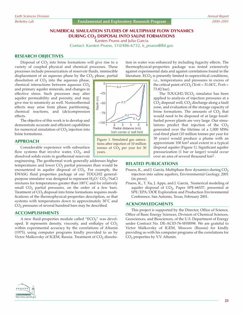
RESEARCH OBJECTIVESDisposal of CO2 into brine formations will give rise to a
variety of coupled physical and chemical processes. Theseprocesses include pressurization of reservoir fluids, immiscibledisplacement of an aqueous phase by the CO2 phase, partialdissolution of CO2 into the aqueous phase,chemical interactions between aqueous CO2and primary aquifer minerals, and changes ineffective stress. Such processes may alteraquifer permeability and porosity, and maygive rise to seismicity as well. Nonisothermaleffects may arise from phase partitioning,chemical reactions, and (de)compressioneffects.
The objective of this work is to develop anddemonstrate accurate and efficient capabilitiesfor numerical simulation of CO2 injection intobrine formations.
APPROACHConsiderable experience with subsurface
flow systems that involve water, CO2, anddissolved solids exists in geothermal reservoirengineering. The geothermal work generally addresses highertemperatures and lower CO2 partial pressures than would beencountered in aquifer disposal of CO2. For example, theEWASG fluid properties package of our TOUGH2 general-purpose simulator was designed to represent H2O/ CO2/NaClmixtures for temperatures greater than 100˚C and for relativelysmall CO2 partial pressures, on the order of a few bars.Treatment of CO2 disposal into brine formations requires modi-fications of the thermophysical-properties description, so thatsystems with temperatures down to approximately 30˚C andCO2 pressures of several hundred bars may be described.
ACCOMPLISHMENTSA new fluid-properties module called “ECO2” was devel-
oped. It represents density, viscosity, and enthalpy of CO2within experimental accuracy by the correlations of Altunin(1975), using computer programs kindly provided to us byVictor Malkovsky of IGEM, Russia. Treatment of CO2 dissolu-
tion in water was enhanced by including fugacity effects. Thethermophysical-properties package was tested extensivelyagainst experimental data and against correlations found in theliterature. ECO2 is presently limited to supercritical conditions,
i.e., temperatures and pressures in excess ofthe critical point of CO2 (Tcrit = 31.04˚C, Pcrit =73.82 bar).
The TOUGH2/ECO2 simulator has beenapplied to analysis of injection pressures at aCO2 disposal well, CO2 discharge along a faultzone, and evaluation of the storage capacity ofbrine formations. The amounts of CO2 thatwould need to be disposed of at large fossil-fueled power plants are very large. Our simu-lations predict that injection of the CO2generated over the lifetime of a 1,000 MWecoal-fired plant (10 million tonnes per year for30 years) would produce a plume with anapproximate 100 km2 areal extent in a typicaldisposal aquifer (Figure 1). Significant aquiferpressurization (1 bar or larger) would occurover an area of several thousand km2 .
RELATED PUBLICATIONSPruess, K., and J. García, Multiphase flow dynamics during CO2
injection into saline aquifers, Environmental Geology, 2001(in press).
Pruess, K., T. Xu, J. Apps, and J. García, Numerical modeling ofaquifer disposal of CO2, Paper SPE-66537, presented atSPE/EPA/DOE Exploration and Production EnvironmentalConference, San Antonio, Texas, February 2001.
ACKNOWLEDGMENTSThis project is supported by the Director, Office of Science,
Office of Basic Energy Sciences, Division of Chemical Sciences,Geosciences, and Biosciences, of the U.S. Department of Energyunder Contract No. DE-AC03-76-SF00098. We are grateful toVictor Malkovsky of IGEM, Moscow (Russia) for kindlyproviding us with his computer programs of the correlations forCO2 properties by V.V. Altunin.
NUMERICAL SIMULATION STUDIES OF MULTIPHASE FLOW DYNAMICSDURING CO2 DISPOSAL INTO SALINE FORMATIONS
Karsten Pruess and Julio GarciaContact: Karsten Pruess, 510/486-6732, [email protected]
Earth Sciences DivisionBerkeley Lab
Annual Report2000–2001
23
Fundamental and Exploratory Research Program
Figure 1. Simulated gas satura-tions after injection of 10 milliontonnes of CO2 per year for 30years.

RESEARCH OBJECTIVESThe objective of this research is to study the impact of rock
mechanical changes on the performance of a CO2 injection oper-ation into brine aquifers.
APPROACHTwo existing computer codes, TOUGH2 and FLAC3D, have
been joined to form a numerical simulator (TOUGH-FLAC) thatanalyzes coupled THM processes in complex geological mediaunder two-phase flow conditions. To model the geologicaldisposal of CO2, the two codes were joined with two hydrome-chanical coupling functions that account for multiphase fluid-pressure-induced stress and porosity changes and correspond-ing changes in hydraulic properties. Then, using laboratory dataon stress-induced porosity and permeability changes, alongwith the TOUGH-FLAC code, we conducted a 2D study ofhydromechanical processes during a deep-underground injec-tion of supercritical CO2 in a hypothetical brine aquifer/caprocksystem. As part of this study, we investigated the possibility ofrock mechanical failure in the form of hydraulic fracturing orshear-slip reactivation of existing faults.
ACCOMPLISHMENTSIn this modeling, CO2 was injected at a constant rate over a
10-year period at a depth of 1,300–1,500 m. The injection zone isoverlain by a 100-meter-thick caprock, located at 1,200–1,300 m,which in one of the studied cases is intersected by a verticalfault. The hydraulic, mechanical, and hydromechanicalresponses caused by the injection were studied. This studyincluded the spread of the CO2 plume, effective stress changes,ground-surface uplift, stress-induced permeability changes, anda mechanical-failure analysis. The analysis showed that mosthydromechanical changes were induced in the lower part of thecaprock, near its contact with the injection zone, while thesealing mechanism of the upper part apparently remainedintact, despite an injection pressure close to the lithostatic stressvalue (Figure 1).
SIGNIFICANCE OF FINDINGS The rate (or amount) of CO2 that can be injected into a brine
aquifer is proportional to the injection pressure. The higher thepressure, the more CO2 can be injected during a fixed timeperiod. However, if the injection pressure approaches the litho-
MODELING OF HYDROMECHANICAL CHANGES ASSOCIATED WITHBRINE AQUIFER DISPOSAL OF CO2
Jonny Rutqvist and Chin-Fu TsangContact: Jonny Rutqvist, 510/486-5432, [email protected]
Earth Sciences DivisionBerkeley Lab
Annual Report2000–2001
24
Fundamental and Exploratory Research Program
Figure 1. Potential for fracturing in the aquifer/caprock systemafter 10 years of CO2 injection, when the injection pressure hasincreased up to the lithostatic stress value. The contour plotshows the potential for fracturing expressed in a pressure margin(pressure margin is the current fluid pressure minus the criticalfracturing pressure). The white dashed lines indicate the orienta-tion of potential hydraulic fractures in the lower part of thecaprock.
static stress, strongly coupled hydromechanical come into play,and rock failure may occur. The simulation shows that if rockfailure occurs, it would at first be limited to the lower part of thecaprock, while the upper part could remain intact. At this stage,with an immediate lowering of the injection rate, further propa-gation of the rock failure could be prevented.
RELATED PUBLICATIONRutqvist, J., and C.-F. Tsang, A study of caprock hydromechan-
ical changes associated with CO2 injection into a brineaquifer, Environmental Geology (in press); Berkeley LabReport LNBL-48145, 2001.
ACKNOWLEDGMENTSThis work was supported by the Director, Office of Science,
Office of Basic Energy Sciences, Division of Chemical Sciences,Geosciences, and Biosciences, of the U.S. Department of Energyunder Contract No. DE-AC03-76SF00098.

RESEARCH OBJECTIVES Fast flow along unsaturated fractures can occur within “frac-
ture surface-zones” when fracture coatings, skins, or micro-cracked damage zones have higher permeabilities than theunderlying bulk rock matrix. When the local flux of water ishigh enough to sustain satiated water contents within fracturesurface-zones, water is expected to flow preferentially withinthe fracture surface-zone. When the energy of pore waters in thefracture surface-zone rises to its near-zero matric potentialrange, film flow becomes possible on the fracture surface. Thus,surface-zone flow, local aperture saturation, and film flow canall contribute to flow along unsaturated fractures. The quantifi-cation of surface-zone permeabilities is difficult because thisregion is typically quite thin and therefore not amenable tocutting for testing independently of the bulk rock. We have iden-tified a theoretical correlation between water imbibition ratesand permeabilities that appeared promising for deducing frac-ture surface-zone permeabilities. This study focuses on thepermeability-sorptivity relation, its experimental testing, andidentification of significant limitations.
APPROACHESBy combining recent analyses by Kao and Hunt—of wetting-
front time dependence during water imbibition into porousmedia—with the classic infiltration analyses of Green and Ampt(and of Philip), it can be shown that permeability is proportionalto the 4th power of the sorptivity. The same proportionality canbe established from the classic scaling analysis of Miller andMiller. This relation appeared promising for determining thepermeability of thin fracture surface-zones, based upon transientimbibition experiments. To test the usefulness of this relation,imbibition experiments were performed on tuffs and rhyolites todetermine sorptivities of their fracture surface-zones and bulkmatrices. Fracture surface-zone and matrix permeabilities werecalculated from measured sorptivities. Permeabilities of the bulkrock were then measured for comparison with values predictedbased on sorptivities. Additional sorptivities were measured onhighly wettable ceramics to extend the permeability range overwhich the sorptivity-permeability relation is tested.
ACCOMPLISHMENTSTransient imbibition tests on some rock samples showed
significantly higher sorptivities within visible fracture surface-zones than in the bulk rock. Based on the sorptivity-perme-ability relation, it was predicted that permeabilities of somefracture surface-zones were about 200 times greater than theirassociated matric rocks. However, direct measurements of rockmatrix permeabilities consistently yielded much higher valuesthan those predicted from imbibition rates. Such discrepanciesdid not exist in the data set analyzed by Kao and Hunt. Testingon ceramics also yielded results in compliance with the sorp-tivity-permeability relation. Contact- angle measurements onthe rock samples showed that their air-dry surfaces were notstrongly water wetting (contact angles ranged from 28˚ to 57˚),indicating that imperfect wettability invalidates the sorptivity-permeability relation.
SIGNIFICANCE OF FINDINGSThe possibility of fast flow along unsaturated fractures
within fracture surface-zones was identified. A relationshipbetween permeability and the 4th power of sorptivity was alsoidentified. Experimental testing showed that this relationshipcannot be used reliably for media with imperfect wettability.
RELATED PUBLICATIONSTokunaga, T.K., J. Wan, and S.R. Sutton, Transient film flow on
rough fracture surfaces, Water Resour. Res., 36, 1737–1746,2000.
Tokunaga, T.K., and J. Wan, Surface-zone flow along unsatu-rated rock fractures, Water Resour. Res., 37, 287–296, 2001.
Tokunaga, T. K., and J. Wan, Approximate boundaries betweendifferent flow regimes in fractured rocks, Water Resour. Res.,2001 (in press).
ACKNOWLEDGMENTSFunding was provided by the Director, Office of Science,
Office of Basic Energy Sciences, Division of Chemical Sciences,Geosciences, and Biosciences, of the U.S. Department of Energyunder Contract No. DE-AC03-76SF00098.
FRACTURE SURFACE-ZONE FLOW ANDTHE SORPTIVITY-PERMEABILITY RELATION
Tetsu K. Tokunaga and Jiamin WanContact: Tetsu K. Tokunaga, 510/486-7176, [email protected]
Earth Sciences DivisionBerkeley Lab
Annual Report2000–2001
25
Fundamental and Exploratory Research Program

RESEARCH OBJECTIVESLarge differences in chemical composition can be sustained
in boundary regions such as those at sediment-water interfaces,interior regions of soil aggregates, and surfaces of fracturedrocks. Predicting transport between various environmentalcompartments is currently often unsuccessful, partly because ofa lack of sufficient spatial and temporal resolution in measure-ments. Batch studies can yield insights into kinetics and equilib-rium in well-mixed systems, but the subsurface is very poorlymixed. Without in situ, spatially and temporally resolved chem-ical information, transport between compartments can only bedescribed with system-specific, nonmechanistic, mass-transfermodels. We are testing the impact of transport limitations onredox-precipitation reactions in sediments.
APPROACHPast efforts in this project focused on selenium transport and
reduction in two types of microenvironments: (1) that found atsurface water-sediment boundaries and (2) that found withinsoil aggregates. Since FY 1998, the project emphasis has shiftedto reactive transport of another environmentally importantcontaminant, chromium. The oxidized Cr(VI) species are mostlysoluble, environmentally mobile, and toxic. Most forms ofreduced Cr(III) are insoluble precipitates of low toxicity. Ourstudies on reactive transport of Cr have included flow-throughand diffusion-limited experiments in soils, including spatiallyresolved, real-time tracking of initial contamination processes.Distributions of total Cr, Cr(III), and Cr(VI) are determined with
x-ray microprobe and micro-XANES (x-ray absorption near-edge structure) analyses conducted at the Advanced PhotonSource (Argonne National Laboratory) and the NationalSynchrotron Light Source (NSLS, at Brookhaven NationalLaboratory).
ACCOMPLISHMENTSOur comparisons of Cr(VI) reduction rates (whether directly
or indirectly microbially mediated) with diffusion-controlledtransport rates show that in water-saturated, microbially activesediments, transport limitations exert two main influences. Thefirst influence occurs through developing steeply decreasingredox potentials with distance from oxygenated boundaries,resulting from oxygen diffusion-limited microbial respiration.This results in the second influence, increasing Cr(VI) reductionrates with distance. Under such conditions, Cr diffusion frontsterminate sharply. As a consequence, highly Cr-contaminatedzones can coexist with pristine sediments, with transition zonesas narrow as 1 mm. We have generalized analyses of reactionrates and diffusion distances using the Thiele modulus to showthat many subsurface reactions of environmental interest aretransport limited.
SIGNIFICANCE OF FINDINGSThese results illustrate the importance of diffusion-limited
Cr reduction in sediments and the need for chemical character-ization with sufficient spatial resolution to identify redox zona-tion. Bulk measurements on samples yield spatially averagedchemical information. When such averaged measurements areobtained over steep chemical gradients, they do not allowcorrect interpretations. The Thiele analysis of rates can beapplied to many other chemical species to deduce the relativeimportance of reaction kinetics and transport.
RELATED PUBLICATIONTokunaga, T.K., J. Wan, M.K. Firestone, T.C. Hazen, E. Schwartz,
S.R. Sutton, and M. Newville, Chromium diffusion andreduction in soil aggregates, Environ. Sci. Technol., 2001 (inpress).
ACKNOWLEDGMENTSThis project is supported by the Director, Office of Science,
Office of Basic Energy Sciences, Division of Chemical Sciences,Geosciences, and Biosciences, of the U.S. Department of Energyunder Contract No. DE-AC03-76-SF00098. Research was in partcarried out at NSLS, Brookhaven National Laboratory, which issupported by the Division of Material Sciences and Division ofChemical Sciences. We thank Tony Lanzirotti and the staff ofNSLS.
Earth Sciences DivisionBerkeley Lab
Annual Report2000–2001
26
Fundamental and Exploratory Research Program
Figure 1. Dependence of the Thiele modulus on 1st-order reaction-rate constant and diffusion distance(radius of soil aggregate or sediment block). Even rela-tively small sediment blocks have diffusion-controlledreactions for a wide range of rate constants.
REACTIVE CHEMICAL TRANSPORT IN STRUCTURED POROUS MEDIA:X-RAY MICROPROBE AND MICRO-XANES STUDIES
Tetsu K. Tokunaga, Jiamin Wan, Terry Hazen, Mary Firestone,1 Stephen R. Sutton,2Egbert Schwartz,1 Matthew Newville,2 and Keith R. Olson1University of California, Berkeley, 2University of Chicago
Contact: Tetsu K. Tokunaga, 510/486-7176, [email protected]

RESEARCH OBJECTIVESOne of the main objectives of studying geophysical inversion
is to use the results from inversion to describe various subsur-face processes involving fluid flow. Hydrological propertiessuch as fluid electrical conductivity and rock porosity cannot bedirectly obtained with conventional inversion techniques. Theelectromagnetic (EM) field propagating through the subsurfacemedium is a function of the bulk conductivity, which in turnmay be empirically related to porosity, pore fluid conductivity,saturation, and occasionally the temperature. Within a particularmedium, seismic travel time along a ray path depends on itspropagation velocity, which may again be related to severalfactors (such as porosity, density, elastic constants, temperature,and pressure). The complex interrelationship among these vari-ables renders direct mapping of these parameters very difficult.However, joint analysis of different geophysical data, along withinformation about the relationships between geophysical andhydrological parameters, may allow us to achieve direct param-eter mapping.
APPROACHTo assess the feasibility of deriving hydrological properties
directly, we have developed a joint-inversion technique usingEM and seismic travel-time data. The objective is to derive thefluid conductivity and rock porosity of a medium between twoboreholes. Archie’s law and the Wyllie time-average relationsare used to relate geophysical parameters to two of the hydro-logical variables: rock porosity and fluid conductivity. Theinversion is based on least-squares criteria that minimize themisfit between the observed data (synthetic data in this study)and that of the inverted hydrological model. A smoothnessconstraint is used to reduce nonuniqueness. To begin with, theinversion is tested on a two-dimensional model. For the EMmethod, the model is axially symmetric near the transmitterborehole, and numerical simulation is carried out with the algo-rithm developed by Alumbaugh and Morrison (1995). The bulkelectrical conductivity used for the EM simulation is estimatedusing Archie’s law. A straight ray path is assumed for the seismicmethod, and travel-time data are calculated based on the simpli-fied Wyllie equation.
ACCOMPLISHMENTSBased on the preliminary results of this research, we have
demonstrated (see Figure 1) that hydrological parameters can beobtained directly with joint inversion of two geophysical surveymethods. The optimum result of the joint inversion has beenobtained by alternating the selection of inversion parameters,
with only one parameter allowed to change (while the otherparameter is held fixed) at each iteration.
SIGNIFICANCE OF FINDINGSJoint analysis of geophysical data for subsurface imaging is
not new. However, the study presented here is the first todirectly obtain hydrological parameters using different geo-physical data. Successful application of the technique willgreatly improve our understanding of various subsurfaceprocesses involving fluid flow.
RELATED PUBLICATIONAlumbaugh, D.L., and H.F. Morrison, Theoretical and practical
considerations for crosswell electromagnetic tomographyassuming a cylindrical geometry, Geophysics 60, 846–870, 1995.
ACKNOWLEDGMENTSThis project is supported by the Director, Office of Science,
Office of Basic Energy Sciences, Division of Chemical Sciences,Geosciences, and Biosciences, of the U.S. Department of Energyunder Contract No. DE-AC03-76-SF00098. Contract No. DE-AC03-76-SF00098.
JOINT INVERSION FOR MAPPINGSUBSURFACE HYDROLOGICAL PARAMETERS
Hung-Wen Tseng and Ki Ha LeeContact: Ki Ha Lee, 510/486-7462, [email protected]
Earth Sciences DivisionBerkeley Lab
Annual Report2000–2001
27
Fundamental and Exploratory Research Program
Figure 1. Joint inversion results using both EM and seismicdata. The conductivity is fixed to obtain a better porositymodel in a first iteration; then porosity is fixed for a betterconductivity model in the next iteration.

between upward transport by partitioning onto rising bubblesand downward transport by eddy dispersion. By measuring thesteady-state concentration profile, the partitioning between bulkand surface regions can be determined.
ACCOMPLISHMENTS Kaolinite exhibited extremely high affinity to the air-water
interface at pH values below 7. Na-montmorillonite andbentonite clay were found excluded from the air-water interfaceat any given pH and ionic strength. The results show the impor-tance of electrostatic interactions between the air-water interfaceand colloids, including pH-dependent edge charges on mineralcolloids and influences of particle shape (Figure 1). Low parti-tioning of latex particles at the air-water interface relative tokaolinite appears to result from particle charge distribution andparticle geometry.
SIGNIFICANCE OF FINDINGS The implications of these types of measurements are espe-
cially relevant in the vadose zone, because this portion of theenvironment can have high values of air-water interfacial areaper unit bulk volume. Because of the common existence of thinwater films in the vadose zone, the distribution of surface-activecolloids between bulk water and the air-water interface can besignificant. Calculated ratios of colloid distribution at the air-water interface to bulk water ranged from approximately 1:1 to1:20 for a wide range of soil saturations and colloid types. Highpartitioning of colloids between the air-water interface and thebulk solution has important implications on colloid transportand transformation in vadose environments.
RELATED PUBLICATIONSWan, J., and T.K. Tokunaga, Measuring partition coefficients of
colloids at air-water interfaces, Environ. Sci. Technol 32,3293–3298, 1998.
Wan, J., and T.K. Tokunaga, Surface excess of clay colloids at gas-water interfaces, J. Colloid and Interface Science, 2001(submitted).
ACKNOWLEDGMENTSThis project is supported by the Director, Office of Science,
Office of Basic Energy Sciences, Division of Chemical Sciences,Geosciences, and Biosciences, of the U.S. Department of Energyunder Contract No. DE-AC03-76-SF00098.
RESEARCH OBJECTIVESClays, humic acids, and microorganisms have been found
preferentially sorbed at air-water interfaces in unsaturated soils.For solutions containing surface-active molecules, the measure-ment of changes in surface tension (with changes in soluteconcentration) permits calculation of their surface excessthrough the Gibbs adsorption equation. However, for suspen-sions of particles, surface-tension changes are often not measur-able. To quantify colloid partitioning at air-water interfacesunder surfactant-poor conditions typical of subsurface environ-ments, an alternative means is needed. Wan and Tokunaga(1998) developed a simple dynamic method to characterizecolloid-surface excesses at air-water interfaces, withoutrequiring assumptions concerning the thickness of interfacialregions and without the use of surfactants. The objective of thisstudy is to use this newly developed method to measure thepartition coefficients (K) of different clay minerals and latexmicrospheres at the air-water interface, under environmentallyrelevant solution-chemistry conditions.
APPROACHThe bubble-column method (Wan and Tokunaga, 1998) was
used to measure the K of different clays (kaolinite, montmoril-lonite, and illite) and polystyrene latex microspheres at the gas-water interface. In the bubble column, air is bubbled through avertical column containing the dilute colloidal suspension, withan open free surface at the top. The rising bubbles sorb and carrythe surface-active species upward, then release them back to thesolution at the free surface, where the bubbles burst. The steady-state concentration profile along the column reflects the balance
PARTITIONING OF CLAY COLLOIDS TOGAS-WATER INTERFACES
Jiamin Wan and Tetsu K. TokunagaContact: Jiamin Wan, 510/486-6004, [email protected]
Earth Sciences DivisionBerkeley Lab
Annual Report2000–2001
28
Fundamental and Exploratory Research Program
Figure 1. Scanning electron micrographs of clays used in thisstudy: (a) kaolinite, (b) illite, and (c) Na-montmorillonite

RESEARCH OBJECTIVESIron oxyhydroxides are powerful agents for metal scav-
enging in the environment. Recently, we have determined thatthe surface reactivity of quartz aquifer grains is dominated bycoatings consisting of nanometer-thick iron oxyhydroxides. Weseek to understand the processes by which these coatings areformed, determine their reactivity compared to bulk ironminerals, and describe the structure and crystal chemistry of thecoatings as completely as possible on the nanometer-to-micronscale.
APPROACHBoth laboratory model studies and field sampling have been
performed. In the laboratory, we are using both perfect quartzcrystals with m-, r-, and c-plane surfaces, and high-surface-areaaerosil silica for sorption and coating-development experiments.In the field, we have emplaced samples of the perfect quartzsubstrates into wells at the U.S.Geological Survey Cape Cod aquifersite, as well as in Naturita, Colorado,to study natural coating formation.
Samples are being studied by x-rayspectroscopy (XAS) at the StanfordSynchrotron Radiation Laboratory, byhigh-resolution transmission electronmicroscopy (HRTEM) at the NationalCenter for Electron Microscopy atBerkeley Lab, and by atomic forcemicroscopy (AFM) at the U.S.Geological Survey in Menlo Park.Grazing incidence XAS measurements(GIXAS) allow us to determine themolecular structure of sorbed ironatoms or multinuclear precipitates, aswell as their relationship to the surfaceSi atoms. Total reflection x-ray fluores-cence (TRXRF) allows unprecedentedsensitivity in chemical analysis. TheHRTEM and AFM studies producenanometer-resolution images that aid in relating molecularstructure to nanometer-and-larger surface structures anddefects.
ACCOMPLISHMENTSDuring the past year, GIXAS and TRXRF spectra have been
obtained on well samples deposited for 8 and 14 months. Oneset of results from the 14-month samples is shown in Figure 1.
As few as 1010 atoms can be detected, equivalent to about 10–14
moles of material. The analyses show that the surface containsFe, Ca, and a range of other transition metal ions. Mn, Cr, and Fesurface concentrations are correlated with each other, but anti-correlated with Ca concentration. This is interesting because theconcentration of Ca is very low in the Cape Cod aquifer waters,with calcite unstable under the conditions in the well. The Camay result from colloid transport, or perhaps from microorgan-isms utilizing surface Fe3+ and rendered it soluble, whilereleasing Ca and acids at the quartz surface.
SIGNIFICANCE OF FINDINGSExtended x-ray absorption fine structure (EXAFS) analysis
can be done on even the small amounts of Fe found on quartzsamples within one year of emplacement, so that the nature ofthe coating can be analyzed in terms of mineral structure as well
as composition. This allows us toanalyze the mode of formation,whether via biological, colloidal trans-port-deposited, or nucleation andgrowth mechanisms.
RELATED PUBLICATIONSWaychunas, G.A., J.A. Davis, and R.Rietmeyer, Formation and structure ofiron-rich oxyhydroxide nanometercoatings: Comparison of laboratory-produced and aquifer-seededsamples, Geosciences ResearchProgram Workshop, Gaithersburg,Maryland, October 15–16, 2000.Waychunas, G.A., R. Reitmeyer, andJ.A. Davis, Grazing incidence EXAFScharacterization of Fe3+ sorption andprecipitation on silica surfaces, J.Colloid Interface Science, 2001(submitted).
ACKNOWLEDGMENTSThis project is supported by the Director, Office of Science,
Office of Basic Energy Sciences, Division of Chemical Sciences,Geosciences, and Biosciences, of the U.S. Department of Energyunder Contract No. DE-AC03-76-SF00098 and by the USGSWater Resources Research Program (JAD and RR). RebeccaReitmeyer and James A. Davis were supported by the U.S.Geological Survey.
Fe3+ SORPTION ON QUARTZ SURFACES: GRAZING INCIDENCE X-RAY ANALYSISGlenn A. Waychunas, Rebecca Reitmeyer,1 and James A. Davis1
1U.S. Geological Survey, Water Resources, Menlo Park, CaliforniaContact: Glenn A. Waychunas, 510/495-2224, [email protected]
Earth Sciences DivisionBerkeley Lab
Annual Report2000–2001
29
Fundamental and Exploratory Research Program
Figure 1. Energy spectrum of the upper 3 nanome-ters of quartz well samples as determined viaTRXRF. The diagram shows the geometry of agrazing-incident experiment.

the number of Fe3+ second neighbors is larger. With furtherincrease in aqueous Zn, the complexation changes because newZn tetrahedral units polymerize onto existing sorbed ones.
Finally, at the highest aqueous Zn concen-trations, a new type of precipitate forms,dominated by octahedrally coordinatedZn and with a layer structure.
SIGNIFICANCE OF FINDINGSOur results show the complexity of
even this simple sorption system, andhence the difficulty of predicting sorp-tion geometry, sorption mechanism,and the chemical fate of certain pollu-tant agents without molecular informa-tion. We also find that a simpleso-called “bond valence” argumentexplains the octahedral-to-tetrahedralchange in Zn coordination upon sorp-tion. The oxygen ion has perfectly bal-anced bond valence (2.00) at theH2-O-Zn aqueous linkage and also atthe tetrahedral Zn-OH-Fe linkage.Hence, once sorption occurs and aproton is lost, the change in coordina-tion returns the ligand oxygen toperfect bond valence.
RELATED PUBLICATIONSWaychunas, G.A., C.C. Fuller, J.A. Davis, Surface complexation
and precipitate geometry for aqueous Zn(II) sorption onferrihydrite: I. EXAFS analysis, Geochimica etCosmochimica Acta, 2001 (in press).
Waychunas, G.A., J.J. Rehr, C.C. Fuller, and J.A. Davis, Surfacecomplexation and precipitate geometry for aqueous Zn(II)sorption on ferrihydrite: II. XANES analysis, Geochimica etCosmochimica Acta, 2001 (submitted).
ACKNOWLEDGMENTSThis project is supported by the Director, Office of Science,
Office of Basic Energy Sciences, Division of Chemical Sciences,Geosciences, and Biosciences, of the U.S. Department of Energyunder Contract No. DE-AC03-76-SF00098; the U.S. GeologicalSurvey Water Resources Research Program (Christopher C. Fullerand James A. Davis); and Laboratory Directed Research andDevelopment funding from Berkeley Lab.
RESEARCH OBJECTIVESAqueous Zn is readily sorbed by ferrihydrite and other iron oxyhy-
droxides at moderate pH values. However, experimental sorptionisotherms vary from linearity some four orders of magnitude in aqueousZn concentration below the saturation levelwith zinc hydroxide. This suggests that aprecipitation process or a change in complex-ation mechanism is occurring. We wish tounderstand the processes that create thisnonlinear behavior in the sorption isothermand describe the molecular geometry ofaqueous Zn uptake.
APPROACHSamples were created at the U.S.
Geological Survey to follow the composi-tion range (i.e., sorption density andaqueous Zn concentration) of theisotherm showing nonlinear behavior.The samples were prepared in both co-precipitation and sorption modes (i.e.,formed respectively with and without Znpresent). While still fresh and wet,samples were examined by wet chemicaland x-ray absorption methods (x-rayabsorption near-edge structure [XANES]and extended x-ray absorption fine struc-ture [EXAFS]) at the Stanford SynchrotronRadiation Laboratory. EXAFS analysis was done, both on thesamples and on a set of well-characterized model compounds, toextract sample interatomic distances and coordination numbers.XANES spectra were simulated using the ab initio Feff 8.0 codeto complement the EXAFS analysis.
ACCOMPLISHMENTSThe combined analysis shows a remarkable set of changes in
molecular geometry as a function of Zn solution concentration(see Figure 1). In an aqueous solution with pH of 6 to 7, the zincion is coordinated by six water molecules in an octahedralcomplex (green). However, this coordination changes to tetra-hedral (green) after sorption on ferrihydrite (represented by redFeO6 octahedra) even at the lowest observable sorption densi-ties. Depending on the type of sample preparation (sorption orco-precipitation) the number of second-neighbor Fe ions about agiven sorbed Zn differs. For co-precipitation samples where Znions have abundant aqueous Fe3+ available during formation,
Earth Sciences DivisionBerkeley Lab
Annual Report2000–2001
30
Fundamental and Exploratory Research Program
Figure 1: Changes in the geometry of Zncomplexes on ferrihydrite as a function ofaqueous Zn concentration. The bond valenceon the relevant oxygen is shown.
THE GEOMETRY OF Zn COMPLEXATION ON FERRIHYDRITEGlenn A. Waychunas, Christopher C. Fuller,1 and James A. Davis1
1U.S. Geological Survey, Water Resources, Menlo Park, CAContact: Glenn A. Waychunas, 510/495-2224, [email protected]

RESEARCH OBJECTIVESSchwertmannite is an iron oxyhydroxide with presumed
intrinsic sulfate that forms in large quantities in acid-mine-drainage environments at low pH values. It is a powerful sinkfor toxic metals and oxyanions, and its structure appears to besimilar to that of a hollandite, but with sulfate bonded into thetunnel sites of this structure. However, our recent work indicatesthat the proposed structure for schwertmannite must be incor-rect, and that the nature of the sulfate group in the structure maybe intermediate between the classical “inner sphere” and “outersphere” complexes. We have investigated this by examining aseries of synthetic schwertmannites formed with varying sulfatecontents, and at different pH and water-saturation conditions.
APPROACHL- and K-edge x-ray absorption near-edge structure
(XANES) spectroscopy can be used to distinguish inner sphere,outer sphere, and intermediate hydrogen-bonded sulfategroups. This information can be combined with other structuralstudies to fully characterize changes in sulfate binding as a func-tion of environmental conditions. Sulfate is generally thought tosorb as either an inner sphere (IS) (directly bonded to a surfacemetal ion) or outer sphere (OS) (separated from the surface byan intervening water molecule) geometry, depending onmineral surface chemistry, charge, and topology. However,recent work we have done using K-edge XANES spectroscopy atSSRL has indicated that schwertmannite may contain a thirdtype of sulfate, a hydrogen-bonded complex intermediatebetween inner and outer sphere geometries. This complex hasan IR spectrum indicative of an inner sphere complex (becausethere is considerable splitting of IR bands consistent with lowsulfate symmetry), but a XANES spectrum indicative of an outersphere complex (because no Fe-O-S features are seen). Thepicture is complicated by the effect of drying on samples, whichcan drive the local pH up and thus possibly change the nature ofa sorbed or bound complex. With this in mind, we are aiming ataccomplishing two goals with this study: first, determine thenature of sulfate and its complexation in schwertmannite (to becombined with other data to resolve the full structure); andsecond, determine the evolution of sulfate complexation atlower pH in environmental (and catalytic) materials.
ACCOMPLISHMENTSOur XANES spectra on the S-K edge shows conclusively that
in schwertmannite, sulfate is not bonded in the tunnels in thenormal way. It is probably a hydrogen-bonded complex in largertunnel-structure defect regions or is largely hydrogen bonded
on the outside of crystallites. Fe-K-edge extended x-ray absorp-tion fine structure (EXAFS) spectroscopy indicates that schwert-mannite has fewer Fe-O-Fe corner linkages than its nominallystructural cousin akaganeite. This points towards a highlydisordered structure, probably with larger tunnel sites.
SIGNIFICANCE OF FINDINGSThe possibility of sulfate and other anion complexation
changing from inner sphere to hydrogen-bonded complexeswith varying pH or other mineral surface characteristics (such aswater saturation) has important consequences for anion seques-tration. In particular, vadose zone complexation may differsubstantially from that in (laboratory) saturated systems. Themode of sulfate incorporation in schwertmannite may also giveinsight into other types of chemical entrapment by naturalnanocrystallites.
ACKNOWLEDGMENTSThis project is supported by the Director, Office of Science,
Office of Basic Energy Sciences, Division of Chemical Sciences,Geosciences, and Biosciences, of the U.S. Department of Energyunder Contract No. DE-AC03-76-SF00098, and by LaboratoryDirected Research and Development funding from BerkeleyLab.
STRUCTURAL ANALYSIS OF SULFATE IN SCHWERTMANNITEGlenn A. Waychunas, Samuel J. Traina,1 Jerry R. Bigham,1 and Satish C.B. Myneni2
1Ohio State University, 2Princeton UniversityContact: Glenn A. Waychunas, 510/495-2224, [email protected]
Earth Sciences DivisionBerkeley Lab
Annual Report2000–2001
31
Fundamental and Exploratory Research Program
Figure 1. A model for the defect structure of schwert-mannite showing positions of various types of sulfate.The framework is made up of FeO6 octahedra linked intoa tunnel structure along the axis normal to the figure.
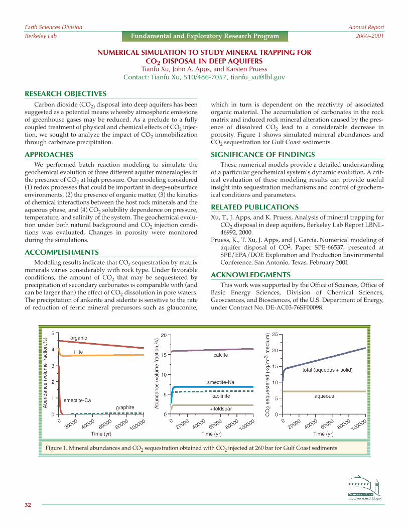
Earth Sciences DivisionBerkeley Lab
Annual Report2000–2001
32
Fundamental and Exploratory Research Program
RESEARCH OBJECTIVESCarbon dioxide (CO2) disposal into deep aquifers has been
suggested as a potential means whereby atmospheric emissionsof greenhouse gases may be reduced. As a prelude to a fullycoupled treatment of physical and chemical effects of CO2 injec-tion, we sought to analyze the impact of CO2 immobilizationthrough carbonate precipitation.
APPROACHESWe performed batch reaction modeling to simulate the
geochemical evolution of three different aquifer mineralogies inthe presence of CO2 at high pressure. Our modeling considered(1) redox processes that could be important in deep-subsurfaceenvironments, (2) the presence of organic matter, (3) the kineticsof chemical interactions between the host rock minerals and theaqueous phase, and (4) CO2 solubility dependence on pressure,temperature, and salinity of the system. The geochemical evolu-tion under both natural background and CO2 injection condi-tions was evaluated. Changes in porosity were monitoredduring the simulations.
ACCOMPLISHMENTSModeling results indicate that CO2 sequestration by matrix
minerals varies considerably with rock type. Under favorableconditions, the amount of CO2 that may be sequestered byprecipitation of secondary carbonates is comparable with (andcan be larger than) the effect of CO2 dissolution in pore waters.The precipitation of ankerite and siderite is sensitive to the rateof reduction of ferric mineral precursors such as glauconite,
which in turn is dependent on the reactivity of associatedorganic material. The accumulation of carbonates in the rockmatrix and induced rock mineral alteration caused by the pres-ence of dissolved CO2 lead to a considerable decrease inporosity. Figure 1 shows simulated mineral abundances andCO2 sequestration for Gulf Coast sediments.
SIGNIFICANCE OF FINDINGSThese numerical models provide a detailed understanding
of a particular geochemical system’s dynamic evolution. A crit-ical evaluation of these modeling results can provide usefulinsight into sequestration mechanisms and control of geochem-ical conditions and parameters.
RELATED PUBLICATIONSXu, T., J. Apps, and K. Pruess, Analysis of mineral trapping for
CO2 disposal in deep aquifers, Berkeley Lab Report LBNL-46992, 2000.
Pruess, K., T. Xu, J. Apps, and J. García, Numerical modeling ofaquifer disposal of CO2, Paper SPE-66537, presented atSPE/EPA/DOE Exploration and Production EnvironmentalConference, San Antonio, Texas, February 2001.
ACKNOWLEDGMENTSThis work was supported by the Office of Sciences, Office of
Basic Energy Sciences, Division of Chemical Sciences,Geosciences, and Biosciences, of the U.S. Department of Energy,under Contract No. DE-AC03-76SF00098.
NUMERICAL SIMULATION TO STUDY MINERAL TRAPPING FORCO2 DISPOSAL IN DEEP AQUIFERS
Tianfu Xu, John A. Apps, and Karsten PruessContact: Tianfu Xu, 510/486-7057, [email protected]
Figure 1. Mineral abundances and CO2 sequestration obtained with CO2 injected at 260 bar for Gulf Coast sediments

RESEARCH OBJECTIVESLarge-scale simulation (i.e., at the multimillion gridblock
level) of multiphase fluid and heat flow in heterogeneous reser-voirs remains a challenge. It can be a formidable task for asingle-processor computer. However, the development ofparallel-computing techniques makes it possible to performsuch large-scale reservoir simulations. The main objective of thiswork is to parallelize the TOUGH2 code, a general-purposenumerical simulation program for modeling multidimensional,multiphase, multicomponent fluid and heat flows in porous andfractured media. Our work is intended to enhance computa-tional performance of TOUGH2 on multiprocessor computersby 1–2 orders of magnitude, both in problem size and in CPUtime requirements.
APPROACHThe two most time-consuming parts of a TOUGH2 simula-
tion are (1) assembling the Jacobian matrix and (2) solving thelinear equations. With that in mind, the most important aim ofa parallel version code is to parallelize these two parts. This goalis achieved by using simulation domain partitioning andparallel linear solving of linearized equations. Three parti-tioning algorithms from the METIS package (version 4.0) areimplemented for grid domain partitioning. The linear solverpart of the TOUGH2 code is restructured, and the Aztec parallelsolver is selected and incorporated into the parallel code.
In addition to parallel computing in the Jacobian matrixassembly and linear equation solver, efficient use of computermemory is also very important. This is because a several-giga-byte memory is generally required for a typical large-scale,three-dimensional simulation. Then the need arises to distributethe memory requirement to all processors. We have optimizedthe data input procedure and made use of computer memoryshared by all processors. The parallel code is currently imple-mented for TOUGH2 EOS3 and EOS9 modules.
ACCOMPLISHMENTS The TOUGH2 code has been parallelized for both computing
time and memory sharing, including optimization for solvingextremely large reservoir-simulation problems. The parallelcode has been successfully used to develop three-dimensionalmodels of fluid and heat flow in the unsaturated zone of YuccaMountain, using up to two million gridblocks. One of the 3Dmodels uses 1,075,522 gridblocks and 4,047,209 connections torepresent the unsaturated zone of the highly heterogeneous frac-tured tuffs at Yucca Mountain. This problem involves solving of3,226,566 linear equations at each iteration step. Simulationresults indicate that the developed parallel code is very efficientand capable of modeling large-scale problems with multimillion
gridblocks. Figure 1 shows the speedup of the parallel code forthis application problem.
SIGNIFICANCE OF FINDINGSThe major benefits of the developed parallel code are that it
(1) allows accurate representation of reservoirs with sufficientspatial resolution, using multimillion gridblocks, (2) allowsadequate description of reservoir heterogeneities, and (3)enhances our modeling capability for solving large-scale, real-world simulations.
RELATED PUBLICATIONSElmroth, E., C. Ding, and Y.S. Wu, High-performance computa-
tions for large-scale simulations of subsurface multiphasefluid and heat flow, Journal of Supercomputing 18(3),233–256, 2001.
Zhang, K., Y.S. Wu , C. Ding, K. Pruess, and E. Elmroth, Parallelcomputing techniques for large-scale reservoir simulation ofmulticomponent and multiphase fluid flow, SPE 66343,presented at the 2001 SPE Reservoir Simulation Symposium,Houston, Texas, February 11–14, 2001.
Zhang, K., Y.S. Wu, C. Ding, and K. Pruess, Application ofparallel computing techniques to large-scale reservoir simu-lation, Proceedings of the 26th Annual Workshop,Geothermal Reservoir Engineering, Stanford University,Stanford, California, January 29–31, 2001.
ACKNOWLEDGMENTSThis work was supported by the Laboratory Directed
Research and Development (LDRD) program of Berkeley Lab, inturn supported by the Director, Office of Science, of the U.S.Department of Energy under Contract No. DE-AC03-76SF00098.
DEVELOPMENT OF A HIGH-PERFORMANCE MASSIVELY PARALLEL TOUGH2 CODEKeni Zhang, Yu-Shu Wu, Karsten Pruess, and Chris Ding1
1National Energy Research Scientific Computing Center (NERSC)Contact: Keni Zhang, 510/486-7393, [email protected]
Figure 1. Reduction of execution time with theincrease of processor number for a one-million-grid-block problem on Cray T3E-900
Earth Sciences DivisionBerkeley Lab
Annual Report2000–2001
33
Fundamental and Exploratory Research Program

Earth Sciences DivisionBerkeley Lab
Annual Report2000–2001
This page is intentionally left blank.
34

The role of the Nuclear Waste Program is to assist the U.S.Department of Energy, the United States, and other countries insolving the problem of safe disposal of nuclear waste throughhigh-quality scientific analyses and technology development.The primary work of the program involves investigating thefeasibility and potential of the Yucca Mountain site in Nevadafor permanent storage of high-level nuclear waste. The NuclearWaste Program also does collaborative work on nuclear-wastedisposal issues with such countries as Japan, Switzerland,Sweden, China, and Romania. The program has established theCenter for International Radioactive Waste Studies, the mainpurpose of which is to foster relationships with other countriesto promote the exchange of ideas and research results.
The Yucca Mountain site is located about 120 km northwestof Las Vegas in a semi-arid region. The potential repositorywould be located about 350 m below ground surface within athick unsaturated zone (UZ). Subsurface rocks at YuccaMountain consist primarily of fractured volcanic tuffs that varyin degree of welding. To date, a total of 60 deep surface bore-holes have been drilled in the area. In 1996, an 8 km long under-ground tunnel, the Exploratory Studies Facility (ESF), wascompleted at Yucca Mountain to facilitate more extensivesubsurface testing.
Berkeley Lab’s work at Yucca Mountain consists of solvingmany problems related to multiphase, nonisothermal flow andtransport through the UZ. Some of the key questions thatBerkeley Lab scientists are addressing include:
• How much water percolates through the UZ to the repos-itory at Yucca Mountain?
• What fraction of the water flows in fractures and howmuch flows through the rock matrix blocks?
• How much of this water will seep into the waste-canisteremplacement drifts?
• How will radionuclides migrate from the repository to thewater table?
• How will coupled TH (thermal-hydrologic), THC (thermal-hydrologic-chemical) and THM (thermal-hydrologic-mechanical) processes affect flow and transport?
To address these questions, the Nuclear Waste Program isorganized into Ambient Testing, Thermal Testing, and Modelinggroups, with support from geophysicial studies.
AMBIENT TESTING GROUPThe Ambient Testing group investigates how water flows
through the mountain and how much of this water will seep intothe emplacement drifts. The group performs various testswithin the ESF, including fracture-matrix interaction tests, drift-to-drift tests, the Paint Brush Unit test (PTn test), and niche(short drift) testing. Fracture-matrix interaction tests are rela-tively small-scale (i.e., a few meters) tests that focus on thecomponents of water flow in fractures and matrix blocks and onthe interaction between the two continua. The drift-to-drift testsaddress the same issues, but on a much larger spatial scale(10–20 m). The test in the Paint Brush unit, which is anunwelded tuff unit, addresses issues of episodic flow, effects offaults and large-scale features, and lateral continuity of flow andtransport. This unit, directly above the potential repository, iskey to dispersed fracture flow from the above fractured unitsand buffers the transient behavior of episodic flow. The nichestudies address perhaps the most crucial problem of YuccaMountain, i.e., determining the fraction of water that will flowinto the emplacement drifts. The niche studies are carried out byintroducing water into boreholes above the drift opening andmeasuring what fraction actually seeps into the opening. Results to date suggest that there is a seepage threshold belowwhich no water will seep into the drifts.
Earth Sciences DivisionBerkeley Lab
Annual Report2000–2001
35
NUCLEAR WASTE
RESEARCH PROGRAM
Gudmundur S. Bodvarsson

THERMAL TESTING GROUPThe Thermal Testing group works in collaboration with
other national laboratories to evaluate the effects of heat on ther-modynamic conditions, fluid flow and transport, and perma-nent property changes at and near the emplacement drifts. TheYucca Mountain Project has completed the first in situ heatertest, called the Single Heater Test. The project is now involvedwith a large-scale heater test in a 50 m long drift. This secondtest, called the Drift Scale Test (DST), is intended to resemble theactual conditions that would exist when the high-level radionu-clide waste is placed in the emplacement drifts. Berkeley Lab’sroles in the heater tests are to characterize the heater-test rockblock (area) prior to testing; monitor potential changes in frac-ture and matrix saturations through air injections, tracer testing,and ground-penetrating radar measurements; and to performpredictive thermal-hydrologic and thermal-hydrologic-chemicalcalculations.
The initial characterizations of the heater test areas areperformed with air-injection tests that yield the 3D permeabilitystructure of the fracture network. Continued air-injection testingduring heating yielded changes that can be attributed tochanges in fracture saturations or mechanical effects. Crossholeradar tomography has also yielded very promising resultsregarding change in global saturations of the system caused byheating. Laboratory scientists are also involved with measure-ments of the isotopic compositions of gases and condensatewater collected in instrumented boreholes. Detailed 3D thermal-hydrologic and thermal-hydrologic-chemical calculations wereused to predict the behavior of the tests. These are being refinedas the test progresses.
MODELING GROUPBerkeley Lab has the primary responsibility for the develop-
ment of the UZ Flow and Transport Model. This is a compre-
hensive, 3D, dual-permeability numerical model that representsthe entire UZ at and near Yucca Mountain. The model isintended to integrate, in a single computational framework, allof the relevant geological, hydrological, geochemical, and otherobservations that have been made at the surface, in boreholes,and in tunnels at Yucca Mountain. The model is calibratedagainst pneumatic moisture tension, matrix potential, tempera-ture, geochemical, perched water, and other data from the UZ.The model is then used to predict all of these variables in newboreholes and new drifts to be drilled. The degree of agreementbetween model predictions and subsequent field observationsindicates the reliability of the model, and provides guidance asto what additional data need to be collected and incorporated.
A very important submodel of the UZ model is the seepagemodel, which is on a tens-of-meters scale, versus the UZ model’shundreds-of-thousands-of-meters scale. The seepage model,similarly to the UZ model, predicts the results of the niche tests,which are subsequently modified to match the actual observa-tions. Another submodel of the UZ model is the coupled processTHC model, calibrated using the heater test data and used toestimate the chemistry of water and gas entering the drifts. Allthese models—the UZ model, the seepage model and the THCmodel—are key process models for Total System PerformanceAssessment (TSPA); performance of the potential repository isonly as reliable as these key models.
FUNDINGThe Nuclear Waste Program’s Yucca Mountain Project
research is supported by the Director, Office of CivilianRadioactive Waste Management, U.S. Department of Energy,through Memorandum Purchase Order EA9013MC5X betweenBechtel SAIC Company, LLC, and Berkeley Lab. The support isprovided to Berkeley Lab through U.S. Department of EnergyContract No. DE-AC03-76SF00098.
Earth Sciences DivisionBerkeley Lab
Annual Report2000–2001
36
Nuclear Waste Program

http://www-esd.lbl.gov
RESEARCH OBJECTIVESThe objective of this research is to evaluate the importance of
fractures at different scales on a variety of processes in the unsat-urated zone at Yucca Mountain. These processes are ambientliquid flow, radionuclide transport, and coupled thermal-hydro-logical processes. Additionally, we evaluate the importance ofincluding all fractures or a subset of mapped fractures in theanalysis of these processes.
APPROACH
Fractures are integral structural features at Yucca Mountain,providing highly permeable pathways for air and liquid to flowthrough unsaturated rocks. They are also potential pathways forradionuclide migration. Though millions of fractures exist in theunsaturated zone, the portion of these fractures relevant toassessing the performance of a potential repository dependsupon the process being evaluated.
Ambient Flow ProcessesWater flows mainly through frac-tures in the low-porosity welded tuffs occurring in the unsatu-rated zone at Yucca Mountain. Yet only a fraction of the widelydispersed and connected fractures is believed to activelyconduct water under ambient conditions. Also, within an activefracture, only a limited area of the rock matrix is in contact withpercolating water (as a result of flow fingering). Thus, much ofthe fracture system does not participate in liquid flow, and thetransfer of water between fractures and the rock matrix islimited.
Radionuclide Transport ProcessesTransport patterns areexpected to mimic flow patterns under ambient conditions.Consequently, only fractures contributing to flow are important.However, the existence of small fractures and microfracturesconnected to larger fractures that transmit water may be impor-tant for transport, because they penetrate matrix blocks and canenhance matrix diffusion, thereby improving repositoryperformance.
Coupled Thermal-Hydrological ProcessesIf a repository isconstructed at Yucca Mountain, the heat generated fromradioactive decay may cause boiling and vaporization of porewater in the rock surrounding the waste packages. Much of thevapor generated will migrate into fractures and be driven awayfrom the repository drifts, creating a dryout zone. When thevapor encounters cooler rock away from the drifts, it willcondense, and saturation will increase locally in all fractures.
Part of the condensate may then imbibe into the matrix, whilesome of the condensate will remain in the fractures, becomemobile, and drain around the drift opening.
ACCOMPLISHMENTS
Tens of thousands of fractures have been mapped anddescribed as part of the site characterization of Yucca Mountain.The majority of the mapped fracture data come from fractureswith trace lengths greater than 1 m; however, small fractures (<1 m in length) are far more numerous. Some small-scale fracture-mapping studies have been conducted in the ECRB Cross Drift,and additional studies have been proposed.
SIGNIFICANCE OF FINDINGS
Numerical analyses should consider all fracture data in lightof the processes to be modeled. For mountain-scale ambient-flow-modeling applications, only fractures that activelycontribute to large-scale flow are believed to be significant. Sincethe specific fractures transmitting water are unknown, werecommend using mapped data for coarse fractures (≥ 1 m inlength) to estimate fracture-network characteristics and suggestadopting a fracture-matrix interaction variable to matchobserved field data. For mountain-scale transport modeling,small fractures and microfractures connected to larger activefractures may be important for diffusion and should be evalu-ated. Coupled thermal-hydrological models should reflect infor-mation about fractures at all scales within the condensationzone, and the full fracture-matrix interface area should be used.
RELATED PUBLICATION
Hinds, J.J., and G.S. Bodvarsson, Role of fractures in processesaffecting potential repository performance, Proceedings of theNinth International High-Level Radioactive Waste ManagementConference, Las Vegas, Nevada, April 29May 3, 2001.
ACKNOWLEDGMENTS
This work was supported by the Director, Office of CivilianRadioactive Waste Management, U.S. Department of Energy,through Memorandum Purchase Order EA9013MC5X betweenBechtel SAIC Company, LLC, and Berkeley Lab. The support isprovided to Berkeley Lab through U.S. Department of EnergyContract No. DE-AC03-76SF00098.
FRACTURES AND UZ PROCESSES ATYUCCA MOUNTAIN
Jennifer J. Hinds and Gudmundur S. BodvarssonContact: Jennifer J. Hinds, 510/486-7107, [email protected]
Earth Sciences DivisionBerkeley Lab
Annual Report2000–2001
37
Nuclear Waste Program

http://www-esd.lbl.gov
RESEARCH OBJECTIVESThe monitoring study conducted in the Enhanced
Characterization of the Repository Block (ECRB) East-WestCross Drift is designed to detect drips in sealed drift sections(Figure 1). The ECRB bulkhead sections are located in the area ofthe drift most likely to show seepage under ambient conditions.This monitoring effort is an integrated part of the field seepagetesting and monitoring program at Yucca Mountain. Theseepage studies, together with hydrological measurements inboreholes and benches, provide field measurements and data tobe used for calibration and validation of unsaturated zonemodels related to seepage.
APPROACH
To observe potential seepage, ventilation effects on theterminal section of the ECRB were minimized with the construc-tion of two bulkheads. These bulkheads were installed in theECRB in June 1999. A third bulkhead was installed in July 2000to ameliorate (but not eliminate) the influence of some nearbyheat sources on the tunnel conditions. Along the tunnel bore
MOISTURE MONITORING ALONG A NONVENTILATED SECTION OF TUNNEL ATYUCCA MOUNTAIN
Rohit SalveContact: Rohit Salve, 510/486-6416, [email protected]
Earth Sciences DivisionBerkeley Lab
Annual Report2000–2001
38
Nuclear Waste Program
ESF
ECRB
AT01-011Existing Relative Humidity/Temperature Measurements
TBM (Hot/Warm)ERPs
(SaturationMeasurements)
Station 21+40Station 20+00
Station 17+63
Station 15+00
Station 25+03
Station 26+00Station 26+05
Station 25+00
Existing Borings
XX
X
XX
XX
XX
Additional Relative Humidity/Temperature Measurements
Figure 1. Terminal 944 m of the ECRB showing the location ofmonitoring stations and three bulkheads
(before and after the bulkhead) humidity, temperature, andbarometric pressure are being measured at various stations toprovide information on moisture dynamics along the ECRB.Additionally, psychrometer measurements of water potentialare being made along the length of boreholes installed beforeand after the bulkhead.
ACCOMPLISHMENTS
Six moisture-monitoring stations have been located beforeand after the bulkhead. Data from these stations, along with peri-odic observations from the nonventilated zone of the ECRB, haveallowed for a better understanding of moisture dynamics in theECRB. When the bulkhead doors were opened briefly in January2001, the cross drift was observed to be dry from the first bulk-head (17+63 to 19+00 m). While there was evidence of waterfrom 24+75 to 24+95 m (between the first and second bulkheads),most of it was concentrated between the second and third bulk-heads. Temperature and relative humidity data from the threenonventilated zone (for the first four months in 2001) show thatthe temperature ranged between 24 and 33ºC, and the relativehumidity ranged from ~80% to close to saturation.
SIGNIFICANCE OF FINDINGS
Condensation observed in the nonventilated section in theECRB could be from seepage or temperature fluctuations asso-ciated with air moving through the fault (or with the hot, moistair leaking through the third bulkhead). Our preliminary datasuggest that the observed condensation could have been causedfrom warmer, moist air moving away from a heat source intocooler zones. Without eliminating the heat source, the cause ofthe observed condensation cannot be identified definitively.
ACKNOWLEDGMENTS
This work was supported by the Director, Office of CivilianRadioactive Waste Management, U.S. Department of Energy,through Memorandum Purchase Order EA9013MC5X betweenBechtel SAIC Company, LLC, and Berkeley Lab. The support isprovided to Berkeley Lab through U.S. Department of EnergyContract No. DE-AC03-76SF00098.

http://www-esd.lbl.gov
RESEARCH OBJECTIVESOver 80% of the potential repository for the permanent
disposal of high-level radioactive nuclear waste will be situatedin the lower lithophysal unit of the Topopah Spring welded tuff,Yucca Mountain, Nevada. This unit is traversed by a 5 m diam-eter drift (the East-West Cross Drift) in the Yucca Mountainunderground testing facility (the Exploratory Studies Facility).The welded tuff is intersected by many small fractures (less than1 meter in length) and interspersed with lithophysal cavitiesranging in size from 15 to 100 cm. Size and spacing of both frac-tures and lithophysal cavities vary appreciably along the 5 mdrift walls over an 800 m stretch. This indicates that hydrologicalcharacteristics at one particular location may not be representa-tive of the entire lower lithophysal unit. Therefore, systematictesting at regular intervals along the drift, regardless of the pres-ence of specific features (such as large fractures, extra abun-dance of fractures, or cavities), is being conducted to understandthe hydrological characteristics and associated heterogeneity ofthis potential repository unit.
APPROACH
Air-injection and liquid-release tests are being carried out in20 m long boreholes that are drilled into the crown of the drift,parallel to and inclined at low angle (~15º) from the drift axis.These boreholes are systematically installed at 30 m intervalsalong the length of the drift. Air-injection tests give a measure offracture permeability, while liquid-release tests determine theability of the open drift to act as a capillary barrier (divertingwater around itself), as well as the potential of water to seep intothe drift. This is important because water seepage into the driftsincreases the potential for corrosion of waste canisters and subse-quent release of radionuclides.
The systematic test equipment is designed to fit on flatbedrail cars, allowing it to be efficiently transported from one teststation to another along the drift. A schematic of the equipmentsystem is shown in Figure 1. Field-scale measurements involv-ing liquid flow in unsaturated rocks require continuous testing,lasting for weeks to months, while the underground facility isopen only eight hours for four days every week. Therefore, thecontrol of test equipment has been fully automated, allowingremote manipulation via computer network when there is nohuman presence at the field site.
ACCOMPLISHMENTS AND SIGNIFICANCE OF FINDINGS
We are presently at the third systematic test station. Data todate are consistent with the conceptual model that lithophysal
cavities act as capillary barriers, causing lateral diversion ofpercolation flux. We have also found that lithophysal cavities(when filled with water) can act as obstructions to fast paths.The tests indicate that, until the first arrival of recorded seepage,water introduced into the formation was being imbibed andstored in the matrix pores. Once seepage was initiated, flow waslikely to go through the least resistive fast paths (connected frac-tures) with weak capillary suction.
ACKNOWLEDGMENTS
This work was supported by the Director, Office of CivilianRadioactive Waste Management, U.S. Department of Energy,through Memorandum Purchase Order EA9013MC5X betweenBechtel SAIC Company, LLC, and Berkeley Lab. The support isprovided to Berkeley Lab through U.S. Department of EnergyContract No. DE-AC03-76SF00098.
SYSTEMATIC HYDROLOGIC CHARACTERIZATION OFTHE TOPOPAH SPRING LOWER LITHOPHYSAL UNIT
Paul Cook, Yvonne Tsang, Rohit Salve, and Barry FreifeldContact: Paul Cook, 510/486-6110, [email protected]
Earth Sciences DivisionBerkeley Lab
Annual Report2000–2001
39
Nuclear Waste Program
Figure 1. A schematic of the equipment system: packer assembly,water supply, air- injection component, seepage-collectioncomponent, and data acquisition and control

http://www-esd.lbl.gov
RESEARCH OBJECTIVES
The objective of this research is to carry out field studies atYucca Mountain, Nevada, to characterize the hydrogeologicprocesses and conditions leading to water seepage into a potentialunderground waste repository constructed in unsaturated frac-tured rock. Seepage into an underground cavity or drift dependsupon the effectiveness of a capillary barrier present at the ceilingof the opening. A capillary barrier is created when the relativelystrong capillary forces in the overlying rock matrix and fractureshold the water in the formation like a sponge, preventing it fromdripping into the drift. Seepage into the potential repository maycause premature corrosion and failure of metal canisters, allowingthe waste contained therein to migrate.
APPROACH
We are testing the physical concept of a capillary barrier andits ability to prevent or reduce seepage by introducing water atdifferent rates into boreholes installed above speciallyconstructed drifts (called niches) and collecting the seepage (ifany) into the niche. Four niches have been constructed and
tested for this purpose in the Topopah Spring Tuff middlenonlithophysal zone (Tptpmn), a densely welded, highly frac-tured rock containing few natural cavities. These tests wereperformed using manually operated test equipment.
A fifth niche site (Niche 5) was constructed in the lowerlithophysae zone (Tptpll), containing abundant lithophysaecavities ranging from a few centimeters to over a meter in diam-eter. Automated test equipment is being used at Niche 5,allowing the remote control, operation, and monitoring ofseepage experiments over the Internet (Figure 1). (Deploymentof this automated test equipment reduces field test costs,produces consistent experimental results, and allows real-timemonitoring and control of the experiments.)
ACCOMPLISHMENTS
To date, over 50 tests have been conducted in the Tptpmnand initial tests are underway in the Tptpll at Niche 5 to charac-terize seepage. During the initial test conducted at Niche 5,approximately 300 L of water were released only 1.5 m above thedrift, but the wetting front did not arrive at the niche ceiling, nordid water seep after 38 days of continuous water injection. Incontrast, the wetting front typically arrived at the niche ceilingand seeped (after releasing only a couple of liters of water)within a few hours of starting the release at the nichesconstructed in the Tptpmn.
SIGNIFICANCE OF FINDINGS
Field tests conducted in the Tptpmn indicate that a capillarybarrier is present at the ceiling of an underground opening thatprevents seepage into the drift; results from Niche 5 are too prelim-inary to draw this same conclusion for the Tptpll. Initial testsperformed in the Tptpll, however, indicate that some lithophysaecavities may act as dead-end pores that can store large volumes ofwater and potentially arrest or slow the progress of a transientpulse of natural water before it reaches and seeps into a drift.
RELATED PUBLICATION
Wang, J.S.Y., R.C. Trautz, P.J. Cook, S. Finsterle, A.L. James, andJ. Birkholzer, Field tests and model analyses of seepage intodrift, Journal of Contaminant Hydrology, 38, 323347, 1999.
ACKNOWLEDGMENTS
This work was supported by the Director, Office of CivilianRadioactive Waste Management, U.S. Department of Energy,through Memorandum Purchase Order EA9013MC5X betweenBechtel SAIC Company, LLC, and Berkeley Lab. The support isprovided to Berkeley Lab through U.S. Depart-ment of Energy Contract No. DE-AC03-76SF00098.
AUTOMATED SEEPAGE TESTING ATNICHE 5, EXPLORATORY STUDIES FACILITY, YUCCA MOUNTAIN
Robert C. TrautzContact: Robert C. Trautz, 510/486-7954, [email protected]
Earth Sciences DivisionBerkeley Lab
Annual Report2000–2001
40
Nuclear Waste Program
Figure 1. Virtual instrument panel used to control, operate,and monitor seepage experiments over the Internet

http://www-esd.lbl.gov
RESEARCH OBJECTIVESSeepage of liquid water into an underground opening such
as a waste emplacement drift is a key factor affecting theperformance of the potential national nuclear waste repositoryat Yucca Mountain, Nevada. Predicting drift seepage relies oncapturing the relevant flow processes in an unsaturated fracture-network model as well as accurately representing the conditionsencountered at the drift surface. The objective of this research isto design a strategy for the development, calibration, and testingof drift-seepage models. This strategy is applied to the analysisof liquid-release tests conducted at Yucca Mountain, specificallyin the lower lithophysal zone of the Topopah Spring tuff.
APPROACH
Air-injection and liquid-release tests were conducted frompacked-off intervals of a slanted borehole drilled into the crown ofa drift located in the lower lithophysal zone. Water injectionoccurred over several weeks, during which the water that seepedinto the drift was collected and its seepage rate measured. Wethen developed a three-dimensional model with a cylindrical driftopening. The fractured formation was modeled as a stochasticcontinuum, based on the permeabilities inferred from the air-injection tests, and lithophysal cavities were added randomly.Figure 1a shows the saturation distribution during a simulatedliquid-release test, revealing flow diversion around the drift as aresult of the capillary-barrier effect. The model was automaticallycalibrated against seepage-rate data to estimate an effective capil-lary strength, which is the parameter most strongly affectingseepage and for which direct measurements are not available.Calibration by inverse modeling is a critical step in the procedurebecause it provides effective, model-related, seepage-specific flow param-eters at the scale of interest. To testthe ability of the model to makeseepage predictions, we performedMonte Carlo simulations andcompared them to data from addi-tional liquid-release tests not usedduring calibration (Figure 1b).
ACCOMPLISHMENTS
Detailed analyses of the seepagedata and model results show thataverage seepage can be both repro-duced and predicted by the calibratedmodel. However, the estimatedparameters are specific to the concep-
tual model and itsnumerical imple-mentation, as well asto the conditions
encountered during testing. Lithophysal cavities tend to increaseseepage because they lead to flow focusing and a jagged driftceiling. Both effects increase the probability of capillary-barrierfailure at a lower percolation flux. Finally, evaporation (currentlynot explicitly modeled) has been identified as a key mechanismaffecting seepage data and thus the estimated parameters.
SIGNIFICANCE OF FINDINGS
The combination of field testing and inverse modeling enablesthe estimation of seepage-relevant parameters that can be used insubsequent model predictions and sensitivity analyses of seepageinto waste emplacement drifts. If test conditions are accuratelymonitored and the key features affecting seepage are included inthe numerical model, the approach developed in this research canprovide the means to make seepage predictions even in theabsence of microscale characterization data. This finding is of prac-tical interest, specifically for studies related to the performance of apotential nuclear waste repository at Yucca Mountain.
RELATED PUBLICATION
Finsterle, S., Using the continuum approach to model unsaturatedflow in fractured rock, Water Resour. Res., 36(8), 20552066, 2000.
ACKNOWLEDGMENTS
This work was supported by the Director, Office of CivilianRadioactive Waste Management, U.S. Department of Energy,through Memorandum Purchase Order EA9013MC5X betweenBechtel SAIC Company, LLC, and Berkeley Lab. The support isprovided to Berkeley Lab through U.S. Department of EnergyContract No. DE-AC03-76SF00098.
SEEPAGE INTO DRIFTS LOCATED INA LITHOPHYSAL ZONE
Stefan Finsterle, C. F. Ahlers, Paul J. Cook, and Yvonne TsangContact: Stefan Finsterle, 510/486-5205, [email protected]
Earth Sciences DivisionBerkeley Lab
Annual Report2000–2001
41
Nuclear Waste Program
Figure 1a. Saturation distribution during simulation of liquid-release test performed to calibrate3D, heterogeneous drift seepage model (injection at indicated supply rate occurs approximately2.75 m above niche crown); 1b. Comparison between measured and predicted seepage rates(uncertainty band calculated from linear analysis, histogram from Monte Carlo simulations).

http://www-esd.lbl.gov
RESEARCH OBJECTIVESCharacterization of seepage into drifts in unsaturated frac-
tured tuff is a key factor for assessing the long-term viability ofthe proposed high-level nuclear waste repository at YuccaMountain. Rock bolts are among the methodsproposed for ground control in the emplace-ment drifts. Rock bolts may, however, alsoprovide a conduit whereby percolating waterthat would otherwise bypass the drift will seepinto the drift (see Figure 1). The objective of thisstudy is to assess the impact that the use of rockbolts may have on seepage.
APPROACH
The impact of rock bolts on seepage isstudied using a numerical model that is finelydiscretized around the rock bolt. Severalsources of uncertainty and variability exist withrespect to the flow system around the drift androck bolt. There is uncertainty about the capil-lary strength of the fractures around the drift, aswell as about how the permeability and capil-lary strength of the grout (used to cement the steel rock boltsinto the bolt holes) will change over time. Variability is expectedin the percolation rates incident upon the drifts, depending onlocation. The uncertainty and variability of these parameters areapproached by evaluating the rock-bolt impact over a range ofvalues for several model parameters. It is also important toconsider where the last fracture capable of carrying flow awayfrom the rock bolt intersects the rock bolt. Three models are usedin which the last fracture is 0, 10, and 50 cm (respectively) abovethe drift.
ACCOMPLISHMENTS
When the rock bolt and grout are much less permeable thanthe surrounding fractures, as they are expected to be for severalhundred years after installation, they should not enhanceseepage because water will preferentially flow in the morepermeable fracture system. At much later times, when the grout
has degraded, the effectively open rock-bolt hole will form acapillary barrier, with the water again preferentially flowing inthe fracture system (i.e., the greater capillary strength of the frac-
ture system will keep water from entering therock bolt hole). For the cases in which thepermeability and capillary strength of the rockbolt and grout system are on the same order asthat of the fracture system, the model indicatesthat the rock bolts do not enhance seepage,which is reasonable considering the smallvolume occupied by the rock bolts.
SIGNIFICANCE OF FINDINGS
A simpler model previously developed tostudy this problem indicated that for theplanned rock bolt spacing of 1.5 m, seepagewould be enhanced by as much as 40%. Theresults of this more detailed study will allowthe amount of seepage predicted to enter thedrifts to be reduced for the Total SystemPerformance Assessment (TSPA) for Yucca
Mountain. These results also reduce uncertainty about theamount of seepage and thus will reduce uncertainty about TSPAresults.
RELATED PUBLICATION
Ahlers, C.F., Y.S. Wu, Q. Hu, G. Li, H.H. Liu, J. Liu, L. Pan,Unsaturated zone flow processes and analysis, MDL-NBS-HS-000012 REV00, Bechtel SAIC Company, Las Vegas,Nevada, Berkeley Lab, 2001 (submitted).
ACKNOWLEDGMENTS
This work was supported by the Director, Office of CivilianRadioactive Waste Management, U.S. Department of Energy,through Memorandum Purchase Order EA9013MC5X betweenBechtel SAIC Company, LLC, and Berkeley Lab. The support isprovided to Berkeley Lab through U.S. Department of EnergyContract No. DE-AC03-76SF00098.
IMPACT OF ROCK BOLTS ON SEEPAGEC. F. Ahlers
Contact: Rick Ahlers, 510/486-7341, [email protected]
Earth Sciences DivisionBerkeley Lab
Annual Report2000–2001
42
Nuclear Waste Program
drift wallseepage?
inclined fracture
rock-bolthole
fracturedrock
Figure 1. Schematic of rock-boltinteraction with percolationthrough unsaturated fracturedtuff

http://www-esd.lbl.gov
RESEARCH OBJECTIVES Seepage into drifts in unsaturated tuff is an important issue
for the long-term performance of the potential nuclear wasterepository at Yucca Mountain, Nevada. Waste emplacementdrifts are subject to drift-ceiling rockfall induced by excavationor long-term degradation caused by seismic or thermal effects.The objective of this research is to calculate seepage ratesforvarious rockfall scenarios and different values of percolationfluxthrough the Topopah Spring middle nonlithophysal(Tptpmn) and the Topopah Spring lower lithophysal (Tptpll)units at Yucca Mountain.
APPROACH
Seepage enhancement caused by rockfall is addressed by (1)defining a heterogeneous permeability model on the drift scalethat is consistent with field data, (2) selecting calibrated param-eters associated with the Tptpmn and the Tptpll units in whichthe potential repository will be situated, and (3) applying rock-fall scenarios from detailed degradeddrift profiles calculated in a separate rockmechanical analysis.
Detailed 3D degraded drift profilescalculated using a discrete-region key-block analysis were used to define threescenarios of rockfall from the drift ceiling:worst degradation (largest rockfallvolume) profile, profile at the 75thpercentile, and no degradation. The 75thpercentile case corresponds to a rockfallvalume per unit length greater than therockfall volume per unit length in 75% ofthe overall emplacement drift length forthat rock unit. Seepage was calculated ineach of the three scenarios for a series of
percolation fluxes and for three realizations of the heteroge-neous permeability field.
ACCOMPLISHMENTS
Figure 1 shows that seepage enhancement for the scenariosin the Tptpmn unit decreases with decreasing percolation flux.The results indicate that seepage enhancement resulting fromthe worst case and the 75th percentile case rockfall ranges from0 to 5% for percolation flux up to 500 mm/yr. For the scenariosin the Tptpll unit, values of percolation flux up to 2,500 mm/yrwere used because of the low seepage. The seepage enhance-ment caused by rockfall in the Tptpll is 2% or less.
SIGNIFICANCE OF FINDINGS
For both the Tptpmn and Tptpll units, seepage enhancementcaused by rockfall was predicted to be larger for larger percola-tion flux. The magnitude of the enhancement appears to be
limited to the scenarios and parametersused. The enhancement does not appearto depend on whether the worst (i.e.,largest rockfall) or 75th percentile case isused.
ACKNOWLEDGMENTS
This work was supported by theDirector, Office of Civilian RadioactiveWaste Management, U.S. Department ofEnergy, through Memorandum PurchaseOrder EA9013MC5X between BechtelSAIC Company, LLC, and Berkeley Lab.The support is provided to Berkeley Labthrough U.S. Department of EnergyContract No. DE-AC03-76SF00098.
SEEPAGE ENHANCEMENT RESULTING FROM ROCKFALLGuomin Li and Chin-Fu Tsang
Contact: Guomin Li, 510/495-2202, [email protected]
Earth Sciences DivisionBerkeley Lab
Annual Report2000–2001
43
Nuclear Waste Program
15
10
5
0
See
page
per
cent
age
(%)
0 100 200 300 400 500Percolation flux (mm/yr)
Tptpmn Unit, worst caseTptpmn Unit, 75 percentile caseTptpmn Unit, base case
Figure 1. Seepage percentage as a functionof percolation flux QP for three scenarios inthe Tptpmn unit, Realization 1

http://www-esd.lbl.gov
plete. This work represents the first effort to rigorously deter-mine large-scale constitutive relations from small-scale meas-urements for porous media with high air-entry values.
RELATED PUBLICATION
Liu, H.H., and G.S. Bodvarsson, Upscaling of constitutive rela-tions in unsaturated heterogeneous porous media with largeair entry values, Water Resour. Res., 2001 (submitted).
ACKNOWLEDGMENTS
This work was supported by the Director, Office of CivilianRadioactive Waste Management, U.S. Department of Energy,through Memorandum Purchase Order EA9013MC5X betweenBechtel SAIC Company, LLC, and Berkeley Lab. The support isprovided to Berkeley Lab through U.S. Department of EnergyContract No. DE-AC03-76SF00098.
RESEARCH OBJECTIVES
When numerical models are used for modeling field-scaleflow and transport processes in the subsurface, the problem ofupscaling arises. Typical scales, corresponding to spatial reso-lutions of subsurface heterogeneity in numerical models, aregenerally much larger than the measurement scale of the param-eters and physical processes involved. The upscaling problem is,then, one of assigning parameters to large (gridblock) scalesbased on parameter values measured on small scales. The focusof this study is to determine upscaled constitutive relations(relationships among relative permeability, capillary pressure,and saturation) from small-scale measurements, for porousmedia with large air-entry values representative of the unsatu-rated zone tuff matrix at Yucca Mountain, Nevada (the poten-tial site of a national high-level nuclear waste repository).
APPROACH
For porous media with large air-entry values, capillaryforces play a key role in determining spatial water distributionat large scales. Consequently, an approximately uniform capil-lary pressure exists even for a relatively large gridblock scaleunder steady-state flow conditions. Based on this reasoning, wedeveloped formulations that relate upscaled constitutive rela-tionships to ones measured at core scale. Numerical studies withstochastically generated heterogeneous porous media were thenused to evaluate these upscaling formulations.
ACCOMPLISHMENTS
General formulations for upscaling constitutive relationswere developed for heterogeneous porous media with large air-entry values. We then applied the upscaled constitutive-rela-tionship formulations to the tuff matrix in the unsaturated zoneof Yucca Mountain. Numerical simulation results are in goodagreement with the relations calculated from the upscalingformulations, supporting the validity of these formulations.
SIGNIFICANCE OF FINDINGS
Upscaling is always needed for field-scale modeling studies.Although considerable progress has been made in upscalingflow parameters describing saturated flow, our knowledgeabout upscaling unsaturated flow parameters is very incom-
UPSCALING OF CONSTITUTIVE RELATIONS INUNSATURATED, HETEROGENOUS POROUS MEDIA
Hui Hai Liu and Gudmundur S. BodvarssonContact: Hui Hai Liu, 510/486-6452, [email protected]
Earth Sciences DivisionBerkeley Lab
Annual Report2000–2001
44
Nuclear Waste Program
Figure 1. Comparison between upscaled waterretention curves and simulated data points.Local water-retention curves with the largestand smallest air-entry values are also shown todemonstrate the spatial variability within theporous medium used in numerical experiments.
TheorySimulationThe largest air entry valueThe smallest air entry value
1013
1011
109
107
105
103
101
- C
apill
ary
pres
sure
(P
a)
0.2 0.4 0.6 0.8 1Saturation

http://www-esd.lbl.gov
may not be valid for a fracture continuum, because the geometryof a fracture network is considerably different from pore geom-etry in a porous medium. Moreover, unsaturated flow behaviorin a fracture network, which is mainly determined by gravity, isnot necessarily the same as that in a porous medium. This studyrepresents an effort to deal with this important issue.
RELATED PUBLICATION
Liu, H.H., and G.S. Bodvarsson, Constitutive relations for unsat-urated flow in a fracture network, Journal of Hydrology (inpress).
ACKNOWLEDGMENTS
This work was supported by the Director, Office of CivilianRadioactive Waste Management, U.S. Department of Energy,through Memorandum Purchase Order EA9013MC5X betweenBechtel SAIC Company, LLC, and Berkeley Lab. The support isprovided to Berkeley Lab through U.S. Department of EnergyContract No. DE-AC03-76SF00098.
RESEARCH OBJECTIVESThe continuum approach is frequently used for modeling
unsaturated flow in both porous and fractured media. Such acontinuum model requires specifying constitutive relationships(relative permeability and capillary-pressure functions) origi-nally developed for porous media. While proven successful fordescribing flow in porous media, the applicability of theseconcepts to fracture networks remains to be demonstrated. Theobjective of this study is to examine the usefulness and limita-tions of the widely used van Genuchten and Brooks-Coreymodels, and to develop improved models for the specific char-acteristics of fracture networks.
APPROACH
Because it is generally difficult to directly measure constitu-tive relationships for a fracture network in the field, we havedetermined these relationships from numerical simulations ofsteady-state unsaturated flow in two-dimensional fracturenetworks (Figure 1). In these simulations, a fracture network isconsidered to be an effective porous medium. The rock matrixis treated as impermeable for the purpose of focusing on thefracture continuum. Fracture networks consist of vertical andhorizontal fractures with different hydraulic properties.
ACCOMPLISHMENTS
Our investigations found that the van Genuchten modelcould reasonably well match the simulated water-retentioncurves except for high saturations, but both van Genuchten andBrooks-Corey models generally underestimate relative perme-ability values except at low saturations. On the basis of thisfinding, we propose a new relative permeability-saturation rela-tionship for the fracture continuum by modifying the Brooks-Corey approach. The combination of this new relationship andthe van Genuchten capillary pressure-saturation relationshipcan represent the simulated curves and may provide animproved set of constitutive relationships for the fracturecontinuum. However, this study is based largely on numericalresults, and further investigation based on relevant field obser-vations are needed.
SIGNIFICANCE OF FINDINGS
The constitutive relationships developed for porous mediato describe unsaturated flow in subgrid-scale fracture networks
CONSTITUTIVE RELATIONS FORUNSATURATED FLOW IN A FRACTURE NETWORK
Hui Hai Liu and Gudmundur S. BodvarssonContact: Hui Hai Liu, 510/486-6452, [email protected]
Earth Sciences DivisionBerkeley Lab
Annual Report2000–2001
45
Nuclear Waste Program
10
9
8
7
6
5
4
3
2
1
0
Z (
m)
0 2 4 6 8 10X (m)
Figure 1. Computationally generated fracturenetworks with the scanline density of 2.2 (frac-ture/m)

http://www-esd.lbl.gov
RESEARCH OBJECTIVESNaturally occurring capillary barriers have been of consider-
able interest for many subsurface flow and contiminant transportproblems. The objective of this study is to investigate the effects ofcapillary barriers on water-flow processes in the unsaturated zone(UZ) of Yucca Mountain. We identify factors controlling theformation of capillary barriers and estimate their effects on theextent of possible large-scale lateral flow within the unsaturated,fractured rocks. This study indicates that the UZ of YuccaMountain is capable of producing strong capillary-barrier effects,which may laterally divert significant amounts of flow.
APPROACH
This modeling study uses five different 2D vertical cross-sectional models to explore capillary-barrier formation andlateral diversion under current ambient flow conditions. Theconceptual hydrogeological framework is based on the one usedto develop the current UZ flow model of Yucca Mountain (Wu etal., 2000). In this framework, the UZ is represented by a stack ofthree-dimensional layers, each with its own set of fracture andmatrix properties. In addition, these layers are intersected byseveral major faults.
Numerical simulations in this study are performed with theTOUGH2 code. Hydrogeological layers and faults along thecross-sectional models are captured by refined numerical grids.A dual-permeability approach is used to handle fracture-matrixinteractions. The bottom model boundary is located at either thewater table or at the interface between the Paintbrush (PTn) and
Topopah Spring (TSw) units of Yucca Mountain, while the topmodel boundary coincides with the bedrock surface of themountain. Surface net infiltration of water is applied to the topboundary to approximate present-day mean infiltration rates.
ACCOMPLISHMENTS
Examination of simulated percolation fluxes at the PTnTSwinterface using the five cross-sectional models reveals thatsignificant lateral flow occurs within the PTn unit, with a largeamount of water being diverted to down-slope faults. Faultsserve as major downward flow pathways crossing the PTnunder the current conceptual model. Figure 1 shows two simu-lated layers within the PTn with high fluxes. These layerscontrol lateral flow within the PTn unit as a result of the contrastin rock properties between these layers and adjacent layers. Thefigure also shows that major faults provide the main flow path-ways for vertical percolation flux.
SIGNIFICANCE OF FINDINGS
This study indicates that with the current conceptualiza-tion, significant capillary-barrier effects may exist within thePTn unit and, as a result, large-scale lateral flow could occur.Faults serve as major downward pathways for laterallydiverted water. Capillary barriers within the PTn unit aremainly the result of contrasts in matrix hydraulic parameters,while fracture properties have a less significant impact onwater flow. Compared with detailed, spatially varying distri-butions, the magnitude of the average net-infiltration rate hasa larger impact on flow patterns through the PTn unit. Themodel results also show that capillary-barrier effects arestrongly correlated with surface infiltration rates, with lowerinfiltration leading to larger lateral flow.
RELATED PUBLICATION
Wu, Y.S., J. Liu, T. Xu, C. Haukwa, W. Zhang, H.H. Liu, and C.F.Ahlers, UZ flow models and submodels, Report MDL-NBS-HS-000006, CRWMS M&O, 2000.
ACKNOWLEDGMENTS
This work was supported by the Director, Office of CivilianRadioactive Waste Management, U.S. Department of Energy,through Memorandum Purchase Order EA9013MC5X betweenBechtel SAIC Company, LLC, and Berkeley Lab. The support isprovided to Berkeley Lab through U.S. Department of EnergyContract No. DE-AC03-76SF00098.
CAPILLARY-BARRIER EFFECTS INUNSATURATED FRACTURED ROCKS OF YUCCA MOUNTAINYu-Shu Wu, Lehua Pan, Jennifer Hinds, and Gudmundur S. Bodvarsson
Contact: Yu-Shu Wu, 510/486-7291, [email protected]
Earth Sciences DivisionBerkeley Lab
Annual Report2000–2001
46
Nuclear Waste Program
Figure 1. Simulated mass flux (kg/s/m2) along an east-westcross section, showing lateral flow along naturally occurringcapillary boundaries and vertical flow along faults

RESEARCH OBJECTIVESMultiscale features of transport processes in fractured porous
media make numerical modeling a difficult task, in both conceptual-ization and computation. In response to this difficulty, investigatorshave found the dual-continuum particle-tracker (DCPT) numericalmodel an attractive method for numerically modeling large-scaleproblems typically encountered in the field, such as those in the unsat-urated zone (UZ) of Yucca Mountain, Nevada (the site for a potentialnational repository of high-level nuclear waste). This methods partic-ular advantage is its ability to capture the major features of flow andtransport in fractured porous rock (i.e., a fast fracture subsystemcombined with a slow matrix subsystem) with reasonably fewcomputational resources. However, as with other conventional dual-continuum approach-based numerical methods, DCPT (v1.0) is oftencriticized for failing to capture the transient features of the diffusiondepth into the matrix. It tends to overestimate the transport of tracersthrough the fractures, especially for the cases with large fracturespacing, and thus predict artificial early breakthroughs. The objectiveof this study is to develop a theory for calculating the particle-transferprobability that captures the transient features of diffusion depth intothe matrix within the framework of the dual-continuum random-walk particle method.
APPROACH
Our approach is to relate the particle-transfer probability to theparticles age by introducing the concept of particle activity range.Particle activity range is used to describe the transient features of thediffusion depth into the matrix. A quantitative relationship betweenthe activity range of a particle and the particles age is derived from ananalytical solution for a system of parallel-plate fractures (separatedby porous rock) responding to a pulse injection in the fractures. Themethod was incorporated into an enhanced version of DCPT (DCPTv2.0), used to model particle transport in heterogeneous, fracturedporous media, and then verified against proven analytical solutions.
ACCOMPLISHMENTS
This new method was verified against analytical solutions for avariety of fracture spacings (Figure 1). Both the old modeling system(DCPT v1.0) and new (DCPT v2.0) predict breakthrough curves thatagree well with the analytical solutions for the case with a fracturespacing of 1 m. However, for the case of the larger fracture spacing of10 m, the old method seriously overestimates the breakthrough atearly times (see Figure 1). On the other hand, Figure 1 shows thatDCPT v2.0 predicts breakthrough curves that are almost identical tothe analytical solutions for both cases (Figure 1). Thus, the newmethod shows the ability to effectively capture transient features ofthe diffusion depth into the matrix, using only one matrix block torepresent the matrix. It does not assume a passive matrix medium (asrequired by a residence-time particle tracking approach) and can be
applied to cases where global water flow exists inboth continua.
This method was then applied to calculate thebreakthrough curves of radionuclides from a poten-
http://www-esd.lbl.gov
tial nuclear-waste repository (i.e., Yucca Mountain, Nevada) to thewater table. Our findings demonstrate the effectiveness of this newtechnique for simulating 3D, mountain-scale transport in a hetero-geneous, fractured porous medium under variably saturated condi-tions. The results show that transient effects (of the diffusion depthinto matrix) on the breakthrough of radionuclides are significant.
SIGNIFICANCE OF FINDINGS
The results of this study show DCPT v2.0 capturing transientfeatures of the diffusion depth into the matrix (using only onematrix block to represent the matrix) without assuming a passivematrix medium. DCPT v2.0 thus proves to be a uniquely powerfulsimulation tool, both in terms of accuracy and efficiency, formodeling transport in fractured porous media.
The results would also suggest the importance of transientfeatures in any further studies. Application of DCPT v.2.0 to theYucca Mountain case indicates that transient-feature effects (of thediffusion depth into matrix) on solute breakthrough are significantin many cases, especially when fracture spacing is large and theeffective diffusion coefficient is small. These effects may need to beaccounted for in future modeling of real-world transport problems.
RELATED PUBLICATION
Pan, L., and G.S. Bodvarsson, Modeling transport in fracturedporous media with the random-walk particle method: Thetransient activity range and the particle-transfer probability,Water Resour. Res., 2001 (submitted).
ACKNOWLEDGMENTS
This work was supported by the Director, Office of CivilianRadioactive Waste Management, U.S. Department of Energy,through Memorandum Purchase Order EA9013MC5X betweenBechtel SAIC Company, LLC, and Berkeley Lab. The support isprovided to Berkeley Lab through U.S. Department of EnergyContract No. DE-AC03-76SF00098.
AN IMPROVEMENT TO DCPT: THE PARTICLE-TRANSFER PROBABILITY AS A FUNCTION OF PARTICLE’S AGELehua Pan and Gudmundur S. Bodvarsson
Contact: Lehua Pan, 510/495-2360, [email protected]
Earth Sciences DivisionBerkeley Lab
Annual Report2000–2001
47
Nuclear Waste Program
C/C
O
Time (yr)
Analytical (10m)DCPT v2.0 (10m)DCPT v1.0 (10m)
1
.08
.06
.04
.02
0102 103 104 105 106
Analytical (1m)DCPT v2.0 (1m)DCPT v1.0 (1m)
Figure 1. Predicted breakthrough curves by DCPT v1.0, DCPTv2.0, and analytical solutions for the case with smaller fracturespacing (1 m) and larger fracture spacing (10 m), respectively

http://www-esd.lbl.gov
and below-boiling repository operating modes were investigatedby varying the initial thermal load and the amount of heatremoved by ventilation. The simulations of coupled heat andmass flow were conducted using TOUGH2 (EOS3 module) overa simulated period of 100,000 years.
ACCOMPLISHMENTS
The models accounted for the uncertainty in repository heatload, the effectiveness of the ventilation process, spatial hetero-geneity in flow properties, and the effect of lithophysal cavities.For both the above-boiling and below-boiling cases, the drift andthe zone below (drift shadow) are dry (Figure 1a), but liquid satu-ration increases above drifts and within the drift pillars.Therefore, while liquid flux up to 5 m above the drifts and withinthe pillars may be enhanced by condensation, the liquid fluxbelow drifts is zero (Figure 1b) or significantly reduced (by acombination of thermal and capillary barrier effects) for over1,000 years. Spatial heterogeneity in fracture permeability andeven the presence of highly permeable features does not substan-tially alter the predicted liquid percolation flux.
SIGNIFICANCE OF FINDINGS
The TH models provide insight into how decay heat fromemplaced waste will affect the magnitude and spatial distribu-tion of temperature, liquid saturation, and percolation fluxreaching the potential waste emplacement drifts, which in turnaffects the potential for seepage into the drifts. Reduced liquidpercolation below the drift means that there is little potential fortransport of radionuclides away from the drifts for thousands ofyears. However, the above-boiling operating mode may resultin higher-than-desired temperatures in the waste emplacement
drifts as well as parts of other units above andbelow TSw.
RELATED PUBLICATION
C.B. Haukwa, S. Mukhopadhay, Y.W. Tsang, andG.S. Bodvarsson, Liquid seepage at the reposi-tory horizon under thermal loading, WaterResour. Res., 2001 (submitted).
ACKNOWLEDGMENTS
This work was supported by the Director, Office ofCivilian Radioactive Waste Management, U.S.Department of Energy, through MemorandumPurchase Order EA9013MC5X between Bechtel SAICCompany, LLC, and Berkeley Lab. The support isprovided to Berkeley Lab through theU.S. Department of Energy ContractNo. DE-AC03-76SF00098.
RESEARCH OBJECTIVES At Yucca Mountain, Nevada, the potential site of a high-level
radioactive waste repository, several factors affect the thermal-hydrologic (TH) response of the unsaturated zone (UZ) to thermalload at the potential repository. These factors include small- andlarge-scale heterogeneity, the thermal load within the repositorydrifts, and the presence of lithophysal cavities. The objective ofthis study is to use numerical modeling to simulate and quantifythese factors.
APPROACH
Numerical modeling is used to investigate the effects of heaton UZ flow, temperature, and liquid saturation on two spatialscales, for a range of potential repository operating modes. TwoTH models are derived from two dual-permeability numericalgrids. The first model is produced from a refined north-southmountain-scale 2D grid. The second model is produced from arefined half-drift (1 m grid near drift) 2D grid with several real-izations of spatially variable fracture permeability for theTopopah Spring welded unit (TSw), the geological unit in whichthe potential repository would be located.
In the TSw lithophysal units, thermal capacity and thermalconductivity of the lithophysal units were scaled within thesemodels, using the lithophysal porosity. The first model providesan overview of layer-wise constant-fracture-permeabilitybehavior at the mountain scale. The second model includes bothsmall-scale (<1 m correlation length) heterogeneity in the fracturepermeability and discrete high-permeability fractures. MonteCarlo methods were used to generate several realizations ofspatially variable fracture permeability (up to four orders ofmagnitude) in the TSw, based on the measured distribution offracture permeability within the exploration drifts. Above-boiling
1140
1120
1100
1080
1060
1040
1020
1000
Ele
vatio
n (m
)
300
250
200
150
100
50
0
Liqu
id fl
ux (m
m/y
r)
0 5 10Distance from drift center (m)
15 20 25 0 5 10Distance from drift center (m)
15 20 25
Drift
SL0.0500.0450.0400.0350.0300.0250.0200.0150.0100.0050.000
0.01100200500600
1000
Years
a. b.
Figure 1a. Fracture liquid saturation andflux at 1,000 years. Spatially variable frac-ture permeability, Var. #1: 1.45 kW/m, 50years 70% ventilation. High permeabilityfracture kf×100 into drift.
Figure 1b. Fracture liquid flux at driftcenterline. Variable fracture perme-ability, Var. #1: 1.45 kW/m, 50 years70% ventilation. High permeabilityfracture kf×100 into drift.
THERMAL-LOADING STUDIES USINGTHE UNSATURATED ZONE MODEL
Charles B. Haukwa, Sumit Mukhopadhay, Yvonne Tsang, and Gudmundur S. BodvarssonContact: Charles B. Haukwa, 510/495-2933, [email protected]
Earth Sciences DivisionBerkeley Lab
Annual Report2000–2001
48
Nuclear Waste Program
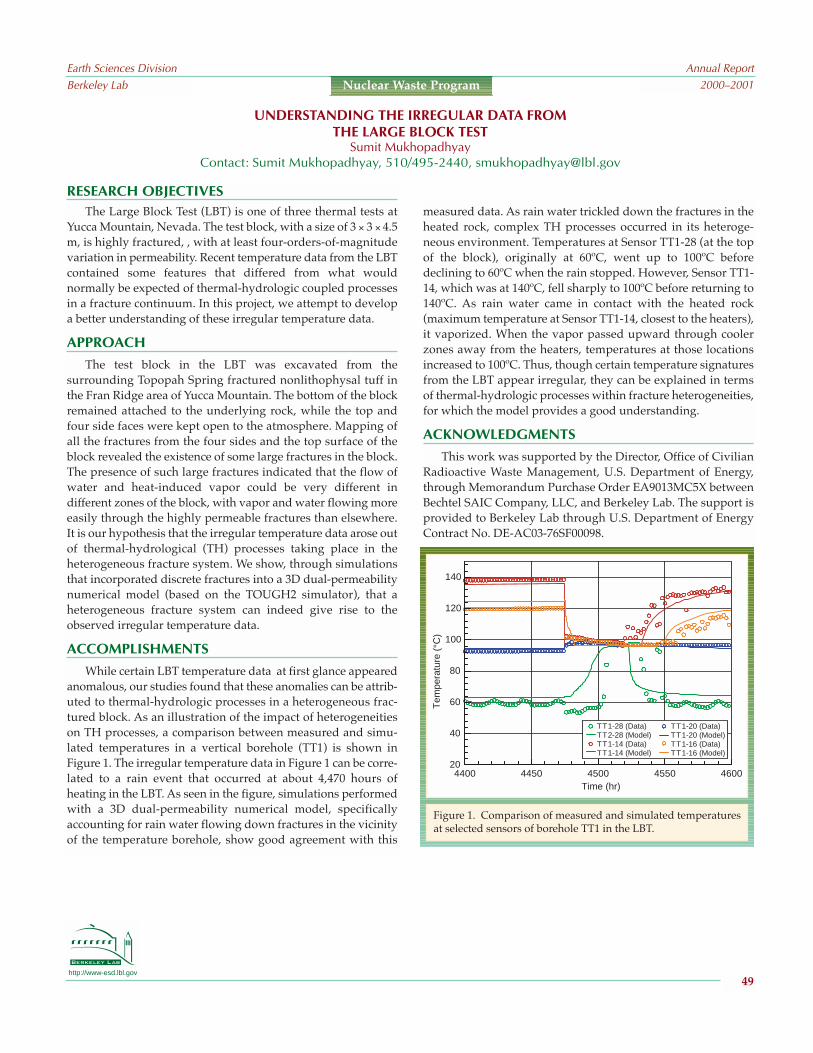
http://www-esd.lbl.gov
RESEARCH OBJECTIVESThe Large Block Test (LBT) is one of three thermal tests at
Yucca Mountain, Nevada. The test block, with a size of 3 × 3 × 4.5m, is highly fractured, , with at least four-orders-of-magnitudevariation in permeability. Recent temperature data from the LBTcontained some features that differed from what wouldnormally be expected of thermal-hydrologic coupled processesin a fracture continuum. In this project, we attempt to developa better understanding of these irregular temperature data.
APPROACH
The test block in the LBT was excavated from thesurrounding Topopah Spring fractured nonlithophysal tuff inthe Fran Ridge area of Yucca Mountain. The bottom of the blockremained attached to the underlying rock, while the top andfour side faces were kept open to the atmosphere. Mapping ofall the fractures from the four sides and the top surface of theblock revealed the existence of some large fractures in the block.The presence of such large fractures indicated that the flow ofwater and heat-induced vapor could be very different indifferent zones of the block, with vapor and water flowing moreeasily through the highly permeable fractures than elsewhere.It is our hypothesis that the irregular temperature data arose outof thermal-hydrological (TH) processes taking place in theheterogeneous fracture system. We show, through simulationsthat incorporated discrete fractures into a 3D dual-permeabilitynumerical model (based on the TOUGH2 simulator), that aheterogeneous fracture system can indeed give rise to theobserved irregular temperature data.
ACCOMPLISHMENTS
While certain LBT temperature data at first glance appearedanomalous, our studies found that these anomalies can be attrib-uted to thermal-hydrologic processes in a heterogeneous frac-tured block. As an illustration of the impact of heterogeneitieson TH processes, a comparison between measured and simu-lated temperatures in a vertical borehole (TT1) is shown inFigure 1. The irregular temperature data in Figure 1 can be corre-lated to a rain event that occurred at about 4,470 hours ofheating in the LBT. As seen in the figure, simulations performedwith a 3D dual-permeability numerical model, specificallyaccounting for rain water flowing down fractures in the vicinityof the temperature borehole, show good agreement with this
measured data. As rain water trickled down the fractures in theheated rock, complex TH processes occurred in its heteroge-neous environment. Temperatures at Sensor TT1-28 (at the topof the block), originally at 60ºC, went up to 100ºC beforedeclining to 60ºC when the rain stopped. However, Sensor TT1-14, which was at 140ºC, fell sharply to 100ºC before returning to140ºC. As rain water came in contact with the heated rock(maximum temperature at Sensor TT1-14, closest to the heaters),it vaporized. When the vapor passed upward through coolerzones away from the heaters, temperatures at those locationsincreased to 100ºC. Thus, though certain temperature signaturesfrom the LBT appear irregular, they can be explained in termsof thermal-hydrologic processes within fracture heterogeneities,for which the model provides a good understanding.
ACKNOWLEDGMENTS
This work was supported by the Director, Office of CivilianRadioactive Waste Management, U.S. Department of Energy,through Memorandum Purchase Order EA9013MC5X betweenBechtel SAIC Company, LLC, and Berkeley Lab. The support isprovided to Berkeley Lab through U.S. Department of EnergyContract No. DE-AC03-76SF00098.
UNDERSTANDING THE IRREGULAR DATA FROMTHE LARGE BLOCK TEST
Sumit MukhopadhyayContact: Sumit Mukhopadhyay, 510/495-2440, [email protected]
Earth Sciences DivisionBerkeley Lab
Annual Report2000–2001
49
Nuclear Waste Program
4400 4450 4500 4550 460020
40
60
80
100
120
140
Time (hr)
Tem
pera
ture
(°C
)
TT1-20 (Data)TT1-20 (Model)TT1-16 (Data)TT1-16 (Model)
TT1-28 (Data)TT2-28 (Model)TT1-14 (Data)TT1-14 (Model)
Figure 1. Comparison of measured and simulated temperaturesat selected sensors of borehole TT1 in the LBT.

http://www-esd.lbl.gov
tions of the major dissolved constituents for the tuff dissolutionwere within a factor of 2 of the measured average steady-statecompositions (Figure 1). The fracture mineral deposition simu-lations are ongoing, with initial model results indicating theprecipitation of a narrow band of silica at the base of the boilingfront. While the overall reduction of fracture porosity is small(~23% over 5 days), fracture permeability is reduced by over anorder of magnitude because of the highly focused silica precip-
itation. Both of these results are in agree-ment with experimental observations.
SIGNIFICANCE OFFINDINGS
This study demonstrates that care-fully constructed THC models cansuccessfully replicate laboratory experi-ments, thus validating the use of similarmodels in the prediction of changes inpermeability, porosity, and resultingfluid flow for the potential nuclear wasterepository at Yucca Mountain.
RELATED PUBLICATIONS
Kneafsey, T.J., J.A. Apps, and E.L.Sonnenthal, Tuff dissolution andprecipitation in a boiling, unsatu-rated fracture, Proceedings of the 9thInternational High-Level Radio-active Waste Management Confer-ence, Las Vegas, Nevada, April29May 3, 2001.
Sonnenthal, E.L., and N. Spycher, Drift-scale coupled processes (DST andTHC seepage) models, Report MDL-NBS-HS-000001 REV01, Bechtel SAICCompany, Las Vegas, Nevada, Berke-ley Lab, 2001 .
ACKNOWLEDGMENTS
This work was supported by theDirector, Office of Civilian Radioactive
Waste Management, U.S. Department of Energy, throughMemorandum Purchase Order EA9013MC5X between BechtelSAIC Company, LLC, and Berkeley Lab. The support isprovided to Berkeley Lab through U.S. Department of EnergyContract No. DE-AC03-76SF00098. We thank Stefan Finsterlefor his assistance in model design.
RESEARCH OBJECTIVES
The objective of this research is to use coupled thermal-hydro-logic-chemical (THC) models to simulate previously conductedlaboratory experiments investigating (1) tuff dissolution and (2)mineral precipitation in a boiling, unsaturated fracture. Mineraldissolution and precipitation could affect the total systemperformance of the potential nuclear waste repository at YuccaMountain, Nevada, where heat-generating nuclear waste willinduce vaporization of water present in the rock matrix and frac-tures. Vaporized water will migrate viafractures to cooler regions where conden-sation and mineral dissolution wouldoccur. Mineralized water flowing backtowards the heated zone would boil,depositing the dissolved minerals,reducing porosity and permeability abovethe repository, and potentially altering theflow paths of percolating water.
APPROACH
Numerical simulations of tuff disso-lution and mineral precipitation in afracture were performed using a modi-fied version of the TOUGHREACT codedeveloped at Berkeley Lab by T. Xu andK. Pruess. These simulations considerthe transport of heat, water, gas, anddissolved constituents; reactionsbetween gas, mineral, and aqueousphases; and the coupling of porosity andpermeability to mineral dissolution andprecipitation. Model dimensions andinitial fluid chemistry, rock mineralogy,permeability, and porosity were definedto reproduce the experimental condi-tions. A 1D plug-flow model was used tosimulate mineral dissolution in water. A2D model was developed to simulate theflow of mineralized water through aplanar fracture within a nonisothermalblock of ash flow tuff, where boilingconditions led to mineral precipitation.In this model, fluid flow was confined to the fracture. Fracturepermeability changes were calculated using the cubic law.
ACCOMPLISHMENTS
Simulations were conducted for both the tuff dissolution andfracture mineral deposition experiments. Predicted concentra-
MODELING OF THERMAL-HYDROLOGIC-CHEMICALLABORATORY EXPERIMENTS
Patrick F. Dobson, Timothy J. Kneafsey, Eric Sonnenthal, and Nicolas SpycherContact: Patrick F. Dobson, 510/486-5373, [email protected]
Earth Sciences DivisionBerkeley Lab
Annual Report2000–2001
50
Nuclear Waste Program
1999 LBNL tuff dissolution experimentv2.2, 60 µm, pot. fsp as microclinev2.2, 120 µm, pot. fsp as microclinev2.3, 60 µm, no k-smectite, pot. fsp as microclinev2.3, 60 µm, no k-smectite, pot. fsp as k-sparv2.3, 60 µm, k-smectite added to illite, pot. fsp as k-spar
1999 LBNL tuff dissolution experimentv2.2, 60 µm, pot. fsp as microclinev2.2, 120 µm, pot. fsp as microclinev2.3, 60 µm, no k-smectite, pot. fsp as microclinev2.3, 60 µm, no k-smectite, pot. fsp as k-sparv2.3, 60 µm, k-smectite as illite, pot. fsp as k-spar
15
10
5
0
150
100
50
0
(a)
(b)
0 20 40 60 80
0 20 40Time (days)
60 80
Na
(m
g/L
)S
iO2
(m
g/L
)
Figure 1. Comparison of measured and simu-lated results for the tuff dissolution plug-flowexperiment. Legend descriptions refer to ver-sions 2.2 and 2.3 of TOUGHREACT, use of 60and 120 mm grain-size models, and variationsin model mineralogy. Plots show variationswith time for Na (a) and SiO2 (b).

http://www-esd.lbl.gov
RESEARCH OBJECTIVES
The objective of this study is to evaluate the thermal-hydro-logical-chemical (THC) effects on flow and geochemistry in theunsaturated zone (UZ) at Yucca Mountain, Nevada, at a moun-tain scale. The major THC processes important in the UZ are (1)mineral precipitation/dissolution affecting flow and transportto and from the potential repository, and (2) changes in thecompositions of gas and liquid that may seep into drifts.
APPROACH
The conceptual model developed for THC processesprovides the basis for modeling mineral-water-gas reactions,because they influence the chemistry of water and gas and asso-ciated changes in mineralogy and hydrologic properties. Dataincorporated in the model include hydrologic and thermalproperties, geologic layering from the UZ 3D flow and transportmodel, geochemical data (fracture and matrix mineralogy, waterand gas geochemistry), and thermodynamic and kinetic data.Simulations included coupling among heat, water, and vaporflow; aqueous and gaseous species transport; kinetic and equi-librium mineral-water reactions; and feedback of mineralprecipitation/dissolution on porosity, permeability, and capil-lary pressure for a dual-permeability (fracture-matrix) system.Simulations were performed using TOUGHREACT V2.3.
The effects of coupled THC processes on the evolution offlow fields and water and gas chemistry in the UZ were evalu-ated for an above-boiling thermal operating mode. A crosssection was chosen from the UZ 3D flow and transport modelthat follows a north-south trend through the potential reposi-tory. Minerals include calcite, silica phases, feldspars, zeolites,clays, gypsum, fluorite, and iron oxides with the relevantaqueous species. The gas phase consists of air, water vapor, andCO2. The composition of the initial and infiltrating water wasderived from the matrix pore water extracted from the TopopahSpring welded tuff near theongoing Drift Scale Test.
ACCOMPLISHMENTS
The simulations revealed that5,000 years after waste emplace-ment, most of the region above anddirectly below the potential repos-itory undergoes a small reductionin fracture porosity of less than 1%(Figure 1). Above the northernedge, a region of slight porosityincrease persists, owing to
enhanced vaporconvection and
condensation. The areas that show the most effect as a result ofheating are the zeolitic units below the potential repository,where calcic zeolites dissolve to form alkali feldspars, leadingto increased aqueous calcium concentrations and increasedporosity. The predicted range in pH from 7 to 9 is linked tochanges in gas-phase CO2 concentrations induced by heating ofpore waters.
SIGNIFICANCE OF FINDINGS
The results of these simulations, based on a limited range ofinput parameters, suggest that mineral precipitation/dissolu-tion will not significantly affect the percolation flux above thepotential repository compared to the effects on flow inducedsolely by increased temperature. Edge effects owing to gasconvection produce mineral precipitation below the drifts at thepotential repository edge and in wider ranges in water and gascompositions than has been observed in drift-scale THC simula-tions. The results of this modeling will be used to bound uncer-tainties in potential repository performance.
RELATED PUBLICATION
Sonnenthal, E.L., and N. Spycher, Drift-scale coupled processes(DST and THC seepage) models, Report MDL-NBS-HS-000001 REV01, Bechtel SAIC Company, Las Vegas, Nevada,Berkeley Lab, 2001.
ACKNOWLEDGMENTS
This work was supported by the Director, Office of CivilianRadioactive Waste Management, U.S. Department of Energy,through Memorandum Purchase Order EA9013MC5X betweenBechtel SAIC Company, LLC, and Berkeley Lab. The support isprovided to Berkeley Lab through U.S. Department of EnergyContract No. DE-AC03-76SF00098.
MOUNTAIN-SCALE COUPLED THERMAL-HYDROLOGIC-CHEMICAL PROCESSES AROUNDTHE POTENTIAL NUCLEAR WASTE REPOSITORY AT YUCCA MOUNTAIN
Eric Sonnenthal, Charles Haukwa, and Nicolas SpycherContact: Eric Sonnenthal, 510/486-5866, [email protected]
Earth Sciences DivisionBerkeley Lab
Annual Report2000–2001
51
Nuclear Waste Program
Figure 1. Porosity changes and temperature contours after 5,000 years. Crosses represent potentialrepository drift locations.

http://www-esd.lbl.gov
RESEARCH OBJECTIVES
This project investigated the effect of two repository oper-ating-temperature modes on coupled thermal, hydrological, andchemical processes around potential nuclear waste-emplacementtunnels (drifts) at Yucca Mountain, Nevada. The main objectiveof this study was to evaluate the composition of fluids (water andgas) that could enter the drifts, because these data directly relateto the performance of waste canisters and other in-drift engi-neered systems over the life of the potential repository.
APPROACH
Multicomponent reactive transport simulations wereperformed using TOUGHREACT, initially written by T. Xu andK. Pruess at Berkeley Lab and modified here to handle high-temperature and boiling environments.Two repository operating- temperaturemodes were investigated: (1) a high-temperature mode, which considered ashort preclosure ventilation period (50years) and gave rise to above-boilingtemperatures in rocks around the driftfor hundreds of years, and (2) a low-temperature mode with a smaller heatload and longer preclosure ventilation(300 years), yielding temperatures at thesurface of the waste package below 85ºC(a design threshold) and thus belowboiling conditions. Simulations underambient conditions (no heat load) werealso conducted to serve as a baseline forcomparing results of thermal-loadingsimulations.
ACCOMPLISHMENTS
For each considered temperaturemode, time profiles of various calculatedthermal, hydrologic, and chemicalparameters were generated for severallocations around a simulated drift(Figure 1). In the high-temperature case,fractures around the drift dry out assoon as preclosure ventilation ends andremain dry until approximately 1,500years. During this time period, carbon dioxide concentrations(pore gas) fall below ambient values because of boiling anddisplacement by steam. In contrast, in the low-temperaturecase, fractures never dry out, and carbon dioxide concentrations
remain above ambient values, because this gas is exsolved frommatrix pore waters (by heating) and transported into fractures.For most major cations and anions, predicted concentrationsimmediately after dryout in the high-temperature case aresignificantly higher (one or more orders of magnitude) than inthe low-temperature case, because of larger prior evaporativeconcentration. However, this effect dissipates relatively quicklyas percolating waters rewet the drift wall after dryout.
SIGNIFICANCE OF FINDINGS
During the first simulated 5,000 years or so, seepage watercompositions around drifts are more affected by high than lowtemperatures, primarily as a result of evaporative concentration.
However, at temperatures below boiling,the continuous presence of water in frac-tures around the drift increases thepotential for seepage to occur. In thelong term (5,000 years or more), waterand gas compositions return to ambientvalues along with temperatures andbecome largely dominated by thecomposition of infiltrating water, regard-less of the operating temperature modeof the repository. Therefore, the vari-ability of infiltrating water compositionsis also important in determining thevariability of fluid compositions thatcould enter drifts.
RELATED PUBLICATION
Spycher, N., and E. Sonnenthal, Section6.3.1 in Supplemental Science andPerformance Analyses, ScientificBases and Analyses, TDR-MGR-MD-000007, Vol. 1, REV 00D (Draft),Bechtel SAIC Company, Las Vegas,Nevada, Berkeley Lab, 2001.
ACKNOWLEDGMENTS
This work was supported by theDirector, Office of Civilian RadioactiveWaste Management, U.S. Department of
Energy, through Memorandum Purchase Order EA9013MC5Xbetween Bechtel SAIC Company, LLC, and Berkeley Lab. Thesupport is provided to Berkeley Lab through U.S. Department ofEnergy Contract No. DE-AC03-76SF00098.
TEMPERATURE EFFECTS ONSEEPAGE FLUID COMPOSITIONS AT YUCCA MOUNTAIN
Nicolas Spycher and Eric SonnenthalContact: Nicolas Spycher,510/495-2388, [email protected]
Earth Sciences DivisionBerkeley Lab
Annual Report2000–2001
52
Nuclear Waste Program
10000
1000
100
10
1
0.1Con
cent
ratio
n (p
pmv)
Tem
pera
ture
(°C
)Li
quid
sat
urat
ion
CO2
160140120100806040200
0.070.060.050.040.030.020.01
01 10 100
Time (yr)1000 10000 10000
High TLow TAmbient
Figure 1. Predicted time profiles of thermal,hydrologic, and chemical parameters at thedrift crown in fractures. The model infiltrationrate was increased at 600 years and 2,000 yearsto account for possible future climate changes.

http://www-esd.lbl.gov
SIGNIFICANCE OF FINDINGSWe have successfully constructed a coupled THM numerical
simulator for two-phase flow conditions, and its use has beendemonstrated. The results from these simulations will be impor-tant for performance assessments of geological disposal of CO2and spent nuclear fuel, and are also valuable in other applica-tions such as geothermal energy extraction and oil and gasreservoir engineering.
RELATED PUBLICATION
Rutqvist, J., Y.-S. Wu, C.-F. Tsang, and G. Bodvarsson, Coupling ofTOUGH2 and FLAC3D codes for analysis of multiphase fluidflow, heat transfer, and rock deformation, InternationalJournal of Rock Mechanics, 2001 (submitted).
ACKNOWLEDGMENTS
This work was jointly supported by the Director, Office ofScience, Office of Basic Energy Sciences, Chemical Sciences andGeosciences Division of the U.S. Department of Energy, and the bythe Office of Civilian Radioactive Waste Management, U.S.Department of Energy, through Memorandum Purchase OrderEA9013MC5X between Bechtel SAIC Company, LLC, and BerkeleyLab. The support is provided to Berkeley Lab through U.S.Department of Energy Contract No. DE-AC03-76SF00098.
RESEARCH OBJECTIVESThe objective of this research is to develop a numerical simu-
lator for coupled thermal-hydrologic-mechanical (THM) analysisin complex geological media under multiphase flow conditions,with possible coupling to reactive transport modeling.
APPROACH
Two existing computer codes, TOUGH2 and FLAC3D, havebeen joined to develop a numerical simulator (TOUGH-FLAC)for analysis of coupled THM processes in complex geologicalmedia under two-phase flow conditions. Both codes are wellestablished and widely used in their respective fields. TheTOUGH2 code is designed for geohydrological analysis ofmultiphase, multicomponent fluid flow and heat transport,while the FLAC-3D code is designed for rock and soil mechanicsinvolving thermo-mechanical and hydromechanical interac-tions. The two codes are executed on two separate meshes andjoined with two coupling modules (Figure 1). One set ofcoupling modules can be exchanged with another set,depending on the type of rock and the problem being consid-ered.
ACCOMPLISHMENTS
Two sets of coupling modules have been developed over thepast year. One set has been developed for highly fractured rocksand has been applied to the Yucca Mountain site in Nevada. Asecond set has been developed for porous rocks and applied togeological sequestration of CO2. Each set requires two couplingmodules (Figure 1). The first module is used to transfer temper-ature and multiphase fluid pressures from the thermal-hydraulic analysis in TOUGH2 to the stress-strain analysis inFLAC3D. This also involves interpolation of TOUGH2 pres-sures, saturation, and temperatures from TOUGH2 nodes (mid-element) to FLAC3D nodes (element corners). The secondcoupling module takes the stress field calculated by FLAC3Dand corrects the hydraulic properties for the TOUGH2 simula-tion. In the case of fractured rock, the aperture is a nonlinearfunction of the stress across each fracture set. The aperturechanges are then used to correct fracture porosity, permeability,and the capillary pressure function. Through various iterativeschemes, either explicitly or implicitly coupled solutions areobtained.
COUPLING OF TOUGH2 AND FLAC3D FOR COUPLED THERMAL-HYDROLOGIC-MECHANICAL ANALYSISUNDER MULTIPHASE FLOW CONDITIONS
Jonny Rutqvist, Yu-Shu Wu, Chin-Fu Tsang, and Gudmundur S. BodvarssonContact: Jonny Rutqvist, 510-486-5432, [email protected]
Earth Sciences DivisionBerkeley Lab
Annual Report2000–2001
53
Nuclear Waste Program
TOUGH2
FLAC3D
Coupling module Coupling module
Fluid and heat transport
TOUGH2 element node
Stress and strain analysis
FLAC3D node
Figure 1. Schematic of the TOUGH-FLAC numericalsimulator

http://www-esd.lbl.gov
RESEARCH OBJECTIVESThe objective of this study is to investigate the impact of
stress-induced permeability changes (a coupled hydrologic-mechanical effect) on the performance of a potential nuclearwaste repository at Yucca Mountain, Nevada.
APPROACH
The two computer codes TOUGH2 and FLAC3D have beenjoined to form a numerical simulator (named TOUGH-FLAC)for analysis of coupled THM processes in complex geologicalmedia under two-phase flow conditions. For the YuccaMountain project, the two codes are joined with hydromechan-ical coupling functions that account for stress-induced changesin fracture apertures and corresponding changes in fracturehydraulic properties. In our modeling, these hydromechanicalcoupling functions are calibrated against several field experi-ments conducted in the Exploratory Study Facility (ESF) atYucca Mountain. Using the calibrated functions and theTOUGH-FLAC code, we then predict THM conditions arounda future potential repository at Yucca Mountain.
ACCOMPLISHMENTS
With waste emplacement and thermal input, the coupledmodel predicts thermal stresses that will reduce permeabilityaround the entire perimeter of the drift. In the long term,
thermal effects will cause permeability changes far from thedrift (up to 100 m), with most changes occurring in thevertical permeability. Permeability reduction is a function ofinitial local permeability values, which are larger for initiallylow values. However, despite permeability decreases to afactor of 0.2 in low-permeability regions, the effect of thehydromechanical coupling on the percolation flux around thedrift is not significant (Figure 1). The reason is that the water-retention curve and the relative permeability, which canchange much more than stress-induced permeability, dictatesunsaturated flow. Further, a stress-induced decrease inpermeability may be compensated for by an increase in rela-tive permeability.
SIGNIFICANCE OF FINDINGS
That the stress-induced changes in hydraulic propertieshave little or no impact on the flow field indicates that hydro-mechanical coupling for this particular case scenario is not asignificant factor in the total system performance assessmentof a potential repository. Work on other scenarios and sensi-tivity studies would be useful for further understanding of thisissue.
RELATED PUBLICATIONS
Bodvarsson, G.S., J. Wang, A. Unger, J. Liu, Y-S. Wu, J. Hinds, C.Haukwa, E. Sonnenthal, C.-F. Tsang, and J. Rutqvist,Unsaturated zone flow, in Chapter 3 of SupplementalScience and Performance Analyses, Volume 1, ScientificBases and Analyses, TDR-MGR-MD-000007, REV 00,CRWMS M&O, Las Vegas, Nevada, 2001 (in press).
Finsterle, S., G.S. Bodvarsson, C.F. Ahlers, G. Li, C-F. Tsang, Y.Tsang, E.L. Sonnenthal, and J. Rutqvist, Seepage, in Chapter4 of Supplemental Science and Performance Analyses,Consisting of Volume 1, Scientific Bases and Analyses, TDR-MGR-MD-000007, REV 00, CRWMS M&O, Las Vegas,Nevada, 2001 (in press).
ACKNOWLEDGMENTS
This work was supported by the Director, Office of CivilianRadioactive Waste Management, U.S. Department of Energy,through Memorandum Purchase Order EA9013MC5X betweenBechtel SAIC Company, LLC, and Berkeley Lab. The support isprovided to Berkeley Lab through U.S. Department of EnergyContract No. DE-AC03-76SF00098.
MODELING OF COUPLED THERMAL-HYDROLOGIC-MECHANICAL PROCESSES ATYUCCA MOUNTAIN
Jonny Rutqvist and Chin-Fu TsangContact: Jonny Rutqvist, 510-486-5432, [email protected]
Earth Sciences DivisionBerkeley Lab
Annual Report2000–2001
54
Nuclear Waste Program
Figure 1. Distribution of percolation flux for a pure THsimulation (left) and a fully coupled THM simulation(right). In the THM calculation (right), the hydraulicproperties of the rock mass are a function of stress.

http://www-esd.lbl.gov
RESEARCH OBJECTIVESEnhanced water-rock interaction resulting from the emplace-
ment of heat-generating nuclear waste in the potential geologicrepository at Yucca Mountain, Nevada, may result in changes tofluid flow (resulting from mineral dissolution and precipitationin condensation and boiling zones, respectively). Studies ofwater-rock interaction in active and fossil geothermal systems(natural analogs) provide evidence for changes in permeabilityand porosity resulting from thermal-hydrologic-chemical (THC)processes. The objective of this research is to document theeffects of coupled THC processes at Yellowstone and thenexamine how differences in scalecould influence the impact thatthese processes may have on theYucca Mountain system.
APPROACH
Subsurface samples from Yel-lowstone National Park, one of thelargest active geothermal systemsin the world, contain some the bestexamples of hydrothermal self-sealing found in geothermal sys-tems (Figure 1). We selected coresamples from two U.S. GeologicalSurvey research drill holes fromthe transition zone between con-ductive and convective portions ofthe geothermal system (wheresealing was reported to occur). We analyzed the core, measuringthe permeability, porosity, and grain density of selected samplesto evaluate how lithology, texture, and degree of hydrothermalalteration influence matrix and fracture permeability.
ACCOMPLISHMENTS
We examined core samples from the Y-5 and Y-8 drill holes,describing lithology, texture, hydrothermal alteration, and veins andfractures. Observed variations in porosity and matrix permeabilityare primarily controlled by lithology. Volcaniclastic sandstone andnonwelded tuffs have high porosity and moderate matrix perme-ability, while densely welded ash-flow tuffs and rhyolite lavas havelow porosity and permeability. Fractures are most abundant in thelatter two lithologies and provide the dominant pathways for fluid
flow there. Most of the observed fractures have been sealed byhydrothermal mineralization. A zone of secondary silica mineral-ization in the Y-8 core corresponds to the location of the imperme-able cap for the near-isothermal, convective geothermal reservoir.
SIGNIFICANCE OF FINDINGS
Predicting changes in permeability and porosity resultingfrom water-rock interaction is important in evaluating the long-term performance of nuclear waste repositories and for geot-hermal reservoir engineering. Geothermal systems have much
higher fluxes of heat and fluidflow than those predicted for thepotential Yucca Mountain repos-itory, and thus hydrothermalmineralization (and the resultingpermeability and porosity reduc-tion) at Yucca Mountain is likelyto be much less extensive thanthat observed at Yellowstone.Scaling comparisons and THCmodeling of Yellowstone couldprovide a more quantitative wayto test THC models used for theYucca Mountain system.
RELATEDPUBLICATION
Dobson, P., J. Hulen, T.J. Kneafsey,and A. Simmons, Permeability at Yellowstone: A naturalanalog for Yucca Mountain processes, Proceedings of the 9thInternational High-Level Radioactive Waste ManagementConference, Las Vegas, Nevada, April 29May 3, 2001,
ACKNOWLEDGEMENTS
This work was supported by the Director, Office of CivilianRadioactive Waste Management, U.S. Department of Energy,through Memorandum Purchase Order EA9013MC5X betweenBechtel SAIC Company, LLC, and Berkeley Lab. The support isprovided to Berkeley Lab through U.S. Department of EnergyContract No. DE-AC03-76SF00098. Additional support (toJeffery Hulen) was provided by DOE Grant DE-FG07-00ID13891to Energy and Geoscience Institute.
YELLOWSTONE AS AN ANALOG FOR THERMAL-HYDROLOGIC-CHEMICAL PROCESSES ATYUCCA MOUNTAIN
Patrick F. Dobson, Timothy J. Kneafsey, Ardyth Simmons, and Jeffrey Hulen1
1Energy and Geoscience Institute, University of UtahContact: Patrick F. Dobson, 510/486-5373, [email protected]
Earth Sciences DivisionBerkeley Lab
Annual Report2000–2001
55
Nuclear Waste Program
Figure 1. Silica sealing in volcaniclastic sandstone coresamples from Yellowstone. Blue color in photomicrographsis dyed epoxy filling pore space in thin sections. Similarzones of silica sealing form an impermeable cap to theconvective portion of the Yellowstone geothermal system.
1 mm 1 mm
Y-8, 155.9Permeability=1030 mdPorosity=29.2%
Y-8, 159.2Permeability=16.9 mdPorosity=15.0%

ACCOMPLISHMENTS
Shown in Figure 1 are the stable isotope data and uraniumconcentrations for the samples collected in 2000. Samples AS-1 andAS-2 exhibit higher U concentrations because of proximity to the orebody (exposed from 0 to 2 m into the adit), indicating the rapiddecrease in U concentration with distance from the ore body.Samples AS-5 and AS-6 have significantly lower δD and δ18O valuesthan the other samples. They probably represent the average compo-sition for the precipitation at the site. The other samples were allcollected from an adit in the unsaturated zone. Of these, AS-1 lies onthe GMWL, but probably does not represent a rainwater sample (it isrelatively enriched in D and 18O for meteoric water at this latitude).The other three samples all fall significantly to the left of the GWMLand may represent atmospheric water vapor that has condensed inthe cooler, underground environment, followed by some evapora-tion in the collection bottles.
SIGNIFICANCE OF FINDINGS
U-series modeling provides a means to characterize thekinetically controlled radionuclide transport and residence timeat Peña Blanca. Using an earlier data set collected by SouthwestResearch Institute, we estimated the 234U alpha-recoil rate intofluids to be 9 dpm/L/y at Peña Blanca versus dissolution ratesof 8.3 dpm/L/y for 238U and 234U. The kinetic model also allowsdetermination of fluid transit time in the unsaturated zone.Uranium-238 increases linearly with increasing transit time,while 234U/238U decreases. The transit time for the seep waterinfiltrated into the adit 8 m below surface is estimated to be 629days, and that for the perched water at 10.7 m depth in an oldborehole is 0.40.5 years. The large values of transit time for theperched water may reflect the long residence time of water inthe borehole. Although the water transit time in the unsaturatedzone is quite short, detectable dissolution of U from fracturedrocks does occur in this low-water flux, high-U concentrationsetting near the Nopal I uranium deposit.
RELATED PUBLICATION
Murrell, M.T.; P. Paviet-Hartmann, S.J. Goldstein, A.J. Nunn,R.C. Roback, P.A. Dixon, and A. Simmons, U-Series naturalanalog studies at Peña Blanca, Mexico: How mobile isuranium? EOS Transactions, AGU 80, F1205, 1999.
ACKNOWLEDGMENTS
Stable isotope analyses were performed by Mark Conrad,Berkeley Lab. U-series modeling was done by Shangde Luo andTeh-Lung Ku, USC. This work was supported by the Director,Office of Civilian Radioactive Waste Management, U.S.Department of Energy, through Memorandum Purchase OrderEA9013MC5X between Bechtel SAIC Company,LLC, and Berkeley Lab. The support is providedto Berkeley Lab through U.S. Department ofEnergy Contract No. DE-AC03-76SF00098.
http://www-esd.lbl.gov
AS-1 12 m from adit entrance on +00 level AS-2 15 m from adit entrance AS-3 23 m from adit entrance AS-4 8.5 m into north part of adit AS-5 Perched water from borehole at +10 level AS-6 Abandoned mining camp supply well
Global Meteoric
Water L
ine
δD (
‰)
20
0
-20
-40
-60
-80-10 -5 0 5
δ18O (‰)
SMOW
AS-5 (6.5)AS-6 (6.0)
AS-1 (67.5)
AS-4 (3.1)
AS-2 (36.9)AS-3 (4.4)
Sample Location
Figure 1. Uranium and stable isotope data for water samplescollected (black circles) from Peña Blanca during February 2000.Also shown is the position of the global meteoric water line andSMOW (Standard Mean Ocean Water). Uranium concentrationsin parts per billion (ppb) are indicated in parentheses after thesample number. Sample locations are shown on key.
RESEARCH OBJECTIVES
Natural analogs provide a line of evidence that supports theunderstanding of how natural and engineered processes could occurover long time frames and large spatial scales at a potential nuclearwaste repository at Yucca Mountain, Nevada. Studies of U-seriesdisequilibria within and around uranium deposits can provide valu-able information on the timing of actinide mobility and hence thestability of a potential repository over geologic time scales. TheNopal I uranium deposit at Peña Blanca, Mexico, is situated in unsat-urated tuff that is similar in composition to the Topopah Spring Tuffof Yucca Mountain and closely matches other evaluation criteria forsuitable natural analogs. By modeling the observed radioactiveisotope disequilibria at Nopal I, we can estimate the rates of sorption-desorption and dissolution-precipitation of the radionuclides overtime. Such information is vital to the testing or validation of perform-ance assessment models for geologic nuclear waste disposal.
APPROACH
A number of boreholes through and surrounding the oredeposit will be drilled to the water table (a depth of ~200 m);from these boreholes, solid core and water samples will betaken. Isotopes of 234U, 238U, 232Th, 230Th, 228Th, 234Th, 226Ra,228Ra, 210Po, and 210Pb will be measured in the fluid samples.Radioactive disequilibria in sorbed phases will be obtainedusing leaching methods on the core samples. To correct for thepossible effect of evaporative concentration on model results,Cl or δ18O and δD compositions of water samples from theunsaturated zone will be compared with those of rainwater. Thefinal report will include recommendations on the application ofmodel results from the Peña Blanca analog site to testing theunsaturated zone process models that provide input to perform-ance assessment models for Yucca Mountain.
U-SERIES TRANSPORT STUDIES AT PEÑA BLANCA, MEXICO, NATURAL ANALOG SITEArdyth M. Simmons and Michael T. Murrell1
1Los Alamos National Laboratory, New MexicoContact: Ardyth M. Simmons, 510/486-7106, [email protected]
Earth Sciences DivisionBerkeley Lab
Annual Report2000–2001
56
Nuclear Waste Program

http://www-esd.lbl.gov
RESEARCH OBJECTIVESThe objective of this project is to participate in a multina-
tional program to investigate the uncertainties involved indeveloping conceptual and numerical models for prediction offlow and transport behavior through fractured rock.
APPROACH
In a previous study (the H-12 flow comparison), severalinternational research organizations conducted numerical simu-lations with the same starting information regarding a hypo-thetical fractured rock mass. The results were subsequentlycompared. In the present work, the exercise is applied to a realsite, a 4 km x 6 km x 3 km region north of the Toki River in theTono area of Gifu, Japan.
In our conceptual model, stochastic permeability andporosity distributions are used to represent fractured rock as aneffective continuum. Individual fractures are not modeledexplicitly. However, large-scale features such as fault zones,lithologic layering, natural boundaries, and surface topographyare incorporated deterministically. The stochastic permeabilitydistribution results from hydrologic testing that occurs usingpacked-off borehole intervals of comparable length to the modelgridblock dimensions (~100 m), giving us confidence that thepermeability values being used in the model are reasonable. Incontrast, the only data available on which to base porosity esti-mates are fracture density measurements. These measurements,obtained from borehole optical scanner images and coresamples, are typically taken on a much smaller scale (a fewcentimeters) than the model gridblocks. Porosity estimates alsorely on the cubic law, which is known to be unreliable. Hence,we recognize that there is a large uncertainty associated withany model result that depends on porosity, such as travel timesthrough the model.
ACCOMPLISHMENTS
We developed the model shown in Figure 1 and used thenumerical simulator TOUGH2 to simulate steady-state flowthrough the 4 km x 6 km x 3 km region. Regional topographydetermines the extent of the grid and the boundary conditions.The resulting flow fields appear consistent with local infiltrationdata and head profiles in boreholes. Calculated travel times frommonitoring points to the model boundaries range from 1 to 25years.
SIGNIFICANCE OF FINDINGS
A major benefit of the present project is the chance for avariety of modeling approaches to highlight which aspects of
site characterization need to be improved to increase confidencein model predictions. Because the field investigation program isongoing, model results can potentially have a significant impacton future characterization activities.
The wide range in travel times obtained by the differentresearch groups for the present exercise (several years tomillions of years) can be largely attributed to orders-of-magni-tude differences in the effective porosity assumed for the frac-ture network. Coupled with our recognition that porosity is oneof the least well-constrained parameters of our model, thisfinding indicates that a field program aimed at better estimatingeffective fracture porosity is needed. Possible areas of investiga-tion include using naturally occurring trace elements or isotopesto estimate residence times and flow paths on a regional scale, oractive tracer tests using suites of neighboring wells to estimateeffective porosity on a smaller scale.
ACKNOWLEDGMENTS
This work was supported by the Japan Nuclear Fuel CycleCorporation (JNC) and Taisei Corporation of Japan, throughU.S. Department of Energy Contract No. DE-AC03-76SF00098.
DEVELOPING AN EFFECTIVE-CONTINUUM SITE-SCALE MODELFOR FLOW AND TRANSPORT IN FRACTURED ROCK
Christine Doughty and Kenzi KarasakiContact: Christine Doughty, 510/486-6453, [email protected]
Earth Sciences DivisionBerkeley Lab
Annual Report2000–2001
57
Nuclear Waste Program
Figure 1. 3D perspective view of the model used for theTOUGH2 simulations of the 4 × 6 km region. Materialtypes are color coded. Surface locatons of wells are blacksymbols.

Results of the calibration to the hydrographs using a fracture-matrix continuum area scaling factor of 0.01 are shown in Figure1b and are: basalt fracture continuum permeability of 3.27 x10¹⁰ m2, basalt matrix continuum permeability of 2.51 x 10¹⁵
m2, BC interbed permeability of 5.01 x 10¹⁷ m2, BC interbed vanGenuchten α of 1 x 10⁴ Pa1 and n of 0.28.
SIGNIFICANCE OF FINDINGS
The significance of this calibration effort pertains to previousmodeling efforts conducted at the Box Canyon site at INEEL aswell as the use of the dual-permeability modeling approach tosimulate steady-state and transient infiltration at Yucca Mountain.
Parameters obtained fromthis modeling effort agreeclosely with those obtainedin a preliminary study con-ducted at the Box Canyonsite. Therefore, we concludethat the use of the dual-permeability approach witha constant fracture-matrixcontinuum area-scaling fac-tor is adequate for modelingtransient infiltration at avariety of scales and undervarious wetting histories.Successful application of thedual-permeability model-ing approach for simulatingthe LPIT lends credibility tothe use of the same ap-
proach for modeling infiltration (both transient and steady state)at the Yucca Mountain site.
RELATED PUBLICATION
Unger, A.J.A., B. Faybishenko, G.S. Bodvarsson, and A.M.Simmons, A three-dimensional model for simulating pondedinfiltration tests in the variably saturated fractured basalt atthe Box Canyon Site, Idaho, Berkeley Lab Report LBNL-44613, 2000.
ACKNOWLEDGMENTS
This work was supported by the Director, Office of CivilianRadioactive Waste Management, U.S. Department of Energy,through Memorandum Purchase Order EA9013MC5X betweenBechtel SAIC Company, LLC, and Berkeley Lab. The support isprovided to Berkeley Lab through U.S. Depart-ment of Energy Contract No. DE-AC03-76SF00098.
http://www-esd.lbl.gov
RESEARCH OBJECTIVESThis work involves using ITOUGH2 to simulate the Large-
Scale Ponded Infiltration Test (LPIT) at Idaho NationalEngineering and Environmental Laboratory (INEEL) to calibrateparameters controlling the infiltration of water in fracturedbasalt using a dual-permeability modeling approach. Thissupports the higher objective of building confidence in the useof the dual-permeability approach for modeling flow and trans-port in unsaturated fractured rock systems.
APPROACH
A 3D dual-permeability mesh representing the geologicalconditions at the LPIT was constructed as shown by the cross
section on Figure 1a. The geology consisted of surficial sedi-ments, two separate basalt flows (A and B basalts) underlain bya low- permeability sedimentary (BC) interbed, and a lower Cbasalt constituting the bottom of the model. Water was allowedto infiltrate from the pond and then pool on top of the sedimen-tary interbed. Water pressure was simulated at four wellsscreened within the fractured basalt on top of the sedimentaryinterbed (B04N11, C04C11, B06N11, C06C11) along two radialangles and at two radial distances. Model results were calibratedto field data using ITOUGH2.
ACCOMPLISHMENTS
Five parameters were selected for calibration by ITOUGH2:(1) basalt fracture-continuum permeability, (2) basalt matrix-continuum permeability, (3) BC interbed permeability, and (4and 5) BC interbed van Genuchten capillary-pressure parame-ters a and n. Inversions were performed using constant fracture-matrix continuum area scaling factors of: 0.02, 0.01, and 0.005.
SIMULATING INFILTRATION ATTHE LARGE-SCALE PONDED INFILTRATION TEST, INEELAndré Unger, Ardyth Simmons, and Gudmundur S. Bodvarsson
Contact: André Unger, 51/495-2823, [email protected]
Earth Sciences DivisionBerkeley Lab
Annual Report2000–2001
58
Nuclear Waste Program
101000100000
990009800097000960009500094000930009200091000900008900088000870008600085000
Wat
er p
ress
ure
(Pa)
0 10 20 30Time (days)
40 50 60
B04N11
C04C11
B06N11
C06C11
Figure 1a. Water saturation in the fracture continuum (Swf) 35.5 days after the start of the infiltration test; Figure1b. Field (symbol) and calibrated model (lines) hydrographs. Note that wells B04N11 and B06N11 are located atthe same radial distance as C04C11 and C06C11, while 04 and 06 wells are on the same radial angle.
10.950.90.850.80.750.70.650.60.550.50.450.40.350.30.250.20.150.10.050
Swf
C04
C11
B04
N11
surficialsediments1550
1540
1530
1520
1510
1500
1490
1480
1470
Ele
vatio
n (m
) A basalt
B basalt
BC interbedBC interbed
C basaltC basalt
BC interbed
C basalt
-500 -400 -300 -200 -100 0 100 200 300 400 500Radius (m)

http://www-esd.lbl.gov
The Energy Resources Program (ER) is responsible for twomajor program areas: Oil and Gas Exploration andDevelopment, and Geothermal Energy Development.
OIL AND GAS EXPLORATION ANDDEVELOPMENT
Multidisciplinary research is being conducted in reservoircharacterization and monitoring, optimization of reservoirperformance, and environmental protection. Using basicresearch studies as a source of innovative concepts, ERresearchers seek to transform these concepts into tangible prod-ucts of use to industry within a time-frame consistent withtodays rapid growth in technology. Reservoir characterizationand monitoring involves development of new seismic and elec-tromagnetic techniques focused at the inter-well scale. Fieldacquisition, laboratory measurements, and numerical simula-tion play important roles in the development activities.Optimization of reservoir performance is focused on simulation-based methods for enhancing reservoir management strategies.Emphasis is placed on the integration of geophysical data,production data, and reservoir simulation. The next major stepin research will focus on methods to optimize performancethrough integration of monitored geophysical data, productiondata, and reservoir simulation.
International and national concern about the variableclimactic effects of greenhouse gases produced by burning offossil fuels is increasing, while it is also recognized that thesefuels will remain a significant energy source well into the nextcentury. In response to these concerns, ER has initiated researchfocused on development of technologies that will minimize theimpact of fossil-fuel usage on the environment. Methanehydrates constitute a huge potential fuel source with lowercarbon emissions than coal or oil. ER researchers are developingand evaluating possible methods for producing gas from suchdeposits. Geophysical data acquisition and inversion methodsdeveloped in the ER program are also being applied in a newproject on geologic sequestration of CO2 carried out in theClimate Variability and Carbon Management Program with theEarth Sciences Division.
Principal research activities include:
Development of single-well and crosswell seismic tech-nology, including instrumentation, acquisition andprocessing
Applications of seismic methods for characterization offractured reservoirs
Laboratory measurement of the seismic properties ofpoorly consolidated sands
Development of efficient 3D elastic-wave propagationcodes
Improved inversion methods for reservoir characteriza-tion, with a focus on combining production and geophys-ical data
Application of x-ray CT and NMR imaging to study multi-phase flow processes
Pore-to-laboratory-scale study of physical properties andprocesses, with a focus on controlling phase mobility,predicting multiphase flow properties and drilling effi-ciency
Development of reservoir process-control methods Development of new methods to mitigate environmental
effects of petroleum refining and use Enhancement of refining processes using biological tech-
nologies Numerical simulation of subsurface methane hydrate
systems
Since 1994, the major part of the Oil and Gas Explorationand Development program has been funded through theNatural Gas and Oil Technology Partnership Program. Begun in1989, the partnership was expanded in 1994 and again in 1995 toinclude all nine Department of Energy multiprogram laborato-ries, and has grown over the years to become an important partof the DOE Oil and Gas Technologies program for the nationallaboratories. Partnership goals are to develop and transfer to thedomestic oil industry the new technologies needed to producemore oil and gas from the nations aging, mature domestic oilfields, while safeguarding the environment.
Earth Sciences DivisionBerkeley Lab
Annual Report2000–2001
59
ENERGY RESOURCES
RESEARCH PROGRAM
Larry R. Myer

http://www-esd.lbl.gov
Partnership technology areas are: Oil and gas recovery technology Diagnostics and imaging technology Drilling, completion and stimulation Environmental technologies Downstream technologiesProjects are typically multiyear, are reviewed and repriori-
tized annually by industry panels and are collaborationsbetween national laboratories and industry
GEOTHERMAL ENERGY DEVELOPMENTThe main objective of ERs geothermal energy development
program is to reduce uncertainties associated with finding, char-acterizing, and evaluating geothermal resources. The ultimatepurpose is to lower the cost of geothermal energy for electricalgeneration or direct uses (e.g., agricultural and industrial appli-cations, aquaculture, balneology). The program encompassestheoretical, laboratory, and field studies, with an emphasis on amultidisciplinary approach to solving the problems at hand.Existing tools and methodologies are upgraded, and new tech-niques and instrumentation are developed for use in the areas ofgeology, geophysics, geochemistry, and reservoir engineering.Cooperative work with industry, universities, and governmentagencies draws from Berkeley Labs 25 years of experience in thearea of geothermal research and development.
In recent years, DOEs geothermal program has becomemore industry-driven, and the Berkeley Lab effort has beendirected toward technology transfer and furthering our under-standing of the nature and dynamics of geothermal resourcesunder production, such as The Geysers geothermal field innorthern California, which has begun to show the effects ofoverexploitation.
At present, the main research activities of the programinclude:
Geothermal Reservoir Dynamics: development andenhancement of computer codes for modeling heat andmass transfer in porous and fractured rocks, with specificprojects such as modeling the migration of phase-parti-tioning tracers in boiling geothermal systems; modeling ofmineral dissolution and precipitation during naturalevolution, production, and injection operations; andgeophysical-signature prediction of reservoir conditionsand processes
Isotope Geochemistry: identification of past and presentheat and fluid sources, development of natural tracers formonitoring fluids re-injected into geothermal reservoirs,better understanding of the transition from magmatic togeothermal production fluids, and enhancement of reser-voir-simulation methods and models by providingisotopic and chemical constraints on fluid source, mixing,and flow paths
Multicomponent 3D Seismic Imaging: development andimplementation of 3D surface and borehole methods fordefining permeable pathways in geothermal reservoirs
Geochemical Baseline Studies: documentation of geot-hermal-fluid behavior under commercial production andinjection operations (e.g., field case studies), with specificemphasis on The Geysers field
Electromagnetic Methods for Geothermal Exploration:development of efficient numerical codes for mappinghigh-permeability zones, using single-hole electromag-netic data
Future research will concentrate on the development of inno-vative techniques for geothermal exploration and assisting in areassessment of geothermal power potential in the U.S. Theemphasis will be on expanding existing fields, prolonging theirproductive life, and finding new "blind" geothermal systems,i.e., those that do not have any surface manifestations, such ashot springs, fumaroles, etc., that suggest the presence of deeperhydrothermal systems.
FUNDINGWithin ER, The Oil and Gas Exploration and Development
program receives support from the Assistant Secretary for FossilEnergy, Office of Natural Gas and Petroleum Technology,through the National Energy Technology Laboratory, theNational Petroleum Technology Office, and the Natural Gas andOil Technology Partnership, under U.S Department of EnergyContract No. DE-AC03-76SF00098. Support is also providedfrom industry and other sources through the Berkeley Lab Workfor Others program. Industrial collaboration is an importantcomponent of DOE Fossil Energy projects.
The Geothermal Energy Development program receivessupport from the Assistant Secretary for Energy Efficiency andRenewable Energy, Office of Power Technologies, Office of Windand Geothermal Technologies, of the U.S. Department of Energy.
Earth Sciences DivisionBerkeley Lab
Annual Report2000–2001
60
Energy Resources Program

http://www-esd.lbl.gov
RESEARCH OBJECTIVESThe central problem in petroleum production is the devel-
opment of a model or simulator that guides the drilling of wells,the management of the field, and the design of enhancedrecovery processes. The objective of this research program is tointegrate both seismic and electromagnetic geophysics for themapping of reservoir propertiesbetween wells. This project will demon-strate that an integrated approach canbe used to assign these properties to theflow simulation models of the interwellvolume and greatly increase the effec-tiveness of in-fill drilling, reservoirproduction, and reservoir stimulation.
APPROACHThe project combines feasibility
studies based on numerical models withthe interpretation of field data to inves-tigate possible methods of integratingelectromagnetic (EM) and seismic data,along with well log information, toproduce images of reservoir parameters(such as pressure and fluid saturations).Numerical studies have been carried outfor a model of a producing North Sea oilfield supplied by industrial partners.This study concentrated on well separa-tions, which are relevant to offshoreapplications but have not been treatedin field experiments to date. Two fielddata examples provided by industrialpartners have been processed and inter-preted to demonstrate how well logmeasurements, crosswell EM, andseismic data can be combined.
ACCOMPLISHMENTSThe numerical feasibility study of
the Snorre Field demonstrates that crosswell EM could be meas-ured and used to infer reservoir average water saturations infields where well separations are on the order of 1 km. Thisrepresents an increase by a factor of 2 in well separations overwhat has been demonstrated to date in field measurements. Thisstudy demonstrated the necessity of integrating structuralcontrol from seismic data along with well control to provide the
optimal estimates of reservoir water saturation in the interwellvolume.
Crosswell, EM, and seismic field data from the Kern Riverand Lost Hills oil fields have been processed and interpreted. Inthe Kern River case, a detailed reprocessing of the seismic data
to produce an equivalent CDP sectionbetween the wells was used to constrainthe EM inversion for conductivity. Thisprocess increased the spatial resolutionof the inferred fluid saturations as wellas the correlation between logs andimaged fluid properties.
In the Lost Hills project, time-lapseseismic and EM data were able to predictboth pressure and saturation changes inthe inter-well volume. In addition, time-lapse changes demonstrated that smallinternal faults, not previously consideredsignificant, were acting as barriers toflow. Figure 1 shows time-lapse changesin electrical conductivity, which directlymaps changes in water saturation causedby an increase in oil.
SIGNIFICANCE OF FINDINGSThe addition of conductivity
mapping via crosswell EM provides arobust estimate of water saturationchanges that is independent from seismicdata.
RELATED PUBLICATIONSHoversten, G.M., G.A. Newman, H.F.
Morrison, and J.I. Berg, Reservoircharacterization using crosswell EMinversion: A feasibility study for theSnorre Field, North Sea: Geophysics,2001 (in press).
ACKNOWLEDGMENTSThis work was funded in part by the Assistant Secretary for
Fossil Energy, Office of Natural Gas and Petroleum Technology,through the Natural Gas and Oil Technology Partnership, of theU.S. Department of Energy under Contract No. DE-AC03-76SF00098 and Sandia Contract No. DE-AC04-94AL85000.
INTEGRATED RESERVOIR MONITORING USINGSEISMIC AND CROSSWELL ELECTROMAGNETICS
G. Michael HoverstenContact: G. Michael Hoversten, 510/486-5085, [email protected]
Earth Sciences DivisionBerkeley Lab
Annual Report2000–2001
61
Energy Resources Program
Figure 1. Time-lapse change in electricalconductivity during CO2 injection. Largenegative changes (blue) indicate an increase inoil saturation and correlate with high-perme-ability zones. The red line marks a small faultmapped from well logs. Changes in electricalconductivity truncate at the fault location.

wave propagation will be computed, using the optimal spatialparameterization for each particular subdomain. The secondcritical concept is the use of a fourth-order time scheme (asopposed to the frequently used second-order schemes).
The new variable-grid-subdomain finite-difference (FD)algorithm is designed for parallel-cluster computing, utilizing amessage-passing-interface technique. Using subdomains in FDmodeling has several major advantages over current single-domain algorithms. For one thing, this approach uses fine grid-ding only in low-velocity regions (sea water, loosely compactedsediments) where it is required, allowing coarser gridding in thehigher-velocity regions (salt, deep sediments). The innovativefourth-order differencing scheme enables improved accuracy intime differencing, and therefore increases the time-differencingstep for the expense of extra computation within a single node.Since inter-CPU communication speed is a major bottleneck forparallel data-processing flow, the fourth-order scheme allows anincrease in the computation-to-communication ratio, improvingthe effectiveness of parallel computations. The fourth-ordertime-differencing scheme has little effect on memory usagecompared to second-order schemes. A required special formu-lation for absorbing boundary conditions is under development.
ACCOMPLISHMENTSFigure 1 shows a graph summarizing a set of runs performed
this past year using the new variable-grid-subdomain FD algo-rithm scheme. The graph shows the number of computationalzones increasing linearly with the number of processors. Perfectscaling results would have zero slope. Cray T3E times areencouraging. The IBM SP shows a reduction in parallel perform-ance with increasing numbers of processors. The performanceloss is less severe for the fourth-order scheme than for thesecond-order scheme. The IBM has slower interprocessorcommunications (both lower bandwidth and higher latency).(Run time reported is wall-clock time.) Cray T3E shows veryefficient processor usage for both second- and fourth-orderschemes. Fourth-order schemes show slower degradation ofparallel performance with increasing problem size.
ACKNOWLEDGMENTSThis work has been supported by the Assistant Secretary for
Fossil Energy, Office of Natural Gas and Petroleum Technology,through the National Petroleum Technology Office, Natural Gasand Oil Technology Partnership, of the U.S. Department ofEnergy under Contract No. DE-AC03-76SF00098.
http://www-esd.lbl.gov
RESEARCH OBJECTIVESThe best tool for understanding and imaging complex struc-
tures and large offset data sets is an accurate, fully elastic 3Dalgorithm. The applications for such an algorithm are many(e.g., survey design, hypothesis testing, AVO evaluation, wavefield interpretation, generation of test data sets for testing of newmigration algorithms, and forward-calculation engines in 3Dprestack migration algorithms and new full waveform inversionalgorithms). While such algorithms have been developed,uniform grid sampling produces costly oversampling of high-velocity regions and unnecessarily small time-integration stepsin low-velocity regions. Thus, the scale of the computerresources required to model the entire geologic section, fromsource locations to the depths of interest and with fully elasticrepresentation, is prohibitive. In addition, the discretization ofhigh-contrast boundaries (such as a salt-sediment interface) canproduce high-energy diffraction events in the modeled data,which are often difficult to completely suppress even inprocessing. There is a critical need for an algorithm that canaccurately model and image all of the elastic effects occurring ina complex structure, and at the same time be efficient enough torun on clusters of available workstations in a reasonable time.We seek to develop an efficient 3D elastic forward-modelingalgorithm that will address these requirements.
APPROACHTwo critical concepts will provide for a significant improve-
ment in computation efficiency and accuracy over what iscurrently available. The first critical concept is the decomposi-tion of the original 3D model into parts (subdomains) where
HIGH-SPEED 3D HYBRID ELASTICSEISMIC MODELING
Valeri A. Korneev and Charles A. RendlemanContact:, Valeri A. Korneev, 510/486-7214, [email protected]
Earth Sciences DivisionBerkeley Lab
Annual Report2000–2001
62
Energy Resources Program
9876543210
IBM 2
IBM 4
T3E 2
T3E 4
1 2 4 8 16Number of CPU's
Wal
l clo
ck ti
me
32 64
Figure 1. Summary of a set of runs, with the number of compu-tational zones increasing linearly with the number of processors

http://www-esd.lbl.gov
RESEARCH OBJECTIVESThe objectives of this work are to: (1) provide a theoretical
basis for frequency-dependent amplitude attributes associatedwith multiple fluid (and gas) phases in poorly consolidatedsands, for a range of consolidation conditions; (2) explore thepossibility of new seismic attributes; (3) use numerical modelingto examine optimum 3D seismic-acquisition geometries andprocessing schemes for illumi-nating these attributes inpoorly consolidated sand reser-voirs; and (4) apply the resultsof these analyses to 4D seismicimaging.
APPROACHThis research combines labo-
ratory acoustic measurements,theoretical development, and3D visco-elastic wave simula-tions. The focus of the acousticmeasurements and theoreticaldevelopment is to obtain afrequency- dependent theoryfor wave propagation in poorlyconsolidated sands, a theorythat can be used to predict theeffects of fluid substitution and reservoir compaction on elasticwaves. The focus of the wave-simulation effort is to embed thisrock physics model into a numerical simulator to predict thechanges in and effects of fluid distributions on acoustic propertiesin the presence of different reservoir structures. After all thiswork, we will analyze synthetic data for robust seismic attributesthat can be used for 4D monitoring of changes in reservoirfluid/gas migration and reservoir consolidation.
ACCOMPLISHMENTSThe second year of the project has focused on three efforts: (1)
analysis of the measured extensional wave velocities and attenu-ation (19 kHz) using existing rock physics models, (2) addition oftorsional-wave sonic-frequency-measurement capabilities to ourextensional wave apparatus, (3) completion of our lab velocityand attenuation measurements on medium-grain clean sandsunder a range of gas saturations and confining pressures, (4)design of a seismic- frequency (1100 Hz) stress-strain apparatus,and (5) 3D dynamic poroelastic modeling of wave propagation inmedia with heterogeneous gas distributions.
Here, we describe some results for Effort 1. (Efforts 25 arepresently ongoing.) Figure 1 displays the extensional wave veloc-
ities obtained from a 3 kHz pulse transmission test on a 0.8 m longpacking of a coarse grain Monterey sand. Three different styles ofgas saturation were introduced into the sample and imaged usingan x-ray computerized-tomography scanner: (1) CO2 degassing,yielding near-homogeneous gas phase; (2) injection of water intoa dry horizontal sample, yielding patchy saturation consisting of
horizontal stratification; and (3)injection of water into a dryvertical sample, yielding patchysaturation consisting of verticalsegregation.
Figure 1 shows that severalstatic-effective-medium theo-ries (Gassmann for the homo-geneous case and Hill for thepatchy-vertical case) showgood agreement with the meas-ured extensional wave veloci-ties. These results demonstratethat sonic-frequency velocitiesfor a coarse-grain sand are notunique functions of the watersaturation. That is, the details ofthe distribution of the fluid andgas phases have an effect on the
velocities. Note that measurements to date suggest that theattenuation (not shown) may provide additional informationthat can be used to deduce the style of saturation (i.e., homoge-neous versus heterogeneous).
SIGNIFICANCE OF FINDINGSSeismic characterization of fluids in poorly consolidated
sands is a problem of growing importance, especially on theGulf Coast. A basic understanding of sand acoustic propertiesunder moderate stresses and in the presence of multiple fluidsand gases is required to relate seismic attributes to fluid distri-butions. The laboratory and modeling efforts described here willprovide clearer relations between heterogeneous and homoge-neous partial-gas saturations in poorly consolidated sands, withsonic-frequency velocities and attenuation.
ACKNOWLEDGMENTSThis work has been supported by the Assistant Secretary for
Fossil Energy, Office of Natural Gas and Petroleum Technology,through the National Petroleum Technology Office, Natural Gasand Oil Technology Partnership, of the U.S. Department ofEnergy under Contract No. DE-AC03-76SF00098.
FREQUENCY-DEPENDENT SEISMIC ATTRIBUTES OF POORLYCONSOLIDATED SANDS
Kurt T. Nihei, Zhuping Liu, Seiji Nakagawa, Larry R. Myer, Liviu Tomutsa, and James W. RectorContact: Kurt T. Nihei, 510/486-5349, [email protected]
Earth Sciences DivisionBerkeley Lab
Annual Report2000–2001
63
Energy Resources Program
Figure 1. Comparison of measured extensional wave velocitieswith Gassmann theory (homogenous saturation) and Hill andGassmann theory (patchy-vertical saturation)

http://www-esd.lbl.gov
ACCOMPLISHMENTS
A synthetic sedimentary model was used to construct 3Dpore networks based on grain-size data obtained from digitizedimages of grains (in turn obtained from thin sections). The soft-ware package 3DMA from the State University of New York,Stonybrook, was used to extract pore-network parameters from3D images of pore space. The extracted data were used as inputin the pore-network model ANETSIM to calculate relativepermeability and capillary pressure curves. The network simu-lations for drainage-water-oil relative permeability and capillarypressure showed good agreement with experimental data. Wealso completed the development of the quasi-static simulator ofdrainage and imbibition. To provide the ability to image the porestructure of many rocks that are of critical economic importanceto oil and gas production, and to increase the basic under-standing of pore-scale processes, we are involved in a coopera-tive project to construct a submicron-resolution rock-microtomography imaging capability at the Advanced LightSource. Also, using x-ray computer-tomagraphy imaging at thenew Rock-Fluid Imaging Laboratory, we investigated foamy oilproduction and the effect of saturation on wave attenuation.
SIGNIFICANCE OF FINDINGSBy reducing the cost and time of petrophysical core meas-
urements, the density of petrophysical data can be signifi-cantly increased. This higher data density, combined withproper upscaling, will yield more accurate reservoir simula-tions, improved oil-reservoir management, and increased oilrecovery.
RELATED PUBLICATIONSPatzek, T.W., Verification of a complete pore network simulator
of drainage and imbibition, SPE 71310, SPEJ, 6, 21442156,June 2001.
Liu, Z., K.T. Nihei, L. Tomutsa, L.R. Myer, and J.T. Geller, Sonic -frequency attenuation in partially saturated, unconsolidatedsand, presented at American Geophysical Union 2000 FallMeeting, San Francisco, California, Dec. 1519, 2000.
Liu, Z., J.W. Rector, K.T. Nihei, L. Tomutsa, L.R. Myer, and S.Nakagawa, Extensional wave attenuation and velocity inpartially saturated sand in the sonic-frequency range,Accepted for presentation at the 38th U. S. Rock MechanicsSymposium "Rock Mechanics in the National Interest," July710, Washington, D.C., 2001.
ACKNOWLEDGMENTSThis work has been supported by the Assistant Secretary for
Fossil Energy, National Petroleum Technology Office of the U.S.Department of Energy under Contract No. DE-AC03-76SF00098.
OBJECTIVE
Our objective is to develop methodologies based onadvanced imaging technology for rapid and accurate measure-ment of petrophysical properties and prediction of engineeringparameters needed for reservoir simulation.
APPROACHTo simulate multiphase flow in a reservoir, for the various
facies, one needs to know petrophysical parameters such asporosity, permeability, relative permeabilities, and capillarypressures. Laboratory measurements of these parameters usingcore plugs are often expensive, time consuming, or unavailablebecause of a lack of core material. Thus, the need exists todevelop rapid methods that require a minimum of core material.One promising approach uses pore-network models to computerock properties. This project addresses (1) obtaining pore-network data to be used as input for existing network models,(2) validating the network predictions with laboratory coremeasurements, and (3) upscaling the core measurements to usein field simulation. The work emphasizes extracting the poredata needed for network modeling from synthetic sedimentarymodels constructed from grains, using grain-size distributionextracted from analysis of small reservoir rock samples notamenable to regular core-flooding techniques. This approachpermits setting the spatial resolution to levels not obtainableexperimentally from microtomography, but which are needed toresolve the pore throats in many rocks of economic interest. Italso presents a very significant time and cost advantagecompared to microtomography.
IMAGING, MODELING, MEASURING, AND SCALING OF MULTIPHASE FLOW PROCESSESLiviu Tomutsa and Tadeusz Patzek
Contact: Liviu Tomutsa, 510/486-5635, [email protected]
Earth Sciences DivisionBerkeley Lab
Annual Report2000–2001
64
Energy Resources Program
Figure 1. Synthetic sedimentary model of sandstone, based ongrain data
Pore Network Modeling

http://www-esd.lbl.gov
RESEARCH OBJECTIVES
The continuing objective of this project is to identify andprovide solutions to fundamental issues surrounding single-well seismic imaging to evaluate and develop the technology ina timely and cost-effective fashion. Single-well imaging is in itsinfancy, and there are many unanswered questions, but onlylimited resources to address them. Therefore, this technologymust be developed in an efficient and logical manner to quicklyidentify the fundamental attributes that must be included in atotal methodology. Such development must occur while lever-aging the best-available resources to ensure the technologyssuccessful application and acceptance.
APPROACHThe work is an integrated approach to spur the development
and application of a new technology much more quickly than ifit were left to individuals working separately. The project ismeant to leverage resources to address issues that would not beaddressed by individual companies. It is a coordinated effortbetween three national laboratories working closely withindustry and involving university support. In addition toBerkeley Lab, the other participating laboratories are IdahoNational Engineering and Environmental Laboratory (INEEL)and Sandia National Laboratories. It recognizes that in a time ofshrinking funds, we have an obligation to spend wisely, whilecreating and maintaining fairness of opportunity to the industry(as well as bringing the appropriate capabilities of the nationallaboratories to complement and catalyze industry's efforts inthis area).
The proposed work consists of four interdependent activi-ties. These activities comprise facets of the technology requiredfor the ultimate successful development of single-well seismicimaging and (to some degree) crosswell imaging:
Hardware: sources/receivers, telemetry/recording, bore-hole noise effects, deployment
Modeling: synthetic seismograms, parametric studies,inversion, designs for hardware/surveys
Field testing: quality data sets, evaluation/validation atwell-characterized sites.
Data processing and interpretation: algorithms, 3Dimaging, noise reduction, visualization.
ACCOMPLISHMENTSSeveral single-well surveys were run at Chevrons Lost
Hills oil field in Central California. The objective of thework was to perform time-lapse imaging of a CO2 flood inthe diatomite. In August 2000 and May 2001, two separatesurveys were run to gain data before injection and afterinjection, respectively. Additional objectives were to testtube-wave damping with a device designed and fabricatedby INEEL. In each survey, different configurations ofsources and receivers were run, using a high-frequencypiezoelectric source (500 Hz to 200 Hz) and a low-frequencyorbital source with both hydrophones and three componentgeophones. In the tube-wave experiments, a 1016 dB reduc-tion of the tube wave was obtained with the INEEL tubewave attenuator. Figure 1 shows an example of the single-well data obtained in the baseline test.
ACKNOWLEDGMENTSThis work has been supported by the Assistant Secretary for
Fossil Energy, Office of Natural Gas and Petroleum Technology,through the National Petroleum Technology Office, Natural Gasand Oil Technology Partnership, of the U.S. Department ofEnergy under Contract No. DE-AC03-76SF00098.
SINGLE-WELL SEISMIC IMAGINGErnest L. Majer, Roland Gritto, and Thomas M. Daley
Contact: Ernest L. Majer, 510/486-6709, [email protected]
Earth Sciences DivisionBerkeley Lab
Annual Report2000–2001
65
Energy Resources Program
Figure 1. An example of the single-well dataobtained at the Lost Hills oil field in CentralCalifornia. The source was a piezoelectricbender; the receivers were 16 hydrophoneswith recordings at 2 ft intervals.
Zone ofInvestigation
ReflectingLayer
ReflectingLayer
Standard WellLoggingSWSI
SensorSensorSourceSourceSensorSource

http://www-esd.lbl.gov
RESEARCH OBJECTIVES
The objective of this project is to conduct field tests of a bore-hole tube-wave suppressor (TWS) in conjunction with single-well seismic imaging (SWSI). We can quantify the effects of anew TWS, developed at Idaho National Engineering andEnvironmental Laboratory (INEEL) by using Berkeley Labssingle-well equipment.
APPROACHWe conducted two field-scale tests. The first was in shallow
wells at the University of Californias Richmond Field Station(RFS). The RFS has four boreholes of 100 m depth and 6 in.diameter. These wells are deep enough to deploy the SWSIsystem and TWS.
A follow-up test at an oil-field site was then scheduled to testthe equipment in a deep well situation. We conducted this testwith Berkeley Lab's SWSI field system at Chevron's Lost Hills oilfield. Chevron's CO2 flood pilot site was extensively used. Thissite has permanently emplaced observation wells that are avail-able for studies without taking production wells off-line.Berkeley Lab has previously acquired crosswell and single-wellsurveys at this site, which has recently undergone hydrofrac-turing and CO2 injection.
ACCOMPLISHMENTSFor the first test, we recorded data with hydrophones and
wall-locking geophones, both with and without the TWS. Thesetests allow quantification of tube-wave attenuation as well asfield testing of the hardware and mechanical/electrical inter-face. Data were recorded by Berkeley Lab using a fiber-opticborehole digitizer. The successful completion of these tests indi-cated a reduction of tube waves of about 10dB, relative to thecompressional P-wave.
In the follow-up test, the presumed vertical fracture zone is aparticularly attractive imaging target for the single-well acquisi-tion geometry. While useful data was acquired in the initialsurveys (demonstrating the baseline properties of the site), tubewaves were a major problem. We expect the seismic data to begreatly enhanced by TWS. The comparison of data collectedwith and without the TWS is shown in Figure 1. We see adramatic reduction of tube-wave energy.
SIGNIFICANCE OF FINDINGSWe have shown that the INEEL TWS can dramatically
reduce the tube-wave energy in a single-well seismic survey.
This result is very important for the future of single-well surveysas well as other borehole seismic surveys.
RELATED PUBLICATIONSDaley, T.M., E.L. Majer, and R. Gritto, Single-well seismic imaging
Status report, Berkeley Lab Report LBNL-45342, 2000.Daley, T.M., Single-well seismic-imaging tests: November 1997 at
Bayou Choctaw Site, Berkeley Lab Report LBNL-42672, 1998.Daley, T.M., Single-well seismic imaging in a deep borehole
using a piezoelectric orbital vibrator, Berkeley Lab ReportLBNL-42673, 1997.
ACKNOWLEDGMENTSThis work was supported through INEEL by the Assistant
Secretary for Fossil Energy, Office of Natural Gas and PetroleumTechnology, the Natural Gas and Oil Technology Partnershipprogram of the U.S. Department Energy under Contract No. DE-AC03-76SF00098. Data processing performed at the Center forComputational Seismology supported by the Director, Office ofSciences, Office of Basic Energy Sciences, Division of ChemicalSciences, Geosciences, and Biosciences, of the U. S. Departmentof Energy under Contract No. DE-AC03-76SF00098.
TUBE-WAVE SUPPRESSION FOR SINGLE-WELL IMAGINGThomas M. Daley, Roland Gritto, and Ernest L. Majer
Contact: Thomas M. Daley, 510/486-7316, [email protected]
Earth Sciences DivisionBerkeley Lab
Annual Report2000–2001
66
Energy Resources Program
Time-Lapse Single-Well ImagingWithout INEEL TWS With INEEL TWS
Pre-Injection Post-InjectionAugust 2000 May 2001
Figure 1. Single-well seismic-receiver gather from Lost Hills wellOB-C1. The data were recorded using Berkeley Labs high-frequency piezoelectric source and hydrophone sensors. Adramatic reduction in tube energy is seen when the tube-wavesuppressor is used in the postinjection survey.

http://www-esd.lbl.gov
RESEARCH OBJECTIVESBerkeley Lab is the lead institution of a comprehensive
program between the Department of Energy and industry forintegrated field testing and analysis. This program is aimed atimproving the fundamental understanding of seismic-wavepropagation in naturally fractured gas reservoirs to extend frac-ture characterization to fracture quantification. A cooperativeresearch program has been organized between Berkeley Lab andConoco, Inc., Lynn, Inc., Schlumberger, Inc., StanfordUniversity, and Virginia Tech. This field-scale effort is focusedon using field production and test facilities for both develop-ment and validation of methods for predicting fractured reser-voir performance.
APPROACHWe are starting with current state-of-
the-art methods and extending thesurface-based information with currentborehole methods (vertical seismicprofiling, crosswell and single well) toquantify fracture characteristics. Theapproach will be an industry-coupledprogram, tightly linked to actual fieldcases, iterating between developmentand application. Past efforts havefocused on field experiments in well-characterized field sites at both the inter-mediate and full field scale. We willcontinue with this approach, working atindustry sites that are representative ofother sites.
The proposed field site for thisyears work was the Conoco property inNew Mexicos San Juan Basin. Thecriteria we set for the field site are: (1) itmust be in an area of ongoing commer-cial interest; (2) it must have a wealth ofgeologic and other geophysical informa-tion; and (3) we must be able to haveongoing access throughout the project.Ideally, we also would like to beinvolved with the producer to such anextent that if our approaches and methodology are successful,they could be integrated into future operational plans. Theselected field site and industry partners meet all of these criteria.
We anticipate that wells will be drilled to validate the results ofthis work.
The overall work plan can be divided into four broad tasks:1. Modeling2. Field measurements 3. Processing and interpretation4. Reservoir simulation
ACCOMPLISHMENTSOver the past year, the effort has focused on reprocessing
and interpretation of a 20-square-mile P-wave, 3D surface,seismic data set. The objective of the reprocessing by Conoco
was to provide the "best" image for frac-ture identification by Lynn. Theprocessing improved the past results bywhich Lynn targeted potentially frac-tured areas in the subsurface. This was inpreparation for the next phase of fieldwork, in which vertical seismic profiling(VSP) and single-well surveys will be runin two new wells drilled by Conoco in the20-square-mile study area.
Another major thrust was themodeling of seismic waves in fracturedmedia. Our approach is to model theeffects of discrete fractures (in addition toan equivalent media approach). Figure 1shows an example of this approach, amultilayer model with one layer havingmany smaller fractures and the entiremodel cut by several larger fractures(faults). The results of using a discrete-fracture modeling approach show thatsuch effects as scattering, tuning, anddiffraction are caused by the fractures.Future work will involve validating thedifferent scale effects with field data.
ACKNOWLEDGMENTSThis work has been supported by the
Assistant Secretary for Fossil Energy,Office of Natural Gas and Petroleum Technology, through theNational Energy Technology Laboratory, of the U.S. Departmentof Energy under Contract No. DE-AC03-76SF200098.
FRACTURE QUANTIFICATION INGAS RESERVOIRS
Ernest L. Majer, Thomas M. Daley, Larry Myer, Kurt Nihei, and Seiji NakagawaContact: Ernest L. Majer, 510/486-6709, [email protected]
Earth Sciences DivisionBerkeley Lab
Annual Report2000–2001
67
Energy Resources Program
Figure 1. Model 113 Horizontal Component400 ms. Seismic wavefield through a layeredmedia with discrete fractures of two differentsizes, large through-going "faults" ("V shapedimage) and smaller fractures within one layer(smaller diffractions). The wavefield wascalculated using a finite-element discrete-frac-ture model rather than an equivalent mediamodel.
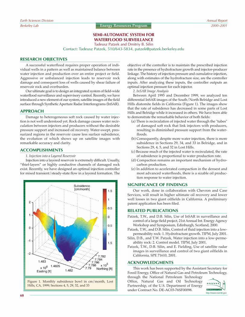
objective of the controller is to maintain the prescribed injectionrate in the presence of hydrofracture growth and injector-producerlinkage. The history of injection pressure and cumulative injection,along with estimates of the hydrofracture size, are the controllerinputs. After analyzing these inputs, the controller outputs anoptimal injection pressure for each injector.
2. InSAR Image AnalysisBetween April 1995 and December 1999, we analyzed ten
differential InSAR images of the South/North Belridge and LostHills diatomite fields in California (Figure 1). The images showthat the rate of subsidence has decreased in some parts of LostHills and Belridge while it increased in others. We have been ableto demonstrate the remarkable behavior of both fields:
(a) There is recirculation of injected water through the "tubes"of damaged soft rock that link injectors with producers,resulting in diminished pressure support from the water-floods.
(b) Consequently, despite more water injection, there is moresubsidence in Sections 29, 34, and 33 in Belridge, and inSections 29, 4, 5, and 32 in Lost Hills.
(c) Because much of the injected water is recirculated, the rateof subsidence is proportional to water production rate.
(d) Compaction remains an important mechanism of hydro-carbon production.
(e) In addition to accelerated compaction in the densest andmost advanced waterfloods, there is a sizable oil produc-tion response to water injection.
SIGNIFICANCE OF FINDINGSOur work, done in collaboration with Chevron and Case
Services, will result in higher ultimate oil recovery and lowerwell losses in two giant oilfields in California. A preliminarypatent application has been filed.
RELATED PUBLICATIONSPatzek, T.W., and D.B. Silin, Use of InSAR in surveillance and
control of a large field project, 21st Annual Int. Energy AgencyWorkshop and Symposium, Edinburgh, Scotland, 2000.
Patzek, T.W., and D.B. Silin, Control of fluid injection into a low-permeability rock: 1. Hydrofracture growth. TIPM, July 2001.
Silin, D.B., and T.W. Patzek, Water injection into a low-perme-ability rock: 2. Control model. TIPM, July 2001.
Patzek, T.W., D.B. Silin, and E. Fielding, Use of satellite radarimages in surveillance and control of two giant oilfields inCalifornia, SPE 71610, 2001.
ACKNOWLEDGMENTSThis work has been supported by the Assistant Secretary for
Fossil Energy, Office of Natural Gas and Petroleum Technology,through the National Petroleum TechnologyOffice, Natural Gas and Oil TechnologyPartnership, of the U.S. Department of Energyunder Contract No. DE-AC03-76SF00098.
http://www-esd.lbl.gov
RESEARCH OBJECTIVESA successful waterflood requires proper operation of indi-
vidual wells in a pattern as well as maintained balance betweenwater injection and production over an entire project or field.Aggressive or unbalanced injection leads to reservoir rockdamage and consequent loss of wells caused by shear failure ofreservoir rock and overburden.
Our ultimate goal is to design an integrated system of field-widewaterflood surveillance and supervisory control. Recently, we haveintroduced a new element of our system, satellite images of the fieldsurface through Synthetic Aperture Radar Interferograms (InSAR).
APPROACHDamage to heterogeneous soft rock caused by water injec-
tion is not well understood yet. Rock damage causes water recir-culation between injectors and producers without the desirablepressure support and increased oil recovery. Water-swept, pres-surized regions in the reservoir cause less surface subsidence,the evolution of which shows up on satellite images withremarkable accuracy and clarity.
ACCOMPLISHMENTS1. Injection into a Layered ReservoirInjection into a layered reservoir is extremely difficult. Usually,
thief-layers or highly conductive channels of damaged rockexist. Recently, we have designed an optimal injection controllerfor mixed transient/steady-state flow in a layered formation. The
SEMI-AUTOMATIC SYSTEM FORWATERFLOOD SURVEILLANCETadeusz Patzek and Dmitriy B. Silin
Contact: Tadeusz Patzek, 510/643-5834, [email protected]
Earth Sciences DivisionBerkeley Lab
Annual Report2000–2001
68
Energy Resources Program
Figure 1. Monthly subsidence bowl in cm/month, LostHills, CA, 1999; Sections 4, 5, 29, 32, and 33

http://www-esd.lbl.gov
RESEARCH OBJECTIVESThe Mallik site represents an onshore permafrost-associated
methane hydrate accumulation at the McKenzie Delta,Northwest Territories, Canada. A 1,150 m deep gas hydrateresearch well was drilled at the site in 1998 and led to the firstsignificant body of field data from anatural-gas hydrate deposit (Dal-limore, et al., 1999). An internationalconsortium of seven organizationsfrom five countries is currently plan-ning a new test well for the analysis ofdissociation under field conditions.The objective of the Berkeley Labcomponent of this research is theanalysis and evaluation of various gasproduction scenarios from severalhydrate deposits.
APPROACHThe analysis of several production
scenarios currently under consideration was conducted usingthe TOUGH2 general-purpose simulator (Pruess, 1991) formulticomponent, multiphase fluid and heat flow and transportin the subsurface with the EOSHYDR2 module (Moridis et al.,1998). EOSHYDR2 is designed to model the nonisothermal CH4release, phase behavior, and flow under conditions typical ofCH4-hydrate deposits (i.e., in the permafrost and in deep-oceansediments) by solving the coupled equations of mass and heatbalance. The model accounts for up to four phases (gas phase,liquid phase, ice phase and CH4-hydrate phase) and up to sevencomponents (CH4-hydrate, water, native methane, dissociatedmethane, salt, water-soluble inhibitors, and heat). The modelcan describe hydrate dissociation involving any combination ofthe possible dissociation mechanisms (i.e., depressurization,thermal stimulation, salting-out effects, and inhibitor-inducedeffects).
ACCOMPLISHMENTS AND SIGNIFICANCEEarly investigations indicated that production from accu-
mulations with free gas and/or water zones underlying thehydrate deposit was not promising because of adverse condi-tions at the site. The study focused on accumulations with nounderlying free gas or water zones, and a CH4-hydrate satura-
tion of at least 50% (the remainder being pore water). Thermalstimulation by circulating hot water in the well was selected asthe main method of dissociation because of its effectiveness andsimplicity under the conditions of the planned field test. These
are significant factors in the effort toanalyze field parameters of hydratedissociation performance.
Sensitivity studies indicated thatCH4 release from the hydrate accumu-lations at the Mallik site increases withthe CH4-hydrate saturation, the hy-drate initial temperature, the tempera-ture of the circulating water in the well,the well boundary conditions, and thethermal conductivity of the system(Figure 1). CH4 production appears tobe less sensitive to the rock andhydrate specific heats, the permeabilityof the formation in the range observed
at the site, and the irreducible gas saturation. A general obser-vation of the study is that the extent of the dissociation zoneappears to be limited within the short operational window ofthe planned test (necessitated by adverse climatic conditions atthe arctic site).
REFERENCESDallimore, S.R., T. Uchida, and T.S. Collett, eds., Scientific results
from JAPEX/JNOC/GSC Mallik 2L-38 gas hydrate researchwell, Mackenzie Delta, Northwest Territories, Canada,Geological Survey of Canada Bulletin 544, 1999.
Moridis, G.J., J.A. Apps, K. Pruess, and L.R. Myer, EOSHYDR:A TOUGH2 module for CH4-release and flow in the subsur-face, Berkeley Lab Report LBNL-42386, 1998.
Pruess, K., TOUGH2A general-purpose numerical simulatorfor multiphase fluid and heat flow, Berkeley Lab ReportLBL-29400, 1991.
ACKNOWLEDGMENTSThis work was supported by the Assistant Secretary for
Fossil Energy, Office of Natural Gas and Petroleum Technology,through the National Energy Technology Laboratory, of the U.S.Department of Energy under Contract No. DE-AC03-76SF00098.
GAS-PRODUCTION SCENARIOS FROM HYDRATE ACCUMULATIONS ATTHE MALLIK SITE, MCKENZIE DELTA, CANADAGeorge J. Moridis, Karsten Pruess, and Larry R. Myer
Contact: George J. Moridis, 510/486-4746, [email protected]
Earth Sciences DivisionBerkeley Lab
Annual Report2000–2001
69
Energy Resources Program
2.0
1.5
1.0
.5
00 5 10 15 20 25 30
Dis
soci
atio
nfr
ont p
ositi
on (
m)
Time (days)
Baseline (kt = 1.5 W/m°C)kt = 1.0 W/m°Ckt = 0.5 W/m°C
Figure 1. Sensitivity of dissociation front to thethermal conductivity

http://www-esd.lbl.gov
RESEARCH OBJECTIVESThe objective of this project is to develop and characterize a
reservoir though the use of surface-deformation data, such asdisplacement and surface tilt induced by pumping or injection.Obtaining such data can be a cost-effective way of gatheringinformation on reservoir flow geometry, which is critical forsuccessful reservoir management.
APPROACHWhen fluid is produced from or injected into a reservoir, it
causes volume changes in the reservoir, which in turn inducedisplacements on the ground surface. If a preferential flow pathsuch as a fault zone exists in the reservoir (which is often thecase in geothermal reservoirs), flow will occur mostly along thefault. Observations of surface deformation can be used to esti-mate the distribution of the volume changes in the reservoir. For
DYNAMIC RESERVOIR CHARACTERIZATION THROUGH THE USE OFSURFACE DEFORMATION DATADonald W. Vasco and Kenzi Karasaki
Contact: Donald Vasco, 510/486-5206, [email protected]
Earth Sciences DivisionBerkeley Lab
Annual Report2000–2001
70
Energy Resources Program
Figure 1. 3D perspective view of the inversion results. Trianglesshow the tiltmeter locations. The fractional volume increase atdepth parallels a known fault.
example, a vertical fault zone would produce a linear trough inthe inverted image. The larger the volume change is at a partic-ular location, the more likely fluid has moved in or out of thelocation. The distribution of volume change is tightly coupledwith that of the reservoir flow properties: permeability andcompressibility.
Surface expression of such reservoir dynamics can be moni-tored by using high-precision tiltmeters, global positioningsystems, laser level gages, and InSAR (Interferometric SyntheticAperture Radar). Monitoring of the deformation at or near thesurface costs very little compared to drilling a large number ofboreholes and instrumenting them with pressure sensors. Thisremote-sensing approach also provides independent data onreservoir dynamics that can be used to confirm or refute a reser-voir model based on the borehole data alone.
ACCOMPLISHMENTSIn 2000, a total of some 24 tiltmeters were used to monitor
surface tilts at the Okuaizu Geothermal Field in Japan.Monitoring was timed to coincide with a scheduled field-widemaintenance, at which time all the production and re-injectionwells were shut-in. The inversion results (Figure 1) indicatedthat the volume change at depth parallels a known fault. Wealso inverted InSAR data from the Coso Geothermal Field andshowed that the use of both ascending- and descending-orbitInSAR data is advantageous for obtaining better resolution ofsubsurface volume change.
SIGNIFICANCE OF FINDINGSWe have shown that surface deformation data such as tilt
and InSAR data can be utilized to characterize the dynamics ofdeep reservoirs.
RELATED PUBLICATIONVasco, D.W., C. Wicks, and K. Karasaki, Geodetic imaging:
High-resolution reservoir monitoring using satellite inter-ferometry, Geophys. J. Int., 2001 (in press).
Vasco, D.W., K. Karasaki, and O. Nakagome, Monitoring reser-voir production using surface deformation at the Hijiori testsite and the Okuaizu geothermal field, Japan, 2001,Geothermics, 2001 (submitted).
ACKNOWLEDGMENTSThis work has been supported by JAPEX Geosciences
Institute, Japan, through Contract No. BG98-071(00).

http://www-esd.lbl.gov
Earth Sciences DivisionBerkeley Lab
Annual Report2000–2001
71
Energy Resources Program
RESEARCH OBJECTIVESVast reserves of dissolved minerals exist in the hypersaline
brines of geothermal fields at Imperial Valley, California.Recovery of zinc from geothermal brines is taking place in thisarea, and recovery of silica, manganese, silver, lead, and lithiumhas been or is being considered. Consequently, the ability tomodel mineral recovery is very importantin terms of economic development andresource utilization.
APPROACHThe reactive-geochemical-transport
simulator TOUGHREACT (Xu andPruess, 1998) has been used to modelrock-fluid interactions during productionfrom and injection into the hypersaline-brine geothermal system. The modelinguses published water-chemistry datafrom Imperial Valley and a simplifiedflow system intended to capture realisticfeatures of the hydrothermal system.Simulations were performed usingdifferent production and injection rates,pH values, and silica concentrations ofthe injection water.
ACCOMPLISHMENTSResults indicate that the evolution of temperature and
zinc concentration depends on production and injection rate.A lower rate results in a lower temperature drop and higherzinc concentration. A low injection pH significantly enhancesthe dissolution of sphalerite (ZnS) in the reservoir rock,increasing aqueous zinc concentration. A higher injectionsilica concentration leads to silica precipitation, but decreasesthe reservoir porosity only slightly (even after 20 years).Simulated evolution of the aqueous zinc concentration atobservation and production wells is shown in Figure 1. (The
observation well is located between the injection and produc-tion wells.)
SIGNIFICANCE OF FINDINGSThis numerical experiment provides useful insight into the
process mechanisms, conditions, andparameters controlling zinc recovery inthe reservoir. This project also demon-strates that TOUGHREACT can be auseful tool for simulating these kinds ofproblems.
RELATED PUBLICATIONSPham, M., C. Klein, S. Sanyal, T. Xu, and K.
Pruess, Reducing cost and environmentalimpact of geothermal power throughmodeling of chemical processes in thereservoir, in Proceedings of Twenty-SixthWorkshop on Geothermal ReservoirEngineering, Stanford University,California, January 2931, 2001.
Xu, T., K. Pruess, M. Pham, C. Klein, and S.Sanyal, Reactive chemical transportsimulation to study geothermal produc-
tion with mineral recovery and silica scaling, GeothermalResources Council Annual Meeting, San Diego, California,August 2629, 2001.
ACKNOWLEDGMENTSThe present work was funded by the Assistant Secretary for
Energy Efficiency and Renewable Energy, Office of PowerTechnologies, Office of Wind and Geothermal Technologies, ofthe U.S. Department of Energy under Contract No. DE-AC03-76SF00098. This work is a continuation of Pham et al. (2001),which is funded by California Energy Commissions EnergyInnovations Small Grant Program to GeothermEx, Inc. (GrantNumber 51391A/99-25).
REACTIVE-CHEMICAL-TRANSPORT SIMULATON TO STUDYGEOTHERMAL PRODUCTION WITH MINERAL RECOVERY
Tianfu Xu, Karsten Pruess, Minh Pham,1 Christopher Klein,1 and Subir Sanyal11GeothermEx, Inc., Richmond, California 94804
Contact: Tianfu Xu, 510/486-7057, [email protected]
1E-5
8E-6
6E-6
4E-6
2E-6
0E-0Co
nce
ntr
ati
on
(m
ol
/ kg
H2
O)
Observation well
Production
0 20 40Time (yr)
60 80 100
Figure 1. Evolution of aqueous zinc concen-tration obtained with a production/injectionrate of 8 kg and an injection pH of 4

changes over time in steam temperatures and steam fractions(from individual wells) shows that steam from wells in thecenter of the NCPA field originates from fairly uniform condi-tions produced by injection. In contrast, steam from wells inperipheral areas originates from progressively drier reservoirzones, which may return to near-original conditions dependingon the characteristics of the injection operations.
Contours of total non-condensable gases show that changesin the location and amount of liquidinjected have been very effective inlimiting gas concentrations in thesteam produced by most of theNCPA wells.
SIGNIFICANCE OFFINDINGS
This study confirms the useful-ness of non-condensable gases toidentify reservoir processes invapor-dominated geothermal sys-tems, particularly in The Geysersfield. Variations of gas ratios in theproduced steam explain processesresulting from large-scale produc-tion and from an increasing amountof injected liquid. It also illustratesthat changes in the source (i.e.,chemical characteristics) of theinjectate are useful in detecting thevarious phenomena occurring in thereservoir.
RELATED PUBLICATIONSD'Amore, F., and A.H. Truesdell,
Calculation of geothermal reservoirtemperatures and steam fractionfrom gas compositions, Geo-thermal Resources Council Trans-actions 9(I), pp. 305310, 1985.
D'Amore, F., 1991, Gas geochemistry as a link between geot-hermal exploration and exploitation, in Application ofGeochemistry in Geothermal Reservoir Development, editedby F.D'Amore, UNITAR/UNDP, Rome, pp. 93117, 1991.
Truesdell, A., B. Smith, S. Enedy, and M. Lippmann, Recentgeochemical tracing of injection-related reservoir processesin the NCPA Geysers field, Geothermal Resources CouncilTransactions 25, 2001.
ACKNOWLEDGMENTSThis work was supported by the Assistant Secretary for Energy
Efficiency and Renewable Energy, Office of PowerTechnologies, Office of Wind and GeothermalTechnologies, of the U.S. Department of Energyunder contract No. DE-AC03-76SF00098.
http://www-esd.lbl.gov
RESEARCH OBJECTIVES
At The Geysers field, 75 miles (120 km) north of SanFrancisco, California, the largest known vapor-dominated geot-hermal system in the world, injection of water back into thereservoir began with commercial exploitation in 1960. This injec-tion, consisting of steam condensate and available surface water,was limited to 30% of the mass extracted. In late 1997, in thesteam field operated by the Northern California Power Agency(NCPA), the amount of injection essentially doubled when lakewater and treated waste water fromthe South East Geysers EffluentPipeline were delivered to thesouthern part of the system.
The purpose of this work is toupdate studies of steam chemistry toreflect changes resulting from theincreased liquid injection, to test theapplicability of geochemical analysisto steam fields with a relative highrate of injection, and to evaluate theuse of non-condensable gases toidentify reservoir processes.
APPROACHThe methodology used in this
study is different from that of earlierwork, which was based on oxygenand hydrogen isotopes. This methodis no longer effective becauseincreased injection of creek and lakewater and treated waste water haslessened the isotopic contrast betweenreservoir steam and injectate.
We use DAmores (1991) gasgeothermometer grids and changesin total gas contents in the steam toconstruct time-series diagrams forindividual NCPA wells over theirentire production histories. Instead ofdescribing the grid diagram behaviorof each well, the behaviors are divided into types and inter-preted according to their patterns. The distributionover spaceand timeof non-condensable gases in the produced steam wasalso analyzed.
ACCOMPLISHMENTSGrid diagrams for nearly 70 NCPA wells were drawn by a
computer program using the equations given in DAmore andTruesdell (1985). The wells have been in production from the mid-to-late-1980s to 2000 (later data were not available).
Four types of grid diagrams were recognized (linear, hairpin,cluster, and random) by Truesdell et al. (2001). In addition, contourfigures showing the distribution of total non-condensable gas inthe NCPA field were developed for different years (e.g., Figure 1).
The application of gas geochemistry to detect and monitor
NON-CONDENSABLE GASES: TRACERS FOR RESERVOIR PROCESSES IN VAPOR-DOMINATED GEOTHERMAL SYSTEMSAlfred Truesdell and Marcelo Lippmann
Contact: Marcelo Lippmann, 510/486-5035, [email protected]
Earth Sciences DivisionBerkeley Lab
Annual Report2000–2001
72
Energy Resources Program
1500
1500
10001000
1000
1000
1500
1500
2000
2000
2500
2500
10001000
2000
2000
2500
2500
15001500
10001000
1000
1000
1000
1000
1500
1500 2000
2000
10001000
15001500
150015002000
20002500
2500
2500
2500
3000
3000
30003000
20002000
15001500
500500
2500
2500
1000
1000
15001500
1500
1500
500
500
500
500
2000
2000
1500
1000
1000
1500
2000
2500
1000
2000
2500
1500
1000
1000
1000
1500 2000
1000
1500
150020002500
2500
3000
3000
2000
1500
500
2500
1000
1500
1500
500
500
2000
399000
398000
397000
396000
395000
1790000 1792000 1794000 1796000 1798000 1800000
1992
399000
398000
397000
396000
395000
1790000 1792000 1794000 1796000 1798000 1800000
1997
399000
398000
397000
396000
395000
1790000 1792000 1794000 1796000 1798000 1800000
2000
Y-4-4
Y-5-5
A-1-1
C-11C-11
F-1-1
J-6-6
Y-4-4
A-1-1
J-6-6
D-1-1
Q-1-1
D-1D-1
Q-4Q-4Q-1Q-1
Q-2Q-2C-11C-11
A-1A-1
F-4F-4
Y-5Y-5
Y-4Y-4
Y-4
Y-5
A-1
C-11
F-1
J-6
Y-4
A-1
J-6
D-1
Q-1
D-1
Q-4Q-1
Q-2C-11
A-1
F-4
Y-5
Y-4
E-6E-6
E-2E-2
E-5E-5
E-1E-1
E-4E-4
B-3B-3
P-7P-7
P-8P-8
P-6P-6
P-5P-5P-2P-2
Q-9Q-9Q-7Q-7Q-8Q-8Q-6Q-6
Q-5Q-5
C-4C-4
C-9C-9
Q-4Q-4
N-1N-1
N-4N-4N-2N-2
C-2C-2F-6F-6
C-5C-5F-5F-5
F-7F-7 C-8C-8
F-3F-3
A-5A-5A-4A-4
H-5H-5
A-3A-3
A-6A-6
Y-3Y-3
Q-5Q-5C-9C-9
C-4C-4C-7C-7C-1C-1C-6C-6
C-2C-2
C-5C-5F-6F-6
F-7F-7
F-4F-4
F-5F-5
F-2F-2
H-2H-2
H-3H-3
H-5H-5
H-1H-1
F-3F-3
C-8C-8
Y-2Y-2
N-3N-3
C-6C-6
N-5N-5
C-1C-1C-7C-7
N-6N-6
D-1D-1
Q-1Q-1
P-9P-9
B-4B-4
P-4P-4B-5B-5
B-6B-6
B-2B-2
E-3E-3
J-4J-4J-5J-5
J-2J-2
D-8D-8
D-2D-2
D-6D-6Y-1Y-1
D-7D-7
Q-3Q-3
J-3J-3
H-3H-3
H-2H-2
H-1H-1
F-2F-2
A-4A-4
A-3A-3
H-2H-2 H-1H-1 F-5F-5
F-2F-2
H-5H-5
F-1F-1
A-4A-4 A-5A-5
A-3A-3
A-6A-6
Y-2Y-2
N-3N-3
D-6D-6
D-2D-2
Y-1Y-1D-7D-7
Q-6Q-6
Q-5Q-5
N-1N-1
N-6N-6
J-2J-2J-3J-3
B-6B-6
B-5B-5 B-4B-4
Q-3Q-3
Q-8Q-8 Q-7Q-7 Q-9Q-9
P-9P-9 P-2P-2 P-5P-5
P-6P-6
P-8P-8
P-7P-7
B-3B-3
E-4E-4
E-1E-1E-5E-5
E-6E-6
E-2E-2
E-3E-3
B-2B-2
J-4J-4
P-4P-4
D-8D-8
J-5J-5
Y-3Y-3
N-2N-2 N-4N-4
C-2C-2 C-6C-6N-5N-5
C-9C-9
C-4C-4C-7C-7C-1C-1
F-3F-3
F-6F-6C-5C-5F-7F-7C-8C-8
H-3H-3
Y-3Y-3
Q-3Q-3
J-4J-4E-3E-3
E-6E-6E-1E-1
E-2E-2E-4E-4
B-3B-3
P-7P-7
B-4B-4
B-2B-2
E-5E-5
A-6A-6
A-5A-5
N-4N-4
N-5N-5
N-2N-2
N-3N-3
N-6N-6
D-2D-2
D-7D-7
J-2J-2J-3J-3
B-5B-5
P-4P-4
D-8D-8
D-6D-6
Y-2Y-2
Y-1Y-1
N-1N-1
Q-6Q-6 Q-8Q-8Q-7Q-7 Q-9Q-9
P-9P-9 P-2P-2P-5P-5 P-6P-6
P-8P-8
Q-4Q-4
E-6
E-2
E-5
E-1
E-4
B-3
P-7
P-8
P-6
P-5P-2
Q-9Q-7Q-8Q-6
Q-5
C-4
C-9
Q-4
N-1
N-4N-2
C-2F-6
C-5F-5
F-7 C-8
F-3
A-5A-4
H-5
A-3
A-6
Y-3
Q-5C-9
C-4C-7C-1C-6
C-2
C-5F-6
F-7
F-4
F-5
F-2
H-2
H-3
H-5
H-1
F-3
C-8
Y-2
N-3
C-6
N-5
C-1C-7
N-6
D-1
Q-1
P-9
B-4
P-4B-5
B-6
B-2
E-3
J-4J-5
J-2
D-8
D-2
D-6Y-1
D-7
Q-3
J-3
H-3
H-2
H-1
F-2
A-4
A-3
H-2 H-1 F-5
F-2
H-5
F-1
A-4 A-5
A-3
A-6
Y-2
N-3
D-6
D-2
Y-1D-7
Q-6
Q-5
N-1
N-6
J-2J-3
B-6
B-5 B-4
Q-3
Q-8 Q-7 Q-9
P-9 P-2 P-5
P-6
P-8
P-7
B-3
E-4
E-1E-5
E-6
E-2
E-3
B-2
J-4
P-4
D-8
J-5
Y-3
N-2 N-4
C-2 C-6N-5
C-9
C-4C-7C-1
F-3
F-6C-5F-7C-8
H-3
Y-3
Q-3
J-4E-3
E-6E-1
E-2E-4
B-3
P-7
B-4
B-2
E-5
A-6
A-5
N-4
N-5
N-2
N-3
N-6
D-2
D-7
J-2J-3
B-5
P-4
D-8
D-6
Y-2
Y-1
N-1
Q-6 Q-8Q-7 Q-9
P-9 P-2P-5 P-6
P-8
Q-4
Figure 1. NCPA Geysers steam field. Contours of totalnon-condensable gas in the produced steam (in ppmv)for 1992, 1997, and 2000. Injection wells in use areshown as solid circles.
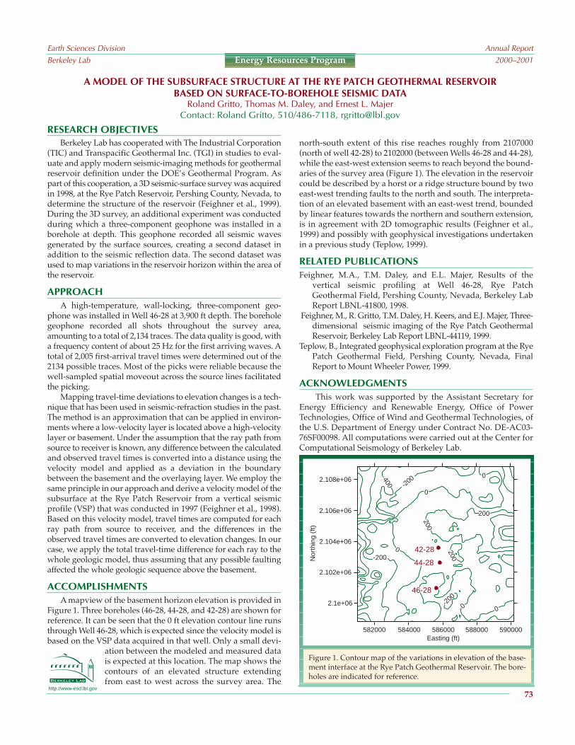
RESEARCH OBJECTIVESBerkeley Lab has cooperated with The Industrial Corporation
(TIC) and Transpacific Geothermal Inc. (TGI) in studies to eval-uate and apply modern seismic-imaging methods for geothermalreservoir definition under the DOEs Geothermal Program. Aspart of this cooperation, a 3D seismic-surface survey was acquiredin 1998, at the Rye Patch Reservoir, Pershing County, Nevada, todetermine the structure of the reservoir (Feighner et al., 1999).During the 3D survey, an additional experiment was conductedduring which a three-component geophone was installed in aborehole at depth. This geophone recorded all seismic wavesgenerated by the surface sources, creating a second dataset inaddition to the seismic reflection data. The second dataset wasused to map variations in the reservoir horizon within the area ofthe reservoir.
APPROACHA high-temperature, wall-locking, three-component geo-
phone was installed in Well 46-28 at 3,900 ft depth. The boreholegeophone recorded all shots throughout the survey area,amounting to a total of 2,134 traces. The data quality is good, witha frequency content of about 25 Hz for the first arriving waves. Atotal of 2,005 first-arrival travel times were determined out of the2134 possible traces. Most of the picks were reliable because thewell-sampled spatial moveout across the source lines facilitatedthe picking.
Mapping travel-time deviations to elevation changes is a tech-nique that has been used in seismic-refraction studies in the past.The method is an approximation that can be applied in environ-ments where a low-velocity layer is located above a high-velocitylayer or basement. Under the assumption that the ray path fromsource to receiver is known, any difference between the calculatedand observed travel times is converted into a distance using thevelocity model and applied as a deviation in the boundarybetween the basement and the overlaying layer. We employ thesame principle in our approach and derive a velocity model of thesubsurface at the Rye Patch Reservoir from a vertical seismicprofile (VSP) that was conducted in 1997 (Feighner et al., 1998).Based on this velocity model, travel times are computed for eachray path from source to receiver, and the differences in theobserved travel times are converted to elevation changes. In ourcase, we apply the total travel-time difference for each ray to thewhole geologic model, thus assuming that any possible faultingaffected the whole geologic sequence above the basement.
ACCOMPLISHMENTSA mapview of the basement horizon elevation is provided in
Figure 1. Three boreholes (46-28, 44-28, and 42-28) are shown forreference. It can be seen that the 0 ft elevation contour line runsthrough Well 46-28, which is expected since the velocity model isbased on the VSP data acquired in that well. Only a small devi-
ation between the modeled and measured datais expected at this location. The map shows thecontours of an elevated structure extendingfrom east to west across the survey area. The
http://www-esd.lbl.gov
north-south extent of this rise reaches roughly from 2107000(north of well 42-28) to 2102000 (between Wells 46-28 and 44-28),while the east-west extension seems to reach beyond the bound-aries of the survey area (Figure 1). The elevation in the reservoircould be described by a horst or a ridge structure bound by twoeast-west trending faults to the north and south. The interpreta-tion of an elevated basement with an east-west trend, boundedby linear features towards the northern and southern extension,is in agreement with 2D tomographic results (Feighner et al.,1999) and possibly with geophysical investigations undertakenin a previous study (Teplow, 1999).
RELATED PUBLICATIONSFeighner, M.A., T.M. Daley, and E.L. Majer, Results of the
vertical seismic profiling at Well 46-28, Rye PatchGeothermal Field, Pershing County, Nevada, Berkeley LabReport LBNL-41800, 1998.
Feighner, M., R. Gritto, T.M. Daley, H. Keers, and E.J. Majer, Three-dimensional seismic imaging of the Rye Patch GeothermalReservoir, Berkeley Lab Report LBNL-44119, 1999.
Teplow, B., Integrated geophysical exploration program at the RyePatch Geothermal Field, Pershing County, Nevada, FinalReport to Mount Wheeler Power, 1999.
ACKNOWLEDGMENTSThis work was supported by the Assistant Secretary for
Energy Efficiency and Renewable Energy, Office of PowerTechnologies, Office of Wind and Geothermal Technologies, ofthe U.S. Department of Energy under Contract No. DE-AC03-76SF00098. All computations were carried out at the Center forComputational Seismology of Berkeley Lab.
A MODEL OF THE SUBSURFACE STRUCTURE AT THE RYE PATCH GEOTHERMAL RESERVOIRBASED ON SURFACE-TO-BOREHOLE SEISMIC DATA
Roland Gritto, Thomas M. Daley, and Ernest L. MajerContact: Roland Gritto, 510/486-7118, [email protected]
Earth Sciences DivisionBerkeley Lab
Annual Report2000–2001
73
Energy Resources Program
Figure 1. Contour map of the variations in elevation of the base-ment interface at the Rye Patch Geothermal Reservoir. The bore-holes are indicated for reference.
200200
200200
200200
0
0
0
0
0
-200
200
200
200
-200
- 400
-200
0
0
0
0
0
2.108e+06
2.106e+06
2.104e+06
2.102e+06
2.1e+06
582000 584000 586000Easting (ft)
588000 590000
Nor
thin
g (f
t)
42-2842-28
44-2844-28
46-2846-28
42-28
44-28
46-28

http://www-esd.lbl.gov
RESEARCH OBJECTIVES
The objective of the proposed research is to develop efficientnumerical codes for mapping high-permeability zones, usingsingle-hole electromagnetic (EM) data.These codes retain a reasonably highresolution, are simple to use, and do notrequire major computational resources.The work is in conjunction with therapid development in instrumentationused for borehole EM surveys inproducing geothermal fields. Mappingof fractures and other high-perme-ability zones are critically importantbecause they play a very important rolein developing and producing geot-hermal reservoirs.
APPROACHA simple 2D inversion code for
analyzing data obtained in single-bore-hole configurations was developed forlaboratory use in FY00. The numericalmethod adopted is the integral equa-tion, based on a modified Born approx-imation. The medium of interest iscylindrically symmetric in this case,and the resulting inversion algorithmwill be simple enough to be imple-mented on PCs operated in the field. InFY01, the 2D inversion code develop-ment will be completed and field-testedfor routine on-site use. In the next 3years (FY02FY04) the algorithm willbe extended to investigate 3D electricalstructures in the vicinity of boreholes. The medium will bedivided azimuthally and radially to confirm cylindrical struc-ture, but each element will be assigned different electricalconductivity.
ACCOMPLISHMENTSIn May 2000, Electromagnetic Instruments Inc. (EMI) conducted a
field test of the newly built Geo-BILT tool (operated by Chevron USA)at Lost Hills oil field in southern California.Berkeley Lab evaluated the data for futuredevelopment of the 3D approximate inver-sion scheme. As part of the final evaluationof 2D inversion code, we conducted a datainversion using only the Mz-Hz data. Theresult is shown in Figure 1.
SIGNIFICANCE OF FINDINGSAn important improvement has
been implemented to the 2D inversioncode developed for analyzing single-borehole EM data. The efficiency androbustness of an inversion scheme isvery much dependent on the proper useof the Lagrange multiplier, which isoften provided manually to achieve adesired convergence. We have devel-oped an automatic Lagrange multiplierselection scheme. Successful applica-tion of the scheme will improve theability of the code to handle field data.
ACKNOWLEDGMENTSThe authors would like to thank
Michael Morea, Chevron USAProduction Company, and the U.S.Department of Energy, NationalPetroleum Technology Office (Class IIIField Demonstration Project DE-FC22-95BC14938) for allowing us to publish
this data. This work was partially supported by the AssistantSecretary for Energy Efficiency and Renewable Energy, Office ofPower Technologies, Office of Wind and GeothermalTechnologies, of the U.S. Department of Energy under ContractNo. DE-AC03-76SF00098.
ELECTROMAGNETIC METHODS FOR GEOTHERMAL EXPLORATIONKi Ha Lee, Hee Joon Kim, and Mike Wilt1
1Electromagnetic Instruments, Inc., Richmond, California 94804Contact: Ki Ha Lee, 510/486-7468, [email protected]
Earth Sciences DivisionBerkeley Lab
Annual Report2000–2001
74
Energy Resources Program
Figure 1. Conductivity imaging derived from the2D inversion of data obtained from ChevronUSA. The model started with uniform conduc-tivity (far left) of 4 Ω-m, and after eight itera-tions, the misfit in terms of rms (shown asfractional numbers after the number of iterationsshown at the top of each image) converged toabout 1%.
http://www-esd.lbl.gov
PROJECT OBJECTIVES
The chemical characterization of fluids in a geothermalreservoir is essential for realizing optimum utilization of theresource. The isotopic composition of elements in fluidsprovides a quantitative measure of material balance, and there-fore isotopes are extremely powerful in unraveling fluid histo-ries and tracing fluid flow. In this regard, conservative elements,such as the noble gases (He, Ne, Ar, Kr, and Xe), are extremelyuseful because they preserve isotopic information related toinitial conditions and sources.
APPROACHThe isotopes of the inert noble gases provide long-lasting
tracers of fluid sources, such as large 3He enrichments in deepfluids originating in the mantle and enrichments in radiogenic4He and 40Ar in crustal fluids. The occurrence and mixing ofthese various components provide tools for identifying specificfluid sources, fluid flow paths from source to reservoir, andgeothermal-reservoir characteristics as defined by mixing, fluidresidence times, and chemical processes.
ACCOMPLISHMENTSThe Yangbajing geothermal field, located ~94 km northwest
of Lhasa, Tibet, has an installed capacity of ~25 MWe.Production is from liquid-dominated, shallow, moderate-temperature (150165ºC) reservoirs. However, Na/K geother-mometer temperatures and recent drilling in the NW sector ofthe field indicate the presence of a deeper, higher-temperature(~300ºC) reservoir beneath the shallow reservoir.
The 3He/4He ratios in fluids from the Yangbajing Field werefound to be low (0.26 Ra) relative to typical mantle values (89Ra). Despite the discovery of the high-temperature deeperreservoir, a deep resistivity anomaly inferred to be a magmabody, and long-held conceptual models for the Yangbajing Fieldcalling on a magmatic heat source, the helium isotopic compo-sitions suggests very little (if any) involvement of recentlyintruded magmas. If the heat source is a magma body, then thehelium has been extensively diluted with radiogenic 4He by
water-rock interaction or roof foundering in the magmachamber. Alternatively, the helium isotopes may suggest thatheat is mined not from a magmatic intrusion but by deep circu-lation of meteoric waters along the Yarlu-Zangbo suture.Variations in helium abundance and isotopic composition areconsistent with the mixing of a deep-high 3He/4He fluid (~0.26Ra) with the shallower overlying reservoir (<0.09 Ra) currentlybeing produced.
SIGNIFICANCE OF FINDINGSThe helium isotopic composition of the Yangbajing geo-
thermal fluids is inconsistent with a strong magmatic influence.In light of the helium isotopic data, the inferred significance ofthe resistivity anomaly should be reconsidered. Variations inhelium abundance and isotopic composition support mixingbetween the deep and shallow reservoirs, suggesting that exten-sive exploitation of the deeper fluids could accelerate depletionof the shallow resource.
RELATED PUBLICATIONSZhao, P., B.M. Kennedy, D. Shuster, J. Dor, E. Xie, and S. Du,
Implications of noble gas geochemistry in the Yangbajinggeothermal field, Tibet, Proc. 10th Water-Rock Conference, 2,pp. 947950, Villasimus, Italy, July 1015, 2001.
Zhao, P., J. Dor, and J. Jin, A new geochemical model of theYangajing geothermal field, Tibet, Proc. World GeothermalCongress, Kyushu-Tohoku, Japan, pp. 20072012, May28June 10, 2000.
ACKNOWLEDGMENTSThis work was jointly supported by the National Natural
Science Foundation of China (Grant No. 49672168 and49972093), the International Atomic Energy Agency (Grant No.CPR9095), and the Assistant Secretary for Energy Efficiency andRenewable Energy, Office of Power Technologies, Office of Windand Geothermal Technologies, of the U.S. Department of Energyunder Contract No. DE-AC03-76SF00098.
THE YANGBAJING GEOTHERMAL FIELD, TIBET: HEAT SOURCE AND FLUID FLOWPing Zhao,1 B. Mack Kennedy, David L. Shuster, Ji Dor,2 Ejun Xie,2 and Shaoping Du2
1Institute of Geology and Geophysics, Chinese Academy of Sciences, Beijing, P.R. China2Tibet Geothermal Geology Team, Lhasa, P.R. China
Contact: B. Mack Kennedy, 510/486-6451, [email protected]
Earth Sciences DivisionBerkeley Lab
Annual Report2000–2001
75
Energy Resources Program

Earth Sciences DivisionBerkeley Lab
Annual Report2000–2001
This page is intentionally left blank.
76

The Environmental Remediation Technology Program(ERTP) conducts multidisciplinary environmental research oncharacterization, monitoring, modeling, and remediation tech-nologies. This research is directed primarily at Department ofEnergy and Department of Defense waste site problems. Sincemany of the contaminants or closely related compounds foundat these sites are also dominant at industrial waste sites, much ofthis research is also applicable to problems faced by the privatesector and other government agencies. These projects are bothbasic and applied, and include everything from molecularstudies to full-scale field deployments in all types of media (gas,water, sediment) in all types of environments (wetlands todeserts). This year’s major customers have been DOE Office ofEnvironmental Management, DOE Office of Science, Work forOthers-DOD, and Work for Others (Industry and OtherGovernment Agencies).
DEMONSTRATIONS AND DEPLOYMENTERTP supports DOE’s Office of Environmental Management
in both the areas of Environmental Restoration (EM40) and theOffice of Science and Technology (EM50). Earth ScienceDivision (ESD) scientists directly supervise characterization,remediation and monitoring, and provide regulatory andpermitting support to Berkeley Lab’s Environmental Health andSafety Department for all environmental problems on site.During this past year, the program demonstrated and deployedtechnologies for bioventing/soil vapor extraction of volatileorganic compounds (VOCs) and air sparging of solvent-contam-inated groundwater.
ERTP research on viscous liquid barriers for containment(patent issued) provides a great opportunity for containing, andcontrolling solvent, metal, and radionuclide contamination atwaste sites, DOE’s greatest environmental cleanup problem.Indeed, this technology was deployed at Brookhaven NationalLaboratory this year to contain radionuclide contamination in
the subsurface at one of their facilities.This year ERTP, in partnership with the
Savannah River Technology Center and Florida
State University, assisted the Institute for Ecology of IndustrialAreas in Poland in completing a full-scale demonstration ofbiopile (aeration) technologies for cleanup of a petroleum-refinery waste lagoon. The demonstration has shown that bothpassive and active aeration strategies can meet cleanup stan-dards for polycyclic aromatic hydrocarbons in the soil and thatactive aeration cuts the remediation time in half. This demon-stration has been so successful that the petroleum refinery iscommercializing the process for other refineries and fuel stationsin Poland.
ERTP also supports EM50 with technical expertise via theStrategic Laboratory Council, the Oakland Site TechnologyCoordination Group, the multi-agency DNAPL TechnologyAdvisory Group, the Subsurface Contaminant Focus Area(SCFA) Vadose Zone Book, the Lead Lab Council for SCFA, andthe Hanford Vadose-Groundwater-River Integrated Program.
FIELD AND LABORATORY STUDIESDOE’s Office of Science provides funding for several ERTP
projects. The basic research projects funded in this area takeadvantage of the unique facilities at Berkeley Lab, such as theAdvanced Light Source, where researchers look at the interac-tions between contaminants, water, and minerals at themicroscale. ERTP has a project funded in the Natural andAccelerated Bioremediation Research (NABIR) program, whichlooks at mesoscale biotransformation dynamics as the basis forpredicting core-scale reactive transport of chromium anduranium.
FIELD DEMONSTRATIONS FOR DODField tests at McClellan Air Force Base, Sacramento,
California, for the Department of Defense have shown thatVadose Zone Monitoring Systems (VZMS)—instrument pack-ages consisting of tensiometers, suction lysimeters, gassamplers, pressure transducers and thermistors—permanentlyinstalled at multiple levels provide better monitoring of contam-inants at waste sides. The field tests at McClellan AFB allowedidentification of significant shallow sources of contamination.
Earth Sciences DivisionBerkeley Lab
Annual Report2000–2001
77
ENVIRONMENTAL REMEDIATION
TECHNOLOGY
RESEARCH PROGRAM
Terry C. Hazen

DEMONSTRATIONS AND TECHNICALASSISTANCE FOR INDUSTRY/OTHER AGENCIES
ERTP has researched selenium transport in the GrasslandWater District, California, for many years. Recent research hasfocused on better methods for compliance monitoring andmanagement. The US Bureau of Reclamation has sponsored thiswork in an effort to better manage selenium loading in the agri-cultural waste water of the San Luis Drain. Microbial studiesthis year have shown that selenium in-transit losses occur andthat the fate of this selenium is sediment beds. Manipulation ofthe microbial ecology of the Drain may stimulate the bioreme-diation of selenium from the water, thereby reducing the massloading of selenium to the San Joaquin River.
ERTP also provides technical consultation to privateindustry and other government agencies on implementingBerkeley Lab- and DOE-patented technologies at private andgovernment-owned sites. Private industry must have a licenseto the technology for use at private sites, and all ERTP expensesare reimbursed by the company or another agency. Severalcontracts this year were executed for consultation regardingbioremediation and characterization.
ERTP also provides technical advisory support for the BayArea Defense Conversion Action Team (BADCAT) and theCalifornia Environmental Business Council (CEBC).
NABIR PROGRAM OFFICEERTP continued to be the NABIR Program Office for the
Office of Science. The NABIR Program Office maintains thedynamic NABIR Web home page (www.lbl.gov/NABIR/) withlinks to investigators, program element managers, science teamleaders, recent publications, annual meeting registration, callsfor proposals, review documents, and other Web sites. In addi-
tion, the NABIR Program Office also organizes the NABIRannual investigators meeting, with more than 150 participantsand sessions for posters, presentations, and breakout sessions.The NABIR Program Office is also producing a new NABIRBioremediation Primer that will be available to the public inprint or electronically on the NABIR home page. The NABIRprogram office also assisted DOE-HQ in reviewing, evaluatingand starting up the Field Research Center for the NABIRprogram at Oak Ridge National Laboratory.
PARTNERS AND FUNDINGERTP receives support from DOE programs in the Offices of
Science and Environmental Management (EM). The EMprograms include the Environmental Management ScienceProgram; the Subsurface Contaminants Focus Area; and theCharacterization, Monitoring, and Sensor TechnologyCrosscutting Program. The Office of Science funds the NABIRProgram Office at Berkeley Lab, and the Office of Science, Officeof Biological and Environmental Research funds two environ-mental remediation projects. Support is also received fromDOD, Cal-EPA, other DOE Labs, the University of California atBerkeley, and U.S. Bureau of Land Management. Othersupporters in 2000 include: Pacific Northwest NationalLaboratory, Radian International, Earthtech, Woodward &Clyde, Florida State University, and IT Corporation. Partnersinclude UC-Berkeley, Stanford University, WestinghouseSavannah River Company, Idaho National EngineeringLaboratory, Lawrence Livermore National Laboratory, PacificNorthwest National Laboratory, Utah State University,University of Nevada, and University of Illinois.
Earth Sciences DivisionBerkeley Lab
Annual Report2000–2001
78
Environmental Remediation Technology Program

RESEARCH OBJECTIVES Significant amounts of radioactive waste were generated by
the production of fuel for nuclear weapons at the Hanford site inWashington. High-level waste is currently stored in tanks, someof which are known to be leaking. In addition, large quantities oflow-level waste were discharged directly to the ground. As aresult of these practices, radionuclide contamination has beendetected in the groundwater at the site and poses a significantthreat to the nearby Columbia River. To examine the pathwaysof fluid and contaminant transport through the vadose zone, weundertook an isotopic and chemical study of pore-watersamples from a borehole through the unsaturated zone.
APPROACHThe stable hydrogen and oxygen
isotope compositions of water providenatural labels for different water sources.Further, evaporation modifies the isotopicsignature of water, producing a distinctivesignal that can be used to identify affectedfluids. In the area of the borehole, the poten-tial inputs to the vadose zone (local precip-itation, process waters derived from theColumbia River) have isotopic composi-tions in the same range as the groundwater.However, evaporation appears to havesignificantly affected most of the vadosezone waters in the area. To quantify theseeffects, the isotopic compositions of 32samples of pore water that were vacuum-distilled from vadose zone core sampleshave been analyzed. The chemical compo-sitions of the pore waters were also meas-ured by analyzing 1:1 de-ionized waterleaches of the core material.
ACCOMPLISHMENTSMost of the measured isotopic compositions of the pore-
water samples were shifted by evaporation. The oxygen isotopecompositions of the pore-water samples are plotted versusdepth on Figure 1. The δ18O value of the shallowest sample(taken at ~0.5 m depth) is much higher than either local precip-itation or process water derived from the Columbia River (thetwo potential sources of surface water), signifying that it isstrongly evaporated. This is typical of near-surface soil waters,especially in arid and semi-arid environments. At 2 m depth,the δ18O value of the pore water is equal to the average value of
precipitation/Columbia River water. Beneath 2 m, however,most of the pore waters are shifted to higher δ18O values, indi-cating that they have also evaporated. Two pore-water samplesfrom the deeper part of the core did not have an evaporatedsignal (the 44.7 and 71.8 m samples). The deeper sample is fromthe saturated zone and reflects the isotopic composition of thegroundwater. The other sample is from a perched water zoneabove a caliche layer in the core. This perched water samplewas the only pore-water sample with significantly elevatedconcentrations of several contaminants (Se, Mo, Cr, U, NO3–,SO42–, and possibly 99Tc).
SIGNIFICANCE OF FINDINGSTwo key aspects of these data have
significant implications for fluid infiltrationat Hanford:
• The 2–4% shift in the oxygen isotopecomposition of most of the pore-watersamples indicates that they have undergone20–35% evaporation. This has importantimplications for natural infiltration rates atthe site. No detailed model is currentlyavailable for translating the average oxygenisotope shift to an infiltration flux.However, to first order, it can be reasonedthat the changes observed in these samplescorrespond to infiltration rates of approxi-mately 2.5–6.0 cm/yr.
• The isotopic composition of theperched water sample is clearly distinctfrom the pore water above and below thishorizon, indicating that it was not derivedfrom direct, vertical infiltration. Further, theelevated levels of contaminants in theperched water imply that this water was
partially derived from Hanford operations. The most likelysource of this water is a set of surface holding ponds that werelocated ~50 m from the borehole, although it is also possible thatthere could be some input from a tank farm further up gradient.
ACKNOWLEDGMENTSThis work has been supported by the Assistant Secretary of
the Office of Environmental Management, Office of Science andTechnology, Environmental Management Science Program ofthe U.S. Department of Energy, under Contract No. DE-AC03-76SF00098.
ISOTOPE TRACKING OF WATER INFILTRATION THROUGHTHE UNSATURATED ZONE AT HANFORD
Mark E. Conrad and Donald J. DePaoloContact: Mark E. Conrad, 510/486-6141, [email protected]
Earth Sciences DivisionBerkeley Lab
Annual Report2000–2001
79
Environmental Remediation Technology Program
Figure 1. Oxygen isotope compositions ofpore water samples distilled from a bore-hole drilled through the Hanford unsatu-rated zone
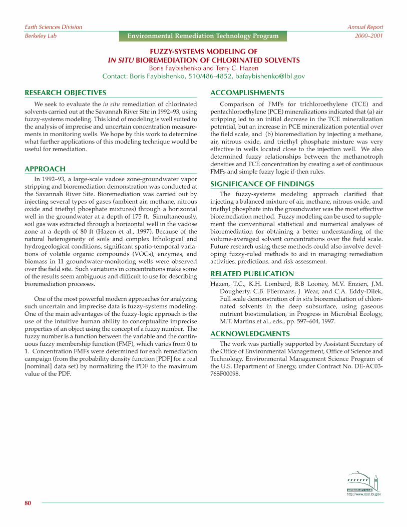
RESEARCH OBJECTIVESWe seek to evaluate the in situ remediation of chlorinated
solvents carried out at the Savannah River Site in 1992–93, usingfuzzy-systems modeling. This kind of modeling is well suited tothe analysis of imprecise and uncertain concentration measure-ments in monitoring wells. We hope by this work to determinewhat further applications of this modeling technique would beuseful for remediation.
APPROACH In 1992–93, a large-scale vadose zone-groundwater vapor
stripping and bioremediation demonstration was conducted atthe Savannah River Site. Bioremediation was carried out byinjecting several types of gases (ambient air, methane, nitrousoxide and triethyl phosphate mixtures) through a horizontalwell in the groundwater at a depth of 175 ft. Simultaneously,soil gas was extracted through a horizontal well in the vadosezone at a depth of 80 ft (Hazen et al., 1997). Because of thenatural heterogeneity of soils and complex lithological andhydrogeological conditions, significant spatio-temporal varia-tions of volatile organic compounds (VOCs), enzymes, andbiomass in 11 groundwater-monitoring wells were observedover the field site. Such variations in concentrations make someof the results seem ambiguous and difficult to use for describingbioremediation processes.
One of the most powerful modern approaches for analyzingsuch uncertain and imprecise data is fuzzy-systems modeling.One of the main advantages of the fuzzy-logic approach is theuse of the intuitive human ability to conceptualize impreciseproperties of an object using the concept of a fuzzy number. Thefuzzy number is a function between the variable and the contin-uous fuzzy membership function (FMF), which varies from 0 to1. Concentration FMFs were determined for each remediationcampaign (from the probability density function [PDF] for a real[nominal] data set) by normalizing the PDF to the maximumvalue of the PDF.
ACCOMPLISHMENTSComparison of FMFs for trichloroethylene (TCE) and
pentachloroethylene (PCE) mineralizations indicated that (a) airstripping led to an initial decrease in the TCE mineralizationpotential, but an increase in PCE mineralization potential overthe field scale, and (b) bioremediation by injecting a methane,air, nitrous oxide, and triethyl phosphate mixture was veryeffective in wells located close to the injection well. We alsodetermined fuzzy relationships between the methanotrophdensities and TCE concentration by creating a set of continuousFMFs and simple fuzzy logic if-then rules.
SIGNIFICANCE OF FINDINGSThe fuzzy-systems modeling approach clarified that
injecting a balanced mixture of air, methane, nitrous oxide, andtriethyl phosphate into the groundwater was the most effectivebioremediation method. Fuzzy modeling can be used to supple-ment the conventional statistical and numerical analyses ofbioremediation for obtaining a better understanding of thevolume-averaged solvent concentrations over the field scale.Future research using these methods could also involve devel-oping fuzzy-ruled methods to aid in managing remediationactivities, predictions, and risk assessment.
RELATED PUBLICATIONHazen, T.C., K.H. Lombard, B.B Looney, M.V. Enzien, J.M.
Dougherty, C.B. Fliermans, J. Wear, and C.A. Eddy-Dilek,Full scale demonstration of in situ bioremediation of chlori-nated solvents in the deep subsurface, using gaseousnutrient biostimulation, in Progress in Microbial Ecology,M.T. Martins et al., eds., pp. 597–604, 1997.
ACKNOWLEDGMENTS The work was partially supported by Assistant Secretary of
the Office of Environmental Management, Office of Science andTechnology, Environmental Management Science Program ofthe U.S. Department of Energy, under Contract No. DE-AC03-76SF00098.
FUZZY-SYSTEMS MODELING OFIN SITU BIOREMEDIATION OF CHLORINATED SOLVENTS
Boris Faybishenko and Terry C. HazenContact: Boris Faybishenko, 510/486-4852, [email protected]
Earth Sciences DivisionBerkeley Lab
Annual Report2000–2001
80
Environmental Remediation Technology Program

RESEARCH OBJECTIVES
The United States produces approximately 200 million tons ofmunicipal solid waste annually, 57% of which is disposed of inmunicipal landfills. With increasing costs and difficulties in permit-ting new landfill sites, existing landfill space is becoming a valuablecommodity. Current regulations require capping of landfills toisolate waste from incoming rainwater and collection of leachate fortreatment prior to release to the environment, creating what istermed a “dry tomb” landfill. Restricting exposure of air and waterto the refuse slows biodegradation rates and increases the timerequired for landfill stabilization. Theobjective of this project is to develop datato support the concept of AerobicLandfill Bioreactors. In these systems,the refuse mass is kept wet and aerobic,thereby greatly increasing the biodegra-dation rate. The increased rate ofbiodegradation results in faster stabiliza-tion and increased settling, which wouldallow for input of additional refuse orfaster land reuse. In addition, aerobicsystems do not produce noxious odorsor methane, a powerful greenhouse gas.
APPROACH In this study, rates of settling and
biodegradation are measured in largelaboratory-scale bioreactors. Threetreatments are being applied to the bioreactors: (a) aerobic land-fill (air injection with water addition and recirculation), (b) dry,anaerobic landfill (no air injection or leachate recirculation), and(c) wet, anaerobic landfill (no air injection, but water additionand recirculation). The three bioreactors consist of 55 gal. clearacrylic tanks instrumented to monitor pressure, temperature,moisture, humidity, and gas and leachate composition and flowrates. All tanks contain 10 cm of gravel at the bottom, overlainby a sample of typical municipal waste. Air is injected into thebottom of the tanks, and gas is vented out the top. Leachate iscollected at the bottom of the tanks, recirculated, and sprinkledover the top of the refuse. A neutron probe is used to monitorthe average moisture content of the refuse.
Relative degradation rates between the tanks are monitoredby CO2 and CH4 production rates. Respiration tests were alsoconducted in the aerobic tank by ceasing air injection and moni-toring the rate of oxygen consumption. The leachate is sampledregularly and monitored for biological activity and chemicalcomposition.
ACCOMPLISHMENTS Over the test period, the aerobic landfill bioreactor has shown
significantly more settling than the anaerobic reactors (see Figure 1).The leachate from the aerobic bioreactor has maintained a neutralpH and has shown low levels of all measured parameters (metals,nitrate, phosphate, and total organic carbon). Respiration tests in theaerobic reactor have demonstrated a dependence on refuse age,temperature, and moisture content. Live/dead cell counts have alsoshown a decrease in biological activity over the same period. Thewet, anaerobic bioreactor has shown high levels of all measured
chemical parameters in the leachate andhas required buffering to adjust the pH toneutral levels. The dry, anaerobic reactordid not produce any leachate, andshowed a lower settling rate and CO2 ratethan the wet, anaerobic reactor. Neutron-probe measurements have proven to be areliable method for monitoring averagemoisture content within the tanks.
SIGNIFICANCE OF FINDINGS This study demonstrates that main-
taining the refuse as an aerobic biore-actor increases the rates of settling andstabilization as well as producing lessodor and less hazardous leachate.Ongoing work includes investigationof the effect of nutrient addition on
activity and further investigation of the effect of moisture andair addition on biodegradation rates. A recently developed codefor numerical simulation of landfill bioreactors (T2LBM) willalso be used to model biodegradation in the reactors. See arelated report in this publication for details on the T2LBM land-fill biodegradation model.
RELATED PUBLICATIONSBorglin, S., T. Hazen, C. Oldenburg, and P. Zawislanski, Laboratory
investigation of the aerobic biodegradation of municipal land-fill materials, Berkeley Lab Report LBNL-47979, 2001.
Oldenburg, C.M., T2LBM: Landfill bioreactor model for TOUGH2,Version 1.0, Berkeley Lab Report LBNL-47961, 2001.
ACKNOWLEDGMENTSThis work has been supported by the Laboratory Directed
Research and Development Program of Berkeley Lab, providedby the Director, Office of Science, of the U.S. Department ofEnergy under Contract No. DE-AC03-76SF00098.
EXPERIMENTAL INVESTIGATION OFAEROBIC LANDFILL BIODEGRADATION
Terry C. Hazen, Sharon E. Borglin, Peter T. Zawislanski, and Curtis M. OldenburgContact: Terry C. Hazen, 510/486-6223, [email protected]
Earth Sciences DivisionBerkeley Lab
Annual Report2000–2001
81
Environmental Remediation Technology Program
Figure 1. Settling of the refuse mass over time bytype of treatment

OBJECTIVE
Although heterogeneity occurs at almost every scale, it is notknown how key physical and chemical parameters affect micro-bial behavior at different scales in a natural environment. Aprimary goal is to relate physical and chemical parameters—using geophysical methods (i.e., parameters that we have expe-rience measuring in situ)—to significant microbial propertiesand thus predict their behavior in the subsurface.
APPROACHThis research involves an integrated approach to character-
izing and identifying the fundamental properties and scalesnecessary to image heterogeneities, using geophysical methodsthat may control transport in near-surface sedimentary media.Particular emphasis is placed on understanding transportbehavior relative to understanding subsurface microbialbehavior.
This approach uses controlled small-scale field sites andsupplementary laboratory information to characterize the prop-erties affecting chemical and bacterial transport, which can beimaged with in situ characterization methods. Efforts in thisresearch have been made toward defining the hierarchy of phys-ical characteristics that control transport and geophysical prop-erties at the laboratory and field scale. Also, several otherimaging techniques (radar, self potential, DC resistivity) arebeing used to obtain a more direct measure of physical, micro-bial, and chemical properties.
ACCOMPLISHMENTSWork in the past year at the Oyster Site in Virginia (as part of
the Department of Energy’s NABIR program) has focused oncorrelating seismic-imaging and radar results to hydrologic andchemical properties. Such work will aid in the understanding ofbacterial transport properties. In addition, geophysical propertiesare being correlated to flow and transport properties affectingflow through a geostatistical approach. Also being investigated isthe possibility of direct detection of microbes using geophysicalmethods. Experiments in the lab and field have indicated thatboth electrical properties and seismic properties will be affectedby the presence of microbes. The charac- terization at this site isfully described at http://www.esd.lbl.gov/people/shubbard/web_page.
SUBSURFACE IMAGING FOR CHARACTERIZING HETEROGENEITY AFFECTINGMICROBIAL-TRANSPORT PROPERTIES IN SEDIMENTS
Ernest L. Majer, Susan Hubbard, Kenneth H. Williams, John E. Peterson, and Jinsong Chen1
1University of California, BerkeleyContact: Ernest L. Majer, 510/486-6709, [email protected]
Earth Sciences DivisionBerkeley Lab
Annual Report2000–2001
82
Environmental Remediation Technology Program
Figure 1. An example of hydraulic-conductivity esti-mates obtained using radar and seismic tomographicdata at the DOE Bacterial Transport Site in Oyster, VA.Note the good correlation with the actual flow meas-urements (Chen et al., 2001; Hubbard et al., 2001).
RELATED PUBLICATIONS
Chen, J., Y. Rubin, and S. Hubbard, Estimating hydraulic conduc-tivity at the South Oyster Site using geophysical tomographicdata, Water Resour. Res., 2001 (in press).
Hubbard, S., and Y. Rubin, A review of selected estimation tech-niques using geophysical data, Journal of ContaminantHydrology, 45, 3–34, 2000.
Hubbard, S., J. Chen, J. Peterson, E. Majer, K. Williams, D. Swift, B.Mailliox, and Y. Rubin, 2001, Hydrogeological characteriza-tion of the D.O.E. Bacterial Transport Site in Oyster Virginia,using geophysical data, Water Resour. Res., 2001 (in press).
ACKNOWLEDGMENTSThis work has been supported by the Director, Office of
Science, Office of Biological and Environmental Research,Environmental Sciences Divison, Natural and AcceleratedBioremedation Research Program under Contract No. DE-AC03-765F0098.

RESEARCH OBJECTIVES
At the DOE Hanford site, heterogeneities of interest can rangefrom localized phenomena (such as silt or gravel lenses, fractures,and clastic dikes) to large-scale lithologic discontinuities. Thesefeatures have been suspected of leading to funneling andfingering, additional physical mechanisms that could alter andpossibly accelerate the transport of contaminants to underlyinggroundwater. Understanding of contaminant migration throughthe vadose zone has not only been hamperedby inadequate conceptual models, but has alsosuffered from inadequate monitoring technolo-gies. Over the last few years, however, cross-well radar and seismic imaging have emergedas possible monitoring solutions.
The main questions addressed with cross-well methods are:
• What parts of the vadose zone-ground-water system control flow geometry?
• What physics controls flow and trans-port in unconsolidated soils of thevadose zone?
• What is the optimum suite of field testsand laboratory studies to provide infor-mation for predicting flow and transportbehavior?
• How can the information obtainedduring site characterization be used forbuilding confidence in predictivenumerical models?
The primary purpose of crosswell radarand seismic imaging at Hanford is to providedetailed information on the lithology and structure (25 cm orless resolution) as well as provide the same level of detail on thelocation of the fluid transport. A second purpose is to evaluatethese methods and/or modification of the methods to determinetheir use at the tank-farm scale.
APPROACH Tests were conducted at an infiltration site where there were
four PVC-lined holes spaced 3 to 5m apart spanning the injec-tion zone. The ground penetrating radar (GPR) work consistedof repeated crosswell tomographic data sets that were collectedbetween the six possible well pairs at the Sisson-Lu site before,
during, and after infiltration tests using fresh water. A total offour data collection visits were made to the site, with three of thevisits consisting of exactly the same data sets being collected.The crosswell seismic imaging data were collected after all of theinfiltration tests were completed because the wells used for thecrosswell seismic had to be filled with water. The piezoelectricsource emitted energy from 1 to 10 kHz.
ACCOMPLISHMENTSIn general, the radar and seismic results
were excellent. At the time of the experiment’sdesign, we did not know how well these twomethods could penetrate or resolve the mois-ture content and structure. It now appearsthat the radar could easily go up to 5, even 10m between boreholes at 200 MHz, and evenfarther (up to 20 m) at 50 MHz. The seismic-imaging results indicate that at several-hundred-hertz propagation of 20 to 30 m, highresolution is possible. One of the most impor-tant results, however, is that together, seismicand radar are complementary in their proper-ties estimation. The radar was sensitiveprimarily to changes in moisture content,while the seismic imaging was sensitiveprimarily to porosity. In a time-lapse mode,the radar can show moisture-content changesto a high resolution (see Figure 1), with theseismic imaging providing high-resolutionlithology. At this time, the two different data
sets have not been merged or jointly interpreted with each otheror with other data sets, but the potential for providing informa-tion on fluid flow through vadose zone environments is verygood.
ACKNOWLEDGMENTSThis work was funded by Assistant Secretary of the Office of
Environmental Management, Office of Science and Technology,Environmental Management Science Program of the U.S.Department of Energy, through the Science and TechnologyProgram at PNNL. We would like to thank Glendon Gee andAndy Ward for their efforts.
HIGH-RESOLUTION IMAGING OF VADOSE ZONE TRANSPORT USING CROSSWELL RADAR ANDSEISMIC METHODS: RESULTS OF TESTS AT THE HANFORD (WASHINGTON) SISSON AND LU SITE
Ernest L. Majer, John E. Peterson, Kenneth H. Williams, and Thomas M. DaleyContact: Ernest L. Majer, 510/486-6709, [email protected]
Earth Sciences DivisionBerkeley Lab
Annual Report2000–2001
83
Environmental Remediation Technology Program
Figure 1. Moisture changes fromthe time-lapse radar data

RESEARCH OBJECTIVES
Contamination of groundwater by methyl tert-butyl ether(MTBE) is a problem throughout the United States because of itsextensive usage as a gasoline oxygenate. Few technologies existfor treatment of MTBE-impacted water. Ex situ treatment ofgroundwater with granular activated carbon (GAC) is generallyregarded as the only proven method for MTBE-contaminatedgroundwater remediation. However, the cost of replenishingGAC and treating the spent GAC is prohibitively high. Morecost-effective and efficient treatment technologies are desper-ately needed.
The objective of this research is to understand the biologicaltreatment process of MTBE in fluidized-bed bioreactors and todevelop a reliable ex situ MTBE treatment technology in fluid-ized-bed bioreactors that use GAC.
APPROACHBiological treatment of MTBE-impacted groundwater poses
many problems because of the lack of basic knowledge aboutMTBE biodegradation. Typically, MTBE treatment systems havestart-up problems with poor process control, and they becomeunmanageable when they fail. Contributing factors to theseproblems are slow growth rate, low biomass yields, and insta-bility of the degrading cultures when MTBE serves as the solesubstrate. On the other hand, co-metabolic MTBE degradationhas the advantage of being inducible by co-substrates, such asiso-pentane (IP) and propane. The process also has some limita-tions, however, including possible failure caused by the deple-tion of co-substrate and competitive inhibition between MTBEand the co-substrate.
ACCOMPLISHMENTS These metabolic processes were simulated in two laboratory-
scale fluidized-bed bioreactors, using fresh GAC saturated for aweek with high concentrations of MTBE (>20,000 mg/L). Underthe same starting conditions and treatments, Reactor 1 removed99.9% of MTBE over the first 80 days, suggesting that MTBE wasbeing utilized as the sole substrate, while Reactor 2 failed toshow significant MTBE treatment. An IP degrading mixedculture (with IP at 583 mg/L reactor/day) was then provided forReactor 2, and MTBE treatment in Reactor 2 began to improve.Within a month, MTBE treatment efficiency was more than99.9%, and IP addition was terminated. The reactor maintainedMTBE removal efficiency without further IP addition.
As shown in Figure 1, treatment efficiency in both reactorstransiently dropped and then rebounded to 99.9% when the
EX SITU TREATMENT OF MTBE-CONTAMINATED GROUNDWATER INFLUIDIZED BED REACTORS
Keun-Chan Oh and William StringfellowContact: Keun-Chan Oh, 510/486-4010, [email protected]
Earth Sciences DivisionBerkeley Lab
Annual Report2000–2001
84
Environmental Remediation Technology Program
Figure 1. MTBE loading rate vs. MTBEremoval rate in Reactors 1 and 2
MTBE loading rate was increased up to 700 mg/L reactor/day.However, the reactors showed different responses to thechanging loading rate. The changing loading rate had littleimpact on Reactor 1, whereas Reactor 2 took much longer torecover to the previous treatment level.
SIGNIFICANCE OF FINDINGSThese results show that MTBE treatment in fluidized-bed
bioreactors can be achieved, either through growth-based metabo-lism or co-metabolism using iso-pentane- degrading microorgan-isms. Also, these studies demonstrated that the biological removalof MTBE-impacted groundwater is a highly feasible treatmenttechnology at contaminated sites and that MTBE degradation canbe initiated in treatment systems at these sites by adding iso-pentane at proper concentrations.
RELATED PUBLICATIONOh, K.-C., and W.T. Stringfellow, Treatment of MTBE in a fluidized-
bed bioreactor using iso-pentane as a co-substrate, 6th BattelleSymposium, San Diego, California, June 3–7, 2001.
ACKNOWLEDGMENTSThis work has been supported by Kinder Morgan Energy
Partners and Envirex/U.S. Filter, under Berkeley Lab Work ForOthers Agreement No. BG99-035(00).

landfill. Shown in Figure 1 are four panels representing liquidsaturation, temperature, acetic acid mass fraction, and aerobicityfor the sample problem after one day. At this time, liquid satu-ration is variable, corresponding to the heterogeneous perme-ability field as shown in the upper-left panel. The temperaturefield (upper-right panel) reflects the heating caused by aerobicbiodegradation as oxygen in the ambient air is consumed. Thelow-temperature region in the right-hand side of the domaincorresponds to the high-liquid saturation region, where there is
less ambient air and moreliquid to be heated. At thislocation, anaerobic condi-tions prevail, with corre-spondingly smaller heatproduction. The mass frac-tion of acetic acid shown inthe lower-left panel revealsthat the anaerobic reactionhas biodegraded more aceticacid than the aerobic reac-tion. In the final panel, thequantity called aerobicity isshown, in which aerobicityequal to one indicatesaerobic conditions, and aero-bicity equal to zero indicatesanaerobic conditions. Mostof the domain is weaklyaerobic as oxygen in the
ambient air is still being consumed, while in the low-perme-ability, high-liquid saturation region, conditions have alreadybecome anaerobic. Methane and CO2 mass fractions in the gas(not shown) confirm these interpretations.
SIGNIFICANCE OF FINDINGSOur simulations to date point out the complexity of landfill
biodegradation processes and demonstrate that numerical simu-lation of these processes is possible. Application of T2LBM isongoing and aimed at simulating results of laboratory experi-ments and field tests of landfill biodegradation processes.
RELATED PUBLICATIONOldenburg, C.M., T2LBM: Landfill bioreactor model for TOUGH2,
Version 1.0, Berkeley Lab Report LBNL-47961, 2001.
ACKNOWLEDGMENTSThis work has been supported by the Laboratory Directed
Research and Development Program of Berkeley Lab, providedby the Director, Office of Science, of the U.S. Department ofEnergy under Contract No. DE-AC03-76SF00098.
RESEARCH OBJECTIVESThe need to control gas and leachate production while mini-
mizing refuse volume in municipal solid waste (MSW) landfillshas motivated the development of landfill simulation modelsthat can be used by operators to predict and design optimaltreatment processes. Prior models of landfill processes are eitherbatch models (zero-dimensional), multilayer batch models (one-dimensional), or do not consider gas production as part ofbiodegradation. The objective of this research is to develop fullythree-dimensional numerical simulation capabilities for landfillbiodegradation processes, in-cluding gas production. Inthis effort, we have devel-oped T2LBM, a module forthe TOUGH2 simulator. Thismodule implements a landfillbioreactor model to providesimulation capability for theprocesses of aerobic or anaer-obic biodegradation of muni-cipal solid waste and theassociated flow and transportof gas and liquid.
APPROACHBiodegradation and gas
production in MSW landfillsis an enormously complexand variable process. Tomake progress in the simula-tion of landfill processes, simplifications must be made. Theapproach chosen for T2LBM couples the process modeling of theflow and transport of gas and aqueous phases inherent inTOUGH2, with biodegradation and gas-generation processes.For simplicity, T2LBM models the biodegradation of a singlesubstrate component (acetic acid, CH3COOH) as a proxy for allof the biodegradable fractions in MSW. T2LBM includes sixchemical components (H2O, CH3COOH, CO2, CH4, O2, N2) andheat distributed in gaseous and aqueous phases with parti-tioning by Henry’s law. This approach assumes implicitly thathydrolysis reactions occur to produce acetic acid and places themodel focus on biodegradation and associated gas production,along with flow and transport processes (including non-isothermal effects).
ACCOMPLISHMENTSWe have developed T2LBM and verified its performance
against results from published laboratory studies of aerobic andanaerobic biodegradation. In addition, we have simulated ahypothetical MSW landfill with leachate recirculation and
subsequent air injection into the bottom of the
NUMERICAL SIMULATION OFLANDFILL BIODEGRADATION PROCESSES
Curtis M. Oldenburg, Sharon E. Borglin, and Terry C. HazenContact: Curtis M. Oldenburg, 510/486-7419, [email protected]
Earth Sciences DivisionBerkeley Lab
Annual Report2000–2001Environmental Remediation Technology Program
Figure 1. Liquid saturation (Sl), temperature (T), mass fraction aceticacid (XHAc
liq), and aerobicity with liquid velocity vectors at t = 1 day
85

APPROACH
Approximately 8 Mb of quarterly data on contaminantchemistry and water-table elevations provided by HardingESE have been entered into the database management systemGIS/KEY®. This system is useful for displaying spatial andtemporal data relevant to the site. The maps created usingGIS/KEY® have enabled us to correlate water-table rise withTCE concentration increases and to observe the downgradientpropagation of pulses containing TCE-contaminated water.
ACCOMPLISHMENTS Figure 1 shows a map of three representative wells near the
burn pit at OU1. The three superimposed graphs are plots of thetemporal changes of the water-table elevation in feet abovemean sea level (in blue) and the TCE concentration in mg/L (ingreen). The vertical dashed green line is a reference line posi-
tioned in the first quarter of 1998 in each graph.These three graphs show that the timing, rate, andmagnitude of the water-table rise that began in 1998were similar in all three wells, whereas the timing ofthe TCE concentration increase varied. The TCEconcentration increased as the water table rose nearthe burn pit (well MW-OU1-06-A), but the corre-sponding TCE concentration increases were delayedin the downgradient wells by 3 to 6 months for thenear well (MW-OU1-05-A) and 6 to 12 months for themore distant well (MW-OU1-20-A).
SIGNIFICANCE OF FINDINGS This delay suggests that pulses of TCE contami-
nation released from the source area are mobilized bywater-table rise and then advected downgradient.These water-table excursions and subsequent TCEincreases are likely caused by TCE-contaminatedwater held in a smear zone between the saturatedand vadose zones near the source area. TheGIS/KEY® system allowed us to extract and displaythese useful data from the full set of monitoring datagathered from 56 wells at OU1.
ACKNOWLEDGMENTS We thank Buck King, Larry Friend, and Ed
Heistand of Harding ESE for providing data for OU1.This work was supported by the U.S. Army IndustrialEcology Center through the Concurrent TechnologiesCorporation Contract No. DAAE30-98-C-1050, TaskNo. 281, CRDL No. B009, administered by theUniversity of California, Santa Cruz, and by BerkeleyLab under U.S. Department of EnergyContract No. DE-AC03-76SF00098.
RESEARCH OBJECTIVES
The objective of this study is to correlate water-table elevationchanges with contaminant concentration changes in monitoringwells. The study site is Operable Unit 1 (OU1) at the former FortOrd Army Base, along the central California coast, where the uncon-fined A-aquifer (saturated thickness ~8 m) exists in unconsolidateddune sands above a thick sequence of clays known locally as theFort Ord-Salinas Valley Aquiclude (FO-SVA). This work is part ofa larger effort to understand the groundwater flow and contaminanttransport in the layered sands and clays at a depth of 30 m (100 ft)downgradient from OU1. Historically, solvents and fuels were usedat OU1 for firefighter training, resulting in groundwater contami-nation consisting of volatile organic compounds (VOCs), primarilytrichloroethylene (TCE). Groundwater extraction and treatmentfrom the A-aquifer has been underway since 1988. Water-tableelevation readings and groundwater chemical analyses are carriedout quarterly in nearby monitoring wells.
WATER-TABLE RISE CORRELATES WITH TCE INCREASE AT A CONTAMINATED SITECurtis M. Oldenburg, Preston D. Jordan, Jennifer Hinds, and Barry M. Freifeld
Contact: Curtis M. Oldenburg, 510/486-7419, [email protected]
Earth Sciences DivisionBerkeley Lab
Annual Report2000–2001
86
Environmental Remediation Technology Program
Figure 1. Temporal evolution of the water table elevation and TCE concentra-tion in groundwater for three wells near the burn pit area of OU1.( * Approximate location of former burn pit)

determine what processes are important for contaminantbehavior and how they can be modeled effectively. Figure 1shows the simulated distribution of a conservative soluteresulting from a tank leak in 1966 estimated at 50,000 gallons.Our simulations show strong vapor-liquid counterflow effects(heat pipe) in the region surrounding the tank during the periodof above-boiling tank temperatures (1956–1967). These effectsprovide a very efficient mechanism for (1) heat transfer awayfrom the tank and (2) solute transport towards the tank.Aqueous solutes are predicted to concentrate and eventuallyprecipitate near the tank.
ACKNOWLEDGMENTSThis work was supported by the Assistant Secretary of the
Office of Environmental Management, Office of Science andTechnology, of the U.S. Department of Energy, under Contract No.DE-AC03-76SF00098 through Memorandum Purchase Order248861-A-B2 between Pacific Northwest National Laboratory andBerkeley Lab.
RESEARCH OBJECTIVES
Of the 15 single-shell tanks at the Hanford 241-SX tank farm,ten are known leakers. Fluid flow and solute transport in theunsaturated zone surrounding the tanks is affected by radioac-tive decay heat and by chemical interactions between fluids andsediments. Multiphase processes near the tanks include flow ofaqueous and gaseous phases, boiling and condensation, migra-tion of solutes, precipitation and dissolution, and vapor-liquidcounterflow. Additional effects arise from variable soluteconcentrations in the aqueous phase, heat generation fromleaked radioactive fluids, interference between the heat load andfluid leaks of different tanks, and suspected (but poorlyconstrained) water-line leaks.
The purpose of the studies reported here is to develop abetter understanding of the unique hydrogeologic systemcreated by the Hanford tanks through detailed mechanisticmodeling of fluid flow, heat transfer, and mass transport. Ouraim is to provide support and guidance for performance assess-ment, field characterization, and decision-making on remedialmeasures.
APPROACHWe focus especially on Tank SX-108, which is one of the
highest heat-load tanks in the 241-SX tank farm and a knownleaker. A realistic quantitative model of mass and energy trans-port near the tanks requires:
• Comprehensive treatment of all significant physical andchemical processes
• Accurate representation of hydrogeologic conditions at the site• Realistic parameters for fluids and sediments, and for
temperature and leak history of the tanksThese are ambitious goals that can only be achieved through
a process of iterative refinement, starting from relatively simplemodels. The initial emphasis of the work reported here is onprocess issues, focusing on the extent to which various multi-phase and nonisothermal processes may impact the migration ofmoisture and aqueous solutes. The Hanford sediments arerepresented as layer-cake stratigraphy, and actual measuredtemperatures are used to specify the tank heat source. BerkeleyLab’s general-purpose fluid- and heat-flow simulator TOUGH2is used in this work.
ACCOMPLISHMENTSA series of two-dimensional radially symmetric models was
developed to probe different processes and mechanisms to
FLUID FLOW, HEAT TRANSFER, AND SOLUTE TRANSPORT AT HANFORD TANK SX-108:A SUMMARY REPORT ON MODELING STUDIES
Karsten Pruess, Steve B. Yabusaki,1 Carl I. Steefel,2 and Peter C. Lichtner3
1Pacific Northwest National Laboratory, 2Lawrence Livermore National Laboratory, 3Los Alamos National LaboratoryContact: Karsten Pruess, 510/486-6732, [email protected]
Earth Sciences DivisionBerkeley Lab
Annual Report2000–2001
87
Environmental Remediation Technology Program
Figure 1. Model domain showing leakedfluid distribution following a 50,000-gallonleak in 1966
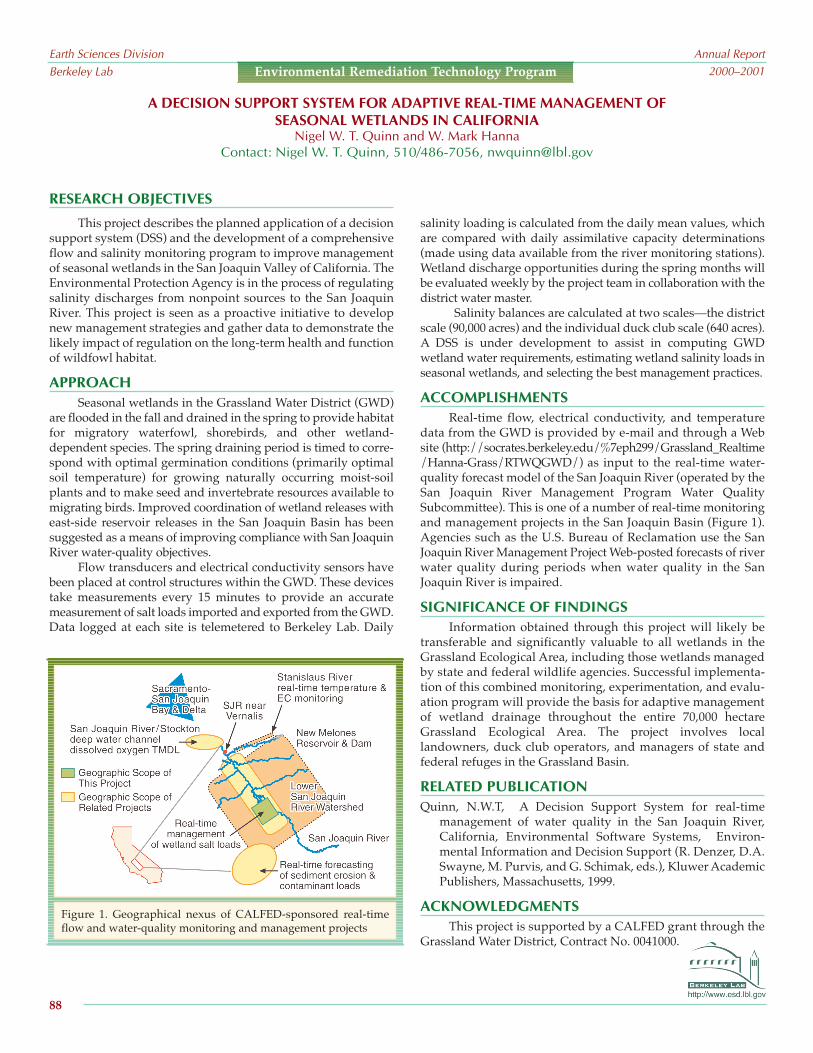
RESEARCH OBJECTIVES
This project describes the planned application of a decisionsupport system (DSS) and the development of a comprehensiveflow and salinity monitoring program to improve managementof seasonal wetlands in the San Joaquin Valley of California. TheEnvironmental Protection Agency is in the process of regulatingsalinity discharges from nonpoint sources to the San JoaquinRiver. This project is seen as a proactive initiative to developnew management strategies and gather data to demonstrate thelikely impact of regulation on the long-term health and functionof wildfowl habitat.
APPROACHSeasonal wetlands in the Grassland Water District (GWD)
are flooded in the fall and drained in the spring to provide habitatfor migratory waterfowl, shorebirds, and other wetland-dependent species. The spring draining period is timed to corre-spond with optimal germination conditions (primarily optimalsoil temperature) for growing naturally occurring moist-soilplants and to make seed and invertebrate resources available tomigrating birds. Improved coordination of wetland releases witheast-side reservoir releases in the San Joaquin Basin has beensuggested as a means of improving compliance with San JoaquinRiver water-quality objectives.
Flow transducers and electrical conductivity sensors havebeen placed at control structures within the GWD. These devicestake measurements every 15 minutes to provide an accuratemeasurement of salt loads imported and exported from the GWD.Data logged at each site is telemetered to Berkeley Lab. Daily
salinity loading is calculated from the daily mean values, whichare compared with daily assimilative capacity determinations(made using data available from the river monitoring stations).Wetland discharge opportunities during the spring months willbe evaluated weekly by the project team in collaboration with thedistrict water master.
Salinity balances are calculated at two scales—the districtscale (90,000 acres) and the individual duck club scale (640 acres).A DSS is under development to assist in computing GWDwetland water requirements, estimating wetland salinity loads inseasonal wetlands, and selecting the best management practices.
ACCOMPLISHMENTSReal-time flow, electrical conductivity, and temperature
data from the GWD is provided by e-mail and through a Website (http://socrates.berkeley.edu/%7eph299/Grassland_Realtime/Hanna-Grass/RTWQGWD/) as input to the real-time water-quality forecast model of the San Joaquin River (operated by theSan Joaquin River Management Program Water QualitySubcommittee). This is one of a number of real-time monitoringand management projects in the San Joaquin Basin (Figure 1).Agencies such as the U.S. Bureau of Reclamation use the SanJoaquin River Management Project Web-posted forecasts of riverwater quality during periods when water quality in the SanJoaquin River is impaired.
SIGNIFICANCE OF FINDINGSInformation obtained through this project will likely be
transferable and significantly valuable to all wetlands in theGrassland Ecological Area, including those wetlands managedby state and federal wildlife agencies. Successful implementa-tion of this combined monitoring, experimentation, and evalu-ation program will provide the basis for adaptive managementof wetland drainage throughout the entire 70,000 hectareGrassland Ecological Area. The project involves locallandowners, duck club operators, and managers of state andfederal refuges in the Grassland Basin.
RELATED PUBLICATIONQuinn, N.W.T, A Decision Support System for real-time
management of water quality in the San Joaquin River,California, Environmental Software Systems, Environ-mental Information and Decision Support (R. Denzer, D.A.Swayne, M. Purvis, and G. Schimak, eds.), Kluwer AcademicPublishers, Massachusetts, 1999.
ACKNOWLEDGMENTSThis project is supported by a CALFED grant through the
Grassland Water District, Contract No. 0041000.
A DECISION SUPPORT SYSTEM FOR ADAPTIVE REAL-TIME MANAGEMENT OFSEASONAL WETLANDS IN CALIFORNIA
Nigel W. T. Quinn and W. Mark HannaContact: Nigel W. T. Quinn, 510/486-7056, [email protected]
Earth Sciences DivisionBerkeley Lab
Annual Report2000–2001
88
Environmental Remediation Technology Program
Figure 1. Geographical nexus of CALFED-sponsored real-timeflow and water-quality monitoring and management projects

RESEARCH OBJECTIVES
A pumping or injection well test is common practice inhydrology and petroleum engineering. It is performed to esti-mate formation hydraulic properties in the vicinity of the well.Normally, such a test requires either maintaining a constantpumping rate or a full shut-in of the well for a substantial periodof time at the beginning of the test. We propose to use regularmonitoring data (from a production or injection well) for esti-mating the formation properties without interrupting the oper-ations. Thus, instead of shutting-in the well for a substantialtime period, we propose to select a portion of the pumping dataover a certain time interval and then derive our conclusionsfrom these data.
APPROACHA distinctive feature of our approach is that we introduce an
additional fitting parameter, an effective pre-test pumping rate,to account for the nonuniform pressure distribution at the begin-ning of the testing time interval. We derive our model from thesame assumptions as in a standard pressure-drawdown or pres-sure-buildup test analysis. The effective pumping rate prior tothe test is a parameter of crucial importance for our procedurebecause no shut-in period precedes the test during regular oper-ations. We seek to show that accounting for this parameterimproves the analyses of traditional pressure-drawdown orpressure-buildup tests.
ACCOMPLISHMENTSTraditional methods of well-test analysis assume uniform
initial pressure distribution near the wellbore. But this assump-tion did not hold true when regular pumping data were analyzed.(Moreover, using rigorous residual term estimates, we demon-strated that it may be inaccurate even for a traditional well test.)Based on this finding, we proposed a modified initial conditioninvolving an effective pre-test pumping rate as an additionalparameter. We then demonstrated that the recovered value of theeffective pre-test pumping rate approximates the actual pre-testpumping rate with remarkable accuracy.
From this, we have developed an efficient estimation method,combining analytical calculations with numerical minimization ofa function of one variable. As shown in Figure 1, data points veryaccurately match the fitting curve.
Along with this new method, we have developed a procedurefor estimating ambient reservoir pressure and dimensionlesswellbore radius. For this procedure, a well test was simulated,using the parameter estimated by the optimization procedurementioned above. In this part of our analysis, we used only thesimulated data; consequently, no special operations at the wellwere required.
The new estimation method was implemented in a code oper-ational data analysis (ODA). This code incorporates a specialcurve-fitting procedure, which we designed to significantlysimplify the problem and reduce the amount of computations.The code has a user-friendly interface, and a beta version of it isavailable for testing and evaluation.
SIGNIFICANCE OF FINDINGSWe have demonstrated that accounting for pumping that
occurred before the test may be important even in a traditionalwell-test analysis. Our method produces results that are stablewith respect to variations in the selection of specific test periodsand also yields more accurate estimates of the aquifer’s hydro-logical parameters. Moreover, our approach requires a shortertest time interval and less frequent measurements during thisinterval. Estimation of the initial aquifer pressure and effectiveradius of influence does not require any field operation and doesnot impose any additional cost.
RELATED PUBLICATIONSSilin, D.B., and C.-F. Tsang, Estimation of formation hydraulic
properties accounting for pre-test injection or productionoperations, Journal of Hydrology, 2001 (submitted).
Silin, D.B., and C.-F. Tsang. Estimation of formation hydraulicproperties from analysis of regular operations data, SPE68780, 2001.
ACKNOWLEDGMENTSThis research has been supported by the U.S. Environmental
Protection Agency, Office of Ground Water and Drinking Water,Underground Injection Control Program, under an InteragencyAgreement with the U.S. Department of Energy under ContractNo. DE-AC03-76SF00098.
A NEW METHOD OF WELL-TEST ANALYSIS USINGOPERATIONAL DATA
Dmitriy B. Silin and Chin-Fu TsangContact: Dmitriy B. Silin, 510/495-2215, [email protected]
Earth Sciences DivisionBerkeley Lab
Annual Report2000–2001
89
Environmental Remediation Technology Program
Figure 1. Well-test data matching, including the effect of injectionprior to the test. The data points are plotted as circles; the solidline is the fitting curve produced by ODA.

OBJECTIVES
Some highly contaminated unsaturated sediments containsubstantial fractions of coarse sands and gravels. Very coarse-textured (>1 mm grain-size) media can sustain high flow rates atrelatively low saturations, doing so by film flow rather than byflow through an interconnected network of saturated pores.Thus, the physics of fast-flow processes in unsaturated, verycoarse media is fundamentally different from that traditionallyrecognized in finer textured sediments (Figure 1). Our objec-tives are (1) to quantify the macroscopic hydraulic properties ofvery-coarse-textured sediments in the near-zero (–5 to 0 kPa)matric potential region and (2) to determine the microscale basisfor fast unsaturated flow.
APPROACHESStudies are being conducted to quantify macroscopic and
microscopic (grain-film scale) hydraulic properties andprocesses in coarse sands and gravels. To obtain results that aredirectly relevant to the DOE, most of our efforts focus on sedi-ments from the Hanford Site (Hanford formation, with grain-sizes ranging from 0.1 to 50 mm). Additional tests are beingdone on quartz and tuff gravels. The 0 to –5 kPa region is a diffi-cult energy range to study because of extreme changes in satu-ration and conductance that take place in coarser-texturedmedia. We have developed new methods for bulk measure-ments of unsaturated potential-saturation-conductance relationson coarse sediments. These methods are variations on suction-plate equilibration, unit-gradient infiltration, and steady-fluxtechniques. Other methods (pressure- plate and vapor-pressureequilibration) are used on the same sediments to characterizepotential-saturation-conductance relations over the full range ofenvironmentally relevant conditions.
ACCOMPLISHMENTS The experiments on macroscopic hydraulic characteristics
focus on the near-zero matric potential range where gravel poresare drained. This energy range was identified from capillarydrainage calculations and from measured saturations. Underconditions of drained pores, the measured unsaturatedhydraulic conductivity is film-controlled. Moisture characteris-tics (matric potential versus saturation) and unsaturated
hydraulic conductivities are being obtained on Hanford forma-tion gravels at the column scale. These column-scale hydraulicproperties are being compared with grain-film hydraulic prop-erties to explain macroscale flow and transport through testedmicroscale concepts. Initial experiments on film hydraulic prop-erties have been completed, with results similar to thoseobtained in our previous work on transient film flow (Tokunagaet al., 2000). Tests at very negative matric potentials show thatthe Hanford gravels have substantial intragranular porosity andsurface area.
SIGNIFICANCE OF FINDINGSOur analyses of unsaturated flow in coarse sediments are
showing that at near-zero matric potentials, fast film flow ispossible. Magnitudes of fast, unsaturated flow in gravels atnear-zero matric potentials are consistent with direct measure-ments of film hydraulic properties. Findings of high intragran-ular porosity and surface area are important for understandingcontaminant transport at Hanford.
RELATED PUBLICATIONSTokunaga, T.K., J. Wan, and S.R. Sutton, Transient film flow on
rough fracture surfaces, Water Resour. Res. 36, 1737–1746,2000.
Tokunaga, T.K., and J. Wan, Approximate boundaries betweendifferent flow regimes in fractured rocks. Water Resour. Res.,2001 (in press).
ACKNOWLEDGMENTSThis study is funded by the Assistant Secretary of the Office
of Environmental Management, Office of Science andTechnology, under U.S. Department of Energy (DOE) ContractNo. DE-AC03-76SF0098. We thank Andrew Mei and RobertConners of Berkeley for technical support and John Zachara,Robert Lenhard, Steve Smith, and Bruce Bjornstad of PacificNorthwest National Laboratory for samples of Hanford forma-tion sediment. We thank the DOE, Office of Science, Office ofBasic Energy Sciences, Division of Chemical Sciences,Geosciences, and Biosciences for support of our related studieson unsaturated flow in fractured rock.
FAST FLOW INUNSATURATED COARSE SEDIMENTS
Tetsu K. Tokunaga, Jiamin Wan, and Keith OlsonContact: Tetsu K. Tokunaga, 510/486-7176, [email protected]
Earth Sciences DivisionBerkeley Lab
Annual Report2000–2001
90
Environmental Remediation Technology Program

OBJECTIVES
Understanding transport and reactions of metal contami-nants (such as chromium [Cr]) in soils is complicated by small-scale variations in physical, chemical, and microbiologicalcharacteristics. The fate of elements with redox-dependent solu-bilities can be complex because strong redox potential gradientscan develop over very short distances. In nature, Cr exists in theIII and VI oxidation states, with the majority of the formerspecies being stable solids and the majority of the latter beingmore soluble and mobile. Transport and reactions of chromiumin soils are critical concerns because of the carcinogenic effects ofCr(VI). Chromium reduction rates reflect interdependent influ-ences of physical, geochemical, and microbial processes. In thisstudy, this interdependence is examined for Cr(VI) contamina-tion of soil aggregates (cohesive structural units comprised ofmany primary mineral particles).
APPROACHPossible Cr redox zonation during contamination of large (90
to 150 mm diameter) soil aggregates was tested. Solutionscontaining up to 800 ppm carbon as tryptic soy broth were usedto wet these soil aggregates. Following 17 days of incubation, theseaggregates were exposed to Cr(VI) solutions (1,000 ppm initial Cr)for three days, representing an episodic contamination event(Figure 1a). Aggregates were then either frozen or incubated for anadditional 31 days (room T), resin-fixed, cut to obtain crosssections (Figure 1b), and scanned for mapping Cr distributions(using an X26A x-ray microphobe at the National SynchrotronLight Source, Brookhaven National Laboratory). Another set ofaggregates was cored to characterize profiles of microbial commu-nities (through phospholipid fatty acid analyses, enzyme analyses,and measurement of microorganism density and activity).
ACCOMPLISHMENTS Aggregates with higher available organic carbon took up
higher amounts of Cr(VI), and reductively precipitated Cr(III)within shorter distances (Figure 1c). Micro x-ray absorptionspectroscopy showed that transported Cr was largely reduced toCr(III), with only 23, 11, and 4% remaining as Cr(VI) in the +0,+80, and +800 ppm organic carbon systems, respectively.Chromium diffused into 100%, 80%, and 50% of the availablesoil volume in the aggregates with 0, +80 ppm, and +800 ppmorganic carbon, respectively. Chromium concentrationsincreased by 212, 406, and 1,350 ppm Cr, in the contaminatedregions of the 0, +80 ppm, and +800 ppm organic carbon aggre-gates, respectively.
SIGNIFICANCE OF FINDINGS
These results show the importance of intra-aggregate spatialrelations for redox-sensitive contaminants as well as for themicrobial communities responsible for redox gradients andreductants. Similar stratification of redox potentials, metalcontaminants, and microbial communities might occur withinlarger sediment blocks deeper in the subsurface. In soils andsediments comprised of aggregates or blocks that supportinternal redox gradients, bulk characterization of chemical andmicrobiological conditions does not allow mechanistic under-standing of biogeochemical processes controlling the fate andtransport of contaminants.
ACKNOWLEDGMENTS This work has been supported by the Director, Office of
Science, Office of Biological and Environmental Research,Environmental Sciences Division, Natural and AcceleratedBioremediation Research Program of the U.S. Department ofEnergy under Contract No. DE-AC03-76SF0098. Use of theAdvanced Photon Source was supported by the U.S. Departmentof Energy, Office of Science, Office of Basic Energy Sciences.
DIFFUSION-LIMITED BIOTRANSFORMATION OFMETAL CONTAMINANTS IN SOIL AGGREGATES: CHROMIUM
Jiamin Wan, Tetsu K.Tokunaga, Terry C. Hazen, Egbert Schwartz,1 Mary K. Firestone,1 Stephen R. Sutton,2Matthew Newville,2 Keith R. Olson, Antonio Lanzirotti,2 and William Rao3
1University of California, Berkeley, 2University of Chicago, 3University of GeorgiaContact: Jiamin Wan, 510/486-6004, [email protected]
Earth Sciences DivisionBerkeley Lab
Annual Report2000–2001
91
Environmental Remediation Technology Program
Figure 1. Synchrotron x-ray microprobe maps of total Cr insections from six soil aggregates. Each aggregate was incubatedwith either +0, +80, or +800 ppm organic carbon solutions, thenexposed to 1,000 ppm Cr(VI) solutions. The black region isoutside of the aggregate. The more reducing conditions estab-lished in the higher organic carbon aggregates result in a morerapid Cr(VI) reduction at shorter distances, higher diffusionuptake of Cr, and sharply terminated contaminant fronts. Thus,highly contaminated and uncontaminated regions can coexistwithin aggregates and sediment blocks at contaminated sites.

OBJECTIVES
Leakage of underground tanks containing high-level nuclearwaste solutions has been identified at various DOE facilities.The Hanford Site is the main facility of concern, with about 2,300to 3,400 m3 of waste liquids leaked. Radionuclides and othercontaminants have been found in elevated concentrations in thevadose zone and groundwater underneath single-shell tankfarms. We do not yet know the nature of pathways and mech-anisms responsible for deep vadose zone contaminant transport,and such understanding is urgently needed for future remedia-tion. It is often speculated that colloid-facilitated contaminanttransport is a major mechanism contributing to rapid contami-nant migration. Because of the extreme chemical conditions ofmost of these tank waste solutions (very high pH, aluminumconcentration, and ionic strength), understanding interactionsbetween the highly reactive waste solutions and sedimentsbecomes crucial for predicting contaminant migration throughthe deep vadose zone. The objectives of this research are to iden-tify the key processes occurring at the contaminant reactionfront, including reaction products, kinetics, colloid generation,and permeability reduction.
APPROACHESThe process of leaking tank-waste solution interacting with
the underlying sediments was simulated through infiltratingsimulated redox tank-waste solutions into columns packed withHanford vadose zone sediments. Since the sediments immedi-ately underlying some single-shell tanks experience elevatedtemperatures from heat released by reactions within tanks,experiments were conducted at elevated (70˚C) and roomtemperatures. Effluents from columns were collected with frac-tion collectors and analyzed for turbidity, pH, and chemicalcomposition. Secondary colloids collected from effluents werecharacterized for their major elements using an electron micro-probe, and mineralogy was determined by x-ray diffraction. Themorphology of the particles was studied using a scanning elec-tron microscope. Changes in major elemental compositionwithin the sediment columns were measured using x-ray fluo-rescence.
ACCOMPLISHMENTS A large quantity of secondary colloids formed because of the
waste solution and sediment interactions. The secondarycolloids formed at different infiltration stages (see Figure 1)possess different chemical composition and mineralogy. At themoving front of the tank waste plume, amorphous silica, calcite,and bayerite are the major phases. Within the waste plumestage, zeolite minerals are dominant. During the dilution stage,
bayerite is abundant. The majority of precipitates collected fromeffluents were submicron to micrometer sized. Maximumparticle formation occurred at the leading edge of the wasteplume, owing to maximum geochemical disequilibrium.Maximum transport of the secondary colloids also occurred atthe leading edge, when and where pores have not yet beenplugged by particle production and new colloids have not yetattached to primary grain surfaces.
SIGNIFICANCE OF FINDINGS Our laboratory studies revealed the complex processes of
reaction-dependent colloid generation/release, permeabilitychange, and flow pathway alteration that can strongly influenceflow and transport of redox tank contaminants in the Hanfordvadose zone. In comparison to the large quantity of secondarycolloids, the inventory of indigenous colloids is often small.Evaluating their carrying capacity of contaminants, degree ofrelease, and transport is a critical issue for understanding highlysorptive contaminant transport at Hanford and other sites.
ACKNOWLEDGMENTS This work is funded by the Assistant Secretary of the Office
Environmental Management, Office of Science and Technologyof the U.S. Department of Energy, under contract No. DE-AC03-76SF-00098.
COLLOID FORMATION DURING LEAKAGE OF HANFORD TANK-WASTE LIQUIDINTO UNDERLYING VADOSE ZONE SEDIMENTS
Jiamin Wan, Tetsu Tokunaga, Eduardo Saiz,1 Keith Olson, and Rex Couture2
1Materials Sciences Division, Berkeley Lab; 2Washington University, St. LouisContact: Jiamin Wan, 510/486-6004, [email protected]
Earth Sciences DivisionBerkeley Lab
Annual Report2000–2001
92
Environmental Remediation Technology Program
Figure 1. Single crystals of zeolites, cancrinite type,Na8(Al6Si6O24)(NO3)2 · 4H2O, formed during the waste-plume stage.
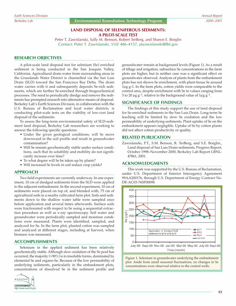
RESEARCH OBJECTIVES
A pilot-scale land disposal test for selenium (Se) enrichedsediment is being conducted in the San Joaquin Valley,California. Agricultural drain water from surrounding areas inthe Grasslands Water District is channelled via the San LuisDrain (SLD) toward the San Francisco Bay Delta. The drainwater carries with it and subsequently deposits Se-rich sedi-ments, which are further Se-enriched through biogeochemicalprocesses. The need to periodically dredge and remove the sedi-ments has prompted research into alternative means of disposal.Berkeley Lab’s Earth Sciences Division, in collaboration with theU.S. Bureau of Reclamation and local water districts, isconducting pilot-scale tests on the viability of low-cost landdisposal of the sediments.
To assess the long-term environmental safety of SLD-sedi-ment land disposal, Berkeley Lab researchers are working toanswer the following specific questions:
• Under the given geological conditions, will Se movedownward in the soil profile and result in groundwatercontamination?
• Will Se remain geochemically stable under surface condi-tions, such that its solubility and mobility do not signifi-cantly increase over time?
• To what degree will Se be taken up by plants?• Will increased Se levels in soil reduce crop yields?
APPROACH Two field experiments are currently underway. In one exper-
iment, 10 cm of dredged sediments from the SLD were appliedto the adjacent embankment. In the second experiment, 10 cm ofsediments were placed on top of, and blended with, 75 cm ofagricultural soils in a nearby cultivated farm plot. Soils and sedi-ments down to the shallow water table were sampled oncebefore application and several times afterwards. Surface soilswere fractionated with respect to Se using a sequential extrac-tion procedure as well as x-ray spectroscopy. Soil water andgroundwater were periodically sampled and moisture condi-tions were measured. Plants were identified, sampled, andanalyzed for Se. In the farm plot, planted cotton was sampledand analyzed at different stages, including at harvest, whenbiomass was measured.
ACCOMPLISHMENTSSelenium in the applied sediment has been relatively
geochemically stable. Although slow oxidation of the Se pool hasoccurred, the majority (>90%) is in insoluble forms, dominated byelemental Se and organo-Se. Because of the low permeability ofunderlying sediments, particularly in the embankment plots,concentrations of dissolved Se in the sediment profile and
groundwater remain at background levels (Figure 1). As a resultof tillage and irrigation, subsurface Se concentrations in the farmplots are higher, but in neither case was a significant effect ongroundwater observed. Analysis of plants from the embankmentplots has not shown Se enrichment, with plant-tissue Se around1µg g-1. In the farm plots, cotton yields were comparable to thecontrol area, despite enrichment with Se to values ranging from5 to 20 µg g–1, relative to the background value of 1µg g–1.
SIGNIFICANCE OF FINDINGSThe findings of this study support the use of land disposal
for Se-enriched sediments in the San Luis Drain. Long-term Seleaching will be limited by slow Se oxidation and the lowpermeability of underlying sediments. Plant uptake of Se on theembankment appears negligible. Uptake of Se by cotton plantsdid not affect cotton productivity or quality.
RELATED PUBLICATIONZawislanski, P.T., S.M. Benson, R. TerBerg, and S.E. Borglin.,
Land disposal of San Luis Drain sediments, Progress Report,October 1998–November 2000, Berkeley Lab Report LBNL-47861, 2001.
ACKNOWLEDGMENTSThis work was supported by the U.S. Bureau of Reclamation,
under U.S. Department of Interior Interagency Agreement99AA200176, through U.S. Department of Energy Contract No.DE-AC03-76SF00098.
LAND DISPOSAL OF SELENIFEROUS SEDIMENTS:A PILOT-SCALE TEST
Peter T. Zawislanski, Sally M. Benson, Robert TerBerg, and Sharon E. BorglinContact: Peter T. Zawislanski, 510/ 486-4157, [email protected]
Earth Sciences DivisionBerkeley Lab
Annual Report2000–2001
93
Environmental Remediation Technology Program
Figure 1. Selenium in groundwater underlying the embankmentplot. Aside from small seasonal fluctuations, no changes in Seconcentrations were observed relative to the control wells.

Earth Sciences DivisionBerkeley Lab
Annual Report2000–2001
This page is intentionally left blank.
94

http://www-esd.lbl.gov
Climate variability and carbon management research is anew and fast-growing program in the Earth Sciences Division. Itcontains research programs and DOE centers focusing onregional climate and hydrology, and the biogeochemistry andcarbon sequestration of geologic, oceanic, and terrestrialsystems. Over the past four years, we have added new staff withexpertise in global- and regional-scale climate modeling,ecosystem modeling, marine geochemistry, and the carbon andwater cycles to provide a strong scientific foundation foraddressing concerns related to carbon emissions and climatevariability.
We have also expanded the research focus of our existingstaff to include issues related to deciphering the isotopic compo-sition of ice cores, developing methods for modeling productionof methane from hydrate formations, geophysical monitoring ofunderground CO2 injection, and predicting the reactivity of CO2in deep geologic formations. Central to making an importantscientific contribution in these important areas is a strong link tothe Center for Atmospheric Sciences at UC Berkeley.
Last year, we made progress on several initiatives, includingNASA/RESAC (California Water Resources Research andApplications Center) and DOCS (the DOE Ocean CarbonSequestration Center). In addition, we have new initiatives: theGEO-SEQ project for geologic sequestration of CO2 and theARM Carbon project, which involves adding carbon and water-cycle monitoring to DOEs Atmospheric and RadiationMeasurements Program (ARM).
Berkeley Labs RESAC team has continued to produceRegional Climate System Model (RCSM) short-term weatherand stream-flow predictions, seasonal climate and stream flowpredictions, long-term climate variability and impact assess-ments, and model evaluations. The team has maintained a two-way flow of information between RESAC and users, has becomea member of the Earth Science Information Partnership as anESIP 2, contributed to the 2000 Intergovernmental Panel on
Climate Change (IPCC) and the U.S. National Assessment, andparticipated in numerous outreach activities. In addition toRESAC activities, climate variability scientists have alsocompleted a number of water-quality and sediment-relatedreseach projects .
One of the strengths of the Climate Variability and CarbonManagement Program is its active partnerships with researchersin universities, industry, and other research laboratories. As aDOE Center and Berkeley Lab research enterprise, the oceanresearch group links with Scripps Institution of Oceanography,Massachusetts Institute of Technology, Stanford University, UCIrvine, WETLabs Inc., Moss Landing Marine Labs, MontereyBay Aquarium Research Institute, Rutgers University, andLawrence Livermore National Laboratory. The Berkeley Labocean biogeochemistry group achieved an important scientificbreakthrough this year by launching robotic floats that measureorganic carbon in the ocean and communicate via satellitetelemetry. The DOCS Center (and the ocean biogeochemistrygroup) will also participate in an advanced iron-fertilizationexperiment near Antartica in late 2001/early 2002.
The GEO-SEQ project is a public-private partnership todevelop the information and technology needed for CO2geologic sequestration by 2015. Partners include LawrenceLivermore and Oak Ridge National Laboratories, StanfordUniversity, Texas Bureau of Economic Geology, the AlbertaResearch Council, the U.S. Geological Survey, and five privatepartners: BP, Chevron, Pan Canadian Resources, Texaco, andStatoil. This wide set of partners is essential for the project toachieve its highly applied goals. GEO-SEQ will developmethods to co-optimize value-added sequestration, proceduresfor lowering the cost of sequestration, monitoring technologiesfor oil, gas, brine, and coal formations, and the methodologyand information for assessing capacity and predicting perform-ance of these formations.
The carbon cycling and terrestrial biogeochemistry grouphas collaborated with universities and research institutes inprogressing on three main fronts: impacts of climate change andland use, sequestration, and modeling ecosystem-atmosphereinteractions. The ARM Carbon project has installed a suite ofinstrumentation in the Southern Great Plains (SGP), making it
Earth Sciences DivisionBerkeley Lab
Annual Report2000–2001
95
CLIMATE VARIABILITY AND
CARBON MANAGEMENT
RESEARCH PROGRAM
Sally M. Benson and Margaret S. Torn

http://www-esd.lbl.gov
(when complete) the first site in the world to have carbon andcarbon-isotope monitoring simultaneously from fields, talltower, and regular plane flights. The project is dovetailed withthe ARM-based Water Cycle Initiative Pilot. The water-cyclepilot is using an integration of modeling, field measurements,and specialized isotopic measurements to improve our ability topredict and budget water cycling in the SGP.
The Climate Variability and Carbon Management Programsresearch areas are highly relevant to current and emergingpolicy issues, such as climate change and carbon sequestration,and contribute to many agencys missions and initiatives. Thishas been a very productive year for research and program-
building, and we believe that this area will continue to grow intoone of ESDs major research activities in the years and decadesto come.
FUNDINGClimate Variability and Carbon Management Program
research is funded by the U.S. Department of Energys Office ofBasic Energy Sciences, Office of Fossil Energy, Office ofGeological and Environmental Research, Office of Biologicaland Environmental Research; the National Aeronautics andSpace Administration; the National Science Foundation; and theOffice of Naval Research.
Earth Sciences DivisionBerkeley Lab
Annual Report2000–2001
96
Climate Variability and Carbon Management Program

RESEARCH OBJECTIVES The GEO-SEQ Project is a public-private applied R&D part-
nership, founded with the goal of developing the technology andinformation needed to enable safe and cost-effective geologicsequestration of CO2 by the year 2015. The goals of the project areto:
Lower the cost of geologic sequestration by (1) developinginnovative optimization methods for sequestration tech-nologies, with collateral economic benefits such as enhancedoil recovery (EOR), enhanced gas recovery (EGR), andenhanced coalbed methane production, and (2) under-standing and optimizing trade-offs between CO2 separationand capture costs, compression and transportation costs,and geologic-sequestration alternatives.
Lower the risk of geologic sequestration by (1) providing theinformation needed to select sites for safe and effectivesequestration, (2) increasing confidence in the effectivenessand safety of sequestration by identifying and demon-strating cost-effective monitoring technologies, and (3)improving performance-assessment methods to predict andverify that long-term sequestration practices are safe, effec-tive, and do not introduce any unintended environmentalimpact.
Decrease the time to implementation by (1) pursuing earlyopportunities for pilot tests with our private sector partnersand (2) gaining public acceptance.
APPROACH The GEO-SEQ Project consists of four coordinated and inter-
related tasks carried out by a multidisciplinary team from eightresearch organizations: Berkeley Lab (Sally Benson, Larry Myer,Curt Oldenburg, Karsten Pruess, Mike Hoversten, Ernie Majer,Chin-Fu Tsang, Christine Doughty); Lawrence Livermore NationalLaboratory (Kevin Krauss, Jim Johnson, Carl Steefel, RobinNewmark); Oak Ridge National Laboratory (David Cole, GerryMoline, Katherine Yuracho); Stanford University (Franklin Orr,Anthony Kovscek); Texas Bureau of Economic Geology (SusanHovocks, Paul Knox, and T. Trembly); U.S. Geological Survey(Robert Burress); Alberta Research Council (Bill Gunter, DavidLow); and NITG-TNN, The Netherlands (Bert van der Meer).
The research is conducted with the participation, advice, andcooperation of DOEs National Energy Technology Laboratoryand five industry partners: Chevron, Texaco, Pan CanadianResources, British Petroleum, and Statoil. In addition, throughongoing collaborations and our advisory committee, the teamextends to include other universities and a number of public andprivate research organizations.
ACCOMPLISHMENTS Highlights of the research conducted to date include: Screening criteria for selection of oil reservoirs that could be
candidates for co-optimizing CO2-EOR and CO2 sequestra-tion were developed.
Numerical simulations based on a conceptualmodel of the Rio Vista Gas Field, in California,suggest that it is feasible to inject CO2 into
http://www-esd.lbl.gov
depleted natural gas reservoirs to sequester carbon andenhance methane recovery.
Numerical simulations have been carried out to showchanges in mineralogy and porosity in a brine-saturatedsandstone formation resulting from injection of impure (i.e.,containing SO2 , NO2 , and H2S ) CO2 waste streams.
Software tools that combine the output of reservoir simula-tors with forward and reverse geophysical modeling weredemonstrated on a generic conceptual model to show thatgravitational, seismic, and crosswell electromagnetic tech-niques could be used to track CO2 subsurface migration.
Field trails of crosswell seismic and EM for monitoring ofCO2 migration were carried out at the Chevron Lost HillsCO2 EOR pilot.
Effects of hydrocarbon and clay on isotopic compositionsneed to be taken into account in using isotopic tracers formonitoring reservoir processes.
State-of-the-art coalbed methane numerical simulatorswere compared, using a test model of CO2 injected into acoal bed from a single well.
A set of benchmark problems was developed and distrib-uted as a basis for an international comparison study ofreservoir simulators for oil, gas, and brine formations.
An assessment of the capacity for sequestration of all theCO2 generated from fossil-fuel-fired power plants inCalifornia suggests that oil reservoirs, gas fields, and brineformations could be sufficient for both short- and long-termneeds.
SIGNIFICANCE OF FINDINGSThe climate of the earth is affected by changes in radiative
forcing caused by several sources, including greenhouse gases(CO2 , CH4 , N2O). Energy production and the burning of fossilfuels are substantially increasing the atmospheric concentrationsof CO2. One of several proposed strategies to reduce atmos-pheric emissions is to capture CO2 from fossil-fuel final powerplants and sequester it deep underground. Results of the GEO-SEQ Project are providing methods and information to enablesafe and cost effective geologic sequestration.
RELATED PUBLICATIONSPublications of the GEO-SEQ Project, in addition to informa-
tion about other research being conducted, can be found athttp://esd.lbl.gov/GEOSEQ/.
ACKNOWLEDGMENTSSupport for this work was provided by the Assistant
Secretary for Fossil Energy, Office of Coal and Power Systemsand Office of Natural Gas and Petroleum Technology, throughthe National Energy Technology Laboratory; and by theDirector, Office of Science, Office of Basic Energy Sciences, of theU.S. Department of Energy under Contract No. DE-AC03-76SF00098.
Earth Sciences DivisionBerkeley Lab
Annual Report2000–2001
97
Climate Variability and Carbon Management Program
THE GEO-SEQ PROJECTLarry R. Myer and Sally M. Benson
Contact: Sally Benson, 510/486-5875, [email protected]

such as the CO2-filled hydrofracture at Lost Hills (Majer et al.,1997). Berkeley Lab has collected time-lapse borehole seismicdata using two observation wells, OB-C1 and OB-C2, before andafter CO2 injection. Two separate crosswell surveys used apiezoelectric source and an orbital vibrator source.
The third survey was a single-well imaging experiment (i.e.,source and receivers in the same well) using the piezoelectricsource and both the three-component accelerometers andhydrophone sensors. The piezoelectric source generates high-frequency data (>2000 Hz), giving wavelengths of about 1 m.The orbital vibrator source is lower frequency (70350 Hz),providing a separate scale of investigation (wavelengths ofabout 6 m).
ACCOMPLISHMENTS
We have acquired three time-lapse data setspiezoelectricand orbital-vibrator crosswell and piezoelectric single well. Wealso have acquired postinjection orbital vibrator single-well dataas part of a tube-wave suppressor test. Analysis of the high-frequency crosswell shows clear changes in velocity (Figure 1).Analysis of single-well imaging indicates possible reflectionimaging of the hydrofracture zone.
SIGNIFICANCE OF FINDINGS
Time-lapse crosswell and single-well methods hold greatpromise in aiding our understanding of the fundamental rockphysics and wave propagation effects that will allow monitoringof CO2 subsurface sequestration. In situ monitoring will likely bea part of any long-term geologic sequestration.
RELATED PUBLICATIONS
Daley, T.M., and D. Cox, Orbital vibrator seismic source for simul-taneous P- and S-wave crosswell acquisition, Berkeley LabReport LBNL-43070, 1999, Geophysics (in press), 2001.
Majer, E.L., J.E. Peterson, T.M. Daley, B. Kaelin, J. Queen, P.D'Onfro, and W. Rizer, Fracture detection using crosswell andsingle-well surveys, Geophysics 62(2), 495504, 1997.
Wang, Z., M.E. Cates, and R.T. Langan, Seismic monitoring of aCO2 flood in a carbonate reservoir: A rock physics study,Geophysics 63, 1604, 1998.
ACKNOWLEDGMENTS
This work was supported by the Assistant Secretary for FossilEnergy, Office of Coal and Power Systems and Office of NaturalGas and Petroleum Technology, through the National EnergyTechnology Laboratory (NETL), of the U.S. Department of Energyunder Contract No. DE-AC03-76SF000098. Data processing wasperformed at the Center for Computational Seismology, which issupported by the Office of Basic Energy Sciences.Thanks to Mike Morea and Chevron USAProduction for field information.
http://www-esd.lbl.gov
RESEARCH OBJECTIVESGeologic sequestration of CO2 is one method proposed for
reducing atmospheric CO2. Ensuring long-term storage is acomponent of any sequestration program. Our goal is to demon-strate techniques for seismic imaging of subsurface CO2 throughfield testing. These techniques can be used for monitoringgeologic sequestration.
APPROACH
Previous studies in carbonate reservoirs have shown thatseismic velocity changes are caused by CO2 injection and thatthese changes can be spatially mapped using crosswell seismicsurveys (Wang et al., 1998). The seismic velocity can change upto 10%, which is easily detectable and mappable with moderncrosswell seismic surveys. Clearly, borehole seismic surveyshold great promise for mapping and long-term monitoring ofsequestered CO2.
We are using an oil field (at Lost Hills, California) currentlyundergoing CO2 injection as a test site for borehole seismicmonitoring. Previous crosswell and single-well seismic studieshave shown the ability to detect a single gas-bearing fracture
BOREHOLE SEISMIC MONITORING OF CO2 INJECTION IN A DIATOMITE RESERVOIRThomas M. Daley, Ernest L. Majer, and Roland Gritto
Contact: Thomas M. Daley, 510/486-7316, [email protected]
Earth Sciences DivisionBerkeley Lab
Annual Report2000–2001
98
Climate Variability and Carbon Management Program
Figure 1. Time-lapse change in seismic velocity as meas-ured by the high-frequency piezoelectric crosswellsurveys at the Lost Hills CO2 injection field site.Regions of large change (blue) indicate a decrease invelocity, indicative of CO2 in the subsurface.

RESEARCH OBJECTIVESGeologic sequestration of CO2 in brine-bearing formations has
been proposed as a means of reducing the atmospheric load ofgreenhouse gases. For this procedure to have any meaningfulimpact on the global carbon cycle, vast quantities of CO2 must beinjected into the subsurface and isolated from the biosphere forhundreds or thousands of years. Numerous brine-bearing forma-tions have been identified as having potential for geologic seques-tration of CO2. The objective of this research is to go beyondidentification and do quantitative studies of CO2 sequestrationcapacity in realistic geologic settings.
APPROACH
To evaluate CO2 sequestration capacity, we use the numericalsimulator TOUGH2, which considers all flow and transportprocesses relevant for a two-phase (liquid-gas), three-component(CO2, water, dissolved NaCl) system. In particular, CO2 may exist ina gas-like supercritical state or be dissolved in the aqueous phase.
We focus on the Frio formation of the upper Texas Gulf Coast.Key features that make the Frio formation well-suited for geologicsequestration include the existence of many local-ized CO2 point sources (power plants, refineries,chemical plants), large volumes of suitable brineformations (unusable as potable water, away frompetroleum resources), formations that are wellcharacterized as a result of stratigraphically andstructurally analogous petroleum reservoirs,extensive use of the Frio for deep-well injection ofhazardous waste, and CO2 injection technologydeveloped for improved oil recovery that hasbeen tested in analogous Gulf Coast formations.
A three-dimensional numerical model isdeveloped of a 1 km × 1 km × 100 m region of thefluvial-deltaic Frio formation using transitionprobability geostatistics. Permeability varies by nearly six orders ofmagnitude in the model, making preferential flow a significanteffect.
We define capacity as the volume fraction of the subsurfacewithin a defined stratigraphic interval available for CO2 sequestra-tion and consider it as the product of four factors: (1) the intrinsiccapacity, controlled by multiphase flow and transport phenomena;(2) a geometric capacity factor, controlled by formation geometry; (3)a heterogeneity capacity factor, controlled by geologic variability;and (4) the formation porosity, the fraction of void space within theformation.
ACCOMPLISHMENTS
Numerical simulation results illustrate how CO2 sequestrationcapacity depends on a combination of factors,including multiphase flow processes, formationand injection well configuration, geologic hetero-geneity, and formation porosity. Capacity also
http://www-esd.lbl.gov
depends on the time in the sequestration process at which it is meas-ured: the capacity obtained when the storage-volume spill point isfirst reached can be much smaller than the capacity obtained forquasi-steady flow conditions.
SIGNIFICANCE OF FINDINGS
Based on the simulation results, the following factors are favor-able for sequestration capacity:
High intrinsic capacity, which depends on the relative perme-ability to CO2 and the viscosity ratio between brine and CO2
A high geometric-capacity factor, which depends on theshape of the structure, permeability anisotropy, and thedensity ratio between brine and CO2
A high heterogeneity-capacity factor, noteworthy becausepreliminary indications suggest that layered-type hetero-geneities enhance sequestration capacity by counteractinggravitational forces
High porosity, which signifies that large pore volume is avail-able for sequestration
RELATED PUBLICATIONS
Doughty, C., K. Pruess, S.M. Benson, S.D. Hovorka, P.R. Knox, andC.T. Green, Capacity investigation of brine-bearing sands of theFrio Formation for geologic sequestration of CO2, First NationalConference on Carbon Sequestration, May 1417, WashingtonDC, National Energy Technology Laboratory, 2001.
Hovorka, S.D., C. Doughty, P.R. Knox, C.T. Green, K. Pruess, andS.M. Benson, Evaluation of brine-bearing sands of the FrioFormation, upper Texas Gulf Coast, for geological sequestrationof CO2, First National Conference on Carbon Sequestration,May 1417, Washington DC, National Energy TechnologyLaboratory, 2001.
ACKNOWLEDGMENTS
This work is supported by the Assistant Secretary for FossilEnergy, Office of Coal and Power Systems and Office of Natural Gasand Petroleum Technology, of the U.S. Department of Energy underContract No. DE-AC03-76SF00098.
CAPACITY INVESTIGATION OF BRINE-BEARING SANDS FOR GEOLOGIC SEQUESTRATION OF CO2Christine Doughty, Karsten Pruess, Sally M. Benson, Christopher T. Green, Susan D. Hovorka,1 and Paul R. Knox1
1Bureau of Economic Geology, University of Texas, Austin, TXContact: Christine Doughty, 510/486-6453, [email protected]
Earth Sciences DivisionBerkeley Lab
Annual Report2000–2001
99
Climate Variability and Carbon Management Program
Figure 1. Modeled gas saturation distribution after two years of injection of supercrit-ical CO2 into a brine-saturated formation for increasingly complex model assump-tions. Each frame shows a vertical cross section through the center of thethree-dimensional model; the injection well is shown as a black line.

provide the proper scaling relationships for understandingoverall flow behavior of the CO2 fluid at reservoir dimensions.Addressed will be the trade-off between the spatial resolutionand the spatial coverage of surface methods and boreholemethods, respectively.
ACCOMPLISHMENTS
A baseline horizontal crosswell-seismic survey was success-fully acquired in August 2000 prior to the injection. To accomplishthe goals in a cost-effective manner and within a production-constrained time window, we combined coiled-tubing deploy-ment of a piezoelectric source with a 48-level hydrophone string intwo parallel horizontal wells. The raw data recorded exhibit awave field rich in many useful wave modes, including compres-sional, shear, and guided waves. A schematic of the geometry isdisplayed in Figure 1. The acquisition was performed as follows:The source was activated with a sweep of 200 to 2000 Hz every 3
m. After the source was dragged alongthe horizontal section of the hole, it waspushed back to its starting position foranother run. The receiver string wasthen pulled three meters and the sourcesweep was repeated. This was donefive times, so that a complete crosswellsurvey at three-meter spacing wasaccomplished. Overall, we havedemonstrated that crosswell tomog-raphy is feasible between horizontalwells. With careful repeat acquisition toaccommodate potential positioningerrors, CO2 monitoring using velocitydifferencing should be feasible.Crosswell data will be processed for P-and S-wave images as well as disper-
sion and amplitude effects. This will be done on a time-lapse basisduring the course of the project as the data are collected. To inter-pret the results, correlations will be made with the injection data toderive migration-path relationships.
ACKNOWLEDGMENTS
The authors gratefully acknowledge OYO Geospace,Tomoseis, TriCan, and PanCanadian for assistance in the acqui-sition of these data. We wish to thank the IEA Weyburn CO2Sequestration Monitoring Research Project, in association withthe Petroleum Technology Research Centre, Regina, Saskat-chewan, for its financial support.
http://www-esd.lbl.gov
RESEARCH OBJECTIVES This work is an integral part of a comprehensive time-lapse
seismic-monitoring program for monitoring a massive CO2flood in a thin, fractured carbonate reservoir in PanCanadiansWeyburn field, located at Williston Basin in southeastSaskatchewan, Canada. The goals of the project are to deploytechnology that could track the detailed changes in CO2 contentas a function of time and to validate the monitoring capability ofthe surface seismic data (3-C and 9-C 3D) and 3D verticalseismic profiling (VSP), which were collected at the same time.
APPROACH
In September 2000, Pan Canadian started the first phase ofan extensive long-term CO2-miscible injection at its Weyburnfield, located at Williston Basin. The flooding project is expectedto expand over the field area for many years. To determine theapplicability as well as refine the borehole methods, we carriedout a comprehensive plan for using geophysical methods for
mapping fluid migration and dynamics. In addition to the base-line 3-C 3D VSP and surface-seismic surveys acquired byPanCanadian, Colorado School of Mines ReservoirCharacterization Projects (CSM/RCP) on-going efforts in 9-C3D surface seismic and VSP are being augmented with BerkeleyLabs high- resolution crosswell and Schlumbergers single-wellefforts. The higher-resolution borehole data will be integratedwith the surface seismic to provide an overall understanding ofreservoir definition and the dynamics of fluid migration. Thecrosswell seismic is intended to provide tomographic images ofchanges in reservoir properties at a meter scale, or less. Whenintegrated with the surface seismic and VSP, these data will
CROSSWELL IMAGING AT THE WEYBURN FIELD FOR CO2 TRACKINGErnest L. Majer and Valeri Korneev
Contact: Ernest Majer, 510/486-6709, [email protected]
Earth Sciences DivisionBerkeley Lab
Annual Report2000–2001
100
Climate Variability and Carbon Management Program
Receiver Well
Source Well
~300 m
~300 m
~100 m separation
CO2 Bank
Hz CO2 Injectors
Hz Producer
Hz Producer
~1000 m
1325
m
Figure 1. Plan and perspective views of the horizontal wells used in the Weyburn CO2 moni-toring experiment. One producer well was used as the receiver well, and one injector well wasused as the sound well.
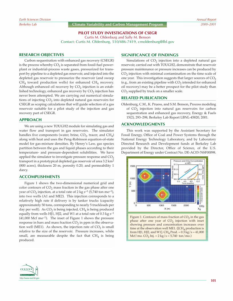
http://www-esd.lbl.gov
RESEARCH OBJECTIVESCarbon sequestration with enhanced gas recovery (CSEGR)
is the process whereby CO2 is separated from fossil-fuel power-plant or industrial-process waste gases, pressurized for trans-port by pipeline to a depleted gas reservoir, and injected into thedepleted gas reservoir to pressurize the reservoir (and sweepCH4 toward production wells) for enhanced CH4 recovery.Although enhanced oil recovery by CO2 injection is an estab-lished technology, enhanced gas recovery by CO2 injection hasnever been attempted. We are carrying out numerical simula-tions of injecting CO2 into depleted natural gas reservoirs forCSEGR as scoping calculations that will guide selection of a gasreservoir suitable for a pilot study of the injection and gasrecovery part of CSEGR.
APPROACH
We are using a new TOUGH2 module for simulating gas andwater flow and transport in gas reservoirs. The simulatorhandles five components (water, brine, CO2, tracer, and CH4)along with heat and uses the Peng-Robinson equation-of-statemodel for gas-mixture densities. By Henrys Law, gas speciespartition between the gas and liquid phases according to theirtemperature- and pressure-dependent solubilities. We haveapplied the simulator to investigate pressure response and CO2transport in a prototypical depleted gas reservoir of area 3.2 km2
(800 acres), thickness 20 m, porosity 0.20, and permeability 1darcy.
ACCOMPLISHMENTS
Figure 1 shows the two-dimensional numerical grid andcolor contours of CO2 mass fraction in the gas phase after oneyear of CO2 injection, at a total rate of 2 kg s1 (5,740 ton mo1),into two wells (A1 and ME2). This injection corresponds to arelatively high rate if delivery is by tanker trucks (capacityapproximately 50 tons, corresponding to nearly 5 truckloads perday per well). As CO2 is being injected, CH4 is being producedequally from wells HJ1, HJ2, and W1 at a total rate of 0.3 kg s1
(41,000 Mcf mo1). The inset of Figure 1 shows the pressureresponse in bars and mass fraction CO2 in ppm in the observa-tion well (ME1). As shown, the injection rate of CO2 is smallrelative to the size of the reservoir. Pressure increases, whilesmall, are measurable despite the fact that CH4 is beingproduced.
SIGNIFICANCE OF FINDINGSSimulations of CO2 injection into a depleted natural gas
reservoir, carried out with TOUGH2, demonstrate that reservoirpressure maintenance or pressure increases can be produced byCO2 injection with minimal contamination on the time scale ofone year. This investigation suggests that larger sources of CO2(e.g., from an existing pipeline with CO2 intended for enhancedoil recovery) may be a better prospect for the pilot study thanCO2 supplied by truck on a smaller scale.
RELATED PUBLICATION
Oldenburg, C.M., K. Pruess, and S.M. Benson, Process modelingof CO2 injection into natural gas reservoirs for carbonsequestration and enhanced gas recovery, Energy & Fuels15(2), 293298, Berkeley Lab Report LBNL-45820, 2001.
ACKNOWLEDGMENTS
This work was supported by the Assistant Secretary forFossil Energy, Office of Coal and Power Systems through theNational Energy Technology Laboratory, and by LaboratoryDirected Research and Development funds at Berkeley Labprovided by the Director, Office of Science, of the U.S.Department of Energy under Contract No. DE-AC03-76SF00098.
PILOT STUDY INVESTIGATIONS OF CSEGRCurtis M. Oldenburg and Sally M. Benson
Contact: Curtis M. Oldenburg, 510/486-7419, [email protected]
Earth Sciences DivisionBerkeley Lab
Annual Report2000–2001
101
Climate Variability and Carbon Management Program
Figure 1. Contours of mass fraction of CO2 in the gasphase after one year of CO2 injection with insetshowing pressure and concentration increases overtime at the observation well ME1. ([CH4 production isfrom HJ1, HJ2, and W1]. CH4 Prod. = 0.3 kg/s = 41,000Mcf/mo. CO2 Inj. = 2 kg/s = 5,740 ton/mo.)
http://www-esd.lbl.gov
RESEARCH OBJECTIVESMathematical models and numerical simulation tools will
play an important role in evaluating the feasibility of CO2storage in subsurface reservoirs, such as brine aquifers,producing or depleted oil and gas reservoirs, and coalbeds. Wehave proposed and initiated a code intercomparison study thataims to explore the capabilities of numerical simulators to accu-rately and reliably model the important physical and chemicalprocesses that would be taking place in CO2 disposal systems.The overall objective of the study is to advance and documentthe state of the art for modeling CO2 injection into subsurfacereservoirs, and to establish credibility for modeling approaches.
APPROACH
Code intercomparison is viewed as an iterative process,progressing from relatively simple and uncoupled test cases toproblems that feature comprehensive process descriptions insettings approaching realistic geologic complexity. Key issuesthat need to be addressed include (1) thermodynamics of sub-and supercritical CO2 and pressure-volume-temperature prop-erties of mixtures of CO2 with other fluids, including (saline)water, oil, and natural gas; (2) fluid mechanics of single andmultiphase flow when CO2 is injected into aquifers, oil reser-voirs, and natural gas reservoirs; (3) coupled hydro-chemicaleffects resulting from interactions between CO2, reservoir fluids,and primary mineral assemblages; (4) coupled hydromechanicaleffects, such as porosity and permeability change resulting fromincreased fluid pressures from CO2 injection; and (5) space andtime discretization effects.
We propose to organize and manage the model intercom-parison study; facilitate the development and selection of appro-priate test problems; distribute them to interested groups ofscientists and engineers; and solicit, collect, reconcile, and docu-ment solutions. The Internet will be used as a convenient vehiclefor organizing this effort. Workshops will be held to discussresults, refine problem definitions, develop new test problems,and agree on future plans and schedules. Participants areexpected to use numerical simulation codes available to themand obtain their own funding.
ACCOMPLISHMENTS
A standard format for specification of test problems wasdeveloped. A first set of eight test problems has been assem-bled to initiate the study. The first two problems address issues
arising in CO2-enhanced gas recovery. Problems 3 and 4 dealwith CO2 disposal in saline aquifers. Problem 5 involves abatch chemical-speciation calculation, while Problem 6explores a coupled hydromechanical process. Problem 7involves a 2D field-scale aquifer disposal problem, andProblem 8 addresses CO2 injection into an oil reservoir.Simulation capabilities for CO2 injection into coalbeds are stillin an early stage of development; no coalbed-related test prob-lems are proposed at the present time, but they may beincluded in future problem sets.
Full problem specifications were mailed to an address listnumbering approximately 150 and were also posted on theWeb (http://esd.lbl.gov/GEOSEQ/) to be accessible to groupsworldwide with relevant expertise and access to simulationtools for geologic sequestration of greenhouse gases.
As of this writing, the following ten groups from six coun-tries have committed to participating: (1) Berkeley Lab(U.S.A.), (2) Stanford University (U.S.A.), (3) LawrenceLivermore National Laboratory (U.S.A.), (4) Los AlamosNational Laboratory (U.S.A.), (5) Alberta Research Council(Canada), (6) Industrial Research Ltd. (New Zealand), (7)CSIRO Petroleum (Australia), (8) University of Stuttgart(Germany), (9) Institut Français de Petrol (France), (10) BRGM(Geological Survey of France).
RELATED PUBLICATIONS
Pruess, K, C.F. Tsang, D. H.-S. Law, and C.M. Oldenburg, Anintercomparison study of simulation models for geologicsequestration of CO2, First National Conference on CarbonSequestration, Washington, DC, May 1417, 2001.
Pruess, K., C.F. Tsang, D. H.-S. Law, and C.M. Oldenburg,Intercomparison of simulation models for CO2 disposal inunderground storage reservoirs, Berkeley Lab ReportLBNL-47353, 2000.
ACKNOWLEDGMENTS
We thank Tianfu Xu, Jonny Rutqvist, Carl Steefel, and TonyKovscek for contributing test problems. This work wassupported by the Assistant Secretary for Fossil Energy, Officeof Coal and Power Systems and Office of Gas and PetroleumTechnology, through the National Energy TechnologyLaboratory (NETL) of the U.S. Department of Energy underContract No. DE-AC03-76SF00098.
AN INTERCOMPARISON STUDY OF SIMULATION MODELS FOR GEOLOGIC SEQUESTRATION OF CO2Karsten Pruess, Chin-Fu Tsang, David H.-S. Law,1 and Curtis M. Oldenburg
1Alberta Research Council, Edmonton, Alberta, CanadaContact: Karsten Pruess, 510/486-6732, [email protected]
Earth Sciences DivisionBerkeley Lab
Annual Report2000–2001
102
Climate Variability and Carbon Management Program

Snow cover area and water equivalent maps for Californiawith University of Arizona
Geostatistical uncertainty analysis of precipitation andstreamflow simulations
Contributions to impact-assessment reports
ACCOMPLISHMENTS
Our center became a member of the Earth ScienceInformation Partnership, providing value-added climate,weather, streamflow and impact information to the broad usercommunity and the 2000 U.S. National Assessment and theIntergovernmental Panel on climate change reports. We havecompleted a series of seasonal and multiyear regional climate
and streamflow simulations, developed a new statisticaldownscaling technique for estimating the limits of uncer-tainty (Kyriakidis et al., 2001), and have used our resultsas input to the above applications. Recent analysis of 2040to 2049 projected climate and streamflow analysis hasbeen submitted (Kim et al., 2001, Miller et al., 2001) andreceived national media coverage.
SIGNIFICANCE OF FINDINGS
The climate change and streamflow analyses indicatethat the likelihood of extreme weather events will increaseand that nighttime temperature will increase at a fasterrate than daytime temperature. The simulated shift instream peakflow implies an increase in winter and springhigh flow (flooding) and a decrease in summer and fallstreamflow. We received new support from the CaliforniaEnergy Commission, CALFED, and DOE based on ouraccomplishments. The California Water ResourcesResearch and Applications Center has become a voice in
California climate change assessments, increasing the awarenessof potential water resource problems in California and theUnited States.
RELATED PUBLICATIONS
Kyriakidis, P.C., N.L. Miller, and J. Kim, Uncertainty propaga-tion of regional climate model precipitation forecasts tohydrologic impact assessment, J. Hydrometeorology 2,140160, Berkeley Lab Report LBNL-45852, 2001.
Miller, N.L., W.J. Gutowski, J. Kim, and E. Strem, AssessingCalifornia streamflow for present day and 2040 to 2049scenarios, J. Hydrometeorology (submitted), Berkeley LabReport LBNL-47987, 2001.
ACKNOWLEDGMENTS
Support is provided by the NASA Office of Earth Science/Earth Science Applications Research Program (OES/ESARP)under grant No. NS-2791.
RESEARCH OBJECTIVESThe California Water Resources Research and Applications
Center is designed around a set of integrated activities that focuson issues related to California water resources. Its primaryobjectives are to advance understanding of California climateand hydrologic variability and change. Core projects includebuilding research partnerships that focus on analysis of (andeducational outreach related to) hydroclimate impact on naturalsystems, society, and infrastructure. The following highlightsour approach and results.
APPROACH
The California Water Resources Research and ApplicationsCenter uses dynamic and statistical downscaling schemes within
our Regional Climate System Model framework. We producehydroclimate simulations at short-term, seasonal, and long-termtime scales for weather and river-flow forecasts, climate changeanalyses, uncertainty estimates, landslide modeling, water-quality monitoring and forecasting; and climate-change assess-ments of water resources, agriculture, rural economy, and hazards(see Figure 1).
Our applications projects include: Runoff contaminant monitoring and real-time management
in the San Joaquin Basin with the U.S. Bureau ofReclamation
Contaminant identification and monitoring from SierraFoothills mine sites with the University of California SpaceSciences Laboratory
Development of a dynamic sediment-transportand landslide-hazards prediction system with theUniversity of California Earth and PlanetaryScience Department
http://www-esd.lbl.gov
THE CALIFORNIA WATER RESOURCES RESEARCH AND APPLICATIONS CENTERNorman L. Miller, Kathy Bashford, George Brimhall, Susan Kemball-Cook, William E. Dietrich,
John Dracup, Jinwon Kim, Phaedon C. Kyriakidis, Xu Liang, and Nigel W.T. QuinnContact: Norman Miller, 510/495-2374, [email protected]
Earth Sciences DivisionBerkeley Lab
Annual Report2000–2001Climate Variability and Carbon Management Program
Land-Surface Processes• Soil and Surface• Snow Budget• Energy and Water Budget
Hydrologic Models
Atmospheric Physicsand Dynamics
Surface Inputs
• Land Analysis Systems Reanalysis• Climate Watershed Information• River Networks
Remotely SensedData
Atmospheric InputsPREPROCESSORS PROCESS MODELS
• GCM• Reanalysis• Synoptic Models
• Satellite • Radar• AWS • Gauges
Predictions & ClimateImpacts Assessments
POSTPROCESSORS
• Climate Change Reports• Weather Information• Climate Variability• Soil Water Content• River Flow• Snowmelt Runoff• Watershed Hydrology• Water Resources• Sediment Transport• Water Quality• Landslide Prediction• Crop Responses• Agro-Economics
• Runoff • Riverflow• Diffusion • Overflow• Soil Moisture• Groundwater Transport• Landslide and Debris Flow
• Wind • Precipitation• Temperature • Radiation• Humidity
Figure 1. The Regional Climate System Model is composed of processmodels nested between preprocessed and postprocessed output data. Themodels are physically based and represent hydroclimate and impacts at arange of scales.
103

http://www-esd.lbl.gov
RESEARCH OBJECTIVESWater-resource planners need to develop contingency plans
to deal with the potential effects of global warming and itsrelated impacts on the San Joaquin Basin. The literature suggeststhat precipitation may be warmer and runoff earlier in theseason, reducing the reservoir capture of snowmelt and rainfallrunoff under current reservoir opera-tional policy. Research also suggests anincrease in the variability of futureweather and the incidence of extremeweather events under a global-warmingscenario. Mathematical models mostuseful to analyze the impacts of climatechange scenarios on water resources andthe environment do not lend themselvesto a system-wide impact analysis. Hence,the objective of this research is todevelop an integrated modeling systemthat simulates a broad array of waterresource and environmental impactsresulting from a range of future climatescenarios. The goals of this project are toproduce a public-domain toolbox, avail-able on CD, that can be readily used byagencies such as the Bureau ofReclamation and the Department of Water Resources; and toanalyze the impacts of climate change on water resources andthe environment.
APPROACH
State-of-the-art simulation models have been acquired fromthe U.S. Bureau of Reclamation, Department of Water Resources,the U.S. Geological Survey, and the University of California. Thefirst phase of the study has involved becoming familiar with thevarious models and making preliminary runs to validate modelcodes. The second phase, begun in June 2000, will customize theModular Modeling System (MMS), a software platform devel-oped by the U.S. Geological Survey, and link the models as asingle toolbox postprocess of our Regional Climate SystemModel (see Figure 1). We are building sets of subroutines forstreamflow, water quality, water demand, sediment transport,agro-economics, and related ecosystem response. Once the
MODELING THE WATER RESOURCE AND ENVIRONMENTAL IMPACTSOF CLIMATE VARIABILITY ON THE SAN JOAQUIN BASIN
Norman L. Miller, Nigel W. T. Quinn, John Dracup, Jinwon Kim, and Richard HowittContact: Norman Miller, 510/495-2374, [email protected]
Earth Sciences DivisionBerkeley Lab
Annual Report2000–2001
104
Climate Variability and Carbon Management Program
subroutines are implemented within the MMS toolbox, the thirdphase of the project will be to complete a series of impact-analysis runs for the San Joaquin Basin. We will compare climatechange scenarios with historic time series to determine thepotential impact on the San Joaquin basin.
ACCOMPLISHMENTS
The MMS has been imported and isrunning on our local workstations, and atraining session with U.S. GeologicalSurvey personnel took place on June1920, 2000, at Berkeley Lab. A paper hasbeen prepared on the initial phase of ourresearch and was presented at theInternational Society of EnvironmentalSystems Software conference on June 2,2000, in Austria.
SIGNIFICANCE OF FINDINGS
Model integration has become a topicof great importance to land and water-resource agencies, owing to the increasingcomplexity of water-resource and environ-mental-management problems. Berkeley
Lab is uniquely qualified to assist in this area of appliedresearch.
RELATED PUBLICATION
Quinn, N.W.T, N.L. Miller, J.A. Dracup, L. Brekke, andL.F.Grober, An integrated modeling system for environ-mental impact analysis of climate variability and extremeweather events in the San Joaquin Basin, California.Environmental Software Systems, EnvironmentalInformation and Decision Support, IFIP TC5 WG5.11, 3rdInternational Workshop on Environmental Software Systems(ISESS 2000), Zell Am See, Austria, May 28June 4, 2000.
ACKNOWLEDGMENTS
This research is supported by the NASA Office of EarthScience/Interdisciplinary Studies (OES)/IDS) Grant No. NS7291and the EPA STAR Grant No. 99-NCERQA-GI.
Adjust CC Runoff forBias between
PC-SIM and PC Runoff
30-year ObservedStreamflow Time
Series (PC)
Compute MonthlyWater Resource Allocation as a Function of
CC and PC Streamflow
Climate Change
Hydrologic ModelsStream Flow
PrecipitationTemperature
Figure 1. Water-resource allocation is beingmodeled as a linked set of models withinour Regional Climate System Model.

http://www-esd.lbl.gov
RESEARCH OBJECTIVES
The objectives of this study are to improve seasonal-to-inter-annual climate prediction by incorporating remotely sensedland-surface data into more realistic starting values for land-surface models. The improved climate predictions will provideinput forcing to water resources, river flow, and agriculturalproductivity models, with climate variability represented. Themodeling framework, methodology, and data obtained in thisstudy will be applied toward advancing seasonal and interan-nual regional climate predictions and climate impact assess-ments for East Asia and Southwest United States.
APPROACH
We have generated improved land-surface data for snow-cover, soil moisture content, and vegetation by combining satel-lite-observed and station data in collaboration with theUniversity of Arizona, NASA Data Centers, and East Asia insti-tutions. Satellite data to be used includes NASAs EarthObserving System/Moderate Resolution ImagingSpectroradiometer, the National Oceanic and AtmosphericAdministrations (NOAA) Advanced Very High ResolutionRadiometer for snow cover and vegetation characteristics, andthe Advanced Microwave Scanning Radiometer for soil mois-ture. Improved land-surface data is then used to initialize theSoil-Plant-Snow (SPS) model as coupled with the MesoscaleAtmospheric Simulation (MAS) model for dynamic down-scaling. The SPS will be modified to examine the effects ofdifferent interpretations of satellite-observed surface data. Thecoupled MAS-SPS will be used to investigate the effects ofimproved land-surface data on regional simulations for seasonaland interannual time scales (see Figure 1). Predicted atmos-pheric data will be used to predict streamflow and agriculturalproduction.
ACCOMPLISHMENTS
This new NASAIDS (Interdisciplinary Studies) project began inMarch 2000 and is a follow-on from our previous NASAIDS precip-itation and streamflow hindcast project. Our preliminary investiga-tion is focused on an evaluation of our Regional Climate SystemModel and the generation of data sets for this study. We have inves-tigated the accuracy of the system and the large-scale forcing data.Simulations for the 1998 and 1999 East Asia monsoon season havebeen completed, using the large-scale analysis data sets from NOAA
APPLICATIONS OF REMOTELY SENSED DATA FOR SEASONAL CLIMATE PREDICTIONS INEAST ASIA AND SOUTHWEST UNITED STATES
Jinwon Kim, Norman L. Miller, R.C. Bales,1 and L.O. Mearns2
1Hydrology and Water Resources Department, University of Arizona, Tucson, AZ2Climate Impacts Group, National Center for Atmospheric Research, Boulder, CO
Contact: Norman Miller, 510/495-2374, [email protected]
Earth Sciences DivisionBerkeley Lab
Annual Report2000–2001
105
Climate Variability and Carbon Management Program
Satellite andStation Observation
Global Analysisand Prediction Streamflow
Model
AgriculturalModel
MAS
SPSImproved Land-Surface Data
Figure 1. An outline of the regional-climate-prediction experiment in this study. Blackarrows indicate one-way data flow; the greenarrows indicate interactive coupling.
and the Korean Meteorological Agency. Additionally, an eight-yearsimulation for the western U.S has been completed and is beingstudied for the effects of vertically varying root density on warm-season regional climate. Fine-scale global vegetation data sets arebeing analyzed and processed to generate surface-vegetation-char-acteristic data for the SPS. We are also obtaining hydrologic data forseveral basins in China and Korea for streamflow research.
SIGNIFICANCE OF FINDINGS
We found a significant difference in the location and intensity ofEast Asian monsoon rain bands simulated with the two differentlarge-scale data sets. We have completed a multiyear simulation ofbasin-scale precipitation and streamflow resulting in fair to goodpredictability of the mean monthly streamflow (Miller et al. 2001).These results imply a potential for dynamic downscaling applica-tions related to water resources and agriculture in this region.
RELATED PUBLICATION
Miller, N., J. Kim, and J. Zhang, Coupled precipitation andstreamflow simulations at the GAME/HUBEX site: XixianBasin, J. Japan. Meteorol. Soc., 2001 (in press).
ACKNOWLEDGMENTS
This work is supported by the NASA Office of EarthScience/Interdisciplinary Studies (OES/IDS) under Grant No.MDAR-0171-0368.

during the pilot study. We will use the resulting water-isotopedata for model parameterization and prediction studies.Satellite-derived data will be evaluated independently, withsurface observations and model simulations. MultiscaleBerkeley Lab RCSM simulations at 36 km, 12 km, and 4 km willdetermine the spatial scales for realistic precipitation and soilmoisture distributions. Tests of the RCSM, which includingland-surface hydrology models with water isotopes, will yieldinformation toward reducing uncertainties in predictability.
ACCOMPLISHMENTS
During the start-up period, we have accessed most of theland-surface characterization data and some historical time seriesof weather variables. We have completed an initial water-budgetsimulation for a single station in the Whitewater Watershed(using our land-surface and streamflow water- and energy-budget model) and performed dynamic atmospheric down-scaling over the United States, nested to 12 km using the MM5model. Water-isotope collection is being prepared for this year'swet season at the Walnut Watershed. Finally, based on literaturestudies (Gedzelman and Arnold, 1994; Hendricks et al., 2000) andcommunication with Global Climate Model (GCM) water-isotopemodelers (D. Noone, personal communication), we have begun toevaluate the procedure for simulating water isotopes in mesoscaleatmospheric models forced by GCMs.
SIGNIFICANCE OF FINDINGS
The significant aspect of this work, in addition to simulatinghydrologic closure, is the generation of a mesoscale water-isotopemap for the continental United States. These resulting atmosphericdeuterium and δ18O distributions will help to answer a number ofpaleoclimate questions. The DOE Water Cycle Initiative pilot is theprecursor to the DOE Water Cycle Dynamics and PredictionProgram that was initiated in January 2001 by a team primarilycomposed of hydrologists and meteorologists. Now under review, itmay become the 2003 phase of this water cycle initiative pilot.
RELATED PUBLICATIONS
Gedzelman, S.D., and R. Arnold, Modeling the isotope compositionof precipitation, JGR 99, 1045510471, 1994.
Hendricks, M.B., D.J. DePaolo, and R.C. Cohen, Space and time vari-ation of delta O-18 and delta D in precipitation: Can paleotem-perature be estimated from ice cores? Global BiogeochemicalCycles, 14, 851861, 2000.
ACKNOWLEDGMENTSThis work is supported by the Director, Office of Science,
Office of Biological and EnvironmentalResearch, the Water Cycle Initiative Pilot, underU.S. Department of Energy Contract No. DE-AC03-76SF00098.
http://www-esd.lbl.gov
RESEARCH OBJECTIVESThe DOE Water Cycle Initiative pilot is designed to use
isotopic measurements of water (deuterium and δ18O) toconstrain hydroclimate models, assimilate remotely sensed datainto hydroclimate models, and test process descriptions andsensitivities at multiple scales-to better understand water cyclevariability. The primary research objectives are to (1) evaluatepredictions of Walnut River water-budget components, using aset of nested models having different spatial resolutions witharchived and new field data; (2) evaluate water-isotope modelingas a means of tracing sources and sinks; and (3) identify water-budget-model improvements and data needs.
APPROACH
Our approach consists of three main tasks: database devel-opment, model advancements, and simulations/evaluation. Thefirst task, Berkeley Labs primary database activity, involvesbuilding a comprehensive set of isotopic data for all componentsof the water cycle. The second task is the advancement of ourRegional Climate System Model (RCSM) to include water-isotope mass-conservation equations and introduce data assim-
ilation to the land-surface and hydrology model (see Figure 1). Ageneric isotope cloud-physics and diffusion scheme is beingdeveloped. This will be upgraded as available measurementsprovide more realistic rate values that take into account in-cloudevaporation, condensation, autoconversion, and accretion, andare implemented into the RCSM. An initial set of deuterium andδ18O parameterizations for surface and subsurface water trans-port will be implemented to our hydrology model. Isotopic vali-dation will be based on precipitation and stream-sampling data.Data assimilation will focus on testing a nudging scheme forforcing prognostic equations related to soil moisture and snowcover area, using remotely sensed data products.
The third task is a synthesis of the first two tasks combinedwith model simulations and evaluation. Berkeley Lab will beresponsible for isotopic analysis of all water samples collected
THE DOE WATER CYCLE INITIATIVE PILOT: MODELING AND ANALYSIS OFSEASONAL AND EVENT VARIABILITY AT THE WALNUT RIVER WATERSHED
Norman L. Miller, Mark S. Conrad, Donald J. DePaolo, and Inez FungContact: Norman Miller, 510/495-2374, [email protected]
Earth Sciences DivisionBerkeley Lab
Annual Report2000–2001
106
Climate Variability and Carbon Management Program
GroundwaterSoilOcean
-12 -20
-15
Water Isotope Balance
-10 -12
-7
-18
-4 -4 -6
-10-10
-10
BackgroundValue-15
-25-30
-30-35
-30
-30
GroundwaterSoil Root
Uptake
Tropopause
Runoff
Ocean
Detrainment
Entrainment
Evaporation
Eva
pora
tion
Con
dens
atio
n
Con
dens
atio
n
Con
dens
atio
nP
reci
pita
tion
Advection
Water Cycle Processes
Eva
pora
tion
EvaporationPBL TopMixing
Tran
spira
tion
Advection
Figure 1. Understanding the water cycle processes at Walnut RiverWatershed requires atmospheric-land surface-hydrologic modelsthat adequately simulate moisture advection, evapotranspiration,precipitation, runoff, groundwater transport, etc. To trace thewater cycle, we are including water-isotope mass-conservationestimates and measurements of hydrologic processes.
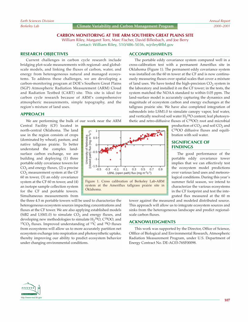
http://www-esd.lbl.gov
RESEARCH OBJECTIVESCurrent challenges in carbon cycle research include
bridging plot-scale measurements with regional- and global-scale models, and linking the fluxes of carbon, water, andenergy from heterogeneous natural and managed ecosys-tems. To address these challenges, we are developing acarbon-monitoring program at DOEs Southern Great Plains(SGP) Atmospheric Radiation Measurement (ARM) Cloudand Radiation Testbed (CART) site. This site is ideal forcarbon cycle research because of ARMs comprehensiveatmospheric measurements, simple topography, and theregions mixture of land uses.
APPROACH
We are performing the bulk of our work near the ARMCentral Facility (CF) located innorth-central Oklahoma. The landuse in the region consists of crops(dominated by wheat), pasture, andnative tallgrass prairie. To betterunderstand the complex land-surface carbon exchange, we arebuilding and deploying (1) threeportable eddy covariance towers forCO2 and energy fluxes, (2) a preciseCO2 measurement system at the CF60 m tower, (3) an eddy covariancesystem at the CF 60 m tower, and (4)an isotope sample collection systemfor the CF and portable towers.Simultaneous measurements fromthe three 4.5 m portable towers will be used to characterize theheterogeneous ecosystem sources impacting concentrations andfluxes at the CF tower. We are also applying established models(SiB2 and LSM1.0) to simulate CO2 and energy fluxes, anddeveloping new methodologies to simulate H2
18O, C18OO, and13CO2 fluxes. Improved understanding of 13C and 18O fluxesfrom ecosystems will allow us to more accurately partition netecosystem exchange into respiration and photosynthetic uptake,thereby improving our ability to predict ecosystem behaviorunder changing environmental conditions.
ACCOMPLISHMENTSThe portable eddy covariance system compared well in a
cross-calibration test with a permanent Ameriflux site inOklahoma (Figure 1). The permanent eddy covariance systemwas installed on the 60 m tower at the CF and is now continu-ously measuring fluxes over spatial scales that cover a mixtureof land uses. We have tested the high-precision CO2 system inthe laboratory and installed it on the CF tower; in the tests, thesystem matched the NOAA standard to within 0.05 ppm. Theland-surface model is accurately capturing the dynamics andmagnitude of ecosystem carbon and energy exchanges at thetallgrass prairie site. We have also completed integration ofsubmodels into LSM1.0 to simulate canopy vapor, leaf water,and vertically resolved soil water H2
18O content; leaf photosyn-thetic and retro-diffusive fluxes of C18OO; root and microbial
production of CO2; and soil CO2 andC18OO diffusive fluxes and equili-bration with soil water.
SIGNIFICANCE OFFINDINGS
The good performance of theportable eddy covariance towerimplies that we can effectively testthe ecosystem model predictionsover various land uses and meteoro-logical conditions. During this yearssummer field season, we intend tocharacterize the various ecosystemsin the CF footprint and test the inte-grated flux measured at the 60 m
tower against the measured and modeled distributed source.This approach will allow us to integrate ecosystem sources andsinks from the heterogeneous landscape and predict regional-scale carbon fluxes.
ACKNOWLEDGMENTS
This work was supported by the Director, Office of Science,Offfice of Biological and Environmental Research, AtmosphericRadiation Measurement Program, under U.S. Department ofEnergy Contract No. DE-AC03-76SF00098.
CARBON MONITORING AT THE ARM SOUTHERN GREAT PLAINS SITEWilliam Riley, Margaret Torn, Marc Fischer, David Billesbach, and Joe Berry
Contact: William Riley, 510/486-5036, [email protected]
Earth Sciences DivisionBerkeley Lab
Annual Report2000–2001
107
Climate Variability and Carbon Management Program
1
0.5
0
-0.5
-1
-1.5-0.5 -0.3 -0.1 0.1 0.3 0.5 0.7 0.9
LBNL (open path) flux (mg m-2s-1)
Uni
vers
ity o
f Neb
rask
a(c
lose
d pa
th)
flux
(mg
m-2
s-1 )
Figure 1. Cross calibration of Berkeley Lab-ARMsystem at the Ameriflux tallgrass prairie site inOklahoma.

http://www-esd.lbl.gov
RESEARCH OBJECTIVES
Anthropogenic activities are altering atmospheric CO2 andclimate as well as increasing nitrogen fixation and depositionglobally. We are investigating theimpacts of global change on carboncycling in an annual grassland at JasperRidge Biological Preserve, Stanford,California (Figure 1). Here we report thetreatment effects on decomposition ofsoil organic matter (SOM) and the rela-tive contribution of Recent versusOld SOM to soil respiration lossesfrom the ecosystem.
APPROACH
The Jasper Ridge experiment hasgrassland plots exposed to elevated CO2,warming, increased precipitation, andnitrogen (N) fertilization, singly and incombination, since the fall of 1998. Thefossil source of elevated CO2 is depletedin 13C relative to the ambient atmos-phere. This creates an isotopic label inplant inputs to the elevated CO2 plotsthat we can use to trace carbon cyclingthrough plant inputs, soil organic mater,and soil respiration. We are using theisotopic signature to partition soil respi-ration into recently (i.e., since the exper-iment began) photosynthesized carbon(Recent) and carbon fixed in previousyears (Old). The ecosystem is dominatedby annual plants that begin growingafter the first rains in fall and die in latespring the following year.
RESULTS
We measured soil respiration six times over the secondgrowing season (19992000) of the experiment. By interpo-lating between the sampling points, we can estimate the cumu-lative respiration from the whole growing season by treatment
(Figure 2). There was no treatment effect on the amount ofRecent C respired. In contrast, the treatments had a
pronounced effect on the decompositionrate of Old soil organic matter. Thewarming or watering treatments had thelowest rates of old C respiration, despitemost models having decompositionrates increasing with soil moisture andtemperature. The two nitrogen-additiontreatments stimulated the most decom-position. One hypothesized mechanismfor N stimulation of decomposition isthat, under N limitation, an increase inplant growth (e.g., resulting fromelevated CO2) leads to a decrease inmicrobial activity, and fertilization atJasper Ridge released soil microbes fromthis constraint.
SIGNIFICANCE OF FINDINGS
In many studies, elevated CO2 causesan increase in plant photosynthesis.However, sustained plant growth, andthus continued C sequestration, is N-limited in most temperate ecosystems.As a result, scientists have hypothesizedthat the combination of CO2 and N fertil-ization will cause net sequestration inmany ecosystems. This is the first studywe are aware of showing that N fertiliza-tion or increased N deposition canincrease decomposition of stable soilorganic matter and thus result in loss ofC stored in soils.
ACKNOWLEDGMENTS
This work has been funded by the Laboratory DirectedResearch and Development Program at Berkeley Lab, providedby the Director, Office of Science, of the U.S. Department ofEnergy under Contract No. DE-AC03-76SF00098.
ISOTOPIC ANALYSIS OF CARBON CYCLING AND SEQUESTRATION IN A CALIFORNIA GRASSLANDMargaret Torn, M. Rebecca Shaw, and Chris Field
Contact: Margaret S. Torn, 495-2223, [email protected]
Earth Sciences DivisionBerkeley Lab
Annual Report2000–2001
108
Climate Variability and Carbon Management Program
Figure 1. Jasper Ridge Global Change Experi-ment, March 2000
Figure 2. Soil respiration over growing season19992000 by treatment. The blue bars are OldC (pre-1998 growing season) and the greenbars are Recent C (1998 growing season andlater). The error bars are standard error ofcumulative season total.

Daley, T.M., E.L. Majer, R. Gritto, and S.M. Benson, Boreholeseismic monitoring of CO2 injection in a diatomite reser-voir, Berkeley Lab Report LBNL-47291, Abs., 2000.
Das, K., A. Becker and K.H. Lee, Experimental validation ofthe wavefield transformation of electromagnetic fields,Geophysical Prospecting (submitted), Berkeley Lab ReportLBNL-47466, 2001.
De Flaun, M., D. Blakwill, J. Chen, F. Dobbs, H. Dong, J.Fredrickson, M. Fuller, M. Green, T. Ginn, T. Griffin, W.Holben, S. Hubbard, W. Johnson, P. Long, B. Maillonx, E.Majer, M. McInernoy, and C. Murray, Breakthroughs infield-scale bacterial transport, EOS, American GeophysicalUnion (in press), Berkeley Lab Report LBNL-48440, 2001.
Dobson, P.F., and T.J. Kneafsey, Numerical simulation of tuffdissolution and precipitation experiments: validation ofthermal-hydrologic-chemical coupled-process modeling,Berkeley Lab Report LBNL-48333, Abs., 2001.
Dobson, P., J. Huten, T.J. Kneafsey, and A. Simmons,Permeability at Yellowstone: A natural analog for YuccaMountain processes, in 2001 International High-LevelRadioactive Waste Management Conference, Las Vegas,Nevada, April 29May 3, 2001, Berkeley Lab Report LBNL-47051, 2001.
Dobson, P., J. Hulen, T.J. Kneafsey, and A. Simmons, The role oflithology and alteration on permeability and fluid flow atthe Yellowstone Geothermal System, Wyoming, in 26thWorkshop on Geothermal Reservoir Engineering, Stanford,California, January 2931, 2001, Berkeley Lab ReportLBNL-47129, 2000.
Doughty, C., K. Pruess, S.M. Benson, S.D. Hovorka, P.R. Knox,and C.T. Green, Capacity investigation of brine-bearingsands of the frio formation for geologic sequestration ofCO2, in First National Conference on CarbonSequestration, Washington, D.C., May 1417, 2001,Berkeley Lab Report LBNL-48176, 2001.
Doughty, C., and K. Karasaki, Flow and transport in hierarchi-cally fractured rock, Journal of Hydrology (submitted),Berkeley Lab Report LBNL-47030, 2000.
Doughty, C., R. Salve, and J.S.Y. Wang, Liquid flow in unsatu-rated fractured welded tuffs: II. Numerical modeling,Journal of Hydrology (submitted), Berkeley Lab ReportLBNL-47530, 2001.
Eaton, D., D. Janecky, D. Woodward, J. Imrich, J. Evans, M.Morris, P. Reimus, and T. Hazen, SCFA lead lab technicalassistance review of the Pit 7 Complex source containment,Berkeley Lab Report LBNL-47546, 2001.
Faybishenko, B., Chaotic dynamics in flow through unsatu-rated fractured media, Berkeley Lab Report LBNL-46958,2000.
Finsterle, S., C.F. Ahlers, P.J. Cook, and Y. Tsang, Seepage intodrifts located in a lithophysal zone, Berkeley Lab ReportLBNL-47947, 2001.
Apps, J. A.T. Xu, and K. Pruess, Carbon dioxide disposal indeep aquifers: A comparison between modeled and realsystems, Berkeley Lab Report LBNL-47636, Abs., 2001.
Barhen, J., J.G. Berryman, L. Borcea, J. Dennis, C. de Groot-Hedlin, F. Gilbert, P. Gill, M. Heinkenschloss, L. Johnson, T.McEvilly, J. More, G. Newman, D. Oldenburg, P. Parker, W.Porto, M. Sen, V. Torczon, D. Vasco, and N.B. Woodward,Optimization and geophysical inverse problems, BerkeleyLab Report LBNL-46959, 2000.
Benson, S.M., Earth Sciences Division Annual Report,19992000, Berkeley Lab Report LBNL-47002, 2000.
Benson, S.M., Effects of reservoir heterogeneity and gravityoverride on pressure buildup and fall-off in CO2 injectionwells, Berkeley Lab Report LBNL-47101, Abs., 2001.
Benson, S.M., Geologic sequestration of carbon dioxide:Prospects and challenges, Berkeley Lab Report LBNL-47098, Abs., 2001.
Benson, S.M., S. Hovorka, and K. Pruess, Identification ofreservoir parameters influencing the sequestration capacityof brine formations: A case study for the Frio/Oakvilleformations, Texas, Berkeley Lab Report LBNL-47099, Abs.,2001.
Benson, S.M., J. Amothor, J. Bishop, and K. Caldeira, The scien-tific challenges of carbon sequestration, EOS, Transactionof American Geophysical Union, 81(48), F3, Berkeley LabReport LBNL-47097, Abs., 2000.
Benson, S.M., and L. Myer, The GEO-SEQ project: First-yearstatus report, Berkeley Lab Report LBNL-47189, Abs., 2000.
Benson, S.M., Approximate analytical solution for calculatingpressure buildup at CO2 injection wells in brine forma-tions, Berkeley Lab Report LBNL-47100, Abs., 2001.
Bishop, J.K., C.K. Guay, J.T. Sherman, and C. Moore, Prospectsfor a C-ARGO: A new approach for exploring oceancarbon system variability, Berkeley Lab Report LBNL-48144, Abs., 2001.
Campbell, J., D. Antoine, R. Armstron, K. Arrigo, W. Balch, R.Barber, M. Behrenfeld, R. Bidigare, J. Bishop, M.-E. Carr, W.Esaias, P. Falkowski, N. Hoepffner, R. Iverson, D. Kiefer, S.Lohrenz, J. Marra, A. Morel, J. Ryan, V. Vedernikov, K.Waters, C. Yentsch, and J. Yoder, Comparison of algorithmsfor estimating ocean primary production from surfacechlorophyll, temperature, and irradiance, GlobalBiogeochemical Cycles (submitted), Berkeley Lab ReportLBNL-48412, 2001.
Chauhan, S., L. Mendez, J. Montanez, and T.C. Hazen,Gaseous in situ bioremediation of benzo(a)pyrene in soil,Berkeley Lab Report LBNL-47637, Abs., 2000.
Chen, J., S. Hubbard, and Y. Rubin, Estimating hydraulicconductivity at the South Oyster site from geophysicaltomographic data using Bayesian techniques based on anormal linear model, Water Resources Research, 37(6),16031613, Berkeley Lab Report LBNL-47682, 2001.
Earth Sciences DivisionBerkeley Lab
Annual Report2000–2001
109
EARTH SCIENCES DIVISION PUBLICATIONS 2000–2001
Publications 20002001

Hazen, T., SCFA lead lab technical assistance review of SLACgroundwater plumes, Berkeley Lab Report LBNL-47831,2001.
Hazen, T.C., A.J. Tien, A. Worsztynowicz, D.J. Altman, K. Ulfig,and T. Manko, Biopiles for remediation of petroleum-contaminated soils: A Polish case study, in NATOAdvanced Research Workshop on Bioremediation, Prague,Czech Republic, June 1418, Berkeley Lab Report LBNL-46445, 2000.
Hazen, T., J. Montanez, L. Mendez, and S. Chauhan,Polynuclear aromatic hydrocarbons in situ bioremediationtreatability test: Focus on contaminant disappearance byHPLC analysis, Berkeley Lab Report LBNL-47003, 2000.
Hinds, J.J., and Gudmundur S. Bodvarsson, Fractures and UZprocesses at Yucca Mountain, Berkeley Lab Report LBNL-47991, 2001.
Hinds, J.J., and Gudmundur Bodvarsson, Role of fractures inprocesses affecting potential repository performance, in2001 International High-Level Radioactive WasteManagement Conference, Las Vegas, Nevada, April29May 3, 2001, Berkeley Lab Report LBNL-47039, 2001.
Houseworth, J., G. Moridis, and G.S. Bodvarsson, The effectsof the drift shadow on radionuclide transport, in 9thInternational High-Level Radioactive Waste Management,La Grange Park, Illinois, April 29May 3, 2001, BerkeleyLab Report LBNL-47467, 2001.
Hu, Q., and J.S.Y. Wang, Diffusion in unsaturated geologicalmedia: A review, Critical Reviews in EnvironmentalScience & Technology (submitted), Berkeley Lab ReportLBNL-47640, 2001.
Hubbard, S.S., J. Chen, B. Mailloux, E. Majer, and Y. Rubin,Heterogeneity and bacterial transport at the Oyster,Virginia, site, EOS, 81(48), December 12, 2000, F180,Berkeley Lab Report LBNL-48455, Abs., 2000.
Hubbard, S.S., J.E. Peterson, J. Zhang, P. Monteiro, and Y.Rubin, Noninvasive detection of rebar corrosion usingground penetrating radar methods, ACI Materials Journal(submitted), Berkeley Lab Report LBNL-48447, 2001.
Johnson, L.R., and C.G. Sammis, Effects of rock damage onseismic waves generated by explosions, Pure and AppliedGeophysics, 158, Berkeley Lab Report LBNL-48368, 2001.
Johnson, W.P., P. Zhang, M.E. Fuller, T.D. Scheibe, G.J.Mailloux, T.C. Onstott, M.F. DeFlaun, S. Hubbard, J. Radke,W.P. Kovacik, and W. Holbinm, Ferrographic tracking ofbacterial transport in the field at the narrow channel focusarea, Oyster, Virginia, Environmental Science Technology,35(1), 182191, Berkeley Lab Report LBNL-46472, 2001.
Juncosa-Rivera, R., T. Xu, and K. Pruess, A comparison ofresults obtained with two subsurface nonisothermal multi-phase reactive transport simulators, FADES-CORE andTOUGHREACT, Berkeley Lab Report LBNL-47315, 2001.
Finsterle, S., Impact of parameter uncertaintly, variability, andconceptual model errors on predictions of flow throughfractured porous media, Berkeley Lab Report LBNL-46794,Abs., 2000.
Geller, J., Lawrence Berkeley National Laboratory geologicnuclear waste disposal: Underground testing andmodeling of flow and transport, Berkeley Lab PublicationPUB-838, 2000.
Glassley, W. E., A. M. Simmons, and J.R. Kercher, Min-eralogical heterogeneity in fractured porous media and itsrepresentation in reactive transport models, Journal ofApplied Geochemistry (in press), Berkeley Lab ReportLBNL-45163, 2001.
Goloshubin, G.M., T.M. Daley, and V.A. Korneev, Seismic low-frequency effects in gas reservoir monitoring VSP data, inSEG Annual Meeting, San Antonio, Texas, September 914,2001, Berkeley Lab Report LBNL-47606, 2001.
Gregory, I.R., J.P. Bowman, L. Jimenez, D. Zhang, J.M. Fleming,G.S. Sayler, S.M. Pfiffner, F.J. Brockman, S. Chauhan, andT.C. Hazen, Use of gene probes to access the impact andeffectiveness of aerobic in situ bioremediation of TCE andPCE, Applied and Environmental Microbiology (sub-mitted), Berkeley Lab Report LBNL-47638, 2001.
Gritto, R., T.M. Daley, and E.L. Majer, A model of the subsur-face structure at the Rye Patch Geothermal Reservoir basedon surface-to-borehole seismic data, Berkeley Lab ReportLBNL-47812, Abs., 2001.
Gritto, R., T.M. Daley, and E.L. Majer, Seismic mapping of thesubsurface structure at the Rye Patch GeothermalReservoir, Nevada, Berkeley Lab Report LBNL-46834, Abs.,2000.
Gritto, R., T.M. Daley, and E.L. Majer, Seismic mapping of thesubsurface structure at the Rye Patch GeothermalReservoir, Berkeley Lab Report LBNL-47032, 2000.
Grote, K.R., S. Hubbard, Y. Rubin, J. Harvey, and A. Lawrence,Nondestructive monitoring of subasphalt water contentusing surface ground penetrating radar techniques,Berkeley Lab Report LBNL-48460, Abs., 2000.
Grote, K.R., S.S. Hubbard, J. Harvey, and Y. Rubin,Nondestructive monitoring of subasphalt water contentusing surface ground penetrating radar techniques,Berkeley Lab Report LBNL-44976, Abs., 2001.
Guay, C.K.H., and J.K.B. Bishop, A rapid birefringence methodfor measuring suspended CaCO3 concentrations in seawater,Deep-Sea Research, Part I (submitted), Berkeley Lab ReportLBNL-46895, 2001.
Guay, C.K.H., K. K. Falkner, R. D. Muench, M. Mensch, M.Frank, and R. Bayer, Wind-driven transport pathways forEurasian Arctic river discharge, Journal of GeophysicalResearch: C-Oceans (in press), Berkeley Lab Report LBNL-45451, 2001.
Earth Sciences DivisionBerkeley Lab
Annual Report2000–2001
110
Publications 20002001
Liu, H.H., and G.S. Bodvarsson, Upscaling of constitutive rela-tions in unsaturated heterogeneous porous media withlarge air-entry values, Water Resources Research(submitted), Berkeley Lab Report LBNL-47237, 2001.
Liu, H.H., and G.S. Bodvarsson, Use of the continuumapproach for modeling unsaturated flow and transport infractured rocks: Recent progress, in American GeophysicalUnion Meeting, San Francisco, California, December 1219,2000, Berkeley Lab Report LBNL-48005, Abs., 2000.
Majer, E.L., G. Li, and V.A. Korneev, High-resolution crosswellseismic imaging in horizontal walls prior to CO2 injectionat the Weyburn oil field, Saskatchewan, Canada, BerkeleyLab Report LBNL-47319, Abs., 2000.
Majer, E.L., T.M. Daley, R. Gritto, V. Korneev, and G. Li,Application of crosswell and single well seismic methodsfor mapping CO2 movement, Berkeley Lab Report LBNL-47431, Abs. (GSA Paper 3514), 2000.
Majer, E.L., T.L. Davis, R.D. Benson, G. Li, R.T. Coates, V.A.Korneev, and L.A. Walter, Integration of high resolutionborehole seismic data with multicomponent 3-D surfaceseismic data for cost-effective reservoir recovery, BerkeleyLab Report LBNL-47426, Abs., 2001.
March, J., M. Hudgins, S. Chauhan, and T.C. Hazen, Successfulimplementation of aerobic landfill bioractor, Environ-mental Science & Technology (submitted), Berkeley LabReport LBNL-47639, 2001.
Miller, N.L., RESAC Annual Progress Report 2001, BerkeleyLab Report LBNL-47753, 2001.
Miller, N.L., W.J. Gutowski Jr., J.Kim, and E. Strem, AssessingCalifornia streamflow for present day and 2040 to 2049climate scenarios, Journal of Hydrometeorology(submitted), Berkeley Lab Report LBNL-47987, 2001.
Myer, L., Laboratory measurement of geophysical propertiesfor monitoring of CO2 sequestration, in First NationalConference on Carbon Sequestration, Morgantown, WestVirginia, May 1417, 2001, Berkeley Lab Report LBNL-47643, 2001.
Myer, L.R., and S. Nakagawa, Mechanical and seismic proper-ties of weak granular rock, in Third InternationalWorkshop on the Application of Geophysics to Rock andSoil Engineering, Melbourne, Australia, November 18,2000, Berkeley Lab Report LBNL-47642, 2000.
OSullivan, M.J., K. Pruess, and M.J. Lippmann, State-of-the-art of geothermal reservoir simulation, Geothermics, 30(4),395429, Berkeley Lab Report LBNL-44699, 2001.
Oh, K.C., Biologically active (Bioactive) absorbents/adsor-bents and additives used in pollution control and remedi-ation: Acceptance criteria and process guidance, BerkeleyLab Report LBNL-46862, 2000.
Keller, R., N. Francis, J. Houseworth, and N. Kramer, Impact ofdrill and blast excavation on repository performanceconfirmation, in 9th International High-Level RadioactiveWaste Management Conference (IHLRWM), Las Vegas,Nevada, April 29May 3, 2001, Berkeley Lab Report LBNL-46877, 2001.
Kennedy, B.M. and T. Torgersen, Multiple atmospheric noblegas components in hydrocarbon reservoirs: A study of thenorthwest shelf, Delaware Basin, SE New Mexico,Geochimica Cosmochimica Acta (submitted), Berkeley LabReport LBNL-47387, 2001.
Kim, J., et al., A nested modeling study of elevation-dependentclimate change signals in California induced by increasedatmospheric CO2, Geophysical Research Letters (in press),Berkeley Lab Report LBNL-48018, 2001.
Kim, J., A nested modeling study of elevation-dependentclimate change signals in California induced by increasedatmospheric CO2, Geophysical Research Letters (in press),LBNL-48081, 2001.
Kim, J., Tae-Kook Kim, Raymond W. Arritt, and Norman L.Miller, Impacts of increased atmospheric CO2 on thehydroclimate of the Western United States, Journal ofClimate (submitted), Berkeley Lab Report LBNL-47986,2001.
Kim, J., N.L. Miller, T.-K. Kim, R.W. Aritt, W.J. Gutowski Jr., Z.Pan, and E.S. Takle, Regional climate change for thewestern U.S. using the coupled MAS-SPS model nestedwithin the HadCM2 scenario, 2001, Berkeley Lab ReportLBNL-46953, Abs., 2001.
Kneafsey, T.J., E.L. Sonnenthal, and J.A. Apps, Tuff dissolutionand precipitation: Fracture sealing in an experimental heatpipe, Berkeley Lab Report LBNL-47028, Abs., 2000.
Kyriakidis, P.C., J. Kim, and N.L. Miller, Geostatisticalmapping of precipitation using atmospheric and terraincharacteristics, Journal of Applied Meteorology (in press),Berkeley Lab Report LBNL-47117, 2001.
Kyriakidis, P.C., N.L. Miller, and J. Kim, Uncertainty propaga-tion of regional climate model precipitation forecasts tohydrologic impact assessment, Journal of Hydrometeor-ology, 2(2), 140160, Berkeley Lab Report LBNL-45852,2001.
Laverov, N.P., V.I. Velichkin, A.A. Pek, and V.D. Akunov, Thegeological disposal of high-level nuclear waste: Conceptualapproach and related problems, 2000, Berkeley Lab ReportLBNL-45282, 2000.
Lee, K.H., H. J. Kim, and T. Uchida, Electromagnetic fields incased borehole, in 5th SEGJ International SymposiumImaging Technology, Tokyo, Japan, January 2426, 2001,Berkeley Lab Report LBNL-47005, Extended Abs., 2000.
Lee, K.H., H. J. Kim, and T. Uchida, Electromagnetic fields insteel-cased borehole, Geophysical Prospecting (submitted),Berkeley Lab Report LBNL-47641, 2001.
Earth Sciences DivisionBerkeley Lab
Annual Report2000–2001
111
Publications 20002001

Salve, R., C.M. Oldenburg, and J.S.Y. Wang, Conceptual modelof flow for liquid-release experiments in the PTn, inInternational High-Level Radioactive Waste ManagementConference 2001, Las Vegas, Nevada, April 29May 3,2001, Berkeley Lab Report LBNL-47072, 2000.
Salve, R., J.S.Y. Wang, and C. Doughty, Liquid flow in unsatu-rated, fractured welded tuffs: I. Field investigations,Journal of Hydrology (submitted), Berkeley Lab ReportLBNL-44411, 2001.
Sonnenthal, E.L., N.F. Spycher, J.A. Apps, and M.E. Conrad, Aconceptual and numerical model for reaction-transportprocesses in unsaturated, fractured rock at YuccaMountain: Model validation using the drift scale heatertest, Berkeley Lab Report LBNL-48292, Abs., 2001.
Spycher, N., E. Sonnenthal, and J. Apps, Predicting fluidcompositions and mineral alteration around nuclear wasteemplacement tunnels, Berkeley Lab Report LBNL-47529,2001.
Spycher, N., E. Sonnenthal, and J. Apps, Simulating long-termreactive transport for studies of nuclear waste disposal:Establishing steady initial conditions and thermodynamicdata calibration, Berkeley Lab Report LBNL-48290, Abs.,2000.
Stocking, A.J., R.A. Deeb, A.E. Flores, W. Stringfellow, J. Talley,R. Brownell, and M.C. Kavanaugh, Bioremediation ofMTBE: A review from a practical perspective,Biodegradation (submitted), Berkeley Lab Report LBNL-45016, 2001.
Stringfellow, W.T., R.T. Hines, D.K. Cockrum, and S.T.Kilkenny, Operational and environmental factors control-ling the biological treatment of MTBE contaminatedgroundwater, Berkeley Lab Report LBNL-46962, Abs.,2001.
Stringfellow, W.T., Q. Hu, R. TerBerg, and G. Castro, Usinghigh performance liquid chromatography (HPLC) for themeasurement of fluorobenzoate tracers in the presence ofinterfering compounds, Berkeley Lab Report LBNL-47921,2001.
Sutton, R., and G. Sposito, Molecular simulation of interlayerstructure and dynamics in 12.4 Å Cs-smectite hydrates,Journal of Colloid and Interface Science, 237(2), 174184,Berkeley Lab Report LBNL-47926, 2001.
Tokunaga, T.K., J. Wan, M.K. Firestone, T.C. Hazen, E.Schwartz, S.R. Sutton, and M. Newville, Chromium diffu-sion and reduction in soil aggregates, EnvironmentalScience Technology (in press), Berkeley Lab Report LBNL-48032, 2001.
Tokunaga, T.K., and J. Wan, Approximate boundaries betweendifferent flow regimes in fractured rocks, Water ResourcesResearch (in press), Berkeley Lab Report LBNL-47854,2001.
Oh, K.C., C. Don, and W.T. Stringfellow, Enhanced treatmentof MTBE using iso-pentane as a co-substrate in an up-flowfluidized bed bioreactor, Berkeley Lab Report LBNL-46451,Abs., 2001.
Oldenburg, C.M., and S.M. Benson, Carbon sequestration withenhanced gas recovery: Identifying candidate sites for pilotstudy, In First National Conference on CarbonSequestration, Washington, D.C., May 1417, 2001,Berkeley Lab Report LBNL-47580, 2001.
Pan, L., H.H. Liu, M. Cushey, and G. Bodvarsson, DCPT v1.0New particle tracker for modeling transport in a dualcontinuum, Berkeley Lab Report LBNL-42958, 2001.
Pan, L., and G.S. Bodvarsson, Modeling transport in fracturedporous media with the random-walk particle method: Thetransient activity range and the particle-transfer proba-bility, Water Resources Research (submitted), Berkeley LabReport LBNL-48042, 2001.
Pham, M., C. Klein, S. Sanyal, T. Xu, and K. Pruess, Reducingcost and environmental impact of geothermal powerthrough modeling of chemical processes in the reservoir, inTwenty-Sixth Workshop on Geothermal ReservoirEngineering, Stanford, CA, January 2931, 2001, BerkeleyLab Report LBNL-47644, 2001.
Podgorney, R.R., T.R. Wood, B. Faybishenko, and T.M. Staops,Spatial and tempered instabilities in water flow throughvariably saturated basalt on a one-meter scale, in Dynamicsof Fluids in Fractured Rocks: Concepts and RecentAdvances, American Geophysical Union, Berkeley LabReport LBNL-46551, 2000.
Pratt, M.(editor), DOE-NABIR PI Workshop: Abstracts 2001,Berkeley Lab Report LBNL-47386, Abs., 2001.
Pruess, K., C.-F. Tsang, D. Law, and C. Oldenburg,Intercomparison of simulation models for CO2 disposal inunderground storage reservoirs, Berkeley Lab ReportLBNL-47353, 2001.
Pruess, K., T. Xu, J. Apps, and J. Garcia, Numerical modeling ofaquifer disposal of CO2, in SPE/EPA/DOE Explorationand Production Environmental Conference, San Antonio,Texas, February 2628, 2001, Berkeley Lab Report LBNL-47135, 2000.
Rubin, Y., S.S. Hubbard, A. Wilson, and M.A. Cushey, Aquifercharacterization, in The Handbook of GroundwaterEngineering, CRC Press, Berkeley Lab Report LBNL-46471,2000.
Rutqvist, J., and C.-F. Tsang, Modeling of multiphase fluidflow, heat transfer and rock deformations during CO2injection in deep aquifers, Berkeley Lab Report LBNL-48146, Abs., 2001.
Rutqvist, J., and C.-F. Tsang, Study of caprock hydromechan-ical changes associated with CO2 injection into a brineformation, Environmental Geology (in press), Berkeley LabReport LBNL-48145, 2001.
Earth Sciences DivisionBerkeley Lab
Annual Report2000–2001
112
Publications 20002001

Torgensen, T., and B.M. Kennedy, Noble gas evolution inhydrocarbon fields: Secondary migration process and end-member characterization, Geochimica Cosmochimica Acta(submitted), Berkeley Lab Report LBNL-47388, 2001.
Trautz, R.C., and J.S.Y. Wang, Seepage into an undergroundopening constructed in unsaturated fractured rock underevaporative conditions, Water Resources Research(submitted, Berkeley Lab Report LBNL-47006, 2001.
Tretbar, D.R., G.B. Arehart, and J.N. Christensen, Dating golddeposition in a Carlin-type gold deposit using Rb/Srmethods on the mineral galkhaite, Geology, 28(10),947950, Berkeley Lab Report LBNL-46544, 2000.
Truesdell, A., B. Smith, S. Enedy, and M. Lippmann, Recentgeochemical tracing of injection-related processes in theNCPA geysers field, in Geothermal Resources Council 2001Annual Meeting, San Diego, California, August 2629,2001, Berkeley Lab Report LBNL-47874, 2001.
Tsang, Y.W., and C.-F. Tsang, A particle tracking method foradvective transport in a fracture with diffusion into finitematrix blocks with application to tracer injection-with-drawal testing, Water Resources Research (in press),Berkeley Lab Report LBNL-43952, 2001.
Tseng, H.-W., and K.H. Lee, Joint inversion for mappingsubsurface hydrological parameters, in SEG 2001International Exposition and 71st Annual Meeting, SanAntonio, Texas, September 914, 2001, Berkeley Lab ReportLBNL-47607, 2001.
Wan, J., S. Veerapaneni, F. Gadelle, and T.K. Tokunaga,Generation of stable microbubbles and their transportthrough porous media, Water Resources Research, 37(5),11731182, Berkeley Lab Report LBNL-45559, 2001.
Wang, J.S.Y., P.J. Cook, R.C. Trautz, J. Liu, and G.S. Bodvarsson,Comparison of lower lithophysal and middle nonlitho-physal hydrogeological characteristics of potential reposi-tory tuff units at Yucca Mountain, Berkeley Lab ReportLBNL-46594, Abs., 2000.
Wilkinson, T.J., D.L. Perry, M.C. Martin, W.R. McKinney, andA.C. Thompson, Applications of synchrotron technology tothe study of latent human fingerprints, Berkeley LabReport LBNL-47980, Abs., 2001.
Wilkinson, T.J., D.L. Perry, M.C. Martin, and W.R. McKinney,Applications of synchrotron infrared microspectroscopy tothe study of fingerprints, Berkeley Lab Report LBNL-47131, Abs., 2000.
Wilkinson, T.J., D.L. Perry, M.C. Martin, W.R. McKinney, andA.A. Cantu, Applications of synchrotron infraredmicrospectroscopy to ink-paper material interactions,Berkeley Lab Report LBNL-47130, Abs., 2000.
Wilkinson, T.J., D.L. Perry, M.C. Martin, W.R. McKinney, A.A.Cantu, and A.C. Thompson, Applications of synchrotrontechnology to ink-paper material interactions and relatedaging kinetics, Berkeley Lab Report LBNL-47981, Abs.,2001.
Wilkinson, T.J., D.L. Perry, M.C. Martin, W.R. McKinney, andA.A. Cantu, Synchrotron infrared microspectroscopicstudies of the chemistry of ink on paper, Berkeley LabReport LBNL-47142, Abs., 2000.
Wu, Y-S., An approximate analytical solution for non-Darcyflow in fractured media, Water Resources Research(submitted), Berkeley Lab Report LBNL-48197, 2001.
Wu, Y.-S., K. Zhang, C. Ding, K. Pruess, E. Elmroth, and G.S.Bodvarsson, An efficient parallel-computing scheme formodeling nonisothermal multiphase flow and multicom-ponent transport in porous and fractured media, Advancesin Water Resources (submitted), Berkeley Lab ReportLBNL-47937, 2001.
Wu, Y.-S., W. Zhang, L. Pan, J. Hinds, and G.S. Bodvarsson,Capillary barriers in unsaturated fractured rocks of YuccaMountain, Nevada, Water Resources Research (submitted),Berkeley Lab Report LBNL-46876, 2001.
Wu, Y.-S., L. Pan, J. Hinds, and G.S. Bodvarsson, Modelingcapillary barrier effects in unsaturated fractured tuffs, inProceedings of the 2001 International Higher-LevelRadioactive Waste Management Conference, Las Vegas,Nevada, April 29May 3, 2001 (in press), Berkeley LabReport LBNL-47012, 2001.
Wu, Y.-S., L. Pan, J. Hinds, and G.S. Bodvarsson, Modelingcapillary barrier efforts in unsaturated fractured tuffs, inProceedings of the 9th International High-LevelRadioactive Waste Management Conference, La GrangePark, Illinois, April 29May 2, 2001 (in press), Berkeley LabReport LBNL-47469, 2001.
Wu, Y.-S., and P.A. Forsyth, On the selection of primary vari-ables in numerical formulation for modeling multiphaseflow in porous media, Journal of Contaminant Hydrology,48(34), 277304, Berkeley Lab Report LBNL-44322, 2001.
Zhang, K., Y.S. Wu, C. Ding, and K. Pruess, Application ofparallel computing techniques to a large-scale reservoirsimulation, in 26th Workshop on Geothermal ReservoirEngineering; Stanford University, Stanford, California,January 2931, 2001, Berkeley Lab Report LBNL-47292,Abs., 2001.
Zhang, K., Y.-S. Wu, C. Ding, K. Pruess, and E. Elmroth,Parallel computing technique for large-scale reservoirsimulation of multicomponent and multiple fluid flow,2000, Berkeley Lab Report LBNL-46195, Abs., 2000.
Earth Sciences DivisionBerkeley Lab
Annual Report2000–2001
113
Publications 20002001

Earth Sciences DivisionBerkeley Lab
Annual Report2000–2001
This page is intentionally left blank.
114

SCIENTISTS/ENGINEERS
Earth Sciences DivisionBerkeley Lab
Annual Report2000–2001
115
Geophysics and GeomechanicsGritto, RolandGruol, VictorHaught, John R.Hoversten, G. Michael**Hubbard, Susan S. Korneev, Valeri A. Lee, Ki-Ha Majer, Ernest L.*Myer, Larry R.Nakagawa, SeijiNihei, Kurt T.Park, Sung-HoSmith, Jeremy T.Tomutsa, LiviuVasco, Donald W.Wan, Jiamin Xie, Ganquan
GeochemistryApps, John A.Bishop, James K. Conrad, Mark S.Christensen, John N.DePaolo, Donald*Dobson, PatrickGates, Lydia Kennedy, B. MackKim, Jinwon Lu, GuopingMiller, Norman L. Myneni, SatishPerry, Dale L.Riley, WilliamSimmons, Ardyth M.Torn, Margaret S. Waychunas, Glenn A.**Wollenberg, Jr., Harold A. Zawislanski, Peter T.
Hydrogeology andReservoir Dynamics
Bodvarsson, Gudmundur S.Doughty, Christine A.Faybishenko, Boris A.Finsterle, Stefan A.Freifeld, Barry M.Guo, Yonghai Haukwa, CharlesHu, Qinhong (Max)Javandel, IrajKarasaki, KenziKim, JeongkonKiryukhin, AlexeyKneafsey, Timothy J.Li, GuominLippmann, Marcelo J.Liu, Hui-HaiLiu, JianchunMoridis, George J.Mukhopadhyay, SumitOldenburg, Curtis M.Pan, LehuaPersoff, PeterPruess, KarstenRutqvist, JonnySalve, RohitSeol, YongkooSilin, DmitriySonnenthal, EricSpycher, NicolasTruesdell, AlfredTsang, Chin-Fu*Tsang, Yvonne T.Unger, AndreWang, Joseph S.Wu, Yu-ShuXu, TianfuZimmerman, Robert
Microbial Ecology andEnvironmental Engineering
Borglin, SharonHazen, Terry C.*Holman, Hoi-YingQuinn, Nigel W.Stringfellow, William T.Tokunaga,Tetsu K.
* Department Head**Deputy Department Head
ACTING DIVISION DIRECTORNorman Goldstein
EARTH SCIENCES DIVISION STAFF 2000–2001

POSTDOCTORAL FELLOWS
FACULTY
Earth Sciences DivisionBerkeley Lab
Annual Report2000–2001
116
Geophysics andGeomechanics
Becker, AlexCooper, George A.Doyle, Fiona M.Glaser, StevenJohnson, Lane R.McEvilly, Thomas V.Morrison, H. FrankRector, James W.Rubin, Yoram
GeochemistryBanfield, JillianBoering, Kristie A.Fung, InezDePaolo, Donald*Dietrich, WilliamDoner, Harvey E.Ingram, B. LynnKyriakidis, Phaedon C.Sposito, Garrison
Geophysics andGeomechanics
Tseng, Hung-Wen
GeochemistryBashford, Kathy E.Kemball-Cook, SusanSalah, SoniaZhang, Guoxiang
Hydrology andReservoir Dynamics
Brimhall, GeorgeNarasimhan, T.N.Patzek, Tadeusz W.Radke, Clayton J.Shen, Hsieh W.Witherspoon, Paul A.
Hydrology andReservoir Dynamics
Ghezzehei, TeamratSeol, Yongkoo,Zhang, KeniZhou, Quanlin
Microbial Ecology andEnvironmental Engineering
Buchanan, Bob B.Firestone, MaryLeighton, Terrance J.
Microbial Ecology andEnvironmental Engineering
Letain, TracyChauhan, Sadhana

GRADUATE STUDENT RESEARCH ASSISTANTS
RESEARCH ASSOCIATES, SPECIALISTS, AND TECHNICIANS
Earth Sciences DivisionBerkeley Lab
Annual Report2000–2001
117
Geophysics and GeomechanicsDaley, Thomas M. Geller, Jil T. Hepple, Robert P.Hoffpauir, CecilLippert, DonaldPena, JasquilinPeterson, John E.Solbau, Ray D.Sell, Russell W.Williams, Kenneth H.
GeochemistryAlusi, Thana Carpenter, Scott A. Cooley, HeatherGatti, Raymond C. Machavaram, Madhav V.Macomber, TaraOlness, CharlesOwens, Thomas L.Smith, Donna S.Vonguyen, Lien P.Weekley, CarylWood, ToddWoods, Katharine N.Zhao, Wenguang
Hydrology andReservoir Dynamics
Ahlers, C. FredrikBorelli, RobertCook, Paul J.Czarnomski, AtlantisFlexser, StevenGonzalez, Jr., EmilioHedegaard, Randall F.Hinds, JenniferJordan, Preston D.Menendez-Barreto, MelaniMorales, AlejandroOlson, Keith R.Shan, Chao Stanley, MaryTerBerg, RobertTrautz, Robert C.Zhang, Winnie W.Zubieta, Ingrid X.
Microbial Ecology andEnvironmental Engineering
Oh, Keun-ChanRychel, Erin
Geophysics and GeomechanicsAnderson, Heidi L.Bhatt, DiveshChoi, YoungkiHildenbrand, Keary L.Kowalsky, MichaelLarsen, JoernLiu, ZhupingLo, Wei-ChengSutton, Rebecca A.Yang, Jeong-SeokZhang, Linbin
GeochemistryAsiego, SarahBerhe, AsmeretBessinger, Brad A.Hammersley, LisaHendricks, Melissa B.Johnson, KathleenLam, PhoebeMaher, KatharineStanley, Mary L.Winter, Stacey J.Yaros, Heather
Hydrogeology andReservoir Dynamics
Al-Futaisi, AhmedBenito, Pascual H.Duff, Elizabeth F.Freer, Eric M.Garcia, JulioGreen, ChristopherJin, GuodonJuanes, RubenMays,, David C.Pandit, TarunReynolds, BenedictVan Amstel, Wouter
Microbial Ecology andEnvironmental Engineering
Greenberg, Michael R.

Earth Sciences DivisionBerkeley Lab
Annual Report2000–2001
118
Aden-Gleason, NancyBurton, TerryDenn, WalterDotterer, Marlene C.Fink, MariaFissekidou, Vassiliki A.Gallagher, KimberlyGlover, PamelaHan, Lijie
Harris, Stephen D.Hawkes, DanielHodge, Sheryl A.Houseworth, JamesJackson, JuneKramer, Bridget R.Kurtzer, GregLau, Peter K.Lendl, SandraLucido, NinaLynch, JayMcClung, Ivelina A.Miller, Grace A.
Nieder-Westermann, GeraldNodora, DonaldPfeiffer, JoyceSeybold, Sherry A. Swantek, Diana M.Taliaferro, Carol L.Valladao, CarolVillavert, MaryannWentworth, Heather (Kat)Wuy, Linda D.
TECHNICAL, ADMINISTRATIVE, AND MANAGEMENT STAFF

Photo Credits
Front Cover Top left: Numerical simulation of effect of shear stress on the anisotropic wave propaga-tion within a medium containing parallel fractures. Top right: Mammoth Mountain, LongValley Caldera in eastern California, Roy Kaltschmidt, Berkeley Lab. Bottom left: Drill bitof the Tunnel Boring Machine (TBM) used to drill the Exploratory Studies Facility (ESF) atYucca Mountain, Nevada, Roy Kaltschmidt, Berkeley Lab. Bottom right: Contours of massfraction of CO2 in the gas phase after one year, Curt Oldenburg, Berkeley Lab.
Back Cover Sunset view of Berkeley Lab looking west, Roy Kaltschmidt, Berkeley Lab.
Page 5 Map defining and monitoring contaminant plumes at the Berkeley Lab site, Iraj Javandel,Berkeley Lab.
Page 7 Cross-well radar tomography interpretation for changes in moisture content, Ernie Majer,Berkeley Lab.
Page 9 ESD scientist Chris Guay performing analysis of particulate inorganic carbon at sea,August 2001, Roy Kaltschmidt, Berkeley Lab.
Page 11 Temperature, pressure, and air flow rate are monitored by a data acquisition system, RoyKaltschmidt, Berkeley Lab.
Page 15 Effect of shear stress on the anisotropic wave propagation within a medium containingparallel fractures. Left: numerical simulation. Right: theory (solid: dynamic theory, dot-ted: static theory), Seiji Nakagawa, Berkeley Lab.
Page 35 ESD Nuclear Waste Program staff in front of the TBM drill-bit used to drill the ESF atYucca Mountain, Nevada, Roy Kaltschmidt, Berkeley Lab.
Page 59 Snapshot of elastic wave field propagation modeling for Mahogany salt body—Gulf ofMexico, Valeri Korneev, Berkeley Lab.
Page 77 Landfill Bioreactors, Roy Kaltschmidt, Berkeley Lab.
Page 95 Berkeley Lab's robotic organic carbon biomass observer at the surface in CaliforniaCurrent waters, Roy Kaltschmidt, Berkeley Lab.
Design and Production: Walter Denn
Production Management: Maria Fink
Editors: Daniel Hawkes and Julie McCullough
Publications List: Pamela Glover
