20 mile museum signage plan - donner summit historical …
TRANSCRIPT

1
Donner Summit is grand and unique and the Donner Summit Historical Society has embarked on a project to highlight the history and beauty of the Summit.
The 20 mile museum will consist of interpretive signs placed on private commercial property and along Old Highway 40. Each sign will highlight the history of the location, display historical photographs and quotes, tell a good story, and list activities for that location.
The purpose of the project is to Share and explain Donner Summit history Share the beauty and activities of Donner Summit Encourage visitation Revitalize the Summit economy which has been on a down hill slide for decades.
Initially the project will consist of 26 interpretive signs as delineated in the chart below. Most will be placed on private commercial property but some will need to be placed on County owned property along Old Highway 40 where there are turnouts or where there is currently parking.
The project will also include a booklet listing all of
“...inexpressibly comprehensive, grand, and picturesque. After congratulating ourselves upon the safe achievement of our morning feat, and breathing our mules a few minutes, we proceeded on our journey. A mile brought us to a small dimple on top of the mountain, in the centre of which is a miniature lake, sur-rounded by green grass.” What I saw in California Edwin Bryant 1849 upon reaching Donner Summit
20 mile museumSignage Plan
Example of interpretive sign, this one explaining the Donner Summit Native American petroglyphs.
2
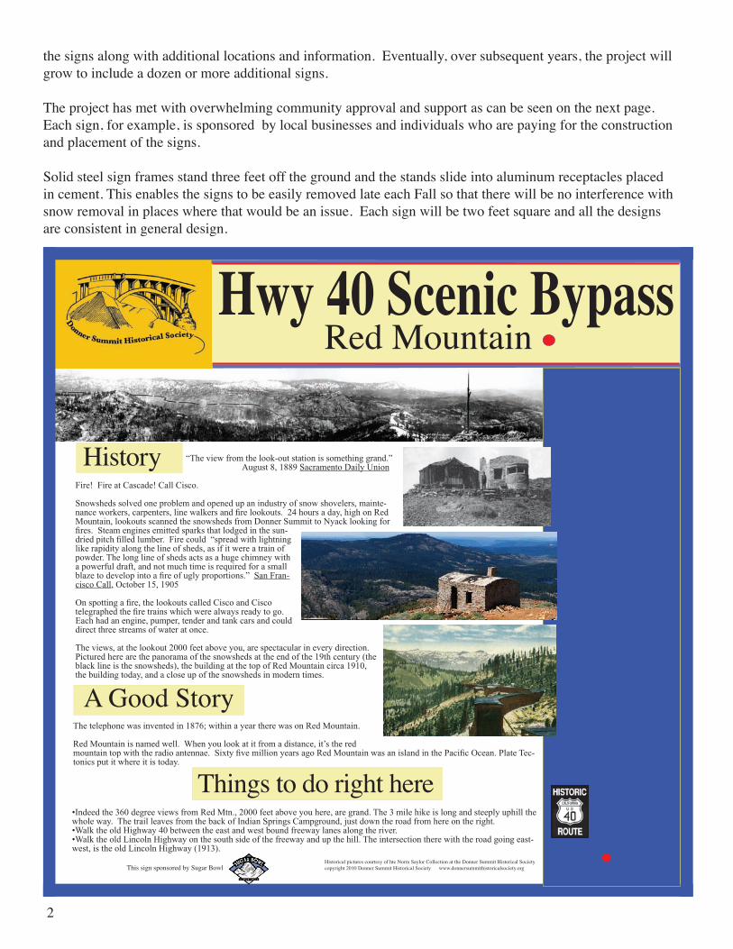
the signs along with additional locations and information. Eventually, over subsequent years, the project will grow to include a dozen or more additional signs.
The project has met with overwhelming community approval and support as can be seen on the next page. Each sign, for example, is sponsored by local businesses and individuals who are paying for the construction and placement of the signs.
Solid steel sign frames stand three feet off the ground and the stands slide into aluminum receptacles placed in cement. This enables the signs to be easily removed late each Fall so that there will be no interference with snow removal in places where that would be an issue. Each sign will be two feet square and all the designs are consistent in general design.
Hwy 40 Scenic BypassRed Mountain
Historical pictures courtesy of hte Norm Saylor Collection at the Donner Summit Historical Societycopyright 2010 Donner Summit Historical Society www.donnersummithistoricalsociety.org
“Theviewfromthelook-outstationissomethinggrand.” August8,1889SacramentoDailyUnion
Fire!FireatCascade!CallCisco.
Snowshedssolvedoneproblemandopenedupanindustryofsnowshovelers,mainte-nanceworkers,carpenters,linewalkersandfirelookouts.24hoursaday,highonRedMountain,lookoutsscannedthesnowshedsfromDonnerSummittoNyacklookingforfires.Steamenginesemittedsparksthatlodgedinthesun-driedpitchfilledlumber.Firecould“spreadwithlightninglikerapidityalongthelineofsheds,asifitwereatrainofpowder.Thelonglineofshedsactsasahugechimneywithapowerfuldraft,andnotmuchtimeisrequiredforasmallblazetodevelopintoafireofuglyproportions.”SanFran-ciscoCall,October15,1905
Onspottingafire,thelookoutscalledCiscoandCiscotelegraphedthefiretrainswhichwerealwaysreadytogo.Eachhadanengine,pumper,tenderandtankcarsandcoulddirectthreestreamsofwateratonce.
Theviews,atthelookout2000feetaboveyou,arespectacularineverydirection.Picturedherearethepanoramaofthesnowshedsattheendofthe19thcentury(theblacklineisthesnowsheds),thebuildingatthetopofRedMountaincirca1910,thebuildingtoday,andacloseupofthesnowshedsinmoderntimes.
History
Things to do right here
Thetelephonewasinventedin1876;withinayeartherewasonRedMountain.
RedMountainisnamedwell.Whenyoulookatitfromadistance,it’stheredmountaintopwiththeradioantennae.SixtyfivemillionyearsagoRedMountainwasanislandinthePacificOcean.PlateTec-tonicsputitwhereitistoday.
•Indeedthe360degreeviewsfromRedMtn.,2000feetaboveyouhere,aregrand.The3milehikeislongandsteeplyuphillthewholeway.ThetrailleavesfromthebackofIndianSpringsCampground,justdowntheroadfromhereontheright.•WalktheoldHighway40betweentheeastandwestboundfreewaylanesalongtheriver.•WalktheoldLincolnHighwayonthesouthsideofthefreewayandupthehill.Theintersectiontherewiththeroadgoingeast-west,istheoldLincolnHighway(1913).
A Good Story
This sign sponsored by Sugar Bowl

3
Hwy 40 Scenic BypassSugar Bowl
copyright 2010 Donner Summit Historical Society www.donnersummithistoricalsociety.org
History
A Good Story
Things to do right here
When Bill Klein, who would trans-form skiing himself, invited Hannes Schroll to Donner Summit from Yo-semite in 1937, the ski industry was about to change. Hannes was a dare-devil champion skier whose yodels as he tore down mountains could be heard for long distances. He was enthusiastic when he saw the Sugar Bowl. “We have to develop this,” he said. The “Sugar Bowl” is perfect for skiing.
His family money disappeared just as he was talking to his mother about send-ing it from Austria so he could buy the land. It was the Anschluss and Hitler had taken charge of Austria and Hannes’ money. Hannes turned to his Yosemite friends and they in turn turned to their friends and Sugar Bowl, the first California ski area built as a destination resort, was built. It included the first chairlift in the state and the second in the nation. The single seater (as opposed to the quads of today) ran to the top of Mt. Disney (3200 feet) in 6 minutes (today’s quad takes 3 minutes). There was a lodge designed by a famous architect, rope tows, a skat-ing rink, and ski jouring. Skiers arrived by train and were transported to the Bowl first by horse drawn and then by tractor drawn sleighs.
Take the road into the Sugar Bowl where the sign says Judah Lodge. Come in for refreshment at the bar or have a meal in the historic Lodge at Sugar Bowl (built in 1939). The food is great and the historical pictures are interesting. Find out about the lodge, William Wilson Wurster the architect, and how the wagon trains climbed over Donner Summit on Roller Pass.
Hannes Schroll was larger than life. At the 1936 Mt. Rainier Olympic Trials, “I heard a yell high above me...like an eagle swooping down on a rabbit [it was] Hannes Schroll... yodel-ing at the top of his lungs! He jumped the first terrace like a deer going over a rail fence. Then he jumped another- and landed on one ski. His body was leaning over like an open jack-knife, and he was swinging his ski poles to keep from somersaulting. He must have skidded a quarter mile on that one ski, whooping and yelling all the time. As he passed
me, his hat sailed trough the air, and he whooped even louder he was that glad to get both is skis back on the snow. Before he stopped, he’[d] passed No. 41, who had taken off ten min-utes before.” Rotarian 2/1936
Walt Disney was an initial investor in Sugar Bowl. One day his daughter wanted to ski. Hannes took her up Mt. Disney, put her on his shoulders, and skied all the way down.
This sign sponsored by Sugar Bowl
Above, the Sugar Bowl Sign. Below, left to right: Tunnel 6, Ice Lakes, Petroglyphs, Snowsheds
Hwy 40 Scenic BypassTunnel 6
Pictures Alfred A. Hart from the Library of Congresscopyright 2010 Donner Summit Historical Society www.donnersummithistoricalsociety.org
Things to do right here
1866 – Right here.
Bam, bam, quarter turn; Bam, bam, quarter turn; bam, bam, quarter turn; all day long, three shifts a day, day after day, week after week. Chinese workers pounded away at the solid granite. One worker held a star bit, turning it a quarter turn as two other workers pounded the bit with 18 lb. sledges. Four teams at four separate faces making progress only inches a day, cut through 1659 feet of solid granite. Once a hole was drilled, it was packed with black powder, the fuse was set, and the workers ran. When the smoke cleared, workers hauled out the rubble - all by hand – no machines.
Imagine the courage holding a drill bit. Imagine the confidence in your friends. Imagine the accuracy of the sledge handlers; imagine their con-centration, hour after hour.
That was Tunnel 6, the longest tunnel of the Sierra Crossing.
Working the solid granite went too slowly. They blasted a shaft straight down above the middle to open two more faces. Hauling the rubble by hand was too slow. A steam engine was brought in to haul up the rubble.
When all four faces joined up, they were off by only two inches – after two years. Amazing.
Facing granite was not the only obstacle. The workers faced avalanches and heavy snows: 40 feet that first winter. Workers didn’t see daylight for days at a time as they moved from their living sheds to the work faces through tunnels dug into the snow.
Nitroglycerine would speed the tunneling but still, work wasn’t fast enough. The railroad hauled track, railroad cars and a steam engine over the pass, over the snow, above here, between Donner Peak and Mt. Judah, so they could continue building on the eastern side – to race across Nevada, to earn pay for miles, to beat the Union Pacific which was coming from the east.
Pictured here, Alfred A. Hart photographs: tunnel 6 incomplete top, “Shaft House over Summit Tunnel, American Peak (now Mt. Lincoln) in the distance,” and east portal of Tunnel 6, bottom.
Hike to the Pacific Crest Trailhead at Lake Mary and instead of going up hill try and retrace the route going downhill of the old Lincoln Highway. It’s what appears to be a roadway that is now being overgrown. Walk to the top, over the tunnel and see the monument there as well as the metal covering for the shaft that was used so the Chinese workers could work from the middle out as well as the outside in.
History
sign sponsored by:
Hwy 40 Scenic BypassIce Lakes
copyright 2010 Donner Summit Historical Society www.donnersummithistoricalsociety.org
History
A Good Story
Things to do right here
Before 1850 you drank your root beer or sarsaparilla warm in California. Then ice began to be imported from Alaska. No one realized there was a closer supply in the Sierra. Ice Lakes got its name from the ice industry that arrived here in 1868, headed by B.B. Redding, who once fly fished 200 trout out of the American River in a day.
He was also the Secretary of State of California, State printer, and RR land agent, among other things. When the ice was thick enough it was incised, sawn into blocks, and floated to the ice houses on the lake shore. There it was stored pend-ing transport to the railroad and then San Francisco. The industry didn’t last long though. Although the ice in Ice Lakes gets to be five feet thick, the climate, snowfall and snow depth were just too much on Donner Summit (400 inches or so
of snow a year). The Summit Ice Co. moved to Prosser in 1870. Note the 1866 map to the left shows 3 Ice Lakes which was true until the dam was built in the 1940’s.
The Dreams he had.
In 1866 Fitz William Redding Jr., from Nova Scotia, became the first settler here at Ice Lakes. He built a small 12 X 12 plank cabin on the edge of the lakes just across from here. He was all alone, but over the hill the railroad was coming and there was lots of activity. Fitz William must have had big plans for the 160 acres that he was aiming to patent (buy) from the government for $2.50 an acre. He cut trees and readied his land for grazing. He even stocked the first fish in the lakes by planting 300 fish. He prob-ably was surprised by the snow and he left for Sacramento spending most of the winter there. He returned in the spring but he might have had trouble finding his cabin under the drifts of snow. He got sick, went back to Sacramento, and died – age 20.
•Eat at Ice Lakes Lodge. The food is really good and the view is spectacular.•Read more about the ice industry on the wall there or at www. DonnerSummitHistoricalSociety.org•Walk around the lakes.
Hwy 40 Scenic BypassPetroglyphs
copyright 2010 Donner Summit Historical Society www.donnersummithistoricalsociety.org
California must have been an interest-ing place in pre-Columbian times. It was the most populated area on the continent and the most diverse ethnically and lin-guistically. There were nine language families in the Sierra alone.
Native Americans left us a record of their presence in the Donner Summit area: petroglyphs. The pictures to the right are Donner Summit area petro-glyphs enhanced in black and white. Similar symbols are found in many places in the northern Sierra Nevada, usually on gently sloping granite slabs. Just above this sign on the granite slab, you see a collection of petroglyphs. This is an extensive petroglyph site that contains over 200 rock art ele-ments, including a bear track (see top photo). The petroglyphs here are hard to see but fascinating. Archeologists estimate that the petroglyphs in this area were made 1500 to 4000 years ago. They were created by pecking through the surface of the glaciated bedrock using a tool called a hammerstone. Most are geometric shapes – wavy lines, circles, and zigzags. Human and animal forms, such as stick figures and deer or bear tracks, are less common. Although no one knows what the petroglyphs mean, many people believe they have a spiri-tual or ceremonial significance. Ancestors of the Washo People created these petroglyphs. Like all Great Basin Indians, they were nomadic. The Washo traveled all over the Sierra, and used Donner Pass as a corridor for travel to and from Lake Tahoe. Adapted to life in the Great Basin and the Sierra, they made annual rounds hunting game, gathering and trading food, clothing materials, salt and ob-sidian. They probably carried dried trout and pine nuts to eat and they would have hunted. The rock art sites are exposed to the harsh environment of the high Sierra. The natural process of exfoliation (peeling away of layers of rock due to the freezing and expansion of water) is at work on Sierra granite. This leaves the petroglyphs fragile and vulnerable to destruction. To preserve these sacred symbols: Walk around, not on, the petroglyphs. Don’t make rubbings or tracings–this wears away the rock surface. Leave rocks, plants and artifacts where they are. And of course remove your trash. Someday the petroglyphs will be gone and along with them will go the tan-gible record of the first visitors to Donner Summit. There are many good sources for information about the earliest visitors to Donner Summit as well as the rock carvings. A particularly good source is Ancient Rock Carvings of the Central Sierra by Willis Gortner. You have to be really lucky to see a copy since it’s out of print - but you may run into someone with a copy.
Walk up to Rainbow Bridge and admire the view. Hike to the top of Mt. Stephens just north of Rainbow Bridge.Watch the rock climbers on the different rock walls. The Summit is a desination for rock climbers.Trace the Lincoln highway and walk the route. It is the road cut you see above. Go up through the underpass and then through the train tun-nel - the original Tunnel 6 built in 1867 for the transcontinental railroad.
If you are even more ambitions, go to the Summit and take the first left after the Alpine Skills Institute. Go down to the turn and park. To the left is a trailhead for the Pacific Crest Trail which you can take. Turn-offs will lead you to the tops of Mts. Donner and Judah for spectacular views. From Donner you can look 1000 feet straight down to Donner Lake.
Things to do right here
History
Hwy 40 Scenic BypassThe Snowsheds
pictures from the archives of the Bancroft Library, University of California, Berkeley and Norm Sayler Collection.copyright 2010 Donner Summit Historical Society www.donnersummithistoricalsociety.org
History
A Good Story
Theodore Judah, who plotted the Central Pa-cific’s route over the Sierra and for whom Mt. Judah was named, thought it was only the mountains that needed conquering as the Central Pacific headed east to meet up with the Union Pacific. He was wrong. The cli-mate needed taming too.
Snowfall on Donner Summit averages 35 feet a year and in extreme years 60 feet can fall. You don’t just push that much snow away - although that was the first solution.
Even as they began building over the Sum-mit the directors of the CPRR saw the problem and they began experimenting with snow-sheds so trains could continue to run even in heavy snows. Ultimately more than 40 miles of sheds would be built to shelter the trains, at a huge cost.
Solving one problem brought others. Snowsheds were extreme fire dangers because they sheltered spark spewing locomotives. Lookouts, line walkers, and fire trains were main-tained to watch and fight fires. An army of snow shovelers worked winters to keep the sheds from collapsing.
The sheds also caused problems for travelers:“The average passenger journeying over the Sierras usually utters a deep sigh of relief when his train emerges from the snowsheds. They have formed one bleak, uninteresting section of the journey, relieved only by a monotonous succession of tantalizing glimpses of striking scenery through the breaks and cracks in a dead wall of grimy timbers. The cars have filled with suffocating smoke and life has been made miserable for a time.” San Francisco Call October 15, 1905
Some of the most beautiful scenery in the world to be seen from a train window, and along the Sierra Summit, was hidden.
Pictured here: snowsheds on Donner Summit and under constrution. Snowsheds often ran right up to buidings. Here The Summit Hotel is seen through a snowshed. Bottom, Snowsheds at Cisco Grove.
With improvements in snow removal miles snow sheds have been removed and those that remain are constructed of fire proof con-crete. The fire lookouts and snow shovelers are gone as is the danger of snowshed collapse. One legacy remains. Many houses built in the 1940’s on Donner Summit were built of old snow shed timbers. They are strong and solid. One owner remembers her mother sanding the insides of the house for years to remove the “patina” that had developed on the timbers from their days as snowsheds. The interior is now gorgeous.
This sign sponsored by Sugar Bowl

4
On page one you see a typical sign in its metal stand. Left, typical side view of a steel stand. Right, typical rear view of a steel stand. Each sign is two feet square and the center of each sign sits 32” off the ground. Each sign slides into an aluminum sleeve set flush with the ground surface and in cement for easy removal. On page two and page three are two of the 26 initial signs, Sugar Bowl and Red Mountain. At the bottom of page three are smaller versions of four more.
Interpretive Signs, 2010
County right of way Private property Other Location Red Mountain NV 39º 19.471/120º 33.779 Eagle Lakes exit no. side at the curve uphillMeadow Lake turn off NV 39º 19.472/120º 33.781 Eagle Lakes exit no. side at the curve uphillLincoln Highway view from 40 PC 39º 18.255/120º 31.490 just east of the overpass on Old 40
Big Bend PC 39º 18.397/120º 31.061 USFS Ranger Station
Rainbow Lodge/Tavern PC 39º 18.603/120º 30.564 Rainbow Lodge
Donner Summit Lodge NV 39º 19.513/120º 23.363 Donner Summit Lodge
Pahatsi Rd wagon train route PC 39º 18.776/120º 22.869 Soda Springs Rd. @ Cascade Rd. near the current Trails West marker
Ice Lakes PC 39º 17.697/120º 22.959 Ice Lakes Lodge
Original Soda Springs Store NV 39º 19.457/120 23.017 Soda Springs Store
Soda Springs Hotel NV 39º 19.408/120º 22.768 Soda Springs Hotel (Donner Summit Hist. Society)
Soda Springs Ski Area NV 39º 19.276/120º 22.758 Soda Springs Ski Area
Summit Valley overlook NV 39º 18.997/120º 21.022 across hiway from CTL
Clair Tappaan & Cal/Heidelman (2) NV 39º 19.012/120º 21.006 top of new loading area to the left back from cars Hutchinson Lodge NV 39º 19.056/120º 212.159 path start at right
Sugar Bowl PC 39º 18.794/120º 20.381 prking structure Sugar Bowl
Roller Pass PC USFS at PCT trailhead
Norden Station NV 39º 19.032/120º 21.327 across from old Norden store Charlie Chaplin’s “Gold Rush” Mt. Lincoln PC yes Sugar Bowl

5
Donner Spitz
20 Mile Museum Supporting organizations/businesses
Magic Carpet PC 39º 18.793/120º 20.345 prkgn structure Sugar Bowl
Lodge at Sugar Bowl PC yes Lodge at Sugar Bowl Donner Ski Ranch NV 39º 19.082/120º 19.808 across from Donner Ski Ranch Sugar Bowl Academy building NV 39º 18.997/120º 19.543 Sugar Bowl Academy
Tunnel 6 – first transc. RR tunnel NV old railroad bed in front of tunnel?? or 39º 19.019/120º 19.794 (turn out prior to tunnel on road to Sugar Bowl)
Donner Lake overlook NV 39º 19.156/120º 19.118 Rainbow Bridge parking north end affixed to railing at lookout on bridge
Rainbow Bridge NV 39º 19.134/120º 19.150 across 40 from Rainbow Bridge parking
Transcontinental Railroad NV 39º 19.119/120º 19.113 Rainbow Bridge Parking so. end or down by the snowshed sign (below)?
China Wall NV 39º 19.052/120º 19.226 turnout prior to climbing parking area
Central Pacific Snowsheds NV 39º 19.123/120º 18.968 turnout below Rainbow Bridge
Miscellaneous:
39º 19.045/120º 19.463 turnout below Sugar Bowl Academy
curve below Rainbow Bridge 39º 19.056/120º 19.230 (petroglyph site - China Wall sign?)
turnout below the climbing wall - small 39º 19.127/120º 18.971 (good snowshed view)souvenir stand at Cisco 39º 18.666/120º 32.471 (possible Forest Gift Shop sign)
Sugar Bowl prkg structure west end 39º 18.796/120º 20.413
Contact: [email protected], Bill Oudegeest 209-606-6859
County right of way Private property Other Location

6
The above diagram shows the design of the stands.
Each stand is made out of hard steel with the center of sign 36” off the ground. The signs are at 45 degree angles to the ground. A 24 gauge galvanized steel sheet sits on the frame, made of 1” square steel 1/8” wall tubing, with the sign and UV plastic cover sitting on top. The post is 2” X 2” 1/4” wall square steel tubing.
The aluminum receptacle sits below ground level so the sign can be removed in winter and so it does not affect snow removal machines. A locking bolt will secure the sign. Receptacles will be plugged when the signs are removed.
Sign Stand Design