2. project description - libraryarchives.metro.netlibraryarchives.metro.net/dpgtl/eirs/metro...
TRANSCRIPT
Airport Metro Connector 96th Street Transit Station Draft EIR
Page 2-1
2. Project Description
2. PROJECT DESCRIPTION
This chapter presents the proposed project location and surrounding uses, background, objectives, a description of the proposed transportation center and associated infrastructure improvements, an estimated construction schedule and phasing, and a summary of the required discretionary actions and approvals. Briefly, the proposed project includes a new multi-modal transportation center with three at-grade Light Rail Transit (LRT) platforms, bus plaza, bicycle hub, pedestrian plaza, passenger vehicle pick-up and drop-off area and Metro transit center/terminal building (“Metro Hub”) to connect Los Angeles International Airport (LAX) to Metro’s regional rail system. The proposed project is one of the 12 transit projects identified in Measure R and included in the Metro Long Range Transportation Plan. Measure R is a half-cent sales tax approved by Los Angeles County voters in 2008.
2.1. LOCATION AND SURROUNDING USES
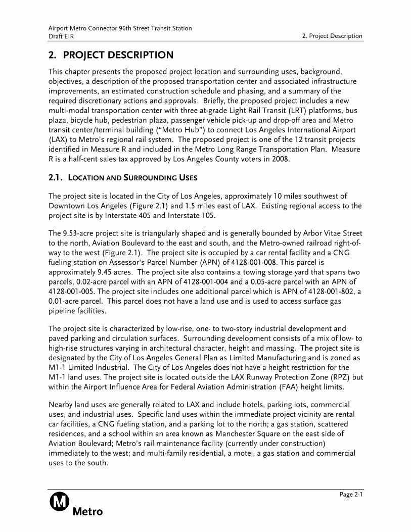
The project site is located in the City of Los Angeles, approximately 10 miles southwest of Downtown Los Angeles (Figure 2.1) and 1.5 miles east of LAX. Existing regional access to the project site is by Interstate 405 and Interstate 105.
The 9.53-acre project site is triangularly shaped and is generally bounded by Arbor Vitae Street to the north, Aviation Boulevard to the east and south, and the Metro-owned railroad right-of-way to the west (Figure 2.1). The project site is occupied by a car rental facility and a CNG fueling station on Assessor's Parcel Number (APN) of 4128-001-008. This parcel is approximately 9.45 acres. The project site also contains a towing storage yard that spans two parcels, 0.02-acre parcel with an APN of 4128-001-004 and a 0.05-acre parcel with an APN of 4128-001-005. The project site includes one additional parcel which is APN of 4128-001-802, a 0.01-acre parcel. This parcel does not have a land use and is used to access surface gas pipeline facilities.
The project site is characterized by low-rise, one- to two-story industrial development and paved parking and circulation surfaces. Surrounding development consists of a mix of low- to high-rise structures varying in architectural character, height and massing. The project site is designated by the City of Los Angeles General Plan as Limited Manufacturing and is zoned as M1-1 Limited Industrial. The City of Los Angeles does not have a height restriction for the M1-1 land uses. The project site is located outside the LAX Runway Protection Zone (RPZ) but within the Airport Influence Area for Federal Aviation Administration (FAA) height limits.
Nearby land uses are generally related to LAX and include hotels, parking lots, commercial uses, and industrial uses. Specific land uses within the immediate project vicinity are rental car facilities, a CNG fueling station, and a parking lot to the north; a gas station, scattered residences, and a school within an area known as Manchester Square on the east side of Aviation Boulevard; Metro’s rail maintenance facility (currently under construction) immediately to the west; and multi-family residential, a motel, a gas station and commercial uses to the south.
Airport Metro Connector 96th Street Transit Station Draft EIR
Page 2-2
2. Project Description
Figure 2.1 Regional and Project Site Location
Source: Terry A. Hayes Associates Inc., 2016.
Airport Metro Connector 96th Street Transit Station Draft EIR
Page 2-3
2. Project Description
2.2. PROJECT HISTORY
Improving the connection between LAX and Metro’s transit system has been a key regional priority for many years. LAX is the seventh busiest airport in the world, accommodating 74.9 million annual passengers in 2015. On the national level, LAX is the second busiest airport in terms of passengers and the third busiest airport in terms of total movement in the United States.
The 2011 LAX Air Passenger Survey indicates that only one percent of air passengers ride transit to LAX (bus and/or rail). About nine percent of airport employees travel to LAX via public transit bus, rail and the LAWA-operated FlyAway shuttles. These proportionately low levels of ridership are due in part to an absence of a convenient transit connection. This need for improved public transit for airport-related travel provides the context and the impetus for the proposed project.
Metro began studying LAX-related transit in 1988 with the Coastal Corridor Rail Transit Project. Since that time, Metro has continued to identify, study, and implement opportunities to facilitate transit to and from LAX. In August 1989, the Los Angeles County Transportation Commission (LACTC), a predecessor to Metro, certified the Final EIR for the Metro Green Line Northern Extension Project. The extension project was approved for implementation by LACTC in March 1990, but was halted due to concerns by the Federal Aviation Administration (FAA) that the extension could adversely affect Airport operations. As a result of those concerns, a LAX/Metro Green Line Interagency Task Force was established in 1991 to create a plan for extending the Metro Green Line to LAX. The plan consisted of a 5-mile Green Line extension from the Interstate 105 to Marina del Rey. The alignment of the Green Line extension was approved in a 1992 Draft Supplemental EIR and approved in a 1994 Final Supplemental EIR. The extension was never constructed due to funding constraints.
In June 2006, the Metro Board of Directors voted to compile the plans and studies related to the Green Line to LAX extension and to coordinate with the City of Los Angeles and LAX in order to ascertain what would be required to implement the project and to estimate the financial cost of moving the Green Line to LAX. In August 2006, the LAX/Metro Green Line Interagency Task Force was reformulated to develop a proposal for implementing a Minimum Operable Segment (MOS) within the vicinity of LAX. Specifically, this MOS of the Green Line would include a two station segment between the existing station at Aviation Boulevard and Imperial Highway, and the intersection of Lincoln Boulevard and Sepulveda Boulevard. The MOS was studied but never environmentally cleared, funded or constructed.
In September 2011, the Metro Board certified the Crenshaw/LAX Transit Project Final EIS/EIR and the Federal Transit Administration issued a Record of Decision in December 2011. The Crenshaw/LAX Line, currently under construction, will extend 8.5 miles from the existing Metro Expo Line at Crenshaw and Exposition Boulevards to the Crenshaw/LAX and Green Line terminus at Century Boulevard and Aviation Boulevard where it connects to the existing Green Line.
Airport Metro Connector 96th Street Transit Station Draft EIR
Page 2-4
2. Project Description
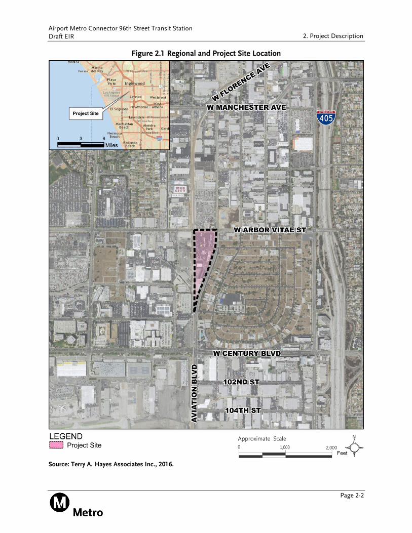
In April 2011, the Metro Board initiated the Alternatives Analysis (AA) for the Metro Green Line to LAX project (now referred to as the AMC 96th Street Transit Station) with the intent to plan a fixed guideway transit connection between Metro’s regional rail system and LAX. Since 2011, Metro has completed three studies refining the alternatives for the AMC project – the Alternatives Analysis (AA) Report (April 2012), the Technical Refinement Study (October 2013), and the Supplemental Analysis Report (June 2014).
The geographic area covered in the planning studies is illustrated in Figure 2.2. The area is bounded by Manchester Avenue to the north, La Cienega Boulevard to the east, 120th Street to the south and the LAX air cargo area to the west, and includes portions of the Cities of Los Angeles, Inglewood and El Segundo.
Figure 2.2 Geographic Area of Alternatives Considered During Planning
Source: ConnectLAX, 2011.
Airport Metro Connector 96th Street Transit Station Draft EIR
Page 2-5
2. Project Description
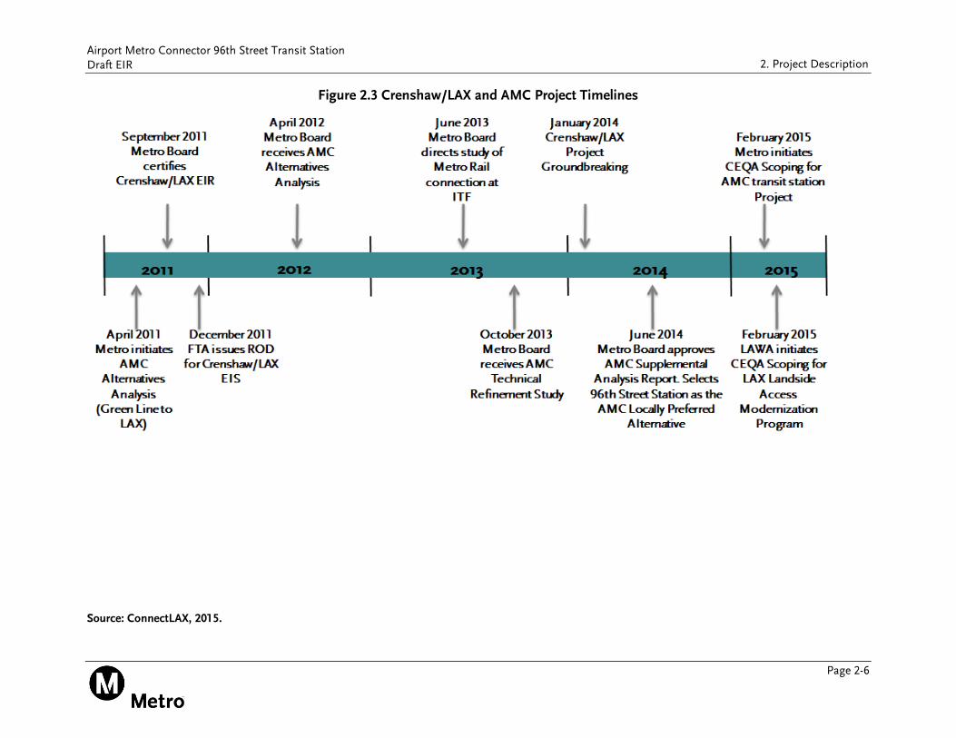
Figure 2.3 provides an overview of the major milestones in the AMC 96th Street Transit Station planning process starting with the initiation of the AA.
In April 2012, the Metro Board received the Metro Green Line to LAX Alternatives Analysis (AA). The 2012 AA Report divided the screening process into two stages. Based on the two-stage screening process and input received at public meetings, the following alternatives were recommended for study in the Draft EIS/EIR:
No Build
Transportation System Management (TSM)
Direct LRT Branch
Circulator (APM operated by LAWA)
Through LAX (Modified LRT Trunk)
Following the release of the AA, but before Metro initiated an EIS/EIR, LAWA released the Specific Plan Amendment Study (SPAS) report. The SPAS Draft EIR identified and evaluated nine potential alternatives to certain components of the previously-approved LAX Master Plan, referred to as Yellow Light Projects, including various configurations for the north airfield, terminal improvements, and improvements to LAX's ground transportation system. After an extensive review of public comments, LAWA staff recommended a combination of airfield and terminal elements, including, but not limited to, extending runaways north and east, an ITF near Lot C and a Consolidated Rental Car Facility (CONRAC) with long-term parking in Manchester Square that would be accessed via an automated people mover (APM).
In June 2013, the Metro Board directed staff to include the Through Intermodal Transit Facility (ITF) Alternative (Intermediate LRT and Circulator) in the environmental review phase. In an effort to expedite the construction of a regional rail connection to the airport, Metro and LAWA worked collaboratively to further refine the definition of alternatives to be carried forward into the Draft EIS/EIR. The AMC Technical Refinement Study of Alternatives Report, which was received by the Metro Board in October 2013, was intended to advance the analysis of alternatives in order to better inform the public, and help expedite the subsequent environmental review process. The AMC Technical Refinement Study refined the alternatives based on new information about LAWA’s future development plans and analyzed them based on refined policy and forecasting assumptions.
Following the presentation of the Technical Refinement Study in October 2013, the Metro Board requested a feasibility study of relocating the ITF to the planned Crenshaw/LAX Southwestern Yard, including a station in the vicinity of 96th Street. This new 96th Street Station was developed because it also provided an alternative connection point for an APM alignment along 96th Street and is the alignment being analyzed by LAWA.
Airport Metro Connector 96th Street Transit Station Draft EIR
Page 2-6
2. Project Description
Figure 2.3 Crenshaw/LAX and AMC Project Timelines
Source: ConnectLAX, 2015.
Airport Metro Connector 96th Street Transit Station Draft EIR
Page 2-7
2. Project Description
In January 2014, staff recommended the elimination of the Metro Rail extensions “through LAX” under the terminals and runways, and advancement of the Circulator, Intermediate Circulator and LRT, and Direct LRT Branch into the environmental review process. The Metro Board approved the staff recommendation, but requested a Supplemental Analysis Report to present findings regarding ridership, passenger convenience, time savings and cost to airport and non-airport bound passengers, as well as feasibility and constructability issues and costs with the Modified LRT Trunk Alternatives from the Technical Refinement Study.
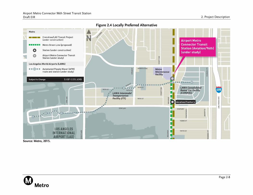
In June 2014, the Metro Board of Directors approved the AMC Supplemental Analysis report and selected the AMC 96th Street Transit Station as the Locally Preferred Alternative (LPA) as shown in Figure 2.4. In this LPA, the LAWA’s APM follows an alignment north of 96th Street and connects to the Crenshaw/LAX and Metro Green Lines at a new Metro 96th Street Station enroute to the LAWA CONRAC. The LPA was selected because while the alternatives that connect Metro Rail to the ITF or the LAX Central Terminal Area (CTA) marginally improve transit ridership, they do so at very high cost. The LPA incorporates a transportation center at 96th Street that would include three at-grade LRT platforms to be served by the Crenshaw/LAX Line scheduled for completion in 2019 and the Green Line via a proposed service extension. The transportation center would also be served by the LAWA operated APM, which would connect transit riders into the CTA and elements of the LAWA Landside Access Modernization Program (LAMP).
Airport Metro Connector 96th Street Transit Station Draft EIR
Page 2-8
2. Project Description
Figure 2.4 Locally Preferred Alternative
Source: Metro, 2015.
Airport Metro Connector 96th Street Transit Station Draft EIR
Page 2-9
2. Project Description
2.3. PROPOSED PROJECT
2.3.1. Proposed Project Objectives
The proposed project is being developed to connect LAX to Metro’s regional bus and rail transit system. Given the high volume of daily vehicular trips to and from LAX and the absence of a convenient transit connection, the goal of the proposed project is to increase transit ridership and provide a reliable and convenient transit option to and from LAX along with the regional bus and rail transit system. As noted in the NOP, dated February 6, 2015, the three project objectives are:
Objective #1: Provide a reliable, fast, and convenient connection for passengers traveling between the LAX area and the regional bus and rail transit system.
Objective #2: Integrate with existing and future transit connections and airport facilities.
Objective #3: Increase the share of transit trips to and from LAX with minimal impact to airport facilities and surrounding communities and to help reduce air pollution.
2.3.2. Proposed Project Components
The proposed project includes a new multi-modal transportation center to connect LAX to the regional bus and rail transit system. Project components include:
Three at-grade LRT platforms to be served by the Crenshaw/LAX Line and an extension of the Metro Green Line;
Bus plaza and terminal facility for Metro and municipal bus operators;
Bicycle hub with secured parking for up to 150 bicycles;
Pedestrian plaza;
Passenger vehicle pick-up and drop-off area; and
Metro transit center/terminal building (“Metro Hub”) that connects passengers between the various modes of transportation.
The west side of Aviation Boulevard would include a 15-foot sidewalk to promote pedestrian accessibility. Site amenities would include benches, trash receptacles, bollards or other low level fixtures, bike racks, public art, and signage and wayfinding. The proposed project components would be linked together by a continuous system of elevated mezzanine walkways. The mezzanine walkway would be approximately 26 feet above the ground surface with a canopy up to approximately 50 feet. Certain architectural, mechanical or signage elements could be taller, but not to exceed 70 feet. Mechanical elements would be effectively screened, so that they are not visible from the public rights-of-way.
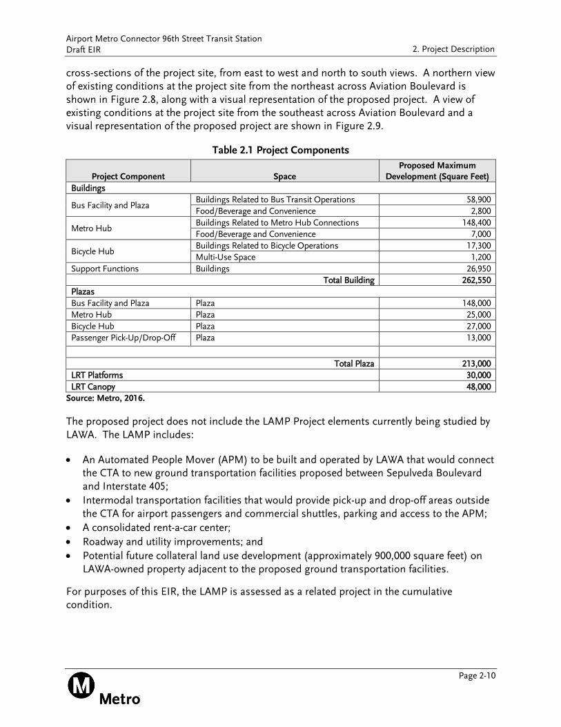
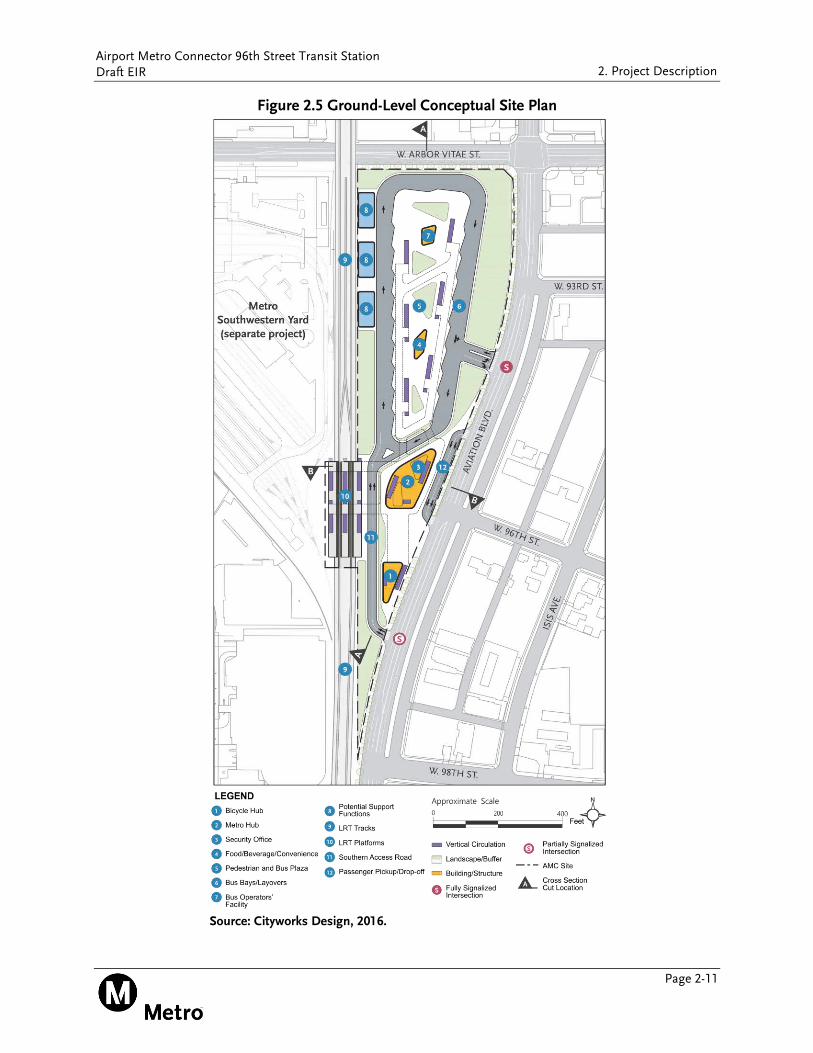
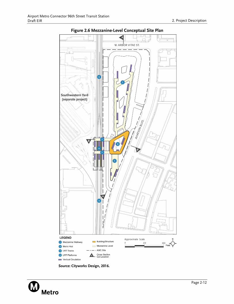
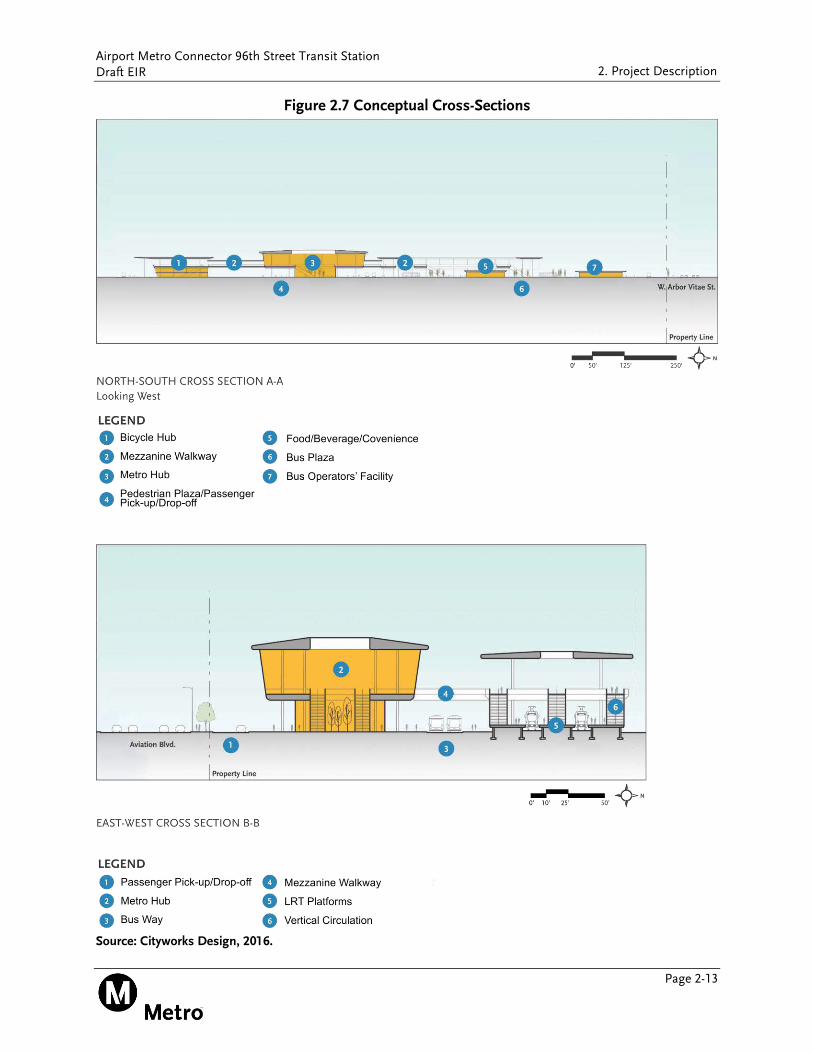
Table 2.1 shows components of the proposed project, which includes approximately 262,550 square feet of total building area and proposed 213,000 square feet of plaza area. Figure 2.5 shows the ground-level plan, Figure 2.6 shows the mezzanine-level plan, and Figure 2.7 shows
Airport Metro Connector 96th Street Transit Station Draft EIR
Page 2-10
2. Project Description
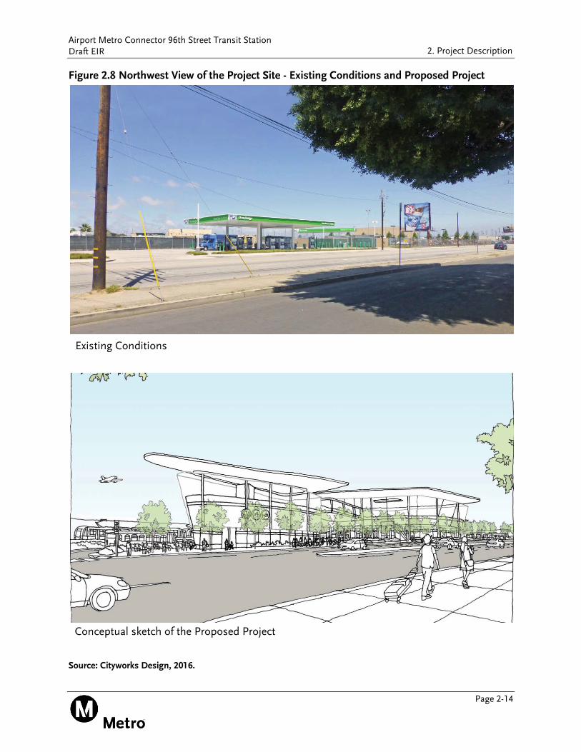
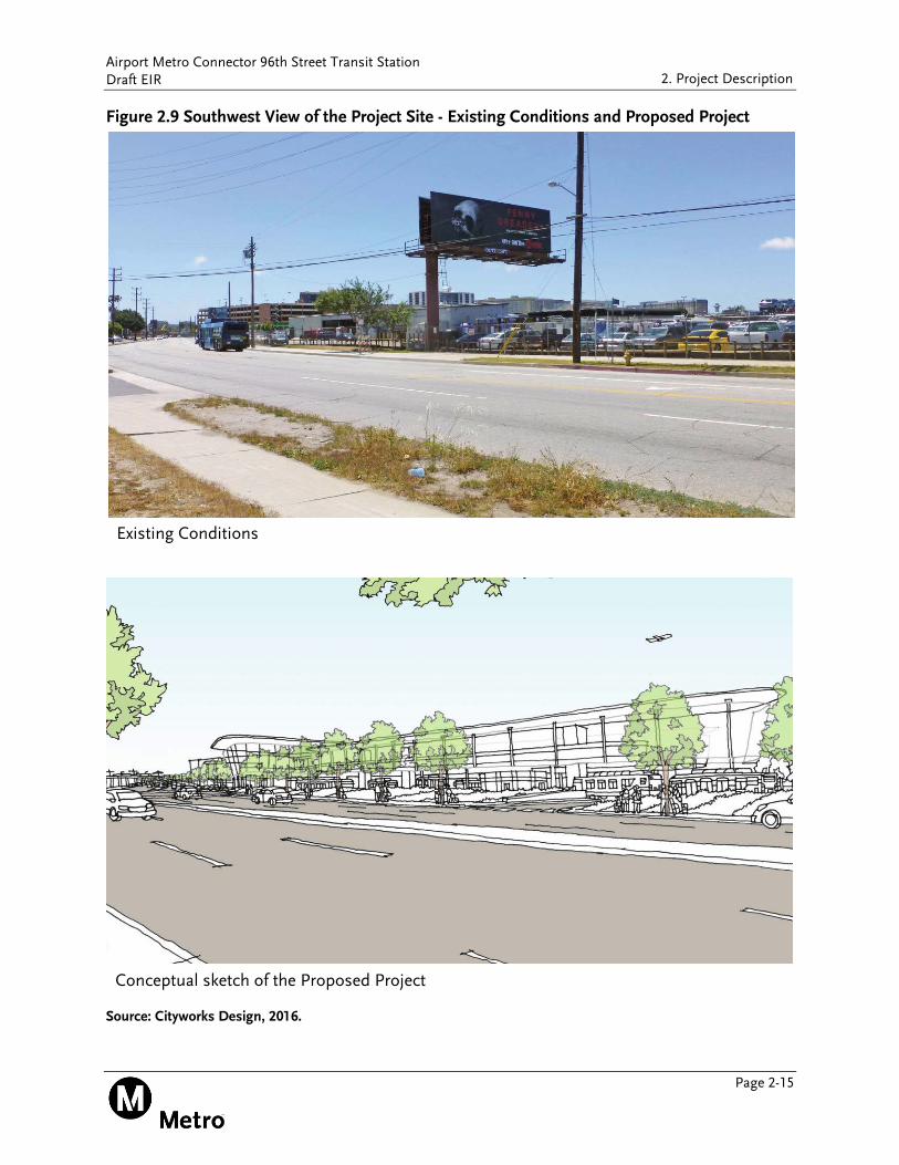
cross-sections of the project site, from east to west and north to south views. A northern view of existing conditions at the project site from the northeast across Aviation Boulevard is shown in Figure 2.8, along with a visual representation of the proposed project. A view of existing conditions at the project site from the southeast across Aviation Boulevard and a visual representation of the proposed project are shown in Figure 2.9.
Table 2.1 Project Components
Project Component Space Proposed Maximum
Development (Square Feet)
Buildings
Bus Facility and Plaza Buildings Related to Bus Transit Operations 58,900
Food/Beverage and Convenience 2,800
Metro Hub Buildings Related to Metro Hub Connections 148,400
Food/Beverage and Convenience 7,000
Bicycle Hub Buildings Related to Bicycle Operations 17,300
Multi-Use Space 1,200
Support Functions Buildings 26,950
Total Building 262,550
Plazas
Bus Facility and Plaza Plaza 148,000
Metro Hub Plaza 25,000
Bicycle Hub Plaza 27,000
Passenger Pick-Up/Drop-Off Plaza 13,000
Total Plaza 213,000
LRT Platforms 30,000
LRT Canopy 48,000 Source: Metro, 2016.
The proposed project does not include the LAMP Project elements currently being studied by LAWA. The LAMP includes:
An Automated People Mover (APM) to be built and operated by LAWA that would connect the CTA to new ground transportation facilities proposed between Sepulveda Boulevard and Interstate 405;
Intermodal transportation facilities that would provide pick-up and drop-off areas outside the CTA for airport passengers and commercial shuttles, parking and access to the APM;
A consolidated rent-a-car center;
Roadway and utility improvements; and
Potential future collateral land use development (approximately 900,000 square feet) on LAWA-owned property adjacent to the proposed ground transportation facilities.
For purposes of this EIR, the LAMP is assessed as a related project in the cumulative condition.
Airport Metro Connector 96th Street Transit Station Draft EIR
Page 2-11
2. Project Description
Figure 2.5 Ground-Level Conceptual Site Plan
Source: Cityworks Design, 2016.
Airport Metro Connector 96th Street Transit Station Draft EIR
Page 2-12
2. Project Description
Figure 2.6 Mezzanine-Level Conceptual Site Plan
Source: Cityworks Design, 2016.
Airport Metro Connector 96th Street Transit Station Draft EIR
Page 2-13
2. Project Description
Figure 2.7 Conceptual Cross-Sections
Source: Cityworks Design, 2016.
Airport Metro Connector 96th Street Transit Station Draft EIR
Page 2-14
2. Project Description
Figure 2.8 Northwest View of the Project Site - Existing Conditions and Proposed Project
Source: Cityworks Design, 2016.
Conceptual sketch of the Proposed Project
Existing Conditions
Airport Metro Connector 96th Street Transit Station Draft EIR
Page 2-15
2. Project Description
Figure 2.9 Southwest View of the Project Site - Existing Conditions and Proposed Project
Source: Cityworks Design, 2016.
Conceptual sketch of the Proposed Project
Existing Conditions
Airport Metro Connector 96th Street Transit Station Draft EIR
Page 2-16
2. Project Description
2.3.2.1. Light Rail Transit Platforms
The LRT platforms, running north and south, to be served by the Metro Crenshaw/LAX Line and the extension of the Metro Green Line, would be located at the southwestern portion of the project site (refer to Figure 2.5). A 300-foot long area along the tracks has been defined in which three 270-foot long platforms would be built. Access to the Metro hub would be provided by mezzanine via vertical circulation over the tracks, including stairs, escalators and elevators.
2.3.2.2. Bus Facility
The bus facility would include up to 20 active bus bays, with six reserved for articulated buses. Bays would accommodate a minimum bus length of 45 feet. Additionally, up to 18 layover bus bays for buses to park on the outside of the bus loop. The project site design includes angled bus bays around a bus plaza in a center island to maximize the efficiency of the bus loop, both in reduced travel distances between transfers and reduced pedestrian/bus conflicts. In addition, the bus bays are designed to eliminate the need for buses to back up.
The bus plaza would include pedestrian amenities space such as restrooms, a lounge for bus operators with restrooms and lockers, and other potential support services such as retail kiosks likely including coffee stand and concession stands.
The bus plaza would incorporate selectively placed landscaped bio-swales, which help to retain and filter stormwater runoff. There would be functional planted areas to act as a buffer between the bus plaza and the bus bays. As an additional benefit, the planting would act as physical barriers to avoid bus/pedestrian conflicts by discouraging pedestrians from walking through the bus parking areas and roadways.
2.3.2.3. Metro Hub
The Metro hub would link the multiple modes of transit on the project site. The Metro hub would be the area of transition for all passengers transferring from the transportation center. It would contain security office, food/beverage/convenience/retail kiosk-type spaces, passenger amenities, artwork and information. The Metro hub would provide amenities for various user groups, ranging from commuters transferring at the station, employees of the airport, and visitors to Los Angeles.
2.3.2.4. Bicycle Hub
The bicycle hub would accommodate up to 150 bicycles in a secure, indoor environment. Additional space for up to 50 bicycles would be provided for short-term parking. Amenities associated with the bicycle hub may include a repair area, a multi-use space, showers and lockers.
Airport Metro Connector 96th Street Transit Station Draft EIR
Page 2-17
2. Project Description
2.3.2.5. Passenger Pick-Up and Drop-Off
The proposed project includes an off-street curbside area that is separated from bus movement with an approximate length of 250 to 300 linear feet. It would most likely serve southbound traffic on Aviation Boulevard. The passenger pick-up and drop-off area would provide easy access to the project site for passengers arriving and departing by automobile to the regional bus and rail transit system. In addition, with the need to alleviate traffic in the LAX CTA, this pick-up and drop-off area would serve as an important addition to the existing network of pick-up and drop-off areas
2.3.2.6. Internal Circulation
All transport modes on the project site would be located at-grade, including the bus loop, passenger pick-up and drop-off area, train platforms, and bicycle hub. These modes would connect directly via vertical circulation components (i.e., stairs, escalators, and elevators) to an elevated mezzanine level. The elevated walkways and interconnected mezzanines would allow safe intermodal transfers between the LRT platforms, bus plaza, pick-up/drop-off area, and the bicycle hub. They would separate pedestrians and passengers from vehicle lanes, avoiding any crossovers and mode of transportation conflicts. This elevated network would provide oversight of all the transport functions on site, creating a zone where passengers can move in an unencumbered way. Clear sightlines would maximize intuitive wayfinding. The trees and plants below and around the site would be visible from the elevated network, creating the sense of inhabiting a protected landscape. Wayfinding and signage will also be provided to help passengers and visitors orient themselves in and navigate through the facility.
The mezzanine areas would be fully or partially enclosed with a series of canopies and screens that reduce the exposure to the elements and the presence of vehicles and equipment. The main public areas in the Metro hub and the bus plaza would provide opportunities for the integration of artwork as well as the full array of passenger amenities including waiting areas, fare collection, information services, and food/beverage/convenience/retail kiosk-type spaces.
2.3.2.7. Support Functions
There would be a number of non-passenger spaces and structures to support maintenance and operational activities. In addition to the bus operator facility and other transport employee areas, the site would contain equipment housing and station management areas. A number of systems components would be located throughout the project including transformers, switchgear, panel rooms, mechanical equipment, pump rooms as well as communications, security and fire, life and safety monitoring rooms.
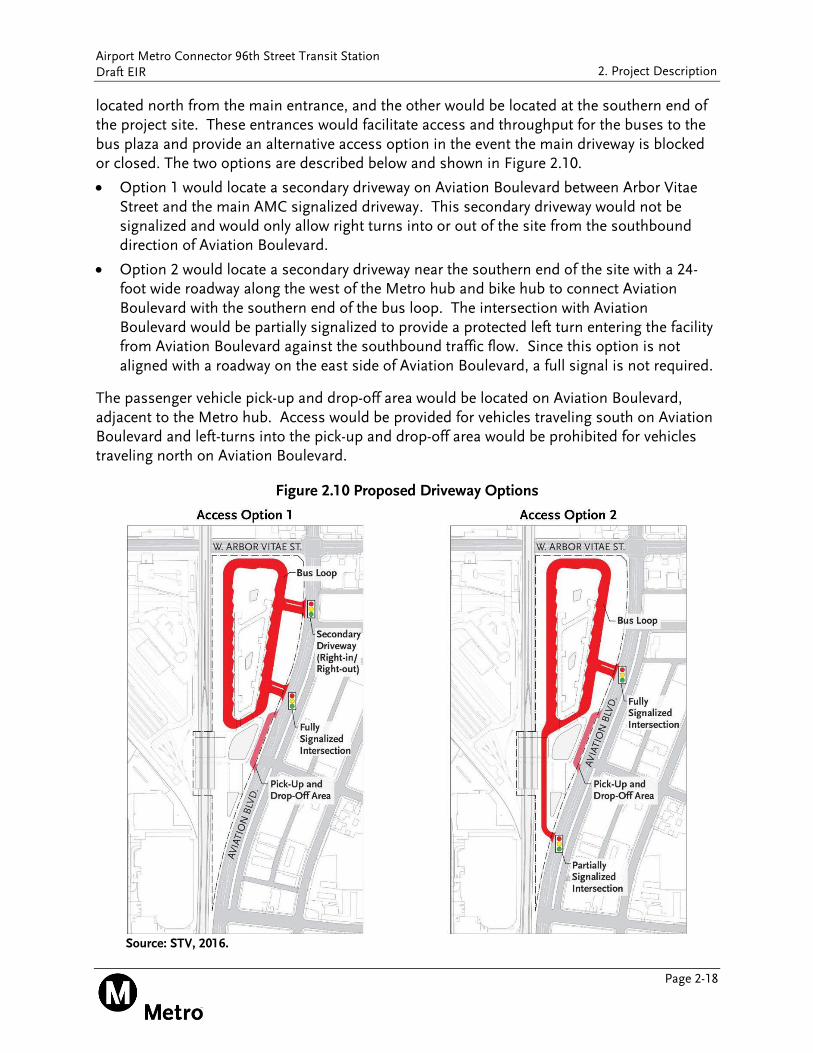
2.3.2.8. Site Access and Circulation
An entrance to the bus loop would be located on Aviation Boulevard approximately 500 feet south of Arbor Vitae Street, which would be signalized. This entrance would be located slightly south of 93rd Street. Two options are under consideration for secondary access: one would be
Airport Metro Connector 96th Street Transit Station Draft EIR
Page 2-18
2. Project Description
located north from the main entrance, and the other would be located at the southern end of the project site. These entrances would facilitate access and throughput for the buses to the bus plaza and provide an alternative access option in the event the main driveway is blocked or closed. The two options are described below and shown in Figure 2.10.
Option 1 would locate a secondary driveway on Aviation Boulevard between Arbor Vitae Street and the main AMC signalized driveway. This secondary driveway would not be signalized and would only allow right turns into or out of the site from the southbound direction of Aviation Boulevard.
Option 2 would locate a secondary driveway near the southern end of the site with a 24-foot wide roadway along the west of the Metro hub and bike hub to connect Aviation Boulevard with the southern end of the bus loop. The intersection with Aviation Boulevard would be partially signalized to provide a protected left turn entering the facility from Aviation Boulevard against the southbound traffic flow. Since this option is not aligned with a roadway on the east side of Aviation Boulevard, a full signal is not required.
The passenger vehicle pick-up and drop-off area would be located on Aviation Boulevard, adjacent to the Metro hub. Access would be provided for vehicles traveling south on Aviation Boulevard and left-turns into the pick-up and drop-off area would be prohibited for vehicles traveling north on Aviation Boulevard.
Figure 2.10 Proposed Driveway Options
Source: STV, 2016.

Airport Metro Connector 96th Street Transit Station Draft EIR
Page 2-19
2. Project Description
2.3.2.9. Sustainability Components
The proposed project has several defined goals for sustainability, specifically focused on achieving a Leadership in Energy and Environmental Design (LEED) Silver minimum rating and compliance with the California Green Building Code and incorporating requirements of the Metro’s Green Construction Policy. The Sustainability strategy would include a comprehensive overview of site stormwater and landscape strategies to reduce runoff and improve water quality that drains into the Ballona Creek watershed and the Pacific Ocean. The landscape would also assist in reducing urban heat island effects through the use of high albedo materials, which would improve the local microclimate and pedestrian comfort.
The design would focus on reductions in potable water demand for the building and landscape, as well as reductions in wastewater (e.g., use of recycled water and wastewater reductions). As part of the concept and schematic phases of design, an energy model would be developed to test alternative design strategies for the building envelope and mechanical systems to identify opportunities for energy demand reductions and to set overall energy performance criteria. This would be benchmarked against the LEED Energy and Atmosphere credit baseline and the 2016 California Building Code’s Title 24 Energy Standard.
The following measures, many of which overlap with LEED credit requirements, are project requirements to demonstrate compliance with the California Green Building Code:
Site Stormwater Best Management Practices
Light Pollution Reduction
Hardscape Alternatives (Heat Island Effect Reduction)
Solar Ready Building
Wastewater Reduction by 20 Percent Minimum
Outdoor Water Use Reduction and Metering
Recycling and Reuse of Excavated Soil and Land-clearing debris
Recycling Facilities
Indoor Air Quality during Construction
Environmental Tobacco Smoke Control
Refrigerant Piping Accessibility
2.4. CONSTRUCTION SCHEDULE AND PHASING
Construction of the proposed project is anticipated to take approximately 36 months beginning in summer 2020 and completed in summer 2023. The proposed project is anticipated to be constructed in approximately six phases. The anticipated six phases would include:
Phase 1 - Site clearance, demolition of existing structures, grading and the relocation of and connection to existing utilities
Phase 2 - Rail platforms: Staging for the rail platforms would be accommodated partially within the middle-western side of the project site.
Airport Metro Connector 96th Street Transit Station Draft EIR
Page 2-20
2. Project Description
Phase 3 - Construction of the Bike hub: This would occur in the southern third of the project site.
Phase 4 - Construction of the Metro Hub: Lay-down, storage, parking, and equipment working envelopes would be accommodated within the middle of the project site.
Phase 5 - Pick-up and Drop-off area: Staging for this area would be accommodated within the middle of the project site, east of Metro’s Crenshaw/LAX Transit Corridor Project and the proposed Metro hub.
Phase 6 - Bus Plaza: Lay-down, storage, parking, and equipment working envelopes would be accommodated within the northern two-thirds of the project site in areas to be dedicated to landscaping.
The proposed project would require excavation of approximately 31,000 cubic yards of soil, of which approximately 15,500 cubic yards of soil would be exported.
2.5. DISCRETIONARY ACTIONS AND APPROVALS
This document is intended to environmentally clear future related discretionary actions under CEQA by Metro and other agencies. Discretionary actions include those approvals, entitlements or permits necessary in order to implement a project. Construction of the proposed project would require compliance with the State General Permit for Storm Water Discharges Associated with Construction Activity (Order No. 99-08-DWQ), as well as local municipal grading, construction, street use, and tree protection ordinances, as appropriate. Stormwater and urban runoff discharges must comply with Los Angeles Regional Water Quality Control Board (LARWQCB) Municipal National Pollutant Discharge Elimination System (NPDES) Permit (Order No. R4-2009-0130). Coordination and approvals from communications and utility purveyors (e.g., Southern California Gas Company) would be needed for temporary or permanent utility relocation or service interruption.