2. part 2: address data content - urisa
TRANSCRIPT

Federal Geographic Data Committee FGDC Document Number FGDC-STD-016-2011 United States Thoroughfare, Landmark, and Postal Address Data Standard
16
2. Part 2: Address Data Content
2.1 Introduction
2.1.1 Purpose The content part defines address elements, their attributes, and address reference system elements.
2.1.2 Organization The address elements are presented first, grouped according to the major components of an address, followed by the attributes, which are grouped by subject, and lastly the address reference system elements. The Table Of Elements And Attributes immediately following this introduction lists elements and attributes in the order they are presented.
2.1.3 Simple Elements, Complex Elements, and Attributes The content part defines simple elements, complex elements, and attributes.
1. Simple elements are address components or address reference system components that are defined independently of all other elements
2. Complex elements are formed from two or more simple or other complex elements
3. Attributes provide descriptive information, including geospatial information, about an address, an address reference system, or a specific element thereof.
Appendix C: Table of Element Relationships lists the relations between simple and complex elements.
2.1.4 Element and Attribute Definitions and Descriptions Each data element is defined and described by giving its:
1. Element name: The name of the element.
2. Other common names for this element: Common words or phrases having the same or similar meaning as the element name. Note: * "(USPS)" indicates terms used in USPS Publication 28. * "(Census TIGER)" indicates terms found in U.S. Census Bureau TIGER\Line Shapefile documentation. * Part 6 gives complete citations for both documents.
3. Definition: The meaning of the element.
Federal Geographic Data Committee FGDC Document Number FGDC-STD-016-2011 United States Thoroughfare, Landmark, and Postal Address Data Standard
17
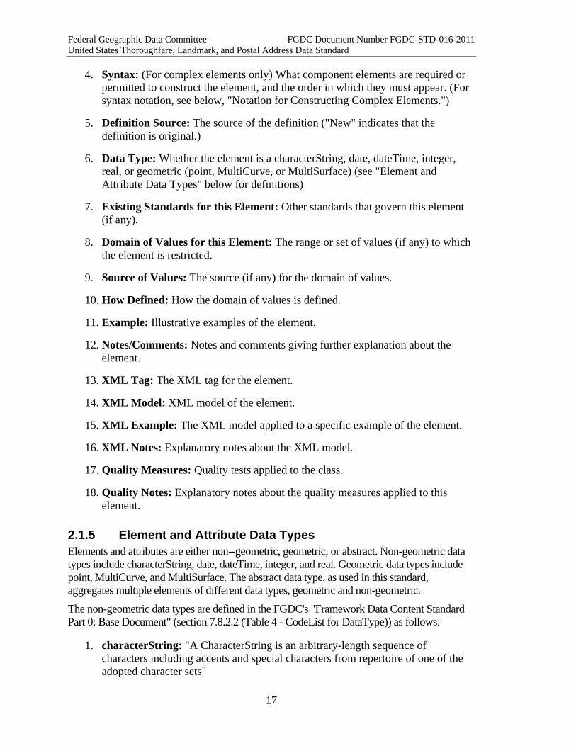
4. Syntax: (For complex elements only) What component elements are required or permitted to construct the element, and the order in which they must appear. (For syntax notation, see below, "Notation for Constructing Complex Elements.")
5. Definition Source: The source of the definition ("New" indicates that the definition is original.)
6. Data Type: Whether the element is a characterString, date, dateTime, integer, real, or geometric (point, MultiCurve, or MultiSurface) (see "Element and Attribute Data Types" below for definitions)
7. Existing Standards for this Element: Other standards that govern this element (if any).
8. Domain of Values for this Element: The range or set of values (if any) to which the element is restricted.
9. Source of Values: The source (if any) for the domain of values.
10. How Defined: How the domain of values is defined.
11. Example: Illustrative examples of the element.
12. Notes/Comments: Notes and comments giving further explanation about the element.
13. XML Tag: The XML tag for the element.
14. XML Model: XML model of the element.
15. XML Example: The XML model applied to a specific example of the element.
16. XML Notes: Explanatory notes about the XML model.
17. Quality Measures: Quality tests applied to the class.
18. Quality Notes: Explanatory notes about the quality measures applied to this element.
2.1.5 Element and Attribute Data Types Elements and attributes are either non--geometric, geometric, or abstract. Non-geometric data types include characterString, date, dateTime, integer, and real. Geometric data types include point, MultiCurve, and MultiSurface. The abstract data type, as used in this standard, aggregates multiple elements of different data types, geometric and non-geometric.
The non-geometric data types are defined in the FGDC's "Framework Data Content Standard Part 0: Base Document" (section 7.8.2.2 (Table 4 - CodeList for DataType)) as follows:
1. characterString: "A CharacterString is an arbitrary-length sequence of characters including accents and special characters from repertoire of one of the adopted character sets"
Federal Geographic Data Committee FGDC Document Number FGDC-STD-016-2011 United States Thoroughfare, Landmark, and Postal Address Data Standard
18
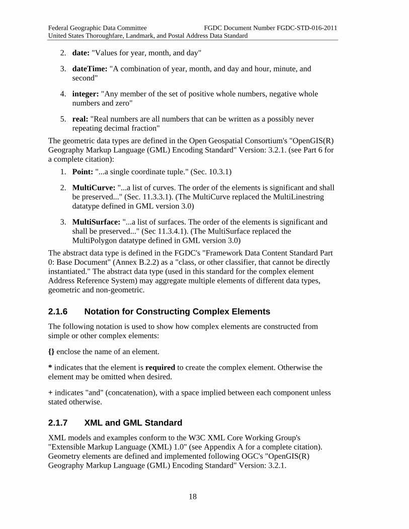
2. date: "Values for year, month, and day"
3. dateTime: "A combination of year, month, and day and hour, minute, and second"
4. integer: "Any member of the set of positive whole numbers, negative whole numbers and zero"
5. real: "Real numbers are all numbers that can be written as a possibly never repeating decimal fraction"
The geometric data types are defined in the Open Geospatial Consortium's "OpenGIS(R) Geography Markup Language (GML) Encoding Standard" Version: 3.2.1. (see Part 6 for a complete citation):
1. Point: "...a single coordinate tuple." (Sec. 10.3.1)
2. MultiCurve: "...a list of curves. The order of the elements is significant and shall be preserved..." (Sec. 11.3.3.1). (The MultiCurve replaced the MultiLinestring datatype defined in GML version 3.0)
3. MultiSurface: "...a list of surfaces. The order of the elements is significant and shall be preserved..." (Sec 11.3.4.1). (The MultiSurface replaced the MultiPolygon datatype defined in GML version 3.0)
The abstract data type is defined in the FGDC's "Framework Data Content Standard Part 0: Base Document" (Annex B.2.2) as a "class, or other classifier, that cannot be directly instantiated." The abstract data type (used in this standard for the complex element Address Reference System) may aggregate multiple elements of different data types, geometric and non-geometric.
2.1.6 Notation for Constructing Complex Elements The following notation is used to show how complex elements are constructed from simple or other complex elements:
{} enclose the name of an element.
* indicates that the element is required to create the complex element. Otherwise the element may be omitted when desired.
+ indicates "and" (concatenation), with a space implied between each component unless stated otherwise.
2.1.7 XML and GML Standard XML models and examples conform to the W3C XML Core Working Group's "Extensible Markup Language (XML) 1.0" (see Appendix A for a complete citation). Geometry elements are defined and implemented following OGC's "OpenGIS(R) Geography Markup Language (GML) Encoding Standard" Version: 3.2.1.
Federal Geographic Data Committee FGDC Document Number FGDC-STD-016-2011 United States Thoroughfare, Landmark, and Postal Address Data Standard
19
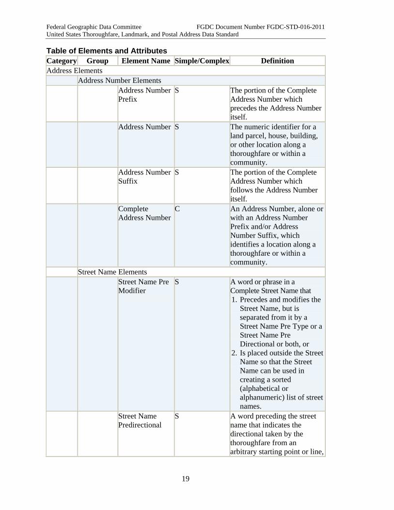
Table of Elements and Attributes Category Group Element Name Simple/Complex Definition Address Elements Address Number Elements Address Number
Prefix S The portion of the Complete
Address Number which precedes the Address Number itself.
Address Number S The numeric identifier for a land parcel, house, building, or other location along a thoroughfare or within a community.
Address Number Suffix
S The portion of the Complete Address Number which follows the Address Number itself.
Complete Address Number
C An Address Number, alone or with an Address Number Prefix and/or Address Number Suffix, which identifies a location along a thoroughfare or within a community.
Street Name Elements Street Name Pre
Modifier S A word or phrase in a
Complete Street Name that 1. Precedes and modifies the
Street Name, but is separated from it by a Street Name Pre Type or a Street Name Pre Directional or both, or
2. Is placed outside the Street Name so that the Street Name can be used in creating a sorted (alphabetical or alphanumeric) list of streetnames.
Street Name Predirectional
S A word preceding the street name that indicates the directional taken by the thoroughfare from an arbitrary starting point or line,

Federal Geographic Data Committee FGDC Document Number FGDC-STD-016-2011 United States Thoroughfare, Landmark, and Postal Address Data Standard
20
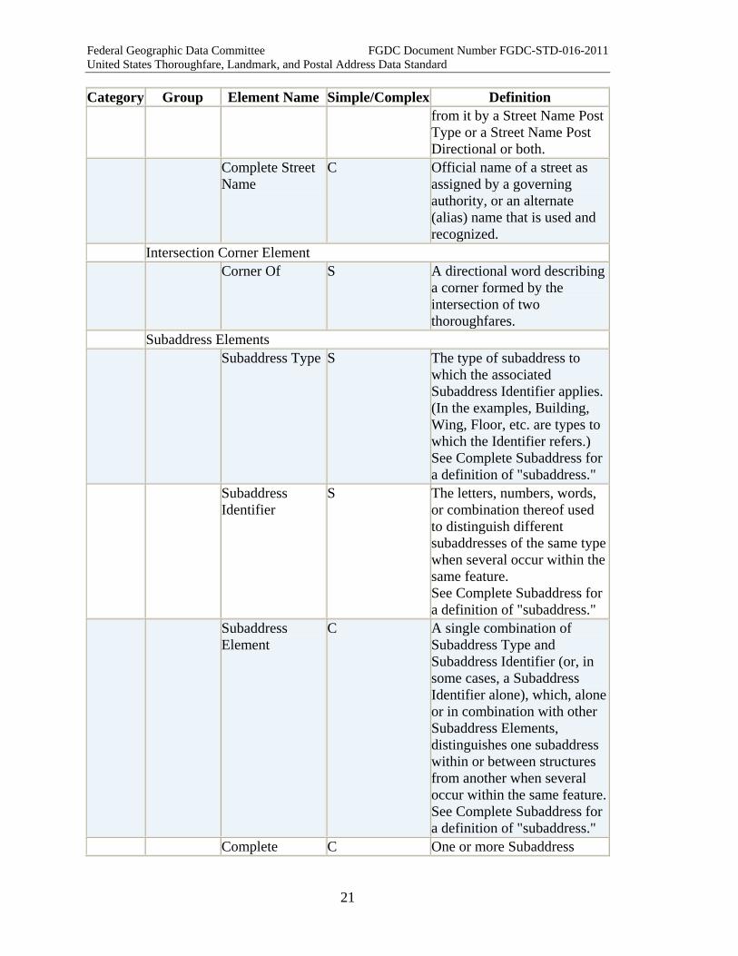
Category Group Element Name Simple/Complex Definition or the sector where it is located.
Street Name Pretype
S A word or phrase that precedes the Street Name and identifies a type of thoroughfare in a Complete Street Name.
Separator Element
S A symbol, word, or phrase used as a separator between components of a complex element or class. The separator is required for Intersection Addresses and for Two Number Address Ranges, and it may be used in constructing a Complete Street Name.
Street Name S The portion of the Complete Street Name that identifies the particular thoroughfare (as opposed to the Street Name Pre Modifier, Street Name Post Modifier, Street Name Pre Directional, Street Name Post Directional, Street Name Pre Type, Street Name Post Type, and Separator Element (if any) in the Complete Street Name.)
Street Name Posttype
S A word or phrase that follows the Street Name and identifies a type of thoroughfare in a Complete Street Name.
Street Name Postdirectional
S A word following the street name that indicates the directional taken by the thoroughfare from an arbitrary starting point or line, or the sector where it is located.
Street Name Post Modifier
S A word or phrase in a Complete Street Name that follows and modifies the Street Name, but is separated
Federal Geographic Data Committee FGDC Document Number FGDC-STD-016-2011 United States Thoroughfare, Landmark, and Postal Address Data Standard
21
Category Group Element Name Simple/Complex Definition from it by a Street Name Post Type or a Street Name Post Directional or both.
Complete Street Name
C Official name of a street as assigned by a governing authority, or an alternate (alias) name that is used and recognized.
Intersection Corner Element Corner Of S A directional word describing
a corner formed by the intersection of two thoroughfares.
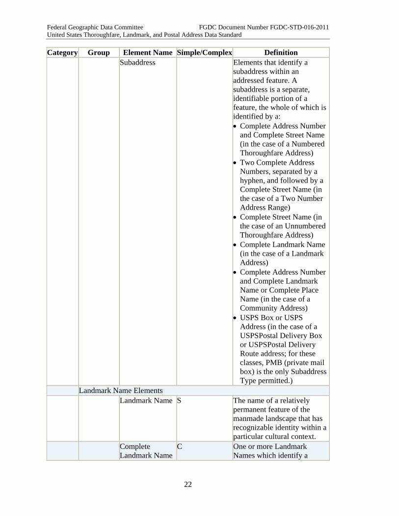
Subaddress Elements Subaddress Type S The type of subaddress to
which the associated Subaddress Identifier applies. (In the examples, Building, Wing, Floor, etc. are types to which the Identifier refers.) See Complete Subaddress for a definition of "subaddress."
Subaddress Identifier
S The letters, numbers, words, or combination thereof used to distinguish different subaddresses of the same type when several occur within the same feature. See Complete Subaddress for a definition of "subaddress."
Subaddress Element
C A single combination of Subaddress Type and Subaddress Identifier (or, in some cases, a Subaddress Identifier alone), which, alone or in combination with other Subaddress Elements, distinguishes one subaddress within or between structures from another when several occur within the same feature. See Complete Subaddress for a definition of "subaddress."
Complete C One or more Subaddress
Federal Geographic Data Committee FGDC Document Number FGDC-STD-016-2011 United States Thoroughfare, Landmark, and Postal Address Data Standard
22
Category Group Element Name Simple/Complex Definition Subaddress Elements that identify a
subaddress within an addressed feature. A subaddress is a separate, identifiable portion of a feature, the whole of which is identified by a: • Complete Address Number
and Complete Street Name (in the case of a Numbered Thoroughfare Address)
• Two Complete Address Numbers, separated by a hyphen, and followed by a Complete Street Name (in the case of a Two Number Address Range)
• Complete Street Name (in the case of an Unnumbered Thoroughfare Address)
• Complete Landmark Name (in the case of a Landmark Address)
• Complete Address Number and Complete Landmark Name or Complete Place Name (in the case of a Community Address)
• USPS Box or USPS Address (in the case of a USPSPostal Delivery Box or USPSPostal Delivery Route address; for these classes, PMB (private mail box) is the only Subaddress Type permitted.)
Landmark Name Elements Landmark Name S The name of a relatively
permanent feature of the manmade landscape that has recognizable identity within a particular cultural context.
Complete Landmark Name
C One or more Landmark Names which identify a
Federal Geographic Data Committee FGDC Document Number FGDC-STD-016-2011 United States Thoroughfare, Landmark, and Postal Address Data Standard
23
Category Group Element Name Simple/Complex Definition relatively permanent feature of the manmade landscape that has recognizable identity within a particular cultural context.
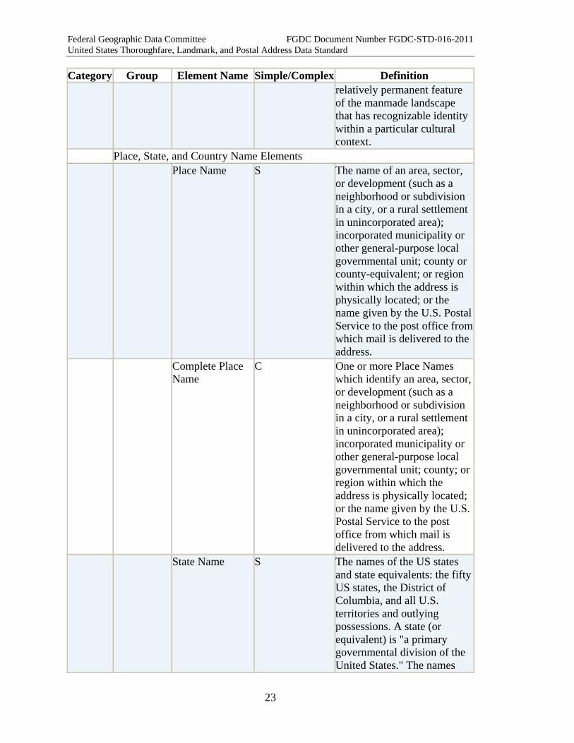
Place, State, and Country Name Elements Place Name S The name of an area, sector,
or development (such as a neighborhood or subdivision in a city, or a rural settlement in unincorporated area); incorporated municipality or other general-purpose local governmental unit; county or county-equivalent; or region within which the address is physically located; or the name given by the U.S. Postal Service to the post office from which mail is delivered to the address.
Complete Place Name
C One or more Place Names which identify an area, sector, or development (such as a neighborhood or subdivision in a city, or a rural settlement in unincorporated area); incorporated municipality or other general-purpose local governmental unit; county; or region within which the address is physically located; or the name given by the U.S. Postal Service to the post office from which mail is delivered to the address.
State Name S The names of the US states and state equivalents: the fifty US states, the District of Columbia, and all U.S. territories and outlying possessions. A state (or equivalent) is "a primary governmental division of the United States." The names

Federal Geographic Data Committee FGDC Document Number FGDC-STD-016-2011 United States Thoroughfare, Landmark, and Postal Address Data Standard
24
Category Group Element Name Simple/Complex Definition may be spelled out in full or represented by their two-letter USPS or ANSI abbreviation.
ZIP Code S A system of 5-digit codes that identifies the individual Post Office or metropolitan area delivery station associated with an address.
ZIP Plus 4 S A 4-digit extension of the 5-digit ZIP Code (preceded by a hyphen) that, in conjunction with the ZIP Code, identifies a specific range of USPS delivery addresses.
Country Name S The name of the country in which the address is located. A country is "an independent, self-governing, political entity."
USPS Postal Address Elements USPS Box Type S The name of the class of the
container used for receipt of USPS mail. USPS Publication 28 requires the use of "PO Box" or "Box" for this element.
USPS Box ID S The numbers or letters distinguishing one box from another within a post office or route.
USPS Box C A container for the receipt of USPS mail uniquely identified by the combination of a USPSBox Type and a USPSBox ID.
USPS Box Group Type
S A name for a type of postal delivery point or route containing a group of USPS Boxes.
USPS Box Group ID
S The numbers or letters distinguishing one route or distribution point from another route or distribution point of the same USPSBox Group Type.
Federal Geographic Data Committee FGDC Document Number FGDC-STD-016-2011 United States Thoroughfare, Landmark, and Postal Address Data Standard
25
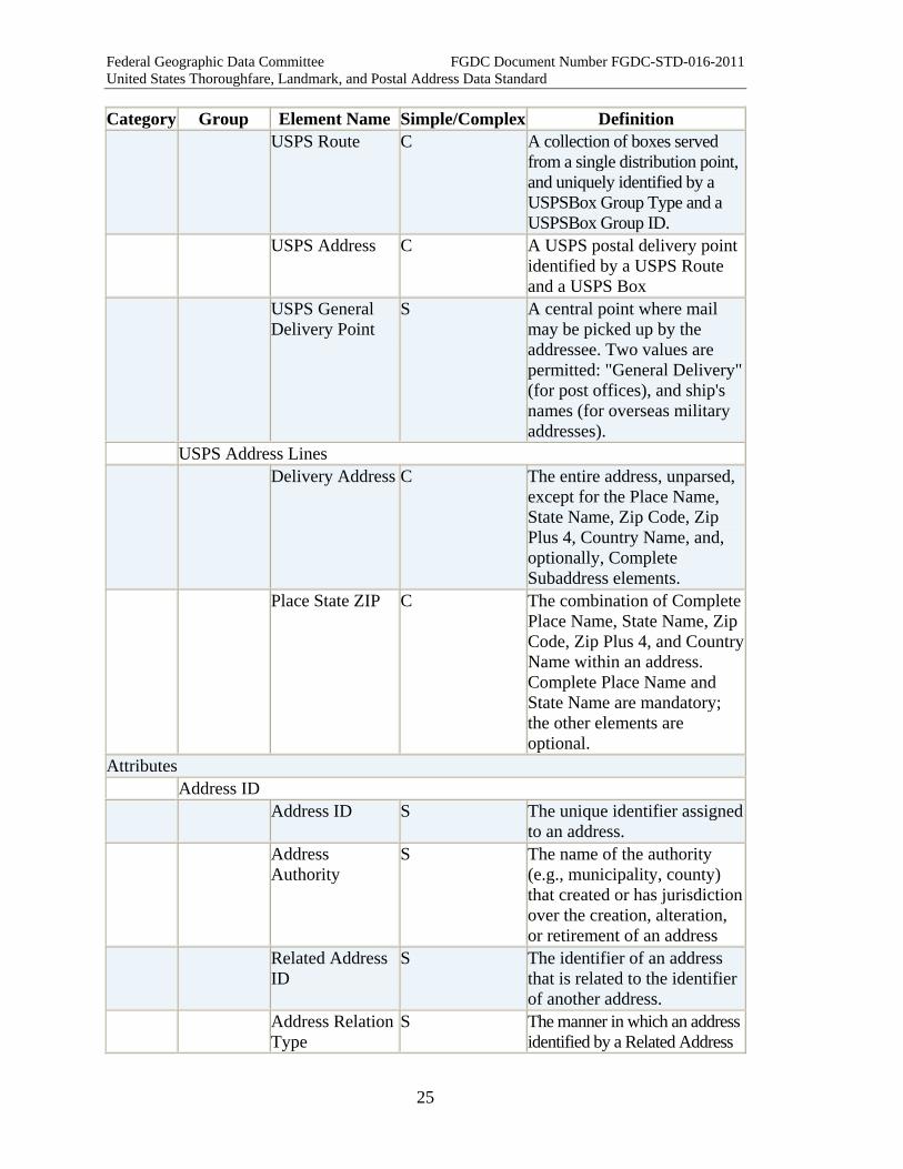
Category Group Element Name Simple/Complex Definition USPS Route C A collection of boxes served
from a single distribution point, and uniquely identified by a USPSBox Group Type and a USPSBox Group ID.
USPS Address C A USPS postal delivery point identified by a USPS Route and a USPS Box
USPS General Delivery Point
S A central point where mail may be picked up by the addressee. Two values are permitted: "General Delivery" (for post offices), and ship's names (for overseas military addresses).
USPS Address Lines Delivery Address C The entire address, unparsed,
except for the Place Name, State Name, Zip Code, Zip Plus 4, Country Name, and, optionally, Complete Subaddress elements.
Place State ZIP C The combination of Complete Place Name, State Name, Zip Code, Zip Plus 4, and Country Name within an address. Complete Place Name and State Name are mandatory; the other elements are optional.
Attributes Address ID Address ID S The unique identifier assigned
to an address. Address
Authority S The name of the authority
(e.g., municipality, county) that created or has jurisdiction over the creation, alteration, or retirement of an address
Related Address ID
S The identifier of an address that is related to the identifier of another address.
Address Relation Type
S The manner in which an address identified by a Related Address
Federal Geographic Data Committee FGDC Document Number FGDC-STD-016-2011 United States Thoroughfare, Landmark, and Postal Address Data Standard
26
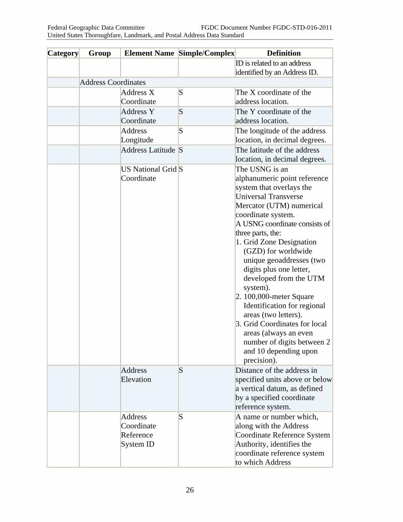
Category Group Element Name Simple/Complex Definition ID is related to an address identified by an Address ID.
Address Coordinates Address X
Coordinate S The X coordinate of the
address location. Address Y
Coordinate S The Y coordinate of the
address location. Address
Longitude S The longitude of the address
location, in decimal degrees. Address Latitude S The latitude of the address
location, in decimal degrees. US National Grid
Coordinate S The USNG is an
alphanumeric point reference system that overlays the Universal Transverse Mercator (UTM) numerical coordinate system. A USNG coordinate consists of three parts, the: 1. Grid Zone Designation
(GZD) for worldwide unique geoaddresses (two digits plus one letter, developed from the UTM system).
2. 100,000-meter Square Identification for regional areas (two letters).
3. Grid Coordinates for local areas (always an even number of digits between 2 and 10 depending upon precision).
Address Elevation
S Distance of the address in specified units above or below a vertical datum, as defined by a specified coordinate reference system.
Address Coordinate Reference System ID
S A name or number which, along with the Address Coordinate Reference System Authority, identifies the coordinate reference system to which Address
Federal Geographic Data Committee FGDC Document Number FGDC-STD-016-2011 United States Thoroughfare, Landmark, and Postal Address Data Standard
27
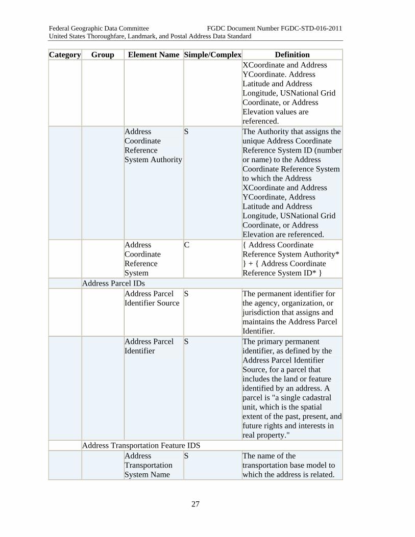
Category Group Element Name Simple/Complex Definition XCoordinate and Address YCoordinate. Address Latitude and Address Longitude, USNational Grid Coordinate, or Address Elevation values are referenced.
Address Coordinate Reference System Authority
S The Authority that assigns the unique Address Coordinate Reference System ID (number or name) to the Address Coordinate Reference System to which the Address XCoordinate and Address YCoordinate, Address Latitude and Address Longitude, USNational Grid Coordinate, or Address Elevation are referenced.
Address Coordinate Reference System
C { Address Coordinate Reference System Authority* } + { Address Coordinate Reference System ID* }
Address Parcel IDs Address Parcel
Identifier Source S The permanent identifier for
the agency, organization, or jurisdiction that assigns and maintains the Address Parcel Identifier.
Address Parcel Identifier
S The primary permanent identifier, as defined by the Address Parcel Identifier Source, for a parcel that includes the land or feature identified by an address. A parcel is "a single cadastral unit, which is the spatial extent of the past, present, and future rights and interests in real property."
Address Transportation Feature IDS Address
Transportation System Name
S The name of the transportation base model to which the address is related.
Federal Geographic Data Committee FGDC Document Number FGDC-STD-016-2011 United States Thoroughfare, Landmark, and Postal Address Data Standard
28
Category Group Element Name Simple/Complex Definition Address
Transportation System Authority
S The authority that maintains the transportation base model specified by the Address Transportation System Name, and assigns Address Transportation Feature IDs to the features it represents.
Address Transportation Feature Type
S The type of transportation feature (TranFeature) used to represent an address.
Address Transportation Feature ID
S The unique identifier assigned to the particular feature that represents an address within a transportation base model.
Related Transportation Feature ID
S The unique identifier assigned (within the reference transportation base model) to a transportation feature to which an address is related.
Address Range Attributes Address Range
Type S This attribute states whether
an address range (either a Two Number Address Range or a Four Number Address Range) is actual or potential. Actual range: the low and high Complete Address Numbers are numbers that have been assigned and are in use along the addressed feature. Potential range: the low and high Complete Address Numbers are numbers that would be assigned if all possible numbers were in use along the addressed feature, and there were no gaps between the range and its preceding and following ranges.
Address Range Parity
S The set of Address Number Parity values specified in the Address Reference System

Federal Geographic Data Committee FGDC Document Number FGDC-STD-016-2011 United States Thoroughfare, Landmark, and Postal Address Data Standard
29
Category Group Element Name Simple/Complex Definition Numbering Rules for the Address Numbers in an address range.
Address Range Side
S The side of the transportation segment(s) (TranSeg) or path (TranPath) on which the address range is found (right, left or both).
Address Range Directionality
S Whether the low Complete Address Number of an address range is closer to the from-node or the to-node of the transportation segment(s) that the range is related to.
Address Range Span
S Whether an address range covers part of a transportation segment, one segment, multiple segments, or the entire thoroughfare within the Address Reference System Extent.
Address Attributes Address
Classification S The class of the address as
defined in the Classification Part of this standard.
Address Feature Type
S A category of real world phenomena with common properties whose location is specified by an address.
Address Lifecycle Status
S The lifecycle status of the address.
Official Status S Whether the address, street name, landmark name, or place name is as given by the official addressing authority (official), or an alternate or alias (official or unofficial), or a verified error.
Address Anomaly Status
S A status flag, or an explanatory note, for an address that is not correct according to the Address Reference System that governs it, but is nonetheless
Federal Geographic Data Committee FGDC Document Number FGDC-STD-016-2011 United States Thoroughfare, Landmark, and Postal Address Data Standard
30
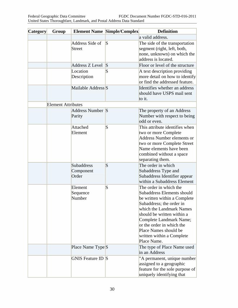
Category Group Element Name Simple/Complex Definition a valid address.
Address Side of Street
S The side of the transportation segment (right, left, both, none, unknown) on which the address is located.
Address Z Level S Floor or level of the structure Location
Description S A text description providing
more detail on how to identify or find the addressed feature.
Mailable Address S Identifies whether an address should have USPS mail sent to it.
Element Attributes Address Number
Parity S The property of an Address
Number with respect to being odd or even.
Attached Element
S This attribute identifies when two or more Complete Address Number elements or two or more Complete Street Name elements have been combined without a space separating them.
Subaddress Component Order
S The order in which Subaddress Type and Subaddress Identifier appear within a Subaddress Element
Element Sequence Number
S The order in which the Subaddress Elements should be written within a Complete Subaddress; the order in which the Landmark Names should be written within a Complete Landmark Name; or the order in which the Place Names should be written within a Complete Place Name.
Place Name Type S The type of Place Name used in an Address
GNIS Feature ID S "A permanent, unique number assigned to a geographic feature for the sole purpose of uniquely identifying that

Federal Geographic Data Committee FGDC Document Number FGDC-STD-016-2011 United States Thoroughfare, Landmark, and Postal Address Data Standard
31
Category Group Element Name Simple/Complex Definition feature as a record in any information system database, dataset, file, or document and for distinguishing it from all other feature records so identified. The number is assigned sequentially (highest existing number plus one) to new records as they are created in the Geographic Names Information System."
ANSI State County Code
S A set of two-digit numeric codes identifying the states, the District of Columbia, Puerto Rico, and the insular areas of the United States, which may be followed by a three-digit numeric code identifying a county or equivalent entity therein.
Delivery Address Type
S Whether the Delivery Address includes or excludes the Complete Subaddress.
Address Lineage Attributes Address Start
Date S The earliest date on which the
address is known to exist. Address End
Date S The date on which the address
is known to no longer be valid.
Data Set ID S An identifier of a transmitted dataset, assigned by the sender or the receiver of the dataset, to associate each record of the dataset to the file-level metadata that accompanies the dataset.
Address Direct Source
S Source from which the data provider obtained the address, or with which the data provider validated the address.
Address Reference System Elements Address
Reference S A unique identifier of an
Address Reference System.
Federal Geographic Data Committee FGDC Document Number FGDC-STD-016-2011 United States Thoroughfare, Landmark, and Postal Address Data Standard
32
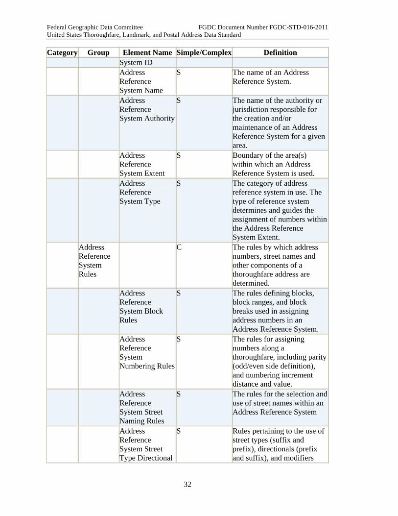
Category Group Element Name Simple/Complex Definition System ID
Address Reference System Name
S The name of an Address Reference System.
Address Reference System Authority
S The name of the authority or jurisdiction responsible for the creation and/or maintenance of an Address Reference System for a given area.
Address Reference System Extent
S Boundary of the area(s) within which an Address Reference System is used.
Address Reference System Type
S The category of address reference system in use. The type of reference system determines and guides the assignment of numbers within the Address Reference System Extent.
Address Reference System Rules
C The rules by which address numbers, street names and other components of a thoroughfare address are determined.
Address Reference System Block Rules
S The rules defining blocks, block ranges, and block breaks used in assigning address numbers in an Address Reference System.
Address Reference System Numbering Rules
S The rules for assigning numbers along a thoroughfare, including parity (odd/even side definition), and numbering increment distance and value.
Address Reference System Street Naming Rules
S The rules for the selection and use of street names within an Address Reference System
Address Reference System Street Type Directional
S Rules pertaining to the use of street types (suffix and prefix), directionals (prefix and suffix), and modifiers

Federal Geographic Data Committee FGDC Document Number FGDC-STD-016-2011 United States Thoroughfare, Landmark, and Postal Address Data Standard
33
Category Group Element Name Simple/Complex Definition and Modifier Rules
(prefix and suffix) of street names.
Address Reference System Place Name State Country and ZIP Code Rules
S Rules for the use of place names, state names, country names, and ZIP Codes within the jurisdiction of an Address Authority.
Address Reference System Subaddress Rules
S Rules that are applied to the addressing of areas within structures as subaddresses (units, suites, apartments, spaces, etc.) within a given Address Reference System
Address Reference System Axis
S The line that defines the points of origin for address numbering along thoroughfares that intersect it, or which are numbered in parallel to streets that intersect it. It may be a road, another geographic feature, or an imaginary line.
Address Reference System Axis Point of Beginning
S Coordinate location of the beginning point of address numbering along an Address Reference System Axis.
Address Reference System Grid Angle
S The degree to which a specific, named address grid is tilted off a north/south or east/west orientation.
Address Reference System Reference Polyline
S A street, geometric line, or other line used to measure address number assignment intervals and ranges within an Address Reference System. The Address Reference System Reference Polyline may consist of a beginning point, one or more segments of a street centerline, geographically identified line, such as a line of latitude or
Federal Geographic Data Committee FGDC Document Number FGDC-STD-016-2011 United States Thoroughfare, Landmark, and Postal Address Data Standard
34
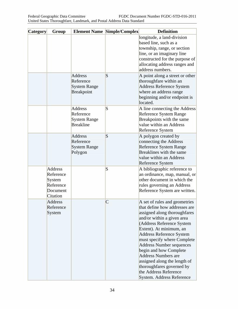
Category Group Element Name Simple/Complex Definition longitude, a land-division based line, such as a township, range, or section line, or an imaginary line constructed for the purpose of allocating address ranges and address numbers.
Address Reference System Range Breakpoint
S A point along a street or other thoroughfare within an Address Reference System where an address range beginning and/or endpoint is located.
Address Reference System Range Breakline
S A line connecting the Address Reference System Range Breakpoints with the same value within an Address Reference System
Address Reference System Range Polygon
S A polygon created by connecting the Address Reference System Range Breaklines with the same value within an Address Reference System
Address Reference System Reference Document Citation
S A bibliographic reference to an ordinance, map, manual, or other document in which the rules governing an Address Reference System are written.
Address Reference System
C A set of rules and geometries that define how addresses are assigned along thoroughfares and/or within a given area (Address Reference System Extent). At minimum, an Address Reference System must specify where Complete Address Number sequences begin and how Complete Address Numbers are assigned along the length of thoroughfares governed by the Address Reference System. Address Reference
Federal Geographic Data Committee FGDC Document Number FGDC-STD-016-2011 United States Thoroughfare, Landmark, and Postal Address Data Standard
35
Category Group Element Name Simple/Complex Definition Systems typically provide rules governing left-right parity of Complete Address Numbers, assignment of Street Names and street types, use of directionals and quadrants, and other aspects of address assignment. An Address Reference System is designated by its Address Reference System Name (required). Additional business rules for an Address Reference System are described in the Address Reference System Rules.
2.2 Address Elements
2.2.1 Address Number Elements
2.2.1.1 Address Number Prefix Element Name AddressNumberPrefix Other common names for this
element
Street Number Prefix, Building Number Prefix, House Number Prefix, Site Number Prefix, Structure Number Prefix
Definition The portion of the Complete Address Number which precedes the Address Number itself.
Definition Source New Data Type characterString Existing
Standards for this Element
None
Domain of Values for this Element
Can be created locally from existing values
Source of Values Local How Defined Locally
Example N6W2 3001 Bluemound Road A 19 Calle 11 194-0 3 Fiftieth Avenue Milepost 1303 Alaska Highway
Notes/Comments 1. This element is not found in most Complete Address Numbers. When found, it should be separated from the Address Number so that the Address Number can be maintained as an integer for
Federal Geographic Data Committee FGDC Document Number FGDC-STD-016-2011 United States Thoroughfare, Landmark, and Postal Address Data Standard
36
sorting and quality control tests. 2. Informally an Address Number and Address Number Prefix may
be written with or without a space between them. Within this standard, the default assumption is that an empty space separates elements unless stated otherwise. The Attached Element can be used to indicate where the assumed space between the Address Number and Address Number Prefix has been omitted within an address file (see Attached Element for additional notes).
3. If a hyphen appears between an Address Number Prefix and an Address Number, the hyphen is included in the Address Number Prefix.
4. Milepost numbers are often used to specify locations on limited-access roads such as interstate highways, and along highways and country roads where addressable features are too sparse to assign address numbers. Where it is useful to treat these as addresses, treat "Milepost" (or "Kilometer,” in Puerto Rico) as an Address Number Prefix, and the milepost number as the Address Number.
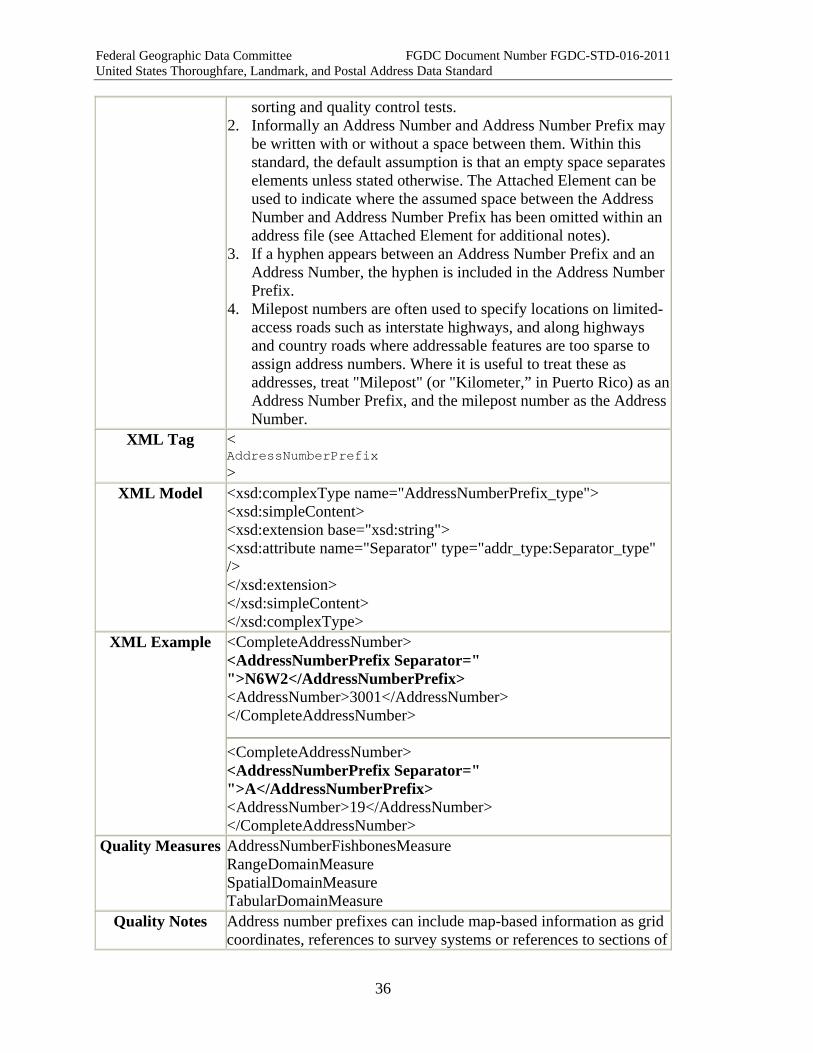
XML Tag < AddressNumberPrefix >
XML Model <xsd:complexType name="AddressNumberPrefix_type"> <xsd:simpleContent> <xsd:extension base="xsd:string"> <xsd:attribute name="Separator" type="addr_type:Separator_type" /> </xsd:extension> </xsd:simpleContent> </xsd:complexType>
XML Example <CompleteAddressNumber> <AddressNumberPrefix Separator=" ">N6W2</AddressNumberPrefix> <AddressNumber>3001</AddressNumber> </CompleteAddressNumber>
<CompleteAddressNumber> <AddressNumberPrefix Separator=" ">A</AddressNumberPrefix> <AddressNumber>19</AddressNumber> </CompleteAddressNumber>
Quality Measures AddressNumberFishbonesMeasure RangeDomainMeasure SpatialDomainMeasure TabularDomainMeasure
Quality Notes Address number prefixes can include map-based information as grid coordinates, references to survey systems or references to sections of

Federal Geographic Data Committee FGDC Document Number FGDC-STD-016-2011 United States Thoroughfare, Landmark, and Postal Address Data Standard
37
a subdivision or housing complex. Where a tabular domain of values are available the prefix can be tested against it. The measure chosen will depend on the type of domain involved. See the introduction to this section for information on which measures to use.
2.2.1.2 Address Number Element Name ADDRstandard.AddressNumber Other common names for this
element
Street Number, Building Number, House Number, Site Number, Structure Number
Definition The numeric identifier for a land parcel, house, building, or other location along a thoroughfare or within a community.
Definition Source New Data Type Integer Existing
Standards for this Element
None
Domain of Values for this Element
Can be created locally.
Source of Values Local jurisdiction Attributes
Associated with this Element
Address Number Parity
How Defined Based on local address ranges associated with individual streets and blocks.
Example 123 Main Street N4W6 123 Oak Road 123 B Highway 88
Notes/Comments 1. The Address Number is defined as an integer to support address sorting, parity (even/odd) definition, and in/out of address range tests.
2. The Address Number must be converted to a characterString when it is combined with the prefix and suffix into a Complete Address Number.
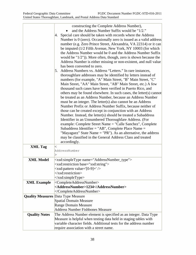
3. Some addresses may contain letters, fractions, hyphens, decimals, and other non-integer content within the Complete Address Number. Those non-integer elements should be placed in the Address Number Prefix if they appear before the Address Number, or in the Address Number Suffix if they follow the Address Number. For example, if the New York City hyphenated address 194-03 ½ 50th Avenue, New York, NY 11365 were to be parsed rather than represented as a Complete Address Number:
• the Address Number Prefix would be "194-0" (including the hyphen and the leading "0"),
• the Address Number would be 3 (converted to text in
Federal Geographic Data Committee FGDC Document Number FGDC-STD-016-2011 United States Thoroughfare, Landmark, and Postal Address Data Standard
38
constructing the Complete Address Number), • and the Address Number Suffix would be "1/2.”
4. Special care should be taken with records where the Address Number is 0 (zero). Occasionally zero is issued as a valid address number (e.g. Zero Prince Street, Alexandria, VA 22314) or it can be imputed (1/2 Fifth Avenue, New York, NY 10003 (for which the Address Number would be 0 and the Address Number Suffix would be "1/2")). More often, though, zero is shown because the Address Number is either missing or non-existent, and null value has been converted to zero.
5. Address Numbers vs. Address “Letters.” In rare instances, thoroughfare addresses may be identified by letters instead of numbers (for example, "A" Main Street, "B" Main Street, "C" Main Street, "AA" Main Street, "AB" Main Street, etc.) A few thousand such cases have been verified in Puerto Rico, and others may be found elsewhere. In such cases, the letter(s) cannot be treated as an Address Number, because an Address Number must be an integer. The letter(s) also cannot be an Address Number Prefix or Address Number Suffix, because neither of those can be created except in conjunction with an Address Number. Instead, the letter(s) should be treated a Subaddress Identifier in an Unnumbered Thoroughfare Address. (For example: Complete Street Name = "Calle Sanchez", Complete Subaddress Identifier = "AB", Complete Place Name = "Mayaguez" State Name = "PR"). As an alternative, the address may be classified in the General Address Class and treated accordingly.
XML Tag < AddressNumber >
XML Model <xsd:simpleType name="AddressNumber_type"> <xsd:restriction base="xsd:string"> <xsd:pattern value='[0-9]+' /> </xsd:restriction> </xsd:simpleType>
XML Example <CompleteAddressNumber> <AddressNumber>1234</AddressNumber> </CompleteAddressNumber>
Quality Measures Data Type Measure Spatial Domain Measure Range Domain Measure Address Number Fishbones Measure
Quality Notes The Address Number element is specified as an integer. Data Type Measure is helpful when testing data held in staging tables with variable character fields. Additional tests for the address number require association with a street name.

Federal Geographic Data Committee FGDC Document Number FGDC-STD-016-2011 United States Thoroughfare, Landmark, and Postal Address Data Standard
39
2.2.1.3 Address Number Suffix Element Name ADDRstandard.AddressNumberSuffix Other common names for this
element
Street Number Suffix, Building Number Suffix, House Number Suffix, Fractional Street Number (USPS), Structure Number Suffix
Definition The portion of the Complete Address Number which follows the Address Number itself.
Definition Source New Data Type characterString Existing
Standards for this Element
None
Domain of Values for this Element
Can be created locally from existing values
Source of Values Local How Defined Locally
Example 123 1/2 Main Street 121 E E Street B317 A Calle 117 Milepost 34.4 (Address Number Suffix = decimal portion only)
Notes/Comments 1. This element is not found in most Complete Address Numbers. When found, it should be separated from the Address Number so that the Address Number can be maintained as an integer for sorting and quality control tests.
2. Informally an Address Number and Address Number Suffix may be written with or without a space between them. Within this standard, the default assumption is that an empty space separates elements unless stated otherwise. The Attached Element can be used to indicate where the assumed space between the Address Number and Address Number Suffix has been omitted within an address file (see Attached Element for additional notes).
3. If a hyphen appears between the Address Number and the Address Number Suffix, the hyphen is included in the Address Number Suffix.
4. When milepost Complete Address Numbers include decimal fractions, the integer portion of the milepost number is treated as the Address Number, and the fraction (including the decimal point) is treated as an Address Number Suffix. (See Complete Address Number for additional notes on milepost address numbers.)
XML Tag < AddressNumberSuffix >
XML Model <xsd:complexType name="AddressNumberSuffix_type"> <xsd:simpleContent>
Federal Geographic Data Committee FGDC Document Number FGDC-STD-016-2011 United States Thoroughfare, Landmark, and Postal Address Data Standard
40
<xsd:extension base="xsd:string"> <xsd:attribute name="Separator" type="addr_type:Separator_type" /> </xsd:extension> </xsd:simpleContent> </xsd:complexType>
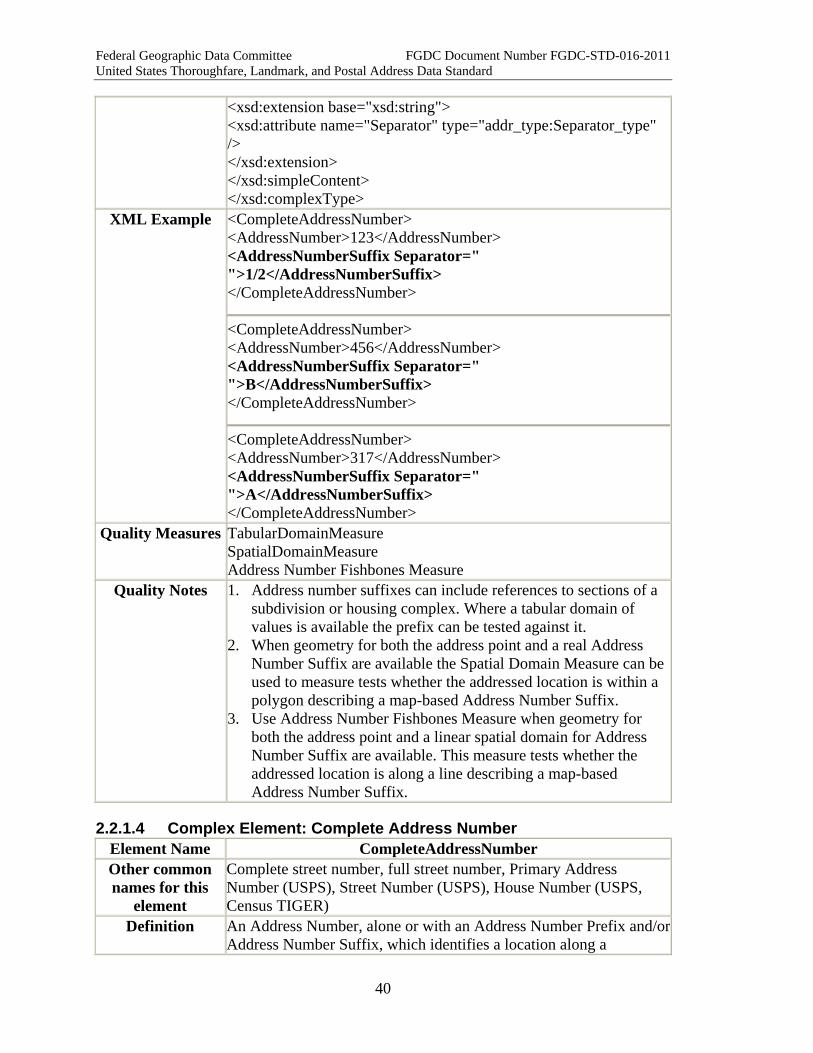
XML Example <CompleteAddressNumber> <AddressNumber>123</AddressNumber> <AddressNumberSuffix Separator=" ">1/2</AddressNumberSuffix> </CompleteAddressNumber>
<CompleteAddressNumber> <AddressNumber>456</AddressNumber> <AddressNumberSuffix Separator=" ">B</AddressNumberSuffix> </CompleteAddressNumber>
<CompleteAddressNumber> <AddressNumber>317</AddressNumber> <AddressNumberSuffix Separator=" ">A</AddressNumberSuffix> </CompleteAddressNumber>
Quality Measures TabularDomainMeasure SpatialDomainMeasure Address Number Fishbones Measure
Quality Notes 1. Address number suffixes can include references to sections of a subdivision or housing complex. Where a tabular domain of values is available the prefix can be tested against it.
2. When geometry for both the address point and a real Address Number Suffix are available the Spatial Domain Measure can be used to measure tests whether the addressed location is within a polygon describing a map-based Address Number Suffix.
3. Use Address Number Fishbones Measure when geometry for both the address point and a linear spatial domain for Address Number Suffix are available. This measure tests whether the addressed location is along a line describing a map-based Address Number Suffix.
2.2.1.4 Complex Element: Complete Address Number Element Name CompleteAddressNumber Other common names for this
element
Complete street number, full street number, Primary Address Number (USPS), Street Number (USPS), House Number (USPS, Census TIGER)
Definition An Address Number, alone or with an Address Number Prefix and/or Address Number Suffix, which identifies a location along a
Federal Geographic Data Committee FGDC Document Number FGDC-STD-016-2011 United States Thoroughfare, Landmark, and Postal Address Data Standard
41
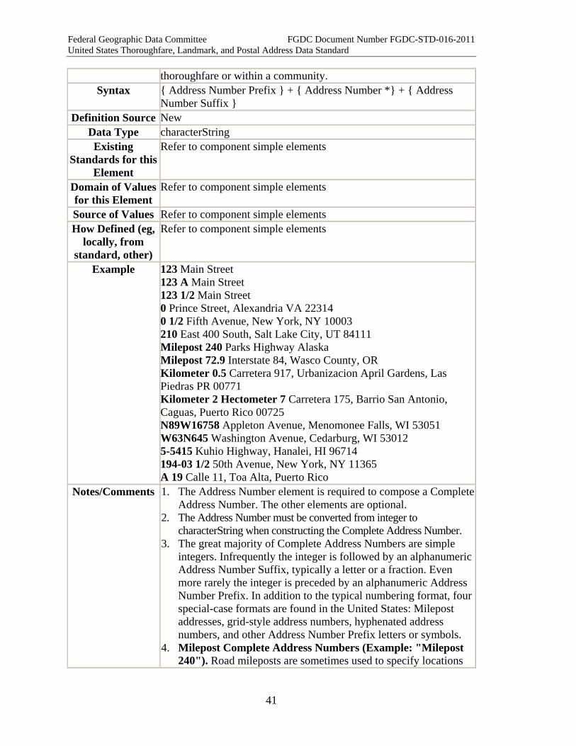
thoroughfare or within a community. Syntax { Address Number Prefix } + { Address Number *} + { Address
Number Suffix } Definition Source New
Data Type characterString Existing
Standards for this Element
Refer to component simple elements
Domain of Values for this Element
Refer to component simple elements
Source of Values Refer to component simple elements How Defined (eg,
locally, from standard, other)
Refer to component simple elements
Example 123 Main Street 123 A Main Street 123 1/2 Main Street 0 Prince Street, Alexandria VA 22314 0 1/2 Fifth Avenue, New York, NY 10003 210 East 400 South, Salt Lake City, UT 84111 Milepost 240 Parks Highway Alaska Milepost 72.9 Interstate 84, Wasco County, OR Kilometer 0.5 Carretera 917, Urbanizacion April Gardens, Las Piedras PR 00771 Kilometer 2 Hectometer 7 Carretera 175, Barrio San Antonio, Caguas, Puerto Rico 00725 N89W16758 Appleton Avenue, Menomonee Falls, WI 53051 W63N645 Washington Avenue, Cedarburg, WI 53012 5-5415 Kuhio Highway, Hanalei, HI 96714 194-03 1/2 50th Avenue, New York, NY 11365 A 19 Calle 11, Toa Alta, Puerto Rico
Notes/Comments 1. The Address Number element is required to compose a Complete Address Number. The other elements are optional.
2. The Address Number must be converted from integer to characterString when constructing the Complete Address Number.
3. The great majority of Complete Address Numbers are simple integers. Infrequently the integer is followed by an alphanumeric Address Number Suffix, typically a letter or a fraction. Even more rarely the integer is preceded by an alphanumeric Address Number Prefix. In addition to the typical numbering format, four special-case formats are found in the United States: Milepost addresses, grid-style address numbers, hyphenated address numbers, and other Address Number Prefix letters or symbols.
4. Milepost Complete Address Numbers (Example: "Milepost 240"). Road mileposts are sometimes used to specify locations

Federal Geographic Data Committee FGDC Document Number FGDC-STD-016-2011 United States Thoroughfare, Landmark, and Postal Address Data Standard
42
along highways and similar roads. Mileposts are often used to locate, for example, crash sites, emergency call boxes, bridge locations, inspection stations, roadside rest stops, railroad crossings, highway exits, park and campground entrances, RV parks, and truck stops. Milepost addresses should be parsed as follows: • "Milepost" (or equivalent word or phrase, such as "kilometer"
or 'Mile Marker") is an Address Number Prefix • The milepost number (integer part only) is an Address
Number • Tenths, if given, are an Address Number Suffix, including the
decimal point. • The road name or highway route number is a Complete Street
Name, and parsed accordingly 5. Note that, in Puerto Rico, road measurements are given in
kilometers (km), which are sometimes divided into hectometers (hm).
6. Grid-style Complete Address Numbers (Example: "N89W16758"). In certain communities in and around southern Wisconsin, Complete Address Numbers include a map grid cell reference preceding the Address Number. In the examples above, "N89W16758" should be read as "North 89, West 167, Address Number 58". "W63N645" should be read as "West 63, North, Address Number 645." The north and west values specify a locally-defined map grid cell within which the address is located. Local knowledge is needed to know when the grid reference stops and the Address Number begins.
7. Hyphenated Complete Address Numbers (Example: "5-5415"). In some areas (notably certain parts of New York City, southern California, and Hawaii), Complete Address Numbers often include hyphens. Hyphenated Complete Address Numbers should not be confused with Two Number Address Ranges. The former is a single Complete Address Number while the latter includes two Complete Address Numbers.
8. Hyphenated Complete Address Numbers can be parsed so that the number indicating the site or structure is the Address Number, and the remainder (including the hyphen) is the Address Number Prefix or Address Number Suffix.
9. In parts of New York City, hyphenated Complete Address Numbers follow a more complex set of rules. The number to the left of the hyphen indicates the "block" (conceptually--the number does not always change at street intersections and sometimes it changes within a single block face). The number to the right of the hyphen indicates the site or house number within the "block". If the Address Number is less than ten, it is written with a leading zero, as in 194-03 1/2 above. (Additional leading
Federal Geographic Data Committee FGDC Document Number FGDC-STD-016-2011 United States Thoroughfare, Landmark, and Postal Address Data Standard
43
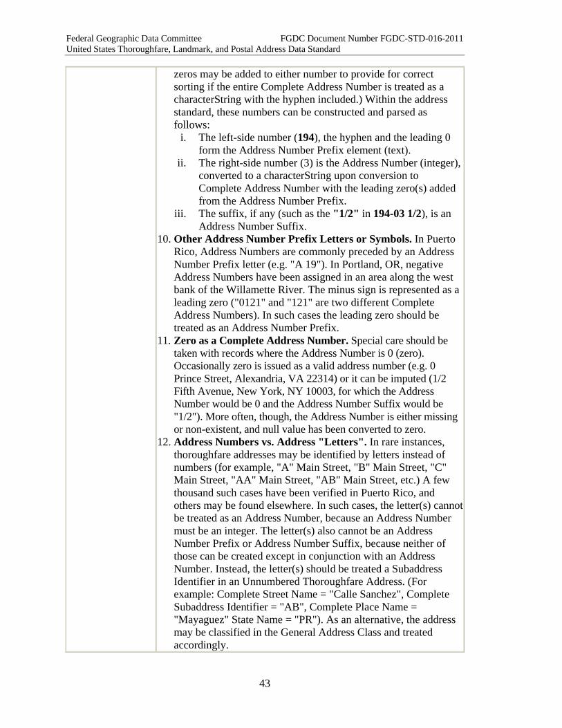
zeros may be added to either number to provide for correct sorting if the entire Complete Address Number is treated as a characterString with the hyphen included.) Within the address standard, these numbers can be constructed and parsed as follows:
i. The left-side number (194), the hyphen and the leading 0 form the Address Number Prefix element (text).
ii. The right-side number (3) is the Address Number (integer), converted to a characterString upon conversion to Complete Address Number with the leading zero(s) added from the Address Number Prefix.
iii. The suffix, if any (such as the "1/2" in 194-03 1/2), is an Address Number Suffix.
10. Other Address Number Prefix Letters or Symbols. In Puerto Rico, Address Numbers are commonly preceded by an Address Number Prefix letter (e.g. "A 19"). In Portland, OR, negative Address Numbers have been assigned in an area along the west bank of the Willamette River. The minus sign is represented as a leading zero ("0121" and "121" are two different Complete Address Numbers). In such cases the leading zero should be treated as an Address Number Prefix.
11. Zero as a Complete Address Number. Special care should be taken with records where the Address Number is 0 (zero). Occasionally zero is issued as a valid address number (e.g. 0 Prince Street, Alexandria, VA 22314) or it can be imputed (1/2 Fifth Avenue, New York, NY 10003, for which the Address Number would be 0 and the Address Number Suffix would be "1/2"). More often, though, the Address Number is either missing or non-existent, and null value has been converted to zero.
12. Address Numbers vs. Address "Letters". In rare instances, thoroughfare addresses may be identified by letters instead of numbers (for example, "A" Main Street, "B" Main Street, "C" Main Street, "AA" Main Street, "AB" Main Street, etc.) A few thousand such cases have been verified in Puerto Rico, and others may be found elsewhere. In such cases, the letter(s) cannot be treated as an Address Number, because an Address Number must be an integer. The letter(s) also cannot be an Address Number Prefix or Address Number Suffix, because neither of those can be created except in conjunction with an Address Number. Instead, the letter(s) should be treated a Subaddress Identifier in an Unnumbered Thoroughfare Address. (For example: Complete Street Name = "Calle Sanchez", Complete Subaddress Identifier = "AB", Complete Place Name = "Mayaguez" State Name = "PR"). As an alternative, the address may be classified in the General Address Class and treated accordingly.
Federal Geographic Data Committee FGDC Document Number FGDC-STD-016-2011 United States Thoroughfare, Landmark, and Postal Address Data Standard
44
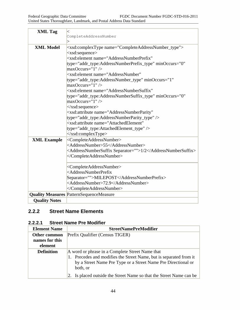
XML Tag < CompleteAddressNumber >
XML Model <xsd:complexType name="CompleteAddressNumber_type"> <xsd:sequence> <xsd:element name="AddressNumberPrefix" type="addr_type:AddressNumberPrefix_type" minOccurs="0" maxOccurs="1" /> <xsd:element name="AddressNumber" type="addr_type:AddressNumber_type" minOccurs="1" maxOccurs="1" /> <xsd:element name="AddressNumberSuffix" type="addr_type:AddressNumberSuffix_type" minOccurs="0" maxOccurs="1" /> </xsd:sequence> <xsd:attribute name="AddressNumberParity" type="addr_type:AddressNumberParity_type" /> <xsd:attribute name="AttachedElement" type="addr_type:AttachedElement_type" /> </xsd:complexType>
XML Example <CompleteAddressNumber> <AddressNumber>55</AddressNumber> <AddressNumberSuffix Separator="">1/2</AddressNumberSuffix></CompleteAddressNumber>
<CompleteAddressNumber> <AddressNumberPrefix Separator="">MILEPOST</AddressNumberPrefix> <AddressNumber>72.9</AddressNumber> </CompleteAddressNumber>
Quality Measures PatternSequenceMeasure Quality Notes
2.2.2 Street Name Elements
2.2.2.1 Street Name Pre Modifier Element Name StreetNamePreModifier Other common names for this
element
Prefix Qualifier (Census TIGER)
Definition A word or phrase in a Complete Street Name that 1. Precedes and modifies the Street Name, but is separated from it
by a Street Name Pre Type or a Street Name Pre Directional or both, or
2. Is placed outside the Street Name so that the Street Name can be
Federal Geographic Data Committee FGDC Document Number FGDC-STD-016-2011 United States Thoroughfare, Landmark, and Postal Address Data Standard
45
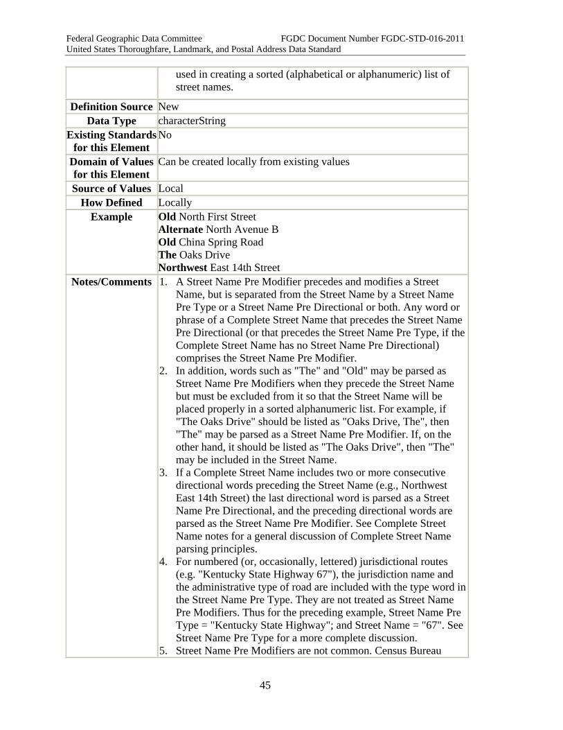
used in creating a sorted (alphabetical or alphanumeric) list of street names.
Definition Source New Data Type characterString
Existing Standards for this Element
No
Domain of Values for this Element
Can be created locally from existing values
Source of Values Local How Defined Locally
Example Old North First Street Alternate North Avenue B Old China Spring Road The Oaks Drive Northwest East 14th Street
Notes/Comments 1. A Street Name Pre Modifier precedes and modifies a Street Name, but is separated from the Street Name by a Street Name Pre Type or a Street Name Pre Directional or both. Any word or phrase of a Complete Street Name that precedes the Street Name Pre Directional (or that precedes the Street Name Pre Type, if the Complete Street Name has no Street Name Pre Directional) comprises the Street Name Pre Modifier.
2. In addition, words such as "The" and "Old" may be parsed as Street Name Pre Modifiers when they precede the Street Name but must be excluded from it so that the Street Name will be placed properly in a sorted alphanumeric list. For example, if "The Oaks Drive" should be listed as "Oaks Drive, The", then "The" may be parsed as a Street Name Pre Modifier. If, on the other hand, it should be listed as "The Oaks Drive", then "The" may be included in the Street Name.
3. If a Complete Street Name includes two or more consecutive directional words preceding the Street Name (e.g., Northwest East 14th Street) the last directional word is parsed as a Street Name Pre Directional, and the preceding directional words are parsed as the Street Name Pre Modifier. See Complete Street Name notes for a general discussion of Complete Street Name parsing principles.
4. For numbered (or, occasionally, lettered) jurisdictional routes (e.g. "Kentucky State Highway 67"), the jurisdiction name and the administrative type of road are included with the type word in the Street Name Pre Type. They are not treated as Street Name Pre Modifiers. Thus for the preceding example, Street Name Pre Type = "Kentucky State Highway"; and Street Name = "67". See Street Name Pre Type for a more complete discussion.
5. Street Name Pre Modifiers are not common. Census Bureau

Federal Geographic Data Committee FGDC Document Number FGDC-STD-016-2011 United States Thoroughfare, Landmark, and Postal Address Data Standard
46
TIGER Technical Documentation (Appendix D) lists the following examples of words that are often Street Name Pre Modifiers : Alternate, Business, Bypass, Extended, Historic, Loop, Old, Private, Public, Spur. (Note that most of these words are also used as Street Name Pre Types).
6. USPS Publication 28 does not recognize Street Name Pre Modifiers. USPS Publication 28 standards are recognized within the Postal Addressing Profile of this standard.
XML Tag < StreetNamePreModifier >
XML Model <xsd:complexType name="StreetNamePreModifier_type"> <xsd:simpleContent> <xsd:extension base="xsd:string"> <xsd:attribute name="Separator" type="addr_type:Separator_type"></xsd:attribute> </xsd:extension> </xsd:simpleContent> </xsd:complexType>
XML Example <CompleteStreetName> <StreetNamePreModifier>OLD</StreetNamePreModifier> <StreetName>FIRST</StreetName> <StreetNamePostType>STREET</StreetNamePostType> <StreetNamePostDirectional>SOUTHWEST</StreetNamePostDirectional> </CompleteStreetName>
Quality Measures TabularDomainMeasure SpatialDomainMeasure
Quality Notes 1. Where a specific set of premodifiers are specified for use, they may be maintained as a domain and tested with TabularDomainMeasure.
2. Where a schema may designate a particular area with a Street Name Pre Modifier the entries may be tested with SpatialDomainMeasure.
2.2.2.2 Street Name Pre Directional Element Name Street Name Pre Directional Other common names for this
element
Predirectional (USPS), Prefix Direction (Census TIGER), Prefix Directional, Predir, Street Prefix (NFIRS)
Definition A word preceding the Street Name that indicates the direction or position of the thoroughfare relative to an arbitrary starting point or line, or the sector where it is located.
Definition Source New Data Type characterString

Federal Geographic Data Committee FGDC Document Number FGDC-STD-016-2011 United States Thoroughfare, Landmark, and Postal Address Data Standard
47
Existing Standards for this Element
USPS Publication 28 Section 233 and 294
Domain of Values for this Element
English: East, West, South, North, Northeast, Southeast, Southwest, Northwest Spanish: Este, Oeste, Sur, Norte; Noreste, Sureste, Suroeste, NoroesteEquivalent words in other languages
Source of Values USPS Publication 28 Sections 233 and 294 (unabbreviated) How Defined As provided by USPS Publication 28 Section 233 and 294
Example North Main Street Southwest North Street East 400 South North Avenue (directional word is the Street Name, not the Street Name Pre Directional) South Carolina Avenue (directional word is part of the Street Name, not the Street Name Pre Directional)
Notes/Comments 1. A Street Name Pre Directional is a word preceding the Street Name that indicates the direction or position of the thoroughfare relative to an arbitrary starting point or line, or the sector where it is located.
2. A Complete Street Name may include a Street Name Pre Directional, a Street Name Post Directional, neither, or both.
3. To avoid confusion, this standard requires that Street Name Pre Directionals be recorded and stored fully spelled out. Abbreviations can cause ambiguity. For example: "N W Jones St": Is it Northwest Jones Street? Ned Walter Jones Street? North Walter Jones Street? For this reason the standard does not recognize abbreviations for Street Name Pre Directionals. If stored unabbreviated, directionals can be exported as abbreviations when needed for special purposes such as mailing labels.
4. For postal addressing, USPS Publication 28 prefers the use of USPS standard abbreviations for Street Name Pre Directionals. USPS Publication 28 sections 233, 294, and Appendix B provide the USPS abbreviations for Street Name Pre Directionals in English and Spanish. USPS standard abbreviations are recognized within the Postal Addressing Profile of this standard.
5. Directional words are often used as or in the Street Name (e.g. North Avenue, West Virginia Avenue). Whether a directional word should be placed in the Street Name Pre Directional or the Street Name cannot always be discerned from the Complete Street Name itself. Sometimes the proper parsing must be inferred from the context of the street name, or checked with the street naming authority. For example, if West Virginia Avenue is named for the state of West Virginia, then "West" is part of the Street Name. However, if at some point the street changes names and become East Virginia Avenue, then perhaps "Virginia" is the Street Name, and "East" and "West" are Street Name Pre

Federal Geographic Data Committee FGDC Document Number FGDC-STD-016-2011 United States Thoroughfare, Landmark, and Postal Address Data Standard
48
Directionals. See Complete Street Name notes for a discussion of this and other cases where a Complete Street Name might be parsed in more than one way.
6. Occasionally two directional words occur together in or before the Street Name (e.g. "East North Avenue", "West South 9th Street", “North West Ridge Road”). Only one of them can be the Street Name Predirectional. The other one might be part of the Street Name, or a Street Name Pre Modifier. See Complete Street Name notes for a discussion of this and other cases where a Complete Street Name might be parsed in more than one way.
7. Local street naming authorities often have rules governing the use of Street Name Pre Directionals in their area of jurisdiction. These rules should be documented in their Address Reference System Street Type Directional And Modifier Rules.
XML Tag <StreetNamePreDirectional> XML Model <xsd:complexType name="StreetNamePreDirectional_type">
<xsd:simpleContent> <xsd:extension base="xsd:string"> <xsd:attribute name="Separator" type="addr_type:Separator_type"></xsd:attribute> </xsd:extension> </xsd:simpleContent> </xsd:complexType>
XML Example <CompleteStreetName> <StreetNamePreDirectional>NORTH
</StreetNamePreDirectional> <StreetName>MAIN</StreetName> <StreetNamePostType>STREET</StreetNamePostType> </CompleteStreetName>
Quality Measures TabularDomainMeasure SpatialDomainMeasure
Quality Notes 1. TabularDomainMeasure can test entries against a tabular domain. 2. In cases where an address scheme designates particular areas as
corresponding with a given Street Name Pre Directional and the geometry for both the streets and the address scheme's spatial domain, SpatialDomainMeasure can test the entries.
2.2.2.3 Street Name Pre Type Element Name StreetNamePreType Other common names for this
element
Prefix type (Census TIGER), Street prefix type, Pre-type
Definition A word or phrase that precedes the Street Name and identifies a type of thoroughfare in a Complete Street Name.
Definition Source New
Federal Geographic Data Committee FGDC Document Number FGDC-STD-016-2011 United States Thoroughfare, Landmark, and Postal Address Data Standard
49
Data Type characterString Existing Standards
for this Element None (Appendix C1 of USPS Publication 28 provides a useful list of Street Suffixes, but does not recognize their use for Street Name Pre Types)
Domain of Values for this Element
Yes. Although not recognized as Street Name Pre Types, Appendix C1 of USPS Publication 28 contains a useful list of Street Suffixes. Development of a list of Street Name Pre Types can incorporate Street Suffixes from USPS Publication 28 Appendix C1 with local additions.
Source of Values Although not recognized as Street Name Pre Types, Section 234 and Appendix C of USPS Publication 28 contains a useful list of Street Types. Development of a list of Street Name Pre Types can incorporate Street Types from USPS Publication 28 with local additions.
How Defined By local addressing authority. Example Avenue A
Calle Aurora Avenue of the Americas Avenue at Port Imperial Alameda de las Pulgas Rue d'Armour Avenue C Loop Rhode Island Route 4 Polk County Road 14A Bypass Highway 22
Notes/Comments 1. A Street Name Pre Type is a word or phrase that precedes the Street Name and identifies a type of thoroughfare in a Complete Street Name. In English-language Complete Street Names, most Street Name Pre Type words are also found as Street Name Post Types.
2. A Complete Street Name usually includes either a Street Name Pre Type or a Street Name Post Type. Occasional Complete Street Names have neither ("Broadway") or both ("Avenue C Loop").
3. For numbered (or, occasionally, lettered) jurisdictional routes, the Street Name Pre Type includes the type word as well as the jurisdiction name and the administrative type of road. The following examples show the parsing of jurisdictional route names: • Highway 101: Street Name Pre Type = "Highway"; Street
Name = "101" • County Road 88: Street Name Pre Type = "County Road";
Street Name = "88" • Rhode Island Route 4: Street Name Pre Type = "Rhode Island
Route"; Street Name = "4" • Texas Ranch-to-Market Road 2398: Street Name Pre Type =
"Texas Ranch-to-Market Road"; Street Name = "2398"

Federal Geographic Data Committee FGDC Document Number FGDC-STD-016-2011 United States Thoroughfare, Landmark, and Postal Address Data Standard
50
• Summit County Road XX: Street Name Pre Type = "Summit County Road"; Street Name = "XX"
• United States Highway 99: Street Name Pre Type = "United States Highway"; Street Name = "99".
4. Where a state name is used in a Street Name Pre Type as shown above, it is required to be written out in full rather than abbreviated. Similarly the words "United States" must be written out for all "US" routes and highways. The word "County" used in County routes must also be written out in full.
5. If a prepositional phrase appears between the Street Name Pre Type and the Street Name, the prepositional phrase is a Separator Element: Avenue of the Americas, Alameda de las Pulgas. Such constructions are rare in English-language Complete Street Names, but they are common in Spanish-, French-, and Italian-language street names.
6. Type words are often used as or in the Street Name (e.g. "Park Lane Circle"). Whether a type word should be placed in the Street Name Pre Type or the Street Name cannot always be discerned from the Complete Street Name itself. Sometimes the proper parsing must be inferred from the context of the street name, or checked with the street naming authority. See Complete Street Name notes for a discussion of this and other cases where a Complete Street Name might be parsed in more than one way.
7. Occasionally two or more type words occur together before the Street Name (e.g., "Bypass Highway 22.") All of the words are placed in the Street Name Pre Type, unless the Address Authorityhas included any of them in Street Name. If the two type words are not part of the Street Name and are not separated from each other by a directional word or other word, they are all placed in the Street Name Pre Type. See Complete Street Name notes for a discussion of this and other cases where a Complete Street Name might be parsed in more than one way.
8. To avoid confusion, this standard does not recognize any abbreviations for Street Name Pre Types. This standard requires that Street Name Pre Types be recorded and stored fully spelled out. Various inconsistent sets of abbreviations are in use, for various purposes, and none is exhaustive. USPS Publication 28 Appendix C.1 contains the best-known list of street type abbreviations. The National Fire Incident Reporting System (NFIRS) has a slightly different list. Local utilities might use other lists, and various software vendors have incorporated still other lists into their products. Terrace might be abbreviated as "Ter", "Terr", or "Tr". "Tr" might stand for terrace, trail, trace, or track. Any number of different abbreviation sets might be used for given operations or applications within an agency or firm. Therefore Street Name Pre Types should be stored

Federal Geographic Data Committee FGDC Document Number FGDC-STD-016-2011 United States Thoroughfare, Landmark, and Postal Address Data Standard
51
unabbreviated, and related to look-up tables of abbreviations so that the proper set of abbreviations can be applied in views or export routines when needed for special purposes such as mailing labels or 9-1-1 files.
9. The USPS does not recognize the Street Name Pre Type element for standardized postal addresses. Instead, USPS Publication 28 requires that the Street Name Pre Type be combined into the Street Name, preferably unabbreviated (USPS Publication 28, Sec. 234.2, 295.2, Appendix F, Appendix H). USPS Publication 28 standards are recognized within the Postal Addressing Profile of this standard.
10. Local street naming authorities often have rules governing the use of Street Name Pre Types in their area of jurisdiction. For example, a jurisdiction might require that "Avenue" precede the Street Name if the Street Name is a letter ("Avenue C"). Where used, such rules should be documented in the Address Authority's Address Reference System Street Type Directional And Modifier Rules.
XML Tag < StreetNamePreType >
XML Model <xsd:complexType name="StreetNamePreType_type"> <xsd:simpleContent> <xsd:extension base="xsd:string"> <xsd:attribute name="Separator" type="addr_type:Separator_type"></xsd:attribute> </xsd:extension> </xsd:simpleContent> </xsd:complexType>
XML Example <CompleteStreetName> <StreetNamePreType>AVENUE</StreetNamePreType> <StreetName>C</StreetName> <StreetNamePostType>LOOP</StreetNamePostType> </CompleteStreetName>
Quality Measures TabularDomainMeasure SpatialDomainMeasure Related Element Value Measure
Quality Notes 1. TabularDomainMeasure can test entries against a tabular domain. 2. In cases where an Address Reference System designates
particular areas as corresponding with a given Street Name Pre Type and the geometry for both the streets and the address scheme's spatial domain, SpatialDomainMeasure can test the entries.
3. In some cases a jurisdiction may have associated specific Street Name Pre Type entries with functional aspects of the road that require additional local quality measures. For example, a court

Federal Geographic Data Committee FGDC Document Number FGDC-STD-016-2011 United States Thoroughfare, Landmark, and Postal Address Data Standard
52
may be required to be a dead end, or a boulevard limited to streets divided by a median. While these associations are beyond the scope of the standard they should be considered in planning a quality program for local addresses. Related Element Value Measure is recommended.
2.2.2.4 Separator Element Element Name SeparatorElement Other common names for this
element
Definition A word, phrase, or symbol used as a separator between components of a complex element or class. The Separator Element is required for Intersection Addresses and for Two Number Address Ranges, and it may be used in constructing a Complete Street Name.
Definition Source New Data Type characterString
Existing Standards for this Element
None
Domain of Values for this Element
None. Typical values may include: 1. For Two Number Address Ranges: - (hyphen)(spaces optional
before or after) 2. For Intersection Addresses: "and", "at", "@", "&", and "&&"
"+","-", and "y" or "con" (Spanish) each having a space before and after.
1. For Complete Street Names: If a Complete Street Name includes a prepositional phrase between a Street Name Pre Type and a Street Name, the prepositional phrase is treated as a separator: "of the", "de la", "des", etc.
Source of Values New How Defined (eg,
locally, from standard, other)
Locally.
Example 1. Two Number Address Range (hyphen): 206 - 210 Fourth Street 2. Intersection Address ("and"): Eighth Street and Pine Street. 2. Complete Street Name :("of the", "de las" and "des") Avenue of
the Americas, Alameda de las Pulgas; Rue des Etoiles. Notes/Comments 1. Separator Elements are special words, phrases, or symbols used
to separate certain component elements when composing Two Number Address Ranges, Intersection Addresses, or used in constructing a Complete Street Name.
2. The default separator, an empty space, is implicit and is not shown in the syntaxes of complex elements and classes.
3. Where the default separator is specifically not used, the AttachedElement attribute is provided to indicate that two elements are
Federal Geographic Data Committee FGDC Document Number FGDC-STD-016-2011 United States Thoroughfare, Landmark, and Postal Address Data Standard
53
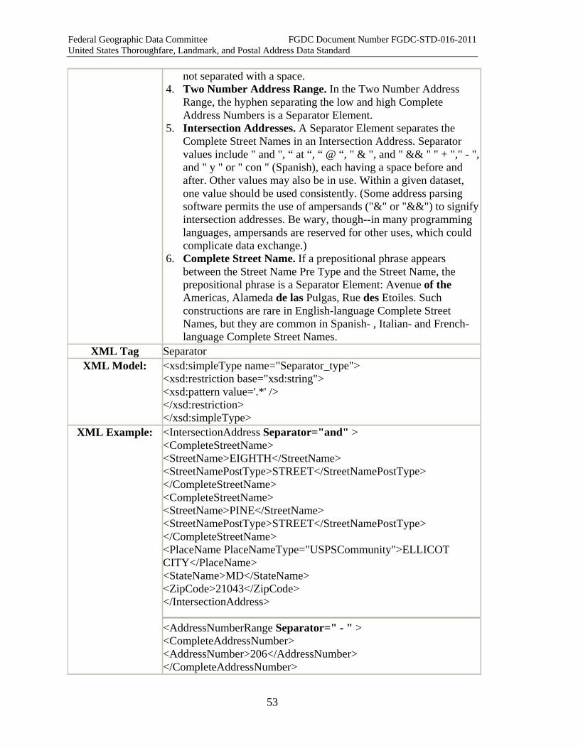
not separated with a space. 4. Two Number Address Range. In the Two Number Address
Range, the hyphen separating the low and high Complete Address Numbers is a Separator Element.
5. Intersection Addresses. A Separator Element separates the Complete Street Names in an Intersection Address. Separator values include " and ", “ at “, “ @ “, " & ", and " && " " + "," - ", and " y " or " con " (Spanish), each having a space before and after. Other values may also be in use. Within a given dataset, one value should be used consistently. (Some address parsing software permits the use of ampersands ("&" or "&&") to signify intersection addresses. Be wary, though--in many programming languages, ampersands are reserved for other uses, which could complicate data exchange.)
6. Complete Street Name. If a prepositional phrase appears between the Street Name Pre Type and the Street Name, the prepositional phrase is a Separator Element: Avenue of the Americas, Alameda de las Pulgas, Rue des Etoiles. Such constructions are rare in English-language Complete Street Names, but they are common in Spanish- , Italian- and French-language Complete Street Names.
XML Tag Separator XML Model: <xsd:simpleType name="Separator_type">
<xsd:restriction base="xsd:string"> <xsd:pattern value='.*' /> </xsd:restriction> </xsd:simpleType>
XML Example: <IntersectionAddress Separator="and" > <CompleteStreetName> <StreetName>EIGHTH</StreetName> <StreetNamePostType>STREET</StreetNamePostType> </CompleteStreetName> <CompleteStreetName> <StreetName>PINE</StreetName> <StreetNamePostType>STREET</StreetNamePostType> </CompleteStreetName> <PlaceName PlaceNameType="USPSCommunity">ELLICOT CITY</PlaceName> <StateName>MD</StateName> <ZipCode>21043</ZipCode> </IntersectionAddress>
<AddressNumberRange Separator=" - " > <CompleteAddressNumber> <AddressNumber>206</AddressNumber> </CompleteAddressNumber>
Federal Geographic Data Committee FGDC Document Number FGDC-STD-016-2011 United States Thoroughfare, Landmark, and Postal Address Data Standard
54
<CompleteAddressNumber> <AddressNumber>210</AddressNumber> </CompleteAddressNumber> </AddressNumberRange>
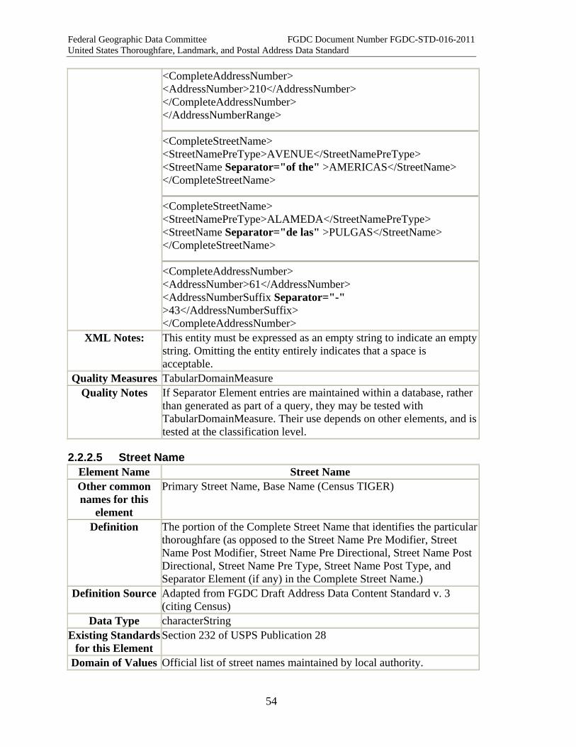
<CompleteStreetName> <StreetNamePreType>AVENUE</StreetNamePreType> <StreetName Separator="of the" >AMERICAS</StreetName> </CompleteStreetName>
<CompleteStreetName> <StreetNamePreType>ALAMEDA</StreetNamePreType> <StreetName Separator="de las" >PULGAS</StreetName> </CompleteStreetName>
<CompleteAddressNumber> <AddressNumber>61</AddressNumber> <AddressNumberSuffix Separator="-" >43</AddressNumberSuffix> </CompleteAddressNumber>
XML Notes: This entity must be expressed as an empty string to indicate an empty string. Omitting the entity entirely indicates that a space is acceptable.
Quality Measures TabularDomainMeasure Quality Notes If Separator Element entries are maintained within a database, rather
than generated as part of a query, they may be tested with TabularDomainMeasure. Their use depends on other elements, and is tested at the classification level.
2.2.2.5 Street Name Element Name Street Name Other common names for this
element
Primary Street Name, Base Name (Census TIGER)
Definition The portion of the Complete Street Name that identifies the particular thoroughfare (as opposed to the Street Name Pre Modifier, Street Name Post Modifier, Street Name Pre Directional, Street Name Post Directional, Street Name Pre Type, Street Name Post Type, and Separator Element (if any) in the Complete Street Name.)
Definition Source Adapted from FGDC Draft Address Data Content Standard v. 3 (citing Census)
Data Type characterString Existing Standards
for this Element Section 232 of USPS Publication 28
Domain of Values Official list of street names maintained by local authority.

Federal Geographic Data Committee FGDC Document Number FGDC-STD-016-2011 United States Thoroughfare, Landmark, and Postal Address Data Standard
55
for this Element Source of Values Local
How Defined Defined by local ordinance Example Main Street
MacIntyre Drive Boston-Providence Turnpike Third Avenue 3rd Avenue Avenue of the Americas East 400 South
Notes/Comments 1. The Street Name is the word or words used to identify a thoroughfare or a portion thereof, excluding any types, directionals, or modifiers in the Complete Street Name.
2. Every Complete Street Name must include a Street Name. The Street Name field cannot be null in any Complete Street Name.
3. Spelling Consistency: Internal Capitalization, Apostrophes, Hyphens, Spaces Local addressing authorities are urged to follow consistent internal street naming practices, and to resolve internal street name inconsistencies, especially for internal capitalization, hyphens, and apostrophes. Example: MacIntyre, McIntyre, Mc Intyre, Mcintyre Example: Smiths Lane, Smith’s Lane Example: Boston Providence Turnpike; Boston-Providence Turnpike; Rule: Follow the spelling adopted by the local street naming authority. Discussion: This standard cannot specify local naming conventions.
4. State Names Not Abbreviated When Used as Street Names: Example: Pennsylvania Avenue (not "PA Avenue") Rule: Where a Street Name is the name of a State of the United States, the Street Name must be spelled out in full, not abbreviated.
5. Numbered Streets Examples: Third Street, 3rd Street, 3 Street Rule: Use the name exactly as given by the local street naming authority. Discussion: This standard cannot specify local naming conventions. Different jurisdictions follow different practices for numbered street names. Pittsburgh spells out “First” through “Twelfth” and uses ordinal numbers (“13th”, 14th, etc.) for higher numbers. Washington DC uses ordinal numbers only (1st, 2nd, etc.). Other jurisdictions have their own conventions. This is a matter for local authorities to decide.
6. Inclusion of Street Type and Directional Words in Street
Federal Geographic Data Committee FGDC Document Number FGDC-STD-016-2011 United States Thoroughfare, Landmark, and Postal Address Data Standard
56
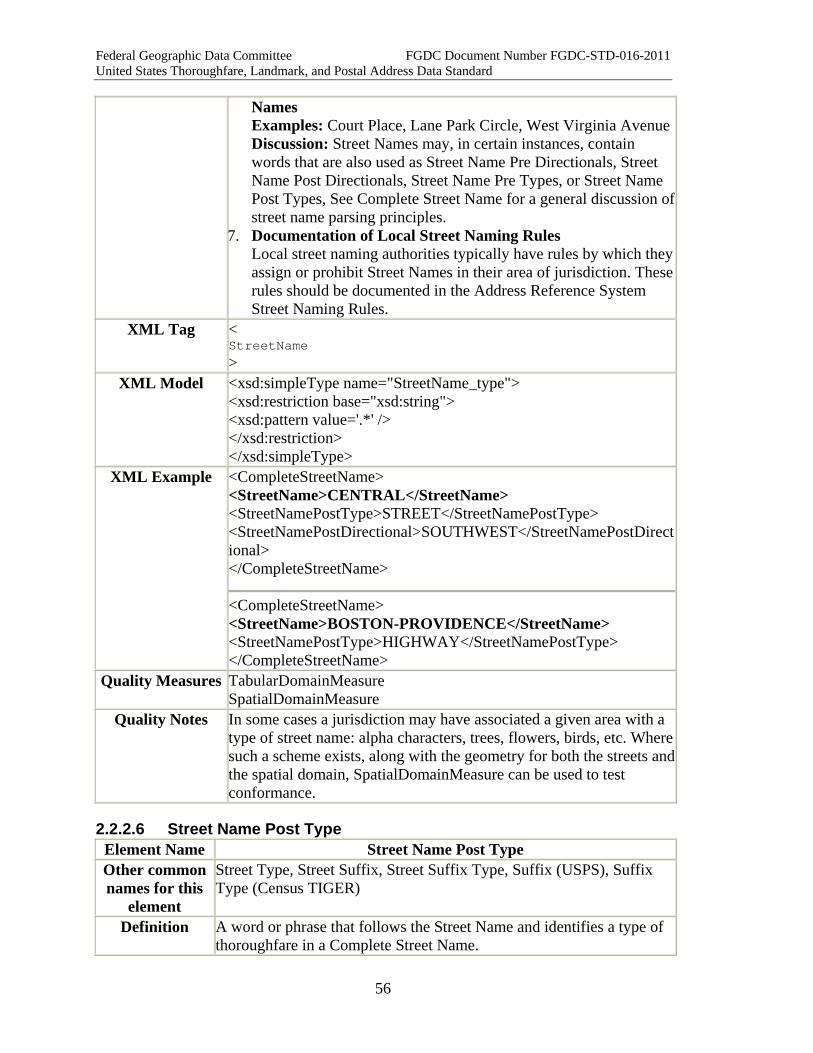
Names Examples: Court Place, Lane Park Circle, West Virginia Avenue Discussion: Street Names may, in certain instances, contain words that are also used as Street Name Pre Directionals, Street Name Post Directionals, Street Name Pre Types, or Street Name Post Types, See Complete Street Name for a general discussion of street name parsing principles.
7. Documentation of Local Street Naming Rules Local street naming authorities typically have rules by which they assign or prohibit Street Names in their area of jurisdiction. These rules should be documented in the Address Reference System Street Naming Rules.
XML Tag < StreetName >
XML Model <xsd:simpleType name="StreetName_type"> <xsd:restriction base="xsd:string"> <xsd:pattern value='.*' /> </xsd:restriction> </xsd:simpleType>
XML Example <CompleteStreetName> <StreetName>CENTRAL</StreetName> <StreetNamePostType>STREET</StreetNamePostType> <StreetNamePostDirectional>SOUTHWEST</StreetNamePostDirectional> </CompleteStreetName>
<CompleteStreetName> <StreetName>BOSTON-PROVIDENCE</StreetName> <StreetNamePostType>HIGHWAY</StreetNamePostType> </CompleteStreetName>
Quality Measures TabularDomainMeasure SpatialDomainMeasure
Quality Notes In some cases a jurisdiction may have associated a given area with a type of street name: alpha characters, trees, flowers, birds, etc. Where such a scheme exists, along with the geometry for both the streets and the spatial domain, SpatialDomainMeasure can be used to test conformance.
2.2.2.6 Street Name Post Type Element Name Street Name Post Type Other common names for this
element
Street Type, Street Suffix, Street Suffix Type, Suffix (USPS), Suffix Type (Census TIGER)
Definition A word or phrase that follows the Street Name and identifies a type of thoroughfare in a Complete Street Name.
Federal Geographic Data Committee FGDC Document Number FGDC-STD-016-2011 United States Thoroughfare, Landmark, and Postal Address Data Standard
57
Definition Source
New
Data Type characterString Existing
Standards for this Element
Section 234 and Appendix C1 of USPS Publication 28 with provision for local additions
Domain of Values for this
Element
USPS Publication 28 Appendix C1 with provisions for local additions.
Source of Values Section 234 and Appendix C1 of USPS Publication 28 with provision for local additions.
How Defined Locally Example Main Street
MacIntyre Drive Boston-Providence Turnpike Third Avenue 3rd Avenue Avenue C Loop Tenth Street Bypass Lee Highway Access Road
Notes/Comments 1. A Street Name Post Type is a word or phrase that follows the Street Name and identifies a type of thoroughfare in a Complete Street Name. In English-language Complete Street Names, most Street Name Pre Type words are also found as Street Name Post Types.
2. A Complete Street Name usually includes either a Street Name Pre Type or a Street Name Post Type. Occasional Complete Street Names have neither ("Broadway") or both ("Avenue C Loop").
3. Street Type words are often used as or in the Street Name (e.g. "Park Lane Circle"). Whether a type word should be placed in the Street Name Post Type or the Street Name cannot always be discerned from the Complete Street Name itself. Sometimes the proper parsing must be inferred from the context of the street name, or checked with the street naming authority. See Complete Street Name notes for a discussion of this and other cases where a Complete Street Name might be parsed in more than one way.
4. Occasionally two or more type words occur together after the Street Name (e.g., "Tenth Street Bypass"). All of the words are placed in the Street Name Post Type, unless the Address Authority has included any of them in the Street Name. If the type words are not part of the Street Name and are not separated from each other by a directional word or other word, they are all placed in the Street Name Post Type. See Complete Street Name notes for a discussion of this and other cases where a Complete Street Name might be parsed in more than one way.
5. To avoid confusion, this standard does not recognize any

Federal Geographic Data Committee FGDC Document Number FGDC-STD-016-2011 United States Thoroughfare, Landmark, and Postal Address Data Standard
58
abbreviations for Street Name Post Types. This standard requires that Street Name Post Types be recorded and stored fully spelled out. Various inconsistent sets of abbreviations are in use, for various purposes, and none is exhaustive. USPS Publication 28 Appendix C1 contains the best-known list of street type abbreviations. National Fire Incident Reporting System (NFIRS) has a slightly different list. Local utilities might use other lists, and various software vendors have incorporated still other lists into their products. Terrace might be abbreviated as "Ter", "Terr", or "Tr". "Tr" might stand for terrace, trail, trace, or track. Any number of different abbreviation sets might be used for given operations or applications within an agency or firm. Therefore Street Name Post Types should be stored unabbreviated, and related to look-up tables of abbreviations so that the proper set of abbreviations can be applied in views or export routines when needed for specific purposes such as mailing labels or 9-1-1 files.
6. The USPS recognizes only the Street Name Post Types listed in USPS Publication 28 Appendix C1. For postal addressing, the USPS prefers that Street Name Post Types be restricted to the words and abbreviated using the standard abbreviation given in Appendix C1. USPS Publication 28 standards are recognized within the Postal Addressing Profile of this standard.
7. Local street naming authorities often have rules governing the use of Street Name Post Types in their area of jurisdiction. For example, a jurisdiction might require that a "Street" must run north-south while an "Avenue" must run east-west, or that “Boulevard” can only be applied to a street classified as an arterial, while “Court” can only be used with a cul-de-sac. Where used, such rules should be documented in the authority's Address Reference System Street Type Directional And Modifier Rules.
XML Tag < StreetNamePostType >
XML Model <xsd:complexType name="StreetNamePostType_type"> <xsd:simpleContent> <xsd:extension base="xsd:string"> <xsd:attribute name="Separator" type="addr_type:Separator_type"></xsd:attribute> </xsd:extension> </xsd:simpleContent> </xsd:complexType>
XML Example <CompleteStreetName> <StreetName>BOSTON-PROVIDENCE</StreetName> <StreetNamePostType>HIGHWAY</StreetNamePostType> </CompleteStreetName>
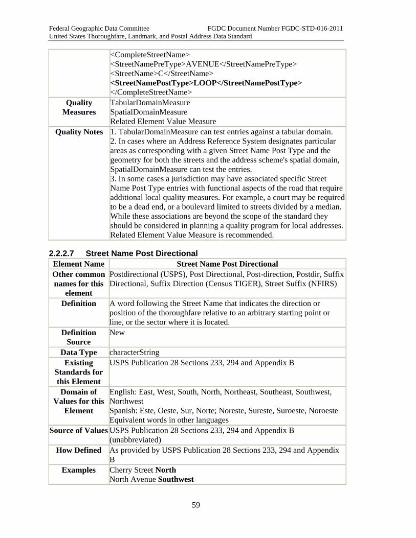
Federal Geographic Data Committee FGDC Document Number FGDC-STD-016-2011 United States Thoroughfare, Landmark, and Postal Address Data Standard
59
<CompleteStreetName> <StreetNamePreType>AVENUE</StreetNamePreType> <StreetName>C</StreetName> <StreetNamePostType>LOOP</StreetNamePostType> </CompleteStreetName>
Quality Measures
TabularDomainMeasure SpatialDomainMeasure Related Element Value Measure
Quality Notes 1. TabularDomainMeasure can test entries against a tabular domain. 2. In cases where an Address Reference System designates particular areas as corresponding with a given Street Name Post Type and the geometry for both the streets and the address scheme's spatial domain, SpatialDomainMeasure can test the entries. 3. In some cases a jurisdiction may have associated specific Street Name Post Type entries with functional aspects of the road that require additional local quality measures. For example, a court may be required to be a dead end, or a boulevard limited to streets divided by a median. While these associations are beyond the scope of the standard they should be considered in planning a quality program for local addresses. Related Element Value Measure is recommended.
2.2.2.7 Street Name Post Directional Element Name Street Name Post Directional Other common names for this
element
Postdirectional (USPS), Post Directional, Post-direction, Postdir, Suffix Directional, Suffix Direction (Census TIGER), Street Suffix (NFIRS)
Definition A word following the Street Name that indicates the direction or position of the thoroughfare relative to an arbitrary starting point or line, or the sector where it is located.
Definition Source
New
Data Type characterString Existing
Standards for this Element
USPS Publication 28 Sections 233, 294 and Appendix B
Domain of Values for this
Element
English: East, West, South, North, Northeast, Southeast, Southwest, Northwest Spanish: Este, Oeste, Sur, Norte; Noreste, Sureste, Suroeste, Noroeste Equivalent words in other languages
Source of Values USPS Publication 28 Sections 233, 294 and Appendix B (unabbreviated)
How Defined As provided by USPS Publication 28 Sections 233, 294 and Appendix B
Examples Cherry Street North North Avenue Southwest

Federal Geographic Data Committee FGDC Document Number FGDC-STD-016-2011 United States Thoroughfare, Landmark, and Postal Address Data Standard
60
East 400 South Notes/Comments 1. A Street Name Post Directional is a word following the Street
Name that indicates the direction or position of the thoroughfare relative to an arbitrary starting point or line, or the sector where it is located.
2. A Complete Street Name may include a Street Name Pre Directional, a Street Name Post Directional, neither, or both.
3. To avoid confusion, this standard requires that Street Name Post Directionals be recorded and stored fully spelled out. Abbreviations can cause ambiguity. For example: "N Avenue W"-- Is it "North Avenue W"? "N Avenue West"? "North Avenue West"? For this reason the standard does not recognize abbreviations for Street Name Post Directionals. If stored unabbreviated, directionals can be exported as abbreviations when needed for special purposes such as mailing labels.
4. For postal addressing, USPS Publication 28 prefers the use of USPSstandard abbreviations for Street Name Post Directionals. USPS Publication 28 sections 233, 294, and Appendix B provide the USPS abbreviations for Street Name Post Directionals in English and Spanish. USPS standard abbreviations are recognized within the Postal Addressing Profile of this standard.
5. Directional words are often used as or in the Street Name (e.g. "Avenue North"). Whether a directional word should be placed in the Street Name Post Directional or the Street Name cannot always be discerned from the Complete Street Name itself. Sometimes the proper parsing must be inferred from the context of the street name, or checked with the street naming authority. See Complete Street Name notes for a discussion of this and other cases where a Complete Street Name might be parsed in more than one way.
6. Occasionally two directional words occur together in or after the Street Name (e.g. "Boulevard South Southwest", "Pharr Court South Northeast"). Only one of them can be the Street Name Post Directional. The other one might be part of the Street Name, or it may be a Street Name Post Modifier. See Complete Street Name notes for a discussion of this and other cases where a Complete Street Name might be parsed in more than one way.
7. Local street naming authorities often have rules governing the use of Street Name Post Directionals in their area of jurisdiction. These rules should be documented in their Address Reference System Street Type Directional and Modifier Rules.
XML Tag < StreetNamePostDirectional >
XML Model <xsd:complexType name="StreetNamePostDirectional_type"> <xsd:simpleContent> <xsd:extension base="xsd:string">
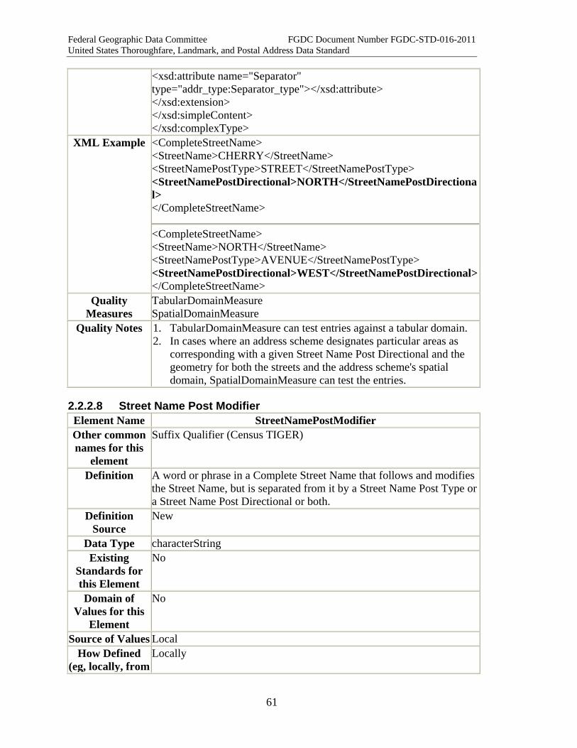
Federal Geographic Data Committee FGDC Document Number FGDC-STD-016-2011 United States Thoroughfare, Landmark, and Postal Address Data Standard
61
<xsd:attribute name="Separator" type="addr_type:Separator_type"></xsd:attribute> </xsd:extension> </xsd:simpleContent> </xsd:complexType>
XML Example <CompleteStreetName> <StreetName>CHERRY</StreetName> <StreetNamePostType>STREET</StreetNamePostType> <StreetNamePostDirectional>NORTH</StreetNamePostDirectional> </CompleteStreetName>
<CompleteStreetName> <StreetName>NORTH</StreetName> <StreetNamePostType>AVENUE</StreetNamePostType> <StreetNamePostDirectional>WEST</StreetNamePostDirectional></CompleteStreetName>
Quality Measures
TabularDomainMeasure SpatialDomainMeasure
Quality Notes 1. TabularDomainMeasure can test entries against a tabular domain. 2. In cases where an address scheme designates particular areas as
corresponding with a given Street Name Post Directional and the geometry for both the streets and the address scheme's spatial domain, SpatialDomainMeasure can test the entries.
2.2.2.8 Street Name Post Modifier Element Name StreetNamePostModifier Other common names for this
element
Suffix Qualifier (Census TIGER)
Definition A word or phrase in a Complete Street Name that follows and modifies the Street Name, but is separated from it by a Street Name Post Type or a Street Name Post Directional or both.
Definition Source
New
Data Type characterString Existing
Standards for this Element
No
Domain of Values for this
Element
No
Source of Values Local How Defined
(eg, locally, from Locally
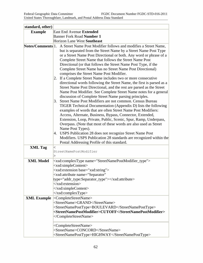
Federal Geographic Data Committee FGDC Document Number FGDC-STD-016-2011 United States Thoroughfare, Landmark, and Postal Address Data Standard
62
standard, other) Example East End Avenue Extended
Banner Fork Road Number 1 Horizon Lane West Southeast
Notes/Comments 1. A Street Name Post Modifier follows and modifies a Street Name, but is separated from the Street Name by a Street Name Post Type or a Street Name Post Directional or both. Any word or phrase of a Complete Street Name that follows the Street Name Post Directional (or that follows the Street Name Post Type, if the Complete Street Name has no Street Name Post Directional) comprises the Street Name Post Modifier.
2. If a Complete Street Name includes two or more consecutive directional words following the Street Name, the first is parsed as a Street Name Post Directional, and the rest are parsed as the Street Name Post Modifier. See Complete Street Name notes for a general discussion of Complete Street Name parsing principles.
3. Street Name Post Modifiers are not common. Census Bureau TIGER Technical Documentation (Appendix D) lists the following examples of words that are often Street Name Post Modifiers: Access, Alternate, Business, Bypass, Connector, Extended, Extension, Loop, Private, Public, Scenic, Spur, Ramp, Underpass, Overpass. (Note that most of these words are also used as Street Name Post Types).
4. USPS Publication 28 does not recognize Street Name Post Modifiers. USPS Publication 28 standards are recognized within the Postal Addressing Profile of this standard.
XML Tag < StreetNamePostModifier >
XML Model <xsd:complexType name="StreetNamePostModifier_type"> <xsd:simpleContent> <xsd:extension base="xsd:string"> <xsd:attribute name="Separator" type="addr_type:Separator_type"></xsd:attribute> </xsd:extension> </xsd:simpleContent> </xsd:complexType>
XML Example <CompleteStreetName> <StreetName>GRAND</StreetName> <StreetNamePostType>BOULEVARD</StreetNamePostType> <StreetNamePostModifier>CUTOFF</StreetNamePostModifier> </CompleteStreetName>
<CompleteStreetName> <StreetName>CONCORD</StreetName> <StreetNamePostType>HIGHWAY</StreetNamePostType>
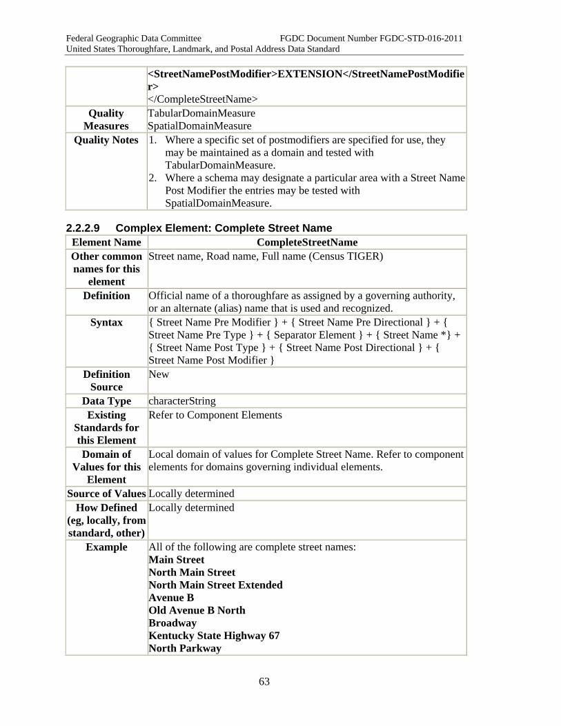
Federal Geographic Data Committee FGDC Document Number FGDC-STD-016-2011 United States Thoroughfare, Landmark, and Postal Address Data Standard
63
<StreetNamePostModifier>EXTENSION</StreetNamePostModifier> </CompleteStreetName>
Quality Measures
TabularDomainMeasure SpatialDomainMeasure
Quality Notes 1. Where a specific set of postmodifiers are specified for use, they may be maintained as a domain and tested with TabularDomainMeasure.
2. Where a schema may designate a particular area with a Street Name Post Modifier the entries may be tested with SpatialDomainMeasure.
2.2.2.9 Complex Element: Complete Street Name Element Name CompleteStreetName Other common names for this
element
Street name, Road name, Full name (Census TIGER)
Definition Official name of a thoroughfare as assigned by a governing authority, or an alternate (alias) name that is used and recognized.
Syntax { Street Name Pre Modifier } + { Street Name Pre Directional } + { Street Name Pre Type } + { Separator Element } + { Street Name *} + { Street Name Post Type } + { Street Name Post Directional } + { Street Name Post Modifier }
Definition Source
New
Data Type characterString Existing
Standards for this Element
Refer to Component Elements
Domain of Values for this
Element
Local domain of values for Complete Street Name. Refer to componentelements for domains governing individual elements.
Source of Values Locally determined How Defined
(eg, locally, from standard, other)
Locally determined
Example All of the following are complete street names: Main Street North Main Street North Main Street Extended Avenue B Old Avenue B North Broadway Kentucky State Highway 67 North Parkway
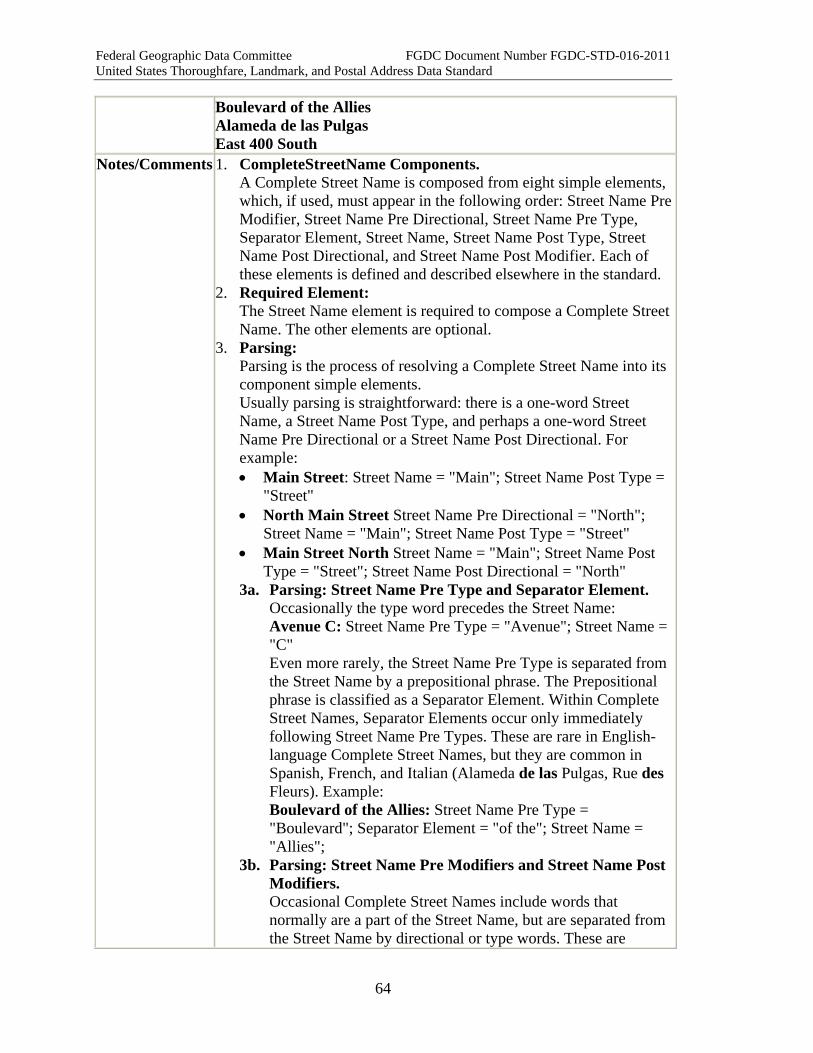
Federal Geographic Data Committee FGDC Document Number FGDC-STD-016-2011 United States Thoroughfare, Landmark, and Postal Address Data Standard
64
Boulevard of the Allies Alameda de las Pulgas East 400 South
Notes/Comments 1. CompleteStreetName Components. A Complete Street Name is composed from eight simple elements, which, if used, must appear in the following order: Street Name Pre Modifier, Street Name Pre Directional, Street Name Pre Type, Separator Element, Street Name, Street Name Post Type, Street Name Post Directional, and Street Name Post Modifier. Each of these elements is defined and described elsewhere in the standard.
2. Required Element: The Street Name element is required to compose a Complete Street Name. The other elements are optional.
3. Parsing: Parsing is the process of resolving a Complete Street Name into its component simple elements. Usually parsing is straightforward: there is a one-word Street Name, a Street Name Post Type, and perhaps a one-word Street Name Pre Directional or a Street Name Post Directional. For example: • Main Street: Street Name = "Main"; Street Name Post Type =
"Street" • North Main Street Street Name Pre Directional = "North";
Street Name = "Main"; Street Name Post Type = "Street" • Main Street North Street Name = "Main"; Street Name Post
Type = "Street"; Street Name Post Directional = "North" 3a. Parsing: Street Name Pre Type and Separator Element.
Occasionally the type word precedes the Street Name: Avenue C: Street Name Pre Type = "Avenue"; Street Name = "C" Even more rarely, the Street Name Pre Type is separated from the Street Name by a prepositional phrase. The Prepositional phrase is classified as a Separator Element. Within Complete Street Names, Separator Elements occur only immediately following Street Name Pre Types. These are rare in English-language Complete Street Names, but they are common in Spanish, French, and Italian (Alameda de las Pulgas, Rue des Fleurs). Example: Boulevard of the Allies: Street Name Pre Type = "Boulevard"; Separator Element = "of the"; Street Name = "Allies";
3b. Parsing: Street Name Pre Modifiers and Street Name Post Modifiers. Occasional Complete Street Names include words that normally are a part of the Street Name, but are separated from the Street Name by directional or type words. These are

Federal Geographic Data Committee FGDC Document Number FGDC-STD-016-2011 United States Thoroughfare, Landmark, and Postal Address Data Standard
65
classified as Street Name Pre Modifiers or Street Name Post Modifiers. Examples: Old North Main Street: Street Name Pre Modifier = "Old"; Street Name Pre Directional = "North"; Street Name = "Main"; Street Name Post Type = "Street" Main Street Extended: Street Name = "Main"; Street Name Post Type = "Street"; Street Name Post Modifier = "Extended" Finally, words such as "The" and "Old" may be parsed as Street Name Pre Modifiers when they precede the Street Name but must be excluded from it so that the Street Name will be placed properly in a sorted alphanumeric list. Example: "Old China Springs Road" might be parsed in either of two ways by the local Address Authority: Old China Springs Road (parsing 1): Street Name Pre Modifier = "Old"; Street Name = "China Springs"; Street Name Post Type = "Road" (if the name is to be listed as "China Springs Road, Old") Old China Springs Road (parsing 2): Street Name = "Old China Springs"; Street Name Post Type = "Road" (if the name is to be listed under "Old", or if the Street Name element is not used for creating sorted Complete Street Name lists)
3c. Complete Street Names That Do not Follow The Typical Pattern. Note 4 describes the logical process for parsing typical Complete Street Names. Certain unusual Complete Street Names do not follow the typical pattern. They are special cases or complex names, and parsing as described in Note 4 below will not result in a properly parsed set of elements. These special cases and complex names are explained in Notes 5 and 6 below.
4. Parsing Procedures for Typical Street Names In practice, most Address Authorities and users will use a commercial or locally-developed parsing program to parse and standardize the parts of each street name. However, most commercially available parsers follow the USPS definitions and procedures, which differ in significant respects from those of this standard. For example, the USPS model does not recognize Street Name Pre Types as a separate element; they are combined into Street Name. It also does not recognize or allow for either Street Name Pre Modifiers or Street Name Post Modifiers, and does not provide guidance on how to handle them in parsing. The specific differences are discussed more fully in the Postal Addressing Profile of this Standard. It is critical that an Address Authority that plans to parse a dataset containing Complete Street Names be aware of these differences. If a USPS parser is used, the Authority must either revise the parser to comply with this standard, or review the
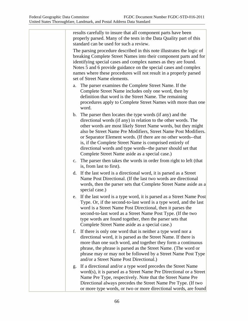
Federal Geographic Data Committee FGDC Document Number FGDC-STD-016-2011 United States Thoroughfare, Landmark, and Postal Address Data Standard
66
results carefully to insure that all component parts have been properly parsed. Many of the tests in the Data Quality part of this standard can be used for such a review. The parsing procedure described in this note illustrates the logic of breaking Complete Street Names into their component parts and for identifying special cases and complex names as they are found. Notes 5 and 6 provide guidance on the special cases and complex names where these procedures will not result in a properly parsed set of Street Name elements. a. The parser examines the Complete Street Name. If the
Complete Street Name includes only one word, then by definition that word is the Street Name. The remaining procedures apply to Complete Street Names with more than one word.
b. The parser then locates the type words (if any) and the directional words (if any) in relation to the other words. The other words are most likely Street Name words, but they might also be Street Name Pre Modifiers, Street Name Post Modifiers. or Separator Element words. (If there are no other words--that is, if the Complete Street Name is comprised entirely of directional words and type words--the parser should set that Complete Street Name aside as a special case.)
c. The parser then takes the words in order from right to left (that is, from last to first).
d. If the last word is a directional word, it is parsed as a Street Name Post Directional. (If the last two words are directional words, then the parser sets that Complete Street Name aside as a special case.)
e. If the last word is a type word, it is parsed as a Street Name Post Type. Or, if the second-to-last word is a type word, and the last word is a Street Name Post Directional, then it parses the second-to-last word as a Street Name Post Type. (If the two type words are found together, then the parser sets that Complete Street Name aside as a special case.)
f. If there is only one word that is neither a type word nor a directional word, it is parsed as the Street Name. If there is more than one such word, and together they form a continuous phrase, the phrase is parsed as the Street Name. (The word or phrase may or may not be followed by a Street Name Post Typeand/or a Street Name Post Directional.)
g. If a directional and/or a type word precedes the Street Name word(s), it is parsed as a Street Name Pre Directional or a Street Name Pre Type, respectively. Note that the Street Name Pre Directional always precedes the Street Name Pre Type. (If two or more type words, or two or more directional words, are found

Federal Geographic Data Committee FGDC Document Number FGDC-STD-016-2011 United States Thoroughfare, Landmark, and Postal Address Data Standard
67
to precede the Street Name, then the parser sets that Complete Street Name aside as a special case.)
h. If a prepositional phrase immediately follows a Street Name Pre Type, then it is removed from the Street Name. It is a Separator Element.
i. If there is more than one non-type, non-directional word, and they do not form a continuous phrase, then the parser separates them from the Street Name by a type or directional word. If a non-type, non-directional word occurs: • Before a Street Name Pre Directional or Street Name Pre
Type, it is a Street Name Pre Modifier. • After a Street Name Pre Directional or Street Name Pre
Type (or Separator Element), or before a Street Name Post Directional or Street Name Post Type, it is part of the Street Name.
• After a Street Name Post Directional or Street Name Post Type, it is a Street Name Post Modifier.
• Between a Street Name Pre Directional and a Street Name Pre Type, or between a Street Name Post Directional and a Street Name Post Type, the parser sets that Complete Street Name aside as a special case.
j. If a Street Name begins with a word such as "The" or "Old", and the Street Name is not preceded by a Street Name Pre Type or a Street Name Pre Directional, and the Address Authority prefers to remove it from the Street Name so that the Street Name can be used as the list word in creating a sorted alphanumeric list of Complete Street Names, then the word may be placed in the Street Name Pre Modifier.
k. Having classified all the words into elements, the parser verifies that each element occurs no more than once, and in the correct order: Street Name Pre Modifier, Street Name Pre Directional, Street Name Pre Type, Separator Element, Street Name, Street Name Post Type, Street Name Post Directional, and Street Name Post Modifier. If any elements are repeated or out of order, the parser sets that Complete Street Name aside as a special case.
l. Lastly the special cases are examined to determine their correct parsing, based on knowledge of the local Address Reference System and the origin of the particular Complete Street Name. Determine the Street Name first, and then decide how to parse the remaining words.
m. The end result is a list of valid Complete Street Names, with the correct parsing for each, and a list of valid values for each street name element.
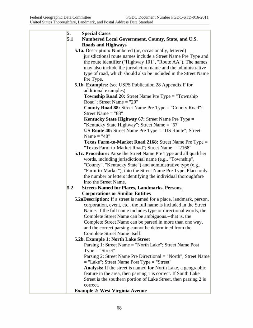
Federal Geographic Data Committee FGDC Document Number FGDC-STD-016-2011 United States Thoroughfare, Landmark, and Postal Address Data Standard
68
5. Special Cases 5.1 Numbered Local Government, County, State, and U.S.
Roads and Highways 5.1a. Description: Numbered (or, occasionally, lettered)
jurisdictional route names include a Street Name Pre Type and the route identifier ("Highway 101", "Route AA"). The names may also include the jurisdiction name and the administrative type of road, which should also be included in the Street Name Pre Type.
5.1b. Examples: (see USPS Publication 28 Appendix F for additional examples) Township Road 20: Street Name Pre Type = "Township Road"; Street Name = "20" County Road 88: Street Name Pre Type = "County Road"; Street Name = "88" Kentucky State Highway 67: Street Name Pre Type = "Kentucky State Highway"; Street Name = "67" US Route 40: Street Name Pre Type = "US Route"; Street Name = "40" Texas Farm-to-Market Road 2168: Street Name Pre Type = "Texas Farm-to-Market Road"; Street Name = "2168"
5.1c. Procedure: Parse the Street Name Pre Type and all qualifier words, including jurisdictional name (e.g., "Township", "County", "Kentucky State") and administrative type (e.g., "Farm-to-Market"), into the Street Name Pre Type. Place only the number or letters identifying the individual thoroughfare into the Street Name.
5.2 Streets Named for Places, Landmarks, Persons, Corporations or Similar Entities
5.2aDescription: If a street is named for a place, landmark, person, corporation, event, etc., the full name is included in the Street Name. If the full name includes type or directional words, the Complete Street Name can be ambiguous.--that is, the Complete Street Name can be parsed in more than one way, and the correct parsing cannot be determined from the Complete Street Name itself.
5.2b. Example 1: North Lake Street Parsing 1: Street Name = "North Lake"; Street Name Post Type = "Street" Parsing 2: Street Name Pre Directional = "North"; Street Name= "Lake"; Street Name Post Type = "Street" Analysis: If the street is named for North Lake, a geographic feature in the area, then parsing 1 is correct. If South Lake Street is the southern portion of Lake Street, then parsing 2 is correct.
Example 2: West Virginia Avenue

Federal Geographic Data Committee FGDC Document Number FGDC-STD-016-2011 United States Thoroughfare, Landmark, and Postal Address Data Standard
69
Parsing 1: Street Name = "West Virginia"; Street Name Post Type = "Avenue" Parsing 2: Street Name Pre Directional = "West"; Street Name = "Virginia"; Street Name Post Type = "Avenue" Analysis: If West Virginia Avenue is named for the state of West Virginia, then "West" is part of the Street Name, and parsing 1 is correct. However, if it is not named for the state, then the word West is considered a Street Name Pre Directional, and parsing 2 is correct.
Example 3: Old North Church Road Parsing 1: Street Name = "Old North Church"; Street Name Post Type = "Road" Parsing 2: Street Name Pre Modifier = "Old"; Street Name Pre Directional = "North"; Street Name = "Church"; Street Name Post Type = "Road" Analysis: If the street was named for a church called “Old North Church” then the entire name belongs in the Street Name, and parsing 1 is correct. However, if the street is a section of Church Road, with the predirectional North, and is perhaps an old alignment which has been replaced, then parsing 2 is correct, placing “Church” alone as the Street Name, “North” as the Street Name Pre Directional, and “Old” as the Street Name Pre Modifier.
5.2c. Procedure: If there is doubt, confer with the local Address Authority (or historian) to determine whether the Complete Street Name includes the name of a place, landmark, person, corporation, event, etc. If so, then place the full name in the Street Name (including any type or directional words in the name), and then parse following the procedure for typical street names. If not, parse the Complete Street Name following the procedure for typical street names.
5.3 Double-directional Grid Street Names without Street Types 5.3a. Description: In Utah, and some areas of Indiana, Complete
Street Names often include both a Street Name Pre Directional and a Street Name Post Directional and a numeric Street Name, but do not contain either a Street Name Pre Type or a Street Name Post Type. The Complete Address Number and the Complete Street Name together give a grid position.
5.3b. Example: 210 East 400 South: Complete Address Number = "210"; Street Name Pre Directional = "East"; Street Name = "400"; Street Name Post Directional = "South" CompleteStreetName = "East 400 South"
5.3c. Procedure: Parse the first number as the Complete Address Number, the first directional as the Street Name Pre
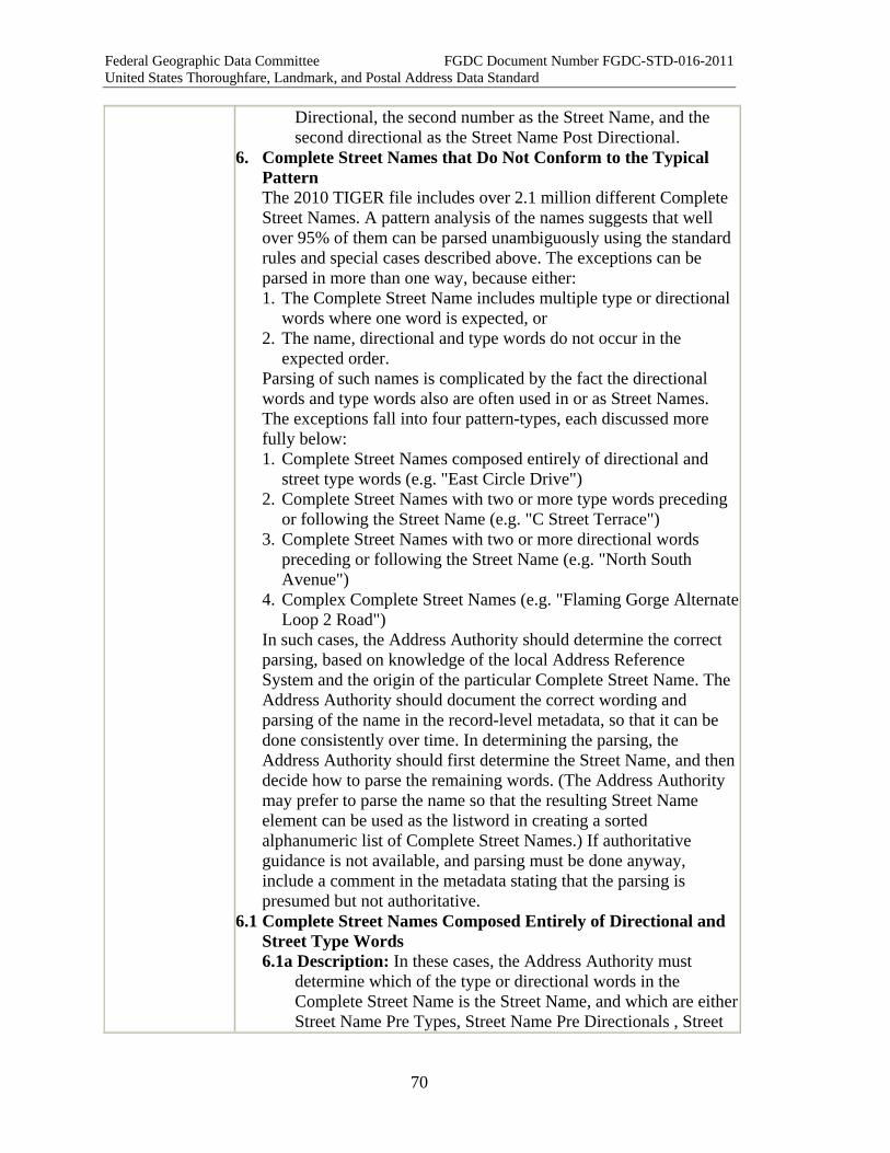
Federal Geographic Data Committee FGDC Document Number FGDC-STD-016-2011 United States Thoroughfare, Landmark, and Postal Address Data Standard
70
Directional, the second number as the Street Name, and the second directional as the Street Name Post Directional.
6. Complete Street Names that Do Not Conform to the Typical Pattern The 2010 TIGER file includes over 2.1 million different Complete Street Names. A pattern analysis of the names suggests that well over 95% of them can be parsed unambiguously using the standard rules and special cases described above. The exceptions can be parsed in more than one way, because either: 1. The Complete Street Name includes multiple type or directional
words where one word is expected, or 2. The name, directional and type words do not occur in the
expected order. Parsing of such names is complicated by the fact the directional words and type words also are often used in or as Street Names. The exceptions fall into four pattern-types, each discussed more fully below: 1. Complete Street Names composed entirely of directional and
street type words (e.g. "East Circle Drive") 2. Complete Street Names with two or more type words preceding
or following the Street Name (e.g. "C Street Terrace") 3. Complete Street Names with two or more directional words
preceding or following the Street Name (e.g. "North South Avenue")
4. Complex Complete Street Names (e.g. "Flaming Gorge Alternate Loop 2 Road")
In such cases, the Address Authority should determine the correct parsing, based on knowledge of the local Address Reference System and the origin of the particular Complete Street Name. The Address Authority should document the correct wording and parsing of the name in the record-level metadata, so that it can be done consistently over time. In determining the parsing, the Address Authority should first determine the Street Name, and then decide how to parse the remaining words. (The Address Authority may prefer to parse the name so that the resulting Street Name element can be used as the listword in creating a sorted alphanumeric list of Complete Street Names.) If authoritative guidance is not available, and parsing must be done anyway, include a comment in the metadata stating that the parsing is presumed but not authoritative.
6.1 Complete Street Names Composed Entirely of Directional and Street Type Words 6.1a Description: In these cases, the Address Authority must
determine which of the type or directional words in the Complete Street Name is the Street Name, and which are either Street Name Pre Types, Street Name Pre Directionals , Street

Federal Geographic Data Committee FGDC Document Number FGDC-STD-016-2011 United States Thoroughfare, Landmark, and Postal Address Data Standard
71
Name Post Types, or Street Name Post Directionals. In some cases with multiple type or directional words, the Street Name Pre Modifier and/or the Street Name Post Modifier may also be required to manage all of the given words.
6.1b. Examples: Court Place; Avenue North; Park Lane Circle 6.2 Complete Street Names with Two or More Type Words
Preceding or Following the Street Name 6.2a Description: To parse these Complete Street Names,
determine if the type word(s) closest to the Street Name actually form part of the Street Name. If so, parse the word(s) as part of the Street Name. If multiple type words occur outside the Street Name, and they occur consecutively, then all of those words are placed in the Street Name Pre Type (if they precede the Street Name) or the Street Name Post Type (if they follow the Street Name). If the type words are not consecutive--that is, they are separated by a directional or other word--then the type word(s) that are separated are placed in the Street Name Pre Modifier (if they precede the Street Name Pre Type) or the Street Name Post Modifier (if they follow the Street Name Post Type). These determinations are made by the Address Authority based on its knowledge of the local Address Reference System and the origin of the Complete Street Name.
6.2b Examples: Charles Lane Boulevard: Street Name = "Charles Lane"; Street Name Post Type = "Boulevard" ("Lane" can be used as a type word, but here it is part of the Street Name because it was named for a person, "Charles Lane".) Tenth Street Bypass: Street Name = "Tenth"; Street Name Post Type = "Street Bypass" (Consecutive type words that follow the Street Name are included in the Street Name Post Type) Lee Highway Access Road: Street Name = "Lee"; Street Name Post Type = "Highway Access Road" (Consecutive type words that follow the Street Name are included in the Street Name Post Type) Bypass Highway 22: Street Name Pre Type = "Bypass Highway"; Street Name = "22" (Consecutive type words that precede the Street Name are included in the Street Name Pre Type) Bypass North Highway 22: Street Name Pre Modifier = "Bypass"; Street Name Pre Directional = "North"; Street Name Pre Type = "Highway"; Street Name = "22"; Street Name Pre Type = "Highway"; ("Bypass" and "Highway" do not occur consecutively)
6.3 Complete Street Names with Two or More Directional Words Preceding or Following the Street Name 6.3a Description: Where two directional words occur together
before or after the Street Name, the Address Authority must determine whether one or both of the two directional words are actually part of the Street Name, or whether the Complete
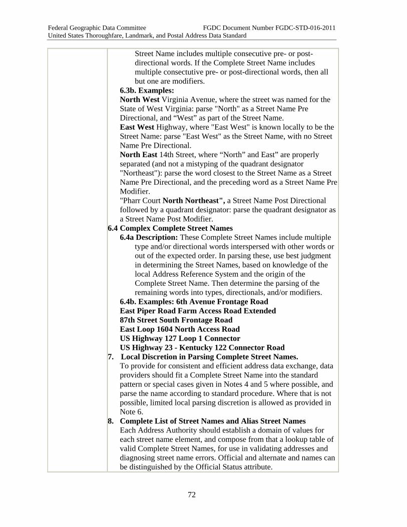
Federal Geographic Data Committee FGDC Document Number FGDC-STD-016-2011 United States Thoroughfare, Landmark, and Postal Address Data Standard
72
Street Name includes multiple consecutive pre- or post-directional words. If the Complete Street Name includes multiple consectutive pre- or post-directional words, then all but one are modifiers.
6.3b. Examples: North West Virginia Avenue, where the street was named for the State of West Virginia: parse "North" as a Street Name Pre Directional, and “West” as part of the Street Name. East West Highway, where "East West" is known locally to be the Street Name: parse "East West" as the Street Name, with no Street Name Pre Directional. North East 14th Street, where “North” and East” are properly separated (and not a mistyping of the quadrant designator "Northeast"): parse the word closest to the Street Name as a Street Name Pre Directional, and the preceding word as a Street Name Pre Modifier. "Pharr Court North Northeast", a Street Name Post Directional followed by a quadrant designator: parse the quadrant designator as a Street Name Post Modifier.
6.4 Complex Complete Street Names 6.4a Description: These Complete Street Names include multiple
type and/or directional words interspersed with other words or out of the expected order. In parsing these, use best judgment in determining the Street Names, based on knowledge of the local Address Reference System and the origin of the Complete Street Name. Then determine the parsing of the remaining words into types, directionals, and/or modifiers.
6.4b. Examples: 6th Avenue Frontage Road East Piper Road Farm Access Road Extended 87th Street South Frontage Road East Loop 1604 North Access Road US Highway 127 Loop 1 Connector US Highway 23 - Kentucky 122 Connector Road
7. Local Discretion in Parsing Complete Street Names. To provide for consistent and efficient address data exchange, data providers should fit a Complete Street Name into the standard pattern or special cases given in Notes 4 and 5 where possible, and parse the name according to standard procedure. Where that is not possible, limited local parsing discretion is allowed as provided in Note 6.
8. Complete List of Street Names and Alias Street Names Each Address Authority should establish a domain of values for each street name element, and compose from that a lookup table of valid Complete Street Names, for use in validating addresses and diagnosing street name errors. Official and alternate and names can be distinguished by the Official Status attribute.

Federal Geographic Data Committee FGDC Document Number FGDC-STD-016-2011 United States Thoroughfare, Landmark, and Postal Address Data Standard
73
Note that alternate and alias names often apply to only a portion of a thoroughfare. For example, US Route 50 in the District of Columbia is an alias for some, but not all, of 14th Street Northwest. Because the relationship between official and alias names changes street segment by street segment, street name relationships cannot be managed fully without reference to a street network model that defines the segments.
9. Creating Sorted Alphabetical and Alphanumeric Lists of Complete Street Names Address Authorities may wish to create a sorted alphabetical list of Complete Street Names (or an alphanumeric list, if the list includes numbered Complete Street Names). Whether and how this is done is a local matter and outside the scope of this standard. One common method is to list the Complete Street Names in order of the Street Name element. Another common method is to list the Complete Street Names in order of Street Name Pre Type, if present, and then by Street Name. If no simple rule works for all Complete Street Names, the Address Authority may create a look-up table that assigns a particular listword to each Complete Street Name. In addition, if a Street Name begins with a word (such as "The" or "Old") that would cause the Complete Street Name to be listed out of its expected order, the Address Authority may separate that word from the Street Name and place it in the Street Name Pre Modifier.
10. Abbreviations To avoid confusion, this standard requires that all words in a Complete Street Name be recorded and stored fully spelled out. Abbreviations can create ambiguity. (For example: "E Street": Is it E Street, or is it really East Street?) Various inconsistent sets of street type abbreviations are in use, for various purposes, and none is exhaustive. Therefore street name words should be recorded and stored unabbreviated, and linked to look-up tables of abbreviations so that the proper set of abbreviations can be applied in views or export routines when needed for special purposes such as mailing labels or 9-1-1 files. For postal addressing, USPS Publication 28 prefers the use of USPSstandard abbreviations for Street Name Pre Directionals, Street Name Post Directionals, and Street Name Post Types. USPS standard abbreviations are recognized within the Postal Addressing Profile of this standard.
XML Tag < CompleteStreetName >
XML Model <xsd:complexType name="CompleteStreetName_type"> <xsd:sequence> <xsd:element name="StreetNamePreModifier" type="addr_type:StreetNamePreModifier_type" minOccurs="0"

Federal Geographic Data Committee FGDC Document Number FGDC-STD-016-2011 United States Thoroughfare, Landmark, and Postal Address Data Standard
74
maxOccurs="1" /> <xsd:element name="StreetNamePreDirectional" type="addr_type:StreetNamePreDirectional_type" minOccurs="0" maxOccurs="1" /> <xsd:element name="StreetNamePreType" type="addr_type:StreetNamePreType_type" minOccurs="0" maxOccurs="1" /> <xsd:element name="StreetName" type="addr_type:StreetName_type"minOccurs="1" maxOccurs="1" /> <xsd:element name="StreetNamePostType" type="addr_type:StreetNamePostType_type" minOccurs="0" maxOccurs="1" /> <xsd:element name="StreetNamePostDirectional" type="addr_type:StreetNamePostDirectional_type" minOccurs="0" maxOccurs="1" /> <xsd:element name="StreetNamePostModifier" type="addr_type:StreetNamePostModifier_type" minOccurs="0" maxOccurs="1" /> </xsd:sequence> <xsd:attribute name="AttachedElement" type="addr_type:AttachedElement_type" /> </xsd:complexType>
XML Example <CompleteStreetName> <StreetNamePreDirectional>NORTH</StreetNamePreDirectional> <StreetName>MAIN</StreetName> <StreetNamePostType>STREET</StreetNamePostType> <StreetNamePostModifier>EXTENDED</StreetNamePostModifier> </CompleteStreetName>
<CompleteStreetName> <StreetNamePreModifier>OLD</StreetNamePreModifier> <StreetNamePreType>AVENUE</StreetNamePreType> <StreetName>B</StreetName> <StreetNamePostDirectional>NORTH</StreetNamePostDirectional> </CompleteStreetName>
Quality Measures
TabularDomainMeasure DuplicateStreetNameMeasure PatternSequenceMeasure
Quality Notes Note that if tabular and/or domains are maintained for Complete Street Name elements at both levels, simple and complex, quality control checks should be run for simple element components before testing the complex element domain.
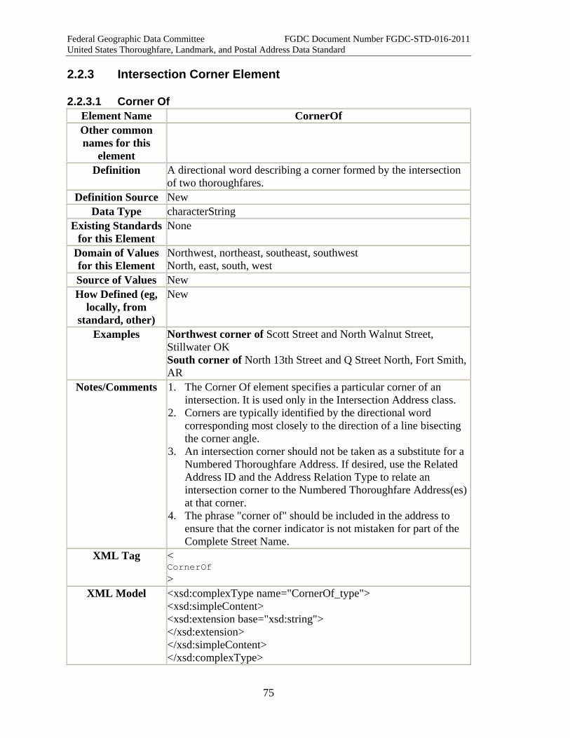
Federal Geographic Data Committee FGDC Document Number FGDC-STD-016-2011 United States Thoroughfare, Landmark, and Postal Address Data Standard
75
2.2.3 Intersection Corner Element
2.2.3.1 Corner Of Element Name CornerOf Other common names for this
element
Definition A directional word describing a corner formed by the intersection of two thoroughfares.
Definition Source New Data Type characterString
Existing Standards for this Element
None
Domain of Values for this Element
Northwest, northeast, southeast, southwest North, east, south, west
Source of Values New How Defined (eg,
locally, from standard, other)
New
Examples Northwest corner of Scott Street and North Walnut Street, Stillwater OK South corner of North 13th Street and Q Street North, Fort Smith, AR
Notes/Comments 1. The Corner Of element specifies a particular corner of an intersection. It is used only in the Intersection Address class.
2. Corners are typically identified by the directional word corresponding most closely to the direction of a line bisecting the corner angle.
3. An intersection corner should not be taken as a substitute for a Numbered Thoroughfare Address. If desired, use the Related Address ID and the Address Relation Type to relate an intersection corner to the Numbered Thoroughfare Address(es) at that corner.
4. The phrase "corner of" should be included in the address to ensure that the corner indicator is not mistaken for part of the Complete Street Name.
XML Tag < CornerOf >
XML Model <xsd:complexType name="CornerOf_type"> <xsd:simpleContent> <xsd:extension base="xsd:string"> </xsd:extension> </xsd:simpleContent> </xsd:complexType>
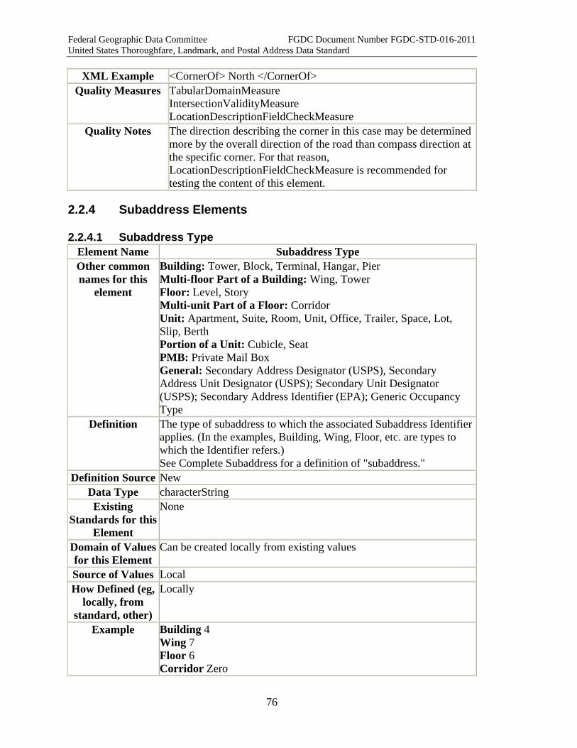
Federal Geographic Data Committee FGDC Document Number FGDC-STD-016-2011 United States Thoroughfare, Landmark, and Postal Address Data Standard
76
XML Example <CornerOf> North </CornerOf> Quality Measures TabularDomainMeasure
IntersectionValidityMeasure LocationDescriptionFieldCheckMeasure
Quality Notes The direction describing the corner in this case may be determined more by the overall direction of the road than compass direction at the specific corner. For that reason, LocationDescriptionFieldCheckMeasure is recommended for testing the content of this element.
2.2.4 Subaddress Elements
2.2.4.1 Subaddress Type Element Name Subaddress Type Other common names for this
element
Building: Tower, Block, Terminal, Hangar, Pier Multi-floor Part of a Building: Wing, Tower Floor: Level, Story Multi-unit Part of a Floor: Corridor Unit: Apartment, Suite, Room, Unit, Office, Trailer, Space, Lot, Slip, Berth Portion of a Unit: Cubicle, Seat PMB: Private Mail Box General: Secondary Address Designator (USPS), Secondary Address Unit Designator (USPS); Secondary Unit Designator (USPS); Secondary Address Identifier (EPA); Generic Occupancy Type
Definition The type of subaddress to which the associated Subaddress Identifier applies. (In the examples, Building, Wing, Floor, etc. are types to which the Identifier refers.) See Complete Subaddress for a definition of "subaddress."
Definition Source New Data Type characterString Existing
Standards for this Element
None
Domain of Values for this Element
Can be created locally from existing values
Source of Values Local How Defined (eg,
locally, from standard, other)
Locally
Example Building 4 Wing 7 Floor 6 Corridor Zero
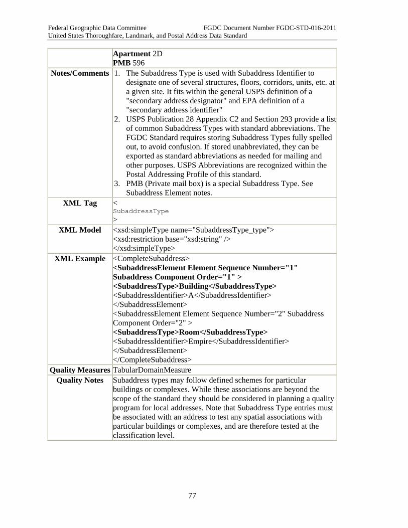
Federal Geographic Data Committee FGDC Document Number FGDC-STD-016-2011 United States Thoroughfare, Landmark, and Postal Address Data Standard
77
Apartment 2D PMB 596
Notes/Comments 1. The Subaddress Type is used with Subaddress Identifier to designate one of several structures, floors, corridors, units, etc. at a given site. It fits within the general USPS definition of a "secondary address designator" and EPA definition of a "secondary address identifier"
2. USPS Publication 28 Appendix C2 and Section 293 provide a list of common Subaddress Types with standard abbreviations. The FGDC Standard requires storing Subaddress Types fully spelled out, to avoid confusion. If stored unabbreviated, they can be exported as standard abbreviations as needed for mailing and other purposes. USPS Abbreviations are recognized within the Postal Addressing Profile of this standard.
3. PMB (Private mail box) is a special Subaddress Type. See Subaddress Element notes.
XML Tag < SubaddressType >
XML Model <xsd:simpleType name="SubaddressType_type"> <xsd:restriction base="xsd:string" /> </xsd:simpleType>
XML Example <CompleteSubaddress> <SubaddressElement Element Sequence Number="1" Subaddress Component Order="1" > <SubaddressType>Building</SubaddressType> <SubaddressIdentifier>A</SubaddressIdentifier> </SubaddressElement> <SubaddressElement Element Sequence Number="2" Subaddress Component Order="2" > <SubaddressType>Room</SubaddressType> <SubaddressIdentifier>Empire</SubaddressIdentifier> </SubaddressElement> </CompleteSubaddress>
Quality Measures TabularDomainMeasure Quality Notes Subaddress types may follow defined schemes for particular
buildings or complexes. While these associations are beyond the scope of the standard they should be considered in planning a quality program for local addresses. Note that Subaddress Type entries must be associated with an address to test any spatial associations with particular buildings or complexes, and are therefore tested at the classification level.
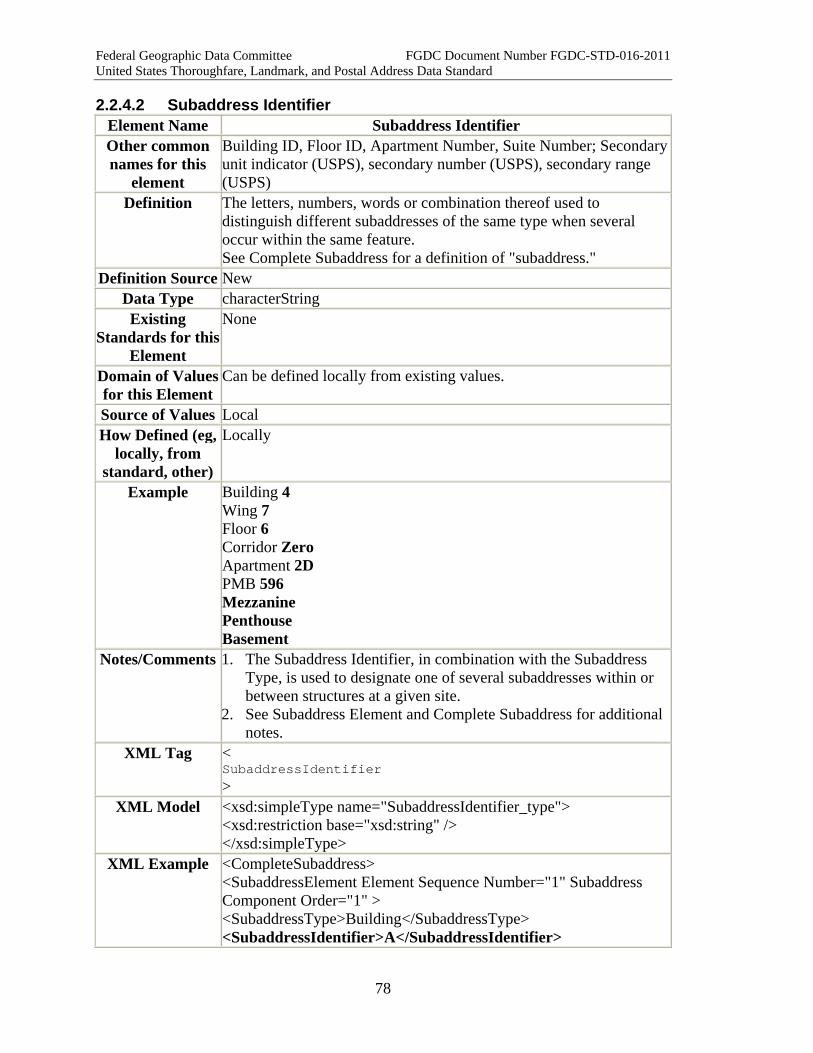
Federal Geographic Data Committee FGDC Document Number FGDC-STD-016-2011 United States Thoroughfare, Landmark, and Postal Address Data Standard
78
2.2.4.2 Subaddress Identifier Element Name Subaddress Identifier Other common names for this
element
Building ID, Floor ID, Apartment Number, Suite Number; Secondary unit indicator (USPS), secondary number (USPS), secondary range (USPS)
Definition The letters, numbers, words or combination thereof used to distinguish different subaddresses of the same type when several occur within the same feature. See Complete Subaddress for a definition of "subaddress."
Definition Source New Data Type characterString Existing
Standards for this Element
None
Domain of Values for this Element
Can be defined locally from existing values.
Source of Values Local How Defined (eg,
locally, from standard, other)
Locally
Example Building 4 Wing 7 Floor 6 Corridor Zero Apartment 2D PMB 596 Mezzanine Penthouse Basement
Notes/Comments 1. The Subaddress Identifier, in combination with the Subaddress Type, is used to designate one of several subaddresses within or between structures at a given site.
2. See Subaddress Element and Complete Subaddress for additional notes.
XML Tag < SubaddressIdentifier >
XML Model <xsd:simpleType name="SubaddressIdentifier_type"> <xsd:restriction base="xsd:string" /> </xsd:simpleType>
XML Example <CompleteSubaddress> <SubaddressElement Element Sequence Number="1" Subaddress Component Order="1" > <SubaddressType>Building</SubaddressType> <SubaddressIdentifier>A</SubaddressIdentifier>

Federal Geographic Data Committee FGDC Document Number FGDC-STD-016-2011 United States Thoroughfare, Landmark, and Postal Address Data Standard
79
</SubaddressElement> <SubaddressElement Element Sequence Number="1" Subaddress Component Order="2" > <SubaddressType>Room</SubaddressType> <SubaddressIdentifier>Empire</SubaddressIdentifier> </SubaddressElement> </CompleteSubaddress>
Quality Measures RangeDomainMeasure TabularDomainMeasure
Quality Notes Subaddress identifiers may follow defined schemes for particular buildings or complexes. While these associations are beyond the scope of the standard they should be considered in planning a quality program for local addresses. Note that Subaddress Identifier entries must be associated with an address to test any spatial associations with particular buildings or complexes, and are therefore tested at the classification level
2.2.4.3 Complex Element: Subaddress Element Element Name SubaddressElement Other common names for this
element
Secondary address identifier (USPS, EPA)
Definition A single combination of Subaddress Type and Subaddress Identifier (or, in some cases, a Subaddress Identifier alone), which, alone or in combination with other Subaddress Elements, distinguishes one subaddress within or between structures from another when several occur within the same feature. See Complete Subaddress for a definition of "subaddress."
Syntax { Subaddress Type } + { Subaddress Identifier* } Definition Source New
Data Type characterString Existing
Standards for this Element
None
Domain of Values for this Element
No
Source of Values N/A How Defined (eg,
locally, from standard, other)
N/A
Attributes Associated with
this Element
Subaddress Component Order
Example *Building 4* %BR% *Wing 7* %BR% *North Tower* %BR% *Floor 6* %BR% *Sixth Floor* %BR% *Corridor Zero* %BR%

Federal Geographic Data Committee FGDC Document Number FGDC-STD-016-2011 United States Thoroughfare, Landmark, and Postal Address Data Standard
80
*Apartment 2D* %BR% *PMB 596* %BR% *Empire Room* %BR% *Penthouse*
Notes/Comments 1. A Subaddress Element, alone or in combination with other Subaddress Elements, forms a Complete Subaddress.
2. In English, if the Subaddress Identifier is a name or an ordinal number, the Subaddress Identifier usually but not always precedes the Subaddress Type ("North Tower," "Sixth Floor," "Empire Room,"). If the Subaddress Identifier is a cardinal number, letter designator, or alphanumeric, it typically follows the Subaddress Type ("Building 4," "Apartment 2D", "Hanger A"). Common usage is loose, and there are numerous exceptions to both rules, and patterns differ in other languages. The Subaddress Component Order can be used to indicate the order in which the Subaddress Type and Subaddress Identifier should be written.
3. Some Subaddress Elements use only one word ("Mezzanine"). In such cases, by definition the word is considered a Subaddress Identifier, and the Subaddress Type is null. Other examples (all from USPS Publication 28 Appendix C2) are: Penthouse, Lobby, Basement, Front, Rear, Upper, Lower, Side.
4. The Special case of PMB (Private Mail Box) Subaddresses. Normally a PMB (Private Mail Box), like a mailstop code and other internal mail distribution codes, pertains to the recipient and is not part of the address. However, USPS Publication 28 Section 284 states, "Exception: When the CMRA [commercial mail receiving agency] mailing address contains a secondary address element (e.g. rural route box number, suite, # or other term), the CMRA customer must use Private Mail Box (PMB) when utilizing a three line address format. Examples: • RR 1 Box 12 PMB 596 • 10 Main Street Suite 11 PMB 234 "
5. Where a PMB appears in the Delivery Address, it is treated as a Subaddress Element. PMB is the only Subaddress Type that is permitted in the USPSPostal Delivery Box or USPSPostal Delivery Route address classes.
XML Tag < SubaddressElement >
XML Model <xsd:complexType name="SubaddressElement_type"> <xsd:sequence> <xsd:element name="SubaddressType" type="addr_type:SubaddressType_type" maxOccurs="1" minOccurs="0" /> <xsd:element name="SubaddressIdentifier" type="addr_type:SubaddressIdentifier_type" maxOccurs="1" minOccurs="1" />

Federal Geographic Data Committee FGDC Document Number FGDC-STD-016-2011 United States Thoroughfare, Landmark, and Postal Address Data Standard
81
</xsd:sequence> <xsd:attribute name="ElementSequenceNumber" type="addr_type:ElementSequenceNumber_type" /> <xsd:attribute name="SubaddressComponentOrder" type="addr_type:SubaddressComponentOrder_type" /> <xsd:attribute name="Separator" type="addr_type:Separator_type" /> </xsd:complexType>
XML Example <CompleteSubaddress> <SubaddressElement Element Sequence Number="1" Subaddress Component Order="1" > <SubaddressType>Building</SubaddressType> <SubaddressIdentifier>A</SubaddressIdentifier> </SubaddressElement> <SubaddressElement Element Sequence Number="2" Subaddress Component Order="1" > <SubaddressType>Floor</SubaddressType> <SubaddressIdentifier>7</SubaddressIdentifier> </SubaddressElement> </CompleteSubaddress>
Quality Measures PatternSequenceMeasure Quality Notes Subaddress elements may follow defined schemes for particular
buildings or complexes. While these associations are beyond the scope of the standard they should be considered in planning a quality program for local addresses. Note that Subaddress Element entries must be associated with an address to test any spatial associations with particular buildings or complexes, and are therefore tested at the classification level
2.2.4.4 Complex Element: Complete Subaddress Element Name CompleteSubaddress Other common names for this
element
See Subaddress Element
Definition One or more Subaddress Elements that identify a subaddress within an addressed feature. A subaddress is a separate, identifiable portion of a feature, the whole of which is identified by a: • Complete Address Number and Complete Street Name (in the
case of a Numbered Thoroughfare Address) • Two Complete Address Numbers, separated by a hyphen, and
followed by a Complete Street Name (in the case of a Two Number Address Range)
• Complete Street Name (in the case of an Unnumbered Thoroughfare Address)
• Complete Landmark Name (in the case of a Landmark Address)

Federal Geographic Data Committee FGDC Document Number FGDC-STD-016-2011 United States Thoroughfare, Landmark, and Postal Address Data Standard
82
• Complete Address Number and Complete Landmark Name or Complete Place Name (in the case of a Community Address)
• USPS Box or USPS Address (in the case of a USPSPostal Delivery Box or USPSPostal Delivery Route address; for these classes, PMB (private mail box) is the only Subaddress Type permitted.)
Syntax A series of one or more Subaddress Elements. If more than one are listed, the Element Sequence Number can be used to show the order in which they should be listed.
Definition Source New Data Type characterString
Existing Standards for this Element
None
Domain of Values for this Element
None
Source of Values N/A How Defined (eg,
locally, from standard, other)
N/A
Attributes Associated with
this Element
Element Sequence Number
Example 1. 123 Main Street, Apartment 101 2. 1000 Aviation Road, Building 4, Wing 7, Floor 6, Corridor
Zero, Office 2B 3. Metro Airport, Terminal A, Gate C27 4. Average Suburban Office Park, Building 12, Mezzanine, Suite
200 5. 800 West Mountain Road, Building 6, Suite 450 6. 740 Park Avenue, Apartment 15/16B 7. 1324-26 Calle Amapolas, Apartamento 103 8. Five-Star Hotel, East Tower, Penthouse 9. U.S. Dept. of Agriculture Building, Wing 7, Room 324 10. General Hospital, Cardiac Wing, Room 224 11. U.S. Department of Commerce Building, Room 6056 (Floor 6,
Corridor Zero, Room 56) 12. Pentagon, Room 3D126 (Third floor, D ring, First corridor,
Room 26) 13. RR 1 Box 12 PMB 596 14. 10 Main Street Suite 11 PMB 234
Notes/Comments 1. Complete Subaddresses and their component elements pertain to a wide variety of residential and commercial buildings, from single basement apartments to multi-structure office parks, as well as countless specialized structures such as airports, piers, warehouses, manufacturing plants, and stadiums. Complete

Federal Geographic Data Committee FGDC Document Number FGDC-STD-016-2011 United States Thoroughfare, Landmark, and Postal Address Data Standard
83
Subaddresses are typically designated by the property owner, and addressing authorities usually have no responsibility for compiling or verifying them. However, this is changing as address verification becomes more important for government purposes such as security, emergency response, and verification of eligibility for voting, school attendance, and public services.
2. Usually Complete Subaddresses follow a pattern of Building-Floor-Room (or Doorway), but due to the wide variety of cases no general rule can be given. In composing the Complete Subaddress, the Subaddress Elements should be ordered from largest to smallest, or in the order one would encounter them in navigating from outside the site to the designated subaddress. If desired, use the Element Sequence Number to indicate the sequence in which the Subaddress Elements should be ordered.
XML Tag < CompleteSubaddress >
XML Model <xsd:complexType name="CompleteSubaddress_type"> <xsd:sequence> <xsd:element name="SubaddressElement" type="addr_type:SubaddressElement_type" minOccurs="1" maxOccurs="unbounded" /> </xsd:sequence> </xsd:complexType>
XML Example <CompleteSubaddress> <SubaddressElement Element Sequence Number="1" Subaddress Component Order="1" > <SubaddressType>Building</SubaddressType> <SubaddressIdentifier>A</SubaddressIdentifier> </SubaddressElement> <SubaddressElement Element Sequence Number="2" Subaddress Component Order="1" > <SubaddressType>Floor</SubaddressType> <SubaddressIdentifier>7</SubaddressIdentifier> </SubaddressElement> </CompleteSubaddress>
Quality Measures RepeatedElementUniquenessMeasure ComplexElementSequenceNumberMeasure PatternSequenceMeasure
Quality Notes This test for the Complete Subaddress assumes that quality tests have been run for supporting elements: Subaddress Type, Subaddress Identifier and Subaddress Element.
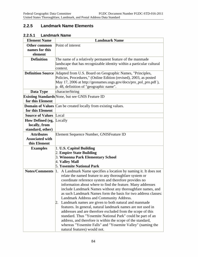
Federal Geographic Data Committee FGDC Document Number FGDC-STD-016-2011 United States Thoroughfare, Landmark, and Postal Address Data Standard
84
2.2.5 Landmark Name Elements
2.2.5.1 Landmark Name Element Name Landmark Name Other common names for this
element
Point of interest
Definition The name of a relatively permanent feature of the manmade landscape that has recognizable identity within a particular cultural context.
Definition Source Adapted from U.S. Board on Geographic Names, "Principles, Policies, Procedures," (Online Edition (revised), 2003, as posted May 17, 2006 at http://geonames.usgs.gov/docs/pro_pol_pro.pdf ), p. 48, definition of "geographic name".
Data Type characterString Existing Standards
for this Element None, but see GNIS Feature ID
Domain of Values for this Element
Can be created locally from existing values.
Source of Values Local How Defined (eg,
locally, from standard, other)
Locally
Attributes Associated with
this Element
Element Sequence Number, GNISFeature ID
Examples 1. U.S. Capitol Building 2. Empire State Building 3. Winonna Park Elementary School 4. Valley Mall 5. Yosemite National Park
Notes/Comments 1. A Landmark Name specifies a location by naming it. It does not relate the named feature to any thoroughfare system or coordinate reference system and therefore provides no information about where to find the feature. Many addresses include Landmark Names without any thoroughfare names, and as such Landmark Names form the basis for two address classes: Landmark Address and Community Address.
2. Landmark names are given to both natural and manmade features. In general, natural landmark names are not used in addresses and are therefore excluded from the scope of this standard. Thus "Yosemite National Park" could be part of an address, and therefore is within the scope of the standard, whereas "Yosemite Falls" and "Yosemite Valley" (naming the natural features) would not.
Federal Geographic Data Committee FGDC Document Number FGDC-STD-016-2011 United States Thoroughfare, Landmark, and Postal Address Data Standard
85
3. The difference between Landmark Name and a Place Name is not always clear and distinct. As a general principle, a landmark is under a single use or ownership or control, while places are not. Thus a landmark, even if it covers an extensive area, might be considered to be a single "master address" (often containing multiple subordinate addresses), while a place generally includes numerous separate addresses. These general principles apply to most cases and are useful as general distinctions, but exceptions and marginal cases are easily found.
4. Local address authorities may wish to compile a list of locally-recognized Landmark Names used as addresses for their convenience. Whether to do so, and if so what names to include, are implementation matters to be decided locally.
5. Most named landmarks that are used as addresses are also designated by one or more thoroughfare addresses. These should be cross-referenced to each other as Related Address IDs, using the Address Relation Type attribute to record the relationship between them.
6. Landmark Name, as used in this standard, does not imply any officially-designated historic landmark status, nor is it restricted to features having such status.
7. The U.S. Board on Geographic Names has compiled and standardized names for many landmarks in the Geographic Names Information System (GNIS), each identified by a unique GNISFeature ID. Local authorities are encouraged to review the GNISFeature ID for more information on the use of the GNIS ID with Landmark Names.
8. The U.S. Board on Geographic Names has defined 65 classes of features for use in classifying features listed in GNIS. These classes, while neither exhaustive nor necessarily definitive for addressing purposes, may provide useful guidance in distinguishing Place Names, manmade Landmark Names, and natural landmark names. • Manmade landmark classes (the names of these features are
often used in addresses and therefore generally within the scope of this standard): airport, bridge, building, canal, cemetery, church, crossing, dam, harbor, hospital, levee, locale, military, mine, oilfield, park, post office, reserve, reservoir, school, tower, trail, tunnel, well.
• PlaceName classes (the names of these features are generally Place Names within this standard): Census, civil, populated place.
• Natural landmark classes (the names of these features are generally outside the scope of this standard): arch, area, arroyo, bar, basin, bay, beach, bench, bend, cape, cave, channel, cliff, crater, falls, flat, forest, gap, glacier, gut,

Federal Geographic Data Committee FGDC Document Number FGDC-STD-016-2011 United States Thoroughfare, Landmark, and Postal Address Data Standard
86
island, isthmus, lake, lava, pillar, plain, range, rapids, ridge, sea, slope, spring, stream, summit, swamp, valley, woods.
9. The complete feature class definitions can be found from the GNIS Domestic Names search page. See Part 6 (U.S. Geological Survey) for a complete citation.
XML Tag <LandmarkName> XML Model <xsd:complexType name="LandmarkName_type">
<xsd:simpleContent> <xsd:extension base="xsd:string"> <xsd:attribute name="ElementSequenceNumber" type="addr_type:ElementSequenceNumber_type" /> </xsd:extension> </xsd:simpleContent> </xsd:complexType>
XML Example <CompleteLandmark> <LandmarkName>YOSEMITE NATIONAL PARK</LandmarkName> </CompleteLandmark>
Quality Measures UniquenessMeasure TabularDomainMeasure SpatialDomainMeasure
Quality Notes Some landmarks will be nested within a larger one, the latter constituting a spatial domain. Similarly, a tabular domain may be associated with an outer landmark.
2.2.5.2 Complex Element: Complete Landmark Name Element Name CompleteLandmarkName Other common names for this
element
Definition One or more Landmark Names which identify a relatively permanent feature of the manmade landscape that has recognizable identity within a particular cultural context.
Syntax A series of one or more Landmark Names. If more than one are listed, the Element Sequence Number can be used to show the order in which they should be listed.
Definition Source Adapted from U.S. Board on Geographic Names, "Principles, Policies, Procedures," (Online Edition (revised), 2003, as posted May 17, 2006 at http://geonames.usgs.gov/docs/pro_pol_pro.pdf ), p. 48, definition of "geographic name".
Data Type characterString Existing Standards
for this Element None, but see GNIS Feature ID
Domain of Values for this Element
Can be created locally from existing values

Federal Geographic Data Committee FGDC Document Number FGDC-STD-016-2011 United States Thoroughfare, Landmark, and Postal Address Data Standard
87
Source of Values Local How Defined (eg,
locally, from standard, other)
Locally
Examples University of Washington, Seattle, WA Suzallo Library, University of Washington, Seattle, WA Statue of Liberty, New York, NY Statue of Liberty, Liberty Island, New York, NY Yosemite National Park, CA Camp Curry, Yosemite National Park, CA
Notes/Comments 1. Landmark names often refer to extensive areas, which may contain smaller named landmarks. In these cases the landmark name may function as a single "master address" containing multiple subordinate addresses. The Complete Landmark Name provides for the inclusion of multiple Landmark Names in an address.
2. Where multiple Landmark Names are given, they are typically ordered from smallest to largest. The Element Sequence Number can be used to indicate the sequence in which the Landmark Names should be ordered.
3. The U.S. Board on Geographic Names has compiled and standardized names for many landmarks in the Geographic Names Information System (GNIS). Local authorities are encouraged to review the GNISFeature ID for more information on the use of the GNIS ID and Landmark Names. Where a complete landmark name consists of more than one landmark name, the GNIS Code for the smallest unit of the complete landmark name should be used to provide the most specific reference.
XML Tag < CompleteLandmarkName >
XML Model <xsd:complexType name="CompleteLandmarkName_type"> <xsd:sequence> <xsd:element name="LandmarkName" type="addr_type:LandmarkName_type" minOccurs="1" maxOccurs="unbounded" /> </xsd:sequence> <xsd:attribute name="Separator" type="addr_type:Separator_type" /> </xsd:complexType>
XML Example <CompleteLandmark Separator=","> <LandmarkName ElementSequenceNumber="1">CAMP CURRY</LandmarkName> <LandmarkName ElementSequenceNumber="2">YOSEMITE NATIONAL PARK</LandmarkName>

Federal Geographic Data Committee FGDC Document Number FGDC-STD-016-2011 United States Thoroughfare, Landmark, and Postal Address Data Standard
88
</CompleteLandmark> Quality Measures RepeatedElementUniquenessMeasure
ComplexElementSequenceNumberMeasure PatternSequenceMeasure
Quality Notes
2.2.6 Place, State, and Country Name Elements
2.2.6.1 Place Name Element Name Place Name Other common names for this
element
Unincorporated community or neighborhood: Community, neighborhood, subdivision, district, ward, borough (in, for example, New York City); Barrio, sector, urbanization, parcela, extension, mansion, reparto, villa, parque, jardine, urbanizacion place name (Puerto Rico); Census designated place, populated place (GNIS), locale (GNIS) Incorporated local government: Municipality, city, borough, town, village, township, actual city, location city, situs city, municipal place name, minor civil division, corporation, consolidated government, metropolitan government, unified government, populated place (GNIS), locale (GNIS) USPS Post Office Name: Post office, mailing city, city (as in "City, State, ZIP"), city name; APO, FPO, DPO (for overseas US military and diplomatic mail delivery) County: Parish (Louisiana); Census Area, City and Borough, and Unorganized Borough (Alaska); Municipality (Alaska and the Commonwealth of the Northern Mariana Islands), Municipio (Puerto Rico), City (Maryland, Missouri, Nevada, and Virginia), District (DC and American Samoa), Island (American Samoa and U.S. Virgin Islands) Region: Metropolitan area, metropolitan statistical area (Census), consolidated metropolitan statistical area (Census), primary metropolitan statistical area (Census)
Definition The name of an area, sector, or development (such as a neighborhood or subdivision in a city, or a rural settlement in unincorporated area); incorporated municipality or other general-purpose local governmental unit; county or county-equivalent; or region within which the address is physically located; or a name recognized by the U.S. Postal Service for delivery of mail to the address.
Definition Source New; partly adapted from: 1. FGDC's "Framework Data Content Standard Part 5:
Governmental unit and other geographic area boundaries"; and, 2. USPS Publication 28, Section 292, "Urbanization".
Data Type characterString

Federal Geographic Data Committee FGDC Document Number FGDC-STD-016-2011 United States Thoroughfare, Landmark, and Postal Address Data Standard
89
Existing Standards for this Element
No single controlling authority, but the Geographic Names Information System (GNIS) attempts to include and standardize the names of all populated places and incorporated local governments (see GNISFeature ID). For USPS Post Office names, the controlling authority is the USPS "City State File" as referenced in Section 221 of USPS Publication 28
Domain of Values for this Element
None (but see existing standards above). Can be created locally from existing values.
Source of Values Locally determined (but see existing standards above) How Defined (eg,
locally, from standard, other)
Locally.
Attributes Associated with
this Element
Place Name Type, Element Sequence Number, GNISFeature ID
Examples Ajo, AZ (unincorporated community in Pima County, AZ) Urbanizacion Los Pinos (Puerto Rican urbanization) Barrio Miraflor (Puerto Rican barrio) Portola Valley, CA (incorporated town) Birmingham, AL (city) Salt Lake City, UT (city) Queens (New York City borough) Orleans Parish, LA (county) APO AE (overseas military postal delivery) FPO AP (overseas military postal delivery) DPO AE (overseas US State Department postal delivery)
Notes/Comments 1. "Place name" can mean different things to different people in different contexts. It may name a community, an incorporated local government, a post office, a county, or a region. For many thoroughfare and landmark addresses, a different place name may be used by an emergency dispatcher directing an ambulance, a local government official assessing local taxes or eligibility for services, a postal clerk, or a business providing contact information on its website.
2. This standard provides the Place Name Type attribute to allow the use of different place names with the same address for different purposes. Five types are defined: unincorporated community or neighborhood, incorporated local government, U.S. Post Office name, county, and region. Other types may be added. Additional explanation is given in the notes below and under Place Name Type.
3. The U.S. Board of Geographic Names has assigned GNIS Codes to all place names that have been registered and accepted by the Board. This standard provides the GNISFeature ID attribute to accommodate those codes. For more information on GNIS, see GNISFeature ID or
Federal Geographic Data Committee FGDC Document Number FGDC-STD-016-2011 United States Thoroughfare, Landmark, and Postal Address Data Standard
90
http://geonames.usgs.gov/domestic/index.html . Notes on Community Names: 1. A community name refers to an area, sector, or development,
such as a neighborhood or subdivision in a city, or a rural settlement in unincorporated area, that is not an incorporated general-purpose local government or county. The name may arise from official recognition or from popular usage.
2. Numerous different terms are used to denote different kinds of communities and community names, but the distinctions are not particularly significant in constructing addresses. An extensive list of terms and definitions can be found in "Framework Data Content Standard Part 5: Governmental unit and other geographic area boundaries," Tables 11 and 15.
3. Community names are of particular importance in Puerto Rican addresses. Street names and address ranges are repeated in many Puerto Rican municipios (county equivalents); these repeated addresses are distinguished from each other by their community name. Administratively, Puerto Rican municipios are divided into barrios and sectors. Smaller areas, such as urbanizacions and parcelas, may be recognized locally, and all of them may be used in locating an address. For postal addressing, repeated addresses are distinguished from each other by their urbanizacion or equivalent community name. For more information on postal addressing standards for Puerto Rico, see USPS Publication 28 Section 29, and USPS “Addressing Standards for Puerto Rico and the Virgin Islands” (especially sections 2 and 5).
Notes on Municipal and County Place Names: 1. County and municipal names indicate the county and the
general-purpose local government area (if any) in which the address is physically located. Local government types and terminologies vary substantially from state to state, but the distinctions are not particularly significant in constructing addresses. An extensive list of terms and definitions can be found in "Framework Data Content Standard Part 5: Governmental unit and other geographic area boundaries," Table 13.
2. Exact municipal and county names are required by public administrators for correct assessing local taxes, assignment of voting precinct, school enrollment, and provision of local government services.
3. Addresses in unincorporated portions of counties have no municipal place name by definition.
4. Many governments have a legal name and a popular name ("Saint Paul" vs. "City of Saint Paul"). For addressing, the popular name is generally preferable if it is unique within the
Federal Geographic Data Committee FGDC Document Number FGDC-STD-016-2011 United States Thoroughfare, Landmark, and Postal Address Data Standard
91
county and state. 5. New York City is comprised of five administrative boroughs
(Bronx, Brooklyn, Manhattan, Queens, and Staten Island). The boroughs are legally distinct from the five counties that are also subdivisions of New York City (Bronx, Kings, New York, Queens, and Richmond) even though the boroughs and counties have identical boundaries and two even share the same name.
Notes on USPS Place Names: 1. The USPS place name is a place name listed in the USPS City
State File for delivery of mail to an address. 2. USPS place names are preferred for postal operations. However,
they are often not the best-suited place names for non-postal purposes such as navigation, public service delivery, and emergency response.
3. For postal purposes, the USPS strongly discourages the use of multiple place names in an address. For example, the USPS on-line ZIP finder will find a ZIP code for an address in ""Wailuku, HI," but not for "Wailuku, Maui, HI."
4. For overseas US military postal addresses, "APO" (Army Post Office) or "FPO" (Fleet Post Office) is used as the Place Name (see USPS Publication 28, Section 225.1 and 238.1). "DPO" (Diplomatic Post Office) is used as the Place Name for some overseas US State Department postal addresses (see USPS Pub 28 Sec. 239).
Notes on Regional Place Names: A region name refers to the region where the address is physically located. Typically this is the name of the central city within the region. For precise, systematic terms, U.S. Census Bureau terms and definitions may be applied, but popular usage is often imprecise and to some extent subjective. Businesses and residents near a regional center often use the central-city name in their address, even if the address is located some distance outside the limits of the city itself.
XML Tag < PlaceName >
XML Model <xsd:complexType name="PlaceName_type"> <xsd:simpleContent> <xsd:extension base="xsd:string"> <xsd:attribute name="PlaceNameType" type="addr_type:PlaceNameType_type" /> <xsd:attribute name="ElementSequenceNumber" type="addr_type:ElementSequenceNumber_type" /> <xsd:attribute name="GNISFeatureID" type="addr_type:GNISFeatureID_type" /> </xsd:extension> </xsd:simpleContent>
Federal Geographic Data Committee FGDC Document Number FGDC-STD-016-2011 United States Thoroughfare, Landmark, and Postal Address Data Standard
92
</xsd:complexType> XML Example <PlaceName>ORLEANS PARISH</PlaceName>
Quality Measures TabularDomainMeasure SpatialDomainMeasure
Quality Notes Some place names will be nested within a larger one, the latter constituting a spatial domain. Similarly, a tabular domain may be associated with an outer place name.
2.2.6.2 Complex Element: Complete Place Name Element Name CompletePlaceName Other common names for this
element
See Place Name
Definition One or more Place Names which identify an area, sector, or development (such as a neighborhood or subdivision in a city, or a rural settlement in unincorporated area); incorporated municipality or other general-purpose local governmental unit; county; or region within which the address is physically located; or the name given by the U.S. Postal Service to the post office from which mail is delivered to the address.
Syntax A series of one or more Place Names. If more than one is listed, the Place Name Type can be used to specify the type for each Place Name (e.g., community, municipal, postal, county, region) and the Element Sequence Number can be used to show the order in which they should be listed.
Definition Source See Place Name Data Type characterString
Existing Standards for this Element
No single controlling authority, but the Geographic Names Information System (GNIS) attempts to include and standardize the names of all populated places and incorporated local governments (see GNISFeature ID). For USPS Post Office names, the controlling authority is the USPS "City State File" as referenced in Section 221 of USPS Publication 28
Domain of Values for this Element
None (but see existing standards above)
Source of Values Local (but see existing standards above) How Defined (eg,
locally, from standard, other)
Locally.
Examples Ajo, Pima County, AZ (unincorporated community in Pima County, AZ) Portola Valley, CA (incorporated town) Birmingham, AL (city) Salt Lake City, UT (city) Queens, New York, NY (New York City borough)

Federal Geographic Data Committee FGDC Document Number FGDC-STD-016-2011 United States Thoroughfare, Landmark, and Postal Address Data Standard
93
Orleans Parish, LA (county) FPO AA (overseas military postal delivery) New Hope Community, Shelby County, AL (unincorporated community Shelby County, AL) Capitol Hill, Washington, DC (neighborhood in Washington, DC)Wailuku, Maui, HI Edgewater Park, Bronx, New York, NY (neighborhood in New York City) Sector La Frontera, Barrio Cotui, San German, PR (Puerto Rican sector) Urbanizacion Altagracia, Toa Baja, PR (Puerto Rican urbanizacion) Jardines Los Almendros, Municipio Maunabo, PR (Puerto Rican urbanization) Parcelas Nuevas, Barrio Rincon, Cidra, PR (Puerto Rican parcelas)
Notes/Comments 1. "Place name" can mean different things to different people in different contexts. It may name a community, an incorporated local government, a post office, a county, or a region. For many thoroughfare and landmark addresses, a different place name may be used by an emergency dispatcher directing an ambulance, a local government official assessing local taxes or eligibility for services, a postal clerk, or a business providing contact information on its website.
2. For some purposes an address may require more than one place name (e.g., "Wailuku, Maui", "New Hope, Shelby County", "Parcelas Nuevas, Barrio Rincon, Cidra”). This is discouraged in postal addresses, but it may be necessary in other contexts, (e.g., to provide both the municipality and county for an address). The Complete Place Name provides for inclusion of multiple Place Names in the address.
3. Where multiple Place Names are given, they are typically ordered from smallest to largest. The Element Sequence Number can be used to indicate the sequence in which the Place Names should be ordered.
4. This standard provides the Place Name Type attribute to allow the use of different place names with the same address for different purposes. Five types are defined: community, municipal, postal, county, and regional. Others may be added. Additional explanation is given under Place Name and Place Name Type.
5. The difference between a place and a landmark is not always clear and distinct. As a general principle, a landmark is under a single use or ownership or control, while places are not. Thus a place generally includes numerous separate addresses, while a landmark, even if it covers an extensive area, might be

Federal Geographic Data Committee FGDC Document Number FGDC-STD-016-2011 United States Thoroughfare, Landmark, and Postal Address Data Standard
94
considered to be a single "master address" (often containing multiple subordinate addresses). These general principles apply to most cases and are useful as general distinctions, but exceptions and marginal cases are easily found.
6. The U.S. Board of Geographic Names has assigned GNISFeature ID's to all place names that have been registered and accepted by the Board. Within the address standard, GNISFeature ID's may be associated with Place Names to facilitate standardization and unambiguous communication. See GNISFeature ID for more information.
XML Tag < CompletePlaceName >
XML Model <xsd:complexType name="CompletePlaceName_type"> <xsd:sequence> <xsd:element name="PlaceName" type="addr_type:PlaceName_type" minOccurs="1" maxOccurs="unbounded" /> </xsd:sequence> <xsd:attribute name="Separator" type="addr_type:Separator_type" /> </xsd:complexType>
XML Example <CompletePlaceName> <PlaceName Place Name Type="USPSPlaceName"> Ajo </PlaceName> </CompletePlaceName>
<CompletePlaceName> <PlaceName Place Name Type="County" > Shelby </PlaceName></CompletePlaceName>
<CompletePlaceName> <PlaceName Place Name Type="USPS" > Washington </PlaceName> </CompletePlaceName>
<CompletePlaceName> <PlaceName Place Name Type="Community" > Urbanizacion Los Olmos </PlaceName> </CompletePlaceName>
<CompletePlaceName> <PlaceName Place Name Type="Community">Queens</PlaceName> <PlaceName Place Name Type="Municipal">New York</PlaceName>
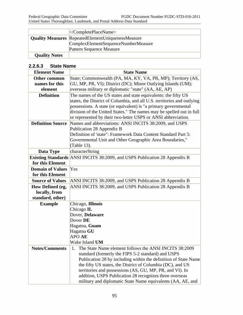
Federal Geographic Data Committee FGDC Document Number FGDC-STD-016-2011 United States Thoroughfare, Landmark, and Postal Address Data Standard
95
</CompletePlaceName> Quality Measures RepeatedElementUniquenessMeasure
ComplexElementSequenceNumberMeasure Pattern Sequence Measure
Quality Notes
2.2.6.3 State Name Element Name State Name Other common names for this
element
State; Commonwealth (PA, MA, KY, VA, PR, MP); Territory (AS, GU, MP, PR, VI); District (DC); Minor Outlying Islands (UM); overseas military or diplomatic "state" (AA, AE, AP)
Definition The names of the US states and state equivalents: the fifty US states, the District of Columbia, and all U.S. territories and outlying possessions. A state (or equivalent) is "a primary governmental division of the United States." The names may be spelled out in full or represented by their two-letter USPS or ANSI abbreviation.
Definition Source Names and abbreviations: ANSI INCITS 38:2009, and USPS Publication 28 Appendix B Definition of 'state": Framework Data Content Standard Part 5: Governmental Unit and Other Geographic Area Boundaries," (Table 13).
Data Type characterString Existing Standards
for this Element ANSI INCITS 38:2009, and USPS Publication 28 Appendix B
Domain of Values for this Element
Yes
Source of Values ANSI INCITS 38:2009, and USPS Publication 28 Appendix B How Defined (eg,
locally, from standard, other)
ANSI INCITS 38:2009, and USPS Publication 28 Appendix B
Example Chicago, Illinois Chicago IL Dover, Delaware Dover DE Hagatna, Guam Hagatna GU APO AE Wake Island UM
Notes/Comments 1. The State Name element follows the ANSI INCITS 38:2009 standard (formerly the FIPS 5-2 standard) and USPS Publication 28 by including within the definition of State Namethe fifty US states, the District of Columbia (DC), and US territories and possessions (AS, GU, MP, PR, and VI). In addition, USPS Publication 28 recognizes three overseas military and diplomatic State Name equivalents (AA, AE, and

Federal Geographic Data Committee FGDC Document Number FGDC-STD-016-2011 United States Thoroughfare, Landmark, and Postal Address Data Standard
96
AP), which the ANSI standard does not; and the ANSI standard recognizes "UM" for US minor outlying islands, which USPS Publication 28 does not.
2. Within this standard State Names may be spelled out in full or they may be represented by their standard two-letter ANSI INCITS 38:2009 or USPS abbreviations.
3. For overseas military and diplomatic postal addresses, "AE" or "AP" or "AA" is used as the State Name. "AE" is used for armed forces and certain diplomatic posts in Europe, the Middle East, Africa, and Canada; "AP" for the Pacific; and "AA" for the Americas excluding Canada (see USPS Publication 28, Section 225.1 and Appendix B).
4. The ANSI INCITS 38:2009 standard abbreviations include the abbreviation UM for U.S. Minor Outlying Islands. These are nine small, remote islands or island groups that do not receive direct mail delivery: Midway Islands, Wake Island, Johnson Atoll, Kingman Reef, Palmyra Atoll, Jarvis Island, Howland Island, Baker Island, and Navassa Island.
5. In rare cases, the postal state and the physical location state of the address are not the same. This occurs in some communities on the borders of two states. In these cases, the physical address should be treated as the primary or official address, including the physical state name, while the postal address with its state name should be listed as an alias.
XML Tag < StateName >
XML Model <xsd:simpleType name="StateName_type"> <xsd:restriction base="xsd:token"> <!-- "US State and The District of Columbia" Abbreviations --> <xsd:pattern value='.*' /> </xsd:restriction> </xsd:simpleType>
XML Example <StateName>VA</StateName>
<StateName>VIRGINIA</StateName> Quality Measures TabularDomainMeasure
SpatialDomainMeasure Quality Notes
2.2.6.3 Zip Code Element Name Zip Code Other common names for this
element
ZIP5, Zone Improvement Plan
Definition A system of 5-digit codes that identifies the individual Post Office
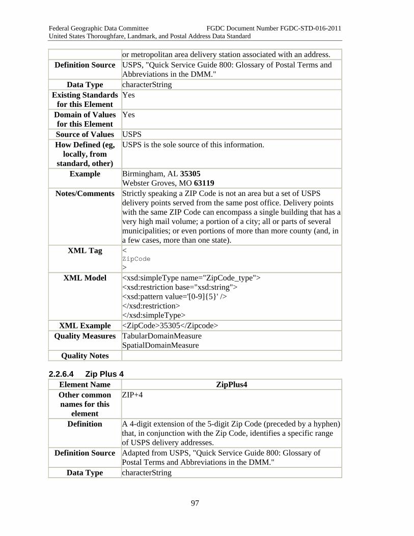
Federal Geographic Data Committee FGDC Document Number FGDC-STD-016-2011 United States Thoroughfare, Landmark, and Postal Address Data Standard
97
or metropolitan area delivery station associated with an address. Definition Source USPS, "Quick Service Guide 800: Glossary of Postal Terms and
Abbreviations in the DMM." Data Type characterString
Existing Standards for this Element
Yes
Domain of Values for this Element
Yes
Source of Values USPS How Defined (eg,
locally, from standard, other)
USPS is the sole source of this information.
Example Birmingham, AL 35305 Webster Groves, MO 63119
Notes/Comments Strictly speaking a ZIP Code is not an area but a set of USPS delivery points served from the same post office. Delivery points with the same ZIP Code can encompass a single building that has a very high mail volume; a portion of a city; all or parts of several municipalities; or even portions of more than more county (and, in a few cases, more than one state).
XML Tag < ZipCode >
XML Model <xsd:simpleType name="ZipCode_type"> <xsd:restriction base="xsd:string"> <xsd:pattern value='[0-9]{5}' /> </xsd:restriction> </xsd:simpleType>
XML Example <ZipCode>35305</Zipcode> Quality Measures TabularDomainMeasure
SpatialDomainMeasure Quality Notes
2.2.6.4 Zip Plus 4 Element Name ZipPlus4 Other common names for this
element
ZIP+4
Definition A 4-digit extension of the 5-digit Zip Code (preceded by a hyphen) that, in conjunction with the Zip Code, identifies a specific range of USPS delivery addresses.
Definition Source Adapted from USPS, "Quick Service Guide 800: Glossary of Postal Terms and Abbreviations in the DMM."
Data Type characterString
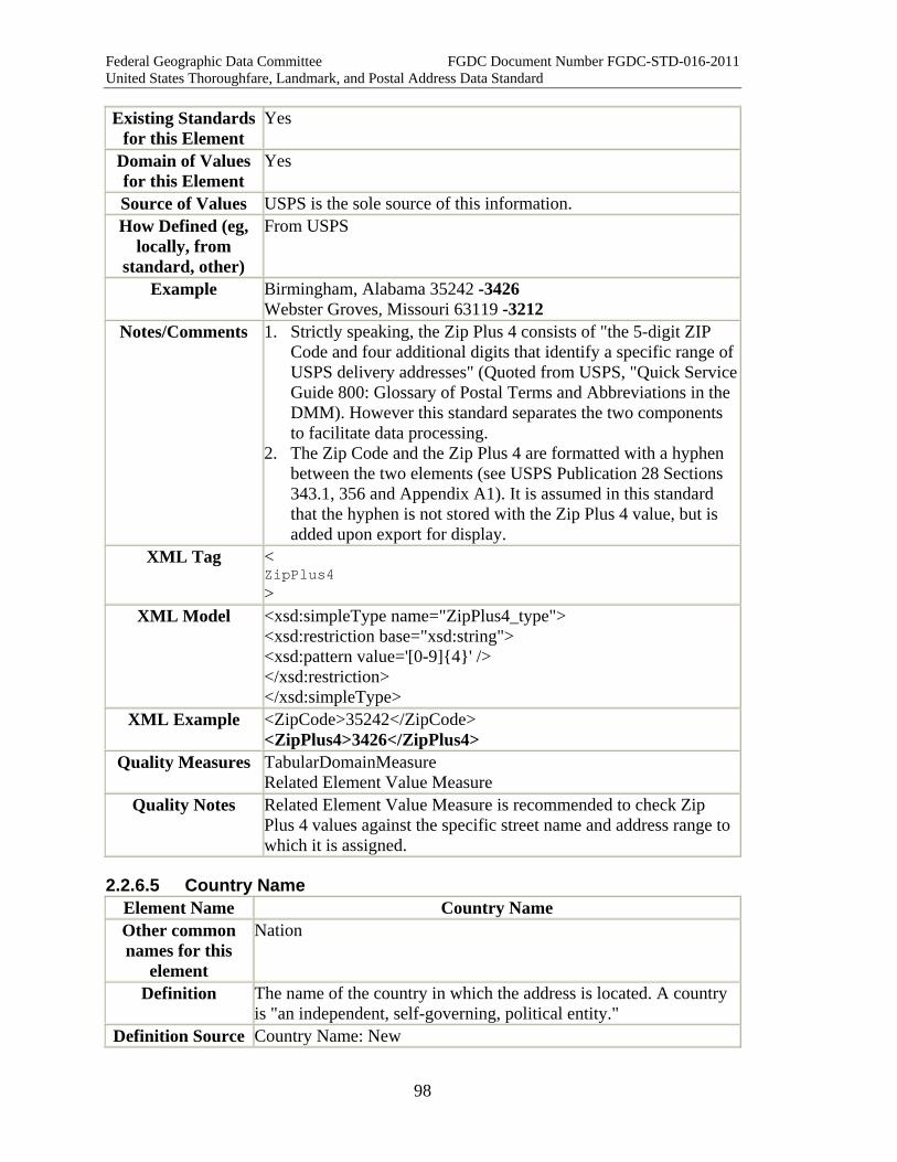
Federal Geographic Data Committee FGDC Document Number FGDC-STD-016-2011 United States Thoroughfare, Landmark, and Postal Address Data Standard
98
Existing Standards for this Element
Yes
Domain of Values for this Element
Yes
Source of Values USPS is the sole source of this information. How Defined (eg,
locally, from standard, other)
From USPS
Example Birmingham, Alabama 35242 -3426 Webster Groves, Missouri 63119 -3212
Notes/Comments 1. Strictly speaking, the Zip Plus 4 consists of "the 5-digit ZIP Code and four additional digits that identify a specific range of USPS delivery addresses" (Quoted from USPS, "Quick ServiceGuide 800: Glossary of Postal Terms and Abbreviations in the DMM). However this standard separates the two components to facilitate data processing.
2. The Zip Code and the Zip Plus 4 are formatted with a hyphen between the two elements (see USPS Publication 28 Sections 343.1, 356 and Appendix A1). It is assumed in this standard that the hyphen is not stored with the Zip Plus 4 value, but is added upon export for display.
XML Tag < ZipPlus4 >
XML Model <xsd:simpleType name="ZipPlus4_type"> <xsd:restriction base="xsd:string"> <xsd:pattern value='[0-9]{4}' /> </xsd:restriction> </xsd:simpleType>
XML Example <ZipCode>35242</ZipCode> <ZipPlus4>3426</ZipPlus4>
Quality Measures TabularDomainMeasure Related Element Value Measure
Quality Notes Related Element Value Measure is recommended to check Zip Plus 4 values against the specific street name and address range to which it is assigned.
2.2.6.5 Country Name Element Name Country Name Other common names for this
element
Nation
Definition The name of the country in which the address is located. A country is "an independent, self-governing, political entity."
Definition Source Country Name: New
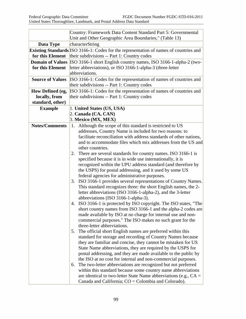
Federal Geographic Data Committee FGDC Document Number FGDC-STD-016-2011 United States Thoroughfare, Landmark, and Postal Address Data Standard
99
Country: Framework Data Content Standard Part 5: Governmental Unit and Other Geographic Area Boundaries," (Table 13)
Data Type characterString Existing Standards
for this Element ISO 3166-1: Codes for the representation of names of countries and their subdivisions -- Part 1: Country codes
Domain of Values for this Element
ISO 3166-1 short English country names, ISO 3166-1-alpha-2 (two-letter abbreviations), or ISO 3166-1-alpha-3 (three-letter abbreviations.
Source of Values ISO 3166-1: Codes for the representation of names of countries and their subdivisions -- Part 1: Country codes
How Defined (eg, locally, from
standard, other)
ISO 3166-1: Codes for the representation of names of countries and their subdivisions -- Part 1: Country codes
Example 1. United States (US, USA) 2. Canada (CA, CAN) 3. Mexico (MX, MEX)
Notes/Comments 1. Although the scope of this standard is restricted to US addresses, Country Name is included for two reasons: to facilitate reconciliation with address standards of other nations, and to accommodate files which mix addresses from the US and other countries.
2. There are several standards for country names. ISO 3166-1 is specified because it is in wide use internationally, it is recognized within the UPU address standard (and therefore by the USPS) for postal addressing, and it used by some US federal agencies for administrative purposes.
3. ISO 3166-1 provides several representations of Country Names. This standard recognizes three: the short English names, the 2-letter abbreviations (ISO 3166-1-alpha-2), and the 3-letter abbreviations (ISO 3166-1-alpha-3).
4. ISO 3166-1 is protected by ISO copyright. The ISO states, "The short country names from ISO 3166-1 and the alpha-2 codes are made available by ISO at no charge for internal use and non-commercial purposes." The ISO makes no such grant for the three-letter abbreviations.
5. The official short English names are preferred within this standard for storage and recording of Country Names because they are familiar and concise, they cannot be mistaken for US State Name abbreviations, they are required by the USPS for postal addressing, and they are made available to the public by the ISO at no cost for internal and non-commercial purposes.
6. The two-letter abbreviations are recognized but not preferred within this standard because some country name abbreviations are identical to two-letter State Name abbreviations (e.g., CA = Canada and California; CO = Colombia and Colorado).
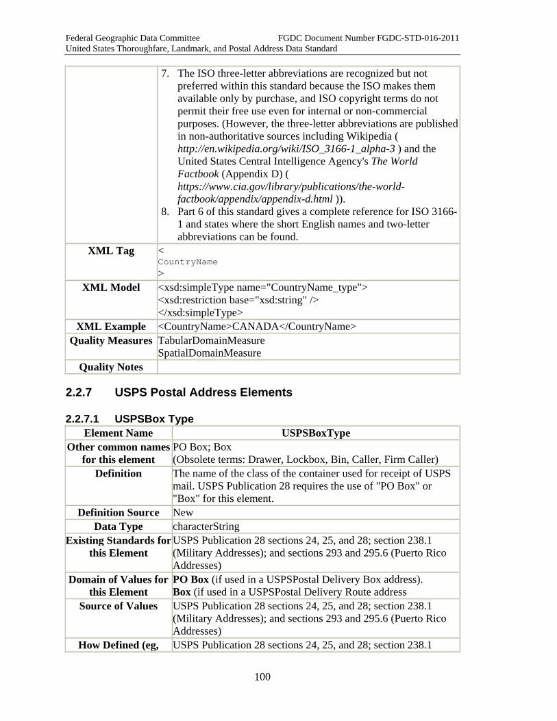
Federal Geographic Data Committee FGDC Document Number FGDC-STD-016-2011 United States Thoroughfare, Landmark, and Postal Address Data Standard
100
7. The ISO three-letter abbreviations are recognized but not preferred within this standard because the ISO makes them available only by purchase, and ISO copyright terms do not permit their free use even for internal or non-commercial purposes. (However, the three-letter abbreviations are published in non-authoritative sources including Wikipedia ( http://en.wikipedia.org/wiki/ISO_3166-1_alpha-3 ) and the United States Central Intelligence Agency's The World Factbook (Appendix D) ( https://www.cia.gov/library/publications/the-world-factbook/appendix/appendix-d.html )).
8. Part 6 of this standard gives a complete reference for ISO 3166-1 and states where the short English names and two-letter abbreviations can be found.
XML Tag < CountryName >
XML Model <xsd:simpleType name="CountryName_type"> <xsd:restriction base="xsd:string" /> </xsd:simpleType>
XML Example <CountryName>CANADA</CountryName> Quality Measures TabularDomainMeasure
SpatialDomainMeasure Quality Notes
2.2.7 USPS Postal Address Elements
2.2.7.1 USPSBox Type Element Name USPSBoxType
Other common names for this element
PO Box; Box (Obsolete terms: Drawer, Lockbox, Bin, Caller, Firm Caller)
Definition The name of the class of the container used for receipt of USPS mail. USPS Publication 28 requires the use of "PO Box" or "Box" for this element.
Definition Source New Data Type characterString
Existing Standards for this Element
USPS Publication 28 sections 24, 25, and 28; section 238.1 (Military Addresses); and sections 293 and 295.6 (Puerto Rico Addresses)
Domain of Values for this Element
PO Box (if used in a USPSPostal Delivery Box address). Box (if used in a USPSPostal Delivery Route address
Source of Values USPS Publication 28 sections 24, 25, and 28; section 238.1 (Military Addresses); and sections 293 and 295.6 (Puerto Rico Addresses)
How Defined (eg, USPS Publication 28 sections 24, 25, and 28; section 238.1
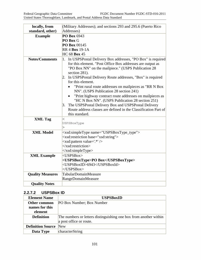
Federal Geographic Data Committee FGDC Document Number FGDC-STD-016-2011 United States Thoroughfare, Landmark, and Postal Address Data Standard
101
locally, from standard, other)
(Military Addresses); and sections 293 and 295.6 (Puerto Rico Addresses)
Example PO Box 6943 PO Box G PO Box 00145 RR 4 Box 19-1A HC 68 Box 45
Notes/Comments 1. In USPSPostal Delivery Box addresses, "PO Box" is required for this element. "Post Office Box addresses are output as "PO Box NN" on the mailpiece." (USPS Publication 28 section 281).
2. In USPSPostal Delivery Route addresses, "Box" is required for this element. • "Print rural route addresses on mailpieces as "RR N Box
NN". (USPS Publication 28 section 241) • "Print highway contract route addresses on mailpieces as
"HC N Box NN". (USPS Publication 28 section 251) 3. The USPSPostal Delivery Box and USPSPostal Delivery
Route address classes are defined in the Classification Part of this standard.
XML Tag < USPSBoxType >
XML Model <xsd:simpleType name="USPSBoxType_type"> <xsd:restriction base="xsd:string"> <xsd:pattern value='.*' /> </xsd:restriction> </xsd:simpleType>
XML Example <USPSBox> <USPSBoxType>PO Box</USPSBoxType> <USPSBoxID>6943</USPSBoxId> </USPSBox>
Quality Measures TabularDomainMeasure RangeDomainMeasure
Quality Notes
2.2.7.2 USPSBox ID Element Name USPSBoxID Other common names for this
element
PO Box Number; Box Number
Definition The numbers or letters distinguishing one box from another within a post office or route.
Definition Source New Data Type characterString

Federal Geographic Data Committee FGDC Document Number FGDC-STD-016-2011 United States Thoroughfare, Landmark, and Postal Address Data Standard
102
Existing Standards for this Element
USPS Publication 28 sections 24, 25, and 28; section 238.1 (Military Addresses); and sections 293 and 295.6 (Puerto Rico Addresses)
Domain of Values for this Element
Yes, within each post office
Source of Values Local post office How Defined (eg,
locally, from standard, other)
Local post office
Example PO Box 6943 PO Box G PO Box 00145 RR 4 Box 19-1A HC 68 Box 45
Notes/Comments 1. USPSBox ID's may include numbers or letters, and may include a hyphen.
2. "Post Office Box numbers that are preceded by significant leading zeroes are identified in the ZIP+4 file by a hyphen (-) preceding the box number. Convert the hyphen into a zero on the output mailpiece." Example: Convert "PO BOX -0145" to "PO BOX 00145" on output from the ZIP+4 file. (USPS publication 28 Section 282)
XML Tag < USPSBoxID >
XML Model <xsd:simpleType name="USPSBoxId_type"> <xsd:restriction base="xsd:string"> <xsd:pattern value='.*' /> </xsd:restriction> </xsd:simpleType>
XML Example <USPSBox> <USPSBoxType>PO Box</USPSBoxType> <USPSBoxID>6943</USPSBoxId> </USPSBox>
Quality Measures TabularDomainMeasure RangeDomainMeasure
Quality Notes
2.2.7.3 Complex Element: USPS Box Element Name USPSBox Other common names for this
element
PO Box, Box, Post Office Box (Obsolete terms: Lockbox, Drawer, Bin, Caller, Firm Caller)
Definition A container for the receipt of USPS mail uniquely identified by the combination of a USPSBox Type and a USPSBox ID.
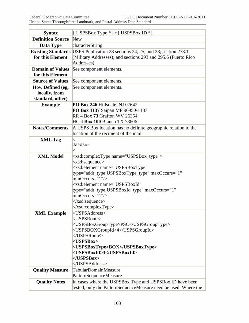
Federal Geographic Data Committee FGDC Document Number FGDC-STD-016-2011 United States Thoroughfare, Landmark, and Postal Address Data Standard
103
Syntax { USPSBox Type *} +{ USPSBox ID *} Definition Source New
Data Type characterString Existing Standards
for this Element USPS Publication 28 sections 24, 25, and 28; section 238.1 (Military Addresses); and sections 293 and 295.6 (Puerto Rico Addresses)
Domain of Values for this Element
See component elements.
Source of Values See component elements. How Defined (eg,
locally, from standard, other)
See component elements.
Example PO Box 246 Hillsdale, NJ 07642 PO Box 1137 Saipan MP 96950-1137 RR 4 Box 73 Grafton WV 26354 HC 4 Box 100 Blanco TX 78606
Notes/Comments A USPS Box location has no definite geographic relation to the location of the recipient of the mail.
XML Tag < USPSBox >
XML Model <xsd:complexType name="USPSBox_type"> <xsd:sequence> <xsd:element name="USPSBoxType" type="addr_type:USPSBoxType_type" maxOccurs="1" minOccurs="1"/> <xsd:element name="USPSBoxId" type="addr_type:USPSBoxId_type" maxOccurs="1" minOccurs="1"/> </xsd:sequence> </xsd:complexType>
XML Example <USPSAddress> <USPSRoute> <USPSBoxGroupType>PSC</USPSGroupType> <USPSBOXGroupId>4</USPSGroupId> </USPSRoute> <USPSBox> <USPSBoxType>BOX</USPSBoxType> <USPSBoxId>3</USPSBoxId> </USPSBox> </USPSAddress>
Quality Measure TabularDomainMeasure PatternSequenceMeasure
Quality Notes In cases where the USPSBox Type and USPSBox ID have been tested, only the PatternSequenceMeasure need be used. Where the
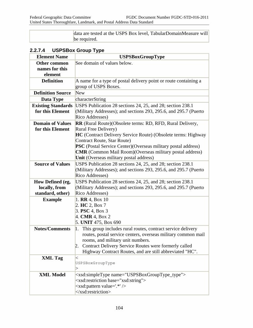
Federal Geographic Data Committee FGDC Document Number FGDC-STD-016-2011 United States Thoroughfare, Landmark, and Postal Address Data Standard
104
data are tested at the USPS Box level, TabularDomainMeasure will be required.
2.2.7.4 USPSBox Group Type Element Name USPSBoxGroupType Other common names for this
element
See domain of values below.
Definition A name for a type of postal delivery point or route containing a group of USPS Boxes.
Definition Source New Data Type characterString
Existing Standards for this Element
USPS Publication 28 sections 24, 25, and 28; section 238.1 (Military Addresses); and sections 293, 295.6, and 295.7 (Puerto Rico Addresses)
Domain of Values for this Element
RR (Rural Route)(Obsolete terms: RD, RFD, Rural Delivery, Rural Free Delivery) HC (Contract Delivery Service Route) (Obsolete terms: Highway Contract Route, Star Route) PSC (Postal Service Center)(Overseas military postal address) CMR (Common Mail Room)(Overseas military postal address) Unit (Overseas military postal address)
Source of Values USPS Publication 28 sections 24, 25, and 28; section 238.1 (Military Addresses); and sections 293, 295.6, and 295.7 (Puerto Rico Addresses)
How Defined (eg, locally, from
standard, other)
USPS Publication 28 sections 24, 25, and 28; section 238.1 (Military Addresses); and sections 293, 295.6, and 295.7 (Puerto Rico Addresses)
Example 1. RR 4, Box 10 2. HC 2, Box 7 3. PSC 4, Box 3 4. CMR 4, Box 2 5. UNIT 475, Box 690
Notes/Comments 1. This group includes rural routes, contract service delivery routes, postal service centers, overseas military common mail rooms, and military unit numbers.
2. Contract Delivery Service Routes were formerly called Highway Contract Routes, and are still abbreviated "HC".
XML Tag < USPSBoxGroupType >
XML Model <xsd:simpleType name="USPSBoxGroupType_type"> <xsd:restriction base="xsd:string"> <xsd:pattern value='.*' /> </xsd:restriction>
Federal Geographic Data Committee FGDC Document Number FGDC-STD-016-2011 United States Thoroughfare, Landmark, and Postal Address Data Standard
105
</xsd:simpleType> XML Example <USPSAddress>
<USPSRoute> <USPSBoxGroupType>PSC</USPSGroupType> <USPSBOXGroupId>4</USPSGroupId> </USPSRoute> <USPSBox> <USPSBoxType>BOX</USPSBoxType> <USPSBoxId>3</USPSBoxId> </USPSBox> </USPSAddress>
Quality Measures TabularDomainMeasure Related Element Value Measure
Quality Notes In cases where a specific USPSBox Group Type is associated with a given locality, Related Element Value Measure may be used to test the values.
2.2.7.5 USPSBox Group ID Element Name USPSBoxGroupID
Other common names for this element
Rural route number; HC number; PSC/CMR/Unit Number
Definition The numbers or letters distinguishing one route or distribution point from another route or distribution point of the same USPSBox Group Type.
Definition Source New Data Type characterString
Existing Standards for this Element
USPS Publication 28 sections 24, 25, and 28; section 238.1 (Military Addresses); and sections 293, 295.6, and 295.7 (Puerto Rico Addresses)
Domain of Values for this Element
Yes
Source of Values Local Post office How Defined (eg,
locally, from standard, other)
Local Post office
Example 1. RR 4 Box 10 2. HC 2 Box 7 3. PSC 4 Box 3 4. CMR 4 Box 2 5. UNIT 475 Box 690
Notes/Comments XML Tag <
USPSBoxGroupID >
XML Model <xsd:simpleType name="USPSBoxGroupId_type">
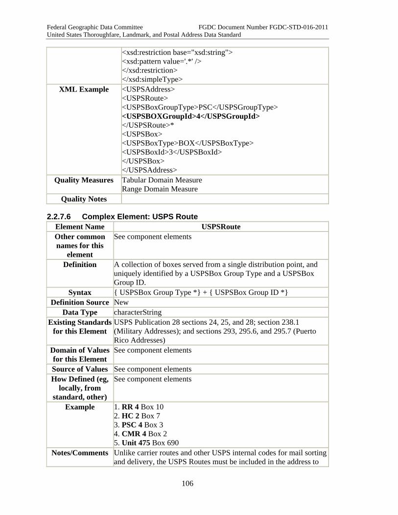
Federal Geographic Data Committee FGDC Document Number FGDC-STD-016-2011 United States Thoroughfare, Landmark, and Postal Address Data Standard
106
<xsd:restriction base="xsd:string"> <xsd:pattern value='.*' /> </xsd:restriction> </xsd:simpleType>
XML Example <USPSAddress> <USPSRoute> <USPSBoxGroupType>PSC</USPSGroupType> <USPSBOXGroupId>4</USPSGroupId> </USPSRoute>* <USPSBox> <USPSBoxType>BOX</USPSBoxType> <USPSBoxId>3</USPSBoxId> </USPSBox> </USPSAddress>
Quality Measures Tabular Domain Measure Range Domain Measure
Quality Notes
2.2.7.6 Complex Element: USPS Route Element Name USPSRoute Other common names for this
element
See component elements
Definition A collection of boxes served from a single distribution point, and uniquely identified by a USPSBox Group Type and a USPSBox Group ID.
Syntax { USPSBox Group Type *} + { USPSBox Group ID *} Definition Source New
Data Type characterString Existing Standards
for this Element USPS Publication 28 sections 24, 25, and 28; section 238.1 (Military Addresses); and sections 293, 295.6, and 295.7 (Puerto Rico Addresses)
Domain of Values for this Element
See component elements
Source of Values See component elements How Defined (eg,
locally, from standard, other)
See component elements
Example 1. RR 4 Box 10 2. HC 2 Box 7 3. PSC 4 Box 3 4. CMR 4 Box 2 5. Unit 475 Box 690
Notes/Comments Unlike carrier routes and other USPS internal codes for mail sorting and delivery, the USPS Routes must be included in the address to
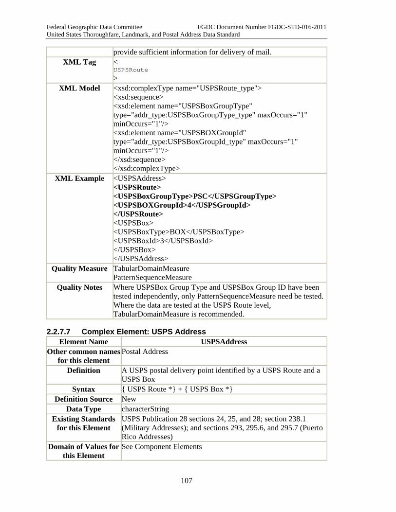
Federal Geographic Data Committee FGDC Document Number FGDC-STD-016-2011 United States Thoroughfare, Landmark, and Postal Address Data Standard
107
provide sufficient information for delivery of mail. XML Tag <
USPSRoute >
XML Model <xsd:complexType name="USPSRoute_type"> <xsd:sequence> <xsd:element name="USPSBoxGroupType" type="addr_type:USPSBoxGroupType_type" maxOccurs="1" minOccurs="1"/> <xsd:element name="USPSBOXGroupId" type="addr_type:USPSBoxGroupId_type" maxOccurs="1" minOccurs="1"/> </xsd:sequence> </xsd:complexType>
XML Example <USPSAddress> <USPSRoute> <USPSBoxGroupType>PSC</USPSGroupType> <USPSBOXGroupId>4</USPSGroupId> </USPSRoute> <USPSBox> <USPSBoxType>BOX</USPSBoxType> <USPSBoxId>3</USPSBoxId> </USPSBox> </USPSAddress>
Quality Measure TabularDomainMeasure PatternSequenceMeasure
Quality Notes Where USPSBox Group Type and USPSBox Group ID have been tested independently, only PatternSequenceMeasure need be tested. Where the data are tested at the USPS Route level, TabularDomainMeasure is recommended.
2.2.7.7 Complex Element: USPS Address Element Name USPSAddress
Other common names for this element
Postal Address
Definition A USPS postal delivery point identified by a USPS Route and a USPS Box
Syntax { USPS Route *} + { USPS Box *} Definition Source New
Data Type characterString Existing Standards
for this Element USPS Publication 28 sections 24, 25, and 28; section 238.1 (Military Addresses); and sections 293, 295.6, and 295.7 (Puerto Rico Addresses)
Domain of Values for this Element
See Component Elements

Federal Geographic Data Committee FGDC Document Number FGDC-STD-016-2011 United States Thoroughfare, Landmark, and Postal Address Data Standard
108
Source of Values USPS Publication 28 sections 24, 25, and 28; section 238.1 (Military Addresses); and sections 293, 295.6, and 295.7 (Puerto Rico Addresses)
How Defined (eg, locally, from
standard, other)
See component elements
Example RR 2 Box 223G Dardanelle AR 72834 HC 3 Box 330 Flasher ND 58535 PSC 802 Box 74 FPO AA 34058 CMR 416 Box 100 APO AE 09140-0015 Unit 2050 Box 4190 APO AP 96278-2050
Notes/Comments XML Tag <
USPSAddress >
XML Model <xsd:complexType name="USPSAddress_type"> <xsd:sequence> <xsd:element name="USPSRoute" type="addr_type:USPSRoute_type" maxOccurs="1" minOccurs="1"/> <xsd:element name="USPSBox" type="addr_type:USPSBox_type" maxOccurs="1" minOccurs="1"/> </xsd:sequence> </xsd:complexType>
XML Example <USPSAddress> <USPSRoute> <USPSBoxGroupType>PSC</USPSGroupType> <USPSBOXGroupId>4</USPSGroupId> </USPSRoute> <USPSBox> <USPSBoxType>BOX</USPSBoxType> <USPSBoxId>3</USPSBoxId> </USPSBox> </USPSAddress>
Quality Measure Pattern Sequence Measure Quality Notes
2.2.7.8 USPSGeneral Delivery Point Element Name USPSGeneralDeliveryPoint Other common names for this
element
Definition A central point where mail may be picked up by the addressee. Two values are permitted: "General Delivery" (for post offices),
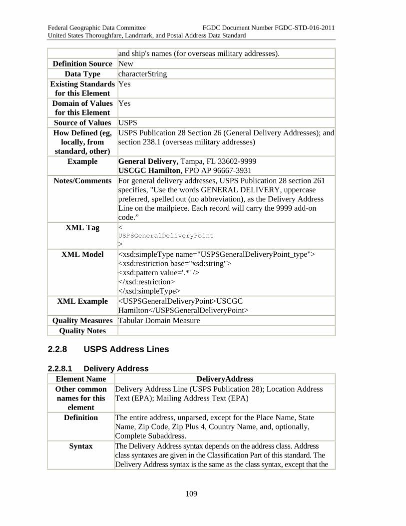
Federal Geographic Data Committee FGDC Document Number FGDC-STD-016-2011 United States Thoroughfare, Landmark, and Postal Address Data Standard
109
and ship's names (for overseas military addresses). Definition Source New
Data Type characterString Existing Standards
for this Element Yes
Domain of Values for this Element
Yes
Source of Values USPS How Defined (eg,
locally, from standard, other)
USPS Publication 28 Section 26 (General Delivery Addresses); and section 238.1 (overseas military addresses)
Example General Delivery, Tampa, FL 33602-9999 USCGC Hamilton, FPO AP 96667-3931
Notes/Comments For general delivery addresses, USPS Publication 28 section 261 specifies, "Use the words GENERAL DELIVERY, uppercase preferred, spelled out (no abbreviation), as the Delivery Address Line on the mailpiece. Each record will carry the 9999 add-on code.”
XML Tag < USPSGeneralDeliveryPoint >
XML Model <xsd:simpleType name="USPSGeneralDeliveryPoint_type"> <xsd:restriction base="xsd:string"> <xsd:pattern value='.*' /> </xsd:restriction> </xsd:simpleType>
XML Example <USPSGeneralDeliveryPoint>USCGC Hamilton</USPSGeneralDeliveryPoint>
Quality Measures Tabular Domain Measure Quality Notes
2.2.8 USPS Address Lines
2.2.8.1 Delivery Address Element Name DeliveryAddress Other common names for this
element
Delivery Address Line (USPS Publication 28); Location Address Text (EPA); Mailing Address Text (EPA)
Definition The entire address, unparsed, except for the Place Name, State Name, Zip Code, Zip Plus 4, Country Name, and, optionally, Complete Subaddress.
Syntax The Delivery Address syntax depends on the address class. Address class syntaxes are given in the Classification Part of this standard. The Delivery Address syntax is the same as the class syntax, except that the
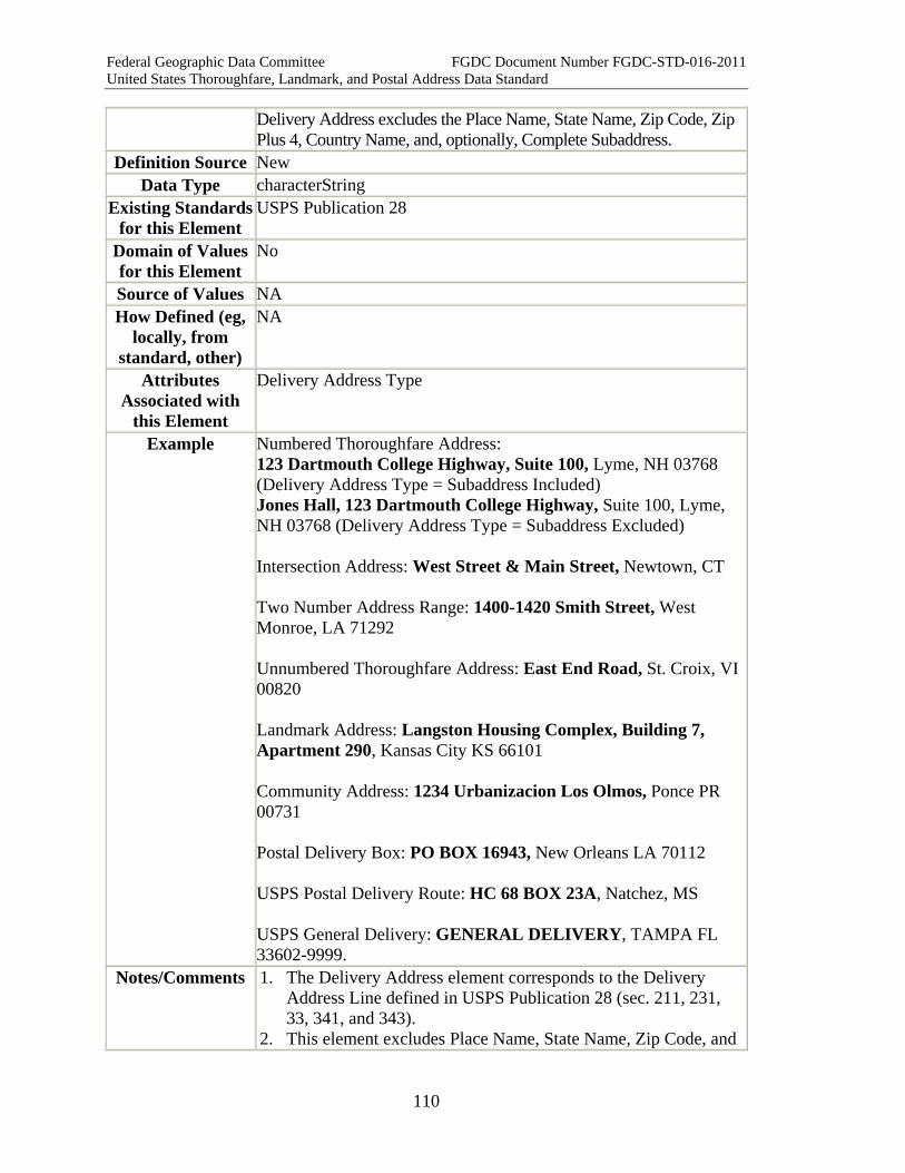
Federal Geographic Data Committee FGDC Document Number FGDC-STD-016-2011 United States Thoroughfare, Landmark, and Postal Address Data Standard
110
Delivery Address excludes the Place Name, State Name, Zip Code, Zip Plus 4, Country Name, and, optionally, Complete Subaddress.
Definition Source New Data Type characterString
Existing Standards for this Element
USPS Publication 28
Domain of Values for this Element
No
Source of Values NA How Defined (eg,
locally, from standard, other)
NA
Attributes Associated with
this Element
Delivery Address Type
Example Numbered Thoroughfare Address: 123 Dartmouth College Highway, Suite 100, Lyme, NH 03768 (Delivery Address Type = Subaddress Included) Jones Hall, 123 Dartmouth College Highway, Suite 100, Lyme, NH 03768 (Delivery Address Type = Subaddress Excluded) Intersection Address: West Street & Main Street, Newtown, CT Two Number Address Range: 1400-1420 Smith Street, West Monroe, LA 71292 Unnumbered Thoroughfare Address: East End Road, St. Croix, VI 00820 Landmark Address: Langston Housing Complex, Building 7, Apartment 290, Kansas City KS 66101 Community Address: 1234 Urbanizacion Los Olmos, Ponce PR 00731 Postal Delivery Box: PO BOX 16943, New Orleans LA 70112 USPS Postal Delivery Route: HC 68 BOX 23A, Natchez, MS USPS General Delivery: GENERAL DELIVERY, TAMPA FL 33602-9999.
Notes/Comments 1. The Delivery Address element corresponds to the Delivery Address Line defined in USPS Publication 28 (sec. 211, 231, 33, 341, and 343).
2. This element excludes Place Name, State Name, Zip Code, and

Federal Geographic Data Committee FGDC Document Number FGDC-STD-016-2011 United States Thoroughfare, Landmark, and Postal Address Data Standard
111
Zip Plus 4 and Country Name, which together form the Place State ZIP complex element.
3. The Delivery Address typically includes the Complete Subaddress. However, there are sometimes reasons to omit or separate the Complete Subaddress from the Delivery Address. For example, the Complete Subaddress can hamper address geocoding, and contact lists often separate the Complete Subaddress from the rest of the feature address (see, e.g., the EPA Contact Information Data Standard).
4. The Delivery Address Type shows whether the Delivery Address includes or excludes the Complete Subaddress.
XML Tag < DeliveryAddress >
XML Model <xsd:complexType name="DeliveryAddress_type"> <xsd:extension base="xsd:string"> <xsd:attribute name="DeliveryAddressType" type="addr_type:DeliveryAddressType_type" /> </xsd:extension> </xsd:simpleContent> </xsd:complexType>
XML Example <DeliveryAddress Delivery Address Type="Subaddress Included">123 Dartmouth College Highway, Suite 100</DeliveryAddress>
<DeliveryAddress Delivery Address Type="Subaddress Excluded">123 Dartmouth College Highway, Suite 100</DeliveryAddress>
<DeliveryAddress>123 Dartmouth College Highway, Suite 100</DeliveryAddress>
Quality Measures Pattern Sequence Measure Quality Notes
2.2.8.2 Place State ZIP Element Name PlaceStateZIP Other common names for this
element
Last Line (USPS)
Definition The combination of Complete Place Name, State Name, Zip Code, Zip Plus 4, and Country Name within an address. Complete Place Name and State Name are mandatory; the other elements are optional.
Syntax { Complete Place Name *} + { State Name *} + { Zip Code } + { Zip Plus 4 } + { Country Name }
Definition Source New
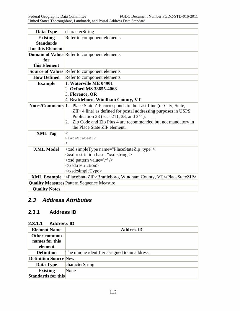
Federal Geographic Data Committee FGDC Document Number FGDC-STD-016-2011 United States Thoroughfare, Landmark, and Postal Address Data Standard
112
Data Type characterString Existing
Standards for this Element
Refer to component elements
Domain of Values for
this Element
Refer to component elements
Source of Values Refer to component elements How Defined Refer to component elements
Example 1. Waterville ME 04901 2. Oxford MS 38655-4068 3. Florence, OR 4. Brattleboro, Windham County, VT
Notes/Comments 1. Place State ZIP corresponds to the Last Line (or City, State, ZIP+4 line) as defined for postal addressing purposes in USPS Publication 28 (secs 211, 33, and 341).
2. Zip Code and Zip Plus 4 are recommended but not mandatory in the Place State ZIP element.
XML Tag < PlaceStateZIP >
XML Model <xsd:simpleType name="PlaceStateZip_type"> <xsd:restriction base="xsd:string"> <xsd:pattern value='.*' /> </xsd:restriction> </xsd:simpleType>
XML Example <PlaceStateZIP>Brattleboro, Windham County, VT</PlaceStateZIP> Quality Measures Pattern Sequence Measure
Quality Notes
2.3 Address Attributes
2.3.1 Address ID
2.3.1.1 Address ID Element Name AddressID Other common names for this
element
Definition The unique identifier assigned to an address. Definition Source New
Data Type characterString Existing
Standards for this None

Federal Geographic Data Committee FGDC Document Number FGDC-STD-016-2011 United States Thoroughfare, Landmark, and Postal Address Data Standard
113
Element Domain of Values for this Element
No
Source of Values Primary key, issued locally How Defined (eg,
locally, from standard, other)
Locally
Example: Integer ID: 1243286 UUID: 550e8400-e29b-11d4-a716-446655440000
Notes/Comments 1. The Address ID is a required element of an address data record. The ID must be unique for each address assigned by an Address Authority. In cases where an Address Authority does not assign an Address ID, it may be assigned by an address aggregator, such as a regional government, state government, federal agency or a commercial address aggregator. The Address ID may be either a locally generated unique ID, or it may be a Universally Unique ID (UUID) which is machine-generated within the database environment.
2. IDs are almost always integers, and integer ID's are much easier to manage. However, some ID schemes use hyphens, leading zeros, or other non-integer characters, so the standard also accommodates alphanumeric IDs.
Notes and Reference Information on UUID 1. A UUID is presented as a 16-byte (128-bit) number written in
hexadecimal form computed according to a UUID algorithm. At least five algorithms have been developed.
2. UUIDs are documented in two standards, ITU-T X.667 and IETF RFC 4122 (see Appendix A for complete references). The two standards are technically consistent.
3. This standard provides for a UUID as a means to identify an address while it is passed from the originating source through a chain of intermediaries to the end-user. The need arises because there exists within the United States no central coordinating body to identify and register addresses. There is not even a registry of the authorities empowered to create addresses, nor is one likely to be created.
4. "The intent of UUIDs is to enable distributed systems to uniquely identify information without significant central coordination. Thus, anyone can create a UUID and use it to identify something with reasonable confidence that the identifier will never be unintentionally used by anyone for anything else. Information labeled with UUIDs can therefore be later combined into a single database without need to resolve name conflicts." (quoted from Wikipedia, "Universally Unique Identifier", as posted 4 September 2010 at:
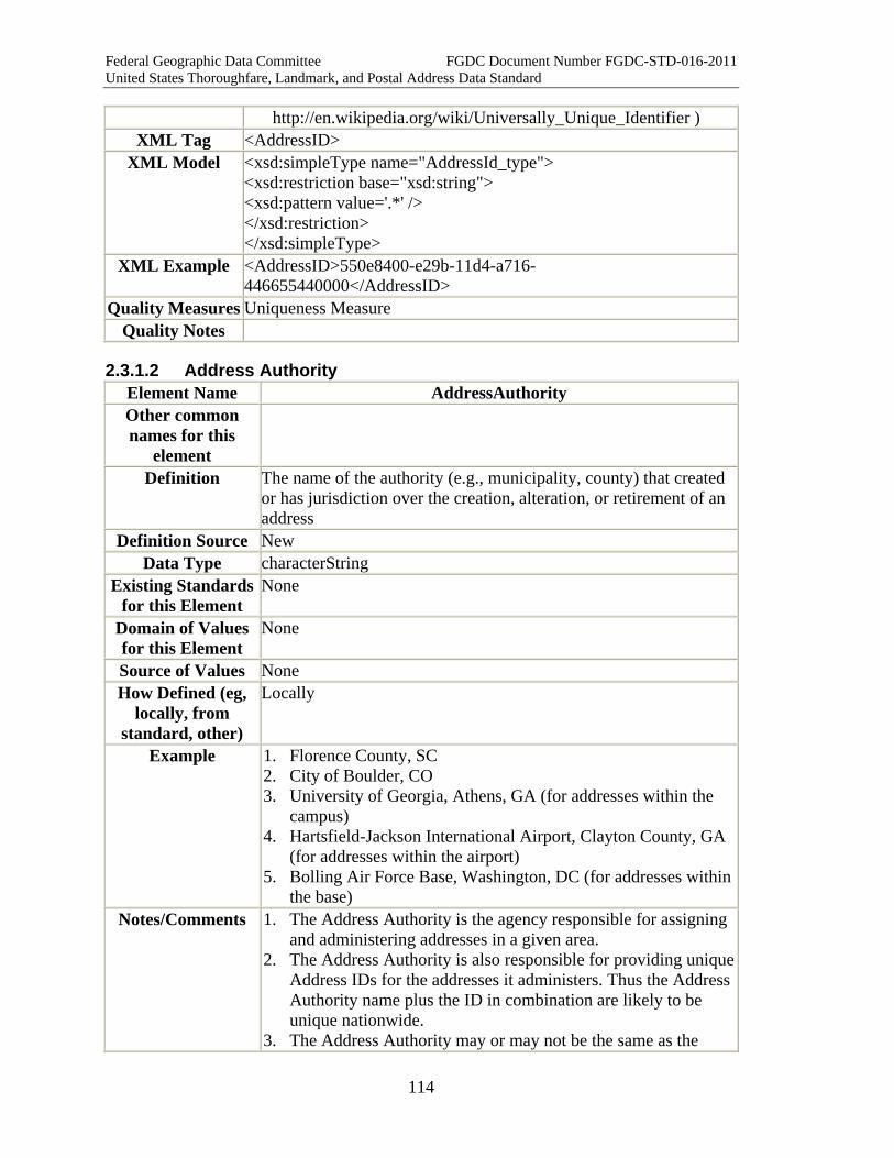
Federal Geographic Data Committee FGDC Document Number FGDC-STD-016-2011 United States Thoroughfare, Landmark, and Postal Address Data Standard
114
http://en.wikipedia.org/wiki/Universally_Unique_Identifier ) XML Tag <AddressID>
XML Model <xsd:simpleType name="AddressId_type"> <xsd:restriction base="xsd:string"> <xsd:pattern value='.*' /> </xsd:restriction> </xsd:simpleType>
XML Example <AddressID>550e8400-e29b-11d4-a716-446655440000</AddressID>
Quality Measures Uniqueness Measure Quality Notes
2.3.1.2 Address Authority Element Name AddressAuthority Other common names for this
element
Definition The name of the authority (e.g., municipality, county) that created or has jurisdiction over the creation, alteration, or retirement of an address
Definition Source New Data Type characterString
Existing Standards for this Element
None
Domain of Values for this Element
None
Source of Values None How Defined (eg,
locally, from standard, other)
Locally
Example 1. Florence County, SC 2. City of Boulder, CO 3. University of Georgia, Athens, GA (for addresses within the
campus) 4. Hartsfield-Jackson International Airport, Clayton County, GA
(for addresses within the airport) 5. Bolling Air Force Base, Washington, DC (for addresses within
the base) Notes/Comments 1. The Address Authority is the agency responsible for assigning
and administering addresses in a given area. 2. The Address Authority is also responsible for providing unique
Address IDs for the addresses it administers. Thus the Address Authority name plus the ID in combination are likely to be unique nationwide.
3. The Address Authority may or may not be the same as the
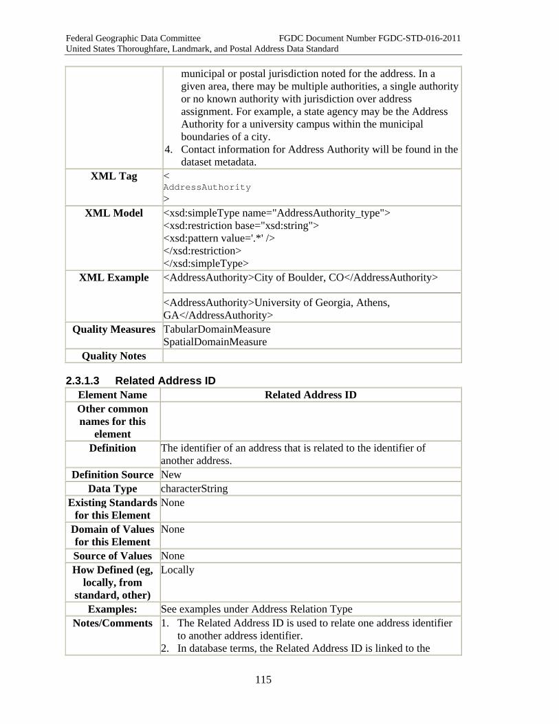
Federal Geographic Data Committee FGDC Document Number FGDC-STD-016-2011 United States Thoroughfare, Landmark, and Postal Address Data Standard
115
municipal or postal jurisdiction noted for the address. In a given area, there may be multiple authorities, a single authority or no known authority with jurisdiction over address assignment. For example, a state agency may be the Address Authority for a university campus within the municipal boundaries of a city.
4. Contact information for Address Authority will be found in the dataset metadata.
XML Tag < AddressAuthority >
XML Model <xsd:simpleType name="AddressAuthority_type"> <xsd:restriction base="xsd:string"> <xsd:pattern value='.*' /> </xsd:restriction> </xsd:simpleType>
XML Example <AddressAuthority>City of Boulder, CO</AddressAuthority>
<AddressAuthority>University of Georgia, Athens, GA</AddressAuthority>
Quality Measures TabularDomainMeasure SpatialDomainMeasure
Quality Notes
2.3.1.3 Related Address ID Element Name Related Address ID Other common names for this
element
Definition The identifier of an address that is related to the identifier of another address.
Definition Source New Data Type characterString
Existing Standards for this Element
None
Domain of Values for this Element
None
Source of Values None How Defined (eg,
locally, from standard, other)
Locally
Examples: See examples under Address Relation Type Notes/Comments 1. The Related Address ID is used to relate one address identifier
to another address identifier. 2. In database terms, the Related Address ID is linked to the

Federal Geographic Data Committee FGDC Document Number FGDC-STD-016-2011 United States Thoroughfare, Landmark, and Postal Address Data Standard
116
Address ID in a linking table or relationship table. Logically, a Related Address ID cannot exist unless it is associated with an Address ID.
3. In some cases, the Related Address ID designates an alternate address at the same location, for example, a Landmark Address associated with a Numbered Thoroughfare Address, or an official address with its alias, or a retired address in the same location as an active address.
4. In other cases, the Related Address ID designates an address at a different location, for example, the address of a property owner (if the owner does not live on the property), or a property's tax billing address (if it is sent to the mortgage holder).
5. The Address Relation Type attribute can be used to record how the address identified by the Related Address ID is related to the address identified by the Address ID. (See Address Relation Type example and notes for additional discussion of Related Address ID.)
XML Tag < RelatedAddressID >
XML Model <xsd:complexType name="RelatedAddressID_type"> <xsd:simpleContent> <xsd:extension base="addr_type:AddressID_type"> <xsd:attribute name="AddressRelationType" type="addr_type:AddressRelationType_type" /> </xsd:extension> </xsd:simpleContent> </xsd:complexType>
XML Example <RelatedAddressID Address Relation Type="Historical Predecessor" >250</RelatedAddressID>
Quality Measures Repeated Element Uniqueness Measure Related Not Null Measure Tabular Domain Measure
Quality Notes
2.3.1.4 Address Relation Type Element Name AddressRelationType Other common names for this
element
Definition The manner in which an address identified by a Related Address IDis related to an address identified by an Address ID.
Definition Source New Data Type characterString
Required Element None.
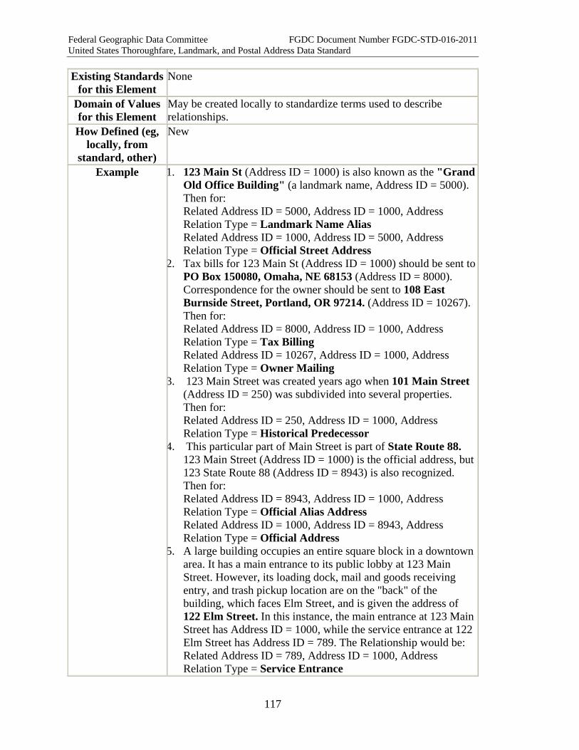
Federal Geographic Data Committee FGDC Document Number FGDC-STD-016-2011 United States Thoroughfare, Landmark, and Postal Address Data Standard
117
Existing Standards for this Element
None
Domain of Values for this Element
May be created locally to standardize terms used to describe relationships.
How Defined (eg, locally, from
standard, other)
New
Example 1. 123 Main St (Address ID = 1000) is also known as the "Grand Old Office Building" (a landmark name, Address ID = 5000). Then for: Related Address ID = 5000, Address ID = 1000, Address Relation Type = Landmark Name Alias Related Address ID = 1000, Address ID = 5000, Address Relation Type = Official Street Address
2. Tax bills for 123 Main St (Address ID = 1000) should be sent to PO Box 150080, Omaha, NE 68153 (Address ID = 8000). Correspondence for the owner should be sent to 108 East Burnside Street, Portland, OR 97214. (Address ID = 10267). Then for: Related Address ID = 8000, Address ID = 1000, Address Relation Type = Tax Billing Related Address ID = 10267, Address ID = 1000, Address Relation Type = Owner Mailing
3. 123 Main Street was created years ago when 101 Main Street (Address ID = 250) was subdivided into several properties. Then for: Related Address ID = 250, Address ID = 1000, Address Relation Type = Historical Predecessor
4. This particular part of Main Street is part of State Route 88. 123 Main Street (Address ID = 1000) is the official address, but 123 State Route 88 (Address ID = 8943) is also recognized. Then for: Related Address ID = 8943, Address ID = 1000, Address Relation Type = Official Alias Address Related Address ID = 1000, Address ID = 8943, Address Relation Type = Official Address
5. A large building occupies an entire square block in a downtown area. It has a main entrance to its public lobby at 123 Main Street. However, its loading dock, mail and goods receiving entry, and trash pickup location are on the "back" of the building, which faces Elm Street, and is given the address of 122 Elm Street. In this instance, the main entrance at 123 Main Street has Address ID = 1000, while the service entrance at 122 Elm Street has Address ID = 789. The Relationship would be: Related Address ID = 789, Address ID = 1000, Address Relation Type = Service Entrance
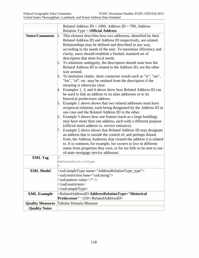
Federal Geographic Data Committee FGDC Document Number FGDC-STD-016-2011 United States Thoroughfare, Landmark, and Postal Address Data Standard
118
Related Address ID = 1000, Address ID = 789, Address Relation Type = Official Address
Notes/Comments 1. This element describes how two addresses, identified by their Related Address ID and Address ID respectively, are related. Relationships may be defined and described in any way, according to the needs of the user. To maximize efficiency and clarity, users should establish a limited, standard set of descriptors that meet local needs.
2. To minimize ambiguity, the descriptors should state how the Related Address ID is related to the Address ID, not the other way around.
3. To minimize clutter, short connector words such as "is", "are", "for", "of", etc. may be omitted from the descriptors if the meaning is otherwise clear.
4. Examples 1, 3, and 4 above show how Related Address ID can be used to link an address to its alias addresses or to its historical predecessor address.
5. Example 1 above shows that two related addresses must have reciprocal relations, each being designated by the Address ID in one case and the Related Address ID in the other.
6. Example 5 shows how one feature (such as a large building) may have more than one address, each with a different purpose (official street address vs. service entrance).
7. Example 2 above shows that Related Address ID may designate an address that is outside the control of, and perhaps distant from, the Address Authority that created the address it is related to. It is common, for example, for owners to live in different states from properties they own, or for tax bills to be sent to out-of-state mortgage service addresses.
XML Tag < AddressRelationType >
XML Model <xsd:simpleType name="AddressRelationType_type"> <xsd:restriction base="xsd:string"> <xsd:pattern value='.*' /> </xsd:restriction> </xsd:simpleType>
XML Example <RelatedAddressID AddressRelationType="Historical Predecessor" >250</RelatedAddressID>
Quality Measures Tabular Domain Measure Quality Notes
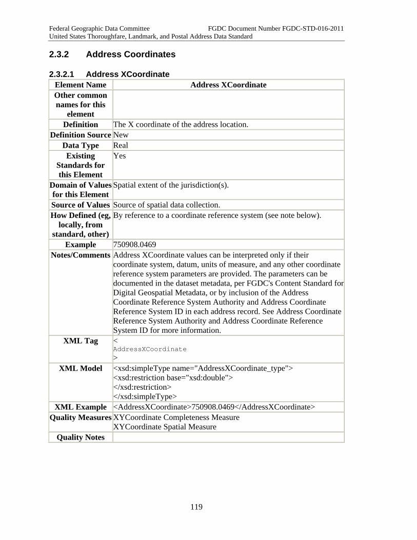
Federal Geographic Data Committee FGDC Document Number FGDC-STD-016-2011 United States Thoroughfare, Landmark, and Postal Address Data Standard
119
2.3.2 Address Coordinates
2.3.2.1 Address XCoordinate Element Name Address XCoordinate Other common names for this
element
Definition The X coordinate of the address location. Definition Source New
Data Type Real Existing
Standards for this Element
Yes
Domain of Values for this Element
Spatial extent of the jurisdiction(s).
Source of Values Source of spatial data collection. How Defined (eg,
locally, from standard, other)
By reference to a coordinate reference system (see note below).
Example 750908.0469 Notes/Comments Address XCoordinate values can be interpreted only if their
coordinate system, datum, units of measure, and any other coordinate reference system parameters are provided. The parameters can be documented in the dataset metadata, per FGDC's Content Standard forDigital Geospatial Metadata, or by inclusion of the Address Coordinate Reference System Authority and Address Coordinate Reference System ID in each address record. See Address Coordinate Reference System Authority and Address Coordinate Reference System ID for more information.
XML Tag < AddressXCoordinate >
XML Model <xsd:simpleType name="AddressXCoordinate_type"> <xsd:restriction base="xsd:double"> </xsd:restriction> </xsd:simpleType>
XML Example <AddressXCoordinate>750908.0469</AddressXCoordinate> Quality Measures XYCoordinate Completeness Measure
XYCoordinate Spatial Measure Quality Notes
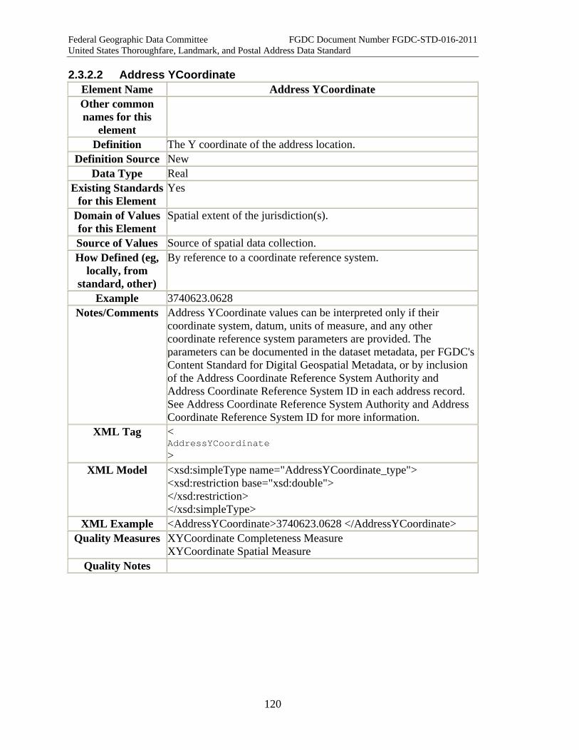
Federal Geographic Data Committee FGDC Document Number FGDC-STD-016-2011 United States Thoroughfare, Landmark, and Postal Address Data Standard
120
2.3.2.2 Address YCoordinate Element Name Address YCoordinate Other common names for this
element
Definition The Y coordinate of the address location. Definition Source New
Data Type Real Existing Standards
for this Element Yes
Domain of Values for this Element
Spatial extent of the jurisdiction(s).
Source of Values Source of spatial data collection. How Defined (eg,
locally, from standard, other)
By reference to a coordinate reference system.
Example 3740623.0628 Notes/Comments Address YCoordinate values can be interpreted only if their
coordinate system, datum, units of measure, and any other coordinate reference system parameters are provided. The parameters can be documented in the dataset metadata, per FGDC's Content Standard for Digital Geospatial Metadata, or by inclusion of the Address Coordinate Reference System Authority and Address Coordinate Reference System ID in each address record. See Address Coordinate Reference System Authority and Address Coordinate Reference System ID for more information.
XML Tag < AddressYCoordinate >
XML Model <xsd:simpleType name="AddressYCoordinate_type"> <xsd:restriction base="xsd:double"> </xsd:restriction> </xsd:simpleType>
XML Example <AddressYCoordinate>3740623.0628 </AddressYCoordinate> Quality Measures XYCoordinate Completeness Measure
XYCoordinate Spatial Measure Quality Notes
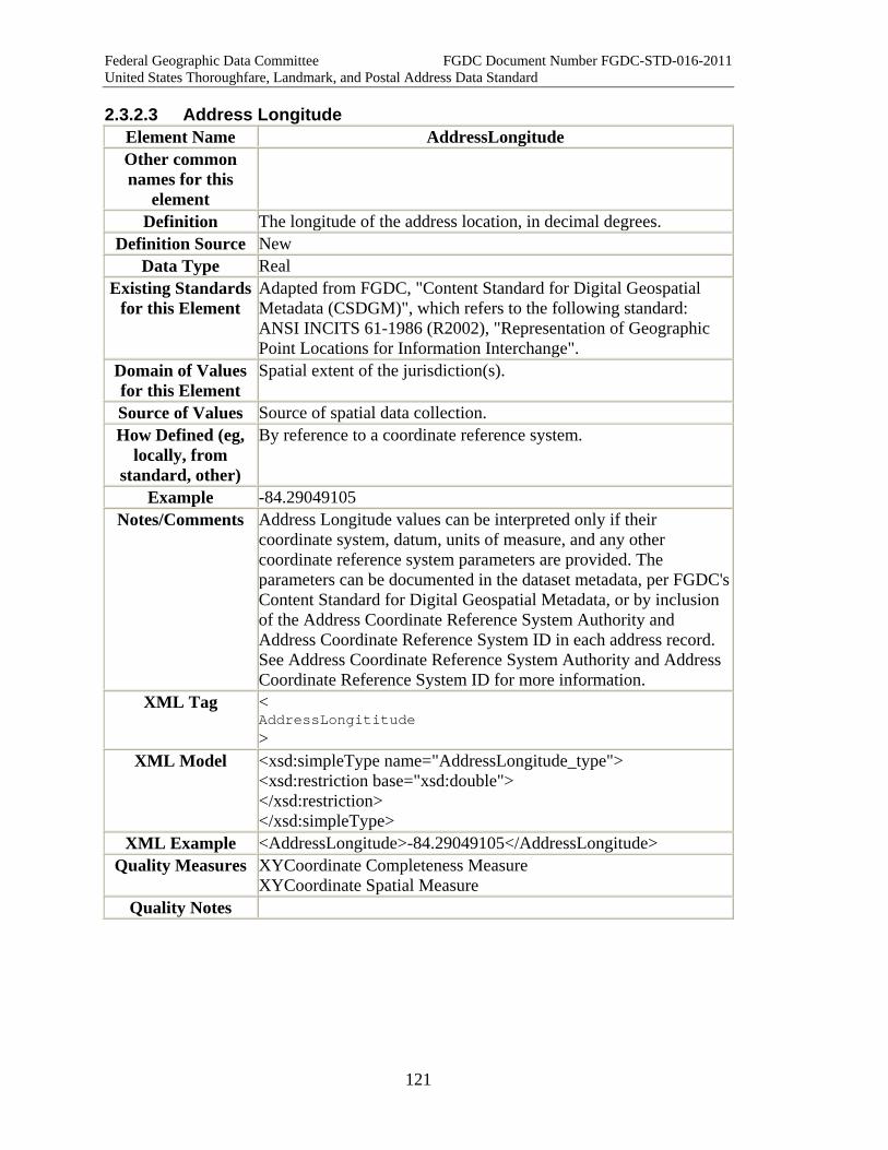
Federal Geographic Data Committee FGDC Document Number FGDC-STD-016-2011 United States Thoroughfare, Landmark, and Postal Address Data Standard
121
2.3.2.3 Address Longitude Element Name AddressLongitude Other common names for this
element
Definition The longitude of the address location, in decimal degrees. Definition Source New
Data Type Real Existing Standards
for this Element Adapted from FGDC, "Content Standard for Digital Geospatial Metadata (CSDGM)", which refers to the following standard: ANSI INCITS 61-1986 (R2002), "Representation of Geographic Point Locations for Information Interchange".
Domain of Values for this Element
Spatial extent of the jurisdiction(s).
Source of Values Source of spatial data collection. How Defined (eg,
locally, from standard, other)
By reference to a coordinate reference system.
Example -84.29049105 Notes/Comments Address Longitude values can be interpreted only if their
coordinate system, datum, units of measure, and any other coordinate reference system parameters are provided. The parameters can be documented in the dataset metadata, per FGDC's Content Standard for Digital Geospatial Metadata, or by inclusion of the Address Coordinate Reference System Authority and Address Coordinate Reference System ID in each address record. See Address Coordinate Reference System Authority and Address Coordinate Reference System ID for more information.
XML Tag < AddressLongititude >
XML Model <xsd:simpleType name="AddressLongitude_type"> <xsd:restriction base="xsd:double"> </xsd:restriction> </xsd:simpleType>
XML Example <AddressLongitude>-84.29049105</AddressLongitude> Quality Measures XYCoordinate Completeness Measure
XYCoordinate Spatial Measure Quality Notes
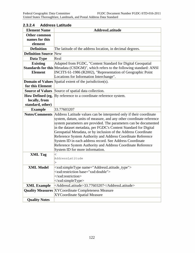
Federal Geographic Data Committee FGDC Document Number FGDC-STD-016-2011 United States Thoroughfare, Landmark, and Postal Address Data Standard
122
2.3.2.4 Address Latitude Element Name AddressLatitude Other common names for this
element
Definition The latitude of the address location, in decimal degrees. Definition Source New
Data Type Real Existing
Standards for this Element
Adapted from FGDC, "Content Standard for Digital Geospatial Metadata (CSDGM)", which refers to the following standard: ANSI INCITS 61-1986 (R2002), "Representation of Geographic Point Locations for Information Interchange".
Domain of Values for this Element
Spatial extent of the jurisdiction(s).
Source of Values Source of spatial data collection. How Defined (eg,
locally, from standard, other)
By reference to a coordinate reference system.
Example 33.77603207 Notes/Comments Address Latitude values can be interpreted only if their coordinate
system, datum, units of measure, and any other coordinate reference system parameters are provided. The parameters can be documented in the dataset metadata, per FGDC's Content Standard for Digital Geospatial Metadata, or by inclusion of the Address Coordinate Reference System Authority and Address Coordinate Reference System ID in each address record. See Address Coordinate Reference System Authority and Address Coordinate Reference System ID for more information.
XML Tag < AddressLatitude >
XML Model <xsd:simpleType name="AddressLatitude_type"> <xsd:restriction base="xsd:double"> </xsd:restriction> </xsd:simpleType>
XML Example <AddressLatitude>33.77603207</AddressLatitude> Quality Measures XYCoordinate Completeness Measure
XYCoordinate Spatial Measure Quality Notes

Federal Geographic Data Committee FGDC Document Number FGDC-STD-016-2011 United States Thoroughfare, Landmark, and Postal Address Data Standard
123
2.3.2.5 USNational Grid Coordinate Element Name USNationalGridCoordinate Other common names for this
element
USNG Coordinate
Definition 1. The USNG is an alphanumeric point reference system that overlays the Universal Transverse Mercator (UTM) numerical coordinate system.
2. A USNG coordinate consists of three parts, the: 3. Grid Zone Designation (GZD) for worldwide unique geoaddresses
(two digits plus one letter, developed from the UTM system). 4. 100,000-meter Square Identification for regional areas (two
letters). 5. Grid Coordinates for local areas (always an even number of digits
between 2 and 10 depending upon precision). Definition
Source Adapted from US National Grid, FDGC-STD-011-2001, Section 3.3 Quoted from: Tom Terry, "The United States National Grid." Professional Surveyor Magazine. Oct. 2004, p. 12.
Data Type characterString Required Element
No
Existing Standards for this Element
US National Grid, FGDC-STD-011-2001.
Domain of Values for this
Element
No
Source of Values How Defined
(from standard, other)
As prescribed in FGDC-STD-011-2001.
Example 18SUJ2348306479 or 18S UJ 23483 06479 18S – Identifies a GZD 18S UJ – Identifies a specific 100,000-meter square in the specified GZD 18S UJ 2 0 - Locates a point with a precision of 10 km 18S UJ 23 06 - Locates a point with a precision of 1 km 18S UJ 234 064 - Locates a point with a precision of 100 meters 18S UJ 2348 0647 - Locates a point with a precision of 10 meters 18S UJ 23483 06479 - Locates a point with a precision of 1 meter
Notes/Comments 1. USNG basic coordinate values and numbering are identical to Universal Transverse Mercator (UTM) coordinate values over all areas of the United States including outlying territories and possessions. The USNG is based on universally defined coordinate and grid systems and can, therefore, be easily extended for use
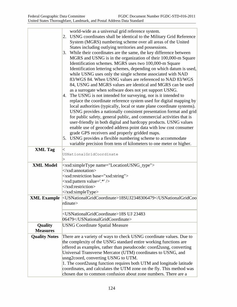
Federal Geographic Data Committee FGDC Document Number FGDC-STD-016-2011 United States Thoroughfare, Landmark, and Postal Address Data Standard
124
world-wide as a universal grid reference system. 2. USNG coordinates shall be identical to the Military Grid Reference
System (MGRS) numbering scheme over all areas of the United States including outlying territories and possessions.
3. While their coordinates are the same, the key difference between MGRS and USNG is in the organization of their 100,000-m Square Identification schemes. MGRS uses two 100,000-m Square Identification lettering schemes, depending on which datum is used, while USNG uses only the single scheme associated with NAD 83/WGS 84. When USNG values are referenced to NAD 83/WGS 84, USNG and MGRS values are identical and MGRS can be used as a surrogate when software does not yet support USNG.
4. The USNG is not intended for surveying, nor is it intended to replace the coordinate reference system used for digital mapping by local authorities (typically, local or state plane coordinate systems). USNG provides a nationally consistent presentation format and grid for public safety, general public, and commercial activities that is user-friendly in both digital and hardcopy products. USNG values enable use of geocoded address point data with low cost consumer grade GPS receivers and properly gridded maps.
5. USNG provides a flexible numbering scheme to accommodate variable precision from tens of kilometers to one meter or higher.
XML Tag < USNationalGridCoordinate >
XML Model <xsd:simpleType name="LocationUSNG_type"> </xsd:annotation> <xsd:restriction base="xsd:string"> <xsd:pattern value='.*' /> </xsd:restriction> </xsd:simpleType>
XML Example <USNationalGridCoordinate>18SUJ2348306479</USNationalGridCoordinate>
<USNationalGridCoordinate>18S UJ 23483 06479</USNationalGridCoordinate>
Quality Measures
USNG Coordinate Spatial Measure
Quality Notes There are a variety of ways to check USNG coordinate values. Due to the complexity of the USNG standard entire working functions are offered as examples, rather than pseudocode: coord2usng, converting Universal Transverse Mercator (UTM) coordinates to USNG, and usng2coord, converting USNG to UTM. 1. The coord2usng function requires both UTM and longitude latitude coordinates, and calculates the UTM zone on the fly. This method was chosen due to common confusion about zone numbers. There are a
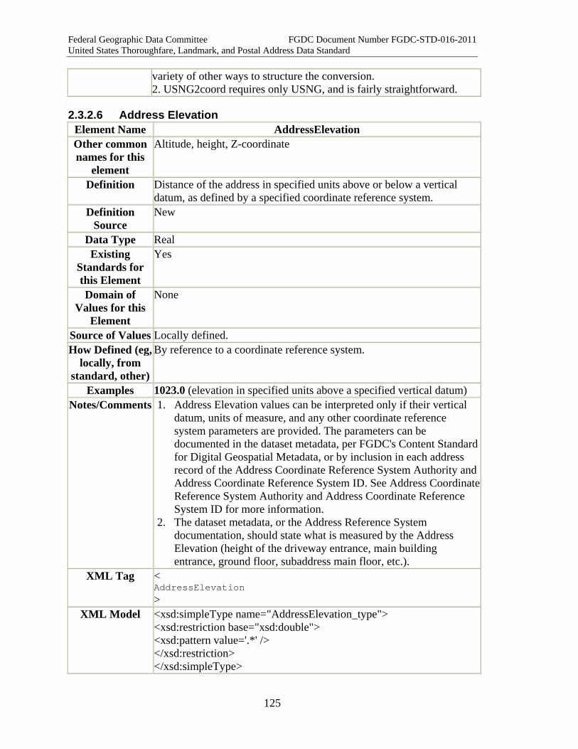
Federal Geographic Data Committee FGDC Document Number FGDC-STD-016-2011 United States Thoroughfare, Landmark, and Postal Address Data Standard
125
variety of other ways to structure the conversion. 2. USNG2coord requires only USNG, and is fairly straightforward.
2.3.2.6 Address Elevation Element Name AddressElevation Other common names for this
element
Altitude, height, Z-coordinate
Definition Distance of the address in specified units above or below a vertical datum, as defined by a specified coordinate reference system.
Definition Source
New
Data Type Real Existing
Standards for this Element
Yes
Domain of Values for this
Element
None
Source of Values Locally defined. How Defined (eg,
locally, from standard, other)
By reference to a coordinate reference system.
Examples 1023.0 (elevation in specified units above a specified vertical datum) Notes/Comments 1. Address Elevation values can be interpreted only if their vertical
datum, units of measure, and any other coordinate reference system parameters are provided. The parameters can be documented in the dataset metadata, per FGDC's Content Standard for Digital Geospatial Metadata, or by inclusion in each address record of the Address Coordinate Reference System Authority and Address Coordinate Reference System ID. See Address Coordinate Reference System Authority and Address Coordinate Reference System ID for more information.
2. The dataset metadata, or the Address Reference System documentation, should state what is measured by the Address Elevation (height of the driveway entrance, main building entrance, ground floor, subaddress main floor, etc.).
XML Tag < AddressElevation >
XML Model <xsd:simpleType name="AddressElevation_type"> <xsd:restriction base="xsd:double"> <xsd:pattern value='.*' /> </xsd:restriction> </xsd:simpleType>
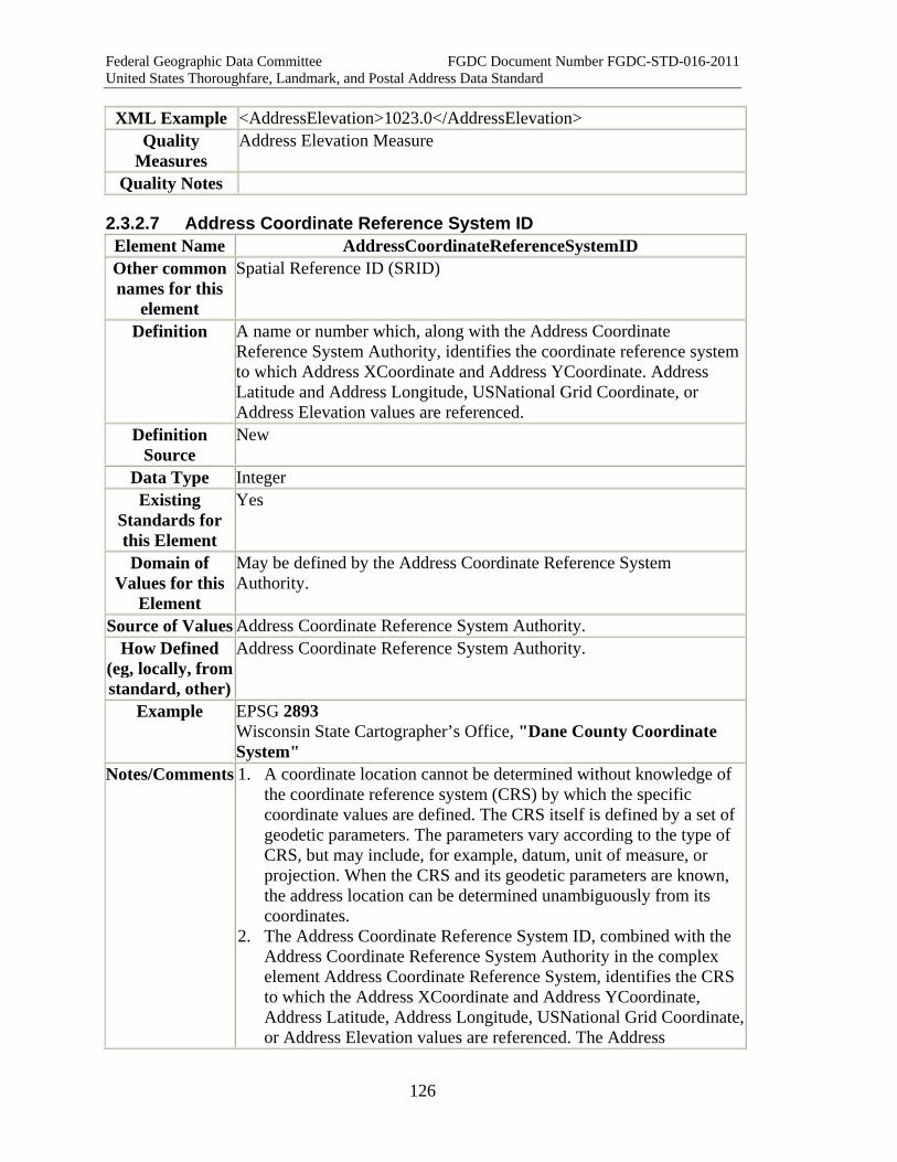
Federal Geographic Data Committee FGDC Document Number FGDC-STD-016-2011 United States Thoroughfare, Landmark, and Postal Address Data Standard
126
XML Example <AddressElevation>1023.0</AddressElevation> Quality
Measures Address Elevation Measure
Quality Notes
2.3.2.7 Address Coordinate Reference System ID Element Name AddressCoordinateReferenceSystemID Other common names for this
element
Spatial Reference ID (SRID)
Definition A name or number which, along with the Address Coordinate Reference System Authority, identifies the coordinate reference system to which Address XCoordinate and Address YCoordinate. Address Latitude and Address Longitude, USNational Grid Coordinate, or Address Elevation values are referenced.
Definition Source
New
Data Type Integer Existing
Standards for this Element
Yes
Domain of Values for this
Element
May be defined by the Address Coordinate Reference System Authority.
Source of Values Address Coordinate Reference System Authority. How Defined
(eg, locally, from standard, other)
Address Coordinate Reference System Authority.
Example EPSG 2893 Wisconsin State Cartographer’s Office, "Dane County Coordinate System"
Notes/Comments 1. A coordinate location cannot be determined without knowledge of the coordinate reference system (CRS) by which the specific coordinate values are defined. The CRS itself is defined by a set of geodetic parameters. The parameters vary according to the type of CRS, but may include, for example, datum, unit of measure, or projection. When the CRS and its geodetic parameters are known, the address location can be determined unambiguously from its coordinates.
2. The Address Coordinate Reference System ID, combined with the Address Coordinate Reference System Authority in the complex element Address Coordinate Reference System, identifies the CRS to which the Address XCoordinate and Address YCoordinate, Address Latitude, Address Longitude, USNational Grid Coordinate, or Address Elevation values are referenced. The Address
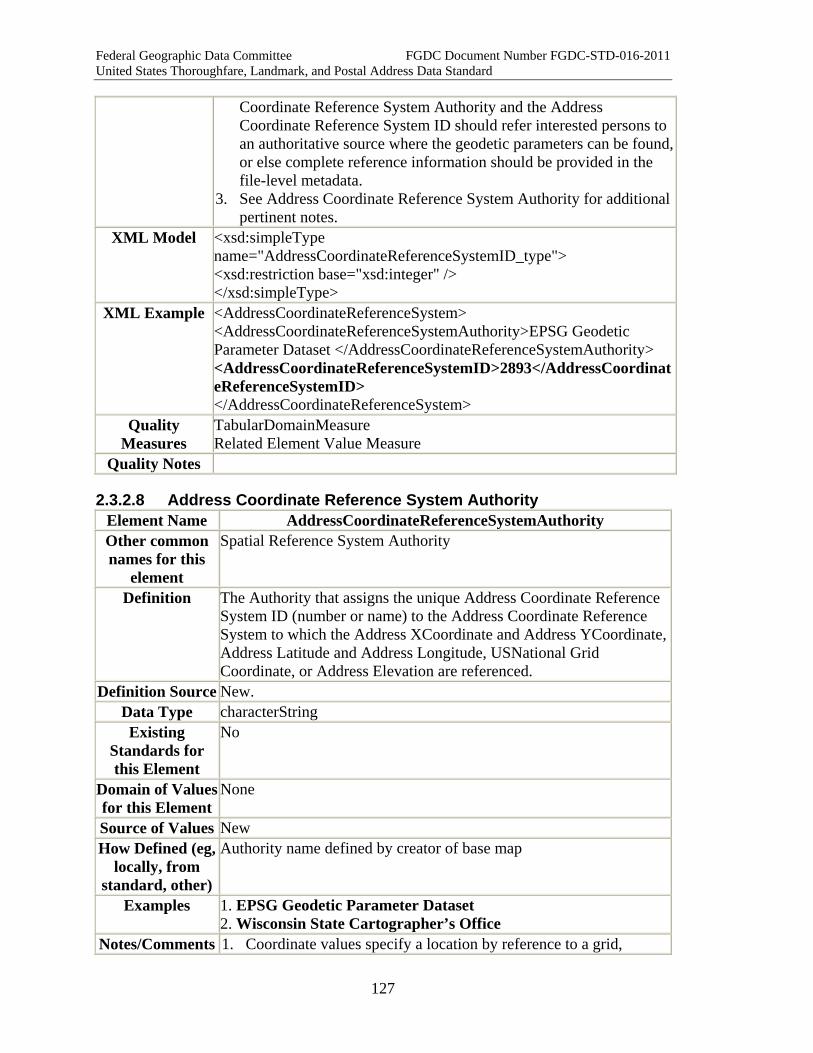
Federal Geographic Data Committee FGDC Document Number FGDC-STD-016-2011 United States Thoroughfare, Landmark, and Postal Address Data Standard
127
Coordinate Reference System Authority and the Address Coordinate Reference System ID should refer interested persons to an authoritative source where the geodetic parameters can be found, or else complete reference information should be provided in the file-level metadata.
3. See Address Coordinate Reference System Authority for additional pertinent notes.
XML Model <xsd:simpleType name="AddressCoordinateReferenceSystemID_type"> <xsd:restriction base="xsd:integer" /> </xsd:simpleType>
XML Example <AddressCoordinateReferenceSystem> <AddressCoordinateReferenceSystemAuthority>EPSG Geodetic Parameter Dataset </AddressCoordinateReferenceSystemAuthority> <AddressCoordinateReferenceSystemID>2893</AddressCoordinateReferenceSystemID> </AddressCoordinateReferenceSystem>
Quality Measures
TabularDomainMeasure Related Element Value Measure
Quality Notes
2.3.2.8 Address Coordinate Reference System Authority Element Name AddressCoordinateReferenceSystemAuthority Other common names for this
element
Spatial Reference System Authority
Definition The Authority that assigns the unique Address Coordinate Reference System ID (number or name) to the Address Coordinate Reference System to which the Address XCoordinate and Address YCoordinate, Address Latitude and Address Longitude, USNational Grid Coordinate, or Address Elevation are referenced.
Definition Source New. Data Type characterString Existing
Standards for this Element
No
Domain of Values for this Element
None
Source of Values New How Defined (eg,
locally, from standard, other)
Authority name defined by creator of base map
Examples 1. EPSG Geodetic Parameter Dataset 2. Wisconsin State Cartographer’s Office
Notes/Comments 1. Coordinate values specify a location by reference to a grid,
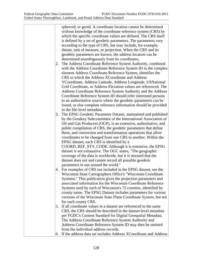
Federal Geographic Data Committee FGDC Document Number FGDC-STD-016-2011 United States Thoroughfare, Landmark, and Postal Address Data Standard
128
spheroid, or geoid. A coordinate location cannot be determined without knowledge of the coordinate reference system (CRS) by which the specific coordinate values are defined. The CRS itself is defined by a set of geodetic parameters. The parameters vary according to the type of CRS, but may include, for example, datum, unit of measure, or projection. When the CRS and its geodetic parameters are known, the address location can be determined unambiguously from its coordinates.
2. The Address Coordinate Reference System Authority, combined with the Address Coordinate Reference System ID in the complex element Address Coordinate Reference System, identifies the CRS to which the Address XCoordinate and Address YCoordinate, Address Latitude, Address Longitude, USNational Grid Coordinate, or Address Elevation values are referenced. The Address Coordinate Reference System Authority and the Address Coordinate Reference System ID should refer interested persons to an authoritative source where the geodetic parameters can be found, or else complete reference information should be provided in the file-level metadata.
3. The EPSG Geodetic Parameter Dataset, maintained and published by the Geodesy Subcommittee of the International Association of Oil and Gas Producers (OGP), is an extensive, authoritative, and public compilation of CRS, the geodetic parameters that define them, and conversion and transformation operations that allow coordinates to be changed from one CRS to another. Within the EPSG dataset, each CRS is identified by a COORD_REF_SYS_CODE. Although it is extensive, the EPSG dataset is not exhaustive. The OGC states, "The geographic coverage of the data is worldwide, but it is stressed that the dataset does not and cannot record all possible geodetic parameters in use around the world."
4. For examples of CRS not included in the EPSG dataset, see the Wisconsin State Cartographers Office's "Wisconsin Coordinate Systems." This publication gives the projection parameters and associated information for the Wisconsin Coordinate Reference Systems used by each of Wisconsin's 72 counties, identified by county name. The EPSG Dataset includes parameters for various versions of the Wisconsin State Plane Coordinate System, but not for each county CRS.
5. If all coordinate values in a dataset are referenced to the same CRS, the CRS should be described in the dataset-level metadata per FGDC's Content Standard for Digital Geospatial Metadata. The Address Coordinate Reference System Authority and Address Coordinate Reference System ID may then be omitted from the individual address records.
6. If the address data set includes Address XCoordinate and Address
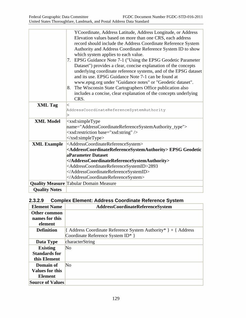
Federal Geographic Data Committee FGDC Document Number FGDC-STD-016-2011 United States Thoroughfare, Landmark, and Postal Address Data Standard
129
YCoordinate, Address Latitude, Address Longitude, or Address Elevation values based on more than one CRS, each address record should include the Address Coordinate Reference System Authority and Address Coordinate Reference System ID to show which system applies to each value.
7. EPSG Guidance Note 7-1 ("Using the EPSG Geodetic Parameter Dataset") provides a clear, concise explanation of the concepts underlying coordinate reference systems, and of the EPSG dataset and its use. EPSG Guidance Note 7-1 can be found at www.epsg.org under "Guidance notes" or "Geodetic dataset".
8. The Wisconsin State Cartographers Office publication also includes a concise, clear explanation of the concepts underlying CRS.
XML Tag < AddressCoordinateReferenceSystemAuthority >
XML Model <xsd:simpleType name="AddressCoordinateReferenceSystemAuthority_type"> <xsd:restriction base="xsd:string" /> </xsd:simpleType>
XML Example <AddressCoordinateReferenceSystem> <AddressCoordinateReferenceSystemAuthority> EPSG Geodetic aParameter Dataset </AddressCoordinateReferenceSystemAuthority> <AddressCoordinateReferenceSystemID>2893 </AddressCoordinateReferenceSystemID> </AddressCoordinateReferenceSystem>
Quality Measure Tabular Domain Measure Quality Notes
2.3.2.9 Complex Element: Address Coordinate Reference System Element Name AddressCoordinateReferenceSystem Other common names for this
element
Definition { Address Coordinate Reference System Authority* } + { Address Coordinate Reference System ID* }
Data Type characterString Existing
Standards for this Element
No
Domain of Values for this
Element
No
Source of Values
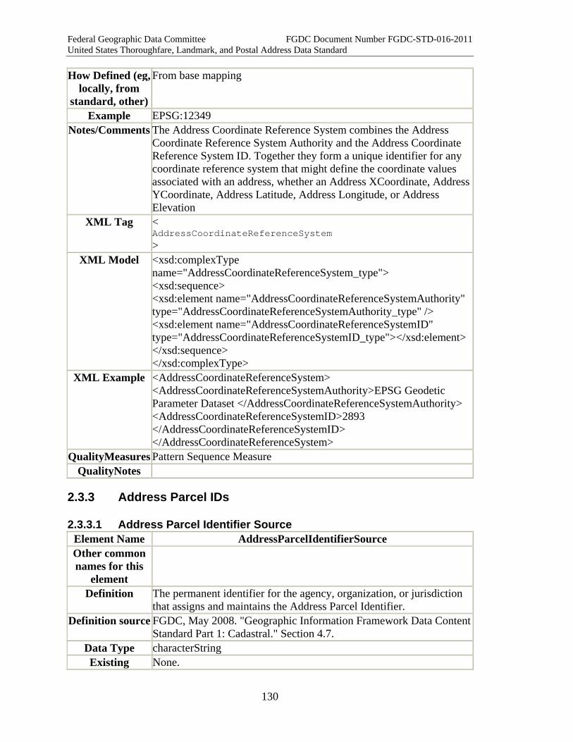
Federal Geographic Data Committee FGDC Document Number FGDC-STD-016-2011 United States Thoroughfare, Landmark, and Postal Address Data Standard
130
How Defined (eg, locally, from
standard, other)
From base mapping
Example EPSG:12349 Notes/Comments The Address Coordinate Reference System combines the Address
Coordinate Reference System Authority and the Address Coordinate Reference System ID. Together they form a unique identifier for any coordinate reference system that might define the coordinate values associated with an address, whether an Address XCoordinate, Address YCoordinate, Address Latitude, Address Longitude, or Address Elevation
XML Tag < AddressCoordinateReferenceSystem >
XML Model <xsd:complexType name="AddressCoordinateReferenceSystem_type"> <xsd:sequence> <xsd:element name="AddressCoordinateReferenceSystemAuthority" type="AddressCoordinateReferenceSystemAuthority_type" /> <xsd:element name="AddressCoordinateReferenceSystemID" type="AddressCoordinateReferenceSystemID_type"></xsd:element></xsd:sequence> </xsd:complexType>
XML Example <AddressCoordinateReferenceSystem> <AddressCoordinateReferenceSystemAuthority>EPSG Geodetic Parameter Dataset </AddressCoordinateReferenceSystemAuthority> <AddressCoordinateReferenceSystemID>2893 </AddressCoordinateReferenceSystemID> </AddressCoordinateReferenceSystem>
QualityMeasures Pattern Sequence Measure QualityNotes
2.3.3 Address Parcel IDs
2.3.3.1 Address Parcel Identifier Source Element Name AddressParcelIdentifierSource Other common names for this
element
Definition The permanent identifier for the agency, organization, or jurisdiction that assigns and maintains the Address Parcel Identifier.
Definition source FGDC, May 2008. "Geographic Information Framework Data Content Standard Part 1: Cadastral." Section 4.7.
Data Type characterString Existing None.

Federal Geographic Data Committee FGDC Document Number FGDC-STD-016-2011 United States Thoroughfare, Landmark, and Postal Address Data Standard
131
Standards for this Element Domain of
Values for this Element
None.
Source of Values None. How Defined (eg,
locally, from standard, other)
By local government (typically county government) law or administrative procedure, as governed by state law.
Example Chester County (PA) Tax Assessment Department Bureau of Land Records Wake County (NC) Revenue Department Delaware County (OH) Auditor's Office
Notes/Comments 1. The Address Parcel Identifier Source designates the agency, organization, or jurisdiction that assigns and maintains the Address Parcel Identifier.
2. If known, give the full name of the agency (department, office, etc.) rather than just the jurisdiction name.
3. In giving a jurisdiction name, if possible follow known naming standards, such as the ANSI (formerly FIPS) names or codes for states and counties, or GNIS names or codes for minor civil divisions, populated places, and other features.
XML Tag < AddressParcelIdentifierSource >
XML Model <xsd:simpleType name="AddressParcelIdentifierSource_type"> <xsd:restriction base="xsd:string"> <xsd:pattern value='.*' /> </xsd:restriction> </xsd:simpleType>
XML Example <AddressParcelIdentifierSource>Wake County (NC) Revenue Department </AddressParcelIdentifierSource>
Quality Measures
Tabular Domain Measure
Quality Notes
2.2.3.2 Address Parcel Identifier Element Name AddressParcelIdentifier Other common names for this
element
Parcel Identifier Number, PIN number
Definition The primary permanent identifier, as defined by the Address Parcel Identifier Source, for a parcel that includes the land or feature identified by an address. A parcel is "a single cadastral unit, which is the spatial extent of the past, present, and future rights and
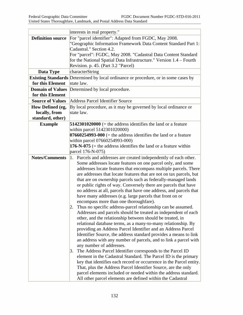
Federal Geographic Data Committee FGDC Document Number FGDC-STD-016-2011 United States Thoroughfare, Landmark, and Postal Address Data Standard
132
interests in real property." Definition source For "parcel identifier": Adapted from FGDC, May 2008.
"Geographic Information Framework Data Content Standard Part 1: Cadastral." Section 4.2. For "parcel": FGDC, May 2008. "Cadastral Data Content Standard for the National Spatial Data Infrastructure." Version 1.4 – Fourth Revision. p. 45. (Part 3.2 "Parcel)
Data Type characterString Existing Standards
for this Element Determined by local ordinance or procedure, or in some cases by state law.
Domain of Values for this Element
Determined by local procedure.
Source of Values Address Parcel Identifier Source How Defined (eg,
locally, from standard, other)
By local procedure, as it may be governed by local ordinance or state law.
Example 5142301020000 (= the address identifies the land or a feature within parcel 5142301020000) 07660254993-000 (= the address identifies the land or a feature within parcel 07660254993-000) 176-N-075 (= the address identifies the land or a feature within parcel 176-N-075)
Notes/Comments 1. Parcels and addresses are created independently of each other. Some addresses locate features on one parcel only, and some addresses locate features that encompass multiple parcels. There are addresses that locate features that are not on tax parcels, but that are on ownership parcels such as federally-managed lands or public rights of way. Conversely there are parcels that have no address at all, parcels that have one address, and parcels that have many addresses (e.g. large parcels that front on or encompass more than one thoroughfare).
2. Thus no specific address-parcel relationship can be assumed. Addresses and parcels should be treated as independent of each other, and the relationship between should be treated, in relational database terms, as a many-to-many relationship. By providing an Address Parcel Identifier and an Address Parcel Identifier Source, the address standard provides a means to link an address with any number of parcels, and to link a parcel with any number of addresses.
3. The Address Parcel Identifier corresponds to the Parcel ID element in the Cadastral Standard. The Parcel ID is the primary key that identifies each record or occurrence in the Parcel entity. That, plus the Address Parcel Identifier Source, are the only parcel elements included or needed within the address standard. All other parcel elements are defined within the Cadastral

Federal Geographic Data Committee FGDC Document Number FGDC-STD-016-2011 United States Thoroughfare, Landmark, and Postal Address Data Standard
133
Standard and need not be repeated here. XML Tag <
AddressParcelIdentifier >
XML Model <xsd:simpleType name="AddressParcelIdentifier_type"> <xsd:restriction base="xsd:string"> <xsd:pattern value='.*' /> </xsd:restriction> </xsd:simpleType>
XML Example <AddressParcelIdentifier>07660254993-000</AddressParcelIdentifier>
Quality Measures Uniqueness Measure Pattern Sequence Measure
Quality Notes
2.3.4 Address Transportation Feature IDs
2.3.4.1 Address Transportation System Name Element Name AddressTransportationSystemName Other common names for this
element
Street centerline file, road network file, street network file, centerline network file
Definition The name of the transportation base model to which the address is related.
Data Type characterString Existing
Standards for this Element
1. There are no standards specifically for naming specific transportation base models.
2. The content requirements for transportation base models are set forth in: U.S. Federal Geographic Data Committee, "Framework Data Content Standard Part 7: Transportation base."
3. The Transportation base part is extended by the "Framework Data Content Standard Part 7c: Roads," which sets forth the requirements for road system models.
4. The Framework Data Content Standard Part 7: Transportation is incorporated into this standard by reference.
Domain of Values for this Element
None.
Source of Values None. How Defined (eg,
locally, from standard, other)
By Address Transportation System Authority
Example DC Street Spatial Data Base TIGER/MAF File
Notes/Comments 1. The Transportation Standard base part "defines the data model for describing transportation systems components of
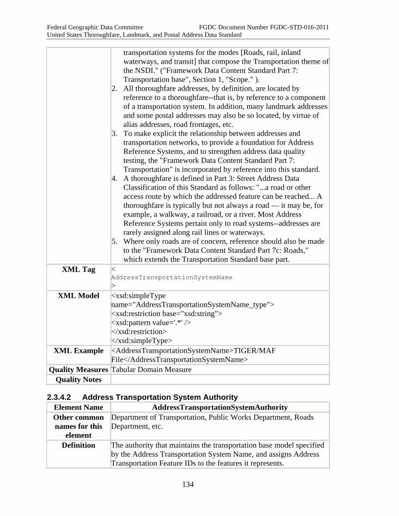
Federal Geographic Data Committee FGDC Document Number FGDC-STD-016-2011 United States Thoroughfare, Landmark, and Postal Address Data Standard
134
transportation systems for the modes [Roads, rail, inland waterways, and transit] that compose the Transportation theme of the NSDI." ("Framework Data Content Standard Part 7: Transportation base", Section 1, "Scope." ).
2. All thoroughfare addresses, by definition, are located by reference to a thoroughfare--that is, by reference to a component of a transportation system. In addition, many landmark addresses and some postal addresses may also be so located, by virtue of alias addresses, road frontages, etc.
3. To make explicit the relationship between addresses and transportation networks, to provide a foundation for Address Reference Systems, and to strengthen address data quality testing, the "Framework Data Content Standard Part 7: Transportation" is incorporated by reference into this standard.
4. A thoroughfare is defined in Part 3: Street Address Data Classification of this Standard as follows: "...a road or other access route by which the addressed feature can be reached... A thoroughfare is typically but not always a road — it may be, for example, a walkway, a railroad, or a river. Most Address Reference Systems pertain only to road systems--addresses are rarely assigned along rail lines or waterways.
5. Where only roads are of concern, reference should also be made to the "Framework Data Content Standard Part 7c: Roads," which extends the Transportation Standard base part.
XML Tag < AddressTransportationSystemName >
XML Model <xsd:simpleType name="AddressTransportationSystemName_type"> <xsd:restriction base="xsd:string"> <xsd:pattern value='.*' /> </xsd:restriction> </xsd:simpleType>
XML Example <AddressTransportationSystemName>TIGER/MAF File</AddressTransportationSystemName>
Quality Measures Tabular Domain Measure Quality Notes
2.3.4.2 Address Transportation System Authority Element Name AddressTransportationSystemAuthority Other common names for this
element
Department of Transportation, Public Works Department, Roads Department, etc.
Definition The authority that maintains the transportation base model specified by the Address Transportation System Name, and assigns Address Transportation Feature IDs to the features it represents.
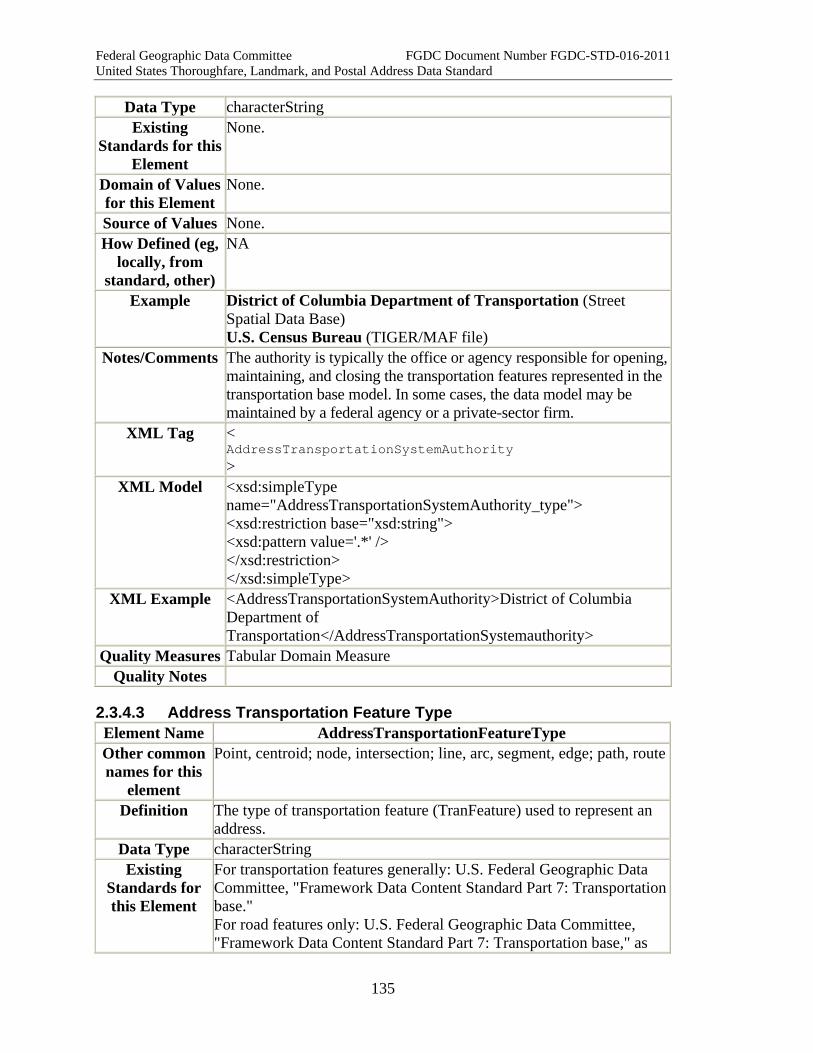
Federal Geographic Data Committee FGDC Document Number FGDC-STD-016-2011 United States Thoroughfare, Landmark, and Postal Address Data Standard
135
Data Type characterString Existing
Standards for this Element
None.
Domain of Values for this Element
None.
Source of Values None. How Defined (eg,
locally, from standard, other)
NA
Example District of Columbia Department of Transportation (Street Spatial Data Base) U.S. Census Bureau (TIGER/MAF file)
Notes/Comments The authority is typically the office or agency responsible for opening, maintaining, and closing the transportation features represented in the transportation base model. In some cases, the data model may be maintained by a federal agency or a private-sector firm.
XML Tag < AddressTransportationSystemAuthority >
XML Model <xsd:simpleType name="AddressTransportationSystemAuthority_type"> <xsd:restriction base="xsd:string"> <xsd:pattern value='.*' /> </xsd:restriction> </xsd:simpleType>
XML Example <AddressTransportationSystemAuthority>District of Columbia Department of Transportation</AddressTransportationSystemauthority>
Quality Measures Tabular Domain Measure Quality Notes
2.3.4.3 Address Transportation Feature Type Element Name AddressTransportationFeatureType Other common names for this
element
Point, centroid; node, intersection; line, arc, segment, edge; path, route
Definition The type of transportation feature (TranFeature) used to represent an address.
Data Type characterString Existing
Standards for this Element
For transportation features generally: U.S. Federal Geographic Data Committee, "Framework Data Content Standard Part 7: Transportation base." For road features only: U.S. Federal Geographic Data Committee, "Framework Data Content Standard Part 7: Transportation base," as

Federal Geographic Data Committee FGDC Document Number FGDC-STD-016-2011 United States Thoroughfare, Landmark, and Postal Address Data Standard
136
extended by "Framework Data Content Standard Part 7c: Roads." Domain of
Values for this Element
For transportation features generally: Point event, linear event, transportation point (TranPoint), transportation segment (TranSeg), or transportation path (TranPath) For road features only: RoadPointFeatureEvent, RoadLinearFeatureEvent, RoadPoint, RoadSeg, or RoadPath
Source of Values U.S. Federal Geographic Data Committee, "Framework Data Content Standard Part 7: Transportation base." See especially Sections 5 (Terms and Definitions), and Section 7 (Requirements).
How Defined (eg, locally, from standard, other)
For all transportation features: U.S. Federal Geographic Data Committee, "Framework Data Content Standard Part 7: Transportation base." For road features: "Framework Data Content Standard Part 7c: Roads."
Examples Point event: parcel centroid, building centroid, etc., located along a thoroughfare. Linear event: parcel frontage, building frontage, etc. located along a thoroughfare Transportation point: Any Intersection Address Transportation segment: A length of road between two intersecting roads (First Street between A Street and B Street) Transportation path: A length of road including multiple segments (First Street from beginning to end)
Notes/Comments 1. This element is meaningful only in the context of a transportation base model as defined in the FGDC's "Framework Data Content Standard Part 7." Transportation features are defined therein.
2. The type of transportation feature used to represent an address depends on: a. the class of the address, and b. (in some cases) how the address is mapped (i.e. as a point, line,
or polygon). 3. These relationships are explained more fully in Appendix H
(Section 3) of this standard. XML Tag <
AddressTransportationFeatureType >
XML Model <xsd:simpleType name="AddressTransportationFeatureType_type"> <xsd:restriction base="xsd:string"> <xsd:pattern value='.*' /> </xsd:restriction> </xsd:simpleType>
XML Example <AddressTransportationFeatureType>RoadPoint</AddressTransportationFeatureType>
Quality Measures
Address Completeness Measure Intersection Validity Measure Segment Directionality Consistency Measure

Federal Geographic Data Committee FGDC Document Number FGDC-STD-016-2011 United States Thoroughfare, Landmark, and Postal Address Data Standard
137
XYCoordinate Completeness Measure XYCoordinate Spatial Measure
Quality Notes
2.3.4.4 Address Transportation Feature ID Element Name AddressTransportationFeatureID Other common names for this
element
Definition The unique identifier assigned to the particular feature that represents an address within a transportation base model.
Data Type characterString Existing
Standards for this Element
U.S. Federal Geographic Data Committee, "Framework Data Content Standard Part 7: Transportation base." "Framework Data Content Standard Part 7c: Roads,"
Domain of Values for this
Element
Constrained by reference transportation base model.
Source of Values Reference transportation base model. How Defined
(eg, locally, from standard, other)
Within reference transportation base model.
Example 9087456 Notes/Comments 1. The reference transportation base model might identify addresses
by their Address ID, or it might assign a different identifier within the transportation base model.
2. If a different identifier is assigned within the transportation base model, then the Address Transportation Feature ID will serve, within the scope of the address record, as a foreign key to the transportation base model.
XML Tag < AddressTransportationFeatureID >
XML Model <xsd:simpleType name="AddressTransportationFeatureId_type"> <xsd:restriction base="xsd:string"> <xsd:pattern value='.*' /> </xsd:restriction> </xsd:simpleType>
XML Example <AddressTransportationFeatureID>9087456</AddressTransportationFeatureID>
Quality Measures
Pattern Sequence Measure Uniqueness Measure
Quality Notes

Federal Geographic Data Committee FGDC Document Number FGDC-STD-016-2011 United States Thoroughfare, Landmark, and Postal Address Data Standard
138
2.3.4.5 Related Transportation Feature ID Element Name RelatedTransportationFeatureID Other common names for this
element
Definition The unique identifier assigned (within the reference transportation base model) to a transportation feature to which an address is related.
Data Type characterString Existing
Standards for this Element
U.S. Federal Geographic Data Committee, "Framework Data Content Standard Part 7: Transportation base." "Framework Data Content Standard Part 7c: Roads."
Domain of Values for this
Element
Constrained by reference transportation base model.
Source of Values Reference transportation base model. How Defined
(eg, locally, from standard, other)
Within the reference transportation base model.
Example 786542 Notes/Comments 1. Thoroughfare addresses (other than Intersection Addresses) are
represented within a transportation base model as point events or linear events, each with a unique Address Transportation Feature ID. These point events and linear events may, in turn, be related to one or more transportation segments within the transportation base model. The transportation segment must have a Complete Street Name and an address range that includes the Complete Street Nameand Complete Address Number of the address.
2. The Related Transportation Feature ID provides the ID, as assigned within the transportation base model, of the related segment.
3. Intersection Addresses are related to one or more transportation points within the transportation data model. For Intersection Addresses, the TranPoint ID would be placed within the Related Transportation Feature ID element.
XML Tag < RelatedTransportationFeatureID >
XML Model <xsd:simpleType name="RelatedTransportationFeatureId_type"> <xsd:restriction base="xsd:string"> <xsd:pattern value='.*' /> </xsd:restriction> </xsd:simpleType>
XML Example <RelatedTransportationFeatureID>786542</RelatedTransportationFeatureID>
Quality Measures
Related Element Uniqueness Measure
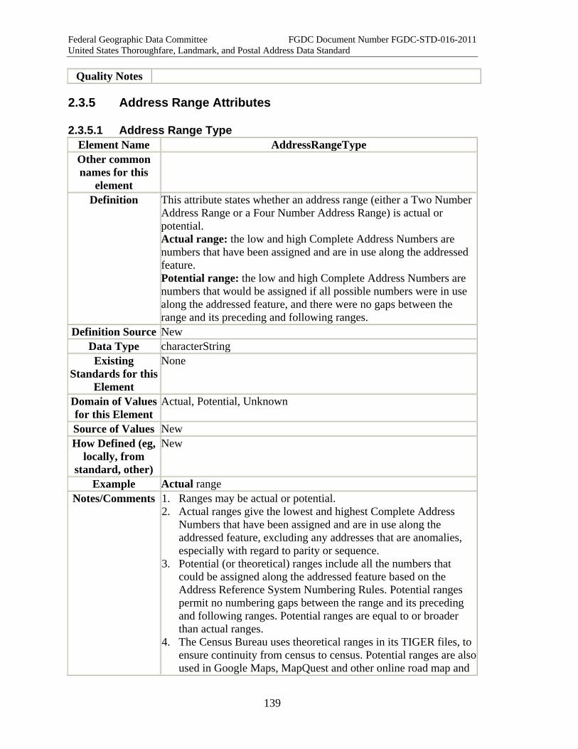
Federal Geographic Data Committee FGDC Document Number FGDC-STD-016-2011 United States Thoroughfare, Landmark, and Postal Address Data Standard
139
Quality Notes
2.3.5 Address Range Attributes
2.3.5.1 Address Range Type Element Name AddressRangeType Other common names for this
element
Definition This attribute states whether an address range (either a Two Number Address Range or a Four Number Address Range) is actual or potential. Actual range: the low and high Complete Address Numbers are numbers that have been assigned and are in use along the addressed feature. Potential range: the low and high Complete Address Numbers are numbers that would be assigned if all possible numbers were in use along the addressed feature, and there were no gaps between the range and its preceding and following ranges.
Definition Source New Data Type characterString Existing
Standards for this Element
None
Domain of Values for this Element
Actual, Potential, Unknown
Source of Values New How Defined (eg,
locally, from standard, other)
New
Example Actual range Notes/Comments 1. Ranges may be actual or potential.
2. Actual ranges give the lowest and highest Complete Address Numbers that have been assigned and are in use along the addressed feature, excluding any addresses that are anomalies, especially with regard to parity or sequence.
3. Potential (or theoretical) ranges include all the numbers that could be assigned along the addressed feature based on the Address Reference System Numbering Rules. Potential ranges permit no numbering gaps between the range and its preceding and following ranges. Potential ranges are equal to or broader than actual ranges.
4. The Census Bureau uses theoretical ranges in its TIGER files, to ensure continuity from census to census. Potential ranges are also used in Google Maps, MapQuest and other online road map and
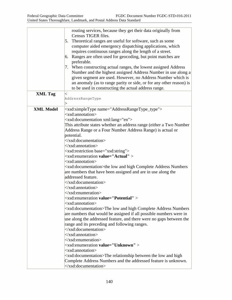
Federal Geographic Data Committee FGDC Document Number FGDC-STD-016-2011 United States Thoroughfare, Landmark, and Postal Address Data Standard
140
routing services, because they get their data originally from Census TIGER files.
5. Theoretical ranges are useful for software, such as some computer aided emergency dispatching applications, which requires continuous ranges along the length of a street.
6. Ranges are often used for geocoding, but point matches are preferable.
7. When constructing actual ranges, the lowest assigned Address Number and the highest assigned Address Number in use along a given segment are used. However, no Address Number which is an anomaly (as to range parity or side, or for any other reason) is to be used in constructing the actual address range.
XML Tag < AddressRangeType >
XML Model <xsd:simpleType name="AddressRangeType_type"> <xsd:annotation> <xsd:documentation xml:lang="en"> This attribute states whether an address range (either a Two Number Address Range or a Four Number Address Range) is actual or potential. </xsd:documentation> </xsd:annotation> <xsd:restriction base="xsd:string"> <xsd:enumeration value="Actual" > <xsd:annotation> <xsd:documentation>the low and high Complete Address Numbers are numbers that have been assigned and are in use along the addressed feature. </xsd:documentation> </xsd:annotation> </xsd:enumeration> <xsd:enumeration value="Potential" > <xsd:annotation> <xsd:documentation>The low and high Complete Address Numbers are numbers that would be assigned if all possible numbers were in use along the addressed feature, and there were no gaps between the range and its preceding and following ranges. </xsd:documentation> </xsd:annotation> </xsd:enumeration> <xsd:enumeration value="Unknown" > <xsd:annotation> <xsd:documentation>The relationship between the low and high Complete Address Numbers and the addressed feature is unknown. </xsd:documentation>
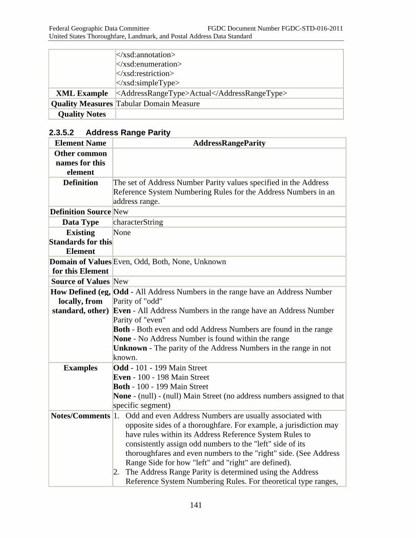
Federal Geographic Data Committee FGDC Document Number FGDC-STD-016-2011 United States Thoroughfare, Landmark, and Postal Address Data Standard
141
</xsd:annotation> </xsd:enumeration> </xsd:restriction> </xsd:simpleType>
XML Example <AddressRangeType>Actual</AddressRangeType> Quality Measures Tabular Domain Measure
Quality Notes
2.3.5.2 Address Range Parity Element Name AddressRangeParity Other common names for this
element
Definition The set of Address Number Parity values specified in the Address Reference System Numbering Rules for the Address Numbers in an address range.
Definition Source New Data Type characterString Existing
Standards for this Element
None
Domain of Values for this Element
Even, Odd, Both, None, Unknown
Source of Values New How Defined (eg,
locally, from standard, other)
Odd - All Address Numbers in the range have an Address Number Parity of "odd" Even - All Address Numbers in the range have an Address Number Parity of "even" Both - Both even and odd Address Numbers are found in the range None - No Address Number is found within the range Unknown - The parity of the Address Numbers in the range in not known.
Examples Odd - 101 - 199 Main Street Even - 100 - 198 Main Street Both - 100 - 199 Main Street None - (null) - (null) Main Street (no address numbers assigned to that specific segment)
Notes/Comments 1. Odd and even Address Numbers are usually associated with opposite sides of a thoroughfare. For example, a jurisdiction may have rules within its Address Reference System Rules to consistently assign odd numbers to the "left" side of its thoroughfares and even numbers to the "right" side. (See Address Range Side for how "left" and "right" are defined).
2. The Address Range Parity is determined using the Address Reference System Numbering Rules. For theoretical type ranges,

Federal Geographic Data Committee FGDC Document Number FGDC-STD-016-2011 United States Thoroughfare, Landmark, and Postal Address Data Standard
142
the low and high numbers are the lowest and highest numbers of the identified parity found within the identified block within the Address Reference System. For actual ranges, the lowest and highest Address Number in use for the selected block are identified and used. Anomalous addresses (e.g., those Address Numbers that have a parity that is not the same as the Address Range Parity) are not used in creating the actual Address Range or in determining the Address Range Parity.
3. The expected values for Address Range Parity depend on rules found in the Address Reference System Rules, and are associated with the Address Range Side. If the address range includes addresses from only one side of the thoroughfare, the Address Range Parity is typically but not always "odd" or "even". If the range covers both sides of the thoroughfare, then the Address Range Parity is typically "both"
4. Address ranges composed of milepost Complete Address Numbers(e.g., Milepost 21 - Milepost 24) by definition have a parity of "both". Milepost numbers denote distance only, not side of street. (For more information on milepost Complete Address Numbers, see Complete Address Number.)
5. If no addresses occur within a range, then the Address Range Parity is "None."
XML Tag < AddressRangeParity >
XML Model <xsd:simpleType name="AddressRangeParity_type"> <xsd:annotation> <xsd:documentation xml:lang="en"> The set of Address Number Parity values specified in the Address Reference System Numbering Rules for the Address Numbers in an address range. </xsd:documentation> </xsd:annotation> <xsd:restriction base="xsd:string"> <xsd:pattern value='.*' /> <xsd:enumeration value="even" > <xsd:annotation> <xsd:documentation> All Address Numbers in the range have an Address Number Parity of "even". </xsd:documentation> </xsd:annotation> </xsd:enumeration> <xsd:enumeration value="odd" > <xsd:annotation> <xsd:documentation>

Federal Geographic Data Committee FGDC Document Number FGDC-STD-016-2011 United States Thoroughfare, Landmark, and Postal Address Data Standard
143
All Address Numbers in the range have an Address Number Parity of "odd". </xsd:documentation> </xsd:annotation> </xsd:enumeration> <xsd:enumeration value="both" > <xsd:annotation> <xsd:documentation> Both even and odd Address Numbers are found in the range. </xsd:documentation> </xsd:annotation> </xsd:enumeration> <xsd:enumeration value="none" > <xsd:annotation> <xsd:documentation> No Address Number is found within the range. </xsd:documentation> </xsd:annotation></xsd:enumeration> <xsd:enumeration value="unknown" > <xsd:annotation> <xsd:documentation>The parity of the Address Numbers in the range in not known. </xsd:documentation></xsd:annotation></xsd:enumeration> </xsd:restriction> </xsd:simpleType>
XML Example <AddressRangeParity>odd</AddressRangeParity> Quality Measures Address Number Range Parity Consistency Measure
Quality Notes
2.3.5.3 Address Range Side Element Name AddressRangeSide Other common names for this
element
Definition The side of the transportation segment(s) (TranSeg) or path (TranPath) on which the address range is found (right, left or both).
Definition Source New Data Type characterString
Existing Standards for this Element
None
Domain of Values for this Element
right, left, both, none, unknown
Source of Values New How Defined (eg,
locally, from New

Federal Geographic Data Committee FGDC Document Number FGDC-STD-016-2011 United States Thoroughfare, Landmark, and Postal Address Data Standard
144
standard, other) Example Elm Street runs south-to-north. For each block, the from-node is at
the south end, and the to-node is at the north end. "Right" and "left" are defined by standing at the south (from) end, and facing the north (to) end. The "right" side is in this case the east side, and the "left" side is the west side. (If the from- and to- nodes were reversed, "left' and "right' would also be reversed.)
Notes/Comments 1. Address Range Side has nothing to do with traffic flow or compass direction.
2. Address Range Side states whether the range includes Complete Address Numbers on right side, left side, or both sides of the thoroughfare.
3. "Right" and "left" must be defined by reference to a specific transportation segment (or set of segments) in a particular transportation network model. By definition, every transportation segment has a from-node at one end and a to-node at the other end. The directionality, right side, and left side of the segment are determined by standing at the from-node and facing the to-node. Address Left Right Measure and Address Range Directionality Measure provide tools for determining "left", "right" and directionality.
4. Address Range Directionality can be defined only for a Two Number Address Range or a Four Number Address Range that has been related to a specific transportation segment (or set of segments) in a particular transportation network model.
5. Use the Address Transportation System Name, Address Transportation System Authority, Address Transportation Feature Type, Address Transportation Feature ID, and Related Transportation Feature ID attributes to relate a particular address range to a specific transportation segment (or set of segments) in a specific transportation network model. Transportation segments, and transportation network models generally, are defined and described in the FGDC's "Geographic Information Framework Data Content Standard Part 7: Transportation Base."
XML Tag < AddressRangeSide >
XML Model <xsd:simpleType name="AddressRangeSide_type"> <xsd:annotation> <xsd:documentation xml:lang="en"> The side of the transportation segment (right , left, both, none, unknown) on which the address range applies. </xsd:documentation> </xsd:annotation> <xsd:restriction base="xsd:string"> <xsd:pattern value='.*' />

Federal Geographic Data Committee FGDC Document Number FGDC-STD-016-2011 United States Thoroughfare, Landmark, and Postal Address Data Standard
145
<xsd:enumeration value="right" > <xsd:annotation> <xsd:documentation> The address is related to the right side of the street. </xsd:documentation> </xsd:annotation> </xsd:enumeration> <xsd:enumeration value="left" > <xsd:annotation> <xsd:documentation> The address is related to the left side of the street. </xsd:documentation> </xsd:annotation> </xsd:enumeration> <xsd:enumeration value="both"> <xsd:annotation> <xsd:documentation> The address pertains to both sides of the street. </xsd:documentation> </xsd:annotation> </xsd:enumeration> <xsd:enumeration value="none" > <xsd:annotation> <xsd:documentation>The address is not on either or both sides of the street or the concept of side of street does not apply to the address. For instance an intersection address would have an Address Side Of Street of none. </xsd:documentation> </xsd:annotation></xsd:enumeration> <xsd:enumeration value="unknown" ></xsd:enumeration> </xsd:restriction> </xsd:simpleType>
XML Example <AddressRangeSide>left</AddressRangeSide> Quality Measures Left Right Odd Even Parity Measure
Address Left Right Measure Quality Notes Note that this measure checks the agreement of an Address Range
Side attribute with geometry, while Left Right Odd Even Parity Measure checks the agreement of an Address Number against an established local rule for associating address parity with the right or left side of the street when traveling away from the governing Address Reference System Axis Point Of Beginning.
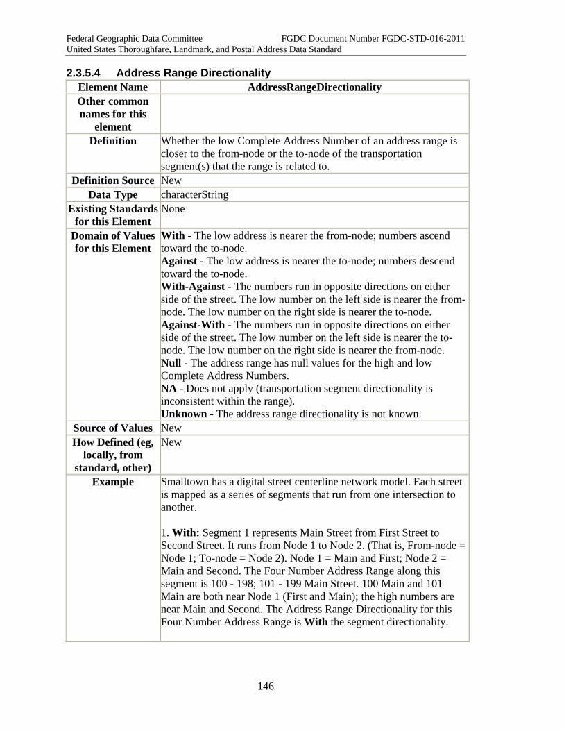
Federal Geographic Data Committee FGDC Document Number FGDC-STD-016-2011 United States Thoroughfare, Landmark, and Postal Address Data Standard
146
2.3.5.4 Address Range Directionality Element Name AddressRangeDirectionality Other common names for this
element
Definition Whether the low Complete Address Number of an address range is closer to the from-node or the to-node of the transportation segment(s) that the range is related to.
Definition Source New Data Type characterString
Existing Standards for this Element
None
Domain of Values for this Element
With - The low address is nearer the from-node; numbers ascend toward the to-node. Against - The low address is nearer the to-node; numbers descend toward the to-node. With-Against - The numbers run in opposite directions on either side of the street. The low number on the left side is nearer the from-node. The low number on the right side is nearer the to-node. Against-With - The numbers run in opposite directions on either side of the street. The low number on the left side is nearer the to-node. The low number on the right side is nearer the from-node. Null - The address range has null values for the high and low Complete Address Numbers. NA - Does not apply (transportation segment directionality is inconsistent within the range). Unknown - The address range directionality is not known.
Source of Values New How Defined (eg,
locally, from standard, other)
New
Example Smalltown has a digital street centerline network model. Each street is mapped as a series of segments that run from one intersection to another. 1. With: Segment 1 represents Main Street from First Street to Second Street. It runs from Node 1 to Node 2. (That is, From-node = Node 1; To-node = Node 2). Node 1 = Main and First; Node 2 = Main and Second. The Four Number Address Range along this segment is 100 - 198; 101 - 199 Main Street. 100 Main and 101 Main are both near Node 1 (First and Main); the high numbers are near Main and Second. The Address Range Directionality for this Four Number Address Range is With the segment directionality.

Federal Geographic Data Committee FGDC Document Number FGDC-STD-016-2011 United States Thoroughfare, Landmark, and Postal Address Data Standard
147
2. Against: Segment 25 represents Elm Street from Oak Street to Pine Street. For Segment 25, the From-node = Node 92 = Elm and Oak; and the To-node = Node 77 = Elm and Pine. The Four Number Address Range along this segment is 110 - 180; 111 - 187 Elm Street. 110 Elm and 111 Elm are both near Node 77 (Elm and Pine); the high numbers are near Elm and Oak. The Address Range Directionality for this Four Number Address Range is Against the segment directionality.
3. Special Case: With - Against: Segment 157 is unusual--the address numbers run in different directions on each side of the street. Segment 157 represents Old Border Road from Farm Road to Park Street. Segment 157 From-node = Node 308; To-node = Node 566. Node 308 = Old Border and Farm; Node 566 = Old Border and Park. The Four Number Address Range along this segment is 4102 - 4188; 4111 - 4181 Old Border Road. 4102 Old Border and 4181 Old Border are both near Node 308 (Old Border and Farm). 4188 Old Border and 4111 Old Border are both near Node 566 (Old Border and Park). The Address Range Directionality for this Four Number Address Range is With - Against the segment directionality.
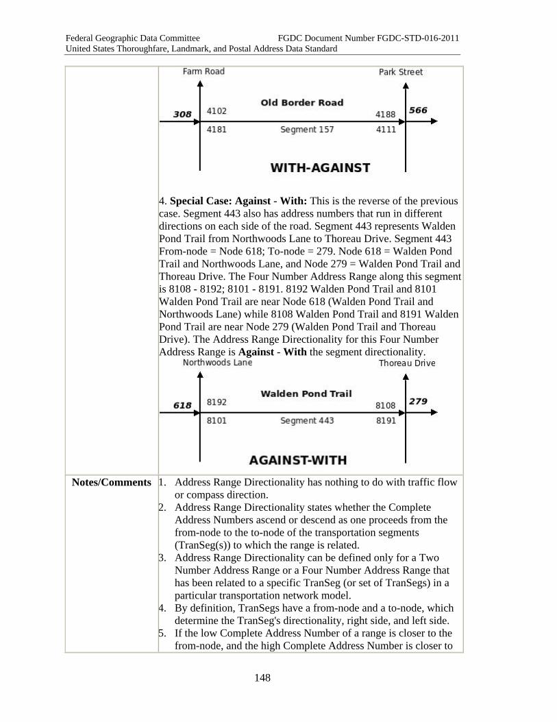
Federal Geographic Data Committee FGDC Document Number FGDC-STD-016-2011 United States Thoroughfare, Landmark, and Postal Address Data Standard
148
4. Special Case: Against - With: This is the reverse of the previous case. Segment 443 also has address numbers that run in different directions on each side of the road. Segment 443 represents Walden Pond Trail from Northwoods Lane to Thoreau Drive. Segment 443 From-node = Node 618; To-node = 279. Node 618 = Walden Pond Trail and Northwoods Lane, and Node 279 = Walden Pond Trail and Thoreau Drive. The Four Number Address Range along this segment is 8108 - 8192; 8101 - 8191. 8192 Walden Pond Trail and 8101 Walden Pond Trail are near Node 618 (Walden Pond Trail and Northwoods Lane) while 8108 Walden Pond Trail and 8191 Walden Pond Trail are near Node 279 (Walden Pond Trail and Thoreau Drive). The Address Range Directionality for this Four Number Address Range is Against - With the segment directionality.
Notes/Comments 1. Address Range Directionality has nothing to do with traffic flow
or compass direction. 2. Address Range Directionality states whether the Complete
Address Numbers ascend or descend as one proceeds from the from-node to the to-node of the transportation segments (TranSeg(s)) to which the range is related.
3. Address Range Directionality can be defined only for a Two Number Address Range or a Four Number Address Range that has been related to a specific TranSeg (or set of TranSegs) in a particular transportation network model.
4. By definition, TranSegs have a from-node and a to-node, which determine the TranSeg's directionality, right side, and left side.
5. If the low Complete Address Number of a range is closer to the from-node, and the high Complete Address Number is closer to
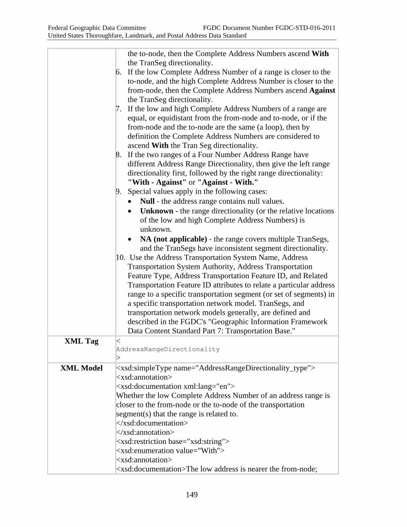
Federal Geographic Data Committee FGDC Document Number FGDC-STD-016-2011 United States Thoroughfare, Landmark, and Postal Address Data Standard
149
the to-node, then the Complete Address Numbers ascend With the TranSeg directionality.
6. If the low Complete Address Number of a range is closer to the to-node, and the high Complete Address Number is closer to the from-node, then the Complete Address Numbers ascend Against the TranSeg directionality.
7. If the low and high Complete Address Numbers of a range are equal, or equidistant from the from-node and to-node, or if the from-node and the to-node are the same (a loop), then by definition the Complete Address Numbers are considered to ascend With the Tran Seg directionality.
8. If the two ranges of a Four Number Address Range have different Address Range Directionality, then give the left range directionality first, followed by the right range directionality: "With - Against" or "Against - With."
9. Special values apply in the following cases: • Null - the address range contains null values. • Unknown - the range directionality (or the relative locations
of the low and high Complete Address Numbers) is unknown.
• NA (not applicable) - the range covers multiple TranSegs, and the TranSegs have inconsistent segment directionality.
10. Use the Address Transportation System Name, Address Transportation System Authority, Address Transportation Feature Type, Address Transportation Feature ID, and Related Transportation Feature ID attributes to relate a particular address range to a specific transportation segment (or set of segments) in a specific transportation network model. TranSegs, and transportation network models generally, are defined and described in the FGDC's "Geographic Information Framework Data Content Standard Part 7: Transportation Base."
XML Tag < AddressRangeDirectionality >
XML Model <xsd:simpleType name="AddressRangeDirectionality_type"> <xsd:annotation> <xsd:documentation xml:lang="en"> Whether the low Complete Address Number of an address range is closer to the from-node or the to-node of the transportation segment(s) that the range is related to. </xsd:documentation> </xsd:annotation> <xsd:restriction base="xsd:string"> <xsd:enumeration value="With"> <xsd:annotation> <xsd:documentation>The low address is nearer the from-node;

Federal Geographic Data Committee FGDC Document Number FGDC-STD-016-2011 United States Thoroughfare, Landmark, and Postal Address Data Standard
150
numbers ascend toward the to-node. </xsd:documentation> </xsd:annotation> </xsd:enumeration> <xsd:enumeration value="Against"> <xsd:annotation> <xsd:documentation>The low address is nearer the to-node; numbers descend toward the to-node. </xsd:documentation> </xsd:annotation> </xsd:enumeration> <xsd:enumeration value="With-Against"> <xsd:annotation> <xsd:documentation>The numbers run in opposite directions on either side of the street. The low number on the left side is nearer the from-node. The low number on the right side is nearer the to-node.</xsd:documentation></xsd:annotation></xsd:enumeration> <xsd:enumeration value="Against-With"> <xsd:annotation> <xsd:documentation>The numbers run in opposite directions on either side of the street. The low number on the left side is nearer the to-node. The low number on the right side is nearer the from-node. </xsd:documentation> </xsd:annotation> </xsd:enumeration> <xsd:enumeration value="Null"> <xsd:annotation> <xsd:documentation>The address range has null values for the high and low Complete Address Numbers. </xsd:documentation> </xsd:annotation> </xsd:enumeration> <xsd:enumeration value="NA"> <xsd:annotation> <xsd:documentation>Does not apply (transportation segment directionality is inconsistent within the range). </xsd:documentation> </xsd:annotation> </xsd:enumeration> <xsd:enumeration value="Unknown"> <xsd:annotation> <xsd:documentation>The address range directionality is not known.</xsd:documentation> </xsd:annotation> </xsd:enumeration> </xsd:restriction>

Federal Geographic Data Committee FGDC Document Number FGDC-STD-016-2011 United States Thoroughfare, Landmark, and Postal Address Data Standard
151
</xsd:simpleType> XML Example <AddressRangeDirectionality>With-
Against</AddressRangeDirectionality> Quality Measures Address Range Directionality Measure
Quality Notes
2.3.5.5 Address Range Span Element Name AddressRangeSpan Other common names for this
element
Definition Whether an address range covers part of a transportation segment, one segment, multiple segments, or the entire thoroughfare within the Address Reference System Extent.
Definition Source New Data Type characterString
Existing Standards for this Element
None
Domain of Values for this Element
Partial Segment, Single Segment, Multi Segments, Entire Street (within a given Address Reference System Extent), Unknown. Other values may be defined locally.
How Defined (eg, locally, from
standard, other)
New
Example Oak Street is four blocks long. Each block is represented as a single transportation segment. Each block has a different hundred range: 1-99, 100-199, 200-299, 300-399. On the first block, a small strip shopping center with a single entrance has storefronts with Complete Address Numbers 2-42. Address Range Spans for following address ranges would be: 1. 2 -42 Oak Street Address Range Span = Partial block 2. 200- 299 Oak Street Address Range Span = Single block 3. 100- 299 Oak Street Address Range Span = Multi-block 4. 1 - 399 Oak Street Address Range Span = Entire street
Notes/Comments 1. Address Range Span states whether an address range covers part of a transportation segment, one segment, multiple segments, or the entire thoroughfare within the Address Reference System Extent.
2. Address Range Span indicates the nature and extent of the geometric features that the range is associated with. It might cover a single building, a portion of a street segment, a full street segment (the most common way in which a range is used), a group of segments, or entire street within a jurisdiction. The latter two categories are often used in E-911 applications where the entire range of addresses found in a
Federal Geographic Data Committee FGDC Document Number FGDC-STD-016-2011 United States Thoroughfare, Landmark, and Postal Address Data Standard
152
single Emergency Service Zone is used. 3. Address Range Span can be defined only for a Two Number
Address Range or a Four Number Address Range that has been related to a specific transportation segment (or set of segments) in a particular transportation network model.
4. Use the Address Transportation System Name, Address Transportation System Authority, Address Transportation Feature Type, Address Transportation Feature ID, and Related Transportation Feature ID attributes to relate a particular address range to a specific transportation segment (or set of segments) in a specific transportation network model. Transportation segments, and transportation network models generally, are defined and described in the FGDC's "Geographic Information Framework Data Content Standard Part 7: Transportation Base."
XML Tag < AddressRangeSpan >
XML Model <xsd:simpleType name="AddressRangeSpan_type"> <xsd:annotation> <xsd:documentation xml:lang="en"> Whether an address range covers part of a transportation segment, one segment, multiple segments, or the entire thoroughfare within the Address Reference System Extent. </xsd:documentation> </xsd:annotation> <xsd:restriction base="xsd:string"> <xsd:enumeration value="Partial Segment" ></xsd:enumeration> <xsd:enumeration value="Single Segment" ></xsd:enumeration><xsd:enumeration value="Multi Segment" ></xsd:enumeration><xsd:enumeration value="Entire Street" ></xsd:enumeration> <xsd:enumeration value="Unknown" gt;</xsd:enumeration> <xsd:pattern value=".+"></xsd:pattern> </xsd:restriction> </xsd:simpleType>
XML Example <AddressRangeSpan>Entire Street</AddressRangeSpan> Quality Measures Tabular Domain Measure
Quality Notes

Federal Geographic Data Committee FGDC Document Number FGDC-STD-016-2011 United States Thoroughfare, Landmark, and Postal Address Data Standard
153
2.3.7 Address Attributes
2.3.7.1 Address Classification Element Name AddressClassification Other common names for this
element
Address Type, Address Class
Definition The class of the address as defined in the Classification Part of this standard.
Definition Source New Data Type characterString Existing
Standards for this Element
The Classification Part of this standard.
Domain of Values for this Element
Class names given in the Classification Part of this standard.
Source of Values The Classification Part of this standard. How Defined (eg,
locally, from standard, other)
In the Classification Part of this standard.
Examples Numbered Thoroughfare Address Intersection Address Two Number Address Range Four Number Address Range Unnumbered Thoroughfare Address Landmark Address Community Address USPSPostal Delivery Box USPSPostal Delivery Route USPSGeneral Delivery Office General Address Class
Notes/Comments Address classes are defined and described in the Classification part of this standard.
XML Tag < AddressClassification >
XML Model <xsd:simpleType name="AddressClassification_type"> <xsd:restriction base="xsd:string"> <xsd:enumeration value="NumberedThoroughfareAddress"></xsd:enumeration> <xsd:enumeration value="IntersectionAddress"></xsd:enumeration><xsd:enumeration value="TwoNumberAddressRange"></xsd:enumeration> <xsd:enumeration value="FourNumberAddressRange"></xsd:enumeration>

Federal Geographic Data Committee FGDC Document Number FGDC-STD-016-2011 United States Thoroughfare, Landmark, and Postal Address Data Standard
154
<xsd:enumeration value="UnnumberedThoroughfareAddress"></xsd:enumeration> <xsd:enumeration value="LandmarkAddress"></xsd:enumeration> <xsd:enumeration value="CommunityAddress"></xsd:enumeration><xsd:enumeration value="USPSPostalDeliveryBox"></xsd:enumeration> <xsd:enumeration value="USPSPostal Delivery Route"></xsd:enumeration> <xsd:enumeration value="USPSGeneral Delivery Office"></xsd:enumeration> <xsd:enumeration value="GeneralAddressClass"></xsd:enumeration> </xsd:restriction> </xsd:simpleType>
XML Example <AddressClassification>IntersectionAddress<AddressClassification> Quality Measures Tabular Domain Measure
Pattern Sequence Measure Quality Notes The Tabular Domain Measure checks on whether a classification
entry actually exists. The Pattern Sequence Measure can be used to check whether the entry associated with the classification matches its description.
2.3.7.2 Address Feature Type Element Name Address Feature Type Other common names for this
element
Definition A category of real world phenomena with common properties whose location is specified by an address.
Definition Source Adapted from FGDC Framework Data Content Standard, Part 0: Base Document, Section 5.22
Data Type characterString Existing Standards
for this Element None
Domain of Values for this Element
May be created locally
Source of Values Local How Defined (eg,
locally, from standard, other)
Locally
Example Parcel, building, building entrance, service entrance, subaddress, utility pole, cell tower
Notes/Comments Initial list of feature types: Block, block face, intersection, parcel, building, entrance, subaddress. The list might be expanded indefinitely to include infrastructure and other features. An address
Federal Geographic Data Committee FGDC Document Number FGDC-STD-016-2011 United States Thoroughfare, Landmark, and Postal Address Data Standard
155
may designate multiple Address Feature Types. XML Tag <
AddressFeatureType >
XML Model <xsd:simpleType name="AddressFeatureType_type"> <xsd:annotation> <xsd:documentation xml:lang="en"> The type of feature identified by the address Initial list of feature types: Street block, street block face, intersection, parcel, building, entrance, unit. The list might be expanded indefinitely to include infrastructure and other features. </xsd:documentation> </xsd:annotation> <xsd:restriction base="xsd:string"> <xsd:pattern value='.+*' /> </xsd:restriction> </xsd:simpleType>
XML Example <AddressFeatureType>Cell Tower</AddressFeatureType> Quality Measures Tabular Domain Measure
Address Reference System Rules Address Completeness Measure
Quality Notes Address Feature Type elements may be defined in the Address Reference System Rules, and should be checked there. Address Completeness Measure checks whether all the addressable objects have assigned addresses.
2.3.7.3 Address Lifecycle Status Element Name Address Lifecycle Status Other common names for this
element
Definition The lifecycle status of the address. Definition Source New
Data Type characterString Existing Standards
for this Element None
Domain of Values for this Element
Potential = Address falls within a theoretical range (See Address Range Type), but has never been used; Proposed = Application pending for use of this address (e.g., address tentatively issued for subdivision plat that is not yet fully approved); Active = Address has been issued and is in use; Retired = Address was issued, but is now obsolete (e.g. street name has been changed, building was demolished, etc.)
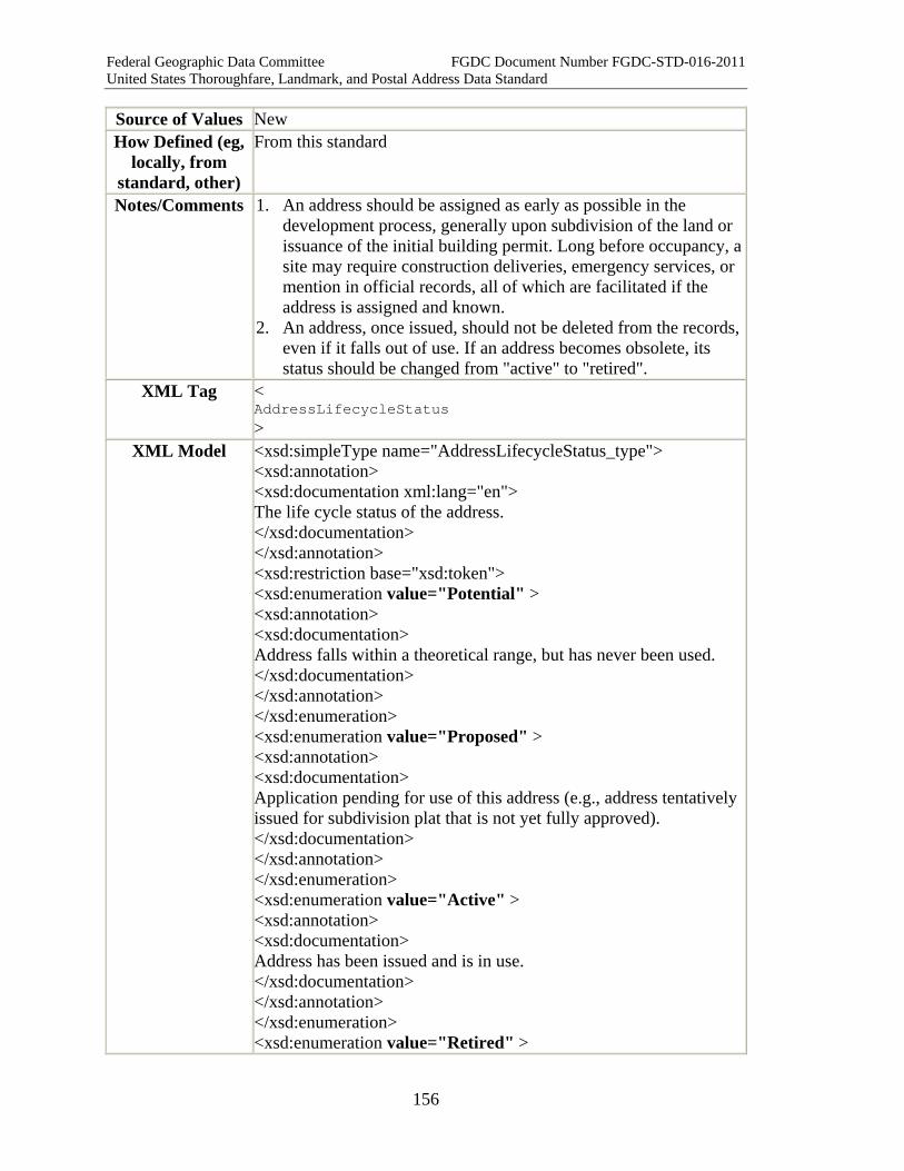
Federal Geographic Data Committee FGDC Document Number FGDC-STD-016-2011 United States Thoroughfare, Landmark, and Postal Address Data Standard
156
Source of Values New How Defined (eg,
locally, from standard, other)
From this standard
Notes/Comments 1. An address should be assigned as early as possible in the development process, generally upon subdivision of the land or issuance of the initial building permit. Long before occupancy, a site may require construction deliveries, emergency services, or mention in official records, all of which are facilitated if the address is assigned and known.
2. An address, once issued, should not be deleted from the records, even if it falls out of use. If an address becomes obsolete, its status should be changed from "active" to "retired".
XML Tag < AddressLifecycleStatus >
XML Model <xsd:simpleType name="AddressLifecycleStatus_type"> <xsd:annotation> <xsd:documentation xml:lang="en"> The life cycle status of the address. </xsd:documentation> </xsd:annotation> <xsd:restriction base="xsd:token"> <xsd:enumeration value="Potential" > <xsd:annotation> <xsd:documentation> Address falls within a theoretical range, but has never been used. </xsd:documentation> </xsd:annotation> </xsd:enumeration> <xsd:enumeration value="Proposed" > <xsd:annotation> <xsd:documentation> Application pending for use of this address (e.g., address tentatively issued for subdivision plat that is not yet fully approved). </xsd:documentation> </xsd:annotation> </xsd:enumeration> <xsd:enumeration value="Active" > <xsd:annotation> <xsd:documentation> Address has been issued and is in use. </xsd:documentation> </xsd:annotation> </xsd:enumeration> <xsd:enumeration value="Retired" >
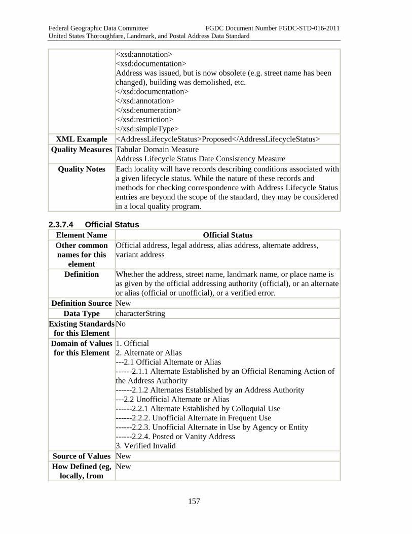
Federal Geographic Data Committee FGDC Document Number FGDC-STD-016-2011 United States Thoroughfare, Landmark, and Postal Address Data Standard
157
<xsd:annotation> <xsd:documentation> Address was issued, but is now obsolete (e.g. street name has been changed), building was demolished, etc. </xsd:documentation> </xsd:annotation> </xsd:enumeration> </xsd:restriction> </xsd:simpleType>
XML Example <AddressLifecycleStatus>Proposed</AddressLifecycleStatus> Quality Measures Tabular Domain Measure
Address Lifecycle Status Date Consistency Measure Quality Notes Each locality will have records describing conditions associated with
a given lifecycle status. While the nature of these records and methods for checking correspondence with Address Lifecycle Statusentries are beyond the scope of the standard, they may be considered in a local quality program.
2.3.7.4 Official Status Element Name Official Status Other common names for this
element
Official address, legal address, alias address, alternate address, variant address
Definition Whether the address, street name, landmark name, or place name is as given by the official addressing authority (official), or an alternate or alias (official or unofficial), or a verified error.
Definition Source New Data Type characterString
Existing Standards for this Element
No
Domain of Values for this Element
1. Official 2. Alternate or Alias ---2.1 Official Alternate or Alias ------2.1.1 Alternate Established by an Official Renaming Action of the Address Authority ------2.1.2 Alternates Established by an Address Authority ---2.2 Unofficial Alternate or Alias ------2.2.1 Alternate Established by Colloquial Use ------2.2.2. Unofficial Alternate in Frequent Use ------2.2.3. Unofficial Alternate in Use by Agency or Entity ------2.2.4. Posted or Vanity Address 3. Verified Invalid
Source of Values New How Defined (eg,
locally, from New
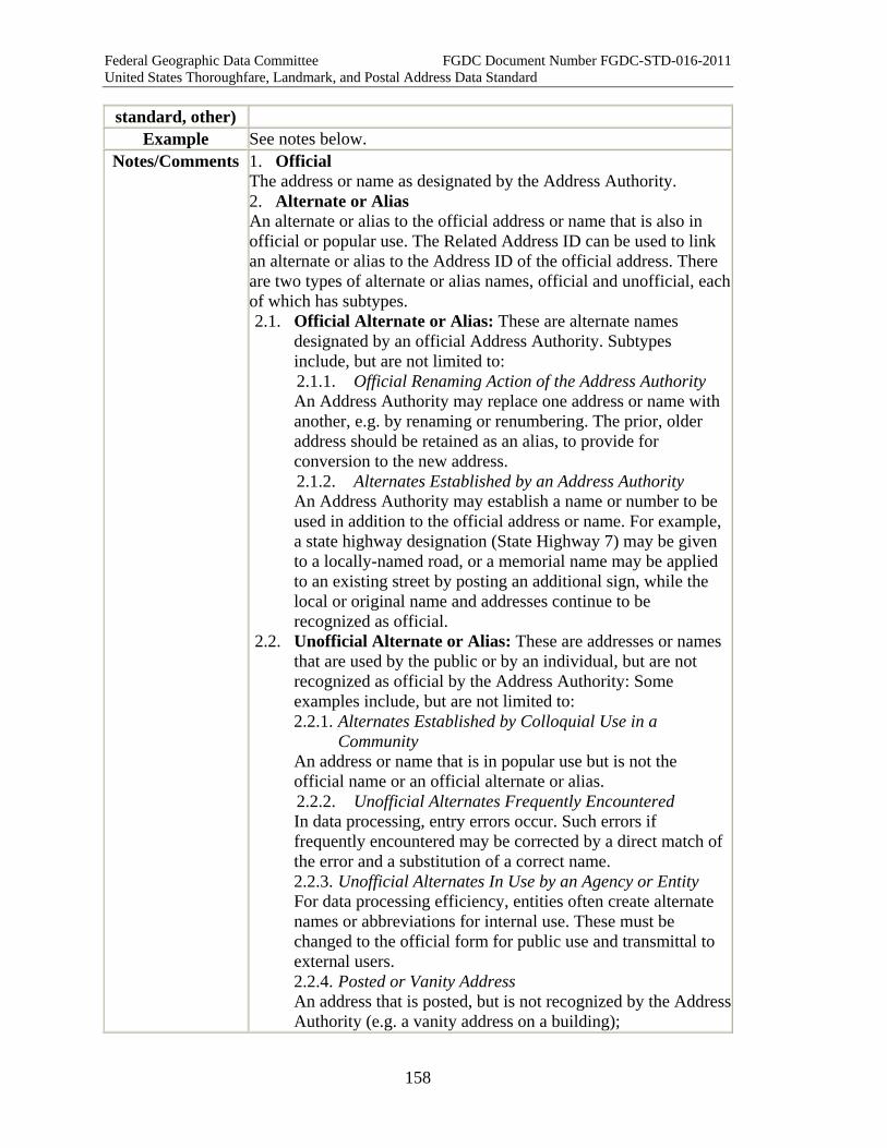
Federal Geographic Data Committee FGDC Document Number FGDC-STD-016-2011 United States Thoroughfare, Landmark, and Postal Address Data Standard
158
standard, other) Example See notes below.
Notes/Comments 1. Official The address or name as designated by the Address Authority. 2. Alternate or Alias An alternate or alias to the official address or name that is also in official or popular use. The Related Address ID can be used to link an alternate or alias to the Address ID of the official address. There are two types of alternate or alias names, official and unofficial, each of which has subtypes. 2.1. Official Alternate or Alias: These are alternate names
designated by an official Address Authority. Subtypes include, but are not limited to: 2.1.1. Official Renaming Action of the Address Authority An Address Authority may replace one address or name with another, e.g. by renaming or renumbering. The prior, older address should be retained as an alias, to provide for conversion to the new address. 2.1.2. Alternates Established by an Address Authority An Address Authority may establish a name or number to be used in addition to the official address or name. For example, a state highway designation (State Highway 7) may be given to a locally-named road, or a memorial name may be applied to an existing street by posting an additional sign, while the local or original name and addresses continue to be recognized as official.
2.2. Unofficial Alternate or Alias: These are addresses or names that are used by the public or by an individual, but are not recognized as official by the Address Authority: Some examples include, but are not limited to: 2.2.1. Alternates Established by Colloquial Use in a
Community An address or name that is in popular use but is not the official name or an official alternate or alias. 2.2.2. Unofficial Alternates Frequently Encountered In data processing, entry errors occur. Such errors if frequently encountered may be corrected by a direct match of the error and a substitution of a correct name. 2.2.3. Unofficial Alternates In Use by an Agency or Entity For data processing efficiency, entities often create alternate names or abbreviations for internal use. These must be changed to the official form for public use and transmittal to external users. 2.2.4. Posted or Vanity Address An address that is posted, but is not recognized by the Address Authority (e.g. a vanity address on a building);

Federal Geographic Data Committee FGDC Document Number FGDC-STD-016-2011 United States Thoroughfare, Landmark, and Postal Address Data Standard
159
3. Verified Invalid An address that has been verified as being invalid, but which keeps appearing in address lists. Different from Unofficial Alternate Names in that these addresses are known not to exist.
XML Tag < OfficialStatus >
XML Model <xsd:simpleType name="OfficialStatus_type"> <xsd:annotation> <xsd:documentation xml:lang="en"> Whether the address, street name, landmark name, or place name is as given by the official addressing authority (official), or an alternate or alias (official or unofficial), or a verified error. </xsd:documentation> </xsd:annotation> <xsd:restriction base="xsd:string"> <xsd:pattern value='.*' /> <xsd:enumeration value="Official" > <xsd:annotation> <xsd:documentation> The address or name as designated by the Address Authority. </xsd:documentation> </xsd:annotation> </xsd:enumeration> <xsd:enumeration value="Alternate or Alias" > <xsd:annotation> <xsd:documentation> An alternate or alias to the official address or name that is also in official or popular use. The Related Address ID can be used to link an alternate or alias to the Address ID of the official address. There are two types of alternate or alias names, official and unofficial, each of which has subtypes. </xsd:documentation> </xsd:annotation> </xsd:enumeration> <xsd:enumeration value="Official Alternate or Alias" > <xsd:annotation> <xsd:documentation> These are alternate names designated by an official Address Authority. </xsd:documentation> </xsd:annotation> </xsd:enumeration>

Federal Geographic Data Committee FGDC Document Number FGDC-STD-016-2011 United States Thoroughfare, Landmark, and Postal Address Data Standard
160
<xsd:enumeration value="Official Renaming Action of the Address Authority" > <xsd:annotation> <xsd:documentation>An Address Authority may replace one address or name with another, e.g. by renaming or renumbering. The prior, older address should be retained as an alias, to provide for conversion to the new address.</xsd:documentation></xsd:annotation> </xsd:enumeration> <xsd:enumeration value="Alternates Established by an Address Authority" > <xsd:annotation> <xsd:documentation>An Address Authority may establish a name or number to be used in addition to the official address or name. For example, a state highway designation (State Highway 7) may be given to a locally-named road, or a memorial name may be applied to an existing street by posting an additional sign, while the local or original name and addresses continue to be recognized as official.</xsd:documentation></xsd:annotation> </xsd:enumeration> <xsd:enumeration value="Unofficial Alternate or Alias" > <xsd:annotation> <xsd:documentation> These are addresses or names that are used by the public or by an individual, but are not recognized as official by the Address Authority. </xsd:documentation> </xsd:annotation> </xsd:enumeration> <xsd:enumeration value="Alternate Names Established by Colloquial Use in a Community" > <xsd:annotation> <xsd:documentation>An address or name that is in popular use but is not the official name or an official alternate or alias. </xsd:documentation></xsd:annotation> </xsd:enumeration> <xsd:enumeration value="Unofficial Alternate Names Frequently Encountered" > <xsd:annotation> <xsd:documentation>In data processing, entry errors occur. Such errors if frequently encountered may be corrected by a direct match of the error and a substitution of a correct name. </xsd:documentation> </xsd:annotation> </xsd:enumeration> <xsd:enumeration value="Unofficial Alternate Names In Use by
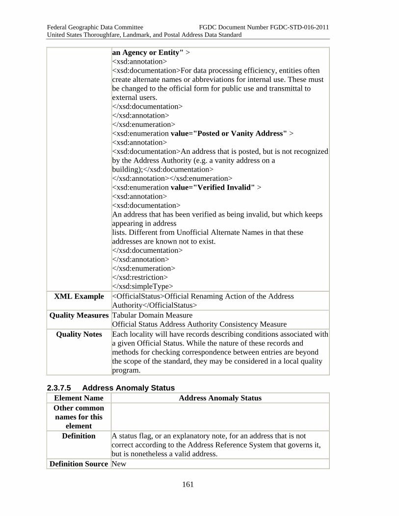
Federal Geographic Data Committee FGDC Document Number FGDC-STD-016-2011 United States Thoroughfare, Landmark, and Postal Address Data Standard
161
an Agency or Entity" > <xsd:annotation> <xsd:documentation>For data processing efficiency, entities often create alternate names or abbreviations for internal use. These must be changed to the official form for public use and transmittal to external users. </xsd:documentation> </xsd:annotation> </xsd:enumeration> <xsd:enumeration value="Posted or Vanity Address" > <xsd:annotation> <xsd:documentation>An address that is posted, but is not recognized by the Address Authority (e.g. a vanity address on a building);</xsd:documentation> </xsd:annotation></xsd:enumeration> <xsd:enumeration value="Verified Invalid" > <xsd:annotation> <xsd:documentation> An address that has been verified as being invalid, but which keeps appearing in address lists. Different from Unofficial Alternate Names in that these addresses are known not to exist. </xsd:documentation> </xsd:annotation> </xsd:enumeration> </xsd:restriction> </xsd:simpleType>
XML Example <OfficialStatus>Official Renaming Action of the Address Authority</OfficialStatus>
Quality Measures Tabular Domain Measure Official Status Address Authority Consistency Measure
Quality Notes Each locality will have records describing conditions associated with a given Official Status. While the nature of these records and methods for checking correspondence between entries are beyond the scope of the standard, they may be considered in a local quality program.
2.3.7.5 Address Anomaly Status Element Name Address Anomaly Status Other common names for this
element
Definition A status flag, or an explanatory note, for an address that is not correct according to the Address Reference System that governs it, but is nonetheless a valid address.
Definition Source New

Federal Geographic Data Committee FGDC Document Number FGDC-STD-016-2011 United States Thoroughfare, Landmark, and Postal Address Data Standard
162
Data Type characterString Existing
Standards for this Element
No
Domain of Values? May be "yes" or "no", or may be an enumerated domain of anomaly types
How Defined (eg, locally, from
standard, other)
Locally
Example An address that has an even Address Number Parity but is located on the odd-numbered side of the street.
Notes/Comments This field may be used to identify the type of anomaly (e.g. wrong parity, out of sequence, out of range, etc.) rather than simply whether or not it is anomalous. Local jurisdictions may create specific categories for anomalies.
XML Tag < AddressAnomalyStatus >
XML Model <xsd:simpleType name="AddressAnomalyStatus_type"> <xsd:restriction base="xsd:string"></xsd:restriction> </xsd:simpleType>
XML Example <AddressAnomalyStatus>yes</AddressAnomalyStatus> Quality Measures Tabular Domain Measure
Quality Notes Validation tests for conditions described Address Anomaly Status values are entirely dependent on local conditions, and are beyond the scope of this standard. Some of the measures described in the standards may provide complete or partial solutions.
2.3.7.6 Address Side of Street Element Name AddressSideOfStreet Other common names for this
element
Definition The side of the transportation segment (right , left, both, none, unknown) on which the address is located.
Data Type characterString Existing Standards
for this Element U.S. Federal Geographic Data Committee, "Framework Data Content Standard Part 7: Transportation base," sections 7.3.2 and B.3.6
Domain of Values for this Element
right, left, both, none, unknown
Source of Values How Defined (eg,
locally, from U.S. Federal Geographic Data Committee, "Framework Data Content Standard Part 7: Transportation base," Annex B.
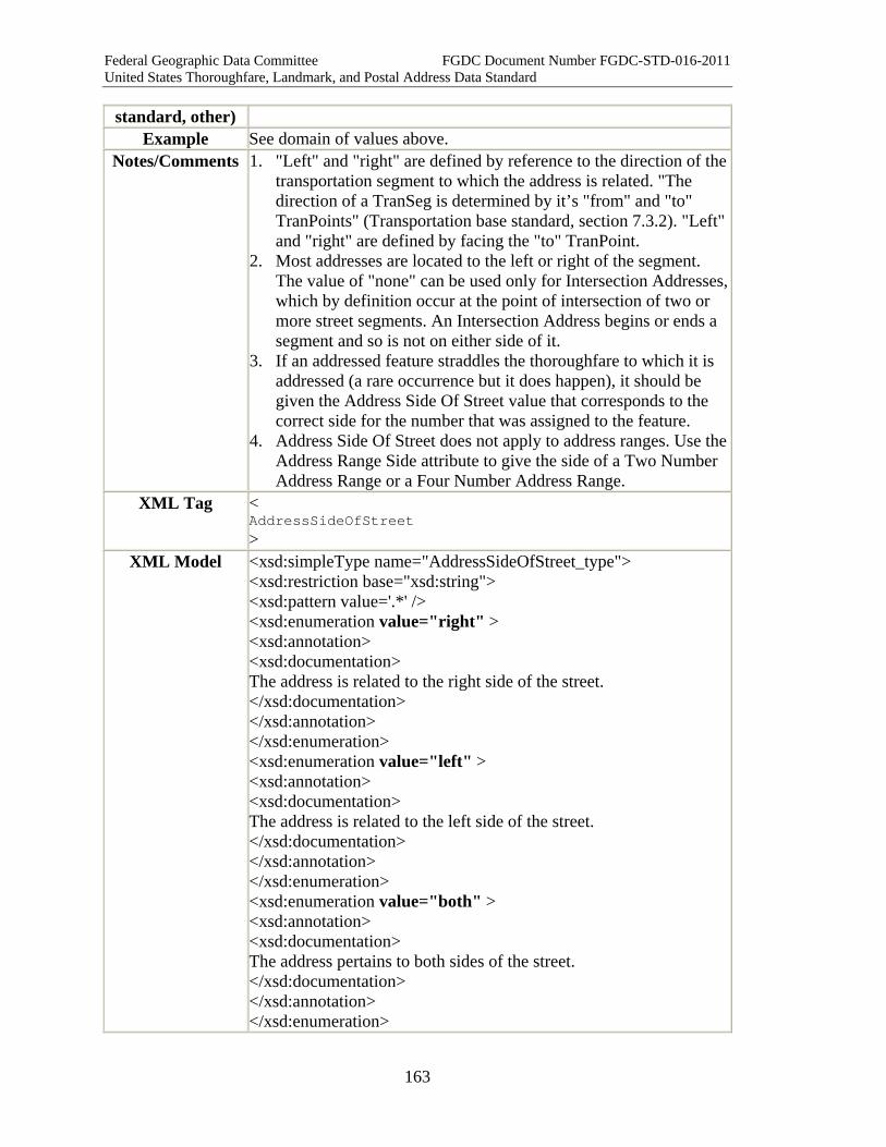
Federal Geographic Data Committee FGDC Document Number FGDC-STD-016-2011 United States Thoroughfare, Landmark, and Postal Address Data Standard
163
standard, other) Example See domain of values above.
Notes/Comments 1. "Left" and "right" are defined by reference to the direction of the transportation segment to which the address is related. "The direction of a TranSeg is determined by it’s "from" and "to" TranPoints" (Transportation base standard, section 7.3.2). "Left" and "right" are defined by facing the "to" TranPoint.
2. Most addresses are located to the left or right of the segment. The value of "none" can be used only for Intersection Addresses, which by definition occur at the point of intersection of two or more street segments. An Intersection Address begins or ends a segment and so is not on either side of it.
3. If an addressed feature straddles the thoroughfare to which it is addressed (a rare occurrence but it does happen), it should be given the Address Side Of Street value that corresponds to the correct side for the number that was assigned to the feature.
4. Address Side Of Street does not apply to address ranges. Use the Address Range Side attribute to give the side of a Two Number Address Range or a Four Number Address Range.
XML Tag < AddressSideOfStreet >
XML Model <xsd:simpleType name="AddressSideOfStreet_type"> <xsd:restriction base="xsd:string"> <xsd:pattern value='.*' /> <xsd:enumeration value="right" > <xsd:annotation> <xsd:documentation> The address is related to the right side of the street. </xsd:documentation> </xsd:annotation> </xsd:enumeration> <xsd:enumeration value="left" > <xsd:annotation> <xsd:documentation> The address is related to the left side of the street. </xsd:documentation> </xsd:annotation> </xsd:enumeration> <xsd:enumeration value="both" > <xsd:annotation> <xsd:documentation> The address pertains to both sides of the street. </xsd:documentation> </xsd:annotation> </xsd:enumeration>
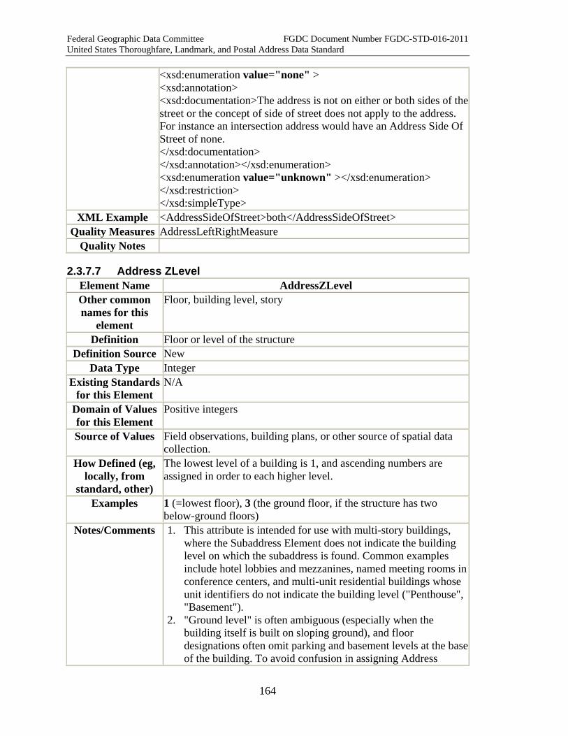
Federal Geographic Data Committee FGDC Document Number FGDC-STD-016-2011 United States Thoroughfare, Landmark, and Postal Address Data Standard
164
<xsd:enumeration value="none" > <xsd:annotation> <xsd:documentation>The address is not on either or both sides of the street or the concept of side of street does not apply to the address. For instance an intersection address would have an Address Side Of Street of none. </xsd:documentation> </xsd:annotation></xsd:enumeration> <xsd:enumeration value="unknown" ></xsd:enumeration> </xsd:restriction> </xsd:simpleType>
XML Example <AddressSideOfStreet>both</AddressSideOfStreet> Quality Measures AddressLeftRightMeasure
Quality Notes
2.3.7.7 Address ZLevel Element Name AddressZLevel Other common names for this
element
Floor, building level, story
Definition Floor or level of the structure Definition Source New
Data Type Integer Existing Standards
for this Element N/A
Domain of Values for this Element
Positive integers
Source of Values Field observations, building plans, or other source of spatial data collection.
How Defined (eg, locally, from
standard, other)
The lowest level of a building is 1, and ascending numbers are assigned in order to each higher level.
Examples 1 (=lowest floor), 3 (the ground floor, if the structure has two below-ground floors)
Notes/Comments 1. This attribute is intended for use with multi-story buildings, where the Subaddress Element does not indicate the building level on which the subaddress is found. Common examples include hotel lobbies and mezzanines, named meeting rooms in conference centers, and multi-unit residential buildings whose unit identifiers do not indicate the building level ("Penthouse", "Basement").
2. "Ground level" is often ambiguous (especially when the building itself is built on sloping ground), and floor designations often omit parking and basement levels at the base of the building. To avoid confusion in assigning Address
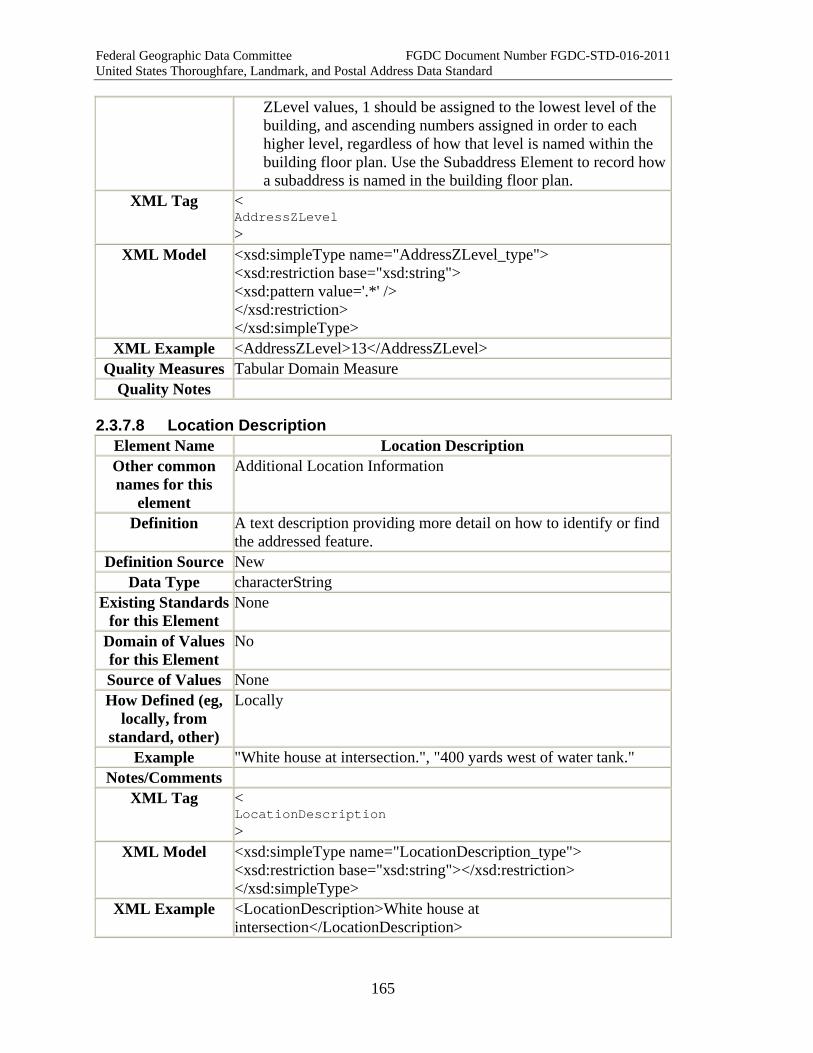
Federal Geographic Data Committee FGDC Document Number FGDC-STD-016-2011 United States Thoroughfare, Landmark, and Postal Address Data Standard
165
ZLevel values, 1 should be assigned to the lowest level of the building, and ascending numbers assigned in order to each higher level, regardless of how that level is named within the building floor plan. Use the Subaddress Element to record how a subaddress is named in the building floor plan.
XML Tag < AddressZLevel >
XML Model <xsd:simpleType name="AddressZLevel_type"> <xsd:restriction base="xsd:string"> <xsd:pattern value='.*' /> </xsd:restriction> </xsd:simpleType>
XML Example <AddressZLevel>13</AddressZLevel> Quality Measures Tabular Domain Measure
Quality Notes
2.3.7.8 Location Description Element Name Location Description Other common names for this
element
Additional Location Information
Definition A text description providing more detail on how to identify or find the addressed feature.
Definition Source New Data Type characterString
Existing Standards for this Element
None
Domain of Values for this Element
No
Source of Values None How Defined (eg,
locally, from standard, other)
Locally
Example "White house at intersection.", "400 yards west of water tank." Notes/Comments
XML Tag < LocationDescription >
XML Model <xsd:simpleType name="LocationDescription_type"> <xsd:restriction base="xsd:string"></xsd:restriction> </xsd:simpleType>
XML Example <LocationDescription>White house at intersection</LocationDescription>
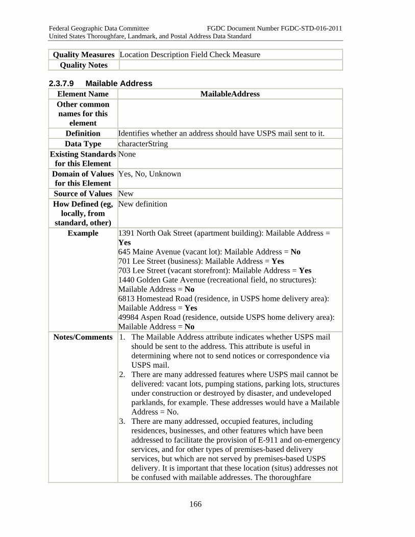
Federal Geographic Data Committee FGDC Document Number FGDC-STD-016-2011 United States Thoroughfare, Landmark, and Postal Address Data Standard
166
Quality Measures Location Description Field Check Measure Quality Notes
2.3.7.9 Mailable Address Element Name MailableAddress Other common names for this
element
Definition Identifies whether an address should have USPS mail sent to it. Data Type characterString
Existing Standards for this Element
None
Domain of Values for this Element
Yes, No, Unknown
Source of Values New How Defined (eg,
locally, from standard, other)
New definition
Example 1391 North Oak Street (apartment building): Mailable Address = Yes 645 Maine Avenue (vacant lot): Mailable Address = No 701 Lee Street (business): Mailable Address = Yes 703 Lee Street (vacant storefront): Mailable Address = Yes 1440 Golden Gate Avenue (recreational field, no structures): Mailable Address = No 6813 Homestead Road (residence, in USPS home delivery area): Mailable Address = Yes 49984 Aspen Road (residence, outside USPS home delivery area): Mailable Address = No
Notes/Comments 1. The Mailable Address attribute indicates whether USPS mail should be sent to the address. This attribute is useful in determining where not to send notices or correspondence via USPS mail.
2. There are many addressed features where USPS mail cannot be delivered: vacant lots, pumping stations, parking lots, structures under construction or destroyed by disaster, and undeveloped parklands, for example. These addresses would have a Mailable Address = No.
3. There are many addressed, occupied features, including residences, businesses, and other features which have been addressed to facilitate the provision of E-911 and on-emergency services, and for other types of premises-based delivery services, but which are not served by premises-based USPS delivery. It is important that these location (situs) addresses not be confused with mailable addresses. The thoroughfare
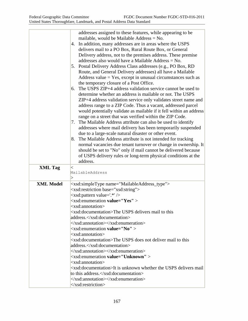
Federal Geographic Data Committee FGDC Document Number FGDC-STD-016-2011 United States Thoroughfare, Landmark, and Postal Address Data Standard
167
addresses assigned to these features, while appearing to be mailable, would be Mailable Address = No.
4. In addition, many addresses are in areas where the USPS delivers mail to a PO Box, Rural Route Box, or General Delivery address, not to the premises address. These premise addresses also would have a Mailable Address = No.
5. Postal Delivery Address Class addresses (e.g., PO Box, RD Route, and General Delivery addresses) all have a Mailable Address value = Yes, except in unusual circumstances such as the temporary closure of a Post Office.
6. The USPS ZIP+4 address validation service cannot be used to determine whether an address is mailable or not. The USPS ZIP+4 address validation service only validates street name and address range to a ZIP Code. Thus a vacant, addressed parcel would potentially validate as mailable if it fell within an address range on a street that was verified within the ZIP Code.
7. The Mailable Address attribute can also be used to identify addresses where mail delivery has been temporarily suspended due to a large-scale natural disaster or other event.
8. The Mailable Address attribute is not intended for tracking normal vacancies due tenant turnover or change in ownership. It should be set to "No" only if mail cannot be delivered because of USPS delivery rules or long-term physical conditions at the address.
XML Tag < MailableAddress >
XML Model <xsd:simpleType name="MailableAddress_type"> <xsd:restriction base="xsd:string"> <xsd:pattern value='.*' /> <xsd:enumeration value="Yes" > <xsd:annotation> <xsd:documentation>The USPS delivers mail to this address.</xsd:documentation> </xsd:annotation></xsd:enumeration> <xsd:enumeration value="No" > <xsd:annotation> <xsd:documentation>The USPS does not deliver mail to this address.</xsd:documentation> </xsd:annotation></xsd:enumeration> <xsd:enumeration value="Unknown" > <xsd:annotation> <xsd:documentation>It is unknown whether the USPS delivers mail to this address.</xsd:documentation> </xsd:annotation></xsd:enumeration> </xsd:restriction>
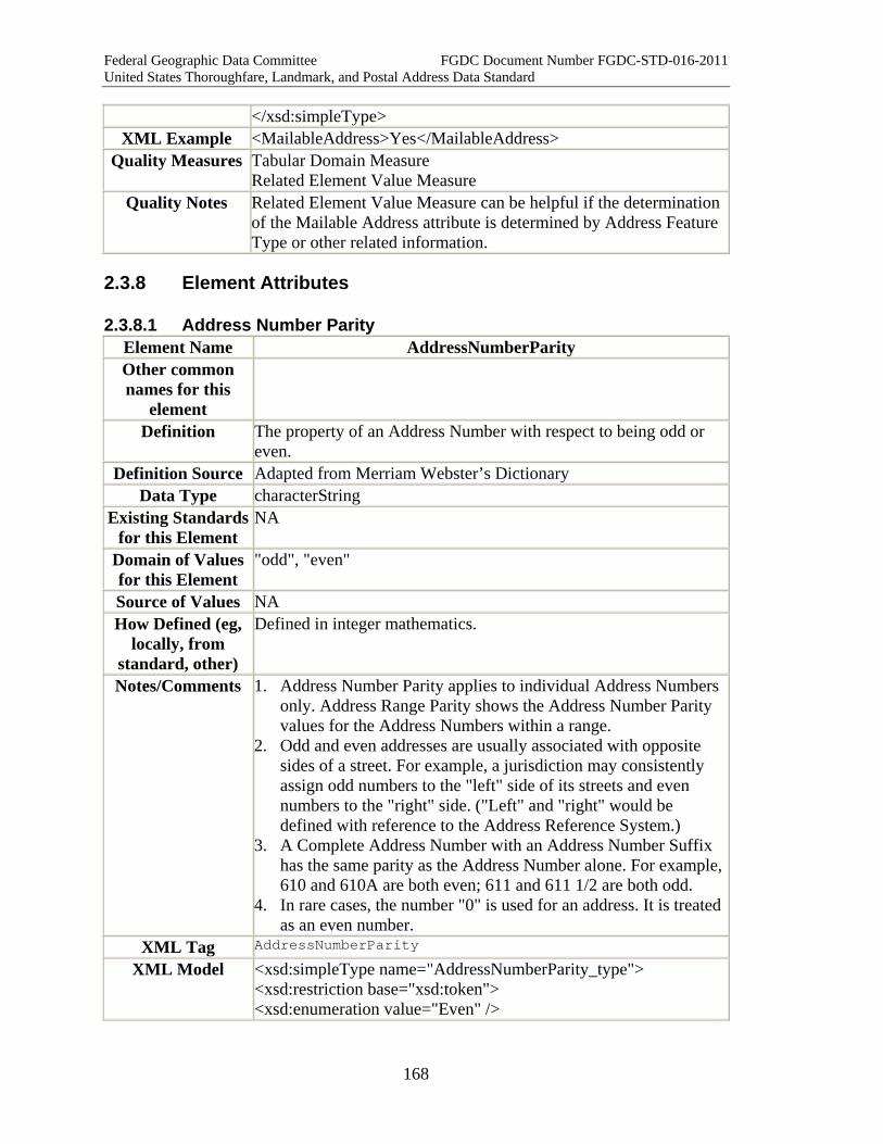
Federal Geographic Data Committee FGDC Document Number FGDC-STD-016-2011 United States Thoroughfare, Landmark, and Postal Address Data Standard
168
</xsd:simpleType> XML Example <MailableAddress>Yes</MailableAddress>
Quality Measures Tabular Domain Measure Related Element Value Measure
Quality Notes Related Element Value Measure can be helpful if the determination of the Mailable Address attribute is determined by Address Feature Type or other related information.
2.3.8 Element Attributes
2.3.8.1 Address Number Parity Element Name AddressNumberParity Other common names for this
element
Definition The property of an Address Number with respect to being odd or even.
Definition Source Adapted from Merriam Webster’s Dictionary Data Type characterString
Existing Standards for this Element
NA
Domain of Values for this Element
"odd", "even"
Source of Values NA How Defined (eg,
locally, from standard, other)
Defined in integer mathematics.
Notes/Comments 1. Address Number Parity applies to individual Address Numbers only. Address Range Parity shows the Address Number Parity values for the Address Numbers within a range.
2. Odd and even addresses are usually associated with opposite sides of a street. For example, a jurisdiction may consistently assign odd numbers to the "left" side of its streets and even numbers to the "right" side. ("Left" and "right" would be defined with reference to the Address Reference System.)
3. A Complete Address Number with an Address Number Suffix has the same parity as the Address Number alone. For example, 610 and 610A are both even; 611 and 611 1/2 are both odd.
4. In rare cases, the number "0" is used for an address. It is treated as an even number.
XML Tag AddressNumberParity
XML Model <xsd:simpleType name="AddressNumberParity_type"> <xsd:restriction base="xsd:token"> <xsd:enumeration value="Even" />
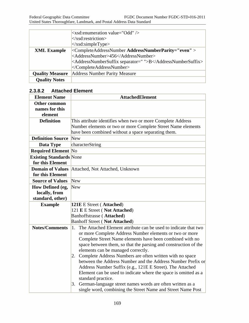
Federal Geographic Data Committee FGDC Document Number FGDC-STD-016-2011 United States Thoroughfare, Landmark, and Postal Address Data Standard
169
<xsd:enumeration value="Odd" /> </xsd:restriction> </xsd:simpleType>
XML Example <CompleteAddressNumber AddressNumberParity="even" > <AddressNumber>456</AddressNumber> <AddressNumberSuffix separator=" ">B</AddressNumberSuffix></CompleteAddressNumber>
Quality Measure Address Number Parity Measure Quality Notes
2.3.8.2 Attached Element Element Name AttachedElement Other common names for this
element
Definition This attribute identifies when two or more Complete Address Number elements or two or more Complete Street Name elements have been combined without a space separating them.
Definition Source New Data Type characterString
Required Element No Existing Standards
for this Element None
Domain of Values for this Element
Attached, Not Attached, Unknown
Source of Values New How Defined (eg,
locally, from standard, other)
New
Example 121E E Street ( Attached) 121 E E Street ( Not Attached) Banhoffstrasse ( Attached) Banhoff Street ( Not Attached)
Notes/Comments 1. The Attached Element attribute can be used to indicate that two or more Complete Address Number elements or two or more Complete Street Name elements have been combined with no space between them, so that the parsing and construction of the elements can be managed correctly.
2. Complete Address Numbers are often written with no space between the Address Number and the Address Number Prefix or Address Number Suffix (e.g., 121E E Street). The Attached Element can be used to indicate where the space is omitted as a standard practice.
3. German-language street names words are often written as a single word, combining the Street Name and Street Name Post

Federal Geographic Data Committee FGDC Document Number FGDC-STD-016-2011 United States Thoroughfare, Landmark, and Postal Address Data Standard
170
Type (e.g., Banhoffstrasse). The Attached Element can be used to indicate such names. Attached Elements are rare in the United States street names, and normally this attribute will not be needed. In such cases the entire single word can be placed in the Street Name field, and the street type field can be left blank (e.g., "Broadway").
XML Tag AttachedElement
XML Model <xsd:simpleType name="AttachedElement_type"> <xsd:restriction base="xsd:string"> <xsd:enumeration value="Attached"> <xsd:annotation> <xsd:documentation>The elements inside the Complete Address Number or Complete Street Name are attached and need special parsing rules.</xsd:documentation> </xsd:annotation></xsd:enumeration> <xsd:enumeration value="Not Attached"></xsd:enumeration> </xsd:restriction> </xsd:simpleType>
XML Example <CompleteAddressNumber Address Number Parity="even" AttachedElement="Attached" > <AddressNumber>456</AddressNumber> <AddressNumberSuffix separator=" ">B</AddressNumberSuffix></CompleteAddressNumber>
Quality Measures Check Attached Pairs Measure Tabular Domain Measure
Quality Notes Check Attached Pairs Measure checks for adjacent pairs of attached attributes. The value of the street name as a whole, including the attached components are checked in the Tabular Domain Measure and Pattern Sequence Measure, applied to Complete Street Name.
2.3.8.3 Subaddress Component Order Element Name Subaddress Component Order Other common names for this
element
None
Definition The order in which Subaddress Type and Subaddress Identifier appear within a Subaddress Element
Definition Source New Data Type Integer
Existing Standards for this Element
None
Domain of Values for this Element
1 = Subaddress Type first, then Subaddress Identifier (or: Subaddress Element does not include a Subaddress Type). 2 = Subaddress Identifier first, then Subaddress Type. 3 = Not stated.

Federal Geographic Data Committee FGDC Document Number FGDC-STD-016-2011 United States Thoroughfare, Landmark, and Postal Address Data Standard
171
Source of Values New How Defined (eg,
locally, from standard, other)
Within this standard
Example 1. Room 212 (Subaddress Component Order = 1 = "Room" (the type) precedes "212" (the identifier))
2. Empire Room (Subaddress Component Order = 2 = "Room" (the type) follows "Empire" (the identifier))
3. Mezzanine (Subaddress Component Order = 1 = "Mezzanine" (the identifier) only; no type is given.)
4. Floor 5 (Subaddress Component Order = 1 = "Floor" (the type) precedes "5" (the identifier))
5. Fifth Floor (Subaddress Component Order = 2 = "Floor" (the type) follows "Fifth" (the identifier))
6. Terrace Ballroom (Subaddress Component Order = 2 --this would refer to a ballroom, the "Terrace" ballroom)
7. Ballroom Terrace (Subaddress Component Order = 2 --this would refer to a terrace, the "Ballroom" terrace)
Notes/Comments 1. This attribute tells data users how to construct an Subaddress Element from its component Subaddress Type and Subaddress Identifier. There are three possibilities, described below. The order is usually obvious for any given record, but if there are a large number of records it may not be feasible to examine each record individually. This attribute supports automated procedures for composing Subaddress Elements.
2. Usually a Subaddress Element is composed of a Subaddress Type followed by a Subaddress Identifier (e.g. "Room 212", "Floor 5")
3. However, if the Subaddress Identifier is a name or an ordinal number, it typically precedes the Subaddress Type (e.g. "Empire Room", "Fifth Floor")
4. Occasionally a Subaddress Element includes only a Subaddress Identifier (e.g. "Mezzanine", "Penthouse", "Rear"). These cases are grouped under Type 1.
5. Usually the component order is obvious upon examination, but ambiguous cases occur, such as "Terrace Ballroom" and "Ballroom Terrace" above. In these cases the order can be determined only by field examination or reference to authoritative records.
XML Tag SubaddressComponentOrder
XML Model <xsd:simpleType name="SubaddressComponentOrder_type"> <xsd:restriction base="xsd:integer"> <xsd:enumeration value="1"> <xsd:annotation> <xsd:documentation>SubaddressType first, then Subaddress Identifier (or: Subaddress Element does not include an Subaddress

Federal Geographic Data Committee FGDC Document Number FGDC-STD-016-2011 United States Thoroughfare, Landmark, and Postal Address Data Standard
172
Type). Example: "Floor 7"</xsd:documentation> </xsd:annotation></xsd:enumeration> <xsd:enumeration value="2"> <xsd:annotation> <xsd:documentation>SubaddressIdentifier first, then Subaddress Type. Example: "Empire Room"</xsd:documentation> </xsd:annotation></xsd:enumeration> <xsd:enumeration value="3"> <xsd:annotation> <xsd:documentation>Order is not known or unstated.</xsd:documentation> </xsd:annotation></xsd:enumeration> </xsd:restriction> </xsd:simpleType>
XML Example <CompleteSubaddress> <SubaddressElement Element Sequence Number="1" "SubaddressComponentOrder="1" > <SubaddressType>Building</SubaddressType> <SubaddressIdentifier>A</SubaddressIdentifier> </SubaddressElement> <SubaddressElement Element Sequence Number="1" SubaddressComponentOrder="2" > <SubaddressType>Room</SubaddressType> <SubaddressIdentifier>Empire</SubaddressIdentifier> </SubaddressElement> </CompleteSubaddress>
Quality Measures Tabular Domain Measure Subaddress Component Order Measure
Quality Notes
2.3.8.3 Element Sequence Number Element Name Element Sequence Number Other common names for this
element
Definition The order in which the Subaddress Elements should be written within a Complete Subaddress; the order in which the Landmark Names should be written within a Complete Landmark Name; or the order in which the Place Names should be written within a Complete Place Name.
Definition Source New Data Type Integer
Existing Standards None
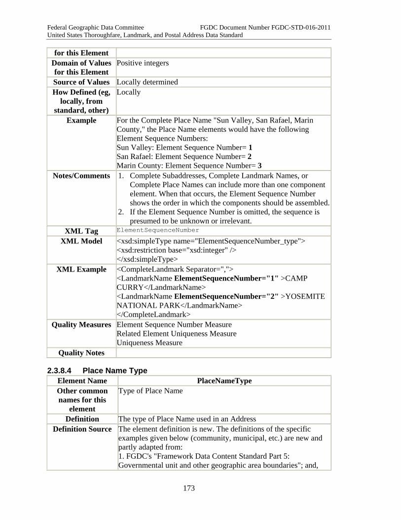
Federal Geographic Data Committee FGDC Document Number FGDC-STD-016-2011 United States Thoroughfare, Landmark, and Postal Address Data Standard
173
for this Element Domain of Values for this Element
Positive integers
Source of Values Locally determined How Defined (eg,
locally, from standard, other)
Locally
Example For the Complete Place Name "Sun Valley, San Rafael, Marin County," the Place Name elements would have the following Element Sequence Numbers: Sun Valley: Element Sequence Number= 1 San Rafael: Element Sequence Number= 2 Marin County: Element Sequence Number= 3
Notes/Comments 1. Complete Subaddresses, Complete Landmark Names, or Complete Place Names can include more than one component element. When that occurs, the Element Sequence Number shows the order in which the components should be assembled.
2. If the Element Sequence Number is omitted, the sequence is presumed to be unknown or irrelevant.
XML Tag ElementSequenceNumber
XML Model <xsd:simpleType name="ElementSequenceNumber_type"> <xsd:restriction base="xsd:integer" /> </xsd:simpleType>
XML Example <CompleteLandmark Separator=","> <LandmarkName ElementSequenceNumber="1" >CAMP CURRY</LandmarkName> <LandmarkName ElementSequenceNumber="2" >YOSEMITE NATIONAL PARK</LandmarkName> </CompleteLandmark>
Quality Measures Element Sequence Number Measure Related Element Uniqueness Measure Uniqueness Measure
Quality Notes
2.3.8.4 Place Name Type Element Name PlaceNameType Other common names for this
element
Type of Place Name
Definition The type of Place Name used in an Address Definition Source The element definition is new. The definitions of the specific
examples given below (community, municipal, etc.) are new and partly adapted from: 1. FGDC's "Framework Data Content Standard Part 5: Governmental unit and other geographic area boundaries"; and,
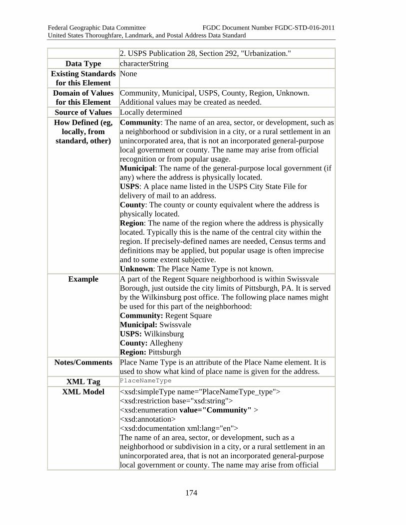
Federal Geographic Data Committee FGDC Document Number FGDC-STD-016-2011 United States Thoroughfare, Landmark, and Postal Address Data Standard
174
2. USPS Publication 28, Section 292, "Urbanization." Data Type characterString
Existing Standards for this Element
None
Domain of Values for this Element
Community, Municipal, USPS, County, Region, Unknown. Additional values may be created as needed.
Source of Values Locally determined How Defined (eg,
locally, from standard, other)
Community: The name of an area, sector, or development, such as a neighborhood or subdivision in a city, or a rural settlement in an unincorporated area, that is not an incorporated general-purpose local government or county. The name may arise from official recognition or from popular usage. Municipal: The name of the general-purpose local government (if any) where the address is physically located. USPS: A place name listed in the USPS City State File for delivery of mail to an address. County: The county or county equivalent where the address is physically located. Region: The name of the region where the address is physically located. Typically this is the name of the central city within the region. If precisely-defined names are needed, Census terms and definitions may be applied, but popular usage is often imprecise and to some extent subjective. Unknown: The Place Name Type is not known.
Example A part of the Regent Square neighborhood is within Swissvale Borough, just outside the city limits of Pittsburgh, PA. It is served by the Wilkinsburg post office. The following place names might be used for this part of the neighborhood: Community: Regent Square Municipal: Swissvale USPS: Wilkinsburg County: Allegheny Region: Pittsburgh
Notes/Comments Place Name Type is an attribute of the Place Name element. It is used to show what kind of place name is given for the address.
XML Tag PlaceNameType
XML Model <xsd:simpleType name="PlaceNameType_type"> <xsd:restriction base="xsd:string"> <xsd:enumeration value="Community" > <xsd:annotation> <xsd:documentation xml:lang="en"> The name of an area, sector, or development, such as a neighborhood or subdivision in a city, or a rural settlement in an unincorporated area, that is not an incorporated general-purpose local government or county. The name may arise from official
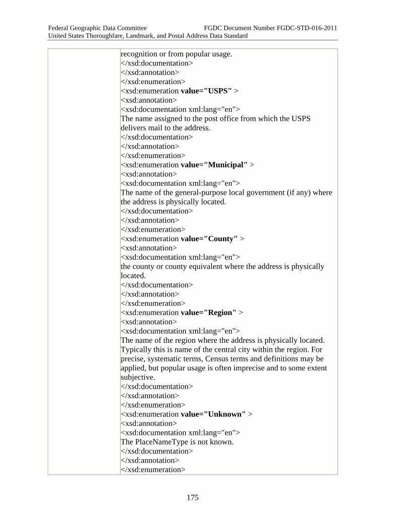
Federal Geographic Data Committee FGDC Document Number FGDC-STD-016-2011 United States Thoroughfare, Landmark, and Postal Address Data Standard
175
recognition or from popular usage. </xsd:documentation> </xsd:annotation> </xsd:enumeration> <xsd:enumeration value="USPS" > <xsd:annotation> <xsd:documentation xml:lang="en"> The name assigned to the post office from which the USPS delivers mail to the address. </xsd:documentation> </xsd:annotation> </xsd:enumeration> <xsd:enumeration value="Municipal" > <xsd:annotation> <xsd:documentation xml:lang="en"> The name of the general-purpose local government (if any) where the address is physically located. </xsd:documentation> </xsd:annotation> </xsd:enumeration> <xsd:enumeration value="County" > <xsd:annotation> <xsd:documentation xml:lang="en"> the county or county equivalent where the address is physically located. </xsd:documentation> </xsd:annotation> </xsd:enumeration> <xsd:enumeration value="Region" > <xsd:annotation> <xsd:documentation xml:lang="en"> The name of the region where the address is physically located. Typically this is name of the central city within the region. For precise, systematic terms, Census terms and definitions may be applied, but popular usage is often imprecise and to some extent subjective. </xsd:documentation> </xsd:annotation> </xsd:enumeration> <xsd:enumeration value="Unknown" > <xsd:annotation> <xsd:documentation xml:lang="en"> The PlaceNameType is not known. </xsd:documentation> </xsd:annotation> </xsd:enumeration>
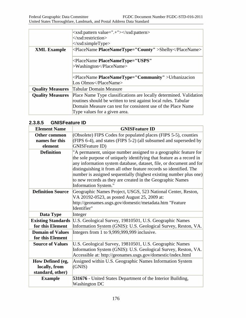
Federal Geographic Data Committee FGDC Document Number FGDC-STD-016-2011 United States Thoroughfare, Landmark, and Postal Address Data Standard
176
<xsd:pattern value=".+"></xsd:pattern> </xsd:restriction> </xsd:simpleType>
XML Example <PlaceName PlaceNameType="County" >Shelby</PlaceName>
<PlaceName PlaceNameType="USPS" >Washington</PlaceName>
<PlaceName PlaceNameType="Community" >Urbanizacion Los Olmos</PlaceName>
Quality Measures Tabular Domain Measure Quality Measures Place Name Type classifications are locally determined. Validation
routines should be written to test against local rules. Tabular Domain Measure can test for consistent use of the Place Name Type values for a given area.
2.3.8.5 GNISFeature ID Element Name GNISFeature ID Other common names for this
element
(Obsolete) FIPS Codes for populated places (FIPS 5-5), counties (FIPS 6-4), and states (FIPS 5-2) (all subsumed and superseded by GNISFeature ID)
Definition "A permanent, unique number assigned to a geographic feature for the sole purpose of uniquely identifying that feature as a record in any information system database, dataset, file, or document and for distinguishing it from all other feature records so identified. The number is assigned sequentially (highest existing number plus one) to new records as they are created in the Geographic Names Information System."
Definition Source Geographic Names Project, USGS, 523 National Center, Reston, VA 20192-0523, as posted August 25, 2009 at: http://geonames.usgs.gov/domestic/metadata.htm "Feature Identifier"
Data Type Integer Existing Standards
for this Element U.S. Geological Survey, 19810501, U.S. Geographic Names Information System (GNIS): U.S. Geological Survey, Reston, VA.
Domain of Values for this Element
Integers from 1 to 9,999,999,999 inclusive.
Source of Values U.S. Geological Survey, 19810501, U.S. Geographic Names Information System (GNIS): U.S. Geological Survey, Reston, VA. Accessible at: http://geonames.usgs.gov/domestic/index.html
How Defined (eg, locally, from
standard, other)
Assigned within U.S. Geographic Names Information System (GNIS)
Example 531676 - United States Department of the Interior Building, Washington DC

Federal Geographic Data Committee FGDC Document Number FGDC-STD-016-2011 United States Thoroughfare, Landmark, and Postal Address Data Standard
177
1658360 - Curry Village, Yosemite National Park, CA (Old FIPS55 Place Code: 17638) 1248001 - Florence County, SC (Old FIPS55 Place Code: 99041)
Notes/Comments 1. “The Geographic Names Information System (GNIS) is the Federal and national standard for geographic nomenclature. The U.S. Geological Survey developed the GNIS in support of the U.S. Board on Geographic Names as the official repository of domestic geographic names data, the official vehicle for geographic names used by all departments of the Federal Government, and the source for applying geographic names to Federal electronic and printed products. “The GNIS contains information about physical and cultural geographic features of all types in the United States, associated areas, and Antarctica, current and historical, but not including roads and highways. The database holds the Federally recognized name of each feature and defines the feature location by state, county, USGS topographic map, and geographic coordinates. Other attributes include names or spellings other than the official name, feature designations, feature classification, historical and descriptive information, and for some categories the geometric boundaries. “… The GNIS collects data from a broad program of partnerships with Federal, State, and local government agencies and other authorized contributors, and provides data to all levels of government, to the public, and to numerous applications through a web query site, web map and feature services, file download services, and customized files upon request.” (Quoted August 25, 2009 from http://geonames.usgs.gov/domestic/index.html )
2. "The [GNIS Feature Identifier] number, by design, carries no information or association to the content of the feature record and therefore is not subject to change as attribute values change. Once assigned to a feature, the number is never changed or withdrawn, and never reassigned. The Feature ID can be applied in conjunction with system-unique record identifiers in any database or system, thus providing a national standard common reference identifier across multiple datasets. The Feature ID is stored in the GNIS database as an integer with a maximum of ten digits. (Source: Geographic Names Project, USGS, 523 National Center, Reston, VA 20192-0523.)" (Quoted August 25, 2009 from: http://geonames.usgs.gov/domestic/metadata.htm "Feature Identifier")
3. The Board of Geographic Names has set forth its principles, policies, and procedures for recognizing and standardizing domestic geographic names in its "Principles, Policies, and

Federal Geographic Data Committee FGDC Document Number FGDC-STD-016-2011 United States Thoroughfare, Landmark, and Postal Address Data Standard
178
Procedures," posted at: http://geonames.usgs.gov/domestic/policies.htm
4. In the context of the address standard, GNISFeature ID is applicable primarily to Landmark Names, Place Names and State Names. GNIS also includes the names of natural features, which are generally outside the scope of the address standard.
5. The Board of Geographic Names seeks to include in GNIS all feature names of public interest. Local authorities are encouraged to submit local feature names that are not already included in GNIS.
6. GNIS offers useful guidance to address authorities in selecting one name as a standard where several variants exist. GNISFeature ID's, if assigned to Landmark Names or Place Names, can help reconcile minor name variations that can frustrate computer matches (e.g., DeKalb, Dekalb, De Kalb). GNISFeature ID's also provide a way to link a preferred local variant name to a nationally-recognized standard.
7. GNIS provides a primary location point (x, y coordinate) for each feature. The GNIS primary point will in many cases differ from address coordinates assigned to the same feature by the addressing authority, due to differences in procedure and precision. GNIS procedures are described at: http://geonames.usgs.gov/domestic/metadata.htm "Primary Point.”
XML Tag GNISFeatureID
XML Model <xsd:simpleType name="GNISFeatureID_type"> <xsd:restriction base="xsd:integer" /> </xsd:simpleType>
XML Example <CompleteLandmark Separator=","> <LandmarkName ElementSequenceNumber="0" GNISFeatureID="1658360" >CURRY VILLAGE</LandmarkName> <LandmarkName Element Sequence Number="1">YOSEMITE NATIONAL PARK</LandmarkName> </CompleteLandmark>
Quality Measures Spatial Domain Measure Tabular Domain Measure
Quality Notes
2.3.8.6 ANSIState County Code Element Name ANSIState County Code Other common names for this
element
(Obsolete) FIPS State Codes (FIPS Publication 5-2), FIPS County Codes (FIPS Publication 6-4)
Definition A set of two-digit numeric codes identifying the states, the District of Columbia, Puerto Rico, and the insular areas of the United

Federal Geographic Data Committee FGDC Document Number FGDC-STD-016-2011 United States Thoroughfare, Landmark, and Postal Address Data Standard
179
States, which may be followed by a three-digit numeric code identifying a county or equivalent entity therein.
Definition Source State codes: ANSI INCITS 38:2009. County codes: ANSI INCITS 31:2009.
Data Type Text Existing Standards
for this Element State codes: ANSI INCITS 38:2009. County codes: ANSI INCITS 31:2009.
Domain of Values for this Element
State codes: 01 through 99 (not all codes are in use). County codes: 001 through 999 (not all codes are in use).
Source of Values State codes: ANSI INCITS 38:2009. County codes: ANSI INCITS 31:2009.
How Defined (eg, locally, from
standard, other)
State codes: ANSI INCITS 38:2009. County codes: ANSI INCITS 31:2009.
Examples 48 (Texas) 48301 (Loving County, Texas: 48 = Texas; 301 = Loving County) 15005 (Kalawao County, Hawaii: 15 = Hawaii; 005 = Kalawao County) 51610 (Falls Church, Virginia: 51 = Virginia; 610 = Falls Church city (an independent city with county-level governance status)) 01117 (Shelby County, Alabama: 01 = Alabama; 117 = Shelby County)
Notes/Comments 1. The state and county codes provide numeric identifiers for states and state equivalents (see State Name) and their counties or county equivalents (see Place Name - Other common names for this element (county)).
2. State codes are two-digit numbers, which may include a leading zero. County codes are three-digit numbers that typically begin with 001 for each state and state equivalent. A county identifier is a five digit combination of the state code followed by the county code.
3. The state and county codes were originally established and maintained by the National Institute of Standards and Technology (NIST) as Federal Information Processing Standards (FIPS) Publications 5-2 (for state codes) and 6-4 (for county codes). The standards were withdrawn by NIST on September 2, 2008 and replaced by the ANSI INCITS 38:2009 standard and ANSI INCITS 31:2009 standard respectively, with the Census Bureau as the maintenance authority for both.
4. ANSI Standards are protected by ANSI copyright. The Census Bureau provides the codes copyright-free via its public website. Part Six of this standard provides complete references to the Census Bureau website and the ANSI Standards, listed under “U.S. Census Bureau.”

Federal Geographic Data Committee FGDC Document Number FGDC-STD-016-2011 United States Thoroughfare, Landmark, and Postal Address Data Standard
180
XML Tag <ANSIStateCountyCode> XML Model <xsd:simpleType name="ANSIStateCountyCode_type">
<xsd:restriction base="xsd:string" /> </xsd:simpleType>
XML Example <ANSIStateCountyCode> 01015 </ANSIStateCountyCode> Quality Measures Tabular Domain Measure
Spatial Domain Measure Quality Notes
2.3.8.7 Delivery Address Type Element Name DeliveryAddressType Other common names for this
element
Definition Whether the Delivery Address includes or excludes the Complete Subaddress.
Definition Source New Data Type characterString
Existing Standards for this Element
None
Domain of Values for this Element
Subaddress Included - The Delivery Address includes the Complete Subaddress (if any) Subaddress Excluded - The Delivery Address excludes the Complete Subaddress (if any) Unstated - Not stated/no information (default value)
Source of Values New How Defined (eg,
locally, from standard, other)
Defined herein.
Example Delivery Address = 123 Main Street, Apt. 1 (Delivery Address Type = Subaddress Included) Delivery Address = 123 Main Street Complete Subaddress = Apt. 1 (Delivery Address Type = Subaddress Excluded) Delivery Address = Ames High School, Room 12 (Delivery Address Type = Subaddress Included) Delivery Address = Ames High School Complete Subaddress = Room 12 (Delivery Address Type = Subaddress Excluded)
Notes/Comments 1. The Delivery Address typically includes the Complete Subaddress. However, there are sometimes reasons to omit or separate the Complete Subaddress from the Delivery Address. For example, the Complete Subaddress can hamper address geocoding, and contact lists often separate the Complete Subaddress from the rest of the Delivery Address (see, for example, the EPA Contact Information Data Standard).

Federal Geographic Data Committee FGDC Document Number FGDC-STD-016-2011 United States Thoroughfare, Landmark, and Postal Address Data Standard
181
2. The Delivery Address Type shows whether the Delivery Address includes or excludes the Complete Subaddress.
3. If all the records in a file have the same Delivery Address Type, this information can be included in the file-level metadata. If records of different types are likely to be mixed together, the Delivery Address Type should be included in each record.
XML Tag DeliveryAddressType
XML Model <xsd:simpleType name="DeliveryAddressType_type"> <xsd:restriction base="xsd:token"> <xsd:enumeration value='SubAddress Included' > <xsd:annotation> <xsd:documentation>The Delivery Address includes the Complete Subaddress (if any) </xsd:documentation></xsd:annotation></xsd:enumeration> <xsd:enumeration value='SubAddress Excluded' > <xsd:annotation> <xsd:documentation>The Delivery Address includes the Complete Subaddress (if any) </xsd:documentation></xsd:annotation></xsd:enumeration> <xsd:enumeration value='Unstated' > <xsd:annotation> <xsd:documentation>Not stated/no information (default value) </xsd:documentation> </xsd:annotation></xsd:enumeration> </xsd:restriction> </xsd:simpleType>
XML Example <DeliveryAddress DeliveryAddressType="Subaddress Included" >123 Dartmouth College Highway, Suite 100</DeliveryAddress>
<DeliveryAddress DeliveryAddressType="Subaddress Excluded" >123 Dartmouth College Highway, Suite 100</DeliveryAddress>
Quality Measures Tabular Domain Measure Delivery Address Type Subaddress Measure
Quality Notes
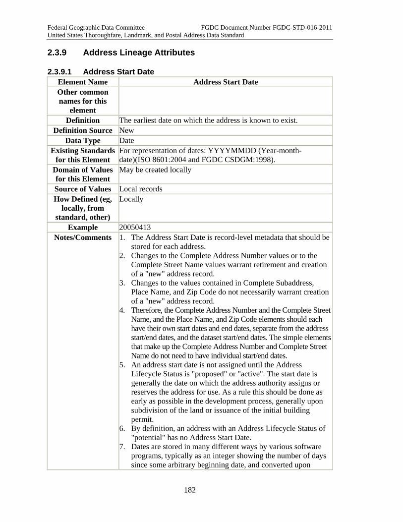
Federal Geographic Data Committee FGDC Document Number FGDC-STD-016-2011 United States Thoroughfare, Landmark, and Postal Address Data Standard
182
2.3.9 Address Lineage Attributes
2.3.9.1 Address Start Date Element Name Address Start Date Other common names for this
element
Definition The earliest date on which the address is known to exist. Definition Source New
Data Type Date Existing Standards
for this Element For representation of dates: YYYYMMDD (Year-month-date)(ISO 8601:2004 and FGDC CSDGM:1998).
Domain of Values for this Element
May be created locally
Source of Values Local records How Defined (eg,
locally, from standard, other)
Locally
Example 20050413 Notes/Comments 1. The Address Start Date is record-level metadata that should be
stored for each address. 2. Changes to the Complete Address Number values or to the
Complete Street Name values warrant retirement and creation of a "new" address record.
3. Changes to the values contained in Complete Subaddress, Place Name, and Zip Code do not necessarily warrant creation of a "new" address record.
4. Therefore, the Complete Address Number and the Complete Street Name, and the Place Name, and Zip Code elements should each have their own start dates and end dates, separate from the address start/end dates, and the dataset start/end dates. The simple elements that make up the Complete Address Number and Complete Street Name do not need to have individual start/end dates.
5. An address start date is not assigned until the Address Lifecycle Status is "proposed" or "active". The start date is generally the date on which the address authority assigns or reserves the address for use. As a rule this should be done as early as possible in the development process, generally upon subdivision of the land or issuance of the initial building permit.
6. By definition, an address with an Address Lifecycle Status of "potential" has no Address Start Date.
7. Dates are stored in many different ways by various software programs, typically as an integer showing the number of days since some arbitrary beginning date, and converted upon
Federal Geographic Data Committee FGDC Document Number FGDC-STD-016-2011 United States Thoroughfare, Landmark, and Postal Address Data Standard
183
display to a format that people can read. This standard does not prescribe how software should create or handle dates internally. However, for display and exchange of dates, this standard prescribes the YYYYMMDD format specified in ISO 8601:2004 and in the FGDC Content Standard for Digital Geospatial Metadata (v2, 1998). The standard is unambiguous and easily-understood, it is recognized nationally and internationally, and it can be extended if needed to include hours, minutes and seconds.
XML Tag < AddressStartDate >
XML Model <xsd:simpleType name="AddressStartdDate_type"> <xsd:restriction base="xsd:date" /> </xsd:simpleType>
XML Example <AddressStartDate>19950517</AddressStartDate> Quality Measures Start End Date Order Measure
Future Date Measure Quality Notes
2.3.9.2 Address End Date Element Name Address End Date Other common names for this
element
Definition The date on which the address is known to no longer be valid. Definition Source New
Data Type Date Existing Standards
for this Element For representation of dates: YYYYMMDD (Year-month-date)(ISO 8601:2004 and FGDC CSDGM:1998).
Domain of Values for this Element
May be created locally
Source of Values Local records How Defined (eg,
locally, from standard, other)
Locally
Example 20110209 Notes/Comments 1. An address is given an end date when the Address Authority
retires it. 2. Changes to the Complete Address Number value or to the
Complete Street Name value warrant retirement of the address.3. Changes to the values contained in Complete Subaddress,
Place Name, and Zip Code do not necessarily warrant a "new" address.
4. Therefore, the Complete Address Number and the Complete

Federal Geographic Data Committee FGDC Document Number FGDC-STD-016-2011 United States Thoroughfare, Landmark, and Postal Address Data Standard
184
Street Name, and the Place Name, and Zip Code elements should have start dates and end dates for the element itself, separate from the dataset start/end dates. The simple elements that make up the Complete Address Number and Complete Street Name do not need to have individual start/end dates.
5. The Address End Date is record-level metadata that should be stored for each address.
6. If the Address Lifecycle Status is potential, proposed or active, then the Address End Date must be null. If the Address Lifecycle Status is retired, then the address or street name must have an Address End Date.
7. Dates are stored in many different ways by various software programs, typically as an integer showing the number of days since some arbitrary beginning date, and converted upon display to a format that people can read. This standard does not prescribe how software should create or handle dates internally. However, for display and exchange of dates, this standard prescribes the YYYYMMDD format specified in ISO 8601:2004 and in the FGDC Content Standard for Digital Geospatial Metadata (v2, 1998). The standard format is unambiguous and easily-understood, it is recognized nationally and internationally, and it can be extended if needed to include hours, minutes and seconds.
XML Tag < AddressEndDate >
XML Model <xsd:simpleType name="AddressEndDate_type"> <xsd:restriction base="xsd:date" /> </xsd:simpleType>
XML Example <AddressEndDate>19950517</AddressEndDate> Quality Measures Start End Date Order Measure
Future Date Measure Quality Notes
2.3.9.3 Data Set ID Element Name DataSetID Other common names for this
element
Definition An identifier in each record of a transmitted dataset, assigned by the sender or the receiver of the dataset, to associate each record of the dataset to the file-level metadata that accompanies the dataset.
Definition Source New Data Type characterString
Existing Standards None
Federal Geographic Data Committee FGDC Document Number FGDC-STD-016-2011 United States Thoroughfare, Landmark, and Postal Address Data Standard
185
for this Element Domain of Values for this Element
Yes
Source of Values Assigned by the sender or the receiver of a data set. How Defined (eg,
locally, from standard, other)
Assigned by the sender or the receiver of a data set.
Example Dataset ID 1475 Notes/Comments 1. The content of the file-level metadata is specified in the
FGDC's Content Standard for Digital Geospatial Metadata. 2. The ID may be assigned by the sender upon transmittal of the
dataset or the recipient upon receipt. 3. Normally the identifier will be numeric, but the standard does
not preclude alphanumeric identifiers. XML Tag <
DataSetID >
XML Model <xsd:simpleType name="DataSetID_type"> <xsd:restriction base="xsd:string"> <xsd:pattern value=".*"></xsd:pattern> </xsd:restriction> </xsd:simpleType>
XML Example <DataSetID>1457</DataSetID> Quality Measures Related Not Null Measure
Quality Notes
2.3.9.4 Address Direct Source Element Name AddressDirectSource Other common names for this
element
Definition Source from which the data provider obtained the address, or with which the data provider validated the address.
Definition Source New Data Type Text
Existing Standards for this Element
None
Domain of Values for this Element
No
Source of Values NA How Defined (eg,
locally, from standard, other)
By data provider
Examples Official Address Authority; regional or state address repository

Federal Geographic Data Committee FGDC Document Number FGDC-STD-016-2011 United States Thoroughfare, Landmark, and Postal Address Data Standard
186
owner; phone company; assessor; commercial data provider Notes/Comments 1. The Address Direct Source may or may not be the same as the
Address Authority. For example, a regional GIS agency might obtain official address records from the cities and counties that are Address Authorities in the region. It might then provide the consolidated set of records to a state agency, which might in turn provide a state-wide file to a federal agency. • When the regional agency receives address records from
the city and county Address Authorities, the Address Authorities are also the Address Direct Sources.
• When the regional agency provides records to the state agency, the regional agency is the Address Direct Source. (The Address Authority remains unchanged.)
• When the state agency provides address records to the federal agency, the state agency is the Address Direct Source. (The Address Authority remains unchanged.)
2. The data provider should enter the Address Direct Source upon creation or transmittal of the address records. Individual address records need contain only the agency name. The file-level metadata should include complete contact information for the Address Direct Source.
Quality Measures Related Element Value Measure Spatial Domain Measure Tabular Domain Measure
Quality Notes Related Element Value Measure can check for sources that are associated with a given Address Feature Type or other indicator.
2.4 Address Reference Systems
2.4.1 Address Reference Systems Introduction An Address Reference System establishes the framework of rules, both spatial and non-spatial, adopted by an Address Authority for assigning addresses within the area it administers. The rules, in turn, provide the basis for address data quality tests that detect address anomalies and errors.
The Address Reference System includes, as needed, rules governing address numbering, street naming, block definition, subaddresses (suites, offices, apartments, etc.), and place names. The Address Reference System may also define address baselines, polylines, and break lines to guide address numbering throughout the area. Finally, for identification and reference, an Address Reference System includes a name and identifier, the name of the Address Reference System Authority that administers it, the boundary of the area it administers, and reference to the official documents and maps where the rules are codified.
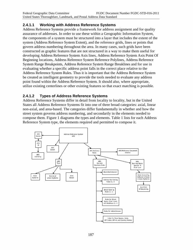
Federal Geographic Data Committee FGDC Document Number FGDC-STD-016-2011 United States Thoroughfare, Landmark, and Postal Address Data Standard
187
2.4.1.1 Working with Address Reference Systems Address Reference Systems provide a framework for address assignment and for quality assurance of addresses. In order to use these within a Geographic Information System, the components of a system must be structured into a layer that includes the extent of the system (Address Reference System Extent), and the reference grids, lines or points that govern address numbering throughout the area. In many cases, such grids have been constructed as graphic features that are not structured in a way to make them useful for developing Address Reference System Axis lines, Address Reference System Axis Point Of Beginning locations, Address Reference System Reference Polylines, Address Reference System Range Breakpoints, Address Reference System Range Breaklines and for use in evaluating whether a specific address point falls in the correct place relative to the Address Reference System Rules. Thus it is important that the Address Reference System be created as intelligent geometry to provide the tools needed to evaluate any address point found within the Address Reference System. It should also, where appropriate, utilize existing centerlines or other existing features so that exact matching is possible.
2.4.1.2 Types of Address Reference Systems Address Reference Systems differ in detail from locality to locality, but in the United States all Address Reference Systems fit into one of three broad categories: axial, linear non-axial, and area-based. The categories differ fundamentally in whether and how the street system governs address numbering, and secondarily in the elements needed to compose them. Figure 1 diagrams the types and elements. Table 1 lists for each Address Reference System type, the elements required and permitted to compose it.
Federal Geographic Data Committee FGDC Document Number FGDC-STD-016-2011 United States Thoroughfare, Landmark, and Postal Address Data Standard
188
2.4.1.2.1 Axial Type Address Reference Systems In axial Address Reference Systems, address numbering is organized around axes. The axes may be thoroughfares, rail lines, rivers, or imaginary lines (such as section lines in PLSS areas, lines of latitude and/or longitude, or arbitrarily drawn lines). Address axes typically extend from a common point of origin (the local "zero" point for address numbers), and all numbers increase with distance from the point of origin.
The axes, in turn, define the zero point for numbering along streets that cross the axes. Most commonly, axial system organize the streets and address numbering into a grid. In a simple case, if Main Street ran north-south from the town square, and State Street ran east-west, then:
1. Address numbering for Main Street and State Street would increase as one proceeded away from the town square.
2. Address numbering for other north-south streets would begin where they cross State Street and increase in parallel with Main Street.
3. Address numbering for other east-west streets would begin where they cross Main Street and increase in parallel with State Street.
Often the geometric grid is interrupted or deformed by terrain, rivers, highways, rail lines, parks, or other major features. Occasionally there are more than four axes, or numbering does not begin at the same point for all axes.
2.4.1.2.2 Linear Non-Axial Address Reference Systems In a linear non-axial Address Reference System, each thoroughfare is addressed independently of the other thoroughfares. There are no axes and there is no grid. Each thoroughfare has its own point of beginning for address numbering, and numbers proceed according to an Address Reference System Numbering Rule from that point to the end of the thoroughfare or the boundary of the Address Reference System. Linear non-axial address reference systems are typically found in areas where the road network is sparse and intersections are few, or where topography dictates a street pattern that is aligned with contours of elevation.
2.4.1.2.3 Area-Based Systems In area-based Address Reference Systems, Complete Address Numbers are not assigned along a thoroughfare, but within an area. Inside the area, Complete Address Numbers might be assigned according to a spatial pattern (around the block, for example), or by parcel or lot numbers, or chronologically as the buildings are built.
Area-based Address Reference Systems are rare in the United States, but they may be found in gated communities, housing projects, Puerto Rican urbanizations, trailer courts, small tribal settlements, military bases, small islands, campgrounds, and similar developments.
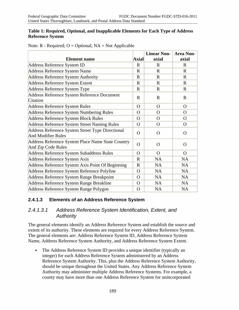
Federal Geographic Data Committee FGDC Document Number FGDC-STD-016-2011 United States Thoroughfare, Landmark, and Postal Address Data Standard
189
Table 1: Required, Optional, and Inapplicable Elements for Each Type of Address Reference System
Note: R - Required; O = Optional; NA = Not Applicable
Element name AxialLinear Non-
axial Area Non-
axial Address Reference System ID R R R Address Reference System Name R R R Address Reference System Authority R R R Address Reference System Extent R R R Address Reference System Type R R R Address Reference System Reference Document Citation R R R
Address Reference System Rules O O O Address Reference System Numbering Rules O O O Address Reference System Block Rules O O O Address Reference System Street Naming Rules O O O Address Reference System Street Type Directional And Modifier Rules O O O
Address Reference System Place Name State Country And Zip Code Rules O O O
Address Reference System Subaddress Rules O O O Address Reference System Axis R NA NA Address Reference System Axis Point Of Beginning R NA NA Address Reference System Reference Polyline O NA NA Address Reference System Range Breakpoint O NA NA Address Reference System Range Breakline O NA NA Address Reference System Range Polygon O NA NA
2.4.1.3 Elements of an Address Reference System
2.4.1.3.1 Address Reference System Identification, Extent, and Authority
The general elements identify an Address Reference System and establish the source and extent of its authority. These elements are required for every Address Reference System. The general elements are: Address Reference System ID, Address Reference System Name, Address Reference System Authority, and Address Reference System Extent.
The Address Reference System ID provides a unique identifier (typically an integer) for each Address Reference System administered by an Address Reference System Authority. This, plus the Address Reference System Authority, should be unique throughout the United States. Any Address Reference System Authority may administer multiple Address Reference Systems. For example, a county may have more than one Address Reference System for unincorporated
Federal Geographic Data Committee FGDC Document Number FGDC-STD-016-2011 United States Thoroughfare, Landmark, and Postal Address Data Standard
190
areas based on terrain changes, historical addressing patterns, or for other reasons. Cities may annex areas which have previously been addressed by a County or other Address Authority, and maintain the old Address Reference System. Other Address Reference Systems may be established in the future as an area develops.
The Address Reference System Name identifies the Address Reference System in a way that is meaningful to users.
The Address Reference System Authority element identifies the agency and/or jurisdiction with administrative responsibility for the Address Reference System.
The Address Reference System Extent defines the geographic boundaries of the area within which addressing is governed by the Address Reference System. The Address Reference System Extent may or may not follow jurisdictional boundaries. There may also be areas within an Address Reference System that are excluded from that Address Reference System because they are addressed according to different rules.
The Address Reference System Reference Document Citation states where to find the authoritative documents that officially establish the Address Reference System. The documents may include a map of the reference system showing the extent, address numbering system, axes, and other features; a statement of the addressing rules described below; an addressing procedures manual and forms; and an address ordinance.
2.4.1.3.2 Address Reference System Rules The remaining elements describe the types of rules that might be adopted by an Address Reference System Authority to govern addressing processes. Due to the variety of local conditions and preferences, not all elements will be applicable to any given system, and all of these presented are optional elements. The rules are collected into the Address Reference System Rules, which incorporates the:
Address Reference System Numbering Rules,
Address Reference System Block Rules,
Address Reference System Street Naming Rules,
Address Reference System Street Type Directional And Modifier Rules,
Address Reference System Place Name State Country And Zip Code Rules,
Address Reference System Subaddress Rules.
2.4.1.3.3 Address Numbering Rules Address numbering rules specify how numbers are assigned along thoroughfares, including what features are numbered. They govern when numbers increase, assign even
Federal Geographic Data Committee FGDC Document Number FGDC-STD-016-2011 United States Thoroughfare, Landmark, and Postal Address Data Standard
191
and odd numbers to sides of streets, and specify the beginning points for numbering. They may also specify if and how address ranges relate to blocks.
What Features are Given Address Numbers? In addition to permanent primary structures, other features that can be numbered include vacant lots, secondary structures such as detached garages or farm outbuildings, temporary and seasonal structures, additional entrances of large buildings, non-structured uses such as open parking lots, and infrastructure features such as cell towers, pump and metering stations, substations and transformers.
Increase and Interval Rules for Address Numbering In the United States, address numbers increase according to one or more of three rules:
1. Distance rule - numbers are assigned according to distance along the thoroughfare (e.g., 1000 numbers per mile, 500 on either side, or 2 per 10.56 feet).
2. "Hundred block" Rule - where streets are laid out in a regular city grid, each block may be given a range of 100 numbers (50 per side), e.g. the 1400 block of Cherry Street. Within each block, numbers may be allocated by distance, or proportionally to the length of the block. If blocks have a fixed length (e.g. ten per mile), then this rule can work just like a distance rule.
3. Sequentially - properties or buildings are numbered sequentially, regardless of distance or blocks. The numbers may increase by twos, or they may increase by a larger interval (4, 6, 8, 14, etc.) to leave intermediate numbers for future divisions of land.
Parity Rules Parity rules assign even numbers to one side of the thoroughfare and odd numbers to the other side.
Point(s) of Beginning for Numbering In axial address reference systems, numbering begins where a thoroughfare intersects (or would intersect) its axis. In non-axial systems, the point of beginning is defined separately for each thoroughfare. Many non-axial systems follow the federal and state highway milepost practice of starting numbering at the southern or western end of the thoroughfare (or boundary of a jurisdiction), and increasing numbers to the north or east.
Block Rules and Address Range Rules These rules derive from the increase and interval rules described above. The Address Reference System Block Rules define how the system is organized into blocks for addressing purposes, and whether blocks break at intersections and begin with a new series of numbers, or whether numbering is sequentially ordered along a street without regard to intersecting streets. Such rules also define what constitutes a block break, as many systems do not recognize alleys, or three-way (T) intersections as block breaks.

Federal Geographic Data Committee FGDC Document Number FGDC-STD-016-2011 United States Thoroughfare, Landmark, and Postal Address Data Standard
192
Address ranges are created using the low and high numbers for each block or other unit defined by the system. Rules pertaining to address ranges are contained with the Address Reference System Block Rules.
2.4.1.3.4 Street Naming Rules Street naming rules define what Street Names may be allowed or prohibited, rules to prevent duplicate names, any language considerations, and whether Street Names must follow particular themes or orders (such as themes for names in subdivisions, or alphabetical or numerical orders).
2.4.1.3.5 Street Name Type, Directional, and Modifier Rules The Address Reference System Street Type Directional And Modifier Rules govern the use of street types, directionals and quadrants, and modifiers in Complete Street Names. Street type rules might specify a limited list of approved types (such as the list in USPS Publication 28 Appendix C1), whether the type must precede or follow the street name, and whether specific types are reserved for thoroughfares with specific functional characteristics. Directional rules include whether a quadrant or cardinal direction (or rarely both) is required, optional or prohibited in an address, and, if so, whether it must precede or follow the street name and type. Modifier rules may allow or prohibit Street Name Pre Modifiers or Street Name Post Modifiers, or specify which modifiers are permitted.
2.4.1.3.6 Subaddress Rules These rules, if included, cover the naming and recording of any subaddresses within structures, such as apartments, office suites, campuses, mobile home parks, industrial plants, malls, and retail centers with multiple tenants, etc.
2.4.1.3.7 Place Name, State, Country, and ZIP Code Rules These rules define the specific allowable combinations of a Place Name, State, and ZIP code in the Address Reference System, and provide input to checking these elements for quality. Unlike other elements of the address, which must be defined locally, Zip Codes are defined by the USPS, and State Names and Country Names must conform to external standards (see State Name and Country Name for complete information).
2.4.1.3.8 Address Axis Rules An Address Reference System Axis defines the points of beginning for address numbers for the streets that intersect it. The Address Reference System Axis pairs are often the "dividers" for quadrants, or directional designations. Finally, an Address Reference System Axis may also function as a "ruler" to define block breaks and address ranges for thoroughfares with similar directionality (e.g. north-south, or east-west streets) within the Address Reference System.
In theory, every street within an axial Address Reference System can be linked to an axis, either by intersection, or a virtual extension of the street centerline to the axis, or by interpolation (for streets that are set at an angle to the axes, and cannot be projected to
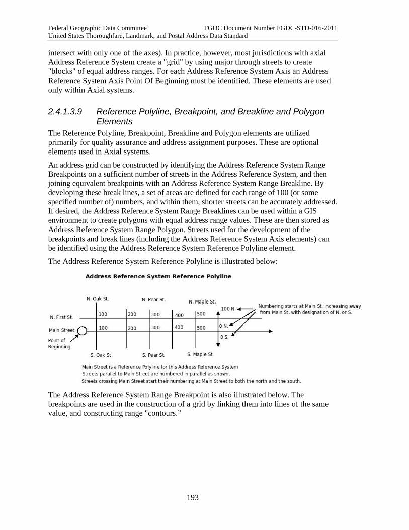
Federal Geographic Data Committee FGDC Document Number FGDC-STD-016-2011 United States Thoroughfare, Landmark, and Postal Address Data Standard
193
intersect with only one of the axes). In practice, however, most jurisdictions with axial Address Reference System create a "grid" by using major through streets to create "blocks" of equal address ranges. For each Address Reference System Axis an Address Reference System Axis Point Of Beginning must be identified. These elements are used only within Axial systems.
2.4.1.3.9 Reference Polyline, Breakpoint, and Breakline and Polygon Elements
The Reference Polyline, Breakpoint, Breakline and Polygon elements are utilized primarily for quality assurance and address assignment purposes. These are optional elements used in Axial systems.
An address grid can be constructed by identifying the Address Reference System Range Breakpoints on a sufficient number of streets in the Address Reference System, and then joining equivalent breakpoints with an Address Reference System Range Breakline. By developing these break lines, a set of areas are defined for each range of 100 (or some specified number of) numbers, and within them, shorter streets can be accurately addressed. If desired, the Address Reference System Range Breaklines can be used within a GIS environment to create polygons with equal address range values. These are then stored as Address Reference System Range Polygon. Streets used for the development of the breakpoints and break lines (including the Address Reference System Axis elements) can be identified using the Address Reference System Reference Polyline element.
The Address Reference System Reference Polyline is illustrated below:
The Address Reference System Range Breakpoint is also illustrated below. The breakpoints are used in the construction of a grid by linking them into lines of the same value, and constructing range "contours.”
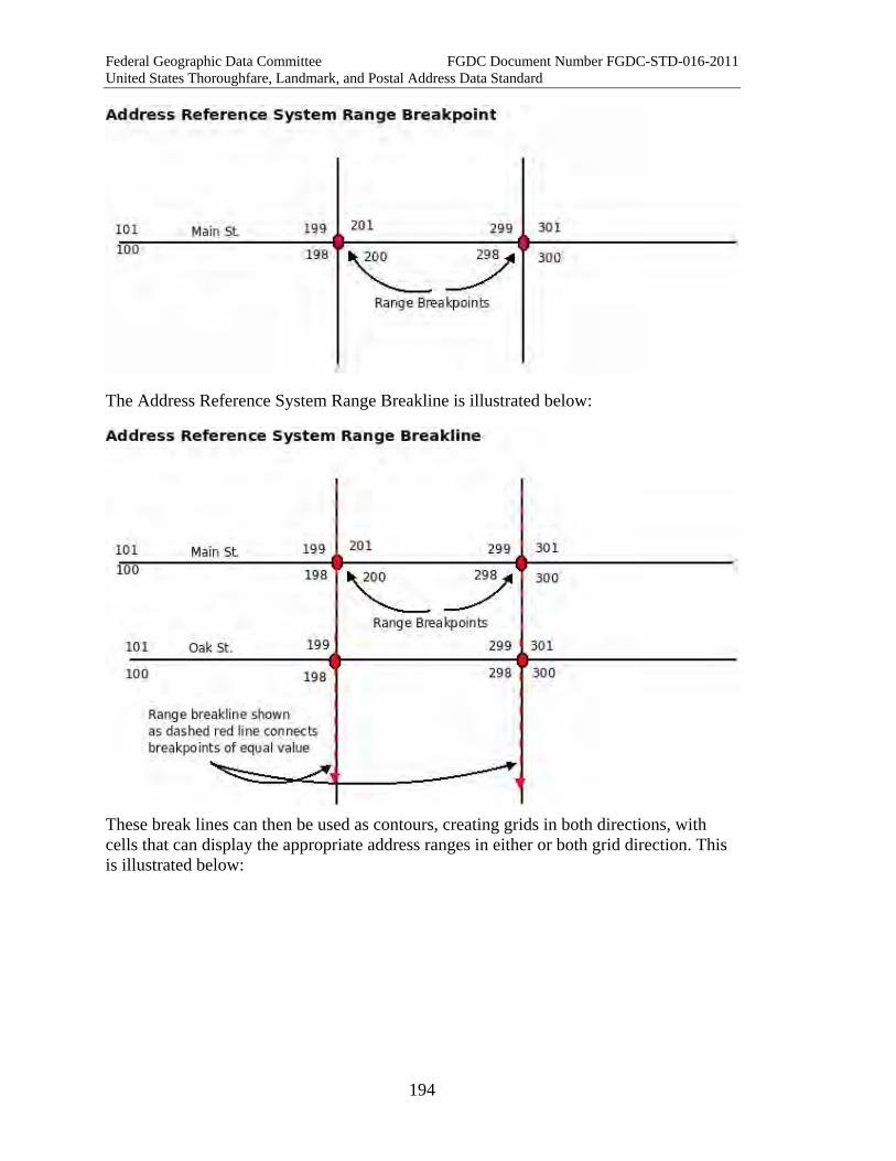
Federal Geographic Data Committee FGDC Document Number FGDC-STD-016-2011 United States Thoroughfare, Landmark, and Postal Address Data Standard
194
The Address Reference System Range Breakline is illustrated below:
These break lines can then be used as contours, creating grids in both directions, with cells that can display the appropriate address ranges in either or both grid direction. This is illustrated below:
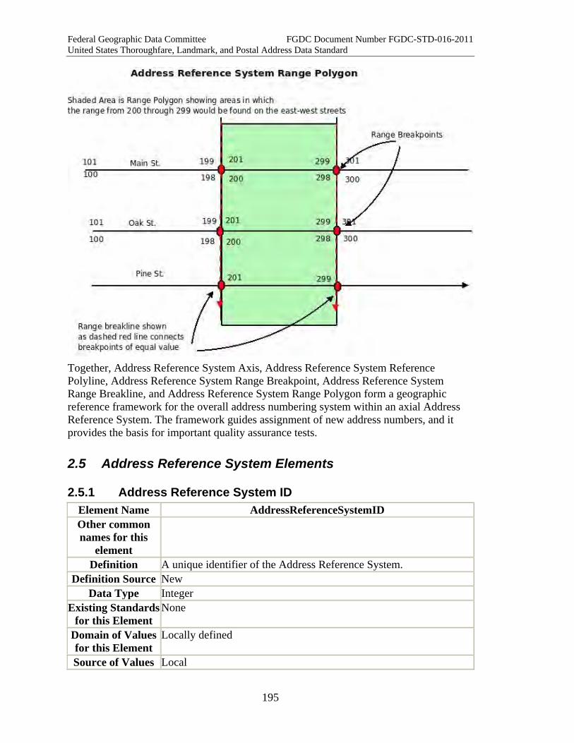
Federal Geographic Data Committee FGDC Document Number FGDC-STD-016-2011 United States Thoroughfare, Landmark, and Postal Address Data Standard
195
Together, Address Reference System Axis, Address Reference System Reference Polyline, Address Reference System Range Breakpoint, Address Reference System Range Breakline, and Address Reference System Range Polygon form a geographic reference framework for the overall address numbering system within an axial Address Reference System. The framework guides assignment of new address numbers, and it provides the basis for important quality assurance tests.
2.5 Address Reference System Elements
2.5.1 Address Reference System ID Element Name AddressReferenceSystemID Other common names for this
element
Definition A unique identifier of the Address Reference System. Definition Source New
Data Type Integer Existing Standards
for this Element None
Domain of Values for this Element
Locally defined
Source of Values Local
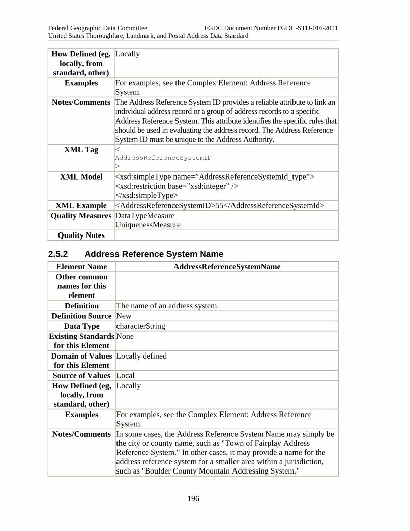
Federal Geographic Data Committee FGDC Document Number FGDC-STD-016-2011 United States Thoroughfare, Landmark, and Postal Address Data Standard
196
How Defined (eg, locally, from
standard, other)
Locally
Examples For examples, see the Complex Element: Address Reference System.
Notes/Comments The Address Reference System ID provides a reliable attribute to link an individual address record or a group of address records to a specific Address Reference System. This attribute identifies the specific rules that should be used in evaluating the address record. The Address Reference System ID must be unique to the Address Authority.
XML Tag < AddressReferenceSystemID >
XML Model <xsd:simpleType name=”AddressReferenceSystemId_type”> <xsd:restriction base=”xsd:integer” /> </xsd:simpleType>
XML Example <AddressReferenceSystemID>55</AddressReferenceSystemId> Quality Measures DataTypeMeasure
UniquenessMeasure � Quality Notes
2.5.2 Address Reference System Name Element Name AddressReferenceSystemName Other common names for this
element
Definition The name of an address system. Definition Source New
Data Type characterString Existing Standards
for this Element None
Domain of Values for this Element
Locally defined
Source of Values Local How Defined (eg,
locally, from standard, other)
Locally
Examples For examples, see the Complex Element: Address Reference System.
Notes/Comments In some cases, the Address Reference System Name may simply be the city or county name, such as "Town of Fairplay Address Reference System." In other cases, it may provide a name for the address reference system for a smaller area within a jurisdiction, such as "Boulder County Mountain Addressing System."

Federal Geographic Data Committee FGDC Document Number FGDC-STD-016-2011 United States Thoroughfare, Landmark, and Postal Address Data Standard
197
XML Tag < AddressReferenceSystemName >
XML Model <xsd:simpleType name="AddressReferenceSystemName_type"> <xsd:restriction base="xsd:string" /> </xsd:simpleType>
XML Example <AddressReferenceSystemName>Mountain Addressing Scheme</AddressReferenceSystemName>
<AddressReferenceSystemName>pre-1990 System</AddressReferenceSystemName>
Quality Measures Tabular Domain Measure Quality Notes Where geometry for the address reference system is available, the
boundaries should be checked as well to support spatial queries.
2.5.3 Address Reference System Authority Element Name AddressReferenceSystemAuthority Other common names for this
element
Definition The name of the authority or jurisdiction responsible for the creation and/or maintenance of an Address Reference System for a given area.
Definition Source New Data Type characterString
Existing Standards for this Element
None
Domain of Values for this Element
None.
Source of Values Local How Defined Defined locally
Example City of Orono, ME; Commander, Bolling Air Force Base, Washington, DC
Notes/Comments The agency responsible for creating or maintaining an Address Reference System may or may not be the same as the Address Authority responsible for assigning and maintaining the addresses in a given area.
XML Tag < AddressReferenceSystemAuthority >
XML Model <xsd:simpleType name="AddressReferenceSystemAuthority_type"> <xsd:restriction base="xsd:string" /> </xsd:simpleType>
Federal Geographic Data Committee FGDC Document Number FGDC-STD-016-2011 United States Thoroughfare, Landmark, and Postal Address Data Standard
198
XML Example <AddressReferenceSystemAuthority>Commander, Bolling Air Force Base</AddressReferenceSystemAuthority>
<AddressReferenceSystemAuthority>City of Orono</AddressReferenceSystemAuthority>
Quality Measure Tabular Domain Measure Quality Notes
2.5.4 Address Reference System Extent Element Name AddressReferenceSystemExtent Other common names for this
element
Definition Boundary of the area(s) within which an Address Reference System is used.
Definition Source New Data Type Geometry (Multisurface), as defined in the Open Geospatial
Consortium's "OpenGIS(R) Geography Markup Language (GML) Encoding Standard" version: 3.2.1 (see Part 6 for a complete citation)
Existing Standards for this Element
NA
Domain of Values for this Element
Coordinate values within the geometric areal extent of the Address Reference System
Source of Values Source of spatial data collection. How Defined (eg,
locally, from standard, other)
Locally defined.
Examples Address Reference System Extent: <gml:MultiSurface> <gml:surfaceMember> <gml:Polygon> <gml:exterior> <gml:LinearRing> <gml:posList>1000 1000 1000 25000 20000 1000 20000 25000 1000 1000</gml:posList> </gml:LinearRing> </gml:exterior> </gml:Polygon> </gml:surfaceMember> </gml:MultiSurface>
Notes/Comments An Address Reference System may include the entire area of a city or county jurisdiction, or it may only include a portion thereof. Military bases, and some university campuses are addressed under Address Reference Systems that are maintained by the Base
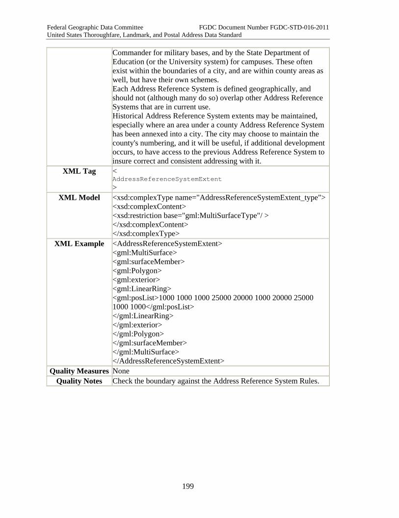
Federal Geographic Data Committee FGDC Document Number FGDC-STD-016-2011 United States Thoroughfare, Landmark, and Postal Address Data Standard
199
Commander for military bases, and by the State Department of Education (or the University system) for campuses. These often exist within the boundaries of a city, and are within county areas as well, but have their own schemes. Each Address Reference System is defined geographically, and should not (although many do so) overlap other Address Reference Systems that are in current use. Historical Address Reference System extents may be maintained, especially where an area under a county Address Reference System has been annexed into a city. The city may choose to maintain the county's numbering, and it will be useful, if additional development occurs, to have access to the previous Address Reference System to insure correct and consistent addressing with it.
XML Tag < AddressReferenceSystemExtent >
XML Model <xsd:complexType name="AddressReferenceSystemExtent_type"><xsd:complexContent> <xsd:restriction base="gml:MultiSurfaceType"/ > </xsd:complexContent> </xsd:complexType>
XML Example <AddressReferenceSystemExtent> <gml:MultiSurface> <gml:surfaceMember> <gml:Polygon> <gml:exterior> <gml:LinearRing> <gml:posList>1000 1000 1000 25000 20000 1000 20000 25000 1000 1000</gml:posList> </gml:LinearRing> </gml:exterior> </gml:Polygon> </gml:surfaceMember> </gml:MultiSurface> </AddressReferenceSystemExtent>
Quality Measures None Quality Notes Check the boundary against the Address Reference System Rules.
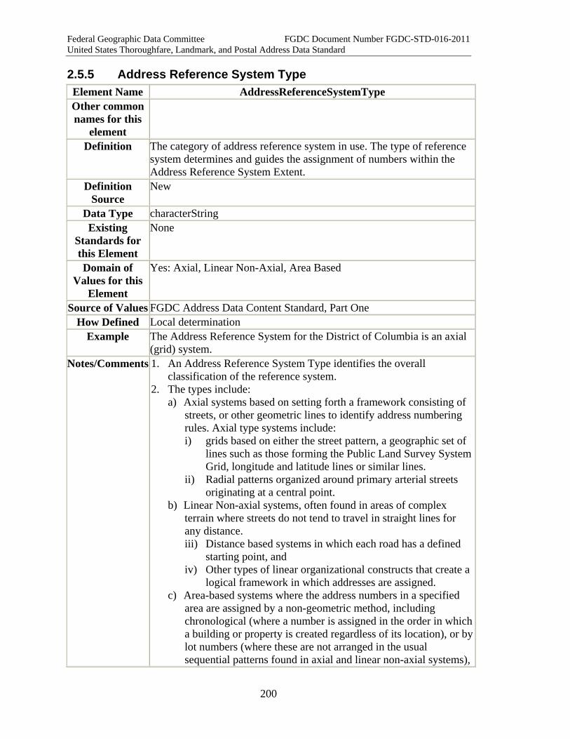
Federal Geographic Data Committee FGDC Document Number FGDC-STD-016-2011 United States Thoroughfare, Landmark, and Postal Address Data Standard
200
2.5.5 Address Reference System Type Element Name AddressReferenceSystemType Other common names for this
element
Definition The category of address reference system in use. The type of reference system determines and guides the assignment of numbers within the Address Reference System Extent.
Definition Source
New
Data Type characterString Existing
Standards for this Element
None
Domain of Values for this
Element
Yes: Axial, Linear Non-Axial, Area Based
Source of Values FGDC Address Data Content Standard, Part One How Defined Local determination
Example The Address Reference System for the District of Columbia is an axial (grid) system.
Notes/Comments 1. An Address Reference System Type identifies the overall classification of the reference system.
2. The types include: a) Axial systems based on setting forth a framework consisting of
streets, or other geometric lines to identify address numbering rules. Axial type systems include: i) grids based on either the street pattern, a geographic set of
lines such as those forming the Public Land Survey System Grid, longitude and latitude lines or similar lines.
ii) Radial patterns organized around primary arterial streets originating at a central point.
b) Linear Non-axial systems, often found in areas of complex terrain where streets do not tend to travel in straight lines for any distance. iii) Distance based systems in which each road has a defined
starting point, and iv) Other types of linear organizational constructs that create a
logical framework in which addresses are assigned. c) Area-based systems where the address numbers in a specified
area are assigned by a non-geometric method, including chronological (where a number is assigned in the order in which a building or property is created regardless of its location), or by lot numbers (where these are not arranged in the usual sequential patterns found in axial and linear non-axial systems),

Federal Geographic Data Committee FGDC Document Number FGDC-STD-016-2011 United States Thoroughfare, Landmark, and Postal Address Data Standard
201
or other means. 3. Some of these systems may have sub-types. In grid systems, some
provide for 100 numbers per "block", others are numbered sequentially without regard for block breaks. In places with radial street patterns, axis streets or lines may originate at one or more places. In some cases a grid or radial pattern may extend beyond its original area, and be expanded in an outlying area using numbering that is continued from the original area.
4. The basis for numbering within any of these systems is created as an attribute of the system. Numbering rules are documented in the Address Reference System Numbering Rules element. These rules are expected to be applied consistently throughout the extent of the reference system, although in practice this is often not true. Additional information on Address Reference Systems may be found in the Address Reference Systems Introduction.
XML Tag < AddressReferenceSystemType >
XML Model <xsd:simpleType name="AddressReferenceSystemType_type"> <xsd:restriction base="xsd:string"> <xsd:enumeration value="Axial"></xsd:enumeration> <xsd:enumeration value="Grid"></xsd:enumeration> <xsd:enumeration value="Radial"></xsd:enumeration> <xsd:enumeration value="Linear Non-Axial"></xsd:enumeration> <xsd:enumeration value="Distance"></xsd:enumeration> <xsd:enumeration value="Area Based"></xsd:enumeration> </xsd:restriction> </xsd:simpleType>
XML Example <AddressReferenceSystemType>Grid</AddressReferenceSystemType>Quality Measure Tabular Domain Measure
Quality Notes
2.5.6 Complex Element: Address Reference System Rules Element Name AddressReferenceSystemRules Other common names for this
element
Addressing Rules
Definition The rules by which address numbers, street names and other components of a thoroughfare address are determined.
Definition Source
New
Data Type characterString Existing
Standards for this Element
None
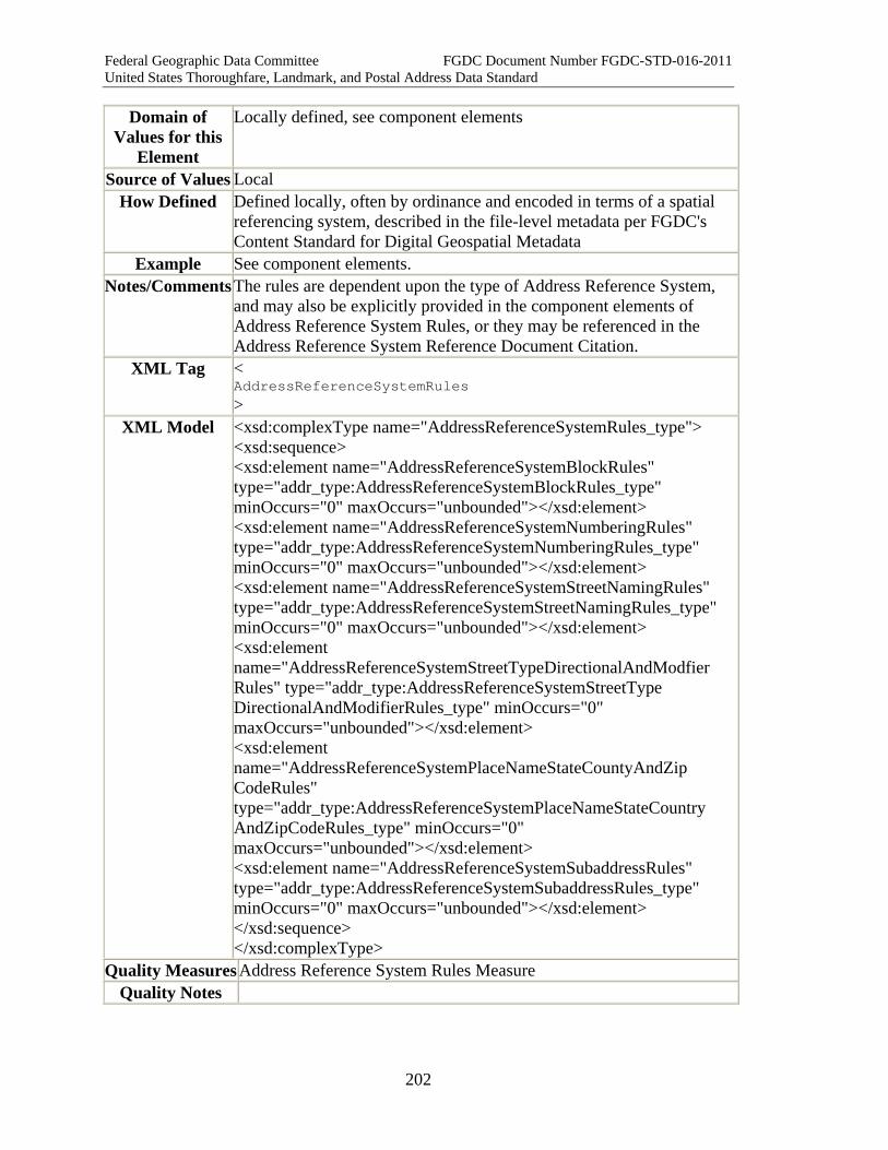
Federal Geographic Data Committee FGDC Document Number FGDC-STD-016-2011 United States Thoroughfare, Landmark, and Postal Address Data Standard
202
Domain of Values for this
Element
Locally defined, see component elements
Source of Values Local How Defined Defined locally, often by ordinance and encoded in terms of a spatial
referencing system, described in the file-level metadata per FGDC's Content Standard for Digital Geospatial Metadata
Example See component elements. Notes/Comments The rules are dependent upon the type of Address Reference System,
and may also be explicitly provided in the component elements of Address Reference System Rules, or they may be referenced in the Address Reference System Reference Document Citation.
XML Tag < AddressReferenceSystemRules >
XML Model <xsd:complexType name="AddressReferenceSystemRules_type"> <xsd:sequence> <xsd:element name="AddressReferenceSystemBlockRules" type="addr_type:AddressReferenceSystemBlockRules_type" minOccurs="0" maxOccurs="unbounded"></xsd:element> <xsd:element name="AddressReferenceSystemNumberingRules" type="addr_type:AddressReferenceSystemNumberingRules_type" minOccurs="0" maxOccurs="unbounded"></xsd:element> <xsd:element name="AddressReferenceSystemStreetNamingRules" type="addr_type:AddressReferenceSystemStreetNamingRules_type" minOccurs="0" maxOccurs="unbounded"></xsd:element> <xsd:element name="AddressReferenceSystemStreetTypeDirectionalAndModfier Rules" type="addr_type:AddressReferenceSystemStreetType DirectionalAndModifierRules_type" minOccurs="0" maxOccurs="unbounded"></xsd:element> <xsd:element name="AddressReferenceSystemPlaceNameStateCountyAndZip CodeRules" type="addr_type:AddressReferenceSystemPlaceNameStateCountry AndZipCodeRules_type" minOccurs="0" maxOccurs="unbounded"></xsd:element> <xsd:element name="AddressReferenceSystemSubaddressRules" type="addr_type:AddressReferenceSystemSubaddressRules_type" minOccurs="0" maxOccurs="unbounded"></xsd:element> </xsd:sequence> </xsd:complexType>
Quality Measures Address Reference System Rules Measure Quality Notes
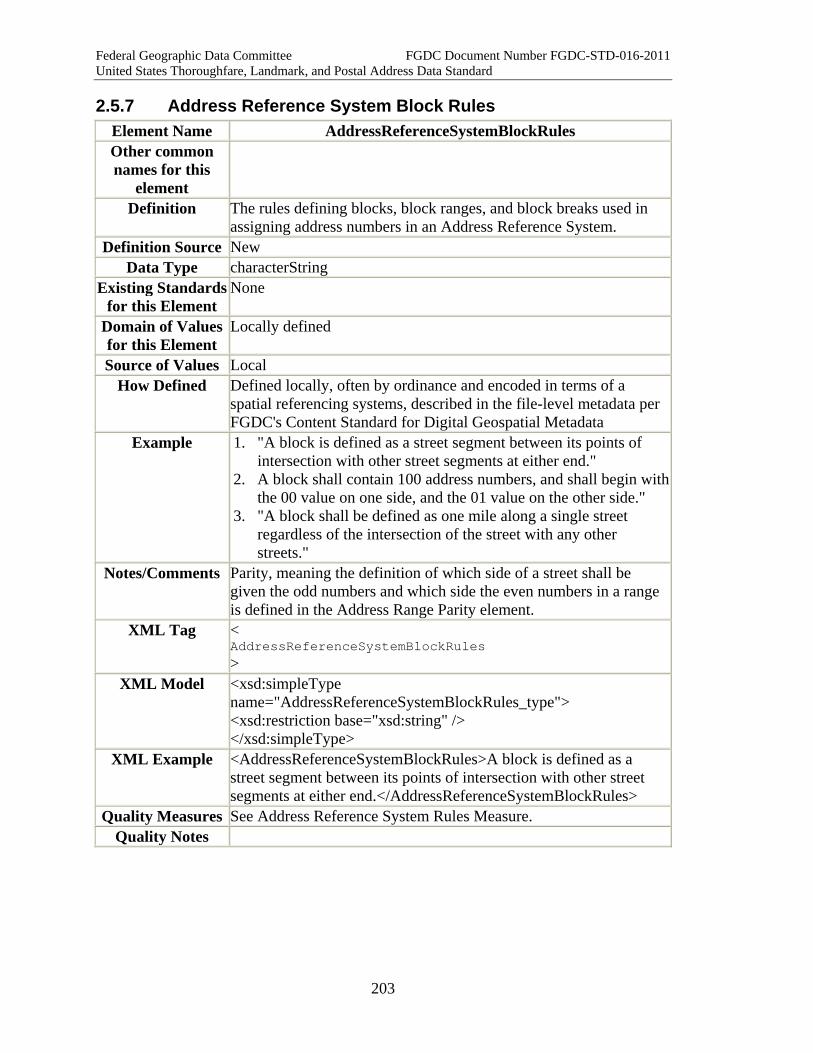
Federal Geographic Data Committee FGDC Document Number FGDC-STD-016-2011 United States Thoroughfare, Landmark, and Postal Address Data Standard
203
2.5.7 Address Reference System Block Rules Element Name AddressReferenceSystemBlockRules Other common names for this
element
Definition The rules defining blocks, block ranges, and block breaks used in assigning address numbers in an Address Reference System.
Definition Source New Data Type characterString
Existing Standards for this Element
None
Domain of Values for this Element
Locally defined
Source of Values Local How Defined Defined locally, often by ordinance and encoded in terms of a
spatial referencing systems, described in the file-level metadata per FGDC's Content Standard for Digital Geospatial Metadata
Example 1. "A block is defined as a street segment between its points of intersection with other street segments at either end."
2. A block shall contain 100 address numbers, and shall begin with the 00 value on one side, and the 01 value on the other side."
3. "A block shall be defined as one mile along a single street regardless of the intersection of the street with any other streets."
Notes/Comments Parity, meaning the definition of which side of a street shall be given the odd numbers and which side the even numbers in a range is defined in the Address Range Parity element.
XML Tag < AddressReferenceSystemBlockRules >
XML Model <xsd:simpleType name="AddressReferenceSystemBlockRules_type"> <xsd:restriction base="xsd:string" /> </xsd:simpleType>
XML Example <AddressReferenceSystemBlockRules>A block is defined as a street segment between its points of intersection with other street segments at either end.</AddressReferenceSystemBlockRules>
Quality Measures See Address Reference System Rules Measure. Quality Notes

Federal Geographic Data Committee FGDC Document Number FGDC-STD-016-2011 United States Thoroughfare, Landmark, and Postal Address Data Standard
204
2.5.8 Address Reference System Numbering Rules Element Name Address Reference System Numbering Rules Other common names for this
element
Definition The rules for assigning address numbers along a thoroughfare, including parity (odd/even side definition), and numbering increment distance and value.
Definition Source New Data Type characterString Existing
Standards for this Element
None
Domain of Values for this Element
Locally defined.
Source of Values Local How Defined Defined locally
Example Address Numbering Rules: Odd numbers are on the south and west, and even numbers on the north and east sides of all streets. There will be one address increment allocated every 5.28 feet, resulting in 1000 addresses possible in each mile of road. The addresses will increase by a value of one unit at each increment.
Notes/Comments 1. In assigning addresses it is important to know which side of a street should be assigned odd numbers and which even.
2. Additionally, the distance between numbers should be specified. In some cases, this is given as a number of feet or meters, while in others, it is given as a number of addresses per block or per mile.
3. The amount by which the address number is to be increased at each increment should be defined. In many cases the next sequential number is used, e.g. 1, 3, 5, etc., while in other cases, the increment may be 2 units, 4 units or any other number determined appropriate by the Address Reference System Authority.
4. If any specific numbers are to be prohibited for local reasons, these should be identified here as well.
5. The rules for how blocks are numbered and where breaks occur are listed in the Address Reference System Block Rules element.
XML Tag < AddressReferenceSystemNumberingRules >
XML Model <xsd:simpleType name="AddressReferenceSystemNumberingRules_type"> <xsd:restriction base="xsd:string" /> </xsd:simpleType>
XML Example 1. <AddressReferenceSystemNumberingRules>
Federal Geographic Data Committee FGDC Document Number FGDC-STD-016-2011 United States Thoroughfare, Landmark, and Postal Address Data Standard
205
1. In assigning addresses it is important to know which side of a street should be assigned odd numbers, and which even.
2. Additionally, the distance between numbers should be specified. In some cases, this is given as a number of feet or meters, while in others, it is given as a number of addresses per block or per mile.
3. The amount by which the address number is to be increased at each increment should be defined. In many cases the next sequential number is used, e.g. 1, 3, 5, etc., while in other cases, the increment may be 2 units, 4 units or any other number determined appropriate by the Address Reference System Authority.
4. </AddressReferenceSystemNumberingRules> Quality Measures See Address Reference System Rules Measure.
Quality Notes
2.5.9 Address Reference System Street Naming Rules Element Name AddressReferenceSystemStreetNamingRules Other common names for this
element
Definition The rules for the selection and use of street names within an Address Reference System
Definition Source New Data Type characterString Existing
Standards for this Element
None
Domain of Values for this Element
Locally defined
Source of Values Local How Defined Defined locally, often by ordinance or regulation
Example 1. Street names shall not be duplicated within the extent of the City of Anywhere Address Reference System.
2. Streets running north-south shall be numbered, beginning at Main Street, and shall be called Avenues, while streets running east-west shall be given letter names (e.g. A, B, C) and shall be Streets.
3. Street names that are vulgar, profane, obscene, or contain racial, ethnic, religious, or sexual terms shall not be permitted.
4. Streets within a subdivision shall have a theme, such as animals, birds, flowers, trees, etc. to unify the street naming and give the subdivision identity.
Notes/Comments Specific street naming rules are helpful in maintaining unique street names and preserving existing patterns of street names that were historically established.
Federal Geographic Data Committee FGDC Document Number FGDC-STD-016-2011 United States Thoroughfare, Landmark, and Postal Address Data Standard
206
XML Tag < AddressReferenceSystemStreetNamingRules >
XML Model <xsd:simpleType name="AddressReferenceSystemStreetNamingRules_type"> <xsd:restriction base="xsd:string" /> </xsd:simpleType>
XML Example <AddressReferenceSystemStreetNamingRules> 1. Street names shall not be duplicated within the extent of the City of Anywhere Address Reference System. 2. Streets running north-south shall be numbered, beginning at Main Street, and shall be called Avenues, while streets running east-west shall be given letter names (e.g. A, B, C) and shall be Streets. 3. Street names that are vulgar, profane, obscene, or contain racial, ethnic, religious, or sexual terms shall not be permitted. 4. Streets within a subdivision shall have a theme, such as animals, birds, flowers, trees, etc. to unify the street naming and give the subdivision identify. </AddressReferenceSystemStreetNamingRules>
Quality Measures See Address Reference System Rules Measure. Quality Notes See Address Reference System Rules Measure.
2.5.10 Address Reference System Street Type Directional and Modifier Rules
Element Name AddressReferenceSystemStreetTypeDirectionalAndModifierRules Other common names for this
element
Definition Rules pertaining to the use of street types (suffix and prefix), directionals (prefix and suffix), and modifiers (prefix and suffix) of street names.
Definition Source New Data Type characterString Existing
Standards for this Element
None
Domain of Values for this Element
Locally defined
Source of Values Local How Defined Defined locally, often by ordinance or regulation
Example 1. Only those street types included in the Anytown Address Reference System list of street types may be used in Anytown. 2. Prefix types may be used. 3. Only the words "Old" and "New" may be used as Pre-Modifiers. The words "Extended", "Bypass" and "Overpass" may be used as post-
Federal Geographic Data Committee FGDC Document Number FGDC-STD-016-2011 United States Thoroughfare, Landmark, and Postal Address Data Standard
207
modifiers. Notes/Comments 1. Many communities have specific rules about the street types that
are permitted, and further rules about the functional classes of streets to which various types can be applied. For example, the type "Boulevard" may only be used with a primary arterial, while "Court" may only be used with a short (one block) cul-de-sac or dead-end road. Additionally, the use of prefix types (e.g. "Avenue B,” or "Calle San Antonio") is regulated in some places.
2. The use of directionals is often complex. In some Axial Address Reference Systems, quadrants are defined for specific areas bounded by the Axes. In others, the part of the area in which a street is located is described by "North" or "West.” The Address Reference System provides that these rules and the areas described for the use of directionals can be documented.
3. Modifiers are words that are separated from the name by either types or directionals. The use of these may be regulated by local rules which are documented in this element.
4. The U.S. Postal Service, in Publication 28 provides a list of recognized street types, and directional values. The USPS does not recognize prefix types, and includes them with the Street Name (not recommended by this Standard), and also requires that any street type not included in Appendix C1 of Publication 28 be incorporated into the Street Name (also not recommended by this Standard). Modifiers are also not recognized separately by the USPS. For mailing purposes, the Complete Street Name element concatenates all of the parts of a Street Name, and is compatible with USPS standards.
XML Tag < AddressReferenceSystemStreetTypeDirectionalAndModifierRules >
XML Model <xsd:simpleType name="AddressReferenceSystemStreetTypeDirectionalAnd ModifierRules_type"> <xsd:restriction base="xsd:string" /> </xsd:simpleType>
XML Example <AddressReferenceSystemStreetTypeDirectionalAndModifierRules> 1. Only those street types included in the Anytown Address Reference System list of street types may be used in Anytown. 2. Prefix types may be used. 3. Only the words "Old" and "New" may be used as Pre-Modifiers. The words "Extended,” "Bypass" and "Overpass" may be used as post-modifiers. </AddressReferenceSystemStreetTypeDirectionalAndModifierRules>
Quality Measures See Address Reference System Rules Measure. Quality Notes

Federal Geographic Data Committee FGDC Document Number FGDC-STD-016-2011 United States Thoroughfare, Landmark, and Postal Address Data Standard
208
2.5.11 Address Reference System Place Name State Country and Zip Code Rules
Element Name AddressReferenceSystemPlaceNameStateCountryAndZipCodeRulesOther common names for this
element
Definition Rules for the use of place names, state names, country names, and ZIP Codes within the jurisdiction of an Address Authority.
Definition Source
New
Data Type characterString Existing
Standards for this Element
Existing Rules for State Name abbreviations and Country Name abbreviations (see those elements for citations).
Domain of Values for this
Element
Locally defined
Source of Values Local How Defined Defined locally, often by ordinance and regulation
Example 1. "All addresses within the Extent of this Address Reference System shall have the Municipal Place Name of "Anytown" and the State Name of "OHIO".
2. "The following community Place Names may be used within this Address Reference System Extent: New Hope, Pine Level, Red Oak Village. The areas of these communities are shown on the map attached to the Address Ordinance for Any County."
Notes/Comments The combinations of place names with state names, and ZIP Codes are defined by the Address Authority for all areas within Address Reference System Extent. For all areas outside the Extent, which are found in the mailing addresses used by a local government, or other user, the USPS is usually the best source of the proper association of a place name (community, city or place) with a State Name, and ZIP Code. For Country Names, rules usually specify how a Country Name will be used (fully spelled out, abbreviated, etc.) may be documented here. Further information on the standards and rules that are applied to State Names and Country Names are found in the element descriptions.
XML Tag < AddressReferenceSystemPlaceNameStateCountryAndZipCodeRules>
XML Model <xsd:simpleType name="AddressReferenceSystemPlaceNameStateCountryAndZip CodeRules_type"> <xsd:restriction base="xsd:string" /> </xsd:simpleType>
XML Example <AddressReferenceSystemPlaceNameStateCountryAndZipCodeRules>

Federal Geographic Data Committee FGDC Document Number FGDC-STD-016-2011 United States Thoroughfare, Landmark, and Postal Address Data Standard
209
1. "All addresses within the Extent of this Address Reference System shall have the Municipal Place Name of "Anytown" and the State Name of "OHIO"." 2. "The following community Place Names may be used within this Address Reference System Extent: New Hope, Pine Level, Red Oak Village. The areas of these communities are shown on the map attached to the Address Ordinance for Any County." </AddressReferenceSystemPlaceNameStateCountryAndZipCodeRules>
Quality Measures
See Address Reference System Rules Measure.
Quality Notes
2.5.12 Address Reference System Subaddress Rules Element Name AddressReferenceSystemSubaddressRules Other common names for this
element
Definition Rules that are applied to the addressing of areas within structures as subaddresses (units, suites, apartments, spaces, etc.) within a given Address Reference System
Definition Source New Data Type characterString Existing
Standards for this Element
None
Domain of Values for this Element
Locally defined
Source of Values Local How Defined Defined locally, often by ordinance or procedures manual.
Example 1. Apartments are addressed using a four digit number where the first number represents the building, the second number the floor on which the unit is located, and the third and fourth numbers the individual apartment unit.
2. In a multi-story building, suites will be numbered in a clockwise manner from the elevator lobby, using even numbers on the right hand side, and odd numbers on the left hand side of the hallway. If the hallway is a single corridor, then the numbers will be assigned from one end of the structure to the other, in the same direction as the addresses on the street on which the building is addressed.
Notes/Comments The rules for subaddresses may include the methods by which subaddresses are applied in a given situation. The rules may also specify the words that are allowed to identify subaddress types, such as unit, suite, space, apartment, and to prohibit the use of others.

Federal Geographic Data Committee FGDC Document Number FGDC-STD-016-2011 United States Thoroughfare, Landmark, and Postal Address Data Standard
210
XML Tag < AddressReferenceSystemSubaddressRules >
XML Model <xsd:simpleType name="AddressReferenceSystemSubaddressRules_type"> <xsd:restriction base="xsd:string" /> </xsd:simpleType>
XML Example <AddressReferenceSystemSubaddressRules> 1. Apartments are addressed using a four digit number where the first number represents the building, the second number the floor on which the unit is located, and the third and fourth numbers the individual apartment unit. 2. In a multi-story building, suites will be numbered in a clockwise manner from the elevator lobby, using even numbers on the right hand side, and odd numbers on the left hand side of the hallway. If the hallway is a single corridor, then the numbers will be assigned from one end of the structure to the other, in the same direction as the addresses on the street on which the building is addressed. </AddressReferenceSystemSubaddressRules>
Quality Measures See Address Reference System Rules Measure. Quality Notes
2.5.13 Address Reference System Axis Element Name AddressReferenceSystemAxis Other common names for this
element
Definition The line that defines the points of origin for address numbering along thoroughfares that intersect it, or which are numbered in parallel to streets that intersect it. It may be a road, another geographic feature, or an imaginary line.
Definition Source New Data Type Geometry (Multicurve), as defined in the Open Geospatial
Consortium's "OpenGIS(R) Geography Markup Language (GML) Encoding Standard" version: 3.2.1 (see Part 6 for a complete citation)
Existing Standards for this Element
None
Domain of Values for this Element
Locally defined
Source of Values Local How Defined Defined locally, often by ordinance and encoded in terms of a spatial
referencing systems, described in the file-level metadata per FGDC's Content Standard for Digital Geospatial Metadata
Example Address Reference System Axis:
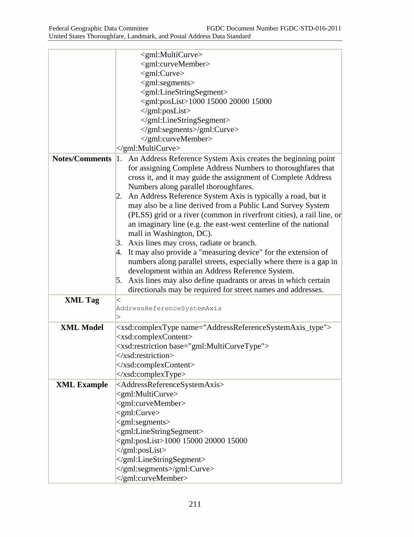
Federal Geographic Data Committee FGDC Document Number FGDC-STD-016-2011 United States Thoroughfare, Landmark, and Postal Address Data Standard
211
<gml:MultiCurve> <gml:curveMember> <gml:Curve> <gml:segments> <gml:LineStringSegment> <gml:posList>1000 15000 20000 15000 </gml:posList> </gml:LineStringSegment> </gml:segments>/gml:Curve> </gml:curveMember>
</gml:MultiCurve> Notes/Comments 1. An Address Reference System Axis creates the beginning point
for assigning Complete Address Numbers to thoroughfares that cross it, and it may guide the assignment of Complete Address Numbers along parallel thoroughfares.
2. An Address Reference System Axis is typically a road, but it may also be a line derived from a Public Land Survey System (PLSS) grid or a river (common in riverfront cities), a rail line, or an imaginary line (e.g. the east-west centerline of the national mall in Washington, DC).
3. Axis lines may cross, radiate or branch. 4. It may also provide a "measuring device" for the extension of
numbers along parallel streets, especially where there is a gap in development within an Address Reference System.
5. Axis lines may also define quadrants or areas in which certain directionals may be required for street names and addresses.
XML Tag < AddressReferenceSystemAxis >
XML Model <xsd:complexType name="AddressReferenceSystemAxis_type"> <xsd:complexContent> <xsd:restriction base="gml:MultiCurveType"> </xsd:restriction> </xsd:complexContent> </xsd:complexType>
XML Example <AddressReferenceSystemAxis> <gml:MultiCurve> <gml:curveMember> <gml:Curve> <gml:segments> <gml:LineStringSegment> <gml:posList>1000 15000 20000 15000 </gml:posList> </gml:LineStringSegment> </gml:segments>/gml:Curve> </gml:curveMember>

Federal Geographic Data Committee FGDC Document Number FGDC-STD-016-2011 United States Thoroughfare, Landmark, and Postal Address Data Standard
212
</gml:MultiCurve> </AddressReferenceSystemAxis>
Quality Measures Address Reference System Axes Point Of Beginning Measure Quality Notes
2.5.14 Address Reference System Axis Point of Beginning Element Name AddressReferenceSystemAxisPointOfBeginning Other common names for this
element
Axis Origin Point
Definition Coordinate location of the beginning point of address numbering along an Address Reference System Axis.
Definition Source New Data Type Geometry (Point) as defined in the Open Geospatial Consortium's
"OpenGIS(R) Geography Markup Language (GML) Encoding Standard" version: 3.2.1 (see Part 6 for a complete citation)
Existing Standards for this Element
N/A
Domain of Values for this
Element
Coordinate location of the beginning point for address numbers along an address axis.
Source of Values Source of spatial data collection. How Defined (eg,
locally, from standard, other)
Point location defined locally, often by ordinance, and encoded in terms of a spatial referencing system, described in file-level metadata per FGDC's Content Standard for Geospatial Metadata.
Example Definition For Washington DC: The US Capitol Building (point of origin for North, South, and East Capitol Streets and the Capitol Mall, which divide DC into four quadrants, NW, NE, SE, and SW). Address numbers increase along those four axes as one travels away from the Capitol Building, and all other streets are addressed more or less in parallel with one of the axis streets, and every address must include a quadrant designation. Element :
<gml:Point> <gml:pos>15000,15000</gml:pos> </gml:Point> For additional examples, please see the Complex Element: Address Reference System
Notes/Comments The origin point for an Address Reference System Axis may be the same or may differ from the origin point for other Address Reference
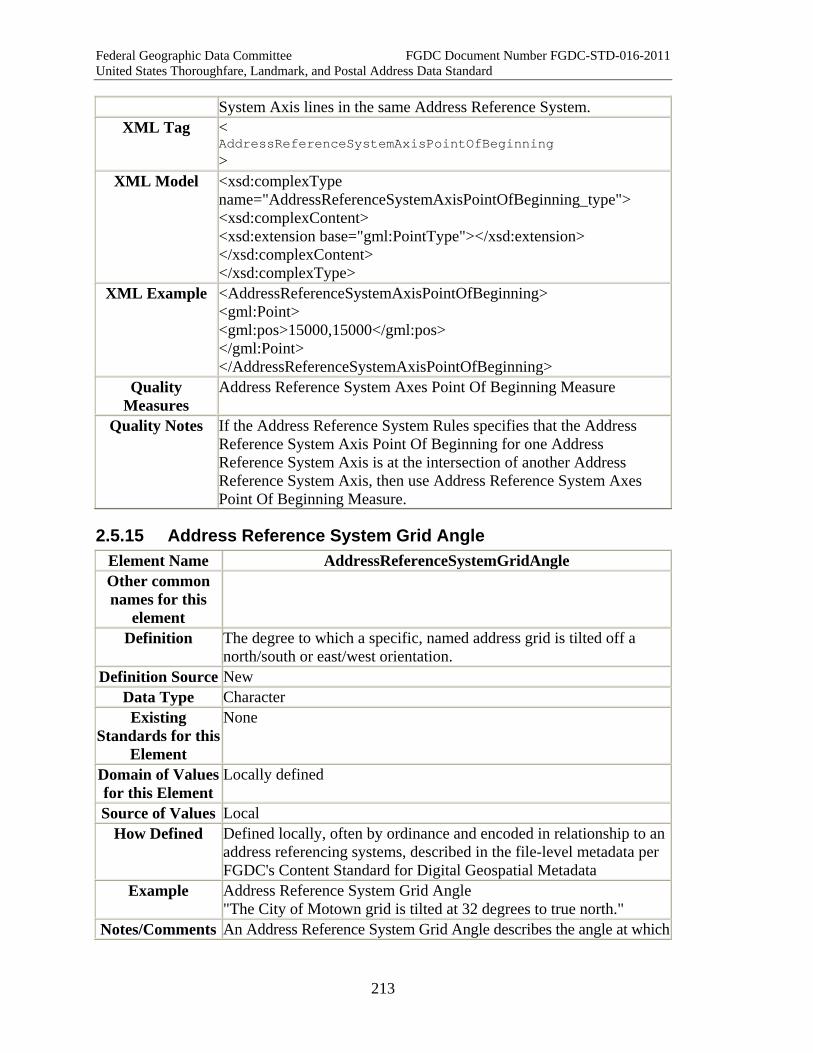
Federal Geographic Data Committee FGDC Document Number FGDC-STD-016-2011 United States Thoroughfare, Landmark, and Postal Address Data Standard
213
System Axis lines in the same Address Reference System. XML Tag <
AddressReferenceSystemAxisPointOfBeginning >
XML Model <xsd:complexType name="AddressReferenceSystemAxisPointOfBeginning_type"> <xsd:complexContent> <xsd:extension base="gml:PointType"></xsd:extension> </xsd:complexContent> </xsd:complexType>
XML Example <AddressReferenceSystemAxisPointOfBeginning> <gml:Point> <gml:pos>15000,15000</gml:pos> </gml:Point> </AddressReferenceSystemAxisPointOfBeginning>
Quality Measures
Address Reference System Axes Point Of Beginning Measure
Quality Notes If the Address Reference System Rules specifies that the Address Reference System Axis Point Of Beginning for one Address Reference System Axis is at the intersection of another Address Reference System Axis, then use Address Reference System Axes Point Of Beginning Measure.
2.5.15 Address Reference System Grid Angle Element Name AddressReferenceSystemGridAngle Other common names for this
element
Definition The degree to which a specific, named address grid is tilted off a north/south or east/west orientation.
Definition Source New Data Type Character Existing
Standards for this Element
None
Domain of Values for this Element
Locally defined
Source of Values Local How Defined Defined locally, often by ordinance and encoded in relationship to an
address referencing systems, described in the file-level metadata per FGDC's Content Standard for Digital Geospatial Metadata
Example Address Reference System Grid Angle "The City of Motown grid is tilted at 32 degrees to true north."
Notes/Comments An Address Reference System Grid Angle describes the angle at which

Federal Geographic Data Committee FGDC Document Number FGDC-STD-016-2011 United States Thoroughfare, Landmark, and Postal Address Data Standard
214
an address grid or reference system consisting of mainly rectangular blocks is tilted or skewed from a true north-south orientation. Such tilting occurs for a number of reasons, including grids based on natural features which are at an angle to the cardinal directions, railroads and major highways that traverse the address reference system at an angle, or other local factors. The angle may have an effect on what directionals are used, and may create confusion when the directionals are referencing the grid rather than the actual compass directions. This attribute will be useful in developing correct assumptions concerning the assignment and quality assurance testing of directionals within the address reference system.
XML Tag < AddressReferenceSystemGridAngle >
XML Model <xsd:simpleType name="AddressReferenceSystemGridAngle_type"> <xsd:restriction base="xsd:double" /> </xsd:simpleType>
XML Example <AddressReferenceSystemGridAngle> 66.5 </AddressReferenceSystemGridAngle>
Quality Measures AddressReferenceSystemRulesMeasure Quality Notes
2.5.16 Address Reference System Reference Polyline Element Name ADDRstandard.AddressReferenceSystemReferencePolyline Other common names for this
element
Definition A street, geometric line, or other line used to measure address number assignment intervals and ranges within an Address Reference System. The Address Reference System Reference Polyline may consist of a beginning point, one or more segments of a street centerline, geographically identified line, such as a line of latitude or longitude, a land-division based line, such as a township, range, or section line, or an imaginary line constructed for the purpose of allocating address ranges and address numbers.
Definition Source New Data Type Geometry (Multicurve), as defined in the Open Geospatial
Consortium's "OpenGIS(R) Geography Markup Language (GML) Encoding Standard" version: 3.2.1 (see Part 6 for a complete citation)
Existing Standards for this Element
None
Domain of Values for this
Can be created locally.
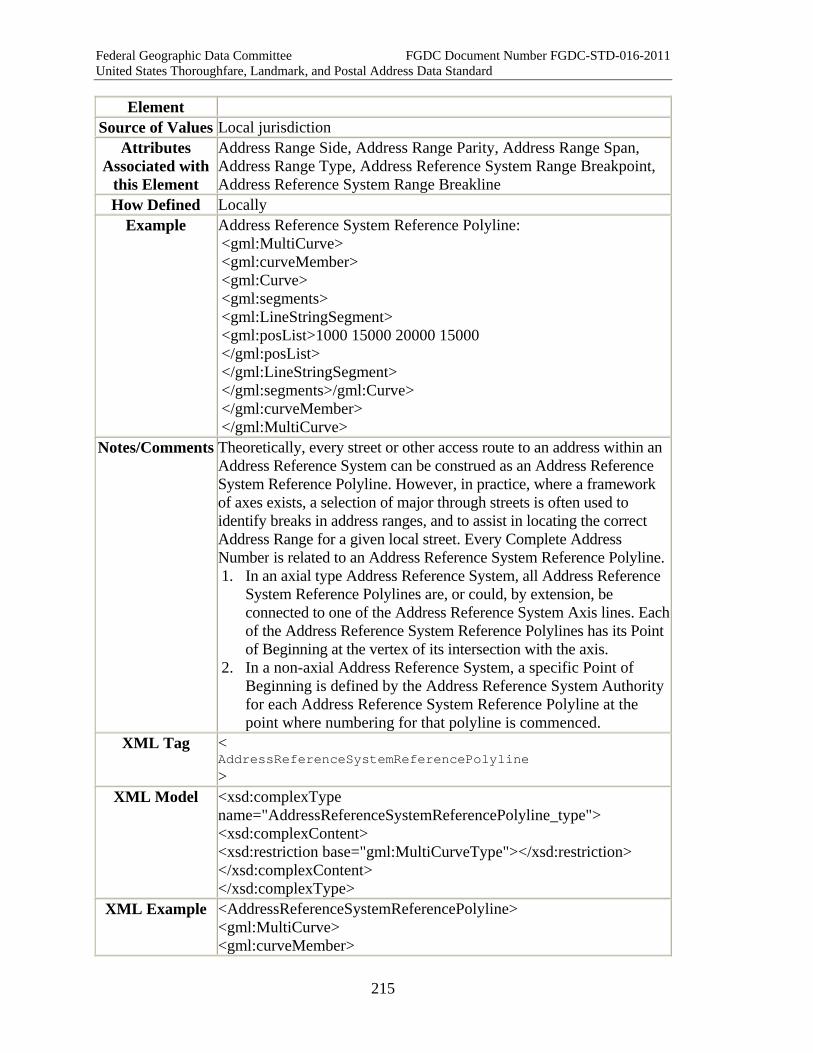
Federal Geographic Data Committee FGDC Document Number FGDC-STD-016-2011 United States Thoroughfare, Landmark, and Postal Address Data Standard
215
Element Source of Values Local jurisdiction
Attributes Associated with
this Element
Address Range Side, Address Range Parity, Address Range Span, Address Range Type, Address Reference System Range Breakpoint, Address Reference System Range Breakline
How Defined Locally Example Address Reference System Reference Polyline:
<gml:MultiCurve> <gml:curveMember> <gml:Curve> <gml:segments> <gml:LineStringSegment> <gml:posList>1000 15000 20000 15000 </gml:posList> </gml:LineStringSegment> </gml:segments>/gml:Curve> </gml:curveMember> </gml:MultiCurve>
Notes/Comments Theoretically, every street or other access route to an address within an Address Reference System can be construed as an Address Reference System Reference Polyline. However, in practice, where a framework of axes exists, a selection of major through streets is often used to identify breaks in address ranges, and to assist in locating the correct Address Range for a given local street. Every Complete Address Number is related to an Address Reference System Reference Polyline. 1. In an axial type Address Reference System, all Address Reference
System Reference Polylines are, or could, by extension, be connected to one of the Address Reference System Axis lines. Each of the Address Reference System Reference Polylines has its Point of Beginning at the vertex of its intersection with the axis.
2. In a non-axial Address Reference System, a specific Point of Beginning is defined by the Address Reference System Authority for each Address Reference System Reference Polyline at the point where numbering for that polyline is commenced.
XML Tag < AddressReferenceSystemReferencePolyline >
XML Model <xsd:complexType name="AddressReferenceSystemReferencePolyline_type"> <xsd:complexContent> <xsd:restriction base="gml:MultiCurveType"></xsd:restriction> </xsd:complexContent> </xsd:complexType>
XML Example <AddressReferenceSystemReferencePolyline> <gml:MultiCurve> <gml:curveMember>
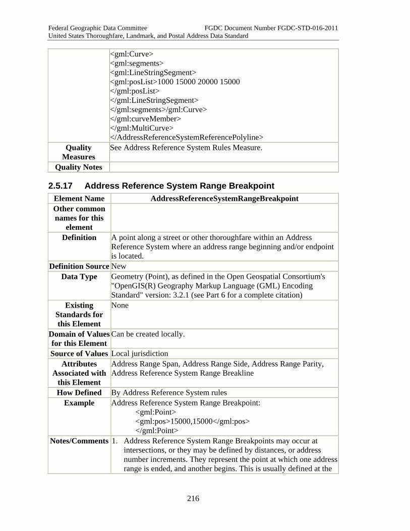
Federal Geographic Data Committee FGDC Document Number FGDC-STD-016-2011 United States Thoroughfare, Landmark, and Postal Address Data Standard
216
<gml:Curve> <gml:segments> <gml:LineStringSegment> <gml:posList>1000 15000 20000 15000 </gml:posList> </gml:LineStringSegment> </gml:segments>/gml:Curve> </gml:curveMember> </gml:MultiCurve> </AddressReferenceSystemReferencePolyline>
Quality Measures
See Address Reference System Rules Measure.
Quality Notes
2.5.17 Address Reference System Range Breakpoint Element Name AddressReferenceSystemRangeBreakpoint Other common names for this
element
Definition A point along a street or other thoroughfare within an Address Reference System where an address range beginning and/or endpoint is located.
Definition Source New Data Type Geometry (Point), as defined in the Open Geospatial Consortium's
"OpenGIS(R) Geography Markup Language (GML) Encoding Standard" version: 3.2.1 (see Part 6 for a complete citation)
Existing Standards for this Element
None
Domain of Values for this Element
Can be created locally.
Source of Values Local jurisdiction Attributes
Associated with this Element
Address Range Span, Address Range Side, Address Range Parity, Address Reference System Range Breakline
How Defined By Address Reference System rules Example Address Reference System Range Breakpoint:
<gml:Point> <gml:pos>15000,15000</gml:pos> </gml:Point>
Notes/Comments 1. Address Reference System Range Breakpoints may occur at intersections, or they may be defined by distances, or address number increments. They represent the point at which one address range is ended, and another begins. This is usually defined at the
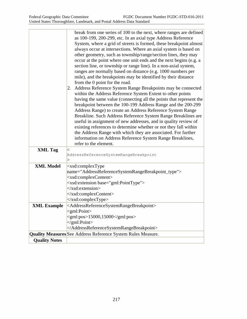
Federal Geographic Data Committee FGDC Document Number FGDC-STD-016-2011 United States Thoroughfare, Landmark, and Postal Address Data Standard
217
break from one series of 100 to the next, where ranges are defined as 100-199, 200-299, etc. In an axial type Address Reference System, where a grid of streets is formed, these breakpoint almost always occur at intersections. Where an axial system is based on other geometry, such as township/range/section lines, they may occur at the point where one unit ends and the next begins (e.g. a section line, or township or range line). In a non-axial system, ranges are normally based on distance (e.g. 1000 numbers per mile), and the breakpoints may be identified by their distance from the 0 point for the road.
2. Address Reference System Range Breakpoints may be connected within the Address Reference System Extent to other points having the same value (connecting all the points that represent the breakpoint between the 100-199 Address Range and the 200-299 Address Range) to create an Address Reference System Range Breakline. Such Address Reference System Range Breaklines are useful in assignment of new addresses, and in quality review of existing references to determine whether or not they fall within the Address Range with which they are associated. For further information on Address Reference System Range Breaklines, refer to the element.
XML Tag < AddressReferenceSystemRangeBreakpoint >
XML Model <xsd:complexType name="AddressReferenceSystemRangeBreakpoint_type"> <xsd:complexContent> <xsd:extension base="gml:PointType"> </xsd:extension> </xsd:complexContent> </xsd:complexType>
XML Example <AddressReferenceSystemRangeBreakpoint> <gml:Point> <gml:pos>15000,15000</gml:pos> </gml:Point> </AddressReferenceSystemRangeBreakpoint>
Quality Measures See Address Reference System Rules Measure. Quality Notes

Federal Geographic Data Committee FGDC Document Number FGDC-STD-016-2011 United States Thoroughfare, Landmark, and Postal Address Data Standard
218
2.5.18 Address Reference System Range Breakline Element Name ADDRstandard.AddressReferenceSystemRangeBreakline Other common names for this
element
Definition A line connecting the Address Reference System Range Breakpoints with the same value within an Address Reference System
Definition Source New Data Type Geometry (Multicurve), as defined in the Open Geospatial
Consortium's "OpenGIS(R) Geography Markup Language (GML) Encoding Standard" version: 3.2.1 (see Part 6 for a complete citation)
Existing Standards for this Element
None
Domain of Values for this
Element
Based on range values in Address Reference System.
Source of Values Local jurisdiction Attributes
Associated with this Element
How Defined Example Address Reference System Range Breakline:
<gml:MultiCurve> <gml:curveMember> <gml:Curve> <gml:segments> <gml:LineStringSegment> <gml:posList>1000 15000 20000 15000 </gml:posList> </gml:LineStringSegment> </gml:segments>/gml:Curve> </gml:curveMember> </gml:MultiCurve>
Notes/Comments The Address Reference System Range Breakline provides address assignment and quality assurance personnel with a means of identifying which ranges apply within a given area of an Address Reference System. In axial (or grid) type systems, with roughly rectangular blocks, these lines should be relatively straight and parallel. However, in less regular topography, or where the street pattern is more irregular, these lines may converge or diverge. They should not cross. The lines are constructed in an axial system by connecting all of the Address Reference System Range Breakpoints that have identical values (for example those that represent the beginning of the "1200"
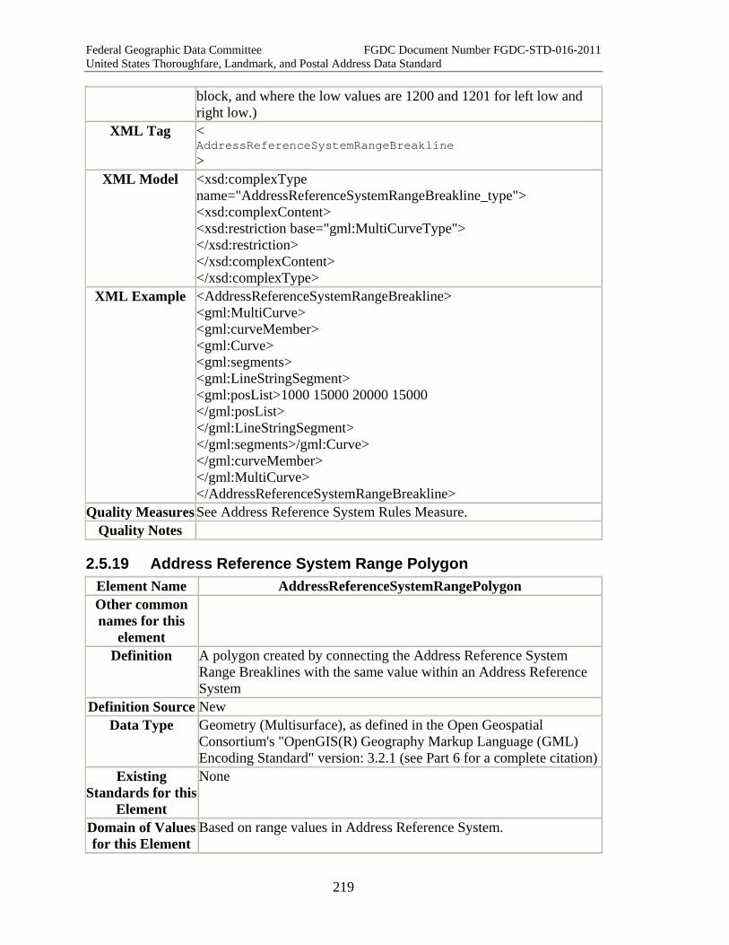
Federal Geographic Data Committee FGDC Document Number FGDC-STD-016-2011 United States Thoroughfare, Landmark, and Postal Address Data Standard
219
block, and where the low values are 1200 and 1201 for left low and right low.)
XML Tag < AddressReferenceSystemRangeBreakline >
XML Model <xsd:complexType name="AddressReferenceSystemRangeBreakline_type"> <xsd:complexContent> <xsd:restriction base="gml:MultiCurveType"> </xsd:restriction> </xsd:complexContent> </xsd:complexType>
XML Example <AddressReferenceSystemRangeBreakline> <gml:MultiCurve> <gml:curveMember> <gml:Curve> <gml:segments> <gml:LineStringSegment> <gml:posList>1000 15000 20000 15000 </gml:posList> </gml:LineStringSegment> </gml:segments>/gml:Curve> </gml:curveMember> </gml:MultiCurve> </AddressReferenceSystemRangeBreakline>
Quality Measures See Address Reference System Rules Measure. Quality Notes
2.5.19 Address Reference System Range Polygon Element Name AddressReferenceSystemRangePolygon Other common names for this
element
Definition A polygon created by connecting the Address Reference System Range Breaklines with the same value within an Address Reference System
Definition Source New Data Type Geometry (Multisurface), as defined in the Open Geospatial
Consortium's "OpenGIS(R) Geography Markup Language (GML) Encoding Standard" version: 3.2.1 (see Part 6 for a complete citation)
Existing Standards for this
Element
None
Domain of Values for this Element
Based on range values in Address Reference System.

Federal Geographic Data Committee FGDC Document Number FGDC-STD-016-2011 United States Thoroughfare, Landmark, and Postal Address Data Standard
220
Source of Values Local jurisdiction Attributes
Associated with this Element
Address Reference System Range Breakpoint, Address Reference System Range Breakline, Address Reference System Reference Polyline
How Defined Example Address Reference System Range Polygon:
<gml:MultiSurface> <gml:surfaceMember> <gml:Polygon> <gml:exterior> <gml:LinearRing> <gml:posList>1000 1000 1000 25000 20000 1000 20000 25000 1000 1000</gml:posList> </gml:LinearRing> </gml:exterior> </gml:Polygon> </gml:surfaceMember> </gml:MultiSurface>
Notes/Comments The Address Reference System Range Polygon provides address assignment and quality assurance personnel with a means of identifying which ranges apply within a given area of an Address Reference System. In axial (or grid) type systems, with roughly rectangular blocks, these polygons should create an area of a long band where all of the addresses are or should be within a given block range. However, in less regular topography, or where the street pattern is more irregular, these polygons may be less coherent. They must not overlap. The lines are constructed in an axial system by connecting all of the Address Reference System Range Breaklines that have identical values and extending the polygon to the Address Reference System Range Breakline with the next higher value (for example those that represent the beginning of the "1200" block, and where the low values are 1200 and 1201 for left low and right low.)
XML Tag < AddressReferenceSystemRangePolygon >
XML Model <xsd:complexType name="AddressReferenceSystemRangePolygon_type"> <xsd:complexContent> <xsd:restriction base="gml:MultiSurfaceType"> </xsd:restriction> </xsd:complexContent> </xsd:complexType>
XML Example <AddressReferenceSystemRangePolygon> <gml:MultiSurface> <gml:surfaceMember>

Federal Geographic Data Committee FGDC Document Number FGDC-STD-016-2011 United States Thoroughfare, Landmark, and Postal Address Data Standard
221
<gml:Polygon> <gml:exterior> <gml:LinearRing> <gml:posList>1000 1000 1000 25000 20000 1000 20000 25000 1000 1000</gml:posList> </gml:LinearRing> </gml:exterior> </gml:Polygon> </gml:surfaceMember> </gml:MultiSurface> </AddressReferenceSystemRangePolygon>
Quality Measures See Address Reference System Rules Measure. Quality Notes
2.5.20 Address Reference System Reference Document Citation Element Name AddressReferenceSystemReferenceDocumentCitation Other common names for this
element
Address Ordinance, Address Manual
Definition A bibliographic reference to an ordinance, map, manual, or other document in which the rules governing an Address Reference System are written.
Definition Source
New
Data Type characterString Existing
Standards for this Element
None
Domain of Values for this
Element
Locally defined
Source of Values Local How Defined Defined locally
Example "Rules for the Anytown Address Reference System are found in the Anytown Address Ordinance, Chapter 15, Sections 1-29, of the Anytown Municipal Code (www.ci.anytown.na.us)"
Notes/Comments The citation should be used initially, until all of the rules are documented within the Address Reference System Rules elements. However, once all of the rules are documented, the citation must be maintained to provide valuable source information for users.
XML Tag < AddressReferenceSystemReferenceDocumentCitation >
XML Model <xsd:simpleType name="AddressReferenceSystemReferenceDocumentCitation_type">

Federal Geographic Data Committee FGDC Document Number FGDC-STD-016-2011 United States Thoroughfare, Landmark, and Postal Address Data Standard
222
<xsd:restriction base="xsd:string" /> </xsd:simpleType>
XML Example <AddressReferenceSystemReferenceDocumentCitation> "Rules for the Anytown Address Reference System are found in the Anytown Address Ordinance, Chapter 15, Sections 1-29, of the Anytown Municipal Code (www.ci.anytown.na.us)" </AddressReferenceSystemReferenceDocumentCitation>
Quality Measures
None
Quality Notes
2.5.21 Complex Element: Address Reference System Element Name AddressReferenceSystem Other common names for this
element
A set of rules and geometries that define how addresses are assigned along thoroughfares and/or within a given area (Address Reference System Extent). At minimum, an Address Reference System must specify where Complete Address Number sequences begin and how Complete Address Numbers are assigned along the length of thoroughfares governed by the Address Reference System. Address Reference Systems typically provide rules governing left-right parity of Complete Address Numbers, assignment of Street Names and street types, use of directionals and quadrants, and other aspects of address assignment. An Address Reference System is designated by its Address Reference System Name (required). Additional business rules for an Address Reference System are described in the Address Reference System Rules.
Definition Source
New
Data Type Abstract Existing
Standards for this Element
Refer to Component Elements
Domain of Values for this
Element
Refer to Component Elements
Source of Values Refer to Component Elements How Defined
(eg, locally, from standard, other)
Refer to Component Elements
Example Address Reference System Name: Metro City Address Grid Address Reference System Axis Point Of Beginning:
<gml:Point> <gml:pos>15000,15000</gml:pos> </gml:Point>
Address Reference System Axis:

Federal Geographic Data Committee FGDC Document Number FGDC-STD-016-2011 United States Thoroughfare, Landmark, and Postal Address Data Standard
223
<gml:MultiCurve> <gml:curveMember> <gml:Curve> <gml:segments> <gml:LineStringSegment> <gml:posList>1000 15000 20000 15000 </gml:posList> </gml:LineStringSegment> </gml:segments>/gml:Curve> </gml:curveMember>
</gml:MultiCurve> Address Reference System Axis Point Of Beginning:
<gml:Point> <gml:pos>15000,15000</gml:pos> </gml:Point>
Address Reference System Axis:
<gml:MultiCurve> <gml:curveMember> <gml:Curve> <gml:segments> <gml:LineStringSegment> <gml:posList>1000 15000 20000 15000 </gml:posList> </gml:LineStringSegment> </gml:segments>/gml:Curve> </gml:curveMember>
</gml:MultiCurve> Address Reference System Extent: <gml:MultiSurface> <gml:surfaceMember> <gml:Polygon> <gml:exterior> <gml:LinearRing> <gml:posList>1000 1000 1000 25000 20000 1000 20000 25000 1000 1000</gml:posList> </gml:LinearRing> </gml:exterior> </gml:Polygon> </gml:surfaceMember>
</gml:MultiSurface> Address Reference System Rules: Written information about parity, street naming conventions, numbering intervals, grids, and other business rules. (Contains elements including Address Reference System Block Rules, Address Reference System Numbering Rules, Address Reference System Street Naming Rules, Address Reference System Street Type Directional And Modifier Rules, Address Reference System

Federal Geographic Data Committee FGDC Document Number FGDC-STD-016-2011 United States Thoroughfare, Landmark, and Postal Address Data Standard
224
Place Name State Country And Zip Code Rules Address Reference System Authority: Name of agency (municipality, county, other) that has authority over the scheme's business rules, extent and other parameters.
Notes/Comments 1. Address Reference System Extents may overlap. 2. There are three broad types of Address Reference Systems: Axial,
linear non-axial and area based. • Axial The Address Reference System is based on streets or
geometric lines which form the basis for address numbering. The axes are often oriented more or less at 90 degrees to each other to define quadrants or directionals. The grid may be defined by topography, rivers, rail lines, or other features. This is by far the most common type in the United States; Chicago is but one of many clear examples.
• Linear Non-axial. Each thoroughfare has its own beginning point for Complete Address Numbers, independent of the other thoroughfares in the Address Reference System. This is common, for example, in rural areas where the road network is sparse and street segments are long. This term may also apply to places where the address numbers are not based on thoroughfares at all.
• Area-based. An Address Reference System may not be based on street geometry, but number assignment is done according to chronology (when a structure was addressed), or parcel or lot numbers.
3. A jurisdiction may have more than one addressing scheme within its area, and its Address Reference System(s) may change over time. Occasionally addresses from different schemes are intermingled along the same block face, which complicates the assignment of an address range to that block face. This may be the result of annexation of developed properties with existing addresses from one jurisdiction to another.
XML Tag < AddressReferenceSystem >
XML Model <xsd:complexType name="AddressReferenceSystem" > <xsd:sequence> <xsd:element name="AddressReferenceSystemID" type="addr_type:AddressReferenceSystemId_type" maxOccurs="1" minOccurs="1"/> <xsd:element name="AddressReferenceSystemName" type="addr_type:AddressReferenceSystemName_type" maxOccurs="1" minOccurs="1"/> <xsd:element name="AddressReferenceSystemAuthority" type="addr_type:AddressReferenceSystemAuthority_type" maxOccurs="1" minOccurs="0"/>
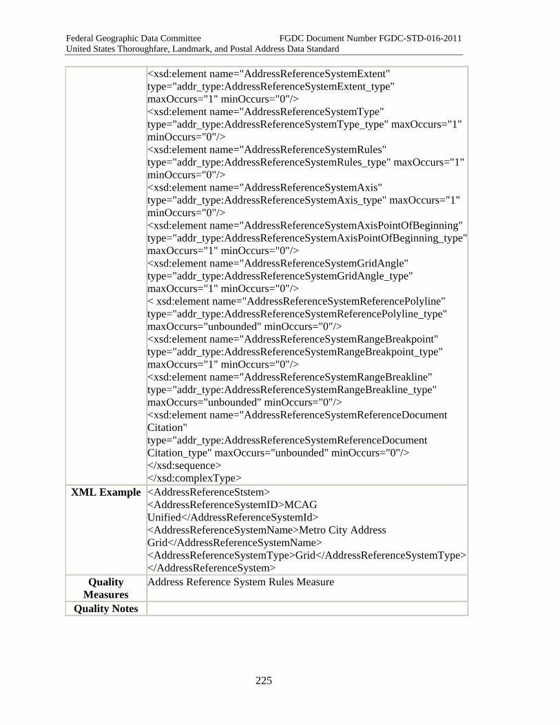
Federal Geographic Data Committee FGDC Document Number FGDC-STD-016-2011 United States Thoroughfare, Landmark, and Postal Address Data Standard
225
<xsd:element name="AddressReferenceSystemExtent" type="addr_type:AddressReferenceSystemExtent_type" maxOccurs="1" minOccurs="0"/> <xsd:element name="AddressReferenceSystemType" type="addr_type:AddressReferenceSystemType_type" maxOccurs="1" minOccurs="0"/> <xsd:element name="AddressReferenceSystemRules" type="addr_type:AddressReferenceSystemRules_type" maxOccurs="1" minOccurs="0"/> <xsd:element name="AddressReferenceSystemAxis" type="addr_type:AddressReferenceSystemAxis_type" maxOccurs="1" minOccurs="0"/> <xsd:element name="AddressReferenceSystemAxisPointOfBeginning" type="addr_type:AddressReferenceSystemAxisPointOfBeginning_type"maxOccurs="1" minOccurs="0"/> <xsd:element name="AddressReferenceSystemGridAngle" type="addr_type:AddressReferenceSystemGridAngle_type" maxOccurs="1" minOccurs="0"/> < xsd:element name="AddressReferenceSystemReferencePolyline" type="addr_type:AddressReferenceSystemReferencePolyline_type" maxOccurs="unbounded" minOccurs="0"/> <xsd:element name="AddressReferenceSystemRangeBreakpoint" type="addr_type:AddressReferenceSystemRangeBreakpoint_type" maxOccurs="1" minOccurs="0"/> <xsd:element name="AddressReferenceSystemRangeBreakline" type="addr_type:AddressReferenceSystemRangeBreakline_type" maxOccurs="unbounded" minOccurs="0"/> <xsd:element name="AddressReferenceSystemReferenceDocument Citation" type="addr_type:AddressReferenceSystemReferenceDocument Citation_type" maxOccurs="unbounded" minOccurs="0"/> </xsd:sequence> </xsd:complexType>
XML Example <AddressReferenceStstem> <AddressReferenceSystemID>MCAG Unified</AddressReferenceSystemId> <AddressReferenceSystemName>Metro City Address Grid</AddressReferenceSystemName> <AddressReferenceSystemType>Grid</AddressReferenceSystemType></AddressReferenceSystem>
Quality Measures
Address Reference System Rules Measure
Quality Notes