1st spanish period
TRANSCRIPT
399
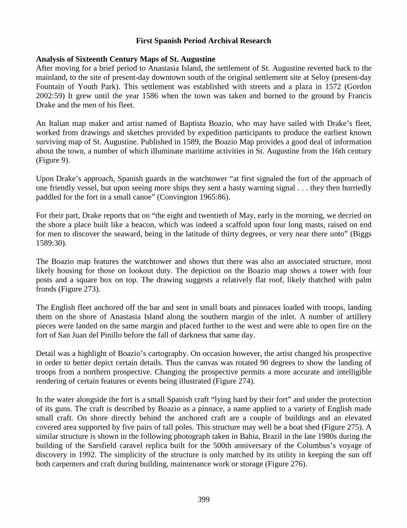
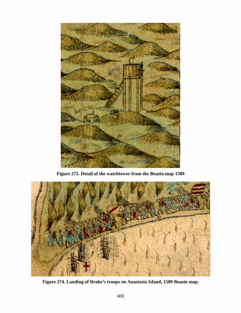
First Spanish Period Archival Research Analysis of Sixteenth Century Maps of St. Augustine After moving for a brief period to Anastasia Island, the settlement of St. Augustine reverted back to the mainland, to the site of present-day downtown south of the original settlement site at Seloy (present-day Fountain of Youth Park). This settlement was established with streets and a plaza in 1572 (Gordon 2002:59) It grew until the year 1586 when the town was taken and burned to the ground by Francis Drake and the men of his fleet. An Italian map maker and artist named of Baptista Boazio, who may have sailed with Drake’s fleet, worked from drawings and sketches provided by expedition participants to produce the earliest known surviving map of St. Augustine. Published in 1589, the Boazio Map provides a good deal of information about the town, a number of which illuminate maritime activities in St. Augustine from the 16th century (Figure 9). Upon Drake’s approach, Spanish guards in the watchtower “at first signaled the fort of the approach of one friendly vessel, but upon seeing more ships they sent a hasty warning signal . . . they then hurriedly paddled for the fort in a small canoe” (Convington 1965:86). For their part, Drake reports that on “the eight and twentieth of May, early in the morning, we decried on the shore a place built like a beacon, which was indeed a scaffold upon four long masts, raised on end for men to discover the seaward, being in the latitude of thirty degrees, or very near there unto” (Biggs 1589:30). The Boazio map features the watchtower and shows that there was also an associated structure, most likely housing for those on lookout duty. The depiction on the Boazio map shows a tower with four posts and a square box on top. The drawing suggests a relatively flat roof, likely thatched with palm fronds (Figure 273). The English fleet anchored off the bar and sent in small boats and pinnaces loaded with troops, landing them on the shore of Anastasia Island along the southern margin of the inlet. A number of artillery pieces were landed on the same margin and placed further to the west and were able to open fire on the fort of San Juan del Pinillo before the fall of darkness that same day. Detail was a highlight of Boazio’s cartography. On occasion however, the artist changed his prospective in order to better depict certain details. Thus the canvas was rotated 90 degrees to show the landing of troops from a northern prospective. Changing the prospective permits a more accurate and intelligible rendering of certain features or events being illustrated (Figure 274). In the water alongside the fort is a small Spanish craft “lying hard by their fort” and under the protection of its guns. The craft is described by Boazio as a pinnace, a name applied to a variety of English made small craft. On shore directly behind the anchored craft are a couple of buildings and an elevated covered area supported by five pairs of tall poles. This structure may well be a boat shed (Figure 275). A similar structure is shown in the following photograph taken in Bahia, Brazil in the late 1980s during the building of the Sarsfield caravel replica built for the 500th anniversary of the Columbus’s voyage of discovery in 1992. The simplicity of the structure is only matched by its utility in keeping the sun off both carpenters and craft during building, maintenance work or storage (Figure 276).
400
Figure 273. Detail of the watchtower from the Boazio map 1589
Figure 274. Landing of Drake’s troops on Anastasia Island, 1589 Boazio map.

401
Figure 275. Moored Spanish vessel called a pinnace by Drake’s men, and a possible boat shed.
Figure 276. Brazilian boat shed used to construct a replica caravel. Courtesy of Morgan Sanger. The structure would normally be oriented 90 degrees to that shown so that a craft could be launched directly into the river. However, the artist can more easily render it accurately when shown in this prospective. This is perhaps another example of the artist changing prospective in order to convey a clearer picture of a feature being illustrated. Adjacent buildings, apparently shaded by trees, may have been the dwellings of boat carpenters, fisherman, or mariners attached to the presidio. They may also have served as storage for ship and boat equipment such as sails, yards, oars, anchors, and line. Clearly, whether the tall structure is a boathouse or not, the structures near the foreshore in conjunction with the anchored craft suggest that this is a maritime activity area associated with the presidio north of
402
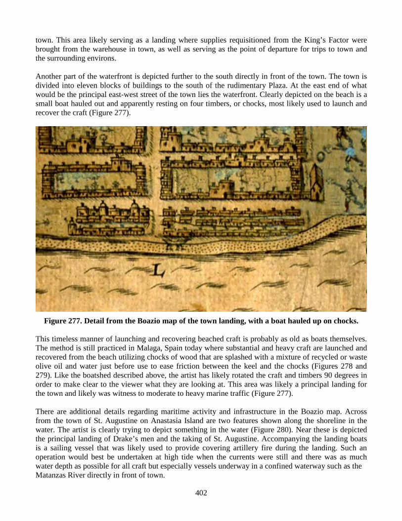
town. This area likely serving as a landing where supplies requisitioned from the King’s Factor were brought from the warehouse in town, as well as serving as the point of departure for trips to town and the surrounding environs. Another part of the waterfront is depicted further to the south directly in front of the town. The town is divided into eleven blocks of buildings to the south of the rudimentary Plaza. At the east end of what would be the principal east-west street of the town lies the waterfront. Clearly depicted on the beach is a small boat hauled out and apparently resting on four timbers, or chocks, most likely used to launch and recover the craft (Figure 277).
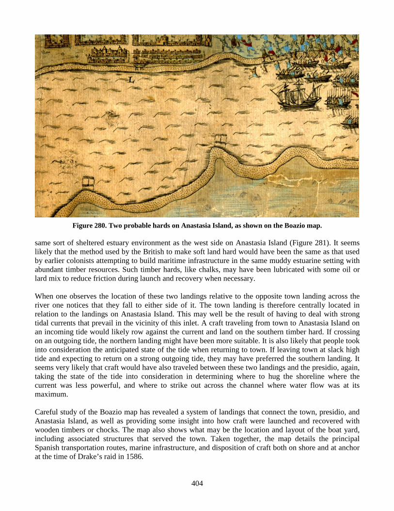
Figure 277. Detail from the Boazio map of the town landing, with a boat hauled up on chocks. This timeless manner of launching and recovering beached craft is probably as old as boats themselves. The method is still practiced in Malaga, Spain today where substantial and heavy craft are launched and recovered from the beach utilizing chocks of wood that are splashed with a mixture of recycled or waste olive oil and water just before use to ease friction between the keel and the chocks (Figures 278 and 279). Like the boatshed described above, the artist has likely rotated the craft and timbers 90 degrees in order to make clear to the viewer what they are looking at. This area was likely a principal landing for the town and likely was witness to moderate to heavy marine traffic (Figure 277). There are additional details regarding maritime activity and infrastructure in the Boazio map. Across from the town of St. Augustine on Anastasia Island are two features shown along the shoreline in the water. The artist is clearly trying to depict something in the water (Figure 280). Near these is depicted the principal landing of Drake’s men and the taking of St. Augustine. Accompanying the landing boats is a sailing vessel that was likely used to provide covering artillery fire during the landing. Such an operation would best be undertaken at high tide when the currents were still and there was as much water depth as possible for all craft but especially vessels underway in a confined waterway such as the Matanzas River directly in front of town.

403
Figure 278. Traditional Malaga craft resting on two chocks.
Figure 279. Landing a boat with first chock in position. This is an important point with regard to the structures shown along Anastasia Island. These are shown as in the water and depicted with the same colors and similar line thickness as the water is, as if they were part of the bay. It seems likely that what are depicted in these two cases are submerged features, specifically, timber hards used for beaching and launching craft at low tide. Unlike the sandy beach waterfront in front of town or the fort, exposed to strong northeasterly seas and storms, the western shoreline of Anastasia is sheltered from and therefore has a heavier load of fine sediments. The accumulation of these marine sediment forms thick mud deposits that can severely hamper the landing and launching of boats, especially if loading or unloading supplies or cargo of any kind. The Tolomato Bar Anchorage site (SJ4801), several miles up the Tolomato River and dating to the British and Second Spanish Periods, contains archaeological evidence for just such timber hards in the
404
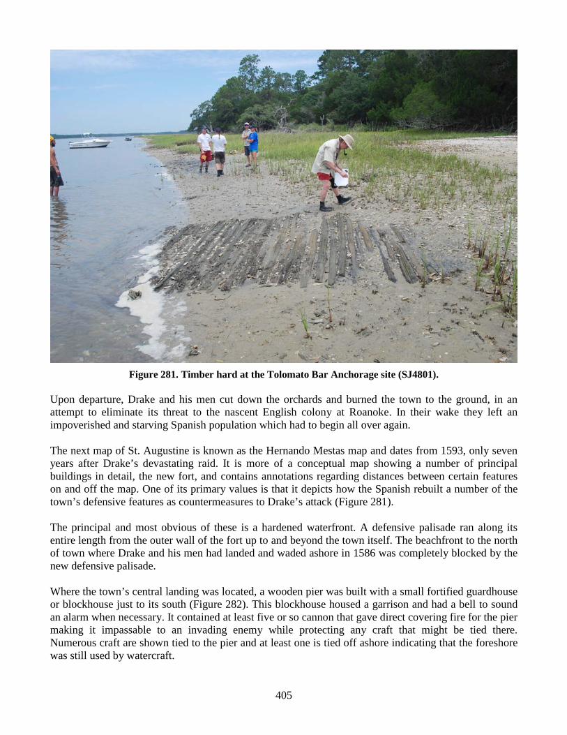
Figure 280. Two probable hards on Anastasia Island, as shown on the Boazio map. same sort of sheltered estuary environment as the west side on Anastasia Island (Figure 281). It seems likely that the method used by the British to make soft land hard would have been the same as that used by earlier colonists attempting to build maritime infrastructure in the same muddy estuarine setting with abundant timber resources. Such timber hards, like chalks, may have been lubricated with some oil or lard mix to reduce friction during launch and recovery when necessary. When one observes the location of these two landings relative to the opposite town landing across the river one notices that they fall to either side of it. The town landing is therefore centrally located in relation to the landings on Anastasia Island. This may well be the result of having to deal with strong tidal currents that prevail in the vicinity of this inlet. A craft traveling from town to Anastasia Island on an incoming tide would likely row against the current and land on the southern timber hard. If crossing on an outgoing tide, the northern landing might have been more suitable. It is also likely that people took into consideration the anticipated state of the tide when returning to town. If leaving town at slack high tide and expecting to return on a strong outgoing tide, they may have preferred the southern landing. It seems very likely that craft would have also traveled between these two landings and the presidio, again, taking the state of the tide into consideration in determining where to hug the shoreline where the current was less powerful, and where to strike out across the channel where water flow was at its maximum. Careful study of the Boazio map has revealed a system of landings that connect the town, presidio, and Anastasia Island, as well as providing some insight into how craft were launched and recovered with wooden timbers or chocks. The map also shows what may be the location and layout of the boat yard, including associated structures that served the town. Taken together, the map details the principal Spanish transportation routes, marine infrastructure, and disposition of craft both on shore and at anchor at the time of Drake’s raid in 1586.
405
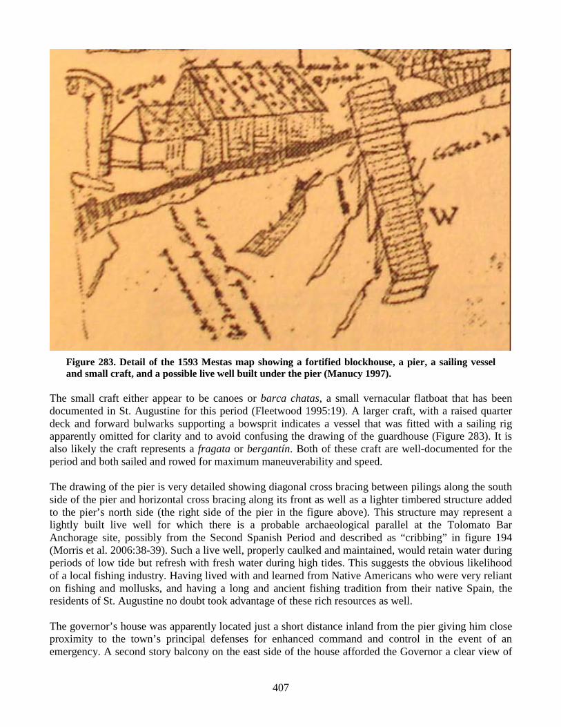
Figure 281. Timber hard at the Tolomato Bar Anchorage site (SJ4801). Upon departure, Drake and his men cut down the orchards and burned the town to the ground, in an attempt to eliminate its threat to the nascent English colony at Roanoke. In their wake they left an impoverished and starving Spanish population which had to begin all over again. The next map of St. Augustine is known as the Hernando Mestas map and dates from 1593, only seven years after Drake’s devastating raid. It is more of a conceptual map showing a number of principal buildings in detail, the new fort, and contains annotations regarding distances between certain features on and off the map. One of its primary values is that it depicts how the Spanish rebuilt a number of the town’s defensive features as countermeasures to Drake’s attack (Figure 281). The principal and most obvious of these is a hardened waterfront. A defensive palisade ran along its entire length from the outer wall of the fort up to and beyond the town itself. The beachfront to the north of town where Drake and his men had landed and waded ashore in 1586 was completely blocked by the new defensive palisade. Where the town’s central landing was located, a wooden pier was built with a small fortified guardhouse or blockhouse just to its south (Figure 282). This blockhouse housed a garrison and had a bell to sound an alarm when necessary. It contained at least five or so cannon that gave direct covering fire for the pier making it impassable to an invading enemy while protecting any craft that might be tied there. Numerous craft are shown tied to the pier and at least one is tied off ashore indicating that the foreshore was still used by watercraft.

406
Figure 282. The 1593 Mestas map, showing the town’s improved maritime defenses. A new fort faces the inlet, a palisade defends the entire waterfront, and an armed blockhouse guards the pier (Manucy 1997).
407
Figure 283. Detail of the 1593 Mestas map showing a fortified blockhouse, a pier, a sailing vessel and small craft, and a possible live well built under the pier (Manucy 1997).
The small craft either appear to be canoes or barca chatas, a small vernacular flatboat that has been documented in St. Augustine for this period (Fleetwood 1995:19). A larger craft, with a raised quarter deck and forward bulwarks supporting a bowsprit indicates a vessel that was fitted with a sailing rig apparently omitted for clarity and to avoid confusing the drawing of the guardhouse (Figure 283). It is also likely the craft represents a fragata or bergantín. Both of these craft are well-documented for the period and both sailed and rowed for maximum maneuverability and speed. The drawing of the pier is very detailed showing diagonal cross bracing between pilings along the south side of the pier and horizontal cross bracing along its front as well as a lighter timbered structure added to the pier’s north side (the right side of the pier in the figure above). This structure may represent a lightly built live well for which there is a probable archaeological parallel at the Tolomato Bar Anchorage site, possibly from the Second Spanish Period and described as “cribbing” in figure 194 (Morris et al. 2006:38-39). Such a live well, properly caulked and maintained, would retain water during periods of low tide but refresh with fresh water during high tides. This suggests the obvious likelihood of a local fishing industry. Having lived with and learned from Native Americans who were very reliant on fishing and mollusks, and having a long and ancient fishing tradition from their native Spain, the residents of St. Augustine no doubt took advantage of these rich resources as well. The governor’s house was apparently located just a short distance inland from the pier giving him close proximity to the town’s principal defenses for enhanced command and control in the event of an emergency. A second story balcony on the east side of the house afforded the Governor a clear view of
408
the entire waterfront, pier, blockhouse, and the larger fort to the north. The watchtower on Anastasia Island would also have been clearly visible. Preliminary Analysis of the Caja de San Agustin de Florida Documents, Contaduria 950 The Archivo General de Indias, in Seville, Spain contains a vast number of documents relevant to the history of the Spanish colonial New World. Within this archive is the Caja de San Agustin de Florida, the “St. Augustine Box.” Within this box are contained the cuentas de bastamientos, or supply accounts, in the form of Contaduria 950. These cuentas de bastamientos cover the period from 1597, the eleventh year following Drake’s raid, to 1601. Transcription, translation, and analysis of these documents is preliminary but a considerable amount of information has come to light regarding the settlement’s organization and administration of maritime resources, and to the variety of boat types used by colonial authorities to maintain security and lines of communication. Continuing study and analysis of these documents promises to yield considerably more information in the future. What follows are two discussions based on the preliminary analysis of these documents, the first focusing on the organization and administration of maritime resources, and the second focusing on types of boats maintained by colonial authorities, with a conjectural reconstruction of a St. Augustine chalupa. Maritime Organization and Administration in Early St. Augustine The watercraft described in the documents were attached to the Presidio, the Spanish military establishment which embodied the principal purpose of the settlement at St. Augustine. There was a group of small craft generically described as lanchas, under a managing piloto, or pilot. During 1597-1599, and possibly before and after that period, the piloto was a man named Antonio Díaz. Díaz was in overall charge of the maintenance and probably the organization and dispatching of the numerous craft on their various assignments. These supply records known as cuentas de bastamientos in Spanish are organized by materials. For example, the records recently examined and which shed light on the Spanish maritime organization in St. Augustine are a group of disbursements of sail thread, ylo de vela, used to make and repair sails. These disbursements contain a surprising amount of information. The events surrounding the need for the disbursements are often described as well as the individuals involved in the chain of command that had to be traversed in order to have two pounds of sail thread requisitioned. This level of information and justification reflects the value of all material goods in St. Augustine. It should be remembered that St. Augustine was on the outskirts of the Spanish New World Empire and it was a colony that existed by and large at a subsistence level. Having no mining or agricultural industries, there was little to generate wealth locally and so the colony was subsidized by the Spanish Crown. With few exceptions, most goods arrived by sea and had significant value. The specific types of watercraft that fall under the category of lanchas are bateles and chalupas. Both these types of craft have been documented in other Spanish maritime contexts, most notably in Labrador, Canada where archaeological examples of both have been found. These finds are associated with the Basque whaling industry which flourished there during the second half of the 16th century. The records show that St. Augustine’s small craft had names just like larger craft. One case in point is a lancha, either a chalupa or batel, named La Florida. This particular craft also had an assigned maestre or master. In La Florida’s case his name was Domingo Rodríguez. On 11 March 1599, two and a half pounds of sail thread were requisitioned by Antonio Díaz to make a new mainsail and its bonnet for Domingo Rodríguez’s La Florida. This most likely represents a replacement due to the standard wear and tear to the crafts sails.

409
Two years earlier on 11 October 1597, six pounds of sail thread were requisitioned for the fragata La Concepción . Fragatas were generally larger than either chalupas or bateles. These vessels represent the larger compliment of St. Augustine’s maritime forces and were used on the high seas to patrol the coast and to communicate with other ports along the Spanish Main, particularly the port of Havana in Cuba and ports in Mexico. This account is of particular interest because the sail thread was requisitioned in preparation for a voyage by the Governor along the coast of Guale in present day Georgia with the intention of attacking Indians responsible for the recent death of a number of Franciscan friars. On 10 December of the same year, Díaz requisitioned two and a half pounds of sail thread in order to make a mainsail with its bonnet and a trinquete (foresail) for a newly built chalupa that was to serve the presidio. This entry is particularly important as it documents on site boatbuilding in St. Augustine in 1597. In 1601, sail thread was again requisitioned for the making of sails for the Presidio’s fragata La Concep ción and another newly built chalupa. An entry from the same year documents the delivery of 50 pieces of timber to a man named Francisco Margado, the master of the presidio’s fragata Sant Andres. He had received the wood from Mateo Louis, described in the documents as Piloto Mayor, or chief pilot ‘of these provinces’ which is a reference to La Florida. Mateo Louis had purchased the wood in New Spain along with other goods necessary for the maintenance of the presidio’s watercraft. This initial and cursory examination of the cuentas de bastamientos sheds a great deal of light on the Spanish maritime organization in St. Augustine at the end of the 16th century. A small craft-building industry was present supplying the presidio with chalupas and probably bateles that also had assigned masters. These were under the care of a managing pilot who in turn worked under a chief pilot of the province of Florida. Further investigations into these records will reveal even more regarding maritime operations in St. Augustine and when entered into a relational database should become a fairly powerful research tool. Vessel Types in Early St. Augustine and the Conjectural Chalupa Reconstruction The documents contain references to numerous vessel types as well as information such as vessel names and their equipment. These include the following: two canoas one chalupa one felibote named Nuestra Senora de Regla one bergantín named San Felipe two fragatas named Concepción and San Andres lancha named La Florida one batel Of these craft a good deal of information has been obtained to date and in other cases little beyond the mention of the craft itself. Nothing other than its existence has been found with regard to the batel. This type of small craft served as a ship’s boat as well as for general harbor work and possibly fishing as well. What are believed to be the archaeological remains of a batel were found in Red Bay, Labrador. Besides cursory mention, little has been found regarding the bergantín San Felipe. Bergantines were a shallow-drafted, galley-like craft that were both rowed and sailed with a fore and aft rig and have been

410
Figure 284. Depiction and principle dimensions of a fragata built under the direction of Juan de Tejada in Havana, ca. 1600. Archivo General Simancas; Mapas, Planos y Dibujos [AGS MPD] 42, 70; published in Otero Lana 1991: 90
documented as serving with fleets of exploration and discovery, used as fast attack craft in the Carib Wars, as blockading craft during Cortez’s siege of Mexico City, and to a lesser degree for coastal trade from the earliest Spanish period in the New World (Smith 1992:24; Turner 2002). The St. Augustine reference is one of the more recent mentions of this craft type from the New World and may indicate a trend towards obsolescence. Little has been found to date with regard to the fragatas named Concepción , and San Andre. These craft were similar to a bergantines in that they were fast and maneuverable patrol vessels, but were larger, ship-rigged, fully decked, and armed with ordnance on a continuous gundeck (Otero Lana 1991; Meide 2002:15-20). They also represented a new and successful vessel type, a transitional form that would eventually evolve into the classic frigate. Earlier fragatas were descendants of Mediterranean galleys and were undecked rowing vessels with lateen rigs, perhaps quite similar to bergantines (Smith 1992:26). By the last decade of the 16th century, a new variant of the fragata developed in Havana shipyards was quickly rising to prominence as a light cruiser for anti-corsair patrols and as auxilleries for the transatlantic flota system. The type was particularly associated with the ship designer and maestre de campo Juan de Tejada. His fragatas were so successful that their production at Havana has been credited with the city’s transformation into the preeminent shipbuilding center in the Indies (Marrero 1975, 2: 73). Figure 284 shows a ca. 1600 illustration of one of Tejada’s fragatas (AGS MPD 42, 70; published in Otero Lana 1991: 90). Unlike its smaller ancestors, the fragata depicted in this illustration (Figure 284) is well-armed, bearing cannons both at the bow (for pursuing enemies) and in a broadside row. Its profile is similar in shape to that of a galleon, though with a considerably lowered superstructure for increased maneuverability in contrary winds. This has lead Otero Lana (1991: 93) to remark that “it is reminiscent of a galeoncete with low lines and with well-balanced proportions . . . ” The galeoncete was an earlier light cruiser design of Menéndez himself, which probably influenced Tejada.

411
Contemporary maritime experts were certainly impressed with Havana’s fragatas. In a 17 October 1606 letter to Felipe III, the Duke of Medina Sidonia wrote:
The better ships that I have known, or have seen sailed, were the fragatas that were built in Havana by the maestre de campo Juan de Tejada, which measurements I have; and now I have one official that made one of them, and the best, named Santa Ana of 180 toneladas; and in every way they were marvelous ships and the sail was extremely so, so that it couldn’t be improved (AGS GA 1606 as cited by Otero Lana 1991: 91).
He emphasized their success in mitigating piracy in Cuban waters and, noting the lack of similar light cruisers in the navy, went on to suggest that the Crown build six Havana-style fragatas in Sanlúcar or Gibralter to supply the Armada of the Ocean Sea and the Tierra Firme flota. In a second letter drafted by his secretary, the Duke added in his own hand:
Neither the Armada nor the squadrons can be effective without light vessels to see the corsairs, in catching or punishing or hurting them; that is the only means for them [the corsairs] to quit this activity; and thus these fragatas, for what I am seeing and the voyages many have completed and the brief ones to the Indies, they [the fragatas] were the best ones to accomplish this service (22 October, AGS GA 1606; as cited by Otero Lana 1991: 91).
Because the sandbar at the mouth of the inlet precluded larger warships, fragatas were probably the largest class of naval vessels regularly present in St. Augustine waters. While Tejada’s fragatas ranged up to 200 tons, contemporary naval architect Garcia de Palacio mentioned 50-ton fragatas in his 1587 shipbuilding treatise, and the fragatas stationed in St. Augustine may have been closer to that size (Garcia 1944: 91b-92a). Regardless, fragatas were a regular sight along St. Augustine’s late 16th and early 17th century waterfront, and would have been vital for defense of the outpost and communication with Havana. The canoas, or canoes, are also very interesting. Their presence is a testament to the maritime traditions of Timucuan natives, as canoes in the colony were undoubtedly influenced by traditional native models, and many or most canoes in St. Augustine waters were probably built by Timucuans. Records state there were two small and old canoes in the inventory (Figures 285). One had been assigned to the centinela, or watchtower, at the St. Augustine bar. The other was assigned to the watchtower at the Matanzas inlet bar. That canoe was described as old and damaged and as a consequence was at the time “varada,” or “on the hard”– drawn up on land. The inventory for these two craft continues, stating that the same had three chalupa oars between them. This last fact may also have had something to do with the Matanzas canoe being drawn up on land and unfit for service. In Spanish, oars and paddles are generally referred to by the same term, remo. In English two separate terms are employed. The term paddle denotes a devise that is held by the paddler in both hands and utilized to move a craft with no attachment to the craft. An oar on the other hand, is attached to the craft with an oarlock or thole pin. The key point here is the description in the inventory of the oars as chalupa oars. These then were clearly oars for rowing as opposed to paddles for paddling. Three paddles could be used to propel two canoes, one for one canoe, and two for the other. The same does not apply to oars. These must operate in pairs. Therefore, the two canoes attached to the watchtower were rowed but clearly only one could be operated under the circumstances as there was only one pair of oars. The third oar may also have been used as a steering oar, so the serviceable canoe may have used all three oars.

412
Figure 285. Entry No. 28, Spanish inventory of canoes from Contaduria 950 with transcription and translation.
Some might find it odd that the canoes had oars rather than paddles. However, there are local examples in St. Augustine of rowed canoes. A dugout canoe known as the Alligator Farm Logboat which dates to the late 19th or early 20th centuries was located for years at the Alligator Farm on Anastasia Island before being acquired by the St. Augustine Lighthouse & Museum for its collections (Figure 286). A late 19th or early 20th century photograph of this same canoe, or one very much like it, on a St. Augustine foreshore, clearly shows thole blocks and holes for thole pins, as does the specimen collected from the Alligator Farm (Figure 287). One also needs to remember that rowing shells, raced competitively by US, Canadian, Australian and European clubs and Universities are themselves very similar to canoes being very low to the water, long, and very narrow of beam. Therefore, between the documentary record and the physical evidence of the Alligator Farm logboat we have good evidence that while the Spanish adopted the local native watercraft, they retained to a degree the European method of propulsion, fitting their canoes with thole blocks, thole pins, and oars. The evolution of the St. Augustine dugout canoe from the 16th century onwards is a good example of the hybridization of Native American, European, and African seafaring traditions.
No. 28 1. Mas se le hace cargo de 2. dos canoas chi 3. cas viexas que la 4. una sirve en la 5. centinela sobre la 6. barra de este puerto = y la otra que 7. sirve en la centinela que se acia 8. en la barra de Matanzas que por es 9. tar viexa y rota esta varada = y 10. tres remos de palo de servicio de las 11. chalupas =
No. 28 1. In addition add to his charge 2. two canoes, sm- 3. all and used the 4. one serving at 5. the watch tower at 6. the bar of this port = and the other 7. that serves at the watch tower built 8. at the Matanzas bar which being 9. old and damaged is on the hard = and 10. three wooden oars that served the 11. chalupas =

413
Figure 286. Alligator Farm dugout canoe.
Figure 287. Photograph of the same canoe, or one very similar, on a St. Augustine foreshore taken around the turn of the 19th century. Courtesy of the St. Augustine Historical Society.
414
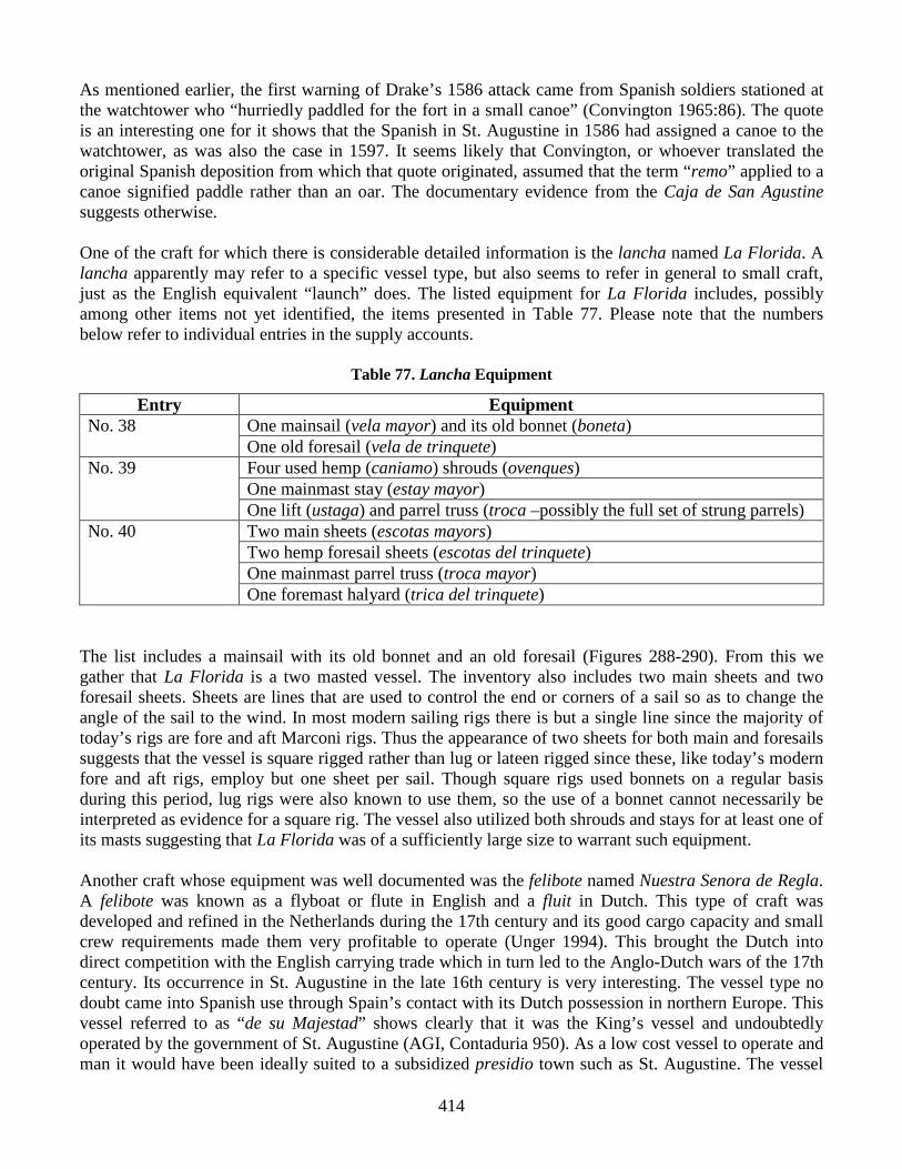
As mentioned earlier, the first warning of Drake’s 1586 attack came from Spanish soldiers stationed at the watchtower who “hurriedly paddled for the fort in a small canoe” (Convington 1965:86). The quote is an interesting one for it shows that the Spanish in St. Augustine in 1586 had assigned a canoe to the watchtower, as was also the case in 1597. It seems likely that Convington, or whoever translated the original Spanish deposition from which that quote originated, assumed that the term “remo” applied to a canoe signified paddle rather than an oar. The documentary evidence from the Caja de San Agustine suggests otherwise. One of the craft for which there is considerable detailed information is the lancha named La Florida. A lancha apparently may refer to a specific vessel type, but also seems to refer in general to small craft, just as the English equivalent “launch” does. The listed equipment for La Florida includes, possibly among other items not yet identified, the items presented in Table 77. Please note that the numbers below refer to individual entries in the supply accounts.
Table 77. Lancha Equipment
Entry Equipment No. 38 One mainsail (vela mayor) and its old bonnet (boneta)
One old foresail (vela de trinquete) No. 39 Four used hemp (caniamo) shrouds (ovenques)
One mainmast stay (estay mayor) One lift (ustaga) and parrel truss (troca –possibly the full set of strung parrels)
No. 40 Two main sheets (escotas mayors) Two hemp foresail sheets (escotas del trinquete) One mainmast parrel truss (troca mayor) One foremast halyard (trica del trinquete)
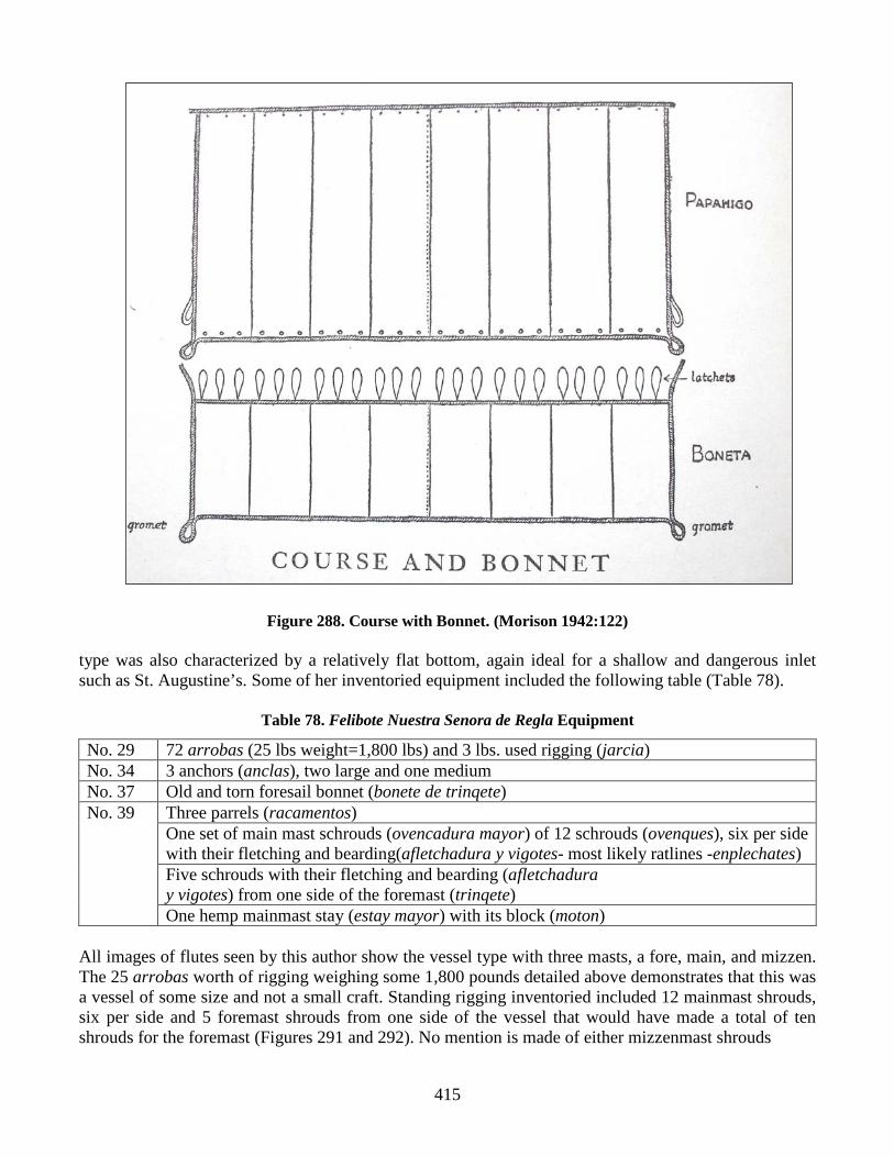
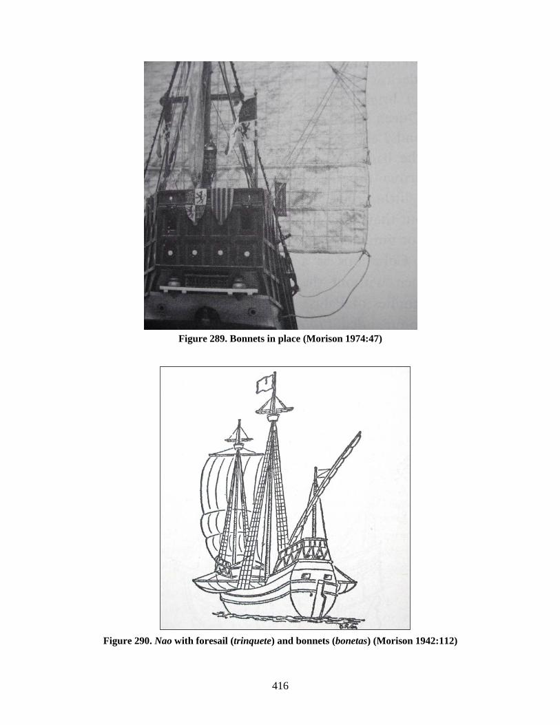
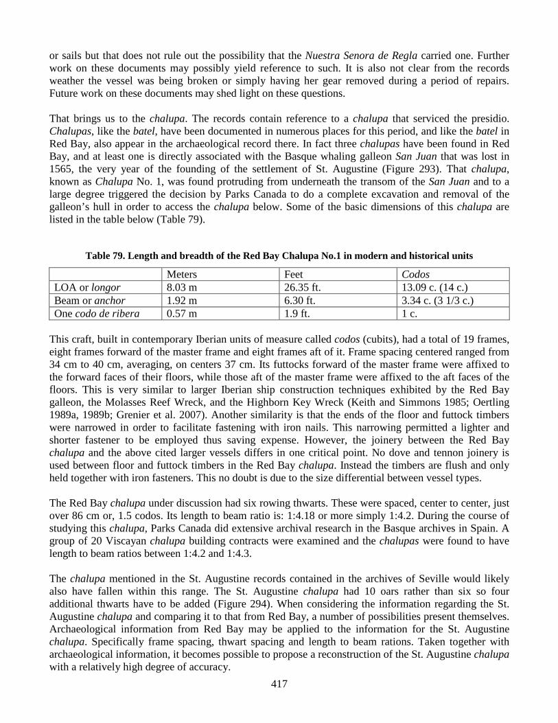
The list includes a mainsail with its old bonnet and an old foresail (Figures 288-290). From this we gather that La Florida is a two masted vessel. The inventory also includes two main sheets and two foresail sheets. Sheets are lines that are used to control the end or corners of a sail so as to change the angle of the sail to the wind. In most modern sailing rigs there is but a single line since the majority of today’s rigs are fore and aft Marconi rigs. Thus the appearance of two sheets for both main and foresails suggests that the vessel is square rigged rather than lug or lateen rigged since these, like today’s modern fore and aft rigs, employ but one sheet per sail. Though square rigs used bonnets on a regular basis during this period, lug rigs were also known to use them, so the use of a bonnet cannot necessarily be interpreted as evidence for a square rig. The vessel also utilized both shrouds and stays for at least one of its masts suggesting that La Florida was of a sufficiently large size to warrant such equipment. Another craft whose equipment was well documented was the felibote named Nuestra Senora de Regla. A felibote was known as a flyboat or flute in English and a fluit in Dutch. This type of craft was developed and refined in the Netherlands during the 17th century and its good cargo capacity and small crew requirements made them very profitable to operate (Unger 1994). This brought the Dutch into direct competition with the English carrying trade which in turn led to the Anglo-Dutch wars of the 17th century. Its occurrence in St. Augustine in the late 16th century is very interesting. The vessel type no doubt came into Spanish use through Spain’s contact with its Dutch possession in northern Europe. This vessel referred to as “de su Majestad” shows clearly that it was the King’s vessel and undoubtedly operated by the government of St. Augustine (AGI, Contaduria 950). As a low cost vessel to operate and man it would have been ideally suited to a subsidized presidio town such as St. Augustine. The vessel
415
Figure 288. Course with Bonnet. (Morison 1942:122) type was also characterized by a relatively flat bottom, again ideal for a shallow and dangerous inlet such as St. Augustine’s. Some of her inventoried equipment included the following table (Table 78).
Table 78. Felibote Nuestra Senora de Regla Equipment
No. 29 72 arrobas (25 lbs weight=1,800 lbs) and 3 lbs. used rigging (jarcia) No. 34 3 anchors (anclas), two large and one medium No. 37 Old and torn foresail bonnet (bonete de trinqete) No. 39 Three parrels (racamentos)
One set of main mast schrouds (ovencadura mayor) of 12 schrouds (ovenques), six per side with their fletching and bearding(afletchadura y vigotes- most likely ratlines -enplechates) Five schrouds with their fletching and bearding (afletchadura y vigotes) from one side of the foremast (trinqete) One hemp mainmast stay (estay mayor) with its block (moton)
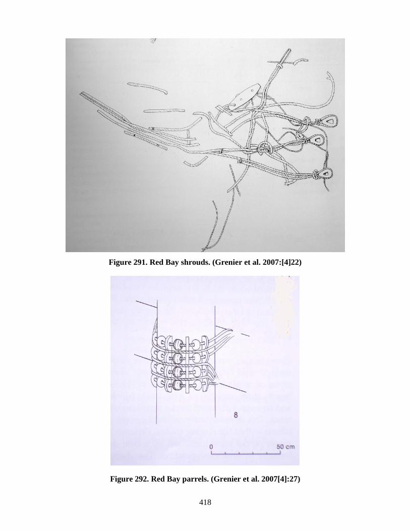
All images of flutes seen by this author show the vessel type with three masts, a fore, main, and mizzen. The 25 arrobas worth of rigging weighing some 1,800 pounds detailed above demonstrates that this was a vessel of some size and not a small craft. Standing rigging inventoried included 12 mainmast shrouds, six per side and 5 foremast shrouds from one side of the vessel that would have made a total of ten shrouds for the foremast (Figures 291 and 292). No mention is made of either mizzenmast shrouds
416
Figure 289. Bonnets in place (Morison 1974:47)
Figure 290. Nao with foresail (trinquete) and bonnets (bonetas) (Morison 1942:112)
417
or sails but that does not rule out the possibility that the Nuestra Senora de Regla carried one. Further work on these documents may possibly yield reference to such. It is also not clear from the records weather the vessel was being broken or simply having her gear removed during a period of repairs. Future work on these documents may shed light on these questions. That brings us to the chalupa. The records contain reference to a chalupa that serviced the presidio. Chalupas, like the batel, have been documented in numerous places for this period, and like the batel in Red Bay, also appear in the archaeological record there. In fact three chalupas have been found in Red Bay, and at least one is directly associated with the Basque whaling galleon San Juan that was lost in 1565, the very year of the founding of the settlement of St. Augustine (Figure 293). That chalupa, known as Chalupa No. 1, was found protruding from underneath the transom of the San Juan and to a large degree triggered the decision by Parks Canada to do a complete excavation and removal of the galleon’s hull in order to access the chalupa below. Some of the basic dimensions of this chalupa are listed in the table below (Table 79).
Table 79. Length and breadth of the Red Bay Chalupa No.1 in modern and historical units
Meters Feet Codos LOA or longor 8.03 m 26.35 ft. 13.09 c. (14 c.) Beam or anchor 1.92 m 6.30 ft. 3.34 c. (3 1/3 c.) One codo de ribera 0.57 m 1.9 ft. 1 c.
This craft, built in contemporary Iberian units of measure called codos (cubits), had a total of 19 frames, eight frames forward of the master frame and eight frames aft of it. Frame spacing centered ranged from 34 cm to 40 cm, averaging, on centers 37 cm. Its futtocks forward of the master frame were affixed to the forward faces of their floors, while those aft of the master frame were affixed to the aft faces of the floors. This is very similar to larger Iberian ship construction techniques exhibited by the Red Bay galleon, the Molasses Reef Wreck, and the Highborn Key Wreck (Keith and Simmons 1985; Oertling 1989a, 1989b; Grenier et al. 2007). Another similarity is that the ends of the floor and futtock timbers were narrowed in order to facilitate fastening with iron nails. This narrowing permitted a lighter and shorter fastener to be employed thus saving expense. However, the joinery between the Red Bay chalupa and the above cited larger vessels differs in one critical point. No dove and tennon joinery is used between floor and futtock timbers in the Red Bay chalupa. Instead the timbers are flush and only held together with iron fasteners. This no doubt is due to the size differential between vessel types. The Red Bay chalupa under discussion had six rowing thwarts. These were spaced, center to center, just over 86 cm or, 1.5 codos. Its length to beam ratio is: 1:4.18 or more simply 1:4.2. During the course of studying this chalupa, Parks Canada did extensive archival research in the Basque archives in Spain. A group of 20 Viscayan chalupa building contracts were examined and the chalupas were found to have length to beam ratios between 1:4.2 and 1:4.3. The chalupa mentioned in the St. Augustine records contained in the archives of Seville would likely also have fallen within this range. The St. Augustine chalupa had 10 oars rather than six so four additional thwarts have to be added (Figure 294). When considering the information regarding the St. Augustine chalupa and comparing it to that from Red Bay, a number of possibilities present themselves. Archaeological information from Red Bay may be applied to the information for the St. Augustine chalupa. Specifically frame spacing, thwart spacing and length to beam rations. Taken together with archaeological information, it becomes possible to propose a reconstruction of the St. Augustine chalupa with a relatively high degree of accuracy.
418
Figure 291. Red Bay shrouds. (Grenier et al. 2007:[4]22)
Figure AR18. Red Bay parrels.
Figure 292. Red Bay parrels. (Grenier et al. 2007[4]:27)

419
Figure 293. Red Bay Chalupa No.1. (Grenier et al. 2007[4]: 314)
The Red Bay chalupa, as stated earlier, had six rowing thwarts, one per oar. Since that documented for St. Augustine had ten oars, assuming that the extra four oars were not simply spares but actually used with the rest, we need to add four more thwarts to our proposed reconstruction. Setting the center-to-center spacing at 86.25 centimeters, as documented archaeologically, and multiplying it by four yields an increased length of 345cm or 3.45meters, the equivalent of 6 codos of the period. So having established the length of the St. Augustine chalupa at 11.48 meters or 20 codos (37.66 ft), by adding the necessary extra length to accommodate the additional thwarts to the length of the Red Bay

420
Figure 294. Entry No. 27 detailing the chalupa in the service of the presidio at St. Augustine along with a transcription and translation.
chalupa, it now becomes necessary to determine the beam. As mentioned earlier a number of chalupa building contracts were examined during the study of the Red Bay material by Parks Canada. Researchers found that boat carpenters of the time working in codos used them in a particular manner. Specifically, when determining dimensions and hull shapes, boat carpenters divided the codos into quarters and thirds. Thus, when determining the beam for the St. Augustine chalupa, we need to keep within the standard length to beam ratio range determined during the study and work in quarters or thirds of codos. This suggests a beam of 2.73 meters or 4 ¾ codos (8.95 ft). The Red Bay chalupa had a total of nineteen frames, eight fore and aft of the main frame. Frame spacing averaged 37 cm. The hypothetical St. Augustine chalupa has been extended 3.45 m beyond its counterpart’s length to accommodate four additional thwarts. Dividing 3.45 m by .37 m to determine the additional number of required frames yields a total of 9.3. Since the master frame is in the middle of the boat and we have an odd number of frames, we will adjust by assuming an even ten additional frames spaced just slightly closer together. Thus the details of the reconstructed St. Augustine chalupa may be summarized in Table 80 below.
No. 27 Spanish 1. Mas se le ase cargo de una chalupa del 2. servicio de este presidio que se avia 3. echo en el para servicio con sus ar 4. volees bergas y timon con sus hierros 5. y diez remos de palo de servicio de la 6 dicha chalupa …
No. 27 English 1. In addition add to his charge one chalupa 2. that serves this presidio that was 3. made in it for service with its mas 4. ts, yards, and rudder with its irons 5. and ten wooden oars for the service of 6. said chalupa…

421
Table 80. Detail summary and comparison of Red Bay Chalupa No. 1 and the St. Augustine chalupa.
Red Bay Chalupa No. 1 Meters Feet Codos LOA or longer 8.03 m 26.35 ft. 13.09 c. (14 c.) Beam or anchor 1.92 m 6.30 ft. 3.34 c. (3 1/3 c.) Frames 19 Length to Breadth ratio 1:4.2
Conjectural St Augustine Chalupa Meters Feet Codos LOA or longer 11.48 m 37.66 ft. 20 c. Beam or anchor 2.73 m 8.95 ft. 4 ¾ c. Frames 29 Length to Breadth ratio 1:4.2